Embed Size (px)
Citation preview


SCANNEL
C0
46 7 -YO / /< J

RELEASE ABATEMENT MEASURE120 DAY STATUS REPORT
LIGHT PRODUCT LOADING RACK AREA
Former Mobil East Boston Terminal 20-001467 and 580 Chelsea Street NEast Boston, Massachusetts
MADEP Site/RTN Nos. 3-1558, 3-18199 & 3-18824
December 3, 2001
Prepared for:
Mr. Michael A. LamarreExxonMobil Refining & Supply - Global Remediation
1001 Wampanoag TrailRiverside, Rhode Island 02915
Prepared by:
ROUX ASSOCIATES, INC.25 Corporate Drive, Suite 230
Burlington, Massachusetts 01803
MC17271M.146/CV

CONTENTS
1.0 IN TR O D U C TIO N .................................................................................................................... 1
2.0 SITE DESCRIPTION AND RESPONSE OPERATIONS CONDUCTED............................22.1 G eneral Site D escription ................................................................................................... 22.2 Status of Response Operations..........................................................................................2
2.2.1 SVE and Dewatering W ell Installation....................................................................32.2.2 Trenching and Subsurface Piping Installation ......................................................... 42.2.3 Site Survey ................................................................................................................ 52.2.4 Rem ediation System Equipm ent..............................................................................5
3.0 MANAGEMENT OF REMEDIATION WASTE ................................................................... 7
4 .0 L S P O P IN IO N .......................................................................................................................... 8
Figures
1. Site Plan
Appendices
A. Bureau of Waste Site Cleanup Form BWSC-106
B. Boring/Well Logs
C. Hazardous Waste Manifest
ROUX ASSOCIATES, INC. - i- MC1727,M.14U R

1.0 INTRODUCTION
Roux Associates, Inc. (Roux Associates), on behalf of ExxonMobil Refining & Supply - Global
Remediation (ExxonMobil), has prepared this 120-Day Release Abatement Measure (RAM)
Status Report for the installation and operation of a soil vapor extraction (SVE) and dewatering
remediation system in the light product loading rack (LPLR) area of the former Mobil East
Boston Terminal 20-001 located at 467 and 580 Chelsea Street in East Boston, Massachusetts,
(hereafter referred to as the "Site"). Mobil Oil Corporation (Mobil) is a wholly owned subsidiary
of ExxonMobil Corporation.
A RAM Plan dated August 2, 2001 was submitted to Massachusetts Department of
Environmental Protection (MADEP) for Release Tracking Numbers (RTNs) 3-18199 and 3-
18824, both of which have been linked to the main Site No. 3-1558. RTN 3-18199 was issued
by the MADEP on April 15, 1999 in response to separate phase hydrocarbons (SPH) observed on
ground water in an excavation adjacent to the southern end of the LPLR in the southwestern
portion of the Site. RTN 3-18824 was issued by the MADEP on October 2, 1999 in response to
a release of approximately 400 gallons of gasoline to the ground surface due to the overfilling of
a tanker truck at the LPLR.
The remainder of this RAM status report is divided into the following sections:
* Section 2.0 provides a general description of the Site and information regarding thestatus of RAM response operations conducted to date;
* Section 3.0 provides details of the management of Remediation Waste; and
* Section 4.0 provides a Licensed Site Professional (LSP) opinion concerning theimplementation of this RAM.
This 120-Day RAM Status Report has been prepared in accordance with 310 Code of
Massachusetts Regulations (CMR) 40.0445 of the Massachusetts Contingency Plan (MCP).
Reference is made to the Bureau of Waste Site Clean-up (BWSC) Form 106 (Appendix A) for
information regarding the person assuming responsibility for conducting the RAM and the seal
and signature of the LSP who prepared this RAM status report.
ROUX ASSOCIATES, INC. MCI7271M.146/R
2.0 SITE DESCRIPTION AND RESPONSE OPERATIONS CONDUCTED
2.1 General Site Description
The Site is a bulk storage facility, which stores various petroleum products prior to distribution.
The current owner and operator of the terminal is Tosco Corporation (Tosco), which acquired the
terminal from Mobil on May 24, 2000. The terminal land area comprises approximately 28 acres
of land located on both sides of Chelsea Street, extending from the Chelsea Street Bridge to the
east, Eagle Square to the west, Chelsea Creek to the north and Bremen Street and the CSX
railroad tracks to the south. Most of the terminal is surrounded by concrete berms, chain link
fencing and the Chelsea Creek. Improvements include buildings, approximately 100
aboveground storage tanks (ASTs) with various capacities, and a pipeline manifold, pump house
and appurtences for distribution to Logan International Airport.
The LPLR area is located in the southwestern portion of the Site, as shown on Figure 1, and is
used for the loading of "light" petroleum products (i.e. gasoline, diesel, jet fuel and fuel oil) into
tanker trucks. The LPLR area is defined by the corrugated metal Foam House building, the
southern berm wall of Yard 127 and the vapor recovery unit to the north, Chelsea and East Eagle
Streets to the south and southwest, the berm walls located on the western side of Tank Nos. 91
through 94 and the southern berm wall associated with Tank Yard (Yard) 90 to the east, and to
the west by the western property bound which abuts the Channel Fish Company property.
2.2 Status of Response Operations
Subsequent to finalizing the design of the SVE and dewatering remediation system, installation
activities were initiated at the Site on September 10, 2001. Major activities conducted to date
include:
* Installation of 32 SVE and dewatering wells;
* Trenching and installation of the subsurface vapor recovery, ground water transmission,and pneumatic piping;
* Survey of the LPLR; and
* Ordering of remediation system components.
These major activities are summarized in the following sections.
ROUX ASSOCIATES, INC. MC[ 7271 M.1

2.2.1 SVE and Dewatering Well Installation
From September 10, 2001 through September 19, 2001, B.L Myers of Belchertown,
Massachusetts advanced 32 borings in the LPLR area (Figure 1). These borings were completed
as SVE and/or dewatering wells (V1 through VGW32). Prior to boring advancement, all boring
locations were hand cleared to a minimum depth of four feet below ground surface (bgs). All
borings were advanced using a hollow stem auger drill rig and 6 1/4 inch inner diameter augers.
All but one of the borings completed as combined SVE and ground water extraction wells, were
advanced to an average depth of approximately 17 feet bgs. Boring VGW22 was advanced to a
depth of 14 feet bgs due to auger refusal. Borings for remedial wells designed for SVE only
were advanced to an average depth of approximately 13 bgs.
During drilling activities, soil samples were collected using a split spoon or by grabbing soil
from the drill cuttings. Soil descriptions are provided on the Boring/Well Logs in Appendix B.
The headspace of the soil samples was screened for volatile organic compounds (VOCs) using a
photo ionization detector (PID). Headspace screening results are also provided on Boring/Well
Logs.
As discussed, the remedial wells designed for both SVE and ground water extraction (VGW2
through VGW5, VGW10, VGW 1, VGW16, VGW17, VGW22, and VGW29 through VGW32)
were completed to a depth of approximately 17 feet bgs. Wells adaptable for future ground
water extraction (V13, V14, V15 and V18 through V23) were also completed to a depth of
approximately 17 feet bgs. Each of these wells consisted of a 4-inch diameter schedule 40 PVC
sump, 4-feet in length, extending from 13 to 17 feet bgs and connected to 10 feet of 0.010-inch
slotted wire wrapped well screen extending from 3 to 13 feet bgs. The wells were completed
with an approximate 3-foot length of 4-inch diameter schedule 40 PVC solid riser with a PVC
cap. A sand pack was installed from the total depth of the boring to approximately 0.5 feet
above the top of screen. To protect the wells from vehicular traffic prior to the installation of the
well vaults, a six-inch thick concrete cap was placed over the well on top of the back fill. Well
heads will be modified at a later date to accommodate the contemplated well head make-ups for
the remedial system.
ROUX ASSOCIATES, INC. MC17271M.146/R
The remedial wells designed for vapor extraction only (VI, V6 through V9, V12, and V25
through V28) were completed to a depth of approximately 13 feet bgs. Each of these wells
consisted of approximately 10 feet of 0.010-inch slotted 4-inch diameter schedule 40 PVC well
screen extending from 3 to 13 feet bgs with an approximate 3-foot length of 4-inch diameter
schedule 40 PVC solid riser completing the well to approximately 6-inches bgs. A PVC cap was
placed on top of each well. A sand pack was installed from the total depth of the boring to
approximately 0.5 feet above the top of screen. To protect the wells from vehicular traffic prior
to the installation of the well vaults, a six-inch thick concrete cap was placed over the well on top
of the back fill. Well construction details are provided on the Boring/Well Logs which are
included in Appendix B. Well heads will be modified at a later date to accommodate the
contemplated well head make-ups for the remedial system.
Drill cuttings generated during the well installation activities were stockpiled on Site on
polysheeting. The drill cuttings were later consolidated with soil generated during the
excavation and trenching activities. Soil disposal activities are discussed below in section 3.0 of
this report. All remedial wells were developed upon completion. Approximately 480 gallons of
development water were removed from the wells and discharged to the on Site storm water
treatment system owned and operated by Tosco which consists oil/water separation followed by
granular activated carbon. Treated water from the storm water treatment system is discharged to
Chelsea Creek under National Pollutant Discharge Elimination System (NPDES) Permit No.
MA0004006. The outfall is located northwest of the former Lube Plant.
2.2.2 Trenching and Subsurface Piping Installation
Between October 9, 2001 and November 6, 2001, excavation/trenching and piping installation
activities were performed in the LPLR area. Prior to excavation, the asphalt pavement was cut to
minimize disturbance to the surrounding pavement. Subsequent to the excavation of the
trenches, each of the remedial wells was manifolded to the vacuum extraction piping and if
applicable, ground water and air transmission piping. The SVE piping consisted of 2-inch
schedule 80 PVC pipe, the ground water transmission piping consisted of 1-inch schedule 40
PVC pipe and the air transmission piping consisted of 1-inch HDPE piping. All piping was
ROUX ASSOCIATES, INC. MCI7271M.1461R

brought back to the area of the proposed remediation system compound located adjacent to the
Foam House in the northwest corner of the LPLR area. Trenching locations are shown on Figure
2. Soil generated from trenching activities was stockpiled on Site. Off Site soil disposal
activities are discussed below in section 3.0.
The piping installed within the trenches was placed on and backfilled with pea-stone covering
the top of the piping runs by approximately 6-inches. The trenches were then backfilled with
concrete to either grade or approximately 6-inches bgs. At trenching locations where the
concrete was not brought to grade, once the concrete had cured, the remaining area above the
concrete was backfilled with stone dust to grade. During backfilling activities, well
vaults/roadboxes were installed and cemented in place around the wells.
At one point during the trenching, rainwater accumulated in a section of the trenching located in
the northeast corner of the LPLR area. A visible sheen was observed on the water's surface
(most likely a result from contact with petroleum impacted soil). To allow piping installation
activities to continue, 800-gallons of rainwater were removed from the trench on October 17,
2001. The water was removed by United Industrial Services of Meriden, Connecticut using a
vacuum truck. Further information regarding removal and off Site disposal of this rain water is
detailed in Section 3.0 of this report.
2.2.3 Site Survey
On November 5 and November 9, 2001, Clark Engineering & Surveying, P.C. surveyed the
locations of the SVE/dewatering wells and associated system trenching for placement on a Site
map (Figure 1). During the survey, a benchmark was established for future surveying in this
area. The benchmark is located on the corner of the concrete berm near the southwest corner of
the vapor recovery unit due to future modifications of well heads.
2.2.4 Remediation System Equipment
Since submittal of the RAM Plan in August 2001, the following remediation system equipment
was ordered:
ROUX ASSOCIATES, INC. -5 - MC17271MA.46

* Components of the SVE and ground water dewatering system including the SVEblowers, pneumatic pump compressor, and the oil/water separator, were ordered fromBISCO Environmental (BISCO) of Randolph, Massachusetts. BISCO is building andintegrating the system components within a portable container that will be moved to theSite. Delivery is expected by the end of December 2001;
* The pneumatic pumps were ordered and received from Clean Environment Equipment ofOakland, California; and
* The liquid storage fractionation tank was ordered from Wade Services, Inc. of Ellisville,Mississippi. Delivery is expected by the end of December 2001.
ROUX ASSOCIATES, INC. MC]7271M.14/R

3.0 MANAGEMENT OF REMEDIATION WASTE
During the installation of the SVE/dewatering wells and piping for the remediation system, the
following remediation waste was generated and disposed of at ExxonMobil approved facilities:
* 800-Gallons of impacted rainwater were removed via vacuum truck by United IndustrialServices and disposed of at their facility United Oil Recovery, located at 136 GraceyAvenue in Meriden, Connecticut.
* 656.02 tons of impacted soil was removed from the Site by Environmental SoilManagement, Inc. and recycled at their thermal processing facility in Loudon, NewHampshire.
The associated Hazardous Waste Manifest documentation for the rainwater disposal is provided
in Appendix C. The Bill of Lading for the soil removal will be forwarded to the MADEP under
separate cover.
ROUX ASSOCIATES, INC. MC17271M.146/RI

4.0 LSP OPINION
In regards to the LSP opinion required in 310 CMR 40.0445(2)(f), reference is made to the
BWSC Form 106 (Appendix A) for information and the LSP opinion as to whether the RAM is
being conducted in conformance with the RAM Plan. No conditions of approval of this RAM
have been established by the MADEP.
ROUX ASSOCIATES, INC. MCI7271M.146R

Respectfully Submitted,
Roux Associates, Inc.
Ian T. Reed
Project Hydrogeologist
Jerry Tolosko, LSP
Senior Hydrogeologist/Project Manager
ROUX ASSOCIATES, INC. MC17271M.146

CI
0 : 1.
4 iL
il
!-
'i
Jd/
- 0<
Ul±
F-
\ -I
%C

Massachusetts Department of Environmental Protection BWSC106Bureau of Waste Site Cleanup
RELEASE & UTILITY-RELATED ABATEMENT Release Tracking Number
MEASURE (RAM & URAM) TRANSMITTAL FORMPursuant to 310 CMR 40.0444 - 0446 and 310 CMR 40.0462 - 0465 (Subpart D)- 1558
A. SITE LOCATION:
SiteName: Fonrmer Mhobil East -nton Terminal 90-001
Street: 4C7 & 0n rhel ~sea Street Location Aid:
City/Town: Paqt Roston ZIPCode: 0219R-0000
SCheck here if a Tier Classification Submittal has been provided to DEP for this Release Tracking Number.
Related Release Tracking Numbers That This RAM or URAM Addresses: 1-1 81 99 and 3 1 8R24
B. THIS FORM IS BEING USED TO: (check all that apply)
] Submit a RAM Plan (complete Sections A, B, C, D, E, F, J, K, L and M).
H Check here if this RAM Plan is an update or modification of a previously approved written RAM Plan. Date Submitted:
SSubmit a RAM Status Report (complete Sections A, B, C, E, J, K, L and M).
SSubmit a RAM Completion Statement (complete Sections A, B, C, D, E, G, J, K, L and M).
F Confirm or Provide URAM Notification (complete Sections A, B, H, K, L and M).
H Submit a URAM Status Report (complete Sections A, B, C, E, J, K, L and M).
SSubmit a URAM Completion Statement (complete Sections A, B, C, D, E, I, J, K, L and M).You must attach all supporting documentation required for each use of form indicated, including copies of
any Legal Notices and Notices to Public Officials required by 310 CMR 40.1400.
C. SITE CONDITIONS:
SCheck here if the source of the Release or Threat of Release is known.
If yes, check all sources that apply: [] UST [] Pipe/Hose/Line H AST L] Drums L Transformer ] Boat
[] TankerTruck ] Vehicle [ Other Specify: 3-18199- SPH in excavation (sour]e unknown)
Identify Media and Receptors Affected: (check all that apply) ] Air &r Groundwater ] SurfaceWater Sediments W Soil
] Wetlands H Storm Drain W Paved Surface [] Private Well [] Public Water Supply L Zone 2 E Residence
] School ] Unknown &r Other Specify: catch ha n connected to nnit e Trmt System
Identify Release and/or Threat of Release Conditions at Site: (check all that apply)
W 2 and 72 Hour Reporting Condition(s) [] 120 Day Reporting Condition(s) [ Other Condition(s)
Describe 3-18199- SPH in excavation (TRA Conmp Rpt submitted 6/99)
- 1RS94- 400- allnn rel of casoline to murface (TWA Conmpn pt submitted 12/99
RAMs may be conducted concurrently with an IRA only with written DEP approvalURAMs may not be conducted if any 2 or 72 Hour conditions exist at the site.
Identify Oils and Hazardous Materials Released: (check all that apply) W Oils ] Chlorinated Solvents Heavy Metals
LI Others Specify:
D. DESCRIPTION OF RESPONSE ACTIONS: (check all that apply)
] Assessmentand/or Monitoring Only [] Deploymtnt I b a I r C Is
] Excavation of Contaminated Soils ] Tempor y4 ( IDL
D Re-use, Recycling or Treatment ] Bioremediation
On Site DEC 11 2001O on Site Off Site Est. Vol.: cubic yards ] Soil Vapor Extraction
Describe: ] Structure Venting SysttEP
] Store O OnSite O Off Site Est. Vol.: cubicyards [] HL e
SECTION D IS CONTINUED ON THE NEXT P 10-NAL OFFICERevised 2/24/95 Supersedes Forms BWSC-007, 008, 009 and 010 (in part) Page 1 of 4
Do Not Alter This Form
Massachusetts Department of Environmental Protection BWSC-106Bureau of Waste Site Cleanup
RELEASE & UTILITY-RELATED ABATEMENT Release Tracking Number
MEASURE (RAM & URAM) TRANSMITTAL FORMPursuant to 310 CMR 40.0444 -0446 and 310 CMR 40.0462 -0465 (Subpart D) 3- 1558
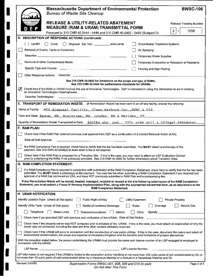
D. DESCRIPTION OF RESPONSE ACTIONS (continued):
[] Landfill Q Cover Q Disposal Est.Vol.: __ cubicyards ] Groundwater Treatment Systems
SRemoval of Drums, Tanks or Containers Air Sparging
Describe: Temporary Water Supplies
SRemoval of Other Contaminated Media Temporary Evacuation or Relocation of Residents
Specify Type and Volume: ] Fencing and Sign Posting
] Other Response Actions Describe:
See 310 CMR 40.0442 for limitations on the scope and type of RAMs.See 310 CMR 40.0464 for performance standards for URAMs.
Check here if this RAM or URAM involves the use of Innovative Technologies. DEP is interested in using this information to aid in creatingan Innovative Technologies Clearinghouse.
Describe Technologies:
E. TRANSPORT OF REMEDIATION WASTE: (if Remediation Waste has been sent to an off-site facility, answer the following
Name of Facility: MTR H ia nosal farilit y ClePan Harhnr Tnc .SMT & TTS
TownandState: Epsom. NH. raint-r e MA. T.Louden. NT & Meriden, CT
Quantity of Remediation Waste Transported to Date: _Rnlbs abs pwH . yrrs soil & 1"flAgal .RPHAWat er
F. RAM PLAN:
H Check here if this RAM Plan received previous oral approval from DEP as a continuation of a Limited Removal Action (LRA).
Date of Oral Approval:
SIf a RAM Compliance Fee is required, check here to certify that the fee has been submitted. You MUST attach a photocopy of thepayment. See 310 CMR 40.0444(2) to learn when a fee is not required.
SCheck here if the RAM Plan is proposed for a Transition Site, If this is the case, you may need to attach an LSP Evaluation Opinionprior to undertaking the RAM, if not previously provided. See 310 CMR 40.0600 for further information about Transition Sites.
G. RAM COMPLETION STATEMENT:
] If a RAM Compliance Fee is required in connection with submission of the RAM Completion Statement, check here to certify that the fee has beensubmitted. You MUST attach a photocopy of the payment. You owe this fee when submitting a RAM Completion Statement if you received oralapproval of a RAM that continued an LRA, and have NOT previously submitted a RAM Plan and accompanying fee.
If any Remediation Waste will be stored, treated, managed, recycled or reused at the site following submission of the RAM CompletionStatement, you must submit a Phase IV Remedy Implementation Plan, along with the appropriate transmittal form, as an attachment to the
RAM Completion Statement.
H. URAM NOTIFICATION:
Identify Location Type: (check all that apply) ] Public Right of Way Utility Easement Private Property
Identify Utility Type: (check all that apply) O Sanitary/Combined Sewerage ] Water H Drainage ] Natural Gas
n Telephone [] Steam Lines Telecommunications [] Electric [] Other Specify:
SCheck here if you provided DEP with previous oral notification of this URAM. Date of Oral Notice:
SCheck here if the property owner was NOT contacted prior to initiation of the URAM. If this is the case, you must attach an explanation of why theowner was not contacted, including the date and time when contact ultimately occurred.
SCheck here if this URAM will occur in connection with the construction of new public utilities. If this is the case, document the nature and extent ofencountered contamination, the scope and expense of necessary mitigation and the benefits amd [imitations of project alternatives.
With the exception stated below, the person undertaking the URAM must provide the name and license number of an LSP engaged or employed inconnection with the URAM:
LSP Name: LSP License Number:
LSP information is not required if the URAM is limited to the excavation and/or handling of not more than 100 cubic yards of soil contaminated by Oil, ornot more than 20 cubic yards of soil contaminated either by a Hazardous Material or a mixture of a Hazardous Material and Oil.
Revised 2/24/95 Supersedes Forms BWSC-007, 008, 009 and 010 (in part) Page 2 of 4Do Not Alter This Form

SMassachusetts Department of Environmental Protection BWSC-106*Bureau of Waste Site Cleanup
RELEASE & UTILITY-RELATED ABATEMENT Release Tracking NumberMEASURE (RAM & URAM) TRANSMITTAL FORMPursuant to 310 CMR 40.0444 -0446 and 310 CMR 40.0462 -0465 (Subpart D)
1I. URAM COMPLETION STATEMENT:
SCheck here if this URAM was limited to the excavation and/or handling of not more than 100 cubic yards of soil contaminated by Oil, or notmore than 20 cubic yards of soil contaminated by either a Hazardous Material or a mixture of a Hazardous Material and Oil.
I If any Remediation Waste will be stored, treated, managed, recycled or reused at the site following submission of the URAM CompletionStatement, you must submit either a Release Abatement Measure (RAM) Plan or a Phase IV Remedy Implementation Plan, along with the
appropriate transmittal form, as an attachment to the URAM Completion Statement.
I J. LSP OPINION:
I attest under the pains and penalties of perjury that I have personally examined and am familiar with this transmittal form, including any and alldocuments accompanying this submittal. In my professional opinion and judgment based upon application of (i) the standard of care in 309 CMR4.02(1), (ii) the applicable provisions of 309 CMR 4.02(2) and (3), and (iii) the provisions of 309 CMR 4.03(5), to the best of my knowledge,information and belief,
> if Section B of this form indicates that a Release Abatement Measure Plan is being submitted, the response action(s) that is (are) the subject of thissubmittal (i) has (have) been developed in accordance with the applicable provisions of M.G.L. c. 21E and 310 CMR 40.0000, (ii) is (are) appropriateand reasonable to accomplish the purposes of such response action(s) as set forth in the applicable provisions of M.G.L. c. 21E and 310 CMR 40.0000and (iii) complies(y) with the identified provisions of all orders, permits, and approvals identified in this submittal;
> if Section B of this form indicates that a Release Abatement Measure Status Report or a Utility-Related Abatement Measure Status Report isbeing submitted, the response action(s) that is (are) the subject of this submittal (i) is (are) being implemented in accordance with the applicableprovisions of M.G.L. c. 21E and 310 CMR 40.0000, (ii) is (are) appropriate and reasonable to accomplish the purposes of such response action(s) as seforth in the applicable provisions of M.G.L. c. 21E and 310 CMR 40.0000 and (iii) complies(y) with the identified provisions of all orders, permits, andapprovals identified in this submittal;
> if Section B of this form indicates that a Release Abatement Measure Completion Statement or a Utility-Related Abatement MeasureCompletion Statement is being submitted, the response action(s) that is (are) the subject of this submittal (i) has (have) been developed andimplemented in accordance with the applicable provisions of M.G.L. c. 21E and 310 CMR 40.0000, (ii) is (are) appropriate and reasonable toaccomplish the purposes of such response action(s) as set forth in the applicable provisions of M.G.L. c. 21E and 310 CMR 40.0000 and (iii)complies(y) with the identified provisions of all orders, permits, and approvals identified in this submittal;
I am aware that significant penalties may result, including, but not limited to, possible fines and imprisonment, if I submit information which I know tobe false, inaccurate or materially incomplete.
Check here if the Response Action(s) on which this opinion is based, if any, are (were) subject to any order(s), permit(s) and/or approval(s) issuedby DEP or EPA. If the box is checked, you MUST attach a statement identifying the applicable provisions thereof.
LSPName: .Terry To] ako LSP#: 3835 Stamp:
Telephone: 7A1-I -270-;n Ext.: 972 1 JERRY
FAX: (optional) 781 -2 70 -90gg
Neo. gSSI Signature: No OW
Date: i 7a o )
An LSP Opinion is not required for a Utility-Related Abatement Measure Notification.
An LSP Opinion is not required for a URAM Completion Statement if the URAM is limited to the excavation andlor handling of not more than100 cubic yards of soil contaminated by Oil, or not more than 20 cubic yards of soil contaminated either by Hazardous Material or
. a mixture of Hazardous Material and Oil.
K. PERSON UNDERTAKING RAM OR URAM:
NameofOrganization: ExxnonMnhil Refining F, gnpply - Global Rem eriation
NameofContact: Mirhael A Tramarre Title: Projp rt- Manager
Street: 1inni0 Wnmn'annnq Trail
City/Town: RivPrside State: PT .. ZIPCode: 09911-0000
Telephone: 401-434-73'AR Ext.: FAX: 401 -434--592
E Check here if there has been a change in person undertaking the RAM or URAM.
S Revised 2/24/95 Supersedes Forms BWSC-007, 008, 009 and 010 (in part) Page 3 of 4Do Not Alter This Form

Massachusetts Department of Environmental Protection BWSC-106Bureau of Waste Site Cleanup
RELEASE & UTILITY-RELATED ABATEMENT Release Tracking NumberMEASURE (RAM & URAM) TRANSMITTAL FORMPursuant to 310 CMR 40.0444 -0446 and 310 CMR 40.0462 -0465 (Subpart D) - 1558
L. RELATIONSHIP TO SITE OF PERSON UNDERTAKING RAM or URAM: (check one)
RPorPRP Specify: O Owner O Operator O Generator O Transporter OtherRPorPRP: Fnrmer Owner/TOperat-nr
SFiduciary, Secured Lender or Municipality with Exempt Status (as defined by M.G.L. c. 21E, s. 2)
SAgency or Public Utility on a Right of Way (as defined by M.G.L. c. 21E, s. 5(j))
] Any Other Person Undertaking a RAM or URAM Specify Relationship:
M. CERTIFICATION OF PERSON UNDERTAKING RAM OR URAM:
1, M1 cha el A. Tamarre , attest under the pains and penalties of perjury (i) that I have personally examined and amfamiliar with the information contained in this submittal, including any and all documents accompanying this transmittal form, (ii) that, based on myinquiry of those individuals immediately responsible for obtaining the information, the material information contained in this submittal is, to the best ofmy knowledge and belief, true, accurate and complete, and (iii) that I am fully authorized to make this attestation on behalf of the entity legallyresponsible for this submtal 1/thper n or entity on whs half this submittal is made am/is aware that there are significant penalties,including, but not lirJedjsessible es and impri o t, for willfully submitting false, inaccurate, or incomplete information.
(signature)
For: Date:(print name of person or entity recorded in Section K)
Enter address of person providing certification, if different from address recorded in Section
Street
City/Town:
Telephone:
State:
Ext.: FAX: (optional)
YOU MUST COMPLETE ALL RELEVANT SECTIONS OF THIS FORM OR DEP MAY RETURN THE DOCUMENT ASINCOMPLETE. IF YOU SUBMIT AN INCOMPLETE FORM, YOU MAY BE PENALIZED FOR MISSING
A REQUIRED DEADLINE.
Revised 2/24/95 Supersedes Forms BWSC-007, 008, 009 and 010 (in part)Do Not Alter This Form
Title: Proiect Manacer
/11/1'u/k
ZIP Code:
Page 4 of 4

APPENDIX B
Boring/Well Logs
ROUX ASSOCIATES, INC. MC17271M.1461APP

ROUX ASSOCIATES, INC. BORING/WELL LOG
Page I of I
Well/Boring ID: VI
Project No: 17271M Project: Former Mobil East Boston Terminal Initial Depth to Water: 3.5'
Location: 467 & 580 Chelsea Street Site No: 20-001 Static Water Level: NGEast Boston, Massachusetts Logged By: Ian Reed TOC Elevation: 12.70'Driller: B.L. Myers Checked By: Jerry Tolosko Top of Screen: 3' Bottom of Screen: 13'Drilling Method: Hollow Stem Auger Start Date: 9/10/01 Boring Diameter 6.25" Well Diameter 4"Sample Method: No samples collected End Date: 9/10/01 Total Depth of Well: 13' Total Depth of Boring: 13
Soil WellSoil Description Type Log
0-0
. -- AsphaltNo samples collected for soil description
2 so 2 2U : 0--
I 2 - - 4 2 - 4:: :::.
! - :::-;: ::-:::
4 4 -- 4
6 6 6
S7 7
la a 8 -- i
I, 9
- - o
0 o LB e koG
12 1 2 : 12! ! [ L
13 3L
SanEnd of boring at 13'14 S4 1n4
15 Is 15
16 16 6
17 17 17
18 18 is1
19 19
020 20
Soil Types and Well Constrction DetailsiPeatg[GaI Bdo Bentonit Gout
Sand Casing Concrete
MC17271M.146/BoringLogsANat NG - not gauged
ROUX ASSOCIATES, INC. BORING/WELL LOG
Page 1 of I
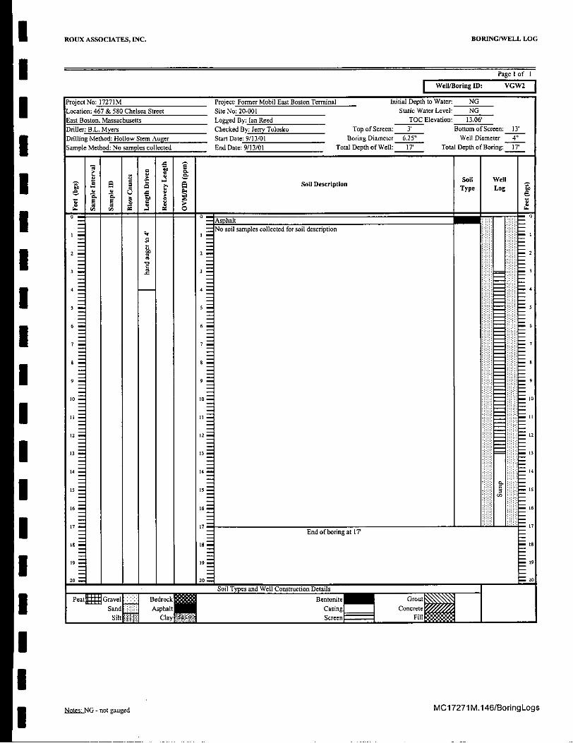
SWell/Boring ID: VGW2
Project No: 17271M Project: Former Mobil East Boston Terminal Initial Depth to Water: NG
Location: 467 & 580 Chelsea Street Site No: 20-001 Static Water Level: NGEast Boston, Massachusetts Logged By: Ian Reed TOC Elevation: 13.06'Driller: B.L. Myers Checked By: Jerry Tolosko Top of Screen: 3' Bottom of Screen: 13'Drilling Method: Hollow Stem Auger Start Date: 9/13/01 Boring Diameter 6.25" Well Diameter 4'Sample Method: No samples collected End Date: 9/13/01 Total Depth of Well: 17' Total Depth of Boring: 17'
Soil Description Typ e ll*Soil Well
0 °7 0I - - Asphalt . -
- o soil samples collected for soil description
S- r3 -1 = 312 2
4 4 4
6 6 6
77
og9to t0 0
1t CyS1ni
12 12 1
13 13 1
14 14 ..- 14
16 16 1
End of boring at IT
29 19 20
Soil Types and We Construction DetailsPeattgGa;IF::F erc Bentonite G'u
Sand ApatCasing Canecct
ClyScreen i
MC17271 M.146/Boring LogsNoteSS"NG - not gauged

I ROUX ASSOCIATES, INC. BORING/WELL LOG
Page 1 of IWell/Boring ID: VGW3
MC1 7271 M.146/BoringLogsNotesz NG - not gauged
I ROUX ASSOCIATES, INC. BORING/WELL LOG
I Page 1 of I
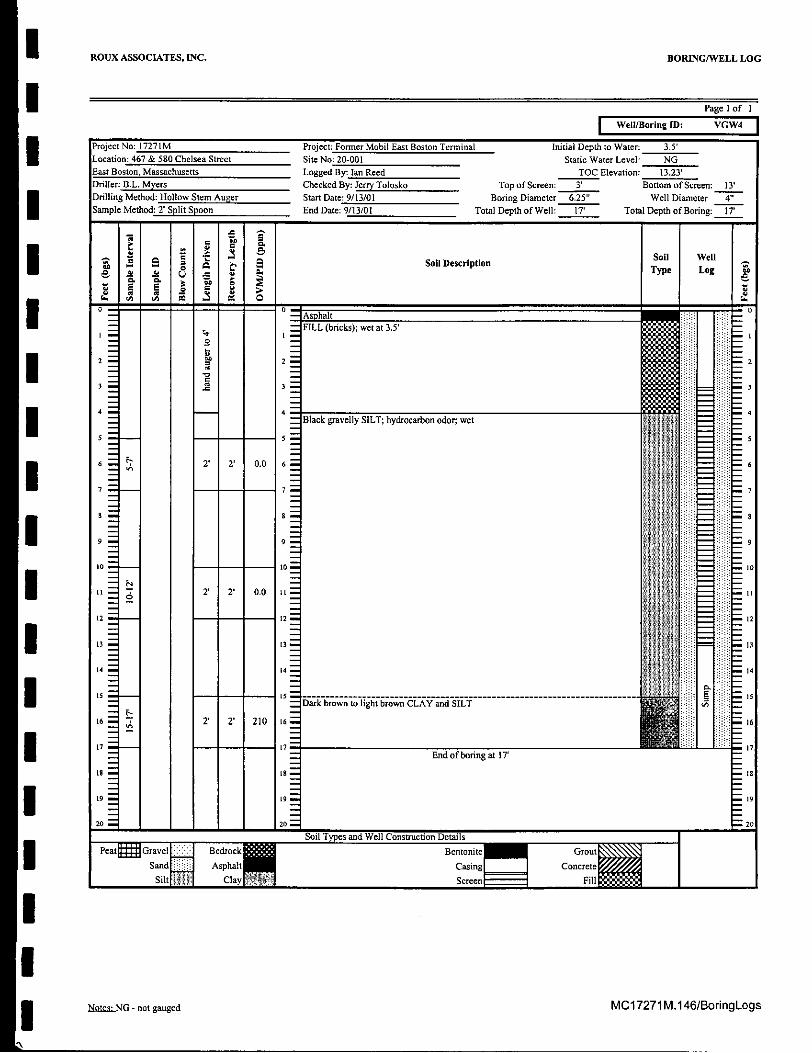
Well/Boring , VW4
Project No: 17271M Project: Former Mobil East Boston Terminal Initial Depth to Water: 3.5'
Location: 467 & 580 Chelsea Street Site No: 20-001 Static Water Level: NGEast Boston, Massachusetts Logged By: tan Reed TOC Elevation: 13.23'Driller: B.L. Myers Checked By: Jerry Tolosko Top of Screen: 3' Bottom of Screen: 13'Drilling Method: Hollow Stem Auger Start Date: 9/13/01 Boring Diameter 6.25" Well Diameter 4"
Sample Method: 2' Split Spoon End Date: 9/13/01 Total Depth of Well: 17' Total Depth of Boring: 17'
" l '6Sol] wellI 4 Soil Description5.S a 0 a. Type Log o
SAsphalt -I' . :FILL (bricks); wet at 3.5'
,: i **-*=*02 a2 2
I -3 3- 4
4 Black gravelly SILT; hydrocarbon odor; wet
5-- 5 - 5
I 2' 2' 0.0 6 6
7. 7=; .7
6 0-
! I11 2' 2' 0.0 1 -
12 12R!lir1
13 B1
14 14 . 14
15 - - ---- 5 - -- ----- ----- ------ ----- ----- ------------------------------------ -- -.- 2.7 ' 2 21 1 Dark brown to light brown CLAY and SILT 42 -
16 72T 2' 210 is 16
1 End of boring at 17' -
I = 9
19 L I9 =19_-- 8 - S
20 20 0 20
Soil ypesand Wll C nuction Details
/Peat Gravel Bedrock Bentonite Grout
Sand Asphalt Casing ConcreteSilt Clay Screen FillI
I
MNal _NG - not gauged MC17271 M.146/BoringLogs
1N

I ROUX ASSOCIATES, INC. BORING/WELL LOG
SPage 1 of I
Well/Boring ID: VGWS
Project No: 17271M Project: Former Mobil East Boston Terminal Initial Depth to Water: NGLocation: 467 & 580 Chelsea Street Site No: 20-001 Static Water Level: NGEast Boston, Massachusetts Logged By: lan Reed TOC Elevation: 13.07'IDriller: B.L. Myers Checked By: Jerry Tolosko Top of Screen: 3' Bottom of Screen: 13'
Drilling Method: Hollow Ste Auger Start Date: 9/13/01 Boring Diameter 6.25" Well Diameter 4"Sample Method: No samples collected EndDate: 9/13/01 Total Depth of Well: 17' Total Depth of Boring: 17'
4 Soil well9 4 " Soil Description
Type Log a
-0- Asphalt 0No soil samples collected for soil description
,, 672 -
2
9'
I 4 4 -4
E-- 9 9
I 10 - 10 - 0
12 - 12 12
13 13 - 13
14 14 .. 14
is - Is - - 15
16 16 16
17 7End of boring at 17'
IS - 18 - - 18
19 -19 - 19
20 20 " 20Soil Types and Well Construction DetailsPeat= G ..vl Bedrock Bentonite Great
Sand Asphalt Caning ConcreteSilt[ Clay" Screen Fill
MC17271M.146/BoringLogslules.'NG - not gauged
ROUX ASSOCIATES, INC. BORING/WELL LOG
Page 1 of I
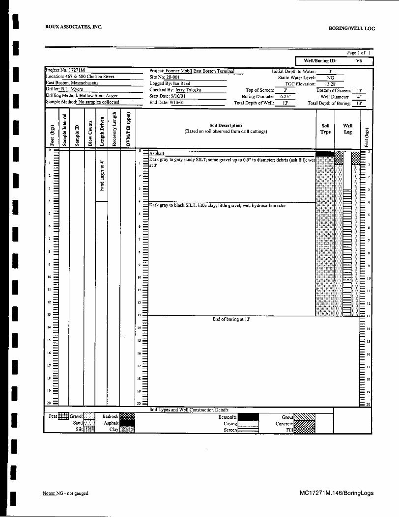
Well/Boring ID: V6
Project No: 17271 M Project: Former Mobil East Boston Terminal Initial Depth to Water: 3'Location: 467 & 580Chelsea Street Site No: 20-001 Static Water Level: NGEast Boston, Massachusetts Logged By: lan Reed TOC Elevation: 13.28Driller B.L. Myers Checked By: JerryTolosko Top of Screen: 3' Bottom of Screen: 13'Drilling Method: Hollow Stem Auger Start Date: 9/10/01 Boring Diameter 6.25" Well Diameter 4"Sample Method: No samples collected End Date: 9/10/01 Total Depth of Well: 13' Total Depth of Boring: 13
- ' Soil Description Soil Wella .= . ,a .n (Based on soil observed from drill cuttings) Type LogVa a 1
0I 0 Asphalt 0
Dark gray to gray sandy SILT; some gravel up to 0.5" in diameter; debris (ash fill); wet.at 3'
42 2- 243 1 :z 3
44Dark gray to black SILT; little clay; little gravel; wet; hydrocarbon odor 4
5 5
6 6 :< 6
0 ( -i~ --
7 7 7
9 9 9
20 o0 10
ii II i~i
12 12 i : - 12
13d End of boringat 13' 13
4 14 14
15 15--- 15
16 16 16
18 is is
19 19 19
200 20Soil Types and Well Construction Details
Send ApatCasing Cnrt
Nnaz:_NG - not gauged MC17271 M.146/BoringLogs

I ROUX ASSOCIATES, INC. BORING/WELL LOG
Page 1 of I
Well/Boring ID: V7
Project No: 17271M Project: Former Mobil East Boston Terminal Initial Depth to Water: 3'
Location: 467 & 580 Chelsea Street Site No: 20-001 Static Water Level: NGEast Boston, Massachusetts Logged By: Ian Reed TOC Elevation: 13.37'Driller: B.L. Myers Checked By: Jerry Tolosko Top of Screen: 3' Bottom of Screen: 13'Drilling Method: Hollow Stem Auger Start Date: 9/10/01 Boring Diameter 6.25" Well Diameter 4"Sample Method: No samples collected End Date: 9/10/01 Total Depth of Well: 13' Total Depth of Boring: 13'
Soil Description Soil WellA a (Based on soil observed from drill cuttings) Type Log
- Asphalt 7Dark gray to gray sandy SILT; some gravel up to 0.5" in diameter; debris (ash fill);
o hydrocarbon odor; wet at 3'
2 2. 21- - -U: 3
4 4 4
Black SILT; some clay; wet; hydrocarbon odor
I5
16 16 - 6
1 7 - 7 --
' 5
I End of boring at 13'
14 14 14
I I16 16 1
17 i
19 19 - 19
20 . 20 20
Soil Types and Well Construction DetailsPeat= Gm Gr I Bedrock Bentonite Grout
Sand Aspha Casing Concrete
Silt Screen Fill
MC17271 M.146/BoringLogsNotes;.NG - not gauged

I ROUX ASSOCIATES, INC. BORING/WELL LOG
Page 1 of I
Well/Boring ID: VS
Project No: 17271M Project: Former Mobil East Boston Terminal Initial Depth to Water: 3'
Location: 467 & 580 Chelsea Street Site No: 20-001 Static Water Level: NGEast Boston, Massachusetts Logged By: Ian Reed TOC Elevation: 13.64Driller: B.L. Myers Checked By: Jerry Tolosko Top of Screen: 3' Bottom of Screen: 13'Drilling Method: Hollow Stem Auger Start Date: 9/10/01 Boring Diameter 6.25" Well Diameter 4"
Sample Method: No samples collected EndDate: 9/10/01 Total Depth of Well: 13' Total Depth of Boring: 13
I' (s o Soil Description Soil Well
S(Based on soil observed from drill cuttings) Type Log
i I1 - -" Asphalt S'- Black sandy SILT; trace gravel; wet at 3' bgs; hydrocarbon odor f:
2 2 2
4 4= ------ - r-------- p-t-i------- ---------------------------- 4
-No samples collected for soil description
12 12 12
I,
13 S
I;I I
I I End of boring at 13'
14 14 14
15 15 15I
IS Is .
17 17 -17
I20 2 *- 20
Soil Types and Well Construction Details
Peat Gravel Bedrock Bentonite Groat
Sand Asphalt Casing Concrete
Silt Clay PazScreeFill
Note.sNG - not gauged MC17271M.146/BoringLogs

I ROUX ASSOCIATES, INC. BORING/WELL LOG
I Page 1 of I
Well/Boring ID: V9
Project No: 17271M Project: Former Mobil East Boston Terminal Initial Depth to Water: 3'
Location: 467 & 580 Chelsea Street Site No: 20-001 Static Water Level: NGEast Boston, Massachusetts Logged By: Ian Reed TOC Elevation: 14.03'Driller: B.L. Myers Checked By: Jerry Tolosko Top of Screen: 3' Bottom of Screen: 13'
Drilling Method: Hollow Stem Auger Start Date: 9/10/01 Boring Diameter 6.25" Well Diameter 4"Sample Method: No samples collected End Date: 9/10/01 Total Depth of Well: 13' Total Depth of Boring: 13'
Soil Wella l o e , d o Soil Description Type Log
I - - Asphalt
No soil samples collected for soil description
3 3
I I
9, 910 10
IIt2 12 1
13 End of boring at 13' 1
14 14 14
15 15 is
16 16 16
17 17 17
19 19 It
19 "20 2: 20
Soil Types and Well Construction DetailsPeat Grvelt Bedrock Bentonite Grout
Sand Asphalt Casing Concrete
Siltw Clay MsScreen 17 7 Fillo
MC1 7271 M.146/BoringLogsNoLe:NG - not gauged

I ROUX ASSOCIATES, INC. BORING/WELL LOG
I Page I of I
Well/Boring ID: VGWI0
Project No: 17271M Project: Former Mobil East Boston Terminal Initial Depth to Water: 4'
Location: 467 & 580 Chelsea Street Site No: 20-001 Static Water Level: NGEast Boston, Massachusetts Logged By: Ian Reed TOC Elevation: 13.90Driller: B.L. Myers Checked By: Jerry Tolosko Top of Screen: 3' Bottom of Screen: 13'Drilling Method: Hollow Stem Auger Start Date: 9/14/01 Boring Diameter 6.25" Well Diameter 4"
Sample Method: No samples collected End Date: 9/17/01 Total Depth of Well: 17' Total Depth of Boring: 17
I Soil Description Soil wellS.s (Based on soil observed from drill cuttings) Type Log
0 - Asphalt-
FILL debris; gravelly silt and fine to coarse sand; hydrocarbon odor; wet and black at
2 2 2
3 3
------------------------------------------------------ - 4SAugers were stained with product; hydrocarbon odor
5 : 5.
6 66
! 77
'9 9 .9
10- 10 10
I It12 - 12 "2
3 13
14 14 14
15$ _ 15 ist
16 16 16
I7 7 End ofboring at 17'
9 19 19
20 20 20Soil Types and Well Construction Details
-Pe-Gravel Bedrock Bentonite GroutSand Asphalt Casing Concrete
Silt Clay Screen 7 Fill
NoM.NG - not gauged MC17271 M.146/BoringLogs
S ROUX ASSOCIATES, INC. BORING/WELL LOG
I Page l of I
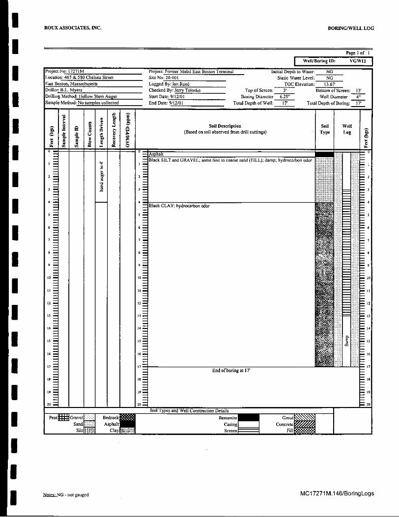
Well/Boring ID: VGWII
ProjectNo: 17271M Project: Former Mobil East Boston Terminal Initial Depth to Water: NGLocation: 467 & 580 Chelsea Street Site No: 20-001 Static Water Level: NGEast Boston, Massachusetts Logged By: Ian Reed TOC Elevation: 13.67Driller: B.L. Myers Checked By: Jerry Tolosko Top of Screen: 3' Bottom of Screen: 13'Drilling Method: Hollow Stem Auger Stan Date: 9/12/01 Boring Diameter 6.25" Well Diameter 4"Sample Method: No samples collected End Date: 9/12/01 Total Depth of Well: 17' Total Depth of Boring: 17
7;
2 Soil Description Soil WellI i0, 0 . e (Based on soil observed from drill cuttings) Type Log a
I *- AsphaltN" t Black SILT and GRAVEL; some fine to coarse sand (FILL); damp; hydrocarbon odor
2 2 2
44Black CLAY; hydrocarbon odor
Itl - 1 -= - 11: i-
13 I3 - . 13
14 t4 "- mi; 14
15 15 5 --
717
17 t7 ,End of boring at 17'
9 9 9
20 I zo 2o
Soil Types and Well Construction Details
to Bedrock BentoniteGrou
12 2 E
13 13B
14 141
Sand Asphalt of borCasing at 'Concrete
Silt Clay 9 9Screen
20 1:i 120
IolTpsadWl Cntuto eal
MC17271M.146/BoringLogsNote, G - not gauged

S ROUX ASSOCIATES, INC. BORING/WELL LOG
I Page 1 of I
Well/Boring ID: VI2
I Project No: 17271M Project: Former Mobil East Boston Terminal Initial Depth to Water: 4'Location: 467 & 580 Chelsea Street Site No: 20-001 Static Water Level: NGEast Boston, Massachusetts Logged By: Ian Reed TOC Elevation: 13.99'Driller: B.L. Myers Checked By: Jerry Tolosko Top of Screen: 3' Bottom of Screen: 13'Drilling Method: Hollow Stem Auger Start Date: 9/10/01 Boring Diameter 6.25" Well Diameter 4'"
Sample Method: No samples collected End Date: 9/10/01 Total Depth of Well: 13' Total Depth of Boring: 14'
S I Soil Description Soil Well- (Based on soil observed from drill cuttings) Type Log
S NE
- Asphalt1 Brown silty SAND; little gravel up to 0.5" diameter; trace debris (bricks); hydrocarbono odor
f l Trace clay at 2' bgs
3 3
-Staining and hydrocarbon odor at 3.5'bgs; wet at 4'bgs4- 4
Dark gray to black silt; trace fine sand; trace gravel to 0.5" diameter; wet
5 -
- 6-6
| "-7 7 7
I II ---- =Is 9to 10
=t II12 12 12
13 13 13
14 14
S - End of boring at 14'
16 16 16
Is -- isL9 9 19
P Soil Types and Well Construction Details
S Bedrock Bentonite Grout
N2_20Sand Asphalt Casing Concrete
Silt Clay Screen Fill
NML.sLNG - not gauged MC17271 M.146/BoringLogs

ROUX ASSOCIATES, INC. BORING/WELL LOG
I Page I of I
Well/Boring ID: VI3
I Project No: 17271M Project: Former Mobil East Boston Terminal Initial Depth to Water: 3.5'
Location: 467 & 580 Chelsea Street Site No: 20-001 Static Water Level: NGEast Boston, Massachusetts Logged By: lan Reed TOC Elevation: 14.05'Driller: B.L. Myers Checked By: Jerry Tolosko Top of Screen: 3' Bottom of Screen: 13'Drilling Method: Hollow Stem Auger Start Date: 9/18/01 Boring Diameter 6.25" Well Diameter 4"
Sample Method: 2' Split Spoon End Date: 9/18/01 Total Depth of Well: 17' Total Depth of Boring: 17'
Soil Well
Soil DescriptionType Log
S Asphalt
0 Silty fine to coarse SAND; hydrocarbon odor (creosote/MGP); wet at 3.5'
2 2 2
1 3
I 4 45 5-I- - - 5
Gray gravelly SILT, some Clay, little fine to coarse Sand; wet; hydrocarbon odor
i 6 F. 2' 0.5" 390 -
7 -7 7
9 9- 9
0 0 -?
10
I_ I I
t2 12 12
1I-
14 Z4 14
16 6 -
1 7 End ofboring at 17T
is - S 18
19 - 19 - " 9
20 2 - 20
Soil Types and Well Construction DetailsPeat= Gravel' Bedrock Bentonite Grout
Sand Asphalt Casing ConcreteSilt Clay Screen7 Fill
Ntes=NG - not gauged MC17271 M.146/BoringLogs
ROUX ASSOCIATES, INC. BORING/WELL LOG
Page I of I
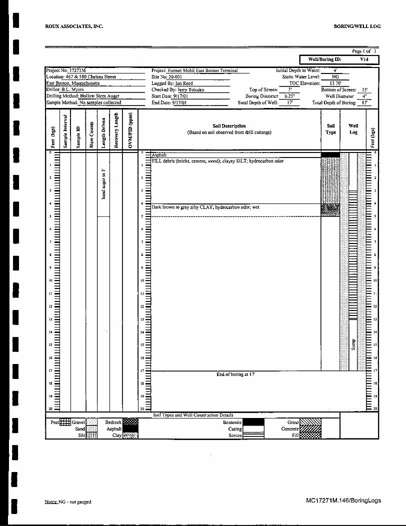
Well/Boring ID: V14
Project No: 17271M Project: Former Mobil East Boston Terminal Initial Depth to Water: 4'Location: 467 & 580 Chelsea Street Site No: 20-001 Static Water Level: NGEast Boston, Massachusetts Logged By: lan Reed TOC Elevation: 13.70'Driller: B.L. Myers Checked By: Jerry Tolosko Top of Screen: 3' Bottom of Screen: 13'Drilling Method: Hollow Stem Auger Start Date: 9/17/01 Boring Diameter 6.25" Well Diameter 4'Sample Method: No samples collected End Date: 9/17/01 Total Depth of Well: 17' Total Depth of Boring: IT
(ae Soil Description Soil Well(Based on soil observed from drill cuttings) Type Log
E E ZCtC
0>S- Asp halt
SFILL debris (bricks, cement, wood); clayey SILT; hydrocarbon odor
atl22
3 3 3
4 4SDark brown to gray silty CLAY; hydrocarbon odor; wet
5 6
7 7 7
9 8
9 9 -9
to o10 = 10
It II
12 12 12
13 13 "3
14 14 .. 14
16 16 . m 16
17 717End of boring at 17'
is 18 8-
S19 "29
20 2o 20Soil Types and Well Construction Details
Peat Grvel Bedrock Bentonite Grnt
Sand Asphalt Casing Concrete
Silq Clay ScreenrFill
NbotezNG - not gauged MC17271 M.146/BoringLogs

I ROUX ASSOCIATES, INC. BORING/WELL LOG
I Page I of I
Well/Boring ID: V1I
Project No: 17271M Project: Former Mobil East Boston Terminal Initial Depth to Water: 4'
Location: 467 & 580 Chelsea Street Site No: 20-001 Static Water Level: NGEast Boston, Massachusetts Logged By: Ian Reed TOC Elevation: 13.78'Driller: B.L. Myers Checked By: Jerry Tolosko Top of Screen: 3' Bottom of Screen: 13'Drilling Method: Hollow Stem Anger Start Date: 9/14/01 Boring Diameter 6.25" Well Diameter 4'"
Sample Method: No samples collected End Date: 9/14/01 Total Depth of Well: 17' Total Depth of Boring: 17'
P 0.
Ias a
4 f a Soil Description Type Log
- 2 E
* -- Asphalt -
SFILL (debris, wood, brick); wet at 4', water is heavily stained with product;hydrocarbon odor|0I 2 2 2
2¢ 3
---------- ----------------------- ------------- - --- -4
No soil samples collected for soil description
S6
6
99 9
I 102 12 12
13 13B
14 14 . . 1
I16 -16 117I End of boring at 17Is u s 18
19 19 1 9
20 1 120L 20
Soil Types and Well Construction Details
Peat Gravel Bedrock Bentonite GrouSand Asphalt Casing Concrete
Siftw Clay" Screenn FilIN
MC17271 M.146/Boring LogsNQeusNG - not gauged

ROUX ASSOCIATES, INC. BORING/WELL LOG
Page I of I
Well/Boring ID: VGW16
Project No: 17271 IM Project: Former Mobil East Boston Terminal Initial Depth to Water: 3.5'Location: 467 & 580 Chelsea Street Site No: 20-001 Static Water Level: NGEast Boston, Massachusetts Logged By: lan Reed TOC Elevation: 14.81'Driller: B.L. Myers Checked By: Jerry Tolosko Top of Screen: 3' Bottom of Screen: 13'Drilling Method: Hollow Stem Auger Start Date: 9/14/01 Boring Diameter 6.25" Well Diameter 4'"Sample Method: No samples collected End Date: 9/14/01 Total Depth of Well: 17' Total Depth of Boring: 17'
_ c., Soil Description Soil WellS, (Based on soil observed from drill cuttings) Type Log
t. ri . oo~
- - Asphalt -
FILL (silt, gravel, bricks, wood); wet at 3.5'
3 3
2 0.6 2= - 2
4 4- 4Light gray to brown clayey SILT; trace gravel; wet -
5 55 -
10 - to
12 12 12
13 13 13
[4 14- 4
I5 Is I
1. 16 is 1
17 -7End of boring at 17'
Is I1 Is
19 I12
20 -20" "20
Soil Types and Well Construction Details
Peat Gravel . Bedrockll Bentoniete Grout
Sand AsphalI Casing ConcreteSilt Clay ScreenFl
NnteszNG - not gauged MC17271 M.146/BoringLogs
S ROUX ASSOCIATES, INC. BORING/WELL LOG
I Page I of I
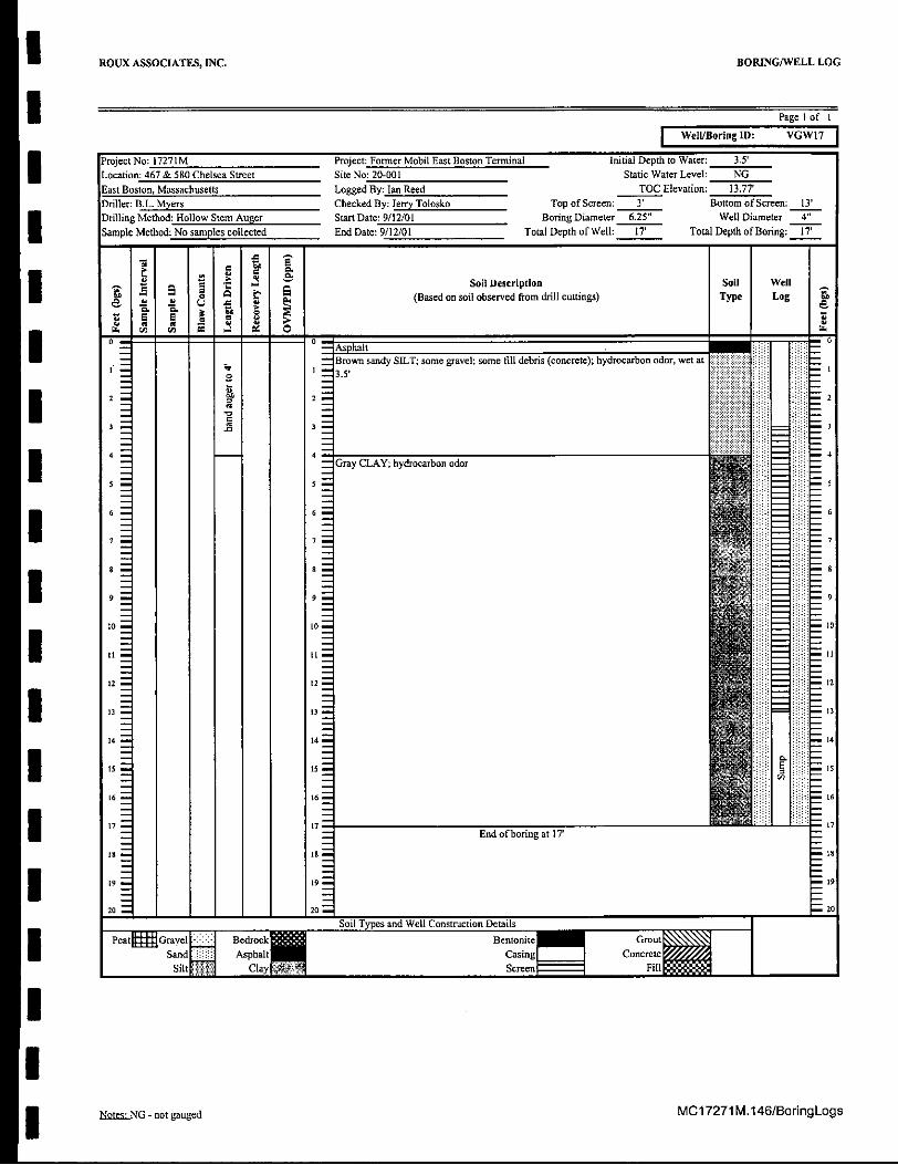
Well/Boring ID: VGW7
Project No: 17271M Project: Former Mobil East Boston Terminal Initial Depth to Water: 3.5'
Location: 467 & 580 Chelsea Street Site No: 20-001 Static Water Level: NGEast Boston, Massachusetts Logged By: Jan Reed TOC Elevation: 13.77'Driller: B.L. Myers Checked By: Jerry Tolosko Top of Screen: 3' Bottom of Screen: 13'Drilling Method: Hollow Stem Auger Start Date: 9/12/01 Boring Diameter 6.25" Well Diameter 4"
Sample Method: No samples collected End Date: 9/12/01 Total Depth of Well: 17' Total Depth of Boring: 17'
Soil Description Sol] Wellel (Based on soil observed from drill cuttings) Type Log
I -Asphalt
Brown sandy SILT; some gravel; some fill debris (concrete); hydrocarbon odor, wet ato 3.5'
2 2
3 3 --.. 3
444
Gray CLAY; hydrocarbon odor
U: 6
S to 0
101I1 II mI
12 12 12
I314 14 14
is1 16 16
I 7 End of boring at 177
19 9
20 o20
Soil Types and Well Construction Details
Peatl Grarl Bedrock Bentoite GFillSaid Asphalt Casing Coet
Silt Clay ScreenFl
MC17271 M.146/BoringLogsNeatS.NG - not gauged
ROUX ASSOCIATES, INC. BORING/WELL LOG
Page 1 of I
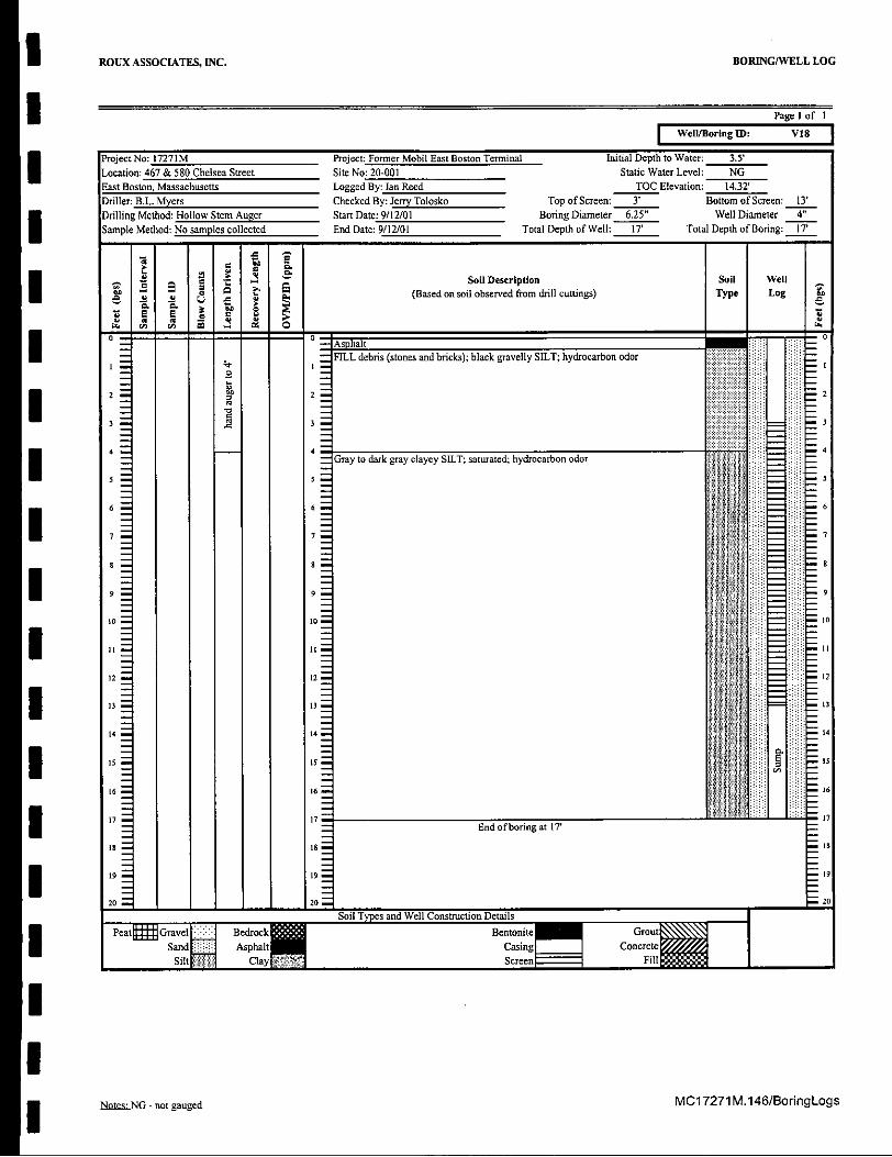
Well/Boring ID: V18
Project No: 17271M Project: Former Mobil East Boston Terminal Initial Depth to Water: 3.5'Location: 467 & 580 Chelsea Street Site No: 20-001 Static Water Level: NGEast Boston, Massachusetts Logged By: lan Reed TOC Elevation: 14.32'Driller: B.L. Myers Checked By: Jerry Tolosko Top of Screen: 3' Bottom of Screen: 13'
Drilling Method: Hollow Stem Auger Start Date: 9/12/01 Boring Diameter 6.25" Well Diameter 4"Sample Method: No samples collected End Date: 9/12/01 Total Depth of Well: 17' Total Depth of Boring: 17'
Va2 Soil Description Soil Well
0 t (Based on soil observed from drill cuttings) Type Log
1
- - Asphalt MFILL debris (stones and bricks); black gravelly SILT; hydrocarbon odor
2 2 2
3 3
4 44Gray to dark gray clayey SILT; saturated; hydrocarbon odor
15 -5 3 I20 10
12 12 1
13 13U
14 14 q
Soil Types and Well Construction Details
6 6 o6
17 17 1
Peat= Gravel Bedrock Bentonite Grot
Sand Asphalt Casing ConcreteSEWt Clay RScreen Fil
MC17271 M.146/BoringLogsNotes NG - not gauged

ROUX ASSOCIATES, INC.
Page I of I
Well/Boring ID: V19
Project No: 17271M Project: Former Mobil East Boston Terminal Initial Depth to Water: 3.5'Location: 467 & 580 Chelsea Street Site No: 20-001 Static Water Level: NGEast Boston, Massachusetts Logged By: Ian Reed TOC Elevation: 14.14'Driller: B.L. Myers Checked By: Jerry Tolosko Top of Screen: 3' Bottom of Screen: 13'Drilling Method: Hollow Stem Auger Start Date: 9/17/01 Boring Diameter 6.25" Well Diameter 4"Sample Method: No samples collected End Date: 9/17/01 Total Depth of Well: 17 Total Depth of Boring: 17
SSoil well" 5 == ' e. A Soil Description SoilType Log
-= ..So..Dscrpton.oi Wel0 . 0
- -o ' -iAsphalt.
Silty fine to coarse SAND; hydrocarbon odor (creosote/MGP); wet at 3.5'
2 2
3 33
4 4 4
S-------------------o soil samples collected for soil description--
End of boring at 17'
Soil Types and Well Construction DetailsPeat Gravel Bedrock Bentonite
Sand Asphalt CasingSilt Clay Screen
MC17271 M.146/BoringLogsNDlelNG - not gauged
BORING/WELL LOG
ROUX ASSOCIATES, INC. BORING/WELL LOG
I Page 1 of I
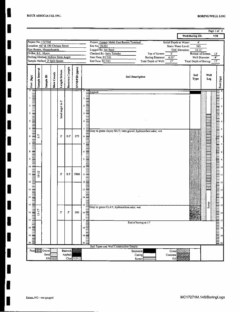
Well/Boring : V20
Project No: 17271M Project: Former Mobil East Boston Terminal Initial Depth to Water: 4'Location: 467 & 580 Chelsea Street Site No: 20-001 Static Water Level: NGEast Boston, Massachusetts Logged By: lan Reed TOC Elevation: 14.11'Driller: B.L. Myers Checked By: Jerry Tolosko Top of Screen: 3' Bottom of Screen: 13'Drilling Method: Hollow Stem Auger Start Date: 9/17/01 Boring Diameter 6.25" Well Diameter 4"Sample Method: 2' Split Spoon End Date: 9/17/01 Total Depth of Well: 17' Total Depth of Boring: 17'
Ii Soil Description Sil Well
jType Log
o- Asphalt -E- 2
100
2
2
14 4 4
E -5
t4 104 10
IIL4 14 -- 14
I5 15 ------ -S5 -------------------------* a ' 2 20 Gray to green CLAY; hydrocarbon odor; wet
16 2' 2' 200 6 -i - 16
End of boring at 17'
o l- - 8
99 20
I0 920 1 20 - 20
Soil Types and Well Construction DetailsPeat= Gravel Bedrock' M Bentonite Grant
Sand Asphalt Casing CocCreteSilt Clay- Sereen IN Ii.
MC17271 M.146/BoringLogsNotes- NG - not gauged

ROUX ASSOCIATES, INC. BORING/WELL LOG
I Page 1 of I
Well/Boring ID: V21
Project No: 17271M Project: Former Mobil East Boston Terminal Initial Depth to Water: 4'Location: 467 & 580 Chelsea Street Site No: 20-001 Static Water Level: NGEast Boston, Massachusetts Logged By: lan Reed TOC Elevation: 14.17'Driller: B.L. Myers Checked By: Jerry Tolosko Top of Screen: 3' Bottom of Screen: 13'Drilling Method: Hollow Stem Auger Start Date: 9/14/01 Boring Diameter 6.25" Well Diameter 4'"Sample Method: No samples collected End Date: 9/14/01 Total Depth of Well: 17' Total Depth of Boring: 17
Asp altSoil D escription Soil W ell(Based on soil observed from drill cuttings) Type Log a
-- ,AsphaltFILL (debris, wood, gravel); wet at 4'
12 12 - 2
30
4 4 - 4------------------------------4
S5 15
6 6.16
I 17
17 17 End of boring at IT7'
9 1-
99
20 ""20 "" 20
Soil Types and Well Construction Details
Peat to Bentonite
12 12 1
13 13 3
14 141
L6 161
I End of boring at 17'
19 99
20 1 20
Sand Asphalt Casig ConcreteSilt Clayp Screen Fill
MC17271 M.146/BoringLogsNotes..NG - not gauged

ROUX ASSOCIATES, INC. BORING/WELL LOG
SPage 1 of I
Well/Boring ID: VGW22
Project No: 17271M Project: Former Mobil East Boston Terminal Initial Depth to Water: 4'Location: 467 & 580 Chelsea Street Site No: 20-001 Static Water Level: NGEast Boston, Massachusetts Logged By: lan Reed TOC Elevation: 1419Driller: B.L. Myers Checked By: Jerry Tolosko Top of Screen: 3' Bottom of Screen: 13'Drilling Method: Hollow Stem Auger Start Date: 9/18/01 Boring Diameter 6.25" Well Diameter 4"Sample Method: No samples collected End Date: 9/18/01 Total Depth of Well: 14' Total Depth of Boring: 14'
siI Soil Description Soil Well. (Based on soil observed from drill cuttings) Type Log
- 'A sphalt
Gravel and silt; some debris (wood); wet at 4'
Hydrocarbon odor
7 7 7I -
I-I,
2 12 -12
144 4
Auger refusal at 14'Iis- End of boring at 14'
I s 16 ,16
17 17 17
is Is Is,
I1 19
4 20
Soil Types and Well Construction DetailsPIa GvA Bedrock Bentonite Grout
Sand AsphaltCasing ConcreteSilt Clay Screen Fill
MC17271 M.146/BoringLogsNatei.NG - not gauged

I I ROUX ASSOCIATES, INC. BORING/WELL LOG
Page 1 of I
Well/Boring ID: V23
MC17271 M.146/BoringLogsNotes.NG - not gauged

I ROUX ASSOCIATES, INC. BORING/WELL LOG
I Page I of I
Well/Boring ID: VGW24
Project No: 17271M Project: Former Mobil East Boston Terminal Initial Depth to Water: NG
Location: 467 & 580 Chelsea Street Site No: 20-001 Static Water Level: NGEast Boston, Massachusetts Logged By: tan Reed TOC Elevation: 14.49'Driller: B.L. Myers Checked By: Jerry Tolosko Top of Screen: 3' Bottom of Screen: 13'Drilling Method: Hollow Stem Auger Start Date: 9/12/01 Boring Diameter 6.25" Well Diameter 4"
Sample Method: No samples collected End Date: 9/12/01 Total Depth of Well: 17' Total Depth of Boring: I1
I~ ~ s so .Soil Well
SSoil Description Type Log
I _-- Asphalt -I-No soil samples collected for soil description
12 02 2
3 . 3
I 4 45
6 66
I 77
| -
9 9-
iis s - is
17 7 P
Is 18 IS
20 20 20
Soil Types and Well Construction DetailsPeat= Graemerc Bentonite Grout
Sand AsphalI Casing Concrete
it Clay Sc II End of boring at 17'
IIt Betoit
Sad2asn 9onre9
Silt creenFi20
Nkhsd NG - not gauged MC17271 M.146/BoringLogs

ROUX ASSOCIATES, INC.
Page 1 of I
Well/Boring ID: V25
Project No: 17271MLocation: 467 & 580 Chelsea StreetEast Boston, MassachusettsDriller: B.L. MyersDrilling Method: Hollow Stem AugerSample Method: No samples collected
Project: Former Mobil East Boston TerminalSite No: 20-001Logged By: Ian ReedChecked By: Jerry Tolosko TStart Date: 9/12/01 BomEnd Date: 9/12/01 Total D
Initial Depth to Water: NGStatic Water Level: NG
TOC Elevation: 15.01'op of Screen: 3' Bottom of Screen: 13'ring Diameter 6.25" Well Diameter 4"epth of Well: 13' Total Depth of Boring: 13'
. " Soil Description-o 0(Based on soil observed from drill cuttings)
0 -sphalt
Black MGP product layer at 7' bgs
End of boring at 13'
Soil types and Well Construction DetailsPeat Gravel Bedrock Bentonite
Sand Asphalt CasingSilt Clay Screen
MC17271 M.146/BoringLogs
BORING/WELL LOG
Note NG - not gauged

ROUX ASSOCIATES, INC. BORING/WELL LOG
Page 1 of I
Well/Boring ID: V26
Project No: 17271M Project: Former Mobil East Boston Terminal Initial Depth to Water: 4'
Location: 467 & 580 Chelsea Street Site No: 20-001 Static Water Level: NGEast Boston, Massachusetts Logged By: Ian Reed TOC Elevation: 14.73'Driller: B.L. Myers Checked By: Jerry Tolosko Top of Screen: 3' Bottom of Screen: 13'Drilling Method: Hollow Stem Auger Start Date: 9/11/01 Boring Diameter 6.25" Well Diameter 4'
Sample Method: No samples collected End Date: 9/11/01 Total Depth of Well: 13' Total Depth of Boring: 13
- Soil Description Soil WellI (Based on soil observed fromn drill cuttings) Type Log
- a 7 a
-- -- - Asphalt
Thick black SILT, like tar, heavily stained, hydrocarbon odorI02 2
2
Black clayey SILT; some gravel; wet; hydrocarbon odor
U: 6 6
7- 77
10 1tO 10I 9
L2 12 12
I 13 End of boring at 13'
14 14 14
is Is i
6 6
6IS t6 -17 - 7 17
to 18 -
3 t9 19 9
I _-2 20 0
Soil Types and Well Construction Details
Peat Gravel Bedrock Bentonite GroutSand Asphalt Casing Concrete
Siltm Clay ScreenI Fillm
MC17271M.146/BoringLogsNotes.NG - not gauged

I ROUX ASSOCIATES, INC. BORING/WELL LOG
Page 1 of I
Well/Boring ID: V27
Project No: 17271M Project: Former Mobil East Boston Terminal Initial Depth to Water: 4'Location: 467 & 580 Chelsea Street Site No: 20-001 Static Water Level: NGEast Boston, Massachusetts Logged By: Ian Reed TOC Elevation: 14.53'Driller: B.L. Myers Checked By: Jerry Tolosko Top of Screen: 3' Bottom of Screen: 13'Drilling Method: Hollow Stem Auger Start Date: 9/11/01 Boring Diameter 6.25" Well Diameter 4'"
Sample Method: No samples collected End Date: 9/11/01 Total Depth of Well: 13' Total Depth of Boring: 13'
SSoil Description Soil Well(Based on soil observed from drill cuttings)Type Log
- -- Asphalt- 1 Black silty gravel (FILL); hydrocarbon odor
C1
2 2 2I 80
Thick black SILT, like tar; heavily stained; hydrocarbon odor
4- 4Black clayey SILT; some gravel; wet; hydrocarbon odor
U: 5
1 6 6 -6
7
a o
I 9
L2 L 2 l'2
End of boring at 13'
14 14 4
I Is16 L16 1t
17 17 17
is La 19
20 L 20Soil Types and Well Construction Details1Peatt Gravel Bedrock" Bentonit GroutSand Asphalt Casing ConcreteSiltN Clay ,Screenr l Filli
MC17271 M.146/BoringLogsNate.o-NG - not gauged
I ROUX ASSOCIATES, INC. BORING/WELL LOG
I Page I of I
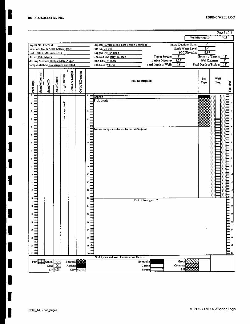
Well/Boring ID: V28
MC17271 M.146/BoringLogsNine: NG - not gauged

SROUX ASSOCIATES, INC. BORING/WELL LOG
I Page 1 of I
Well/Boring ID: VGW29
Project No: 17271M Project: Former Mobil East Boston Terminal Initial Depth to Water: 3.5'Location: 467 & 580 Chelsea Street Site No: 20-001 Static Water Level: NGEast Boston, Massachusetts Logged By: lan Reed TOC Elevation: 1550Driller: B.L. Myers Checked By: Jerry Tolosko Top of Screen: 3' Bottom of Screen: 13'Drilling Method: Hollow Stem Auger Start Date: 9/12101 Boring Diameter 6.25" Well Diameter 4"Sample Method: 2' Split Spoon End Date: 9/12/01 Total Depth of Well: 17 Total Depth of Boring:
Sol DescriptionS _ .: e Type Log a
- - Asphalt -1 1 FILL debris; some gravel; wet at 3.5'D Wl
2 2 2
3 : 3
I 4 4 4
5 5 5
6 2' 0.0' NA 6 : 6
. Gray clayey SILT; little gravel moist, hydrocarbon odor
19 90
to to - -- ... to
- 2' 2' 260 II i t
12 - -- - 12 - 12
3 13
14 14 14
L5 15 - - is
L6 7 2' 2' 419 16 16
End ofboring at 17'
18 18 18
[9 19 19
20 20 20Soil Types and Wel Construction DetailsIPeatktGravell BedrockIR Bentonite GroutSand Asphalt Cauing Concrete
Silt Clay Screen HIMl
MC1 7271 M.146/BoringLogsN2[1..NG - not gauged

ROUX ASSOCIATES, INC. BORING/WELL LOG
I Page 1 of I
Well/Boring ID: VGW3O
Project No: 17271M Project: Former Mobil East Boston Terminal Initial Depth to Water: 4'
Location: 467 & 580 Chelsea Street Site No: 20-001 Static Water Level: NGEast Boston, Massachusetts Logged By: Ian Reed TOC Elevation: 14.82Driller: B.L. Myers Checked By: Jerry Tolosko Top of Screen: 3' Bottom of Screen: 13'Drilling Method: Hollow Stem Auger Start Date: 9/12/01 Boring Diameter 6.25" Well Diameter 4"Sample Method: No samples collected End Date: 9/17/01 Total Depth of Well: IT Toal Depth of Boring: 17'
Soil Description Soil Well
S(Based on soil observed from drill cuttings) Type Log
o - Asphalt10 FILL debris (bricks); dark brown SILT; some clay, wet at 4'
2 2I : 26 2
4 4Dark brown clayey SILT; trace gravel, hydrocarbon odor
6 6I 7 Y 6
la 8 8
10 -0 to
Is12 z- 12
3 13
14 14
15 - 15 15
16 16
I S7End of boring at 17'
19 19 19
20 220
Soil Types and Well Construction DetailsPeatk Gmvel Bedrock Bentonite Grout
Sand Asphalt Casing ConcreteSilt' Clay P Screen Fill
bte.NG - not gauged MC17271M.146/BoringLogs
ROUX ASSOCIATES, INC. BORING/WELL LOG
Page 1 of I
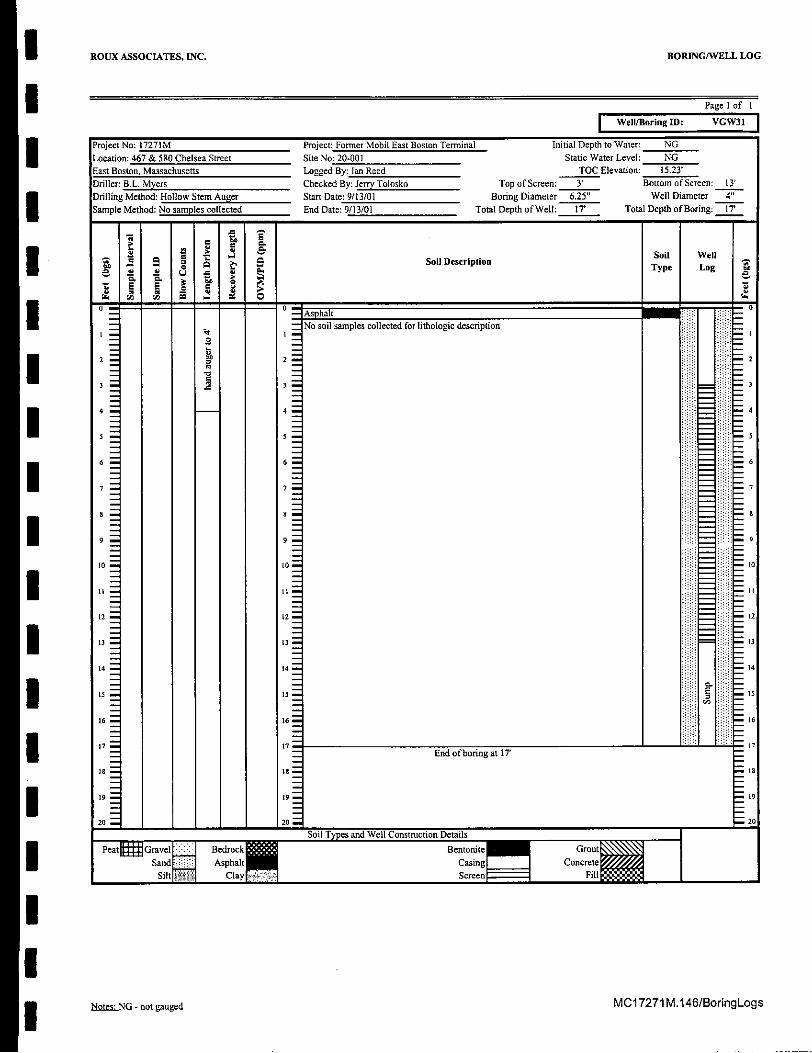
Well/Boring ID: VGW31
Project No: 17271MLocation: 467 & 580 Chelsea StreetEast Boston, MassachusettsDriller: B.L. MyersDrilling Method: Hollow Stem AugerSample Method: No samples collected
Project: Former Mobil East Boston Terminal Initial Depth to Water: NGSite No: 20-001 Static Water Level: NGLogged By: Ian Reed TOC Elevation: 15.23'Checked By: Jerry Tolosko Top of Screen: 3' Bottom of Screen: 13'Start Date: 9/13/01 Boring Diameter 6.25" Well Diameter 4"End Date: 9/13/01 Total Depth of Well: 17' Total Depth of Boring: 17'
I 8 I S Soil Description
N . . . f -o -_ Asphalt| |I1 | |1| No soil samples collected for lithologic description
End of boring at 17'
Soil Types and Well Construction Details
Peat Gravel K Bedrock" BentoniteSand Asphalt Casing
Silt Clay Screen
MC17271 M.146/BoringLogsNotes NG - not gauged
m

APPENDIX C
Hazardous Waste Manifest
ROUX ASSOCIATES, INC. MC17271M.146(APP

U NEW MAMninS unran I ma.c. I sr aSn V I *.---I-" -WASTE MANAGEMENT DIVISION
Health and Human Services Building6 Hazen Drive, Concord, NH 03301,6509
603-271.2921 2 - :FOR STATE USE ONLY
Please print or type. (Form designed for use on elite (12.pitch) typewriter. - Form Approved OMB No. 2050-0039
mUNIFORM HAZARDOUS 1. Generator's US EPA ID No. Manifest 2. Page 1 Information in the shaded areas=-t I b a o e re ir ed by tte l aw.
WASTE MANIFEST Ab 5. .7.7. of - may a requre y t awt
. Generator's I, qlid MIling Address . - . .
4. Generator's Phone ( EO/ ") 't -r..
5. Transpo er 1 mpany Name 6. - USEPAID umber
7 Translortr mS+an e NNubee . b EA -I 67Transnnrtar 9Cnmnanv Name 8. US EPA ID Number "0
9. Des iatqd Facility Name and Site Address
11.U D Dsitn7 AluPr11. USDO rt (" i P n
1.US DOT Description (Including Proper Shipping Name,
a. -, T -- - i( ,,- r a' z
10. US EPAID Number
12- ContiHazard Class, and ID Manlumer)
S : No.IAJ'k M5t
b. ?
C.
d.
tion and Additional Information
1
6 77bra7 ... tf
All.______________
IN wt~ ~pttc~)~-v
16. GENERATOR'S CERTIFICATION: I hereby declare that the contents of this conscrment are fully and accurately described above by proper shipping name
and are classified, packed, marked, and labeled, and are in all respects in pro condition for transport by highway according to applicable international
and national government regulations.If I ama large quantity generator, I certify that I have a program in place to reducerevolume and toxicity of waste generated to the degree I have determined to
be economically practicable and that I have selected the practicable method of tnment. storage, or disposal currently available to me which minimizes the
present and future threat to human health and the environment; OR, if I am a srraquantity generator I have made od faith imize my waste
generation and select the best waste management method that is available to merrard that I can a,wt~r, iJ Y '
P&ed yped Namp m , r
T17. Transporter 1 Acknowledgement of Receipt of Materialsr
T 18. Transporter 2 Acknowledgement of Receipt of MaterialsA P ~kd/Typed Name - t a~~~MnhDy Ya
o1. Trnpre cnwegmnt of Receipt of Materials
S Printed/Typed Name -Signatt r ,Month Day YearEP
S19. Dis... y .ctio
F CA
20. Facili Owner r Oe mCertific on of re ipt of hazardou r rials this manifest except as no in Item 1
NP e ype Name ign "-nt Ye
EPA Form 8700-22 (Rev. 9-88) Previous Editions are Obsolete " - "
COPY NRATOR COMPETEDCOPY
Signalr o


