Embed Size (px)
Citation preview

Form OGC-la SUBMIT IN TRIPLICATE*
STATE OF UTAH (Other instructions on
DEPARTMENT OF NATURAL RESOURCESreverse side)
DIVISION OF OIL, GAS, AND MINING 5. Lease Designation and Serial No.
FeeAPPLICATIONFOR PERMIT TO DRILL, DEEPEN, OR PLUG BACK G. If Indian, Allottee or Tribe Name
la. Type of Work7. Unit Agreement NameDRILLR DEEPEN PLUG BACK O
b. Type of WellOil Gas Single Multiple 8. Farm or Lease Name
2. Nne of OperatorWell Other Zone Zone Champlin 458 Amoco "G"
AMDCOPRODUCTIONCOMPANY 9. Well No.
3. Address of Operator
P.O. Box 17675 Salt Lake City, Utah 84117 *° "" ""4. Location of Well (Report location clearly and in accordance with any State requirements.*)
At surface
1¾ FSL & FEL NW/4 SE/4 " aiÎ'si:ve",'oa
At proposed po neBHL: 500' FSL & 500' FEL Sec. 17, TAN, RSE
14. Distance in mîles and direction from nearest town or post offîce* 12. County or Parrish 13. State
Surmit Utah15. Distance from proDosed* 16. No. of acres in lease 17. No. of acres assigned
location to nearest to this wellproperty or lease line, ft,(Also to nearest drlg. line, if any)
18. Distance from proposed location* 19. Proposed depth 20. Rotary or cable toolsto nearest well, drilling, completed,or applied for, on this lease, ft 13, 850 ' Rotary
21. Elevations (Show whether DF, RT, GR, etc.) 22. Approx, date work will start*
7377 . 5 ' GR When Approved23.
PROPOSED CASING AND CEMENTING PROGRAM
Size of Hole Size of Casing Weight ver Foot Setting Depth . . . .Qyantity of Cement
17 1/2" 13 3/8" 54.5# - 61# 3000 ' Ciculated12 1/4" 9 5/8" 40#-53.5# 11,500' Cement across salt8 1/2" 7" 23#-26# 13,850' Cement across all pay and
salt.
PROPOSETO DEVELDPNUGGETHYDROCARBONRESERË(See Attachments)
(Well to be drilled in accordance with the Order issued in CauseNo. 183-2, dated 4/22/80; surface location selected due to terrain& surface owner requirements)
IN ABOVE SPACE DESCRIBE PROPOSED PROGRAM: If proposal is to deeven or plug back, give data on present productive zone and proposed new pro-ductive zone. If proposal is to drill or deepen directionally, give pertinent data on subsurface locations and roeasured and true vertical depths. Give blowoutpreventer ro y.
Districtswasa. ,Administratiye...Supervisor nat. June...12.,....1981(This e Federal or State office use)
APPROVER..BY THE STATEPermit No. Avoroval Date ....UTAH DIViŠiON OF
Approved hy -......... ....---- 01 GA «ANDMININGConditions of approval, if any:
BY:*See Instructions On Reverse
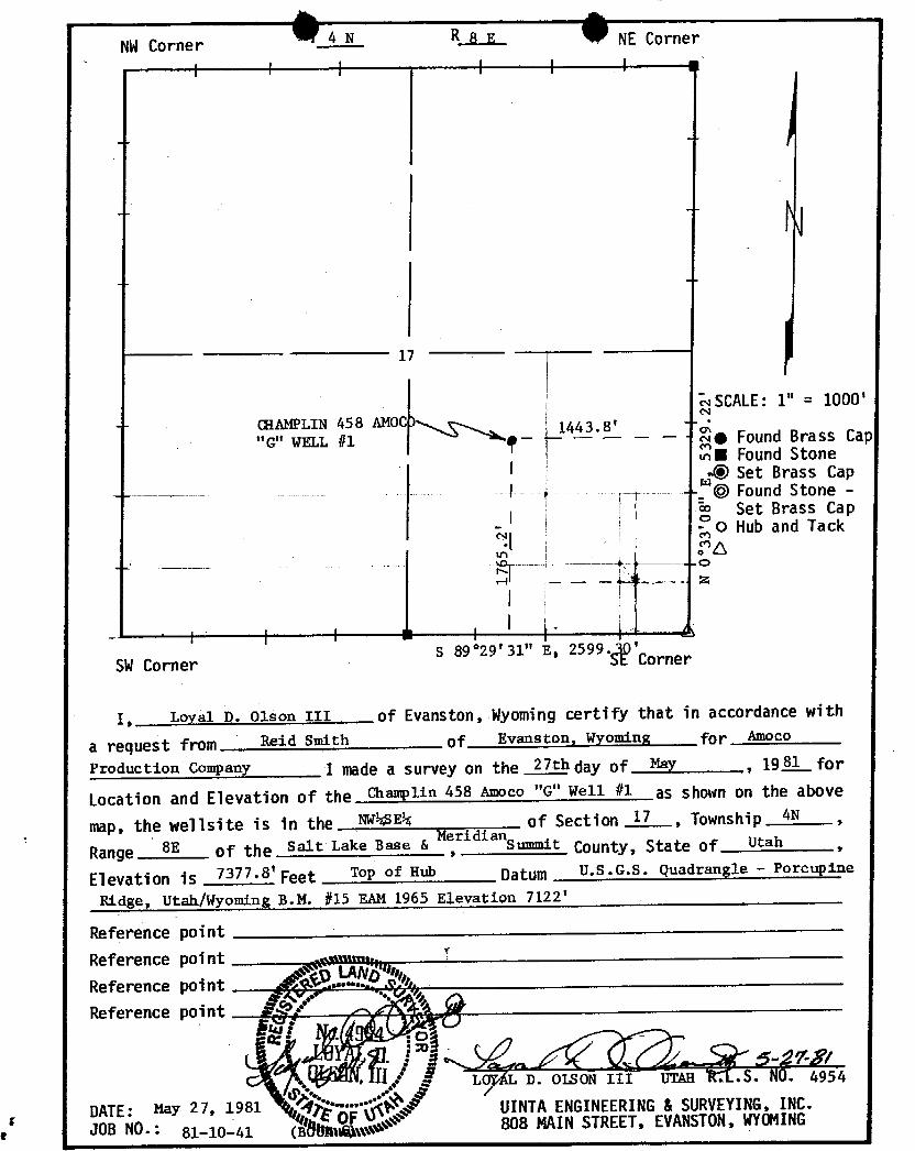
NWCorner 4 N R 8 E NE Corner
I l I l I I i
------ 17
SCALE: 1" = 1000
"GN 4518 AMOC) 4 .8' e Found Brass Cap
II Found Stone49 Set Brass Cap
- © Found Stone -
Set Brass Capo Hub and Tack
SW Corners 89°29'31" E, 2599. D'Corner
I, Loyal D. Olson III of Evanston, Wyoming certif.y that in accordance with
a request from Reid smith of Evaaston, Wyoming for Amoco
Production Company I made a survey on the 27th day of May,
19.81 for
Location and Elevation of the Champlin 458 Amoco "G" Well #1 as shown on the above
rap, the we11site is in the NV4SES of Section 17, Township 4N
Range 8E of the salt Lake Base &MeridianSummit
C0unty, State of Utah
Elevation is 7377•S'Feet Top of Hub Datum U.S.G.S. Quadrangle - Porcupine
Ridge, Utak/Wyoming B.M. #15 EÄM 1965 Elevation 7122'
Reference pointReference point pannu '
Reference point .• •.
Reference point P
LGyAL D. OLSON III UTaa . .S. NO. 4954
DATE: May 27, 1981 "" UINTAENGINEERING& SURVEYING,INC.JOB NO.: 81-10-41 (
O 808 MAINSTREET, EVANSTON,
NWCorner 4 N R 8 E NE Corner
I l I l I I i
------ 17
SCALE: 1" = 1000
"GN 4518 AMOC) 4 .8' e Found Brass Cap
II Found Stone49 Set Brass Cap
- © Found Stone -
Set Brass Capo Hub and Tack
SW Corners 89°29'31" E, 2599. D'Corner
I, Loyal D. Olson III of Evanston, Wyoming certif.y that in accordance with
a request from Reid smith of Evaaston, Wyoming for Amoco
Production Company I made a survey on the 27th day of May,
19.81 for
Location and Elevation of the Champlin 458 Amoco "G" Well #1 as shown on the above
rap, the we11site is in the NV4SES of Section 17, Township 4N
Range 8E of the salt Lake Base &MeridianSummit
C0unty, State of Utah
Elevation is 7377•S'Feet Top of Hub Datum U.S.G.S. Quadrangle - Porcupine
Ridge, Utak/Wyoming B.M. #15 EÄM 1965 Elevation 7122'
Reference pointReference point pannu
'
Reference point .• •.
Reference point P
LGyAL D. OLSON III UTaa . .S. NO. 4954
DATE: May 27, 1981 "" UINTAENGINEERING& SURVEYING,INC.JOB NO.: 81-10-41 (
O 808 MAINSTREET, EVANSTON,

© 9ATTAŒMENT II) FORMOGC-la
Champlin 458 Amoco "G" No. 1
1) Geologic name of the surface formation: Tertiary
2) Estimated tops of geological markers:
Frontier 3850 '
Gannett 6850 '
Preuss 9850 '
Salt 10 , 850 '
Twin Creek 11, 350 '
Nugget 12, 850 '
TD 13,850'
3) Estimated depths anticipated to encounter water, oil, gas orother mineral-bearing formations :
See Item #2 Above
4) Casing Program: See Form OGC-la, Item #23
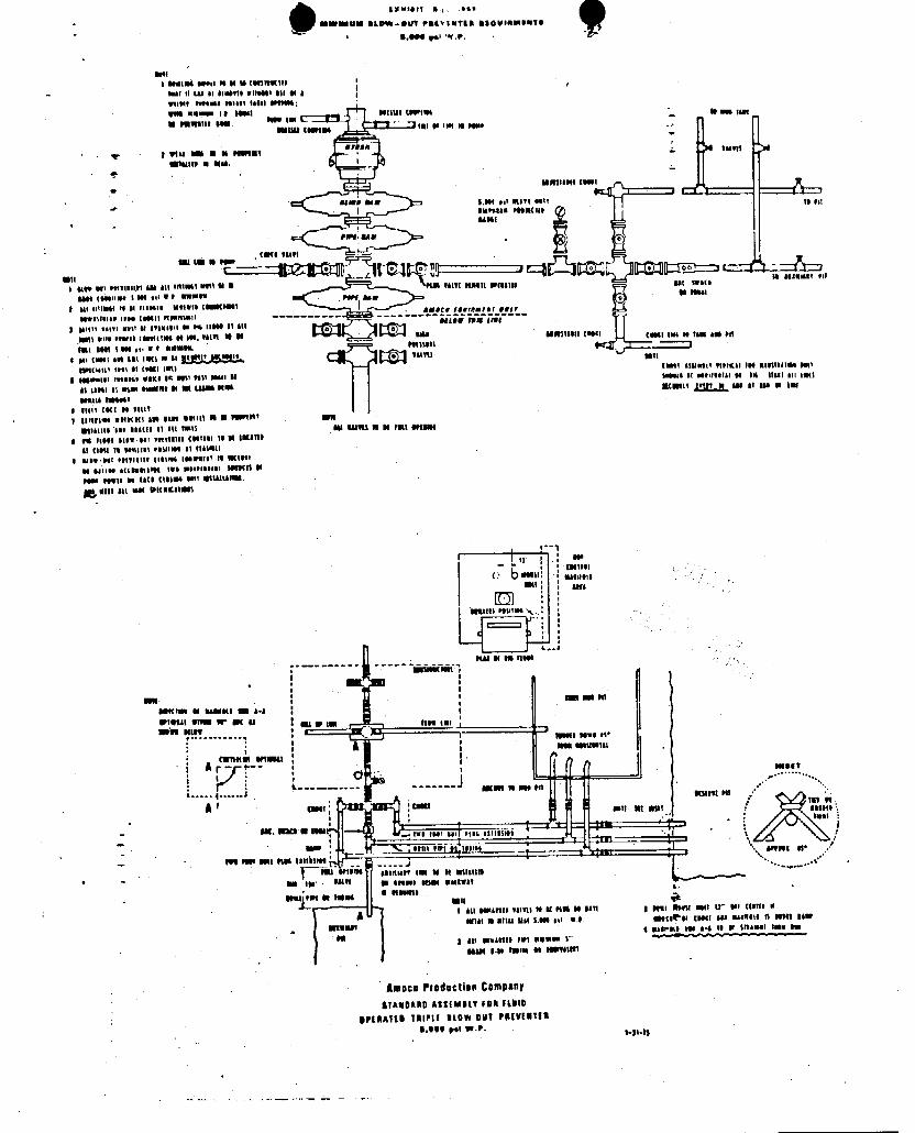
5) Operators minimum specifications for pressure control equipmentare explained on the attached schematic diagram. Testing ofsuch equipment is to be performed daily and noted on the IADCDaily Drilling Report. After running surface casing and priorto drilling out, BGP and other pressure equipment will betested to the full working pressure rating as shown on theattached diagram. Thereafter, the BOP will be checked dailyfor mechanical operations only and will be noted on the IADCDaily Drilling Report .
6) Mud Program:
0 - 3000' Native, 8.3-8.5#/gal., Viscosityas required to clean hole
3000' - 10,850' Low Solid, Non-Dispersed, 8.7-9.5#/gal.
10,850' - 11,500' Salt Mud, 10.1-10.5#/gal., Viscosityas required to clean hole
11,500' - 13,850' Low Solid, Non-Dispersed, 8.7-8.9#/gal.
7) Auxiliary Equipment:
Kelly CocR Sub with full opening valve with remote controlchoke, 3" manifoldMud I.ogger (2-man
© 9ATTAŒMENT II) FORMOGC-la
Champlin 458 Amoco "G" No. 1
1) Geologic name of the surface formation: Tertiary
2) Estimated tops of geological markers:
Frontier 3850 '
Gannett 6850 '
Preuss 9850 '
Salt 10 , 850 '
Twin Creek 11, 350 '
Nugget 12, 850 '
TD 13,850'
3) Estimated depths anticipated to encounter water, oil, gas orother mineral-bearing formations :
See Item #2 Above
4) Casing Program: See Form OGC-la, Item #23
5) Operators minimum specifications for pressure control equipmentare explained on the attached schematic diagram. Testing ofsuch equipment is to be performed daily and noted on the IADCDaily Drilling Report. After running surface casing and priorto drilling out, BGP and other pressure equipment will betested to the full working pressure rating as shown on theattached diagram. Thereafter, the BOP will be checked dailyfor mechanical operations only and will be noted on the IADCDaily Drilling Report .
6) Mud Program:
0 - 3000' Native, 8.3-8.5#/gal., Viscosityas required to clean hole
3000' - 10,850' Low Solid, Non-Dispersed, 8.7-9.5#/gal.
10,850' - 11,500' Salt Mud, 10.1-10.5#/gal., Viscosityas required to clean hole
11,500' - 13,850' Low Solid, Non-Dispersed, 8.7-8.9#/gal.
7) Auxiliary Equipment:
Kelly CocR Sub with full opening valve with remote controlchoke, 3" manifoldMud I.ogger (2-man

Attachment to Form OGC-laChamplin 458 Amoco "G" #1Page Two
8) Testing Program:
Drill Sten Tests to be conducted as determined byDivision office
Coring Program:
None
Logging Program:
BHC-Sonic-GR-CAL Surface to Total DepthDIL-GR Base of Surface Casing to Total DepthDLL-MSFL " " " " "CNL-FDC-CAL-GR " " " " "
FIL " " " " "
HDT-Dipmeter " " " " "
Stimulation Program:
To be determined by District Office upon campletion ofdrilling operations
9) No abnormal pressures, temperatures, or hydrogen sulfide gas isanticipated.
10) Anticipated starting date will be when approved and duration ofoperations will be appraximately 180
gxistSti 5 a **
MWMU- BLOW-StFT PREVIWTER B36UIBMGWTO
9011t MELM 99941 it WM t-IRMHO
IMI 11 (se si $1-0919 witutil til et aTupit tweene solari istti 8919-;With WBul- I t itBI Millit (8091154 gg
i Win im it it Pimt-i 15
StMtN W Mai
i ett est 51471 9517 to 981EMPsiis Pitittlit
i ggga ggt 99tTitum ist BH !!!151 MWilMS 94¾ Tatti MMift Witilli Min giggmat 941
4000 (ettilms i Mt was W 9 NWMSN PSPf Asi Mt entmM to si osasett uttelt temtmit asett iteremier gegr
Ottilitiss inte ( Bill Pititttisti ------ --+------ ------
I Mysti eggri wait at syssetti en 94 IIMI 54 Mi
guen orty peerit toest(tes et ist, tilit W pt mu agmilatti (mos (mit tm as tam agepit
peu seu i est es, we ammelt 9ttusil
e au (Wes! *Et ist Ian nu st‡tti ;¾•5919. mmgyttsent thet et taali isti TWil BIMhtti TitlKai ist mirutiles mit
i inwetsi isoppse esKo ist nyt1past issu BI imust it stilititat si im itasi sti itin
ti Lasst si sim st-Itt MM (Al-4 MM gggggy gggy gg gg gg, , gg,
Watti TMtWI
i 51417 (KI $5 5419
; nittimestiMell out East Willt) WM 9WIN' GER
st1MLit Att tigtgi $1 att 5-15 AU til?B fi $( 79H Optilit
I es it09t tits tai estyttlit (951951 15 54 imilltsi (laH ft $$ttill! 9091995 Et (tA14tl
1 8409 9tl Petflillt titties intPsifft it IKtWf
ti >tpi g((pattitM TWt st|Nttill tesitti Wpelle 90Wtt es isti titiet tatt Stinati-gmitt au BM ORWKit!RI
I tr us(5-1991
< b ... .....,,
smaammesmos .
sw a es nues
ma ma ... nisostumeer numere m a.aWIWIM wit-- Or - 45mas mass .
r-----•--••9 ggggggggs; gr
una seuromu
muu. anmnA - ensET
4.....4....-' Mulgt Mi ,
E-Et spit Mt MNT seest
fut INT sit stiL !!!E5988
tini 9191 gg !çoist 9595 $ .
twoem ma nas uttà e ..
V Im WM mistitoI- its itsest in- WutWit
sent m entem a mmnamu
i Att Sminli 18tfu NM Pt!$ M BAT1 | Wil Atill EMI U Mi (45t!$ $
-184 - Witu Mit i Mi gel W.0 mettPOf (pHI 855 WaxW0ki I) EBMt Dimauss- 4 gassegig yes n.s is si greammtgeen es.
M g nu usagasistot somos i
NAM i to fismi 50 itsyggtil
Amoca Production Company$7AWDAnn AztiMBLY FDR Fabib
BP(AAlib TRIPLE BLOW OUT PREVEillia5.999 pel
gxistSti 5 a **
MWMU- BLOW-StFT PREVIWTER B36UIBMGWTO
9011t MELM 99941 it WM t-IRMHO
IMI 11 (se si $1-0919 witutil til et aTupit tweene solari istti 8919-;With WBul- I t itBI Millit (8091154 gg
i Win im it it Pimt-i 15
StMtN W Mai
i ett est 51471 9517 to 981EMPsiis Pitittlit
i ggga ggt 99tTitum ist BH !!!151 MWilMS 94¾ Tatti MMift Witilli Min giggmat 941
4000 (ettilms i Mt was W 9 NWMSN PSPf Asi Mt entmM to si osasett uttelt temtmit asett iteremier gegr
Ottilitiss inte ( Bill Pititttisti ------ --+------ ------
I Mysti eggri wait at syssetti en 94 IIMI 54 Mi
guen orty peerit toest(tes et ist, tilit W pt mu agmilatti (mos (mit tm as tam agepit
peu seu i est es, we ammelt 9ttusil
e au (Wes! *Et ist Ian nu st‡tti ;¾•5919. mmgyttsent thet et taali isti
TWil BIMhtti TitlKai ist mirutiles mit
i inwetsi isoppse esKo ist nyt1past issu BI imust it stilititat si im itasi sti itin
ti Lasst si sim st-Itt MM (Al-4 MM gggggy gggy gg gg gg, , gg,
Watti TMtWI
i 51417 (KI $5 5419
; nittimestiMell out East Willt) WM 9WIN' GER
st1MLit Att tigtgi $1 att 5-15 AU til?B fi $( 79H Optilit
I es it09t tits tai estyttlit (951951 15 54 imilltsi (laH ft $$ttill! 9091995 Et (tA14tl
1 8409 9tl Petflillt titties intPsifft it IKtWf
ti >tpi g((pattitM TWt st|Nttill tesitti Wpelle 90Wtt es isti titiet tatt Stinati-gmitt au BM ORWKit!RI
I tr us(5-1991
< b ... .....,,
smaammesmos .
sw a es nues
ma ma ... nisostumeer numere m a.aWIWIM wit-- Or - 45mas mass .
r-----•--••9 ggggggggs; gr
una seuromu
muu. anmnA - ensET
4.....4....-' Mulgt Mi ,
E-Et spit Mt MNT seest
fut INT sit stiL !!!E5988
tini 9191 gg !çoist 9595 $ .
twoem ma nas uttà e ..
V Im WM mistitoI- its itsest in- WutWit
sent m entem a mmnamu
i Att Sminli 18tfu NM Pt!$ M BAT1 | Wil Atill EMI U Mi (45t!$ $
-184 - Witu Mit i Mi gel W.0 mettPOf (pHI 855 WaxW0ki I) EBMt Dimauss- 4 gassegig yes n.s is si greammtgeen es.
M g nu usagasistot somos i
NAM i to fismi 50 itsyggtil
Amoca Production Company$7AWDAnn AztiMBLY FDR Fabib
BP(AAlib TRIPLE BLOW OUT PREVEillia5.999 pel
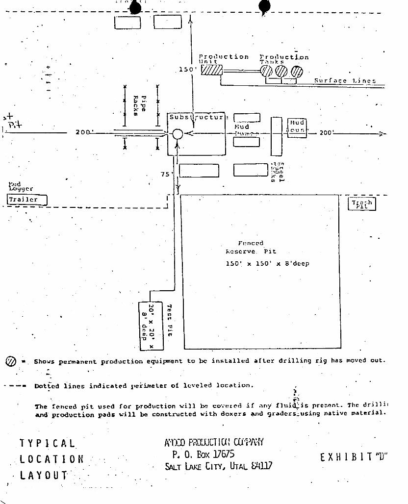
Production Pr duct .on
linit Tanks150'
surface Lines
n•Qo
Subs ( t --
riud.P, Mu d .
'2 0 0 ' -<-
---- -- -
'-- 20 0 -
. 75' x ae in F-*
Mud ' u .
Logger
Trailer 1 .
¯ ¯
FencedLeserve Pit
150' x 150' x 8'deep,
O oCD - O
e. o rt•o
-
Shows permanent production equipment to be installed af Ler drilling rig has moved out.
--= Dot ed lines indicated peëi.meter of leveled 3ocation.
* The fenced pit used for production vill lx> covereã if any fluid'is pre:.ent. The drillit
and production pads will be constructed with doxers a.nd graders using native material.
TYPlc AL AWDPROUJCHU'CUPlWLOCATIOli P.O.Baxl7675 EXHlBlT"D"
SALT l..AKECITY, UTALM.1.9LAYOUT .
-
Production Pr duct .on
linit Tanks150'
surface Lines
n•Qo
Subs ( t --
riud.P, Mu d .
'2 0 0 ' -<-
---- -- -
'-- 20 0 -
. 75' x ae in F-*
Mud ' u .
Logger
Trailer 1 .
¯ ¯
FencedLeserve Pit
150' x 150' x 8'deep,
O oCD - O
e. o rt•o
-
Shows permanent production equipment to be installed af Ler drilling rig has moved out.
--= Dot ed lines indicated peëi.meter of leveled 3ocation.
* The fenced pit used for production vill lx> covereã if any fluid'is pre:.ent. The drillit
and production pads will be constructed with doxers a.nd graders using native material.
TYPlc AL AWDPROUJCHU'CUPlW
LOCATIOli P.O.Baxl7675 EXHlBlT"D"SALT l..AKECITY, UTALM.1.9
LAYOUT .
-

** FILE NOTATIONS**
DATE: (7,,
OPERAT yy .47£46 (y .
WELLNO: (' 4/n Ÿ Ñ/nuLocation: Sec. T. /-//V R. 25& County:
. A'l n ,ma fF¿te Ptepaked: Entexed on H.I .9
Cax.d Indexed: Compleklon Sheet
API Humbet 6/ 3 ~ O 3 ¯
CHECKEDBY:
Petroleum Engineer:
Director: go
Administrative Aide:
APPROVALLETTER:
Sond RequiAed: Sukvey Plat Requixed
0&dex Wo. / f 5A /-/ 'An 0.K. Rule C-3
Rule C-3.(e) , Topogxaph¿c Excepf¿on - company owns oA contAofo acreagew¿thin a 660' tadAas og pAoposed 4¿te
Leas e Dea¿gnat¿on Plotted on Map
AppAoval. LetteA GIALtten
Hot L¿ne p.7
4 à
July 17, 1981
AmocoProduction CompanyP. 0. Box 17676Salt LAkeCig. Utah 84117
RE: Well No. Chamþ11n458 Amoco "G" #1,Sec. 17, T. 4N, R. 8E,Summit County, Utah
Insofar as this office is concerned, approval to drill the abovereferred to gas well is hereby granted in accordance with the Order issuedin Cause No. 183-2.
Should you determine that it will be necessary to plug and abandonthis well, you are hereby requested to immediately notify the following:
MICHAELT. MINDER- Petroleum EngineerOffice: 533-5771Home: 876-3001
Enclosed please find Fonn OGC-8-X, Which is to be completedwhetheror not water sands (acquifers) are encountered during drilling. Yourcooperation in completing this form will be appreciated.
Further, it is requested that this Division be notified within 24 hoursafter drilling operations commence,and that the drilling contractor and rignumber be identified.
The API numberassigned to this well is 43-043-30176.
Sincerely,
DIVISIONOFOIL, GAS,.ANDMINING
Cleon 8. FeightDirector
CBF/dbCC:
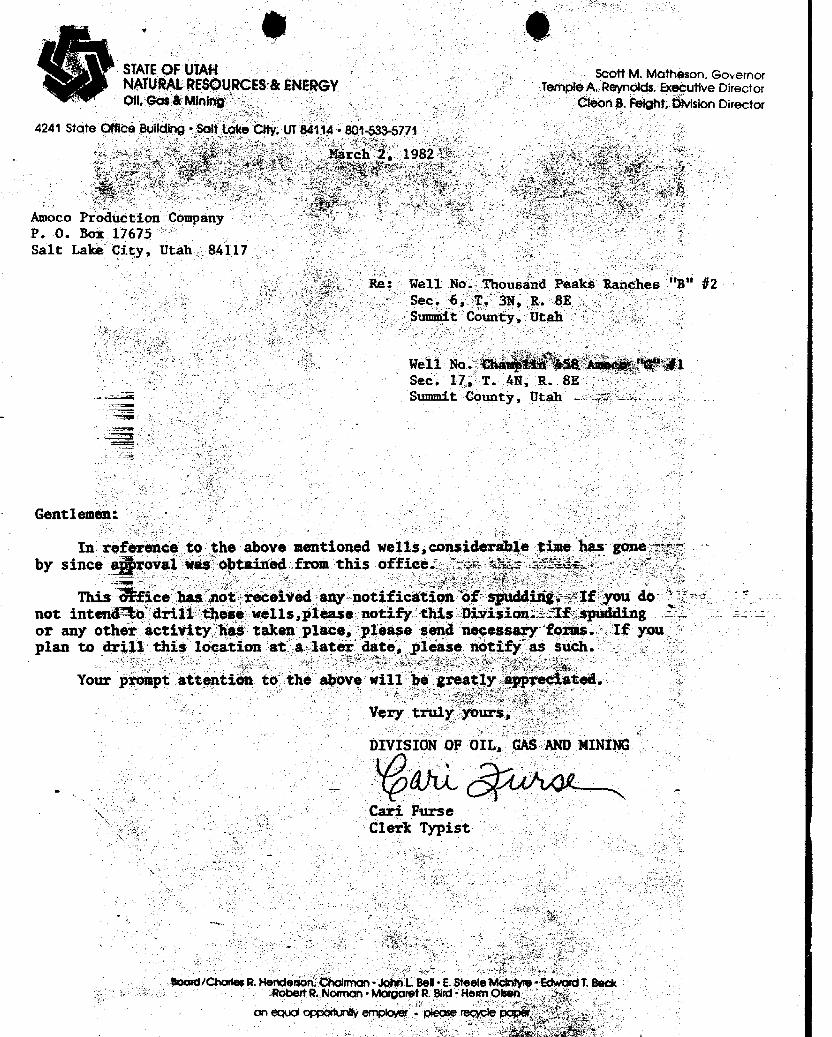
STATEOF UTAN scottM. Motheson. GovernorNATURALRESOURCES&ENERGY Temple A. Reynolds, Executive DirectorOil, Gas & Mining Cleon B. Felght, DivisionDirector
4241 State Qffice Building Solt take City, UT84114 - 801433-5771
Mar , 1982 t a i
Amoco Production Company '
P. O. Box 17675Salt Lake City, Utah 84117
Re: Hell No. Thousand Peaks Ranches "B" #2- Sec. 6, T. 3N, R. BE
Summit County, Utah
Well No. thå ÄÊ&$8Amb Ñ1Sec. 17, T. AN, R. 8E
.. Summit County, Utah 1 - -
Gentlemen:
In reference to the above mentioned wells,considerable time has gone -;:r
by since a roval was obtained from this office.¯Tw. a¾ìs TTSie.
This fice has'not received any-notification 'of sguddirigxIf you donot intenno~dril1these wells,please notify this Division.-"If spuddingor any other activity has taken place, please send necessary forms. If youplan to drill this location at a later date, please notify as such.
Your prompt attention to the above will be greatly appreciated.
Very truly yours,
D MINI
Cari FurseClerk Typist
Board/Charles R. Henderson, Choirman•John L Be!•E. Steele Mcintyre IkiwarciT. BeckRobert R. Norman • Morgolet R Bird · Herrn Olsen
on equoropportunily employer i please
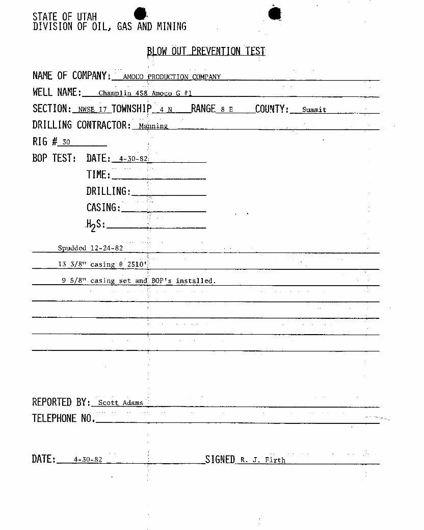
STATEOFUTAH $DIVISIONOFOIL, GASANDMINING
OWOUTPREVENTIONTEST
NAMEOFCOMPANY:AMOCOPRODUCTION COMPANY
WELLNAME: Champlin 458 Amoco G #1
SECTION:NWSE 17 TOWNSHI4 N RANGE8 E COUNTY:summit
DRILLINGCONTRACTOR:MÅningRI6 # so
BOPTEST: DATE:4-30-82
TIME:DRILLING:CASING:-H2
Spudded 12-24-82
13 3/8" casing @ 2510'
9 5/8" casing set and 80P's installed.
REPORTEDBY: Scott Adams
TELEPHONENO.
DATE: 4-30-82 SIGNEDR. J.
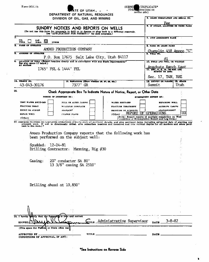
Forrn OGC-1b SUBMI TRIPLICATE*
TE OF UTAH . x- . (Oth ytructionsonreverse side)
DEPARTMENT OF NATURAL RESOURCESDIVISION OF OIL, GAS, AND MINING S. I.BASE DESIONATION AND SERIAL NO.
FeeSUNDRYNOTICESAND REPORTSON WELLS
O w morAN, Amu MM Nm
(Do not use this form for proposals to drill or to deepen or plug back to a diferent reservoir.Use "APPLICATION FOR PERMIT-" for such proposals.)
A. 7. UNIT AGRMMMENT NAMSOW
LL O °^.'s.. E3 o2...2. NAME 07 OPERATOR S. FARM OR LEASE NAME
AMDCOPRODUCTIONCOMPANY Ch l in MS Amoco"G"8. A0DEBBB OF OPERAMON 0, W.PNO.
P.O. Box 17675 Salt Lake City, Utah 841174. I.0cArzou or wmLL (Report loestion clearly and in accordance with any state requirements.• 10. FIELD AND POOL, OR WILDCATSee also space 17 below.)
At surtate Anschutz Ranch East1765 ' FSL & 1444 ' FEL n. ..e., .., ... m., on ar... amEUByst 05 ARRA
Sec. 17, TAN, RSE14. PanMrr No. 15. ElgkATIONe (Show whether or, ar, on, ete.) là. consor on waarom 16. swara
43-043-30176 7377 ' GR Sunnit Utahte· CheckAppropnate BoxTo Indicate NatureoFNotice, Repost,or OtherData
NO ICE 07 INTENTION TO: BUBasqUEN REPORT 07:
TE-T WATER BRUT-Off PULL OR AI.TER CASINO WATER BHUT•Opr x8PAIRING WELL
PRACTURE TREAT MULTIPLE COMPLETE FRACTURE TREATMENT ALTERING CABING
BHOOT OR ACIDIES ABANDON* SHOOTING OR ACIDIBING ABANDONMENT
REPAIR WELL CHANGE PLANs (Other) REPORTOF OPERATIONS(Other (Nooz : Report results of multiple completion on Wel
('onipletion or Recompletion Report and Log form.)17. DESCRIBE PROPOSED OR COMPLETED OPERATIONS (L'learly state n11 pertinent details, and give pertinent dates, including estimated date of stgrting nny '
proposed work. If well is directionally drilled, give subsurface locations and measured and true vertical depths for all markers and zones perti-nent to this Work.) *
Amoco Production Companyreports that the following work hasbeen performed on the subject well:
Spudded: 12-24-81Drilling Contractor: Manning, Rig #30
Casing: 20" conductor SA 80 '
13 3/8" casing SA 2510 '
Drilling ahead at 10 , 850 '
18. I hproby ity that tot og is tr e and correct
SIGNED TLE Strative Spensor ,,,,3-8-82
(This space for Fe ra or State ofbee use
APPROVED BY TITLE DATECONDITIONS OF APPROVAL, 17 ANY:
*SeeInstructionson ReverseSide

Forrn OGC-1b SUBMIT IN TRIPLICATE*
STATE OF UTAH (Otherinstructions onreverse side)
DEPARTMENT Of NATURAL RESOURCESDIVISION OF OIL, GAS, AND MINING 6. I.BASE DBBIONATION AND BE IAL NO.
Fee0. IF INDIAN, ALLOTTEM 08 TR E NAMESUNDRYNOTICESAND REPORTSON WELLS
(Do not tiet this form for proposals to de li or to deepen or plug back to a diferent reservoir.Use "APPLICATION F PERMIT-" for such proposals.)
I. T. UNIT AemaaMaxT Waxa
I.L O 'w^.".... E o,...9. maxa of OPERATOR O. PARM OB LEASE NAME
AMDCOPRODUCTIONCCMPANY Œamplin 458 Amoco "G"8. ADomass or ormaa20s 9. WELL No.
P.O. Box 1767 Salt Lake City, Utah #14. LOCATION OF WELL (Report location clearly an in accorÊancewith any Atate requirements.* 10. PIBLD AND POOL, 08 W1LDC T
203.9' FSL & 2.4' M u.,c ch t
80895T 08 ABBA
Sec. 17, TAN, R8E14. PanMIT Wo. 15. ELOVATIONS (Show whether or, at, on, ete.) 12. couarr on ranzen la. swara
43-043-30154 7739 ' GR Sulmit Utahse CheckAppropnote BoxToIndicateNatureof Notice,Report,or OtherDate
NO ICS 07 IWTENTION TO: - SUBSEQUENT REPOtt 07:
TERT WATER SHUT•OFF PUI.L OR ALTER CAgiNO WATER 8HUT-Orr REPAIRING WELL
raActuns rasAT MULTIPLW COMPLETE FRACTURE TREATMENT ALTERING CASING
SHOOT OR ACIDIZE ABANDON† SHOoTING OR ACIDIEING ABANDONMENT*
SIDETIEtnEPAIR WELI. CHANGE PLANS (Other)(BloTE: Report results of multiple completion on Wel(Other) ('ompletion or Recompletion Report and Log form.)
17. DEBORIBE PROPOSED OR 00M1'LETED OPERATIONs (Clearly state all pertinent details, and give pertinent dates, including estimated date of starting anyproposed work. It well is dinetionally dr lied, give subsurface loostions and measured and true vertical depths for all markers and sopes perti-nent to this work.) *
Amoco Production Campany herewith advises that the following workwas performed on the gubjectwell:
TD: 14,000'
Casing 7 5/8" SA 12, 438 '
Plugs:
1) Fram Fish to 13,863' w/100 sx2) Fram shoe of 7 5/8" esg at 12, 438' w/100 sx
Drilled 6 1/4"hole to TD at 14,000'. Penetrated approximately 113'Nugget Formation. Fish in hole at 14,000' - 13,863'. Propose toplug back and cup window in 7 5/8" for sidetracking
(verbal approval received from R.J. Firth, UOG6MD,on 8/27/82)
18. I hproby certify Ûr r oing rue and correct
aronsa K W DF wF y TITLE Administrative Supervisor var. 9-13-82
(This space for Federal or State ofBee u..> APPROVED BY THE S I Al EAPPROVED BT TITLE OF UTAH Q ISI N OFCONDITIONS OF APPROVAL, IF ANT: OIL, GAS, A
DATE: EBY·
*SeeInstructionson ReverseSid.
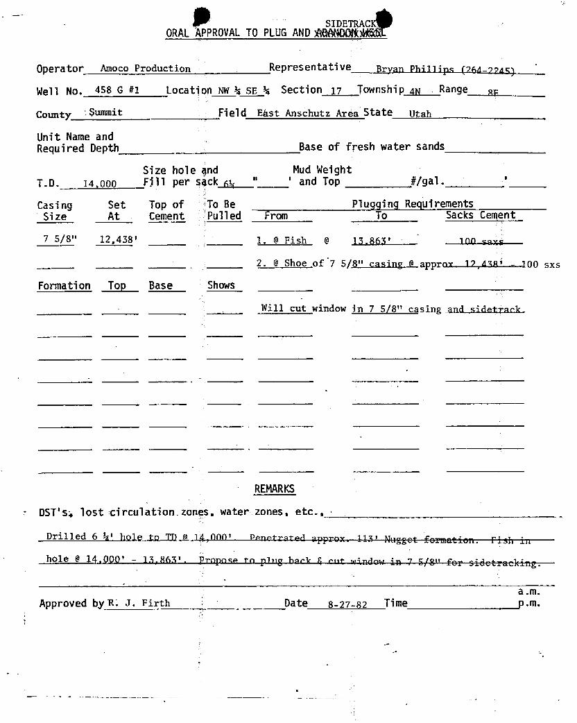
SIDETRACORALAPPROVALTO PLUGANDMANDON
Operator Amoco Production Representative Brvan Phillips (764-794 )
Well No. 458 G #1 Location NWk SE k Section 17 TownshiP 4N . Range gy
County Summit Field Ekst Anschutz Area State Utah
Unit Name andRequired Depth Base of fresh water sands
Size hole gnd Mud WeightT.D. 14,000 Fill per qqck 64
" ' and Top #/gal.
Casing Set Top of To Be Plugging RequirementsSize At Cement Pulled From To Sacks Cement
7 5/8" 12,438' 1. @ Fish 15 865' inn enve
2. @ Shoe of 7 5/8" casing approv 17,asn' - 100 sxs
Formation Top Base Shows
Will cut window in 7 5/8" casing and sidetrack.
REMARKS
DST's. lost circulation_zones, water zones, etc., ·
Drilled 6 k' hole to Tn o 14 000' Penetro*=a ,rrr^x 117' Hugget formation. rich in
hole @ 14.000' - 13.863'. Propose to ping hoek 4 ent tanden in 7 E/?" for sidetracking.
a.m.Approved byR. J. Firth Date 8-27-82 Time
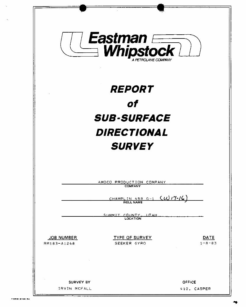
Eastman i\ Whipstock
A PETROLANECCMFMNY
REPOR Tof
SUB- SURFACEDIREC TIONAL
SURV EY
AMOCO PRODUCT ION COMPANYCOMPANY
CHAMPLIN 458 G-1 /WELL NAME
MIMMTT rnONTY llTAHLOCATION
JOS NUMBER TYPE OF SURVEY DATERM183-A1248 SEEKER GYRO 1-8-83
SURVEY BY OFFICEIRVIN MCFALL 410, CASPER
FORM D-302
Eastman i\ Whipstock
A PETROLANECCMFMNY
REPOR Tof
SUB- SURFACEDIREC TIONAL
SURV EY
AMOCO PRODUCT ION COMPANYCOMPANY
CHAMPLIN 458 G-1 /WELL NAME
MIMMTT rnONTY llTAHLOCATION
JOS NUMBER TYPE OF SURVEY DATERM183-A1248 SEEKER GYRO 1-8-83
SURVEY BY OFFICEIRVIN MCFALL 410, CASPER
FORM D-302

AMOCO PRODUCTION COMPANY SEEKER OYROWELL NAME: CHAMPLIN 453 G-1LOCATION: SUMMIT COUNTY, UTAHFILE NO.: A2-122, FL 7-02DATE: OS-JAN-83JOB NO.: RM103-A1248TYPE: SEEKER GYRO TOOL NO.: EWO108SURVEYOR: IRVIN MCFALLLATITUDE: 41.25 MODE: FASTCOMPUTER OPERATOR: STEVEN STURGENCOMPANY REP.: BRIAN LOGAN
O
REbORD OF SURVE
RADIUS OF CURVATURE
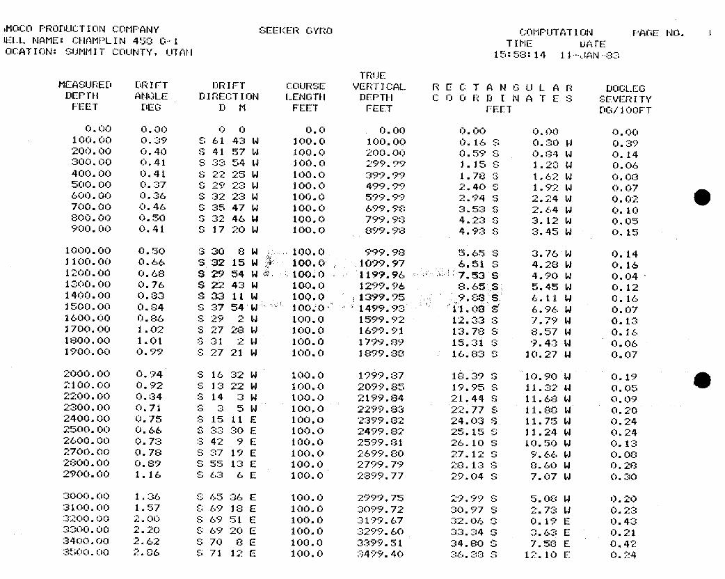
•MOCO PRODUCTION COMPANY SEEKER GYRO COMPUTATION PAGE NO. 1IELL NAME: CHAMPLIN 458 O-1 TIME DATEOCATION: SUMMIT COUNTY, UTAH 15:58:14 11-JAN 03
TRUEMEASURED DRIFT DRIFT COURSE VERTICAL RECT A NGUL A R DOCLEG
DEPTH ANOLE DIRECTION LENGTH DEPTH COORD I N A TES SEVERITYFEET DEG D M FEET FEET FEET DG/100FT
O.OO O.OO O O O.O O.OO O.OO 0.00 0.00100.00 0.39 S 61 43 W 100.0 100.00 0.16 S O.30 W 0.39200.00 0.40 S 41 57 W 100.0 200.00 0.59 S 0.04 W O.14300.00 0.41 S 33 54 W 100.0 299.99 1.15 S 1.28 W O.06400.00 0.41 S 22 25 W 100.0 399.99 1.78 3 1.62 W 0.08500.00 0.37 S 29 23 W 100.0 499.99 2.40 S 1.92 W O.07600.00 0.36 S 32 23 W 100.0 599.99 2.94 S 2.24 W 0.02700.00 0.46 S 35 47 W 100.0 699.98 3.53 S 2.64 W O.10800.00 0.50 S 32 46 W 100.0 799.98 4.23 S 3.12 W 0.05900.00 0.41 S 17 20 W 100.0 899.98 4.93 S 3.45 W 0.15
1000.00 0.50 S 30 8 W 100.0 999.98 5.65 S 3.76 W O.141100.00 0.66 3 32 15 W 100.0 1099.97 6.51 S 4.28 W O.161200.00 0.68 S 29 54 W 10010 1199.96 7.53 S 4.90 W 0.041300.00 0.76 S 22 43 W 100.0 1299.96 8.65 S 5.45 W O.121400.00 0.83 9 33 11 W 100.0 1399.95 9.00 S 6.11 W 0.161500.00 0.84 S 37 54 100;O 1499.93 11.0 5 6.96. W O,071600.00 0.86 S 29 2 W 100.0 1599.92 12.33 3 7.79 W O.131700.00 1.02 S 27 28 W 100.0 1699.91 13.78 S 8.57 W O.161800.00 1.01 S 31 2 W 100.0 1799.89 15.31 S 9.43 W O.061900.00 0.99 S 27 21 W 100.0 1899.88 16.83 8 10.27 W O.07
2000.00 O.94 S 16 32 W 100.0 1999.87 18.39 3 10.90 W O.192100.00 0.92 S 13 22 W 100.0 2099.85 19.95 S 11.32 W O.OS2200.00 0.84 S 14 3 W 100.0 2199.84 21.44 S 11.68 W 0.092300.00 0.71 S 3 5 W 100.0 2299.83 22.77 S 11.8C W O.202400.00 0.75 S 15 11 E 100.0 2399.82 24.03 S 11.75 W O.242500.00 0.66 S 33 30 E 100.0 2499.82 25.15 S 11.24 W O.242600.00 0.73 S 42 9 E 100.0 2599.31 26.10 S 10.50 W O.132700.00 0.78 S 37 19 E 100.0 2699.80 27.12 S 9.66 W O.082800.00 0.89 S 55 13 E 100.0 2799.79 28.13 S 8.60 W O.282900.00 1.16 S 63 6 E 100.0 2899.77 29.04 S 7.07 W O.3O
3000.00 1.36 8 65 36 E 100.0 2999.75 29.99 S 5.08 W 0.203100.00 1.57 O 69 18 E 100.0 3099.72 30.97 S 2.73 W O.233200.00 2.00 S 69 51 E 100.0 3199.67 32.06 3 0.19 E 0.433300.00 2.20 S 69 20 E 100.0 3299.60 33.34 S 3.63 E 0.213400.00 2.62 S 70 8 E 100.0 3399.51 34.80 3 7.53 E O.423500.00 2.06 S 71 12 E 100.0 3499.40 36.38 S 12.10 E
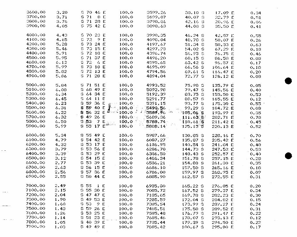
3600.00 3.20 S 70 46 E 100.0 3599.26 38.10 G 17.09 E 0.343700.00 3.71 S 71 SE 100.0 3699.07 40.07 8 22.79 E O.513800.00 3.76 3 71 28 E 100.0 3798.06 42.16 3 28.96 E O.OC3900.00 4.05 S 75 42 E 100.0 3098.63 44.08 S 35.50 E O.41
4000.00 4.43 S 70 23 E 100.0 3990.35 46.24 S 42.57 E O.554100.00 4.65 O 72 9 E 100.0 4098.04 48.70 S 50.07 E O.264200.00 5.28 S 73 24 E 100.0 4197.67 51.34 3 58.33 E O.634300.00 5.46 S 73 15 E 100.0 4297.23 54.02 S 67.29 E 0.184400.00 5.91 3 72 18 E 100.0 4396.74 56.95 3 76.75 E O.464500.00 5.95 S 71 37 E 100.0 4496.20 60.15 S 86.58 E 0.084600.00 6.12 S 72 6 E 100.0 4595.65 63.42 S 96.57 E 0.174700.00 5.99 S 73 18 E 100.0 4695.09 66.56 S 106.64 E O.184800.00 5.82 S 72 13 E 100.0 4794.56 69.6L S 116.47 E 0.204900.00 5.86 S 71 28 E 100.0 4894.04 72.77 S 126.12 E 0.08
O5000.00 5.84 S 71 51 E 100.0 4993.52 75.98 3 135.79 E O.055100.00 6.08 S 68 49 E 100.0 5092.98 79.47 S 145.56 E 0.405200.00 6.34 S 64 34 E 100.0 5192.39 83.75 3 155.50 E O.535300.00 6.45 S 64 11 E 100.0 5291.77 80.57 8 165.55 E O.125400.00 6.23 3 59 36 E 100.0 5391.15 93.77 3 175.30 E O.555500.00 6.31 S 59 40 E 100.0 5490.g6 99.29 S 104.72 E 0.085600.00 6.22 S 56 32 E 100.0 358f.#6 105.06 S 193.99 E O.355700.00 6.32 S 49 26 E 100.0 5689.36 111.6Š 202.71 E O.785000.00 6.50 0 53 7 E 100.0 5788.74 118.61 211.42 E O.455900.00 5.99 S 53 17 E 100.0 5888.14 125.13 Ë 220.13 E O.52
6000.00 5.34 S 55 49 E 100.0 5987.66 130.85 3 228.16 E O.706100.00 4.79 S 54 42 E 100.0 6087.27 135.87 S 235,42 E 0.566200.00 4.32 S 53 17 E 100.0 6106.95 140.54 S 241.04 E 0.486300.00 3.79 S 53 56 E 100.0 6286.70 144.73 S 247.52 E O.536400.00 3.39 8 53 29 E 100.0 6386.50 148.43 S 252.57 E O.406500.00 3.12 C 54 15 E 100.0 6486.34 151.78 S 257.15 E O.206600.00 2.77 S 53 39 E 100.0 6586.21 154.80 S 261.30 E O.356700.00 2.63 S 56 15 E 100.0 6686.10 157.50 S 265.16 E O.186800.00 2.56 S 57 36 E 100.0 6786.00 159.97 S 260.95 E O.O96900.00 2.55 C 50 44 E 100.0 6885.90 162.57 S 272.55 E O.31
7000.00 2.49 S 55 1 E 100.0 69GS.80 165.22 S 276.05 E 0.207100.00 2.15 G 55 30 E 100.0 7085.72 167.52 S 279.37 E O.347200.00 2.04 S 47 47 E 100.0 7135.65 169.78 S 282.23 E O.307300.00 1.90 S 49 53 E 100.0 7285.59 172.04 S 284.82 E O.157400.00 1.68 S 53 9 E 100.0 7385.54 173.99 3 237.27 E O.247500.00 1.43 8 59 26 E 100.0 7485.51 175.50 S 289.52 E O.317600.00 1,26 S 53 25 E 100.0 7585.48 176.79 S 291.47 E O.227700.00 1.14 S 51 23 E 100.0 7685.46 178.07 S 293.13 E O.127800.00 1.05 S 40 39 E 100.0 7705.44 179.39 S 294.50 E O.227900.00 1.03 S 49 49 E 100.0 7885.42 100.67 S 295.80 E
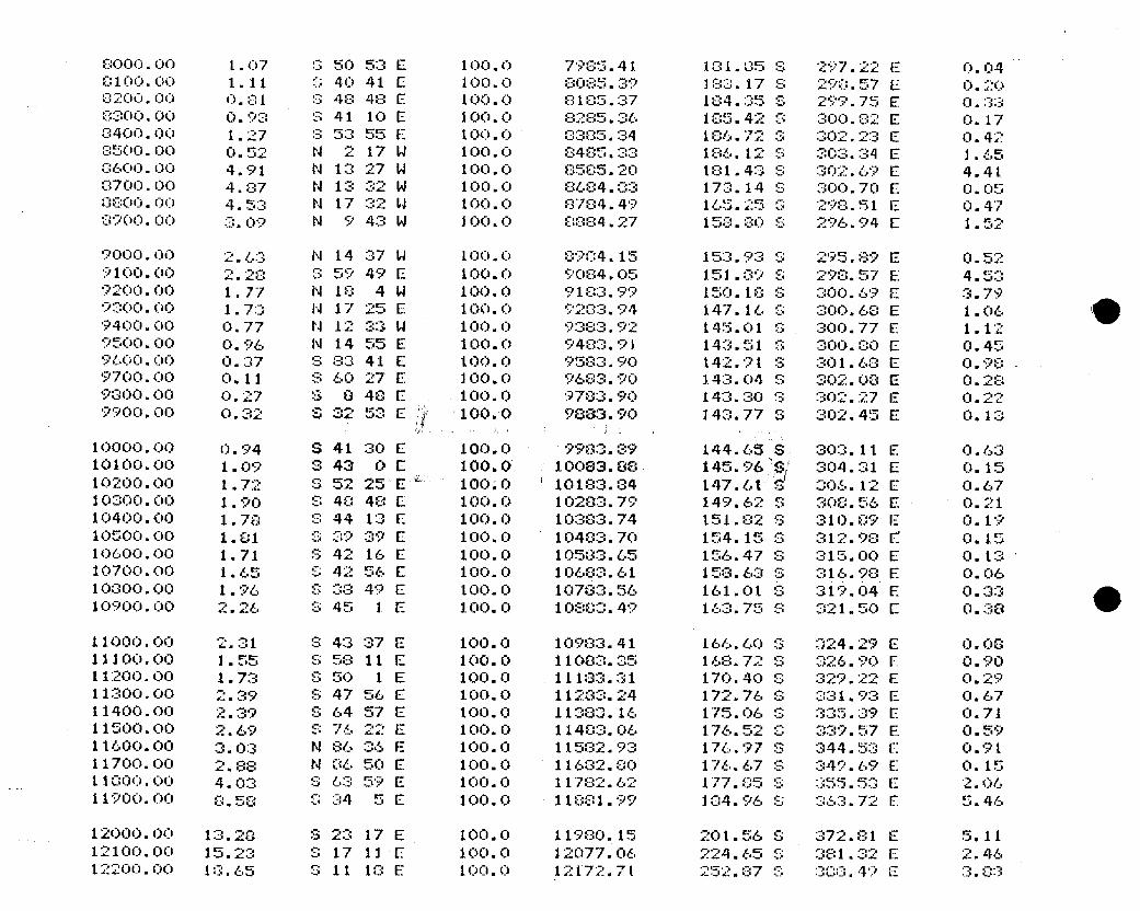
8000.00 1.07 3 SO 53 E 100.0 7985.41 101.05 S 297.22 E O.040100.00 1.11 G 40 41 E 100.0 8085.39 183.17 S 290.57 E O.2O8200.00 J.81 S 48 48 E 100.0 8105.37 184.35 S 299.75 E O.338300.00 0.93 S 41 10 E 100.0 8285.36 185.42 G 300.82 E O.178400.00 1.27 S 53 55 E 100.0 0385.34 186.72 3 302.23 E O.428500- O O.52 N 2 17 W 100.0 8485.33 186.12 S 303.34 E 1.65
6 -OO 4.91 N 13 27 W 100.0 8505.20 181.43 S 302.69 E 4.418700.00 4.87 N 13 32 W 100.0 8604.83 173.14 S 300.70 E 0.050800.00 4.53 N 17 32 W 100.0 8784.49 165.25 G 298.51 E 0.478900.00 3.09 N 9 43 W 100.0 0884.27 158.80 S 296.94 E 1.52
9000.00 2.63 N 14 37 W 100.0 8904.15 153.93 S 295.89 E 0.529100.00 2.28 S 59 49 E 100.0 9084.05 151.89 S 290.57 E 4.539200.00 1.77 N 18 4 W 100.0 9103.99 150.18 S 300.69 E 3.799300.00 1.73 N 17 25 E 100.0 92G3.94 147.16 S 300.68 E 1.069400.00 0.77 N 12 33 W 100.0 9383.92 145.01 S 300.77 E 1.129500.00 0.96 N 14 55 E 100.0 9483.91 143.51 S 300.00 E 0.459600.00 0.37 S 83 41 E 100.0 9583.90 142.91 S 301.68 E O.989700.00 0.11 S 60 27 E 100.0 9683.90 143.04 S 302.08 E 0.289000.00 0.27 8 8 48 E 100.0 9783.90 143.30 S 302.27 E O.229900.00 0.32 S 32 53 E 100.0 9883.90 143.77 S 302.45 E 0.13
10000.00 0.94 S 41 30 E 100.0 9983.39 144.65 S 303.11 E O.6310100.00 1.09 S 43 OE 100.0 10083.88 145.96 S 304.31 E O.1510200.00 1.72 S 52 25 E 100;O ' 10183.G4 147.61 $ 305.12 E O.6710300.00 1.90 S 48 48 E 100.0 10283.79 149.62 S 308.56 E 0.2110400.00 1.78 S 44 13 E 100.0 10383.74 151.82 S 310.89 E O.1910500.00 1.81 S 39 39 E 100.0 10483.70 154.15 S 312.98 Ë O.1510600.00 1.71 S 42 16 E 100.0 10533.65 156.47 S 315.00 E O.1310700.00 1.65 S 42 56 E 100.0 10683.61 158.63 S 316.98 E O.0610000.00 1.96 S 38 49 E 100.0 10783.56 161.01 S 319.04 E O.3310900.00 2.26 S 45 1 E 100.0 10803.49 163.75 S 321.50 E 0.38
11000.00 2.31 S 43 37 E 100.0 10983.41 166.60 G 324.29 E O.OS11100.00 1.55 S 58 11 E 100.0 11083.35 168.72 S 326.90 E O.9011200.00 1.73 S 50 1 E 100.0 11183.31 170.40 S 329.22 E O.2911300.00 2.39 S 47 56 E 100.0 11283.24 172.76 S 331.93 E O.6711400.00 2.39 S 64 57 E 100.0 11383.16 175.06 S 335.39 E 0.7111500.00 2.69 S 76 22 E 100.0 11483.06 176.52 S 339.57 E O.5911600.00 3.03 N 86 36 E 100.0 11582.93 176.97 S 344.53 E 0.9111700.00 2.88 N 86 50 E 100.0 11682.00 176.67 S 349.69 E O.1511000.00 4.03 S 63 59 E 100.0 11782.62 177.85 S 355.53 E 2.0611900.00 e.58 8 34 5 E 100.0 11881.99 184.96 S 363.72 E 5.46
12000.00 13.28 S 23 17 E 100.0 11980.15 201.56 S 372.81 E 5.1112100.00 15.23 S 17 11 E 100.0 12077.06 224.65 S 381.32 E 2.4612200.00 13.65 S 11 1G E 100.0 12f72.7l 252.87 S 303.49 E
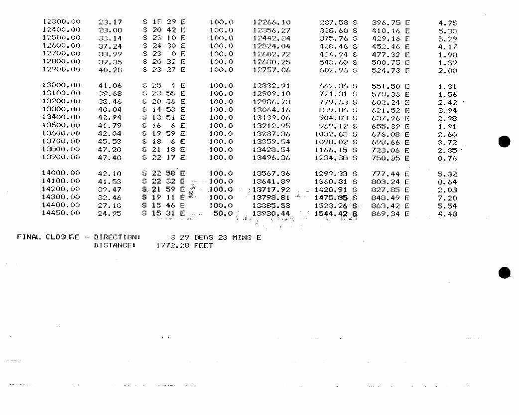
12300.00 23.17 S 15 29 E 100.0 12266.10 287.58 S 396.75 E 4.7512400.00 28.00 S 20 42 E 100.0 12356.27 328.60 S 410.16 E 5.3312500.00 30.14 S 23 10 E 100.0 12442.34 375.76 S 429.16 E 5.2912600.00 37.24 S 24 30 E 100.0 12524.04 428.46 G 452.46 E 4.1712700.00 38.99 S 23 OE 100.0 12602.72 404.94 S 477.32 E 1.9812800.00 39.35 S 20 32 E 100.0 12680.25 543.60 S 500.75 E 1.5912900.00 40.28 S 23 27 E 100.O 12757.OG 602.96 S 524.73 E 2.OO
13000.00 41.06 S 25 4 E 100.0 12832.91 662.36 S 551.50 E 1.3113100.00 39.68 S 23 55 E 100.0 12909.10 721.31 S 578.36 E 1.5613200.00 33.46 S 20 36 E 100.0 12906.73 779.63 S 602.24 E 2.42 ·
13300.00 40.04 S 14 53 E 100.0 13064.16 839.86 S 621.52 E 3.9413400.00 42.94 S 13 51 E 100.0 13139.06 904.03 S 637.96 E 2.9813500.00 41.79 S 16 6 E 100.0 13212.95 969.12 S 655.39 E 1.9113600.00 42.04 S 19 59 E 100.0 13287.36 1032.63 S 676.08 E 2.6013700.00 45.53 S 18 CE 100.0 13359.54 1098.02 S 698.66 E 3.7213800.00 47.20 S 21 18 E 100.0 1342G.54 1166.15 3 723.06 E 2.05 -
13900.00 47.40 S 22 17 E 100.0 13496.36 1234.38 S 750.35 E O.76
14000.00 42.10 S 22 58 E 100.0 13567.36 1299.33 S 777.44 E 5.3214100.00 41.53 S 22 32 E 100.0 13641.89 1360.81 S 803.24 E O.6414200.00 39.47 S 21 59 E 100.0 13717.92 1420.?1 S 827.85 E 2.0814300.00 32.46 S 19 11 E 100.0 13798.81 1475.85 S 848.49 E 7.2014400.00 27.10 S 15 46 E 100.0 13885.53 1323.26 S: 863.42 E 5.5414450.00 24.95 3 15 31 E 50.0 13930,44 1544.42 à 869.34 E 4.48
FINAL CLOSURE -- DIRECTION: S 29 DEGS 23 MINS EDISTANCE: 1772.28

15: 58: 1411 -JAN- 83FILE NUMBER: 122
AMOCG PRODUCTION COMPANY SEEKER GYROWELL NAME: CHAMPLIN 458 G ·1
LOCATION: SUMMIT COUNTY, UTAH
ONVERSATIONAL SURVEY PROGRAM VO2. 11
O
15: 58: 1411 -JAN- 83FILE NUMBER: 122
AMOCG PRODUCTION COMPANY SEEKER GYROWELL NAME: CHAMPLIN 458 G ·1
LOCATION: SUMMIT COUNTY, UTAH
ONVERSATIONAL SURVEY PROGRAM VO2. 11
O
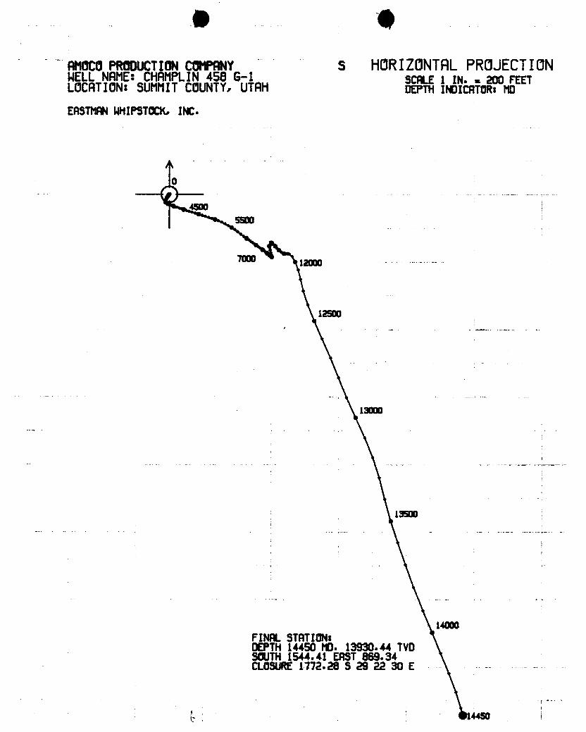
B 0AMOCOPRODUCTIONCOMPANY S HORIZONTALPROJECTIONWELLNAME:CHAMPLIN458 G-1 scALE 1 IN. - 200 FEETLOCATION:SUMMITCOUNTY,UTAH DEPTHINDICATOR:MD
EASTMANWHIPSTOCK,INC.
O
45005500
12000
12500
13000
13500
14000FINAL STATION:DEPTH14450 MO. 13930.44 TVDSOUTH1544.41 EAST869.34CLOSURE1772.28 S 29 22 30 E -
B 0AMOCOPRODUCTIONCOMPANY S HORIZONTALPROJECTIONWELLNAME:CHAMPLIN458 G-1 scALE 1 IN. - 200 FEETLOCATION:SUMMITCOUNTY,UTAH DEPTHINDICATOR:MD
EASTMANWHIPSTOCK,INC.
O
45005500
12000
12500
13000
13500
14000FINAL STATION:DEPTH14450 MO. 13930.44 TVDSOUTH1544.41 EAST869.34CLOSURE1772.28 S 29 22 30 E -
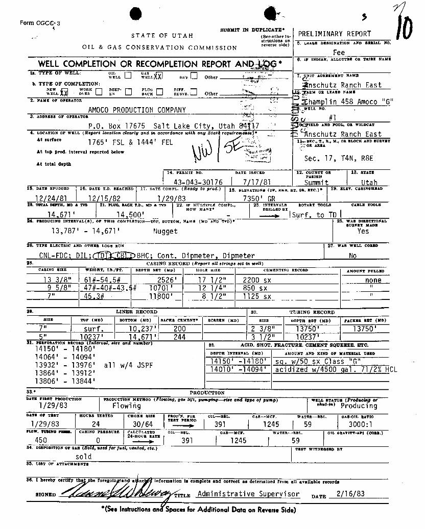
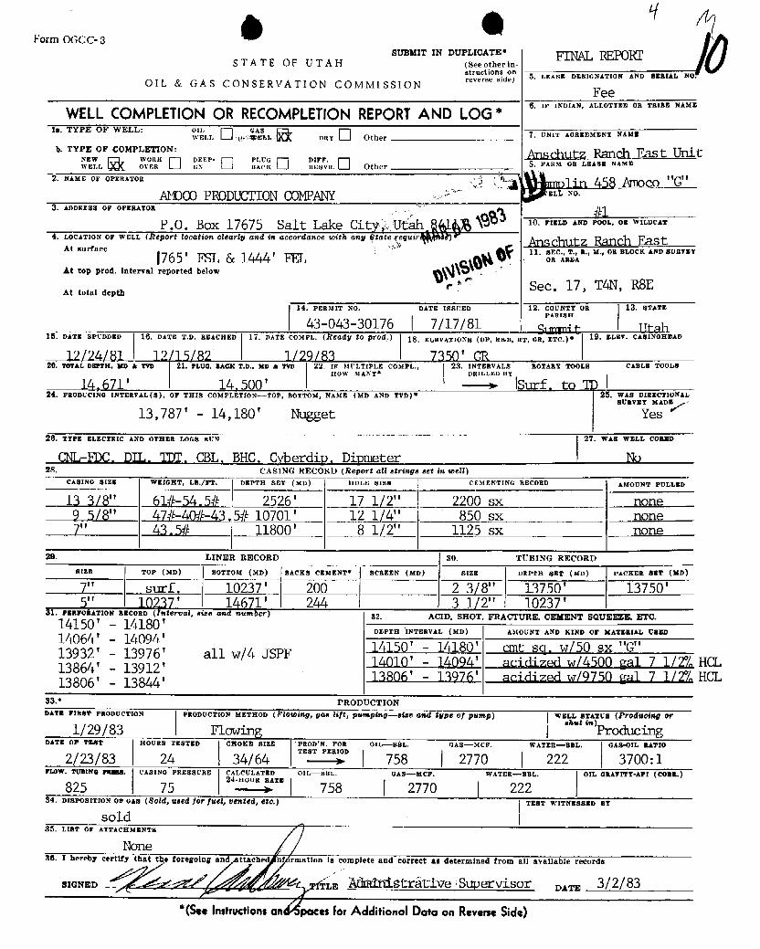
Form OGCC-3sUBMIT IN DUPLICATE*
STATE OF UTAH (Seeotherin, PRELIMINARY REPORTstructions on 5. LEASE DESIGNATION AND p-RIAL No.
OIL & GAS CONSERVATION COMMISSION reverseside)
FeeWELLCOMPLETIONOR RECOMPLETIONREPORTAN *
O, IF INDIAN, ALLOTTES OR TRIBE NAME
15. TYPE OF WELL: o AI DRY Other H -MENT W
k TYPE OF COMPLETION: BSchutz Ranch East
2. NAME OF OPERATOR hampl in 458 Amoco "G"AMOCOPRODUCTIONCOMPANY 16 "°
3. ADDRESS OF OPEBATOR
P.O. Box 17675 Salt Lake City, Utah 94J17 ELD AND POOL. OR WILDCAT
4. LOCATION OF WELL (Report location clearly and in accordance totth any Stat requiremente) ADSchutz Ranch Eastit .urrae. 1765 ' FSL & 1444 ' FEL .
is..ge o a...., 0B ELOCK AND BURTET
At top prod, interval reported below
At total depthSec. 17, T4N, R8E
14. PERMIT No. DATE ISBUED 12. COUNTY OR 18. BTATE43-043-30°l76 Í 7/17/81 5 mit _ _ Utah
15. DATE SPUDDED 16. DATE T.D. REACHED 17. DATE COMPL. (ÑOGdy $0 pf04.) 18. ELEVATIONE (Dr. RIEB, BT, GB, ETC.)e 19. ELEV. CASINGREAD
12/24/81 I 12/15/82 1/29/83 I 7350' GRÊ#. TOTAL DSPTH, MD & TTD 21. PLUG, BACK T,þ., MD A TVD 22, IF MULTIPLE COMPL., 23. INTERVALS ROTARY TOOLS CABLE TOOLE
14,671' 14,500' -
DRILLEDBY
Surf. to TD24. PRODUCING INTERVAL(B), OF THIS COMPLETION-TOP, BOTTOM, NAME (MD AND TVD)* 25. WAS DIRECTroNAL
SURVET MADE
13,787' - 14,671' Nugget Yes
20. TTPE ELECTRIC AND OTHER LOGB RUN 27. WAB WELL CORED
CNL-FDC; DIL;ggBHC; Cont. Dipmeter, Dipmeter No28. CASING RECORD (Report all atrings set in well)
CASINO 8155 WEIGHT, LB.ffT, DEPTH SET (MD) HOLE BIEE CEMENTING RECORD AMOUNT PULLED
13 3/8" 61#-54.5# 2526' 17 1/2" 2200 sx none9 5/8" 47#-40#-43.L# 10701' 12 1/4" 850 sx "
.
7" 45,3# 11800' 8 1/2" 1125 sx "
29. LINER RECORD 80. TUBING RECORDBIzE ToP (MD) BoTTox (MD) SACKS CEMENT* ScamEN (xD) SIEE DEPTR BET (MD) PACKER $$T (MD)
7" surf. 10,237' 200 2 3/8" 13750' 13750'5" 10237' 14,671'! 244 3 1/2" 10237'
AI. raaronarios ascono (Interval, size and number) 82. ACID, SHOT, FRACTURE, CEMENT SQUEEEE, ETC.14150 - 14180'DEPTH INTERVAL (MD) AMOUNT AND KIND Or MAT-BIAL U-En
14064' - 14094', , 14150' -14180' sq. w/50 sx Class "G"
3 64' 3 'all w/4 JSPF 14010' -14094' acidized w/4500 gal. 71/2% HCL
13806' - 13844'83 * PRODUCTIONDATE FIRST PRODUCTION PRODUCTION METHOD (Fl0WIWg, g68 Nff, pH¾ping--Biss GWd igpg Of pg-p) WELL STATum (Prodsoing or
1/29/83 Flowing •***'") ProducingDATE OF TERT HOURE TESTED CHOKE SIzz PROD'N. FOR OHr-BAL- GAS-MCF. WATER--BBL. OA8-OIL BATIO
TEET PERIOD1/29/83 24 30/64 391 1245 59 3000:1FloW. TUBING PREUS. CASING PRESBURE CALCULATED OIL-BUL. GAS-MCF, wATER-BEL. OIL GRATITT-API (CORE.)24-Hous RATE
450 0 391 1245 5934. DISPOSITION Or GAS (8084, seed for fugl, vented, etc.) TEST WITNESSED BT
sol d85. Liar or ATTACHMENTE
30. I hereby certify th he foregot information is complete and correct as determined from all available records
SIONED ITLa Administrative Supervisor eso, 2/16/83*(SeeInstructionsan Spacesfor AdditionalData on Revers.
INSTRUCTIONSGeneral: This form is designed for submitting a complete and correct well completion report and log on all types of lands and leases to either a Federal agency or a State agency,or both, pursuant to applicable Federal and/or State laws and regulations. Any necessary special instructions concerning the use of this form and the number of copies to besubmitted, particularly with regard to local, area, or regional procedures and practices, either are shown below or will be issued by, or may be obtained from, the local Federaland/or State ofice. See instructions on items 22 and 24, and 38, below regarding separate reports for separate completions.If not filed prior to the time this summary record is submitted, copies of all currently available logs (drlHers, geologists, sàmple and core analysis, all types electric, etc.), forma-tion and pressure tests, and directional surveys, should be attached hereto, to the extent required by applicable Federal and/or State laws and regulations. All attachmentsshould be listed on this form, see item 35.item 4: If there are no applicable State requirement*, lâcations on Federal or Indian land should be described in accoidance with Federal requirements. Consult local Stateor Federal office for specific instructions.Item 18: Indicate which elevation is used as reference (where not otherwise shown) for depth measurements given in other spaces on this form and in any attachments.items 22 and 24: If this weH is completed for separaté production from more than one interval zone (mpltiple completion)i, so state in item 22, and in item 24 show the producinginterval, or intervals, top(s), bottom(s) and name(s) (if any) for only the interval reported in item 88. Submit a segrate report (page) on this form, adequately identified,for each additional interval to be separately produced, showing the additional data pertinent to such intervaLitem 29: "Backs Cement": Attached supplemental records for this well should show the details of any multiple stage cementing and the location of the cementing tooLitem 33: Submit a separate completion report on thig form for each interval to be separately produced. (See instructiog for items 22 and 24 above.)
87. SUMMARY OF POROUS BONES:SHOW ALL IMPORTANT BONEB OF POROSKTT AND CONTESTS THEREOF; CORED INTERTALB; AKD ALL DEKLL-gTEM TESTS, INCLUDIso 38. GEOLOGIC MARKERSDEPTH INTERVAL TESTED, CUSHION USED, TIME TOOL ÓPEN, FLOWING AND SHUT-IN PRESBUR-B, AND BECOVERIES
FORMATION TOP BOTTOM DESCREPTION, CONTENTS, ETC. TOPNAME
MEAS. DEPTS TAUSTRIT.DEPTH
ITwin Creek 11,630'
Nugget l
INSTRUCTIONS
General: This form is designed for submitting a complete and correct well completion report and log on all types of lands and leases to either a Federal agency or a State agency,or both, pursuant to applicable Federal and/or State laws and regulations. Any necessary special instructions concerning the use of this form and the number of copies to besubmitted, particularly with regard to local, area, or regional procedures and practices, either are shown below or will be issued by, or may be obtained from, the local Federaland/or State ofice. See instructions on items 22 and 24, and 38, below regarding separate reports for separate completions.If not filed prior to the time this summary record is submitted, copies of all currently available logs (drlHers, geologists, sàmple and core analysis, all types electric, etc.), forma-tion and pressure tests, and directional surveys, should be attached hereto, to the extent required by applicable Federal and/or State laws and regulations. All attachmentsshould be listed on this form, see item 35.item 4: If there are no applicable State requirement*, lâcations on Federal or Indian land should be described in accoidance with Federal requirements. Consult local Stateor Federal office for specific instructions.Item 18: Indicate which elevation is used as reference (where not otherwise shown) for depth measurements given in other spaces on this form and in any attachments.items 22 and 24: If this weH is completed for separaté production from more than one interval zone (mpltiple completion)i, so state in item 22, and in item 24 show the producinginterval, or intervals, top(s), bottom(s) and name(s) (if any) for only the interval reported in item 88. Submit a segrate report (page) on this form, adequately identified,for each additional interval to be separately produced, showing the additional data pertinent to such intervaLitem 29: "Backs Cement": Attached supplemental records for this well should show the details of any multiple stage cementing and the location of the cementing tooLitem 33: Submit a separate completion report on thig form for each interval to be separately produced. (See instructiog for items 22 and 24 above.)
87. SUMMARY OF POROUS BONES:SHOW ALL IMPORTANT BONEB OF POROSKTT AND CONTESTS THEREOF; CORED INTERTALB; AKD ALL DEKLL-gTEM TESTS, INCLUDIso 38. GEOLOGIC MARKERSDEPTH INTERVAL TESTED, CUSHION USED, TIME TOOL ÓPEN, FLOWING AND SHUT-IN PRESBUR-B, AND BECOVERIES
FORMATION TOP BOTTOM DESCREPTION, CONTENTS, ETC. TOPNAME
MEAS. DEPTS TAUSTRIT.DEPTH
ITwin Creek 11,630'
Nugget l
g 0 *Form OGCC-3
SUBMIT IN DUPLICATE' FINAL REPORTSTATE OF UTAH (seeotherin-structions on
5, LEASE DESIGNATION AND BERIAL NO.OIL & GAS CONSERVATION COMMISSION reverseside)
Fee
WELLCOMPLETION OR RECOMPLETION REPORTAND LOG*6, IF INDIAN, ALLOTTRE OR TRIBE NAME
la. TYPE OF WELL: o sLLonY Other 7, UNIT AGREEMENT NAME
b. TYPE OF COMPLETION:ADSchutz Ranch East Unit
"sEl WOR C EP· H. Other FARM OR LEASE NAME
2. NAME OF OPERATOR • AIllO o "G"NOCO PRODUCTIONCOMPANY EL NO.
3. ADDRESS OF OFERATOR
P.O. Box 17675 Salt Lake Cit Ufah \$ 10. FIELD AND POOL, OR WILDCAT
4, LOCATION OF WELL (Ñ€pOft IOOG$iON Clearig and in accordance toith ang State eguir ) Anschutz Ranch EastAt surface 11. SEC., T., R., M., OR BLOCK AND SURVEY1765'FSL 6c 1444' FEL on Aa=a
At top prod. Interval reported below
r Sec. 17, TAN, RSEAt total depth
14. PERMIT NO. DATE ISSUED 12. COUNTT OR 13. STATE
43-043-30176 7/17/81 9 e I Utah-15. DATE SPUDDED 16. DATE T.D. REACHED 17. DATE COMFL. (Ñ€Gdy $0 pf04 18. ELEVATIONs (DF, aan, RT, GE, ETC.)* 19. ELET. CASINGREAD
12/24LBL 12/15/82 1/29/83 | 7350' GR20. TorAL DarTH, wo a Two 21. PLUG. BACK T.D., MD & TVD 22. IF MULTIPLE COMPL., 23. INTERVALS ROTARY TOOLS CABLE TOOLS
HOW MANT* DRILLED BY
14, 671' 14, 500 '- Isurf, . to TD I
24. PRODUCING INTERVAL(B), OF THIS COMPLETION--TOP, BOTTOM, NAME (MD AND TVD)* 26. WAS DIRECTIONALSURVEY MADE
13,787' - 14,180' Nugget Yes
26. TTPE ELECTRIC AND OTHER LOGS RUN 27. WAS WELL CORED
G\¶-FDC, DIL, TDT, CBL, BHC. Cyberdip. Dipmeter No28. CASING RECORD (Report all strings set in well)
CABING SIzm WEIGHT, LB./NT, DEPTH SET (MD) HOLE SIZE CEMENTING RECORD AMOUNT PULLED
13 3/8" 61#-54,5# 2526' 17 1/2" 2200 sx none9 5/8" 47#-A0#-43.5# 10701' 12 1/4" 850 sx none7" 43.,W 11800' 8 1/2" 1125 sx none
29. LINER RECORD 30. TUBING RECORDRIZE TOP (MD) BOTTOM (MD) SACKS CEMENT* SCREEN (MD) SIZE DEPTH SET (MD) PACKER sgT (MD
7" surf, 10237' 200 2 3/8" 13750' 13750'5" 10237' 14671' 244 3 1/2" 10237'Šl. PaarokATroN REconn (Interval,size and notaber) 82. ACID. SHOT. FRACTURE, CEMENT SQUEEEE, ETC.14150 '
- 14180 'DEPTH INTERVAL (MD) AMOUNT AND KIND OF MATERIAL DBED14064' - 14094'
13932' - 13976' all w/4 JSPF 14150' - 14180' cmt sq, w/50 sx "G"13864' - 13912' 14010' - 14094' acidiz,ed w/4500 gal 7 1/2% HCL
13806' - 13844' 13806' - 13976' acidived w/9750 gal 7 1/2% HCL
33.* PRODTJCTIONDATE FIRST PRODUCTION PRODUCTION METHOD (Flotoing, gas lift, pumping-time and type of pump) wsLL sTAzus (Producing or
1/29/83 i Flowing """'ProducingDATE OF TEST HOURS TESTED CHOKE SIBE PROD*N. FOR OIL- BÉL. GAS-MCF. WATER-BBL, GAS-OIL BATIO
2/23/83 24 34/64H D
758 2770 222 3700:1FLOW. TURING 75-55. CAslNO PREsscRE CALCULATED OIL-BBL. GAS-MCF. WATER-BBL. OIL GRAVITT-API (CORE.)24-HOUR RATE825 75 758 2770 22234. Dxaros!TION OF GAS (805d, Hadd for fu68, USW Bd, Éd.) TEST WITNESSBD BT
sold35. LIST OF ATTACEMENTH
Nonehereby ee foregoing ch ation is complete and corre t as deetennined all available record3/2/83
*(Se nstructions an es for Additional Data on Reverse
g 0 *Form OGCC-3
SUBMIT IN DUPLICATE' FINAL REPORTSTATE OF UTAH (seeotherin-structions on
5, LEASE DESIGNATION AND BERIAL NO.OIL & GAS CONSERVATION COMMISSION reverseside)
Fee
WELLCOMPLETION OR RECOMPLETION REPORTAND LOG*6, IF INDIAN, ALLOTTRE OR TRIBE NAME
la. TYPE OF WELL: o sLLonY Other 7, UNIT AGREEMENT NAME
b. TYPE OF COMPLETION:ADSchutz Ranch East Unit
"sEl WOR C EP· H. Other FARM OR LEASE NAME
2. NAME OF OPERATOR •
AIllO o "G"NOCO PRODUCTIONCOMPANY EL NO.
3. ADDRESS OF OFERATOR
P.O. Box 17675 Salt Lake Cit Ufah \$ 10. FIELD AND POOL, OR WILDCAT
4, LOCATION OF WELL (Ñ€pOft IOOG$iON Clearig and in accordance toith ang State eguir ) Anschutz Ranch EastAt surface 11. SEC., T., R., M., OR BLOCK AND SURVEY1765'FSL 6c 1444' FEL on Aa=a
At top prod. Interval reported below
r Sec. 17, TAN, RSEAt total depth
14. PERMIT NO. DATE ISSUED 12. COUNTT OR 13. STATE
43-043-30176 7/17/81 9 e I Utah-15. DATE SPUDDED 16. DATE T.D. REACHED 17. DATE COMFL. (Ñ€Gdy $0 pf04 18. ELEVATIONs (DF, aan, RT, GE, ETC.)* 19. ELET. CASINGREAD
12/24LBL 12/15/82 1/29/83 | 7350' GR20. TorAL DarTH, wo a Two 21. PLUG. BACK T.D., MD & TVD 22. IF MULTIPLE COMPL., 23. INTERVALS ROTARY TOOLS CABLE TOOLS
HOW MANT* DRILLED BY
14, 671' 14, 500 '- Isurf, . to TD I
24. PRODUCING INTERVAL(B), OF THIS COMPLETION--TOP, BOTTOM, NAME (MD AND TVD)* 26. WAS DIRECTIONALSURVEY MADE
13,787' - 14,180' Nugget Yes
26. TTPE ELECTRIC AND OTHER LOGS RUN 27. WAS WELL CORED
G\¶-FDC, DIL, TDT, CBL, BHC. Cyberdip. Dipmeter No28. CASING RECORD (Report all strings set in well)
CABING SIzm WEIGHT, LB./NT, DEPTH SET (MD) HOLE SIZE CEMENTING RECORD AMOUNT PULLED
13 3/8" 61#-54,5# 2526' 17 1/2" 2200 sx none9 5/8" 47#-A0#-43.5# 10701' 12 1/4" 850 sx none7" 43.,W 11800' 8 1/2" 1125 sx none
29. LINER RECORD 30. TUBING RECORDRIZE TOP (MD) BOTTOM (MD) SACKS CEMENT* SCREEN (MD) SIZE DEPTH SET (MD) PACKER sgT (MD
7" surf, 10237' 200 2 3/8" 13750' 13750'5" 10237' 14671' 244 3 1/2" 10237'Šl. PaarokATroN REconn (Interval,size and notaber) 82. ACID. SHOT. FRACTURE, CEMENT SQUEEEE, ETC.14150 '
- 14180 'DEPTH INTERVAL (MD) AMOUNT AND KIND OF MATERIAL DBED14064' - 14094'
13932' - 13976' all w/4 JSPF 14150' - 14180' cmt sq, w/50 sx "G"13864' - 13912' 14010' - 14094' acidiz,ed w/4500 gal 7 1/2% HCL
13806' - 13844' 13806' - 13976' acidived w/9750 gal 7 1/2% HCL
33.* PRODTJCTIONDATE FIRST PRODUCTION PRODUCTION METHOD (Flotoing, gas lift, pumping-time and type of pump) wsLL sTAzus (Producing or
1/29/83 i Flowing """'ProducingDATE OF TEST HOURS TESTED CHOKE SIBE PROD*N. FOR OIL- BÉL. GAS-MCF. WATER-BBL, GAS-OIL BATIO
2/23/83 24 34/64H D
758 2770 222 3700:1FLOW. TURING 75-55. CAslNO PREsscRE CALCULATED OIL-BBL. GAS-MCF. WATER-BBL. OIL GRAVITT-API (CORE.)24-HOUR RATE825 75 758 2770 22234. Dxaros!TION OF GAS (805d, Hadd for fu68, USW Bd, Éd.) TEST WITNESSBD BT
sold35. LIST OF ATTACEMENTH
Nonehereby ee foregoing ch ation is complete and corre t as deetennined all available record3/2/83
*(Se nstructions an es for Additional Data on Reverse

INSTRUCTIONSGemarei: This form is designed for submitting a complete and correct well completion report and log on all types of lands and leases to either a Federal agency or a State agency,or both, pursuant to applicable Federal and/or State laws and regulations. Any necessary special instructions concerning the use of this form and the number of copies to besubmitted, particularly with regard to local, area, or regional procedures and practices, either are shown below or will be issued by, or may be obtained from, the local Federaland/or State oflice. See instructions on items 22 and 24, and 33, below regarding separate reports for separate completions.If not filed prior to the time this summary record is submitted, copies of all eurrently available logs (drillers, geologists, sample and core analysis, all types electric, etc.), forma-tion and pressure tests, and directional surveys, should be attached hereto, to the extent required by applicable Federal;and/or State laws and regulations. All attachmentsshould be listed on this form, see item 35.Efem 4: If there are no applicable State requirements, 1ócations on Federal or Indian land should be described in accordance with Federal requirements. Consult local Stateor Federal ofEce for specific instructions.Item 18: Indicate which elevation is used as reference (where not otherwise shown) for depth measurements given in other spaces on this form and in any attachments.Items 22 and 24: If this well is completed for separate production from more than one interval zone (mpltiple completion), so state in item 22, and in item 24 show the producinginterval, or intervals, top(s), bottom(s) and name(s) (if any) for only the interval reported in item 88. Submit a separate report (page) on this form, adequately identified,for each additional interval to be separately produced, showing the additional data pertinent to such interval.Item 29: "ßacka Cement": Attached supplemental records for this well should show the details of any multiple stage cementing and the location of cementing tool.Item 33: Submit a separate completion report on this form for each interval to be separately produced. (See instruction for items 22 and 24 abo
37. SUMMARY OF POROUS ZONES:BHOW ALL IMPORTANT ZONES OF POROSITY AND CONTENTS THERBOF| CORED INTagyALS, AND ALL DRILL-BTEM TESTB, INCLUDIKG 38. GMBLOGIC MARKERSDEPTH INTERVAL TESTED, CUBBION USED, TIME TOOL OPEN, FLOWING AND SBUT-IN PRESSURES, AND RECOVERIEB
FORMATION TOP BOTTOM DESCRIPTION, CONTENTS, ETC. TOPNAME
HEAS. ÐEPTE TADE VERT.DEPTR
TWin Creek 11, 630 '
Nugget 13, 787 '
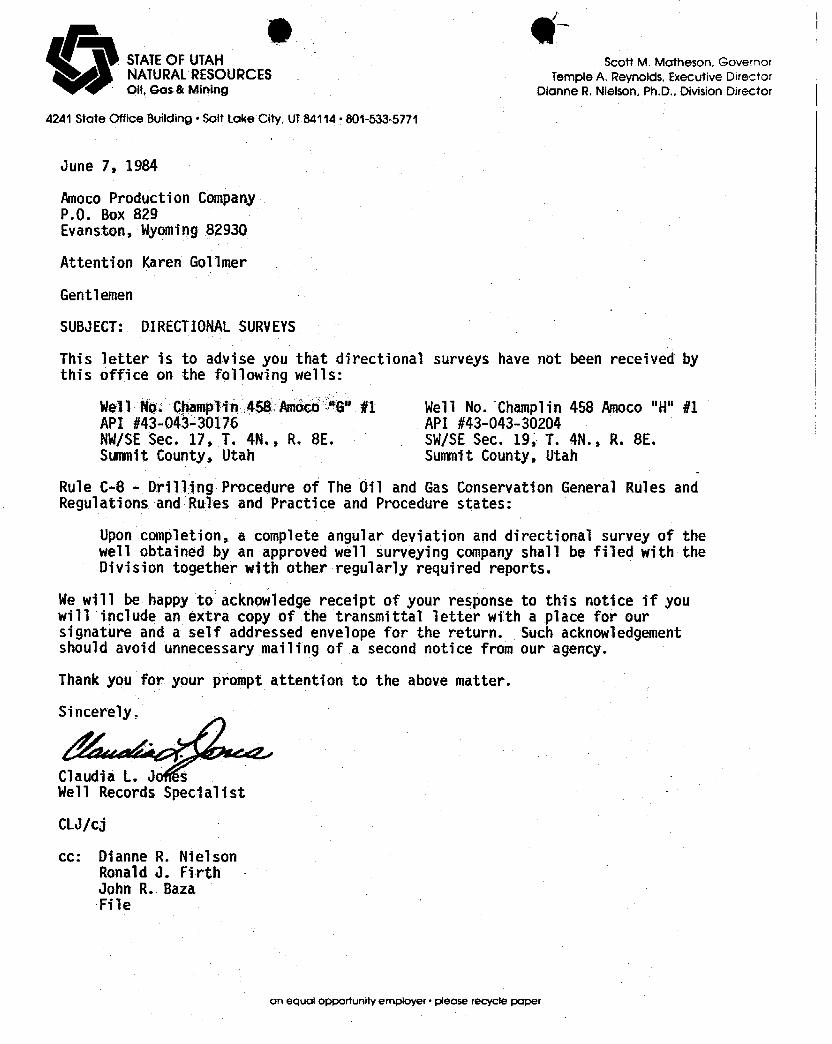
(ik (11-STATEOF UTAH Scott M. Motheson, GovernorNATURALRESOURCES Temple A. Reynolds. Executive DirectorOil, Gos & Mining Dionne R. Nielson, Ph.D., DivisionDirector
4241 State Office Building •Solt Loke City. UT84114•801-533-5771
June 7, 1984
Amoco Production CampanyP.O. Box 829Evanston, Wyoming82930
Attention Karen Go11mer
Gentlemen
SUBJECT: DIRECTIONALSURVEYS
This letter is to advise you that directional surveys have not been received bythis office on the following wells:
Nell No. Champlin 458 Amoco "G" #1 Well No. Champlin 458 Amoco "H" #1API #43-043-30176 API #43-043-30204NW/SESec. 17, T. 4N., R. 8E. SW/SESec. 19, T. 4N., R. 8E.Summit County, Utah Summit County, Utah
Rule C-8 - Brilling Procedure of The Oil and Gas Conservation General Rules andRegulations and Rules and Practice and Procedure stãtes:
Upon completion, a complete angular deviation and directional survey of thewell obtained by an approved well surveying companyshall be filed with theDivision together with other regularly required reports.
We will be happy to acknowledge receipt of your response to this notice if youwill i.nclude an extra copy of the transmittal letter with a place for oursignature and a self addressed envelope for the return. Such acknowledgementshould avoid unnecessary mailing of a second notice from our agency.
Thank you for your prompt attention to the above matter.
Sincerely,
Claudia L. J sWell Records Specialist
CLJ/cj
cc: Dianne R. NielsonRonald J. FirthJohn R. BazaFile
on equal opportunity employer • please recycle
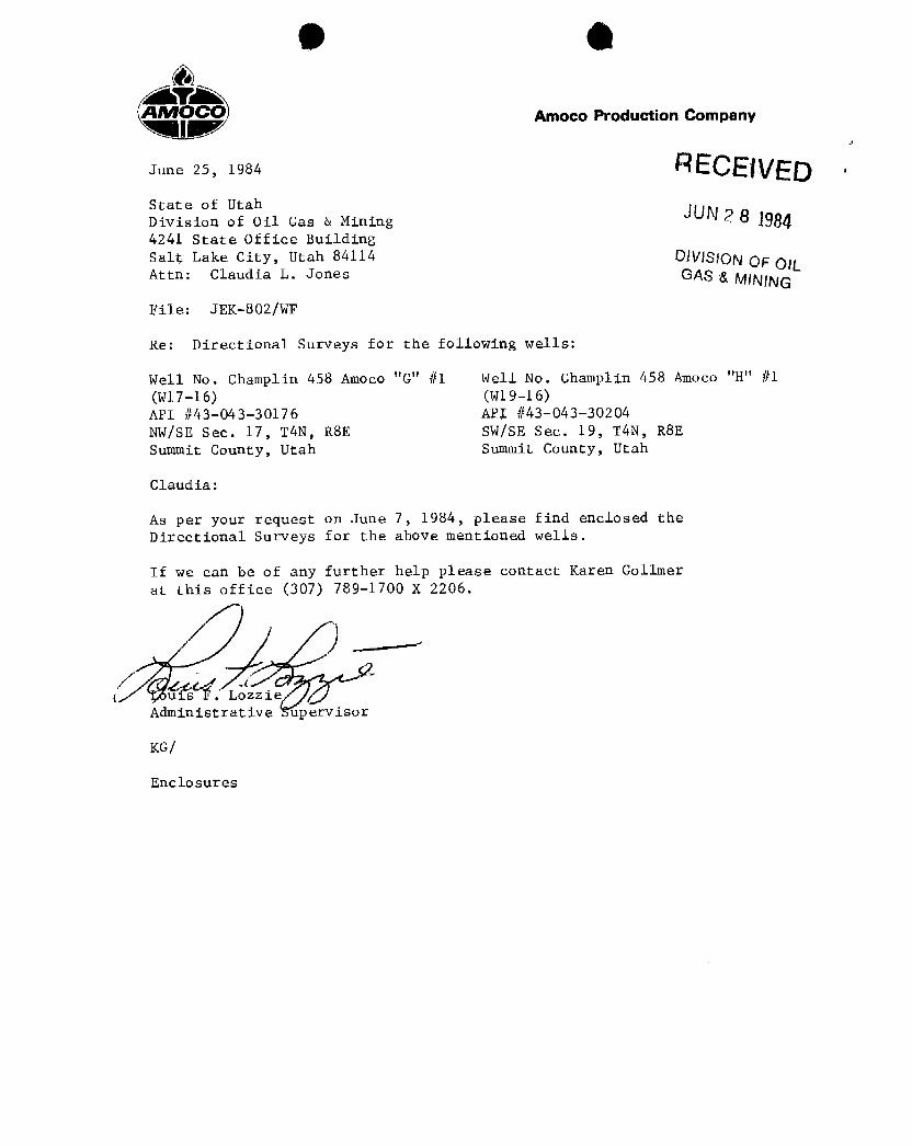
O O
AMOCO Amoco Production Company
June 25, 1984
State of UtahDivision of Oil Gas & Mining UN 2 8 19844241 State Office BuildingSalt Lake City, Utah 84114 DjVP>R3N OF OILAttn: Claudia L. Jones GAS & NUNAR3
File: JEK-802/WF
Re: Directional Surveys for the following wells:
Well No. Champlin 458 Amoco "G" #1 Well No. Champlin 458 Amoco "H" #1(Wl7-16) (wl9-16)
API #43-043-30176 API #43-043-30204NW/SE Sec. 17, TAN, RSE SW/SE Sec. 19, TAN, RSESummit County, Utah Summit County, Utah
Claudia:
As per your request on June 7, 1984, please find enclosed theDirectional Surveys for the above mentioned wells.
If we can be of any further help please contact Karen Gollmerat this office (307) 789-1700 X 2206.
Administrative upervisor
KG/
Utah Division of oil, Gas, and MiningSeptember 12, 1984Page 2
gas to oil. Would you please note these changes in yourwell files.
Sincerely yours ,
SDE/jwu
Attachment
Utah Division of oil, Gas, and MiningSeptember 12, 1984Page 2
gas to oil. Would you please note these changes in yourwell files.
Sincerely yours ,
SDE/jwu
Attachment
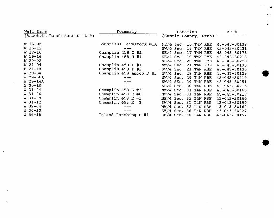
e
Well Name Formerly Location API#(Anschutz Ranch East Unit #) (Summit County, Utah)
W 16-06 Bountiful Livestock #1A NE/4 Sec. 16 T4N R8E 43-043-30138W 16-12 --- SW/4 Sec. 16 T4N RSE 43-043-30231W 17-16 Champlin 458 G #1 SE/4 Sec. 17 T4N R8E 43-043-30176W 19-16 Champlin 458 H #1 SE/4 Sec. 19 T4N RSE 43-043-30215W 20-02 --- NE/4 Sec. 20 T4N RSE 43-043-30228W 21-04 Champlin 458 F #1 NW/4 Sec. 21 T4N RSE 43-043-30135E 21-14 Champlin 458 F #2 -SW/4 Sec. 21 T4N R8E 43-043-30130W 29-04 Champlin 458 Amoco D #1 NW/4 Sec. 29 T4N RSE 43-043-30129W 29-06A --- NW/4 Sec. 29 T4N RSE 43-043-30219W 29-14A --- SW/4 SEc. 29 T4N RSE 43-043-30251W 30-10 --- SE/4 Sec. 30 T4N RSE 43-043-30215W 31-04 Champlin 458 E #2 NW/4 Sec. 31 T4N RSE 43-043-30165W 31-06 Champlin 458 E #6 NW/4 Sec. 31 T4N RSE 43-043-30217W 31-08 Champlin 458 E #1 NE/4 Sec. 31 T4N R8E 43-043-30164W 31-12 Champlin 458 E #3 SW/4 Sec. 31 T4N R8E 43-043-30190W 32-04 --- NW/4 Sec. 32 T4N RSE 43-043-30162W 36-10 --- SE/4 Sec. 36 T4N RSE 43-043-30227W 36-16 Island Ranching E #1 SE/4 Sec. 36 T4N R8E 43-043-30157
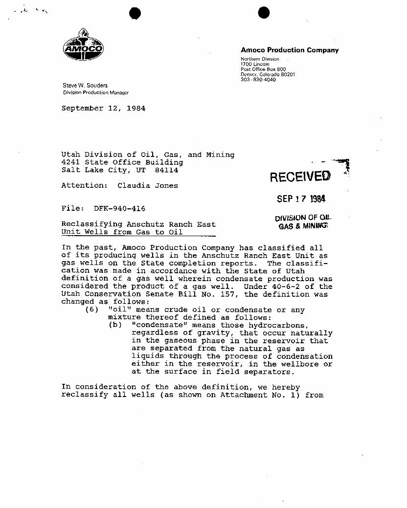
AMOCO Amoco Production CompanyNorthern Division1700 LincolnPost Office Box 800Denver, Colorado 80201303 -830-4040
Steve W. SoudersDivision Production Manager
September 12, 1984
Utah Division of Oil, Gas, and Mining4241 State office Building -¯- 1Salt Lake City, UT 84114 RECEIVEDAttention: Claudia Jones
SEP 17 1984File: DFK-940-416
DIVISION OF OiLReclassifying Anschutz Ranch East gAggMWOKEUnit Wells from Gas to Oil
In the past, Amoco Production Company has classified allof its producing wells in the Anschutz Ranch East Unit asgas wells on the state completion reports. The classifi-cation was made in accordance with the state of Utahdefinition of a gas well wherein condensate production wasconsidered the product of a gas well. Under 40-6-2 of theUtah Conservation Senate Bill No. 157, the definition waschanged as follows:
(6) "oil" means crude oil or condensate or anymixture thereof defined as follows:(b) "condensate" means those hydrocarbons,
regardless of gravity, that occur naturallyin the gaseous phase in the reservoir thatare separated from the natural gas asliquids through the process of condensationeither in the reservoir, in the wellbore orat the surface in field separators.
In consideration of the above definition, we herebyreclassify all wells (as shown on Attachment No. 1)
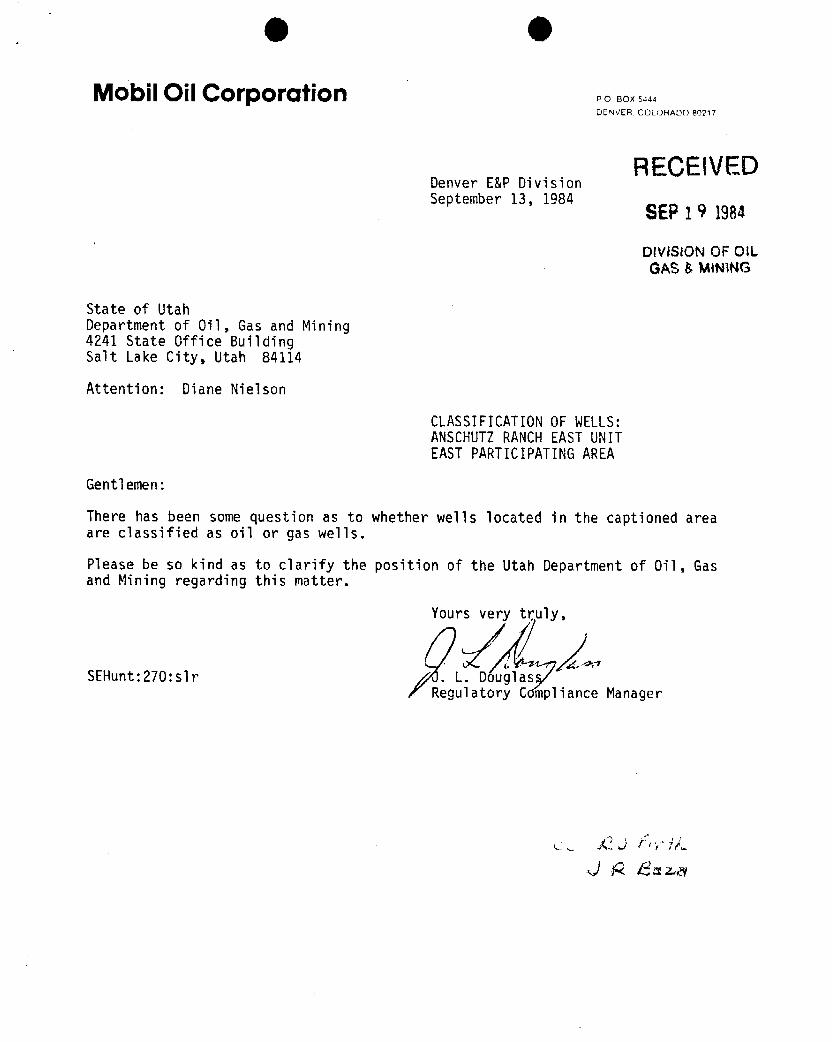
(Iþ (Il
Mobil Oil Corporation so soxs,44DENVER COLORADO80217
RECEIVEDDenver E&P DivisionSeptember 13, 1984
SEP1 9 1984
DivlSION OF OttGAS &MINiNG
State of UtahDepartment of Oil, Gas and Mining4241 State Office BuildingSalt Lake City, Utah 84114
Attention: Diane Nielson
CLASSIFICATIONOF WELLS:ANSCHUTZRANCHEASTUNITEASTPARTICIPATINGAREA
Gentlemen:
There has been some question as to whether wells located in the captioned areaare classified as oil or gas wells.
Please be so kind as to clarify the position of the Utah Department of Oil, Gasand Mining regarding this matter.
Yours very truly,
SEHunt:270:s1r . L. DouglasRegulatory C pliance
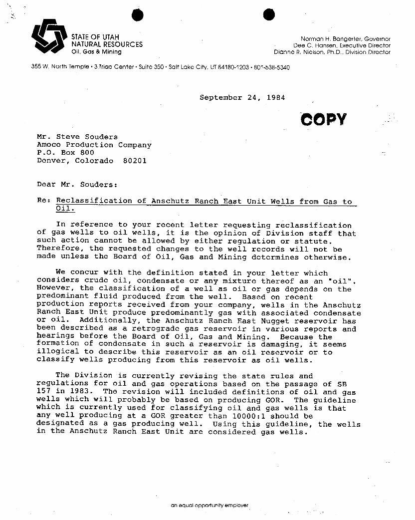
O STATEOF UTAH Norman H. Bangerter, GovernorNATURALRESOURCES Dee C. Hansen, Executive DirectorOil, Gas & Mining Dianne R. Nielson, Ph.D., Division Director
355 W. North Temple •3 Triad Center• Suite 350 • Salt Lake City, UT84180-1203 - 801-538-5340
September 24, 1984
COPYMr. Steve SoudersAmoco Production CompanyP.O. Box 800Denver, Colorado 80201
Dear Mr. Souders:
Re: Reclassification of Anschutz Ranch East Unit Wells from Gas toOil.
In reference to your recent letter requesting reclassificationof gas wells to oil wells, it is the opinion of Division staff thatsuch action cannot be allowed by either regulation or statute.Therefore, the requested changes to the well records will not bemade unless the Board of Oil, Gas and Mining determines otherwise.
We concur with the definition stated in your letter whichconsiders crude oil, condensate or any mixture thereof as an "oil".However, the classification of a well as oil or gas depends on thepredominant fluid produced from the well. Based on recentproduction reports received from your company, wells in the AnschutzRanch East Unit produce predominantly gas with associated condensateor oil. Additionally, the Anschutz Ranch East Nugget reservoir hasbeen described as a retrograde gas reservoir in various reports andhearings before the Board of Oil, Gas and Mining. Because theformation of condensate in such a reservoir is damaging, it seemsillogical to describe this reservoir as an oil reservoir or toclassify wells producing from this reservoir as oil wells.
The Division is currently revising the state rules andregulations for oil and gas operations based on the passage of SB157 in 1983. The revision will included definitions of oil and gaswells which will probably be based on producing GOR. The guidelinewhich is currently used for classifying oil and gas wells is thatany well producing at a GOR greater than 10000:1 should bedesignated as a gas producing well. Using this guideline, the wellsin the Anschutz Ranch East Unit are considered gas wells.
an equal opportunity
6 O
Page 2Amoco Production CompanySeptember 24, 1984
If the producing conditions change in any of the referencedwells and the change qualifies them for reclassification, theDivision would be happy to make that determination. Please let usknow if we can be of further assistance.
Sincerely,
OriginalSignedbyJohnR.Bais
John R. BazaPetroleum Engineer
cc: Mobil Oil Corp. Attn: J.L. DouglassD.R. NielsonR.J.
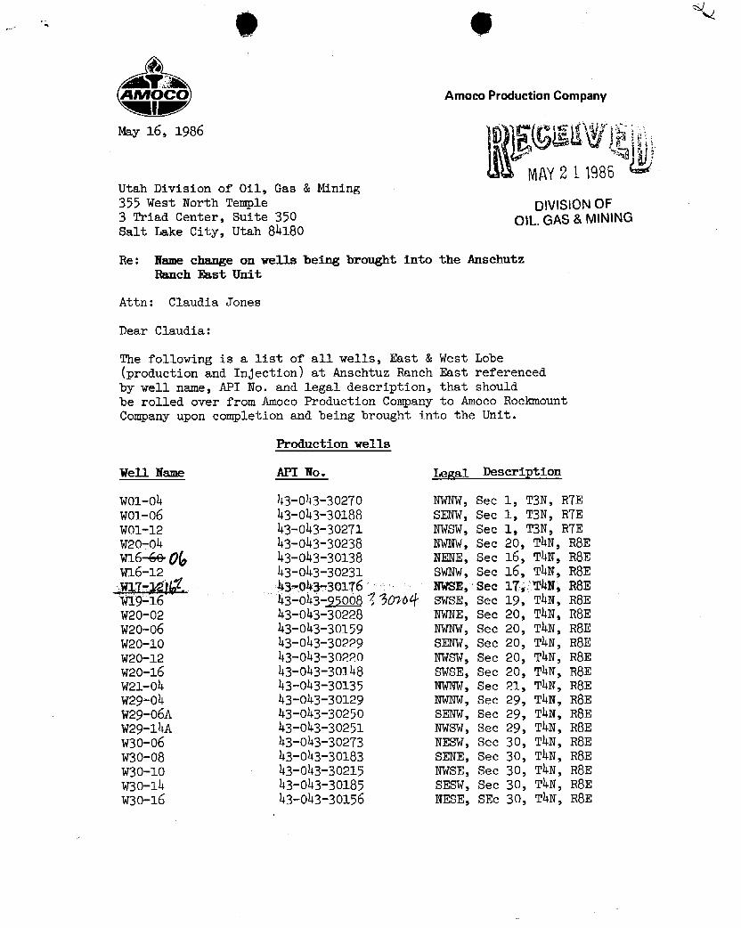
AMOCO Amoco Production CompanyMI
May 16, 1986
WLAY2 1 1986Utah Division of Oil, Gas & Mining355 west North Temple DNISIONOF3 Triad center, Suite 350 OILGLAS&MININGSalt Lake City, Utah 84180
Re: Name change on wells being brought into the AnschutzRanch East Unit
Attn: Claudia Jones
Dear Claudia:
The following is a list of all wells, East & West Lobe(production and Injection) at Anschtuz Ranch East referencedby well name, API No. and legal description, that shouldbe rolled over from Amoco Production Company to Amoco RockmountCompany upon completion and being brought into the Unit.
Production wells
well Name API No• gal Description
w01-Oh 43-Oh3-302TO NWNW,Sec 1, T3N, RTEWO1-06 43-043-30188 SENW, Sec 1, T3N, RTEW01-12 43-043-302T1 NWSW, see 1, T3N, RTEW20-04 43-043-30238 NWNW,Sec 20, ThN, RSEw16-Ge06 43-043-30138 NENE, Sec 16, ThN, RSEW16-12 43-043-30231 SWNW, Sec 16, T4N, RSEW1T-12)kÍ. 43-043-301T6 NWSE, Sec 1T, T4N, RSEW19-16 43-043-9500813090# swsE, Sec 19, ThN, RSEw20-02 43-043-30228 NWNE, Sec 20, TAN, RSEw20-o6 43-043-30159 NWNW,Sec 20, ThN, RSEW20-10 43-043-30229 SENW, Sec 20, TAN, RSEW20-12 43-043-30220 NWSW, Sec 20, ThN, RSEW20-16 43-043-30148 SwsE, Sec 20, T4N, RSEW21-04 43-043-30135 NWNW,Sec 21, ThN, RSEW29-04 43-043-30129 NWNW, Sec 29, T4N, RSEV29-06A 43-043-30250 SENW, see 29, ThN, R8EW29-14A 43-043-30251 NWSW, Sec 29, TAN, RSEW30-06 43-oh3-302T3 NESW, Sec 30, TAN, RSEW30-08 43-043-30183 SENE, Sec 30, ThN, RSEw30-10 43-043-30215 NwsE, Sec 30, T4N, RSEW30-14 43-043-30185 SESW, Sec 30, TAN, RSEW30-16 43-043-30156 NESE, SEc 30, T4N,
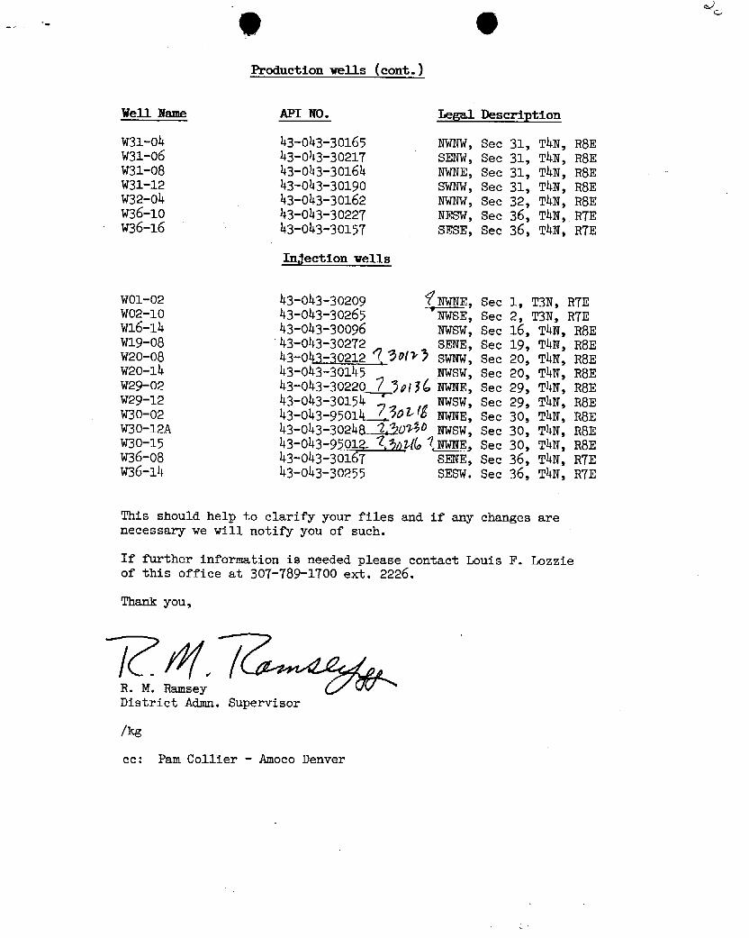
Production wells (cont.)
Well Name API NO. Legal Description
w31-04 43-043-30165 KWNW,See 31, TAN, R8EW31-06 43-043-3021T SENW, See 31, TAN, RSEW31-08 43-043-30164 KwNE, See 31, ThN, RSEW31-12 43-043-30190 SWNW, Sec 31, ThN, RSEW32-04 43-043-30162 NWNW,See 32, ThN, RSEW36-10 43-043-3022T NESW, See 36, ThN, RTEW36-16 43-Oh3-3015T SESE, Sec 36, TAN, RTE
Injection wells
WO1-02 43-043-30209 fNWNE, Sec 1, T3N, RTEWO2-10 43-043-30265 'NWSE, Sec 2, T3N, RTEW16-14 43-043-30096 NWSW, See 16, ThN, RSEwl9-08 43-043-30272 SENE, Sec 19, T4N, RSEW20-08 43-043-30212 9 90/>) SwNW, Sec 20, ThN, RSEH20-là 43-043-30145 NWSW, Sec 20, T4N, RSEW29-02 43-043-30220 Î );tyC NWNE, Sec 29, TAN, RSEV29-12 43-043-30154 *
NWSW, Sec 29, ThN, RSEW30-02 43-043-95014__Î.506/ËNWNE, Sec 30, TAN, RSEW30-12A 43-043-3024A '23040 NVSW, See 30, T4N, RSEW30-15 43-043-95012- $$ptífo1JDBfs, see 30, ThN, R8EW36-08 43-043-3016T SENE, Sec 36, TAN, RTEW36-14 43-043-30255 SESW. See 36, T4N, RTE
This should help to clarify your files and if any changes arenecessary we will notify you of such.
If further information is needed please contact Louis F. Lozzieof this office at 30T-789-1700 ext. 2226.
Thank you,
R. M. RamseyDistrict Admn. Supervisor
/kg
oc: Pam Collier - Amoco
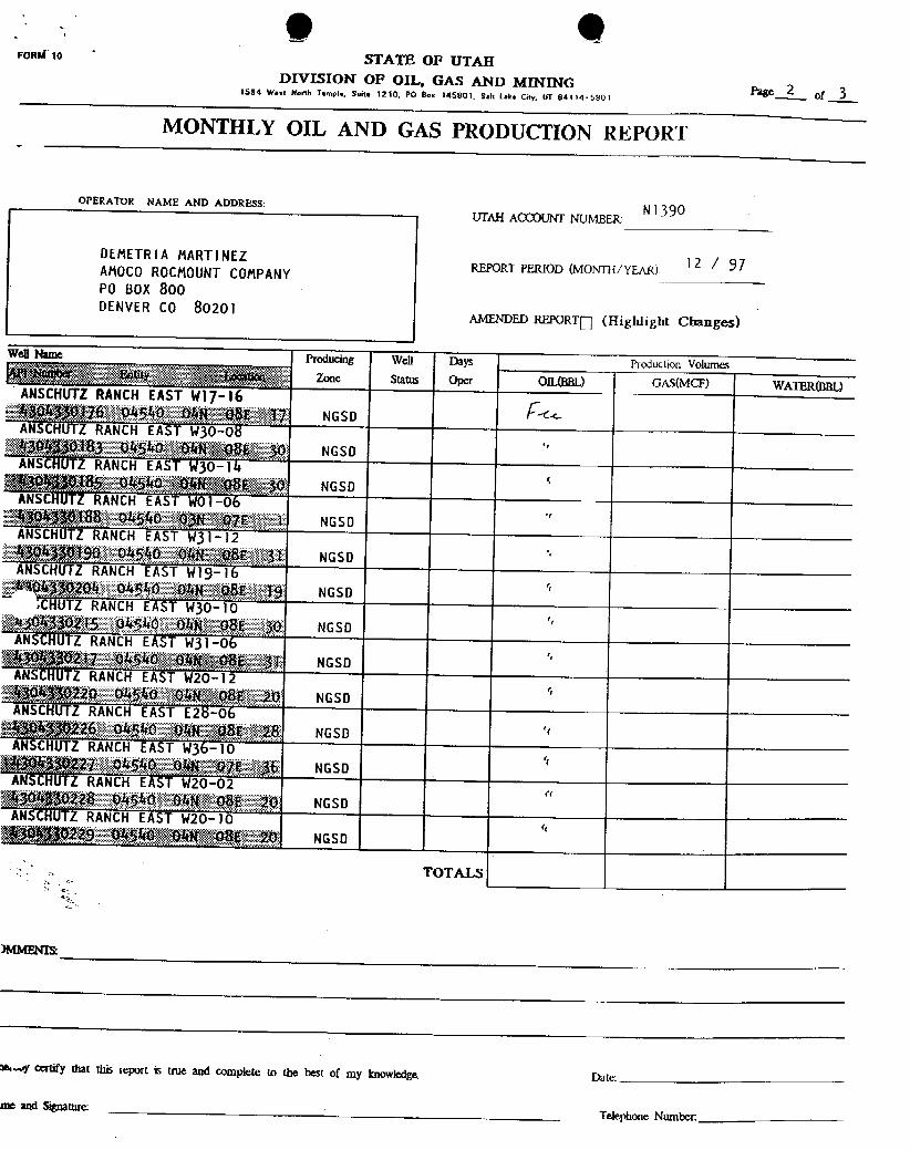
(Ib (IlFOMÑ1o STATE OF UTAH
DIVISION OP OIL, GAS AND MINING Page 2 471594 West North Temple, suite 1210. PO Box 145801. Salt Lake City, UT 84114·580;
MONTHLY OIL AND GAS PRODUCTION REPORT
OPERATOR NAME AND ADDRESS:
UTAH ACC)UNT NUMBER:Nl 390
DEMETRIA MARTINEZ 12 / 97REPORT PERIOD (MONDUYEAR)AMOCOROCMOUNT COMPANYPO BOX 800DENVERCO 80201
AMENDED REPORTO(Highlight Changes)
Well Name Producing Well Days Producuon VolumesZone Status Oper OIL(BBL) GAS(MCF) WATER(BBL)ANSCHUTZRANCHEAST W17-16
%30830176 - 04549 04N 08E , 17 NGSDANŠCHUTZRANCH EAST W30-08
430530163 04540 DANeoßL 30 NGSDANSCHUTZRANCH EAST W30-'14
50gg185 04540 PGANV§0BE',<30 NGSDANSCÑUTZRANCH EAST WOl-06$04¾g18ß,04540 Og', 97E ' I NGSO
ANSCHUTZRANCHEAST W31-l2fig43g190 04540 OAN',08E 31 NGSDANSCHUTZ RANCH EAST Wl9-16A'404))g204 04§40 OAN 88" 19 NGSD
.CHUTZRANCHEAST W30-1010,4,350215 045Ao ohN USE 30 NGSO
ANSCHUTZRANCHEA$T W3l-063 30217 0AS40,'9442,086 31 NGSD
ANSCHUTZRANCHEAŠT W20-124304$30220 04540 ' DAN',:086, 20 NGSDANSCÑUTZRANCH EAST E28-06#fD4310226 04540 ONN , 08E 28 NGSDÄNSCHUTZRANCH EAST W36-10$$iBR227 04540 DAN,,'978 36 NGSD
ANSCHUTLRANCHEAST W20-02
gg 30 28 94540' OAN 08E 20 NGSOANSCHUTLRANCHEAST W20-10
045ft**>gOAAk,08620 NGSD
TOTALS
me.« certify that this report is true and complete to the best of my knowledge. Date:
me and SignatureTelephone
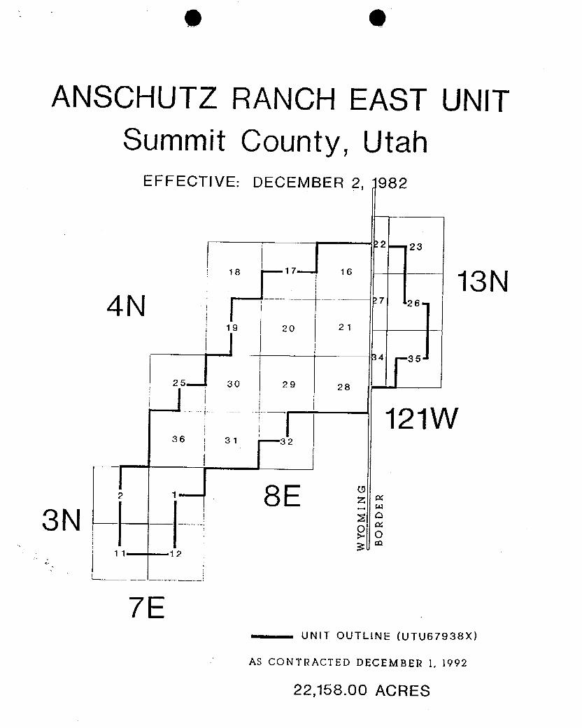
e e
ANSCHUTZ RANCH EAST UNITSummit County, Utah
EFFECTIVE: DECEMBER 2, 982
I r 12 23
18 17 16 -- 13N4 N ¯¯¯ ¯ 27 26
19 20 21-
34 35
25 30 29 28 --
121W36 31 32
8E3N
11 12
7E....-.-. UNIT OUTLINE (UTU67938X)
AS CONTRACTED DECEMBER 1, 1992
22,158.00
e e
ANSCHUTZ RANCH EAST UNITSummit County, Utah
EFFECTIVE: DECEMBER 2, 982
I r 12 23
18 17 16 -- 13N4 N ¯¯¯ ¯ 27 26
19 20 21-
34 35
25 30 29 28 --
121W36 31 32
8E3N
11 12
7E....-.-. UNIT OUTLINE (UTU67938X)
AS CONTRACTED DECEMBER 1, 1992
22,158.00
O OonM e STATE OF UTAH
DMSION OF OIL, GAS AND MINING5. L.nase Designation and Serial Number
SUNDRYNOTICES AND REPORTS ON WELLS sg MaormNarne.
Anschutz Ranch EastŸ.UnitAgreement Nami
De not use this fann for proposals to dri!I new weds, deepen existing wells, or to reenter plugged and abandoned welis.ARE W17-16Usa RT10N FOA PERMrr TO DRIU..OR DEEPEN form for such Proomats.
i. Type of Wou: OIL GAS OTHER: u. Wen Name and Number
2. Name of Operaler8. API Well NumberAmoco Production Company
Address and Telephone NumbecP.O. Box 800, Rm 8 12B, Denver, CO 8020 1 (303) 830-4781 10. M and Pool, or WHdcat
ARE4 Location of Weil765' FSL, 731' FEL
coumy: Summitcxa .T..a.R: Sec 17, T4N, R8E state: Utah
. CHECK APPROPRIATE BOXES TO INDICATE NATURE OF NOTICE, REPORT, OR OTHERDATANOTICE OF INTENT
SUBSEQUENT REPORT(Subenit in Duplieute)(submitoriginalForm only)
Abandonrnent O New Construction O Abandonment O New ConstructionCasing Repair O Pull or After casine O Casing Repair O Pull or Alter CasingChange of Plans O Recompletion O changeof Plans O Shoot or AcidizeConversion to injection O Shoot or Acidize O conversionto injection O ventor Flarej Fracture Treat « Q Vent or Flare O Fracture Treat O Water Shutai Multiple Completion O Water Shut-Cff O OtherOther
Date of work completion:proximate date work will start
Peoort results of Multiple Completions and Recompletions to different reservoirs on WEU.COMPL£T10N OR RECOMPLET10N AND LOG fonn.
* Must De accompanied by a cement verification report.
DESCRIBEPADPOSED OR COMPLETED OPERAT10NS (Cleady state all peronent details, and gwe peonent dates. 11well is directionady drilled, grve suosurface locations and messured and trueverocal dapchs for all madegrs mod goney pertinent,to th) worte.)
Amoco Production Company is now the operator of the above mentioned well. We will be operating underUtah Bond #831094. This is effective 1/31/95.
If you require additional information, please contact Gigi Martinez @(303) 830-4781.
Permit Agent 215198
a space for Stata use only)
(See instructions on Anverse

FEB 26 '98 08:24AM AMOCO PRODUCTION RM.#1885l P.1e - , estate of De aivare
PAGE 1
Office of the Secr tary of State
I, EDWARD J. FREEL, SECRETA Y OF STATE OF THE STATE OF
DELAWARE, DO HEREBY CERTIFY THE ATTACHED IS A TRUE AND CORRECT
COPY OF THE CERTIFICATE OF DIsS LUTION OF "AMOCO ROCMOUNT
COMPANY", FILED IN THIS OFFICE N THE THIRTY-FIRST DAY OF
JANUARY, A.D. 1995, AT 10 O'CLOCK A.M.
A CERTIFIED COPY OF THIS CE TIFICATE HAS BEEN FORWARDED TO
THE NEW CASTLE COUNTY RECORDER pF DEEDS FOR

FEB 26 '98 08'25AM AM PRODUCTIONRM.#1885 P.24 e
CERTIFICA OF DISSOLUTION
oF
AMOCORdCMOUNT COMPANY
I
AMOCOROCMOUNTCO ANY, a corporationorganizedand existing
underand by virtue of the Genetal orporationI.aw of the State of Delaware,
DOBS HEREBYCERTIFY:
FIRST: That dissolution as authorizedonJanuary 19, 1995.
SECOND: That dissolutionhas been authorized by the unanimouswritten
consent of all of the stockholde of the corporationentitled to vote on a
dissolution in accordance with the rovisionsof subsection (c) of section275 of
the General CorporationIaw of the Stateof Delaware.
] THIRD: That the namesandaddresses of the directors and offleers of
AMOCO ROCMOUNTCOMPANÝare as follows:
IRECTORS
I NAMES ADDRESSESI. M. Brown 501 WestLakePark Boulevard
Houston, TX 77079
J. M. Gross 501 WestLakePark BoulevardHouston, TX 77079
D. H. Welch 200 Bast RandolphDriveChicago, IL 60601
NAMES' = ADDRESS
J. M. Brown Presi ent 501 WestLakePark Blvd,Houston,TX 77079
M. R. Gile Vice President 1670BroadwayDenver, CO 80202
J. N. Jaggers Vice President 1670 BroadwayDenver, CO
FEB 26 '98 08: 25AM AMO PRODUCTION RM.#1885 P. 3
I
Page 2
NehfES OPP CES ADDRESS
D. H. Welch Vice resident 200 East RandolphDriveChicago, IL 60601
J. M, Gross Secre 501 WestLakePark Blvd.Houston, TX 77079
R. B. Wilson Assistmt 1670BroadwaySecretary Denver, CO 80202
Rebecca Gormezano Assistant 200 East RandolphDdveSecretary Chicago,IL 60601
C. F. Helm Assistmt 519 S. BostonSecrelary Tulsa, OK 74103
A. L. Haws AssistMt 501 WestLake Park Blvd.Secret Houston, TX 77079
Daniel B. Pinkert Assisþt 200 East Randolph DriveSecretg Chicago, IL 60601
G. L. Paulson AssistÅt 1670BroadwaySecret Denver, CO 80202
J E. Rutter Assis t 501 WestLake Park Blvd.Sects - Housten, TX 77079
J. L Siddall Assis t 200 East Randolph DriveSecre Chicago, IL 60601
M. J. Stonecipher Assistut 519 S. BostonSecretary Tulsa, OK 74103
Rebecca S. McGee Assistyt 1670BroadwaySecret Denver, CO 80202
Gerald M. Wilson Assis t 200 East Randolph DriveSecre r Chicago, IL 60601
Marsha Williams Treas ter 200 East Randolph DriveChicago, IL 60601
IN WITNESS WHBÉEOF, d AMOCOROCMOUNT COMPANY has
caused this certificate to be signedb M. R. Gile, its Vice President, and attested
by Rebecca $1 M¢Gee its Assistant Secretary, this _,261_... day of
January, 1995.
OCO ROCMOUNT COMPANY
ATTEST:
M. K. UIIe, Vice Presiderit
Assistant
FEB 26 '98 08: 26AM AMOC PRODUCTION RM. #1885 I P. 4
Page 3
I
STATE OP COLORADO )
CITY OF DENVER )
I, í¾r/Ñ, a Notary Public, do hereby certify thatM. R. GILE and 6.beM J ??d Šr££ of the above namedAMOCOROCMOUNT COMPANY, personagy knownto me to be the same personswhose names are subscribed to the |foregoinginstrument as Vice Presidentand Assistant Secretary, respectively,appeared before me this day in person,and acknowledged that they signed, led and delivered the said instrumentas the free and voluntary act of sal AMOCO ROCMOUNT COMPANY,and as their own free and volun act as Vice President and AssistantSecretary, respectively, for the uses d purposes therein set forth.
GIVEN under my hand and of leial seal this day of January,1995.
I
I

0 0
O State of UtahDEPARTMENT OF NATURAL RESOURCESDIVISION OF OIL, GAS AND MINING1594 West North Temple, Suite 1210
Michael O. Leavitt PO Box 145801GovernorTed Stewart Salt Lake City, Utah 84114-5801
Executive Director 801-538-5340
Inwell P. Braxton 801-359-3940 (Fax)Division Director 801-538-7223 (TDD)
February 26, 1998
G. G. MartinezAmoco Production CompanyP. O. Box 800, Room 812BDenver, Colorado 80201
Re: Notification of Sale or Transfer of Fee Lease Interest
The Division has received notification of a change ofoperator from Amoco Rocmount Company to Amoco Production Companyfor the following wells which are located on fee leases:
Well Name Sec.-T.-R. API Number(Anschutz Ranch East "ARE")
ARE W20-08 20-04N-08E 43-043-30123ARE 29-04ST1 29-04N-08E 43-043-30129ARE E21-14 21-04N-08E 43-043-30130ARE W21-04 21-04N-08E 43-043-30135ARE W29-02 29-04N-08E 43-043-30136ARE W16-06 16-04N-08E 43-043-30138ARE W20-16 20-04N-08E 43-043-30148ARE W30-16 30-04N-08E 43-043-30156ARE W36-16 36-04N-07E 43-043-30157ARE W20-06 20-04N-08E 43-043-30159ARE W32-04 32-04N-08E 43-043-30162ARE W31-08 31-04N-08E 43-043-30164ARE W31-04 31-04N-08E 43-043-30165ARE W17-16 17-04N-08E 43-043-30176ARE W30-08 30-04N-08E 43-043-30183ARE W30-14 30-04N-08E 43-043-30185ARE WO1-06 01-03N-07E 43-043-30188ARE W31-12 31-04N-08E 43-043-30190ARE W19-16 19-04N-08E 43-043-30204ARE W30-10 30-04N-08E 43-043-30215ARE W31-06 31-04N-08E
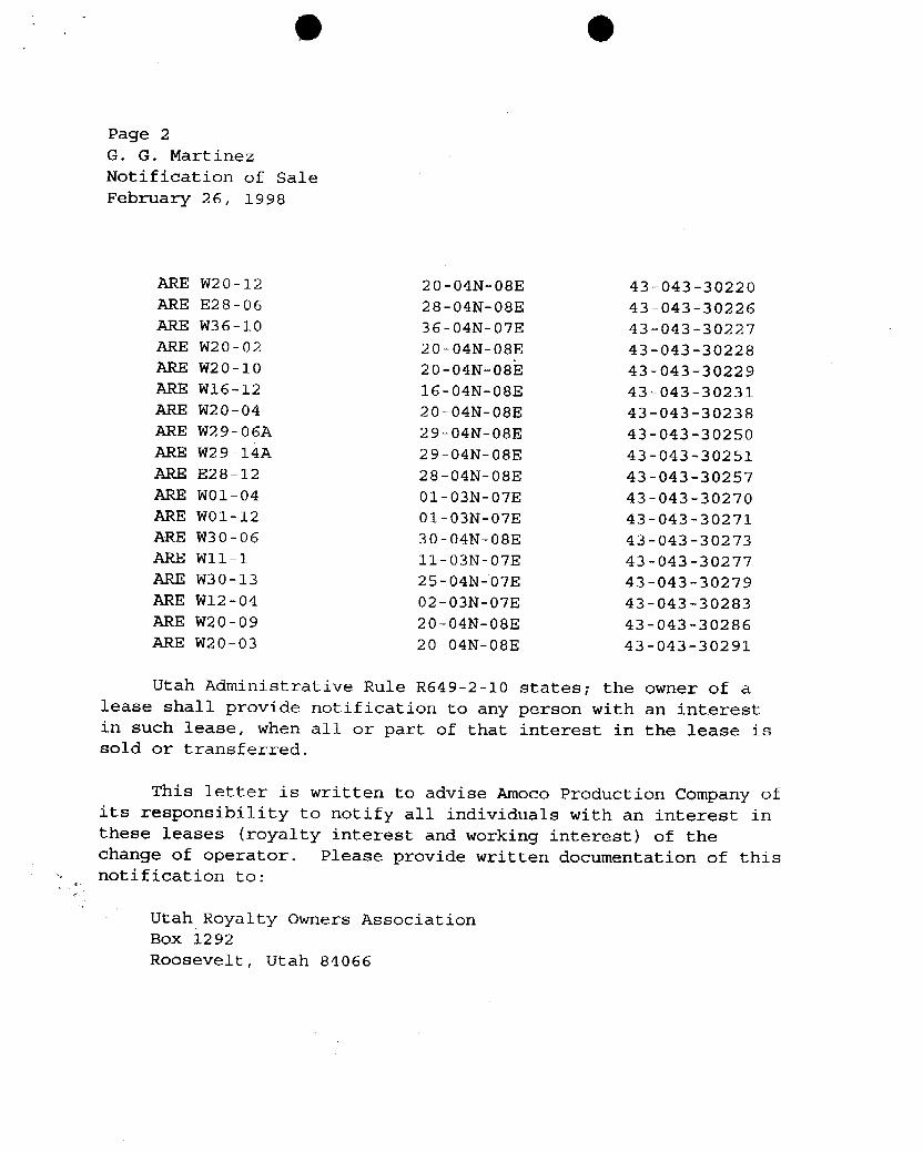
O O
Page 2G. G. MartinezNotification of SaleFebruary 26, 1998
ARE W20-12 20-04N-08E 43-043-30220ARE E28-06 28-04N-08E 43-043-30226ARE W36-10 36-04N-07E 43-043-30227ARE W20-02 20-04N-08E 43-043-30228ARE W20-10 20-04N-08E 43-043-30229ARE W16-12 16-04N-08E 43-043-30231ARE W20-04 20-04N-08E 43-043-30238ARE W29-06A 29-04N-08E 43-043-30250ARE W29-14A 29-04N-08E 43-043-30251ARE E28-12 28-04N-08E 43-043-30257ARE WO1-04 01-03N-07E 43-043-30270ARE WO1-12 01-03N-07E 43-043-30271ARE W30-06 30-04N-08E 43-043-30273ARE W11-1 11-03N-07E 43-043-30277ARE W30-13 25-04N-07E 43-043-30279ARE W12-04 02-03N-07E 43-043-30283ARE W20-09 20-04N-08E 43-043-30286ARE W20-03 20-04N-08E 43-043-30291
Utah Administrative Rule R649-2-10 states; the owner of alease shall provide notification to any person with an interestin such lease, when all or part of that interest in the lease issold or transferred.
This letter is written to advise Amoco Production Company ofits responsibility to notify all individuals with an interest inthese leases (royalty interest and working interest) of thechange of operator. Please provide written documentation of thisnotification to:
Utah Royalty Owners AssociationBox 1292Roosevelt, Utah
O O
Page 2G. G. MartinezNotification of SaleFebruary 26, 1998
ARE W20-12 20-04N-08E 43-043-30220ARE E28-06 28-04N-08E 43-043-30226ARE W36-10 36-04N-07E 43-043-30227
ARE W20-02 20-04N-08E 43-043-30228ARE W20-10 20-04N-08E 43-043-30229ARE W16-12 16-04N-08E 43-043-30231
ARE W20-04 20-04N-08E 43-043-30238ARE W29-06A 29-04N-08E 43-043-30250
ARE W29-14A 29-04N-08E 43-043-30251ARE E28-12 28-04N-08E 43-043-30257ARE WO1-04 01-03N-07E 43-043-30270ARE WO1-12 01-03N-07E 43-043-30271ARE W30-06 30-04N-08E 43-043-30273ARE W11-1 11-03N-07E 43-043-30277ARE W30-13 25-04N-07E 43-043-30279ARE W12-04 02-03N-07E 43-043-30283ARE W20-09 20-04N-08E 43-043-30286
ARE W20-03 20-04N-08E 43-043-30291
Utah Administrative Rule R649-2-10 states; the owner of alease shall provide notification to any person with an interestin such lease, when all or part of that interest in the lease issold or transferred.
This letter is written to advise Amoco Production Company ofits responsibility to notify all individuals with an interest inthese leases (royalty interest and working interest) of thechange of operator. Please provide written documentation of thisnotification to:
Utah Royalty Owners AssociationBox 1292Roosevelt, Utah
O O
Page 3G. G. MartinezNotification of SaleFebruary 26, 1998
Your assistance in this matter is appreciated.
Sincerely,
Lisha CordovaAdmin. Analyst, oil & Gas
cc: Amoco Rocmount Company, Ed HadlockUtah Royalty Owners Association, Stephen EvansJohn R. Baza, Associate DirectorOperator File
O O
Page 3G. G. MartinezNotification of SaleFebruary 26, 1998
Your assistance in this matter is appreciated.
Sincerely,
Lisha CordovaAdmin. Analyst, oil & Gas
cc: Amoco Rocmount Company, Ed HadlockUtah Royalty Owners Association, Stephen EvansJohn R. Baza, Associate DirectorOperator File
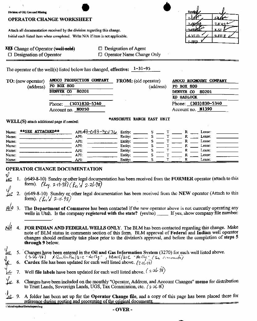
e àDivisionof Oil, Gas and Mining Ro
OPERATOR CHANGE WORKSHEET 1- * 6
Attach all documentationreceived by the division regarding this change.Initial each listed item when completed. Write N/A if itemis not applicable. 4-VI n // 9-Fu p
18 Change of Operator (weH-eeld) O Designationof AgentO Designation of Operator O OperatorName Change Only
The operator of the well(s) listed below has changed, effective: 1-31-95
TO: (new operator) AMOCOPRODUCTION COMPANY FROM: (old operator) AMOCO ROCMOUNTCOMPANY
(address) Po Box 800 (address) Po Box 800DENVER CO 80201 DENVER CO 80201
ED HADLOCK
Phone: (303)830-5340 Phone: (303)830-5340
Account no. NOO50 Account no. N1390
.
*ANSCHUTZ RANCH EAST UNITWELL(S) attach additional page if needed:
Name: **SEE ATTACHED** API:Å#-043-W)/ 7 Q Entity: S T R Lease:Name: API: Entity: S T R Lease:Name: API: Entity: S T R Lease:Name: API: Entity: S T R Lease:Name: API: Entity: S T R Lease:Name: API: Entity: S T R Lease:Name: API: Entity: S T R Lease:
OPERATOR CHANGE DOCUMENTATION
1. (r649-8-10) Sundryor other documentationhas been received from the FORMER operator (attach to this
2. (r649-8-10) Sundry other legal documentation has been received from the NEW operator (Attach to thisform). (g/ 2.- //- †
3. The Department of Commerce has been contacted if the new operator above is not currently operating anywells in Utah. Is the company registered with the state? (yes/no) If yes, show company file number:
4. FOR INDIAN AND FEDERAL WELLS ONLY. The BLM has been contacted regarding this change. Makenote of BLM status in comments section of this form. BLM approval of Federal and Indian well operatorchanges should ordinarily take place prior to the division'sapproval, and before the completion of steps 5through 9 below.
5. C s been e in the Oil and Gas In ormation System (3270) for each well listed above.
6. Cardex file has been updated for each well listed above. (y¿,_ÿQ7. Well file labels have been updated for each well listed above. ( 2 )
8. Changeshave been included on the monthly "Operator,Address, and Account Changes" memo for distributionto Trust Lands, Sovereign Lands, UGS, Tax Commission,etc. (24640
9. A folder has been set up for the Operator Change file, and a copy of this page has been placed there forreference during routing and processing of the original documents.
c:ldons\wpdocs\formsWperchng- OVER
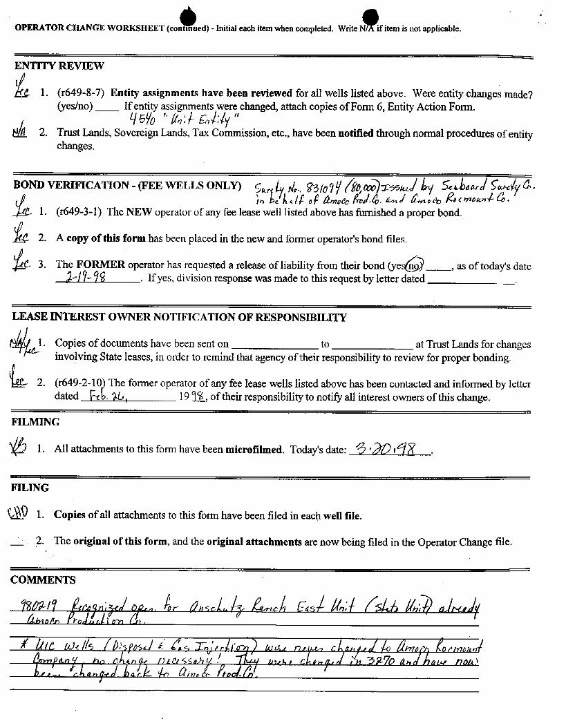
OPERATOR CHANGE WORKSHEET (cont¯mued)-- Initial each item when completed. Write N/A if item is not applicable.
ENTITY REVIEW
1. (<649-8-7)Entity assignments have been reviewed for all wells listed above. Were entity changes made?(yes/no) If entity assignments were changed, attach copies of Form 6, Entity Action Form.
2. Trust Lands, Sovereign Lands, Tax Commission,etc., have been notified through normal procedures of entitychanges.
BOND VERIFICATION - (FEE WELLS ONL¶ g gy¡ ggg)ymy,) AyíÁnarÁfue Ë.1. (<649-3-1)The NEW operator of any fee lease well listed above has furnished a proper bond.
2. A copy of this form has been placed in the new and forner operator's bond files.
C 3. The FORMER operator has requested a release of liability from their bond (yeË , as of today's date/Î-¾ . If yes, division response was made to this request by letter dated
LEASE INTEREST OWNER NOTIFICATION OF RESPONSIBILITY
N l. Copies of documents have been sent on to at Trust Lands for changesinvolving State leases, in order to remind that agency of their responsibility to review for proper bonding.
2. (r649-2-10) The forner operator of any fee lease wells listed above has been contacted and informed by letterdated FA 76, 1919>_,of their responsibility to notify all interest owners of this change.
FILMING
l. All attachments to this form have been microfilmed. Today'sdate: 6 '.
FILING
L Û 1. Copies of all attachments to this form have been filed in each well file.
2. The original of this form, and the original attachments are now being filed in the Operator Change file.
OPERATOR CHANGE WORKSHEET(cont¯mued)
-- Initial each item when completed. Write N/A if item is not applicable.
ENTITY REVIEW
1. (<649-8-7)Entity assignments have been reviewed for all wells listed above. Were entity changes made?(yes/no) If entity assignments were changed, attach copies of Form 6, Entity Action Form.
2. Trust Lands, Sovereign Lands, Tax Commission,etc., have been notified through normal procedures of entitychanges.
BOND VERIFICATION - (FEE WELLS ONL¶ g gy¡ ggg)ymy,) AyíÁnarÁfue Ë.1. (<649-3-1)The NEW operator of any fee lease well listed above has furnished a proper bond.
2. A copy of this form has been placed in the new and forner operator's bond files.
C 3. The FORMER operator has requested a release of liability from their bond (yeË , as of today's date/Î-¾ . If yes, division response was made to this request by letter dated
LEASE INTEREST OWNER NOTIFICATION OF RESPONSIBILITY
N l. Copies of documents have been sent on to at Trust Lands for changesinvolving State leases, in order to remind that agency of their responsibility to review for proper bonding.
2. (r649-2-10) The forner operator of any fee lease wells listed above has been contacted and informed by letterdated FA 76, 1919>_,of their responsibility to notify all interest owners of this change.
FILMING
l. All attachments to this form have been microfilmed. Today'sdate: 6 '.
FILING
L Û 1. Copies of all attachments to this form have been filed in each well file.
2. The original of this form, and the original attachments are now being filed in the Operator Change file.
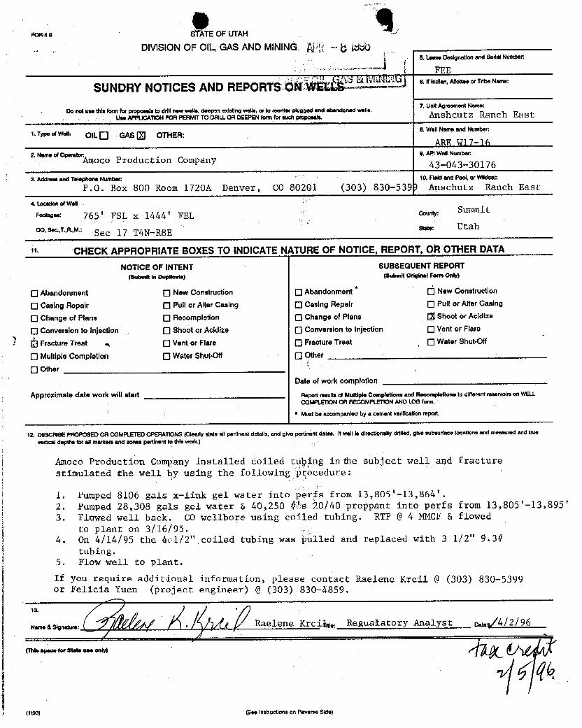
r-onae STATEOF UTAH
DIVISIONOF OIL,GAS AND MINING.À - 6 18805. I.ease Designationand Bedal Number:
FEE
SUNDRY NOTICES ANDREPORTSáÑ S.Ifindian,AllotteeorTribeName:
7. UnitAgreement Name:Do not use this form for propaeals to drill new wolle,deepen existing wolle, or to seenter plugged and abandoned wolle.
Use APPUCATION FORPERMrr TO DRit.I.OADEEPENformfor such AnSh cu tz Ranch Eas t
1. Type of Well: OIL GAS OTHER:8. Well Name and Number:
ARE W17-160. API WellNumber:2.Nameof0 Á¾OCÖProduction Company 43-043-30176
3. Address and Telephone Number: 10. Fleid and Pool, or Wildcat:
P.O. Box 800 Room 1720A Denver, CO 80201 (303) 830-539) Anschutz Ranch East
4. Location of Well
'*s•• 765' FSL x 1444' FEL county: Summit
CO. Sec..T.,R,M.: Sec 17 TAN-R8E st.t. Utah
" CHECK APPROPRIATE BOXES TO INDICATE NtTURE OF NOTICE, REPORT, Ol'l OTHER DATA
NOTICE OF lNTENT SUBSEQUENT REPORT(Submit in Dupiloate) (Submit Original Form Only)
O Abandonment O New Construction O Abandonment O New Construction
O casingRepair O Pull or Alter casing O casingRepair O Pull or AltercasingO changeof Plans O Recompletion 0 changeof Plans [3 Shoot or Acidize
O conversionto injection O Shoot or Acidize Conversion to Injection O Vent or Flare
Fracture Treat O Vent or Flare O Fracture Treat O Water Shut-Off
O Multiple Completlon O Water Shut-Off O Other
O OtherDate of work completion
Approximate date work will start n.portresuits or multipi.completioneand Menompletione to different reservoim on WELLCOMPLETION OR AECOMPLETlON ANDLOG form.
* Must be accompanied by a cement verificationreport.
12. DESCRIÈE PFIOPOSED OR COMPLETEDOPERATIONS (Clearly state all pertinent details, and give pertinent dates. If well is directionally drilled, give subsurface locations and measured and truevertical depths for all markem and zones pertinent to this work.)
Amoco Production Company installed coiled tuþing in the subject well and fracturestimulated the well by using the following prócedure:
1. Pumped 8106 gals x-link gel water into perfs from 13,805'-13,864'.2. Pumped 28,308 gals gel water & 40,250 #1s 20/40 proppant into perfs from 13,805'-13,895'3. Flowed well back. CO wellbore using coiled tubing. RTP @4 MMCF& flowed
to plant on 3/16/95.4. On 4/14/95 the 401/2" coiled tubing was þulled and replaced with 3 1/2" 9.3#
tubing.5. Flow well to plant.
If you require additional information, please contact Raelene Kreil @ (303) 830-5399
...as
r Fel project u
a 1 e r i
9859.Regualatory
Analyst o,4, /4/2/96
(1\03) (See Instructions on Reverse

O OSTATE OF UTAH FORM 9
DEPARTMENTOF NATURALRESOURCESDIVISIONOF OIL,GAS AND MINING 5. LEASEDESIGNATIONANDSERIALNUMBER:
6. IF INØlAN,ALLOTTEEOR TRIBE NAMESUNDRY NOTICES AND REPORTS ON WELLS7. UNITor CA AGREEMENTNAME:Do not use thisform for proposals todrill new wells, significannydeepen existing wells below currentbottom-hole depth, reenter plugged wels, or t° See Attacheddrii horizontal laterals. Use APPLICAllON FOR PERMIT TO DRILLform for such proposals.
1. TYPE OF WELLOIL WELL GAS WELL OTHER See Attached 8 WEU.NAMEendNUMBER
See Attached2. NAMEOF OPERATOR: 9. API NUMBERAmoco Production Company Attached
3. ADDRESS OF OPERATOR PHONE NUMBER 10. FIELDAND POOL, OR WILDCAT:501 Westlake Park Blv(,, Houston STATE TX ,,,77079 (281) 366-5328 See Attached
4. LOCATIONOF WEt.L
FOOTAGESATSURFACE: See Attached COUNTY: See Attached
OTR/QTR, SECTION. TOWNSHIP. RANGE. MERIDIAN: STATE:UTAH
19. CHECK APPROPRIATE BOXES TO INDICATENATUREOF NOTICE, REPORT, OR OTHER DATATYPE OF SUBMISSION TYPE OF ACTION
O mio= O DEEPEN REPERFOMATECURRENT FORMATIONNOTICE OF INTENT(submitin Duplicat•> 0 ALTERCANNG FRACTURETREAT SIDETRACKTO REPAIRWELL
-te date word a CASNG REPNR NEWCONSTRUCTION TEMPORARILYABANDON
O CHANGETO PREVIOUS PLANS OPERATOR CHANGE TUBINGREPAIR
O CHANGETUBING PLUGANDABANDON O VENT OR FLARE
O SUBSEQUENT REPORT 0 CMGE WELLNAME O PLUG BACK WATERDISPOSAL(submitoriginalForm only)O CHANGEWEU. STATUS PRODUCTION(STARTIRESUME) WAYERSHUT-OFF
Omleaf work complellon:O COMMINGLEPRODUCING FORMATIONS RECLAMATIONOF WELLSITE OTHER. Operator Name
O CONvm WEU. WE RECOMPLETE - DIFFERENT FORMATION
12. DESCRIBEPROPOSED OR COMPLETED OPERATIONS.Clearly showall pertinent detalis including dates, depths, volumes, etc.
Amoco Production Company proposes to change its name to BP America Production Company, effective December 31, 2001.Mailingaddresses and designated agents shall remain the same.
Attached to this sundry is a listing of wells currently operated by Amoco Production Company. This list includes all wells withthe exception of those wells which have a plugged or D&A status.
Also attached for the Board's file is a copyof the Board Resolution approvingthe name change.
(TMs space for Stato use only)
DEC13 2001DIVISIONOFemooo> <s•••=•tr====••= B•-• •> OIL,GAS AND
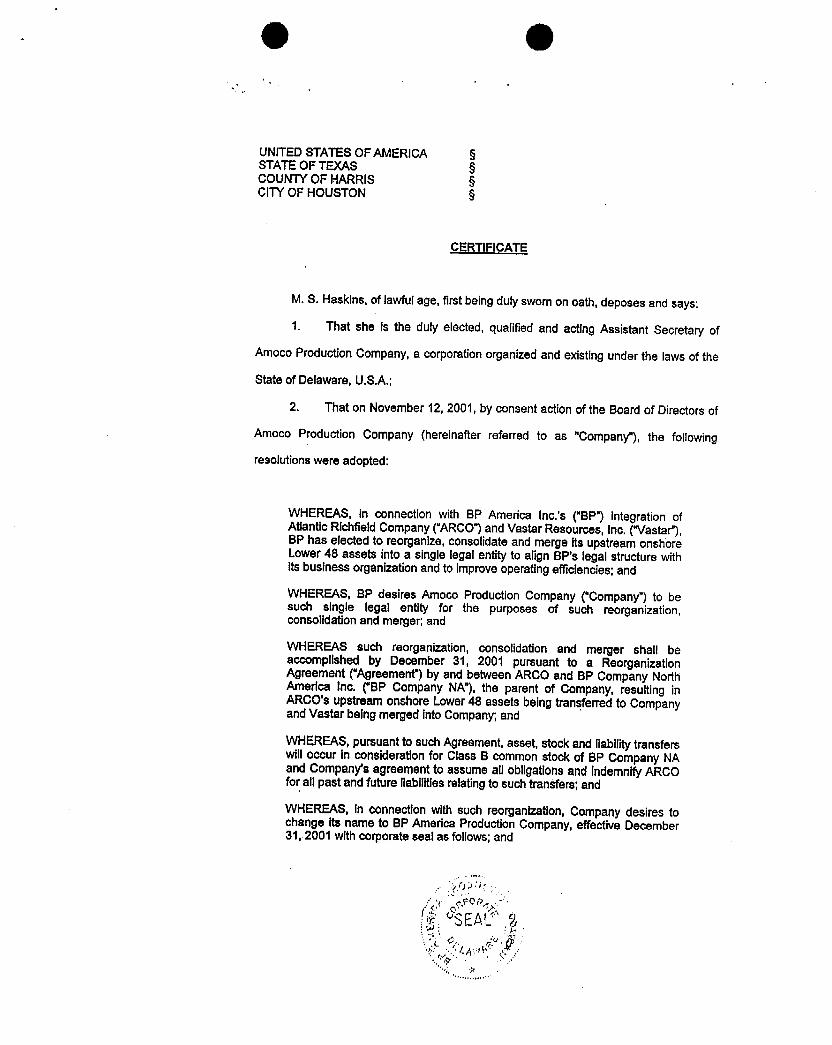
O O
UNITEDSTATESOF AMERICA §STATEOF TEXAS §COUNTYOF HARRIS §CITYOF HOUSTON §
CERTIFICATE
M. S. Haskins, of lawful age, first being duly sworn on oath, deposes and says:
1. That she is the duly elected, qualified and acting Assistant Secretary of
Amoco ProductionCompany, a corporationorganized and existingunder the laws of the
State of Delaware, U.S.A.;
2. That on November 12, 2001, by consent action of the Board of Directors of
Amoco Production Company (hereinafter referred to as "Company"), the following
resolutions were adopted:
WHEREAS, in connection with BP America Inc.'s ("BP") Integration ofAtlantic Richfield Company(ARCO")and Vastar Resources, Inc. ("Vastar"),BP has elected to reorganize,consolidate and merge its upstream onshoreLower48 assets into a single legal entity to align BP's legal structure withits business organizationand to Improveoperatingefficiencles;and
WHEREAS, BP desires Amoco Production Company ("Company")to besuch single legal entity for the purposes of such reorganization,consolidationand merger and
WHEREAS such reorganization, consolidation and merger shall beaccomplished by December 31, 2001 pursuant to a ReorganizationAgreement ("Agreement")by and between ARCO and BP Company NorthAmerica Inc. ("BP Company NA"),the parent of Company, resulting inARCO's upstreamonshoreLower48 assets being transferredtoCompanyand Vastar being merged intoCompany; and
WHEREAS,pursuant to such Agreement, asset, stock and liabilitytransferswilloccur In consideration for Class B common stock of BP Company NAand Company's agreement toassume allobilgationsand IndemnifyARCOforall past and future liabilitiesrelatingto such transfers;and
WHEREAS, in connectionwith such reorganization, Company desires tochange its name to BP America ProductionCompany, effective December31, 2001 withcorporate seal as follows;

0 6
WHEREAS all officersand directors of Companywlll remain unchanged.
NOW,THEREFORE,BE IT,
RESOLVED, Company wlli accept asset, stock and liability transferseffectiveDecember 31, 2001 pursuant to theAgreementand willassume allobligations and indemnifyARCO for all past or future liabilitiesrelating tosuch transfers.
FURTHERRESOLVED, Company willchange its name and corporate seatto BP America Production Company, effective December 31, 2001 and allofficersand directorswillremain unchanged.
3. That the aforesaid resolutions have not been amended, rescinded, or
annulled,but remain infullforce and effecton the date hereof.
EXECUTED In the City of Houston, State of Texas, on this the i day of, 2001.
' M.SkHaskins
SUBSC D and sworn to before me thisi day of , 2001.
(NotarySeal)
DENISEROBERTSONNourvr.im,se....ra NOTARY PUBLIC,STATE OF TEXAS
MYMbalen EipkesOctober 12,
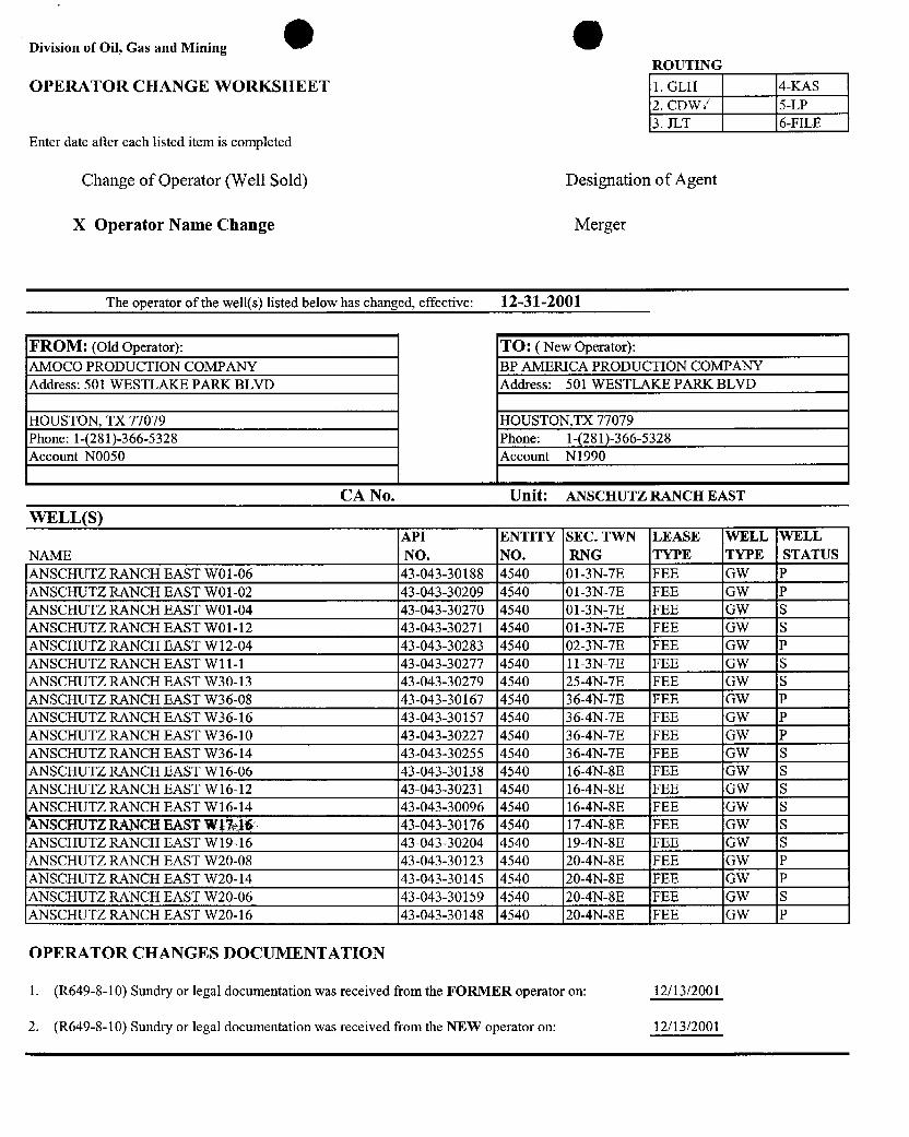
Division of Oil, Gas and MiningROUTING
OPERATOR CHANGE WORKSHEET 1. GLH 4-KAS
2. CDW/ 5-LP3. JLT 6-FILE
Enter date after each listed item is completed
Change of Operator (Well Sold) Designation of Agent
X Operator Name Change Merger
The operator of the well(s) listed below has changed, effective: 12-31-2001
FROM: (oldOperator): TO: ( New Operator):AMOCO PRODUCTION COMPANY BP AMERICA PRODUCTION COMPANYAddress: 501 WESTLAKE PARK BLVD Address: 501 WESTLAKE PARK BLVD
HOUSTON, TX 77079 HOUSTON,TX 77079Phone: 1-(281)-366-5328 Phone: 1-(281)-366-5328Account N0050 Account N1990
CA No. Unit: ANSCHUTZ RANCH EASTWELL(S)
API ENTITY SEC. TWN LEASE WELL WELLNAME NO. NO. RNG TYPE TYPE STATUSANSCHUTZ RANCH EAST W01-06 43-043-30188 4540 01-3N-7E FEE GW PANSCHUTZ RANCH EAST W01-02 43-043-30209 4540 01-3N-7E FEE GW PANSCHUTZ RANCH EAST W01-04 43-043-30270 4540 01-3N-7E FEE GW SANSCHUTZ RANCH EAST W01-12 43-043-30271 4540 01-3N-7E FEE GW SANSCHUTZ RANCH EAST W12-04 43-043-30283 4540 02-3N-7E FEE GW PANSCHUTZ RANCH EAST W11-1 43-043-30277 4540 11-3N-7E FEE GW SANSCHUTZ RANCH EAST W30-13 43-043-30279 4540 25-4N-7E FEE GW SANSCHUTZ RANCH EAST W36-08 43-043-30167 4540 36-4N-7E FEE GW PANSCHUTZ RANCH EAST W36-16 43-043-30157 4540 36-4N-7E FEE GW PANSCHUTZ RANCH EAST W36-10 43-043-30227 4540 36-4N-7E FEE GW PANSCHUTZ RANCH EAST W36-14 43-043-30255 4540 36-4N-7E FEE GW SANSCHUTZ RANCH EAST W16-06 43-043-30138 4540 16-4N-8E FEE GW SANSCHUTZ RANCH EAST Wl6-12 43-043-30231 4540 16-4N-8E FEE GW SANSCHUTZ RANCH EAST Wl6-14 43-043-30096 4540 16-4N-8E FEE GW SANSCHUTZ FÀNCH EAST W17-16 43-043-30176 4540 17-4N-8E FEE GW SANSCHUTZ RANCH EAST W19-16 43-043-30204 4540 19-4N-8E FEE GW SANSCHUTZ RANCH EAST W20-08 43-043-30123 4540 20-4N-8E FEE GW PANSCHUTZ RANCH EAST W20-14 43-043-30145 4540 20-4N-8E FEE GW PANSCHUTZ RANCH EAST W20-06 43-043-30159 4540 20-4N-8E FEE GW SANSCHUTZ RANCH EAST W20-16 43-043-30148 4540 20-4N-8E FEE GW P
OPERATOR CHANGES DOCUMENTATION
1. (R649-8-10) Sundry or legal documentation was received from the FORMER operator on: 12/13/2001
2. (R649-8-10) Sundry or legal documentation was received from the NEW operator on:

3. The new company has been checked thr the Department of Commerce, Division of porations Database on: 12/14/2001
4. Is the new operator registered in the State of Utah: YES Business Number: PENDING
5. If NO, the operator was contacted contacted on: N/A
6. Federal and Indian Lease Wells: The BLM and or the BIA has approved the (Inerger, name change,or operator change) for all wells listed on Federal or Indian leases on: N/A
7. Federal and Indian Units: The BLM or BIA has approved the successor of unit operatorfor wells listed on: N/A
8. Federal and Indian Communization Agreements ("CA"): The BLM or the BIA has approved the operatorchange for all wells listed involved in a CA on: N/A
9. Underground Injection Control ("UIC") The Division has approved UIC Form 5, Transfer of Authority to Inject,for the enhanced/secondary recovery unit/project for the water disposal well(s) listed on: N/A
DATA ENTRY:1. Changes entered in the Oil and Gas Database on: 12/17/2001
2. Changes have been entered on the Monthly Operator Change Spread Sheet on: 12/17/2001
3. Bond information entered in RBDMS on: 12/11/2001
4. Fee wells attached to bond in REDMS on: 12/17/2001
STATE BOND VERIFICATION:1. State well(s) covered by Bond No.: N/A
INDIAN BOND VERIFICATION:1. Indian well(s) covered by Bond No.: N/A
FEDERAL BOND VERIFICATION:1. Federal well(s) covered by Bond No.: N/A
FEE WELLS - BOND VERIFICATION/LEASE INTEREST OWNER NOTIFICATION:1. (R649-3-1) The NEW operator of any fee well(s) listed has furnished a bond: 103172911249
2. The FORMER operator has requested a release of liability from their bond on: N/AThe Division sent response by letter on: N/A
3. (R649-2-10) The FORMER operator of the Fee wells has been contacted and informed by a letter from the Divisionof their responsibility to notify all interest owners of this change on: 12/19/2001
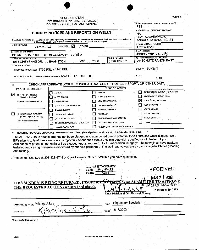
0 6STATEOFUTAH FORM9
DEPARTMENTOF NATURALRESOURCESDIVISIONOF OIL, GAS AND MINING 5. LEASEDESIGNATIONANDSERIALNUMBER.
FEE6. IF INDIAN,ALLOTTEEOR TRIBE NAME
SUNDRY NOTICES AND REPORTS ON WELLS NA7. UNITor CA AGREEMENT NAME:
Do not use thisform for proposals to drillnew wells, significantly deepen existing wells below current bottom-hole depth, reenter plugged wells, or t° ANSCHUTZ RANCH EASTdrill horizontal laterals. Use APPLICATIONFOR PERMIT TO DRILLform for such proposals.
1. TYPE OF WELL 8. WELL NAMEand NUMBER:OIL WELL GAS WELL OTHER ARE W17-16
2.NAMEOFOPERATOR: 9.APINUMBER:
BP AMERICA PRODUCTION COMPANY SUITE A 430438623† 30/g3. ADDRESS OF OPERATOR: PHONE NUMBER, 10. FIELDAND POOL, OR WILDCAT.
1013 CHEYENNE DR., EVANSTON WY 82930 (303) 423-5749 ANSCHUTZ RANCH EAST
4. LOCATIONOF WELL
FOOTAGESATSURFACE: 1765 FSL x 1444 FEL COUNTY: SUMMIT
QTR/QTR. SECTION, TOWNSHIP, RANGE, MERIDIAN: NWSE 17 4N 8E STATE:UTAH
it CHECK APPROPRIATE BOXES TO INDICATENATUREOF NOTICE, REPORT, OR OTHER DATA
TYPE OF SUBMISSION TYPE OF ACTION
O ACIDIZE DEEPEN REPERFORATE CURRENT FORMATION
NOTICE OF INTENT(Submit in Duplicate) ALTER CASING FRACTURETREAT SIDETRACKTO REPAIR WELL
Approximate date workwillstart CASING REPAIR NEWCONSTRUCTION TEMPORARILYABANDON
CHANGETO PREVIOUS PLANS OPERATOR CHANGE TUBING REPAIR
CHANGETUBING PLUG ANDABANDON VENT OR FLARE
O SUBSEQUENT REPORT CHANGEWELLNAME PLUG BACK WATER DISPOSAL
(Submit Original Form Only)
O CHANGE WELLSTATUS PRODUCTION(STARTIRESUME) WATER SHUT-OFF
Date of work completion:
O COMMINGLEPRODUCING FORMATIONS RECLAMATIONOF WELLSITE OTHER:
CONVERTWELL TYPE RECOMPLETE - DIFFERENT FORMATION
12 DESCRIBE PROPOSED OR COMPLETED OPERATIONS. Clearly show all pertinent details including dates, depths, volumes, etc.
The ARE W17-16 is shut in and has not been plugged and abandoned due to potential for a future salt water disposal well.BP's plan is to hold thesewells in a Temporarily Abandoned status until this potential is verified or eliminated. Uponelimination of potential, the wells will be plugged and abandoned. As for mechanical integrity: These wells all have packersinstalled and casing pressure is monitored by our field personnel. The wellhead valves are also on a regular PM for greasingand testing.
Please call Kris Lee at 303423-5749 or Clark Lawler at 307-783-2406 if you have questions.
COPY SENTTOOPERATOREde: //-/‡-· RECElVED
MAR2 72003THIS SUNDRY IS BEING RETURNED INSUPFif W SUBM TED TO APPROVE
THE REQUESTED ACTION (see attached sheet). .0F OlL,GAS&MINiÑO
November 19, 2003Utah Division of Oil, Gas and Mining
NAME(PLEASE PRINT) Kristing A.Lee TITLE
SIGNATURE DATE 3/17/2003
(This space for State use only)
(5/2000) (See Instructions on Reverse
0 6STATEOFUTAH FORM9
DEPARTMENTOF NATURALRESOURCESDIVISIONOF OIL, GAS AND MINING 5. LEASEDESIGNATIONANDSERIALNUMBER.
FEE6. IF INDIAN,ALLOTTEEOR TRIBE NAME
SUNDRY NOTICES AND REPORTS ON WELLS NA7. UNITor CA AGREEMENT NAME:
Do not use thisform for proposals to drillnew wells, significantly deepen existing wells below current bottom-hole depth, reenter plugged wells, or t° ANSCHUTZ RANCH EASTdrill horizontal laterals. Use APPLICATIONFOR PERMIT TO DRILLform for such proposals.
1. TYPE OF WELL 8. WELL NAMEand NUMBER:OIL WELL GAS WELL OTHER ARE W17-16
2.NAMEOFOPERATOR: 9.APINUMBER:
BP AMERICA PRODUCTION COMPANY SUITE A 430438623† 30/g3. ADDRESS OF OPERATOR: PHONE NUMBER, 10. FIELDAND POOL, OR WILDCAT.
1013 CHEYENNE DR., EVANSTON WY 82930 (303) 423-5749 ANSCHUTZ RANCH EAST
4. LOCATIONOF WELL
FOOTAGESATSURFACE: 1765 FSL x 1444 FEL COUNTY: SUMMIT
QTR/QTR. SECTION, TOWNSHIP, RANGE, MERIDIAN: NWSE 17 4N 8E STATE:UTAH
it CHECK APPROPRIATE BOXES TO INDICATENATUREOF NOTICE, REPORT, OR OTHER DATA
TYPE OF SUBMISSION TYPE OF ACTION
O ACIDIZE DEEPEN REPERFORATE CURRENT FORMATION
NOTICE OF INTENT(Submit in Duplicate) ALTER CASING FRACTURETREAT SIDETRACKTO REPAIR WELL
Approximate date workwillstart CASING REPAIR NEWCONSTRUCTION TEMPORARILYABANDON
CHANGETO PREVIOUS PLANS OPERATOR CHANGE TUBING REPAIR
CHANGETUBING PLUG ANDABANDON VENT OR FLARE
O SUBSEQUENT REPORT CHANGEWELLNAME PLUG BACK WATER DISPOSAL
(Submit Original Form Only)
O CHANGE WELLSTATUS PRODUCTION(STARTIRESUME) WATER SHUT-OFF
Date of work completion:
O COMMINGLEPRODUCING FORMATIONS RECLAMATIONOF WELLSITE OTHER:
CONVERTWELL TYPE RECOMPLETE - DIFFERENT FORMATION
12 DESCRIBE PROPOSED OR COMPLETED OPERATIONS. Clearly show all pertinent details including dates, depths, volumes, etc.
The ARE W17-16 is shut in and has not been plugged and abandoned due to potential for a future salt water disposal well.
BP's plan is to hold thesewells in a Temporarily Abandoned status until this potential is verified or eliminated. Uponelimination of potential, the wells will be plugged and abandoned. As for mechanical integrity: These wells all have packers
installed and casing pressure is monitored by our field personnel. The wellhead valves are also on a regular PM for greasingand testing.
Please call Kris Lee at 303423-5749 or Clark Lawler at 307-783-2406 if you have questions.
COPY SENTTOOPERATOREde: //-/‡-· RECElVED
MAR2 72003THIS SUNDRY IS BEING RETURNED INSUPFif W SUBM TED TO APPROVE
THE REQUESTED ACTION (see attached sheet). .0F OlL,GAS&MINiÑO
November 19, 2003Utah Division of Oil, Gas and Mining
NAME(PLEASE PRINT) Kristing A.Lee TITLE
SIGNATURE DATE 3/17/2003
(This space for State use only)
(5/2000) (See Instructions on Reverse
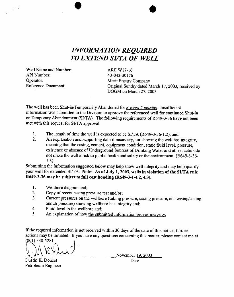
0 6
INFORMATION REQUIREDTO EXTEND SI/TA OF WELL
Well Name and Number: ARE W17-16API Number: 43-043-30176Operator: Merit Energy CompanyReference Document: Original Sundry dated March 17, 2003, received by
DOGM on March 27, 2003
The well has been Shut-in/Temporarily Abandoned for 8 years 5 months. Insufficientinformation was submitted to the Division to approve the referenced well for continued Shut-inor Temporary Abandonment (SI/TA). The following requirements of R649-3-36 have not beenmet with this request for SI/TA approval.
1. The length of time the well is expected to be SI/TA (R649-3-36-1.2), and2. An explanation and supporting data if necessary, for showing the well has integrity,
meaning that the casing, cement, equipment condition, static fluid level, pressure,existence or absence of Underground Sources of Drinking Water and other factors donot make the well a risk to public health and safety or the environment. (R649-3-36-1.3)
Submitting the information suggested below may help show well integrity and may help qualifyyour well for extended SI/TA. Note: As of July 1, 2003, wells in violation of the SI/TA ruleR649-3-36 may be subject to full cost bonding (R649-3-1-4.2, 4.3).
1. Wellbore diagram and;2. Copy of recent casing pressure test and/or;3. Current pressures on the wellbore (tubing pressure, casing pressure, and casing/casing
annuli pressure) showing wellbore has integrityand;4. Fluid level in the wellbore and;5. An explanation of how the submitted information proves integrity.
If the required information is not received within 30 days of the date of this notice, furtheractions may be initiated. If you have any questions concerning this matter, please contact me at
1) 538-
November 19, 2003Dustin K. Doucet DatePetroleum

STATE OF UTAH FORM 9DEPARTMENTOF NATURALRESOURCES
DIVISIONOF OIL,GAS AND MINING 5. LEASEDESIGNATIONANDSERIALNUMBER:
6. IF INDIAN,ALLOTTEEOR TRIBE NAMESUNDRY NOTICES AND REPORTS ON WELLS7. UNITor CA AGREEMENTNAME:Do not use this form for poposals to drillnew wells, significantly deepen existing wells below current bottom-hole depth, reenter plugged wells, or to See Attacheddrill horizontal laterals. Use APPLICATIONFOR PERMIT TO DRILLform for such proposals.
1, TYPE OF WELLOIL WELL O GAS WELL O OTHER See Attached 8. WELLNAMEand NUMBER:
See Attached2.NAMEOFOPERATOR: 9.APINUMBER:BP America Production Company Attached
3. ADDRESS OF OPERATOR: PHONE NUMBER: 10, FIELDAND POOL. OR WILDCAT:501 WestLake Park BN Houston sa, TX 277079 (281) 366-2000 See Attached
4. LOCATIONOF WELL
FOOTAGES AT SURFACE: See Attached COUNTY: See Attached
QTR/QTR, SECTION, TOWNSHIP, RANGE. MERIDIAN: STATE:UTAH
n CHECK APPROPRIATE BOXES TO INDICATENATUREOF NOTICE, REPORT, OR OTHER DATATYPE OF SUBMISSION TYPE OF ACTION
O ACIDIZE DEEPEN REPERFORATE CURRENT FORMATIONNOTICEOF INTENT(Submit in Duplicate) ALTERCASING FRACTURETREAT SIDETRACKTO REPAIR WELL
Approximate date work will start: CASINGREPAIR NEW CONSTRUCTION TEMPORARILYABANDON
CHANGETO PREVIOUS PLANS OPERATOR CHANGE TUBINGREPAIR
CHANGETUBING PLUG ANDABANDON VENTOR FLARE
O SUBSEQUENT REPORT CHANGEWELLNAME PLUG BACK WATERDISPOSAL(Submit Original Form Only)CHANGE WELLSTATUS PRODUCTION(STARTIRESUME) WATERSHUT-OFF
Date of work completion:COMMINGLEPRODUCING FORMATIONS RECLAMATIONOF WELL SITE OTHER:
O CONVERT WEt,LTYPE RECOMPLETE - DIFFERENT FORMATlON
12. DESCRIBE PROPOSED OR COMPLETED OPERATIONS. Clearly show all pertinent details including dates, depths, volumes, etc.
BP America Production Company, effective May 1, 2003, has transferredits interest in the attached list of properties to :
MeritEnergy Company13727 Noel Road, Suite 500Dallas, TX 75240
Transfer of operations is effective July 1, 2003.
By Merit Energy Company
N ME(P EA EPa Production CompanyOsv•cA4. S gf)¶$ TITLE . ggg
SIGNATURE DATE
(This space for State use only)
RECElVEDJULO32003
(5/2000) (See Instructîons on Reverse Side)
DIV.OF OIL,GAS&
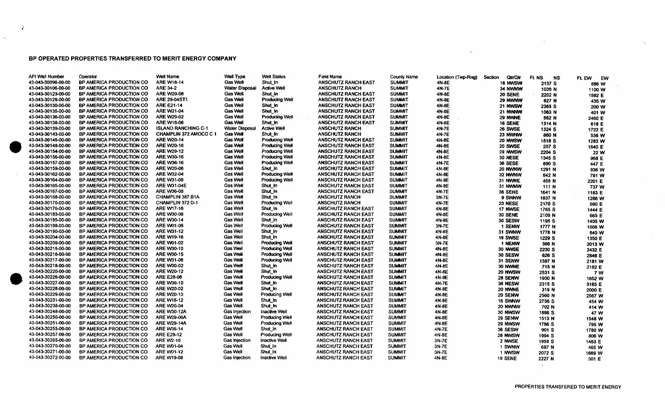
BP OPERATED PROPERTIES TRANSFERRED TO MERIT ENERGY COMPANY
API Well Number Operator Well Name Well Type Well Status Fieki Name County Name Locaten (TyRng) Sechon OtrlOtr FL NS NS FL EW EW43-043-30096-00-00 BP AMERICA PRODUCTION CO ARE W16-14 Gas Well Shut in ANSCHUTZ RANCH EAST SUMMIT 4N-8E 16 NWSW 2137 S 686 W43-043-30106-00-00 BP AMERICA PRODUCTION CO ARE 34-2 Water Disposal Active Well ANSCHUTZ RANCH SUMMIT 4N-7E 34 NWNW 1036 N 1100 W43-043-30123-00-00 BP AMERICA PRODUCTION CO ARE W20-08 Gas Well Shut_in ANSCHUTZ RANCH EAST SUMMIT 4N-SE 20 SENE 2202 N 1592 E43-043-30129-00-00 BP AMERICA PRODUCTION CO ARE 29-04ST1 Gas Weli Producing Well ANSCHUTZ RANCH EAST SUMMIT 4N-8E 29 NWNW 627 N 435 W43-043-30130-00-00 BP AMERICA PRODUCTION CO ARE E21-14 Gas Well Shut in ANSCHUTZ RANCH EAST SUMMIT 4N-8E 21 NWSW 2365 S 200 W43-043-30135-DD-00 BP AMERICA PRODUCTION CO ARE W21-04 Gas Well Shut In ANSCHUTZ RANCH EAST SUMMIT 4N-8E 21 NWNW 1063 N 401 W43-043-30136-00-00 BP AMERICA PRODUCTION CO ARE W29-02 Gas Well Producing Well ANSCHUTZ RANCH EAST SUMMIT 4N-8E 29 NWNE 662 N 2460 E43-043-30138-00-00 BP AMERICA PRODUCTION CO ARE W16-06 Gas Well Shut_In ANSCHUTZ RANCH EAST SUMMIT 4N-BE 16 SENE 1314 N 618 E43-043-30139-00-00 BP AMERICA PRODUCTION CO ISLAND RANCHING C-1 Water Disposal Active Well ANSCHUTZ RANCH SUMMIT 4N-7E 26 SWSE 1324 S 1722 E43-043-30143-00-00 BP AMERICA PRODUCTION CO CHAMPUN 372AMOCO C 1 Gas Wei Shut_In ANSCHUTZ RANCH SUMMIT 4N-7E 23 NWNW 860 N 536 W43-043-30145-00-00 BP AMERICA PROOUCT10N CO ARE W20-14 Gas Wel Producing Well ANSCHUTZ RANCH EAST SUMMIT 4N-8E 20 NWSW 1518 S 1283 WO 43-043-30148-00-00 BP AMERICA PRODUCT10N CO ARE W2 16 Gas Wei Producing Well ANSCHUTZ RANCH EAST SUMMIT 4N-8E 20 SWSE 257 S 1640 E43-043-30154-00-00 BP AMERICA PRODUCT10N CO ARE W29-12 Gas Wel Producing Well ANSCHUTZ RANCH EAST SUMMIT 4N-SE 29 NWSW 2204 S 22 W43-043-30156-00-00 BP AMERICA PRODUCTION CO ARE W30-16 Gas Well Producing Well ANSCHUTZ RANCH EAST SUMMIT 4N-BE 30 NESE 1345 S 988 E43-043-30157-00-00 BP AMERICA PRODUCTION CO ARE W36-16 Gas Well Producing Well ANSCHUTZ RANCH EAST SUMMIT 4N-7E 36 SESE 890 S 447 E4M43-30159-00-00 BP AMERICA PRODUCTION CO ARE W20-06 Gas Well Shut in ANSCHUTZ RANCH EAST SUMMIT 4N-SE 20 NWNW 1291 N 936 W43-043-30162-00-00 BP AMERICA PRODUCTION CO ARE W32-04 Gas Well Producing Well ANSCHUTZ RANCH EAST SUMMIT 4N-8E 32 NWNW 642 N 791 W43-043-30164-00-00 BP AMERICA PRODUCTION CO ARE W31-08 Gas Well Producing Well ANSCHUTZ RANCH EAST SUMMIT 4N-8E 31 NWNE 468 N 2201 E43-043-30165-00-00 BP AMERICA PRODUCTION CO ARE W31-04E Gas Weil Shut_In ANSCHUTZ RANCH EAST SUMMIT 4N-SE 31 NWNW 111 N 737 W4M43-30167-00-00 BP AMERICA PRODUCTION CO ARE W3&oß Gas Well Shut in ANSCHUTZ RANCH EAST SUMMIT 4N-7E 36 SENE 1641 N 1183 E43-043-30168-00-00 BP AMERICA PRODUCTION CO CHAMPLIN 387 B1A Gas Well Shut_fn ANSCHUTZ RANCH SUMMIT 3N-7E 9 SWNW 1837 N 1286 W43-043-30170-00-00 BP AMERICA PRODUCTION CO CHAMPL1N372 D-1 Gas Well Producing Well ANSCHUTZ RANCH SUMMIT 4N-7E 23 NESE 2170 S 680 E43-043-30176-00-00 BP AMERICA PRODUCTlON CO ARE W17-16 Gas Well Shut_In ANSCHUTZ RANCH EAST SUMMIT 4N-SE 17 NWSE 1765 S 1444 E4M43-30183-00-DO BP AMERICA PRODUCTION CO ARE W30-08 Gas Well Producing Well ANSCHUTZ RANCH EAST SUMMIT 4N-SE 30 SENE 2109 N 665 E43-043-30185-00-00 BP AMERICA PRODUCTION CO ARE W30-14 Gas Well Start_Jn ANSCHUTZ RANCH EAST SUMMIT 4N-BE 30 SESW 1195 S 1405 W43-043-30188-00-00 BP AMERICA PRODUCTION CO ARE WO1-06 Gas Well Producing Well ANSCHUTZ RANCH EAST SUMMIT 3N-7E 1 SENW 1777 N 1666 W43-043-30190-0 00 BP AMER1CAPRODUCTlON CO AREW31-12 Gas Well Shut_In ANSCHUTZ RANCH EAST SUMMIT 4N-SE 31 SWNW 1778 N 640 W43-043-30204-00-00 BP AMERICA PRODUCTION CO ARE W19-16 Gas Well Shut_In ANSCHUTZ RANCH EAST SUMMIT 4N-SE 19 SWSE 1229 S 1350 E43-043-30209-0 00 BP AMERICA PRODUCTION CO ARE WO1-02 Gas Well Producing Well ANSCHUTZ RANCH EAST SUMMIT 3N-7E 1 NENW 386 N 2013 W43-043-30215-00-00 BP AMERICA PRODUCTION CO ARE W30-10 Gas Well Producing Well ANSCHUTZ RANCH EAST SUMMIT 4N-BE 30 NWSE 2230 S 2432 E43-043-30216-00-DO BP AMERICA PRODUCTION CO ARE W30-15 Gas Weil Producing Well ANSCHUTZ RANCH EAST SUMMIT 4N-BE 30 SESW 626 S 2848 E43-043-30217-00-00 BP AMERICA PRODUCTION CO ARE W31-06 Gas Well Producing Well ANSCHUTZ RANCH EAST SUMMIT 4N-8E 31 SENW 1397 N 2181 W43-04 30218-00-00 BP AMERICA PRODUCTION CO ARE W30-02 Gas Wei Shut_In ANSCHUTZ RANCH EAST SUMMIT 4N-8E 30 NWNE 715 N 2182 E43-043-30220-00-00 BPAMERlCA PRODUCTION CO ARE W20-12 Gas Well Shut_In ANSCHUTZ RANCH EAST SUMMIT 4N-SE 20 NWSW 2531 S 7 WO 43-043-30226-00-00 BPAMERlCA PRODUCTION CO ARE E28-06 Gas Well Producing Well ANSCHUTZ RANCH EAST SUMMIT 4N-SE 28 SENW 1900 N 1652 W43-04 30227-00-00 BP AMERICA PRODUCTION CO ARE W36-10 Gas Well Shutin ANSCHUTZ RANCH EAST SUMMIT 4N-7E 36 NESW 2315 S 3185 E43-043-30228-00-00 BP AMER1CAPRODUCTION CO ARE W20-02 Gas Well Shut_In ANSCHUTZ RANCH EAST SUMMIT 4N-SE 20 NWNE 319 N 2000 E43-043-30229-00-00 BP AMERICA PRODUCTION CO ARE W20-10 Gas Well Producing Well ANSCHUTZ RANCH EAST SUMMIT 4N-SE 20 SENW 2560 N 2567 W43-043-30231-00-00 BP AMERICA PRODUCTION CO ARE W16-12 Gas Well Shut_in ANSCHUTZ RANCH EAST SUMMIT 4N-SE 16 SWNW 2756 S 454 W43-043-30238-OD-00 BP AMERICA PRODUCTION CO ARE W20-04 Gas Well Shut_In ANSCHUTZ RANCH EAST SUMMIT 4R-SE 20 NWNW 702 N 414 W43-043-30248-DD-00 BP AMERICA PRODUCTION CO ARE W30-12A Gas injecIion Inactive Well ANSCHUTZ RANCH EAST SUMMIT 4N-SE 30 NWSW 1886 S 47 W43-043-30250-00-00 BP AMERICA PRODUCTION CO ARE W29-0BA Gas Well Producing Well ANSCHUTZ RANCH EAST SUMMIT 4N-8E 29 SENW 1513 N 1548 W43443-30251-00-00 BP AMERICA PRODUCTION CO ARE W29-14A Gas Well Producing Well ANSCHUTZ RANCH EAST SUMMIT 4N-SE 29 NWSW 1786 S 795 W43-043-30255-00-00 BP AMERICA PRODUCTION CO ARE W36-14 Gas WeFI Shut_in ANSCHUTZ RANCH EAST SUMMiT 4N-7E 36 SESW 901 S 1780 W43-043-30257-09-00 BP AMERICA PRODUCTION CO ARE E28-12 Gas Well Producing Well ANSCHUTZ RANCH EAST SUMMIT 4N-SE 28 NWSW 1994 S 806 W43-043-30265-00-00 BP AMERICA PRODUCTION CO ARE W2-10 Gas injection inactive Well ANSCHUTZ RANCH EAST SUMMIT 3N-7E 2 NWSE 1959 S 1463 E43-043-30270-00-00 BP AMERICA PRODUCTION CO ARE WO1-04 Gas Well Shut_in ANSCHUTZ RANCH EAST SUMMIT 3N-7E 1 SWNW 697 N 465 W43-043-30271-00-00 BP AMERICA PRODUCTION CO ARE WO1-12 Gas Well Shut_tn ANSCHUTZ RANCH EAST SUMMIT 3N-7E 1 NWSW 2072 S 1669 W43-043-30272-00-00 BP AMERICA PRODUCTION CO ARE W19-08 Gas injection Inactive Well ANSCHUTZ RANCH EAST SUMMIT 4N-SE 19 SENE 2227 N 301 E
PROPERTIES TRANSFERED TO MERIT
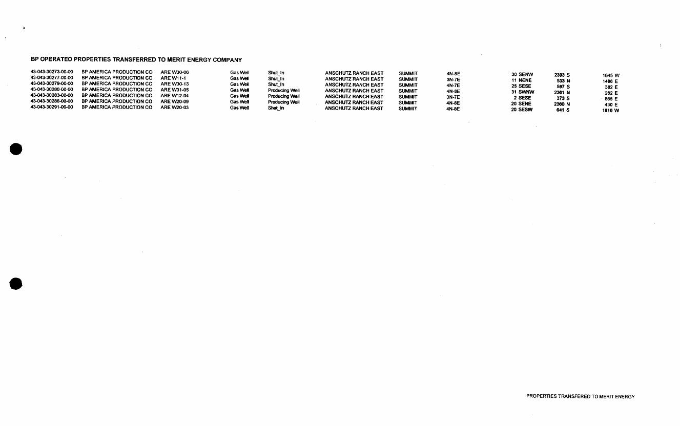
BP OPERATED PROPERTIES TRANSFERRED TO MERIT ENERGY COMPANY
43-043-30273-00-00 BP AMERICA PRODUCTION CO ARE W30-06 Gas Well Shut_In ANSCHUTZ RANCH EAST SUMMIT 4N-SE 30 SENW 2393 S 1645 W43-043-30277-00-00 BP AMERJCA PRODUCTION CO ARE W11-1 Gas Well Shut_In ANSCHUTZ RANCH EAST SUMMIT 3N-7E 11 NENE 533 N 1486 E43-043-30279-00-00 BP AMER1CA PRODUCTION CO ARE W30-13 Gas Well Shut_In ANSCHUTZ RANCH EAST SUMMIT 4N-7E 25 SESE 597 S 382 E43-043-30280-DD-00 BP AMERICA PRODUCTION CO ARE W31-05 Gas Well Producing Well ANSCHUTZ RANCH EAST SUMMIT 4N-BE 31 SWNW 2361 N 282 E43-043-30283-OD-00 BP AMERICA PRODUCTION CO ARE W12-04 Gas Well Producing Well ANSCHUTZ RANCH EAST SUMMFT 34-7E 2 SESE 373 S 865 E43-043-30286-00-00 BP AMERICA PRODUCTION CO ARE W20-09 Gas Well Producing Well ANSCHUTZ RANCH EAST SUMMIT 4N-8E 20 SENE 2360 N 430 E43-043-30291-0(M)0 BP AMERICA PRODUCTION CO ARE W20-03 Gas Well StM_ln ANSCHUTZ RANCH EAST SUMMIT 4N-8E 20 SESW 641 S 1810 W
O
PROPERTIES TRANSF ERED TO MERfT

StaŸe of UtahDEPARTMENT OF NATURAL RESOURCESDIVISION OF OIL, GAS AND MINING1594 West North Temple, Suite 1210PO Box 145801
Michael O. LeavittGovernor Salt Lake City, Utah 84114-5801
Robert L Morgan (801) 538-5340 telephoneExecutive Director (801) 359-3940 fax August 26, 2003Lowell P. Braxton (801) 538-7223 TTYDivision Director www.nr.utah.gov
Bruce WilliamsBP America Production Company501 WestLake Park BlvdHouston, TX 77079
Subject: Notification of Sale or Transfer of Fee Lease Interest
Dear Mr. Williams:
The Division has processed your request for an operator change from BP America ProductionCompany to Merit Energy Company effective July 1, 2003 for the attached list of fee wells.
Utah Administrative Code Rule R649-2-10 states: "The owner of a lease shall providenotification to any person with an interest in such lease, when all or part of that interest in the lease issold or transferred".
This letter is written to advise you of your responsibility to notify all individuals with an interest inthese leases (royalty interest and working interest) of the changer. Please provide written documentation ofthis notification to:
Utah Royalty Owners AssociationPO Box 1292Roosevelt, Utah 84066
Your assistance in this matter is appreciated.
Sincerely,
Earlene RussellEngineering Technician
Attachment
cc: Merit Energy CompanyUtah Royalty Owners Association
utah!Where idra<
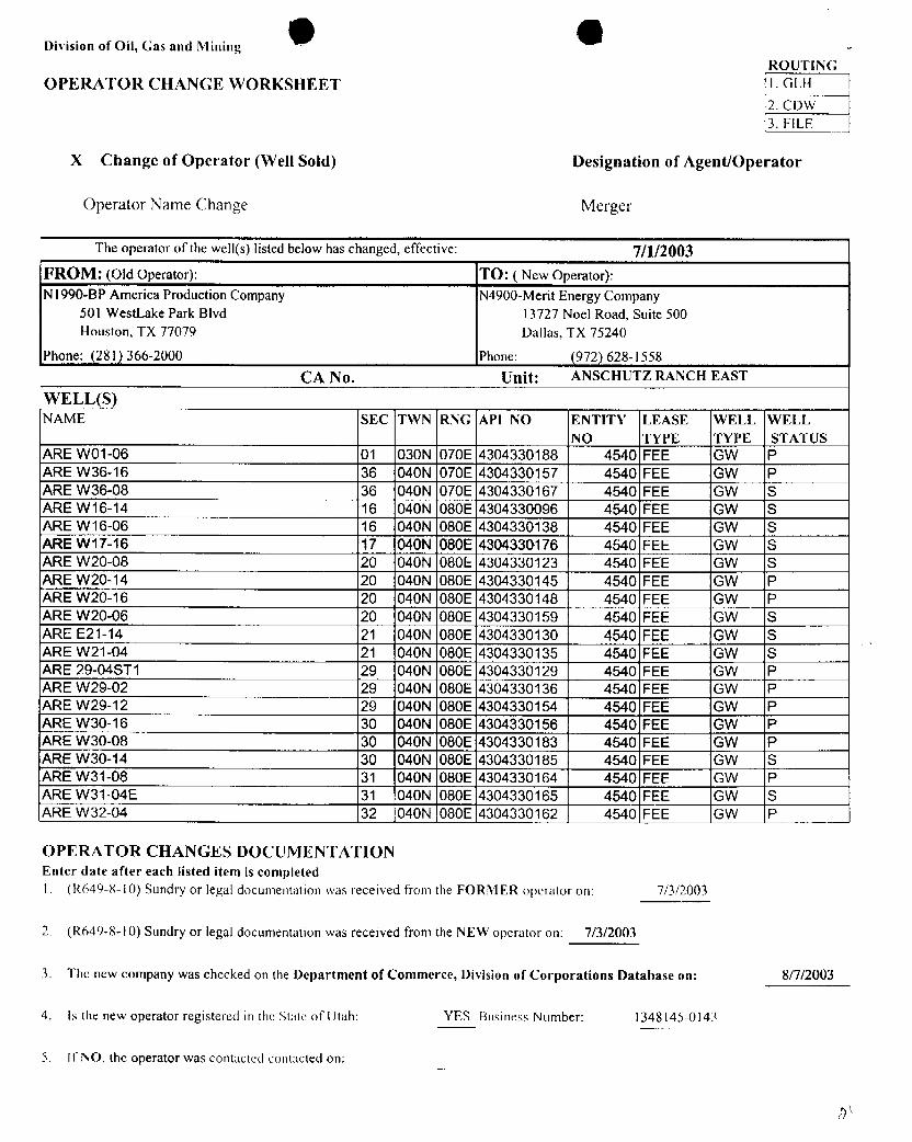
Division of Oil, Gas and MiningROUTING
OPERATOR CHANGE WORKSHEET I. GLH2. CDW3. FILE
X Change of Operator (Well Sold) Designation of Agent/Operator
Operator Name Change Merger
The operator of the well(s) listed below has changed, effective: 7/1/2003FROM: (Old Operator): TO: ( New Operator):N1990-BP America Production Company N4900-Merit Energy Company
501 WestLake Park Blvd 13727 Noel Road, Suite 500Houston, TX 77079 Dallas, TX 75240
Phone: (281) 366-2000 Phone: (972) 628-1558
CA No. Unit: ANSCHUTZ RANCH EAST
WELL(S)NAME SEC TWN RNG API NO ENTITY LEASE WELL WELL
NO TYPE TYPE STATUSARE WO1-06 01 030N 070E 4304330188 4540 FEE GW PARE W36-16 36 040N 070E 4304330157 4540 FEE GW PARE W36-08 36 040N 070E 4304330167 4540 FEE GW SARE W16-14 16 040N 080E 4304330096 4540 FEE GW SARE W16-06 16 040N 080E 4304330138 4540 FEE GW SARE W17-16 17 040N 080E 4304330176 4540 FEE GW SARE W20-08 20 040N 080E1304330123 4540 FEE GW SARE W20-14 20 040N 080E 4304330145 4540 FEE GW PARE W20-16 20 040N 080E 4304330148 4540 FEE GW PARE W20-06 20 040N 080E 4304330159 4540 FEE GW SARE E21-14 21 040N 080E Ã3Ò4330130 4540 FEE GW SARE W21-04 21 040N 080E 4304330135 4540 FEE GW SARE 29-04ST1 29 040N 080E 4304330129 4540 FEE GW PARE W29-02 29 040N 080E 4304330136 4540 FEE GW PARE W29-12 29 040N 080E 4304330154 4540 FEE GW PARE W30-16 30 040N 080E 4304330156 4540 FEE GW PARE W30-08 30 040N 080E 4304330183 4540 FEE GW PARE W30-14 30 040N 080E 4304330185 4540 FEE GW SARE W31-08 31 040N 080E 4304330164 4540 FEE GW PARE W31-04E 31 040N 080E 4304330165 4540 FEE GW SARE W32-04 32 040N 080E 4304330162 4540 FEE GW P
OPERATOR CHANGES DOCUMENTATIONEnter date after each listed item is completed1. (R649-8-l0) Sundry or legal documentation was received from the FORMER operator on: 7/3/2003
2. (R649-8-l0) Sundry or legal documentation was received from the NEW operator on: 7/3/2003
3. The new company was checked on the Department of Commerce, Division of Corporations Database on: 8/7/2003
4. Is the new operator registered in the State of Utah: YES Business Number: 1348145-0143
5. If NO, the operator was contacted contacted
Division of Oil, Gas and MiningROUTING
OPERATOR CHANGE WORKSHEET I. GLH
2. CDW3. FILE
X Change of Operator (Well Sold) Designation of Agent/Operator
Operator Name Change Merger
The operator of the well(s) listed below has changed, effective: 7/1/2003FROM: (Old Operator): TO: ( New Operator):N1990-BP America Production Company N4900-Merit Energy Company
501 WestLake Park Blvd 13727 Noel Road, Suite 500Houston, TX 77079 Dallas, TX 75240
Phone: (281) 366-2000 Phone: (972) 628-1558
CA No. Unit: ANSCHUTZ RANCH EAST
WELL(S)NAME SEC TWN RNG API NO ENTITY LEASE WELL WELL
NO TYPE TYPE STATUSARE WO1-06 01 030N 070E 4304330188 4540 FEE GW PARE W36-16 36 040N 070E 4304330157 4540 FEE GW PARE W36-08 36 040N 070E 4304330167 4540 FEE GW SARE W16-14 16 040N 080E 4304330096 4540 FEE GW SARE W16-06 16 040N 080E 4304330138 4540 FEE GW SARE W17-16 17 040N 080E 4304330176 4540 FEE GW SARE W20-08 20 040N 080E1304330123 4540 FEE GW SARE W20-14 20 040N 080E 4304330145 4540 FEE GW PARE W20-16 20 040N 080E 4304330148 4540 FEE GW PARE W20-06 20 040N 080E 4304330159 4540 FEE GW SARE E21-14 21 040N 080E Ã3Ò4330130 4540 FEE GW SARE W21-04 21 040N 080E 4304330135 4540 FEE GW SARE 29-04ST1 29 040N 080E 4304330129 4540 FEE GW PARE W29-02 29 040N 080E 4304330136 4540 FEE GW PARE W29-12 29 040N 080E 4304330154 4540 FEE GW PARE W30-16 30 040N 080E 4304330156 4540 FEE GW PARE W30-08 30 040N 080E 4304330183 4540 FEE GW PARE W30-14 30 040N 080E 4304330185 4540 FEE GW SARE W31-08 31 040N 080E 4304330164 4540 FEE GW PARE W31-04E 31 040N 080E 4304330165 4540 FEE GW SARE W32-04 32 040N 080E 4304330162 4540 FEE GW P
OPERATOR CHANGES DOCUMENTATIONEnter date after each listed item is completed1. (R649-8-l0) Sundry or legal documentation was received from the FORMER operator on: 7/3/2003
2. (R649-8-l0) Sundry or legal documentation was received from the NEW operator on: 7/3/2003
3. The new company was checked on the Department of Commerce, Division of Corporations Database on: 8/7/2003
4. Is the new operator registered in the State of Utah: YES Business Number: 1348145-0143
5. If NO, the operator was contacted contacted
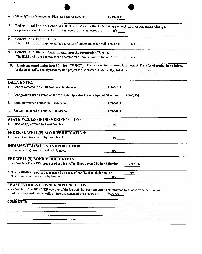
6. (R649-9-2)Waste Management Plan has been received on: IN PLACE
7. Federal and Indian Lease Wells: The BLM and or the BIA has approved the merger, name change,or operator change for all wells listed on Federal or Indian leases on: n/a
8. Federal and Indian Units:The BLM or BIA has approved the successor of unit operator for wells listed on: n/a
9. Federal and Indian Communization Agreements ("CA"):The BLM or BIA has approved the operator for all wells listed within a CA on: n/a
10. Underground Injection Control ("UIC") The Division has approved UIC Form 5, Transfer of Authority to Inject,for the enhanced/secondary recovery unit/project for the water disposal well(s) listed on: n/a
DATA ENTRY:1. Changes entered in the Oil and Gas Database on: 8/26/2003
2. Changes have been entered on the Monthly Operator Change Spread Sheet on: 8/26/2003
3. Bond information entered in RBDMS on: 8/26/2003
4. Fee wells attached to bond in RBDMS on: 8/26/2003
STATE WELL(S) BOND VERIFICATION:1. State well(s) covered by Bond Number: n/a
FEDERAL WELL(S) BOND VERIFICATION:l. Federal well(s) covered by Bond Number: n/a
INDIAN WELL(S) BOND VERIFICATION:1. Indian well(s) covered by Bond Number: n/a
FEE WELL(S) BOND VERIFICATION:1. (R649-3-1) The NEW operator of any fee well(s) listed covered by Bond Number 103912218
2. The FORMER operator has requested a release of liability from their bond on: n/aThe Division sent response by letter on: n/a
LEASE INTEREST OWNER NOTIFICATION:3. (R649-2-10) The FORMER operator of the fee wells has been contacted and informed by a letter from the Division
of their responsibility to notify all interest owners of this change on: 8/26/2003
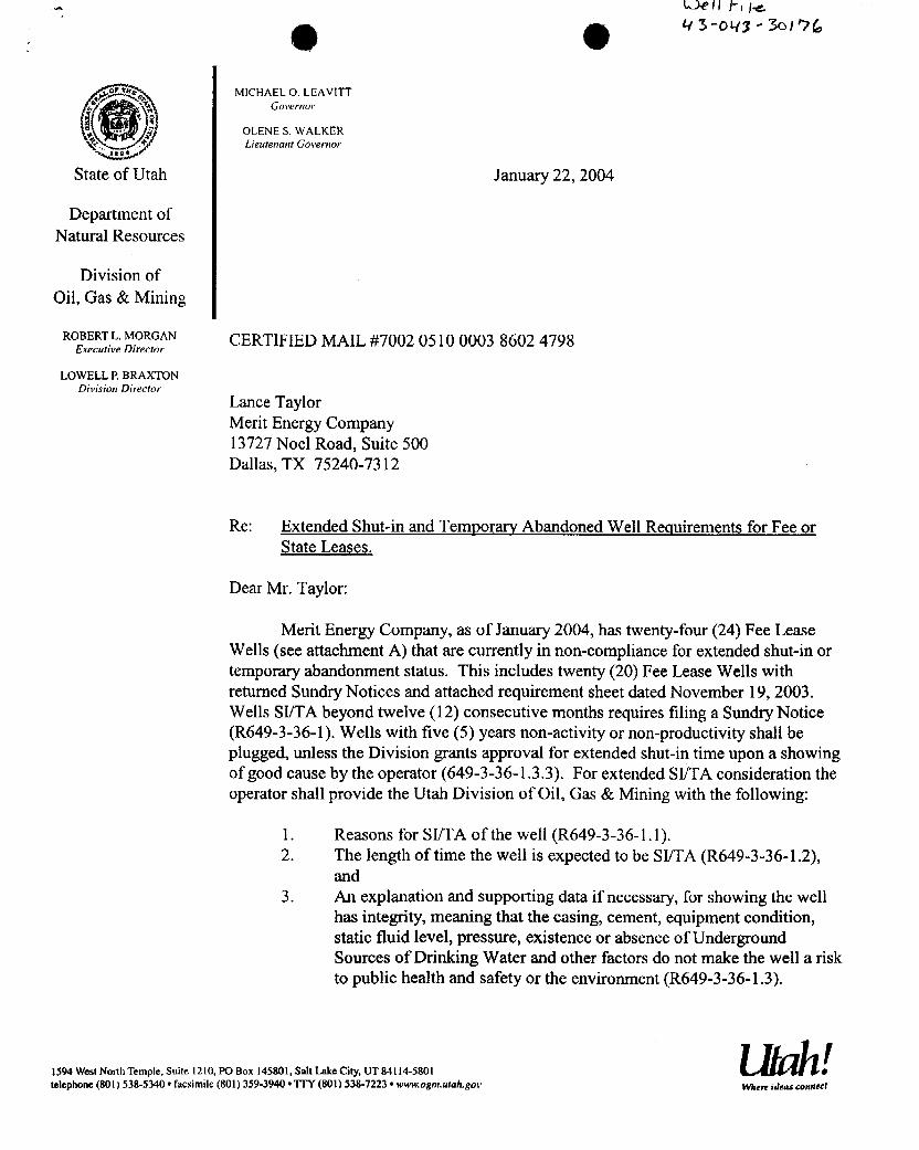
MICHAEL O. LEAVITTGovernor
OLENE S. WALKERLieutenant Governor
State of Utah January 22, 2004
Department ofNatural Resources
Division ofOil, Gas & Mining
ROBERTL MORGAN CERTIFIED MAIL #7002 0510 0003 8602 4798ExecutiveDirector
LOWELL R BRAXTONDivision Director
Lance TaylorMerit Energy Company13727 Noel Road, Suite 500Dallas, TX 75240-7312
Re: Extended Shut-in and Temporary Abandoned Well Requirements for Fee orState Leases.
Dear Mr. Taylor:
Merit Energy Company, as of January 2004, has twenty-four (24) Fee LeaseWells (see attachment A) that are currently in non-compliance for extended shut-in ortemporary abandonment status. This includes twenty (20) Fee Lease Wells withreturned Sundry Notices and attached requirement sheet dated November 19, 2003.Wells SI/TA beyond twelve (12) consecutive months requires filing a Sundry Notice(R649-3-36-1). Wells with five (5) years non-activity or non-productivity shall beplugged, unless the Division grants approval for extended shut-in time upon a showingof good cause by the operator (649-3-36-1.3.3). For extended SI/TA consideration theoperator shall provide the Utah Division of Oil, Gas & Mining with the following:
1. Reasons for SI/TA of the well (R649-3-36-1.1).2. The length of time the well is expected to be SI/TA (R649-3-36-1.2),
and3. An explanation and supporting data if necessary, for showing the well
has integrity, meaning that the casing, cement, equipment condition,static fluid level, pressure, existence or absence of UndergroundSources of Drinking Water and other factors do not make the well a riskto public health and safety or the environment (R649-3-36-1.3).
I1594 West Nonh Temple, Suite 1210. PO Box 145801, Salt Lake City,UT 84114-5801 etelephone (801)538-5340•facsimile (801) 359-3940•TTY (801) 538-7223• www.ogm.utah.gov Where ideas
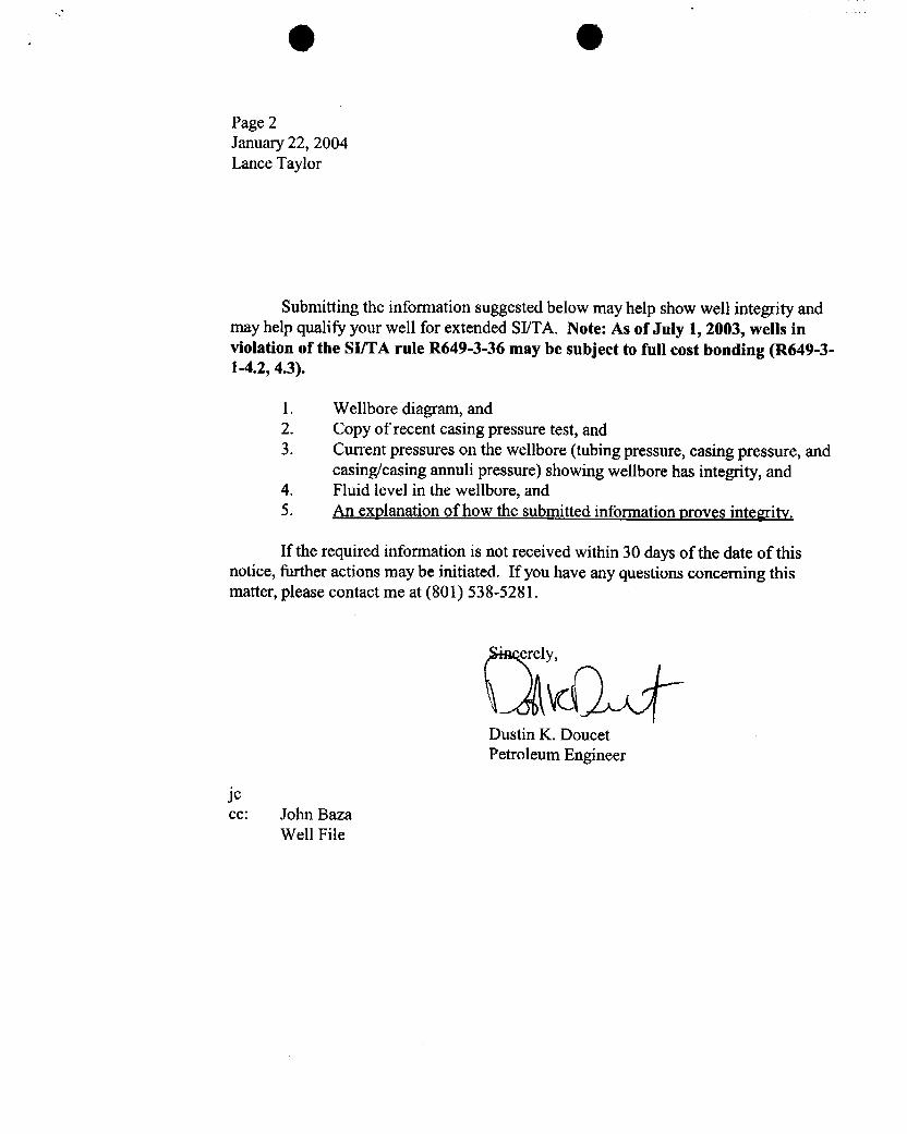
Page 2January 22, 2004Lance Taylor
Submitting the information suggested below may help show well integrity andmay help qualify your well for extended SI/TA. Note: As of July 1, 2003, wells inviolation of the SI/TA rule R649-3-36 may be subject to full cost bonding (R649-3-1-4.2, 4.3).
1. Wellbore diagram, and2. Copy of recent casing pressure test, and3. Current pressures on the wellbore (tubing pressure, casing pressure, and
casing/casing annuli pressure) showing wellbore has integrity, and4. Fluid level in the wellbore, and5. An explanation of how the submitted information proves integrity.
If the required information is not received within 30 days of the date of thisnotice, further actions may be initiated. If you have any questions concerning thismatter, please contact me at (801) 538-5281.
erely
Dustin K. DoucetPetroleum Engineer
jecc: John Baza
Well

Well Name API Lease Type Years inactive1 ARE W20-06 43-043-30159 Fee 1 Year 2 Months2 ARE W31-04E 43-043-30165 Fee 1 Year 3 Months3 ARE W36-10 43-043-30227 Fee 1 Year 3 Months4 ARE W36-08 43-043-30167 Fee 1 Year 7 Months
Wells withreturned Surdry Notices and attached equirement sheet dated November 19, 20031 ARE W21-04 43-043-30135 Fee 1 Year 10 Months.2 Champlin 372 Amoco C1 43-043-30143 Fee 1 Year 11 Months3 ARE W16-06 43-043-30138 Fee 1 Year 11 Months4 ARE WO1-12 43-043-30271 Fee 2 Years 4 Months5 ARE W30-02 43-043-30218 Fee 3 Years 2 Months6 ARE W36-14 43-043-30255 Fee 4 Years 5 Months7 ARE W30-06 43-043-30273 Fee 5 Years 4 Months8 AREW20-02 43-043-30228 Fee 5 Years 4 Months9 AREW30-13 43-043-30279 Fee 5 Years 6 Months10 AREW19-16 43-043-30204 Fee 5 Years 8 Months11 ARE W20-4 43-043-30238 Fee 6 Years 3 Months12 ARE W31-12 43-043-30190 Fee 7 Years 3 Months13 AREWO1-04 43-043-30270 Fee 7 Years 4 Months14 ARE W11-01 43-043-30277 Fee 7 Years 4 Months15 ARE W20-03 43-043-30291 Fee 8 Years 1 Month16 ARE W16-14 43-043-30096 Fee 8 Years 1 Month17 ARE 16-12 43-043-30231 Fee 8 Years 3 Months18 Champlin387 B1A 43-043-30168 Fee 8 Years 6 Months19 ARE W17-16 43-043-30176 Fee 8 Years 7 Months20 ARE E21-14 43-043-30130 Fee 10 Years 8 Months
Attachment

O OMICHAELO. LEAVITT
Governor
OLENE S. WALKER
I a pLier¿terrarrtGovernor ,
State of Utah January 22, 2004
Department ofNatural Resources
Division ofOil, Gas & Mining
ROBERTL. MORGAN CERTIFIED MAIL #7002 0510 0003 8602 4798Executive Director
LOWELL P. BRAXTONDivision Director
Lance TaylorMerit Energy Company13727 Noel Road, Suite 500Dallas, TX 75240-7312
Re: Extended Shut-in and Temporary Abandoned Well Requirements for Fee orState Leases.
Dear Mr. Taylor:
Merit Energy Company, as of January 2004, has twenty-four (24) Fee LeaseWells (see attachment A) that are currently in non-compliance for extended shut-in ortemporary abandonment status. This includes twenty (20) Fee Lease Wells withreturned SundryNotices and attached requirement sheet dated November 19, 2003.Wells SI/TA beyond twelve (12) consecutive months requires filing a Sundry Notice(R649-3-36-1). Wells with five (5) years non-activity or non-productivity shall beplugged, unless the Division grants approval for extended shut-in time upon a showingof good cause by the operator (649-3-36-1.3.3). For extended SI/TA consideration theoperator shall provide the Utah Division of Oil, Gas & Mining with the following:
1. Reasons for SI/TA of the well (R649-3-36-1.1).2. The length of time the well is expected to be SI/TA (R649-3-36-1.2),
and3. An explanation and supporting data if necessary, for showing the well
has integrity, meaning that the casing, cement, equipment condition,static fluid level, pressure, existence or absence of UndergroundSources of Drinking Water and other factors do not make the well a riskto public health and safety or the environment (R649-3-36-1.3).
I1594 West North Temple, Suite 1210, PO Box 145801, Salt Lake City, UT 84114-5801 etelephone (801) 538-5340 •facsimile (801) 359-3940•TTY (801) 538-7223• www.ogm.urah.gov When ideas
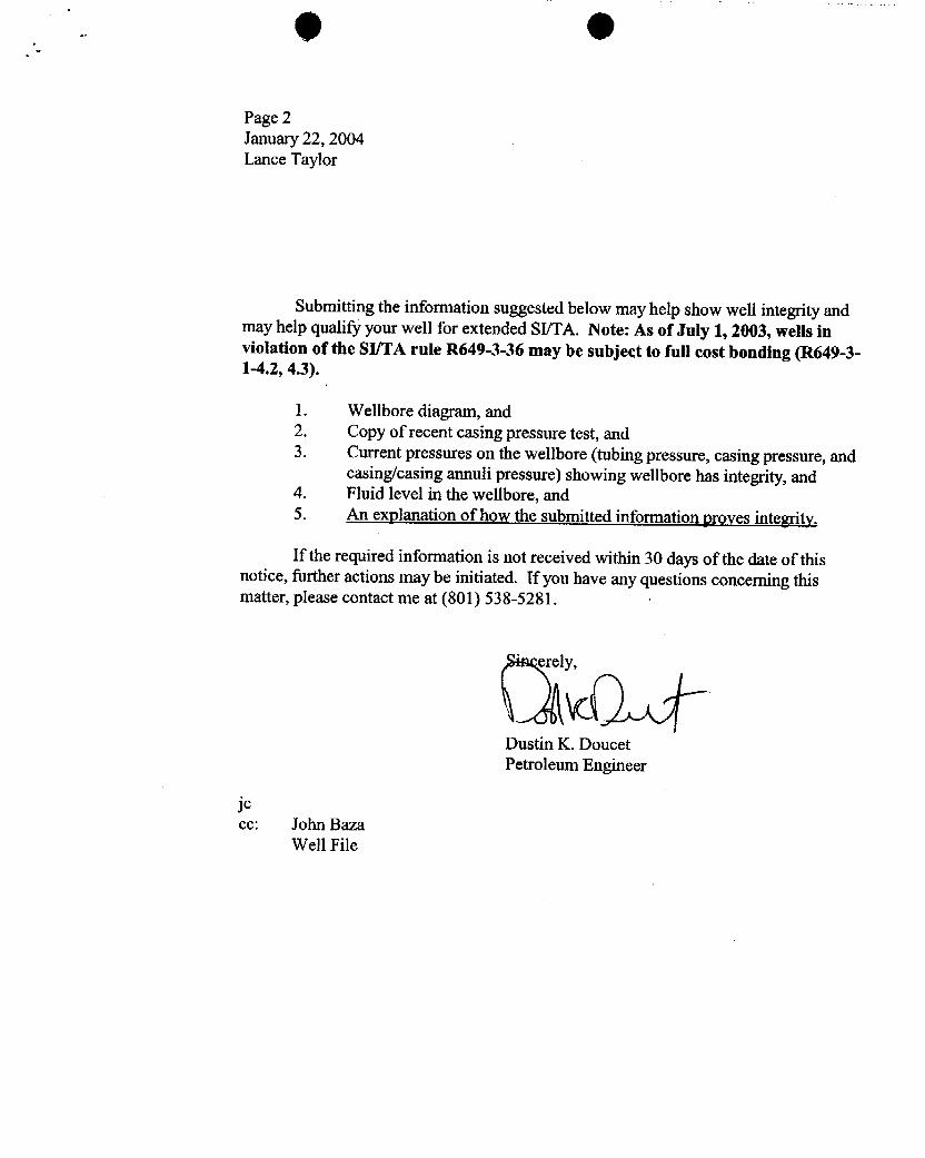
9 O
Page 2January 22, 2004Lance Taylor
Submitting the information suggested below may help show well integrity andmay help qualify your well for extended SI/TA. Note: As of July 1, 2003, wells inviolation of the SI/TA rule R649-3-36 may be subject to full cost bonding (R649-3-1-4.2, 4.3).
1. Wellbore diagram, and2. Copy of recent casing pressure test, and3. Current pressures on the wellbore (tubing pressure, casing pressure, and
casing/casing annuli pressure) showing wellbore has integrity, and4. Fluid level in the wellbore, and5. An explanation of how the submitted information proves integrity.
If the required information is not received within 30 days of the date of thisnotice, further actions may be initiated. If you have any questions concerning thismatter, please contact me at (801) 538--5281.
'erely,
Dustin K. DoucetPetroleum Engineer
jeec: John Baza
Well
Well Name API Lease Type Years Inactive1 ARE W20-06 43-043-30159 Fee 1 Year 2 Months2 ARE W31-04E 43-043-30165 Fee 1 Year 3 Months3 ARE W36-10 43-043-30227 Fee 1 Year 3 Months4 ARE W36-08 43-043-30167 Fee 1 Year 7 Months
Wells withreturned Sun3ry Notices and attached equirement sheet dated November 19, 20031 ARE W21-04 43-043-30135 Fee 1 Year 10 Months.2 Champlin 372 Amoco C1 43-043-30143 Fee 1 Year 11 Months3 ARE W16-06 43-043-30138 Fee 1 Year 11 Months4 ARE WO1-12 43-043-30271 Fee 2 Years 4 Months5 ARE W30-02 43-043-30218 Fee 3 Years 2 Months6 ARE W36-14 43-043-30255 Fee 4 Years 5 Months7 ARE W30-06 43-043-30273 Fee 5 Years 4 Months8 ARE W20-02 43-043-30228 Fee 5 Years 4 Months9 ARE W30-13 43-043-30279 Fee 5 Years 6 Months10 ARE W19-16 43-043-30204 Fee 5 Years 8 Months11 ARE W20-4 43-043-30238 Fee 6 Years 3 Months12 ARE W31-12 43-043-30190 Fee 7 Years 3 Months13 ARE WO1-04 43-043-30270 Fee 7 Years 4 Months14 ARE W11-01 43-043-30277 Fee 7 Years 4 Months15 ARE W20-03 43-043-30291 Fee 8 Years 1 Month16 ARE W16-14 43-043-30096 Fee 8 Years 1 Month17 ARE 16-12 43-043-30231 Fee 8 Years 3 Months18 Champlin 387 B1A 43-043-30168 Fee 8 Years 6 Months19 AREW17-16 43-043-30176 Fee 8 Years 7 Months20 ARE E21-14 43-043-30130 Fee 10 Years 8 Months
Attachment
13727 Noel Road, Suite 500Dallas, TX 75240Ph: 972-701-8377 Fx: 972-960-1252
MER I T ENERGY COMP A NY www.meritenergy.com
Date: February 13, 2004
Subject: Extended Shut-inwells in the Anschutz Ranch East Field
Dear Mr. Doucet:
In response to your letter dated January 22, 2004, I would like to submit the attached supporting documentationregarding our extended shut-in wells. Merit Energy Company purchased an operating interest in the Anschutz RanchEast Unit from BP Production Company effective July 1, 2003, and has spent the last seven months evaluating theproduction capability of all active and inactive wells in the field. This process has resulted in workovers thathavereestablished production in several of these wells, and revealed future opportunities for all of the others. Here is aquick synopsis of our plans for each well.
• ARE W20-06- Workover is planned to immediately reactive this well by running smaller tubing, and puttingthe well on gas lift Should be reactivated by mid year 2004.
• ARE W31-04- BP attempted a directional reentry of thiswellbore in 2001, during which time the drill pipewas inadvertently cemented in thehorizontal section of the wellbore. Merit is investigating methods toeffectively stimulate this wellbore and return it to production. If unable to do so, it will be plugged.
• ARE W36-10- This well will be the first test candidate for an experimental production method for artificiallifting gas wells. An electric submersible pump will be run in this well in the next couple of months in anattempt to reestablish production by removing large volumes of water from the formation. If this project issuccessful it could lead to the reactivation of virtually every inactive well in the field. The project isapproved internally, and we are waiting on equipment and supplies before mobilizing a service rig.
• ARE W36-08- This well has been reactivated following a workover last fall. A sundry notice was filed andapproved by theUtah Oil and Gas Commission.
• ARE W21-04- Surface tubing pressure indicates this well may be capable of producing again. Howeverattempts to return this well to production with thecurrent wellbore configuration have not been successful.Merit plans to install smaller tubingand gas lift on thiswell. If that is unsuccessful, this well is also acandidate for an electric submersible pump installation. If all attempts to reactivate theNugget formation fail,this well is a recompletion candidate in the Twin Creek formation.
• Champlin 372 C-1- This well is capable of producing for a few days at a time, but quickly loads up withwater and dies. Again, this well is a candidate for an electric submersible pump installation, or may be usedas a salt water disposal well if additional capacity is needed due to the ESP program.
• ARE W16-06- This well will have an electric submersible pump installed if the program is successful.Otherwise it will be plugged.
• ARE WO1-12-This well will have an electric submersible pump installed if the program is successful. It isalso considered for an uphole recompletion.
• ARE W30-02- An attempt was made to return this well to production last fall, but was unsuccessful due tohigh water production. Pending the success of the W36-10, this well will also have an electric submersiblepump installed.
• ARE W36-14- This well will have an electric submersible pump installed if theprogram is successful. It isalso considered for an uphole recompletion.
• ARE W30-06- This well will have an electric submersible pump installed if the program is successful. It isalso considered for an uphole recompletion.
• ARE W20-02- A workover has been approved internally to reactivate this well, and should begin in the next gfew weeks A sundry notice was filed and approved by theUtah Oil and Gas Commission. Q 2
• ARE W30-13- This well will have an electric submersible pump installed if the program is successful. It is [.¡jalso considered for an uphole recompletion.
• ARE W19-16- This well will have an electric submersible pump installed if the program is successful. It isalso considered for an uphole recompletion.
• ARE W20-04- This well have an electric submersible pump installed i e program is successful. It isalso considered for an uphole recompletion.
• ARE W31-12- An attempt was made to reactivate thiswell in late 2003, but was unsuccessful. A sundrynotice was filed and approved by theUtah Oil and Gas Commission. An uphole recompletion in the TwinCreek formation is planned and will be completed in thenext few months.
• ARE WO1-04-This well will have an electric submersible pump installed if the program is successful. It isalso considered for an uphole recompletion.
• ARE W11-01- This well will have an electric submersible pump installed if the program is successful.Otherwise it will be plugged.
• ARE W20-03- This well will have an electric submersible pump installed if the program is successful. It isalso considered for an uphole recompletion.
• ARE W16-14- This well will have an electric submersible pump installed if theprogram is successful. It isalso considered for salt water disposal well if additional capacity is needed.
• ARE W16-12- This well will have an electric submersible pump installed if the program is successful. It isalso considered for salt water disposal well if additional capacity is needed.
• Champlin 387 B-1A- Merit Energy is in the process of obtaining records from BP for this well. Oncehistorical information is obtained, we will evaluate all feasible methods to return this well to producing status.Otherwise it will be plugged.
• ARE W17-16- This well will have an electric submersible pump installed if the program is successful. It isalso considered for salt water disposal well if additional capacity is needed.
• ARE E21-14- This well was returned to producing status on 12/19/03.
In addition to this infortnation, I have enclosed pressure data for all wells, and a wellbore schematic for all wellsexcept the Champlin 387 B-lA. The static bottom hole pressures and static fluid levels were collected in September2003 with bottom hole gauges. If you need any further information, please contact me at 972-628-1651 orelectronically at lance.taylor meritenergy.com.
Operations Engineer
Cc: Rusty GinnettiArlene ValliquetteDennis Longwell
Attachments: (1) page of pressure data, (23) wellbore schematics
Return-path: <[email protected]>Received: from imail.meritenergy.com [208.133.141.18]
by UTSTDP13.state.ut.us; Tue, 24 Feb 2004 07:06:49 -0700
Subject: Anschutz Ranch East UnitTo: [email protected]: Rusty Ginnetti <[email protected]>,
Arlene Valliquette <[email protected]>,Dennis Longwell <[email protected]>
X-Mailer: Lotus Notes Release 5.0.10 March22, 2002Message-ID: <OF2FAC50A1.BE12C251-ON86256E44.004BO584-86256E44.004D8670@meritenergy.com>From: Lance Taylor <[email protected]>Date: Tue, 24 Feb 2004 08:06:46 -0600
X-MIMETrack: Serialize by Router on imail/Meritenergy(Release 6.0.3|September 26, 2003) at02/24/2004 08:06:49 AMMIME-Version:1.0Content-type: text/plain;charset=US-ASCII
Mr. Dworshak,
I'd like to confirmour 2/23/04 telephone conversation in response to myletter dated 2/13/04 regarding extended shut in and temporarilyabandonedwellbores in the Anschutz Ranch East Unit ("ARE Unit") of Summit countyUtah. It is Merit Energy Company's intentionto utilizeeach wellbore toit's full capacity. As such, Merit is in the process of attempting toreactivate the wellbores in question. Several wellbore specificworkovershave been identified, and the approximate timingof each is mentioned in myoriginalletter.
However, the majorityof the reactivationwork depends on the successfulutilizationof electric submersible pumps for artificiallift. It is thetimingof thisproject that I would like to address. As you know, this isa capital intensive project, so Merit plans to do the appropriate researchprior to implementation. Merit intends to test the idea on the ARE W36-10within the next 8-12 weeks. Following a 4-12 week test period, Meritwillperform a strenuous economic and operational evaluation. If it isdetermined thatthe project is valid, full scale implementation could beginas earlyas June. However, due to the complexityof the equipment, depthof the wells, and unavailabilityof service rigs, Merit anticipates thisproject will take several months, possiblyone year, to complete. Due tothe large volumes of water to be produced by this project, it is likelythatone or more of the shut in wells willneed to be reactivated as saltwater disposal wells. AIIregulatoryand state documentation willbecompleted prior to SWD conversion.
Finally, if the ESP project is unsuccessful, several of these wellborehaverecompletion potential in shallower formations. Specifically, Merit hasidentified the Jurassic aged Twin Creek formationas a possiblerecompletion target. Completion practices must be researched and developedin order to ensure economic quantities of hydrocarbons. Again, all stateand federal permits willbe approved priorto project
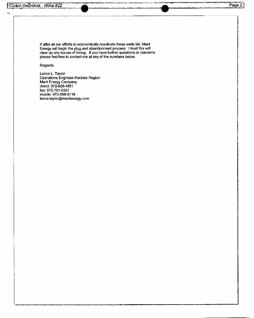
Ifafter all our efforts to economicallyreactivate these wells fail, MeritEnergy will begin the plug and abandonment process. I trust this willclear up any issues of timing. Ifyou have further questions or concernsplease feel free to contact me at any of the numbers below.
Regards,
Lance L. TaylorOperations Engineer-Rockies RegionMerit Energy Companydirect: 972-628-1651fax: 972-701-0351mobile: 972-998-9116
MICHAEL O. LEAVITTGovernor
OLENE S. WALKERLieutenant Governor
State of Utah March 5, 2004
Department ofNatura1Resources
CERTIFIED RE TURA RECEIPT4 7002 0510 0003 8602 4880
Division of Mr. Lance TaylorOil, Gas & Mining Merit Energy Company
13727 Noel Road, Suite 500ROBERT L. MORGAN Dallas, TX 75240Executive Director
LOWELL P.BRAXTONDivision Director
Re: Extended Shut-in and Temporary Abandoned Well Requirements for Fee orState Leases dated January 22, 2004.
Dear Mr. Taylor,
The Division of Oil, Gas and Mining (DOGM) is in receipt of your letter datedFebruary 13, 2004 in regards to the twenty-four (24) shut-in wells operated by MeritEnergy Company (Merit). DOGM accepts Merit's plan of action to recomplete alltwenty-four wells by year-end 2004. Many of the recompletions are dependent uponthe success of electric submersible pumps; if this experimental procedure is notsuccessful, keep the Division advised of any changes in Merit's plan of action. Basedupon the plan of action and other information provided, DOGM approves the twenty-four (24) wells for extended shut-in until January 1, 2005. Please submit recompletionprocedures and notice of intent sundries upon finalization.
For reference, Attachment A lists the wells subject to this request. If you haveany questions or need additional assistance in regards to the above matters pleasecontact me at (801) 538-5281.
S erely,
Dustin DoucetPetroleum Engineer
I1594 West North Temple, Suite 1210,PO Box 145801, Salt Lake City, UT 84114-5801 etelephone(801) 538-5340 •facsimile (80l) 359-3940 - TTY (801) 538-7223•wü>w.ogm.utah.gov When ideas
O O
Well Name API Lease Type Years inactive1 ARE W20-06 43-043-30159 Fee 1 Year 2 Months2 ARE W31-04E 43-043-30165 Fee 1 Year 3 Months3 ARE W36-10 43-043-30227 Fee 1 Year 3 Months4 AREW36-08 43-043-30167 Fee 1 Year 7 Months
Wells with returned Surdry Notices and attached equirement sheet dated November 19, 20031 ARE W21-04 43-043-30135 Fee 1 Year 10 Months2 Champlin 372 Amoco C1 43-043-30143 Fee 1 Year 11 Months3 AREW16-06 43-043-30138 Fee 1 Year 11 Months4 ARE WO1-12 43-043-30271 Fee 2 Years 4 Months5 AREW30-02 43-043-30218 Fee 3 Years 2 Months6 ARE W36-14 43-043-30255 Fee 4 Years 5 Months7 ARE W30-06 43-043-30273 Fee 5 Years 4 Months8 ARE W20-02 43-043-30228 Fee 5 Years 4 Months9 AREW30-13 43-043-30279 Fee 5 Years 6 Months10 ARE W19-16 43-043-30204 Fee 5 Years 8 Months11 ARE W20-4 43-043-30238 Fee 6 Years 3 Months12 ARE W31-12 43-043-30190 Fee 7 Years 3 Months13 ARE WO1-04 43-043-30270 Fee 7 Years 4 Months14 ARE W11-01 43-043-30277 Fee 7 Years 4 Months15 ARE W20-03 43-043-30291 Fee 8 Years 1 Month16 AREW16-14 43-043-30096 Fee 8 Years 1 Month17 ARE 16-12 43-043-30231 Fee 8 Years 3 Months18 Champlin 387 B1A 43-043-30168 Fee 8 Years 6 Months19 AREW17-16 43-043-30176 Fee 8 Years 7 Months20 ARE E21-14 43-043-30130 Fee 10 Years 8 Months
Attachment
MERIT ENERGY COMPANY13727 Noel Road Suite 500 · Dallas, Texas 75240
Ph 972.701.8377 Fx 972.960.1252 - www.meritenergy.com
January 7, 2005
State of Utah -- Department of Natural ResourcesDivisionof Oil, Gas, & MiningAttn: Mr. Dustin DoucetPO Box 145801Salt Lake City, UT 84114-5801
Dear Mr. Doucet:
This letter is in response to a telephoneconversationthat I had with Clint Dworshak on December 6,2004. At thattime,he requested that I provide information on Merit Energy Company's shut-inwellsatAnschutz Ranch East, proving thattheground waters are protected.
Enclosed, please find a summary sheet, as well as wellbore diagrams for thesubjectwells.
If you have any questions or wish to discuss this further, please contact me at (972) 628-1550 orelectronicallyat [email protected].
Michael L. Mercer

U H DOGM -- SI WELL LIST
Wells to be Reactivated in 2005• CHAMPLIN 372 C1
o Packer at 8,320 (MD) 6,648 (TVD)o Top of cement (TOC) at 4,906o Tubing Pressure 1250#o Casing Pressure 0#o The 4-1/2" liner is cemented in place at 5090 (below the TOC). The tubingpressure and
casing pressure are different. Therefore, the casing and tubingare not in communicationand the ground waters are protected.
• ARE W16-06o Packer at 13,398o Top of cement (TOC) at 12,640o Tubing Pressure 0#o Casing Pressure 0#o The packer is located below the TOC. When Merit set the packer in October 2004, we
pressure tested the annulus to 500 psi and it held. Therefore, the casing has integrity andthe ground waters are protected.
• ARE W30-02o Packerat noneo Top of cement (TOC) at 12,452o Tubing Pressure 0#o Casing Pressure 0#o Fluid Level 8200' from Surfaceo On 09/02/03, Merit ran a packer in thiswell and sat it at 13055' (below the TOC). The
casing and packer were pressure tested to 1500 psi and held. The packer has since beenremoved and there is open-ended tubingin the well. However, the casing has integrityand the ground waters are protected.
• ARE W36-14o Packer at 13,988o Top of cement (TOC) at 13,700o Tubing Pressure 400#o Casing Pressure 0#o The packer is set below the TOC. The tubingpressure and casing pressure are different.
Therefore, the casing and tubingare not in communication and the ground waters areprotected.
• ARE W30-06o Packer at 13,450o Top of cement (TOC) at 11,200 (7" casing)o Tubing Pressure 0#o Casing Pressure 0#o The packer is set below the TOC. The 9-5/8" casing string has cement f/ 11911-7940.
The 13-3/8" casing has cement f/ 5745-1200. With no pressure on the casing, and threestrings of casing (7", 9-5/8", 13-3/8"), the ground waters are protected.
• ARE W30-13o Packer at 12,320o Top of cement (TOC) at 12,200o Tubing Pressure 300#o Casing Pressure 0#o The packer is set below the TOC. The tubingpressure and casing pressure are different.
Therefore, the casing and tubingare not in communication and the ground waters areprotected.
Page 1 of 3
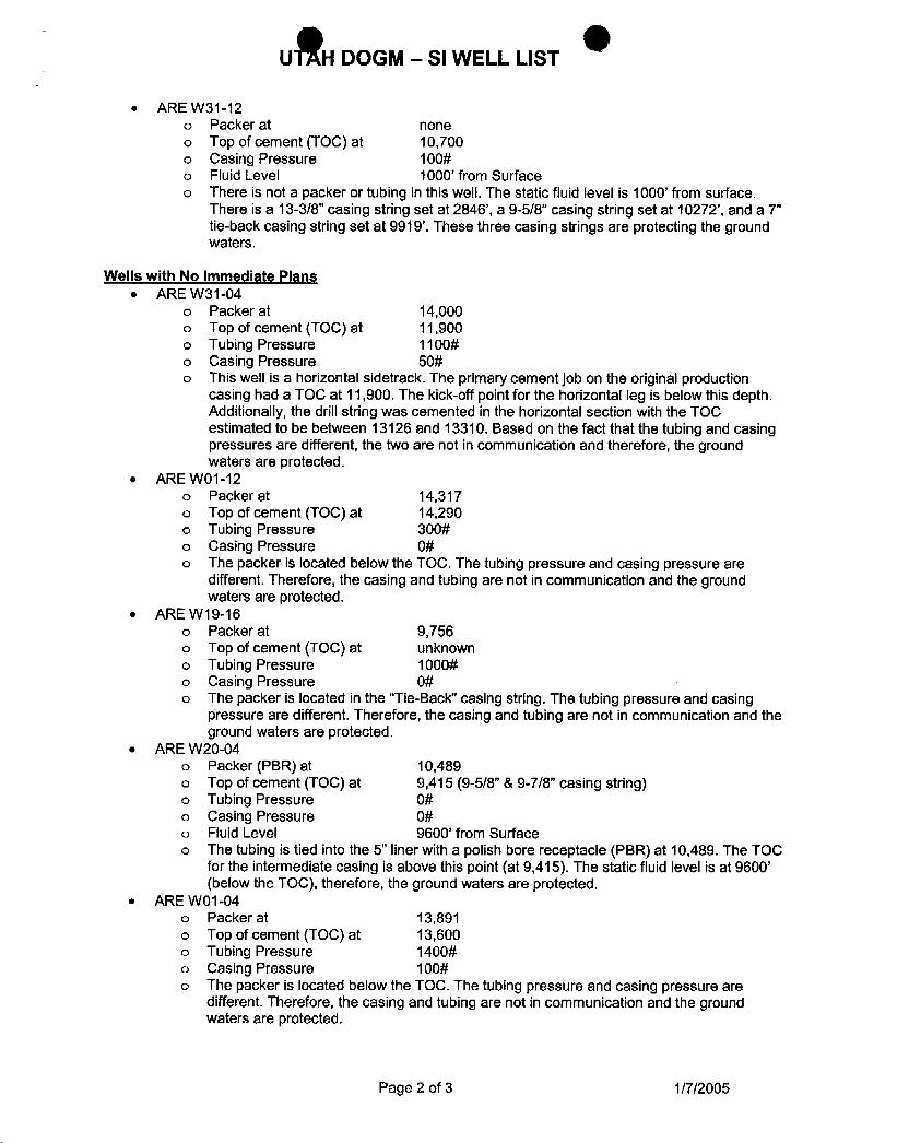
uÊH DOGM - SI WELL LIST
• ARE W31-12o Packerat noneo Top of cement (TOC) at 10,700o Casing Pressure 100#o Fluid Level 1000' from Surfaceo There is not a packer or tubingin thiswell.The static fluid level is 1000' from surface.
There is a 13-3/8" casing string set at 2846', a 9-5/8" casingstring set at 10272', and a 7"tie-backcasing string set at 9919'. These three casing strings are protecting the groundwaters.
Wells with No Immediate Plans• ARE W31-04
o Packer at 14,000o Top of cement (TOC) at 11,900o Tubing Pressure 1100#o Casing Pressure 50#o This well is a horizontal sidetrack. The primary cement job on the originalproduction
casing had a TOC at 11,900. The kick-off point for the horizontal leg is below thisdepth.Additionally, the drill string was cemented in the horizontal section with the TOCestimated to be between 13126 and 13310. Based on the fact that the tubingand casingpressures are different, the twoare not in communication and therefore,the groundwaters are protected.
• ARE WO1-12o Packer at 14,317o Top of cement (TOC) at 14,290o Tubing Pressure 300#o Casing Pressure 0#o The packer is located below the TOC. The tubingpressure and casing pressure are
different. Therefore, the casing and tubingare not in communication and the groundwaters are protected.
• ARE W19-16o Packer at 9,756o Top of cement (TOC) at unknowno Tubing Pressure 1000#o Casing Pressure 0#o The packer is located in the "Tie-Back" casing string. The tubingpressure and casing
pressure are different. Therefore, the casing and tubingare not in communication and theground waters are protected.
• ARE W20-04o Packer (PBR) at 10,489o Top of cement (TOC) at 9,415 (9-5/8" & 9-7/8" casing string)o Tubing Pressure 0#o Casing Pressure 0#o Fluid Level 9600' from Surfaceo The tubingis tied into the 5" liner witha polish bore receptacle (PBR) at 10,489. The TOC
for the intermediate casing is above thispoint (at 9,415). The static fluid level is at 9600'(below the TOC), therefore,the ground waters are protected.
• ARE WO1-04o Packer at 13,891o Top of cement (TOC) at 13,600o Tubing Pressure 1400#o Casing Pressure 100#o The packer is located below the TOC. The tubingpressure and casing pressure are
different. Therefore, the casing and tubingare not in communication and the groundwaters are protected.
Page 2 of 3
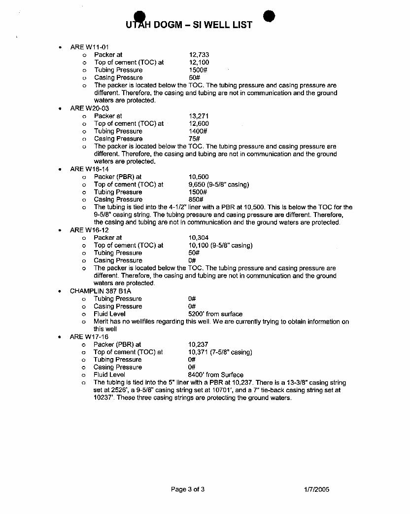
uÊH DOGM - SI WELL LIST
• ARE W11-01o Packer at 12,733o Top of cement (TOC) at 12,100o Tubing Pressure 1500#o Casing Pressure 50#o The packer is located below the TOC. The tubingpressure and casing pressure are
different. Therefore, the casing and tubingare not in communication and the groundwaters are protected.
• ARE W20-03o Packer at 13,271o Top of cement (TOC) at 12,600o Tubing Pressure 1400#o Casing Pressure 75#o The packer is located below the TOC. The tubingpressure and casing pressure are
different. Therefore, the casing and tubingare not in communication and the groundwaters are protected.
• ARE W16-14o Packer (PBR) at 10,500o Top of cement (TOC) at 9,650 (9-5/8" casing)o Tubing Pressure 1500#o Casing Pressure 850#o The tubingis tied into the 4-1/2" liner with a PBR at 10,500. This is below the TOC for the
9-5/8" casing string. The tubingpressure and casing pressure are different. Therefore,the casing and tubingare not in communicationand the ground waters are protected.
• ARE W16-12o Packer at 10,304o Top of cement (TOC) at 10,100 (9-5/8" casing)o Tubing Pressure 50#o Casing Pressure 0#o The packer is located below the TOC. The tubing pressure and casing pressure are
different. Therefore, the casing and tubingare not in communication and the groundwaters are protected.
• CHAMPLIN 387 B1Ao Tubing Pressure 0#o Casing Pressure 0#o Fluid Level 5200' from surfaceo Merit has no wellfiles regarding thiswell. We are currently tryingto obtain information on
thiswell• ARE W17-16
o Packer (PBR) at 10,237o Top of cement (TOC) at 10,371 (7-5/8" casing)o Tubing Pressure 0#o Casing Pressure 0#o Fluid Level 8400' from Surfaceo The tubingis tied into the 5" liner witha PBR at 10,237. There is a 13-3/8" casing string
set at 2526', a 9-5/8" casing string set at 10701', and a 7" tie-backcasing string set at1023T. These three casing strings are protecting the ground waters.
Page 3 of 3
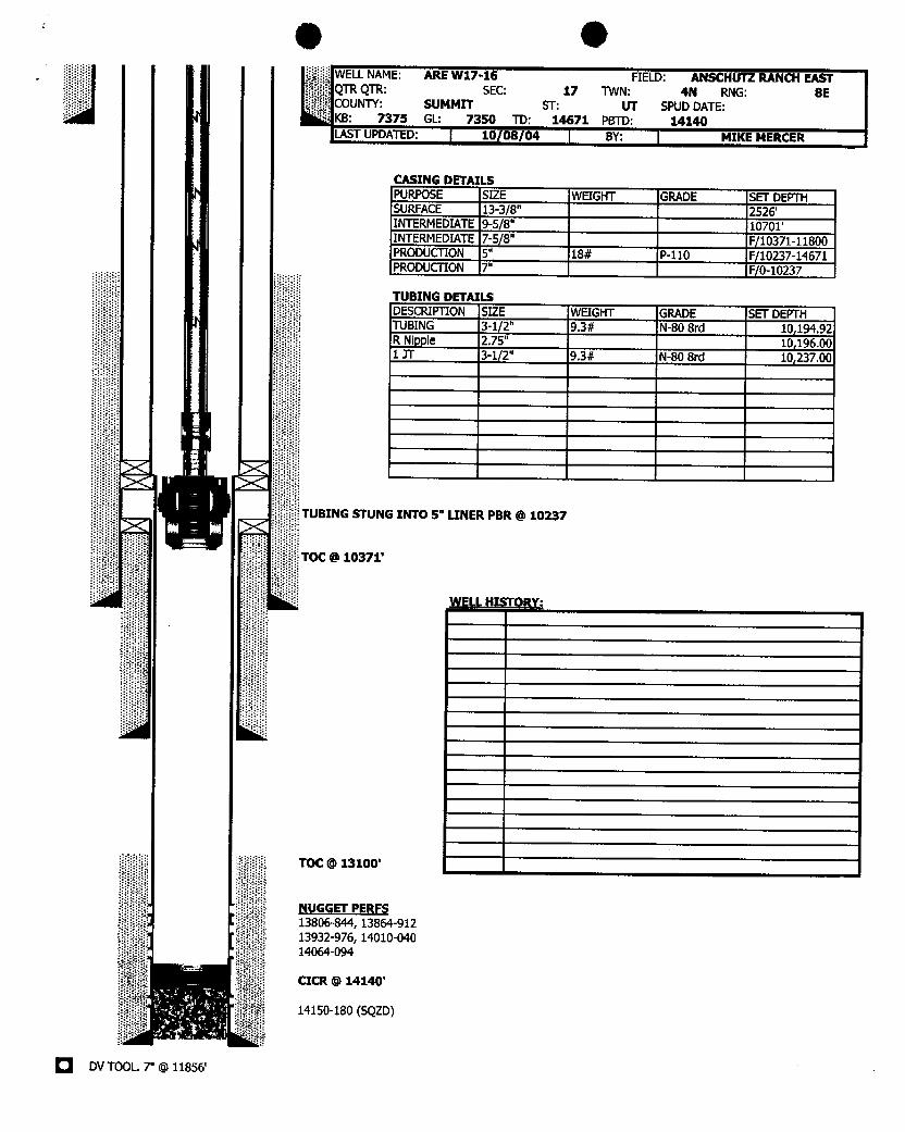
O OELLNAME: ARE W17-16 FIELD: ANSCHUTZRANCHEASTR QTR: SEC: 17 TMN: 4N RNG: 8EUNTY: SUMMIT ST: UT SPUDDATE:
B: 7375 GL: 7350 TD: 14671 PETD: 14140ST UPDATED: 10(08/04 BY: MIKEMERCER
CASING DETAILSPURPOSE SIZE WEIGHT GRADE SET DEPTHSURFACE 13-3/8" 2526'INTERMEDIATE9-5/8" 10701'INTERMEDIATE7-5/8" F(10371-11800PRODUCTION 5" 18# P-110 F/10237-14671PRODUCTION 7" F/0-10237
TUBING DETAILSDESCRIPTION SIZE WEIGHT GRADE SET DEPTHTUBING 3-1/2" 9.3# N-80 Brd 10,194.92R Nipple 2.75" 10,196.001 JT 3-1/2" 9.3# N-80 Brd 10,237.00
TUBING STUNG INTO 5" LINER PBR @10237
TOC O 10371'
TOC @13100'
NUGGET PERFS13806-844, 13864-91213932-976, 14010-04014064-094
CICR @14140'
14150-180 (SQZD)
DVTOOL. 7" @
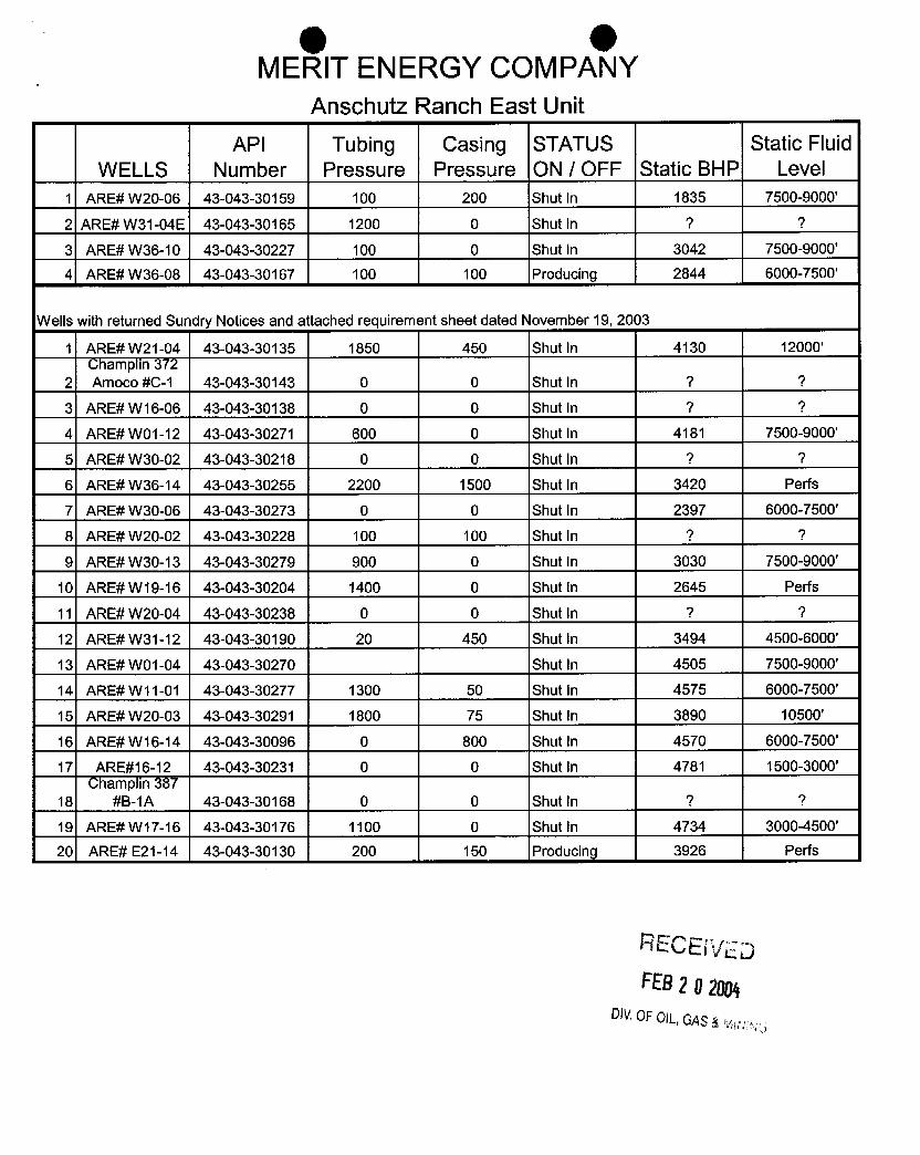
O OMERIT ENERGY COMPANY
Anschutz Ranch East UnitAPI Tubing Casing STATUS Static Fluid
WELLS Number Pressure Pressure ON / OFF Static BHP Level1 ARE# W20-06 43-043-30159 100 200 Shut in 1835 7500-9000'
2 ARE#W31-04E 43-043-30165 1200 0 Shut in ? ?
3 ARE# W36-10 43-043-30227 100 0 Shut in 3042 7500-9000'
4 ARE# W36-08 43-043-30167 100 100 Producing 2844 6000-7500'
Wells withreturned Sundry Notices and attached requirement sheet dated November 19, 2003
1 ARE# W21-04 43-043-30135 1850 450 Shut in 4130 12000'amp m
2 Amoco #C-1 43-043-30143 0 0 Shut In ? ?
3 ARE# W16-06 43-043-30138 0 0 Shut in ? ?
4 ARE# WO1-12 43-043-30271 600 0 Shut In 4181 7500-9000'
S ARE#W30-02 43-043-30218 0 0 Shut in ? ?
6 ARE# W36-14 43-043-30255 2200 1500 Shut in 3420 Perfs
7 ARE# W30-06 43-043-30273 0 0 Shut In 2397 6000-7500'
8 ARE# W20-02 43-043-30228 100 100 Shut In ? ?
9 ARE# W30-13 43-043-30279 900 0 Shut in 3030 7500-9000'
10 ARE# W19-16 43-043-30204 1400 0 Shut in 2645 Perfs
11 ARE#W20-04 43-043-30238 0 0 Shut in ? ?
12 ARE# W31-12 43-043-30190 20 450 Shut in 3494 4500-6000'
13 ARE# WO1-04 43-043-30270 Shut in 4505 7500-9000'
14 ARE#W11-01 43-043-30277 1300 50 Shut in 4575 6000-7500'
15 ARE# W20-03 43-043-30291 1800 75 Shut in 3890 10500'
16 ARE# W16-14 43-043-30096 0 800 Shut in 4570 6000-7500'
17 ARE#16-12 43-043-30231 0 0 Shut In 4781 1500-3000'amp m
18 #B-1A 43-043-30168 0 0 Shut in ? ?
19 ARE# W17-16 43-043-30176 1100 0 Shut in 4734 3000-4500'
20 ARE# E21-14 43-043-30130 200 150 Producíng 3926 Perfs
RECElVEDFEB2 O2004
DIVOFOlL,GAS&
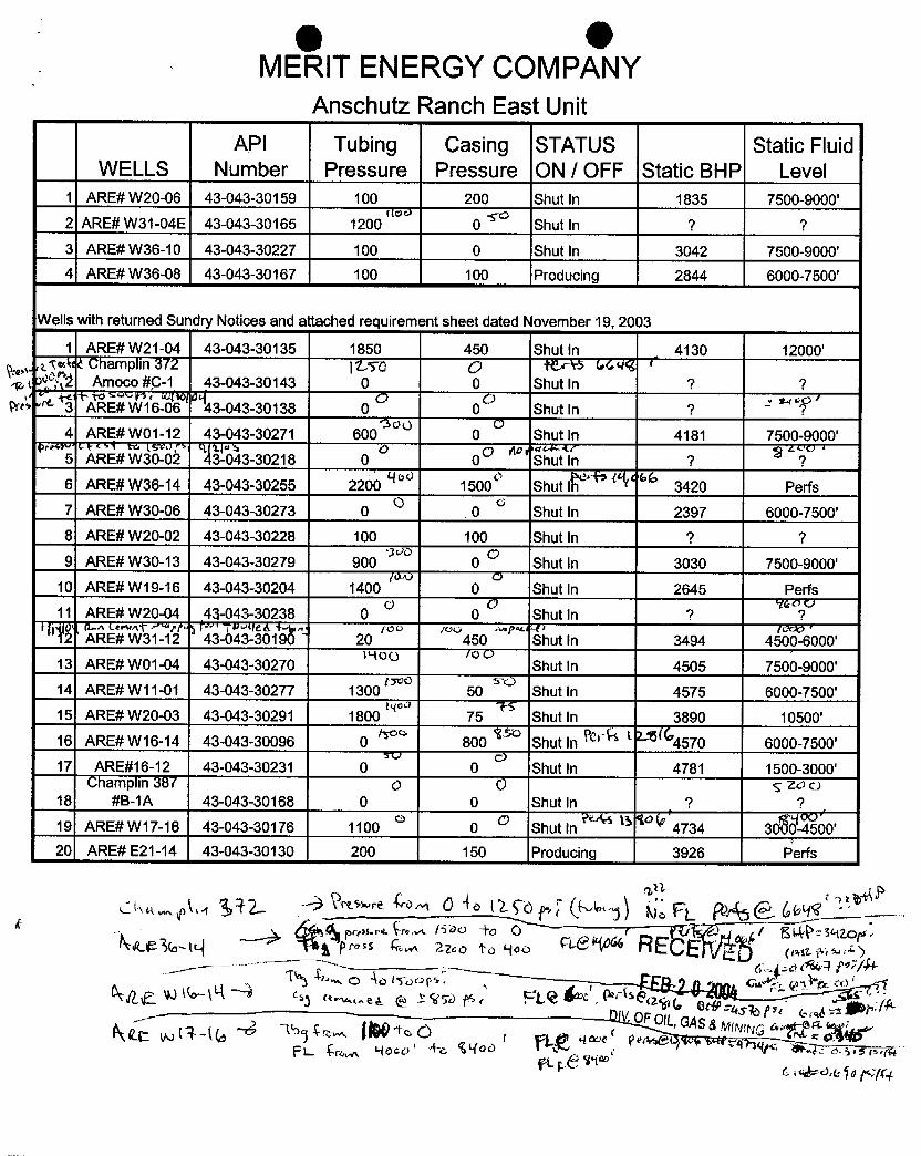
O OMERIT ENERGY COMPANY
Anschutz Ranch East UnitAPI Tubing Casing STATUS Static Fluid
WELLS Number Pressure Pressure ON / OFF Static BHP Level1 ARE# W20-06 43-043-30159 100 200 Shut In 1835 7500-9000'
2 ARE# W31-04E 43-043-30165 1200 0 Shut In ? ?3 ARE# W36-10 43-043-30227 100 0 Shut In 3042 7500-9000'
4 ARE# W36-08 43-043-30167 100 100 Producing 2844 6000-7500'
Wells with returned Sur dry Notices and a tached requirem int sheet dated 6 ovember 19, 20 33
1 ARE# W21-04 43-043-30135 1850 450 Shut In 4130 12000'Champlin
372¯ ¯ jty0 QJE¯ctrs
(,44 «
t 36Ë Amoco #p-1 43-043-30143 O O Shut In ? 9
pr" 3 ARE# W16-06 43-043-30138 0 0 Shut In ? ~ 7
4 ARE# WO1-12 43-043-30271 600 0 Shut In 4181 7500-9000'
5 ARE# W30-02 43-043-30218 0 0 Shut In 7 ?6 ARE# W36-14 43-043-30255 2200 1500 Shut Ih 3420 Perfs7 ARE# W30-06 43-043-30273 0 0 Shut In 2397 6000-7500'
8 ARE# W20-02 43-043-30228 100 100 Shut In 7 ?9 ARE# W30-13 43-043-30279 900 0 Shut In 3030 7500-9000'
10 ARE# W19-16 43-043-30204 1400 0 Shut In 2645 Perfs11 ARE# W20-04 43-043-30238 0 0 Shut In ? ?T2 ' ARE# W31-12 43-043-30190 ^
20 450 Shut In 3494 4500-6000'
13 ARE# WO1-04 43-043-30270 Shut in 4505 7500-9000'
14 ARE# W11-01 43-043-30277 1300 50 Shut In 4575 6000-7500'
15 ARE# W20-03 43-043-30291 1800 75 Shut In 3890 10500'16 ARE# W16-14 43-043-30096 0 800 Shut In Ÿerk t L15 4570 6000-7500'
17 ARE#16-12 43-043-30231 0 0 Shut In 4781 1500-3000'Champlin 38/ c y ze a
18 #B-1A 43-043-30168 0 0 Shut In ? ?19 ARE# W17-16 43-043-30176 1100 0 Shut In 4734 3000-4500'
20 ARE# E21-14 43-043-30130 200 150 Producing 3926
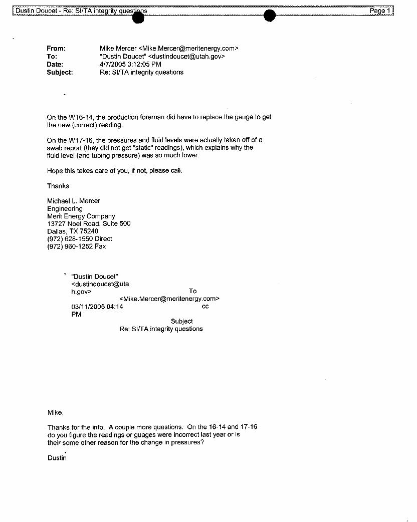
From: Mike Mercer <[email protected]>To: "Dustin Doucet" <[email protected]>
Date: 4/7/2005 3:12:05 PMSubject: Re: SI/TA integrity questions
On the W16-14, the production foreman did have to replace the gauge to getthe new (correct) reading.
On the W17-16, the pressures and fluid levels were actually takenoffof aswab report (theydid not get "static"readings), which explains why thefluid level (and tubing pressure) was so much lower.
Hope this takes care of you, if not, please call.
Thanks
Michael L. MercerEngineeringMerit Energy Company13727 Noel Road, Suite 500Dallas, TX 75240(972) 628-1550 Direct(972) 960-1252 Fax
"Dustin Doucet"<dustindoucet@uta
h.gov> To<[email protected]>
03/11/2005 04:14 ccPM
SubjectRe: SI/TA integrity questions
Mike,
Thanks for the info. A couple more questions. On the 16-14 and 17-16do you figure the readings or guages were incorrect last year or istheirsome other reason for the change in pressures?

Dustin Doucet - Re: SI/TA integrity questio Page 2
>>> Mike Mercer <[email protected]> 03/11/05 1:48 PM >>>
Dustin,
Sorry it has taken me so long to get back with you...in response toyouremail, most are easily explained...(see below in red)
Regarding the W30-14, we are installing ESPs on either side of thiswell,we have a service company designing gas liftfor thiswelland areevaluating a reactivation following the ESP installations. Ifwe donothave the well reactivated in the next couple of months, Iwillprovideyouwith the wellbore diagram, pressures, and fluid level.
Let me know ifyou need anything else. Thanks
Michael L. MercerEngineeringMerit Energy Company13727 Noel Road, Suite 500Dallas, TX 75240(972) 628-1550 Direct(972) 960-1252 Fax
"Dustin Doucet"
<dustindoucet@uta
h.gov>To
02/16/2005 04:04cc
PM
SubjectSIITA integrity
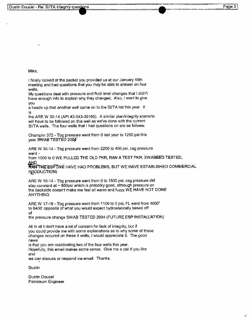
Mike,
I finally looked at the packet you provided us at our January 10thmeeting and had questions that you may be able to answer on fourwells.My questions deal with pressure and fluid level changes that I didn'thave enough info to explain why they changed. Also, Iwant to giveyoua heads up that another well came on to the SIITA list this year. Itisthe ARE W 30-14 (API 43-043-30185), A similarplan/integrity scenariowill have to be followed on thiswell as we've done with the currentSI/TA wells. The four wells that I had questions on are as follows:
Champlin 372 - Tbg pressure went from 0 last year to 1250 psi thisyear SWAB TESTED 2007
ARE W 36-14 - Tbg pressure went from 2200 to 400 psi, csg pressurewent ·
from 1500 to O WE PULLED THE OLD PKR, RAN A TEST PKR, SWABBEDTESTED,
EBBÉ(WE HAVE HAD PROBLEMS, BUT WE HAVE ESTABLISHED COMMERCIALPgODUCTION)
ARE W 16-14 - Tbg pressure went from 0 to 1500 psi, csg pressure didstay constant at ~ 850psi which is probably good, although pressure onthe backside doesn't make me feel all warm and fuzzy WE HAVE NOT DONEANYTHING
ARE W 17-16 - Tbg pressure went from 1100 to 0 psi, FL went from 4000'to 8400' opposite of what you would expect hydrostatically based offofthe pressure change SWAB TESTED 2004 (FUTURE ESP1NSTAELATfDN)
All in all I don't have a lot of concern for lack of integrity, but ifyou could provide me withsome explanations as to whysome of thesechanges occured on these 4 wells, I would appreciate it. The goodnewsis that you are reactivating twoof the four wells thisyear.Hopefully, thisemail makes some sense. Give me a call ifyou likeandwe can discuss or respond via email. Thanks.
Dustin
Dustin DoucetPetroleum
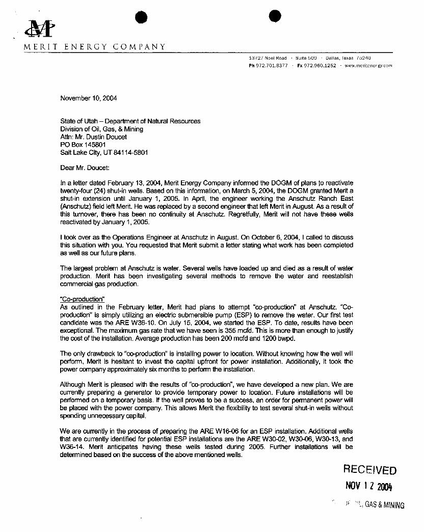
M * eMERIT ENERGY COMPANY
13727 Noel Road Suite 500 Dallas, Texas 75240
Ph 972.701.8377 Fx 972.960.1252 www.meritenergy.com
November 10, 2004
State of Utah -- Department of Natural ResourcesDivisionof Oil, Gas, & MiningAttn: Mr. Dustin DoucetPO Box 145801Salt Lake City, UT 84114-5801
Dear Mr. Doucet:
In a letter dated February 13, 2004, Merit Energy Company informed the DOGM of plans toreactivatetwenty-four(24) shut-inwells. Based on thisinformation, on March 5, 2004, the DOGM granted Meritashut-in extension until January 1, 2005. In April, the engineer working the Anschutz Ranch East(Anschutz) field left Merit. He was replaced by a second engineer thatleft Merit in August. As a resultofthis turnover,there has been no continuityat Anschutz. Regretfully, Merit will not have these wellsreactivatedþyJanuary 1, 2005.
I tookover as the Operations Engineer at Anschutz in August. On October 6, 2004, I called to discussthissituationwith you. You requested that Merit submit a letter stating what work has been completedas well as our future plans.
The largest problem at Anschutz is water. Several wells have loaded up and died as a result of waterproduction. Merit has been investigating several methods to remove the water and reestablishcommercial gas production.
"Co-production"As outlined in the February letter, Merit had plans to attempt "co-production"at Anschutz. "Co-production" is simplyutilizingan electricsubmersible pump (ESP) to remove the water. Our first testcandidate was the ARE W36-10. On July 15, 2004, we started the ESP. To date, results have beenexceptional.The maximumgas rate that we have seen is 355 mcfd.This is more thanenough tojustifythecost of the installation. Average production has been 200 mcfdand 1200 bwpd.
The onlydrawback to "co-production"is installing power to location. Without knowing how thewellwillperform, Merit is hesitant to invest the capital upfrontfor power installation. Additionally, it tookthepower companyapproximatelysixmonths to perform the installation.
Although Merit is pleased withthe results of "co-production",we have developed a new plan. We arecurrentlypreparing a generator to provide temporarypower to location. Future installations willbeperformed on a temporarybasis. Ifthe wellproves to be a success, an order for permanent power willbe placed with the power company.This allowsMerit the flexibilityto test several shut-inwellswithoutspending unnecessary capital.
We are currentlyin the process of preparing the ARE W16-06 for an ESP installation. Additional wellsthatare currentlyidentified for potential ESP installations are the ARE W30-02, W30-06, W30-13, andW36-14. Merit anticipates having these wells tested during 2005. Further installations will bedetermined based on thesuccess of theabove mentioned wells.
RECEIVEDNOV12 2004
GAS&
O Oe Page 2 November 10, 2004
Capillary StringsMerit has also begun utilizingcapillary strings to inject soap downhole to assist the well in liftingtheproduced water. We currently have five (5) capillarystrings in service at Anschutz and are planning oninstallingfour (4) more before theend ofthe year.
Gas LiftAlthough gas liftis not new toAnschutz, Merit has been tryingto extend its capabilities.Our first hurdleregarding gas liftis obtainingadditionalliftgas capacity.We currentlyutilizesales gas for gas lift.Basedon our current compression, we are limited to 4 mmcfd of liftgas. In additionto increasing our gas liftcapability, Merit is exploringthe idea of utilizingnitrogen for gas lift.
With thatbeing said, we currently have seventeen wells capable of being gas lifted. Due to our limitedliftgas capacity,onlysix (6) wells are currently being gas lifted.
Additionally,Merit is workingwithseveral service companies to exploreways to gas liftfrom below thepacker. There are several wells at Anschutz that have one to twothousandfeet of pay. As a result,conventionalgas liftmay or may not be effective.We have triedone method of gas liftingfrom belowthe packer and the results are great. However, thismethod is not a "cure-all".Itwillonlywork on selectwells.We willcontinueto look for wells capable of being lifted in thismanner. We are in the process ofidentifyinga candidate to test another method of gas liftingfrom below the packer. As soon as thewellis identified, the installation willbe performed.
While Merit is stillin the early phase of developing completiontechniquesto adequately produce thewells at Anschutz, we are makinggreat progress. We have had to think"out-of-the-box" to come upwith creative ways to remove the water and increase the gas and are exhausting all resources toimprove production and reduce idle wellbores.
Ihave attached the February 13 letter as well as our currentplans for the24 wells.
If you have any questions or require additional information, please contact me at (972) 628-1550 orelectronicallyat [email protected].
Sincerely,
Michael L. MercerOperations

O O13727 Noel Road, Suite 500Dallas, TX 75240Ph: 972-701-8377 Fx: 972-960-1252
MER I T ENERGY COMP A NY www.meritenergy.com
Date: February 13, 2004
Subject Extended Shut-in wells in the Anschutz Ranch East Field
Dear Mr. Doucet
In response to your letter dated January 22, 2004, I would like to submit the attachedsupporting documentationregarding our extended shut-in wells. Merit Energy Company purchased an operating interest in the Anschutz RanchEast Unit from BP Production Company effective July 1, 2003, and has spent the last seven months evaluating theproduction capability of all active and inactive wells in the field. This process hasresulted in workovers thathavereestablished production in several of these wells, and revealed future opportunitiesfor all of theothers. Here is aquick synopsis of our plans for each well.
• ARE W20-00 Workover is planned to immediately reactive this well by running smaller tubing, andputtingthe well on gas lift. Should be reactivated by mid year 2004.
• ARE W31-04- BP attempteda directional reentry of this wellbore in 2001, during which time thedrill pipewas inadvertently cemented in the horizontal section of thewellbore. Merit is investigating methods toeffectively stimninte thiswellbore and return it to production. If unable to do so, it will be plugged.
• ARE W36-10- This well will be the first test candidate for an experimental production method for artificiallifting gas wells. An electric submersible pump will be run in this well in thenext couple of months in anattempt to reestablish production by removing large volumes of water from the formation. If this project issuccessful it could lead to the reactivation of virtually every inactive well in the field. The project isapproved internally, and we are waiting on equipment and supplies before mobilizing a service rig.
• ARE W36-08- This well has been reactivated following a workover last fall. A sundry notice was filed andapproved by the Utah Oil and Gas Commission.
• ARE W21-04- Surface tubing pressure indicates thiswell may be capable of producing again. Howeverattempts to return this well toproduction with the current wellbore configuration have not been successful.Merit plans to install smaller tubing and gas lift on this well. If that is unsuccessful, thiswell is also acandidate for an electric submersible pump installation. If all attempts to reactivate theNugget formation fail,this well is a recompletion candidate in the Twin Creek fonnation.
• Champlin 372 C-1- This well is capable of producing for a few days at a time, but quickly loads up withwater and dies. Again, this well is a candidate for an electric submersible pump installation, or may be usedas a salt water disposal well if additional capacity is needed due to the ESP program.
• ARE W16-06-This well will have an electric submersible pump installed if the program is successful.Otherwise it will be plugged.
• ARE WO1-12-This well will have an electric submersible pump installed if the program is successful. It isalso considered for an uphole recompletion.
• ARE W30-02-An attempt was made to return this well to production last fall, but was unsuccessful due tohigh water production. Pending the success of the W36-10,thiswell will also have an electricsubmersiblepump installed.
• ARE W36-14- This well will have an electric submersible pump installed if the program is successful. It isalso considered for an uphole recompletion.
• ARE W30-06- This well will have an electric submersible pump installed if the program is successful. It isalso considered for an uphole recompletion.
• ARE W20-02-A workover has been approved internally to reactivate thiswell, and should begin in the nextfew weeks A sundry notice was filed and approved by the Utah Oil and GasCommission.
• ARE W30-13- This well will have an electric submersible pump installed if theprogram is successful. It isalso considered for an uphole recompletion.
• ARE W19-16- This well will have an electric submersible pump installed if theprogram is successful. It isalso considered for an uphole recompletion.
• ARE W20-04- This w have an electric submersible pump installe theprogram is successful. It isalso considered for an uphole recompletion.
• ARE W31-12- An attempt was made to reactivate this well in late 2003, but was unsuccessful. A sundrynotice was filed and approved by the Utah Oil and Gas Commission. An uphole recompletion in theTwinCreek formation is planned and will be completed in the next few months.
• ARE WO1-04-This well will have an electric submersible pump installed if the programis successful. It isalso considered for an uphole recompletion.
• ARE W11-01- This well will have an electric submersible pump installed if the program is successful.Otherwise it will be plugged.
• ARE W20-03- This well will have an electric submersiblepump installed if the program is successful. It isalso considered for an uphole recompletion.
• ARE W16-14- This well will have an electric submersible pump installed if theprogram is successful. It isalso considered for salt water disposal well if additional capacity is needed.
• ARE W16-12- This well will have an electric submersible pump installed if theprogram is successful. It isalso considered for salt water disposal well if additional capacity is needed.
• Champ1In 387 B-1A- Merit Energy is in the process of obtaining records from BP for thiswell. Oncehistorical information is obtained,we will evaluate all feasible methods to return thiswell to producing status.Otherwise it will be plugged.
• ARE W17-16- This well will have an electric submersible pump installed if theprogram is successful.It isalso considered for salt water disposal well if additional capacity is needed.
• ARE E21-14- This well was returned toproducing status on 12/19/03.
In addition to this information, I have enclosed pressure data for all wells, and a wellbore schematic for all wellsexcept theChamplin 387 B-1A. The static bottom hole pressures andstatic fluid levels were collected in September2003 with bottom hole gauges. If you need any further information, please contact me at 972-628-1651 orelectronically at lance.taylor(Ameritenergy.com.
Operations Engineer
Cc: Rusty GinnettiArlene ValliquetteDennis Longwell
Attachments: (1) page of pressure data, (23) wellbore schematics
O O
Well Name API Lease Type Years Inactive1 ARE W20-06 43-043-30159 Fee 1 Year 2 Months2 ARE W31-04E 43-043-30165 Fee 1 Year 3 Months3 ARE W36-10 43-043-30227 Fee 1 Year 3 Months4 ARE W36-08 43-043-30167 Fee 1 Year 7 Months
Wells with returned Sur dry Notices and attached equirement sheet dated November 19, 20031 ARE W21-04 43-043-30135 Fee 1 Year 10 Months2 Champlin 372 Amoco C1 43-043-30143 Fee 1 Year 11 Months3 ARE W16-06 43-043-30138 Fee 1 Year 11 Months4 ARE WO1-12 43-043-30271 Fee 2 Years 4 Months5 ARE W30-02 43-043-30218 Fee 3 Years 2 Months6 ARE W36-14 43-043-30255 Fee 4 Years 5 Months7 ARE W30-06 43-043-30273 Fee 5 Years 4 Months8 ARE W20-02 43-043-30228 Fee 5 Years 4 Months9 ARE W30-13 43-043-30279 Fee 5 Years 6 Months10 ARE W19-16 43-043-30204 Fee 5 Years 8 Months11 ARE W20-4 43-043-30238 Fee 6 Years 3 Months12 ARE W31-12 43-043-30190 Fee 7 Years 3 Months13 ARE WO1-04 43-043-30270 Fee 7 Years 4 Months14 ARE W11-01 43-043-30277 Fee 7 Years 4 Months15 ARE W20-03 43-043-30291 Fee 8 Years 1 Month16 ARE W16-14 43-043-30096 Fee 8 Years 1 Month17 ARE 16-12 43-043-30231 Fee 8 Years 3 Months18 Champlin 387 B1A 43-043-30168 Fee 8 Years 6 Months19 ARE W17-16 43-043-30176 Fee 8 Years 7 Months20 ARE E21-14 43-043-30130 Fee 10 Years 8 Months
Attachment
9 OJON M. HUNTSMAN, JR.
Governor
GARY R. HERBERTLieutenant Governor
State of Utah April 8, 2005
Department ofNatural Resources
M A R R Merit Energy CompanyAttn: Michael L. Mercer
Division of 13727 Noel Road, Suite 500Oil, Gas & Mining Dallas, Texas 75240
MARY ANN WRIGHTActing Division Director
Re: Approval for Extension of Shut-in or Temporarily Abandoned Status for Wellson Fee or State Leases
Dear Mr. Mercer:
The Division of Oil, Gas and Mining (the "Division") is in receipt of yourletters dated November 10, 2004 (received by the Division on November 12, 2004)and January 7, 2005 (received by the Division on January 10, 2005) in regards to thetwenty-four (24) shut-in wells operated by Merit Energy Company ("Merit"). TheDivision understands that six of these wells were put back into production in 2004.Merit's original plan was to return all twenty-four wells to production in 2004.Because of power restrictions, etc., Merit was unable to achieve that target. It is nowthe Division's understanding that Merit plans to return seven more wells to productionin 2005 by installing an ESP. The Division understands that Merit is alsoinvestigating other methods to assist in lifting the water (e.g. capillary strings).Depending on the success of the wells with ESP's installed, the wells currently on GasLift, and the success of the other methods, the remaining 11 wells will either beplugged or put into production.
Based on the submitted information and plan of action, the Division approvesyour request for extended SI/TA for the eighteen (18) remaining SI/TA wells (seeattachment A) until January 1, 2006. The operator should continue to monitor thewells by documenting pressures and fluid levels on a periodic basis. Any significantchange in pressure or fluid level should be reported to the Division immediately.Remedial action may be necessary.
In addition to the twenty-four wells mentioned above, Merit also has one newwell for 2005 that requires approval for extended SI/TA. The well is the ARE W30-
14 (API # 43-043-30185). Our records indicate that this well has been SI/TA sinceFebruary of 2003. Merit must submit their future plans for this well and informationthat demonstrates the well has integrity and is not a risk to public health and safety orthe environment (R649-3-36-1.1 to 1.3).
1594 West North Temple, Suite 1210, PO Box 145801, SaltLakeCity, UT 84114-5801telephone(801)538-5340 • facsimile(801)359-3940. TTY (801) 538-7458 •
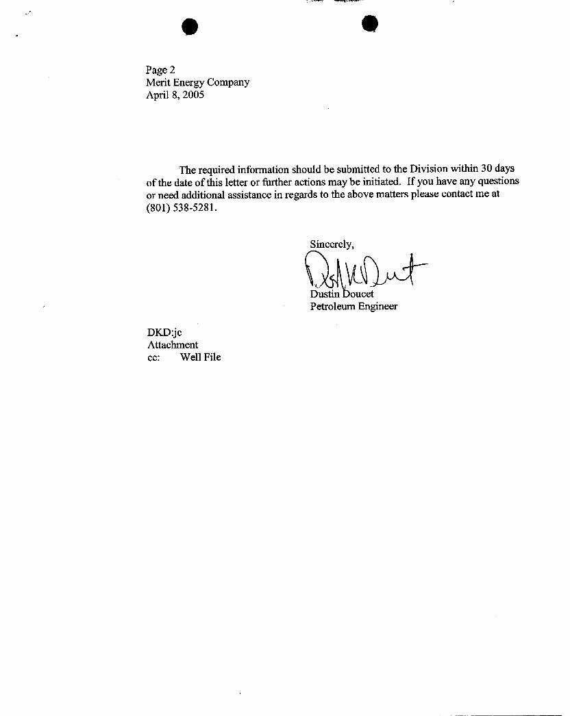
Page 2Merit Energy CompanyApril 8, 2005
The required information should be submitted to the Division within 30 daysof the date of this letter or further actions may be initiated. If you have any questionsor need additional assistance in regards to the above matters please contact me at(801) 538-5281.
Sincerel
Dustin oucetPetroleum Engineer
DKD:jeAttachmentec: Well

ATTACHMENT A
Well Name API Lease Type Years Inactive
1 ARE W31-04E 43-043-30165 Fee 2 Year 3 Months2 Champlin 372 Amoco C 1 43-043-30143 Fee 2 Year 11 Months
3 ARE W16-06 43-043-30138 Fee 2 Year 11 Months
4 ARE WO1-12 43-043-30271 Fee 3 Years 4 Months5 ARE W30-02 43-043-30218 Fee 4 Years 2 Months6 ARE W36-14 43-043-30255 Fee 5Years 5 Months
7 ARE W30-06 43-043-30273 Fee 6 Years 4 Months
8 ARE W30-13 43-043-30279 Fee 6 Years 6 Months
9 ARE W19-16 43-043-30204 Fee 6 Years 8 Months10 ARE W20-04 43-043-30238 Fee 7 Years 3 Months
11 ARE W31-12 43-043-30190 Fee 8 Years 3 Months
12 ARE WO1-04 43-043-30270 Fee 8 Years 4 Months
13 ARE W11-01 43-043-30277 Fee 8 Years 4 Months
14 ARE W20-03 43-043-30291 Fee 9 Years 1 Month
15 ARE W16-14 43-043-30096 Fee 9 Years 1 Month
16 ARE W16-12 43-043-30231 Fee 9 Years 3 Months
17 Champlin 387 B1A 43-043-30168 Fee 9 Years 6 Months
18 ARE W17-16 43-043-30176 Fee 9 Years 7

State of UtahDEPARTMENT OF NATURAL RESOURCES
MICHAEL R. STYLERExecutiveDirector
JON M. HUNTSMAN, JR.Division of Oil, Gas and Mining
Governor JOHN R. BAZA
GARY R.HERBERTDivision Director
Lieutenant Governor
August 26, 2008
CERTIFIED MAIL NO. 7004 2510 0004 1824 6053
Mr. Michael Mercer 4 6 MSMerit Energy Company ME WO- IQ13727Noel Road, Suite 500Dallas, TX 75240 74 N %E fl
Re: Third Notice of Extended Shut-in and Temporarily Abandoned Well Requirements forFee or State Leases
Dear Mr. Mercer:
As of July 2008, Merit Energy Company has fifteen (15) Fee Lease Wells that are in non-compliance with the requirements for extended shut-in or temporarily abandoned (SI/TA) status(see attachment A). All wells SI/TA beyond twelve (12) consecutive months require the filing ofa Sundry Notice in accordance with R649-3-36-1 for Utah Division of Oil, Gas & Mining("Division") approval. Wells with five (5) years non-activity or non-productivity shall beplugged, unless the Division grants approval for extended shut-in time upon a showing of goodcause by the operator (R649-3-36-1.3.3).
On January 22, 2004 the Division notified Merit by certified mail 24 wells were on theSI/TA list. Merit responded by letters of February 13, 2004, November 10, 2004, and January 5,2005, with evaluation plans for each of the 24 wells. By the time an extension of SI/TA statuswas granted to Merit by the Division on April 8, 2005, six of the original 24 wells had beenreturned to production.
To date, 10 of the original 24 wells remain as SI/TA. Two wells were producing brieflyin 2005 but have since returned to SI/TA status. These wells are listed as number 8 and number10 on Attachment A. Two additional wells (ARE W36-08 API# 43-043-30167 & ARE 29-04ST1 API# 43-043-30129) were producing briefly for 3 months in 2007, but are now showing asSI, and will soon be added to this list.
Five (5) new wells have been added to the current list. These are the wells numbered 11through 15 on Attachment A
UTAH
DNR
1594 West North Temple, Suite 1210, PO Box 145801, Salt Lake City, UT 84114-5801telephone(801) 538-5340 • facsimile (801) 359-3940 •TTY (801) 538-7458 • www.ogm.utah.gov OIL, GAS &
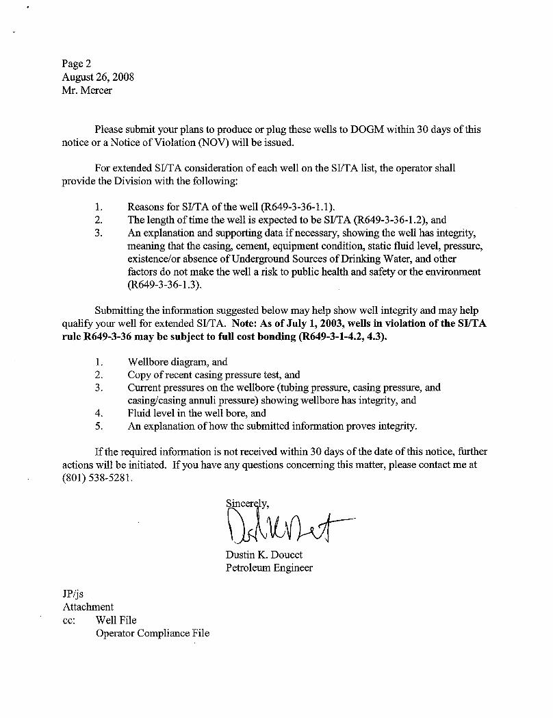
Page 2August 26, 2008Mr. Mercer
Please submit your plans to produce or plug these wells to DOGM within 30 days of thisnotice or a Notice of Violation (NOV) will be issued.
For extended SI/TA consideration of each well on the SI/TA list, the operator shallprovide the Division with the following:
1. Reasons for SI/TA of the well (R649-3-36-1.1).2. The length of time the well is expected to be SI/TA (R649-3-36-1.2), and3. An explanation and supporting data if necessary, showing the well has integrity,
meaning that the casing, cement, equipment condition, static fluid level, pressure,existence/or absence of Underground Sources of Drinking Water, and otherfactors do not make the well a risk to public health and safety or the environment(R649-3-36-1.3).
Submitting the information suggested below may help show well integrity and may helpqualify your well for extended SI/TA. Note: As of July 1, 2003, wells in violation of the SI/TArule R649-3-36 may be subject to full cost bonding (R649-3-1-4.2, 4.3).
1. Wellbore diagram, and2. Copy of recent casing pressure test, and3. Current pressures on the wellbore (tubing pressure, casing pressure, and
casing/casing annuli pressure) showing wellbore has integrity, and4. Fluid level in the well bore, and5. An explanation of how the submitted information proves integrity.
If the required information is not received within 30 days of the date of this notice, furtheractions will be initiated. If you have any questions concerning this matter, please contact me at(801) 538-5281.
Dustin K. DoucetPetroleum Engineer
JP/jsAttachmentec: Well File
Operator Compliance
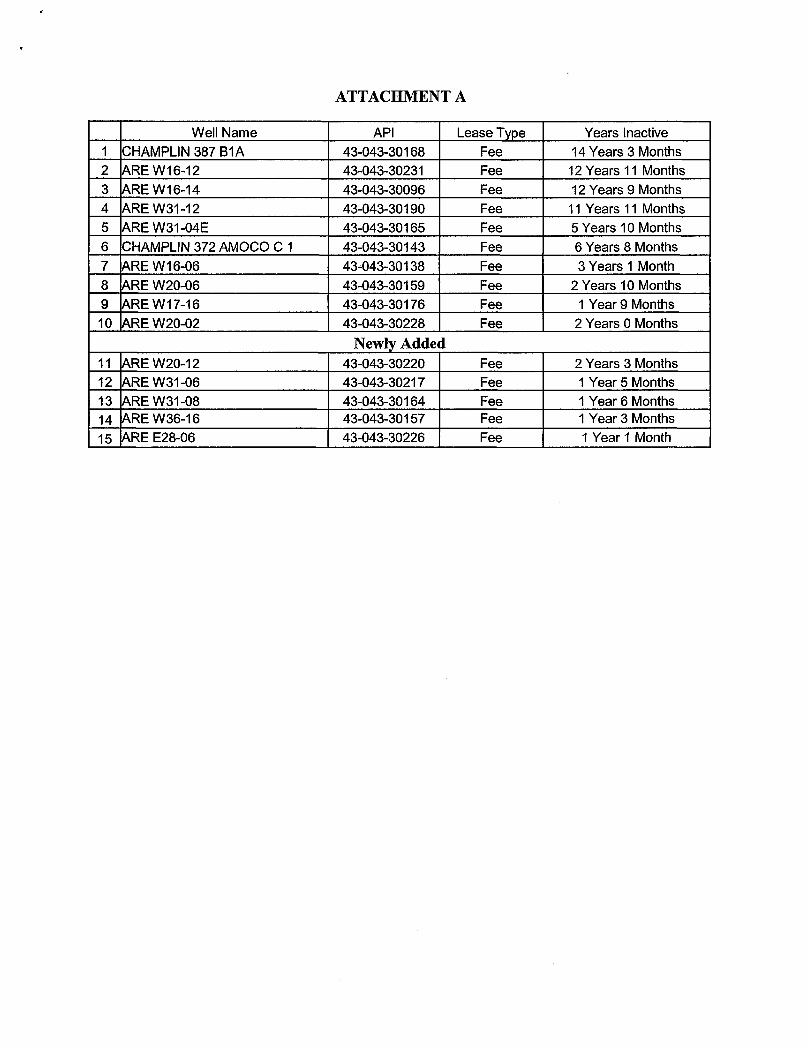
ATTACHMENT A
Well Name API Lease Type Years Inactive1 CHAMPLIN 387 B1A 43-043-30168 Fee 14 Years 3 Months2 ARE W16-12 43-043-30231 Fee 12 Years 11 Months3 ARE W16-14 43-043-30096 Fee 12 Years 9 Months4 ARE W31-12 43-043-30190 Fee 11 Years 11 Months5 ARE W31-04E 43-043-30165 Fee 5 Years 10 Months6 CHAMPLIN 372 AMOCO C 1 43-043-30143 Fee 6 Years 8 Months7 ARE W16-06 43-043-30138 Fee 3 Years 1 Month8 ARE W20-06 43-043-30159 Fee 2 Years 10 Months9 ARE W17-16 43-043-30176 Fee 1 Year 9 Months10 ARE W20-02 43-043-30228 Fee 2 Years OMonths
Newly Added11 ARE W20-12 43-043-30220 Fee 2 Years 3 Months12 ARE W31-06 43-043-30217 Fee 1 Year 5 Months13 ARE W31-08 43-043-30164 Fee 1 Year 6 Months14 ARE W36-16 43-043-30157 Fee 1 Year 3 Months15 ARE E28-06 43-043-30226 Fee 1 Year 1
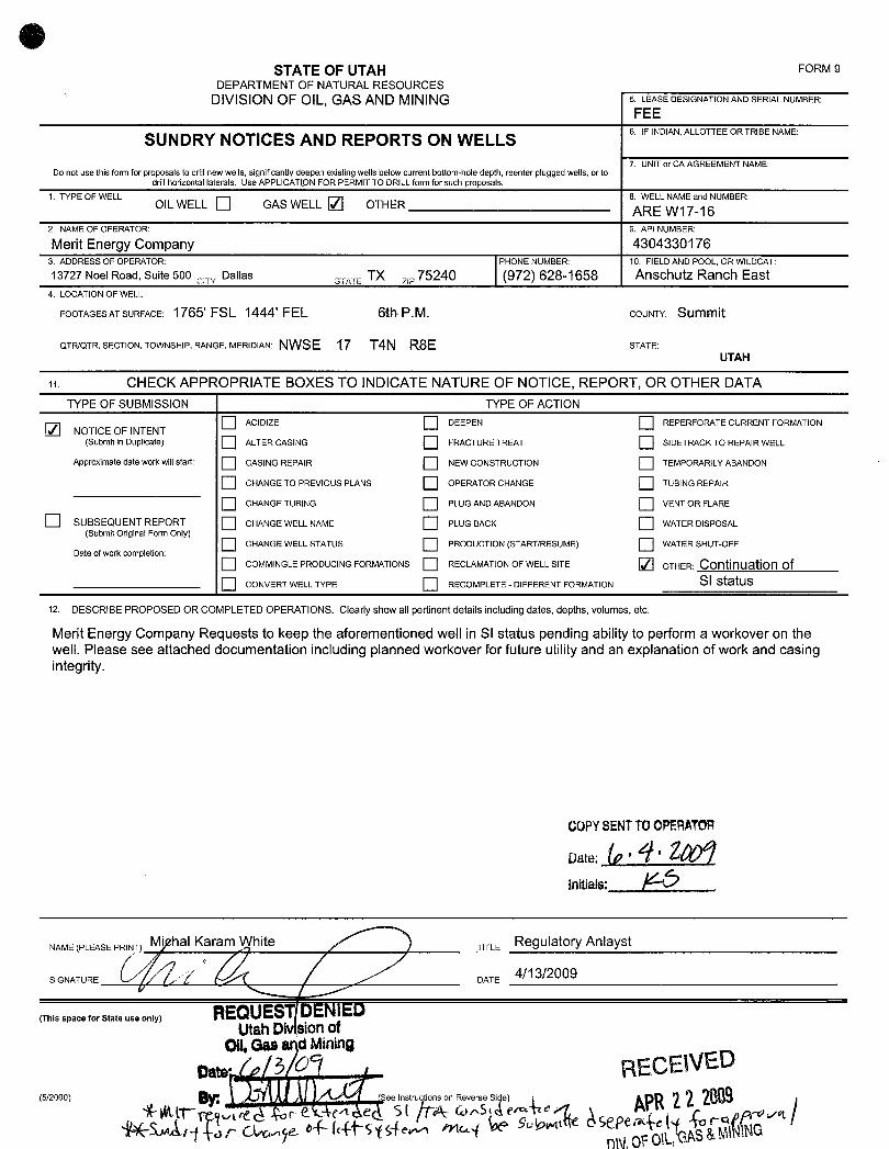
OSTATE OF UTAH FORM 9
DEPARTMENT OF NATURALRESOURCESDIVISIONOF OIL, GAS AND MINING 5. LEASEDESIGNATIONANDSERIALNUMBER:
FEE
SUNDRY NOTICES AND REPORTS ON WELLS 6. IFINDIAN,ALLOTTEEORTRIBENAME:
7. UNIT or CA AGREEMENT NAME:Do not use this form for proposals to drillnewwells, significantlydeepen existing wells below current bottom-hole depth, reenter plugged wells, or to
drill horizontal laterals. Use APPLICATlON FOR PERMIT TO DRILLform for such proposals.1.TYPEOF\NELL 8.\NELLNAMEandNUMBER:
OIL WELL GAS WELL OTHER ARE W17-162. NAMEOF OPERATOR: 9. API NUMBER:
Merit Energy Company 43043301763. ADDRESS OF OPERATOR: PHONE NUMBER: 10. FIELDAND POOL, OR WILDCAT:
13727 Noel Road, Suite 500 Dallas , ,,, TX zie75240 (972) 628-1658 Anschutz Ranch East4. LOCATIONOF WELL
FOOTAGESATSURFACE: 1765' FSL 1444' FEL 6th P.M. COUNTY: Summit
QTR/QTR, SECTION, TOWNSHIP, RANGE, MERIDIAN: NWSE 17 T4N RSE STATE:UTAH
it CHECK APPROPRIATE BOXES TO INDICATENATURE OF NOTICE, REPORT, OR OTHER DATATYPE OF SUBMISSION TYPE OF ACTION
ACIDIZE DEEPEN REPERFORATE CURRENT FORMATION2 NOTICE OF INTENT(Submit in Duplicate) ALTER CAS1NG FRACTURE TREAT SIDETRACK TO REPA1RWELL
Approximate date work willstart: CASING REPAIR NEW CONSTRUCTION TEMPORARILYABANDON
CHANGE TO PREVIOUS PLANS OPERATOR CHANGE TUBING REPAIR
CHANGE TUBING PLUG ANDABANDON VENT OR FLARE
SUBSEQUENT REPORT CHANGE WELL NAME PLUG BACK WATER DISPOSAL(Submit Original Form Only)
CHANGE WELL STATUS PRODUCTION (START/RESUME) WATER SHUT-OFFDate ofwork completion:
COMMINGLEPRODUClNG FORMATIONS RECLAMATlONOF WELL SITE OTHER: Continuation ofCONVERT WELL TYPE RECOMPLETE - DIFFERENT FORMATION SI status
12. DESCRIBE PROPOSED OR COMPLETED OPERATIONS. Clearly show all pertinent details including dates, depths, volumes, etc.
Merit Energy Company Requests to keep the aforementioned well in SI status pending ability to perform a workover on thewell. Please see attached documentation including planned workover for future utilityand an explanation of work and casingintegrity.
COPYSENTTOOPERATOR
NAME(PLEASE PRINT) hal Karam White TITLE Regulatory Anlayst
SIGNATURE DATE 4/13/2009
(This space for State use only) REQUESTDENlEDUtahDivisionof
Oll,Gas Mining
cate REC NED(5/2000) See instructions on Reverse

ARE W17-16Sec. 17-T4N-R8ESummit County, UtahAPI #43-043-301764/9/2009
Pull Tubing & Run Reverse Gas Lift
Well DataTubing: 2-3/8", 4.7#, N-80Casing: 7" @10,237'Liner: 5", 18#, P-110 @10,237' - 14,671'TD: 14,671'PBTD: 14,140'Elevation: 7,375' KB 7,350' GL
2-3/8" X-nippleOn/off toolASI-X Packer set @13,747'XN-nipple
Open Perforations:Nugget 13,806' - 13,844', 13,864' - 13,912', 13,932' - 13,976', 14,010' - 14,040'
14,064' - 14,094'
Procedure1. RU slickline. RIH with guage ring sized according to pressure and temperature tools to
check for clearance. POH.2. RIH with pressure and temperature recorders for pressure build up test per Altec's
recommendations. POH. RD slickline. Send data to Altec for reverse gas lift design.3. MIRU PU. ND WH. NU BOP. Release ASI-X packer. TOH laying down 2-3/8"
production tubing.4. If unable to release packer, release from off on/off tool. TOH laying down 2-3/8"
production tubing. (Note: If able to release packer, make bit run on 2-3/8" productiontubing unless tubing is scaled off.)
5. PU jars and 2-7/8" P-110 workstring. TIH and latch onto on/off tool. Jar packer free.TOH. Lay down fishing tools and packer.
6. PU 4-1/8" bit and 4.151" drift casing scrapper on 2-7/8" P-110 workstring or 2-3/8"production string. TIH and tag fill to make sure perforations are open. TOH.
7. PU and TIH with 3-1/2" & 2-3/8" tubing for reverse gas lift set according to design (donot run until wellhead and surface work are done). Band 1/4" cap string to 13,800'.
8. ND BOP. NU WH. Kick the well up with gas lift. RDMO PU.
ContactsForeman: Don Baucum (307) 380-8300Operations Manager: Bruce Vargo (307) 320-5113Operations Engineer: Nick Tunnell (972)
Explanation of Work and Casing Integrity
Due to the current pricing environment, the proposed project is currently uneconomical.However, as prices come up at a future point and time and as Merit is able to lower operatingcosts, Merit is confident that the proposed project is still a viable project and there is futureutility for the wellbore. Attached is a proposed procedure to install reverse gas lift to unload thewell. Merit swab tested the subject well, tested an ESP, and installed conventional gas lift in thesubject well in late 2005/early 2006, but the well was not returned to production. Due to the highsetting depth of the ESP and the inability of conventional gas lift to unload the well across theperforations, reverse gas lift has proved to be a successful alternative, obtaining added drawdown across the perforations needed to reactivate wells.
During the workover performed, the casing in the subject well was pressure tested to 1000 psiand tested good in November 2005. Therefore, there is no reason for concern in regards tocasing integrity at this
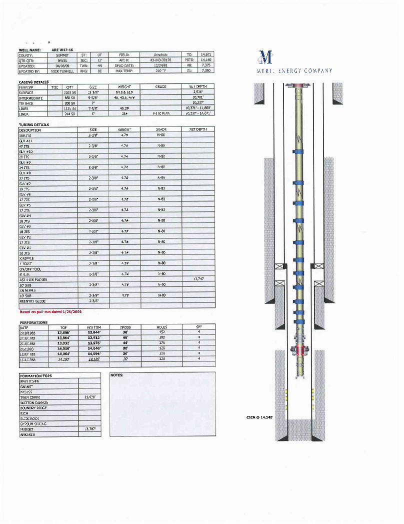
WELL NAME: AREW17-16COUNTY SUMMIT ST; UT FIELD: Anschum TD: 14,671
qTRQTR NWSE SEC; 17 API9: 43-043-30176 PETD: 14,140
UPDATED: 04/08/09 TWN: 4N SPDD DATE: 12/24]S1 KB: 2,375
(UPDATED BY: NICKTUNNEU.. RNG: SE MAXTEMP: 210 "F GL 7,3so I MERITENERGY COMPANY
CA5ING DETAILSPURPOSE TOC CMT SIZE WEIGHT GRADE SET DEPTH _ŸSURFACE 2200 SX 13-3/8" 54.5 &61# 2,526'
INTERMEDIATE 850SK 9-WB• 40, 43.5, 47# 10,701'
TIEBACK 200SK 7" 10,237
l.INER 1125SX 7-5/8" 45.3# 10,37f-11,80lf
LINER 244SX 56 18# P-110 FL4S 10,237 - 14,67¾
TUBINGDETAILSDESCRIFTION SIZE WEIGHT GRADE SET DEPTH
199 JTS 2-3/8" 4.7# N-80
GLV#11
47]TS 2-3/8" 4,7# N-80
GLV#1028 JTS 2-3/8" 4.7# N-80
GLV#924JTS 2-3/8" 4.7# N-80
GLV#822JTS 2-3/8" 4.7& N-80
GLV#719 JTS 2-3/8" 4,7# N-80
GLV#617 JTS 2-3/8" 4.7# N-80
GLV#517 JTE 2-3(8" 4.7# N-80
GLV#418 JTS 2-3/8" 4,78 N-80
GLV#3
18JiS 2-3/8" 4.7# N-80
GLV#217 JTS 2-3/8" 4.7# N-80
GLV#1
52J15 2-3/8" 4.7# N-80
X NIPPLE1 JOINT 2-3/8" 4.7# N-80
ON/OFF TOOL
6' SUB 2-3/8" 4.7# N-80
ASI-X10K PACKER 13,747
10' SUB 2-3/8" 4.7# N-80
XN N[PPLEI& SUB 2-3/8" 4.7# N-80
REENTRYGUIDE 2-3/8"
Based on pull-run dated 1/25/20 16
PERFORATIONSDATE TOP BUFTOM GROSS HOLES SPF
2/19/1983 13,806' 13,844' 38' 152 4
2/19/1983 13,864' 13,912' 48' 192 4
2/19/1983 13,932' 13,976' 44' 176 4
2/5/1983 14,010' 14,040' 30' 120 4
1/25/1983 14,064' 14,094' 30' 120 4
1/11/1983 HJ ' HJ ' E' 120 4
IFORMATION TOPS NOTES:
BEARRIVERGANNETPREUSSTWIN CREEK 11,630'
WATTON CANYONBOUNDRYRIDGE
RICHSLIDE ROCK CICR @ 14,140'
GYPSUMSPRING
NUGGET 13,787

State of UtahDEPARTMENT OF NATURAL RESOURCES
MICHAEL R. STYLER--' ExecutiveDirector
JON M. HUNTSMAN, JR.Division of Oil Gas and Mining
Governor JOHN R. BAZADivision Director
GARY R. HERBERTLieutenant Governor
January 21, 2009
Mr. Nicholas TunnellMerit Energy Company13727 Noel Road, Suite 500Dallas, TX 75240
Subject: Extended Shut-in and Temporary Abandoned Well Requirements for Fee or StateLeases dated August 26, 2008.
Dear Mr. Tunnell:
The Division of Oil, Gas and Mining (the Division) is in receipt of your letter datedOctober 17, 2008 in regards to the fifteen (15) shut-in or temporarily abandoned (SI/TA) FeeLease Wells (Attachment A) operated by Merit Energy Company (Merit).
The Division does not object to the proposed work on the said wells. Several of thewells listed look as though they may have integrity. However, due to insufficient evidence theDivision is unable to grant extended SI/TA status for these wells. Not enough data was receivedper R649-3-36 providing proof of integrity or lengths of time wells are expected to be shut-in.The Divisions preferred method of demonstrating well integrity is to perform an MIT. Pleasesubmit the necessary information to bring these wells back into compliance. Please note,approval will be necessary prior to continuing with the planned work for these wells.
Please submit an individual sundry for each well along with required information tohelp expedite approval and documentation processes. If the required information is not receivedwithin 30 days of the date of this notice, further actions may be initiated. If you have anyquestions concerning this matter, please contact me at (801) 538-5281.
incerely,
Dustin K. DoucetPetroleum Engineer
DKD/JP/jsEnclosureoc: Well FileS URH
Compliance File DNRN:\O&G Reviewed Docs\ChronFile\PetroleumEngineer\SITA
1594 West North Temple, Suite 1210, PO Box 145801, Salt Lake City, UT 84114-5801telephone (801) 538-5340 • facsimile (801) 359-3940 • TTY (801) 538-7458 • wwwogm.utah.gov OIL GAS &
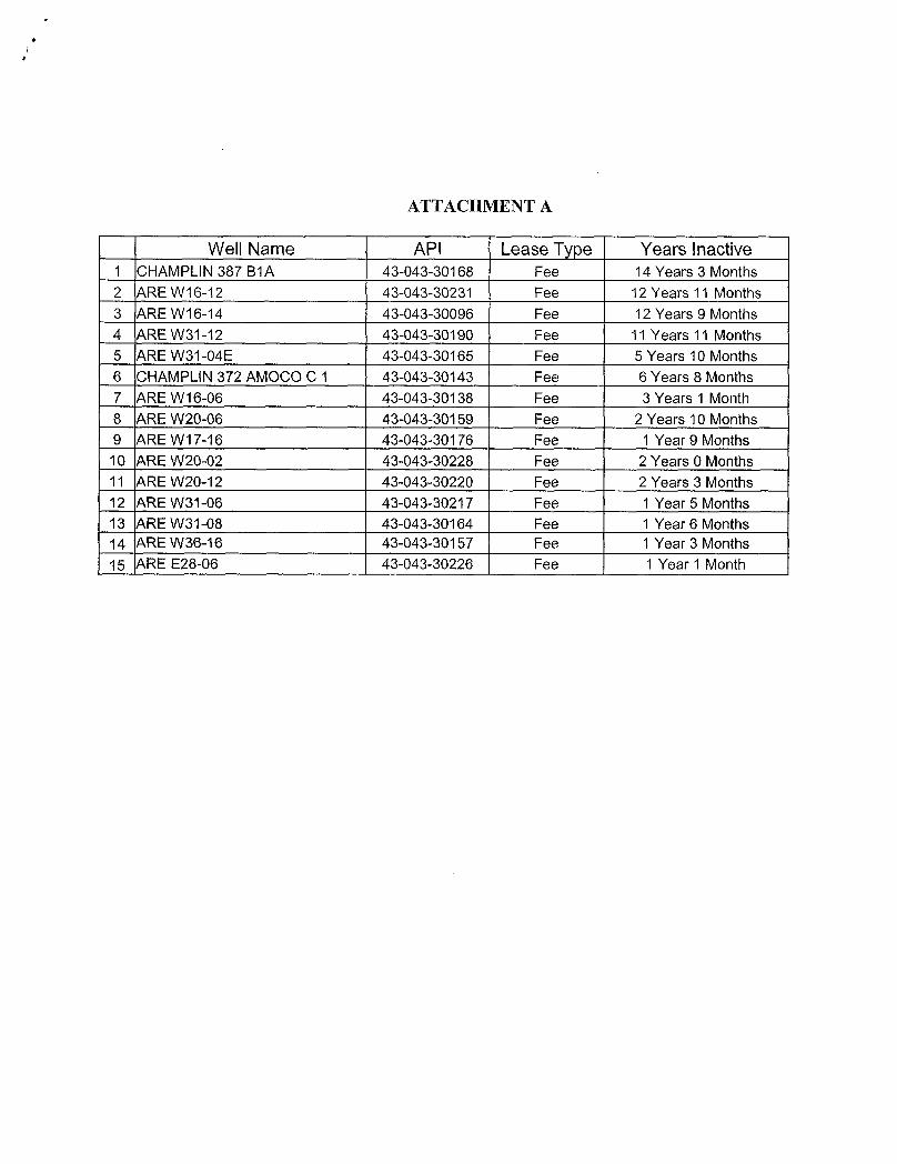
ATTACHMENT A
Well Name API Lease Type Years inactive1 CHAMPLIN 387 B1A 43-043-30168 Fee 14 Years 3 Months2 ARE W16-12 43-043-30231 Fee 12 Years 11 Months3 ARE W16-14 43-043-30096 Fee 12 Years 9 Months4 ARE W31-12 43-043-30190 Fee 11 Years 11 Months5 ARE W31-04E 43-043-30165 Fee 5 Years 10 Months6 CHAMPLIN 372 AMOCO C 1 43-043-30143 Fee 6 Years 8 Months7 ARE W16-06 43-043-30138 Fee 3 Years 1 Month8 ARE W20-06 43-043-30159 Fee 2 Years 10 Months9 ARE W17-16 43-043-30176 Fee 1 Year 9 Months10 ARE W20-02 43-043-30228 Fee 2 Years 0 Months11 ARE W20-12 43-043-30220 Fee 2 Years 3 Months12 ARE W31-06 43-043-30217 Fee 1 Year 5 Months13 ARE W31-08 43-043-30164 Fee 1 Year 6 Months14 ARE W36-16 43-043-30157 Fee 1 Year 3 Months15 ARE E28-06 43-043-30226 Fee 1 Year 1

MERIT ENERGY COMPANY13727 Noel Road · Suite 500 Dallas, Texas 75240Ph 972.701.8377 · Fx 972.960.1252 · www.meritenergy.com
October 17, 2008
State of Utah - Department of Natural ResourcesDivisionof Oil, Gas, &MiningAttn: Mr.Dustin DoucetPO Box 145801Salt Lake City, UT 84114-5801
Dear Mr. Doucet:
in response to your letter dated August 26, 2008, I wouldlike to submit the attached supportingdocumentation regarding our extended shut-inwells,Enclosed, please find a summary sheet with Merit Energy Company's future plans for each of the wellslisted in your letter, a sheet withexplanationsand supportingdata showing each well's integrity,as wellas wellborediagrams for thesubject wells.If you have any questions or wish to discuss thisfurther, please contact me at (972) 628-1084 [email protected],
NicholasR. TunnellOperations EngineerMeritEnergy
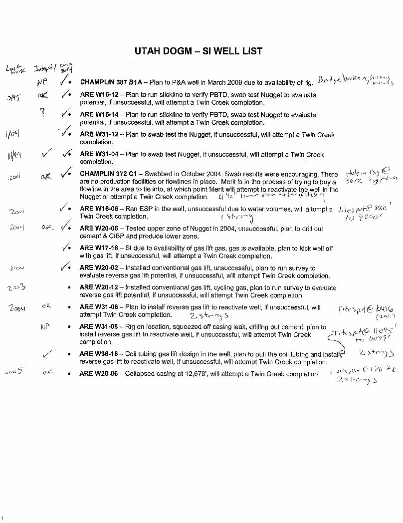
UTAH DOGM - SI WELL LIST
• CHAMPLIN 387 B1A- Plan to P&A well in March2009 due to availabilityof rig. 'A
ARE W16-12 - Plan to run slicklineto verifyPBTD, swab test Nugget to evaluatepotential, if unsuccessful, will attempt a Twin Creek completion.
ARE W16-14 - Plan to run slickline to verifyPBTD, swab test Nugget to evaluatepotential, if unsuccessful, willattempt a Twin Creek completion.ARE W31-12 - Plan to swab test the Nugget, if unsuccessful, will attempt a Twin Creekcompletion.
ARE W31-04-- Plan to swab test Nugget, if unsuccessful, willattempt a Twin Creekcompletion.
CHAMPLIN 372 C1 - Swabbed in October 2004. Swab results were encouraging. There tare no production facilities or flowlines in place. Merit is in the process of tryingto buy a 36/2flowline in the area to tie into, at which point Merit will attempt to react vate the well in theNugget or attempt a Twin Creek completion, ph Lov E^ " Er A 4
2coi • ARE W16-06 - Ran ESP in the well, unsuccessful due to water volumes, will attempt a y 7000Twin Creek completion. ) 'ÿ¿ao /
2cog 0 ARE W20-06 - Tested upper zone of Nugget in 2004, unsuccessful, plan to drill outcement & CIBP and produce lower zone.
• ARE W17-16 - S1 due to availability of gas liftgas, gas is available, plan to kick well offwithgas lift, if unsuccessful, will attempt a Twin Creek completion.
se ARE W20-02 - Installed conventional gas lift, unsuccessful, plan to run survey toevaluate reverse gas lift potential, if unsuccessful, willattempt Twin Creek completion.
o3 • ARE W20-12 - installed conventional gas lift, cycling gas, plan to run survey to evaluatereverse gas liftpotential, if unsuccessful, willattempt Twin Creek completion.
o • ARE W31-06 - Plan to install reverse gas liftto reactivate well, if unsuccessful, will (ogattempt Twin Creek completion. 2..,S 5
N • ARE W31-08 -- Rig on location, squeezed off casing leak, drilling out cement, plan toinstall reverse gas lift to reactivate well, if unsuccessful, will attempt Twin Creekcompletion.
• ARE W36-16- Coll tubing gas liftdesign in the well, plan to pull the coil tubing and instal 1 5
reverse gas lift to reactivate well, if unsuccessful, willattempt Twin Creek completion.• ARE W28-06 - Collapsed casing at 12,678', will attempt a Twin Creek completion.
UTAH DOGM - SI WELL UST
Wells to be Reactivated In 2009. Da
• ARE W16-12o Packer at 10,304o Top of cement (TOC) at 10,100 (9-5/8" casing)o Tubing Pressure 50# 5 oo Casing Pressure 0# 8 poo The packer is located below the TOC. The tubingpressure and casing pressure are S
different. Therefore, the casing and tubingare not in communication and the groundwaters are protected.. A• ARE W16-14
o Packer (PBR) at 10,500 too b o Mo Top of cement (TOC) at 9,650 (9-5/8" casing) 2<»f a rvAo Tubing Pressure 1650# 94 jw 3 To Casing Pressure 850# m3 too Oo The tubingis tied into the 4-1/2" liner with a PBR at 10,500. This is below the TOC for th 0 tod IT
9-5/8" casing string. The tubingpressure and casing pressure are different. Therefore,the casing and tubingare not in communication and the ground waters are protected., A 4• ARE W31-12
o Packer at noneo Top of cement (TOC) at 10,700o Casing Pressure 100#
a3 0o Fluid Level 1000' from Surfaceo There is not a packer or tubingin thiswell. The static fluid level is 1000' from surface.There is a 13-3/8" casing string set at 2846', a 9-5/8" casing string set at 10272', and a 7"tie-backcasing string set at 9919'. These three casing strings are protecting the groundwaters.
• ARE W31-04¿¤¤ g '3a N
o Packer at 14,000o Top of cement (TOC) at 11,900 moos iro 30o Tubing Pressure 1000# es no 6o Casing Pressure 0# z 3 ao This well is a horizontal sidetrack. The primary cement job on the original productioncasing had a TOC at 11,900. The kick-off point for the horizontal leg is below thisdepth.
Additionally, the drill string was cemented in the horizontal section with the TOCestimated to be between 13126 and 13310. Based on the fact that the tubingand casingpressures are different, the twoare not in communication and therefore,the groundwaters are protected.go• CHAMPLIN372 C1 '
geoo Packer at 8,320 (MD) 6,648 (TVD)o Top of cement (TOC) at 4,906o Tubing Pressure 0#o Casing Pressure 0#o The 4-1/2" liner is cemented in place at 5090 (below the TOC). N A
• ARE W16-06NA Nko Packer at none
A N Ao Top of cement (TOC) at 12,640o Casing Pressure 0#o When Meritset a packer in October 2004, we pressure tested the annulus to500 psi andit held. Therefore, the casing has integrity and the ground waters are protected.
• ARE W20-06o Packer at 12,858'o Top of cement (TOC) at 9,650' (9-5/8" casing) 2cd 72o *FO
o Tubing Pressure 0# 2oo 33a 3o Casing Pressure 0#o When Merit set the packer in June 2004, we pressure tested the annulus to 5 0 psi andheld. There is a 13-3/8" casing string set at 5411', a 9-5/8" casing string set at 11330',
Page 1 of 2
UTAHDOGM - SI WELL LIST
and a 7" tie-backcasing string set at 10079'. These three casing strings are protectingthe ground waters.• ARE W17-16 2AT ÍU Ik
o Packer 13,747' O Q t i o c.9o Top of cement (TOC) at 10,371' (7-5/8" casing) oT c No Tubing Pressure 78# o 9 o ao Casing Pressure 53#o There is a 13-3/8" casing string set at 2526', a 9-5/8" casing string set at 10701', and a 7"tie-backcasing string set at 10237'. These threecasing strings are protecting thegroundwaters.
qçµ Tod• ARE W20-02
¿ÿ<a N°o Packer at 12,646' gooy goca - ¿ ¡ yo Top of cement (TOC) at 8,910' (7" casing) go a y y too ao Tubing Pressure 384# pg d Øo Casing Pressure 310# (da 7% Qo There is a 13-3/8" casing string set at 5140', a 9-5/8" casing string set at 10934', and a 7"casing string set at 13928'. These threecasing strings are protecting the ground waters.
• ARE W20-12 zoc 43 ¿oyoo Packer at 12,863'o Top of cement (TOC) at 10,372' (9-5/8" casing) to o axedo Tubing Pressure 912#o Casing Pressure 930#o There is a 13-3/8" casing string set at 5362', a 9-5/8" casing string set at 11245', and a 7"tie-backcasing string set at 10109'. These threecasing strings are protecting the groundwaters·
2o y O N A• ARE W31-062eoca 210 NAo Packer at 10284' zoof a 42o Top of cement (TOC) at 9996' (7" casing) MN no qqao Tubing Pressure 0# 2°°S * Lao Casing Pressure 0#
o There is a 13-3/8" casing string set at 2301', a 9-5/8" casing string set at 10689', and a 7"casing string set at 14033'. These threecasing strings are protecting the ground waters.• ARE W36-16
2 ei tzad Oo Packer (PBR)at 10,680 foo no oo Top of cement (TOC) at 10,172 (7" casing) 2°" o £6°o Tubing Pressure 1357# n°¾ 1so Oo Casing Pressure 0# L3 tyo oo The packer is located below the TOC. The tubing pressure and casing pressure aredifferent. Therefore, the casing and tubingare not in communication and the groundwaters are protected·
Zaß N A• ARE E28-06
2 oc y C Oo Packer at none goog (to Oo Top of cement (TOC) at 11,900' (7" casing) . , y y (p yoo Tubing Pressure 0#o Casing Pressure 0#o There is a 13-3/8" casing string set at 3988', a 9-5/8" casing string set at 12990', and a 7"tie-backcasing string set at 12313'. These threecasing strings are protecting the groundwaters.
Page 2 of 2
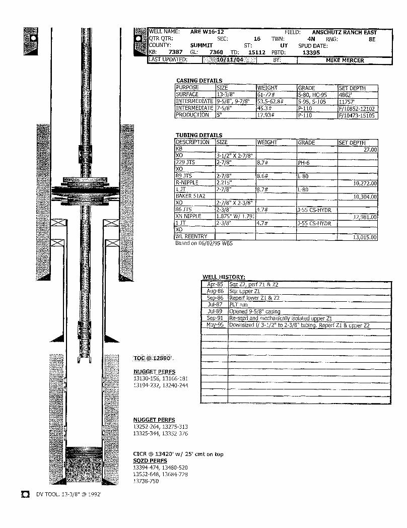
WELLNAME: ARE W16-12 FIELD: ANSCHUTZ RANCH EASTQTR QTR: SEC: 16 TWN: 4N RNG: 8ECOUNTY: SUMMIT ST: UT SPUD DATE:KLA UP7D3AST
D:GL: 736100/11/
415 12 PBY:D: 13395
MIKE MERCER
CASING DETAILSPURPOSE SIZE WEIGHT GRADE SET DEPTHSURFACE 13-3/8" 61-72# S-80, HC-95 4862'INTERMEDIATE9-5/8", 9-7/8" 53.5-62.8# S-95, S-105 11757'INTERMEDIATE 7-5/8" 45.3# P-110 F/10852-12102PRODUCTION 5" 17.93# P-110 F/10473-15105
TUBING DETAILSDESCRIPTION SIZE WEIGHT GRADE SET DEPTHKB 27.00XO 3-1/2" X 2-7/8"
| 229 JTS 2-7/8" 8.7# PH-6XO89 JTS 2-7/8" 8.6# L-80R-NIPPLE 2.215" 10,272.001 JT 2-7/8" 8,7# L-80BAKER51A2 10,304.00XO 2-7/8" X 2-3/8"86 JTS 2-3/8" 4.7# 3-55 CS-HYDRXN NIPPLE 1.875" W/ 1.791 12,981.001 JT 2-3/8" 4.7# J-55 CS-HYDRXOWL REENTRY 13,015,00Based on 06/02/95 WBS
WELL HIETORY:Apr-85 Sqz Z2, perf Z1 & Z2Aup-86 Sqz upper Z1Sep-86 Reperf lower Z1 & Z2Jul-87 PLT runJul-89 Opened 9-5/8" casingSep-91 Re-sqzd and mechanically isolated upper Z1May-95 Downsized f/ 3-1/2" to 2-3/8" tubing.Reperf Z1 & upper Z2
TOC @ 12890'
NUGGET PERFS13130-156, 13166-18113194-232, 13240-244
NUGGET PERFS13252-264, 13275-31313325-344, 13352-376
CICR © 13420' w/ 25' cmt on topSQZD PERFS13394-474, 13480-52013552-648, 13684-72813738-750
DVTOOL. 13-3/8" @
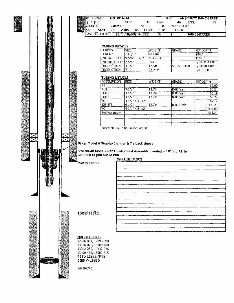
WELLNAME: ARE W16-14 FIELD: ANSCHUTZ RANCHEASTQTR QTR: SEC: 16 TWN: 4N RNG: 8ECOUNTY: SUMMIT ST: UT SPUD DATE:KB: 7324 GL: 7305 TD: 14050 PBTD: 13516LASTUPDATED: iMOROS104)gggi BY: MIKEMERCER
CASING DETAILSPURPOSE SIZE WEIGHT GRADE SET DEPTHSURFACE 13-3/8" 61-68# 2040'INTERMEDIATE 9-5/8", 9-7/8" 40-62.8# 11091'INTERMEDIATE 7-5/8" 39# F/10331-11310PRODUCTION 4-1/2" 13.5# SS-95, P-110 F/10500-14045PRODUCTION 7" 23-29# F/0-10331
TUBING DETAILSDESCRIPTION SIZE WEIGHT GRADE SET DEPTHKB 19.001 3T 3-1/2" 12.7# N-80 Vam 50.24PUP JT 3-1/2" 12.7# N-80 Vam 56.19PUP JT 3-1/2" 12.7# N-80 Vam 66.27XO 3-1/2" X4-1/2" 67.12323 JTS 4-1/2" 12.7# N-80 Hydril 10,493.23XO 4-1/2" X3-1/2" 10,494.00Seal Assembly 10,511.20
Based on 04/07/35 Pulling Report
Baker Model A Simplex Hangar & Tie back sleeve
Size 80-40 Model G-22 Locator Seal Assembly. Landed w/ 6' out, 11' in30,000# to pull out of PBR
WELL HIETORY:PBR @ 10500'
TOC @ 11570'
NUGGET PERFS12816-864, 12890-99013016-076, 13100-18013202-250, 13332-37613400-464, 13500-515PBTD 13516 (Fill)CIBP @ 13630

ANSCHUTZ RANCH EAST UNIT W31-12Summit County, Utah
Location: 640' FWL & 1778' FNL Sec 31-T4N-R8EElevation: 7870' GL/ 7890' KB
Last Updated by LLT2/12/2004
WELL HISTORY & NOTES13-3/8" Surface Casing @2846' 2/82 Champlin 458E-3 Spud by Amoco61# J-55 ST C (85') 10/27/82 TD @ 14,418'48# H-40 STC (1112') 11/30/82 Complete @Zone 3 Producer54.5# K-55 STC (826') Perf 14,210-70' @4 spf &90° phasing61#J-55 STC (845') Acidize w/ 6,255g 7.5% in 3 wash stagesCmtd w/ 3500 sxs 13.2 ppg 50/50 poz & Perf 13900-56' @4 spf & 90° phasing500 sxs 15.8 ppg class "G" Acidize w/ 5,250g 7.5% & 250# BAFSet CIBP above all perts
Production Tubing removed 1/6/04 Perf 13042-578(OA) @4 spf &90° phasingAcidize w/ 22,000g 7.5% & 1500# BAF5/13/82 Squeeze Zone 3 and Reperf7" Production CasNin80intoC e Back @ 9,919
Sqz w/ totalof 500sx in 3 tries under CICR23# SOO-95 LTC (5423') Drillout all to 14,370'
23# S-95 LTC (513') TCP perf 13872-14326 OA @6 spf & 60°26# N-80 LTC (3303') 10/11/89 Add Zone 2 Perfs29# N-80 LTC (504') TCP perf 13022-850 OA @ 6 spf & 60°
Cmtd w/ 200 sxs 15.8 ppg class "G" 12/12/89 Acidize AIIPump 3,000g 15% HCL
4/20/90 Lost spinner tool @14,000'9-5/8"x4-1/2" TIW hydr hanger @9,927, 11/93 convert to Injector
7/16/96 Attempted water shut-off4" ID TlW PBR @9,937. Dump 10,180# 20/40 sand & 60' cmt (tag @
Missing Reort2s
fIBPL
t @12,537'9-5/8" Intermediate Casing 10,272' 12/22/00 Pull tbg and clean out53.5#N-80 LTC (83') Clean out cmt/sand & CIBP down to cmt @43.5# N-80 LTC (520')13,266'. No tbg in well.40# N-80 LTC (3608')
43.5# N-80 LTC (1606') 1/10/01 Run new 3-1/2" tbg47# N-80 LTC (2204') Caliper shows good csg/liner above 10,318'
53.5# N-80 LTC (2191') 11/13/03 Install 2-3/8" tbgCmtd w/ 500 sxs 14.2 ppg 50/50 por & 300 sxs 15.8 Set CIBP @ 13,202' wl 10' cmt. TCP perf
ppg class "G" 12,854-94' @4 spf. Stimulate entireTor Nugget interval w/ propellant sleeves.
Unable to swab down. Suspect cement7-5/8" Intermediate Liner 10,030-11;tS9' integrity issues. RDMO to evaluate.
45.3# P-110 FL4S 1/6/04 TOH w/ 2-3/8" tbgCmtd w/ 600 sxs 16.1ppg class "G" 1/9/04 Ran Pulsed Neutron Log1/14/04 Ran Cement Mapping Tool
**All in dications are water influx is viafractures in the formation. Evaluate
isolation/recompletion options.
Nugget Sand Z1 & Z2 Perfs12752-72, 12800-20, 12854-94, 12960-80,
13035-55, 13022-100, 13120-188
8 8CIBP @13,202'w/ cmt to 13,190'
Nuqqet Sand Z3 Perfs13210-72, 13294-402, 13426-94, 13520-78,
13640-720, 13760-850, 13872-956, 13980-9814048-141, 14168-270, 14292-326
4-1/2" Production Liner 8, 9919-14418'15.1# P-110 LTC
7"x4-1/2" TlW Tie Back Sleeve @9919'9-5/8"x7-5/8" TlW hydraulic hanger @992T PBTD: 14,338'4" ID TlW polished bore recepticle @9937'
Cmt'd w/ 140 sxs 11.0 ppg Dowell "Hi Lift"& 170 sxs 9.0 F SH TD: 14,418'ppg Amoco "Bubble" (CBL shows poor bond) e seusa
Printed
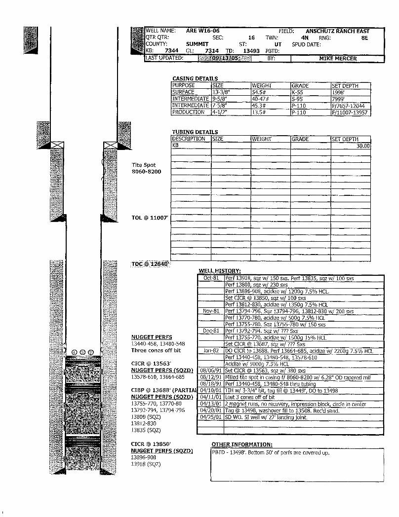
WELLNAME: AREW16-06 FIELD: ANSCHUTZRANCHEASTQTR QTR: SEC: 16 TWN: 4N RNG: 8ECOUNTY: SUMMIT ST: UT SPUD DATE:KB: 7344 GL: 7314 TD: 13493 PBTD:LASTUPDATED: MO¶/jig/iq5a¶ÿë BY: MIKE MERCER
CASING DETAILSPURPOSE SIZE WEIGHT GRADE SET DEPTHSURFACE 13-3/8" 54.5# K-55 1998'INTERMEDIATE 9-5/8" 40-47# S-95 7999'INTERMEDIATE 7-5/8" 45.3# P-110 F/7657-12044PRODUCTION 4-1/2" 13.5# P-110 F/11007-13957
TUBING DETAILSDESCRIPTION SIZE WEIGHT GRADE SET DEPTHKB 30.00
Tite Spot8060-8200
TOL@ 11007
WELL HIETORY:Oct-81 Perf 13918, sqz w/ 150 sxs. Perf 13835, sqz w/ 100 sxs
Perf 13800, sqz w/ 230 s×sPerf 13896-908, acidizew/ 12009 7.5% HCL.Set CICR @13850, sqz w/ 100 sxsPerf 13812-830, acidizew/ 1350g 7.5% HCL
Nov-81 Perf 13794-796. Sqz 13794-796, 13812-830 w/ 200 sxsPerf 13770-780, acidizew/ 500g 7.5% HCLPerf 13755-780. Sqz 13755-780 w/ 150 sxs
Dec-81 Perf 13792-794. Sqz w/ ??? SxsNUGGET PERFS Perf 13755-770, acidize w/ 15009 15% HCL13440-458, 13480-548 Set CICR@ 13687, sqz w/ ??? SxsThree cones off bit Jan-82 DO CICRto 13688. Perf 13664-685, acidizew/ 2200g 7.5% HCL
Perf 13440-458, 13480-548, 13578-610CICR @ 13563' Acidize w/ 90009 7.5% HCLNUGGET PERFS (SQZD) 08/06/91 Set CICR@ 13563, sqz w/ 380 sxs13578-610, 13664-685 08/12/91 Milledtitespot in casing f/ 8060-8200 w/ 6,28" OD taperedmill
08/18/91 Perf 13440-458, 13480-548 thru tubingCIBP @ 13688' (PARTIAI 04/10/01 TIH w/ 3-3/4" bit, tag fill@ 13449', DO to 13498NUGGET PERFS (SQZD) 04/11/01 Lost 3 cones offof bit13755-770, 13770-80 04/13/01 2 magnet runs, no recovery, impression block,circle in center13792-794, 13794-796 04/20/01 Tag @13498, washover fillto 13508. Rec'd sand.13800 (SQZ) 04/25/01 SD WO.SI wellw/ 27' landingjoint.13812-83013835 (SQZ)
CICR @ 13850' OTHER INFORMATION:NUGGET PERFS (SQZD) PBTD - 13498'. Bottom 50' of perfs are covered up.13896-90813918
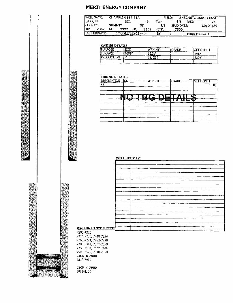
MERIT ENERGY COMPANY
WELLNAME: CHAMPLIN 387 B1A FIELD: ANSCHUTZ RANCHEASTQTR QTR: SEC: 9 TWN: 3N RNG: 7ECOUNTY: SUMMIT ST: UT SPUD DATE: 10/04/80KB: 7342 GL: 7327 TD: 8309 PBTD: 7800LASTUPDATED: 01/11/05 BY: MIKE MERCER
CASING DETAILSPURPOSE SIZE WEIGHT GRADE SET DEPTHSURFACE 9-5/8" 32.3# 1412'PRODUCTION 7" 23, 26# 8299'
TUBING DETAILSDESCRIPTION SIZE WEIGHT GRADE SET DEPTHKB 15.00
WELL HISTORY:
WATTON CANYON PERFf7200-72207224-7230, 7248-72567268-7274, 7282-72987308-7314, 7332-73507390-7404, 7432-74467500-7520, 7540-7550CICR @ 78007818-7910
CICR @ 7900
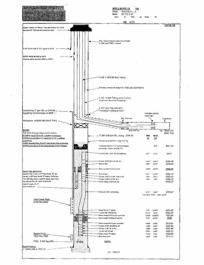
WELLBORE DL MField: Anschutzk.chWell: CH 372 C #1
SEC: 23 T'NP. 4N RGE: 7E
KB 16.70'DEPTH KB
Ingram Cactus 11" 3M by T SMw/R2 bottom 6 bow(bg spool(7' 26# csg stub landed in slips)
Note: Casing pressure testedfrom 0-3600'to 1000 psig 2/16/01 -passed
9 5/8" 32.3# HAD ST & C csg set at 1518' )
NOTE: HOLE INCSG at 3612' I C(Casing patch set from 3582' to 3635' )
2-3/8" 4.7# EUE 8md Tubing
Annulus pressure tested to 1000 psig (2/27/2001)
4-1/2" 12.60# Tubing run to surfaceNew Vam Beveled Couplings
4-1/2" Liner Top witti BPRCement top 7" per CBL on 2/15/98 Cemented in place at 5090'logged by Schlumberger at 4906'+ - Inflatible packer
Whipstock at 5600' MD (5513' TVD)MD DhOle
NOTE: Shoe 7850 MD TD = 8608' MDTwin Creek & Nugget squeezed offas follows, 6648 (VD2/12/98 pumped 410 sx "G" + addlivesno pressure T' 26# S-95 & K-55 casing - 2296.62' MIN MAX2/13/98 Dumped 100 sx "G" neat &200 ex*G" + addRies ID ODno pressure Cement cap at 6018.22 - tagged via tbg2/14/98 pumpêd 50sx 19-0 RFC andobtain 1150 osisaueeze2/14/98 pump 20 ex'G" fortopoutomt cap on topof retainer Hallhurton Model "Hcs" cement retafoer 5.5" 605198'
(set via tbg - Bottom at 6054, 1¾)
Cut off 2 3/8"4.7# N-80 CS hydri thg 1.90f 2.375° 6077
X-Over 2 3/8" CS to 2 3/8" 8<d 1.901" 3.062" 6089.49'Spacer tube 1.901" 2.375" 6090.29
Bakermode1A-Sdualpacker 1.90¾" 6.093' 6092.81'
Spacer tube,X-omr, 2 3/8" pup, Model "E' h Spacer tube 1.901" 2,375- 6098.13'tripsub, 2 3/8" pup, Model "F" nipple,Perfd pup X-Over 2 3/8" to 2 3/8" 10sd to Brd 1.901 2.875" 6099.43'i Jt2 3/8" tbg, Baker modet"R" nippio,Mule shoe X-Over 2 3/8* to2 7/8" Brd 1.901 3.00- 6099.75'Avg OD's & ID's: ID 1.901" & OD 2.92' Perfd tubing: 4 shots (4 spo 6103.5TOverstilength;48.73EOT at 6141.54
29)(tof27/8"O,S#8tdtbg 2.44T 3.668' 6100.OTTbg collars: 3,668"- Tube: 2 875"
T C kP s:
XX Baker Model "F" nipple 1.87 3.6875" 6994.86'X 1 jlof 2 7/8" 6.5# Brd tbg 2.441" 3.668· 6995.8T
Saket Túodel 22 ocatorassembly 2 40ff 3 4 Fr 70 5'
Baker model 80-32 seal assembly 2.406" 2,688" 7036.66.×-over:2 3ta" lord ex by BX 1.906" 3.062" 7037,09'
---- X4)me 2 3/8' NU to EU 1.906" 3.062- 7037.46'1 jt of 2 3/8" EU Brd 1.901" 3.062· 7069.12'Bakermo nipple 1760" 2 9
FISH: 2 3/8"tbg (25')- PBTD;
7" 23# & 26# at 7300,25'TDi
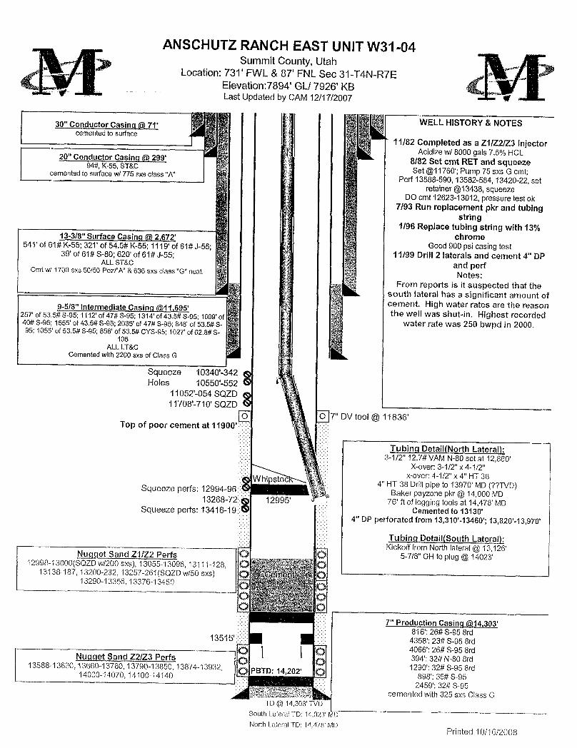
ANSCHUTZRANCH EAST UNIT W31-04Summit County, Utah
Location: 731' FWL & 87' FNL Sec 31-T4N-R7EElevation:7894'GL/ 7926' KBLast Updated by CAM 12/17/2007
WELL HISTORY & NOTES30" Conductor Casinq @ 7fcemented to surface
~ 11/82 Completed as a Z1/Z2/Z3 InjectorAcidize w/ 8000 gals 7.5% HCL20" Conductor Casinq @299' 8/82 Set cmt RETand squeeze94#, K-55,ST&C Set @11760';Pump 75 sxs G cmt;cemented to surface w/ 775 sxs class "A" Perf 13588-590, 13582-584,13420-22, set
retainer @13438,squeezeDO cmt 12623-13012, pressure test ok
7/93 Run replacement pkr and tubingstring
1/96 Replace tubing string with 13%13-3/8" Surface Casinq @2,672, chrome
541' of 61# K-55; 321' of 54.5# K-55; 1119' of 61# J-55; Good 900 psi casing test39' of 61# S-80; 620' of 61# J-55; 11/99 Drill 2 laterals and cement 4" DP
ALL ST&C and perfCmt w/ 1700 s×s 50/50 Pozl"A" &636 sxs class "G" neat. Notes:From reports is it suspected that the
south lateral has a significant amount ofcement. High water rates are the reason9-5/8" Intermediate Casinq @11,695' the well was shut-in. Highest recorded257' of 53.5# S-95; 1112' of 47# S-95; 1314' of 43.5# S-95; 1609' of
40# S-95; 1555' of 43.5# S-95; 2035' of 47# S-95; 848' of 53,5# S- water rate was 250 bwpd in 2000.95; 1055' of 53.5# S-95; 856' of 53.5# CYS-95; 1027' of 62.8# S-
105ALL LT&C
Cemented with 2200 sxs of Class G
Squeeze 10340'-342 gHoles 10550'-552 G
11052'-054 SQZD g11708'-710' SQZD
7" DV tool @11836'Top of poor cement at 11900'
Tubinq Detail(North Lateral):3-1/2" 12.7# VAMN-80 set at 12,860'
X-over: 3-1/2" × 4-1/2"x-over:4-1/2" x 4" HT 38Wh pstoc 4" HT 38 Drillpipe to 13970' MD (??TVD)Squeeze perfs: 12994-96
Baker payzone pkr @ 14,000 MD13268-72 12995' 76' ft of logging tools at 14,478' MDSqueeze perfs: 13416-19 Cemented to 13130'
4" DP perforated from 13,310'-13460'; 13,820'-13,970'
Tubing Detail(South Lateral):Kickoff from Northlateral @13,126'
Nuqqet Sand Z1/Z2 Perfs 5-7/8" OH toplug @14023'12998-13000(SQZD w/200 sxs), 13055-13096, 13111-128,
13138-187, 13200-232, 13257-261(SQZD w/50 s×s)13290-13356, 13376-13450
7" Production Casing (ãñ4,303'816': 26# S-95 8rd
13515' 4358': 23# S-95 Brd
cemented with325 sxs Class GTD @ 14,303' i VD
South Lateral TD: 14,023' MDNorth Lateral TO: 14,478' MD
Printed
ANSCHUTZRANCH EAST UNIT W31-04Summit County, Utah
Location: 731' FWL & 87' FNL Sec 31-T4N-R7EElevation:7894'GL/ 7926' KBLast Updated by CAM 12/17/2007
WELL HISTORY & NOTES30" Conductor Casinq @ 7fcemented to surface
~ 11/82 Completed as a Z1/Z2/Z3 InjectorAcidize w/ 8000 gals 7.5% HCL20" Conductor Casinq @299' 8/82 Set cmt RETand squeeze94#, K-55,ST&C Set @11760';Pump 75 sxs G cmt;cemented to surface w/ 775 sxs class "A"
Perf 13588-590, 13582-584,13420-22, setretainer @13438,squeeze
DO cmt 12623-13012, pressure test ok7/93 Run replacement pkr and tubing
string1/96 Replace tubing string with 13%
13-3/8" Surface Casinq @2,672, chrome541' of 61# K-55; 321' of 54.5# K-55; 1119' of 61# J-55; Good 900 psi casing test
39' of 61# S-80; 620' of 61# J-55; 11/99 Drill 2 laterals and cement 4" DPALL ST&C and perfCmt w/ 1700 s×s 50/50 Pozl"A" &636 sxs class "G" neat. Notes:
From reports is it suspected that thesouth lateral has a significant amount ofcement. High water rates are the reason9-5/8" Intermediate Casinq @11,695' the well was shut-in. Highest recorded257' of 53.5# S-95; 1112' of 47# S-95; 1314' of 43.5# S-95; 1609' of
40# S-95; 1555' of 43.5# S-95; 2035' of 47# S-95; 848' of 53,5# S- water rate was 250 bwpd in 2000.95; 1055' of 53.5# S-95; 856' of 53.5# CYS-95; 1027' of 62.8# S-
105ALL LT&C
Cemented with 2200 sxs of Class G
Squeeze 10340'-342 gHoles 10550'-552 G
11052'-054 SQZD g11708'-710' SQZD
7" DV tool @11836'Top of poor cement at 11900'
Tubinq Detail(North Lateral):3-1/2" 12.7# VAMN-80 set at 12,860'
X-over: 3-1/2" × 4-1/2"x-over:4-1/2" x 4" HT 38Wh pstoc 4" HT 38 Drillpipe to 13970' MD (??TVD)Squeeze perfs: 12994-96
Baker payzone pkr @ 14,000 MD13268-72 12995' 76' ft of logging tools at 14,478' MDSqueeze perfs: 13416-19 Cemented to 13130'
4" DP perforated from 13,310'-13460'; 13,820'-13,970'
Tubing Detail(South Lateral):Kickoff from Northlateral @13,126'
Nuqqet Sand Z1/Z2 Perfs 5-7/8" OH toplug @14023'12998-13000(SQZD w/200 sxs), 13055-13096, 13111-128,
13138-187, 13200-232, 13257-261(SQZD w/50 s×s)13290-13356, 13376-13450
7" Production Casing (ãñ4,303'816': 26# S-95 8rd
13515' 4358': 23# S-95 Brd
cemented with325 sxs Class GTD @ 14,303' i VD
South Lateral TD: 14,023' MDNorth Lateral TO: 14,478' MD
Printed

WELLNAME: ARE W20-06 FIELD: ANSCHUTZ RANCH EASTQTR QTR: SEC: 20 TWN: 4N RNG: SEOUNTY: SUMMIT ST: UT SPUD DATE: 05/19/81B: 7563 GL: 7534 TD: 14163 PBTD: 13823ST UPDATED: Sí¾ig/gg/g Rig BY: NICKTUNNELL
CASING DETAILSPURPOSE SIZE WEIGHT GRADE SET DEPTHSURFACE 13-3/8", 13-1/2" 61-8L4# N-80,S-80, S-95 5411'INTERMEDIATE9-5/8", 9-7/8" 43.5-62.8# S-95 11330'PRODUCTION 7", 6-5/8" 26-32# N-80,P-110 14163'
TUBING DETA)LSDESCRIPTION SIZE WEIGHT GRADE SET DEPTHKB 29.00TBG 2-7/8" 6.5# N-80PKR 12,858'
Top of 6-5/8"@ 10079'
Alldepths are es imates based on "Daily Activity Reaort" dated 06/2/J4
NUGGET PERFS:13008-038, 13046-06413092-115 WELLHISTORY:
CIBP w/ cmt @ 13220' 01/01/82 Initial completion - perfd 13966-990, 13910-930, 13628-65013230-310 13606-618, 13514-533, 13680-692, 13699-708, 13716-72613736-746, 13772-800, 13830-860, 13556-580, 13248-26813292-346, 13370-392, 13418-446, 13470-490.
13370-392, 13418-446 Sqzd 13910-99013470-490, 13514-533 09/20/83 sqzd13680-692 (for conformance).Perfd 13610-22, 13632-5413556-580, 13606-618 07/29/86 sqzd13248-346 (OA)13628-650 Perfd 13370-92, 13418-46, 13470-90, 13514-33PKR @ 13670' 09/05/86 Perfd 13135-215, 13092-115, sqzd 13092-2153gg0-692 (sqzd) 07/01/92 Replace corroded tbg, Perfd 13008-38, 13046-64, 13092-11513699¾gg6 03/22/96 Perfd 13230-310...may have squeeze some perfs,no records13736-746, 13772-800 03/10/04 Pulled tubingand packer,selectivelyswab tested
13830-860 (fill)CICR @ 13886'
Fish @ 13995': Junk
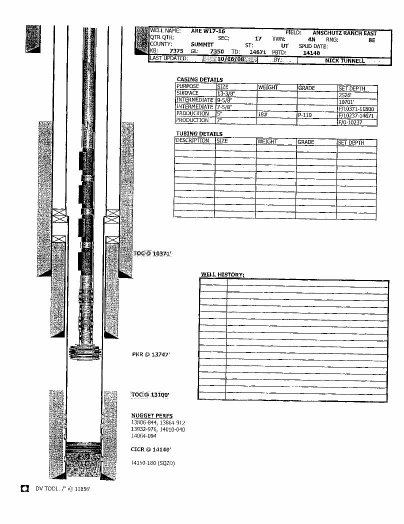
WELLNAME: ARE W17-16 FIELD: ANSCHUTZ RANCHEASTQTRQTR: SEC: 17 TWN: 4N RNG: 8ECOUNTY: SUMMIT ST: UT SPUD DATE:KB: 7375 GL: 7350 TD: 14671 PBTD: 14140LASTUPDATED: 10/16/08 BY: NICKTUNNELL
CASING DETAILSPURPOSE SIZE WEIGHT GRADE SET DEPTHSURFACE 13-3/8" 2526'INTERMEDIATE9-5/8" 10701'INTERMEDIATE7-5/8" F/10371-11800PRODUCTION 5" 18# P-110 F/10237-14671PRODUCTION 7" F/0-10237
TUBING DETAILSDESCRÌPTION SIZE WEIGHT GRADE SET DEPTH
TOC @ 10371'
WELLHIETORY:
PKR @ 1374T
NUGGET PERFS13806-844, 13864-91213932-976, 14010-04014064-094
CICR @14140'
14150-180 (SQZD)
O DV TOOL. 7" @

ELLNAME: AREW20-02 FIELD: ANSCHUTZ RANCH EASTR QTR: SEC: 20 TWN: 4N RNG: 8E
OUNTY: SUMMIT ST: UT SPUDDATE: 05/01/83B: 7331 GL: 7310 TD: 13928 PBTD: 12950
ST UPDATED: 11/09/07 BY: CASEY MORTON
CASING DETAILSPURPOSE SIZE WEIGHT GRADE SET DEPTHSURFACE 13-3/8", 13-5/8" 54.5-88.2# K-55, HC-95 5140'INTERMEDIATE9-5/8", 9-7/8" 47-62.8# MC-95, S-105 10934'PRODUCTION 7" 32-35# N-80, S-95 13928'Has an additional20" surface casing string set @ 60', not shown on WBS
TUBING DETAlLSDESCRIPTION SIZE WEIGHT GRADE SET DEPTHKB 21.0082 JTS 2-7/8" 6.5# N-80 2,650.53GLV#7 2-7/8" 2,657.5778 JTS 2-7/8" 6.5# N-80 5,139.88GLV#6 2-7/8" 5,146.9168 JTS 2-7/8" 6.5# N-80 7,311.03GLV#5 2-7/8" 7,318.0558 JTS 2-7/8" 6.5# N-80 9,167.66GLV #4 2-7/8" 9,174.6848 JTS 2-7/8" 6.5# N-80 10,692.10GLV#3 2-7/8" 10,699.1234 JTS 2-7/8" 6.5# N-80 11,784.19GLV#2 2-7/8" 11,791.2224 JTS 2-7/8" 6.5# N-80 12,558.46GLV #1 2-7/8" 12,565.481 JT 2-7/8" 6.5# N-80 12,597.76X NIPPLE 2.313" 12,598.801 JT 2-7/8" 6.5# N-80 12,631.08ON/OFFTOOL 2-7/8" X 5-1/2" 12,632.90PUP JT 2-7/8" 6.5# N-80 12,638.98ASI-X PKR 2-7/8" X7" 12,646.52PUP JT 2-7/8" 6.5# N-80 12,652.60XN NIPPLE 2.313" W/ NO Gi 12,653.73
DVT Jol at 12203' PUP JT 2-7/8" 6.5# N-80 12,659.78WL REENTY 2-7/8" 12,660.46Based on 03/18/34 Pulling Report
WELL HISTORY:08/18/83 Perf Z3 f/ 13476-560, acidize w/ 6300g 10% HCL
Perf Z2 f/ 13004-430 (OA) w/ TCP.Acidize all w/ 600 bbis acid
.- 10/17/84 Left 7 of PLT toolin hole01/08/86 Sqz 13004-108 w/ 150 sxs
Perf Z1 f/ 12739-924 (OA) w/ TCP (no stimulation)02/15/86 PLT indicatesflowf/ 5 of 11 zones
NUGGET Z1 PERFS 07/29/86 Test lower Z2 &Z312739-768, 12778-784 09/09/86 Convert to injection,perf Z2 f/ 13005-065, 13080-11012792-811, 12831-864 03/01/95 Convert to production12890-899, 12912-924 05/18/98 Attempt WSO, spot 27 bbl crnt f/ 12950-13628 (tagged@12951)
NUGGET Z2 PERFS02/01/04 Set CIBP at 12990? RIH with gas lift
13005-065, 13080-110 (w/ 1/4 spf, 0 phasing)13127-152, 13164-22013232-256, 13280-30813320-360, 13372-430
NUGGET Z3 PERFS13475-560AII perfs shot w/ 4 spf 90 phasing unless noted otherwise
DVTOOL. 3-3/8" @ ????, T' @
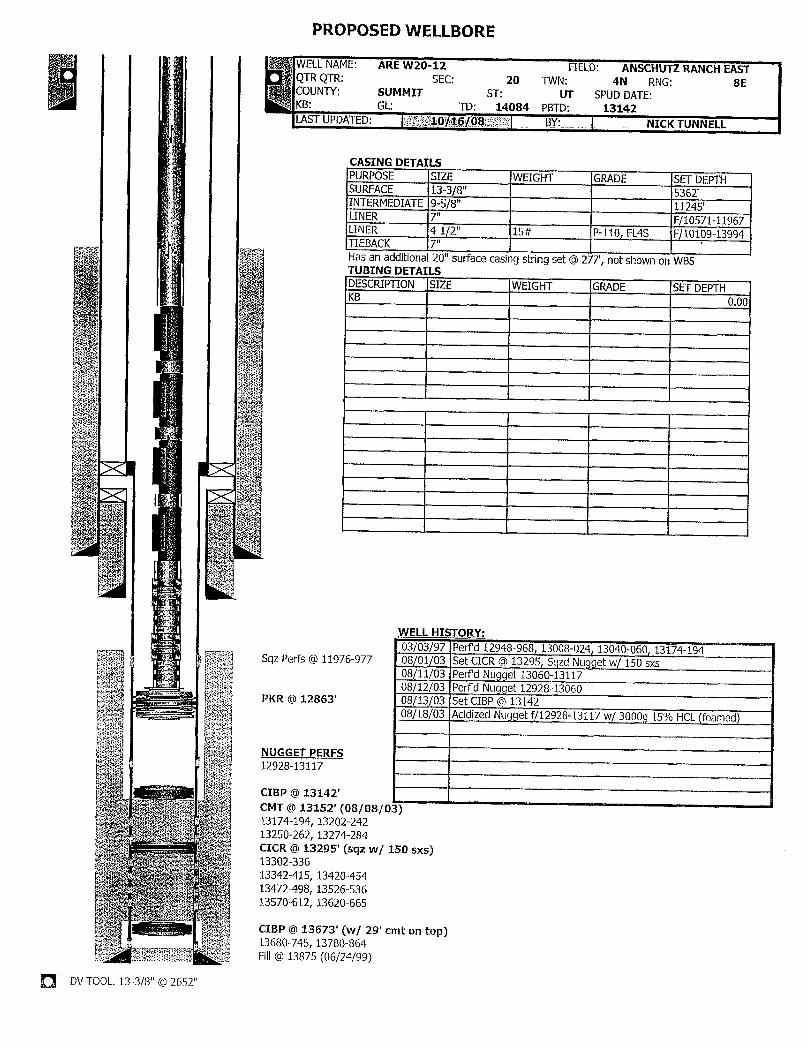
PROPOSED WELLBORE
WELLNAME: ARE W20-12 FIELD: ANSCHUTZ RANCH EASTQTR QTR: SEC: 20 TWN: 4N RNG: 8ECOUNTY: SUMMIT ST: UT SPUDDATE:KB: GL: TD: 14084 PBTO: 13142LASTUPDATED: Mgül/f;Iißig BY:_ NICKTUNN ELL
CASING DETAILSPURPOSE SIZE WEIGHT GRADE SET DEPTHSURFACE 13-3/8" 5362'INTERMEDIATE9-5/8" 11245'LINER 7" F/10571-11967LINER 4-1/2" 15# P-110, FL4S F/10109-13994TIEBACK 7"Has an additional20" surface casing string set @277', not shown on WBSTUBING DETAILSDESCRIPTION SIZE WEIGHT GRADE SET DEFTHKB 0.00
WELL HISTORY:03/03/97 Perfd 12948-968, 13008-024, 13040-060, 13174-194
Sqz Perfs @ 11976-977 08/01/03 Set CICR @ 13295, SqzdNugget w/ 150 sxs08/11/03 Perfd Nugget 13060-1311708/12/03 PerPd Nugget 12928-13060
PKR @ 12863' 08/13/03 Set CIBP @ 1314208/18/03 Acidized Nugget f/12928-13117 w/ 3000g 15% HCL(foamed)
NUGGET PERFS12928-13117
CIBP @ 13142'CMT @ 13152' (08/08/0; )13174-194, 13202-24213250-262, 13274-284CICR @ 13295' (sqz w/ 150 sxs)13302-33613342-415, 13420-45413472-498, 13526-53613570-612, 13620-665
CIBP @ 13673' (w/ 29' cmt on top)13680-745, 13780-864
wa Fill@13875 (06/24/99)
O DVTOOL. 13-3/8" @
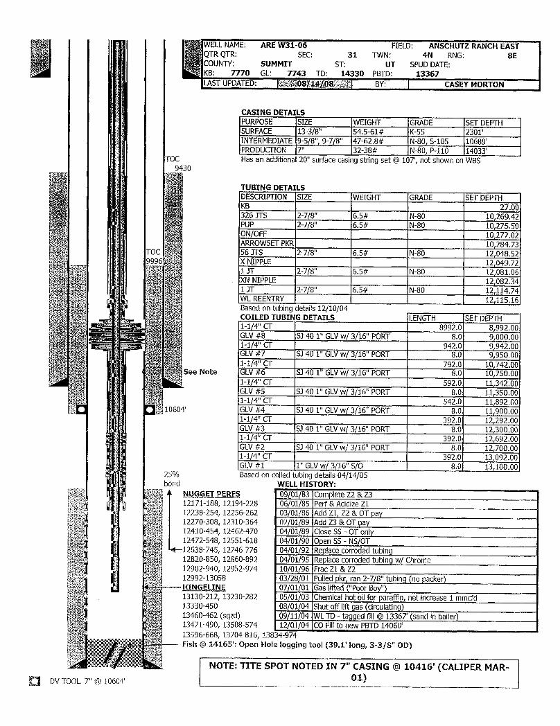
WELLNAME: ARE W31-06 FIELD: ANSCHUTZ RANCH EASTQTR QTR: SEC: 31 TWN: 4N RNG: SECOUNTY: SUMMIT ST: UT SPUD DATE:
4 KB: 7770 GL: 7743 TD: 14330 PBTD: 13367LASTUPDATED: i j§¶Qgggggg8f;2¾ BY: CASEY MORTON
CASING DETAILSPURPOSE SIZE WEIGHT GRADE SET DEPTHSURFACE 13-3/8" 54.5-61# K-55 2301'INTERMEDIATE 9-5/8", 9-7/8" 47-62.8# N-80, S-105 10689'PRODUCTION 7" 32-38# N-80,P-110 14033'
TOC Has an additional20" surface casing string set @ 107, not shown on WBS9 30
TUBING DETAILSDESCRIPTION SIZE WEIGHT GRADE SET DEPTHKB 27.00326 JTS 2-7/8" 6.5# N-80 10,269.42PUP 2-7/8" 6.5# N-80 10,275.50ON/OFF 10,277.02ARROWSETPKR 10,284.73
TOC 56 JTS 2-7/8" 6.5# N-80 12,048.529996 X NIPPLE 12,049.72
1 JT 2-7/8" 6.5# N-80 12,081.06XN NIPPLE 12,082.341 JT 2-7/8" 6.5# N-80 12,114.74WL REENTRY 12,115.16Based on tubingdetails 12/10/04COILED TUBING DETAILS LENGTH SET DEPTH1-1/4" CT 8992.0 8,992.00GLV#8 SJ 40 1" GLVw/ 3/16" PORT 8.0 9,000.001-1/4" CT 942.0 9,942.00GLV#7 SJ 40 1" GLVw/ 3/16" PORT 8.0 9,950.001-1/4" CT 792.0 10,742.00
See Note GLV#6 SJ 40 1" GLVw/ 3/16" PORT 8.0 10,750.001-1/4" Cf 592.0 11,342.00GLV#5 SJ 40 1" GLVw/ 3/16" PORT 8.0 11r350.001-1/4" CT 542.0 11,892.00
10604' GLV#4 SJ 40 1" GLVw/ 3/16" PORT 8.0 11,900.001-1/4" CT 392.0 12,292.00GLV#3 S3 40 1" GLVw/ 3/16" PORT 8.0 12,300.001-1/4" CT 392.0 12,692.00GLV#2 SJ 40 1" GLVw/ 3/16" PORT 8.0 12,700.001-1/4" CT 392.0 13,092.00GLV#1 1" GLVw/ 3/16" S/O 8.0 13,100.00
25% Based on coiledtubingdetails 04/14/05bond WELL HISTORY:
NUGGET PERFS 09/01/83 Complete Z2 & Z312171-188, 12194-228 06/01/85 Perf & Acidize Z112238-254, 12256-262 03/01/86 Add Z1, Z2 & OT pay12270-308, 12310-364 02/01/89 Add Z3 &OT pay12410-454, 12462-470 04/01/89 Close SS - OT only12472-548, 12551-618 D4/01/90 Open SS - NS/OT
4-12638-745, 12746-776 04/01/92 Replace corroded tubing12820-850, 12860-892 04/01/95 Replace corroded tubingw/ Chrome12902-940, 12952-974 10/01/96 Frac Z1 &Z212992-13058 03/28/01 Pulled pkr, ran 2-7/8" tubing(no packer)HINGELINE 07/01/01 Gas lifted("Poor Boy")13130-212, 13230-282 05/01/03 Chemicalhot oil for paraffin, net increase 1 mmcfd13330-450 08/01/04 Shut off liftpas (circulating)13460-462 (sqzd) 09/11/04 WLTD - taggedfill@ 13367 (sand in bailer)13471-490, 13508-574 12/01/04 CO Fill to new PBTD 14060'13596-668, 13704-816, 138 14-974
Fish @ 14165': Open Hole logging tool (39.1' long, 3-3/8" OD)
NOTE: TITE SPOT NOTED IN 7" CASING @ 10416' (CALIPER MAR-DVTOOL. '" @ 10604'
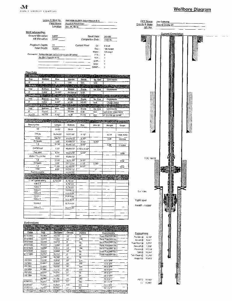
M Wellbore DiagramMERJT liNERGY COMPANY
Lease &Well NO. ARE W36-16 (FKA: Island Ranch E-1) CPF Name Gas GathedngField Name Anschutz Ranch East County & State summitCounty,UT
Location Sec.38.4N7E A
Well Information Jurrent : spletlosGround Elevatíon: 8,070' Spud Date: 2/01/82
KB Elevation: 8L CompletionDate: 11/01/83
Plugback Depth: 77 Current Prod: Oil- o bopdTotal Depth: 14.475' Gas - 185 mcípd
Water- 175bwpdComments: Sch1umberger coiled tubing gas lift setup FTP - 7
No Merit Reports in PA FCP - 7SITP - 7SICP - 7
SIBHP - 7
Pi e Data
Top Bottom Size Weight Grado Sx. Cmt CommentsO' O' 0 Unk Unk Unk
Top Bottom Size Welght Grade Sx. Cmt Comments0' 2,888' 13-3/8" 54.5&61# K-55
Top Bottom Size Weight Grade Sx. Cmt Comments0' 6,833' 9-5/8" 47.0# HC-95 Unk DV 5662
Top Bottom Size Weight Grade Sx. Cmt Comments0 11,817' 7" 32-35# S.95 Unk 32#6230',29#-10489'10,476' 14,775' 4-1/2" 15.1# P-110 Unk 4" ID PBR @10748'
scription Length Bottom Size Min. ID Weight Grade
KB 38.00' 38.00
318 jts 9,854.00' 9,892.00' 3-1/2" 10.3# VAM; N-8024 jts 743.72' 10,635.72' 3-1/2" 9.2# Chmme
R-Nipple 1.00' 10,636.72' 3-1/2" 2.5621 jt 31.00' 10,667.72' 3-1/2" 9.2# Chome
On/Off tool 1.00' 10,668.72' 5-1/2 x 3-1/2
Pup loint 6.00' 10,674.72' 3-1/2" VAMBakerFHL packer 6.00' 10,680.72'
TOC 10172'i jt 31.00' 10,711.72' 3-1/2" VAM
R Nipple 1.00' 10,712.72' >1/2" 2.5621 jt 31.00' 10,743.72' 3-1/2" VAM
PBR 4.00' 10,747.72' 4"Seal Assmebly 10,747.72'
1-1/4" Colled tubing 6 766.00' 6,766.00Valve 8 6,767.00Valve 7 8,766.00Valve 6 10,168.00 Sqz holesValve 5 11,016.00Valve 4 11,616.00Valve3 12,216.00 Tight spotValve 2 12.716,00
11095' - 11099'Valve 1 13,117.00
Formations9/11/1985 1 ,400' 13,410' 10 40 Sand Frac(48K lbs ) Fiontier @ 4.764'9/11/1985 13,420 13,482' 62 248 Sand Frac(48Klbs.) Aspen @ 5,341'9/11/1985 13,510' 13,516' 6' 24 Sand Frac(48Klbs.) Bear River @ S,5519/11/1985 13,542' 13,582' 20 80 Sand Frac(4 Gannett@ 7,003'9/11/1985 13,582' 13,613' 31 124 Sand Frac(48K Ibs.} Preuss @ 10,2189/11/1985 13,676' 13,690' 14 56 Sand Frac(48K lbs ) San @ 11.3449/11/1985 13,701' 13,710' 9' 36 Sand Frac(48K lbs.) Twin Creek @ 11,760
13,750' 13,768' 18 72 Nugget@ 13,6181/8/1984 13,776' 13,832' 56 224 Ai! 4 SPF1/8/1984 13,861' 13,894' 33 132 All 4 SPF1/8/1984 13,924' 13,950 26 104 All 4 SPF1/8/1984 13,980' 14,015 35 140 All4SPF1/8/1984 14.030' 14,054 24 96 AlI4SPF1/8/1984 14,061' 14.072 11 44 All 4 SPF
14,088' 14,158 70 280 All 4 SPF PBTD 14,9609/28/1987 14,270 14,340 70 280 All 4 SPF TD 15,4669/26/1987 14,370 14,520 160 600 Alf 4 SPF9/28/1987 14,500 14,600 20 80 All 4
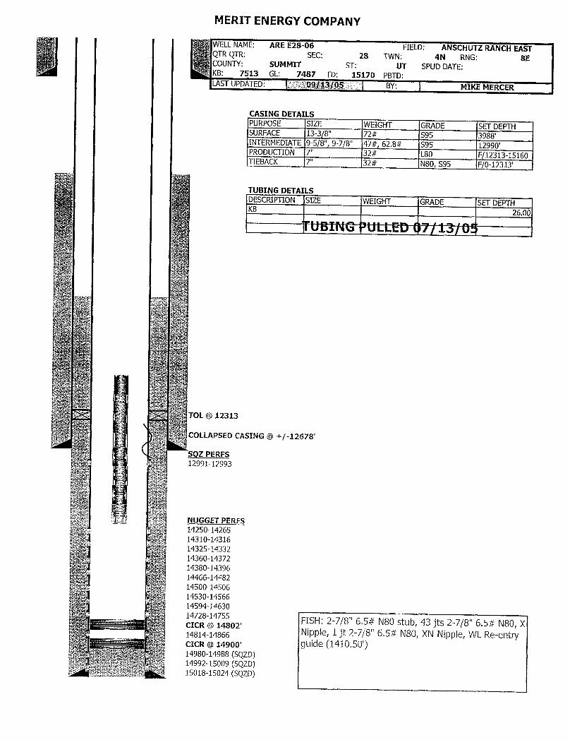
MERIT ENERGYCOMPANY
WELLNAME: ARE E28-06 FIELD: ANSCHUTZ RANCH EASTQTR QTR: SEC: 28 TWN: 4N RNG: 8ECOUNTY: SUMMIT ST: UT SPUD DATE:KB: 7513 GL: 7487 TD: 15170 PBTD:LASTUPDATED: Gjia 10¾ BY: MIKE MERCER
CASING DETAILSPURPOSE SIZE WEIGHT GRADE SETDEPTHSURFACE 13-3/8" 72# S95 3988'INTERMEDIATE9-5/8", 9-7/8" 47#, 62.8# S95 12990'PRODUCTION 7" 32# L80 F/12313-15160TIEBACK 7" 32# N80, S95 F/0-12313'
TUBING DETAILSDESCRIPTION SIZE WEIGHT GRADE SET DEPTHKB 26.00
TOL@ 12313
COLLAPSED CASING @ +/-12678'
SQZ PERFS12991-12993
I
NUGGET PERFS14250-1426514310-1431614325-1433214360-1437214380-1439614466-1448214500-1450614530-1456614594-1463014728-14755
FISH: 2-7/8" 6.5# N8Òstub, 43 jts 2-7/8" 6.5# N80, XCICR @ 14802'14814-14866 Nipple, 1 jt 2-7/8" 6.5# N80, XN Nipple, WL Re-entryCICR @ 14900' guide (1410.50')14980-14988 (SQZD)14992-15009 (SQZD)15018-15024

State of UtahDEPARTMENT OF NATURAL RESOURCES
MICHAEL R. STYLER
GARY R. HERBERT Executive Dimctor
Governor Division of Oil, Gas and MiningGREGORY S. BELL JOHN R. BAZALieutenant Governor Division Director
June 6, 2011
Ms. Michal K. WhiteMerit Energy Company13727 Noel Road, Suite 500Dallas, TX 75240
Subject: Notice of Violation: Abandoned Well Requirements for Fee or State Leases
Dear Ms. White:
The Division of Oil, Gas and Mining (the Division) is reissuing this Notice of Violation (NOV)that originally went out via certified mail to Merit Energy Company (Merit) on July 1, 2010 (seeAttachment of original Violation). Merit was given until September 30, 2010, to respond to this NOV.To date the Division has not received any information from Merit showing any attempt to move thesewells out of violation status.
As of January 1, 2011, Merit had twentyfive (25) wells that were in non-compliance with therequirements for shut-in or temporarily abandoned (SI/TA) status. The Division recognizes that two (2)wells have been plugged and abandoned (PA'd) in March of this year. However the two wells that werePA'd were not part of this NOV. Currently Merit has twentythree (23) wells that are still in non-compliance. Nine (9) of the 23 wells have previously been addressed in this NOV (see Attachment),originally dated June 30, 2010. Six (6) wells have recently been issued an NOV and the remaining eight(8) have also recently being issued a second notice of non-compliance.
Wells with five (5) years non-activity or non-productivity shall be plugged, unless the Divisiongrants approval for extended shut-in timeupon a showing of good cause by the operator (R649-3-36-1.3.3).
IMMEDIATE ACTION REQUIRED: Please submit information required by R649-3-36, plugand abandon or place wells on production.
Date of service mailing: June 7, 2011CERTIFIED MAIL No.: 7005 1820 0001 5562 9832
If you have any questions concerning this matter, please contact me at (801) 538-5281.
Si
Dus K. DoucetPetroleum Engineer
DKD/JP/jsEnclosureec: Well Files uma
Compliance File DNRN:\O&G Reviewed Does\ChronFile\PetroleumEngineer\NOV
1594 West North Temple, Suite 1210, PO Box 145801, Salt Lake City,UT 84114 -5801
telephone (801) 538-5340•facsimile (801) 359-3940 •TTY (801) 538-7458 . www.ogm.utah.gov OIL, GAS &
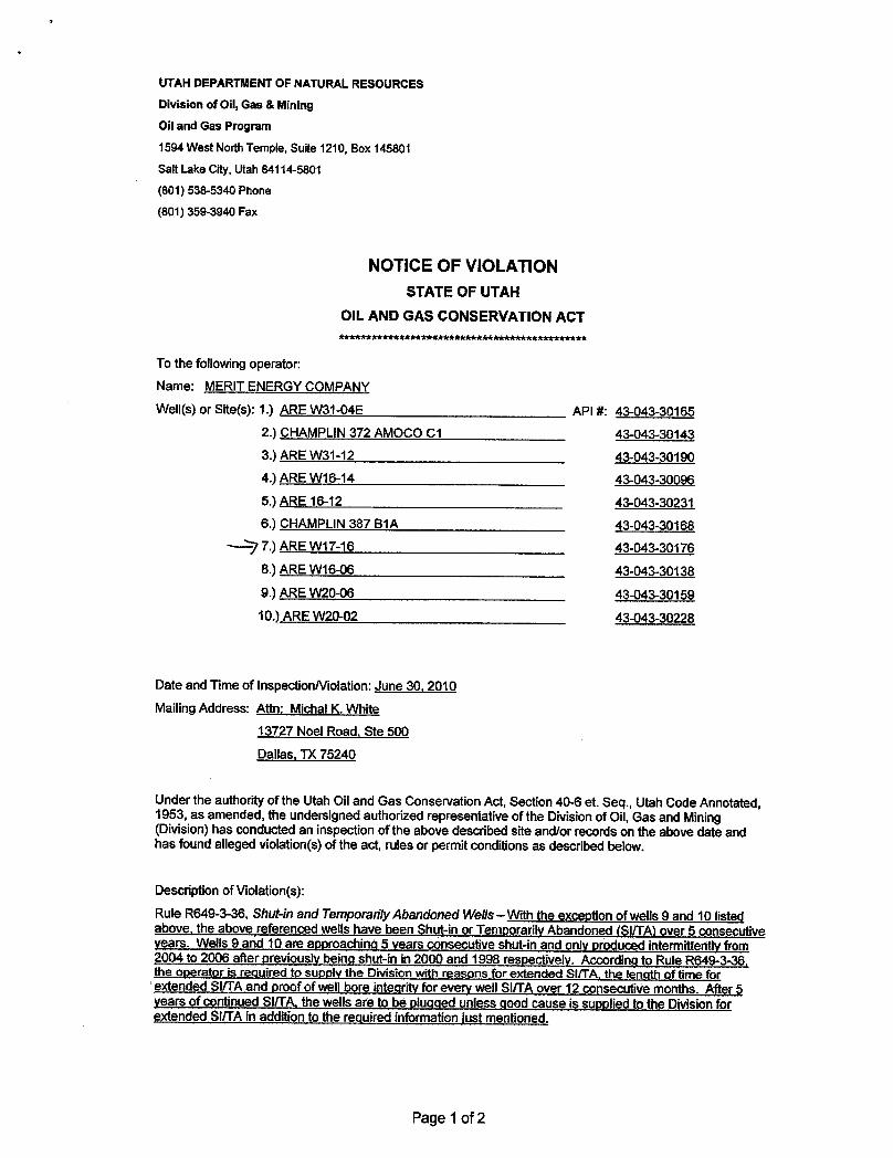
UTAH DEPARTMENT OF NATURAL RESOURCES
Division of 011,Gas & Mining
Oil and Gas Program
1594West North Temple,Suite 1210, Box 145801
Salt Lake City, Utah 84114-5801
(601) 538-5340 Phone
(801) 359-3940 Fax
NOTICE OF VIOLATIONSTATE OF UTAH
OIL AND GAS CONSERVATION ACTAAk*******Akkkkkkkkkkkkkkkkk************Akt**
To the following operator:Name: MERIT ENERGY COMPANY
Well(s) or Site(s): 1.) ARE W31-04E API #: 43-043-30165
2.) CHAMPLIN372 AMOCO C1 43-043-30143
3.) ARE W31-12 43-043-30190
4.) ARE W16-14 43-043-30096
5.) ARE 16-12 43-043-30231
6.) CHAMPLIN387 B1A 43-043-30168
7.) ARE W17-16 43-043-30176
8.) ARE Wi6-06 43-043-30138
9.) ARE W20-06 43-043-30159
10.) ARE W20-02 43-043-30228
Date and Time of InspectionNiolation: June 30, 2010
Mailing Address: Attn: Michal K. White13727 Noel Road, Ste 500
Dallas, TX 75240
Under the authority of the Utah Oil and Gas Conservation Act, Section 40-6 et. Seq., Utah Code Annotated,1953, as amended, the undersigned authorized representative of the Division of Oil, Gas and Mining(Division) has conducted an inspection of theabove described site and/or records on the above date andhas foundalleged violation(s) of the act, rules or permit conditionsas described below.
Description ofViolation(s):
Rule R649-3-36, Shut-in and Temporadly Abandoned Wells -- With the exception of wells 9 and 10 listedabove, theabove referenced wells have been Shut-inor Temporarily Abandoned (SIITA)over 5 consecutiveyears. Wells 9 and 10 are approachinq 5 years consecutiveshut-inand onlyproduced intermittently from2004 to 2006 after previouslybeing shut-in in 2000 and 1998 respectively. According to Rule R649-3-36,the operator is required to supply the Division with reasons for extended SI/TA, the length of time forextended SI/TAand proof of wellbore integrity for every wellSIITAover 12 consecutivemonths. After 5years of continuedSIITA, thewellsare to be pluqqed unless good cause is suppliedtothe Divisionforextended SiffA in additionto the required information justmentioned.
Page 1 of
UTAH DEPARTMENT OF NATURAL RESOURCES
Division of 011,Gas & Mining
Oil and Gas Program
1594West North Temple,Suite 1210, Box 145801
Salt Lake City, Utah 84114-5801
(601) 538-5340 Phone
(801) 359-3940 Fax
NOTICE OF VIOLATIONSTATE OF UTAH
OIL AND GAS CONSERVATION ACTAAk*******Akkkkkkkkkkkkkkkkk************Akt**
To the following operator:Name: MERIT ENERGY COMPANY
Well(s) or Site(s): 1.) ARE W31-04E API #: 43-043-30165
2.) CHAMPLIN372 AMOCO C1 43-043-30143
3.) ARE W31-12 43-043-30190
4.) ARE W16-14 43-043-30096
5.) ARE 16-12 43-043-30231
6.) CHAMPLIN387 B1A 43-043-30168
7.) ARE W17-16 43-043-30176
8.) ARE Wi6-06 43-043-30138
9.) ARE W20-06 43-043-30159
10.) ARE W20-02 43-043-30228
Date and Time of InspectionNiolation: June 30, 2010
Mailing Address: Attn: Michal K. White
13727 Noel Road, Ste 500
Dallas, TX 75240
Under the authority of the Utah Oil and Gas Conservation Act, Section 40-6 et. Seq., Utah Code Annotated,1953, as amended, the undersigned authorized representative of the Division of Oil, Gas and Mining(Division) has conducted an inspection of theabove described site and/or records on the above date andhas foundalleged violation(s) of the act, rules or permit conditionsas described below.
Description ofViolation(s):
Rule R649-3-36, Shut-in and Temporadly Abandoned Wells -- With the exception of wells 9 and 10 listedabove, theabove referenced wells have been Shut-inor Temporarily Abandoned (SIITA)over 5 consecutiveyears. Wells 9 and 10 are approachinq 5 years consecutiveshut-inand onlyproduced intermittently from2004 to 2006 after previouslybeing shut-in in 2000 and 1998 respectively. According to Rule R649-3-36,the operator is required to supply the Division with reasons for extended SI/TA, the length of time forextended SI/TAand proof of wellbore integrity for every wellSIITAover 12 consecutivemonths. After 5years of continuedSIITA, thewellsare to be pluqqed unless good cause is suppliedtothe Divisionforextended SiffA in additionto the required information justmentioned.
Page 1 of
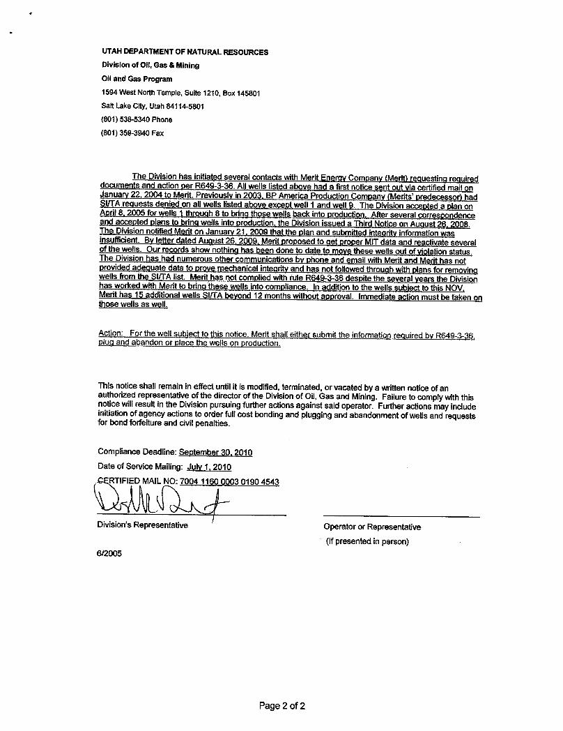
UTAH DEPARTMENT OF NATURALRESOURCESDivision of Ofi, Gas &Mining
011and Gas Program
1594 West North Temple, Suite 1210, Box 145801Salt LakeCity, Utah 84114-5801
(801) 538-5340 Phone
(801) 359-3940Fax
The Division has initiated several contacts with Merit Energy Company (Merit) requesting requireddocuments and action per R649-3-36. AIIwells listed above had a first notice sent out via certified mail onJanuary 22, 2004 to Merit. Previously in 2003. BP America Production Company (Merits' predecessor) hadSI/TA requests denied on allwells listed above except well 1 and well 9. The Division accepted a plan onAoril 8, 2005 for wells 1 through8 to bring those wells back into production. After several correspondenceand accepted plans to brinq wells into production, the Division issued a Third Notice on August 26, 2008.The Division notified Merit on January 21, 2009 that the plan and submitted integrity information wasinsufficient. By letter dated Auqust 26, 2009, Merit proposed to get proper MITdata and reactivate severalof the wells. Our records show nothing has been done to date to move these wells out of violation status.The Division has had numerous other communications by phone and email with Merit and Merit has notprovided adequate data to prove mechanical integrity and has not followedthroughwith plans for removingwells from the SIITAlist. Merit has not complied with rule R649-3-36 despite the several years the Divisionhas worked with Merit to bring these wells înto compliance. In addition to the wells subject to this NOV,Merit has 15 additionalwells Sl/TA beyond 12 months without approval. Immediate actionmust be taken onthosewellsas well.
Action: For thewellsubject to this notice. Merit shall either submit the information required by R649-3-36,plug and abandon or place the wells on production.
This notice shall remain in effect until it is modified,terminated,or vacated by a written notice of anauthorized representative of the director of the Divisionof Oil, Gas and Mining. Failure to complywith thisnotice willresult in the Division pursuing further actionsagainst said operator. Further actions mayincludeinitiation of agency actions to order full cost bonding and plugging and abandonment of wells and requestsfor bond forfeiture and civil penalties.
Compliance Deadline: September 30, 2010Date of Service Mailing: July 1, 2010
F N 4 03 0190 4543
Division's Representative Operator or Representative
(If presented in person)6/2005
Page 2 of
UTAH DEPARTMENT OF NATURALRESOURCES
Division of Ofi, Gas &Mining
011and Gas Program
1594 West North Temple, Suite 1210, Box 145801
Salt LakeCity, Utah 84114-5801
(801) 538-5340 Phone
(801) 359-3940Fax
The Division has initiated several contacts with Merit Energy Company (Merit) requesting requireddocuments and action per R649-3-36. AIIwells listed above had a first notice sent out via certified mail onJanuary 22, 2004 to Merit. Previously in 2003. BP America Production Company (Merits' predecessor) hadSI/TA requests denied on allwells listed above except well 1 and well 9. The Division accepted a plan onAoril 8, 2005 for wells 1 through8 to bring those wells back into production. After several correspondenceand accepted plans to brinq wells into production, the Division issued a Third Notice on August 26, 2008.The Division notified Merit on January 21, 2009 that the plan and submitted integrity information wasinsufficient. By letter dated Auqust 26, 2009, Merit proposed to get proper MITdata and reactivate severalof the wells. Our records show nothing has been done to date to move these wells out of violation status.The Division has had numerous other communications by phone and email with Merit and Merit has notprovided adequate data to prove mechanical integrity and has not followedthroughwith plans for removingwells from the SIITAlist. Merit has not complied with rule R649-3-36 despite the several years the Divisionhas worked with Merit to bring these wells înto compliance. In addition to the wells subject to this NOV,Merit has 15 additionalwells Sl/TA beyond 12 months without approval. Immediate actionmust be taken onthosewellsas well.
Action: For thewellsubject to this notice. Merit shall either submit the information required by R649-3-36,plug and abandon or place the wells on production.
This notice shall remain in effect until it is modified,terminated,or vacated by a written notice of anauthorized representative of the director of the Divisionof Oil, Gas and Mining. Failure to complywith thisnotice willresult in the Division pursuing further actionsagainst said operator. Further actions mayincludeinitiation of agency actions to order full cost bonding and plugging and abandonment of wells and requestsfor bond forfeiture and civil penalties.
Compliance Deadline: September 30, 2010Date of Service Mailing: July 1, 2010
F N 4 03 0190 4543
Division's Representative Operator or Representative
(If presented in person)6/2005
Page 2 of

RECEIVED: Aug. 02, 2012
STATE OF UTAHDEPARTMENT OF NATURAL RESOURCES
DIVISION OF OIL, GAS, AND MINING
FORM 9
5.LEASE DESIGNATION AND SERIAL NUMBER: FEE
SUNDRY NOTICES AND REPORTS ON WELLS
Do not use this form for proposals to drill new wells, significantly deepen existing wells belowcurrent bottom-hole depth, reenter plugged wells, or to drill horizontal laterals. Use APPLICATIONFOR PERMIT TO DRILL form for such proposals.
6. IF INDIAN, ALLOTTEE OR TRIBE NAME:
7.UNIT or CA AGREEMENT NAME: ANSCHUTZ RANCH EAST
1. TYPE OF WELL Gas Well
8. WELL NAME and NUMBER: ARE W17-16
2. NAME OF OPERATOR: MERIT ENERGY COMPANY
9. API NUMBER: 43043301760000
3. ADDRESS OF OPERATOR: PHONE NUMBER: 13727 Noel Rd Ste 500 , Dallas, TX, 75240 972 628-1540 Ext
9. FIELD and POOL or WILDCAT: ANSCHUTZ RANCH EAST
4. LOCATION OF WELL FOOTAGES AT SURFACE: 1765 FSL 1444 FEL QTR/QTR, SECTION, TOWNSHIP, RANGE, MERIDIAN: Qtr/Qtr: NWSE Section: 17 Township: 04.0N Range: 08.0E Meridian: S
COUNTY: SUMMIT
STATE: UTAH
11.
CHECK APPROPRIATE BOXES TO INDICATE NATURE OF NOTICE, REPORT, OR OTHER DATA
TYPE OF SUBMISSION TYPE OF ACTION
NOTICE OF INTENTApproximate date work will start:
10 /1 /2012
SUBSEQUENT REPORTDate of Work Completion:
SPUD REPORTDate of Spud:
DRILLING REPORTReport Date:
ACIDIZE ALTER CASING CASING REPAIR
CHANGE TO PREVIOUS PLANS CHANGE TUBING CHANGE WELL NAME
CHANGE WELL STATUS COMMINGLE PRODUCING FORMATIONS CONVERT WELL TYPE
DEEPEN FRACTURE TREAT NEW CONSTRUCTION
OPERATOR CHANGE PLUG AND ABANDON PLUG BACK
PRODUCTION START OR RESUME RECLAMATION OF WELL SITE RECOMPLETE DIFFERENT FORMATION
REPERFORATE CURRENT FORMATION SIDETRACK TO REPAIR WELL TEMPORARY ABANDON
TUBING REPAIR VENT OR FLARE WATER DISPOSAL
WATER SHUTOFF SI TA STATUS EXTENSION APD EXTENSION
WILDCAT WELL DETERMINATION OTHER OTHER:
12. DESCRIBE PROPOSED OR COMPLETED OPERATIONS. Clearly show all pertinent details including dates, depths, volumes, etc.
Merit Energy Company requests approval to permanently plug &abandon this well as detailed in the attached procedure.
NAME (PLEASE PRINT) PHONE NUMBER Arlene Valliquette 972 628-1558
TITLE Regulatory Manager
SIGNATURE N/A
DATE 8 /2 /2012
August 15, 2012
Sundry Number: 28436 API Well Number: 43043301760000Sundry Number: 28436 API Well Number: 43043301760000
FORM 9STATE OF UTAH
DEPARTMENTOF NATURALRESOURCES5.LEASE DESIGNATION AND SERIAL NUMBER:DIVISION OF OIL, GAS, AND MINING FEE
SUNDRY NOTICES AND REPORTS ON WELLS 6. IF INDIAN, ALLOTTEE OR TRIBE NAME:
Do not use this form for proposals to drill new wells, significantly deepen existing wells belowcurrent bottom-hole depth, reenter plugged wells, or to drill horizontal laterals. Use APPLICATION 7.UNITor CA AGREEMENT NAME:
FOR PERMIT TO DRILL form for such proposals. ANSCHUTZ RANCH EAST
1. TYPE OF WELL 8. WELL NAME and NUMBER:Gas Well ARE W17-16
2. NAME OF OPERATOR: 9. API NUMBER:MERIT ENERGY COMPANY 43043301760000
3. ADDRESS OF OPERATOR: PHONE NUMBER: 9. FIELD and POOL or WILDCAT:13727 Noel Rd Ste 500 , Dallas, TX, 75240 972 628-1540 Ext ANSCHUTZ RANCH EAST
4. LOCATION OF WELL COUNTY:FOOTAGES AT SURFACE: SUMMIT
1765 FSL 1444 FELQTRIQTR, SECTION, TOWNSHIP, RANGE, MERIDIAN: STATE:
QtrlQtr: NWSE Section: 17 Township: 04.0N Range: 08.0E Meridian: S UTAH
CHECK APPROPRIATE BOXES TO INDICATENATURE OF NOTICE, REPORT, OR OTHER DATA
TYPE OF SUBMISSION TYPE OF ACTION
ACI DIZE ALTER CASING CASING REPAIRNOTICE OF INTENT
Approximate date work will start: CHANGE TO PREVIOUS PLANS CHANGE TUBING CHANGE WELL NAME
10/1/2012CHANGE WELL STATUS COMMINGLE PRODUCING FORMATIONS CONVERT WELL TYPE
SUBSEQUENT REPORT DEEPEN FRACTURE TREAT NEW CONSTRUCTIONDate of Work Completion:
OPERATOR CHANGE PLUG AND ABANDON PLUG BACK
PRODUCTION START OR RESUME RECLAMATION OF WELL SITE RECOMPLETE DIFFERENT FORMATIONSPUD REPORT
Date of Spud: REPERFORATE CURRENT FORMATION SIDETRACK TO REPAIR WELL TEMPORARY ABANDON
TUBING REPAIR VENT OR FLARE WATER DISPOSAL
DRILLING REPORT WATER SHUTOFF SI TA STATUS EXTENSION APD EXTENSIONReport Date:
WILDCATWELLDETERMINATION OTHER OTHER:
12. DESCRIBE PROPOSED OR COMPLETED OPERATIONS. Clearly show all pertinent details including dates, depths, volumes, etc.
Merit Energy Company requests approval to permanently plug & Approved by theabandon this well as detailed in the attached procedure. Utah Division of
OFI, Gas and Mining
Date: August 15, 2012
By:
NAME (PLEASE PRINT) PHONE NUMBER TITLEArlene Valliquette 972 628-1558 Regulatory Manager
SIGNATURE DATEN/A 8/2/2012
RECEIVED: Aug. 02,
Sundry Number: 28436 API Well Number: 43043301760000
FORM 9STATE OF UTAH
DEPARTMENTOF NATURALRESOURCES5.LEASE DESIGNATION AND SERIAL NUMBER:DIVISION OF OIL, GAS, AND MINING FEE
SUNDRY NOTICES AND REPORTS ON WELLS 6. IF INDIAN, ALLOTTEE OR TRIBE NAME:
Do not use this form for proposals to drill new wells, significantly deepen existing wells belowcurrent bottom-hole depth, reenter plugged wells, or to drill horizontal laterals. Use APPLICATION 7.UNITor CA AGREEMENT NAME:
FOR PERMIT TO DRILL form for such proposals. ANSCHUTZ RANCH EAST
1. TYPE OF WELL 8. WELL NAME and NUMBER:Gas Well ARE W17-16
2. NAME OF OPERATOR: 9. API NUMBER:MERIT ENERGY COMPANY 43043301760000
3. ADDRESS OF OPERATOR: PHONE NUMBER: 9. FIELD and POOL or WILDCAT:13727 Noel Rd Ste 500 , Dallas, TX, 75240 972 628-1540 Ext ANSCHUTZ RANCH EAST
4. LOCATION OF WELL COUNTY:FOOTAGES AT SURFACE: SUMMIT
1765 FSL 1444 FELQTRIQTR, SECTION, TOWNSHIP, RANGE, MERIDIAN: STATE:
QtrlQtr: NWSE Section: 17 Township: 04.0N Range: 08.0E Meridian: S UTAH
CHECK APPROPRIATE BOXES TO INDICATENATURE OF NOTICE, REPORT, OR OTHER DATA
TYPE OF SUBMISSION TYPE OF ACTION
ACI DIZE ALTER CASING CASING REPAIRNOTICE OF INTENT
Approximate date work will start: CHANGE TO PREVIOUS PLANS CHANGE TUBING CHANGE WELL NAME
10/1/2012CHANGE WELL STATUS COMMINGLE PRODUCING FORMATIONS CONVERT WELL TYPE
SUBSEQUENT REPORT DEEPEN FRACTURE TREAT NEW CONSTRUCTIONDate of Work Completion:
OPERATOR CHANGE PLUG AND ABANDON PLUG BACK
PRODUCTION START OR RESUME RECLAMATION OF WELL SITE RECOMPLETE DIFFERENT FORMATIONSPUD REPORT
Date of Spud: REPERFORATE CURRENT FORMATION SIDETRACK TO REPAIR WELL TEMPORARY ABANDON
TUBING REPAIR VENT OR FLARE WATER DISPOSAL
DRILLING REPORT WATER SHUTOFF SI TA STATUS EXTENSION APD EXTENSIONReport Date:
WILDCATWELLDETERMINATION OTHER OTHER:
12. DESCRIBE PROPOSED OR COMPLETED OPERATIONS. Clearly show all pertinent details including dates, depths, volumes, etc.
Merit Energy Company requests approval to permanently plug & Approved by theabandon this well as detailed in the attached procedure. Utah Division of
OFI, Gas and Mining
Date: August 15, 2012
By:
NAME (PLEASE PRINT) PHONE NUMBER TITLEArlene Valliquette 972 628-1558 Regulatory Manager
SIGNATURE DATEN/A 8/2/2012
RECEIVED: Aug. 02,
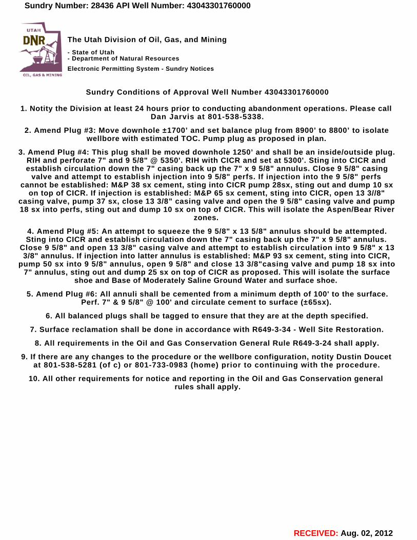
RECEIVED: Aug. 02, 2012
The Utah Division of Oil, Gas, and Mining
- State of Utah- Department of Natural Resources
Electronic Permitting System - Sundry Notices
Sundry Conditions of Approval Well Number 43043301760000
1. Notity the Division at least 24 hours prior to conducting abandonment operations. Please callDan Jarvis at 801-538-5338.
2. Amend Plug #3: Move downhole ±1700’ and set balance plug from 8900’ to 8800’ to isolatewellbore with estimated TOC. Pump plug as proposed in plan.
3. Amend Plug #4: This plug shall be moved downhole 1250’ and shall be an inside/outside plug.RIH and perforate 7" and 9 5/8" @ 5350'. RIH with CICR and set at 5300'. Sting into CICR andestablish circulation down the 7" casing back up the 7" x 9 5/8" annulus. Close 9 5/8" casing
valve and attempt to establish injection into 9 5/8" perfs. If injection into the 9 5/8" perfscannot be established: M&P 38 sx cement, sting into CICR pump 28sx, sting out and dump 10 sx
on top of CICR. If injection is established: M&P 65 sx cement, sting into CICR, open 13 3//8"casing valve, pump 37 sx, close 13 3/8” casing valve and open the 9 5/8" casing valve and pump18 sx into perfs, sting out and dump 10 sx on top of CICR. This will isolate the Aspen/Bear River
zones.
4. Amend Plug #5: An attempt to squeeze the 9 5/8" x 13 5/8" annulus should be attempted.Sting into CICR and establish circulation down the 7" casing back up the 7" x 9 5/8" annulus.
Close 9 5/8" and open 13 3/8" casing valve and attempt to establish circulation into 9 5/8" x 133/8" annulus. If injection into latter annulus is established: M&P 93 sx cement, sting into CICR,
pump 50 sx into 9 5/8" annulus, open 9 5/8" and close 13 3/8"casing valve and pump 18 sx into7" annulus, sting out and dump 25 sx on top of CICR as proposed. This will isolate the surface
shoe and Base of Moderately Saline Ground Water and surface shoe.
5. Amend Plug #6: All annuli shall be cemented from a minimum depth of 100' to the surface.Perf. 7" & 9 5/8" @ 100' and circulate cement to surface (±65sx).
6. All balanced plugs shall be tagged to ensure that they are at the depth specified.
7. Surface reclamation shall be done in accordance with R649-3-34 - Well Site Restoration.
8. All requirements in the Oil and Gas Conservation General Rule R649-3-24 shall apply.
9. If there are any changes to the procedure or the wellbore configuration, notity Dustin Doucetat 801-538-5281 (of c) or 801-733-0983 (home) prior to continuing with the procedure.
10. All other requirements for notice and reporting in the Oil and Gas Conservation generalrules shall apply.
Sundry Number: 28436 API Well Number: 43043301760000Sundry Number: 28436 API Well Number: 43043301760000
UTAH
DNR The Utah Division of Oil, Gas, and Mining- State of Utah- Department of Natural ResourcesElectronic Permitting System - Sundry Notices
TI BA%PrNINTfdG
Sundry Conditions of Approval Well Number 43043301760000
1. Notity the Division at least 24 hours prior to conducting abandonment operations. Please callDan Jarvis at 801-538-5338.
2. Amend Plug #3: Move downhole ±1700' and set balance plug from 8900' to 8800' to isolatewellbore with estimated TOC. Pump plug as proposed in plan.
3. Amend Plug #4: This plug shall be moved downhole 1250' and shall be an insideloutside plug.RIH and perforate 7" and 9 5/8" @ 5350'. RIH with CICR and set at 5300'. Sting into CICR andestablish circulation down the 7" casing back up the 7" x 9 5/8" annulus. Close 9 5/8" casing
valve and attempt to establish injection into 9 5/8" perfs. If injection into the 9 5/8" perfscannot be established: M&P 38 sx cement, sting into CICR pump 28sx, sting out and dump 10 sx
on top of CICR. If injection is established: M&P 65 sx cement, sting into CICR, open 13 3//8"casing valve, pump 37 sx, close 13 3/8" casing valve and open the 9 5/8" casing valve and pump18 sx into perfs, sting out and dump 10 sx on top of CICR. This will isolate the Aspen/Bear River
zones.
4. Amend Plug #5: An attempt to squeeze the 9 5/8" x 13 5/8" annulus should be attempted.Sting into CICR and establish circulation down the 7" casing back up the 7" x 9 5/8" annulus.
Close 9 5/8" and open 13 3/8" casing valve and attempt to establish circulation into 9 5/8" x 133/8" annulus. If injection into latter annulus is established: M&P 93 sx cement, sting into CICR,
pump 50 sx into 9 5/8" annulus, open 9 5/8" and close 13 3/8"casing valve and pump 18 sx into7" annulus, sting out and dump 25 sx on top of CICR as proposed. This will isolate the surface
shoe and Base of Moderately Saline Ground Water and surface shoe.
5. Amend Plug #6: AII annuli shall be cemented from a minimum depth of 100' to the surface.Perf. 7" & 9 5/8" @ 100' and circulate cement to surface (±65sx).
6. AII balanced plugs shall be tagged to ensure that they are at the depth specified.
7. Surface reclamation shall be done in accordance with R649-3-34 - Well Site Restoration.
8. AII requirements in the Oil and Gas Conservation General Rule R649-3-24 shall apply.
9. If there are any changes to the procedure or the wellbore configuration, notity Dustin Doucetat 801-538-5281 (of c) or 801-733-0983 (home) prior to continuing with the procedure.
10. AII other requirements for notice and reporting in the Oil and Gas Conservation generalrules shall apply.
RECEIVED: Aug. 02,
Sundry Number: 28436 API Well Number: 43043301760000
UTAH
DNR The Utah Division of Oil, Gas, and Mining- State of Utah- Department of Natural Resources
Electronic Permitting System - Sundry NoticesTI BA%PrNINTfdG
Sundry Conditions of Approval Well Number 43043301760000
1. Notity the Division at least 24 hours prior to conducting abandonment operations. Please callDan Jarvis at 801-538-5338.
2. Amend Plug #3: Move downhole ±1700' and set balance plug from 8900' to 8800' to isolatewellbore with estimated TOC. Pump plug as proposed in plan.
3. Amend Plug #4: This plug shall be moved downhole 1250' and shall be an insideloutside plug.RIH and perforate 7" and 9 5/8" @ 5350'. RIH with CICR and set at 5300'. Sting into CICR andestablish circulation down the 7" casing back up the 7" x 9 5/8" annulus. Close 9 5/8" casing
valve and attempt to establish injection into 9 5/8" perfs. If injection into the 9 5/8" perfscannot be established: M&P 38 sx cement, sting into CICR pump 28sx, sting out and dump 10 sx
on top of CICR. If injection is established: M&P 65 sx cement, sting into CICR, open 13 3//8"casing valve, pump 37 sx, close 13 3/8" casing valve and open the 9 5/8" casing valve and pump18 sx into perfs, sting out and dump 10 sx on top of CICR. This will isolate the Aspen/Bear River
zones.
4. Amend Plug #5: An attempt to squeeze the 9 5/8" x 13 5/8" annulus should be attempted.Sting into CICR and establish circulation down the 7" casing back up the 7" x 9 5/8" annulus.
Close 9 5/8" and open 13 3/8" casing valve and attempt to establish circulation into 9 5/8" x 133/8" annulus. If injection into latter annulus is established: M&P 93 sx cement, sting into CICR,
pump 50 sx into 9 5/8" annulus, open 9 5/8" and close 13 3/8"casing valve and pump 18 sx into7" annulus, sting out and dump 25 sx on top of CICR as proposed. This will isolate the surface
shoe and Base of Moderately Saline Ground Water and surface shoe.
5. Amend Plug #6: AII annuli shall be cemented from a minimum depth of 100' to the surface.Perf. 7" & 9 5/8" @ 100' and circulate cement to surface (±65sx).
6. AII balanced plugs shall be tagged to ensure that they are at the depth specified.
7. Surface reclamation shall be done in accordance with R649-3-34 - Well Site Restoration.
8. AII requirements in the Oil and Gas Conservation General Rule R649-3-24 shall apply.
9. If there are any changes to the procedure or the wellbore configuration, notity Dustin Doucetat 801-538-5281 (of c) or 801-733-0983 (home) prior to continuing with the procedure.
10. AII other requirements for notice and reporting in the Oil and Gas Conservation generalrules shall apply.
RECEIVED: Aug. 02,
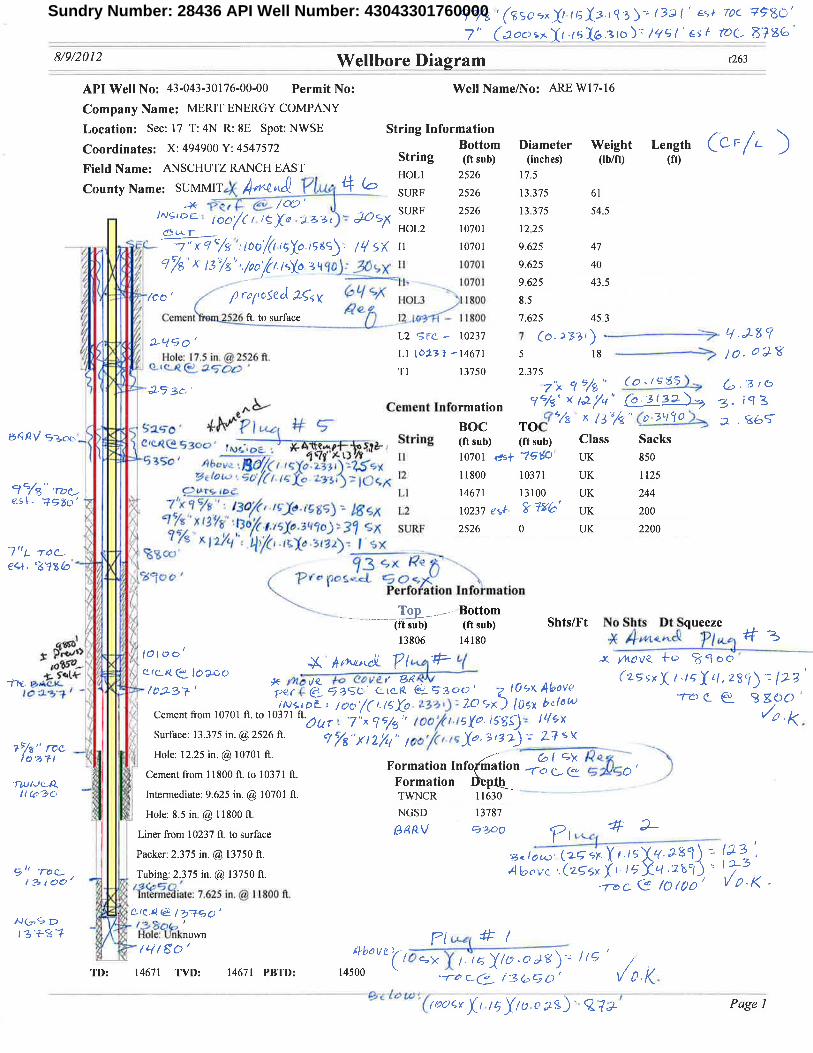
RECEIVED: Aug. 02, 2012
Sundry Number: 28436 API Well Number: 43043301760000Sundry Number: 28436 API Well Number: 43043301764% '(ssos XI tsÏ.3-mby /32 I' w roc Ngo'
8/9/2012 Wellbore Diagram r263
API Well No: 43-043-30176-00-00 Permit No: Well Name/No: ARE Wl7-16
Company Name: MERIT ENERGY COMPANY
Location: See: 17 T: 4N R: 8E Spot: NWSE String InformationCoordinates: X: 494900 Y: 4547572
.
Bottom Diameter Weight Length F LStrmg (ft sub) (inches) (Ib/ft) (ft)
Field Name: ANSCHUTZ RANCH EAST
County Name: SUMMIT ,LLSHU 22552266 137.3575
61
SURF 2526 13.375 54.51 0 6/ Xe = Y HOL2 10701 12.25
(00 /igo1985 ||5)( Il 10701 9.625 47
A /3 6 /00 (f /gó 3490 Il 10701 9.625 40Il- 10701 9.625 43.5
/co 9 repo5ed ,2 1lOL3 111800 8.5Cement 526 ft to surface 12.10171 - I 1800 7.625 45.3
L2 Sic - 10237 7 (o. 233 $ ŸHole: 17.5 in @2526 ft. Ll (0.23 f -14671 5 18 |Q 0 / ff
te_4 Tl 13750 2.375
Cement Information</% /.2 · (e - 3 / 3f') 3· 6 1
2ee' BOCTOCT /32g"(a-36/90
IMA/ -RGS3c y,A wet- String (ftsub) (ftsub) Class Sacks-4go a '071 Il 10701 CNf '7966 UK 850
/- A £e ·ys 12 11800 10371 UK 11251 /S To L] 14671 13100 UK 244esh 1930 -'
LS Atyg - )( L2 10237 €¾A UK 200(·l.rú
.3490 2 6/( SURF 2526 0 UK 2200
Perfo ation Information
To Bottom(ft sub) (ft sub) Shts/Ft No Shts Dt Squeeze13806 14180 >+ttn.c
Cement from 10701 ft to 10371 ft .dar 7"x9'ys /cc .isyo.isg . I sx e /(ree
Surface: 13.375 in. @2526 ft c s, , pg - 17 sy
/ y, Hole: 12.25 in. @10701 ft
Cement from 11800 ft to 10371 ft.Formation Info ation
ru A Formation h// 3c Intermediate: 9.625 in. @ 10701 ft TWNCR l1630
Hole: 8.5 in.@ l1800 ft NGSD 13787
Liner from 10237 ft to surface (à/UL 93 O
Packer: 2.375 in. @ 13750 ft (2
Tubing: 2.375 in. @13750 ft
Interrnediate: 7.625 in. @ l1800 ft
1379 01 : n'known/6//60' 4bove
TD: 14671 TVD: 14671 PBTD:
Sundry Number: 28436 API Well Number: 43043301764% '(ssos XI tsÏ.3-mby /32 I' w roc Ngo'
8/9/2012 Wellbore Diagram r263
API Well No: 43-043-30176-00-00 Permit No: Well Name/No: ARE Wl7-16
Company Name: MERIT ENERGY COMPANY
Location: See: 17 T: 4N R: 8E Spot: NWSE String InformationCoordinates: X: 494900 Y: 4547572
.
Bottom Diameter Weight Length F LStrmg (ft sub) (inches) (Ib/ft) (ft)
Field Name: ANSCHUTZ RANCH EAST
County Name: SUMMIT ,LLSHU 22552266 137.3575
61
SURF 2526 13.375 54.51 0 6/ Xe = Y HOL2 10701 12.25
(00 /igo1985 ||5)( Il 10701 9.625 47
A /3 6 /00 (f /gó 3490 Il 10701 9.625 40Il- 10701 9.625 43.5
/co 9 repo5ed ,2 1lOL3 111800 8.5Cement 526 ft to surface 12.10171 - I 1800 7.625 45.3
L2 Sic - 10237 7 (o. 233 $ ŸHole: 17.5 in @2526 ft. Ll (0.23 f -14671 5 18 |Q 0 / ff
te_4 Tl 13750 2.375
Cement Information</% /.2
· (e - 3 / 3f') 3· 6 1
2ee' BOCTOCT /32g"(a-36/90
IMA/ -RGS3c y,A wet- String (ftsub) (ftsub) Class Sacks-4go a '071 Il 10701 CNf '7966 UK 850
/- A £e ·ys 12 11800 10371 UK 11251 /S To L] 14671 13100 UK 244esh 1930 -'
LS Atyg - )( L2 10237 €¾A UK 200(·l.rú
.3490 2 6/( SURF 2526 0 UK 2200
Perfo ation Information
To Bottom(ft sub) (ft sub) Shts/Ft No Shts Dt Squeeze13806 14180 >+ttn.c
Cement from 10701 ft to 10371 ft .dar 7"x9'ys /cc .isyo.isg . I sx e /(ree
Surface: 13.375 in. @2526 ft c s, , pg - 17 sy
/ y, Hole: 12.25 in. @10701 ft
Cement from 11800 ft to 10371 ft.Formation Info ation
ru A Formation h// 3c Intermediate: 9.625 in. @ 10701 ft TWNCR l1630
Hole: 8.5 in.@ l1800 ft NGSD 13787
Liner from 10237 ft to surface (à/UL 93 O
Packer: 2.375 in. @ 13750 ft (2
Tubing: 2.375 in. @13750 ft
Interrnediate: 7.625 in. @ l1800 ft
1379 01 : n'known/6//60' 4bove
TD: 14671 TVD: 14671 PBTD:
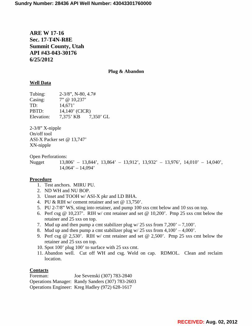
RECEIVED: Aug. 02, 2012
ARE W 17-16 Sec. 17-T4N-R8E Summit County, Utah API #43-043-30176 6/25/2012
Plug & Abandon Well Data Tubing: 2-3/8”, N-80, 4.7# Casing: 7” @ 10,237’ TD: 14,671’ PBTD: 14,140’ (CICR) Elevation: 7,375’ KB 7,350’ GL 2-3/8” X-nipple On/off tool ASI-X Packer set @ 13,747’ XN-nipple Open Perforations: Nugget 13,806’ – 13,844’, 13,864’ – 13,912’, 13,932’ – 13,976’, 14,010’ – 14,040’,
14,064’ – 14,094’ Procedure
1. Test anchors. MIRU PU. 2. ND WH and NU BOP. 3. Unset and TOOH w/ ASI-X pkr and LD BHA. 4. PU & RIH w/ cement retainer and set @ 13,750’. 5. PU 2-7/8” WS, sting into retainer, and pump 100 sxs cmt below and 10 sxs on top. 6. Perf csg @ 10,237’. RIH w/ cmt retainer and set @ 10,200’. Pmp 25 sxs cmt below the
retainer and 25 sxs on top. 7. Mud up and then pump a cmt stabilizer plug w/ 25 sxs from 7,200’ – 7,100’. 8. Mud up and then pump a cmt stabilizer plug w/ 25 sxs from 4,100’ – 4,000’. 9. Perf csg @ 2,530’. RIH w/ cmt retainer and set @ 2,500’. Pmp 25 sxs cmt below the
retainer and 25 sxs on top. 10. Spot 100’ plug 100’ to surface with 25 sxs cmt. 11. Abandon well. Cut off WH and csg. Weld on cap. RDMOL. Clean and reclaim
location. Contacts Foreman: Joe Sevenski (307) 783-2840 Operations Manager: Randy Sanders (307) 783-2603 Operations Engineer: Kreg Hadley (972) 628-1617
Sundry Number: 28436 API Well Number: 43043301760000Sundry Number: 28436 API Well Number: 43043301760000
ARE W 17-16Sec. 17-T4N-RSESummit County, UtahAPI #43-043-301766/25/2012
Plug & Abandon
Well Data
Tubing: 2-3/8", N-80, 4.7#Casing: 7" @10,237'TD: 14,671'PBTD: 14,140' (CICR)Elevation: 7,375' KB 7,350' GL
2-3/8" X-nippleOn/off toolASI-X Packer set @13,747'XN-nipple
Open Perforations:Nugget 13,806' - 13,844', 13,864' - 13,912', 13,932' - 13,976', 14,010' - 14,040',
14,064' - 14,094'
Procedure1. Test anchors. MIRU PU.2. ND WH and NU BOP.3. Unset and TOOH w/ ASI-X pkr and LD BHA.4. PU & RIH w/ cement retainer and set @13,750'.5. PU 2-7/8" WS, sting into retainer, and pump 100 sxs cmt below and 10 sxs on top.6. Perf csg @10,237'. RIH w/ cmt retainer and set @10,200'. Pmp 25 sxs cmt below the
retainer and 25 sxs on top.7. Mud up and then pump a cmt stabilizer plug w/ 25 sxs from 7,200' -7,100'.8. Mud up and then pump a cmt stabilizer plug w/ 25 sxs from 4,100' -4,000'.9. Perf csg @2,530'. RIH w/ cmt retainer and set @2,500'. Pmp 25 sxs cmt below the
retainer and 25 sxs on top.10. Spot 100' plug 100' to surface with 25 sxs cmt.11. Abandon well. Cut off WH and csg. Weld on cap. RDMOL. Clean and reclaim
location.
ContactsForeman: Joe Sevenski (307) 783-2840Operations Manager: Randy Sanders (307) 783-2603Operations Engineer: Kreg Hadley (972) 628-1617
RECEIVED: Aug. 02,
Sundry Number: 28436 API Well Number: 43043301760000
ARE W 17-16Sec. 17-T4N-RSESummit County, UtahAPI #43-043-301766/25/2012
Plug & Abandon
Well Data
Tubing: 2-3/8", N-80, 4.7#Casing: 7" @10,237'TD: 14,671'PBTD: 14,140' (CICR)Elevation: 7,375' KB 7,350' GL
2-3/8" X-nippleOn/off toolASI-X Packer set @13,747'XN-nipple
Open Perforations:Nugget 13,806' - 13,844', 13,864' - 13,912', 13,932' - 13,976', 14,010' - 14,040',
14,064' - 14,094'
Procedure1. Test anchors. MIRU PU.2. ND WH and NU BOP.3. Unset and TOOH w/ ASI-X pkr and LD BHA.4. PU & RIH w/ cement retainer and set @13,750'.5. PU 2-7/8" WS, sting into retainer, and pump 100 sxs cmt below and 10 sxs on top.6. Perf csg @10,237'. RIH w/ cmt retainer and set @10,200'. Pmp 25 sxs cmt below the
retainer and 25 sxs on top.7. Mud up and then pump a cmt stabilizer plug w/ 25 sxs from 7,200' -7,100'.8. Mud up and then pump a cmt stabilizer plug w/ 25 sxs from 4,100' -4,000'.9. Perf csg @2,530'. RIH w/ cmt retainer and set @2,500'. Pmp 25 sxs cmt below the
retainer and 25 sxs on top.10. Spot 100' plug 100' to surface with 25 sxs cmt.11. Abandon well. Cut off WH and csg. Weld on cap. RDMOL. Clean and reclaim
location.
ContactsForeman: Joe Sevenski (307) 783-2840Operations Manager: Randy Sanders (307) 783-2603Operations Engineer: Kreg Hadley (972) 628-1617
RECEIVED: Aug. 02,
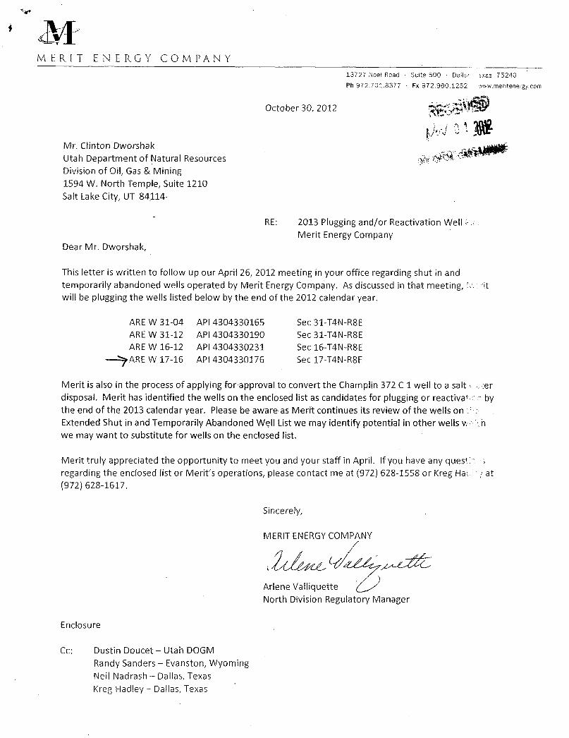
MERIT ENERGY COMPANY13727 Noel Road Suite 500 Dallas xas 75240Ph 972.701.8377 - Fx 972.960.1252 www mentenergy.com
October 30, 2012
Mr. Clinton DworshakUtah Department of Natural Resources okDivision of Oil, Gas & Mining1594 W. North Temple, Suite 1210Salt Lake City, UT 84114-
RE: 2013 Plugging and/or Reactivation Well FMerit Energy Company
Dear Mr. Dworshak,
This letter is written to follow up our April 26, 2012 meeting in your office regarding shut in andtemporarily abandoned wells operated by Merit Energy Company. As discussed in that meeting, itwill be plugging the wells listed below by the end of the 2012 calendar year.
ARE W 31-04 API 4304330165 Sec 31-T4N-R8E
ARE W 31-12 API 4304330190 Sec 31-T4N-RSE
ARE W 16-12 API 4304330231 Sec 16-T4N-R8E
AREW 17-16 API 4304330176 Sec 17-T4N-R8E
Merit is also in the process of applying for approval to convert the Champlin 372 C 1 well to a salt erdisposal. Merit has identified the wells on the enclosed list as candidates for plugging or reactivat bythe end of the 2013 calendar year. Please be aware as Merit continues its review of the wells onExtended Shut in and Temporarily Abandoned Well Listwe may identify potential in other wells v hwe may want to substitute for wells on the enclosed list.
Merit truly appreciated the opportunity to meet you and your staff in April. If you have any questregarding the enclosed list or Merit's operations, please contact me at (972) 628-1558 or Kreg Ha at(972) 628-1617.
Sincerely,
MERIT ENERGY COMPANY
Arlene ValliquetteNorth Division Regulatory Manager
Enclosure
Cc: Dustin Doucet -- Utah DOGMRandy Sanders - Evanston, WyomingNeil Nadrash - Dallas, TexasKreg Hadley - Dallas,
PROBABLEREACTIVATIONS;POSSIBLEP&A'S
Well Name: AREW 20-09API: 43-043-30286
Summit County, UtahPerfs: 11,742'-13,821'
The 20-09 was completed in the Nugget in 1988 and has cummed 590 MBO, 30.1 BCF, and 587 MBW.This well is currently SJ with a conventional gas lift with a "go"system. Due to the structural position ofthis well (very high), Merit hopes to reactivate this well.
Well Name: AREW 20-06
APl: 43-043-30159
Summit County, UtahPerfs: 13,008'- 13,860'
The 20-06 was completed in the Nugget in 1982 and has cummed 4.1 MBO, 81.8 BCF, and 152 MBW.This well is currently SI w/ 2-7/8" tbg in the hole w/ pkr at 12,898'. This well is in a good structuralposition within the field and based on the relatively low volumes of water this well has producedcomparably, Merit hopes to reactivate this well.
Well Name: AREW 20-08API: 43-043-30123Summit County, UtahPerfs: 11,900' -- 12,647' (OA)
The 20-08 was completed in the Nugget in 1981and has cummed 534 MBO, 31.5 BCF, and 1.2 MMBW.This well is currently SI with a 2-7/8" poor boy gas lift system. The 20-08 has a conventional gas liftsystem with a hole punched in the tbg @10,250'. Due to the high structural positioning of this well, it islikely that this well will be further evaluated for water shut-off and reactivation.
Well Name: ARE W 20-12
API: 43-043-30220
Summit County, UtahPerfs: 12,928' - 13,117'
The 20-12 was completed in the Nugget in 1983 and has cummed 5.6 MMBO, 127 BCF,and 742 MBW.This well is currently SI with a 2-3/8" conventional gas lift system. This well is in a good structuralposition in the field and exhibits Si pressures that would indicate remaining production potential givenproper evaluation into water shut-off for
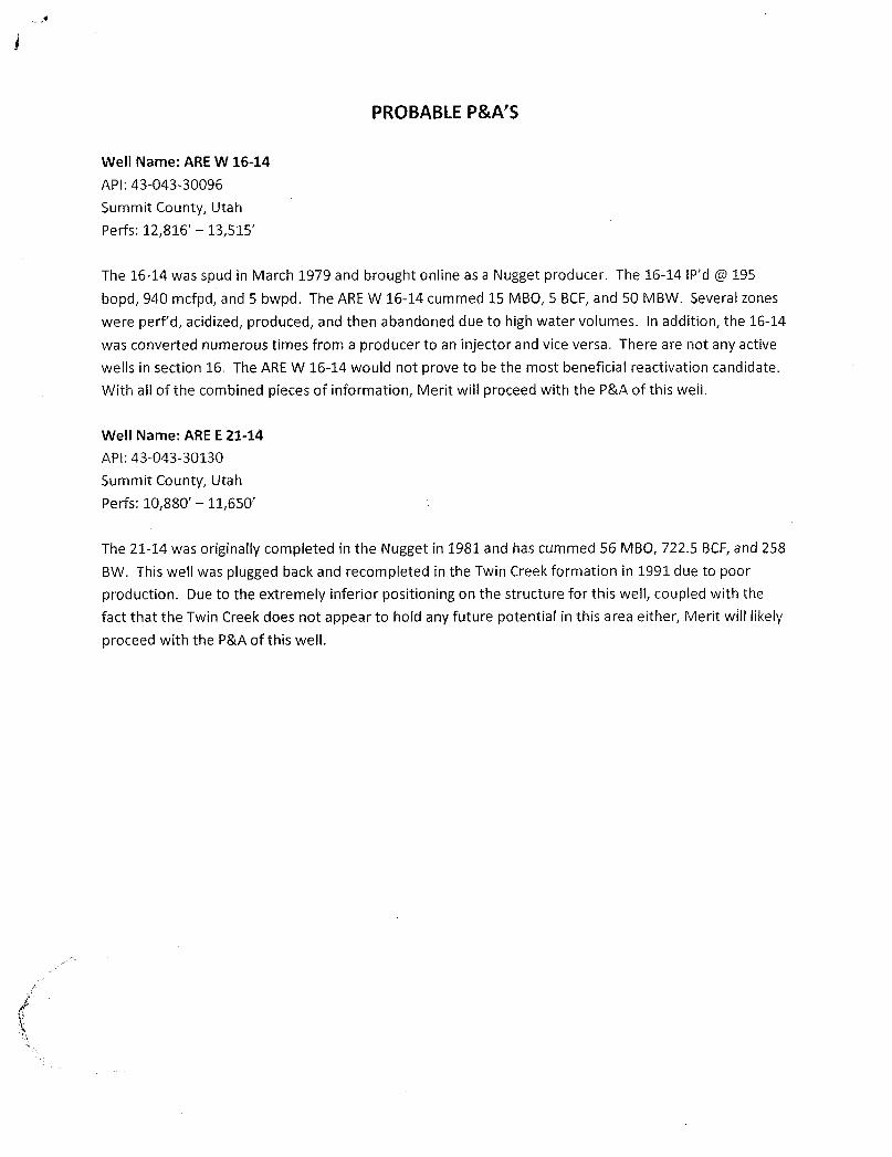
PROBABLE P&A'S
Well Name: AREW 16-14
API: 43-043-30096
Summit County, Utah
Perfs: 12,816' - 13,515'
The 16-14 was spud in March 1979 and brought online as a Nugget producer. The 16-14 IP'd @ 195
bopd, 940 mcfpd, and 5 bwpd. The AREW 16-14 cummed 15 MBO, 5 BCF,and 50 MBW. Several zoneswere perf'd, acidized, produced, and then abandoned due to high water volumes. In addition, the 16-14
was converted numerous times from a producer to an injector and vice versa. There are not any activewells in section 16. The AREW 16-14 would not prove to be the most beneficial reactivation candidate.With all of the combined pieces of information, Merit will proceed with the P&A of this well.
Well Name: ARE E 21-14
APl: 43-043-30130
Summit County, Utah
Pe rfs: 10,880' - 11,650'
The 21-14 was originally completed in the Nugget in 1981and has cummed 56 MBO, 722.5 BCF,and 258BW. This well was plugged back and recompleted in the Twin Creek formation in 1991due to poor
production. Due to the extremely inferior positioning on the structure for this well, coupled with thefact that the Twin Creek does not appear to hold any future potential in this area either, Merit will likelyproceed with the P&Aof this
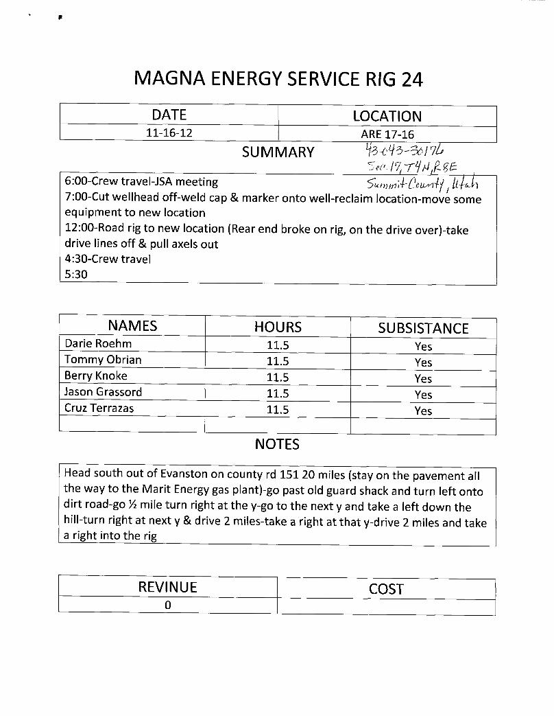
MAGNA ENERGYSERVICERIG 24
DATE LOCATION11-16-12 ARE 17-16
SUMMARY IA6:00-Crew travel-JSA meeting S'ummade llŠl7:00-Cut wellhead off-weld cap & marker onto well-reclaim location-move someequipment to new location12:00-Road rig to new location (Rear end broke on rig, on the drive over)-takedrive lines off & pull axels out4:30-Crew travel5:30
NAMES HOURS SUBSISTANCEDarie Roehm 11.5 YesTommy Obrian 11.5 YesBerry Knoke 11.5 YesJason Grassord 11.5 YesCruz Terrazas 11.5 Yes
NOTES
Head south out of Evanston on county rd 15120 miles (stay on the pavement allthe way to the Marit Energy gas plant)-go past old guard shack and turn left ontodirt road-go ½ mile turn right at the y-go to the next y and take a left down thehill-turn right at next y & drive 2 miles-take a right at that y-drive 2 miles and takea right into the rig
REVINUE COST
MAGNA ENERGYSERVICERIG 24
DATE LOCATION11-16-12 ARE 17-16
SUMMARY IA
6:00-Crew travel-JSA meeting S'ummade llŠl7:00-Cut wellhead off-weld cap & marker onto well-reclaim location-move someequipment to new location12:00-Road rig to new location (Rear end broke on rig, on the drive over)-takedrive lines off & pull axels out4:30-Crew travel5:30
NAMES HOURS SUBSISTANCEDarie Roehm 11.5 YesTommy Obrian 11.5 YesBerry Knoke 11.5 YesJason Grassord 11.5 YesCruz Terrazas 11.5 Yes
NOTES
Head south out of Evanston on county rd 15120 miles (stay on the pavement allthe way to the Marit Energy gas plant)-go past old guard shack and turn left ontodirt road-go ½ mile turn right at the y-go to the next y and take a left down thehill-turn right at next y & drive 2 miles-take a right at that y-drive 2 miles and takea right into the rig
REVINUE COST
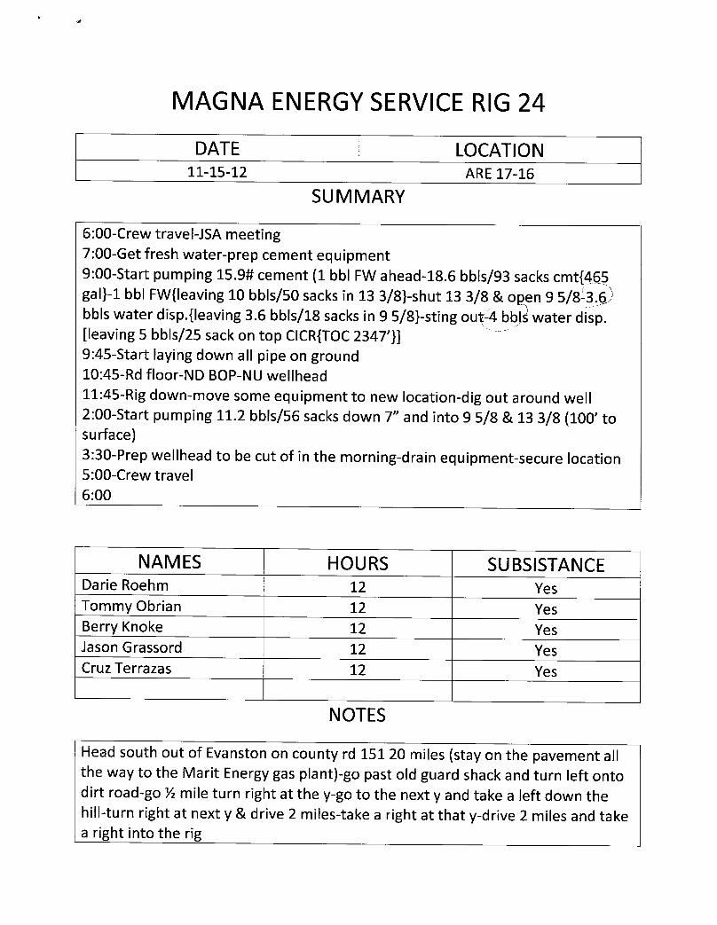
MAGNA ENERGYSERVICERIG24
DATE LOCATION11-15-12 ARE 17-16
SUMMARY
6:00-Crew travel-JSA meeting7:00-Get fresh water-prep cement equipment9:00-Start pumping 15.9# cement (1 bbl FW ahead-18.6 bbis/93 sacks cmt{465gal}-1 bbl FW{leaving 10 bbis/50 sacks in 13 3/8}-shut 13 3/8 & open 9 5/8 3.6bbls water disp.{leaving 3.6 bbis/18 sacks in 9 5/8}-sting ouf4 bblÀwater disp.[leaving 5 bbls/25 sack on top CICR{TOC2347'}]9:45-Start laying down all pipe on ground10:45-Rd floor-ND BOP-NU wellhead11:45-Rig down-move some equipment to new location-dig out around well2:00-Start pumping 11.2 bbis/56 sacks down 7" and into 9 5/8 & 13 3/8 (100' tosurface)3:30-Prep wellhead to be cut of in the morning-drain equipment-secure location5:00-Crew travel6:00
NAMES HOURS SUBSISTANCEDarie Roehm 12 YesTommy Obrian 12 YesBerry Knoke 12 YesJasonGrassord 12 YesCruz Terrazas 12 Yes
NOTES
Head south out of Evanston on county rd 15120 miles (stay on the pavement allthe way to the Marit Energy gas plant)-go past old guard shack and turn left ontodirt road-go ½ mile turn right at the y-go to the next y and take a left down thehill-turn right at next y & drive 2 miles-take a right at that y-drive 2 miles and takea right into the
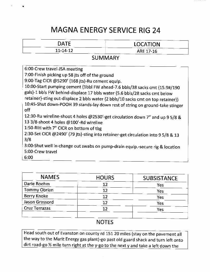
MAGNA ENERGYSERVICERIG24
DATE LOCATION11-14-12 ARE 17-16
SUMMARY
6:00-Crew travel-JSA meeting7:00-Finish picking up 58 jts off of the ground9:00-Tag CICR@5290'(168 jts)-Ru cement equip.10:00-Start pumping cement (1bbl FW ahead-7.6 bbis/38 sacks cmt {15.9#/190gals}-1 bbls FW behind-displace 17 bbls water {5.6 bbls/28 sacks cmt belowretainer}-sting out-displace 2 bbls water {2 bbis/10 sacks cmt on top retainer})10:45-Shut down-POOH 39 stands-lay down rest of string on ground-take stingeroff12:30-Ru wireline-shoot 4 holes @2530'-getcirculation down 7" and up 9 5/8 &13 3/8-shoot 4 holes @100'-Rd wireline1:50-RlH with 7" CICRon bottom of tbg2:30-Set CICR @2490' (79 jts)-sting into retainer-get circulation into 9 5/8 & 133/83:00-Shut well in-change out swabs on pump-drain equip.-secure rig & location5:00-Crew travel6:00
NAMES HOURS SUBSISTANCEDarie Roehm 12 YesTommy Obrian 12 YesBerry Knoke 12 YesJason Grassord 12 YesCruz Terrazas 12 Yes
NOTES
Head south out of Evanston on county rd 15120 miles (stay on the pavement allthe way to the Marit Energy gas plant)-go past old guard shack and turn left ontodirt road-go ½ mile turn right at the y-go to the next y and take a left down
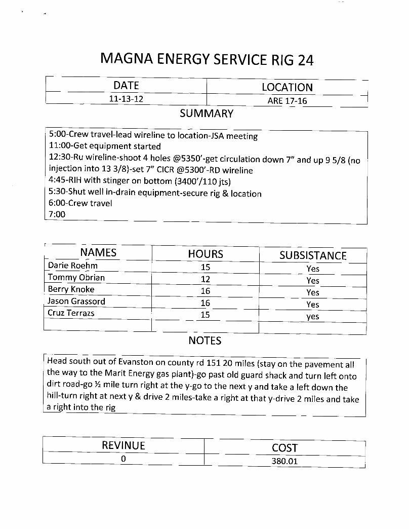
MAGNAENERGYSERVICERIG24DATE LOCATION
11-13-12 ARE 17-16
SUMMARY
5:00-Crew travel-lead wireline to location-JSA meeting11:00-Get equipment started12:30-Ru wireline-shoot 4 holes @5350'-getcirculation down 7" and up 9 5/8 (noinjection into 13 3/8)-set 7" CICR @5300'-RD wireline4:45-RIH with stinger on bottom (3400'/110 jts)5:30-Shut well in-drain equipment-secure rig & location6:00-Crew travel7:00
NAMES HOURS SUBSISTANCEDarie Roehm 15 YesTommy Obrian 12 YesBerry Knoke 16 YesJason Grassord 16 YesCruz Terrazs 15 yes
NOTES
Head south out of Evanston on county rd 15120 miles (stay on the pavement allthe way to the Marit Energy gas plant)-go past old guard shack and turn left ontodirt road-go ½ mile turn right at the y-go to the next y and take a left down thehill-turn right at next y &drive 2 miles-take a right at that y-drive 2 miles and takea right into the rig
REVINUE COST0
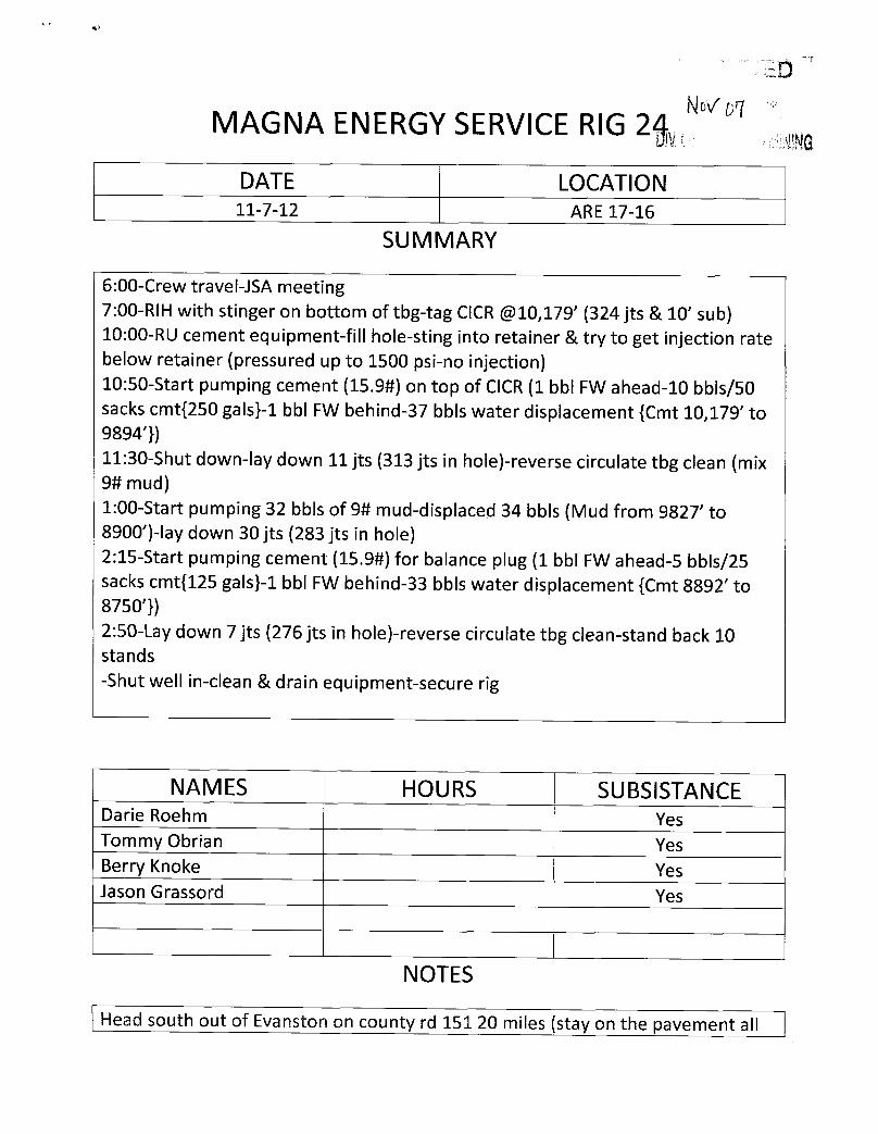
MAGNA ENERGYSERVICE RIG 2
DATE LOCATION11-7-12 ARE 17-16
SUMMARY
6:00-Crew travel-JSA meeting7:00-RIH with stinger on bottom of tbg-tag CICR@10,179'(324 jts & 10' sub)10:00-RU cement equipment-fill hole-sting into retainer & try to get injection ratebelow retainer (pressured up to 1500 psi-no injection)10:50-Start pumping cement (15.9#) on top of CICR(1 bbl FW ahead-10 bbls/50sacks cmt{250 gals}-1 bbl FW behind-37 bbis water displacement {Cmt 10,179' to9894'})11:30-Shut down-lay down 11 jts (313 jts in hole)-reverse circulate tbg clean (mix9# mud)1:00-Start pumping 32 bbis of 9# mud-displaced 34 bbls (Mud from 9827' to8900')-lay down 30 jts (283 jts in hole)2:15-Start pumping cement (15.9#) for balance plug (1 bbl FW ahead-5 bbis/25sacks cmt{125 gals}-1 bbl FW behind-33 bbis water displacement {Cmt 8892' to8750'})2:50-Lay down 7 jts (276 jts in hole)-reverse circulate tbg clean-stand back 10stands-Shut well in-clean & drain equipment-secure rig
NAMES HOURS SUBSISTANCEDarie Roehm YesTommy Obrian YesBerry Knoke YesJason Grassord Yes
NOTES
Head south out of Evanston on county rd 15120 miles (stay on the pavement
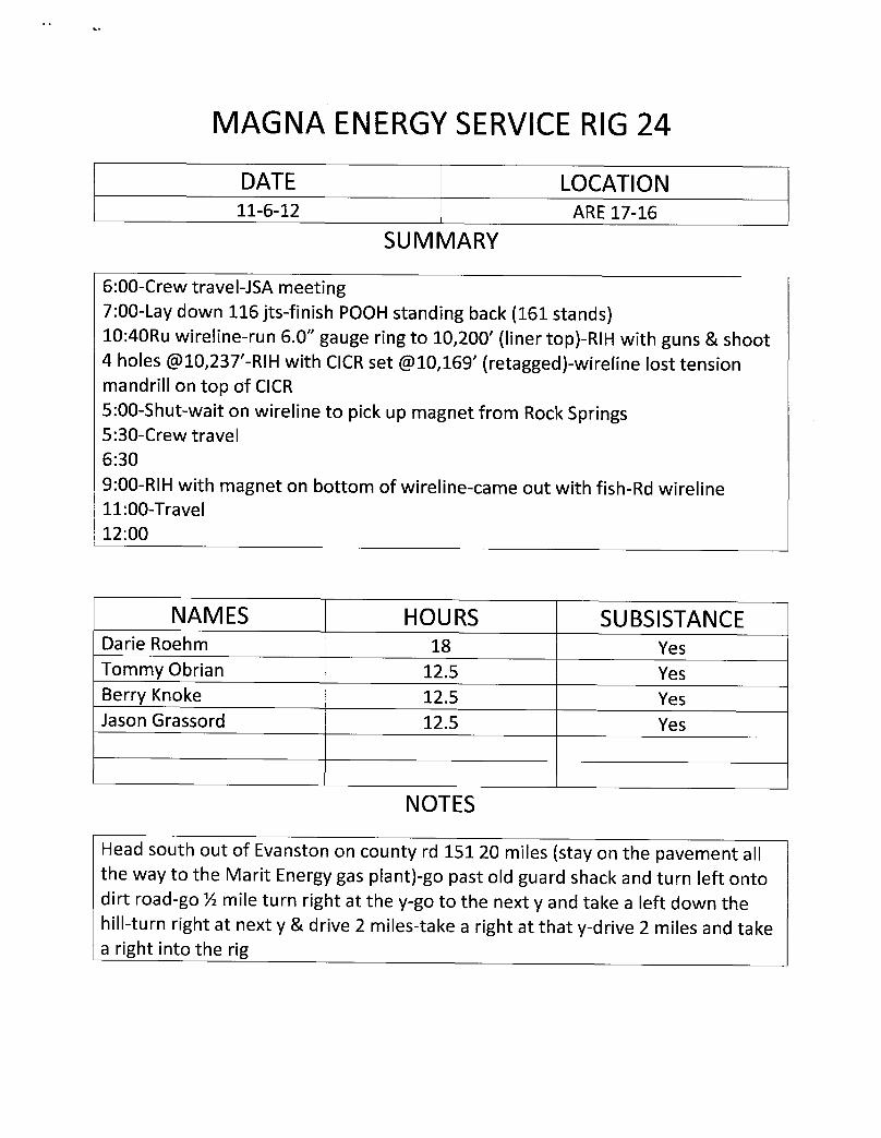
MAGNAENERGYSERVICERIG24
DATE LOCATION11-6-12 ARE17-16
SUMMARY
6:00-Crew travel-JSA meeting7:00-Lay down 116 jts-finish POOH standing back (161stands)10:40Ru wireline-run 6.0" gauge ring to 10,200' (liner top)-RIH with guns & shoot4 holes @10,237'-RIH with CICRset @10,169'(retagged)-wireline lost tensionmandrill on top of CICR5:00-Shut-wait on wireline to pick up magnet from Rock Springs5:30-Crew travel6:309:00-RIH with magnet on bottom of wireline-came out with fish-Rd wireline11:00-Travel12:00
NAMES HOURS SUBSISTANCEDarie Roehm 18 YesTommy Obrian 12.5 YesBerry Knoke 12.5 YesJason Grassord 12.5 Yes
NOTES
Head south out of Evanston on county rd 15120 miles (stay on the pavement allthe way to the Marit Energy gas plant)-go past old guard shack and turn left ontodirt road-go ½ mile turn right at the y-go to the next y and take a left down thehill-turn right at next y & drive 2 miles-take a right at that y-drive 2 miles and takea right into the
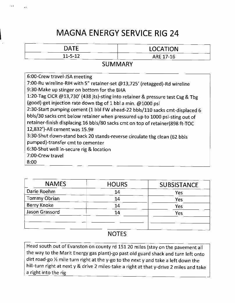
MAGNAENERGYSERVICERIG24
DATE LOCATION11-5-12 ARE 17-16
SUMMARY
6:00-Crew travel-JSA meeting7:00-Ru wireline-RIH with 5" retainer-set @13,725'(retagged)-Rd wireline9:30-Make up stinger on bottom for the BHA1:20-Tag CICR @13,730'(438 jts)-sting into retainer & pressure test Csg & Tbg(good)-getinjection rate down tbg of 1 bbl a min. @1000psi2:30-Start pumping cement (1 bbl FW ahead-22 bbis/110 sacks cmt-displaced 6bbis/30 sacks cmt below retainer when pressured up to 1000 psi-sting out ofretainer-finish displacing 16 bbis/80 sacks cmt on top of retainer(898 ft-TOC12,832')-All cement was 15.9#3:30-Shut down-stand back 20 stands-reverse circulate tbg clean (62 bbispumped)-transfer cmt to cementer6:30-Shut well in-secure rig & location7:00-Crew travel8:00
NAMES HOURS SUBSISTANCEDarie Roehm 14 YesTommy Obrian 14 YesBerry Knoke 14 YesJasonGrassord 14 Yes
NOTES
Head south out of Evanston on county rd 15120 miles (stay on the pavement allthe way to the Marit Energy gas plant)-go past old guard shack and turn left ontodirt road-go ½ mile turn right at the y-go to the next y and take a left down thehill-turn right at next y & drive 2 miles-take a right at that y-drive 2 miles and takea right into the
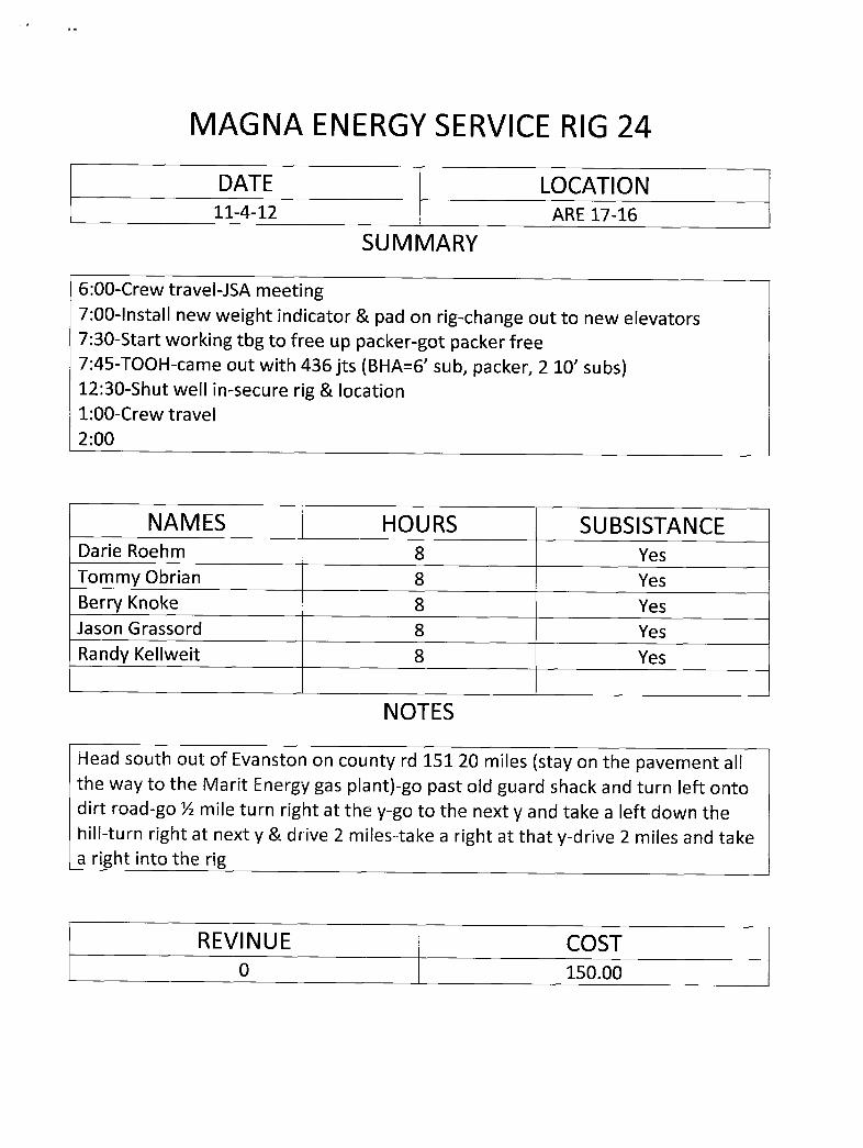
MAGNAENERGYSERVICERIG24
DATE LOCATION11-4-12 ARE 17-16
SUMMARY
6:00-Crew travel-JSA meeting7:00-Install new weight indicator & pad on rig-change out to new elevators7:30-Start working tbg to free up packer-got packer free7:45-TOOH-came out with 436 jts (BHA=6' sub, packer, 2 10' subs)12:30-Shut well in-secure rig & location1:00-Crew travel2:00
NAMES HOURS SUBSISTANCEDarie Roehm 8 YesTommy Obrian 8 YesBerry Knoke 8 YesJason Grassord 8 YesRandy Kellweit 8 Yes
NOTES
Head south out of Evanston on county rd 15120 miles (stay on the pavement allthe way to the Marit Energy gas plant)-go past old guard shack and turn left ontodirt road-go ½ mile turn right at the y-go to the next y and take a left down thehill-turn right at next y & drive 2 miles-take a right at that y-drive 2 miles and takea right into the rig
REVINUE COST0

MAGNA ENERGYSERVICERIG 24
DATE LOCATION11-3-12 ARE 17-16
SUMMARY
6:00-Crew travel-JSA meeting7:00-Finish reclaiming location-finish moving equipment to new location10:00-Spot in-Rig up-run line to tank to bleed down tbg11:00-Nd wellhead-Nu BOP-Ru floor-unland well-lunch1:00-Try to release packer-got it to release, pull 1 jt and packer stuck on us-try towork packer free4:00-Shut down due to weight indicator-shut well in-secure rig & location4:30-Crew travel5:30
NAMES HOURS SUBSISTANCEDarie Roehm 11.5 YesTommy Obrian 11.5 YesBerry Knoke 11.5 YesJason Grassord 11.5 YesRandy Kellweit 11.5 Yes
NOTES
Head south out of Evanston on county rd 15120 miles (stay on the pavement allthe way to the Marit Energy gas plant)-go past old guard shack and turn left ontodirt road-go ½ mile turn right at the y-go to the next y and take a left down thehill-turn right at next y & drive 2 miles-take a right at that y-drive 2 miles and takea right into the rig
REVINUE COST0
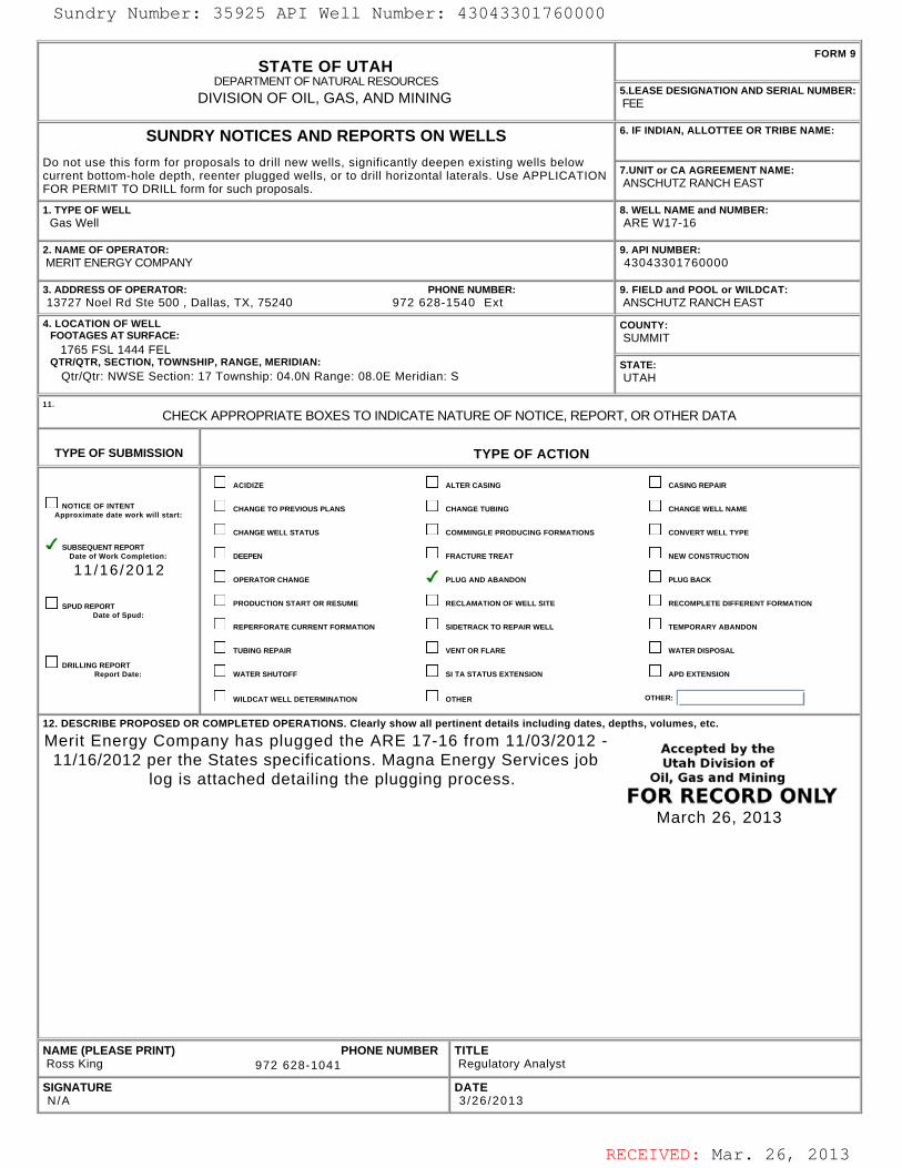
RECEIVED: Mar. 26, 2013
STATE OF UTAHDEPARTMENT OF NATURAL RESOURCES
DIVISION OF OIL, GAS, AND MINING
FORM 9
5.LEASE DESIGNATION AND SERIAL NUMBER: FEE
SUNDRY NOTICES AND REPORTS ON WELLS
Do not use this form for proposals to drill new wells, significantly deepen existing wells belowcurrent bottom-hole depth, reenter plugged wells, or to drill horizontal laterals. Use APPLICATIONFOR PERMIT TO DRILL form for such proposals.
6. IF INDIAN, ALLOTTEE OR TRIBE NAME:
7.UNIT or CA AGREEMENT NAME: ANSCHUTZ RANCH EAST
1. TYPE OF WELL Gas Well
8. WELL NAME and NUMBER: ARE W17-16
2. NAME OF OPERATOR: MERIT ENERGY COMPANY
9. API NUMBER: 43043301760000
3. ADDRESS OF OPERATOR: PHONE NUMBER: 13727 Noel Rd Ste 500 , Dallas, TX, 75240 972 628-1540 Ext
9. FIELD and POOL or WILDCAT: ANSCHUTZ RANCH EAST
4. LOCATION OF WELL FOOTAGES AT SURFACE: 1765 FSL 1444 FEL QTR/QTR, SECTION, TOWNSHIP, RANGE, MERIDIAN: Qtr/Qtr: NWSE Section: 17 Township: 04.0N Range: 08.0E Meridian: S
COUNTY: SUMMIT
STATE: UTAH
11.
CHECK APPROPRIATE BOXES TO INDICATE NATURE OF NOTICE, REPORT, OR OTHER DATA
TYPE OF SUBMISSION TYPE OF ACTION
NOTICE OF INTENTApproximate date work will start:
SUBSEQUENT REPORTDate of Work Completion:
11/16 /2012
SPUD REPORTDate of Spud:
DRILLING REPORTReport Date:
ACIDIZE ALTER CASING CASING REPAIR
CHANGE TO PREVIOUS PLANS CHANGE TUBING CHANGE WELL NAME
CHANGE WELL STATUS COMMINGLE PRODUCING FORMATIONS CONVERT WELL TYPE
DEEPEN FRACTURE TREAT NEW CONSTRUCTION
OPERATOR CHANGE PLUG AND ABANDON PLUG BACK
PRODUCTION START OR RESUME RECLAMATION OF WELL SITE RECOMPLETE DIFFERENT FORMATION
REPERFORATE CURRENT FORMATION SIDETRACK TO REPAIR WELL TEMPORARY ABANDON
TUBING REPAIR VENT OR FLARE WATER DISPOSAL
WATER SHUTOFF SI TA STATUS EXTENSION APD EXTENSION
WILDCAT WELL DETERMINATION OTHER OTHER:
12. DESCRIBE PROPOSED OR COMPLETED OPERATIONS. Clearly show all pertinent details including dates, depths, volumes, etc.
Merit Energy Company has plugged the ARE 17-16 from 11/03/2012 -11/16/2012 per the States specifications. Magna Energy Services job
log is attached detailing the plugging process.
NAME (PLEASE PRINT) PHONE NUMBER Ross King 972 628-1041
TITLE Regulatory Analyst
SIGNATURE N/A
DATE 3 /26 /2013
March 26, 2013
Sundry Number: 35925 API Well Number: 43043301760000Sundry Number: 35925 API Well Number: 43043301760000
FORM 9STATE OF UTAH
DEPARTMENTOF NATURALRESOURCES5.LEASE DESIGNATION AND SERIAL NUMBER:DIVISION OF OIL, GAS, AND MINING FEE
SUNDRY NOTICES AND REPORTS ON WELLS 6. IF INDIAN, ALLOTTEE OR TRIBE NAME:
Do not use this form for proposals to drill new wells, significantly deepen existing wells belowcurrent bottom-hole depth, reenter plugged wells, or to drill horizontal laterals. Use APPLICATION 7.UNITor CA AGREEMENT NAME:
FOR PERMIT TO DRILL form for such proposals. ANSCHUTZ RANCH EAST
1. TYPE OF WELL 8. WELL NAME and NUMBER:Gas Well ARE W17-16
2. NAME OF OPERATOR: 9. API NUMBER:MERIT ENERGY COMPANY 43043301760000
3. ADDRESS OF OPERATOR: PHONE NUMBER: 9. FIELD and POOL or WILDCAT:13727 Noel Rd Ste 500 , Dallas, TX, 75240 972 628-1540 Ext ANSCHUTZ RANCH EAST
4. LOCATION OF WELL COUNTY:FOOTAGES AT SURFACE: SUMMIT
1765 FSL 1444 FELQTRIQTR, SECTION, TOWNSHIP, RANGE, MERIDIAN: STATE:
QtrlQtr: NWSE Section: 17 Township: 04.0N Range: 08.0E Meridian: S UTAH
CHECK APPROPRIATE BOXES TO INDICATENATURE OF NOTICE, REPORT, OR OTHER DATA
TYPE OF SUBMISSION TYPE OF ACTION
ACI DIZE ALTER CASING CASING REPAIR
NOTICE OF INTENT CHANGE TO PREVIOUS PLANS CHANGE TUBING CHANGE WELL NAMEApproximate date work will start:
CHANGE WELL STATUS COMMINGLE PRODUCING FORMATIONS CONVERT WELL TYPE
SUBSEQUENT REPORTDate of Work Completion: DEEPEN FRACTURE TREAT NEW CONSTRUCTION
11/16/2012OPERATOR CHANGE PLUG AND ABANDON PLUG BACK
SPUD REPORT PRODUCTION START OR RESUME RECLAMATION OF WELL SITE RECOMPLETE DIFFERENT FORMATIONDate of Spud:
REPERFORATE CURRENT FORMATION SIDETRACK TO REPAIR WELL TEMPORARY ABANDON
TUBING REPAIR VENT OR FLARE WATER DISPOSAL
DRILLING REPORTReport Date: WATER SHUTOFF SI TA STATUS EXTENSION APD EXTENSION
WILDCATWELLDETERMINATION OTHER OTHER:
12. DESCRIBE PROPOSED OR COMPLETED OPERATIONS. Clearly show all pertinent details including dates, depths, volumes, etc.
Merit Energy Company has plugged the ARE 17-16 from 11/03/2012 -
Accepted by the11/16/2012 per the States specifications. Magna Energy Services job Utah Division of
log is attached detailing the plugging process. Oil, Gas and Mining
FOR RECORD ONLYMarch 26, 2013
NAME (PLEASE PRINT) PHONE NUMBER TITLERoss King 972 628-1041 Regulatory Analyst
SIGNATURE DATEN/A 3/26/2013
RECEIVED: Mar. 26,
Sundry Number: 35925 API Well Number: 43043301760000
FORM 9STATE OF UTAH
DEPARTMENTOF NATURALRESOURCES5.LEASE DESIGNATION AND SERIAL NUMBER:DIVISION OF OIL, GAS, AND MINING FEE
SUNDRY NOTICES AND REPORTS ON WELLS 6. IF INDIAN, ALLOTTEE OR TRIBE NAME:
Do not use this form for proposals to drill new wells, significantly deepen existing wells belowcurrent bottom-hole depth, reenter plugged wells, or to drill horizontal laterals. Use APPLICATION 7.UNITor CA AGREEMENT NAME:
FOR PERMIT TO DRILL form for such proposals. ANSCHUTZ RANCH EAST
1. TYPE OF WELL 8. WELL NAME and NUMBER:Gas Well ARE W17-16
2. NAME OF OPERATOR: 9. API NUMBER:MERIT ENERGY COMPANY 43043301760000
3. ADDRESS OF OPERATOR: PHONE NUMBER: 9. FIELD and POOL or WILDCAT:13727 Noel Rd Ste 500 , Dallas, TX, 75240 972 628-1540 Ext ANSCHUTZ RANCH EAST
4. LOCATION OF WELL COUNTY:FOOTAGES AT SURFACE: SUMMIT
1765 FSL 1444 FELQTRIQTR, SECTION, TOWNSHIP, RANGE, MERIDIAN: STATE:
QtrlQtr: NWSE Section: 17 Township: 04.0N Range: 08.0E Meridian: S UTAH
CHECK APPROPRIATE BOXES TO INDICATENATURE OF NOTICE, REPORT, OR OTHER DATA
TYPE OF SUBMISSION TYPE OF ACTION
ACI DIZE ALTER CASING CASING REPAIR
NOTICE OF INTENT CHANGE TO PREVIOUS PLANS CHANGE TUBING CHANGE WELL NAMEApproximate date work will start:
CHANGE WELL STATUS COMMINGLE PRODUCING FORMATIONS CONVERT WELL TYPE
SUBSEQUENT REPORTDate of Work Completion: DEEPEN FRACTURE TREAT NEW CONSTRUCTION
11/16/2012OPERATOR CHANGE PLUG AND ABANDON PLUG BACK
SPUD REPORT PRODUCTION START OR RESUME RECLAMATION OF WELL SITE RECOMPLETE DIFFERENT FORMATIONDate of Spud:
REPERFORATE CURRENT FORMATION SIDETRACK TO REPAIR WELL TEMPORARY ABANDON
TUBING REPAIR VENT OR FLARE WATER DISPOSAL
DRILLING REPORTReport Date: WATER SHUTOFF SI TA STATUS EXTENSION APD EXTENSION
WILDCATWELLDETERMINATION OTHER OTHER:
12. DESCRIBE PROPOSED OR COMPLETED OPERATIONS. Clearly show all pertinent details including dates, depths, volumes, etc.
Merit Energy Company has plugged the ARE 17-16 from 11/03/2012 -
Accepted by the11/16/2012 per the States specifications. Magna Energy Services job Utah Division of
log is attached detailing the plugging process. Oil, Gas and Mining
FOR RECORD ONLYMarch 26, 2013
NAME (PLEASE PRINT) PHONE NUMBER TITLERoss King 972 628-1041 Regulatory Analyst
SIGNATURE DATEN/A 3/26/2013
RECEIVED: Mar. 26,
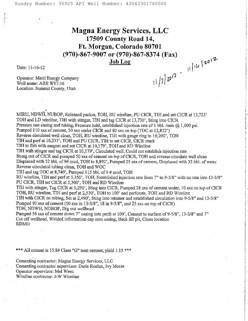
RECEIVED: Mar. 26, 2013
Sundry Number: 35925 API Well Number: 43043301760000Sundry Number: 35925 API Well Number: 43043301760000
Magna Energy Services, LLC17509 County Road 14,
Ft. Morgan, Colorado 80701(970)-867-9007 or (970)-867-8374 (Fax)
Job Log solDate: 11-16-12 \Operator:Merit Energy Company gÛÛWell narne: ARE W17-16Location: Summit County, Utah
MIRU,NDWËNUBOP,Released packer, TOH, RU wireline, PU CICR, TIH and set CICR at 13,725'TOH and LD wireline, TIH with stinger, TIH and tag CICRat 13,730', Sting into CICRPressure test casing and tubing, Pressure held, established injection rate of 1 bbl. /min @1,000 psi.Pumped 110 sxs of cement, 30 sxs under CICR and 80 sxs on top (TOC at 12,832')Reverse circulated well clean, TOH, RU wireline, TIH with gauge ring to 10,200', TOHTIH and perf at 10,237', TOH and PU CICR, TIH to set CICR, CICR stuckTIH to fish with magnet and set CICR at 10,179', TOH and RD WirelineTIH with stinger and tag CICR at 10,179', Circulated well, Could not establish injection rateStungout of CICR and pumped 50 sxs of cement on top of CICR,TOH and reverse circulate well cleanDisplaced with 32 bbl of 9# mud, TOH to 8,892', Pumped 25 sxs of cement, Displaced with 33 bbl. of waterReverse circulated tubing clean, TOH and WOCTIH and tag TOC at 8,740', Pumped 115 bbl. of 9 # mud, TOHRU wireline, TIH and perf at 5,350', TOH, Established injection rate from 7" to 9-5/8" with no rate into 13-3/8"PU CICR, TIH set CICR at 5,300', TOH and RD WirelineTIH with stinger, Tag CICR at 5,290', Sting into CICR, Pumped 28 sxs of cement under, 10 sxs on top of CICRTOH, RU wireline, TIH and perf at 2,530', TOH to 100' and perforate, TOH and RD WirelineTIH with CICR on tubing, Set at 2,490', Sting into retainerand established circulation into 9-5/8" and 13-3/8"Pumped 93 sxs of cement (50 sxs in 13-3/8", 18 in 9-5/8", and 25 sxs on top of CICR)TOH, NDWH, NDBOP, Dig out wellheadPumped 56 sxs of cement down 7" casing into perfs at 100', Cement to surface of 9-5/8", 13-3/8" and 7"Cut off wellhead, Welded information cap onto casing, Back fill pit, Clean locationRDMO
*** All cement is 15.8# Class "G" neat cement, yield 1.15 ***
Cementing contractor: Magna Energy Services, LLCCementing contractor supervisor: Darie Roehm, Ivy MorseOperator supervisor: Mel WrenWireline contractor: J-W
Sundry Number: 35925 API Well Number: 43043301760000
Magna Energy Services, LLC17509 County Road 14,
Ft. Morgan, Colorado 80701(970)-867-9007 or (970)-867-8374 (Fax)
Job Log solDate: 11-16-12 \Operator:Merit Energy Company gÛÛWell narne: ARE W17-16Location: Summit County, Utah
MIRU,NDWËNUBOP,Released packer, TOH, RU wireline, PU CICR, TIH and set CICR at 13,725'TOH and LD wireline, TIH with stinger, TIH and tag CICRat 13,730', Sting into CICRPressure test casing and tubing, Pressure held, established injection rate of 1 bbl. /min @1,000 psi.Pumped 110 sxs of cement, 30 sxs under CICR and 80 sxs on top (TOC at 12,832')Reverse circulated well clean, TOH, RU wireline, TIH with gauge ring to 10,200', TOHTIH and perf at 10,237', TOH and PU CICR, TIH to set CICR, CICR stuckTIH to fish with magnet and set CICR at 10,179', TOH and RD WirelineTIH with stinger and tag CICR at 10,179', Circulated well, Could not establish injection rateStungout of CICR and pumped 50 sxs of cement on top of CICR,TOH and reverse circulate well cleanDisplaced with 32 bbl of 9# mud, TOH to 8,892', Pumped 25 sxs of cement, Displaced with 33 bbl. of waterReverse circulated tubing clean, TOH and WOCTIH and tag TOC at 8,740', Pumped 115 bbl. of 9 # mud, TOHRU wireline, TIH and perf at 5,350', TOH, Established injection rate from 7" to 9-5/8" with no rate into 13-3/8"PU CICR, TIH set CICR at 5,300', TOH and RD WirelineTIH with stinger, Tag CICR at 5,290', Sting into CICR, Pumped 28 sxs of cement under, 10 sxs on top of CICRTOH, RU wireline, TIH and perf at 2,530', TOH to 100' and perforate, TOH and RD WirelineTIH with CICR on tubing, Set at 2,490', Sting into retainerand established circulation into 9-5/8" and 13-3/8"Pumped 93 sxs of cement (50 sxs in 13-3/8", 18 in 9-5/8", and 25 sxs on top of CICR)TOH, NDWH, NDBOP, Dig out wellheadPumped 56 sxs of cement down 7" casing into perfs at 100', Cement to surface of 9-5/8", 13-3/8" and 7"Cut off wellhead, Welded information cap onto casing, Back fill pit, Clean locationRDMO
*** All cement is 15.8# Class "G" neat cement, yield 1.15 ***
Cementing contractor: Magna Energy Services, LLCCementing contractor supervisor: Darie Roehm, Ivy MorseOperator supervisor: Mel WrenWireline contractor: J-W
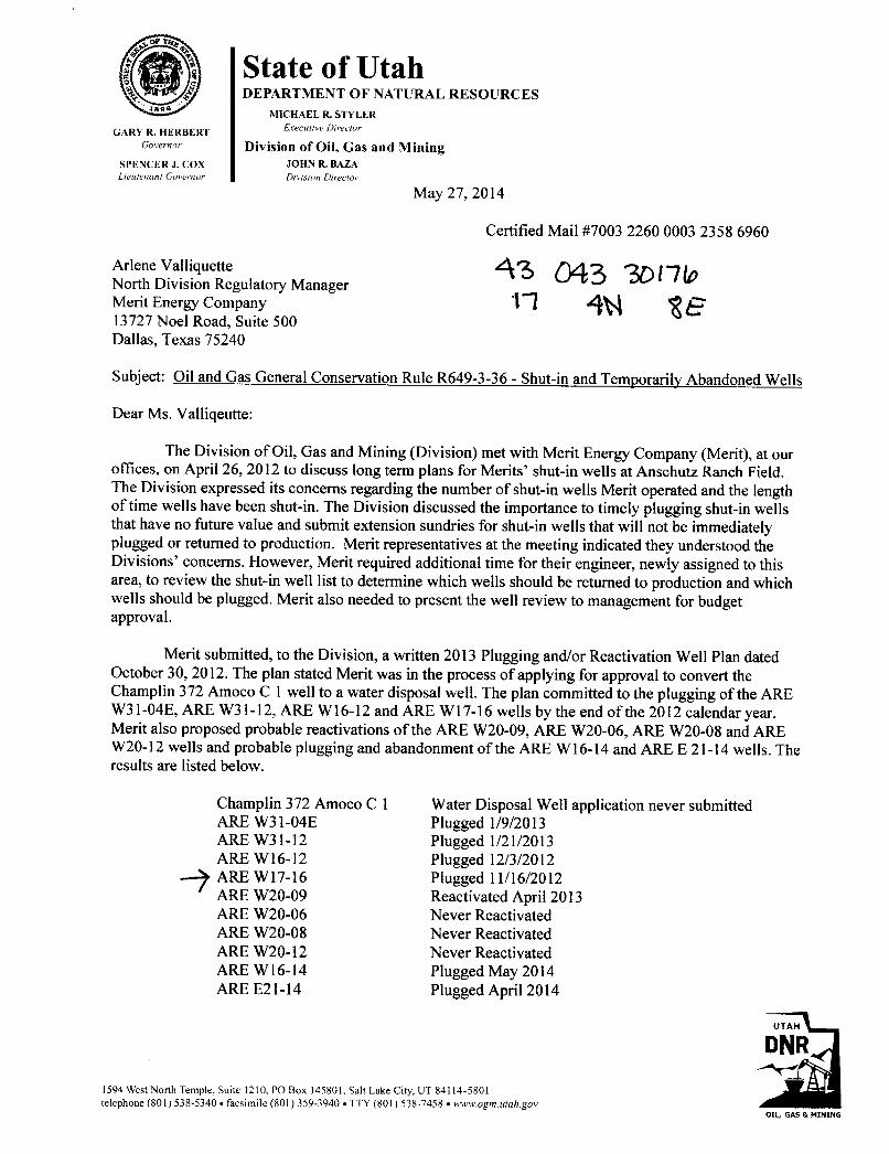
, State of UtahDEPARTMENT OF NATURAL RESOURCES
MICHAEL R. STYLER
GARY R. HERBERT Executive Director
Governor Division of Oil, Gas and MiningSPENCER J. COX JOHN R. BAZALieutenant Govemor Division Director
May 27, 2014
Certified Mail #7003 2260 0003 2358 6960
Arlene ValliquetteNorth Division Regulatory ManagerMerit Energy Company 4W 2E13727 Noel Road, Suite 500Dallas, Texas 75240
Subject: Oil and Gas General Conservation Rule R649-3-36 - Shut-in and Temporarily Abandoned Wells
Dear Ms. Valliqeutte:
The Division of Oil, Gas and Mining (Division) met with Merit Energy Company (Merit), at ouroffices, on April 26, 2012 to discuss long term plans for Merits' shut-in wells at Anschutz Ranch Field.The Division expressed its concerns regarding the number of shut-in wells Merit operated and the lengthof time wells have been shut-in. The Division discussed the importance to timely plugging shut-in wellsthat have no future value and submit extension sundries for shut-in wells that will not be immediatelyplugged or returned to production. Merit representatives at the meeting indicated they understood theDivisions' concerns. However, Merit required additional time for their engineer, newly assigned to thisarea, to review the shut-in well list to determine which wells should be returned to production and whichwells should be plugged. Merit also needed to present the well review to management for budgetapproval.
Merit submitted, to the Division, a written 2013 Plugging and/or Reactivation Well Plan datedOctober 30, 2012. The plan stated Merit was in the process of applying for approval to convert theChamplin 372 Amoco Cl well to a water disposal well. The plan committed to the plugging of the AREW31-04E, ARE W31-12, ARE Wl6-12 and ARE W17-16 wells by the end of the 2012 calendar year.Merit also proposed probable reactivations of the ARE W20-09, ARE W20-06, ARE W20-08 and AREW20-12 wells and probable plugging and abandonment of the ARE W16-14 and ARE E 21-14 wells. Theresults are listed below.
Champlin 372 Amoco Cl Water Disposal Well application never submittedARE W31-04E Plugged 1/9/2013ARE W31-12 Plugged 1/21/2013ARE W16-12 Plugged 12/3/2012ARE Wl7-16 Plugged 11/16/2012ARE W20-09 Reactivated April 2013ARE W20-06 Never ReactivatedARE W20-08 Never ReactivatedARE W20-12 Never ReactivatedARE Wl6-14 Plugged May 2014ARE E21-14 Plugged April 2014
UTAH
DNR
1594 West North Temple, Suite 1210, PO Box 145801, Salt Lake City, UT 84114-5801telephone (801) 538-5340 • facsimile (801) 359-3940 •TTY (801) 538-7458 • wwwogm.utah.gov
OIL, GAS &

Page 2Merit Energy CompanyMay 27, 2014
Ryan Huddleston from your office has indicated in recent conversations with Dustin Doucet thatMerit is preparing to reactivate/plug 6-8 more shut-in wells. To date Merit has not submitted a writtenplan for Division approval.
Merit currently operates twenty-five (25) shut-in wells at Anschutz Ranch Field; see ComplianceAttachment. Eleven (11) of the twenty-five total shut-in wells were added between January 2012 andJanuary 2014. The Division has sent Merit several Shut-in and Temporary Abandonment Noticesdescribing Rule 649-3-36 Shut-in and Temporarily Abandoned Well requirements. The Division deniedshut-in extension requests for seven (7) wells due to insufficient information. The Division also issuedNotices of Violation for ten (10) of the shut-in wells. Merit has not submitted shut-in extensions sundriesfor the eleven wells added between January 2012 and January 2014, or submitted additional requiredinformation for the seven denied shut-in extensions, or resolved the Notices of Violation.
The operator is responsible to file, yearly, for extended shut-in or temporary abandonment forwells shut-in or temporarily abandoned for a period of twelve (12) consecutive months. Merit must file aSundry Notice providing the following information for each of the twenty-five wells listed on theCompliance Attachment; reasons for shut-in or temporarily abandonment of the well, length of time thewell is expected to be shut-in or temporarily abandoned and an explanation and supporting data showingthe well has integrity (R649-3-36.l). After review the Division will either approve the continued shut-inor temporarily abandoned status or require remedial action (R649-3-36.2). After five (5) years of non-activity or non-productivity, the well shall be plugged in accordance with R649-3-24, unless approval forextended shut-in time is given by the Division upon a showing of good cause by the operator (R649-3-36.3). Please note, thirteen (13) of the twenty-five wells listed on the Compliance Attachment have beenshut-in over five (5) years.
Merit has until June 30, 2014 to submit sundries, for the subject wells, in accordance with Oiland Gas Conservation General Rule 649-3-36 Shut-in and Temporarily Abandoned Wells.
Should Merit not meet shut-in and temporarily abandoned well requirements, the Division isprepared to file a Notice of Agency Action (NAA) for Commencement of Informal AdjudicativeProceedings (R649-10-3) for this matter in accordance with Oil and Gas Conservation General RuleR649-10 Administrative Procedures.
If you have any questions or need further assistance, please feel free to contact me [email protected] or 801-538-5280 or Dustin Doucet, Petroleum Engineer, at [email protected] 801-538-5281.
Sincerely,
Clinton DworshakOil and Gas Compliance Manager
CLD/jsEnclosure: Compliance History
ec: John Rogers, O&G Associate DirectorDustin Doucet, Petroleum EngineerCompliance FileWell
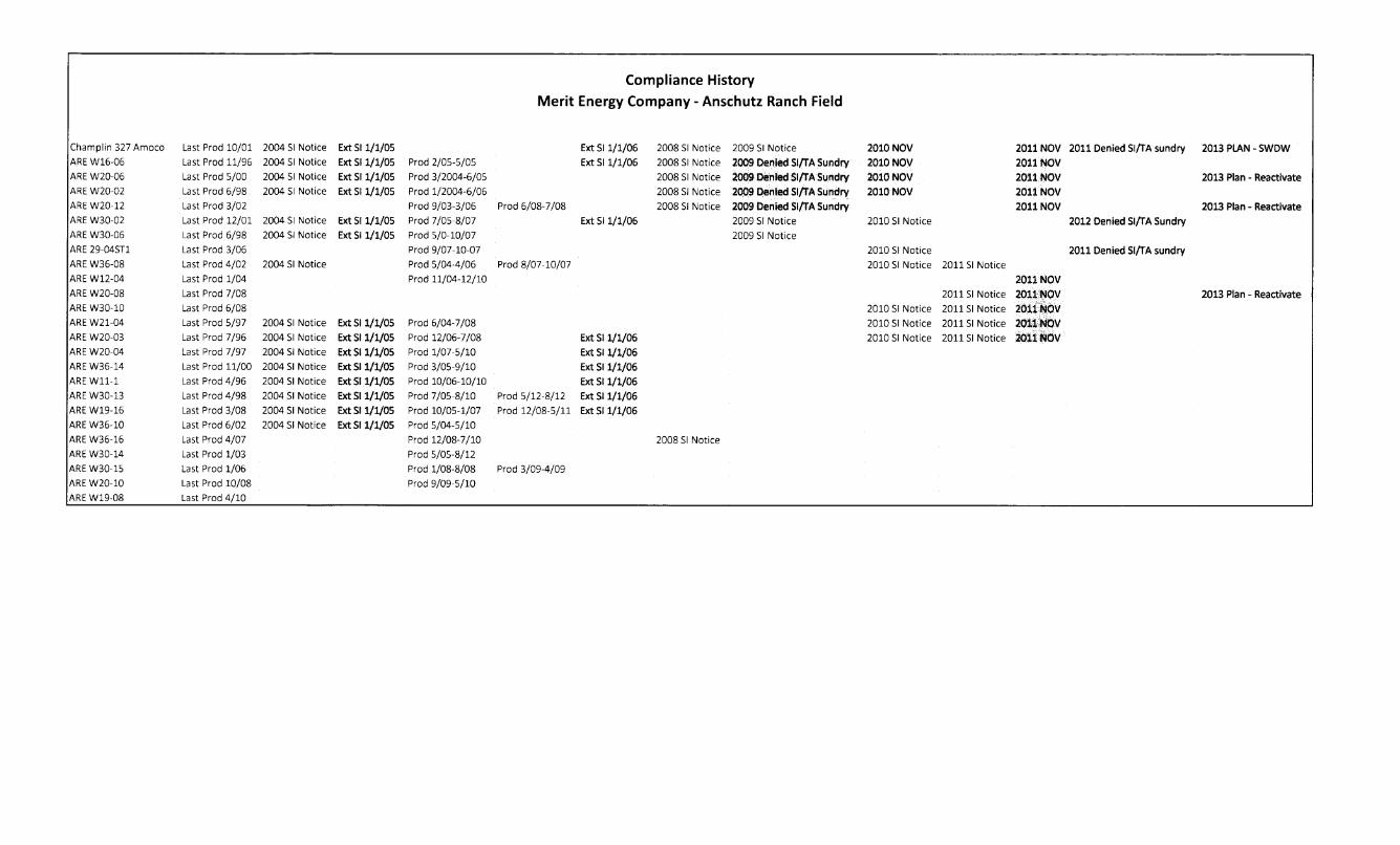
Compliance HistoryMerit Energy Company - Anschutz Ranch Field
Charnplin 327 Amoco Last Prod 10/01 2004 SI Notice Ext SI 1/1/05 Ext Si 1/1/06 2008 SI Notice 2009 SI Notice 2010 NOV 2011NOV 2011 Denied Sl/TA sundry 2013 PLAN - SWDWAREW16-06 Last Prod 11/96 2004 SI Notice Ext SI 1/1/05 Prod 2/05-5/05 Ext 511/1/06 2008 SI Notice 2009 Denied SI/TA Sundry 2010 NOV 2011NOVAREW20-06 Last Prod 5/00 2004 SI Notice Ext SI 1/1/05 Prod 3/2004-6/05 2008 SI Notice 2009 Denled SI/TA Sundry 2010 NOV 2011AOV 2013 Plan - ReactivateAREW20-02 Last Prod 6/98 2004 St Notice ExtSI 1/1/05 Prod 1/2004-6/06 2008 SJ Notice 2009 Denied SI/TA Sundry 2010 NOV 201iNOVAREW20-12 Last Prod 3/02 Prod 9/03-3/06 Prod 6/08-7/08 2008 SI Notice 2009 Denied SI/TA sundry 2011NOV 2013 Plan - ReactivateAREW30-02 Last Prod 12/01 2004 SI Notice Ext Si 1/1/05 Prod 7/05-8/07 Ext SI 1/1/06 2009 St Notice 2010 SI Notice 2012 Denied SifrA SundryAREW30-06 Last Prod 6/98 2004 SI Notice Ext SI 1/1/05 Prod 5/0-10/07 2009 SI NoticeARE29-04ST1 Last Prod 3/06 Prod 9/07-10-07 2010 St Notice 2011 Denied SI/TA sundryAREW36-08 Last Prod 4/02 2004 SI Notice Prod 5/04-4/06 Prod 8/07-10/07 2010 SI Notice 2011SI NoticeAREW12-04 Last Prod 1/04 Prod 11/04-12/10 2011NOVAREW20-08 Last Prod 7/08 20115| Notice 2011NOV 2013 Plan - ReactivateAREW30-10 Last Prod 6/08 2010 SI Notice 2011 SI Notice 2011 NOVAREW21-04 Last Prod 5/97 2004 SI Notice Ext Si 1/1/05 Prod 6/04-7/08 2010 SI Notice 2011 Si Notice 2011 NOVAREW20-03 Last Prod 7/96 2004 SI Notice ExtSI 1/1/05 Prod 12/06-7/08 Ext SI 1/1/06 2010 SI Notice 201151 Notice 2011NOVAREW20-04 Last Prod 7/97 2004 Si Notice ExtSI 1/1/05 Prod 1/07-5/10 Ext SI 1/1/06AREW36-14 Last Prod 11/00 2004 SI Notice Ext SI 1/1/05 Prod 3/05-9/10 Ext SI 1/1/06AREW11-1 Last Prod 4/96 2004 SI Notice ExtSI 1/1/05 Prod 10/06-10/10 Ext SI 1/1/06AREW30-13 Last Prod 4/98 2004 SI Notice Ext SI 1/1/05 Prod 7/05-8/10 Prod 5/12-8/12 Ext Si 1/1/06AREW19-16 Last Prod 3/08 2004 SI Notice Ext SI 1/1/05 Prod 10/05-1/07 Prod 12/08-5/11 Ext SI 1/1/06AREW36-10 Last Prod 6/02 2004 SI Notice Ext SI 1/1/05 Prod 5/04-5/10
AREW36-16 Last Prod 4/07 Prod 12/08-7/10 2008 SI NoticeAREW30-14 Last Prod 1/03 Prod 5/05-8/12
AREW30-15 Last Prod 1/06 Prod 1/08-8/08 Prod 3/09-4/09
AREW20-10 Last Prod 10/08 Prod 9/09-5/10
AREW19-08 Last Prod
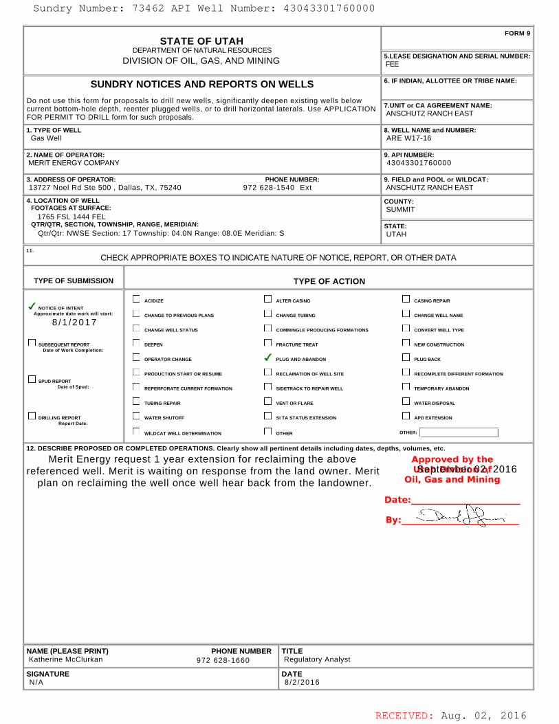
RECEIVED: Aug. 02, 2016
STATE OF UTAHDEPARTMENT OF NATURAL RESOURCES
DIVISION OF OIL, GAS, AND MINING
FORM 9
5.LEASE DESIGNATION AND SERIAL NUMBER: FEE
SUNDRY NOTICES AND REPORTS ON WELLS
Do not use this form for proposals to drill new wells, significantly deepen existing wells belowcurrent bottom-hole depth, reenter plugged wells, or to drill horizontal laterals. Use APPLICATIONFOR PERMIT TO DRILL form for such proposals.
6. IF INDIAN, ALLOTTEE OR TRIBE NAME:
7.UNIT or CA AGREEMENT NAME: ANSCHUTZ RANCH EAST
1. TYPE OF WELL Gas Well
8. WELL NAME and NUMBER: ARE W17-16
2. NAME OF OPERATOR: MERIT ENERGY COMPANY
9. API NUMBER: 43043301760000
3. ADDRESS OF OPERATOR: PHONE NUMBER: 13727 Noel Rd Ste 500 , Dallas, TX, 75240 972 628-1540 Ext
9. FIELD and POOL or WILDCAT: ANSCHUTZ RANCH EAST
4. LOCATION OF WELL FOOTAGES AT SURFACE: 1765 FSL 1444 FEL QTR/QTR, SECTION, TOWNSHIP, RANGE, MERIDIAN: Qtr/Qtr: NWSE Section: 17 Township: 04.0N Range: 08.0E Meridian: S
COUNTY: SUMMIT
STATE: UTAH
11.
CHECK APPROPRIATE BOXES TO INDICATE NATURE OF NOTICE, REPORT, OR OTHER DATA
TYPE OF SUBMISSION TYPE OF ACTION
NOTICE OF INTENTApproximate date work will start:
8 /1 /2017
SUBSEQUENT REPORTDate of Work Completion:
SPUD REPORTDate of Spud:
DRILLING REPORTReport Date:
ACIDIZE ALTER CASING CASING REPAIR
CHANGE TO PREVIOUS PLANS CHANGE TUBING CHANGE WELL NAME
CHANGE WELL STATUS COMMINGLE PRODUCING FORMATIONS CONVERT WELL TYPE
DEEPEN FRACTURE TREAT NEW CONSTRUCTION
OPERATOR CHANGE PLUG AND ABANDON PLUG BACK
PRODUCTION START OR RESUME RECLAMATION OF WELL SITE RECOMPLETE DIFFERENT FORMATION
REPERFORATE CURRENT FORMATION SIDETRACK TO REPAIR WELL TEMPORARY ABANDON
TUBING REPAIR VENT OR FLARE WATER DISPOSAL
WATER SHUTOFF SI TA STATUS EXTENSION APD EXTENSION
WILDCAT WELL DETERMINATION OTHER OTHER:
12. DESCRIBE PROPOSED OR COMPLETED OPERATIONS. Clearly show all pertinent details including dates, depths, volumes, etc.
Merit Energy request 1 year extension for reclaiming the abovereferenced well. Merit is waiting on response from the land owner. Merit
plan on reclaiming the well once well hear back from the landowner.
NAME (PLEASE PRINT) PHONE NUMBER Katherine McClurkan 972 628-1660
TITLE Regulatory Analyst
SIGNATURE N/A
DATE 8 /2 /2016
September 02, 2016
Sundry Number: 73462 API Well Number: 43043301760000Sundry Number: 73462 API Well Number: 43043301760000
FORM 9STATE OF UTAH
DEPARTMENTOF NATURALRESOURCES5.LEASE DESIGNATION AND SERIAL NUMBER:DIVISION OF OIL, GAS, AND MINING FEE
SUNDRY NOTICES AND REPORTS ON WELLS 6. IF INDIAN, ALLOTTEE OR TRIBE NAME:
Do not use this form for proposals to drill new wells, significantly deepen existing wells belowcurrent bottom-hole depth, reenter plugged wells, or to drill horizontal laterals. Use APPLICATION 7.UNITor CA AGREEMENT NAME:
FOR PERMIT TO DRILL form for such proposals. ANSCHUTZ RANCH EAST
1. TYPE OF WELL 8. WELL NAME and NUMBER:Gas Well ARE W17-16
2. NAME OF OPERATOR: 9. API NUMBER:MERIT ENERGY COMPANY 43043301760000
3. ADDRESS OF OPERATOR: PHONE NUMBER: 9. FIELD and POOL or WILDCAT:13727 Noel Rd Ste 500 , Dallas, TX, 75240 972 628-1540 Ext ANSCHUTZ RANCH EAST
4. LOCATION OF WELL COUNTY:FOOTAGES AT SURFACE: SUMMIT
1765 FSL 1444 FELQTRIQTR, SECTION, TOWNSHIP, RANGE, MERIDIAN: STATE:
QtrlQtr: NWSE Section: 17 Township: 04.0N Range: 08.0E Meridian: S UTAH
CHECK APPROPRIATE BOXES TO INDICATENATURE OF NOTICE, REPORT, OR OTHER DATA
TYPE OF SUBMISSION TYPE OF ACTION
ACI DIZE ALTER CASING CASING REPAIRNOTICE OF INTENT
Approximate date work will start: CHANGE TO PREVIOUS PLANS CHANGE TUBING CHANGE WELL NAME
8/1/2017CHANGE WELL STATUS COMMINGLE PRODUCING FORMATIONS CONVERT WELL TYPE
SUBSEQUENT REPORT DEEPEN FRACTURE TREAT NEW CONSTRUCTIONDate of Work Completion:
OPERATOR CHANGE PLUG AND ABANDON PLUG BACK
PRODUCTION START OR RESUME RECLAMATION OF WELL SITE RECOMPLETE DIFFERENT FORMATIONSPUD REPORT
Date of Spud: REPERFORATE CURRENT FORMATION SIDETRACK TO REPAIR WELL TEMPORARY ABANDON
TUBING REPAIR VENT OR FLARE WATER DISPOSAL
DRILLING REPORT WATER SHUTOFF SI TA STATUS EXTENSION APD EXTENSIONReport Date:
WILDCATWELLDETERMINATION OTHER OTHER:
12. DESCRIBE PROPOSED OR COMPLETED OPERATIONS. Clearly show all pertinent details including dates, depths, volumes, etc.
Merit Energy request 1 year extension for reclaiming the above Approved by thereferenced well. Merit is waiting on response from the land owner. Merit LSeþtmlinhdoß2tf2016
plan on reclaiming the well once well hear back from the landowner. Oil, Gas and Mining
NAME (PLEASE PRINT) PHONE NUMBER TITLEKatherine McClurkan 972 628-1660 Regulatory Analyst
SIGNATURE DATEN/A 8/2/2016
RECEIVED: Aug. 02,
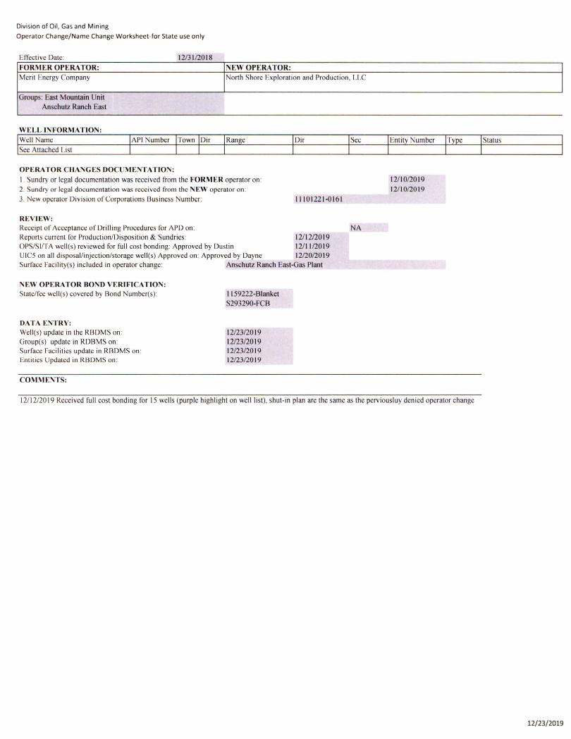
Division of Oil, Gas and Mining
Operator Change/Name Change Worksheet-for State use only
EfTcctive Datc' 12/3 1/20 18
FORMER OPERA TOR: NEW OPERA TOR: Merit Energy Company North Shore Exploration and Production, LLC
Groups: East Mountain Unit Anschutz Ranch East :
WELL INFORMATION:
Well Name Range
See Attached List
OPERATOR CHANGES DOCUME TATION:
I . Sundry or legal documentation was received from the FORMER operator on : 2. Sundry or legal documentation was received from the NEW operator on :
3. ew operator Division of Corporations Business Number:
REVIEW:
Dir
11101221-0161
Receipt of Acceptance of Drilling Procedures for APD on : NA Reports current for Production/Disposition & Sundries: 12/ 12/2019 OPS/Slr rA well(s) reviewed for full cost bonding: Approved by Dustin 12/ 11 /20 19 UICS on all disposal/injection/storage well(s) Approved on: Approved by Dayne 12/20/20 19 Surface Facilily(S) included in operator change: Anschutz Ranch East-Gas Plant
'EW OPERATOR BOND VERIFICATIO ' : State/fee well (s) covered by Bond Number(s) :
DATA ENTRY: Wel\(s) update in the RBDMS on : Group(s) update in RDBMS on: Surface Facilitics updatc in RBDMS on : Entities Updated in RBDMS on:
COMMENTS:
I I 59222-Blanket S293290-FCB
12/23/20 19 12/23/2019 12/23/20 19 12123/20 19
12/ 1012019 12/ 10/20 19
12/ 12/2019 Received full cost bonding for 15 wells (purple highlight on well list), shut-in plan are the same as the perviousluy denied operator change
Status
12/23/2019
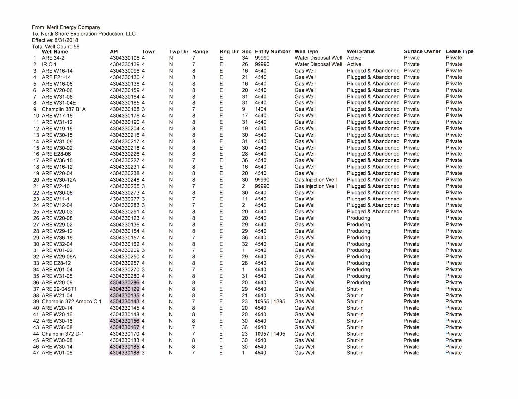
From: Merit Energy Company To : North Shore Exploration Production , LLC Effective: 8/31/2018 Total Well Count: 56
Well Name API Town Twp Dir Range Rng Dir Sec Entity Number Well Type Well Status Surface Owner Lease Type 1 ARE 34-2 4304330106 4 N 7 E 34 99990 Water Disposal Well Active Private Private 2 IR C-1 4304330139 4 N 7 E 26 99990 Water Disposal Well Active Private Private 3 ARE W16-14 4304330096 4 N 8 E 16 4540 Gas Well Plugged & Abandoned Private Private 4 ARE E21 -14 4304330130 4 N 8 E 21 4540 Gas Well Plugged & Abandoned Private Private 5 ARE W16-06 4304330138 4 N 8 E 16 4540 Gas Well Plugged & Abandoned Private Private 6 ARE W20-06 4304330159 4 N 8 E 20 4540 Gas Well Plugged & Abandoned Private Private 7 ARE W31-08 4304330164 4 N 8 E 31 4540 Gas Well Plugged & Abandoned Private Private 8 ARE W31 -04E 4304330165 4 N 8 E 31 4540 Gas Well Plugged & Abandoned Private Private 9 Champlin 387 B1A 4304330168 3 N 7 E 9 1404 Gas Well Plugged & Abandoned Private Private 10 ARE W17-16 4304330176 4 N 8 E 17 4540 Gas Well Plugged & Abandoned Private Private 11 AREW31 -12 4304330190 4 N 8 E 31 4540 Gas Well Plugged & Abandoned Private Private 12 ARE W19-16 4304330204 4 N 8 E 19 4540 Gas Well Plugged & Abandoned Private Private 13 ARE W30-15 4304330216 4 N 8 E 30 4540 Gas Well Plugged & Abandoned Private Private 14 ARE W31-06 4304330217 4 N 8 E 31 4540 Gas Well Plugged & Abandoned Private Private 15 ARE W30-02 4304330218 4 N 8 E 30 4540 Gas Well Plugged & Abandoned Private Private 16 ARE E28-06 4304330226 4 N 8 E 28 4540 Gas Well Plugged & Abandoned Private Private 17 ARE W36-1 0 4304330227 4 N 7 E 36 4540 Gas Well Plugged & Abandoned Private Private 18 ARE W16-12 4304330231 4 N 8 E 16 4540 Gas Well Plugged & Abandoned Private Private 19 ARE W20-04 4304330238 4 N 8 E 20 4540 Gas Well Plugged & Abandoned Private Private 20 ARE W30-12A 4304330248 4 N 8 E 30 99990 Gas Injection Well Plugged & Abandoned Private Private 21 ARE W2-10 4304330265 3 N 7 E 2 99990 Gas Injection Well Plugged & Abandoned Private Private 22 ARE W30-06 4304330273 4 N 8 E 30 4540 Gas Well Plugged & Abandoned Private Private 23 ARE W11 -1 4304330277 3 N 7 E 11 4540 Gas Well Plugged & Abandoned Private Private 24 ARE W12-04 4304330283 3 N 7 E 2 4540 Gas Well Plugged & Abandoned Private Private 25 ARE W20-03 4304330291 4 N 8 E 20 4540 Gas Well Plugged & Abandoned Private Private 26 ARE W20-08 4304330123 4 N 8 E 20 4540 Gas Well Producing Private Private 27 ARE W29-02 4304330136 4 N 8 E 29 4540 Gas Well Producing Private Private 28 ARE W29-12 4304330154 4 N 8 E 29 4540 Gas Well Producing Private Private 29 ARE W36-16 4304330157 4 N 7 E 36 4540 Gas Well Producing Private Private 30 ARE W32-04 4304330162 4 N 8 E 32 4540 Gas Well Producing Private Private 31 ARE W01 -02 4304330209 3 N 7 E 1 4540 Gas Well Producing Private Private 32 ARE W29-06A 4304330250 4 N 8 E 29 4540 Gas Well Producing Private Private 33 ARE E28-12 4304330257 4 N 8 E 28 4540 Gas Well Producing Private Private 34 ARE W01-04 4304330270 3 N 7 E 1 4540 Gas Well Producing Private Private 35 ARE W31-05 4304330280 4 N 8 E 31 4540 Gas Well Producing Private Private 36 ARE W20-09 4304330286 4 N 8 E 20 4540 Gas Well Producing Private Private 37 ARE 29-04ST1 4304330129 4 N 8 E 29 4540 Gas Well Shut-i n Private Private 38 ARE W21-04 4304330135 4 N 8 E 21 4540 Gas Well Shut-i n Private Private 39 Champlin 372 Amoco C 1 4304330143 4 N 7 E 23 10955 11 395 Gas Well Shut-in Private Private 40 ARE W20-14 4304330145 4 N 8 E 20 4540 Gas Well Shut-in Private Private 41 ARE W20-16 4304330148 4 N 8 E 20 4540 Gas Well Shut-in Private Private 42 ARE W30-16 4304330156 4 N 8 E 30 4540 Gas Well Shut-in Private Private 43 ARE W36-08 4304330167 4 N 7 E 36 4540 Gas Well Shut-in Private Private 44 Champlin 372 D-1 4304330170 4 N 7 E 23 10957 11405 Gas Well Shut-in Private Private 45 ARE W30-08 4304330183 4 N 8 E 30 4540 Gas Well Shut-in Private Private 46 ARE W30-14 4304330185 4 N 8 E 30 4540 Gas Well Shut-in Private Private 47 ARE W01 -06 4304330188 3 N 7 E 1 4540 Gas Well Shut-in Private Private
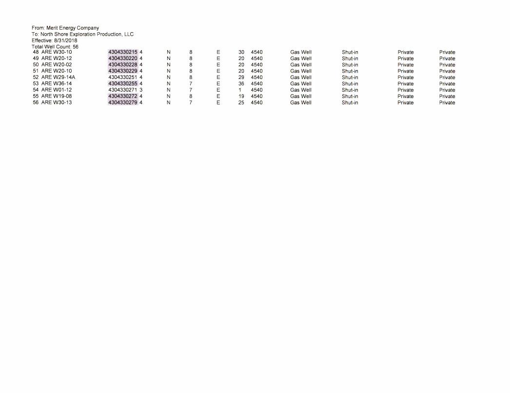
From: Merit Energy Company To: North Shore Exploration Production , LLC Effective: 8/31/2018 Total Well Count: 56 48 ARE W30-1 0 4304330215 4 N 8 E 30 4540 Gas Well Shut-i n Private Private 49 ARE W20-12 4304330220 4 N 8 E 20 4540 Gas Well Shut-in Private Private 50 ARE W20-02 4304330228 4 N 8 E 20 4540 Gas Well Shut-in Private Private 51 AREW20-10 4304330229 4 N 8 E 20 4540 Gas Well Shut-in Private Private 52 ARE W29-14A 4304330251 4 N 8 E 29 4540 Gas Well Shut-in Private Private 53 ARE W36-14 4304330255 4 N 7 E 36 4540 Gas Well Shut-in Private Private 54 ARE W01 -12 4304330271 3 N 7 E 1 4540 Gas Well Shut-i n Private Private 55 ARE W19-08 4304330272 4 N 8 E 19 4540 Gas Well Shut-in Private Private 56 ARE W30-13 4304330279 4 N 7 E 25 4540 Gas Well Shut-in Private Private
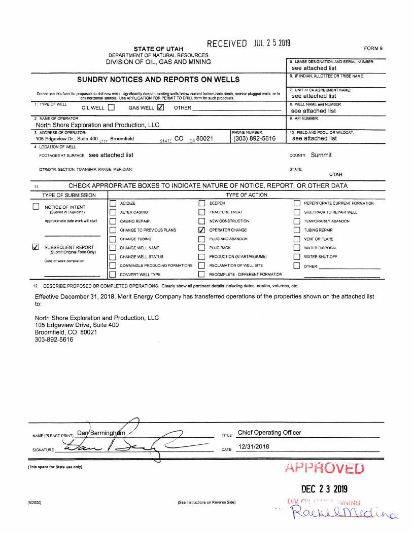
RECEIVED JUL 2 5 2019 STATE OF UTAH
DEPARTMENT O F NAT URAL RESOURCES
DIVISION OF OIL, GAS AND MINI NG
SUNDRY NOTICES AND REPORTS ON WELLS
Do nol usa Ihis form for pfOposals 10 drill new wells, slgnlflcanlly deepen axisling wells below current bottom·hole depth, reanter plugged wells, or 10 drill horizontal laterats, Use APPLICATION FOR PERMIT TO DRILL fo rm for sUCh proposals,
1. TYPE OF WELL OIL WELL 0 GAS WELL [Z] O THER ______________________ __
2, NAME OF OPERATOR:
North Shore Exploration and Production, LLC
ST~r co ~IP 8002 1 I PHONE NUMBER:
(303) 892-5616 3. ADDRESS OF OPERATOR:
105 Edgevlew Dr" Suite 400 ("TV Broomfield
4. LOCATION OF VliELL
FOOTAGES AT SURFACE: see attached list
QTRIOTR. SECTION, TO_SHIP, RANGE, MERIDIAN:
FORM9
5 lEASE DESIGNATION AND SERIAL NUMBER:
see attached list 6. IF INDIAN, AlLOITEE OR TRIBE NAME.
7. UNIT or CA AGREEMENT NAME:
see attached list 8. WELL NAME and NUMBER:
see attached list g, API NUMBER:
10. FIELD AND POOL, OR WILDCAT:
see attached list
COWrY: Summit
STATE: UTAH
t t. CHECK APPROPRIATE BOXES TO INDICATE NATURE OF NOTICE, REPORT, OR OTHER DATA
TYPE OF SUBM ISSIO N TYPE O F ACTION
0 0 ACIDIZE 0 DEEPEN 0 REPERFORATE CURRENT FORMATION NOTICE OF INTENT
(Submit in Duplicate) 0 ALTER CASING 0 FRACTUR E TREAT 0 SIDETRACK TO REPAIR WELL
Approximate date wOO< will stan: 0 CASING REPAIR 0 NEW CONSTRUCTION 0 TEMPORARILY ABANDON
0 CHANGE TO PREVIOUS PLANS [Z] OPERATOR CHANGE 0 TUBING REPAIR
0 CHANGE TUBING 0 PLUG AND ABANDON 0 VENT OR FLARE
Ql SUBSEQUENT REPORT 0 CHANGE VliELL NAME 0 PLUG BACK 0 WATER DISPOSAL (Submit Original Form Or/y)
0 0 0 CHANGE WELL STATUS PRODUCTION (STARTIRESUME) WATER SHUT -OFF Date of work completJon:
0 0 0 COMMINGLE PRODUCING FORMATIONS RECLAMATION OF WELL SITE OTHER:
0 CONVERT WELL TYPE 0 RECOMPLETE · DIFFERENT FORMATION
12 DESCRIBE PROPOSED OR COMPLETED OPERATIONS. Clearly show all pertinent details Including dates, depths, volumes, etc.
Effective December 31, 2018, Merit Energy Company has transferred operations of the properties shown on the attached list to:
North Shore Exploration and Production , LLC 105 Edgeview Drive, Suite 400 Broomfi eld, CO 80021 303-892-5616
TITLE
SIGNATURE -~~~~~=~L~;;;;:;;~::::~=r.~r-:::===---- DATE
(This spoce for Stote UI' only)
(512000) (Se8 Instructions on Reverse Side)
Chief Operating Officer
12/31/2018
DEC 2 3 2019 [JiV. ni l ( • - ' tir~INl:i
R~~
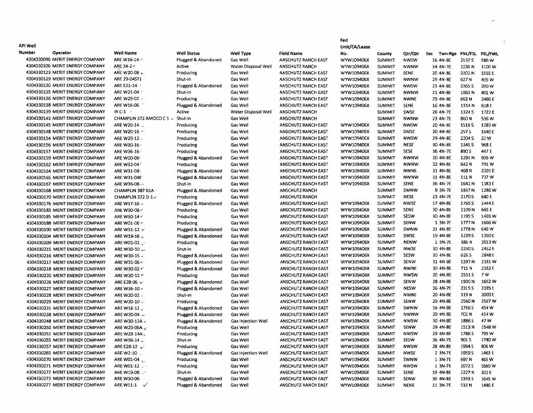
API Well
Number Operiltor
4304330096 MERIT ENERGY COMPANY
4304330106 MERIT ENERGY COMPANY
4304330123 MERIT ENERGY COMPANY
4304330129 MERIT ENERGY COMPANY
4304330130 MERIT ENERGY COMPANY
4304330135 MERIT ENERGY COMPANY
4304330136 MERIT ENERGY COMPANY
4304330138 MERIT ENERGY COMPANY
4304330139 MERIT ENERGY COMPANY
4304330143 MERIT ENERGY COMPANY
4304330145 MERIT ENERGY COMPANY
4304330148 MERIT ENERGY COMPANY
4304330154 MERIT ENERGY COMPANY
4304330156 MERIT ENERGY COMPANY
4304330157 MERIT ENERGY COMPANY
4304330159 MERIT ENERGY COMPANY
4304330162 MERIT ENERGY COMPANY
4304330164 MERIT ENERGY COMPANY
4304330165 MERIT ENERGY COMPANY
4304330167 MERIT ENERGY COMPANY
4304330168 MERIT ENERGY COMPANY
4304330170 MERIT ENERGY COMPANY
4304330176 MERIT ENERGY COMPANY
4304330183 MERIT ENERGY COMPANY
4304330185 MERIT ENERGY COMPANY
4304330188 MERIT ENERGY COMPANY
4304330190 MERIT ENERGY COMPANY
4304330204 MERIT ENERGY COMPANY
4304330209 MERIT ENERGY COMPANY
4304330215 MERIT ENERGY COMPANY
4304330216 MERIT ENERGY COMPANY
4304330217 MERIT ENERGY COMPANY
4304330218 MERIT ENERGY COMPANY
4304330220 MERIT ENERGY COMPANY
4304330226 MERIT ENERGY COMPANY
4304330227 MERIT ENERGY COMPANY
4304330228 MERIT ENERGY COMPANY
4304330229 MERIT ENERGY COMPANY
4304330231 MERIT ENERGY COMPANY
4304330238 MERIT ENERGY COMPANY
4304330248 MERIT ENERGY COMPANY
4304330250 MERIT ENERGY COMPANY
4304330251 MERIT ENERGY COMPANY
4304330255 MERIT ENERGY COMPANY
4304330257 MERIT ENERGY COMPANY
4304330265 MERIT ENERGY COMPANY
4304330270 MERIT ENERGY COMPANY
4304330271 MERIT ENERGY COMPANY
4304330272 MERIT ENERGY COMPANY
4304330273 MERIT ENERGY COMPANY
4304330277 MERIT ENERGY COMPANY
Well Name
AREW16-14 /
ARE 34-2 w '
AREW20-08 __
ARE 29-04ST1 .
ARE E21-14 '
AREW21-04 .
AREW29-02 '
AREW16-06 -
IR C-1 '
Well Status
Plugged & Abandoned
Active
Producing
Shut-In
Plugged & Abandoned
Shut-In
Producing
Plugged & Abandoned
Active
Well Type
Gas Well
Water Disposal Well
Gas Well
Gas Well
Gas Well
Gas Well
Gas Well
Gas Well
CHAMPLIN 372 AMOCO C 1 - Shut-in
Water Disposal Well
Gas Well
ARE W20-14 ~
ARE W2D-16 /
ARE W29-12 ,
ARE W3D-16 -
ARE W36-16 ,
ARE W2D-0G
AREW32-04 '
ARE W31-08 ·
ARE W31-04E
AREW36-08 -
CHAMPLIN 387 BIA -
CHAMPLIN 372 0-1 "
ARE W17-16 -
ARE W3D-08 "
ARE W30-14 "
ARE WOI-D6 v
ARE W31-12 ....
AREWl9-16 ..
ARE WOI-02 .
AREW3D-I0 ~
ARE W3D-15 J
AREW31-06 "
AREW30-02 v ARE W2D-12 . -
ARE E28-06 ,,'
AREW36-10 .
AREW20-02 _
ARE W20-10 .'
ARE W16-12 ,
AREW20-04 _
ARE W3D-12A_'
ARE W29-06A v ARE W29-14A ,_
AREW36-14 y
ARE E28-12 v ' AREW2-10 ,
ARE WOI-D4 ,_-
ARE WOl-12 • -
AREW19-08
AREW3D-06
ARE Wll- l ./
Producing
Producing
Producing
Producing
Producing
Plugged & Abandoned
Producing
Plugged & Abandoned
Plugged & Abandoned
Shut- in
Plugged & Abandoned
ProdUCing
Plugged & Abandoned
Producing
Producing
Producing
Plugged & Abandoned
Plugged & Abandoned
Producing
Shut-in
Plugged & Abandoned
Plugged & Abandoned
Plugged & Abandoned
Producing
Plugged & Abandoned
Plugged & Abandoned
Shut-in
Producing
Plugged & Abandoned
Plugged & Abandoned
Plugged & Abandoned
Producing
Producing
Shut-in
Producing
Plugged & Abandoned
Producing
Producing
Gas Well
Gas Well
Gas Well
Gas Well
Gas Well
Gas Well
Gas Well
Gas Well
Gas Well
Gas Well
Gas Well
Gas Well
Gas Well
Gas Well
Gas Well
Gas Well
Gas Well
Gas Well
Gas Well
Gas Well
Gas Well
Gas Well
Gas Well
Gas Well
Gas Well
Gas Well
Gas Well
Gas Well
Gas Well
Gas Well
Gas Injection Well
Gas Well
Gas Well
Gas Well
Gas Well
Gas Injection Well
Gas Well
Gas Well
Shut-in Gas Well
Plugged & Abandoned Gas Well
Plugged & Abandoned Gas Well
Field Name
ANSCHUTZ RANCH EAST
ANSCHUTZ RANCH
ANSCHUTZ RANCH EAST
ANSCHUTZ RANCH EAST
ANSCHUTZ RANCH EAST
ANSCHUTZ RANCH EAST
ANSCHUTZ RANCH EAST
ANSCHUTZ RANCH EAST
ANSCHUTZ RANCH
ANSCHUTZ RANCH
ANSCHUTZ RANCH EAST
ANSCHUTZ RANCH EAST
ANSCHUTZ RANCH EAST
ANSCHUTZ RANCH EAST
ANSCHUTZ RANCH EAST
ANSCHUTZ RANCH EAST
ANSCHUTZ RANCH EAST
ANSCHUTZ RANCH EAST
ANSCHUTZ RANCH EAST
ANSCHUTZ RANCH EAST
ANSCHUTZ RANCH
ANSCHUTZ RANCH
ANSCHUTZ RANCH EAST
ANSCHUTZ RANCH EAST
ANSCH UTZ RANCH EAST ANSCHUTZ RANCH EAST
ANSCHUTZ RANCH EAST
ANSCHUTZ RANCH EAST
ANSCH UTZ RANCH EAST
ANSCHUTZ RANCH EAST
ANSCHUTZ RANCH EAST
ANSCHUTZ RANCH EAST
ANSCHUTZ RANCH EAST
ANSCH UTZ RANCH EAST
ANSCHUTZ RANCH EAST
ANSCHUTZ RANCH EAST
ANSCHUTZ RANCH EAST
ANSCHUTZ RANCH EAST
ANSCHUTZ RANCH EAST
ANSCHUTZ RANCH EAST
ANSCHUTZ RANCH EAST
ANSCHUTZ RANCH EAST
ANSCHUTZ RANCH EAST
ANSCHUTZ RANCH EAST
ANSCHUTZ RANCH EAST
ANSCHUTZ RANCH EAST
ANSCHUTZ RANCH EAST ANSCHUTZ RANCH EAST
ANSCHUTZ RANCH EAST
ANSCHUTZ RANCH EAST
ANSCHUTZ RANCH EAST
Fed
Unit/CA/Lease
No_
WYWI09406X
WYWI09406X
WYWI09406X
WYW109406X
WYW109406X
WYWI09406X
County
SUMMIT
SUMMIT
SUMMIT
SUMMIT
SUMMIT
SUMMIT
QtTfQtr
NWSW
NWNW
SENE
NWNW
NWSW
NWNW
WYW109406X SUMMIT NWNE
WYW109406X SUMMIT SENE
WYWI09406X
WYWI09406X
WYWI09406X
WYWI09406X
WYW109406X
WYWI09406X
WYWI09406X
WYWI09406X
WYWI09406X
WYW109406X
WYW109406X
WYW109406X
WYW109406X
WYW109406X
WYWI09406X
WYWI09406X
WYWI09406X
WYWI09406X
WYWI09406X
WYWI09406X
WYWI09406X
WYW109406X
WYWI09406X
WYWI09406X
WYWI09406X
WYWI09406X
WYWI09406X
WYWI09406X
WYWI09406X
WYWI09406X
WYW109406X
WYW109406X
WYWI09406X
WYWI09406X
WYWI09406X
WYWI09406X
SUMMIT
SUMMIT
SUMMIT
SUMMIT
SUMMIT
SUMMIT
SUMMIT
SUMMIT
SUMMIT
SUMMIT
SUMMIT
SUMMIT
SUMMIT
SUMMIT
SUMMIT
SUMMIT
SUMMIT
SUMMIT
SUMMIT
SUMMIT
SUMMIT
SUMMIT
SUMMIT
SUMMIT
SUMMIT
SUMMIT
SUMMIT
SUMMIT
SUMMIT
SUMMIT
SUMMIT
SUMMIT
SUMMIT
SUMMIT
SUMMIT
SUMMIT
SUMMIT
SUMMIT
SUMMIT
SUMMIT
SWSE
NWNW
NWSW
SWSE
NWSW
NESE
SESE
NWNW
NWNW
NWNE
NWNW
SENE
SWNW
NESE
NW5E
SENE
SESW
SENW
SWNW
SWSE
NENW
NW5E
SESW
SENW
NWNE
NWSW
SENW
NESW
NWNE
SENW
SWNW
NWNW
NWSW
SENW
NWSW
SESW
NWSW
NWSE
SWNW
NWSW
WYW109406X SUMMIT SENE
WYW109406X SUMMIT 5ENW
WYWI09406X SUMMIT NENE
Sec Twn-Rge FNL/FSL FEL/FWL
16 4N-8E 2137 5 686 W
344N-7E
204N-SE
294N- SE
214N-SE
21 4N-8E
294N-8E
164N-8E
264N-7E
23 4N-7E
204N-8E
204N-8E
294N-SE
304N- SE
364N-7E
204N-8E
324N-SE
314N-8E
314N-8E
364N-7E
93N-7E
23 4N-7E
174N-8E
304N-8E
304N-8E
1 3N-7E
31 4N-8E
194N-8E
1 3N-7E
304N-8E
304N-8E
314N-8E
3D 4N-8E
204N-8E
284N-8E
364N-7E
204N-8E
204N-8E
164N-8E
204N-8E
304N-8E
294N-8E
29 4N-8E
364N-7E
28 4N-8E
2 3N-7E
1 3N-7E
1 3N-7E
19 4N-8E
30 4N-SE
11 3N-7E
1036 N
2202 N
627N
2365 S
1063 N
llOOW
1592 E
435W
2DOW
401W
662 N 2460E
1314 N 618 E
1324 S
860N
15185
257 S
22045
1345 S
8905
1291 N
642 N
468N
111 N
1641N
1837N
21705
1765S
2109N
1195S
1777N
1778N
1229S
386 N
2230S
6265
1397N
715 N
2531S
1900N
2315S
319 N
2560N
27565
702 N
18865
1513 N
1786S
901 S
19945 19595
697 N 20725
1722 E
536W
1283W
1640E
22W
968 E 447 E
936W
791 W
2201 E
737W
1183 E
1286W
680 E
1444£
665 E 1405W
1666W
640W
1350E
2013W
2432E
2848E
21S1W
21S2 E
7W
1652W
3185E
2000E
2567W
454W
414W
47W
1548W
795W
1780W
806W
1463 E
465W
1569W
2227 N 301 E 2393 S 1645 W
533 N 1486 E
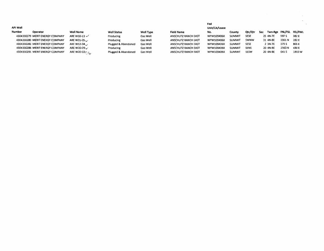
Fed
API Well Unit/CA/lease
Number Operator Well Name Well Status Well Type Field Name No. County Qtr/Qtr Sec Twn-Rge FNl/FSl FEl/FWl
4304330279 MERIT ENERGY COMPANY ARE W30-13 ./ Producing Gas Well ANSCHUTZ RANCH EAST WYW109406X SUMMIT SESE 25 4N-7E 597 S 382E
4304330280 MERITENERGY COMPANY ARE W31-OS v' Producing Gas Well ANSCHUTZ RANCH EAST WYW109406X SUMMIT SWNW 31 4N-8E 2361 N 282E
4304330283 MERIT ENERGY COMPANY ARE W12-04 ", Plugged & Abandoned Gas Well ANSCHUTZ RANCH EAST WYW109406X SUMMIT SESE 2 3N-7E 373 S 865 E
4304330286 MERIT ENERGY COMPANY ARE W20·09 ,,' Producing Gas Well ANSCHUTZ RANCH EAST WYW109406X SUMMIT SENE 20 4N-8E 2360N 430E
4304330291 MERIT ENERGY COMPANY ARE W20-03c:;. \o Plugged & Abandoned Gas Well ANSCHUTZ RANCH EAST WYW109406X SUMMIT SESW 20 4N-8E 641 S 1810W


