Embed Size (px)
Citation preview
THE
Oil and Gas Resources of
CASS AND JACKSON COUNTIES MISSOURI
by
JOSEPH R. CLAIR
Vol. XXVII, Second Series
1943
MISSOURI
GEOLOGICAL SuRVEY AND vVATER RESOURCES
H. A. BUEHLER DIRECTOR AND STATE GEOLOGIST
ROLLA, MISSOURI
MJO .. STATE PRINTING CO., JEff'BRSON CITY, MO.
X35146
TABLE OF CONTENTS
TABLE OF CONTENTS . ... .. . .. . ............ . ... . . . ...... . . ... . .. .. ..... .. . LIST 01<' ILLUSTRATIONS . . . .. . .. .. ..•. .... •.. . ... . .... .. . .... . . . .... LETTER OF TRANSMl'l'TAL . . . .... ... ... .... .. .. ..... . . . . . . . . . .. . . l:s!TRODUCTION .. ..... . . .. .. . .. . . ........... . . .....•. ACKNO'\'fLEDCMi;;N'TS . . . .. . . ... . .. . ... ..... .. .... . . . . . ..... .. ... . ......... . LOCA'rION. . . . . . . . . . . . . . . . . . . . . . . . ... . . ... .. . PIIYSIOGHAPHY . . . .. . ..... .... .. .... ... ..... .. . •. . . . ... .
Special Features. . . .....•........ . . . . . ...... .. .............. STRATIGRAPHY.. ..... . . ... . .. .. .. .... . . . .. . . .. .. .. .. . . . ... .. ...... .
General Statement... . .. . ...... . .. ... .. .... .• .. .. .. Surface Formations . . . . .... . . . .... .... .. .. .. . ....... . ... . .
Des Moines Series. . . . . . . . . . . . . . .. .. . ... . . .. .. . . Cherokee Group. . . . . . . .. .. . .. . .... •... ... . •. .... •. .. Henrietta Group... . . . . .. . .... . .. . ... .
:Missouri Series . . . . . . . . . . . . . . . . . . . . .. . ...... ... ... ..... ... . Pleasanton FormaUon ... .. . .. . . .... . .... .. . . .. ............ . . . . .
Kansas City Group. . . . . . . . . . . . . . . ... . . ... . The Belton Sand . . .. . . . .. .. . ..... . •. ... . . . . . ... .
Lansing Group . . .. . .. .....•. . . . . . .. . .. . . . .. .. . Pre-Pennsylvanian Formations ......... .
Mississippian System . . . .. . ...... .. ... .•. .... . . :vreramec Group . . . . .... . . . .... .. . .. . .
St. Louis . . . . . . . . . . . . . . . . . . . . . .. . . .. ... .. .. . .. . . . Spergen-Warsaw.. . . . . . . . . . . . . . . .... •... . .. .. . . ... LO\\'er Warsa,v. . . . . . . . . . . . . . . . . . . . . . . ... . ... .
Osage Group. . . . . . . . . . . . . . . . . . . . . . . .... . . .. .. .... .. . . Keokuk-Burlington . . . . . . . . . . . . . . . . . . . . . . . . . . . . . ... . . Sedalia . . . . . .. . . .•. .. . . . . . . . .. .. . . .. .
Kinderhook Group.. . . .. .... .. ... . .. .. . • ..... Chouteau .... . .. . .. .. . .. . .. . ..... . • .. . . . . . ................. Kinderhook shale.
.Devonian System.... . .. . .. . ...... . . .. .. . .. . . ... .. ... . .. . . . . . . Callaway . .... ....... .. .... .... . .. .. . . . ... . .. . ... .
Ordovician System . . . . . . . . . . . . . . . . . . . . .. . . .. . .. . Kimmswick . . . . . . . . . . . . . . . . . .. .. . .. .. . .. .. .. . . .... . . . . .. . .. . Decorah ....... . ... . . .. .. . .. . . . .... . . . ... .... .. .. . .. . .. . .. . St. Peter. . .. ... .. . . . . . . . . . . . . . . .. .... .. . .. . .. .
Canadian System (E. O. '(Tlrich) . . . . .. . .. .. .. . . .. . .. . ...... . .. ... . .. . .. .. . Jefferson City. . . . . . . . . .. . . ... ...... . .. . ... . . Roubidoux... . . .. . .. . ..... . . . .. . .. . ........ . .... . .
Ozarkian System (E. 0. U lrich}.. . . . . . . . . . . . . . . . .... . ..... .. .. . . . . Gasconade. . . . . ... . . .. .. . .. . Van Buren .... . . ... . Eminence ........ ..... . ..•....... . .. . . ....... . .. .. . .. Potosi. . .... . .... .. . .. . .. .. .
Cambrian System. . ..... . ..... . . ... . ..... . .. . . .... .. . . . . .. .. . Bonneterr c ..... . ... .... .. .•.. ....... LaMotte.. . .. . . .. . ... . . .. .. . .
Pre-Cam brla11 System. . .......... . . Granite and associated igneous and m etamorphic rocks.
ST ll.UCTURAL GEOLOGY. . . . . . . . . . . . . . ... . ....... . .... . Rev iew of Earlier ,Vork . . . . . . . . . . . . . . . . . . . . . . . . .... . .. .. . . Structural Detail. . . . . . . . . . . . . . . . . . .. .. . . .. . . .. .. .. . .. .
G<>neral Statement. . . ..... .. . . .. .. .. . .. . . . . Cass County . . . . . . . . . . . . . . . . . . .. . .. . . .
Bclton- Droxcl Dist rict . . . . ... .. .. ..... .. . . . . . .. . Archle-Pleasant Hill-St,rasburg D istrict . . . .. .. . . .. . . Gunn City-Creighton-D ayt,on District. . . . . . . .. .. .. .... .. .
Jackson County . . . ..... . . .. .. .. . ... .. . . .... . . . Origin of Structure. . . . . . . . . . . . . . . . . ... . . .. .
( 3 )
Page
3 5 6 7 8 ()
()
10 11 11 14 14 15 17 18 l8 20 20 25 25 27 28 28 28 30 30 30 30 30 30 31 3 1 31 32 32 32 32 33 33 33 33 33 33 34 34 34 :l4 34 35 35 35 35 37 37 37 3() 4()
.51 52 GI
4 Table of Contents
ECONO.:IIIC GEOLOGY ... . ..... . . Cass County .... .
Summary or ~:arly Oil and Gas Devt>lopnwnts .. . .. . ... . Dclt,on-Drexel District... . . . . . . . . . .. . ..... . .
Knoche Gas Pool ... . ... . . .. .. . . ... . .. .. ..... . ... . . ....... . .. . . Clarke-Miller Oil Pool.. . . . . . .... . . . North Freeman Gas Pool .. Freeman-West Linc Gas Pool . . . . . . . . . . . . . . . . . . . . . .... . ... . . . Jaudon Channel Sand Pool.. . . ... . .. . . . . . . Endicott-Shaler Oil and Gas Pool. . ..... . ... . .
Archie-Pleasant IIill-Strasburg District .. .. ......... . .. . ......... . .. .. . Jackson County. . . . . . . . . . . . . . . . . . . . . . . . . . . . . . . . . . . . . . . . . . . ... . ..... .
Summary of Ea.rly Oil and Gas Developments. . . . . ..... . .. . Township 47 North, Range 32 and 33 West ... . ..... . . .. . .. .
East Grandview Gas field .. . West Grandview Gas field .. .. . .. . . Carlson, Wells and Duck Oil Pools . .... .. . . Klapmeyer Oil Pool .. . Lester Oil Pool ............. .. .. ..... . .. .
Township 47 North. Range 31 West.... . . . . . .. . . . . Loos Summit t-0wnsile pool..
Special Features ....... . Township 47 North, Range 29 and 30 West . . .. ........ . ... . .. ... . Township 48 North, Ranges 31 and 32 West .. . Township 49 Nort,h. Range 32 West... . . .. . .. . .. .. .. . . .. . . .
Centropolis pool .. Kline pool . . .. .. .. . .. . . Blue Ridge Gas field . .. . . .. .. . .. ... . ... .
The Shoe-string Sand of the Blue IUdge Gas field . Bradford and .l<'rancis pool .....
Township 50 North, Range 32 ,vest . . . ... ..... . Township 49 North, Range 33 West . Township 48 ~ort11. Range 33 ,vPst . . .... ... . .. . .. .
Recommendations .. .... .. .................. .. .. ... . . ....... . Areas fo1· further Shallow Development. .. .
Cass County . . . . . . . . . . . . . . . . . . . . . . . . .... . .... .. .. .. .. . Belton- Drexel District ...... . Archie-Pleasant Hill-Stra.5hurg District. .. .. . .. .. .. .. . Gunn City-Crcighton-Dayt,on District ... . .
Ja.ckson County .... ............ . .. . Possible Areas for deeper prospecting . .. ... . ... .. ... ... .. . ....... . ... .. .
Cass County. . . . . . . . . . . . . . . . . . . . . . . . . . . . . . . . . ..... . ..... . . Jackson County ...... . ... .
CONCLUSION. . . ... . . . . .. . .. . . BfDLIOGRAPHY ... ... .. . . . APPENDIX I. .. . . .. .. .. . .
,veil ,vater Aoalysos Cass and Jackson Couflt.ies. . . . ... .. . APPENDIX II .................................................... . .
Data Sheet of Deep Wells in Cass and .Jackson Counties ......... . . . .. ... . •. .. Data Sheet of Cherokee Wells in Cass and Jackson Counties .............. .. .. .
APPENDIX UT. ........................ .. .. .. , . . ,, .. ,, .. . · · · 'I'ypical Well LO!!S Cass and J:tckson Counties . . . ... . . ... . .. . .. . . ... . .. . . . .
l'ai;c
62 62 62 63 63 6(i 67 69 71 72 74 75 75 76 77 77 78 78 79 80 so 83 84 88 92 ~)2
93 94 96
102 103 105 105 106 106 106 106 107 10\J 109 111 112 113 114 115 117 117 123 123 128 189 189
!'late I
II
lH
IV
\'
VI VII
Figure
LIST OF ILLUSTRATIONS
Page
Columnar section of Pennsylvanian Rocks in Cass and Jackson Coun ties .. .... ... .......................... In pocket
Structure contour nrnp of Cass County, :.\lissouri, da tum, hase of Myrick Station limestone ............... ... .. In pocket
Structure contour map of Jackson County, Missouri, clalum, base :Myrick Station lin1estone ..... .......... In pocket Structure contour map of Bellon area, Cass County, Missouri, large scale, datum, Lop of Bethany Falls limestone ..... . .. .. ........ .... .... . ... . ........... In pocket Structure contour map of the Blue Ridge shoe-string sand, la rge scale, datum, top of Burbank sand ....... . In pocket Isopach map of Belton sand . . . . . . . . . . . . . . . . . . . . . . . . 20
Cross-sections of Belton sand . . . . . . . . . . . . . . . . . . . . . . . 22
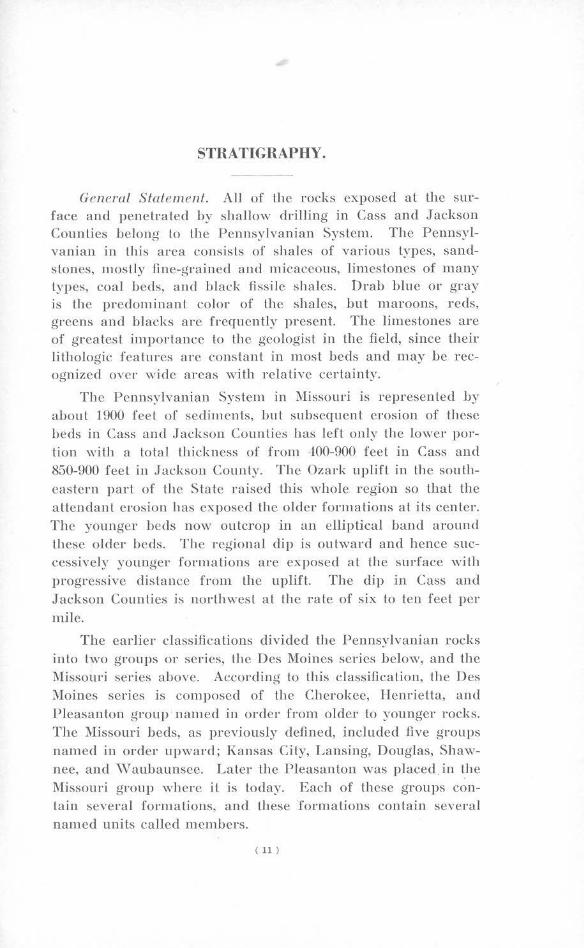
1 Map showing location of area . . . . . . . . . . . . . . . . . . . . . . . 9 2 Areal geologic map of Cass and .Jackson Counties...... 12
3 Map showing thickness of Kinderhook, shale-St. Peter sandstone interval- . . . . . . . . . . . . . . . . . . . . . . . . . . . . . . . . . 2G
4 :\fap showing thickness of Mississippian limestone. . . . . 29 5 l\fap showing location of wells in sections 4, 5, (i, 7, 8,
9, 16, and 21, T. 47 N., R. 33 W . ...... .......... .. .. In pocket 6 Map showing location of wells in sec tion 5 and 6, T.
47 N., R. 31 W. . . . . . . . . . . . . . . . . . . . . . . . . . . . . . . . . . . . . 82
7 .Map showing location of wells in sections 19 and 24, T. 47 N., R. 29 ancl 30 \V. . . . . . . . . . . . . . . . . . . . . . . . . . . . 85
8 Map showing location of wells in sections 32 and 33, T. 47N.,H.30W . . ... ..... . . .. . . .......... ... ...... 87
9 Map showing location of wells in sections 21, 22, 27, and 28, T. 48 N., R. 32 W. . . . . . . . . . . . . . . . . . . . . . . . . . . 90
10 :\lap showing wells completed in the Mississippian or deeper formations .. ........... .... ... ........ . .. ... In pocket
11 Map showing analyses of waters from the Galesburg an cl Ladore sha Jes . . . . . . . . . . . . . . . . . . . . . . . . . . . . . . . . . . 118
12 Map showing analyses of waters from lhe Lexington coal horizon . . . . . . . . . . . . . . . . . . . . . . . . . . . . . . . . . . . . . . . 119
13 Map show ing analyses of ·waters from the Squirrel sand 120 14 Map showing analyses of waters from the lower Ch ero-
kee horizons . . . . . . . . . . . . . . . . . . . . . . . . . . . . . . . . . . . . . . . 121
Table
I Chemical analyses of deep well waters . . . . . . . . . . . . . . . 122
( 5 )
LETTER OF TRANSMITf AL.
Honorable Forrest C. nonne/1, Govemor of Nli.~.rnuri, Jefferson
City, Missouri.
Dear Governor Donnell:
It is my pleasure lo lransmit herewith a report covering
lhe Oil and Gas Resources of Cass and Jackson Counties:
\Vhile Lhe present production of oil and gas in Missouri
is of minor commercial importance, il is true that these
counties have produ<.:ed more of either fuel than any of the other counties in the state. The repo rts by special employees
on structural features, with additional prospecting may prove
production. The geologic records of some two thousand drill
holes are included. Respectfully submitted,
II. A. BUEHLER, Stale Geologist.
( 6)
INTRODUCTION*.
The oil and gas production in Cass and Jackson Counties,
though rather small, is nevertheless of considerable economic importance. Although portions of these counties have been
thornughly developed, there remain large areas in which but
little prospecting has been carried on. In order to aid further development in the region the Missomi Geological Survey has
mapped all the known wells in the counties as a basis for preparing the structure contour maps of this report. These maps
are prepared to show the structure of the area in as much de
tail as is possible ,:vith available information as a guide for
future development. In addition, a member of the Survey staff is stationed in Kansas City to give assistance lo the opera
tors in the region and to collect Jogs and sam ples from all the wells drilled.
The location of these counties with regard to both the For
est City Basin and the producing fields of eastern I{ansas makes them extremely important for they are in a transition area in
which detailed stratigraphic and structural information has heretofore been lacking. It is thought that the structure de
picted in these counties may well serve as type structures for
shallow production throughout west cen tral Missouri. Also they may likewise serve as a guide to occurrence in the ad
jacent areas of Kansas and possibly Nebraska and Iowa.
The fo1Io-wing report is therefore submitted as a means of placing before the operators in the region all of the informa
tion available in these counties and lo indicate possibilities for further development.
• A portion or the matel'ial in this report wns submitted by the writer as pal'tial fulfillment of the requirements for llfaster of Science and Doctor's degrees, n L the Missouri School of Mines and Metallurgy and the Uninrsity of ~Orth Carol ina l'espectively.
( 7)
ACKNOWLEDGEMENTS.
The writer wishes to express his indebtedness to Dr. H. A.
Buehler, ·who made this investigation possible; to Mr. H. S. McQueen and Mr. F. C. Green, who have given many valuable
suggestions and under whose direction the field work for this
report was successfully completed. Logs, samples, and other
information were supplied by many drillers and operators in the two counties and to each one of these the writer acknowl
edges his whole-hearted appreciation.
The ·writer wishes to acknowledge his great indebtedness
to Mr. Louis H. Knoche, who contributed time and valuable in
formation in the form of logs, statistics and able field examination, without which the investigations fo Cass County could
not have been completed.
The following individuals contributed much valuable time and supplied necessary statistics: Mr. Mort W'hite, Lee's Sum
mit Gas Company; Mr. Rufus F. Smith, Panhandle Eastern
Pipe Line Co.; Messrs. Dave and Nestor Judd, J. D. Judd &
Son, Martin City, Missouri; Mr. George V. Hassinger, Mr. E. M. Lause and Mr. Robert French, Interstate Gas Company, Har
risonville, Missouri; Mr. F. E. Davis, Missouri Valley Gas and
Oil Company; Mr. R. A. Foster, Harrisonville, Missouri; Mr. Ben Endicott, Paola, Kansas; and Dr. Glenn G. Bartle, Dean,
University of Kansas City, Kansas City, Missouri.
The writer wishes to thank Mrs. Mary Hundhausen McCracken and Mr. C. E. Prouty for aid in identification of heavy
minerals . in residues; Mr. Earl McCracken and Mr. John
Grohskopf for carefulJy checking lhe several deep wells used
in this report and all other members of the Survey staff who
have helped in various ways. The writer was assisted in the field by Mr. K. D. Cox, Mr. Jay Phipps, and Mr. ·wmard De
Laney. Mr. Clyde Boulson served as draftsman.
( 8)
LOCATION.
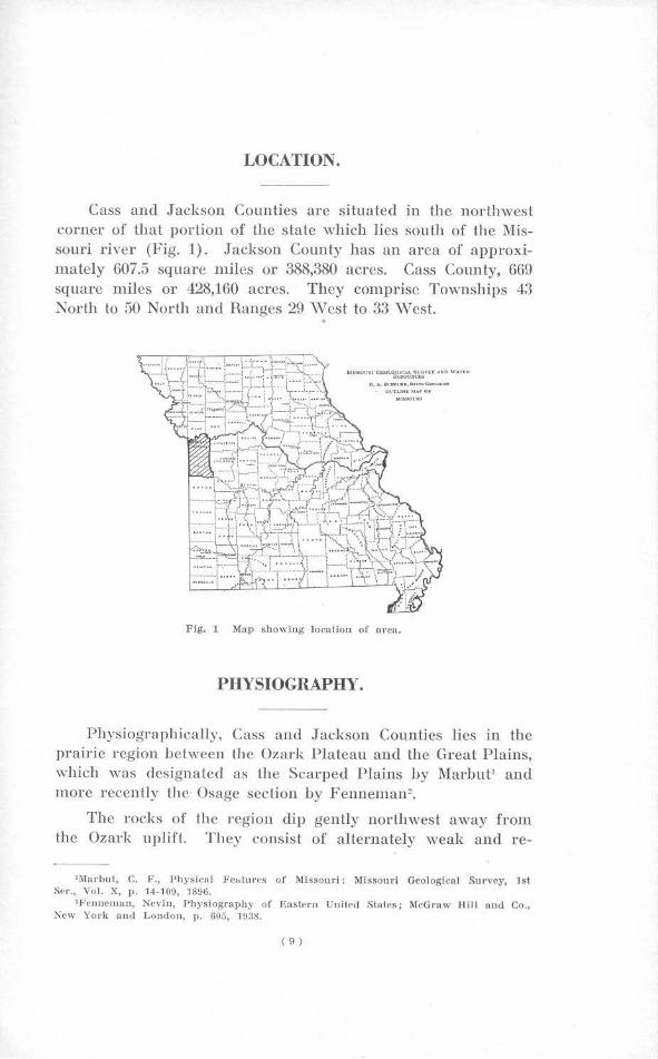
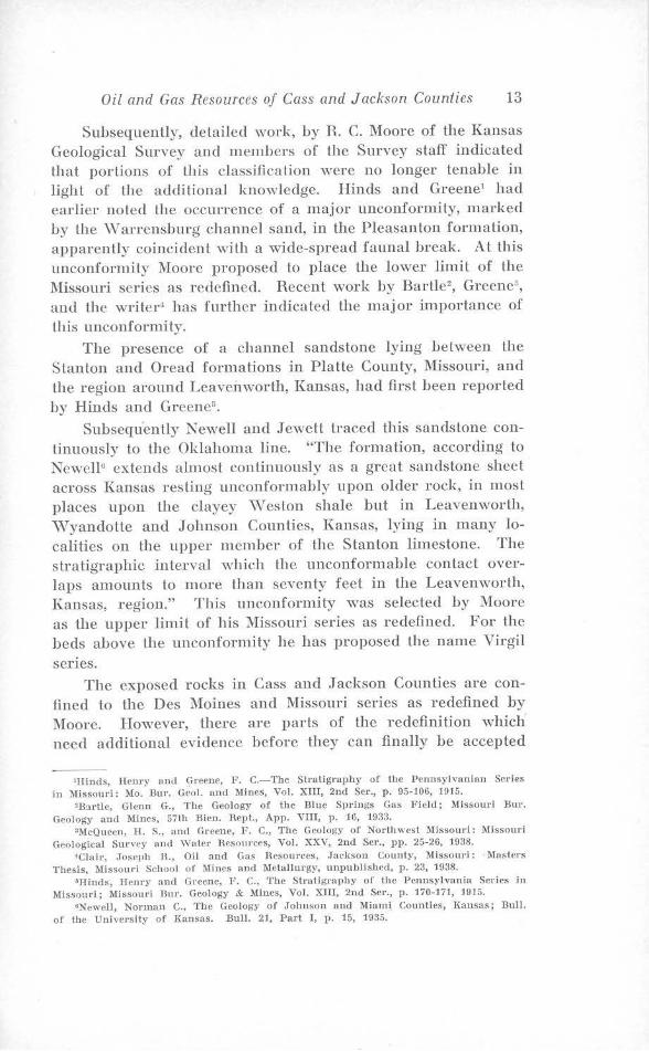
Cass and Jackson Counties arc situated in the northwest corner of that portion of the state which lies south of the :Missouri river (Fig. 1). Jackson County has an area of approximately 607.5 square miles or 388,380 acres. Cass County, 669 square miles or 428,160 acres. T hey comprise Townships 43 North to 50 North and Ranges 29 vVcst to 33 '\Vest. .
U. l,.. $tl1PU<11•,ll!l,n1C(I_....,...., <Kl'.i'UNlll-1,r.POI'
Fig. 1 Map showing location of area.
PHYSIOGRAPHY.
Physiographically, Cass and Jackson Counties lies in the prairie region between the Ozark Plateau and the Great Plains, which was designated as the Scarped Plains by Marbut1 and more recently the Osage section by Fenneman2 •
The rocks of the region dip gently northwest away from the Ozark uplift. They consist of alternately weak and re-
' Marbut, C. F., Physical Fe .. tmes of Missouri: Missouri Geological Survey, 1st Ser., Vol. X, p. 14 -109, 1896.
'Fenncman, Nevin, Physiogrnphy of Eastern linit~d States; McGraw Hill and Co., New \' ork and London, p. 605, rn:1s.
( 9)
10 Missouri Geological Survey and Water Resources
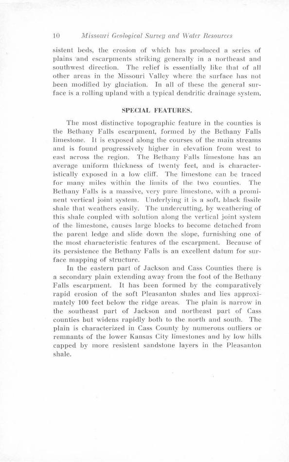
sislenl beds, the erosion of which has produced a series ol' plains and escarpments striking generally in a northeast and southwest diredion. The relief is essentially like that of all other areas in the Missouri \' alley where lhe surface has not been modified by glaciation. In all of these the general surface is a rolling upland with a typical dendritic drainage system.
SPECIAL FEATURES.
The mosl distinctive topographic feature in the counties is the Bethany Falls escarpment, formed by the Bethany Falls limestone. IL is exposed along the courses of the main streams and is found progressively higher in elevation from west to east across the region. The Bethany Falls limestone has an average uniform thickness of twenty feet, and is characteristically exposed in a low cliff. The limestone can be traced for many miles ,vithin the limits of the two counties. The Bethany Falls is a massive, very pure limestone, with a prominent vertical joint system. Underlying it is a soft, black fissile shale that weathers easily. The undercutting, by weathering of this shale coupled with solution along the vertical joint system of the limestone, causes large blocks to become detached from the parent ledge and slide down the slope, furnishing one of the most characteristic features of the escarpment. Because of ils persistence lhe Bethany Falls is an excellent datum for surface mapping of structure.
In lhe eastern part of Jackson and Cass Counties there is a secondary plain extending away from the fool of the Bethany Falls escarpment. It has been formed by the comparatively rapid erosion of the soft Pleasanton shales and lies approximately 100 feet below the ridge areas. The plain is narrow jn
the southeast part of .Jackson and northeast part of Cass counties hut widens rapidly both to the north and south. The plain is characterized in Cass County by numerous outliers or remnants of the lower l{ansas City limestones and by low hills capped by more resistent sandstone layers in the Pleasanton shale.
STRATIGRAPHY.
G<>neral Statement. All of the rocks exposed at the surface and penetrated by shallow drilling in Cass and Jackson Counties belong to the Pennsylvanian System. The Pennsylvanian in this area consisls of shales of various lypes, sandstones, mostly fine-graine<l and rn icaceous, limestones of many types, coal beds, and black fissile shales. Drab blue or gray is the predominant color of the shales, but maroons, reds, greens and blacks are frequently present. The limestones are of greatest importance to the geologist in lhe field, since their lithologic features are conslanl in most beds and may be recognized over wide areas with relative certainty.
The Pennsylvanian System in Misisouri is represented by about 1900 feet of sedimentis, but subsequent erosion of these beds in Cass and Jackson Counties has left only the lower portion with a total thickness of from -100-900 feel in Cass and 850-900 feet in Jackson County. The Ozark uplift in the southeastern part of the State raised lhb whole region so that the attendant eroision has expose<l the older formations at its center. The younger beds now outcrop in an elliptical band around these older beds. The regional dip is outward and hence successively younger formalions are exposed at the surface with progresisive dislance from lhe uplift. The dip in Cass and Jackson Counties is norlhwesl at the rate of six to ten feet per mHe.
The earlier classifications divided the Pennsylvanian rocks into two groups or series, the Des Moines series below, and the 1V1issouri series above. According lo this classification, the Des Moines series is compose<l of the Cherokee, Henrietta, and Pleasanton group · named in order from older to younger rocks. The Missouri beds, as previously defined, included five groups named in order upward; Kansas City, Lansing, Douglas, Shawnee, and vVaubaunsee. Later the Pleasanton was placed. in t_he Missouri group where it is today. Each of these groups contain several formations, and these formations contain several named units called members.
( 11)
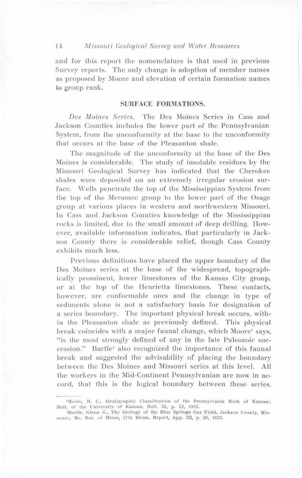
111,ssouru GEOLOGICAL SURVEY.
A REAL GEOLOGY OF
JACKSON AND CASS COUNTIES BY .JOSEPH R. CLAIR
SCAl.EO I l ~ 4 $ 6Mll.f$
-LH,EHO-~ L ANSING GFIOUP
c::) KANSAS CITY C ROUP
~ PLEASANTON FORMAT ION
~ e:z::a
L-.4---1
I 6 ~tTON
0
I
l~A.t".t'.EL
r··--··--· - ----... 33W R 3ZW
VOL. XXVII, SECOND s,nuus, F1G. 2.
R30W
T 51 N
T 50 N
T 49 N
T 48 N
T 47 N
T 46 N
T 45 N
R 29W
• T 43 N
Oil and Gas Resources of Cass and Jackson Counties 13
Subsequently, detailed work, by R. C. Moore of the Kansas Geological Survey and members of Lhe Survey staff indicated that porlions of this classification were no longer tenable in light of the addilional knowledge. Hinds and Greene1 had earlier noted the occurrence of a major unconformity, marked by the \Varrensburg channel sand, in the Pleasanton formation, apparently coincident wilh a wide-spread faunal break. At this unconformity Moore proposed to place the lower limi L of the Missouri series as redefined. Recent work by Bartle2, Greene3, and Lhe writer4 has further indicated the major importance of this unconformity.
The presence of a channel sandstone lying between the Stanton and Oread formations in Platte County, Missouri, and the region around Leavenworth, Kansas, had first been reported by Hinds and Greene5
•
Subsequently Newell and Jewett traced this sandstone continuously to the Oklahoma line. "The formation, according to Newell6 extends almost continuously as a great sandstone sheet across Kansas resting unconformably upon older rock, in most places upon the clayey \\Teston shale but in Leavenworth, ·wyandotte and Johnson Counties, Kansas, lying in many localities on the upper member of the Stanton limestone. The stratigraphic interval which the unconformable contact overlaps amounts lo more than seventy feet in the Leavenworth, Kansas, region." This unconformity was selected by Moore as the upper limit of his Missouri series as redefined. For the beds above the unconformity l1e has proposed the name Virgil series.
The exposed rocks in Cass and Jackson Counties are confined to the Des :Moines and Missouri series as redefined by Moore. However, there are parts of the redefinition which need additional evidence before they can finally he accepted
'Hinds, Henry and GJ·eene, F. C.-The Sll'atigrnphy of the Pennsylvanian Serles in Missouri: :Mo. Bur. Geo!. and Mines, Vol. XIII, 2nd Ser., p. 95-106, 1915.
'B:irtlc, Glenn G., The Geology of the Blue Springs Gas Field; Missouri Bur. Geology and Mines, 57th Bien. Rept., App. VIII, p. 16, 1933.
•111cQuecn, H. S., and GreenP, F. C., The Geology of Northwest Missouri: Missouri Geological Sur"ey and \Valer Resources, Vol. XXV, 2nd Ser., pp. 25-26, 1938.
•Clalt-, .Toseph R., OH mid Gas R,·sourcPs, .Jackson County, ll!issoul'i: · Masters Thesis, Missouri School of Mines and Metallurgy, unpublished, p. 23, 1938.
GHinds, Henry and Greene, F. C., The Strntigraphy of the Pennsylvania Series in Missouri; Missouri llnr. Geology & Mines, Vol. XIII, 2nd Ser., p. 170-171, 1915.
•Newell, Norman C., 'l'be Geology of Johnson and !lliami Counties, I,ansas; Bull. of the University of l{ansas. Bull. 21, Part I, p. 15, 1935.
14 Jl1issouri Geological Survey and Waler Resources
and for this report the nomenclature is that used in previous Survey reports. The only change is adoption of member names as proposed by Moore and elevation of certain formation names to group rank.
SURFACE FORMATIONS.
Des Moin<'S Series. The Des l\Ioines Series in Cass and Jackson Counties includes the lower part of the Pennsylvanian System, from the unconformi Ly at the base lo the unconformity that occurs at the base of the Pleasanton shale.
The magnitude of the unconformity at the base of the Des Moines is considerable. The study of insoluble residues by the Missouri Geological Survey has indica led lhal the Cherokee shales were deposited on an extremely irregular erosion surface. ,vells penetrate the top of the Mississippian System from the lop of the Meramec group to the lower part of the Osage group at various plac:es in western and northwestern Missouri. In Cass and Jackson Counties knowledge of the .Mississippian rocks is limited, due lo the small amount of deep drilling. However, available information indicates, that particularly in Jackson County there is considerable relief, though Cass County exhibits much less.
Previous definitions have placed the upper boundary of the Des l\Ioines series al the base of the widespread, topographically prominent, lower limestones of the Kansas City group, or al the top of the Henrietta limestones. These contacts, however, are conformable ones and the change in type of sediments alone is not a satisfactory basis for designation of a series boundary. The important physical break occurs, within the Pleasanton shale as previously defined. This physical break coincides with a major faunal change, which Moore1 says, "is the most strongly defined of any in the late Paleozoic succession." Bartle2 also recognized the importance of this fauna! break and suggested the advisability of placing the boundary between the Des l\Ioines and Missouri series at this level. All the workers in the Mid-Continent Pennsylvanian are now in accor<l, that this is the logical boundary between these series.
1 :\loore, n. C., Stratigraphic Classification of the PennsylYania Rock of T(ansas; Bull. of the University of J{ansas, Dull. 22, p. 52, 1935.
'Bartle, Gle11n G., The Geology of the Blue Springs Gas Field, Jackson County, :Missouri; Mo. Dur. of llincs, 57th Bicnn. Report, App. III, p. 26, 1933.
Oil and Gas Resources of Cass and Jackson Counties 15
There arc many places, however, ,vhere the exact location of the break cannot be ascertained. This is due to the lack of good exposures, to lithologic similarity of beds occurring above and below the unconformily, and lo lack of abundant well logs. Particularly, is the exact break difficult to delermine in well logs, where the channel sandstones of this unconformity are absent. Hence, it is still more praclicable lo include in the Missouri series lhose upper Des Moines shales occurring above the uppermost limestones of the Henrietta group.
The Des Moines series is subdivided into the Cherokee group below and the Henrietta group above, with the contact placed at lhc base of the Blackjack Creek limestone member of the Fort Scott formation. There is much information available now to juslify a revision of the Cherokee; and while the Missouri Geological Survey has taken no official action, F. C. Greene of the Survey slaff1 suggests, "that the upper part from a plane a short distance below the Ardmore limestone, be included with the overlying Henrietta group and the group be given a new name. It is believed that this line of demarcation will approximale lhal separating the Pottsville and Allegheny groups of the Pennsylvanian section."
CHEROKEE GROUP.
The Cherokee group as defined for this report includes the strata from the base of the Pennsylvanian upward to the lowest limestone of the Henrietta group. The pre-Ardmore porlion of the Cherokee is characterized by the scarcity of marine invertebrates and great irregularity of stratification. There arc many sandstones in this lower Cherokee section in Cass and Jackson Counties, among them the Burgess or Bartlesville, the so-called Bartlesville of drillers, and the Burbank (in Jackson County); but there is no evidence that any are continuous over the entire area. The Burgess sand of drillers in Cass and .Jackson Counties is probably the equivalent of the Clear Creek sand (Bluejacket of l{ansas) of Vemon County and hence more nearly the true correlative of the Bartlesvi11e. It lies at or near the base of the Cherokee. The so-called Bartlesvi11e is a sand lying stratigraphically higher than the Bartlesville and appears to bear the same relationship to it as the Redfork sand in Okla-
')lcQuecn, JI. S., and Greene, F. C., The Geology of Northwest Missouri; :\lissouri Geological SnrYey and \Yater Hesources; Vol. XX\", 2nd Ser., p. 2-!, 1938.
16 Missouri Geological Survey and Water Resources
homa. In Townships 48 and 49 North, Range 31 and 32 West, J ackson Counly, there has recently been discovered a Ycry produclivc sand body, which, due to its long narrow oullinc, is called a shoestring sand. This sand is correlated with the Burbank sand of Oklahoma and Kansas.
These sands are of ten reservoirs for gas and oil and the upper two have produced gas in Cass and .Jackson Counties but lo date only water has been found in the Burgess. In places these sands are thick and massive, at others thin and plaly changing laterally rapidly to sandy shale or shale. Crossbedding is common, and all U1e sands arc quartzose and contain an abundance of mica. In Cass County Lhc sands are much more poorly developed Lhan in Jackson County and particularly is this true of the basal sand. The remaining portion of the lower Cherokee is made of sandy shales, gray to black argillaceous shales with occasional coal streaks and thin limestone lenses. A fairly persistent "red bed" (red shale) just below the Ardmore limestone is a useful key bed when recorded. It is well to note here that none of this lower Cherokee section actually ou !crops in Cass or .T ackson Counties.
The Upper Cherokee beds, beginning with the Ardmore limestone arc not typically developed on the outcrop in Cass County and do not outcrop in Jackson County. The Ardmore limestone is a thin, dense, rather dark blue limestone but its liU10logy is quite variable. It may occur as one bed three Lo ten feet thick or in three beds each three feet or more in thickness. Because of this variation it is an insecure datum plane for structural contouring. The Lagonda sands and shales make up the bulk of the interval between the Ardmore and the top of the Cherokee. The Bevier coal horizon lies near or at the base of this member and is marked in Cass and Jackson Counties by black fissile shale. The Lagonda contains the "Squirrel Sand Zone" of drillers which is lhc most irnporlant gas producing horizon in the two counlics. At times the entire interval is occupied by mass ive sandstone as is the case in T . 45 and 46 N., R. 33 \V., in Cass County and in T. ,19 N., R. 82 \V., in Jackson County. Outside of the pool areas in both Cass and Jackson counties, the sand development is sporadic, and gray sandy shales make up the hulk of the section. The sandstones, as ·with those in the lower Cherokee, are quartzose, highly micaceous with fairly high porosity. The Mulky Coal
Oil and Gas Resources of Cass and Jackson Counties 17
horizon at the lop of lhe Cherokee is again represented by black slaty shale an<l coal. Generally there is some coal present Lhough in Cass and Jackson Counties the coal b poorly <levcloped. The Mulky horizon is persistent over most of Cass and Jackson Counties except in the norlhwest comer of Cass County where the lower Henrietta beds are missing and the horizon is replaced by sandstone.
HENRIETTA GROUP.
The Henrietta group comprises the beds lying between the base of the Blackjack Creek limestone member of the Fort Scott formation and the unconformity at the base of the Pleasanton as now defined. This group has been the subject of a recent intensive study in northwest Missouri and southern Iowa by L. M. Cline of Iowa State College, with the cooperation of F. C. Greene of the Missomi Geological Survey and R. C. Moore of the Kansas Geological Survey. This paper' has recently been published and the names p roposed by Cline for the various limestones have been adopted for this reporl. Cline failed, however, to provide names for the shale members of the section so the names of the shale members are proposed by the wriler. The lithology and thickness of the members of the Henrietta are shown in sufficient detail in the columnar section, hence little discussion is required. The Myrick Station limestone of the Pawnee formation is lhe Lexington coal "cap rock" of former Survey reports. It is one of the most persistent limestone horizons in the Des Moines series and is readily iden tifiablc in well logs because of the underlying Lexington coal horizon. Its persistence and minimum variation in thickness makes the base of the Myrick Station an excellent datum for struclural contouring and it is used as a datum for the structure maps of this report.
One striking stratigraphic irregularily occurs in the Henriella group in Cass County. The Labette shale between the Pawnee and Fort Scott becomes a sandstone in parts of Tps. 45 and 46 :North, Range 33 \Vest and this sandstone develops a channeling phase culling oul a11 of the limestones and shales of the lower Henrietta. In this area, the entire section from the
'Cline, L. M., Traverse of L'pper Des Moiti~s and Lower Missouri Series from ,Jackson County, ;\lissouri lo Appanoose County, Iown; Amer. Assoc. Petroleum Geologisls Bull., Vol. 25, No. l, pp. 23-72, Jan. 19-11.
18 Missouri Geological Survey and Water Resources
Lexington coal horizon down into the "Squirrel Sand zone" of the Cherokee is composed of sand and sandy shales.
1l!lissouri Series. The .Missouri series in Cass and Jackson Counties, includes the strata lying between the unconformity marking the boundary between the Missouri and underlying Des Moines series and the middle limestone member of the Stanton limestone formation of the Lansing group. In previous Survey reports these beds have been placed under the subdivisions of the Pleasanton shale, Lhe Kansas City group and the Lansing group and this division is retained for the present report.
PLEASANTON FORMATION.
The Pleasanton formation corresponds to the Pleasanton shale group of recent Survey reports, that is to the series of shales and sands and one or two thin limestone beds lying beh:veen the base of the Hertha Iiniestone and the unconformity that marks the base of the Missouri series. Due to the physical nature of the beds in contact at the unconformity, as previously mentioned, it has been extremely difficult to draw the exact contact of this lower boundary either in the field or in well logs. The careful study of well logs throughou l western Missouri has made this portion of the section fairly clear in some areas, though still obscure in others. It has been demonstrated by means of well logs that the channel sandstones of this horizon belong lo the lower part of the section, below a widespread bed of black fissile shale, which is believed to represent according to Greene' the Dawson coal horizon of Oklahoma. The presence of the channel sands was first noted by Barlle2 and referred to him to the \Varrensburg channel deposits, at Lhe time he was directing drilling operations in the "Blue Springs Pool." Its presence, quoting from the above paper, "was tot.ally unexpected, and is of considerable stratigraphic importance from the fact that it tends to extend the importance of the unconformity ·within the Pleasanton." In areas where the channel sandstones are thin or absent, the zone is marked by dark, or in many places by red and green clay shales.
1Greene, F. C., Oil and Gas Pools of Western :Missouri; Missouri Bur. Geology and Mines, 57th Bicnn. Rcpt., App. TT, p. 24, 1933.
•Bartle, Glen G., Geo logy of the Blue Springs Gas Field ; Missouri Bnr. Geology and Mines, 57th Bicnn. Rept., App. TIJ, p. 1G, 1933.
Oil and Gas Resources of Cass and Jackson Counties 19
The black shale at the Dawson coal horizon is fairly persistent throughout .Jackson County and the western two-thirds of Cass County. It varies from a soft, black carbonaceous Lo fissile shale to a hard black slaly shale. ·where the bed is slaty it is characterized by numerous hard black, dense, finegrained limestone concretions, some of which are quite large, and all of definitely secondary origin. The bed is extremely difficult to locate on the outcrop, but where available, its base is an excellent datum plane for structural mapping. The best outcrops are found along Lhe Grand River drainage ditch, in T. 43 N., R 31 \V., particularly at the ford north of the town of Archie. The horizon is quite fossiliferous, the concretions containing several species of cephalopods and olher molluscs wilh occasional brachiopods and fish remains. This black shale probably represents the initial marine deposition of the Missouri series. It has an average thickness of ahou t one foot.
Above the Dawson coal horizon, this formation contains two other persistent sandstone horizons. The first, ten to twenty-five feet above the Dawson, called the ,,rayside sand by drillers, is probably the most persistent sandstone in the Pleasanton. It is a soft, reddish brown, micaceous and quartzose sandstone tending to become calcareous toward the top. It has a maximum variation in thickness of zero lo thirtyeight feet hut will average close to ten feet Lhroughout the two counties. This sand is capped by a thin layer of dark, fossiliferous, shaley limestone, which according to Greene1, has been found in widely scattered points in northwest Missouri and also in southern Iowa, even where the underlying sand is absent. The limey cap is correlated with the Exline limestone by the writer, though Cline, who named the bed, indicates that it belongs below the vVayside. The Exline is particularly characterized hy the small, flat spired gastropod Trepospira. This zone has been identified on the outcrop in Jackson County but has not been found in Cass County. However, its presence is indicated by its appearance in practically every well log, which penetrates the horizon. Cline has placed the contact between the Des Moines and Missouri series at the base of the \Vayside sand, however, at least in western Missouri the major break is below this and Cline's correlation is questionable.
'Greene, F. C., op. cit., p. 26.
20 Missouri Geological Survey and Water Resources
The second sand, the Knoblown sand zone, lies seventy-five lo one hundred feel above lhe '\\Tayside. It is composed of a persistent sand, marked by a calcareous cap lying about thirty feet below Lhe base of the Hertha and of an irregular sand that may occupy any portion or all, the interval between the persistent bed and Lhe base of the Hertha. This irregular sand is a producing horizon in the Plattsburg area in northwest 1\'1issouri and more recently is the producing sand in a shallow gas field just wesl of Dallas, Missouri, in Johnson County, Kansas. The persistent bed is the Knobtown sand of the type locality previously described by Greene1. The lithology of these sands and the remaining members of the formation is shown in the columnar section. (Plate I in Pocket).
KANSAS CITY GROUP.
The Kansas City group as defined for this report includes Lhose beds lying between the base of the Hertha limestone and the top of the Argentine limestone member of the Iola limstone formation. The details of the various formations and members of thiis group is adequately shown in the columnar section. They outcrop over practicalJy the entire area of Jackson County and the western two-thirds of Cass County and are readily distinguishable. The principal stratigraphic irregularity in the section is the Bellon sand which is discussed in the following paragraphs.
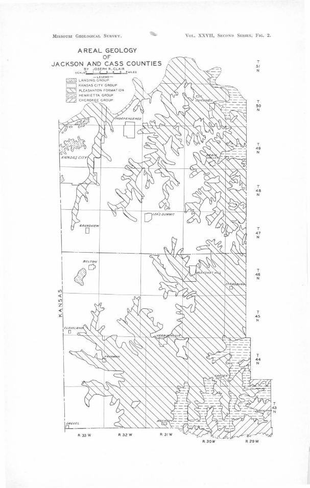
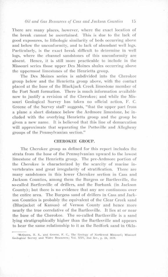
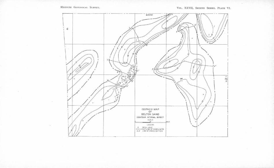
The Belton Sand. This unusual sand body is one of the principal stratigraphic irregularities in Cass County. It consists of a main lense, elongated in a general northeast-southwest direction and three ismaller disconnected lenses, at the same horizon, which have a slightly different alignment. One of the smaller lenses parallels the main sand body on the west, while Lhe other two, separated by a narrow channel from the larger Jens have a due north-south lrend. (See Isopach Map of Sand Body. Plate VI.)
The sand body, including the smaller lenses, has a total area of about eight square miles. The main lense is about four and one-half miles long by one-half to sev.en-eights of a rnilc wide. The other two lenses are of minor importance. The deposit is found under all or parts of Secs. 1, 2, 3, 4, 7, 8, 9, 10,
1Greene, F. C., op. cit., p. 19.
MISSOURI GEOLOGICAL SURVllY.
6
ISOPACH MAP OF
BELTON SAND COtflOUR INTERVAL IOFEET
SCA.LE
r==~-~":,.;,.===J..~, LEGEND
O ORILt. HOLE -~-;-ouTUt,IE Of SANO LIMITS
c_fL.L'_L_ _______ J_ _________ L::·A,LINE OF CROSS SECTION ___ ___i__ _ __L ___ _J

Oil and Gas Resources of Cass and Jackson Counties 21
11, 12, 13, 1-1, rn, 17, 19, 20, and :M), T. ,16 K, R. 3~{ vV. The main portion is apparently open at either end and may extend northeastward into Jackson County and southwestward into Johnson County, Kansas.
Stratigraphically, the sand replaces the \Vesterville limestone of the Kansas City group and all or parts of the shale above and belov,1 this horizon in Lhe area where H is found.
The sand is while Lo light gray in color and quarlzose to micaceous in character. It varies from O to 3-1 feet in thickness and is found at a depth of 59 to 152 feet below the surface, depending on surface elevation and position of the well in relation to the structure of the area.
The presence of the sand body, was first brought to the attention of the writer during the summer of 1934, while investigating possibilities for additional water supply for the Lown of Belton. This sand had been the source of water supply for the town and the severe drain placed on the wells by the excessive drouth of that summer had caused the wells to go dry.
The sand body was first thought to be the result of filling of on old stream valley. The narrow, elongated, slightly irregular shape is suggestive of valley filling, and this, together with the presence of numerous channel deposits at other places in the stratigraphic column of the adjoining area, led the writer and other geologists with the Missouri Geological Survey who were working on the problem to assign its origin to this cause.
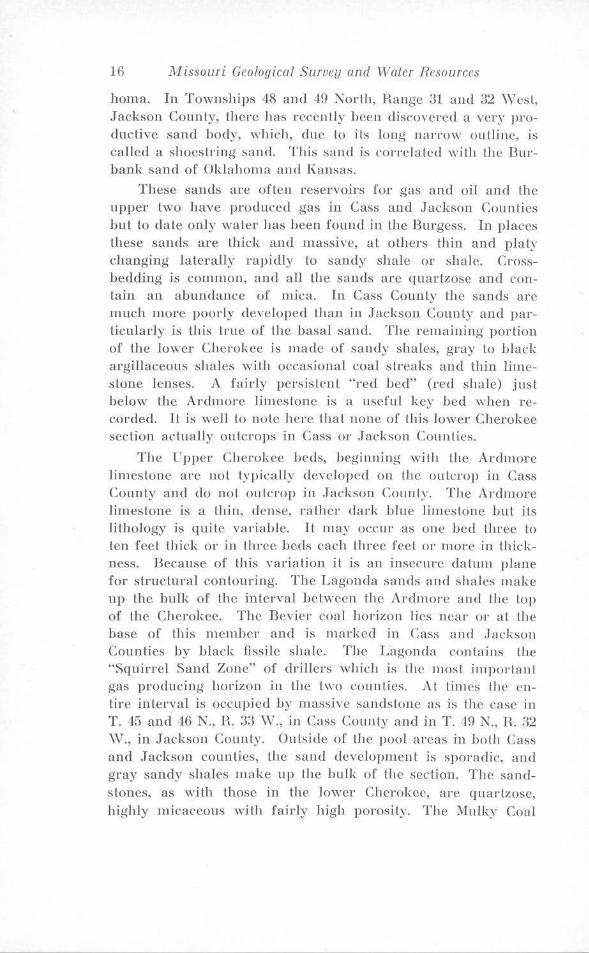
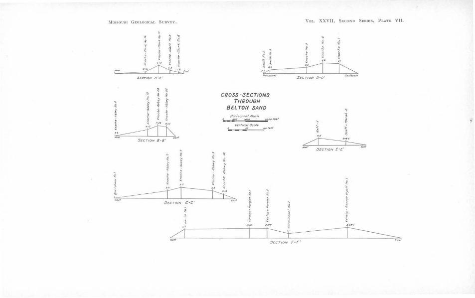
During the field work, carried on by the writer, incident to the securing of data for the report on Cass County, the addition of new logs and accurate elevations and locations of existing wells supplied more detailed information regarding this deposit. Careful study of the elongated outline and preparation of detailed cross-sections suggested lo the writer the possibility of a shoestring sand similar in origin to those so typically developed in the Cherokee shale in Greemvood and Butler Counties, Kansas.
The sand body, because of its narrow elongated outline, is limited to two probable types of origin (1) a filled stream channel, or (2) a sand bar, sbnilar to those along the Atlantic Coast. Detailed cross-section of numerous, known filled stream valleys and channel deposits have established the fact that deposits of this type are usually convex downward and are wider
22 Missouri Geological Survey and Water Resources
al the top tlian al the bottom. Citations of this are numerous in the literature. In the present case, however, the cross-sections (Plate VII) show thal this is not true. Rather the surface in this in.slancc is convex upward. The cross-sections indicate that the sand body has a rather sharp face and is thicker toward one edge sloping more gradually to the other side. In the case of the western segment, the eastern edge is the sharper, while with the other part it is the western edge. Information as to the original attitude of the base of lhe sand has been destroyed by the folding which the area has undergone. Evidence presented by the cross-sec tions, ,vhich have been plotted with both top and base as flat surfaces, would tend to indicate that the deposit probably did not originate as a filled stream chaunel. Hence there remains to investigale the possibility of its being an "off-shore bar" lype of deposit.
Bass1, in his recent work on lhe shoestring sands of Greenwood and Butler Counties, Kansas, has definitely assigned these deposits as ancient off-shore bars formed along the shores of an ancient Cherokee sea. These sands are apparenlly, according to Bass, similar in origin to those so excellently developed along the present coastline of North Carolina and Virginia. These shoeslring sands in Kansas are in no way related to surface structure. They have slightly convex tops and flat bases, slightly tilted either east or west depending on which shore of the sea they were deposited. Bass2 in a recent paper on the Verden sandstone of Oklahoma has also indicated that offshore bar types of shoestring sands are not confined to the Cherokee shale.
That shoestdng sands do occur in this part of Missouri has heen estahlished by the writer3, also, this shoestring sand in Jackson County is thought to have an origin similar to those in Greenwood and Butler Counties, Kansas.
The typical bar-shaped cross-section, further indicates that this deposit in Cass County may possibly be a ln1ried "off-shore bar." The apparent relation of this sand body lo surface structure, lack of information regarding the original allitude of lhe
'Bass, N. \Yood., Origin of lite Shoestriug Sands of Greenwood and Butler Counties, l{ansas; Bull. of the University of l(ans11s, Bull. 23, pp. 122-123, 1936.
•Bass, N. Wood, Verden Sandstone of Oklahoma-An Exposed 'Shoestring Sand of Permian Age: Amer. Assoc. Petrnleum Geologists Bull.; Vol. XXIII, No. 4, pp. 559-582, April, 1939.
•Clair, J. n., Oil and Gas Resources, Jackson County, :.\Iissouri; Masters Thesis, Missonri School of Mines and Metallurgy, unpublished, p. 125, 1038.
~ltssot'lll Gi;ot.OG1CAL S.:nvEv. Vor.. XXVII, Sue.ONO $ERIES, PLATE VII.
\l \! ll ,t ] ~ ~ i ..
-i! ..
'<) ~ ~ 1 ~ ~ ~ ~ j '! ':> . i • ~ \; ¥ 1 ~ C,$ Ii l
~ ~ ~ ' ' . ~ ; i t l
~ ~ ~ r ~ r''' ~ ~f~I
i ~ r ~ 3,4
s,%:1: ~u//i,--/ Sccr101V A·A' N"dhwul SECTION 0·0'
l! :i ~ ll ~ i ~ £
.. " :2 :.s ~ 1 ~ ~ ~ '}' ~ .
Cl?OSS-SECTIONS THROUGH
BELTON SAND ~ ft V "C'
~ ~ l t • 8 ~
Horizon/4/ .Sco/e
~~ '1'f" C £""'~*'
V~rllcol Scol•
m41 r-, St:CTION 8-8'
~ ~ ~ ~ ~ ~ l: 0
l' : t' ~ ~ ~ : .t
~ ~ ~ ~ ~ \. ~ ~ l I
l l ~ t t ~ ~ 11 { g ~ ~.~. ~ . I I I ~
s. ~~;r« I -=
- .. ~ t wu,----- ----:L _ _l ______ L_[:::::,._
S~CTION C -C' r<HI ~ '
- t f J ll • ' ~ t l
':' .., ~
~ f . ' ::: ' ~ t
~ = tllnf S~CT/0/V f·E.' ~H)
• l: ::: } . r " ! < {; ~ { ~
/I' T ~ wnr S eCT!DN F-f''
~o~,

Oil and Gas Resources of Cass and Jackson Counties 23
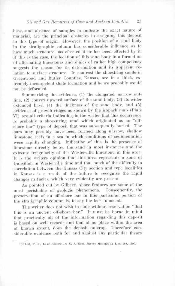
base, and absence of samples lo indicate the exact nature of material, are the principal obstacles in assigning this deposit to this type of origin. However, the position of a sand body in the stratigraphic column has considerable influence as lo how much structure has effected it or has been effected by it. If this is the case, the location of this sand body in a formation of alternating limestones and shales of rather high competency suggests the reason for its deformation and its apparent relation to surface structure. In contrast the shoestring sands in Greenwood and Butler Counties, Kansas, are in a thick, extremely incompetent shale formation and hence probably would not be deformed.
Summarizing the evidence, (1) the elongated, narrow outline, (2) convex upward surface of the sand body, (3) its wider extended base, (4) the thickness of the sand body, and (5) evidence of growth ridges as shown by the isopach map (Plate VI) are all criteria indicating to the writer that this occurrence is probably a shoe-string sand which originated as an "offshore bar" type of deposit that was subsequently buried. The bars may possibly have been formed along narrow, shallow limestone reefs in a sea in which conditions of sedimentation ·were rapidly changing. Indication of this, is the presence of limestone directly below the sand in most instances and the extreme irregularity of the ·w csterville limestone in this area. It is the writers opinion that this area represents a zone of transition in \Vesterville time and that much of the difficulty in correlation between the Kansas City section and type localities in Kansas is a result of the failure to recognize the rapid changes in facies, ,vhich very evidently are present.
As pointed out by Gilbert\ shore features are some of the most perishable of geologic phenomena. Consequently, the preservation of an off-shore bar in this particular portion of the stratigraphic column is, lo say the least unusual.
The writer docs not wish to slate without reservation "that this is an ancient. off-shore bar." It must be borne in mind that practically all of the information regarding this deposit is based on well records and that at no place within the area of known extent, does the deposit outcrop. Therefore considerable evidence both for and against any particular theory
' Gilbcrl, T. K, Lake Booneville: U. S. Geo!. Snrvey Monograph I, p. 109, 1890.
24 Missouri Geological Survey and Waler Resources
of orgin is subject lo a certain amount of error. Furthermore, the presence of fresh water indicates some surface connection for the sand body. In south-cent ral Jackson County, McCourt1
reported the presence of a sand body some twenty feet thick which was underlain by some five feet of calcareous conglomerate. At that time its relation to the other formations could not be determined. However, the addition of information indicates, according to Greene\ it is at the same horizon as the Belton sand.
Another irregularity in this group is found in southeastern Jackson and northeastern Cass Counties. In this area the Ladore shale between the Middle Creek limestone of the Swope formation and the Hertha limestone becomes sandy and the interval thickens fro1n an average of 2 Lo 3 feet up to as much as 40 feet. The interval may be made up of sand entirely but more often is sandy shale. The thickening is apparently at the expense or the underlying beds because the interval from the top of the Bethany Falls limestone to the base of the Myrick Station limestone does not vary appreciably, and the Hertha is considerably thinner in this region.
A third slraligraphic irregularity in the Kansas City group is found in the Chanute shale between the Raytown limestone and the Argentine limestone member of the Iola limestone formation. In the southwest pad of Jackson County, a channel sandstone develops in this portion of the section and occupies all or part of the interval between the two limestones. There are two excellent exposures of lhis channel sand; one, is along the Kansas City Southern Hailroad tracks about one-fourth mile north of Bannister Road, in the ):\V / NE Section 25, T. 48 N., R. 33 ·w. The other is at the entrance to the Southridgc Country Club Golf Course in the SE/ ):\\' of Section 2, T. 47 N., R. 33 \V.
A fourth irregularity in this group is found in the Bethany Falls limestone in Cass County. In the old vVeiscr Hock Quarry, in Sec. 8, T. 44 N., H. 33 \V., just west of the village of vVest Line, the upper two lo three feet of the Bethany Falls, which is usually nodular, hccomes very oolitic. This ooli tic zone is so saturated with heaYy oil that on extremely hot summer days
1McCourt, \V. E., The Geolo!(y of Jackson County: .\lisso111·i Bnr. Geology and Mines, Vol. XIV, 2nd Ser., p. 59, 1917.
'Greene, F. C., Personal Communication.
Oil and Gas Resources of Cass and Jackson Counties 25
Lhe quarry face will "bleed" oil. This condition seems to be limited to this area in Cass County though it has been reported at other exposures in this immediate vicinity.
LANSING GROUP.
The outcrop of the Lansing group in Cass and Jackson Counties is limiled and includes only beds from the top of the Argentine limestone to the top of the Olathe limestone member of the Stanton limestone formation. In .Jackson Couuty only the lo,ver portion of the group is outcropping and it is found in a very limited area in the western and northern parts of Kansas City. (Fig. 2). The Lane shale formation is well developed over most of the area bul the lower part or Merriam limestone member of the Plattsburg limestone formation overlying it is found in a very limited area in parts of Secs. 16, 17, 19, 20, and 21, T. 49 N., R. 33 \V., where it has been preserved in a structural sink, which has protected it from complete removal. The interval between the lower Farley limestone member and the top of the Argentine limestone of the Kansas City group, is much thinner than normal. The group has a maximum thickness of sixty-five feet.
In Cass Counly the Lansing group is more fully developed but areal distribution is limited lo the northwest portion of the Bellon fault complex. The down faulting of this area has preserved the beds from removal by erosion. The only outcrops are in Secs. 21 and 27, T. 46 N., R. 33 Vv., and Lhey are poorly exposed and steeply dipping. The remaining information available is from four wells in the area which have encountered these beds. The details are best shown in the columnar section accompanying the report.
PRE-PENNSYLVANIAN ROCKS.
BY .T. G. GROIISKOPF
Nowhere within Lhe area do rocks older than Pennsylvanian appear at the surface, co11sequenlly knowledge of the older formations is based upon an examination of cuttings from a relatively small number of wells. The correlations are based upon lithology and from a study of insoluble residues. The latter is the residue which remains after the original rock has been treated with hydrochloric acid in order to dissolve the
l\l1ssorru GnotOGJCAT, Sl1 nnty. Yor.. XXYII, SHCOND SERIES, Fu:. :l.
llAP SHOWDlG THICKNESS OF KINDERHOOK SHALEST. PETER SANDSTONE INTERVAL AND APPRO.l:DIATE
LINE OF ST. PETER OVERLAP
Soale 0 5 E3 F3 e-
/ /
Contour interval 25 feet
•
---------R33W 32 31
T 50 N
I 49
48
47
I 46
I 45
o' 44
\ .
0143
~ Well 29 374 Thickness of interval c:'.'.) Pennsylvanian oil and gas pools
~-~ Line of St. Peter pinch out
Oil and Gas Resources of Cass and Jackson Counties 27
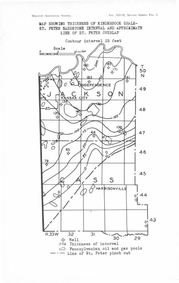
limestone or dolomite. This melhod is indispensable in making identifications below the St. Peter and also is a distinct aid in the overlying formations.
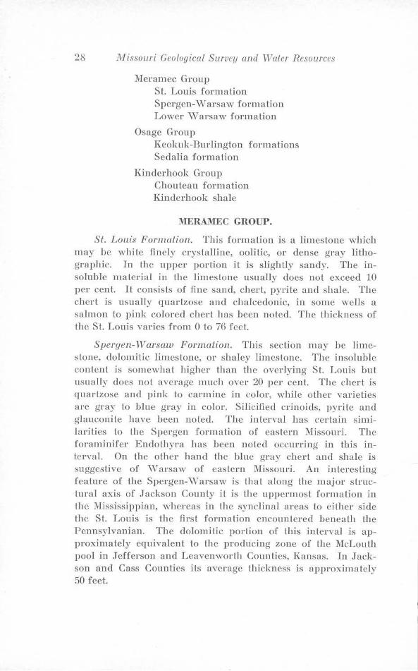
The section below Lhe Pennsylvanian includes rocks of Mississippian, Devonian, Ordovician, Cambrian and pre-Cambrian age. The thickness of the sedimentary section from the base of the Pennsylvanian to the top of the pre-Cambrian granite varies from 1-110 feet in southeastern Cass County to 1730 feet in northern Jackson County. This is due to the unconformities occurring between the above menlioned systems, and the wedging in of formations from sou th east to norlhwesl.
Thickening of the interval between the base of the Kinderhook (Mississippian) shale and the top of the St. Peter sandstone is shown by the map, (Fig. 3). The map also shows the subsurface limits or "pinch out" of the St. Peter. Southeast of the line indicated, the St. Peter is absent or represented by isolated areas of limited ex tent; usually the Mississippian rocks rest on the Canadian ("Arbuckle") dolomite. Xortlnvesl of lhe line, and contiguous thereto the Mississippian rocks rest on St. Peter but fa1:Lher northwest they rest on Devonian formations. No weJls of record show Mississippian resting on Kimms'\vick or olher post St. Peter Ordovician formations. Some of these formations are known to be present, and in other localities in the State are known to be in contact with the Mississippian.
MISSISSIPPIAN SYSTEM.
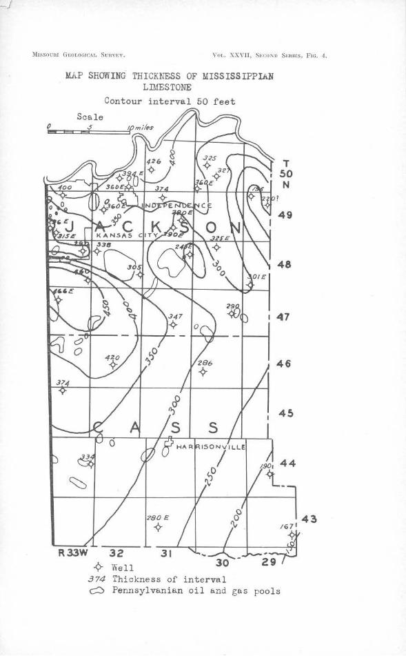
The Mississippian syslem consists in the main of limestone with some dolomile and shale; the middle portion is quite cherty, and the lower fifteen or twenty feet is a shale. The thickness of the :Mississippian varies from 167 feet in the Creighton Oil and Gas Development Co., well located in Sec. 25, T. 43 N., R. 29 vV., southeastern Cass County, to 470 feet in Lhe Russell-Bannister well located in Sec. 36, T. ,18 N., R 33 \V., northern Jackson County. The thickening is regional from southeast to northwest and is due to the incoming of )'.otmger beds in that direct.ion. This is shown by Lhe map (Fig. 4). The maximum Mississippian section contains the following representatives in descending order:
28 lVI issouri Geological Survey and Water Resources
lYieramec Group St. Louis formation Spergen-vVarsaw formation Lower \Varsaw formation
Osage Group Keokuk-Burlington formations Sedalia formation
Kinderhook Group Chouteau formation Kinderhook shale
MERAMEC GROUP.
St. Louis Formation. This formation is a limestone which may be white finely crystalline, oolitic, or dense gray lithographic. In the upper portion it is slightly sandy. The insoluble material in the limestone usually does not exceed 10 per cent. It consists of fine sand, chert, pyrite and shale. The chert is usually quartzose and chalcedonic, in some wells a salmon to pink colored chert has been noted. The thickness of the St. Louis varies from O to 7G feet.
S pergen- '1\T arsaw Formation. This section may be limestone, dolomitic limestone, or shaley limestone. The insoluble content is somewhat higher than the overlying St. Louis but usually does not average much over 20 per cent. The chert is quartzose and pink to carmine in color, while other varieties are gray to blue gray in color. Silicified crinoids, pyrite and glauconite have been noted. The interval has certain similarities to the Spergen formation of eastern Missouri. The foraminifer Endothyra has been noted occurring in this interval. On the other hand the blue gray chert and shale is suggestive of \Varsaw of eastern :Missouri. An interesting feature of the Spergen-\Varsaw is that along the major structural axis of Jackson County it is the uppermost formation in the Mississippian, whereas in the synclinal areas to either side the St. Louis is the first formation encountered beneath the Pennsylvanian. The dolomitic portion of this interval is approximately equivalent to the producing zone of the McLouth pool in Jefferson and Leavenworth Counties, Kansas. In Jackson and Cass Counties its average thickness is approximately 50 feet.
!II1ssoum G~OLOG1CAL SunvEv. Vor.. XXVII, SEc:oNo S1rnms, F ie. ,1.
MAP SHOWING THICKNESS OF MISSISSIPPIAN LIMESTONE
Scale
L ..... e-1
Contour interval 50 feet
49
48
I 47
R33W 32 -9- We 11
?80E
-<!>-
31
.374 Thickness of interval
46
c:::'.:) Pennsylve.nie.n oil a.nd gas pools
30 Missouri Geological Survey and Water Resources
Lower 1¥ arsaw Formation. The lov,1cr "' arsaw formation js a gray to tan, crystalline, granular, crinoidal and somewhat glauconitic )jmeslone. Its insolublc content averages about 30 per cent and consists in the main of chert, with some pyrite, glauconitc, and shale. The chert is dark gray to light tan mollled, may be either smooth, contain quartzose crinoidal vugs or may consist of silicified crinoids and byrozoa. Its thickness averages 50 feel in the area.
OSAGE GROUP.
J{eokuk-Burlinglon Formations. It has not appeared feasible to sub-divide these formations in the area. The upper portion usually consists of white to tan crystalline crinoidal limestone which the lower portion may be a tan to gray dolomitic limestone or dolomite. Glauconite has been noted especially in the lower portion. Chert is the dominant insoluble constituent and may make up over 50 per cent of the formation. It may vary from soft tripolitic to dense subtranslucent, and contains silicified crinoids and bryozoa in abundance. The lower dolomitic zone in many wells is reported to carry large amounts of waler. The combined thickness of the two formations is approximately 150 feet.
Sedalia Formation. The Sedalia is markedly different from the overlying Burlington in that it is very low in its insoluble content, which may be either chert, pyrite or very fine sand or silt. The chert is usually quartzose in character. The formation is usually a dolomitic limestone or very finely granular limestone, which is somewhat darker in color than the overlying Burlington. Its thickness averages 15 feet.
KINDERHOOK GROUP.
Chouteau Formation. The Chouteau is variable in its character. The upper portion is usually an earthly dark colored dolomitic limestone and contains considerable slate gray very dense chert which is characteristic in its appearance. The lower portion is a dense gray to tan lirnestone somewhat argillaceous, less cherty and somewhat crinoidal. The lower 15 to 25 feet usually contains a Jillle dark shale in the residue and also some silicified tubes or worm casts. This portion usually also carries a bdght shiny crystalline pyrite which has a "lattice Jike" appearance.
Oil and (;as Resources of Cass and .Jackson Counties 31
Kincleriwok Shale. The shale lying at the base of the Mississippian is considered by some to be of Devonian age but is here classed with the Mississippian. It is light gray-green ju color aud contains some fine silt and in a fe\'v wells some rounded white sand. In one well, Lone Jack Oil and Gas Co., D. Lee Shawhan No. 6, Sec. 14, T. 47 N. R., 30 vV., the shale carried some tan <lisc like organic specs which appear to be spores; as a general rule, however, spores are rare in the shale in this area. The average · thickness of the shale is 10 feet.
DEVONIAN SYSTEM.
Samples arc available from four wells in Jackson County and two in Cass County which have penetrated the Devonian System. In three of the Jackson County ·wells and one of the Cass County wells the Devonian is a limestone which is finely crystalline to lithographic in texture. The insoluble content is less than 5 per cent and consists of sand grains, pyrite, shale, doubly terminated quartz crystals and white Lo tan quartzose chert. In the other well in Jackson County the section js essentially the same with the exception that the limestone m the lower twenty feet is sandy in that it contains about 40 per cent of white rounded and frosted sand similar lo the St. Peter. One well in Cass County, Charnllcr-Lewis, Sec. 4, T. 45 N., R. 33 Vv., has an entirely different section. In this well 20 feet of sandstone underlying the Kinderhook shale was penetrated. Underlying the sandstone 12 feet of dolomite was drilled which rested upon Kimmswick ? (Ordovician) chert. The sandstone is composed of fine lo medium subangular white grains, a few of the grains are suhrounded and frosted. There is a possibility that this sand is a representative of the Misener which is considered by some to be of Mississippian, but by others lo be of Devonian age. The dolomite is finely crystalline lo sucrose tan-gray in color and contains sand. grains similar to those in the overlying sandstone. Dolomites of similar appearance have been noted in the Devonian from wells in the Forest City basin lo the norlhwest of the area. It is believed that the Devonian in this area represents the Callaway formation, although conceivably the dense litl1ographic limestones in the lower portion maj, represent what has been designated as the Cooper. The Devonian varies in thickness from O to l2G feet in the area. The thicken-
32 Missouri Geological Survey and Water Resources
iug appears to be regional from soulheasl Lo uorthwcsl and continues into the Forest City basin.
ORDOVlCIAN SYSTEM.
The Devonian rests on Ordovician rocks throughout the area. A considerable unconformity is present since no Silurian has been recognized and the Devonian rnay rest upon the J{immswick formation or the St. Peler sand. The Maquoketa (Sylvan) which overlies the Kimmswick in the Forest City basin, the Plallin and Joachim which underlie the latter arc absent in this area.
Kimmswick-Decorah Formations. The Kimmswick formation consists of approximately 90 percent chert, with some limestone and shale. It varies in thickness from O to 64 feet. The chert is dense blue-gray to white. Fragments of silicifie<l brachiopods and cystid or crinoi<l segments have also been noted in this interval. This type of chert together ·with silicified fossil fragments are common to the middle and lower portion of the I<immswick (Viola) of the Forest City basin. The limestone associated with the chert is mouse gray and has a dense texture. In one well the chert is associated with shale that appears to be Decorah and sand that resembles St. Peter. The underlying St. Peter is only 15 feet thick in this well; it appears that both the Decorah and a portion o( the St. Peter were eroded and reworked in Kimmswick time.
St. Peter Formation. The St. Peter (\iVilcox of Mid-Continent) is composed of white rounded and frosted grains of sand similar to that found in other areas. Its thickness varies from O to 105 feet and may be overlain by Kimmswick or Devonian; it rests on Jefferson City in the 5 wells from which samples are available.
An indication of the unconformity at lhe hase of the St. Peter is . shown by h·vo wells in eastern Kansas. In the F. J. Kasper-James No. 1, Sec. 8, T. 13 S., R. 25 E., the St. Peter is 403 feet thick. It rests on a rubble of chert shale and sand 35 feel in thickness which in turn rests upon the Roubidoux formation. The entire J efferson City formation or approximately 200 feet of section is missing. The abnormal thickness of the St. Peter may be due to channel filling or the filling of an
•
Oil ancl Gas Resources of Cass and Jackson Counties 33
existing sink hole. The Clark-Vaugn No. 1, Sec. 28, T. 17 S., R. 22 E., has 354 feel of St. Peler which was not comp]ctcly penetrated.
CANADIAN SYSTEM (E. O. Ulrich)
Dr. Ulrich has separated a part of the Lower Ordovician system of authors into the Canadian an<l Ozark.fan systems; this usage is followed in this report. Samples are available from three wells which penetrate the Canadian system. The Jefferson City an<l the Roubidoux formations of this system occur in the area. Identification of these and older formations arc based on a study of the insoluble residues remaining after digestion of the rock in dilute hydrochloric acid .
• Jefferson City Formation. This formation has a thickness of 215 feet in the three wells from which samples arc available. It consists of grny to brown dolomite which varies in texture from dense, granular, to sucrose and crystalline. The upper 10 to 15 feet contains considerable green shale. \Vhilc the underlying section consists of chcrty and somewhat sandy dolomite. The cherts are the distinguishing characteristics, they vary from glassy white and tan to chalky white. The dense cherts arc oolitic and some arc dolocastic. Chert is more plentiful near the middle of the formation. The insoluble content in certain portions varies from 60 percent to 10 percent.
Roubiclou.1; Formation. The Roubidoux has a thickness of 130 feet in the area. It is a brown to sucrose dolomite containing some chert and becomes a sandstone in the lower fifty feet in some wells. This sandstone is a source of water supply for many towns to the cast and south but in this area is loo mineralized for such purposes.
OZARKIAN SYSTEM (E. 0. Ulrich)
Complete samples of the Ozarkian and lower beds arc available from one well, the Martin and Reiser, Anne Perrin No. 1, Sec. 17, T. 50 N., R. 30 \Y. The description of the Ozarkian and older beds are from these samples.
Gasconade-Van Buren Formations. The formations arc not separated in this description though rcprcsentatiYes of each appear to be present. The average insoluble con Lent of
34 Missouri Geological Survey and Water Resouras
these two formations is 40 percent and is all chert. The chcrls arc dense white to blue quartzose and dolocastic especially in the lower portion. The dolomite is coarsely crystalline gray to white. These combined thicknesses of the two formations is 185 feet. These formations may he expecled to yield considerable water.
Gunter Member of lhe Van Buren Formation. The Gunter is a non-cherty slightly sandy dolomite averaging approximately 10 percent sand and throughout its thickness of 35 feet.
Eminence Formation. This formation has a thickness of 380 feet. It is a relatively non-chcrty dolomite the insoluble content averaging less than 10 percent. The dolomite is gray to pink medium to coarsely crystalline which is slightly "5andy in the upper fifly feet. The chert is waxy gray quartzose, slightly oolitic and dolocastic. Pyrite an<l green shale are present in minute amounts. The lower 100 feet of the Eminence contains a green shale residue with some roun<le<l sand.
Potosi Formation. A thickness of 35 feet is assigned to the Potosi which is a brown crystalline dolomite. The residue consists of quartz, quartzose chert and handed drusy quartz.
CAl\'IBRIAN SYSTEM (restricted).
Bonnelerre Formation. The Bonncterre in this well has a thickness of 25 feet. It is a gray-cream crystalline dolomite which has an insoluble content of about 10 percent. The insoluble material is chiefly suhrounded sand, with some glauconite and granular silica. It is believed that this in tcrval represents the Bonncterre, however, there is a possibility that the beds may be younger and equivalent to the Davis. Lack of regional control and the thin section make exact correlation difficult.
LaMotte Formation. The Lal\fotte is a brown, bluish gray to white sandstone, slightly dolomitic near the lop. The sand gains are clear to frosted, fine and generally ,vell rounded. It is 120 feet in thickness in Lhis well. In the F . .J. Kasper-James No. 1 well, Sec. 8, T. 13 S., R. 25 E., Johnson Counly, Kansas, the LaMotte sandslone was absent and the Bonncterre rests directly on granite.
Oil and Gas Resources of Cass and Jackson Counties 35
PRE-CAMBRIAN SYSTEM.
The pre-Cambrian rocks are represented in two wells, the Martin and Reisser-Anne Perrin No. 1, Sec. 17, T. 50 N., R. 30 vV., and the Toll Estate well in Sec. 27, T. 47 N., R. 31 W., from ,vhich samples are available for study. Granite wash occurs to a thickness of 50 feet. It is made up of coarse sand grading downward into a coarse quartz feldspar sand all of which shows rounding. Below the granite wash occurs the solid granite the cuttings of which are composed of angular fragments of quartz, pink feldspar, hornblende, biotitc, mica, etc. In the Perrin well 1925 feet of granite was drilled.
STRUCTURAL GEOLOGY.
Review of Earlier Work.
The similarity of conditions in eastern Kansas, where oil and gas have long been produced, to structural conditions within the area of outcrops of the Pennsylvania system in lWissouri, has for many years been of considerable interest to geologists.
Hinds and Grcenc1 first published a structure map of the entire area of Pennsylvanian outcrop in .Missouri. This map showed a numher of gentle folds trending northwest and southeast. Two of these, the Kansas City-Centerview anticline and the Laduc-Freeman anticline, pass in a northwest-southeast direction across Jackson and Cass counties. The map is on a small scale with a 50-foot contour interval, so that close coincidence ·with more detailed structural work is not to be expected. It is of value, however as a guide to general structural conditions. In discussing the structure, they concluded, "that the local structure seemed to fall in to three classes; (1) structures comprising the low undulations common in the coal fields; (2) structures in which the rocks dip rather steeply and arc often faulted; these structures arc usually small in area and are found two· or three to a county; (3) the third and most important from an economic standpoint, includes the folds whose axes trend northwest and southeast." They further concluded, "that the first class is probably due to slight ir-
lHinds, Henry and Greene F. C., The Stratigraphy of tlle Pennsy!Yanian Series In Missouri; Missouri Bur. Geology and Mines, 2nd Ser., Vol. XIII, p. 202, Plate XXIlI, 1915.
36 Missouri Geological Survey and Water Resources
regularities of the surface on which the bc<ls were deposited or to unequal settling after deposition; the second class may be due to solution of underlying Mississippian rocks, causing collapse of the Pennsylvanian strata; and the last class is probably due to the intersection of larger folds, where exceptional strains have resulted in steep dips or faulls.
,vilso111 published a report on the oil and gas possibilities of an area in Cass and Jackson counties. He included a structure map of the area using the base of the Iola limestone as a datum, together with a discussion of the stratigraphy, structure and previous drilling in this region.
,vilson2 published subsequently a report in which he discussed generally the structural features of the state as a whole. He reviewed the earlier work of Hinds and Greene, and a portion of the report on the Belton area. \\Tilson further discussed the general conditions in Cass and .Jackson counties, and republished both the structure maps of the Belton area and Hinds and Green's original map. He concluded that cross-folding rather than solution of underlying l\Iississippian strata most satisfactorily accounts for the observed structural conditions.
J\IcCourt3 reviewed the general structure of Jackson County calling attention to the direction of dip and the fact that the normal dip is very Hat, varying from six to tcu feet per mile. He includes a structure map of Kansas City with the Haytown limestone as the datum plane. The map is of considerable interest and will he referred to later in this report. His discussion of lhc structural significance of the map is brief and no mention is made of structural conditions in the remainder of the county.
Greene\ published a report covering the knowu oil and gas pools in western l\Iissouri, in which he inchtded structure contour maps of the Freeman-Peculiar, Knorpp, Shawhan, Lone Jack, and Independence pools together with brief discussions of the structure and producing horizons of these areas. He also disctissc<l the Belton-Martin City district in Cass and Jack-
'Wilson, Malcom E., Oil :md Gas Possibilities of the Belton Area: Missouri Bur. Geology and Mines, p. 39, 1918.
'\Yilson, Malcom E., The Occ11 rrence of Oil nnd Gas in Missouri: Missouri Bur. Geology and Mines, Yo!. XVI, 2nd Ser., 1!122.
3JlfcCourt, \\", E., The Geolo!(y of .Jackson County: Missouri lJnr. Geology and '.\tiues, Yo!. XIV, 2nd Ser., p. 74-75, 1917.
•Greene, F. C., Oil and Gas Pools of \Vestern Missouri; Missouri Bur. Geology and Mines, 57th Bit>11. Rept., pp. :ll-11, 1933.
Oil and Gas Resources of Cass and Jackson Counties 37
son counties but did not include a map. In a later paper', he published structure contour maps of the vVcst Grandview and Marotta pools with brief discussions.
Bartle2, published a detailed geological report covering an area in Township 48 North, Ranges 31 and 32 "\¥est known as the Blue Springs and Bannister Ridge fields. He reviewed previous works and gave a detailed account of the structure of the area, together with maps and cross-sections.
Structural Detail.
General Statement. The struclure maps included in the present report arc largely based on well logs, except in southeastern Cass County, and although in considerable detail locally, care should be taken in using them. Particularly is this true where data arc limited and the contouring therefore largely interpretative. The control whC'rc adequate, expresses the structural detail with considerable accuracy but where control is lacking the structural features as presented arc entirely the writers interpretation of available information.
In working out the subsurface structure shown on the accompanying county maps (Plates II & III) the logs of some 2000 wells were used. A few of these arc included in detail elsewhere in this report together with a tabulation showing data for each well used. The wells arc tabulated as to: (1) Map number of vvcll, (2) Company or Owner, (3) Farm, (4) Location, (5) Surface elevation, (6) Total depth, (7) Depth to top of Bethany Falls limestone, (8) Ele'vation top of Bethany Falls limestone, (!)) Depth to base of l\Iyrick Station limestone, (cap-rock of Lexington coal horizon), (10) Elevation base of :Myrick Station limestone, (11) Type o[ well. The logs of all wells are on file in the oflices of the ?11issonri Geological Survey and "\Vatcr Resources at Roll::i, Missouri.
CASS COUNTY.
It will be seen from the structure map (Plate TI) that there are a number of structural features, which ,vith their numerous minor structures make up the structural detail of the county.
'Greene, F. C., Oil and Gas DeYelopments in Missouri in 1933-3-J; 1'!issouri Geological Survey and Water Resources, 58th Bien. Rept., App. III, pp. -i:l-17, rn:i :;.
'Bartle, Glenn G., The Geology of the Blue Springs Gas F ield; ll'lissouri Bur. Geology and Mines, 57th Bien. Rcpt., App. Ill, pp. 27-31, P, r, JI, III, 19:l:l.
38 Missouri Geological Survey and Water Resources
These major and minor features have been designated hy names taken from towns, farms nnd other geographic features within the county. They arc designated on the map by key numbers and letters, which together with the names will be used in the discussion of the detail of the structure. In Cass County the major structural features arc not as clearly defined as they are farther to the north. This is because they are masked by the numerous minor structures of which Lhcy are composed.
The two major synclines, Pleasant Hill-Garden City-Dayton and Main City-Belton (H-4 and B-12, arc bolh broken hy numerous minor structures throughout their extent. The major anticlines are designated as vVestern, Central, and Eastern and they likewise are made up of a large number of minor structures, which either follow the axial trend or cut across it at an angle. The Central anticline, lying between the two major synclines mentioned above, corresponds roughly to the axis of the Laduc:Frceman anticline of Hinds and Greene's earlier map, however, the axis has a more nearly due north-south trend. This is to be expected because of the greater detail of the present map. The \Vestern anticline has no representation in the earlier work but apparently terminates in the Martin City anticline to the north in Jackson County. The Eastern anticline is only partially developed in Cass County, the major portion of it apparently lying to the east in Johnson and Henry counties. It is evidently the continuation to the south of the major anticline of the Jackson County map.
Discussion of the structural detail is based on interpretation of the map on the lower structural datum, the base of the Myrick Station limestone of the Hcnriella Group. In order to facilitate the discussion the county has been divided into the following districts: (1) Belton-Drexel, comprising all of Tws., 4:.l, 44, 45, 46 N., R. 33 \V., and half of R. 32 vV; (2) ArchiePleasant Hill-Strausburg, comprising all of Tws., 43, 44, 45, 46 N., R. 31 V.,T., half of R. 32 \V., and T. 45-46, R. 29 and 30 vV; (3) Gunn City-Creighton-Dayton district, cornprising all of Tws., 43, 44 of Rgs. 29 and 30 vV.
Oil and Gas Resources of Cass and Jackson Counties 39
BELTON-DREXEL DISTRICT.
The Belton-Drexel district includes the ·western anticline, the :i.\Iain City-Belton syncline and a portion of the Central anticline. The minor structural features found in this area will be discussed with the key numbers and letters found on the structure map.
The Knoche anticline (B-1, A. B. C. D.) 1 is the largest an<l most sharply defined in the northern part of this district. It consists of two very sharp, elongated domes, Clarke (B), and Miller (A), and a flat-topped, northward plunging nose, which has a westward extension, \\Talton nose (C), and Poindexter nose (D). It is hounded on the east by the Jost syncline (B-1 A), on the west by the Herr syncline (B-2), and on the southeast and south by the Belton Fault complex (B-5). In fact the southern and southeastern sides are broken hy the northern faults of the complex. The anticline has been an excellent producer of gas in the past, particularly from the \,Vallon and Poindexter noses, and is today the major producing oil field in the State of Missouri. It is of particular interest because of the pecularities in sedimentation exhibited and the extreme sharpness of the two domes. Along the crest of the anticline the lower Ilenriclla limestones arc absent being replaced hy sandstone and sandy shales, indicative of unstable conditions during lower Henrietta time in this area. The anticline has a maximum closure of seventy feet on the base of the l\f yrick Station limestone, the :Miller dome displaying this maximum. The rest of the structure has an average closure of thirty f cet. The axis of the anticline trends slightly cast of north. Gas production follows closely the top of the structure, but oil production is confined mainly to the southeast flank. The highest wells on the Miller dome carried a large q nantity of gas and, although recorded as dry holes, they were actually plugged to retain the gas in the producing sand.
The North Freeman anticline (B-14, A. B. C. D. E. F.) consists of four fairly well-developed domes, together with a sharp closed syncline and a closed depression. A structure map of
'Arabic numerals with Prefacing l(ey T.eltcr DPsignating Distdcts together with Capital letters, B-1, A, etc., arc key numbers referring to these structures on the structure n1aps.
40 111issouri Geological Survey and Waler Resources
this area was published previously by Greene1 • The northwestern portion of this map agrees closely with the Beeghley dome (A) of the present map hut the addition of information in this report has added considerable detail not present in Greene's structure map. The Beeghlcy dome and the Knight dome (C) arc S<'parated by a sharp closed syncline, l\IcGill syncline (B). The Bccghlcy dome is the larger of the two, and its axis li<'s across the general axial trend of the anticline, which is slightly west of north. It has a maximum closure of forty feet on the base of the l\Iyrick Station limestone. It is of particular interest because of the extreme sharpness of its southwest flank, which drops into a portion of the l\Iain CityBelton syncline. Herc the Myrick Station liincstone dips 125 feet in slightly more than a quarter of a mile. The Knight dome is not quite so large and has small closure. Its axis trends just east of north about parallel to that of the Beeghley dome. The Richardson (E) and the Henricks (F) domes arc separated from the Bccghlcy and Knight domes by a sharp closed depression, the Colburn (D). Information on this depression is based on surface control and interpolation to the lower structural datum. Both the Richardson and Hcinricks domes are fairly regular and hoth have low closures. The Colburn sink has about twenty feet of closure and its axis is at an angle to the anticlinal axis. The Knight, Hichardson, and Heinrick domes flallen out to the north and northeast and merge into the syncline which wraps around the end of the Prettyman anticline (II-!l). The l\IcGill syncline is rather sharp, very narrow, closed syncline. Ils axis parallels Lhal of the domes on either side and is at an angle to that of the axial trend of the major anticline. The North Freeman anticline is bounded on the west, southwest, and south by the sharpest portion of the l\1ain City-Belton syncline, but on the cast the slope is much less abrupt and merges into the prcYiously mentioned broad syncline.
The .Tau don anticline (B-10, A. B. C.) consists of an elongated dome which has its axis almost perpendicular to the axial trend of the anticline, l\Iaxwell dome (A), a faulted dome, the Downing faulted dome (B), the northern half of which is displaced hy the southern fault of the Belton fault complex; and
•Greene, F. C., Oil and Gas Pools of \Vcstern Missouri: Missouri Tlur. Geology and Mines, App. II, 5ith Bien. Rept., p. 28 pl. V., 1933.
Oil and Gas Resources of Cass and Jackson Counties 41
a structural depression, the Jones sink (C), which lies partly on the axis of the anticline and partially on the west limb of the Harrelson sink (B-G). The Jaudon anticline of this report agrees closely with the Jaudon anticline of "Wilson's original structure map of the area.1 Since publication of this map, however, thirty-two years have elapsed and the accumulated information has made a more detailed picture possible. Drilling on the basis of 'Wilson's map, first by the California Oil and Gas Co., was unproductiYe because of the sharp syncline cutting into the anticline from the west. Evidence of this was lacking on the basis of surface data. Later Louis Knoche, drilling on the l\Iaxwell dome of this report, brought in three small gas wells, but sand conditions were not particularly good and the Yolume was small. Subsequently in 1939 two more wells were drilled on the Maxwell dome both of which were too small for commercial wells. In the spring of 1940 drilling on the southeast flank of the l\Iaxwcll dome uncovered a \Vanensburg Channel sand deposit with considerable gas. The channel is extremely narrow and is at the present time only a little oYer a half mile in proven length. 1 t lies on a narrow terrace between the lowest closing contour of the l\Iaxwell dome an<l the sharp descent into the Jones sink.
The Downing faulted dome is apparently almost circular, the northern half having been displaced by a fault. Only one well, Knoche-Downing No. 1 (Map No. 170), Section 28, T. 4G N., R. 33 vV., has been drilled on the structure. It was located part way down on the southwest flank, and consequently poorly located structurally. The well, logged a show of gas in a thin san<l at the vVarrcnsburg horizon and also in black fissile shale at the Lexington coal horizon. It is possible that production might he secured from a more advantageously located test, but the poor sand conditions in the Downing well hldicates that prohahly even the top would fail to produce. ln addition the amount of closure on the upthrown side of the fault is small and the area available for drilling is extremely limiled.
The Jones sink (C) is a peculiar structure hoth in shape and location. Information regarding it is hased entirely on well logs hut its outline is pretty definitely estahlished. H has
'\\'ilson, )lalcom E., Oil and Gas Possibilities in the Belton Area; Misso11d Bur. Geology and Mines. Pocket, 1918.
42 lVIissouri Geological Survey and Waler Resources
ten feet of closure and is apparently caused by Lhe inlersection of the major axis of the anticline with that of the Maxwell dome.
The Jaudon anticline has a maximum of thirty feet of closure and its axial trend is roughly that of the Knoche anlicline, slightly west of north.
The East Cleveland anticline (B-13, A), consists of an irregular dome with a long northward plunging nose, the Groh nose (A). Detail of this structure is based on surface control on the Lower Kansas City limestones, and its structure on the base of the Myrick Station limestone is inlerpolatcd from interval data ohtaincd from surrounding wells. There have heen no wells drilled on the domed portion and only three wells loca tcd on the extreme northwest tip of the nose, none of which were \VeJl placed structurally. The anticline flattens out to the west and the beds have a continuous dip to the western boundary of the county. Its southern border is a rather sharp syncline, which hreaks across the axis of the major V\Testern anticline. The East Cleveland anticline is bounded on the cast by the Main City-Belton syncline, the axis of which it parallels for a distance of some six miles to where the beds plunge into the Harrelson sink.
The ·wood anticline (B-11) lies to the south of the Jaudon anticline and is separated from it by a low flat saddle. The anticline is asymctrical, with the steeper limb being on the west. The structure has only ten feet of closure and one of the two wells drilled on the anticline was located well enough structurally to thoroughly test the structure. The eastern limb of the structure <lips gently for a considerable distance and merges into the Harrelson sink.
The Harrelson sink (B-6) is a sharp, closed syncline, with its axis lying at an angle to the l\Iain City-Belton syncline. It is apparently a portion of this major structure, which has been off set due to the disturbance of the Belton fault complex to the northwest. There have been no wells drilled in the sink and surface control outlines the structure as represented on the maps.
The Mullen depression (B-7), is likewise a closed syncline, with its axis approximately parallel to that of the Harrelson sink. It is apparently closely related to the Harrelson sink and to the major syncline.
Oil and Gas Resources of Cass and Jackson Counties 43
Between the Harrelson sink and the 1\lullen depression, is a narrow, flat anticline, the axis of which parallels that of the synclines. Its presence is unusual aud is apparently related to the disturbing influences of the fault complex, which appears to control the structure of the area surrounding it.
The Seba anticline (B-8) has a curving axis, part of it parallel to the axis of the above mentioned structures, and the northern part curving to practically parallel the general structural trend of the region. The northeast edge of the anticline <lips rapidly into a rather large syncline which extends into Jackson County. The western side of the structure is bounded by a portion of the l\Iain City-Belton syncline and on the south lies the l\fullen depression. Only one well has been drilled on the anticline. It was not well localed structurally and the structure appears worthy of further testing.
The Raymore nose (B-$>) is a long, low, northward plunging anticline. It has little closure and appears to he of minor importance.
The King anticline (B--1) is a large, irregular flat-topped dome which corresponds rather closely to the Bellon anticline of \Vilson's original map. It has been renamed in the present paper because of the more adaptable use of the term Belton to indicate the fault complex lying just south of that town. This structure is probably the oldest producing area in Cass County and a great many wells have been drilled on it. IfoweYer, many of the well locations have been obliterated so that the present map by no means shows all the wells that have been drilled but does indicate sufficient recent drilling to outline the structure ·with reasonable accuracy. The present work indicates that the center of the dome lies farther to the east than is shown on \Vilson's map. The anticline has low closure, maximum of 20 feel, but is flat-topped and very broad. \¥ ells drilled on i l supplied the town of Belton with gas for some fifteen years prior lo 1918. In contrast with some of the sharper structures in the area there appears to be little steepening of dip on the lower structural datum (base of the Myrick Station limestone). The King anticline is faulted sharply on the south side by the northern faull of the Belton fault complex. It is bounded on the cast by another closed synclinal portion of lhe Main City-Belton syncline and on the ,vest by the Jost syncline (B-lA).
44 Missouri Geological Surv<'y and Water Resources
The Johnson terrace (B-3) is not fully developed in Cass County. It is rather small hut dips sharply Lo Lhe east into the Herr syndine. There have been Lhrec wells drilled on Lhe slrw .. :ture, Lwo of which ,verc producers. These arc both exhausted at the present time.
The Herr syncline (B-2) forms the western boundary of the Knoche anticline. It is very narrow and drops sharply from the western limb of the anticline. It is of particular interest because in addition to being a structural valley it is also a topographic valley. Mill Creek follows the syncline throughout most of its course in the area.
The Belton faull complex (B-5, A, B, C, D) is the controlling structural feature of the norLhern part of the district. It consists of a down<lropped block which had been rather complexly folded before faulting Look place. The block has been further complexly faulted coincident with the faulting which depressed the block, as is shown by the structure map (Plate 11). The area within the boundary faults includes all of Secs. 2, 22, and 23, and the greater portion of Secs. 14, 15, 16, 26, 27, and 28, T. 46 N., R. 33 " ' · Two well defined zones of surface faulting can be traced for short distances, one in a general eastwest direction through Lhe mid-portions of Secs. 26, 27, and 28; and a second, in a north-sou th direction across Sec. 27. A less well defined zone is traceable in a general north -south direction across Sec. 26 and a part of Sec. 23. Three well defined minor faults, with strikes of N. 36 ·w., X 34 vV., and N 34 ·w., divide the area into four fault blocks which have moved in relation to each other and also in respect to the main faults bounding the area. Dips observed on ouLcrops within the area range from 3 to 32 degrees. The determination of the boundary faults is in part hypothetical because of the lack of surface evidence of the faults and lack of data obtainable from well logs. \:Vhere surface or subsurface evidence is available the fault is indicated by solid lines on the structure maps. \:Vhere information is lacking but presence of the fault probable, the position of the fault is indicated by a dashed line.
The major movement of the entire block has been downward. It has been slight along the southern boundary fault, the displacement being ju the neighborhood of 25 feet, but along the northern fault the displacement is much greater with a maximum proven movement of 143 feet. The faults arc all
Oil and Gas Resources of Cass and Jackson Counties 45
vertical or al least at a very high angle, as shown by (a) absence of crossing of fault pJanes in well records, (b) displace-111 eu l of beds between closely spaced wells, and ( c) character of the obserYed surface faults. Movement bet ween the minor fault blocks has likewise been irregular in regards to the individual blocks. They show less displacement to the south and greater displacement toward the north. In addition they have moved downward toward the east or west in relation to the separate blocks.
\\Tilson recognized the presence, in this area, of complex faulting and folding hut states, "that crustal disturbance has produced condiUons so complex as to prohibit practical representation by methods used in constructing the accompanying structural map." His map showed only strike and dip symbols where obtainable within the area, and apparently he failed to recognize the true relationship of the area. This is undoubtedly due lo lack of information but is also partially due to the failure to recognize the minor faults in the block.
In working out the structure of this small area, elevations of the base of all available key beds were obtained, together with dip and strike readings on all outcrops. The conversion to the structure datum (lop of Bethany Falls limestone) (Plate IV) was made by applying interval data accurnulated from wells within the down-dropped area and surrounding it. There has been no attempt to convert these figures to the lower da Lum (base of the Myrick Station limestone).
Faull block A (A) is apparently a portion of the syncline between the Knoche and the Jaudon anticlines. The folding is much accentuated on the Bethany Falls datum but from avai lable evidence it is apparent that the structure on the lower datum was anticlinal prior to the deposition of the Missouri series. This is evidenced by the elevation of the Myrick Station limestone in the Knoche-Dobson No. 1, (Map No. 164) Sec. 21, T. 46 N., R. 33 \V., and by the extremely thin Pleasanton section in the same well. The movement of the block has been hingelike with the displacement being greater on the north than on the south. In addition it has tilted toward the west, having greater displacement in relation to the western boundary fault than to the fault separating it from Block B.
Fault Block B (B) appears lo have been a northward plunging nose but its relationship to the surrounding area and to the
46 l\1issouri Geological Survey and Water Resources
other fault blocks is extremely obscure. The block has dropped down in relation to Blocks A and C and has also had the characteristic hinge-movement with the greatest displacement toward the north. The tilling within Lhe block is in this case toward Lhc cast, the greatest displacement being along Lhe fault between Blocks B and C. The contouring on Block B is largely hypothetical norlh of the Chandler well (Map Xo. 1G6) Sec. 22, T. 46 N., H. 33 \V., so that the displacement at the northern tip of the block may not be as great as is indicated.
Faull Block C (C) is again up-faulted in relation Lo Blocks B and D but the movement is still downward in relation to the elongated dome and is apparently fairly closely related to Block D. Its relation to Block B is obscure, however. The maximum displacement is again to the north but the Lilting within the Llock is not as striking as in the other three.
Fault Block D (D) has undergone the maximum proven displacement of the four. The northern boundary fault is clearly defined and the block as stated above, is apparently closely related to Block C. The maximum displacement is again al the northern end. In the case of this block the western fault does not intersect the main east-west fault along the southern side but intersects the eastern boundary fault. Consequently, while Lhe displacement is greater than normal it is not as great as it might be if it had intersected the southern fault. The tiWng within the block seems to have been both north and south and to the east.
The origin of this particular structure is naturally obscure and opinions vary greatly, hence the following is solely the opinion of the writer. It is concluded (a) from the complexity of the structure in Lhe fault complex that the displacement is due to vertical adj ustmcnt along a deep-seated fault zone, probably in the pre-Cambrian basement. The increase in in tensity of faulting with depth as shown by meager available data indicates Lhal Lhe faulting is from below. Since there is no possible way. to account for the formation of a deep-seated fault confined to the pre-Pennsylvanian Paleozoic section tbe only logical assumption is that the fault zone is in the basement rock. (b) The strike of the major faults of the fault complex being approximately east-west, suggests different caslial forces and different times for the folding and faulting. The folding necessitates crustal shortening and can probably be attributed lo dif-
Oil and Gas Resources of Cass and Jackson Counties 4 7
ferential downwarping of lhe area. The faulting is apparently of tensional variety and could he caused by differential movements between the Belton area and the upthrown Ozark region. The faults as expressed in lhe Paleozoic rocks appears to he younger than the folds though they may well have followed existing lines of weakness in the inaccessible pre-Cambrian basement. (c) From the foregoing discussion it appears that the only movement that can produce the observed results is a "grahen" type of displacement. Conclus ive proof of this is Jacking, but, the condilion of outcropping beds within the area; the dovm<lropped relationship of the complex in relation to the surrounding area; the high angle of all observed faults and those indicated by well log da La; and the size of lhe area involved, all point to this type of displacement.
The :Main City-Belton syncline (B-12) one of the two major synclines in the county, is the southward extension of one hranch of the Penn Valley syncline (13) (Plate III). It parallels roughly the range line between Ranges 32 and 33 \Vest from the Cass-Bales County line until it reaches the southern edge of the Belton fault complex. Herc the disturbance has apparently caused an offset in the axis of the major syncline, crealing the Harrelson sink (B-6) and the :\follen depression (B-7) with the shallow anlicline separating lhem. Also a portion of the syncline is apparently involved in the faulting in the northeast corner of Block D, of the fault complex. Throughout its entire length, the axis of the :Main City-Belton syncline hns an undulating profile. It is dominantly synclinal but has a series of more sharply defined depressions accompanied by slight rises in between.
The Freernan-\Veslline anticline (B-15, A, B, C, D, E, F) has an almost cast-west axial trend, cutting at right angles to the axis of the \\' es tern anticline. ll is made up of a series of small domes, Sauer dome (A), Hock Crusher dome (B), Brown dome ( C), Lash dome (D), Uebrun dome (E), and Stark dome (F), all of which are small in size, more or less irregular and of uniformly low closure. The axis of the domes conform more nearly to the axial trend of the major anticline with the exception of the Stark dome which has a southwest-noi·theast trend. They are separated from each other by low saddles. The Freeman-\Vesl Linc anticline is bounded on all sides by
48 1\!Iissouri Geological Survey and Water Resources
sharp synclines, two of which cul across the axis of the western an Licline paralleling the axis of the minor an ticlinal feature.
The North \Vest Line syncline (B-16) bounds the Freeman\Vest Line anticline on the north. It has an east-west axial trend and merges into the major Main City-Belton syncline at its eastern end. ·
The \Vest Dolan syncline (B-17) bounds the Freeman-\Vest Line anticline on the south. It too has an east-west axial trend and merges into the major syncline on the east, but it is considerably sharper and much more complex than the North \Vest Line syncline.
The Lisle anticline (B-18) is a long, narrow anticline with a slightly S-shaped axis. The axial trend is approximately that of the major anticline and the closure is small the fold dips sharply in all directions from the top. An unnamed syncline, which merges with the \Vest Dolan syncline on Lhe north separates il from the Horse Creek-South Creek anticline to the east.
The Horse Creek-South Creek anticline (B-19, A) is a large, very irregularly developed fold with a small westward plunging nose, the Duncan-Shaler nose (A) . The axial trend of the structure is northwest-southeast generally but is slightly curved. l t is bounded on the east by the Main City-Belton syncline and on the west and south by Lhe unnamed syncline which joins the \Vest Dolan syncline on the north and swings to the south around the Horse Creek-South Creek anticline and joins the Main City-Belton syncline in the southeast part of T. 13 X., R. 33 \V. The Duncan-Shaler nose is the s tructural trap for a small oil pool producing from a sand at the \Varrensburg horizon. The anticline is hounded on the north hy the \Vcsl Dolan syncline and has fifty feet of closure on the Myrick Station datum.
The Riner dome (B-21) is a small elongated dome on the south flank of a sharp syncline coming into the county from the Kansas side to the south of the Lisle anticline. It is outlined entirely by the some ten wells that were drilled on it, all of them but ttwo being dry holes. The two wells were small oil wells of no commercial value.
The balance of the features in the Bellon-Drexel district are too general Lo be discussed here and will be 1nentioned in connection vvith recommendations for future development.
Oil and Gas Resources of Cass and Jackson Counties 49
ARCIDE-PLEASANT HILL-STRASBURG DISTRICT.
The Archic-Pleasanl Hill-Strasburg district includes the major portion of the Central anticline, the northern half of the Plcasanl Hill-Garden City-Dayton syncline and lhe northern half of the Easlern anticline.
The Central anticline has no anticlinal continuation lo the north in Jackson County but terminates in a closed syncline along the Cass-Jackson Coun ly line. It corresponds in part to the axis of the Laduc-Freeman anticline of llinds and Greene's earlier map but as with other anticlines it has a more nearly due north-south axis. The anticline is quite complex and particularly in the northern portion the minor structures are difficult to interpret. The northern part is marked by several flat, rather broad closed synclines, ,vhose axis have an almost east-wesl trend or at right angles to the main structural axis. The major synclines bound it on easl and west and this anticlinal fealure may be the cause of the splitting of the Penn \' alley syncline into two limbs. It is possible that the East Grandview anticline (Plate TU) is a portion of this major structure bu l the presence of the large closed syncline he tween the two, makes this interpretation doubtful. Description of the structural detail is again based on the description of the minor structures ,vhich make up the anticline.
The dominant minor strnclure of the Cen lral anticline is the Prettyman anticline (H-9, A, B, C, D, E). This is the largest continuous structure in the county and while it has had considerable exploitation lhe major portion is still undeveloped. It is a long, rather irregular an licline with four small domes and a terraced nose, its axial trend paralleling that of the major anticline. The northern most dome, lhc Barton Station dome (A), is slightly elongated with low closure. It has had no drilling and its presence is oulline from surface control. The Cressman nose (B) is actually a terracing on the anticline proper, north of the Lanningham dome (C). It furnishes an excellent example of the importance of terraces as possible traps for shallow gas pools. The Lanningham dome (C) is another elongated dome. It has thirty feel of closmc and is the largest of the four domes. It has produced some gas but has not been completely prospecled. The Anderson dome (D) and the Hess dome (E) are smaller rather regular domes with low closure. They are separated from the Lanningham dome hy a
50 Missouri Geological Survey and Water Resources
low broad saddle. The Hess dome has one small house well and looks promising particularly in view of the extremely sharp dip on the southeast flank. The Prettyman anticline is bounded on the west by the Main City-Belton syncline, on the south by the Everett fault complex (II-10) and on the east and north by the Archie-Lone Tree-Peculiar syncline, which ·wraps around the northern end of the structure.
The Pearson anticline (H-6) is an elongated, peculiarly shaped structure of considerable size but with small closure. It is asymmetrical with the sharper flank to the northwest and it has a northeast-southwest axial trend. The structure might easily he considered as a continuation of the larger Harrisonville anticline to the south but appears to be separated from it by a shallow syncline. To the northwest the structure dips into a rather broad, enclosed syncline with an cast-west trending axis and it is bordered on the cast by a pol'Lion of the Pleasant Hill-Garden City-Dayton syncline. To the sou th as mentioned above the syncline is shallow and rather indistinct.
The Harrisonville anticline (H-7, A, B) is a rather narrow north-south trending anticline made up of l\vo rather flat domes, the \'an Horn dome (A) and the \Vright dome (B). It is bounded on the west by the sharp Archie-Lone Tree-Peculiar syncline but on the other sides the synclines are rather indistinct.
The Everett fault complex (H-10) is probably the outstanding featu re of the Central anticline, though its outline and interpretation are based on only very meager information. It is apparently another downdropped block like the Belton fault complex (B-5) but is, as interpreted, wedge-shaped, and control for the structure is very poor. Subsequent information in the area may change the picture as presented on the structure map entirely. None of the postulated faults arc observable on the surface and strikes are for the most part hypothetical. No attempt ha.s been made to contour the block because of the lack of information. The complex forms the southern syncline of the Prettyman anticline and apparently has been the controlling feature of this portion of the Central anticline. The fault complex breaks into the northwest flank of the Underbrink dome (H-11) and makes interpretation of this structure very difficult.
Oil and Gas Resources of Cass and Jackson Counties 51
The remainder of the features which make up the Central anticline are very generali:t:ed and will be deall with later in discussing areas for future developments.
The Pleasant Hill-Garden City-Dayton syncline is the second major syncline of the county, and it i.s like the other major syncline difficult to interpret because of Hs extreme irregularity. It is the southward extension of the previously mentioned eastern limb of the Penn Valley syncline (13, Jackson County Map) of Jackson County. Like the Main City-Belton syncline its profile is undulating and while distinctly developed in the Archie-Pleasant Hill-Strasburg district, it is much less so in the district which lies to the southeast. This is due mostly lo the character of the structure of that region.
The Eastern anticline is the third major anticline of the county. Like the other two it is made of minor features hut information is so sparse on this structural feature particularly in this district that these minor structures are few in number. The anticline is apparently the southward continuation of the main anticline to the north in Jackson County. Only one minor feature is sufficiently detailed to ,varrant mention here. It is the Knorpp dome (H-1.3) which is the Cass County portion of the Knorpp dome or anticline (5) of the Jackson County Map. This anticline is in reality a series of small domes closely related and has been a highly productive structure. The remainder of the structural features in this portion of the Eastern anticline are best discussed later under areas for future development.
GUNN CITY-CREIGHTON-DAYTON DISTRICT
The Gunn City-Creighton-Dayton district includes the southern half of the Eastern anticline and the southern half of the Pleasant Hill-Garden City-Dayton syncline. This portion of the map is based almost entirely on surface control, supplemented where possible with well data. It is in this area that the Henrietta group is outcropping, and, as is to be expected in surface structure, the structural picture is one of extreme frregulari ty. The axial trend of the Pleasant Hill-Garden City-Dayton syncline becomes extremely tortuous and is difficult to trace. The southern portion of the Eastern anticline or rather that p'ortion which is developed in the county is made up of an extremely heterogeneous array of minor structures. Most of the structures
52 Missouri Geological Survey and Waler Resources
arc small in size and all are exlremely irregular in outline. The complexity is further incrcasc<l by Lhe intricate deYelopmenL of synclines associated wilh the smaller anliclinal features. Since drilling in this area has been extremely meager an<l most of the structural information is based on surface mapping it is Lhought best Lo discuss the minor structures of this region under areas for future development. The structures in this district are designated by the key letter "G" before the arabic numeral. No names have been given to these various structures.
JACKSON COUNTY.
lt will he seen from the structure contour map (Plate III) Lhat there are several major structural features within the county just as in the case of Cass County. These with their accompanying minor structures comprise lhe structural detail of the county.
The following names, indicated on Lhe structure maps by their key numbers, have been selected from towns and other geographic features within the area and will be used in the discussion of the structural geology of the county. They are: The Martin Ci Ly anticline, the East Grandview anticline, the Lees Summit nose, the Knorpp anticline, the Shawhan and Lone Jack domes, the Adams Cemetery anticline, the Indian Creek dome, the Bannister Ridge anticline, the Blue Springs anticline, the Centropolis dome, the Independence nose, the Rock Creek nose, the Penn Valley syncline, the Kansas CityBlue Springs-Lone Jack syncline, the Cockrell sink, and the Powell School fault. In addition to those named there are other features, indicated by contours, but too generalized to warrant naming.
The large anticlinal fold which trends in a southeast to northwest direction across the entire county is the most prominent structural feature of the region. This anticline is bounded on both sides by well developed synclines that are evidently the conlroJJing features in the structural development of the county. These major features coincide closely with the general pattern of the original structure map published by Hinds and Greene1 • The axis of the Kansas City-Centerview anticline of this old report, however, has a more westedy trend than
•Hinds, Henry, nnd Greene, F. C., The Strntigrnphy of the Pennsyl\'anian Series in Missouri: Missouri Bur. Geology ::ind Mines, 2nd Ser., Vol. XII, p. 202, Pl. XXIII, 1915.
Oil and Gas Resources of Cass and Jackson Counties 53
the major anticline of the present report, hut in general the trends are the same. Of the t,vo synclines, the Kansas CityBlue Springs-Lone Jack syncline (16 on Plate III) is the larger. It is more clearly defined than the Penn Valley syncline (13), hence is more prominent. It extends from the Missouri River at the northwest corner of Kansas City to the southeast corner of the county, having a rather curving axis with the convex side to the northeast. As defined on the structure map it is extremely narrow in some parts of its extent and rather wide in others.
The Penn Valley syncline (13) bounds the major anticline on the west and southwest, extending from the northwest corner of Kansas City in a direction slightly east of south to the southern border of Lhe county. It divides north of the Lown of Grandview, one fold going to the west of the tO\vn and the other to the east, the divergence being due to the East Grandview anticline (2). The two diverging limbs of the syncline continue to the south forming the two major synclines of the Cass County structure map. (Plate II). The greater part of Kansas City proper lies within this syncline and the structure coincides closely with the surface structure as shown in McCourts'1 structure map of Kansas City based on elevations on the Raytown limestone. South of T{ansas City it separates the major anticline from the Marlin City anticline, the Indian Creek dome, and Lhe South Kansas City dome, These structures make up the northern extension of the anticline that reaches its fullest development as the vVestern anticline in Cass County. In sections 17 and 20, T. 49 N., R. 33 \V. is a structural sink which lies in the trough of the Penn Valley syncline and it is this structural condition that is responsible for the preservation of the remnants of the Plattsburg limestone of the Lansing formation that are found in this area.
The Martin City anticline (1, A, B, C, D, E, F, G, H, I) is the most prominent feature of the anticlinal fold mentioned above. The axi.s of the structure though slightly curving, parallels roughly that of the major anticlinal fold to the east. It is composed of a series of small domes separated by rather sharp synclines, all lying along a major axis, which are indicated on the structure maps by the letters as listed · above.
1:McCourt, \V. E., The Geology of Jackson County: Missouri Bur. Geology and Mines, 2nd Ser., Vol. XIV, 1917, Plate IV.
54 Missouri Geological Survey and Water Resources
These domes comprise the only commercial oil field in .Jackson County and are unique for that reason. "\Vhile some gas has been produced in the area it is very small and whoJJy secondary to the production of oil. The I<lapmeyer dome (D) is one of the two places in the county ·where gas and oil in commercial quantities occur in the same structure. The wells high up on this structure produced gas and those on the southwest flank yield oil. The \Vest Grandview terrace is really a portion of the Klapmeyer dome. It is given a separate name because of a previous published reporl1 on the area. This terrace has produced no oil and the amount of gas recovered was rather disappointing. The greater part of the production is from the Peru sand of the Henrietta formation. A secondary high on the Carlson dome (~) has a dry hole on the very top of the structure. This is one of several instances in various pads of the county where dry holes are located high structurally. The common explanation is that the sand on top is too compact and therefore, cannot hold gas. How this can be consistently true is a little hard to understand. Locally a tight sand might he due to any of several conditions, such as unusual cemcntation by underground ,vater or secondary deposition of iron carbonate in quantity but these might occur at any other place on the structure. In this particular instance, however, the sand horizon is shaly and the problem is one of lack of sand rather than porosity. A possible explanation is that diastrophic movement had already started at the time of deposition of the Cherokee and that the uplifted portions were subjected lo erosion while adjacent areas were subject to deposition of elastic material2. The syncline on the west of the Martin City anticline, though rather shallow is well defined. The syncline to the east is a part of the Penn Valley syncline and is sharper and much deeper.
To the north of the Martin City anticline and separated from it by a flat saddle is the Indian Creek dome (10). The dome is h:regular and its two axis are almost equally developed, the major axis striking northwest and soulheast. Here again dry holes are found high up on the structure. It is of Ji ltle importance commerciaJJy. The South Kansas City dome (9)
' Greene, F. C., Oil an<! Gas Developrnents in .Missouri in 1933-3 l: '.\lissouri Geological Snney and ,vate,. Reso11rc<'s, 58th llicn Rcpt., A1>1>. HI, pp. 15-18, 1935.
•Cadman, ,v. IL, The Golden Lanes of Greenwood County, I{ansas; Am. Assoc. Petroleum Geologists l3uIL, Vol. II, No. 2, p. 1179, 1927.
Oil and Gas Resources of Cass and Jackson Counties 55
farther to the north is rather small with low closure. The axial trend is again northwest-southeast. All of the wells have been used for private consumption.
The East Grandview anticline (2) lies between the arms of the Penn Valley syncline. IL is irregularly elongated in a slighlly northeast-southwest direction and has forty feet of closure. Production, contrary to the general rule is found well down on the west side while the southeast side is entirely barren.
The major anliclinal fold, comprising the area between lhe previously described, well-defined synclines, is composed of a large number of structural features. They will be discussed under the names by which they arc designated on the structure contour maps.
The Lees Summit nose (3, A, B) is a prominent structural feature of this major anticlinal fold and it bears a close relationship lo the other structures which make up the southern portion for the fold. The Lees Summit townsite dome (A) consists really of the hvo flat-topped domes, divided by a sharp syncline with a closed depression in its trough. The structure as obsen·ed on the maps is based on interval data, for not enough wells have gone below the ,varrensburg Channel sand to outline the structure at the Myrick Station datum. The domes as shown have some ten to twenty feet of closure. A striking feature of the Lees Summit nose is a rather promincn t structural sink (B). Of the particular interest is the presence of several small gas wells on the ,vest edge of the sink, whereas wells on the east flank, much higher structurally, are totally dry. A well (Map No. 2) S. E. Edmondson, ~,v1.4., Sec. 1, T. 17 N., R. 32 VV., in the bottom of the sink yields comparatively fresh water in the ,varrensburg sand and is used as a water well.
The nose widens to the southeast from Lees Summit and on its widening flank are found the Adams cemetery anticline (4), the Hartz, Knorpp, Shawhan, and Lone Jack domes (20, 5, 6, 7), the Cockrell sink (21), and the Powell School fault (22). The Adams Cemetery anticline (4) is irregulary elongated in a northeast-southwest direction, with a total closure of about forty feet. The wells are all rather small. The Knorpp dome (5) is situated on the Cass-Jackson County line. It is irregularly elongated in a northwest-southeast direction with a total
56 1\t!issouri Geological Survey and Water Resources
closure of aboul thirty feet. The dolllc is bordered on the north by a deep faulled syncline and on the south b y a sharp depression which docs not show on the structure contour map of Jackson County because that part lies in Cass County. The Shawhan and Lone Jack domes (6 and 7) are elongated in a north-south direction with a suggestion of a northwest-southeast trend. They have a total closure of forty and fifty feel respectively. To the south and southwest of the Shawhan dome is a large structural sink, the Cockrell sink (21) which has been broken by the Powell School faull (22). "' ells drilled in it produce large quantities of water from the same horizon that produces gas on the domes. The Hartz dome (20) is small wilh only about ten feet of closure but the dip on the northeast and north flanks is extremely sharp.
The Cockrell sink (21) forms the controlling syncline for the Adams Cemetery anticline, the Shawhan dome, the Knorpp dome and the Hartz dome. J t is of considerable size and is broken near the middle by lhe curving axis of the Powell School fault (22). The western side of the fault is downdropped and has about 110 feet of displacement. \\'ells drilled in the downthrown portion of the sink have found beds as high stratigraphically as the Raytown limestone in a region in which the vVinterset and Bethany Falls limestones are the outcropping rocks. The actual tracing of the fault is difficult and it is found dcfini tely in only four places along some six. miles of apparent strike. The fault dies out to the north in the Adams Cemetery anticline and disappears to the south at the Cass-Jackson County line. The structure of the sink as interpreted on the structure map is based on estimated elevations from available jnterval data. Since most of the fault trace is obscure, its location, except where marked in solid line is largely hypothetical and subject to change as additional information is obtained.
The Bannister Ridge anticline (11, A, B, C, D, E, F, G, H, I, J , K, L, M, N) covers practically the entire area of Twp. 48 N., R. 32 ,v. The names applied to the different structural features which make up the anticline were first used by Bartlc1 and are used in this report with additional ones which were found necessary because of the greater detail of the . present map.
'Bartle, Glenn G., The Geology of tl1e Blue Springs Gas Field: Missouri Bur. Ge, ology and Mines, 57th Bien. :Rept., App. nr, p. 28, 1933.
Oil and Gas Resources of Cass and Jackson Counties 57
The anticline is bounded on lhe west by lhe Penn \'alley syncline (13) on the sou th by the Ervin syncline C~,T) on the north by lhe Jennings (I) and the Ric:hards Field basins (L) and on the east by the Unity syncline (12, H). The many small domes that comprise lhe fold are flal-lopped with low closures. A structural sink (M) lies in almost the exact center of the area. It is of considerable importance in that it is apparently the controlling syncline for all of the small domes. The Jennings basin (I) rnenlioned above is anolher struclural sink of consi<lerable size. A lone wildcat well, George Jennings 'Xo. 1, (Map Xo. 2), XE14 x,v:1,4 xw14 Sec. 3, T. -18 X., R. 32 ,v., in this basin has an elevation of 578 on the base of the 1\Iyrick Slalion limestone. Between this well and one three and onefourth miles to the south the tolal structural relief is 103 feet. Since normal dip is at the rate of six feet per mile the lotal structural irregularity is a little more than eighty feet. On the flanks of the Jones anticline (II) which has a few small gas wells, lies a small oil field owned and operated by the Unity School of Christianity. The oil is produced from lhe Squirrel sand and is of very low gravily. The Yost anticline (I{) is flat-topped and appears unusually favorable for production of gas, but the logs of two wells drilled on it show no sand of any consequence.
The Blue Springs anticline (12, A, B, C, D, E, F, G, H, T) lies to the cast of the Bannister Ridge area and is separated from it by the Unity syncline (H). The Burris syncline (I) bounds the anticline lo lhe north, easl and south and is considerably greater in extent than indicated in the previous report on the area, Barlle's1 map showing a saddle between the Burris syncline and the Selvey depression. On lhc map of this report the Burris syncline joins the well-defined Kansas CilyBlue Springs-Lone Jack syncline on the north and merges with the aforementioned Selvey depression to the sou th extending entirely around the east and south e<lges of the anticline. In lhe deepest part of the syncline the Bethany Falls limcslonc sinks to a level of 8-18 feet, considerably lower than elevations of 910 feet on the Hughes terrace (S), one and one-fourth miles lo the southeast and 9-10 feet on the Thornton dome (D), two and one-half miles straight south. The Morris nose (.T) ac-
1Barllc, op. cit. p. 8, pl. I.
58 Nlissouri Geological Survey and Water Resources
cording to Barllc1 evidently docs not rise high enough out of the dominant syncline to produce gas.
\Velis drilled on the Howard dome (A) provided evidence of the true nalure of the Channel sandslone deposils in Jackson County which later was responsible for correlating them with Lhose of the ,v arrernsburg Channel sandstone. "T. C. Howard No. 2 (.l\Iap No. 10) SVl Sec. 8, T. 48., R. 31 \V.," quoting from Bartlc2, "with an initial production of 500,000 cubic feet in the Channel sand, was deepened to reach the Squirrel horizon in the Cherokee. One hundl'e<l and sixty-five feet of solid sandstone was drilled, covering the interval usually represented by the lower Pleasanton, Henrietta and upper part of the Cherokee formations." The channel character is excellently shown because wells one-quarler mile to the north and cast respectively showed no sandstone at that horizon. Bartles'~ map of the area shows a closed depression in the north central portion which the present map fails to show, the Velie depression of the earlier report merging inlo the Unity syncline on the map of the present report.
The Blackwell anticline (E) is a cross fold with its axis trending northeast-sou th west. The struclure has several wells producing from the channel sandstone but there is no pro<.iuction from lower formations. A dry hole (Map N'o. 163) to the southwesL of the Blackwell anticline encountered a rather thick Pleasanton section and the shallow syncline between the Ritter nose and the Blackwell anticline on Bartle's map, is much accentuated on the Myrick Station datum and becomes a major synclinal feature, separating the Blue Springs anlicline from the Lees Summit nose.
The Riller nose (F), as intimated by Barlle4, is extension of the larger anticline which underlies Lees Summit. The production is from the ,varrensburg Channel sand and here, as on the Blackwell anticline, the lower formations have been penetrated by only a few wells. Lack of wells which cut the horizon of the Myrick Station in this area has made necessary the use of the interval, between the top of the Bethany Falls limestone and base of the Myrick Station limestone, to obtain sufficient control for contouring the iiyrick Station map (Plate III).
1 Bnctle, idem., p. 29. 2Bactlc, op. cit. p. 33. •l3nrlle, idem., p. 8, pl. I. •Bartle, op. cit., p. 32.
Oil and Gas Resources of Cass and Jackson Counties 59
The Hughes terrace (G), according to Bartle1, "is an outstanding example of the value of a flallening of formations on the reversal of dip." The largest well in the field, Hughes ~o. 4. (Map No. 25), SE1,4 Sec. 10, T. 48 N., R. 31 \V., is located here and had an initial open flow of 2,200,000 cubic feet at a depth of only 220 feet. The terrace merges with the Graves dome on the south in the map of the present report. The Cordson nose (B) is really a continuation of the Hughes terrace. \i\Tells that have been drilled rather far out on the nose penetrated very little sand and produced no gas. The Graves dome (C) is one of the highest structures of the area. Bartle2 stales, "that drilling in synclines or on the normal dip has been uniformly unsuccessful."
The Raytown anticline (15, A, B, C, D, E) is an irregular shaped slrncture with one rather large dome, two smaller ones and a long narrow fold. One of the domes, the Municipal Farm dome (C) is slightly elongated with a north-south axis. It has forty feet of closure and the structure is a commercial producer of gas. The two smaller domes, the \Vest Raytown (B) and the Duncan (E) also have a north-south trend but have no commercial wells. The Duncan, though small, has sufficient closure to expect production but a well drilled on the top of the structure failed to obtain any gas. The Rayto,vn fold (A) is a cross-fold on the Raytown anticline with a northeast-southwest axis. It is long and narrow, ·with a flat lop and low closure. The producing wells are compari tively smaJI and have been used only for private consumption. A small oil well, which has not been pumped, is located on the southeast flank. The Leeds syncline (D) bounds the Raytown anticline on the north. It is a well developed feature and appears to be an arm of the Penn Valley syncline (13).
The Blue Ridge anticline (U, A, B, C, D) is the most recently discovered structure in the county. It is composed of three irregular domes, the Marotta (A), Logan (B), and Davis (D) and a long narrow nose, the Sni-A-Bar Gardens nose (C). It is distinctive in that it is the only place, so far as the writer can determine, where surface and subsurface structure coincide with a shoestring sand. On the other hand there js complete Jack of coincidence with structure shown by this same shoestring sand in other parts of the area. The Marotta dome (A)
1nartle, op. cit., p. 30. 'Barlle, idem., p. 31.
60 Missouri Geological Surveu and Water Resources
appears to be a cross-fold with a northeast-southwest axis. I t has a total closure of about twenty feel. A structure map of this area has been previously published1 but due to additional jnformation now available, the structure as seen on_the present map does not agree with it in detail. The Logan dome (B) has a north-south axis with a closure of thirty feel. The Davis dome (D) has only ten feet of closure. The axis of the Blue Ridge anticline is sligh lly curved with the convex side lo the northeast paralleling the Kansas City-Blue Springs-Lone .Jack syncline, which bounds H on the north and cast. It is bounded on the south and west by the Leeds and Penn \'alley synclines.
The Centropolis dome (17) is a small subsurface structure elongated in a north-south direction that lies entirely in the valley of the Big Blue River. It is comparatively flat-topped with very low closure. The Rock Creek nose (18, A) is separated by a flat saddle from the Centropolis dome. The western end (Kline pool, A) was described by Greene2 in conjunction with the structure contour map of the :'.vfarotta dome and appears on that map to be closely related lo il. The map accompanying the present report (Plate III), however, shows that it is really a part of another structure separated from the Blue Hidge anticline by the Kansas City-Blue Springs-Lone Jack syncline (Hi). The Rock Creek nose is the westward extension of a larger westward plunging nose that extends three-fourths of the way across the county. The Independence nose (19) is apparently a minor projection of the above mentioned large slruclnral nose. It has a norLh-souLh axis which merges into the east-west axis of the larger feature, on the south. A structure map based on altimeter elevations was previously published by Greene3 hut it does not agree with the prcsen t map except in a very general way.
In addition Lo those features which have hcen named and discussed in the preceding pages, there arc others too generalized Lo warrant naming, but of suffic..:ient importance lo deserve further mention. Since they are in areas where structural control is sparse or Jacking the discussion of these has to <lo with recommendations for their future development, hence they will be touched upon later in the report.
•Greene, F. C., Oil and Gas Developments in :1Iisso11d, 1933-31: )fissouri Geological Survey and Water Resources, 58th Bien. Rcpt., App. ll!, p. 13, 1935.
'Greene, op. cit., p. 13. 3Grecnc, F. C., Oil :m<l Gas Pools of Western !lfisouri: Missouri Bur. Geology
nnd )lines, 57th Bien. Rcpt., App. I, p. 49, 1933.
Oil and Gas Resources of Cass and Jackson Counties 61
ORIGIN OF STRUCTURE.
The problem of origin of local structure in the Mid-Continent region, of which Cass and Jackson Counties are a part, has heen discussed at considerabJc length throughout the literature on petroleum geology. A nurnber of these references are listed in the accompanying Bibliography. Many theories have been advanced hut careful study of all available information indicates, according to 1VkCoy1, "that all possible methods of structural genesis can be classed essentially under four main headings (1) tangential compression, (2) torsional stress, (3) differential settling of sediments, and (4) local vertical uplifts.
As may readily be seen from the introduction to the discussion of structure, little has been published on the Missouri portion of the Mid-Continent region. From an analysis of the theories advanced in these papers, however, it is concluded that Lhey are all readily classified under the above four headings.
The structures in Cass and Jackson Counties are apparently of two types; (1) large anticlinal and synclinal folds, and (2) large numbers of minor anticlinal and synclinal structures which are superposed on the major features. Furthermore, the axial trend of these minor features is more often than not different than the axial grain of the major structural features. ·with the foregoing as a basis the writer has reached the following conclusions concerning Lhe origin of the structure in this region.
(1) The major structural features as observed are the result of differential regional downwarp.
(2) Many of the minor structures, as well as the major axis, arc a resultant of this irregular downward settling, but the greater part arc dne to differential settling around the numerous lensing sands found in the Cherokee sediments.
(3) The lack of coinci.dence between major and minor structural axes is accountable to the above.
(4) The adjustments ,,vhich produced the structures in the area were intermittent and continued over a considerable period of time.
>)lcCoy. Alex . \V., An Interpretation of Local Slr11ctnral Developments in MidContinent Arens: Pl'ob. of Petroleum Geology, Amer. Assoc. Petro. Geologists, p. 611, 1934.
62 Missouri Geological Survey and Water Resources
(5) The time of folding and faulting which created the slructures as observed today is naturally obscure. Most cerlainly it occurred long after the close of the Pem1sylvanian but probably Lhe nearest it can be dated is simply, post-Pennsylvanian.
ECONOMIC GEOLOGY.
CASS COUNTY.
Swnmary of Early Developments. From 1902 through 1906 some 15 wells were drilled in Secs. 1, 2, and 14, T. 46 N., H. 33 Vv., in the vicinity of Belton. The ,vells ranged in depth from 295 feet to a maximum of 820 feet. The average <leplh, however, was from 300 to 400 feet. Most of these early wells produced gas from the ,vayside sand or from thin sands and black shales in the Henrietta group. The initial production ranged from 40,000 to 1,000,000 cubic feet, with pressures ranging from 10 to 120 pounds. Most of these wells were located on or near the crest of the Bellon ant.icline ('Vilson's report, King dome of present report). These old wells are not sho,vn on lhe present structure maps because accurate localions were not obtainable. Gas from these wells was piped into the village of Belton and supplied gas for healing and lighting in some 75 houses for several years. At the time of \,Vilson's first reporl1 only a fe,v of the wells were still producing and lillle gas was being supplied. By 1922, according to ,vj]son 2, they were all abandoned. Aside from the foregoing information, nothing is known of early developments in Cass County. From 190G to 1928, there ,:vas apparently little exploratory drilling, and no accurate r ecord is available of any of the results.
The following table, compiled from data in the files of the Missouri Geological Survey, show readily the progress of development in Cass County. The yearly tabulation for lhe entire county is presented, because no separate record is kepi. for individual districts. The major development in the County has come in the period since 1922 for ,vilson estimated at that time there were some sixty wells drilled in Cass County.
' \Yi Ison, l\fal<'om E., Oil and Gas Possibilitks in the Bellon Area: Missouri Bur. Geolo~y and Mines, p. 30, 1918.
>\\' il son, Mnlcom E., The Occurrence of Oil and Gas in Missouri: '.\lissoul'i Bur. Geology and Mines, Vol. X\11, 2nd Ser., pp. 131-t:l5, 1922.
Oil and Gas Resources of Cass and Jackson Counties 63
TABLE I
Yem· Oil Gas Dry Holes Total Initial Open Flow Prod. in Bbls. in Cu. Ft.
Through 1932 8 194 166 368 ? ? 1933-34 8 7 15 30 95 1,357,440 1935-36 16 4 14 34 164 800,000 1937 5 0 3 8 101 1938 5 4 15 24 63 542,000 1939 4 2 3 9 40 480,000 1940 3 4 12 19 28 1,901,000 1941 0 1 8 9 0 500,000 1942 0 0 1 1 0
The figures prior to 1933 are probably incomplete bul since that time the records arc quite complete an<l practically all the logs have been secured by the Survey. The table docs not include many wells drilled for waler. The discussion of the individual pools is limited to more recent developments, for which more complete data are available.
THE BELTON-DREXEL DISTRICT.
,vithin the Belton-Drexel district are found all lhc commercial oil and gas pools but one, in Cass County. In this area are the Knoche Gas Pool, the :~forth Freeman Gas Pool, the Frecman-\Vest Linc Gas Pool, the Endicoll-Shalcr Oil and Gas Pool, a new \Varrenshurg channel sandstone gas pool, the Jaudon Channel Gas Pool, and the principal oil pool of the stale, the Clarke-Miller Oil Pool. The old Belton gas pool also is in this district, bul as stated previously, H has long been abandoned and since no production figures are available for the pool it will be touched on only briefly in this <liscussion. The pools will be taken up separately and <liscussed as lo: (1) Outcropping formations, (2) Producing horizons, (3) Production statistics, and (4) Future development.
KNOCHE GAS POOL.
The Knoche gas pool is confined lo the \Vallon and Poindexter noses of the Knoche anticline. It lies in Secs . .. 1, 5, 6, 8, and 9, T. 46 N., R. 33 W.
Outcropping Formations. The outcropping form a tions in the Knoche pool vary from the \\'intersel limestone in the valleys to the Argentine limestone member of the Iola limestone
I
64 Missouri Geological Survey and_i"Water Resourcfs
formation on the divides. Mosl of the wells in the pool slart either in the Argentine limestone member of the Iola limestone or in the Upper Chanute shale. A few of the wells in Lhe western part of the field slarl below the Block limestone. These wells arc located in the valley of Mill Creek where the \\'inter·· set limestone is the outcropping formation.
Producing Horizons. Gas is found in the Wayside sand, sands below the Labirdie limestone, the Lexington coal horizon, sands in the Labette shale, and in the Squirrel sand. l\Iost of the gas has been produced from the upper four of these horizons. Only three wells in the Knoche gas pool have penetrated the Squirrel sand and none ha<l more than a show of gas. Two of these made producing oil ,vells in the Squirrel and the third was a dry hole.
The \Vayside sand lies about 10~1 feet below lhe Hcrlha limestone in this area. The sands below the Labirdie limestone lie about 80 feet lower and the Lexington coal horizon lies 267 feel below the lop of the Bethany Falls limestone. The Squirrel sand zone is encountered al about 550 feel in we]]s starting in the A rgen Line limestone member of the Iola limestone.
Production Statistics. All of the gas from this field ,vas purchased by the Panhandle-Eastern Pipe Line Company and since the pool is exhausted, unusually complete production statistics are available. Four of the producing ·wells in Lhe pool were private ,,.,ells, producing from the ·\'f\T ayside sand. These were never connected to the pipe line and consequently the production figures do not include the gas used from Lhese wells. In addition, two wells on the Johnson lease in Sec. 6, T. 46 X, R. 33 \V., have been tabulated with this field, despilc the fact they are on a separate structure. A total of forty-six wells have been drilled in the pool. Thirty-three were gas wells, two were oil wells and eleven were dry holes. The first wells were drilled in March, 1927, and the pool was connected to the pipe line in March, 1928. Additional drilling occurred in 1928 and two wells were drilled in 1932.
The total production of the field and life of the wells, considering their initial production, is quite remarkable. The field produced gas commercially for eleven and a half years, despite the fact that the initial open flow of the wells averaged only
\
Oil and Gas Resources of Cass and Jackson Counties 65
about 150,000 cubic feet. Nol all of the wells produced for the entire life of the pool but one lease, the Ennis lease in Sec. 4, T. 46 N., H. :13 ,v., produced for the whole period. The tolal initial open flow in June, 1928, was only 4,712,000 cubic feet, for thirly-one producing wells. The decline of open flow was quile rapid, however, and by September, 1930, it was only 480,000 cubic feet. In September, 1936, only one well was still in production with a total open flow of 15,000 cubic feet. This ·well continued Lo produce unlil the field was reclaimed. At reclarnalion in September, 1938, the field had produced a total of 464,8G7,000 cubic feet of gas. The following table shows the production of the pool by years to date of reclamalion in September, 1938. The total includes gas secured in process of reclaiming the field.
Year 1928 1929 1930 1931 1932
1933
1934 1935 1936 1937
1H38
TABLE II
Total .. . ............ . . ... . .
Cubic Feel 164,330,000 106,624,000 67,277,000
34,669,000 26,516,000
25,287,000 12,549,000
6,930,000 741,000 380,000
6,000
464,867,000
No dala are available on oil production from the two oil wells in this pool. One of Lhern has been abandoned and the other has been pumped only enough to keep the lease in force.
Future Development. The future of Lhis pool is problematical. The only two v,1elb, which have found good sand at Lhe Squirrel sand horizon had good oil but only slight gas shows. Possibly Lhe future development will be in exploitation of lhis oil. At any event, further development of gas in the pool. is dependenl on tapping of sands below the Squirrel sand zone and so far no ,vells have been drilled deep enough to give any information concerning sand conditions al the lower horizons.
66 Missouri Geological Survey and Water Resources
CLARKE-MILLER OIL POOL.
This pool occupies the Clarke and Miller domes and the southern portion of the \Valton nose of the Knoche anticline. It lies in Secs. 9, and 16, T. ,rn N., R. 33 \V.
Outcropping Formations. The outcropping formations range from the Argentine limestone member of the Iola limestone formation lo Lhe Raytown limestone. Most of the wells in the pool start either in residual Argentine or in the upper Chanute shale. A 11 start above the Raytown limestone.
Producing Horizons. All of the oil is produced from the Squirrel sand zone and the main production is found 70 to 100 feet below the base of the Myrick Station limestone. It is in this pool, particularly, that the unconformity in the lower Henrietta is distinctly noticeable. The entire seclion, from the base of the Lexington coal horizon to the total depth of the ,vells, is made up of sandstone and sandy shales, and oil shows are present throughout. However, the main zone of saturation lies near the bottom of the Squirrel sand. Several of the wells along the crest of the structure have produced considerable gas but it is plugged off and returned to the producing horizon to help maintain the reservoir pressure. It is of particular in lerest that two of these wells produced gas from the limestones in the Henrietta group. The majori Ly of the oil production is confined to the eastern flank of the structure, though some of the wells along the crest are excellent producers. The depth to the top of the producing sand ranges from 560 to 590 feet depending on the surface location of the ·well.
A total of sixty-hvo wells have been drilled in the field to date. Of this number forty-seven are producing wells and fifteen are dry holes. The .first wells were drilled in 1934 and production started in 1 ~)36. The oil is a high grade fuel oil of 24° lo 25° A.P.I. It contains no sulphur and burns without any residue. It is used without treatment, other than settling, for heating by laundries, hotels, apartments, elc., and the past winter the pool supplied fuel to heat the State Capitol building.
Production Slalislics. The field is controlled by a private company, headed by Mr. Louis H. J{noche, ·who has heen extremely careful both in the drming of the field and in the care
•
Oil and Gas Resources of Cass and Jackson Counties 67
of the wells since production started. The amount of oil produced is astounding considering the size of the wells and the short time they have been producing. At present there is no indication of appreciable decline in the field and inside locations are still being drilled. Due to the careful handling of the ,vells already drHled, inside locations drilled during the past year (1940) recorded the same reservoir pressure as did the original wells in the pool, about 160 pounds.
Production from the pool is regulated by consumer demand, so that during the summer months when demand is low the wells are rested and surplus tankage is accumulated. Initial production, varies from five to sixty barrels per day and two of the larger wells are still making thirty-five barrels per day after five years in production. The field has produced between 140,000 an<l 160,000 barrels to December, H)42, and is Ly no means near exhaustion. The production to date makes this by far the most important oil field in the State of Missouri.
Fulure Development. The pool has been completely outlined and the indications are that il should continue to be a prolific producer for several years. The only additional development to be anticipated js the drilling of a few remaining inside locations. The possibility of securing deeper production in the pool is excellent. Only one well, Knoche-E. Miller Ko. 1, Sec. 16, T . .. l(; X, R. 33 vV., (Map No. 1-1,l), has penetrated the section below the Squirrel sand. This well logged lwo tliin sands below the Ardmore limestone but indicates no shows of oil or gas in either. The pool from a structural standpoint appears to be one of the most advantageous locations for a deep well in this part of the State, and any test of the pre-Pennsylvanian section should most certainly be made on this structure.
NORTH FREEMAN GAS POOL.
The North Freeman gas pool is confined to the North Freeman anticline, a part of which lies beyond the limits of the Belton area. It lies in Secs. 31 and 32, T. '15 N., H. 32 \V., and Secs. 5 and 6, T. 44 N., R. 32 \V.
Outcropping Formations. The uplands are capped by the lower limestone members of the Kansas City group, \Vinterset,
68 Missouri Geological Survey and Water Resources
Bethany Falls and Hertha. "r ells in the tributary valleys to Grand River, which drain the area, begin in the Pleasanton shale.
Producing H orizon.s. The first gas horizon, is the black shale at the Dawson Coal horizon, 150 to 175 feet below the Hertha, which shows gas but invariably carries water with it. The Lexington coal horizon, some 50 to 75 feel lower yields shale gas. The black shale below the lower Fort Scott formation, lhe Mulky coal horizon, and lhe upper parl of lhe Squirrel sand just below are the major producing zones of the :field. The Squirrel sand zone is very shaley in lhis area, but the lower part contains another gas sand. The black shale below the Ardmore limestone yields gas in a few wells and the so-called Bartlesville sand is an important producer. A total of fortythree wells have been drilled in the pool, twenty-seven of which are producing wells and sixteen are dry holes.
There have been no wells of the large size drilled in lhe area. The larger ,vells range from 100,000 to 250,000 cubic feet initial open flow, however, wells of 20,000 to 30,000 cubic feet have been saved when close to the pipe line. Initial pressures range from 50 to 120 pounds, but decline of both reservoir pressure and open flow is quite rapid. The :field is connected to the pipe line of the Interstate Gas Company. The first wells were drilled in 1929 and early part of 1930 and the field was first connected in October, 1930.
Produrtion Statistics. All of the gas from the field has been purchased by the In lersla le Gas Company, so production data is quite complete. The field is now abandoned after eleven years in the line but this is a resull of regulalion of production to meet consumer demand. Consequently the life of the field has been prolonged beyond the normal expectancy of fields which are not subject to consurnption regulation. To January 1, 1942, the field had produced a total of 241,9H2,000 cubic feel. Only five leases were producing at the time the field was connected and additional drilling was completed in 1931.
Oil and Gas Resources of Cass and Jackson Counties 69
Year 1930 1931 1932 HJ33 1934 Hl35 1936 19;17
1938 1939 Hl40 1!)41
Total.
TABLE III
Cubic Feel 7,426,000
42,538,000 66,945,000 46,547,000 13,259,000 12,197,000 11,541,000 12,428,000 7,888,000 5,268,000 3,036,000 1,479,000
241,992,000
Figures on Lola] initial open flow of the pool arc nol available and no data as to munber of wells producing a L any one time have been kept. However, Lhe field has produced a considerable amou n L of gas considering the number of wells and their initial volume.
Future Development. The future possibilities for this pool are extremely limited. The eastern portion has not been completely drilled but it is doubtful that the amount of ne,v production Lo be secured would warrant the expense of drilling. The possibility of pre-Pennsylvanian production seems rather small in the light of deep drilling in other parts of the surrounding area.
THE FREEMAN-WEST LINE POOL.
The Freeman-\\' est Line pool occupies all of the Freeman\:Vest Linc anticline. It lies in Secs. 5, 6, 8, 9, 11, 12, 13, and H, T. 44 N., R. 33 \V.
Outcropping Formations. The uplands are capped by Lhc lower limestone members of the Kansas City group (\Vintersel, Bethany Falls, and Hertha limes lone::;), while wells dri1led in Lhe valleys of the area starl in the upper part of the Pleasanton shale.
70 Missouri Geological Survey and Water Resources
Producing Horizons. The first gas produclion is from the ,vayside sand aboul 100 feet below lhe llerlha, hut no commercial wells have been obtained from this horizon. The next horizon is the black shale al lhe Dawson coal horizon some 50 feet lo,ver, but this horizon invariably carries waler. The Peru sand or black shale at its horizon gives the next production and several wells jn the pool have produced considerable gas from this horizon. 1L lies about 65 feet below the Dawson in this area. The Lexington coal horizon yields much shale gas and is the principal producing horizon in the pool. Black shales al lhe Summitt and Mulky coal horizons and in lhe upper part of the Lagonda of the Cherokee are other producing horizons of considerable im porlance in this field. There has been little drilling of sufficient depth to obtain produclion from sands in the Cherokee, most of the wells having stopped above the Squirrel sand horizon. Those which have gone deep enough show good sand at that horizon but they have all been poorly located structurally and have secured no production of any consequence.
Production Slalislics. There ha,1e been no very large wells drilled in the field. The largest ones being in lhe neighborhood of 520,000 cubic feet open flow. They have ranged from that figure down to wells of as low as 20,000 cubic feel. vV ells of this size have only been saved when very close to pipe line connections. Reservoir pressures are rather low varying from 40 to 80 pounds and decline of both reservoir and open flow was very r apid. First production '\vas brought in in H)28 and ad ditional drilling was done in 1929 and 1932 accounting for the large increase in production in those years. There has been a total of forty-eight wells drilled in the field proper, twentyseven of which were producing wells and lwenly-one dry holes.
Most of the gas produced in this pool was purchased by the Panhandle Eastern Pipe Line Company so production data is fairly complete. The figures do not include, however, gas from several private wells, or those owned hy the lnterslate Gas Company. They do include, however, gas purchased from several wells ,vhich are just wesl of this area in Kansas. No :figures are available on total initial open flow. At date of reclamation, January, 1938, the Panhandle had pm:chased a total of 362,453,000 cubic feet. The following table shows the yearly production from 1928 through 1937.
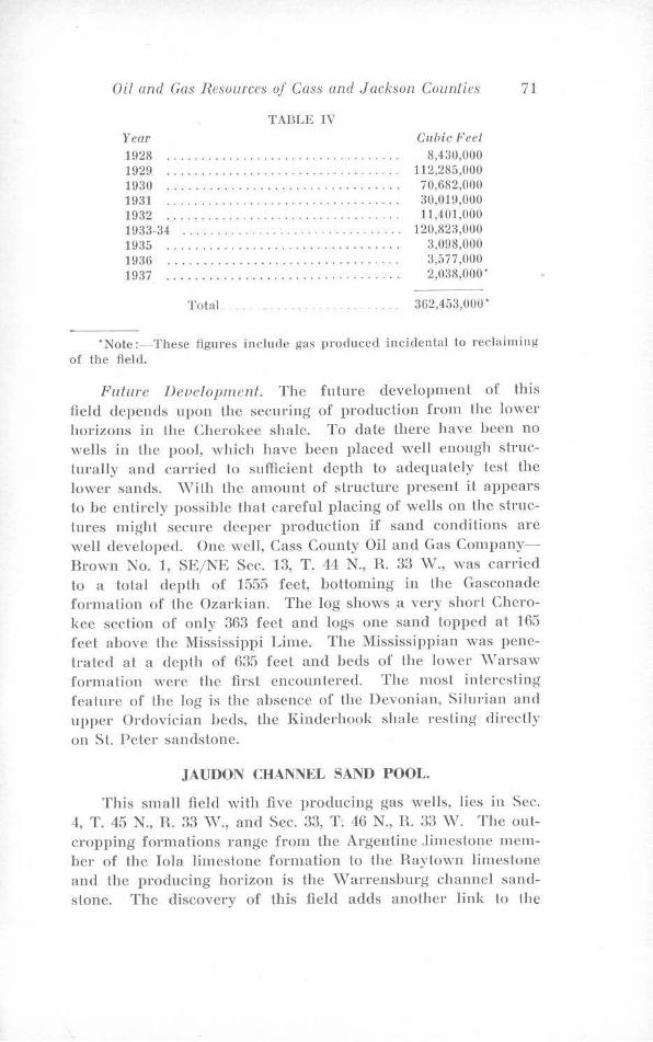
Oil and Gas Resources of Cass and Jackson Counties 71
TABLE IV Year 1928 .............................. . 192() .................. . .... . ......... . 1930 ..................... . ...... · ·. · · 1931 ...... .. ..... . . . . . ............... . 1932 ............. . . ............. . ... . . 1933-34 .................. ............. . 1935 1936 1937
Total.
Cubic Feel
8,430,000 112,285,000 70,682,000 30,019,000 11 ,401,000
120,823,000 :l,098,000 3,577,000 2,0:38,000 ·
362,453,000 •
'Nole :- These figures include gas produced incidental to reclaiming of the field.
Future nevelopmenl. The fulure development of this field depends upon the securing of production from lhe lower horizons in the Cherokee shale. To date there have been no wells in the pool, which have been placed well enough struclurally and carried to sufficient depth to adequately test the lower sands. vVith the amount of structure present it appears to be entirely possible that careful placing of wells on lhe structures might secure deeper production if sand conditions are well developed. One well, Cass County Oil and Gas CompanyBrown No. 1, SE/ NE Sec. 13, T. 44 N., R. 33 \V., was carried to a total depth of 1555 feet, bottoming in the Gasconade formation of U1e Ozarkian. The log shows a very short Cherokee section of only 363 feel and logs one sand topped at 165 feet above the Mississippi Lime. The Mississippian was penetrated at a depth of 635 feet and beds of the lower \Varsaw formation were the firsl encountered. The most interesting feature of the log is the absence of the Devonian, Silurian and upper Ordovician beds, the Kinderhook shale resting directly on SL Peter sandstone.
JAUDON CHANNEL SAND POOL.
This small field with five producing gas wells, lies in Sec. 4, T. 45 N., R. 33 \V., and Sec. 33, T. 46 N., H. 33 \V. The outcropping formations range from the Argentine .limes Lone member of the Iola limestone formation to the Raytown limestone and the producing horizon is the v,r arrensburg channel sands Lone. The discovery of this field adds another link to the
72 Missouri Geological Survey and Water Resources
growing chain of evidence supporting Lhe major unconformity between the Des Moines and Missouri serjes. The channel deposit is apparently Jillie afTecte<l by structure, though it follows a narrow terrace on the east flank of the Jaudon anticline. It is extremely narrow, less than a quarter of a mile in width, and has a proven linear extent of a little over one-half mile. The channel trends due north-south and attempts to extend it to the south have so far been unsuccessful. The north end, however,
. is still open. The depth to the sand is about 390 feet for wells starting in the Argentine limestone member of the Iola limestone. The reservoir pressure is about 80 pounds. The five producing wells drilled in the pool had an initial open flow of 1,525,000 cubic feet. These wells had produced a total of 19,847,000 cubic feet of gas to September 22, 19L12, and had been connected for nine months.
Any further development in this area is apparently dependent upon tracing I.he possible further extension of lhis narrow channel deposH. Other wells on the Jaudon anticline are too small for commercial product.ion and the discovery well Charles Lewis ct al, Chandler No. 1, NE/ NE Sec. 4, T. 45 N., H. 33 \V.), in the channel sand was drilled to a total depth of 1500 feet, bottoming fo the Jefferson City formation of Lhe Canadian. However, as may readily be seen it was nol well located, structurally. The log of this well is included in Appendix III to this report.
ENDICOTT-SHALER OIL AND GAS POOL.
The Endicott-Shaler oil and gas pool occupies a complex nose on the Horse Creek-South Creek anticline. It lies in Secs. 27, and 34, T. 44 N., R. 33 \V., and is the second oil pool in the counly.
Outcropping Formations. The lower limestones of the Kansas CHy group occupy the uplands and wells in Section 27, start in the ·winterset or Bethany Falls limestone. However, the major portion of the wells are in Section 3"1 in the valley of Horse Creek and hence start in the upper portion of the Pleasan Lon shale.
Producing Formations. Gas produclion is from black shales in the Henrietta and upper part of the Cl1erokee, with the Lexington coal horizon again the main producing zone. Oil production is from a thin sand at the \Varrensburg horizon.
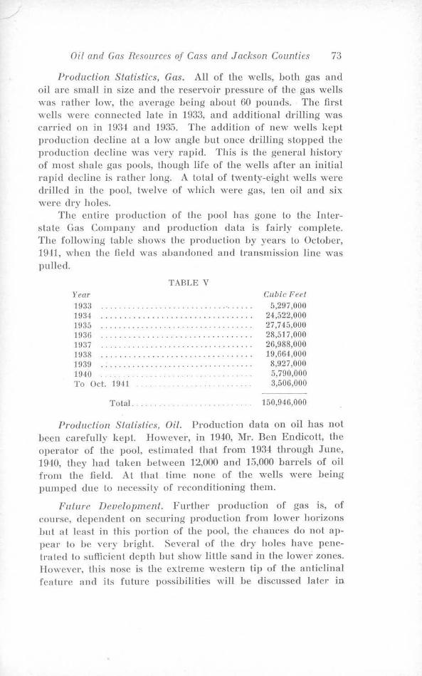
Oil and Gas Resources of Cass and Jackson Counties 73
Production Statistics, Gas. All of the wells, both gas and oil are small in size and the reservoir pressure of the gas wells was rather low, the average being about 60 pounds. The first wells were connected late in 1933, and additional drilling was carried on in 193 ~ and 1935. The addition of new wells kepl production decline at a low angle but once drilling stopped the production decline was very rapid. This is the general history of most shale gas pools, though life of the wells after an initial rapid decline is rather long. A total of twenty-eight ·wells ,vere drilled in the pool, twelve of which were gas, ten oil and six were dry holes.
The entire prodnclion of the pool has gone to the Interslate Gas Company and production data is fairly complete. The following table shows the production by years to October, 1941, when the field was abandoned and transmission line was pulled.
Year
1933 1934 1!l35 1936 lfl37 1938
TABLE V
1939 ............. . ................... . 1940 . .. . .. . ......... . To Oct. 1941
Total .... . . . .. . .. .
Cubic Feet 5,297,000
24,522,000 27,745,000 28,517,000 26,988,000 19,664,000 8,927,000 5,790,000 3,506,000
150,946,000
Produclion Statistics, Oil. Production data on oil has nol been carefully kept. However, in 1940, Mr. Ben Endicott, the operator of the pool, estimated that from 1934 through June, 1940, they had laken between 12,000 and 15,000 barrels of oil from the field. At that time none of the wells were being pumped due lo necessity of reconditioning them.
Future Development. Further production of gas is, of course, dependent on securing production from lower horizons but at leasl in this portion of the pool, the chances do not appear lo be very bright. Several of the dry holes have penetrated to sufficient depth but show little sand in the lowe1; zones. However, this nose is the extreme western lip of the anticllnal feature and its future possibilities will be discussed later in
74 Missouri Geological Survey and Water Resources
this report. The possibilities for further oil production seem to be nil, for the oil producing portion of the structure is completely oulline<l and none of the lower horizons have shown oil in commercial quantities.
ARCHIE-PLEASANT HILL-STRASBURG DISTRICT.
In this district is found the one remaining commercial gas pool and another sma1l pool which furnished gas for the United Brick Plant at Harrisonville.
The Cressman pool in Sec. 3, T. 4L1 N., R. 32 \V., is of small size and though the wells are not dead, they are no longer able to produce against the pressure of the gathering line servicing the field. The outcropping formations are the lower members of the Kansas City group and production is obtained mainly from black shales in the Henrietta, with main production coming from the Lexington coal horizon. The lower formations have not been drilled in this pool, though one well off the structure went to the so-called Bartlesville. No production data is available, and future development is dependent on securing gas from the Squirrel sand or lower sands in the Cherokee shale.
The Harrisonville pool furnished gas for the United Brick and Tile Company plant at Harrisonville and was not used otherwise commerciall)~- All of the wells start in the Pleasanton shale and the principal producing horizon was the black shale at the Mulky coal horizon, though most of the wells also had gas at the Lexington coal horizon and the common practice was to save the gas from both. All of the wells were small and no production data is available. Future development is again dependent on securing production from lower horizons in the Cherokee.
The producing fields in Cass County, as may be seen from the previous discussion, have been rather small but have produced considerable gas. In summarizing, the following figures on total gas and oH production for the county may be of interest. These figures as previously pointed out are necessarily incomplete:
Total gas production- 1,240,330,000 cubic feet. Total oil production- 170,000 barrels plus.
•
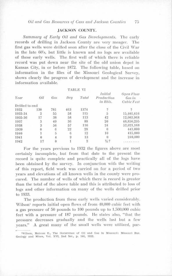
Oil and Gas Resources of Cass and Jackson Counties 75
JACKSON COUNTY.
Summary of Early Oil and Gas Developments. The early records of drilling in Jackson County are very meager. The first gas wells were drilled soon after the close of the Civil ,var in the late 60's, but Jitlle is kno,vn and no logs are available of these early wells. The first well of which there is rel iablc record was put down near the site of the old union depot in Kansas City, in or before 1872. The following lable, based on information in lhe files of the Missouri Geological Survey, shows clearly the progress of development and the increase in information available.
TABLE VI Initial Open Flow
Year Oil Gas Dry Total Production Gas in in Bbls. Cubic Feet
Drilled to end 1932 130 781 463 1374 ? ? 1933-34 2 55 58 115 5 15,401,616 1935-36 17 38 58 113 42 12,003,968 1937 3 49 36 88 20 48,850,295 1938 3 56 57 116 24 52,021,168 1939 0 6 22 28 0 443,000 1940 1 5 6 12 10 415,000 1941 0 4 9 13 0 240,000 194::!. 1? 0 1 2 1h? .........
For the years previous to 1932 the figures above arc most certainly incon1plete, but from Uiat date to the present the record is quite complete and practicaily all of the logs have been obtained by the survey. In conjunction with the writing of this report, field work was canied on for a period of two years and elevations of all known wells in the county were procured. The number of wells of which there is .rec01·d is greater than the total of the above table and this is attributed to loss of logs and other information on many of the weils driIIed prior to 1933.
The production from these early wells varied considerably. ,vnson1 reports ip.ilial open flows of from 40,000 cubic feet with a gas pressure of 50 pounds to 100 pounds up lo 1,500,000 cubic feet with a pressure of 187 pounds. He states also, "that the pressure decreases gradually and the wells last but a few years." A great many of the small wells ,vere utilized, par-
•Wilson, Malcom E., The Occurrence of Oil and Gas in Missouri: Missouri Bur. Geology and Mines, Vol. XVI, 2nd Ser., p. 146, 1022.
76 A1issouri Geological Survey and VVater Resources
ticularJy on farms and in private homes in and near Kansas City, .for heating and illuminating purposes. The first commerical dislribution of gas from natural sources was al ?lfartin City where one well owned by Mr. Louh; II. Knoche supplied the town for several years.
The early production of oil ,vas very srnall and only two localities are men Lioned in previous publications on this region. One, the Scruggs and Johnson lease in Lhe S\V:4, Sec. 36, T. 47 N., R. 33 \V., one-half mile north uf the Cass-Jackson County line, had belween five and Len producing wells and for a short Lime the average sale of oil from this Jcase was 300 barrels a month. The date of this activity is prior to 1912. The other locality is the state line area between Dallas and New Santa Fe. \Vilson' stales "several wells have been drilled during the last few years (prior to H>22) and that an initial production of 50 to 75 barrels per day is reported by the Dallas Oil and Gas Company."
The earliest figures available on the total number of ,veils drilled are those of \Vilson2
• He estimates that 100 to f50 wells had been drilled to that date (1922). Even taking into consideration the fact that this is probably a very low flgure, it is easily seen from the preceding table that the major portion of the development has taken place in the last 20 years. For this reason the detailed discussion of development deals with the more recent discoveries for which more complete information is available. This discussion will be taken up by townships in order to facilitate location of the various pools.
TOWNSIDP 47 NORTH, RANGE 32 AND 33 WEST.
The only commercial oil pools in Jackson County are located in this area. There are also two very productive gas fields and many small scall.ered oil and gas wells.
Outcropping Formations. In this area, which has a surface relief of over 300 feet, Lhe uplands are capped by Lhe Argentine limestone member of the Iola limeslone formation and the top of lhe Pleasanton shale is exposed in the Valley of Big Blue River. In the intervening space the entire thickness of the Kansas City group is exposed.
'Wilson, op. cit., p. 147. •Wilson, idem., p. 145.
Oil and Gas Resources of Cass and Jackson Counties 77
Producing Hori=ons. Gas is encountered in the \Vayside sand, the marginal phase of the \Varrensburg sand, the Peru sand, the Lexington coal horizon, the Squirrel sand and the so-called Bartlesville sand. \Veils on upland Lhal start in the Argen line limestone, reach the Lexington coal ho rizon al a round 500 feet, the lop of the Squirrel sand zone at .::;25 to 5...10 feel and Lhc top of the so-called Bartlesville sand at about 650 feet. Oil is found only in the upper and lower part of the Squirrel sand zone.
The two gas fields lie lo the easl and west of the town of Grandview and they arc designaled as the East and \Vest Grandview gas fields. The East Grandview field in Secs. 17, 18, 19, and 20, T. -17 X, R. 32 \\' ., and Secs. 13, 2 l, and 25, T. 47 N., R. 33 \V., occupies mosl of the Easl Grandview anticline (2) and is much the larger of the two. \\' ith depletion of Lhe Squirrel gas, deeper drilling lo the so-called Bartlesville sand encountered additional production and several wells in the field are slill producing from Lhis horizon. Al Lhc present lime, however, prodticlion from the so-called Bartlesville is confined to the western portion of the f1cld and there is a long narrow area on lop of Lhe dome in which no wells have been drilled. The Sol Chiles well (Map ~o. 18) S\Y% Sec. 19, T. 47 X, R. 32 \V., penetrated Lhe Burgess sand horizon hut failed to get any gas. It did, however, encounter salt water. This well was located high structurally, hut was drilled after wells in the Squirrel sand horizon on Lhe same lease were abandoned. This field has produced a lolal of G:50,8G2,000 cubic feet to October 22, H.l-12, and three wells are still producing gas from the socalled Bartlesville.
The \Vest GrandYiew field lies in Secs. 3, ..J-, 10, and 1f5. T. 47 N., R. 33 \Y. It occupies a Lerra cc (I), a part of the l\farlin City anticline (1). 1t is the first commercial pool in the county producing from the Peru sand. The field was opened in September, 1933, and initial J)roduclion of more than 1,000.000 cubic feet was reported from several wells. This is rather large for wells producing from this horizon. Additional development occurred in 1934 and a total of twelve gas wells and seven dry holes have been drilled. Nearly all the gas is from the Peru sand and attempts to obtain further production from the Squirrel sand and Lhc so-called BartlesYille have been disappointing. The field is now abandoned and all wells have been salvaged. The field produced a total of 240,82U,OOO cuhic feet of gas to September, 1940.
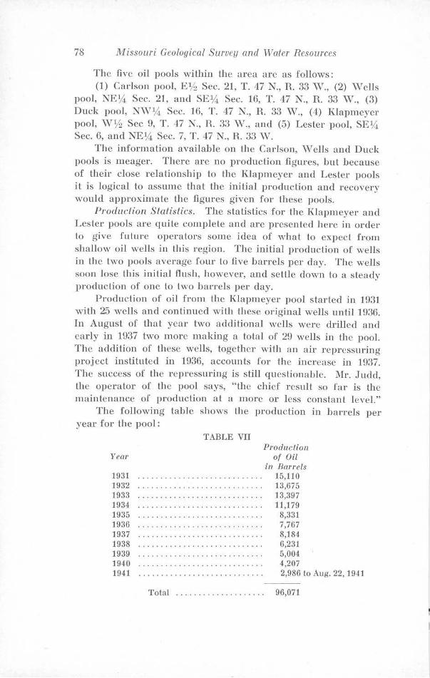
78 Missouri Geological Survey and Water Resources
The five oil pools within the area arc as follows: (1) Carlson pool, EVz Sec. 21, T. 47 N., R. 33 vV., (2) vVells
pool, NEY.!, Sec. 21, and SEY.!, Sec. rn, T. 47 N., R. 33 vV., (3) Duck pool, N\:V:14 Sec. rn, T. 47 N., R. 33 vV., (4) Klapmeyer pool, \VYz Sec 9, T. 47 X, H.. 33 vV., and (5) Lester pool, SEY.!, Sec. 6, and NEl,4 Sec. 7, T. 47 N., R. 33 ·w.
The information available on the Carlson, \Vells and Duck pools is meager. There are no production figures, but because of their close relationship to the Klapmeyer and Lester pools it is logical to assume that the initial production and recovery would approximate the figures given for these pools.
Production Statistics. The statistics for the l{Japmeyer and Lester pools are quite complete and are presented here in order to give fu lure operators some idea of what to expect from shallow oil wells in this region. The initial production of wells in the two pools average four to five barrels per day. The wells soon lose this initial flush, however, and sellle down to a steady production of one to two barrels per day.
Production of oil from the Klapmeyer pool started in 1931 ·with 25 wells and continued wilh these original wells until 1936. In August of that year two additional wells were drilled and early in 1937 two more making a total of 29 wells in the pool. The addition of these wells, together with an air repressuring project instituted in 193(), accounts for the increase in 1987. The success of the repressuring is still questionable. Mr. Judd, the operator of the pool says, "the chief result so far is the maintenance of production at a more or less constant level."
The following table shows the production in barrels per year for the pool:
Year
1931 1932 1933 1934 1935 1936 1937 1938 1939 1940 1941
TABLE VII Production
of Oil in Barrels
15,110 13,675 13,397 11,179
8,331 7,767 8,184 6,231 5,004 4,207 2,986 to Aug. 22, 1941
Total . . . . . . . . . . . . . . . . . . . . 96,071
Oil and Gas Resources of Cass and Jackson Counties 79
Pool sold to Brown-Slrauss Corp. on Aug. 22, 1941. The total value of all the oil produced, to the time the field was sold to Brown-Strauss Corporalion, based on an average of $0.86 per barrel is $82,621.07.
The Lester pool is smaller with a total of 14 producing wells. Pumping did nol start in this pool until 1932 though oil had been produced from the surrounding area for many years. The following table gives production in barrels per year for the pool:
Year
1932 1933 1934 1935 193G 1937 1938 1939 1940 1941
TABLE VIII
Produclion of Oil
in Banels
11,452 5,9G9 4,321 2,855 1,642 1,518 1,153
889 756 550
Total . . . . . . . . . . . . . . . . . . . . . . . . 31,105
The total value of all oil produced is $26,750.30. The production from this pool has been considerably less than from the Klapmeyer pool and the writer believes that this is due to exploitation of the region prior to 1932. The rate of production is declining slowly and the pool will probably reach depletion before the Klapmeyer pool. However, a new well drilled in 1941 was good for five barrels per day and ·will add to the life of the pool.
In addilion to the wells in the pools previously described there are many private ones and numerous dry holes scattered over the entire region. The logs of these wells provide information otherwise unobtainable and hence are of considerable value in the development of the region. The following table summarizes drilling activities in the area under discussion:
80 Missouri Geological Survey and Water Resources
TABLE IX
T.4-7 N. R.32 W.
Total Number of Wells of which there is record.
Logs of \V ells on Fi le .. . Gas ................... . Oil ................... . Water ................ . . Dry Holes .... . ....... .
63 53 14
0 5
43
T. 4-7 N. H.33 W.
288 244
G5 99 11 77
Total
351 297 79 99 lG
120
Future Developmf'nl. The future of this area is highly problematical. Deeper drilling in any of Lhe older fields may encounter additional gas or oil or both, lmt as yet it has nol been attempted exeept in lhe East Grandview field. Further work in repressuring, either by air or water flooding methods,* might revive lhe oil pools and the writer recommends that U1e operators investigate repressuring more thoroughly. The gas fields of the region are being rapidly depleted and only the so-called Bartlesville sand wells are still producing gas for commercial consumption. The possibility of further production appears to rest entirely on deeper drilling. The majodty of the area in Range 32 \Vest is open for further prospecting. The structure map (Plate III) shows the lack of information jn the area and it is entirely possible Lhat detailed surface mapping might uncover several structures in the area that are not indicated on the map of this report.
TOWNSHIP 47 NORTH, RANGE 31 WEST
This area has one small commercial gas fie]d and a few scattered private gas wells. In addition there are a number of dry holes, one of which penetrated pre-Cambrian rocks.
LEES SUMMIT TOWNSITE POOL
Outcropping Form.ations. The outcropping formations range from the Argentine limestone member of the Iola limestone formation Lo the Bethany Falls limestone of the Kansas City group. Most of the wells in Lhe Lees Summit pool start in the Argentine limestone or high up in the Chanule shale while wells in other parts of the area begin slightly lower dmvn in the section.
'Brown-Strauss Corporallon has started water flooding in the Rlapmeyer pool Jmt. no information regarding results is yet available.
Oil and Gas Resources of Cass and Jackson Counties 81
Producing Horizons. The only commercial production is from the vVarrensburg channel sandstone which is well developed particularly in the Lees Summit area. The Squirrel sand is absent beneath the Lees Summit pool and deeper formations fail to show sand bodies of any magnitude. ,v ells in the remainder of the region, ho"vever, have penetrated practically normal sand sections.
Production Statistics. The Lees Smnmit townsite pool lies in Secs. 5, 6, 7, and 8, T. 47 N., R. 31 vV. This field affords the second instance of both gas and oil in commercial quantities in the same field. The pool was first opened by private drilling for home consumption in 1927. Soon, however, the Lees Summit Gas Company leased and drilled a 11 available locations and began supplying the town with gas.
Since practically all the gas produced was carried by the Company pipe lines fairly accurate production figures for the pool are available. The only gas not accounted for is from private wells which were never used commercially and that which was consumed by the property owner, unmetered, as part of the lease contract. The total initial open flow of 32 ou l of 39 producing wells used commercially was 14,646,000 cubic feet. The open flow from the olher wells are not available, but all were small private wells.
The following table gives the total production :for the pool:
Year
19:l8 1929 1930 1931 1932 19::l3
TABLE X Production of gas in cubic fl.
5,815,200 34,296,900 49,272,000 43,815,200 29,602,220
:3,185,300
Total . . . . . . . . . . . . . . . . . . . . . . 165,981,820 cu. fl.
Al the end of 1933 Lhe gas company abandoned the wells and after attempts by land owners to continue their use for private consumption proved unsuccessful, they were salvaged. The records of oil production are not available but the wells were all small and total production could not have been very large. All are now abandoned.
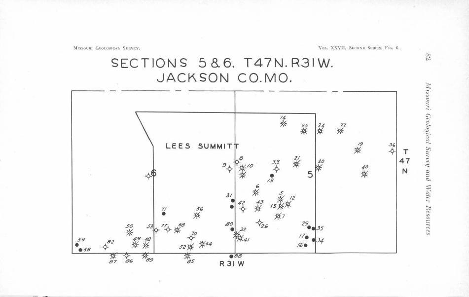
'.\l1ssocn1 GEOLOGICAL SvnvEv. VOL, XXVII, SECOND SERIES, FIG. G.
SECTIONS 5B.6. T47N.R31W. JACKSON CO.MO.
1 25 fl 2l
* * LEES SUMMIT 19 .3(,
·* -<?- T 21
20 .33
* 4 • 5
47 ,f.O
* N,
/.3 6
31 * .s 43 * 12
7/ S6 * ,s:Jt* • * *7
so SJ 7!¢- 68 ~6 29. .J5
* * 70 17. S9 49 ,{8 ~ .34 • 42 ** 52* *S4 /6e ese
ese 87 66 OS R31 W
00 l'-'
~ "' "' 0 t:: ...., -· G')
"" C --c:, cc: ;:;· Q
V) t:: ...., <::: "" ~ Q ::::, ~
:s:: --. a ('t, ....,
~ ('t,
"' 0 t:: ...., ("')
"' "'
Oil and Gas Resources of Cass and Jackson Counties 83
Special Features. The total absence of the Squirrel sand beneath this pool and throughout the surrounding area js worthy of note. In fact the log of the Kenton well (Map No. 8fi) N'E1.4 S W1.4 Sec. 7, T. 47 N., R. 31 \V., shows only two very thin streaks of sand in the entire Cherokee formation. This absence of sand indicales that in this parlicular area, at least, muddy water conditions persisled throughout the deposilion of the Cherokee. The production of gas and oil from the \Varrensburg sand in closely spaced wells is also worthy of mention.
The remainder of this region has been hut slightly prospected. The records show only 24 wells localed outside of the Lees Summit townsite pool. Of this number six ,vere small gas wells and the others dry holes or water wells. The producing horizons are similar to those of the Lees Summit pool except the Squirrel, so-called Bartlesville and Burgess sands are present, thus indicating that the muddy water was confined to a rather small part of this region. The Phil K. Toll well (Map .No. 99), SE1.4 NvV1.4 SE1.4 Section 29, To,vnship 47 North, Range 31 \J;,T est, is lhe deepest hole in the township. It penetrated preCarnbrian rock al 2214 feet and is one of the five "granite" wells in Jackson County. The log shows 80 feet of sand at the St. Peter (\Vilcox ?) horizon with a sho,ving of water. The logs of the gas wells are not in the files, but their location indicates that they are well up on top of the Lees Summit nose. The following table summarizes drilling in the townsite pool and the remainder of the Range.
TABLE XI
Lee's Summit Remainder of Pool T. 47 N., R. 31 W. Total
Total Number of Wells of Which There is Record ..
Logs of Wells on File ... . Gas ..................... . Oil ........... . ....... . . . \¥ater ........... .. . . .... . Dry ..................... .
93 71 54 15
1 22
24 17
6 0 3
15
117 88 60 15 4
37
Future Development. The Lees Summit pool is deplele<l and completely abandoned. The absence of good sand precludes the possibility of further production from lower horizons. The future of the remainder of this range rests on
84 Missouri Geological Survey and V\later Resources
furtl1er prospecting an<l detailed surface mapping to discover new structures.
TOWNSHIP 47 NORTH, RANGE 29 AND 30 WEST
This area contains three small commercial gas fields, a group of gas wells that have never been used commercially and the usual scattel'ing of dry holes and water wells.
Outcropping Formations. Practically the entire area is underlain by the lower three mernbers of the Kansas City formation and in a few places in I.he Knorpp pool small outliers of the overlying Cherryvale shale remain. In other places the larger streams have cut down into the top of the Pleasanton.
Produring Horizons. The \Vaysidc sand is the first horizon penetrated that 8hows gas, but it is insignificant in quantity. The main production in the Knorpp pool comes either from the Squirrel sand or the \Varrensburg channel sand which trends in a northwest-southeast direction across Section 32 and 33, T. 47 N., R. 30 \V. The channel sand here has a maximum thickness of 70 feet. It generall y rests on the limestone below the Lexington coal horizon, but where the maximum thickness is developed even this has been cut out. The Squirrel sand is ,vell developed, one of the wells penetrating 80 feel of sand at this hodzon. In the Shawhan and Lone Jack pools the main production is also from the Squirrel sand, but the channel sand is nussmg. Some gas is also found in the black shales at the Lexington, Summit., and Mulky coal horizons. One well (Map No. 86) Ott Clark No. 7, SE~ ~\V~ :NE:1/i,, Section 32, Township 1l7 :North, Range 30 ·west, in the J{norpp pool was drilled Lo the Mississippian limestone. The log shows 9!) feet of sand and shale al the so-called Bartlesville horizon and 35 feet of Burgess sand, though neither ·was productive. Tsvo wells were drilled to the "Lime" in the Shawhan pool and in one, D. Lee Shawhan :No. G (Map No. 23), N,v~ SE% SE1,4, Section 1-i, Township 47 North, Range 30 \Vest, drilling was finally stopped at 1265 feel. The so-called Bartlesville sand was absent and the Burgess carried water.
The gas from Lhe three pools is purchased by the Interstate Gas Company of Harrisonville, Missouri, and since production records of the three arc combined, they will be considered as one in this discussion. The l{norpp pool lies in Sections 32 and 33, Township 47 North, Range 30. \¥est, and
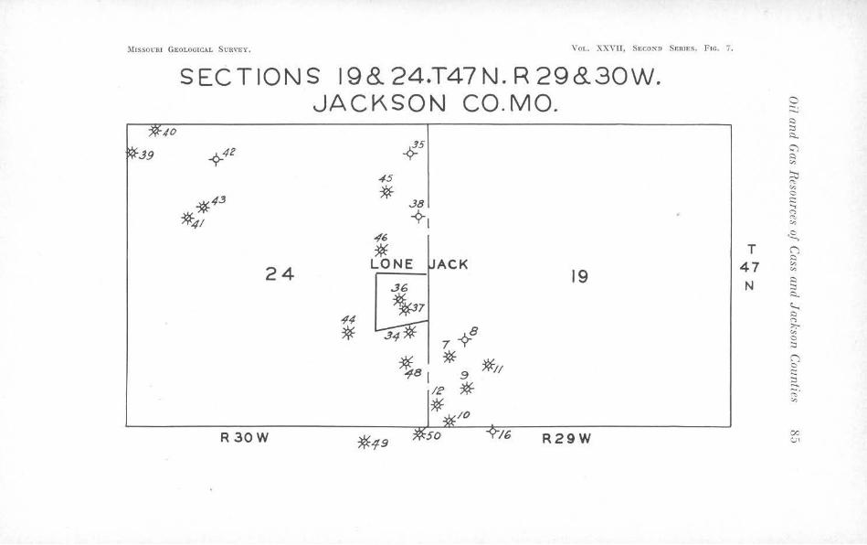
l\11ssou nr GEOLOGICAL SURVEY. Vor,. XXVH, SECOND SERIES , Fie. 7.
SECTIONS 198.. 24.T47N. R 29&30W. JACKSON CO.MO. a -. ,.._
Q
40 :::, \:;..
.J9 -¢-42 4-s (;) i::)
"' 45 ~
<"'>
*43 * ..38
*41 ~, "' 0 i:::: ..., <"> <"> "'
,f6 ~
* 24 LONE ACK
19 .:J6
,;4 ~7
* 7 -i-8
T (') ~
47 "' "' N
Q :::, i::i..
~ Q <"> :>:;-"' 0 :::,
ts1 * 9 *11
IE * (') 0 t::: ;:?.. -. <">
* "'
R30W *19 16 R29W 00
CJ1

86 Missouri Geological Survey and Water Resources
extends south over the county line into Sections 4 and 5, Township 3G North, Hauge 30 Vv est, in Cass County. For this reason production records include gas from ten wells that are not localed in Jackson County though a part of this pool. The Shawhan pool covers parts of Sections 13, 14, 23, and 2-1, Township -17 North, Range 30 ,vest, and the Lone Jack pool lies along the range line in Sections 19 and 30, Township 47 North, Range 29 \Vest, and Sections 2...1: and 25, Township 47 North, Hauge 30 " rest. The pools were not connected un Lil 1930 though the discovery well in the Shawhan pool was drilled in 1925 and in Lhe J{norpp pool in 1929. There were a total of 120 "\Yells drilled in the three pools, 89 of them producing gas and 31 being d1·y holes. In the Knorpp pool eight were completed as small oil wells in the \Varrensburg channel sand, but were soon abandoned.
Production Statistics. The production figures from these pools are rather startling in that the total initial open flow was never very large considering the number of wells, and the life of the pools has been much longer than would normally be expected from the size of the wells. The LoLal initial open flow early in 1930 was 10,883,652 cubic feel. This was increased by drilling additional wells so that on November 5, 1930, with a total of 4!) producing wells, the total open flow was 11,542,000 cubic feet, the maximum figure for the pools. The decline of open flow was rather rapid ancl on September 17, 1934, the open flow was only 1,103,938 cubic feet. Despite continued decrease of open flow and the fact that the reservoir pressure had declined to eight pounds at the end of 1937, 20 wells were still producing. These pools are now depleted and the fo llowing table gi Yes the total production for them:
Year 1930 19~1 1932 1933 1934 1935 193G 1937 1938
TABLE XII Production of gas in cu. /'l.
Gl,816,000 . . . . . . . . . . . . . . . . . . . . . . . . . . . . . . . . . . . 67,616,000 . . . . . . . . . . . . . . . . . . . . . . . . . . . . . . . . . . . 73,543,000 . . . . . . . . . . . . . . . . . . . . . . . . . . . . . . . . . . . 56,023,000 . . . . . . . . . . . . . . . . . . . . . . . . . . . . . . . . . . . 44,752,000 . . . . . . . . . . . . . . . . . . . . . . . . . . . . . . . . . . . 18,920,000 . . . . . . . . . . . . . . . . . . . . . . . . . . . . . . . . . . . 7,G12,000
Total. ....
5,289,000 4,235,000
337,806,000
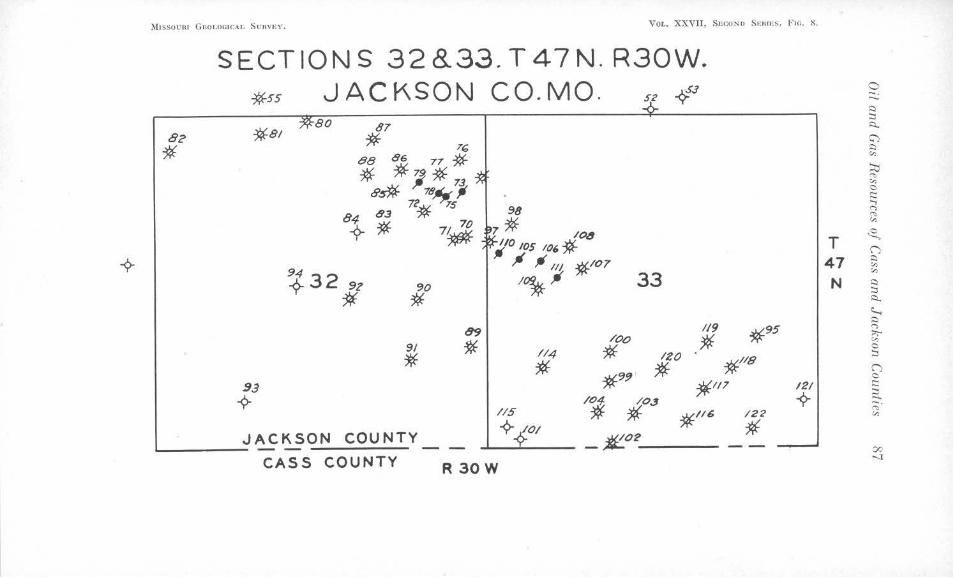
i\I1ssOt:JU G£OLOG!CAL Sunv1,:v. VOL. XXVII, SECOND S1m11,s, Frn. 8.
82
*
SECTIONS 32 8..33. T 4 7 N. R30W. *ss JACKSON CO. MO. 5: 4:1
~80 *8/
87
*
90
* 89
9/ * *
33
/Oo / / 4 * IZO
* * 1/9
* *95
*IIB *9!) '
93 *l/7
-<?- /04 *OJ //5 * *//6 /22
JACKSON COUNTY -<?-401 _£_02 * -- --CASS COUNTY R 30W
12/
i>"
0 -. -s:::, :::i ~
:;) s:::,
"' :::i::i .... "' 0 t::: ..., r, .... "'
T .s, ('")
47 s:::,
"' "' N s:::,
:::i s:::,_
~ s:::, r, ::.;-"' 0 :::I
('") 0 t::: :::i ...... -. .... :,,
co -.,l
88 Missouri Geological Survey and Water Resources
In addi lion to these pools there are several small gas ·wells on lhe elongated Adams Cemetery anticline in Sections 3, 10, !), 8, and 17, Township Ll7 North, Range 30 '\Vest. The wells are ralher small and have never been used commercially. Outcropping formations are the same as Lhose in the other parts of lhc area previously described. Production is mainly from the Squirrel sand and as yel no wells have been drilled to deeper horizons in this part of the range.
Future nevelopmenl. The three commercial pools, have reached Lolal depletion. There is little possibility of production from lower formations because deep tests on these structures, though well located structurally, have failed to obtain any gas. The fulure of the Adams Cemetery anticline will be considered later. The following table gives a summary of drilling in the region:
TABLE XTII
Total Number of Wells of Which There is Record ..
Logs of Wells on File .... . Gas ................ .... . . Oil ................... .. . Water ........ ... ... . .... . Dry Holes .... . . . . . .. . .. .
T. li7 N. R.29 W.
18 16
5 0 6 9
T.li7N. R . .10 W.
132 120
71 8
16 37
Total
150 136
76 8
22 46
TOWNSHIP 48 NORTH, RANGE 31 AND 32 WEST
These ranges comprise the area previously published and described in delail under the title, "Geology of the Blue Springs Gas Field." 1 Il is unnecessary, therefore, to discuss further ils location, outcropping formations, producing horizons and other features. However, the writer believes it worthwhile lo again call attention to the \Varrensburg channel sandstone. It was in this area I.hat its true relationship to Lhe surrounding beds in Jackson County was first definitely recognized. Bartle2 discussed at considerable length the importance both economic and stratigraphic, of this discovery and suggested that it seemed logical to place the con tact between the Des Moines and the Missouri groups at this unconformity. Previously, it had been
'Bm·tlc, Glenn G., Geology of the Blue Springs Gas Field: :Missouri llur. Geology and Mines, 57th Bien. Rcpt., App. 11!, p. 6-1, 1933.
'Bartle, idem., p. 18.
Oil and Gas Resources of Cass and Jackson Counties 89
drawn al the base of the Kansas City formation on the basis of change in Jilhology. After careful study of Lhe problem in the lighl of additional information, leading geologists in this part of the :Mid-Continent region agree that the boundary between the Des .Moines and the Missouri series should logically be placed at this horizon.
Prodllcfion Statistics. Since almost the entire production from this field has been handled by one company, the Panhandle Easlern Pipe Line Company, unusually complete statistics are available from the company records. The gas produced and used by the Knobtown Development Company was added to the original figures of Bartle's reporl. The only gas not accounted for in these fl.gures is that which is used by the landowner, unmetered, as a part of the lease contract, leakage and line Joss, and loss due to "blowing off" while gauging wells or cleaning them of excess water. Bartle1 says, however, that the total arnoun t produced is probably less than ten per cent greater than the production figures show.
The Blue Springs field was divided into districts based upon the date of connection of wells to the main line system. Since records of the Panhandle Eastern Pipe Line Company show the production for such districts the same subdivisions will be used in this report. The East and :\Tortheast districts include all of the wells on lhe Blue Springs anticline, except those on the Ritter nose. The Sou th district covers those wells on the Ritter nose.
Using the "Production Decline Curve Method" Bartle2 estimated the expected future production of the field after January 1, H)32. Comparing these estimates with the actual production of the field to October 31, 1942, a considerable discrepancy is noticed. To January 1, 1932, the East and Northeast districts, with a total initial open flow of 36,870,000 cubic feet, had produced a total of 974,280,000 cubic feel of gas. Based on extrapolation of Decline Curves he estimated that an additional 440,000,000 cubic feet would be produced, making a total of 1,414,280,000 cubic feel before abandonment. To October 31, 1942, these districts had produced a total of 1,708,027,000 cubic feet and three wells were still on the lines showing that Bartlc's estimate was 393,7-17,000 cubic feel loo low. The
' Bartle, op. cit., p. 35. •Bartle, idem., p. 38.
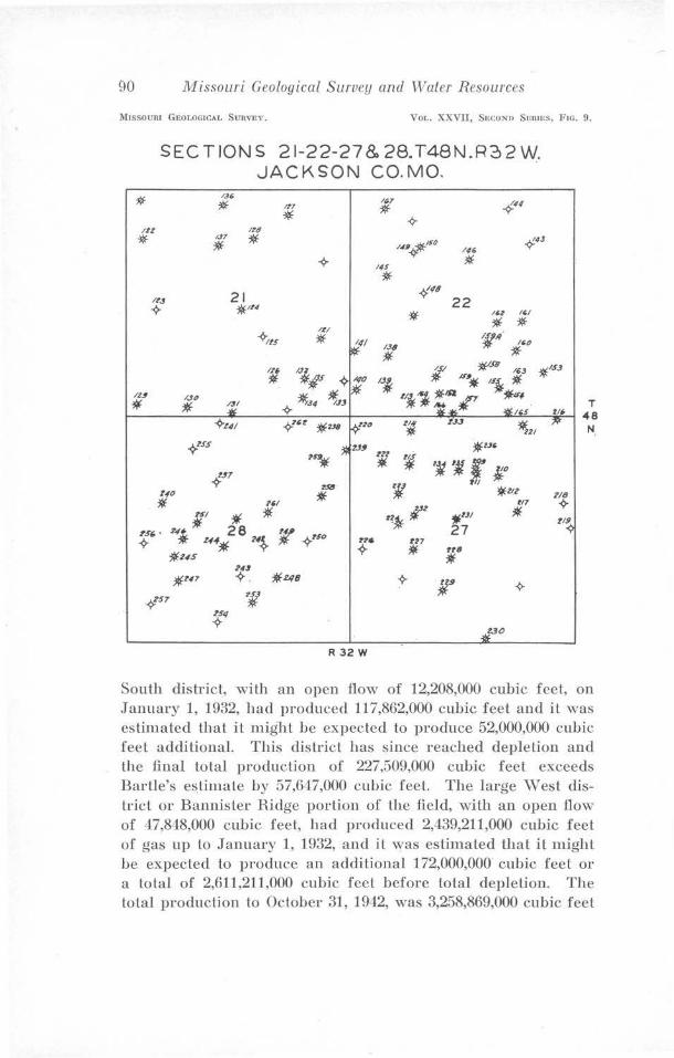
90 M'issouri Geological Survey and Water Resources
MISSOURI GeOLOGICAI. SURVEY. VoL. XXVII, SecoND SERIES, FIG. 9.
SECT IONS 21-22-27 & 28. T48N.R2, 2 W. JACKSON CO.MO.
1.u.
* 1?7
* lt,7
* -9-IU
* l rt/
IJ7
* * -9-
N, -jlf/SO ~
I #
* 21 -1'~8
*"4 *
-9-ltS
11//
* l '
R 32 W
South district, with an open flow of 12,208,000 cubic feet, on January 1, 1932, had produced 117,862,000 cubic feet and iL was estimated that it might be expeded to produce 52,000,000 cubic feet additional. This district has since reached depletion and the final total production of 227,509,000 cubic feet exceeds Bartle's e~timate by 57,647,000 cubic feet. The large vVest district or Bannister Ridge portion of the field, with an open flow of 47,8,18,000 cubic feet, had produced 2,439,211,000 cubic feet of gas up to January 1, 1932, and it was estimated that it might be expected to produce an additional 172,000,000 cubic feet or a total of 2,611,211,000 cubic feet before total depletion. The total production to October 31, 19-12, was 3,258,869,000 cubk feet
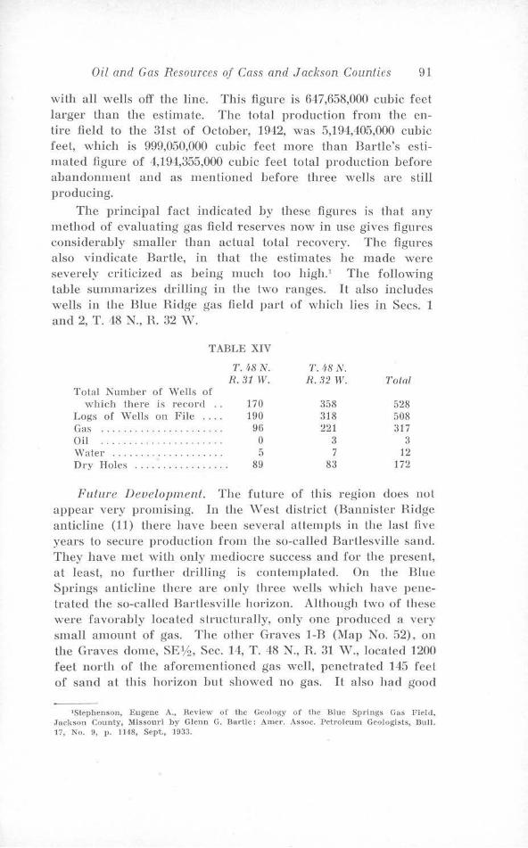
Oil and Gas Resources of Cass and Jackson Counties 91
with all wells off the line. This figure is 647,658,000 cubic feet larger than the estimate. The total production from the entire field to the 31st of October, 1942, was 5,194,405,000 cubic feet, which is 999,050,000 cubic feet more than Bartle's estimated figure of 4,194,355,000 cubic feet total production before abandonment and as mentioned before three wells arc still producing.
The principal fact indicated by these figures is that any method of evaluating gas field reserves now in use gives figures considerably smaller than actual total recovery. The figures also vindicate Bartle, in that the estimates he made were severely criticized as being much too high. 1 The following table summadzes drming in the two ranges. It also includes wells in the Blue Ridge gas field part of ,:vhich lies in Secs. 1 and 2, T. 48 N., R. 32 vV.
TABLE XIV
T.48N. R. 31 W.
Tola! Number of Wells of which there is reco rd . . 170
Logs of Wells on File . . . . 190 Gas . . . . . . . . . . . . . . . . . . . . . . 96 Oil . . . . . . . . . . . . . . . . . . . . . . 0 \.Valer . . . . . . . . . . . . . . . . . . . . 5 Dry Holes . . . . . . . . . . . . . . . . . 89
1'. 4-8 N. R.32 W.
358 318 221
3 7
83
Total
528 508 317
3 12
172
Future Development. The future of this region does not appear very promising. In the \Vest district (Bannister Ridge anticline (11) there have been several attempts in the last five years to secure procluction from the so-called Bartlesville sand. They have met with only mediocre success and for the present, at least, no further drilling is contemplatecl. On the Blue Springs anticline there are only three wells which have penetrated the so-called Bartlesville horizon. Although two of these were favorably located structurally, only one produced a very small amount of gas. The other Graves 1-B (Map No. 52), on the Graves dome, SE1h, Sec. 14, T. 48 N., R. 31 vV., located 1200 feet north of the aforementioned gas well, penetrated 145 feet of sand at this horizon but showed no gas. It also had good
'Stephenson, Eugene A., Rev iew of 1hc Geolo~y of lhc Blue Springs Gns Field, .Jackson County, Missouri by Glenn G. Bartle: Amer. Assoc. Petroleum Geologists, Bull. 17, No. 9, p. 1148, Sept., 1933.
92 Missouri Geological Survey and Water Resources
sand al the Burgess horizon. The third well, Oscar Roten No. l (Map N'o. 116) K\Vl,4 S\\T~, Sec. 28, T. 48 N., R. 31 \V., is low on the east flank of the Ritter nose and did not have any sand at the so-called Bartlesville horizon. However, the log shows 35 feel of water-bearing sand at the Burgess horizon. In spite of these failures it is entirely possible that an occasional well favorably localed might obtain production from these lower formations.
TOWNSHIP 49 NORTH, RANGE 32 WEST.
There are four commercial gas pools located in this region, one of which reached the proportions of a major gas field. In addition there are a number of scattered private wells and a small group of shallow wells which were used lo supply several private homes.
The Centropolis pool lies in Sections 6 and 7, T. 49 N., R. 32 \V., entirely within the valley of the Big Blue River. Alluvium covers the whole area and none of the older formations show at the surface.
Produciny Horizons. Production is from the Squirrel sand and the so-called Bartlesville sand. Since the field lies in the river valley, wells penetrate these horizons at considerably shallower depths than in the upland pools.
The first ·wells were drilled by industrial firms for use in manufacturing. This development ,.vas about 1910 and for several years gas was used by a number of factories. In 1929 the Prior Brass Company had trouble with their first wel], so they drilled another deepening it lo the so-called Bartlesville sand. The ini Lial open flow from Lhis well (1,039,000 cubic feet) was so much larger Lhan the others in the vicinity which were producing froni the Squirrel sand, that it attracted commercial operators and a number of additional wells were drilled. The Cities Service Company laid a connection to the field and purchased gas from a few wells. However, the structure is rather small and the life of the wells was comparitively shorl. AU of the commercial wells have been abandoned and the remaining private wells produce a very s1nall amount of gas. This was the first commercial field in Jack~on County to produce gas from the so-called Bartlesville horizon. There are no accurate production statistics available since the majorily of the gas was used privately.
•
Oil and Gas Resources of Cass and Jackson Counties 93
Future Developments. The pool has practically reached depletion and Lhc possibilily of furlher devcloprnen L from it is not very promising. The Squirrel and so-called Bartlesville horizons have already been tapped and though there arc no wells penetrating the Burgess sand, it seems unlikely that this horizon will produce.
The mine pool lies in Sec. 8, T. l9 N., R. 32 ,v. It is a ,·cry small pool and only two wells have been conneclcd to the pipe line.
Outcropping Formations. The outcropping ro<:ks, all are in the Kansas Cily group ranging from the upper part of the Chanute shale to the Bethany Falls limestone.
Producing II orizons. Gas is encountered in the \Vayside sand, the Peru sand, at the Lexington coal horizon, and the Squirrel sand. One well, Kline No. 3, (Map No. 60), ).JE%, Sec. 8, T. 49 N., R. 32 \V., was drilled to the so-called Bartlesville sand but failed to obtain further produclion and was plugged back to the Squirrel sand.
Produclion Statistics. The first well in this pool was drilled in 1932. Only two of four producing wells have been connected to the pipe line and considering the initial size of Lhese wells, the amount of gas they have produced is rather remarkable. Kibby ).Jo. 1 (Map No. f>()), NW~ SEl,,i ~,v14, Sec. 8, T. -19 N., R. 32 ,v., was connected to the line in 1932. It had an initial open flow of 180,000 cubic feel considered extremely small for a commercial well. However, despite the small open now, this well had produced a total of 52,232,000 cubic feel of ga:,; Lo Nlarch 22, 1938, an average of 28,619 cubic feet per day over a period of fi Ye years. Th is \\'ell produced a total of GI ,907,000 cubic feel of gas and was off line on June 22, 10-12. The other well, Kline No. 1 (Map No. 57), N,V% ~E% ~,v14, Sec. 8, T. J9 N., R. 32 \V., with an initial open flow of 480,000 cubic feet produced a total of 6G,812,000 cubic feet and was off line on June 22, 1942.
Fulure, Development. The future of this pool is highly problemalical. The absence of sand al the so-called Bartlesville horizon precludes production from this zone. Since there has been no production from lower formalions in other pools and because this structure has little closure, it does nol appear advisable to test them here.
94 Missouri Geological Sutv<'!J and Water Resources
The Blue Ridge gas field, the most recent development in Lhe county, lies in Secs. 18, 17, 16, 22, 21, 27, 31, 35, T. 49 N., H. 32 \V., Secs. 1 and 2, T. 48 X, H. 32 ,v., and Secs 6, 7, and 8, T. 48 N., H. 31 \V. IL is composed of three pools disconnected on the surface slrucl.ure maps but becoming more closely related with increasing depth. These pools will be discussed separately and their relationship as shown on lhe subsurface maps will be explained.
Outcropping Formations. The outcropping formalions range from the top of the Argentine limeslone member of the Iola limestone form a Lion to the upper part of the Pleasan Lon shale and in any one pool there is litlle variation. The southern portion of the field lies in the valley of the Little Blue River and hence wells in this part starl rather far down in the Pleasanton.
Producing Horizons. The main production in Lhe western part of the field is from the Squirrel sand, however, many of the wells encountered gas in the ,v ayside, \Varrensburg channel and Peru sands and also at Lhe Lexington coal horizon, and several of these flows were large enough to justify Lheir utilization. The Burbank sand was discovered in this western area but its shoe-string character was not realized until later. This sand is the main producing horizon for the easl and soulheast portions of the field. The Squirrel sand is unusually well developed particularly in the Marotta pool. The logs of several wells that have penetrated the entire thickness sliowing from 90 to 100 feet of sand in that area.
The Marotta pool in Secs. 17 and 18, T. 49 N., H. 32 '\'., although a new development commercially, had produced gas from shallow wells for private use for many years. lVIr. F. E. Davis deepened an old well, lVIarotla No. 2 (Map No. 109), NE'Y-1 s,v~ Sec. 17, T. 49 N., R. 32 ,v., from the Peru to the Squirrel sand in April 193°1. It was completed al a depth of 478 feet with an initial open flow of 450,000 cubic feet. Subsequent drilling outlined the dome and at the Lime of publication of the original structure rnap1 of the pool, it was thought to be closely related to the older KJine pool in Sec. 8, T. 49 X, R. 32 "\V. Further information, however, has proven_ this to be incorrect and that really Lhey are separated by a sharp syncline.
'Greene, F. C., Oil ancl Gas Developments in Missouri, 1933-3~: .Missouri Geologicul Survey and \Yaler Resources, 581h flien., App. 1II, p . .13, 1935.
Oil and Gas Resources of Cass and Jackson Counties 95
Thirteen wells were originally drilled lo the Squirrel sand, nine of which were producers and four (including one, Denlon No. 1 l\fap No. 102) previously drilled a short distance sou th of the pool), were dry. Subsequently Lhree more ·wells were drilled to the Squirrel sand and then an attempt was made to obtain production from the so-called Bartlesville sand. The first well drilled lo this horizon, \¥111. vVilson No. 1 (Map No. 119), N\Vl,4 S\J;,Tl,4, Sect. 17, T. 49 N., H. 32 \V., obtained production from a sand about 50 feet below the Ardmore limestone which was correlated at that time with Lhe so-caJled Bartlesville. More recent informal.ion shows that it should be correla led with the Burbank sand of Oklahoma and Kansas.
The largest producing well from the Squirrel sand is \Voodson No. 1 (Map No. 124), SE% NW%, Sec. 1.7, T. 49 N., R. 32 \J;,T., with an foitial open flow of 1,110,000 cubic feet. The largest well in the pool is ·woodson No. 2 (Map >Jo. 125), producing from Lhe Burbank sand with an initial open flow of 2,000,000 cubic feet. The field is approaching depletion and the folJowing figures give a rather complete picture of production as compared to open tlO\v. The total initial open flow for 25 wells was 10,015,000 cubic feet. The field was connected August 21, 1934 and from that date lo June 22, 1912 had produced a to!al of 481,754,000 cubic feet. Altogether there have been 34 wells drilled, ten produced from the Squirrel, twelve from the Burbank, two produced from both Squirrel and Peru, and one from a black shale in the Cherokee. Nine of the wells were dry holes. This pool is still producing but as stated above is approaching depletion and production is very small.
The Logan pool lies in Secs. 16 and 21, T. 49 N., R. 32 \¥. It was located as a result of surface mapping by the writer, a1Lhough there was little indicalion. of the structure that subsequent drilling revealed. The development was similar to that of the Marotta pool though there were fewer wells producing from the Squirrel sand. The juitial volume o:f the well:, was comparable to the volume of wells in the Marotta pool. The essential difference between the pools is that the Squirrel sand in the Logan pool is dry while in the Marotta pool it carried water and the sand is much thinner in eastern part of the Logan pool. The discovery well, Logan No. 1 (Map No. 88) ·NE% S\Vl,4 Sec. rn, T. 49 N., R. 32 \¥., had an initial open flow of 552,000 cubic feet at a depth of 404 feet.
96 1\1 issouri Geological Survey and v\laler Resources
The remainder of the Blue HidgP- gas Geld js ca lied the SniA-Rar Gardens pool. However, <;i1v·c devcloprncnt ·in this pool disclosed the Burbank "shoestring sand" discussion of the pool will be combined with that of the sand in the next pnragraphs.
THE SHOESTRING SAND OF THE BLUE RIDGE GAS .FIELD
The chief stratigraphic irregularity of this field is a shoestring sand with a definite relationship lo Lhe structure of the area.
The shoestring-like distribution of belts of Burbank and Bartlesville sand in l{ansas and Oklahoma, led Bass and others' to the conclusion that their origin was restricted to two probahle types of deposits, filled stream channels and off-shore bars. They further concluded that the Burbank and Bartlesville sands were deposited as systems of off-shore bars on th e western shore of an arm of the Cherokee sea, because of the following facts: "(1) the areal distribution of the sand bodies in narrow, nearly slraigh l lines; (2) the offset arrangement of the individual sand bodies within lhe systems; (3) the gaps between the sand bodies; (-1) the occurrence of features believed lo represent growth ridges; (5) the probable original slope of the bases of many of the sand bodies; (6) the narrow, elongated, lens-like forms and bar shape, particularly the convex top known to characterize many sand bodies; (7) the composition of the sands and their physical characters, such as sorting and shapes of grain; (8) the types of hedding; and (9) the occurrence of marine fossils."
The possibility that the producing sand in the Sni-A-Bar Gardens pool in Secs. 22, 27, 8--1, and 35, T. 49 N., R. 32 ,v., Secs. 1 and 2, T. -18 N., R. 32 \V., and Secs. fi, 7 and 8, T. --18 N., H. 31 ,v., was a shoe-string sand first occurred to the writer while studying Lhe logs used in preparing the structure contour map for this report. The writer had been responsible for the su rface mapping in this field and it was largely al his insistence that the discovery well, Sni -A-Bar Gardens ~o. 2 (Map ~o. 51), ~,v14 SE.t,4, Sec. 27, T. 49 N., R. 32 \V., was deepened below the Squirrel sand zone when this horizon failed to produce gas.
'llass, N. \\'., Leathe,·ock, Constance, Dillard, \\'. \{., :incl l\ennedy, L. L., Origin and Distribution of Ba,·llPsville and Hurbank Shoe-siring Oil Sand in Parts of Oklahoma and Kansas: Amer. Assoc. Petroleum Geologists, Bull. 21, No. I, p. 55, .January, 1n31.
Oil and Gas Resources of Cass and Jackson Counties 97
Since this was a pri vatc well, drilling was slopped afler sufficient gas for the owners needs had been obtained. 1 Subsequent deepening of an old well, Melcher ~o. 1 (Map N'o. 1-12) N',V:!4 SE:t,/.i, Sec. 27, T. -19 N., R. 82 \V., Jed lo commercial development of the Held and discovery of the true character of the producing sand.
The distrihu tion of producing wells in a narrow belt together with the similarity of this belt to those of the Burbank sand in Oklahoma and Kansas and its close correlation Lo the stratigraphic position of the Burbank led the writer, rather early in Lhe development of the field, to correlate the producing san d of the Sni-A-Bar Gardens pool with that stratigraphic horizon.
The Logan pool was reopened when two wells in the syncline between the Marotta and Logan pools produced gas from a sand a L Lhe same slra ligraphic horizon as the Burbank sand in the Sni-A-Bar Gardens pool. Further development of this sand in Lhe Logan pool, strengthened Lhe writers belief that it ·was a shoe-string sand and led to a closer slndy of Jogs from the lVIarolla pool, disclosing the fact that the lower producing horizon there, originally correlated wi Lh the so-called Bartlesville was in reality the Burbank sand.
Additional drilling in the southern and northern parls of the Sni-A-Bar Gardens pool provided more evidence of the shoe-string character of this sand and further disclosed its actual coincidence wilh the structure of the field.
The work of Bass2 and others on the shoe-string sands of Kansas has established proof of their complete lack of coincidence ,:vith structure. In fact Bass says, "Lhat the structure contours arc not deflected when they cross the area underlain by Lhe sand body, and the minor structural features such as synclines and anticlines show no deviations from the normal in crossing the area". He says further", "that the surface structural features appear to lack any suggestion of conformation with the shape of the buried sand bodies throughout so
'Note :-A commercial well, Davis and ,Johnson, Sni-A-Bar Gardens No. 1 (Map No. 219) was drilled within :JOO feet of the above wcl) , later in the d cvelopme.nt of the· pool. IL h11d 011 Jnilinl open flow of .J,500,000 cubic feet t h e second Jargl.'s l i ,l tlw Burbank sand.
3Bass, N. \V., OriJ.(i11 or tile Shoe .. st.l'in~ Sands of Gree nwood and flt1t1<·r Co untic•s. Kansas: UniYcrsity of Kansas 13ull., No. 2:1, Vol. 37, No. 18, p. 5li, 19:l,.
3J3nss, N. \\'., op. cit., p. 60.
98 J11issouri Geological Survey and Water Resources
large a part of their extent that the few exceptions where they do, are believed to be the result of chance".
'With these facts in mind it is evident that the conformity lo surface structure shown by the shoe-string sand in the Blue Ridge gas field is something new in the history of such deposits. The question immediately arises as to whether this shoe-string sand is an off-shore bar type of deposit similar to those found in Oklahoma and Kansas'? This question is difficult to answer, and is further complicated by the fact that in parts of the field the shoe-string does not coincide with the structure. The accompanying large scale map gives a better picture than would be possible on the smaller scale maps of the county. It is contoured from elevations on top of the shoe-string sand. (Plate V)
The map sho,vs plainly the bar-like outline of the sand body, particularly that portion of it which lies to the south and east of Section 22; it also shows the offset arrangement of the two portions of the sand body which are separated by a narrow gap in which the sand is missing. Such gaps arc typical of shoe-string sands in Kansas and Oklahoma and also of recent off shore bars of the Atlantic Coast. The chief diff crence between this shoe-string and those in Kansas and Oklahoma is the width, the one under consideration being very narrow in comparison with those in the above mentioned areas. In its other characteristics, however, it coincides quite closely. The top of the sand is convex upward and the slope is steep to the south and west and more gradual to the north and east. Only one well, Martha Vlilson No. 3, (Map No. 115), N"\¥1,4 Sec. 17, T. 49 N., R. 32 W., has penetrated lhe entire thickness of the bar so that information concerning the attitude of its base is not available. The total thickness of sand penetrated in this well was 74 feet, which is very close to the average thickness of the shoe-string sands in Kansas and Oklahoma. Cross-sections of the sand body show that the top of the sand grades inlo shale on both sides and that red shale occupies the horizon of the top of the sand in wells off the edge of the shoe-string. Bass,1 notes the persistent occurrence of red shale at about the stratigraphic position of the shoe-string sand, in wells where the sand is missing, in Greemvood and Butler counties, Kansas.
1J3ass, idem., pp. 22-24.
•
Oil and Gas Resources of Cass and Jackson Counties 99
The shoe-string has secondary ridges that are higher than other parts of the sand body indicating possibly growth al different stages. This feature js quite common in present day off-shore bars. The shoe-string is ,vider at the bottom than at the top indicating Lhal il jg not a filled stream channel. The knowledge of physical characters of the sand body is rather limited because of the lack of samples. However, the information available indicates that the size of grain, degree of sorting, lypes of material, and heavy mineral assortment are very similar to those in the shoe-string sands of Kansas. The stringer, developing in Section 21, is typical of this type of deposit both in Kansas and in recent off-shore bars. Checking the above facts against the conclusions of Bass and others the evidence is overwhelmingly in favor of off-shore bar type of deposition. Heference lo lhe two maps (Plates III & V) shows the close conformity to structure of the shoe-string sand, a feature unknown in any such type of deposit previously described. The present occurrence certainly cannot be attributed to chance because the close coincjdence is in evidence for considerable dis lance.
In the Logan pool in Section 16, a well, Logan No. 2 (Map No. 195), twin lo the discovery well, Logan No. 1 (Map No. 88), is estimated to he one of the largest gas wells in the state with an initial volume in excess of 5,000,000 cubic feet. There is considerable difference of opinion, however, as to whether it has actually reached the Burbank sand. The chief argument against its ever having reached the Burbank lies in the fact that the well pressure1 is only 75 pounds, the normal pressure for Squirrel sand wells, while the normal pressure for the Burbank sand is 145 to 150 pounds. On the other hand, in view of the secondary ridges in other parts of the shoe-string, it is entirely possihle that deposition might have been continuous on this portion of the bar from Burbank to Squirrel time. The structme of the pool based on the Myrick Station limestone is rather sharp, but on the top of the shoe-string sand as shown by the large scale map of the area (Plate V) the structure is even
'>lote :- The pressnre of wells as gauged has alwnys been considered to be rock pressure, but this is a misnomer. It is 1·eally well pressure or casing heall pressure and according to Hcroy• in the case of a reservoir yielding only gas, the pressure lndlcat<>d nt the casing head, will in the ahsence of leakage, be the same as the pressure in the sanct itself and will ('Onseqn<>nlly be identical with hte reservoir pressure.
>tleroy, '"· B., Rock Pressure: Butt. Amer. Assoc. Petro. Geologists, Vol. 12, No. 1, p. 368, April 1928.
100 Missouri Geological Survey and ·water Resources
sharper. Deepening of lhis well is nccassary before the queslion can he accurately answered.
The shoe-string crosses the syncline separating the Logan and Marotta pools, still coinciding in general to the structure of the area, finally being replaced by shale to the west in Section 18, Township -19 North, Range 32 \Vest. To the east of Logan No. 2 in Section 16, iL apparently bends sharply to the southwest and a gap devoid of sand divides the sand body. This is the first place where it docs not coincide with the structure, hut lhc gap is indicated hy the structure contours on (Plate III) and the extension of the stringer to the southwest from the main sand body is also slightly indicated. The coincidence hetween sand body and structure is best seen in Sections 22, 27, and 3-1 where the conformity is practically perfect. In the S\\' ~~ of Section 34 SE1,4 of Section 35, the sand again deviates slightly from the structure. Then after conforming for a short distance in the NE14 of Section 2, Township 48 North, Range 32 \Vest, it deviates entirely and there is no further coincidence in the remainder of its extent, lo the S\'1\Tl/ 1 of Section 8, T. 48 N. R. 31 \V.
The origin of this type of deposit and the cause for its c.oincidence with structure of the region presents a very difficult problem. Any theory advanced will be subject to criticism because of the lack of proof, but nevertheless the writer wishes to present the one which to him appears most logical. This theory involves a combination of regional uplift and diffe1·ential compaction. It is logical to assume that post-Pennsylvanian deformation in the Ozark region may have affected this area . Assuming that the shoe-string was deposited as an off-shore bar on a comparatively flat ocean floor, a subsequent change in eonditions of sedimenlation might result in rapid deposition of mud, silt, aud carbonaceous material, thus burying and preserving the bar. Than after deposition of some 1400 feet of Pennsylvanian sediments that probably overlaid ii al one time, uplift in the Ozark region may reasonably have caused some warping in this area. Such warping logcthcr with the differcntial cornpadion in materials of the bar and of Lhc surrounding sedimenls, might plausibly account for the type of structure represented here. Further evidence of Lhc possible influence of warping is furnished by the fact that the bar area is bounded on the north and east by one of the t\:vo major synclines of the
Oil and Gas Resources of Cass and Jackson Counties 101
county indicating that there was structural deformation of considerable ex Len l in this region.
The shoe-string has a total length of seven and one-quarter miles, but is divided by a small area about one-fourth of a mile wide which is devoid of sand. In all, 72 producing wells have been drilled on it and further extension seems unlikely.
Production Slalistics. The Blue Ridge gas field is an excellent example of the evil of oYer drilling, particularly in a shoestring sand. The following figures are indicative of the prolific production of this sand body; Lhe total initial open flow frolll 72 producing wells is 98,700,9GO cubic feet. Though production on the Marolla pool from the Squinel sand started in April 193-1 it was not until 193G Lhat the Burbank production started into the pipe lines. It is impossible lo completely divorce the earlier production from Lhe total of the field to date, but it can safely be said that the major part has come from the Burbank horizon. All of the gas has been purchased by two companies and production slalislics are quite complete. Despite the short lenglh of time the field was in production the amount produced was quite considerable. Panhandle Eastern Pipe Line Company purchased the major portion of the gas from the southern portion of Lhe field. It was placed on the line in January 1D~8 and was off line .January 1, 1912. In the four years this portion of the field produced 836,:32[1,000 cubic feet of gas. The Missouri Valley Gas and Oil Company purchased the remainder of the gas from Lhis southern portion and it too is off line, with the exception of two wells in the northern part of the pool. The total purchases by this company are 28-1,918,000 cubic feel with two wells still producing. This gives a total for the Sni-A-Bar Gardens portion of the field of 1,121,2-11,000 cubic feet, with the possibility of some slight additional production from Lhe two remaining wells. The remainder of lhe field was controlled hy tlte ';,\lisouri Valley Gas and Oil Company and is still in production. The :figures of course include the production from the Squirrel sand in the Marotta and Logan pools. To June 22, 1912 Lhe remainder of the pool had produced J ,030,739,000 cuhic feet. Thus the Blue Ridge gas field, despite its short life, has produced a t.otal of 2,151,980,000 cubic feel, which ranks it as the second lnrgest gas field in the county. 'What the field may eventually total is problematical, but in view of the early depletion of the Sni-
102 Missouri Geological Survey and Waler Resources
A-Bar Gardens pool and rapid decline of pressure in the balance of the field the total production will probably not be greatly in excess of the above figure.
The Bradford and Francis pool occupies the whole of the Municipal Farm dome of the Raytown anticline lying jn Secs. 29, 30, and 31, T. 49 N., R. 32 vV.
Outcropping Formations. The outcropping rocks are all in the Kansas City group, ranging from the Iola to the Bethany Falls limestones, depending upon the surface elevation of the well.
Producing Horizons. Gas is found in the \\Tayside sand, the vVarrensburg sand, the Peru sand, in black shale at the Lexington coal horizon, in black shale at the Mulky coal horizon and in the Squirrel sand. Four wells have been drilled to the so-called Bartlesville horizon, but have failed to find sand or any production. However, it is well to note that all of these wells were located off the top of the structure.
First drilling in the fleld was by private individuals for house use and some five wells with a total initial open flow of 422,000 cubic feet were completed in 1933-34 and 1935. Subsequently in 1938, Bradford and Francis drilled several more wells and opened the :field as a commercial producer. None of the wells were very large, the largest being only 300,000 cubic feet and no pressure data is available. Altogether there has been a total of 28 wells drilled in the field, eighteen of which were gas wells and ten dry holes. Counting the original private wells the field had a total initial open flow of 1,954,6!)6 cubic feet.
The field was not connected to the pipe line until early in 1939 and hence production figures are for a rather short period of time and hence, do not mean very much. The field had produced to June 22, 1942, a total of 96,295,000 cubic feet. This figure of course does not include the original private wells from which there are no production data.
Future Development. Future development depends on whether there is sand at the lower horizons in the Cherokee on the structure. As previously indicated wells off structure have failed to find sand at the lower so-called Bartlesville horfaon and it is highly problematical whether the sand conditions are any better developed on structure.
Oil and Gas Resources of Cass and Jackson Counties 103
In addition to lhe areas already described lhere are several groups of wells scattered over the to,•mship that should be mentioned. In Sec. l, T. 49 N., R. 32 Vv. arc several small wells producing from the vVayside sand. They have been used to supply a small number of houses in that area hut are of no commercial value. Atlempls to obtain production from deeper horizons in the area were unsuccessful. On the Raytown anticline (A) a number of small private wells have heen in continuous use for ten years. The structure appears unusually favorable, yet several holes drilled near the crest were dry. Two groups are very small and of little importance. They all have been abandoned and further development appears unlikely.
The future of this region is unusually promising. Continued development of the shoe-string sand of the Blue Ridge gas field appears unlikely, hut it is entirely possible that additional shoe-string sands may be discovered. Furthermore, the
• sharpness of the structure in this field makes it an excellen t area for testing the other Pennsylvanian formations. The Rock Creek nose (19A) is worthy of more careful investigation. It is possible the isolated well, Cavanaugh No. 1, NW1/.J,, NE14, S\\T:1/i , Sec. 9, T. 49 N., R. 32 Vl., (Map No. 68), producing from a sand at about the horizon of the so-called Bartlesville may he an indication of another gas field. The following table summarizes drilling in the region. However, it does not include those wens in the Blue Ridge gas field which lies in Sec. 1 an,l 2, T. 48 N., R. B2 vV.
TABLE XV
Blue Ridge Remainder Gas Field of Region Total
Tolal Number of Wells of which there is record .. .
Logs of wells on file ...... . Gas ..................... . Oil ................... . . . Water Dry Holes .. : . . .......... .
144 144
80 0 6
56
140 115
62 0 5
48
TOWNSHIP 50 NORTH, RANGE 32 WEST
284 259 142
0 11
106
There is one small commercial pool in the area anci several scattered wells. Several of the latter arc deep holes bottomed in the Mississippian or lower formations.
104 Missouri Geological Survey and Water Resources
The Independence pool in Sections 2(j and 35, Township 50 North, Range 32 \Vest has been previously described and a structure map of the area was published by Greene.1 Since there have been no additional developments in the pool since that time, the lack of information regarding many of the wells and absence of any production statistics makes further description of the area unnecessary. The data available indicates that the lower sands, though penetrated, were non-productive or contained salt water.
In addition to this pool thre are two other small gas wells in othC'r parts of the area an<l several dry holes. One of the gas wells, :Missouri Valley Gas and Oil Company, II. L. McElroy No. 1, (l\Iap No. 23), SEl11, NW% , SvVl/1 , Section 28, Township 50 North, Range :~2 \Vest had sufficient gas to be saved for a commercial well. It was drilled on a supposedly well-defined surface structure and produced from the Squirrel sand, but two offset locations were <lry holes so the structure was abandoned aud the lone ,vcll sold to the landowner. The other small gas well is on the Bessemer farm in SEJ,4, Section 23, Tovmship 50 North, Range 32 \Vest. It is producing from the horizon of the \Varrenshurg Channel sandstone.
Future Development. The possibility of obtaining further production in this region is remote. Deeper drilling both in the Independence pool and in other parts of the area has failed to ohtain any production from lower formations. The only chance lies in detailed mapping of this range with the possibility of discovering some new structural feature. However, the structure contour maps of this report lend little encouragement to such a proj eel.
The following tahle summarizes drilling in the region.
TABLE XVI
Independence Remainder Pool ol lfrgion Total
Total N'urnher of \\'ells of which there is recor<l .. .
Logs of Wells on File .... . Gas ..................... . Oil ..................... . Water ........ . . . ....... . Dry Holes .... .. ......... .
53 30 15
0 0
1'1
22 21 7 0 3
11
75 51 22 0 3
25
'Greene, F. C., Oil and Gas Pools of Western Missouri: ~fissouri Bur. Geology and Mines, 57th Bien. Revt., App. ll, pp. 39-41, 1933.
Oil and Gas Resources of Cass and Jackson Counties 105
TOWNSHIP 49 NORTH, RANGE 33 WEST
This comprises the Kansas City townsite area with the exception of the southern part. In Kansas City there have been no commercial fields though there arc a number of gas wells that have been used both for private and industrial use. This area has had more drilling with less success than any other portion of the county. This is attributed to the synclinal structure that embraces most of the area of Kansas City. The outcropping formations range from the Plattsburgh limestone or the Lansing formation to the upper part of the Pleasanton and the producing horizons are similar to those found throughout the remainder of the county. The wells in this area arc all abandoned or producing only very small amounts of gas. No producing wells have been drilled in Kansas City recently and the possibility of obtaining further production in the future appears remote.
TOWNSHIP 4,8 NORTH, RANGE 33 WEST
This area is unimportant commercially except for the Indian Creek pool in Section 28, Township 48 North, Hauge ;33 vVest. The wells in this pool were all very small and lasted only a short time. The field lies at the junction of the valleys of Indian Creek and Big Blue River, hence drilling starts in beds stratigraphicaJly below the Kansas City group. For this reason the producing horizon is closer to the surface than in pools under the upland areas. Nine wells have hccn drilled here, four of which were dry holes. No information is available on the production and the field is completely abandoned.
There arc a number of other wells scattered over the region and several have prod.need gas. However, none has been of commercial size and they have only hcen used privately. The future of the region is nol very promising and careful detailed mapping should precede any further drilling.
The remainder of the county has only a few scattered wells. The majority or these lie to the northeast and east of the well-defined Kansas City-Blue Springs-Lone Jack syncline and with the exception of one or two small flows of gas, they are entirely non-productive. l\lost of the wells in this area were drilled primarily for water, consequently drilling was stopped well above the producing horizons. The few Lha t go deep enough are poorly located structurally for the most part and
106 Missouri Geological Survey and Water Resources
arc therefore dry holes. In spite of the results to date this region has considerable promise of production and recommendations concerning its future development will be made later in the report.
In summary, the following figures on lolal production of gas and oil for the county may he of interest.
Total Oil Production .......... 127,176 barrels Total Gas Production 8,968,877,820 cuhic feet
The figures on oil production include only the oil from the Klapmeyer and Lester leases so the figure is very low. The :figure on gas production is more complete hut il still is considerable short of actual production.
RECOMMENDATIONS
In as much as the primary purpose of this report is to indicate areas for possih1c further development of gas and oil, the report would be incomplete without recommendations of certain areas. As little deep drilling has been done in the two counties, recommendations fall naturally into two categories (1) Recommendations for further shallow development, and (2) Possible areas for deeper prospecting. In the following pages they will be taken up in this order.
AREAS FOR FURTHER SHALLOW DEVELOPMENT
The areas of structures in the following list arc suggested by the writer to appear worthy of further prospecting and in which drilling can be carried on with the minimum of preliminary investigation.
CASS COUNTY
BELTON-DREXEL DISTRICT
The East Cleveland anticline (B-13, A), in Secs. 13, 24, 25, and 36, T. 45 N., R. 33 "\V., has sufficient area and closure to make it worthy of particular notice. The structure, as outlined, is based on reconnaissance plane table mapping, using the lop of the Bethany Falls limestone as a <lalum. The dome in Secs. 25 and 3G, T. 45 N., R. 33 "\V., appears to be a favorable one for drilling. There have been no wel1s drilled on it and it lies directly west of the North Freeman Gas Pool, being separated
Oil and Gas Resources of Cass and Jackson Counties 107
from it by a very sharp syncline. The nosing portion of the anticline, the Groh nose (A), is long and flal, plunging gently to the north. It should produce for a considerable distance along its length, for structures of this type in other parts of the State have been prolific producers of gas. Production of course is dependent on sand conditions but one of the wells drilled on the northwest end of the nose logged fair sand in the Squirrel sand zone and wells located more advantageously on this structure should obtain production.
The writer would recommend that some additional surface mapping be carried out, for the work for this report was of a reconnaissance nature. If the additional work hears out the structure as interpreted in Lhis report, the initial test should be made slightly to the cast of the crest of the dome in Sec. 36, T. 45 N., H. 33 W., close to the highest outcrop elevation.
The Horse Creek-South Creek anticline, extending from Sec. 27, T. 44 N., R. 33 Vv., to Sec. 7, T. 43 N., R. 32 vV., the upper closing contours of which occupy all or parts of the following sections, Secs. 27, 34, :35, 36, T. 44 N., R. 33 Vv., Sec. 31, T. 44 N., H. 32 ·w., Sec. 1, T. 43 N., R. 33 v..r., and Secs. 6 and 7, T. 43 N., R. 32 vV. The structure has a total closure of 40 feel and the Endicott-Shaler oil and gas pool is found on the complex westward extending nose. However, no wells within the top closing con tours have been drilled deep enough to tap the principal producing horizons and an area some three miles in length by three-fourths of a mile wide on the top of the structure appears worthy of further drilling. Some additional surface ,vork is recommended but the writer believes that some drilling could be safely attempted without it.
ARCHIE-PLEASANT HILL-STRASBURG DISTRICT
In the northern part of this district there are four elongated anticlinal features worthy of mention, the Coleman anticline (H-2), the North Coleman anticline (H-1), the l\fohr-Oakcrest anticline (II-3), and the Pearson anticline (H-6). Of this group only the Coleman: anticline (H-2) has never been drilled and its outline is based on surface control. Any drilling on this structure should he prefaced by rather detailed surface mapping for present knowledge is based on reconnaisance work. The top closing contour occupies parts of Secs. 7, 8, and 9, T. 4/5 N., R. 31 W. The structure as outlined has 50 feet of closur('. The
108 1\1issouri Geological Survey and Water Resources
other three features have experienced some drilling ,rnd all have small gas wells located on them, producing gas for private consumption. The North Coleman anticline appears to haYc been thoroughly tested for the highest well on the structure (Mbsouri-Kansas Pipe Linc Co., Smith No. 1, (i\Jap No. 11) , Sec. 16, T. 4G N., R. ;31 \\7.), was drilled to the Mississippi Linc without obtaining commercial production. It logged H8 feet of sand at the base of the Cherokee but had water and no gas. However, wells on the southeast flank are producing gas from the Wayside sand and the Lexington coal horizon. The top closing con tour lies in Secs. 16 and 17, T. 46 X, R. 31 Vv. The 1\lohr-Oakcrest anticline (H-3, in Secs. 1, 2, 11, 12, 13, 14, 23, and 24, T. 46 N., H. 31 \V., has 30 feet closnre. Top wells on the structure ha \'e produced gas from black shale at the Lexington and l\Tulky coal horizons and from the Squirrel sand which is well developed. The wells ha vc been used only for private consumption, ho,:ve,·er, and are located on the northwest tip of the top closing contour. Additional surface mapping is advised but careful location of the initial test might secure production without additional preliminary work.
The P earson anticline (H-o), the top closing contour of which lies iu Secs. 25, 2(5, 3·1, and 35, T. 45 N., R. 31 vV., has two small private wells producing gas from. black shale at the Lexington coal horizon. The sharpness of dip on NvV, NE and East flanks together with the rather flat top makes this structure appear quite worthy of further testing. However, the higher of these two wells was carried below the horizon of the Squirrel sand without ohtaining any production from that zone. Consequently any prospecting should be carried out with this in mind.
The southern part of this district has two and possibly four areas worthy of note. First, lhc \~Tright dome (B) of the HarrisonYille dome (H-7, A, B), has produced considerable gas but only from the extreme northwest end of the dome. In Yicw of this it seems worthwhile to prospect further the broad flat top of this structure to the south in Secs. 16, and 22, T. 44 N., H. 31 Vv. \¥ells will start in the Pleasanton shale so any test should he carried at least to the lower sand horizons in the Cherokee shale before abandonment.
The Hess dome (E) of the Prettyman anticline (H-!>) in Sec. 1, T. 43 N., R. 31 V\T., appears very promising. One small
Oil and Gas Resources of Cass and Jackson Counties 109
well on the southern edge is producing gas from the Lexington coal horizon and in view of Lhc produclion farther north on this large anticlinal feature, this dome seems worthy of further a tten tiou.
Two small domes, the A us tin dome (H-12) in Sec. 24, and the North Austin dome (12A) in Sec. 14, T. 43 N., R. 31 \V., are doubtfully worthy of mention because of their small size. They both arc sharp and have little closure, hence the number of possible producing \veJls, if any, would be few.
The Underbrink dome (H-11) in Sec. 21, 28, 27, and 34, T. 43 N., R. 31 Vv., is broken on the northwest by the triangular fault of the Everett fault complex (H10). For this reason and the facl that the upper producing horizons arc close to the surface, care should he taken in attempting deYelopment of this structure. However, the closure is suflicien tly sharp and the top of the elongated dome large enough to make it worthy of consideration.
GUNN CITY-CREIGHTON-DAYTON DISTlUCT
This district in the area of Henrietta outcrop is characterized by a number of irregular dome-shaped structures. Since this area has outcropping one of the principal producing fforizons in the county, any production must come from lower horizons in the Cherokee shale, part of which also outcrops within this district. Therefore any drilling in this area should he undertaken ,vith the realization that possibi lities are few and that only the sharper structures have any probability of producing. For obvious reasons these structures haYe been given no names and the following list of key numbers from the structure map indicates those which the ,vritcr believes has some chance. They are:
(1) G-3, Section 31, T. 44 N., R. 29 VI/.; (2) G-4, Section 35, T. 44 N., R. 29 vV.; (3) G-7, Section rn, T. 43 N., R. 29 vV.; (4) G-6, Section 13, T. 43 N., R. 2$) \V.; (5) G-8, Section 24 and 25, T. 43 N., R. 30 Vl.; (G) G-9, Section 33, T. 43 N., H. 30 Vl.
JACKSON COUNTY
(1) Sections 19 and 20, T. 47 N., R. 32 Vv., in the East Grandview pool. Here the crest of Lhc anticline has not been drilled for a distance of almost a mile. One well, Ruf Brothers, Sol Chiles No. 1, SW14 Sec. 19, T. 47 N., R. 32 vV., penetrated
110 Missouri G<'ological Survey and Water Resources
the Burgess sand but encountered salt ·water. However, this test was west of the crest and the anticline is high enough structurally and has sufficient closure to make other locations more favorable. This structure also a pp ears to be an ex cell en t place for testing the pre-Pennsylvanian section.
(2) The SE.!u SWI,4 N£1J1 , Sec. 9, T. 47 N., R. 30 Vv., within the highest closed contour on the Adams Cemetery anticline. This area has seven wells producing from the Squirrel sand or higher hut none have heen used commercially. Any drilling in this area should be preceded by some detailed surface work, particularly in view of the Powell School fault, which breaks in to it from the sou th.
The preceding recommendations cover those areas which may possibly become commercially productive. Other locations will probably become apparent to the reader on further study of the structure maps hut they are small and are not worthy of recommendation for commercial development.
In addition to the above recommendations the writer believes that any part of the area northeast and east of the Kansas City-Blue Springs-Lone Jack syncline has definite possibilities and that detailed mapping of the entire region would he desirable. If this is not feasible the following specific locations should receive careful attention:
(1) The area in the vicinity of Haynes No. 1 (l\lap No. 1) N\V1,4 NWl;{i, NE%, Sec. 16, T. 47 N., R. 29 \V. Here the structure map indicates a portion of a dome which lies along the eastern county line. The above well has the highest elevation on the base of the Myrick Station limestone in Jackson County. This is to be expected from its location in the southeast corner of the county, yet it is fully 50 feet higher than it is in wells in the Lone Jack pool three and one-half miles to the southwest.
(2) The slightly elongated dome, the closing contour of which, lies in Sec. 30, T. 49 N., R. 29 W. This dome has several wells, all of which have been drilled for water, and consequently have not reachc<l the producing horizons. From the sharpness of the northwest dip as '\vell as the abnormal soulheasl dip an<l flat top this area seems worthy of mention. This area is in the outcrop helt of the Pleasanton shale and surface mapping is impractical. Hence it is recommende<l that some shallow core drilling to the Lexington coal horizon be carried
Oil and Gas Resources of Cass and Jackson Counties 111
out, to prove the northeast flank of the structure, before deeper drilling is attempted.
(3) The long westward plunging nose that extends through the north half of T. 49 N., Hg's. 29, 30, 31, and 32 W.
( 4) The area in the vicinity of the Erni well (Map No. 1) , NW% Sec. 14, T. 50 N., R. 31 \V. This isolated well is the northeasterly of the producing gas wells in Jackson County. It appears to be on the western edge of another westward plunging nose. Detailed mapping of this region will be difficult due to the heavy covering of drift and loess in the upland areas.
In addition to these specific areas and structures it is worthwhile lo point out the fact that in view of the lack of control in a great many parts of these maps that no area should be condemned without addilional ,,,ork. Even the major synclines are in many places such broad features as to possibly be the site of small anticlinal structures such as those which make up the Blue Ridge or Bannister Ridge anticlines. In the main it is thought the numerous minor structures which make up these larger features are in no way related to any diastrophic movements hut rather arc the result of differential compaction of sediments over and around lenticular sands in the Pennsylvanian section 1 • This being the case they can he expected to occur at most any place. In this connection careful surface mapping, using the top of the Bethany Falls limestone, as a datum, may uncover numerous structures of this type if any of the unproven areas.
POSSIBLE AREAS FOR DEEPER PROSPECTING
"What are the possibilities of obtaining deeper production?" (from the pre-Pennsylvanian section) is a difficult question to ans·wer. The accompanying data sheet (Appendix II), and map (fig. 10) covering wells that penetrated the formations older Lhan the Pennsylvanian show how little deep drilling has actually been cafried on in the two counties. Additionally it shows that of the deep drilling, already done, none has been advantageously located "on structure" as outlined on the accompanying maps. As previously pointed out, it is believed that most of these structures arc purely Pennsylvanian in their
1F. C. Greene, personal communication.
112 Missouri Geological Survey and li\l ater Resources
development and hence do not reflect the pre-Pennsylvanian structure. If this be the case none of these small structures arc worthy of testing below the Pennsylvanian.
It has been pointed out, however, that these minor structures arc apparently superimposed on broad regional features and it is thought that these regional features, al least, are related lo deflnite diastrophic moYements and therefore, do reflect the deeper structure. Consequently, it is to these broad re-. gional features, often only minutely indicated, to which one must turn for areas worthy of deeper prospecting in these counties.
\,\Tith the above facts in mind the writer will attempt to point out those areas on the two maps which may possibly be reflections of deeper structure.
CASS COUNTY
In the western part of Cass County, three areas appear to be indicative of the major structural trend of the region. (1) The east Cleveland anticline (Bl 3) appears the most likely lo carry into pre-Pennsylvanian structure. It is very long with broad, flat top and its northward plunging nose dips sharply into the Jarge syncline to the north. (2) The group of structures making up the southern third of the western anticline (ie., the Horse Creek-South Creek and Lisle anticlines and the Drexel Terrace) show sufficient indication of regional structural grain to worthy of consideration.
(3) The Knoche anticline, despite its small size, is, because of its relationship to the regional structure defintely worthy of deeper testing. This is particularly true in the light of the previous discussion of the pre-Pennsylvanian section of the Lewis-Chandler well ('Vell No. 1). The presence of the thick sand section in the upper Devonian or basal Mississippian may indicate a nearby high in Devonian time, possibly exposing the St. Peter sand and thus furnishing a source for this sand. If this were. true, a well, which is structurally located, might conceivably obtain production from this horizon.
In the central part of the county only two areas have sufficient indication of the regional structure to be worthy of invesligalion. They are the Prettyman anticline (H9) and the rather sharp pull out (H15) to the cast of the Harrisonville anticline (H7).
Oil and Gas Resources of Cass and Jackson Counties 113
(1) The Prettyman anticline as previously mentioned is the largest structural feature in lhe central r egion of the county. Three wells have been drilled to the Mississippian on the Lanningham dome (C) of this large structural feature but none have gone deep enough lo lest this structure. Since no samples are available it is impossible lo determine what part of the Mississippian systcrn they encountered.
(2) The sharp pull out is one of those minute indications of regional structure which may bear investigation. In the northeast part of the county there are two such features, the long, broad Strausburg nose (H-1'1) and the long nose (H-16), lhe top of which is about over the town of East Lynn. These two, because of the sparseness of control seem to distinctly reflect the regional structural picture and for that reason arc areas that should be considered for deeper prospecting. The data for both these areas is sparse, though one <leep well drilled on the west flank of the strasburg nose (H-14), (Jake ·weisser, Hifflc No. 1 (Map No. 25), Sec. 29, T. 46 K, H. 30 \V.) was completed in the Gasconade formation at a total depth of 1-100 feet.
JACJ<SON COUNTY
The major structural features in Jackson County, though more clearly outlined because of the greater amount of available control, sho"v however, far fewer indications of the prePennsylvanian structure.
(1) The western portion of the county has no really large pull outs except for the Penn Valley syncline and this is an extremely doubt.ful structural feature for deep investigation.
(2) In the southern and southeastern part of the county, the Lees Summit nose is the largest structural feature. Because of its size and relationship to the major anticline of the county it is believed that it probably is a re11cction of the deeper structure and as such is worthy of a carefully placed deep test. The Phil l{. Toll well (Map No. 99) , Sec. 27, T. 47 N., R. 31 \V., which was drilled into the pre-Cambrian was located low down on the flank of this structure.
(3) In the northeast and north central part of the county arc two large pull outs which appear to be definitely related to deeper structural origin. The long westward plunging nose extending across most of Rgs. 30, 31, and 32 \V., T. 49 N., appears to be of sufficient magnitude to be considered worthy of possible
" 114 Missouri Geological Survey and Water Resources
investigation. Also, the westward plunging nose lying to the east of the Erni well (Map No. 4), Sec. 27, T. 50 N., R. 31 vV., though of lesser magnitude, appears to be a broad regional feature.
( 4) Lastly, the northward plunging anticline with the two local closures, one in the vicinity of the Haynes well (Map No. 1), Sec. 16, T. 47 N., R. 29 \V., and the other in the vicinity of the Brakebiel and Armstrong wells (Map No's. 10 and 13, Sec. 25, T. 49 N., R. 30 'W.). This anticline because of the sharpness of its western flank, in view of the sparseness of control, seems to indicate deeper lying structural relationship.
The foregoing paragraphs have presented those areas which tiic writer believes shows in<lications of deep structural reflection. Any prospecting in these areas should be prccecded by careful analysis of the structure and close study of its regional relationships.
CONCLUSION. In this report the writer has attempted to bring together
all available information both surface and subsurface and thereby designate areas in which future development may be expected. In conclusion, the writer wishes to point out that the structure maps for this report have been prepared, except where indicated, from all available subsurface information. All surface work was strictly of a reconnaissance nature and should therefore be used with caution. In light of this it is easy to see that the structure maps are subject to change as additional information is acquired. Particularly is this true in areas where information is meager and contouring for that reason largely interpretative. Consequently any detailed mapping in any area will undoubtedly encounter structures which may not even appear on the present map, or even modify structures which are indicated on them.
Oil and Gas Resources of Cass and Jackson Counties 115
BIBLIOGRAPHY.
Athy, L. F., Density porosity and compnrtion of sedimentary rocks: Am. Assoc. 'Petroleum Geologists Bull., Vol. 14, No. 1, pp. 1-25, Jan. 19:10.
Bain, H. F., Limestone at Bethany, Missouri: Am. Jour. Science, Vol. 15,,-156, pp. 4 33-439, 1898.
Barlle, Glenn G., The Geology of the Blue Springs Gas Field: Missouri Bur. GNlogy and Mines, 57th Bien. Rcpt., App. III, 64 pages, 19:1:1.
Bass, N. \\'ood, Origin Bartles,·ille Shoestring Sands, Greenwood and Butler Counties, l(ansas: Am. Assoc. Pet roleum Geologists Bn ll., Vol. 18, No. 19, pp. 131:J-1312, Sept. 1934.
Bass, N. Wood, Leathero,•k, Constance, Dillard, \\'. Beese, and Kennedy, Luther E .. Orig in and Distribution of BartlesYille and Burbank Oil Santis in Paris of Oklahoma nnd J{ansas: Am. Assoc. Pelrolemn Geologists Uull., Vol. 21, No. 1, pp. 30-66, ,Jan. Hl37.
Bass, N. \\'ood, Origin of Jhe Shoestring SHnds of Greenwood and Butler Counti(•s, Kansas: Bul l. of th~ Uni"· of Kansas, Bul l. 23, 12,l pages, 19'36.
Bass. N. \Yood, Verden Sandstone or Oklahoma- An Exposed Shoestring Sane! of Perm ian Age: Am. Asso,•. Petroleum Geologists Bul l., Vol. 2:l, No. 4, pp. 559-581, April 1939.
Blackwelder, Eliot, The Origin of Central H:nnsns Oil Domes : Am. ASSO('. PPtrolcnm Geologists Bul l., Vol. 4, No. 1, pp. 8!) -91, 1920.
Cini!', .Joseph R., Oil and Gas Rl•som·ccs, .Jackson County, Missouri, Maste1·s Thesis, ,\lissouri Sch. Mines and Met., unpnblishe<l, 141 pages, 19:J8.
Clarke, S. J{., The Mechanics of the Plains- Type or Folds of the Northern Micl-Conl inent Arca: Jour. Geology, Vol. 40, pp. 46-61, 1932.
Cline, L. M., Traverse of Upper Des Moines and Lower Missouri Series fron, .Ja~kson County. Missouri, to Appanoose County, lowil: Am. Assoc. Petroleum Geologists Bul l. Vol. 25, No. 1, pp. 23-i5, Jan., 19,l'I.
Daley, Reginald A., The Changing World of the Jee Age, Yale Unive rsily Press, 263 pages, 1934.
Fenneman, Nevin, Physiography of Eastern United States, New York and Londou, McGrnw Hill Book Co .• Inc., ll31l pages, 1938.
Decker, Charles E., Studies in Mi nor Folds, University of Chicago Press, 81 pages, 1920.
Foley, Lyndon L., The Orig in or the Faults in Creel, and Osage Count ies, Oklahoma: Am. Assoc. Petrolmm Geologists Bull., Vol. X, No. 3, pp. 293-303, J\lar('h 1926.
Gardner, .James lf., Rock Distortion on Local Structures in the Oil Fields of Old ahoma: Am. Assoc. Petroleum Geolog ists Bul l., Vol. VI, No. 3, pp. 228-239, 1922.
Gardner, Jnmes II., The Vert i('al Component in Loca l Folding: llu ll. of Sou thwes tern Assoc. Pclrolemn Geologi sts, Vol. I, pp. 107-109, 1917.
Gi l bert, G. IC, Lake Bonneville: U. S. Geo!. Sm·v(•y, Vol. T, p. 101, 1810.
Greene, Frank C., Oil and Gas Pools in \Vcsten1 Missou ri : :\Jissouri Hur. Geology and Mines, 571h Oien. Rcpt., App. ll, 57 pages, 1933.
Greene, Frank C., Oil · ond Gas De\'elopments in Missouri, 1933-1f/34: :\lissouri Geo log ic,;J Survey and \\'ater Resources, 581h 1.lien. Rept., App. III, 21 pages, 1935.
Greene, Frank C., Oil and Gas Developments in Missouri, 1935-1930: ~lissoUJ·i Geological Survey and \Yater Hcsources, 59th Bien. Rept., App. VIII, 4 pages, 1937.
Hedbert, Hollis, D., The Effect of Grav il a.liona l Compaction on tl1e Structure of Sedimentary Rock: Am. Assoc. Petroleum Geologists, Bull., Vol. X, No. 11; pp. 10:J5-J072, November 1926.
Heroy, Will iam B., Rock Pressu,·e: Am. Assoc. Pet roleum Geologists Bul l., Vol. ·12, No. 4, pp. 355-384, April 1928.
1 rn Missouri Ceological Survey and \Valer Resources
Hinds, Henry, Coal Deposits of Missouri: i\lissonri Geological Snn·ey (2), Vol. 11, Pl>· 2~2-2~3, 1912.
Hinds, Henry and Greene, Frank C., The Slraligraphy of the PenusylYanian Series in Missouri: Missouri Bur. Geology and )Jines, Vol. XTII, 2nd Ser., 3i7 pages, 1015.
Jewett, John l\!., Oil and Gas in J. inn County, J{:rnsns: Unive rs ily of J(ansas Publ ications, Bu II. :10, 29 pages, l!MO.
Levorsen, A. I., Pennsyh·anian o,•erlap in the t:nited Slates: Am. Assoc. Petroleum Geolog isls Bull., Vol. 15, Xo. 2, pp. 11:l-1-18, February 1931.
Levorsen, A. r., Co1l\'ergence Studies in the )lid-Continent Region: Am. Assoc. Petroleum Geologists Bull., Vol. 11 , Xo. 7, pp. 657-682, ,July 1!127.
Link, Theodore A., The Origin and S ignificance or "F:piunlicl inn" Faulls As Hevenled hy Experinwnts : Am. Assoc. PctrolNun Geologists Hull., Vol. l l, No. 8, pp. 853-866, August 1927.
Marbut, C. F., Physical Features of )li:,souri: Missouri Geologi<·al Sun·cy, Vol. 10, pp. 11-10!), 18%.
M<·Coy, Alex \\' ., An Interp retation of Local Struclural De,·elopment in )lid-Continent Arens Associalecl \\'ilh Depos ils of Petroleum: Problems of Petrole11m Geology (Sidney Powt;rs l\lemorial Vol11me), pp. 581 -li27, Am. Assor. PelrolN11n Geologists, 193,1.
)lcCoy, Alex \\' ., A Short Sketch of lhc Palcoiicography and Ilistorical Geology of the :\lid-Conline111 Oil Districts and lls Importance to Petroleum Geology: Am. Assoc. Petro leum Geologists, Vol. V, No. 5, pp. 5~1 -58-1, Srptember- O<'lober, 192~.
:\l<'Qne<•n , II. S., and Greene, F. C., The Geology of Northwestern Missouri: Missouri Geologica l Survey and \\'a ter Resources, Vol. XXV, 2nd SH., 212 pagrs, 1938.
i\!iscr, llugb D., Relation of Ouach ita Bell of Paleozoic Hocks to Oil 11nd Gas Fie lds of the Mid-Continent Regio11: Arn. Asso,•. Petro leum Geologists Hull., Vol. 18, No. 8, pp, 1059-1077, August 1931.
:\lonell, V. E., Possihlc Origin of Some of the Structures of the )!id-Continent Oil Fields: Economic Geo!., \'ol. 17, pp. 1S4- 200, 1!!22,
)!oore, Raymond C., Slra ligr:iph ic Class ilication of Lhe P ennsyh·a ninn Rocks of J{ansas: Bu ll. of the Univers ity of Kansas, Hull. 22, 244 pages, 1935.
~!oo re, Ha~·mond C., A Hrclassilicntion of the P<·m1syl vanian System in the Norlhem Mid-Continent Region: J,a11sas Gl'olo. Sol'. Guidebook, 6th Ann. Fie ld Con f., pp. 79-10:1, 1932.
:-;ewell, Normal D. and .Jewell, John :\l., The Geology of .Johnson and \\'y;mdotte Counties, J{nnsns: Hul l. of the t.:nh·crsity of l(ansas, Bull. 21, Part I and II, I 95 pnges, 193:;.
Powers, S idney, Structural Geology of the :\lid-Continent Region: Geo!. Soc. Am, Bull., Vol. 36, pp. 37!)-392, l!J25.
Rich, John L., Sour ce an(( Date of Acc11mnlat ion of Oi l in "Grnnile Ridge" Pools of Kansas and Oklahoma: An,. Assoc. Petroleum Geologists Bull., \'ol. J5, No. 12, J>p. 1~31- 1452, December 1931.
l\0U1, Robert, Regional Exlent of l\larrnalon and Chel'OkCe Mid-Continent Pennsyh·anian Formation: Am. Assoc. Pet roleum Geo logists Bull., Vol. 11, No. 10, pp. 1249-1278, Octobe.- 1930.
Rubcy, \\'illiam A., The E fl'(•ct o f Gr:wilnli,mnl ComJH1clion on the Strncture of Sedimentary Rocks; a Discussion: Am. Assoc. Petroleum Geologists Bull., Vol. 11, l\o. (i, pp. (;21-6:12, ,June 1927.
Schuchcrt, Clrnrles, The fl<'lations of Slrniligrnphic and Paleo-geography to Petrnleum Geology: 1\111. Assoc. Petroleum Geologists 81111., \'o l. 3, pp. 286-298, 1919.
Trask, Parker n., Compnclion of Sediments: Am. Assoc. Pe tro leum Geolog ists, Vol. 16, No. 3, pp. 271-276, 1931.
\'ander Gracht, \\'. A .. T. M. vun \\'atcrschost, Permo-Cnrhoniferous Orogeny in SouthCentral l.In ited Stales: An1. Assoc. Pelroleum Geo logists Bul l., \'ol. 15, No. 9, pp. 991-1057, September '193 1.
\\'ii son, Malcom E., Oil nnd Gas Possihilil ies in lhe llellon Area: Missouri Bur. Geology and Mines, 39 pages, 1918.
\\'il son, Malcom E ., The Occurrence of Oil and Gas in Missouri: Missouri Bu r. Geology and Mines, \'o l. XVI, 2nd Ser., 284 pages, 1922.
Oil and Gas Resources of Cass and .l ackson Counties 117
APPENDIX I.
DISCUSSION OF WATER ANALYSIS MAPS
The maps, Figs. (11), (12), (13), (14), and table (I) arc presented as a means of .showing the increase in mineralization of waters from Pennsylvanian and lower formations in a general down dip direction. Like,vise they show the increase in mineralization with depth below the surface.
The apparent relationship between low total dissolved solids and the major anticlinal axis of Jackson County, ·which trends in a northwest-southwest direction from southeast of Lees Summit to northwest Kansas City, .Missouri, is of particular interest. This relationship holds true until the lower Cherokee horizons are reached. In the lower Cherokee waters this lower mineralization migrates toward the syncline to the west of this anticlinal axis. However, the map for the lower Cherokee waters includes analysis of waters from several horizons within the lower Cherokee and in one case an analysis of a mixed sample so that the importance of this particular map is questionable.
There is not sufficient information available on the waters from the \Vay.side ho-rizon to construct a map but available data indicates that it does not follow a set pattern. Likewise, analysis of waters from the vVarrensbnrg channel sand shows such a wide variation in wells from the same section that it is impossible to prepare a map of them. Possibly more complete data might clarify this problem. These maps are hased on a very meager amount of control and consequently are highly generalized.
Table (I) shows analyses of deeper waters from selected wells in Cass and Jackson Counties and vicinity. They, in general, bear out the picture indicated by the upper waters.
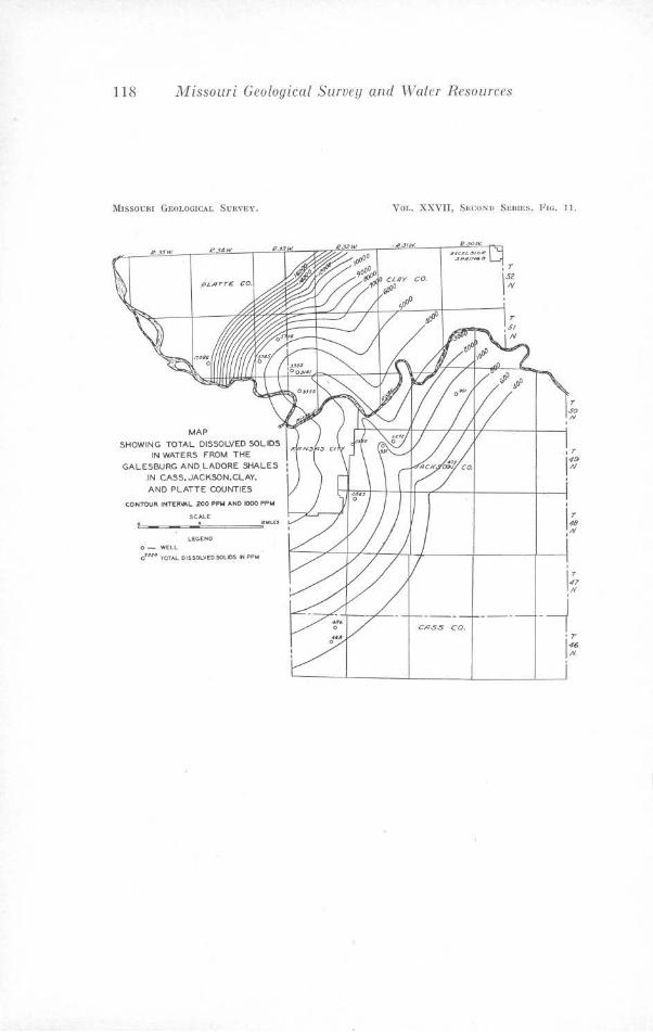
118 JV!issouri Geological Survey and Water Resources
MISSOURI GEOLOGICAL SURVEY.
R 4W.
MAP
SHOWING TOTAL DISSOLVED SOLIDS IN WATERS FROM THE
GALESBURG AND.L ADORE SHALES .IN CASS,JACKSON,CLAY,
AND PLATTE COUNTIES
CONl'OUR tNTCR'*'L. 200 PPM ANO t000 PPM
0 - W(LL
SCAI..E . o~.uo TOTAL D1SSOLVE0.$0l.lOS IN PPM
VOL. XXVJJ, SECOND SERIES, FIG. 11.
~ .JIW'. ~:;t~Ll.,'31011'
.:,~,(f/N&.:t
,r
1;: '
'
If '
- ~ •r
146 IV.
'
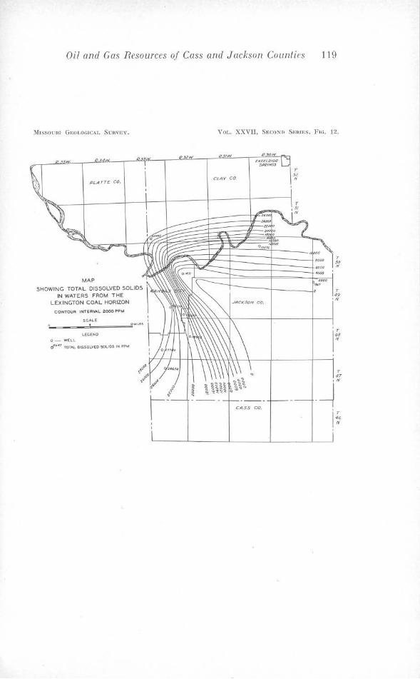
Oil and Gas Resources of Cass and Jackson Counties 119
)ltssoem Gi,oLOC.lCAI.. S\Jnv,w.
I?.
PLATT£ CO.
MAP
SHOWING TOTAL DISSOLVED SOLIDS IN WATERS FROM THE
LEXINGTON COAL HORIZON
CONTOUR INTERVAL 2000 PPM
SCA.Lt . l.tCtNO
O-W£:I.L
0'1HS TOTAL 0\$SOLV(0 SOLIDS IN PPM
YOL. XXVII, Si;co.Nn S1rn rn s, Ftr.. 12.
R. IW.
CL'iY CO.
Row. exce1.s,o.l!
CASS CO.
.... 4IJ()O
181-1
T ~· If
T 49 .,,
T 47
,N
-~
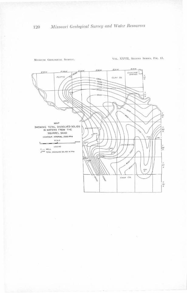
120 Missouri Geological Survey and Water Resources
J\hSSOUR I GF.OLOGICAI. S U!1\"ln'.
MAP
SHOWING TOTAL DISSOLVED SOLIDS IN WATERS FROM THE
SQUIRREL SAND
CONTOUR I NTER\6\L 2000 PPM
SCALE
t..£GEN0
0- WCLL rJ1PI 'TOTAL 06SOLVEO $0L IDS IN PPM
Yor .. XXVII, Seco;s:u SERIES, Fie. 1:l.
e.,,w.
T so
"
T ~9
"
T 48
·"
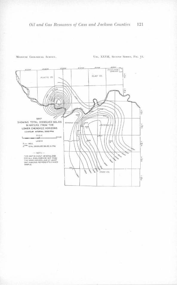
Oil and Gas Resources of Cass and Jackson Counties 121
l\[ JSSOl'H I GROT.OGICAJ.. Sun,·n,~.
PLATT£ CO.
MAP SHOWING
IN WATERS FROM T HE
LOWER CHEROKEE HORIZONS C.ON'TOUR INTERVAL 2'00()PPM
SCA\.E . LECENO
o- WELL
J'"4' TOTAL OISSOl.VEO SOLIDS N PPM
- NOTE-
THIS MAP IS HIGHLY GENEAAL.12EO F'OA ALL ANALYSES ARE NOT FROM THE SAME HORJZON, ANO A'f LEAST ON£ ANAI..YSIS REPA.£SE NTS A MIXED SAMPLE.
Yor .• XXYJT, SEC.ONO SF.RIES, FIG. 11.
p IW'.
CLAY' CO.
7' ... "
T
{ ,l'f
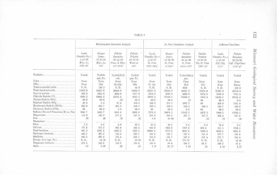
,_. TABLF, I ts.:>
ts.:>
Mi~8issippian Lime,tone Anolysis St. Peter Sandstone Analysis Jefferson City-Cotter
~ Lewis Kasper Pallette Pallette l ewis Kasper l'allette Pallette Lewis Pallett, ~-Chandler No. J Jame, Bannister Triplett Chan4ler No. 1 James Ba.rmi8Jer Triplett C/1andler No.1 Bannister "' 0 4/46//JS 18/ 36/£5 36/4S/ S3 19/60/ SI 4/46/SJ 18.:36/ £6 36/4h/ S3 19/50/ 31 4/4.~/SS 36/48/SS s::::
Miss. Ls. Miss. /.s. J'enn. & ,I/ iss. Water at St. J'eter St. Peter St. Peter Top .~t . Peter Jeff. City Jeff. City-Cotter ...., --10SJ-S6' 785' 977- IS~S' f.,66 1 1300-/SOf at 1640' bfl[Otr J.';0()' JSS:-41' 1416' 1,;39.41' C)
-------- "' 0 Turbidity . .. .. .. .. .. .. Turbid Turbid- Turbid-Drill Turbid- Turbid Turbid Turbid-Blnek Turbid Turbid Turbid c
<Q ppt. Fe. scd. ppt. Fe. ppt. ;::;· Color . . . .. ... .. .. ... . None None None None None None Clear None None None i::::i Odor. None Oily Mouldy Oily SI. oily Oily H2S Oily None Musty ..._
Total suspended solids. ·· · ···· · · · · )I. D. 110. 2 N.D. 65 .0 N. D. N. D. 1048 N.D. N.D. 410 .0 VJ Total dissolved solids . .. , ... ..... . .... 11632.0 19237 .0 26430 .0 16039 0 25251 0 3324S.O 40691 .0 19518.0 28107 .0 46119 .o s:::: ...., Loss on ignition . .. . ... . . . ... . ... .. ... 806 0 1401.0 2242 .0 1017.0 3334 .o 2918.0 4403 . 0 3574 .0 3670.0 7751.0 <:: Chloride Radicle (C'l). 10605.6 13035 .1 22114 0 "' . . .. . .. . .... . 6290 . 3 14866.2 S501.3 17826 .8 21069.4 9013 8 14S53. l ~ Nitrate Radiele (N()s) ..... 00 .0 00 .0 .38 00 .0 00 .0 00 .0 . 29 00 00.0 0.0 ~ Sulphate Radicle (S04) ·· ·········· · · 45 . 9 6.8 57 .4 663.5 229 .0 274 .2 1057 .3 00 459 .0 1161.0 ::::i Bicarbonate Radicle (HCO,i) . .. 543 .0 252.7 201 .8 280 .1 205 8 150 .8 180 . 2 160.3 338 7 139 0 ~ Carbonate Radicle (('03) ... . .. .. .. . . . 00 00 .0 9.3 00 .0 00 00 .0 0 .0 00 00 .0 00.0
~ Sodium (Na) and Potassium (K) as (Na) 3()49.7 6693 . 7 8869 . 6 5305 0 ;31s.2 10476. 2 11922. 9 547;{ 2 8450.2 11916.1 ~ Magnesium .... 116. 5 135.8 377.5 187 4 388.2 388.1 601.1 1s; . 2 492.4 817 .o --"' Iron .. ···· ·· ·· ·· ·· ··· .20 . 50 .70 .12 8 .0 15 00 .35 .12 . ;o .30 ....,
.Manganese .. . .. ::.:i Silica. .. . .... ... .. .. ... .. .. . 7 .6 5 .6 4.0 10 8 26.4 10.S 6.8 6 0 16 4 6 .8 "" Calcium 187 8 316 .3 453.9 344.2 644 .0 1032 .3 1667 .5 355.5 831.8 1380.5 "' · · ········ · · ·· · ··· · 0
Total hardness . .. . . ... .. . ... . ... 947 .2 1347.5 2682 .3 1628 8 30201.6 4772.0 6633 .3 1056.4 4098 3 6801.0 s:::: Carbonate hardness .. ... , ....... . .. .. . 445 .3 207 . 2 165 .5 229 .7 168. 8 123 . 7 147 . 8 131.4 277 .7 114 0
...., (")
Alkalinite . ... 445 .3 207 . 2 165.5 229. 7 168 8 123 .7 147.8 131 .4 277 .7 114 .o "' .... .. .... ... .. ... "' Precipt. Iron (ppl. Fe.) . . ···· ········· N.D. 14.10 N.D. 10.90 N. D. N.D. 179. 78 N.D. N. D. 68.41
Temporary hardness . .. .. .. .. .. . . 378.5 153. 9 110.3 189.4 141 8 88 4 109. 2 65 .8 240 2 85 . 5 A'20: .. .. .. .91 3 69 .20 . 23 1.37 31 . 77 I. 90 23 4.60 5 .57
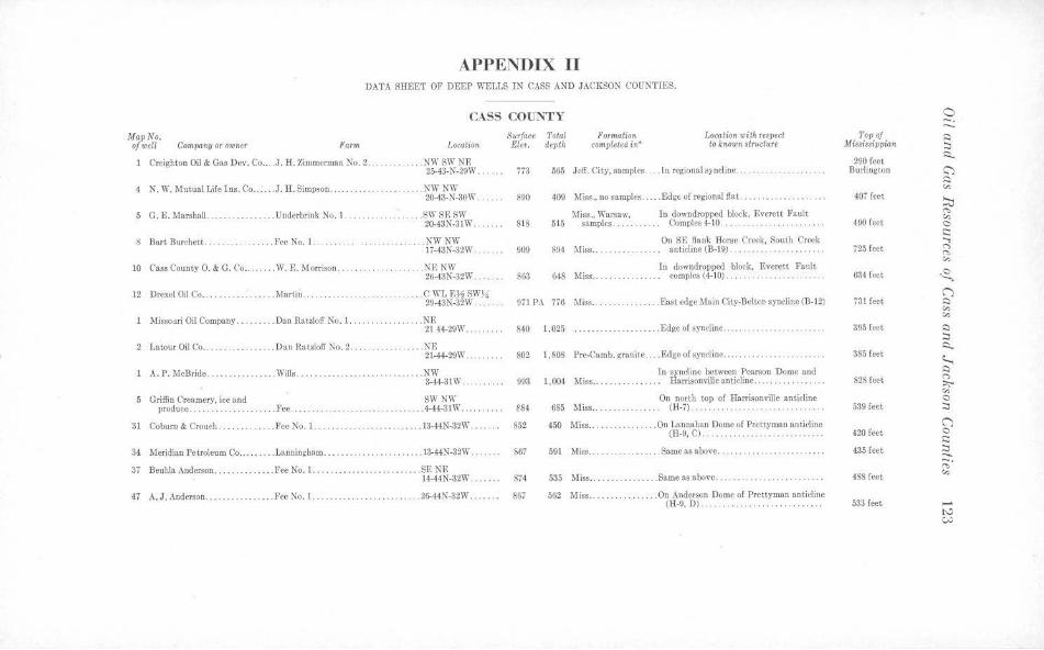
APPENDIX II DATA SHEET OF DEEP WELLS IN CASS AND JACKSON COUNTIES.
CASS COUNTY
MGpNo. of well Company or owntr Farm Location
Creighton Oil & Gas Dev. Co .. .. J. H. 7.iromcrman No. 2 ... . . . NWSW NE 25-43-N-29\V.
4 N. W.MutualLifelns . Co .... J.H.Simpson. . .NW NW 20-43-N-30\\'.
5 G. E. Marshall ..... .. ......... Underbrink No. I. .SW SE SW 20-43N-31\V.
8 Bart Burchett .. ...... . Fe<: No. I. . .. NWNW 17-43N-32W.
10 C'ass Cou11ty 0. & G. C',o .. .... .. W. E. Morrison . ... . . .N~: KW 26-43N-32W.
12 Drexel Oil Co ..... . ........... Martin ..... CWLE,l4SWJ4 29-43N-32W . .. ..
.Missoori Oil Comp.Sil)' .. . .. Dan Rat.toll' No. 1.. . ............ NE
2 Latour Oil Co .. .... .... ....... Dan Ratzloff No. 2.
A. P. McBride . .. .. ...••.. . ... Wills.
5 Griffin Creamery, iee and produoo. . . . . . . .. . .. . . . .. . . Fee ..
31 Coburn & Crouch ........... . . Fee No. I..
2144-29\V . .
. ... . .. NE 21-44-29W
..... .. ....... NW 3-44-31W.
SW NW .. .4-44-31\V ...
. .... 13-44N-32W.
34 Meridian Petroleum Co . . .. . .. . L.snningham ................... . ... 13-44N-32W . .
37 Beuhla Anderson .............. Fee No, 1. ............. .. . ....... . SE NE 14-44N-32W . ..... .
47 A. J. Anderson ....... . .... . ... Fee No. I ................. . ... . . . 26-44N-32W ...... .
Surface Total Formation Location with res-pect Ele<. depth completea i11* to known structure
773 565 Jeff. Cit.y, samples ... . ln regional syncline .. . ... .
890 409 Miss., no samples . . . . Edgt of regional Oat. .. . . . . . . . . . . . . .
818 515 Miss., Warsaw,
samples. In downdroppcd block, Rvcrctt Fault
Coroplcs 4-10.
909 894 Miss .. ... On SE Hank Horse Creek, South Creek
anticline (B-19) . . ·········· ······· ··· In downdropped block, Everett Fault
863 648 Miss .. . ..... .... . coroplcs (4-10) . ....
9il PA 776 Miss .. ... ...... .. ... East edge 1fain City-BcltoP syncline (B-12)
840 1,025 . . .. . Edge of syncline
802
993
es4 852
S67
874
867
1,808 Pre-Carob. gr.mite .... Edge of s)'ncline ....
Io syncline between Pearson Dome and 1,004 Miss... . . . . .. . . . . .. . Harrisonville anticline ........
685 Miss ...
450 Miss .. . .
591 Miss ..
535 11iss ..
562 Miss ..
On north top ol Harrisonville anticline (H-7) . .
. .... On Lannuhan Dome of Prettyman anticline (H-9,C).. . ... .. ............ ..
.. . Sameasabove . .
. . . . . Same as above.
. . . On Anderson Dome of Prettyman anticline (ll-9, Dl. . . .. .. ..... . ....... . .... .. .
0 -. --T&pof ~ Miuia8ippian ;:,
290 feet ~
Burlington C') ~ c,,
407 feet ~ "" 490 feet c,, C s::: ...,
725 feet <"> "' c,,
634 feet ~ (")
i31 feet ~ c,, c,,
395 feet ~ ;:, i::i..
385 feet ~ ~
828 feet 0. ;:,,;,.. c,, 0
539 feet ;:,
(') 420 feet 0
s::: 435 feet ;::: ..... 488 feet
;· c,,
533 feet -"' CN
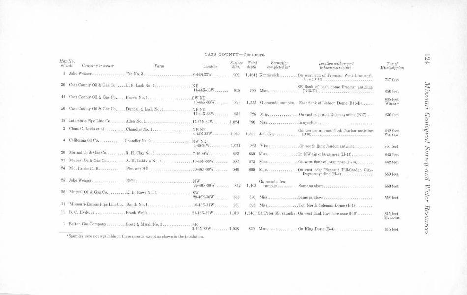
CASS COUNTY- Continued.
Map No. of well Company or owner Parm Location
Jake Weisser ... ... . ........ . . Fee No. 3 .. . . ....... .. ... . .. . f-44:-l-33\V ..
30 Cass County Oil & Gas Co ..... . E. F. Lash No. l ..
44 Cass County Oil & Gas Co .... .. Brown No. 1.
50 Cass County Oil & Gas Co ... . .. Duncan & bsh )lo . 1.
.. .. . .... . .. NE t t-44N-33W . .
.SWNE 13-44N-33W ....
. .. ... NF.NF.
Surface Total Eleu. depth
Pormation completed in•
I.oralion with re,pect to known .~tructure
900 I ,464~ Kimmswick .... . ..... On west end of Freeman West Line anti-
916 700 11iss ... ......... . .
cline (B 15).... . . .... . .. .. . . .
SE flank of Lash dome Freeman anticline (815-D)
S39 1,555 Gasconade, samples ... Ellst flank of Liebron Dome (B15-E)
14-44N-33\\' . ...... 851 728 Miss ....... ......... On cast edg~ east Dolan syncline (Bt7) ... . 18 Interstate Pipe Line Co .. . ...... Allen No. 1. . . . 17-45N~2W .. .. 1.024 790 Miss .. ..... J n syncline . 2 Cb.as. C. Lewis et al . . Chandler No. 1 . . . . ... NENF.
4-45N-33W. . ... .. 1,069 1,5-00 JclT. City On terrace on east flank Jaudon antieline
(BIO) .....
California Oil Co ..... .ChandlerNo.2 . . . .. .. ... ... .. .. .. . . NW NE 4-45-331'1 . .
20 Mutual Oil & Gas Co .. . .R.H. Clay No. I.
21 Mutual Oil & Gas Co .... .... . . A.H. Baldwin No. 1
24 Mo. Pacific R.R ....... .. . . .. . Pleasant Hill
25 Jake \l'eisscr .... .. . Riffle .. .
. . . . 7-46-30\V ..
.. . 16-46N-30W.
. . . 20-46N -30\V .
.... . NW 29-46N-30\V.
26 Mutual Oil & Gas Co . . ........ E. F.. Rowe No. I. ... .. . . .. . ....... SW
ll Missouri-KansasPipcliueCo . . . Smith No. I. .
ll B. C. Hy~e, Jr.. . .. Frank Webb
20-46N-30W ...
. . t6-46N-31 W.
. . 2t-46N-32W.
Belton Gas Company . .. . ... . Scott & Marsh No. 3 . ....... . .... .. SB
l ,Oi4
983
S85
849
642
838
983
865 Miss . . .. . ... . .... .. .. On south flank Jnudoo anticline ..
650 Miss . .. . On NW tip of large nose (H-14)
572 Miss . .. ........... . . On west flank of large nose (H-14)
005 Mis.• .. .
1,403 Gasconade, few
samples ..... .
580 Miss . .
695 ~liss ....
. . . On east edge Pleasant Rill-Carden CityDayton syncline (ll-4) . . .. .
. Same as above ...... .. .. .. .. .. ... . .. .. .
.... Same as a hove .. .
. Top North Coleman Dome (H-1) ....
I ,010 t ,340 St. Peter SS, samples . On wost fiank Raymorr nose (B-9} . ..... .
2-4GN~3W ....... 1,028 820 ,liss .. . .. ... On King Dome (B-4) ..
"'Samples were not :-wailable on these re-cords except as shown in the tabulation.
..... I'-'
Top of M issi~si ppian
,is,.
717 feet
~ 680 root ;;;·
"' 035 fort 0 \Varsaw s::: ..., -. 630 fc.-ct C')
"' 0
0 842 feet «::i Warsaw -. r,
C --860 feet V)
G45 feet s::: ;; 562 feet rs
'!::: C
580 feet :::i ;::,._
550 lect ---<: C
558 feet -'""' ..., ;o
815 feet rs
"' St . Louis 0 s::: ...,
815 ft-et r, ...,, "'
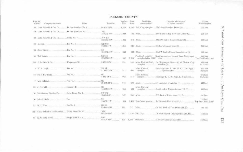
J ,\ CKSON COUNT Y
Jlap.\'o. of ,ttll co .. panw or°"""
23 Lone Jack Oil & Gn, Co.
forJft
. . D. IA'<' liloawlian No. 6
30 Lone fack Oil & Gas Co.. . .. . D. Lee 81,uwhan No. I.
sn Lo110 Jack Oil & Ga, <'o .•.... ('lark 'lo. 7 ....... .
~6 Krnton ........••...•.•.... Fer No . I
... 14-4,1'-:IOW.
.NE 23-47N-~OW.
.'.'<WM; 3U7'<~10\\
:SE~\\ 7-47N-3111
96 Jol,n Harris. . . . • .. . . . . . .... . fee No. I .. . ................... SE 21-47N-31W ...... .
!~ Toll Estate . .. .... .. Fee Xo. I N\\. SE 27-Ht\-3111" •.•..••
294 J. D. Judd & C'o ...... . . .. Klapm,'y« I\ I. ..•.... li-4,N-331\
4 II . ll. Pu~h. ..•. Fet ""· I ......... NRl'E 31 4,N 29\1'
S-1 ~111-.\ Bar Farm .... ...•. fee No. I ....... SE 4-4!>:S 30W
Luu Holland . , . , , .. . Fee i'(o. 1. ......... . . SE a0.48N-:\OW ...
56 J. D. Judd ... ..• Graves I B ........ SE 14-4i>N-31W
116 \!o.-Kans:>s Pipclino C'o.,.. . . ~r &trn Ko. I.. ... .KW!SW 20-4 '1-3111' ..•...
16 John J. Blair .. . . .. . Fee ...... ,,, ....... .. ........ . .... NR
32 II !,. Yo,t........ . . . . .. . . FN' Nu. I
7-4SN-32W .•• , .. , .
.......... SIi :O:f, 12-4~'.'-1-321\' .
192 Unity l'd,ool o[ C'hri,t,onity . .. .!'nit) Farm No. 12 .........•...... N\I' 2~4SN-32W.,.
Sur/a« Tota/ Et, dtpth
ForWtlllion <Omplcttd in"
l.oeation u1itJ, rfttP,at lo kn.w h .. ,nu turt
1.02, 1.21,.; Jl"ff. City, ,amples NII Bank Shawha11 Dumc(6) ..
l ,02U
1.006
1.015
053
726 Miss ................ South end of top Shwl,un Dome (6)
••..•..•• 011 N\\' end uf Knorpp Dome /5)
Ou Lee's Summit nooe \3) ..
625 ~lisa .. On SW flank of L,•e'• 8uuuuit nose (3).
Tc7,of .\UniariJ11ri1Jn
700 fN'l
700 fcrt
,22 fc,•t
621 fort
Pre-C'amb. minite, \t·ar bottom ea,t limb of Penn Valle)' &)·n· 61>9 fret 2 .216 •mi~" below 1215'. rliue. . . . . . .. . . . . • • Top Pre-C'amb. zw.;• OOi
971
962
94U
920
!)51
940 ~ltsa. Keokuk-Burl., On Klnpmeyer Dome (0) of Martin C'tl)' Allmple•........... nnticline (I) .. . .. . .. .. .. . . . .. ..
Mis;. l\',rsuw, Eawt <•dge near S. end of K. C.-BI. :-\p~•--05G "'11DJ)les ... , ... . 1,,J.syncline(16)
~Ii,.. K,..,kuk, 6i5 ••m1~1'8 ..• , ... , fo,t edge K. C. Bl. ;;~,.-L. J. syndinc .••
090 Mi... . , , , , ... , .... On 1•t1st edge of synrli,w (I) . .
MiB, Warsaw, ~ t.'\mp!~~ Soutl, cod of HugliN tem-ae (12, G)
705 Mz,, .. NE flank of Ritter no.st (12, F) .
639 frt•t St. l.oui•
030 frN ~pergen
6,5 fe<et St. Louts
053 fo>et
752 feet 2,401 Pre-C'nmh. j(ranite . In Hirhards Field •ink (1 1, J.) •. , .. , , .• , . Tor Pre-C'amh. 2.348'
ili ~li!"I. . . . . . . . . . . . . Ou c:~t fbnk or Yoil Oome (11, K) 705' ft,•t
1, 510 J clT. C'ity . On west edge of Unit, •yncline (12, 11). 715 [t'l·t
11 K. C'. Pork Board ....... . .. . S111,pe Purk No. 2 .... , .• , , .. , ..... . NW J 1-4,N~l:}I\.. . .... ~72 1, 12,; Devonian .• , ..•. , .. ln l'enn \'all<)' syndint• (13) ......• .. .. , 750 feet
0 -. --
-1...:: (.;I
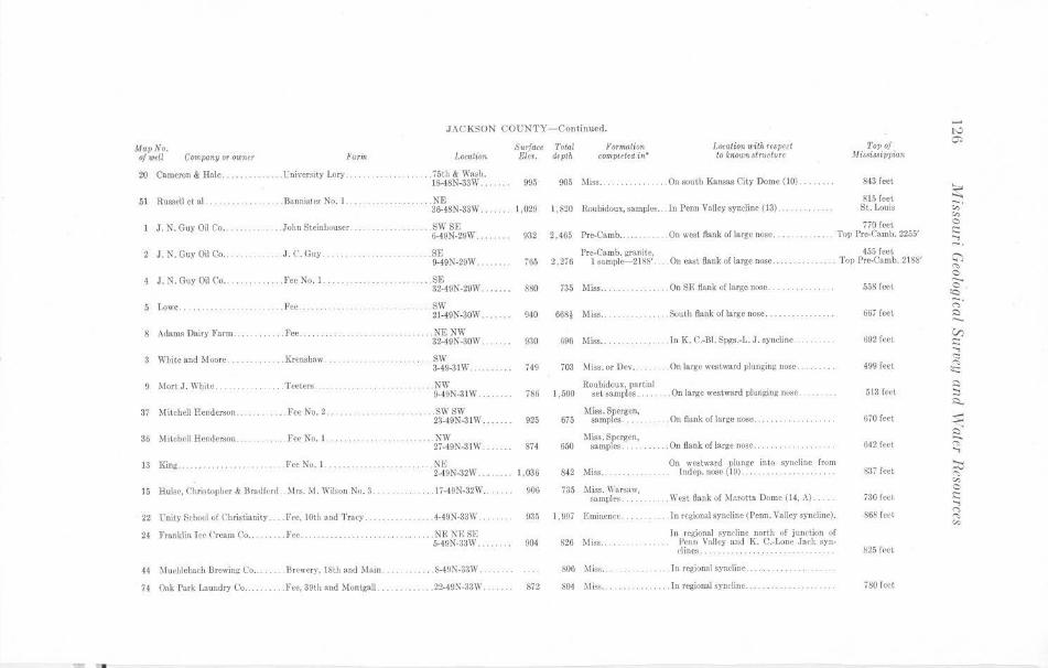
•
Map No. of well Com1>0ny or owner Farm
20 Cameron & Hale. .. .. ..... t;niversity Lory ....
51 Russell ct al. .. . ...... .... Bannister No. I..
J. N. Guy Oil Co.
2 J . N. Guy Oil Co ..
4 J. N. Guy Oil C'o ....
5 J.owc .
8 Adams Dairy Farm . .
3 White and ~toore.
9 Mort J. White .. . .
37 M itrhell Henderson
36 Mitchell Henderson . .
13 Kiog ...
.John Steinl,ouser .
. . ... J. C. Guy
. .. . Fee No.I.
.. .Fee ....
.. Fee.
.Krensha.w
.. . Teeters . .
.Fee No. 2.
.. ... Fee No. I.
. foe No. I. .
15 Ruise, Christopher & Bradford . Mrs. M. Wilson No. 3 . .
22 Unity Sthool of Christianity . . .. Fee, 10th and Tral')'.
24 Franklin Jee Crcs11n Co
44 ~!uehlcbad, Brewing C'o ..
74 Oak Park J..aundry Co.
.Fee ....
Brewery, 18th tllld Main
. .. Fee, 39th and Montgall . .
JACKSON COUNTY- Continued.
Location
. 75th & Wash. 18-48N-33W . . . . .. .
.... . NE 36-48N-33W . .
SW SR i>-49N-29W.
..... SE 9-49N-20W ..
SF, 32-49N-29W.
..... SW 21-49N-30W . .
.. . .. NENW 32-49N-30W.
.. ... SW 3-49-31W ...
.. ... NW 9-49N-3JW.
.... .. SWSW 23-49:N-31 W . .
.. .. .. . .... NW 27-49N-31 W ..
.NE 2-49N-321V.
. .. . 17-49N-32W ..
4-49N-33W.
.. NF. NBSE 5-49N-33W.
. . . . . 8-491\-3~\V.
. . • ... 22-49N-33\I' ..
Surface Toto! Eleo. depth
Formation computect ii!'"
995 905 Miss ...
LO<Glion with respe(t to known gtructure
. .On south Kansas City Dome (10)
I, 820 Roubidoux, samples. . In Penn Valley syncline (13) ..
To110/ Mi.ssi8sippian
843 feet
815 feet St. Louis
770 feet
1,029
932 2,465 Prc~Camb. .. . . . . . . . On west Bank of large nose. .. , .. . . Top Pre-C'amb. 2255'
765
880
940
930
749
786
925
874
1,036
906
935
872
455 feet Pre-Carob. gra11iic, 2,276 l samplc-2188' ... On C3St flank of large nose .. . . . Top Pre-Carob. 2188'
735 Miss .. On SE flank of large nose . .
668~ Miss .. . .. South flank or large nose.
69G Miss .. . ln K. C.-131. Spgs.-L. J. syncline
703 11iss. or Dev... . .... On large westward plunging nose.
Roubidoux, partial set samples. . • . On large westward pluoging nose 1,500
675 1fas. Spergcn,
samples . . . . . On flank of large nose ... .. . ....... .... . .
Miss. Spcrgen. samples . . . . . ... Ou flank oflarge nose ... . ..
842 Miss .. On westward plunge: into sync:Jine from
lndep. nose (19) . . .
735 Miss. \Vnr~nw, samplcs. . .. . .. West Oank of )farotta l)omc, (14, A).
1,907 1':minenfe .
826 Miss ..
806 MiR~ . .
804 Mis.s ..
. In rtgionnl syncline (Penn . Valley syncline).
In re~ional syncline north of junction of l'eun V;;llc)' aud K. C.-1,one Ja('k sync·lincs . ..
1 n regional sync·linc .
. . .. . Jn regional sync·line.
558 feet
667 feet
692 feet
499 feet
513 feet
670 feet
642 feet
S.17 feet
730 feet
868 feet
825 ft-ct
78-0 feet
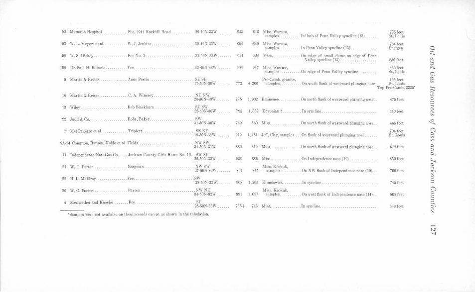
92 Menorah Hospital. ...... . .. . .. Fee, 4944 Rockhill Road . .. ........ . 29-49N-33W.
93 W. L. Meyers et al. . .. . W.J.Jcnkins . ........... . . ..... 30-49N-33W .
99 W. S. Dickey . .... . . .. . Fee Ko . 2 ....... . .............. .. . 32-49N-33W ..... ..
109 Dr. Saro H. Roberts. ... l'ce .... . . ... 32-49N-33W .
5 Martin & Reiser ... . ....... . ... Anne Perrin ....................... SE SE 17-50N-30W .. .
16 Martin & Reiser ....... .. . .. .. C. A . Winerey .. . .. .. .............. NE NW 28-50N-30W.
13 Wiley .... ..... .. . .. Bob Blackburn .. . .. . .. ..... .. .. .. . SE SW 22-50N-30W.
22 Judd & Co ....... .. . ... .. ... . . Robt. Baker .......... .. . .... . . . SW 3i-50K-30W ....
7 Mel Pallctte ct al. ...... .. . Triplett ..... .
9A-24 Compton, Ranson, Noble el al. Fields . ........ .
. .. . SEKE 19-50N-31W.
.. .. .. ... NWSW 34-oON-31W.
11 lnde~ndence Nat. Gas Co . . ... Jackson County Girls Home No. 10 . .. $\\' SE 26-50N-32W ..
21 W. 0. Porter ............ .. .Borgman .... ... . .. NWSW 27-50N-32W . .
22 H. L. McElroy . ..... . .. Fee ................ .. . . ... SW 28-50N-32W'. .. ... .
26 W. 0. Porter ........... .. . . . Paxton. .. .............. . NW NE 34-50N-32W .. . . . .
4 Meriwether and Knoche.. . . . . . Fee .. . ...... . . . ... . SE 25-50N'-33W ..
•Samples were not available on these records except tis shown in the tabulation .
843
864
921
903
772
735
795
742
919
S82
928
867
908
991
735+
815 Miss. Warsaw, samples . .. ... . ... Tn limb of Penn Valley syncl ine (13/ .... . .
S40 Miss. Warsaw, samples. . . . ... In Penn Valley syncline (13) . ........... .
S56 Miss ......... . ..... On edge 0£ small dome on edge of Penn Valley synelinc (13) .. .. . .......... .
947 Miss . Warsaw, s.~mples. . ..... .On edge of Penn Valley syncline .. ...
735 feet St. Louis
764 feet Spcrgen
8.50 feet
860 feet St. Louis
Pre-Carob. granite, 495 rect 4,200 samples. . . . . . .. . . On south flank of westward plunging nose. St. Louis
1,902 Eminence . . . .. .. . On north flank of westward plunging n0se ..
1,068 Devonian ? .......... J n syndine . .... .
560 Miss .... . . . . On north Bank of westward plunging nose ..
1,481 Jeff. City, samples .. . On flank of west.ward plunging nose ... . .. .
61~ .Miss ... .On north tlllnk of westward plunging nose ..
885 Miss .. ... On Independence nose (19) . ........ ... ..
845 Miss. Keokuk,
samples . . . ... . . . On NW flank of Independence nose (19) ...
1,205 Kimmswick ... . . . . .. . In syncline . . .
1,097 Miss . Keokuk,
samples .. . . .... On west flank of Tndepcndcnce nose (14) . .
743 Miss ............. ... In syncline ..... ... .. ....... . .......... .
Top Pre-Camb. 2225'
475 feet
540 feet
465 feet
704 feet St. Louis
612 feet
850 feet
700 feet
745 feet
SOS feet
639 feet
a -. --
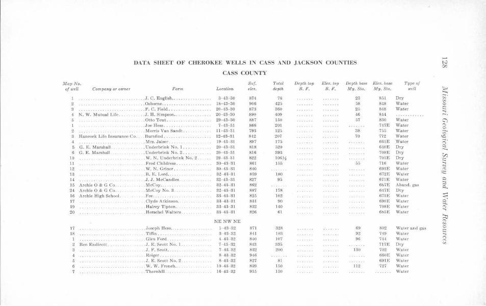
..... DATA SHEET OF CHEROKEE WELLS IN CASS AND JACKSON COUNTIES tv
00
CASS COUNTY
Map No. Su/. Total Depth top Etev. top Depth base Ele•. base Type of of well Company or 010ner Farm Location ele•. depth B. F. B.F. My. Sta. My.Sta. well ~
1 . ... J.C. English ...... . .. . .. .. . .. 3- 43 -30 874 76 23 851 Dry ,;;· "' 2 . .. Osborne ..... . 1&-43-30 906 425 58 848 Water 0
3 ... ... .. . .. . .. ... . . . F. C. Field ..... 20- 43- 80 873 360 25 848 Water s::: ..., 4 N. W. Mutual L ife . . . J . H. Simpson .. . . 20- 48 30 890 109 46 844 ······ · · ··· · -. 5 .Otto Teut .. . . . . . . . . . . . . 29- 43- 30 887 150 57 830 Water G"l 1 .... ...... .Joe Hess ..... . .. 7- 43- 31 866 201 747E Water "' 0 2 . Morris Van Sandt .. . . ...... .. 11- 43- 31 793 125 38 755 Water ..._
0 3 Hancock Life Insurance Co .. .Burnfind ... . . . . . 12-43-31 842 207 70 772 Water ~
4 .. . .. .. . . Mrs. Jaiser . 19-43-31 897 175 665E Water -. ..... .. .. . ..... n 5 G. E. Ma rsha ll. . . . . Underbrink No. 1 .. . .. 20- 43- 3 1 818 520 640E Dry Q
6 G. E. Marshall . . Underbrink No. 2 .... . . . 20-43- 3 1 8 16 393 708E Dry V)
10 .... . W. N. U nderbrink No. 2 . . 29- 43- 31 822 106~ 705E Dry i:::: 11 .. . . Fred Childress ... .. . .. . . 30- 43 3 ] 861 J 55 55 716 Water ;; 12 .W. N. Griner .. . ... . . 30- 43- 31 840 693£ Water <'<> 13 .. . . . B. E. Lord .. 32- 43- 31 859 180 672F, Water <t:::
14 .. . . J. J. Mccandles . . 32- 43- 31 827 95 671E Water Q
]5 Archie O & G Co. . lV!cCoy ...... . . 32- 43-31 862 667E Aband. gas ;::, .:i..
24 Archie O & G Co. . . . . . .. McCoy No. 3 .. . . 32 43- 31 887 178 647E Dry 16 Archie High School. . .Fee ... .. . 33-43- 3 1 825 102 673E Water ~ 17 .. . Clyde Atkinson . . . · · ·· ··· · ·· · 33- 43- 31 831 90 690E Water a 19 . . .. . .. . . . .. . ... Halrey Tipton .. ....... . 33 43 31 832 HO 708E Water ('t,
20 . Herschel Walters . 33- 43- 3 1 826 61 6!s5E Water ..., ~
NE NWNE <'<>
"' 17 ... . . Joseph Hess .. .. .. ... l 43 ·32 871 328 69 802 Water and gas 0 ... .... i::::
18 .... Tiffin ........ . . 3 43- 32 841 103 92 749 Water ..... . . .. Glen Ford . . <1- 43- 32 840 107 96 744 Water n . . .. .. . .. .. .. . "' 2 Ben Endicol.t . .. .. J.E. Scou No. 1 . . .. . . 7 ,13 32 s ,13 335 717E Dry "'
3 . J. F. Scot t .. .. .. . 7- 43- 32 832 200 130 702 Water 1 .. .. . . Reiger. 8- 43- 32 946 660E Water 5 . . . ... . . J.E. Scot~ No. 2. 8 43 32 827 8 1 691E Water 6 ... W.W. French .. 10-43- 32 839 150 112 727 Water 7 .. .. ... ... .... . . . Thornhill .. 16-43-32 915 150 Water
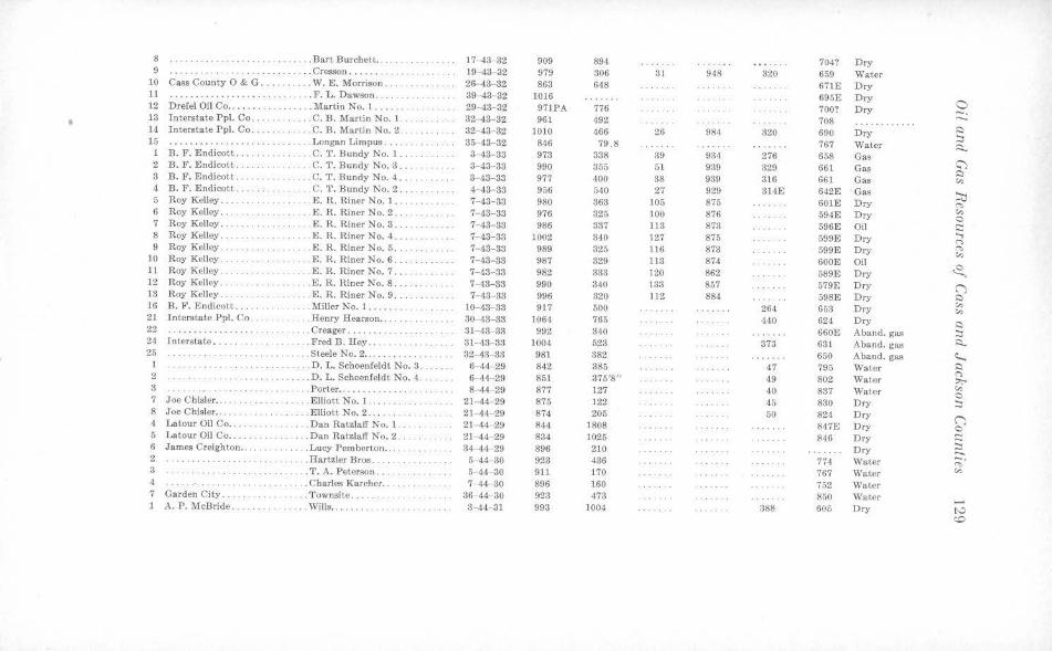
8 ..... Bart J3urchctt. . ·· ········ 17-43- 32 909 894 704? Dry 9 .. . Cresson .... .. . 19-43-32 979 306 31 948 320 659 Water
10 Ca~s County O & G ..... . . . . . W. E. Morrison .... . . 26-43- 32 863 648 671E Dry 11 ..... .. .. . ......... .. F. L. Dawson ... . ... 39-43-32 1016 695E Dry
0 12 Drefel Oil Co ........ . .. Martin No. 1 .... . 29- 48-32 971PA 776 700? Dry -. • 13 Interstate Ppl. Co ........ . . C. B. Martin No. J . 32-43- 32 961 492 708 ··· ·· ·· · ·· 14 Interstate Ppl. Co . . . . .. . C. B. Martin No. 2. 32-43-32 1010 466 26 984 320 690 Dry ~ ~ 15 ............... .. . .. .. . Longan Limpus . . . . 35 43-32 846 79 .8 767 Water ~ 1 B. F. E ndicott .. . .... C. T . Bundy No. 1. 3-43-33 973 338 39 934 276 658 Gas
2 B. F. Endicott .. . . .. .. . C. T. Bundy No. 3 .. 8-43-33 990 355 51 939 329 661 Gas c:'l ~ 3 B. F . Endicott ... .. .. C. T. Bundy No. 4 .. . 3- 43-33 977 400 38 939 316 661 Gas "' 4 B. F. E ndicott .. .... . .. . . C. T . Bundy No. 2 . .. . 4-43- 33 956 540 27 929 314E 642E Gas ~ 5 Roy Kelley ... ..... . .. E. R. Riner No. 1 .. . 7-43-33 980 363 105 875 601E Dry ('!>
6 Roy Kelley .. .. ... E . R. Riner No. 2 .. 7- 43-33 976 325 100 876 594E Dry "' 0 7 Roy Kelley .. .. . .. . . . E. R. Riner No. 3 ... 7-43-33 986 337 113 873 596E Oil ;::: 8 Roy Kelley. . E. R. Riner No. 4 . .. 7- 43-83 1002 340 127 876 599E Dry
...., <"> 9 Roy Kelley . . .E. R. Riner No. 5 ... 7- 43-33 989 325 ll6 873 599E Dry ~
"' 10 Roy KelJey ....... . .. . E. R. Riner No. 6 .. . . 7- 48- 33 987 329 113 874 600E Oil ,2., 11 Roy Kelley ... ... E. R. Riner No. 7 .. .... 7- 43- 33 982 333 120 862 589E Dry
12 Roy Kelley. ·· · ····· · ·· .. .... E. R. Riner No. 8 . . 7- 43-33 990 340 133 857 579E Dry C") 13 Roy Kelley . ... .. . E. R. Riner No. 9 .. . 7- 48-33 996 320 112 884 598E Dry ~ 16 J3. F. E ndicott ... . . .... ... . Miller No. 1. ...... 10-43- 38 917 500 264 653 Dry "' "' 21 Interstate Ppl. Co ... .. . . .. Henry Hearson .. .. ...... ... . 80--43-33 106·1 765 440 624 Dry
~ 22 ················ · ... Creager ..... 31- 43-33 992 340 660E Aband. gas :::, 24 Interstate •.. . . ....... .. . Fred B. Hey ... 31-43- 33 1004 523 373 631 Aband. gas R. 25 ··· · · ········ .Steele No. 2 ..... ....... ... 32-43- 33 981 382 650 A band. gas ~ 1 ···· · · · ··· . .. . D. L. Schoenfeldt No. 3 . 6- 44-29 842 385 47 795 Water ~
<"> 2 . . . . . . . . . . . . . . . . . . . D. L. Schoenfeldt No. 4. 6- 44-29 851 375'8" 49 802 Water ::,,;-, 3 .. Porter ... . . ... . . . .... 8--44-29 877 127 40 837 Water "' 0 7 Joe Chisler . .... . . . ElliottNo. l .. .. . . 21 - 44-29 875 122 45 830 Dry ~ 8 Joe Chisler .. ..... . .E lliott No. 2 .. . .. . .. . 21- 44- 29 874 205 50 824 Dry C") 4 Latour Oil Co ... . .Dan Ratzlaff No. 1. 21- 44-29 844 1808 847E Dry 0 5 Latou r Oil Co ... .. . Dan Ratzlaff No. 2 . 21- 44- 29 834 1025 846 Dry ;::: 6 James Creigh ton . .. ... . Lucy Pemberton .... 34-44- 29 896 210 Dry ~ 2 .... . Hartzler Bros. 5- 44-30 923 436 774 Water -· . . . ' . . ' . . .
"' 3 ... . .. . .. . ..... . T. A. Peterson .... 5-44- 30 911 170 767 Water "' 4 ······ · · · ·· ... Charles Karcher . .. . 7- 44- 30 896 160 752 Water 7 Garden City . ..... Townsitc ... .... 36- 44-30 923 473 850 Water 1 A. P. McBride .. .. . ... . . Wills, . , ..... 3--44- 31 993 1004 388 605 Dry tv
c:o
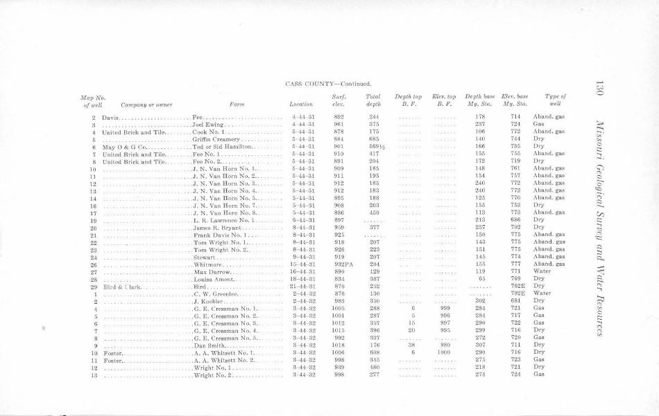
CASS COUNTY-Continued. ,.... C;J
Map No. Surf. Total Depth top Elev. top Depth base Elev. base Type of 0
ofweU Company or oumer Far1n Location elev. depth B. F. B.F. My.St<,. My. Sta. well
2 Davis ... . ........ . . . . . . .. Fee ....... 4- 4'1- 31 892 244 178 714 Aband. gas
3 . . . . . . . . . . . . . .. . . .. Joel Ewing .. . . . 4- 44- 31 961 375 237 724 Gas ~ 4 United Brick a nd Tile .. .. . . . .. Cook No. 1. 5--44- 31 878 175 106 772 Aband. gas -. 5 . .. Griffin Creamery. 5- 41 31 884 685 140 74,1 Dry "' "' 6 May O & G Co ....... . . . . Ted or S id Hamilton . . . 5- 44- 81 901 569~ 166 785 Dry 0
7 United Brick and Tile .. .. . .... Fee No. 1.. 5- 44- 31 910 417 155 755 Aband. gas .::: ..., 8 United Brick and Tile . . .Fee No. 2 .. 5- <\4 31 891 204 172 719 Dry -·
10 .. J. N. Van Horn No. 1. 5- 44- 31 909 185 148 761 A band. gas c;'}
11 . . .. J. N. Van Horn No. 2 .. 5- 44- 31 911 195 154 757 Aband. gas ..,, 0
12 .J. N. Van Horn No. 3 .. 5- ,14 31 912 183 240 772 Aband. gas 0 13 .. J. N. Van Horn No. 4. 5-44- 31 912 183 240 772 Aband. gas «:)
14 .. . J. N. Van Horn No. 5 .. 5- 44- 31 895 188 125 770 Aband. gas ;:;· 16 . . . . . .. . . .. . . . .. J. N. Van Horn No. 7 . . 5- 44- 31 908 203 155 753 Dry ~
17 .. . J. N. Van Horn No. 8 . . 5- 41- 31 886 450 113 773 Aba nd. gas VJ 19 .... L. R. Lawrence No. 1. 6- 44- 31 897 213 686 Dry .::: 20 .... . .. . . . . . . .... James R. Bryant .. 8 ·44- 3 1 959 377 257 702 Dry ; 21 .. . Frank Davis No. l ... . 8- 44- 31 925 150 775 Aband. gas <'>
22 . . Tom Wright No. 1.. 8- 44-31 918 207 143 775 Aband. gas (t::
23 . Tom Wright No. 2 ... 8-<14- 31 926 223 151 775 Aband. gas s::)
:::, 24 .Stewart . ... . ... 9- 44- 31 919 207 145 774 Aband. gas ~ 26 . .. Whitmore .... . . . 15- 44-31 932PA 204 155 777 Aband. gas _.. 27 ... Max Darrow .... 16- 44- 31 890 129 119 771 Water ...,...
...... 28 . Louisa A mcnt ... 18- 44- 31 834 387 65 769 Dry i::i ....... 29 Bird & C Lark .. .. Bird . . . . . . . . . . . 21- 44- 31 870 252 762 E Dry "" ...,
1 .. . . . C. ·w. Greenlee . .. . 2- 44- 32 876 130 792E Water
2 .J. Koehler. 2- 44- 32 983 350 302 681 Dry ::::, 4 .. G. E. Cressman No. 1. . 3- 44- 32 1005 288 6 999 284 721 Gas
,..,, "'
5 .G. E. Cressman No. 2 . . 3- 44- 32 1001 287 5 996 284 717 Gas 0 .:::
6 . . G. E. Cressman No. 3. 3- 44- 32 1012 357 15 997 290 722 Gas ..., 7 .. G. E. Cressman No. 4 .. 3 44- 32 1015 396 20 995 299 716 Ory <"> ,.,, 8 .. G. E. Cressman No. 5 .. . 3- 41 32 992 337 272 720 Gas "' 9 .. . . Dan Smith ... .. . 3-44- 32 1018 176 38 980 307 711 Dry
10 Foster .. .. A. A. Whitsett No. 1. . . . 3- 44- 32 1006 608 6 1000 290 716 Dry
11 Foster . . .. .. . .. . . . .. . . . A. A. Whitsett No. 2 . . 3-,14- 32 998 345 275 723 Ga.s
12 . . . . Wright No. 1 . .. 3-44-32 939 480 218 721 Dry
13 .... Wright No. 2 .. .. . .. .. . . 3- 44-32 998 277 274 724 Gas
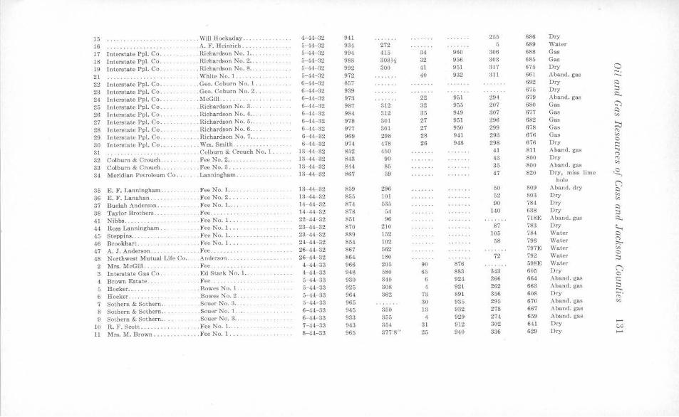
15 ..... . ... . . .. . . Will Hockaday. , . , , .. 4- 44-32 941 255 686 Dry
16 · ·········· . .. . . A. F. Heinrich ... 5- 44- 32 934 272 5 689 Water
17 Interstate Pp!. Co .. .. . . Richardson No. 1. . . . 5- 4'1- 32 994 415 34 960 306 688 Gas
18 Interstate Pp\. Co . .. ... Richardson No. 2 . . . .... 5- 44- 32 988 308,!4 32 956 303 685 Gas
19 Interstate Ppl. Co . .. . . Richardson No. 8 . . .... . .. .. .. 5- 44- 32 992 300 4t 951 317 675 Dry a 21 . . . White No. 1 .. 5-44- 32 972 40 932 311 661 Aband. gas -.
········ · ······· ..._
22 Interstate Ppl. Co . . .Geo. Coburn No. l .. . 6- 44-32 857 692 Dry ~
23 Interstate Ppl. Co . .. .. . . . .. .. Geo. Coburn No. 2. 6- 44- 32 939 675 Dry ~
24 Interstate Ppl. Co . . . McGill . .. . ..... 6-44- 32 973 22 951 294 679 Aband. gas ~
25 Interstate Pp\. Co .. . , , Richardson No. 3 . .. . . 6-44- 32 987 312 :l2 955 207 680 Gas C")
26 Interstate Ppl. Co , . . . Richardson No. 4 ... 6-44- 32 984 312 35 949 307 677 Gas ~
"' 27 Interstate Ppl. Co . . .. . Richardson No. 5 ... 6-44 32 978 301 27 951 296 682 Gas
~ 28 Interstate Ppl. Co . . . . . Richardson No. 6 . . 6-44- 32 977 301 27 950 299 678 Gas
""' 29 Interstate Ppl. Co ... . . Richardson No. 7 .. . . 6- 44- 32 969 298 28 941 293 676 Gas ,:,,
80 Interstate Ppl. Co .. . . . . Wm. Smith ... 6- 44 32 974 478 26 948 298 676 Dry 0 .::
31 ····· · ··· · ···· · · ,, .. Colburn & Crouch No. 1 . 13- 44-32 852 450 41 811 Aband. gas ..., (">
32 Colburn & Crouch . . . Fee No. 2 .. . . . . 13- 44- 32 843 90 43 800 Dry (',:,
83 Colburn & Crouch. . Fee No. 3 .. 13- 44 32 844 85 35 800 ,,\band. gas "' 3,j Meridian Petroleum Co. ... Lanningham. 13-44- 32 867 59 47 820 Dry, miss lime ~
hole (J 35 E. F. Lanningham . .. . . Fee No. 1. .... 13-44- 32 859 296 50 809 Aband . dry ~
36 E. F. Lanahan .... . .. FeeNo.2 .. .. 13-44-32 855 101 52 80:l Dry "' c,,
37 Buelah Anderson ... .. . .. . . .. Fee No. 1. . .. . H - 44- 32 874 535 90 784 Dry ~
38 Taylor Brothers .. . .. .. Fee .. ... . . . 14- 44- 32 878 5,1 140 638 Dry ~
41 Nibbs .... , .. . .FeeNo. l . .. 22- 44- 32 851 96 718~ Aband . gas ~
44 Ross Lanningham .. . Fee No. 1 ... 23- 44- 32 870 210 87 783 Dry ~ 45 Steppins ... .. . .... Fee No. J. . 23-44- 32 889 152 105 784 Water Q
46 Brookhart . .. . .... Fee No. 1 ... .. 24- 44- 32 854 102 58 796 '\\7ater (">
::,;.. 47 A. J . Anderson. . .Fee .. . ... . . ... 26- 44- 32 867 562 797E Water "'
Northwest Mutual Life Co .. . . . Anderson . .. .. . 26- 44- 32 864 180 72 792 Water C
48 :::i 2 Mrs. McGill . . .. . . . . . Fee .. . .. ... .. . . 4-44- 33 966 205 90 876 598E Water
3 Intersta te Gas Co. . .. Ed Sta rk No. 1 .. . , 4-44- 33 948 580 65 883 343 605 Dry (J 0
4 Brown Estate . . . , .. . . Fee. 5- 44- 33 930 340 6 924 266 664 Aband. gas .:: 5 Hocker . . . . Bowes No. 1. 5-44- 33 925 308 4 921 262 663 Aband. gas ~ 6 Hocker . . . . . .. Bowes No. 2 . . . 5- 44- 33 964 362 73 891 356 608 Dry -.
"' 7 Sothem & Sothern . . .Souer No. 3 .. . 5- 44- 33 965 30 935 295 670 .t\band. gas "' 8 Sothern & Sothern .. . Sou er No. 1. . .. 6-44- 33 9,15 350 13 932 278 667 Aband. gas
9 Sothern & Sothern . . . Souer No. 3 .. .. 6- 44- 33 933 355 4 929 274 659 Aband. gas
10 R. F. Scot t .. . Fee No. 1. .. . .. 7-44- 33 943 354 31 912 302 641 D ry ...... w
11 Mrs. M. Brown ... , . .. . .. . .. . Fee No. 1 .. 8-44-33 965 377'8" 25 9,10 336 629 Dry ......
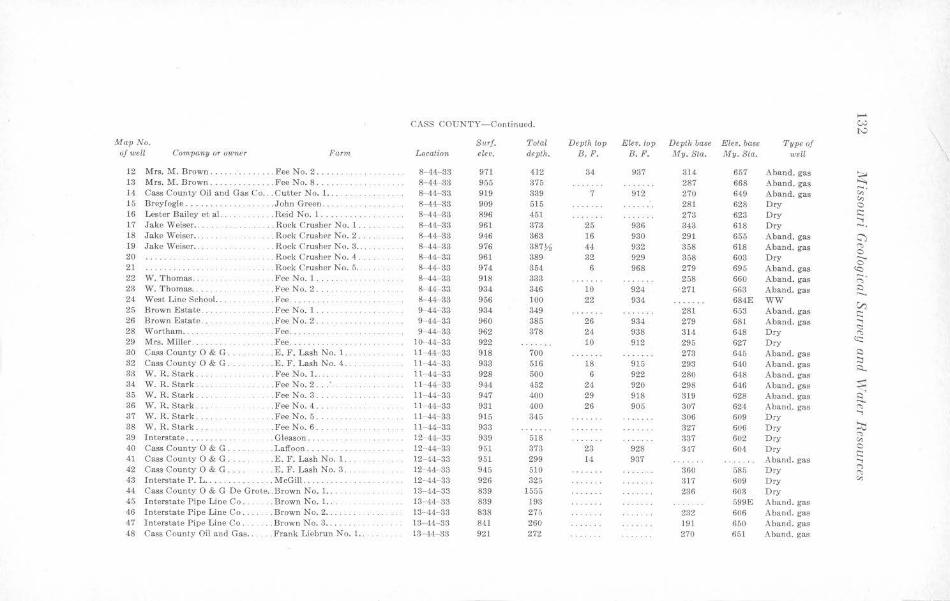
...... CASS COUNTY- Continued. w
I'-' Map No. Surf. Total Depth top E!e•. top Depth base Elev. base Type of
\ of u;ell Corn.pany or owner Farm Location elev. depth. B.F. B. F. My.Sta. My.Sta. well \
12 Mrs. M. Brown ...... · . .. .... . Fee No. 2 ..... . . 8-44-33 971 412 34 937 314 657 Aband. gas ~ 13 Mrs. M. Brown .. . . ..... Fee No. 8 ... ... 8 44- 33 955 375 287 668 Aband. gas -. 14 Cass County Oil and Gas Co .. . Cutter No. 1. . .. 8- 44- 33 919 339 7 912 270 649 Aband. gas "' "' 15 Breyfogle . .. ...... . . John Green . . . . 8-44-33 909 515 281 628 Dry 0
16 Lester Bailey ct al . .Re;d No. I •• .. • .••.. 8 44- 33 896 451 273 623 Dry s::: ..... 17 Jake Weiser ... . . . . . . . . . . . . . . . Rock Crusher No. 1 . . 8-11-33 961 373 25 936 343 618 Dry -. 18 Jake Weiser ... . . . . Rock Crusher No. 2 .. 8-44-33 946 363 16 930 291 655 A band. gas C') 19 Jake Weiser . . . Rock Crusher No. 3 ..... 8- 44- 33 976 387)1 14 932 858 618 Aband. gas "' 0 20 .. . .. . .. . . Rock Crusher No. 4 ... 8-44 33 961 389 32 929 358 603 Dry ..._
0 21 . . . . Rock Crusher No. 5 .. 8-44-33 974 354 6 968 279 695 A band. gas 'Q 22 W. Thomas . . . . . Fee No. 1 .... ...... .. 8 44- 33 918 333 258 660 Aband. gas ;:;· 23 W. T homas . . . .... FeeNo.2 ... . 8- 44-33 934 346 10 924 271 663 Aband. gas ~
24 West Line School. . . . ... . . Fee. . .. . .. .. . . .. . . .. .. . 8-44- 33 966 100 22 934 684E WW V) 25 Brown Estate .. .. ... .Fee No. 1. .... 9- 44-33 934 349 281 653 Aband. gas s::: 26 Brown Estate .. .. FeeNo.2 .... 9-44- 33 960 385 26 934 279 681 Aband. gas .....
<:::: 28 Wort.barn .. . . . .. .. Fee .... . . . . .... . . . .. 9-44-33 962 378 21 938 314 648 Dry "" 29 Mrs. Miller . ... .Fee . . . .. .. . .. .. . 10 ··44- 33 922 10 912 295 627 Dry cc: 30 Cass County O & G . .. .. E. F . Lash No. 1.. 11- 44- 33 918 700 273 645 Aband. gas s::)
32 Cass County O & G . . . . £.1''. Lash No. 4. 11- 44- 33 933 516 18 915 293 640 A band. gas :::, i::i..
33 W.R. Stark. ... Fee No. 1. . . .. 11- 44- 33 928 500 6 922 280 648 Aband. gas 34 W.R. Stark . .. .. .. F ee No. 2 .. : . . 11-44 33 944 •152 24 920 298 646 Aband. gas s::: 35 W. R. Stark . . . FeeNo.3 .... 11-44- 33 947 400 29 918 319 628 Aband. gas ~ 36 W.R. Stark. .FeeNo.4 .. .. 11-44 33 931 400 26 905 307 624 Aband . gas "" 37 W.R. Stark . .. Fee No. 5 . 11- 44-33 915 3,15 306 609 Dry
.....
38 W.R. Stark. . Fee No. 6 . ll-44-33 933 327 606 D ry ::v 39 Interstate ..... . Gleason ... 12-44 33 939 518 337 602 Dry "" "' 40 Cass County O & G . ... Laffoon . 12- 44- 33 951 373 23 928 347 604 Dry 0
.:::: 4l Cass County O & G .. .£. F. Lash No. l. 12- 44- 33 951 299 14 937 Aband. gas ..... 42 Cass County O & G .. . E. F. Lash No. 3 . 12- 44 33 945 510 360 585 Dry
(")
"" 43 Interstate P. L .. . . McGill ..... 12- 44- 33 926 325 317 609 Dry "' 44 Cass County O & G De Grote . . Brown No. 1.. 13- 44- 33 839 1555 236 603 Dry 45 Interstate Pipe Line Co ... . .Brown No. 1. . 13-44 33 839 193 599E Aband. gas 46 Interstate Pipe Line Co . .. . . Brown No. 2 .. 13-44- 33 838 275 232 606 Aband. gas •17 Interstate P ipe Line Co. . .. Brown No. 3 ... . . 13-44- 33 841 260 191 650 Aband. gas 48 Cass County Oil and Gas .. . Frank Liebrun No. I. . 13 ·44-33 921 272 270 651 Aband. gas
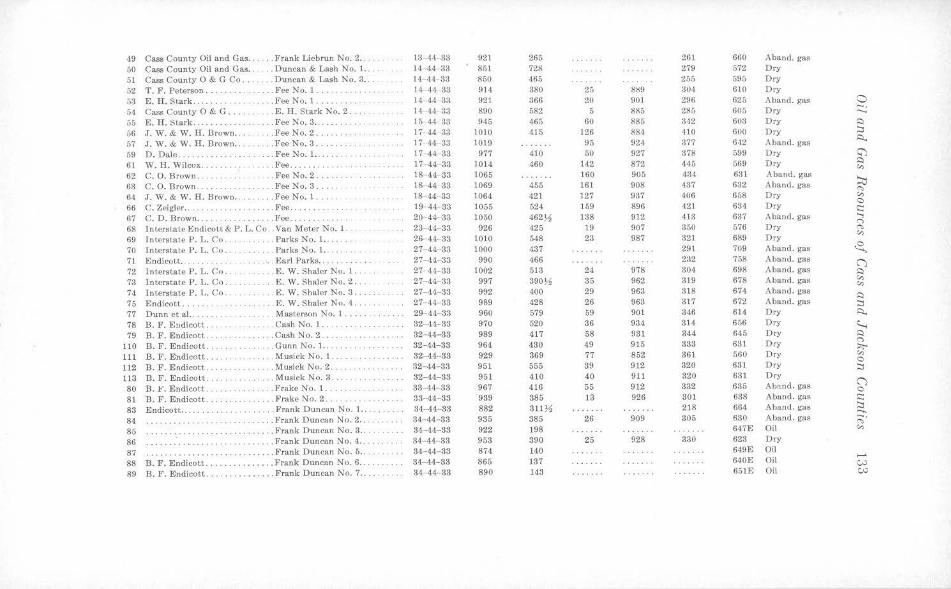
49 Cass County Oil and Gas .. . . . . Frank Liebrun No. 2 . .. 13- 44- 33 921 265 261 660 Aband. gas 50 Cass County Oil and Gas . . . .. Duncan & Lash No. 1. .. 14.- 44-33 851 728 279 572 Dry
51 Cass Count.y O & G Co . . . . . . . Duncan & Lash No. 3 ... 14- ·H - 33 860 465 255 595 Dry
52 T. F. Peterson .. . .. . . .. Fee No. l. .... 14-44- 33 914 380 25 889 304 610 Dry
53 E. H. Stark . . . . .. .. Fee No. 1 ... 14- 44- 33 921 366 20 901 296 625 Aband. gas 0 54 Cass Counly O & G .. . . E. H. Stark No. 2. 14 --14 33 890 582 5 885 285 605 Dry -. ..._
55 E. H. Stark . . . . .. Fee No. 3 .. ... . ...... 15- 44- 33 945 465 60 885 342 603 Dry $:)
56 J. W. & W. H. Hrown . . .FeeNo.2 ... . ... . 17- 44-3:l 1010 415 126 881 410 600 Dry :::,
57 J. W. & W. H. Brown ... . . . . . . FeeNo.3 . 17 14 33 1019 95 924 377 6'12 Aband. gas ~
59 D. Dale .. .. . .. . .. Fee No. l... 17-44-33 977 410 50 927 378 599 Dry <;')
61 W. H. Wilcox. . ... l~ee . ... 17- 44- 33 1014 460 112 872 445 569 Dry I::)
"' 62 C. O. Brown. . .. Fee No. 2 .. 18- 44- 33 1065 160 905 434 631 Aband. gas ~ 63 C. 0. Brown ... . . . . FceNo.3 .. .. 18-44- 33 1069 455 161 908 437 632 Aband. gas "" 64 J . W. & W. H. Brown . . . . . . . . Fee No. 1 ... 18 44- 33 1064 421 127 937 406 658 Dry "'
66 C. Zeigler . . .. . . ... . Fee .... . . 19-44 33 1055 524 159 896 421 634 Dry C
· · · · ··· · · · c:: 67 C. D. Brown ....... .. Fee .... 20-44-33 1050 462~ 138 912 413 637 Aband. gas ...,
<"> 68 Interstate Endicott & P. L. Co .. Van Meter No. I. 23- 44- 33 926 425 19 907 350 576 Dry ,.,, 69 Interstate P. L. Co .. . .Parks No. 1... 26 44 33 1010 5~8 23 987 321 689 Dry
<:,,
70 Interstate P. L. Co. . . .. Parks No. 1. . . .. 27- 44- 38 1000 437 291 709 Aband. gas ~ 71 Endicott . .. . . . Earl Parks .. ..... 27- 44- 33 990 466 232 758 A band. gas C") 72 Interstate P. L. Co .. . .. . E.W. Shaler No. l . . . 27 44- 33 1002 518 24 978 304 698 Aband. gas I::,
73 Interstate P. L. Co .. . . E.W. Shaler No. 2 .. 27- 44- 33 997 390)1 85 962 319 678 Aband. gas "' "' 74 Interslate P. L. Co .. . . E.W. Shaler No. 3. 27- 44- 33 992 400 29 963 318 674 Aband. gas ~
75 Endicott ... . .. . .. E.W. Shaler No. 4 . . . 27- 4'1 33 989 428 26 963 317 672 Aband. gas :::, 77 D unn et al.. . M astcrson No. 1 ... . . .. .. 29- 44- 33 960 579 59 901 346 614 Dry ~
78 B. P. Eudicott. ... . . .. . .. . . . . Cash No. 1. .. . 32- 44- 33 970 520 36 934 314 656 Dry ~ 79 B. F. Endicott . . . . .. Cash No. 2 . . . . . . . ..... . 32- 44-38 989 417 58 931 344 645 Dry ~
110 B. F. Endicott. . ... Gunn No. 1. ... 32-44-33 964 430 49 915 383 631 Dry <"> ' . . . . . . . . . ·· ·· · ··· · ··· · · ::,,;-
111 B. F. Endicott . .. .. . .. .. .. .. . Musick No. 1. .. 32-44-33 929 369 77 852 361 560 Dry "' C 112 B. F. Endicott . .Musick No. 2 .. . 32- 44- 83 951 555 39 9)2 320 631 Dry :::, 113 B. F. Endicott . .. .Musick No. 3 .. 32-44-33 951 410 40 911 320 631 Dry
C") 80 B. t '. Endicott .. . Frake No. 1. .. 33-44- 33 967 416 55 912 332 685 Aband. gas 0
81 B. F . Endicott . . ....... Frake No. 2 . 33-·44-33 939 385 13 926 301 638 Aband . gas i::: 83 Endicott .... . .. Frank Duncan No. 1. .. . . 34-44-33 882 31l )1 218 664 A band. gas :::, ...... 84 . ... Frank Duncan No. 2 .. 34- 44- 38 935 385 26 909 305 630 Aband. gas -.
"" 85 ......... Frank D un can No. 3 . . ...... . 34--44-33 922 198 647E Oil "' 86 . ' . . . . . . . . . . . ... Frank Duncan No. 4 .. .. . 34-44- 33 953 390 25 928 330 623 Dry
87 ········ · ··· · · · . ...... Frank Duncan No. 5 .. 34-44-33 874 140 649E Oil
88 B. F. Endicott . . .... ....... Frank Duncan No. 6 .. .. .. . .. 34-44-33 865 137 640E Oil .... ~
89 B. F. Endicott . . .... ....... Frank Duncan No. 7 . ... . ... 34-44- 33 890 143 651E Oil C;.j
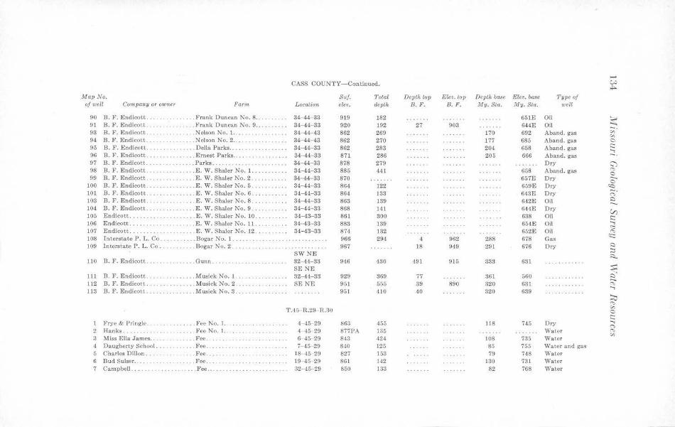
...... CASS COUNTY-Continued. w
.i,..
Map No. Suf. Total Depth top Elev. lop Depth base Elev. ba8e Type of of well Company or owner Fam, Location elev. depth B. F. B. F. My. Sta. My. Sta. well
90 B. F. Endicott . . ....... .... Frank Duncan No. 8 ... 34-44-33 919 182 651E Oil ~ 91 B. F. Endicott. ..... Frank Duncan No. 9 .. . .. 34- 44-33 920 192 27 903 644E Oil 93 B. F. Endicott. . .. Nel$0n No. 1 ..... 34-44- 48 862 269 170 692 Aband. gas ,;;·
"' 94 n. F. Endicott . . . .. Nelson No. 2 .... 34-44-43 862 270 177 685 Aband. gas 0
95 B. F. Endicott . . .. .. . ..... .. . Della Parks .. . . . 34-44- 33 862 283 204 658 Aband . gas s::: ..., 96 B. F. Endicott . ... ... Ernest Parks .. .. . .. . 34-44- 33 871 286 205 666 Aband. gas - . 97 B. F. Endicott. · ·· · ······ . . . . Parks .. 34-44-33 878 279 Dry 0 98 B. F. Endicott . . . .... . . . . .. E.W. Shaler No. 1.. 34-44-33 885 441 658 Aband. gas '"" 0 99 B. F. Endicott ... . .. . . . . ... .. E . W. Shaler No. 2 ........ 34- 44- 83 870 657E Dry --0
100 B. F . Endicott. .. . .. .. . . . .. .. E.W. Shaler No. 5 . . ... . .. .. . 34-44- 33 864 122 659E Dry «::i 101 B. F. Endicott .. . . B. W. Shaler No. 6 . . . 34-44-33 864 133 6·13E Dry ;:;· 103 B. F. Endicott . . .... E. W. Shaler No. 8 . . 3·1- 44- 83 863 139 642E Oil Q ,.._ 104 B. F . Endicott .. . .. . E. W. Shaler No. 9 . . 34-44-33 868 141 644E Dry V) 105 Endicott .. . . E.W. Shaler No. 10. 34-43-33 861 300 638 Oil s::: 106 Endicott . .. . .... .. E. W. Shaler No. 11. 84-43- 33 883 139 654E Oil
..., <:::
107 Endicott . . . .. E. W. Shaler No. 12 . . . . .. 34-43- 33 874 132 652E Oil "' 108 Interstate P. L. Co . . . Bogar No. 1. 966 294 4 962 288 678 Gas er:: 109 Interstate P . L. Co. . .. . Bogar No. 2. ·· · · ·· ·· ·· 967 18 949 291 676 Dry Q
::i SWNE Q.. 110 13. F. Endicott . . . .. Gunn . . . . 32-44-33 946 430 491 915 333 631
SE NE ~ 111 Jl . F. Endicott . .. ... Musick No. l. . 32-44-33 929 369 77 361 560 · · · ·· · ··· · ~ 112 B. F. Endicott. .. MusickNo.2. ... . .... .. SENE 951 555 39 890 320 631 ········ ·· · · <'>
113 B. F. Endicott. . . . Musick No. 3. 951 410 40 320 639 ..., ~ '"" T.45- R.29- R.30 "' 0 s:::
1 l>rye & Pringle . . . . . . . . . . . . . . Fee No. l. . . ...... . .. . . 4- 45- 29 863 455 118 745 Dry '-, ("")
2 Hanks .... .Fee No. I. . . .. .. . .. ... 4 45 29 877PA 135 Water "' "' 3 Miss Ella James . . . . .. . .. Fee . 6-45-29 843 424 108 735 Waler 4 Daugherty School ... .. .. Fee .. . ... . .. .. . .. .. . .. . .. 7- 45- 29 840 125 85 755 Water and gas 5 Charl es Dillon . . . . . Fee ... .. . . .. .. . .... .. ... . . 18- 45 29 827 153 79 748 Water G Bud Sulser .. . . . . . . . . . . . . . . . . . Fee . .. 19 -45 29 861 142 130 731 " 'atcr 7 Campbell .. .. ... Pee .... ·· · ··· ······ ······ · 32- 45-29 850 133 82 768 Water
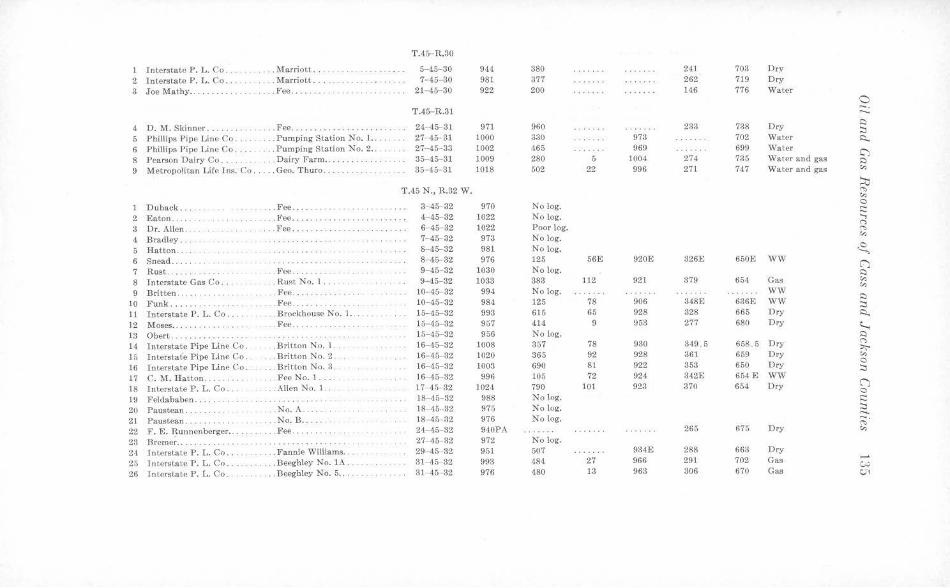
T.15- R.30
1 Interstate P. L. Co . . . Marriot t ... 5--45-30 944 380 241 703 Dry
2 Interstate P. L. Co .. .... . Marriott .. 7- 45- 30 981 377 262 719 Dry
3 Joe Math:,, .... . ..... .. . . . . . . . Fee ..... ... 21- 45- 80 922 200 H6 776 Water a
T.45- R.81 -. ,.._
4 D. M. Skinner ... . ... Fee ..... . ..... 24- 45- 81 971 960 233 738 Dry ,:)
::i 5 Phillips Pipe Line Co. . .. Pumping Station No. l. . .. 27- 45- 31 1000 330 973 702 Water R. 6 Phillips Pipe Line Co. . .. Pumping Station No. 2 .. 27-45-33 1002 465 969 699 Water CJ 8 Pearson Dairy Co ... .. Dairy Farm .. 35-45-31 1009 280 5 1004 274 735 Water and gas ,:)
9 Metropolitan Life Ins: Co . . . . . Geo. Thuro . 35- 45- 31 1018 502 22 996 271 747 Water and gas <r,
~ T.45 N., R.32 W . "" <r,
D uback .. . .. . Fee . . . 3- 45-32 970 No log. 0 ~
2 Eaton . . .... . .Fee .... . . ··· ··· ·· ·· · 4- 45-32 1022 No log. ..., 3 Dr. Allen .. . . . .. .. . . . Fee . ... 6- 45- 32 1022 Poor log.
(")
"" 4 Bradley . . 7-45-32 973 No log.
<r,
5 Hatton .. . . . . . . . . . . 8-45- 32 981 No log. <8., 6 Snead ..... 8- 45 32 976 125 56E 920E 326E 650E WW (."') 7 Rust ..... . . .. Fee . . . 9- 45- 32 1030 No log. ,:)
8 Interstate Gas Co. .. . Rust No. l. 9--45-32 1033 383 112 921 379 65-1 Gas <r, Cr,
9 Britten . . ...... . . . . . . Fee . .... . 10--45- 32 994 No log . WW
10 Funk .... . . .Fee .... . ... 10- 45- 32 984 125 78 906 348E 636E WW ,:)
::i 11 Interstate P. L. Co. . . Brockhouse No. I. 15-45-32 993 615 65 928 328 665 Dry ~
12 Moses .. ····· · ·· · · .Fee . . ...... . ... . 15- 45-32 957 414 9 953 277 680 Dry ~ 13 Obert . .. .. ... .. ······· · ····· 15- 45- 32 956 No log. ,:)
14 Interstate Pipe Line Co. .B ritton No. 1 . . 16- 45-32 JOOS 357 78 930 349. 6 658.5 Dry (")
~ 15 Interstate Pipe J,inc Co . .Britton No. 2 . 16- 45- 32 1020 365 92 928 361 659 Dry <r,
16 l nterstate Pipe Line Co . . Britton No. 3. 16-45- 32 1003 690 81 922 353 650 Dry 0 ::i
17 C . r,,r. Hatton ...... . . .FceNo. l .... 16- 45- 32 996 lOo 72 924 342E 654 E WW
18 Interstate P. L. Co . .. .... . Allen No. J . . 17 45-32 1024 790 101 923 370 654 Dry (") 0
19 Feldababen .. ··· ·· ··· · · · 18-45- 32 988 No log. ~
20 Paustean . . .No. A . . .... . 18- 45···32 975 No log. ::i ...... 2 1 Paustean. . . . No. J3 .•.. . 18--45-32 976 No log. ;;· 22 F. E. Runnenbcrgcr . . . . .. . . Fee .. .. . 24- 45- 32 940PA 260 675 Dry <r,
23 Breme~ .. .. 27--45- 32 972 No log.
24 Interstate P. L. Co . .. . . . . Fannie Williams .... 29- 45- 82 951 507 934E 288 663 Dry
25 lntersta~e P. L. Co. . . .. Beeghley No. lA . 31- 45- 32 993 484 27 966 291 702 Gas ...... c.,;,
26 Interstate P. L. Co. .... Beeghley No. 5 .. 31- 45-32 976 480 13 963 306 670 Gas C.71
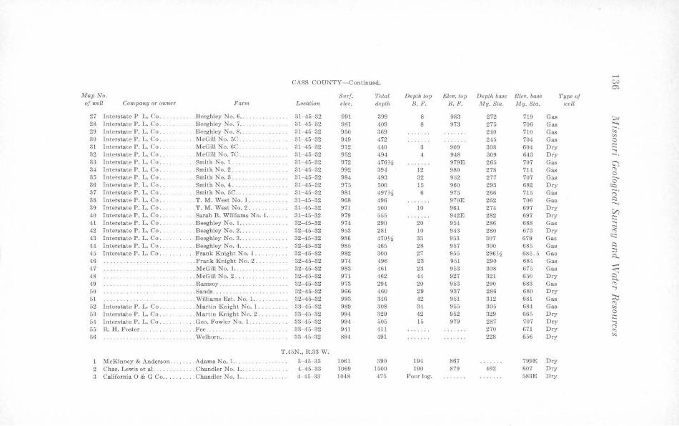
...... CASS COUNTY- Continued. c.,.,
er.,
Map No. S1<rf. Total Deptht-0p Elev. top Depth base Elev. ba,ie Type of of well Conipany or owner Farm Locati&n eleo. depth B. F. B.F. My. Sta. My.Sta. well
27 Interstate P L. Co . . Bccghley No. 6 . . . 31 -15 32 991 399 8 983 272 719 Gas ~ 28 l nterstate P. L. Co. .. . . Beeghley No. 7 .. 31- 45· 32 9l!J 409 8 973 275 706 Gas -. 29 Interslate P. L. Co. . . Beeghley No. 8 .. 31- 45- 32 950 369 240 710 Gas "' "' 30 Interstate P. L. Co. . .. McGill No. 5C . .. 31 45 32 949 472 245 704 Gas 0
31 lntcrstatc P. L. Co. . ... McGill No. 6C. 31-45- 32 912 440 3 909 308 604 Dry s:::: ...., 32 Interstate P. L. Co ... . . . McGill No. 7C .. 31-45- 32 952 494 4 948 309 643 Dry -. 33 Interstate P. L. Co . . . .. Smith No. l .. 31 ·45- 32 972 476Y:i 979E 265 707 Gas G"l 34 lnterstatc P. L. Co. .. . Smith No. 2 . 31- 45- 32 992 394 12 980 278 714 Gas ~
35 Jnterstate P. L. Co ... .. . Smith No. 3. 31-45- 32 984 493 32 952 277 707 Gas 0 ......
36 Interstate P. L. Co ... .Smith No. 4. 31 ·45- 32 975 Dry 0
500 15 960 293 682 ~ 37 Interstate P. L. Co .. ... Smith No. 5C. 31-45- 32 98] 497,!1 6 975 266 715 Gas ;::;· 38 Interstate P. L. Co ... ... T. M. West No. 1 . 31- 45- 32 968 496 970E 262 706 Gas i::i ,..._ 39 Interstate P. J,. Co . . . .T. M. West No. 2 .. . . ... . . .. 31 ·45- 32 971 500 10 961 274 697 Dry
VJ 40 Interstate P. L. Co .. . . . Sarah B. Williams No. 1. . . .. .. 31-45- 32 979 555 942E 282 697 Dry s:::: 41 Interstate P. L. Co .. .. . . Beeghley No. 1 .. . . 32-45-32 974 290 20 954 286 688 Gas ...., 42 Interstate P. L. Co . .. .Beeghley No. 2 . . . . 32- 45- 32 953 281 10 943 280 673 Dry
<::: . .. ..... .. "" 43 Interstate P. L. Co . ... Beeghley No. 3 .... 32-45- 82 986 470V. 33 953 307 679 Gas 't:::
44 Interstate P . L. Co. ... Beeghley No. 4 .... 32-45-32 985 465 28 957 300 685 Gas Q
15 Jnterstate P. L. Co . . .. Frank Knight No. 1 .. . . 32- 45- 32 982 300 27 955 296,!1 685.5 Gas :::s ~
46 . .. Frank Knight No. 2. 32-45-32 974 496 23 951 290 684 Gas -47 . . McGill No. 1.. 32- 45- 32 983 461 23 953 308 675 Gas ..,.. -18 ... . McGill No. 2 . ... . . ... . 32--45- 32 971 462 44 927 321 650 Dry ~ 49 . . . . Ramsey ... 32-45-32 973 294 20 953 290 683 Gas ..,, 50 .... . Sands .. . . . . . 32- 45- 32 966 460 29 937 286 680 Dry
....,
51 ... .. Williams Est. No. 1. . . .. 32-45-32 993 316 42 951 312 681 Gas :=,j
52 Interstate P. L. Co. ... . Martin Knight No. 1. 33- 45-32 989 308 34 955 305 684 Gas "" "' 53 Interstate P . L. Co ... . . .. Martin Knight No. 2 . ... 33- 45 32 994 329 42 952 329 665 Dry 0 s:::
54 Jnterstate P. L. Co .. . Geo. Fowler No. 1. 33- 45- 32 994 505 15 979 287 707 Dry ...., 55 R. H. Foster. . ... . Fee. :)3- 45- 32 941 411 270 671 Dry <">
"" 56 . Welborn . . . .... 33 '15 32 884 491 228 656 Dry "' .. ... .. T.45N., R.33 W.
1 McKinney & Anderson. . . . Adams No. 1. . . . 3- 45- 33 1061 390 194 867 799E Dry 2 Chas. Lewis et al. ... . . .. Chandler No. 1.. 1 45 33 1069 1500 190 879 462 607 Dry 3 California O & G Co .. . . . . . . Chandler No. 1. 4- 45- 3:1 1048 475 Poor log. 583E Dry
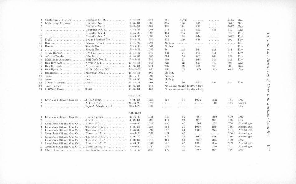
4 California O & G Co ... .... .. . Chandler No. 2 .... . 4-45-33 1074 865 887E 614E Gas 5 McKinney-Anderson . ... . . ... . C handler No. 1. .. . ·· ······ · · · 4- 45-33 1069 395 190 879 607E Gas 6 .. Chandler No. 2 . . . ............ 4-45- 33 1064 395 184 880 608E Gas 7 ... Chandler No. 3 .. 4- 45-33 1066 675 194. 872 456 610 Gas 8 ······ · ·· · .... Chandler No. 4 .. 4 -45- 33 1096 426 205 891 619E Dry 0
25 . ...... Chandler No. 5 . . 4- 46 33 1034 365 164 870 608E Dry -. 9 D uff. ... Bruce Schubert No. 1. 9- 45- 33 989 738 109 880 594 Dry
..._ ···· · ·· ·· · · ·· ·· i:::i
10 Rosier . . ... . . . .. Schubert No. 1. .. .. .. . ... . . 9 45- 33 1004 No log. Dry :::i 11 Rosier .. . ... . . . . . . . . Woods No. I. . . 9-45 33 1061 No log. Dry ~ 12 . Woods No. 2 . . . 9- 45-33 1059 761 148 911 428 631 Dry ::' 13 J. M. Horner ... ... . .. .. Groh No. 1. .. ll-45-33 979 372 74 905 361 618 Dry i:::i 14 Ashton-Traylor ... . .... Schmid ... 12 45- 33 956 393 59 897 334 622 Dry "' 15 McKinney-Anderson . . . ... Will Groh No. I. 13-45--33 985 580 71 914 344 641 Dry :::0 16 Ben Hyde, Jr ... .. .. ..... . .. . Noyes No. 1. .. . 20-45-33 945 722 72 873 339 606 Gas "' "' 17 Ben Hyde, Jr .. . . . . NoyesNo.2. 20- 45-33 911 706 38 873 305 606 Gas 0
18 Ben Hyde, .Jr .. .. .. W. K. Mounce No. 1 .... . .... 20- 45- 33 911 550 32 879 298 613 Gas ,:: .. .. . .. . . . ..,
19 Brodhurst. . . . . . . ... . .. Mossman No. 1 .. . . 25- 45- 33 867 No log. '"' "' 20 Sears . .. .. . ... ... Fee .. 26- 45- 33 925 No log. "' 21 Sears ... . . .. Fee . . . ·· ····· · ·· ·· · ·· · ·· · ·· 26- 45- 33 934 No log. ~ 22 J. O'Neil Bruen. . .. .. . ... Coble .. ......... . · ·· · ·· · ·· · 33-45- 33 908 561 30 878 295 613 Dry 23 Saint Lafoon . . . . .. 34 45-33 174 No elevation and location loot. (")
24 J. O'Neil Bruen .. . .. .. Smith .... 35- 45- 33 453 No elevation and location lost. ,::) . .. . .. .. .. . .. .. ... . "' "'
T.46-R.29 0
6- 46- 29 1088 527 31 1002 302 781 Dry ::i
1 Lone Jack Oil and Gas Co . . . . . J. G. Adams. ~ 2 .A.G. Sigfrid . ······· · ··· 20-46- 29 876 142 734 Water
~ 3 .. . Frye & Pringle No. 2 .. . .. 33-4&-29 883 Dry 0
'"' T.46-R.30 "'" "'
Lone Jack Oil a nd Gas Co .... . Henry Carson .... .. .. . ....... 2-46-30 1019 380 32 987 310 709 Dry 0 :::i
2 .... . J. V. Hon .... . . .. ... . 4-46-30 999 410 12 987 271 728 Dry CJ 3 Lone Jack Oil and Gas Co .. . . . Thornton No. 1 ... . 4 46- 80 1015 405 46 969 281 734 Aband. gas 0
4 Lone Jack Oil and Gas Co. . ... Thornton No. 2. ··· · · ·· ······ 4-46-30 1035 380 25 1010 299 736 Aband. gas ,:: 5 Lone Jack Oil and Gas Co . . ... Thornton No. 3 ... 4-46-30 1025 373 24 1001 274 751 Aband. gas :::i --6 Lone Jack Oil and Gas Co . . . . . T hornton No. 4 .. . 4-46- 30 1038 374 22 754E Aband. gas -.
"' 7 Lone Jack Oil and Gas Co. . ... 'l'hornton No. 5 . . . 4-4.fr-30 1017 430 34 983 278 739 Aband. gas "' 8 Lone Jack Oi l and Gas Co . . . . . Thornton No. 6 .... . 4- 46- 30 1015 430 48 967 315 700 Dry 9 Lone Jack Oil and Gas Co . . . . . Thornton No. 7 .... 4- 46- 30 1043 236 42 1001 304 739 Aband. gas
10 Lone Jack Oil and Gas Co . . . . . Thornton No. 8 ..... 4-46-30 1037 382 36 1001 286 751 Aband. gas ..... c..~
11 Clark Knorpp. . . . Fee No. 1. . . .. .. . .. . 5-46- 30 1004 400 16 988 267 737 Dry ,1
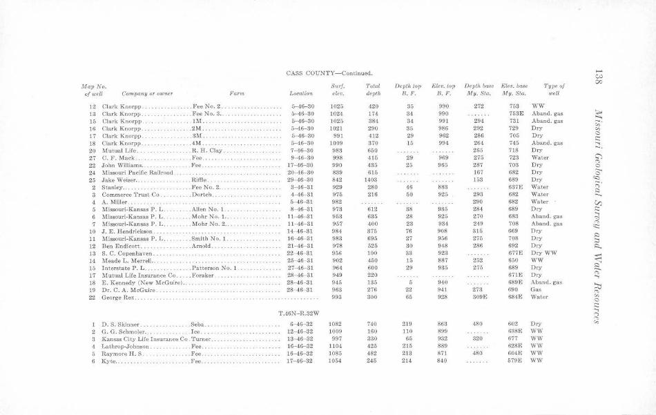
CASS COUNTY-Continued. ....... e,:,
Map No. Surf. Total Depth top Elev. lop Depth base Elev. base Type of 00
of well Company or owner Farm Location elev. depth B.F. B.F. My. Sta. My. Sta. well
12 Clark Knorpp . . .FeeNo.2 ... . 5-46-30 1025 420 35 990 272 753 WW 13 Clark Knorpp .. . ... Fee No. 8 ..... . ..... 5- 46- 30 1024 174 34 990 753E Aband. gas ~ 15 Clark Knorpp . . . .. . .' . .. . .. ... lM ...... ... . . .. . . . 5-46-30 1025 384 34 991 294 731 Aband. gas 16 Clark Knorpp , .. .. 2M ... 5-46-30 1021 290 35 986 292 729 Dry "' · · ·· · ·· · · · ·· · ·· ······· "' 17 Clark K norpp .. .. ... 3M .. 6- 46- 30 991 412 29 962 286 705 Dry 0
c:: 18 Clark Knorpp .... . . . . .. . . . . . .4M .......... 6-46-30 1009 370 15 994 264 745 Aband. gas ::: . 20 Mutual Life ....... . .. . .. . . . . R.H. Clay. 7-46-30 983 650 265 718 Dry 27 C. F. Mack . .. .}'ee ..... 9-46-30 998 416 29 969 275 723 Water ~
22 John Williams .. .. . .. . Fee . . .. . ... . .. . .. 17-46-30 990 435 25 965 287 703 Dry ,.,,
··········· 0
24 Missouri Pacific Railroad . . . ..... . .... .. ....... 20-46-30 839 615 167 682 Dry ...... 0
25 Jake Weiser ..... . . . .. . Riffle ... 29- 46-30 842 1403 153 689 Dry <Q
2 Stanley .. .... Fee No. 2 .. .. . .......... . .... 3-46- 31 929 280 46 883 637E Water ;:;· 3 Commerce Trust Co .... . .. ... Dortch ., ... 4-46-31 975 216 50 925 298 682 Water
:::) .. ... .. .... ...... 4 A. Miller ... 5- 46- 81 982 290 682 Water V) 5 Missouri-Kansas P. L. . . .. Allen No. 1. . . .. . .. . ... . .... 8-46-31 973 612 38 935 284 689 Dry ;:: 6 Missouri-Kansas P . L .. . .. . Mohr No. 1. .. 11-46-31 953 635 28 925 270 683 Aband . gas
..., <:::
7 Missou ri-Kansas P. L .. . .. .. .. Mohr No. 2 .... 11- 46- 31 957 400 23 934 249 708 Aband. gas (':,
o:c: 10 J.E. Hendrickson ... ' . . . . . . . . . ... . .. .. .. . . 14-46-31 984 375 76 908 315 669 Dry 11 Missouri-Kansas P. L. .. . Smith No. 1. 16-46-31 983 695 27 956 275 708 Dry
:::) :::,
12 Ben Endicott ..... . . . ... . Arnold ... . . 21- 46- 31 978 525 80 948 286 692 Dry i::i.. 13 S. C. Copcnhaven. · · ····· · ··· · ···· · ·· · ·· ·· ·· ····· 22-46-81 956 100 33 923 677E Dry WW
~ 14 Meade L. Merrell.. .. . . 25-46-31 902 450 15 887 252 650 WW 10 Interstate P. L ... . Patterson No . 1. .. 27-46-31 964 600 29 935 275 689 Dry ~ 17 Mutual Life Insurance Co .. . . . Foraker . .. . .... . .. . .. 28-46-31 949 220 67\E Dry "' ..., 18 E. Kennedy (New McGuire) .. .. ... . . . . .. .. . 28-46- 31 945 135 5 940 689E Aband. gas '.:lj 19 Dr. C. A. McG uire. 28-46-31 968 276 22 941 273 690 Gas "' 22 George Rex. ·· · ·· ·· ·· ·· · ···· ·· ·· · .. . ...... . 993 300 65 928 309E 684E Water "' 0
s:::: T.46N-R.32W
...,
...., "' 1 D.S. Skinner. .Seba . .. · ··· · · · ·· ·· ·· · ·· 6-46-32 1082 740 219 863 480 602 Dry "'
2 G. G. Schmoler .. .. Ice . .. .. ... 12-46- 32 1009 160 110 899 6381,; WW
3 Kansas City Lire Insurance Co. 'l'urncr. .. .. .. ..... .. . .... . . . 13- 46- 32 997 330 65 932 320 677 WW 4 J,athrop-Johnson. .. Fee ..... ··· · ·· ·· ·· ·· ·· · ·· 16-46-32 1104 425 215 889 628E WW 5 Raymore H . S .. .. .. Fee .... 16-46-32 1085 482 213 871 480 604E WW 6 Kyte .......... . ... Fee. · · ··· · ·· · ······· · ·· ·· · · 17- 46- 32 1054 245 214 840 579E WW
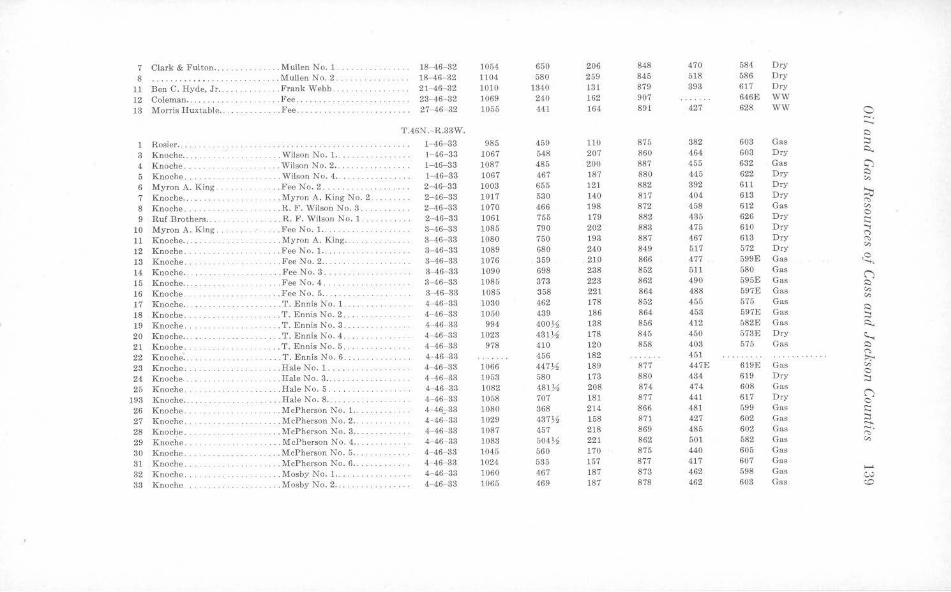
7 Clark & Fulton .. .... .. . . .. . Mullen No. 1 . 18- 46-32 1054 650 206 848 470 584 Dry
8 · ···· · ······· ·· . .... .. .. .. .. M ullen No. 2 . 18-46-32 1104 580 259 845 618 586 Dry
11 Ben C. Hyde, Jr .. . . . . . Frank Webb . ... 21- 46-32 1010 1340 131 879 393 617 Dry
12 Coleman .... .. .. . . .. . . . . Fee. · ·· · · · ··· ·· · · · · ·· 23- 46- 32 1069 240 162 907 646E WW
13 Morris H uxtable . . . . .. . Fee . .. .. . . .... . ... . . . .. .. 27-46- 32 1055 441 16,1 891 427 628 WW 0 ::::.:
T.46N.-H .. 33W. C
1 Rosier .. . . . . . l 46- 33 985 459 110 875 382 603 Gas ::,
3 Knoche .... .. .. . . . .. . .. Wilson No. 1 .. 1- 46-33 1067 548 207 860 464 603 Dry i:::i..
4 K noche .. . . . Wilson No. 2 . . . . . . . . .. 1- 46-33 1087 485 200 887 455 632 Gas C)
5 Knoche . . . . . Wil_son No. 4 .. . · · ··· · ··· · · · · · 1--46- 33 1067 467 187 880 445 622 D ry C
"' 6 Myron A. K ing . . FceKo.2 .. 2--46--33 1003 655 121 882 392 611 Dry
7 Knoche .. . . . ... . .. . Myron A. King No. 2. 2--46- 33 1017 530 140 8 17 404 613 Dry ~
8 Knoche . .. . . . . R. F. Wilson No. 3 . 2- 46- 33 1070 466 198 872 458 612 Gas ,.. "'
9 R uf Brothers .. . . .. .. R. F. Wilson No. 1 . 2- 46- 33 1061 755 179 882 435 626 Dry 0 i::::
10 Myron A. King. . .. . . Fee No. 1. ... . 3--46-33 1085 790 202 883 475 610 D ry ....,
11 Knoche .... . . . .. ... .. . Myron A. King .... . 3-46- 33 1080 750 193 887 467 613 Dry (") ,..
12 Knoche. .. Fee No. 1 .. . . . 3- 46- 33 1089 680 240 849 517 572 Dry "' 13 Knoche . . . . . . .. Fee No. 2 .... .. . .. . . 3- 46-33 1076 359 2 10 866 477 599E Gas ~ 14 Knoche . . . . . Fee No. 3 . .. . .. . . 3- 46- 33 1090 698 238 852 511 580 Gas ("') 15 Knoche .. . .. FeeNo.4 . .. 3- 46- 33 1085 373 223 862 490 595E Gas C 16 Knoche .. . FceNo.5 .. 3- 46- 33 1085 358 221 864 488 597E Gas "' 17 Knoche. . . ... .. . T . Ennis No. 1. 4- 46- 33 1030 462 178 852 455 575 Gas "' 18 Knoche ... . .. .. .. . T . EnnisNo.2. 4- 46- 33 1050 439 186 864 453 597E Gas
C ::,
19 Knoche ... . .. . T. Ennis No. 3 . .... .. ... .. 4- 46- 33 994 400 )1 138 856 412 582E Gas i:::i.. 20 K noche .. .. .. .. .. .. . T. Ennis No . 4 .. . 4-46 33 1023 4.81)4 178 845 450 578E Dry ~ 21 Knoche .. . . . T. Ennis No. 5 . . 4- 46- 33 978 410 120 858 408 575 Gas C
22 Knoche . .. . . . .. T. E nn is No. 6 . 4-46- 33 456 182 451 (")
;,,;.. 23 Knoche . .. .. . Hale No . 1. .. . .. . 4- 46- 33 1066 447)1 189 877 447E 619E Gas "' 24 Knoche . .. Hale No. 3 .. . 4--46-33 1053 580 173 880 434 619 Dry
0 ::,
25 K noche .. .. . Bale No. 5. 4--46- 33 1082 481)4 208 874 474 608 Gas
193 Knoche .. .... Hale No. 8 ... . . . .. .. .. .. .. 4 -46- 33 1058 707 181 877 441 6)7 Dry ("') 0
26 Knoche .. . .. McPherson No. 1.. 4--46;-33 1080 368 214 866 481 599 Gas ;:::
27 Knoche . . McPherson No. 2 . . .. .. .. 4-46- 83 1029 437)4 158 871 427 602 Gas 2:1.. 28 Knoche . . .... McPherson No. 3 .. 4- 46- 33 1087 457 218 869 485 602 Gas ~-29 Knoclie .. .. . . McPherson No. 4 .. 4-46- 33 1083 504)4 221 862 501 582 Gas "' 30 Knoche ... .McPherson No. 5 .. . . 4- 46- 33 1045 560 170 875 440 605 Gas
31 Knoche . ..... McPherson No. 6 .. .. .. .. .. . .. 4- 46-33 1024 535 157 877 417 607 Gas
32 K noche .. . . . . Mosby No. 1 .. 4-46- 33 1060 467 187 873 462 598 Gas .......
· ·· ·· ·· ·· ·· · · w 33 K noche . . . . .. . . . . . . . Mosby No. 2 .. . . .. . 4-46- 33 1065 469 187 878 462 603 Gas <O
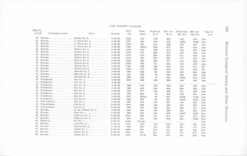
CASS COUNTY-Continued. ..... ~
Map No. Surf. Total Depth top Elev. top Depth baae Elev. bue Type of 0 of well Company or owner Farm Location elev. depth B.F. 8.F. My. Sta. My. Sta. well
34 Knoche .. · · ··· · ···· · .. . .. Mosby No. 3 . . . . . . 4-46-33 1052 445 172 880 438 614 Gas 85 Knoche . . .. . C. Smith No. 1.. .. .. . 4-46-33 1067 450 195 872 462E 605E Gas ~ 36 Knoche ... . . . .. . ... . . C. Smith No. 2 . . .. . 4-46-83 1076 484 210 866 479 597 Dr:, ;;; · 37 Knoche .. ... . C. Smit h No. 3 . . . 4·-46-33 1080 592~ 203 877 467 618 Gas "' 38 Knoche. ... . Walton No. 1. ... .. 4- 46- 33 1059 467 188 871 454 605 Gas 0 39 Knoche ........ .. ... .. Walton No. 2 . . 4-46-88 1070 479 200 870 472 598 Gas
,:: ...., 40 Knoche . . . . . . . Walton No. 3. 4- 46-33 1070 476 200 870 471 599 Gas -. 41 Knoche ... . . . Walton No. 4 . .. ,,., . 4- 46-38 1074 484 207 867 477 597 Gas C") 42 Knoche ...... . . .. . ...... Walt.on N o.5 . 4-46-33 1059 463 188 871 455 604 Dry "" . ' . . . . . . . .
0 43 Knoche . . · · · · ·· ·· · . . . ... ... . Walton No. 6 . · ·· · ·· ·· ·· ·· · ·· 4- 46- 33 1086 450 171 865 444 592 Gas c 44 Knoche. ......... . Walton No. 7 . .. ,. 4-46- 38 1065 582 198 867 464 601 Oil '<::! 46 Knoche. . ···· ·· · ·· · · .. Walt.on No. 8. 4-46-33 1063 577 189 874 459 604 Oil ;::;· 46 Knoche . . .. . Marnell No. 1. .. 5-46-33 890 332 63 827 380 560 Gas :::i . .. . .... .. .. . . .. ... . .. . . ..._ 47 Knoche. . . ... Marnell No. 2 .. 5-46-33 907 338 72 835 334 573 Gas V) 48 Knoche ...... . .. . .. ... . .. Marnell No. 4 .. 5-46- 33 899 380 75 824 345E 554 Dry ,:: 49 Poindexter .. ..... Fee No. 1. .. . .. ,, .. .. .. .. . .. 5-46-38 1018 466 192 826 458 560 Gas
...., <:::; 50 Poindexter .. . .. Fee No. 2. . .......... .. 5-46-33 ........ . ... "" 51 Poindexter .. .. . Fee No. 8 ... .. 5-46-33 986 879 106 830 870 566 Gas
(t:::
52 Poindexler . . ... Fee No. 4 ... , .. . , .. .. .. . 5-46- 38 968 405 130 888 399 569 Dry :::i :::i 53 Poindexter .. .. . . . .. .. . FeeNo.5. 5-46-33 940 377 104 836 371 569 Gas ~ 54 Poindexter .. . . . Fee No. 6 ... . 5-46-33 903 348 76 827 342 561 Gas
55 Poindexter . . .. . .. FeeNo.7. . ····· · ··· · · 5-46- 33 887 294)1 46 841 313E 574E Gas ~ 56 Poindexter ....... . .. Fee No. 8 ... 5-46-33 895 820 64 831 331E 564E Gas ~ 57 Tom Johnson . . . . Fee No. 1 .. 6- 46- 33 981 414 ]50 881 412 569 Gas "" ...., 58 Tom Johnson. . ...... Fee No. 2. 6-46-33 1003 426 164 839 4.23 580 Gas j;j 59 Tom Johnson . . .. Fee No. 3 . 6- 46- 33 967 394 132 885 393 574 Gas
"" 60 Knoche .. . . .. . .. . ..... .. . . R. M . Johnson No. 1. 7-46-38 998 434 172 826 432 566 Dry "' 61 Knoche. . .... . .. . .. .. .. ... . . Kerr No. 1 . 7-46-33 988 400 179 809 446E 542E Dry C ,:: 62 Knoche. .. . .. .. , .. .. . . . F ullerton No. 1. 8-46- 33 1005 469 191 814 464 541 Dry ...., <"> 63 Knoche . ... Fullerton No. 2. 8-46- 33 991 431 168 823 435 556E Dry "" 64 Full erton. .... Ft"C No. 1 ...... 8- 46 33 1008 No log Dry "' 65 Knoche ... .Groh No. 2 ... 8- 46-83 1024 5:34 199 825 462 562 Dry
66 Knoche . ... . .. . Marnell No. 3 . . . 8- 46-33 965 395 130 835 391 574 Gas 67 Knoche. . .. .. Abbey No. l .... 9 ·16- 33 1061 800 210 851 481 580 Dry 68 K noche .. .. .Abbey No. 2 . ... 9-46-33 ]087 481 210 877 475 612 Gas 69 Knoche ... .... .. Abbey No. 3 .. 9-46-33 1074 471)4 196 878 465 609 Gas
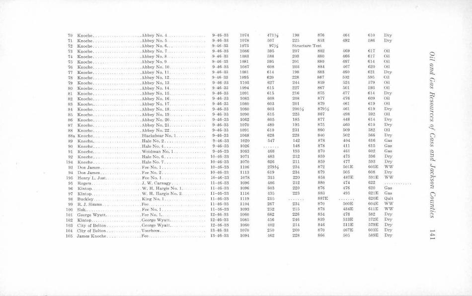
70 Knoche .. ...... Abbey No. 4 ..... ... 9- 46-33 1074 471~ 198 876 464 610 Dry 71 Knoche. .. Abbey No. 5 . ... 9- 46-33 1078 507 225 853 492 586 Dry 72 Knoche .. . . . . . Abbey No. 6 .. .. 9- 46- 83 1073 97% Stru cture Test 73 Knoche .. . Abbey No. 7 .... 9- 46-33 1086 595 207 882 469 617 Oil
0 74 Knoche. .Abbey No. 8. 9-46-33 1083 588 203 880 466 617 Oil -. 75 Knoche .. . ... Abbey No. 9 . 9- 46 33 1081 595 201 880 467 614 Oil
..._
76 Knoche . . .. .. .. . Abbey No. 10 .. 9-46-33 1087 608 203 884 467 620 Oil s:i :::i
77 Knoche . . . Abbey No. 11 . ... 9-46-33 1081 614 198 883 460 621 Dry R. 78 Knoche. . ... . Abbey No. 12. 9 46 38 1095 620 228 867 502 595 Oil C'} 79 K noche .. ... . .. Abbey No. 13 .. 9-46-33 1103 627 244 859 524 579 Oil s::i 80 Knoche. . .Abbey No. 14 .. 9-46-33 1094 615 227 867 501 593 Oil "' 81 Knoche. . Abbey No. 15. 9- 46- 33 1091 615 216 875 477 614 Dry ~ 82 Knoche .. . .. Abbey No. 16 . . 9-46- 33 1085 608 208 877 476 609 Oil "' 83 KnochP .. . .Abbey No. 17 .. 9- 46-33 1080 603 201 879 461 619 Oil "' C
84 Knoche . .Abbey No. 18 . . 9- 46- 83 1080 603 200~ 879~ 461 619 Dry i:::::
85 K noche ... .. . Abbey No.19 .. 9-46- 33 1090 615 223 867 498 592 Oil ...., C'>
86 Knoche. . . . Abbey No. 20 . .. 9-46-33 1062 605 185 877 448 614 Dry "' "' 87 Knoche ... . .. . .. Abbey No. 21 . . 9 46- 83 1070 480 195 875 460 610 Dry ~ 88 Knoche ... .. . . .. . Abbey No. 22 . . 9-46- 33 1091 610 231 860 509 582 Oil
88a Knoche .. .Blackshear No. 1. 9-46-33 1068 628 228 840 502 566 Dry (")
89 K noche ... .Hale No.2 .... 9- 46- 33 1020 547 142 878 404 616 Gas s::i
"' 90 Knoche .... .HalcNo.4 ... . .. 9-46- 33 1026 148 878 411 615 Gas "' 91 Knoche . . . .. . Weidman No. 1 . . ... . 9- 46-33 1063 468 193 870 461 602 Gas s::i 92 Knoche . . .Hale No. 6 .... 10- 46 33 1071 483 212 859 475 596 Dry :::i
194 Knoche . ... .Hale No. 7 .. 10-46- 33 1070 626 211 859 477 593 Dry A..
93 Don James. . .. . Fee No. 1 .. . 10- 46-33 1106 279 ,11 23·1 872 501E 605E WW ~ 94 Don James. . .. . Fee No. 2 .. 10- 46-33 1113 619 234 879 505 608 Dry s::i
n 195 Henry L. Jost . . . . .. Fee No. 1. 10- 46-33 1078 315 220 858 487E 591E WW :,.,..
"' 95 Rogers . . . .. . J. W . Carnagy ... . 11-46-33 1096 486 212 880 474 622 C
96 Kintop . . . . W. H. Hargis No. l 11 46 33 1096 603 220 876 476 620 Gas ::J 97 Kintop . . .. . . . ... . . . W. H. Hargis No. 2. 11-46-33 1116 435 223 883 495 621E Gas (") 98 Buckley .. .. . . King No. l .... .. 11- 46-33 1119 215 887E 620£ Quit C
99 R. J. Simms .. ... .. Fee . .... . 11- 46- 33 1104 267 234 870 500E 604E WW i::::: .. ;::_ 100 Sisk .... .. . ... . . Fee No. 1. ... 11-46-33 1093 252 215 878 484E 611E WW 101 George Wyatt . . .. Fee No. 1 •. 12-46- 33 1060 682 226 834 478 582 Dry ;:;;·
"' 102 Kintop . .. George Wyatt .. 12- 46- 33 1085 456 246 839 513E 572E Dry
108 City of Belton. . . . George Wyatt .. 12-46- 33 1060 402 214 846 511E 579£ Dry
104 City of Belton .. .. . . Voorhees . .... 13- 46- 83 1070 250 200 870 467E 603E Dry
105 James Knoche. ... Fee .. 13- 46- 33 1094 462 228 866 505 589E Dry ,i::,.. ......
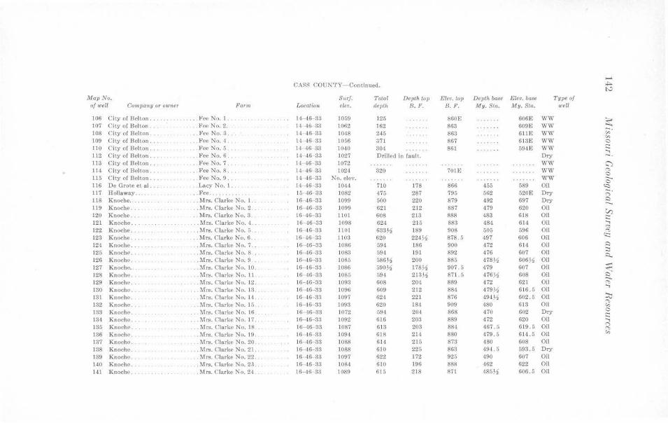
-CASS COUNTY-Continued. *"" I'-'
Map No. S11rf. Total Depth top Eler. top Depth ba8e Elev. ba•e Type <>f of well Company or owner Farm LocatioT< elev. depth B. F. B. F. My. Sta. My. Sta. 1<·ell
106 City ol Bellon .. . . . . Fee No. l. .. 11-,16- 33 1059 125 860E 606E WW ~ 107 City o[ Belton ... . .. ~·ec No. 2. 14- 46- 33 1062 162 863 609E WW
108 City of Belton .. .. FeeNo.3. 14 46- 33 1048 245 863 611E WW ;;;· "' 109 City ol Bellon . . ... . Fee No.~ ... 14 ~6 33 1056 371 867 Gl3E WW 0
110 Cily ol Bel ton . .Fee No. 5 ... . 14- 46 33 lQ,10 304 86l 59<1E WW .::: ...., 112 City ol Belton . .Fee No. 6. 14 46- 33 1027 Drilled in fault. Dry -. Jl3 City of Belton . .Fee No. 7 . 14 16 33 1072 WW C') 114 CiW of Belton ... . Fee No. 8 .. 14- 46- 33 1024 320 10m WW "' 0 115 C ity ol Belton . .. FeeNo.9 . l4 46- 33 No. elev . WW 0 116 De Grote el al. .. J.acy No. I .. 14 46 33 1044 710 178 866 455 589 Oil (<:)
117 Hollaway ..... .. Fee ...... .. . .. 15-46 33 1082 475 287 795 562 520E Dry ;::;· 118 Knoche ... . .. .... Mrs. c.;Jarke No. I. 16 46-33 1099 500 220 879 492 697 Dry I:) -1)9 Knoche ... . . Mrs. Clarke No. 2 . 16 46 33 1099 621 212 887 479 620 Oil V) 120 Knoche ... .. Mrs. Clarke No. 3. t6 46- 33 1101 608 213 888 483 61M Oil .::: 121 Knoche . . .... . Mrs. C larke No. 4 16 46- 33 1098 624 215 883 484 614 Oil ....,
s:: 122 Knoche .... .. Mrs. C larke No. 5 16 46 33 llOI 633~ 189 908 505 596 Oil "' 123 Knoche ... .. Mrs. Clarke No. 6 .. 16 46 33 ll03 620 224~ 878.5 497 606 Oil <c: 124 Knoche .. .. Mrs. Clarke No. 7. 16 46-33 1086 594 186 900 472 614 Oil i::)
125 Knoch~ . .. Mrs. Clarke No. 8 . . . 16 46 33 1083 594 J 91 892 476 607 Oil ::::i ~
126 Knoche .. .. Mrs. Clarke No. 9 .. 16- 46- 83 1085 586~ 200 885 478% 606~ Oil 127 Knoche .. .. Mrs. C larke No. 10. 16 46- 33 1086 590~ 1787!, 907 .5 479 607 Oil $l 128 Knoche . . . .. Mrs. Clarke No. 11 . 16 46 33 1065 594 213~ 871.5 476~ 608 Oil e: 129 Knoche .. . Mrs. Clarke No. 12 .. 16-46-33 1093 608 204 889 472 621 Oil "" 130 Knoche . Mrs. Clarke No. 13. 16 46-33 1096 609 212 881 479~ 6 16.5 Oi l
....,
131 Knoche. Mrs. Clarke No. 14 ... 16 ,16 33 1097 624 221 876 494~ 602.5 Oi l ~ 132 Knoche .. . Mrs. C larke No. Ir, . .. 16- 46 33 1093 620 184 909 480 613 Oil '"" "' 133 Knoche . . .. . Mrs. Clarke No. 16 .... 16 46-33 1072 594 204 868 470 602 Dry 0
.::: 134 Knoche .. Mrs. Clarke No. 17. 16- <16- 33 1092 616 203 889 472 620 Oil ...., 135 Knoche ... ... Mrs. Clarke No. 18 .. 16-46- 33 1087 613 203 884 467.5 619.5 Oi l n
"' 136 Knoche . ... Mrs. CJarke No. 19. 16 46- 33 1094 618 214 880 479. 5 614.5 Oil "' 137 Knoche .. . . Mrs. Clarke No. 20 . . 16 46 33 1088 614 215 873 480 608 Oil 138 Knoche ... .. Mrs. Clarke No. 21. 16- 46-33 1088 610 225 863 -194. 5 593.5 Dry
139 Knoche . . .. Mrs. C larke No. 22. 16- 46-33 1097 622 172 925 490 607 Oil 140 Knoche. .. Mrs. Clarke No. 23. 16 46 33 108<1 610 196 888 462 622 Oil
141 Knoche ... . Mrs. Clarke No. 24 rn- 16 33 1089 615 218 871 485)4 606 . 5 Oil
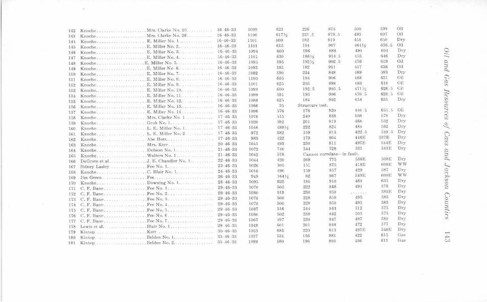
142 Knoche ..... . .. .Mrs. Clarke No. 25. JG ,16-33 1099 623 226 87:l 500 599 Oil
143 Knoche ...... . . Mrs. Clarke No. 26 16 46 ·33 1100 617~ 221.5 878.5 493 607 Oil
144 Knoche .... ..... ..... . E. Miller No. 1 . . ... 16- 46-33 1101 800 182 919 451 650 Dry
145 Knoche .. .. .. .. E. Miller No. 2 ... 16- 46-33 ll 01 615 19,1 907 464~ 636. 5 Oil
146 Knoche . . .. . E. Miller No. 3 . . 16 46 33 1094 600 196 888 490 604 Dry a 147 Knoche . . .... . . E. Miller No. 4 . .. 16-46- 33 1101 630 186~ 914. 5 455 646 Dry - . .... --148 Knoche ... .. .. . . E. Miller No. 5 .. 16-46- 33 1095 595 192)1 902.5 476 619 Oil s::i
149 Knoche. .. E. Miller No. 6 . . 16 46- 33 1098 585 182 911 457 636 Oil :::,
150 Knoche .. , . . E. Miller No. 7 . . 16-46- 33 1082 590 234 848 489 593 Dry ::::i..
151 Knoche ... ... . ....... E. Miller No. 8 .. 16- 46- 33 1100 605 194 906 468 631 Oil ~
152 Knoche .. . ... . E. Miller No. 9 .. 16- 46- 33 1101 625 203 898 483 618 Oil ~
"' 153 Knoche .. E. Miller No. 10. 16- 46 33 1098 600 192 . 5 905.5 471 ~ 626. 5 Oil ;::t:: 154 Knoche . . .... E. Miller No. 11. 16- 46-33 1099 591 193 906 470. 5 628. 5 Oil
""' 155 Knoche ... . . ..... E. l\oliller No. 12 .. 16-46- 33 1086 625 184 902 454 635 Dry v., C
156 Knoche ... . . E. !Miller No. 13 .. 16 46- 33 1086 35 Structure lest. s:::: 157 Knoche .. . . . ..... ....... . E. Miller No. 14 . 16- 46- 33 1096 576 176 920 440 ,) 655.5 Oil ....,
(")
158 Knoche ..... .. Mrs. Clarke No 1 17- 46- 33 1078 515 240 838 508 570 Dry ""' 159 Knoche . . . .. Groh No. I. 17 46- 33 1020 592 201 819 468 552 Dry
v.,
160 Knoche. ... L. E. Miller No. I. 17- 46-33 1046 489~ 222 824 484 562 Dry ~ 161 Knoche . ... .. . L. I'.:. Miller No. 2 17- 46-33 972 682 159 813 422. 5 549.5 Dry (;
162 Knoche .. .. .. . . .. .. .. . ... Abe Herr . ...... 17- 46- 33 983 422 179 804 4-16E 537E Dry s::i
163 Knoche .. . . Mrs. Kerr ... 2(1-46- 33 1041 498 230 811 497E 544E Dry "' "' 164 Knoche .... ... Dobson No. 1 .. . 21- 46-33 1072 740 344 728 531 5HE Dry
:::)
165 Knoche .. . . . Walters No. 1.. 21- 46- 33 1042 578 Cannot correlate-in fault. . ::J
166 DeGrote et al. .J.E. Chandler No. l.. 22 -46 33 1044 420 269 775 536E GOSE Dry ~
167 Sidney Lasley .. Fee No. 1.. 23- 46- 3~ 1026 305 151 875 418E 608E WW ~ 168 Knoche ..... . C. Blair No. l. . . . 24- 46 33 1016 490 159 857 ,)29 587 Dry ~
169 Jim Green. . . .. . Fee ............ 26- 46 33 949 164~ 82 867 349E 600E WW (")
>;-
170 Knoche .... .. . .. Downing No. l.. 28- 46-33 1095 622 185 910 460 635 Dry "' 171 C. F. Bane ... . . .. Fee No. 1. 29- 46-33 1070 505 222 848 494 576 Dry
C ::J
172 C. F. Banc. . . l•'ee No. 2 .. . 29-46 33 1080 519 230 850 583E Dry (")
173 C. F. Bane ... . ... Fee No. 3. 29-46- 3~ 1078 500 228 850 495 583 Dry 0
174 C. 1>. Bane ... . .. . .. Fee No. 4. 29- 46- 33 1078 500 228 850 ,195 583 Dry s::::
175 C. F. BanP . .Fee No. 5 . 29 46 33 1087 516 244 843 512 575 Dry :::, -176 C. F. Bane. ..... Fee No. 6. 29 -46- 33 1080 502 2:38 842 505 575 Dry -.
"" 177 C. F._]3ane .. .Fee No. 7 . 29 -46- 33 1067 ·197 220 847 ,187 r.80 Dry V)
178 Lewis et al. . .. .. Blair No. I. 29 46 3:l 1049 601 20 1 848 472 r,77 Dry
179 Kin t.op. .. Kerr .. . 30- 46- 33 1033 685 220 813 487F. 546E Dry
180 Kintop . . Belden No. l. . . 33-46 33 1037 534 156 881 422 615 Gas ,_. ~
181 Kintop . .. Bolden No. 2 . . . ;):3-46- 33 1099 580 196 903 486 611 Gas w
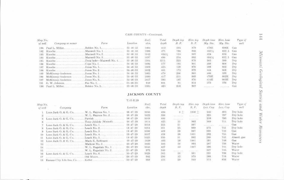
CASS COUNTY-Continued. -..t:a. Map No. Surf. Total Depth to11 i'Jle•. to11 Depth base Elev. base Tvpe of ..t:a.
of well Comvany or owner For,,, Loration elet•. ,tevlh B.F. IJ. F. llrly. Sta. My. Sta. well
196 Paul L. Miller .. ,. . . .. .. Belden No. 1. ... . 33 16 33 1084 412 205 879 -1781,; 6061,; Gas 182 Knoche .. . l\faxwell No. 1. .. . 3:) 46 33 \086 471 19l! R88 463)1 622.5 Gas
~ 183 Knoche. ... . Maxwell No. 2 .... 33 -4G 33 1042 430711 155 887 424 618 Gas 18'\ Knoche. ... .. . . .. .. . . , , .. , , . Max well No. 3 .. 33 46 33 1097 490 214 883 484.11 612.5 Gas "' 185 Knoche ... .. . . . . .. Deep hole-!'l•laxwell No. 4 .. . . 33 46 33 1104 1211 225 879 506 599 Dry "' C
186 Knoche .. .. . CopeNo. l. ·· · ·· ·· · ···· 34-,16- 33 1096 577 195 901 488 608 Dry ,:::
187 Knoche .. .... Jones No. I. . .. 34- 46- 33 1009 435 139 870 406 603 Dry ...., -.
188 Knoche .. ... Jones No. 2. 34- 46- 33 1052 451 175 879 444 608 Dry ~ 189 McKinney-Anderson. .... Jones No. l. . . 34 <16 33 1065 470 200 865 466 599 Dry '"" 190 M eKinney-Anderson . . ... Jones No. 2., 34- 46- 33 1080 417 2ll 869 478E 602£ Dry C ....... 197 McKinney-Anderson . .. .. .. Jones No. 3 ... 34- 46- 33 1057 393 187 870 45-1E 603F. Dry C
~ 191 G. W. Johnson ., .... . Fee No. 1. ... 35-46- 33 949 801 95 854 373 576 Dry ::;· 198 Paul L. Miller ..... ... Belden No. 2 . . ... 33 46 33 1085 420 218 867 Gas i::i --VJ
JACKSON COl"NTY c::: ...., <::::
T.,17-R.29 "" ;:::
Ma11No. Surf. 1'otal De1Jth to11 Eleo. top Depth base Eler. base Ty11e of i::i of well Company Parm Locatio>< elev. depth 8. F. B. F. Le.r:. Gav Lex. Cav wdl ::i
o± 1050 ± i::i... Lone Jack 0. & G. Co .. . W. L. Haynes No. 1. 16- 47- 29 1050 484 245 805 Dry hole
2 . W. L. Haynes No. 2 .. 16 47 29 1022 330 225 797 Dry hole s: -... 3 Lone Jack 0. & G. Co .. .. . Parrish . . . J(j- 47-29 1049 400 266 793 Dry hole i::i ....... G .. Tony Jelnick (Wetzell) . 18- 47- 29 1014 425 31 983 300 714 Dry hole "' ...., 7 Lone Jack 0. & G. Co. . . Leach No. I. 19 -1.7- 29 1018 255 21 997 Gas
8 Lone .Jack 0. & G. Co. .. Leach No. 2. 19 47- 29 1014 351 25 989 273 741 Dry hole :;;, "' 9 Lone 'Jack 0. & G. Co .. .. Leach No. 3 .. 19 47- 29 1036 409 :39 997 290 746 Gas "'
10 Lone Jack O. & G. Co. .. Leach No. 4. 19 47- 29 1037 418 36 100) 282 755 GaA 0 ,:::
11 Lone Jack 0. & G. Co. .. Loach No. 5 . 19- 47- 29 1023 350 31 992 280 743 Aband. gas ....,
Lone Jack 0. & G. Co .. . Mark E. Robinson . 19 47- 29 1039 403 38 1001 291 748 Gas (")
12 "" 13 . Malkow No. 3. 20- 47- 29 1023 505 30 993 287 736 Water "' 14 .. W. L . Ragsdale No. l 20 47- 29 1040 427 33 1007 296 744 Dry hole
15 . W. L. Ragsdale No. 2 . 2 1- 47 29 972 340 227 745 Water
16 Lone Jack 0. & G. C'o ... .. .. .. Leach No. 6 .. :10 47- 29 1029 365 38 991 291 7:38 Dry hole
17 . . . . . . . . . ' . .. Old Moore. 28- 47 29 982 290 12 970 266 716 Waler
18 Kansas City Lile Ins. Co . .... . Keller. :10- ,17 29 969 4~5 29 940 81:1 656 Water
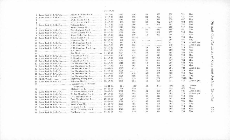
T.47-R.30
1 Lone Jack O. & G. Co ... . . . . . . Adams & Witte No. 1. 3- 47- 30 1023 450 30 993 282 741 Gas
2 Lone Jack 0. & G. Co ... .. Jackson No. l .. . ... 3- 47- 30 1020 570 22 998 275 745 Gas
3 . . ... .. . .. W. S. Easily No. 1 . .. . . ... . 8-47- 30 1010 480 28 982 273 437 Dry
4 ···· ··· · · ··· ...... W. S. Easily No. 2 .. 8-47 30 998 360 26 972 276 722 Dry 0 5 Lone Jack 0. & G. Co .. ... .. . . Fehrman No. 1. 8- 47-30 1035 360 32 1003 281 754 Gas -· -. 6 ··· ··········· ·· ·· ... . ... Frank Norton No. l. 9- 47- 30 1012 260 253 759 Gas s:)
7 Lone Jack O. & G. Co .. ... . David Adams No. 1 . . 10 47- 30 1036 505 30 1006 281 755 Gas :::,
8 Lone Jack O. & G. Co .. .... Robert Adams No. 1. 10-47- 30 1023 400 21 1002 277 746 Gas Ro
9 Lone Jack 0. & G. Co .. .. . . . Steve Haller No. 1. 13-47- 30 1009 370 10 999 262 747 Gas C')
10 Lone Jack 0. & G. Co . . ... Steve Haller No. 2 .... 13- 47- 30 989 357~ 261 728 Gas s:)
"' 11 . . . .. .. .. .. . .... ... .. . .. . .. Neinenger No. 2 . . . . ... 13- 47- 30 993 415 287 706 Dry
12 Lone Jack 0. & G. Co .. . . J. D. Shawhan No. 1. .. 13-47- 30 967 370 241 726 Aband. gas ~ "" 13 Lone Jack 0. & G. Co .. . . J. D. Shawhan No. 4 .. . 13-47- 30 957 355 242 715 Aband. gas V,
14 Lone Jack O. & G. Co .. .J. D. Shawhan No. 5. 13- 47- 30 1011 425 49 962 292 719 Dry 0 I::
15 ··· ··· ··· · .... S. C.Shore .......... . 13- 47- 30 1004 405 55 949 299 705 Gas ..., 16 .Jas. Noel. .......... .. . 14- 47- 30 1004 410 32 972 298 706 Dry
(")
······ · · ·· ······· "" 17 Lone Jack O. & G. Co ... .. J. Shawhan No. 2 ... . . . ... .. . 14- 47- 30 1017 412 47 970 309 708 Gas
V,
18 Lone Jack 0. & G. Co ... . .. . . J. Shawhan No. 3 .. 14-47-30 1009 390 33 976 294 7 15 Gas ~ 19 Lone Jack 0. & G. Co •. .. J . Shawhan No. 6 ... ... . 14- 47-30 1023 405 41 982 287 736 Gas (') 20 Lone Jack 0. & G. Co .. . . ... . Lee Shawhan No. 3. 14- 4.7- 30 1015 390 18 997 287 728 Gas s:)
21 Lone Jack 0. & G. Co .. .. . .. . Lee Shawhan No. 4 .. 14- 47- 30 991 365 3 988 267 724 Gas V, V,
22 Lone Jack 0. & G. Co .. . . . . . .. Lee Shawhan No. 5 .. .. . .. . . 14- 47- 30 1017 411 34 983 294 723 Aband. gas
23 Lone Jack 0. & G. Co ... . . Lee Shawhan No. 6 . 14- 47- 30 1028 50 978 309 719 Gas Q
. . . .. . . .. . :::, 24 Lone Jack 0. & G. Co ... . . Lee Shawhan No. 7 . ... 14- 47- 30 1027 418 46 981 309 7l8 Gas ~
25 Lone Jack 0. & G. Co .. .. Lee Shawhan No. 8 .... . .. . . 14- 47-30 1025 422 58 967 321 704 Dry ~ 26 R. 0. Wright ......... .. . Righ tway J."illing Stat .. 17- 47- 80 1031 273 28 1003 277 754E Gas Q
27 Lone Jack O. & G. Co .. .. . . . . Fehrman No. 2 . . ... . .. . .. 18- 47- 30 1031 334 58 973 314 717 A band. gas ("')
:,;,. 28 Malkow No. 1 (Howard V,
Ridgeway) ... . ...... 23- 47- 30 984 435 39 945 297 687 Water 0 :::,
29 . Malkow No. 2 ..... . .. . 23-47- 30 929 420 254 675 Water
30 Lone Jack 0. & G. Co .. . . .. D. Lee Shawhan No. 1.. 23- 47- 80 1029 712 32 997 304 725 Aband. gas (') 0
31 Lone Jack O. & G. Co . . . D. Lee Shawhan No. 2. 23-47- 30 1023 404 80 993 303 720 Aband. gas I::
32 Lone Jack 0. & G. Co .. . . . .. Geo. Shawhan No. 1. 23-47-30 1012 485 38 974 316 710 Dry :::,
33 Lone Jack 0. & G. Co .. .. . Geo. Shawhan No. 2 . . . 23- 47- 30 990 435 30 960 294 696 Dry ..... ;.;·
34 Lone Jack O. & G. Co . .. .. . ... Ball No. l. ......... 24- 47- 30 1028 412 35 993 304 724 Gas V,
35 Lone Jack O. & G. Co .. . . . .. Frank Cave No. 1 .... 24- 47- 30 1005 421 26 979 293 712 Dry
36 Lone Jack 0. & G. Co .. . H. Cave No. 1 .. 24- 47- 30 1021 409 40 981 305 716 Gas
37 .. W. H. Davidson No. 1. 24-47- 30 1025 420 35 990 303 722 Gas ......
········· · ···· ······ ~
38 Lone Jack O. & G. Co .... .. . . . Faulkenberry ..... 24-47- 30 1011 430 37 974 308 703 Dry C)'I
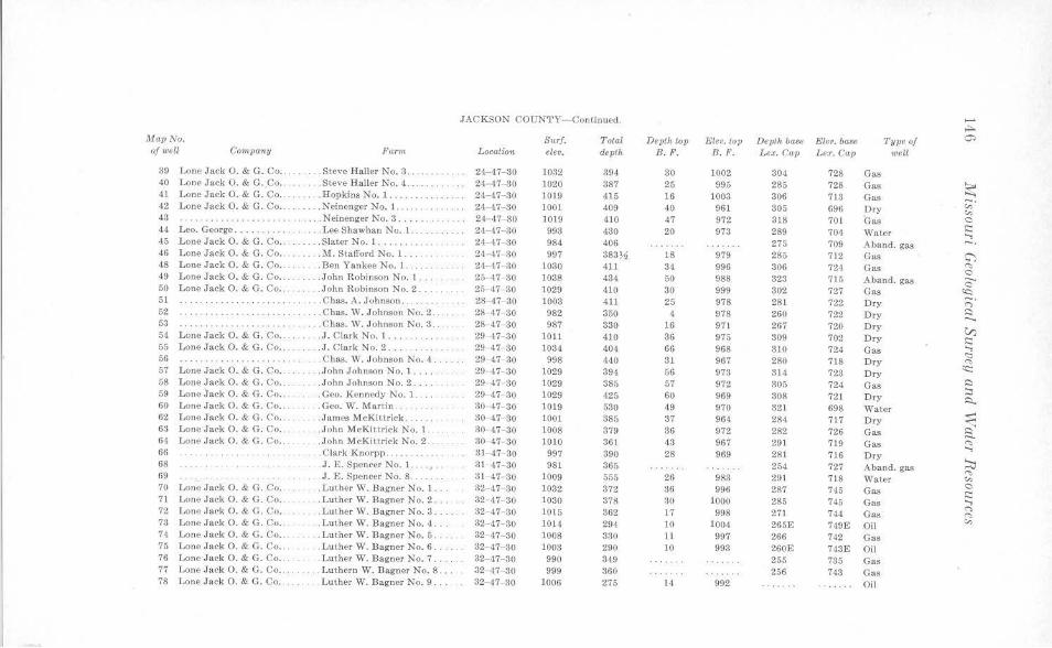
JACKSON COUN'l'Y-Continued. ...... ,..,. Map No. s .. rJ. Total Depth top Elev. top Depth base Elev. base Type of 0:,
of well Company Farm, Location elev. depth B.F. B. F. Lex. Cap Ler. Cap well
39 Lone Jack 0. & G. Co . . . . . ... . Steve Haller No. 3. 24-47-30 1032 394 30 1002 304 728 Gas 40 Lone Jack 0. & G . . Co .. .. . Steve Haller No. 4. 24 47-30 1020 387 25 995 285 728 Gas ~ 41 Lone Jack 0. & G. Co .. ... . .. . Hopkins No. 1. 24-47- 30 1019 415 16 1003 306 713 Gas 42 Lone Jack 0. & G. Co ... . . .. .. Neincnger No. 1 ..... .. . 24- 47-30 ]001 409 40 961 305 696 Dry ;;·
"' 43 ············ · · · ·· ·· · .. . N einenger No. 3 . 2-1 47-30 1019 410 47 972 318 701 Gas C 44 Leo. George ... . . Lee Shawhan No. 1 ... .. 24- 47- 30 993 430 20 973 289 704 Water :;::: ..., 45 Lone Jack 0. & G. Co .. . .. .. .. Slater No. 1 ........ . 24- 47- 30 984 406 275 709 Aband. gas 46 Lone Jack 0. & G. Co. . . . . M. Stafford No. 1 .... . .. 24 -47- 30 997 383% 18 979 285 712 Gas C") 48 Lone J a ck O. & G . Co . . . . .Ben Yankee No. 1. 24- 47 30 1030 411 34 996 306 724 Gas "' C 49 Lone Jack 0. & C. Co . . . . . . . . . John R obinson No. 1 .... 25- 47- 30 1038 43,1 50 988 323 715 Aband. gas ...._
C 50 Lone Jack 0. & G. Co .. .. . . John Robinson No. 2 . .. 25 47- 30 1029 410 30 999 302 727 Gas 'Q 51 .. . . Chas. A. Johnson . . . 28- 47- 30 1003 411 25 978 281 722 Dry ;::;· 52 .. . .. ... Chas. vV. Johnson No. 2 .. 28- 47- 30 982 350 1 978 260 722 Dry i::i ...._ 53 ··· · ··· · ·· · ·· · ·· · ..... C has. W. Johnson No. 3. 28 47- 30 987 330 16 97l 267 720 Dry V) 54 Lone Jack O. & G. Co .. . .. ... . J. C lark No. l .... . . 29- 47-30 1011 410 36 975 309 702 Dry :;::: 55 Lone Jack 0. & C. Co . . .. .. . . . J. Clark No. 2 . . .. 29- 47- 30 1034 404 66 968 310 724 Gas
..., <::: 56 · ·· · ·· · ·· · ····· · · · · · .. . . ... . Chas. W . Johnson No. 4 . . . ... 29 47- 30 998 440 31 967 280 718 Dry "' 57 Lone J a ck 0. & G. Co ..... . , .. John J ohnson No. 1 . . .. . 29- 47- 30 1029 394 56 973 314 723 Dry cc:
58 Lone Jack 0 . & C. Co . . . . . . . . . John Johnson No. 2 .... . 29- 47- 30 1029 385 57 972 305 724 Gas i::i 59 Lone Jack 0. & G. Co .. . Geo. Kennedy No. J. 29- 47- 30 1029 425 60 969 308 721 Dry :::i
i::t.. 60 Lone Jack O. & G. Co .. ... . Geo. W. MarUn . 30- 47- 30 1019 530 49 970 321 698 Water 62 Lone Jack 0 . & C. Co . . .. .. . . . James .McKittrick . . . 30- 47- 30 1001 385 37 964 284 717 Dry s:: 63 Lone Jack 0. & G . Co .. . . . John McKittrick No. 1 . . 30 ,17- 30 1008 379 36 972 282 726 Gas c' -64 Lone Jack 0. & G. Co . . .John McKi~trick No. 2. 30- 47 30 1010 361 43 967 29 1 719 Gas "" 66 . . . ... . . Clark K norpp . . . 3 1- 47- 30 997 390 28 969 281 716
..., Dry
68 .J. E. Spencer No. 1 . .. . 31- 47- 30 981 365 254 727 J\ b and. gas ::0 "' 69 J.E. Spencer No. 8 . 31- 47 30 1009 555 26 983 29 1 718 Water "' 70 Lone Jack 0 . & G. Co ... . . . . . . Luther W . Bagner No. I .. 32- 47- 30 1032 372 36 996 287 745 Gas C i::: 71 Lone Jack 0. & G . Co .. .. . Luther W. Bagner No. 2 . 32- 47- 30 1030 378 30 1000 285 745 Gas ...,
72 Lone Jack 0. & C . Co .. . Lu ther W. Bagner No. 3. 32- 47- 30 1015 362 17 998 271 744 Gas ~
"" 78 Lone Jack 0 . & G. Co . . .. .... . Lut her W. Bagner No. 4 .. 32-47- 30 1014 294 10 1004 265E 749£ Oil "' 74 Lone Jack 0. & G. Co .. . Lut her W. Bagner No. 5. 32- -17- 30 1008 330 11 997 266 742 Gas 75 Lone Jack 0 . & G. Co . . . Lu ther W. Bagner No. 6 . 82- 47- 30 1003 290 10 993 260E 743E Oil 76 Lone Jack 0. & G. Co .. . Luther W. Bagner No. 7 .. 32- 47- 30 990 349 255 735 Gas 77 Lone Jack 0. & G. Co .. . . . . . . . Luthcrn W. Bagner No . 8 . .. 32 "47- 30 999 360 256 743 Gas 78 Lone Jack 0. & G. Co . ... . . Luther W . Ba gner No. 9 ... 32- 17- 30 1006 275 14 992 Oil
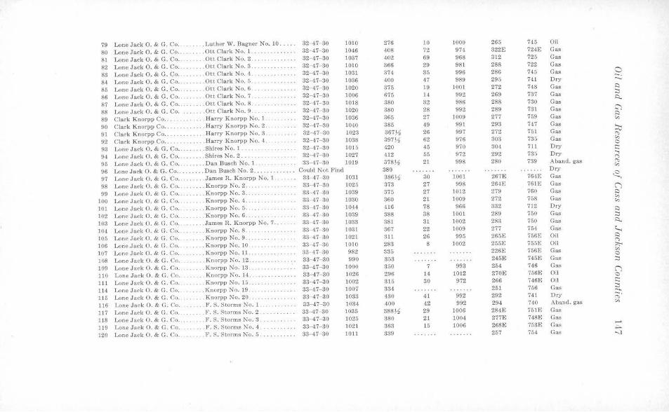
79 Lone J ack O. & G. Co . . . . .. . . . Luther W. Dagner No. 10 .. 32- 47- 30 1010 276 10 1000 265 745 Oil
80 Lone Jack O. & G. Co .. . Ott Clark No. 1. 32- 47- 30 1046 408 72 974 322E 724E G as
81 Lone Jack 0. & G. Co ....... . .Ott Clark No . 2 .. . . .. . .. . 32 47- 30 1037 402 69 968 312 725 Gas
82 Lone Jack 0. & G. Co .... . .. .. Ott Clark No. 3 . . . . 32- 47- 80 1010 366 29 981 288 722 Gas
83 Lone Jack O. & G. Co . .... . .Ott Clark No. 4 . · ·· · · · ····· 32-47- 30 1031 374 35 996 286 745 Gas 0 -. 84 Lone Jack 0. & G. Co .. .Ott Clark No. 5. 32- 47- 30 1036 400 47 989 295 741 Dry ...._
85 Lone Jack 0. & G. Co . . . Ot.t Clark No. 6 ... . . .. . .. . . 32- 47- 30 1020 375 19 1001 272 748 Gas s:::i
86 Lone Jack 0. & G. Co .... . . . . Ott Clark No. 7. 32- 47- 30 1006 675 14 992 269 737 Gas :::i i::,..
87 Lone Jack 0. & G. Co . . . . Ott Clark No. 8 . .. . ... .. .. 32-·47- 30 1018 380 32 986 288 730 Gas
88 Lone Jack 0. & G. Co. . . . .. Ott Clark No. 9. 32- 47 30 1020 380 28 992 289 731 Gas ~
89 Clark Knorpp Co . .. . . .. .. . . Ha rry Knorpp No. 1. 32-47-30 1036 365 27 1009 277 759 Gas s:::i
"' 90 Clark Knorpp Co .. . . Harry K norpp No. 2. 32- 47- 30 1040 885 49 991 293 747 Gas
::.::0 91 Cla rk Knorpp Co . . . . . . Harry Knorpp No. 3 . 32-47 30 1023 367~ 26 997 272 751 Gas ~
92 Clark Knorpp Co .. .. . .. . . .Ha rry Knorpp No. 4 . . . 32- 47- 30 1038 397~ 62 976 303 735 Gas "' 0
93 Lone J ack 0. & G. Co .. . . Shires No. 1 . .. 32- 47- 30 1015 420 45 970 304 711 Dry i:::
94 Lone Jack 0. & C. Co . .. . ... . Shires No. 2 ... .. .. . , .. . 32 -47 30 1027 412 55 972 292 786 Dry ..., C>
95 Lone Jack 0. & G. Co .. ... . . . . Dan Busch No. 1 . . . . . 33- 47- 30 1019 378)4 21 998 280 739 Aband. gas ~
96 Lone Jack 0. & G. Co .... . .... Dan Busch No. 2 ..... . ... . ... Could Not Find 380 Dry "' 97 Lone Jack 0. & G. Co . . . . . . . . . James R. Knorpp No. 1. 83- 47 30 1031 38631, 30 1001 267E 764E Gas ~ 98 Lone Jack 0. & G. Co . . . .. . Knorpp No. 2 .. 33- 47- 30 1025 373 27 998 264E 761E Cas (")
99 Lone Jack 0. & G. Co .. ... Knorpp No. 3 . 33- 47- 30 1039 375 27 1012 279 760 Gas s:::i
100 Lone Jack O. & G. Co .. . .. Knorpp No. 4 . . 33- 47- 30 1030 360 21 1009 272 758 Gas "' "' 101 Lone Jack 0. & G. Co . ... . .. Knorpp No. 5 . 33- -17- 30 1044 416 78 966 332 712 Dry s:::i
102 Lone Jack 0. & G. Co .. .. .. . . Knorpp No. 6 . 33- 47- 30 1039 388 38 1001 289 750 Gas :::i
103 Lone Jack O. & G. Co .. .. .. .. . James R. Knorpp No. 7 ... 33- 47- 30 1033 381 31 1002 283 750 Gas i::,..
104 Lone Jack 0. & G. Co . .. .. . Knorpp No. 8 ... . . 33- 47- 30 1031 367 22 1009 277 754 Gas ~ 105 Lone .Jack 0. & G. Co .. . . . Knorpp No. 9 . . .. 33- 47- 30 )021 311 26 995 265E 756E Oil l::)
106 Lone Jack O. & G. Co .. . . K norpp No. 10 . .. . 33- 47- 30 1010 283 8 )002 255E 755E Oil C> ::,,;-
107 Lonr. Jack O. & G. Co . . .. .. K norpp No. ll .. .. . . 33- 47- 30 982 335 226E 756E Gas "' 0
108 Lone Jack O. & G. Co .. . . . .. Knorpp No. 12 . ... 33--47-30 990 353 245E 745E Gas :::i
109 Lone Jack 0. & G. Co . . . , . K norpp No. 13 . 33--47-30 1000 350 7 993 254 746 Gas (") 110 Lono Jack O. & G. Co . . .. . Knorpp No. 14 . 83-47-30 1026 296 14 1012 270E 756E Oil 0
111 Lone Jack O. & G. Co . . . . .. Knorpp No. 15. ·· · ·· · · ·· ·· 33-47- 30 1002 315 30 972 266 746E Oil i::::
114 Lone Jack 0 . & G. Co ... . ... . Knorpp No. 19 .. . . .. .. .. .. . 33- 47- 80 1007 384 251 756 Gas :::i ....... 115 Lone Jack O. & G. Co .. . .. .. Knorpp No. 20. . . . . . . . . . . 33- 47-30 1088 430 41 992 292 741 Dry ;::;· 116 Lone Jack 0. & G. Co .. . ... .. F . S. Storms No. 1. 33-47- 30 1034 400 42 992 294 740 Aband. gas "' ll7 Lone Jack 0. & G. Co . . ... I•'. S. Swrms No. 2 .... .. .. . 33- 47- 30 1035 388~ 29 1006 284E 751E Gas
118 Lone Jack O. & G. Co .. ..... .. F . S. Storms No. 3. 33-47-30 1025 380 21 1004 277E 748E Gas
J19 Lone Jack 0 . & C. Co . . . . F. S. Storms No. 4 .... . . ..... 33- 47- 30 1021 363 15 1006 268E 753E Cas ....... ..t::.
120 Lone Jack O. & G. Co . . . . . . . . F . S. Storms No. 5. 88-47- 30 1011 339 257 754 Gas -...}
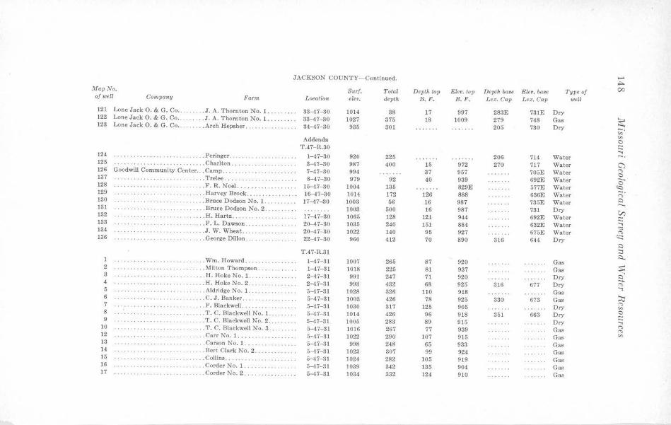
JACKSON COUNTY-Continued. ...... ~
Map No. Surf. Total Depth top Elev. top Depth base Elev. base Type of 00 of well Company Farm Location ew•. depth B.F. B.F. Lex. Cap Lex. Cap well
121 Lone Jack O. & G. Co .. ... J. A. Thornton No. I. 33-47-30 1014 88 17 997 283E 781E Dry 122 Lone Jack O. & G. Co .. . . .... . J. A. Thornton No. 1 . 38-47- 30 1027 375 18 1009 279 748 Gas ~ 123 Lone Jack 0. & G. Co ... ...... Arch Repsher ... . .. .. . .. .. 34-47- 30 935 301 205 780 Dry c:;·
"' Addenda 0 T.47-R.30 s:::: ..,
124 . . . . . . . . . . . ... Peringer. 1-47-80 920 225 206 714 Water -. . .. ... . ... 125 · ·· ··· ······· . ....... ...... . Charlton . . . . .. .. . . ... 8-47-30 987 400 15 972 270 717 Water G) 126 Goodwill Community Center ... Camp .... . ... 7- 47- 30 994 37 957 705E Water "' .. . . . . .. . ..
0 137 ·· · ·· ·· ···· ·· . .. ...... Trelee ........ 8-47-80 979 92 40 939 692E Water ........ 0 128 · ·· ·· ·· ·· ··· .... . ...... F. R. Noel. ....... 15-47-30 1004 135 829E 577E Water <c:,
129 .. ... ... . .. . ........ Harvey Brock ...... 16-47- 30 1014 172 126 888 636E Water ;::;· 130 .. ..... Bruce Dodson No. 1. ...... 17-47-30 1003 56 16 987 785E Water 0 ·· ··· · ··· · ·· ···· 181 . . . . ...... ... Bruce Dodson No. 2 .. . 1008 500 16 987 731 Dry V) 132 .. .. , .. .... . .. .... . H. Hartz ..... . ..... 17-47- 30 1065 128 121 944 692E Water s:::: 138 ·· ······ · ··· .. ... F. L. Dawson . 20-47-30 1085 240 151 884 632E Water ..,
<:::: 134 .... . . . ... ·· · · · ···· · ... J . W. Wheat ... 20- 47- 30 1022 140 95 927 675E Water r.. 136 .... George Dillon . . 22-47- 80 960 412 70 890 316 644 Dry cc: . . .. .. .... ....
.:i T.47-R.31 ::::,
:::i.. 1 ····· · ··· ··········· . . ... Wm. Howard ...... . . 1-47- 81 1007 265 87 920 Gas 2 ... Milton Thompson . ···· · ·· ·· · 1-47-81 1018 225 81 937 Gas ~ 3 . . .. ...... . . . . .. .. ... H. Hoke No. 1. ... . 2- 47-31 991 247 71 920 Dry ~ 4 .......... . .. . ... . . . . . . . . . .. H. Hoke No. 2 .... 2-47- 31 993 432 68 925 316 677 D ry c:, ..., 5 . .. . . . .. .. . .. . Aldridge No. 1. 5-47-31 1028 326 110 918 Gas 6 .. .. .. ..... .. .. .... C. J. Banker ..... . . 5-47- 31 1003 426 78 925 330 673 Gas ~ 7 . . .. . F. Blackwell. .. .. 5- 47-31 317 125 905 Dry
c:, · · · ·· ·· ·· ···· · ·· ·· · · 1030 "' 8 ... T. C. Blackwell No. 1. 5-47- 31 1014 426 96 918 351 663 Dry 0 ·· · ·· · · · ··· s:::: 9 ·· ·· ··········· ·· · .... T. C. Blackwell No. 2. 5-47- 31 1005 283 89 915 Dry .., 10 .. ... T. C. l3lackwell No. 3 . 5-47-31 1016 267 77 939 Gas
("> ··················· "' 12 .... Carr No. 1 .... ..... . 5-47-81 1022 290 107 915 Gas "' 13 · ·· ·· · ·· · ·· · ··· ... Carson No. 1 . . . · · ·· ·· ·· ·· · ·· 5-47-31 998 248 65 933 Gas 11 . .. . .. . ....... . . .. Bert Clark No. 2 . 5-47-31 1023 307 99 924 Gas 15 . . Collins .. . . . . . . . . . . . 5-47-31 1024 282 105 919 Gas 16 . Corder No. 1 . ········· · 5-47-31 1039 342 135 904 Gas 17 ··· ·· · ··· · ·· ····· .. Corder No. 2. .. · ·· ·········· 5-47-31 1034 332 124 910 Gas
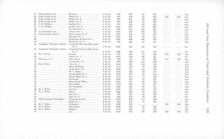
19 Nath Corder et al. .. . . ....... Everton .... . ... . .. ...... 5-47-31 990 260 55 935 Dry 20 Nath Corder et al. . . .. Fisher No. l. 5-47- 31 978 306 44 934 306 -672 Gas 21 Nath Corder et a l .. . . . ..... Fisher No. 2 .. ··········· · · 5-47-31 995 261 63 932 Gas 22 Nath Corder et al. . .... . .... Fisher No. 3. 5-47-31 987 252 65 932 Gas 24 C. E. Phillips .. . . . . . Graffice No. l. 5-47-31 991 254 60 931 Gas 0 25 C. E. Phillips. .. .. Graffice No. 2 . 5-47-31 1016 287 87 929 Gas -. ·········· ··· --26 ··············· ... .. Dr. Hand No. I. 5-47-31 1032 310 103 929 Dry ~ 29 Arnold Rush et al ... . ... . .. ... Hoover :S.o. 1. . . . 5-47- 31 1027 320 108 919 Oil ::::, 80 Lee's Summit Gas Co .. . . ... Henry Long No. 2 . ..... 5-47-31 1015 305 90 925 Gas ~
31 . .. Maxwell No. 1 ........ . 5-47-31 1025 290 80 945 Gas C) 32 . ... . .. .. .. .. .. . ~ .. .. . . . . McKesson & Roos No. 1 . 5- 47-81 1028 283 108 920 Gas ~
"' 88 ................ . . . .... .. ... McKinley No. 1 ... . .... .. . . 5-47-31 996 245 65 931 Dry ~ 34 Campbell, Thompson, Spicer ... Campbell Morning Side Acres ('>
No. I. .. .......... .... 5-47-31 1023 300 110 913 Oil "' 35 Campbell, 1'homps-0n, Spicer .. . Campbo,11 Morning Side Acres 0 c:: No. 2. 5-47-31 1026 325 111 915 Oil ....,
36 M. J. White . ..... Muckie . .. . ... 5-47-31 959 360 37 922 300 659 Dry ('") ('>
38 .. ... .. Schick No. 1. ..... . 5-47- 31 1053 302 112 941 Oil "' 40 Thomas et :ii. . ··· ·· ··· ·· · .... Wm. Short .. 5-47-31 989 415 60 929 317 672 Gas ~ 41 .. .... Turo£t Mtr. Co .. 5-47-31 1033 284 104 929 Gas ("") 42 Mort White . .. ... City No. 1 . .. ... .. ... ... .. ... 5-47-81 1012 261 100 912 Dry ~ 43 . ... Mont Williams. 5- 47-31 1019 284 94 925 Gas "' "' 47 .. ... .... Acult Chev. Co .... 6-47-31 1052 3ll 119 933 Gas 48 . ... W. L. Baker . .. .. .. .. .. .. .. . . 6- 47- 31 1031 281 90 941 Gas ~
::::, 49 .. . . .. . . .. . . . Frank Bales No. 1 .. . 6-47-31 1028 279 79 944 Gas ~ 50 . Frank Bales No. 2. 6-47-31 1013 271 71 942 Gas ~ 51 .. .. . Browning . .. . .. . .. .. ... ... ... 6-47- 31 1036 297 79 957 Gas ~ 52 . . Browning & Miller . 6-47-31 1030 287 92 938 Gas ~ · ·· · · · · ··· ;:,;-, 53 · ·· ·· ·· ··· .. .. .. . ... .. ..... Butterfield ..... 6-47- 31 1003 265 59 944 Dry "' 54 ... Dr. Campbell . ... .. .. ... .. ... 6- 47- 31 1023 284 92 931 Gas 0
::::s 56 M. J. White . . . . .. . . .. . . .. ... Joe Cox . .. 6-47-31 1045 305 101 944 Gas 67 M.J. White . . ... .. . .. . Davis . .... ... . ... 6-47-31 1028 289 93 935 Gas ("")
0 58 . . .. .. ....... . Day No. 1. ··· ·· ·· ·· · 6-47-31 993 279 64 929 Oil i::: 59 .... Day No. 2 . 6-47-31 993 270 49 944 Oil ::::, ...... 60 Mid-Continent Petroleum .. .. . Diamond Station . . . . . . . . . . . . . 6-47- 31 1052 320 114 938 Gas ;:;· 61 . ... Diehl No. 1 .... . 6-47-31 991 275 71 920 Oil "' 66 M. J. White ..... . . . . .. . . .... Dickerson. ... .. . .... . . .. . . .. 6-47-31 1032 672 334 698 Gas 68 M. J. White . ... . .. ..... ... Price Gunn .... ··········· 6-47- 31 1032 293 93 939 Gas 69 M. J. White . ..... Higgins . 6-47-31 1016 280 70 946 Gas -,.;:,.. 70 .. . .. .. . ... .... . ... Lee .. .. · ··· · · ·· · · · ·· · · ··· · ·· 6--47-31 1042 630 106 936 363 679 Dry <O
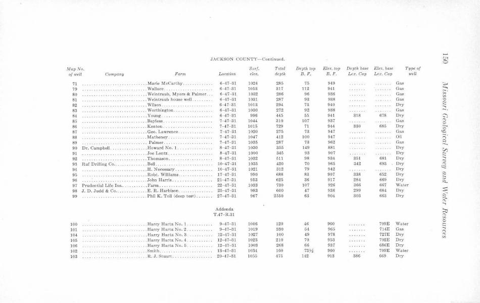
....... JACKSON COUNTY- Continued. c.;1
0
Map No. Surf. Total Depth top Ele•. top Depth base Elev. base Type of of well Company Farm. Location elev. depth B. F. B. F. L ex. Cap Lex. Cap well
71 .... Marie McCarthy, ....... 6-47-31 1024 285 75 949 Gas ~ 79 ... . . . .. .•.. . ..•........ ... Wallace ... . 6-47-31 1053 317 112 941 Gas 80 . ... . .. .. .. .. .. .. ... Wein t raub, Myers & Palmer ... 6-47- 31 1032 286 96 936 Gas ;;;·
v., 81 . ....... . . .. .. Weintraub house well. .. .. .... 6-47-31 1031 287 93 938 Gas 0
82 . .. . .................... Wilson .. 6-47-31 1013 294 73 940 Ory s:::: ...., 83 .. ..... ...... .... .. .. ... Worthington . .. . . . ... .. .. .. . . 6- 47-81 1080 272 92 938 Gas -· 84 ··· ·· · · ·· · ··· . . . . . Young ..... .. .. . .. ... .... • . . 6-47-81 996 445 55 941 318 678 Dry ~ 85 .... . .. . . .. . .. . ... ... .. .. Bayless . ...... . .. , .... ...... 7-47-31 1044 310 107 937 Gas "' 0 86 ·· ·· ·· ·· ··· · · ··· .. ... Kenton. .. ·················· 7- 47-81 1015 729 71 944 830 685 Dry -.
0 87 ... Geo. Lawrence .. . ... .... . .... 7-47-31 1020 275 73 947 Gas ~ 88 .... Matheney ... . 7-47- 31 1047 412 100 947 Oil -. .. .. .. ... .. <"> 89 · ·· ·· ··· ··· ·· ··· ········· ... Palmer . . · ·· ·· · ········· 7- 47- 31 1035 287 73 962 Gas ~ -. 90 Dr. Campbell . . .. Howard No. 1 ..... .. . ... .•. . 8-47-31 )030 355 149 881 Dry V) 91 ······ ·· ···· ... Joe Lentz. . . . . . . . . . . 8-47- 31 1000 846 93 907 Dry s::: 92 ·············· . .. 'l'homason . . .. .. . . ..... . ..... 8-47- 31 1082 511 98 934 351 681 Dry ....,
<:::: 98 Ruf Drilling Co .. ........ .. ... Bell ........ .... .. . ... .... . 10-47-31 1035 420 70 965 342 698 Dry "' 94 .H. Necessary ..... 10- 47- 31 1021 312 79 942 Dry c:::: . . . . ' . . . . . . . 95 · ·· ·· · · ·· · . . . Robt. Williams . .. 17-47-31 990 688 83 907 338 652 Dry ~
;::, 96 .. John Harris ........... .. , . .. 21-47-31 953 625 36 917 284 669 Dry i:::i.. 97 Prudential Life Ins .. . . . .. . Farm ....... . . . . .. . ... .. .. .. 22- 47- 81 1088 780 107 926 366 667 Water 98 J. D. Judd & Co .... . .E. R . Harbison .. ..... . 25-47-31 983 600 47 936 299 684 Dry ~ 99 ·················· . Phil K. Toll (deep test) ... . ... 27-47- 31 967 2550 68 904 303 663 Dry ~
"' ..... Addenda :::i;;
T.47- R.31 "' v.,
100 . ... ...... . .. .. .. . ... Harry Ilart.z No. l. . · ·· ·· · ··· 9-47- 81 1006 120 46 960 709E Waler 0 s:::
101 ... Harry Hartz No. 2 . 9-47-31 10 19 330 64 965 714E Gas ...., <">
104 ... . .. . ... .. . . .. . Harry Hartz No. 3 .. 12-47- 31 1027 100 49 978 727E Dry "" v., 105 . ... Harry Hartz No. 4. . ··· · ····· 12-47-31 1023 210 70 953 702E Dry 106 · ·· · · · · · ···· · ··· .... Harry Hartz No. 5 ... . .. • .... 12-47-31 1003 268 66 937 686E Dry 102 . ... Smith ........ . · ·· ··· ····· · 13- 47- 31 1084 ]60 73J1 960 709E Water 103 ·· ·· ····· · ........ R. J. Stuart ................. 20-47-31 1055 475 142 913 886 669 Dry
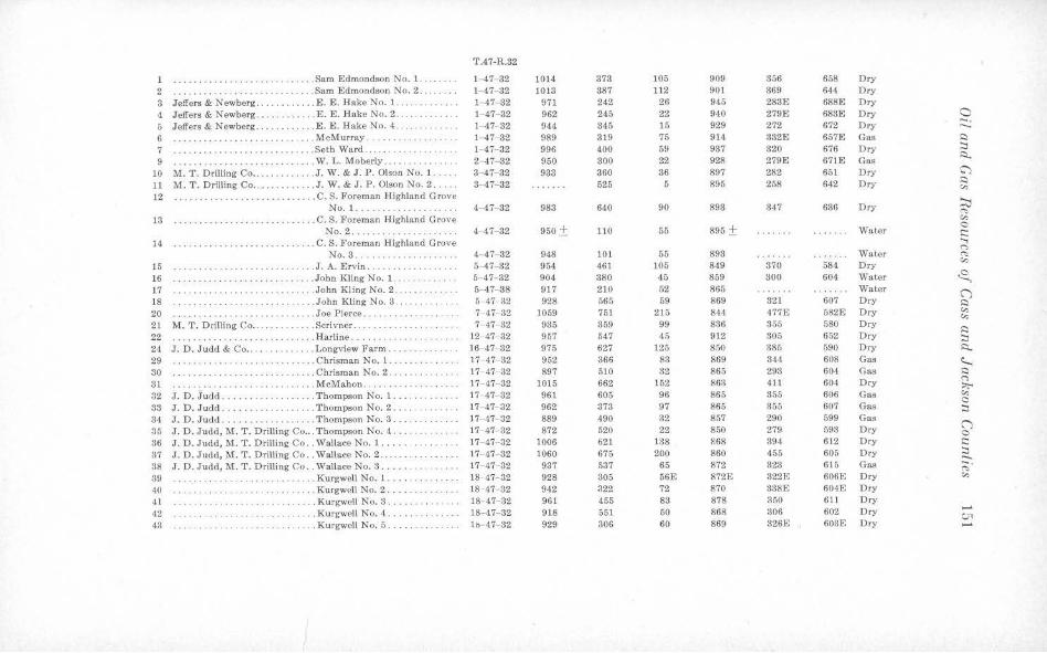
T.47-R.82
1 .... .. ...... .. ...... .. ...... Sam Edmondson No. 1. . ...... 1-47-32 1014 373 105 909 356 658 Dry 2 .... .. ... . . ..... . Sam Edmondson No. 2 .. . .. . .. 1- 47-32 1018 887 112 901 369 644 Dry
3 Jeffers & Newberg ............ E. E. Hake No. 1.. 1-47-32 971 242 26 945 283E 688E Dry 4 Jeffers & Newberg ......... . .. E. E. Hake No. 2 . ............ 1-47-32 962 245 22 940 279E 683E Dry a 6 Jeffers & Newberg ... . . .. • . ... E. E. Hake No. 4 .. . .... . . 1- 47- 32 944 345 15 929 272 672 Dry -. ..._
6 . .......... .. .. . .... . McMurray . ... ....... . 1-47-32 989 319 75 914 332E 657E Gas ,::i
7 . .. .. .. ......... . ... Seth Ward . . . ... .. ... .. .. .... 1- 47-32 996 400 59 937 320 676 Dry :::i
9 .. ..... W. L. Moberly ..... 2-47- 32 950 300 22 928 279E 671E Gas ,:::_
· ·· ······· ··········· 10 M. T . Drilling Co ..... . . ... ... J. W. & J.P. Olson No. 1. . . .. 3-47-32 933 360 86 897 282 651 Dry C'")
11 .M. T . Drilling Co . ... . .. ....... J. W. & J . P. Olson No. 2 ... . . 3-47- 32 525 5 895 258 642 Dry ~ (n
12 .... . .. .. .. ... .. C. S. Foreman Highland Grove ~ No. 1 . . ... ... .. ..... ... . . 4- 47- 82 983 640 90 893 347 636 Dry <'">
13 ... ........ . .. . . .. . .. . . . . ... C. S. Foreman Highland Grove (n
No. 2. 4-47- 32 950± 110 55 895 ± Water 0 ,::
14 .. . . .. .. ..... .. ..... . . C. S. Foreman Highland Grove ;:; No. 3. 4- 47- 32 948 101 55 893 Wat.er <'">
15 . .. . ....•........... . . J. A. Ervin .... 5-47-32 954 461 105 849 370 584 Dry (n
16 ... . .........• . .. .. ... John Kling No. 1 . ... 5- 47- 32 904 880 45 859 300 604 Wat.er <8.. 17 .. .. . . .. .. .. . .. • ..... . . John Kling No. 2 . 5- 47- 38 917 210 52 865 Water ("') 18 ... . .. . ..... John Kling No. 8 . . ........ 5- 47- 32 928 565 59 869 321 607 Dry ~
20 · · · ·· ·· · ·· ···· ·· ··· .. . .. Joe Pierce ... 7- 47- 32 1059 751 215 844 477E 582E Dry (n C,:
21 M. T. Dtilling Co .. . . . . Scrivner . 7- 47- 32 935 359 99 836 355 580 Dry ~
22 . .. ...... Harline. . ···· ·· · · ·· · 12- 47- 32 957 547 45 912 305 652 Dry :::i 24 J. D. Judd & Co .... .. .. .. . ... Longview Farm . .. ... ... . . .. 16- 47- 32 975 627 125 850 385 590 Dry ~
29 · ·· ·· · · ··· · · · ····· .. .. . .. .. Chrisman No. 1. 17- 47- 32 952 366 83 869 344 608 Gas ~ 30 . .. . ........ . .... Chrisman No. 2 ... . .. . ... . .. 17- 47- 32 897 510 32 865 293 604 Gas ,:::,
31 .. . . .... . . . . .. . . .. ... . McMahon .. 17- 47-32 1015 662 152 863 411 604 Dry ("')
.. .... . . .. . :,;.. 32 J. D. Judd ... ... .. .. . . . Thompson No. 1 ... . 17- 47 32 961 605 96 865 355 606 Gas <,-,
c:, 33 J . D. Judd . . .. ... . .. Thompson No. 2 .. .. 17- 47- 32 962 373 97 865 355 607 Gas :::i 34 J. D. J udd ............. . .. .. Thompson No. 3 . . .. . . .... . 17- 47- 32 889 490 32 857 290 599 Gas
("') 35 J. D. Judd, M. T. Drilling Co ... Thompson No. 4 ... 17- 47- 32 872 520 22 850 279 593 Dry 0 36 J. D . .Judd, M. T. Drilling Co .. Wallace No. 1. 17- 47- 32 )006 621 138 868 394 612 Dry ,::
37 J. D. Judd, M. T. Drilling Co .. Wallace No. 2. 17- 47-32 1060 675 200 860 455 605 Dry :::i ..... 38 J . D. Judd, M. T. Drilling Co . . Wallace No. 3. 17- 47- 32 937 537 65 872 323 615 Gas ;:;· 39 .. . Kurgwell No. J •• .. .. .. 18· 47- 32 928 305 56E 872E 322E 606E Dry (n
40 .. . .. . .. .. . ... Kurgwell No. 2 ... . ... 18- 47- 32 9-12 322 72 870 338E 604E Dry
41 ······ ·· · ·· ······ ······ · ·· · . Kurgwcll No. 3 ..... 18- 47- 32 961 455 83 878 350 611 Dry
42 ... . Kurgwell No. 4 . ....... 18- 47- 32 918 551 50 868 306 602 Dry ...... .. .. ....... . . ..... . . c;, 43 . . . . . . .. . . . . . Kurgwell No. 5 ..... .. . l is- 47- 32 929 306 60 869 826E 603E Dry ......
JACKSON COUNTY- Continued. ....... CJI
Map No. Surf. Total Depth top Ele•. top Depth baae Eleo. base Type of l'v
of welt Company Farm Location elev. depth B. F. 8. F' • Lex. Cap Lex. Cap well
44 Louise Knoche . .. . . . Ada E. Saleela No. 2 .... 18-47- 32 962 360% 97 865 356 606 Gas 45 Louis Knoche. . . Ada E. Saleela No. 3 . . 18- 47- 32 9,19 339 73 876 334 615 Gas ~ 46 Louis Knoche .. . . . . . Chiles No. 1 .. 19 ·47- 32 928 300 37 891 295 633 Aband. gas ;;;· 47 Louis Knoche . .. .... . .Chiles No. 2 .. )9- 47- 32 930 572 52 878 306~ 623)1 Dry c.:, 48 Ruf Drilling Co . . . . . . Sol Chiles No. J 19- 47- 32 921 665 42 879 297 624 Dry 0
,::: 49 Louis Knoche . . .... II. J. Elliott . 19 47- 32 962 354 89 873 349 613 Gas ...., 50 Louis Knoche . ... . . . H.J. E lliott . 19- 47- 32 95$ 348)1 88 870 343 615 Gas -. 52 M. T. Drilling Co .. . .. McLucas No. l. 20- 47- 32 1053 670 191 862 450 603 Gas CJ
'"" 53 M. T. Drilling Co .. . .. . .. . McLucas No. 2. Could not find 650 Dry 0
54 M. T. Drilling Co .. . .. McLucas No. 3 . Could not find 660 Dry ,.._ 0
55 Lee's Summit Gas Co . . .. . Hook No. 1 ... 23-47-32 976 511 87 889 344 632 Dry <Q .. . ;::;· 56 Lee's Summit Gas Co . .. . . . ... Hook Nv. 2 . . ... . . 26-47- 32 1010 614 129 881 387 623 Dry ~
57 .. <'. L. Peterson No. 1. 28 47- 32 940 423 106 834 358 582 Dry ....... 59 .C. L. Peterson No. 3 .. 28- 47- 32 1001 515 141 860 394 607 Dry V, 60 .C. L. Peterson No. ·:I . 28- 47- 32 963 278 83 880 336 627 Dry c:: ...., 61 Louis Knoche. .. Orear No. 4 ... 30- 47- 32 1013 381% 140 873 395E 618 Dry <:::: 63 . .. Russell . . 31- 17- 32 974 340 136 838 "" . . . . .. .. . . ............ <c::
~ Addenda :::,
T .47- R.32 ~
64 Kling-Judd Oil Co .... . .John Kling No. 1 ... 5-47 32 925 426 58 863 3H, 610 Dry ~ 65 Kling-Judd Oil Co . . . .. . John Kli ng No. 2 . 5- 47- 32 921 440 58 867 317 604 Dry ~ 66 Kling-Judd Oil Co .. .John Kling No. 3. 5- 47- 32 928 452 64 864 333 595 Dry ~ 67 Kli ng-Judd Oil Co .. .John Kling No. 4. 5- ,t7 32 823 490 200 623 Dry
68 Kling-Judd Oil Co .. ... . John Kling No. 5. 5-47- 32 910 555 33 877 291 619 Dry ;:o 69 Kling-Judd Oil Co ... . . .. John Kling No. 6 . 5-47- 32 924 436 59 865 318 606 Dry '"" (,) 70 Kling-Judd Oil Co .. .John Kling No. 7 .. 5 .. ,17 32 911 425 50 861 310 601 Dry C 71 Kling-Judd Oil Co .. .. . . . John Kling No. 8 . 5-47- 32 928 4.38 62 866 321 607 Dry c:: . . .. . . . .. . ....,
("')
"" T.47- R.33 c.:,
1 Bartle & Marshall .. . .. . .' . .... E. Holmes No. 1 ... .. .. . . 3 -47- 33 911 440 90 ll21 353 558 Dry 2 Bartle & Marshall. . ... . Swafford No. 1. . 3-47- 33 970 380 136 834 Dry 3 Bartle & Marshall. . . Swafford No. 4 . . 3- 47-33 980 510 158 822 430 550 Gas 4 . .. .... Dr. W. E. Minor No. l. ... . .. 4- 47- 33 846 566 2 844 266 580 Gas 5 ... Dr. W. E. Minor No. 3 ... .. . . 4- ,17- 33 841 575 5 836 867 574 Gas
6 . . . .. .. .... . .. .. .. Dr. W. F:. Minor No. 7 .. ... . . 4- 47- 33 841 580 3 858 268E 573E bry 7 · · · ·· ·· ·· · ·· · · .Dr. W. E. Minor No. 8 .. . . . .. 4- 47- 33 823 605 270 553 Dry
ll Bartle & l\farshall . . .. .. . Reid No. 1 ..... . 4- 47- 33 911 635 70 841 338 573 Dry 12 Bryce B. Smith .. . . ..... Red Bridge No. 1 ..... . .. .. . 4- 47- 33 839 302 268 571 Gas 13 ·· ·· ·· · ·· · ·· .. .. Red Bridge No. 2 .. 4- 47- 33 829 502 257 572 Gas 0 14 .... Red Bridge No. 3. 4- 47- 33 !'.ill 455 246 565 Dry -. ..... 15 J. M. Horner. .. . .. . Holmes No. 1. .. . . . . 6-47- 33 874 610 47 827 316 558 Dry I::) 16 . . . ' . . . . . . . .. ... J.B. Howe No. 1 ..... . . . 5- 47- 33 854 361 28 or 49 826 or 805 291 563 Gas :::i 17 J. D. Judd .. .. . . .. .. Lester No. 18 .... 5- 47- 33 963 490 154 ' l:109 422 541 Gas :::i.. 18 J. D. Jude! . ... ..... Lester No. J9 . .. 5- 47- 33 957 475 142 815 405 552 Gas G) 19 ... .. . Dr. W. E. Minor No. 6 .. . 5- 47- 33 871 591 59 812 303 568 Gas I::)
20 . .. Dr. L. L. Potts . 5- 47- 33 933 ]65 121 812 Water <-,
· ··· · ··· · · ·· ·· 22 Dallas Oil & Gas Co .. .... Lester No. O. 6- 47- 33 953 657 137 816 394 559 Oil ::0 23 Dallas Oil & Gas Co . .. . ... Lester No. 1 . . 6- 47- 33 940 491 122 818 386 554 Oi l "' <-,
24 Dallas Oil & Gas Co .. . .. .. . .. Lester No. 2 . 6- 47- 83 940 490 119 82 382 558 Oil 0 t::: 25 Dallas Oil & Gas Co ... . .. . Lest.er No. 3. 6- 47- 33 945 520 134 811 408 547 Oil ...,
26 Dallas Oil & Gas Co . . . .. Lester No. -1 . 6-,17- 33 925 494 112 lH3 382 543 Oil <'>
"' 27 Dallas Oil & Gas Co . . ... . .. . . Lester No. 5 . 6- 47- 33 935 515 127 808 397 538 Oil <-,
28 Dallas Oil & Gas Co .... . . . Lester No. 6. 6 47- 33 936 475 116 820 380 556 Oil ~ 29 Dallas Oil & Gas Co . . . .. .. Lester No. 7. 6- 47- 33 929 450 111 815 377 552 Oil ("") 30 Dallas Oil & Gas Co . ... .. . . Lester No. 8 .. 6-47 33 918 483 107 811 375 543 Oil I::)
31 Dallas Oil & Gas Co .. . .. Lester No. SA . 6- 47- 38 920 009 109 811 368 560 Dry <-,
32 Dallas Oil & Gas Co .. . .. Lester No. 813 .. ..... 6- 47- 33 947 485 126 821 388 559 Dry <-,
33 Dallas Oi l & Gas Co . . . . Lester No. 9 . . . 6- 47- 33 921 605 115 1106 385 536 Oil ,::i :::i 34 Dallas Oil & Gas Co .. ... . Lester No. 10. . ... . . .. .. . 6 47- 33 900 475 95 805 366 534 Oil Q..
85 Dallas Oil Co ... .. .. . . Lester No. 11 . 6- 47- 33 932 505 125 807 394 538 Oil ~ 36 Dallas Oil Co ..... . . . .. . Lester No. 12. 6- 47- 33 913 480 104 809 367 546 Dry ,::i
37 Dallas Oil & Gas Co .. .. .... .. Lester No. 13. .. . . .. .. . . 6- 47- 33 897 456 88 809 358 539 Oil <'> :,,;-..
88 Dallas Oil & Gas Co .. . . .. Lester No. 14 .. . .. . ..... . .... 6- 17- 33 913 470 98 lS15 361 552 Dry "' 39 Dallas Oil & Gas Co . . . ... . LesterNo.15 . . . 6- 47 -33 903 464 92 811 361 542 Oil C :::i 40 Dallas Oil & Gas Co .. . . Lester No. 16. . . . . .. .. ... . 6- 47- 33 921 421 105 816 370 551 Oil
41 Dallas Oil & Gas Co . . . .. . . Lester No. 17 .. . . ...... .. .. . 6-47 33 961 530 150 811 419 542 Oil ("") C 13 Dallas Oil & Gas Co . . . . . . . . . . Lester No. 20 . . . 6-47- 33 940 515 134 806 395 545 Dry t:::
44 . . . . . . . . . . . . . . . .. James G. Gale No. 1 . 7- 47- 33 954 551 131 823 398 556 Dry :::i 45 .James G. Gale No. 2 . 7- 47-33 907 413 81 826 346 564 Gas
..... ,;;·
46 . . . ... . .. . James G. Cale No. 3 . . . 7- 47- 33 880 430 64 816 331 549 Dry <-,
47 .James G. Gale No. 4 .. . 7- 47- 33 947 625 120 827 885 562 Dry 48 . . ........ James G. Gale No. 5 ..... ... . . 7- 47- 33 877 440 57 820 320 557 Gas 49 . . James G. Gale. 7- 47 33 874 630 59 815 330 544 Dry .....
C.,"\ 53 M. T. Drilling Co .. .. Klapmeyer No. 1. ... . . .. . . . . 7- 47- 33 957 530 142 815 399 558 Oil e,.;,
..... JACKSON COUNTY- Continued. C..,"1
..i::,..
Map No. S urf. T otal Depth top Ele,,. top Depth ba~e Elev. base Type of
of well C,nnpcrny Farm Loco/ion P-let'. depth B. F . B. F. L ex. Cap L ex. Cap well
54 M. T. Drilling Co . . . . . . Klapmeyor No. 2 . · · · · ·· · · ·· · 7- 47- 33 949 519 136 813 400 549 Oil ~ 55 M. T . Drilling Co . . . . . .. . . Klapmeyer No. 3 .. 7- 47- 33 947 511 141 806 406 541 Oil
56 M. T. Drilling Co . . . .. Klapmeyer No. 4 .. 7- 47- 33 955 524 141 814 403 552 Oil ;;;· 57 M. T. Drilling Co . . . . . . . Klapmeyor No. 4A .. . . . . 7- 47- 33 940 525 139 801 412 528 Dry "' 0
58 M. ·r. Drilling Co . . ..... . . l{]apmeyer No. 5. 7- 47- 33 95•1 530 149 805 420 534 Oil c:: 59 M. T. Drilling Co .. .. . . Klapmeyer No. 6. 7-·47- 33 954 528 146 M08 4 11 543 Oil
...., -. 60 Dallas Oil Co . . . . .... . Klapmeyer No. 7 . ... . . .. 7- 47- 33 963 535 145 818 403 560 Oil C"') 61 Dallas Oil Co . . . . Klapmeyer No. 7 A . 7- 47 33 945 530 136 809 408 537 Dry ....,
62 . .. . H. E. Chick No. 1.. . 8- 47- 33 915 583 .so 835 347 568 Gas 0
0 63 . . H. E. Chick No. 2 . 8- 47- 33 942 618 112 830 378 564 Dry «::, 68 J . D .. Judd & Co .. .. . . . . Van Gunton No. 1 . . 8 47- 83 856 517 17 839 276 580 Gas ~-69 J. D. Judd & Co. . . .. . Van Gunton No. 2 . ... .... ... 8-47- 33 838 508 3 835 265 573 Gas .:i ..._ 70 Judd Drilling Co . . . . .. .. .. . B. J . Kerr No. l.. 8-47-33 898 550 65 833 328 570 Gas V) 71 J udd Drilling Co .... . . . .. .. .. . B. J. Kerr No. 2 .. . 8-47- 33 886 553 49 887 317 569 Gas c:: 72 Judd Dri lling Co . .. ... . . . . . . . B. J . Kerr No. 3. 8-47- 33 875 362 87 838 313 562 Gas .... <::. 73 J. D. Judd .. . . . . Klapmeyer No. 6 . 8-47-33 825 361 251 574. Dry .., 74 J. D. Judd. . .. .. . . .. . .. .. . . . Klapmeyer No. 9 . . . 8- 47- 33 890 542 309 58 1 Dry ·:.::: 75 • J. D. Judd ..... . . . . . .. Klapmeyer No. 10 .. 8- 47- 33 824 440 286 538 Gas ~
76 J. D. Judd .... ... Klapmeyer No. 11. . . .. .. 8- 47- 33 879 Dry ;::, R.
77 J. D. Judd . . . .. . . .. Klapmeyer No. 19A .. 8-47- 33 827 360 276 551 Oil 78 J. D. Judd ..... . . .. .. .. Kate Mosher No. 2 .. 8- 47- 33 906 575 335 571 Dry :s::
" 79 . . .. Schaeffer . . .. 8-47-33 852 535 303 549 Gas s. 80 ·· ·· ·· · · · ·· · .. . Spruill No. 1 . . . . 8- 47- 38 886 541 60 826 324 562 Gas "' 81 .. . Spruill No. 2. 8- 47-33 879 547 66 813 310 569 Gas
...., . .. . . . .. . . .
84 . .. . Bays Hotel Camp No. l.. 9- 47- 33 866 607 289 577 Gas ::0 85 . . Bays Hotel Camp No. 2 . 9- 47- 38 954 643 112 842 377 577 Dry
...., "'
86 Lewis Newberg et al. .... A.G. Higgins No. 1 . . .. .. . 9- 47-33 8 13 281 228 585 Oil 0 c::
87 Lewis Newberg et al. . ... .. ... A.G. Higgins No. 2 . . . . .. . ... 9-47- 33 810 316~ 232 578 Oil ...., 88 Lewis Newberg et al. ..... .... A. G. Higgins No. 3 .. 9-47- 33 810 316 237 573 Oil ('")
"' 89 Lewis Newberg et al.. .. . A.G. Higgins No. 4 . .. .. .. . 9-47- 33 813 325 231 582 Oil "' 90 L . Newberg et al.. . .. . Holmes No. l. . .. . . ..... . . .. . 9-47- 38 853 620 264 589 Gas
91 · · ···· ·· ·· ·· . .. Holmes No. 2 .... 9- 47- 33 862 298 10 852 279 583 Gas 92 . . . . . . . . ' . .. . . Holmes No. 3 . . . . . . . . . . . . . . . 9-47-33 868 294 18 850 285 588 Gas
93 ·· ·· ·· ·· ·· . .. . Holmes No. 4 . . 9-47- 83 828 252 241 587 Gas 94 · ·· · · · · · ·· · ·· . .. .. . . . Holmes No. 5 . ... . ...... . . . . 9- 47- 33 802 226 213 589 Gas .
95 . .............. . Holmes No. 6 .. .. ........ . ... 9-47-33 823 358 231 592 Gas 98 J. D. Judd & Co .... . ......... Klapmeyer No. l. .. .. ........ * 882 615 28 854 293 589 Dry 99 ························· .. . Klapmeyer No. 2 . . .. 882 321 55 827 812 570 Aband. gas
100 . ... . ....... ... Klapmcyer No. 3 ............. 886 323 45 841 812 574 Aband. gas 101 J. D. Judd & Co ...... .. .. .... Klapmeyer No. 4 ..... ........ 868 294 20 848 285 583 Aband. gas a 102 J . D. Judd & Co .. . . .. . ... . ... Klapmeyer No. 5 .... 836 269~ 260 576 Aband. gas -. --105 M. T. Drilling Co ... . .. .. .... . C. C. Klapmeyer No.1 .... ... 817 342~ 232 585 Oil s::, 107 . . .. .. . .... .. . .. .. . .. C. C. Klapmeyer No. 2 ... .. . . 812 340 223 589 Oil :::i
s::,_ 108 .. .. ... . ..... ... . .. . .. ... C. C. Klapmeyer No. 3 .. 815 340 248 667 Oil 109 ··· ·· ·· ···· · ········ · ·· .. .. . C. C. Klapmeyer No. 4 .... • . . 819 338 244 575 Oil c;-i 110 ... C. C. Klapmeyer No. 5 ....... 819 339 254 565 Oil
s::,
"' 111 .... . .. .. .. .. .. .... .. .. ..... C. C. Klapmeyer No. 6 ...... 832 362 278 554 Oil ::0 112 · ·· ··· · ···· ······· .. C. C. Klapmeyer No. 7 ... .. .. 821 342 263 558 Oil "' 113 . .. .. C. C. Klapmeyer No. 8 . ... . .. 825 348 269 556 Oil "' 0 114 ·· ········· ············ . .. C. C. Klapmeyer No. 9 ... 819 349 260 559 Oil i:::: 115 ···· ···· ····· ·· ·· ·· ·· ···· . . C. C. Klapmeyer No . 10. 824 329 271 553 Oil
..., n
116 . .. . C. C. Klapmeyer No. 11. 815 341 242 573 Oil "' "' 117 ... . C. C. Klapmeyer No. 12 .... .. 820 840 252 568 Oil ~ 118 .. .. . .. .. .. C. C. Klapmeyer No. 13 ... .. . 821 345 259 562 Oil
119 M . T. Drilling Co •. . .. C. C. Klapmcyer No. 14. 813 340 241 572 Oil (") 120 .. .. . C. C. Klapmeyer No. 15 . 812 349 Oil s::, 121 . .. C. C. Klapmeyer No. 16 . .. 827 355~ 264 563 Oil "' "' 122 ·· ·· ········· ···· ···· ... C. C. Klapmeyer No. 17. 826 355 270 552 Oil s::, 123 ········· · · .. .. . C. C. Klapmeyer No. 18. 828 358 274 554 Oil :::i 124 . . C. C. Klapmeyer No. 19 .. .. .. 823 350 260 563 Oil s::,_
125 . .. .. . .. .. . .. . ...... . ....... C. C. K lapmeyer No. 20 .... .. 811.4 340 248 568 Oil <:..... 126 ... .............. ... . ..• . .. . C. C. Klapmcyer No. 21 .... .. 818 360 237 581 Oil s::,
<")
127 . .. . .... . C. C. Klapmeyer No. 22 ... 813 843 236 577 Oil ~ 128 ... C. C. Klapmeyer No. 23 ...... 815 355 228 587 Oil "' . . .... .......... . .. .. . .. . 0 129 ·············· . ... C. C. Klapmeyer No. 24. 813 361 241 572 Oil ;::i
130 . .. . . C. C. Klapmeyer No. 25 ...... 814 361 243 571 Oil (") 131 · ············· · .. C. C. Klapmeyer No. 26 ... ... 817 380 239 578 Oil 0 182 ··· ·· ·· ·· ·· ···· . .. . C. C. Klapmcyer No. 27. 818 355 235 583 Oil i::::
133 .. C. C. Klapmeyer No. 28. 2.. 134 . . . C. C. Klapmeyer No. 29 ..... . - .
··· ·············· ········ "' 140 . .. Lydiard No. 1 . 9-47-33 874 543 306 568 Gas "' ... .. .. .. .. ~ . .. . .. .. . . l4l .. . Lydiard No. 2 . . ·········· 9-47- 38 844 385 265 579 Dry
...... *The following 34 wells are located in 120 acres which occupy all but t he north 60 acres of t he west~ of Sec. 9-47-33.
C.,"1 a,
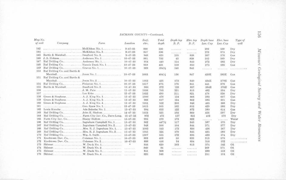
...... JACKSON COUNTY- Continued. c.n
C')
Map No. Surf. Total Depth wp Eleo. top Depth base Ele o. base 'l'ype of of well Co111,pan11 Farm Location elev. depth B. F. B. F. Lex. Cap Lex. Cap well
142 ... McKibben No. 1 ... . ... . ... . . 9-47-33 860 530 292 568 Dry ~ 144 ·· ·· ·· ··· ·· .. McKibbcn No. 3 ... ... . .. ... . 9-47- 38 847 596 273 574 Dry
145 Bartle & Marshall ... . .Swafford No. 3 . .. .. · ·· · · ·· · · · 9-47- 33 943 620 105 838 367 576 Gas ~-(;')
146 J. S. Holmes ...... . .. .. Anderson No. 1. .. .. . 10-47-33 881 733 43 838 312 569 Dry 0 147 Ruf Drilling Co . . . ... Anderson No. 1. ... . .. .. .. .. 10-47-33 954 440 114 840 372 582 Dry .:: ...., 148 Ruf Drilling Co . . . ... .. . . . .Nannie Duck No. 1. .... 10-47-33 959 431 109 850 373 586 Gas -. 149 Ruf Drilling Co .. ..... ... . . ... Graves No. 1. ..... . .. . 10-47- 33 989 394J., 146 843 ············ C') 150 Ruf Drilling Co. and Bartle & "' 0 Marshall .. . . .... . .. . . . Jones No. 1. .. 10-47- 33 1003 404.J.11 156 847 420E 583E Gas 0 151 Ruf Drilling Co. and Bartle & <c:i
Marshall .. . .. .... . Jones No. 2 . . . 10- 47- 33 1013 425 173 840 434E 579E Gas ;:;· 154 Ruf DriJJing Co .... ... .. . . . . . Pinkston No. 1 .. .. . .. . 10-47-33 1017 675 176 841 441 576 Gas ,::) ..... 155 Bartle & Marshall . .. . .. . .. . .. Swafford No. 2 .. ..... .. . .. .. . 10-47- 33 960 272 123 837 384E 576E Gas
VJ 156 .. . ... . .... ....... . . .. J.M. Pate .. .. .. .. 11-47- 83 1036 703 221 815 482 554 Dry .:: 157 ... .. .. .. .. ...... . . . ... Lee Erbe. . . . .. . . ... 12-47-33 1082 490 211 821 476 556 Dry ....,
<::: 158 Green & Stephens . ... . . .. . ... A. J. King No. 1. .. . .. 13-47-33 1000 470 134 866 393 607 Gas "' 159 Green & Stephens . .. . . . ... A. J. King No. 2 ... .. . 13- 47- 33 986 617 124 862 385 601 Gas <c: 160 Green & Stephens ..... .. ..... A. J. King No. 4 ... 13-47- 33 1051 582 205 846 465 586 Dry ,::)
161 ...... . ............ . .. . .. ... Geo . Spaw No. 1 .. ... . 13-47-33 1015 505 162 853 429 686 Dry :::i R. 162 Louis Knoche ........ .. . Ada Suleeba No. l. . . ... .. . 13-47- 33 994 635 122 872 380 614 Gas
163 Ruf Drilling Co ...... . . ... . John E. Shelton ...... . . ... 14-47- 38 1058 525 198 860 456 597 Dry ~ 164 Ruf Drilling Co ... . . . . . Farm City Inv. Co., Dave Long. 15-47-33 972 475 137 835 402 570 Dry ....... 165 Farm City Inv. Co .... . .. . Sleepy Hollow ............... 15-47- 33 995 199 173 822 Water ~ ...., 166 Ruf Drilling Co •..... ..... Ingraham Campbell No. 1 ..... 15- 47-33 962 447.J.11 117 845 887 575 Dry 167 Ruf Drilling Co ...... .. . Ingraham Campbell No. 2 ..... 15-47-33 948 500 104 844 371 577 Dry ~
~ 168 Ruf Drilling Co .. .. .. ... Mrs. R. J. Ingraham No. 1. ... 15-47- 33 1008 543 173 830 436 567 Dry (;')
169 Ruf Drilling Co .. . . . .. . Mrs. R. J. Ingraham No. 2 . . . . 15-47- 33 1015 524 170 845 485 580 Dry 0 .:: 170 Ruf Drilling Co ...... . .... Wm. S. Swift .... . . 15-47-33 1007 555 172 835 433 574 Dry ....,
171 Knobt:own Dev. Co .. . . .. . . .. . Coleman No. 1. .. .. .. .. . ..... 16-47- 33 883 409 50 833 313 570 (") ............. ~
172 Knobt:own Dev. Co ... . ... Coleman No. 2 ... 16-47- 88 888 416 54 834 316 572 (;')
······ ······ 173 Skinner ... . ... .. . ..... W. Duek No. 1 .... . . . . . . . . . . * 916 620 103 813 374 542 Oil 174 Skinner ... . .. .. .. . .. .. . .. ... W. Duck No. 2 .... .. .. . . • .. . 840 84 269 571 Oil 175 Skinner . ... .. .. . ... W. Duck No. 3. 841 368 288 558 Oil 176 Skinner ...... . ....... W. Duck No. 4. 825 346 251 574 Oil
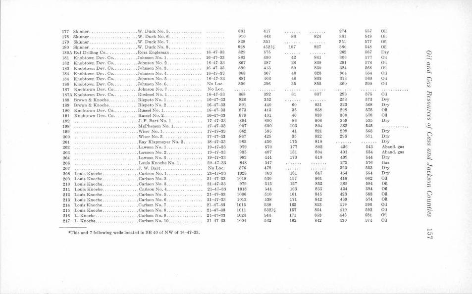
177 Skinner . . . . ......... ... ..... W. Duck No. 5 .............. 831 417 274 557 Oil 178 Skinner ... . ...... ........ . .. W. Duck No. 6 .. ....... 910 443 86 824 361 549 Oil 179 Skinner ...............•..... W. Duck No. 7 ... 828 351 251 577 Oil 180 Skinner ..... . ..... W. Duck No. 8 .. 928 452~ 107 827 380 548 Oil 180A Ruf Drilling Co .............. Rosa Engleman ........ .. .... 16-47-33 829 575 262 567 Dry 0 181 Knobtown Dev. Co . .. . ... . ... Johnson No. 1 .. .... .... . .. . . 16-47- 33 883 400 42 841 306 577 Oil -. ....... 182 Knobtown Dev. Co •. .. .. Johnson No. 2. 16-47- 33 867 387 28 839 291 576 Oil Q
183 Knobtown Dev. Co .. ... Johnson No. 3 ... ..... .. lf,-..47-33 890 413 60 830 824 566 Oil ::, 184 Knobtown Dev. Co ... . . .... .. Johnson No. 4. 16-47- 33 868 367 40 828 304 564 Oil s::i..
184 Knobtown Dev. Co .. .. . Johnson No. 5. 16- 47-33 881 403 48 833 313 568 Oil C"'J 186 Knobtown Dev. Co .. ... Johnson No. 6. No Loe. 890 396 85 855 800 590 Oil Q
187 Knob town Dev. Co ... .. ... . . . Johnson No. 7 ... No Loe . "' ·· · · ······· ............ 187A Knobtown Dev. Co .. . ... Riedesel No. 1. 16-47- 33 868 392 31 837 293 575 Oil ~ 188 Brown & Knoche ... . . . Riepeto No. 1. . 16-47-33 826 352 253 578 Dry "' .. .. . ......... "' 189 Brown & Knoche ... . ......... Riepeto No. 2 .. ·· ······ · · ·· 16-47- 33 891 440 60 831 323 568 Dry 0
i::: 190 Knobtown Dev. Co ..... . ... . . Russel No. 1. .... 16- 47- 33 873 413 35 838 298 575 Oil .., 191 Knobtown Dev. Co .. .. .. ... . Russel No. 2 ... ... . 16-47-33 878 401 40 888 300 678 Oil
(")
"' 192 .. .... .. .. ..... J. F. BartNo.1 .. . . · ··· ·· · ··· 17-47- 33 894 600 86 808 359 535 Dry "' 198 ·· ··· ·· ·· · · · ·· ··· ........... McPherson No. 1. 17- 47-33 907 600 108 804 362 545 ............ ~ 199 . .. . . . .. . .......•... . . Wiser No. 1 ..... . . ..... 17-47-33 862 585 41 821 299 563 Dry
(") 200 .. . ......... .. .. ... . Wiser No. 2 ........... 17-47-83 867 425 35 832 296 571 Dry Q
201 .. . . . .. .......... • . ... Ray Klapmeyer No. 2 ... 18--47-33 985 450 175 810 Dry "' 202 . . .. Lawson No. 1 ... ..... . ...•... 19- 47-33 979 670 177 802 436 543 Aband. gas "' ··· · · · ·· ·········· 203 ... . .. . .............. Lawson No. 2 ..... 19-47- 33 935 407 131 804 401 534 Aband. gas Q
· ······ ·· · ::, 204 ············· ..... . .. ... .. .. Lawson No. 3 .. ...... 19- 47-33 983 444 173 810 489 644 Dry s::i.. 206 ...... ........ . ... Louis Knoche No. 1 .... • ..... 20-47-83 848 647 272 576 Gas
~ 207 ........... . ... . . ... ..... J. W. Bart ........ .. . . ..•. .. No Loe. 876 479 323 553 Dry Q
208 Louis Knoche .... ..... Carlson No. 1 . .......... • .... 21-47-33 1028 763 181 847 464 664 Dry (")
:>;-209 Louis Knoche . .. . . . • . . . . . . . . . Carlson No. 2 . ..... .. ........ 21-47-33 1018 530 157 861 416 602 Oil "' 210 Louis Knoche . . .. ... Carlson No. 3 .......... • . .•.• 21-47-38 979 515 127 852 385 594 Oil 0
211 Louis Knoche .. .. ........ . .. . Carlson No. 4 .......... . ..... 21- 47-33 1018 544 163 855 424 594 Oil ::,
212 Louis Knoche .. ..... . ....... . Carlson No. 5 ... ···· · ······· · 21-47-33 1006 510 161 845 423 583 Oil (")
213 Louis Knoche . ..... .......... Carlson No. 6 . .... ..•....• ... 21-47-33 1013 538 171 842 489 674 Oil 0 i:::
214 Louis Knoche .... . • . . .. ... ... Carlson No. 7 ... .. .. .. .. .. .. . 21-47-33 1015 538 162 853 419 596 Oil ::, 215 Louis Knoche ... ...... . .. .. .. Carlson No. 8 ...... . ..•...... 21-47-33 1011 532~ 157 854 419 592 Oil
...... -. 216 L. Knoche . . ......... • ..•.... Carlson No. 9 . . . 21-47-33 1024 544 171 853 443 581 Oil "' .. .......... "' 217 L. Knoche ................ . .. Carlson No. 10 .. .. ........... 21-47-33 1004 532 162 842 430 574 Oil
*This and 7 following wells located in SE 40 of NW of 16-47- 33. ..... <:.,I -..J
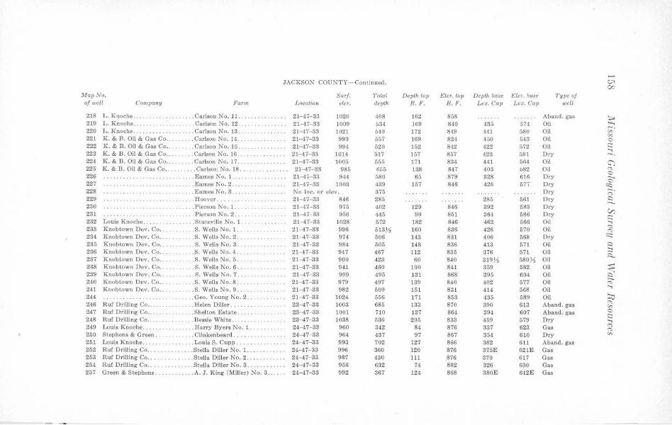
...... JACKSON COUNTY-Continued. v'<
00 Map No. Surf. Total Deplkt-Op Elev. top Depth base Elev. b,Me Type <>f of well Cmnpany Farm Location elev. devth B . F. B.F. Lex. Gav Lex. Cap welt
218 L. Knoche ... . . . Carlson No. 11. . 21-47-33 1020 408 162 858 Aband. gas ~ 219 L. Knoche .. . . .. .. .. : . . ... Carlson No. 12. .. . .. .. .... 21--47- 33 1009 634 169 840 435 574 Oil
220 L. Knoche .. .. . .. . .. . . .. ... Carlson No. 13 . .. ·· ··· ······ · 21- 47- 33 1021 540 172 849 441 580 Oil ~-"' 221 K. & B. Oil & Gas Co .. . . Carlson No. 14. 21--47-33 998 557 169 824 450 548 Oil 0
222 K. & B. Oil & Gas Co ... ... ... Carlson No. 15 .. · · · ·· · · · ·· · 21-47-33 994 (>20 152 842 422 572 Oil i:::: 223 K. & B. Oil & Gas Co ... .. Carlson No. 16 .. ······ · ··· · · 21--47- 33 1014 517 157 857 423 591 Dry :::. 224 K. & B. Oil & Oas Co .... . . . . . Carlson No. 17. 21-47- 33 1005 555 171 834 441 564 Oil C") 225 K. & B. Oil & Gas Co . . . . . .. ... Carlson No. 18 ... .. ....... . . . 21-47-33 985 655 138 847 403 082 Oil '"" 226 . .. Eames No. l. . ... . .. 21-47- 33 944 580 65 879 328 616 Dry
0 --227 .. ... Eames No. 2 . . ... . 21-47-33 1003 439 157 846 426 577 Dry 0
(<::,
228 ·· ·· ·· · ·· ·· ·· · .. .. . EamesNo.3 ..... ·· · ·· ··· ·· · No loc. or elev. 375 Dry ;:;· 229 ···· ·· ·· ·· · . ... Hoover ....... . .. ··· · ·· ·· ·· · 21-4.7-33 846 285 285 561 Dry S::)
230 .. . . . . .... Pierson No. 1. .... 21-47-33 975 402 129 846 392 583 Dry ....... V) 231 ······· ·· · .. . Pierson No. 2 ... ···· ··· · ·· · · 21-47-33 950 445 99 851 364 586 Dry i::::
232 Louis Knoche ......... .. ... . . Stuteville No. 1. .. ... ...... .. 21-47- 38 1028 572 182 846 462 566 Oil ...., 238 Knobtown Dev. Co .. .. . .... S. Wells No. 1.. 21-47-33 996 513~ 160 836 426 570 Oil <:::
"' 234 Knobtown Dev. Co .... .. . .. S. WcllsNo.2 .. . . . .. . .. ... . 21-47-33 974 506 148 881 406 568 Dry <::::::
235 Knobtown Dev. Co . .. . .. .. ... S. Wells No. 8 ... · ·· ·· ·· ·· ·· · 21- 47- 83 984 505 148 836 413 571 Oil S::)
286 Knobtown Dev. Co . . .. . . . S. Wells No. 4 . . 21- 47-33 947 467 112 835 376 571 Oil :::i 237 Knobtown Dev. Co .... . . .. ... S. Wells No. 5 .... , . . . . . .. . 21--47-33 900 423 60 840 319~ 580~ Oil
i:::,...
238 Knobtown Dev. Co . .. . .... S. Wells No. 6 . . .. . ·· ·· · ··· · · 21-47- 33 941 460 100 841 359 582 Oil ~ 239 Knobtown Dev. Co .. ... . .. S.WelJsNo.7 . . .. . 21-47-33 999 495 131 868 395 604 Oil 2. 240 Knobtown Dev. Co .. .. .. . S. WellsNo.8 .... ·· · · ·· ·· ·· · 21--47-33 979 497 139 840 402 577 Oil "' 241 Knobtown Dev. Co . ... . . . . . . . S . Wells No. 9 . .. .. . .. .. . .. . . 21-47- 33 982 509 151 831 414 568 Oil
..., 244 . . . . . . . . . . . . . . .. . Geo. Young No. 2. 21-47-33 1024 556 171 853 435 589 Oil ~ 246 Ruf Drilling Co ... . .. Helen Diller ... 23-47-33 1003 685 133 870 390 613 Aband. gas "' "' 247 Ruf Drilling Co . . . . ... . .. .. ... Shelton Estate . .. . .. .. .. . .. . 23- -17-33 1001 710 137 864 394 607 Aband. gas 0
248 Ruf Drilling Co .... .. .. .. ... . Bessie White ....... . 23-47-33 1038 536 205 883 459 579 Dry E; 249 Louis Knoche .. .. .. .. ... Harry Byers No. 1. ... . ... . .. 24--47-38 960 342 84 876 337 623 Gas n
"' 250 Stephens & Green . . . .. Clinkenbeard . .. . ....... 24- 47-33 964 487 97 867 354 610 Dry "' 251 Louis Knoche. . .. Louis S. Cu pp .. 24-47-33 993 702 127 866 882 6ll Aband. gas 252 Ruf Drilling Co . . . .. .. Stella Diller No. 1.. 24--47- 33 996 360 120 876 375E 62IE Gas 253 Ruf Drilling Co . ...... . . . Stella Diller No. 2 . .. ... 24-47-33 987 430 111 876 370 617 Gas 254 Ruf Drilling Co .... .. .. . Stella Diller No. 3 .... . . 24-47-33 956 632 74 882 326 630 Gas 257 Green & Stephens. . . .. . A. J . King (Miller) No. 3 . . .. .. 24--47-38 992 367 124 868 380E 612E Gas
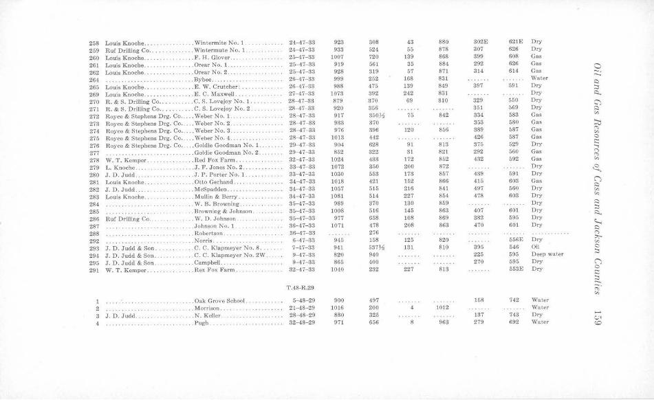
258 Louis Knoche ... . . ... . . .. . ... Win termite No. 1 ..... . . .. . 24-47-33 923 308 43 880 302E 621E Dry
259 Ruf Drilling Co ........ . ..... Wintermute No. 1 . . 24-47- 33 983 524 55 878 307 626 Dry
260 Louis Knoche ... ... . . . .. . . ... F. H. Glover ... . .. . 25-47-33 1007 720 139 868 899 608 Gas
261 Louis Knoche . . . .. . Orear No. 1. .. .. .. .... .. . 25-47- 33 919 561 35 884 292 626 Gas 0 262 Louis Knoche .. . .Orear No. 2 . ... .... 25-47- 33 928 319 57 87) 314 614 Gas -. 264 .. .. .. .. .. ... Bybee . ... ....... 26-47-33 999 252 168 831 Water
........ ·· ···· · ···· · · · · · ·· ·· · · ··· ·· .::)
265 Louis Knoche . .. .. ..... .. E. W. Crutcher .... 26-47-33 988 475 139 849 397 591 Dry ::i 269 Louis Knoche .. .. ...... . ..... E. C. Maxwell . ... 27-47-33 1073 392 242 831 Dry ~
270 R. & S. Drilling Co ... . .. .. ... C. S. Lovejoy No. 1. 28-47-33 879 370 69 810 329 650 Dry ~ . 271 R. & S. Drilling Co ...... ..... C. S. Lovejoy No. 2. 28-47- 38 920 356 851 569 Dry .:i
272 Royce & Stephens Drg. Co . . . .. Weber No. 1. . 28- 47- 33 917 350~ 75 842 334 588 Gas "' 273 Royce & Stephens Drg. Co .. .. . WeberNo.2 .. . 28- 47-33 933 370 358 580 Gas ~ 274 Royce & Stephens Drg. Co. ... WebcrNo.3. 28-47-33 976 396 120 856 389 587 Gas "' "' 275 Royce & Stephens Drg. Co .. . . . Weher No. 4 ......... . 28-47- 83 1013 442 426 587 Gas a
276 Royce & Stephens Drg. Co . . ... Goldie Goodman No. 1.. 29- 47-33 904 628 91 813 375 529 Dry I::; ..., 277 ....... . .. .... .. .. .. .. .. ... Goldie Goodman No. 2 . . 29-47-33 852 822 31 821 292 560 Gas r,
"' 278 W. T. Kemper . . . .. Red Fox Farm .. . ... .. 32-47- 38 1024 433 172 852 432 592 Gas "' 279 L. Knoche . . ... . . . . . . . . . . . . . J. F. Jones No. 2 .. 33- 47- 33 1072 350 200 872 D ry .s, 280 J. D. Judd ..... .. J . P. Porter No. 1 . · ·· ······· 33-47-33 1030 553 173 857 439 591 Dry
281 Louis Knoche .... ... .. ... . .. Otto Gerhand .. . .. .... 34- 47- 33 1018 421 152 866 415 603 Gas (")
282 J. D. Judd . .... . ... McSpadden ....... 34-47- 33 1057 515 216 841 497 560 Dry .::)
... . .. .. .. "' 283 Louis Knoche ... . . ........ Mullin & Berry . . 34-47-33 }081 514 227 854 478 603 Dry "' 284 .... . ...... ·· ·········· .. . W. B. Browning. ···· · ·· ·· · · 3n-47-33 989 370 130 859 Dry .::)
285 .. .. . Browning & Johnson ...... . 35-47- 38 1008 516 145 863 407 601 Dry ::i ~
286 Ruf Drilling Co .. .. W. D. Johnson .. 35- 47- 33 977 658 108 869 882 595 Dry ~
287 .... Johnson No. 1 ... 86-47-33 1071 478 208 863 470 601 Dry .:i 288 . . . Robertson .. 36-47-33 276 <">
292 . .... Norris .. . . ......... 6-47- 38 945 158 125 820 556E Dry ::,;-.. "'
293 J . D. Judd & Son . .... ..... . . C. C. Klapmeyer No. 8 . . . 7-47- 83 941 537),1 131 810 395 546 Oil a
294 J. D. Judd & Son. . C. C. Klapmcyer No. 2W . 9-47-33 82'0 940 225 595 Deep waler ::i
295 J. D. J udd & Son ... .. Campbell ...... . .. 9-47- 38 865 400 270 595 Dry (")
291 W. T. Kemper . . . .. ... Rex Fox Farm . .. . 32-47-33 1040 232 227 818 553E Dry a § ......
T.48-R.29 ;:;;· ,:,,
l .. .... Oak Grove School. ·········· · 5-48-29 900 497 158 742 Water
2 · ·· · · ·· ·· ·· ··· .. Morrison . .. . 21-48- 29 1016 200 4 1012 Water
3 J . D. Judd. . N. Keller . 28- 48-29 880 325 137 743 Dry ..... ... . ... . .. . a,
4 ....... .. . Pugh . .... .... .. .. 32-48-29 971 656 8 963 279 692 Water <.O
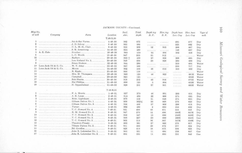
JACKSON COUNTY-Continued. ...... O'>
lllapNo. Surf. Total Depth top Eleo. lop Depth ba$e Ele•. base Type of 0 of well Company Farm Location e/.eo. depth B. F. B. F. Lex. Cap Lex. Cap well
T.48-R.30
·· · ·· ··· ·· · · ····· ····· · · · . .. Sni-A-Bar Farms . .. .. . 4-48-30 962 875 285 677 Dry ~ 2 .. . ..... .. . . . ... J. D. Selvey ..... . 8-48--30 885 580 223 662 Dry
3 ... . .. . ....... ... . . ... .. C. L. M. St. Clair. . . . . . . . . . . . 8-48- 80 955 393 52 903 288 667 Dry ,;;· "' 4 · ·········· ·· .. . ... .. .. . .. .. S. E. Armstrong .. . . . ... . ..... 14-48-30 835 480 148 687 Dry 0
5 A. E. Hale ........ . ... . .. . . . Strother .... . 18-48-30 960 550 64 896 802 658 Dry s::: ...., 6 . . . . . . . . . . .. ... . L. C. Worth .. 19- 48-30 947 200 35 912 Water -· 12 .. ... . ... ....... . . .. . .. . . . .. Earhart .... .. . . .. . 29-48- 30 968 ± 400 27 936 268 695 Dry C") 7 .. ... . .. .. . .. .. . . . . . . Lon llolland No. 1. , . .. . . . . . 30-48-30 949 690 20 929 260 689 Dry <'>
0 8 ·········· · ······· ... Bruce Dodson .. 32-48-30 944 280 250 694 Water 0 10 Lone Jack Oil & G. Co ... . . . . . W. T. Alley .... .. ... 33-48- 80 967 560 250 717 D ry ~ 11 Lone Jack Oil & G. Co . . . . . Moore. . ···· ·· ··· · ··· ·· ·· · ·· 34-48-30 962 400 49 913 300 662 Dry ;:;· 15 .. .... . .. . ... .. .. R. Epple .. 25-48- 30 860 150 Water ~ ....._ 14 ·· ··· · ·· · ·· ·· ·········· .. ... Mrs. M. T hompson . 29-48- 30 968 120 46 922 681E Water
V) 16 · · · · · · · · ·· ·· ·· ·· ·· · ··· · .. ... Campbell .... . .. .. 29-48- 30 925 125 695E Water s::: 17 · ·· · · ··· · ··· · . . . .. ... . Bob Shutts .. . . . . . . . . . . . . 80-48- 80 959 212 48 916 675E Water ...., ~ 18 ·· ··· ·· · ···· · · ·· · ··· ··· · . .. . Hal Phillips . . .. . . . 31-48- 30 899 125 5 894 653E Water <'>
19 ··· · ··· ··· · ·· ·· ·· . . H. Oppenheimer . ···· ·· ··· · ·· · 31-48-30 928 201 27 901 660E Water <s::: ~
T.48-R.31 :::i ~ 1 .. ... . . .. . . . . . . . .. . . . ... ... . F. A. Morris. 1- 48-31 937 370 46 891 283 654 D ry
2 · ·· ·· ··· ·· · . ... . . .. ... A. B. Lease ... 2-48-31 910 490 22 888 275 635 Dry ~ 3 · · ·· · ·· · ·· · ··· . .. . Robt. Lightbum . ... . . .. 2-48-31 879 412 31 848 274 605 Dry a 5 · ··· · ···· · ·· · .. . . .. . .. . . .... Gilham Dalton No. l. .. . 4- 48-31 899 362~ 80 869 276 623 Dry <'> ...., 6 .. .. ... . .. .. .... .. ... Gilham Dalton No. 3 . . . 4-48-31 906 400 37 869 288 618 Dry
;:r;; 7 ·· · · ·· ·· ·· · · . . . 'l"'urner . ............. .. ... .. . 4-48-31 882 480 2 880 250 632 Dry
"" 8 . .. .... . .. . . . .. . .. . . .. T. C. Howard No. 4 . . 7-48- 81 931 400 60 871 313 618 Dry "' 9 ... R. M. Howard No. 3 ....... . . 8-48-31 947 270 51 896 300E 647E Dry C · ·· ·· ·· ·· ·· · s::: 10 ... . . , .. . .. ..... . T. C. Howard No. 2 . , .. ... . , . 8-48-31 906 347 10 896 258E 648E Dry ...., 11 . . T. C. Howard No. 3 ........ 8-48- 81 909 227 20 889 269E 640E Gas
(") .. . . . . .. . . .. . · ·· · ······ ..,, 12 . .... T. C. Howard No. 5 .. 8-48-31 963 310 96 867 347E 616E Dry "' 13 . .. .. .. .. .. .... Theodore Pressly .. . .. .. .... . . 8-48- 31 893 381 27 866 276 617 Dry 14 · · · · · · · · ·· · · · · · · · .. . Tilham Dal ton No. 2 .... .. . . . 9-48- 31 901 360 29 872 277 624 Dry 15 · ·· ··· ·· · ·· . . . Ed. Goodloe . . •.•. • ...... 9-48-31 929 410 56 873 306 628 Dry 16 · · ··· ·· ·· ·· ·· · · ·· ·· · · .. . John R. Leinweber No. 1. 9- 48-31 905 331 11 894 258 647 Gas 17 .. . .. . . .. . ... . .. • .. . . .. .. . .. John R. Leinweber No. 2 . 9- 48- 31 894 335 14 890 251 643 Gas
•
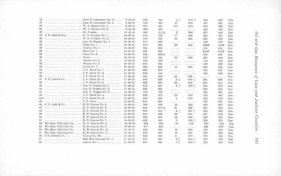
18 ... ... . John R. Leinweber No. 3 ...... 9--48-31 879 345 5± 874 ± 248 631 Dry 19 · ··· ·· ··· · ··· ·· ·· · ·· ·· .. John R. Leinweber No. 4. ..• ... 9--48- 81 912 885 37 875 291 621 Dry 20 ···· ····· · · ········ · ·· .. ... . W. A. Shreeve No. 1 . . . . . .... . 9--48- 31 975 437 105 870 347 628 Dry 21 . . . .... W. A. Shreeve No. 2 ......... 9-48-31 862 429 346 616 Dry 22 .. .......... ... ... Dr. Combs ... . ....... . ... .. 10-48- 31 886 317~ 2 884 237 649 Gas C) 23 J. D. Judd & Son. . .. ... .... H. N. Cordson No. 1 . 10--48- 31 915 532 17 898 264 651 Dry -. -.. 24 ... . .. H. N. Cordson No. 2 . . 10--48-31 918 346 33 885 268 650 Gas ~ 25 . ... . .... ............... .... Geo. H. Hughes No. 4 ... .. ... 10--48-31 817 225 138 679 Gas :::i 26 ... ... . ... .. .. .. ··· ·· · ·· · .. Hulse No. 1. . . . .. ....... 10-48- 31 916 360 22 894 262E 654E Dry ~ 27 .Newton No: 1. . ... . ....... 10-48-31 794 255 176 618 Dry ~ 28 .. ....... .. ... . .. . .. . .. .. .. . Sweet No. l. ... .. 10- 48-31 892 822 241E 651E Gas ~
"" 29 ... Sweet No. 2 .. .... .. .. . ...... 10-48-31 843 228)1 194 649 Gas 30 .... Toute .. . · · ····· ·· · · ··· · 10-48-Sl 913 341 24 889 265 648 Gas !:tl
C't, 31 ······ · ·· ····· · · · . .. . Watson No. 1. .......... . 10--48-31 814 885 174 640 Dry "" 32 ... .. . . . Watson No. 2 ... . ... .. .. .. .. . 10--48-31 801 224 139 662 Gas C .. .. ......... . i:::
33 ....... ... . .......... . Wolfe No. 1. .... 10-48-81 930 360 45 880 278 652 Gas ..., 34 .... J . F Baird No. 1. 11-48-31 863 279 190 673 Gas n . ... . . .. . . . .. . ... , ~ 35 .. .. .. . J. F. Baird No. 2. 11--48-31 846 445 188 658 Gas "" .. . , .. . . ... . 36 · ··· ·· ··· ·· ·· ·· ·· .. J. F. Baird No. 3 . 11- 48- 31 905 503 23 882 Dry .c -37 J. D. Judd & Co ... . . .... . . J . F. Baird No. 5 . 11-48-31 908 326 3± 900 ± 234 669 Gas
C") 38 . .. .. .. . ... J. F. Baird No. 6 . 11-48-31 898 890 39 859 284 614 Dry ~ 89 ·· ··· · ··· ·· ······ · ... . . Geo. P. Hughes No. 1. .. . .. ... 11- 48- 81 918 347 9± 909 ± 240 678 Gas c,,
c,, 40 ' . ' .. ... . ... . .. . . . . . Geo. F. Hughes No. 2 . 11-48-31 892 325 289 653 Gas 41 . ... . . Geo. F. Hughes No. 3 .. .. . .. 11--48-31 916 849 235 681 Gas ~
:::i 44 ··········· · ·· · · · ·· .. ... J. F. Baird No. 4 ...... . .. .. .. 14-48-31 939 375 20 919 272 667 Gas ~ 44A . ... . . ... .. .. .. .. .. . .. . .. . .. J. 0. Boten No. 3 .. 14-48- 31 918 340 5 913 242 676 Gas ~ 45 . ... .. C. P . Fann . . .... . 14--48-31 840 280 189 661 Gas ~ 46 J. D. Judd & Co .. . ... E. H . Graves No. 2 ... .. ... . . . 14-48- 31 966 390 42 924 279 687 Gas (")
::,;-. 47 ·· ·· ···· ··· ·· ·· ·· ·· ··· · .. E. H. Graves No. 3 . . . ... . .. 14-48- 31 944 357)1 21 923 261 683 Gas c,, 48 .... E. H . Graves No. 4 . 14-48-31 900 505 3 ± 897 ± 235 665 Gas 0 .. . .. . .. . . :::i 49 · ·· · · ·· · · ·· . ..... E. H. Graves No. 5 .. ......... 14- 48--81 940 369 26 914 267 673 Gas 50 ·· ··· ·· ·· ·· · ··· · · ·· .. E. H. Graves No. 6 ... . .. . .. 14- 48-31 938 367 32 906 268 670 Gas C")
C 51 ·· ·· ·· ·· · ·· ...... E. H. Graves No. 7 . . 14-48-31 902 484 0 902 ± 228 674 Gas i::: 52 Mo.-Kan. Pipe Line Co . . . . . . .. E . H. Graves No. 8. 14--48- 31 932 360 20 912 259 673 Gas :::i 63 Mo.-Kan. Pipe Line Co . . . . . . E. H. Graves No. 9 . . 14- 48- 81 917 333 238 679 Gas
...... ;::;·
54 Mo.-Kan. Pipe Line Co .. .... E. H. Graves No. 10 14- 48- 31 932 358 12 920 252 680 Gas c,, 55 Mo.-Kan. Pipe Line Co .. . E. H. Graves No. l 1. 14- 48 31 953 385 32 921 270 683 Gas 56 J. D. Judd & Co .. .. Graves No. lB, .. .. . . 14- 48-31 958 800 41 917 275 683 Dry 57 .... Half Hill, Jennings No. 1 .. . 14- 48- 31 910 334 6 ± 904 ± 237 673 Gas .....
m 58 · ·· · · · ·· · · ·· · · · · .. .. Ogilvie No. 1 ..... .. . ........ 14-48 31 900 360 o± 900 ± 245 655 Dry .....
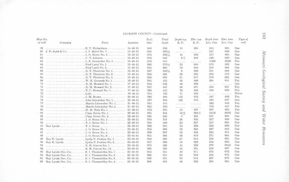
JACKSON COUNTY-Continued. -O'> MapNo. Surf. Total Depth top Elev. top Depth base Elev. base Type of t,.;,
of well Company Farm Location elev. depth B.F. B.F. Lex. Cap Lex. Cap well
59 ............. . . . .. E. T. Richard•on .. . . .. . .. . ... 14-48- 31 940 358 15 925 255 685 Gas 60 J. D. Judd & Co ........ . . .. J. F. Baird No. 7 ... 16 48- 31 916 333~ 247 669 Gas ~ 61 .... J. O. Botcn No. 2 .. ...... .. .. 15- 48 31 972 382~ 40 932 277 695 Gas 62 · · ·· · ·· · ····· · ·· .... C. T. Johnson . 15-4&-31 912 343 9 ± 903 249 663 Gas ,;;·
"' 63 .. ... J. R. Leinweber No. 5 .. .... 15- 4!Hll 818 415 156E 662E Dry C
64 .. .. }'red Lund No. 1 .. ..... . ..... 15-48 31 965 375~ 25 940 273 692 Gas i::: ...., 65 . . ... Fred Lund No. 2 .... . 15-48-31 943 660 19 924 250 693 Gas -· 66 .... . ... . R. 'l'. 'l'hornlon No. 1. 15- 4&-31 937 338~ 8 929 251 686 Gas C":) 67 .......... . .. R. T. Thornton No. 2 . 15-48- 31 958 383 28 930 282 ,376 Gas "' C 60 . . .. . . R. T. Thornton No. 3. 15-48- 31 938 370 21 917 276 662 Gas 0 69 . W. H. Grounds No. 1. 16-4&-31 935 455 49 886 294 641 Dry ~ 70 . .. . .. ... R. M. Howard No. l. ..... . .. 17- 48- 31 948 242 49 899 Gas -.
<"> 71 . . .. .. .. ... . .... .. R. M. Howard No. 2 ... ..... . 17-48-31 957 447 b6 871 330 627 Dry ~ -72 . . .. T. C. Howard No. 1. 17- 48- 31 960 445 78 882 332 628 Dry
V) 73 . .. .. .. . .. . ... . ..... Lohr .. .. 19- 48- 31 955 123 71 884 Water i::: 75 .. .. . .. .. . .. . .. . .. .. .. J.M. B rown . ........ 20-48- 81 986 406 112 874 317 639 Dry ....,
<::: 76 .. . John Leinweber No. 1. 20 -48- 31 997 600 122 875 360 637 Gas "" 77 . ... Martin Leinweber No. l. 2 1- 48- 31 905 515 262 643 Dry <c:: . .. .. . . .. .. 78 .. . Martin Leinweber No. 2 . 21- 4!HH 925 358 278 647 Dry ~
80 .. .. .. H. M. Twis No. 1 . ... . 21- 48- 31 912 385 45 867 287 625 Dry :::, ~
81 . Chas. Boten No. l .. . . 22-48- 31 934 344 12± 922 ± 24JE 693E Gas 82 .. Chas. Boten NCI. 2 . . 22-4&-31 924 340 0 924 231 693 Gas ~ 83 .. J . O. Boten No. 5 .. . . . 22 48-31 956 357 26 930 257 699 Gas ~ 84 · · · ········· . T. J. Boten No. l .. 22-48- 31 950 408 23 927 267 693 Dry "' 85 Roy Lynds. ... T.J.Bot.en ... .. ....... . . 22- 4&-31 962 395 34 928 266 696 Dry
....,
86 .. . ... . . .. .. . . .. . . . . .... J. 0. Boten No. 1 .. 23- 43-31 956 366 36 920 267 6!;9 Gas ~ 87 .. . .. J. 0. Boten No. 4 . . 23-48- 31 939 367 33 906 265 674 Gas "" .. .... ..... "' 88 .J. 0. Boten No. 6 . .. . . ... 23-48-31 955 390 86 919 271 684 Gas C
i::: 89 Roy E. Lynds . . .. . .. . . .. Lydia F. Fowkes No. L 23- 43-31 942 380 27 915 258 684 Gas ...., 90 Roy E . Lynds. .... Lydia F. Fowkes No. 2 ..... .. 23-48-81 947 382 18 929 252 695 Gas <">
··· · · · ·· ·· "' 91 ........ .. . .. .. . .. .. . E. H. Graves No. 1. ..... .. 28-48-31 973 629 44 929 279 694E Gas "' 92 . E. H. Graves No. 12 ... . . 23-48 31 983 530 52 931 286 697 Gas 93 Roy Lynds Dev. Co ... .. .. ... F. I. Thommiribu No. l .. 23- 48- 31 954 521 43 911 276 678 Gas
94 Roy Lynds Dev. Co ... ... . .F. I. T homrni ribu No. 2 . . 23- 48- 31 923 355 20 903 250 673 Gas 95 Roy Lynds Dev. Co .. . F. I. Thommiribu No. 3 . 23- 48- 31 946 535 30 916 267 679 Gas 96 Roy Lynds Dev. Co .. .. .. F. I. Thommiri b1;1 No. 4. 23-48- 31 968 400 46 922 284 684 Gas
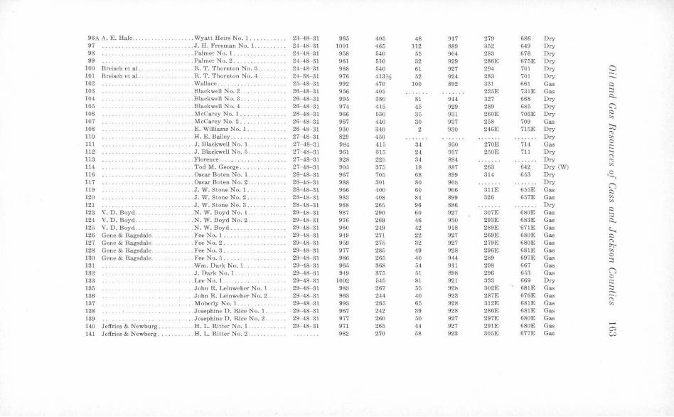
96A A. E. Hale . . . . Wyatt Heirs No. 1 ..... ...... 23-48- 31 965 405 48 917 279 686 Dry 97 . . .. J. H. Freeman No. 1 ... 24-48-31 1001 465 112 889 352 649 Dry 98 .. . Palmer No. 1 ......... . 24-48- 31 958 540 55 904 283 676 Dry 99 ... Palmer No. 2 .... 24-48-31 961 510 32 929 286E 675E Dry
100 Breisch et al . .. . . .. R. T. Thornton No. 3 .. 24- 48- 31 988 540 61 927 294 701 Dry 0 101 Breisch et al. . . . . R. T. Thornton No. 4 .. 24-38- 31 976 413)1 52 924 283 701 Dry -. ..._ 102 .. .. . .. .. Wallace ... . . . . . . . . . . 25- 48- 31 992 470 100 892 331 661 Gas ::::)
103 .. Blackwell No. 2 . .. . ........ 26- 48- 31 956 405 225E 731E Gas :::, 104 .. .. Blackwell No. 3 .. 26-48- 31 995 380 81 914 327 668 Dry ~
105 · · ·· ·· · · ·· ·· .... Blackwell No. 4 . . · · ··· ·· · ·· · 26-48- 31 974 415 45 929 289 6ll5 Dry C"') 106 ·· · · ··· · ·· ·· . ... Mccarey No. I .. ········· · · 26- 48- 31 966 530 35 931 260E 706E Dry ::::)
,:,, 107 .. .. McCarey No. 2 .... . . . 26- 48- 31 967 4•10 30 937 258 709 Gas
~ 108 ·· ·· · ·· · · ·· · ·· · ·· ·· .. .. £. Williams No. 1 .. 26-48-31 930 340 2 930 246E 715E Dry ~
110 ... · ··· · · ·· ·· ....... H. E. Bailey ... .... . 27- 48- 31 829 450 Dry "' 111 .. . J. Blackwell No. 1 .. 27--18- 31 9ll4 415 34 950 270E 714 Gas 0 i::::
112 ....... . . .. .. .. . ... . J. Blackwell No. 5. 27- 4lS--31 961 315 24 937 250E 711 Dry ..., r,
113 .. .. Florence . . . ........ . . 27- 48-31 928 225 34 894 Dry ~
114 ....... Tod M. George .... . .. . . ..... 27- 48-31 905 375 18 887 263 642 Dry (W) "' ............ 116 ·· ···· ·· ··· .. Oscar Bo ten No. 1 . 28-48- 31 967 705 68 899 314 653 Dry ~ 117 . Oscar Bo ten No. 2 . . 28- 48- 81 988 30) 80 90S Dry
() 119 .J. W. Stone No. 1. 28- 48- 31 966 400 60 906 311E 655E Gas ::::) 120 .J. W. Stone No. 2 .. . 28-48- 31 983 408 84 899 326 657E Gas "' ,:,, 121 .J. W. Stone No. 3. 28- 48- 31 968 265 96 886 Dry
::::) 123 V. D. Boyd. . .. N. W. Boyd No. 1. .. 29- 48- 31 987 290 60 927 807E 6l!OE Gas :::i 124 V. D. Boyd. ... N. W. Boyd No. 2 . 29- 48- 31 976 269 46 930 293E 61!3E Gas ~ 125 V. D. Boyd ... ... N. W. Boyd . . . 29- 48- 31 960 249 42 918 289E 671B Gas ~ 126 Gene & Ragsdale . . ... Fee No. 1.. 29- 48-31 949 271 22 927 269E 680E Gas ::::)
127 Gene & Ragsdale .. ... FeeNo.2 ... .... 29-48 31 969 275 32 927 279E 680E Gas r, ~
128 Gene & Ragsdale. . . . .. . Fee No. 3 .. 29- 48- 31 977 285 49 928 296E 681E Gas "' 130 Gene & Ragsdale. . .. Fee No. 5 .. 29- 48- 31 986 265 40 944 289 697E Gas 0
···· ·· · ·· · · ::i 131 ...... ..... . Wm. Dark No. 1.. 29- 48 31 965 368 54 911 298 667 Gas 132 . .. . .. .. . J . Dark No. 1. .. . 29- 48-31 949 375 51 898 296 653 Gas ()
0 133 .Lee No. 1. . . . . ... 29-48-31 1002 545 81 921 333 669 Dry s::: 135 . . John R. Leinweber No. 1. 29- 48 31 983 267 55 92ll 302E 681E Gas :::i 136 . . . John R. Leinweber No. 2. 29- 48-31 963 244 40 923 287E 676E Gas
...... ;:;·
137 . Moberl.y No. 1. .. . ..... 29- 48-31 993 265 65 928 312E 681E Gas ,:,,
138 . .... . . Josephine D. Rice No. 1. 29- 48- 3] 967 242 39 928 286E 68JE Gas 139 . . . Josephine D. Rice No. 2. 29- 48- 31 977 260 50 927 297E 680E Gas 140 Jeffries & Newburg .. .. .. . . H. L. Ritter No. 1. .... 29- 48- 31 971 265 44 927 291E 680E Gas -O'> 141 Jeffries & Newberg ........ . . . H. L. Ritter No. 2 . ... . . ... 982 270 58 923 305E 677E Gas (»
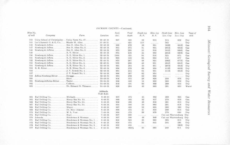
....... JACKSON COUNTY- Continued. Ci) ...
Map No. Surf. '.l'otal Depth top Elev. top Depth ba~e Eleo. base Type of ofweU Company Farin Location elev. depth R.F. B.F. Lex. Cap Le,;. Cap well
144 Unity School of Christianity ... Unity Farm No. 47 ... 30-48-31 967 560 52 915 315 652 Dry ~ 145 Lee's Summit O. & G. Co .. .. Maude M. Allen .... .. 31- 48-31 425 110 363 Dry
146 Newberg & Jeff res .. . . . .. . Ben D. Allen No. 1. 32- 48- 31 989 272 58 931 308E 681E Gas ,;;· 147 Newberg & Jelfres .. .. . .. Ben D. Allen No. 2 . ... . 32- 48- 31 965 275 31 934 281E 684E Gas "' 0 148 Newberg & Jeffries .. .. . .. Ben D. Allen No. 3 ... . 32- 48- 31 973 280 55 918 305E 66fSE Gas i::: 149 ... R. 'l'. Ritter . 32- 48- 31 974 256 44 930 294E 680E Gas
..., -· 150 Newberg & Jeffers. . . . R. E. Ritter No. 1. 32-48- 31 1000 535 84 916 825 675 Gas C) 151 Newberg & Jeffers. ... R. E. Ritter No. 2 . . 32·-48- 31 993 553 63 930 316 677 Gas "' 152 Newberg & Jeffers. . . . R. E. Ritter No. 3. 32- 48- 31 973 267 49 924 296E 677E Gas
0
0 153 Newberg & Jeffers .. .. . .. . . . R. E. Ritter No. 4 . .. 32-48- 31 979 266 48 931 295E 684E Gas ~ 154 Newberg & Jeffers. . . R. E. Ritter No. 5 . . 82-48- 31 981 264 50 931 297E 684E Dry ;::;· 155 R. E. Ritter ..... ... . R. E. Ritter No. 6 . . . 32- 48 31 996 279 66 930 313E 683E Dry I:)
156 . .. .. J . V. Rowell No. 4. 32- 48- 31 995 255 64 931 311E 684E Dry -. ... ..... . V) 157 .... . J. V. Rowell No. 5 . . 32- 48- 31 996 267 62 934 Dry i:::
158 Jeffers-Newberg-Ritter. . .. .. . . Scruggs. 32- 48 31 994 279 62 932 Dry ..., 160 . .. Short ... 33-48-31 956 375 28 928 280 676 Dry "' .... .. ..... .. ......... (is
161 Newberg-Jefferies-Ritter . . .. . . . Tudor ..... .... ...... .. 33- 48- 31 936 400 14 922 260 676 Dry c:c: 162 . . . Colborn. 34-48- 81 949 401 60 889 299 650 Dry I:)
163 .. . .. .. .. ...... . .. .. . . .. . .. . Dr. Ed ward N. Thiesson . 34- 48- 31 926 294 43 883 291 635 Water :::s s::l..
Addenda
~ T.48 -R.81
164 Ruf Drilling Co .. . . .. .. Michaels . ........ . .. . .. . .. 6-48-31 907 475 45 862 282 625 Gas "" 165 Ru f Drilling Co .. . Henry Ess No. IA . .... 6-48- 81 889 465 32 857 270 619 Gas
..., 166 Ru f Drilling Co .. . ... . Henry Ess No. 2A .. 6- 48- 31 906 490 48 858 291 615 Dry ::0
(":> 167 Ruf Drilling Co. . . .. . Henry Ess No. 3A . .. .. . .. . 6- 48- 31 910 500 50 860 291 619 Dry "' 168 Ru f Drilling Co ... .. .. Mayer ... 6-48- 81 887 485 52 835 292 595 Dry 0
i::: 169 Ruf Drilling Co .. . .. . Dr. Rice (Adams) ... 6- 48-31 899 475 41 858 289 610 Gas ..., 173 Ruf Drilling Co . .. . . . . . . . . . . W. L. Yost . .. . .. . . .. ..... . 7- 48--31 918 475 39 879 278 640 Dry
("') (":>
174 Ru f Drilling Co .. . . . . Hoyt ...... . . 7-48-31 807 388 Cut ou t Warrensburg Dry "' 170 Johenda . ...... . . . . . Henderson & Worman .... 8-48-31 937 500 48 889 Cut out Warrensburg Dry 171 Ruf Drilling Co . ........ .. . . Henderson & Worman No. l. 8- 48-31 905 500 45 860 295 610 Dry 172 Ruf Drilling Co .. . . Henderson & Worman No. 2 . 8-48 -31 878 475 33 845 285 593 Dry 176 Ruf Drilling Co . . . . . . . Henderson & Worman No. 3. 8- 48-31 852 450 598E Dry 177 Ruf Drilling Co. . ...... Henderson & Worman No. 4. • . 8 4~- 31 900 462.11 40 860 2lS9 611 Dry
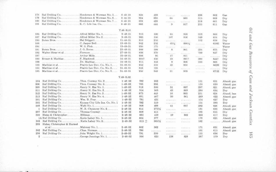
178 Ruf Drilling Co .. . . . .. . .. .. . Henderson & Worman No. 6 . . . 8- 48- 31 83l) 428 236 602 Gas 179 Ruf Drilling Co .. . . . Henderson & Worman No. 6 . . . 8 4lS- 81 924 690 64 860 315 609 Dry 180 Ruf Drilling Co . .. . .... Henderson & Worman No. 7 . .. 8-48- 31 819 428 218 601 Dry 181 Ruf Drilling Co . . . . K. C. Lile Tns. Co . ... .. . . .. .. 8-48-31 866 444 9 857 255 611 Gas
T.48- R.31 a -· ...._ 186 Ruf Drilling Co . . . . . . Alfred Miller No. 1 . . 9-48- 31 913 600 65 848 313 600 Dry s::) 187 Ruf Drilling Co .. .. .. . . .. . .. Alfred Miller No. 2. 9-48-31 963 550 107 856 349 (;14 Dry :::i 190 Boten Bros .. . . . . Hal Briggett .. .. .. lt- 41:1-31 810 255 152 658 Dry i::i.. 188 ... .. . . .. . .. .. . C. Jasper Bell.. 13- 48-31 942 252 43.J,i 898.l1, 658E Water <;) 194 ····· ·· ··· ··· · .. . W. S. Fink. .. . . . .. .. . .. . .. . 13- 48-31 930 175 \Vater s::)
191 Boten Bros . . .. ... . .. J. 0. Boten .... 23- 48-31 909 598 8 901 231 675 Dry "' 192 \Valtcr Shear et al. . . .. .. .. . . F lorence . . . ... . 27- 48- 31 836 370 789 647 Dry ~ 197 . . . . . . . . . ' . . . .. Arthur Mills. . . . .. .. . .. . . . .. 33-48- 31 906 95 17 811 Dry "' "' 193 Breuer & Mat hias. .. . F. Blackwell .. . . 34- 48-31 904? 450 13 891? 260 644? Dry 0
t:: 196 . . Dr. Mathias . . . .. . . . . ... . . . 34- 48- 31 915 448 9 906 250 665 Dry ...., 183 Mat hias et al . . . .. . Prairie Lee Dev. Co. No. 1 ... 34- 48-31 952 510 42 910 662E Dry n
"' 184 Mathias et al .. . Prairie Lee Dev . Co. No. 2 .. . . 34- 48- 31 848 125 Dry "' 185 Mathias ct al .. . . . .. . Prairie Lee Dev. Co. No. 3 .. .. 34- 48- 31 950 843 31 919 671E Dry ~
T.48- R.32 (') s::)
304 Ruf Drilling Co . ... ... 'l'hos. Conway No. 2 ... 1-48-32 782 352 151 631 Aband. gas "' "' 306 Ruf Drilling Co . . . . . . Thos. Conway No. 3 . . .. 1- 48- 32 785 355 155 680 Aband. gas s::)
309 Ruf Drilling Co. .. . Henry N. Ess No. l. . . . . .. . . . 1- 48- 32 918 500 51 867 297 621 Aband. gas :::i 811 Ruf Drilling Co ... . . . Henry N. Ess No. 2 .. l-48-32 914 505 45 869 280 634 Dry i::i.. 312 Ruf Drilling Co .. . .. . .. . . .. .. Henry N. Ess No. 3 . .. . . . . .. . 1- 48- 82 875 445 10 865 251 624 Aband. bas <...... 818 Ruf Drilling Co . . . . .. . Henry N. Ess No. 4 .. .. . . . . . . 1- 48- 32 891 467 80 861 269 622 Aband. gas s::)
801 Ruf Drilling Co . . Wm. B. l!'rey . .. . . ... .... .. 1-48-32 781 431 154 627 Dry n ;,;-.
305 Ruf Drilling Co . . . ·· · · · ··· · · . Kansas City Life Ins. Co. No. 1 1- 48- 82 782 610 151 393 Dry "' 308 Ruf Drilling Co .. .. . Wahl No. 1. . . .. . . . . .... .. . 1- 48- 32 908 488 41 867 282 626 Aband. gas
0 :::i
1 Ruf Drilling Co .... . . ... W. B. Chauncey No. 2 . . ... 2-48- 32 814 375~ 181 633 Aband. gM (') 297 Ruf Drilling Co . .. . . . . . . .. .. . Thomas Conway .. .... .. .. .. . 2-48- 82 808 415 193 615 Dry 0
300 H u lse & Christopher . .... . . ... Hillman ... .. .. . .. .. . . .. . . . . . 2-48-32 885 459 19 866 268 617 Dry t:: lA Ruf Drilling Co ..... . . . . .. Katie Lahey No. I . . . . 2-48-32 804 377 179 625 Aband. gas :::i ......
303 R u f Drilling Co .. . . .... ... .. . Katie Lahey No. 2 .. .. 2-48- 82 818 ± 366~ 182 Aband. ga.s ;;· 299 Hulse, Christopher & lfarmel "' et al : .. .. . . . ...... . . . .. ... Maloney No. 1. ... . ... .. . . . .. 2- 48- 32 802 862 171 631 Aband. gas 302 Ruf Drilling Co . . . . . .. .. .. . . . Chas. Norman . 2-48-32 786 161 615 Aban d. gas 298 Ruf Drilling Co. .... . John Wright No. 1 .. 2-48-82 791 350 155 636 Dry
,_. 0)
2 . ... . George Jennings No. l. .. . ... . 3-48- 82 966 625 188 828 387 579 Dry C,)1
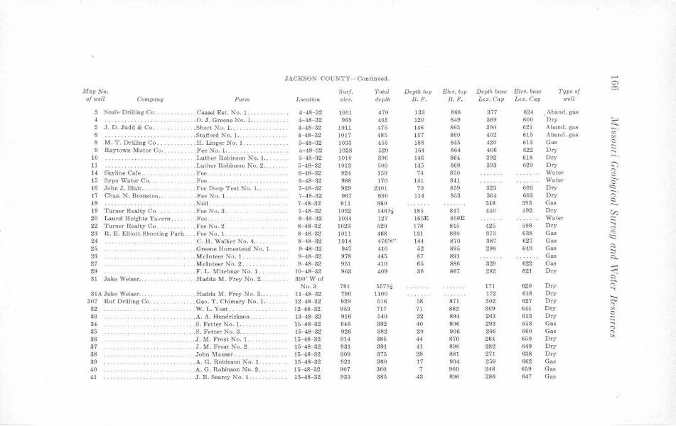
JACKSON COUNTY- Continued. ..... O>
MapNo. Surf. Total Depth top Elev. top Depth ba8e Elev. base Type of O>
of well Cornpcmy Farm Location e/tv. depth B.F. H.P. Lex. Cap Lex. Cap well
3 Scale Drilling Co . . . . . Cassel Est. No. 1. ... 4-48-32 1001 470 133 868 377 624 Aband. gas 4 .............. . .. .. .. 0. J. Greene No. 1. .. 4-48-32 969 465 120 849 369 600 Dry ~ 5 J. D. Judd & Co ..... ... Short No. 1. .. 4-48- 32 1011 475 146 865 390 621 Aband. gas 6 .. Stafford No. 1. .. ... . . 4- 48-32 1017 485 157 860 402 615 Aband. gas
~-"' 8 M. T. Drilling Co .. .... H. Linger No. 1. ... . . 5-48-32 1033 455 188 845 420 613 Gas 0
9 Raytown Motor Co . . .. . . FceNo.1. . . . . b-48- 32 1028 520 164 864 406 622 Dry t:: ..., 10 .......... Lu~her Robinson No. 1. .. ... . 5- 48- 32 1010 396 )46 864 392 618 Dry ~. 11 ... Luther Robinson No. 2 ... . 5-48-32 1013 500 145 868 893 620 Dry <;')
14 Skyline Cale ... . .. . Fee . . 6-48-32 924 150 74 850 Water '"" 0 15 Sypo Water Co .. .Fee .. . .. ......... . . . . 6- 48-32 988 170 141 841 Water c 16 John J. Blair . . .. . .. Fee Deep Test No. 1. .. 7-48-32 929 2401 70 859 323 606 Dry ~
17 Chas. N. Bronston . . . . .. Fee No. l. 7-48-32 967 660 114 853 364 603 Dry ;::;· 18 . Noll .. . 7- 48- 32 911 360 318 593 Gas
s:) ........ . ... -.. 19 'l'urner Realty Co .. .. ... Fee No. 3 . 7- 48- 32 1032 546~ 185 847 440 592 Dry V) 20 Laurel Heights T avern .. . . .. Fee . . .. ... . 8-48-32 1034 127 165E 859E Water :::; 22 Turner Realty Co. .FeeNo.2 . 8-48-32 1023 520 178 845 425 598 Dry <:::: 23 R. E . Elliott Shooting Park . . . . Fee No. 1. . ·· ·· · ··· · ·· · 8- 48- 32 1011 468 131 880 373 638 Gas <'>
<c:: 24 .. .. .. . ... .. .. . . .C.H. Walker :-.fo. 4 . . .. 8-48--32 1014 4761811 144 870 387 627 Gas 25 ... . .. G reene Homestead No. 1 . . . 9-48-32 947 410 52 895 298 649 Gas
i:::) ;::,
26 · ··· · ·· ·· ·· · . . Mc!nteer No. 1 ........ . ... . . 9-48- 32 978 445 87 891 Gas ~ 27 · ·· ·· ······· . Meluteer No. 2 ....... . 9-48-32 95) 410 65 886 829 622 Gas 29 . ... .. F. L. Mitchner No. l .. . . 10-48-32 903 409 86 867 282 621 Dry ~ 31 Jake Weiser .. . . .. Hadda M. F rey No. 2 ... . .. . . . 300' Wof ~
No. 3 791 557)1 171 620 Dry <'> ..., 3JA Jake Weiser .... ... .Hadda M. Frey No. 3 .. . ...... 11-48- 32 790 1100 172 618 D ry
~ 307 Ruf Drilling Co . . . . . ... Geo . T. Chima ry No. 1. . . . 12-48- 32 929 516 58 871 302 627 Dry <'>
32 . W. L. Yost . .. . . 12-48-32 953 717 71 882 309 644 Dry "' 33 . .. A. A. Hendrickson . . . . ...... . 18- 48- 32 916 540 22 894 263 653 D ry 0
···· ··· ·· ·· ·· ·· ··· t:: 34 .. S. Fetter No. J ... . .. 16-48-32 946 392 40 906 293 653 Gas ..., 35 ... . S . Fetter No. 3 ..... . 15-48-32 926 382 20 906 266 660 Gas
n ··· · ··· ·· ·· · ·· · ··· · ··· · · <'>
36 ... .. . .. J.M. Frost No. 1 .... ... 15-48- 32 914 385 44 870 264 650 Dry "" · ·· ··· · ···· ·· ·· ·· · ·· 37 .. .. .. .. .. . . J . M . Frost No. 2 ... 15-48-32 931 391 41 890 282 649 Dry 38 .. . . . . . . .. .. . . .. . .. .. ... . .. .. John Mauser .. . . .... 15-48- 32 909 375 28 881 271 638 Dry
39 · · · ··· ·· ·· ·· · .. . A.G. Robinson No. 1. .... .. . 15- 48- 32 921 360 17 904 259 662 Gas 40 ... A.G. Robinson No. 2 . 15-48-32 907 360 7 900 248 659 Gas 41 . .. .. .. ... . .. .. . J.B. Searcy No. l. 15-48-32 938 385 43 890 286 647 Gas
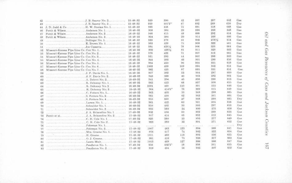
42 ... J.B. Searcy No. 2 .... . 15-48-32 939 890 42 897 287 652 Gas 43 · ·· · · ··· ·· ·· .. .. . J.B. Searcy No. 3 ..... 15-48- 32 939 401'2" 47 892 289 650 Ory
44 J. D. Judd & Co .. . ... H. W. Storms No. 1. .. .... 15-48-32 966 448 75 891 318 648 Gas 46 Pettit & Wilson .. . . ... Anderson No. 1. ..... . 16-48-32 916 384 20 896 268 648 Gas 47 Pettit & Wilson. . ... Anderson No. 2. 16-48-32 946 415 48 898 292 654 Gas 0 48 Pettit & Wilson . . . . . ... Anderson No. 3 .. . ... . .... . 16-48-32 934 384 20 914 268 666 Gas -· ..._ 49 . .. . Bollinger No. 1. .. 16-48- 32 933 379 31 902 279)1 654 Gas ~
50 ............ E. Brown No. 1. .. . 16- 18- 32 983 426 75 908 322 661 Gas :::l
51 .. Joe Cassetta ... 16-48-32 984 429 )-4 78 906 320 664 Gas ~
52 M issouri-Kansas Pipe Line Co. Cox No. 1. . ........ 16-48- 32 992 428)-4 81 911 329 663 Gas C')
53 Missouri-Kansas Pipe Line Co . Cox No. 2 . ... 16- ,18- 32 978 422 71 907 313 665 Gas C
"' 54 M issouri-Kansas Pipe Line Co .Cox No. 3. ·········· 16-48-32 951 393 44 907 288 663 Gas
55 Missouri-Kansas Pipe Line Co. Col< No. 4 ... . ...... 16-48- 32 944 393 43 901 288 656 Gas >.:i 56 Missouri-Kansas Pipe Line Co. Cox No. 5 ... . 16-48- 32 994 450 90 904 335 659 Gas "" "' 57 Missouri-Kansas Pipe Line Co . Cox No. 6 ... 16-48-32 1003 459 109 894 352 651 Gas C .. .. .. ... .. i::: 58 Missouri-Kansas Pipe Line Co. Cox No. 7 .... 16-48- 32 982 435 87 895 331 651 Gas ..., fi9 .. .. . J . F. Davis No. 1 .. HH.8- 32 957 392 53 904 297 660 Gas
C"> ,.,, 60 .. ... . J. F. Davis No. 2 ... 16-48-32 943 388 40 903 282 661 Gas "' ··· ··········· · 62 ... A. Debrot No. 2 .... .. .. .. .. 16-48- 32 941 394 45 896 288 653 Gas <2, 63 . .. ................... . R. Dehoney No. 1 ... 16- 48- 32 963 413 66 897 308 655 Gas (") 64 ··· · ···· · ··· · ··· · ·· ·· · ... . R. Dehoncy No. 2 .. 16-48-32 1001 460 110 891 355 646 Gas Q
65 . .. k. Dehoney No. 8 . . . . 16-48- 82 964 414'6" 75 889 815 649 Gas "' "' 66 ·· ·· ·· ·· · ·· ·· · ... C. Fetters No. 1. . ... 16- 48- 32 963 405 55 908 298 665 Gas 67 .. .. ... S. Fetters No. 2 ..... 16-48-32 965 400 62 903 801 664 Gas
Q
:::l 68 ······ · ··· · .. S. Fetters No. 4 . . .. . 16-48- 32 955 660 47 908 290 665 Dry ~
69 ··········· · · ... Larson No. 1 .... . . .. 16-48- 32 961 412 60 901 305 656 Gas ~ 70 . . .. Schneider No. 1. .. . 16-48-32 950 403 50 900 297 653 Gas Q
71 .. .... . Schneider No . 2 .... . 16-48- 82 933 380 34 899 275 658 Gas C"> :,,;-
72 ... J. A. Brizendine No. 1. 17- 48-32 952 404 60 892 299 653 Gas "' 73 Pettit et al. . ... J. A. Brizendine No. 2 .... 17-48-32 957 414 65 892 312 645 Gas
0 :::l
74. .. ... C.H. Cole No. 1.. 17-48- 32 926 380 38 sn 277 649 Gas
75 .. .. . .. . .. .. ............ .... C.H. Cole No. 2. 17- 48-32 923 380 32 891 271 652 Gas (") C
76 · ········ · . ... Fehrman No. 1. .. . .. .. .. .. . Dry i::: 77 .. ... Fehrman No. 2 ...... 17- 48- 32 1007 463 123 884 366 641 Gas ~ 78 .. . . . .. . .. . .. ..... .. ..... Mrs. Greene No. 1. . . 17- 48--32 976 417 74 902 322 654 Gas ~· 79 . .. II. Greene ............ 17-48-32 1011 460 118 893 356 655 Gas "' 80 . .. . 0. J. Greene .. 17- 48- 32 981 416 75 906 817 664 Gas
81 ··········· ... . Laura i\iluir .. 17-48-32 1018 469 127 886 366 647 Gas
82 ..... Pendleton No. 1 ....... 17-48- 82 956 402'4'· 58 898 301 655 Gas ,__ 0)
83 .. ... Pendleton No. 2 ... . ... . . . .. . . 17- 48- 32 959 404 56 903 307 652 Gas "
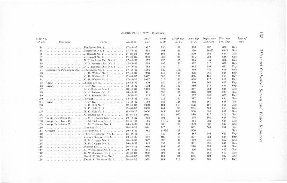
JACKSON COUNTY-Continued. 0:,
Map No. Surf . Tota! Depth top Elev. wp Depth base Elev. base Type of 00
of well Company Farm Location elev. depU. B. 1". B.1". L ex. Cap L ex. Cap well
84 . ... ... , . ... .. . ... . .. ... . ... Pendleton No. 3 . . .. . .. .. . ... . 17-48-32 937 390 39 898 285 652 Gas 85 .. .. . ....... .. . .. .. . ... .. .. . Pendleton No. 4 .. ..... • . .. .. . 17-48-32 945 404 55 890 301E 644E Gas ~ 86 .. . . . , . .. .. . ... • ...... ... . .. J. Russell No. 2 . . .... . .. . ... . 17-48- 32 939 403 49 890 295 644 Gas 87 . ... . ... . ... . .......... . ... . J. Russell No. 3 . .. .. .. .... . . . 17-48-32 930 386 36 894 282 648 Gas
;;· "' 88 . . ... .. ....... .. . . •.. .. ... .. N. J. Sechrest Est. No. 1. . . 17-48-32 972 425 97 875 347 625 Gas 0
89 .. ... . N . J. Sechrest Est . No. 2 .. ... . 17-48-32 953 409 71 882 315 638 Gas s::: ···· · ·· · · ··· · ...,
90 . . . ... .. ... .... . ... ... . ... .. N. J. Sechrest Est. No. 4 . 17- 48-32 983 435 101 882 Sal 632 Dry -. 91 Cooperative Petroleum Co .. .. . Stevenson No. 1. . . .. . . . . . . ... 17- 48- 32 1001 437 102 899 342 659 Gas C""l 92 .. ... C.H. Walker No. I. .. . . . . ... . 17- 48- 32 988 446 110 878 360 628 Dry <"'>
. . . . . . . . . . . . . . . . . . . . . . 0
93 · · · · · ··· · ·· ··· ······· · ··· . .. C.H. Walker No. 2 .. .. . .... . . 17-48- 32 1017 500 166 865 401 616 Dry 0 94. · ·· ·· ······ ·· ·· .. .. . ... . ... . C.H. Walker No. 3 .... . . . .• .. 17-48- 32 1027 515 162 865 412 615 Dry ~ --95 Ragan .. . . . .. , ............. . Eestes No. 3 .. .. · · · · · · · · ·· · 18-48- 82 970 450 110 860 365 605 Dry (")
96 Ragan ... .. . . •.. . .......•.. .. Estes No. 4 . .. . .. .. ... .. .. .. . 18- 48- 32 1012 469 132 880 376 636 Dry ,:::)
97 . . ... ... . .. ... .. .•.... .. ... . N. J. Sechrest No. 1 .. . ..• .. . . 18- 48- 82 1010 500 123 887 384 626 Gas V) 98 . .... . .. ... .. ........... . . . N. J. Sechrest No. 2 . .. . ... . .. 18-48- 32 911 390 35 876 282 629 Gas s::: 99 .. . N. J. Sechrest No. 3 . .. . ... ... 18- 48- 32 878 346 6 872 251 627 Dry
..., · · · · · · ··· ······· · ·· · <::::
100 . ... . ... . .. ... . .. . .. . .. .... . Bryant . . . ....... . 18-48- 32 1041 512 )54 887 898 64:J Gas "" 101 Ragan. . . .... Estes No. I . .. . 19-48- 32 1008 463 116 892 360 648 Gas er:: .. . .. ... . .. ··· · · ··· ·· · 103 . .. . ... . .. . ...•.. .. .•..... . . E. E. Hall No. 1 . . ... . ..• . .. . 19- 48- 32 1002 463 110 892 a57 645 Gas I:)
:::, 104 ... ... . .... . .. . ... .. . . ... .. . E . E . Hall No. 2 . .. .. . . . .. .... 19-4R- 32 1008 454 99 904 350 653 Gas ~ 105 . ... .. .. . .. . .... . E. E. Hall No. 3 . . .. . .. . . . . . . 19-48- 82 1006 449 106 900 355 651 Gas
~ 106 .. ... . ... .. . .. . ... . . . ... G. Ragan No. 6 .. . .. ... . . • . .. 19-48- 32 1040 504 160 880 412 628 Gas 107 Co-op. Petroleum Co . . . .. ... .. L. M. Dehoney No. 1. .. . . ... . 20-48- 32 938 391 43 895 290 64.8 Gas ~ 108 Co-op. Petroleum Co . . . .. .. . .. L. M. Dehoney No. 2 . . .. .. . . . 20-48- 32 966 4187S 72 894 322 644 Gas "' ..., 109 Co-op. Petroleum Co . . . .. . .... L . M. Dehoney No. 3 . . . . .. . . . 20--48-32 980 680 90 8!)0 338 642 Gas
~ 110 ... , ... , . ... . .. .. ... , .. , ... , Duncan No. 2 .. . .... . .. . . .. .. 20-48- 32 894 847 8 891 240 654 Gas <"'> 111 Grogg er . . ... .. .. . . . ... .. . ... Beverly No. 1. .. . .. .. . .. •. .. . 20-48- 32 962 259~ 12 850 Gas "' 112 . .. .. ... .. .•. . .... . . . ... . ... Florence Grogger No. 1. .. . . 20- 48- 32 910 410 46 868 293 621 Dry 0
C: 113 ······ ·· ··· ···· ··· ···· . ..... George Grogger No. 1. . . . ... •• 20-48- 32 947 425 70 877 322 625 Dry ...,
(")
114 ... F. n. Grogger No. l. . . ... . .. . 20- 48- 32 927 520 18 909 265 662 Gas <"'>
115 . ... . . F. B . Grogger No. 2 .. ... 20- 48- 32 943 898 52 891 298 645 Gas "' ··· · ···· · ··· · ··· ······ 116 ·· ·· ··· ·· ·· ··· · ·· ·· · ·· · · . ... Rhodes No. 1. · · ·· ······ ··· · · 20-48- 32 936 398 46 890 295 641 Gas 117 · ····· ·· ··· .... ... . ... . G. W. Sechrest No. 1. .... . ... 20-48- 32 945 394 49 896 292 653 Gas 118 .. . .. . ........ . ...... .. .. ... G. W. Sechrest No. 2 ... .. . . .. 20-48- 32 938 399 41 897 285 653 Gas 119 ···· ··· ···· ·· ·· · . ..• . .. , ... . Frank X. Wachter No. 1 . . .. .. 20-48- 32 969 430 84 885 332 637 Gas 120 . .... . ... . ······ · ·· ···· ... Frank X. Wachter No. 2 ...... 20-48- 32 993 465 119 884 864 629 Dry
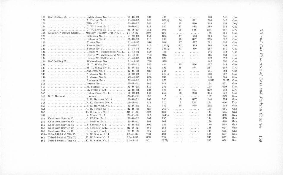
121 Ruf Drilling Co . . . . ... . . . . . . . Ralph Byrne No. 1 ... 21- 48-32 801 425 15a 648 Gas 122 . ... A. Debrot No. 1 ... ····· · · ··· 21-48-32 911 366~ 20 891 266 645 Gas 123 ..... Ellison No. 1. .•.. 21- 48-32 943 415 63 880 809 684 Dry 121 ·· ········ .... C. W. Erwin No. 1. 2t-48-32 922 380 37 885 289 633 Gas 125 ··············· .. ... C. W. Erwin No. 2 ... .. 21-48-32 981 405 48 888 294 637 Dry 0 126 Missouri National Guard . ... . Military Country Club No. 1 .. 21- 48- 82 840 296 186 654 Gas -. ...... 127 ······ · ·· ·· · .. ........ . . . . Robinson No. 1. . . 21-48-32 950 865 47 903 294 656 Gas .:)
128 ·· · ···· · · · ·· · ·· · ··· · ·· · . .. .. Robinson No. 2 .. . 21- 48- 32 910 864 13 897 255 655 Gas :.::i 129 . .. . Turner No. 1. .... 21-48- 32 946 396 47 897 291 653 Gas i::i..
ISO ··· ······· ·· · ··· · ········· .. Turner No. 2 ...... 21-48-32 911 360~ 112 899 260 651 Ga.s <:;) 131 ... . Turner No. 3 ......... 21-48-32 917 363~ 21 896 267 650 Gas ,::i
c,, 132 ... George W. Walkenhorst No. l.. 21-48- 32 800 155 146 654 Gas
~ 133 .... George W. Walkenhorst No. 2 . . 21-48- 32 796 245 185 661 Gas "' 134 ······ ·· ··············· . . George W. Walkenhorst No. 3 .. 21-48-82 805 259 132 673 Gas c,,
185 Ruf Drilling Co. .. . Walkenhorst No. 1 .. . . .. . 21-48-32 798 388 142 656 Gas 0 .:::
136 .. .. . .... .. .. . . ... M. T. WbiteNo.1. 21- 48- 32 945 400 49 896 297 648 Gas ...., 137 .... M. T. White No. 2 ...... . ... . 21-48-32 932 403 38 894 287 645 Dry
(")
<"> 138 . . .. Anderson No. 1. 22-48-32 823 245 141 682 Gas
c,, ·· · ··· ·· ·· ··· ····
139 ······ · ··· · .. . .. . .... . .. . ... Anderson No. 2 . . .. .. . . .. .. .. 22-48- 32 810 2703'2 143 667 Gas ~ 140 . Anderson No. 3 . .. . ........ 22- 48- 82 800 246 186 664 Gas
(j 141 . .. .. ................ . ...... Anderson No. 4 .... 22-48-32 826 273 145E 681E Gas ,::i 213 ·········· .. ... Burton No. 1 .. . ·· ·· · · · · ··· · 22-48-32 805 243 134 671 Gas c,,
c,, 143 ... M. Petters .. 22- 48- 32 815 285 165 650 Dry 144 ... M. Fetter No. 2. 22-48-32 938 896 47 891 290 648 Dry ,::i
:::, 145 ··· · ·· ·· ·· ·· ·· ·· .. Goldie Frost No. 1 .. . 22-48-32 941 555 88 908 294 657 Gas i::i.. 146 B. F . Hammel . . .. . Hammel.. 22- 48- 32 886 187 649 Gas I:..., 147 ... . . .. . . . . . . .. F. K. Harrison No. l .... .. .. . 22-48- 32 902 345 5 897 246 656 Gas ,::i
148 ............ F. K. Harrison No. 3 .. 22-48-32 917 370 6 911 261 656 Dry (")
;,,;-150 . . F. K. Harrison No. 5 ... 22-48-32 910 865 15 895 262 648 Gas c,,
151 .. . C. B. Lorenz No. 1. .......... 22- 48- 82 829 269% 165 664 Gas 0 ··· · · ·· ·· · ····· · ·· ····· ·· :::,
152 ... C. B. Lorenz No. 2 ... . 22-48-32 809 258 144 665 Gas 153 ······ · ··· · ··· ······ ·· · .. A. Meyer No. 1. . . .. . 22-48-32 802 254~ 140 662 Gas (j
0 154 Knobtown Service Co .. . .. .. C. Pfeiffer No. 1.. .... 22- 48- 82 807 255 144 663 Gas .::: 155 Knobtown Service Co . . .. .. C. Pfeiffer No. 2 ... 22-48-32 804 269 186 668 Gas :::,
Knohtown Service Co . . . .. . . . . E. Schock No. 1. . . 22-48- 32 805 257 140 665 Gas .....
157 ;;· 158 Knobtown Service Co ... . ... E. Schock No. 2 .. ·· ·· ······· · 22-48--32 805 253 138 667 Gas c,,
159 Knobtown Service Co .... .. .. . E. Schock No. 8 .... . .. .. . 22-48-32 807 255 144 668 Gas 159A United Brick & Tile Co . . . . . . . E.W. Simon No. 1. 22-48-32 798 408 141 657 Gas 160 United Brick & Tile Co ... . . .. E.W. Simon No. 2 .. 22-48-32 803 233 136 667 Gas .....
0) 161 U nited Brick & Tile Co . ... ... E.W. Simon No. 3 . .. .. .... .. 22-48-32 801 227~ 135 666 Gas ~
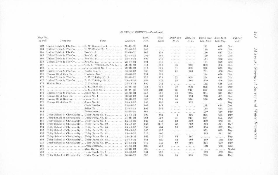
JACKSON COUNTY-Continued. ...... -..J
Map No. Surf. Total Depth top Ekv. top Depth base Elev. ba$e Type of C
of well Company Far1n Location elev. depth B . F. B.P. Lex. Cap Lex. Cap wetl
162 United Brick & T ile Co . . . . . . . E . W. Simon No. 4. ........ .. 22-48- 32 806 141 665 Gas 163 United Brick & Tile Co. . ... E.W. Simon No. 5 .... 22-48- 32 803 145 658 Gas ~ 164 United Brick & Tile Co . ...... FeeNo.3 . 22-48-32 807 250 140 667 Gas 165 United Brick & Tile Co ....... Fee No. 18 ...... . .. .. .... . .. 22- 48- 32 793 380 129 664 Gas
,;;· "' 166 United Brick & Tile Co ....... F'ee No. 14 . . 22-48- 32 806 247 144 662 Gas 0
283 United Brick & Tile Co ....... Fee No. 2 ..... 22-48-32 804 841 134 670 Gas s:::: ....,
167 .................. Geo. E. Walleck, Jr. No. 1. .... 22- 48-32 943 300 38 910 300 686 Gas -. 168 . .. . J. J. DeGroff No. 1 .. . 23- 48 82 913 385 31 882 280 633 Dry C'"}
169 United Brick & Tile Co ....... Englar No . 1. . .. 23-48-32 989 520 31 908 281 658 Gas <":> 0
170 Kansas Oil & Gas Co ..... .. .. Hartman No. 1. . . 23·-48-32 794 225 144 650 Gas 0 171 United Brick & Tile Co ...... . B. F. Holliday No. 1.. 28- 48- 32 927 370 22 905 274 653 Gas ~
172 Uni~ed Brick & Tile Co . ... ... B. F. Holliday No. 2. 23-48-32 926 372 26 900 270 656 Gas ;:;· 173 Skidler Bros .. .. ....... .. .. . . C. Holliday . . . . 23-48-32 800 242 142 658 Gas ~ -. 174 ......... T. E. Jones No. l. 23-48- 32 932 613 30 902 272 660 Dry V) 175 . . . T . E. Jones No. 2 .. 23- 48-32 948 442 33 915 279 669 Gas s:::: 176 Unite<! Brick & Tile Co ... . .. . Jones No. 1. 23-48-32 955 381 40 915 284. 671 Dry
...., <:::
177 Kansas Oil & Gas Co. . ..... Jones No. l. 23-48-32 954 383 36 918 273 681 Gas "" 178 Kansas Oil & Gas Co . . . . . . . . . Jones No. 2 ..... 23-48- 32 956 384 40 916 280 676 Gas
SC:
179 Kansas Oil & Gas Co .... ... . Jones No. 3 ... 23-48-32 942 130 40 902 Dry ::::i :::,
180 ... Chris Pfeiffer . · ·· · · ··· ··· 23-48- 32 802 246 148 654 Gas i::i.. 183 .... . Seiler No. l. . . .. 23-48- 32 802 252 148 654 Gas :s:: 184. ......... . Zimmerman ... 23-48-32 805 159 646 Dry ,,.
187 Unity School of Christianity ... Unity Farm No. 44 . 24-48-32 900 461 4 896 265 635 Dry ~ -188 Unity School of Christianity . .. Unity Farm No. 45 .... 2-i - 48- 32 962 520 51 911 307 655 Dry "" ...., 189 Unity School of Christianity ... Unity Fa rm No. 1 . . . 25-48-32 967 445 68 899 309 658 Oil
;::lj 192 Unity School of Christianity .. . Unity Farm No. 12 ....•. .. . 25-48-32 950 1510 68 882 309 641 Dry <'>
194 Unity School of Christianity .. . Unity Farm No. 40 . . 25- 48-32 952 434 50 902 380 622 Dry "' 195 Unity School of Christianity . .. Unity Farm No. 41 .. 25-48-32 965 435 332 633 Dry 0
s:::: 196 Unity School of Christianity ... Unity Farm No. 42 . . 25-48-32 913 400 303 611 Oil ...,
r, 197 Un ity School of Christianity ... Unity Farm No. 43 25- 18-32 962 235 55 907 Dry <'> 198 Unity School or Christianity . . . Unity Farm No. 48. 25-48-32 96] 520 52 909 309 652 Dry "' 310 Unity School of Christianity ... Unity Farm No. 49 . 25-48-32 975 515 69 906 305 670 Dry 199 ...... . ................. . ... Dean Borman . . .. . .. .. .. .... . 26- 48- 32 820 253 162 658 Gas 200 . .......... .. . Mrs. Davis . 26-48-·32 938 Water 203 . . . . . . . . . . . . . . . . . . . . . . . . . . . . R. A. Posch No. 2 . .. . 26-48-32 861 290 199 662 Gas 205 Unity School of Christianity ... Unity Farm No. 36 . . . 26-48- 32 935 364 20 915 265 670 Dry
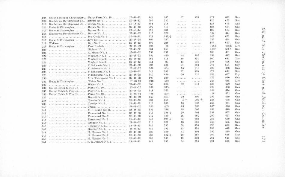
208 Unity School ol Christianity ... Unity Farm No. 39 ........... 26-48- 32 940 385 27 913 271 669 Gas
209 Knobtown Development Co . . . . Brown No. 1. .. ... ........... 27-48-32 795 235 120 675 Gas 210 Knobtown Development Co . .. Brown No. 2 ... .. . ... .... • ... 27-48- 32 804 248 129 675 Gas
211 Hulse & Christopher . . ... . .. Brown No. 3 •...... . . •. . •.. .. 27-48-32 797 410 123 674 Gas
212 Hulse & Christopher ... ... .. .. Brown No. 4 .. ..... ·· ·· ··· ·· · 27-48-32 810 361 135 670 Gas 0 -. 214 Knobtown Development Co ... Burton No. 2 . .... .. ..•.. . 27-48-32 816 259 142 674 Gas ..... 215 ·· · ·· ·················· .. . . . Joel Cook No. 1. ... . . . .•... . . 27- 48- 82 913 356~ 242 671 Gas ~
217 Hulse & Christopher .. . . ..... . Dye No. 1. . . . .. . 27-4-8-32 801 387 137 664 Gas :::i i::,_
218 Wallace .... .. ........ .. . ... . Dye No. 1. . . . .. .. .. .. . ..... . 27-48-32 807 226 157 650 Dry
219 H ulsc & Christopher . . ...... Paul Eveleth ... .. . . .. . .. . . ... 27-48- 82 794 86 156E 638E Dry :;.,
220 . .. ... .. Gleisner No. 1. ..... . . 27-4-8- 32 901 352 245E 656E Gas i:::i
"' 221 .. .. .. A. Meyer No. 2 . .. .. .. ..•. ... 27-48-32 791 241 130 661 Gas
~ 222 ..... .......... ........ . . Muglach No. 1. 27-48- 32 931 410 44 887 289 642 Gas "" 223 ·· ·· ·· ·· ·· ··· .. Muglach No. 2 ... . . . . . . . . . . . . 27- 48-32 964 415 50 914 300 664 Gas "' C 224 ... .. .. . Muglach No. 3 .. .. . ·· · ·· ·· ··· 27-48-32 951 27 15 936 268 676 Gas c:: 226 ... F. Schwartz No. 1. .. . 27-48- 82 925 395 21 904 272 653 Dry
...., · · ··· · · ······ · ·· · · ·· ····· <">
227 . ... F. Schwartz No. 2 ....... 27- 48-32 960 404 50 910 297 663 Gas ,.,, "' 228 .. . F. Schwartz No. 3 ... . . ....... 27-4-8-32 942 393 27 915 278 664 Gas
229 . .. . F. Schwartz No. 4 .... ... ..... 27- 48- 32 940 630 30 910 283 657 Dry ~ 230 ·········· . .. Mrs. T horogood No. 1 .. . ... .. 27- 48-32 807 240 177 630 Gas ("') 231 Hulse & Christopher ... .. .. Weber No. \ . ·············· 27-48-32 912 540 244 668 Dry s::,
2a2 . . Weber No. 2 . 27-48-82 950 395 39 911 280 670 Gas "' · ·· ····· ···· ····· ··· ·· ·· ·· · ··· · ·· "' 284 United Brick & Tile Co ... . .. . P lantNo.10 . 27-48- 32 938 375 272 666 Gas s::, 235 United Brick & Tile Co. .. Plan t No. 11 . ···· ···· ·· ·· ·· ·· 27-4-8-32 918 332 244 674 Gas :::i 236 United Brick & Tile Co .. . ... . P lant No. 12. ················ 27-48- 82 788 235 116 672 Gas i::,_
237 . ... ... . .. .. .. . . . Barnett No. 1. . 28- 48-82 949 391 50 899 290 659 Gas c..... 238 ·· ··· · ·· ·· · ·· . . Cowden ~o. l. . .. . . .. . .... . . 28-48-32 904 350 4 ± 900 ± 246 658 Gas s::,
<"> 239 · ·· ·· ···· ······ · · ·· .. Cowden No. 2 ... ... . .... . .. 28-48-32 915 363 10 905 254 661 Gas ;,,;-
240 .. Crane . .... 28-48- 32 953 409 65 888 307 646 Gas "' · ·· ·· ······· · ·· ·· ·· ··· C 241 · · ·· · ···· · · ·· ·· · · . . M. I . Daub No. 2. ·· ······· · 28-48-32 931 386 28 903 286 645 Gas ::::i
242 ··· ·· ···· · · · · ·· ···· · ·· ·· ·· . Emmanuel No. 1 .. . .. .. .. 28- 48- 82 943 396,!1 39 904 291 652 Gas ("') 243 ·· · · ·· ·· · ··· .Emmanuel No. 2 ..... . 28- 48- 32 947 400 46 901 290 657 Gas C
244 ·· · ·· · ·· ·· ······ · . . Emmanuel No. 3 . .. .•... . ... 28-48-32 943 393~ 35 908 283 660 Gas c:: 245 .. ... . .. •... .. .. . Grogger No. 1. .... .. .. . . 28- 48-32 918 361 18 900 263 655 Gas :::i .. .. .. .. .. -246 ................ . Grogger No. 2 .. . ....... . . . .. . 28- 48-32 940 390 50 890 290 650 Gas ;:;· 247 . .. ... . Grogger No. 3 ... 28-48-32 937 392 43 894 289 648 Gas "' ·· ···· ·· ···· · ·· · ·· · · · 248 ·· · ··· · ·· ·· .... • . ...... . . .. . N. Hansen No. 1. . .. . . 28-48- 82 935 399 41 894 290 445 Gas
249 . . . . . . . . . . . .. N. Hansen No. 2 . .. ....... . .. 28-48-32 935 392)1 48 887 299 636 Dry
250 ... N. Hansen No. 3 .... 28-48-32 906 366 13 893 261 645 Gas ......
·· · ···· ···· ······ ·· ·· -..:i 251 ·· ··· ·· ······ ········ ... . S . E. Jerrard No. 1 . . .. . .. . .. . 28- 48- 32 949 395 54 895 294 655 Gas -"
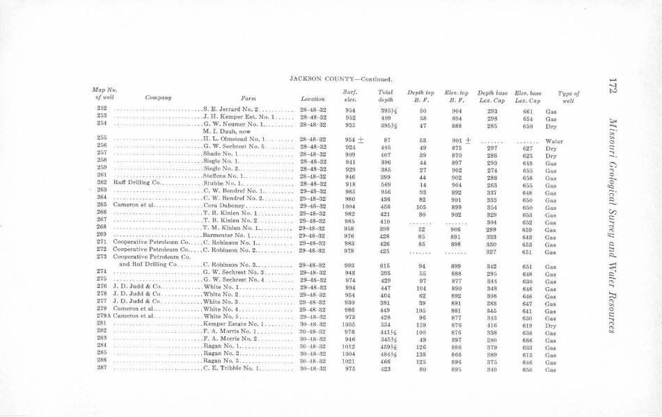
JACKSON COUNTY-Continued. ..... -..J
Map No. Surf. Total Depth top Eleo. top Dep/J1 ba.e Elev. base Type of I:" of well Company Farin Locatwn eleo. dep/J1 B.F . B . F. Lex. Cap Lex. Cap well 252 . . . . . S. E. Jerrard No. 2 ...... . 28- 48- 32 954 395)1 50 904 293 661 Gas 253 .... . ........ . . .. ... J. H. Kemper Est. No. 1 ...... 28-48-82 952 409 58 894 298 654 Gas
~ 254 .. .. . .. ... . . . . . . G . W. Neumer No. 1. ......... 28-48-32 935 395)1 47 888 285 650 Dry M. I . Daub, now ,;;·
"' 255 ... H. L. Olmstead No. 1. . 28-48-32 954 ± 87 63 901 ± Water 0 256 . ········· · .... G. W. Sechrest No. 5 . 28-48-32 924 405 49 875 297 627 Dry t::: ...., 257 .. . .. Shade No. 1 .. . .. 28-48- 32 909 407 39 870 286 623 Dry -. 258 ·· · ·· ·· · ·· .. . .. SiegleNo.1 ....... 28-48--32 941 396 44 897 298 648 Gas ~ 259 . . .... Siegle No. 2 .. . 28-48-32 929 385 27 902 274 655 Gas ~ 0 261 . .. .. .. .. ... Steffens No. 1. . . . . . . . . . . . . . . . 28-48-32 946 399 44 902 288 658 Gas ...... 0 262 Ruff Drilling Co . . ..... . ... ... Stubbs No. 1. ..... 28-48- 82 918 569 14 904 268 655 Gas <c:,
263 .. ... C. W. Bend ref No. 1. ... 29-48-32 985 956 93 892 387 648 Gas -. ("> 264 ··········· .... C. W. Bend ref No. 2 .. 29- 48-32 980 436 82 901 333 650 Gas ~ ...... 265 Cameron et al. .. . . .... Cora Daboney . ... . 29-48-82 1004 456 105 899 854 650 Gas V) 266 ..... T. B. Ki nlen No. 1 .. .. 29-48- 82 982 421 80 902 329 653 Gas t::: 267 ··· ·· ········ ... T. B. Kinlen No. 2 . .... ... ... 29-48-32 985 410 304 652 Gas ....,
<:::: 268 .... T. M. Kinlen No. 1. . 29-48-82 958 398 52 906 299 659 Gas ~ 269 ..... Barmenter No. 1 ... 29-48-32 976 428 85 891 333 643 Gas
(C ····················· 271 Cooperative Petroleum Co .... . C. Robinson No. 1. . .. . . 29-48-32 983 426 85 898 330 653 Gas ~ 272 Cooperative Petroleu m Co . . , . . C. Robinson No. 2 ... 29-48-32 978 425 827 651 Gas
::, R. 273 Cooperative Petroleum Co.
and Ruf Drilling Co . ... . ... C. Robinson No. 3 ... 29-48-32 998 615 94 899 342 651 Gas ~ 274 ·· ·· ·········· · · . . ... G. W. Sechrest No. 3. 29-48-32 943 395 55 888 295 648 Gas 275 . . . . . . . . . . . . . . . . . .... ... G. W. Sechrest No. 4 . 29-48- 32 974 429 97 877 344 630 Gas ~ ...., 276 J. D. Judd & Co .. . .. .. . . . White No. 1 . . . ·· ·· ·· ·· ··· 29-48-32 994 447 104 890 348 646 Gas
~ 278 J. D. Judd & Co . .. ..... White No. 2 . ... . .. . . . . . ... .. 29-48- 32 954 404 62 892 308 646 Gas ~ 277 J. D. Judd & Co. ......... . . . White No. 3 . ... . . . 29-48- 82 930 381 39 891 283 647 Gas "' 279 Cameron et al. . . . ......... White No. 4 .. 29-48-32 986 449 105 881 345 641 Gas 0 ··············· i::: 279A Cameron et al. . ..... White No. 5 . . . ... . ... . ... 29-48- 32 973 ·128 96 877 843 630 Gas ...,
281 .... Kemper Estate No. I .... .. . .. 30- 48-32 1035 534 159 876 416 619 Dry ("> ~ 282 . ... F. A. Morris No. 1 .. 30- 48-32 976 441~ 100 876 888 638 Gas "' · ·············· ·
283 ... F. A. Morris No. 2 ... ... . .. . 30-48-32 946 345~ 49 897 280 666 Gas 284 .. . Ragan No. 1.. .... . 30-48- 32 1012 459~ 126 886 379 633 Gas 285 .. . .. .. .. .. . .. Ragan No. 2 ..... ... 30- 48- 32 1004 484)1 138 866 389 615 Gas 286 ... Ragan No. 3 ....... 30-48-32 1021 466 125 896 376 646 Gas 287 . . . ... .. .. C. E. Tribble No. 1 .. 30-48- 32 975 423 80 895 340 650 Gas
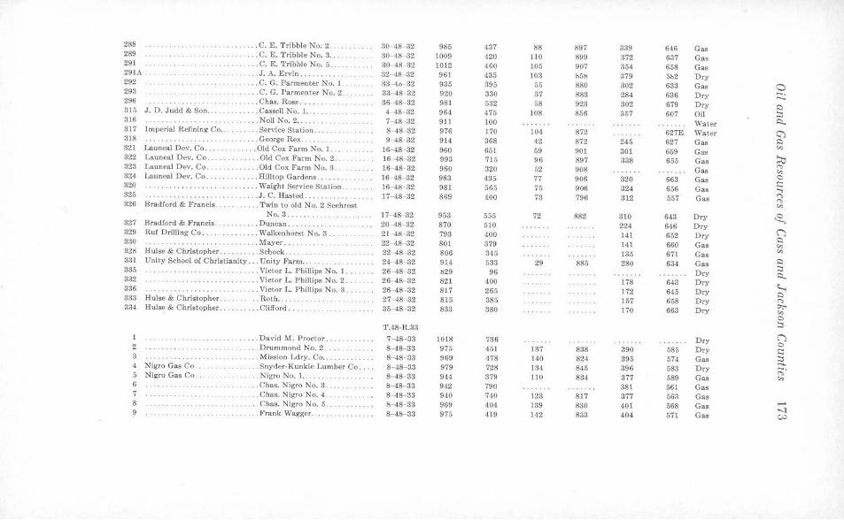
288 · ·· ·· ···· · · ·· ···· · ··· · . .. ... C. E. Tribble No. 2 .. . 30-48-32 985 437 88 897 339 646 Gas 289 ··········· · · · ... . C. E. Tribble No. 3 . . . ... 30- 48- 32 1009 420 110 899 372 637 Gas 291 . . .. ..... .. . C. E. Tribble No. 5. . . . . . . . . . . 30- 48- 32 1012 460 105 907 354 658 Gas 291A . . .... . ... . . . . . . . .. . . . ..... J. A. Ervin . .. .. .. .. . 32-48- 32 961 435 103 !15lS 379 5b2 Dry 292 ·· · · ·· ··· ·· . . . . . .. C. G. Parmenter No. 1 33- 40- 32 935 395 55 880 302 633 Gas 0 293 . .... ... . . C. G. Parmenter No. 2 . . 33-48- 32 920 330 37 883 284 636 Dry -. ...... 296 ······ · · · · · . . . . Chas. Ross ... . 36-48- 32 981 532 58 923 302 679 Ory 0 315 J. D. Judd & Son ... . ... .. Cassell No. 1. . 4- 48- 32 964 475 108 856 357 607 Oil :::, 316 ········· · ········· ····· ... Noll No. 2 .. .. . ... . 7-48- 32 911 100 Water l'::l.. 317 Imperial Refining Co . . . .. Service Station . . . . .. .. .. . .. .. 8- 48- 32 976 170 104 872 627E Water G) 318 ···· ··········· · · . . . . . George Rex ..... . . . . . . . . . . . . . 9- 48- 32 914 368 42 872 245 627 Gas 0 321 Launeal Dev. Co ... . . . . . . . . . . Old Cox Farm No. 1 .. ... . 16-48-32 960 651 59 901 659 Gas
,:,, 301
322 Launeal Dev. Co . .. . ... .. Old Cox Farm No. 2 . .... . .. .. 16- 48- 32 993 715 96 897 338 655 Gas ::ti 328 Launeal Dev. Co . ..... .. .. Old Cox Farm No. 3 . . 16- 48- 32 960 320 52 908 Gas "' ,:,, 324 Launeal Dev. Co ... .. ... . Hilltop Gardens., .... . 16- 48- 32 983 435 77 906 320 663 Gas 0
.::: 320 ······ ······ · ··· ·· ... Waight Service Station . 16-41:1-32 981 565 75 906 324 656 Gas ..... 325 ... J.C. Hasted .. .. .. 17--48-32 869 400 73 796 812 557 Gas
(") ....... .. ....... .. ······· · ··· "' 326 Bradford & Francis . .. ... . Twin to old No. 2 Sechrest ,:,,
No. 3 ... .. ... . 17- 48--32 953 555 72 882 310 6•13 Dry ~ 327 Bradford & Francis. ... . Duncan ...... .. . . . . 20-48- 32 870 510 224 646 Dry 329 Ruf Drilling Co .. . . . .. ... . . Walkenhorst No. 3 ... 21-41l- 32 793 400 141 652 Dry C")
0 330 ........ .. ' . . . . . . . . . .. Mayer .. . . ... . . 22- 48 32 80t 379 141 660 Gas ,:,, 32!l Hulse & Christopher . . . ... . . . . Schock. 22- 48- 32 806 345 135 671 Gas
,:,,
331 Unity School of Christianity ... U nity Farm .. 24- 48- 32 914 533 29 885 280 634 Gas 0 :::, 335 . ... Victor L. Phillips No. 1 .. 26-48- 32 IS29 96 Dry .:i... 332 .. ... .. Victor L. Fhillips No. 2. 26-48-32 821 400 178 643 Dry ~ 336 . . . . Victor L. Phill ips No. 3 . . . 26 48- 32 817 265 172 645 Dry 0 333 Hulse & Christopher ..... .. .. Roth ..... . . 27-48- 32 815 385 157 658 Dry (")
334 Hulse & Christopher . . .. ..... . Clifford ...... 35-48-32 833 380 170 663 Dry :,;,.. ,:,, 0
T.48-R.33 :::, 1 ..... David M. Proctor .. . . 7- 48- 33 1018 736 Dry C")
0 2 . . . Drummond No. 2. 8-48- 33 975 451 137 888 390 585 Dry .::: 3 .. . . . . . .. ... . ... .. . M ission Ldry. Co ... . . 8-48- 33 969 478 140 824 395 574 Gas :::, ....... 4 Nigro Gas Co. . . . . . . Snyder-K unkle Lumber Co . . .. 8--48-33 979 728 134 845 396 683 Dry ;;;· 5 Nigro Gas Co. ... Nigro No. 1 .. . . . .. 8- 48- 33 944 379 110 834 377 589 Gas ,:,, 6 . .. . . . ...... . . .. . .. Chas. N igro No. 3 ... .. .. . ... . 8-48- 33 942 790 381 561 Gas 7 ... .. Chas. Nigro No. 4 . 8 48- 33 940 740 123 817 377 56!\ Gas 8 . . . ... .. .. . .. .......... . . .. . Chas. Nigro No. 5 .. !s- 48- 33 969 404 139 830 401 568 Gas ----1 9 .. .. Frank Wagger .... ·· ·· ·· ······ 8- 48- 33 975 419 142 833 404 571 Gas w
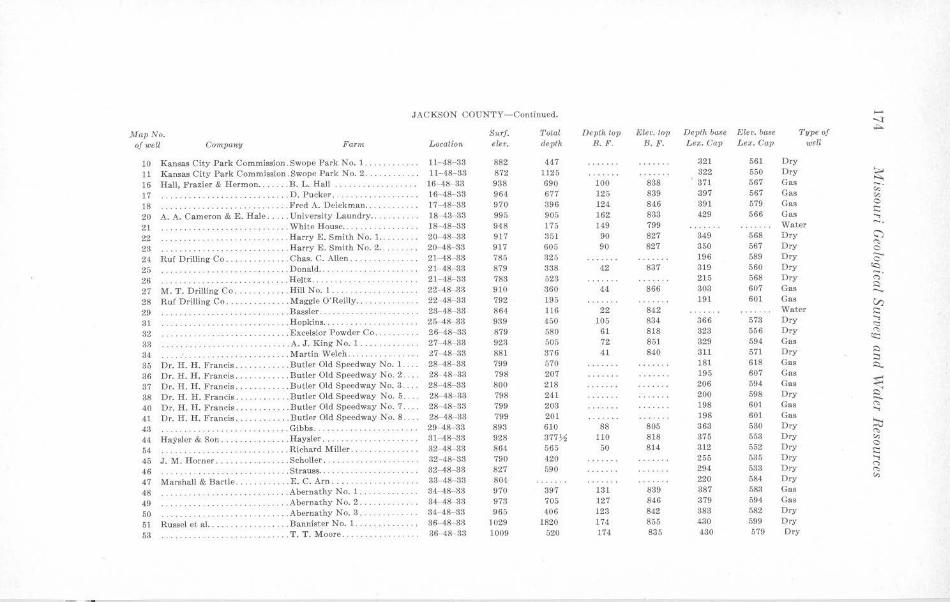
JACKSON COUNTY- Continued. .... -...}
,UapNo. S u rf. Total Depth top Eler. top Depth base F.ler. base Type of ,ts..
of well Company Farm LocaUon elev. depth B.F. B. F. Lex. Cap Lex. Cap well
10 Kansas City Park Commission.Swope Park No. 1. . . . . . . .. ... 11- 48- 33 882 447 321 561 Dry
11 Kansas City Park Commission .Swope Park No. 2 . . · ·· · ·· ···· 11-48- 33 872 1125 322 550 Dry ~ 16 Hall, l'razier & Hermon ... . .. . B. L. Hall .. . .. . .. . . . .. .. .. . 16- 4!Hl3 938 690 100 888 371 567 Gas ~-17 . . . . . . . . . . . D. P ucker . 16 48- 33 964 677 125 839 397 567 Gas "' 18 ·· ·· ··· ·· ·· ·· · · ..... Fred A. Deickman .... . ... ... . 17-48- 33 970 396 124 846 391 579 Gas 0
20 A. A. Cameron & E. Hale ... . . University Laundry .. . ........ 18- 43- 33 995 905 162 883 429 566 Gas i::: ....,
21 · ·· ·· · · ·· · .. . . ... .. .. ... \Vhitc House ... . ... ····· ·· ·· · 18- 48- 33 948 175 149 799 Water -. 22 .. Harry E. Smith No. 1 . .. . 20-48-33 917 351 90 827 349 568 Dry G')
23 .... ... . ... .. . Harry E. Smith No. 2 .. 20- 48- 88 917 605 90 827 350 567 Dry (':,
0
24 Ruf Dri lling Co . .. . . .. .. .. ... C has. C. Allen .... .. .. .. .. . .. 21- 48- 33 785 325 196 589 Dry a 25 ' . . . . . . . . . . . ' . .. . Donald .. . . ... . ... . ... . .. .... 21- 48- 38 879 338 42 837 319 560 Dry <c::, - . 26 . . . . . . . . • . .. . . . . . Heitz. 21- 48- 33 783 523 215 568 Dry · ······ · ··· ........ .. c-,
27 M. T. Drilling Co .... . .Hill No. 1 . . 22-48- 33 910 360 44 866 303 607 Gas ~ .... .. ..... ..... . 28 R u f Drilling Co . . .. . .... Maggie O'Reilly .. . . .. . . . . . .. . 22-48- 83 792 195 191 601 Gas V) 29 ··· ·· ··· · · . . . . . . . . . . . . . .. .. . Bassler . .... . . . . . . . . . . . . . . . . . 28- 48- 33 864 116 22 842 Water i:::
31 . . . .. .. . ... . .. . . . . Hopkins ... . . , . ... .. .. . . . . . .. 25-48- 33 939 450 105 834 366 573 Dry ...., <::
32 ·· ·· · ·· · ·· · . Excelsior Powder Co . ... . . ... . 26- 48- 33 879 580 61 818 323 556 Dry "" 33 .A. J. King No. 1 ..... . ... .. .. 27- 48- 33 923 505 72 851 329 594 Gas
~
34 . Martin Welch . . . 27- 48 38 881 376 41 840 311 571 Dry ,::)
35 Dr. H. H. Francis .. .Butler Old Speedway No. 1. . .. 28-48- 33 799 570 181 618 Cas :::: ~
36 Dr. H. H. Francis .... .. B utler Old Speedway No. 2 . ... 28- 48- 33 798 207 195 607 Gas
37 Dr. H. H. Francis .. . . . Butler Old Speedway No. 3 . ... 28- 48- 33 800 218 206 594 Cas ~ 38 Dr. H. H . Francis . . . . . . .. ... . Butler Old Speedway No. 5 . . 28- 48- 33 798 241 200 598 Dry ~ 40 Dr. H. H. Francis .. . . ... Butler Old Speedway No. 7 .... 28-48 83 799 203 198 601 Cas (':, ..., 41 Dr. H. H. Francis . . . . . • . . ... . Butler Old Speedway No. 8 . . 2ti- 48-33 799 201 198 601 Gas
43 . . .. . .. . .. .. .. .. . .. Gibbs . .. ... . ... . . 29-48-33 893 610 88 805 363 530 Dry :::;; 44 Haysler & Son . . . ........ . . . . Haysler .... 31- 48-33 928 877~ 110 818 375 553 Dry
(':,
"' 54 .. . .. • .. . .. .. , Richard Miller .. . . .. .. .. . .. . . 32-48- 33 864 565 50 814 312 552 Dry 0
. . . . . . . . . . . i::: 45 J.M. Horner ...... . .. . . . ... . Scholler. , .. , .. . . ... 32- 48- 33 790 420 265 535 Dry ....,
46 .... . . Strauss. ... . . .. 32-48-33 827 590 294 533 Dry C"> . . ... .. .. .. . .. . . . . . ... .. .. . ... ""
47 Marsha ll & Bartle . . . . .. ... . .. E. C. Arn . .. . , . . . 33- 48- 33 804 220 584 Dry "' 48 ··· ··· · ·· ··· · · ··· · . Abernathy No. 1. 34- 48- 33 970 397 131 839 387 583 Gas
49 . .. .. ......... · ····· · · · · · .. . Abernathy No. 2., .. .. . . . ... . 34-48- 33 973 705 )27 846 379 594 Cas
50 ···· · ········ · · · · .. Abernathy No. 3,. · · · •·· · · · · 84 ·48- 33 965 406 123 842 383 582 Dry
51 Russel et al. . . .. . .. Bannister No. 1. ····· ·· ·· ·· ·· Sf,-48- 33 1029 1820 174 855 430 599 Dry
53 · ··· · ···· · · . .. T . T. Moore .. . .. .. , . . .. . . 36-48- 83 1009 520 174. 835 430 579 Ory
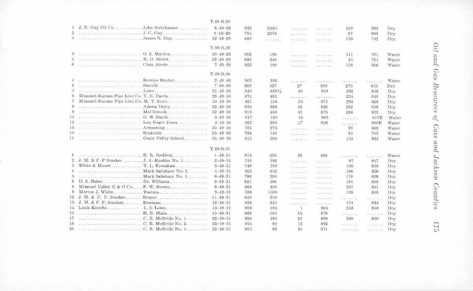
T.49-R.29
1 J. N. Guy Oil Co .. . . .. .. .. Joh n Steinhauser. .. 6- 49- 29 932 2465 240 692 Dry 2 . . . . . . . . . . . . . J.C. Guy .. 9-49-29 765 2276 67 698 Dry 4 .... ..... . .. ... . James N. Guy .. 32-4.9 29 880 138 742 Dry
T.49-R.29 a --,.._ 8 ··· ··· ·· ··· ···· ··· ······ · .. . 0. S. Mathes .. 30- 49-29 902 )60 111 791 Water l:) 5 . .. R. D. Bleich. 32-49 29 826 240 45 781 Water :::, 6 .. Chas. Steele .. ... . .. . .... . .. 7- 49-29 822 180 136 686 Water ~
T.49-R.30 C') s::i
. . . . Bernice Banker . . 2-49 30 903 186 Water "" 2 .. .... Sherrill .. 7-49-30 926 527 27 899 273 653 Dry ~ 5 .. Lowe ... ........ 21-49-30 940 668~ 40 900 282 658 Dry '"" "" 6 Missou ri-Kansas Pipe Line Co . Y. E. Davis . . 29- 4.9- 30 874 485 234 640 Dry 0
C: 7 Missouri-Kansas Pipe Line Co. r,,i. T. Scott .. . . ....... . .. .. .. 31-49- 30 921 556 50 871 293 628 Dry ...., 8 .. .. Adams Dairy .. . 32 49- 30 930 696 48 882 292 638 Dry <">
"' 9 . . McClintock ... .. 32-49-30 919 400 43 876 286 633 Dry "" 14 .. ...... . 0. H. Smith . . 3- 49-30 917 185 14 903 657E Water ~ 12 ·· ······ · ·· .. .. Lou Roger Jones .. .. 1- 49 30 923 200 17 906 660E Water 13 . .. Armstrong . . ... . 25-49- 30 785 273 97 688 Water ()
s::i JO ... Brakebill ... . ... . ... 25 49- 30 798 140 95 703 Water "' 11 .. .. Grain Valley School. . 35-49- 30 815 300 151 664 Water "" . . ···· ··· ····· ·· i:::,
T.49-R.31 :::, ~
1 . .. . .. R. R. Redfield . 1-49-81 916 220 28 888 Water ~ 2 J . M. & F. P Stucker . ...... .. J. A. Koehler No. 1.. 2- 49-31 744 382 97 647 Dry i:::,
3 White & Moore ...... ... T. L. Krenshaw. 3- 49- 31 749 703 100 649 Dry <"> ::,;,..
4 . . .. .. Mark Salisbury No. 2 ......... 5 49- 31 822 252 196 626 Dry "" 5 . Mark Salisbury No. 1. 6-49- 31 799 300 170 629 Dry 0 ··· · ·· ··· ·· ·· :::,
6 D.S. Hulse .. ..... . .. Dr. Williams ... 6- 49- 31 825 490 195 630 Dry n 8 Missouri Valley G & 0 Co ... . . F. W. Brown . . 9-49- 31 868 400 237 631 Dry 0
9 Morton J. White ... . .... . . .. . Teeters .... · ··· · ·· · · ·· · 9-49- 31 786 1500 138 648 D ry C: 12 J.M.& F. P. Stucker ... . .. . . B runer ......... ........... 11- 49 31 840 350 Dry :::, ...... 13 J . M. & F. P. Stucker ... ... .. . Bowman. 12- 49- 31 838 345 174 664 Dry ;:;;· 14 Louis Knoche. ..... . . ... . .. L. S. Lowe ....... 14-49- 31 906 465 905 258 648 Dry "" 15 · ·· ·· · · · ······ . .. H. R. Main . ... . . 15- 49- 31 889 500 10 879 D ry 17 · ······ ·· ·· · .. C. E. McBride No. 1. .. 22- 49-31 890 495 21 869 260 630 Dry 18 .. .. C. E. McBride No. 2 .. . . ...... 22- 49- 31 874 80 12 862 Dry ......
-..J 20 . ............ . ... . .. . . .. .. .. C. E. McBride No. -1... 22- 49- 31 905 63 34 871 Dry C,)1
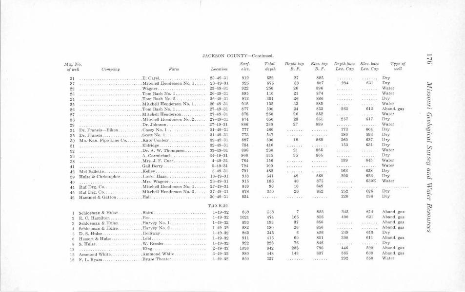
JACKSON COUNTY- Continued. ...... -..J
Map No. S1trJ. Total Depth top Elev. top Depth base Elev. base Type of ~
of well Company Farni, LocaUon eLev. depth B. F. B.F. Lex. Cap Lex . Cap well
21 . . . . . . . . . . . .. .. E. Carel. . . .. . .. . 23-49- 31 912 522 27 885 Dry 37 . .. .. .. .. . .... . . . . . Mitch ell Henderson No. 1 . . 23-49- 31 925 675 38 887 294 631 Dry
~ 22 . . . . . . Wagner .. .. . ... . . .. . .. ..... 23- 49- 31 922 250 26 896 Water -. 23 ..... .. ... . .. . . . . . . . . . . Tom Bash No. 1 .. .. 26-49- 31 895 110 21 874 Water "' "' 24 .. .. . Tom Bash No. 2 .. . 26- 49 81 912 301 26 886 Dry 0
25 ··· ··· · ··· .. .. . Mitchell Henderson No. l. . . 26- 49- 31 918 125 33 885 Water s:::: ..., 26 ·· · · ··· · ·· · . .. . . ... . .. Tom Bash No. 1 ... . . 27- 49- 31 877 500 24 853 265 612 Aband. gas -. 27 .. .. . Mitchell Henderson . .. . ... . . .. 27- 49- 31 878 250 26 852 Water <:')
36 · ········ · . . . . . Mitchell Henderson No. 2 .. 27-49- 31 874 650 23 851 257 617 Dry <'> 0
29 . . Dr. Johnson ... 27-49- 31 866 230 27 839 Water ..._
34 Dr. Francis- Eiken .. . . ... Casey No. l. . . .. 31- 49- 31 777 480 173 604 Dry 0
<Q
35 Dr. Francis . .... . .. .. . . . . Scott No. 1 . . . 31-49- 31 773 547 180 593 Dry ;· 30 Mo.-Kan. Pipe Line Co ... . Kate Conboy .. . 32-49- 31 887 500 18 869 260 627 Dry ::::i
31 . . . Eldridge . . . ... .. .. .. . . 32- 49- 31 784 410 153 631 Dry V)
32 . . . Dr. A. W. Thompson .. . 33- 49- 31 886 280 21 865 Water s:::: 33 · ·· · ···· ·· . . .. /\.Carmichael ..... .......... 34- 49-31 900 535 35 865 Dry ..., 38 . . . . Mrs. J. F. Curr . .. . . .. 4-49- 31 784 156 139 645 Water
<:::: <'>
41 .. . Gail Berry . . .. . . . .. . . ... .. . . . 5-49- 31 794 100 Water <c::
42 Mel Pallette .. .. .. .. . .. .. . Kelley .... ... . .. . · ··· · ·· · · ·· 5-49-31 791 482 163 628 Dry ::::i
39 Hulse & Christopher. . . . Lester Haas .. . . . 18-49- 31 918 541 49 869 295 623 Dry :::; R.
40 ········ · · · · · .. Mrs. Wagner . . . . . . 23- 49-31 915 186 40 875 630E Water
44 Ruf Drg. Co ..... . ... . . Mitchell Henderson No. 1 . . 27-49-31 859 90 10 849 ........... . ~ 45 Ruf Drg. Co .... . . . Mitchell Henderson No. 2 .. 27- 49- 31 878 350 26 852 252 626 Dry ::::i
46 Hammel & Gatton ... . . Hall ... 30-49- 31 824 226 598 Dry -.
· ··· · ··· · · C'S ..., T.49-R.32 ~
1 Schloeman & Hulse .. . . ... . Baird .. 1- 49- 32 859 558 7 852 245 614 Aband. gas C'S
·· ······ · ··· · ·· · "' 2 E. C. Hamilton . .. .. . ... . .. Fee .. .. . 1- 49- 32 1021 474 165 856 400 621 Aband. gas 0
s:::: 3 Schloeman & Hulse .. . ... . . Harvey No. l . 1- 49- 32 893 193 37 856 Aband. gas ..., 4 Schloeman & Hulse .. . . Harvey No. 2 . 1- 49- 32 882 180 26 856 A band. gas C'>
C'S
5 D.S. Hulse . .. .. ... .. Holliway .. . l 49 82 862 345 6 b56 249 613 Dry c,,
6 Hessert & Hut;e . . . Lebi. . 1- 49- 32 911 415 60 Sol 300 6ll A.band. gas
8 S. Hulse. . . W. Ressler . . 1- 49- 32 922 228 76 846 Dry
13 . . . . .. King ..... . .. . 2- 49- a2 1036 842 238 798 446 590 Aband. gas
15 Ammond White. .Ammond White . 3- 49- 82 980 448 143 837 385 600 Aband. gas
16 F.L.Byam. ·· · ·· ···· · .. Byam Theater. 4--49- 32 850 327 292 558 Water
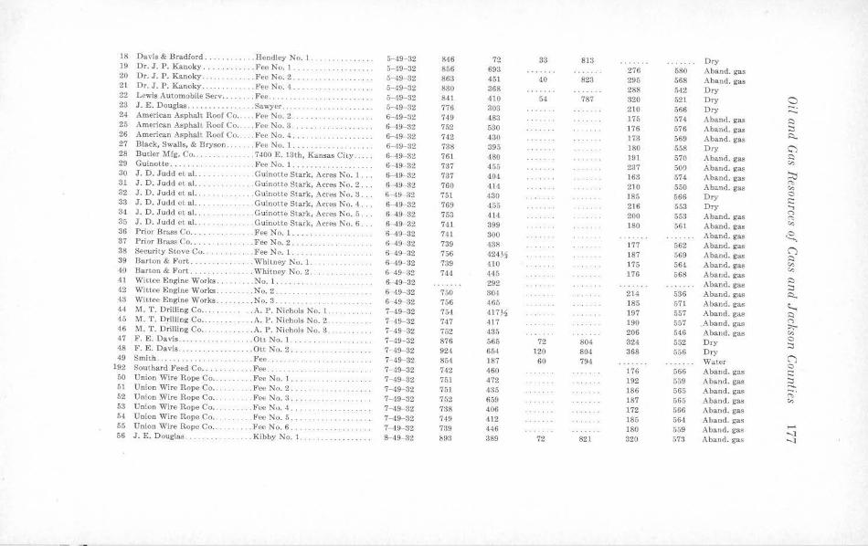
18 Du vis & Bradford .. . . .. Hendley No. l . ·· ·· ········ 5--49- 32 846 72 33 8 13 Dry 19 Dr. J. P. Kanoky ... . .. Fee No. 1 . · ·· · · ·· ·· · ·· ·· 5- 49- 32 856 693 276 580 Aband. gas 20 Dr. J.P. Kanoky ..... .... . . FeeNo.2 .. ·· · ·· · ···· · 5- 49 32 863 451 40 823 295 568 Aband. gas 21 Dr.J. P. Kanoky . . . . .. .. . . . . . J!'ee No. 4 ..... . 5-49-32 830 368 288 542 Dry 22 Lewis Automobile Serv . .. .. .. . Fee. · ···· ·· · ·· · ·· · · ·· 5-49- 32 841 410 54 787 320 521 Dry 0 23 J.E. Douglas ............ . . .. Sawyer . . . . 5-49 32 776 303 210 566 Dry -· ······ ··· · ...... 24 American Asphalt Roof Co .. . . Fee No. 2 .. ..... 6- 49-32 749 483 175 574 Aban<I. gas ~ 25 American Asphalt Roof Co .. . . . Fee No. 3 . ..... .. . .. . 6 -49- 32 752 530 176 576 Aband. gas :::i 26 American Asphal~ Roof Co .. . . . Fee No. 4 .... 6- ·19- 32 742 430 173 569 Aband. gas ~ 27 Black, Swails, & Bryson ...... . Fee No. 1 .... · · · ·· ·· · ·· · · · 6-4~- 32 738 395 180 558 Dry C') 28 Butler Mfg. Co .. . .... . .. ..... 7400 E. 13th, Kansas City . . . 6- 49- 32 761 480 191 570 Aband. gas ~
,:,, 29 Guinotte .. .. . .. . . . .. Fee No. 1. .... .. . .. . 6 -49-32 7;37 455 237 500 Aband. gas ~ 30 J. D. Judd et al. .. ...... . . .. Guinotte S tark, Acres No. 1 ... 6- 49- 32 737 404 168 574 Aband . gas "' 31 J . D. Judd et a l. .. . Guinotte Stark, Acres No. 2 . .. 6- 49- 32 760 414 210 550 Aband. gas ,:,,
32 J. D. Judd et al. . . . . . Guinottc Stark, Acres No. :l ... 6 ·49- 32 751 430 185 566 Dry 0 ,:: 33 J. D . J udd ct al. ..... . . . .. . Guinotte Stark, Acres No. 4 ... 6- 49 82 769 455 2l6 553 Dry ...,
34 J. D. Judd et al. .. . Gui notte Stark, Acres No. 5 . . . 6- 49- 82 753 414 200 553 Aband. gas (") (-:,
35 J. D. Judd et al.. . Guinotte S tark, Acr~s No. 6 .. 6-49- 32 741 399 180 561 Aband. gas ,:,, 36 Prior Bra.ss Co ...... .. . . FeeNo.1 . 6- 49 32 741 300 Aband. gas ~ 37 Prior Brass Co ..... . . ... ... Fee No. 2. . . .. . .. . ... . . . ti- 49- 32 739 438 177 562 Aband. gas
('") 38 Security Stove Co . . ... . ... Fee No. 1. 6- 49- 32 756 •124~ 187 569 Aband. gas ~ 39 Barton & Fort .... . .. . Whiuiey No. 1. ······ ·· · · ·· · · 6- 49- 82 739 410 176 564 Aband . gas ,:,, ,:,, 40 Barton & Fort ........ . Whi t ney No. 2. 6--49- 32 744 445 176 568 Aband. ga., ~ 41 Wit tee Engine Works ... . No. l . . ..... . 6- 49- 32 292 A band. gas :::i 42 Wit tec Engine Works . .No. 2 . .. . 6- 49- 32 750 304 214 536 Aband. gas ~ 43 Wit ~e Engi ne Works. ... .. No. 8 . .. . ·· ····· · ·· · · ·· 6- 49- 32 756 465 185 571 Aband. gas ~ 44 M. T. Drilling Co .. . ... . . A. P. Nichols No. 1. 7- 49- 32 754 4 17~ 197 557 Aband. gas ~ 45 M. T. Drilling Co .. . .. . . .A. P. N ichols No. 2 ...... . . . .. 7- 19- 32 747 417 190 557 Aband. gas (")
;:,;-46 M. T. Drilli ng Co . . . . .. A. P. N ichols No. 3 . . ...... . 7- 49- 32 752 435 206 546 Aband. gas "" 47 F. E. Davis ..... . . . Ott No. 1. 7- 49-32 876 565 72 804 324 552 Dry 0 . .. ....... :::i 48 F. E. Davis .. .. . .... Ott No. 2 . . ·· ·· · ·· · ·· · ·· · 7- 49- 32 924 654 120 804 368 556 Dry ('") 49 Smith . . · ···· · ····· ·· . . Fee ... 7- 49- 32 854 187 60 794. Water 0 192 Southard ~'eed Co .. . .. Fee. 7 49- 32 742 460 176 566 Aband. gas ,::;
50 Union Wire Rope Co . . . . .. FeeNo.1 . ······ · ·· · ·· 7- 49- 32 751 472 192 559 Aband. gas :::i ...... 51 Union Wire Rope Co . . . .. Fee No. 2 . . ............ 7- 49- 32 751 435 186 565 A band. gas ;:;· 52 Union Wire Rope Co .... .. Fee No. 3 ... .. 7- 49- 32 752 659 187 565 Aband. gas ,:,, 53 Union Wire Rope Co •. . . .. FeeNo. 4 .. ...... . .. . .. . . .. . 7- 49- 32 788 406 172 566 Aband. gas 54 Union Wire Rope Co . . .. Fee No. 5 .. . ... . . . .. . 7- 49- 32 749 412 185 564 Aband. gas 55 Union Wire Rope Co .. . ... l<'ee No. 6 ... . 7- 49- 32 739 446 180 559 Aband. gas .....
-..J 56 J.E. Douglas. . ... Kibby No. 1 .... . .. ... . . .. . .. 8- 49- 32 &93 389 72 821 320 573 Aband. gas -..J
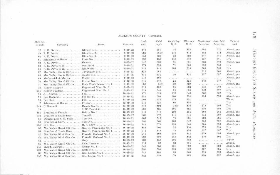
,_. JACKSON COUNTY-Continued. -..J
c,::
Map No. Surf. Total Depth top Elev. top De1>th base Elev. base Type of
of well Company Farm Location elev. deplh B.F. 8. F. Lex. Cap Lex. Cap well
57 F. E. Davis . . . .. . Kline No. 1 .... . 8- 49- 32 !170 381 46 824 295 575 Aband. gas ~ 59 F. E. Davis. . . Kline No. 2. 8- 49- 32 924 661~ 110 814 352 .572 A band. gas
60 F. E. Davis .. . ... . . .. .. Kline No. 3 . 8- 49 32 853 620 33 820 277 576 Aband. gas "' "' 61 Schloeman & Hulse . . .. . Prat t No. 1. 8- 49- 32 928 450 118 810 357 571 Dry 0
62 P. E . Davis ........ . . .. . . Showen . . . .. ... 8--49- 32 842 369 21 821 269 573 A band. gas s::: .....
63 F . E. Davis et a l. . . . . . Swat hford ... 8- 49 32 879 398 71 808 320 559 Dry -. 64 F. E. Davis et a l. . . . . Jim W hite. 8- 49- 32 923 445 109 814 364 559 Dry (;"')
67 Mo. Valley Gas & Oil Co .. . .. Cavanaugh No. l. 9- 49- 32 823 665 215 608 A band. gas "' 0
68 Mo. Valley Gas & Oil Co .. . . . Hunter No. 1 . . . . . .. . .. .. .... 9 ,19 32 834 334 10 824 237 597 Aband. gas --0
69 McCormick & Martin .... . . . . . ~1anin. . . . . . . . . . . . . 9--49- 32 910 460 Aband. gas <c: 70 Mo. Valley Gas & Oil Co . . . . Perdue No. l. .. .... . . 9- 49- 32 84!, 370 24 824 272 576 Dry -. <">
71 Mo. Valley Gas & Oil Co .. . . . . Rock Creek School No. 1. . 9 49- 32 868 81~ 39 829 Aband. gas ~
73 Homer Vaughan ... . . . Englewood Mkt . No. 1 9- 49- 32 919 407 95 824 340 579 V) 235 Homer Vaughan . ...... . Englewood Mkt. No. 2 . 9- 49- 32 919 5~0 95 024 342 577 Dry s:::
74 J . I. Cu rtis. . . Fee . . 10 49- 32 970 628 127 843 368 602 Dry ..... <::::
75 Lou Holland ... .. .. .. . .. . .. ..FeeNo.2 .. 10- 49 32 934 580 100 834 336 698 Aband. gas "' 76 Lee Hart . . . .. . ... . . Fee ... . 11- 49- 32 1009 235 178 831 Water <c::
·· · · ··· · ·· 7 Schloeman & Hul•e. . . Prcator . . ··· · · · ·· ··· · 12- 49- 32 914 225 60 854 Dry ::::
244 C. Hammil .. . .. . . .. Dennis No. 1 . 10- 49-32 874 492 38.)1 836 278 696 Dry :::i · · ··· · · ·· · · · ::::...
78 .. . . J. W. Pcmblott. 15-49- 32 930 425 105 825 350 580 Dry
191 Bradford & r'rancis .. . . ... . .. Baldry No. 1 . .. . .. . . .. . .. . . . 16 49- 32 944 540 109 835 360 584 Aband. gas ~ 232 Bradford & Du vis Bros . . ... .. . Cannell .. . . . . . . . . . . . . . 16-49- 32 961 572 115 846 354 607 A band. gas ~ 80 Douglas and E. E. Place .. . . . .Carr No. 1 ... 16- 49- 32 906 545 75 831 320 586 Dry "' ..... 81 Bradlord & Carr ..... . .. . . . . Carr No. 1. . .. 16 49- 32 951 560 109 842 356 595 Aband. gas
236 B. I. Hall .... . .. . . .H. S. Crow ... 16-49- 32 940 573 120 840 364 596 Aband. gas ~ 83 Mo. Valley Gas & Oil Co .. . . . . Ge,:, . H. Flannagan No. 1. 16- 49- 32 885 500 35 850 275 610 Dry "' "' 84 Bradlord & Da vis Bros ... . . . . Geo. H . F lannagan No. 1. . 16 49- 32 914 448 76 836 327 587 Dry C
s::: 85 Mo. Valley Oil & Gas Co ..... . r'ranklin Orchard Nv. 1 ... 16- 49- 32 975 469 130 845 379 596 Aband. gas ..... 86 Mo. Valley Oil & Gas. Co. .... Franklin Orchard No. 3 . . . 16- ,19- 32 980 600 138 842 376 604 Dry '"' "' 82 . . Gray . 16 49-32 939 150 106 833 Water "' ·· · ·· ·· · · ·· . . . . . . . . . . . 87 Mo. Valley Gas & Oil Co ... . . . Zella Hartman . .. . 16- 49- 32 916 82 82 834 Aband.
245 Hall & Baldwin ... . . . Kelley No. l. 16- 49- 32 940 550 101 839 320 620 Aband. gas
204 Mo. Valley Gas & Oil Co .... .. Keila No. 1. ·· · · ······ · · 16- 49- 32 951 580 129 822 367 584 Dry
88 Mo. Valley Gas & Oil Co . . . . . . Geo. Logan No. 1 . 16- 49- 32 943 404. 83 860 315 628 Aband. gas
195 Mo. Valley Oil & Gas Co ... . . . Geo. Logan No. 2 .. ••• •a • • • •• 16-49- 32 942 449 79 863 310 632 Aband. gas
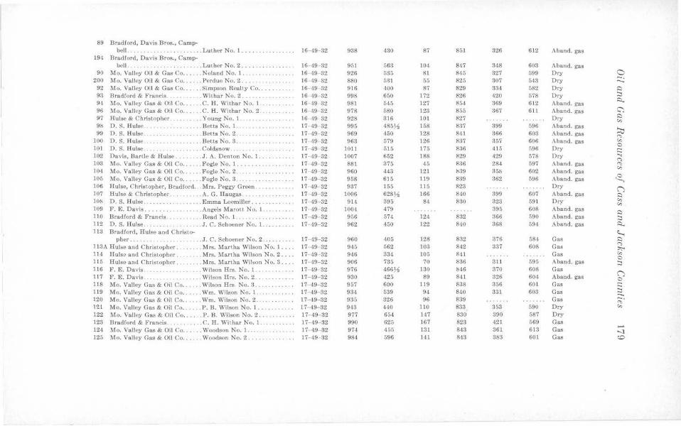
89 Bradford, Davis Bros., Camp-bell .. .. . . .. . ....... . ..... Luther No. 1 .... .. ..... .. . . . 16- 49- 32 938 130 87 851 326 612 Aband. gas
194 Bradford, Davis Bros., Camp-bell . .. . .. .. . ..... . ... . .. .. Luther No. 2 .... .. . •. . • .. •.. 16- 49 32 951 563 104 847 348 603 Aband. gas
90 Mo. Valley Oil & Gas Co ... . .. Noland No. 1. 16 49 32 926 535 81 845 327 599 Dry 0 200 Mo. Valley Oil & Gas Co ..... . Perdue No. 2 ... . . 16 49- 32 880 531 55 825 307 543 Ory ::::.:
92 Mo. Valley Oil & Gas Co . . ... . Simpson Realty Co ....... .. .. 16 49 32 916 400 87 829 334 582 Dry ~
93 Bradford & Francis. .. Withar No. 2 . . . ..... 16 49 32 998 650 172 826 420 578 Dry :::, 94 Mo. Valley Gas & Oil Co .... .. C. H. Withar N o. 1 . .. 16 49- 32 981 545 127 854 369 612 Aband. gas ::::i..
96 Mo. Valley Gas & Oil Co ...... C. H. Withar No. 2 . . ... .. .. .. 16 49 32 978 580 123 855 367 611 Aband. gas C": 97 Hulse & C hristopher ... .. ... .. Young No. l. IG- 49 32 928 316 101 827 Dry ~ ....... .. . "' 98 D.S. Hulse .. . ... Betts No. 1. .. . 17- 49- 32 995 4S5~ 158 837 399 596 Aband. gas
~ 99 D.S. Hulse . . . . . .. . .. . .. Betts No. 2 ... ... .. .. ... ... .. 17 ·49- 32 969 450 128 841 366 603 A band. gas "' 100 D.S. Hulse . . . . .. . .. . .. . .. . .. Betts No. 3 . . · ··· · ·· ·· · ·· · ·· 17- 49 32 963 579 126 837 357 606 Aband. gas "' C
101 D.S. Hulse .. . .. . . . . . . . ... Coldsnow .... .. 17- 49- 32 1011 515 175 836 415 n96 Ory i::: 102 Davis, BarUe & Hulse. . .. J. A. Denton No. 1. 17 ·49- 32 1007 652 188 829 429 578 Dry ....,
(") 103 Mo. Valley Gas & Oil Co ... .. . Fogle No. I .... .. .. .. . ... . 17- 49 32 881 375 45 836 284 597 Aband. gas "' 104 Mo. Valley Gas & Oil Co ... . . . Fogle No. 2 . . .... 17 49- 82 960 443 121 b39 35!, 602 Aban<l. gas "' 105 Mo. Valley Gas & Oil Co . . .. . . Fogle No. 3. ·· ····· · · · 17 49- 32 958 615 119 889 362 596 Aband. gas <2, 106 Hulse, Christopher, Bradford . .. Mrs. Peggy Green .... .. ... 17- 49 32 937 155 115 823 Ory C") 107 Ruise & Christ.opher .. . .... .. A.G. Haugas .. .. 17- 49- 82 1006 628~ 166 840 399 607 Aband. ga.'I Cl !Ob D.S. Hulse .. .. .. . Emma Loemiller. 17 49- 32 914 395 84 830 323 591 Dry "' "' 109 F. E. Davis ...... . . . . . . . .. .. Angels Marott No. 1. .. ... . .. . 17 49 32 1004 479 395 608 Aban<l. gas
Cl 110 Bradford & Francis .. . .... . . . Read No. 1 . . .. . .. . .. . 17- 49- 32 906 574 124 832 366 590 Aband. gas ;::, 112 D.S. Hulse .. .. . J . C. Schoener No. 1. . 17 49- 32 962 150 122 810 368 594 Aband. gas Cl. ll:J Bradlor<l, Hulse and Christo- ~
pher . . . ... . ... . . .. . . ... . .. J. C. Schoener No. 2. 17 -49- 32 960 405 128 832 376 084 Gas ~
ll3A Hube and Christopher. .. Mrs. Martha Wilson No. 1 ... . 17 49 32 945 562 103 842 337 608 Gas (")
::,,;-. 114 Hulse and Christopher. . .. Mrs. Martha Wilson No. 2 .... 17- 49- 32 946 334 105 841 Gas "' 0 115 Hulse a nd Christopher. .. Mrs. Manha Wil•on No. 3 ... 17 ·'19- 32 906 735 70 836 311 595 A band. gas :::, 116 F. E. Davis . . ... . . . . . . . Wilson Hrs. No. 1. .. 17 ·49 32 976 466~ 130 b46 370 608 Gas
C") 117 F. E. Davis ... . . ... Wilson Hrs. No. 2 ..... . 17- 49- 82 930 425 89 841 326 604 Aband. gas 0 118 Mo. Valley Gas & Oil Co . . .... Wilson Hrs No. 3 ... 17 -49- 32 957 600 119 838 356 601 Gas i::: 119 Mo. Valley Gas & Oil Co . ..... Wm. Wilson No. 1. ..... . .. . .. 17- -19 32 934 539 94 840 331 603 Gas ;::, ....... 120 Mo. Valley Gas & Oil Co .... . . Wm. Wilson No. 2 . .. . . . . •... . 17- 49- 32 935 326 96 839 Gas ~-121 Mo. Valley Gas & Oil C'o ... .. . P. B . Wilson No. 1 ..... 17 -49- 32 943 440 110 833 353 590 Dry "' 122 Mo. Valley Gas & Oil Co ...... P. B. Wilson No. 2 . .. . ..• . . .. l 7 49 32 977 654 147 830 390 587 Ory 123 Brad lord & Francis .. . . .C.H. Wiihar No. I .. . . .. . ... 17- 49- 32 990 625 167 823 421 569 Gas 124 Mo. Valley Gas & Oil Co . . .. .. Woodson No. 1 ... 17- 49- 32 974 455 131 843 361 613 Gas
...... -....1
125 Mo. Valley Gas & Oil Co .. . ... Woodson No. 2. . . . . . . . . . . .. 17 49 32 981 596 141 843 383 601 Gas ~

JACKSON COUNTY-Continued. ...... 00
MapNo. Surf. Total Depth lop Elev. top Depth base Etev. baae Type of 0
of well Company Farm Location eler,. depth B.F. B. F. Lex. Cap Lex. Cap wc/.1
126 Mo. Valley Gas & Oil Co ... .. . Callengcr No. 1 ... ··········· 18- 49- 32 872 498 42 830 284 588 Aband. gas
126A W. J. Dalton .... ....... . .... . Fee .. ······ ················· 18-49-32 892 111 66 826 Dry ~ 127 Charles G uinn ........ ... .. . . l<'ee .... . ............. • .. •. .. 18-49- 32 943 445 110 833 350 598 Aband. gas -. 128 Hulse-Christopher-Bradford . . .. McClellan No. 1 ........ .. ... 18 49- 32 846 505 21 825 275± ,m± Dry "' "' 129 H ulse-Christopher-Bradford . . .. Munsell No. 1 ................ 18-49-32 9 17 640 94 823 339 578 Aband. gas 0
130 Hulse-Christopher-Bradford .... Munsell No. 2 ...... . ... . . ... 18-49-32 941 560 110 831 354 587 Aband. gas .::: ...., 131 Mo. Valley Gas & Oil Co ..... . R ummell & Miles No. 1. ...... 18- 49- 32 909 545 72 737 310 599 Dry -. 132 ··········· · ·········· . .. . . . Lewis DDH No. 3 ............ 20-49- 32 923 969 109 814 362 561 Dry a 133 Mo. Valley Gas & Oil Co ...... Franklin Orchard No. 2 .. 21-49-32 971 450 125 840 371 600 Aband. gas "' 0
133A ......... . ..... · · · · ·, · · · · . .. Rupert & Mathis .. .......... . 21- 49- 32 1004 532 182 822 416 588 Dry 0 201 Bradford & l~rancis .... . .. . . .. Schowengerdt No. 1 .......... 21- 49- 32 1015 186 829 433 582 Dry ~
243 Dr. Francis ....... . ... . Schowengerd t No. 2 ..... •. ... 21-49-32 1031 6115 201 830 448 683 Dry -. 0
135 Mo. Valley Gas & Oil Co ...... F red Withar No. 2 .......... . 21- 49- 32 1009 169 840 413 596 Aband. gas 0
209 Bradford & Francis ... . Fred Withar No. l .. . ........ 21- 49- 82 983 587 146 887 396 587 Aband. gas V) 221 Hulse & Christopher ... . . . . . . . D. Arends ...... ········ · ···· 22-49-32 1057 637 205 852 452 605 A band. gas .::: 220 B. I. Hall ............ . . . . . . . J . Arends ... .... ···· ········· 22- 49-32 1086 661 182 854 424 612 Dry
...., <:::
228 Earl Smith ........... .. .... Carr No. 1 .... . .. . .. . .. . ... 22-,19- 32 1055 639 204 851 450 605 Aband. gas ('t,
136 Mo. Valley Gas & Oil Co ...... Jim Cat.heart .. 22-49-32 1035 680 195 840 438 597 Dry water (C
·· · ··· ········ 137 Mo. Valley Gas & Oil Co ..... . C has. H ill ........ ........... 22- 49-32 1089 243 205 834 Dry 0
:::i 214 Mo. Valley Gas & Oil Co ...... Kirby .. . ....... . . . . ... . ..... 22-49- 32 1004 199 158 846 Dry ~
203 Mo. Valley Gas & Oil Co ... . .. Larson No. 1 .•. .. .. ...... . .. 22-49-32 1051 618 200 851 437 614 Aband. gas
229 Mo. Valley Gas & Oil Co ...... Larson No. 2 ... . ..... 22- 49-32 104.3 629 198 850 438 605 Aband. gas ~ 224 Mo. Valley Gas & Oil Co .... . . Locke (Royalty) (Davis) ...... 22- 49- 32 1043 617 189 854. 431 612 Aband. gas a 138 F. E. Davis .. .... . ..... . .... Fred Redford No. 1. . ... . .... 22-49-82 937 611 103 834 339 598 Dry "' ...., 23& Hulse & Christopher. . .. F red Redford No. 1.. 22- 49-32 1014 615 170 844 414 600 Dry
240 H ulse & Christopher . .. . ... . . . Fred Redford No. 2 . ... ... .... 22- 49- 32 1006 623 164 842 401 605 Dry ~ ('t,
231 .. .. ......... ......... . .. Simmons Cotta ge Camp . ... ... 22-49- 32 1052 631 204 848 444 608 Aband. gas "' 212 Mo. Valley Gas & Oil Co .. . .. . Smith No. l . . .............. . 22- 49- 32 1012 591 165 847 407 605 Aband. gas 0
i:::: 241 H ulse & C hristopher .. .... .. . Smith No. 1 ... . ...... . ... ... 22- 49- 32 1021 188 183 838 Dry ....,
246 Hulse & Christopher . ..... . . .. Smit.h No. 2. 22-49-32 970 570 135 835 872 598 Dry "' ........... ..... ('t,
237 Hulse & Christopher .......... Stone No. lA .. . ..... .. .. 22- 49-32 1024 620 181 843 426 598 A band. gas "' 215 H ulse & Christopher .... . ... . . Wagner .. . ..... ............. 22- 49- 32 1024 635 172 852 418 606 Aband. gas
207 H ulse & Christopher ... . . ..... Williamson & Weston No. l ... 22-49-32 1038 611 185 853 425 613 Aband. gas
247 Hulse & Christopher .......... Williamson & Weston No. 2 ... 22-49-32 1038 497 188 855 423 615 Aband. gas
249 Hulse & Ch ristopher . ...... . Williamson & Weston No. 3 .. . 22 ·49 32 1028 614 173 855 414 614 . .. . ..... . . 234 H all & Gatton .......... . . . .. Witte No. 1 .... . ............ 22- 49- 82 1021 609 179 842 420 601 Aband. gas
239 Hall & Gatton . . .. .... WitteNo.2 ... .. .. .. . 22-49- 32 1010 605 174 836 412 598 Aband. gas 248 Hall & Gattan .. ..•. Witte No. 3 ..... 22- 49-a2 987 595 146 841 386~ 601 Dry 250 Hall & Gauon .. . . . .. . . . Witte No. 4 ...... .. . .. . .... . 22-49-32 975 · · ······· · 140 ··· · ·· · ·· · ·· · · ·· .. . L.B. Schowengerdt. .. . . ... ... 23-49- 32 1040 493 214 826 458 592 Dry 141 .. .. . . ... Patterson ..... . . . . ··· · ·· · · · · 23- 49-32 943 85 134E 809E Water a 197 H ulse & Christopher . . . .. .... . Cook No. 1. . .. . 27- 49- 32 1036 594 173 863 418 618 Aband. gas -. ..._ 237 Mo. Valley Gas & Oil Co . .. . . .Howe No. I .. 27-49- 32 992 674 133 859 375 617 Aband. gas ~ 19!> .. . Sam Kaplon .. . 27- 49- 32 980 171 124 856 "\\7a ter ::::i 230 Hulse & Christopher .. . .. ,Julian a nd Emma Lebricht .. . . 27- 49, 32 997 574 136 861 380 617 Aband. gas R. 142 Mo. Valley Gas & Oil Co . .. . .. Melcher .... . . .. . 27-49- 32 976 549 112 864 357 619 Aband. gas c;') 145 Mo. Valley Gas & Oil Co .. .... Norfleet No. l. 27- 49- 32 1008 577 144 864 384 624 Aband. gas ~
(r., 208 Mo. Valley Gas & Oil Co . . . . . . Norfleet No. 2 .... 27- 49- 32 1029 589 169 860 412 617 Aband. gas ~ 226 Ruf Drilling Co ..... .... W. W. Robinson .. .... . . . . ... 27-49- 82 974 686 110 864 348 626 Aband. gas ('> 227 Hulse & Christopher . .. .. . .. Walter Schulenberg . . .. 27- 49- 82 1037 608 171 866 41& 619 Aband. gas (r.,
150 J. D. Judd & Co ..... .. . . Sni-A•Bar Gardens No. 1. 27- 49- 32 1089 665 193 846 449 590 Dry C ,::
151 Johnson ... .. . ... . Sni-A-Bar Gardens No. 2. 27-49- 32 985 540 120 865 361 624 Aband. gas ..... ("> 219 Mo. V. G. & 0. Co.- Johnson .. Sni-A-Bar Gardens No. 1. 27- 49-82 971 540 104 867 346 625 Aband. gas "" 149 ... . Summe Dairy No. 3. 27- 49- 32 959 352 100 859 339 620 Aband. gas tr,
152 Mo. Valley Gas & Oil Co ... . .. Twichers No. J. · · ·· · ···· · · 27- 49- 32 959 644 103 856 348 611 Dry ~ 154 Hulse & Christopher ....... .. . Ware No. 1. ... .. . 27- 49- 32 1032 595 177 855 419 618 A band. gas ("') 158 Dutch Mill Filling Sta .. . .. . .. . Tourist Camp . . . . . . . . . . . . . ... 29-49- 32 800 310~ 223 577 Dry ~ 159 A. A. Gillespie. . . . . . .... Fee No. 1 ... .... 29-49- 32 900 187 48 852 Dry (r., (r., 160 A. A. Gillespie ... .. . . ...... .. Fee No. 2 .... . . 29- 49-32 895 268 35 860 A band. gas ~ 162 J. D. Judd & Co . . . ... . Dr. Lane No. 1. 29- 49- 32 858 500 0 853 247 606 Aband. gas ::::i 163 Gentry. .. . Fee No. 1 .... . .. . .... . 80-49- 32 764 540 190 574 Aband. gas R.
164 A. B. Grogger . .. . . ... Fee No. 1. . . 30- 49- 82 832 450 8 829 248 584 Dry ~ 165 A. B. Groggcr . ... .. . FeeNo. 2. 30-49- 32 784 205 579 Dry ~
166 Kansas City, Mo . . . . . .. House of Correction Municipal r, :,;..
Farm . 30- 49- 32 766 508 166 600 Aband. gas (r.,
167 . . .. F. E. Lane No. 2 .. . 30- 49- 82 925 560 66 859 317 608 Aband. gas C ::::i 168 . . . Wilson No. 1 ... ... 30- 49- 32 893 550 77 816 297 596 Dry
169 Mo.-Kansas. Gas Co . .. ..... . . Winters No. 1. 30-49- 32 936 440 104 832 348 588 Dry ("') C 170 H. T. Grubbs. . . . . . Fee No. l. .. 32-49-82 869 365 26 843 280 589 Dry ,::
171 Barton & Plakas ... . . . Plakas No . l . 32- 49- 32 891 400 39 852 271 620 Aband. gas ::::i ...... 172 Pete & Lena Plakas ... Plakas No. 1. 32- 49- 82 888 371 89 848 318 570 Aband. gas .;; · 174 W. K. Bu xton . .. .. . . . Fee No. 1 .. . 33- 49- 32 1012 481 152 860 395 617 Aband. gas (r.,
175 Earl C. Gardner . .FccNo.1 .. 33- 49- 32 1007 475 152 855 393 614 Dry 178 Henthorn ..... ... .l•ee . .. 33-49- 82 980 160 112 868 Water 180 Mo.-Kan. Pipe Linc Co . l\fary B. Lewi$ 33- 49-32 981 485 121 860 370 611 Dry
,_. 00 181 Scafe Drilling Co . . . . . .. . ..... Fee No. 1 ... ... 33-49- 32 1007 478 152 855 400 607 Aband. gas ......
JACKSON COUNT Y-Continu ed. ..... 00
Map No. Surf. '.l'otat Depth top Elev. top Depth ba$e Elev. ba$e Type of Iv
of well Company Farm Location elu. depth B.F. B.F. Le:r:. Cap Lez. Cap well
183 Mo. V . G . & O. Co.-Bradford .J.E. Snoddy . . . .. 33- 49- 32 999 593 131 868 376 623 Dry 203 Ruf Drilling Co ... ... . . . . .. . .. Ray A. Depew . .. . .. . . . .... .. 34- 49- 32 891 525 19 872 266 625 Dry ~ 222 Ruf Drilling Co . . .. · ... . . . ... . Glen Lake Fishi ng Clu b . .. . 34-49- 82 922 515 49 873 300 622 Dry 199 Ruf Drilling Co •... . . . .. Jackson ..... 34- 49- 32 1008 647 157 851 403 605 Dry ;;·
"' 218 Ruf Dr Hing Co ... . . . . . 1'. J. Kelley No. 2 .. . 34- 49- 32 982 512 62 870 310 622 Aband. gas 0
186 Mo. Valley G. & 0. Co ... . . ... Pendleton No. 1 . 34- 49- 82 941 547 80 861 819 622 Dry I::;
223 Ruf Drilling Co .. .. . .. Deborah Pendleton . · ·· · ··· · ·· 84- 49-32 969 550 103 866 347 622 Aband. gas :::. 217 Ru ( Drilling Co .. . . . . . L. T hurman .... .... . .. . . .. . . 34- 49- 32 952 515 80 872 325 627 Aband. gas C)
225 R uf Drilling Co . .. .... .. . . .. . . Elanora Whitney . 84-49- 82 964 547 98 866 346 618 Aband. gas ..,, 0
188 . .. .. . ........ . .. . . ... . . . . Brady . . ...... . .. . . . .. . . . .. .. 85- 49- 82 925 473 48 877 286 639 Aband. gas --C 205 Ruf Drilli ng Co . . . . . .. .... Chauncey No. 1 .. . . . ... 85- 49- 32 823 390 190 633 Aband. gas CQ
210 Ruf D rilling Co .. . ... . . Dr. Davis .. .. . 85- 49- 32 834 385 180 654 A band. gas ;:;· 189 .. .. . .. . ... ....... . . . . . Dr. E. A. Eubanks ... . 35- 49- 32 915 503 38 882 277 638 Gas ,::, --2 16 Ruf. Drg. Co.-Eubanks . . . Dr. Eubanks . . . . .. 35- 49- 32 884 475 6 878 234 650 Dry V) 213 Ruf Drilling Co ... . .. .. .. . . T. B. Hensley . . .. . 35- 49- 32 833 193 640 Aband. gas s::::: 211 Ru! Drilling Co .. . .. . T. J . Kelley No. l. . . .. . . .. .. 35 49- 32 834 395 206 627 Aband. gas
...., <::::
190 Ruf Drilli ng Co . . . . .. . . . .. Orlando Twiehaus . . 35- 49- 32 973 605 107 866 356 617 Dry "' 274 .. . . . . . .. Singleton ... .. . . 2- 49- 32 978 546 145 833 391 587 Dry ~
281 Bradford & Cam pbell. . . .. Trantos ... 8- 49-32 898 571 81 817 337 567 Dry Q ::::
263 . . .. . D r. S. L. Green .. .. 10-49- 32 1006 624 H,O 826 420 586 Dry ~ 266 .... .. .. . .. . .. .... . .... . C. Brad brook .. 15-49- 32 927 125 37 890 Water -259 Hulse & Christopher. . . . . Tndcp. Land and Dev. No. 1. 15- 49- 32 882 465 Old hole deepened Oas ~ 260 H ulse & Christopher . .. .. lndep. Land and Dev. No. 2. 15- 49 32 900 470 51 849 287 613 Gas ~ 258 Ruf D rilling Co . . . . . . .. Oldbam . . 15 49- 32 987 590 147 840 393 594 Dry "' ...., 256 B . I. Hall ..... . .. . .. .. Witte No. 5. 15- 49- 32 934 530 88 846 332 602 D ry 257 B. I. Hall .. . .. . . . .. .. .. WiUe No. 6 .... 15-49- 82 943 542 98 845 344 599 Dry ::0
"' 270 Ruf Drilling Co . . . .. . .. Mrs. Ida Witte . 15- 49- 32 946 555 109 837 351 595 D ry "' 267 Jl. T. 1fall. .. .. Cassel. 16- •19- 32 937 555 106 831 352 585 Dry 0
I::; 262 Hammel & Gatton .. . .. Geo. Gerhart. .. 16- 49- 32 942 525 99 843 843 599 Gas ...., 261 B. I. Hall . ...... . . . .. Hartman. 16 49- 32 950 576 103 847 384 616 Dry
(")
"' 282 Bradford & Son ... . ... Munsell No. 4 . . . 18- 49- 82 892 6 10 120 772 364 528 Gas "' 283 . ......... . .. . .. Gentry . ... . . . 20- 49- 32 904 335 83 821 829 675 Dry 251 Bradford & Francis ... . . . . . . . . Brauninger ... 2 1- 49- 32 1025 795 190 885 443 582 Dry 252 Bradford & Francis . . . .. . . . . .. Hawkinson . 21- 49- 32 990 645 155 835 402 588 Dry 265 Mo. Valley Gas & Oil Co ... . .. Hawkinson. 21- 49- 32 996 645 161 885 ·109 587 Dry 275 ······· · · · ···· .. .. . Wellborn .. . . 21- 49- 32 990 185 157 838 588E Water
•
276 . . . . . . . ' . . . . . . . Buehler . ... .... . .. . .. .. .. .. 22- 49- 32 1017 624 175 842 420 597 Dry
284 Hulse & Christopher . • \\7iston. 22-49-·32 1015 500 169 846 414 601 Dry
268 B. F. Hammel. .Gruwell No. 1. ... 24 49- 32 924 611 77 847 323 601 Dry 269 B. F. Hammel. . . Gruwell No. 2. 24-49- 32 948 107 Dry
290 ..... Riss . ... 28- 49- 32 988 489 169 819 4.19 569 Dry a 27[ Bradford & Son. .. .. Laura Lane . ... 30 49- 32 903 390 36 867 281 622 Gas -. 278 Bradford & Son . . . . .. Letha Lane No. 4 . 30-49-32 940 415 75 865 320 620 Gas --277 Bradford & Francis . ... Floyd H. Smith . . 30- 49- 32 948 430 95 853 835 613 Gas
s::i :::i
279 . Wilson No. 2 ... . 30 49- 32 898 293 57 841 Gas ~
253 Bradford & Son . . . Pitcher . . .... 30-49- 32 920 405 51 869 298 622 Gas ~ 285 Bradford & Francis . .. . ... . Smith No. 1. 31- 49- 32 964 450 106 858 352 612 Gas ;::i
286 Bradford & Francis. . Thrasher .. . . . . 31- 49- 32 982 600 131 851 375 607 Gas "' 254 Bradford & Francis .. . Whitaker No. I .. . 31- 49- 32 921 540 60 861 307 614 Dry :::;:i 255 Bradford & Francis. ... . . Whitaker No. 2 ... 31- 49- 32 958 435 96 862 342 616 Gas "" "' 272 Dr. 1'' rancis . .H. E. Wolfe .. . .. 31 <19- 32 1008 491 156 852 406 602 Gas c:,
287 H. H. Francis . . Letha Lane No. l . . 32- 49- 32 838 430 242 596 Gas i:::: ...., 288 H. H. Francis . . . . Letha Lane No. 2 . 32-49- 32 863 335 264 599 Gas r,
289 H. H. Francis . . ... Letha Lane No. 3 . .. 32-49 -32 863 220 Dry "' "' 291 Bradford et al. . . .Lutz . . .. . .. .. . . , . 33-49-32 988 642 127 861 372 616 Dry
~ 264 Breuer ....... . S. L. Conway ..... 35-49-32 844 460 236 608 Dry
273 Thompson & Breuer .... .. . ... 0. H. Thompson .... 35- 49- 32 919 475 18 901 284 635 Dry (") ~
"' T.49-R.83 "' 1 . Weber Engine Co. No. 1 .... 1-49- 33 772 502 224 548 Dry ~
:J 2 . . . , , .. , Weber Engine Co. No. 2 . 1- 49- 33 751 468 207 544 Dry ~ 5 . .. . .. Enoch Bu tcher No. 1 .. ..... . 2- 49- 33 862 400 75 7ll7 324 538 Ory
~ 6 .. . .. Enoch Butcher No. 2 ... . 2- 49- 33 861 530 36 785 825 536 Dry s::i 7 . ..... .. American Sash & Door Co .. 3- 49- 33 844 675 90 754 340 504 Dry c-,
:>;-8 . . .. . . . J .C. Estes. 3- 49- 33 844 432 72 772 319 525 Dry "'
14 .... . Ed. Wax ... . . 3- 49- 33 958 675 201 757 454 504 Dry 0 :J
16 ... Zanner Apts .. . 3- 49- 33 936 710 180 756 430 506 Dry
17 ..... Clark Paving Co .. . . 4-49- 33 930 760 164 766 424E 506 Dry (")
18 . ... . Faultless Laundry .. 4-49·-33 852 600 97 755 353 499 Dry 0 s:::
19 .. ... . . Jdeal Laundry. 4-49- 33 848 704 87 761 329 519 Dry :J 20 . .. .. Neuer Bros. Meat Co .... . . . 4-49-33 912 715 170 742 413 499 Dry
..._ ~·
21 .. . . Union Jee Co .... 4- 49- 33 943 400 203 740 460E 483 Dry "' 22 . .. Unity School of Christianity. 4- 49- 33 9a5 1997 191 744 441 494 Dry
23 ... Dunlap Laundry . . .. .. ... 5- 49- 33 934 729 205 729 495 439 Dry
24 ... Franklin Ice Cream Co 5- 49- 33 904 826 164 740 414 490 Dry ...... 00
25 . St. James Hotel. 5-49-33 827 527 67 760 363 464 Dry w
JACKSON COUNTY- Continued. ,._.. co
Map No. Surf. Total Depth top Elev. top Depth base Elev. base Type of ,.,.
ofweU Company Farm Location elev. depth B. F. B.F. Lex. Cap Lex. Cap well
27 . .. . .... Blanchard ..... .... .... . ..... 6-49-33 747 620 307 440 Dry 30 . . .. .. .. . Columbia Steel Tank Co. No. 3 6-49-33 746 362 312 434 Dry ~ 36 . . J. N. Dietz . .. . ... . .......... 7-,19- 33 920 601 158 762 435 485 Gas -. 44 · ·· ···· ·· · ·· .. .. . Geo. Muehlbach Brewing Co ... 8-49-33 818 866 82 736 357 641 Dry V')
V')
45 .. . Dr. Phillips ...... . 6-49-33 959 692 191 768 465 494 Dry C
46 . . . .. . . . .. . .. . . .. Shukert ...... . 8- '19-33 874 60331 129 745 397 477 Dry i:::: ...., 47 ·· · ·· ·· · · ·· ........ Dr. Slusher ..... ·········· · 8-49-33 951 690 184 767 463 488 Dry -. 48 . Nicollet .o\pts .. . 9- 49-33 948 330 168 780 Dry CJ 49 ······ ·· ·· ·· · . . . . Dr, I. M. Ridge. 9-49-33 885 436 123 762 398 487 Dry "' C 50 ................. Nat'l. Tie Co. No. 3 ... . ... . .. 13-49-33 322 Gas --C 51 . . .. Nat'l. Tic Co. No. 4 .. . 13- 49-33 764 301 2 217 547 Gas <c::,
52 G. F. Green .. .. . . .. Bryon Hotel. ....... 15-49- 33 995 685 215 780 479 520 Aband. gas ;:;· 53 ·· ·········· ·· ··········· . .. Dragon Cleaners ..... ... 15-49- 33 938 630 144 794 394 544 Dry ~
54 Harry Goldberg ..... . . Commodore Hotel. .. 16-49-33 986 753 224 762 483E 503E Dry V) 55 ...... . .. . ... .. Beaumont Apts ..... 17-49- 33 983 541 230 753 496 485 Dry i:::: 56 M. L. McLaughlin ....... . .. .A. Schultz, Criterion Cleaners . . 17-49- 33 971 138 235 736 500 471 Dry ....,
59 .. . Simon-Wiles Mtr. Co .. 17-49-33 902 770 155 717 425 477 Dry <::: ' . . . . . . . . . "'
60 ... Battenfield Crease Co ... 18-49- 83 793 528 34 759 297 486 Aband. gas :c:: 61 .. . .. . .... .. .. .. K. C. Marble & Tile Co. No. l. 18-49-33 763 683 255 498 Gas Q
62 .. . K. C. Marble & Tile Co. No. 2. Hl -49-33 753 ± 311 245± 508± Gas :::, ~
63 ... . .. . .. . ... .. . .. .. .... . . .. Midwest Precote Co. No. 1 ... . 18-49 83 753 245 238 515 Gas 64 .. ........... Midwest Precote Co. No. 2. 18- 49-33 751 498 236 515 Gas ~ 65 . . Nat'!. Mfg. Co ........ 18- 49-33 752 650 231 521 Gas ~ ..... 66 .. Rodney Mills Co. No. l. . ... 18-49- 33 760 494 238 527 Gas ('>
68 ...... Goar .... . .. . . 19- 49- 33 964 453 191 773 448 516 Dry ...,
69 ... . . Drum. 20- 49- 33 898 609 146 752 412 486 Dry ~ 70 Sout),west Drug Co .. .. . .... .. Kirk & Bechtel ..... . .... .. . 20-49- 33 935 595 191 744 471 464 Dry
('>
"' 72 . Westport Laundry Co .. 20- 49-33 936 675 181 755 448 488 Dry C .. . . ... . . ... . . .. .. . .. .. .. .. i:::: 73 .. .. . Ru! Bros .. ...... 21-49- 38 919 715 140 779 413 506 Dry ..., 74 . Oak Park Laundry . .. 22-49-33 872 804 96 776 356 517 Dry r, . . . .. .. . .. . .. .. .. . "' 75 ... Woods ............. . 22-49- 33 924 792 141 783 399 525 Dry "' 77 . .. . Hannah Drug Co .... .. . 24- 49- 38 788 480 240 548 Dry 78 . ... . .. . .. .. ... Krakenfuhl. .. .. ..... .. . 24-49- 33 759 575 229 530 Gas 79 .. ........ .. . .. . A. Reich & Son No. 1. . 24- 49-33 783 850 239 544 Gas 80 . .. .. A. Reich & Son No. 2 . . 24 49-33 775 288 237 538 Gas 81 ······ ··· · ·· · ·· · ·· · . . .. Grover Renick No. 1 . . 24-49- 33 773 287 222 551 Gas
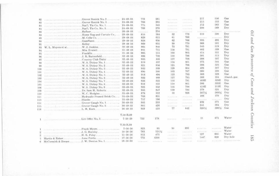
82 . .. . ... , . ...•. .. .. .. . .. . .... Grover Renick No. 2 .. 24- 49- 33 773 281 217 656 Gas
83 ·· ·· ·· ·· · ·· · ·· · ·· ..... Grover Renick No. 3 . 24-49- 33 768 285 215 553 Gas
84 ·· · · ··· · ·· ·· · · . .. .. Nat'J. Tie Co. No. J • •• •• • • . •• 24- 49-33 775 345 212 563 Gas
85 ... . .. .. .. .. ..... . .. . .. .. . .. Nat'I. Tie Co. No. 5 ..... 24- 49- 33 769 270 200 569 Dry
86 .. . .. .. . .. . . .. .... IIetlner ........ . 26- 49 33 234 a 8lS .Home Rug and Curt.ain Co .. . . 28- 49- 33 810 584 32 778 310 500 Dry -. 89 . . .. .. . .. . ..•... . .. .. M. Cells Co . .. . .. .. . . ... . . .. 29 -49- 33 829 615 61 768 Dry
..... 90 ... . . Gumfliano ... . 29- 49 83 828 630 62 766 335 493 Dry
l:)
···· ··· ··· · :::, 91 ···· ······· ····· ····· ... .. Kelley ....... ··· ······· ·· · ·· 29- 49- 33 869 635 99 770 368 501 Dry ~
93 W. L. Meyers et al. ... .. .. . . .. W. J. Jenkins . .. . . .. . ... ..... 30 49-33 864 840 73 791 345 519 Dry C')
94 . .. . .. ...... . . Mrs. Everett .. .. 31- •19- 33 941 711 150 791 402 539 Gas l:)
95 . . . . . . . . . . . . . . ... . . Franklin ......... . . . 31- 49- 33 965 515 160 805 414 551 Dry "' 96 . .. . ... . .. . .. . .. . ... .J. R. Battenfield ... 32- 49- 33 896 702 110 786 381 515 Dry ;:i:i 97 . . . . . . . . . . . Country Club Dairy 32- 49- 33 935 403 137 798 398 537 Dry "' "' 98 ······ ·· ·· · · . ... . W. S. Dickey No. 1. 32- 49- 33 919 437 118 801 375 544 Gas 0
99 . . .. ..... . .. .. W. S. Dickey No. 2 .... 32- 49-33 921 856 125 796 396 525 Gas c:: ...., 100 . .. .. . .. . . ... . .. . W. s. Dickey No. 3 . . ... .. . 32 -49- 33 933 539 129 804 426 507 Dry "' "" 101 . .. . .. . .. . .. . .. . .. . W. s. Dickey No. 4 . . ... . ... . . 32- 49- 33 890 500 103 787 360 530 Gas "' 102 ·· · · · ·· · ·· ·· · . . . . . . . . . . . . W. S. Dickey No. 5 . . ... . . .... 32- 49- 33 916 494 123 793 388 528 Gas ~ 103 . . ... W. S. Dickey No. 6 .. . ... .. 32- 49-33 922 488 127 785 388 534 Aband. gas
104 . . .. .. .. . . . . . . , ...... . . .... W. S. Dickey No. 7 . 32- 49- 33 936 525 155 781 408E 52l!E Dry (')
105 .. . W. S. Dickey No. 8 . . ...... . .. 32-49- 33 919 435 111! 801 386 533E Gas l:)
·· ·· ········ · ·· · ·· "' 106 ... . ... . .. . .. . . . . ... W. S. Dickey No. 9 ·· ···· 32- 49- 33 923 552 155 768 410E 513E Dry "' 109 ........... .. . . ........... .. Dr. Sam H. Roberts . ... 32- 49- 33 903 947 119 784 379 524 Dry l:)
110 ··· · ··· · · · ·· ..... W, C. Hodgins ..... . ... .. .. 35-49- 33 876 312 50 826 307~ 568~ Dry :::, Ro
111 · ··· · ······· . . .. Hydraulic Pressed Brick Co 35-49-33 768 631 198 570 Dry
11:1 . .. . .. .. . Shanks .. · ·· ····· · ·· ·· · 35 49- 33 767 186 Dry ~ l:)
11<1 ... . .. . .. Grover Gaugh No. 1. . . . 36- 49- 33 803 233 232 671 Gas "' 115 .. . ... . Grover Gaugh No. 2 .... . .. ... 36- 49-33 805 426 241 564 Dry :,:...
"' 116 .. . . ..... . .. . .. . L. H. Kurz . . .. . . .. .. 36- 49- 33 919 410 77 842 320~ 598.!1 Gas 0
:::,
T.50-R.29 (')
1 ... . . .. .... . .. . ...... . .. . . . . Litt Offitt No. 3. 7- 50-29 722 178 51 671 Water 0
·· · · ·· ·· · ·· ·· c:: ~
T.50-R.30 -. ,:-.,
1 . .. . . .. , .. .. . . .. Frank Myers . . .. . .. . .. . 7- 50 30 923 95 30 893 Water "' 2 .. ... J. G. Burnley ... . .... .. ..... . 10- 50-30 783 124~ Water
3 .. . .. II. R. Foley .... . ··· ··· · · ··· · 11- 50-30 812 475 127 685 Water
5 Martin & Reiser .. . . . . . Anne Perrin . .... 17- 50- 30 772 4200 144? 628 Dry hole .... 00
6 McCormick & Breuer . . . . .. J. W. Denton No. I .• ... . .. . . 18 50- 30 c.,,
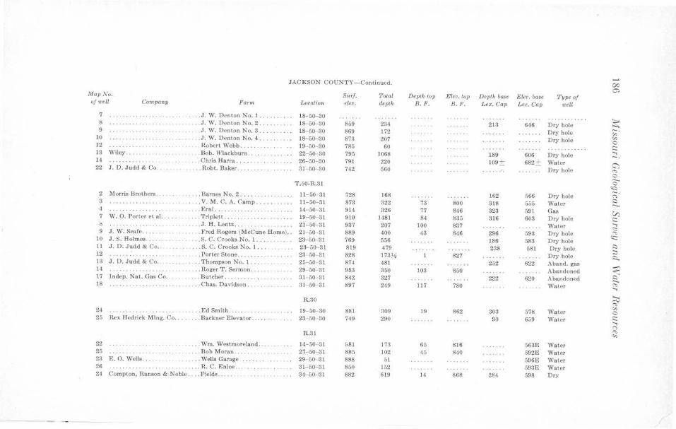
..... JACKSON COUNTY-Continued. 00
0:, MavNo. Surf. T otal Depth tov Ele•. top Depth base Elev. ba,ie 1'ype of of well Compa1111 Fann Location elev. depth B.F. B. F. Lex. Cap Lee. Cap well
7 ··· ·· ·· ·· ···· · . ... J. W. Denton No. 1. 18-50- 30 · · · ·· ·· ····· ~ l! ········· ······· · . . .. J. W. Denton No. 2 ..... ..... 18-50- 30 859 234 213 646 Dry hole 9 . . . J. W. Denton No. 3 . .... . .. .. 18- 50 30 869 172 Dry hole -. ·· · ··· ······ · "' 10 ... J. W. Denton No. 4 .. .. .. .. . 18- 50- 30 873 207 Dry hole "' ···· ·· ·· · ·· ·· · · C 12 ... .. . . .......... ........ . . Robert Webb ..... . . 19- 50- 30 785 60 . ... .... .... t:
13 Wiley ... . .... Bob. !Vlackburn . .. . . . .. . .. . .. 22- 50 30 795 1068 189 606 Dry hole ..... ..... -. 14 ·· · ··· · ·· ·· · ·· . . ... Chris Harra .. 26- 50-30 791 220 109 ± 682± Water C") 22 J. D. Judd & Co .. . .. . .. .. . .. Robt. Baker .... 31- 50- 30 742 560 .. .. .. ·. Dry hole ""' C
T.50-R.31 c ~-2 Morris Brothers . . . . . . . . .. . .. Barnes No. 2 .... . 11-60 31 728 168 162 r,66 Dry bole <">
3 .. . . V. M. C. A. Camp .... . ... . . . 11- 50- 31 873 322 73 800 818 555 Water ~ ·· ·········· · ·· ··· ...... 4 · ········· ··· ······ . .. Erni .. .. . . .. ..... ... 14- 50- 31 914 326 77 846 323 591 Gas V) 7 W. 0. Porter el al. ... . .. . . . . Triplett .. . .. ... 19- 50 ·31 919 1481 84 835 316 603 Dry bole t: () .... . J. H. Lentz . ... 21-50- 31 937 207 100 837 Water .....
<::: 9 J. W. Scale . .. ... 1'' red Rogers (McCune Home) .. 21 - 50- 31 889 400 43 846 296 593 D ry hole "' 10 J . S. Holmes . . .. .S. C. Crooks No. 1 . . 23- 50 31 769 556 186 583 Dry hole <c:: 11 J. D. Judd & Co . . . . . S. C. Crooks No. l .. . 23-50-31 819 479 238 581 Dry hole ~
::, 12 . Porter Stone. 23- 50- 31 828 173~ 827 Dry hole R. 13 .r. D. Judd & Co .... .... Thompson No. l .. .. . 25- 50 31 874 481 252 622 Aband. gas _. 14 . . . . . . . . . . . . . .. Roger T. Sermon . ...... .. 29- 50- 31 953 350 103 850 Abandoned ...... 17 Indep. Nat. Ga• Co .. .. .Butcher . . . . 31- 50- 31 842 327 222 620 Abandoned ~ 18 · ·· ··· ·· ····· · ·· · · .... Chas. Davidson .. . 31- 50 81 897 249 117 780 Water "' .....
R.30 .::i::, "' 881 19 862 303 57lj Water "' 24 ····· ······ · ·· · ·· · · . . .. Ed Smith ...... ... 19- 50-30 309 0
25 Rex Hedrick Ml ng. Co .. ..... . Backner Elevator . 23 50 30 749 290 90 659 Wale r r:: ..... <">
R.31 ""' "' 22 . ... . Wm. Westmoreland . .. 14-50- 31 &81 173 65 816 563E Water 25 . . . Bob Moran . . . . 27- 50- 31 885 102 45 840 592E VVatcr 23 E. 0. Wells .. . . ... .... . . Wells Garage 29- 50 31 888 51 596E Water 26 ·········· ·· ·· · · ... .. R. C. Enloe . 31- 50- 31 850 152 593E Water 24 Compton, Ranson & Noble .. .. Fields .. .... 34- 50- 31 882 619 14 868 284 598 Dry
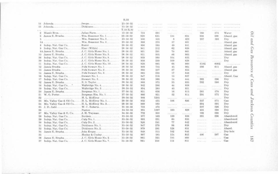
R.32
61 Johenda .. . . Swope .... ... 25- 50 32 . . . . .. ...... 53 Johenda .... . . Dickinson . ... 35- 50- 32
·· ····· ·· ·· ····· · ·· ·· ·· ·· ·· · ·· · · ··· T.50-R.32 2 Massie Bros .... . ..... .... . Julian Farm ... ... . ... . . . 13- 50 32 734 294 160 574 Water 0 8 James E. Brusha. . . Wm. Bessemer No. 1. 23-50- 32 928 625 104 821 338 590 Aband. gas -. ....... 5 ·· ··· ·· ··· ····· . . . Wm. Bessemer No. 3 .. . . . 23 50-32 !!30 345 8 822 237 593 Dry 0 5A .... ... ..... . .. . .. .... .. Wm. Bessemer No. 4 .. .. . .. 23- 50 32 888 270 67 831 Aband. gas :::i 8 fndep. Nat. Gas Co .. . . . . . Bosier . .... . ... . .. 26- 50- 32 890 190 49 841 Aband. gas .::i...
9 Indep. Nat. Gas Co .. .. . . E lser (Wilkie) . ... . ... .. 26 -50- 32 901 212 62 839 Aband. gas C")
9A James E. Brusha . .. . , . J.C. Girls Home No. 1 . .... 26- 60 32 931 291 70 861 Adand. gas 0
"' 10 James E. Brusha . . .J.C. Girls Home No. 3 .... 26- 50- 32 951 305 86 865 Aband. gas :::v 38 lndcp. Nat. Gas Co .. . . . .. .. .. ,l. C. Girls Home No. 8 .. . ... . 26-50-32 939 360 104 835 Dry ~
39 lndep. Nat. Gas Co. . J.C. Girls Home No. 9 . ... 26- 50 32 938 239 109 829 Ory "' 11 Jndep. Nat . Gas Co . .. .. .. . J.C. Girls Home No. 10 ... 26- 50- 32 928 885 68 860 319E 609E
C .......... s:: 12 James Brusha .. ... .. Polk Stewart No. l. . 26- 50- 32 909 755 45 864 298 611 Aband. gas ...,
(")
13 James Brush a .. . . . . .. Polk Stewari No. 2 .. . . .. 26- 50- 32 880 237 27 853 Aband. gas ~
14 James E. Brusha . . . . . Polk Stewart No. 3. 26-50 32 865 230 17 848 Dry "' 16 I ndep. Nat. Gas Co .. ... . . Stewart No. l. . . . 26- 50- 32 847 216 10 837 Aband. Gas ,8, 17 Indep. Nat. Gas Co. . . . Stewart No. 8 . . .. . .... 26- 50- 32 858 368 14 844 262 596 Dry () 62 James E. Brusha . . .. . E. S. Taylor ... .. . 26-50- 32 868 375 35 833 282 586 Dry Q 18 Jndep. Nat . Gas Co .. . . ... . Walbridge No. 4 . 26- 50- 32 902 286 44 858 Ory "' "' 19 Indep. Nat. Gas Co .. . . . .. Walbridge No. 5 ... 26- 50- 32 894 260 43 851 Dry
0 20 James E. Brusha .. . .... . . Borgman No. l .... . . 27-50-32 831 636 16 815 261 570 Dry :::, 21 W. 0. Porter .. . ... .. . Borgman Hrs. No. 1. 27- 50-32 866 831 52 814 291 575 Ory i::i... 22 .... H. L. McElroy . .. . .. 28-50- 32 908 1205 Dry "--; 23 Mo. Valley Gas & Oil Co .. . .. . H. L. McElroy No. 1. . .. 28-50- 32 932 435 106 826 357 575 Gas 0 24 Mo. Valley Gas & Oil Co .. .. . . H. L. McElroy No. 2 ... 28- 50-32 889 560 294 695 Ory <"> :,;,.. 25 J. D. Judd . ....... .. W. C. Roberts ..... . . 31- 50- 32 733 470 207 526 Dry "' 26 . Paxton .. .. .. . . .. .. .... 34-50-32 991 1097 163 828 401 590 Ory
0 .. .. ...... :::, 27 Mo. Valley Gas & 0 . Co ... .. .. J. H. Twyman. 34- 50-32 772 300 182 590 Dry
() 28 Indep. Nat. Gas Co .. .Borders ... . . .. . .. . .. .. .. 35- 50-32 977 569 139 838 381 596 Abandoned C 29 Indep. Nat. Gas Co .. ... ..... Culp No. I , . . . .. . 35-50- 32 893 231 60 833 Abandoned s:: 30 Jndep. Nat. Gas Co . .. ..... CulpNo.2 .... .. . 35- 50-32 926 241 77 842 Abandoned :::i ..... 31 Indep. Nat. Gas Co .. ... .. . ... Dickinson No. 1 . . .. .. .. .... . 35-50- 82 947 279 88 859 Dry ~-32 Indep. Nat. Gas Co . . . . . . . . . . Dickinson No. 2. 35-50- 32 979 281 128 851 Aband. "' 3,1 James E. Brusha ... . ..... John Evans . . .... . .. 35-50- 32 948 315 102 846 Dry hole 35 .. . . Henley & Cooley .. . . .. 35-50 82 997 51'15 154 843 400 597 Gas 36 James E. Brusha ... . . . .. J. C. Girls Home No. 2 ..... 35-50-32 965 325 105 860 Gas
,_. 00
37 I ndep. Nat. Gas Co . .. , ., ... . J. C. Girls Home No. 7. 85-50- 32 965 250 114 851 Gas -..J
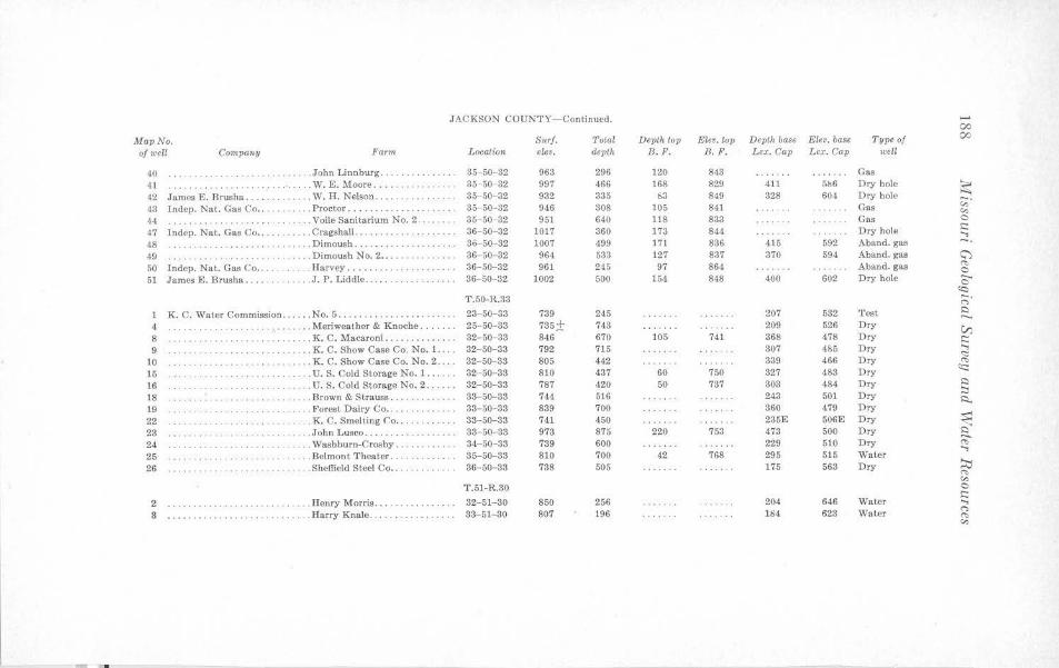
JACKSON COUNTY-Continued. ..... 00
Map No. Sttrf. 1'olal Deplk top Elev. lop Depth base El~v. base Type of 00
ofweU Compa11y Farm Location eleo. depth B. F. B.F. Le:,;. Cap Lex. Cap well
40 . . John Linnburg . 35- 50- 32 963 296 120 843 Gas 41 ···· ·· ·· · · ... W. E. Moore .... . .. . . 35- 50- 32 997 466 168 829 411 5b6 Dry hole ~ 42 James E. Brusha .. . .. .. ... W. H. Nelson . .... 35- 50-32 932 335 b3 849 328 60,1 Dry hole ,;;· ,13 Indep. Nat. Gas Co .. .. . . ... . . Proctor .... . ..... . ... . 35 50- 32 946 808 105 841 Gas v., 44 ········· · . .. Voile Sanitarium No. 2 . . 35-50- 32 951 640 118 833 Gas 0
47 lndep. Nat. Gas Co ... .. Cragshall .. . .. . .. . . 36- 50-32 1017 360 173 844 Dry hole s:: ..., 48 . ... . . .......... . ... . . . .. .. .Dimoush ... . . . .. ... . . .. 86- 50- 32 1007 499 171 836 415 592 Aband. gas -. 49 . . Dimoush No. 2 .... . . .. .. . .. .. 36- 50- 32 964 533 127 837 370 594 Aband. gas (;")
50 Indep. Nat. Gas Co .... ... . Harvey ... . .... . .. 36-50-32 961 245 97 864 Aband. gas "" 0 51 James E. Brusha .. . . . . . J.P. Liddle ..... . .. ... . .. .. . 86- 50- 32 1002 500 154 848 400 602 Dry hole ..._
0 'Cl
T.50-R.83 ;:;· 1 K. C. Water Commission ... . •. No. 5 .......... . ...... . ..... 23-50-33 739 245 207 532 Test ,::)
4 ... Meriweather & Knoche ... 25- 50- 33 785± 743 209 526 Dry V) 8 . . .. . . .. . .. . .. . .. . .. . .. .. . . K. C. Macaroni ....... . .. . . . . 32- 50-33 846 670 105 741 368 478 Dry s:: 9 .. . . ... . . ..... .... . .. . . .. . K. C. Show Case Co. No. 1.. 32-50-33 792 715 307 4$5 Dry ...,
<::: 10 . .... .. . K. C. Show Case Co. No. 2 ... . 82- 50- 83 805 412 339 466 Dry "" 15 . .. . . . .. ....• . . .... . U. S. Cold Storage No. 1 ... . .. 32- 50-33 810 437 60 750 327 483 Dry <::::
16 . .. . U.S. Cold Storage No. 2. 32-50-33 787 420 50 737 303 484 Dry ,::)
18 ... . Brown & Strauss .... 33-50-33 744 516 243 501 Dry :::s A.
19 .. .. . Forest Dairy Co .... . . 33- 50-33 839 700 360 479 Dry 22 . ... K. C. Smelting Co . . . . 33-50-33 741 450 235E 506E Dry ~ 23 ... . . John Lusco ..... ... . ... . .. 38- 50- 33 973 875 220 753 473 500 Dry Q
24 .. . . .. . .. .. · ·· · ·· · ·· · · .. Washburn-Crosby . . ·· · · · ··· · · 34-50-33 739 600 229 510 Dry ~ ..., 25 . .. . Belmont Theater .. .. .. 35-50-33 810 700 42 768 295 515 Water 26 . .. Sheffield Steel Co ... 86- 50- 33 738 505 175 563 Dry ::i:::,
"" v., T.51-R.30 0
. . Henry Morris .... 32-51-30 850 256 646 Water i:::
2 ···· · ········ · · 204 ..., 8 . Harry Knale. 33-51- 30 807 196 184 623 Water
("')
.... . .......... ... . . .. .. .. . . "" v.,
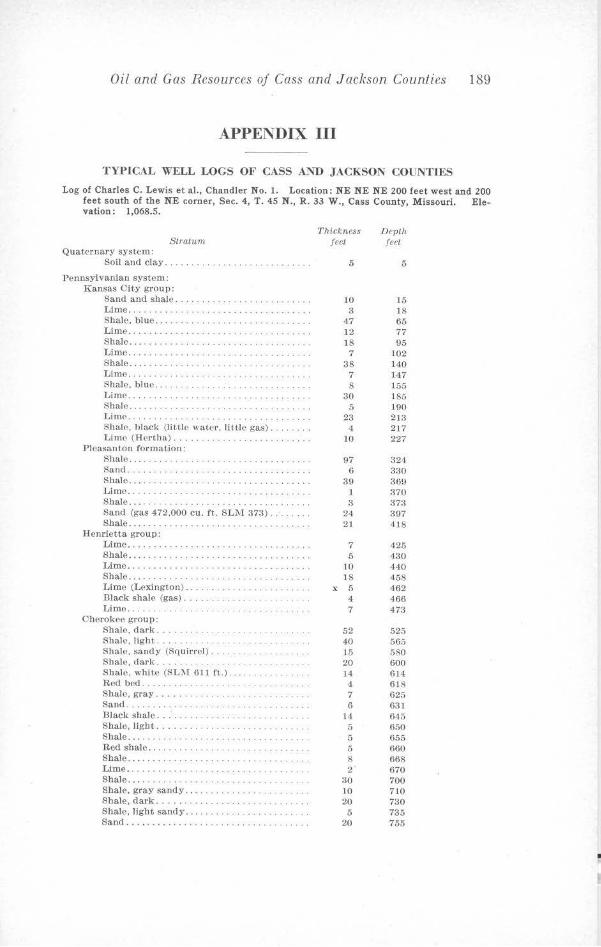
Oil and Gas Resources of Cass and Jackson Counties 189
APPENDIX III
TYPICAL WELL LOGS OF CASS At"\ID JACKSON COUNTIES
Log of Charles C. Lewis et al., Chandler No. 1. Location: NE NE NE 200 feet west and 200 feet south of the NE corner, Sec. 4, T. 45 N., R. 33 W., Cass County, Missouri. Ele-vation: 1,068.5.
Stratum Quaternary system:
Soil and clay .....
Pennsylvanian system: Kansas City group:
Sand and shale .. Lime . ........ . Shale, blue .. . Lime . ... . .. . Shale ... ........ . Limo ..... . Shale ... . Lime . . .... . ..... . ......... . Shale, blue . .. . Lime ... . Shale ... . Lime ... . Shale, hlack (little water. lit,Ue ga.s) . .. . . . Lime (Hertha) ......... .
Pleasanton formation: Shalo. .. . . ................. . Sand . . ........ . Shale.... . .. . . · . ·. · · · · · · Lime .... . . Shale ..... . Sand (gas 472.000 cu. ft. SLM 373) . . Shale...... . . ........... .
Henrietta group: Lime .......... . .. .. . .. ... ............•. Shale ............... .... . .•.. Lime ............ . Shale...... . ........... . Lime (Lexington). . . . . .. .. .. . . Black shale (gas) . .... Lime ...... .
Chorokcc group: Shale, dark ... . Sha](', light ... . Shale, sandy (Squirrel). Shale, dark . . Shale, white (SL?.1 61 1 ft.).. ... . . . . . ... Rod bed ..... . ... . Shale, gray ... . Sand ...... . ..... . Black shale .. .' .. . . Shale, light ...... . Shale ............ . Red shale ... . Shale ............ . Lime .... .. ..... . . Shale .... .. .. . . .. . Shale, gray sandy .. . Shale, dark ....... . Shale, light sandy ... . Sand ............. .
Thickness feet
5
10 3
47 12 18 7
38 7 8
30 5
23 4
10
97 6
39 1 3
24 21
7 5
10 18
X 5 4 7
52 40 15 20 14
4
7 6
14 5 5 5 8 2
30 10 20 5
20
Depth feet
5
15 18 65 77 95
102 140 147 155 185 190 2m 217 227
324 330 369 :no 373 397 418
425 430 440 458 462 466 473
525 565 580 600 614 618 625 631 645 650 655 660 668 670 700 710 730 735 755
•
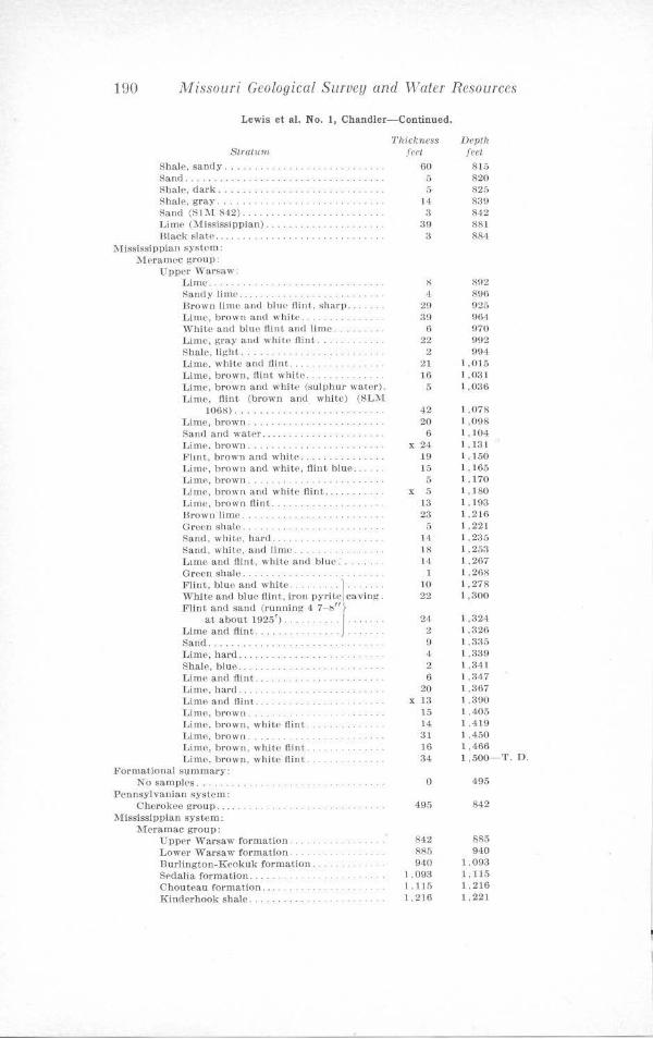
190 Missouri Geological Survey and Water Resources
Lewis et al. No. 1, Chandler-Continued.
Straium. Shale, sandy .... . .. . . Sand . .. . . Shale, dark ...... . . Shale. gray .. . .. .. . . Sand (SC\t 842) . . Lime (Misi;issippian) ... Black slatP.
MississiPJ>ian systom: l\lnamec group:
Upper Warsaw: Litne . . .. .. . Sandy lime ... . Drown lime and blue flint. sharp. Lime, brown and white . . White ancl blue flint and lime . . . Lime, gray and white flint .... . .. .. . . Shale, light .... . .. . l,ime, white and flint .. . . Lime, brown, Hint white . . .. . .. . . . . . . . Lime, brown and white (sulphur water). Lime, flint (brown a.nd white) (SL'.\l
I068) ..... .. . . Lime, brown .... . Sand aud water .. Lime, brown. l<'ltnt, brown and white. Lime, brown and whit(', flint blue .. l .1i tnP, bro,,,-,n . ... . .. . ... . . . . . Lime, brown and white flint ... . Lime, brown flint. Hrown lime .. Groen shale. Sand, white, haru ... Sand, white. and limo .. . .. Lime and fJint, white and blue. Groen shale .. FJJnt, bluo and white . . . . . . . .. ) .. . . White and blue flint, iron pyritPI caving . Flint and sand (running 4 7 - ·;/' ~
at about 1925'). . . . . . . . J .... . .. Lime and flint . .... . . . . . .. . . . Sand . . . Lime, hard ... Shale, blue .. Llme and flint . Lime, hard . .. . Lime and flint . .. . . LitnP, brown. Lime. brown. white flint Lime, brown . .. . . . Lime, brown. white flint . . Lime. brown, white flint . . ...
Format.ional S\lmmary: No samples ... . ...... .. .
Pennsylvanian system : Cherokee group ...
Mississippian system: JVI<>ramac group:
Upper Warsaw formation. Lower Warsaw formation. Burlington-Kl'okuk formalion . .. Sl'dalia formation . .. . Chouteau formation ... .... . Kinderhook shale.
Thickness feet
60 5 5
14 3
39 a
8 •!
29 39
6 22
2 21 16 5
42 20
6 X 24
19 15
5 X 5
13 23
5 l4 18 14
1 10 22
24 2 9 ·1 2 6
20 X l:J
15 14 31 lG 34
0
495
842 885 940
l ,09:J 1.115 1,216
Depth feet
8 15 820 825 830 842 881 884
802 896 925 9()4 970 91)2 994
1,015 1,031 1,036
1,078 1,098 1,104 I .13 l 1,150 1,165 1 ,170 1 ,180 1,193 1.216 1 .221 1.235 1,253 1.267 l ,268 1 ,278 1,300
1,324 l .326 1 .335 1,339 1,341 1.:H7 1.307 1 .390 1,405 1.419 1,450 1,466 1,500-T.
495
842
S85 940
1.093 1 . Jl5 1,216 1,221
D.
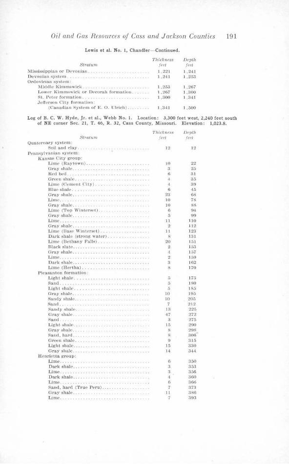
Oil and Gas Resources of Cass and Jackson Counties 191
Lewis et al. No. 1, Chandler- Continued.
'thickness Dl'pth Stratum feet feet
M ississippian or D('vo11ian . . .. .. . .. .... . . 1 ,221 I ,241 Devonian system . . . . .. . .. . . .. . 1,241 1.25;{ Ordovician system:
?.liddle l<immswicl<. 1,253 1 ,267 Lown K i mmswick or Decorah formatiou . 1,267 1 .300 St,. Peter format.ion . . . . .. .. . . . .. . 1,300 1 .341 Jo!ferson City formation:
(Canadian Syst~m of E. 0. Ul ri ch) .... . 1 .341 l .500
Log of B. C. W. Hyde, Jr. et al., Webb No. 1. Location: 3,300 feet west, 2,240 feet south of NE corner Sec. 21, T. 46, R. 32, Cass County, Missouri. Elevation: 1,023.8.
Stratum Quaternary syst<:>m:
Soil and clay . Pennsylvanian system:
Kansas City group: Lime (Raytown). Gray shale . . . . Red bed .. . Green shale .... .. .. . .. . Lime (Cement City) . . . .. . . Blue shale .... . Gray shale . . Limn . . Gray shale . . Lime (1'01) Wintersf't) . . (hay shale . .... Lime . Gray sh.tie .. Lime (Base ·wmt.erset). Dark shal<' (strong water) . . .. . Lim<' (Bethany Falls) .. . . .. . .. . mack state . .... G ray shale . Lime ..... . .. . .. . .. .. . . . Dark shale .. . . . Lime (Ilert,ha) ... .
Pleasanton formatiOJJ: Light shale . . . . . . . . .. ... . .. . . . . . Sand. . .. . . . . .. . .. . .. . ..... . . . . Light shal<'. . . . . . . . . . . . . . . . .. . .. . . Gray shale .. .. . . Sanely sl1ale .. . Sand... . . .. . . ... .. . .. . .. . ... .. . . . .. . Sandy shale . . .. .. . . Gray s hale . .. . Sand . .. . .. . . . . . .. .. . . Light shale . . . .. .. .. . . . Oray shale . . . . . Sand, hard .. . .. .... .. .. . . .. .. . Green shale . . .. . . Light shale .... , . . Gray shale .. .
Henrietta group: Lime ... . . Dark sha.le. Lime ..... . Dark shale .. .. . .. . ... . Lime.. . ..... . .. . . . .. . . . . . Sand. hard ('l'rue PPru). Gray shale . . Lime .. . .... .. .
Thickness Depth f(•ft .fe,•t
12 12
10 22 3 25 6 31 4 35 4 39 6 45
23 68 10 78 10 88
6 94 5 99
11 110 2 1)2
11 12:l 8 131
20 151 2 153 4 1.57 2 159 3 162 8 170
5 175 5 180 5 185
10 195 10 205
7 212 13 225 47 272
3 275 15 290 8 298 8 306 9 315
)5 330 14 344
6 350 3 353 a 356 4 :mo 6 360 7 373
11 386 7 393
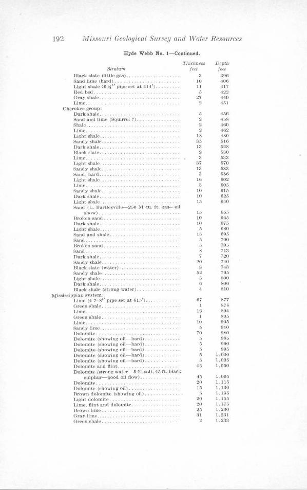
192 Missouri Geological Survey and ·water Resources
H yde Webb No. 1- Continued.
Stratum Dlack slate (littlo gas) .......... . ........ . Sand lime (hard) .... . ... .. . . ......... .. . Light shale (6 U" pipe set at 414') ........ . Red bed . ........... . . . . . .. .. . . .... . Gray shale . Lim e . .
CherokPe group: Da rk shale . .. . ..... . ... . Sand and lime (Squirrel ?) . . . . Shale.... .. .......... . .. .. .... .... . L ime . . L ight Rhalc . . .... . .. . . . ... .... , . .. . Sandy shale ... . ...... .. .. . . . Dark shale . ...... . mack slate .... . .... . . .. .. .. . .. ..... . . .. .
Thickness feet
3 JO 11 5
27 2
5 2 2 2
18 35 l3
Li1nc. . . . . ..... .. .. . .. . .. .. . .. . .. .• 2 3
37 13 3
Light shale .... . Sandy shale ........ . . . ... .. . .. . . .. .. . . . . Sand, bard . . . Light shale .... . Lime . . Sandy shalo . . . . Dark sh1\IC . . . L ight shale .. . . . .. .. .. . . Sand ( L . Dartlesville-250 '.1,1 cu. ft. gas-oil
show) .. . Broken sand ....... . . .. . . . . . . . ... . . .. .. . Dark shale .... . Light shale ..... .. .. . .. .. . . Sand and shal<• . . .. . .. . . Sand ... Broken sand .. . Sa.nd . . . . ..... . Dark shale ... .. . . . . .. . .. . . Sandy shale .... . . Diacl( slate (water) .... . Sandy shltle . . L ight shale .. . . . .... . Dark shale ....... . . . Dlack shale (strong water) ..
Mississippian system: Lime (4 7-8" pipe set at 6151
) • .
Green shale . . .. . ..... . . . .. . . Lime..... . . . . . ..... .. . Green shale ... .. . .. . . Lime.. . . ... . . .. . Sanrly lime . . .. . Dolomite ... . Dolomite (showing oil-hard). Dolomite (showing oil-hard) ... Dolomite (showing oil- hard} .. Dolomite (showing oil-hard). Dolomite (showing oil-hard) .. . Dolomite and llint ............ . Dolornit,:, (strong water- 5 ft. salt, 45 ft. black
s ulphur-good oil flow) .............. . Dolomi t,e . . . . . . . . . . . ..... .. ... . Dolomite (showing oil} . . . Rrown dolomi te (showing oil) ... . . Light dolotnite ............ . Lime, flint and dolomite .. Dr own lime.. . . . .. .. . . . G ray lime..... . . . .. .. .. . .. . Or<>en shale ... . .
l\j
3 1.0 JO 15
15 10 10
5 15
5 5 8 7
20 a
52 5 6 4
67 1
16 1
10 5
70 5 5 5 5 5
45
45 20 )5 5
20 20 25 3l
2
Depth feet
396 406 417 422 449 451
456 458 460 462 480 516 528 530 533 570 583 586 602 605 615 625 640
655 665 675 680 695 700 705 713 7 20 740 743 795 800 806 810
877 878 894 895 905 910 9l;0 985 990 995
1 .000 1.005 1,050
1,095 1.115 1,130 I, 135 1,155 1,175 1.200 1,2:31 1 .233
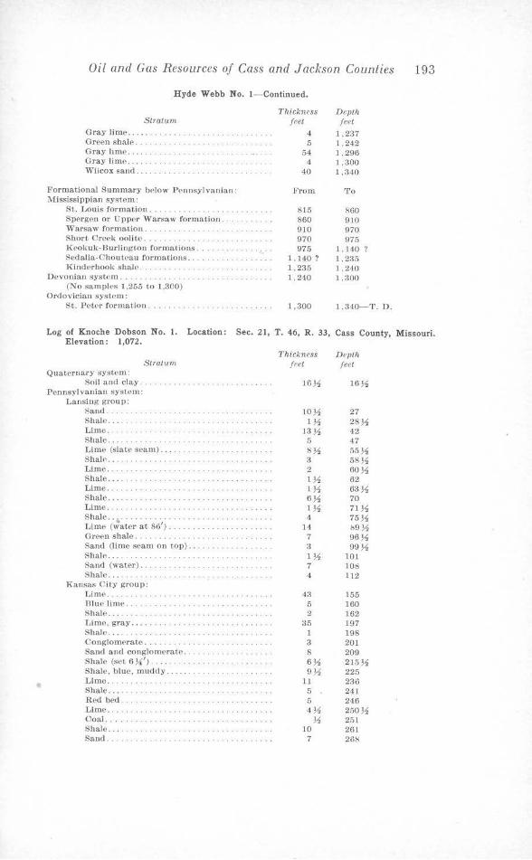
•
Oil and Gas Resources of Cass and Jackson Counties 193
Hyde Webb No. 1- Continued.
Stratum Gray lime ....... . Green shale . . . . . . .. .. .. . .. . . Gray lime ... . Gray limo ..... . . . Wilcox sand ..... .
Formational Summary bPlOw Pennsylvanian: JV!ississippian system:
St. Louis formation . . . . . . . . . .. . ... . Spergen or Upper 'Warsaw formation. ,varsaw formation .......... .. . Short Cre<>k ooli te ..... . Krokuk-Burlingt-On formations .. Sedalia.Chouteau formations .. . .. .. . Kinderhook shale ..
D evonian system .... . .. . .. . .. . .. . (No samples l ,255 to J ,300)
Ordovician system: St. Pet<•r for mation ..... . .. . .
Thickness feet
4 5
54 4
40
From
$15 860 910 970 975
1, 140 ? 1,235 1.240
1,300
Devth feet
1,237 1 .242 1 .296 1.300 1,340
To
/;60 910 970 975
1,140 ? 1 ,235 1.240 l .300
1,340-T. D.
Log of Knoche Dobson N o. l. Location: Sec. 21, T. 46, R. 33, Cass County, Missouri . Elevation: 1,072.
Quaternary system: Soil and clay .
Pennsylvanian system : Lansing group:
sand . . Shale ..... .. . Lime ... . Shale ... .
Stratum
Li me (slat,e seam) .... Shale .. . Lime . . . . Shale ... . . Lime .... . Shale .. . Lime... . . . . .. . .. . . ... . .. . .. .. . . . . . Shale .. • .... .. .. .. . Lime (water at 86'). Green shale . . . . . . Sand (lime scam on top) . . . .. . . . ... . . Shale.... . . . .. . .. .. . Sand (water) .. Shale .... . .. .
Kansas City group: Lime .. Blue lime . .. .. . . Shale ... . Lime, gray......... . . . .... ... .. . ..... . Shale . . ..... . Conglomerate ..•. Sand and conglomerate.. . . . . ........ . Shale (SPt 6 ~ ') ..... . ...... . Shale, blue. muddy .... . ... . .. .. . Lime.......... . . .. ... .. . Shale .... Red bed. Lime ..... . Coal.. Shale ... .. .. . .. .. .. . ... . .. .. . .. . . . Sand. . . . . . ... . . . . . . . . . . .. .... . ...... .
Thickness feet
16J,1
10~ 1~
J3~ 5 8~ 3 2 1% 1 J,1 6 J,1 1% 4
14 7 3 IM 7 4
43 5 2
35 l 3 8 6~ 9},!,
11 5 5 4~ ~
10 7
Depth feet
16},!,
27 28~ 42 47 55 J,1 58M 60~ 62 63~ 70 71},!, 75~ !s9M 96M 99M
101 108 112
155 160 162 197 198 201 209 215% 225 236 241 246 250J,1 251 261 288
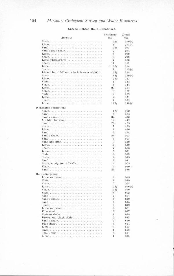
194 Missouri Geological Survey and Water Resources
Knoche D obson No. I - Continued.
St.r<1.tum Shale .... , ..... . Lime .. . . .. . Sand. . . ... . ... . ...... . Sandy gray shale, ... , . ... . . Lime. Shale .... . ... . .. . . Liml' (shale scams) ..... . . Shale ..... L ime .. Shale .... Limo. blu<· (150' water in hole over night) .. Shall'.... . . . ... . . .. .. .. . Lime . . . . Slate ...... .... .. .. .. . Shale .... .. . . . . . . .. . Lime . . Shale ... . .. ... . . .. . .. .. . .. .. . Slate . . Lime . . Shale .... . . .. .. . . ... . .. . Lime .. .
Pleasanton rormation: Shale ... . .. . .. ..... .. .. . .. . .. ..... . . . Sand. Sandy shale. Muddy blue shale ..... .. .. . .. .. . .. . .. . . . Sand. . .......... .. . . . . . .. . ... . .. . Shale...... .. · · · · · · · · · Lime .. . .. . . .......................... . . Sand .... .. .... . . . . . ...... . . . . . ... . . •. .. Sandy shale .. . Sand ..... . . .. .. .. . . . . Sand and lime ........ . Limo .. Shale .... . .. . . . . . .... . Lime ... . .... . Slate .... . Shale . . . . Sand .. ... . Shale, sandy (set 4 7-811
).
Shall' . . ..... .. . ...... . ...... . . Sand .. .
Henrietta group: Lime and sand ...... . . Slate .. . ...... . Shale ... .. ..... . ..... .. . Lime . .. . . . . . . . ... ... .. . Shale ...... . Slate .. Sand . . . Sandy shale . .. . . .. .. . .. . ..... . .. . .. . Sand . . . Shale, ... . Lime and sand . Fine sand .. . Slate or sbalo .... . .. .. . .. . Hrown and black shal(• ... . Sandy shale .... . Blue shah• ....... . Lim(' .. . .. . .. .. .. . ..... . . Slate. . .. . . . . . . . ... . . . . ..... .. . .. . . Shale, blue . Lime ...... ..... .. . .. ..... . . .. .. . .. .
Thickness feet
2~ 1 5 J.1 7 6 3 7
11 X 3~
1 12~
I ~ 7~ 1 6
20 :i 2 2 l
18~
1~ 6
:l2 I:.! 26
7 1 2
24 5 3 9 7 5 2 2 6
14 5
26
2 1 5 2~ 2 .l1 3 2 6 5 4 2
16 1 5 7 4 :i I 6
Depth fret 270~ 211u 277 284 290 293 300 311 :l14 315~ 328 329~ 337 336 344 364 367 369 371 372 390~
392 39S 430 442 468 475 476 478 503 507 510 519 526 5:':Jl 533 535 541 555 560 586
588 589 594 59o~ 599 602 604 610 615 6 19 621 637 638 643 650 654 657 658 664 665
•
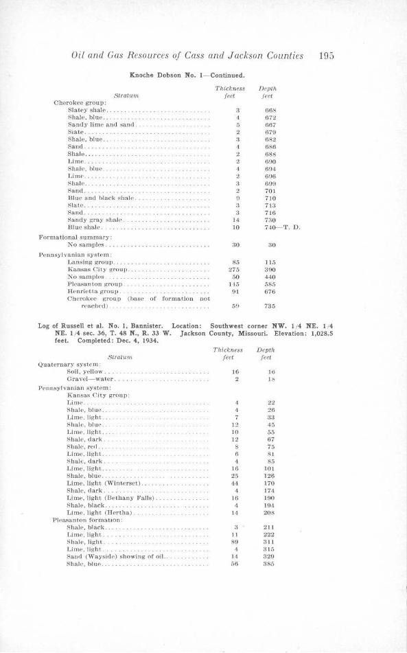
Oil and Gas Resources of Cass and Jackson Counties 195
Knoche Dobson No. 1- Continued.
Stro.tiun Cherokee group:
Slatey shale . . Shale, blue .. . . Sandy lime tuHl sancl . .. .. . . ... . .. . . .. . Sutte . . . Shale, blue .. . Sand . .. ...... .. . .. .. . .. . .. . .. . .. . . Shale .. ... . Lime .. . .. . ShalP, bin('. Lime ... .. ... . Shale .......... . ..... .. .. . .. . .. . ....•... Sand ... . Blue and black shalP. Slate . . . ...... . . ..... . ... . ..... . ... . . . . . Hanel ... . Sandy gray shal<' . . . Blue shale . . .. . . . .. .
Formational summary: No samples ................... . ........ .
Pennsylvanian s yst-E'm: Lansing group ... . Kansas City group .. . No samples . . .. ..... . . ..... . ........... . Pleasanton group. HPnriett,a group . Cherokee group (base of formatfon not
r<'achPd ) . . .. . . . ... .
Thickness feet
3 4 5 2 3 4 2 2 4 2 3 2 9 3 3
14 10
30
85 275
50 H5 91
50
Depth feet
668 672 667 679 682 686 688 690 6\14 6U6 699 701 710 713 716 no 740-T. D.
30
115 390 440 585 676
735
Log of Russell et al. No. 1, Bannister. Location: Southwest corner NW. 1/4 NE. 1/4 NE. 1 /4 sec. 36, T. 48 N., R. 33 W. Jackson County, Missouri. Elevation: 1,028.5 feet. Completed: Dec. 4, 1934.
St.ratmn Quaternary system:
Soil, yellow . .. . . Gravel-water .... .
PPnnsyl vanian system: Kansas City group: Lime ... . .. . . Shale, blue . . . Lime. Jig lH. Shale, bluP. LimP. light. Sha.le. cl ark . Shale, red .. . Lime. light, .. . . Shale, chirk . Lime, light. .. . Shale, blue . ...... . ..... .. . Lime . light (Winterset) . . . ..... . .. . .. .. . Shale. dark . . Lime. light (Be thany Falls). Shale. black... . . . . .. . .. . LimP, light (Hertha) ..
Pleasanton forrnat,100: S hale. black . Lime, light. . .... .. . . Shale, light .. .. . . Lime, light. . . . .. . . .. .. . Sand (Wayside) showing of oil. . . Shale, blue ...
Thickness Depth feet feet
16 16 2 Jo
4 22 4 26 7 33
]2 45 10 55 12 67 8 75 6 8 1 4 85
16 101 25 126 44 170
4 174 16 190 4 194
14 208
3 211 11 222 89 311
4 3 15 14 329 56 385
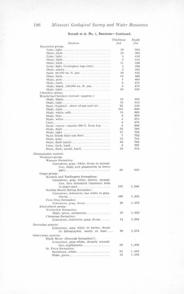
196 Missouri Geological Survey and Waler Resources
Russell et al. No. 1, Bannister- Continued.
1'hickne$S Stratum
IIenricUa group: Lime, light ...... ... . . . .. .. . . . . .. . . . ... . Shale, dark .. . Lim<', light, ........ . .. . . Shale, light .. ........ . . .. .. .. . .. . . . .. .. . Shale, dark.. . . . ... . .. . .. . ... . . . Lime, light (Lexington cap-rock) ...... . Shale, sandy ..... . . Sand, 80,000 cu. ft. gas .. Shale, light. . . . . . . .. ... . . Shale, piok.. . . . . ... . . .. .. . ... . Sha)(', dark ...... . .. .. . . . Shale, black. 100,000 cu. ft. gas .... . ..... . . Shale, light. .. . ..
C herokee group: Henrietta-Cherokee con ta.ct (approx.) :
Sha.le, black... . . . . . . . . . . . .. . .. . .. . . . S hale, light ......... . Sand (Squirrel-show of gas and oil) .. . .. . . Shale, dark ................. . Shale, white, soft ..... . Shale, blue ...... . ..... ... .. .. . Shale, white ....... .. . ... . .. .. . . ... . . Lime.. . .. .. .. .. . . Sand-water-stands 500 ft. from top ... Shale, dark ......... . .. . .... . Shale, light ......... . Sand (black slate one foot' .... . .... . . Shal<', gray ... . ........ . .. . ... .. ... . . . . Shale, dark sandy ...... . Lime, dark, hard.. . ... . . .... . .. .. .. .. . Shale, dark. sandy, hard ..... . .. . . . . .
Mississippian system: lVIeramec group:
Warsaw forma~iow Limest-011e, gray, whHe. dense to crystal
line, shaly and glauconitic in lower part ....... . .... .
Osage group: Keokuk and Burlington formations:
Limestone, gray white, cherty, crystalline, thin dolomitic limestone beds in upper part . . .. ...... . .. .. . . . . .
Seda.Ha-Reeds Spring formation: Limestone, dolomitic, tan whitP to gray,
chcrty.. . . . . . . . . .. . .. . . Fern Glen formation:
Limestone, gray, dense. . .. ... .. .. . . . Kinderhook group:
Northview formation: Shale, green, calcareous ..... .
Chouteau formation: T.,imestone. dolomitic, gray, dense ..... .
Devonian system: Limestone, gray white to brown, dense
to· lithographic, sandy ai base .. . •
Ordovician system: Black River (Decorah formation?):
Limestone, gray-white, densely crysta,1-line, argillaceous .......... . ..... .
St. Peter formation: Sandstone, white ................... . Shale, green ...... . .... . .. ...... .. . . .
feet
10 10
5 5
ll 4 5
10 15 4 8 2
16
10 13 33
]04 15 5 4 4 8
22 17 7
13 49
3 18
98
173
166
20
10
12
80
29
73 13
Depth feet
395 405 410 415 426 430 435 445 460 464 472 474 490
500 513 546 650 665 670 674 678 686 708 725 732 745 794 797 815
913
1,086
1,252
1,272
1 ,282
1,294
1,374
1,403
1,476 1,489
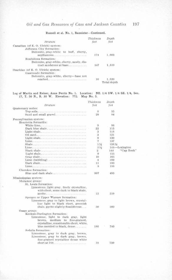
Oil and Gas Resources of Cass and J ackson Counties 197
Russell et al. No. l, Bannister- Continued.
Stratum
Canadian (of E. 0. Ulrich) system: Jefferson City formation :
Dolomite, gray-white argillaceous ..... .
Roubidoux formation:
to buff, chcrty,
Dolomite, gray-white, chnty, sandy, distinct sandst,one at base ... .
Ozarkian (of E. 0. Ulrich) system: Gasconade formation:
Dolomite, !,'Tay-white, cherty- base not roached.. . . . ..... . .
Thickness Depth feet feet
174 1,663
147 1,810
10 1,820 'fotal depth
Log of M artin a nd Reiser, Anne Perrin No. 1. Location: NE. 1/4 SW . 1/4 SE. 1/4, Sec. 17, T. 50 N. , R. 30 W . Elevation: 772. M ap No. 5.
Stratum Quaternary series:
Top soils . . Sand and small gravel. .. . ... .. ......... . .
Pennsylvanian system: Henrietta formatiln:
White lime ... Dark blue shale ..... .. . .. ... .... . .. . Light shal<~ ......... . .... . . . Oil sand .... . . . .. . Light shale . .. .......................... . Lime . .. . . ............... .. . .. .. . .. .. . . . Shale ...... .. ...... . .......... . .. . . .. .. , Limo . . . . ... . ..... .... . .... . . .. ... ..... . Black shale.. . . . . . . .... . . Light shale.. . . . . . . . .. ........ . Gray shale.. . . . . ............ . .. . Lime (bubbling) ...... . ............ .. . . . . Dark shale... . . . ... . . .. . Lime .. . ......... . . . ... ... ... . .. .
Cherokee format.ion: Dlue a.nd dark shale ... ...... . .... .
Mississippian system: Meramec group:
St. Louis formation: Limestone. light gray, J1 nely crystalline,
with chert, some dark to black shaJe, pyrite ..... .. ............. .. .. .
Spergen or Upper ,varsaw formation: Limestone, gray to light brown. crystal
line light to black chert, greenish shale, pyrite slightly fossiliferous.
Osage group: Keokuk-Jlurliugton formation:
Limestone, light to dark gray, light brown, medium to fine-grained, crystalline, consi<lorable chc.rt, white, blue mottled to black, <lense ... . . . .
Sedalia formation: Limestone, gray to dark gray, brown, Limestone, gray to dark gray, brown,
flnc-gra.inccl crystalline denso wbito chert at 748 ..... . ......... . . . . . .
Thickness feet
()
29
9 22
3 3 9 7 1% 5~
2 9
10 4
11 8
307
15
50
180
10
Depth f eet
55 84
93 115 118 121 130 137 138 }-4 144-Lexington 140 "Cap Rook" 155 165 169 180 188
495
510
560
740
750
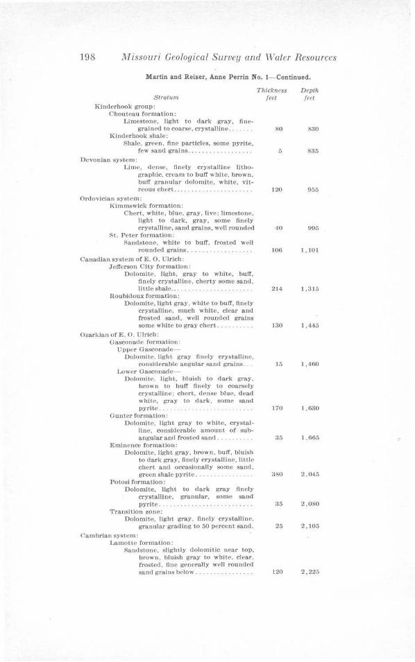
198 Missouri Geological Survey and \Valer Resources
Martin and Reiser, Anne Perrin No. !- Continued.
Stratum Kinderhook group:
C:houtoau formation: l, imestone. light to dark gray, fine
grained to coars<', crystalline ... Kinderhook shale:
Shale, green, fine particles, some pyrite, few sand grains ..... ... . .. .. .... .
Devonian system: Lime, dense, finely crystalline litho
graphic. cream to buff white, brown, buff granular dolomite, white, vit-reous chert ......... .
Ordovician system: Kimmswick formation:
Chert, white, blue, gray, live: limestone. light to dark, gray, some finely crystalline, sand grains, well rounded
St. Peter formation: Randstone, white to buff, frosted well
rounded grains ...... . Canadian system ofE. 0. Ulrich:
Jefferson City formation: Dolomite, light, gray to white, buff,
finely crystalline, chcrty some sand, little shale ... . . .
Roubidoux formation: Dolomite, light gray, wltite to bull', finely
crystalline, much white, clear and frosted sand , well rounded grains some white to gray chert. ...
Ozarkian of E. 0. Ulrich: Gasconade formation:
Upper Gasconade-Dolomite. light gray finely crystalline,
considerable angular sand grains . .. Lower Gasconade-
Dolomite, light, bluish to dark gray, brown to bufr finely to coarsely crystalline; chert, d!'nse blue, d ead white, gray to dark, some sand pyrite . .. ... .
Gunter formation: Dolomite. light gray t-0 white, crystal
line, considerable amount of subangular and frosted sand ....
Eminence formation: Dolomite, light gray, brown. buff, bluish
to dark gray, finely crystalline, little chert and occasionally some sand, green shale pyrite .. ........... . . .
Potosi rormalion: DolomJte, light to dark gray finely
crystalline, granular, some sand pyrite. . . . ..... . . .......... ... .
Transition zone: Dolomite, light gray, finely crystalline,
granular grading to 50 percent sand. <'arnbrian system:
Lamotte formation: Sandstone, slightly dolomitic near top,
brown, bluish gray to white, clear, frosted, fine generally well rounded sand grains below ........ .. ..... .
Thickness feet
80
5
120
40
106
214
130
15
170
35
380
35
25
120
Depth feet
830
835
955
095
1.101
1.315
1,445
1 ,460
1,630
1, 665
2 , 045
2,080
2,105
2,225
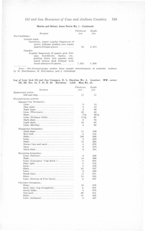
Oil and Gas Resources of Cass and Jackson Counties 199
Martin and Reiser, Anne Perrin No. I- Continued.
Stratum Pre-Cambrian:
Granite wash: Sandstone, coarse angular fragments of
pyrit.e. feldspar grading into coarse
Thickness feet
quartz feldspar gravel.. . . . . 50
Granite: Angular fragments of quartz pink feld
spar, hornblende. biatite, etc .. grading clown into granite composed salmon pink feldspar with minor amounts of quartz. . . . . . . . . . l. 925
fJevt.h feet
2,275
4.200
Note:- Pre-Ponnsylvanian section from sample determination of insoluble residues by :IC. Hundhausen, E. 1lcCracken, and J. Crohskopf.
Log of Lone Jack Oil and Gas Company, D. L. Shawhan No. 6. Location: NW. corner SE. SE. Sec. 14, T. 47, R. 30. Elevation: 1,028. Map No. 23.
Stratum Quaternary series:
Soil and clay . .................. . ....... .
Pennsylvanian system: Kansas City formation:
Lime ........................... . ...... . Blue shale.. . ..... . . • ....... . . Dark shale ......... .. . .... . .•..... . .. . . . Lime (Winterset) ..................... . Shale ................... •.. ............. Limo (Bethany Falls) ....... • .... .... .... Dark shale ........... . Liitht shale ........... . ... .. . ......... . •. Limo (Hert.ha) ............... .. ........ .
Plcasan ton formation: Dark shale ............... ... . .......... . Red rock ....... . ..... ... .............. . Shale .... . ................... ·· · ····· Lime ...... ..... . ..... . .... .. ....... ··,, Shale .. . . .. ..... . .. . . .. .. . . .. .. . . . ..... . Brown limo and sand ... . .. ... .. . .... . i<and.... ... . ..... . ... •. ......... .. .. Dark shale.. ..... . ............ .
Henrietta formation: Lime (Pawnee) . . ..... . . . Shale... .... . .. . .... . .... . .. . . . .. . l,ime (Lexington "Cap Rock") ........ •. . . Slate (gas) . . . . . . . . . . . . ..... •.. ... Limo .............. .. .................. . Shale ..... . .... .•.....•. ... ..... .. ...... Lime ......... • , ............. . ....... . . . Black slate ......... . Shale .................. . ...... . . · · · ·. · • Limo (Bottom of Fort Scott) ............. .
Cherokee formation: Shale ...................... . ..... . ..... . Saud (gas) (to1> of squirrel) ... . . . .. . ..... . Sandy shale .. .... .... .... .. . . . . Gas sand ... . . .................... . . ... . Shale .... .... .. ..................... ... . Lime (Ardmore) ... ... .•... . ..... . ... . ...
Thickness Depth feet feet
11 11
3 14 4 18 2 20
22 42 7~ 49~
17~ 67 9 76
19 95 3 98
11 109 5 )14
136 250 3 253
15 268 4 272 6 278 6 284
2 286 14 300 8 308 4 312 4 316
21 337 2 339 2 341
14 355 2 357
13 370 3 373 5 378
36 414 41 455
2 457
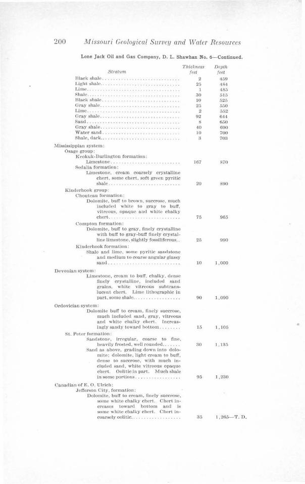
200 Missouri Geological Survey and Water Resources
Lone Jack Oil and Gas Company, D. L. Shawhan No. 6-Continued.
Stratum
Dlack shale ... . .. . . ....... . ....••.. . .. . . Light shale ... . .. . .. . . .. ... ... . ....... .. . Limo ...... ... . ..... . .• ..... • ... Shale..... . .. ... ......... •........ Rlack shale ............ . .. ... . . ........ . Gray shale ........ . ........... •. ... .•... Lime ......... ..•.. .. .... .. .•.....•..... Gray shale ...... . .. ....... . .. . .. . .. .. . . . Sand ...................... . . .. . .. . .... . Gray shale .. . .. ..•....•. ... ... ... . . .. .. . ,vater sand ..... .... .. . ....... . .. .. .•... Sbalo, dark ..................... • ........
:Mississippian system: Osage group:
Keokuk-Durlington formation: Limestone ... . . . ... ....... .. . . ..... .
Sedalia formation: Limestone. cream coarsely crystalline
chert. some chert, soft green pyrltic shalo ................... . .. .... .
Kinderhook group: Chouteau formation:
Dolomite. buff to brown. succrose, much included white to gray to bufr, vitreous, opaque and white chalky chert..... .. ..... . .. . ........ .
Compton formation: Dolomite. buff to gray, finely crystalline
with buff to gray-buff finely crystalline limestone. slight,Jy fossiliferous ..
Kinderhook formation: Shale and Ii me, some pyritic sandst-0ne
and mPdium to coarse angular glassy sand ....... ... ....... . .. .... .. .
Devonian system: Limestone, cream to buff, chalky, dense
finely crystallinP, included sand grains, white vitreous subt.ranslueent chert. Lime lithographic in part, some shale ..... . .... .. ..... .
Ordovician system: Dolomite buff to cream. finely succrose,
much included sand , gray, vitreous and white chalky chert. Increasingly sandy toward bottom.
St. PPter formation: SanclstonP, irrpgular , coarse to fine,
heavily frosted. well rounded .. . . .. . Sand as above, grading down into dolo
mite; dolomite. light cream to buff, dense to succrosc, with much included sand. white vitreous opaque chert. Oolitic in part. Much shale in some portions ............. .. . .
Caoadian of E. 0. Ulrich: Jefferson City, formation:
Dolomite, buff to cream, finely succrosc, some white chalky chert. CherL increases toward bottom and Is some white chalky chert. Chert in-coarsely oolitic .. ... ....... . ..... .
Thtckness Depth feet feet
2 459 25 484
1 485 30 515 10 525 25 550
2 552 92 644
8 650 40 690 10 700
:i 703
167 870
20 890
75 965
25 990
10 1,000
90 1,090
15 1 ,105
30 1,135
95 1,230
35 1,265-T. D.
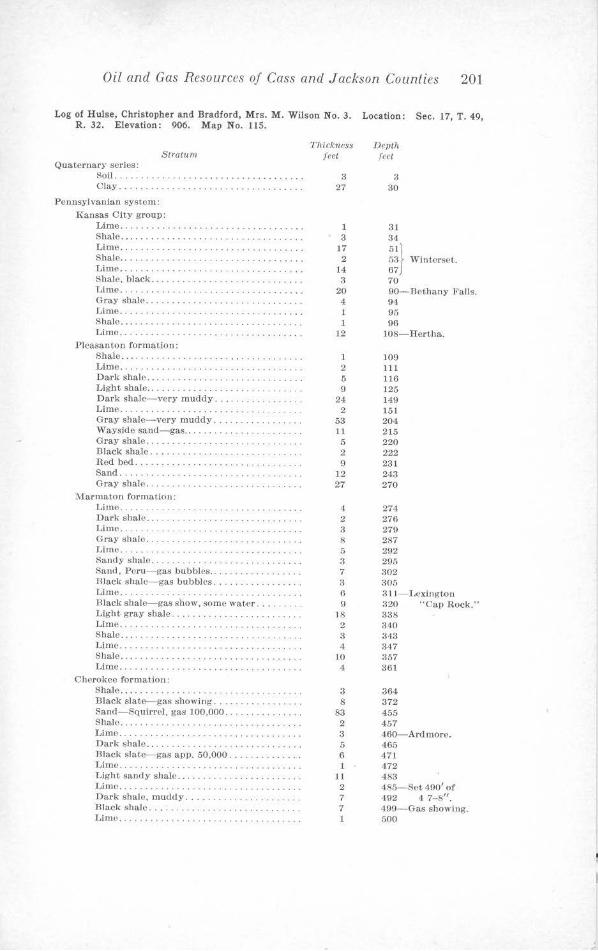
Oil and Gas Resources of Cass and Jackson Counties 201
Log of Hulse, Christopher and Bradford, Mrs. M. Wilson No. 3 . Location : Sec. 17, T . 49, R . 32. Elevation: 906. Map No. 115.
Stratum Quaternary series:
Soil.. . .....•..... . .. . .... . ....... . Clay.... . ..... . ............... .
Pennsylvanian system: Kansas City group:
Lime . .. .............. • .. . . . ..... . ...... Shale . ...... .... ... . ..... •. .. .. .....•... Lime ...... •. .... . .......... . ..... • ..... Shale •........... . . . . ...... .. . ..... •... . Lime ..... . ............. •.. ............. Shale, black . . . . . ................. . ..... . Lime ............ • . . ·.· ············•· ··· Gray shale . .......... •. .... • ............ Lime ..... . . .. ... ... ·········· •· ···· · ··· Shale . .............. . .... ·.·.···· •· ····· Lime ...... . ........ •. ....•.............
Pleasa11ton formation: Shale ... .............. . ..... . .........•. Lime .............. . ... . .•• . ... . ........ .Dari, shale ... ... . ................... • ... Light shale ....... . ........... . .. . . .. ... . Dark shale- very muddy . .. ... . ......... . Lime .. ... . . .. ............. . Gray shale-very muddy. . . . . . . ........ . Wayside sand- gas . .. . .. .. . .. .•..... ..... Gray shale... . ... . . . . .. . ........... . . Black shale .. ...... . ... . Red bed ...... . ................... . Sand... ... .... . ........... . . Gray shale .....
lV(armaton formation: Limo ....... . Dark shale . . ........ . ... . Lime.. . . . . · . ·. · ·· · · ·· ··· · ·· · Gray shale ..... . ......... . ...... . .. .. .. . Lime. . ... . . ........ . , . · · · Sanely shale. . . . . . . ...... . ..... . Sand, Peru- gas bubbles .......... . Dlack shale-gas bubbles ... . Lime . ..... .. ... . ....... . ... . . Hlack shale-gas show, some water . . ... . Light gray shale ... ... . . Lime.. . . . . · . . · · . · · · · · · · · · · · · · · Sbalo .... ... . .... .... . ............ ... . Lime ... . Shale ... . . . Lime . ........ . .
Cherokee formation: Shale. . ................ . .... . . . . . Dia.ck slate-gas showing ........... •. .... Sand-Squirrel, gas 100,000 .... . ... . . . Shale............ . ......... ... . Lime.... .. . ...... . . . .. ... ... . . . Dark shale . . ........... . .. . Black slate-gas app. 50,000 .. .. .. ... .... . Limo......... . . . . . ..... . . Light sandy shale ..... . . Lime ............ . ......... . ... . .. . .. .. . Dark shale. muddy .... . .... . . .. . ....... . Hlack shale ... . ........ .. ... . . Limo.. ........ . .. . . .. . ...... . . ..... .
Thickness Devth feet feet
3 3 27 30
1 31 3 34
17 5ll 2 53 Winterset.
14 67J 3 70
20 90-Betltany l•'alls. 4 94 1 95 1 96
12 108-Rertha.
l 109 2 111 5 116 9 125
24 149 2 151
53 201 11 2 15 5 220 2 222 9 231
12 243 27 270
4 274 2 276 3 279 8 287 5 292 3 295 7 302 3 305 6 3 11-L<"x.ington 9 320 "Cap Rock ."
18 338 2 310 3 343 4 347
10 357 4 361
3 364 8 372
83 455 2 457 3 460- Ardmore. 5 465 6 471 1 472
11 48:1 2 485- Sot 490' of 7 492 4 7-8" . 7 499-Gas showing. 1 500
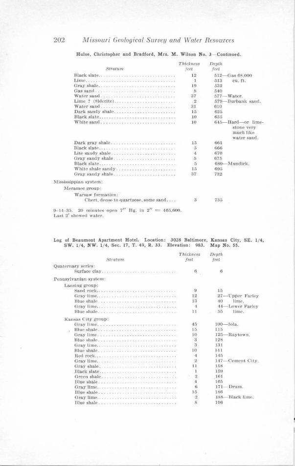
202 Missouri Geological Survey and Water Resources
Hulse, Christopher and Bradford, Mrs. M. Wilson No. 3- Continued.
Stratum Black slate .. . Limo ..... . Gray shale .. ... . .. . . ...... . ..... . .. .. . . . Gas sand.... . .. . . .. . .. . .. . . ..... . . ,vater sand. . . . . . . . . .. . ..... . .. .. . .. . Lime ? (Si<lcritc) . . . . ..... . .. ... . Water sand ... . .. .... . . . . . ... ..... ... . . . Dark sandy shale ... . Black slate ...... . .. .. . .. .. . .. ....... ... . White sand .... . .. . .. ..... .. . .. .. ..... . .
Darlc gray shale .. . .. . . . .. . .. . .. . . . .... . . Black slato ........ . Lite sandy shale . . .............. . .. ... . Gray sandy shale ... .. . . .. . . .. . . .. .. . .. . . Black slate ... .. . . . White shale sandy. Gray sandy shale.
Mississippian system: l\:(eramec group:
,varsaw formation: C hert. dense to quartzose. some sand ....
Thickness feet
12 1
19 8
37 2
31 15 10 IO
15 5 4
5 5
15 37
3
9-14-35. 20 minutes open 7" Hg. in 2" = 465.600. Last 2 1 showed water.
Depth feet 512-Gas 68,000 513 cu. ft. 532 540 577- WatC>r. 579-Burbank sand. 610 625 635 615-IIard-or llme
st-Ono very much like water sand.
661 666 670 67.'; 680- Mundick. 695 732
735
Log of Beaumont Apartment Hotel. Location: 3028 Baltimore, Kansas City, SE. 1/4, SW. 1/4, NW. 1/ 4, Sec. 17, T. 49, R. 33. Elevation: 983. Map No. 55.
8tratu,n Quaternary sories:
Surface clay ....
Pennsylvaniau system: Lansing group:
San<l rock .. Gray lirne . . Blue shale. Gray lime .. .. . B lue shale .. . .
Kansas City group: Gray lime .... . Blue sh,\le ....... . . . .. . . .. . Gra.y lime ..... . . Blue shale .......... . . . .. . . .. .. .. . . .. . . . Gray limo.. . . . . . .... .. .. . . .. . . J31uo shale .... ......... . . ...... . . . . Red rock ... . Gray lime .. Gray shale .. . . ... . .. . . Dlack slate .. . . Green shale . . . . . .. . . . ... . Dlue shale .... . . . Gray lime .. Blue shale. Gray 11m~ .. Blue shale ..... .. .
ThiCktleSS Depth feet feet
6 6
9 15 12 27-Upper Farley 13 40 lime. 4 44- Lower FarlEIY
ll 55 lime.
45 100-Iola. 15 115 10 125- Rayt-Own. a 128 3 131
10 141 4 145 2 J47-Cement CJty.
11 158 1 159 2 161 4 165 6 171- Drum.
15 186 2 188- l-llack lime. 8 196
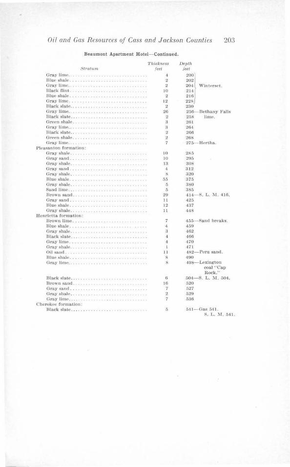
Oil and Gas Resources of Cass and Jackson Counties 203
Beaumont Apartment Hotel-Continued.
Cray lime ... Illue shale ..
Strattsm
Cray lime . ........ . ......... . Hlack flint . 13lue shale. . . . . .. . Cray lime . ...... . ..... . Black slate ..... ·. . . . . ...... . ...... . Gray lime. . . . . .... . ......... . 13lack slate . .. .... . ...... . ... . .... . . . .. . . Green shale ......... . Cray lime.. .. . . .................. . ... . Black slate .. . ... . . .. . . . .. . .. . ..... . .. . . . Gre<>n shale .... . .. .. . Cray lime . .... . ........ . ..... . ......... .
Pleasanton formation: Gray shale ... . ......................... . Cray sane!. .... . . Gray shale . . ... . ..... . ..... ... ... .. ... . Gray sand ... .. . .. ....... . . . .... . . . Gray shale ...........•.................. Rluc shale .. ...... . .................... . Cray shale .. Sand lime .. .. . Hrown sand. ....... . ..... . ........... . Cray sand . ... . ............. . Blue shale .. Gray shale . .... .
Henrietta formation: Drown lime .... ........................ . Blue shale ............................ . Cray shale . ............... . . . ... . . . ... . Black slate . . . . . . . . . . . . . . .. . .. . . . ... . G1·ay lime ..... . Gray shale .. .. . . . Oil sand . . . ..................... . ..... . Blue shale .... ..... . Gray lime . ... .•... . .•........ . ..... . ...
fllack slate .. ........ . ... . Brown sand . . . . ...... . .. . . . Gray sand . . . .. ... . . Gray shale •. . ..... .... . ..... . ... . . Cray lime . . . ........... .. .. . ........... .
Cherokee formation : Dlack slate .......... .•......•...........
Thickness feet
4 2 2
10 2
12 2
26 2 3 3 2 2 7
10 10 13 4 8
55 5 5
29 11 12 11
7 4 3 4
4
11
8 8
6 16
7 2 7
5
Depth f eet
200) 2021 204 t \Vint<'rsct. 214 216 228) 23() 256-Bethany Falls 258 lime. 261 264 266 268 275- H<'rtha.
285 295 308 312 320 375 380 385 414- S. L. :-.r. 416. 425 437 448
455- Stind brC'aks. 459 462 466 470 471 482-Pcru sand . 490 498- Lexington
coal "Cap Rock."
504-S. L. '.\f. 504. 520 527 529 536
541- Gas 541. S. L. M . 541.

I N DE X
Page Acknowlcdg1nents . . . . . . . . . . . . . . . . . . . . . . . . . . . . . • . . . . . . . . . . . . . . • . . . . 8 Analyses or deep well waters. . . . . . . . . . . . .. . . • . . . . . • . . . . . . . . . . . . 122 Analysis maps, waler, discussion of . . . . . . . . . . . . . . . . . . • . . .. . . . . . . . . . . . . . . . . . . . 117 Analysis, water, maps of .. ................. ... .. . . . ...... • ...... . ...... • ... . . 118-121 Archic-Plellsnnt Hill-Strasburg district
further prospecting in . . . . . . . . . . . . . . . . . . . . . . . . . . . • . . . . . . . . . . . . . • . . . . . . . . . . 107 gas pools in . . . . . . . . . . . . . . . . . . . . . . . . • • . . . . . . . . . . . . • . . . . . . . . . . . . . . • . . i-1 structure of . . . . . . . . . . • . . . . . . . . . . . . . . • . . . . . . • . . . . . . . . . . . . . . • . . . . . . . . . . . . . . 49
Arca, geologic map of................ .. . ........ .... . ....... . .............. .. . 12 location of . . . . . . . . . . . . . . . . . . . • . . . . . . . . . . . . . . . . . . . • . . . . . . . . . . . . • • 9 special features of . . . . . . . . . . . . . . . . . . . . . . . . . • • . . . . . . . . . . . . . . . . . . . . . . . . . . . . 10
Areas for deeper r,rospcding . . . . . . . . . . . . . . . . . . . . . . . . . . . . . . . . . . . . . . . . . . . . . . . • . 111 Areas for further shallow development .. ..... ...... .. ... , . . . . . . • . . . . . . . . . . . . . . 106 Banuistcr Hidgc anticline . . . . . . . . . . . . . . . . . . . . . . . . . . . . . . . . . . . . . . . . . . . . . . 56 Helton-Drexel district
further prospecting in .... . ... . ...................... , . . . . . . . . . . . . . . . . . . . . 106 gas and oil pools in . . . . . . . . . . . . . . . . • . . . . . . . . . . . . . . . . . . . . . . . . . . . . . . . . . . . . 63 structure of . . . . . . . . . . . . . . . . . . . . . . . . . . . . . . . . . . . . . . . . . . • . . . . . • . . . . . 39
Belton fault conwlex . . . . • . . . . . . . . . . . . . . . . . . . . . . • . . . . . . . . . . . . . . • . . . 44 Belton sand . . . . . . . . . . . . . . . . . . . . . . . . . . . . . . . . . . . . . . . . . . . . . . . . . . . . . . . 20
cross sections of . . . . . • . . . . . . . . . . . . . . . . . . . . . . . . . . . . . . . . . . . . • . . . . . . . . . . 22 description of . . . . . . . . . . . . . . . . . . . . • . . . . . . . . . . . . . . . . . . . . . . • . . . . . . . . . . . . . . . . 21 cxtcut of' . . . . . . . . . . . . . . • . . . . . . . . . . . . . . • . . . . . . . . . . . . . . . . . . . . . . • . . . . . . • . . 20 isopach map of . . . . . . . . . . • • . . . . . • . . . . . . • . . . . . . • • . . . . . . • . . . . . . • • . . . 20 origin of . . . . . . . . . . . . . . . . . . . . . . . . . . • . . . . . . . . . . . . . . . . . . . . . . . . . . . . . . . . . . . 21
Bethany Falls escarpment . . . . . . . . . . . . . . . . . . . . . . . . . . . . . . . . . . . . . . . . . . . . . . . . . . . . 10 Bibliography . . . . . . . . . . . . . . . . . . . . . . . . . . • • . . . . . . . . . . . . . . . . . . 115 Blue Ridge itnticl inc . . . . . . . . . . . . . . . . . . . . . . . . . . . . . . . . . . . . . . . . . . . . . . . . . . . . . . • . . 59 Blue Hidge gas field . . . . . . . . . . . . . . . . . . . . . . . . . . • . . . . . • . . . . . . . • . . . . . . . . . . . . . . . . . 9.J. Blue Springs anticline . . . . . . . . . • . . . . . . . . . . . . . . . . . . . . . . . . . . . . . . . 57 Bonncterre formation . . . . . . . . . . . . . . . . . . . . . . . . . . . . . . . . . . • . . . . . . . . . . . . . . . . . . . . . . 34 Bradford and Francis pool . . . . . . • • . . . . . . . . . . . . . . . . . . . . . . . . . . . • . . . . . . . . . . 102 Burgess sand . . . . . . . . . . . . . . . . . . . . . • . . . . . . . • . . . . . . . . . . . . . . . . . . . . . . . . . . . . . • . . . . 15 Cambrian system . . . . . . . . . . . . . . . . . • . . . . . . . • . . . . . . . • . . . . . . . . . . . . . . . . . . . . . • . . . . . 34 Canadian system . . . . . . . . . . . . . . . . . . . . . . . . . . . . . . . . . . . . . . . . . . . . . . . . . . . . . . . . . . . . . 33 Cass County
Arcbic- Plcasanl Hill-Strasburg district, structure of . . . . . . . . . . . . . . . . . . . . . . . 49 Jlelton-Drexcl district, structure of . . . . . . . . . . . . . . . . . . . . . . . . . . . . . . . . . . . . . . . 39 Cherokee wells in ... . .... .. .... ... .... • ... . .. •• ..... ••. ..... ... ..... 128-141 deep wells in . . . . . . . . . . . . . . . . . . . . . . . . . . . . . . . . . . . . . . • . . . . . . . . . . . ... 123-124 deeper prospecting in . . . . . . . . . . . . . . . . . . . . . . . . . . . . . • . . . . . . . . . . 112 early cconornk develot>mcnts of' . . . . . . . . . . . . . . . . . . . . . . . . . . . . . . . . . . . . . . • . . . 62 further prospecting in . . . . . . . . . . . . . . . . . . . . . . . . . . . . . . . . . . . . . . . 106 gas and oil pools in . . . . . . . . . . . . . . . . . . . . . . . . . . . . . . . . . . . . • . . . . . . • . . . . . . • . . . 63 Gunn City-Crcighton-D~ylon district, structure of . • . . . . . . . . . 51
logs of wells in ....................................... . •. . ..... .... . . • .. . 189-195 structure mnp of, reference . . . . . . . . • • . . . . . . . . . . . . . . . . . . . . . . . . . . . . . . . . . . . . . 37
Central anticline . . . . . . . . . . . . . . . . . . . . . . . . . . . . . . . . . . . . . . . . . . . . . . . . . . . . 49 Centropolis dome . . . . . . . . . . . . . . . . . . . . . . . . . . . . . . . . . . . . . . . . . . . . . • . . . . . • . . . . . . . • 60 Centropolis pool . . . . . . . . . . . . • . . . . . . . • . . . . . . . . . . . . . . . . . . . . . . . . . . . . . . . . . . . • . . . . 92 Cherokee grour> . . . . . . . . . . . . . . . . . . . . . . • . . . . . . . . . . . . . . . . . . . . . . . . . . . . . 15
ehnracteristics of . . . . . . . . . . . . . . . . . . . . . . . . . . . • . . . . . . . . . . . . . . • . . . . . . 15 units of . . . . . . . . . . . . . . . . . . . . . . . . . . . . . . . . . . . . . . . . . . . . . . . . . . . . . . . . . 16
Cherokee wells m Cass and Jackson counties .. . ............... . ............ .' .128-188 Chouteau J'ormaUon . . . . . . . . . . . . . . . . . . . . . . . . . . . . . . . . . . . . . . . . . . . . . . . . . . . . 30 Clarke-Miller o ii pool . . . . . . . . . . . . . • . . . . . . • . . . . . . . . . . . . . . . . . . . . . . . . . . . . . . . . . . . 66 Cockrell sink . . . . . . . . . . . . . . . . . . . . . . • • . . . . . . • . . . . . . • . . . . . . • . . . . . . • . . . . . . . • . . . . 56 Conclusion . . . . . . • . . . . . . . . . . . . . . . . . . . . . . . . . . . . . . . . . . . • . . . . . . • . . . . . . • . . . . . . • . . . 114
( 205)
206 J1.fissouri Geological Survey and Water Resources
Page Contents, table of . . . . . . . . . . . . . . . . . . . . . . . . . . . . . . . . . . . . . . . . . . . . . . . . . . . . . . . . . . . . 3 Cressrnan pool . . . . . . . . . . . . . • . . . . . . . . . . . . . . . . . . . . . . . . . . . . . . . . . . • . . . . . . . . . . . . . . 74 Des )Joines series. . . . . . . . . • . . . . . . . . . . . . • • . . . . . . . . . . . . . • . . . . . . . . . . . . . . . . . . . . . . . 1-1 Devonian system . . . . . . . . . . . . . . . . . • . . . . . . • . . . . . • . . . . . . . . . . . . . . . . . . . . . 31 Downing faulted dome . . . . . . . . • • . . . . . . . . . . . . . . • . . . . . . . . . 41 Enst Cleveland anticline . . ... . .. ............ .• .. . .. .... ..... • . . .. . , . . . . . . . . . . 42 'Eastern anticline . ... •.. .. .. . . . .. .. , . . . . . . . . . . . . . • . . . . . . . . . . . . . 51 Enst Grandview anticline . . . . . . . . . . . . . . . . . . . . . . . . . . . . . . . . . . . . . . . . . . . . . . . . . . . 55 East Grandview gas field . . . . . . . . . . . . . • . . . . . . . . . . . . . . . . . . . . . . . . . . . . . . . . . . . . . 77 Endicott-Shaler oil a11d gas pool .................. . .. . .. .. .. . .. ..•... . . , . . . . . 72 Everett fault complex . . . . . . . . . . . . . . . . . . . . . . . . . . . . • . . . . . . . . . . . . . . . . . . . . • . . . . . . 50 Frceman-\Vcst Line anticline . . . . . . . . . . . . . . . . . . . . . . . . . . . . . . . . . . . . . . . . . . . . . . . . . 47 Freeman-West Line pool . . . . . . . . . . . . . . . . . . • . . . . . . . . . . . . . . . . . . . . . . . . . . . . . . . . 69 Gasconade-Van Buren formations . . . . . . . . . . . . . . . . • • . . . . . . . . . . . . 33 Gunn City-Creighton-Dayton district
further prospecting in . . . . . . . . . . . . . . . . . . . . . • . . . . . . . . . . . . . . . . . . . . . . . . . . . . . . 109 structure of . . . . . . . . . . . . . . . . . . . . . . . . . . . . . . . • . . . . . . . . . . . . • . . . . . . . . . . . . . . 51 Gunter member, Va11 Buren formation ........... . ...... , . . . . . . . . . . . . . • . . . 31
Harrelson sink ....................... . ............... •. ... ...... . .. ....... , . . 42 Hauisonville antic) i11c . . . . . . . . • . . . . . . . • . . . . . . . . . . . . . . . . . . . . . . . . . . . . . . . . . . . . . . . 50
Harrisonville gas pool . . . . . . . . . . . . . . . . . . . . . • . . . . . . . . . . . . . . . . . . . . . . . . . . . • . . 74 Henrietla group . . . . . . . . . . . . . . . . . . . . . . . . . . . . . . . . . . . . . . . . . . . . • . . . . . . • . . . . . . . . . . 17 Herr syncline . . . . . . . . . . . . . . . . . . . . . . . • • . . . . . . • . . . . . . . . . . . . . . . . . . . . . . . . . . • . . . . . 44 Horse Creek-South Creek anticline . . . . . . . . . . . . . . . . . . . . . . . . . . . . . . . . . . . 48 Indian Creek dome . . . . . . . . . . . . . . . . . . . . . . . . . . . . . . . . . . . . . . • . . . . . • • • . . . . . . . . . . . . 54 Introduction ............... . ............... •.. .... • ............. •. .......... - . . 7 Illustrations, list of . . . . . • . . . . . . . . . . . . . . . . . . . . . . . . . . . . . . . . . . . • . . . . . . . . . . . 5 Jackson County
Cherokee wells in .............. .. .. ... .. ......... . .. ..................... 14-1- 188 deep wells in ................. . ... .. ......... . .. . . ............ ... ........ 125-127 deeper prospecting in . . . . . . . . . . . . . . . . . . . . . • . . . . . . . . . . . . . . . . . . . . • • . . . . . . . . 113 early economic developments of . . . . . . . . . . . . . . . . . . . . . . . . . • . . . . . . • . . . . . . . . . 75 further prospecting in . . . . . . . . . . . . . • . . . . . . . . . . . . . . . . . . . . . . . . . . . . . . . . . . . . . . 109 gas and oil pools in . . . . . . . . . . . . . . • . . . . . . . . . . . . . • • . . . . . . . . . . . . • . . . . . . • . . . . 76 logs of wells in ..... . ........................ •. ..... ... .... •.... .. .... .. . 195-203 structure map of, reference . . . • . . . . . . • . . . . . . . . . . . . . . . . . . . . • . . . . . . . . . . . . . . . 37 structure of . . . . . . . . . . . . . . . . . . . . . . . . . . . . . . . . . . . . • . . . . . . . . . . . . . • . . . . . 52
Jaudon anticline . . . . . . . . . . . . . . • . . . . . . . . . . . . . . • . . . . . . • . . . . . . . . . . . . . . . . . . • • . . 40 Jaudon channel sand pool . . . . . . . . . . . . . . . . . . . . . . . . • • . . . . . . . . . . . . . . . . . . . . . . . . . . 71 Jefferson City formation . . . . . . . . . . . . . . . . . . . . . . . . . • . . . . . . . . . . . . • • . . . . . . . . . . . . . 33 Johnson terrace . . . . . . . . . . . . . . . . . . . . . . . . . . . . • . . . . . . • . . . . . . . . . . . . . . . . . . . • . . . . . . 4.J Jones sink . . . . . . . . . . . . . . . . . . . . . . . . . . . . . . . . . . . . . . . . . . . . . . . . . . . . . . . . . . . . • . . . . . . 41 I{ansas City group . . . . . . . . . . . . . . . . . . . . . • • . . . . . . . . . . . . . • . . . . . . . . . . . . . • . . . . . . . • 20 J{eokuk-Burlington formalions . . . . . . . . . . . . . . . . . . • . . . . . . . . . . . . . . . . . . . . . . . . . . . . . 30 Kimmswick-Decorah formations . . . . . . . . • . . . . . . . . . . . . . • . . . . . . • • . . . . . . . . . . . . . . . 32 J{inderhook group . . . . . . . . . . . . . . . . . . . . . . . . . . . . . . . . . . . . . . . . . . . . . . . • . . . . . . . . . 30 I{inderhook shale . . . . . . . . . . . . . . . . . . . . . . . . . . . . . . . . . . . . . . . . . . . . . '.J l J{inderhook shale-SJ. Peter sandstone interva l , map .of . . . . . . . . . . . . . . . . . . . . . . . . 26 !{Ing anticline . . . . . . . . . . . . . . . . . . . . . . . . . . . . . . . . . . . . . . . . . . . . . . . . . . . . . . . . . . . . . . . . 43 l{Jine pool . . . . . . . . . . . . . . . . . . . . • . . . . . . . . . . . . . . . . . . . . . . . . . . . . . . . . . • . . . . . . . . . . 93 Knobtown san(I . . . . . . . . . . . . . . . . . . . . . . • . . . . . . . . . . . . . . . . . . . . . • . . . . . . . . . . . . 20 J{noche anticline . . . . . . . . . . . . . . . . . . . . . . . . . . . • . . . . . . • . . . . . . . . . . . . . . . . . . . . . • . . . . 39 Knoche gns pool . . . . . . . . . . . . • . . . . . . • . . . . . . . . . . . . . . . . . . . . . • . . . . . . . . . . . . • • . . . . . . 63 Lansing group . . . . . . . . . . . . . . . . . . . . . . . . . . . . • • . . . . . . . . . . . . . . . . . . . . . . . . . . . . . . . . . 25 Lee's Sum111it 11osc . . . . . . . . . . . . . . . . . . . . . . . . . . . . . . . . . . . . . . . . . . . . . . . . . . . . 55 Lee's Summit townsite pool . . . . . . . • . . . . . . . . . . . . . . . . . . . . . • . . . . . . . . . . . . . • . . . . . . • 80 Lisle anticline . . . . . . . . . . . . . . . . . . . . . . . . . . . . . . . . . . . . . . . . . . . . . . . • . . . . . . . 48 Logan pool . . . . . . . . . . . . . . . . . . . . . . . . . . . . . . . . . . . . . • . . . . . . . . . . . . . . . . . . . . . . . . . . . . . 95 Logs of W('llS In Cass and .Ta~kson counties .. ... ..... . . .. ........ .... ... ..•.. . 189-20:"I LaMolte formation . . . . . . . . . . . . . . . . . . . . . . . . . . . . . . . . . . • . . . . . . . . . . . . . . . . . 3~ Main City-Belton syncline . . . . . . • . . . . . . . . . . . . . . • . . . . . . . . . . . . . . . . . . . . . . . . . • . . . . 47 Marotta pool . . . . . . . . . . . . . . . . . . . . . . . . . . . . . . . . . . . . . . . . . • . . . . . . . . . . . . . • . . . . . . . . . 94 Martin City Anlklinc . . . . . . . . . . . . . . . . . . . . . . . . . . . . . . • . . . . . . . . . . . . 53 )leramec group . . . . . . . . . . . . . . . . . . . . . . . . . . . . . . . . . . . . . . . . . . . . . . . . . • . . . . . . • . . . . . 28 Mississippian Jimesto,w, thickness map of . . . . . . . . . . . . . . . . . . . . . . . . . . . . . . • . . . . . 29
--
Index
Mississippian system . . ......... . .. . .. ......... . ... . .....••............. .. .... units of ........ .. . .. .... ... . ...... . .. . ........... . ....•... .. • .... .. • .....
Missouri series ... . ........ . .......... ... ...•.. .. ..... .... •• ...... . . . . ..•.... . Mullen d epress ion ....... . ..•......•.............•.. .. .. . .. .. .. . .... .. •. . . .. North Freeman anticline . . . . . . . . . . . . • . . . . . . . . . . . . . . . . . . . .. . .. . .. . .. . North Freeman gas pool ..... •. .............•............. . ...... . .. .. ..•.... . North West Linc syncline .. .. . ...... ..... ..... . . .. ... . . .. ..... ....... ... •. ... . Ordovician system . .. . .. .. .. . ... .. . . . .. . ........ .. •. . . .. .•......•.. .. ...... . . Osage group . . . . . . . . . . . . . . . . . . • . . . . . . . . . . . . . . . . . . . . . . . . . . . . . • . . . .. ... . .. . Ozarkian system Pearson nnticlinc Penn Valley syncline ..... . ... . ...... ... ......... • .. .. . ....... . • .. . ... . .. .. ... Physiogr:11>hy ............ . ......... .. . . . . .. .. .......... • .... .• . .. . .. •. ..... • .. Pleasant Hill-Garden Cily-Dayton syncline . ... .. . ... .. .. . .. . ... . .. .... . . . . . . • . Pleasanton formation ....... . ........... . ............. .. ...... . .... . ... . .. ..•.
characteristics of . .....•.. . . .. .. .. .. .• ...... •. .. . ..... .. .... .. ... • . . .... • . definition of ......... .. ...... • .......... . .... ... ... .. .... .. .. . .. . ... .. .. ..
Potosi formation Pre-Cambrian system ............ . ... . ... . ............ . .. ... . . . • . ..... • .. . .... Pre-Pennsylvanian rocks .. .. ............ .. . ...... . . ..... .• . .... •. . ......... . •• Prcttyrnan irntlcllnc ..... .. ....... •• ...... . ... . .. . .. .. ... . .. .. . . .... ........... Raytown a nticline ....... .. .. . . . ........ . ... • ................... . . .. ... .. ..... Riner dome . . . . . . . . . . . . . . . . . . . . . . . . . . . . . . . . . . . .. . .... ......... •. ..... Rou bidoux formation .. .. ..... .. . . .. ... ..... ... . . ...... . ... . .. ... . . .. ........ . Seba anticline . . . . . Scdal ht formation ... ........ . ....... •. .. . . . . . ....... ... ...... . .. . ... . .. Shoestring sand, Blue Ridge gas field . . . . . . . . . . . . . • . . . . . . . . . . ... .. ... . . Sni-A-Bar Gardens pool . . . . . . . . . .. . ... . .. ..... •. . .. . .. ...... • ............. Spergen-\\'arsaw formation . . . . . . . . . . . • . . . . . . . . . . . . . • . . . . . . . ... • .. .. Squirrel sand zone . ...... . . .. .. ...... • . . ..... • .. .. .. . .. . .. . • ..... . ..... St. Louis formation .. . . . .. . ... . ..... . ... . ... . .. .. .. . .. ..... ... .... • ....... ... . St. Peter formation . . . . . . . . . . . . .. .. . ... .... ... .. . .. . . .. . .. .. . Stratigraphy ...... •. . .. . .•......••. . ...••......•......•.. . ... • ... Structure
J3anni~ter Ridg(• nnticlinl' ....... . .. .. ... ..... .. . .. . ..... .. . .. ......... •... Bellon f::tull complex . . Blue Hidgc anticl ine Blue Spdngs ant icl ine .. . . ... .. . .. ... . . . .. .. ...... .. . .... .. . .... .. ..... .. . Cent ral anticline Centropolis dome ... ...... ... •. ...... .. . .. . ••• ..... • . ... ... • ... ... •..... •• Cockrell sink . . . . . . . . . . . . . . . . . . . . . . . . . . . ... • ........ . ... . ........ . . !)owning faulted d ome .............. . .. ............ . ... . ..... . .......... . earlier work .. ... .. ...... . ... • ...... •... .. . . . .. . ... .. ......... . ...... . ... . East Cleveland ant icl ine . . . . . . . . . . . . . . . . . ... • .. . .. ... . ........ . E~stern anticline ...... . ......... ... . . . ... . ... • .. . ............. . .. .. .. .. .. East Grandview anticlilw Everett faull complex ....... . Frccman-\Vcst Linc antic line Harrelson sink Ila rrisonville anticline ..... . ll('rr syncline ........... . ..... ... .. . .......... •... ... .. . . . .. . . ..... . ... . . Horse Creek-South Creek anticline . . ... .. .. .. .. . .. ..... . ... .. . .. .. ... • .... Indian Creek dome ... . .... ... ... . . ... . .. .. . .. . . .. .. ......... •...... . .... . Jaudon anticline . . . . . . . . . . • . . . . . . .... . ...... . . .... . • .............. . ... .Johnson terrace Jones sink King anticline . . . . .. .. .. ..•... . .. .• .. .. .. .. ...... . ... . Knoche anticline ... •. .... . •• .... . .•......•......•. . ....• ....... .. .. .. • .. .
207
Page 27 28 18 42 39 67 48 32 30
33-34 50 53
!)
51 18 18 18 34 35 25 49 59 48 :13 43 30 96 96 28 16 28 32 11
56 44 59 57 49 60 56 41 35 42 51 55 50 47 42 50 44 48 54. 40 44 41 43 39
Lee's Summit nose . . . . . . . . . . . . . . . . . . . . . . . . . . . . . . . . . . . . . . . . . . . . . . . . . . . . . • . . 5;; Lisle anticline . . . . . . . . . . . . . . . • . . . . . . • . . . . . . . • . . . . . . . . . . . . . . . . . . . . . . . . . . . . . 48 ;\fain Clly-J3elton synclin,· . . . . . . . . . . . . . . . . . . . . . . . . . . . . . . . • . . . . . . . . . . . . . • . . ,17 maps of, refere,w~ . . . . . . . . . . . . . . . . . . . . . . . . . . . . . . . . . . . . . . • . . . . . • . . . . . . . . 37 Martin City a nticline . . . . . . . • . . . . . . . . . . . . . . • . . . . . • • . . . . . • . . . . . . . . . . . . . . . . . r,;1 Mullen depression . . . . . . . . . . . . . . . . . . . • . . . . . . . . . . . . . . . . . . . . . . . . . . . • . 42 North Freeman anticline . . . . • . . . . . . • . . . . . . . . . . . . . . . . . . . . . • . . . . . . . • . . . . . . . 39
208 lVlissouri Geological Surveu and Waler Resources
Page North West Linc syncline . . . . . . . . . . . . . . . . . . . . . . . . . . . . . . . . . . . . . . . . . . . . . . . . 18 Pearson antkllne . . . . . . . . . . . . . . . . . . . . . . . . . . . . . . . . . . . . . . . . . . . . . . . . • . . . . . . . . :"iO Penn Yalley syndl11c . . . . . . . . . . . . . . . . . . . . . . . . . . . . . . . . . . . . . . . . . . . . . . . . . . . . . 53 l'lca,nnl Hill-Gare.kn Cily-l>nyton syncline . . . . . . . . . . . . . . . . . . . . . . . . . . . . . . . . 51 Prell~ man anllcli111• . . . . . . . . . . . . . . . . . . . . . . . . . . . . . . . . . . . . . . . . . . . . . . . . . . . . . l!l Raytown antklinc . . . . . . . . . . . . . . . . . . . . . . . . . . . . . . . . . . . . . . . . . . . . . . . . . . . . . . . . r,9 Rin,·1· donw . . . . . . . . . . . . . . . . . . . . • • . . . . . • . . . . . . • . . . . . . . • . . . . . . • . . . . . • . . . . . . . ,IS Seha nnticliuc . . . . . . . . . . . . . . . . . . . . . . . . . . . . . . . . • . . . . . . . . . . .. . . . . . . . • . . . . . . -13 \\"est Dolan syncline . . . . . . • . . . . . . • . . . . . . • . . . . . . • . . . . . . • . . . . . . . . . . . . • • . . . . . ~8 \Voocf nnticline . .... ... ...•.. .. ... • .. , . . , •. .... •. . , . . . • . . . . . . . . . . . . . • . . . . . 42
Surface fo,·mations . . . . . . . . . . . . . . . . . . . . . . . . . . . . . . . . . . . . . . . . . . . . . . . . . . . . . . . . . . . 1.f Trnns111iltnl, letter of . . . . . . . . . . . . . . . . . . • . . . . . . • . . . . . . . . . . . . • . . . . . . . . . . . . . . . . . . . 6 \\"arsaw formntion, lower . . . . . . . . . . . . . . . . . . • . . . . . . 30 \\"uysidc sand . . . . . . . . . . . . . . . . . . . . . . . . . . . . . . . . . . . . . . . • . . . . . . . . . . . . . . . . . . . . . . . . l!J \\'ells (ci1•ep ) in Cass an,1 Jack,011 counti,•s ........... . ...•... ... ... ..... •. ... 12:1-12; \\"<•st llolnn syncline .. . . ... ......................................... ... ... , . . 48 West Gruuclview gas fll'lcl . . • . . . . . . • . . . . . • . . . . . • • . . . . . . • . . . . . . • . . . . . • • . . . . . . • . . 77 Wood nnticlinc . . . . . . . . . . . . . . . . . . . . . . . . . . . . . . . . . . . . . . . . . . . . . . . . . . . . . . . . . . . . . . . 42


