Embed Size (px)
Citation preview
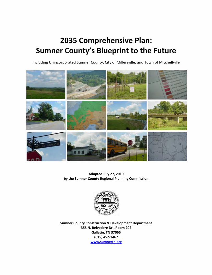
2035 Comprehensive Plan:
Sumner County’s Blueprint to the Future
Including Unincorporated Sumner County, City of Millersville, and Town of Mitchellville
Adopted July 27, 2010
by the Sumner County Regional Planning Commission
Sumner County Construction & Development Department 355 N. Belvedere Dr., Room 202
Gallatin, TN 37066 (615) 452-1467
www.sumnertn.org
ii
THIS PAGE INTENTIONALLY LEFT BLANK
iii
THIS PAGE INTENTIONALLY LEFT BLANK FOR SUMNER COUNTY BOARD OF COUNTY COMMISSIONERS RESOLUTION IF ADOPTED
iv
THIS PAGE INTENTIONALLY LEFT BLANK
v
Acknowledgements
Sumner County Regional Sumner County Planning Commission Construction & Development Staff Luther Bratton, Chair Gary Hammock, Director of Construction & Development Shawn Fennell, Vice-Chair Saundra Boyd Planning Cecil Ray Michael Briggs, AICP, County Planner Bob Hendricks Rachael Ivie, Community Planner (TN Local Planning Office) Jim Williams Todd Baker, Community Planner (TN Local Planning Office) Cynthia Hall Templeton Lisa DiOrio, Administrative Assistant Charles Haynes (Former) Mike Honeycutt Stormwater Norman S. Tripp (Former) Jerry Bean, MS4 Inspector Paul R. Goode Linda Haupt, Administrative Assistant Charles Lea (Former) Dan Downs (Former) Building Codes & Zoning Enforcement Cordell Borders (Former) Tracey Barrow, Inspector Clif Hutson (Former) Stacey Troutt, Inspector Aaron Carter, Inspector Toni Speer, Administrative Assistant Cindy Overstreet, Administrative Assistant
The preparation of the natural resources components of this document was financially aided through The Kresge Foundation and work activities of the 2010 Climate Solutions University members and partners, including the Model Forest Policy Program, Cumberland River Compact, and The Climate Project.
Prepared by Michael Briggs, AICP
Sumner County Planner
vi
Acknowledgements
Sumner County Executive Anthony Holt
Sumner County Board of County Commissioners
District 1 District 5 District 9 Mike Akins Saundra Ridings Boyd Chris Hughes Shawn Fennell Steve Camp David Kimbrough District 2 District 6 District 10 David Cummings Bob Hendricks Paul R. Goode Shawn A. Utley Jim Vaughn Jo Skidmore District 3 District 7 District 11 Steve Graves Trisha LeMarbre Paul D. Freels David Satterfield Kirk Moser Jerry F. Stone District 4 District 8 District 12 Frank E. Freels Merrol N. Hyde Billy S. Hobbs Joe C. Matthews Paul Decker Bob Pospisil
vii
Acknowledgements
Comprehensive Plan Working Group
Members Advisory Representatives Mike Fussell, School Board Member Michael Skipper, Nashville Area MPO Lee Zoller, Business Owner Tonya Blades, Greater Nashville Regional Shawn Fennell, Sumner County Commissioner Council Jim Williams, Sumner County Planning Commissioner Jim McAteer, Regional Transportation Authority Cecil Ray, Sumner County Planning Commissioner Jeanne Stevens, Tenn. Dept. of Transportation Ken Louallen, Local Developer Bridget Jones, Cumberland Region Tomorrow Brenda Payne, Chamber Representative Audra Ladd, Land Trust of Tennessee Jim Hodges, Long Time Property Owner Vena Jones, Cumberland River Compact Dale Bennett, Gallatin Representative Gwen Griffith, Cumberland River Compact Rick Gregory, Goodlettsville Representative Elaine Boyd, TN Dept. of Env. & Conservation Don Ames, Hendersonville Representative Brooxie Carlton, Tennessee Three Star Program Jim Lech, Millersville Representative Dwight Barrett, TN Division of Forestry Jarrett Bigbee, Mitchellville Representative Lora Baulsir, Regional Transportation Authority Jerry Taylor, Portland Representative Matt Meservy, Nashville Area MPO Mike Carter, Westmoreland Representative Amy Miller, State Planning Office Addam McCormick, White House Representative Rachael Ivie, State Planning Office Paul Ballard, Regional Transportation Authority Brooxie Carlton, Three Star Program Amy New, Three Star Program Michael Briggs, Sumner County Construction & Development Jerry Bean, Sumner County Construction & Development Gary Hammock, Sumner County Construction & Development Attendees Frank Rainear, County Resident Bob Olari, County Resident
viii
Acknowledgements
Comprehensive Plan Technical Stakeholders
Jim Svoboda, Gallatin Planning & Codes Kevin Chastine, Gallatin Planning & Codes Tony Allers, Gallatin Planning & Codes Robert Kalisz, Gallatin Planning & Codes Howard Whitaker, Cumberland Electric Membership Corporation Rick Gregory, Goodlettsville Planning Lisa Milligan, Hendersonville Planning Don Long, Hendersonville Economic/Community Development Gary Hammock, Sumner County Construction & Development Jerry Bean, Sumner County Construction & Development David Lege, Nashville Electric Service Frank Mink, Nashville Electric Service Brian Stephens, North Central Telephone Cooperative Ken Weidner, Sumner County Emergency Management Agency Paige Strong, Gallatin Area Chamber of Commerce Jimmy Johnston, Forward Sumner Economic Council Bill Thompson, White House Utility District Pat Harrell, White House Utility District Nick Tuttle, Gallatin Engineering Ron Bailey, White House Engineering Fred Rogers, Hendersonville Planning Michael Briggs, Sumner County Construction & Development
Natural Resources Protection Focus Group
Gwen Griffith, Cumberland River Compact Phil Clifford, Vol State Community College Audra Ladd, Land Trust of Tennessee Amy Murray, Goodlettsville Stormwater Rick Hendrix, Bledsoe Lick Historical Assoc. Angela Govan, Bledsoe Lick Historical Assoc. Bob Olari, Local Resident Vena Jones, Cumberland River Compact Dwight Barnett, TN Division of Forestry Paige Strong, Gallatin Area Chamber of Comm. Rachael Ivie, State Local Planning Office Colleen Coury, Sumner Co. CVB Kevin Chastine, Gallatin Planning & Codes Jerry Bean, Sumner Co. Construction & Dev. Bruce Rainey, Rainey & Associates Tonya Blades, Greater Nashville Regional Council Jimmy Johnston, Forward Sumner Economic Council Elaine Boyd, TN Department of Env. & Conservation Sarah McCann, Western Kentucky University Intern Michael Briggs, Sumner Co. Construction & Dev.
ix
Acknowledgements
Special thanks for the use of their facilities to conduct the public workshops:
Mr. Frank Cardwell, Principal
Beech High School
Rev. John Hill, Pastor, & Congregation Bethpage United Methodist Church
Mr. Terry Herndon, Principal
North Sumner Elementary School
Mrs. Lynne Porter, Principal Oakmont Elementary School
Mr. Anthony Holt, County Executive
Sumner County Administration Building
Special thanks to fellow planners and city staff that assisted with the public
workshops: Michael Briggs, Sumner County Construction & Development Rachael Ivie, State Planning Office Gary Hammock, Sumner County Construction & Development Jerry Bean, Sumner County Construction & Development Melinda Wagner, Portland Planning & Codes Lisa DiOrio, Sumner County Construction & Development Amy Miller, State Planning Office Rick Gregory, Goodlettsville Planning Addam McCormick, White House Planning & Codes
x
THIS PAGE INTENTIONALLY LEFT BLANK
xi
Table of Contents
Regional Planning Commission Resolution ....................................................................................... i Board of County Commissioners Resolution .................................................................................. iii Acknowledgements .......................................................................................................................... v Table of Contents ............................................................................................................................ xi Executive Summary ....................................................................................................................... xvii 1.0 INTRODUCTION ............................................................................................................. 1-1 1.1 Purpose of Planning ................................................................................................... 1-1 1.2 What is a Comprehensive Plan? ................................................................................ 1-2 1.3 County Planning Efforts ............................................................................................. 1-4 1.4 Municipal Planning Efforts ......................................................................................... 1-7 1.5 Regional Planning Efforts ........................................................................................... 1-9 1.6 Developing Property in Sumner County .................................................................. 1-12 Introduction Element Endnotes ..................................................................................... 1-13 2.0 EXISTING & FUTURE CONDITIONS .................................................................................. 2-1 2.1 State and Regional Growth ........................................................................................ 2-1 2.2 Sumner County Trends & Projections ........................................................................ 2-4 3.0 VISION & GOALS ............................................................................................................ 3-1 3.1 Regional Assets .......................................................................................................... 3-2 3.2 Local Assets ................................................................................................................ 3-2 3.3 Vision & Goals for 2035 ............................................................................................. 3-3 4.0 LAND USE ...................................................................................................................... 4-1 4.1 Existing Land Use ....................................................................................................... 4-1 4.2 Zoning Controls .......................................................................................................... 4-2
xii
Table of Contents (continued) 4.3 Land Consumption Patterns ...................................................................................... 4-5 4.4 Development Scenarios ............................................................................................. 4-8 4.5 Community Character Areas .................................................................................... 4-10 4.6 General Framework Map for 2035 .......................................................................... 4-11 Conservation ..................................................................................................... 4-18 Rural .................................................................................................................. 4-20 Suburban ........................................................................................................... 4-22 Mixed Use Neighborhood ................................................................................. 4-24 Waterfront Living .............................................................................................. 4-26 Crossroads Village Center ................................................................................. 4-28 Traditional Village Center ................................................................................. 4-30 Historical Village Center .................................................................................... 4-32 High Growth Center .......................................................................................... 4-34 Highway Services .............................................................................................. 4-36 Industrial ........................................................................................................... 4-38 Industrial Revitalization .................................................................................... 4-40 Regional Activity Center .................................................................................... 4-42 Regional Employment Center ........................................................................... 4-44 5.0 TRANSPORTATION......................................................................................................... 5-1 5.1 Thoughts about Transportation in Sumner County ................................................... 5-1 5.2 Transportation’s Role in Achieving 2035 Vision ........................................................ 5-2 5.3 Local Commuting Patterns ......................................................................................... 5-2 5.4 Sumner County’s Existing Roadway System .............................................................. 5-8

xiii
Table of Contents (continued) 5.5 Types of Roadway Infrastructure by Functional Class ............................................. 5-10 5.6 Sumner County’s 2035 Roadway System................................................................. 5-11 5.7 Priority Roadway Improvements ............................................................................. 5-13 5.8 Sumner County’s Existing Bicycle & Pedestrian System .......................................... 5-15 5.9 Types of Bicycle & Pedestrian Infrastructure ........................................................... 5-16 5.10 Sumner County’s 2035 Bicycle & Pedestrian System ............................................ 5-17 5.11 Priority Bicycle & Pedestrian Improvements ......................................................... 5-19 5.12 Sumner County’s Existing Mass Transit System ..................................................... 5-21 5.13 Types of Mass Transit Infrastructure ..................................................................... 5-21 5.14 Sumner County’s 2035 Mass Transit System ......................................................... 5-22 5.15 Priority Mass Transit Improvements...................................................................... 5-24 5.16 Key Concept – Complete Streets ........................................................................... 5-26 5.17 Key Concept – Connectivity ................................................................................... 5-27 5.18 Key Concept – Green Infrastructure ...................................................................... 5-27 5.19 Key Concept – Transportation Safety .................................................................... 5-28 5.20 Focus Area: Long Hollow Pike Corridor & Shackle Island Community ................... 5-31 5.20.1 Existing Transportation Conditions along Long Hollow Pike ................. 5-32 5.20.2 Future Transportation Strategies along Long Hollow Pike .................... 5-33 5.20.3 Integrating Long Hollow Pike Transportation Improvements with Land Use Decisions......................................................................... 5-34 5.21 Station Camp Area Multi-Modal Station Concepts ................................................ 5-39 Transportation Element Endnotes ................................................................................. 5-40 6.0 NATURAL & CULTURAL RESOURCES ............................................................................... 6-1
xiv
Table of Contents (continued) 6.1 Key Concept – Sustainability ...................................................................................... 6-1 6.2 Middle Tennessee Flood of 2010 ............................................................................... 6-3 6.3 Climate Solutions University ...................................................................................... 6-7 6.4 Sumner County’s Topography.................................................................................... 6-8 6.4.1 Hazards of Excessive Slopes ..................................................................... 6-10 6.4.2 Causes of Movement ............................................................................... 6-11 6.5 Forest Assessment of Sumner County ..................................................................... 6-12 6.5.1 Original Forest Conditions ....................................................................... 6-12 6.5.2 Current Stands & Health Status ............................................................... 6-12 6.5.3 Land Ownership ....................................................................................... 6-15 6.5.4 Forest Hydrology ...................................................................................... 6-27 6.5.5 Other Elements of Forest Health ............................................................. 6-29 6.5.6 Status, Trends, & Risks of Land Conversions to Monoculture or Other Uses ........................................................................................... 6-29 6.5.7 Timber Harvests Over Time ..................................................................... 6-29 6.5.8 Forest Local Governance.......................................................................... 6-30 6.5.9 Forest Vulnerabilities & Trends ............................................................... 6-31 6.5.10 Forest Opportunities .............................................................................. 6-33 6.6 Water Assessment of Sumner County ..................................................................... 6-34 6.6.1 Watersheds .............................................................................................. 6-34 6.6.2 Critical Habitats ........................................................................................ 6-41 6.6.3 Water Quality ........................................................................................... 6-43 6.6.3.1 Phase II MS4 General Permit ................................................... 6-54
xv
Table of Contents (continued) 6.6.3.2 Key Concept – Green Infrastructure ..................................................... 6-54 6.6.3.3 Key Concept – Codes and Ordinances Review and Update ..... 6-55 6.6.4 Water Consumption ................................................................................. 6-57 6.6.4.1 Utility District Service Areas & Supply Systems ....................... 6-57 6.6.4.2 Utility Expansion Plans ............................................................. 6-61 6.6.4.3 Limiting Factors for Utility Expansion ...................................... 6-62 6.6.4.4 Self Supplied Users (Water Wells) ........................................... 6-62 6.6.4.5 Water Shortages ...................................................................... 6-63 6.6.5 Existing Wastewater Systems .................................................................. 6-63 6.6.6 Water Governance ................................................................................... 6-65 6.6.7 Water Risks .............................................................................................. 6-66 6.6.8 Water Opportunities ................................................................................ 6-71 6.7 Cultural Resources in Sumner County ..................................................................... 6-72 6.8 Putting It All Together .............................................................................................. 6-73 6.9 Focus Area: North Sumner County .......................................................................... 6-78 6.10 Focus Area: Taylor Hollow ..................................................................................... 6-80 6.11 Focus Area: Bledsoe Lick Area ............................................................................... 6-82 Natural & Cultural Resources Element Endnotes .......................................................... 6-84 7.0 IMPLEMENTATION ........................................................................................................ 7-1 7.1 Overall Objectives and Strategies .............................................................................. 7-2 7.2 Protection of Natural Resources Objectives and Strategies ...................................... 7-3 7.3 Efficient Transportation System Objectives and Strategies ....................................... 7-5 7.4 Maintain Sense of Community and Sense of Place Objectives and Strategies .......... 7-8
xvi
Table of Contents (continued) 7.5 Rural Preservation Objectives and Strategies ............................................................ 7-9 7.6 Economic Enrichment Objectives and Strategies .................................................... 7-10 7.7 Historic Conservation & Enhancement Objectives and Strategies .......................... 7-11 7.8 Ensure Availability of Services Objectives and Strategies ........................................ 7-13 7.9 Viable Agriculture Objectives and Strategies ........................................................... 7-15 7.10 Preserve Urban Centers Objectives and Strategies ............................................... 7-16 7.11 Provide Housing Options Objectives and Strategies .............................................. 7-17 APPENDICES Appendix A: Growth Projections & Trends Appendix B: Public Input Opportunities Appendix C: Results of On-line Visioning Survey Appendix D: Results of On-line Transportation Survey Appendix E: Transportation Plan Projects Appendix F: Visual Preference Survey
xvii
Executive Summary
Projections show that Sumner County’s population will increase by 72,000 people by 2035. This anticipated increase will change the landscape in Sumner County and impact infrastructure such as roads, schools, and utilities. The 2035 Comprehensive Plan: Sumner County’s Blueprint to the Future provides an analysis of historical and projected growth trends and outlines a scenario developed by consensus with local residents, decision makers, and other stakeholders. A common vision held by many of these individuals is to maintain the high quality of life of those that live, work, and play in unincorporated Sumner County. A series of ten goals are highlighted to support the vision. The 2035 Comprehensive Plan focuses on future land use, transportation investment priorities, and protection of natural and cultural resources.
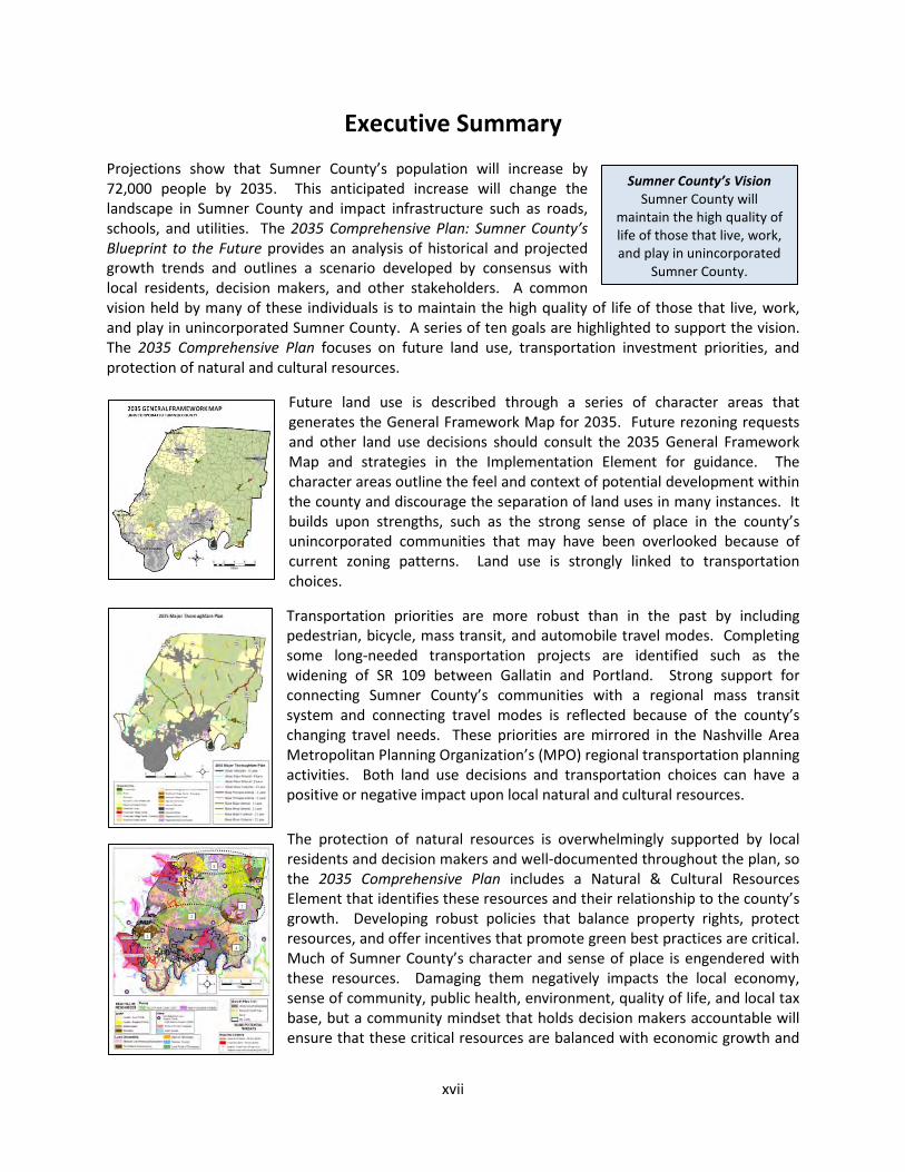
Future land use is described through a series of character areas that generates the General Framework Map for 2035. Future rezoning requests and other land use decisions should consult the 2035 General Framework Map and strategies in the Implementation Element for guidance. The character areas outline the feel and context of potential development within the county and discourage the separation of land uses in many instances. It builds upon strengths, such as the strong sense of place in the county’s unincorporated communities that may have been overlooked because of current zoning patterns. Land use is strongly linked to transportation choices.
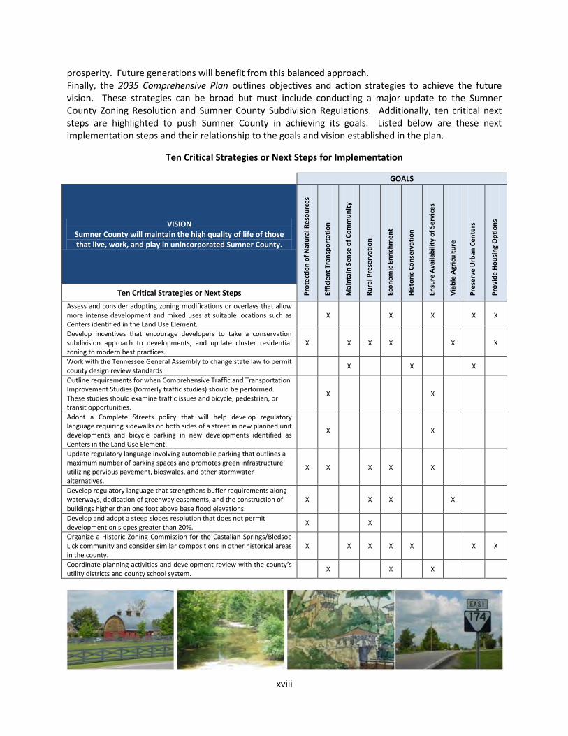
Transportation priorities are more robust than in the past by including pedestrian, bicycle, mass transit, and automobile travel modes. Completing some long-needed transportation projects are identified such as the widening of SR 109 between Gallatin and Portland. Strong support for connecting Sumner County’s communities with a regional mass transit system and connecting travel modes is reflected because of the county’s changing travel needs. These priorities are mirrored in the Nashville Area Metropolitan Planning Organization’s (MPO) regional transportation planning activities. Both land use decisions and transportation choices can have a positive or negative impact upon local natural and cultural resources.
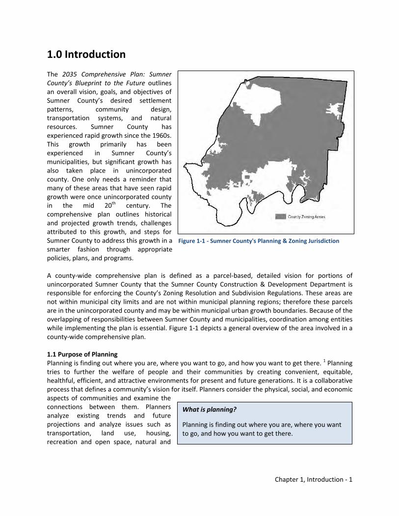
The protection of natural resources is overwhelmingly supported by local residents and decision makers and well-documented throughout the plan, so the 2035 Comprehensive Plan includes a Natural & Cultural Resources Element that identifies these resources and their relationship to the county’s growth. Developing robust policies that balance property rights, protect resources, and offer incentives that promote green best practices are critical. Much of Sumner County’s character and sense of place is engendered with these resources. Damaging them negatively impacts the local economy, sense of community, public health, environment, quality of life, and local tax base, but a community mindset that holds decision makers accountable will ensure that these critical resources are balanced with economic growth and
Sumner County’s Vision Sumner County will
maintain the high quality of life of those that live, work, and play in unincorporated
Sumner County.
xviii
prosperity. Future generations will benefit from this balanced approach. Finally, the 2035 Comprehensive Plan outlines objectives and action strategies to achieve the future vision. These strategies can be broad but must include conducting a major update to the Sumner County Zoning Resolution and Sumner County Subdivision Regulations. Additionally, ten critical next steps are highlighted to push Sumner County in achieving its goals. Listed below are these next implementation steps and their relationship to the goals and vision established in the plan.
Ten Critical Strategies or Next Steps for Implementation
GOALS
VISION Sumner County will maintain the high quality of life of those that live, work, and play in unincorporated Sumner County.
Prot
ecti
on o
f Nat
ural
Res
ourc
es
Effic
ient
Tra
nspo
rtat
ion
Mai
ntai
n Se
nse
of C
omm
unit
y
Rura
l Pre
serv
atio
n
Econ
omic
Enr
ichm
ent
His
tori
c Co
nser
vati
on
Ensu
re A
vaila
bilit
y of
Ser
vice
s
Via
ble
Agr
icul
ture
Pres
erve
Urb
an C
ente
rs
Prov
ide
Hou
sing
Opt
ions
Ten Critical Strategies or Next Steps
Assess and consider adopting zoning modifications or overlays that allow more intense development and mixed uses at suitable locations such as Centers identified in the Land Use Element.
X X X X X
Develop incentives that encourage developers to take a conservation subdivision approach to developments, and update cluster residential zoning to modern best practices.
X X X X X X
Work with the Tennessee General Assembly to change state law to permit county design review standards.
X X X
Outline requirements for when Comprehensive Traffic and Transportation Improvement Studies (formerly traffic studies) should be performed. These studies should examine traffic issues and bicycle, pedestrian, or transit opportunities.
X X
Adopt a Complete Streets policy that will help develop regulatory language requiring sidewalks on both sides of a street in new planned unit developments and bicycle parking in new developments identified as Centers in the Land Use Element.
X X
Update regulatory language involving automobile parking that outlines a maximum number of parking spaces and promotes green infrastructure utilizing pervious pavement, bioswales, and other stormwater alternatives.
X X X X X
Develop regulatory language that strengthens buffer requirements along waterways, dedication of greenway easements, and the construction of buildings higher than one foot above base flood elevations.
X X X X
Develop and adopt a steep slopes resolution that does not permit development on slopes greater than 20%.
X X
Organize a Historic Zoning Commission for the Castalian Springs/Bledsoe Lick community and consider similar compositions in other historical areas in the county.
X X X X X X X
Coordinate planning activities and development review with the county’s utility districts and county school system.
X X X
Chapter 1, Introduction - 1
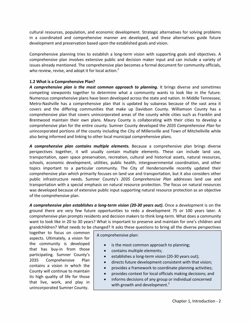
1.0 Introduction The 2035 Comprehensive Plan: Sumner County’s Blueprint to the Future outlines an overall vision, goals, and objectives of Sumner County’s desired settlement patterns, community design, transportation systems, and natural resources. Sumner County has experienced rapid growth since the 1960s. This growth primarily has been experienced in Sumner County’s municipalities, but significant growth has also taken place in unincorporated county. One only needs a reminder that many of these areas that have seen rapid growth were once unincorporated county in the mid 20th century. The comprehensive plan outlines historical and projected growth trends, challenges attributed to this growth, and steps for Sumner County to address this growth in a smarter fashion through appropriate policies, plans, and programs. A county-wide comprehensive plan is defined as a parcel-based, detailed vision for portions of unincorporated Sumner County that the Sumner County Construction & Development Department is responsible for enforcing the County’s Zoning Resolution and Subdivision Regulations. These areas are not within municipal city limits and are not within municipal planning regions; therefore these parcels are in the unincorporated county and may be within municipal urban growth boundaries. Because of the overlapping of responsibilities between Sumner County and municipalities, coordination among entities while implementing the plan is essential. Figure 1-1 depicts a general overview of the area involved in a county-wide comprehensive plan. 1.1 Purpose of Planning Planning is finding out where you are, where you want to go, and how you want to get there. 1 Planning tries to further the welfare of people and their communities by creating convenient, equitable, healthful, efficient, and attractive environments for present and future generations. It is a collaborative process that defines a community’s vision for itself. Planners consider the physical, social, and economic aspects of communities and examine the connections between them. Planners analyze existing trends and future projections and analyze issues such as transportation, land use, housing, recreation and open space, natural and
What is planning?
Planning is finding out where you are, where you want to go, and how you want to get there.
Figure 1-1 - Sumner County's Planning & Zoning Jurisdiction
Chapter 1, Introduction - 2
A comprehensive plan:
• is the most common approach to planning; • contains multiple elements; • establishes a long-term vision (20-30 years out); • directs future development consistent with that vision; • provides a framework to coordinate planning activities; • provides context for local officials making decisions; and • informs decisions of any group or individual concerned
with growth and development.2
cultural resources, population, and economic development. Strategic alternatives for solving problems in a coordinated and comprehensive manner are developed, and these alternatives guide future development and preservation based upon the established goals and vision. Comprehensive planning tries to establish a long-term vision with supporting goals and objectives. A comprehensive plan involves extensive public and decision maker input and can include a variety of issues already mentioned. The comprehensive plan becomes a formal document for community officials, who review, revise, and adopt it for local action.2
1.2 What is a Comprehensive Plan? A comprehensive plan is the most common approach to planning. It brings diverse and sometimes competing viewpoints together to determine what a community wants to look like in the future. Numerous comprehensive plans have been developed across the state and nation. In Middle Tennessee, Metro-Nashville has a comprehensive plan that is updated by subareas because of the vast area it covers and the differing communities that make up Davidson County. Williamson County has a comprehensive plan that covers unincorporated areas of the county while cities such as Franklin and Brentwood maintain their own plans. Maury County is collaborating with their cities to develop a comprehensive plan for the entire county. Sumner County developed the 2035 Comprehensive Plan for unincorporated portions of the county including the City of Millersville and Town of Mitchellville while also being informed and linking to other local municipal comprehensive plans.
A comprehensive plan contains multiple elements. Because a comprehensive plan brings diverse perspectives together, it will usually contain multiple elements. These can include land use, transportation, open space preservation, recreation, cultural and historical assets, natural resources, schools, economic development, utilities, public health, intergovernmental coordination, and other topics important to a particular community. The City of Hendersonville recently updated their comprehensive plan which primarily focuses on land use and transportation, but it also considers other public infrastructure needs. Sumner County’s 2035 Comprehensive Plan addresses land use and transportation with a special emphasis on natural resource protection. The focus on natural resources was developed because of extensive public input supporting natural resource protection as an objective of the comprehensive plan.
A comprehensive plan establishes a long-term vision (20-30 years out). Once a development is on the ground there are very few future opportunities to redo a development 75 or 100 years later. A comprehensive plan prompts residents and decision makers to think long-term. What does a community want to look like in 20 to 30 years? What is important to preserve and maintain for one’s children and grandchildren? What needs to be changed? It asks these questions to bring all the diverse perspectives together to focus on common aspects. Ultimately, a vision for the community is developed that has buy-in from those participating. Sumner County’s 2035 Comprehensive Plan contains a vision in which the County will continue to maintain its high quality of life for those that live, work, and play in unincorporated Sumner County.
Chapter 1, Introduction - 3
A comprehensive plan directs future development consistent with that vision. A vision is established in the comprehensive plan, so development decisions are based upon this consensus. For example, a new residential subdivision of 250 lots is proposed as a medium density planned unit development for rezoning to the Sumner County Regional Planning Commission, but the comprehensive plan shows that this area may be best utilized as a mixed use center providing neighborhood retail and various housing options. The Planning Commission has more knowledge of what citizens envisioned for the community and can request informed changes to the proposal, so the community can collectively attain the vision set in the comprehensive plan. The 2035 Comprehensive Plan is not intended to be a stumbling block for development, but a guiding document that will create development that is appropriate for the community.
A comprehensive plan provides a framework to coordinate planning activities. The government is composed of various entities charged with carrying out activities for residents. A comprehensive plan is an opportunity to discuss these activities and coordinate functions across departments dealing with growth and development. The 2035 Comprehensive Plan has received input from professionals involved with the Sumner County School System, economic development and retention, emergency response, municipal public works, utility districts, and other governmental entities. Some objectives are outlined that address coordination and intergovernmental collaboration within Sumner County and the Middle Tennessee region.
A comprehensive plan provides context for local officials making decisions. Because a vision is established, local officials will look to a comprehensive plan to help determine decisions concerning growth and development. The Sumner County Commission, Sumner County Regional Planning Commission, and other decision-making bodies should utilize the 2035 Comprehensive Plan to inform their decision-making processes.
A comprehensive plan informs decisions of any group or individual concerned with growth and development. Any developer, entity, or individual will be able to obtain a copy of a comprehensive plan and determine what the community desires in a particular area in the future. The development and preservation efforts in the community will be influenced by the comprehensive plan. In Sumner County, the development of a comprehensive plan will be an open process and the final product will be available at anytime for review. The 2035 Comprehensive Plan will also be flexible and may require updating depending upon changes in a community.
A comprehensive plan usually involves a significant amount of local decision maker and citizen input through a variety of techniques including open house style meetings, one-on-one interviews, technical interviews, soliciting of public comments, and others. It is important that citizen opinions are heard throughout the process because it will be these individuals that will raise families and live in the community in the future. A number of techniques were undertaken during the 2035 Comprehensive Plan development. These public input techniques are outlined in Appendix B.
In Sumner County, the county’s decision making bodies should consider the 2035 Comprehensive Plan while making land use and transportation decisions; otherwise these decisions will not consider the vision contained in the plan. Future decisions will be mindful of residents’ input and the consensus achieved about Sumner County’s future while developing the plan.
What has been done to address development until now? The Existing & Future Conditions Element (2.0) discusses the existing and projected growth trends Sumner County is likely to see in the future, but it is necessary to place the 2035 Comprehensive Plan in
Chapter 1, Introduction - 4
the context of historical and existing planning, zoning, and building activities in Sumner County and examine its interrelatedness with planning at the municipal and regional levels. Additionally, State Law dictates much of what a local government can perform regarding these functions. 1.3.1 County Planning Efforts County planning and land use regulations in Tennessee rest on powers granted to counties by the State Constitution. These powers are not mandated, but counties which choose to exercise planning, subdivision regulation, and zoning must comply with the grant of power. Sumner County has examples of this power contained in the county’s Zoning Resolution and Subdivision Regulations. Additionally, Sumner County developed these guiding plans:
• Sumner County Major Road Plan in 1996; • Sumner County Bicycle and Pedestrian Master Plan in 2000 in cooperation with the Nashville
Area Metropolitan Planning Organization (MPO); • Station Camp Creek Area Land Use Plan in 2001 in cooperation with the City of Gallatin; • Long Hollow Pike Corridor Land Use Plan in 2003 in cooperation with the Cities of Gallatin,
Goodlettsville, and Hendersonville; and • 2025 Land Use Plan for Hendersonville Urban Growth Boundary in 2008 in cooperation with the
City of Hendersonville.
Two older planning documents were developed for Sumner County in the 1960s and 70s when Federal funds were available through the Department of Housing and Urban Development’s (HUD) Urban Renewal Administration’s Urban Planning Assistance Program, which was authorized by Section 701 of the Housing Act of 1954. The first plan developed in 1968 called the Land Use and Transportation Plan: Sumner County, Tennessee established goals and objectives through 1990. It examined land use and thoroughfares with implementation strategies for Sumner County, excluding the Hendersonville Urban Area. Within the plan was another part that analyzed land use and thoroughfares with implementation strategies for the Hendersonville Urban Area. At the time, portions of the City of Hendersonville were being incorporated and less than two percent (273 persons) of the population of the urban area were within the city limits.
The second plan developed in 1977 was entitled Land Use Plan: Sumner County, Tennessee. It established goals and objectives through 2000 and outlined existing development features among growth trends and the natural environment. It analyzed different land use patterns and documented a list of policy goals for various land uses. It can only be assumed by current staff that the previous two land use plans developed in the 1960s and 1970s were not used to inform decisions of the Sumner County Regional Planning Commission on a regular basis. It is the intent of current Sumner County staff and elected officials that the 2035 Comprehensive Plan will inform the decisions of the Sumner County Regional Planning Commission and other county elected or appointed bodies. The 2035 Comprehensive Plan builds upon the previous planning activities described.
In May of 1998 the Tennessee General Assembly enacted Public Chapter 1101 which had ramifications for a county wide growth policy, municipal boundary changes through annexation, and incorporations of new municipalities. It mandated the establishment of a comprehensive growth plan for the county and its eight municipalities, changes the manner in which land may be annexed into an existing municipality, and changes the manner in which new areas may incorporate to form new municipalities.
Chapter 1, Introduction - 5
The law required at a minimum the establishment of an urban growth boundary around each of the existing municipalities where high intensity development will be expected, the establishment of planned growth areas outside of the urban growth boundaries where high intensity development will be permitted, and the establishment of rural areas where agricultural uses will be expected. The law permits high intensity development in both the planned growth areas and urban growth boundary areas. The primary difference is that a municipality can annex property within its urban growth boundary provided the annexation conforms to the requirements of Public Chapter 1101, but it will not be permitted to annex into a planned growth area. Nothing in the law forbids development of property in rural areas. However, rural areas are intended to be remote and somewhat inaccessible, should be developed with low intensity development, and should be preserved for agricultural purposes.3
Figure 1-2 depicts the Growth Plan for Sumner County. Current city limits are in light gray; urban growth boundaries are in the dark gray; planned growth areas are in peach; and rural areas are in green. At the time of adoption of the boundaries for Sumner County, Walnut Grove had established city limits and an urban growth boundary. Those areas are depicted but would now be part of the county’s planned growth area. This area was never included in amendments to update White House’s urban growth boundary. These boundaries have now been established for over 10 years. Significant areas in Hendersonville and Gallatin were annexed since this was developed. Unfortunately, these boundaries have had little influence on growth and development decisions in unincorporated Sumner County. These boundaries have mostly impacted annexation. When a municipality annexes land the municipality must prepare a plan of services which details the services that will be provided to the area annexed and must provide a reasonable time frame for the implementation of the plan. Public Chapter 1101 requires that the municipality be held accountable for implementing the plan and the failure of a municipality to implement the plan will prohibit it from annexing additional land until it has met its obligations.
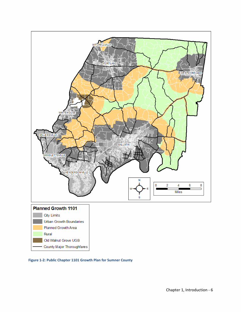
Chapter 1, Introduction - 6
Figure 1-2: Public Chapter 1101 Growth Plan for Sumner County
Chapter 1, Introduction - 7
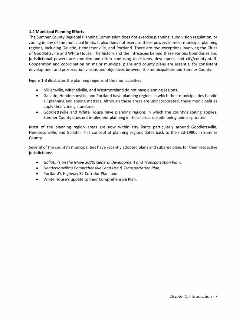
1.4 Municipal Planning Efforts The Sumner County Regional Planning Commission does not exercise planning, subdivision regulation, or zoning in any of the municipal limits. It also does not exercise these powers in most municipal planning regions, including Gallatin, Hendersonville, and Portland. There are two exceptions involving the Cities of Goodlettsville and White House. The history and the intricacies behind these various boundaries and jurisdictional powers are complex and often confusing to citizens, developers, and city/county staff. Cooperation and coordination on major municipal plans and county plans are essential for consistent development and preservation visions and objectives between the municipalities and Sumner County. Figure 1-3 illustrates the planning regions of the municipalities:
• Millersville, Mitchellville, and Westmoreland do not have planning regions. • Gallatin, Hendersonville, and Portland have planning regions in which their municipalities handle
all planning and zoning matters. Although these areas are unincorporated, these municipalities apply their zoning standards.
• Goodlettsville and White House have planning regions in which the county’s zoning applies. Sumner County does not implement planning in these areas despite being unincorporated.
Most of the planning region areas are now within city limits particularly around Goodlettsville, Hendersonville, and Gallatin. This concept of planning regions dates back to the mid-1980s in Sumner County.
Several of the county’s municipalities have recently adopted plans and subarea plans for their respective jurisdictions:
• Gallatin’s on the Move 2020: General Development and Transportation Plan; • Hendersonville’s Comprehensive Land Use & Transportation Plan; • Portland’s Highway 52 Corridor Plan; and • White House’s update to their Comprehensive Plan.
Chapter 1, Introduction - 8
Figure 1-3: Municipal Planning Regions in Sumner County
Chapter 1, Introduction - 9
1.5 Regional Planning Efforts Decision makers are concerned about growth, development, and preservation in Sumner County, but one should also recognize the county’s role in the greater Middle Tennessee region. Important planning efforts are underway with partners at the Greater Nashville Regional Council (GNRC), Cumberland Region Tomorrow, Cumberland River Compact, Nashville Area MPO, and other regional planning agencies. Several studies are underway or recently adopted by the MPO that examine land use and transportation on a regional level involving Sumner County:
• Regional Long Range Transportation Plan; • Regional Bicycle and Pedestrian Plan; • Regional Freight Study; • Northeast Corridor Mobility Study (corridor generally following US-31E from Downtown
Nashville to Gallatin); and • Tri-County Transportation & Land Use Study (subarea involving Robertson, Sumner, and Wilson
Counties).
The Northeast Corridor Mobility Study will ultimately help determine the transportation options appropriate for the current land use and future scenarios in the study area. The study is examining a variety of travel options and appropriate design guidelines.
The Tri-County Transportation & Land Use Study is the foundation for the 2035 Comprehensive Plan. The study is a process to bring local leaders from Robertson, Sumner, and Wilson Counties to consider the growth plans of neighboring communities while also improving the local communities for regional mobility and prosperity. The study is articulating issues of doing business as usual in Sumner County, suggesting alternatives, and making recommendations that detail appropriate growth and preservation scenarios supported by decision makers and residents.
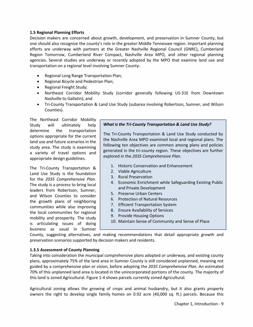
1.3.5 Assessment of County Planning Taking into consideration the municipal comprehensive plans adopted or underway, and existing county plans, approximately 75% of the land area in Sumner County is still considered unplanned, meaning not guided by a comprehensive plan or vision, before adopting the 2035 Comprehensive Plan. An estimated 70% of this unplanned land area is located in the unincorporated portions of the county. The majority of this land is zoned Agricultural. Figure 1-4 shows parcels currently zoned Agricultural. Agricultural zoning allows the growing of crops and animal husbandry, but it also grants property owners the right to develop single family homes on 0.92 acre (40,000 sq. ft.) parcels. Because this
What is the Tri-County Transportation & Land Use Study?
The Tri-County Transportation & Land Use Study conducted by the Nashville Area MPO examined local and regional plans. The following ten objectives are common among plans and policies generated in the tri-county region. These objectives are further explored in the 2035 Comprehensive Plan.
1. Historic Conservation and Enhancement 2. Viable Agriculture 3. Rural Preservation 4. Economic Enrichment while Safeguarding Existing Public
and Private Development 5. Preserve Urban Centers 6. Protection of Natural Resources 7. Efficient Transportation System 8. Ensure Availability of Services 9. Provide Housing Options 10. Maintain Sense of Community and Sense of Place
Chapter 1, Introduction - 10
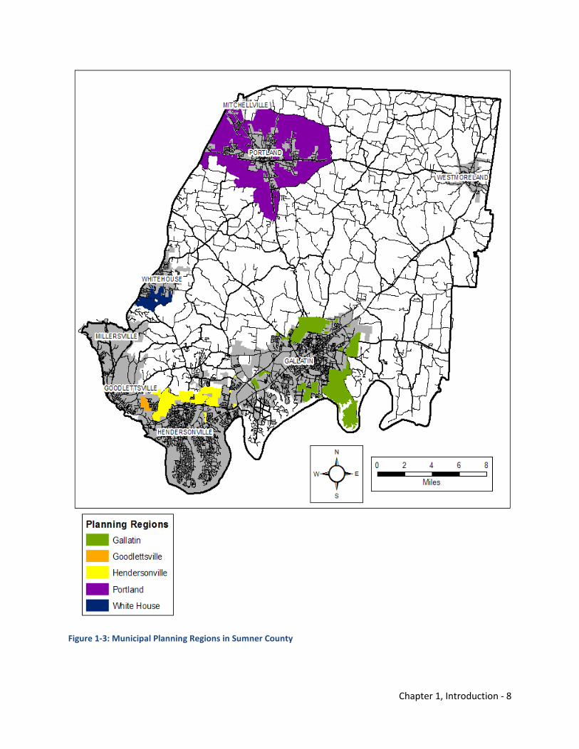
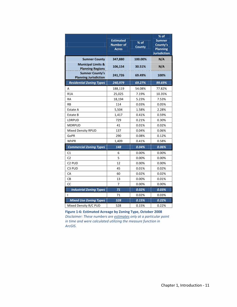
farmland is valuable, it is often subdivided once agricultural activities have concluded on a tract of land. Cost of Community Services Studies conducted in select Tennessee counties including neighboring Robertson County show that the exchanging of agricultural land to residential uses typically cost a community more than preserving the open space or maintaining agricultural activities. Agricultural lands may not seem to pay as much tax, but farm land has very little community service costs. In Robertson County, the revenues did not cover the expenditures involved with residential uses. These uses also significantly impact a county’s school system. Commercial and industrial land uses are most often financial assets and in this case in Robertson County, the revenues cover the expenditures. See Figure 1-5 for example
information from the 2008 Cost of Community Services Study concerning revenues and expenditures involving these land uses. Figure 1-6 depicts the estimated number of acres associated with each Sumner County zoning type. Most acres in the county are zoned residential type uses and only a small number of acres is devoted to commercial, industrial, and mixed uses, which may be more likely to offset expenditures.
Figure 1-5: Revenues & Expenditures by Land Use, Robertson County, Tennessee Source: Cost of Community Services Study (2008)
$0
$20,000,000
$40,000,000
$60,000,000
$80,000,000
$100,000,000
Residential Commercial & Industrial
Farmland
RevenuesExpenditures
Figure 1-4: Agricultural Zoned Parcels
Chapter 1, Introduction - 11
Estimated Number of
Acres
% of County
% of Sumner County’s Planning
Jurisdiction
Sumner County 347,880 100.00% N/A
Municipal Limits & Planning Regions
106,154 30.51% N/A
Sumner County’s Planning Jurisdiction
241,726 69.49% 100%
Residential Zoning Types 240,979 69.27% 99.69%
A 188,119 54.08% 77.82%
R1A 25,025 7.19% 10.35%
RA 18,194 5.23% 7.53%
RB 114 0.03% 0.05%
Estate A 5,504 1.58% 2.28%
Estate B 1,417 0.41% 0.59%
LDRPUD 729 0.21% 0.30%
MDRPUD 41 0.01% 0.02%
Mixed Density RPUD 137 0.04% 0.06%
GoPR 290 0.08% 0.12%
WhPR 1,409 0.41% 0.58%
Commercial Zoning Types 148 0.04% 0.06%
C1 6 0.00% 0.00%
C2 5 0.00% 0.00%
C2 PUD 12 0.00% 0.00%
C3 PUD 45 0.01% 0.02%
CA 60 0.02% 0.02%
CB 13 0.00% 0.01%
CC 7 0.00% 0.00%
Industrial Zoning Types 71 0.02% 0.03%
I 71 0.02% 0.03%
Mixed Use Zoning Types 528 0.15% 0.22%
Mixed Density R/C PUD 528 0.15% 0.22%
Figure 1-6: Estimated Acreage by Zoning Type, October 2008 Disclaimer: These numbers are estimates only at a particular point in time and were calculated utilizing the measure function in ArcGIS.
Chapter 1, Introduction - 12
1.6 Developing Property in Sumner County When a property owner proposes to rezone and/or subdivide their property of five acres or less in unincorporated Sumner County, the request for rezoning and/or plat is reviewed by the Sumner County Regional Planning Commission. Before adoption of the 2035 Comprehensive Plan, this process was responsive to these requests because an assessment of the proposal and final decision were based upon the current Zoning Resolution and Subdivision Regulations. A long range plan that described a vision and objectives was not taken into consideration unless the property was located within the Station Camp area, Long Hollow Pike corridor, or Hendersonville UGB. Despite being responsive, these decisions did not bring to fruition a vision of the county in 20 to 30 years desired by residents. Common goals that many decision makers advocate involving economic development, rural preservation, water quality, and others can be hindered by processes that are only responsive and not proactive in achieving the long term vision. Because a long term vision and goals has not been documented in a county-wide comprehensive plan until now, it was difficult for the Sumner County Regional Planning Commission and Sumner County Board of County Commissioners to make proactive recommendations involving rezoning and platting of land to fit the desires of its citizens and decision makers. The costs associated with only making responsive decisions is almost impossible to calculate, but the burden upon the county is apparent with increased road congestion, limited travel and housing options, threatened rural preservation and natural resources, and other suburban problems that face rapidly growing counties around the country, including Sumner County. The 2035 Comprehensive Plan moves Sumner County forward in its long range thinking and decision making by outlining a growth and development vision, so decision makers have more information about how a potential development might impact services and aligns with the community’s values.
What is the difference between responsive planning and proactive planning?
Responsive planning takes plans for potential development and considers immediate needs typically four to five years into the future. It usually considers current conditions, adopted zoning resolution, and adopted subdivision regulations, but does not consider a comprehensive set of long term impacts.
Proactive planning takes plans for potential development and considers long term needs typically 20 to 30 years or more into the future. It usually considers current conditions and projects those trends into the future to reflect an updated zoning resolution and subdivision regulations that strive to achieve a vision for the future.
Costs associated with not making proactive decisions include:
• increased road congestion; • limited travel and housing options; • decreased agricultural farming; • threatened preservation of natural resources; and • other issues facing rapidly growing communities.
Chapter 1, Introduction - 13
Introduction Element Endnotes 1Tennessee Department of Economic & Community Development Local Planning Assistance Office, Tennessee Planning Commissioner Handbook (2003). 2Cumberland Region Tomorrow, Quality Growth Toolbox (2006). 3City of Murfreesboro Planning Department, Growth Policy, Annexation, and Incorporation Public Chapter 1101 of 1998 (1999).
Chapter 1, Introduction - 14
THIS PAGE INTENTIONALLY LEFT BLANK
Chapter 2, Existing & Future Conditions - 1
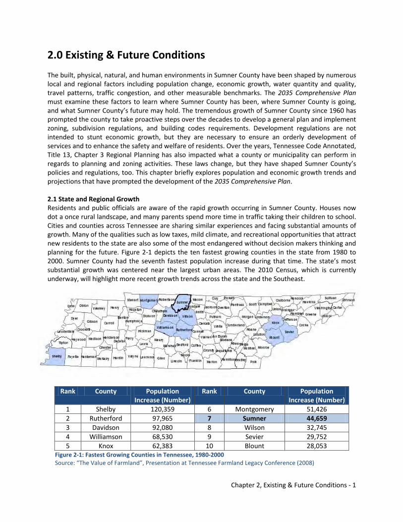
2.0 Existing & Future Conditions The built, physical, natural, and human environments in Sumner County have been shaped by numerous local and regional factors including population change, economic growth, water quantity and quality, travel patterns, traffic congestion, and other measurable benchmarks. The 2035 Comprehensive Plan must examine these factors to learn where Sumner County has been, where Sumner County is going, and what Sumner County’s future may hold. The tremendous growth of Sumner County since 1960 has prompted the county to take proactive steps over the decades to develop a general plan and implement zoning, subdivision regulations, and building codes requirements. Development regulations are not intended to stunt economic growth, but they are necessary to ensure an orderly development of services and to enhance the safety and welfare of residents. Over the years, Tennessee Code Annotated, Title 13, Chapter 3 Regional Planning has also impacted what a county or municipality can perform in regards to planning and zoning activities. These laws change, but they have shaped Sumner County’s policies and regulations, too. This chapter briefly explores population and economic growth trends and projections that have prompted the development of the 2035 Comprehensive Plan. 2.1 State and Regional Growth Residents and public officials are aware of the rapid growth occurring in Sumner County. Houses now dot a once rural landscape, and many parents spend more time in traffic taking their children to school. Cities and counties across Tennessee are sharing similar experiences and facing substantial amounts of growth. Many of the qualities such as low taxes, mild climate, and recreational opportunities that attract new residents to the state are also some of the most endangered without decision makers thinking and planning for the future. Figure 2-1 depicts the ten fastest growing counties in the state from 1980 to 2000. Sumner County had the seventh fastest population increase during that time. The state’s most substantial growth was centered near the largest urban areas. The 2010 Census, which is currently underway, will highlight more recent growth trends across the state and the Southeast.
Rank County Population
Increase (Number) Rank County Population
Increase (Number) 1 Shelby 120,359 6 Montgomery 51,426 2 Rutherford 97,965 7 Sumner 44,659 3 Davidson 92,080 8 Wilson 32,745 4 Williamson 68,530 9 Sevier 29,752 5 Knox 62,383 10 Blount 28,053
Figure 2-1: Fastest Growing Counties in Tennessee, 1980-2000 Source: “The Value of Farmland”, Presentation at Tennessee Farmland Legacy Conference (2008)
Chapter 2, Existing & Future Conditions - 2
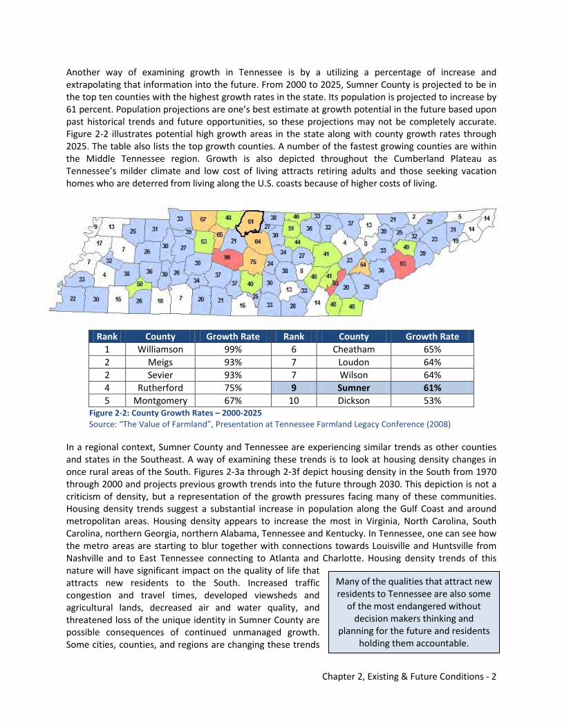
Another way of examining growth in Tennessee is by a utilizing a percentage of increase and extrapolating that information into the future. From 2000 to 2025, Sumner County is projected to be in the top ten counties with the highest growth rates in the state. Its population is projected to increase by 61 percent. Population projections are one’s best estimate at growth potential in the future based upon past historical trends and future opportunities, so these projections may not be completely accurate. Figure 2-2 illustrates potential high growth areas in the state along with county growth rates through 2025. The table also lists the top growth counties. A number of the fastest growing counties are within the Middle Tennessee region. Growth is also depicted throughout the Cumberland Plateau as Tennessee’s milder climate and low cost of living attracts retiring adults and those seeking vacation homes who are deterred from living along the U.S. coasts because of higher costs of living.
Rank County Growth Rate Rank County Growth Rate 1 Williamson 99% 6 Cheatham 65% 2 Meigs 93% 7 Loudon 64% 2 Sevier 93% 7 Wilson 64% 4 Rutherford 75% 9 Sumner 61% 5 Montgomery 67% 10 Dickson 53%
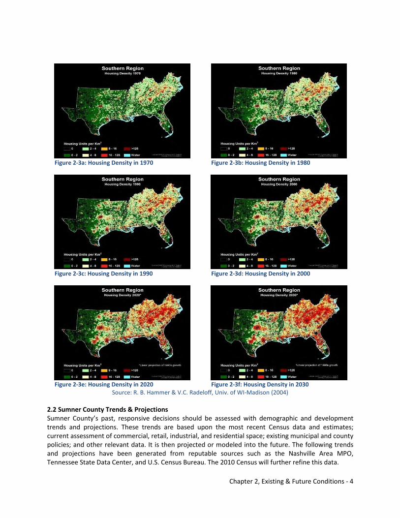
Figure 2-2: County Growth Rates – 2000-2025 Source: “The Value of Farmland”, Presentation at Tennessee Farmland Legacy Conference (2008) In a regional context, Sumner County and Tennessee are experiencing similar trends as other counties and states in the Southeast. A way of examining these trends is to look at housing density changes in once rural areas of the South. Figures 2-3a through 2-3f depict housing density in the South from 1970 through 2000 and projects previous growth trends into the future through 2030. This depiction is not a criticism of density, but a representation of the growth pressures facing many of these communities. Housing density trends suggest a substantial increase in population along the Gulf Coast and around metropolitan areas. Housing density appears to increase the most in Virginia, North Carolina, South Carolina, northern Georgia, northern Alabama, Tennessee and Kentucky. In Tennessee, one can see how the metro areas are starting to blur together with connections towards Louisville and Huntsville from Nashville and to East Tennessee connecting to Atlanta and Charlotte. Housing density trends of this nature will have significant impact on the quality of life that attracts new residents to the South. Increased traffic congestion and travel times, developed viewsheds and agricultural lands, decreased air and water quality, and threatened loss of the unique identity in Sumner County are possible consequences of continued unmanaged growth. Some cities, counties, and regions are changing these trends
Many of the qualities that attract new residents to Tennessee are also some
of the most endangered without decision makers thinking and
planning for the future and residents holding them accountable.
Chapter 2, Existing & Future Conditions - 3
by taking more proactive measures by promoting the development of comprehensive plans and appropriate best practices that result in positive community development. Organizations such as the Nashville Area Metropolitan Planning Organization (MPO), Cumberland Region Tomorrow, Cumberland River Compact, and Greater Nashville Regional Council are leading regional conversations about growth and promoting best practices.
Substantial growth as shown on the housing density maps also impacts the environment. A visual preference survey was conducted at a joint training session among local city and county planning commissioners in 2008. Images of the built environment were displayed on a screen and participants were asked to score their favorability of those environments. Images depicting mass transit and greenways tended to be highly desirable, while images showing vast parking lots and strip shopping centers were less desirable. Participants also indicated an interest within the county to maintain and enhance the region’s water and forest resources with best management practices involving green infrastructure. Results of the visual preference survey are found in Appendix F. Many of these sustainable techniques are not reflected in Sumner County’s current subdivision regulations and zoning resolution. These regulatory documents typically do not prohibit these practices, but they do not provide incentives to encourage them.
Chapter 2, Existing & Future Conditions - 4
Figure 2-3a: Housing Density in 1970
Figure 2-3b: Housing Density in 1980
Figure 2-3c: Housing Density in 1990
Figure 2-3d: Housing Density in 2000
Figure 2-3e: Housing Density in 2020
Figure 2-3f: Housing Density in 2030
Source: R. B. Hammer & V.C. Radeloff, Univ. of WI-Madison (2004) 2.2 Sumner County Trends & Projections Sumner County’s past, responsive decisions should be assessed with demographic and development trends and projections. These trends are based upon the most recent Census data and estimates; current assessment of commercial, retail, industrial, and residential space; existing municipal and county policies; and other relevant data. It is then projected or modeled into the future. The following trends and projections have been generated from reputable sources such as the Nashville Area MPO, Tennessee State Data Center, and U.S. Census Bureau. The 2010 Census will further refine this data.
Chapter 2, Existing & Future Conditions - 5
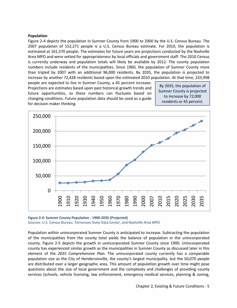
Population Figure 2-4 depicts the population in Sumner County from 1900 to 2000 by the U.S. Census Bureau. The 2007 population of 152,271 people is a U.S. Census Bureau estimate. For 2010, the population is estimated at 161,570 people. The estimates for future years are projections conducted by the Nashville Area MPO and were vetted for appropriateness by local officials and government staff. The 2010 Census is currently underway and population totals will likely be available by 2012. The county population numbers include residents of the municipalities. Since 1960, the population of Sumner County more than tripled by 2007 with an additional 96,000 residents. By 2035, the population is projected to increase by another 72,428 residents based upon the estimated 2010 population. At that time, 233,998 people are expected to live in Sumner County, a 45 percent increase. Projections are estimates based upon past historical growth trends and future opportunities, so these numbers can fluctuate based on changing conditions. Future population data should be used as a guide for decision maker thinking.
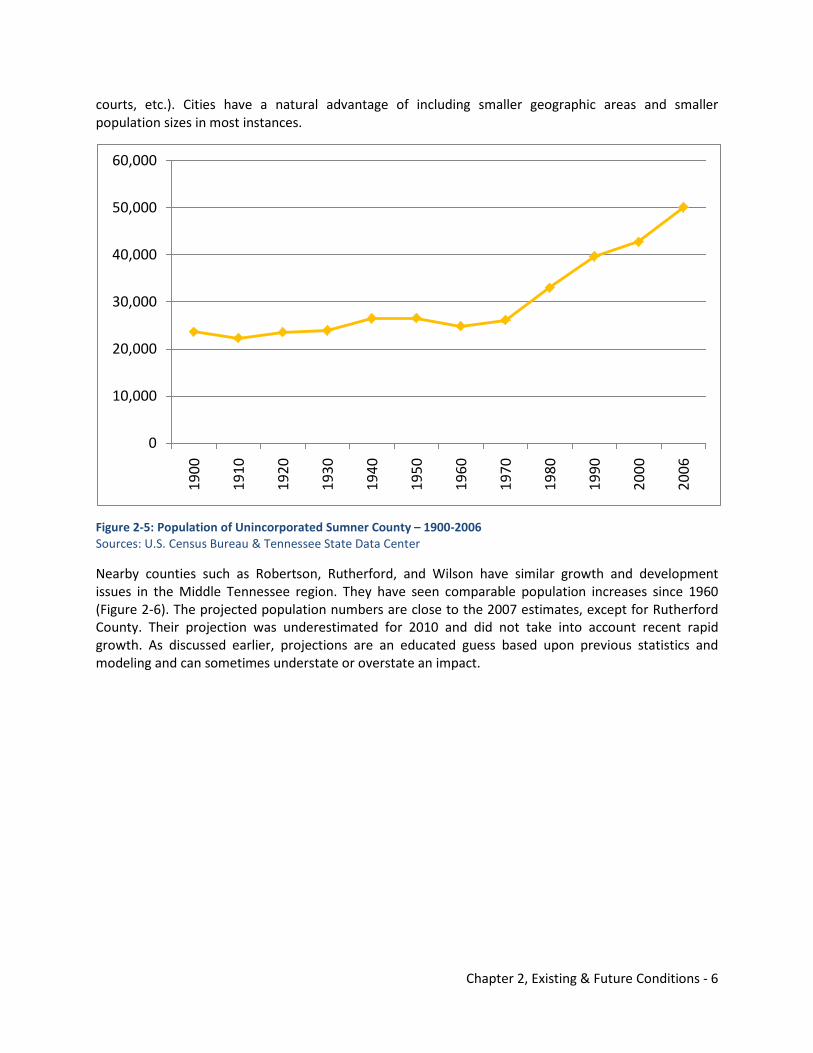
Figure 2-4: Sumner County Population - 1900-2035 (Projected) Sources: U.S. Census Bureau, Tennessee State Data Center, and Nashville Area MPO Population within unincorporated Sumner County is anticipated to increase. Subtracting the population of the municipalities from the county total yields the balance of population in the unincorporated county. Figure 2-5 depicts the growth in unincorporated Sumner County since 1900. Unincorporated county has experienced similar growth as the municipalities in Sumner County as discussed later in this element of the 2035 Comprehensive Plan. The unincorporated county currently has a comparable population size as the City of Hendersonville, the county’s largest municipality, but the 50,070 people are distributed over a larger geographic area. This amount of population growth over time might pose questions about the size of local government and the complexity and challenges of providing county services (schools, vehicle licensing, law enforcement, emergency medical services, planning & zoning,
0
50,000
100,000
150,000
200,000
250,000
1900
1910
1920
1930
1940
1950
1960
1970
1980
1990
2000
2007
2010
2015
2020
2025
2030
2035
By 2035, the population of Sumner County is projected
to increase by 72,000 residents or 45 percent.
Chapter 2, Existing & Future Conditions - 6
courts, etc.). Cities have a natural advantage of including smaller geographic areas and smaller population sizes in most instances.
Figure 2-5: Population of Unincorporated Sumner County – 1900-2006 Sources: U.S. Census Bureau & Tennessee State Data Center
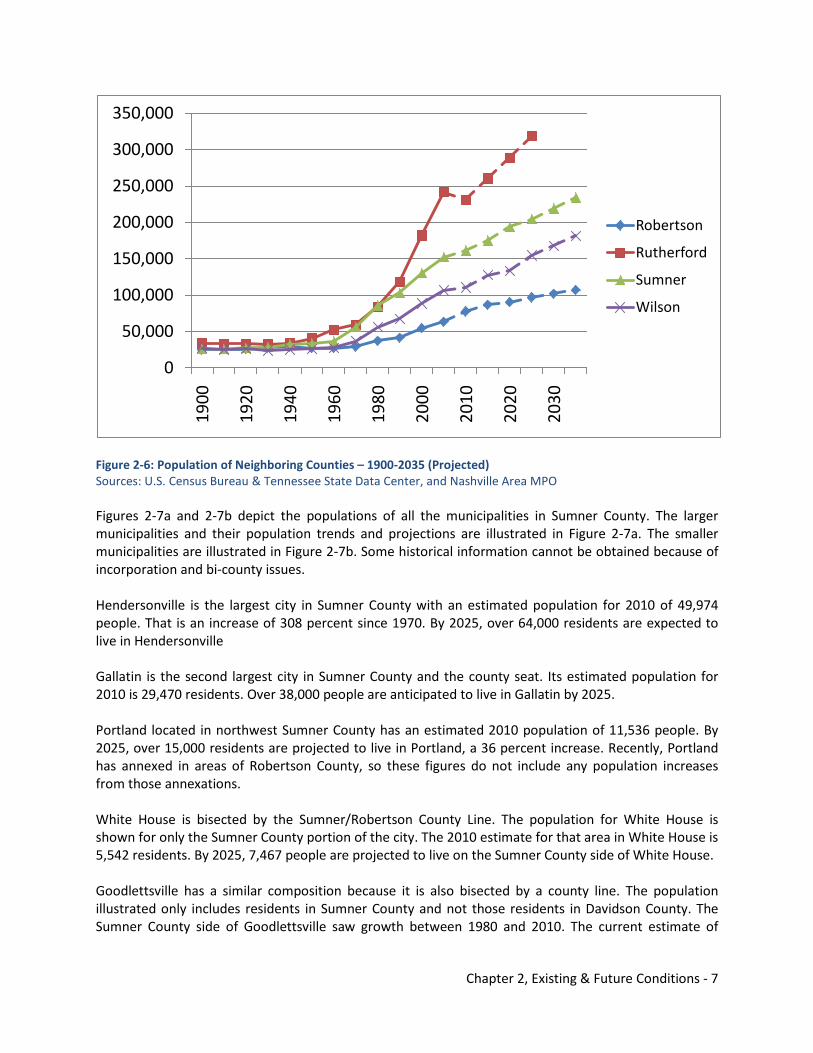
Nearby counties such as Robertson, Rutherford, and Wilson have similar growth and development issues in the Middle Tennessee region. They have seen comparable population increases since 1960 (Figure 2-6). The projected population numbers are close to the 2007 estimates, except for Rutherford County. Their projection was underestimated for 2010 and did not take into account recent rapid growth. As discussed earlier, projections are an educated guess based upon previous statistics and modeling and can sometimes understate or overstate an impact.
0
10,000
20,000
30,000
40,000
50,000
60,000
1900
1910
1920
1930
1940
1950
1960
1970
1980
1990
2000
2006
Chapter 2, Existing & Future Conditions - 7
Figure 2-6: Population of Neighboring Counties – 1900-2035 (Projected) Sources: U.S. Census Bureau & Tennessee State Data Center, and Nashville Area MPO Figures 2-7a and 2-7b depict the populations of all the municipalities in Sumner County. The larger municipalities and their population trends and projections are illustrated in Figure 2-7a. The smaller municipalities are illustrated in Figure 2-7b. Some historical information cannot be obtained because of incorporation and bi-county issues. Hendersonville is the largest city in Sumner County with an estimated population for 2010 of 49,974 people. That is an increase of 308 percent since 1970. By 2025, over 64,000 residents are expected to live in Hendersonville Gallatin is the second largest city in Sumner County and the county seat. Its estimated population for 2010 is 29,470 residents. Over 38,000 people are anticipated to live in Gallatin by 2025. Portland located in northwest Sumner County has an estimated 2010 population of 11,536 people. By 2025, over 15,000 residents are projected to live in Portland, a 36 percent increase. Recently, Portland has annexed in areas of Robertson County, so these figures do not include any population increases from those annexations. White House is bisected by the Sumner/Robertson County Line. The population for White House is shown for only the Sumner County portion of the city. The 2010 estimate for that area in White House is 5,542 residents. By 2025, 7,467 people are projected to live on the Sumner County side of White House. Goodlettsville has a similar composition because it is also bisected by a county line. The population illustrated only includes residents in Sumner County and not those residents in Davidson County. The Sumner County side of Goodlettsville saw growth between 1980 and 2010. The current estimate of
0
50,000
100,000
150,000
200,000
250,000
300,000
350,000
1900
1920
1940
1960
1980
2000
2010
2020
2030
Robertson
Rutherford
Sumner
Wilson
Chapter 2, Existing & Future Conditions - 8
5,606 residents is an increase of 3,664 people since 1980. By 2025, over 7,000 residents are anticipated to live in the area. Millersville’s population is also expected to increase from the 2010 estimate of 5,881 people to nearly 8,000 people by 2025. That is a 36 percent increase in residents. The 2010 population estimate for Westmoreland is 2,472 people. By 2025, 3,125 people are anticipated to live in the city. Mitchellville is Sumner County’s smallest municipality. In 2010, 242 residents were estimated to live in Mitchellville. The area will remain with a steady population of 294 people by 2025. Appendix A contains the actual numbers used in this analysis. Many of the municipalities performed special censuses since the 2000 Census was conducted, but the population projections were based upon the 2000 data. Alternatively, the county projected data developed by the Nashville Area MPO used the updated estimates performed by the cities since 2000. The 2010 Census numbers will ultimately help clarify the population numbers for the cities and the county. The primary point of this analysis is to show the significant growth increases in population anticipated in Sumner County and the region over the next 15 to 25 years. In comparing the cities’ population growth to the unincorporated county’s population growth, the cities have seen a 799 percent increase in growth since 1960. The unincorporated county has seen an increase of 102 percent since 1960. In 1960, the municipalities comprised of 11,374 residents, and the unincorporated county had 24,843 people. Today, the municipalities have 102,201 residents, and the unincorporated county has 50,070 people.
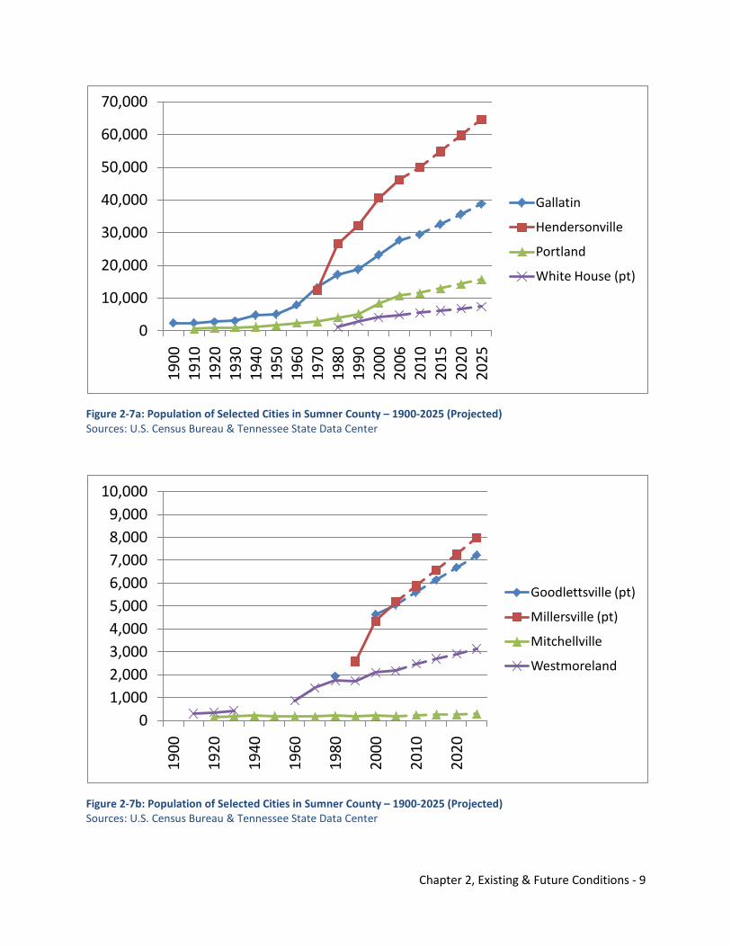
Chapter 2, Existing & Future Conditions - 9
Figure 2-7a: Population of Selected Cities in Sumner County – 1900-2025 (Projected) Sources: U.S. Census Bureau & Tennessee State Data Center
Figure 2-7b: Population of Selected Cities in Sumner County – 1900-2025 (Projected) Sources: U.S. Census Bureau & Tennessee State Data Center
0
10,000
20,000
30,000
40,000
50,000
60,000
70,000
1900
1910
1920
1930
1940
1950
1960
1970
1980
1990
2000
2006
2010
2015
2020
2025
Gallatin
Hendersonville
Portland
White House (pt)
01,0002,0003,0004,0005,0006,0007,0008,0009,000
10,000
1900
1920
1940
1960
1980
2000
2010
2020
Goodlettsville (pt)
Millersville (pt)
Mitchellville
Westmoreland
Chapter 2, Existing & Future Conditions - 10
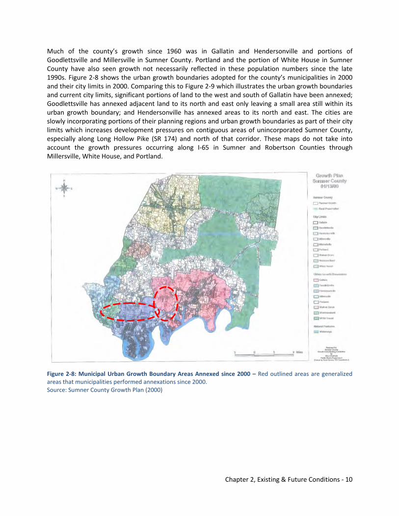
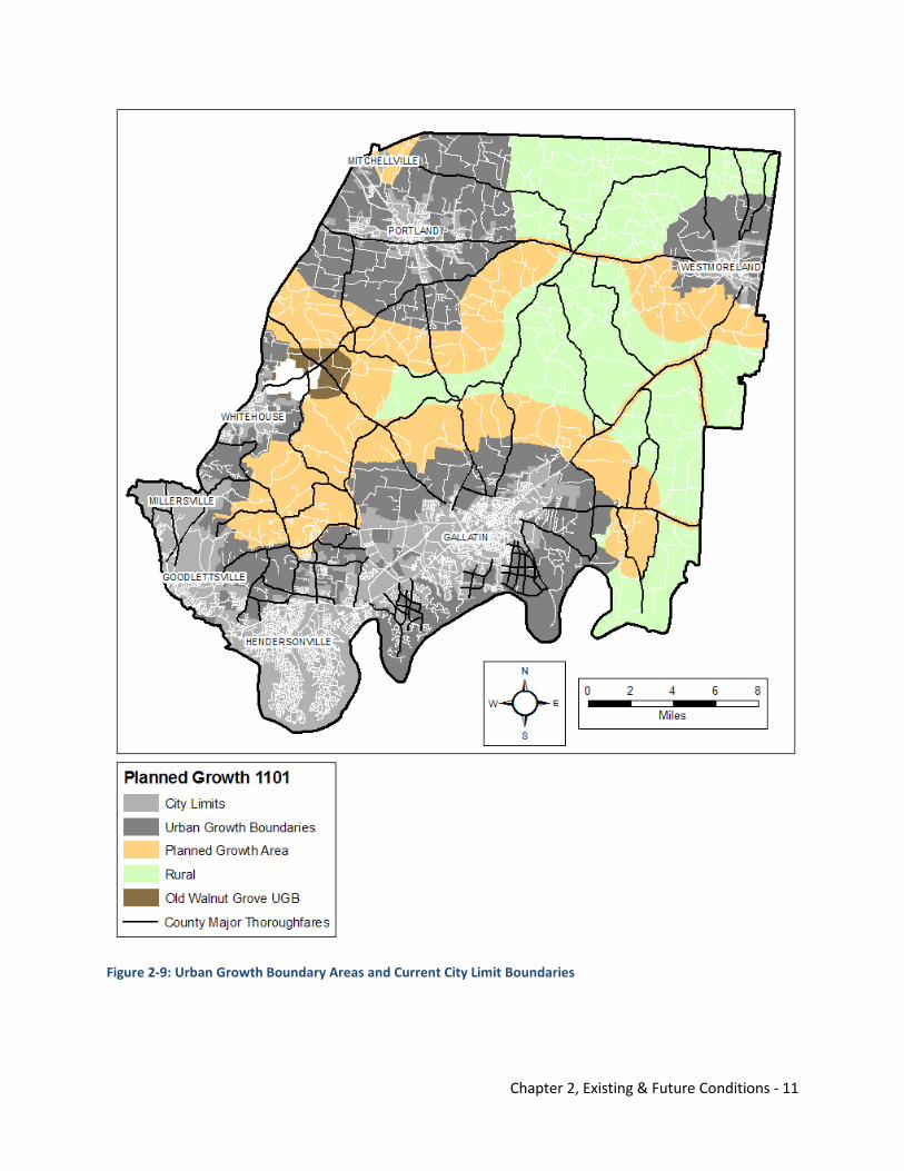
Much of the county’s growth since 1960 was in Gallatin and Hendersonville and portions of Goodlettsville and Millersville in Sumner County. Portland and the portion of White House in Sumner County have also seen growth not necessarily reflected in these population numbers since the late 1990s. Figure 2-8 shows the urban growth boundaries adopted for the county’s municipalities in 2000 and their city limits in 2000. Comparing this to Figure 2-9 which illustrates the urban growth boundaries and current city limits, significant portions of land to the west and south of Gallatin have been annexed; Goodlettsville has annexed adjacent land to its north and east only leaving a small area still within its urban growth boundary; and Hendersonville has annexed areas to its north and east. The cities are slowly incorporating portions of their planning regions and urban growth boundaries as part of their city limits which increases development pressures on contiguous areas of unincorporated Sumner County, especially along Long Hollow Pike (SR 174) and north of that corridor. These maps do not take into account the growth pressures occurring along I-65 in Sumner and Robertson Counties through Millersville, White House, and Portland.
Figure 2-8: Municipal Urban Growth Boundary Areas Annexed since 2000 – Red outlined areas are generalized areas that municipalities performed annexations since 2000. Source: Sumner County Growth Plan (2000)
Chapter 2, Existing & Future Conditions - 11
Figure 2-9: Urban Growth Boundary Areas and Current City Limit Boundaries
Chapter 2, Existing & Future Conditions - 12
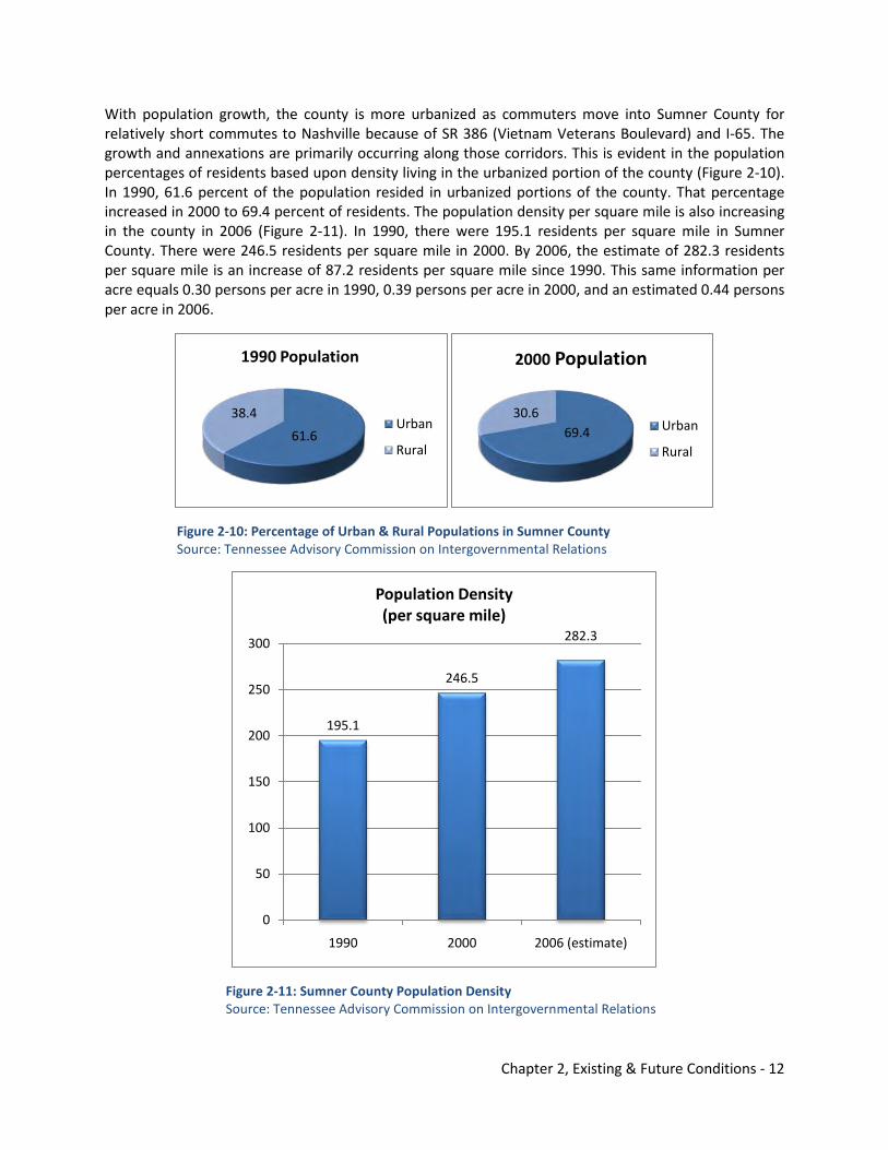
With population growth, the county is more urbanized as commuters move into Sumner County for relatively short commutes to Nashville because of SR 386 (Vietnam Veterans Boulevard) and I-65. The growth and annexations are primarily occurring along those corridors. This is evident in the population percentages of residents based upon density living in the urbanized portion of the county (Figure 2-10). In 1990, 61.6 percent of the population resided in urbanized portions of the county. That percentage increased in 2000 to 69.4 percent of residents. The population density per square mile is also increasing in the county in 2006 (Figure 2-11). In 1990, there were 195.1 residents per square mile in Sumner County. There were 246.5 residents per square mile in 2000. By 2006, the estimate of 282.3 residents per square mile is an increase of 87.2 residents per square mile since 1990. This same information per acre equals 0.30 persons per acre in 1990, 0.39 persons per acre in 2000, and an estimated 0.44 persons per acre in 2006.
Figure 2-10: Percentage of Urban & Rural Populations in Sumner County Source: Tennessee Advisory Commission on Intergovernmental Relations
Figure 2-11: Sumner County Population Density Source: Tennessee Advisory Commission on Intergovernmental Relations
61.6
38.4
1990 Population
Urban
Rural69.4
30.6
2000 Population
Urban
Rural
195.1
246.5
282.3
0
50
100
150
200
250
300
1990 2000 2006 (estimate)
Population Density (per square mile)
Chapter 2, Existing & Future Conditions - 13
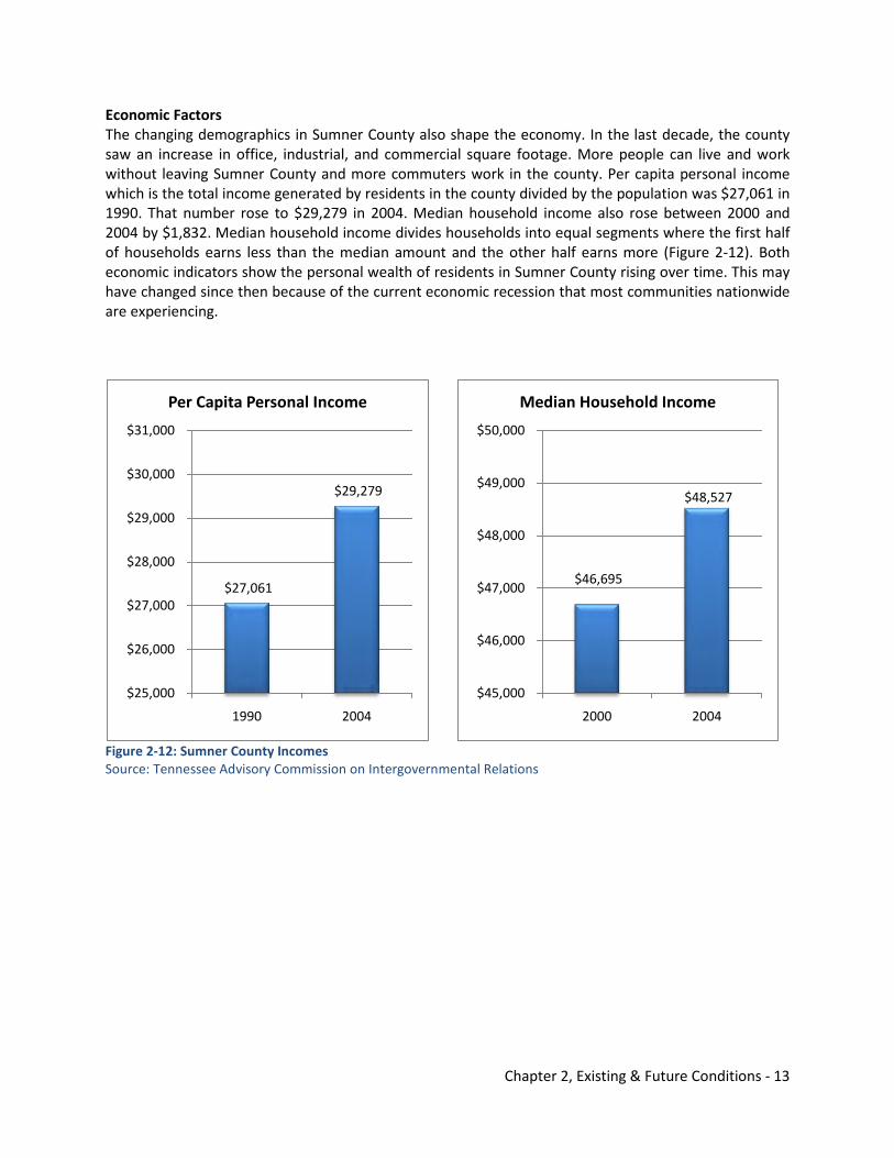
Economic Factors The changing demographics in Sumner County also shape the economy. In the last decade, the county saw an increase in office, industrial, and commercial square footage. More people can live and work without leaving Sumner County and more commuters work in the county. Per capita personal income which is the total income generated by residents in the county divided by the population was $27,061 in 1990. That number rose to $29,279 in 2004. Median household income also rose between 2000 and 2004 by $1,832. Median household income divides households into equal segments where the first half of households earns less than the median amount and the other half earns more (Figure 2-12). Both economic indicators show the personal wealth of residents in Sumner County rising over time. This may have changed since then because of the current economic recession that most communities nationwide are experiencing.
Figure 2-12: Sumner County Incomes Source: Tennessee Advisory Commission on Intergovernmental Relations
$27,061
$29,279
$25,000
$26,000
$27,000
$28,000
$29,000
$30,000
$31,000
1990 2004
Per Capita Personal Income
$46,695
$48,527
$45,000
$46,000
$47,000
$48,000
$49,000
$50,000
2000 2004
Median Household Income
Chapter 2, Existing & Future Conditions - 14
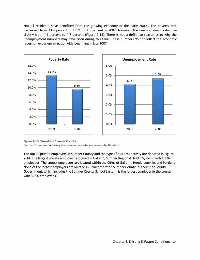
Not all residents have benefited from the growing economy of the early 2000s. The poverty rate decreased from 13.4 percent in 1999 to 9.6 percent in 2004; however, the unemployment rate rose slightly from 4.1 percent to 4.7 percent (Figure 2-13). There is not a definitive reason as to why the unemployment numbers may have risen during this time. These numbers do not reflect the economic recession experienced nationwide beginning in late 2007.
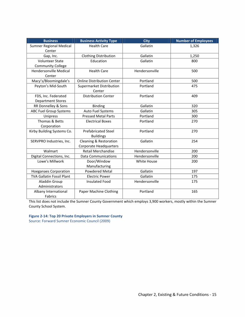
Figure 2-13: Poverty in Sumner County Source: Tennessee Advisory Commission on Intergovernmental Relations The top 20 private employers in Sumner County and the type of business activity are denoted in Figure 2-14. The largest private employer is located in Gallatin, Sumner Regional Health System, with 1,326 employees. The largest employers are located within the Cities of Gallatin, Hendersonville, and Portland. None of the largest employers are located in unincorporated Sumner County, but Sumner County Government, which includes the Sumner County School System, is the largest employer in the county with 3,900 employees.
13.4%
9.6%
0.0%
2.0%
4.0%
6.0%
8.0%
10.0%
12.0%
14.0%
16.0%
1999 2004
Poverty Rate
4.1%
4.7%
0.0%
1.0%
2.0%
3.0%
4.0%
5.0%
6.0%
2001 2006
Unemployment Rate
Chapter 2, Existing & Future Conditions - 15
Business Business Activity Type City Number of Employees Sumner Regional Medical
Center Health Care Gallatin 1,326
Gap, Inc. Clothing Distribution Gallatin 1,250 Volunteer State
Community College Education Gallatin 800
Hendersonville Medical Center
Health Care Hendersonville 500
Macy’s/Bloomingdale’s Online Distribution Center Portland 500 Peyton’s Mid-South Supermarket Distribution
Center Portland 475
FDS, Inc. Federated Department Stores
Distribution Center Portland 409
RR Donnelley & Sons Binding Gallatin 320 ABC Fuel Group Systems Auto Fuel Systems Gallatin 305
Unipress Pressed Metal Parts Portland 300 Thomas & Betts
Corporation Electrical Boxes Portland 270
Kirby Building Systems Co. Prefabricated Steel Buildings
Portland 270
SERVPRO Industries, Inc. Cleaning & Restoration Corporate Headquarters
Gallatin 254
Walmart Retail Merchandise Hendersonville 200 Digital Connections, Inc. Data Communications Hendersonville 200
Lowe’s Millwork Door/Window Manufacturing
White House 200
Hoeganaes Corporation Powdered Metal Gallatin 197 TVA Gallatin Fossil Plant Electric Power Gallatin 175
Aladdin Group Administrators
Insulated Food Hendersonville 175
Albany International Fabrics
Paper Machine Clothing Portland 165
This list does not include the Sumner County Government which employs 3,900 workers, mostly within the Sumner County School System. Figure 2-14: Top 20 Private Employers in Sumner County Source: Forward Sumner Economic Council (2009)
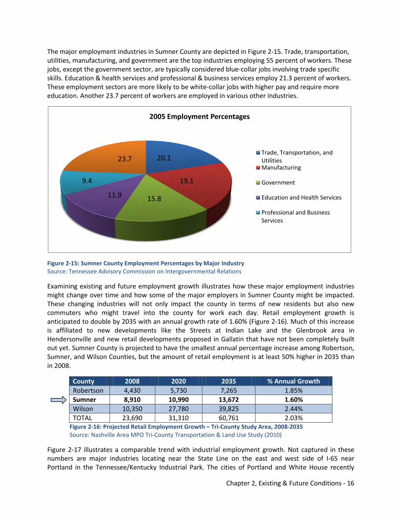
Chapter 2, Existing & Future Conditions - 16
The major employment industries in Sumner County are depicted in Figure 2-15. Trade, transportation, utilities, manufacturing, and government are the top industries employing 55 percent of workers. These jobs, except the government sector, are typically considered blue-collar jobs involving trade specific skills. Education & health services and professional & business services employ 21.3 percent of workers. These employment sectors are more likely to be white-collar jobs with higher pay and require more education. Another 23.7 percent of workers are employed in various other industries.
Figure 2-15: Sumner County Employment Percentages by Major Industry Source: Tennessee Advisory Commission on Intergovernmental Relations
Examining existing and future employment growth illustrates how these major employment industries might change over time and how some of the major employers in Sumner County might be impacted. These changing industries will not only impact the county in terms of new residents but also new commuters who might travel into the county for work each day. Retail employment growth is anticipated to double by 2035 with an annual growth rate of 1.60% (Figure 2-16). Much of this increase is affiliated to new developments like the Streets at Indian Lake and the Glenbrook area in Hendersonville and new retail developments proposed in Gallatin that have not been completely built out yet. Sumner County is projected to have the smallest annual percentage increase among Robertson, Sumner, and Wilson Counties, but the amount of retail employment is at least 50% higher in 2035 than in 2008.
County 2008 2020 2035 % Annual Growth Robertson 4,430 5,730 7,265 1.85% Sumner 8,910 10,990 13,672 1.60% Wilson 10,350 27,780 39,825 2.44% TOTAL 23,690 31,310 60,761 2.03%
Figure 2-16: Projected Retail Employment Growth – Tri-County Study Area, 2008-2035 Source: Nashville Area MPO Tri-County Transportation & Land Use Study (2010)
Figure 2-17 illustrates a comparable trend with industrial employment growth. Not captured in these numbers are major industries locating near the State Line on the east and west side of I-65 near Portland in the Tennessee/Kentucky Industrial Park. The cities of Portland and White House recently
20.1
19.1
15.811.9
9.4
23.7
2005 Employment Percentages
Trade, Transportation, and UtilitiesManufacturing
Government
Education and Health Services
Professional and Business Services
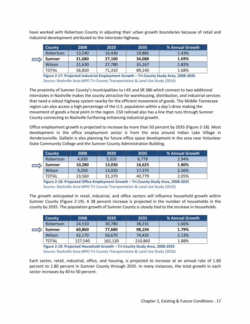
Chapter 2, Existing & Future Conditions - 17
have worked with Robertson County in adjusting their urban growth boundaries because of retail and industrial development attributed to the interstate highway.
County 2008 2020 2035 % Annual Growth Robertson 13,540 16,430 19,885 1.43% Sumner 21,680 27,100 34,088 1.69% Wilson 21,630 27,780 35,167 1.82% TOTAL 56,850 71,310 89,140 1.68%
Figure 2-17: Projected Industrial Employment Growth – Tri-County Study Area, 2008-2035 Source: Nashville Area MPO Tri-County Transportation & Land Use Study (2010)
The proximity of Sumner County’s municipalities to I-65 and SR 386 which connect to two additional interstates in Nashville makes the county attractive for warehousing, distribution, and industrial services that need a robust highway system nearby for the efficient movement of goods. The Middle Tennessee region can also access a high percentage of the U.S. population within a day’s drive making the movement of goods a focal point in the region. CSX railroad also has a line that runs through Sumner County connecting to Nashville furthering enhancing industrial growth.
Office employment growth is projected to increase by more than 50 percent by 2035 (Figure 2-18). Most development in the office employment sector is from the area around Indian Lake Village in Hendersonville. Gallatin is also planning for future office space development in the area near Volunteer State Community College and the Sumner County Administration Building.
County 2008 2020 2035 % Annual Growth Robertson 4,030 5,320 6,779 1.94% Sumner 10,280 13,030 16,625 1.80% Wilson 9,250 13,020 17,375 2.36% TOTAL 23,560 31,370 40,779 2.05%
Figure 2-18: Projected Office Employment Growth – Tri-County Study Area, 2008-2035 Source: Nashville Area MPO Tri-County Transportation & Land Use Study (2010)
The growth anticipated in retail, industrial, and office sectors will influence household growth within Sumner County (Figure 2-19). A 38 percent increase is projected in the number of households in the county by 2035. The population growth of Sumner County is closely tied to the increase in households.
County 2008 2020 2035 % Annual Growth Robertson 24,510 30,780 38,231 1.66% Sumner 60,860 77,680 98,194 1.79% Wilson 42,170 56,670 74,435 2.13% TOTAL 127,540 165,130 210,860 1.88%
Figure 2-19: Projected Household Growth – Tri-County Study Area, 2008-2035 Source: Nashville Area MPO Tri-County Transportation & Land Use Study (2010)
Each sector, retail, industrial, office, and housing, is projected to increase at an annual rate of 1.60 percent to 1.80 percent in Sumner County through 2035. In many instances, the total growth in each sector increases by 40 to 50 percent.
Chapter 2, Existing & Future Conditions - 18
Adequate Services Understanding the potential demand for future services is essential in estimating local government budgets. The 2008 Cost of Community Services Study from Robertson County is discussed in the Introduction Element (1.0) (see Figure 1-5). Robertson County was the closest county to Sumner County that had recently completed one of these studies. Based on this study, the burden of providing adequate services is passed on to the local taxpayer in instances where revenues do not cover expenditures. The type of land use can have an impact on future budget projections. Figure 2-20 shows the estimated future demand for services that a municipality, Sumner County, or a utility district may need to provide in Sumner County by 2035. The information on the left shows the amount of recommended delivery service standard. The column on the right depicts the estimated future demand needed to provide adequate coverage in those key service areas based upon population projections for 2035. This gives an idea of future service demands needed for those providers in Sumner County.
Service Type Recommended Service Delivery Standard
Estimated Future Demand
Fire Protection 1.29 firefighters/1,000 residents 302 firefighters (an additional 27)
Police Protection .84 officers/1,000 residents 197 officers (an additional 72)
Potable Water* 250 gpd/1,000 sq. ft. residential 0.10 gpd/1,000 sq. ft. industrial 0.64 gpd/1,000 sq. ft. commercial & office
12.1 gpd/1,000 sq. ft.
Sewer** 225 gpd/1,000 sq. ft. residential 0.069 gpd/1,000 sq. ft. industrial 0.080 gpd/1,000 sq. ft. commercial & office
9 gpd/1,000 sq. ft.
Parkland 10 acres/1,000 residents 2,340 acres
gpd - gallons per day sq. ft. - square feet
Figure 2-20: Estimated Future Demand for Services Source: Nashville Area MPO Tri-County Transportation & Land Use Study (2010)
Another delivery service that the county provides that is not included in this table is public education. The Sumner County School System comprises between 80 to 85 percent of the annual budget of the Sumner County Government in any given year. The funding of public education is closely tied to the potential of economic growth, but the school system can have a significant impact on the county’s financial health. The coordination of new school buildings within existing infrastructure can tremendously reduce costs over time compared to building facilities where infrastructure must be upgraded. When a school building is built in an area lacking adequate infrastructure, the local government and utility systems must also spend money to upgrade facilities. Although these sites may be more financially attractive initially, they often cost more over time with the increasing strain on adequate infrastructure that will need to be updated. Additionally, the development of residential areas can seriously impact the services of the school system causing a shift in school populations. Station Camp High School (Figure 2-21) was built to handle the student population growth in the Hendersonville
Chapter 2, Existing & Future Conditions - 19
and Gallatin areas. The high school has been paired since with an elementary and middle school. The school complex was one factor generating a need for additional infrastructure improvements in the area like the construction of Big Station Camp Boulevard, the proposed extension of Jenkins Lane, improvements to Saundersville Road, improved sidewalks, and development of a new greenway. New residential and commercial services are also proposed in the immediate area because of the adjacent growth. Coordinating infrastructure improvements through school site planning, utility system upgrades and expansions, land use changes, and proposed transportation improvements are critical in reducing the tax burden upon residents. Currently, that level of robust planning is not taking place between the school system, utility systems, Sumner County, and the municipalities. The Implementation Element (7.0) contains a strategy to begin intergovernmental coordination regarding these development activities.
Figure 2-21: Station Camp High School Source: Station Camp High School Website (2010)
Chapter 2, Existing & Future Conditions - 20
THIS PAGE INTENTIONALLY LEFT BLANK
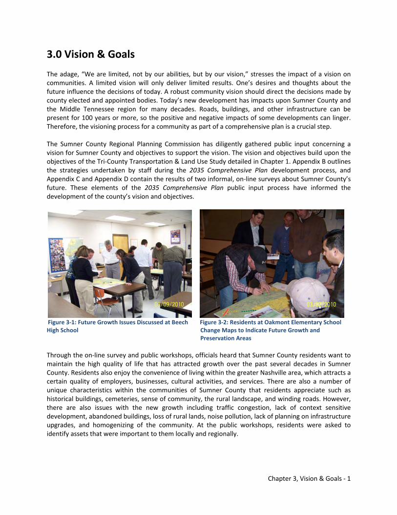
Chapter 3, Vision & Goals - 1
3.0 Vision & Goals The adage, “We are limited, not by our abilities, but by our vision,” stresses the impact of a vision on communities. A limited vision will only deliver limited results. One’s desires and thoughts about the future influence the decisions of today. A robust community vision should direct the decisions made by county elected and appointed bodies. Today’s new development has impacts upon Sumner County and the Middle Tennessee region for many decades. Roads, buildings, and other infrastructure can be present for 100 years or more, so the positive and negative impacts of some developments can linger. Therefore, the visioning process for a community as part of a comprehensive plan is a crucial step. The Sumner County Regional Planning Commission has diligently gathered public input concerning a vision for Sumner County and objectives to support the vision. The vision and objectives build upon the objectives of the Tri-County Transportation & Land Use Study detailed in Chapter 1. Appendix B outlines the strategies undertaken by staff during the 2035 Comprehensive Plan development process, and Appendix C and Appendix D contain the results of two informal, on-line surveys about Sumner County’s future. These elements of the 2035 Comprehensive Plan public input process have informed the development of the county’s vision and objectives.
Figure 3-1: Future Growth Issues Discussed at Beech Figure 3-2: Residents at Oakmont Elementary School High School Change Maps to Indicate Future Growth and Preservation Areas Through the on-line survey and public workshops, officials heard that Sumner County residents want to maintain the high quality of life that has attracted growth over the past several decades in Sumner County. Residents also enjoy the convenience of living within the greater Nashville area, which attracts a certain quality of employers, businesses, cultural activities, and services. There are also a number of unique characteristics within the communities of Sumner County that residents appreciate such as historical buildings, cemeteries, sense of community, the rural landscape, and winding roads. However, there are also issues with the new growth including traffic congestion, lack of context sensitive development, abandoned buildings, loss of rural lands, noise pollution, lack of planning on infrastructure upgrades, and homogenizing of the community. At the public workshops, residents were asked to identify assets that were important to them locally and regionally.
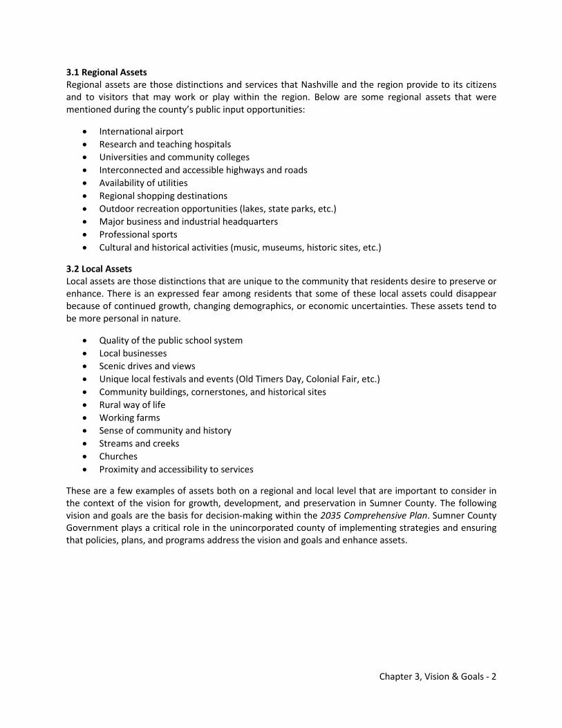
Chapter 3, Vision & Goals - 2
3.1 Regional Assets Regional assets are those distinctions and services that Nashville and the region provide to its citizens and to visitors that may work or play within the region. Below are some regional assets that were mentioned during the county’s public input opportunities:
• International airport • Research and teaching hospitals • Universities and community colleges • Interconnected and accessible highways and roads • Availability of utilities • Regional shopping destinations • Outdoor recreation opportunities (lakes, state parks, etc.) • Major business and industrial headquarters • Professional sports • Cultural and historical activities (music, museums, historic sites, etc.)
3.2 Local Assets Local assets are those distinctions that are unique to the community that residents desire to preserve or enhance. There is an expressed fear among residents that some of these local assets could disappear because of continued growth, changing demographics, or economic uncertainties. These assets tend to be more personal in nature.
• Quality of the public school system • Local businesses • Scenic drives and views • Unique local festivals and events (Old Timers Day, Colonial Fair, etc.) • Community buildings, cornerstones, and historical sites • Rural way of life • Working farms • Sense of community and history • Streams and creeks • Churches • Proximity and accessibility to services
These are a few examples of assets both on a regional and local level that are important to consider in the context of the vision for growth, development, and preservation in Sumner County. The following vision and goals are the basis for decision-making within the 2035 Comprehensive Plan. Sumner County Government plays a critical role in the unincorporated county of implementing strategies and ensuring that policies, plans, and programs address the vision and goals and enhance assets.
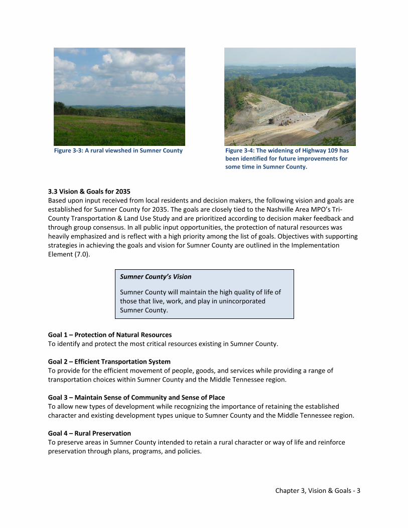
Chapter 3, Vision & Goals - 3
Figure 3-3: A rural viewshed in Sumner County Figure 3-4: The widening of Highway 109 has
been identified for future improvements for some time in Sumner County.
3.3 Vision & Goals for 2035 Based upon input received from local residents and decision makers, the following vision and goals are established for Sumner County for 2035. The goals are closely tied to the Nashville Area MPO’s Tri-County Transportation & Land Use Study and are prioritized according to decision maker feedback and through group consensus. In all public input opportunities, the protection of natural resources was heavily emphasized and is reflect with a high priority among the list of goals. Objectives with supporting strategies in achieving the goals and vision for Sumner County are outlined in the Implementation Element (7.0). Goal 1 – Protection of Natural Resources To identify and protect the most critical resources existing in Sumner County. Goal 2 – Efficient Transportation System To provide for the efficient movement of people, goods, and services while providing a range of transportation choices within Sumner County and the Middle Tennessee region. Goal 3 – Maintain Sense of Community and Sense of Place To allow new types of development while recognizing the importance of retaining the established character and existing development types unique to Sumner County and the Middle Tennessee region. Goal 4 – Rural Preservation To preserve areas in Sumner County intended to retain a rural character or way of life and reinforce preservation through plans, programs, and policies.
Sumner County’s Vision
Sumner County will maintain the high quality of life of those that live, work, and play in unincorporated Sumner County.
Chapter 3, Vision & Goals - 4
Goal 5 – Economic Enrichment while Safeguarding Existing Public & Private Development To enhance economic growth and opportunities in Sumner County and the Middle Tennessee region to ensure that a high quality of life remains for residents. Goal 6 – Historic Conservation & Enhancement To promote the conservation of historic and cultural resources and support these efforts in Sumner County through plans, programs, and policies. Goal 7 – Ensure Availability of Services To ensure that future growth in Sumner County occurs in a coordinated manner with community infrastructure and services needed to adequately support growth and development. Goal 8 – Viable Agriculture To recognize and support the important role of agriculture in Sumner County’s existing and future economy. Goal 9 – Preserve Urban Centers To strengthen and enhance existing community nodes in Sumner County through plans, programs, and policies. Goal 10 – Provide Housing Options To provide a wide range of housing types and communities in Sumner County for a variety of household sizes and income ranges.
Chapter 4, Land Use - 1
4.0 Land Use Sumner County’s topography and proximity to Nashville have strongly influenced its current land use patterns. Southern portions of the county developed more quickly because of relatively short commutes to Nashville where much of the region’s employment base existed. Northern portions of Sumner County have maintained a rural atmosphere for the most part. Maintaining this sense of rural identity was echoed throughout the public input opportunities held for the 2035 Comprehensive Plan, and concerns were expressed on losing that important characteristic that was the foundation for the county. The Land Use Element will document existing land use in Sumner County, current regulatory controls, shifting land use patterns based upon a business as usual scenario, and outline a 2035 General Framework Map as an alternative scenario to projected development patterns. 4.1 Existing Land Use Throughout unincorporated Sumner County, current land uses are generally agricultural and timber/forested areas with pockets of residential. Figure 4-1 illustrates the land uses based upon the Computer Assisted Appraisal System (CAAS) utilized by county property assessors in Tennessee. The agricultural areas are white, or lacking color on the map. Current agricultural uses are concentrated between the Cities of White House and Portland and northeast of the City of Gallatin. Timber/forested parcels are dotted with green. The mostly forested Ridge area is highlighted and extends from near Millersville traversing northeast and south of Westmoreland. Sporadic pockets of residential exist throughout the Ridge. Residential uses are indicated with light brown and are concentrated on flatter terrain of the county in northern Sumner County, between White House and Portland north of the Ridge, and between the city limits of Hendersonville and Gallatin and the Ridge. Some parcels with existing commercial uses in the county are easily identified, too, because of their red color. These parcels are mostly located on SR 109, SR 174 (Long Hollow Pike), SR 52, US 31E, and US 31W. Several significant public or semi-public uses are shaded in dark green. These include the TVA Gallatin Steam Plant, Taylor Hollow State Natural Area, historic sites in Castalian Springs, and some conservation easements within a land trust. The only industrial land uses are located along SR 76 between White House and Portland in the New Deal community. These areas are colored purple.

Chapter 4, Land Use - 2
Figure 4-1: Sumner County Existing Land Use, 2009 Source: Tennessee ECD Local Planning Assistance Office (2010) Note: Current city limits are incorrectly depicted in this map.
4.2 Zoning Controls Sumner County currently regulates most land use decisions through the Sumner County Zoning Resolution adopted in 1973. Most rezonings since its initial adoption were requested by property owners. There have been few rezonings initiated by the county government. Most amendments approved by the Sumner County Board of County Commissioners that were initiated by the local government have addressed land uses and activities permitted within certain zones. Because these regulatory controls are rather dated and have not been comprehensively updated for nearly 40 years, the current Sumner County Zoning Resolution may not yield desirable land use patterns that support public feedback while developing the 2035 Comprehensive Plan. A major update of the county’s zoning is an essential strategy detailed in the Implementation Element (7.0). Zoning districts are illustrated in Figure 4-2 as of late 2008. Most of unincorporated Sumner County is zoned Agricultural and depicted with the light green color. Agricultural zoning allows the raising of crops and animal husbandry, but it also allows property owners to subdivide their land into 40,000 square feet
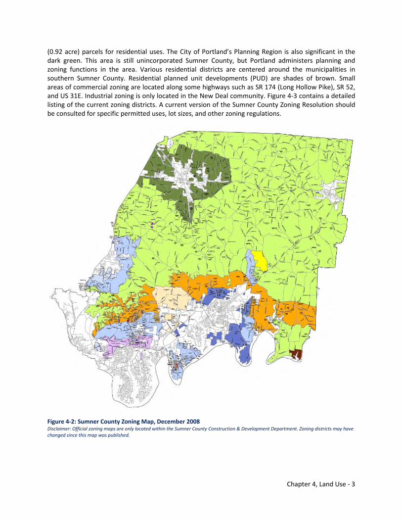
Chapter 4, Land Use - 3
(0.92 acre) parcels for residential uses. The City of Portland’s Planning Region is also significant in the dark green. This area is still unincorporated Sumner County, but Portland administers planning and zoning functions in the area. Various residential districts are centered around the municipalities in southern Sumner County. Residential planned unit developments (PUD) are shades of brown. Small areas of commercial zoning are located along some highways such as SR 174 (Long Hollow Pike), SR 52, and US 31E. Industrial zoning is only located in the New Deal community. Figure 4-3 contains a detailed listing of the current zoning districts. A current version of the Sumner County Zoning Resolution should be consulted for specific permitted uses, lot sizes, and other zoning regulations.
Figure 4-2: Sumner County Zoning Map, December 2008 Disclaimer: Official zoning maps are only located within the Sumner County Construction & Development Department. Zoning districts may have changed since this map was published.
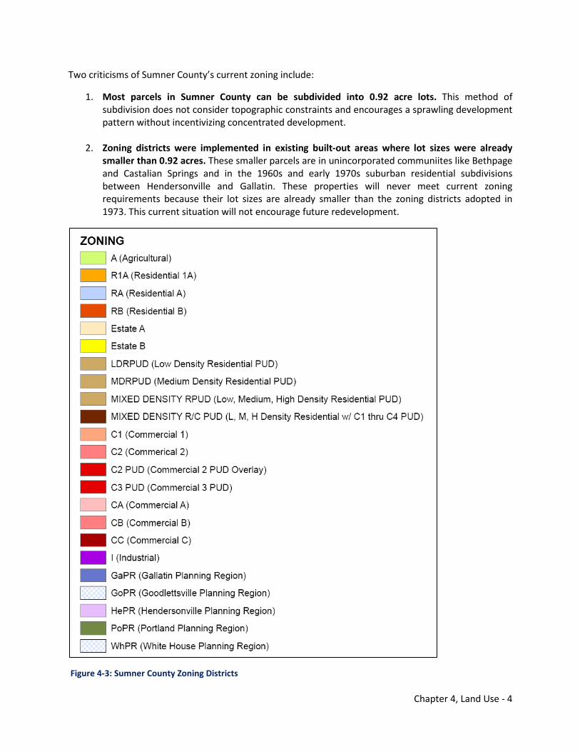
Chapter 4, Land Use - 4
Two criticisms of Sumner County’s current zoning include:
1. Most parcels in Sumner County can be subdivided into 0.92 acre lots. This method of subdivision does not consider topographic constraints and encourages a sprawling development pattern without incentivizing concentrated development.
2. Zoning districts were implemented in existing built-out areas where lot sizes were already smaller than 0.92 acres. These smaller parcels are in unincorporated communiites like Bethpage and Castalian Springs and in the 1960s and early 1970s suburban residential subdivisions between Hendersonville and Gallatin. These properties will never meet current zoning requirements because their lot sizes are already smaller than the zoning districts adopted in 1973. This current situation will not encourage future redevelopment.
Figure 4-3: Sumner County Zoning Districts
Chapter 4, Land Use - 5
4.3 Land Consumption Patterns Land use patterns have changed dramatically since the 1960s in Sumner County. Areas that were once disconnected to urban and suburban life are now incorporated parts of the municipalities. The expansion of utilities, use of the autmobile, good quality schools, changing employment sectors, and attractiveness of suburban living have changed the look and character of Sumner County. The consumption of land excelerated in Sumner County over the last few decades. Sumner County’s natural and environmental resources are under pressure for continued development. Rural viewsheds, high water quality, rolling topography, and forest land are all characteristics that many Sumner County residents appreciate, but development that is not context sensitive can endanger these important qualities valued by residents. Agricultural land is also endangered within the county because of the increased costs for small family farms. It is often easier and more profitable for an individual to sell land for development instead of continuing to farm. This alters the landscape, and with current county zoning adopted in most of the unincorporated portions of Sumner County, the entire county could feasibly be consumed with housing on 0.92 acre lots. Figure 4-4 shows developed land in the Middle Tennessee region in 1965. Much of the development in the region was in Nashville and around smaller cities such as Franklin, Gallatin, and Clarksville noted on the map. The large area of developed property to the northwest in Montgomery County is the Ft. Campbell Army Base. Most of the development in Sumner County was centered near Gallatin and the area between Davidson County and what would become the City of Hendersonville.
Sumner County’s natural and environmental resources are under pressure for development.
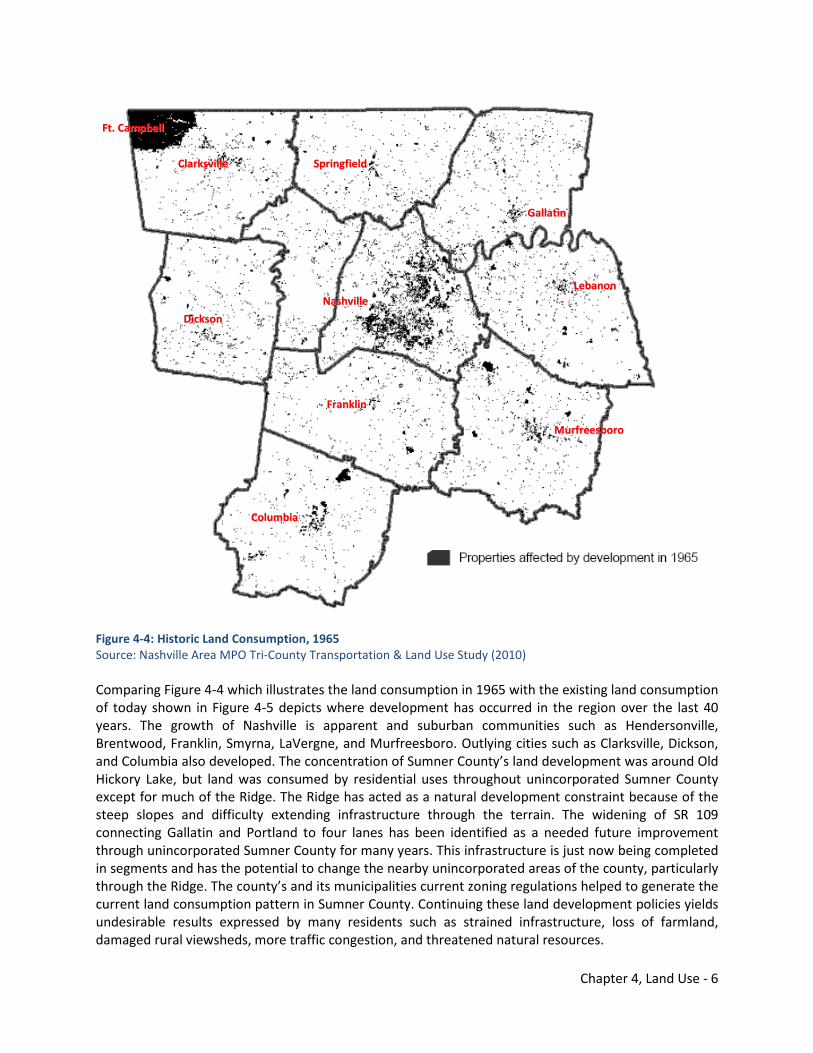
Chapter 4, Land Use - 6
Figure 4-4: Historic Land Consumption, 1965 Source: Nashville Area MPO Tri-County Transportation & Land Use Study (2010) Comparing Figure 4-4 which illustrates the land consumption in 1965 with the existing land consumption of today shown in Figure 4-5 depicts where development has occurred in the region over the last 40 years. The growth of Nashville is apparent and suburban communities such as Hendersonville, Brentwood, Franklin, Smyrna, LaVergne, and Murfreesboro. Outlying cities such as Clarksville, Dickson, and Columbia also developed. The concentration of Sumner County’s land development was around Old Hickory Lake, but land was consumed by residential uses throughout unincorporated Sumner County except for much of the Ridge. The Ridge has acted as a natural development constraint because of the steep slopes and difficulty extending infrastructure through the terrain. The widening of SR 109 connecting Gallatin and Portland to four lanes has been identified as a needed future improvement through unincorporated Sumner County for many years. This infrastructure is just now being completed in segments and has the potential to change the nearby unincorporated areas of the county, particularly through the Ridge. The county’s and its municipalities current zoning regulations helped to generate the current land consumption pattern in Sumner County. Continuing these land development policies yields undesirable results expressed by many residents such as strained infrastructure, loss of farmland, damaged rural viewsheds, more traffic congestion, and threatened natural resources.
NNaasshhvviillllee
GGaallllaattiinn
FFrraannkklliinn
FFtt.. CCaammppbbeellll
CCoolluummbbiiaa
LLeebbaannoonn
MMuurrffrreeeessbboorroo
SSpprriinnggffiieelldd
DDiicckkssoonn
CCllaarrkkssvviillllee
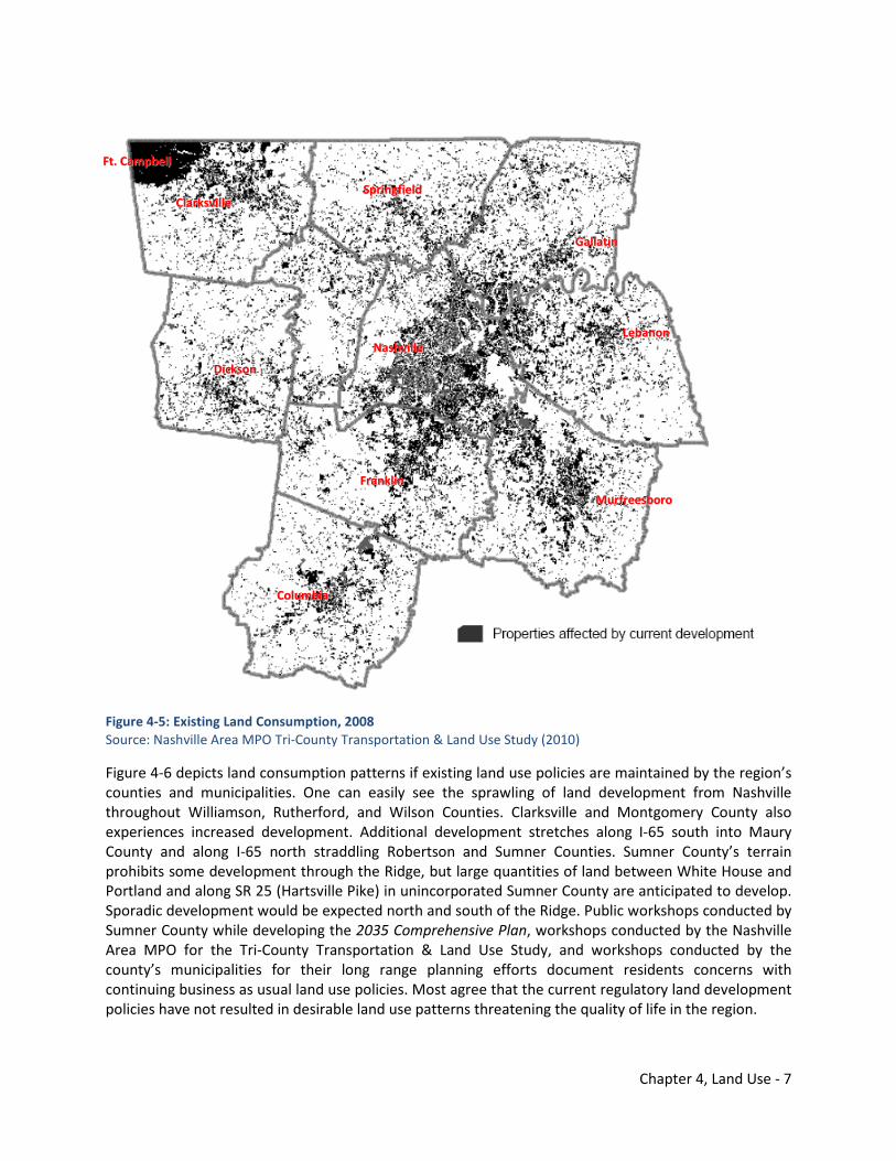
Chapter 4, Land Use - 7
Figure 4-5: Existing Land Consumption, 2008 Source: Nashville Area MPO Tri-County Transportation & Land Use Study (2010)
Figure 4-6 depicts land consumption patterns if existing land use policies are maintained by the region’s counties and municipalities. One can easily see the sprawling of land development from Nashville throughout Williamson, Rutherford, and Wilson Counties. Clarksville and Montgomery County also experiences increased development. Additional development stretches along I-65 south into Maury County and along I-65 north straddling Robertson and Sumner Counties. Sumner County’s terrain prohibits some development through the Ridge, but large quantities of land between White House and Portland and along SR 25 (Hartsville Pike) in unincorporated Sumner County are anticipated to develop. Sporadic development would be expected north and south of the Ridge. Public workshops conducted by Sumner County while developing the 2035 Comprehensive Plan, workshops conducted by the Nashville Area MPO for the Tri-County Transportation & Land Use Study, and workshops conducted by the county’s municipalities for their long range planning efforts document residents concerns with continuing business as usual land use policies. Most agree that the current regulatory land development policies have not resulted in desirable land use patterns threatening the quality of life in the region.
NNaasshhvviillllee
GGaallllaattiinn
FFrraannkklliinn
FFtt.. CCaammppbbeellll
CCoolluummbbiiaa
LLeebbaannoonn
MMuurrffrreeeessbboorroo
SSpprriinnggffiieelldd
DDiicckkssoonn
CCllaarrkkssvviillllee
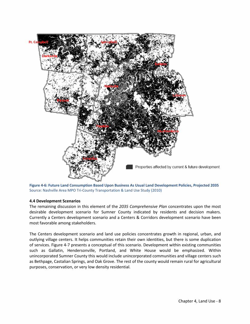
Chapter 4, Land Use - 8
Figure 4-6: Future Land Consumption Based Upon Business As Usual Land Development Policies, Projected 2035 Source: Nashville Area MPO Tri-County Transportation & Land Use Study (2010) 4.4 Development Scenarios The remaining discussion in this element of the 2035 Comprehensive Plan concentrates upon the most desirable development scenario for Sumner County indicated by residents and decision makers. Currently a Centers development scenario and a Centers & Corridors development scenario have been most favorable among stakeholders. The Centers development scenario and land use policies concentrates growth in regional, urban, and outlying village centers. It helps communities retain their own identities, but there is some duplication of services. Figure 4-7 presents a conceptual of this scenario. Development within existing communities such as Gallatin, Hendersonville, Portland, and White House would be emphasized. Within unincorporated Sumner County this would include unincorporated communities and village centers such as Bethpage, Castalian Springs, and Oak Grove. The rest of the county would remain rural for agricultural purposes, conservation, or very low density residential.
NNaasshhvviillllee
GGaallllaattiinn
FFrraannkklliinn
FFtt.. CCaammppbbeellll
CCoolluummbbiiaa
LLeebbaannoonn
MMuurrffrreeeessbboorroo
SSpprriinnggffiieelldd
DDiicckkssoonn
CCllaarrkkssvviillllee
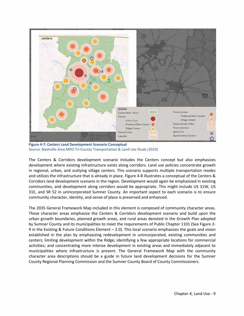
Chapter 4, Land Use - 9
Figure 4-7: Centers Land Development Scenario Conceptual Source: Nashville Area MPO Tri-County Transportation & Land Use Study (2010) The Centers & Corridors development scenario includes the Centers concept but also emphasizes development where existing infrastructure exists along corridors. Land use policies concentrate growth in regional, urban, and outlying village centers. This scenario supports multiple transportation modes and utilizes the infrastructure that is already in place. Figure 4-8 illustrates a conceptual of the Centers & Corridors land development scenario in the region. Development would again be emphasized in existing communities, and development along corridors would be appropriate. This might include US 31W, US 31E, and SR 52 in unincorporated Sumner County. An important aspect to each scenario is to ensure community character, identity, and sense of place is preserved and enhanced. The 2035 General Framework Map included in this element is composed of community character areas. These character areas emphasize the Centers & Corridors development scenario and build upon the urban growth boundaries, planned growth areas, and rural areas denoted in the Growth Plan adopted by Sumner County and its municipalities to meet the requirements of Public Chapter 1101 (See Figure 2-9 in the Existing & Future Conditions Element – 2.0). This local scenario emphasizes the goals and vision established in the plan by emphasizing redevelopment in unincorporated, existing communities and centers; limiting development within the Ridge; identifying a few appropriate locations for commercial activities; and concentrating more intense development in existing areas and immediately adjacent to municipalities where infrastructure is present. The General Framework Map with the community character area descriptions should be a guide in future land development decisions for the Sumner County Regional Planning Commission and the Sumner County Board of County Commissioners.
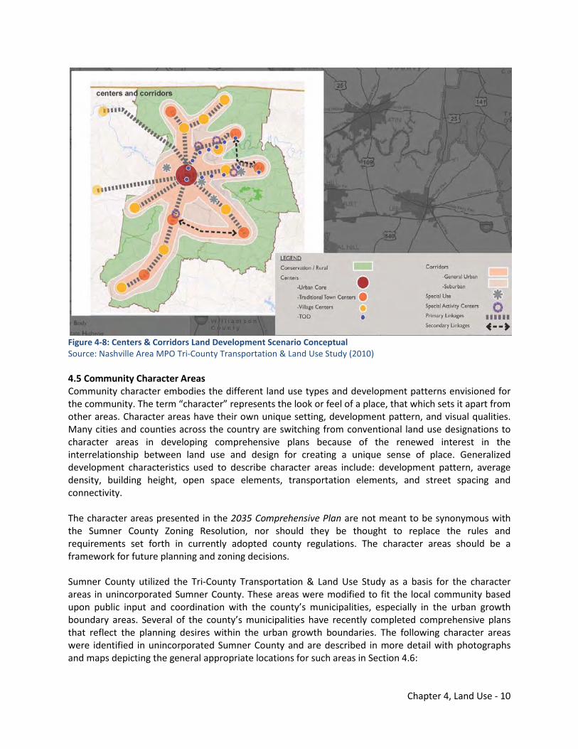
Chapter 4, Land Use - 10
Figure 4-8: Centers & Corridors Land Development Scenario Conceptual Source: Nashville Area MPO Tri-County Transportation & Land Use Study (2010) 4.5 Community Character Areas Community character embodies the different land use types and development patterns envisioned for the community. The term “character” represents the look or feel of a place, that which sets it apart from other areas. Character areas have their own unique setting, development pattern, and visual qualities. Many cities and counties across the country are switching from conventional land use designations to character areas in developing comprehensive plans because of the renewed interest in the interrelationship between land use and design for creating a unique sense of place. Generalized development characteristics used to describe character areas include: development pattern, average density, building height, open space elements, transportation elements, and street spacing and connectivity. The character areas presented in the 2035 Comprehensive Plan are not meant to be synonymous with the Sumner County Zoning Resolution, nor should they be thought to replace the rules and requirements set forth in currently adopted county regulations. The character areas should be a framework for future planning and zoning decisions. Sumner County utilized the Tri-County Transportation & Land Use Study as a basis for the character areas in unincorporated Sumner County. These areas were modified to fit the local community based upon public input and coordination with the county’s municipalities, especially in the urban growth boundary areas. Several of the county’s municipalities have recently completed comprehensive plans that reflect the planning desires within the urban growth boundaries. The following character areas were identified in unincorporated Sumner County and are described in more detail with photographs and maps depicting the general appropriate locations for such areas in Section 4.6:
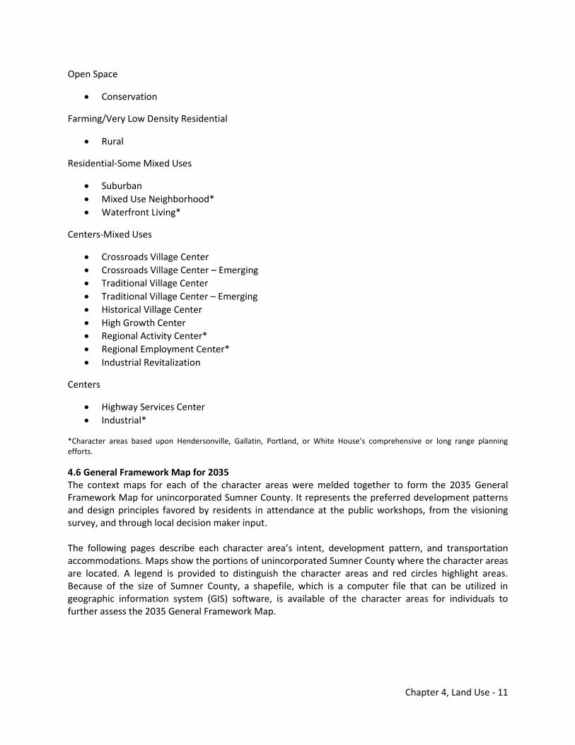
Chapter 4, Land Use - 11
Open Space
• Conservation
Farming/Very Low Density Residential
• Rural
Residential-Some Mixed Uses
• Suburban • Mixed Use Neighborhood* • Waterfront Living*
Centers-Mixed Uses
• Crossroads Village Center • Crossroads Village Center – Emerging • Traditional Village Center • Traditional Village Center – Emerging • Historical Village Center • High Growth Center • Regional Activity Center* • Regional Employment Center* • Industrial Revitalization
Centers
• Highway Services Center • Industrial*
*Character areas based upon Hendersonville, Gallatin, Portland, or White House’s comprehensive or long range planning efforts.
4.6 General Framework Map for 2035 The context maps for each of the character areas were melded together to form the 2035 General Framework Map for unincorporated Sumner County. It represents the preferred development patterns and design principles favored by residents in attendance at the public workshops, from the visioning survey, and through local decision maker input. The following pages describe each character area’s intent, development pattern, and transportation accommodations. Maps show the portions of unincorporated Sumner County where the character areas are located. A legend is provided to distinguish the character areas and red circles highlight areas. Because of the size of Sumner County, a shapefile, which is a computer file that can be utilized in geographic information system (GIS) software, is available of the character areas for individuals to further assess the 2035 General Framework Map.

Chapter 4, Land Use - 12
2035 GENERAL FRAMEWORK MAP UNINCORPORATED SUMNER COUNTY
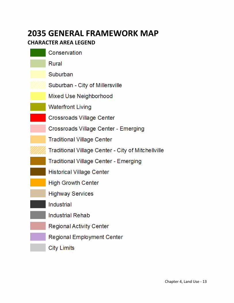
Chapter 4, Land Use - 13
2035 GENERAL FRAMEWORK MAP CHARACTER AREA LEGEND
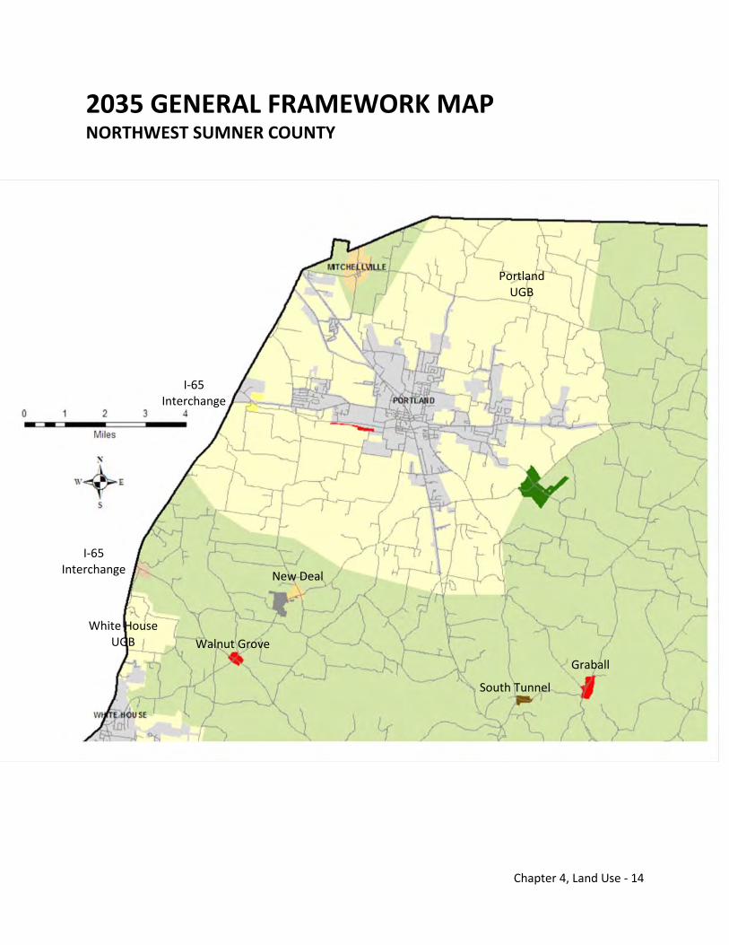
Chapter 4, Land Use - 14
2035 GENERAL FRAMEWORK MAP NORTHWEST SUMNER COUNTY
New Deal
South Tunnel
Walnut Grove
Graball
I-65 Interchange
I-65 Interchange
Portland UGB
White House UGB
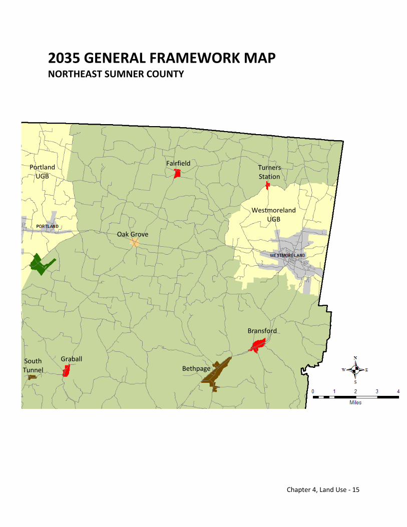
Chapter 4, Land Use - 15
2035 GENERAL FRAMEWORK MAP NORTHEAST SUMNER COUNTY
Turners Station
Oak Grove
Portland UGB
Bransford
Fairfield
South Tunnel
Graball Bethpage
Westmoreland UGB
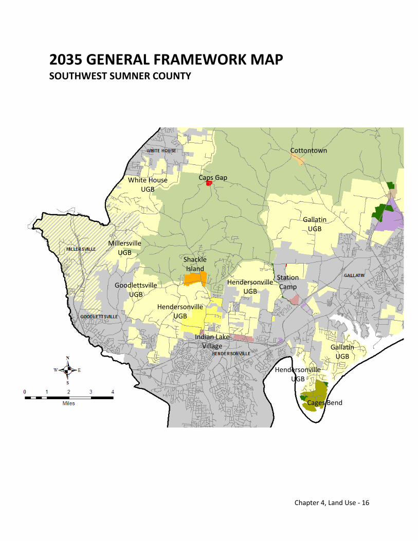
Chapter 4, Land Use - 16
2035 GENERAL FRAMEWORK MAP SOUTHWEST SUMNER COUNTY
White House UGB
Caps Gap
Shackle Island
Cottontown
Millersville UGB
Gallatin UGB
Station Camp
Gallatin UGB
Goodlettsville UGB
Hendersonville UGB
Hendersonville UGB
Indian Lake Village
Cages Bend
Hendersonville UGB
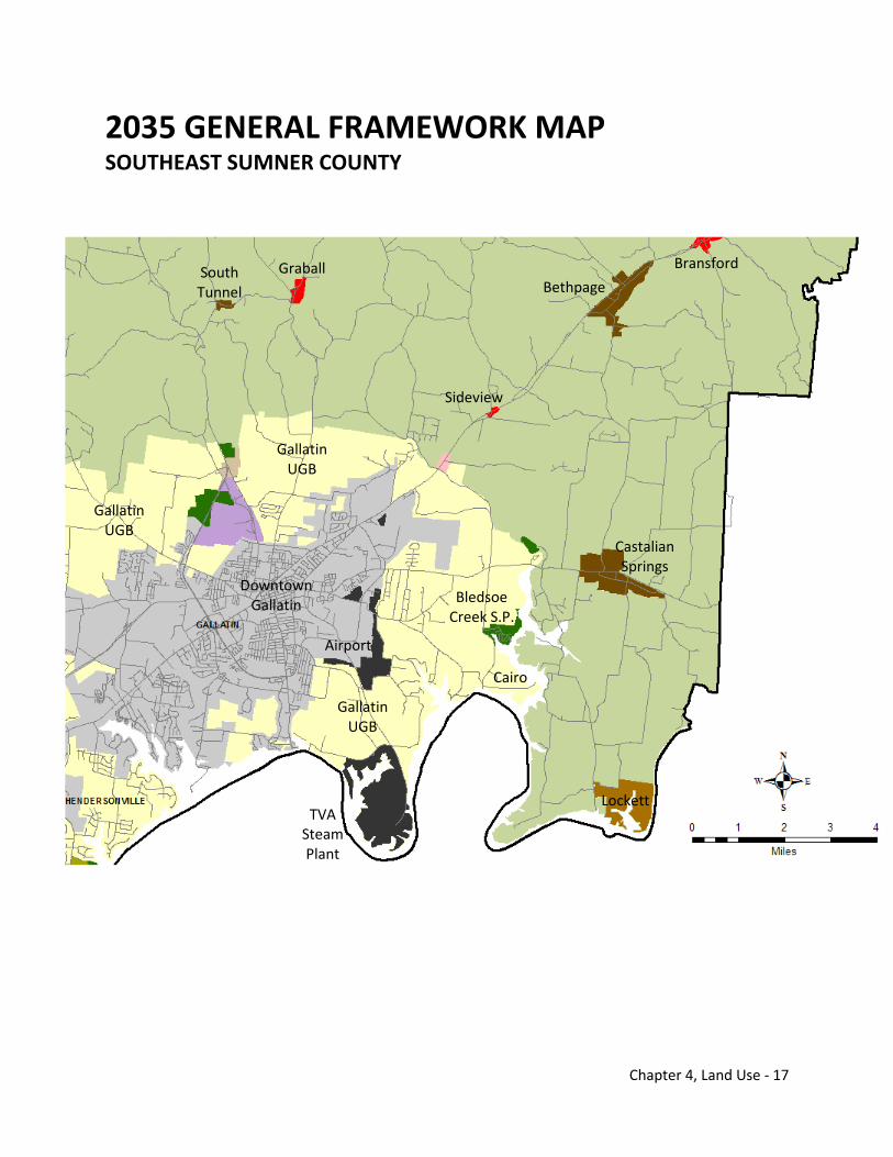
Chapter 4, Land Use - 17
2035 GENERAL FRAMEWORK MAP SOUTHEAST SUMNER COUNTY
Bransford
Airport
Gallatin UGB
Gallatin UGB
Castalian Springs
Cairo
Downtown Gallatin
TVA Steam Plant
Bledsoe Creek S.P.
Gallatin UGB
Lockett
Sideview
Bethpage Graball South
Tunnel
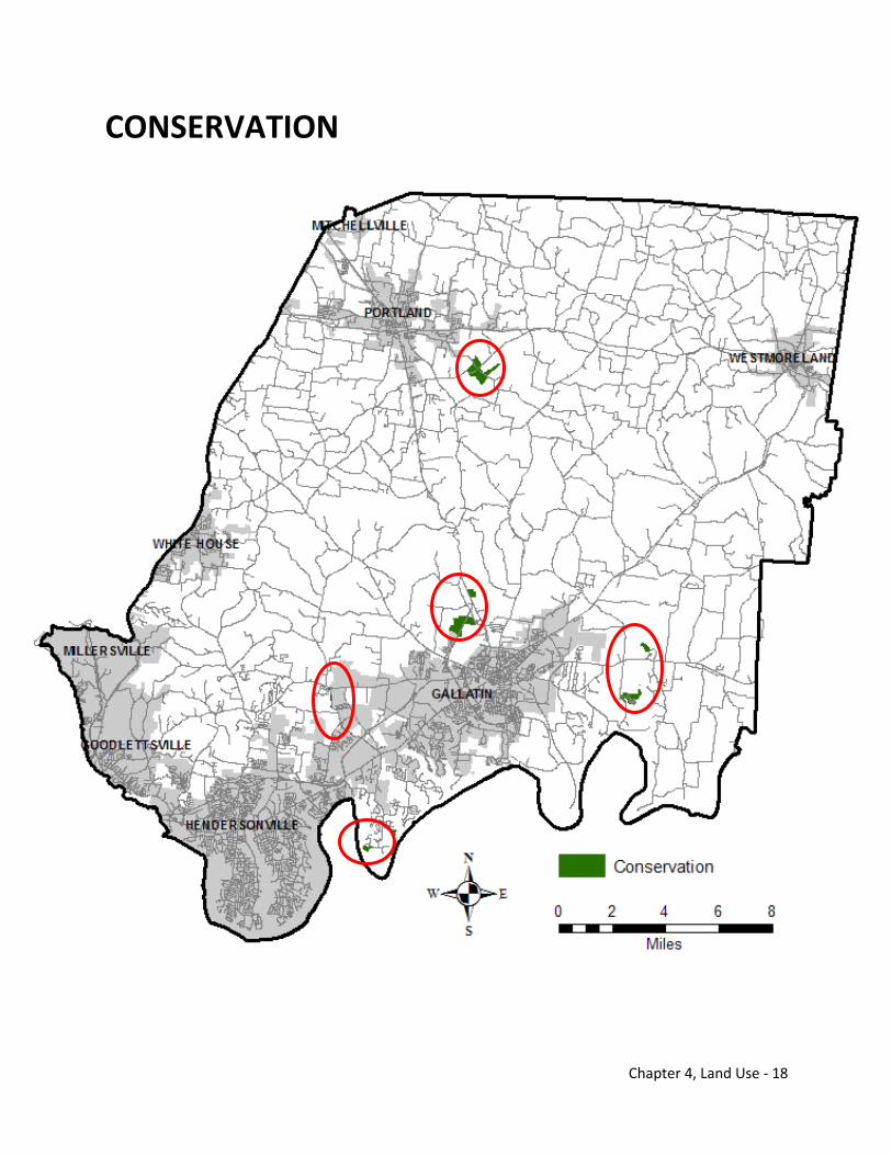
Chapter 4, Land Use - 18
CONSERVATION

Chapter 4, Land Use - 19
CONSERVATION Definition Areas recognized for preservation of environmentally sensitive areas includes state parks and large dedicated open space areas Drainage easements and natural resource buffers along waters of the State Local Examples Old Hickory Lake Bledsoe Creek State Park Conservation easements Drainage easements Development Pattern Predominantly undeveloped environmentally sensitive lands Typical Street Pattern Collector streets served by roads Spacing of streets varies Pedestrian Accommodations System of greenways based upon Transportation Element Bicycle Accommodations System of greenways and trailheads based upon Transportation Element Mass Transit Considerations Regional demand response
Protection of Natural Resources X
Historic Conservation & Enhancement
X
Efficient Transportation
Ensure Availability of Services
Maintain Sense of Community X Viable
Agriculture X
Rural Preservation X Preserve Urban Centers
Economic Enrichment Provide Housing
Options
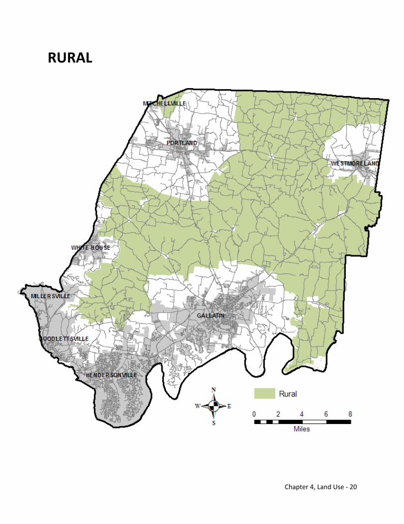
Chapter 4, Land Use - 20
RURAL
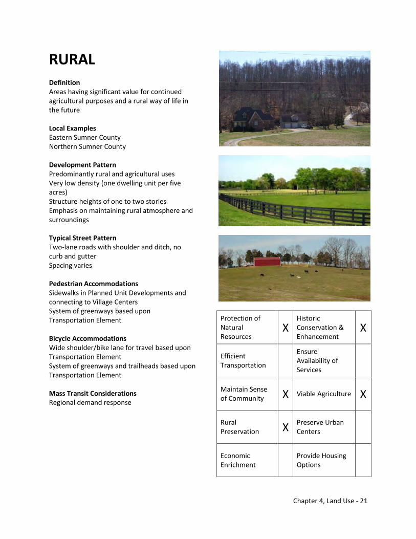
Chapter 4, Land Use - 21
RURAL Definition Areas having significant value for continued agricultural purposes and a rural way of life in the future Local Examples Eastern Sumner County Northern Sumner County Development Pattern Predominantly rural and agricultural uses Very low density (one dwelling unit per five acres) Structure heights of one to two stories Emphasis on maintaining rural atmosphere and surroundings Typical Street Pattern Two-lane roads with shoulder and ditch, no curb and gutter Spacing varies Pedestrian Accommodations Sidewalks in Planned Unit Developments and connecting to Village Centers System of greenways based upon Transportation Element Bicycle Accommodations Wide shoulder/bike lane for travel based upon Transportation Element System of greenways and trailheads based upon Transportation Element Mass Transit Considerations Regional demand response
Protection of Natural Resources
X Historic Conservation & Enhancement
X
Efficient Transportation
Ensure Availability of Services
Maintain Sense of Community X Viable Agriculture X
Rural Preservation X Preserve Urban
Centers
Economic Enrichment Provide Housing
Options
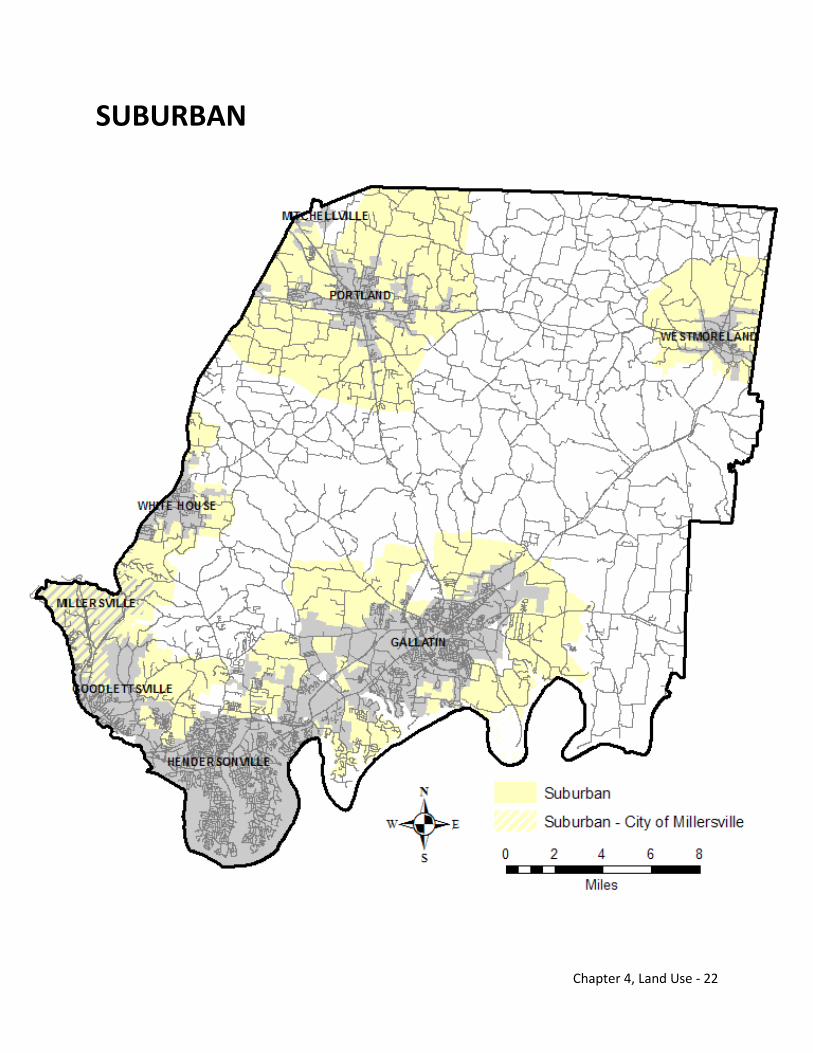
Chapter 4, Land Use - 22
SUBURBAN
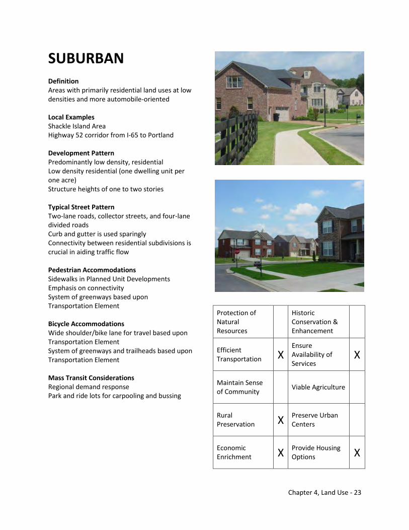
Chapter 4, Land Use - 23
SUBURBAN
Definition Areas with primarily residential land uses at low densities and more automobile-oriented Local Examples Shackle Island Area Highway 52 corridor from I-65 to Portland Development Pattern Predominantly low density, residential Low density residential (one dwelling unit per one acre) Structure heights of one to two stories Typical Street Pattern Two-lane roads, collector streets, and four-lane divided roads Curb and gutter is used sparingly Connectivity between residential subdivisions is crucial in aiding traffic flow Pedestrian Accommodations Sidewalks in Planned Unit Developments Emphasis on connectivity System of greenways based upon Transportation Element Bicycle Accommodations Wide shoulder/bike lane for travel based upon Transportation Element System of greenways and trailheads based upon Transportation Element Mass Transit Considerations Regional demand response Park and ride lots for carpooling and bussing
Protection of Natural Resources
Historic Conservation & Enhancement
Efficient Transportation X
Ensure Availability of Services
X
Maintain Sense of Community Viable Agriculture
Rural Preservation X Preserve Urban
Centers
Economic Enrichment X Provide Housing
Options X
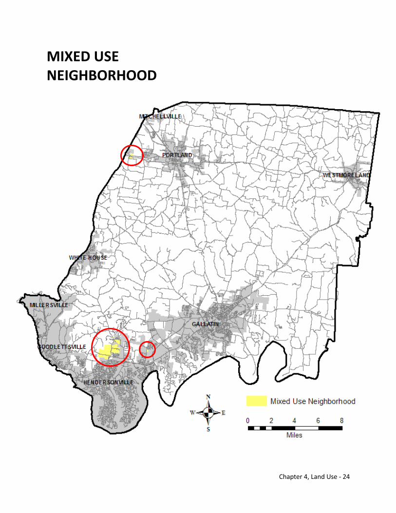
Chapter 4, Land Use - 24
MIXED USE NEIGHBORHOOD
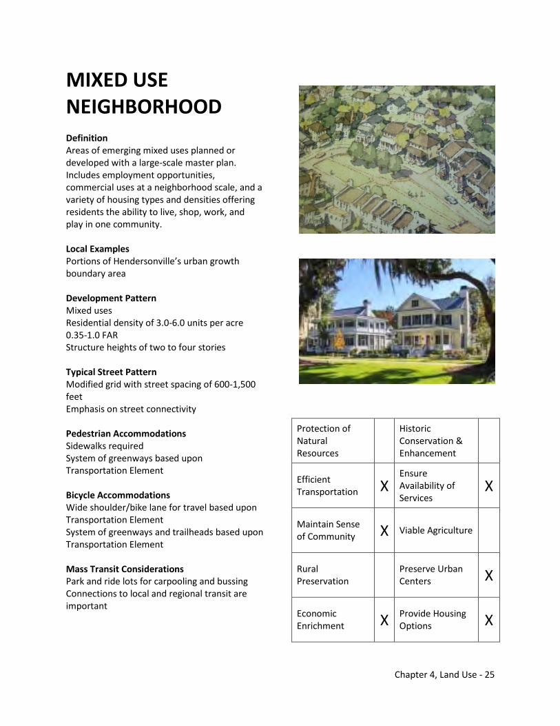
Chapter 4, Land Use - 25
MIXED USE NEIGHBORHOOD
Definition Areas of emerging mixed uses planned or developed with a large-scale master plan. Includes employment opportunities, commercial uses at a neighborhood scale, and a variety of housing types and densities offering residents the ability to live, shop, work, and play in one community. Local Examples Portions of Hendersonville’s urban growth boundary area Development Pattern Mixed uses Residential density of 3.0-6.0 units per acre 0.35-1.0 FAR Structure heights of two to four stories Typical Street Pattern Modified grid with street spacing of 600-1,500 feet Emphasis on street connectivity Pedestrian Accommodations Sidewalks required System of greenways based upon Transportation Element Bicycle Accommodations Wide shoulder/bike lane for travel based upon Transportation Element System of greenways and trailheads based upon Transportation Element Mass Transit Considerations Park and ride lots for carpooling and bussing Connections to local and regional transit are important
Protection of Natural Resources
Historic Conservation & Enhancement
Efficient Transportation X
Ensure Availability of Services
X
Maintain Sense of Community X Viable Agriculture
Rural Preservation Preserve Urban
Centers X
Economic Enrichment X Provide Housing
Options X
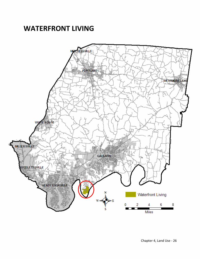
Chapter 4, Land Use - 26
WATERFRONT LIVING
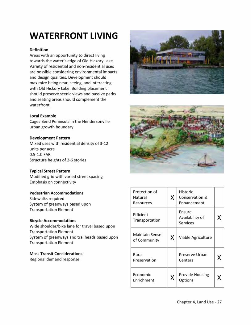
Chapter 4, Land Use - 27
WATERFRONT LIVING
Definition Areas with an opportunity to direct living towards the water’s edge of Old Hickory Lake. Variety of residential and non-residential uses are possible considering environmental impacts and design qualities. Development should maximize being near, seeing, and interacting with Old Hickory Lake. Building placement should preserve scenic views and passive parks and seating areas should complement the waterfront. Local Example Cages Bend Peninsula in the Hendersonville urban growth boundary Development Pattern Mixed uses with residential density of 3-12 units per acre 0.5-1.0 FAR Structure heights of 2-6 stories Typical Street Pattern Modified grid with varied street spacing Emphasis on connectivity Pedestrian Accommodations Sidewalks required System of greenways based upon Transportation Element Bicycle Accommodations Wide shoulder/bike lane for travel based upon Transportation Element System of greenways and trailheads based upon Transportation Element Mass Transit Considerations Regional demand response
Protection of Natural Resources
X Historic Conservation & Enhancement
Efficient Transportation
Ensure Availability of Services
X
Maintain Sense of Community X Viable Agriculture
Rural Preservation Preserve Urban
Centers X
Economic Enrichment X Provide Housing
Options X
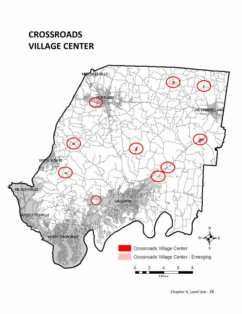
Chapter 4, Land Use - 28
CROSSROADS VILLAGE CENTER
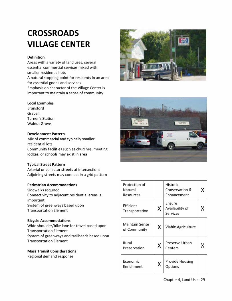
Chapter 4, Land Use - 29
CROSSROADS VILLAGE CENTER Definition Areas with a variety of land uses, several essential commercial services mixed with smaller residential lots A natural stopping point for residents in an area for essential goods and services Emphasis on character of the Village Center is important to maintain a sense of community Local Examples Bransford Graball Turner’s Station Walnut Grove Development Pattern Mix of commercial and typically smaller residential lots Community facilities such as churches, meeting lodges, or schools may exist in area Typical Street Pattern Arterial or collector streets at intersections Adjoining streets may connect in a grid pattern Pedestrian Accommodations Sidewalks required Connectivity to adjacent residential areas is important System of greenways based upon Transportation Element Bicycle Accommodations Wide shoulder/bike lane for travel based upon Transportation Element System of greenways and trailheads based upon Transportation Element Mass Transit Considerations Regional demand response
Protection of Natural Resources
Historic Conservation & Enhancement
X
Efficient Transportation X
Ensure Availability of Services
X
Maintain Sense of Community X Viable Agriculture
Rural Preservation X Preserve Urban
Centers X
Economic Enrichment X Provide Housing
Options
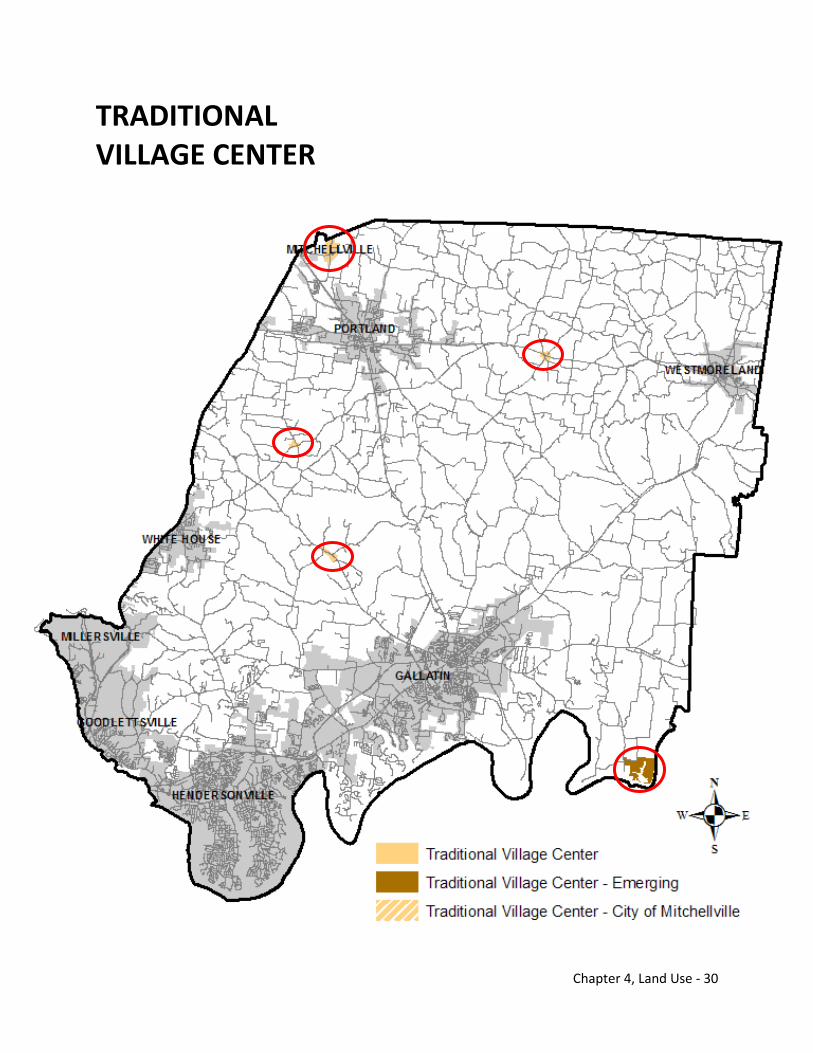
Chapter 4, Land Use - 30
TRADITIONAL VILLAGE CENTER
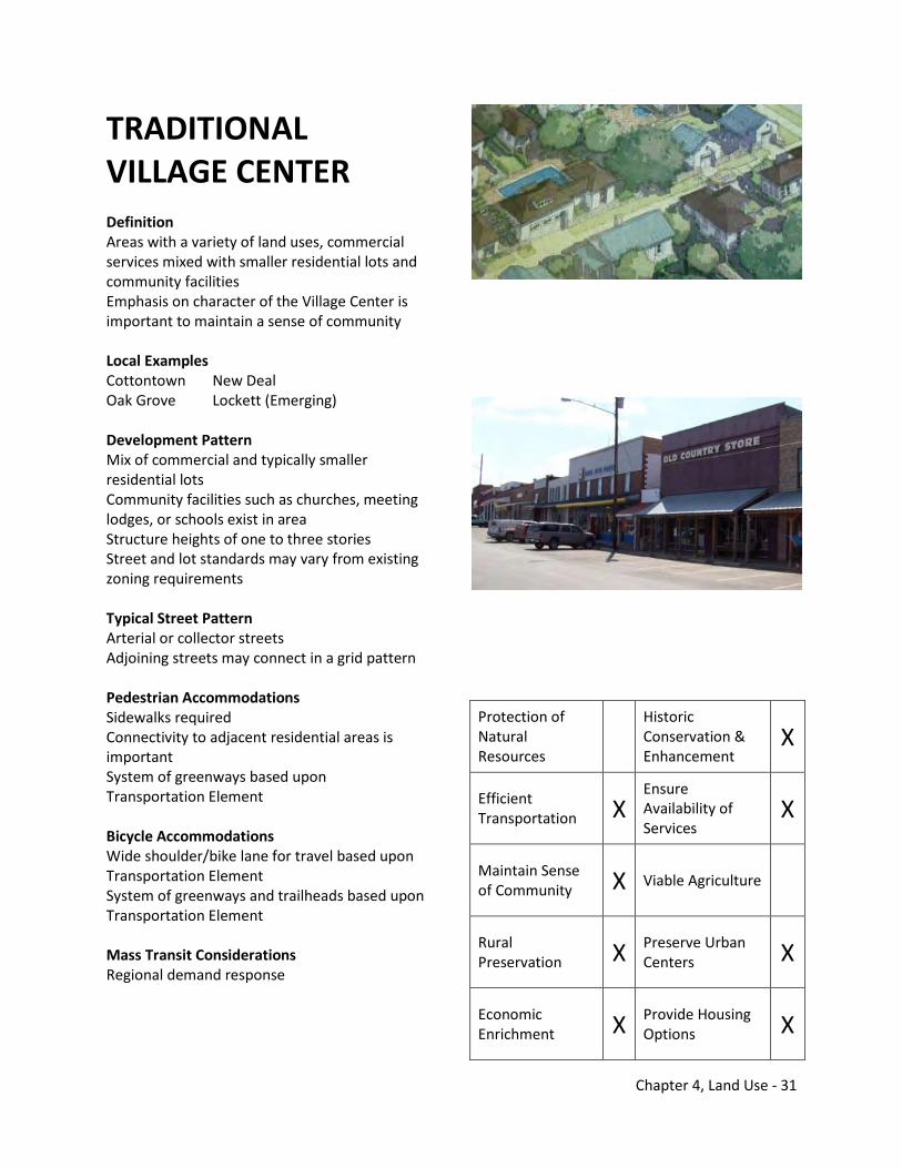
Chapter 4, Land Use - 31
TRADITIONAL VILLAGE CENTER Definition Areas with a variety of land uses, commercial services mixed with smaller residential lots and community facilities Emphasis on character of the Village Center is important to maintain a sense of community Local Examples Cottontown New Deal Oak Grove Lockett (Emerging) Development Pattern Mix of commercial and typically smaller residential lots Community facilities such as churches, meeting lodges, or schools exist in area Structure heights of one to three stories Street and lot standards may vary from existing zoning requirements Typical Street Pattern Arterial or collector streets Adjoining streets may connect in a grid pattern Pedestrian Accommodations Sidewalks required Connectivity to adjacent residential areas is important System of greenways based upon Transportation Element Bicycle Accommodations Wide shoulder/bike lane for travel based upon Transportation Element System of greenways and trailheads based upon Transportation Element Mass Transit Considerations Regional demand response
Protection of Natural Resources
Historic Conservation & Enhancement
X
Efficient Transportation X
Ensure Availability of Services
X
Maintain Sense of Community X Viable Agriculture
Rural Preservation X Preserve Urban
Centers X
Economic Enrichment X Provide Housing
Options X
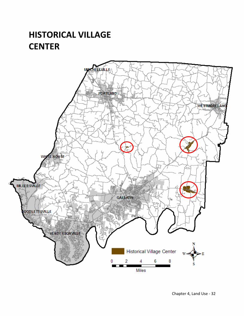
Chapter 4, Land Use - 32
HISTORICAL VILLAGE CENTER
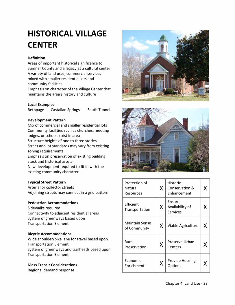
Chapter 4, Land Use - 33
HISTORICAL VILLAGE CENTER Definition Areas of important historical significance to Sumner County and a legacy as a cultural center A variety of land uses, commercial services mixed with smaller residential lots and community facilities Emphasis on character of the Village Center that maintains the area’s history and culture Local Examples Bethpage Castalian Springs South Tunnel Development Pattern Mix of commercial and smaller residential lots Community facilities such as churches, meeting lodges, or schools exist in area Structure heights of one to three stories Street and lot standards may vary from existing zoning requirements Emphasis on preservation of existing building stock and historical assets New development required to fit in with the existing community character Typical Street Pattern Arterial or collector streets Adjoining streets may connect in a grid pattern Pedestrian Accommodations Sidewalks required Connectivity to adjacent residential areas System of greenways based upon Transportation Element Bicycle Accommodations Wide shoulder/bike lane for travel based upon Transportation Element System of greenways and trailheads based upon Transportation Element Mass Transit Considerations Regional demand response
Protection of Natural Resources
X Historic Conservation & Enhancement
X
Efficient Transportation X
Ensure Availability of Services
X
Maintain Sense of Community X Viable Agriculture X
Rural Preservation X Preserve Urban
Centers X
Economic Enrichment X Provide Housing
Options X
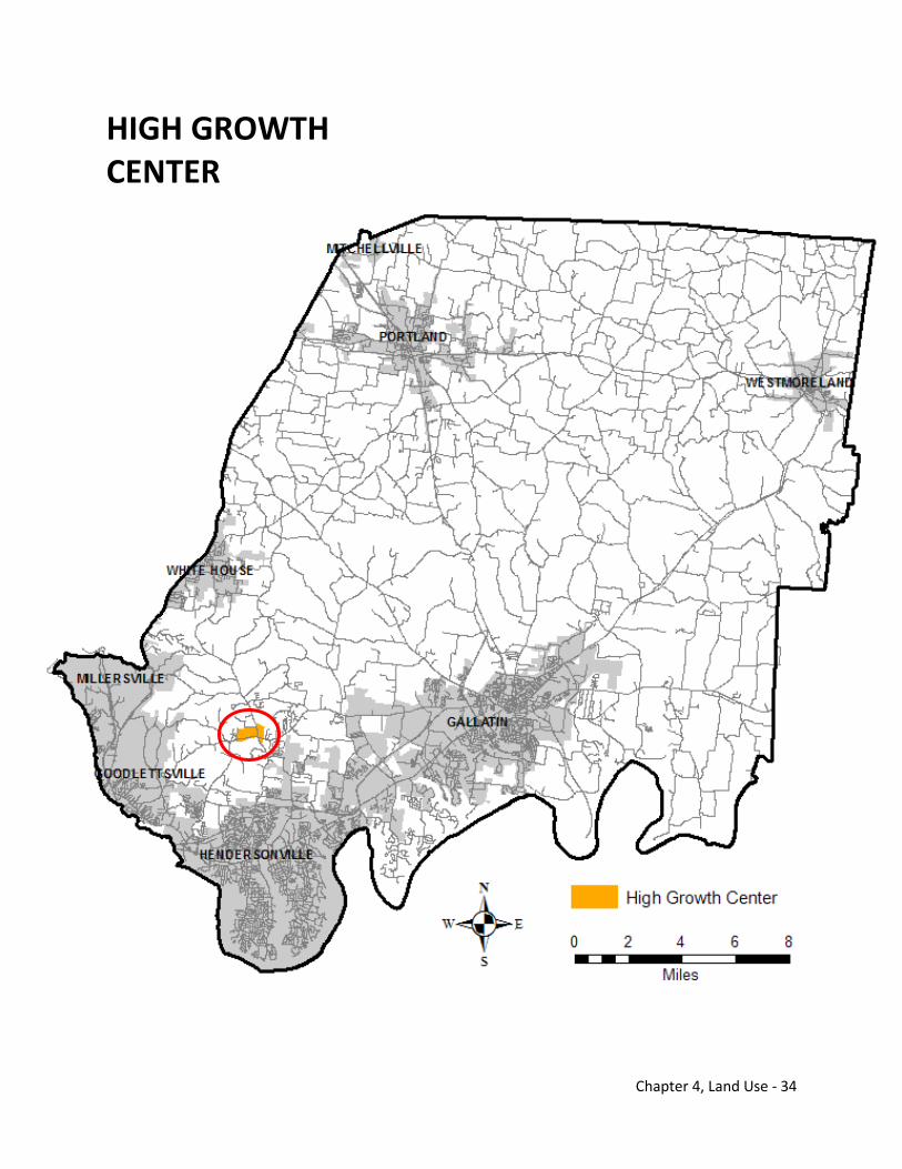
Chapter 4, Land Use - 34
HIGH GROWTH CENTER
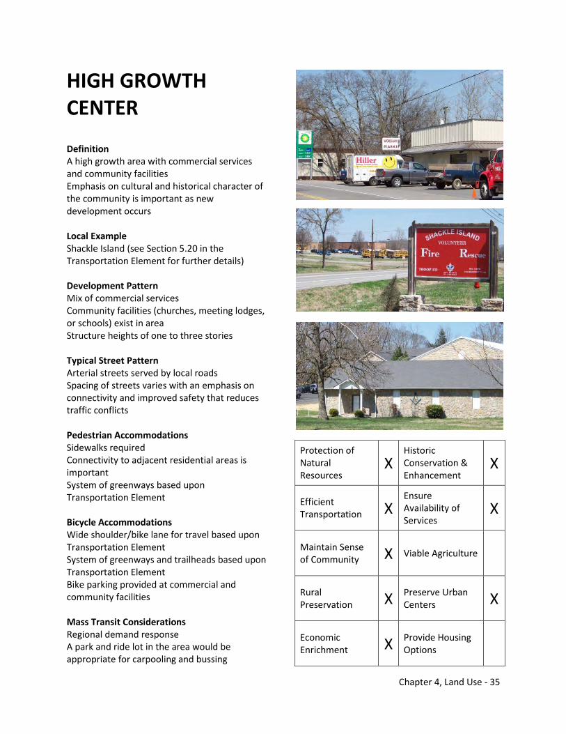
Chapter 4, Land Use - 35
HIGH GROWTH CENTER
Definition A high growth area with commercial services and community facilities Emphasis on cultural and historical character of the community is important as new development occurs Local Example Shackle Island (see Section 5.20 in the Transportation Element for further details) Development Pattern Mix of commercial services Community facilities (churches, meeting lodges, or schools) exist in area Structure heights of one to three stories Typical Street Pattern Arterial streets served by local roads Spacing of streets varies with an emphasis on connectivity and improved safety that reduces traffic conflicts Pedestrian Accommodations Sidewalks required Connectivity to adjacent residential areas is important System of greenways based upon Transportation Element Bicycle Accommodations Wide shoulder/bike lane for travel based upon Transportation Element System of greenways and trailheads based upon Transportation Element Bike parking provided at commercial and community facilities Mass Transit Considerations Regional demand response A park and ride lot in the area would be appropriate for carpooling and bussing
Protection of Natural Resources
X Historic Conservation & Enhancement
X
Efficient Transportation X
Ensure Availability of Services
X
Maintain Sense of Community X Viable Agriculture
Rural Preservation X Preserve Urban
Centers X
Economic Enrichment X Provide Housing
Options
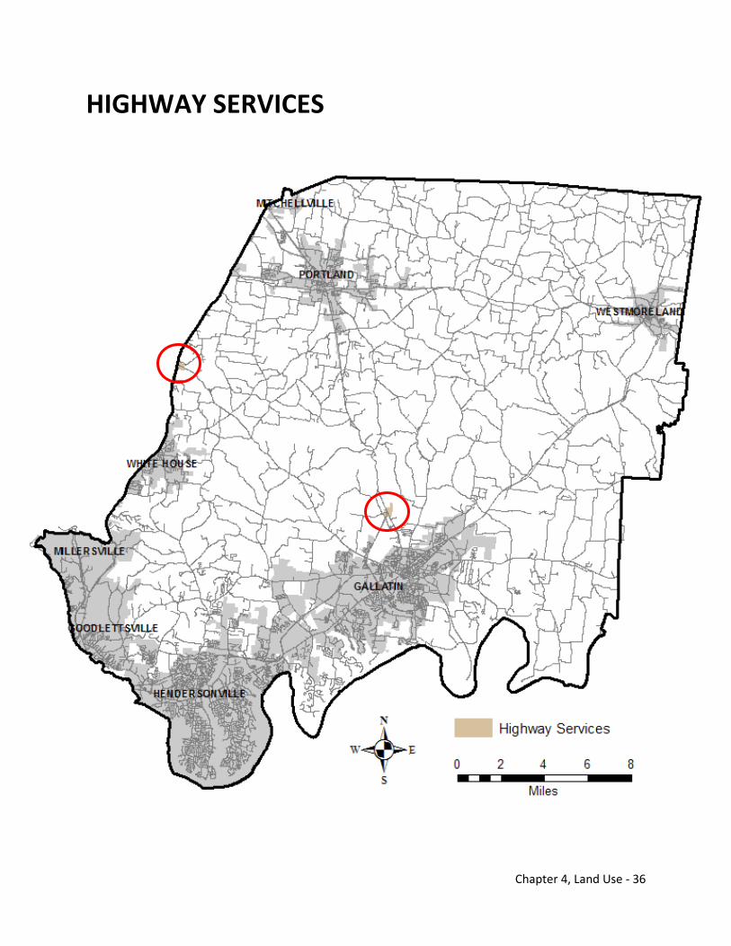
Chapter 4, Land Use - 36
HIGHWAY SERVICES
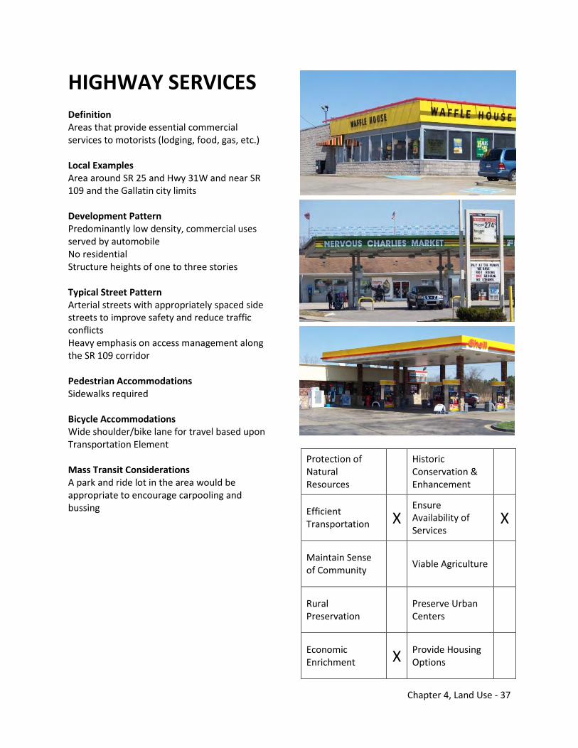
Chapter 4, Land Use - 37
HIGHWAY SERVICES Definition Areas that provide essential commercial services to motorists (lodging, food, gas, etc.) Local Examples Area around SR 25 and Hwy 31W and near SR 109 and the Gallatin city limits Development Pattern Predominantly low density, commercial uses served by automobile No residential Structure heights of one to three stories Typical Street Pattern Arterial streets with appropriately spaced side streets to improve safety and reduce traffic conflicts Heavy emphasis on access management along the SR 109 corridor Pedestrian Accommodations Sidewalks required Bicycle Accommodations Wide shoulder/bike lane for travel based upon Transportation Element Mass Transit Considerations A park and ride lot in the area would be appropriate to encourage carpooling and bussing
Protection of Natural Resources
Historic Conservation & Enhancement
Efficient Transportation X
Ensure Availability of Services
X
Maintain Sense of Community Viable Agriculture
Rural Preservation Preserve Urban
Centers
Economic Enrichment X Provide Housing
Options
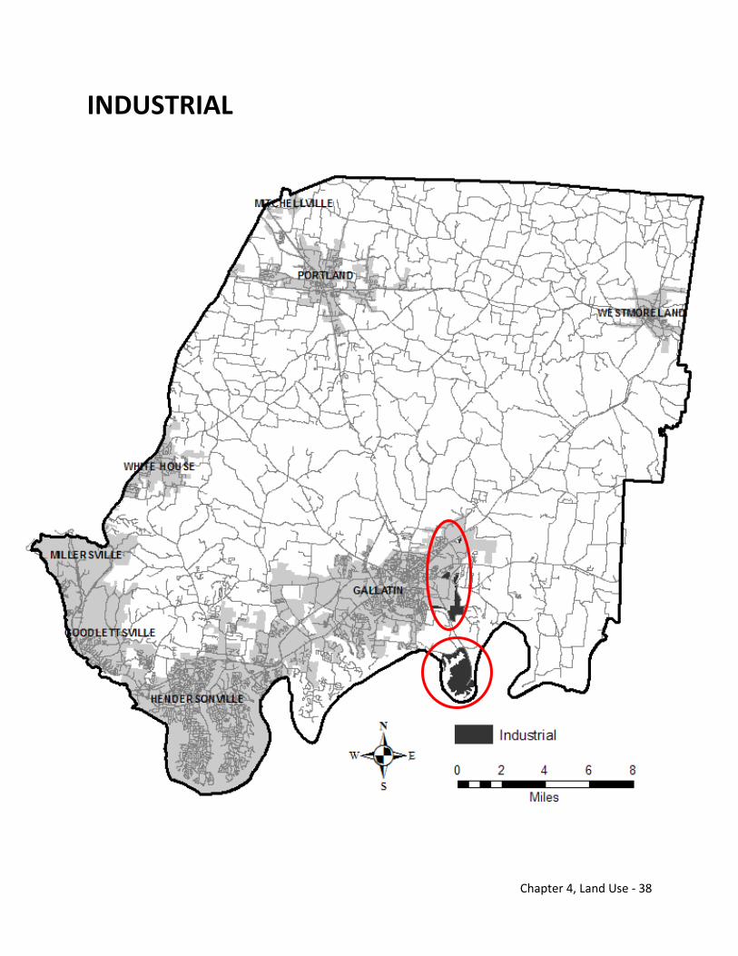
Chapter 4, Land Use - 38
INDUSTRIAL
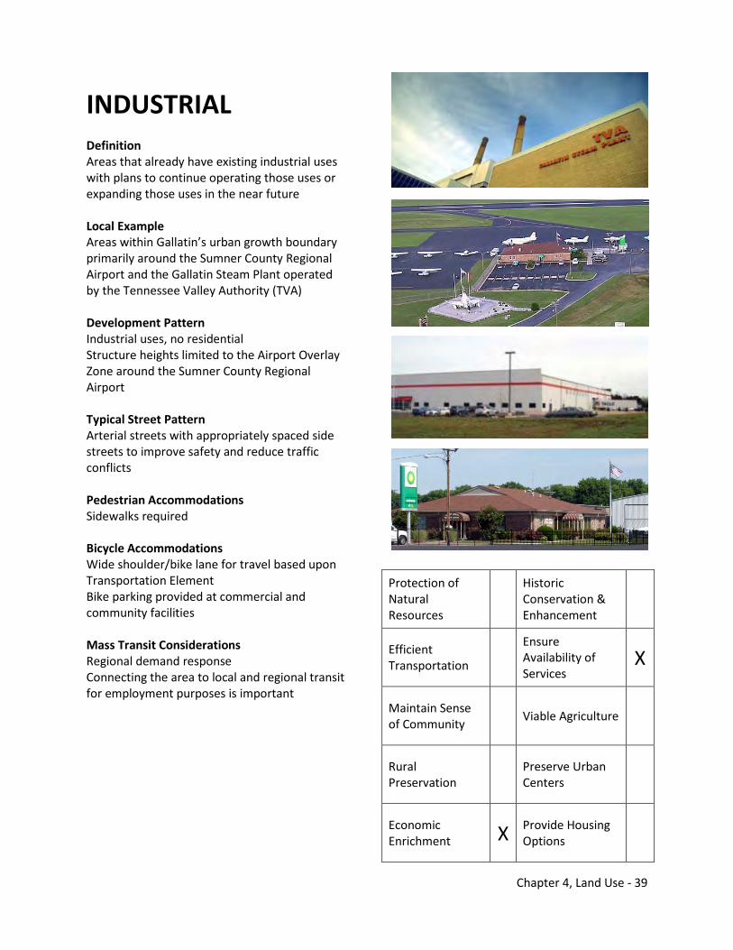
Chapter 4, Land Use - 39
INDUSTRIAL Definition Areas that already have existing industrial uses with plans to continue operating those uses or expanding those uses in the near future Local Example Areas within Gallatin’s urban growth boundary primarily around the Sumner County Regional Airport and the Gallatin Steam Plant operated by the Tennessee Valley Authority (TVA) Development Pattern Industrial uses, no residential Structure heights limited to the Airport Overlay Zone around the Sumner County Regional Airport Typical Street Pattern Arterial streets with appropriately spaced side streets to improve safety and reduce traffic conflicts Pedestrian Accommodations Sidewalks required Bicycle Accommodations Wide shoulder/bike lane for travel based upon Transportation Element Bike parking provided at commercial and community facilities Mass Transit Considerations Regional demand response Connecting the area to local and regional transit for employment purposes is important
Protection of Natural Resources
Historic Conservation & Enhancement
Efficient Transportation
Ensure Availability of Services
X
Maintain Sense of Community Viable Agriculture
Rural Preservation Preserve Urban
Centers
Economic Enrichment X Provide Housing
Options
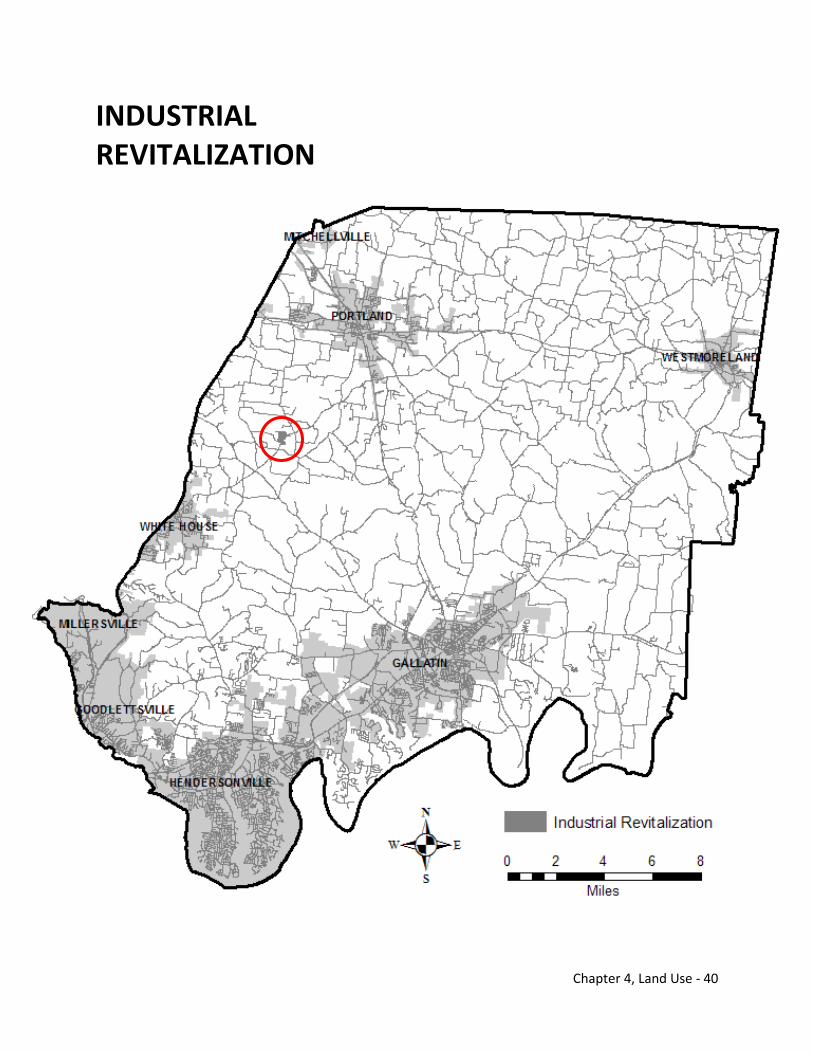
Chapter 4, Land Use - 40
INDUSTRIAL REVITALIZATION
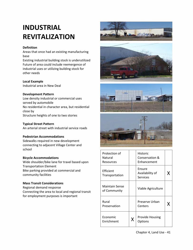
Chapter 4, Land Use - 41
INDUSTRIAL REVITALIZATION Definition Areas that once had an existing manufacturing base Existing industrial building stock is underutilized Future of area could include reemergence of industrial uses or utilizing building stock for other needs Local Example Industrial area in New Deal Development Pattern Low density industrial or commercial uses served by automobile No residential in character area, but residential close by Structure heights of one to two stories Typical Street Pattern An arterial street with industrial service roads Pedestrian Accommodations Sidewalks required in new development connecting to adjacent Village Center and school Bicycle Accommodations Wide shoulder/bike lane for travel based upon Transportation Element Bike parking provided at commercial and community facilities Mass Transit Considerations Regional demand response Connecting the area to local and regional transit for employment purposes is important
Protection of Natural Resources
Historic Conservation & Enhancement
Efficient Transportation
Ensure Availability of Services
X
Maintain Sense of Community Viable Agriculture
Rural Preservation Preserve Urban
Centers X
Economic Enrichment X Provide Housing
Options
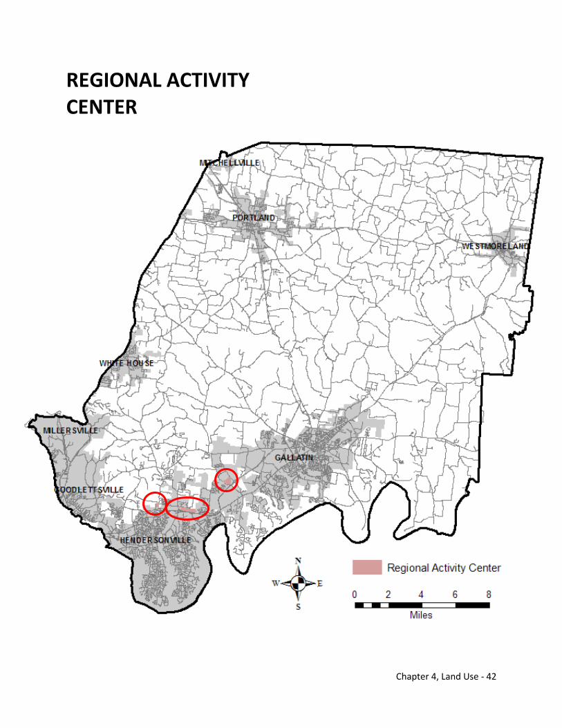
Chapter 4, Land Use - 42
REGIONAL ACTIVITY CENTER
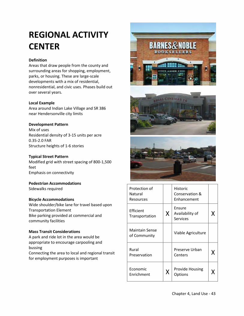
Chapter 4, Land Use - 43
REGIONAL ACTIVITY CENTER Definition Areas that draw people from the county and surrounding areas for shopping, employment, parks, or housing. These are large-scale developments with a mix of residential, nonresidential, and civic uses. Phases build out over several years. Local Example Area around Indian Lake Village and SR 386 near Hendersonville city limits Development Pattern Mix of uses Residential density of 3-15 units per acre 0.35-2.0 FAR Structure heights of 1-6 stories Typical Street Pattern Modified grid with street spacing of 800-1,500 feet Emphasis on connectivity Pedestrian Accommodations Sidewalks required Bicycle Accommodations Wide shoulder/bike lane for travel based upon Transportation Element Bike parking provided at commercial and community facilities Mass Transit Considerations A park and ride lot in the area would be appropriate to encourage carpooling and bussing Connecting the area to local and regional transit for employment purposes is important
Protection of Natural Resources
Historic Conservation & Enhancement
Efficient Transportation X
Ensure Availability of Services
X
Maintain Sense of Community Viable Agriculture
Rural Preservation Preserve Urban
Centers X
Economic Enrichment X Provide Housing
Options X
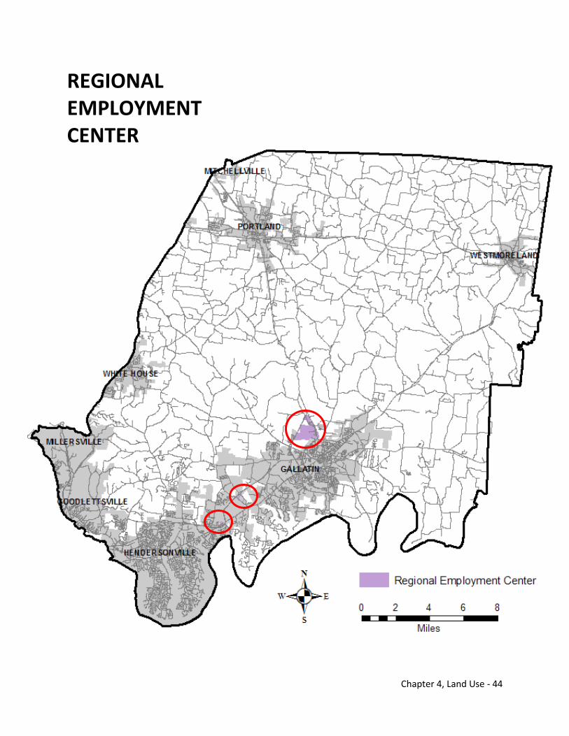
Chapter 4, Land Use - 44
REGIONAL EMPLOYMENT CENTER
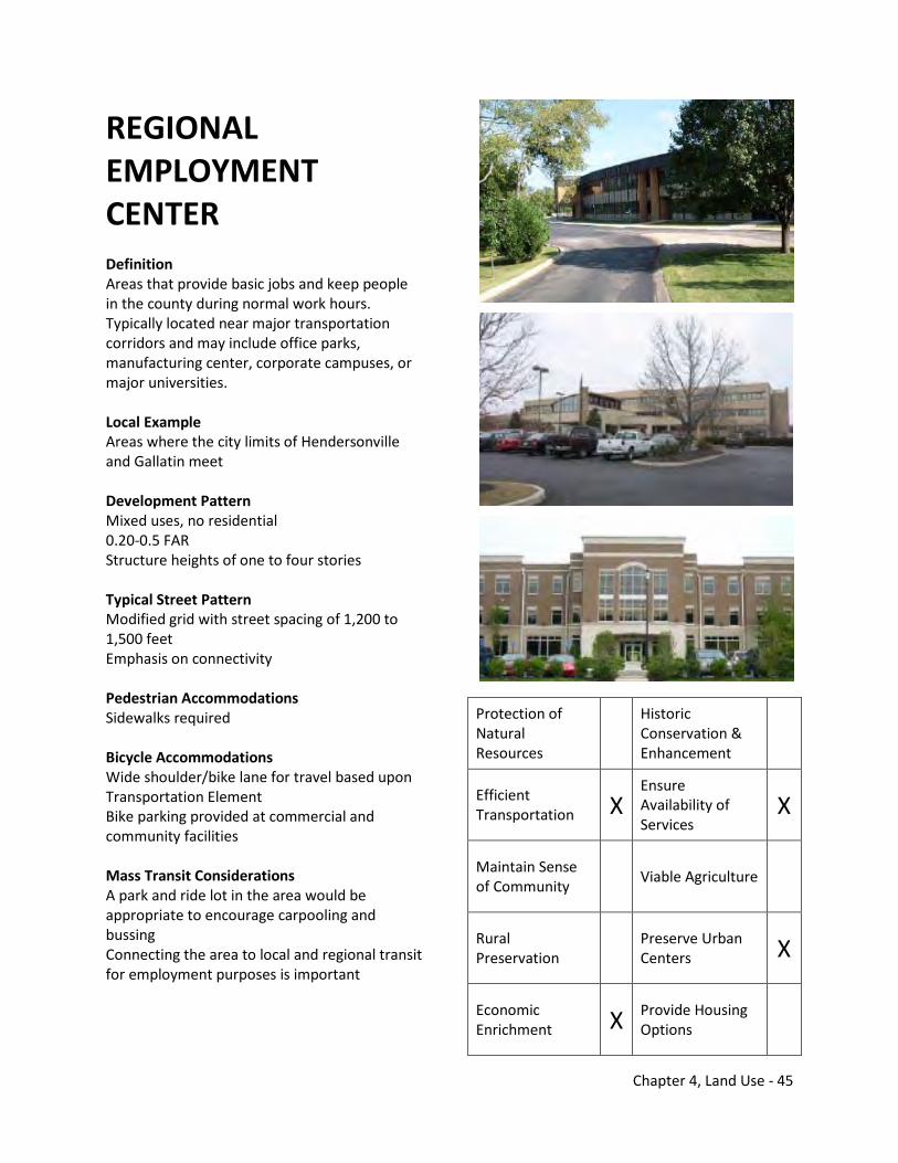
Chapter 4, Land Use - 45
REGIONAL EMPLOYMENT CENTER Definition Areas that provide basic jobs and keep people in the county during normal work hours. Typically located near major transportation corridors and may include office parks, manufacturing center, corporate campuses, or major universities. Local Example Areas where the city limits of Hendersonville and Gallatin meet Development Pattern Mixed uses, no residential 0.20-0.5 FAR Structure heights of one to four stories Typical Street Pattern Modified grid with street spacing of 1,200 to 1,500 feet Emphasis on connectivity Pedestrian Accommodations Sidewalks required Bicycle Accommodations Wide shoulder/bike lane for travel based upon Transportation Element Bike parking provided at commercial and community facilities Mass Transit Considerations A park and ride lot in the area would be appropriate to encourage carpooling and bussing Connecting the area to local and regional transit for employment purposes is important
Protection of Natural Resources
Historic Conservation & Enhancement
Efficient Transportation X
Ensure Availability of Services
X
Maintain Sense of Community Viable Agriculture
Rural Preservation Preserve Urban
Centers X
Economic Enrichment X Provide Housing
Options
Chapter 4, Land Use - 46
THIS PAGE INTENTIONALLY LEFT BLANK
Chapter 5, Transportation - 1
5.0 Transportation Today’s transportation infrastructure in Sumner County was primarily built to move cars. Since the mass production of the automobile, Sumner County has seen similar growth in its transportation network built around cars as in other fast growing communities in the United States. Farm to market roads were paved and transformed into today’s road system. Coordination with the Tennessee Department of Transportation (TDOT) over the years has resulted in the construction of highways connecting the county to the region. These convenient connections to Nashville and other places of employment have attracted new people to Sumner County. As Sumner County grew, traffic increased on many principal roadways especially during peak travel times. Local, regional, and national priorities are also shifting in the new millenimum as sources for additional transportation funding have remained stagnant. The maintenance of the current roadway infrastructure and improvement of other travel modes are less costly to implement and have longer life cycles. The transportation system in Sumner County is no longer viewed strictly from a roadway or thoroughfare perspective. Biking, walking, and utilizing mass transit are now appropriate transportation solutions that residents desire and local officials should consider funding. The roadway system will remain the backbone of transportation infrastructure in Sumner County, but other travel modes will complement this critical infrastructure. Infrastructure improvements to the transportation system support economic growth, maintain sustainability, enhance local communities, reduce congestion, improve safety, support local land use functions, improve commute times, and mitigate air quality issues. These quality of life benchmarks can improve or deteriorate because of transportation improvements. Each benchmark can be analyzed for each travel mode. The Transportation Element of the 2035 Comprehensive Plan begins with an overview of residents desires for the transportation system in Sumner County. Then, an analysis of the existing transportation system and its regional connections is presented to understand Sumner County’s future. Finally, an overview of the roadway system’s function, potential future roadway projects, potential bicycle and pedestrian projects, and potential mass transit projects are outlined. 5.1 Thoughts about Transportation in Sumner County During an on-line survey conducted in December 2009, residents where asked about the future of Sumner County. One question, “What do you not like about Sumner County?” generated a number of comments regarding transportation. The top three choices that were picked most by survey respondents were transportation-related:
1. Lack of sidewalks/no connectivity 2. Traffic/congestion 3. Few transit options
Appendix C contains the entire survey and responses that were received in December 2009.
Sumner County followed up with another on-line survey conducted in May 2010 addressing just transportation issues. The survey was performed to gather more input regarding transportation’s role in Sumner County’s future. Residents were asked about positive and negative characteristics of transportation and to identify the top issues future transportation projects should address in Sumner County. The top five issues in the survey were:
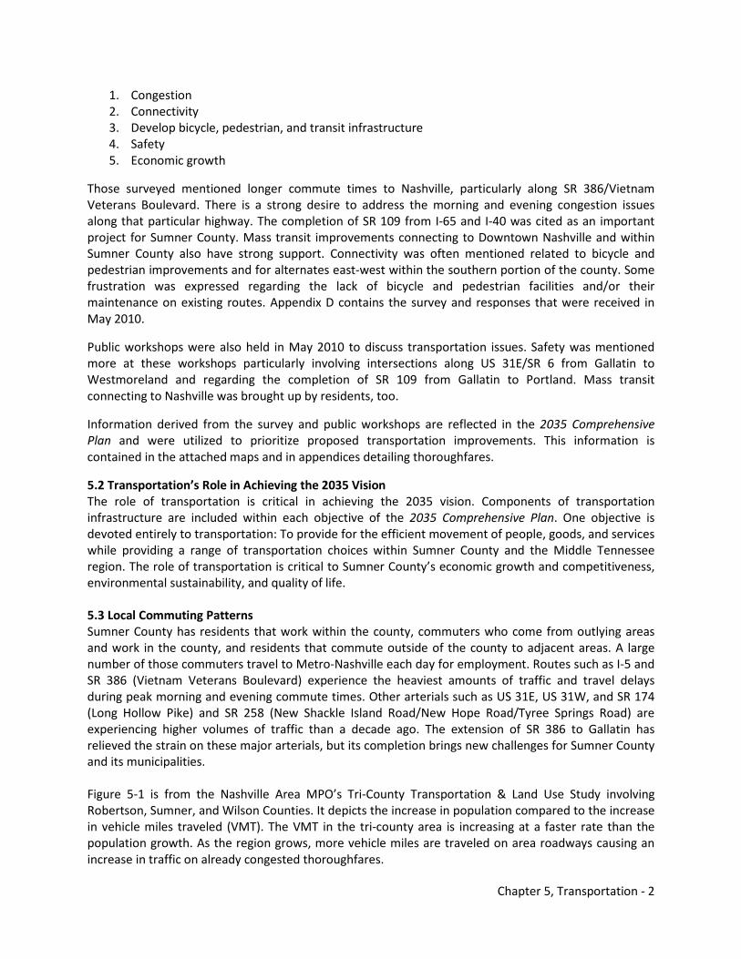
Chapter 5, Transportation - 2
1. Congestion 2. Connectivity 3. Develop bicycle, pedestrian, and transit infrastructure 4. Safety 5. Economic growth
Those surveyed mentioned longer commute times to Nashville, particularly along SR 386/Vietnam Veterans Boulevard. There is a strong desire to address the morning and evening congestion issues along that particular highway. The completion of SR 109 from I-65 and I-40 was cited as an important project for Sumner County. Mass transit improvements connecting to Downtown Nashville and within Sumner County also have strong support. Connectivity was often mentioned related to bicycle and pedestrian improvements and for alternates east-west within the southern portion of the county. Some frustration was expressed regarding the lack of bicycle and pedestrian facilities and/or their maintenance on existing routes. Appendix D contains the survey and responses that were received in May 2010.
Public workshops were also held in May 2010 to discuss transportation issues. Safety was mentioned more at these workshops particularly involving intersections along US 31E/SR 6 from Gallatin to Westmoreland and regarding the completion of SR 109 from Gallatin to Portland. Mass transit connecting to Nashville was brought up by residents, too.
Information derived from the survey and public workshops are reflected in the 2035 Comprehensive Plan and were utilized to prioritize proposed transportation improvements. This information is contained in the attached maps and in appendices detailing thoroughfares.
5.2 Transportation’s Role in Achieving the 2035 Vision The role of transportation is critical in achieving the 2035 vision. Components of transportation infrastructure are included within each objective of the 2035 Comprehensive Plan. One objective is devoted entirely to transportation: To provide for the efficient movement of people, goods, and services while providing a range of transportation choices within Sumner County and the Middle Tennessee region. The role of transportation is critical to Sumner County’s economic growth and competitiveness, environmental sustainability, and quality of life. 5.3 Local Commuting Patterns Sumner County has residents that work within the county, commuters who come from outlying areas and work in the county, and residents that commute outside of the county to adjacent areas. A large number of those commuters travel to Metro-Nashville each day for employment. Routes such as I-5 and SR 386 (Vietnam Veterans Boulevard) experience the heaviest amounts of traffic and travel delays during peak morning and evening commute times. Other arterials such as US 31E, US 31W, and SR 174 (Long Hollow Pike) and SR 258 (New Shackle Island Road/New Hope Road/Tyree Springs Road) are experiencing higher volumes of traffic than a decade ago. The extension of SR 386 to Gallatin has relieved the strain on these major arterials, but its completion brings new challenges for Sumner County and its municipalities. Figure 5-1 is from the Nashville Area MPO’s Tri-County Transportation & Land Use Study involving Robertson, Sumner, and Wilson Counties. It depicts the increase in population compared to the increase in vehicle miles traveled (VMT). The VMT in the tri-county area is increasing at a faster rate than the population growth. As the region grows, more vehicle miles are traveled on area roadways causing an increase in traffic on already congested thoroughfares.
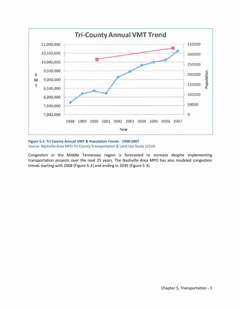
Chapter 5, Transportation - 3
Figure 5-1: Tri-County Annual VMT & Population Trends - 1998-2007 Source: Nashville Area MPO Tri-County Transportation & Land Use Study (2010)
Congestion in the Middle Tennessee region is forecasted to increase despite implementing transportation projects over the next 25 years. The Nashville Area MPO has also modeled congestion trends starting with 2008 (Figure 5-2) and ending in 2035 (Figure 5-3).
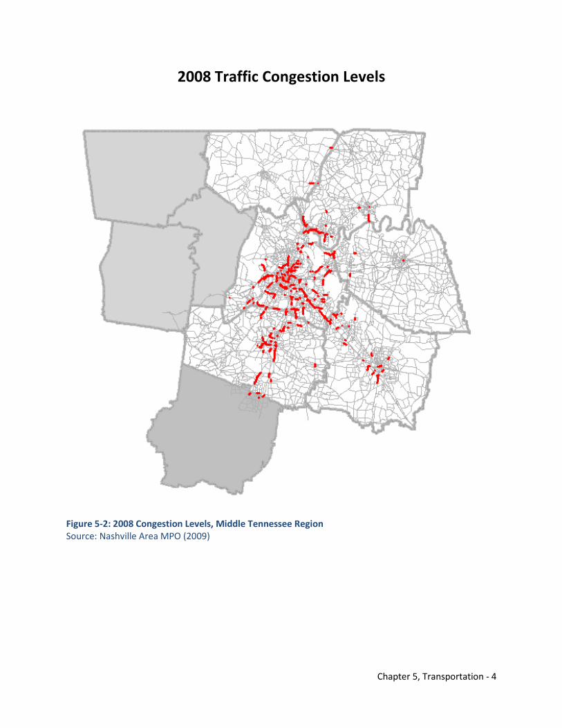
Chapter 5, Transportation - 4
2008 Traffic Congestion Levels
Figure 5-2: 2008 Congestion Levels, Middle Tennessee Region Source: Nashville Area MPO (2009)
Chapter 5, Transportation - 5
2035 Traffic Congestion Levels
Figure 5-3: 2035 Projected Congestion Levels, Middle Tennessee Region Source: Nashville Area MPO (2009)
Understanding basic commuting patterns helps identify where increases in VMT will likely occur. This relationship is also regional because commuters are not restricted to only staying within their jurisdictional boundaries. The following discussion considers the two largest cities in Sumner County and depicts where Sumner County residents commute for work and where workers come from into Sumner County. Figure 5-4 and Figure 5-5 illustrates this relationship for Hendersonville. Figure 5-4 shows that Hendersonville residents primarily commute to Nashville and other work destinations within the county such as Gallatin, Goodlettsville, and Portland. Brentwood and the Franklin/Cool Springs area are also evident work destinations, and some residents commute as far as an hour away to Dickson and Clarksville.
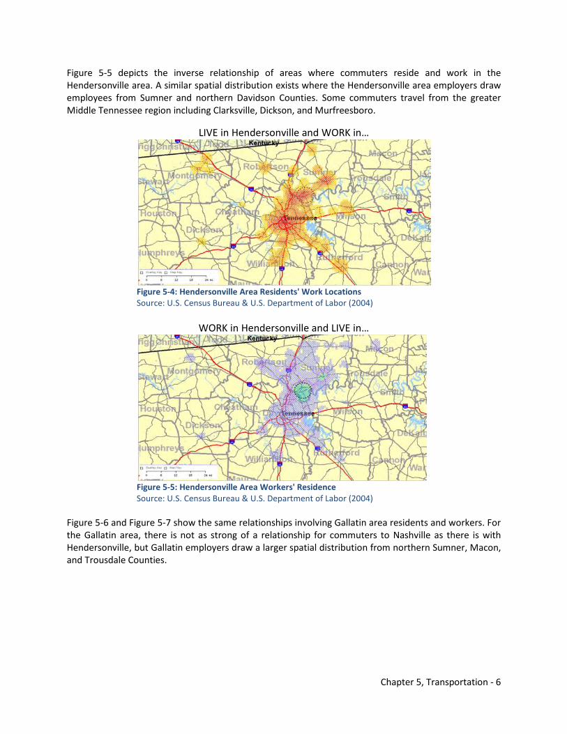
Chapter 5, Transportation - 6
Figure 5-5 depicts the inverse relationship of areas where commuters reside and work in the Hendersonville area. A similar spatial distribution exists where the Hendersonville area employers draw employees from Sumner and northern Davidson Counties. Some commuters travel from the greater Middle Tennessee region including Clarksville, Dickson, and Murfreesboro.
LIVE in Hendersonville and WORK in…
Figure 5-4: Hendersonville Area Residents' Work Locations Source: U.S. Census Bureau & U.S. Department of Labor (2004)
WORK in Hendersonville and LIVE in…
Figure 5-5: Hendersonville Area Workers' Residence Source: U.S. Census Bureau & U.S. Department of Labor (2004)
Figure 5-6 and Figure 5-7 show the same relationships involving Gallatin area residents and workers. For the Gallatin area, there is not as strong of a relationship for commuters to Nashville as there is with Hendersonville, but Gallatin employers draw a larger spatial distribution from northern Sumner, Macon, and Trousdale Counties.
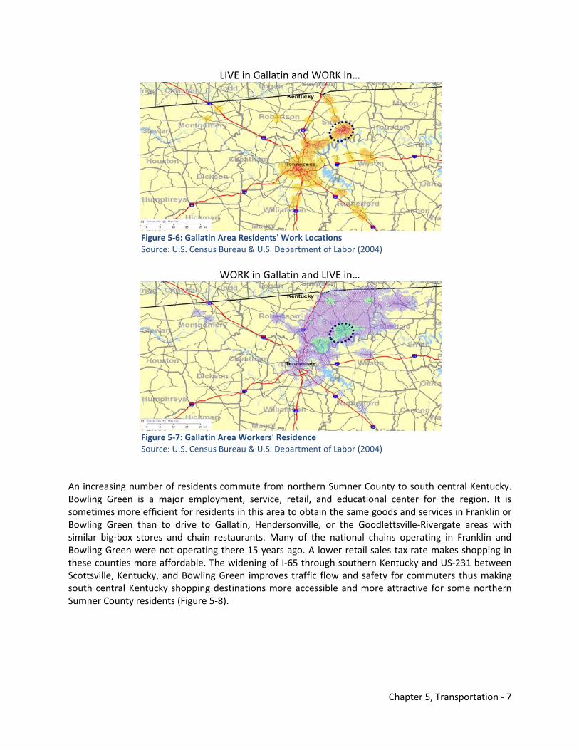
Chapter 5, Transportation - 7
LIVE in Gallatin and WORK in…
Figure 5-6: Gallatin Area Residents' Work Locations Source: U.S. Census Bureau & U.S. Department of Labor (2004)
WORK in Gallatin and LIVE in…
Figure 5-7: Gallatin Area Workers' Residence Source: U.S. Census Bureau & U.S. Department of Labor (2004) An increasing number of residents commute from northern Sumner County to south central Kentucky. Bowling Green is a major employment, service, retail, and educational center for the region. It is sometimes more efficient for residents in this area to obtain the same goods and services in Franklin or Bowling Green than to drive to Gallatin, Hendersonville, or the Goodlettsville-Rivergate areas with similar big-box stores and chain restaurants. Many of the national chains operating in Franklin and Bowling Green were not operating there 15 years ago. A lower retail sales tax rate makes shopping in these counties more affordable. The widening of I-65 through southern Kentucky and US-231 between Scottsville, Kentucky, and Bowling Green improves traffic flow and safety for commuters thus making south central Kentucky shopping destinations more accessible and more attractive for some northern Sumner County residents (Figure 5-8).
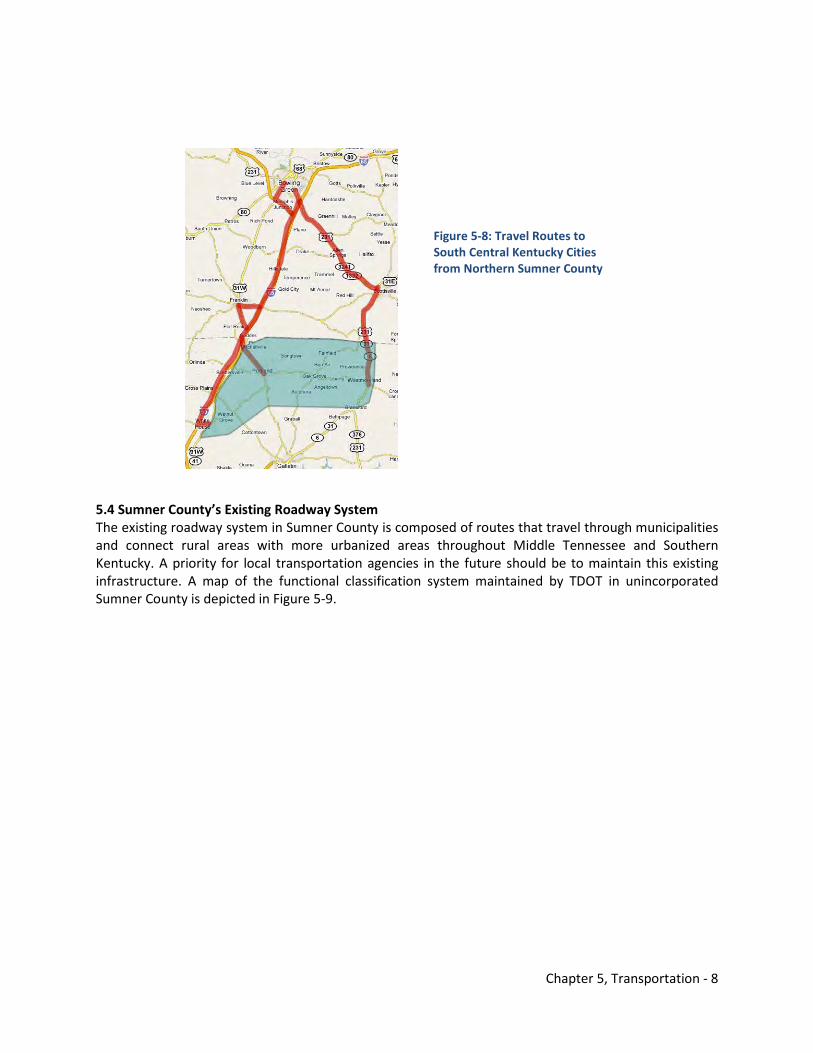
Chapter 5, Transportation - 8
5.4 Sumner County’s Existing Roadway System The existing roadway system in Sumner County is composed of routes that travel through municipalities and connect rural areas with more urbanized areas throughout Middle Tennessee and Southern Kentucky. A priority for local transportation agencies in the future should be to maintain this existing infrastructure. A map of the functional classification system maintained by TDOT in unincorporated Sumner County is depicted in Figure 5-9.
Figure 5-8: Travel Routes to South Central Kentucky Cities from Northern Sumner County
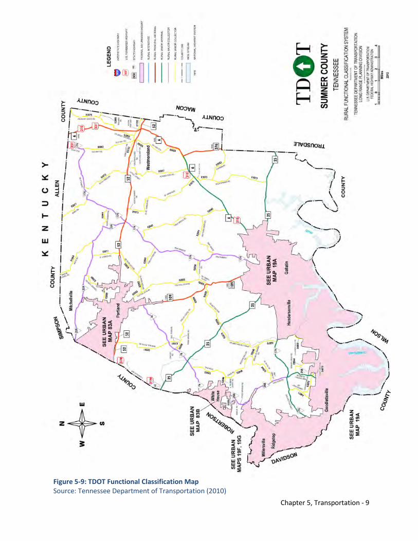
Chapter 5, Transportation - 9
Figure 5-9: TDOT Functional Classification Map Source: Tennessee Department of Transportation (2010)
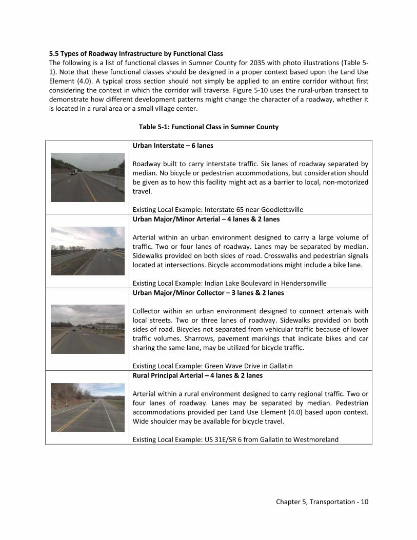
Chapter 5, Transportation - 10
5.5 Types of Roadway Infrastructure by Functional Class The following is a list of functional classes in Sumner County for 2035 with photo illustrations (Table 5-1). Note that these functional classes should be designed in a proper context based upon the Land Use Element (4.0). A typical cross section should not simply be applied to an entire corridor without first considering the context in which the corridor will traverse. Figure 5-10 uses the rural-urban transect to demonstrate how different development patterns might change the character of a roadway, whether it is located in a rural area or a small village center.
Table 5-1: Functional Class in Sumner County
Urban Interstate – 6 lanes Roadway built to carry interstate traffic. Six lanes of roadway separated by median. No bicycle or pedestrian accommodations, but consideration should be given as to how this facility might act as a barrier to local, non-motorized travel. Existing Local Example: Interstate 65 near Goodlettsville
Urban Major/Minor Arterial – 4 lanes & 2 lanes Arterial within an urban environment designed to carry a large volume of traffic. Two or four lanes of roadway. Lanes may be separated by median. Sidewalks provided on both sides of road. Crosswalks and pedestrian signals located at intersections. Bicycle accommodations might include a bike lane. Existing Local Example: Indian Lake Boulevard in Hendersonville
Urban Major/Minor Collector – 3 lanes & 2 lanes Collector within an urban environment designed to connect arterials with local streets. Two or three lanes of roadway. Sidewalks provided on both sides of road. Bicycles not separated from vehicular traffic because of lower traffic volumes. Sharrows, pavement markings that indicate bikes and car sharing the same lane, may be utilized for bicycle traffic. Existing Local Example: Green Wave Drive in Gallatin
Rural Principal Arterial – 4 lanes & 2 lanes Arterial within a rural environment designed to carry regional traffic. Two or four lanes of roadway. Lanes may be separated by median. Pedestrian accommodations provided per Land Use Element (4.0) based upon context. Wide shoulder may be available for bicycle travel. Existing Local Example: US 31E/SR 6 from Gallatin to Westmoreland
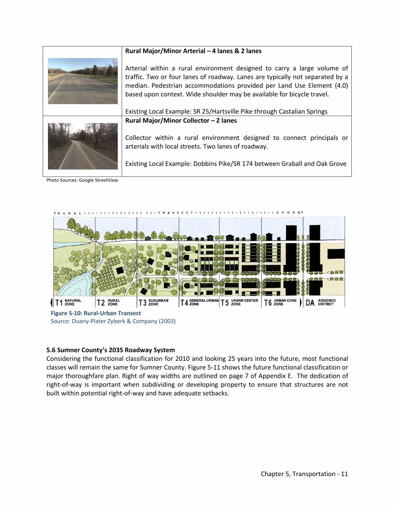
Chapter 5, Transportation - 11
Rural Major/Minor Arterial – 4 lanes & 2 lanes Arterial within a rural environment designed to carry a large volume of traffic. Two or four lanes of roadway. Lanes are typically not separated by a median. Pedestrian accommodations provided per Land Use Element (4.0) based upon context. Wide shoulder may be available for bicycle travel. Existing Local Example: SR 25/Hartsville Pike through Castalian Springs
Rural Major/Minor Collector – 2 lanes Collector within a rural environment designed to connect principals or arterials with local streets. Two lanes of roadway. Existing Local Example: Dobbins Pike/SR 174 between Graball and Oak Grove
Photo Sources: Google StreetView
Figure 5-10: Rural-Urban Transect Source: Duany-Plater Zyberk & Company (2003)
5.6 Sumner County’s 2035 Roadway System Considering the functional classification for 2010 and looking 25 years into the future, most functional classes will remain the same for Sumner County. Figure 5-11 shows the future functional classification or major thoroughfare plan. Right of way widths are outlined on page 7 of Appendix E. The dedication of right-of-way is important when subdividing or developing property to ensure that structures are not built within potential right-of-way and have adequate setbacks.
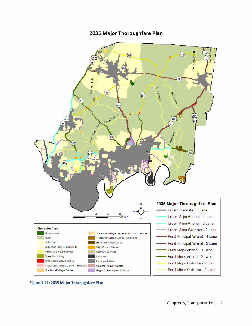
Chapter 5, Transportation - 12
2035 Major Thoroughfare Plan
Figure 5-11: 2035 Major Thoroughfare Plan
Chapter 5, Transportation - 13
Appendix E also contains a listing of all major thoroughfares, right-of-way, character areas, and bicycle/pedestrian accommodations in unincorporated Sumner County. Typical cross sections of thoroughfares are not depicted in the 2035 Comprehensive Plan. The Sumner County Subdivision Regulations contains cross sections that must be updated to reflect the intent of the 2035 Comprehensive Plan. Cross sections should be multi-modal and context sensitive. Any future roadway improvements should be mindful of its context within a community. This is especially important in unincorporated communities, so the sense of place and sense of community are maintained. Too often in the past, these areas have been bypassed by newer, wider roadways or bisected by these facilities. Future roadway improvements should be mindful of the community character established in the Land Use Element (4.0) and consider improvements from a multi-modal perspective and not just moving vehicles. A robust transportation system must include bicycle, pedestrian, and mass transit components.
5.7 Priority Roadway Improvements The following is a list of the most important roadway improvements in Sumner County (Figure 5-12) Most of these improvements are located in unincorporated Sumner County; however, a few of the improvements listed are located in Robertson or Davidson Counties. These routes have significant impact on the mobility of Sumner County residents and commuters. Sumner County will need to work with TDOT and the Nashville Area MPO to secure funding to implement improvements. These routes must be developed in a context sensitive manner that enhances sense of community, preserves rural viewsheds, and accommodates non-motorized travel modes and mass transit where appropriate. The Land Use Element (4.0) and Figure 5-8 should be consulted where these thoroughfares may need pedestrian or bicycle accommodations.
1. Complete widening of SR 109 from I-40 to I-65, including a Portland bypass and interchange with I-65. Limit future development to key access points to ensure that traffic flow is not impeded.
2. Widen SR 174/Long Hollow Pike from Goodlettsville to Gallatin. Include multi-modal elements such as a signed, wide shoulder for bicyclists, a shared use trail on the south side, and sidewalks in the Shackle Island community. Consider the viewsheds and context of the corridor in coordination with TDOT to ensure a scenic drive in the future and limited commercial development at key centers along the corridor as identified in the Land Use Element (4.0).
3. Widen US 31E/SR 6 from Gallatin to the Tennessee/Kentucky State Line. Include multi-modal elements such as sidewalks in communities such as Bransford, Bethpage, and Sideview. The context of the corridor should also direct TDOT’s widening through the City of Westmoreland.
4. Widen SR 258/New Shackle Island Road from Hendersonville to Latimer Lane. Include multi-modal elements such as sidewalks in this fast growing, suburban area of Sumner County.
5. Widen I-65 through Sumner and Robertson Counties from Davidson County Line to Tennessee/Kentucky State Line. Consider multimodal elements such as mass transit that could link Nashville to Bowling Green or Louisville, Kentucky.
6. Widen SR 386/Vietnam Veterans Boulevard from I-65 to Saundersville Road. Consider how this corridor might support the objectives of the Northeast Corridor Mobility Study conducted by the Nashville Area MPO.
7. Reconstruct the SR 386/Vietnam Veterans Boulevard and I-65 interchange in Davidson County to provide access from westbound SR 386 to northbound I-65 and from southbound I-65 to eastbound SR 386.
8. Complete free-flow interchange of SR 386/Vietnam Veterans Boulevard and SR 109. Possibly coordinate this improvement with the Hatten Track Extension proposed by the City of Gallatin.
9. Widen US 231/SR 376 from US 31E/SR 6 to Trousdale/Sumner County Line.
Chapter 5, Transportation - 14
10. Implement safety improvements to Upper Station Camp Creek Road that includes a wider shoulder and multi-modal elements such as crosswalks with a planned greenway parallel to the roadway in the future.
11. Widen the bridge over Station Camp Creek on SR 174/Long Hollow Pike, a TDOT designated bike route, to accommodate increased bicycle and pedestrian activity.

Chapter 5, Transportation - 15
Priority Roadway Improvements
Figure 5-12: Priority Road Improvements 5.8 Sumner County’s Existing Bicycle & Pedestrian System The Sumner County Regional Planning Commission adopted the Bicycle & Pedestrian Master Plan for unincorporated areas in 2000. The Bike-Ped Master Plan outlined a number of proposed improvements involving shared use trails or greenways, bike lanes, and bike routes. Many of these projects involve
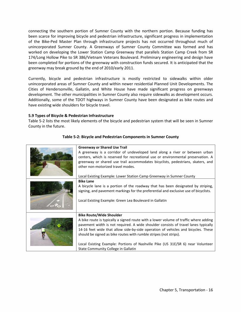
Chapter 5, Transportation - 16
connecting the southern portion of Sumner County with the northern portion. Because funding has been scarce for improving bicycle and pedestrian infrastructure, significant progress in implementation of the Bike-Ped Master Plan through infrastructure projects has not occurred throughout much of unincorporated Sumner County. A Greenways of Sumner County Committee was formed and has worked on developing the Lower Station Camp Greenway that parallels Station Camp Creek from SR 174/Long Hollow Pike to SR 386/Vietnam Veterans Boulevard. Preliminary engineering and design have been completed for portions of the greenway with construction funds secured. It is anticipated that the greenway may break ground by the end of 2010/early 2011. Currently, bicycle and pedestrian infrastructure is mostly restricted to sidewalks within older unincorporated areas of Sumner County and within newer residential Planned Unit Developments. The Cities of Hendersonville, Gallatin, and White House have made significant progress on greenways development. The other municipalities in Sumner County also require sidewalks as development occurs. Additionally, some of the TDOT highways in Sumner County have been designated as bike routes and have existing wide shoulders for bicycle travel. 5.9 Types of Bicycle & Pedestrian Infrastructure Table 5-2 lists the most likely elements of the bicycle and pedestrian system that will be seen in Sumner County in the future.
Table 5-2: Bicycle and Pedestrian Components in Sumner County
Greenway or Shared Use Trail A greenway is a corridor of undeveloped land along a river or between urban centers, which is reserved for recreational use or environmental preservation. A greenway or shared use trail accommodates bicyclists, pedestrians, skaters, and other non-motorized travel modes. Local Existing Example: Lower Station Camp Greenway in Sumner County
Bike Lane A bicycle lane is a portion of the roadway that has been designated by striping, signing, and pavement markings for the preferential and exclusive use of bicyclists. Local Existing Example: Green Lea Boulevard in Gallatin
Bike Route/Wide Shoulder A bike route is typically a signed route with a lower volume of traffic where adding pavement width is not required. A wide shoulder consists of travel lanes typically 14-16 feet wide that allow side-by-side operation of vehicles and bicycles. These should be signed as bike routes with rumble stripes (not strips). Local Existing Example: Portions of Nashville Pike (US 31E/SR 6) near Volunteer State Community College in Gallatin
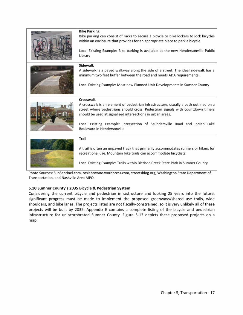
Chapter 5, Transportation - 17
Bike Parking Bike parking can consist of racks to secure a bicycle or bike lockers to lock bicycles within an enclosure that provides for an appropriate place to park a bicycle. Local Existing Example: Bike parking is available at the new Hendersonville Public Library
Sidewalk A sidewalk is a paved walkway along the side of a street. The ideal sidewalk has a minimum two feet buffer between the road and meets ADA requirements. Local Existing Example: Most new Planned Unit Developments in Sumner County
Crosswalk A crosswalk is an element of pedestrian infrastructure, usually a path outlined on a street where pedestrians should cross. Pedestrian signals with countdown timers should be used at signalized intersections in urban areas. Local Existing Example: Intersection of Saundersville Road and Indian Lake Boulevard in Hendersonville
Trail A trail is often an unpaved track that primarily accommodates runners or hikers for recreational use. Mountain bike trails can accommodate bicyclists. Local Existing Example: Trails within Bledsoe Creek State Park in Sumner County
Photo Sources: SunSentinel.com, rosiebrowne.wordpress.com, streetsblog.org, Washington State Department of Transportation, and Nashville Area MPO. 5.10 Sumner County’s 2035 Bicycle & Pedestrian System Considering the current bicycle and pedestrian infrastructure and looking 25 years into the future, significant progress must be made to implement the proposed greenways/shared use trails, wide shoulders, and bike lanes. The projects listed are not fiscally-constrained, so it is very unlikely all of these projects will be built by 2035. Appendix E contains a complete listing of the bicycle and pedestrian infrastructure for unincorporated Sumner County. Figure 5-13 depicts these proposed projects on a map.
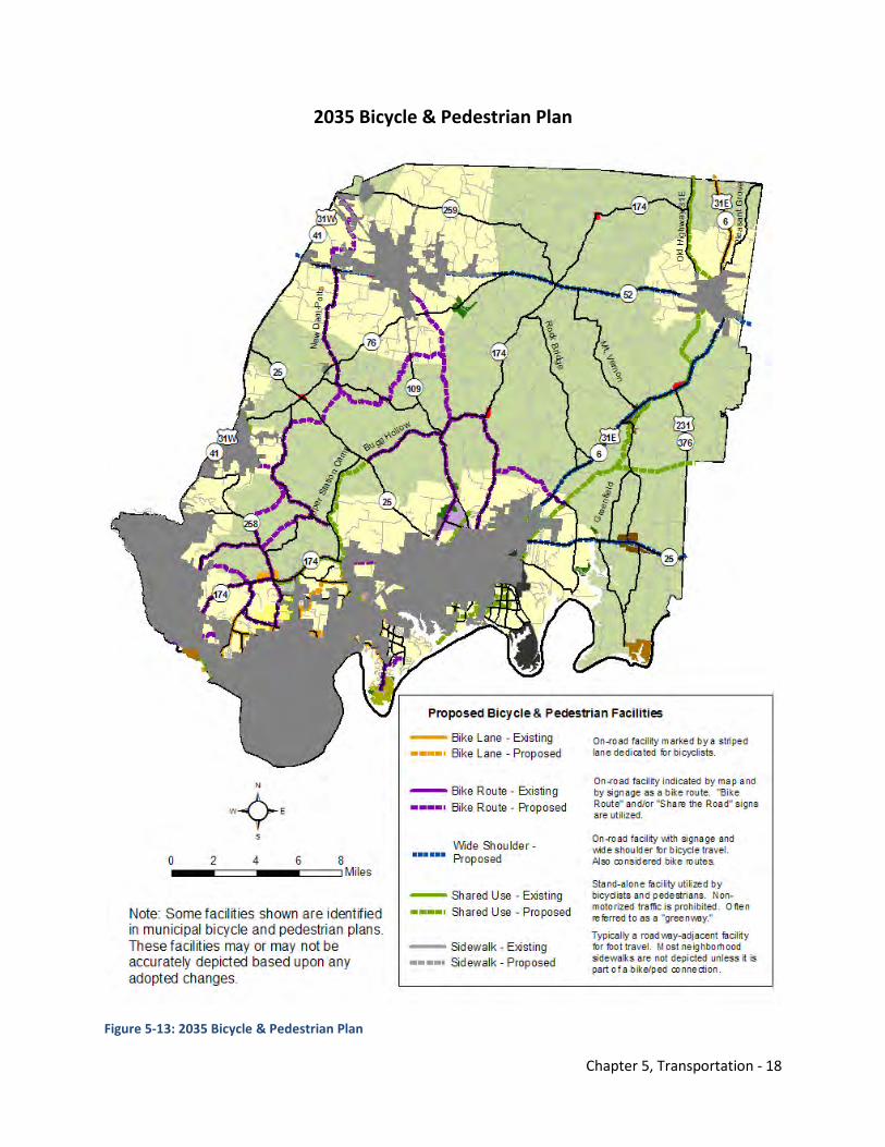
Chapter 5, Transportation - 18
2035 Bicycle & Pedestrian Plan
Figure 5-13: 2035 Bicycle & Pedestrian Plan
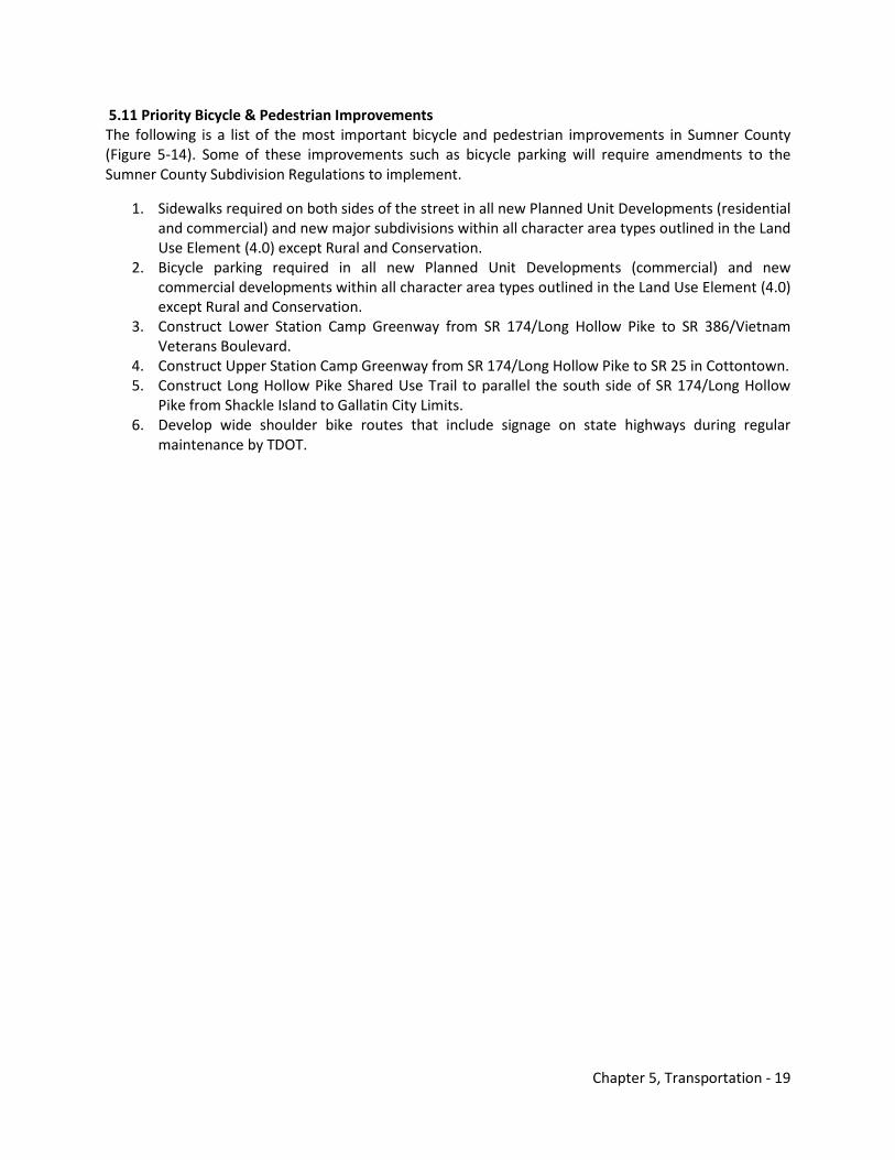
Chapter 5, Transportation - 19
5.11 Priority Bicycle & Pedestrian Improvements The following is a list of the most important bicycle and pedestrian improvements in Sumner County (Figure 5-14). Some of these improvements such as bicycle parking will require amendments to the Sumner County Subdivision Regulations to implement.
1. Sidewalks required on both sides of the street in all new Planned Unit Developments (residential and commercial) and new major subdivisions within all character area types outlined in the Land Use Element (4.0) except Rural and Conservation.
2. Bicycle parking required in all new Planned Unit Developments (commercial) and new commercial developments within all character area types outlined in the Land Use Element (4.0) except Rural and Conservation.
3. Construct Lower Station Camp Greenway from SR 174/Long Hollow Pike to SR 386/Vietnam Veterans Boulevard.
4. Construct Upper Station Camp Greenway from SR 174/Long Hollow Pike to SR 25 in Cottontown. 5. Construct Long Hollow Pike Shared Use Trail to parallel the south side of SR 174/Long Hollow
Pike from Shackle Island to Gallatin City Limits. 6. Develop wide shoulder bike routes that include signage on state highways during regular
maintenance by TDOT.
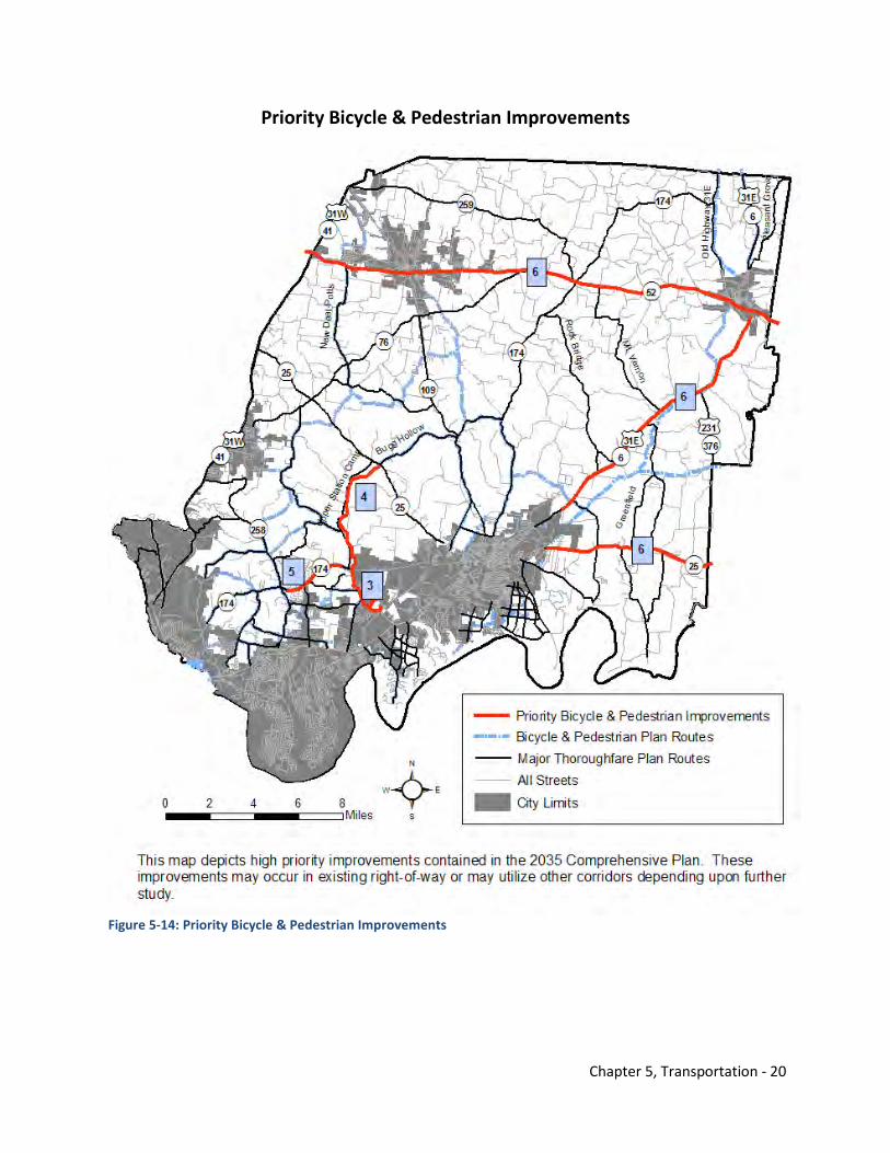
Chapter 5, Transportation - 20
Priority Bicycle & Pedestrian Improvements
Figure 5-14: Priority Bicycle & Pedestrian Improvements
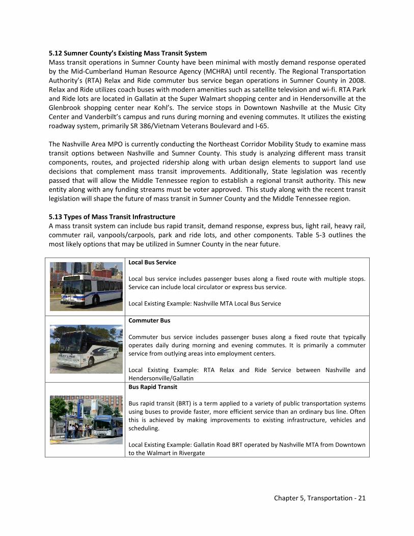
Chapter 5, Transportation - 21
5.12 Sumner County’s Existing Mass Transit System Mass transit operations in Sumner County have been minimal with mostly demand response operated by the Mid-Cumberland Human Resource Agency (MCHRA) until recently. The Regional Transportation Authority’s (RTA) Relax and Ride commuter bus service began operations in Sumner County in 2008. Relax and Ride utilizes coach buses with modern amenities such as satellite television and wi-fi. RTA Park and Ride lots are located in Gallatin at the Super Walmart shopping center and in Hendersonville at the Glenbrook shopping center near Kohl’s. The service stops in Downtown Nashville at the Music City Center and Vanderbilt’s campus and runs during morning and evening commutes. It utilizes the existing roadway system, primarily SR 386/Vietnam Veterans Boulevard and I-65. The Nashville Area MPO is currently conducting the Northeast Corridor Mobility Study to examine mass transit options between Nashville and Sumner County. This study is analyzing different mass transit components, routes, and projected ridership along with urban design elements to support land use decisions that complement mass transit improvements. Additionally, State legislation was recently passed that will allow the Middle Tennessee region to establish a regional transit authority. This new entity along with any funding streams must be voter approved. This study along with the recent transit legislation will shape the future of mass transit in Sumner County and the Middle Tennessee region. 5.13 Types of Mass Transit Infrastructure A mass transit system can include bus rapid transit, demand response, express bus, light rail, heavy rail, commuter rail, vanpools/carpools, park and ride lots, and other components. Table 5-3 outlines the most likely options that may be utilized in Sumner County in the near future.
Local Bus Service Local bus service includes passenger buses along a fixed route with multiple stops. Service can include local circulator or express bus service. Local Existing Example: Nashville MTA Local Bus Service
Commuter Bus Commuter bus service includes passenger buses along a fixed route that typically operates daily during morning and evening commutes. It is primarily a commuter service from outlying areas into employment centers. Local Existing Example: RTA Relax and Ride Service between Nashville and Hendersonville/Gallatin
Bus Rapid Transit Bus rapid transit (BRT) is a term applied to a variety of public transportation systems using buses to provide faster, more efficient service than an ordinary bus line. Often this is achieved by making improvements to existing infrastructure, vehicles and scheduling. Local Existing Example: Gallatin Road BRT operated by Nashville MTA from Downtown to the Walmart in Rivergate
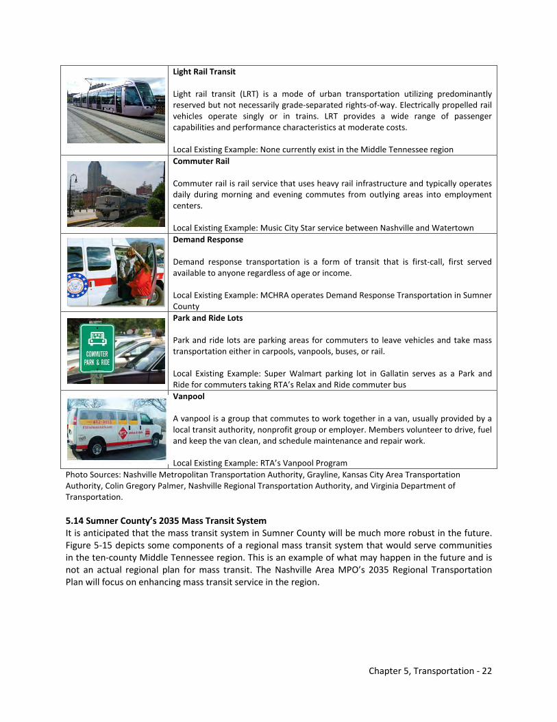
Chapter 5, Transportation - 22
Light Rail Transit Light rail transit (LRT) is a mode of urban transportation utilizing predominantly reserved but not necessarily grade-separated rights-of-way. Electrically propelled rail vehicles operate singly or in trains. LRT provides a wide range of passenger capabilities and performance characteristics at moderate costs. Local Existing Example: None currently exist in the Middle Tennessee region
Commuter Rail Commuter rail is rail service that uses heavy rail infrastructure and typically operates daily during morning and evening commutes from outlying areas into employment centers. Local Existing Example: Music City Star service between Nashville and Watertown
Demand Response Demand response transportation is a form of transit that is first-call, first served available to anyone regardless of age or income. Local Existing Example: MCHRA operates Demand Response Transportation in Sumner County
Park and Ride Lots Park and ride lots are parking areas for commuters to leave vehicles and take mass transportation either in carpools, vanpools, buses, or rail. Local Existing Example: Super Walmart parking lot in Gallatin serves as a Park and Ride for commuters taking RTA’s Relax and Ride commuter bus
Vanpool A vanpool is a group that commutes to work together in a van, usually provided by a local transit authority, nonprofit group or employer. Members volunteer to drive, fuel and keep the van clean, and schedule maintenance and repair work. Local Existing Example: RTA’s Vanpool Program
Photo Sources: Nashville Metropolitan Transportation Authority, Grayline, Kansas City Area Transportation Authority, Colin Gregory Palmer, Nashville Regional Transportation Authority, and Virginia Department of Transportation. 5.14 Sumner County’s 2035 Mass Transit System It is anticipated that the mass transit system in Sumner County will be much more robust in the future. Figure 5-15 depicts some components of a regional mass transit system that would serve communities in the ten-county Middle Tennessee region. This is an example of what may happen in the future and is not an actual regional plan for mass transit. The Nashville Area MPO’s 2035 Regional Transportation Plan will focus on enhancing mass transit service in the region.
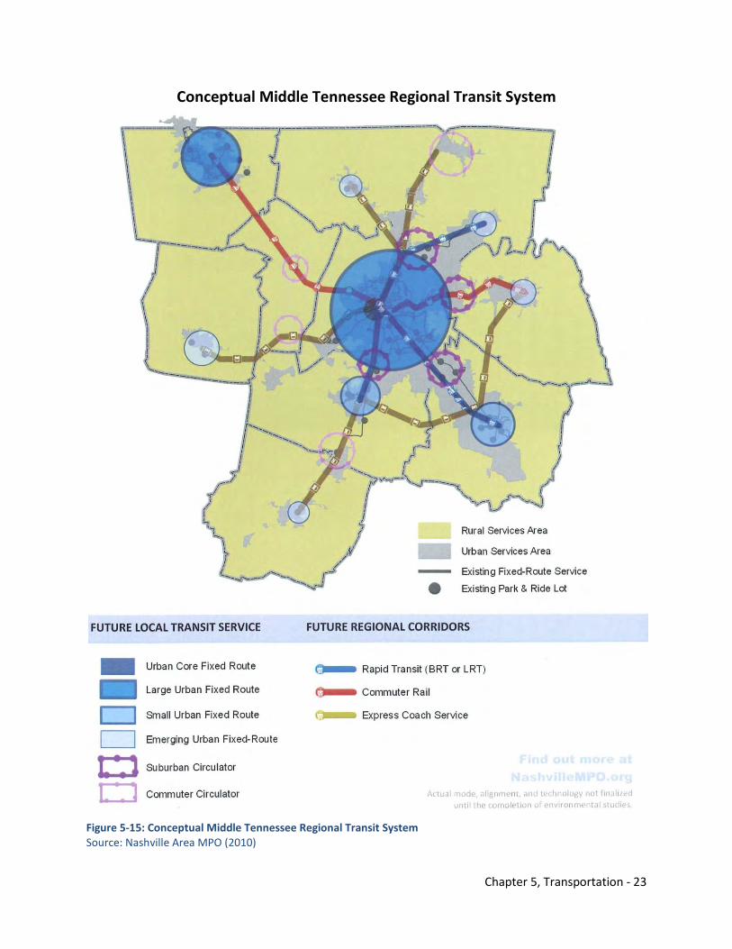
Chapter 5, Transportation - 23
Conceptual Middle Tennessee Regional Transit System
Figure 5-15: Conceptual Middle Tennessee Regional Transit System Source: Nashville Area MPO (2010)
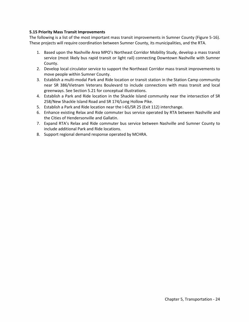
Chapter 5, Transportation - 24
5.15 Priority Mass Transit Improvements The following is a list of the most important mass transit improvements in Sumner County (Figure 5-16). These projects will require coordination between Sumner County, its municipalities, and the RTA.
1. Based upon the Nashville Area MPO’s Northeast Corridor Mobility Study, develop a mass transit service (most likely bus rapid transit or light rail) connecting Downtown Nashville with Sumner County.
2. Develop local circulator service to support the Northeast Corridor mass transit improvements to move people within Sumner County.
3. Establish a multi-modal Park and Ride location or transit station in the Station Camp community near SR 386/Vietnam Veterans Boulevard to include connections with mass transit and local greenways. See Section 5.21 for conceptual illustrations.
4. Establish a Park and Ride location in the Shackle Island community near the intersection of SR 258/New Shackle Island Road and SR 174/Long Hollow Pike.
5. Establish a Park and Ride location near the I-65/SR 25 (Exit 112) interchange. 6. Enhance existing Relax and Ride commuter bus service operated by RTA between Nashville and
the Cities of Hendersonville and Gallatin. 7. Expand RTA’s Relax and Ride commuter bus service between Nashville and Sumner County to
include additional Park and Ride locations. 8. Support regional demand response operated by MCHRA.
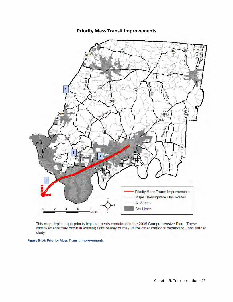
Chapter 5, Transportation - 25
Priority Mass Transit Improvements
Figure 5-16: Priority Mass Transit Improvements
Chapter 5, Transportation - 26
5.16 Key Concept – Complete Streets Complete streets are designed and operated to enable safe access for all users. Pedestrians, bicyclists, motorists, and transit riders of all ages and abilities must be able to safely move along and across a complete street. Creating complete streets means transportation agencies and planning officials must change their orientation toward building primarily for cars. Instituting a complete streets policy ensures that transportation agencies and local governments routinely design and operate the entire right of way to enable safe access for all users. Places with complete streets policies make sure that their streets and roads work for drivers, transit users, pedestrians, and bicyclists, as well as for older adults, children, and people with disabilities. Each complete street can be unique, so it is impossible to give a single description. Ingredients that may be found on a complete street include sidewalks, bike lanes (or wide paved shoulders), special bus lanes, comfortable and accessible transit stops, frequent crossing opportunities, median island, accessible pedestrian signals, curb extensions, and more. A complete street in a rural area will look quite different from a complete street in a highly urban area. Both are designed to balance safety and convenience for everyone using the road. Examples of different types of Complete Streets across the country can be found on the National Complete Streets Coalition website.1 Successful complete street transformations require community support and leadership, as well as coordination between various disciplines. In particular, support must include economic revitalization, business retention and expansion, property owner involvement, land use planning, urban design, landscape architecture, roadway design, utility coordination, traffic engineering, transportation planning, transit planners, architects, graphic artists, and developers. The following principles embody the most important aspects of a successful Complete Streets program:
• Achieve community objectives. • Blend street design with the character of the area served. • Capitalize on a public investment by working diligently with property owners, developers,
economic development experts, and others to spur private investment in the area. A minimum return-on-investment of $3 private for every $1 of public investment should be expected. Often in more densely populated areas, the ratio is 10:1 or more.
• Design in balance so that traffic demands do not overshadow the need to walk, bicycle, and ride transit safely, efficiently, and comfortably. The design should encourage people to walk.
• Empower citizens to create their own sense of ownership in the success of the street and its myriad characters.
The Implementation Element (7.0) outlines a strategy for Sumner County to develop and adopt a Complete Streets policy.
KEY CONCEPT: COMPLETE STREETS With the adoption of a Complete Streets policy, future development that include road improvements in Sumner County shall consider the complete streets concept to ensure safe access for all users – drivers, transit users, pedestrians, bicyclists, older adults, children, and people with disabilities.
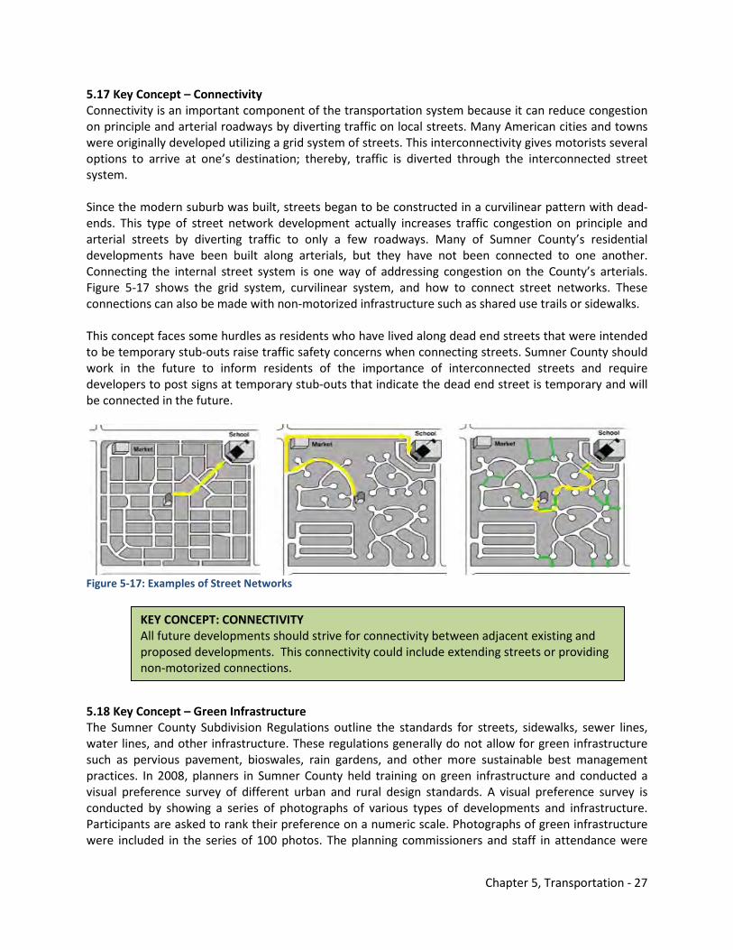
Chapter 5, Transportation - 27
5.17 Key Concept – Connectivity Connectivity is an important component of the transportation system because it can reduce congestion on principle and arterial roadways by diverting traffic on local streets. Many American cities and towns were originally developed utilizing a grid system of streets. This interconnectivity gives motorists several options to arrive at one’s destination; thereby, traffic is diverted through the interconnected street system. Since the modern suburb was built, streets began to be constructed in a curvilinear pattern with dead-ends. This type of street network development actually increases traffic congestion on principle and arterial streets by diverting traffic to only a few roadways. Many of Sumner County’s residential developments have been built along arterials, but they have not been connected to one another. Connecting the internal street system is one way of addressing congestion on the County’s arterials. Figure 5-17 shows the grid system, curvilinear system, and how to connect street networks. These connections can also be made with non-motorized infrastructure such as shared use trails or sidewalks. This concept faces some hurdles as residents who have lived along dead end streets that were intended to be temporary stub-outs raise traffic safety concerns when connecting streets. Sumner County should work in the future to inform residents of the importance of interconnected streets and require developers to post signs at temporary stub-outs that indicate the dead end street is temporary and will be connected in the future.
Figure 5-17: Examples of Street Networks 5.18 Key Concept – Green Infrastructure The Sumner County Subdivision Regulations outline the standards for streets, sidewalks, sewer lines, water lines, and other infrastructure. These regulations generally do not allow for green infrastructure such as pervious pavement, bioswales, rain gardens, and other more sustainable best management practices. In 2008, planners in Sumner County held training on green infrastructure and conducted a visual preference survey of different urban and rural design standards. A visual preference survey is conducted by showing a series of photographs of various types of developments and infrastructure. Participants are asked to rank their preference on a numeric scale. Photographs of green infrastructure were included in the series of 100 photos. The planning commissioners and staff in attendance were
KEY CONCEPT: CONNECTIVITY All future developments should strive for connectivity between adjacent existing and proposed developments. This connectivity could include extending streets or providing non-motorized connections.
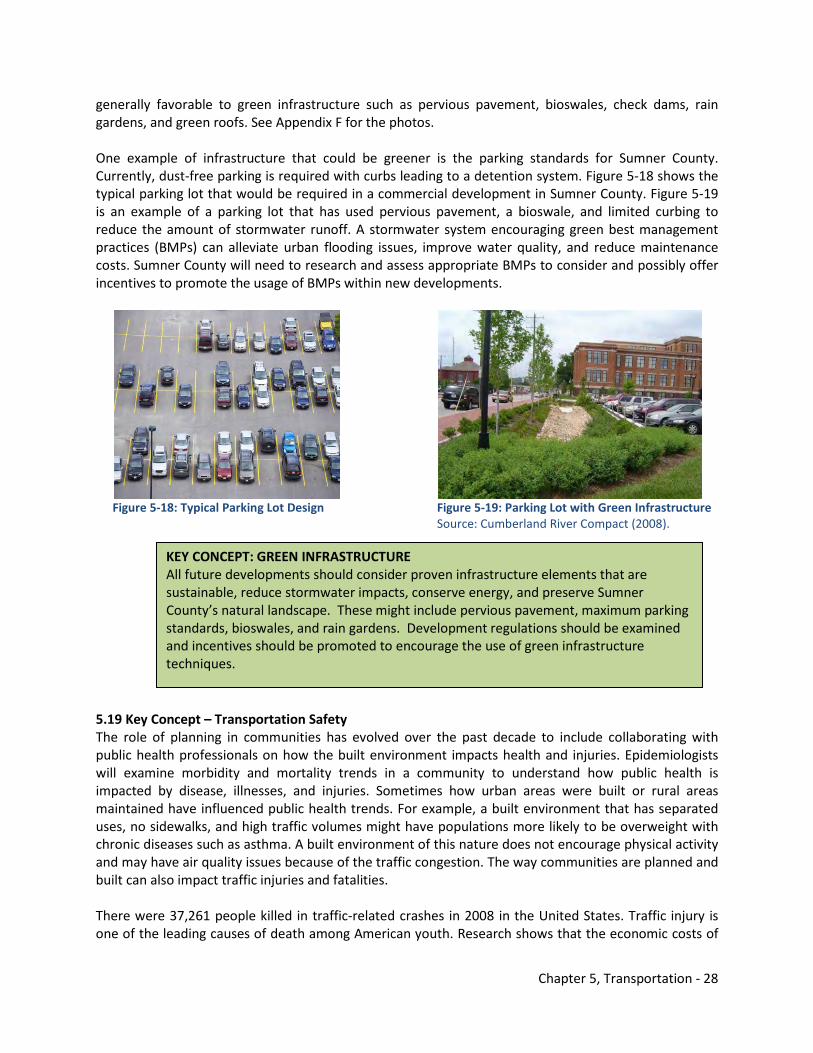
Chapter 5, Transportation - 28
generally favorable to green infrastructure such as pervious pavement, bioswales, check dams, rain gardens, and green roofs. See Appendix F for the photos. One example of infrastructure that could be greener is the parking standards for Sumner County. Currently, dust-free parking is required with curbs leading to a detention system. Figure 5-18 shows the typical parking lot that would be required in a commercial development in Sumner County. Figure 5-19 is an example of a parking lot that has used pervious pavement, a bioswale, and limited curbing to reduce the amount of stormwater runoff. A stormwater system encouraging green best management practices (BMPs) can alleviate urban flooding issues, improve water quality, and reduce maintenance costs. Sumner County will need to research and assess appropriate BMPs to consider and possibly offer incentives to promote the usage of BMPs within new developments.
Figure 5-18: Typical Parking Lot Design Figure 5-19: Parking Lot with Green Infrastructure Source: Cumberland River Compact (2008). 5.19 Key Concept – Transportation Safety The role of planning in communities has evolved over the past decade to include collaborating with public health professionals on how the built environment impacts health and injuries. Epidemiologists will examine morbidity and mortality trends in a community to understand how public health is impacted by disease, illnesses, and injuries. Sometimes how urban areas were built or rural areas maintained have influenced public health trends. For example, a built environment that has separated uses, no sidewalks, and high traffic volumes might have populations more likely to be overweight with chronic diseases such as asthma. A built environment of this nature does not encourage physical activity and may have air quality issues because of the traffic congestion. The way communities are planned and built can also impact traffic injuries and fatalities. There were 37,261 people killed in traffic-related crashes in 2008 in the United States. Traffic injury is one of the leading causes of death among American youth. Research shows that the economic costs of
KEY CONCEPT: GREEN INFRASTRUCTURE All future developments should consider proven infrastructure elements that are sustainable, reduce stormwater impacts, conserve energy, and preserve Sumner County’s natural landscape. These might include pervious pavement, maximum parking standards, bioswales, and rain gardens. Development regulations should be examined and incentives should be promoted to encourage the use of green infrastructure techniques.
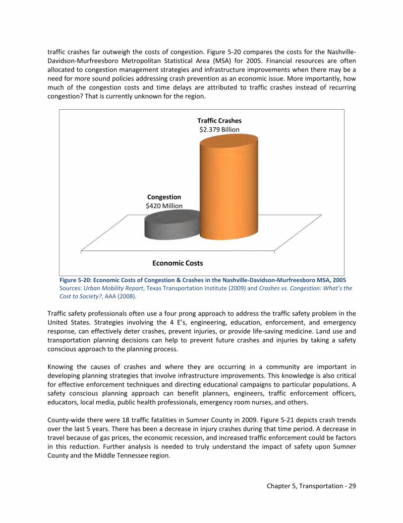
Chapter 5, Transportation - 29
traffic crashes far outweigh the costs of congestion. Figure 5-20 compares the costs for the Nashville-Davidson-Murfreesboro Metropolitan Statistical Area (MSA) for 2005. Financial resources are often allocated to congestion management strategies and infrastructure improvements when there may be a need for more sound policies addressing crash prevention as an economic issue. More importantly, how much of the congestion costs and time delays are attributed to traffic crashes instead of recurring congestion? That is currently unknown for the region.
Figure 5-20: Economic Costs of Congestion & Crashes in the Nashville-Davidson-Murfreesboro MSA, 2005 Sources: Urban Mobility Report, Texas Transportation Institute (2009) and Crashes vs. Congestion: What’s the Cost to Society?, AAA (2008). Traffic safety professionals often use a four prong approach to address the traffic safety problem in the United States. Strategies involving the 4 E’s, engineering, education, enforcement, and emergency response, can effectively deter crashes, prevent injuries, or provide life-saving medicine. Land use and transportation planning decisions can help to prevent future crashes and injuries by taking a safety conscious approach to the planning process. Knowing the causes of crashes and where they are occurring in a community are important in developing planning strategies that involve infrastructure improvements. This knowledge is also critical for effective enforcement techniques and directing educational campaigns to particular populations. A safety conscious planning approach can benefit planners, engineers, traffic enforcement officers, educators, local media, public health professionals, emergency room nurses, and others. County-wide there were 18 traffic fatalities in Sumner County in 2009. Figure 5-21 depicts crash trends over the last 5 years. There has been a decrease in injury crashes during that time period. A decrease in travel because of gas prices, the economic recession, and increased traffic enforcement could be factors in this reduction. Further analysis is needed to truly understand the impact of safety upon Sumner County and the Middle Tennessee region.
Economic Costs
Congestion$420 Million
Traffic Crashes$2.379 Billion
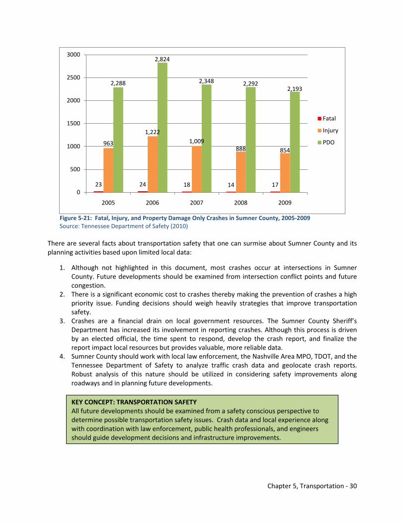
Chapter 5, Transportation - 30
Figure 5-21: Fatal, Injury, and Property Damage Only Crashes in Sumner County, 2005-2009 Source: Tennessee Department of Safety (2010) There are several facts about transportation safety that one can surmise about Sumner County and its planning activities based upon limited local data:
1. Although not highlighted in this document, most crashes occur at intersections in Sumner County. Future developments should be examined from intersection conflict points and future congestion.
2. There is a significant economic cost to crashes thereby making the prevention of crashes a high priority issue. Funding decisions should weigh heavily strategies that improve transportation safety.
3. Crashes are a financial drain on local government resources. The Sumner County Sheriff’s Department has increased its involvement in reporting crashes. Although this process is driven by an elected official, the time spent to respond, develop the crash report, and finalize the report impact local resources but provides valuable, more reliable data.
4. Sumner County should work with local law enforcement, the Nashville Area MPO, TDOT, and the Tennessee Department of Safety to analyze traffic crash data and geolocate crash reports. Robust analysis of this nature should be utilized in considering safety improvements along roadways and in planning future developments.
23 24 18 14 17
963
1,2221,009
888 854
2,288
2,824
2,348 2,2922,193
0
500
1000
1500
2000
2500
3000
2005 2006 2007 2008 2009
Fatal
Injury
PDO
KEY CONCEPT: TRANSPORTATION SAFETY All future developments should be examined from a safety conscious perspective to determine possible transportation safety issues. Crash data and local experience along with coordination with law enforcement, public health professionals, and engineers should guide development decisions and infrastructure improvements.
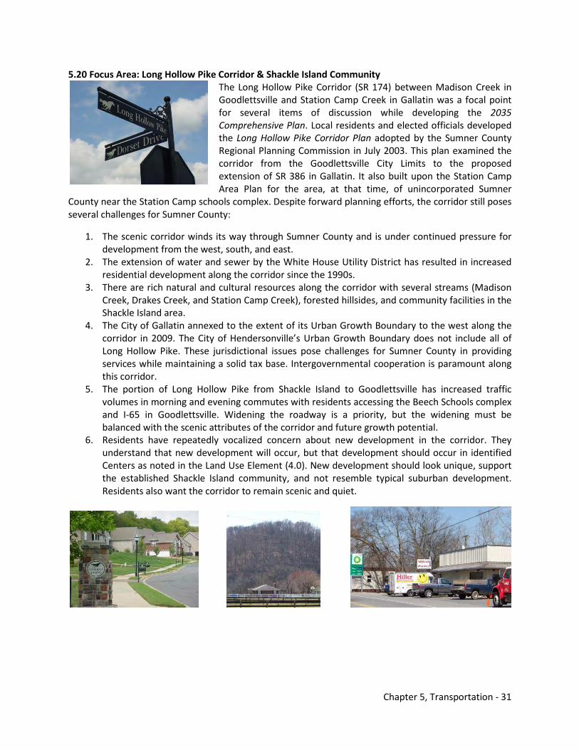
Chapter 5, Transportation - 31
5.20 Focus Area: Long Hollow Pike Corridor & Shackle Island Community The Long Hollow Pike Corridor (SR 174) between Madison Creek in Goodlettsville and Station Camp Creek in Gallatin was a focal point for several items of discussion while developing the 2035 Comprehensive Plan. Local residents and elected officials developed the Long Hollow Pike Corridor Plan adopted by the Sumner County Regional Planning Commission in July 2003. This plan examined the corridor from the Goodlettsville City Limits to the proposed extension of SR 386 in Gallatin. It also built upon the Station Camp Area Plan for the area, at that time, of unincorporated Sumner
County near the Station Camp schools complex. Despite forward planning efforts, the corridor still poses several challenges for Sumner County:
1. The scenic corridor winds its way through Sumner County and is under continued pressure for development from the west, south, and east.
2. The extension of water and sewer by the White House Utility District has resulted in increased residential development along the corridor since the 1990s.
3. There are rich natural and cultural resources along the corridor with several streams (Madison Creek, Drakes Creek, and Station Camp Creek), forested hillsides, and community facilities in the Shackle Island area.
4. The City of Gallatin annexed to the extent of its Urban Growth Boundary to the west along the corridor in 2009. The City of Hendersonville’s Urban Growth Boundary does not include all of Long Hollow Pike. These jurisdictional issues pose challenges for Sumner County in providing services while maintaining a solid tax base. Intergovernmental cooperation is paramount along this corridor.
5. The portion of Long Hollow Pike from Shackle Island to Goodlettsville has increased traffic volumes in morning and evening commutes with residents accessing the Beech Schools complex and I-65 in Goodlettsville. Widening the roadway is a priority, but the widening must be balanced with the scenic attributes of the corridor and future growth potential.
6. Residents have repeatedly vocalized concern about new development in the corridor. They understand that new development will occur, but that development should occur in identified Centers as noted in the Land Use Element (4.0). New development should look unique, support the established Shackle Island community, and not resemble typical suburban development. Residents also want the corridor to remain scenic and quiet.
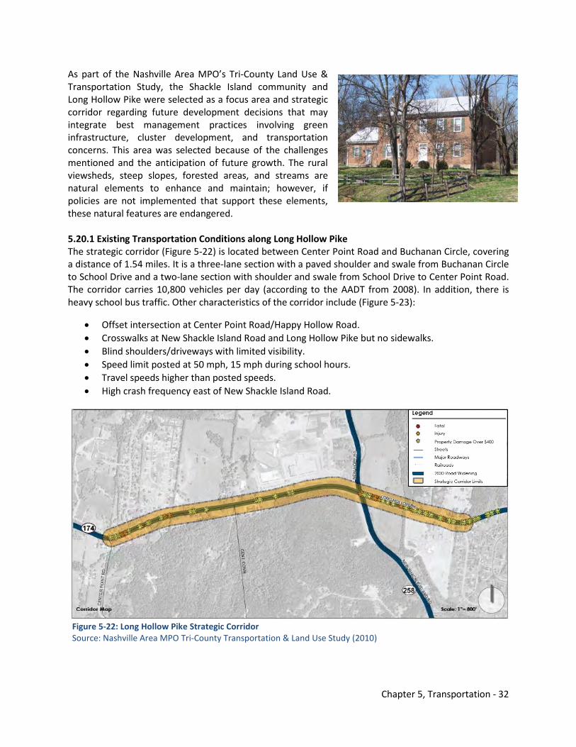
Chapter 5, Transportation - 32
As part of the Nashville Area MPO’s Tri-County Land Use & Transportation Study, the Shackle Island community and Long Hollow Pike were selected as a focus area and strategic corridor regarding future development decisions that may integrate best management practices involving green infrastructure, cluster development, and transportation concerns. This area was selected because of the challenges mentioned and the anticipation of future growth. The rural viewsheds, steep slopes, forested areas, and streams are natural elements to enhance and maintain; however, if policies are not implemented that support these elements, these natural features are endangered. 5.20.1 Existing Transportation Conditions along Long Hollow Pike The strategic corridor (Figure 5-22) is located between Center Point Road and Buchanan Circle, covering a distance of 1.54 miles. It is a three-lane section with a paved shoulder and swale from Buchanan Circle to School Drive and a two-lane section with shoulder and swale from School Drive to Center Point Road. The corridor carries 10,800 vehicles per day (according to the AADT from 2008). In addition, there is heavy school bus traffic. Other characteristics of the corridor include (Figure 5-23):
• Offset intersection at Center Point Road/Happy Hollow Road. • Crosswalks at New Shackle Island Road and Long Hollow Pike but no sidewalks. • Blind shoulders/driveways with limited visibility. • Speed limit posted at 50 mph, 15 mph during school hours. • Travel speeds higher than posted speeds. • High crash frequency east of New Shackle Island Road.
Figure 5-22: Long Hollow Pike Strategic Corridor Source: Nashville Area MPO Tri-County Transportation & Land Use Study (2010)
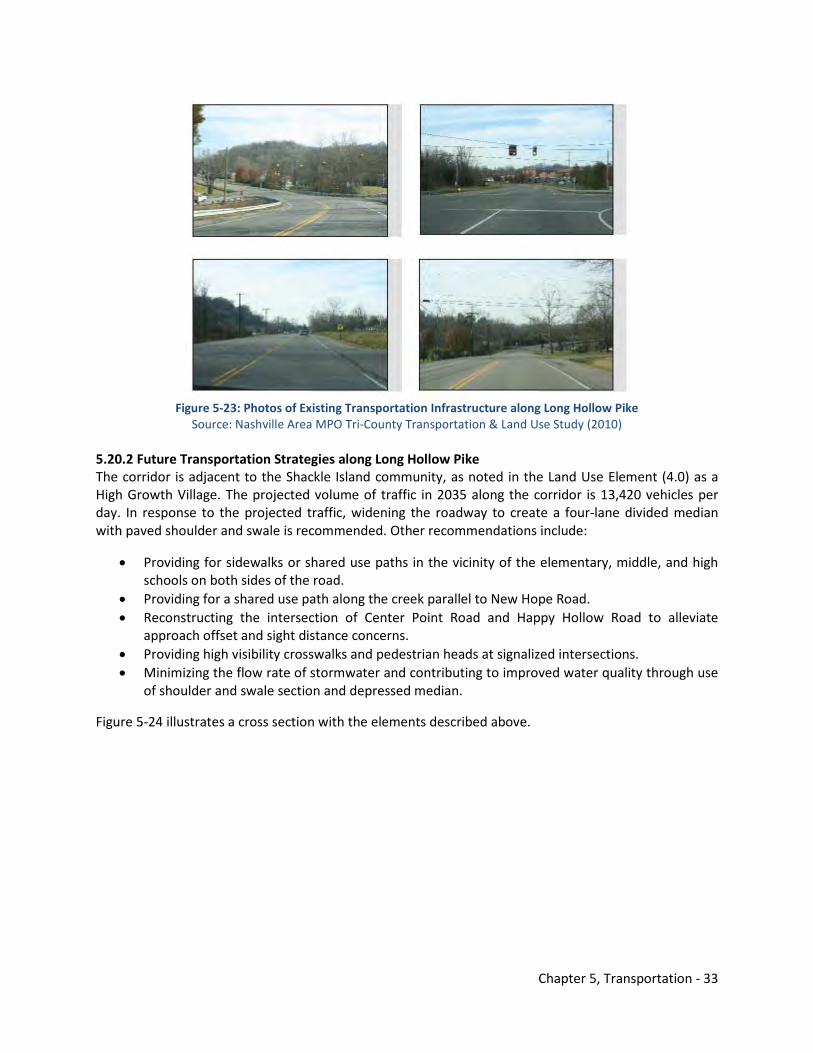
Chapter 5, Transportation - 33
Figure 5-23: Photos of Existing Transportation Infrastructure along Long Hollow Pike
Source: Nashville Area MPO Tri-County Transportation & Land Use Study (2010) 5.20.2 Future Transportation Strategies along Long Hollow Pike The corridor is adjacent to the Shackle Island community, as noted in the Land Use Element (4.0) as a High Growth Village. The projected volume of traffic in 2035 along the corridor is 13,420 vehicles per day. In response to the projected traffic, widening the roadway to create a four-lane divided median with paved shoulder and swale is recommended. Other recommendations include:
• Providing for sidewalks or shared use paths in the vicinity of the elementary, middle, and high schools on both sides of the road.
• Providing for a shared use path along the creek parallel to New Hope Road. • Reconstructing the intersection of Center Point Road and Happy Hollow Road to alleviate
approach offset and sight distance concerns. • Providing high visibility crosswalks and pedestrian heads at signalized intersections. • Minimizing the flow rate of stormwater and contributing to improved water quality through use
of shoulder and swale section and depressed median.
Figure 5-24 illustrates a cross section with the elements described above.
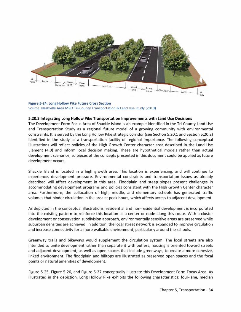
Chapter 5, Transportation - 34
Figure 5-24: Long Hollow Pike Future Cross Section Source: Nashville Area MPO Tri-County Transportation & Land Use Study (2010) 5.20.3 Integrating Long Hollow Pike Transportation Improvements with Land Use Decisions The Development Form Focus Area of Shackle Island is an example identified in the Tri-County Land Use and Transportation Study as a regional future model of a growing community with environmental constraints. It is served by the Long Hollow Pike strategic corridor (see Section 5.20.1 and Section 5.20.2) identified in the study as a transportation facility of regional importance. The following conceptual illustrations will reflect policies of the High Growth Center character area described in the Land Use Element (4.0) and inform local decision making. These are hypothetical models rather than actual development scenarios, so pieces of the concepts presented in this document could be applied as future development occurs. Shackle Island is located in a high growth area. This location is experiencing, and will continue to experience, development pressure. Environmental constraints and transportation issues as already described will affect development in this area. Floodplain and steep slopes present challenges in accommodating development programs and policies consistent with the High Growth Center character area. Furthermore, the collocation of high, middle, and elementary schools has generated traffic volumes that hinder circulation in the area at peak hours, which affects access to adjacent development. As depicted in the conceptual illustrations, residential and non-residential development is incorporated into the existing pattern to reinforce this location as a center or node along this route. With a cluster development or conservation subdivision approach, environmentally sensitive areas are preserved while suburban densities are achieved. In addition, the local street network is expanded to improve circulation and increase connectivity for a more walkable environment, particularly around the schools. Greenway trails and bikeways would supplement the circulation system. The local streets are also intended to unite development rather than separate it with buffers; housing is oriented toward streets and adjacent development, as well as open spaces that include greenways, to create a more cohesive, linked environment. The floodplain and hilltops are illustrated as preserved open spaces and the focal points or natural amenities of development. Figure 5-25, Figure 5-26, and Figure 5-27 conceptually illustrate this Development Form Focus Area. As illustrated in the depiction, Long Hollow Pike exhibits the following characteristics: four-lane, median
Chapter 5, Transportation - 35
divided section with swales and shoulders wide enough to accommodate experienced bicycle riders. This is also consistent with the City of Hendersonville’s Comprehensive Land Use and Transportation Plan adopted in 2009.
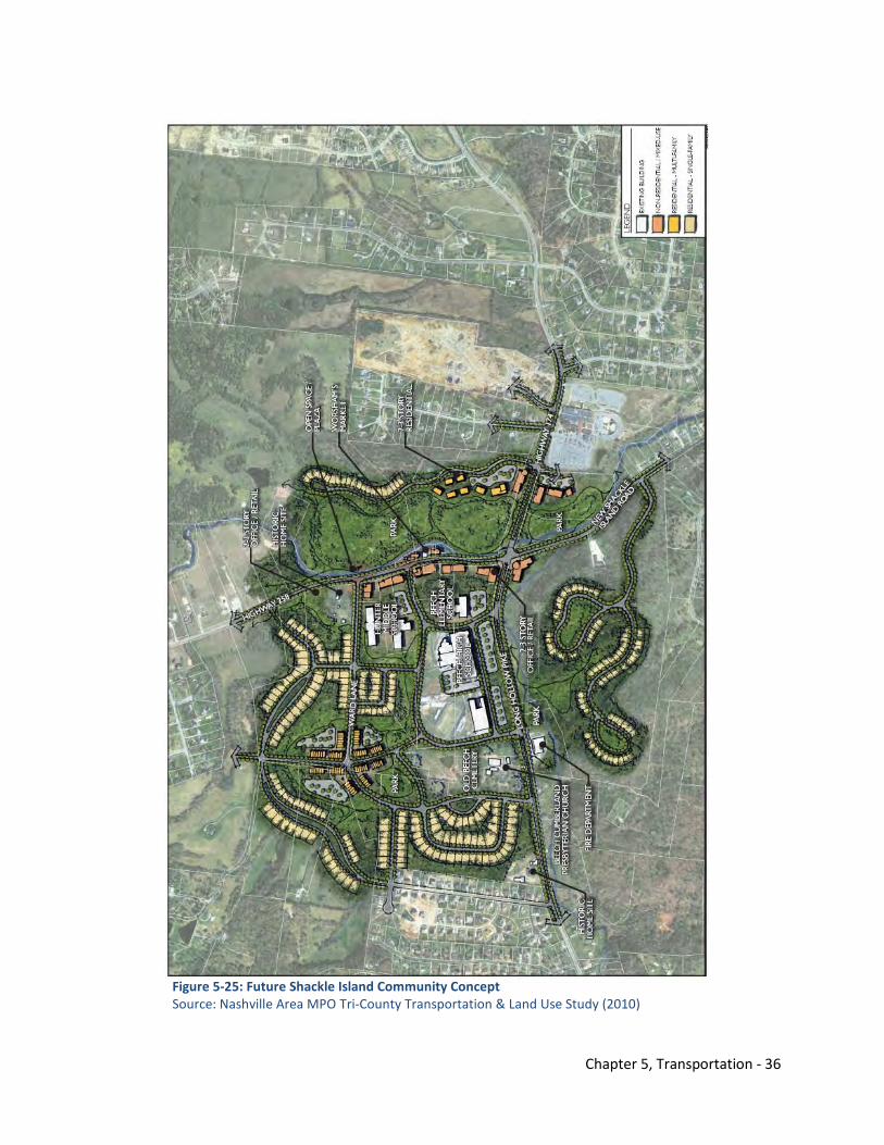
Chapter 5, Transportation - 36
Figure 5-25: Future Shackle Island Community Concept Source: Nashville Area MPO Tri-County Transportation & Land Use Study (2010)
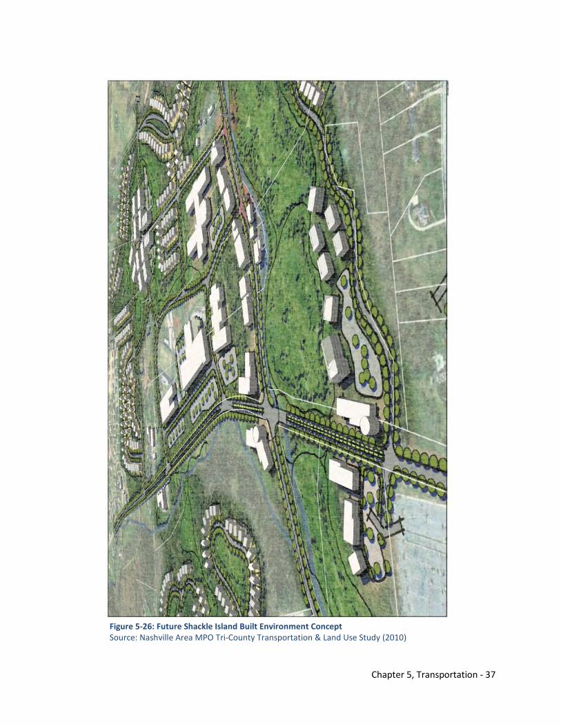
Chapter 5, Transportation - 37
Figure 5-26: Future Shackle Island Built Environment Concept Source: Nashville Area MPO Tri-County Transportation & Land Use Study (2010)
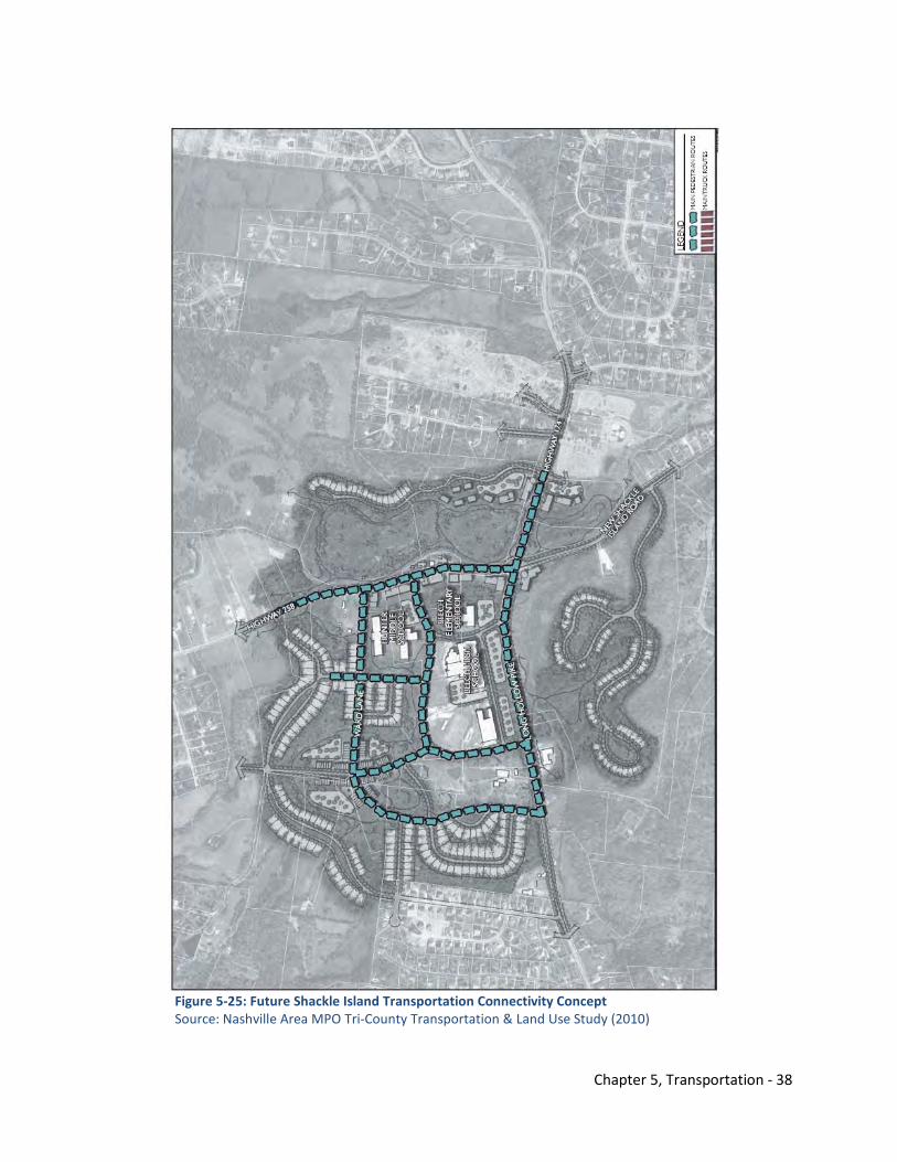
Chapter 5, Transportation - 38
Figure 5-25: Future Shackle Island Transportation Connectivity Concept Source: Nashville Area MPO Tri-County Transportation & Land Use Study (2010)
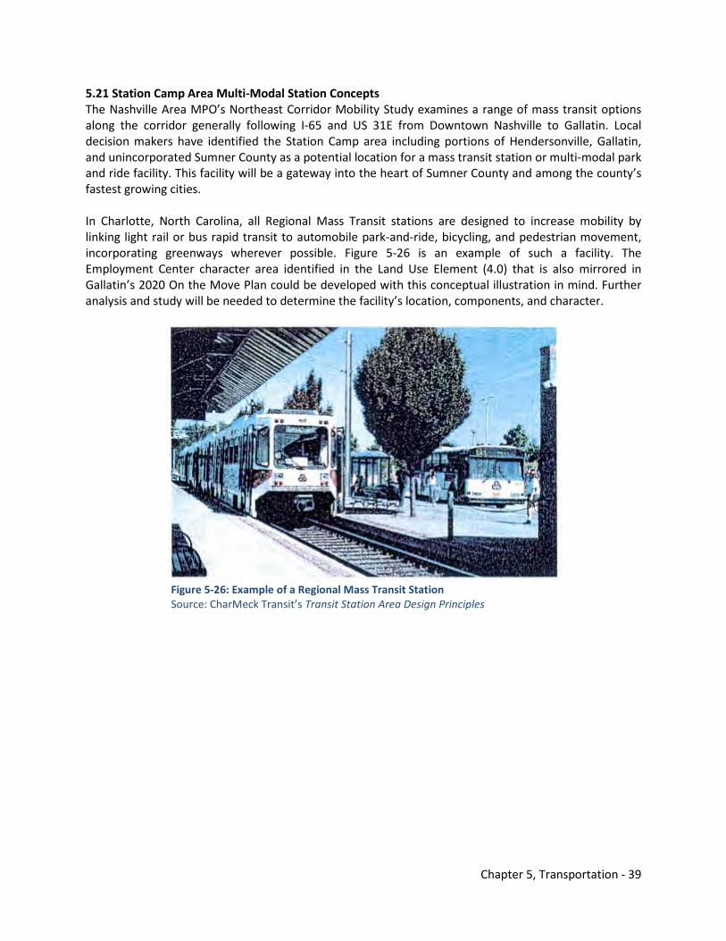
Chapter 5, Transportation - 39
5.21 Station Camp Area Multi-Modal Station Concepts The Nashville Area MPO’s Northeast Corridor Mobility Study examines a range of mass transit options along the corridor generally following I-65 and US 31E from Downtown Nashville to Gallatin. Local decision makers have identified the Station Camp area including portions of Hendersonville, Gallatin, and unincorporated Sumner County as a potential location for a mass transit station or multi-modal park and ride facility. This facility will be a gateway into the heart of Sumner County and among the county’s fastest growing cities. In Charlotte, North Carolina, all Regional Mass Transit stations are designed to increase mobility by linking light rail or bus rapid transit to automobile park-and-ride, bicycling, and pedestrian movement, incorporating greenways wherever possible. Figure 5-26 is an example of such a facility. The Employment Center character area identified in the Land Use Element (4.0) that is also mirrored in Gallatin’s 2020 On the Move Plan could be developed with this conceptual illustration in mind. Further analysis and study will be needed to determine the facility’s location, components, and character.
Figure 5-26: Example of a Regional Mass Transit Station Source: CharMeck Transit’s Transit Station Area Design Principles
Chapter 5, Transportation - 40
Transportation Element Endnotes 1National Complete Streets Coalition, Complete Streets FAQ Website -http://www.completestreets.org/. Accessed online on July 15, 2010.
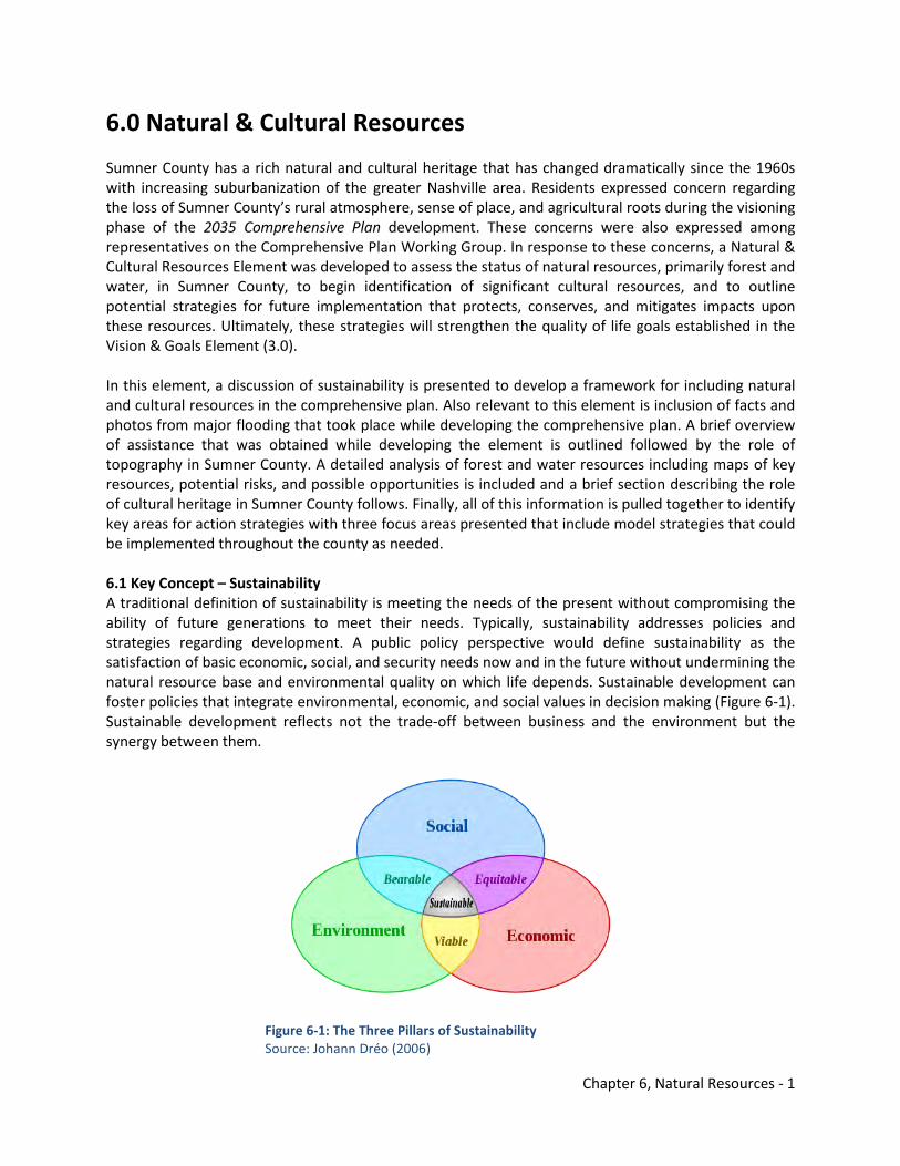
Chapter 6, Natural Resources - 1
6.0 Natural & Cultural Resources Sumner County has a rich natural and cultural heritage that has changed dramatically since the 1960s with increasing suburbanization of the greater Nashville area. Residents expressed concern regarding the loss of Sumner County’s rural atmosphere, sense of place, and agricultural roots during the visioning phase of the 2035 Comprehensive Plan development. These concerns were also expressed among representatives on the Comprehensive Plan Working Group. In response to these concerns, a Natural & Cultural Resources Element was developed to assess the status of natural resources, primarily forest and water, in Sumner County, to begin identification of significant cultural resources, and to outline potential strategies for future implementation that protects, conserves, and mitigates impacts upon these resources. Ultimately, these strategies will strengthen the quality of life goals established in the Vision & Goals Element (3.0). In this element, a discussion of sustainability is presented to develop a framework for including natural and cultural resources in the comprehensive plan. Also relevant to this element is inclusion of facts and photos from major flooding that took place while developing the comprehensive plan. A brief overview of assistance that was obtained while developing the element is outlined followed by the role of topography in Sumner County. A detailed analysis of forest and water resources including maps of key resources, potential risks, and possible opportunities is included and a brief section describing the role of cultural heritage in Sumner County follows. Finally, all of this information is pulled together to identify key areas for action strategies with three focus areas presented that include model strategies that could be implemented throughout the county as needed. 6.1 Key Concept – Sustainability A traditional definition of sustainability is meeting the needs of the present without compromising the ability of future generations to meet their needs. Typically, sustainability addresses policies and strategies regarding development. A public policy perspective would define sustainability as the satisfaction of basic economic, social, and security needs now and in the future without undermining the natural resource base and environmental quality on which life depends. Sustainable development can foster policies that integrate environmental, economic, and social values in decision making (Figure 6-1). Sustainable development reflects not the trade-off between business and the environment but the synergy between them.
Figure 6-1: The Three Pillars of Sustainability Source: Johann Dréo (2006)
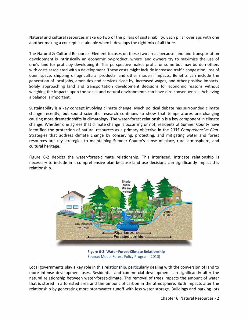
Chapter 6, Natural Resources - 2
Natural and cultural resources make up two of the pillars of sustainability. Each pillar overlaps with one another making a concept sustainable when it develops the right mix of all three. The Natural & Cultural Resources Element focuses on these two areas because land and transportation development is intrinsically an economic by-product, where land owners try to maximize the use of one’s land for profit by developing it. This perspective makes profit for some but may burden others with costs associated with a development. These costs might include increased traffic congestion, loss of open space, shipping of agricultural products, and other modern impacts. Benefits can include the generation of local jobs, amenities and services close by, increased wages, and other positive impacts. Solely approaching land and transportation development decisions for economic reasons without weighing the impacts upon the social and natural environments can have dire consequences. Achieving a balance is important. Sustainability is a key concept involving climate change. Much political debate has surrounded climate change recently, but sound scientific research continues to show that temperatures are changing causing more dramatic shifts in climatology. The water-forest relationship is a key component in climate change. Whether one agrees that climate change is occurring or not, residents of Sumner County have identified the protection of natural resources as a primary objective in the 2035 Comprehensive Plan. Strategies that address climate change by conserving, protecting, and mitigating water and forest resources are key strategies to maintaining Sumner County’s sense of place, rural atmosphere, and cultural heritage. Figure 6-2 depicts the water-forest-climate relationship. This interlaced, intricate relationship is necessary to include in a comprehensive plan because land use decisions can significantly impact this relationship.
Figure 6-2: Water-Forest-Climate Relationship Source: Model Forest Policy Program (2010)
Local governments play a key role in this relationship, particularly dealing with the conversion of land to more intense development uses. Residential and commercial development can significantly alter the natural relationship between water-forest-climate. The removal of trees impacts the amount of water that is stored in a forested area and the amount of carbon in the atmosphere. Both impacts alter the relationship by generating more stormwater runoff with less water storage. Buildings and parking lots
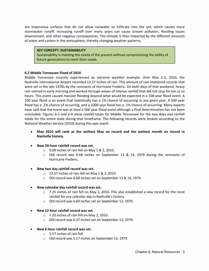
Chapter 6, Natural Resources - 3
are impervious surfaces that do not allow rainwater to infiltrate into the soil, which causes more stormwater runoff. Increasing runoff over many years can cause stream pollution, flooding issues downstream, and other negative consequences. The climate is then impacted by the different amounts of water and carbon in the atmosphere, thereby changing weather patterns. 6.2 Middle Tennessee Flood of 2010 Middle Tennessee recently experienced an extreme weather example. Over May 1-2, 2010, the Nashville International Airport recorded 13.57 inches of rain. This amount of rain shattered records that were set in the late 1970s by the remnants of Hurricane Frederic. On both days of that weekend, heavy rain started in early morning and worked through waves of intense rainfall that did not stop for ten or so hours. This event caused massive flooding beyond what would be expected in a 100-year flood event. A 100 year flood is an event that statistically has a 1% chance of occurring in any given year. A 500 year flood has a .2% chance of occurring, and a 1000 year flood has a .1% chance of occurring. Many experts have said that the event was at least a 500 year flood event although a final determination has not been concluded. Figures 6-3 and 6-4 show rainfall totals for Middle Tennessee for the two days and rainfall totals for the entire state during that timeframe. The following records were broken according to the National Weather Service (2010) during this epic event:
• May 2010 will rank as the wettest May on record and the wettest month on record in Nashville history.
• New 24-hour rainfall record was set. o 9.09 inches of rain fell on May 1 & 2, 2010. o Old record was 6.68 inches on September 13 & 14, 1979 during the remnants of
Hurricane Frederic.
• New two day rainfall record was set. o 13.57 inches of rain fell on May 1 & 2, 2010. o Old record was 6.68 inches set on September 13 & 14, 1979.
• New calendar day rainfall record was set.
o 7.25 inches of rain fell on May 2, 2010. This also established a new record for the most rainfall for any calendar day in Nashville's history.
o Old record was 6.60 inches set on September 13, 1979.
• New 12 hour rainfall record was set. o 7.20 inches of rain fell on May 2, 2010. o Old record was 6.37 inches set on September 13, 1979.
• New 6 hour rainfall record was set.
o 5.57 inches of rain fell. o Old record was 5.17 inches on September 13, 1979.
KEY CONCEPT: SUSTAINABILITY Sustainability is meeting the needs of the present without compromising the ability of future generations to meet their needs.
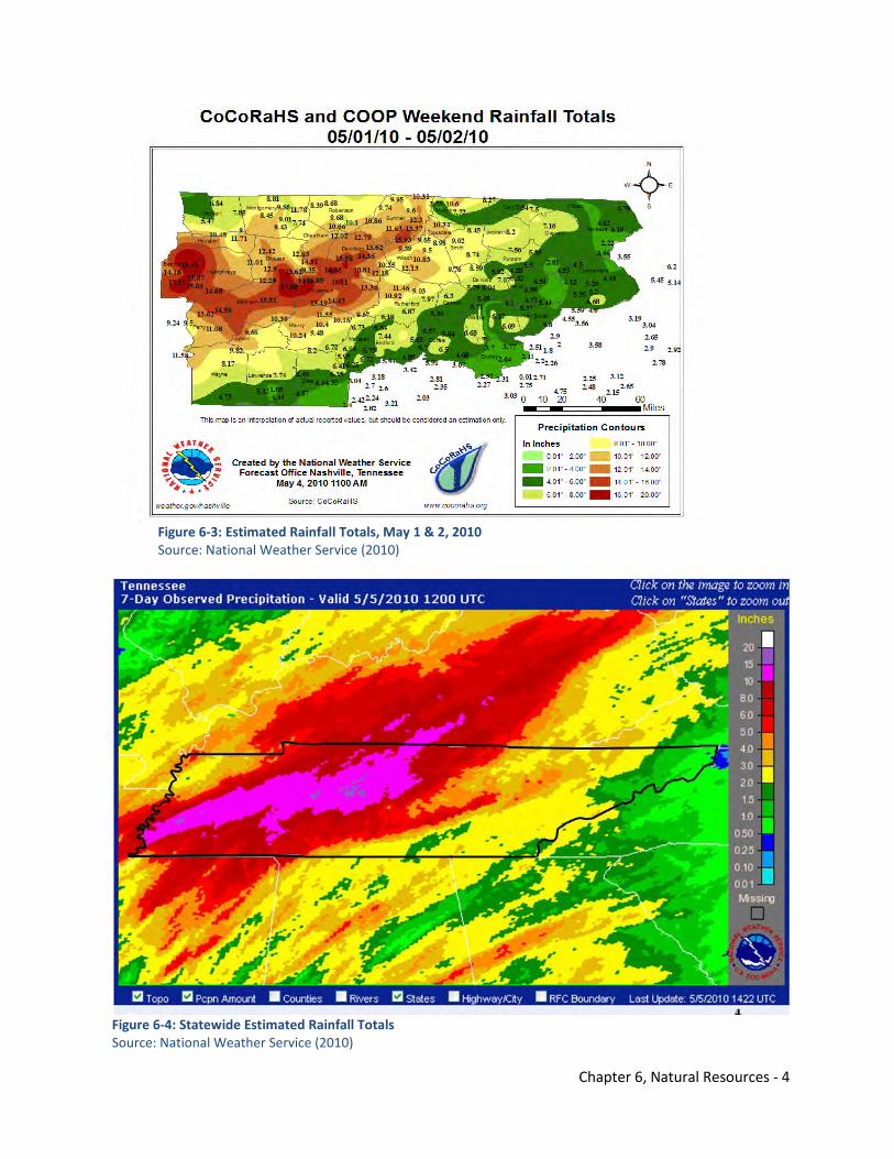
Chapter 6, Natural Resources - 4
Figure 6-3: Estimated Rainfall Totals, May 1 & 2, 2010 Source: National Weather Service (2010)
Figure 6-4: Statewide Estimated Rainfall Totals Source: National Weather Service (2010)
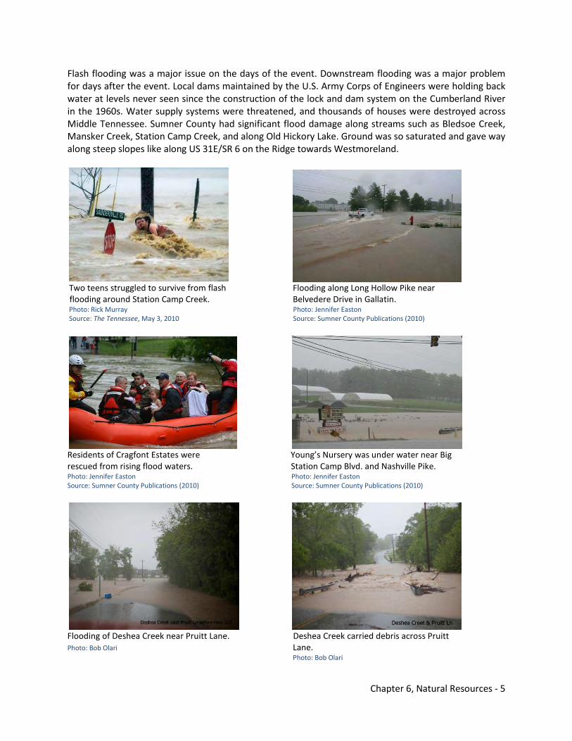
Chapter 6, Natural Resources - 5
Flash flooding was a major issue on the days of the event. Downstream flooding was a major problem for days after the event. Local dams maintained by the U.S. Army Corps of Engineers were holding back water at levels never seen since the construction of the lock and dam system on the Cumberland River in the 1960s. Water supply systems were threatened, and thousands of houses were destroyed across Middle Tennessee. Sumner County had significant flood damage along streams such as Bledsoe Creek, Mansker Creek, Station Camp Creek, and along Old Hickory Lake. Ground was so saturated and gave way along steep slopes like along US 31E/SR 6 on the Ridge towards Westmoreland.
Two teens struggled to survive from flash Flooding along Long Hollow Pike near flooding around Station Camp Creek. Belvedere Drive in Gallatin. Photo: Rick Murray Photo: Jennifer Easton Source: The Tennessee, May 3, 2010 Source: Sumner County Publications (2010)
Residents of Cragfont Estates were Young’s Nursery was under water near Big rescued from rising flood waters. Station Camp Blvd. and Nashville Pike. Photo: Jennifer Easton Photo: Jennifer Easton Source: Sumner County Publications (2010) Source: Sumner County Publications (2010)
Flooding of Deshea Creek near Pruitt Lane. Deshea Creek carried debris across Pruitt Photo: Bob Olari Lane. Photo: Bob Olari
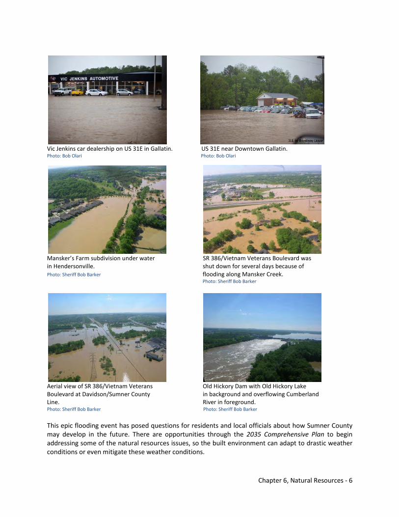
Chapter 6, Natural Resources - 6
Vic Jenkins car dealership on US 31E in Gallatin. US 31E near Downtown Gallatin. Photo: Bob Olari Photo: Bob Olari
Mansker’s Farm subdivision under water SR 386/Vietnam Veterans Boulevard was in Hendersonville. shut down for several days because of Photo: Sheriff Bob Barker flooding along Mansker Creek. Photo: Sheriff Bob Barker
Aerial view of SR 386/Vietnam Veterans Old Hickory Dam with Old Hickory Lake Boulevard at Davidson/Sumner County in background and overflowing Cumberland Line. River in foreground. Photo: Sheriff Bob Barker Photo: Sheriff Bob Barker This epic flooding event has posed questions for residents and local officials about how Sumner County may develop in the future. There are opportunities through the 2035 Comprehensive Plan to begin addressing some of the natural resources issues, so the built environment can adapt to drastic weather conditions or even mitigate these weather conditions.
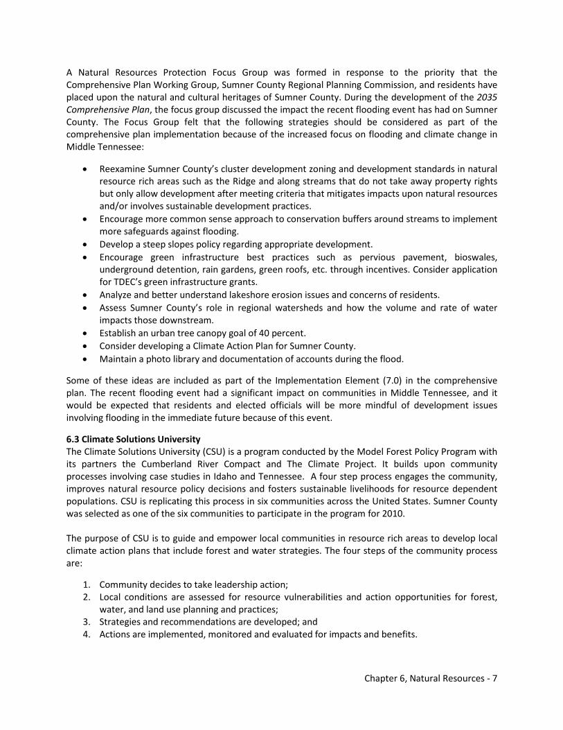
Chapter 6, Natural Resources - 7
A Natural Resources Protection Focus Group was formed in response to the priority that the Comprehensive Plan Working Group, Sumner County Regional Planning Commission, and residents have placed upon the natural and cultural heritages of Sumner County. During the development of the 2035 Comprehensive Plan, the focus group discussed the impact the recent flooding event has had on Sumner County. The Focus Group felt that the following strategies should be considered as part of the comprehensive plan implementation because of the increased focus on flooding and climate change in Middle Tennessee:
• Reexamine Sumner County’s cluster development zoning and development standards in natural resource rich areas such as the Ridge and along streams that do not take away property rights but only allow development after meeting criteria that mitigates impacts upon natural resources and/or involves sustainable development practices.
• Encourage more common sense approach to conservation buffers around streams to implement more safeguards against flooding.
• Develop a steep slopes policy regarding appropriate development. • Encourage green infrastructure best practices such as pervious pavement, bioswales,
underground detention, rain gardens, green roofs, etc. through incentives. Consider application for TDEC’s green infrastructure grants.
• Analyze and better understand lakeshore erosion issues and concerns of residents. • Assess Sumner County’s role in regional watersheds and how the volume and rate of water
impacts those downstream. • Establish an urban tree canopy goal of 40 percent. • Consider developing a Climate Action Plan for Sumner County. • Maintain a photo library and documentation of accounts during the flood.
Some of these ideas are included as part of the Implementation Element (7.0) in the comprehensive plan. The recent flooding event had a significant impact on communities in Middle Tennessee, and it would be expected that residents and elected officials will be more mindful of development issues involving flooding in the immediate future because of this event.
6.3 Climate Solutions University The Climate Solutions University (CSU) is a program conducted by the Model Forest Policy Program with its partners the Cumberland River Compact and The Climate Project. It builds upon community processes involving case studies in Idaho and Tennessee. A four step process engages the community, improves natural resource policy decisions and fosters sustainable livelihoods for resource dependent populations. CSU is replicating this process in six communities across the United States. Sumner County was selected as one of the six communities to participate in the program for 2010. The purpose of CSU is to guide and empower local communities in resource rich areas to develop local climate action plans that include forest and water strategies. The four steps of the community process are:
1. Community decides to take leadership action; 2. Local conditions are assessed for resource vulnerabilities and action opportunities for forest,
water, and land use planning and practices; 3. Strategies and recommendations are developed; and 4. Actions are implemented, monitored and evaluated for impacts and benefits.
Chapter 6, Natural Resources - 8
The Natural & Cultural Resources Element builds upon the methods of the CSU program. This work was very timely in assisting Sumner County with strategies to include in the comprehensive plan for adoption. With the adoption of the 2035 Comprehensive Plan, Sumner County will be ready to start step 4 and implement actions that are outlined in the Implementation Element (7.0).
6.4 Sumner County’s Topography The State of Tennessee, because of varying geographic differences, has been divided into three sections or physiographic provinces. These large surface divisions by title are the Appalachians, the Central Highlands, and the Mississippi Plain and Plateau and are generally referred to as East, Middle, and West Tennessee, respectively (Figure 6-5). Sumner County lies within the Central Highlands Province, and is further divided into two major regions. A sharply defined ridge line, which is in fact the transition escarpment between the Central Basin and the Highland Rim, divides the county roughly in half. The two regions and the Ridge are the result of millions of years of erosion by running water acting upon a rocky bulge in the earth’s surface historically called the Nashville Dome. The Central Basin This portion of the county varies in elevation from approximately 450 feet above sea level along the banks of the Cumberland River to areas of rolling hills of approximately 600 feet above sea level. While this area is mostly level to rolling with slopes under 12 percent, some isolated hills and knobs may exceed 12 percent. The Highland Rim This hilly upland region occurs throughout the northern half of Sumner County. It is characterized by rolling plains and open hills with roughly 80 percent of the area having slopes less than 12 percent. The elevation averages about 850-900 feet above sea level. The Ridge The Ridge as it is known locally is not really a separate province or region, but due to the significance of the landforms it deserves separate attention. The Ridge itself extends from the southwestern part of the county to the northeast in a gentle arc. It consists of hilltops, steep-walled valleys, and dissected ridges and is a result of the mature stage of dissection of the low limestone plateau by stream erosion. At the base of the Ridge, elevations average about 600 feet above sea level while the hilltops will range from 850 to 950 and in some cases over 1,000 feet above sea level. Slopes in this area will vary from 20 to 30 percent to as much as 50 to 60 percent. This area presents severe limitation to any kind of development. Characteristic landforms of this region are the ridges and valleys formed by centuries of erosion. Woven between the intricate drainage patterns are many narrow, steep-walled valleys with great varieties of wildflowers and vegetation, outstanding landforms, and abundant wildlife. These elements of the ecosystem, coupled with the man-made agricultural resources of the fertile valley floors make this region worthy for strong conservation and preservation policies.
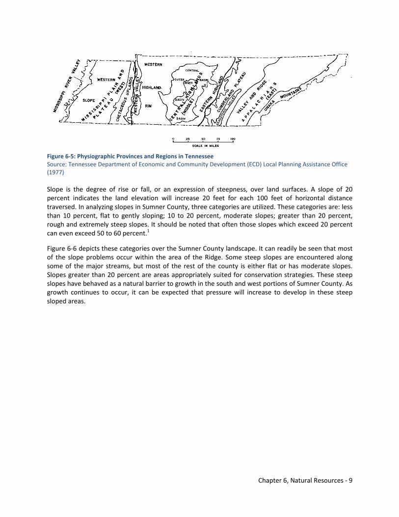
Chapter 6, Natural Resources - 9
Figure 6-5: Physiographic Provinces and Regions in Tennessee Source: Tennessee Department of Economic and Community Development (ECD) Local Planning Assistance Office (1977) Slope is the degree of rise or fall, or an expression of steepness, over land surfaces. A slope of 20 percent indicates the land elevation will increase 20 feet for each 100 feet of horizontal distance traversed. In analyzing slopes in Sumner County, three categories are utilized. These categories are: less than 10 percent, flat to gently sloping; 10 to 20 percent, moderate slopes; greater than 20 percent, rough and extremely steep slopes. It should be noted that often those slopes which exceed 20 percent can even exceed 50 to 60 percent.1
Figure 6-6 depicts these categories over the Sumner County landscape. It can readily be seen that most of the slope problems occur within the area of the Ridge. Some steep slopes are encountered along some of the major streams, but most of the rest of the county is either flat or has moderate slopes. Slopes greater than 20 percent are areas appropriately suited for conservation strategies. These steep slopes have behaved as a natural barrier to growth in the south and west portions of Sumner County. As growth continues to occur, it can be expected that pressure will increase to develop in these steep sloped areas.
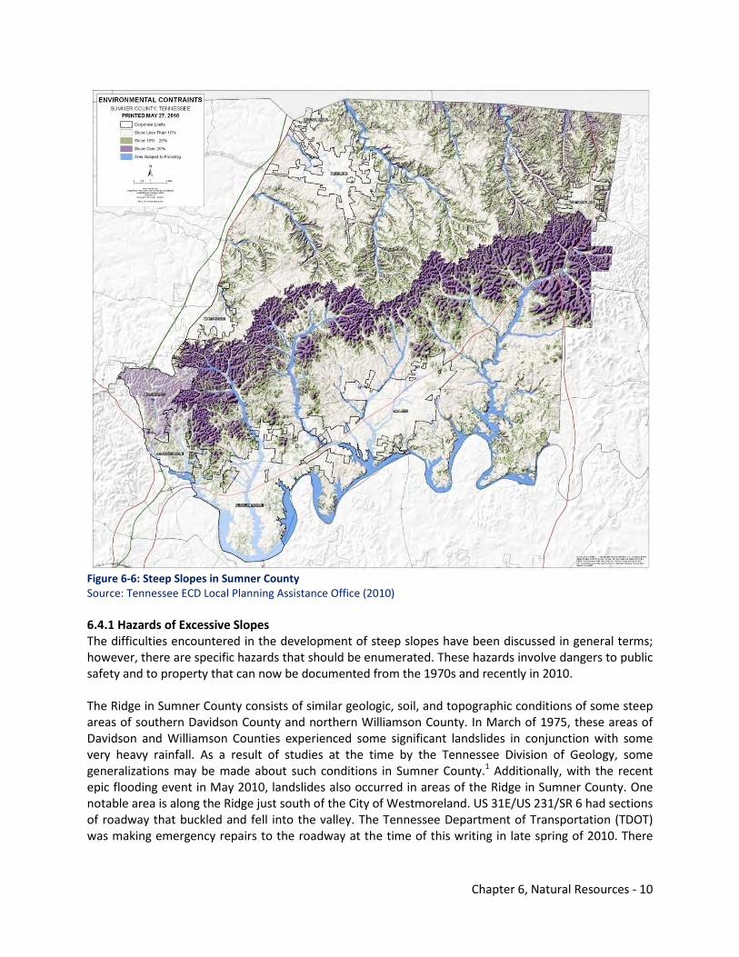
Chapter 6, Natural Resources - 10
Figure 6-6: Steep Slopes in Sumner County Source: Tennessee ECD Local Planning Assistance Office (2010) 6.4.1 Hazards of Excessive Slopes The difficulties encountered in the development of steep slopes have been discussed in general terms; however, there are specific hazards that should be enumerated. These hazards involve dangers to public safety and to property that can now be documented from the 1970s and recently in 2010. The Ridge in Sumner County consists of similar geologic, soil, and topographic conditions of some steep areas of southern Davidson County and northern Williamson County. In March of 1975, these areas of Davidson and Williamson Counties experienced some significant landslides in conjunction with some very heavy rainfall. As a result of studies at the time by the Tennessee Division of Geology, some generalizations may be made about such conditions in Sumner County.1 Additionally, with the recent epic flooding event in May 2010, landslides also occurred in areas of the Ridge in Sumner County. One notable area is along the Ridge just south of the City of Westmoreland. US 31E/US 231/SR 6 had sections of roadway that buckled and fell into the valley. The Tennessee Department of Transportation (TDOT) was making emergency repairs to the roadway at the time of this writing in late spring of 2010. There
Chapter 6, Natural Resources - 11
were also numerous documented cases in the Middle Tennessee region where foundations were shifted and portions of houses collapse because of landslides during the epic rain event. The landslides of 1975 took place when land development was permitted to intrude on steep slopes. Left undisturbed, the movement of the slopes would have not been noticed, but with the construction of roads and houses and the removal of natural cover, the slides were intensified and private property was affected. The slides themselves occurred upon a substance known as colluviums. This is a general term applied to any loose, heterogeneous, and incoherent mass of soil and rock fragments deposited chiefly by gravity, usually at the base of a steep slope or cliff. The colluvial material was derived principally from the weathering and erosion of the geological formation known as the Fort Payne Formation. As the Highland Rim escarpment has retreated outward from the Central Basin, remnant hills and ridges remain. The same Fort Payne rocks capping the Highland Rim also cap these remnants. It is the siliceous debris supplied by these rocks that comprises the bulk of the colluviums both along the escarpment and around the outlying hills and ridges. The colluvium forms wedges and collars of weak, unconsolidated material with its upper limit normally at the break in the slope of the hillsides. Slump is the principal type of movement that has occurred in the landslide area. This is an earth movement characterized by shearing and rotary movement of a generally independent mass of rock or earth along a curved slip surface and about an axis parallel to the slope from which it descends and by backward tilting of the mass with respect to that slope. The curved surface of the movement is concave upward. 6.4.2 Causes of Movement The material involved in the slides within the area studied in 1975 moves naturally in the form of soil creep. To most people, the amount of movement is imperceptible, being only a few millimeters to centimeters annually. The distinct, abrupt movement involved in slumping was due principally to two factors. These were slope alterations by various means and excess water due to near record rainfall levels. In almost every case of landslide occurrence, the slopes had been altered by construction in relation to residential development. This alteration was in one or a combination of three methods:
1. steepening of the entire slope; 2. notching above the toe of the wedge of colluviums; and/or 3. removal of the toe.
Steepening here refers to increasing the slope angle beyond the critical slope or angle of repose. This is defined as the local maximum slope inclination that the soil and rock materials underlying the slope can support without failure under existing elements, vegetation, and land use.
The slides described above occurred during March 11-13, 1975. Although some of the slides caused no damage to structures, many resulted in damage ranging from minor cracking of retaining walls and driveways to failure of dwelling foundations and major damage to walls and other structures.1 Similar to 1975, the recent flooding event on May 1-2, 2010, caused similar damage throughout the Middle Tennessee region. Hazards of this nature will continue to happen as long as development continues to occur along steep slopes where conservation strategies are most appropriate.
Chapter 6, Natural Resources - 12
These basic conservation strategies were detailed in a 1977 Land Use Plan for Sumner County:
1. Prohibit massive removal of natural vegetation. 2. Prohibit the steepening of slopes. 3. Limit development to very low densities.
Action strategies are outlined in the Implementation Element (7.0) addressing these issues.
6.5 Forest Assessment of Sumner County A forest assessment of Sumner County was conducted for the CSU curriculum. The purpose of the forest assessment is to fully understand the history of forest resources in Sumner County, its current health and status, areas that are threatened, governance structure involving forests, and possible strategies that are apparent based upon review of this information. CSU faculty assisted Sumner County and the Natural Resources Protection Focus Group in pulling together this information and assessing forest resources. The Tennessee Department of Agriculture (TDA) Division of Forestry was especially helpful in gathering qualitative information for the forest assessment. 6.5.1 Original Forest Conditions Most of Sumner County was forested originally. Species included oaks, chestnut, hickory, poplar (primarily in coves), sugar maple, beech, and many others. The age and size of most of the trees in this forest were greater than today. Size was greater because of the greater age and the soils were rich and not depleted by agriculture. It was not all “old growth”. Scattered patches of younger forest were situated where there were storms and/or a killing fire. Canopies in most areas were more varied and open than today, and vertical diversity (multiple canopy layers) was greater. The amount of standing and down dead wood was also greater than today. Mast yields were far greater due to the presence of chestnuts. The forb layer (ground level) was often thicker and more palatable to wildlife because of frequent fires. Fire also created more hollow trees. Forest types included chestnut-oak-hickory on ridge and other dry sites, mixed mesophytic (cool, moist upland forest) in coves and small valleys, late successional beech-maple forest in areas that had long escaped disturbance, cedar-oak forest on dry rocky sites, and sycamore-elm-ash-cottonwood forest on wet ground near the Cumberland River. Extensive beech forest was reported on what is now good farmland in Ohio, Kentucky, and northern Tennessee. Flat land, especially in northern Sumner County, was at times occupied by prairie, savannah, and brushy areas propagated by Indian-set fires. The extent of this open cover type was variable depending on climate, weather, and human population. These areas of natural prairie and savannah no longer exist today. 6.5.2 Current Stands & Health Status Forest stands in Sumner County are predominantly even-aged in the overstory. Most land in Middle Tennessee was cleared and grazed for pasture in the 1800s and early 1900s. Starting with the Great Depression, poverty, overpopulation in farm areas, and depletion of soil drove large numbers of subsistence farmers off the land. Forest grew up on these lands, but rampant setting of fires continued for agricultural and other purposes giving a competitive advantage to oak. This is the reason oak is so common in the overstory now. These stands are still biologically “young”, with low quantities of dead snags and down trees. Now, understories are developing a lot of sugar maple, hickory, beech, black gum, and other shade-tolerant species, especially on moister sites. These will eventually dominate the
Chapter 6, Natural Resources - 13
overstories as the oaks die, unless the stand is disturbed sufficiently to allow oak and yellow poplar to regenerate and grow to maturity. Valuable hardwood timber is tall, straight, and free of defects (limbs, decay, and cracks) and is of commercially desirable species, especially oak, poplar, and walnut. These species grow only in direct sunlight and do not tolerate shade when they are out of the seedling stage. They grow at a faster rate than shade-tolerant species like maple and hickory. Maple is a valuable wood, but maple trees grow slowly and are usually limby, which ruins quality. Quality is important in hardwood timber production. Timber volume and quality increased for several decades in the Middle Tennessee region following the Great Depression due largely to early use of fire then later the exclusion of fire. Fire strongly favors oak regeneration, but it later damages the maturing trees and opens them up to decay. Fire control and exclusion have slowly lowered the incidence of hollow logs over the last 60 years. Now, with fire no longer a factor, oak regeneration has plummeted, and forests are dominated by more shade-tolerant species, especially in the understory. These trees will dominate the stand in Sumner County in the future. So called “selective” logging has degraded timber quality over the last few decades. “Selective” logging in Mid-South hardwood forests has repeatedly removed the highest-grade, most profitable trees and left the “junk.” This system is the most profitable for the logger and the landowner in the short term, but it leaves little resources for the future. Also when forests are harvested this way, insufficient light reaches the ground to regenerate oak, poplar, and other desirable timber species. Some forests in Middle Tennessee are now composed of poorly-formed specimens of less-desired timber species, and some stands have no oak left at all. Hardwood timber is usually harvested when trees reach at least 14 inches (often 16 inches) in diameter (This minimum used to be higher). An oak reaches this size on a typical site in about 60 to 80 years. The current rate of harvest statewide in Tennessee is about half of total growth. This means that the trees are bigger, but this wood volume accumulates on poorer grade timber because the best logs have been removed. The less desirable logs are left. Timber volume for Sumner County is not accurately known, but as a general guideline, most 60-80 year old stands have volumes typically averaging 3,500 BF per acre. A good stand of oak and/or poplar can have 6,000-10,000 BF per acre, which is rare. Higher volumes are sometimes found in poplar stands, but this is rare, too. Forest health in terms of timber growing is good with some exceptions. Native endemic insects are always a factor, but they seldom reach a point of concern. However, there are several major threats from invasive exotic pests:
• The emerald ash borer will soon exterminate ash in Tennessee. It is found in Kentucky and is moving rapidly south. There is no defense against it.
• The gypsy moth completely infested the northeast as far as southwest Virginia. The Federal/State “slow the spread” campaign slowed the advance considerably and currently quashes all new infestations brought into the state on vehicles, but eventually the pest will infest all of the state’s forests. Estimated time of arrival is in excess of 30 years in the future if
Chapter 6, Natural Resources - 14
present efforts continue. Gypsy moth defoliates trees, especially oaks, and especially white oak. Repeated defoliation can kill trees, especially mature trees under stress already on dry ridges.
• Other pests include beech bark complex, butternut canker, hemlock wooly adelgid. New pests will be introduced such as the Asian long horn beetle, which has the potential to devastate local forests. It is currently found around New York and a few other cities in the Northeast.
• Tree of heaven (Ailanthus altissima) has been in Tennessee since the late 1800s and is slowly spreading from cities and home sites into the forest. It spreads vigorously by windblown seed and root sprouting. It can dominate disturbed areas indefinitely by outgrowing poplar. Sites are very difficult to reclaim.
• Bush (Amur) honeysuckle is a serious understory competitor on more moist sites. It is allelopathic (kills the seedling under it), casts dense shade, and takes over the best timber growing and wildflower sites.
• Cogon grass has almost reached Tennessee. It will be the most devastating pest yet. • Studies have shown that acid rain does not affect forest growth significantly in the Middle
Tennessee region. • As hardwoods reach the end of their genetically programmed lives, their resistance to storms,
insects, and disease decrease. This is a natural part of forest ecology and does not indicate some other health problem.
Fragmentation of forest ownership (smaller wooded lots) also affects timber resources. Timber volume is often insufficient on small tracts to make harvesting profitable to the logger.
Steep slopes and shallow soils make many slopes inoperable. This is apparent in Sumner County. Timber harvest using wheeled or tracked skidders is not advised on slopes exceeding 40 percent. Cable logging systems as used in the Northwest are too expensive to utilize in Middle Tennessee. Sulphura soils are prominent in this area and are characterized by steepness, shallowness, and a tendency to ravel if disturbed. An area of unincorporated Sumner County along Dobbins Pike bears the same name as the soil. They have low productivity and should be left alone.
Forest health should not be evaluated strictly on timber growing. Health must also consider forest wildlife. Forest game species, specifically deer and turkey, have staged a spectacular comeback and are now quite plentiful, but declining hard mast production in the future is a concern. Forests in Middle Tennessee are often sub-optimal for non-game wildlife. Canopies are generally too closed for most songbirds; understory layering is often lacking; and the quality of large snags and large organic debris on the forest floor are almost always sub-optimal. Leaving the forest “as is” will correct this as the forest becomes more ecologically mature. Intensive timber management can be antithetic to non-game species (such as box turtles, salamanders, white footed mouse, shrews, snakes, squirrels, insects, etc.). Innovative timber management integrated with wildlife needs can improve the situation, including crop trees release, small group selection harvesting, deadening of snag trees, and leaving tops after logging.
Biomass harvesting of trees offers both opportunities and concerns. If done appropriately, it can benefit the future timber supply, but there is concern that removal of woody materials will harm habitats for non-game wildlife.
Forest fragmentation is a serious threat to non-game forest wildlife. Roads, clearing, and construction destroy habitats and hinder movement. Forest interior songbirds require hundreds or thousands of acres of contiguous habitat, and some species do not do well near human activity.
Forest within 100 feet of streams is very important for all wildlife, especially songbirds and amphibians.
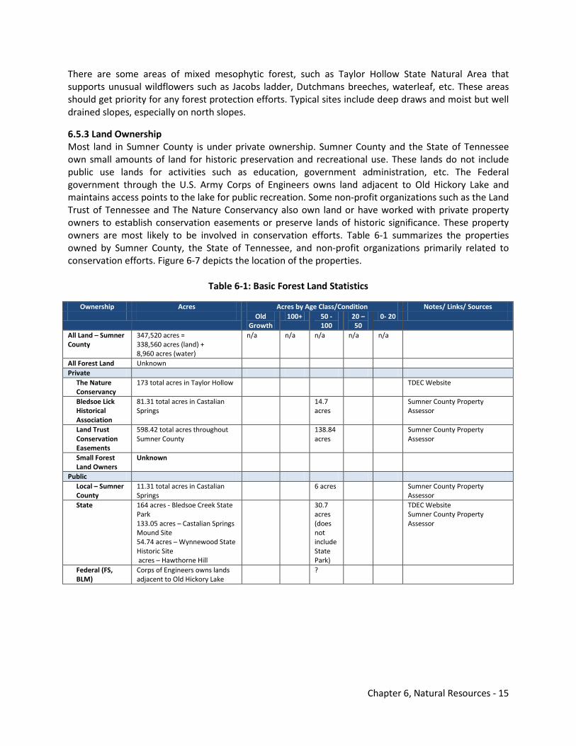
Chapter 6, Natural Resources - 15
There are some areas of mixed mesophytic forest, such as Taylor Hollow State Natural Area that supports unusual wildflowers such as Jacobs ladder, Dutchmans breeches, waterleaf, etc. These areas should get priority for any forest protection efforts. Typical sites include deep draws and moist but well drained slopes, especially on north slopes.
6.5.3 Land Ownership Most land in Sumner County is under private ownership. Sumner County and the State of Tennessee own small amounts of land for historic preservation and recreational use. These lands do not include public use lands for activities such as education, government administration, etc. The Federal government through the U.S. Army Corps of Engineers owns land adjacent to Old Hickory Lake and maintains access points to the lake for public recreation. Some non-profit organizations such as the Land Trust of Tennessee and The Nature Conservancy also own land or have worked with private property owners to establish conservation easements or preserve lands of historic significance. These property owners are most likely to be involved in conservation efforts. Table 6-1 summarizes the properties owned by Sumner County, the State of Tennessee, and non-profit organizations primarily related to conservation efforts. Figure 6-7 depicts the location of the properties.
Table 6-1: Basic Forest Land Statistics
Ownership Acres Acres by Age Class/Condition Notes/ Links/ Sources Old
Growth 100+ 50 -
100 20 – 50
0- 20
All Land – Sumner County
347,520 acres = 338,560 acres (land) + 8,960 acres (water)
n/a n/a n/a n/a n/a
All Forest Land Unknown Private
The Nature Conservancy
173 total acres in Taylor Hollow TDEC Website
Bledsoe Lick Historical Association
81.31 total acres in Castalian Springs
14.7 acres
Sumner County Property Assessor
Land Trust Conservation Easements
598.42 total acres throughout Sumner County
138.84 acres
Sumner County Property Assessor
Small Forest Land Owners
Unknown
Public Local – Sumner County
11.31 total acres in Castalian Springs
6 acres Sumner County Property Assessor
State 164 acres - Bledsoe Creek State Park 133.05 acres – Castalian Springs Mound Site 54.74 acres – Wynnewood State Historic Site acres – Hawthorne Hill
30.7 acres (does not include State Park)
TDEC Website Sumner County Property Assessor
Federal (FS, BLM)
Corps of Engineers owns lands adjacent to Old Hickory Lake
?
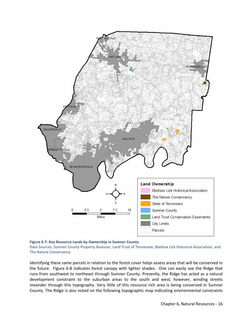
Chapter 6, Natural Resources - 16
Figure 6-7: Key Resource Lands by Ownership in Sumner County Data Sources: Sumner County Property Assessor, Land Trust of Tennessee, Bledsoe Lick Historical Association, and The Nature Conservancy Identifying these same parcels in relation to the forest cover helps assess areas that will be conserved in the future. Figure 6-8 indicates forest canopy with lighter shades. One can easily see the Ridge that runs from southwest to northeast through Sumner County. Presently, the Ridge has acted as a natural development constraint to the suburban areas to the south and west; however, winding streets meander through this topography. Very little of this resource rich area is being conserved in Sumner County. The Ridge is also noted on the following topographic map indicating environmental constraints
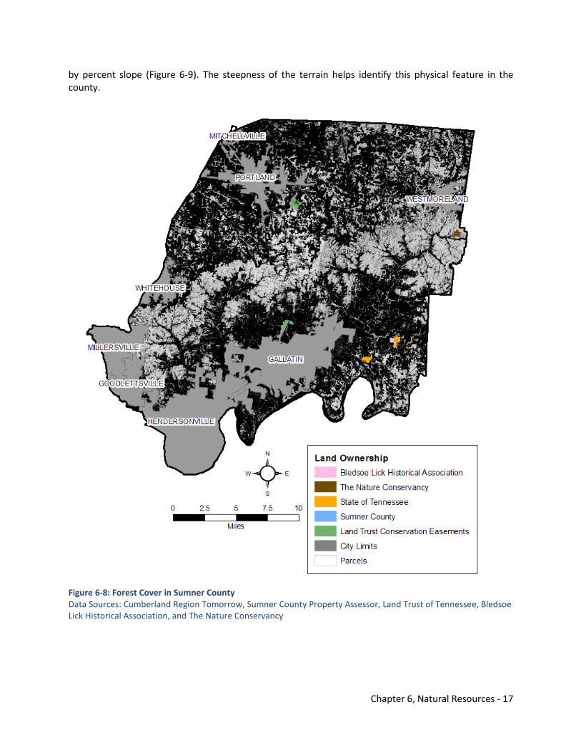
Chapter 6, Natural Resources - 17
by percent slope (Figure 6-9). The steepness of the terrain helps identify this physical feature in the county.
Figure 6-8: Forest Cover in Sumner County Data Sources: Cumberland Region Tomorrow, Sumner County Property Assessor, Land Trust of Tennessee, Bledsoe Lick Historical Association, and The Nature Conservancy
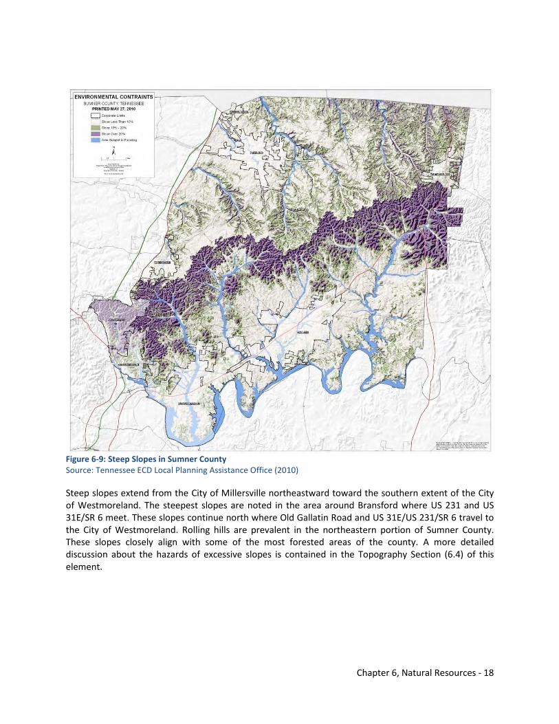
Chapter 6, Natural Resources - 18
Figure 6-9: Steep Slopes in Sumner County Source: Tennessee ECD Local Planning Assistance Office (2010) Steep slopes extend from the City of Millersville northeastward toward the southern extent of the City of Westmoreland. The steepest slopes are noted in the area around Bransford where US 231 and US 31E/SR 6 meet. These slopes continue north where Old Gallatin Road and US 31E/US 231/SR 6 travel to the City of Westmoreland. Rolling hills are prevalent in the northeastern portion of Sumner County. These slopes closely align with some of the most forested areas of the county. A more detailed discussion about the hazards of excessive slopes is contained in the Topography Section (6.4) of this element.
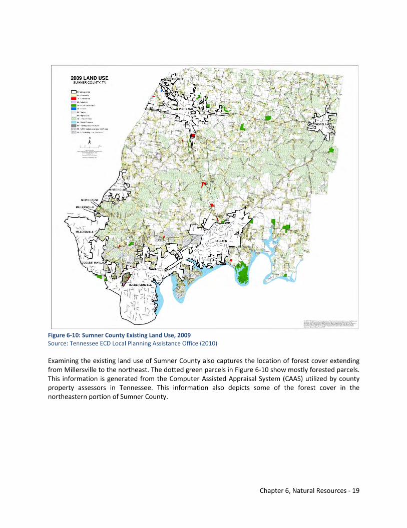
Chapter 6, Natural Resources - 19
Figure 6-10: Sumner County Existing Land Use, 2009 Source: Tennessee ECD Local Planning Assistance Office (2010) Examining the existing land use of Sumner County also captures the location of forest cover extending from Millersville to the northeast. The dotted green parcels in Figure 6-10 show mostly forested parcels. This information is generated from the Computer Assisted Appraisal System (CAAS) utilized by county property assessors in Tennessee. This information also depicts some of the forest cover in the northeastern portion of Sumner County.
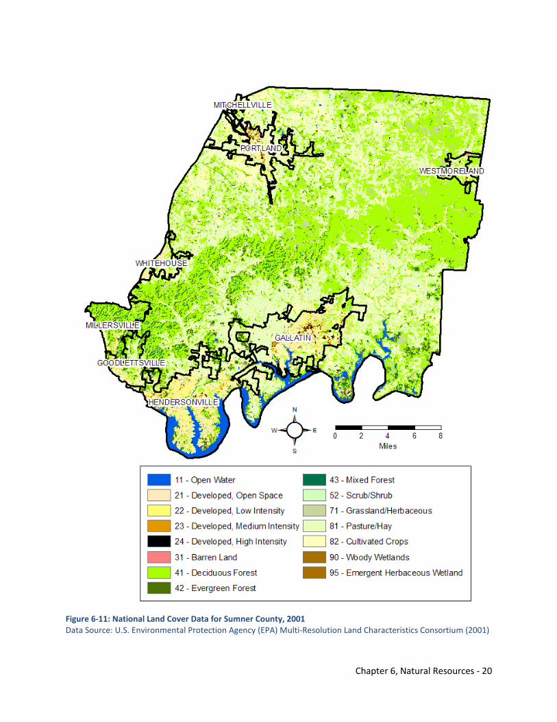
Chapter 6, Natural Resources - 20
Figure 6-11: National Land Cover Data for Sumner County, 2001 Data Source: U.S. Environmental Protection Agency (EPA) Multi-Resolution Land Characteristics Consortium (2001)
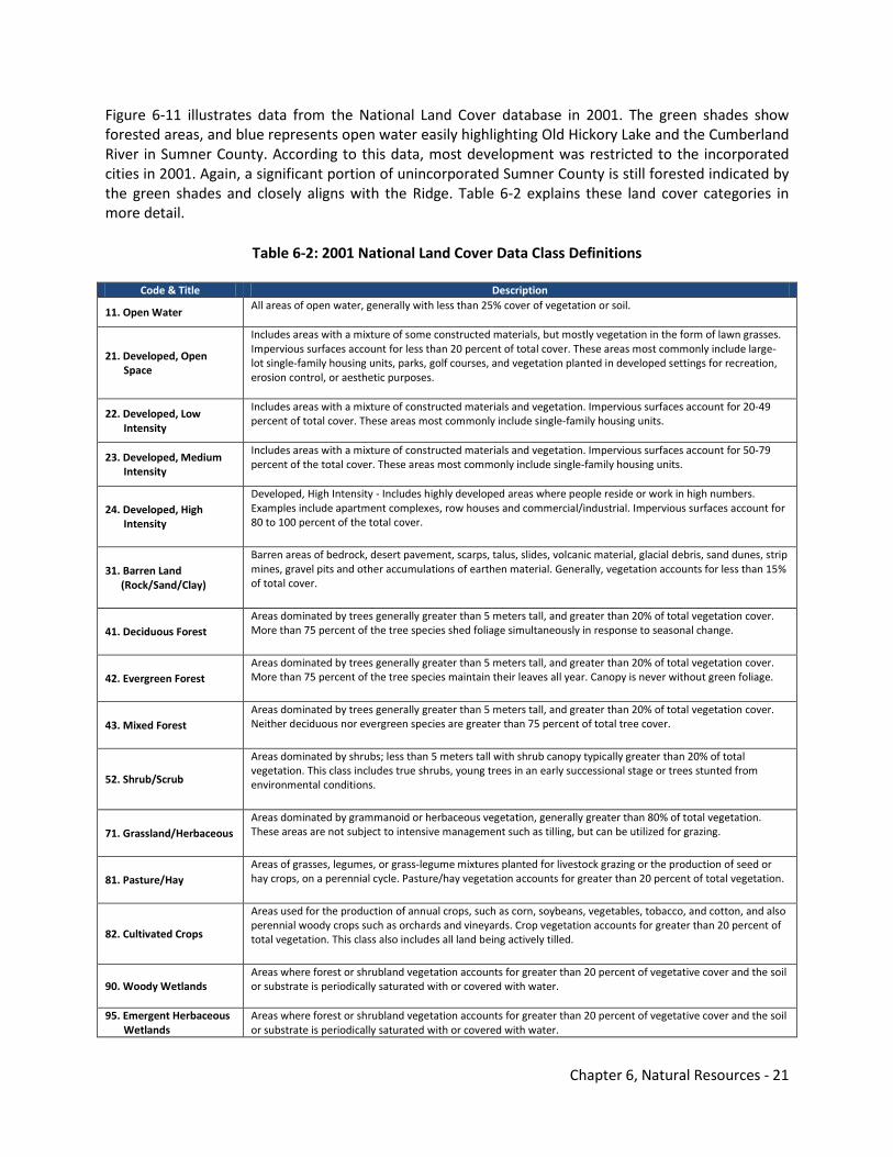
Chapter 6, Natural Resources - 21
Figure 6-11 illustrates data from the National Land Cover database in 2001. The green shades show forested areas, and blue represents open water easily highlighting Old Hickory Lake and the Cumberland River in Sumner County. According to this data, most development was restricted to the incorporated cities in 2001. Again, a significant portion of unincorporated Sumner County is still forested indicated by the green shades and closely aligns with the Ridge. Table 6-2 explains these land cover categories in more detail.
Table 6-2: 2001 National Land Cover Data Class Definitions
Code & Title Description
11. Open Water All areas of open water, generally with less than 25% cover of vegetation or soil.
21. Developed, Open Space
Includes areas with a mixture of some constructed materials, but mostly vegetation in the form of lawn grasses. Impervious surfaces account for less than 20 percent of total cover. These areas most commonly include large-lot single-family housing units, parks, golf courses, and vegetation planted in developed settings for recreation, erosion control, or aesthetic purposes.
22. Developed, Low Intensity
Includes areas with a mixture of constructed materials and vegetation. Impervious surfaces account for 20-49 percent of total cover. These areas most commonly include single-family housing units.
23. Developed, Medium Intensity
Includes areas with a mixture of constructed materials and vegetation. Impervious surfaces account for 50-79 percent of the total cover. These areas most commonly include single-family housing units.
24. Developed, High Intensity
Developed, High Intensity - Includes highly developed areas where people reside or work in high numbers. Examples include apartment complexes, row houses and commercial/industrial. Impervious surfaces account for 80 to 100 percent of the total cover.
31. Barren Land (Rock/Sand/Clay)
Barren areas of bedrock, desert pavement, scarps, talus, slides, volcanic material, glacial debris, sand dunes, strip mines, gravel pits and other accumulations of earthen material. Generally, vegetation accounts for less than 15% of total cover.
41. Deciduous Forest Areas dominated by trees generally greater than 5 meters tall, and greater than 20% of total vegetation cover. More than 75 percent of the tree species shed foliage simultaneously in response to seasonal change.
42. Evergreen Forest Areas dominated by trees generally greater than 5 meters tall, and greater than 20% of total vegetation cover. More than 75 percent of the tree species maintain their leaves all year. Canopy is never without green foliage.
43. Mixed Forest Areas dominated by trees generally greater than 5 meters tall, and greater than 20% of total vegetation cover. Neither deciduous nor evergreen species are greater than 75 percent of total tree cover.
52. Shrub/Scrub
Areas dominated by shrubs; less than 5 meters tall with shrub canopy typically greater than 20% of total vegetation. This class includes true shrubs, young trees in an early successional stage or trees stunted from environmental conditions.
71. Grassland/Herbaceous Areas dominated by grammanoid or herbaceous vegetation, generally greater than 80% of total vegetation. These areas are not subject to intensive management such as tilling, but can be utilized for grazing.
81. Pasture/Hay Areas of grasses, legumes, or grass-legume mixtures planted for livestock grazing or the production of seed or hay crops, on a perennial cycle. Pasture/hay vegetation accounts for greater than 20 percent of total vegetation.
82. Cultivated Crops
Areas used for the production of annual crops, such as corn, soybeans, vegetables, tobacco, and cotton, and also perennial woody crops such as orchards and vineyards. Crop vegetation accounts for greater than 20 percent of total vegetation. This class also includes all land being actively tilled.
90. Woody Wetlands Areas where forest or shrubland vegetation accounts for greater than 20 percent of vegetative cover and the soil or substrate is periodically saturated with or covered with water.
95. Emergent Herbaceous Wetlands
Areas where forest or shrubland vegetation accounts for greater than 20 percent of vegetative cover and the soil or substrate is periodically saturated with or covered with water.
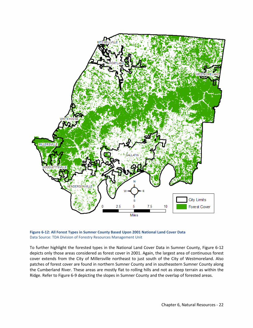
Chapter 6, Natural Resources - 22
Figure 6-12: All Forest Types in Sumner County Based Upon 2001 National Land Cover Data Data Source: TDA Division of Forestry Resources Management Unit To further highlight the forested types in the National Land Cover Data in Sumner County, Figure 6-12 depicts only those areas considered as forest cover in 2001. Again, the largest area of continuous forest cover extends from the City of Millersville northeast to just south of the City of Westmoreland. Also patches of forest cover are found in northern Sumner County and in southeastern Sumner County along the Cumberland River. These areas are mostly flat to rolling hills and not as steep terrain as within the Ridge. Refer to Figure 6-9 depicting the slopes in Sumner County and the overlap of forested areas.
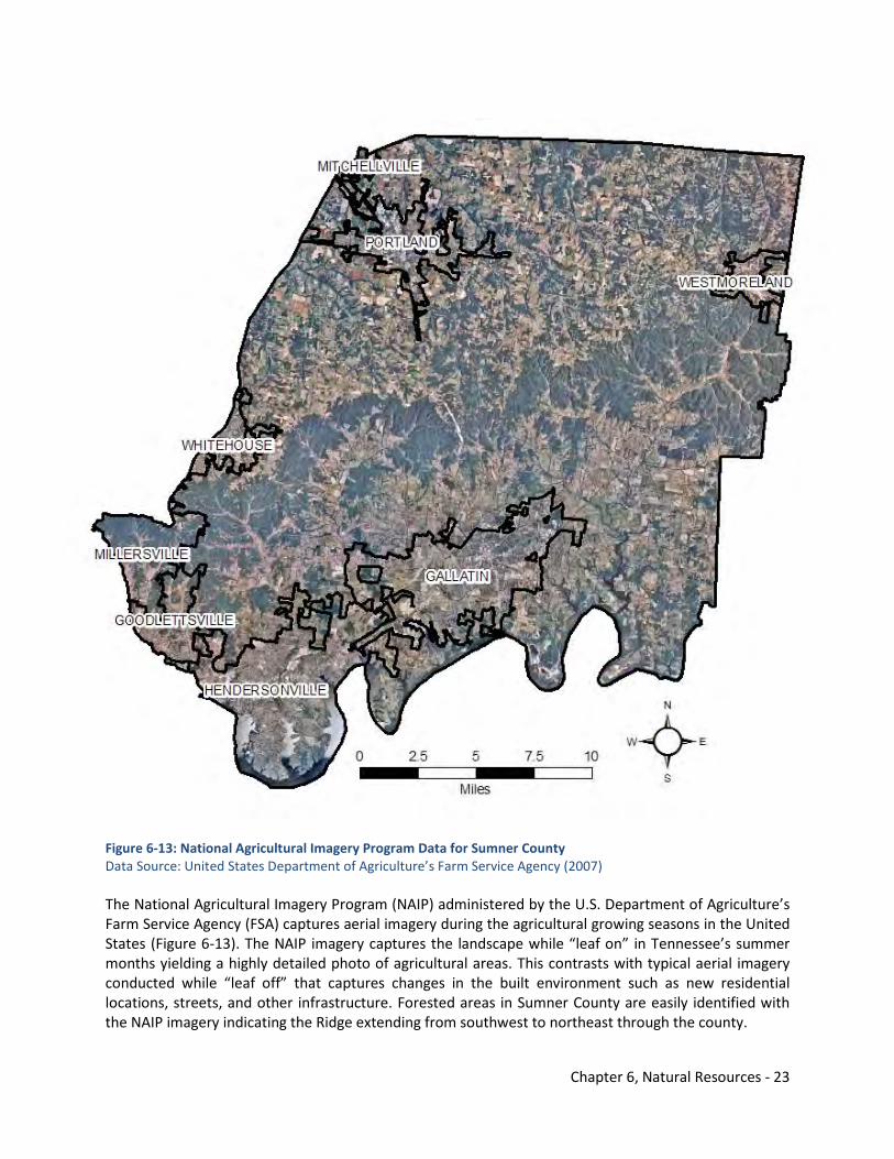
Chapter 6, Natural Resources - 23
Figure 6-13: National Agricultural Imagery Program Data for Sumner County Data Source: United States Department of Agriculture’s Farm Service Agency (2007) The National Agricultural Imagery Program (NAIP) administered by the U.S. Department of Agriculture’s Farm Service Agency (FSA) captures aerial imagery during the agricultural growing seasons in the United States (Figure 6-13). The NAIP imagery captures the landscape while “leaf on” in Tennessee’s summer months yielding a highly detailed photo of agricultural areas. This contrasts with typical aerial imagery conducted while “leaf off” that captures changes in the built environment such as new residential locations, streets, and other infrastructure. Forested areas in Sumner County are easily identified with the NAIP imagery indicating the Ridge extending from southwest to northeast through the county.
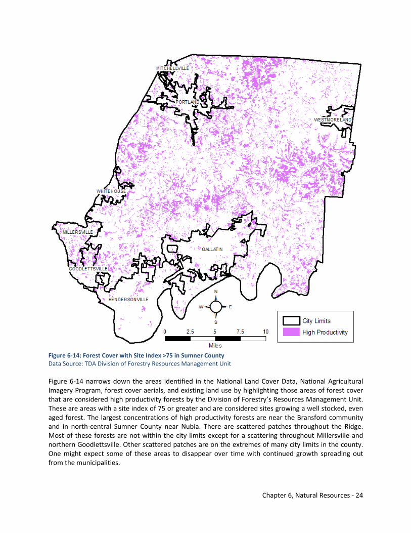
Chapter 6, Natural Resources - 24
Figure 6-14: Forest Cover with Site Index >75 in Sumner County Data Source: TDA Division of Forestry Resources Management Unit Figure 6-14 narrows down the areas identified in the National Land Cover Data, National Agricultural Imagery Program, forest cover aerials, and existing land use by highlighting those areas of forest cover that are considered high productivity forests by the Division of Forestry’s Resources Management Unit. These are areas with a site index of 75 or greater and are considered sites growing a well stocked, even aged forest. The largest concentrations of high productivity forests are near the Bransford community and in north-central Sumner County near Nubia. There are scattered patches throughout the Ridge. Most of these forests are not within the city limits except for a scattering throughout Millersville and northern Goodlettsville. Other scattered patches are on the extremes of many city limits in the county. One might expect some of these areas to disappear over time with continued growth spreading out from the municipalities.
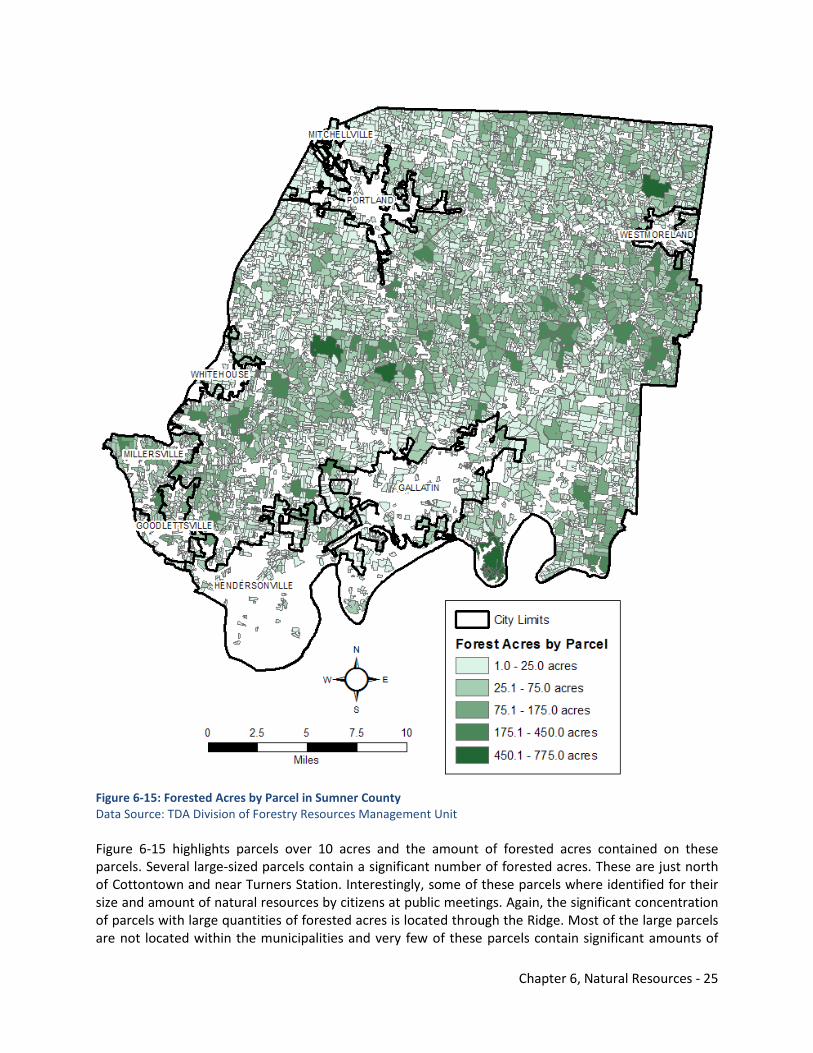
Chapter 6, Natural Resources - 25
Figure 6-15: Forested Acres by Parcel in Sumner County Data Source: TDA Division of Forestry Resources Management Unit Figure 6-15 highlights parcels over 10 acres and the amount of forested acres contained on these parcels. Several large-sized parcels contain a significant number of forested acres. These are just north of Cottontown and near Turners Station. Interestingly, some of these parcels where identified for their size and amount of natural resources by citizens at public meetings. Again, the significant concentration of parcels with large quantities of forested acres is located through the Ridge. Most of the large parcels are not located within the municipalities and very few of these parcels contain significant amounts of
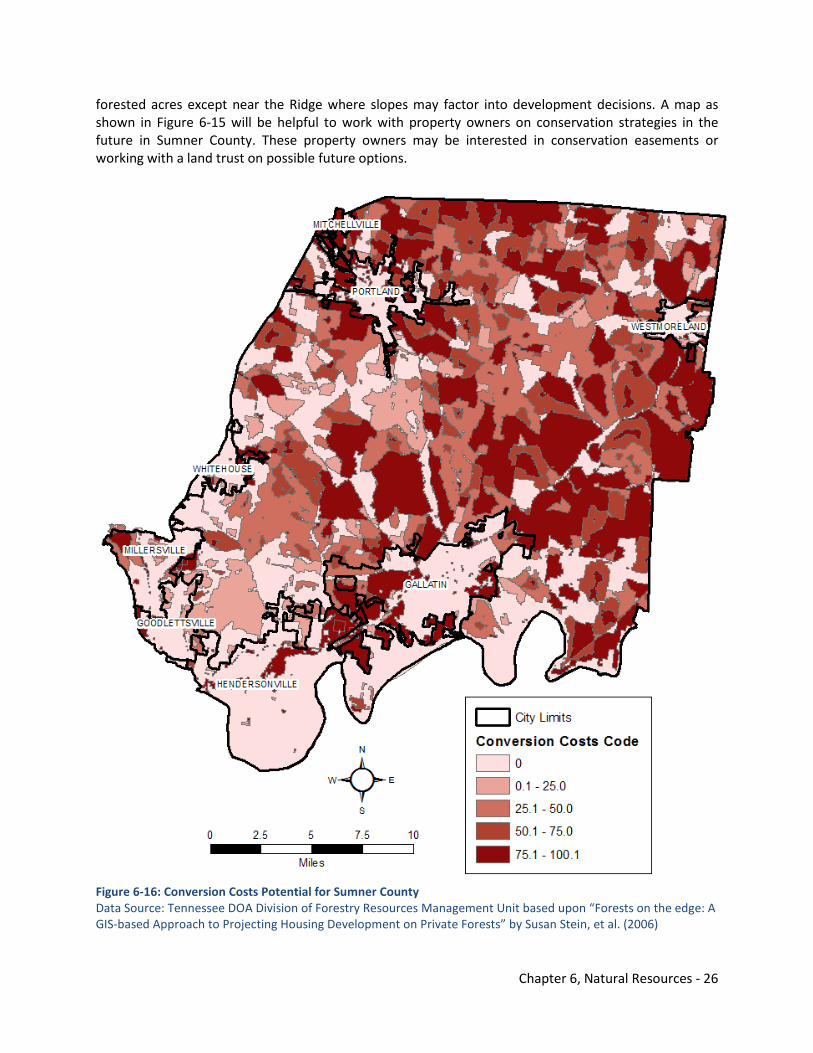
Chapter 6, Natural Resources - 26
forested acres except near the Ridge where slopes may factor into development decisions. A map as shown in Figure 6-15 will be helpful to work with property owners on conservation strategies in the future in Sumner County. These property owners may be interested in conservation easements or working with a land trust on possible future options.
Figure 6-16: Conversion Costs Potential for Sumner County Data Source: Tennessee DOA Division of Forestry Resources Management Unit based upon “Forests on the edge: A GIS-based Approach to Projecting Housing Development on Private Forests” by Susan Stein, et al. (2006)
Chapter 6, Natural Resources - 27
One might also consider the cost of converting forested land over to residential uses or other land uses. Figure 6-16 is based upon a paper by Susan Stein, et al., “Forests on the Edge: A GIS-based Approach to Projecting Housing Development on Private Forests” from the USDA Forest Service Proceedings RMRS-P-42CD, 2006. The predicted change in housing density for each 30 meter pixel in non-urban areas between the years 2000 and 2030 was divided into 15 classes ranging from almost no housing unit per 1,000 acres to high urban levels at over 10,000 per 1,000 acres. The move from one class to another over the 30 year period was then assigned a weight ranging from 10 to 100 with 100 carrying the highest cost to the environment of changing from a less developed to a more developed use. According to the Division of Forestry, the method was somewhat arbitrary, and the values probably cannot be used to compute averages for large areas such as watersheds or counties; however, it gives an indication of what one environmentalist thinks the cost of development would be to the forest cover and ecosystem in Sumner County on a large parcel-scale. The highest weight of conversion costs is located in some areas of the Ridge between Bethpage and Bransford and in north-central Sumner County. These were areas highlighted as high productivity forests in Figure 6-14. Of particular concern are areas on the outer extents of city limits, especially between Hendersonville and Gallatin and around Portland. One would assume that these areas are most likely to be converted over to residential land uses in the future thereby exhibiting the potential for higher conversion costs. 6.5.4 Forest Hydrology Forests play a key role in water quality including suspended sediment, nutrients, oxygen, content, and siltation. Forest soils are very stable and highly permeable due to tree root mats, biological activity, high organic matter content, and lack of compacting agents. Forest soils also regulate and attenuate the flow of stormwater and provide higher summer base flows in the Middle Tennessee region. They make a watershed less flashy and less prone to flooding. Water absorbed by forest soils enters cracks in the bedrock, slowly moves down slope, and emerges near streams and from springs. Trees and brush shade keep forest streams cool and oxygenated. Large organic debris (logs) is very important for stream structure, slowing flow, sediment storage, plunge pools, gravel sorting, and habitats.
Logging does not affect water quality substantially as long as state best management practices (BMPs) are followed and stream buffers implemented. Logging roads and skid trails are the main source of sediment. Careful preplanning of skid routes is important. Steep skid trails where the root mat is broken can erode causing sedimentation and permanent loss of site productivity.
Forest hydrology impacts road and house location. Houses at the base of steep slopes can be subject to rotational slumps of deep colluviums in heavy rainfall events. Roads above steep slopes can contribute to landslides on steep terrain, especially at the head of draws, by collecting water and channeling it into an already unstable slope. This is especially important in subdivisions. The issue of hazards involving excessive slopes was discussed further in the Topography Section (6.4) of this element.
Impaired and high quality streams are discussed in more detail as part of the Water Assessment. Figure 6-17 is a map of forested areas and the location of impaired and high quality streams in relation to the forest cover and high productivity forests. Within the City of Millersville are issues involving impaired streams and high productivity forests. Also, north of Westmoreland is an impaired stream and forest cover. These impaired streams can impact the amount of forest cover and health of forests in these areas.
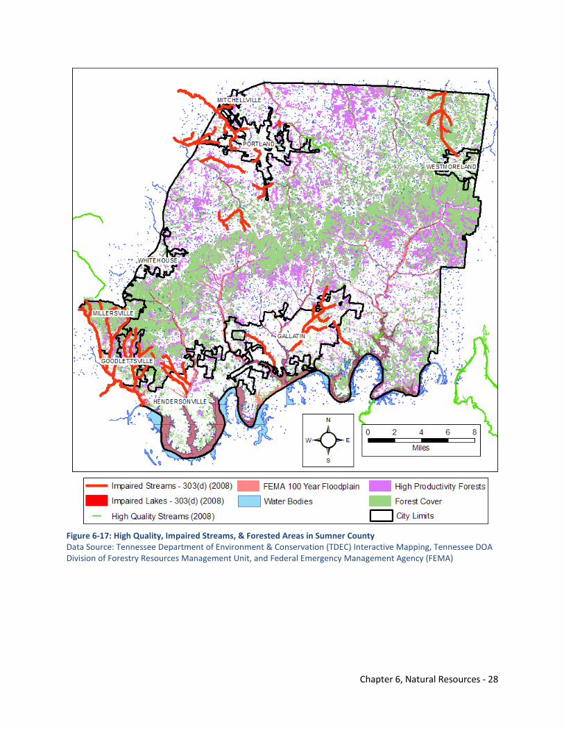
Chapter 6, Natural Resources - 28
Figure 6-17: High Quality, Impaired Streams, & Forested Areas in Sumner County Data Source: Tennessee Department of Environment & Conservation (TDEC) Interactive Mapping, Tennessee DOA Division of Forestry Resources Management Unit, and Federal Emergency Management Agency (FEMA)
Chapter 6, Natural Resources - 29
6.5.5 Other Elements of Forest Health Fire is often not considered sufficiently in planning development on forested land, especially on steep slopes. Fire incidence in Sumner County is low, but as seen in Southern California, arson often comes with increased populations. Houses surrounded by trees are never safe. This is especially true of houses on top of steep hills. Fire starting at the base of a hill can engulf a house in 20 minutes as seen repeatedly in East Tennessee. The Division of Forestry’s FireWise program is designed to show homeowners how to make their woodland homes safe from forest fires. A cleared yard and simple construction devices can make a difference.
Large contiguous concentrations of forest, as found in the eastern part of Sumner County and in the hills ascending out of the Nashville Basin, are prime habitat for forest interior songbirds, are important to watersheds and water quality, and pose the greatest risk from wildfire to houses. These areas warrant special consideration.
Mature red oaks are dying at an increasing rate. They do not live as long as white oak and they are more sensitive to drought. They were heavily impacted by the freeze and drought of 2007. This mortality will decrease the red oak component of forests in Middle Tennessee. It is not the product of an insect or disease epidemic, and does not pose a risk of a pine beetle style epidemic.
6.5.6 Status, Trends, & Risks of Forest Land Conversions to Monoculture or Other Uses There is little likelihood of monoculture forestry developing in Sumner County. There is currently little or no market for pine, the most common monoculture forest crop. The climate and sites are also not highly suited. Pine production is retreating to the Deep South and Brazil. Monoculture cropping of fescue hay is of greater wildlife concern.
6.5.7 Timber Harvests Over Time Timber harvest consumes at most only half of the wood that grows in the forest each year. Few reliable statistics exist for Sumner County, but observation indicates a relatively low rate of timber harvest. There is one primary wood-using mill in Sumner County in Portland, B&S Specialty Hardwoods.
Future demand for timber is not likely to match that of the peak demand prior to 2008. Demand will continue to be high for veneer logs, which are the highest quality log product. These are rare but could be cultured on good sites in the future. Demand for low-grade material is likely to be steady to strong, especially if rail becomes more popular. There is a ready market nearby (Guthrie, Kentucky, and Lafayette) for low-grade material. Lumber and flooring demand (#1 and 2 sawlogs) are likely to be tepid in coming years.
Landowners near developing metropolitan areas tend to be wealthier than past owners, less interested in timber harvest, and more interested in aesthetics and wildlife. This changing in demographics will tend to diminish the timber supply. On the other hand, owners will have occasions when they need income. If they have been holding their timber for some time, some of the higher quality trees could have grown into a higher grade worth more money. Growing a few high quality trees appeals to many wealthier landowners because they are less inclined to practice conventional logging or forest management.
Another future factor to consider is finding forest management techniques that deal effectively with invasive plants like tree of heaven. These techniques might include retaining shade, such as small group harvest or true single tree selection management of maple of suitable (cool, moist, rich) sites, and intensive herbicide use. Goats can be introduced to control bush honeysuckle prior to harvest and reforestation. There will likely be further innovations.
Chapter 6, Natural Resources - 30
Integrating forest bird management by using crop tree release will increase timber production by a third where it is practiced.
Public education and assistance are very important in maintaining a good timber resource. A tool now emerging to motivate landowners to practice better management is Certified Wood, which is paying a premium price and catching on quickly. To qualify, landowners must have and implement a multiple use forest management plan.
In urban areas, waste wood from tree removal can be ground and sold as biofuel instead of taking up landfill space.
Again, biomass harvesting is likely in the future. It is an economic and forest management opportunity for low grade stands that need renewing, but it should be used with care, moderation, and balanced with other goals. Even removal of forest thinnings will degrade non-game habitat. Frequent biomass harvest could conceivably not allow the growth of older higher quality timber on some parcels of land. Another forest market will be carbon sequestration. Landowners are paid to grow trees, but the highest rates go to young pine stands. Older hardwood forest will be “rented” at a much lower rate, if at all.
6.5.8 Forest Local Governance Table 6-3 summarizes local and state policies that might impact development activities in forested areas of Sumner County.
Table 6-3: Forest Governance in Unincorporated Sumner County
Governance level What does it do? Who is responsible? Monitoring? Reference citations and sources
Forest Practices Road rules BMPs encouraged by
Division of Forestry – forest roads and skid trails required
TDA Division of Forestry Property Owner TDOT Sumner County Hwy Dept.
TDA Division of Forestry monitors implementation
TDA’s Best Management Practices in Tennessee
Riparian rules Land disturbance permitting Buffering along streams SWPPP required
Sumner County C&D TDEC Developer/Property owner
Regular stormwater inspections by Sumner County C&D
Sumner County Stormwater & Illicit Discharge Resolutions
Logging rules BMPs encouraged by Division of Forestry Agriculture and silviculture (forestry) activities are exempt from general permitting
TDA Division of Forestry Property Owner
TDA Division of Forestry monitors implementation
TDA’s Best Management Practices in Tennessee
Watershed rules ARAP required on all stream bank disturbance Notice of violation on habitat disturbances
Property Owner TDEC
TDEC monitors stream gauges for pollutants & TMDL, consumption TDA Division of Forestry monitors implementation
TDA’s Best Management Practices in Tennessee
Conversions Subdivision regulation Subdivision of land with
adequate services Construction & drainage plans required
Sumner County C&D No financial resources to monitor on site implementation except for stormwater inspections
Sumner County Subdivision Regulations
Conservation easements or other non-regulatory
Ensures that land is conserved in the future
Property Owner Land Trust of Tennessee
Land Trust of Tennessee maintains property owner database
Land Trust of Tennessee
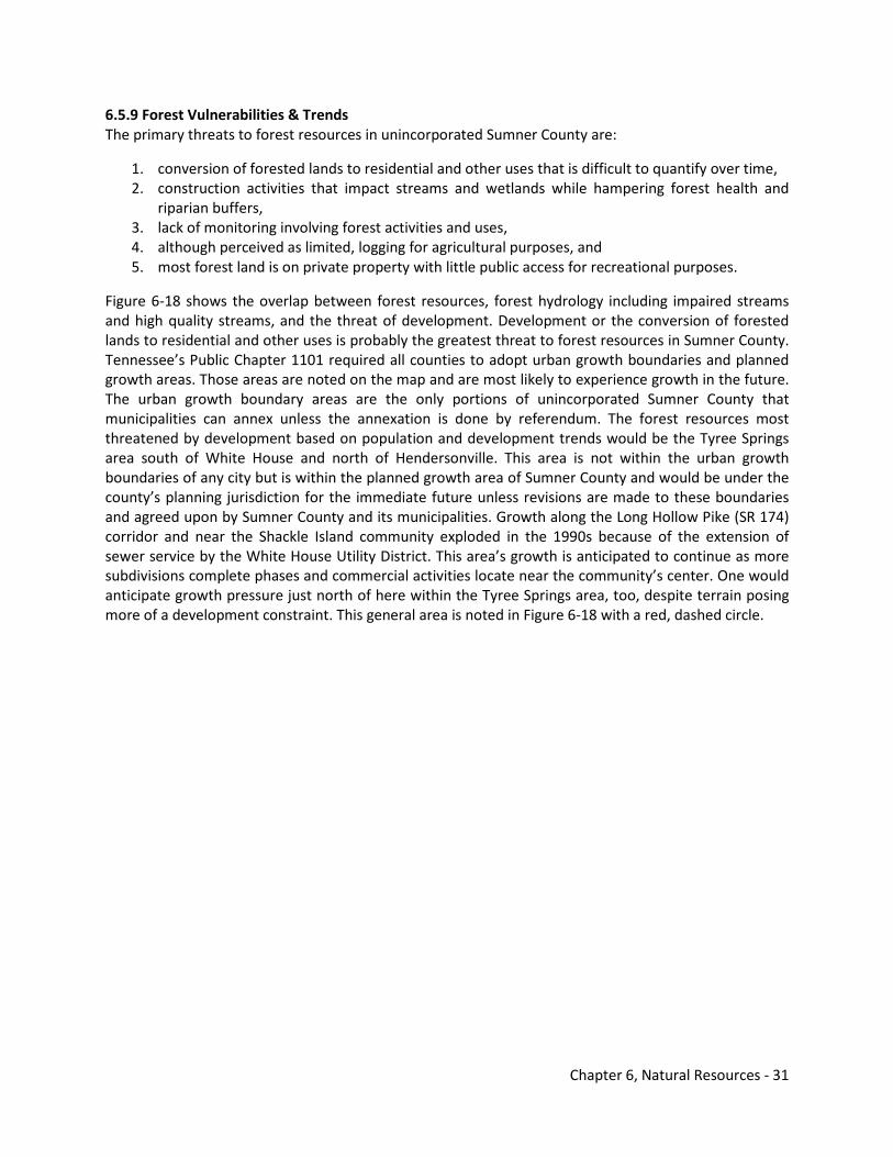
Chapter 6, Natural Resources - 31
6.5.9 Forest Vulnerabilities & Trends The primary threats to forest resources in unincorporated Sumner County are:
1. conversion of forested lands to residential and other uses that is difficult to quantify over time, 2. construction activities that impact streams and wetlands while hampering forest health and
riparian buffers, 3. lack of monitoring involving forest activities and uses, 4. although perceived as limited, logging for agricultural purposes, and 5. most forest land is on private property with little public access for recreational purposes.
Figure 6-18 shows the overlap between forest resources, forest hydrology including impaired streams and high quality streams, and the threat of development. Development or the conversion of forested lands to residential and other uses is probably the greatest threat to forest resources in Sumner County. Tennessee’s Public Chapter 1101 required all counties to adopt urban growth boundaries and planned growth areas. Those areas are noted on the map and are most likely to experience growth in the future. The urban growth boundary areas are the only portions of unincorporated Sumner County that municipalities can annex unless the annexation is done by referendum. The forest resources most threatened by development based on population and development trends would be the Tyree Springs area south of White House and north of Hendersonville. This area is not within the urban growth boundaries of any city but is within the planned growth area of Sumner County and would be under the county’s planning jurisdiction for the immediate future unless revisions are made to these boundaries and agreed upon by Sumner County and its municipalities. Growth along the Long Hollow Pike (SR 174) corridor and near the Shackle Island community exploded in the 1990s because of the extension of sewer service by the White House Utility District. This area’s growth is anticipated to continue as more subdivisions complete phases and commercial activities locate near the community’s center. One would anticipate growth pressure just north of here within the Tyree Springs area, too, despite terrain posing more of a development constraint. This general area is noted in Figure 6-18 with a red, dashed circle.
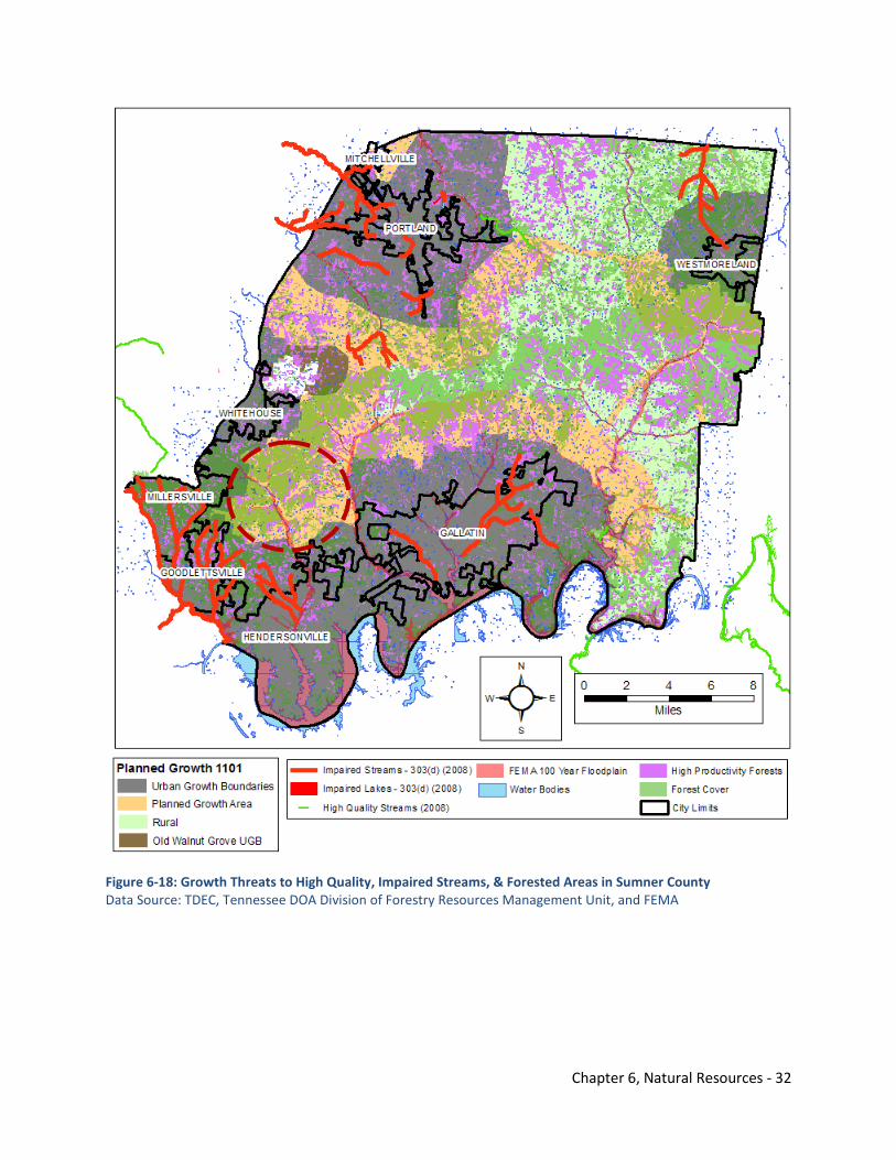
Chapter 6, Natural Resources - 32
Figure 6-18: Growth Threats to High Quality, Impaired Streams, & Forested Areas in Sumner County Data Source: TDEC, Tennessee DOA Division of Forestry Resources Management Unit, and FEMA
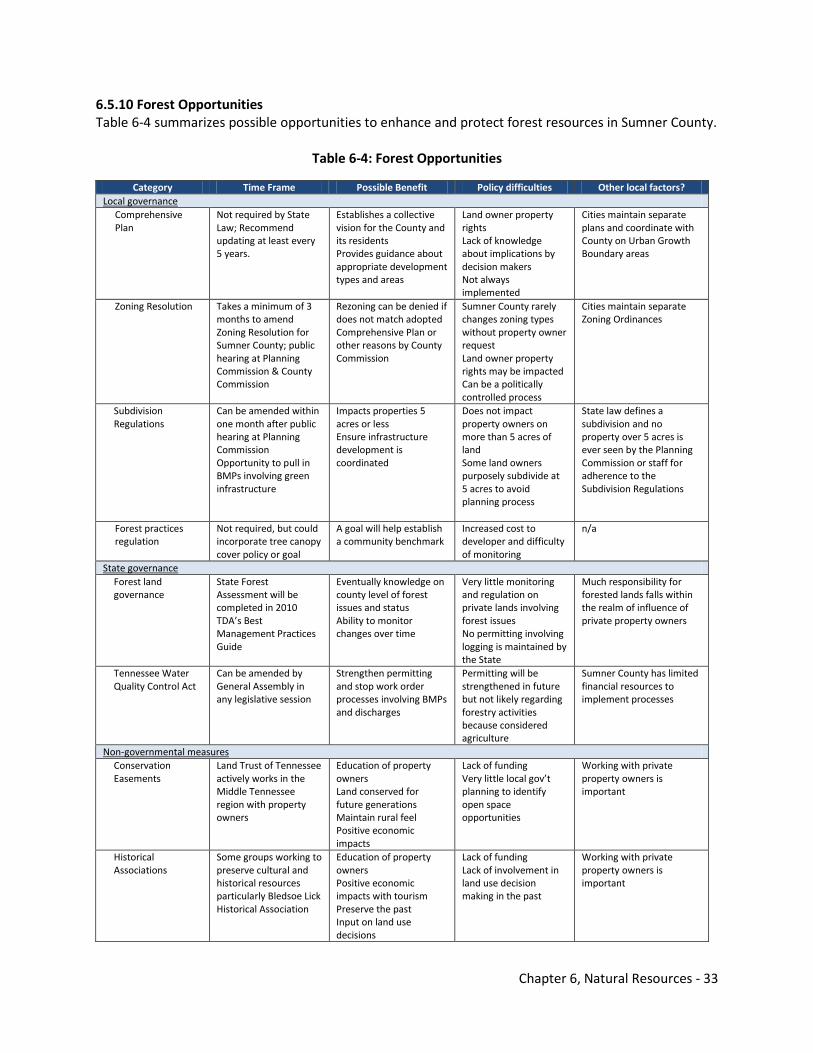
Chapter 6, Natural Resources - 33
6.5.10 Forest Opportunities Table 6-4 summarizes possible opportunities to enhance and protect forest resources in Sumner County.
Table 6-4: Forest Opportunities
Category Time Frame Possible Benefit Policy difficulties Other local factors? Local governance
Comprehensive Plan
Not required by State Law; Recommend updating at least every 5 years.
Establishes a collective vision for the County and its residents Provides guidance about appropriate development types and areas
Land owner property rights Lack of knowledge about implications by decision makers Not always implemented
Cities maintain separate plans and coordinate with County on Urban Growth Boundary areas
Zoning Resolution Takes a minimum of 3 months to amend Zoning Resolution for Sumner County; public hearing at Planning Commission & County Commission
Rezoning can be denied if does not match adopted Comprehensive Plan or other reasons by County Commission
Sumner County rarely changes zoning types without property owner request Land owner property rights may be impacted Can be a politically controlled process
Cities maintain separate Zoning Ordinances
Subdivision Regulations
Can be amended within one month after public hearing at Planning Commission Opportunity to pull in BMPs involving green infrastructure
Impacts properties 5 acres or less Ensure infrastructure development is coordinated
Does not impact property owners on more than 5 acres of land Some land owners purposely subdivide at 5 acres to avoid planning process
State law defines a subdivision and no property over 5 acres is ever seen by the Planning Commission or staff for adherence to the Subdivision Regulations
Forest practices regulation
Not required, but could incorporate tree canopy cover policy or goal
A goal will help establish a community benchmark
Increased cost to developer and difficulty of monitoring
n/a
State governance Forest land governance
State Forest Assessment will be completed in 2010 TDA’s Best Management Practices Guide
Eventually knowledge on county level of forest issues and status Ability to monitor changes over time
Very little monitoring and regulation on private lands involving forest issues No permitting involving logging is maintained by the State
Much responsibility for forested lands falls within the realm of influence of private property owners
Tennessee Water Quality Control Act
Can be amended by General Assembly in any legislative session
Strengthen permitting and stop work order processes involving BMPs and discharges
Permitting will be strengthened in future but not likely regarding forestry activities because considered agriculture
Sumner County has limited financial resources to implement processes
Non-governmental measures Conservation Easements
Land Trust of Tennessee actively works in the Middle Tennessee region with property owners
Education of property owners Land conserved for future generations Maintain rural feel Positive economic impacts
Lack of funding Very little local gov’t planning to identify open space opportunities
Working with private property owners is important
Historical Associations
Some groups working to preserve cultural and historical resources particularly Bledsoe Lick Historical Association
Education of property owners Positive economic impacts with tourism Preserve the past Input on land use decisions
Lack of funding Lack of involvement in land use decision making in the past
Working with private property owners is important
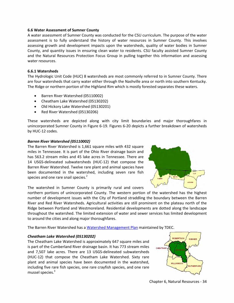
Chapter 6, Natural Resources - 34
6.6 Water Assessment of Sumner County A water assessment of Sumner County was conducted for the CSU curriculum. The purpose of the water assessment is to fully understand the history of water resources in Sumner County. This involves assessing growth and development impacts upon the watersheds, quality of water bodies in Sumner County, and quantity issues in ensuring clean water to residents. CSU faculty assisted Sumner County and the Natural Resources Protection Focus Group in pulling together this information and assessing water resources. 6.6.1 Watersheds The Hydrologic Unit Code (HUC) 8 watersheds are most commonly referred to in Sumner County. There are four watersheds that carry water either through the Nashville area or north into southern Kentucky. The Ridge or northern portion of the Highland Rim which is mostly forested separates these waters.
• Barren River Watershed (05110002) • Cheatham Lake Watershed (05130202) • Old Hickory Lake Watershed (05130201) • Red River Watershed (05130206)
These watersheds are depicted along with city limit boundaries and major thoroughfares in unincorporated Sumner County in Figure 6-19. Figures 6-20 depicts a further breakdown of watersheds by HUC-12 codes. Barren River Watershed (05110002) The Barren River Watershed is 1,661 square miles with 432 square miles in Tennessee. It is part of the Ohio River drainage basin and has 563.2 stream miles and 45 lake acres in Tennessee. There are 14 USGS-delineated subwatersheds (HUC-12) that compose the Barren River Watershed. Twelve rare plant and animal species have been documented in the watershed, including seven rare fish species and one rare snail species.2 The watershed in Sumner County is primarily rural and covers northern portions of unincorporated County. The western portion of the watershed has the highest number of development issues with the City of Portland straddling the boundary between the Barren River and Red River Watersheds. Agricultural activities are still prominent on the plateau north of the Ridge between Portland and Westmoreland. Residential developments are dotted along the landscape throughout the watershed. The limited extension of water and sewer services has limited development to around the cities and along major thoroughfares.
The Barren River Watershed has a Watershed Management Plan maintained by TDEC.
Cheatham Lake Watershed (05130202) The Cheatham Lake Watershed is approximately 647 square miles and is part of the Cumberland River drainage basin. It has 773 stream miles and 7,507 lake acres. There are 13 USGS-delineated subwatersheds (HUC-12) that compose the Cheatham Lake Watershed. Sixty rare plant and animal species have been documented in the watershed, including five rare fish species, one rare crayfish species, and one rare mussel species.3
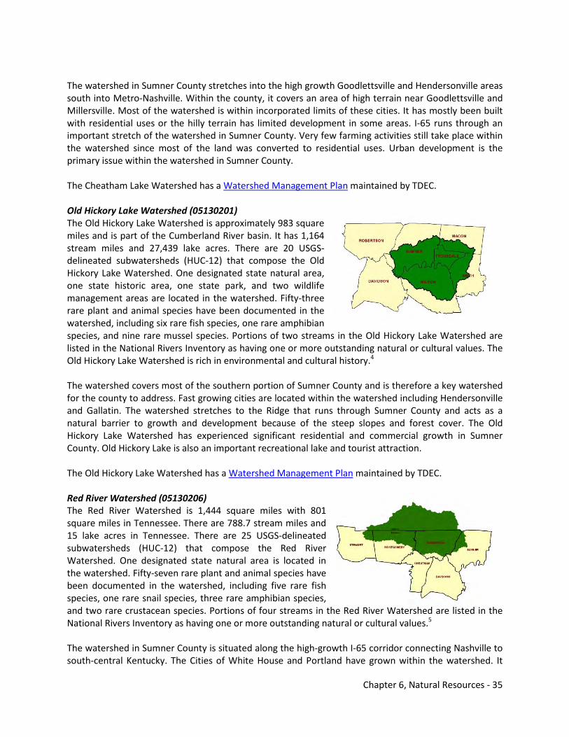
Chapter 6, Natural Resources - 35
The watershed in Sumner County stretches into the high growth Goodlettsville and Hendersonville areas south into Metro-Nashville. Within the county, it covers an area of high terrain near Goodlettsville and Millersville. Most of the watershed is within incorporated limits of these cities. It has mostly been built with residential uses or the hilly terrain has limited development in some areas. I-65 runs through an important stretch of the watershed in Sumner County. Very few farming activities still take place within the watershed since most of the land was converted to residential uses. Urban development is the primary issue within the watershed in Sumner County. The Cheatham Lake Watershed has a Watershed Management Plan maintained by TDEC. Old Hickory Lake Watershed (05130201) The Old Hickory Lake Watershed is approximately 983 square miles and is part of the Cumberland River basin. It has 1,164 stream miles and 27,439 lake acres. There are 20 USGS-delineated subwatersheds (HUC-12) that compose the Old Hickory Lake Watershed. One designated state natural area, one state historic area, one state park, and two wildlife management areas are located in the watershed. Fifty-three rare plant and animal species have been documented in the watershed, including six rare fish species, one rare amphibian species, and nine rare mussel species. Portions of two streams in the Old Hickory Lake Watershed are listed in the National Rivers Inventory as having one or more outstanding natural or cultural values. The Old Hickory Lake Watershed is rich in environmental and cultural history.4 The watershed covers most of the southern portion of Sumner County and is therefore a key watershed for the county to address. Fast growing cities are located within the watershed including Hendersonville and Gallatin. The watershed stretches to the Ridge that runs through Sumner County and acts as a natural barrier to growth and development because of the steep slopes and forest cover. The Old Hickory Lake Watershed has experienced significant residential and commercial growth in Sumner County. Old Hickory Lake is also an important recreational lake and tourist attraction. The Old Hickory Lake Watershed has a Watershed Management Plan maintained by TDEC. Red River Watershed (05130206) The Red River Watershed is 1,444 square miles with 801 square miles in Tennessee. There are 788.7 stream miles and 15 lake acres in Tennessee. There are 25 USGS-delineated subwatersheds (HUC-12) that compose the Red River Watershed. One designated state natural area is located in the watershed. Fifty-seven rare plant and animal species have been documented in the watershed, including five rare fish species, one rare snail species, three rare amphibian species, and two rare crustacean species. Portions of four streams in the Red River Watershed are listed in the National Rivers Inventory as having one or more outstanding natural or cultural values.5 The watershed in Sumner County is situated along the high-growth I-65 corridor connecting Nashville to south-central Kentucky. The Cities of White House and Portland have grown within the watershed. It
Chapter 6, Natural Resources - 36
would be anticipated that growth within the watershed will continue because of water and sewer availability and the proximity of the watershed to the interstate connecting to major cities. Limited farming activities take place within the watershed and these activities will likely diminish as the area has the potential to suburbanize because of the mostly flat terrain north of the Ridge and proximity to corridors leading to Nashville. The Red River Watershed has a Watershed Management Plan maintained by TDEC.
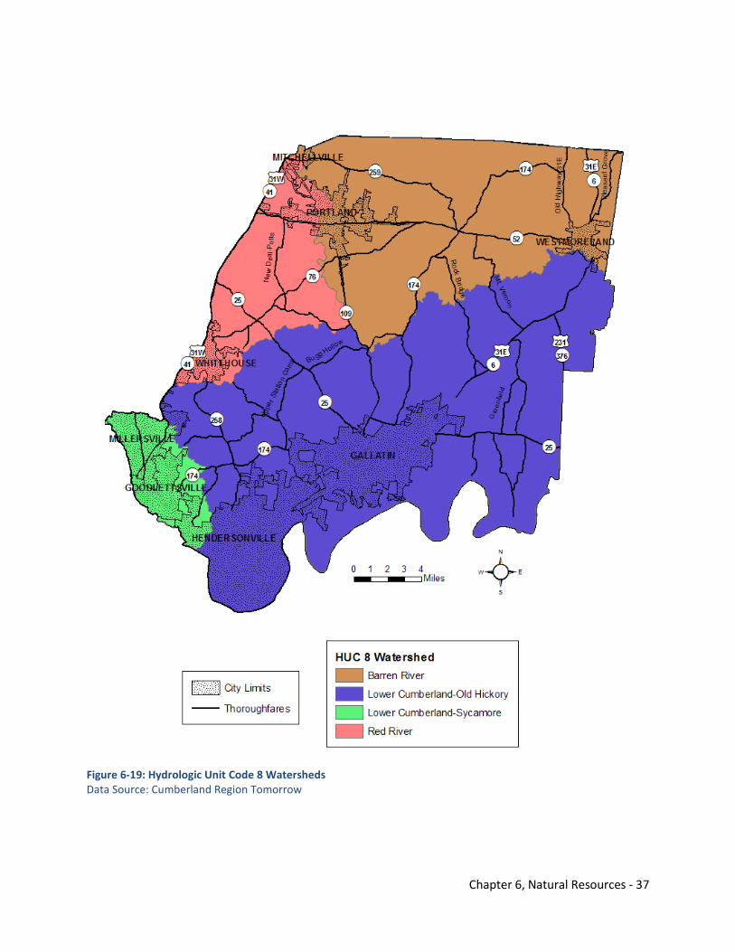
Chapter 6, Natural Resources - 37
Figure 6-19: Hydrologic Unit Code 8 Watersheds Data Source: Cumberland Region Tomorrow
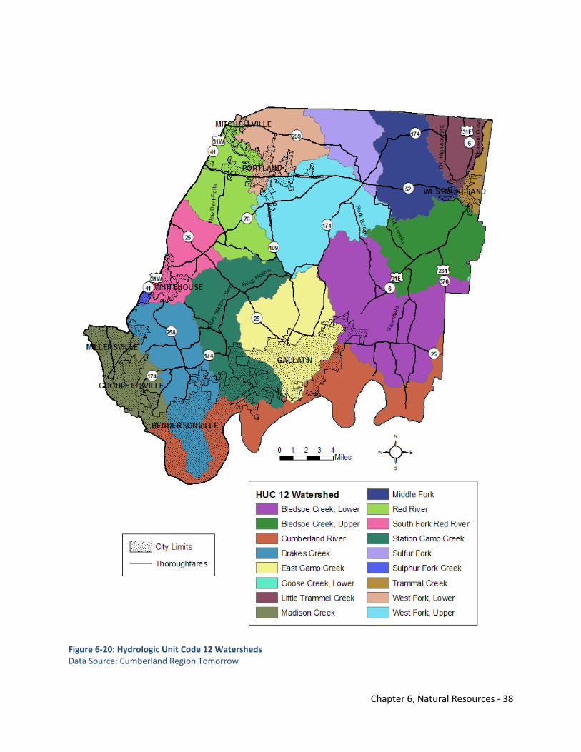
Chapter 6, Natural Resources - 38
Figure 6-20: Hydrologic Unit Code 12 Watersheds Data Source: Cumberland Region Tomorrow
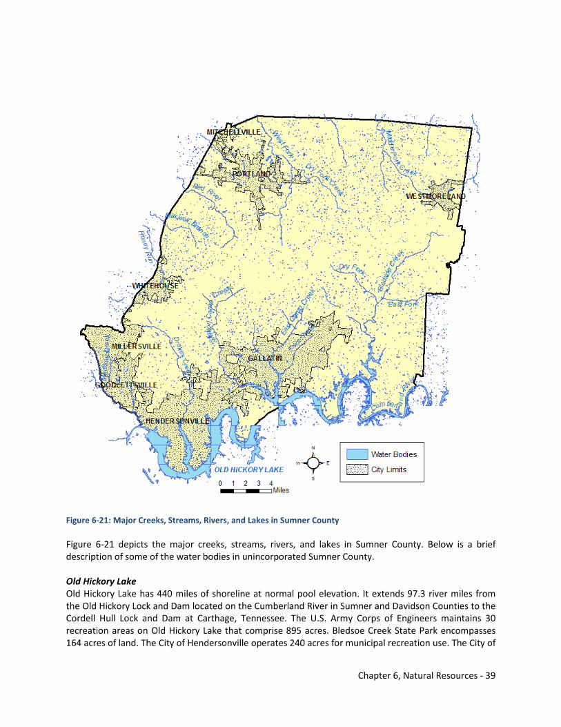
Chapter 6, Natural Resources - 39
Figure 6-21: Major Creeks, Streams, Rivers, and Lakes in Sumner County Figure 6-21 depicts the major creeks, streams, rivers, and lakes in Sumner County. Below is a brief description of some of the water bodies in unincorporated Sumner County. Old Hickory Lake Old Hickory Lake has 440 miles of shoreline at normal pool elevation. It extends 97.3 river miles from the Old Hickory Lock and Dam located on the Cumberland River in Sumner and Davidson Counties to the Cordell Hull Lock and Dam at Carthage, Tennessee. The U.S. Army Corps of Engineers maintains 30 recreation areas on Old Hickory Lake that comprise 895 acres. Bledsoe Creek State Park encompasses 164 acres of land. The City of Hendersonville operates 240 acres for municipal recreation use. The City of
Chapter 6, Natural Resources - 40
Gallatin maintains a 30-acre soccer complex on Station Camp Creek as well as 158 acres at Lock 4, Gallatin, and Cedar Grove recreation areas. There are eight commercial concessions around the lake occupying a total of 134 acres of land and water. Land not developed along the lake is now extremely beneficial for providing areas of valuable recreational pursuits such as bird watching, photography, etc., as well as much needed wildlife habitat. Native plantings and species are encouraged along the shoreline. Old Hickory Lake is a major recreational lake in Sumner County for boating and fishing activities. Its development was a significant growth generator for the Cities of Hendersonville and Gallatin over the last few decades.6 The U.S. Army Corps of Engineers developed the 2008 Update to the Old Hickory Lake Shoreline Management Plan (SMP). It is anticipated to be updated again in 2013. The SMP provides updates to policies and guidelines for the effective long-range management of the shoreline resources of Old Hickory Lake and outlines permitting criteria. Cumberland River
The Cumberland River is 688 miles long and starts in Harlan County, Kentucky, and ends at the Ohio River at Smithland, Kentucky. The river snakes it way south through northern Tennessee, including Sumner County, before moving back into Kentucky. Most of the river is navigable below the Wolf Creek Lock and Dam.7 The Cumberland River is used for recreational purposes, too. These activities include boating and fishing. The river has experienced significant growth through the Middle Tennessee
region around cities such as Nashville and Clarksville and their suburban communities. Lakes in these areas that are part of the lock and dam system have drawn residents to these communities. The Cumberland River Compact addresses issues and works with local governments including Sumner County regarding the environmental stewardship of the watershed. The Compact is a non-profit organization that has taken on the mission of educating residents and local officials in the watershed about the importance of the Cumberland River to the many communities located within the watershed.8 The Cumberland River was a key waterway in the flooding events of May 2010. It was this river and many of its tributaries that overflowed into Downtown Nashville and impacted communities to the west of Sumner County including Cheatham County, Dickson County, and Clarksville-Montgomery County. Red River The Red River is a major stream running through north-central Tennessee and south-central Kentucky. It is a tributary of the Cumberland River. It drains the northern Highland Rim in Tennessee and the Pennyroyal Plateau in Kentucky. Its headwaters are in Sumner County. The stream's name derives from its typical water color caused by a large load of clay and silt which contains iron oxides. As the area drained by the Red River becomes somewhat less agricultural and more of the remaining farmers switch to techniques involving less cultivation, it is likely that this color will continue to lessen in intensity, but certainly will not vanish. Development impacting water quality within the Red River watershed is important to consider as parts of Robertson and Montgomery Counties grow.9
Chapter 6, Natural Resources - 41
The Red River Watershed Association is a community-based organization and initiated by the Cumberland River Compact. The Association is dedicated to enhancing and protecting the quality and quantity of water in the creeks and streams that flow into the Red River. Drakes Creek Drakes Creek’s headwaters are located in the Ridge of Sumner County. The creek runs south into Old Hickory Lake at Hendersonville and is the reason the Shackle Island community exists today. The William Montgomery Farm located along the creek was the location of a grinding mill and sawmill in the early 1800s. Today, Drakes Creek winds its way through the fast growing residential developments in Hendersonville. Suburban development is an issue involving the creek. Limited farming activities still take place along the creek north of Long Hollow Pike and moving into the Ridge. Hendersonville has developed recreational parks and greenway amenities along Drakes Creek as it drains into Old Hickory Lake. Station Camp Creek Station Camp Creek runs along today’s Bugg Hollow Road, Upper Station Camp Creek Road, and Lower Station Camp Creek Road before draining into Old Hickory Lake near Gallatin. The southern portion of Station Camp Creek has mostly been developed as a natural boundary between the Cities of Hendersonville and Gallatin. North of Long Hollow Pike, Station Camp Creek still has adjacent farming activities. The community of Cottontown was founded in the late 1700s along the creek. Greenway amenities are planned to parallel Station Camp Creek from Cottontown to Gallatin. Bledsoe Creek Bledsoe Creek roughly parallels US 31E moving through the communities of Bransford and Bethpage before connecting to the Cumberland River system. This creek has historical significance as a cornerstone in these communities. Deshea Creek Deshea Creek’s headwaters are located in the Ridge north of Hickory Ridge Road and meanders south following Deshea Creek Road and eventually connects with Bledsoe Creek leading to the Cumberland River system. Many of the creeks mentioned have experienced development along adjacent properties of these waters. The intensity of development increases as one travels towards the county’s municipalities. These creeks have headwaters in the Ridge and travel towards Old Hickory Lake or the Cumberland River. 6.6.2 Critical Habitats The Tennessee Wildlife Resource Authority (TWRA) developed the State Wildlife Action Plan (SWAP) called Tennessee’s Comprehensive Wildlife Conservation Strategy in 2005. This plan identified priority terrestrial, subterranean, and aquatic habitats throughout the state. The SWAP identifies some key locations within Sumner County. Figure 6-22 identifies these critical habitats along with other critical conservation areas such as shorelines, high quality streams, and floodplains. Aquatic habitats of low priority are shaded in light brown, and those of medium priority are yellow on the map. The habitats to the north of the Ridge are part of the Barren River Drainage, which makes up
Chapter 6, Natural Resources - 42
only 1 percent of landmass in the state barely dipping into Tennessee along the Interior Low Plateau. Some sources of stress in this area include incompatible grazing and residential development. Those habitats to the south are part of the Cumberland River Drainage, which is the second largest aquatic region in Tennessee with 25.4 percent of the state’s total land area. Incompatible grazing, construction of dams, and incompatible mining practices are some sources of stress upon these habitats. No aquatic habitats are identified in the SWAP of high or very high priority within or immediately nearby Sumner County. Subterranean habitats are identified by the medium brown shading on the map. The habitat to the south in Gallatin is part of the Nashville Basin Subterranean Region (NAB) composing 14.4 percent of land area in the state. Residential sewage/septic systems, primary residential development, and construction of roads/railroads/utilities are some sources of stress to the habitat. The habitat to the north near Portland is part of the Central Uplands Subterranean Region (CUP), which composes 20.2 percent of land area in Tennessee. Some sources of stress include primary residential development, residential sewage/septic systems, and incompatible grazing. Terrestrial habitats are the dark brown in Figure 6-22 and are part of the Interior Low Plateau (ILP), which is the largest terrestrial region in Tennessee covering 37.3 percent of the state’s landmass. Some sources of stress to terrestrial habitats in the ILP are primary residential development, agricultural conversion, and commercial/industrial development. The SWAP should be consulted for more details regarding the natural, semi-natural, and non-natural habitats in the ILP. The SWAP also identifies portions of Sumner County for the grassland/shrub focus area and wetlands focus area. The Nature Conservancy also has obtained Taylor Hollow as part of its Ecoregional Planning Terrestrial Portfolio. The northwestern portion of Sumner County is identified as a Freshwater Initiatives Conservation Area by The Nature Conservancy.10
The high quality streams and 100-year floodplains mapped by the Federal Emergency Management Agency (FEMA) are discussed in Section 6.6.3 and Section 6.6.7 respectively. The areas identified in Figure 6-22 are overlapped with additional natural resources data later in this element to determine areas where certain risks and opportunities exist.
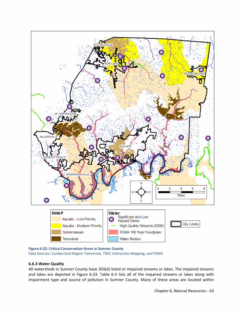
Chapter 6, Natural Resources - 43
Figure 6-22: Critical Conservation Areas in Sumner County Data Sources: Cumberland Region Tomorrow, TDEC Interactive Mapping, and FEMA 6.6.3 Water Quality All watersheds in Sumner County have 303(d) listed or impaired streams or lakes. The impaired streams and lakes are depicted in Figure 6-23. Table 6-5 lists all of the impaired streams or lakes along with impairment type and source of pollution in Sumner County. Many of these areas are located within
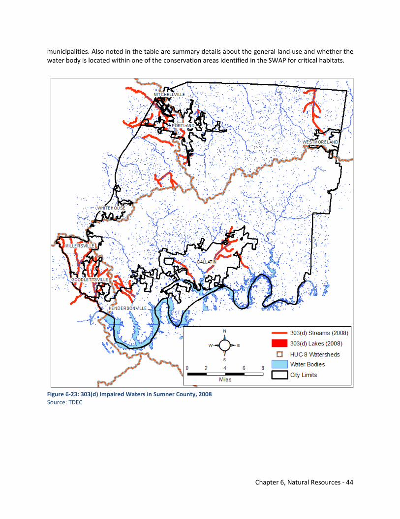
Chapter 6, Natural Resources - 44
municipalities. Also noted in the table are summary details about the general land use and whether the water body is located within one of the conservation areas identified in the SWAP for critical habitats.
Figure 6-23: 303(d) Impaired Waters in Sumner County, 2008 Source: TDEC
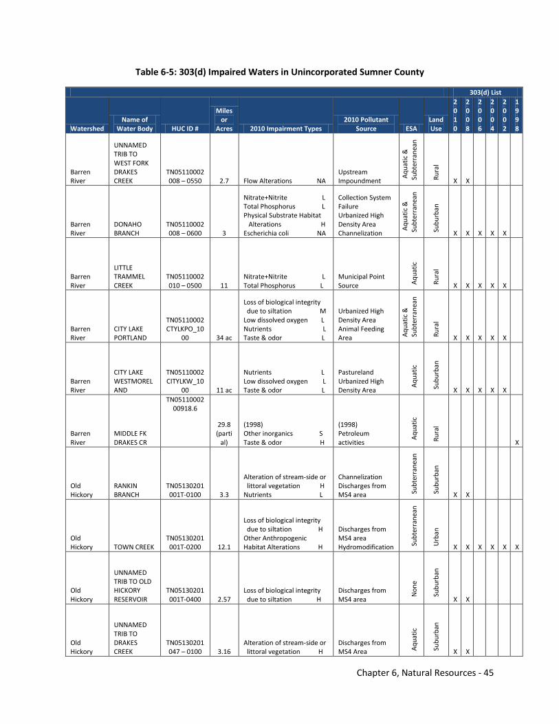
Chapter 6, Natural Resources - 45
Table 6-5: 303(d) Impaired Waters in Unincorporated Sumner County
303(d) List
Watershed Name of
Water Body HUC ID #
Miles or
Acres 2010 Impairment Types 2010 Pollutant
Source ESA Land Use
2010
2008
2006
2004
2002
1998
Barren River
UNNAMED TRIB TO WEST FORK DRAKES CREEK
TN05110002 008 – 0550 2.7 Flow Alterations NA
Upstream Impoundment A
quat
ic &
Su
bter
rane
an
Rura
l
X X
Barren River
DONAHO BRANCH
TN05110002 008 – 0600 3
Nitrate+Nitrite L Total Phosphorus L Physical Substrate Habitat Alterations H Escherichia coli NA
Collection System Failure Urbanized High Density Area Channelization A
quat
ic &
Su
bter
rane
an
Subu
rban
X X X X X
Barren River
LITTLE TRAMMEL CREEK
TN05110002 010 – 0500 11
Nitrate+Nitrite L Total Phosphorus L
Municipal Point Source A
quat
ic
Rura
l
X X X X X
Barren River
CITY LAKE PORTLAND
TN05110002 CTYLKPO_10
00 34 ac
Loss of biological integrity due to siltation M Low dissolved oxygen L Nutrients L Taste & odor L
Urbanized High Density Area Animal Feeding Area A
quat
ic &
Su
bter
rane
an
Rura
l
X X X X X
Barren River
CITY LAKE WESTMORELAND
TN05110002 CITYLKW_10
00 11 ac
Nutrients L Low dissolved oxygen L Taste & odor L
Pastureland Urbanized High Density Area Aqu
atic
Subu
rban
X X X X X
Barren River
MIDDLE FK DRAKES CR
TN05110002 00918.6
29.8 (parti
al)
(1998) Other inorganics S Taste & odor H
(1998) Petroleum activities A
quat
ic
Rura
l X
Old Hickory
RANKIN BRANCH
TN05130201 001T-0100 3.3
Alteration of stream-side or littoral vegetation H Nutrients L
Channelization Discharges from MS4 area Su
bter
rane
an
Subu
rban
X X
Old Hickory TOWN CREEK
TN05130201 001T-0200 12.1
Loss of biological integrity due to siltation H Other Anthropogenic Habitat Alterations H
Discharges from MS4 area Hydromodification Su
bter
rane
an
Urb
an
X X X X X X
Old Hickory
UNNAMED TRIB TO OLD HICKORY RESERVOIR
TN05130201 001T-0400 2.57
Loss of biological integrity due to siltation H
Discharges from MS4 area N
one
Sub
urba
n
X X
Old Hickory
UNNAMED TRIB TO DRAKES CREEK
TN05130201 047 – 0100 3.16
Alteration of stream-side or littoral vegetation H
Discharges from MS4 Area A
quat
ic
Subu
rban
X X
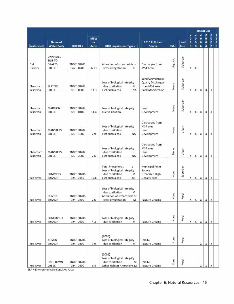
Chapter 6, Natural Resources - 46
303(d) List
Watershed Name of
Water Body HUC ID #
Miles or
Acres 2010 Impairment Types 2010 Pollutant
Source ESA Land Use
2010
2008
2006
2004
2002
1998
Old Hickory
UNNAMED TRIB TO DRAKES CREEK
TN05130201 047 – 0200 6.13
Alteration of stream-side or littoral vegetation H
Discharges from MS4 Area A
quat
ic
Subu
rban
X X
Cheatham Reservoir
SLATERS CREEK
TN05130202 220 – 0300 11.3
Loss of biological integrity due to siltation H Escherichia coli NA
Sand/Gravel/Rock Quarry Discharges from MS4 area Bank Modification N
one
Subu
rban
X X X X X
Cheatham Reservoir
MADISON CREEK
TN05130202 220 – 0400 14.4
Loss of biological integrity due to siltation H
Land Development N
one
Subu
rban
X X X X X
Cheatham Reservoir
MANSKERS CREEK
TN05130202 220 – 1000 7.9
Loss of biological integrity due to siltation H Escherichia coli NA
Discharges from MS4 area Land Development N
one
Urb
an
X X X X X
Cheatham Reservoir
MANSKERS CREEK
TN05130202 220 – 2000 7.6
Loss of biological integrity due to siltation H Escherichia coli NA
Discharges from MS4 area Land Development N
one
Urb
an
X X X X X
Red River SUMMERS BRANCH
TN05130206 024 - 0150 12.6
Total Phosphorus L Loss of biological integrity due to siltation M Escherichia coli M
Municipal Point Source Urbanized High Density Area N
one
Subu
rban
X X X X X
Red River BUNTIN BRANCH
TN05130206 024 - 0200 7.6
Loss of biological integrity due to siltation M Alteration of stream-side or littoral vegetation M Pasture Grazing N
one
Rura
l
X X X X X
Red River SOMERVILLE BRANCH
TN05130206 024 - 0600 4.3
Loss of biological integrity due to siltation M Pasture Grazing N
one
Rura
l
X X X X X
Red River AUSTIN BRANCH
TN05130206 024 - 0300 3.9
(2006) Loss of biological integrity due to siltation M
(2006) Pasture Grazing N
one
Rura
l
X X X
Red River HALL TOWN CREEK
TN05130206 024 - 0400 6.4
(2006) Loss of biological integrity due to siltation M Other Habitat Alterations M
(2006) Pasture Grazing N
one
Rura
l
X X X ESA = Environmentally Sensitive Area
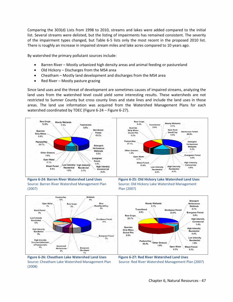
Chapter 6, Natural Resources - 47
Comparing the 303(d) Lists from 1998 to 2010, streams and lakes were added compared to the initial list. Several streams were delisted, but the listing of impairments has remained consistent. The severity of the impairment types changed, but Table 6-5 lists only the most recent in the proposed 2010 list. There is roughly an increase in impaired stream miles and lake acres compared to 10 years ago. By watershed the primary pollutant sources include:
• Barren River – Mostly urbanized high density areas and animal feeding or pastureland • Old Hickory – Discharges from the MS4 area • Cheatham – Mostly land development and discharges from the MS4 area • Red River – Mostly pasture grazing
Since land uses and the threat of development are sometimes causes of impaired streams, analyzing the land uses from the watershed level could yield some interesting results. These watersheds are not restricted to Sumner County but cross county lines and state lines and include the land uses in those areas. The land use information was acquired from the Watershed Management Plans for each watershed coordinated by TDEC (Figure 6-24 – Figure 6-27).
Figure 6-24: Barren River Watershed Land Uses Figure 6-25: Old Hickory Lake Watershed Land Uses Source: Barren River Watershed Management Plan Source: Old Hickory Lake Watershed Management (2007) Plan (2007)
Figure 6-26: Cheatham Lake Watershed Land Uses Figure 6-27: Red River Watershed Land Uses Source: Cheatham Lake Watershed Management Plan Source: Red River Watershed Management Plan (2007) (2008)
Chapter 6, Natural Resources - 48
The primary land uses in each watershed is deciduous and evergreen forest except for the Red River watershed which is pasture/hay. Developed land uses such as residential and commercial are the highest percentage in the Cheatham Lake watershed. For Sumner County, this is probably the most developed watershed. In general, the pollutant sources and land uses are mostly human-induced related to development throughout the Middle Tennessee region. Conversion of land to other uses and construction activities increase stormwater runoff. There is a tendency to increase the flashiness of stream flows and impact properties downstream in flooding events. Figure 6-28 shows the streams that are impaired by siltation and their drainage areas. These impairments are confined near Summers Branch, Buntin Branch, and Portland City Lake in Portland, Madison Creek and Slaters Creek in Goodlettsville and Millersville, and Town Creek in Gallatin.
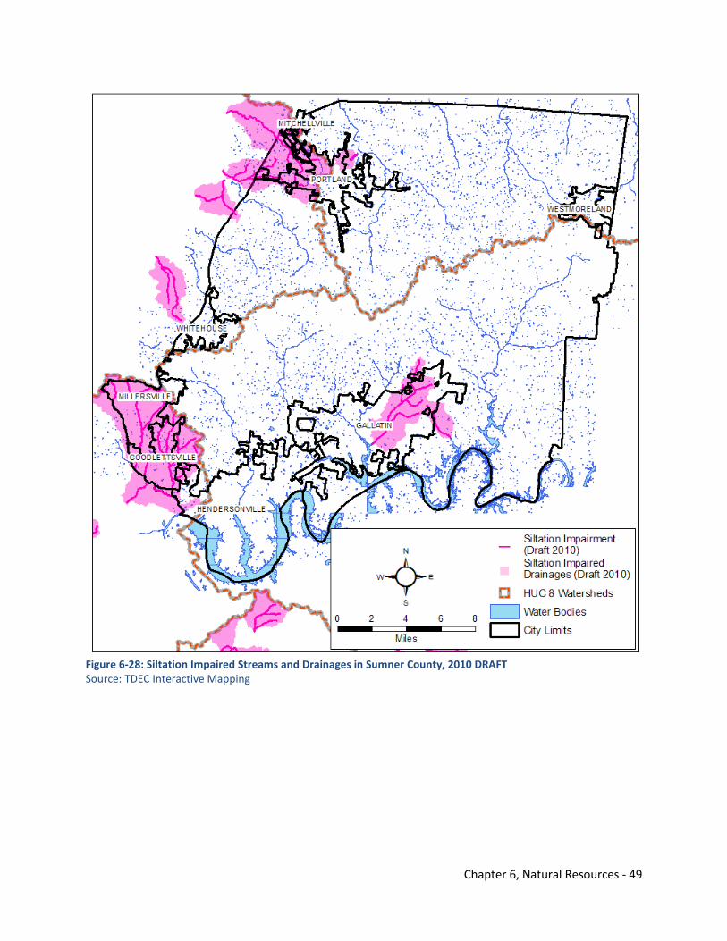
Chapter 6, Natural Resources - 49
Figure 6-28: Siltation Impaired Streams and Drainages in Sumner County, 2010 DRAFT Source: TDEC Interactive Mapping
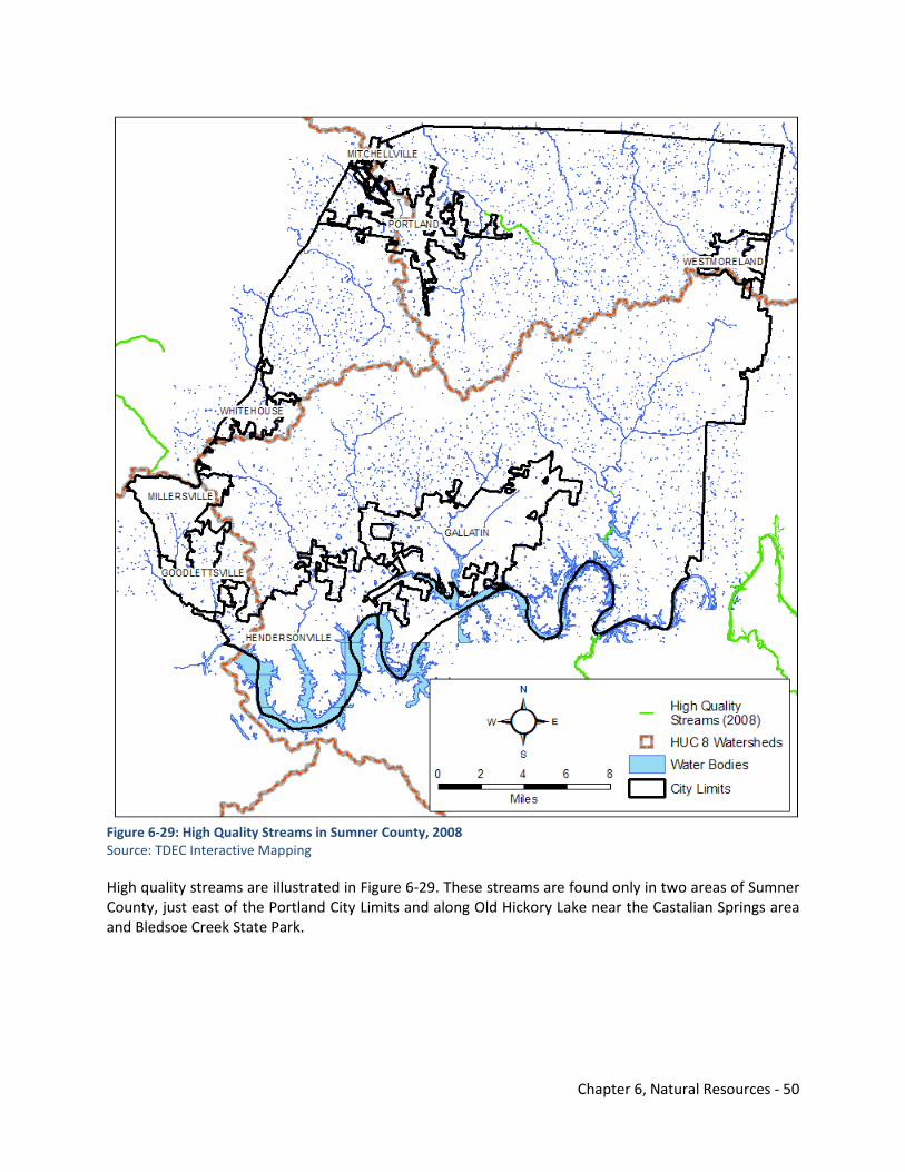
Chapter 6, Natural Resources - 50
Figure 6-29: High Quality Streams in Sumner County, 2008 Source: TDEC Interactive Mapping High quality streams are illustrated in Figure 6-29. These streams are found only in two areas of Sumner County, just east of the Portland City Limits and along Old Hickory Lake near the Castalian Springs area and Bledsoe Creek State Park.
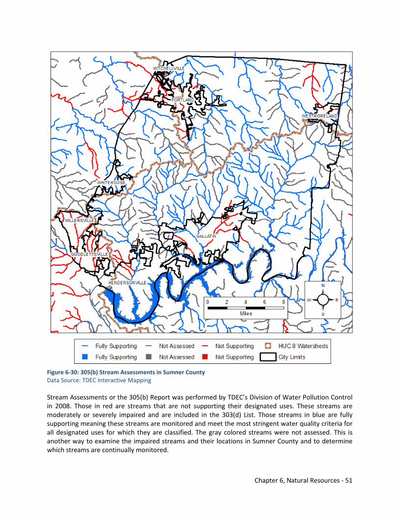
Chapter 6, Natural Resources - 51
Figure 6-30: 305(b) Stream Assessments in Sumner County Data Source: TDEC Interactive Mapping Stream Assessments or the 305(b) Report was performed by TDEC’s Division of Water Pollution Control in 2008. Those in red are streams that are not supporting their designated uses. These streams are moderately or severely impaired and are included in the 303(d) List. Those streams in blue are fully supporting meaning these streams are monitored and meet the most stringent water quality criteria for all designated uses for which they are classified. The gray colored streams were not assessed. This is another way to examine the impaired streams and their locations in Sumner County and to determine which streams are continually monitored.
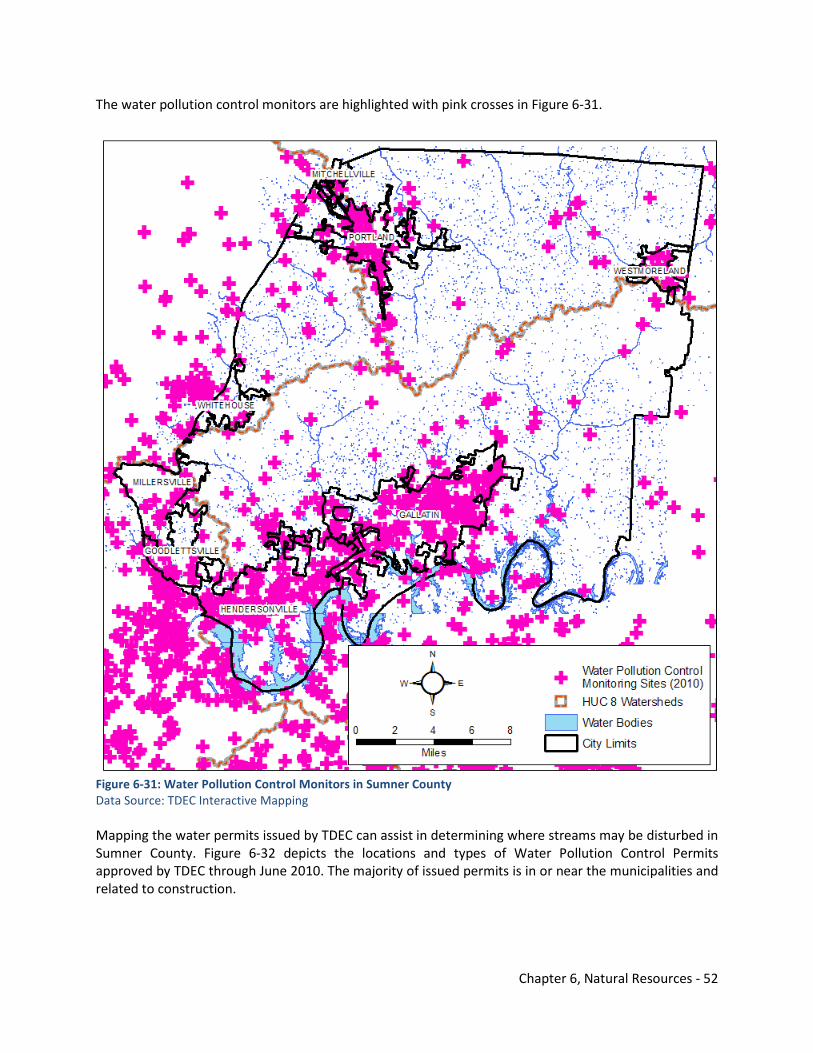
Chapter 6, Natural Resources - 52
The water pollution control monitors are highlighted with pink crosses in Figure 6-31.
Figure 6-31: Water Pollution Control Monitors in Sumner County Data Source: TDEC Interactive Mapping Mapping the water permits issued by TDEC can assist in determining where streams may be disturbed in Sumner County. Figure 6-32 depicts the locations and types of Water Pollution Control Permits approved by TDEC through June 2010. The majority of issued permits is in or near the municipalities and related to construction.
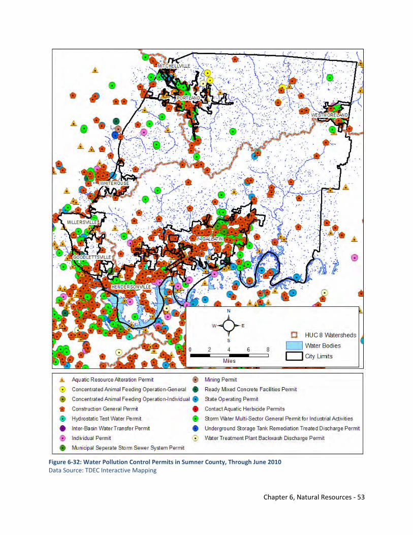
Chapter 6, Natural Resources - 53
Figure 6-32: Water Pollution Control Permits in Sumner County, Through June 2010 Data Source: TDEC Interactive Mapping
Chapter 6, Natural Resources - 54
6.6.3.1 Phase II MS4 General Permit Over the past 30 years, EPA and state water quality agencies have realized the great impact that rain water runoff has on surface waters. Rain water falling on industries, urban areas and construction activities can become contaminated with sediments, suspended soils, nutrients phosphorous and nitrogen, metals, pesticides, organic material, and floating trash. These pollutants are then carried into the surface waters. Unlike sanitary wastewater and industrial wastewater, historically most stormwater has not been treated prior to entering streams. Pollution from stormwater must be prevented at the source by reducing the volume and intensity of the runoff and/or the reduction of pollutants in the runoff. Phase I EPA stormwater regulations initiated a national stormwater permitting program in 1990 that applied to industrial activities, to construction sites of five acres or more, and to urban runoff from larger cities. Phase II regulations in 1999 address additional urbanized areas, certain cities with population over 10,000, and construction activities of one to five acres. TDEC’s Division of Water Pollution Control implements the Environmental Protection Agency’s (EPA) Phase I and Phase II stormwater rules programs in Tennessee. The division works with jurisdictions designated as Municipal Separate Storm Sewer Systems or MS4s. Sumner County is designated as a MS4. The proposed National Pollutant Discharge Elimination System (NPDES) general permit to cover discharges of stormwater runoff from Phase II MS4s, including city and county-operated MS4s, will impact Sumner County. Standards are established for the permit that encourages infiltration, evapotranspiration, and capture and use of stormwater through a set of performance standards. These standards are in priority order:
• runoff reduction (infiltration or green infrastructure, see discussion below), • pollutant removal, and • off-site mitigation or payment into public stormwater project fund.12
6.6.3.2 Key Concept – Green Infrastructure This discussion was included in the Transportation Element (5.0), but it is repeated here because of TDEC’s emphasis on reducing stormwater runoff through green infrastructure implementation. The overlap between development policies and regulations and permitting involving stormwater is significant. An example of this relationship is with automobile parking standards for the county. The Sumner County Subdivision Regulations outline the standards for streets, sidewalks, sewer lines, water lines, and other infrastructure. These regulations generally do not allow for green infrastructure such as pervious pavement, bioswales, rain gardens, and other more sustainable best management practices. In 2008, planners in Sumner County held training on green infrastructure and conducted a visual preference survey of different urban and rural design standards. A visual preference survey is conducted by showing a series of photographs of various types of developments and infrastructure. Participants are asked to rank their preference on a numeric scale. Photographs of green infrastructure were included in the series of 100 photos. The planning commissioners and staff in attendance were generally favorable to green infrastructure such as pervious pavement, bioswales, check dams, rain gardens, and green roofs. See Appendix F for the green infrastructure photos utilized in the survey. One infrastructure policy that could be greener is the parking standards for Sumner County. Currently, dust-free parking is required with curbs leading to a detention system. Figure 6-33 shows the typical parking lot that would be required in a commercial development in Sumner County. Figure 6-34 is an
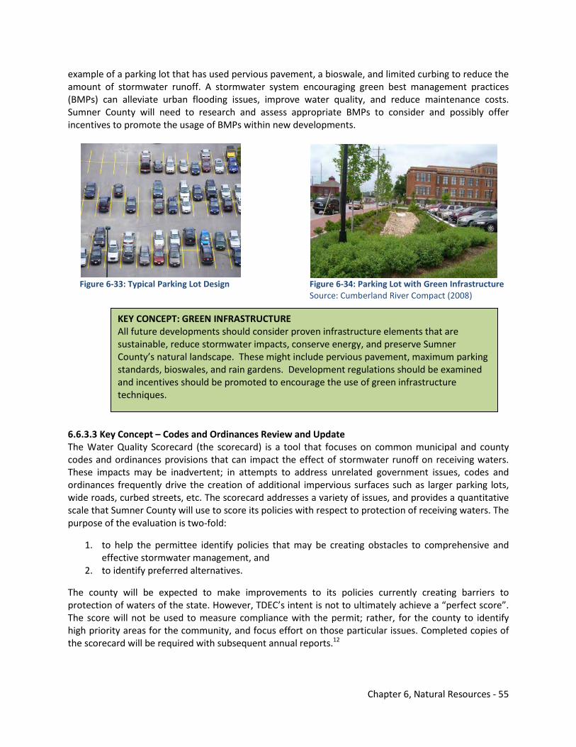
Chapter 6, Natural Resources - 55
example of a parking lot that has used pervious pavement, a bioswale, and limited curbing to reduce the amount of stormwater runoff. A stormwater system encouraging green best management practices (BMPs) can alleviate urban flooding issues, improve water quality, and reduce maintenance costs. Sumner County will need to research and assess appropriate BMPs to consider and possibly offer incentives to promote the usage of BMPs within new developments.
Figure 6-33: Typical Parking Lot Design Figure 6-34: Parking Lot with Green Infrastructure Source: Cumberland River Compact (2008) 6.6.3.3 Key Concept – Codes and Ordinances Review and Update The Water Quality Scorecard (the scorecard) is a tool that focuses on common municipal and county codes and ordinances provisions that can impact the effect of stormwater runoff on receiving waters. These impacts may be inadvertent; in attempts to address unrelated government issues, codes and ordinances frequently drive the creation of additional impervious surfaces such as larger parking lots, wide roads, curbed streets, etc. The scorecard addresses a variety of issues, and provides a quantitative scale that Sumner County will use to score its policies with respect to protection of receiving waters. The purpose of the evaluation is two-fold:
1. to help the permittee identify policies that may be creating obstacles to comprehensive and effective stormwater management, and
2. to identify preferred alternatives.
The county will be expected to make improvements to its policies currently creating barriers to protection of waters of the state. However, TDEC’s intent is not to ultimately achieve a “perfect score”. The score will not be used to measure compliance with the permit; rather, for the county to identify high priority areas for the community, and focus effort on those particular issues. Completed copies of the scorecard will be required with subsequent annual reports.12
KEY CONCEPT: GREEN INFRASTRUCTURE All future developments should consider proven infrastructure elements that are sustainable, reduce stormwater impacts, conserve energy, and preserve Sumner County’s natural landscape. These might include pervious pavement, maximum parking standards, bioswales, and rain gardens. Development regulations should be examined and incentives should be promoted to encourage the use of green infrastructure techniques.
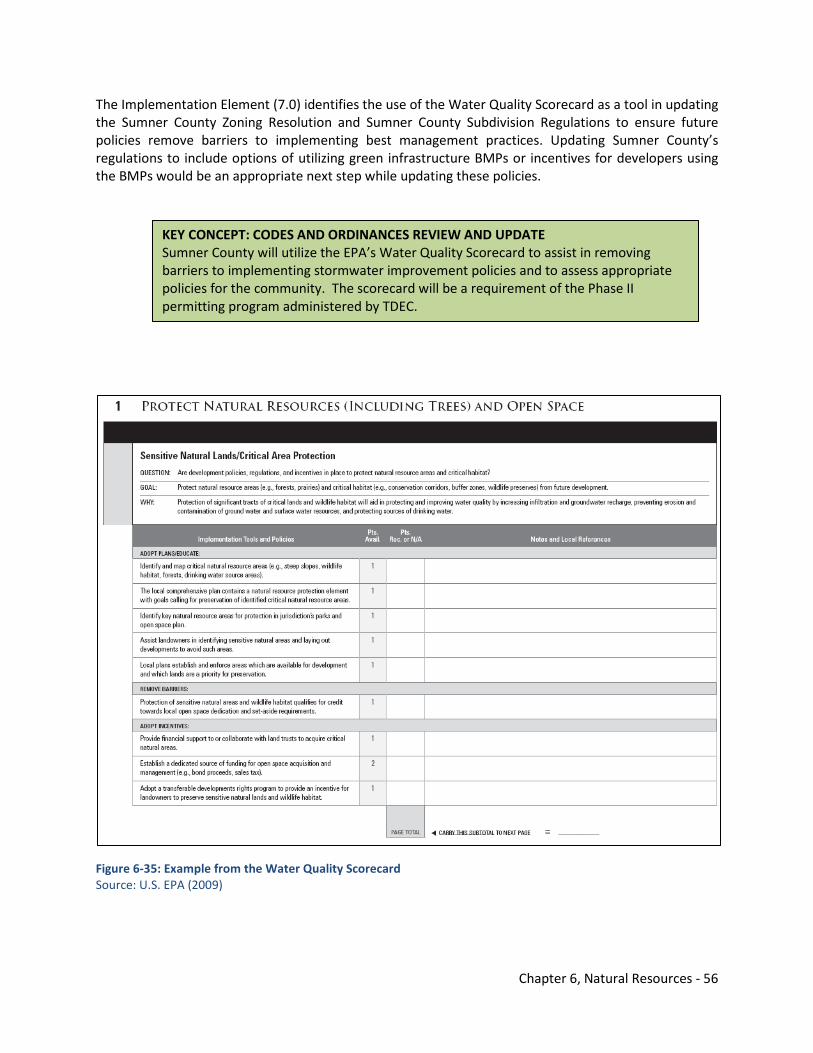
Chapter 6, Natural Resources - 56
The Implementation Element (7.0) identifies the use of the Water Quality Scorecard as a tool in updating the Sumner County Zoning Resolution and Sumner County Subdivision Regulations to ensure future policies remove barriers to implementing best management practices. Updating Sumner County’s regulations to include options of utilizing green infrastructure BMPs or incentives for developers using the BMPs would be an appropriate next step while updating these policies.
Figure 6-35: Example from the Water Quality Scorecard Source: U.S. EPA (2009)
KEY CONCEPT: CODES AND ORDINANCES REVIEW AND UPDATE Sumner County will utilize the EPA’s Water Quality Scorecard to assist in removing barriers to implementing stormwater improvement policies and to assess appropriate policies for the community. The scorecard will be a requirement of the Phase II permitting program administered by TDEC.
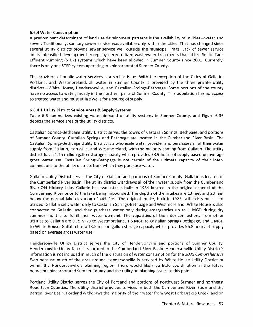
Chapter 6, Natural Resources - 57
6.6.4 Water Consumption A predominant determinant of land use development patterns is the availability of utilities—water and sewer. Traditionally, sanitary sewer service was available only within the cities. That has changed since several utility districts provide sewer service well outside the municipal limits. Lack of sewer service limits intensified development except by decentralized wastewater treatments that utilize Septic Tank Effluent Pumping (STEP) systems which have been allowed in Sumner County since 2001. Currently, there is only one STEP system operating in unincorporated Sumner County. The provision of public water services is a similar issue. With the exception of the Cities of Gallatin, Portland, and Westmoreland, all water in Sumner County is provided by the three private utility districts—White House, Hendersonville, and Castalian Springs-Bethpage. Some portions of the county have no access to water, mostly in the northern parts of Sumner County. This population has no access to treated water and must utilize wells for a source of supply. 6.6.4.1 Utility District Service Areas & Supply Systems Table 6-6 summarizes existing water demand of utility systems in Sumner County, and Figure 6-36 depicts the service area of the utility districts. Castalian Springs-Bethpage Utility District serves the towns of Castalian Springs, Bethpage, and portions of Sumner County. Castalian Springs and Bethpage are located in the Cumberland River Basin. The Castalian Springs-Bethpage Utility District is a wholesale water provider and purchases all of their water supply from Gallatin, Hartsville, and Westmoreland, with the majority coming from Gallatin. The utility district has a 1.45 million gallon storage capacity which provides 38.9 hours of supply based on average gross water use. Castalian Springs-Bethpage is not certain of the ultimate capacity of their inter-connections to the utility districts from which they purchase water. Gallatin Utility District serves the City of Gallatin and portions of Sumner County. Gallatin is located in the Cumberland River Basin. The utility district withdraws all of their water supply from the Cumberland River-Old Hickory Lake. Gallatin has two intakes built in 1954 located in the original channel of the Cumberland River prior to the lake being impounded. The depths of the intakes are 13 feet and 28 feet below the normal lake elevation of 445 feet. The original intake, built in 1925, still exists but is not utilized. Gallatin sells water daily to Castalian Springs-Bethpage and Westmoreland. White House is also connected to Gallatin, and they purchase water only during emergencies up to 1 MGD during dry summer months to fulfill their water demand. The capacities of the inter-connections from other utilities to Gallatin are 0.75 MGD to Westmoreland, 1.5 MGD to Castalian Springs-Bethpage, and 1 MGD to White House. Gallatin has a 13.5 million gallon storage capacity which provides 56.8 hours of supply based on average gross water use. Hendersonville Utility District serves the City of Hendersonville and portions of Sumner County. Hendersonville Utility District is located in the Cumberland River Basin. Hendersonville Utility District’s information is not included in much of the discussion of water consumption for the 2035 Comprehensive Plan because much of the area around Hendersonville is serviced by White House Utility District or within the Hendersonville’s planning region. There would likely be little coordination in the future between unincorporated Sumner County and the utility on planning issues at this point. Portland Utility District serves the City of Portland and portions of northwest Sumner and northeast Robertson Counties. The utility district provides services in both the Cumberland River Basin and the Barren River Basin. Portland withdraws the majority of their water from West Fork Drakes Creek, and on
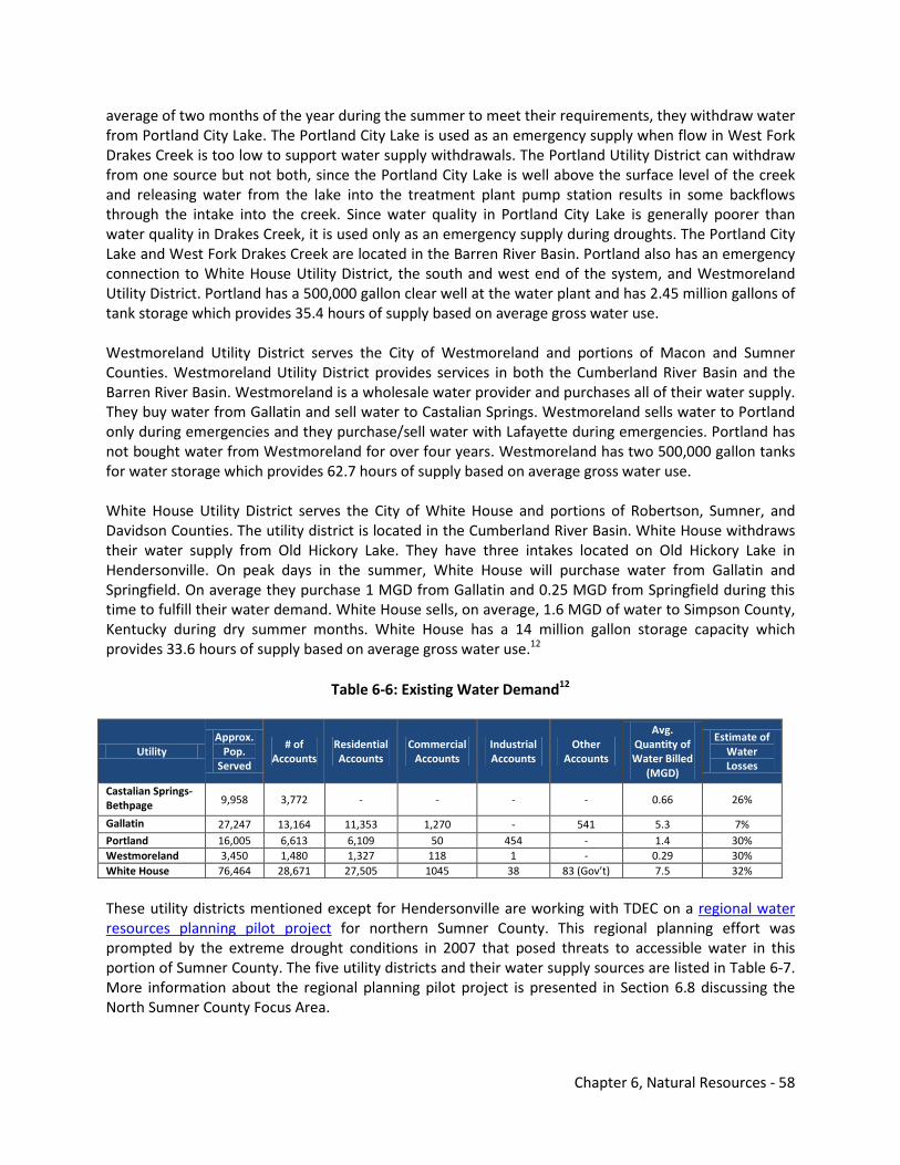
Chapter 6, Natural Resources - 58
average of two months of the year during the summer to meet their requirements, they withdraw water from Portland City Lake. The Portland City Lake is used as an emergency supply when flow in West Fork Drakes Creek is too low to support water supply withdrawals. The Portland Utility District can withdraw from one source but not both, since the Portland City Lake is well above the surface level of the creek and releasing water from the lake into the treatment plant pump station results in some backflows through the intake into the creek. Since water quality in Portland City Lake is generally poorer than water quality in Drakes Creek, it is used only as an emergency supply during droughts. The Portland City Lake and West Fork Drakes Creek are located in the Barren River Basin. Portland also has an emergency connection to White House Utility District, the south and west end of the system, and Westmoreland Utility District. Portland has a 500,000 gallon clear well at the water plant and has 2.45 million gallons of tank storage which provides 35.4 hours of supply based on average gross water use. Westmoreland Utility District serves the City of Westmoreland and portions of Macon and Sumner Counties. Westmoreland Utility District provides services in both the Cumberland River Basin and the Barren River Basin. Westmoreland is a wholesale water provider and purchases all of their water supply. They buy water from Gallatin and sell water to Castalian Springs. Westmoreland sells water to Portland only during emergencies and they purchase/sell water with Lafayette during emergencies. Portland has not bought water from Westmoreland for over four years. Westmoreland has two 500,000 gallon tanks for water storage which provides 62.7 hours of supply based on average gross water use. White House Utility District serves the City of White House and portions of Robertson, Sumner, and Davidson Counties. The utility district is located in the Cumberland River Basin. White House withdraws their water supply from Old Hickory Lake. They have three intakes located on Old Hickory Lake in Hendersonville. On peak days in the summer, White House will purchase water from Gallatin and Springfield. On average they purchase 1 MGD from Gallatin and 0.25 MGD from Springfield during this time to fulfill their water demand. White House sells, on average, 1.6 MGD of water to Simpson County, Kentucky during dry summer months. White House has a 14 million gallon storage capacity which provides 33.6 hours of supply based on average gross water use.12
Table 6-6: Existing Water Demand12
Utility Approx.
Pop. Served
# of Accounts
Residential Accounts
Commercial Accounts
Industrial Accounts
Other Accounts
Avg. Quantity of Water Billed
(MGD)
Estimate of Water Losses
Castalian Springs-Bethpage 9,958 3,772 - - - - 0.66 26%
Gallatin 27,247 13,164 11,353 1,270 - 541 5.3 7% Portland 16,005 6,613 6,109 50 454 - 1.4 30% Westmoreland 3,450 1,480 1,327 118 1 - 0.29 30% White House 76,464 28,671 27,505 1045 38 83 (Gov’t) 7.5 32%
These utility districts mentioned except for Hendersonville are working with TDEC on a regional water resources planning pilot project for northern Sumner County. This regional planning effort was prompted by the extreme drought conditions in 2007 that posed threats to accessible water in this portion of Sumner County. The five utility districts and their water supply sources are listed in Table 6-7. More information about the regional planning pilot project is presented in Section 6.8 discussing the North Sumner County Focus Area.
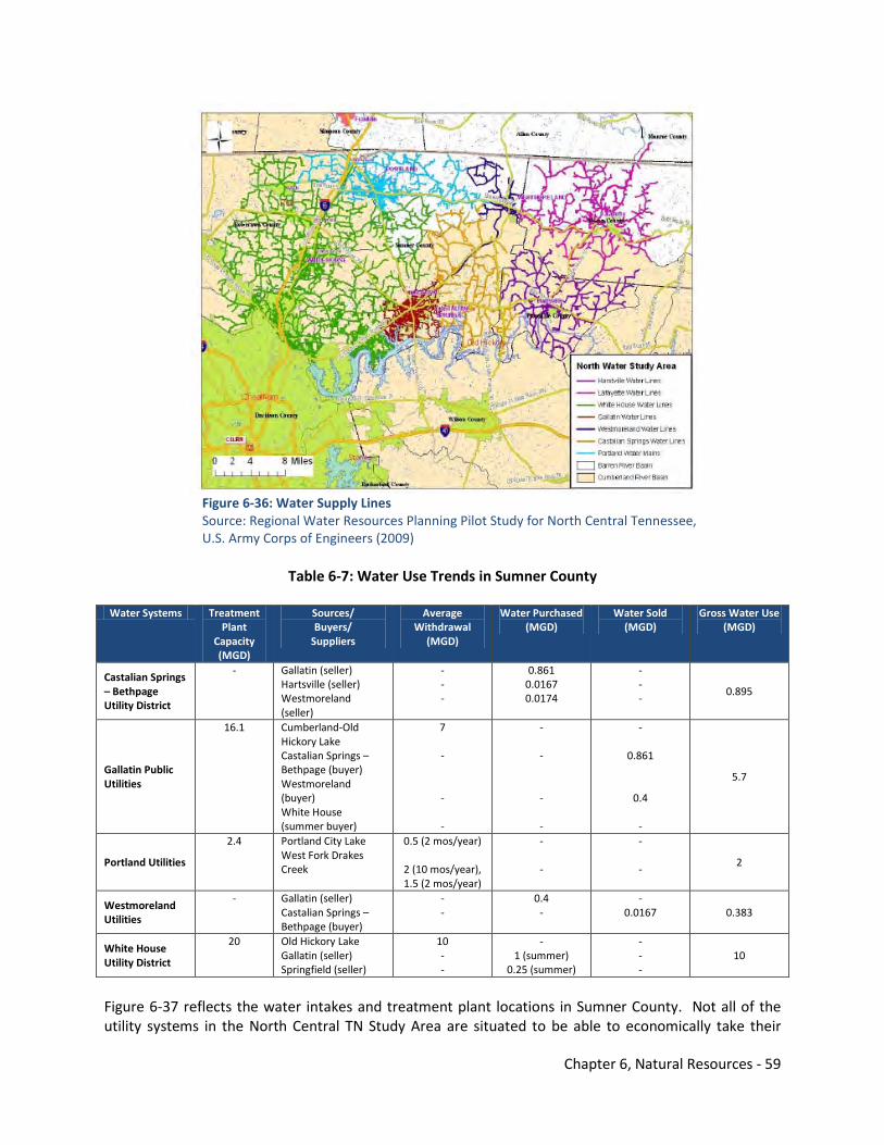
Chapter 6, Natural Resources - 59
Figure 6-36: Water Supply Lines Source: Regional Water Resources Planning Pilot Study for North Central Tennessee, U.S. Army Corps of Engineers (2009)
Table 6-7: Water Use Trends in Sumner County
Water Systems Treatment
Plant Capacity (MGD)
Sources/ Buyers/
Suppliers
Average Withdrawal
(MGD)
Water Purchased (MGD)
Water Sold (MGD)
Gross Water Use (MGD)
Castalian Springs – Bethpage Utility District
- Gallatin (seller) Hartsville (seller) Westmoreland (seller)
- - -
0.861 0.0167 0.0174
- - -
0.895
Gallatin Public Utilities
16.1 Cumberland-Old Hickory Lake Castalian Springs – Bethpage (buyer) Westmoreland (buyer) White House (summer buyer)
7 - - -
- - - -
-
0.861
0.4 -
5.7
Portland Utilities
2.4 Portland City Lake West Fork Drakes Creek
0.5 (2 mos/year)
2 (10 mos/year), 1.5 (2 mos/year)
- -
- -
2
Westmoreland Utilities
- Gallatin (seller) Castalian Springs – Bethpage (buyer)
- -
0.4 -
- 0.0167 0.383
White House Utility District
20 Old Hickory Lake Gallatin (seller) Springfield (seller)
10 - -
- 1 (summer)
0.25 (summer)
- - -
10
Figure 6-37 reflects the water intakes and treatment plant locations in Sumner County. Not all of the utility systems in the North Central TN Study Area are situated to be able to economically take their
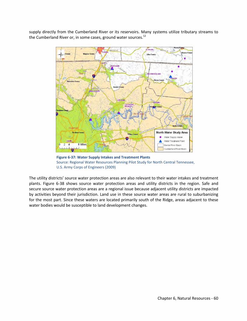
Chapter 6, Natural Resources - 60
supply directly from the Cumberland River or its reservoirs. Many systems utilize tributary streams to the Cumberland River or, in some cases, ground water sources.12
Figure 6-37: Water Supply Intakes and Treatment Plants Source: Regional Water Resources Planning Pilot Study for North Central Tennessee, U.S. Army Corps of Engineers (2009)
The utility districts’ source water protection areas are also relevant to their water intakes and treatment plants. Figure 6-38 shows source water protection areas and utility districts in the region. Safe and secure source water protection areas are a regional issue because adjacent utility districts are impacted by activities beyond their jurisdiction. Land use in these source water areas are rural to suburbanizing for the most part. Since these waters are located primarily south of the Ridge, areas adjacent to these water bodies would be susceptible to land development changes.
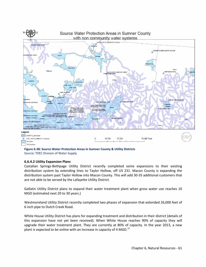
Chapter 6, Natural Resources - 61
Figure 6-38: Source Water Protection Areas in Sumner County & Utility Districts Source: TDEC Division of Water Supply 6.6.4.2 Utility Expansion Plans Castalian Springs-Bethpage Utility District recently completed some expansions to their existing distribution system by extending lines to Taylor Hollow, off US 231. Macon County is expanding the distribution system past Taylor Hollow into Macon County. This will add 30-35 additional customers that are not able to be served by the Lafayette Utility District. Gallatin Utility District plans to expand their water treatment plant when gross water use reaches 10 MGD (estimated next 20 to 30 years.) Westmoreland Utility District recently completed two phases of expansion that extended 26,000 feet of 6 inch pipe to Dutch Creek Road. White House Utility District has plans for expanding treatment and distribution in their district (details of this expansion have not yet been received). When White House reaches 90% of capacity they will upgrade their water treatment plant. They are currently at 80% of capacity. In the year 2013, a new plant is expected to be online with an increase in capacity of 4 MGD.12
Chapter 6, Natural Resources - 62
6.6.4.3 Limiting Factors for Utility Expansion Castalian Springs-Bethpage Utility District claims that money is their limiting factor for expansion of their existing distribution system. At the same time, Gallatin Utility District cannot extend service into areas controlled by other utility districts. The limiting factors of expansion for Portland are limited raw water supply and small rural line sizes. White House and Castalian Springs-Bethpage do not have any current limiting factors for expansion.
Existing demand for the current population, the number of utility connections, the number of municipal and industrial connections, current percent of water produced that is billed, and system losses within north Sumner County are shown in Table 6-6. The approximate population served for each utility district was calculated by taking the average household size from the 2000 U.S. Census and multiplying it by the number of residential accounts in the service areas. Castalian Springs-Bethpage Utility District serves mainly residential accounts. The district serves only three convenience stores and one elementary school. They do not bill their water separately for these accounts. The average household size for Castalian Springs-Bethpage and surrounding Sumner County area is 2.64 persons. Gallatin Utility District serves residential, commercial, and other accounts such as sprinkler systems. The majority of Gallatin’s water is billed to residential accounts (80 to 90 percent). The rest of the water billed is to commercial or other accounts. The average household size for the Gallatin service area is 2.40 persons. Portland Utility District serves a majority of residential accounts and a small amount of commercial and industrial accounts. On average, 90 percent of Portland’s water billed is to residential accounts, six percent to commercial accounts, and four percent to industrial accounts. The average household size for the Portland area is 2.62 persons. Westmoreland Utility District serves a majority of residential accounts and a fair amount of industrial accounts. The average household size for the Westmoreland area is 2.60 persons. White House Utility District serves a majority of residential accounts, a fair amount of commercial accounts, and a small amount of industrial/other accounts. The average household size of the White House area is 2.78 persons.12 6.6.4.4 Self Supplied Users (Water Wells) Water wells are still utilized in Sumner County, particularly in the northeast quadrant. All of the self supplied users in northern Sumner County are assumed to withdraw their water from groundwater sources. Since none of the utility districts provided their water use broken into different accounts, an average of 125 gallons per day per person was used to determine the estimated amount of water use by self supplied users in the study area. Castalian Springs-Bethpage Utility District serves an area of roughly 124 square miles. Using 2000 U.S. Census data, it was determined that the service area has an approximate population of 20,040 persons. Since Castalian Springs-Bethpage serves an approximate population of 9,958, it was estimated that the population of self-supplied users in the service area is 10,082. With the average household size of 2.64 persons, the estimated number of potential new residential accounts is 3,819. With each person using
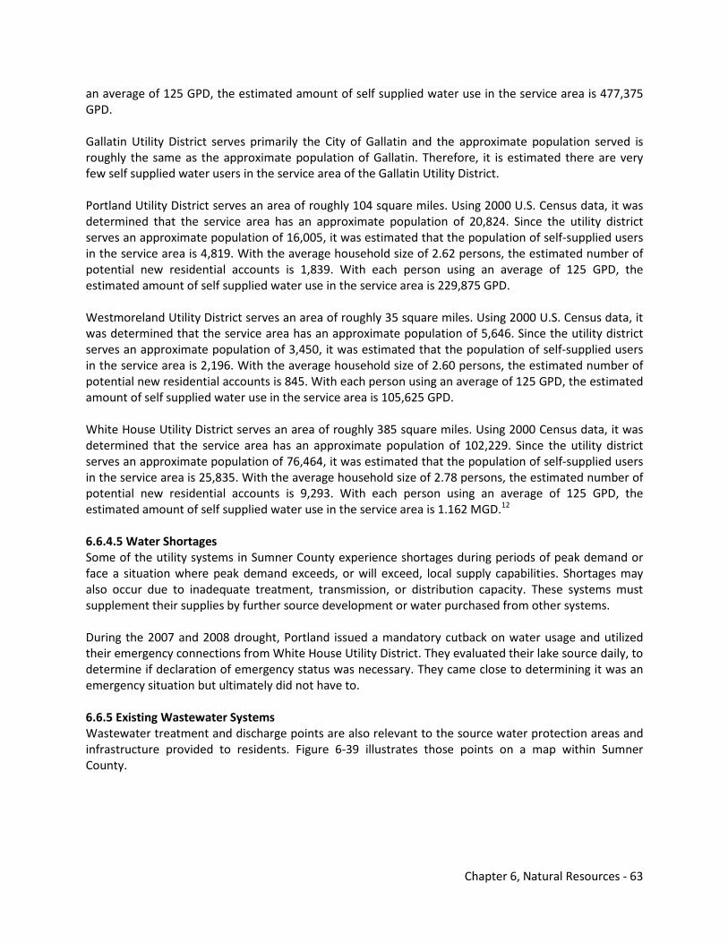
Chapter 6, Natural Resources - 63
an average of 125 GPD, the estimated amount of self supplied water use in the service area is 477,375 GPD. Gallatin Utility District serves primarily the City of Gallatin and the approximate population served is roughly the same as the approximate population of Gallatin. Therefore, it is estimated there are very few self supplied water users in the service area of the Gallatin Utility District. Portland Utility District serves an area of roughly 104 square miles. Using 2000 U.S. Census data, it was determined that the service area has an approximate population of 20,824. Since the utility district serves an approximate population of 16,005, it was estimated that the population of self-supplied users in the service area is 4,819. With the average household size of 2.62 persons, the estimated number of potential new residential accounts is 1,839. With each person using an average of 125 GPD, the estimated amount of self supplied water use in the service area is 229,875 GPD. Westmoreland Utility District serves an area of roughly 35 square miles. Using 2000 U.S. Census data, it was determined that the service area has an approximate population of 5,646. Since the utility district serves an approximate population of 3,450, it was estimated that the population of self-supplied users in the service area is 2,196. With the average household size of 2.60 persons, the estimated number of potential new residential accounts is 845. With each person using an average of 125 GPD, the estimated amount of self supplied water use in the service area is 105,625 GPD. White House Utility District serves an area of roughly 385 square miles. Using 2000 Census data, it was determined that the service area has an approximate population of 102,229. Since the utility district serves an approximate population of 76,464, it was estimated that the population of self-supplied users in the service area is 25,835. With the average household size of 2.78 persons, the estimated number of potential new residential accounts is 9,293. With each person using an average of 125 GPD, the estimated amount of self supplied water use in the service area is 1.162 MGD.12 6.6.4.5 Water Shortages Some of the utility systems in Sumner County experience shortages during periods of peak demand or face a situation where peak demand exceeds, or will exceed, local supply capabilities. Shortages may also occur due to inadequate treatment, transmission, or distribution capacity. These systems must supplement their supplies by further source development or water purchased from other systems. During the 2007 and 2008 drought, Portland issued a mandatory cutback on water usage and utilized their emergency connections from White House Utility District. They evaluated their lake source daily, to determine if declaration of emergency status was necessary. They came close to determining it was an emergency situation but ultimately did not have to. 6.6.5 Existing Wastewater Systems Wastewater treatment and discharge points are also relevant to the source water protection areas and infrastructure provided to residents. Figure 6-39 illustrates those points on a map within Sumner County.
Chapter 6, Natural Resources - 64
Figure 6-39: Wastewater Treatment Plants & Discharge Points Source: Regional Water Resources Planning Pilot Study for North Central Tennessee, U.S. Army Corps of Engineers (2009)
Table 6-8 summarizes the key characteristics of the wastewater systems in Sumner County. Castalian Springs has no sewer customers or waste water treatment plant (WWTP). Gallatin’s WWTP is currently being upgraded to treat 11.5 million gallons per day. The plant has a 25 million gallon hydraulic capacity. Gallatin discharges into the Cumberland River. Portland’s WWTP has a 3.8 MGD capacity and treats 1.9 MGD on average and 3.8 MGD for peak flow. Portland discharges into Sumner Branch, which flows into the Red River. Westmoreland has a 300,000 GPD capacity WWTP and discharges an average of 250,000 GPD to Little Trammel Creek. White House has a small package system located in the Tanasi Shores development in Gallatin. The treatment plant has a 40,000 GPD capacity. They discharge an average of 18,000 GPD to Old Hickory Lake. The majority of White House’s wastewater is pumped to Metro Nashville and to the City of Gallatin—an average of 250,000 and 200,000 GPD, respectively. Lack of sewer service limits intensified development except by decentralized wastewater treatments that utilize Septic Tank Effluent Pumping (STEP) systems which have been allowed in Sumner County since 2001. Currently, there is only one STEP system operating in unincorporated Sumner County, and that system is maintained by the Tennessee Wastewater Facility in Creekview Estates. Some issues with STEP systems include:
• Accountability for maintenance by a utility or service provider. • Potential burden upon the county or residents in the event of a failed system.
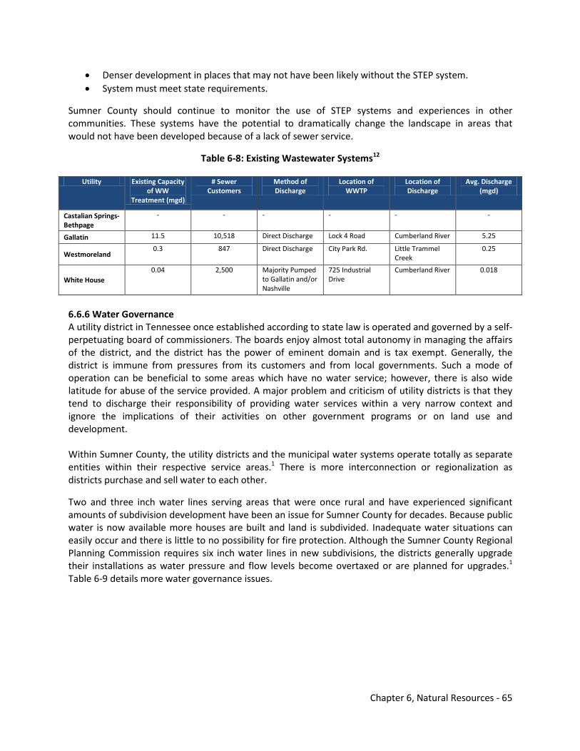
Chapter 6, Natural Resources - 65
• Denser development in places that may not have been likely without the STEP system. • System must meet state requirements.
Sumner County should continue to monitor the use of STEP systems and experiences in other communities. These systems have the potential to dramatically change the landscape in areas that would not have been developed because of a lack of sewer service.
Table 6-8: Existing Wastewater Systems12
Utility Existing Capacity
of WW Treatment (mgd)
# Sewer Customers
Method of Discharge
Location of WWTP
Location of Discharge
Avg. Discharge (mgd)
Castalian Springs-Bethpage
- - - - - -
Gallatin 11.5 10,518 Direct Discharge Lock 4 Road Cumberland River 5.25
Westmoreland 0.3 847 Direct Discharge City Park Rd. Little Trammel
Creek 0.25
White House 0.04 2,500 Majority Pumped
to Gallatin and/or Nashville
725 Industrial Drive
Cumberland River 0.018
6.6.6 Water Governance A utility district in Tennessee once established according to state law is operated and governed by a self-perpetuating board of commissioners. The boards enjoy almost total autonomy in managing the affairs of the district, and the district has the power of eminent domain and is tax exempt. Generally, the district is immune from pressures from its customers and from local governments. Such a mode of operation can be beneficial to some areas which have no water service; however, there is also wide latitude for abuse of the service provided. A major problem and criticism of utility districts is that they tend to discharge their responsibility of providing water services within a very narrow context and ignore the implications of their activities on other government programs or on land use and development. Within Sumner County, the utility districts and the municipal water systems operate totally as separate entities within their respective service areas.1 There is more interconnection or regionalization as districts purchase and sell water to each other.
Two and three inch water lines serving areas that were once rural and have experienced significant amounts of subdivision development have been an issue for Sumner County for decades. Because public water is now available more houses are built and land is subdivided. Inadequate water situations can easily occur and there is little to no possibility for fire protection. Although the Sumner County Regional Planning Commission requires six inch water lines in new subdivisions, the districts generally upgrade their installations as water pressure and flow levels become overtaxed or are planned for upgrades.1 Table 6-9 details more water governance issues.
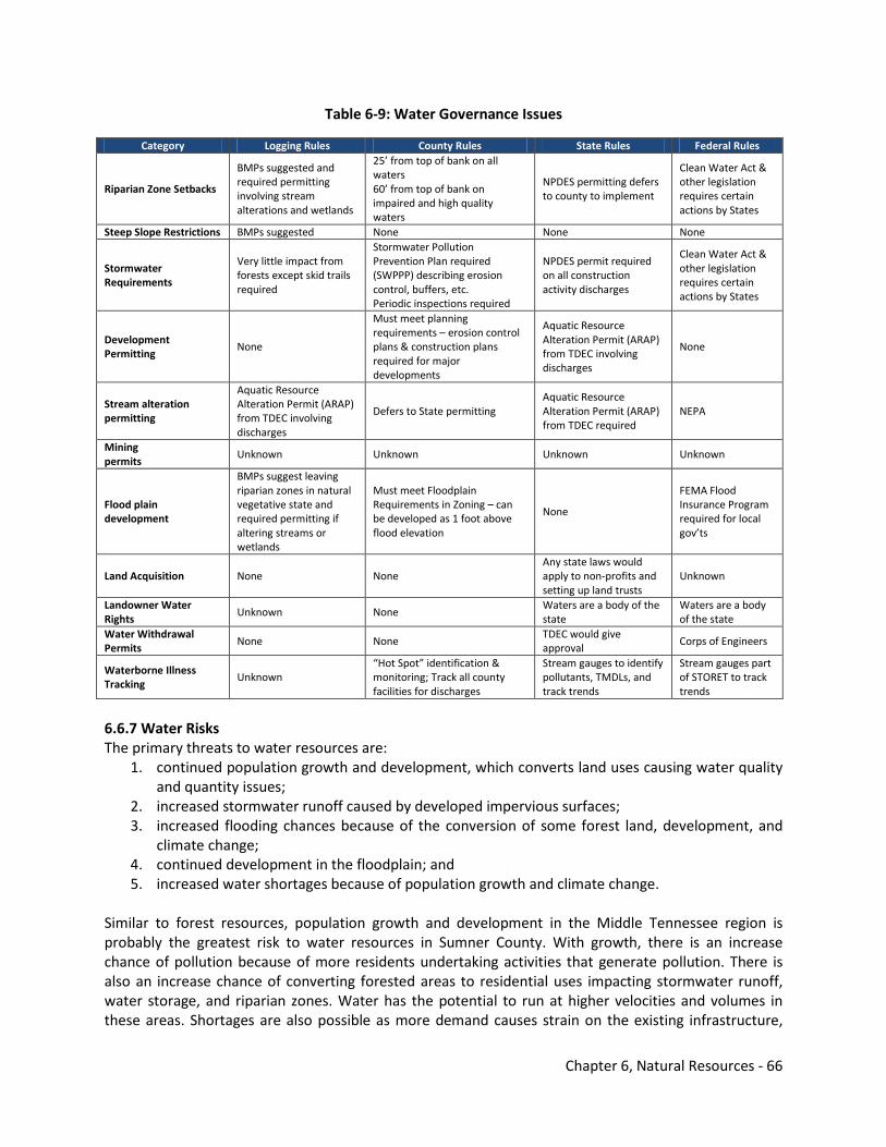
Chapter 6, Natural Resources - 66
Table 6-9: Water Governance Issues
Category Logging Rules County Rules State Rules Federal Rules
Riparian Zone Setbacks
BMPs suggested and required permitting involving stream alterations and wetlands
25’ from top of bank on all waters 60’ from top of bank on impaired and high quality waters
NPDES permitting defers to county to implement
Clean Water Act & other legislation requires certain actions by States
Steep Slope Restrictions BMPs suggested None None None
Stormwater Requirements
Very little impact from forests except skid trails required
Stormwater Pollution Prevention Plan required (SWPPP) describing erosion control, buffers, etc. Periodic inspections required
NPDES permit required on all construction activity discharges
Clean Water Act & other legislation requires certain actions by States
Development Permitting
None
Must meet planning requirements – erosion control plans & construction plans required for major developments
Aquatic Resource Alteration Permit (ARAP) from TDEC involving discharges
None
Stream alteration permitting
Aquatic Resource Alteration Permit (ARAP) from TDEC involving discharges
Defers to State permitting Aquatic Resource Alteration Permit (ARAP) from TDEC required
NEPA
Mining permits
Unknown Unknown Unknown Unknown
Flood plain development
BMPs suggest leaving riparian zones in natural vegetative state and required permitting if altering streams or wetlands
Must meet Floodplain Requirements in Zoning – can be developed as 1 foot above flood elevation
None
FEMA Flood Insurance Program required for local gov’ts
Land Acquisition None None Any state laws would apply to non-profits and setting up land trusts
Unknown
Landowner Water Rights
Unknown None Waters are a body of the state
Waters are a body of the state
Water Withdrawal Permits
None None TDEC would give approval
Corps of Engineers
Waterborne Illness Tracking
Unknown “Hot Spot” identification & monitoring; Track all county facilities for discharges
Stream gauges to identify pollutants, TMDLs, and track trends
Stream gauges part of STORET to track trends
6.6.7 Water Risks The primary threats to water resources are:
1. continued population growth and development, which converts land uses causing water quality and quantity issues;
2. increased stormwater runoff caused by developed impervious surfaces; 3. increased flooding chances because of the conversion of some forest land, development, and
climate change; 4. continued development in the floodplain; and 5. increased water shortages because of population growth and climate change.
Similar to forest resources, population growth and development in the Middle Tennessee region is probably the greatest risk to water resources in Sumner County. With growth, there is an increase chance of pollution because of more residents undertaking activities that generate pollution. There is also an increase chance of converting forested areas to residential uses impacting stormwater runoff, water storage, and riparian zones. Water has the potential to run at higher velocities and volumes in these areas. Shortages are also possible as more demand causes strain on the existing infrastructure,
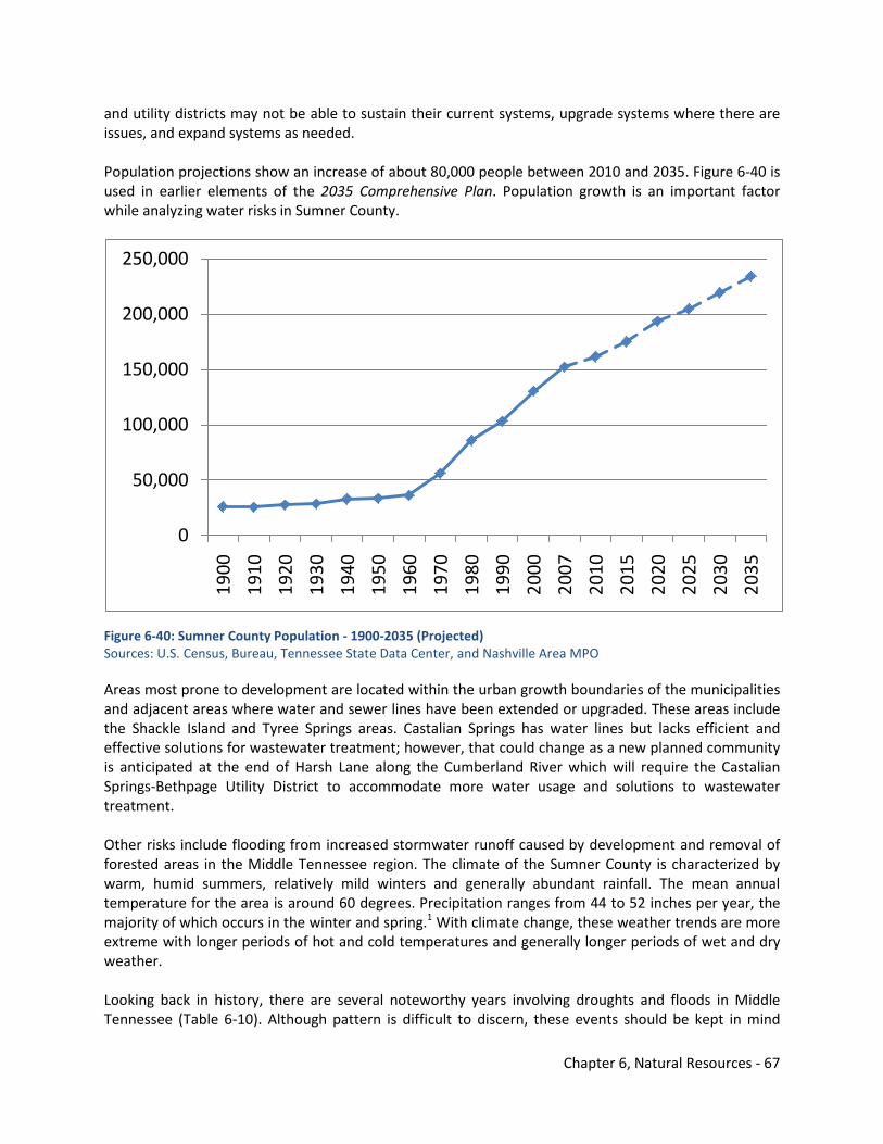
Chapter 6, Natural Resources - 67
and utility districts may not be able to sustain their current systems, upgrade systems where there are issues, and expand systems as needed. Population projections show an increase of about 80,000 people between 2010 and 2035. Figure 6-40 is used in earlier elements of the 2035 Comprehensive Plan. Population growth is an important factor while analyzing water risks in Sumner County.
Figure 6-40: Sumner County Population - 1900-2035 (Projected) Sources: U.S. Census, Bureau, Tennessee State Data Center, and Nashville Area MPO Areas most prone to development are located within the urban growth boundaries of the municipalities and adjacent areas where water and sewer lines have been extended or upgraded. These areas include the Shackle Island and Tyree Springs areas. Castalian Springs has water lines but lacks efficient and effective solutions for wastewater treatment; however, that could change as a new planned community is anticipated at the end of Harsh Lane along the Cumberland River which will require the Castalian Springs-Bethpage Utility District to accommodate more water usage and solutions to wastewater treatment. Other risks include flooding from increased stormwater runoff caused by development and removal of forested areas in the Middle Tennessee region. The climate of the Sumner County is characterized by warm, humid summers, relatively mild winters and generally abundant rainfall. The mean annual temperature for the area is around 60 degrees. Precipitation ranges from 44 to 52 inches per year, the majority of which occurs in the winter and spring.1 With climate change, these weather trends are more extreme with longer periods of hot and cold temperatures and generally longer periods of wet and dry weather. Looking back in history, there are several noteworthy years involving droughts and floods in Middle Tennessee (Table 6-10). Although pattern is difficult to discern, these events should be kept in mind
0
50,000
100,000
150,000
200,000
250,000
1900
1910
1920
1930
1940
1950
1960
1970
1980
1990
2000
2007
2010
2015
2020
2025
2030
2035
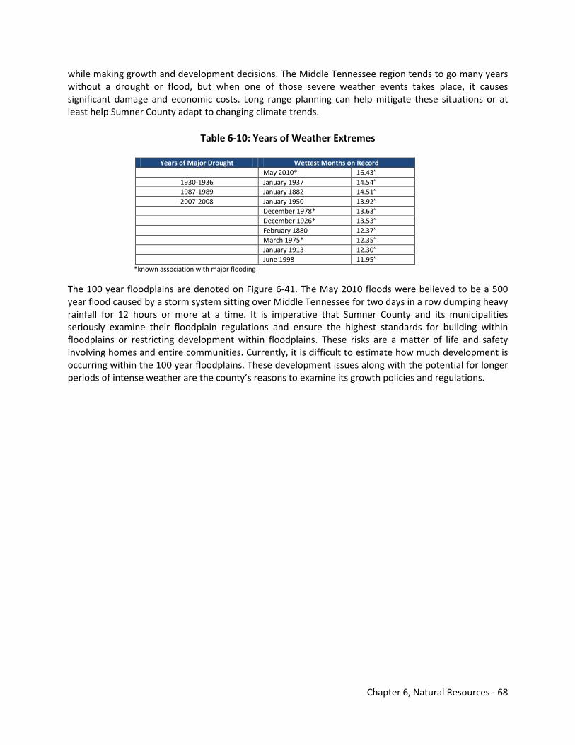
Chapter 6, Natural Resources - 68
while making growth and development decisions. The Middle Tennessee region tends to go many years without a drought or flood, but when one of those severe weather events takes place, it causes significant damage and economic costs. Long range planning can help mitigate these situations or at least help Sumner County adapt to changing climate trends.
Table 6-10: Years of Weather Extremes
Years of Major Drought Wettest Months on Record May 2010* 16.43”
1930-1936 January 1937 14.54” 1987-1989 January 1882 14.51” 2007-2008 January 1950 13.92”
December 1978* 13.63” December 1926* 13.53” February 1880 12.37” March 1975* 12.35” January 1913 12.30” June 1998 11.95”
*known association with major flooding
The 100 year floodplains are denoted on Figure 6-41. The May 2010 floods were believed to be a 500 year flood caused by a storm system sitting over Middle Tennessee for two days in a row dumping heavy rainfall for 12 hours or more at a time. It is imperative that Sumner County and its municipalities seriously examine their floodplain regulations and ensure the highest standards for building within floodplains or restricting development within floodplains. These risks are a matter of life and safety involving homes and entire communities. Currently, it is difficult to estimate how much development is occurring within the 100 year floodplains. These development issues along with the potential for longer periods of intense weather are the county’s reasons to examine its growth policies and regulations.
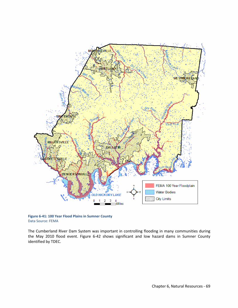
Chapter 6, Natural Resources - 69
Figure 6-41: 100 Year Flood Plains in Sumner County Data Source: FEMA The Cumberland River Dam System was important in controlling flooding in many communities during the May 2010 flood event. Figure 6-42 shows significant and low hazard dams in Sumner County identified by TDEC.
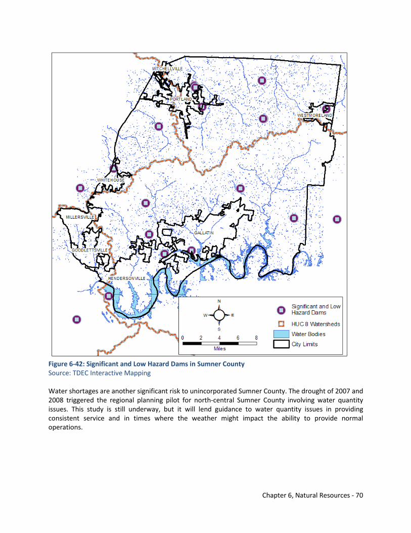
Chapter 6, Natural Resources - 70
Figure 6-42: Significant and Low Hazard Dams in Sumner County Source: TDEC Interactive Mapping Water shortages are another significant risk to unincorporated Sumner County. The drought of 2007 and 2008 triggered the regional planning pilot for north-central Sumner County involving water quantity issues. This study is still underway, but it will lend guidance to water quantity issues in providing consistent service and in times where the weather might impact the ability to provide normal operations.
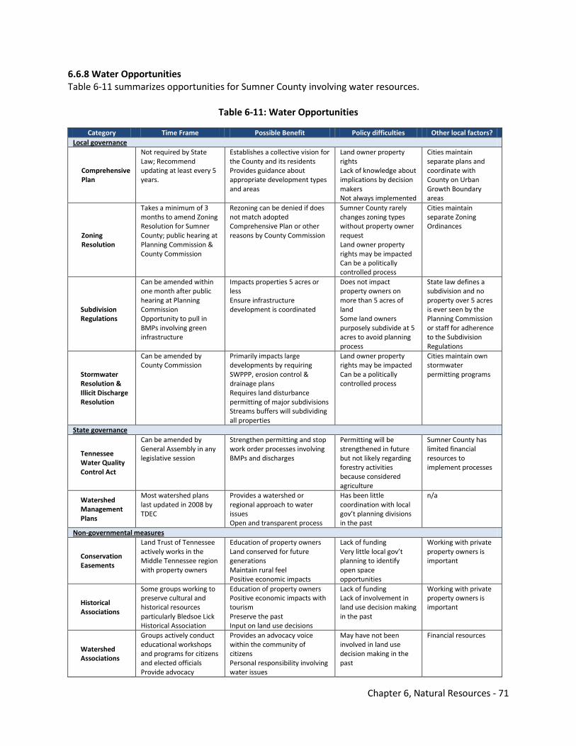
Chapter 6, Natural Resources - 71
6.6.8 Water Opportunities Table 6-11 summarizes opportunities for Sumner County involving water resources.
Table 6-11: Water Opportunities
Category Time Frame Possible Benefit Policy difficulties Other local factors? Local governance
Comprehensive Plan
Not required by State Law; Recommend updating at least every 5 years.
Establishes a collective vision for the County and its residents Provides guidance about appropriate development types and areas
Land owner property rights Lack of knowledge about implications by decision makers Not always implemented
Cities maintain separate plans and coordinate with County on Urban Growth Boundary areas
Zoning Resolution
Takes a minimum of 3 months to amend Zoning Resolution for Sumner County; public hearing at Planning Commission & County Commission
Rezoning can be denied if does not match adopted Comprehensive Plan or other reasons by County Commission
Sumner County rarely changes zoning types without property owner request Land owner property rights may be impacted Can be a politically controlled process
Cities maintain separate Zoning Ordinances
Subdivision Regulations
Can be amended within one month after public hearing at Planning Commission Opportunity to pull in BMPs involving green infrastructure
Impacts properties 5 acres or less Ensure infrastructure development is coordinated
Does not impact property owners on more than 5 acres of land Some land owners purposely subdivide at 5 acres to avoid planning process
State law defines a subdivision and no property over 5 acres is ever seen by the Planning Commission or staff for adherence to the Subdivision Regulations
Stormwater Resolution & Illicit Discharge Resolution
Can be amended by County Commission
Primarily impacts large developments by requiring SWPPP, erosion control & drainage plans Requires land disturbance permitting of major subdivisions Streams buffers will subdividing all properties
Land owner property rights may be impacted Can be a politically controlled process
Cities maintain own stormwater permitting programs
State governance
Tennessee Water Quality Control Act
Can be amended by General Assembly in any legislative session
Strengthen permitting and stop work order processes involving BMPs and discharges
Permitting will be strengthened in future but not likely regarding forestry activities because considered agriculture
Sumner County has limited financial resources to implement processes
Watershed Management Plans
Most watershed plans last updated in 2008 by TDEC
Provides a watershed or regional approach to water issues Open and transparent process
Has been little coordination with local gov’t planning divisions in the past
n/a
Non-governmental measures
Conservation Easements
Land Trust of Tennessee actively works in the Middle Tennessee region with property owners
Education of property owners Land conserved for future generations Maintain rural feel Positive economic impacts
Lack of funding Very little local gov’t planning to identify open space opportunities
Working with private property owners is important
Historical Associations
Some groups working to preserve cultural and historical resources particularly Bledsoe Lick Historical Association
Education of property owners Positive economic impacts with tourism Preserve the past Input on land use decisions
Lack of funding Lack of involvement in land use decision making in the past
Working with private property owners is important
Watershed Associations
Groups actively conduct educational workshops and programs for citizens and elected officials Provide advocacy
Provides an advocacy voice within the community of citizens Personal responsibility involving water issues
May have not been involved in land use decision making in the past
Financial resources
Chapter 6, Natural Resources - 72
6.7 Cultural Resources in Sumner County Sumner County was created by act of the North Carolina General Assembly, November 17, 1786, and obtained its area from the eastern portion of Davidson County, then the only county in Middle Tennessee. It is the second oldest county in the middle grand division and was at the time the fifth county organized in the state. The original bounds of Sumner County included areas that were later incorporated into the present counties of Wilson, Macon, Smith, and Trousdale, and it now contains 538 square miles. The first permanent settlement in the area which is now Sumner County was made in 1779 at Bledsoe Lick. This is now known as Castalian Springs. Prior to that time, the territory had only been visited by hunters and explorers. The area was then a vast wilderness inhabited only by Indians and wild animals such as buffalo, bear, wildcat, deer, and a variety of small game. Thomas Spencer, a hunter and explorer, is known as the first permanent settler in the county and is reputed to have lived in a hollow sycamore tree at Bledsoe Lick in 1779. Early settlements took place in close by forts or stations which were erected by the settlers for protection from Indian attacks. The most notable of these were Bledsoe’s Station, at Bledsoe Lick, Mansker’s Station, near Mansker Creek; Greenfield Station, about two miles north of Bledsoe Lick; Zeigler’s Station, on Zeigler Creek about five miles southeast of Gallatin, and near Cairo; White’s and Lander’s Stations on Deshea Creek; and Hamilton’s Station at the headwaters of Drakes Creek. There were other forts as well erected at various places in the county. These forts consisted mostly of stockades, made of timbers set upright, and they afforded good protection from Indian attacks. The early pioneers settled in groups around these forts. In addition to hardships caused by the Indians, early settlers also had to carve a place for home and farm out of a heavily wooded wilderness. The timber consisted of such excellent hardwoods as oak, poplar, chestnut, walnut, beech, maple, elm, and hickory. The settlers were forced to reduce grain to flour or meal by the use of the mortar, and later by small horse mills. The first permanent water mill was erected by George Winchester on Bledsoe Creek at the crossing of the Nashville and Carthage Turnpike. This was later known as Stump’s Mill. Soon after 1800, another mill was erected on Station Camp Creek near Gallatin, and a third mill on Drakes Creek now in Hendersonville. Grist and saw mills were continuously erected as the county was settled and developed. After fields were created from wooded areas, the raising of cotton and tobacco was introduced, and cotton was a staple crop. Tobacco has long been a vital crop on the highlands in the northern part of the county where the soils are particularly well suited for that crop. By an act passed in November of 1801, the General Assembly of the State of Tennessee appointed Samuel Donelson, Shadrick Nye, James Wilson, Charles Donoho, and Major Tomas Murray commissioners to purchase forty acres of land and lay out a town for the seat of justice to be called Gallatin, to superintend the sales of lots, the erection of public building, and for other purposes. Accordingly, the commissioners on February 25, 1802, purchased from Captain James Trousdale, for $490, the original site of the Town of Gallatin which contained 42.5 acres, including one acre reserved by the grantor and 1.5 acres in the public square. The town was surveyed and platted, and the sale of lots made in the spring of 1802.
Chapter 6, Natural Resources - 73
Numerous springs were found throughout the county, many with mineral waters. These contributed to the early development of the county. The variety of mineral waters at Tyree Springs at the head of Drakes Creek in western Sumner County earned Tyree the reputation as “the most celebrated watering place in the state.” The mineral waters at Castalian Springs provided the basis for a spa and resort development which began around 1828 and was quite noteworthy with Nashvillians as Nashville began to grown and urbanize.1
The details described in the above paragraphs were extracted from the Land Use Plan for Sumner County in 1977. This plan was developed for 2000, and it recognized the importance of the county’s history. Through the vision surveys and feedback from public meetings the rural atmosphere in the county and its cultural resources were mentioned as important qualities to maintain for Sumner County. Unfortunately, the 2035 Comprehensive Plan does not have sufficient room to further identify the cultural resources of historic significance in Sumner County. The goal of this plan was to at least mention the value of the county’s natural and cultural heritages and prepare the county for more detailed work needed to identify and assess these cultural resources that are worthy of preservation. In the Implementation Element (7.0), the creation of subarea plans is identified as action items. During this process, county officials should collect and assess cultural resources information unique to each subarea and more heavily consider these resources as part of those plans. The Bledsoe Lick area or Castalian Springs is noted in this element as a focus area because of involvement of the Bledsoe Lick Historical Association in the 2035 Comprehensive Plan and because of the association’s detailed work to protect Sumner County’s early settlement and develop a tourism industry encompassing the county’s cultural heritage. The land ownership information included in numerous maps in this element show some of the properties of significance in the Bledsoe Lick area. More specific noteworthy strategies are explored in the Focus Area discussion (Section 6.10) and within the Implementation Element (7.0) that build upon the Historical Association’s plan for Bledsoe Lick. 6.8 Putting It All Together The Natural & Cultural Resources Element contains a variety of information never analyzed together in one document for Sumner County. The element was developed because of the large amount of public and stakeholder input emphasizing the importance of Sumner County maintaining its natural resources and preserving its past. Although these resources are discussed rather distinctly within the element, it is necessary to pull these together and identify possible areas for Sumner County to consider for action strategies during implementation of the 2035 Comprehensive Plan. Figure 6-43 identifies all the “high value” resources in Sumner County. These areas include forest cover; high productivity forests; all water bodies; high quality streams; floodplains; critical aquatic, subterranean, and terrestrial habitats; and properties within a land trust or maintained for conservation.
Figure 6-44 overlays potential development threats to water, forest, and cultural resources in relationship to the high value resources. This is best illustrated by the adopted Growth Plan from 1999 required by Tennessee’s Public Chapter 1101 depicting urban growth boundaries, planned growth areas, and rural areas for the county. City limits are also noted on the maps. Growth and development is anticipated to occur over the next 10 to 25 years in these areas. The Growth Plan has not been updated since its initial adoption, so changes will be necessary in the future to the 1101 Growth Plan for Sumner County. At that time, serious consideration should be given to the analysis of water, forest, and cultural resources in this element to modify growth areas.
Chapter 6, Natural Resources - 74
The impaired waters and streams and drainages impaired by siltation are also illustrated as threats on Figure 6-44. These characteristics are likely more of a reflection of the changing development trends in Sumner County.
The dashed circles are areas where significant resources overlap with possible threats. The outline below corresponds with the numbers on Figure 6-44 and outlines the resources and threats. These areas should be further examined in subarea plans and model strategies outlined in the three Focus Areas in Sections 6.8, 6.9, and 6.10 should be considered.
1. Tyree Springs Area a. Resources:
i. Concentrated forest cover ii. Some high productivity forests
iii. Steep slopes iv. Terrestrial habitat identified in SWAP v. Streams and floodplain
b. Threats: i. Portions within White House urban growth boundary
ii. High growth area for unincorporated Sumner County particularly towards Hendersonville
iii. Water and sewer service are available in the area iv. Siltation impaired streams nearby
2. The Ridge
a. Resources: i. Concentrated forest cover
ii. Some high productivity forests iii. Some extremely steep slopes iv. Boundary between watersheds (headwaters) v. Limited expansion of water and sewer through the Ridge thus far
b. Threats: i. Zoning that allows intense developments on steep slopes
ii. Identified within the county’s planned growth area iii. Widening of SR 109 almost completed that may generate additional growth and
development
3. Bethpage-Bransford Areas a. Resources:
i. Concentrated high productivity forest cover ii. Steep slopes
iii. Terrestrial habitat identified in SWAP iv. Taylor Hollow nearby v. Historic Bethpage community
vi. Bledsoe Creek & floodplain vii. Greenways planned to traverse through area in the future
b. Threats: i. Growth and development from US 231 and US 31E/SR 6 intersecting in the area
ii. Limited financial resources to construct greenways
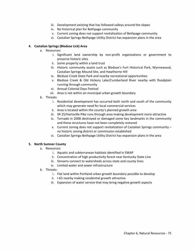
Chapter 6, Natural Resources - 75
iii. Development existing that has followed valleys around the slopes iv. No historical plan for Bethpage community v. Current zoning does not support revitalization of Bethpage community
vi. Castalian Springs-Bethpage Utility District has expansion plans in the area
4. Castalian Springs (Bledsoe Lick) Area a. Resources:
i. Significant land ownership by non-profit organizations or government to preserve historic sites
ii. Some property within a land trust iii. Historic community assets such as Bledsoe’s Fort Historical Park, Wynnewood,
Castalian Springs Mound Site, and Hawthorne Hill iv. Bledsoe Creek State Park and nearby recreational opportunities v. Bledsoe Creek & Old Hickory Lake/Cumberland River nearby with floodplain
running through community vi. Annual Colonial Days Festival
vii. Area is not within an municipal urban growth boundary b. Threats:
i. Residential development has occurred both north and south of the community which may generate need for local commercial services
ii. Area is located within the county’s planned growth area iii. SR 25/Hartsville Pike runs through area making development more attractive iv. Tornado in 2008 destroyed or damaged some key landmarks in the community
and these structures have not been completely restored v. Current zoning does not support revitalization of Castalian Springs community –
no historic zoning district or commission established vi. Castalian Springs-Bethpage Utility District has expansion plans in the area
5. North Sumner County
a. Resources: i. Aquatic and subterranean habitats identified in SWAP
ii. Concentration of high productivity forest near Kentucky State Line iii. Streams connect to watersheds across state and county lines iv. Limited water and sewer infrastructure
b. Threats: i. Flat land within Portland urban growth boundary possible to develop
ii. I-65 nearby making residential growth attractive iii. Expansion of water service that may bring negative growth aspects
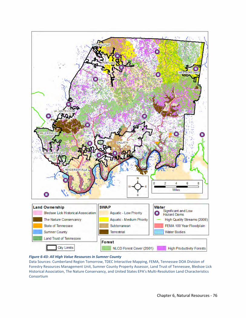
Chapter 6, Natural Resources - 76
Figure 6-43: All High Value Resources in Sumner County Data Sources: Cumberland Region Tomorrow, TDEC Interactive Mapping, FEMA, Tennessee DOA Division of Forestry Resources Management Unit, Sumner County Property Assessor, Land Trust of Tennessee, Bledsoe Lick Historical Association, The Nature Conservancy, and United States EPA’s Multi-Resolution Land Characteristics Consortium
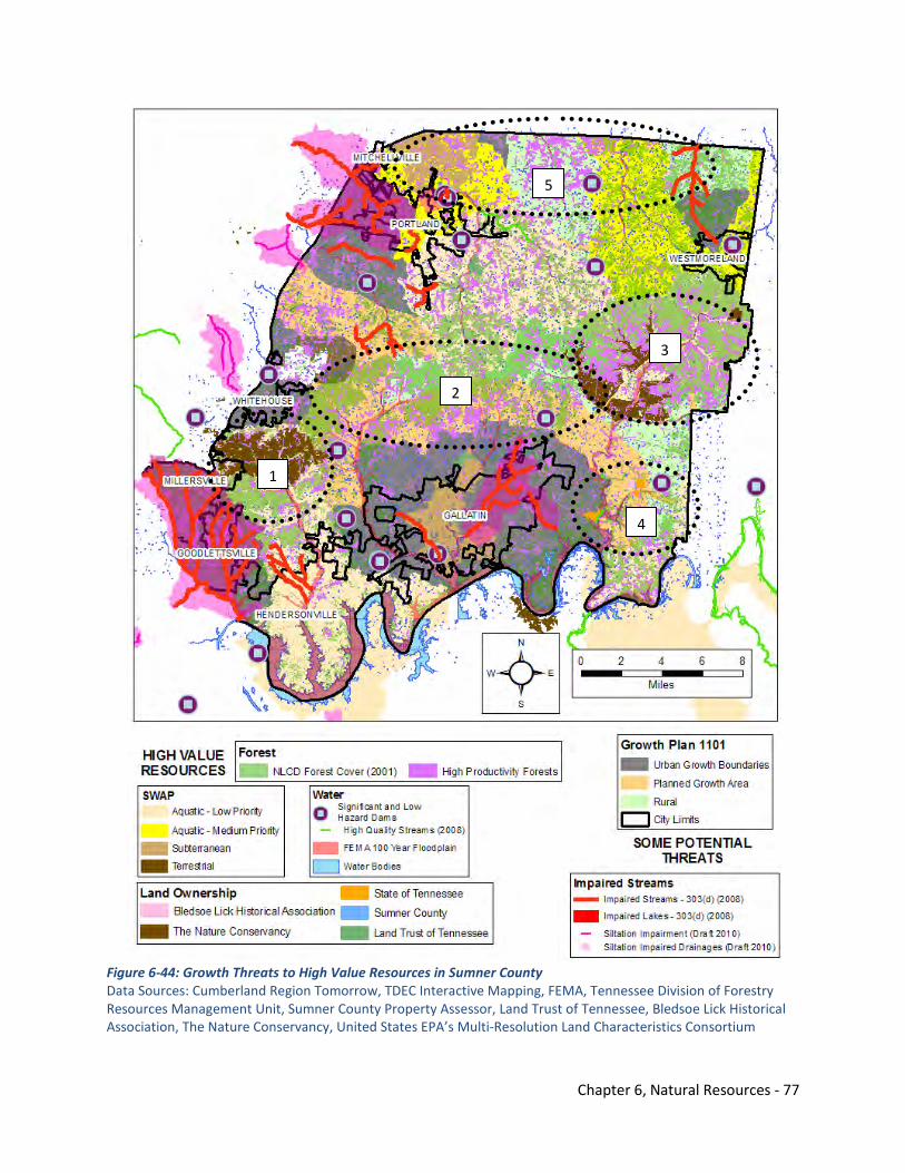
Chapter 6, Natural Resources - 77
Figure 6-44: Growth Threats to High Value Resources in Sumner County Data Sources: Cumberland Region Tomorrow, TDEC Interactive Mapping, FEMA, Tennessee Division of Forestry Resources Management Unit, Sumner County Property Assessor, Land Trust of Tennessee, Bledsoe Lick Historical Association, The Nature Conservancy, United States EPA’s Multi-Resolution Land Characteristics Consortium
1
2
3
4
5
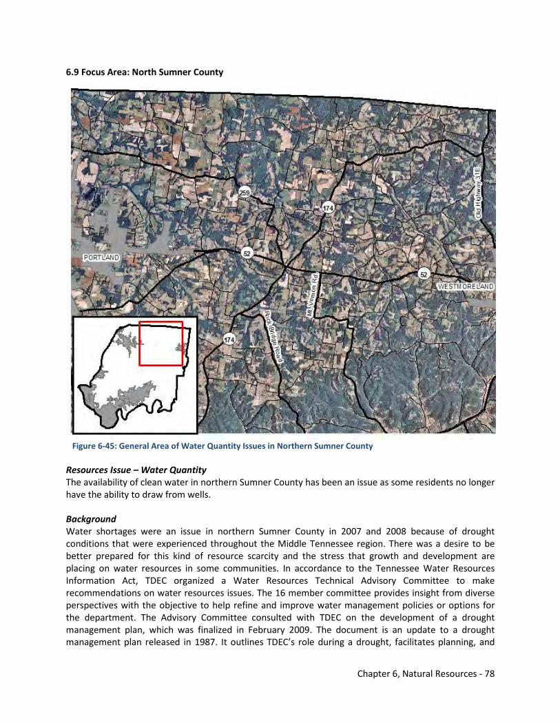
Chapter 6, Natural Resources - 78
6.9 Focus Area: North Sumner County
Figure 6-45: General Area of Water Quantity Issues in Northern Sumner County Resources Issue – Water Quantity The availability of clean water in northern Sumner County has been an issue as some residents no longer have the ability to draw from wells. Background Water shortages were an issue in northern Sumner County in 2007 and 2008 because of drought conditions that were experienced throughout the Middle Tennessee region. There was a desire to be better prepared for this kind of resource scarcity and the stress that growth and development are placing on water resources in some communities. In accordance to the Tennessee Water Resources Information Act, TDEC organized a Water Resources Technical Advisory Committee to make recommendations on water resources issues. The 16 member committee provides insight from diverse perspectives with the objective to help refine and improve water management policies or options for the department. The Advisory Committee consulted with TDEC on the development of a drought management plan, which was finalized in February 2009. The document is an update to a drought management plan released in 1987. It outlines TDEC’s role during a drought, facilitates planning, and
Chapter 6, Natural Resources - 79
provides a framework for action and cooperation in water resources management among the many local, state, and federal agencies with drought-related responsibilities. TDEC also developed a guide entitled Guidance for Developing Community Water System Drought Management Plans to provide community water systems with the necessary elements of a drought management plan. This guide is designed to promote increased preparedness so that a drought’s adverse impacts would be mitigated. The guidance includes suggested drought management planning steps. The Advisory Committee reviewed impacts form the drought of 2007 and discussed the benefits of a regional planning effort. The Advisory Committee recommended that TDEC pilot regional water resource planning projects to validate those benefits and develop a model regional water plan. In late 2008, TDEC partnered with the U.S. Army Corps of Engineers Nashville District, members of the Advisory Committee, and other regional planning experts to initiate a water resources planning pilot in two areas significantly impacted by the drought of 2007. The planning partners on this project also include the USGS, Tennessee Association of Utility Districts, Tennessee Department of Agriculture, Tennessee Advisory Commission on Intergovernmental Relations, Tennessee Valley Authority, Tennessee Wildlife Resources Agency, The Nature Conservancy, Land Trust for Tennessee, and Tennessee Tech University. One area included the North Central Tennessee region involving Sumner County, Portland, Gallatin, Castalian Springs-Bethpage, White House, and Westmoreland Utility Districts.13 Currently, TDEC is conducting this process which has involved gathering of water system infrastructure data, water consumption for the area, and studying the interconnectedness of the system in Sumner County with the region. The document, Water Resources Regional Planning Pilot for North Central Tennessee – Phase 1, was released in March 2009 detailing much of this information. TDEC is modeling water usage in the area and examining how improvements might impact service. Presently, there have not been recommendations released from this study; however, the impacts of this study will be important as unincorporated Sumner County continues to grow in the future. In this area of Sumner County, there are aquatic and subterranean habitats identified in the SWAP. There are also impaired streams due to some farming practices and development around the Portland City Limits. Additionally, high productivity forest cover is found around the Nubia area in north Sumner County. There are also several large parcels that have a large quantity of forested acres noted by the Division of Forestry. Currently, water infrastructure is not as prevalent as in southern Sumner County, but expansion of water infrastructure in this area could significantly impact growth and development in northern Sumner County in the future. SR 52 connecting Portland and Westmoreland is an improved highway and connects to Interstate 65 making shorter commutes to Nashville and Bowling Green, where more employment opportunities can be found. The recommendations that will be drawn from the pilot planning process will be important in preparing Sumner County for additional growth and/or protecting natural and cultural resources in this area of unincorporated Sumner County. Model Best Practices
• Sumner County should remain actively involved in the regional water resources planning pilot. • TDEC should continue discussions with Sumner County and municipal elected officials
concerning growth concerns. • The utility districts that serve Sumner County and planning departments should actively
communicate and coordinate growth and development issues.
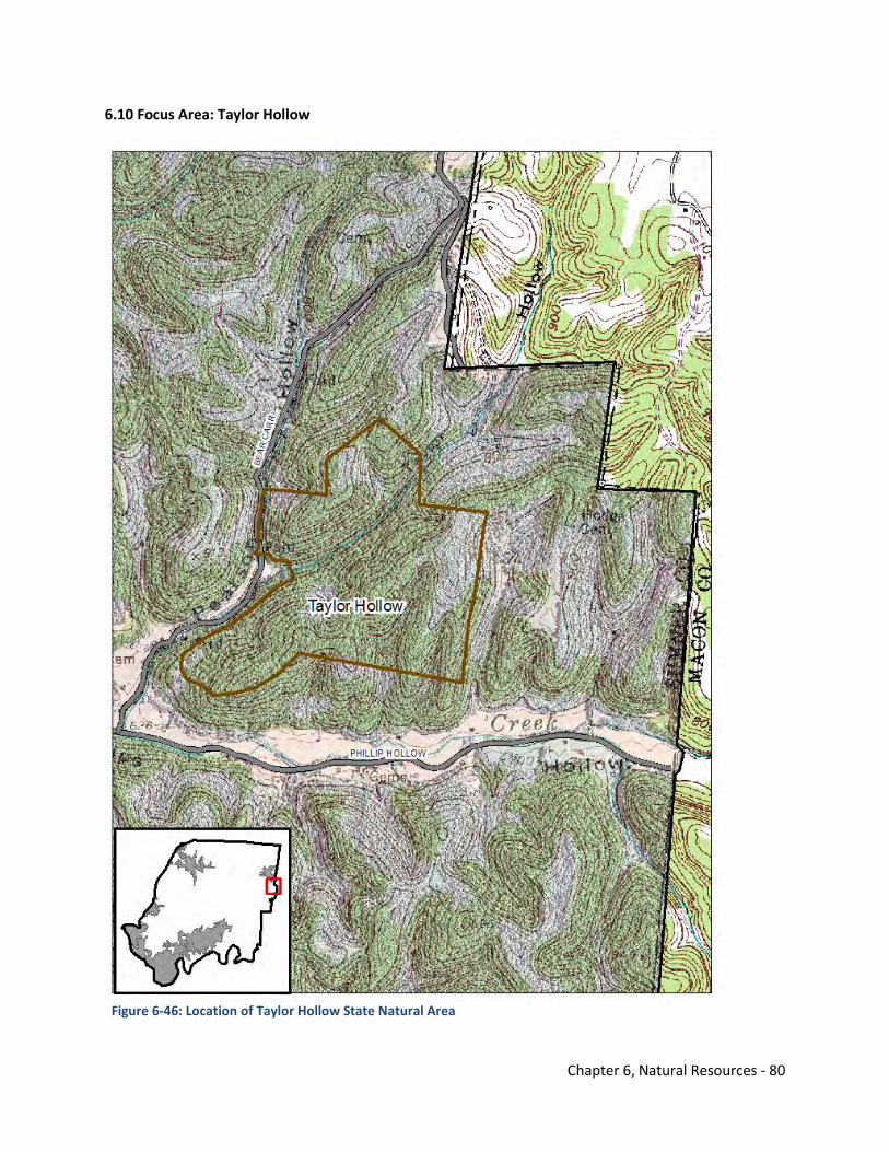
Chapter 6, Natural Resources - 80
6.10 Focus Area: Taylor Hollow
Figure 6-46: Location of Taylor Hollow State Natural Area
Chapter 6, Natural Resources - 81
Resources Issues – Steep Slope & Forest Cover The area of northern Sumner County near the Macon and Trousdale County Lines is forested with areas of steep slopes. This area is still rural; however, US 231 travels nearby and acts as a bypass for truck traffic and other vehicles around the Nashville area. The highway has been improved between Bowling Green and Scottsville, Kentucky making it an attractive travel option between I-65 and I-40 around Nashville. Background Taylor Hollow is a 173-acre natural area located in Sumner County on the Western Highland Rim and is owned by The Nature Conservancy. It is a Class II Natural-Scientific State Natural Area and is part of The Nature Conservancy’s Ecoregional Planning Terrestrial Portfolio. It is a botanically rich and a biologically diverse area that is one of only a very few areas remaining like this in Middle Tennessee that has been minimally impacted by human activity. The natural area is characterized by narrow winding ridges and separated by steep V-shaped valleys that drop 200 to 300 feet from the ridge. Its rich hollows provide habitat for a spectacular display of spring wildflowers and is highlighted by a carpet of blue-eyed Mary (Collinsia verna). The rare Ozark least trillium (Trillium pusillum var. oazarkanum) is another noteworthy species that occurs here. It is an evolutionary intermediate between sessile and stalked forms of trillium. Taylor Hollow's forest community is generally considered old growth though some very selective cutting for commercially important species may have occurred here. The mixed mesophytic forest is particularly interesting because its species composition is very similar to an East Tennessee forest. The forest structure is indicative of old growth with snags and large standing live trees along with decomposing logs and organic forest matter in decay on the forest floor. The vast occurrence of blue-eyed Mary is also indicative of old growth. Blue-eyed Mary is sensitive to forest disturbance like logging and probably was once much more abundant in moist rich Middle Tennessee forests before logging occurred. The mixed mesophytic forest includes sugar maple, tulip poplar, numerous oak and hickory species, ash species, buckeye, basswood, yellow wood, and beech, only to name but a few species. The mixed mesophytic forest is considered the most biologically diverse forest community in the eastern deciduous forest.14
Model Best Practices
• Identify other areas in Sumner County for restoration with minimal human activity. • Identify areas in Sumner County with forest cover and steep slopes that should not be
developed and work with property owners on conservation strategies. • Work with local non-profit organizations to help manage areas with similar characteristics to
ensure conservation in the future. • Assess how future growth with improved highways and infrastructure might impact natural
areas like Taylor Hollow.
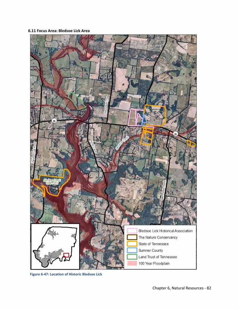
Chapter 6, Natural Resources - 82
6.11 Focus Area: Bledsoe Lick Area
Figure 6-47: Location of Historic Bledsoe Lick
Chapter 6, Natural Resources - 83
Resources Issues – Significant Cultural Resources and Water Bodies The Bledsoe Lick area or Castalian Springs community in Sumner County is a culturally rich area founded on Bledsoe Creek. Several historic structures, landmarks, and grounds are in the area with some significant properties under non-profit organizations or governments’ ownership. Bledsoe Creek meanders through the community with the State Park close by. Recreational and tourism opportunities exist and could be further expanded. Background There are four significant historic sites in Castalian Springs – Castalian Springs Mound Site, Bledsoe’s Fort, Wynnewood State Historic Site, and Hawthorne Hill. There is evidence that people may have lived in the area of Historic Bledsoe’s Lick as early as 15,000 years ago. The Castalian Springs Mound Site was occupied around 1,000 AD to 1,450 AD. When the first European settlers arrived in the late 18th century the area was a hunting ground for several Native American groups. It was toward the end of that century, about 1784, that Isaac Bledsoe built his fortified station. Bledsoe did not live to see it but by 1796 Native Americans had been driven from Middle Tennessee.
By the beginning of the 19th century substantial houses such as Hawthorne Hill (ca. 1800) were built in Castalian Springs. The massive log structure named Castalian Springs was completed about 1830. Not long after, the community of Bledsoe’s Lick adopted the name. It was not until the 1940s that the property was named Wynnewood after that family that had lived there for over a century.15
The Bledsoe Lick Historical Association developed A Preservation, Management, and Interpretive Plan for Historic Bledsoe’s Lick to address the four properties mentioned and future opportunities. Partners in this planning work were the Tennessee Wars Commission, Tennessee Historical Commission, Tennessee Division of Archaeology, Sumner County Commission, Sumner County Convention and Visitors Bureau, Middle Tennessee State University, and Associated Native American Tribes. The objectives of the plan are:
• construct a visitor center at Bledsoe’s Fort Historical Park; • increase visitation to both Bledsoe’s Fort Historical Park and Wynnewood; and • open Hawthorne Hill and Castalian Springs Mound Site to the public.15
Priorities are placed on preserving specific parcels through conservation easements and influencing future development that is appropriate for the viewshed. Issues involving identifying additional structures for preservation, managing the sites, marketing the area, and developing a well-designed interpretative program are discussed within the plan.
Model Best Practices
• Work with county officials particularly the Sumner County Board of County Commissioners and the Sumner County Regional Planning Commission to implement the Plan for Historic Bledsoe’s Lick.
• Identify potential parcels and properties of historic significance for conservation easements. • Market the area’s natural and cultural resources as a tourism initiative and economic driver for
the county. • Link the natural and cultural resources that are in proximity together such as the Bledsoe Creek
State Park and the original Bledsoe Lick community. • BLHA members should stay involved in development decisions regarding private property in the
immediate Bledsoe Lick area.
Chapter 6, Natural Resources - 84
Natural & Cultural Resources Element Endnotes 1Tennessee State Planning Office, Land Use Plan – Sumner County, Tennessee (1977). 2Tennessee Department of Environment and Conservation Division of Water Pollution Control Watershed Management Section, Barren River Watershed (05110002) of the Ohio River Basin Watershed Water Quality Management Plan (2007).
3Tennessee Department of Environment and Conservation Division of Water Pollution Control Watershed Management Section, Cheatham Lake Watershed (05130202) of the Cumberland River Basin Watershed Water Quality Management Plan (2008). 4Tennessee Department of Environment and Conservation Division of Water Pollution Control Watershed Management Section, Old Hickory Lake Watershed (05130201) of the Cumberland River Basin Watershed Water Quality Management Plan (2007). 5Tennessee Department of Environment and Conservation Division of Water Pollution Control Watershed Management Section, Red River Watershed (05130206) of the Cumberland River Basin Watershed Water Quality Management Plan (2007). 6United States Army Corps of Engineers, Old Hickory Lake Shoreline Management Plan (2008). 7Cumberland River - http://en.wikipedia.org/wiki/Cumberland_River. Accessed on June 30, 2010. Cumberland river Wikipedia site 8Cumberland River Compact, About the Cumberland River Basin Website - http://www.cumberlandrivercompact.org/. Accessed on June 15, 2010. 9Red River Watershed Association, Watershed Info Website - http://www.redriverwatershed.org/. Accessed on June 15, 2010. 10Tennessee Wildlife Resources Agency, Tennessee’s Comprehensive Wildlife Conservation Strategy (2005). 11United States Army Corps of Engineers and Tennessee Department of Environment and Conservation, Regional Water Resources Planning Pilot Study for North Central Tennessee – Phase 1 (2009). 12Tennessee Department of Environment and Conservation, Rationale Sheet for NPDES General Permit for Discharges from Small Municipal Separate Storm Sewer Systems (MS4s), Permit No. TNS000000 (2010). 13Tennessee Department of Environment and Conservation, Water Resources Regional Planning Website - http://www.state.tn.us/environment/regionalplanning/. Accessed June 15, 2010. 14Tennessee Department of Environment and Conservation Resources Management Division, Taylor Hollow State Natural Area Website - http://www.tennessee.gov/environment/na/natareas/taylor/. Accessed June 18, 2010.
Chapter 6, Natural Resources - 85
15Tennessee Wars Commission by Mudpuppy & Waterdog, Inc. A Preservation, Management, and Interpretative Plan for Historic Bledsoe’s Lick, (2007).

Chapter 6, Natural Resources - 86
THIS PAGE INTENTIONALLY LEFT BLANK
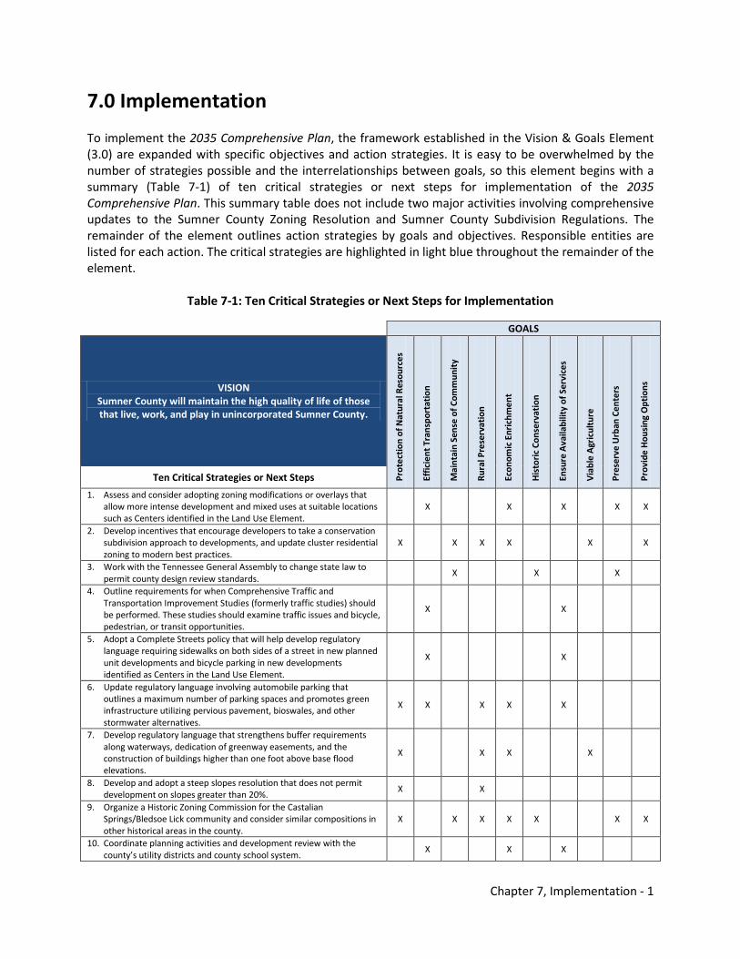
Chapter 7, Implementation - 1
7.0 Implementation To implement the 2035 Comprehensive Plan, the framework established in the Vision & Goals Element (3.0) are expanded with specific objectives and action strategies. It is easy to be overwhelmed by the number of strategies possible and the interrelationships between goals, so this element begins with a summary (Table 7-1) of ten critical strategies or next steps for implementation of the 2035 Comprehensive Plan. This summary table does not include two major activities involving comprehensive updates to the Sumner County Zoning Resolution and Sumner County Subdivision Regulations. The remainder of the element outlines action strategies by goals and objectives. Responsible entities are listed for each action. The critical strategies are highlighted in light blue throughout the remainder of the element.
Table 7-1: Ten Critical Strategies or Next Steps for Implementation
GOALS
VISION Sumner County will maintain the high quality of life of those that live, work, and play in unincorporated Sumner County.
Prot
ecti
on o
f Nat
ural
Res
ourc
es
Effic
ient
Tra
nspo
rtat
ion
Mai
ntai
n Se
nse
of C
omm
unit
y
Rura
l Pre
serv
atio
n
Econ
omic
Enr
ichm
ent
His
tori
c Co
nser
vati
on
Ensu
re A
vaila
bilit
y of
Ser
vice
s
Via
ble
Agr
icul
ture
Pres
erve
Urb
an C
ente
rs
Prov
ide
Hou
sing
Opt
ions
Ten Critical Strategies or Next Steps
1. Assess and consider adopting zoning modifications or overlays that allow more intense development and mixed uses at suitable locations such as Centers identified in the Land Use Element.
X X X X X
2. Develop incentives that encourage developers to take a conservation subdivision approach to developments, and update cluster residential zoning to modern best practices.
X X X X X X
3. Work with the Tennessee General Assembly to change state law to permit county design review standards.
X X X
4. Outline requirements for when Comprehensive Traffic and Transportation Improvement Studies (formerly traffic studies) should be performed. These studies should examine traffic issues and bicycle, pedestrian, or transit opportunities.
X X
5. Adopt a Complete Streets policy that will help develop regulatory language requiring sidewalks on both sides of a street in new planned unit developments and bicycle parking in new developments identified as Centers in the Land Use Element.
X X
6. Update regulatory language involving automobile parking that outlines a maximum number of parking spaces and promotes green infrastructure utilizing pervious pavement, bioswales, and other stormwater alternatives.
X X X X X
7. Develop regulatory language that strengthens buffer requirements along waterways, dedication of greenway easements, and the construction of buildings higher than one foot above base flood elevations.
X X X X
8. Develop and adopt a steep slopes resolution that does not permit development on slopes greater than 20%.
X X
9. Organize a Historic Zoning Commission for the Castalian Springs/Bledsoe Lick community and consider similar compositions in other historical areas in the county.
X X X X X X X
10. Coordinate planning activities and development review with the county’s utility districts and county school system.
X X X
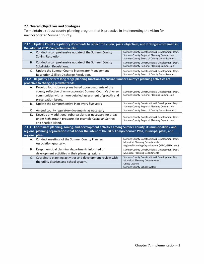
Chapter 7, Implementation - 2
7.1 Overall Objectives and Strategies To maintain a robust county planning program that is proactive in implementing the vision for unincorporated Sumner County. 7.1.1 – Update County regulatory documents to reflect the vision, goals, objectives, and strategies contained in the adopted 2035 Comprehensive Plan.
A. Conduct a comprehensive update of the Sumner County Zoning Resolution.
Sumner County Construction & Development Dept. Sumner County Regional Planning Commission Sumner County Board of County Commissioners
B. Conduct a comprehensive update of the Sumner County Subdivision Regulations.
Sumner County Construction & Development Dept. Sumner County Regional Planning Commission
C. Update the Sumner County Stormwater Management Resolution & Illicit Discharge Resolution.
Sumner County Construction & Development Dept. Sumner County Board of County Commissioners
7.1.2 – Regularly perform long range planning functions to ensure Sumner County’s planning activities are proactive to changing growth trends.
A. Develop four subarea plans based upon quadrants of the county reflective of unincorporated Sumner County’s diverse communities with a more detailed assessment of growth and preservation issues.
Sumner County Construction & Development Dept. Sumner County Regional Planning Commission
B. Update the Comprehensive Plan every five years. Sumner County Construction & Development Dept. Sumner County Regional Planning Commission
C. Amend county regulatory documents as necessary. Sumner County Board of County Commissioners
D. Develop any additional subarea plans as necessary for areas under high growth pressure, for example Castalian Springs and Shackle Island.
Sumner County Construction & Development Dept. Sumner County Regional Planning Commission
7.1.3 – Coordinate planning, zoning, and development activities among Sumner County, its municipalities, and regional planning organizations that honor the intent of the 2035 Comprehensive Plan, municipal plans, and regional plans.
A. Conduct meetings of the Sumner County Planners Association quarterly.
Sumner County Construction & Development Dept. Municipal Planning Departments Regional Planning Organizations (MPO, GNRC, etc.)
B. Keep municipal planning departments informed of development activities in their planning regions.
Sumner County Construction & Development Dept. Municipal Planning Departments
C. Coordinate planning activities and development review with the utility districts and school system.
Sumner County Construction & Development Dept. Municipal Planning Departments Utility Districts Sumner County School System
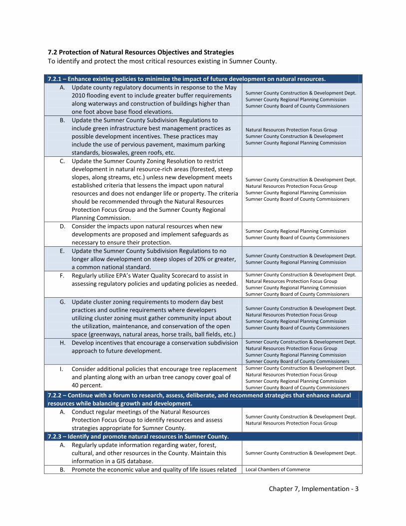
Chapter 7, Implementation - 3
7.2 Protection of Natural Resources Objectives and Strategies To identify and protect the most critical resources existing in Sumner County. 7.2.1 – Enhance existing policies to minimize the impact of future development on natural resources.
A. Update county regulatory documents in response to the May 2010 flooding event to include greater buffer requirements along waterways and construction of buildings higher than one foot above base flood elevations.
Sumner County Construction & Development Dept. Sumner County Regional Planning Commission Sumner County Board of County Commissioners
B. Update the Sumner County Subdivision Regulations to include green infrastructure best management practices as possible development incentives. These practices may include the use of pervious pavement, maximum parking standards, bioswales, green roofs, etc.
Natural Resources Protection Focus Group Sumner County Construction & Development Sumner County Regional Planning Commission
C. Update the Sumner County Zoning Resolution to restrict development in natural resource-rich areas (forested, steep slopes, along streams, etc.) unless new development meets established criteria that lessens the impact upon natural resources and does not endanger life or property. The criteria should be recommended through the Natural Resources Protection Focus Group and the Sumner County Regional Planning Commission.
Sumner County Construction & Development Dept. Natural Resources Protection Focus Group Sumner County Regional Planning Commission Sumner County Board of County Commissioners
D. Consider the impacts upon natural resources when new developments are proposed and implement safeguards as necessary to ensure their protection.
Sumner County Regional Planning Commission Sumner County Board of County Commissioners
E. Update the Sumner County Subdivision Regulations to no longer allow development on steep slopes of 20% or greater, a common national standard.
Sumner County Construction & Development Dept. Sumner County Regional Planning Commission
F. Regularly utilize EPA’s Water Quality Scorecard to assist in assessing regulatory policies and updating policies as needed.
Sumner County Construction & Development Dept. Natural Resources Protection Focus Group Sumner County Regional Planning Commission Sumner County Board of County Commissioners
G. Update cluster zoning requirements to modern day best practices and outline requirements where developers utilizing cluster zoning must gather community input about the utilization, maintenance, and conservation of the open space (greenways, natural areas, horse trails, ball fields, etc.)
Sumner County Construction & Development Dept. Natural Resources Protection Focus Group Sumner County Regional Planning Commission Sumner County Board of County Commissioners
H. Develop incentives that encourage a conservation subdivision approach to future development.
Sumner County Construction & Development Dept. Natural Resources Protection Focus Group Sumner County Regional Planning Commission Sumner County Board of County Commissioners
I. Consider additional policies that encourage tree replacement and planting along with an urban tree canopy cover goal of 40 percent.
Sumner County Construction & Development Dept. Natural Resources Protection Focus Group Sumner County Regional Planning Commission Sumner County Board of County Commissioners
7.2.2 – Continue with a forum to research, assess, deliberate, and recommend strategies that enhance natural resources while balancing growth and development.
A. Conduct regular meetings of the Natural Resources Protection Focus Group to identify resources and assess strategies appropriate for Sumner County.
Sumner County Construction & Development Dept. Natural Resources Protection Focus Group
7.2.3 – Identify and promote natural resources in Sumner County. A. Regularly update information regarding water, forest,
cultural, and other resources in the County. Maintain this information in a GIS database.
Sumner County Construction & Development Dept.
B. Promote the economic value and quality of life issues related Local Chambers of Commerce
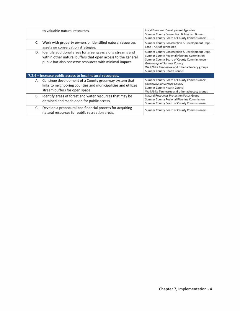
Chapter 7, Implementation - 4
to valuable natural resources. Local Economic Development Agencies Sumner County Convention & Tourism Bureau Sumner County Board of County Commissioners
C. Work with property owners of identified natural resources assets on conservation strategies.
Sumner County Construction & Development Dept. Land Trust of Tennessee
D. Identify additional areas for greenways along streams and within other natural buffers that open access to the general public but also conserve resources with minimal impact.
Sumner County Construction & Development Dept. Sumner County Regional Planning Commission Sumner County Board of County Commissioners Greenways of Sumner County Walk/Bike Tennessee and other advocacy groups Sumner County Health Council
7.2.4 – Increase public access to local natural resources. A. Continue development of a County greenway system that
links to neighboring counties and municipalities and utilizes stream buffers for open space.
Sumner County Board of County Commissioners Greenways of Sumner County Sumner County Health Council Walk/bike Tennessee and other advocacy groups
B. Identify areas of forest and water resources that may be obtained and made open for public access.
Natural Resources Protection Focus Group Sumner County Regional Planning Commission Sumner County Board of County Commissioners
C. Develop a procedural and financial process for acquiring natural resources for public recreation areas.
Sumner County Board of County Commissioners
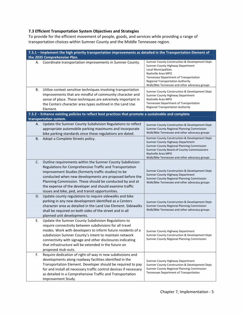
Chapter 7, Implementation - 5
7.3 Efficient Transportation System Objectives and Strategies To provide for the efficient movement of people, goods, and services while providing a range of transportation choices within Sumner County and the Middle Tennessee region. 7.3.1 – Implement the high priority transportation improvements as detailed in the Transportation Element of the 2035 Comprehensive Plan.
A. Coordinate transportation improvements in Sumner County. Sumner County Construction & Development Dept. Sumner County Highway Department Local Municipalities Nashville Area MPO Tennessee Department of Transportation Regional Transportation Authority Walk/Bike Tennessee and other advocacy groups
B. Utilize context sensitive techniques involving transportation improvements that are mindful of community character and sense of place. These techniques are extremely important in the Centers character area types outlined in the Land Use Element.
Sumner County Construction & Development Dept. Sumner County Highway Department Nashville Area MPO Tennessee Department of Transportation Regional Transportation Authority
7.3.2 – Enhance existing policies to reflect best practices that promote a sustainable and complete transportation system.
A. Update the Sumner County Subdivision Regulations to reflect appropriate automobile parking maximums and incorporate bike parking standards since these regulations are dated.
Sumner County Construction & Development Dept. Sumner County Regional Planning Commission Walk/Bike Tennessee and other advocacy groups
B. Adopt a Complete Streets policy. Sumner County Construction & Development Dept. Sumner County Highway Department Sumner County Regional Planning Commission Sumner County Board of County Commissioners Nashville Area MPO Walk/Bike Tennessee and other advocacy groups
C. Outline requirements within the Sumner County Subdivision Regulations for Comprehensive Traffic and Transportation Improvement Studies (formerly traffic studies) to be conducted when new developments are proposed before the Planning Commission. These should be conducted by and at the expense of the developer and should examine traffic issues and bike, ped, and transit opportunities.
Sumner County Construction & Development Dept. Sumner County Highway Department Sumner County Regional Planning Commission Walk/Bike Tennessee and other advocacy groups
D. Update county regulations to require sidewalks and bike parking in any new development identified as a Centers character area as detailed in the Land Use Element. Sidewalks shall be required on both sides of the street and in all planned unit developments.
Sumner County Construction & Development Dept. Sumner County Regional Planning Commission Walk/Bike Tennessee and other advocacy groups
E. Update the Sumner County Subdivision Regulations to require connectivity between subdivisions for all travel modes. Work with developers to inform future residents of a subdivision Sumner County’s intent to maintain network connectivity with signage and other disclosures indicating that infrastructure will be extended in the future on proposed stub-outs.
Sumner County Highway Department Sumner County Construction & Development Dept. Sumner County Regional Planning Commission
F. Require dedication of right-of-way in new subdivisions and developments along roadway facilities identified in the Transportation Element. Developer should be required to pay for and install all necessary traffic control devices if necessary as detailed in a Comprehensive Traffic and Transportation Improvement Study.
Sumner County Highway Department Sumner County Construction & Development Dept. Sumner County Regional Planning Commission Tennessee Department of Transportation
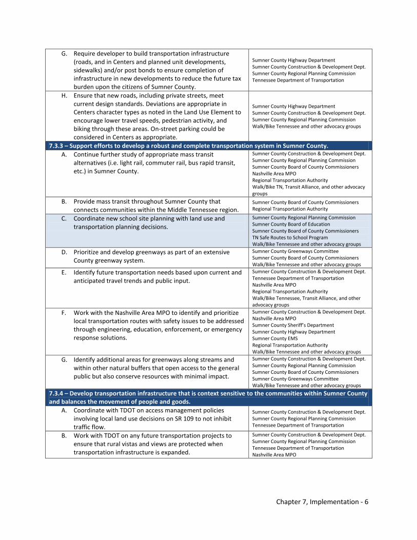
Chapter 7, Implementation - 6
G. Require developer to build transportation infrastructure (roads, and in Centers and planned unit developments, sidewalks) and/or post bonds to ensure completion of infrastructure in new developments to reduce the future tax burden upon the citizens of Sumner County.
Sumner County Highway Department Sumner County Construction & Development Dept. Sumner County Regional Planning Commission Tennessee Department of Transportation
H. Ensure that new roads, including private streets, meet current design standards. Deviations are appropriate in Centers character types as noted in the Land Use Element to encourage lower travel speeds, pedestrian activity, and biking through these areas. On-street parking could be considered in Centers as appropriate.
Sumner County Highway Department Sumner County Construction & Development Dept. Sumner County Regional Planning Commission Walk/Bike Tennessee and other advocacy groups
7.3.3 – Support efforts to develop a robust and complete transportation system in Sumner County. A. Continue further study of appropriate mass transit
alternatives (i.e. light rail, commuter rail, bus rapid transit, etc.) in Sumner County.
Sumner County Construction & Development Dept. Sumner County Regional Planning Commission Sumner County Board of County Commissioners Nashville Area MPO Regional Transportation Authority Walk/Bike TN, Transit Alliance, and other advocacy groups
B. Provide mass transit throughout Sumner County that connects communities within the Middle Tennessee region.
Sumner County Board of County Commissioners Regional Transportation Authority
C. Coordinate new school site planning with land use and transportation planning decisions.
Sumner County Regional Planning Commission Sumner County Board of Education Sumner County Board of County Commissioners TN Safe Routes to School Program Walk/Bike Tennessee and other advocacy groups
D. Prioritize and develop greenways as part of an extensive County greenway system.
Sumner County Greenways Committee Sumner County Board of County Commissioners Walk/Bike Tennessee and other advocacy groups
E. Identify future transportation needs based upon current and anticipated travel trends and public input.
Sumner County Construction & Development Dept. Tennessee Department of Transportation Nashville Area MPO Regional Transportation Authority Walk/Bike Tennessee, Transit Alliance, and other advocacy groups
F. Work with the Nashville Area MPO to identify and prioritize local transportation routes with safety issues to be addressed through engineering, education, enforcement, or emergency response solutions.
Sumner County Construction & Development Dept. Nashville Area MPO Sumner County Sheriff’s Department Sumner County Highway Department Sumner County EMS Regional Transportation Authority Walk/Bike Tennessee and other advocacy groups
G. Identify additional areas for greenways along streams and within other natural buffers that open access to the general public but also conserve resources with minimal impact.
Sumner County Construction & Development Dept. Sumner County Regional Planning Commission Sumner County Board of County Commissioners Sumner County Greenways Committee Walk/Bike Tennessee and other advocacy groups
7.3.4 – Develop transportation infrastructure that is context sensitive to the communities within Sumner County and balances the movement of people and goods.
A. Coordinate with TDOT on access management policies involving local land use decisions on SR 109 to not inhibit traffic flow.
Sumner County Construction & Development Dept. Sumner County Regional Planning Commission Tennessee Department of Transportation
B. Work with TDOT on any future transportation projects to ensure that rural vistas and views are protected when transportation infrastructure is expanded.
Sumner County Construction & Development Dept. Sumner County Regional Planning Commission Tennessee Department of Transportation Nashville Area MPO
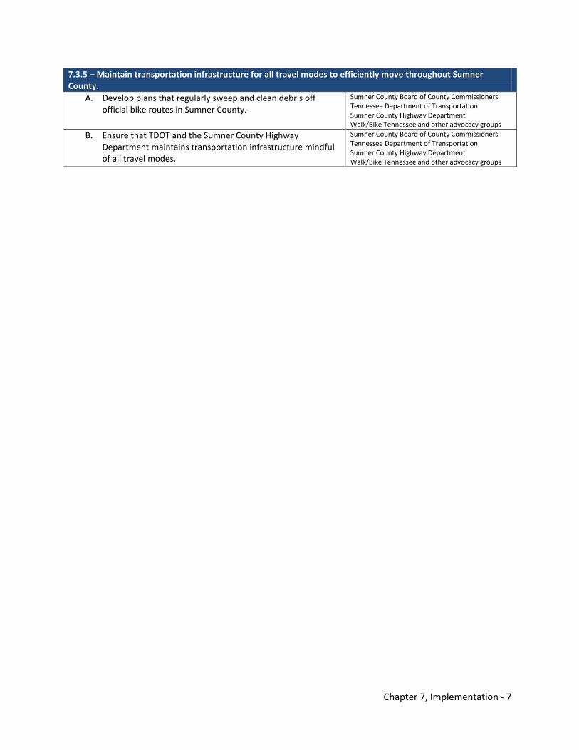
Chapter 7, Implementation - 7
7.3.5 – Maintain transportation infrastructure for all travel modes to efficiently move throughout Sumner County.
A. Develop plans that regularly sweep and clean debris off official bike routes in Sumner County.
Sumner County Board of County Commissioners Tennessee Department of Transportation Sumner County Highway Department Walk/Bike Tennessee and other advocacy groups
B. Ensure that TDOT and the Sumner County Highway Department maintains transportation infrastructure mindful of all travel modes.
Sumner County Board of County Commissioners Tennessee Department of Transportation Sumner County Highway Department Walk/Bike Tennessee and other advocacy groups
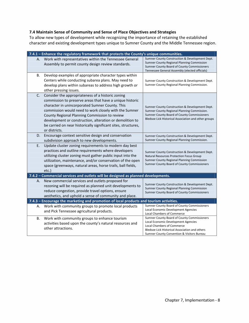
Chapter 7, Implementation - 8
7.4 Maintain Sense of Community and Sense of Place Objectives and Strategies To allow new types of development while recognizing the importance of retaining the established character and existing development types unique to Sumner County and the Middle Tennessee region. 7.4.1 – Enhance the regulatory framework that protects the County’s unique communities.
A. Work with representatives within the Tennessee General Assembly to permit county design review standards.
Sumner County Construction & Development Dept. Sumner County Regional Planning Commission Sumner County Board of County Commissioners Tennessee General Assembly (elected officials)
B. Develop examples of appropriate character types within Centers while conducting subarea plans. May need to develop plans within subareas to address high growth or other pressing issues.
Sumner County Construction & Development Dept. Sumner County Regional Planning Commission.
C. Consider the appropriateness of a historic zoning commission to preserve areas that have a unique historic character in unincorporated Sumner County. This commission would need to work closely with the Sumner County Regional Planning Commission to review development or construction, alteration or demolition to be carried on near historically significant sites, structures, or districts.
Sumner County Construction & Development Dept. Sumner County Regional Planning Commission. Sumner County Board of County Commissioners Bledsoe Lick Historical Association and other groups
D. Encourage context sensitive design and conservation subdivision approach to new developments.
Sumner County Construction & Development Dept. Sumner County Regional Planning Commission.
E. Update cluster zoning requirements to modern day best practices and outline requirements where developers utilizing cluster zoning must gather public input into the utilization, maintenance, and/or conservation of the open space (greenways, natural areas, horse trails, ball fields, etc.)
Sumner County Construction & Development Dept. Natural Resources Protection Focus Group Sumner County Regional Planning Commission Sumner County Board of County Commissioners
7.4.2 – Commercial services and outlets will be designed as planned developments. A. New commercial services and outlets proposed for
rezoning will be required as planned unit developments to reduce congestion, provide travel options, ensure aesthetics, and uphold a sense of community and place.
Sumner County Construction & Development Dept. Sumner County Regional Planning Commission Sumner County Board of County Commissioners
7.4.3 – Encourage the marketing and promotion of local products and tourism activities. A. Work with community groups to promote local products
and Pick Tennessee agricultural products. Sumner County Board of County Commissioners Local Economic Development Agencies Local Chambers of Commerce
B. Work with community groups to enhance tourism activities based upon the county’s natural resources and other attractions.
Sumner County Board of County Commissioners Local Economic Development Agencies Local Chambers of Commerce Bledsoe Lick Historical Association and others Sumner County Convention & Visitors Bureau
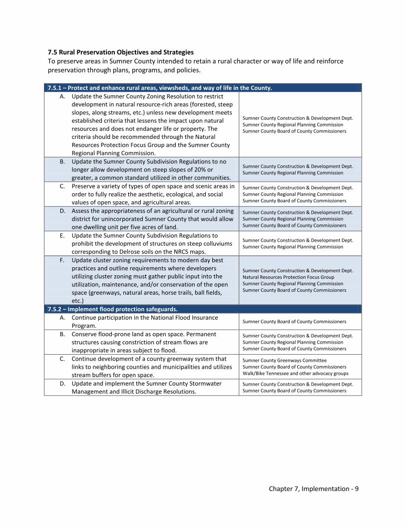
Chapter 7, Implementation - 9
7.5 Rural Preservation Objectives and Strategies To preserve areas in Sumner County intended to retain a rural character or way of life and reinforce preservation through plans, programs, and policies. 7.5.1 – Protect and enhance rural areas, viewsheds, and way of life in the County.
A. Update the Sumner County Zoning Resolution to restrict development in natural resource-rich areas (forested, steep slopes, along streams, etc.) unless new development meets established criteria that lessens the impact upon natural resources and does not endanger life or property. The criteria should be recommended through the Natural Resources Protection Focus Group and the Sumner County Regional Planning Commission.
Sumner County Construction & Development Dept. Sumner County Regional Planning Commission Sumner County Board of County Commissioners
B. Update the Sumner County Subdivision Regulations to no longer allow development on steep slopes of 20% or greater, a common standard utilized in other communities.
Sumner County Construction & Development Dept. Sumner County Regional Planning Commission
C. Preserve a variety of types of open space and scenic areas in order to fully realize the aesthetic, ecological, and social values of open space, and agricultural areas.
Sumner County Construction & Development Dept. Sumner County Regional Planning Commission Sumner County Board of County Commissioners
D. Assess the appropriateness of an agricultural or rural zoning district for unincorporated Sumner County that would allow one dwelling unit per five acres of land.
Sumner County Construction & Development Dept. Sumner County Regional Planning Commission Sumner County Board of County Commissioners
E. Update the Sumner County Subdivision Regulations to prohibit the development of structures on steep colluviums corresponding to Delrose soils on the NRCS maps.
Sumner County Construction & Development Dept. Sumner County Regional Planning Commission
F. Update cluster zoning requirements to modern day best practices and outline requirements where developers utilizing cluster zoning must gather public input into the utilization, maintenance, and/or conservation of the open space (greenways, natural areas, horse trails, ball fields, etc.)
Sumner County Construction & Development Dept. Natural Resources Protection Focus Group Sumner County Regional Planning Commission Sumner County Board of County Commissioners
7.5.2 – Implement flood protection safeguards. A. Continue participation in the National Flood Insurance
Program. Sumner County Board of County Commissioners
B. Conserve flood-prone land as open space. Permanent structures causing constriction of stream flows are inappropriate in areas subject to flood.
Sumner County Construction & Development Dept. Sumner County Regional Planning Commission Sumner County Board of County Commissioners
C. Continue development of a county greenway system that links to neighboring counties and municipalities and utilizes stream buffers for open space.
Sumner County Greenways Committee Sumner County Board of County Commissioners Walk/Bike Tennessee and other advocacy groups
D. Update and implement the Sumner County Stormwater Management and Illicit Discharge Resolutions.
Sumner County Construction & Development Dept. Sumner County Board of County Commissioners
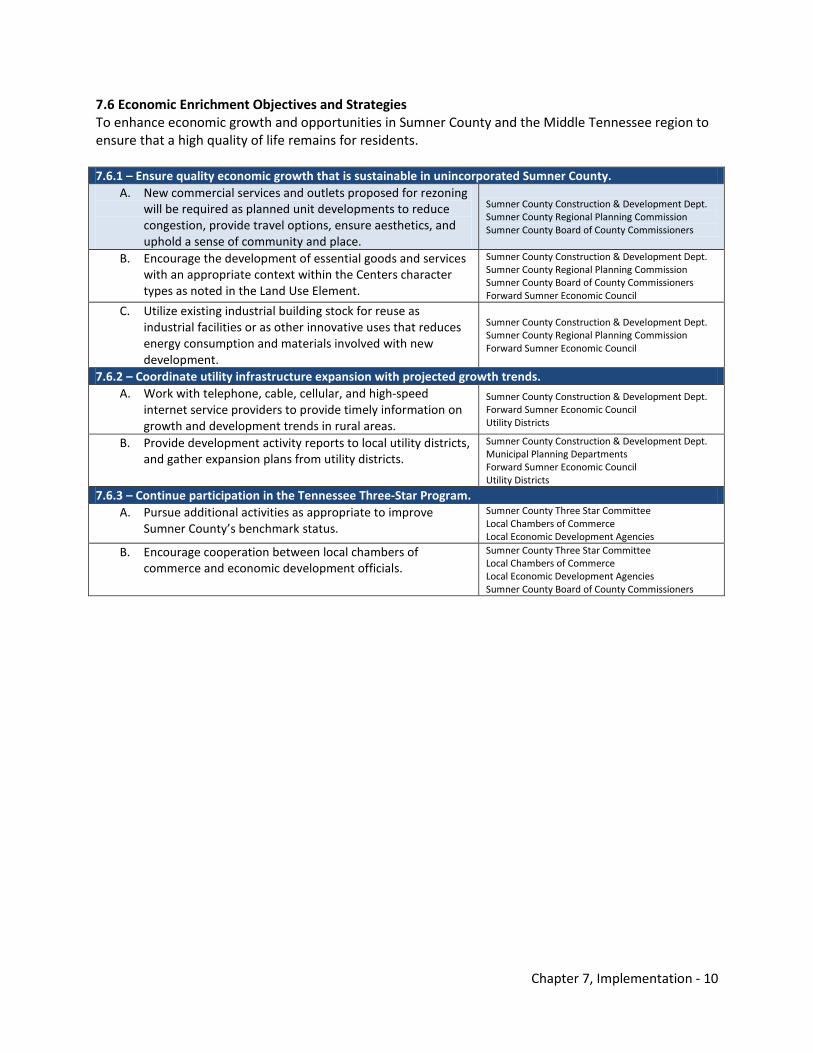
Chapter 7, Implementation - 10
7.6 Economic Enrichment Objectives and Strategies To enhance economic growth and opportunities in Sumner County and the Middle Tennessee region to ensure that a high quality of life remains for residents. 7.6.1 – Ensure quality economic growth that is sustainable in unincorporated Sumner County.
A. New commercial services and outlets proposed for rezoning will be required as planned unit developments to reduce congestion, provide travel options, ensure aesthetics, and uphold a sense of community and place.
Sumner County Construction & Development Dept. Sumner County Regional Planning Commission Sumner County Board of County Commissioners
B. Encourage the development of essential goods and services with an appropriate context within the Centers character types as noted in the Land Use Element.
Sumner County Construction & Development Dept. Sumner County Regional Planning Commission Sumner County Board of County Commissioners Forward Sumner Economic Council
C. Utilize existing industrial building stock for reuse as industrial facilities or as other innovative uses that reduces energy consumption and materials involved with new development.
Sumner County Construction & Development Dept. Sumner County Regional Planning Commission Forward Sumner Economic Council
7.6.2 – Coordinate utility infrastructure expansion with projected growth trends. A. Work with telephone, cable, cellular, and high-speed
internet service providers to provide timely information on growth and development trends in rural areas.
Sumner County Construction & Development Dept. Forward Sumner Economic Council Utility Districts
B. Provide development activity reports to local utility districts, and gather expansion plans from utility districts.
Sumner County Construction & Development Dept. Municipal Planning Departments Forward Sumner Economic Council Utility Districts
7.6.3 – Continue participation in the Tennessee Three-Star Program. A. Pursue additional activities as appropriate to improve
Sumner County’s benchmark status. Sumner County Three Star Committee Local Chambers of Commerce Local Economic Development Agencies
B. Encourage cooperation between local chambers of commerce and economic development officials.
Sumner County Three Star Committee Local Chambers of Commerce Local Economic Development Agencies Sumner County Board of County Commissioners
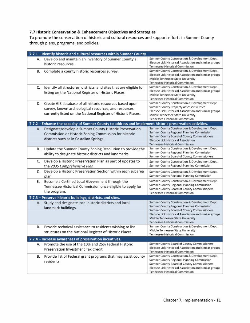
Chapter 7, Implementation - 11
7.7 Historic Conservation & Enhancement Objectives and Strategies To promote the conservation of historic and cultural resources and support efforts in Sumner County through plans, programs, and policies. 7.7.1 – Identify historic and cultural resources within Sumner County
A. Develop and maintain an inventory of Sumner County’s historic resources.
Sumner County Construction & Development Dept. Bledsoe Lick Historical Association and similar groups Tennessee Historical Commission
B. Complete a county historic resources survey. Sumner County Construction & Development Dept. Bledsoe Lick Historical Association and similar groups Middle Tennessee State University Tennessee Historical Commission
C. Identify all structures, districts, and sites that are eligible for listing on the National Register of Historic Places.
Sumner County Construction & Development Dept. Bledsoe Lick Historical Association and similar groups Middle Tennessee State University Tennessee Historical Commission
D. Create GIS database of all historic resources based upon survey, known archeological resources, and resources currently listed on the National Register of Historic Places.
Sumner County Construction & Development Dept. Sumner County Property Assessor’s Office Bledsoe Lick Historical Association and similar groups Middle Tennessee State University Tennessee Historical Commission
7.7.2 – Enhance the capacity of Sumner County to address and implement historic preservation activities. A. Designate/develop a Sumner County Historic Preservation
Commission or Historic Zoning Commission for historic districts such as in Castalian Springs.
Sumner County Construction & Development Dept. Sumner County Regional Planning Commission Sumner County Board of County Commissioners Bledsoe Lick Historical Association Tennessee Historical Commission
B. Update the Sumner County Zoning Resolution to provide the ability to designate historic districts and landmarks.
Sumner County Construction & Development Dept. Sumner County Regional Planning Commission Sumner County Board of County Commissioners
C. Develop a Historic Preservation Plan as part of updates to the 2035 Comprehensive Plan.
Sumner County Construction & Development Dept. Sumner County Regional Planning Commission
D. Develop a Historic Preservation Section within each subarea plan.
Sumner County Construction & Development Dept. Sumner County Regional Planning Commission
E. Become a Certified Local Government through the Tennessee Historical Commission once eligible to apply for the program.
Sumner County Construction & Development Dept. Sumner County Regional Planning Commission Sumner County Board of County Commissioners Tennessee Historical Commission
7.7.3 – Preserve historic buildings, districts, and sites. A. Study and designate local historic districts and local
landmark buildings. Sumner County Construction & Development Dept. Sumner County Regional Planning Commission Sumner County Board of County Commissioners Bledsoe Lick Historical Association and similar groups Middle Tennessee State University Tennessee Historical Commission
B. Provide technical assistance to residents wishing to list structures on the National Register of Historic Places.
Sumner County Construction & Development Dept. Middle Tennessee State University Tennessee Historical Commission
7.7.4 – Increase awareness of preservation incentives. A. Promote the use of the 10% and 25% Federal Historic
Preservation Investment Tax Credit. Sumner County Board of County Commissioners Bledsoe Lick Historical Association and similar groups Tennessee Historical Commission
B. Provide list of Federal grant programs that may assist county residents.
Sumner County Construction & Development Dept. Sumner County Regional Planning Commission Sumner County Board of County Commissioners Bledsoe Lick Historical Association and similar groups Tennessee Historical Commission
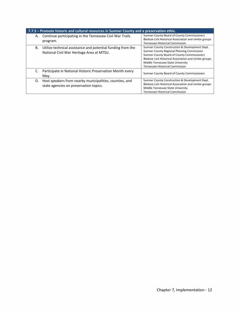
Chapter 7, Implementation - 12
7.7.5 – Promote historic and cultural resources in Sumner County and a preservation ethic. A. Continue participating in the Tennessee Civil War Trails
program. Sumner County Board of County Commissioners Bledsoe Lick Historical Association and similar groups Tennessee Historical Commission
B. Utilize technical assistance and potential funding from the National Civil War Heritage Area at MTSU.
Sumner County Construction & Development Dept. Sumner County Regional Planning Commission Sumner County Board of County Commissioners Bledsoe Lick Historical Association and similar groups Middle Tennessee State University Tennessee Historical Commission
C. Participate in National Historic Preservation Month every May.
Sumner County Board of County Commissioners
D. Host speakers from nearby municipalities, counties, and state agencies on preservation topics.
Sumner County Construction & Development Dept. Bledsoe Lick Historical Association and similar groups Middle Tennessee State University Tennessee Historical Commission
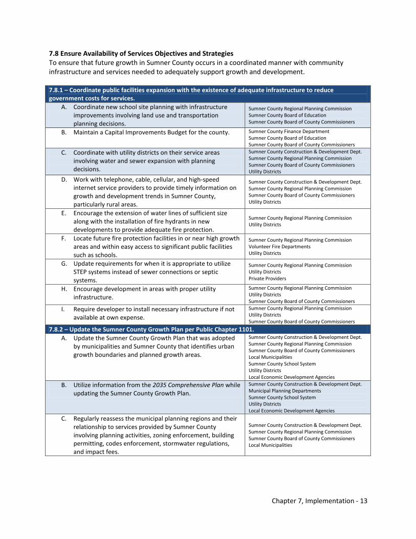
Chapter 7, Implementation - 13
7.8 Ensure Availability of Services Objectives and Strategies To ensure that future growth in Sumner County occurs in a coordinated manner with community infrastructure and services needed to adequately support growth and development. 7.8.1 – Coordinate public facilities expansion with the existence of adequate infrastructure to reduce government costs for services.
A. Coordinate new school site planning with infrastructure improvements involving land use and transportation planning decisions.
Sumner County Regional Planning Commission Sumner County Board of Education Sumner County Board of County Commissioners
B. Maintain a Capital Improvements Budget for the county. Sumner County Finance Department Sumner County Board of Education Sumner County Board of County Commissioners
C. Coordinate with utility districts on their service areas involving water and sewer expansion with planning decisions.
Sumner County Construction & Development Dept. Sumner County Regional Planning Commission Sumner County Board of County Commissioners Utility Districts
D. Work with telephone, cable, cellular, and high-speed internet service providers to provide timely information on growth and development trends in Sumner County, particularly rural areas.
Sumner County Construction & Development Dept. Sumner County Regional Planning Commission Sumner County Board of County Commissioners Utility Districts
E. Encourage the extension of water lines of sufficient size along with the installation of fire hydrants in new developments to provide adequate fire protection.
Sumner County Regional Planning Commission Utility Districts
F. Locate future fire protection facilities in or near high growth areas and within easy access to significant public facilities such as schools.
Sumner County Regional Planning Commission Volunteer Fire Departments Utility Districts
G. Update requirements for when it is appropriate to utilize STEP systems instead of sewer connections or septic systems.
Sumner County Regional Planning Commission Utility Districts Private Providers
H. Encourage development in areas with proper utility infrastructure.
Sumner County Regional Planning Commission Utility Districts Sumner County Board of County Commissioners
I. Require developer to install necessary infrastructure if not available at own expense.
Sumner County Regional Planning Commission Utility Districts Sumner County Board of County Commissioners
7.8.2 – Update the Sumner County Growth Plan per Public Chapter 1101. A. Update the Sumner County Growth Plan that was adopted
by municipalities and Sumner County that identifies urban growth boundaries and planned growth areas.
Sumner County Construction & Development Dept. Sumner County Regional Planning Commission Sumner County Board of County Commissioners Local Municipalities Sumner County School System Utility Districts Local Economic Development Agencies
B. Utilize information from the 2035 Comprehensive Plan while updating the Sumner County Growth Plan.
Sumner County Construction & Development Dept. Municipal Planning Departments Sumner County School System Utility Districts Local Economic Development Agencies
C. Regularly reassess the municipal planning regions and their relationship to services provided by Sumner County involving planning activities, zoning enforcement, building permitting, codes enforcement, stormwater regulations, and impact fees.
Sumner County Construction & Development Dept. Sumner County Regional Planning Commission Sumner County Board of County Commissioners Local Municipalities
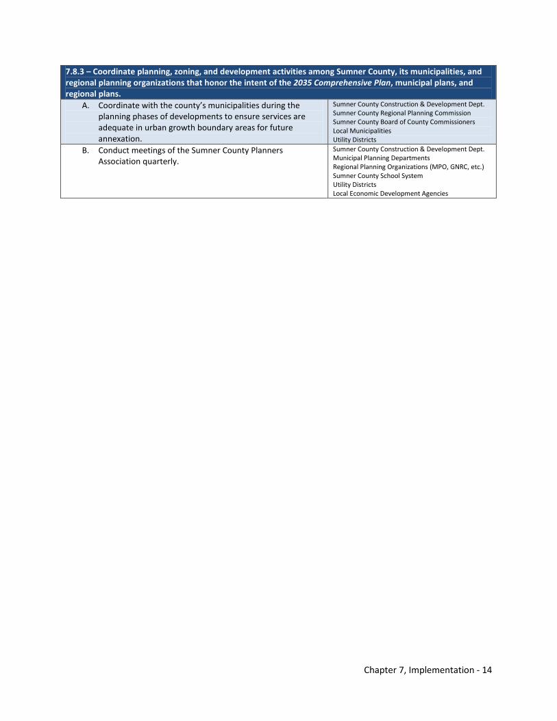
Chapter 7, Implementation - 14
7.8.3 – Coordinate planning, zoning, and development activities among Sumner County, its municipalities, and regional planning organizations that honor the intent of the 2035 Comprehensive Plan, municipal plans, and regional plans.
A. Coordinate with the county’s municipalities during the planning phases of developments to ensure services are adequate in urban growth boundary areas for future annexation.
Sumner County Construction & Development Dept. Sumner County Regional Planning Commission Sumner County Board of County Commissioners Local Municipalities Utility Districts
B. Conduct meetings of the Sumner County Planners Association quarterly.
Sumner County Construction & Development Dept. Municipal Planning Departments Regional Planning Organizations (MPO, GNRC, etc.) Sumner County School System Utility Districts Local Economic Development Agencies
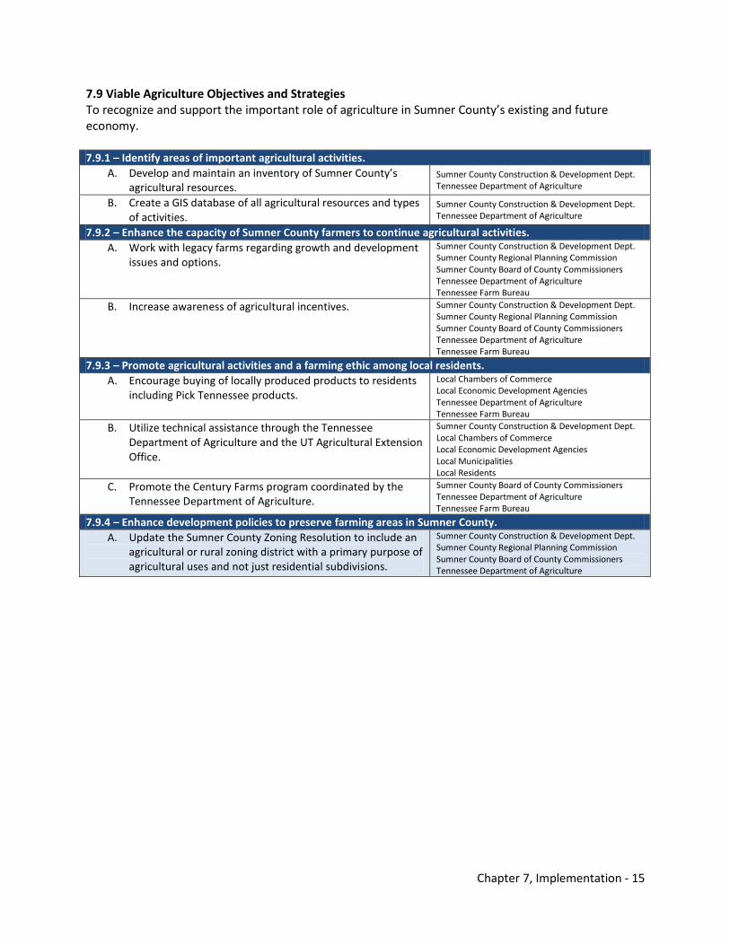
Chapter 7, Implementation - 15
7.9 Viable Agriculture Objectives and Strategies To recognize and support the important role of agriculture in Sumner County’s existing and future economy. 7.9.1 – Identify areas of important agricultural activities.
A. Develop and maintain an inventory of Sumner County’s agricultural resources.
Sumner County Construction & Development Dept. Tennessee Department of Agriculture
B. Create a GIS database of all agricultural resources and types of activities.
Sumner County Construction & Development Dept. Tennessee Department of Agriculture
7.9.2 – Enhance the capacity of Sumner County farmers to continue agricultural activities. A. Work with legacy farms regarding growth and development
issues and options. Sumner County Construction & Development Dept. Sumner County Regional Planning Commission Sumner County Board of County Commissioners Tennessee Department of Agriculture Tennessee Farm Bureau
B. Increase awareness of agricultural incentives. Sumner County Construction & Development Dept. Sumner County Regional Planning Commission Sumner County Board of County Commissioners Tennessee Department of Agriculture Tennessee Farm Bureau
7.9.3 – Promote agricultural activities and a farming ethic among local residents. A. Encourage buying of locally produced products to residents
including Pick Tennessee products. Local Chambers of Commerce Local Economic Development Agencies Tennessee Department of Agriculture Tennessee Farm Bureau
B. Utilize technical assistance through the Tennessee Department of Agriculture and the UT Agricultural Extension Office.
Sumner County Construction & Development Dept. Local Chambers of Commerce Local Economic Development Agencies Local Municipalities Local Residents
C. Promote the Century Farms program coordinated by the Tennessee Department of Agriculture.
Sumner County Board of County Commissioners Tennessee Department of Agriculture Tennessee Farm Bureau
7.9.4 – Enhance development policies to preserve farming areas in Sumner County. A. Update the Sumner County Zoning Resolution to include an
agricultural or rural zoning district with a primary purpose of agricultural uses and not just residential subdivisions.
Sumner County Construction & Development Dept. Sumner County Regional Planning Commission Sumner County Board of County Commissioners Tennessee Department of Agriculture
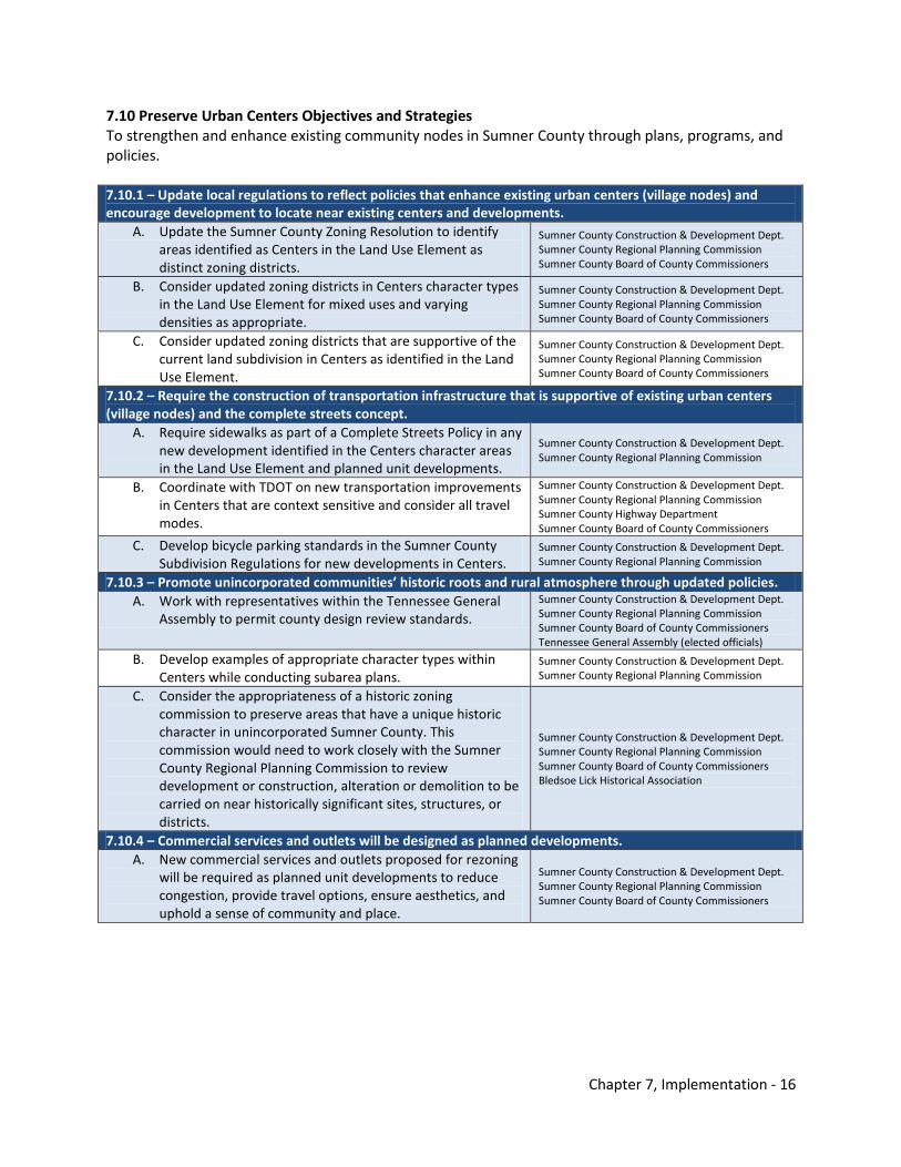
Chapter 7, Implementation - 16
7.10 Preserve Urban Centers Objectives and Strategies To strengthen and enhance existing community nodes in Sumner County through plans, programs, and policies. 7.10.1 – Update local regulations to reflect policies that enhance existing urban centers (village nodes) and encourage development to locate near existing centers and developments.
A. Update the Sumner County Zoning Resolution to identify areas identified as Centers in the Land Use Element as distinct zoning districts.
Sumner County Construction & Development Dept. Sumner County Regional Planning Commission Sumner County Board of County Commissioners
B. Consider updated zoning districts in Centers character types in the Land Use Element for mixed uses and varying densities as appropriate.
Sumner County Construction & Development Dept. Sumner County Regional Planning Commission Sumner County Board of County Commissioners
C. Consider updated zoning districts that are supportive of the current land subdivision in Centers as identified in the Land Use Element.
Sumner County Construction & Development Dept. Sumner County Regional Planning Commission Sumner County Board of County Commissioners
7.10.2 – Require the construction of transportation infrastructure that is supportive of existing urban centers (village nodes) and the complete streets concept.
A. Require sidewalks as part of a Complete Streets Policy in any new development identified in the Centers character areas in the Land Use Element and planned unit developments.
Sumner County Construction & Development Dept. Sumner County Regional Planning Commission
B. Coordinate with TDOT on new transportation improvements in Centers that are context sensitive and consider all travel modes.
Sumner County Construction & Development Dept. Sumner County Regional Planning Commission Sumner County Highway Department Sumner County Board of County Commissioners
C. Develop bicycle parking standards in the Sumner County Subdivision Regulations for new developments in Centers.
Sumner County Construction & Development Dept. Sumner County Regional Planning Commission
7.10.3 – Promote unincorporated communities’ historic roots and rural atmosphere through updated policies. A. Work with representatives within the Tennessee General
Assembly to permit county design review standards. Sumner County Construction & Development Dept. Sumner County Regional Planning Commission Sumner County Board of County Commissioners Tennessee General Assembly (elected officials)
B. Develop examples of appropriate character types within Centers while conducting subarea plans.
Sumner County Construction & Development Dept. Sumner County Regional Planning Commission
C. Consider the appropriateness of a historic zoning commission to preserve areas that have a unique historic character in unincorporated Sumner County. This commission would need to work closely with the Sumner County Regional Planning Commission to review development or construction, alteration or demolition to be carried on near historically significant sites, structures, or districts.
Sumner County Construction & Development Dept. Sumner County Regional Planning Commission Sumner County Board of County Commissioners Bledsoe Lick Historical Association
7.10.4 – Commercial services and outlets will be designed as planned developments. A. New commercial services and outlets proposed for rezoning
will be required as planned unit developments to reduce congestion, provide travel options, ensure aesthetics, and uphold a sense of community and place.
Sumner County Construction & Development Dept. Sumner County Regional Planning Commission Sumner County Board of County Commissioners
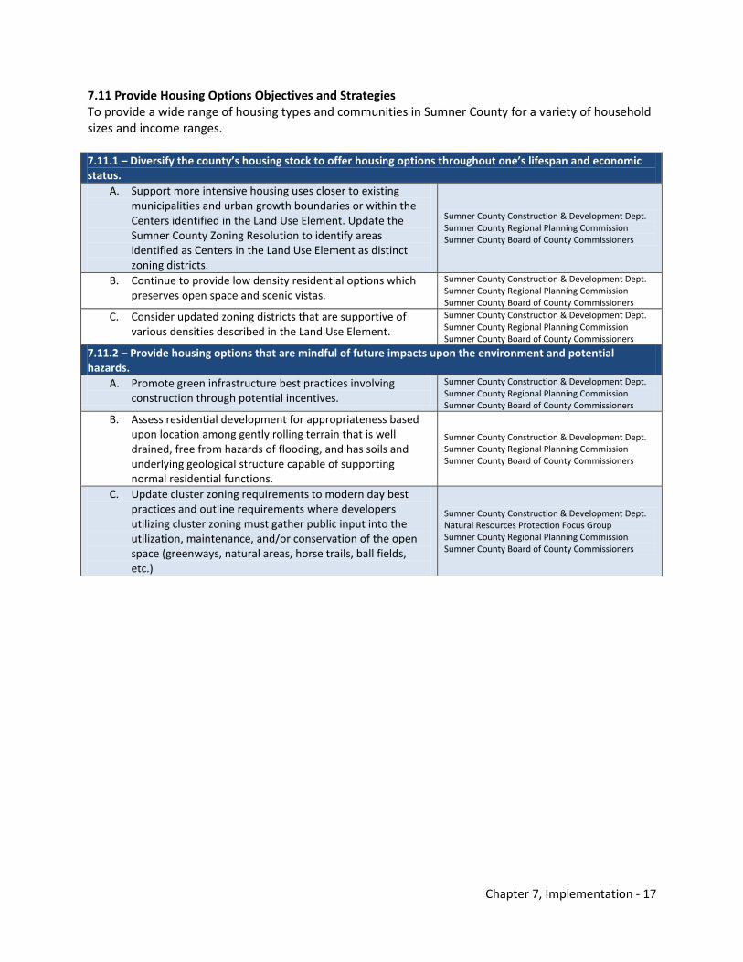
Chapter 7, Implementation - 17
7.11 Provide Housing Options Objectives and Strategies To provide a wide range of housing types and communities in Sumner County for a variety of household sizes and income ranges. 7.11.1 – Diversify the county’s housing stock to offer housing options throughout one’s lifespan and economic status.
A. Support more intensive housing uses closer to existing municipalities and urban growth boundaries or within the Centers identified in the Land Use Element. Update the Sumner County Zoning Resolution to identify areas identified as Centers in the Land Use Element as distinct zoning districts.
Sumner County Construction & Development Dept. Sumner County Regional Planning Commission Sumner County Board of County Commissioners
B. Continue to provide low density residential options which preserves open space and scenic vistas.
Sumner County Construction & Development Dept. Sumner County Regional Planning Commission Sumner County Board of County Commissioners
C. Consider updated zoning districts that are supportive of various densities described in the Land Use Element.
Sumner County Construction & Development Dept. Sumner County Regional Planning Commission Sumner County Board of County Commissioners
7.11.2 – Provide housing options that are mindful of future impacts upon the environment and potential hazards.
A. Promote green infrastructure best practices involving construction through potential incentives.
Sumner County Construction & Development Dept. Sumner County Regional Planning Commission Sumner County Board of County Commissioners
B. Assess residential development for appropriateness based upon location among gently rolling terrain that is well drained, free from hazards of flooding, and has soils and underlying geological structure capable of supporting normal residential functions.
Sumner County Construction & Development Dept. Sumner County Regional Planning Commission Sumner County Board of County Commissioners
C. Update cluster zoning requirements to modern day best practices and outline requirements where developers utilizing cluster zoning must gather public input into the utilization, maintenance, and/or conservation of the open space (greenways, natural areas, horse trails, ball fields, etc.)
Sumner County Construction & Development Dept. Natural Resources Protection Focus Group Sumner County Regional Planning Commission Sumner County Board of County Commissioners
Chapter 7, Implementation - 18
THIS PAGE INTENTIONALLY LEFT BLANK

Appendix A Growth Projections & Trends

THIS PAGE INTENTIONALLY LEFT BLANK
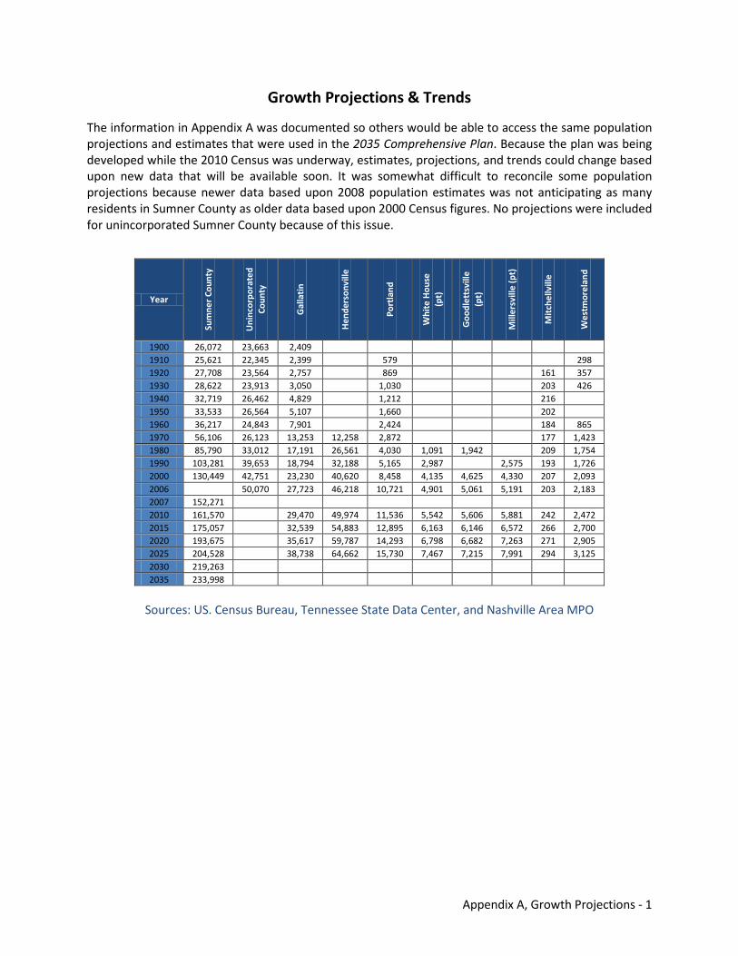
Appendix A, Growth Projections - 1
Growth Projections & Trends
The information in Appendix A was documented so others would be able to access the same population projections and estimates that were used in the 2035 Comprehensive Plan. Because the plan was being developed while the 2010 Census was underway, estimates, projections, and trends could change based upon new data that will be available soon. It was somewhat difficult to reconcile some population projections because newer data based upon 2008 population estimates was not anticipating as many residents in Sumner County as older data based upon 2000 Census figures. No projections were included for unincorporated Sumner County because of this issue.
Sources: US. Census Bureau, Tennessee State Data Center, and Nashville Area MPO
Year
Sum
ner
Coun
ty
Uni
ncor
pora
ted
Coun
ty
Gal
lati
n
Hen
ders
onvi
lle
Port
land
Whi
te H
ouse
(p
t)
Goo
dlet
tsvi
lle
(pt)
Mill
ersv
ille
(pt)
Mit
chel
lvill
e
Wes
tmor
elan
d
1900 26,072 23,663 2,409 1910 25,621 22,345 2,399
579
298 1920 27,708 23,564 2,757
869
161 357
1930 28,622 23,913 3,050
1,030
203 426 1940 32,719 26,462 4,829
1,212
216
1950 33,533 26,564 5,107
1,660
202 1960 36,217 24,843 7,901
2,424
184 865
1970 56,106 26,123 13,253 12,258 2,872
177 1,423 1980 85,790 33,012 17,191 26,561 4,030 1,091 1,942
209 1,754
1990 103,281 39,653 18,794 32,188 5,165 2,987
2,575 193 1,726 2000 130,449 42,751 23,230 40,620 8,458 4,135 4,625 4,330 207 2,093 2006
50,070 27,723 46,218 10,721 4,901 5,061 5,191 203 2,183
2007 152,271 2010 161,570
29,470 49,974 11,536 5,542 5,606 5,881 242 2,472 2015 175,057
32,539 54,883 12,895 6,163 6,146 6,572 266 2,700
2020 193,675
35,617 59,787 14,293 6,798 6,682 7,263 271 2,905 2025 204,528
38,738 64,662 15,730 7,467 7,215 7,991 294 3,125
2030 219,263 2035 233,998
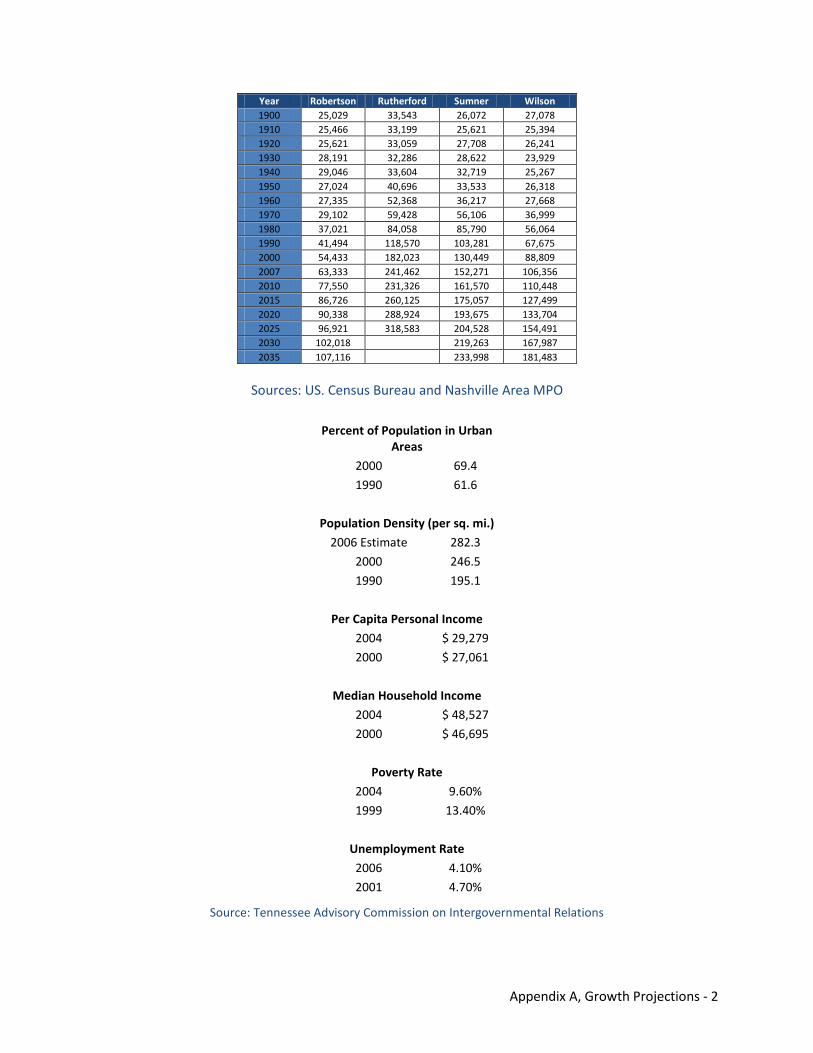
Appendix A, Growth Projections - 2
Sources: US. Census Bureau and Nashville Area MPO
Source: Tennessee Advisory Commission on Intergovernmental Relations
Year Robertson Rutherford Sumner Wilson 1900 25,029 33,543 26,072 27,078 1910 25,466 33,199 25,621 25,394 1920 25,621 33,059 27,708 26,241 1930 28,191 32,286 28,622 23,929 1940 29,046 33,604 32,719 25,267 1950 27,024 40,696 33,533 26,318 1960 27,335 52,368 36,217 27,668 1970 29,102 59,428 56,106 36,999 1980 37,021 84,058 85,790 56,064 1990 41,494 118,570 103,281 67,675 2000 54,433 182,023 130,449 88,809 2007 63,333 241,462 152,271 106,356 2010 77,550 231,326 161,570 110,448 2015 86,726 260,125 175,057 127,499 2020 90,338 288,924 193,675 133,704 2025 96,921 318,583 204,528 154,491 2030 102,018
219,263 167,987
2035 107,116
233,998 181,483
Percent of Population in Urban Areas
2000 69.4
1990 61.6
Population Density (per sq. mi.)
2006 Estimate 282.3
2000 246.5
1990 195.1
Per Capita Personal Income
2004 $ 29,279
2000 $ 27,061
Median Household Income
2004 $ 48,527
2000 $ 46,695
Poverty Rate
2004 9.60%
1999 13.40%
Unemployment Rate
2006 4.10%
2001 4.70%
Appendix B Public Input Opportunities

THIS PAGE INTENTIONALLY LEFT BLANK
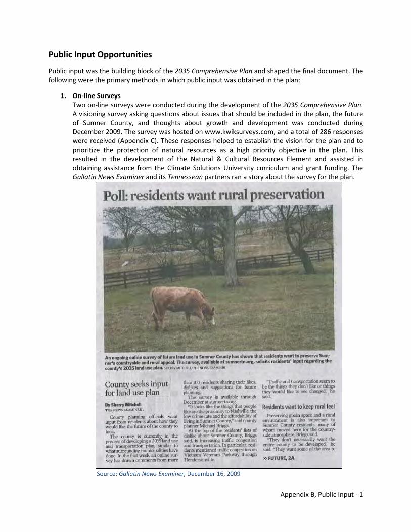
Appendix B, Public Input - 1
Public Input Opportunities
Public input was the building block of the 2035 Comprehensive Plan and shaped the final document. The following were the primary methods in which public input was obtained in the plan:
1. On-line Surveys Two on-line surveys were conducted during the development of the 2035 Comprehensive Plan. A visioning survey asking questions about issues that should be included in the plan, the future of Sumner County, and thoughts about growth and development was conducted during December 2009. The survey was hosted on www.kwiksurveys.com, and a total of 286 responses were received (Appendix C). These responses helped to establish the vision for the plan and to prioritize the protection of natural resources as a high priority objective in the plan. This resulted in the development of the Natural & Cultural Resources Element and assisted in obtaining assistance from the Climate Solutions University curriculum and grant funding. The Gallatin News Examiner and its Tennessean partners ran a story about the survey for the plan.
Source: Gallatin News Examiner, December 16, 2009
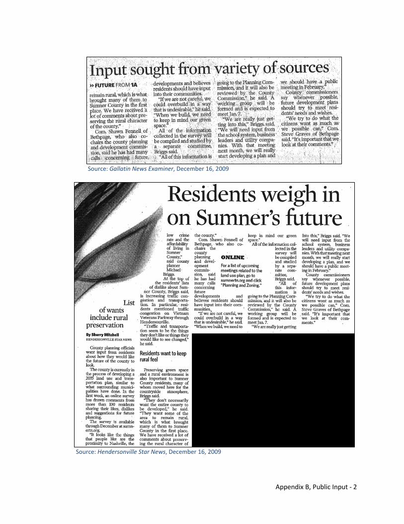
Appendix B, Public Input - 2
Source: Gallatin News Examiner, December 16, 2009
Source: Hendersonville Star News, December 16, 2009
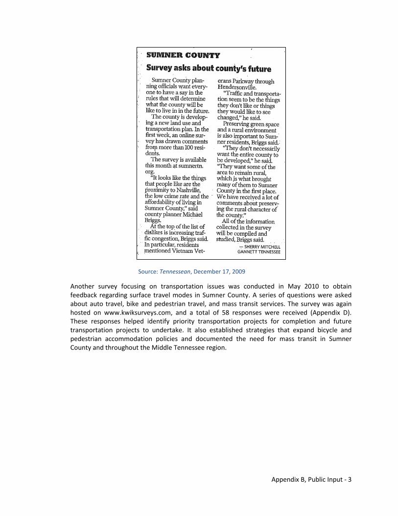
Appendix B, Public Input - 3
Source: Tennessean, December 17, 2009
Another survey focusing on transportation issues was conducted in May 2010 to obtain feedback regarding surface travel modes in Sumner County. A series of questions were asked about auto travel, bike and pedestrian travel, and mass transit services. The survey was again hosted on www.kwiksurveys.com, and a total of 58 responses were received (Appendix D). These responses helped identify priority transportation projects for completion and future transportation projects to undertake. It also established strategies that expand bicycle and pedestrian accommodation policies and documented the need for mass transit in Sumner County and throughout the Middle Tennessee region.
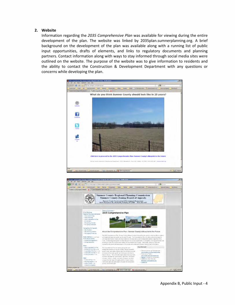
Appendix B, Public Input - 4
2. Website Information regarding the 2035 Comprehensive Plan was available for viewing during the entire development of the plan. The website was linked by 2035plan.sumnerplanning.org. A brief background on the development of the plan was available along with a running list of public input opportunities, drafts of elements, and links to regulatory documents and planning partners. Contact information along with ways to stay informed through social media sites were outlined on the website. The purpose of the website was to give information to residents and the ability to contact the Construction & Development Department with any questions or concerns while developing the plan.
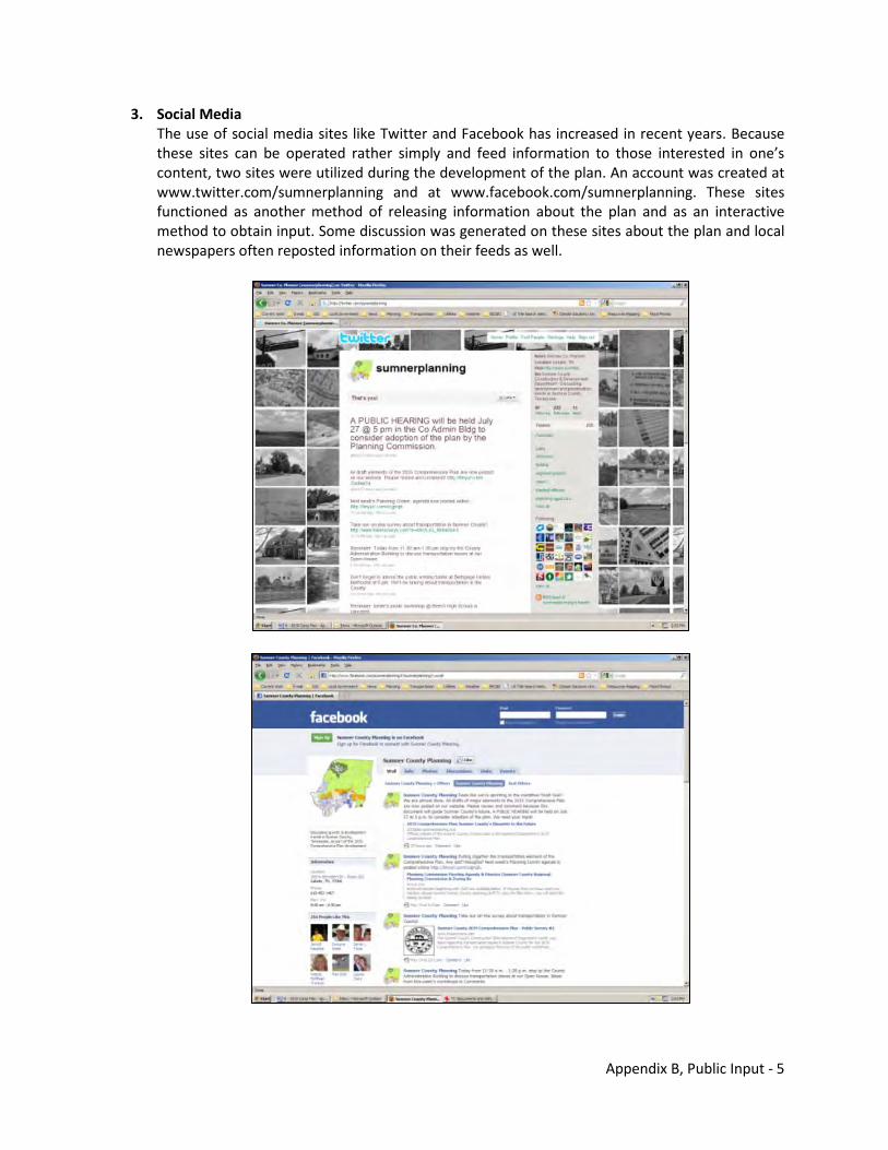
Appendix B, Public Input - 5
3. Social Media The use of social media sites like Twitter and Facebook has increased in recent years. Because these sites can be operated rather simply and feed information to those interested in one’s content, two sites were utilized during the development of the plan. An account was created at www.twitter.com/sumnerplanning and at www.facebook.com/sumnerplanning. These sites functioned as another method of releasing information about the plan and as an interactive method to obtain input. Some discussion was generated on these sites about the plan and local newspapers often reposted information on their feeds as well.
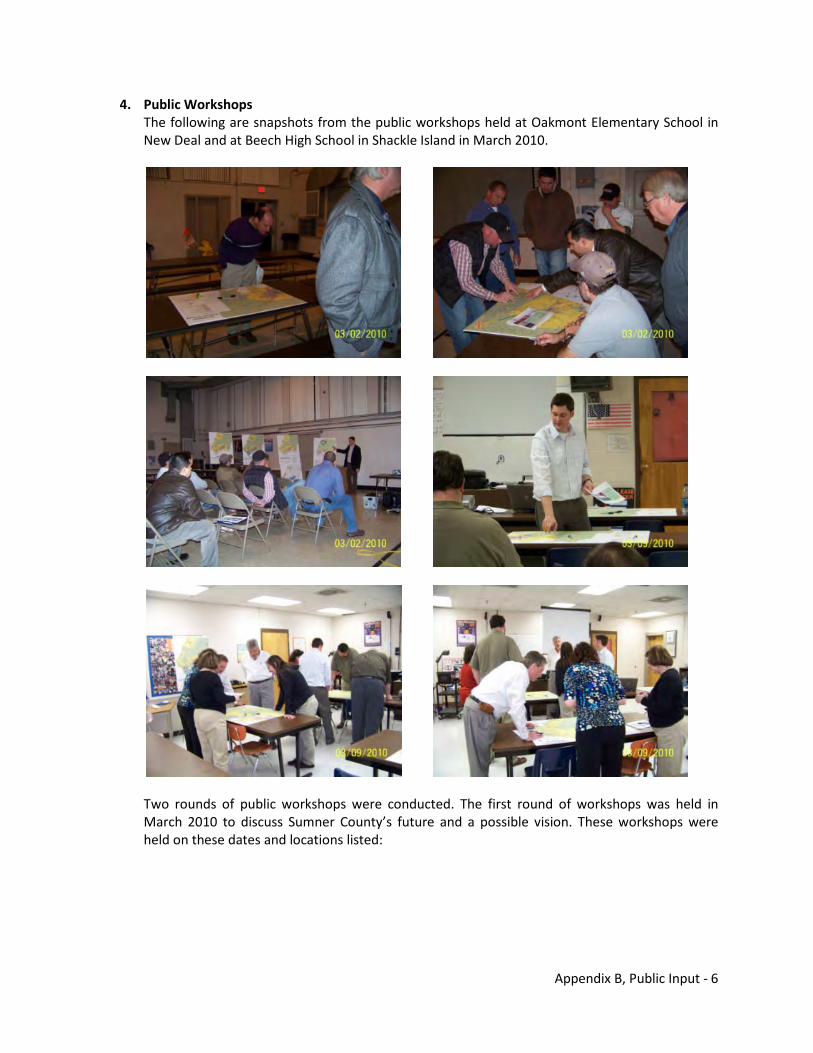
Appendix B, Public Input - 6
4. Public Workshops The following are snapshots from the public workshops held at Oakmont Elementary School in New Deal and at Beech High School in Shackle Island in March 2010.
Two rounds of public workshops were conducted. The first round of workshops was held in March 2010 to discuss Sumner County’s future and a possible vision. These workshops were held on these dates and locations listed:
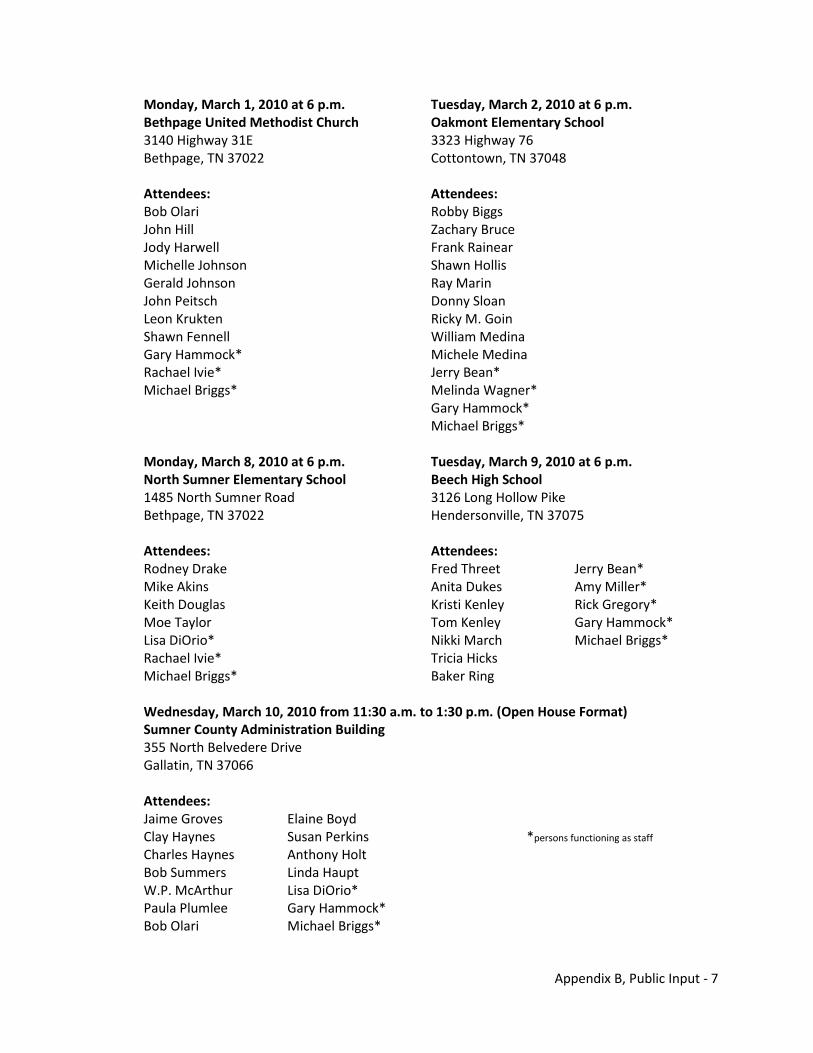
Appendix B, Public Input - 7
Monday, March 1, 2010 at 6 p.m. Tuesday, March 2, 2010 at 6 p.m. Bethpage United Methodist Church Oakmont Elementary School 3140 Highway 31E 3323 Highway 76 Bethpage, TN 37022 Cottontown, TN 37048 Attendees: Attendees: Bob Olari Robby Biggs John Hill Zachary Bruce Jody Harwell Frank Rainear Michelle Johnson Shawn Hollis Gerald Johnson Ray Marin John Peitsch Donny Sloan Leon Krukten Ricky M. Goin Shawn Fennell William Medina Gary Hammock* Michele Medina Rachael Ivie* Jerry Bean* Michael Briggs* Melinda Wagner* Gary Hammock* Michael Briggs* Monday, March 8, 2010 at 6 p.m. Tuesday, March 9, 2010 at 6 p.m. North Sumner Elementary School Beech High School 1485 North Sumner Road 3126 Long Hollow Pike Bethpage, TN 37022 Hendersonville, TN 37075 Attendees: Attendees: Rodney Drake Fred Threet Jerry Bean* Mike Akins Anita Dukes Amy Miller* Keith Douglas Kristi Kenley Rick Gregory* Moe Taylor Tom Kenley Gary Hammock* Lisa DiOrio* Nikki March Michael Briggs* Rachael Ivie* Tricia Hicks Michael Briggs* Baker Ring Wednesday, March 10, 2010 from 11:30 a.m. to 1:30 p.m. (Open House Format) Sumner County Administration Building 355 North Belvedere Drive Gallatin, TN 37066 Attendees: Jaime Groves Elaine Boyd Clay Haynes Susan Perkins *persons functioning as staff
Charles Haynes Anthony Holt Bob Summers Linda Haupt W.P. McArthur Lisa DiOrio* Paula Plumlee Gary Hammock* Bob Olari Michael Briggs*
Appendix B, Public Input - 8
The second round of workshops was held in May 2010. Two workshops scheduled in early May were canceled because of the major flooding event that occurred over the weekend just before these meetings. Three additional opportunities were still held. The dates and locations of these workshops included: Monday, May 3, 2010 at 6 p.m. Tuesday, May 4, 2010 at 6 p.m. North Sumner Elementary School Beech High School 1485 North Sumner Road 3126 Long Hollow Pike Bethpage, TN 37022 Hendersonville, TN 37075 Workshop canceled because of flooding. Workshop canceled because of flooding. Monday, May 10, 2010 at 6 p.m. Tuesday, May 11, 2010 at 6 p.m. Bethpage United Methodist Church Oakmont Elementary School 3140 Highway 31E 3323 Highway 76 Bethpage, TN 37022 Cottontown, TN 37048 Attendees: Attendees: Bob Olari Bob Pospisil Rick Hansen Mike Honeycutt Teddy Wilson Frank Rainear John Hill Jerry Bean* Gerald Johnson Addam McCormick* John Leitsch Michael Briggs* John Norman Rachael Ivie* Michael Briggs* Wednesday, May 12, 2010 from 11:30 a.m. to 1:30 p.m. (Open House Format) Sumner County Administration Building 355 North Belvedere Drive Gallatin, TN 37066 Attendees: Bob Olari Don Horton Martha Akins Susan Perkins Michael Briggs* (several additional people stopped by but did not sign in) *persons functioning as staff
The public workshops were advertised by the local newspaper and posted on the Sumner County website, on the social media sites, and bulletin boards in the County Administration Building.
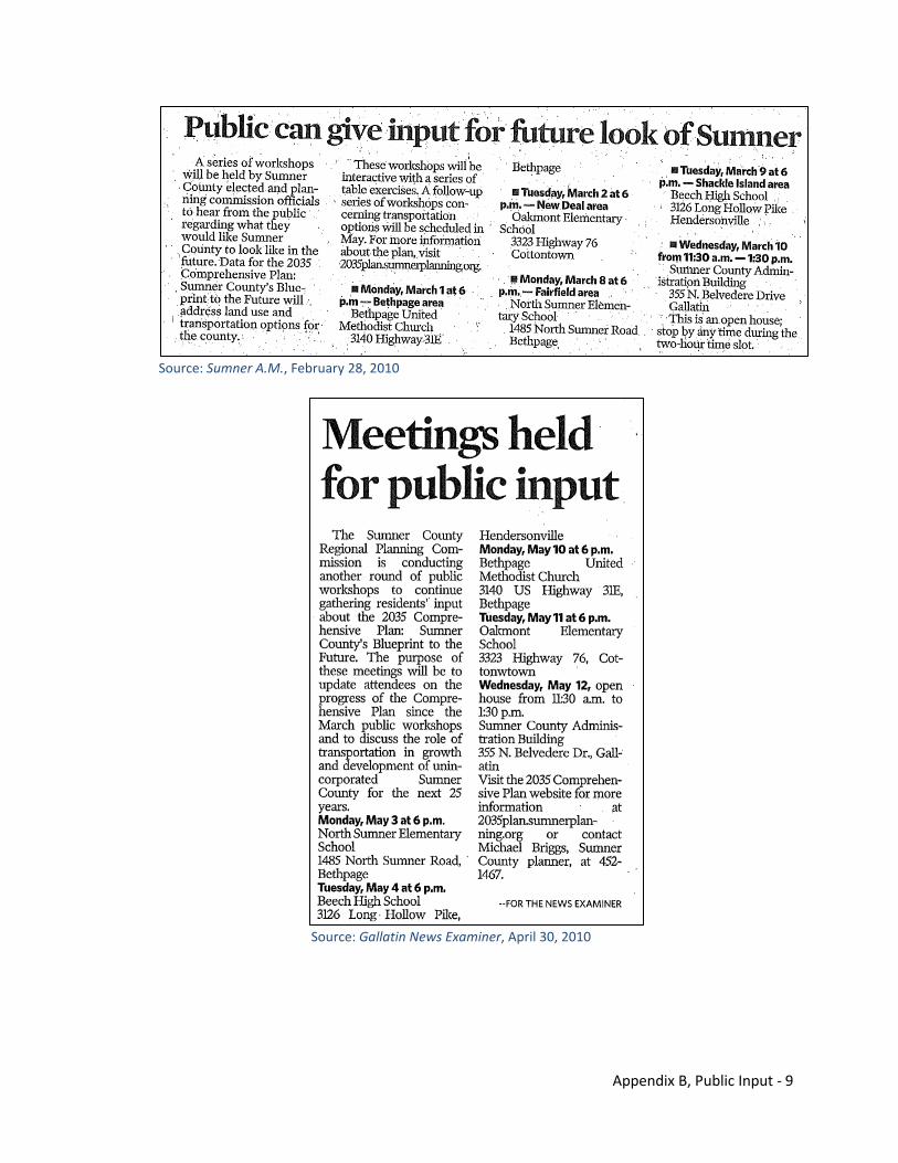
Appendix B, Public Input - 9
Source: Sumner A.M., February 28, 2010
Source: Gallatin News Examiner, April 30, 2010
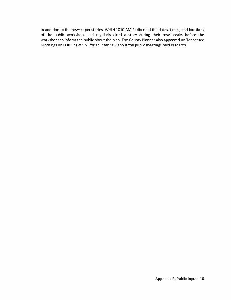
Appendix B, Public Input - 10
In addition to the newspaper stories, WHIN 1010 AM Radio read the dates, times, and locations of the public workshops and regularly aired a story during their newsbreaks before the workshops to inform the public about the plan. The County Planner also appeared on Tennessee Mornings on FOX 17 (WZTV) for an interview about the public meetings held in March.
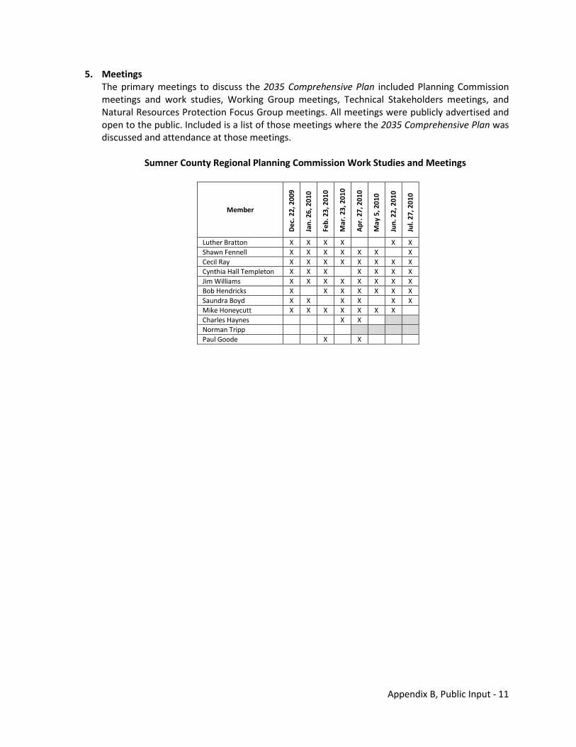
Appendix B, Public Input - 11
5. Meetings The primary meetings to discuss the 2035 Comprehensive Plan included Planning Commission meetings and work studies, Working Group meetings, Technical Stakeholders meetings, and Natural Resources Protection Focus Group meetings. All meetings were publicly advertised and open to the public. Included is a list of those meetings where the 2035 Comprehensive Plan was discussed and attendance at those meetings.
Sumner County Regional Planning Commission Work Studies and Meetings
Member
Dec
. 22,
200
9
Jan.
26,
201
0
Feb.
23,
201
0
Mar
. 23,
201
0
Apr
. 27,
201
0
May
5, 2
010
Jun.
22,
201
0
Jul.
27, 2
010
Luther Bratton X X X X X X Shawn Fennell X X X X X X X Cecil Ray X X X X X X X X Cynthia Hall Templeton X X X X X X X Jim Williams X X X X X X X X Bob Hendricks X X X X X X X Saundra Boyd X X X X X X Mike Honeycutt X X X X X X X Charles Haynes X X Norman Tripp Paul Goode X X
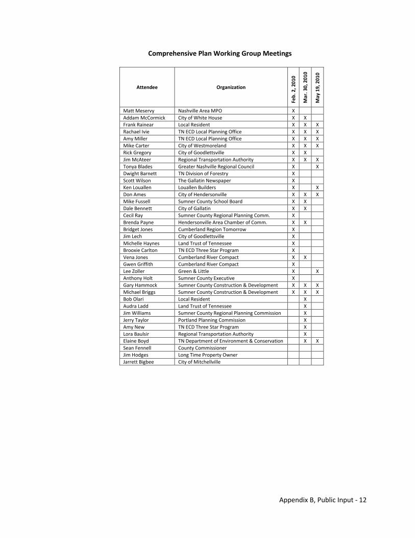
Appendix B, Public Input - 12
Comprehensive Plan Working Group Meetings
Attendee Organization
Feb.
2, 2
010
Mar
. 30,
201
0
May
19,
201
0
Matt Meservy Nashville Area MPO X Addam McCormick City of White House X X Frank Rainear Local Resident X X X Rachael Ivie TN ECD Local Planning Office X X X Amy Miller TN ECD Local Planning Office X X X Mike Carter City of Westmoreland X X X Rick Gregory City of Goodlettsville X X Jim McAteer Regional Transportation Authority X X X Tonya Blades Greater Nashville Regional Council X X Dwight Barnett TN Division of Forestry X Scott Wilson The Gallatin Newspaper X Ken Louallen Louallen Builders X X Don Ames City of Hendersonville X X X Mike Fussell Sumner County School Board X X Dale Bennett City of Gallatin X X Cecil Ray Sumner County Regional Planning Comm. X Brenda Payne Hendersonville Area Chamber of Comm. X X Bridget Jones Cumberland Region Tomorrow X Jim Lech City of Goodlettsville X Michelle Haynes Land Trust of Tennessee X Brooxie Carlton TN ECD Three Star Program X Vena Jones Cumberland River Compact X X Gwen Griffith Cumberland River Compact X Lee Zoller Green & Little X X Anthony Holt Sumner County Executive X Gary Hammock Sumner County Construction & Development X X X Michael Briggs Sumner County Construction & Development X X X Bob Olari Local Resident X Audra Ladd Land Trust of Tennessee X Jim Williams Sumner County Regional Planning Commission X Jerry Taylor Portland Planning Commission X Amy New TN ECD Three Star Program X Lora Baulsir Regional Transportation Authority X Elaine Boyd TN Department of Environment & Conservation X X Sean Fennell County Commissioner Jim Hodges Long Time Property Owner Jarrett Bigbee City of Mitchellville
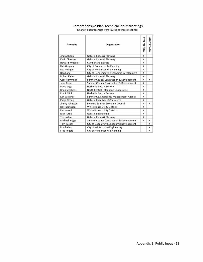
Appendix B, Public Input - 13
Comprehensive Plan Technical Input Meetings (56 individuals/agencies were invited to these meetings)
Attendee Organization
Mar
. 25,
201
0
May
18,
201
0
Jim Svoboda Gallatin Codes & Planning X Kevin Chastine Gallatin Codes & Planning X Howard Whitaker Cumberland Electric X Rick Gregory City of Goodlettsville Planning X Lisa Milligan City of Hendersonville Planning X Don Long City of Hendersonville Economic Development X Robert Kalisz Gallatin Codes & Planning X Gary Hammock Sumner County Construction & Development X X Jerry Bean Sumner County Construction & Development X David Lege Nashville Electric Service X Brian Stephens North Central Telephone Cooperative X Frank Mink Nashville Electric Service X Ken Weidner Sumner Co. Emergency Management Agency X Paige Strong Gallatin Chamber of Commerce X Jimmy Johnston Forward Sumner Economic Council X X Bill Thompson White House Utility District X Pat Harrell White House Utility District X Nick Tuttle Gallatin Engineering X Tony Allers Gallatin Codes & Planning X Michael Briggs Sumner County Construction & Development X X Tom Tucker City of Goodlettsville Economic Development X Ron Bailey City of White House Engineering X Fred Rogers City of Hendersonville Planning X
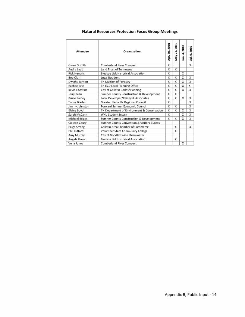
Appendix B, Public Input - 14
Natural Resources Protection Focus Group Meetings
Attendee Organization
Apr
. 30,
201
0
May
21,
201
0
Jun.
4, 2
010
Jul.
9, 2
010
Gwen Griffith Cumberland River Compact X X Audra Ladd Land Trust of Tennessee X X Rick Hendrix Bledsoe Lick Historical Association X X Bob Olari Local Resident X X X X Dwight Barnett TN Division of Forestry X X X X Rachael Ivie TN ECD Local Planning Office X X X X Kevin Chastine City of Gallatin Codes/Planning X X X X Jerry Bean Sumner County Construction & Development X X Bruce Rainey Local Developer/Rainey & Associates X X X X Tonya Blades Greater Nashville Regional Council X X Jimmy Johnston Forward Sumner Economic Council X X X Elaine Boyd TN Department of Environment & Conservation X X X X Sarah McCann WKU Student Intern X X X Michael Briggs Sumner County Construction & Development X X X X Colleen Coury Sumner County Convention & Visitors Bureau Paige Strong Gallatin Area Chamber of Commerce X X Phil Clifford Volunteer State Community College X Amy Murray City of Goodlettsville Stormwater Angela Govan Bledsoe Lick Historical Association X Vena Jones Cumberland River Compact X
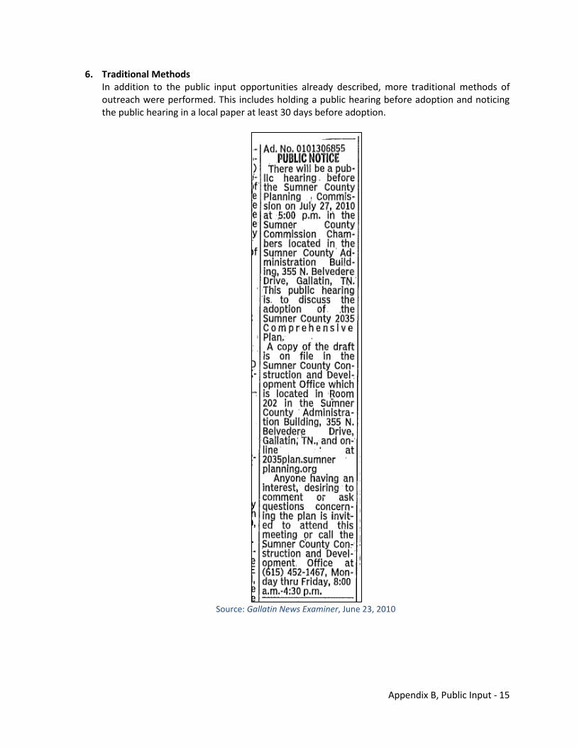
Appendix B, Public Input - 15
6. Traditional Methods In addition to the public input opportunities already described, more traditional methods of outreach were performed. This includes holding a public hearing before adoption and noticing the public hearing in a local paper at least 30 days before adoption.
Source: Gallatin News Examiner, June 23, 2010
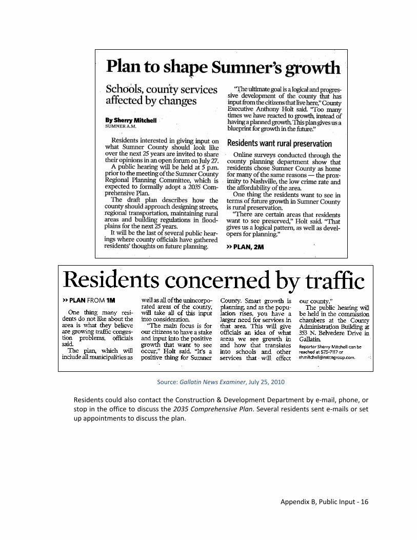
Appendix B, Public Input - 16
Source: Gallatin News Examiner, July 25, 2010 Residents could also contact the Construction & Development Department by e-mail, phone, or stop in the office to discuss the 2035 Comprehensive Plan. Several residents sent e-mails or set up appointments to discuss the plan.

Appendix C Results of On-line Visioning Survey
THIS PAGE INTENTIONALLY LEFT BLANK
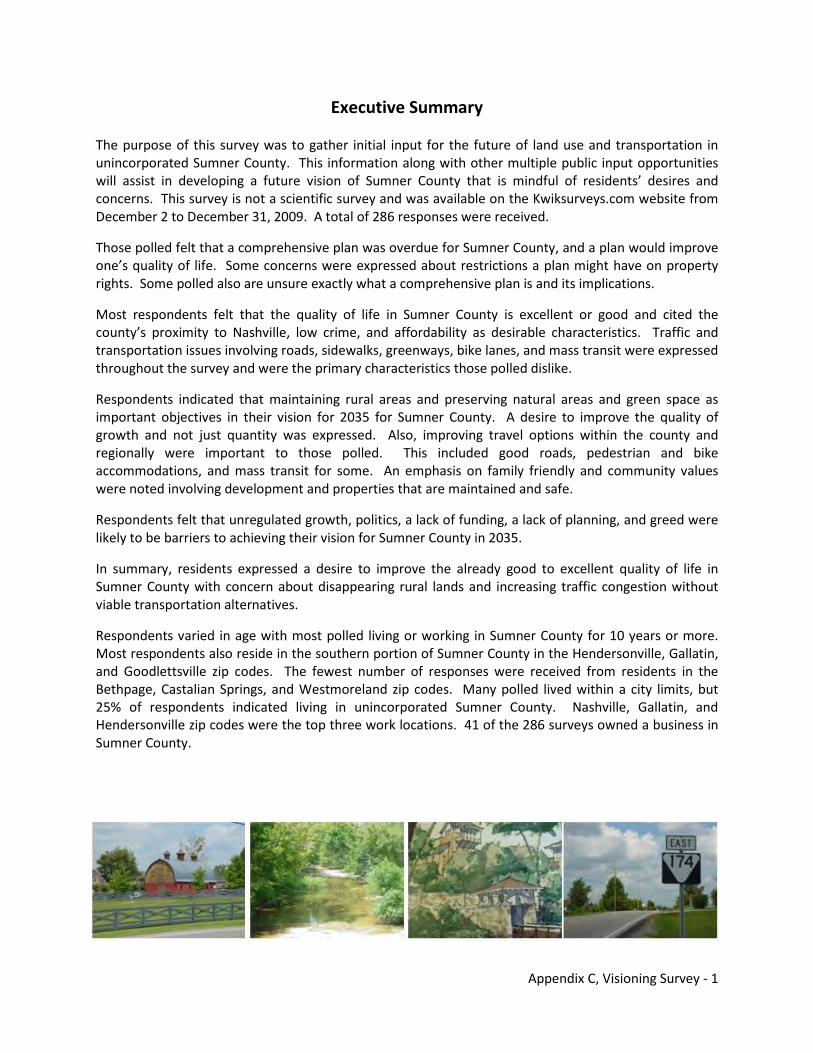
Appendix C, Visioning Survey - 1
Executive Summary
The purpose of this survey was to gather initial input for the future of land use and transportation in unincorporated Sumner County. This information along with other multiple public input opportunities will assist in developing a future vision of Sumner County that is mindful of residents’ desires and concerns. This survey is not a scientific survey and was available on the Kwiksurveys.com website from December 2 to December 31, 2009. A total of 286 responses were received.
Those polled felt that a comprehensive plan was overdue for Sumner County, and a plan would improve one’s quality of life. Some concerns were expressed about restrictions a plan might have on property rights. Some polled also are unsure exactly what a comprehensive plan is and its implications.
Most respondents felt that the quality of life in Sumner County is excellent or good and cited the county’s proximity to Nashville, low crime, and affordability as desirable characteristics. Traffic and transportation issues involving roads, sidewalks, greenways, bike lanes, and mass transit were expressed throughout the survey and were the primary characteristics those polled dislike.
Respondents indicated that maintaining rural areas and preserving natural areas and green space as important objectives in their vision for 2035 for Sumner County. A desire to improve the quality of growth and not just quantity was expressed. Also, improving travel options within the county and regionally were important to those polled. This included good roads, pedestrian and bike accommodations, and mass transit for some. An emphasis on family friendly and community values were noted involving development and properties that are maintained and safe.
Respondents felt that unregulated growth, politics, a lack of funding, a lack of planning, and greed were likely to be barriers to achieving their vision for Sumner County in 2035.
In summary, residents expressed a desire to improve the already good to excellent quality of life in Sumner County with concern about disappearing rural lands and increasing traffic congestion without viable transportation alternatives.
Respondents varied in age with most polled living or working in Sumner County for 10 years or more. Most respondents also reside in the southern portion of Sumner County in the Hendersonville, Gallatin, and Goodlettsville zip codes. The fewest number of responses were received from residents in the Bethpage, Castalian Springs, and Westmoreland zip codes. Many polled lived within a city limits, but 25% of respondents indicated living in unincorporated Sumner County. Nashville, Gallatin, and Hendersonville zip codes were the top three work locations. 41 of the 286 surveys owned a business in Sumner County.
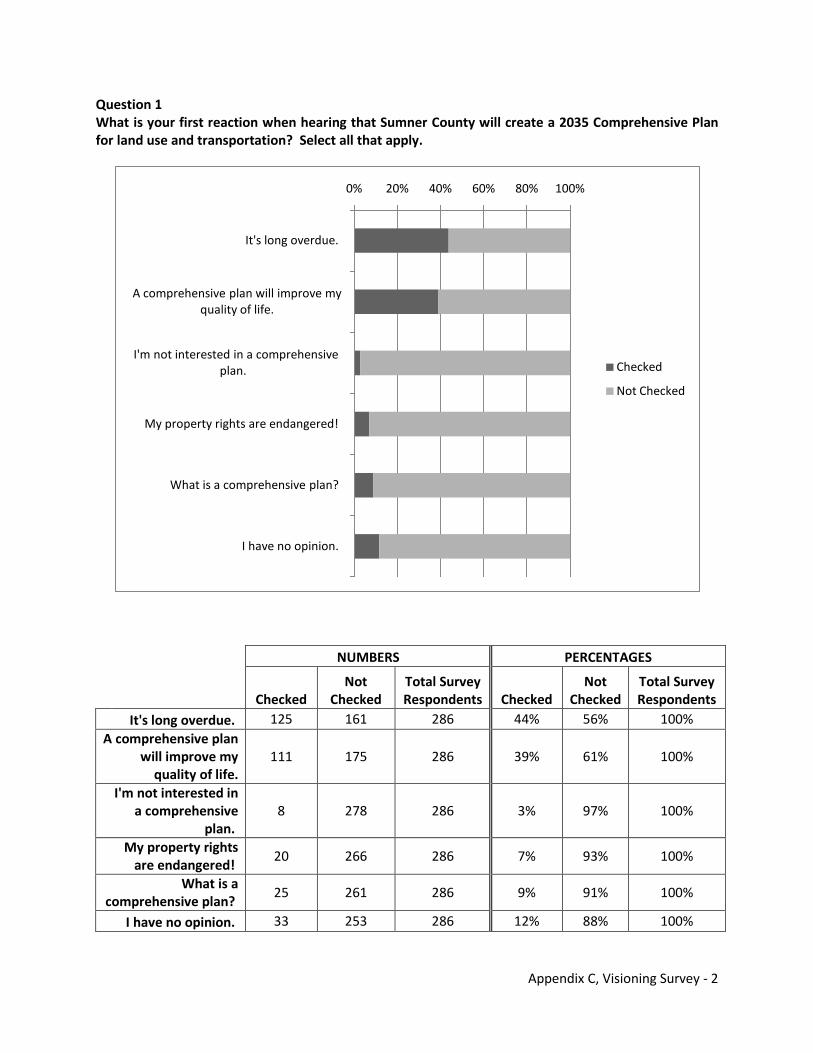
Appendix C, Visioning Survey - 2
Question 1 What is your first reaction when hearing that Sumner County will create a 2035 Comprehensive Plan for land use and transportation? Select all that apply.
NUMBERS PERCENTAGES
Checked
Not Checked
Total Survey Respondents Checked
Not Checked
Total Survey Respondents
It's long overdue. 125 161 286 44% 56% 100% A comprehensive plan
will improve my quality of life.
111 175 286 39% 61% 100%
I'm not interested in a comprehensive
plan. 8 278 286 3% 97% 100%
My property rights are endangered!
20 266 286 7% 93% 100%
What is a comprehensive plan?
25 261 286 9% 91% 100%
I have no opinion. 33 253 286 12% 88% 100%
0% 20% 40% 60% 80% 100%
It's long overdue.
A comprehensive plan will improve my quality of life.
I'm not interested in a comprehensive plan.
My property rights are endangered!
What is a comprehensive plan?
I have no opinion.
Checked
Not Checked
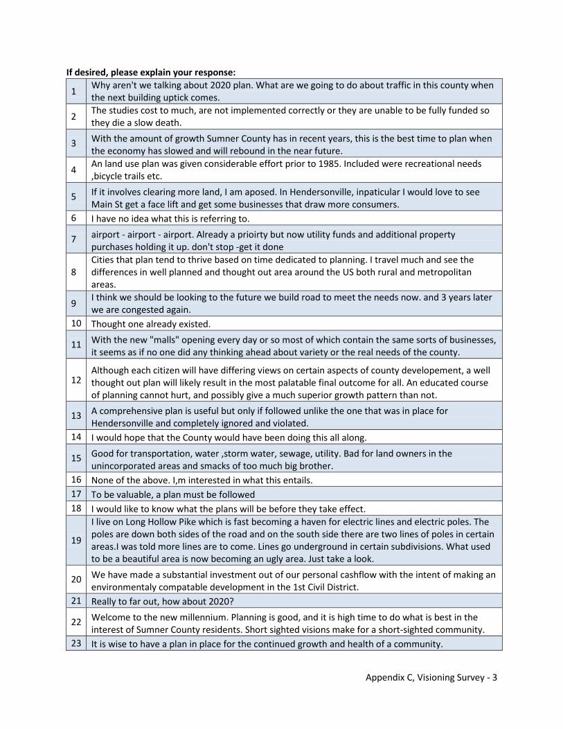
Appendix C, Visioning Survey - 3
If desired, please explain your response:
1 Why aren't we talking about 2020 plan. What are we going to do about traffic in this county when the next building uptick comes.
2 The studies cost to much, are not implemented correctly or they are unable to be fully funded so they die a slow death.
3 With the amount of growth Sumner County has in recent years, this is the best time to plan when the economy has slowed and will rebound in the near future.
4 An land use plan was given considerable effort prior to 1985. Included were recreational needs ,bicycle trails etc.
5 If it involves clearing more land, I am aposed. In Hendersonville, inpaticular I would love to see Main St get a face lift and get some businesses that draw more consumers.
6 I have no idea what this is referring to.
7 airport - airport - airport. Already a prioirty but now utility funds and additional property purchases holding it up. don't stop -get it done
8 Cities that plan tend to thrive based on time dedicated to planning. I travel much and see the differences in well planned and thought out area around the US both rural and metropolitan areas.
9 I think we should be looking to the future we build road to meet the needs now. and 3 years later we are congested again.
10 Thought one already existed.
11 With the new "malls" opening every day or so most of which contain the same sorts of businesses, it seems as if no one did any thinking ahead about variety or the real needs of the county.
12 Although each citizen will have differing views on certain aspects of county developement, a well thought out plan will likely result in the most palatable final outcome for all. An educated course of planning cannot hurt, and possibly give a much superior growth pattern than not.
13 A comprehensive plan is useful but only if followed unlike the one that was in place for Hendersonville and completely ignored and violated.
14 I would hope that the County would have been doing this all along.
15 Good for transportation, water ,storm water, sewage, utility. Bad for land owners in the unincorporated areas and smacks of too much big brother.
16 None of the above. I,m interested in what this entails. 17 To be valuable, a plan must be followed 18 I would like to know what the plans will be before they take effect.
19
I live on Long Hollow Pike which is fast becoming a haven for electric lines and electric poles. The poles are down both sides of the road and on the south side there are two lines of poles in certain areas.I was told more lines are to come. Lines go underground in certain subdivisions. What used to be a beautiful area is now becoming an ugly area. Just take a look.
20 We have made a substantial investment out of our personal cashflow with the intent of making an environmentaly compatable development in the 1st Civil District.
21 Really to far out, how about 2020?
22 Welcome to the new millennium. Planning is good, and it is high time to do what is best in the interest of Sumner County residents. Short sighted visions make for a short-sighted community.
23 It is wise to have a plan in place for the continued growth and health of a community.
Appendix C, Visioning Survey - 4
24 If it will improve the county as a whole.
25 Development planning is the right thing to do, as long as, you don't endanger anyone's property rights.
26 Hope we don't use the same designer that designed Saundersville Rd from the by-pass to the railroad on any road projects! Someone will be severely injured, if they have not already!
27 I was involved in the updating of the new Hendersonville Land Use and Transportation plan. 28 will it wast money like [----------------] gallatin
29
It's useful if its plans are followed. Often, it seems plans like this look good on paper, are followed when it is convenient to those in positions of political influence, and abandoned when the same individuals find it expedient to do so. The plan, once adopted, should be respected and serve as the map for future development of the county.
30 Middle Tennessee will be a rapidly growing araa for decades to come. We have a chance now to provide a quality environment in the future.
31 I believe the growth is unquestionable so the planning is vital.
32 Could be a delicate line to follow. Overall I like a comprehensive plan as long as it is not to intrusive.
33 if done properly, i believe that it will make sumner county more desirable.
34 I am cautious as these types of plans are almost always good for some and detremental to others (usually the "little" guy). I truely believe in smaller goverment, on all levels, and more personal responsibility but I also understand the potential benifits to this kind of long term planning.
35 Depends on what they come up with
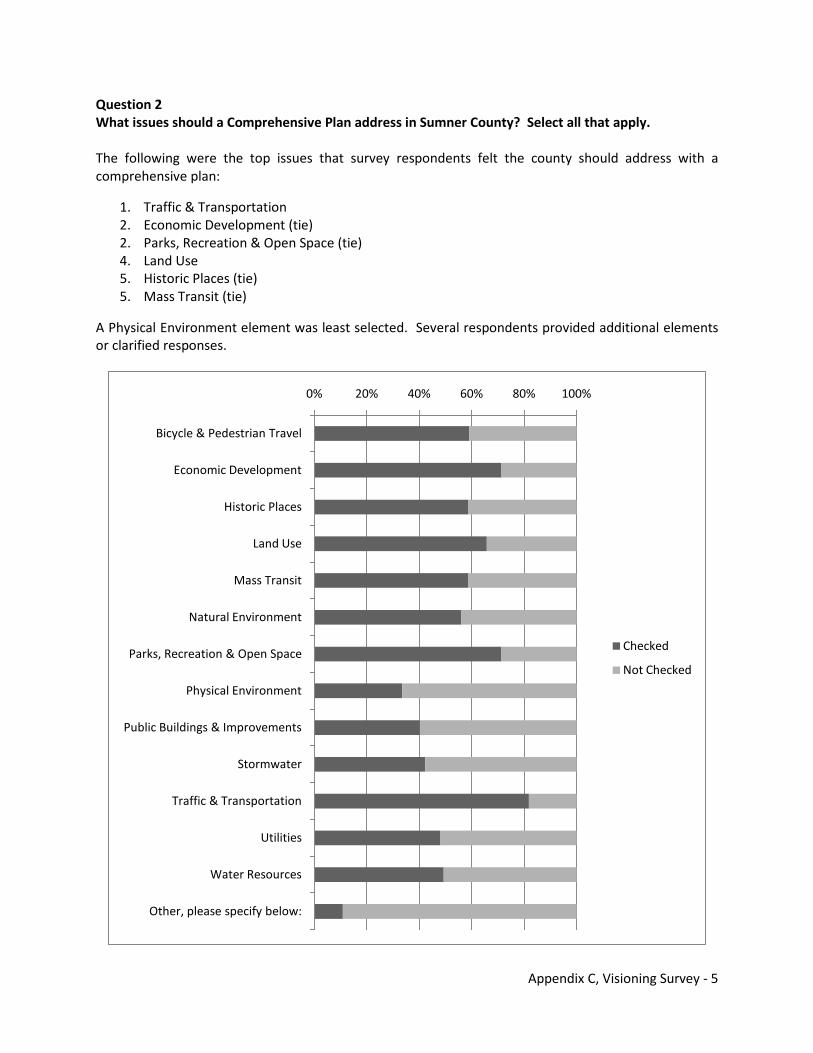
Appendix C, Visioning Survey - 5
Question 2 What issues should a Comprehensive Plan address in Sumner County? Select all that apply. The following were the top issues that survey respondents felt the county should address with a comprehensive plan:
1. Traffic & Transportation 2. Economic Development (tie) 2. Parks, Recreation & Open Space (tie) 4. Land Use 5. Historic Places (tie) 5. Mass Transit (tie)
A Physical Environment element was least selected. Several respondents provided additional elements or clarified responses.
0% 20% 40% 60% 80% 100%
Bicycle & Pedestrian Travel
Economic Development
Historic Places
Land Use
Mass Transit
Natural Environment
Parks, Recreation & Open Space
Physical Environment
Public Buildings & Improvements
Stormwater
Traffic & Transportation
Utilities
Water Resources
Other, please specify below:
Checked
Not Checked
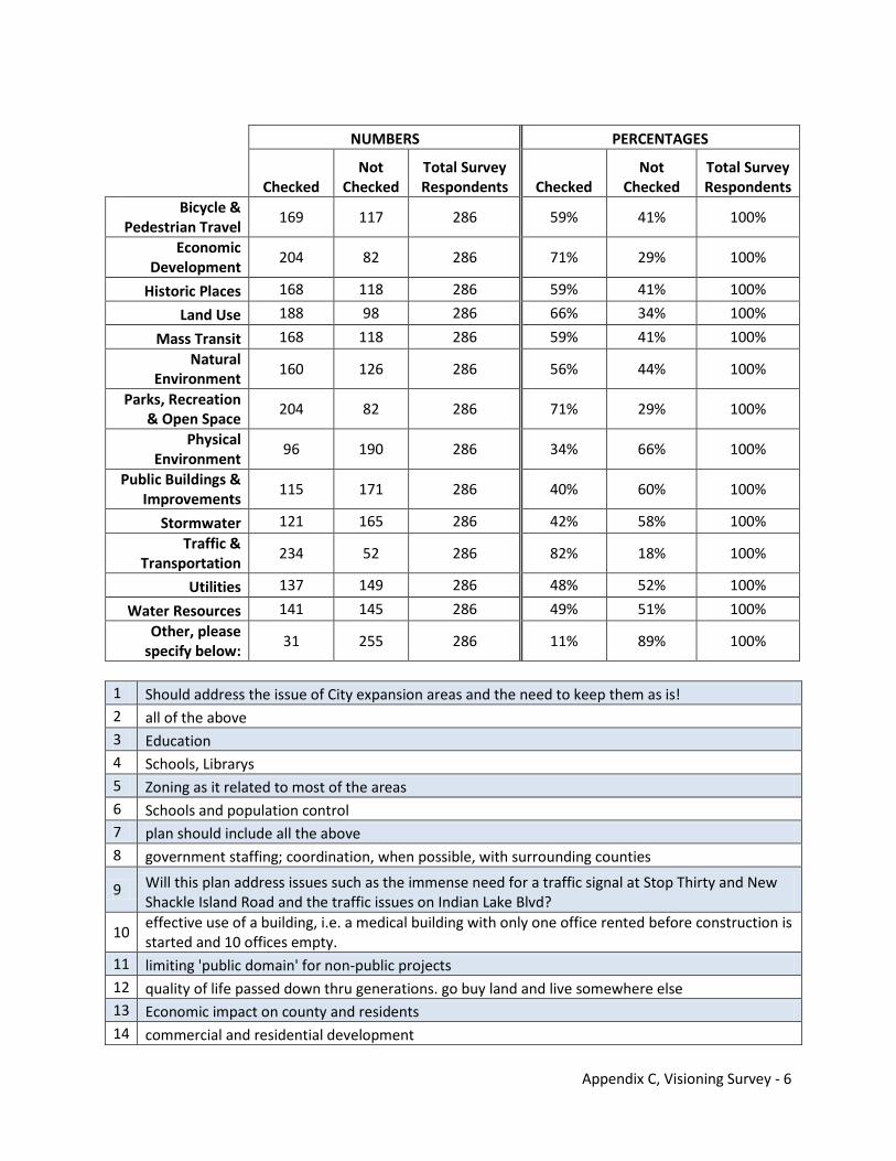
Appendix C, Visioning Survey - 6
NUMBERS PERCENTAGES
Checked
Not Checked
Total Survey Respondents Checked
Not Checked
Total Survey Respondents
Bicycle & Pedestrian Travel
169 117 286 59% 41% 100%
Economic Development
204 82 286 71% 29% 100%
Historic Places 168 118 286 59% 41% 100%
Land Use 188 98 286 66% 34% 100%
Mass Transit 168 118 286 59% 41% 100% Natural
Environment 160 126 286 56% 44% 100%
Parks, Recreation & Open Space
204 82 286 71% 29% 100%
Physical Environment
96 190 286 34% 66% 100%
Public Buildings & Improvements
115 171 286 40% 60% 100%
Stormwater 121 165 286 42% 58% 100% Traffic &
Transportation 234 52 286 82% 18% 100%
Utilities 137 149 286 48% 52% 100%
Water Resources 141 145 286 49% 51% 100% Other, please
specify below: 31 255 286 11% 89% 100%
1 Should address the issue of City expansion areas and the need to keep them as is! 2 all of the above 3 Education 4 Schools, Librarys 5 Zoning as it related to most of the areas 6 Schools and population control 7 plan should include all the above 8 government staffing; coordination, when possible, with surrounding counties
9 Will this plan address issues such as the immense need for a traffic signal at Stop Thirty and New Shackle Island Road and the traffic issues on Indian Lake Blvd?
10 effective use of a building, i.e. a medical building with only one office rented before construction is started and 10 offices empty.
11 limiting 'public domain' for non-public projects 12 quality of life passed down thru generations. go buy land and live somewhere else 13 Economic impact on county and residents 14 commercial and residential development
Appendix C, Visioning Survey - 7
15 High speed internet access to everyone. 16 YMCA or some type of public pool and more indoor recreation of some type for kids 17 Education
18 Cultural heritages of those riseding here and of the local area (i.e. Native American, African American etc)
19 lower speed limit on vetnam vet. pky. with strict enforcement (most dangerous road in tn.) 20 airport access, waterways (including dredging of backwater in public view & habors) 21 preserving a semi-rural setting 22 Quit building before traffic and schools are addressed.
23 Emperment of water quality in natural flowing springs because of permited operations on adjacent properties.
24 Housing for 55 and older 25 Preserving agriculture/forestry. 26 Animal control, we need to fund a spay/nueter program 27 animal control center 28 steam plant pollution, pollution from hogandaes plant on airport rd. and crime 29 To add recycling pick up for residential 30 Widening and lengthening vietnam vets
31 We need to be careful to protect the values we hold now while leaving enough room for individual situations to be dealt with as they come up over the years.
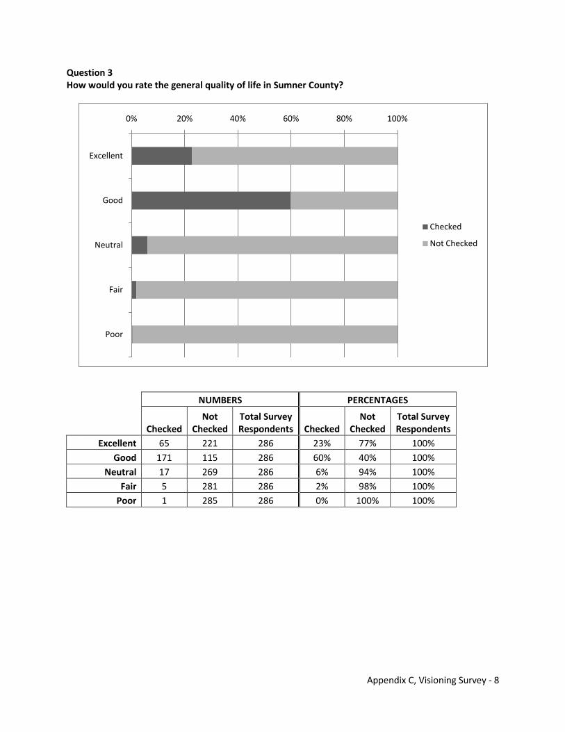
Appendix C, Visioning Survey - 8
Question 3 How would you rate the general quality of life in Sumner County?
NUMBERS PERCENTAGES
Checked
Not Checked
Total Survey Respondents Checked
Not Checked
Total Survey Respondents
Excellent 65 221 286 23% 77% 100% Good 171 115 286 60% 40% 100%
Neutral 17 269 286 6% 94% 100% Fair 5 281 286 2% 98% 100%
Poor 1 285 286 0% 100% 100%
0% 20% 40% 60% 80% 100%
Excellent
Good
Neutral
Fair
Poor
Checked
Not Checked
Appendix C, Visioning Survey - 9
Question 4 Sumner County has worked with the Nashville Area Metropolitan Planning Organization (MPO) to conduct a study involving transportation and land use in Robertson, Sumner, and Wilson Counties. Listed below are common growth and development objectives reflected in local land use and transportation plans from these counties. How important are the following objectives to the quality of life in Sumner County?
Historic Conservation & Enhancement
Viable Agriculture
Very Important
33%
Important46%
Neutral19%
Unimportant
1%Very
Unimportant
1%
Very Important
33%
Important44%
Neutral20%
Unimportant
2%Very
Unimportant
1%
Appendix C, Visioning Survey - 10
Rural Preservation
Economic Enrichment while Safeguarding Existing Public & Private Development
Preserve Urban Centers
Very Important
38%
Important37%
Neutral20%
Unimportant
4%Very
Unimportant
1%
Very Important
37%
Important46%
Neutral15%
Unimportant
1%Very
Unimportant
1%
Very Important
16%
Important44%
Neutral34%
Unimportant
4%Very
Unimportant
2%
Appendix C, Visioning Survey - 11
Protect Natural Resources Efficient Transportation System Ensure Availability of Services
Very Important
56%
Important32%
Neutral11%
Unimportant
1%
Very
Unimportant
0%
Very Important
55%Important
29%
Neutral9%
Unimportant
5%Very
Unimportant
2%
Very Important
32%
Important52%
Neutral16%
Unimportant
0%
Very
Unimportant
0%
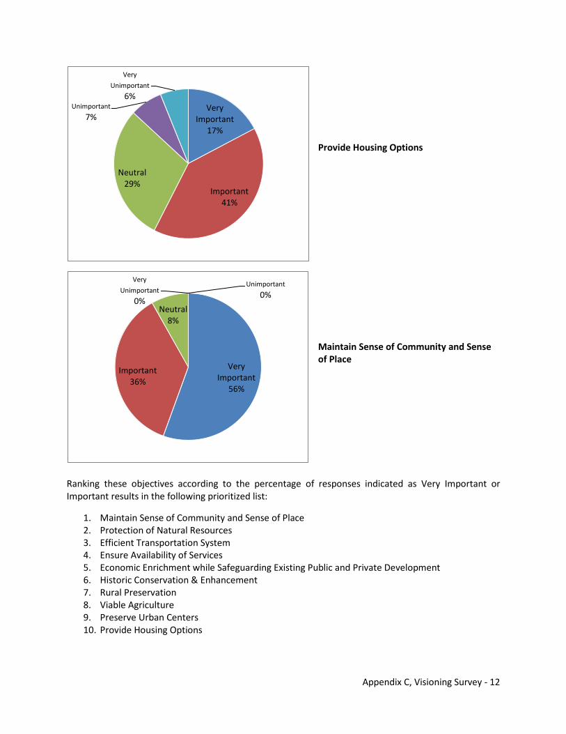
Appendix C, Visioning Survey - 12
Provide Housing Options Maintain Sense of Community and Sense of Place
Ranking these objectives according to the percentage of responses indicated as Very Important or Important results in the following prioritized list:
1. Maintain Sense of Community and Sense of Place 2. Protection of Natural Resources 3. Efficient Transportation System 4. Ensure Availability of Services 5. Economic Enrichment while Safeguarding Existing Public and Private Development 6. Historic Conservation & Enhancement 7. Rural Preservation 8. Viable Agriculture 9. Preserve Urban Centers 10. Provide Housing Options
Very Important
17%
Important41%
Neutral29%
Unimportant
7%
Very
Unimportant
6%
Very Important
56%
Important36%
Neutral8%
Unimportant
0%
Very
Unimportant
0%
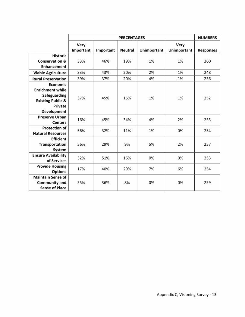
Appendix C, Visioning Survey - 13
PERCENTAGES NUMBERS
Very Important Important Neutral Unimportant
Very Unimportant Responses
Historic Conservation &
Enhancement 33% 46% 19% 1% 1% 260
Viable Agriculture 33% 43% 20% 2% 1% 248
Rural Preservation 39% 37% 20% 4% 1% 256 Economic
Enrichment while Safeguarding
Existing Public & Private
Development
37% 45% 15% 1% 1% 252
Preserve Urban Centers
16% 45% 34% 4% 2% 253
Protection of Natural Resources
56% 32% 11% 1% 0% 254
Efficient Transportation
System 56% 29% 9% 5% 2% 257
Ensure Availability of Services
32% 51% 16% 0% 0% 253
Provide Housing Options
17% 40% 29% 7% 6% 254
Maintain Sense of Community and
Sense of Place 55% 36% 8% 0% 0% 259
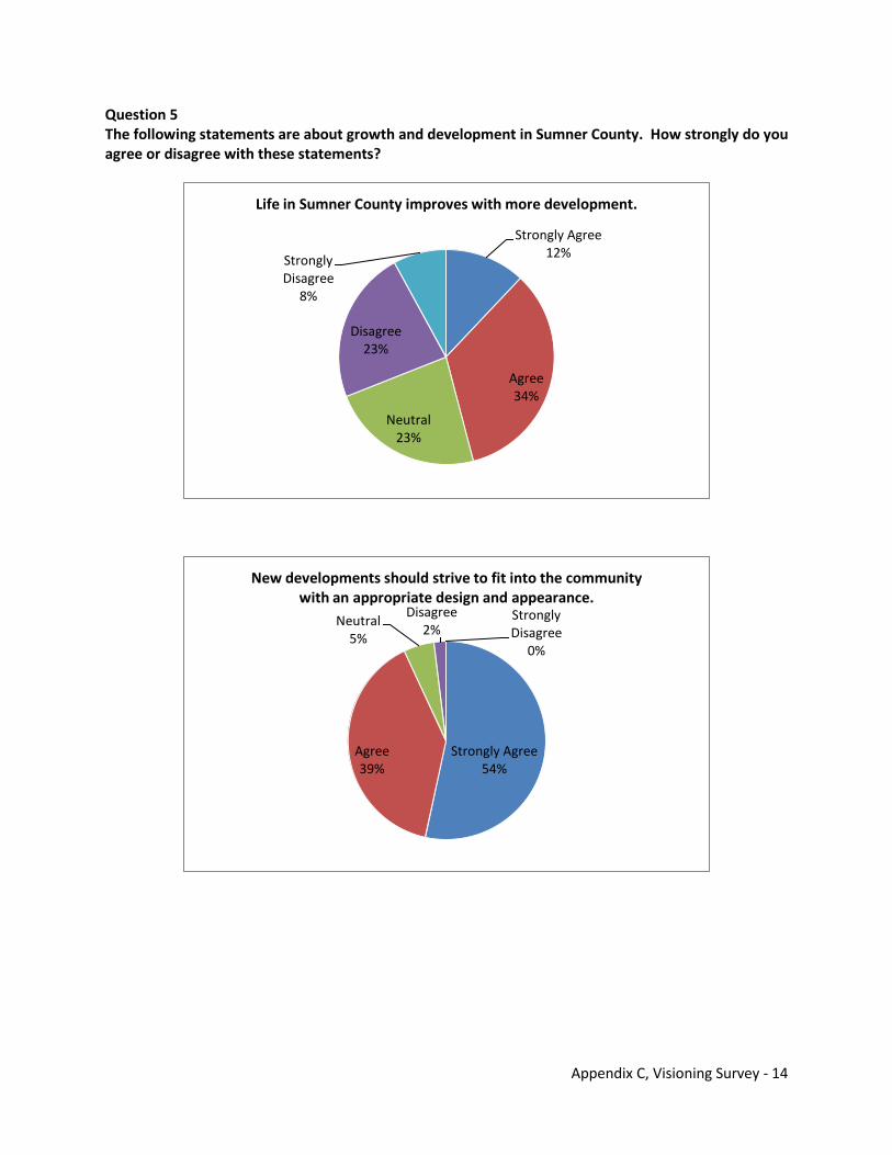
Appendix C, Visioning Survey - 14
Question 5 The following statements are about growth and development in Sumner County. How strongly do you agree or disagree with these statements?
Strongly Agree12%
Agree34%
Neutral23%
Disagree23%
Strongly Disagree
8%
Life in Sumner County improves with more development.
Strongly Agree54%
Agree39%
Neutral5%
Disagree2%
Strongly Disagree
0%
New developments should strive to fit into the community with an appropriate design and appearance.
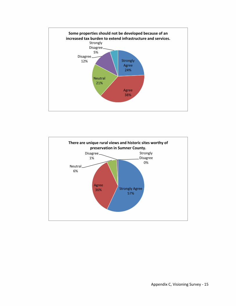
Appendix C, Visioning Survey - 15
Strongly Agree24%
Agree38%
Neutral21%
Disagree12%
Strongly Disagree
5%
Some properties should not be developed because of an increased tax burden to extend infrastructure and services.
Strongly Agree57%
Agree36%
Neutral6%
Disagree1%
Strongly Disagree
0%
There are unique rural views and historic sites worthy of preservation in Sumner County.
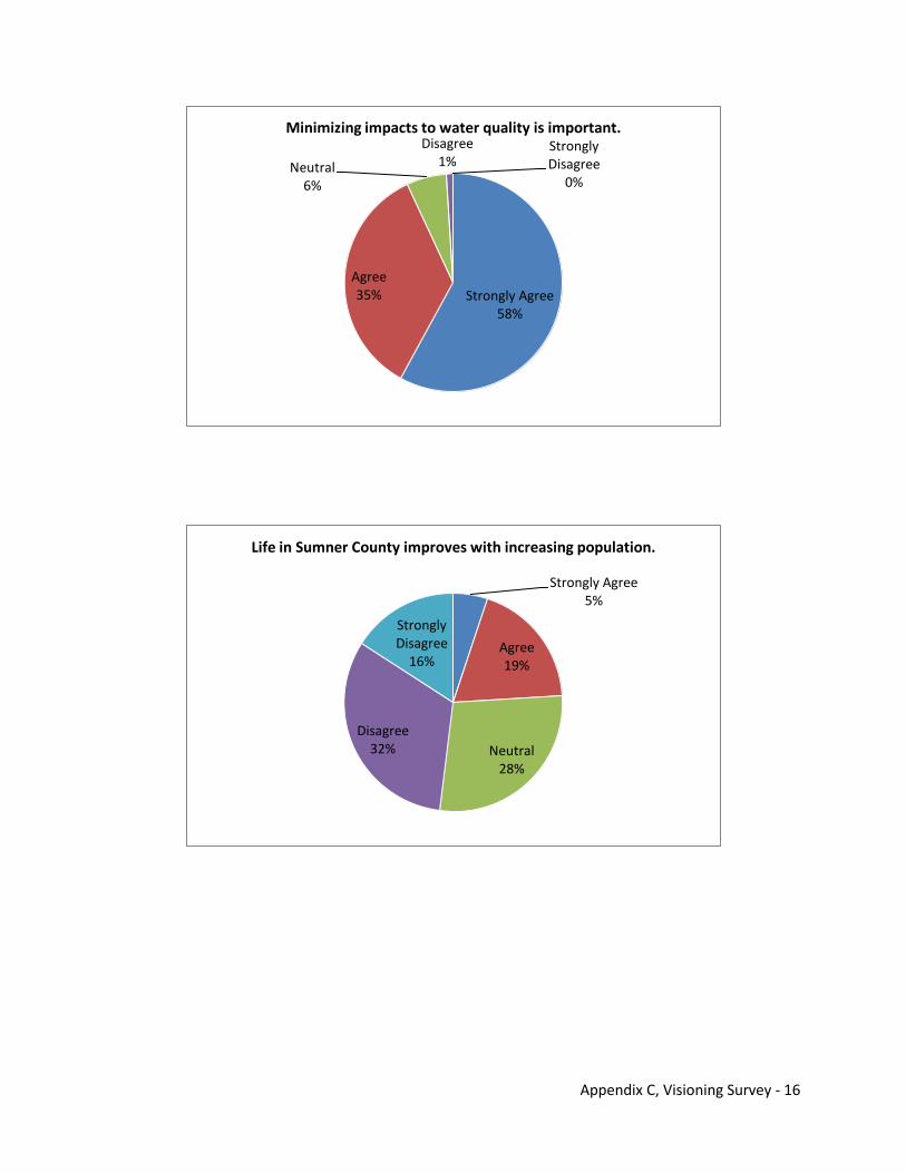
Appendix C, Visioning Survey - 16
Strongly Agree58%
Agree35%
Neutral6%
Disagree1%
Strongly Disagree
0%
Minimizing impacts to water quality is important.
Strongly Agree5%
Agree19%
Neutral28%
Disagree32%
Strongly Disagree
16%
Life in Sumner County improves with increasing population.
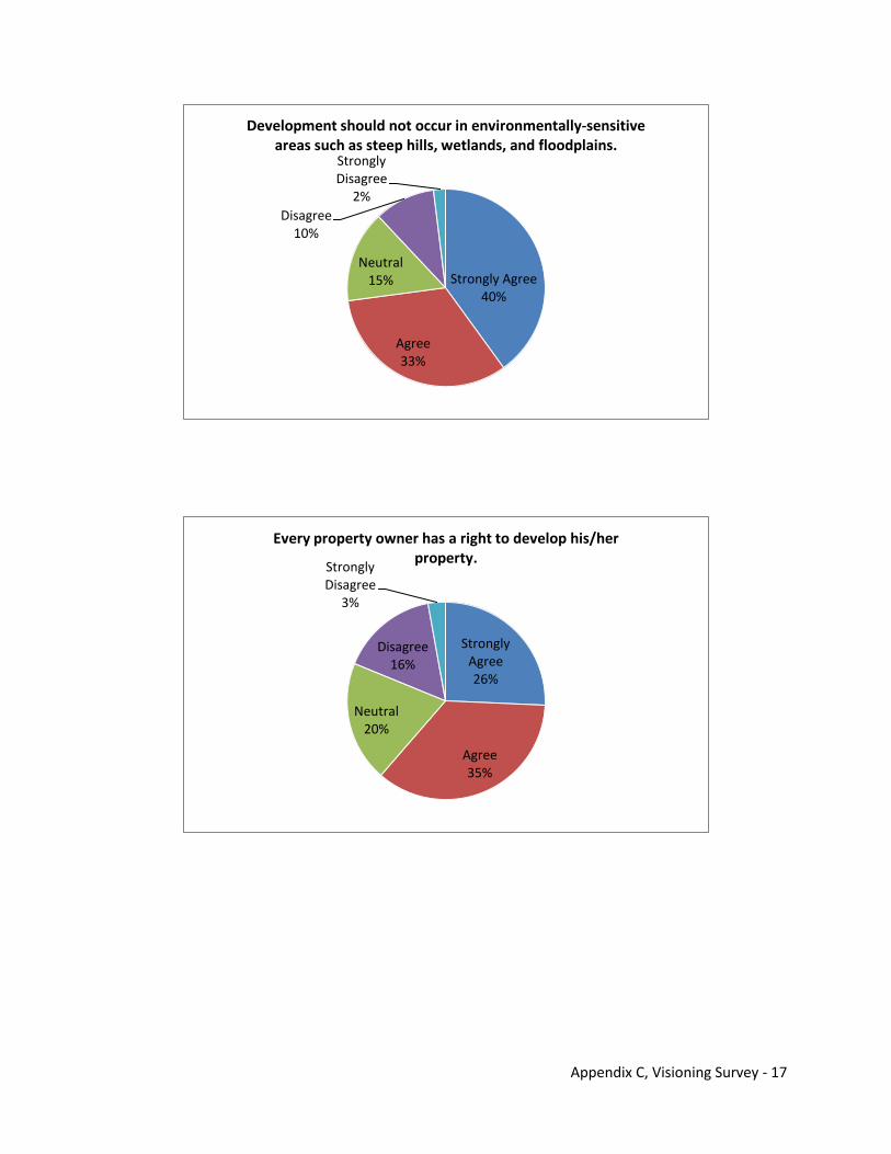
Appendix C, Visioning Survey - 17
Strongly Agree40%
Agree33%
Neutral15%
Disagree10%
Strongly Disagree
2%
Development should not occur in environmentally-sensitive areas such as steep hills, wetlands, and floodplains.
Strongly Agree26%
Agree35%
Neutral20%
Disagree16%
Strongly Disagree
3%
Every property owner has a right to develop his/her property.
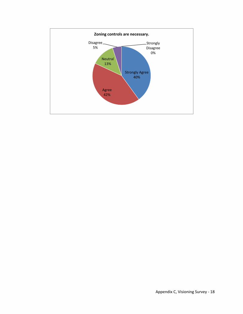
Appendix C, Visioning Survey - 18
Strongly Agree40%
Agree42%
Neutral13%
Disagree5%
Strongly Disagree
0%
Zoning controls are necessary.
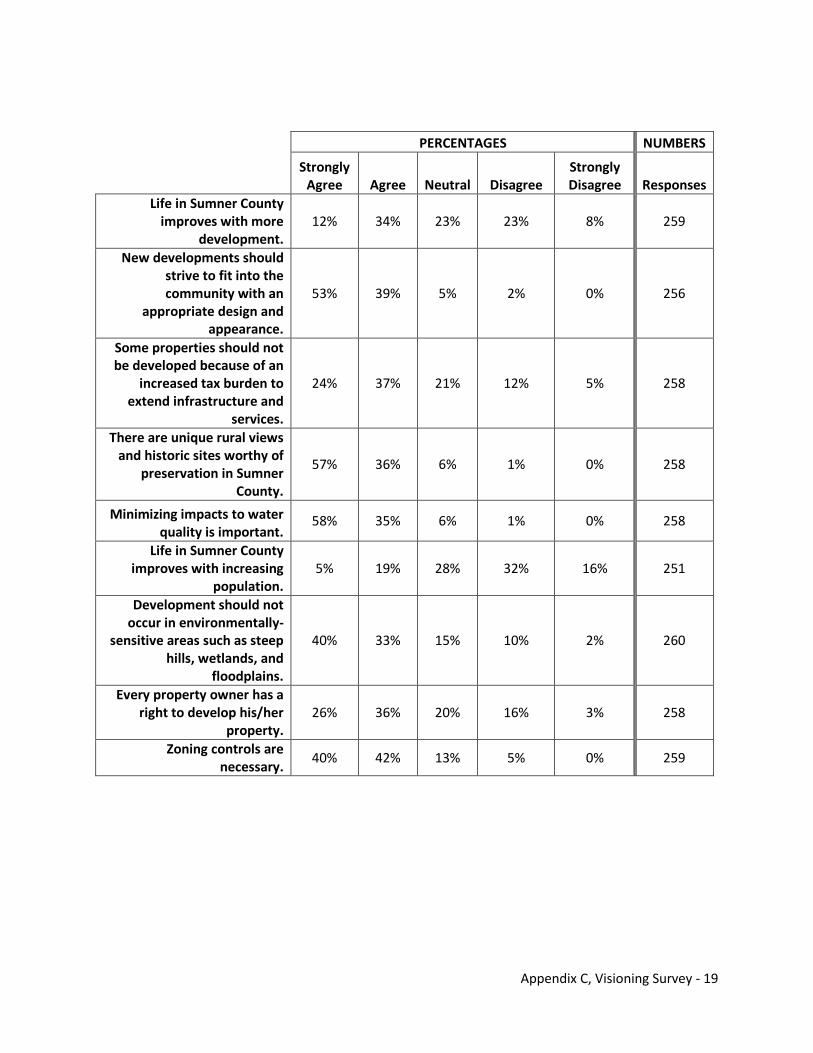
Appendix C, Visioning Survey - 19
PERCENTAGES NUMBERS
Strongly Agree Agree Neutral Disagree
Strongly Disagree Responses
Life in Sumner County improves with more
development. 12% 34% 23% 23% 8% 259
New developments should strive to fit into the community with an
appropriate design and appearance.
53% 39% 5% 2% 0% 256
Some properties should not be developed because of an
increased tax burden to extend infrastructure and
services.
24% 37% 21% 12% 5% 258
There are unique rural views and historic sites worthy of
preservation in Sumner County.
57% 36% 6% 1% 0% 258
Minimizing impacts to water quality is important.
58% 35% 6% 1% 0% 258
Life in Sumner County improves with increasing
population. 5% 19% 28% 32% 16% 251
Development should not occur in environmentally-
sensitive areas such as steep hills, wetlands, and
floodplains.
40% 33% 15% 10% 2% 260
Every property owner has a right to develop his/her
property. 26% 36% 20% 16% 3% 258
Zoning controls are necessary.
40% 42% 13% 5% 0% 259
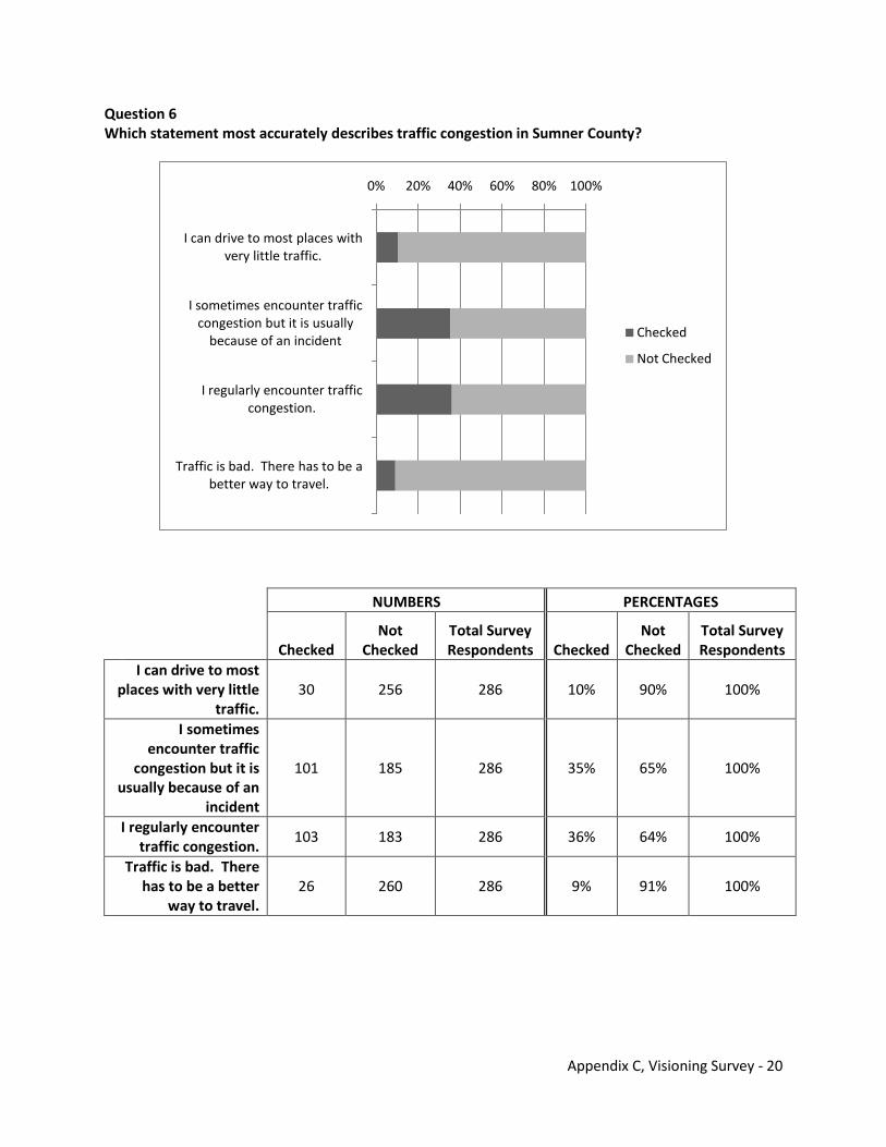
Appendix C, Visioning Survey - 20
Question 6 Which statement most accurately describes traffic congestion in Sumner County?
NUMBERS PERCENTAGES
Checked
Not Checked
Total Survey Respondents Checked
Not Checked
Total Survey Respondents
I can drive to most places with very little
traffic. 30 256 286 10% 90% 100%
I sometimes encounter traffic
congestion but it is usually because of an
incident
101 185 286 35% 65% 100%
I regularly encounter traffic congestion.
103 183 286 36% 64% 100%
Traffic is bad. There has to be a better
way to travel. 26 260 286 9% 91% 100%
0% 20% 40% 60% 80% 100%
I can drive to most places with very little traffic.
I sometimes encounter traffic congestion but it is usually
because of an incident
I regularly encounter traffic congestion.
Traffic is bad. There has to be a better way to travel.
Checked
Not Checked
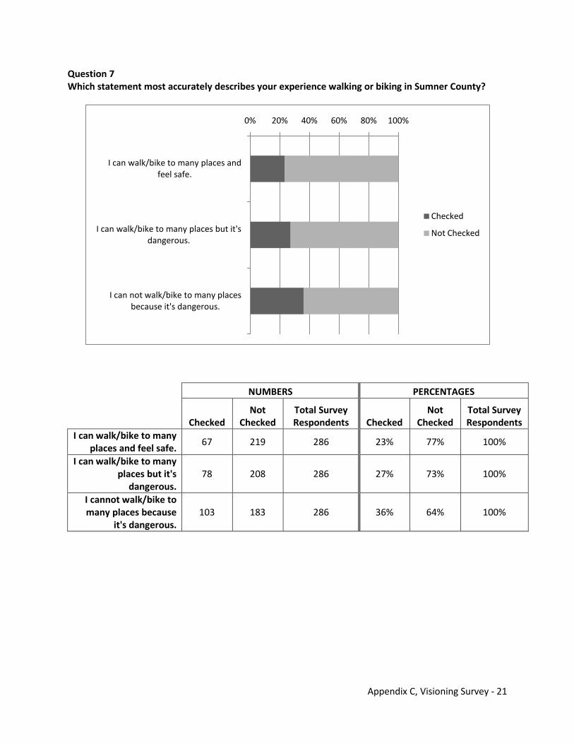
Appendix C, Visioning Survey - 21
Question 7 Which statement most accurately describes your experience walking or biking in Sumner County?
NUMBERS PERCENTAGES
Checked
Not Checked
Total Survey Respondents Checked
Not Checked
Total Survey Respondents
I can walk/bike to many places and feel safe.
67 219 286 23% 77% 100%
I can walk/bike to many places but it's
dangerous. 78 208 286 27% 73% 100%
I cannot walk/bike to many places because
it's dangerous. 103 183 286 36% 64% 100%
0% 20% 40% 60% 80% 100%
I can walk/bike to many places and feel safe.
I can walk/bike to many places but it's dangerous.
I can not walk/bike to many places because it's dangerous.
Checked
Not Checked
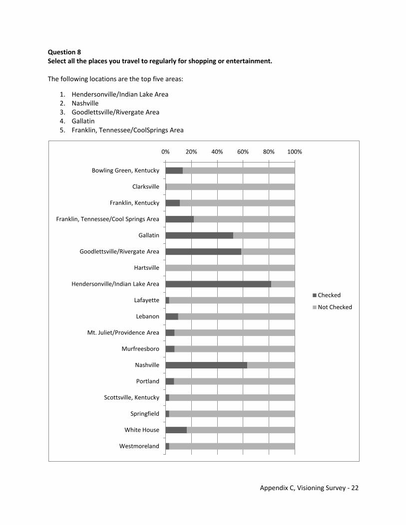
Appendix C, Visioning Survey - 22
Question 8 Select all the places you travel to regularly for shopping or entertainment. The following locations are the top five areas:
1. Hendersonville/Indian Lake Area 2. Nashville 3. Goodlettsville/Rivergate Area 4. Gallatin 5. Franklin, Tennessee/CoolSprings Area
0% 20% 40% 60% 80% 100%
Bowling Green, Kentucky
Clarksville
Franklin, Kentucky
Franklin, Tennessee/Cool Springs Area
Gallatin
Goodlettsville/Rivergate Area
Hartsville
Hendersonville/Indian Lake Area
Lafayette
Lebanon
Mt. Juliet/Providence Area
Murfreesboro
Nashville
Portland
Scottsville, Kentucky
Springfield
White House
Westmoreland
Checked
Not Checked
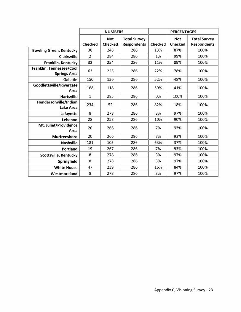
Appendix C, Visioning Survey - 23
NUMBERS PERCENTAGES
Checked
Not Checked
Total Survey Respondents Checked
Not Checked
Total Survey Respondents
Bowling Green, Kentucky 38 248 286 13% 87% 100%
Clarksville 2 284 286 1% 99% 100%
Franklin, Kentucky 32 254 286 11% 89% 100% Franklin, Tennessee/Cool
Springs Area 63 223 286 22% 78% 100%
Gallatin 150 136 286 52% 48% 100% Goodlettsville/Rivergate
Area 168 118 286 59% 41% 100%
Hartsville 1 285 286 0% 100% 100% Hendersonville/Indian
Lake Area 234 52 286 82% 18% 100%
Lafayette 8 278 286 3% 97% 100%
Lebanon 28 258 286 10% 90% 100% Mt. Juliet/Providence
Area 20 266 286 7% 93% 100%
Murfreesboro 20 266 286 7% 93% 100%
Nashville 181 105 286 63% 37% 100%
Portland 19 267 286 7% 93% 100%
Scottsville, Kentucky 8 278 286 3% 97% 100%
Springfield 8 278 286 3% 97% 100%
White House 47 239 286 16% 84% 100%
Westmoreland 8 278 286 3% 97% 100%
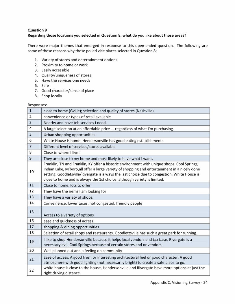
Appendix C, Visioning Survey - 24
Question 9 Regarding those locations you selected in Question 8, what do you like about those areas? There were major themes that emerged in response to this open-ended question. The following are some of those reasons why those polled visit places selected in Question 8:
1. Variety of stores and entertainment options 2. Proximity to home or work 3. Easily accessible 4. Quality/uniqueness of stores 5. Have the services one needs 6. Safe 7. Good character/sense of place 8. Shop locally
Responses: 1 close to home (Gville); selection and quality of stores (Nashville) 2 convenience or types of retail available 3 Nearby and have teh services I need. 4 A large selection at an affordable price ... regardless of what I'm purchasing. 5 Urban shopping opportunities 6 White House is home. Hendersonville has good eating establishments. 7 Different level of services/stores available 8 Close to where I live! 9 They are close to my home and most likely to have what I want.
10
Franklin, TN and Franklin, KY offer a historic environment with unique shops. Cool Springs, Indian Lake, M'boro,all offer a large variety of shopping and entertainment in a nicely done setting. Goodletsville/Rivergate is always the last choice due to congestion. White House is close to home and is always the 1st choice, although variety is limited.
11 Close to home, lots to offer 12 They have the irems I am looking for 13 They have a variety of shops. 14 Conveinence, lower taxes, not congested, friendly people
15 Access to a variety of options
16 ease and quickness of access 17 shopping & dining opportunities 18 Selection of retail shops and restaurants. Goodlettsville has such a great park for running.
19 I like to shop Hendersonville because it helps local vendors and tax base. Rivergate is a necessary evil. Cool Springs because of certain stores and or vendors.
20 Well planned out and a feeling on community
21 Ease of access. A good fresh or interesting architectural feel or good character. A good atmosphere with good lighting (not necessarily bright) to create a safe place to go.
22 white house is close to the house, Hendersonville and Rivergate have more options at just the right driving distance.
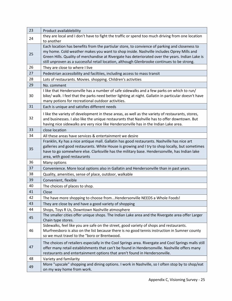
Appendix C, Visioning Survey - 25
23 Product availablebility
24 they are local and I don't have to fight the traffic or spend too much driving from one location to another
25
Each location has benefits from the partiular store, to convience of parking and closeness to my home. Cold weather makes you want to shop inside. Nashville includes Oprey Mills and Green Hills. Quality of merchandise at Rivergate has deteriorated over the years. Indian Lake is still unproven as a successful retail location, although Glenbrooke continues to be strong.
26 They are close to where I live 27 Pedestrian accessibility and faciltiies, including access to mass transit 28 Lots of restaurants. Movies. shopping. Children's activities 29 No. comment
30 I like that Hendersonville has a number of safe sidewalks and a few parks on which to run/ bike/ walk. I feel that the parks need better lighting at night. Gallatin in particular doesn't have many potions for recreational outdoor activities.
31 Each is unique and satisfies different needs
32 I like the variety of development in these areas, as well as the variety of restaurants, stores, and businesses. I also like the unique restaurants that Nashville has to offer downtown. But having nice sidewalks are very nice like Hendersonville has in the Indian Lake area.
33 close location 34 All these areas have services & entertainment we desire
35
Franklin, Ky has a nice antique mall. Gallatin has good restaurants. Nashville has nice art galleries and good restaurants. White House is growing and I try to shop locally, but sometimes have to go somewhere else. Clarksville has the military base. Hendersonville, has Indian lake area, with good restaurants
36 Many options 37 Convenience. More local options also in Gallatin and Hendersonville than in past years. 38 Quality, amenities, sense of place, outdoor, walkable 39 Convenient, flexible 40 The choices of places to shop. 41 Close 42 The have more shopping to choose from...Hendersonville NEEDS a Whole Foods! 43 They are close by and have a good variety of shopping 44 Shops, Toys R Us, Downtown Nashville atmosphere
45 The smaller cities offer unique shops. The Indian Lake area and the Rivergate area offer Larger Chain type stores.
46 Sidewalks, feel like you are safe on the street, good variety of shops and restaurants. Murfreesboro is also on the list because there is no good tennis instruction in Sumner county so we must travel to the "boro or Brentwood.
47 The choices of retailers especially in the Cool Springs area. Rivergate and Cool Springs malls still offer many retail establishments that can't be found in Hendersonville. Nashville offers many restaurants and entertainment options that aren't found in Hendersonville.
48 Variety and familarity
49 More "upscale" shopping and dining options. I work in Nashville, so I often stop by to shop/eat on my way home from work.
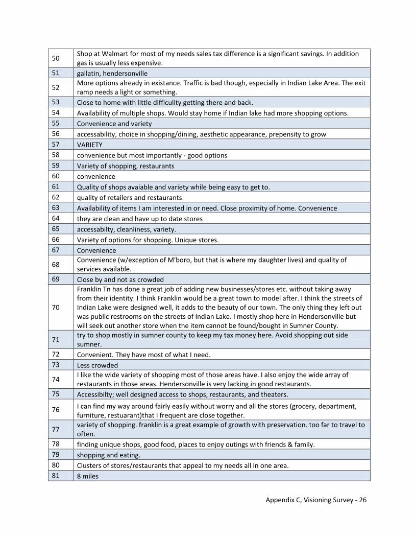
Appendix C, Visioning Survey - 26
50 Shop at Walmart for most of my needs sales tax difference is a significant savings. In addition gas is usually less expensive.
51 gallatin, hendersonville
52 More options already in existance. Traffic is bad though, especially in Indian Lake Area. The exit ramp needs a light or something.
53 Close to home with little difficulity getting there and back. 54 Availability of multiple shops. Would stay home if Indian lake had more shopping options. 55 Convenience and variety 56 accessability, choice in shopping/dining, aesthetic appearance, prepensity to grow 57 VARIETY 58 convenience but most importantly - good options 59 Variety of shopping, restaurants 60 convenience 61 Quality of shops avaiable and variety while being easy to get to. 62 quality of retailers and restaurants 63 Availability of items I am interested in or need. Close proximity of home. Convenience 64 they are clean and have up to date stores 65 accessabilty, cleanliness, variety. 66 Variety of options for shopping. Unique stores. 67 Convenience
68 Convenience (w/exception of M'boro, but that is where my daughter lives) and quality of services available.
69 Close by and not as crowded
70
Franklin Tn has done a great job of adding new businesses/stores etc. without taking away from their identity. I think Franklin would be a great town to model after. I think the streets of Indian Lake were designed well, it adds to the beauty of our town. The only thing they left out was public restrooms on the streets of Indian Lake. I mostly shop here in Hendersonville but will seek out another store when the item cannot be found/bought in Sumner County.
71 try to shop mostly in sumner county to keep my tax money here. Avoid shopping out side sumner.
72 Convenient. They have most of what I need. 73 Less crowded
74 I like the wide variety of shopping most of those areas have. I also enjoy the wide array of restaurants in those areas. Hendersonville is very lacking in good restaurants.
75 Accessibilty; well designed access to shops, restaurants, and theaters.
76 I can find my way around fairly easily without worry and all the stores (grocery, department, furniture, restuarant)that I frequent are close together.
77 variety of shopping. franklin is a great example of growth with preservation. too far to travel to often.
78 finding unique shops, good food, places to enjoy outings with friends & family. 79 shopping and eating. 80 Clusters of stores/restaurants that appeal to my needs all in one area. 81 8 miles
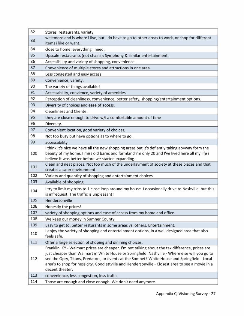
Appendix C, Visioning Survey - 27
82 Stores, restaurants, variety
83 westmoreland is where i live, but i do have to go to other areas to work, or shop for different items i like or want.
84 close to home, everything i need. 85 Upscale restaurants (not chains); Symphony & similar entertainment. 86 Accessibility and variety of shopping, convenience. 87 Convenience of multiple stores and attractions in one area. 88 Less congested and easy access 89 Convenience, variety. 90 The variety of things available! 91 Accessability, convience, variety of amenities 92 Perception of cleanliness, convenience, better safety, shopping/entertainment options. 93 Diversity of choices and ease of access. 94 Cleanliness and Clientel. 95 they are close enough to drive w/i a comfortable amount of time 96 Diversity. 97 Convenient location, good variety of choices, 98 Not too busy but have options as to where to go. 99 accessability
100 I think it's nice we have all the new shopping areas but it's defiantly taking ab=way form the beauty of my home. I miss old barns and farmland i'm only 20 and I've lived here all my life i believe it was better before we started expanding..
101 Clean and neat places. Not too much of the underlayment of society at these places and that creates a safer environment.
102 Variety and quantity of shopping and entertainment choices 103 Available of shopping
104 I try to limit my trips to 1 close loop around my house. I occasionally drive to Nashville, but this is infrequest. The traffic is unpleasant!
105 Hendersonville 106 Honestly the prices! 107 variety of shopping options and ease of access from my home and office. 108 We keep our money in Sumner County. 109 Easy to get to, better resturants in some areas vs. others. Entertainment.
110 I enjoy the variety of shopping and entertainment options, in a well designed area that also feels safe.
111 Offer a large selection of shoping and dinining choices.
112
Franklin, KY - Walmart prices are cheaper. I'm not talking about the tax difference, prices are just cheaper than Walmart in White House or Springfield. Nashville - Where else will you go to see the Opry, Titans, Predators, or events at the Somnet? White House and Springfield - Local area's to shop for nessicity. Goodlettville and Hendersonville - Closest area to see a movie in a decent theater.
113 convenience, less congestion, less traffic 114 Those are enough and close enough. We don't need anymore.
Appendix C, Visioning Survey - 28
115 Convinience 116 Safe & high quality
117
Rivergate is not a bad drive and there is plenty of businesses to choose from for our buget and time. We moved out of Hendersonville to get away from the over development of the Indian Lake area, with its traffic, I wonder how all those corporate stores are having an affect on the small businesses in the area, I have yet to shop in Indian Lake Area.
118 Specific stores or restaurants. 119 Available shopping, safety, ease of getting there 120 Easy access and variety of shopping. 121 I go to all these areas for different reasons. 122 convenience, selection 123 They are close to my home. 124 Close to home, variety of stores 125 convenience
126
There is not shopping available where I live (Portland) to meet the needs of the community, which forces me to travel to Nashville to shop at places like Walmart or large grocery stores. The grocery stores in Portland aren't maintained properly. There are definitely not enough satisfactory eating options in Portland, which force residents to travel to other cities such as Hendersonville or Nashville. Residents are sick of fast food and Mexican restaurant and just want some decent eating options.
127 I don't like going to Nashville to shop. I like shopping in Hendersonville to keep the money here at home. I do not shop at the Streets of Indian Lake because I don't care for that development. I do shop at Walmart.
128 The culture and opportunities in Nashville. Options offered in other areas. More to choose from.
129 Convienent to job and route. 130 Unique restaurants 131 Ease of access. 132 they all have wal mart 133 Reasonably safe. Home town. Good shops, restaurants. It's home. 134 Most are easily accessible, and family friendly.
135
Indian Lakes is the best example of land use and Cool Springs Mall uses brims and landscaping to "block view" of parking lots quite aesthetically, something Sumner County FAILS to do but EVERYONE (but misinformed merchants) seek; i.e. we DO NOT need to see a "Big Box" or Convenience store to use it!
136
Music and restaurants. I would like to see more traditional music venues in the Sumner County area. Our roots are bluegrass, classic country, blues and gospel. These should be more prevalent in the Sumner County area for families to teach their children these music genres - particularly, concerts in the parks.
137 They are convienient and have the services and products I am looking for.
138 More choice of businesses. Gallatin and Hendersonville - bad look with so many used car dealers on the road, parking areas (asphalt, etc) not maintained for older businesses. New businesses seem to have more restrictions. Not a business owner, but a resident
139 convenience
Appendix C, Visioning Survey - 29
140 Not too much congestion, safe, variety
141 They have the retail stores I am looking for. But the Goodlettsville/Rivergate area has compromised safety and I fear Hendersonville is going to do the same.
142
Compared to the large Metro where we reside, all of the cities checked have qualities that are attractive to us. Nashville - State Services, Universities, Symphony, Museumns. Gallatin - County Services, dining, shopping - food, etc. The rest provide shopping, dining or farmers market opportunities.
143 Lots of choices for eating/shopping and entertainment. 144 They are close and I can avoid interstate travel
145 Indian Lakes is developing into a state of the art development rather than srip develoment wesee so much of in Sumner County.
146 Nashville- Entertainment,Goodslettsville/Rivergsate,electronics etc.Indian Lake food,some shopping.
147 Clean, modern, upscale feel 148 I like the Franklin area the most. Nice community with core services.
149
LOVE THE INDIAN LAKES DEVELOPMENT. THEY DID A NICE JOB CREATING A PEDESTRIAN FRIENDLY SQUARE. I WANT TO SUPPORT GALLATIN BUSINESSES, SO I TRY TO DO MOST OF MY SHOPPING IN GALLATIN/INDIAN LAKES. HOWEVER, THERE ARE TIMES I NEED TO HIT RIVERGATE. I WANT TO STRESS THE FACT THAT I LOVE THE FARM LAND WE ENJOY IN SUMNER COUNTY AND WANT TO HELP PRESERVE/DEVELOP A PLAN THAT MAINTAINS OPEN SPACES . . . WE DON'T NEED A BUNCH OF BUSINESSES THAT END UP LOOKING 2ND RATE. LET'S MAKE GALLATIN/SUMNER COUNTY THE NEW FRANKLIN!
150 Both Gallatin and Hendersonville are convenient and easy to get to for me. 151 nearby!
152 I go to the different areas for different reasons. Most everything that I need is right here in Hendersonville.
153 Relatively easy to get from point A to point B. 154 easy access / safe shoping and entertainment / resturants 155 Close proximity to my house and good shopping and entertainment options 156 Good places to shop and dine. 157 Convenience of many stores and restaurants in one location. 158 great places to eat and shop. safe areas to be in. 159 The stores and convenience in getting there. 160 they are relatively near by
161 nashville; food, entertainment and shops not avaiable in sumner county. the other places are for shopping purposes onlyie...mall or walmart
162 Less congestion 163 shopping location are availabile as restaurants 164 The shopping and entertainment that I want can most easily be found in these locations.
165 Love the Streets of Indian Lake shopping center but we need to take great efforts to keep it a family, kid friendly place and keep gangs and shoplifters out!!!!!
166 Safety and beauty of the shopping centers. Convenience. 167 there is more to do mall, shopping, activities
Appendix C, Visioning Survey - 30
168
Hendersonville has a upscale atomsphere but yet down to earth feel the new shoppes and movie cinema really gave them a positive feel Gallatin needs that we need a mall area with different shoppes to keep money here in Gallatin I have lived in Gallatin all my life we have improved but we need to do better
169 Variety 170 VARIETY OF SHOPPING 171 Convenience. 172 Don't, they have what I need. 173 Nashville and Cool Springs/Brentwood are the variety of businesses, etc. 174 I live in Gallatin, Rivergate- I like olive garden and the book stores, Thats about it. 175 thats just where the stores are
176 They are close and traffic congestion is mimimal. Please do not let this area become another Rivergate!!!!! I am pleased not to have to go there much any more.
177 They are close to work and home. I feel safe shopping in Hendersonville, Gallatin, Lebanon, & Mt. Juliet any time of the day. I will not go to Rivergate after dark, I never feel safe.
178 the people seem to be clean. rivergate and nashville seem to be filled with dirty rude people. 179 Hendersonville is a clean, inviting city. 180 Availability of what I'm looking for, ease of parking.
181 Everything I need is there. You did not include Glenbrook area - I use this regularly - and avoid Indian Lake - too uppity, not my style or need.
182 with the exception of Goodlettsville/Rivergate Area, and Nashville, I like the over all appeal of small town feel
183 I love the Cool Springs Area because of all the resturant and shopping options. They have the most options of any part of the Nashville area and surrounding communities. I love living in Hendersonville but Franklin would be my second choice for that reason.
184 In most places, traffic is not too bad on most occasions, with the exception of Nashville. Each location has amenities and attractions unique unto itself.
185 convenience of shopping nearby in safe areas. entertainment variety (culture and arts) in Nashville
186 Location and development - there's stuff to do or else its close. 187 Greenhills shopping mall, Whole Foods and Trade Joe and Belks and Rivergate mall for clothes
188 I prefer the safety of Hendersonville, Portland, Gallatin the most. I dislike the Rivergate area because of all of the crime and crime potential. No MTA bus stops please.
189 Aviablity of services
190 I like the variety of shops at Indian Lake Mall. Also shop at Kohl's,Ross and Stein Mart for Bargain's.
191 easy access from my residence and several shopping choices
192 Gallatin - proximity Goodlettsville - large anchor stores; mall Hendersonville - variety and ease of use
193 Hendersonville/Rivergate/Nashville--like the availability of good restaurants 194 Quick travel time, variety of food and entertainment available. 195 most are close to home area and have evething I need 196 Nice safe shopping centers
Appendix C, Visioning Survey - 31
197 I like the extensive selection and diversity. I prefer not to travel long distances to get to what I want and need.
198
I don't like going to Cool Springs, Lebanon or Murfreesbor because of the length of time to get there. But that being said, i love the variety that is offered at Cool Springs & Murfreesboro. I like what is being done at Indian Lake alot and hope they continue with the variety & similar structure look. I like how most of these areas have shopping areas that are similar in look and tend to blend with surrounding. I lived for several years in Texas and would recommend taking a look at the Quarry Development in San Antonio for a theme type shopping area. I think this would work well and be able to showcase local items of interest to boot.
199 Shopping areas seem spread out better than they were & easy access. 200 We like the Indian lake area and having a concentrated area of shopping and restaurants.
201 I currently work in Madison and live in Portland so all these areas are on my normal route back and forth to work. I try to do everything along my route so as to save on gas as much as possible.
202 Gallatin is close to home, and the other areas are moer upscale retail.
203 I work in Nashville. My kids go to school outside of Sumner county so I have to travel to get them there. so I tend to do shopping/entertainment to & from those destinations. I love the greenways that Nashville has in terms of recreation.
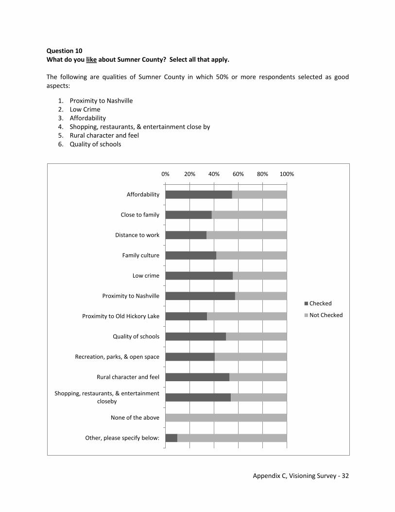
Appendix C, Visioning Survey - 32
Question 10 What do you like about Sumner County? Select all that apply. The following are qualities of Sumner County in which 50% or more respondents selected as good aspects:
1. Proximity to Nashville 2. Low Crime 3. Affordability 4. Shopping, restaurants, & entertainment close by 5. Rural character and feel 6. Quality of schools
0% 20% 40% 60% 80% 100%
Affordability
Close to family
Distance to work
Family culture
Low crime
Proximity to Nashville
Proximity to Old Hickory Lake
Quality of schools
Recreation, parks, & open space
Rural character and feel
Shopping, restaurants, & entertainment closeby
None of the above
Other, please specify below:
Checked
Not Checked
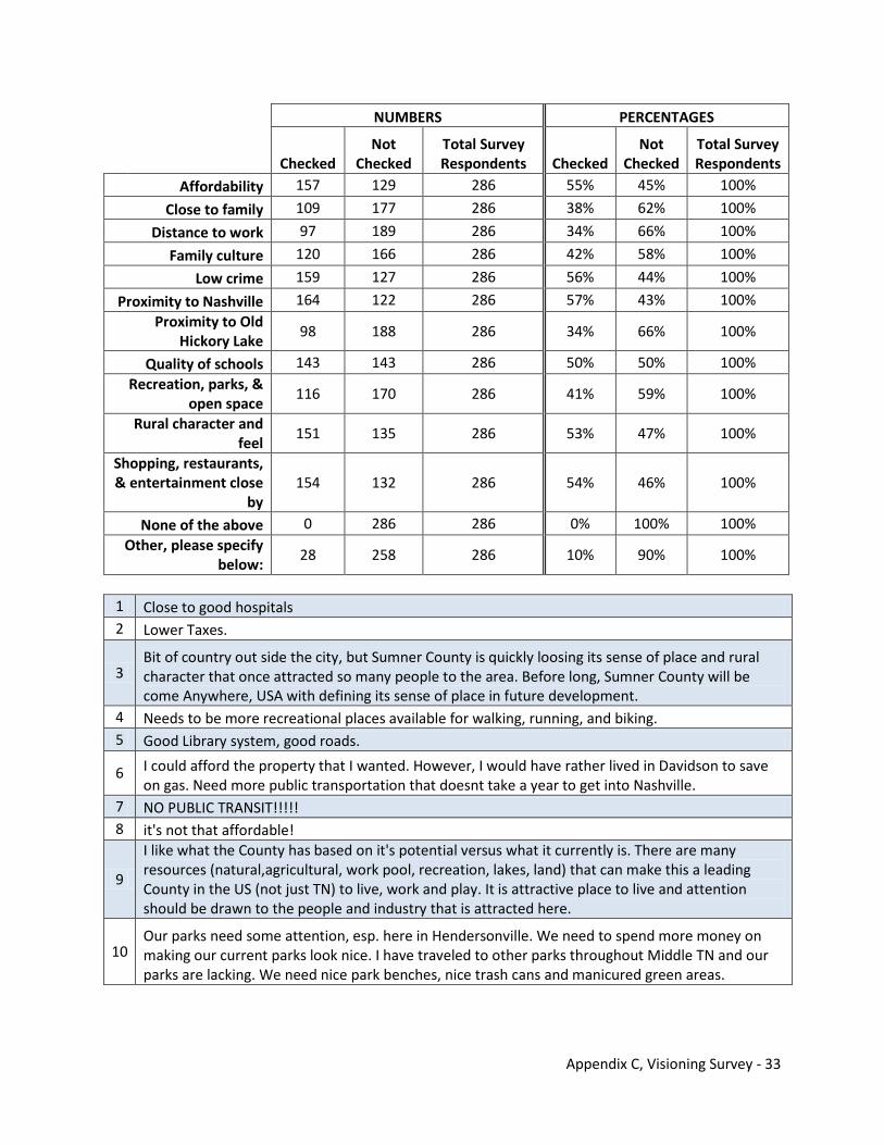
Appendix C, Visioning Survey - 33
NUMBERS PERCENTAGES
Checked
Not Checked
Total Survey Respondents Checked
Not Checked
Total Survey Respondents
Affordability 157 129 286 55% 45% 100%
Close to family 109 177 286 38% 62% 100%
Distance to work 97 189 286 34% 66% 100%
Family culture 120 166 286 42% 58% 100%
Low crime 159 127 286 56% 44% 100%
Proximity to Nashville 164 122 286 57% 43% 100% Proximity to Old
Hickory Lake 98 188 286 34% 66% 100%
Quality of schools 143 143 286 50% 50% 100% Recreation, parks, &
open space 116 170 286 41% 59% 100%
Rural character and feel
151 135 286 53% 47% 100%
Shopping, restaurants, & entertainment close
by 154 132 286 54% 46% 100%
None of the above 0 286 286 0% 100% 100% Other, please specify
below: 28 258 286 10% 90% 100%
1 Close to good hospitals 2 Lower Taxes.
3 Bit of country out side the city, but Sumner County is quickly loosing its sense of place and rural character that once attracted so many people to the area. Before long, Sumner County will be come Anywhere, USA with defining its sense of place in future development.
4 Needs to be more recreational places available for walking, running, and biking. 5 Good Library system, good roads.
6 I could afford the property that I wanted. However, I would have rather lived in Davidson to save on gas. Need more public transportation that doesnt take a year to get into Nashville.
7 NO PUBLIC TRANSIT!!!!! 8 it's not that affordable!
9
I like what the County has based on it's potential versus what it currently is. There are many resources (natural,agricultural, work pool, recreation, lakes, land) that can make this a leading County in the US (not just TN) to live, work and play. It is attractive place to live and attention should be drawn to the people and industry that is attracted here.
10 Our parks need some attention, esp. here in Hendersonville. We need to spend more money on making our current parks look nice. I have traveled to other parks throughout Middle TN and our parks are lacking. We need nice park benches, nice trash cans and manicured green areas.
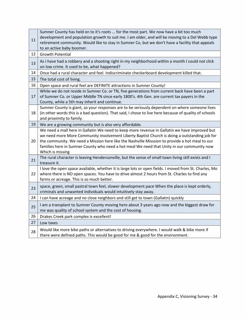
Appendix C, Visioning Survey - 34
11
Sumner County has held on to it's roots ... for the most part. We now have a bit too much development and population growth to suit me. I am older, and will be moving to a Del Webb type retirement community. Would like to stay in Sumner Co, but we don't have a facility that appeals to an active baby boomer.
12 Growth Potential
13 As I have had a robbery and a shooting right in my neighborhood within a month I could not click on low crime. It used to be, what happened?
14 Once had a rural character and feel. Indiscriminate checkerboard development killed that. 15 The total cost of living. 16 Open space and rural feel are DEFINITE attractions in Sumner County!
17 While we do not reside in Sumner Co. or TN, five generations from current back have been a part of Sumner Co. or Upper Middle TN since early 1800's. 4th Gen. are current tax payers in the County, while a 5th may inherit and continue.
18 Sumner County is giant, so your responses are to be seriously dependent on where someone lives (in other words this is a bad question). That said, I chose to live here because of quality of schools and proximity to family.
19 We are a growing community but is also very affordable.
20
We need a mall here in Gallatin We need to keep more revenue in Gallatin we have improved but we need more More Community involvement Liberty Baptist Church is doing a outstanding job for the community. We need a Mission here like the Nashville Misssion to provide a hot meal to our families here in Sumner County who need a hot meal We need that Unity in our community now Which is missing
21 The rural character is leaving Hendersonville, but the sense of small town living still exists and I treasure it.
22 I love the open space available, whether it is large lots or open fields. I moved from St. Charles, Mo where there is NO open spaces. You have to drive almost 2 hours from St. Charles to find any farms or acreage. This is so much better.
23 space, green, small pastral town feel, slower development pace When the place is kept orderly, criminals and unwanted individuals would intuitively stay away.
24 I can have acreage and no close neighbors and still get to town (Gallatin) quickly
25 I am a transplant to Sumner County moving here about 3 years ago now and the biggest draw for me was quality of school system and the cost of housing.
26 Drakes Creek park complex is excellent! 27 Low taxes
28 Would like more bike paths or alternatives to driving everywhere. I would walk & bike more if there were defined paths. This would be good for me & good for the environment.
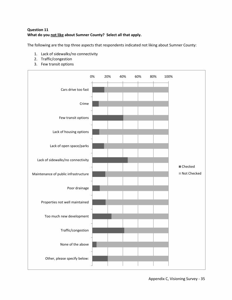
Appendix C, Visioning Survey - 35
Question 11 What do you not like about Sumner County? Select all that apply. The following are the top three aspects that respondents indicated not liking about Sumner County:
1. Lack of sidewalks/no connectivity 2. Traffic/congestion 3. Few transit options
0% 20% 40% 60% 80% 100%
Cars drive too fast
Crime
Few transit options
Lack of housing options
Lack of open space/parks
Lack of sidewalks/no connectivity
Maintenance of public infrastructure
Poor drainage
Properties not well maintained
Too much new development
Traffic/congestion
None of the above
Other, please specify below:
Checked
Not Checked
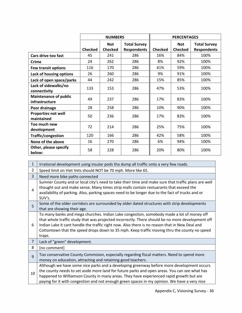
Appendix C, Visioning Survey - 36
NUMBERS PERCENTAGES
Checked
Not Checked
Total Survey Respondents Checked
Not Checked
Total Survey Respondents
Cars drive too fast 45 241 286 16% 84% 100%
Crime 24 262 286 8% 92% 100%
Few transit options 116 170 286 41% 59% 100%
Lack of housing options 26 260 286 9% 91% 100%
Lack of open space/parks 44 242 286 15% 85% 100% Lack of sidewalks/no connectivity
133 153 286 47% 53% 100%
Maintenance of public infrastructure
49 237 286 17% 83% 100%
Poor drainage 28 258 286 10% 90% 100% Properties not well maintained
50 236 286 17% 83% 100%
Too much new development
72 214 286 25% 75% 100%
Traffic/congestion 120 166 286 42% 58% 100%
None of the above 16 270 286 6% 94% 100% Other, please specify below:
58 228 286 20% 80% 100%
1 Irrational development using insular pods tha dump all traffic onto a very few roads. 2 Speed limit on Viet Vets should NOT be 70 mph. More like 65. 3 Need more bike paths connected
4
Sumner County and or local city's need to take their time and make sure that traffic plans are well thought out and make sense. Many times strip malls contain restuarants that exceed the availability of parking. Also, parking spaces need to be longer due to the fact of trucks and or SUV's.
5 Some of the older corridors are surrounded by older dated structures with strip developments that are showing their age.
6
To many banks and mega churches. Indian Lake congestion, somebody made a lot of money off that whole traffic study that was projected incorrectly. There should be no more development off Indian Lake it cant handle the traffic right now. Also there is no reason that in New Deal and Cottontown that the speed drops down to 35 mph. Keep traffic moving thru the county no speed traps.
7 Lack of "green" development. 8 [no comment]
9 Too conservative County Commision, especially regarding fiscal matters. Need to spend more money on education, attracting and retaining good teachers.
10
Although we have some nice parks and a developing greenway before more development occurs the county needs to set aside more land for future parks and open areas. You can see what has happened to Williamson County in many areas. They have experienced rapid growth but are paying for it with congestion and not enough green spaces in my opinion. We have a very nice
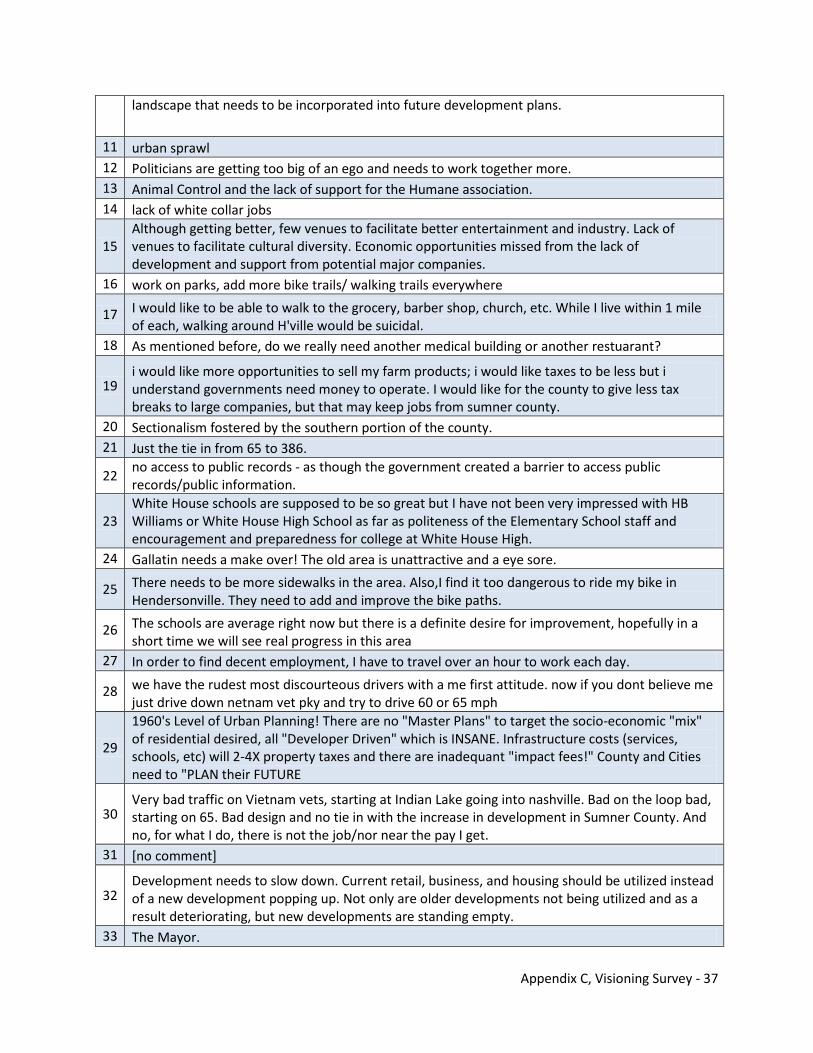
Appendix C, Visioning Survey - 37
landscape that needs to be incorporated into future development plans.
11 urban sprawl 12 Politicians are getting too big of an ego and needs to work together more. 13 Animal Control and the lack of support for the Humane association. 14 lack of white collar jobs
15 Although getting better, few venues to facilitate better entertainment and industry. Lack of venues to facilitate cultural diversity. Economic opportunities missed from the lack of development and support from potential major companies.
16 work on parks, add more bike trails/ walking trails everywhere
17 I would like to be able to walk to the grocery, barber shop, church, etc. While I live within 1 mile of each, walking around H'ville would be suicidal.
18 As mentioned before, do we really need another medical building or another restuarant?
19 i would like more opportunities to sell my farm products; i would like taxes to be less but i understand governments need money to operate. I would like for the county to give less tax breaks to large companies, but that may keep jobs from sumner county.
20 Sectionalism fostered by the southern portion of the county. 21 Just the tie in from 65 to 386.
22 no access to public records - as though the government created a barrier to access public records/public information.
23 White House schools are supposed to be so great but I have not been very impressed with HB Williams or White House High School as far as politeness of the Elementary School staff and encouragement and preparedness for college at White House High.
24 Gallatin needs a make over! The old area is unattractive and a eye sore.
25 There needs to be more sidewalks in the area. Also,I find it too dangerous to ride my bike in Hendersonville. They need to add and improve the bike paths.
26 The schools are average right now but there is a definite desire for improvement, hopefully in a short time we will see real progress in this area
27 In order to find decent employment, I have to travel over an hour to work each day.
28 we have the rudest most discourteous drivers with a me first attitude. now if you dont believe me just drive down netnam vet pky and try to drive 60 or 65 mph
29
1960's Level of Urban Planning! There are no "Master Plans" to target the socio-economic "mix" of residential desired, all "Developer Driven" which is INSANE. Infrastructure costs (services, schools, etc) will 2-4X property taxes and there are inadequant "impact fees!" County and Cities need to "PLAN their FUTURE
30 Very bad traffic on Vietnam vets, starting at Indian Lake going into nashville. Bad on the loop bad, starting on 65. Bad design and no tie in with the increase in development in Sumner County. And no, for what I do, there is not the job/nor near the pay I get.
31 [no comment]
32 Development needs to slow down. Current retail, business, and housing should be utilized instead of a new development popping up. Not only are older developments not being utilized and as a result deteriorating, but new developments are standing empty.
33 The Mayor.
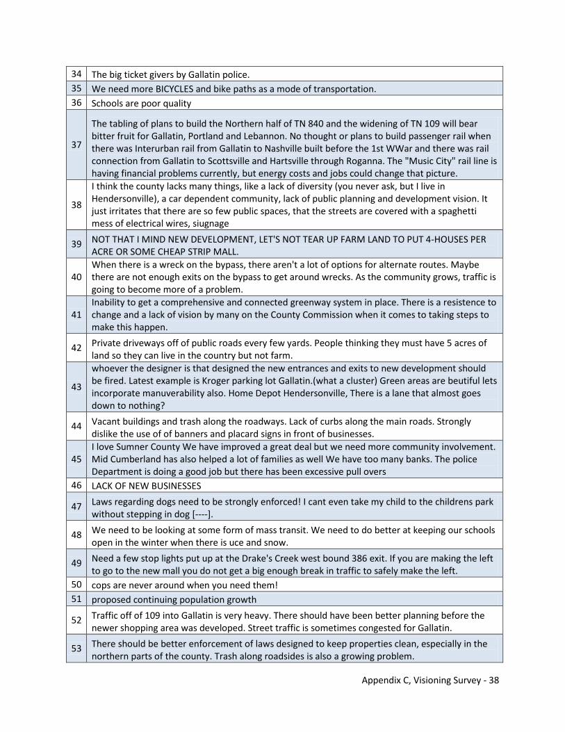
Appendix C, Visioning Survey - 38
34 The big ticket givers by Gallatin police. 35 We need more BICYCLES and bike paths as a mode of transportation. 36 Schools are poor quality
37
The tabling of plans to build the Northern half of TN 840 and the widening of TN 109 will bear bitter fruit for Gallatin, Portland and Lebannon. No thought or plans to build passenger rail when there was Interurban rail from Gallatin to Nashville built before the 1st WWar and there was rail connection from Gallatin to Scottsville and Hartsville through Roganna. The "Music City" rail line is having financial problems currently, but energy costs and jobs could change that picture.
38
I think the county lacks many things, like a lack of diversity (you never ask, but I live in Hendersonville), a car dependent community, lack of public planning and development vision. It just irritates that there are so few public spaces, that the streets are covered with a spaghetti mess of electrical wires, siugnage
39 NOT THAT I MIND NEW DEVELOPMENT, LET'S NOT TEAR UP FARM LAND TO PUT 4-HOUSES PER ACRE OR SOME CHEAP STRIP MALL.
40 When there is a wreck on the bypass, there aren't a lot of options for alternate routes. Maybe there are not enough exits on the bypass to get around wrecks. As the community grows, traffic is going to become more of a problem.
41 Inability to get a comprehensive and connected greenway system in place. There is a resistence to change and a lack of vision by many on the County Commission when it comes to taking steps to make this happen.
42 Private driveways off of public roads every few yards. People thinking they must have 5 acres of land so they can live in the country but not farm.
43
whoever the designer is that designed the new entrances and exits to new development should be fired. Latest example is Kroger parking lot Gallatin.(what a cluster) Green areas are beutiful lets incorporate manuverability also. Home Depot Hendersonville, There is a lane that almost goes down to nothing?
44 Vacant buildings and trash along the roadways. Lack of curbs along the main roads. Strongly dislike the use of of banners and placard signs in front of businesses.
45 I love Sumner County We have improved a great deal but we need more community involvement. Mid Cumberland has also helped a lot of families as well We have too many banks. The police Department is doing a good job but there has been excessive pull overs
46 LACK OF NEW BUSINESSES
47 Laws regarding dogs need to be strongly enforced! I cant even take my child to the childrens park without stepping in dog [----].
48 We need to be looking at some form of mass transit. We need to do better at keeping our schools open in the winter when there is uce and snow.
49 Need a few stop lights put up at the Drake's Creek west bound 386 exit. If you are making the left to go to the new mall you do not get a big enough break in traffic to safely make the left.
50 cops are never around when you need them! 51 proposed continuing population growth
52 Traffic off of 109 into Gallatin is very heavy. There should have been better planning before the newer shopping area was developed. Street traffic is sometimes congested for Gallatin.
53 There should be better enforcement of laws designed to keep properties clean, especially in the northern parts of the county. Trash along roadsides is also a growing problem.
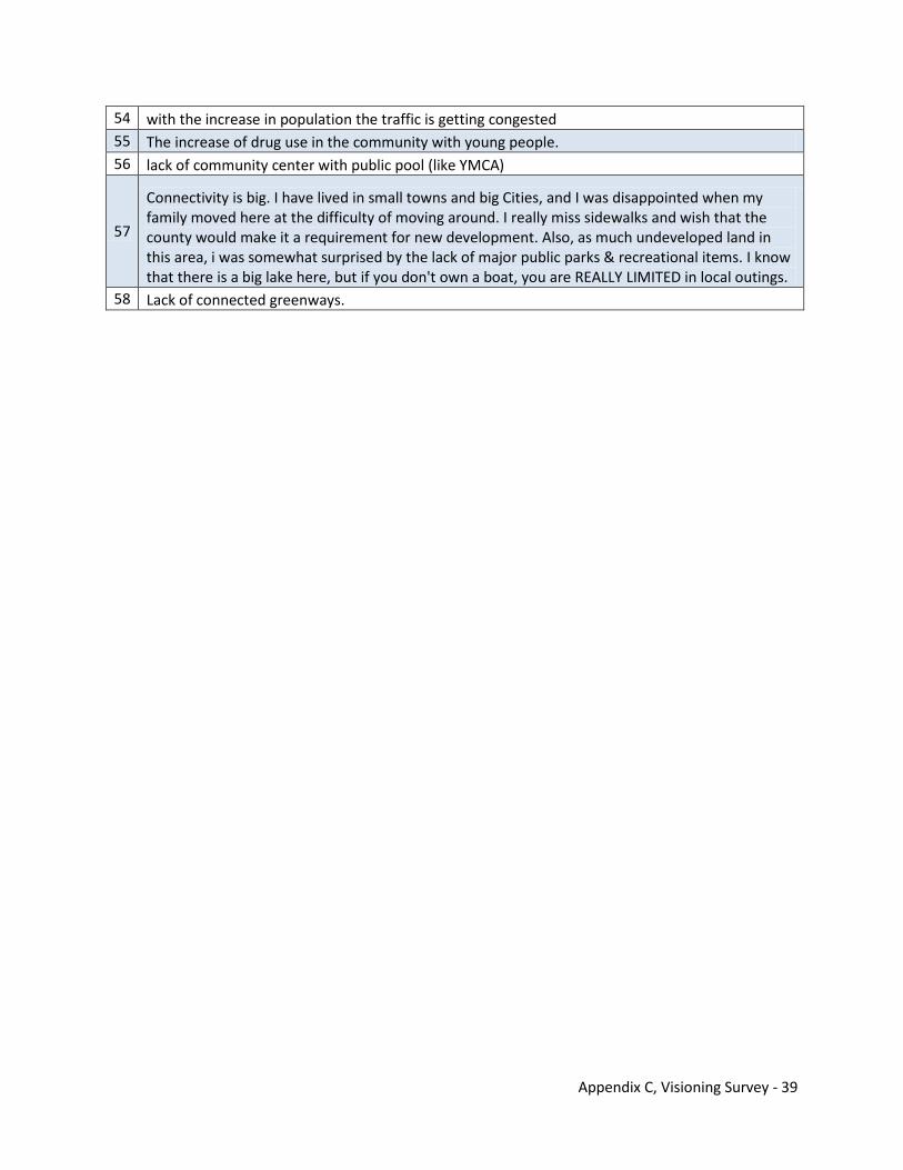
Appendix C, Visioning Survey - 39
54 with the increase in population the traffic is getting congested 55 The increase of drug use in the community with young people. 56 lack of community center with public pool (like YMCA)
57
Connectivity is big. I have lived in small towns and big Cities, and I was disappointed when my family moved here at the difficulty of moving around. I really miss sidewalks and wish that the county would make it a requirement for new development. Also, as much undeveloped land in this area, i was somewhat surprised by the lack of major public parks & recreational items. I know that there is a big lake here, but if you don't own a boat, you are REALLY LIMITED in local outings.
58 Lack of connected greenways.
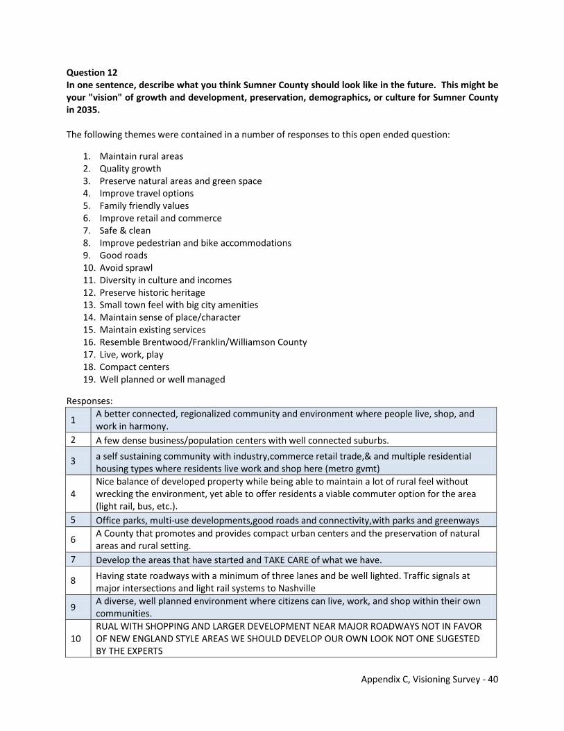
Appendix C, Visioning Survey - 40
Question 12 In one sentence, describe what you think Sumner County should look like in the future. This might be your "vision" of growth and development, preservation, demographics, or culture for Sumner County in 2035. The following themes were contained in a number of responses to this open ended question:
1. Maintain rural areas 2. Quality growth 3. Preserve natural areas and green space 4. Improve travel options 5. Family friendly values 6. Improve retail and commerce 7. Safe & clean 8. Improve pedestrian and bike accommodations 9. Good roads 10. Avoid sprawl 11. Diversity in culture and incomes 12. Preserve historic heritage 13. Small town feel with big city amenities 14. Maintain sense of place/character 15. Maintain existing services 16. Resemble Brentwood/Franklin/Williamson County 17. Live, work, play 18. Compact centers 19. Well planned or well managed
Responses:
1 A better connected, regionalized community and environment where people live, shop, and work in harmony.
2 A few dense business/population centers with well connected suburbs.
3 a self sustaining community with industry,commerce retail trade,& and multiple residential housing types where residents live work and shop here (metro gvmt)
4 Nice balance of developed property while being able to maintain a lot of rural feel without wrecking the environment, yet able to offer residents a viable commuter option for the area (light rail, bus, etc.).
5 Office parks, multi-use developments,good roads and connectivity,with parks and greenways
6 A County that promotes and provides compact urban centers and the preservation of natural areas and rural setting.
7 Develop the areas that have started and TAKE CARE of what we have.
8 Having state roadways with a minimum of three lanes and be well lighted. Traffic signals at major intersections and light rail systems to Nashville
9 A diverse, well planned environment where citizens can live, work, and shop within their own communities.
10 RUAL WITH SHOPPING AND LARGER DEVELOPMENT NEAR MAJOR ROADWAYS NOT IN FAVOR OF NEW ENGLAND STYLE AREAS WE SHOULD DEVELOP OUR OWN LOOK NOT ONE SUGESTED BY THE EXPERTS
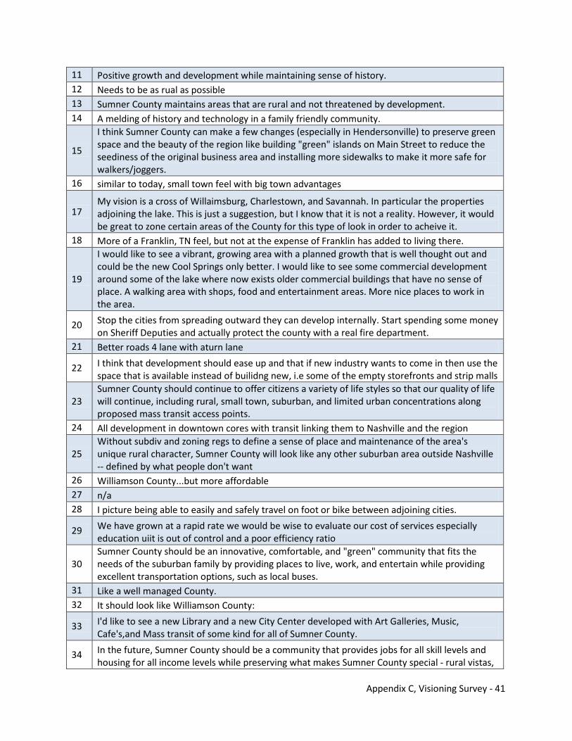
Appendix C, Visioning Survey - 41
11 Positive growth and development while maintaining sense of history. 12 Needs to be as rual as possible 13 Sumner County maintains areas that are rural and not threatened by development. 14 A melding of history and technology in a family friendly community.
15
I think Sumner County can make a few changes (especially in Hendersonville) to preserve green space and the beauty of the region like building "green" islands on Main Street to reduce the seediness of the original business area and installing more sidewalks to make it more safe for walkers/joggers.
16 similar to today, small town feel with big town advantages
17 My vision is a cross of Willaimsburg, Charlestown, and Savannah. In particular the properties adjoining the lake. This is just a suggestion, but I know that it is not a reality. However, it would be great to zone certain areas of the County for this type of look in order to acheive it.
18 More of a Franklin, TN feel, but not at the expense of Franklin has added to living there.
19
I would like to see a vibrant, growing area with a planned growth that is well thought out and could be the new Cool Springs only better. I would like to see some commercial development around some of the lake where now exists older commercial buildings that have no sense of place. A walking area with shops, food and entertainment areas. More nice places to work in the area.
20 Stop the cities from spreading outward they can develop internally. Start spending some money on Sheriff Deputies and actually protect the county with a real fire department.
21 Better roads 4 lane with aturn lane
22 I think that development should ease up and that if new industry wants to come in then use the space that is available instead of builidng new, i.e some of the empty storefronts and strip malls
23 Sumner County should continue to offer citizens a variety of life styles so that our quality of life will continue, including rural, small town, suburban, and limited urban concentrations along proposed mass transit access points.
24 All development in downtown cores with transit linking them to Nashville and the region
25 Without subdiv and zoning regs to define a sense of place and maintenance of the area's unique rural character, Sumner County will look like any other suburban area outside Nashville -- defined by what people don't want
26 Williamson County...but more affordable 27 n/a 28 I picture being able to easily and safely travel on foot or bike between adjoining cities.
29 We have grown at a rapid rate we would be wise to evaluate our cost of services especially education uiit is out of control and a poor efficiency ratio
30 Sumner County should be an innovative, comfortable, and "green" community that fits the needs of the suburban family by providing places to live, work, and entertain while providing excellent transportation options, such as local buses.
31 Like a well managed County. 32 It should look like Williamson County:
33 I'd like to see a new Library and a new City Center developed with Art Galleries, Music, Cafe's,and Mass transit of some kind for all of Sumner County.
34 In the future, Sumner County should be a community that provides jobs for all skill levels and housing for all income levels while preserving what makes Sumner County special - rural vistas,
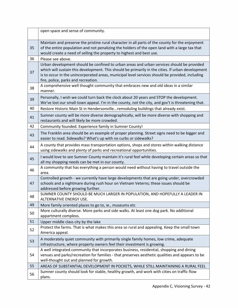
Appendix C, Visioning Survey - 42
open space and sense of community.
35 Maintain and preserve the pristine rural character in all parts of the county for the enjoyment of the entire population and not penalizing the holders of the open land with a large tax that would create a need of selling the property to highest and best use.
36 Please see above.
37
Urban development should be confined to urban areas and urban services should be provided which will sustain this development. This should be primarily in the cities. If urban development is to occur in the unincorporated areas, municipal level services should be provided, including fire, police, parks and recreation.
38 A comprehensive well thought community that embraces new and old ideas in a similar manner.
39 Personally, I wish we could turn back the clock about 20 years and STOP the development. We've lost our small-town appeal. I'm in the county, not the city, and gov't is threatening that.
40 Restore Historic Main St in Hendersonville...remoduling buildings that already exist.
41 Sumner county will be more diverse demographically, will be more diverse with shopping and restaurants and will likely be more crowded.
42 Community founded. Experience family in Sumner County!
43 The Franklin area should be an example of proper planning. Street signs need to be bigger and easier to read. Sidewalks? What's up with no curbs or sidewalks?
44 A county that provides mass transportation options, shops and stores within walking distance using sidewalks and plenty of parks and recreational opportunities.
45 I would love to see Sumner County maintain it's rural feel while developing certain areas so that all my shopping needs can be met in our county.
46 A community that has everything a person would need without having to travel outside the area.
47 Controlled growth - we currently have large developments that are going under, overcrowded schools and a nightmare during rush hour on Vietnam Veterns; these issues should be addressed before growing further.
48 SUMNER COUNTY SHOULD BE MUCH LARGER IN POPULATION, AND HOPEFULLY A LEADER IN ALTERNATIVE ENERGY USE.
49 More family oriented places to go to, ie., museums etc
50 More culturally diverse. More parks and side walks. At least one dog park. No additional appartment complexs.
51 Upper middle class city by the lake
52 Protect the farms. That is what makes this area so rural and appealing. Keep the small town America appeal.
53 A moderately quiet community with primarily single family homes, low crime, adequate infrastructure, where property owners feel their investment is growing.
54 A well integrated community that incorporates business, residential, shopping and dining venues and parks/recreation for families - that preserves aesthetic qualities and appears to be well-thought out and planned for growth.
55 AREAS OF SUBSTANTIAL DEVELOPMENT IN POCKETS, WHILE STILL MAINTAINING A RURAL FEEL
56 Sumner county should look for stable, healthy growth, and work with cities on traffic flow plans.
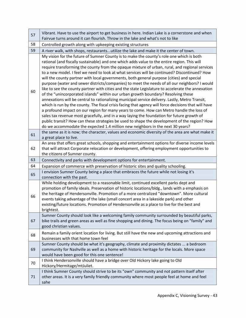
Appendix C, Visioning Survey - 43
57 Vibrant. Have to use the airport to get business in here. Indian Lake is a cornerstone and when Fairvue turns around it can flourish. Throw in the lake and what's not to like
58 Controlled growth along with upkeeping existing structures 59 A river walk, with shops, restaurants...utilize the lake and make it the center of town.
60
My vision for the future of Sumner County is to make the county’s role one which is both rational (and fiscally sustainable) and one which adds value to the entire region. This will require transforming the county from the opaque mixture of urban, rural, and regional services to a new model. I feel we need to look at what services will be continued? Discontinued? How will the county partner with local governments, both general purpose (cities) and special purpose (water and sewer districts/companies) to meet the needs of all our neighbors? I would like to see the county partner with cities and the state Legislature to accelerate the annexation of the “unincorporated islands” within our urban growth boundary? Resolving these annexations will be central to rationalizing municipal service delivery. Lastly, Metro Transit, which is run by the county. The fiscal crisis facing that agency will force decisions that will have a profound impact on our region for many years to come. How can Metro handle the loss of sales tax revenue most gracefully, and in a way laying the foundation for future growth of public transit? How can these strategies be used to shape the development of the region? How do we accommodate the expected 1.4 million new neighbors in the next 30 years?
61 the same as it is now; the character, values and economic diversity of the area are what make it a great place to live.
62 An area that offers great schools, shopping and entertainment options for diverse income levels that will attract Corporate relocation or development, offering employment opportunities to the citizens of Sumner county.
63 Connectivity and parks with development options for entertainment. 64 Expansion of commerce with preservation of historic sites and quality schooling.
65 I envision Sumner County being a place that embraces the future while not losing it's connection with the past.
66
While holding development to a reasonable limit, continued excellent parks dept and promotion of family ideals. Preservation of historic locations/bldg., lands with a emphasis on the heritage of Hendersonville. Promotion of a more centralized "downtown". More cultural events taking advantage of the lake (small concert area in a lakeside park) and other existing/future locations. Promotion of Hendersonville as a place to live for the best and brightest.
67 Sumner County should look like a welcoming family community surrounded by beautiful parks, bike trails and green areas as well as fine shopping and dining. The focus being on "family" and good christian values.
68 Remain a family orient location for living. But still have the new and upcoming attractions and businesses with that home town feel
69 Sumner County should be what it's geography, climate and proximity dictates ... a bedroom community for Nashville as well as a home with historic heritage for the locals. More space would have been good for this one sentence!
70 I think Hendersonville should have a bridge over Old Hickory lake going to Old Hickory/Hermitage/mtJuliet.
71 I think Sumner County should strive to be its "own" community and not pattern itself after other areas. It is a very family friendly community where most people feel at home and feel sahe
Appendix C, Visioning Survey - 44
72 We should maintain the core "ruralness" of our setting, while guiding and controlling our development in a way that enhances that setting.
73 Mass transit to all parts of county, more forms of entertainment that is more craft/hobby oriented, gift shops that welcome consignments from residents to better promote personal involvement in community.
74 look to franklin tn 75 An environment to live, work and play.
76 A combination of rural 'hometown' feel and access to urban amenities, with a safe and well maintained presence. A combination of home town ambiance, modern amenities, rural and urban areas well maintained and policed.
77 i would like to see some of the shopping areas in "town" clean up and improve rather than necessarily adding more and letting the older ones continue to decline. this would
78 Sumner County should be a place of quality, not quantity.
79 it should look like a place where government gets [-----] and says no more annexing of taking land for the 'common good
80 More diverse amenities for shopping, dining and entertainment.
81 lots of retail options...inclding resturants, great schools busiling buiness and voted best place to live YOY
82 Regulated, well-planned growth with infrastructure taken into consideration more so than what has been done lately, and an emphasis on keeping historical areas preserved and protected.
83 Tastefully developed.
84 A community of quality development offering sufficient choices for living, employment, shopping and recreation to keep the best and brightest at home.
85 My vision would be that all services be available to everyone no matter what and transportation would be provided to everyone as well!
86 SAumner county should grow with the welfare of ALL citizens in mind, progressing toward the future while honoring and preserving and learning from the past.
87 Similar to Franklin, aggressive and controlled commercial development with complimentary amenities that exploit our great location and resources.
88 Controlled growth to bring new, postive things to the County, including jobs, but preserve things that are unique to Sumner County so we don't just look like any other place in Tennessee
89 My vision of Sumner Co. would be for infrastructure to be re-enforced and updated and to have more cultral opportunities.
90 In 2035, residents of SC should be able to find good jobs, shopping, restaurants, school, green space, rural beauty, historic sites, entertainment, recreation and affordable housing without leaving the county, and feel safe while living and enjoying our county.
91 Clean, easy to navigate, lots of options on housing and shopping. 92 Prosperous, pride, clean, caring 93 Green and filled with wild flowers like the good old day!!
94 I feel that Sumner County should become the Brentwood/Franklin of North Nashville. I feel the standards for commercial and residential properties should be maintained.
95 The next "Brentwood". 96 Good roads and good schools.
Appendix C, Visioning Survey - 45
97 I really would like to see neighborhood schools where children could walk to and from daily, and also have a safe place to play after hours that is within walking distance to their homes. This could be a meeting place for families to get some much needed activity and have FUN!
98 I believe we will see more mass transit and people walking more to and from work where we will have more office space. Smaller more efficient "green" homes. I hope to see what it is like by then but I will be really old!!
99 Coexsisting with nature while still maintaing the idea of a family community. 100 A comfortable, safe, easily travelled county in which my wife and I can enjoy our retirement. 101 A county where families can live, work and play.
102 I believe it should be a clean, protected community. Low taxes, good jobs, housing that is well maintained with City well educated to improvements. Protection of Seniors.
103 Sumner county should continue to grow, while maintaining a community feel.
104 Well educated, have good employment opportunities,more four lane roads, low taxes, continue to be a safe place to raise a family and run a business.
105 I have just moved here after serving 20+ years in the military. I moved to the area because it is peaceful and Sumner County should keep it peaceful.
106 Maintain rural character and feel; limit new housing, particularly apartments, until basic services & infrastructure can be provided without tax increase.
107 Public transportation would be key.
108 I think Sumner County is growing too fast and we have enough empty store fronts, why do we need to keep building more?
109 Clean, organized, welcoming, and a desired tourist destination.
110 In 2035 gasoline will cost $10.00 per gallon in current dollars and Hendersonville will cease to be a place lower income and lower middle income can live and commute to Nashville.
111
Our children are the future of this county first and foremost. Lets stop with the consumerism and start with learning to give of our talents for the Common Good. Learning from a historical stand point and a desire to preserve our Natural Resources we should value and protect what we have now, if we look at the demographics every five years or so and keep a balanced buget all will take its course in do time. If there is a community worth living in because of good, sound planning and public imput as there seems to be now we will have minimal problems in the future.
112 Prosperous community with good schools and employment opportunities.
113 Sidewalks in more rural settings, transit from outlying areas to Nashville and excellent employment opportunities.
114 no opinion
115 Slow the development and preserve the history and beauty of Sumner County. Improve the air quality which hasn't been mentioned thus far.
116 In 2035 the county is known for it's great historical charm as well as being a leader in rural land and green space preservation, connectivity via greenways and bike routes and lake lifestyle.
117 We moved to Hendersonville in 1988 because we wanted to be in a smaller town, so slow down the development and preserve that quality.
118 Mass transit would become a reality.
Appendix C, Visioning Survey - 46
119
Education is important....but it can't all be done in schools....I would love to see some culture in this town. Let's show our children that Native Americans still live and breathe today and that African American people aren't just stained white people. They are beautiful black through and through and should never be ashamed to live in this small southern town. When we are learning about each other (especially at a young age...means less problems down the road.) ....
120 Needs to keep it's small-town feel yet offer to meet needs of local people. 121 Sumner County should be like a small town due to the rural areas. 122 we need to have a comphrensive mass transit plan and go back to shipping by r.r.
123
Entrances to towns be made visually pleasing (Ex. weeds mowed and scrub trees removed), eliminate or hide the strip mall effect down Gallatin Rd. in H'ville. My example of visually pleasing would be something similar to Hilton Head. Electrical, cable and phone lines buried underground.
124 People friendly, public participation in decision making, comfortable, and a safe (but not overbearing)living environment.
125 There are MANY comparisons between Sumner & Williamson County. Williamson has done a "good job," except they did not control infrastrure costs; 3X tax base!
126 Old Hickory Lake should be a backdrop for tourism with clean shores and larger beaches. Train transportation in Sumner and to/from Nashville for work and play.
127 Safe neighborhoods with sidewalks and bike lanes that connect to mass transit stations and schools.
128 Keeping the current community feeling with open land but some delevoplement and better roads in and out of county.
129 Safe, hometown community.
130 Sumner Co. will still have its rural/agrarian roots coupled with "smart" development to accomodate a growing population and an evolving demographic landscape.
131 It should look uncongested.
132 Go to Flower Mound, TX a suburd of Dallas. We look like them twenty years ago and see what is likely to happen.
133 Sumner County in 2035 will continue to have a rural feel, strong families, plenty of open spaces, MORE BIKE PATHS AND BICYCLESi, and fewer cars. We will realize that we share the planet with 6.8 billion people and that our future depends on us acting responsibly.
134 Follow Franklin's (TN) example
135 Take a look at Raleigh/Durham, or Chattanooga. Now those folks know how to envision development.
136 MAINTAIN OPEN SPACES/FARMING, WITH HIGH-END SHOPS/BUSINESSES, COMMUNITY CENTERS/SPACES WITH EASY ACCESS, TRAIN TO NASHVILLE/LEBANON/FRANKLIN, MAINTAIN THE HISTORIC ELEMENTS OF OUR COUNTY.
137 I would like for Sumner County to remain true to it's rural and historic roots. 138 I see the area looking like a more organized and nicer "cool springs". 139 I think the lots in subdivisions should be at least 2 acres so people aren't crowded together. 140 each new development have its own community feeling/but also have underground services
141 A place where future generations can still enjoy the rural heritage of our county - not just another overbuilt congested suberb.
142 Slowed development and better maintaining of what we have.
Appendix C, Visioning Survey - 47
143 Preserve natural beauty and family friendly environment. 144 grow at a steady rate but not too fast.
145 Multiple modes of transportation. Freedom for walkers and bikers to use the roads without cars claiming to own all roads.
146 Sumner will be an environmentally progressive community maintaining the delicate balance between rural and urban.
147 i thinks its fine the way it is. 148 Keep the rural areas just that. When large farms sell divide by 20 acres instead of 1-5 acres
149 I would like for it to be a place to meet all of my shopping and eating needs for my family so that I don't have to travel to Gallatin or Goodlettsville.
150 A home town city with pride of ownership.
151 I would love walking, cycling paths or just sidewalks, a bridge or quick way to cities, hendersonville, nashville, to be rated number 1 town to live in in America
152 Vision of growth more community involvemnt
153 We seem to be going in the right direction, so forward progress with emphasis on refurbishing the older dilapidated areas to integrate them with the newer progressive areas like the Indian Lake project.
154 Limit retail development to specific areas and preserve the rural atmosphere. 155 The same as 2010.
156 Just traffic keeping up with growth. Need a friendlier system, if not mass transit, but in a green, clean, sophisticated system.
157 Im not in a position to make a comment 158 little if any increase in large developments that destroy rural landscape 159 It should be a balance of rural and urban. It should not become "Nashville.
160 We need more open areas, more parks, better signage (lower, smaller and fewer), more cooperation among the cities and the county in these areas.
161 Sumner County needs to maintain the balance between a rural farm area and a thriving city. 162 a lot less government housing projects! 163 urbanism with 'return to traditional neighborhood' concept 164 A peaceful, ex-urban place to live with well-preserved historic sites. 165 Sumner County should have 50% rural, 50% homes and business developement.
166 Working Class, very safe for families, i.e. low crime, Good work opportunities buy moving in new businesses.
167
Sumner County should mirror Williamson County (Franklin area). Development is not a problem except when it affects the traffic and congestion. I don't know the answer but there should be better veins into different areas of the city..at least in Hendersonville. I'm hoping Saundersville Rd. extension will improve that. The bottle neck at Vietnam Vets and I-65 is a nightmare mostly because of inconsiderate drivers and the more we develop, the worse it will get. The future should have in a place a better route to get out of the city and head toward downtown Nashville.
168 The affluence of the county should be reflected in its integrity, i.e. through respect of its historical and agriculture past and its natural environment.
169 Sumner County will have a large population. It will be important to protect, prserve and enhance open space, environmentally sensitive ares,and deal wth storm water in a state-of-the-
Appendix C, Visioning Survey - 48
art fashion
170 Developing neighborhoods surrounding town centers providing cultural, shopping and restaurant experiences.
171 I do not want any more Billboards.
172 I would like to see Sumner County rival all counties in Tennessee as the most desired county to own land/acreage in.
173 it should stay mainly rural, with no big aprtment complexes. 174 NO illegal aliens. NO spanish.
175 Well groomed and maintained historical places and New schools with well enforced anti-drug laws.
176 Sumner County should be a place that your children want to stay when they grow up. We need more industry and more opportunities to work in Sumner County. This can be accomplished by proper planning of our roads and developments.
177 Beautiful rolling hills, large single residential homes, open sidewalk shopping centers, developed housing options on the lake and more lake recreation, resort type town
178 More community centers, availability of more restaurants 179 180 Well there will be house everwhere and plenty of place to shop and good road to get there. 181 very little growth
182 Continued residential and buisness growth in all Sumner Co cities with plenty of diversity so that you can live and work there and have everything you need in one place but keeping the family first feeling.
183
I think Sumner County functions now as a "bedroom" county and I feel that there is a definite lack of community. I would like to see Sumner County capitalize on future development opportunities and work to recruit big business. There is no reason the County can not grow into a great "Live - Work - Play" area.
184 All the growth going on is exciting, as long as the communities are preserved & it doesn't get too overgrown it will continue to be an appealing location for families!
185 Attract as many people as possible with new business parks and provide incentives for new residents and businesses to come here ie: deferred taxes, tax decreases. The more people and especially businesses that move here the lower our taxes will be.
186 I would like to see Sumner County stay majorly rural with future growth and developement centered around the existing urban centers thus preserving the "country" feel while still providing for needed jobs and services.
187 A modern population center that has maintained its historical perspective and increased economic opportunities for it's residents.
188 would really like to see more emphasis on the community going green. having alternate ways for transportation. Less new building. We can't afford to keep increasing our schools, etc. We'll loose the small town feel if we keep building more & more houses/apts.
Appendix C, Visioning Survey - 49
Question 13 What might hinder achieving what you described in Question 12? The following were common themes among respondents:
1. Unregulated growth 2. Politics 3. Lack of funding 4. Lack of planning 5. Greed 6. Taxes – either raising taxes or no change in taxes 7. Lack of preservation 8. Lack of knowledge 9. Developers 10. Lack of travel options 11. Fear of change 12. Lack of vision
Responses: 1 Lack of governmental cooperation and territorial protectionism.
2 Desire to use only the most profitable land for development without contributing adequately to the infrastructure.
3 lack of transportation alternatives and public utilities too much overlap in services between cities and county
4 County Commissioners unwilling to impose new taxes ... being more worried about garnering votes than doing the right thing for our children and grandchildren.
5 A negative business environment
6 Balancing Private Property Rights v/s County and Cities developing regulations to protect rural and natural areas.
7 Lack of foresight for maintaining exsisting areas. 8 Money and a Master Plan
9 Bringing jobs to the county is key to becoming something other than a bedroom community to Nashville.
10 PLANNERS AND COUNTY OFFICIALS WITH THEIR OWN AGENDAS AND IDEAS OF WHAT SUMNER COUNTY SHOULD LOOK LIKE AND NOT THE OF THE CITIZENS
11 Unregulated growth 12 Greed 13 More and more subdivisions that continue to be developed in the county.
14 Lack of preservation, more desire to compete with more metropolitan areas than to preserve family friendly atmosphere.
15 Not sure
16 Not everyone wants the Neo-Classical look. Also, Developing is very expensive and it would require a lot of Capital to make this look a reality.
17 Balancing development with the cost. We do not have the income in Sumnet County to do everything that Franklin, TN can do.
18 Money and people who do not want growth of any kind. Also, uncontrolled growth without
Appendix C, Visioning Survey - 50
proper planning.
19 Cities and politicians who want to squabble over every little thing and everybody tries to protect their little piece of the pie instead of doing whats right for the entire county.
20 money 21 [-----------------------------] and all the other greedy people in this county
22 Permissive governmental zoning and land use to increase the tax base at the expense of our neighborhoods and living environment.
23 The people of Sumner County. Politicians. Developers.
24
Hindering adherence to subdiv/zoning regs are peoples view of change, in the way they do things now and instead wanting to define a sense of place that is unique through develpment guidelines. These guidelines derived by the process of planning and through the input of locals, also relies up council/commission members upholding the subdiv/zoning regs on the books -- which were defined by the planning process. Plan the work, then work the plan.
25 economy, unemployment, 26 n/a 27 Massive cost associated with inputting more sidewalks and bike lanes.
28 Our ability to change,without the encumberance of tryiny to please everyone and ending up costing the chance for effective management
29 Money. 30 Lack of plaining
31 Greedy politicans & developers that have no taste, no enforcement of codes, poor traffic planning, exit 7 and shopping area is an example of no professional planning.
32 Money.
33 elected officials that do not see the benefit of having a community that includes affordable housing. current residents that don't want affordable housing near them because of negative perceptions.
34 Maintain a tax base on the open spaces at a reasonalbe rate to make it easier for the owner to continue to keep the space rather than selling for development.
35 The current state of the economy and the dire need of counties and cities for increased tax bases.
36
The negative impacts of urban sprawl are gradual and thus not detected until it is too late. It is difficult for people to understand this. Plus, developers and residents are mobile; they can pick up and move further out or they can move back into Nashville to an area which has hit rock bottom and is on the way back up. Of course this is very costly to those less mobile and to the suburbs which have allowed it to happen.
37 Fear of change and a desire to "close the door
38 Everyone seems more worried about the development at Indian Lake in Hendersonville, than restoring what origionally made Hendersonville.
39 Traffic will continue to get worse, it is very difficult getting around during the day & the commute home.
40 Politicians big heads! Too much power in all aspects.
Appendix C, Visioning Survey - 51
41
The transit situation here is horriable and I see no progress to solve it. The 386 is a parking lot! Nothing planned or in the works to help get traffic from Nashville to the northeast part of the County. Long Hollow Pike is not being widened. It is hurting the property value growth of all residents that live east of Hendersonville. I would love to live in Hendersonville but the traffic in that town is nonstop with no solution being submitted. Why in the world do we not have a four lane road cutting over the river from Hendersonville to Old Hickory! I've lived here (Hendersonville and Gallatin) for 37 years and no one has ever seriously proposed this. It would save gas, and time. This road should be built and connected to the 386 and Long Hollow.
42 Money, lack of understanding by government, good ole boy network
43 Finding the big name stores and luring them to our county. Working to make sure we don't overdevelop so that the rural feel is no longer there. Planning has to take place to make sure both can be achieved.
44 Politics
45 Continuing to approve new housing and retail developments prior to getting a handle on what has already been built.
46 LACK OF FUNDING TO SUPPORT THE INSTALLATION AND UTILIZATION OF SAID ALTERNATIVE ENERGY.
47 lack of funding 48 1950's view points. Not be open to change and new ideas. Same old same old mentality. 49 Failure to understand the potential with with our adjacient lake frontage. 50 Too many subdivisions.
51 Public transit will open the area to more lower income renters who have no investment in or commitment to the community.
52 Citizens who perceive growth as negative.
53 OVERDEVELOPMENT IN AREAS WHILE OTHER AREAS HAVE EMPTY BUILDINGS BUILT ONLY A FEW YEARS AGO
54 No prgoression / foresight by the elected officials. 55 Not acquiring the land...i.e., the front part of Saunders Ferry Rd.... 56 Elected officals and the need to increase taxes which may never be approved.
57
too many people wanting the southern end of the county to resemble williamson county; having more white collar jobs and more retail/restaurant choices at home would be wonderful, but giving up what makes us unique and being inundated with corporate trainsents and people with no tie to this region of the country is not worth it.
58
The needs of our county have outgrown the abilities of the current political structure and politicans. The ability of those in office was fine even 10 years ago, but the needs of today have expanded beyond thier expertise, and in some cases beyond their willingness to think for the good of all, rather than their own personal agendas.
59 Beauracracy. 60 Road infrastructure 61 Lack of a vision and not involving the constiuents of the County. 62 greed 63 Politics
64 Money, and coming together as a whole to achieve great things. You can never make everyone happy but as a person of power or control you must remove your self interests and really think about what is best and what is good for the community and the people that live here.
Appendix C, Visioning Survey - 52
65 Some of the leaders don't want to see progress. 66 Greed. 67 Nothing, it's long overdue.
68
The lack of a comprehensive master plan that acknowledges our many assets (developable rural land), manages our development going forward toward 2035 in a way that blends development (residential and commercial)into the beautiful topography of our county, and the continuing existance of a "we/they" mentality amoung the county political leadership in relationship to the incorporated communities. We must work together. If we don't, people are still going to come to Sumner County to avoid the zip code surcharge they see in Williamson County. As the old addage goes, "if we fail to plan, we plan to fail.
69 Singular thinging that includes forgetting that not everyone has a car or can even afford one and most don't have family to help them get around. All the more reason to strongly consider mass transist to areas beyond Nashville and Rivergate.
70 tax base
71 The lack of true industry or corporate employers in Sumner County will be the biggest impediment. If you are able to secure corporate headquarters or larger employers, that's where your residents (and resulting tax base) will come from.
72 The cost of paying for all the 'perks'. No one wants higher taxes, but do want all the advantages. Hmmmm!
73 Low end retail and housing/apartments. 74 increased government 75 Stubborn home owners that have lived in Sumner County forever and are opposed to change 76 we need bike lanes and more bike friendly roads. I would love a place to rollerblade 77 Unregulated, growth for growth's sake, without proper planning for impact on infrastructure. 78 Greed 79 The illusion of high cost. 80 Lack of knowledge base! 81 Petty local politics and petty local politicians.
82 Letting certain individuals hinder growth and development because of their own agenda instead of doing what is for the greater of everyone. The local governments need to work together more for the county instead of just their own area.
83 Obviously, the state of the economy is the biggest concern.
84
Uncontrolled development, both residential and commercial, can hurt the green space, rural beauty, quality of education and historic sites; Entertainment, shopping, restaurants and recreation opportunities have greatly improved over the past decade and should keep up with our continued growth; Affordble housing is hard to find in Hendersonville, Gallatin and White House areas but is still available in the more rural parts of the county but without proper planning, this will become a greater problem forcing young Sumner County families and lower income SC families to leave to find the best value for their home purchase; The Sumner County goverment and the collective city governments have to keep working to bring more job opportunities to Sumner County. A large portion of SC residents leave the county every workday to work whatever money is spent on lunch, groceries, cleaning, ets. is done out of the county and that is less money for local businesses and less tax dollars supporting SC.
85 Government beauracrats 86 Greed and lack of leadership.
Appendix C, Visioning Survey - 53
87 Excessive development
88 Failure to allure proper businesses. Too many bus stops like the ones just added to Indian lake and the Kohl's shopping center area. Too many low income house developments (Pop up neighborhoods)
89 Lack of educated leadership. Small town minds cannot usually propagate big city growth. Not that they do not want to, they just don't usually have the experience, training or education in how to attract big industries, manage the growth, etc. It has to be much more than just a desire.
90 Money 91 Lack of public support. 92 Money and the economy. Negative people. 93 To much development not enough preservation. 94 Availability of revenues to the county and municipal governments to maintain / enhance services.
95 Sumner County's leaders need to make a more concerted effort to attract employers to the county, including corporate headquarters, industry, retail, restaurants, etc.
96 High taxes. 97 Too much growth too quickly without proper planning. 98 Over regulation 99 What will hinder achieving Question 12? Greedy politicians and land developers. 100 Allowing any new development that comes along; slow economy. 101 Lack of vision 102 The mighty dollar! 103 Economy
104 Mass transit to and from Nashville and better schools in Nashville could make Nashville more desirable and push Nashville's poor out to the suburbs as Nashville gentrifies and takes on a more European city pattern.
105 Big corporations, big promises, big tax hikes, big brother. 106 Inadequate transportation choices 107 Funds to carry out projects.
108 Greed. The officials in our towns all want the same thing--more tax revenues. They bend to what the developers want(which is more money and profits).We need politicians who have a vision to make our county a better place in which to live rather than concern for tax dollars.
109
Those that continue valuing the directing of county resources to unrestrained development rather than using some of them to build lifestyle infrastructure beyond new roads, bridges and shopping centers. The opportunity is there for Sumner County to be a leader in balancing growth while at the same time maximizing quality of life.
110 Our mayor and the developers that have taken up residence here. They are trying to compete with the Brentwood/Franklin area. If I wanted to live in that type of town I would have moved there in 1988.
111 Poor planning and money. Blurred vision for the future. 112 Politics and bias southern boys.... 113 Money
114 The explosive growth in Indian Lake and parts of Hendersonville can put a blight on the area if not managed properly.
Appendix C, Visioning Survey - 54
115 money 116 Land ownership, costs of landscaping, wire and cable burial. 117 Too much/too fast unplanned/unforeseen growth.
118
Good-ole-boy" Bubba's who let developers call the shots instead of proactively PLANNING the "type" of development we need. Example, "lakefront retirement" is NET gain in taxes where 1,200 "starter homes" will destroy property tax base relative to services. ~85% of County budget is "schools!
119 Political differences. 120 Money.
121 Good ol boys in the development office. I complained about drainage that was incorrectly done by a developer. [------] told us to sue to developer (and let the developer know we complained). So, he did not do his job and wants a private citizen who is being affected to do it.
122 Federal dollars for future road construction. 123 Over development, traffic congestion, lack of sidewalks. 124 Myopic vision of future, scarse funding and expensive energy. 125 More major development which causes more traffic.
126 Planners and politicians who have limited experience and only are familar with their box. You need to have people who can provide you with a different view than what you are use to. Growth is going to happen whether you want it or not.
127 Lack of forward-thinking officials
128 I think the decision makers in my community are too hands-off, pro-business oriented in their vision. Small thinking worries me. Gallatin Pike is just going to be another Dickerson Rd in 30 years on this path.
129
IF WE ALLOW BUILDERS TO BE GREEDY AND OVERBUILD ON FARM LAND, THIS COUNTY WILL LOOK LIKE EVERY OTHER NEW DEVELOPMENT. REQUIRE LARGER LOTS, MAINTAIN FARMLAND AND PUBLIC OPEN SPACES. STOP ALLOWING BUILDERS TO USE VINYL/PLASTIC SIDING--UGLY! LET'S MAKE THIS COUNTY UNIQUE AND DESIRABLE TO VISIT. WE'VE GOT THE LAKE, LET'S KEEP THIS PLACE BEAUTIFUL!
130 Development that does not take into mind what would be best for the entire area of Gallatin. 131 Traffic problems 132 Developers and their influence on zoning laws. 133 fast money developers (gready)
134 Uncontrolled development focused on additional tax revenue rather than quality of life within the county.
135 Developers and contractors on zoning boards and officials to closely connected to these people. 136 Poor development planning. Public housing. 137 people who are planning the growth not taking in account the future. 138 The attitude of being a "car" culture. 139 lack of vision 140 planning committees 141 Politics
142 Continuing to build "new" along the perimeters and stoppping the improvement and maintenace of the center of town. The old Gallatin has become rundown and dilapidated.
Appendix C, Visioning Survey - 55
143 no action 144 lack of vision not developing more community involvement 145 Lack of vision & leadership & the economy. 146 Unrestricked growth. 147 People who don't know how good they got it. 148 economy
149 wealthy developers from (sometimes)outsde the county/state that cares little what our county looks like
150 Greed as in over development.
151 Uncontrolled growth. You can't stop growth, but you can control it and improve it. This plan is a step in the right direction.
152 over development of the area 153 large number of low or no income families 154 Too much ambition for development and population growth. 155 Overdevelopment kills the rural landscape. 156 Greed 157 SECTION 8, LOW INCOME HOUSING!!!!! Cutting back on our police force.
158 People in charge not making decisions based on the good of the county but who their buddies are. I'm not opposed to development...just bad development decisions.
159 Failure to respect the adopted plan would hinder achievement of the desired goals. Political leaders must be held accountable to the needs and desires of the public as a whole, not just the developers with the cash and influence. A good quality of life is ultimately priceless!
160 Lack of planning, lack of provision for green/open space, and lack of tree canopy 161 Lack of planning for: storm water drainage, Sewer development, zoning and transportation. 162 To much development. 163 population growth, and the need for tax funds 164 The police not doing their job.
165 Pollution and parents who continue to turn their heads as their children continue to drop out of school and buy drugs.
166 poor planning 167 Overbuilding the rural ares, too much concrete, too much greed 168 increase in taxes 169 Money
170 too much growth will take away from the beauty and small town feeling everyone loves in Gallatin.
171 Road limitations into and out of the county being sufficient enough for the growth.
172
Not having a strong development plan for the county in the early stages, not having county representives having a clear understanding of what the plan is and being strong enough to pass on items that would not necessarily help the county in the long run. also, if there are opportunities available, not going HARD after them. We should be in a continous recruiting mode - not for any and everything in site, but for businesses and opportunities that will make the County safer, help in sustainable growth, and ultimately lead to enrichment of residents lifes.
173 economy...
Appendix C, Visioning Survey - 56
174 not widening widen vietnam vets hwy asap to keep up with future developmentnot building a bridge across the lake from hendersonville to mt juliet.
175 Greed and lack of holding true to the values we say are dear to us. 176 Poor zoning and lack of dynamic leadership.
Appendix C, Visioning Survey - 57
Question 14 If you have any additional comments or matters which you believe the Sumner County Executive, Sumner County Commission, and/or Sumner County Regional Planning Commission should address, please use the space below. Responses:
1 Is anybody considering acquiring and preserving the Tyree Springs Area?
2 should study metropolitan form of government for all of Sumner County
3 I said enough.
4 I'd like to see the greenspace that has been designated developed and cared for.
5 I think that we should have a plan to connect major greenways and produce greenways in Sumner Co.
6
Please stop the use of red light and traffic cameras. They are nothing more than a revenue stream and their use is not proven to enhance safety. Their use is a greedy ploy to try to hide revenue generation under the guise of safety. If accidents and safety are truly an issue, station officers at the location to address the issue.
7 PLEASE LETS START DOING THE WILL OF THE PEOPLE AND NOT WHAT WE NEED TO DO TO BE ELECTED
8
I think it is important for Sumner to pursue green development and green infrastructure options as they continue to build. The area around the Hendersonville library is a good example of a way to build and retain the beauty of the natural resources while providing access for pedestrians and joggers.
9 What, if any, is the plan for the Regional airport.
10 I think that mixed use area where one could work, live and shop without getting in a car would be nice. A planned community where you could park your car and get around in golf carts, bicycle or walk.
11 Provide a real fire department to the citizens of the county, there is more money spent on dog catchers than on providing for our life safety.
12 Address hwy 31-e north as to 4 lane to ease traffic problems This will keep tax dollars here instead of Ky.
13 Sumner County needs to consolidate the water and sewer services of the utility districts and cities in order to have a uniform quality and cost of service, while protecting the watershed areas in a consistant manner.
14
Please beaware that planning in Sumner County and among its communities should require area's working together to creat a great place to live, work and play. Create and plan through public input for a vision where you want to live, not want to move from in 5-10 yrs because it has lost its sense of place and local character due to unmananged/unchecked growth and development.
15 Get the politics out of planning ,focus on training,watch out for the federal government,they have been moving to take this job away from local control for sometime.resist the EPA they will take as much control as you permit
16 More trees, flowers, and foliage need to be planted along roads, sidewalks, and around county buildings.
17 Education is at the top of my list. Impact studies should be used.
18 Adopt or maintain a strong zoning ordiance that operates outside political interference.
Appendix C, Visioning Survey - 58
19 Please take this very seriously. Look at the history of other urbanizing counties. The future is at stake. This is your opportunity to provide the necessary leadership, to step outside the box and make the hard decisions necessary to sustain growth and prosperity for the long term.
20 Annexation should not be forced on citizens. The bypass is a disaster and desperately needs additional lanes. And if we have all these excess police cars that sit empty all over town, maybe we should get rid of them or hire more officers.
21
I believe more should be done insofar as promoting tornado shelters in the event of bad weather. Tennessee has a tendency to become tornadic and the tornado events that do strike tend to be at night, thus the increased number of fatalities. Namely, apartment complexes & condos should look into building community shelters for residents since they have no place to go.
22
The opportunity to beautify and improve Sumner County in exciting. I believe our number one job is to make it more accessable to Nashville. Mass Transit (rail) would be excellent. If the traffic situation does not get addressed with future traffic congestion growth included in the planning, then all other issues will not make much difference.
23
Traffic on Vietnam Veterans... Just a few years ago, once I hit VV in the evenings coming home from work, we could drive the speed limit and get home quickly. Now, it is worse than I-65. Over half the time I spend in the car is sitting on VV. This really should be widened to accomodate all the recent population growth.
24 AS A COUNTY, WE NEED TO STRIVE FOR THE ABILITY TO BE SELF SUSTAINING IN AGRICULTURE AND ENERGY INDUSTRIES. WE CANNOT CONTINUE TO RELY ON THE STATE AND FEDERAL GOVERNMENT FOR FUNDING AND SUPPORT.
25
Sumner needs the following: Dog park and support for animal shelters (need to control the pet population/spay & neuter) sidewalks slow new construction growth (residential) planning in future of transportation due to population growth more public transportation to and from Nashville
26 The Cages Bend area has way too many water outages! Large construction projects over the years always result in property owners being without water service for up to 10 hours. This could be disastrous in the event of fire.
27 Do we know when the Saundersville Road project will be finished? Also is there any plans for a Riverwalk?
28 MPO using federal dollars may be pushing it and willing to subsidize it, but resist the absurdity known as commuter rail and other quasi-mass transit schemes. this area will never have the population density necessary to make it work.
29 I hope to see the results of this survey posted for review and observations.
30 Remember where we are, who we are, and what we want to have. Growth is not necessarily "better". Those who moved here many years ago moved here for certain benefits. Don't "grow" us out of why we are here in the first place.
31 It is my wish that whoever plans traffic and development for the county would be as concerned with traffic flow and traffic issues as they are with the physical appearance of Sumner County.
32
Let's quit the petty bickering and one upsmanship that has become all to prevalent in our County government. Refusal to understand that our county is not only changing now, but will continue to change for years to come and that the change will not stop. The only thing that can positively impact how, when, and where we change is agreeing that we have much more to gain--county wide--by working together than continuing to have these petty little skirmishes that only lead to stalemate and stagnation. Neither of those two conditions contribute one thing to a plausible, functional, responsible plan to guide the growth and development of our county.
Appendix C, Visioning Survey - 59
33 Glad our future is being studied, planned for and given years of thought as to quality of growth and life 'in the county', as opposed to city dwelling.
34 Fresh water supplies for the northern part of the county.
35 AIRPORT expansion, industrial growth
36 I understand the difficulties the officials at the County level encounter. I hope that they are smart enough to adopt a "Pay as you Go" type of mentality and can keep the borrowing down to a minimum... at least for the time being.
37 Better planning of what the main arteries entering our cities look like. Stop building schools on main roads causing traffic congestion. Main traffic arteries in all cities should have 5 lanes.
38 Do not outlaw ugly. It is all in the eyes of the beholder.
39 Thank you - this survey is a great idea.
40 Sumner County's leaders need to make a more concerted effort to attract employers to the county, including corporate headquarters, industry, retail, restaurants, etc.
41 Try to improve education whether it be law enforcement, utilities, education of children or citzenery.
42 Support recycling of glass and metal
43
County should remember to be who we are...we aren't Nashville. There is a good balance of rural to city now, so don't try to cover every part of the county with new subdivisions. We don't need to attract more people with children to educate until our infrastructure catches up. Concentration on business & economic development should be a priority.
44 I do not support any efforts toward "regionalization" of the counties surrounding Nashville. It is important to retain autonomy from the influence of the Nashville government.
45 More sidewalks and bike lanes PLEASE!
46 This is not a rural county. All land in the county should be in a municipal planning area. The county planning has subverted any planning that cities tried to do.
47 Transparency in what lies ahead, or life as we love it will be a transitory dream.
48 More rural zoning enforcement would be a great benefit to the county. Too many areas have abandoned unkept properties. Also, the streets and roadways are not kept up as they should be. Potholes and erosion of shoulders is a huge problem.
49 When a city annexes areas of the county they should be able to offer all services to the new areas before they start collecting taxes.Where is the concern for the people they annex? Probably just concerned about the tax money!
50 We need a county wide greenway, along with more bike routes and permanent greenspaces. Additionally, spur of commuter train to Nashville should be built with stops in Gallatin, Hendersonville before heading on into Rivergate and Nashville.
51
Stop the development on the Sander Ferry/Walton Ferry Peninsula and the Indian Lake Penisulas. The wildlife are in our neighborhoods because they have been run out of their habitat! Stop the development between Gallatin & Hendersonville. It's okay to have rolling hills and pastures to separate our towns. We don't have to meld together thru overpriced, homeowner association run, cookie cutter neighborhoods.
Appendix C, Visioning Survey - 60
52
Let's NOT be the next Franklin....They have grown to the point of eating themselves alive....Who wants to live there now??? What a nightmare!!!! Keep it balanced and not extreme with simple charm and inclusion of all. Maybe look to revitalize the area behind the tracks....you know where I'm talking about.
53 i see public transportation as our single biggest need other than illegial aliens from all over the world.
54 Good ole' Common Sense when spend vs income. Increased income (taxes) not always the proper answer.
55
Look at the "resources" devoted to PLANNING in Franklin TN, Williamson County and Murfreesboro and MATCH. I KNOW what Sumner's current level is (as well as Hendersonville & Gallatin) and you have a LONG WAY to go. Second, Commissioner's SUPPORT the Planning Professionals, NOT the "Good-ole-Boys.
56 Be careful and respectful of Fee Simple Landownership Rights. It is a "Third Rail" issue.
57 Provide a sound system so everyone can understand the discussions in the general chambers. It now sounds like people are talking into a can and with the accent, forget it.
58 I think Gallatin authorities have done a better job than those from my community of Hendersonville in developing future plans. I'd for more regional development coordination.
59 I WOULD BE VERY INTERESTED IN LEARNING MORE ABOUT THE COMMISSION AND IT'S PUBLIC MEETINGS. [------------------------------------------------------]
60 Try to keep up older areas. As new development arises, I'd like to see old areas on 31E as you drive through our town (Gallatin) beautified in some way.
61 Try getting along and supporting our schools and teachers!
62 turning lanes on major rural roads
63 The influence of outsiders should be diminished and there shuold be more oversight of planning and zoning.
64 Please please please put sidewalks in! It is so dangerous to not drive in Sumner (esp. in cities), yet so many do not have cars. Don't make Sumner County look like another strip mall suburb. There is so much history and character- let that shine in a green way!
65 Keep Sumner County simple, Dont try to compete with the Jones. Low taxes and Family.
66 I just think we really need to strive to keep Hendersonville the wonderful place that it is to live in and raise a family. We need to do all that is possible to keep crime rates low and to have a safe and wonderful community and that is what brings people to our community in the first place.
67
Remove and replace the chain-link fence along the 109 by-pass and replace with brick privacy fencing and sidewalks and landscaping. Include a magazine of the parks department activities(events and classes), sent to all the residents and use the monies rasied to maintain the roadway. Work with the residents to play in the city, pay in the city and defray the costs of living in our city.
Appendix C, Visioning Survey - 61
68
In Nasvhville they have many agency to help the needy or low income families we need that a lot of our families have lived here for years we need to take better care of our families providing better health care dental care more assistane needed for low income families to improve their homes which over all beautifies Sumner County as whole yes improving the Square was a needed project but we can not forget about individual homes which beautifies our neighborhoods where new families will be living.We need to attract and get new businesses that will offer affordable clothing and services to our community. We have too many banks.
69 Sumner County needs a quality indoor facility that will accommodate large crowds to utilize fundraisers/formal balls etc... Presently we have to commute to Nashville for these type provisions.
70 The residential development without the necessary infrastructure to support it such as adequate schools and roads to carry the extra traffic.
71 Stop the property tax hike. It's obvious and rediculous that we barrowed an additional 6.5 million. Afraid of what I'll be paying in the following years!!!
72 our county is a treasure that should be guarded against destruction. out of control growth will do that if we are not careful.
73 The county needs to get out of the business of providing scholarships for individual students and concentrate on getting the most for all the citizens of the county with the revenue available to them.
74 get traffic lights synchronized, write tickets to cars in fire no parking lanes, more cameras at intersections, better pay to good teachers, get rid of (quit passing around) bad teachers.
75
It may be imperetive that we have public transportation for environment and seniors; however, we do not like to see bus runniing in this small town. I would like to see charmingly designed vans to transport people for short distances within town, and to the central locations, where they can transfer to regular bus lines to travel to Nashville or other cities.
76 Stop the sprawl, please.
77 Be mindful of the board makeup. Too many contractors and developers will further damage our rural past.
78 ...greater enforcement of property maintenance in the county, especially the northern part.
79
I suggest (and only suggest) from a professonal standpoint that tree canopy be considered for stormwate abatement, temperature control, and quality of life. Sumner County is in my area of responsibility for urban forestry assistance. I will be available, at planning meetings if desired. Please keep me in mind as a resource. [-----------------------------------------------------]
80 Better public notification of county issues before commission voting
81 keep the quality of life as is, we have hospitals, resturants and shopping close. Keep the rural areas so we can still enjoy wildlife and a sense of freedom.
82 The hospital needs new equipment & more people, not a bigger building, sitting half empty. Public transportation besides cab companies. There are TOOOOO many stop lights & each day more goes up. What about one way streets instead. More fire depts. to help protect rural areas.
83
I would like to see enforced drug testing at the high schools with parents and children both to be held accountable. There should be something available other than a urine exam as students are passing these. Also, when found guilty for drugs or alcohol; I believe these students should clean pollution from parks, roadsides, etc.
Appendix C, Visioning Survey - 62
84 Portland needs a bypass to take the transit truck traffic away from the residential and retail commercial areas of 109.
85 Expanding the rail for commuting to Nashville
86
Growth should be controlled with emphasis on limiting urban sprawl and overloading existing infrastructure.Try to encourage growth within city limits and town square areas to reduce economic shift away from population centers and creating urban blight and decay (go to downtown Naperville ILL)
87 Keep with in the budget do not over spend .Keep taxas a low as you can.
88 I believe all cities in Sumner County should be developed more by businesses and corporations and that Sumner County must work to have transit options throughout the county as well as options to connect to Metro Nashville Transit options.
89
I know that money is always a factor, but I believe that getting rid of the County Engineer position was a major mistake. You need an engineer with experience to be able to work hand in hand with the planning department. No offense to the planning people, but most do not have the background knowledge to know if they are getting hosed on new development. I also think that having an elected Highways Super is a bad idea and that this type of work should fall to a County Engineer and his/her staff. A lot of good can come from having this postition elected (I like Scotty Parker is an example of that), but if the county is serious about moving forward, a politician worried about getting re-elected could and probably will become a major hinderance in meeting these goals.
90
Keep expanding infrastructure as you have in hendersonville and gallatin. This is the reason our family and our parents moved here. We came from Allegheny county (pittsburgh,pa) and the taxes are 300% more there because there was a 40 -50 year lack of expanding infrastructure and Pittsburgh has LOST 400,000 people since 1950. That's right LOST 400,000 tax payers!!!
91 none
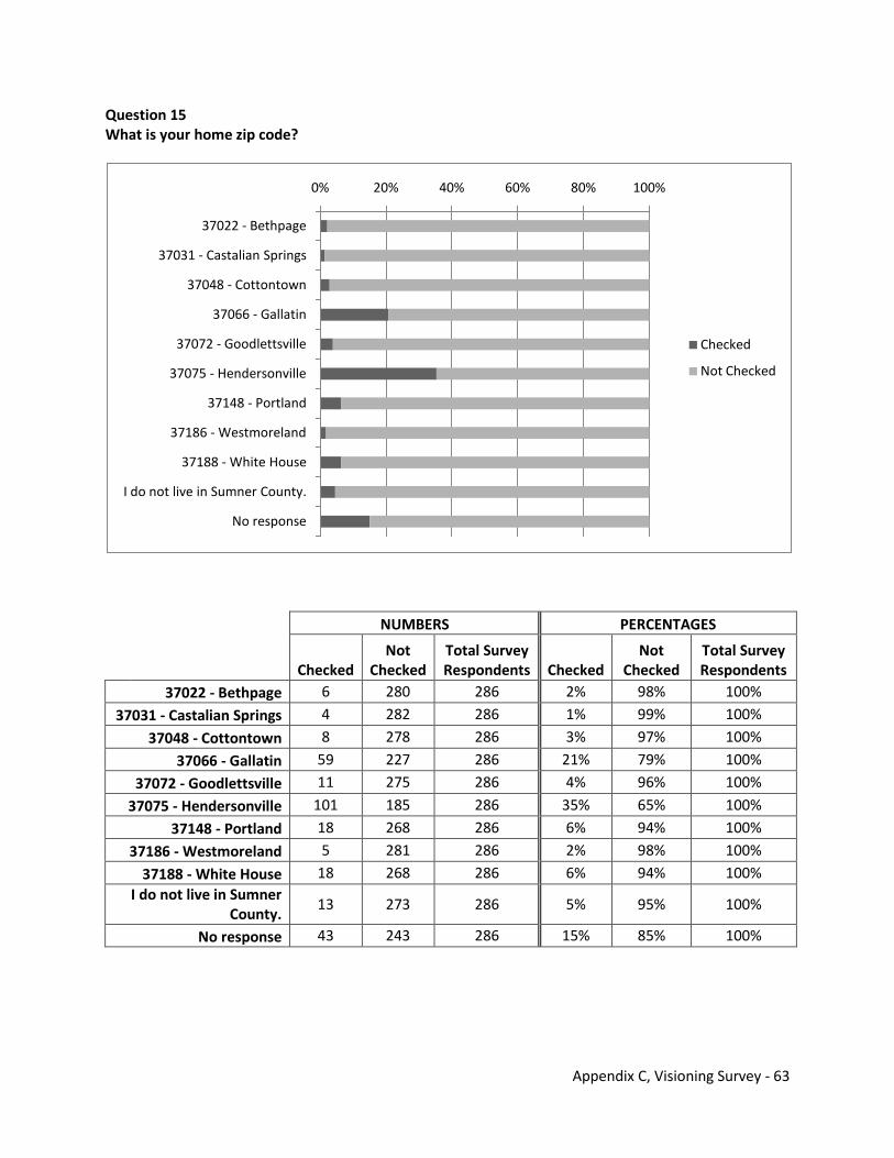
Appendix C, Visioning Survey - 63
Question 15 What is your home zip code?
NUMBERS PERCENTAGES
Checked
Not Checked
Total Survey Respondents Checked
Not Checked
Total Survey Respondents
37022 - Bethpage 6 280 286 2% 98% 100%
37031 - Castalian Springs 4 282 286 1% 99% 100%
37048 - Cottontown 8 278 286 3% 97% 100%
37066 - Gallatin 59 227 286 21% 79% 100%
37072 - Goodlettsville 11 275 286 4% 96% 100%
37075 - Hendersonville 101 185 286 35% 65% 100%
37148 - Portland 18 268 286 6% 94% 100%
37186 - Westmoreland 5 281 286 2% 98% 100%
37188 - White House 18 268 286 6% 94% 100% I do not live in Sumner
County. 13 273 286 5% 95% 100%
No response 43 243 286 15% 85% 100%
0% 20% 40% 60% 80% 100%
37022 - Bethpage
37031 - Castalian Springs
37048 - Cottontown
37066 - Gallatin
37072 - Goodlettsville
37075 - Hendersonville
37148 - Portland
37186 - Westmoreland
37188 - White House
I do not live in Sumner County.
No response
Checked
Not Checked

Appendix C, Visioning Survey - 64
Question 16 Do you live within any city limits (Gallatin, Goodlettsville, Hendersonville, Millersville, Mitchellville, Portland, Westmoreland, and White House) in Sumner County?
NUMBERS PERCENTAGES
Checked
Not Checked
Total Survey Respondents Checked
Not Checked
Total Survey Respondents
Yes 154 132 286 54% 46% 100%
No 71 215 286 25% 75% 100% I do not live in Sumner
County. 13 273 286 5% 95% 100%
No response 48 238 286 17% 83% 100%
0% 20% 40% 60% 80% 100%
Yes
No
I do not live in Sumner County.
No response
Checked
Not Checked
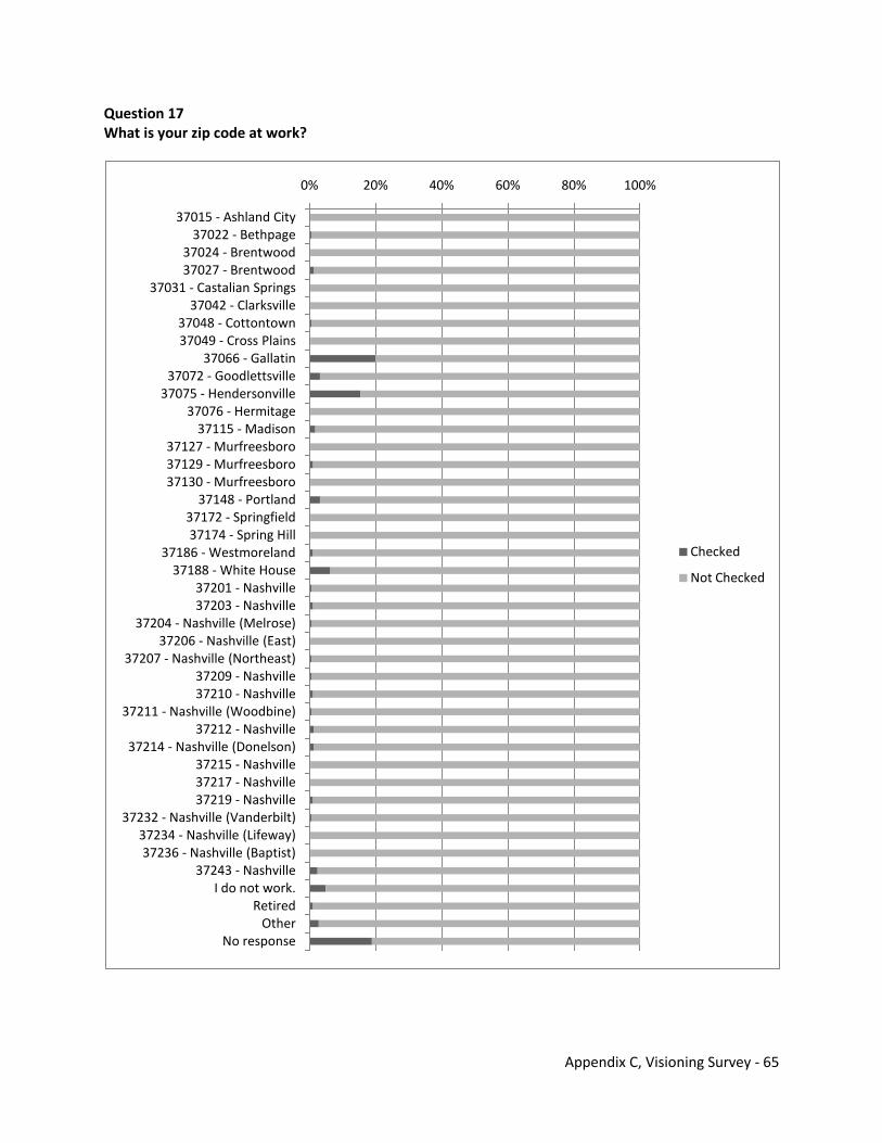
Appendix C, Visioning Survey - 65
Question 17 What is your zip code at work?
0% 20% 40% 60% 80% 100%
37015 - Ashland City37022 - Bethpage
37024 - Brentwood37027 - Brentwood
37031 - Castalian Springs37042 - Clarksville
37048 - Cottontown37049 - Cross Plains
37066 - Gallatin37072 - Goodlettsville
37075 - Hendersonville37076 - Hermitage
37115 - Madison37127 - Murfreesboro37129 - Murfreesboro37130 - Murfreesboro
37148 - Portland37172 - Springfield37174 - Spring Hill
37186 - Westmoreland37188 - White House
37201 - Nashville37203 - Nashville
37204 - Nashville (Melrose)37206 - Nashville (East)
37207 - Nashville (Northeast)37209 - Nashville37210 - Nashville
37211 - Nashville (Woodbine)37212 - Nashville
37214 - Nashville (Donelson)37215 - Nashville37217 - Nashville37219 - Nashville
37232 - Nashville (Vanderbilt)37234 - Nashville (Lifeway)37236 - Nashville (Baptist)
37243 - NashvilleI do not work.
RetiredOther
No response
Checked
Not Checked
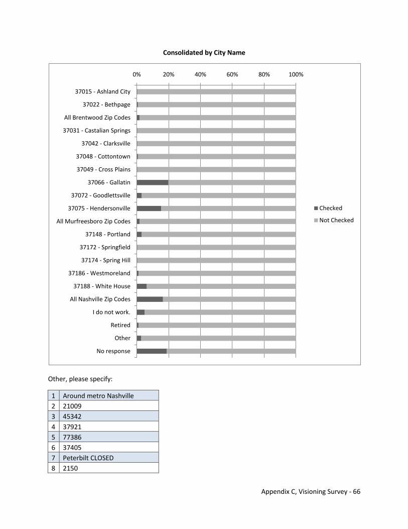
Appendix C, Visioning Survey - 66
Consolidated by City Name
Other, please specify:
1 Around metro Nashville 2 21009 3 45342 4 37921 5 77386 6 37405 7 Peterbilt CLOSED 8 2150
0% 20% 40% 60% 80% 100%
37015 - Ashland City
37022 - Bethpage
All Brentwood Zip Codes
37031 - Castalian Springs
37042 - Clarksville
37048 - Cottontown
37049 - Cross Plains
37066 - Gallatin
37072 - Goodlettsville
37075 - Hendersonville
All Murfreesboro Zip Codes
37148 - Portland
37172 - Springfield
37174 - Spring Hill
37186 - Westmoreland
37188 - White House
All Nashville Zip Codes
I do not work.
Retired
Other
No response
Checked
Not Checked
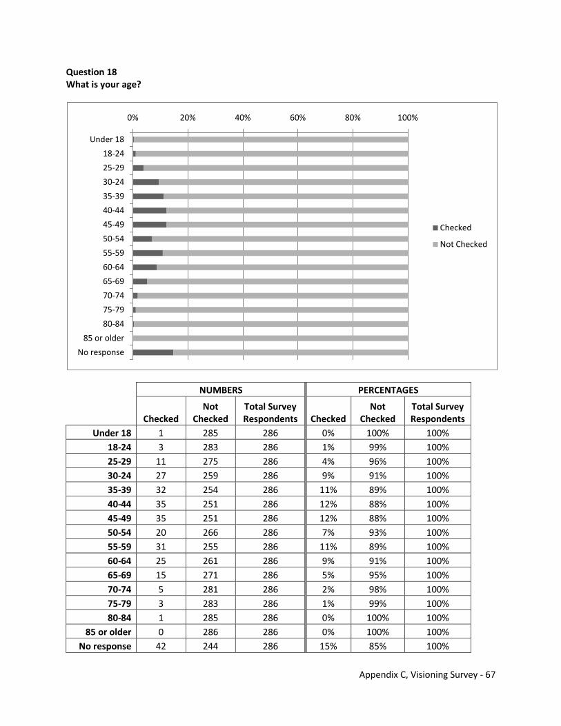
Appendix C, Visioning Survey - 67
Question 18 What is your age?
NUMBERS PERCENTAGES
Checked Not
Checked Total Survey Respondents Checked
Not Checked
Total Survey Respondents
Under 18 1 285 286 0% 100% 100% 18-24 3 283 286 1% 99% 100% 25-29 11 275 286 4% 96% 100% 30-24 27 259 286 9% 91% 100% 35-39 32 254 286 11% 89% 100% 40-44 35 251 286 12% 88% 100% 45-49 35 251 286 12% 88% 100% 50-54 20 266 286 7% 93% 100% 55-59 31 255 286 11% 89% 100% 60-64 25 261 286 9% 91% 100% 65-69 15 271 286 5% 95% 100% 70-74 5 281 286 2% 98% 100% 75-79 3 283 286 1% 99% 100% 80-84 1 285 286 0% 100% 100%
85 or older 0 286 286 0% 100% 100% No response 42 244 286 15% 85% 100%
0% 20% 40% 60% 80% 100%
Under 18
18-24
25-29
30-24
35-39
40-44
45-49
50-54
55-59
60-64
65-69
70-74
75-79
80-84
85 or older
No response
Checked
Not Checked
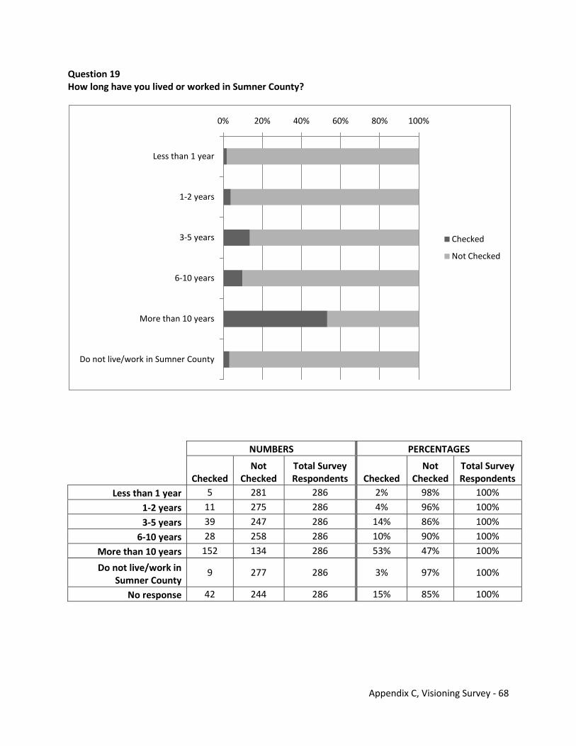
Appendix C, Visioning Survey - 68
Question 19 How long have you lived or worked in Sumner County?
NUMBERS PERCENTAGES
Checked Not
Checked Total Survey Respondents Checked
Not Checked
Total Survey Respondents
Less than 1 year 5 281 286 2% 98% 100%
1-2 years 11 275 286 4% 96% 100%
3-5 years 39 247 286 14% 86% 100%
6-10 years 28 258 286 10% 90% 100%
More than 10 years 152 134 286 53% 47% 100%
Do not live/work in Sumner County
9 277 286 3% 97% 100%
No response 42 244 286 15% 85% 100%
0% 20% 40% 60% 80% 100%
Less than 1 year
1-2 years
3-5 years
6-10 years
More than 10 years
Do not live/work in Sumner County
Checked
Not Checked
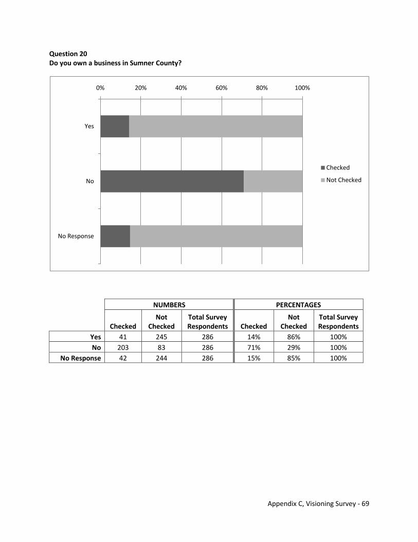
Appendix C, Visioning Survey - 69
Question 20 Do you own a business in Sumner County?
NUMBERS PERCENTAGES
Checked Not
Checked Total Survey Respondents Checked
Not Checked
Total Survey Respondents
Yes 41 245 286 14% 86% 100% No 203 83 286 71% 29% 100%
No Response 42 244 286 15% 85% 100%
0% 20% 40% 60% 80% 100%
Yes
No
No Response
Checked
Not Checked
Appendix C, Visioning Survey - 70
THIS PAGE INTENTIONALLY LEFT BLANK
Appendix D Results of On-line Transportation Survey

THIS PAGE INTENTIONALLY LEFT BLANK
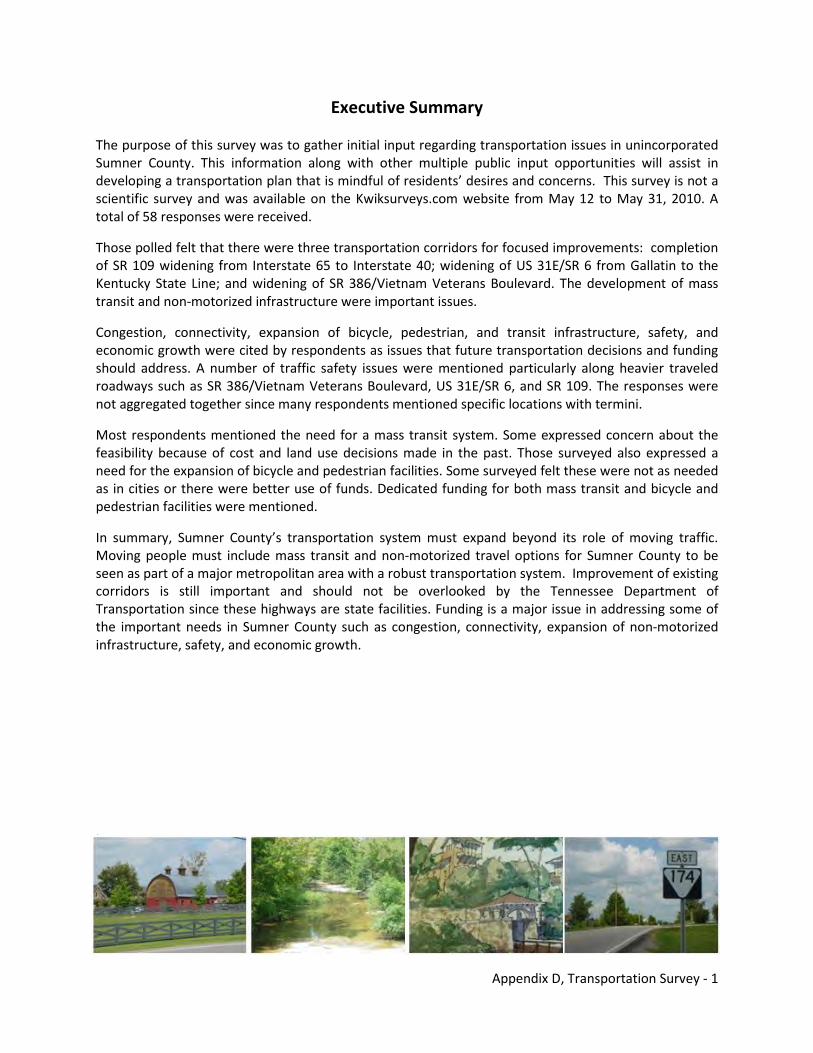
Appendix D, Transportation Survey - 1
Executive Summary
The purpose of this survey was to gather initial input regarding transportation issues in unincorporated Sumner County. This information along with other multiple public input opportunities will assist in developing a transportation plan that is mindful of residents’ desires and concerns. This survey is not a scientific survey and was available on the Kwiksurveys.com website from May 12 to May 31, 2010. A total of 58 responses were received.
Those polled felt that there were three transportation corridors for focused improvements: completion of SR 109 widening from Interstate 65 to Interstate 40; widening of US 31E/SR 6 from Gallatin to the Kentucky State Line; and widening of SR 386/Vietnam Veterans Boulevard. The development of mass transit and non-motorized infrastructure were important issues.
Congestion, connectivity, expansion of bicycle, pedestrian, and transit infrastructure, safety, and economic growth were cited by respondents as issues that future transportation decisions and funding should address. A number of traffic safety issues were mentioned particularly along heavier traveled roadways such as SR 386/Vietnam Veterans Boulevard, US 31E/SR 6, and SR 109. The responses were not aggregated together since many respondents mentioned specific locations with termini.
Most respondents mentioned the need for a mass transit system. Some expressed concern about the feasibility because of cost and land use decisions made in the past. Those surveyed also expressed a need for the expansion of bicycle and pedestrian facilities. Some surveyed felt these were not as needed as in cities or there were better use of funds. Dedicated funding for both mass transit and bicycle and pedestrian facilities were mentioned.
In summary, Sumner County’s transportation system must expand beyond its role of moving traffic. Moving people must include mass transit and non-motorized travel options for Sumner County to be seen as part of a major metropolitan area with a robust transportation system. Improvement of existing corridors is still important and should not be overlooked by the Tennessee Department of Transportation since these highways are state facilities. Funding is a major issue in addressing some of the important needs in Sumner County such as congestion, connectivity, expansion of non-motorized infrastructure, safety, and economic growth.
.
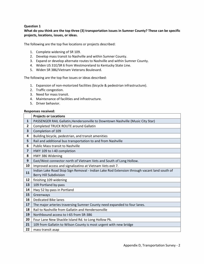
Appendix D, Transportation Survey - 2
Question 1 What do you think are the top three (3) transportation issues in Sumner County? These can be specific projects, locations, issues, or ideas. The following are the top five locations or projects described:
1. Complete widening of SR 109. 2. Develop mass transit to Nashville and within Sumner County. 3. Expand or develop alternate routes to Nashville and within Sumner County. 4. Widen US 31E/SR 6 from Westmoreland to Kentucky State Line. 5. Widen SR 386/Vietnam Veterans Boulevard.
The following are the top five issues or ideas described:
1. Expansion of non-motorized facilities (bicycle & pedestrian infrastructure). 2. Traffic congestion. 3. Need for mass transit. 4. Maintenance of facilities and infrastructure. 5. Driver behavior.
Responses received: Projects or Locations 1 PASSENGER RAIL Gallatin,Hendersonville to Downtown Nashville (Music City Star) 2 Completed TRUCK ROUTE around Gallatin 3 Completion of 109 4 Building bicycle, pedestrian, and transit amenities 5 Rail and additional bus transportation to and from Nashville 6 Public Mass transit to Nashville 7 HWY 109 to I-40 completion 8 HWY 386 Widening 9 East/West connector north of Vietnam Vets and South of Long Hollow.
10 Improved access and signalizatino at Vietnam Vets exit 7.
11 Indian Lake Road Stop Sign Removal - Indian Lake Rod Extension through vacant land south of Berry Hill Subdivision
12 finishing 109 widening 13 109 Portland by-pass 14 Hwy 52 by-pass in Portland 15 Greenways 16 Dedicated Bike lanes 17 The major arteries traversing Sumner County need expanded to four lanes. 18 Rail to Nashville from Gallatin and Hendersonville 19 Northbound access to I-65 from SR-386 20 Four Lane New Shackle Island Rd. to Long Hollow Pk. 21 109 from Gallatin to Wilson County is most urgent with new bridge 22 mass transit asap
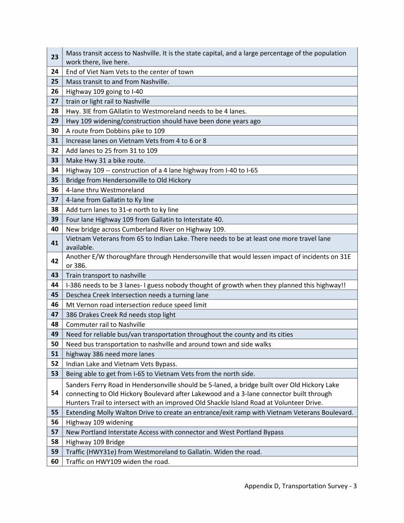
Appendix D, Transportation Survey - 3
23 Mass transit access to Nashville. It is the state capital, and a large percentage of the population work there, live here.
24 End of Viet Nam Vets to the center of town 25 Mass transit to and from Nashville. 26 Highway 109 going to I-40 27 train or light rail to Nashville 28 Hwy. 3lE from GAllatin to Westmoreland needs to be 4 lanes. 29 Hwy 109 widening/construction should have been done years ago 30 A route from Dobbins pike to 109 31 Increase lanes on Vietnam Vets from 4 to 6 or 8 32 Add lanes to 25 from 31 to 109 33 Make Hwy 31 a bike route. 34 Highway 109 -- construction of a 4 lane highway from I-40 to I-65 35 Bridge from Hendersonville to Old Hickory 36 4-lane thru Westmoreland 37 4-lane from Gallatin to Ky line 38 Add turn lanes to 31-e north to ky line 39 Four lane Highway 109 from Gallatin to Interstate 40. 40 New bridge across Cumberland River on Highway 109.
41 Vietnam Veterans from 65 to Indian Lake. There needs to be at least one more travel lane available.
42 Another E/W thoroughfare through Hendersonville that would lessen impact of incidents on 31E or 386.
43 Train transport to nashville 44 I-386 needs to be 3 lanes- I guess nobody thought of growth when they planned this highway!! 45 Deschea Creek Intersection needs a turning lane 46 Mt Vernon road intersection reduce speed limit 47 386 Drakes Creek Rd needs stop light 48 Commuter rail to Nashville 49 Need for reliable bus/van transportation throughout the county and its cities 50 Need bus transportation to nashville and around town and side walks 51 highway 386 need more lanes 52 Indian Lake and Vietnam Vets Bypass. 53 Being able to get from I-65 to Vietnam Vets from the north side.
54 Sanders Ferry Road in Hendersonville should be 5-laned, a bridge built over Old Hickory Lake connecting to Old Hickory Boulevard after Lakewood and a 3-lane connector built through Hunters Trail to intersect with an improved Old Shackle Island Road at Volunteer Drive.
55 Extending Molly Walton Drive to create an entrance/exit ramp with Vietnam Veterans Boulevard. 56 Highway 109 widening 57 New Portland Interstate Access with connector and West Portland Bypass 58 Highway 109 Bridge 59 Traffic (HWY31e) from Westmoreland to Gallatin. Widen the road. 60 Traffic on HWY109 widen the road.
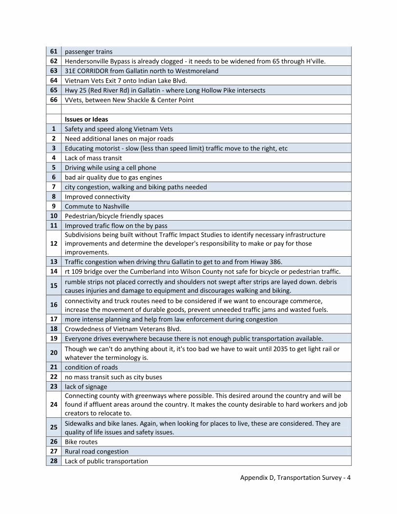
Appendix D, Transportation Survey - 4
61 passenger trains 62 Hendersonville Bypass is already clogged - it needs to be widened from 65 through H'ville. 63 31E CORRIDOR from Gallatin north to Westmoreland 64 Vietnam Vets Exit 7 onto Indian Lake Blvd. 65 Hwy 25 (Red River Rd) in Gallatin - where Long Hollow Pike intersects 66 VVets, between New Shackle & Center Point Issues or Ideas 1 Safety and speed along Vietnam Vets 2 Need additional lanes on major roads 3 Educating motorist - slow (less than speed limit) traffic move to the right, etc 4 Lack of mass transit 5 Driving while using a cell phone 6 bad air quality due to gas engines 7 city congestion, walking and biking paths needed 8 Improved connectivity 9 Commute to Nashville
10 Pedestrian/bicycle friendly spaces 11 Improved trafic flow on the by pass
12 Subdivisions being built without Traffic Impact Studies to identify necessary infrastructure improvements and determine the developer's responsibility to make or pay for those improvements.
13 Traffic congestion when driving thru Gallatin to get to and from Hiway 386. 14 rt 109 bridge over the Cumberland into Wilson County not safe for bicycle or pedestrian traffic.
15 rumble strips not placed correctly and shoulders not swept after strips are layed down. debris causes injuries and damage to equipment and discourages walking and biking.
16 connectivity and truck routes need to be considered if we want to encourage commerce, increase the movement of durable goods, prevent unneeded traffic jams and wasted fuels.
17 more intense planning and help from law enforcement during congestion 18 Crowdedness of Vietnam Veterans Blvd. 19 Everyone drives everywhere because there is not enough public transportation available.
20 Though we can't do anything about it, it's too bad we have to wait until 2035 to get light rail or whatever the terminology is.
21 condition of roads 22 no mass transit such as city buses 23 lack of signage
24 Connecting county with greenways where possible. This desired around the country and will be found if affluent areas around the country. It makes the county desirable to hard workers and job creators to relocate to.
25 Sidewalks and bike lanes. Again, when looking for places to live, these are considered. They are quality of life issues and safety issues.
26 Bike routes 27 Rural road congestion 28 Lack of public transportation
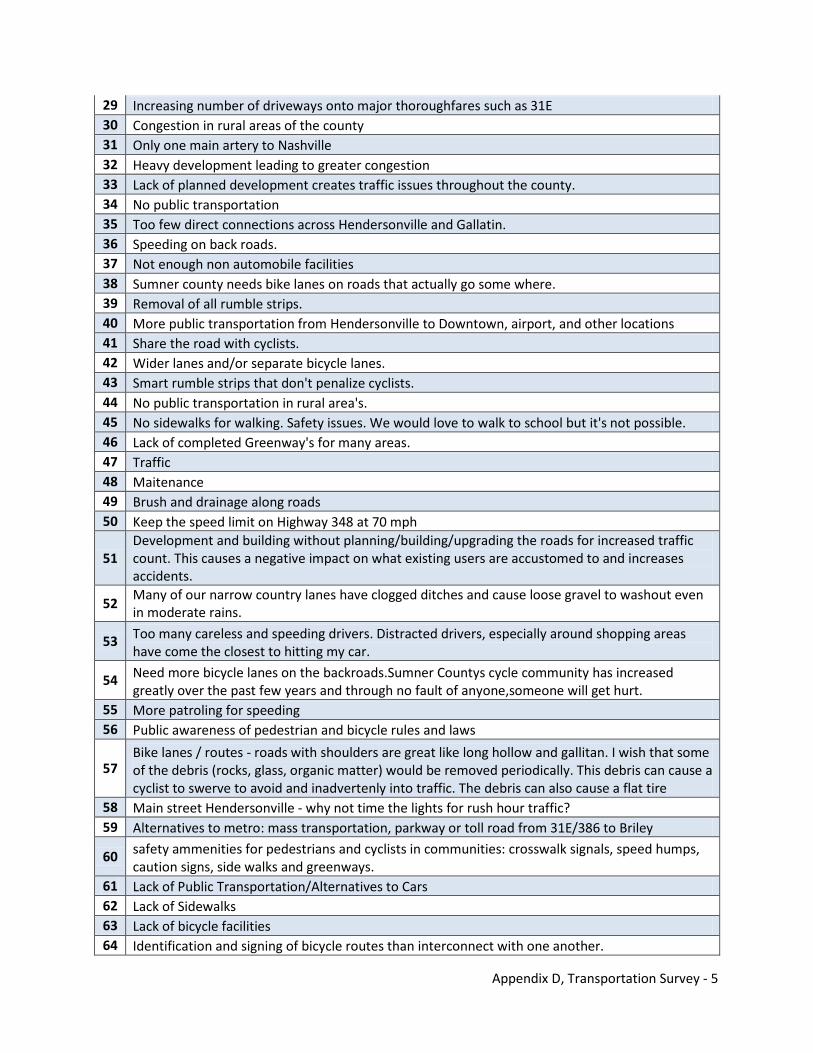
Appendix D, Transportation Survey - 5
29 Increasing number of driveways onto major thoroughfares such as 31E 30 Congestion in rural areas of the county 31 Only one main artery to Nashville 32 Heavy development leading to greater congestion 33 Lack of planned development creates traffic issues throughout the county. 34 No public transportation 35 Too few direct connections across Hendersonville and Gallatin. 36 Speeding on back roads. 37 Not enough non automobile facilities 38 Sumner county needs bike lanes on roads that actually go some where. 39 Removal of all rumble strips. 40 More public transportation from Hendersonville to Downtown, airport, and other locations 41 Share the road with cyclists. 42 Wider lanes and/or separate bicycle lanes. 43 Smart rumble strips that don't penalize cyclists. 44 No public transportation in rural area's. 45 No sidewalks for walking. Safety issues. We would love to walk to school but it's not possible. 46 Lack of completed Greenway's for many areas. 47 Traffic 48 Maitenance 49 Brush and drainage along roads 50 Keep the speed limit on Highway 348 at 70 mph
51 Development and building without planning/building/upgrading the roads for increased traffic count. This causes a negative impact on what existing users are accustomed to and increases accidents.
52 Many of our narrow country lanes have clogged ditches and cause loose gravel to washout even in moderate rains.
53 Too many careless and speeding drivers. Distracted drivers, especially around shopping areas have come the closest to hitting my car.
54 Need more bicycle lanes on the backroads.Sumner Countys cycle community has increased greatly over the past few years and through no fault of anyone,someone will get hurt.
55 More patroling for speeding 56 Public awareness of pedestrian and bicycle rules and laws
57 Bike lanes / routes - roads with shoulders are great like long hollow and gallitan. I wish that some of the debris (rocks, glass, organic matter) would be removed periodically. This debris can cause a cyclist to swerve to avoid and inadvertenly into traffic. The debris can also cause a flat tire
58 Main street Hendersonville - why not time the lights for rush hour traffic? 59 Alternatives to metro: mass transportation, parkway or toll road from 31E/386 to Briley
60 safety ammenities for pedestrians and cyclists in communities: crosswalk signals, speed humps, caution signs, side walks and greenways.
61 Lack of Public Transportation/Alternatives to Cars 62 Lack of Sidewalks 63 Lack of bicycle facilities 64 Identification and signing of bicycle routes than interconnect with one another.
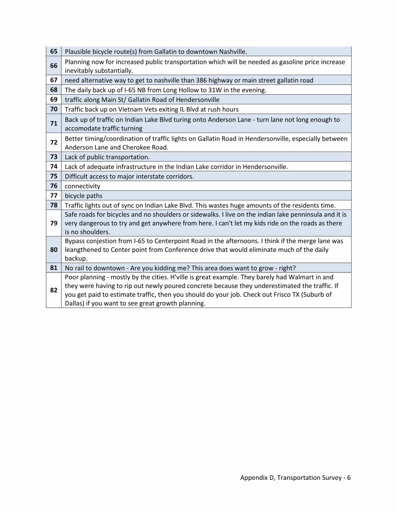
Appendix D, Transportation Survey - 6
65 Plausible bicycle route(s) from Gallatin to downtown Nashville.
66 Planning now for increased public transportation which will be needed as gasoline price increase inevitably substantially.
67 need alternative way to get to nashville than 386 highway or main street gallatin road 68 The daily back up of I-65 NB from Long Hollow to 31W in the evening. 69 traffic along Main St/ Gallatin Road of Hendersonville 70 Traffic back up on Vietnam Vets exiting IL Blvd at rush hours
71 Back up of traffic on Indian Lake Blvd turing onto Anderson Lane - turn lane not long enough to accomodate traffic turning
72 Better timing/coordination of traffic lights on Gallatin Road in Hendersonville, especially between Anderson Lane and Cherokee Road.
73 Lack of public transportation. 74 Lack of adequate infrastructure in the Indian Lake corridor in Hendersonville. 75 Difficult access to major interstate corridors. 76 connectivity 77 bicycle paths 78 Traffic lights out of sync on Indian Lake Blvd. This wastes huge amounts of the residents time.
79 Safe roads for bicycles and no shoulders or sidewalks. I live on the indian lake penninsula and it is very dangerous to try and get anywhere from here. I can't let my kids ride on the roads as there is no shoulders.
80 Bypass conjestion from I-65 to Centerpoint Road in the afternoons. I think if the merge lane was leangthened to Center point from Conference drive that would eliminate much of the daily backup.
81 No rail to downtown - Are you kidding me? This area does want to grow - right?
82
Poor planning - mostly by the cities. H'ville is great example. They barely had Walmart in and they were having to rip out newly poured concrete because they underestimated the traffic. If you get paid to estimate traffic, then you should do your job. Check out Frisco TX (Suburb of Dallas) if you want to see great growth planning.
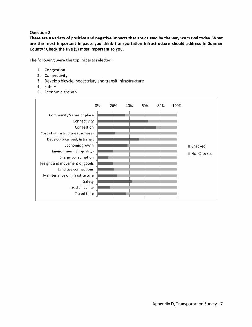
Appendix D, Transportation Survey - 7
Question 2 There are a variety of positive and negative impacts that are caused by the way we travel today. What are the most important impacts you think transportation infrastructure should address in Sumner County? Check the five (5) most important to you. The following were the top impacts selected:
1. Congestion 2. Connectivity 3. Develop bicycle, pedestrian, and transit infrastructure 4. Safety 5. Economic growth
0% 20% 40% 60% 80% 100%
Community/sense of place
Connectivity
Congestion
Cost of infrastructure (tax base)
Develop bike, ped, & transit
Economic growth
Environment (air quality)
Energy consumption
Freight and movement of goods
Land use connections
Maintenance of infrastructure
Safety
Sustainability
Travel time
Checked
Not Checked
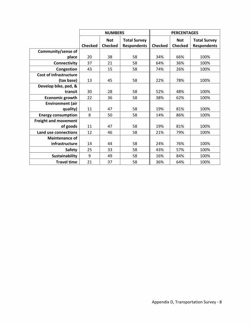
Appendix D, Transportation Survey - 8
NUMBERS PERCENTAGES
Checked
Not Checked
Total Survey Respondents Checked
Not Checked
Total Survey Respondents
Community/sense of place 20 38 58 34% 66% 100%
Connectivity 37 21 58 64% 36% 100% Congestion 43 15 58 74% 26% 100%
Cost of infrastructure (tax base) 13 45 58 22% 78% 100%
Develop bike, ped, & transit 30 28 58 52% 48% 100%
Economic growth 22 36 58 38% 62% 100% Environment (air
quality) 11 47 58 19% 81% 100% Energy consumption 8 50 58 14% 86% 100%
Freight and movement of goods 11 47 58 19% 81% 100%
Land use connections 12 46 58 21% 79% 100% Maintenance of
infrastructure 14 44 58 24% 76% 100% Safety 25 33 58 43% 57% 100%
Sustainability 9 49 58 16% 84% 100% Travel time 21 37 58 36% 64% 100%
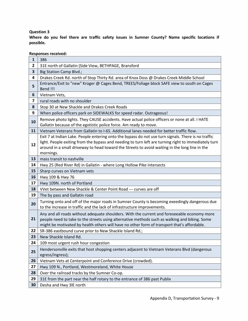
Appendix D, Transportation Survey - 9
Question 3 Where do you feel there are traffic safety issues in Sumner County? Name specific locations if possible. Responses received:
1 386 2 31E north of Gallatin (Side View, BETHPAGE, Bransford 3 Big Station Camp Blvd.; 4 Drakes Creek Rd. north of Stop Thirty Rd. area of Knox Doss @ Drakes Creek Middle School
5 Entrance/Exit to "new" Kroger @ Cages Bend, TREES/Foliage block SAFE view to south on Cages Bend !!!
6 Vietnam Vets, 7 rural roads with no shoulder 8 Stop 30 at New Shackle and Drakes Creek Roads 9 When police officers park on SIDEWALKS for speed radar. Outrageous!
10 Remove photo lights. They CAUSE accidents. Have actual police officers or none at all. I HATE Gallatin because of the egotistic police force. Am ready to move.
11 Vietnam Veterans from Gallatin to I-65. Additional lanes needed for better traffic flow.
12
Exit 7 at Indian Lake. People entering onto the bypass do not use turn signals. There is no traffic light. People exiting from the bypass and needing to turn left are turning right to immediately turn around in a small driveway to head toward the Streets to avoid waiting in the long line in the mornings.
13 mass transit to nashville 14 Hwy 25 (Red River Rd) in Gallatin - where Long Hollow Pike intersects 15 Sharp curves on Vietnam vets 16 Hwy 109 & Hwy 76 17 Hwy 109N. north of Portland 18 VVet between New Shackle & Center Point Road --- curves are off 19 The by pass and Gallatin road
20 Turning onto and off of the major roads in Sumner County is becoming exeedingly dangerous due to the increase in traffic and the lack of infrastructure improvements.
21 Any and all roads without adequate shoulders. With the current and foreseeable economy more people need to take to the streets using alternative methods such as walking and biking. Some might be motivated by health others will have no other form of transport that's affordable.
22 SR-386 eastbound curve prior to New Shackle Island Rd.; 23 New Shackle Island Rd. 24 109 most urgent rush hour congestion
25 Hendersonville exits that host shopping centers adjacent to Vietnam Veterans Blvd (dangerous egress/ingress);
26 Vietnam Vets at Centerpoint and Conference Drive (crowded). 27 Hwy 109 N., Portland, Westmoreland, White House 28 Over the railroad tracks by the Sumner Co-op. 29 31E from the part near the half rotary to the entrance of 386 past Publix 30 Desha and Hwy 3lE north
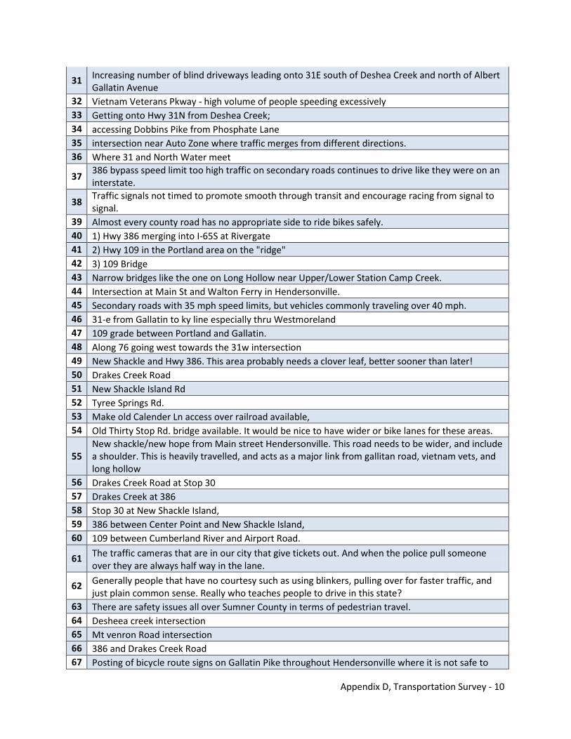
Appendix D, Transportation Survey - 10
31 Increasing number of blind driveways leading onto 31E south of Deshea Creek and north of Albert Gallatin Avenue
32 Vietnam Veterans Pkway - high volume of people speeding excessively 33 Getting onto Hwy 31N from Deshea Creek; 34 accessing Dobbins Pike from Phosphate Lane 35 intersection near Auto Zone where traffic merges from different directions. 36 Where 31 and North Water meet
37 386 bypass speed limit too high traffic on secondary roads continues to drive like they were on an interstate.
38 Traffic signals not timed to promote smooth through transit and encourage racing from signal to signal.
39 Almost every county road has no appropriate side to ride bikes safely. 40 1) Hwy 386 merging into I-65S at Rivergate 41 2) Hwy 109 in the Portland area on the "ridge" 42 3) 109 Bridge 43 Narrow bridges like the one on Long Hollow near Upper/Lower Station Camp Creek. 44 Intersection at Main St and Walton Ferry in Hendersonville. 45 Secondary roads with 35 mph speed limits, but vehicles commonly traveling over 40 mph. 46 31-e from Gallatin to ky line especially thru Westmoreland 47 109 grade between Portland and Gallatin. 48 Along 76 going west towards the 31w intersection 49 New Shackle and Hwy 386. This area probably needs a clover leaf, better sooner than later! 50 Drakes Creek Road 51 New Shackle Island Rd 52 Tyree Springs Rd. 53 Make old Calender Ln access over railroad available, 54 Old Thirty Stop Rd. bridge available. It would be nice to have wider or bike lanes for these areas.
55 New shackle/new hope from Main street Hendersonville. This road needs to be wider, and include a shoulder. This is heavily travelled, and acts as a major link from gallitan road, vietnam vets, and long hollow
56 Drakes Creek Road at Stop 30 57 Drakes Creek at 386 58 Stop 30 at New Shackle Island, 59 386 between Center Point and New Shackle Island, 60 109 between Cumberland River and Airport Road.
61 The traffic cameras that are in our city that give tickets out. And when the police pull someone over they are always half way in the lane.
62 Generally people that have no courtesy such as using blinkers, pulling over for faster traffic, and just plain common sense. Really who teaches people to drive in this state?
63 There are safety issues all over Sumner County in terms of pedestrian travel. 64 Desheea creek intersection 65 Mt venron Road intersection 66 386 and Drakes Creek Road 67 Posting of bicycle route signs on Gallatin Pike throughout Hendersonville where it is not safe to
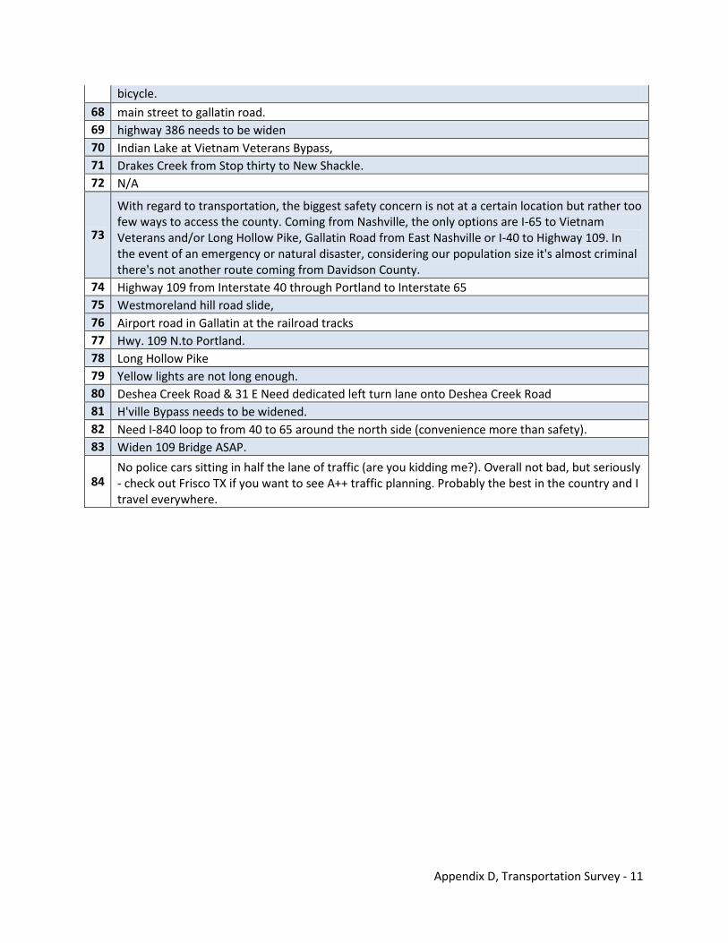
Appendix D, Transportation Survey - 11
bicycle. 68 main street to gallatin road. 69 highway 386 needs to be widen 70 Indian Lake at Vietnam Veterans Bypass, 71 Drakes Creek from Stop thirty to New Shackle. 72 N/A
73
With regard to transportation, the biggest safety concern is not at a certain location but rather too few ways to access the county. Coming from Nashville, the only options are I-65 to Vietnam Veterans and/or Long Hollow Pike, Gallatin Road from East Nashville or I-40 to Highway 109. In the event of an emergency or natural disaster, considering our population size it's almost criminal there's not another route coming from Davidson County.
74 Highway 109 from Interstate 40 through Portland to Interstate 65 75 Westmoreland hill road slide, 76 Airport road in Gallatin at the railroad tracks 77 Hwy. 109 N.to Portland. 78 Long Hollow Pike 79 Yellow lights are not long enough. 80 Deshea Creek Road & 31 E Need dedicated left turn lane onto Deshea Creek Road 81 H'ville Bypass needs to be widened. 82 Need I-840 loop to from 40 to 65 around the north side (convenience more than safety). 83 Widen 109 Bridge ASAP.
84 No police cars sitting in half the lane of traffic (are you kidding me?). Overall not bad, but seriously - check out Frisco TX if you want to see A++ traffic planning. Probably the best in the country and I travel everywhere.
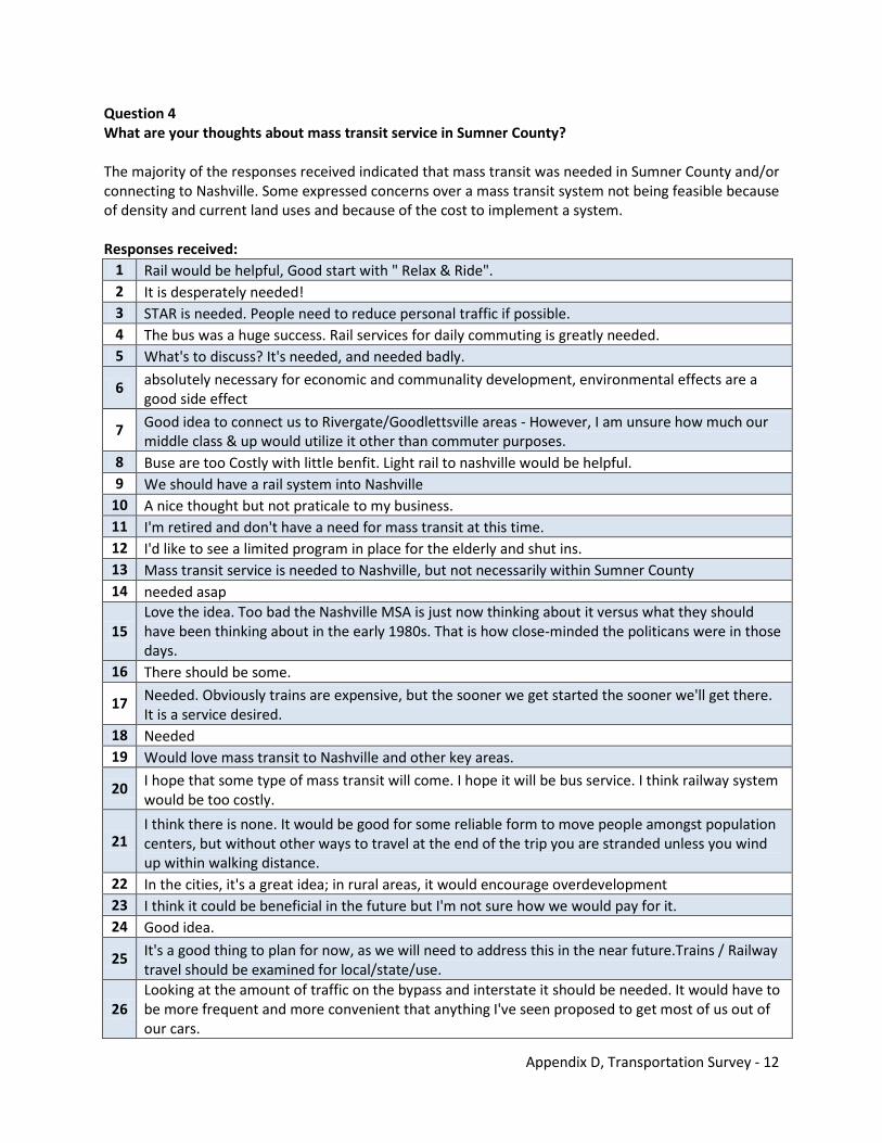
Appendix D, Transportation Survey - 12
Question 4 What are your thoughts about mass transit service in Sumner County? The majority of the responses received indicated that mass transit was needed in Sumner County and/or connecting to Nashville. Some expressed concerns over a mass transit system not being feasible because of density and current land uses and because of the cost to implement a system. Responses received:
1 Rail would be helpful, Good start with " Relax & Ride". 2 It is desperately needed! 3 STAR is needed. People need to reduce personal traffic if possible. 4 The bus was a huge success. Rail services for daily commuting is greatly needed. 5 What's to discuss? It's needed, and needed badly.
6 absolutely necessary for economic and communality development, environmental effects are a good side effect
7 Good idea to connect us to Rivergate/Goodlettsville areas - However, I am unsure how much our middle class & up would utilize it other than commuter purposes.
8 Buse are too Costly with little benfit. Light rail to nashville would be helpful. 9 We should have a rail system into Nashville
10 A nice thought but not praticale to my business. 11 I'm retired and don't have a need for mass transit at this time. 12 I'd like to see a limited program in place for the elderly and shut ins. 13 Mass transit service is needed to Nashville, but not necessarily within Sumner County 14 needed asap
15 Love the idea. Too bad the Nashville MSA is just now thinking about it versus what they should have been thinking about in the early 1980s. That is how close-minded the politicans were in those days.
16 There should be some.
17 Needed. Obviously trains are expensive, but the sooner we get started the sooner we'll get there. It is a service desired.
18 Needed 19 Would love mass transit to Nashville and other key areas.
20 I hope that some type of mass transit will come. I hope it will be bus service. I think railway system would be too costly.
21 I think there is none. It would be good for some reliable form to move people amongst population centers, but without other ways to travel at the end of the trip you are stranded unless you wind up within walking distance.
22 In the cities, it's a great idea; in rural areas, it would encourage overdevelopment 23 I think it could be beneficial in the future but I'm not sure how we would pay for it. 24 Good idea.
25 It's a good thing to plan for now, as we will need to address this in the near future.Trains / Railway travel should be examined for local/state/use.
26 Looking at the amount of traffic on the bypass and interstate it should be needed. It would have to be more frequent and more convenient that anything I've seen proposed to get most of us out of our cars.
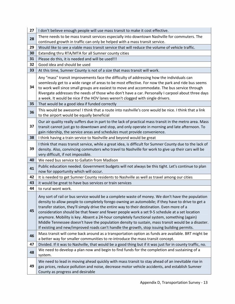
Appendix D, Transportation Survey - 13
27 I don't believe enough people will use mass transit to make it cost effective.
28 There needs to be mass transit services especially into downtown Nashville for commuters. The continued growth in traffic can only be helped with a mass transit service.
29 Would like to see a viable mass transit service that will reduce the volume of vehicle traffic. 30 Extending thru RTA/MTA for all Sumner county cities 31 Please do this, it is needed and will be used!!! 32 Good idea and should be used 33 At this time, Sumner County is not of a size that mass transit will work.
34
Any "mass" transit improvements face the difficulty of addressing how the individuals can seemlessly get to a wide range of areas to be most effective. For now the park and ride bus seems to work well since small groups are easiest to move and accommodate. The bus service through Rivergate addresses the needs of those who don't have a car. Personally I carpool about three days a week. It would be nice if the HOV lanes weren't clogged with single drivers.
35 That would be a good idea if funded correctly
36 This would be awesome! I think that a route into nashville's core would be nice. I think that a link to the airport would be equally beneficial
37 Our air quality really suffers due in part to the lack of practical mass transit in the metro area. Mass transit cannot just go to downtown and stop, and only operate in morning and late afternoon. To gain ridership, the service areas and schedules must provide convenience.
38 I think having a train service to Nashville and beyond would be great
39 I think that mass transit service, while a great idea, is difficult for Sumner County due to the lack of density. Also, convincing commuters who travel to Nashville for work to give up their cars will be very difficult, if not impossible.
40 We need bus service to Gallatin from Madison
41 Public education needed. Government budgets will not always be this tight. Let's continue to plan now for opportunity which will occur.
42 It is needed to get Sumner County residents to Nashville as well as travel among our cities 43 it would be great to have bus services or train services 44 to rural wont work.
45
Any sort of rail or bus service would be a complete waste of money. We don't have the population density to allow people to completely forego owning an automobile; if they have to drive to get a transfer station, they'll simply drive the entire way to their destination. Even more of a consideration should be that fewer and fewer people work a set 9-5 schedule at a set location anymore. Mobility is key. Absent a 24-hour completely functional system, something (again) Middle Tennessee doesn't have the population density to sustain, mass transit would be a disaster. If existing and new/improved roads can't handle the growth, stop issuing building permits.
46 Mass transit will come back around as a transportation option as funds are available. BRT might be a better way for smaller communities to re-introduce the mass transit concept.
47 Divided. If it was to Nashville, that would be a good thing but if it was just for in county traffic, no.
48 We need to develop a plan now and begin to find funds for the completion and sustaining of a system.
49 We need to lead in moving ahead quickly with mass transit to stay ahead of an inevitable rise in gas prices, reduce pollution and noise, decrease motor vehicle accidents, and establish Sumner County as progress and desirable
Appendix D, Transportation Survey - 14
50 like to think it would work but It is not practical for me. I would rather see a bridge across the dam. 51 like to think it would work but It is not practical for me. I would rather see a bridge across the dam. 52 Should have been here 10-years ago. The longer you wait, the harder it gets.
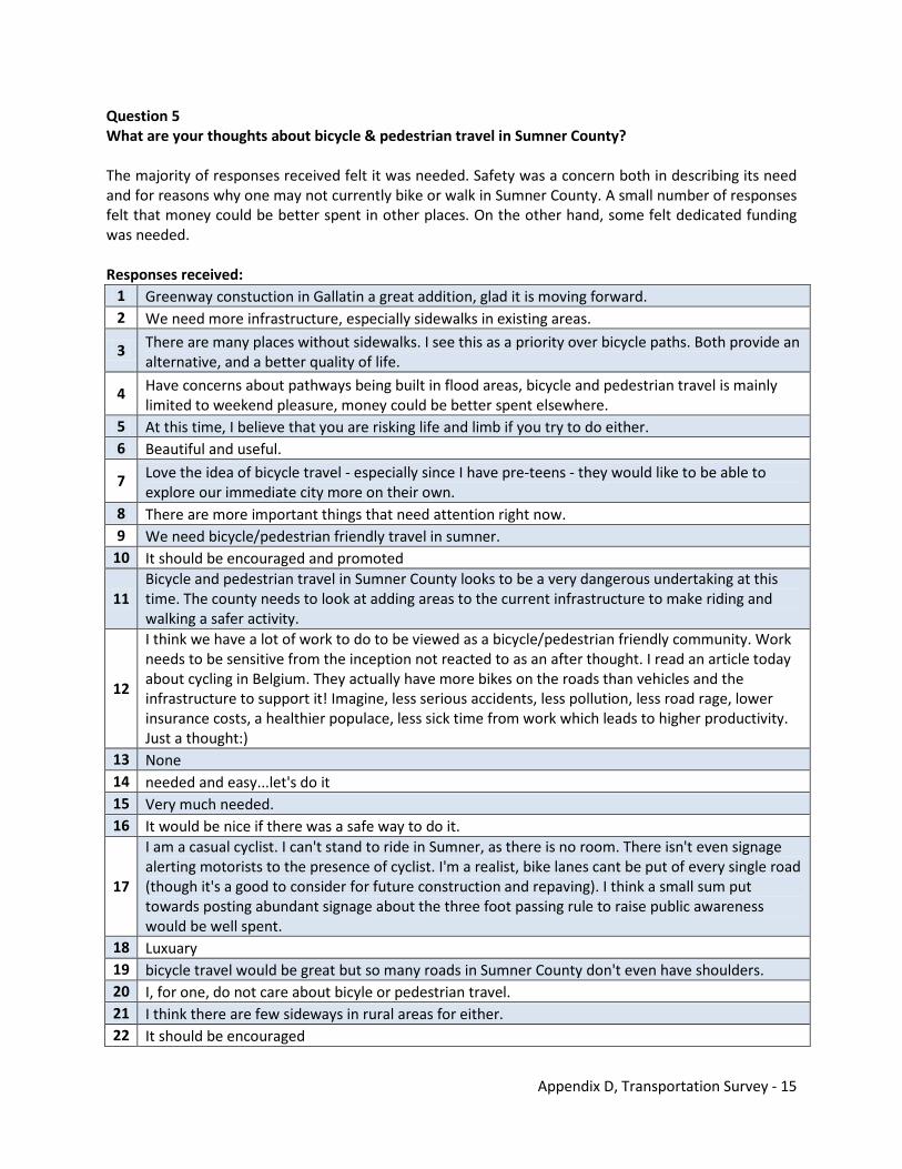
Appendix D, Transportation Survey - 15
Question 5 What are your thoughts about bicycle & pedestrian travel in Sumner County? The majority of responses received felt it was needed. Safety was a concern both in describing its need and for reasons why one may not currently bike or walk in Sumner County. A small number of responses felt that money could be better spent in other places. On the other hand, some felt dedicated funding was needed. Responses received:
1 Greenway constuction in Gallatin a great addition, glad it is moving forward. 2 We need more infrastructure, especially sidewalks in existing areas.
3 There are many places without sidewalks. I see this as a priority over bicycle paths. Both provide an alternative, and a better quality of life.
4 Have concerns about pathways being built in flood areas, bicycle and pedestrian travel is mainly limited to weekend pleasure, money could be better spent elsewhere.
5 At this time, I believe that you are risking life and limb if you try to do either. 6 Beautiful and useful.
7 Love the idea of bicycle travel - especially since I have pre-teens - they would like to be able to explore our immediate city more on their own.
8 There are more important things that need attention right now. 9 We need bicycle/pedestrian friendly travel in sumner.
10 It should be encouraged and promoted
11 Bicycle and pedestrian travel in Sumner County looks to be a very dangerous undertaking at this time. The county needs to look at adding areas to the current infrastructure to make riding and walking a safer activity.
12
I think we have a lot of work to do to be viewed as a bicycle/pedestrian friendly community. Work needs to be sensitive from the inception not reacted to as an after thought. I read an article today about cycling in Belgium. They actually have more bikes on the roads than vehicles and the infrastructure to support it! Imagine, less serious accidents, less pollution, less road rage, lower insurance costs, a healthier populace, less sick time from work which leads to higher productivity. Just a thought:)
13 None 14 needed and easy...let's do it 15 Very much needed. 16 It would be nice if there was a safe way to do it.
17
I am a casual cyclist. I can't stand to ride in Sumner, as there is no room. There isn't even signage alerting motorists to the presence of cyclist. I'm a realist, bike lanes cant be put of every single road (though it's a good to consider for future construction and repaving). I think a small sum put towards posting abundant signage about the three foot passing rule to raise public awareness would be well spent.
18 Luxuary 19 bicycle travel would be great but so many roads in Sumner County don't even have shoulders. 20 I, for one, do not care about bicyle or pedestrian travel. 21 I think there are few sideways in rural areas for either. 22 It should be encouraged
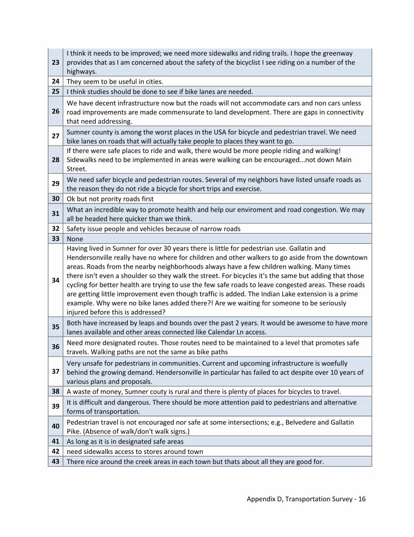
Appendix D, Transportation Survey - 16
23 I think it needs to be improved; we need more sidewalks and riding trails. I hope the greenway provides that as I am concerned about the safety of the bicyclist I see riding on a number of the highways.
24 They seem to be useful in cities. 25 I think studies should be done to see if bike lanes are needed.
26 We have decent infrastructure now but the roads will not accommodate cars and non cars unless road improvements are made commensurate to land development. There are gaps in connectivity that need addressing.
27 Sumner county is among the worst places in the USA for bicycle and pedestrian travel. We need bike lanes on roads that will actually take people to places they want to go.
28 If there were safe places to ride and walk, there would be more people riding and walking! Sidewalks need to be implemented in areas were walking can be encouraged...not down Main Street.
29 We need safer bicycle and pedestrian routes. Several of my neighbors have listed unsafe roads as the reason they do not ride a bicycle for short trips and exercise.
30 Ok but not prority roads first
31 What an incredible way to promote health and help our enviroment and road congestion. We may all be headed here quicker than we think.
32 Safety issue people and vehicles because of narrow roads 33 None
34
Having lived in Sumner for over 30 years there is little for pedestrian use. Gallatin and Hendersonville really have no where for children and other walkers to go aside from the downtown areas. Roads from the nearby neighborhoods always have a few children walking. Many times there isn't even a shoulder so they walk the street. For bicycles it's the same but adding that those cycling for better health are trying to use the few safe roads to leave congested areas. These roads are getting little improvement even though traffic is added. The Indian Lake extension is a prime example. Why were no bike lanes added there?! Are we waiting for someone to be seriously injured before this is addressed?
35 Both have increased by leaps and bounds over the past 2 years. It would be awesome to have more lanes available and other areas connected like Calendar Ln access.
36 Need more designated routes. Those routes need to be maintained to a level that promotes safe travels. Walking paths are not the same as bike paths
37 Very unsafe for pedestrians in communities. Current and upcoming infrastructure is woefully behind the growing demand. Hendersonville in particular has failed to act despite over 10 years of various plans and proposals.
38 A waste of money, Sumner couty is rural and there is plenty of places for bicycles to travel.
39 It is difficult and dangerous. There should be more attention paid to pedestrians and alternative forms of transportation.
40 Pedestrian travel is not encouraged nor safe at some intersections; e.g., Belvedere and Gallatin Pike. (Absence of walk/don't walk signs.)
41 As long as it is in designated safe areas 42 need sidewalks access to stores around town 43 There nice around the creek areas in each town but thats about all they are good for.
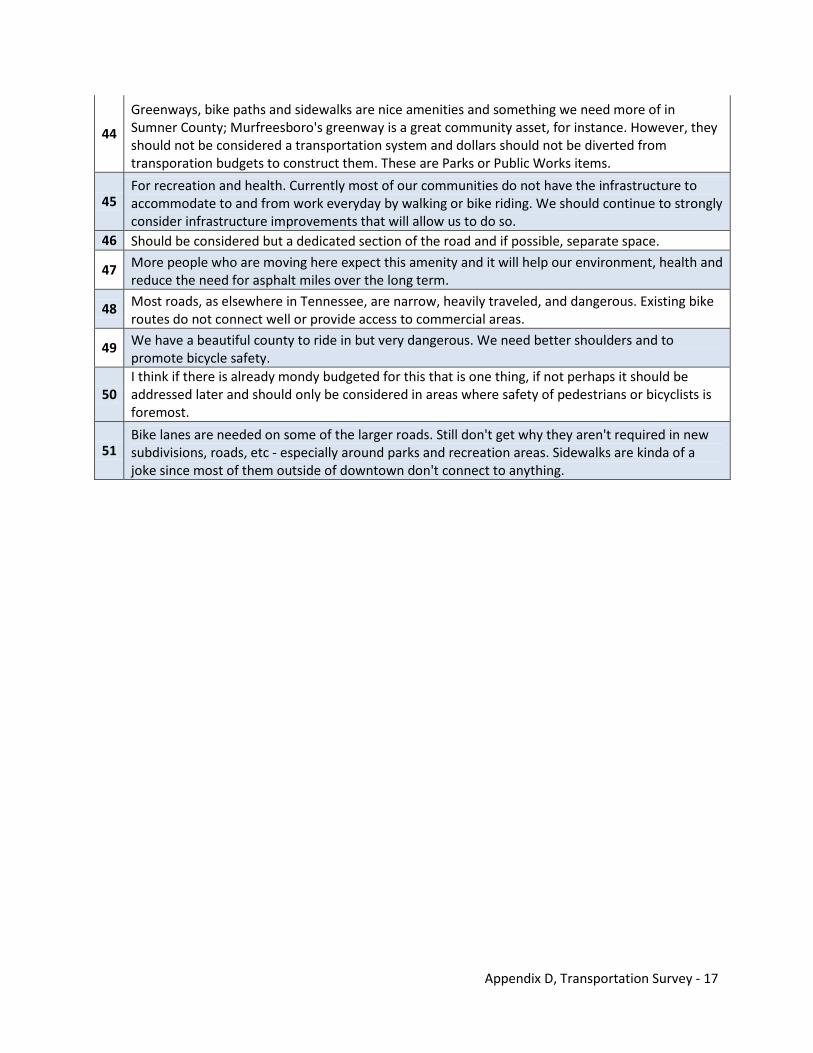
Appendix D, Transportation Survey - 17
44
Greenways, bike paths and sidewalks are nice amenities and something we need more of in Sumner County; Murfreesboro's greenway is a great community asset, for instance. However, they should not be considered a transportation system and dollars should not be diverted from transporation budgets to construct them. These are Parks or Public Works items.
45 For recreation and health. Currently most of our communities do not have the infrastructure to accommodate to and from work everyday by walking or bike riding. We should continue to strongly consider infrastructure improvements that will allow us to do so.
46 Should be considered but a dedicated section of the road and if possible, separate space.
47 More people who are moving here expect this amenity and it will help our environment, health and reduce the need for asphalt miles over the long term.
48 Most roads, as elsewhere in Tennessee, are narrow, heavily traveled, and dangerous. Existing bike routes do not connect well or provide access to commercial areas.
49 We have a beautiful county to ride in but very dangerous. We need better shoulders and to promote bicycle safety.
50 I think if there is already mondy budgeted for this that is one thing, if not perhaps it should be addressed later and should only be considered in areas where safety of pedestrians or bicyclists is foremost.
51 Bike lanes are needed on some of the larger roads. Still don't get why they aren't required in new subdivisions, roads, etc - especially around parks and recreation areas. Sidewalks are kinda of a joke since most of them outside of downtown don't connect to anything.
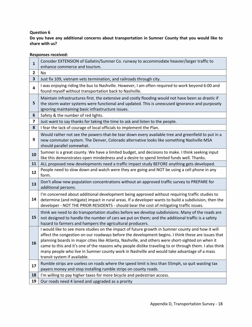
Appendix D, Transportation Survey - 18
Question 6 Do you have any additional concerns about transportation in Sumner County that you would like to share with us? Responses received:
1 Consider EXTENSION of Gallatin/Sumner Co. runway to accommodate heavier/larger traffic to enhance commerce and tourism.
2 No 3 Just fix 109, vietnam vets termination, and railroads through city.
4 I was enjoying riding the bus to Nashville. However, I am often required to work beyond 6:00 and found myself without transportation back to Nashville.
5 Maintain infrastructures first. the extensive and costly flooding would not have been as drastic if the storm water systems were functional and updated. This is unexcused ignorance and purposely ignoring maintaining basic infrastructure issues.
6 Safety & the number of red lights. 7 Just want to say thanks for taking the time to ask and listen to the people. 8 I fear the lack of courage of local officials to implement the Plan.
9 Would rather not see the powers-that-be tear down every available tree and greenfield to put in a new commuter system. The Denver, Colorado alternative looks like something Nashville MSA should parallel somewhat.
10 Sumner is a great county. We have a limited budget, and decisions to make. I think seeking input like this demonstrates open mindedness and a desire to spend limited funds well. Thanks.
11 ALL proposed new developments need a traffic impact study BEFORE anything gets developed.
12 People need to slow down and watch were they are going and NOT be using a cell phone in any form.
13 Don't allow new population concentrations without an approved traffic survey to PREPARE for additional persons.
14 I'm concerned about additional development being approved without requiring traffic studies to determine (and mitigate) impact in rural areas. If a developer wants to build a subdivision, then the developer - NOT THE PRIOR RESIDENTS - should bear the cost of mitigating traffic issues.
15 think we need to do transportation studies before we develop subdivisions. Many of the roads are not designed to handle the number of cars we put on them; and the additional traffic is a safety hazard to farmers and hampers the agricultural producers.
16
I would like to see more studies on the impact of future growth in Sumner county and how it will affect the congestion on our roadways before the development begins. I think these are issues that planning boards in major cities like Atlanta, Nashville, and others were short-sighted on when it came to this and it's one of the reasons why people dislike traveling to or through them. I also think many people who live in Sumner county work in Nashville and would take advantage of a mass transit system if available.
17 Rumble strips are useless on roads where the speed limit is less than 55mph, so quit wasting tax payers money and stop installing rumble strips on county roads.
18 I'm willing to pay higher taxes for more bicycle and pedestrian access. 19 Our roads need 4 laned and upgraded as a prority
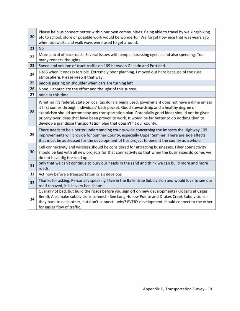
Appendix D, Transportation Survey - 19
20 Please help us connect better within our own communities. Being able to travel by walking/biking etc to school, store or possible work would be wonderful. We forget how nice that was years ago when sidewalks and walk ways were used to get around.
21 No
22 More patrol of backroads. Several issues with people harassing cyclists and also speeding. Too many redneck thoughts.
23 Speed and volume of truck traffic on 109 between Gallatin and Portland.
24 I-386 when it ends is terrible. Extremely poor planning. I moved out here because of the rural atmosphere. Please keep it that way.
25 people passing on shoulder when cars are turning left 26 None. I appreciate the effort and thought of this survey. 27 none at this time.
28
Whether it's federal, state or local tax dollars being used, government does not have a dime unless it first comes through individuals' back pocket. Good stewardship and a healthy degree of skepticism should accompany any transportation plan. Potentially good ideas should not be given priority over ideas that have been proven to work. It would be far better to do nothing than to develop a grandiose transportation plan that doesn't fit our county.
29 There needs to be a better understanding county-wide concerning the impacts the Highway 109 improvements will provide for Sumner County, especially Upper Sumner. There are side effects that must be addressed for the development of this project to benefit the county as a whole.
30 Cell connectivity and wireless should be considered for attracting businesses. Fiber connectivity should be laid with all new projects for that connectivity so that when the businesses do come, we do not have dig the road up.
31 only that we can't continue to bury our heads in the sand and think we can build more and more roads.
32 Act now before a transportation crisis develops
33 Thanks for asking. Personally speaking I live in the Ballentrae Subdivision and would love to see our road repaved, it is in very bad shape.
34
Overall not bad, but build the roads before you sign off on new developments (Kroger's at Cages Bend). Also make subdivisions connect - See Long Hollow Pointe and Drakes Creek Subdivisions - they back to each other, but don't connect - why? EVERY development should connect to the other for easier flow of traffic.
Appendix D, Transportation Survey - 20
THIS PAGE INTENTIONALLY LEFT BLANK

Appendix E Transportation Plan Projects
THIS PAGE INTENTIONALLY LEFT BLANK
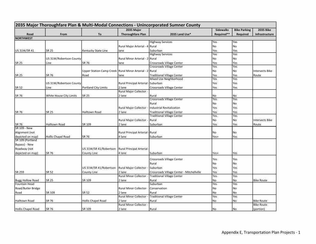
Road From To2035 Major
Thoroughfare Plan 2035 Land Use*Sidewalks Required**
Bike Parking Required
2035 Bike Infrastructure
US 31W/SR 41 SR 25 Kentucky State LineRural Major Arterial ‐ 4 lane
Highway ServicesRuralSuburban
YesNoYes
YesNoYes
SR 25US 31W/Robertson County Line SR 76
Rural Minor Arterial ‐ 2 lane
Highway ServicesRuralCrossroads Village Center
YesNoYes
YesNoYes
SR 25 SR 76Upper Station Camp Creek Road
Rural Minor Arterial ‐ 2 lane
Crossroads Village CenterRuralTraditional Village Center
YesNoYes
YesNoYes
Intersects Bike Route
SR 52US 31W/Robertson County Line Portland City Limits
Rural Principal Arterial ‐2 lane
Mixed Use NeighborhoodSuburbanCrossroads Village Center
YesYesYes
YesYesYes
SR 76 White House City Limits SR 25Rural Major Collector ‐ 2 lane Rural No No
SR 76 SR 25 Halltown RoadRural Major Collector ‐ 2 lane
Crossroads Village CenterRuralIndustrial RevitalizationTraditional Village Center
YesNoYesYes
YesNoYesYes
SR 76 Halltown Road SR 109Rural Major Collector ‐ 2 lane
Traditional Village CenterRuralSuburban
YesNoYes
YesNoYes
Intersects Bike Route
SR 109 ‐ New Alignment (not d i t d ) H lli Ch l R d SR 76
Rural Principal Arterial ‐4 l
RuralS b b
NoY +
NoY
NORTHWEST
2035 Major Thoroughfare Plan & Multi‐Modal Connections ‐ Unincorporated Sumner County
depicted on map) Hollis Chapel Road SR 76 4 lane Suburban Yes+ YesSR 109 (Portland Bypass) ‐ New Roadway (not depicted on map) SR 76
US 31W/SR 41/Robertson County Line
Rural Principal Arterial ‐4 lane Suburban Yes+ Yes
SR 259 SR 52US 31W/SR 41/Robertson County Line
Rural Major Collector ‐ 2 lane
Crossroads Village CenterRuralSuburbanCrossroads Village Center ‐ Mitchellville
YesNoYesYes
YesNoYesYes
Bugg Hollow Road SR 25 SR 109Rural Minor Collector ‐ 2 lane
Traditional Village CenterRural
YesNo
YesNo Bike Route
Fountain Head Road/Butler Bridge Road SR 109 SR 52
Rural Minor Collector‐ 2 lane
SuburbanConservationRural
YesNoNo
YesNoNo
Halltown Road SR 76 Hollis Chapel RoadRural Minor Collector ‐ 2 lane
Traditional Village CenterRural
YesNo
YesNo Bike Route
Hollis Chapel Road SR 76 SR 109Rural Minor Collector ‐ 2 lane Rural No No
Bike Route (portion)
Appendix E, Transportation Plan Projects ‐ 1
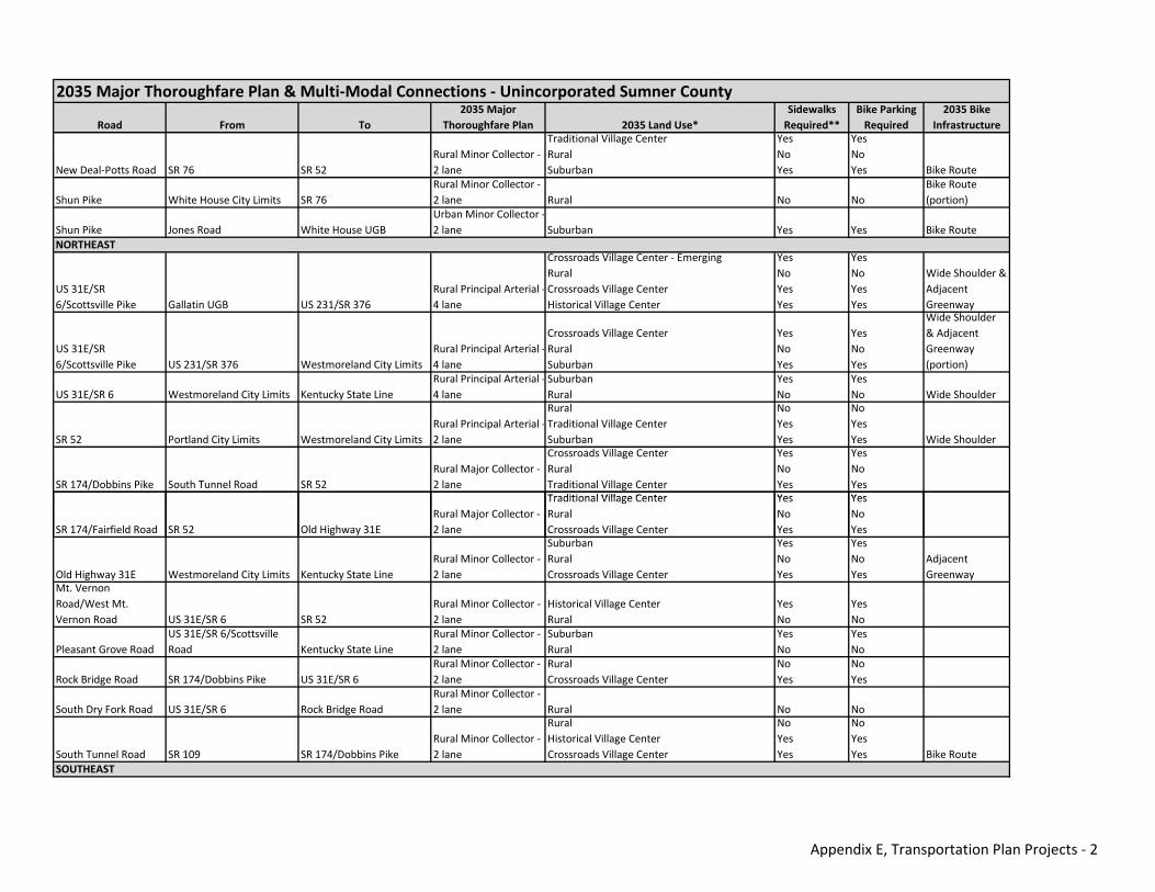
Road From To2035 Major
Thoroughfare Plan 2035 Land Use*Sidewalks Required**
Bike Parking Required
2035 Bike Infrastructure
2035 Major Thoroughfare Plan & Multi‐Modal Connections ‐ Unincorporated Sumner County
New Deal‐Potts Road SR 76 SR 52Rural Minor Collector ‐ 2 lane
Traditional Village CenterRuralSuburban
YesNoYes
YesNoYes Bike Route
Shun Pike White House City Limits SR 76Rural Minor Collector ‐ 2 lane Rural No No
Bike Route (portion)
Shun Pike Jones Road White House UGBUrban Minor Collector ‐2 lane Suburban Yes Yes Bike Route
US 31E/SR 6/Scottsville Pike Gallatin UGB US 231/SR 376
Rural Principal Arterial ‐4 lane
Crossroads Village Center ‐ EmergingRuralCrossroads Village CenterHistorical Village Center
YesNoYesYes
YesNoYesYes
Wide Shoulder & Adjacent Greenway
US 31E/SR 6/Scottsville Pike US 231/SR 376 Westmoreland City Limits
Rural Principal Arterial ‐4 lane
Crossroads Village CenterRuralSuburban
YesNoYes
YesNoYes
Wide Shoulder & Adjacent Greenway (portion)
US 31E/SR 6 Westmoreland City Limits Kentucky State LineRural Principal Arterial ‐4 lane
SuburbanRural
YesNo
YesNo Wide Shoulder
SR 52 Portland City Limits Westmoreland City LimitsRural Principal Arterial ‐2 lane
RuralTraditional Village CenterSuburban
NoYesYes
NoYesYes Wide Shoulder
SR 174/Dobbins Pike South Tunnel Road SR 52Rural Major Collector ‐ 2 lane
Crossroads Village CenterRuralTraditional Village Center
YesNoYes
YesNoYes
Traditional Village Center Yes Yes
NORTHEAST
SR 174/Fairfield Road SR 52 Old Highway 31ERural Major Collector ‐ 2 lane
Traditional Village CenterRuralCrossroads Village Center
YesNoYes
YesNoYes
Old Highway 31E Westmoreland City Limits Kentucky State LineRural Minor Collector ‐ 2 lane
SuburbanRuralCrossroads Village Center
YesNoYes
YesNoYes
Adjacent Greenway
Mt. Vernon Road/West Mt. Vernon Road US 31E/SR 6 SR 52
Rural Minor Collector ‐ 2 lane
Historical Village CenterRural
YesNo
YesNo
Pleasant Grove RoadUS 31E/SR 6/Scottsville Road Kentucky State Line
Rural Minor Collector ‐ 2 lane
SuburbanRural
YesNo
YesNo
Rock Bridge Road SR 174/Dobbins Pike US 31E/SR 6Rural Minor Collector ‐ 2 lane
RuralCrossroads Village Center
NoYes
NoYes
South Dry Fork Road US 31E/SR 6 Rock Bridge RoadRural Minor Collector ‐ 2 lane Rural No No
South Tunnel Road SR 109 SR 174/Dobbins PikeRural Minor Collector ‐ 2 lane
RuralHistorical Village CenterCrossroads Village Center
NoYesYes
NoYesYes Bike Route
SOUTHEAST
Appendix E, Transportation Plan Projects ‐ 2
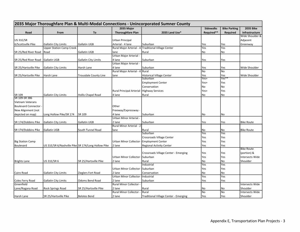
Road From To2035 Major
Thoroughfare Plan 2035 Land Use*Sidewalks Required**
Bike Parking Required
2035 Bike Infrastructure
2035 Major Thoroughfare Plan & Multi‐Modal Connections ‐ Unincorporated Sumner County
US 31E/SR 6/Scottsville Pike Gallatin City Limits Gallatin UGB
Urban Principal Arterial ‐ 4 lane Suburban Yes Yes
Wide Shoulder & Adjacent Greenway
SR 25/Red River RoadUpper Station Camp Creek Road Gallatin UGB
Rural Major Arterial ‐ 4 lane
Traditional Village CenterRural
YesNo
YesNo
SR 25/Red River Road Gallatin UGB Gallatin City LimitsUrban Major Arterial ‐ 4 lane Suburban Yes Yes
SR 25/Hartsville Pike Gallatin City Limits Harsh LaneUrban Major Arterial ‐ 4 lane Suburban Yes Yes Wide Shoulder
SR 25/Hartsville Pike Harsh Lane Trousdale County LineRural Major Arterial ‐ 4 lane
RuralHistorical Village Center
NoYes
NoYes Wide Shoulder
SR 109 Gallatin City Limits Hollis Chapel RoadRural Principal Arterial ‐4 lane
SuburbanEmployment CenterConservationHighway ServicesRural
Yes+Yes+NoYes+No
Yes**YesNoYesNo
SR 109‐SR 386 Vietnam Veterans Boulevard Connector ‐ New Alignment (not depicted on map) Long Hollow Pike/SR 174 SR 109
Other Freeway/Expressway ‐ 4 lane Suburban No No
SR 174/Dobbins Pike Gallatin City Limits Gallatin UGBUrban Minor Arterial ‐ 2 lane Suburban Yes Yes Bike Route
SR 174/D bbi Pik G ll ti UGB S th T l R dRural Minor Arterial ‐ 2 l R l N N Bik R tSR 174/Dobbins Pike Gallatin UGB South Tunnel Road lane Rural No No Bike Route
Big Station Camp Boulevard US 31E/SR 6/Nashville Pike SR 174/Long Hollow Pike
Urban Minor Collector ‐2 lane
SuburbanCrossroads Village CenterEmployment CenterRegional Activity Center
YesYesYesYes
YesYesYesYes
Brights Lane US 31E/SR 6 SR 25/Hartsville PikeUrban Minor Collector ‐2 lane
Crossroads Village Center ‐ EmergingSuburbanRural
YesYesNo
YesYesNo
Bike Route (portion) & Intersects Wide Shoulder
Cairo Road Gallatin City Limits Zieglers Fort RoadUrban Minor Collector ‐2 lane
IndustrialSuburbanConservation
YesYesNo
YesYesNo
Coles Ferry Road Gallatin City Limits Odoms Bend RoadUrban Minor Collector ‐2 lane
IndustrialSuburban
YesYes
YesYes
Greenfield Lane/Rogana Road Rock Springs Road SR 25/Hartsville Pike
Rural Minor Collector ‐ 2 lane Rural No No
Intersects Wide Shoulder
Harsh Lane SR 25/Hartsville Pike Belotes BendRural Minor Collector ‐ 2 lane
RuralTraditional Village Center ‐ Emerging
NoYes
NoYes
Intersects Wide Shoulder
Appendix E, Transportation Plan Projects ‐ 3
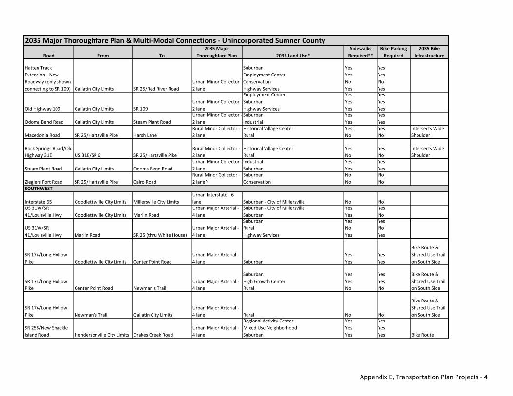
Road From To2035 Major
Thoroughfare Plan 2035 Land Use*Sidewalks Required**
Bike Parking Required
2035 Bike Infrastructure
2035 Major Thoroughfare Plan & Multi‐Modal Connections ‐ Unincorporated Sumner County
Hatten Track Extension ‐ New Roadway (only shown connecting to SR 109) Gallatin City Limits SR 25/Red River Road
Urban Minor Collector ‐2 lane
SuburbanEmployment CenterConservationHighway Services
YesYesNoYes
YesYesNoYes
Old Highway 109 Gallatin City Limits SR 109Urban Minor Collector ‐2 lane
Employment CenterSuburbanHighway Services
YesYesYes
YesYesYes
Odoms Bend Road Gallatin City Limits Steam Plant RoadUrban Minor Collector ‐2 lane
SuburbanIndustrial
YesYes
YesYes
Macedonia Road SR 25/Hartsville Pike Harsh LaneRural Minor Collector ‐ 2 lane
Historical Village CenterRural
YesNo
YesNo
Intersects Wide Shoulder
Rock Springs Road/Old Highway 31E US 31E/SR 6 SR 25/Hartsville Pike
Rural Minor Collector ‐ 2 lane
Historical Village CenterRural
YesNo
YesNo
Intersects Wide Shoulder
Steam Plant Road Gallatin City Limits Odoms Bend RoadUrban Minor Collector ‐2 lane
IndustrialSuburban
YesYes
YesYes
Zieglers Fort Road SR 25/Hartsville Pike Cairo RoadRural Minor Collector ‐ 2 lane^
SuburbanConservation
NoNo
NoNo
Interstate 65 Goodlettsville City Limits Millersville City LimitsUrban Interstate ‐ 6 lane Suburban ‐ City of Millersville No No
US 31W/SR 41/Louisville Hwy Goodlettsville City Limits Marlin Road
Urban Major Arterial ‐ 4 lane
Suburban ‐ City of MillersvilleSuburban
YesYes
YesNo
Suburban Yes Yes
SOUTHWEST
US 31W/SR 41/Louisville Hwy Marlin Road SR 25 (thru White House)
Urban Major Arterial ‐ 4 lane
SuburbanRuralHighway Services
YesNoYes
YesNoYes
SR 174/Long Hollow Pike Goodlettsville City Limits Center Point Road
Urban Major Arterial ‐ 4 lane Suburban
YesYes
YesYes
Bike Route & Shared Use Trail on South Side
SR 174/Long Hollow Pike Center Point Road Newman's Trail
Urban Major Arterial ‐ 4 lane
SuburbanHigh Growth CenterRural
YesYesNo
YesYesNo
Bike Route & Shared Use Trail on South Side
SR 174/Long Hollow Pike Newman's Trail Gallatin City Limits
Urban Major Arterial ‐ 4 lane Rural No No
Bike Route & Shared Use Trail on South Side
SR 258/New Shackle Island Road Hendersonville City Limits Drakes Creek Road
Urban Major Arterial ‐ 4 lane
Regional Activity CenterMixed Use NeighborhoodSuburban
YesYesYes
YesYesYes Bike Route
Appendix E, Transportation Plan Projects ‐ 4
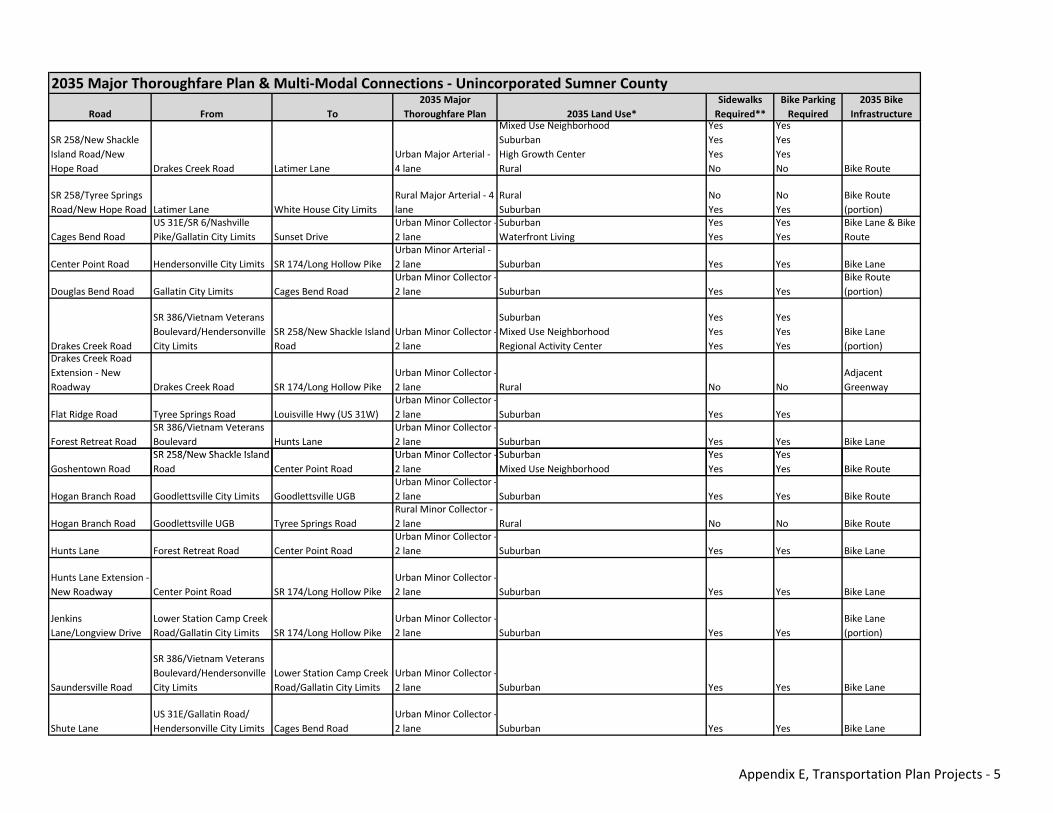
Road From To2035 Major
Thoroughfare Plan 2035 Land Use*Sidewalks Required**
Bike Parking Required
2035 Bike Infrastructure
2035 Major Thoroughfare Plan & Multi‐Modal Connections ‐ Unincorporated Sumner County
SR 258/New Shackle Island Road/New Hope Road Drakes Creek Road Latimer Lane
Urban Major Arterial ‐ 4 lane
Mixed Use NeighborhoodSuburbanHigh Growth CenterRural
YesYesYesNo
YesYesYesNo Bike Route
SR 258/Tyree Springs Road/New Hope Road Latimer Lane White House City Limits
Rural Major Arterial ‐ 4 lane
RuralSuburban
NoYes
NoYes
Bike Route (portion)
Cages Bend RoadUS 31E/SR 6/Nashville Pike/Gallatin City Limits Sunset Drive
Urban Minor Collector ‐2 lane
SuburbanWaterfront Living
YesYes
YesYes
Bike Lane & Bike Route
Center Point Road Hendersonville City Limits SR 174/Long Hollow PikeUrban Minor Arterial ‐ 2 lane Suburban Yes Yes Bike Lane
Douglas Bend Road Gallatin City Limits Cages Bend RoadUrban Minor Collector ‐2 lane Suburban Yes Yes
Bike Route (portion)
Drakes Creek Road
SR 386/Vietnam Veterans Boulevard/Hendersonville City Limits
SR 258/New Shackle Island Road
Urban Minor Collector ‐2 lane
SuburbanMixed Use NeighborhoodRegional Activity Center
YesYesYes
YesYesYes
Bike Lane (portion)
Drakes Creek Road Extension ‐ New Roadway Drakes Creek Road SR 174/Long Hollow Pike
Urban Minor Collector ‐2 lane Rural No No
Adjacent Greenway
Flat Ridge Road Tyree Springs Road Louisville Hwy (US 31W)Urban Minor Collector ‐2 lane Suburban Yes Yes
Forest Retreat RoadSR 386/Vietnam Veterans Boulevard Hunts Lane
Urban Minor Collector ‐2 lane Suburban Yes Yes Bike Lane
SR 258/New Shackle Island Urban Minor Collector Suburban Yes YesGoshentown Road
SR 258/New Shackle Island Road Center Point Road
Urban Minor Collector ‐2 lane
SuburbanMixed Use Neighborhood
YesYes
YesYes Bike Route
Hogan Branch Road Goodlettsville City Limits Goodlettsville UGBUrban Minor Collector ‐2 lane Suburban Yes Yes Bike Route
Hogan Branch Road Goodlettsville UGB Tyree Springs RoadRural Minor Collector ‐ 2 lane Rural No No Bike Route
Hunts Lane Forest Retreat Road Center Point RoadUrban Minor Collector ‐2 lane Suburban Yes Yes Bike Lane
Hunts Lane Extension ‐ New Roadway Center Point Road SR 174/Long Hollow Pike
Urban Minor Collector ‐2 lane Suburban Yes Yes Bike Lane
Jenkins Lane/Longview Drive
Lower Station Camp Creek Road/Gallatin City Limits SR 174/Long Hollow Pike
Urban Minor Collector ‐2 lane Suburban Yes Yes
Bike Lane (portion)
Saundersville Road
SR 386/Vietnam Veterans Boulevard/Hendersonville City Limits
Lower Station Camp Creek Road/Gallatin City Limits
Urban Minor Collector ‐2 lane Suburban Yes Yes Bike Lane
Shute LaneUS 31E/Gallatin Road/ Hendersonville City Limits Cages Bend Road
Urban Minor Collector ‐2 lane Suburban Yes Yes Bike Lane
Appendix E, Transportation Plan Projects ‐ 5
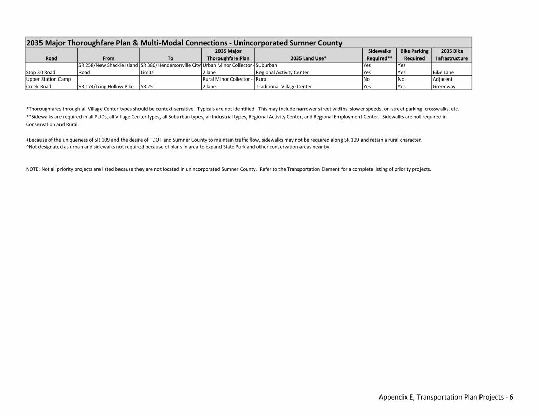
Road From To2035 Major
Thoroughfare Plan 2035 Land Use*Sidewalks Required**
Bike Parking Required
2035 Bike Infrastructure
2035 Major Thoroughfare Plan & Multi‐Modal Connections ‐ Unincorporated Sumner County
Stop 30 RoadSR 258/New Shackle Island Road
SR 386/Hendersonville City Limits
Urban Minor Collector ‐2 lane
SuburbanRegional Activity Center
YesYes
YesYes Bike Lane
Upper Station Camp Creek Road SR 174/Long Hollow Pike SR 25
Rural Minor Collector ‐ 2 lane
RuralTraditional Village Center
NoYes
NoYes
Adjacent Greenway
NOTE: Not all priority projects are listed because they are not located in unincorporated Sumner County. Refer to the Transportation Element for a complete listing of priority projects.
*Thoroughfares through all Village Center types should be context‐sensitive. Typicals are not identified. This may include narrower street widths, slower speeds, on‐street parking, crosswalks, etc.
**Sidewalks are required in all PUDs, all Village Center types, all Suburban types, all Industrial types, Regional Activity Center, and Regional Employment Center. Sidewalks are not required in Conservation and Rural.
+Because of the uniqueness of SR 109 and the desire of TDOT and Sumner County to maintain traffic flow, sidewalks may not be required along SR 109 and retain a rural character.^Not designated as urban and sidewalks not required because of plans in area to expand State Park and other conservation areas near by.
Appendix E, Transportation Plan Projects ‐ 6
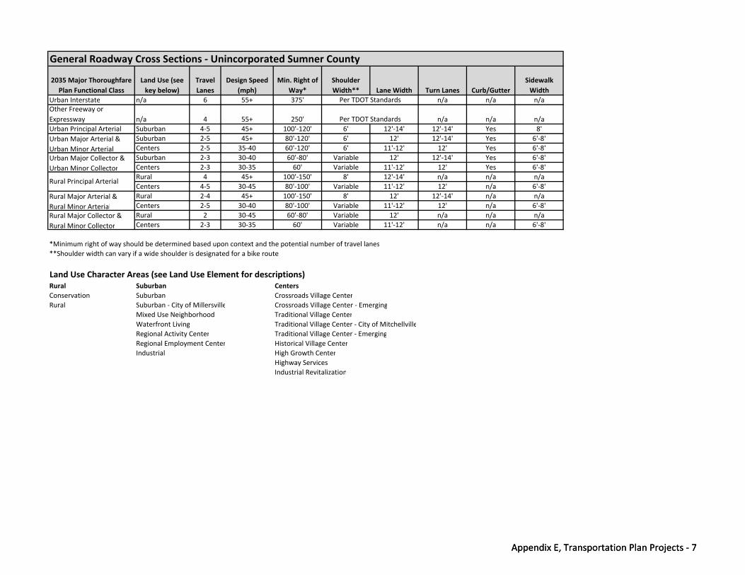
2035 Major Thoroughfare Plan Functional Class
Land Use (see key below)
Travel Lanes
Design Speed (mph)
Min. Right of Way*
Shoulder Width** Lane Width Turn Lanes Curb/Gutter
Sidewalk Width
Urban Interstate n/a 6 55+ 375' n/a n/a n/aOther Freeway or Expressway n/a 4 55+ 250' n/a n/a n/aUrban Principal Arterial Suburban 4‐5 45+ 100'‐120' 6' 12'‐14' 12'‐14' Yes 8'
Suburban 2‐5 45+ 80'‐120' 6' 12' 12'‐14' Yes 6'‐8'Centers 2‐5 35‐40 60'‐120' 6' 11'‐12' 12' Yes 6'‐8'Suburban 2‐3 30‐40 60'‐80' Variable 12' 12'‐14' Yes 6'‐8'Centers 2‐3 30‐35 60' Variable 11'‐12' 12' Yes 6'‐8'Rural 4 45+ 100'‐150' 8' 12'‐14' n/a n/a n/aCenters 4‐5 30‐45 80'‐100' Variable 11'‐12' 12' n/a 6'‐8'Rural 2‐4 45+ 100'‐150' 8' 12' 12'‐14' n/a n/aCenters 2‐5 30‐40 80'‐100' Variable 11'‐12' 12' n/a 6'‐8'Rural 2 30‐45 60'‐80' Variable 12' n/a n/a n/aCenters 2‐3 30‐35 60' Variable 11'‐12' n/a n/a 6'‐8'
*Minimum right of way should be determined based upon context and the potential number of travel lanes**Shoulder width can vary if a wide shoulder is designated for a bike route
Land Use Character Areas (see Land Use Element for descriptions)Rural Suburban CentersConservation Suburban Crossroads Village CenterRural Suburban ‐ City of Millersville Crossroads Village Center ‐ Emerging
Mixed Use Neighborhood Traditional Village Center
General Roadway Cross Sections ‐ Unincorporated Sumner County
Urban Major Arterial & Urban Minor ArterialUrban Major Collector & Urban Minor Collector
Rural Principal Arterial
Rural Major Arterial & Rural Minor ArterialRural Major Collector & Rural Minor Collector
Per TDOT Standards
Per TDOT Standards
Appendix E, Transportation Plan Projects ‐ 7
Waterfront Living Traditional Village Center ‐ City of MitchellvilleRegional Activity Center Traditional Village Center ‐ EmergingRegional Employment Center Historical Village CenterIndustrial High Growth Center
Highway ServicesIndustrial Revitalization
Appendix E, Transportation Plan Projects ‐ 7
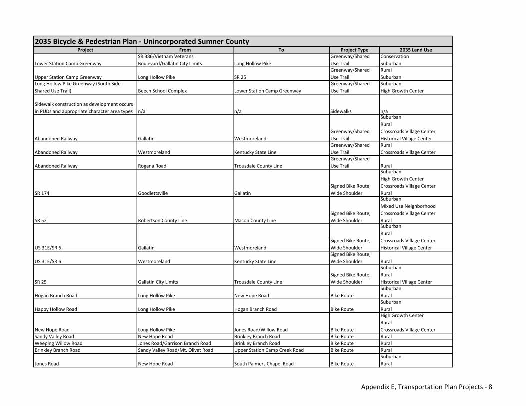
Project From To Project Type 2035 Land Use
Lower Station Camp GreenwaySR 386/Vietnam Veterans Boulevard/Gallatin City Limits Long Hollow Pike
Greenway/Shared Use Trail
ConservationSuburban
Upper Station Camp Greenway Long Hollow Pike SR 25Greenway/Shared Use Trail
RuralSuburban
Long Hollow Pike Greenway (South Side Shared Use Trail) Beech School Complex Lower Station Camp Greenway
Greenway/Shared Use Trail
SuburbanHigh Growth Center
Sidewalk construction as development occurs in PUDs and appropriate character area types n/a n/a Sidewalks n/a
Abandoned Railway Gallatin WestmorelandGreenway/Shared Use Trail
SuburbanRuralCrossroads Village CenterHistorical Village Center
Abandoned Railway Westmoreland Kentucky State LineGreenway/Shared Use Trail
RuralCrossroads Village Center
Abandoned Railway Rogana Road Trousdale County LineGreenway/Shared Use Trail Rural
SR 174 Goodlettsville Gallatin Signed Bike Route, Wide Shoulder
SuburbanHigh Growth CenterCrossroads Village CenterRural
SR 52 Robertson County Line Macon County LineSigned Bike Route, Wide Shoulder
SuburbanMixed Use NeighborhoodCrossroads Village CenterRuralSuburban
2035 Bicycle & Pedestrian Plan ‐ Unincorporated Sumner County
US 31E/SR 6 Gallatin WestmorelandSigned Bike Route, Wide Shoulder
SuburbanRuralCrossroads Village CenterHistorical Village Center
US 31E/SR 6 Westmoreland Kentucky State LineSigned Bike Route, Wide Shoulder Rural
SR 25 Gallatin City Limits Trousdale County LineSigned Bike Route, Wide Shoulder
SuburbanRuralHistorical Village Center
Hogan Branch Road Long Hollow Pike New Hope Road Bike RouteSuburbanRural
Happy Hollow Road Long Hollow Pike Hogan Branch Road Bike RouteSuburbanRural
New Hope Road Long Hollow Pike Jones Road/Willow Road Bike Route
High Growth CenterRuralCrossroads Village Center
Sandy Valley Road New Hope Road Brinkley Branch Road Bike Route RuralWeeping Willow Road Jones Road/Garrison Branch Road Brinkley Branch Road Bike Route RuralBrinkley Branch Road Sandy Valley Road/Mt. Olivet Road Upper Station Camp Creek Road Bike Route Rural
Jones Road New Hope Road South Palmers Chapel Road Bike RouteSuburbanRural
Appendix E, Transportation Plan Projects ‐ 8
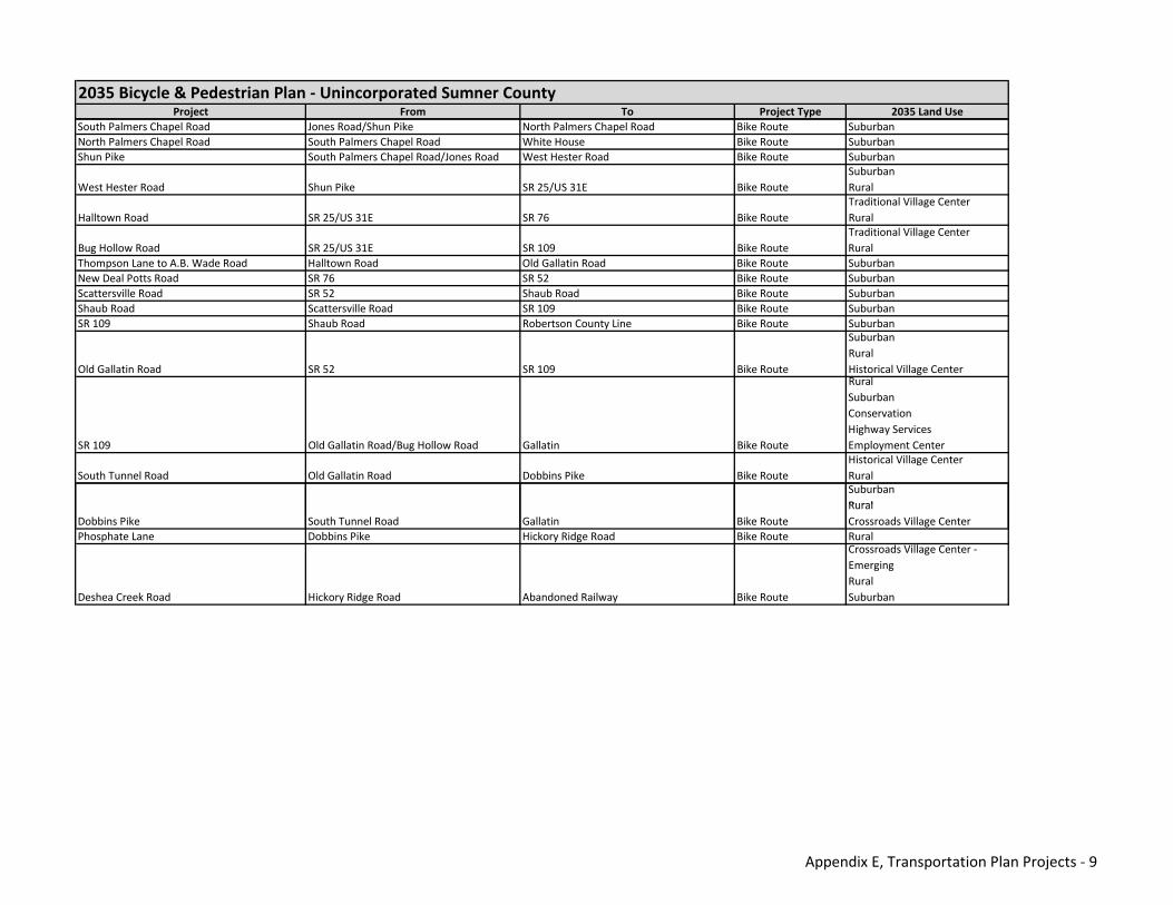
Project From To Project Type 2035 Land Use
2035 Bicycle & Pedestrian Plan ‐ Unincorporated Sumner County
South Palmers Chapel Road Jones Road/Shun Pike North Palmers Chapel Road Bike Route SuburbanNorth Palmers Chapel Road South Palmers Chapel Road White House Bike Route SuburbanShun Pike South Palmers Chapel Road/Jones Road West Hester Road Bike Route Suburban
West Hester Road Shun Pike SR 25/US 31E Bike RouteSuburbanRural
Halltown Road SR 25/US 31E SR 76 Bike RouteTraditional Village CenterRural
Bug Hollow Road SR 25/US 31E SR 109 Bike RouteTraditional Village CenterRural
Thompson Lane to A.B. Wade Road Halltown Road Old Gallatin Road Bike Route SuburbanNew Deal Potts Road SR 76 SR 52 Bike Route SuburbanScattersville Road SR 52 Shaub Road Bike Route SuburbanShaub Road Scattersville Road SR 109 Bike Route SuburbanSR 109 Shaub Road Robertson County Line Bike Route Suburban
Old Gallatin Road SR 52 SR 109 Bike Route
SuburbanRuralHistorical Village Center
SR 109 Old Gallatin Road/Bug Hollow Road Gallatin Bike Route
RuralSuburbanConservationHighway ServicesEmployment Center
South Tunnel Road Old Gallatin Road Dobbins Pike Bike RouteHistorical Village CenterRuralSuburbanRural
Dobbins Pike South Tunnel Road Gallatin Bike RouteRuralCrossroads Village Center
Phosphate Lane Dobbins Pike Hickory Ridge Road Bike Route Rural
Deshea Creek Road Hickory Ridge Road Abandoned Railway Bike Route
Crossroads Village Center ‐ EmergingRuralSuburban
Appendix E, Transportation Plan Projects ‐ 9
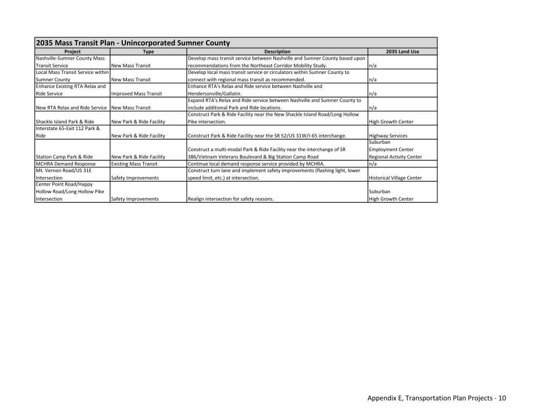
Project Type Description 2035 Land UseNashville‐Sumner County Mass Transit Service New Mass Transit
Develop mass transit service between Nashville and Sumner County based upon recommendations from the Northeast Corridor Mobility Study. n/a
Local Mass Transit Service within Sumner County New Mass Transit
Develop local mass transit service or circulators within Sumner County to connect with regional mass transit as recommended. n/a
Enhance Existing RTA Relax and Ride Service Improved Mass Transit
Enhance RTA's Relax and Ride service between Nashville and Hendersonville/Gallatin. n/a
New RTA Relax and Ride Service New Mass TransitExpand RTA's Relax and Ride service between Nashville and Sumner County to include additional Park and Ride locations. n/a
Shackle Island Park & Ride New Park & Ride FacilityConstruct Park & Ride Facility near the New Shackle Island Road/Long Hollow Pike intersection. High Growth Center
Interstate 65‐Exit 112 Park & Ride New Park & Ride Facility Construct Park & Ride Facility near the SR 52/US 31W/I‐65 interchange. Highway Services
Station Camp Park & Ride New Park & Ride FacilityConstruct a multi‐modal Park & Ride Facility near the interchange of SR 386/Vietnam Veterans Boulevard & Big Station Camp Road
SuburbanEmployment CenterRegional Activity Center
MCHRA Demand Response Existing Mass Transit Continue local demand response service provided by MCHRA. n/aMt. Vernon Road/US 31E Intersection Safety Improvements
Construct turn lane and implement safety improvements (flashing light, lower speed limit, etc.) at intersection. Historical Village Center
Center Point Road/Happy Hollow Road/Long Hollow Pike Intersection Safety Improvements Realign intersection for safety reasons.
SuburbanHigh Growth Center
2035 Mass Transit Plan ‐ Unincorporated Sumner County
Appendix E, Transportation Plan Projects ‐ 10
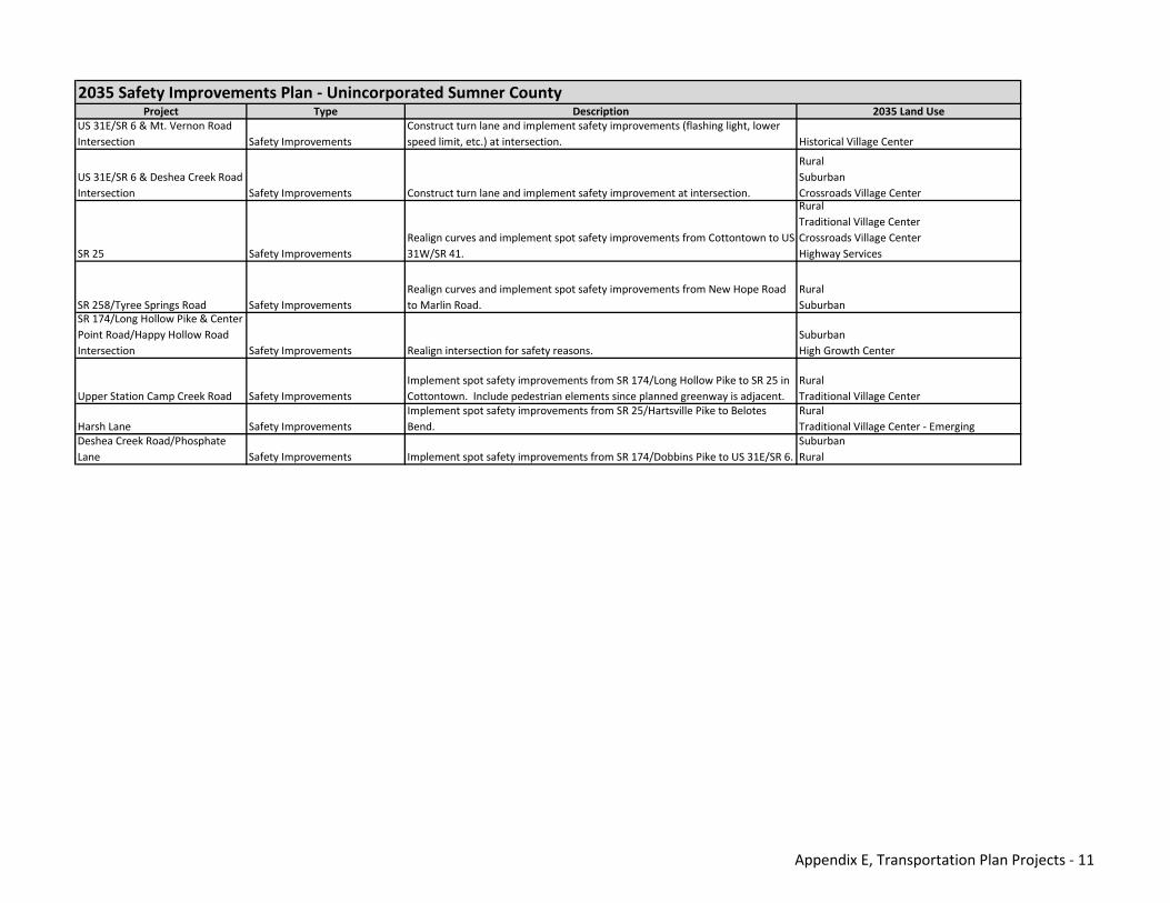
Project Type Description 2035 Land UseUS 31E/SR 6 & Mt. Vernon Road Intersection Safety Improvements
Construct turn lane and implement safety improvements (flashing light, lower speed limit, etc.) at intersection. Historical Village Center
US 31E/SR 6 & Deshea Creek Road Intersection Safety Improvements Construct turn lane and implement safety improvement at intersection.
RuralSuburbanCrossroads Village Center
SR 25 Safety ImprovementsRealign curves and implement spot safety improvements from Cottontown to US 31W/SR 41.
RuralTraditional Village CenterCrossroads Village CenterHighway Services
SR 258/Tyree Springs Road Safety ImprovementsRealign curves and implement spot safety improvements from New Hope Road to Marlin Road.
RuralSuburban
SR 174/Long Hollow Pike & Center Point Road/Happy Hollow Road Intersection Safety Improvements Realign intersection for safety reasons.
SuburbanHigh Growth Center
Upper Station Camp Creek Road Safety ImprovementsImplement spot safety improvements from SR 174/Long Hollow Pike to SR 25 in Cottontown. Include pedestrian elements since planned greenway is adjacent.
RuralTraditional Village Center
Harsh Lane Safety ImprovementsImplement spot safety improvements from SR 25/Hartsville Pike to Belotes Bend.
RuralTraditional Village Center ‐ Emerging
Deshea Creek Road/Phosphate Lane Safety Improvements Implement spot safety improvements from SR 174/Dobbins Pike to US 31E/SR 6.
SuburbanRural
2035 Safety Improvements Plan ‐ Unincorporated Sumner County
Appendix E, Transportation Plan Projects ‐ 11
Appendix E, Transportation Plan Projects - 12
THIS PAGE INTENTIONALLY LEFT BLANK

Appendix F Visual Preference Survey

THIS PAGE INTENTIONALLY LEFT BLANK
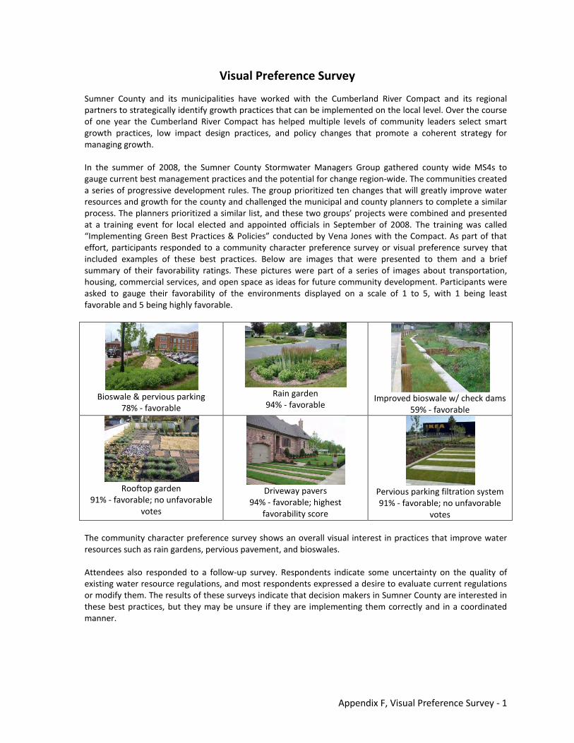
Appendix F, Visual Preference Survey - 1
Visual Preference Survey
Sumner County and its municipalities have worked with the Cumberland River Compact and its regional partners to strategically identify growth practices that can be implemented on the local level. Over the course of one year the Cumberland River Compact has helped multiple levels of community leaders select smart growth practices, low impact design practices, and policy changes that promote a coherent strategy for managing growth. In the summer of 2008, the Sumner County Stormwater Managers Group gathered county wide MS4s to gauge current best management practices and the potential for change region-wide. The communities created a series of progressive development rules. The group prioritized ten changes that will greatly improve water resources and growth for the county and challenged the municipal and county planners to complete a similar process. The planners prioritized a similar list, and these two groups’ projects were combined and presented at a training event for local elected and appointed officials in September of 2008. The training was called “Implementing Green Best Practices & Policies” conducted by Vena Jones with the Compact. As part of that effort, participants responded to a community character preference survey or visual preference survey that included examples of these best practices. Below are images that were presented to them and a brief summary of their favorability ratings. These pictures were part of a series of images about transportation, housing, commercial services, and open space as ideas for future community development. Participants were asked to gauge their favorability of the environments displayed on a scale of 1 to 5, with 1 being least favorable and 5 being highly favorable.
Bioswale & pervious parking
78% - favorable
Rain garden
94% - favorable
Improved bioswale w/ check dams
59% - favorable
Rooftop garden
91% - favorable; no unfavorable votes
Driveway pavers
94% - favorable; highest favorability score
Pervious parking filtration system 91% - favorable; no unfavorable
votes
The community character preference survey shows an overall visual interest in practices that improve water resources such as rain gardens, pervious pavement, and bioswales. Attendees also responded to a follow-up survey. Respondents indicate some uncertainty on the quality of existing water resource regulations, and most respondents expressed a desire to evaluate current regulations or modify them. The results of these surveys indicate that decision makers in Sumner County are interested in these best practices, but they may be unsure if they are implementing them correctly and in a coordinated manner.
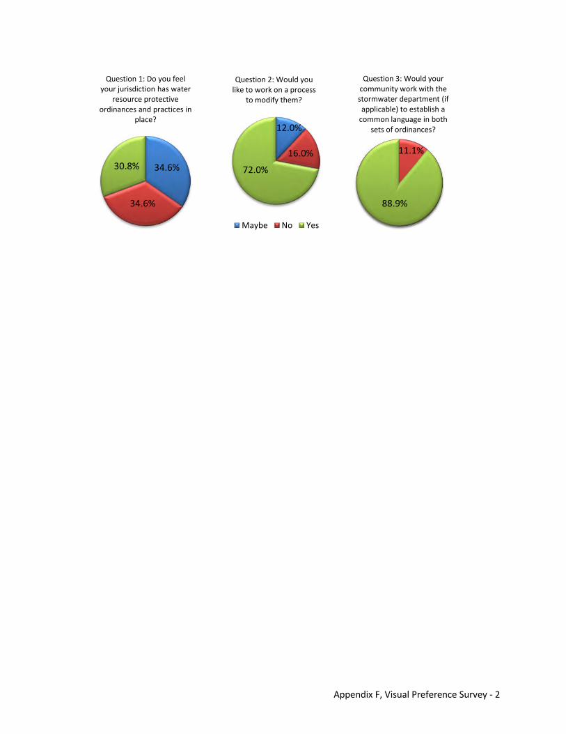
Appendix F, Visual Preference Survey - 2
Question 1: Do you feel your jurisdiction has water
resource protective ordinances and practices in
place?
Question 2: Would you like to work on a process
to modify them?
Maybe No Yes
Question 3: Would your community work with the stormwater department (if applicable) to establish a
common language in both sets of ordinances?
30.8% 34.6%
34.6%
72.0%
88.9%
12.0%
16.0% 11.1%

![[Task] Rencana Tata Ruang Kawasan Strategis Migas \u0026 Agro Kecamatan Kapas Kab.Bojonegoro tahun 2015 - 2035](https://img.dokumen.tips/doc/110x75/6358ef8f3cd558f04e058e9c/task-rencana-tata-ruang-kawasan-strategis-migas-u0026-agro-kecamatan-kapas-kabbojonegoro.jpg)


