Embed Size (px)
Citation preview
ERIE COUNTY
2018 Hazard Mitigation Plan
ERIE COUNTY
HAZARD MITIGATION PLAN
UPDATED 2018
FOR ERIE COUNTY AND ALL MUNICIPAL GOVERNMENTS THEREIN
Erie County Hazard Mitigation Plan Table of Contents
TABLE OF CONTENTS
1.0 INTRODUCTION……………………………………………………………………………
1.1 Background………………………………..…………………………………………….
1.2 Purpose…………………………..……………………………………………………..
1.3 Scope……………..…………………………………………………………………….
1.4 Authority and References……………………………………………………………..
2.0 COMMUNITY PROFILE……………………………………………………………………
2.1 Geography and Environment……………………………………………………………
2.2 Community Facts……………………………………………………………………….
2.3 Population and Demographics…………………………………………………………
2.4 Land Use and Development……….………………………………………………….
2.5 Inventory Assets…………….………………………………………………………….
2.6 Climate Change…………………………………………………………………………..
2.7 Data Sources and Limitations………………………………………………………….
3.0 DOCUMENTATION OF THE PLANNING PROCESS…………………………………..
3.1 Update Process and Participation Summary…………………………………………
3.2 The Planning Process………………………………………………………………….
3.3 Meetings and Documentation…………………………………………………………
3.4 Public and Stakeholder Participation…………………………………………………
3.5 Multi-Jurisdictional Planning………………………………………………………….
3.6 Existing Planning Mechanisms………………………………………………………..
4.0 RISK ASSESSMENT…………..…………………………………………………………
4.1 Update Process Summary…………………………………………………………….
4.2 Hazard Identification……………………………….…………………………………….
4.2.1 Disaster Declarations……………………………………………………………
4.2.2 Summary of Hazards……………………………………………………………
1
1
1
1
2
4
4
9
16
19
22
41
44
46
46
49
51
52
55
56
59
59
59
59
61
Erie County Hazard Mitigation Plan Table of Contents
4.3 Profile Hazards…..…………………..…………………………………………………
4.3.1 Coastal Erosion……………………………………………………………………
4.3.1.1 Location and Extent………………………………………………………..
4.3.1.2 Range of Magnitude…………………………………………………………
4.3.1.3 Past Occurrence……………………………………………………………..
4.3.1.4 Future Occurrence…………………………………………………………..
4.3.1.5 Vulnerability Assessment…………………………………………………...
4.3.2 Drought……………………………………………………………………………
4.3.2.1 Location and Extent………………………………………………………..
4.3.2.2 Range of Magnitude…………………………………………………………
4.3.2.3 Past Occurrence……………………………………………………………..
4.3.2.4 Future Occurrence…………………………………………………………..
4.3.2.5 Vulnerability Assessment…………………………………………………...
4.3.3 Earthquake…………………………………………………………………………
4.3.3.1 Location and Extent………………………………………………………..
4.3.3.2 Range of Magnitude…………………………………………………………
4.3.3.3 Past Occurrence……………………………………………………………..
4.3.3.4 Future Occurrence…………………………………………………………..
4.3.3.5 Vulnerability Assessment…………………………………………………...
4.3.4 Flood, Flash Flood, Ice Jam……………………………………………………..
4.3.4.1 Location and Extent………………………………………………………..
4.3.4.2 Range of Magnitude…………………………………………………………
4.3.4.3 Past Occurrence……………………………………………………………..
4.3.4.4 Future Occurrence…………………………………………………………..
4.3.4.5 Vulnerability Assessment…………………………………………………...
74
75
75
78
79
81
83
84
84
86
89
90
93
94
94
95
98
99
100
101
101
103
122
130
156
Erie County Hazard Mitigation Plan Table of Contents
4.3.5 Invasive Species…………………………………………………………………..
4.3.5.1 Location and Extent………………………………………………………..
4.3.5.2 Range of Magnitude…………………………………………………………
4.3.5.3 Past Occurrence……………………………………………………………..
4.3.5.4 Future Occurrence…………………………………………………………..
4.3.5.5 Vulnerability Assessment…………………………………………………...
4.3.6 Landslide……………………………………………………………………………
4.3.6.1 Location and Extent………………………………………………………..
4.3.6.2 Range of Magnitude…………………………………………………………
4.3.6.3 Past Occurrence……………………………………………………………..
4.3.6.4 Future Occurrence…………………………………………………………..
4.3.6.5 Vulnerability Assessment…………………………………………………...
4.3.7 Tornado & Windstorm……………………………………………………………..
4.3.7.1 Location and Extent………………………………………………………..
4.3.7.2 Range of Magnitude…………………………………………………………
4.3.7.3 Past Occurrence……………………………………………………………..
4.3.7.4 Future Occurrence…………………………………………………………..
4.3.7.5 Vulnerability Assessment…………………………………………………...
4.3.8 Winter Storm………………………………………………………………………
4.3.8.1 Location and Extent………………………………………………………..
4.3.8.2 Range of Magnitude…………………………………………………………
4.3.8.3 Past Occurrence……………………………………………………………..
4.3.8.4 Future Occurrence…………………………………………………………..
4.3.8.5 Vulnerability Assessment…………………………………………………...
4.3.9 Dam Failure…………………………………………………………………………
4.3.9.1 Location and Extent………………………………………………………..
4.3.9.2 Range of Magnitude…………………………………………………………
4.3.9.3 Past Occurrence……………………………………………………………..
4.3.9.4 Future Occurrence…………………………………………………………..
4.3.9.5 Vulnerability Assessment…………………………………………………...
157
157
158
165
166
168
169
169
169
170
170
171
172
172
174
177
187
188
189
189
191
193
199
200
201
201
203
204
205
205
Erie County Hazard Mitigation Plan Table of Contents
4.3.10 Environmental Hazards………………………………………………………….
4.3.10.1 Location and Extent………………………………………………………..
4.3.10.2 Range of Magnitude………………………………………………………
4.3.10.3 Past Occurrence……………………………………………………………
4.3.10.4 Future Occurrence…………………………………………………………
4.3.10.5 Vulnerability Assessment………………………………………………….
4.3.11 Radiological Incident…………………………………………………………….
4.3.11.1 Location and Extent………………………………………………………..
4.3.11.2 Range of Magnitude………………………………………………………
4.3.11.3 Past Occurrence……………………………………………………………
4.3.11.4 Future Occurrence…………………………………………………………
4.3.11.5 Vulnerability Assessment………………………………………………….
4.3.12 Urban Fire & Explosion………………………………………………………..
4.3.12.1 Location and Extent………………………………………………………..
4.3.12.2 Range of Magnitude………………………………………………………
4.3.12.3 Past Occurrence……………………………………………………………
4.3.12.4 Future Occurrence…………………………………………………………
4.3.12.5 Vulnerability Assessment………………………………………………….
4.3.13 Utility Interruption…………………………………………………………………
4.3.13.1 Location and Extent………………………………………………………..
4.3.13.2 Range of Magnitude………………………………………………………
4.3.13.3 Past Occurrence……………………………………………………………
4.3.13.4 Future Occurrence…………………………………………………………
4.3.13.5 Vulnerability Assessment………………………………………………….
206
206
208
213
214
218
219
219
221
225
226
229
230
230
233
234
235
238
239
239
241
242
244
244
Erie County Hazard Mitigation Plan Table of Contents
4.3.14 War & Criminal Activity………………………………………………………….
4.3.14.1 Location and Extent………………………………………………………..
4.3.14.2 Range of Magnitude………………………………………………………
4.3.14.3 Past Occurrence……………………………………………………………
4.3.14.4 Future Occurrence…………………………………………………………
4.3.14.5 Vulnerability Assessment………………………………………………….
4.3.15 Lake Hazards……………………………………………………………………..
4.3.15.1 Location and Extent………………………………………………………..
4.3.15.2 Range of Magnitude………………………………………………………
4.3.15.3 Past Occurrence……………………………………………………………
4.3.15.4 Future Occurrence…………………………………………………………
4.3.15.5 Vulnerability Assessment………………………………………………….
4.3.16 Transportation Infrastructure Decay……………………………………………
4.3.16.1 Location and Extent………………………………………………………..
4.3.16.2 Range of Magnitude………………………………………………………
4.3.16.3 Past Occurrence……………………………………………………………
4.3.16.4 Future Occurrence…………………………………………………………
4.3.16.5 Vulnerability Assessment………………………………………………….
4.4 Hazard Vulnerability Summary……………………………………………………….
4.4.1 Methodology……………………………………………………………………
4.4.2 Ranking Results………………………………………………………………..
4.4.3 Potential Loss Estimates………………………………………………………
4.4.4 Future Development and Vulnerability……………………………………….
5.0 CAPABILITY ASSESSMENT……………………………………………………………
5.1 Update Process Summary………………………………………………………………
5.2 Capability Assessment Findings……………………………………………………….
5.2.1 Jurisdictional Capabilities……………………………………………………..
5.2.2 Administrative and Technical Capabilities………………………………………
5.2.3 Fiscal Capabilities…………………………………………………………………
5.2.4 Political Capabilities………………………………………………………………
245
245
246
249
250
252
253
253
255
256
257
258
259
259
261
263
264
267
268
268
271
273
281
284
284
284
284
289
291
292

Erie County Hazard Mitigation Plan Table of Contents
5.2.5 Self-Assessment……………………………………………………………….
5.2.6 Plan Integration……………………………………………………………………
5.3 Existing Limitations…………………………………………………………………….
6.0 MITIGATION STRATEGY………………………………………………………………
6.1 Update Process Summary………………………………………………………………
6.2 Mitigation Goals and Objectives……………………………………………………….
6.3 Identification and Analysis of Mitigation Techniques…………………………………
6.4 Mitigation Action Plan…………………………………………………………………….
7.0 PLAN MAINTENANCE PROCESS………………………………………………………
7.1 Update Process Summary………………………………………………………….
7.2 Monitoring, Evaluating, and Updating the Plan………………………………………
7.3 Continued Public Involvement...……………………………………………………….
8.0 APPENDICES
Appendix 1: Meeting Documentation
Appendix 2: Public Survey
Appendix 3: Active Project Prioritization
Appendix 4: Inactive Projects
Appendix 5: Citations
Appendix 6: Adopting Resolutions
292
294
303
304
304
304
305
306
381
381
381
383
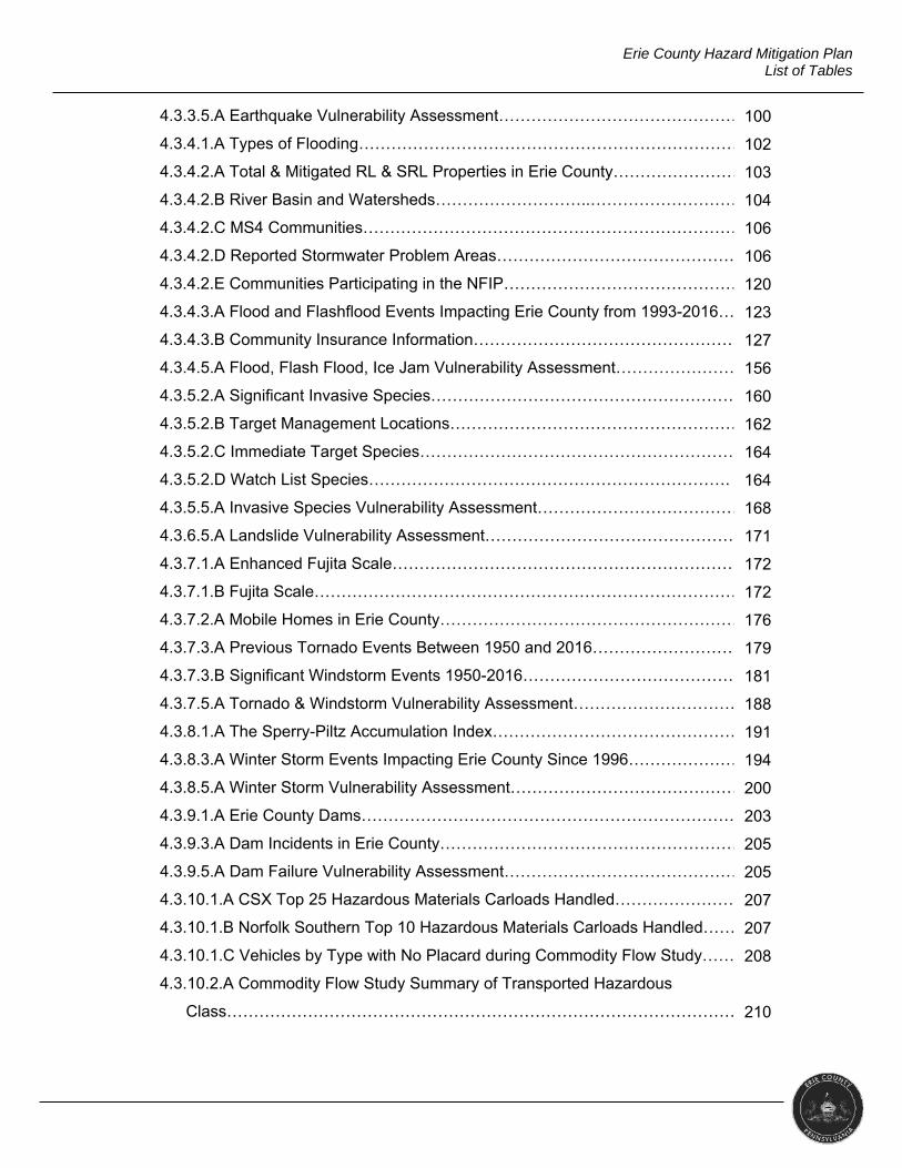
Erie County Hazard Mitigation Plan List of Tables
LIST OF TABLES
1.0 INTRODUCTION
1.4.A Guides and Reference Documents…..…………………………………………….
2.0 COMMUNITY PROFILE
2.1.A Geography and Environment…………………………………………………………
2.1.B Erie County Weather Averages………………………………………………………
2.2.A Top 10 Employers………………………………………………………………….
2.2.B Erie County Unemployment.…………………………………………………………
2.3.A Erie County Demographics………………………………………………………….
2.3.B Municipal Demographics………………………………………………………….
2.3.C University Populations…………………………………………………………………
2.5.A Asset Inventory……………………………………………………………………….
3.0 DOCUMENTATION OF THE PLANNING PROCESS
3.1.A Municipal Involvement…………………………………………………………………
3.2.A Jurisdictional Representatives……………………………………………………….
3.4.a Stakeholder Involvement……………………………………………………………
3.6.A Existing Planning Mechanisms………………………………………………………
4.0 RISK ASSESSMENT
4.2.1.A Presidential Disaster and Emergency Declarations……………………………
4.2.1.B Gubernatorial Proclamations of Emergency……………………………………..
4.2.2.A Hazard Updates…………………………………………………………………….
4.2.3.A Hazard Snapshots…………………………………………………………………
4.3.1.1.A Municipalities with Designated Bluff Recession Hazard Area……………
4.3.1.2.A Shoreline Coverage………………………………………………………………
4.3.1.5.A Coastal Erosion Vulnerability Assessment……………………………………
4.3.2.1.A Palmer Drought Severity Scale…………………………………………………
4.3.2.2.A Number of Domestic Wells per Municipality …………………………………
4.3.2.3.A Erie County Declared Drought Status from 1980 to 2016……………………
4.3.2.5.A Drought Vulnerability Assessment………………………………………………
4.3.3.3.A Earthquakes Reportedly Felt in Erie County……………………………………
3
4
5
9
9
16
17
18
23
48
49
53
57
59
60
61
64
78
79
83
84
89
90
93
98
Erie County Hazard Mitigation Plan List of Tables
4.3.3.5.A Earthquake Vulnerability Assessment…………………………………………
4.3.4.1.A Types of Flooding………………………………………………………………
4.3.4.2.A Total & Mitigated RL & SRL Properties in Erie County………………………
4.3.4.2.B River Basin and Watersheds………………………..………………………..
4.3.4.2.C MS4 Communities……………………………………………………………..
4.3.4.2.D Reported Stormwater Problem Areas……………………………………….
4.3.4.2.E Communities Participating in the NFIP…………………………………………
4.3.4.3.A Flood and Flashflood Events Impacting Erie County from 1993-2016……
4.3.4.3.B Community Insurance Information…………………………………………….
4.3.4.5.A Flood, Flash Flood, Ice Jam Vulnerability Assessment………………………
4.3.5.2.A Significant Invasive Species…………………………………………………
4.3.5.2.B Target Management Locations……………………………………………….
4.3.5.2.C Immediate Target Species……………………………………………………..
4.3.5.2.D Watch List Species………………………………………………………….
4.3.5.5.A Invasive Species Vulnerability Assessment……………………………………
4.3.6.5.A Landslide Vulnerability Assessment……………………………………………
4.3.7.1.A Enhanced Fujita Scale…………………………………………………………
4.3.7.1.B Fujita Scale………………………………………………………………………
4.3.7.2.A Mobile Homes in Erie County……………………………………………………
4.3.7.3.A Previous Tornado Events Between 1950 and 2016…………………………
4.3.7.3.B Significant Windstorm Events 1950-2016…………………………………..
4.3.7.5.A Tornado & Windstorm Vulnerability Assessment………………………………
4.3.8.1.A The Sperry-Piltz Accumulation Index…………………………………………
4.3.8.3.A Winter Storm Events Impacting Erie County Since 1996……………………
4.3.8.5.A Winter Storm Vulnerability Assessment…………………………………………
4.3.9.1.A Erie County Dams…………………………………………………………………
4.3.9.3.A Dam Incidents in Erie County……………………………………………………
4.3.9.5.A Dam Failure Vulnerability Assessment…………………………………………
4.3.10.1.A CSX Top 25 Hazardous Materials Carloads Handled………………………
4.3.10.1.B Norfolk Southern Top 10 Hazardous Materials Carloads Handled…………
4.3.10.1.C Vehicles by Type with No Placard during Commodity Flow Study………
4.3.10.2.A Commodity Flow Study Summary of Transported Hazardous
Class……………………………………………………………………………………
100
102
103
104
106
106
120
123
127
156
160
162
164
164
168
171
172
172
176
179
181
188
191
194
200
203
205
205
207
207
208
210
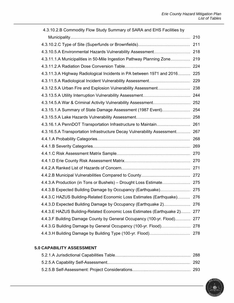
Erie County Hazard Mitigation Plan List of Tables
4.3.10.2.B Commodity Flow Study Summary of SARA and EHS Facilities by
Municipality…………………………………………………………………………….
4.3.10.2.C Type of Site (Superfunds or Brownfields)…………………………………
4.3.10.5.A Environmental Hazards Vulnerability Assessment……………………….
4.3.11.1.A Municipalities in 50-Mile Ingestion Pathway Planning Zone…………….
4.3.11.2.A Radiation Dose Conversion Table…………………………………………..
4.3.11.3.A Highway Radiological Incidents in PA between 1971 and 2016……………
4.3.11.5.A Radiological Incident Vulnerability Assessment……………………………
4.3.12.5.A Urban Fire and Explosion Vulnerability Assessment…………………………
4.3.13.5.A Utility Interruption Vulnerability Assessment………………………………
4.3.14.5.A War & Criminal Activity Vulnerability Assessment……………………………
4.3.15.1.A Summary of State Damage Assessment (1987 Event)……………………
4.3.15.5.A Lake Hazards Vulnerability Assessment………………………………………
4.3.16.1.A PennDOT Transportation Infrastructure to Maintain………………………
4.3.16.5.A Transportation Infrastructure Decay Vulnerability Assessment……………
4.4.1.A Probability Categories……………………………………………………………
4.4.1.B Severity Categories………………………………………………………………..
4.4.1.C Risk Assessment Matrix Sample………………………………………………….
4.4.1.D Erie County Risk Assessment Matrix…………………………………………..
4.4.2.A Ranked List of Hazards of Concern……………………………………………..
4.4.2.B Municipal Vulnerabilities Compared to County………………………………..
4.4.3.A Production (in Tons or Bushels) – Drought Loss Estimate……………………
4.4.3.B Expected Building Damage by Occupancy (Earthquake)………………………
4.4.3.C HAZUS Building-Related Economic Loss Estimates (Earthquake)………….
4.4.3.D Expected Building Damage by Occupancy (Earthquake 2)………………….
4.4.3.E HAZUS Building-Related Economic Loss Estimates (Earthquake 2)……….
4.4.3.F Building Damage County by General Occupancy (100-yr. Flood)……………
4.4.3.G Building Damage by General Occupancy (100-yr. Flood)…………………..
4.4.3.H Building Damage by Building Type (100-yr. Flood)…………………………..
5.0 CAPABILITY ASSESSMENT
5.2.1.A Jurisdictional Capabilities Table…….……………………………………………
5.2.5.A Capability Self-Assessment..…………………………………………………….
5.2.5.B Self-Assessment: Project Considerations………..………………………………
210
211
218
219
224
225
229
238
244
252
254
258
261
267
268
269
270
270
271
272
275
275
276
276
277
277
278
278
288
292
293
Erie County Hazard Mitigation Plan List of Tables
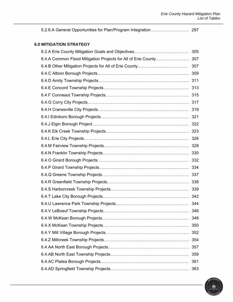
5.2.6.A General Opportunities for Plan/Program Integration……………………………
6.0 MITIGATION STRATEGY
6.2.A Erie County Mitigation Goals and Objectives…………………………………..
6.4.A Common Flood Mitigation Projects for All of Erie County……………………
6.4.B Other Mitigation Projects for All of Erie County………………………………
6.4.C Albion Borough Projects…………………………………………………………….
6.4.D Amity Township Projects…………………………………………………………….
6.4.E Concord Township Projects………………………………………………………..
6.4.F Conneaut Township Projects……………………………………………………..
6.4.G Corry City Projects…………………………………………………………………….
6.4.H Cranesville City Projects…………………………………………………………….
6.4.I Edinboro Borough Projects…………………………………………………………
6.4.J Elgin Borough Project………………………………………………………………..
6.4.K Elk Creek Township Projects………………………………………………………
6.4.L Erie City Projects…………………………………………………………………….
6.4.M Fairview Township Projects……………………………………………………..
6.4.N Franklin Township Projects……………………………………………………….
6.4.O Girard Borough Projects…………………………………………………………..
6.4.P Girard Township Projects………………………………………………………….
6.4.Q Greene Township Projects………………………………………………………..
6.4.R Greenfield Township Projects……………………………………………………..
6.4.S Harborcreek Township Projects……………………………………………………
6.4.T Lake City Borough Projects……………………………………………………….
6.4.U Lawrence Park Township Projects…………………………………………………
6.4.V LeBoeuf Township Projects…………………………………………………………
6.4.W McKean Borough Projects………………………………………………………….
6.4.X McKean Township Projects………………………………………………………….
6.4.Y Mill Village Borough Projects…………………………………………………………
6.4.Z Millcreek Township Projects……………………………………………………….
6.4.AA North East Borough Projects……………………………………………………….
6.4.AB North East Township Projects……………………………………………………..
6.4.AC Platea Borough Projects……………………………………………………………
6.4.AD Springfield Township Projects……………………………………………………..
297
305
307
307
309
311
313
315
317
319
321
322
323
326
328
330
332
334
337
338
339
342
344
346
348
350
352
354
357
359
361
363
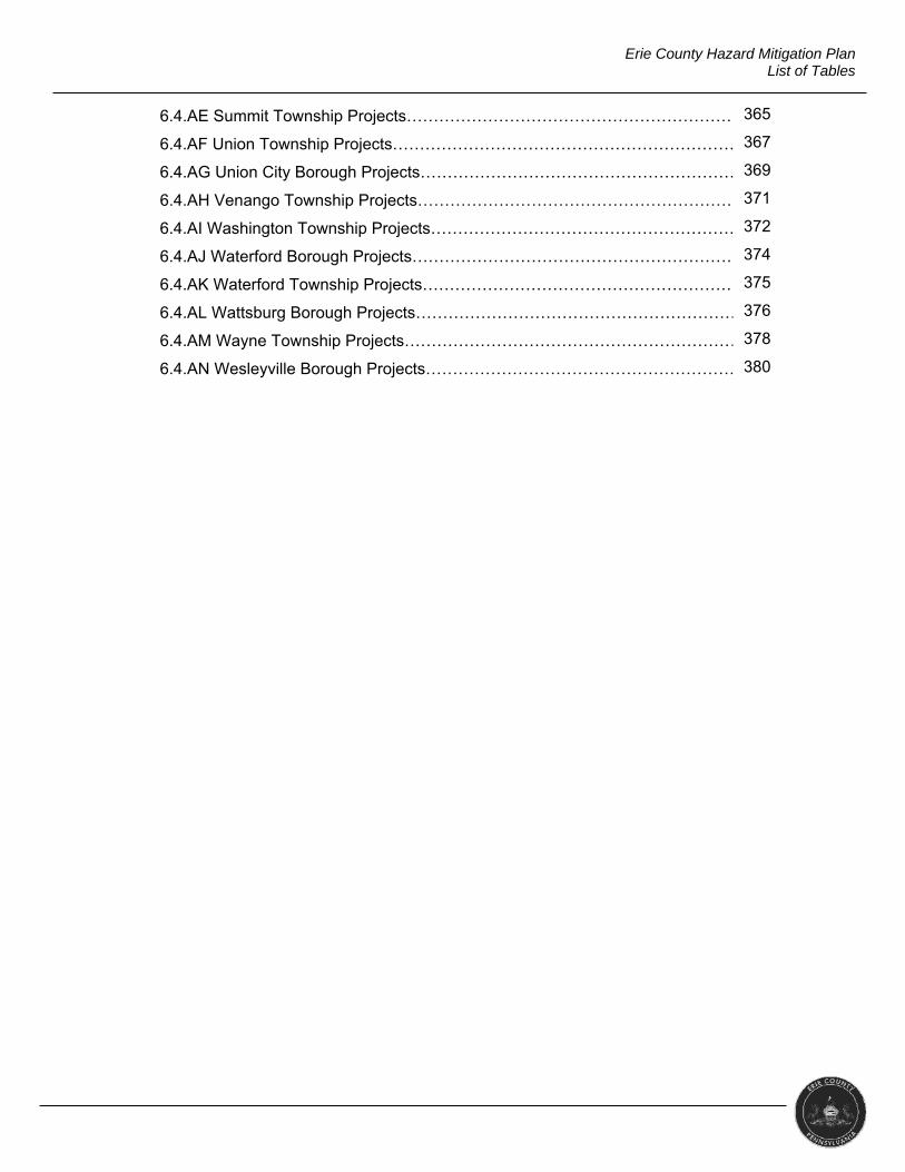
Erie County Hazard Mitigation Plan List of Tables
6.4.AE Summit Township Projects………………………………………………………….
6.4.AF Union Township Projects…………………………………………………………….
6.4.AG Union City Borough Projects………………………………………………………
6.4.AH Venango Township Projects………………………………………………………
6.4.AI Washington Township Projects…………………………………………………….
6.4.AJ Waterford Borough Projects…………………………………………………………
6.4.AK Waterford Township Projects……………………………………………………….
6.4.AL Wattsburg Borough Projects………………………………………………………
6.4.AM Wayne Township Projects…………………………………………………………..
6.4.AN Wesleyville Borough Projects……………………………………………………….
365
367
369
371
372
374
375
376
378
380
1
Erie County Hazard Mitigation Plan 1.0 Introduction
1.0 INTRODUCTION
This section presents an introduction to the hazard mitigation plan and
defines the authority, scope and purpose of the plan.
1.1 BACKGROUND
Natural and man-made disasters have caused injury and death, damaged
and destroyed property and disrupted business and government function. In an effort
to lessen the effects of a disaster, Erie County Department of Public Safety, Erie
County Department of Planning, and the county’s 38 municipalities took part in this
planning process to identify potential hazards and possible actions and activities to
mitigate their vulnerability to those hazards.
FEMA (2017) advises that “effective mitigation requires that we all
understand local risks, address the hard choices, and invest in long-term community
well-being” (para.2). To address these choices, Erie County created a committee
made up of elected officials, emergency management personnel, and department of
planning personnel. It was the committee’s goal to reduce the future costs of
recovery, repair, and reconstruction by investing in mitigation actions.
1.2 PURPOSE
Erie County has undertaken this hazard mitigation plan update for several
reasons, including the following.
To protect life, safety, and property by reducing the potential for future
damages and the economic losses that result from hazards
To build partnerships for risk reduction involving government, organizations,
businesses, and the public
To identify long-term, broadly-supported strategies for risk reductions
To align risk reduction with other county and municipal objectives
To communicate priorities to potential sources of funding
1.3 SCOPE
The Erie County 2017 Hazard Mitigation Plan has been prepared in
compliance with requirements set forth by the Federal Emergency Management
Agency (FEMA) and the Pennsylvania Emergency Management Agency (PEMA) in
order for the county and municipalities to be eligible for funding and technical
2
Erie County Hazard Mitigation Plan 1.0 Introduction
assistance form state and federal hazard mitigation programs. It thus applies to the
county and all 38 municipalities and serves as their official hazard mitigation plan. It
addresses both natural and human-made hazards of significant risk to the county
and its municipalities. The committee reviews the plan annually and a complete plan
update will take place at minimum every five years.
1.4 AUTHORITY AND REFERENCES
Authority for this plan originates from the following federal government
sources.
Robert T. Stafford Disaster Relief and Emergency Assistance Act, 42 U.S.C.,
Section 322, as amended;
Code of Federal Regulations (CFR), Title 44, Parts 201 and 206;
Disaster Mitigation Act of 2000, Public Law 106-390, as amended; and
National Flood Insurance Act of 1968, as amended, 42 U.S.C. 4001 et seq.
Authority for this plan also originates from the following Commonwealth of
Pennsylvania sources.
Pennsylvania Emergency Management Services Code. Title 35, PA C.S.
Section 101;
Pennsylvania Municipalities Planning Code of 1968, Act 247, as reenacted
and amended by Act 170 of 1988; and
Pennsylvania Stormwater Management Act of October 4, 1978, P.L. 864, No.
167.
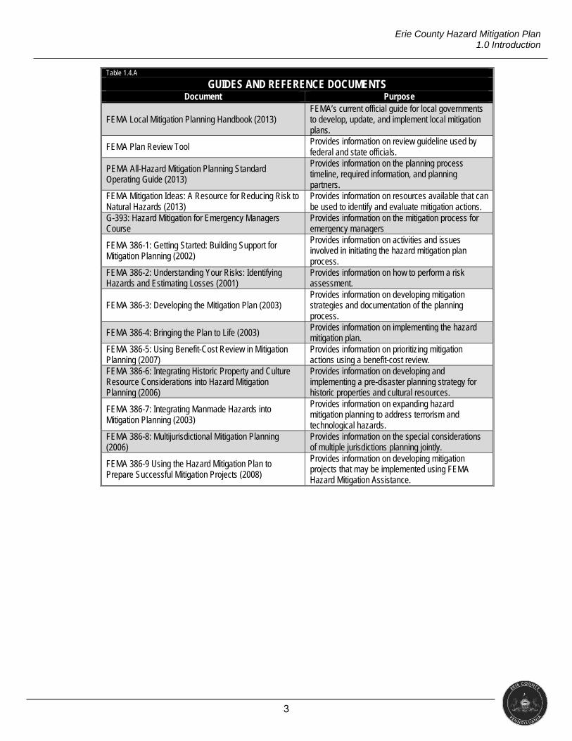
Erie County’s stakeholders and its consultant utilized several guidelines and
reference documents specifically outlining the mitigation planning process throughout
this update. The table below lists them.
3
Erie County Hazard Mitigation Plan 1.0 Introduction
Table 1.4.A
GUIDES AND REFERENCE DOCUMENTS Document Purpose
FEMA Local Mitigation Planning Handbook (2013) FEMA’s current official guide for local governments to develop, update, and implement local mitigation plans.
FEMA Plan Review Tool Provides information on review guideline used by federal and state officials.
PEMA All-Hazard Mitigation Planning Standard Operating Guide (2013)
Provides information on the planning process timeline, required information, and planning partners.
FEMA Mitigation Ideas: A Resource for Reducing Risk to Natural Hazards (2013)
Provides information on resources available that can be used to identify and evaluate mitigation actions.
G-393: Hazard Mitigation for Emergency Managers Course
Provides information on the mitigation process for emergency managers
FEMA 386-1: Getting Started: Building Support for Mitigation Planning (2002)
Provides information on activities and issues involved in initiating the hazard mitigation plan process.
FEMA 386-2: Understanding Your Risks: Identifying Hazards and Estimating Losses (2001)
Provides information on how to perform a risk assessment.
FEMA 386-3: Developing the Mitigation Plan (2003) Provides information on developing mitigation strategies and documentation of the planning process.
FEMA 386-4: Bringing the Plan to Life (2003) Provides information on implementing the hazard mitigation plan.
FEMA 386-5: Using Benefit-Cost Review in Mitigation Planning (2007)
Provides information on prioritizing mitigation actions using a benefit-cost review.
FEMA 386-6: Integrating Historic Property and Culture Resource Considerations into Hazard Mitigation Planning (2006)
Provides information on developing and implementing a pre-disaster planning strategy for historic properties and cultural resources.
FEMA 386-7: Integrating Manmade Hazards into Mitigation Planning (2003)
Provides information on expanding hazard mitigation planning to address terrorism and technological hazards.
FEMA 386-8: Multijurisdictional Mitigation Planning (2006)
Provides information on the special considerations of multiple jurisdictions planning jointly.
FEMA 386-9 Using the Hazard Mitigation Plan to Prepare Successful Mitigation Projects (2008)
Provides information on developing mitigation projects that may be implemented using FEMA Hazard Mitigation Assistance.
4
Erie County Hazard Mitigation Plan 2.0 Community Profile
2.0 COMMUNITY PROFILE
This section discusses the geography, environment, and other community
demographics. It provides a general description of Erie County.
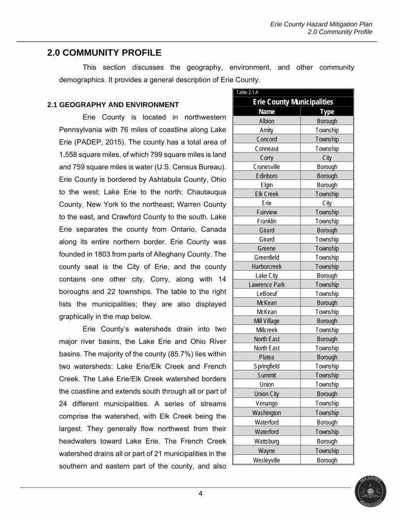
2.1 GEOGRAPHY AND ENVIRONMENT
Erie County is located in northwestern
Pennsylvania with 76 miles of coastline along Lake
Erie (PADEP, 2015). The county has a total area of
1,558 square miles, of which 799 square miles is land
and 759 square miles is water (U.S. Census Bureau).
Erie County is bordered by Ashtabula County, Ohio
to the west; Lake Erie to the north; Chautauqua
County, New York to the northeast; Warren County
to the east, and Crawford County to the south. Lake
Erie separates the county from Ontario, Canada
along its entire northern border. Erie County was
founded in 1803 from parts of Alleghany County. The
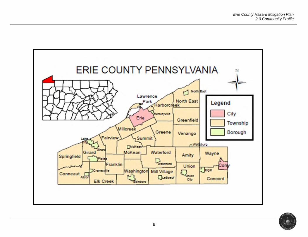
county seat is the City of Erie, and the county
contains one other city, Corry, along with 14
boroughs and 22 townships. The table to the right
lists the municipalities; they are also displayed
graphically in the map below.
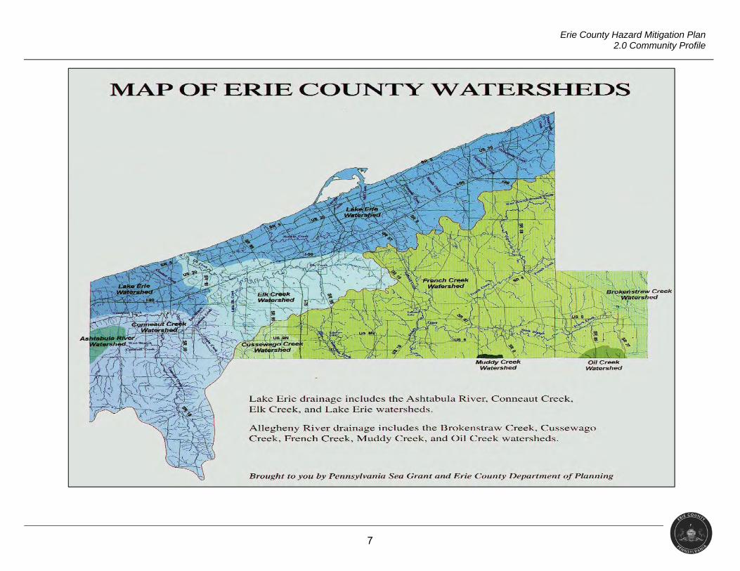
Erie County’s watersheds drain into two
major river basins, the Lake Erie and Ohio River
basins. The majority of the county (85.7%) lies within
two watersheds: Lake Erie/Elk Creek and French
Creek. The Lake Erie/Elk Creek watershed borders
the coastline and extends south through all or part of
24 different municipalities. A series of streams
comprise the watershed, with Elk Creek being the
largest. They generally flow northwest from their
headwaters toward Lake Erie. The French Creek
watershed drains all or part of 21 municipalities in the
southern and eastern part of the county, and also
Table 2.1.A
Erie County Municipalities Name Type Albion Borough Amity Township
Concord Township
Conneaut Township Corry City
Cranesville Borough Edinboro Borough
Elgin Borough Elk Creek Township
Erie City Fairview Township Franklin Township Girard Borough Girard Township Greene Township
Greenfield Township Harborcreek Township
Lake City Borough Lawrence Park Township
LeBoeuf Township McKean Borough McKean Township
Mill Village Borough Millcreek Township
North East Borough North East Township
Platea Borough Springfield Township
Summit Township Union Township
Union City Borough
Venango Township
Washington Township
Waterford Borough
Waterford Township
Wattsburg Borough
Wayne Township
Wesleyville Borough
5
Erie County Hazard Mitigation Plan 2.0 Community Profile
contains three of the nine glacial lakes in western Pennsylvania: Lake Pleasant, Lake
LeBoeuf, and Edinboro Lake. Glacial activity attributed to the many wetland areas in the
French Creek watershed.
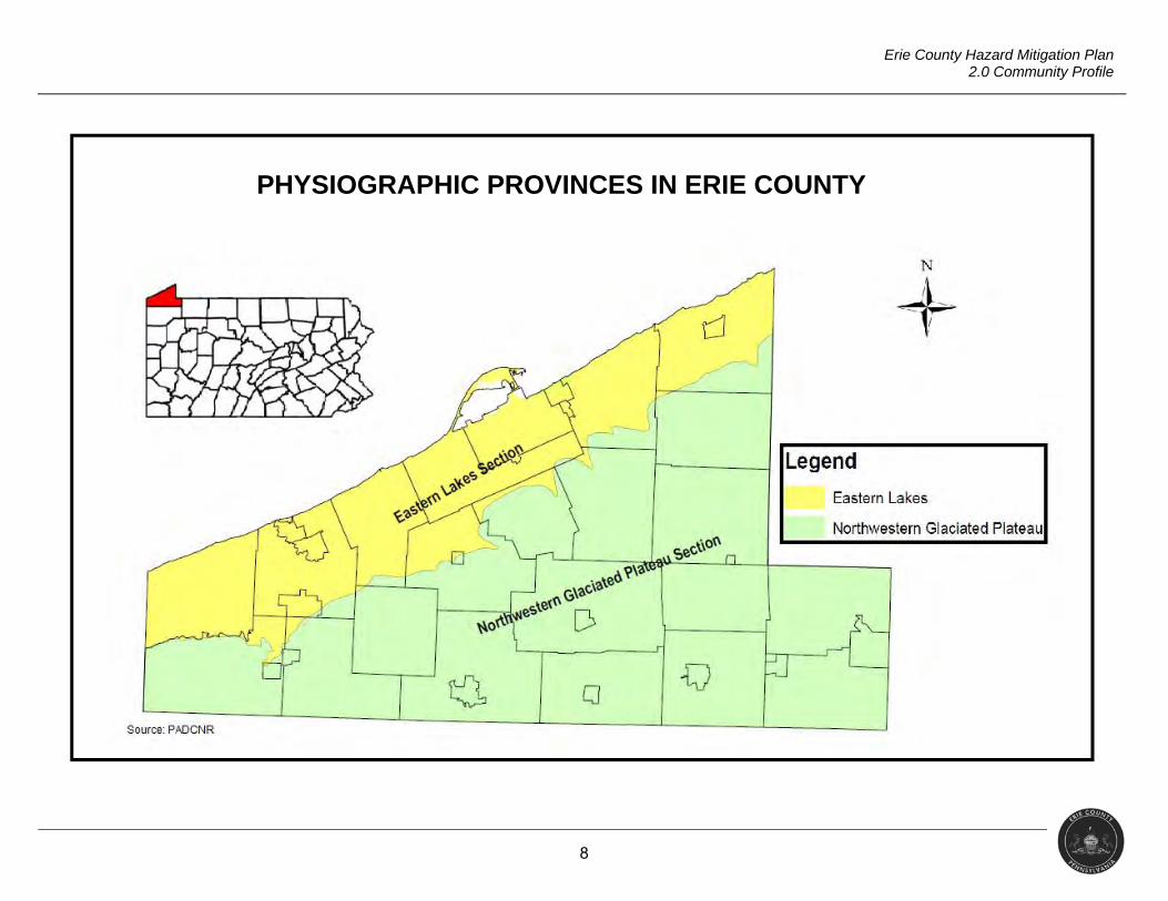
Portions of two physiographic provinces bisect Erie County’s topography. The area
adjacent to Lake Erie lies in the Eastern Lake Section of the Central Lowlands Province, and
is a relatively narrow zone consisting of a series of lake-parallel, low-relief ridges. Steep-sided,
narrow valleys cut through these ridges into the underlying shales and siltstones and flow into
Lake Erie. Erosion of the Lake Erie shoreline has resulted in a steep bluff adjacent to the lake.
The majority of the county lies within the Northwestern Glaciated Plateau Section of the
Appalachian Plateaus Province, and consists of rolling land that is notably higher in elevation
than the coastal lowland. This area is typical of the glaciated portions of northwest
Pennsylvania, characterized by broad uplands separated by linear flat-floored valleys and
long, linear, rounded ridges. There are several unique scenic geological features located in
Erie County, including Presque Isle peninsula, the Devils Backbone, and Titus Bog.
The influence of Lake Erie is profoundly evident in the climate of Erie County. In the
Central Lowlands Province along the lakeshore, the lake has a moderating effect on
temperatures, and the freeze-free season is normally extended to about 200 days.
Temperatures above 90°F or below 0°F are extremely rare. The lake also reduces daily
temperature ranges to less than 20°F in most months. Throughout the county, cloudiness and
frequent snowfalls are prevalent in winter as a result of the “lake effect” of cold air passing
over the relatively warm Lake Erie, picking up moisture. Annual precipitation averages close
to 40 inches. Annual snowfall averages just under 80 inches per year near the lakeshore, with
considerably more in the higher elevations of the county. Heavy snow squalls are capable of
depositing one to two feet of snow on the county, though as the lake surface freezes over,
snowfalls of this type become less frequent.
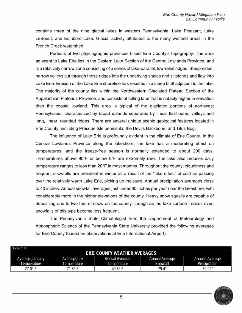
The Pennsylvania State Climatologist from the Department of Meteorology and
Atmospheric Science of the Pennsylvania State University provided the following averages
for Erie County (based on observations at Erie International Airport).
Table 2.1.B
ERIE COUNTY WEATHER AVERAGES Average January
Temperature Average July Temperature
Annual Average Temperature
Annual Average Snowfall
Annual Average Precipitation
27.0° F 71.3° F 49.3° F 79.4” 39.92”
6
Erie County Hazard Mitigation Plan 2.0 Community Profile
7
Erie County Hazard Mitigation Plan 2.0 Community Profile
8
Erie County Hazard Mitigation Plan 2.0 Community Profile
PHYSIOGRAPHIC PROVINCES IN ERIE COUNTY
9
Erie County Hazard Mitigation Plan 2.0 Community Profile
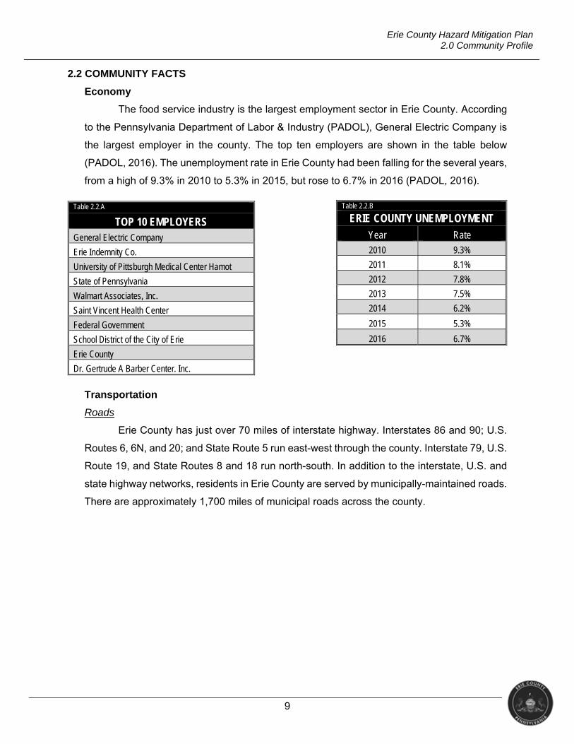
2.2 COMMUNITY FACTS
Economy
The food service industry is the largest employment sector in Erie County. According
to the Pennsylvania Department of Labor & Industry (PADOL), General Electric Company is
the largest employer in the county. The top ten employers are shown in the table below
(PADOL, 2016). The unemployment rate in Erie County had been falling for the several years,
from a high of 9.3% in 2010 to 5.3% in 2015, but rose to 6.7% in 2016 (PADOL, 2016).
Transportation
Roads
Erie County has just over 70 miles of interstate highway. Interstates 86 and 90; U.S.
Routes 6, 6N, and 20; and State Route 5 run east-west through the county. Interstate 79, U.S.
Route 19, and State Routes 8 and 18 run north-south. In addition to the interstate, U.S. and
state highway networks, residents in Erie County are served by municipally-maintained roads.
There are approximately 1,700 miles of municipal roads across the county.
Table 2.2.A
TOP 10 EMPLOYERS General Electric Company
Erie Indemnity Co.
University of Pittsburgh Medical Center Hamot
State of Pennsylvania
Walmart Associates, Inc.
Saint Vincent Health Center
Federal Government
School District of the City of Erie
Erie County
Dr. Gertrude A Barber Center. Inc.
Table 2.2.B
ERIE COUNTY UNEMPLOYMENT
Year Rate 2010 9.3%
2011 8.1%
2012 7.8%
2013 7.5%
2014 6.2%
2015 5.3%
2016 6.7%
10
Erie County Hazard Mitigation Plan 2.0 Community Profile
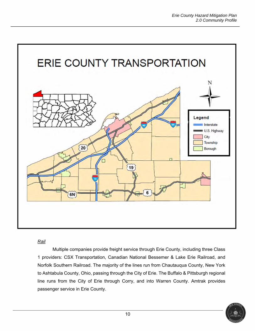
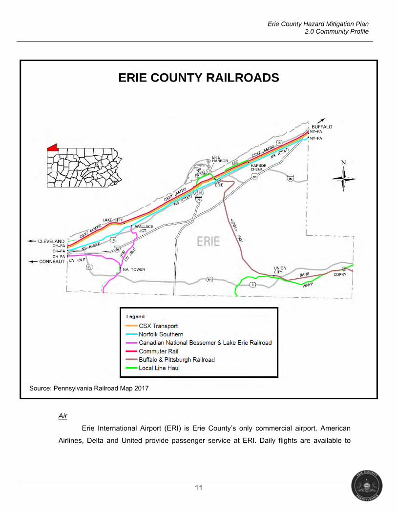
Rail
Multiple companies provide freight service through Erie County, including three Class
1 providers: CSX Transportation, Canadian National Bessemer & Lake Erie Railroad, and
Norfolk Southern Railroad. The majority of the lines run from Chautauqua County, New York
to Ashtabula County, Ohio, passing through the City of Erie. The Buffalo & Pittsburgh regional
line runs from the City of Erie through Corry, and into Warren County. Amtrak provides
passenger service in Erie County.
11
Erie County Hazard Mitigation Plan 2.0 Community Profile
Air
Erie International Airport (ERI) is Erie County’s only commercial airport. American
Airlines, Delta and United provide passenger service at ERI. Daily flights are available to
Source: Pennsylvania Railroad Map 2017
ERIE COUNTY RAILROADS
12
Erie County Hazard Mitigation Plan 2.0 Community Profile
Chicago O’Hare International Airport, Philadelphia International Airport and to Detroit
Metropolitan Airport.
Public Transit
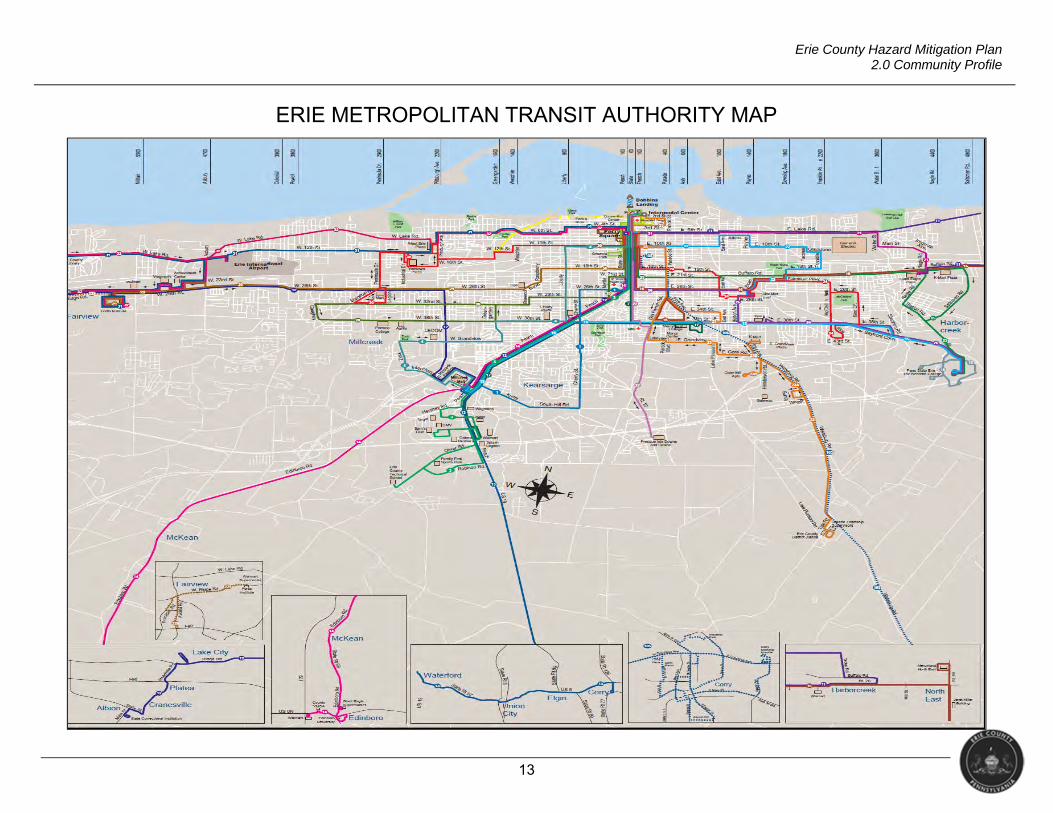
The Erie Metropolitan Transit Authority (EMTA) provides public transportation in Erie
County. Service times vary by route. Some routes operate on a weekday-Saturday-Sunday
schedule while others only operate on specific days. EMTA offers trolley and shuttle services
Monday to Friday during regular business hours. EMTA also offers curb to curb paratransit
service to eligible disabled persons seven days a week (EMTA, 2017).
Currently, EMTA has 29 routes which include pick-up and drop off locations at
hospitals, shopping centers, Erie International Airport, educational institutes, etc. The map
below shows an overview of the routes provided (www.ride-the-e.com).
13
Erie County Hazard Mitigation Plan 2.0 Community Profile
ERIE METROPOLITAN TRANSIT AUTHORITY MAP
14
Erie County Hazard Mitigation Plan 2.0 Community Profile
Medical Access
There are four hospitals in Erie County: Corry Memorial Hospital, Millcreek Community
Hospital, Saint Vincent Health Center, and University of Pittsburgh Medical Center Hamot.
Both Corry Memorial Hospital, located in the City of Corry, and Millcreek Community Hospital,
located in Millcreek Township, are part of Lake Erie College of Osteopathic Medicine Health
System, while St. Vincent Health Center is a member of the Allegheny Health Network. UPMC
Hamot and St. Vincent Health Center are both located in the City of Erie (PADOH, 2017).
Utilities
Electricity
There are two electric service providers in Erie County: FirstEnergy Penelec and
Northwestern Rural Electric Cooperative (NREC). First Energy owns or controls generating
capacities including nuclear, coal, natural gas, hydro, wind and solar facilities. NREC uses
several sources to provide electric service to its customers including nuclear and hydro.
Internet
Erie County has a total of 18 internet providers, ranging from national providers to local
companies. These include Spectrum, Verizon, Velocity.net, Windstream, Time Warner Cable,
Enterprise Providers, Sunesys, Earthlink, AT&T, Sprint, T-Mobile, Hughes Net, and Dish
Network (Broadbandnow.com, 2016).
Natural Gas
Three companies provide natural gas service within Erie County: National Fuel, North
East Heat & Light Company, and Vineyard Oil and Gas (Erie Regional chamber and Growth
Partnership).
Sewer
The majority of the residents in the county use septic systems; however, there are
multiple municipal sewer providers throughout the county. Below is a list of providers and the
communities they serve.
Albion Borough Sewer System: Albion Borough, Cranesville Borough, parts of
Conneaut and Elk Creek Townships
City of Corry Sewer System: Corry City, and parts of Concord and Wayne Townships
as well as Columbus Township (Warren County)
15
Erie County Hazard Mitigation Plan 2.0 Community Profile
Borough of Edinboro Sewer System: Edinboro Borough and parts of Washington
Township
City of Erie Sewer System: Erie City, Lawrence Park Township, Wesleyville
Borough, and parts of Fairview, Harborcreek, Millcreek, and Summit Townships
Fairview Township Sewer System: Fairview Township
Girard Borough Sewer System: Girard Borough and parts of Girard Township
Green Township Sewer System: Greene Township
Harborcreek Township Sewer System: Harborcreek Township
Lake City Borough Sewer System: Lake City Borough
Lawrence Park Township Sewer System: Lawrence Park Township
McKean Borough Sewer System: McKean Borough
McKean Township Sewer System: McKean Township
Millcreek Township Sewer System: Millcreek Township
North East Borough Sewer System: North East Borough and parts of North East
Township
Summit Township Sewer System: Summit Township
Union City Borough Sewer System: Union City Borough and parts of Union
Township
Washington Township Sewer System: Washington Township
Waterford Borough Sewer System: Waterford Borough and parts of Waterford
Township
Wesleyville Borough Sewer System: Wesleyville Borough
Telecommunications
Erie County is home to two telecommunications providers: Verizon North, LLC and
Windstream PA, LLC (Pennsylvania Public Utility Commission, 2016). There are a number of
cellular communications providers in the area.
Water
Most residents of Erie County use private wells for source water. However, there are
several municipal water systems throughout the county. Below is a list of the providers and
the areas they serve.
16
Erie County Hazard Mitigation Plan 2.0 Community Profile
Albion Borough Water System: Albion Borough, Cranesville Borough, and parts of
Conneaut and Elk Creek Townships
City of Corry Water System: Corry City, parts of Concord and Wayne Townships,
and Columbus Township (Warren County)
Borough of Edinboro Water System: Edinboro Borough and parts of Washington
Township
City of Erie Water System: Erie City, Lawrence Park Township, Wesleyville Borough,
and parts of Fairview, Harborcreek, Millcreek, and Summit Townships
Fairview Township Water System: Fairview Township
Girard Borough Water System: Girard Borough
Green Township Water System: Greene Township
Lake City Borough Water System: Lake City Borough
North East Borough Water System: North East Borough and parts of North East
Township
Summit Township Water System: Summit Township
Union City Borough Water System: Union City Borough and parts of Union
Township
Washington Township Water System: Washington Township
Waterford Borough Water System: Waterford Borough and parts of Waterford
Township
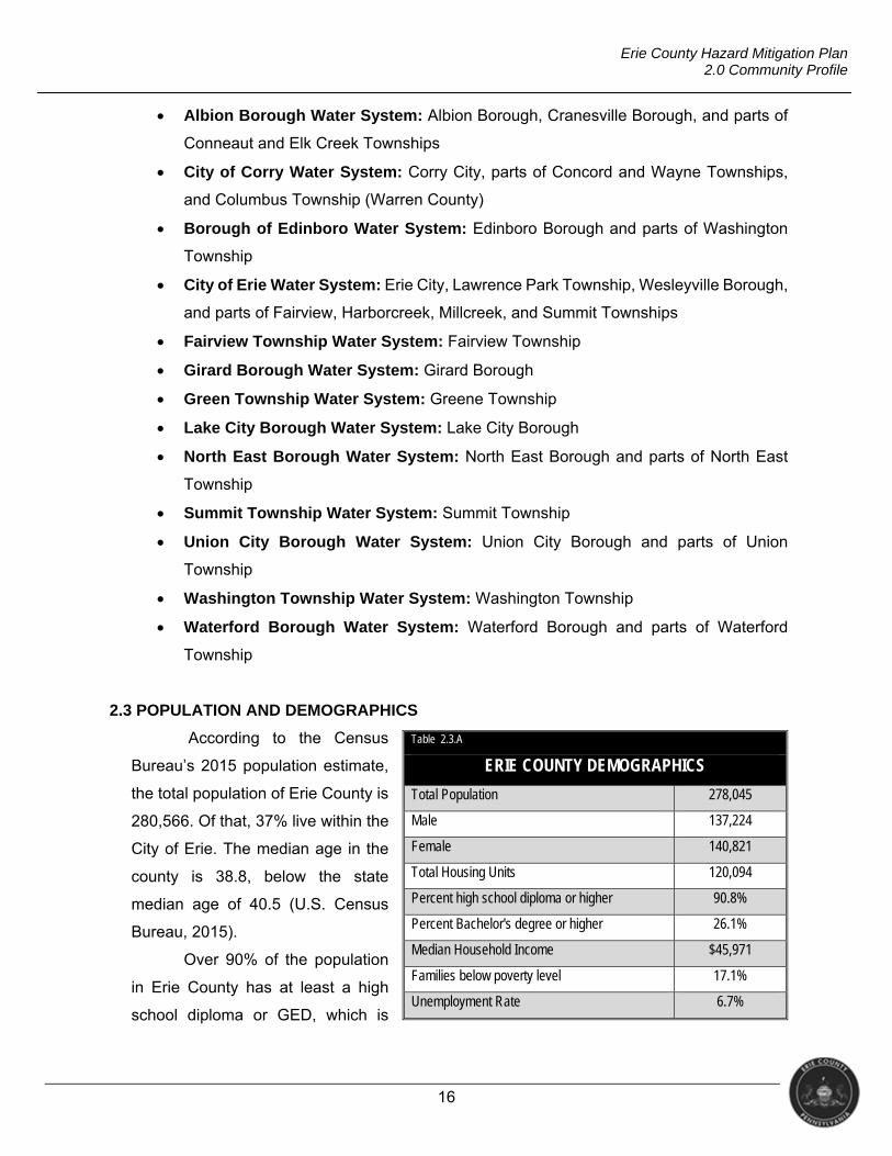
2.3 POPULATION AND DEMOGRAPHICS
According to the Census
Bureau’s 2015 population estimate,
the total population of Erie County is
280,566. Of that, 37% live within the
City of Erie. The median age in the
county is 38.8, below the state
median age of 40.5 (U.S. Census
Bureau, 2015).
Over 90% of the population
in Erie County has at least a high
school diploma or GED, which is
Table 2.3.A
ERIE COUNTY DEMOGRAPHICS
Total Population 278,045
Male 137,224
Female 140,821
Total Housing Units 120,094
Percent high school diploma or higher 90.8%
Percent Bachelor's degree or higher 26.1%
Median Household Income $45,971
Families below poverty level 17.1%
Unemployment Rate 6.7%
17
Erie County Hazard Mitigation Plan 2.0 Community Profile
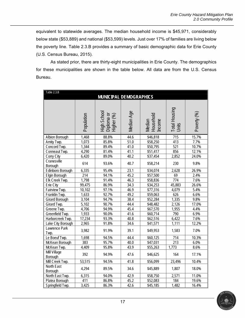
equivalent to statewide averages. The median household income is $45,971, considerably
below state ($53,889) and national ($53,599) levels. Just over 17% of families are living below
the poverty line. Table 2.3.B provides a summary of basic demographic data for Erie County
(U.S. Census Bureau, 2015).
As stated prior, there are thirty-eight municipalities in Erie County. The demographics
for these municipalities are shown in the table below. All data are from the U.S. Census
Bureau.
Table 2.3.B
MUNICIPAL DEMOGRAPHICS
Popu
latio
n
Hig
h Sc
hool
D
iplo
ma
or
Hig
her (
%)
Med
ian
Age
Med
ian
Hou
seho
ld
Inco
me
Tota
l Hou
sing
U
nits
Pove
rty (%
)
Albion Borough 1,468 88.8% 44.6 $46,818 715 15.7% Amity Twp. 1,073 85.8% 51.0 $58,250 413 7.7% Concord Twp. 1,344 89.4% 41.0 $50,795 521 10.7% Conneaut Twp. 4,290 81.4% 41.1 $51,417 856 12.1% Corry City 6,420 89.0% 40.2 $37,454 2,852 24.0% Cranesville Borough 614 93.6% 40.7 $58,214 230 9.8%
Edinboro Borough 6,335 95.4% 23.1 $34,074 2,628 26.9% Elgin Borough 214 94.1% 45.2 $57,500 69 2.4% Elk Creek Twp. 1,798 91.4% 46.3 $58,836 774 7.6% Erie City 99,475 86.9% 34.3 $34,253 45,883 26.6% Fairview Twp. 10,102 97.1% 46.9 $77,316 4,079 5.4% Franklin Twp. 1,633 92.7% 49.2 $59,063 626 6.6% Girard Borough 3,104 94.7% 38.4 $52,284 1,335 9.8% Girard Twp. 5,102 90.7% 44.4 $48,482 2,126 17.0% Greene Twp. 4,706 94.9% 45.4 $67,570 1,955 4.4% Greenfield Twp. 1,933 90.0% 41.6 $60,714 790 6.9% Harborcreek Twp. 17,234 93.3% 40.8 $62,516 6,422 7.6% Lake City Borough 2,965 91.8% 34.6 $41,571 1,111 12.2% Lawrence Park Twp.
3,982 91.9% 39.1 $49,953 1,583 7.0%
Le Boeuf Twp. 1,698 94.5% 44.4 $60,125 714 10.3% McKean Borough 383 95.7% 40.0 $47,031 213 6.0% McKean Twp. 4,409 95.8% 43.9 $55,263 1,773 8.6% Mill Village Borough
392 94.9% 47.6 $46,625 164 17.1%
Mill Creek Twp. 53,515 94.5% 41.8 $56,099 23,496 10.4% North East Borough
4,294 89.5% 34.6 $45,889 1,807 18.0%
North East Twp. 6,315 94.0% 42.9 $58,750 2,571 11.0% Platea Borough 411 86.8% 45.2 $52,083 184 19.6% Springfield Twp. 3,425 86.3% 42.6 $45,185 1,482 16.4%
18
Erie County Hazard Mitigation Plan 2.0 Community Profile
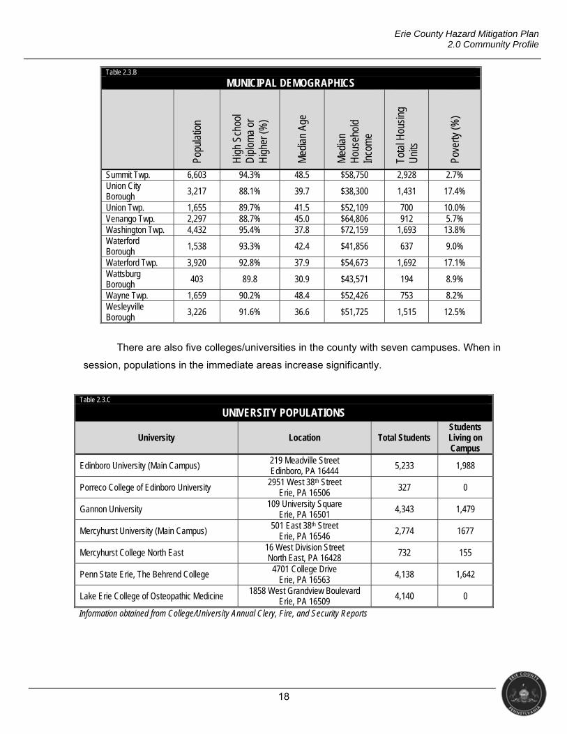
Table 2.3.B MUNICIPAL DEMOGRAPHICS
Popu
latio
n
Hig
h Sc
hool
D
iplo
ma
or
Hig
her (
%)
Med
ian
Age
Med
ian
Hou
seho
ld
Inco
me
Tota
l Hou
sing
U
nits
Pove
rty (%
)
Summit Twp. 6,603 94.3% 48.5 $58,750 2,928 2.7% Union City Borough 3,217 88.1% 39.7 $38,300 1,431 17.4%
Union Twp. 1,655 89.7% 41.5 $52,109 700 10.0% Venango Twp. 2,297 88.7% 45.0 $64,806 912 5.7% Washington Twp. 4,432 95.4% 37.8 $72,159 1,693 13.8% Waterford Borough
1,538 93.3% 42.4 $41,856 637 9.0%
Waterford Twp. 3,920 92.8% 37.9 $54,673 1,692 17.1% Wattsburg Borough 403 89.8 30.9 $43,571 194 8.9%
Wayne Twp. 1,659 90.2% 48.4 $52,426 753 8.2% Wesleyville Borough
3,226 91.6% 36.6 $51,725 1,515 12.5%
There are also five colleges/universities in the county with seven campuses. When in
session, populations in the immediate areas increase significantly.
Table 2.3.C UNIVERSITY POPULATIONS
University Location Total Students Students Living on Campus
Edinboro University (Main Campus) 219 Meadville Street Edinboro, PA 16444
5,233 1,988
Porreco College of Edinboro University 2951 West 38th Street Erie, PA 16506
327 0
Gannon University 109 University Square
Erie, PA 16501 4,343 1,479
Mercyhurst University (Main Campus) 501 East 38th Street
Erie, PA 16546 2,774 1677
Mercyhurst College North East 16 West Division Street North East, PA 16428 732 155
Penn State Erie, The Behrend College 4701 College Drive Erie, PA 16563
4,138 1,642
Lake Erie College of Osteopathic Medicine 1858 West Grandview Boulevard Erie, PA 16509
4,140 0
Information obtained from College/University Annual Clery, Fire, and Security Reports
19
Erie County Hazard Mitigation Plan 2.0 Community Profile
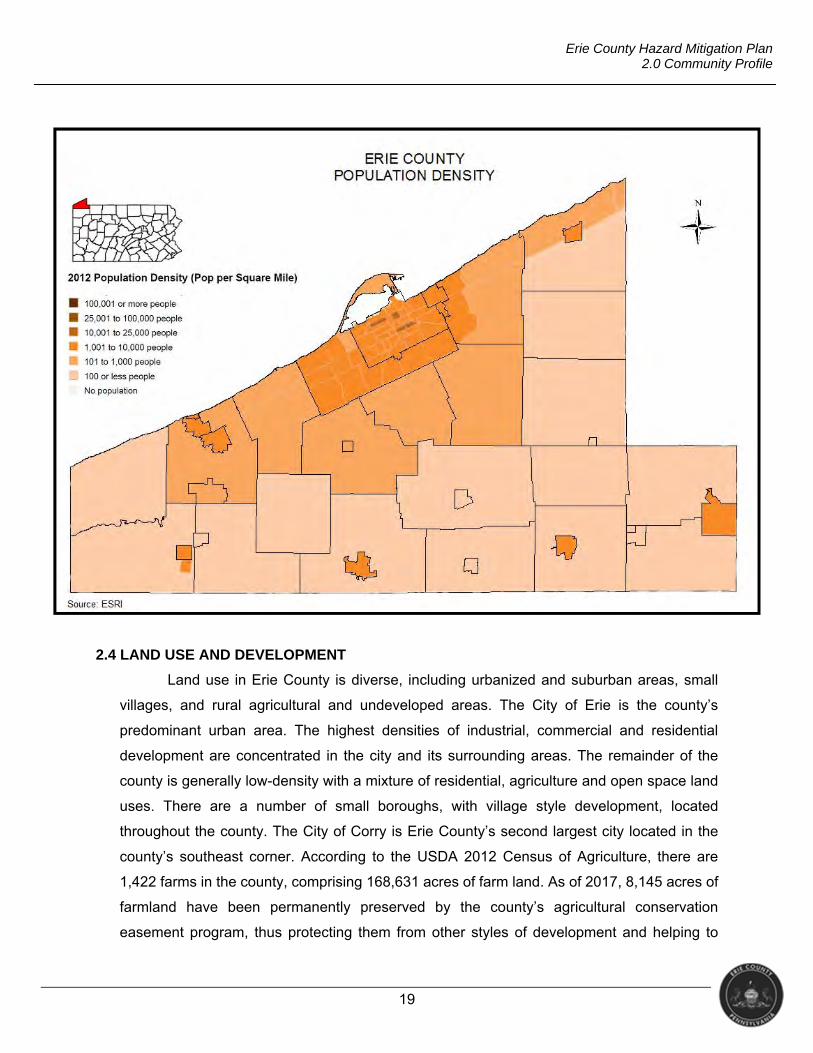
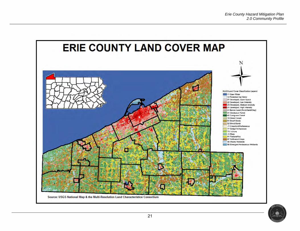
2.4 LAND USE AND DEVELOPMENT
Land use in Erie County is diverse, including urbanized and suburban areas, small
villages, and rural agricultural and undeveloped areas. The City of Erie is the county’s
predominant urban area. The highest densities of industrial, commercial and residential
development are concentrated in the city and its surrounding areas. The remainder of the
county is generally low-density with a mixture of residential, agriculture and open space land
uses. There are a number of small boroughs, with village style development, located
throughout the county. The City of Corry is Erie County’s second largest city located in the
county’s southeast corner. According to the USDA 2012 Census of Agriculture, there are
1,422 farms in the county, comprising 168,631 acres of farm land. As of 2017, 8,145 acres of
farmland have been permanently preserved by the county’s agricultural conservation
easement program, thus protecting them from other styles of development and helping to
20
Erie County Hazard Mitigation Plan 2.0 Community Profile
maintain the character of the county’s rural areas. The brown and yellow areas of the map
below represent those supporting cultivated crops and pasture land (respectively). These
areas could be adversely impacted by drought conditions as well as other severe weather
hazards (e.g., intense or prolonged precipitation, extreme heat, or extreme cold).
Land cover significantly affects hazard vulnerability. For example, as urbanization
occurs, areas that were once covered with trees and grass are often replaced by impervious
surfaces of roads, roofs, and parking lots. This urbanization reduces infiltration of rainwater
thus increasing the amount of stormwater runoff and the potential for flash flooding (USGS,
2005). The pink and red sections of the map below would best represent these areas, and
could thus be susceptible to damage during high-density rain events. As development
continues, projects that enhance infiltration, such as retention basins, permeable pavement
installations, etc. could mitigate some forms of flash flooding. More densely-developed areas
may also be subject to risk from infrastructure decay, as roadways, water/sewer systems, and
other infrastructure age. Increases in structural development often correlate with increases of
strain on infrastructure systems. The increase in usage, combined with age and deterioration,
may hasten an infrastructure failure.
The transportation system profoundly influences land use and development. Roads,
rails, airports, and ports are important for the transportation of people, goods and services;
thus, development occurs around transportation hubs. Whereas “good” infrastructure can
support increased development, aging or faulty infrastructure may discourage it. As such, the
general infrastructure decay hazard may result in economic risk. In addition to the highways,
rails and airport discussed above, Erie County is also home to the Port of Erie. The Port of
Erie, along with the other two ports in the state (the ports of Philadelphia and Pittsburgh),
combine to move over 100 million tons of goods with an economic benefit of nearly $50 billion
dollars annually (PennDOT, 2017). The Port of Erie’s economic influence can be impacted by
various lake hazards as well as infrastructure decay.
21
Erie County Hazard Mitigation Plan 2.0 Community Profile
22
Erie County Hazard Mitigation Plan 2.0 Community Profile
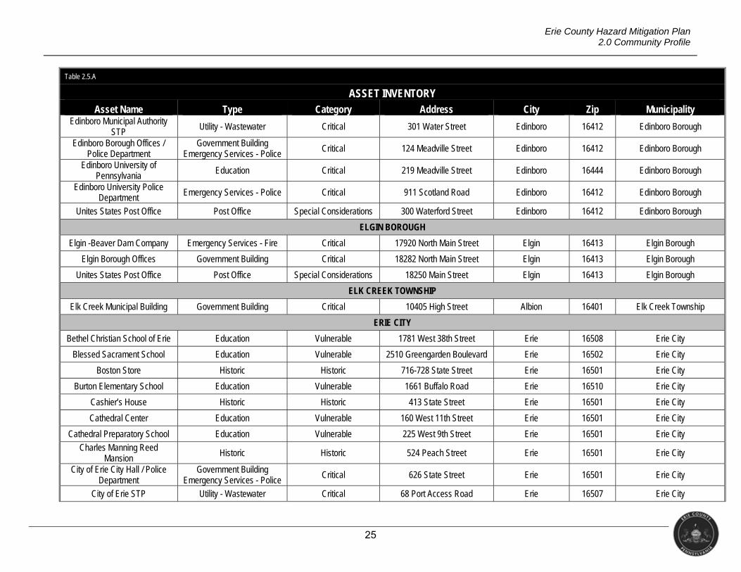
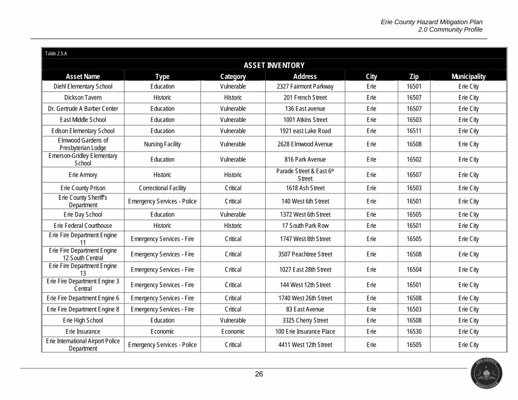
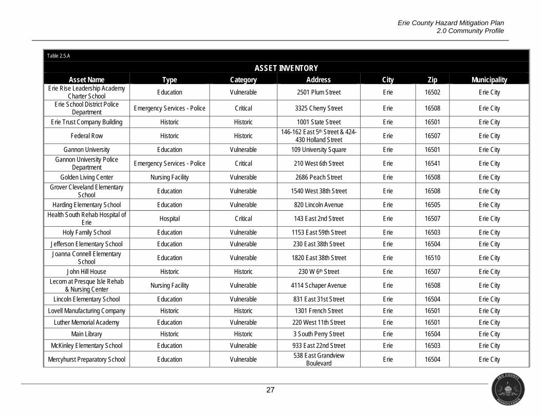
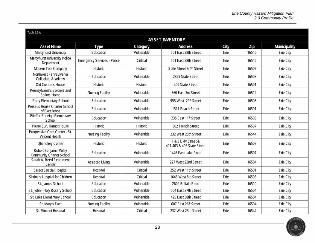
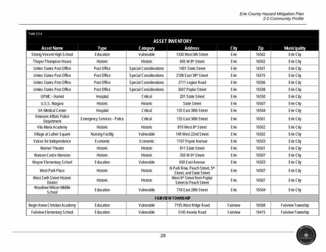
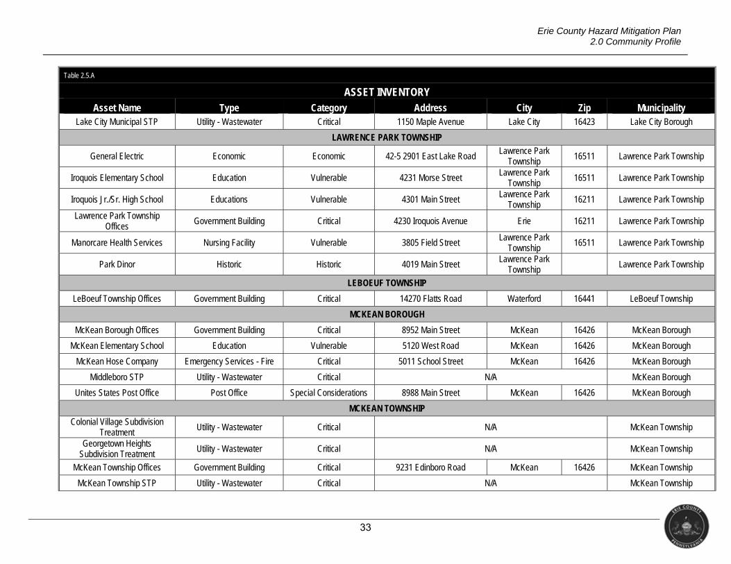
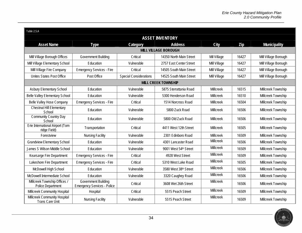
2.5 INVENTORY ASSETS
This plan identifies potentially-vulnerable community assets such as critical facilities,
critical infrastructure, historical properties, commercial/industrial facilities, etc. Assets
contribute directly to the quality of life in the community as well as ensure its continued
operation. As such, government facilities are often listed, as are water/wastewater and
transportation infrastructure. Assets can also be irreplaceable items within the community,
such as historical structures or even vulnerable populations (including the elderly or youths).
Methodology
Inventorying assets first involves determining what in the community can be affected
by a hazard event. The hazard profiles contained in Section 4 contain generalized loss
estimates that, in some cases identify the types of facilities that could be impacted by the
hazards considered in this plan. Additionally, the committee used its meetings during the
update process to significantly revise the previous version of the list. In Table 2.5.A, assets
are grouped into the following categories.
Critical Facilities: Governmental facilities, water/wastewater facilities, emergency
services facilities, medical facilities (hospitals/clinics), and transportation infrastructure
Vulnerable Populations: Schools, nursing homes, and senior centers
Economic Assets: Large commercial/industrial facilities or large employers (not
covered in other categories)
Special Considerations: Community outreach facilities, post offices, and libraries
Historical Considerations: Areas/structures listed on the National Register of
Historic Places
23
Erie County Hazard Mitigation Plan 2.0 Community Profile
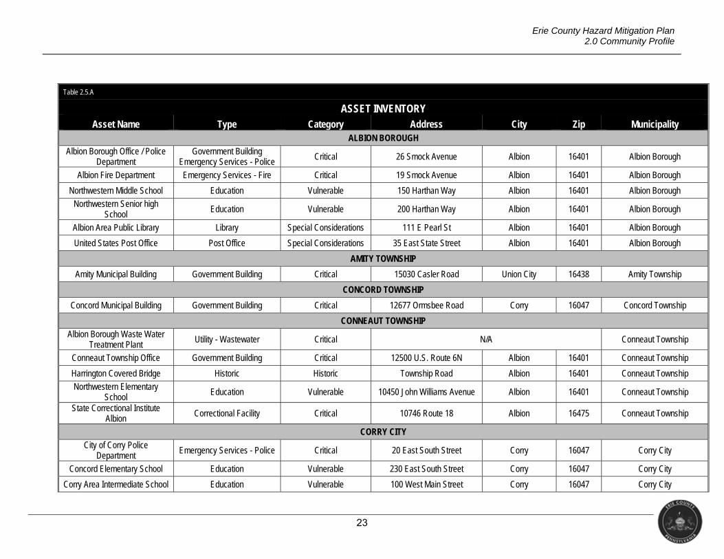
Table 2.5.A
ASSET INVENTORY Asset Name Type Category Address City Zip Municipality
ALBION BOROUGH
Albion Borough Office / Police Department
Government Building Emergency Services - Police Critical 26 Smock Avenue Albion 16401 Albion Borough
Albion Fire Department Emergency Services - Fire Critical 19 Smock Avenue Albion 16401 Albion Borough
Northwestern Middle School Education Vulnerable 150 Harthan Way Albion 16401 Albion Borough
Northwestern Senior high School
Education Vulnerable 200 Harthan Way Albion 16401 Albion Borough
Albion Area Public Library Library Special Considerations 111 E Pearl St Albion 16401 Albion Borough
United States Post Office Post Office Special Considerations 35 East State Street Albion 16401 Albion Borough
AMITY TOWNSHIP
Amity Municipal Building Government Building Critical 15030 Casler Road Union City 16438 Amity Township
CONCORD TOWNSHIP
Concord Municipal Building Government Building Critical 12677 Ormsbee Road Corry 16047 Concord Township
CONNEAUT TOWNSHIP
Albion Borough Waste Water Treatment Plant
Utility - Wastewater Critical N/A Conneaut Township
Conneaut Township Office Government Building Critical 12500 U.S. Route 6N Albion 16401 Conneaut Township
Harrington Covered Bridge Historic Historic Township Road Albion 16401 Conneaut Township
Northwestern Elementary School Education Vulnerable 10450 John Williams Avenue Albion 16401 Conneaut Township
State Correctional Institute Albion
Correctional Facility Critical 10746 Route 18 Albion 16475 Conneaut Township
CORRY CITY
City of Corry Police Department Emergency Services - Police Critical 20 East South Street Corry 16047 Corry City
Concord Elementary School Education Vulnerable 230 East South Street Corry 16047 Corry City
Corry Area Intermediate School Education Vulnerable 100 West Main Street Corry 16047 Corry City
24
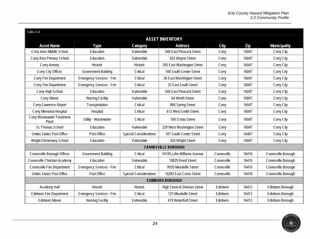
Erie County Hazard Mitigation Plan 2.0 Community Profile
Table 2.5.A
ASSET INVENTORY Asset Name Type Category Address City Zip Municipality
Corry Area Middle School Education Vulnerable 540 East Pleasant Street Corry 16047 Corry City
Corry Area Primary School Education Vulnerable 423 Wayne Street Corry 16047 Corry City
Corry Armory Historic Historic 205 East Washington Street Corry 16047 Corry City
Corry City Offices Government Building Critical 100 South Center Street Corry 16047 Corry City
Corry Fire Department Emergency Services - Fire Critical 26 East Washington Street Corry 16047 Corry City
Corry Fire Department Emergency Services - Fire Critical 25 East South Street Corry 16047 Corry City
Corry High School Education Vulnerable 540 East Pleasant Street Corry 16047 Corry City
Corry Manor Nursing Facility Vulnerable 64 Worth Street Corry 16047 Corry City
Corry-Lawrence Airport Transportation Critical 800 Spring Street Corry 16047 Corry City
Corry Memorial Hospital Hospital Critical 612 West Smith Street Corry 16047 Corry City
Corry Wastewater Treatment Plant
Utility - Wastewater Critical 100 Sciota Street Corry 16047 Corry City
St. Thomas School Education Vulnerable 229 West Washington Street Corry 16047 Corry City
Unites States Post Office Post Office Special Considerations 101 South Center Street Corry 16407 Corry City
Wright Elementary School Education Vulnerable 426 Wright Street Corry 16047 Corry City
CRANESVILLE BOROUGH
Cranesville Borough Offices Government Building Critical 10195 John Williams Avenue Cranesville 16410 Cranesville Borough
Cranesville Christian Academy Education Vulnerable 10029 Reed Street Cranesville 16410 Cranesville Borough
Cranesville Fire Department Emergency Services - Fire Critical 9920 Meadville Street Cranesville 16410 Cranesville Borough
Unites States Post Office Post Office Special Considerations 10283 East Crane Street Cranesville 16410 Cranesville Borough
EDINBORO BOROUGH
Academy Hall Historic Historic High Street & Division Street Edinboro 16412 Edinboro Borough
Edinboro Fire Department Emergency Services - Fire Critical 125 Meadville Street Edinboro 16412 Edinboro Borough
Edinboro Manor Nursing Facility Vulnerable 419 Waterford Street Edinboro 16412 Edinboro Borough
25
Erie County Hazard Mitigation Plan 2.0 Community Profile
Table 2.5.A
ASSET INVENTORY Asset Name Type Category Address City Zip Municipality
Edinboro Municipal Authority STP
Utility - Wastewater Critical 301 Water Street Edinboro 16412 Edinboro Borough
Edinboro Borough Offices / Police Department
Government Building Emergency Services - Police Critical 124 Meadville Street Edinboro 16412 Edinboro Borough
Edinboro University of Pennsylvania Education Critical 219 Meadville Street Edinboro 16444 Edinboro Borough
Edinboro University Police Department
Emergency Services - Police Critical 911 Scotland Road Edinboro 16412 Edinboro Borough
Unites States Post Office Post Office Special Considerations 300 Waterford Street Edinboro 16412 Edinboro Borough
ELGIN BOROUGH
Elgin -Beaver Dam Company Emergency Services - Fire Critical 17920 North Main Street Elgin 16413 Elgin Borough
Elgin Borough Offices Government Building Critical 18282 North Main Street Elgin 16413 Elgin Borough
Unites States Post Office Post Office Special Considerations 18250 Main Street Elgin 16413 Elgin Borough
ELK CREEK TOWNSHIP
Elk Creek Municipal Building Government Building Critical 10405 High Street Albion 16401 Elk Creek Township
ERIE CITY
Bethel Christian School of Erie Education Vulnerable 1781 West 38th Street Erie 16508 Erie City
Blessed Sacrament School Education Vulnerable 2510 Greengarden Boulevard Erie 16502 Erie City
Boston Store Historic Historic 716-728 State Street Erie 16501 Erie City
Burton Elementary School Education Vulnerable 1661 Buffalo Road Erie 16510 Erie City
Cashier’s House Historic Historic 413 State Street Erie 16501 Erie City
Cathedral Center Education Vulnerable 160 West 11th Street Erie 16501 Erie City
Cathedral Preparatory School Education Vulnerable 225 West 9th Street Erie 16501 Erie City
Charles Manning Reed Mansion
Historic Historic 524 Peach Street Erie 16501 Erie City
City of Erie City Hall / Police Department
Government Building Emergency Services - Police
Critical 626 State Street Erie 16501 Erie City
City of Erie STP Utility - Wastewater Critical 68 Port Access Road Erie 16507 Erie City
26
Erie County Hazard Mitigation Plan 2.0 Community Profile
Table 2.5.A
ASSET INVENTORY Asset Name Type Category Address City Zip Municipality
Diehl Elementary School Education Vulnerable 2327 Fairmont Parkway Erie 16501 Erie City
Dickson Tavern Historic Historic 201 French Street Erie 16507 Erie City
Dr. Gertrude A Barber Center Education Vulnerable 136 East avenue Erie 16507 Erie City
East Middle School Education Vulnerable 1001 Atkins Street Erie 16503 Erie City
Edison Elementary School Education Vulnerable 1921 east Lake Road Erie 16511 Erie City
Elmwood Gardens of Presbyterian Lodge Nursing Facility Vulnerable 2628 Elmwood Avenue Erie 16508 Erie City
Emerson-Gridley Elementary School
Education Vulnerable 816 Park Avenue Erie 16502 Erie City
Erie Armory Historic Historic Parade Street & East 6th Street
Erie 16507 Erie City
Erie County Prison Correctional Facility Critical 1618 Ash Street Erie 16503 Erie City
Erie County Sheriff’s Department
Emergency Services - Police Critical 140 West 6th Street Erie 16501 Erie City
Erie Day School Education Vulnerable 1372 West 6th Street Erie 16505 Erie City
Erie Federal Courthouse Historic Historic 17 South Park Row Erie 16501 Erie City
Erie Fire Department Engine 11
Emergency Services - Fire Critical 1747 West 8th Street Erie 16505 Erie City
Erie Fire Department Engine 12 South Central Emergency Services - Fire Critical 3507 Peachtree Street Erie 16508 Erie City
Erie Fire Department Engine 13 Emergency Services - Fire Critical 1027 East 28th Street Erie 16504 Erie City
Erie Fire Department Engine 3 Central
Emergency Services - Fire Critical 144 West 12th Street Erie 16501 Erie City
Erie Fire Department Engine 6 Emergency Services - Fire Critical 1740 West 26th Street Erie 16508 Erie City
Erie Fire Department Engine 8 Emergency Services - Fire Critical 83 East Avenue Erie 16503 Erie City
Erie High School Education Vulnerable 3325 Cherry Street Erie 16508 Erie City
Erie Insurance Economic Economic 100 Erie Insurance Place Erie 16530 Erie City
Erie International Airport Police Department Emergency Services - Police Critical 4411 West 12th Street Erie 16505 Erie City
27
Erie County Hazard Mitigation Plan 2.0 Community Profile
Table 2.5.A
ASSET INVENTORY Asset Name Type Category Address City Zip Municipality
Erie Rise Leadership Academy Charter School
Education Vulnerable 2501 Plum Street Erie 16502 Erie City
Erie School District Police Department Emergency Services - Police Critical 3325 Cherry Street Erie 16508 Erie City
Erie Trust Company Building Historic Historic 1001 State Street Erie 16501 Erie City
Federal Row Historic Historic 146-162 East 5th Street & 424-
430 Holland Street Erie 16507 Erie City
Gannon University Education Vulnerable 109 University Square Erie 16501 Erie City
Gannon University Police Department
Emergency Services - Police Critical 210 West 6th Street Erie 16541 Erie City
Golden Living Center Nursing Facility Vulnerable 2686 Peach Street Erie 16508 Erie City
Grover Cleveland Elementary School
Education Vulnerable 1540 West 38th Street Erie 16508 Erie City
Harding Elementary School Education Vulnerable 820 Lincoln Avenue Erie 16505 Erie City
Health South Rehab Hospital of Erie
Hospital Critical 143 East 2nd Street Erie 16507 Erie City
Holy Family School Education Vulnerable 1153 East 59th Street Erie 16503 Erie City
Jefferson Elementary School Education Vulnerable 230 East 38th Street Erie 16504 Erie City
Joanna Connell Elementary School Education Vulnerable 1820 East 38th Street Erie 16510 Erie City
John Hill House Historic Historic 230 W 6th Street Erie 16507 Erie City
Lecom at Presque Isle Rehab & Nursing Center
Nursing Facility Vulnerable 4114 Schaper Avenue Erie 16508 Erie City
Lincoln Elementary School Education Vulnerable 831 East 31st Street Erie 16504 Erie City
Lovell Manufacturing Company Historic Historic 1301 French Street Erie 16501 Erie City
Luther Memorial Academy Education Vulnerable 220 West 11th Street Erie 16501 Erie City
Main Library Historic Historic 3 South Perry Street Erie 16504 Erie City
McKinley Elementary School Education Vulnerable 933 East 22nd Street Erie 16503 Erie City
Mercyhurst Preparatory School Education Vulnerable 538 East Grandview
Boulevard Erie 16504 Erie City
28
Erie County Hazard Mitigation Plan 2.0 Community Profile
Table 2.5.A
ASSET INVENTORY Asset Name Type Category Address City Zip Municipality
Mercyhurst University Education Vulnerable 501 East 38th Street Erie 16546 Erie City
Mercyhurst University Police Department
Emergency Services - Police Critical 501 East 38th Street Erie 16546 Erie City
Modern Tool Company Historic Historic State Street & 4th Street Erie 16507 Erie City
Northwest Pennsylvania Collegiate Academy
Education Vulnerable 2825 State Street Erie 16508 Erie City
Old Customs House Historic Historic 409 State Street Erie 16501 Erie City
Pennsylvania’s Soldiers and Sailors Home Nursing Facility Vulnerable 560 East 3rd Street Erie 16512 Erie City
Perry Elementary School Education Vulnerable 955 West 29th Street Erie 16508 Erie City
Perseus House Charter School of Excellence Education Vulnerable 1511 Peach Street Erie 16501 Erie City
Pfieffer-Burleigh Elementary School Education Vulnerable 235 East 11th Street Erie 16503 Erie City
Pierre S.V. Hamot House Historic Historic 302 French Street Erie 16507 Erie City
Progressive Care Center - St. Vincent Health Nursing Facility Vulnerable 232 West 25th Street Erie 16544 Erie City
Qhandlery Corner Historic Historic 1 & 3 E 4th Street &
401-403 & 405 State Street Erie 16507 Erie City
Robert Benjamin Wiley Community Charter School
Education Vulnerable 1446 East Lake Road Erie 16507 Erie City
Sarah A. Reed Retirement Center
Assisted Living Vulnerable 227 West 22nd Street Erie 16504 Erie City
Select Special Hospital Hospital Critical 252 West 11th Street Erie 16501 Erie City
Shriners Hospital for Children Hospital Critical 1645 West 8th Street Erie 16505 Erie City
St. James School Education Vulnerable 2602 Buffalo Road Erie 16510 Erie City
St. John - Holy Rosary School Education Vulnerable 504 East 27th Street Erie 16504 Erie City
St. Luke Elementary School Education Vulnerable 425 East 38th Street Erie 16504 Erie City
St. Mary’s East Nursing Facility Vulnerable 607 East 26th Street Erie 16504 Erie City
St. Vincent Hospital Hospital Critical 232 West 25th Street Erie 16544 Erie City
29
Erie County Hazard Mitigation Plan 2.0 Community Profile
Table 2.5.A
ASSET INVENTORY Asset Name Type Category Address City Zip Municipality
Strong Vincent High School Education Vulnerable 1330 West 8th Street Erie 16502 Erie City
Thayer-Thompson House Historic Historic 605 W 8th Street Erie 16502 Erie City
Unites States Post Office Post Office Special Considerations 1401 State Street Erie 16501 Erie City
Unites States Post Office Post Office Special Considerations 2108 East 38th Street Erie 16515 Erie City
Unites States Post Office Post Office Special Considerations 2711 Legion Road Erie 16506 Erie City
Unites States Post Office Post Office Special Considerations 3607 Poplar Street Erie 16508 Erie City
UPMC - Hamot Hospital Critical 201 State Street Erie 16550 Erie City
U.S.S. Niagara Historic Historic State Street Erie 16507 Erie City
VA Medical Center Hospital Critical 135 East 38th Street Erie 16504 Erie City
Veterans Affairs Police Department
Emergency Services - Police Critical 135 East 38th Street Erie 16501 Erie City
Vila Maria Academy Historic Historic 819 West 8th Street Erie 16502 Erie City
Village at Luther Square Nursing Facility Vulnerable 149 West 22nd Street Erie 16502 Erie City
Voices for Independence Economic Economic 1107 Payne Avenue Erie 16503 Erie City
Warner Theater Historic Historic 811 State Street Erie 16501 Erie City
Watson-Curtze Mansion Historic Historic 356 W 6th Street Erie 16507 Erie City
Wayne Elementary School Education Vulnerable 650 East Avenue Erie 16503 Erie City
West Park Place Historic Historic N Park Row, Peach Street, 5th
Street, and State Street Erie 16507 Erie City
West Sixth Street Historic District Historic Historic
West 6th Street from Poplar Street to Peach Street Erie 16507 Erie City
Woodrow Wilson Middle School
Education Vulnerable 718 East 28th Street Erie 16504 Erie City
FAIRVIEW TOWNSHIP
Begin Anew Christian Academy Education Vulnerable 7195 West Ridge Road Fairview 16508 Fairview Township
Fairview Elementary School Education Vulnerable 5145 Avonia Road Fairview 16415 Fairview Township
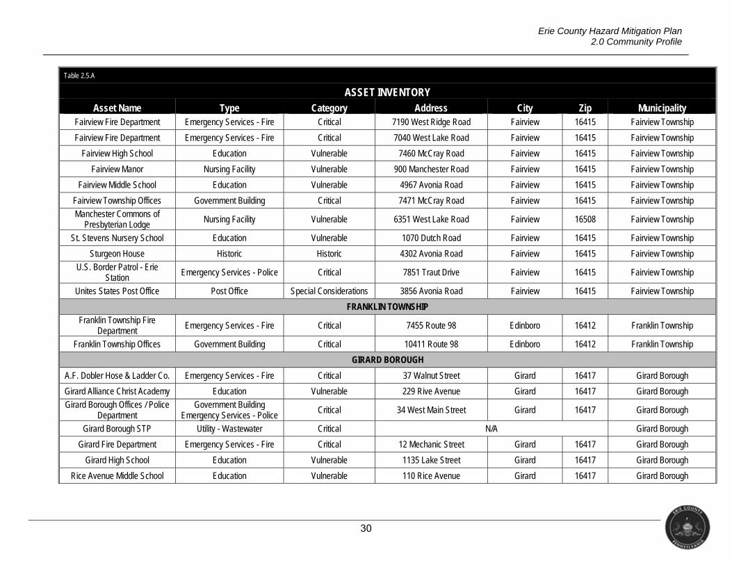
30
Erie County Hazard Mitigation Plan 2.0 Community Profile
Table 2.5.A
ASSET INVENTORY Asset Name Type Category Address City Zip Municipality
Fairview Fire Department Emergency Services - Fire Critical 7190 West Ridge Road Fairview 16415 Fairview Township
Fairview Fire Department Emergency Services - Fire Critical 7040 West Lake Road Fairview 16415 Fairview Township
Fairview High School Education Vulnerable 7460 McCray Road Fairview 16415 Fairview Township
Fairview Manor Nursing Facility Vulnerable 900 Manchester Road Fairview 16415 Fairview Township
Fairview Middle School Education Vulnerable 4967 Avonia Road Fairview 16415 Fairview Township
Fairview Township Offices Government Building Critical 7471 McCray Road Fairview 16415 Fairview Township
Manchester Commons of Presbyterian Lodge
Nursing Facility Vulnerable 6351 West Lake Road Fairview 16508 Fairview Township
St. Stevens Nursery School Education Vulnerable 1070 Dutch Road Fairview 16415 Fairview Township
Sturgeon House Historic Historic 4302 Avonia Road Fairview 16415 Fairview Township
U.S. Border Patrol - Erie Station
Emergency Services - Police Critical 7851 Traut Drive Fairview 16415 Fairview Township
Unites States Post Office Post Office Special Considerations 3856 Avonia Road Fairview 16415 Fairview Township
FRANKLIN TOWNSHIP
Franklin Township Fire Department
Emergency Services - Fire Critical 7455 Route 98 Edinboro 16412 Franklin Township
Franklin Township Offices Government Building Critical 10411 Route 98 Edinboro 16412 Franklin Township
GIRARD BOROUGH
A.F. Dobler Hose & Ladder Co. Emergency Services - Fire Critical 37 Walnut Street Girard 16417 Girard Borough
Girard Alliance Christ Academy Education Vulnerable 229 Rive Avenue Girard 16417 Girard Borough
Girard Borough Offices / Police Department
Government Building Emergency Services - Police
Critical 34 West Main Street Girard 16417 Girard Borough
Girard Borough STP Utility - Wastewater Critical N/A Girard Borough
Girard Fire Department Emergency Services - Fire Critical 12 Mechanic Street Girard 16417 Girard Borough
Girard High School Education Vulnerable 1135 Lake Street Girard 16417 Girard Borough
Rice Avenue Middle School Education Vulnerable 110 Rice Avenue Girard 16417 Girard Borough
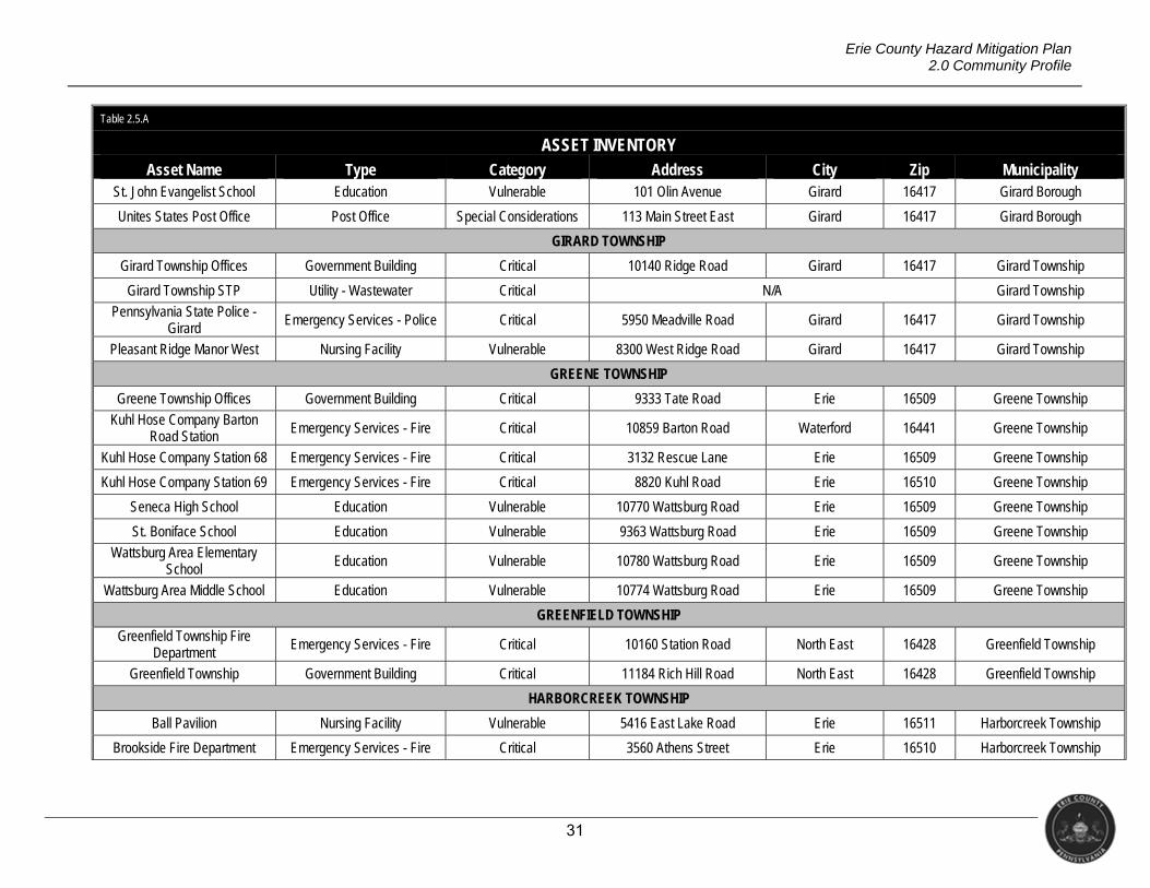
31
Erie County Hazard Mitigation Plan 2.0 Community Profile
Table 2.5.A
ASSET INVENTORY Asset Name Type Category Address City Zip Municipality
St. John Evangelist School Education Vulnerable 101 Olin Avenue Girard 16417 Girard Borough
Unites States Post Office Post Office Special Considerations 113 Main Street East Girard 16417 Girard Borough
GIRARD TOWNSHIP
Girard Township Offices Government Building Critical 10140 Ridge Road Girard 16417 Girard Township
Girard Township STP Utility - Wastewater Critical N/A Girard Township
Pennsylvania State Police - Girard Emergency Services - Police Critical 5950 Meadville Road Girard 16417 Girard Township
Pleasant Ridge Manor West Nursing Facility Vulnerable 8300 West Ridge Road Girard 16417 Girard Township
GREENE TOWNSHIP
Greene Township Offices Government Building Critical 9333 Tate Road Erie 16509 Greene Township
Kuhl Hose Company Barton Road Station
Emergency Services - Fire Critical 10859 Barton Road Waterford 16441 Greene Township
Kuhl Hose Company Station 68 Emergency Services - Fire Critical 3132 Rescue Lane Erie 16509 Greene Township
Kuhl Hose Company Station 69 Emergency Services - Fire Critical 8820 Kuhl Road Erie 16510 Greene Township
Seneca High School Education Vulnerable 10770 Wattsburg Road Erie 16509 Greene Township
St. Boniface School Education Vulnerable 9363 Wattsburg Road Erie 16509 Greene Township
Wattsburg Area Elementary School Education Vulnerable 10780 Wattsburg Road Erie 16509 Greene Township
Wattsburg Area Middle School Education Vulnerable 10774 Wattsburg Road Erie 16509 Greene Township
GREENFIELD TOWNSHIP
Greenfield Township Fire Department
Emergency Services - Fire Critical 10160 Station Road North East 16428 Greenfield Township
Greenfield Township Government Building Critical 11184 Rich Hill Road North East 16428 Greenfield Township
HARBORCREEK TOWNSHIP
Ball Pavilion Nursing Facility Vulnerable 5416 East Lake Road Erie 16511 Harborcreek Township
Brookside Fire Department Emergency Services - Fire Critical 3560 Athens Street Erie 16510 Harborcreek Township
32
Erie County Hazard Mitigation Plan 2.0 Community Profile
Table 2.5.A
ASSET INVENTORY Asset Name Type Category Address City Zip Municipality
Clark Elementary School Education Vulnerable 3650 Depot road Erie 16510 Harborcreek Township
Fairfield Hose company Emergency Services - Fire Critical 4896 East Lake Road Erie 16511 Harborcreek Township
Harbor Creek Junior High School Education Vulnerable 6375 Buffalo Road Harborcreek 16421 Harborcreek Township
Harbor Creek Senior high School
Education Vulnerable 6375 Buffalo Road Harborcreek 16421 Harborcreek Township
Harborcreek Christian School Education Vulnerable 4719 Buffalo Road Erie 16510 Harborcreek Township
Harborcreek Fire Department Emergency Services - Fire Critical 8024 East Lake Road Erie 16511 Harborcreek Township
Harborcreek Fire Department Emergency Services - Fire Critical 7275 Buffalo Road Harborcreek 16421 Harborcreek Township
Harborcreek Township Offices Government Building Critical 5610 Buffalo Road Harborcreek 16421 Harborcreek Township
Klein Elementary School Education Vulnerable 5325 East Lake Road Erie 16511 Harborcreek Township
Penn State Behrend Police Department
Emergency Services - Police Critical 4651 College Drive Erie 16563 Harborcreek Township
Penn State Erie, Behrend College (Main Campus) Education Vulnerable 4701 College Drive Erie 16563 Harborcreek Township
Rolling Ridge Elementary School Education Vulnerable 3700 Ridge Road Harborcreek 16510 Harborcreek Township
Unites States Post Office Post Office Special Considerations 7175 Buffalo Road Harborcreek 16421 Harborcreek Township
Vineyard Christian Kindergarten Education Vulnerable 7895 Buffalo Road Harborcreek 16421 Harborcreek Township
Wal-Mart Economic Economic 5741 Buffalo Road Harborcreek 16421 Harborcreek Township
LAKE CITY BOROUGH
Elk Valley Elementary School Education Vulnerable 2556 Maple Avenue Lake City 16423 Lake City Borough
Lake City Borough Police Department Emergency Services - Police Critical 2352 Main Street Lake City 16423 Lake City Borough
Lake City Borough Offices Government Building Critical 2350 Main Street Lake City 16423 Lake City Borough
Lake City Fire Company Emergency Services - Fire Critical 2232 Rice Avenue Lake City 16423 Lake City Borough
Lake City Fire Company Emergency Services - Fire Critical 10157 West Lake Road Lake City 16423 Lake City Borough
33
Erie County Hazard Mitigation Plan 2.0 Community Profile
Table 2.5.A
ASSET INVENTORY Asset Name Type Category Address City Zip Municipality
Lake City Municipal STP Utility - Wastewater Critical 1150 Maple Avenue Lake City 16423 Lake City Borough
LAWRENCE PARK TOWNSHIP
General Electric Economic Economic 42-5 2901 East Lake Road Lawrence Park
Township 16511 Lawrence Park Township
Iroquois Elementary School Education Vulnerable 4231 Morse Street Lawrence Park Township
16511 Lawrence Park Township
Iroquois Jr./Sr. High School Educations Vulnerable 4301 Main Street Lawrence Park Township
16211 Lawrence Park Township
Lawrence Park Township Offices
Government Building Critical 4230 Iroquois Avenue Erie 16211 Lawrence Park Township
Manorcare Health Services Nursing Facility Vulnerable 3805 Field Street Lawrence Park
Township 16511 Lawrence Park Township
Park Dinor Historic Historic 4019 Main Street Lawrence Park
Township Lawrence Park Township
LEBOEUF TOWNSHIP
LeBoeuf Township Offices Government Building Critical 14270 Flatts Road Waterford 16441 LeBoeuf Township
MCKEAN BOROUGH
McKean Borough Offices Government Building Critical 8952 Main Street McKean 16426 McKean Borough
McKean Elementary School Education Vulnerable 5120 West Road McKean 16426 McKean Borough
McKean Hose Company Emergency Services - Fire Critical 5011 School Street McKean 16426 McKean Borough
Middleboro STP Utility - Wastewater Critical N/A McKean Borough
Unites States Post Office Post Office Special Considerations 8988 Main Street McKean 16426 McKean Borough
MCKEAN TOWNSHIP
Colonial Village Subdivision Treatment Utility - Wastewater Critical N/A McKean Township
Georgetown Heights Subdivision Treatment
Utility - Wastewater Critical N/A McKean Township
McKean Township Offices Government Building Critical 9231 Edinboro Road McKean 16426 McKean Township
McKean Township STP Utility - Wastewater Critical N/A McKean Township
34
Erie County Hazard Mitigation Plan 2.0 Community Profile
Table 2.5.A
ASSET INVENTORY Asset Name Type Category Address City Zip Municipality
MILL VILLAGE BOROUGH
Mill Village Borough Offices Government Building Critical 14350 North Main Street Mil Village 16427 Mill Village Borough
Mill Village Elementary School Education Vulnerable 2757 East Center Street Mill Village 16427 Mill Village Borough
Mill Village Fire Company Emergency Services - Fire Critical 14505 South Main Street Mill Village 16427 Mill Village Borough
Unites States Post Office Post Office Special Considerations 14525 South Main Street Mill Village 16427 Mill Village Borough
MILL CREEK TOWNSHIP
Asbury Elementary School Education Vulnerable 5875 Sterrattania Road Millcreek 16515 Millcreek Township
Belle Valley Elementary School Education Vulnerable 5300 Henderson Road Millcreek 16510 Millcreek Township
Belle Valley Hose Company Emergency Services - Fire Critical 1514 Norcross Road Millcreek 16504 Millcreek Township
Chestnut Hill Elementary School
Education Vulnerable 5800 Zuck Road Millcreek 16506 Millcreek Township
Community Country Day School Education Vulnerable 5800 Old Zuck Road Millcreek 16506 Millcreek Township
Erie International Airport (Tom ridge Field) Transportation Critical 4411 West 12th Street Millcreek 16505 Millcreek Township
Forestview Nursing Facility Vulnerable 2301 Edinboro Road Millcreek 16509 Millcreek Township
Grandview Elementary School Education Vulnerable 4301 Lancaster Road Millcreek 16506 Millcreek Township
James S Wilson Middle School Education Vulnerable 9001 West 54th Street Millcreek 16509 Millcreek Township
Kearsarge Fire Department Emergency Services - Fire Critical 4928 West Street Millcreek 16509 Millcreek Township
Lakeshore Fire Department Emergency Services - Fire Critical 5310 West Lake Road Millcreek 16505 Millcreek Township
McDowell High School Education Vulnerable 3580 West 38th Street Millcreek 16506 Millcreek Township
McDowell Intermediate School Education Vulnerable 3320 Caughey Road Millcreek 16506 Millcreek Township
Millcreek Township Offices / Police Department
Government Building Emergency Services - Police
Critical 3608 Wet 26th Street Millcreek
16506 Millcreek Township
Millcreek Community Hospital Hospital Critical 5515 Peach Street Millcreek 16509 Millcreek Township
Millcreek Community Hospital Trans Care Unit
Nursing Facility Vulnerable 5515 Peach Street Millcreek
16509 Millcreek Township
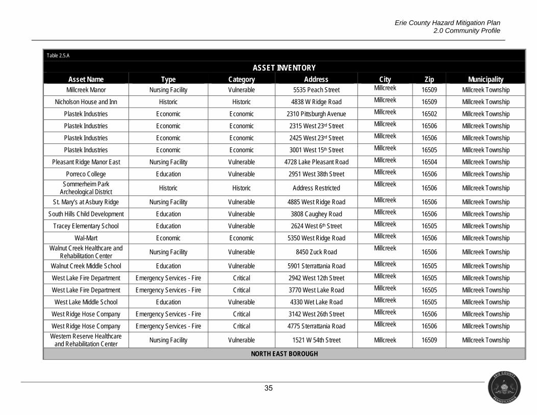
35
Erie County Hazard Mitigation Plan 2.0 Community Profile
Table 2.5.A
ASSET INVENTORY Asset Name Type Category Address City Zip Municipality
Millcreek Manor Nursing Facility Vulnerable 5535 Peach Street Millcreek 16509 Millcreek Township
Nicholson House and Inn Historic Historic 4838 W Ridge Road Millcreek 16509 Millcreek Township
Plastek Industries Economic Economic 2310 Pittsburgh Avenue Millcreek 16502 Millcreek Township
Plastek Industries Economic Economic 2315 West 23rd Street Millcreek 16506 Millcreek Township
Plastek Industries Economic Economic 2425 West 23rd Street Millcreek 16506 Millcreek Township
Plastek Industries Economic Economic 3001 West 15th Street Millcreek 16505 Millcreek Township
Pleasant Ridge Manor East Nursing Facility Vulnerable 4728 Lake Pleasant Road Millcreek 16504 Millcreek Township
Porreco College Education Vulnerable 2951 West 38th Street Millcreek 16506 Millcreek Township
Sommerheim Park Archeological District Historic Historic Address Restricted
Millcreek16506 Millcreek Township
St. Mary’s at Asbury Ridge Nursing Facility Vulnerable 4885 West Ridge Road Millcreek 16506 Millcreek Township
South Hills Child Development Education Vulnerable 3808 Caughey Road Millcreek 16506 Millcreek Township
Tracey Elementary School Education Vulnerable 2624 West 6th Street Millcreek 16505 Millcreek Township
Wal-Mart Economic Economic 5350 West Ridge Road Millcreek 16506 Millcreek Township
Walnut Creek Healthcare and Rehabilitation Center
Nursing Facility Vulnerable 8450 Zuck Road Millcreek
16506 Millcreek Township
Walnut Creek Middle School Education Vulnerable 5901 Sterrattania Road Millcreek 16505 Millcreek Township
West Lake Fire Department Emergency Services - Fire Critical 2942 West 12th Street Millcreek 16505 Millcreek Township
West Lake Fire Department Emergency Services - Fire Critical 3770 West Lake Road Millcreek 16505 Millcreek Township
West Lake Middle School Education Vulnerable 4330 Wet Lake Road Millcreek 16505 Millcreek Township
West Ridge Hose Company Emergency Services - Fire Critical 3142 West 26th Street Millcreek 16506 Millcreek Township
West Ridge Hose Company Emergency Services - Fire Critical 4775 Sterrattania Road Millcreek 16506 Millcreek Township
Western Reserve Healthcare and Rehabilitation Center
Nursing Facility Vulnerable 1521 W 54th Street Millcreek 16509 Millcreek Township
NORTH EAST BOROUGH
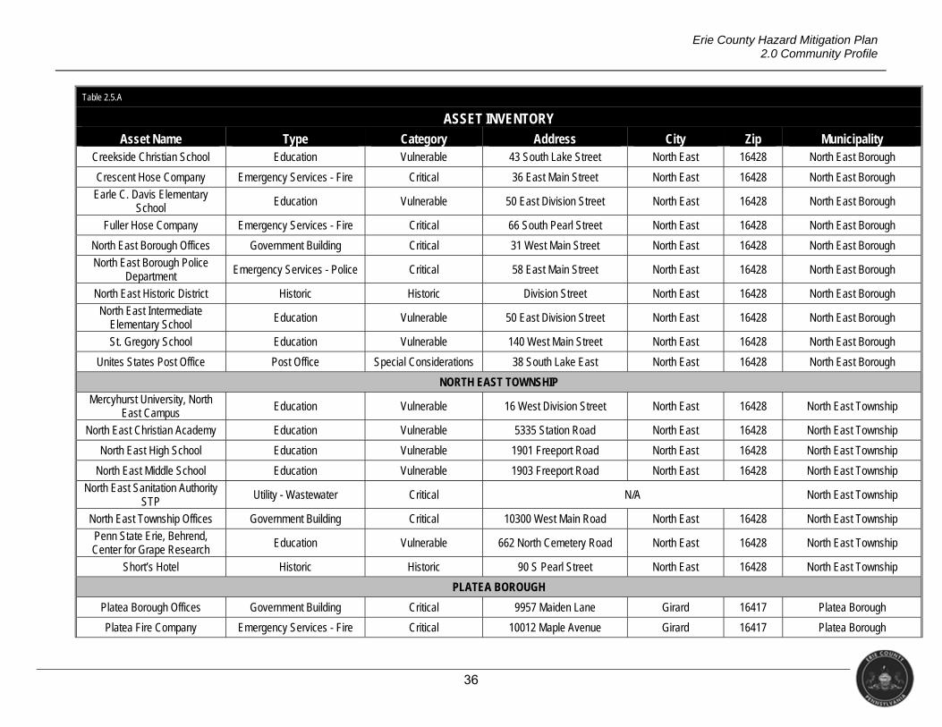
36
Erie County Hazard Mitigation Plan 2.0 Community Profile
Table 2.5.A
ASSET INVENTORY Asset Name Type Category Address City Zip Municipality
Creekside Christian School Education Vulnerable 43 South Lake Street North East 16428 North East Borough
Crescent Hose Company Emergency Services - Fire Critical 36 East Main Street North East 16428 North East Borough
Earle C. Davis Elementary School Education Vulnerable 50 East Division Street North East 16428 North East Borough
Fuller Hose Company Emergency Services - Fire Critical 66 South Pearl Street North East 16428 North East Borough
North East Borough Offices Government Building Critical 31 West Main Street North East 16428 North East Borough
North East Borough Police Department
Emergency Services - Police Critical 58 East Main Street North East 16428 North East Borough
North East Historic District Historic Historic Division Street North East 16428 North East Borough
North East Intermediate Elementary School
Education Vulnerable 50 East Division Street North East 16428 North East Borough
St. Gregory School Education Vulnerable 140 West Main Street North East 16428 North East Borough
Unites States Post Office Post Office Special Considerations 38 South Lake East North East 16428 North East Borough
NORTH EAST TOWNSHIP
Mercyhurst University, North East Campus
Education Vulnerable 16 West Division Street North East 16428 North East Township
North East Christian Academy Education Vulnerable 5335 Station Road North East 16428 North East Township
North East High School Education Vulnerable 1901 Freeport Road North East 16428 North East Township
North East Middle School Education Vulnerable 1903 Freeport Road North East 16428 North East Township
North East Sanitation Authority STP
Utility - Wastewater Critical N/A North East Township
North East Township Offices Government Building Critical 10300 West Main Road North East 16428 North East Township
Penn State Erie, Behrend, Center for Grape Research
Education Vulnerable 662 North Cemetery Road North East 16428 North East Township
Short’s Hotel Historic Historic 90 S Pearl Street North East 16428 North East Township
PLATEA BOROUGH
Platea Borough Offices Government Building Critical 9957 Maiden Lane Girard 16417 Platea Borough
Platea Fire Company Emergency Services - Fire Critical 10012 Maple Avenue Girard 16417 Platea Borough
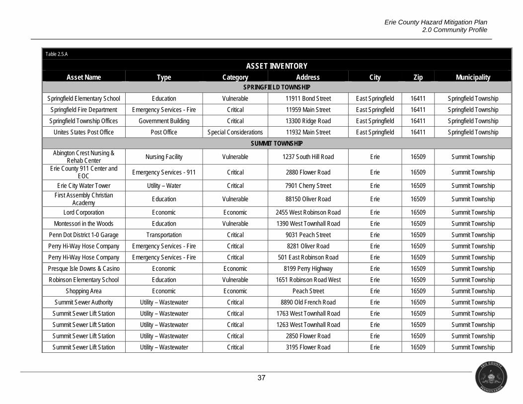
37
Erie County Hazard Mitigation Plan 2.0 Community Profile
Table 2.5.A
ASSET INVENTORY Asset Name Type Category Address City Zip Municipality
SPRINGFIELD TOWNSHIP
Springfield Elementary School Education Vulnerable 11911 Bond Street East Springfield 16411 Springfield Township
Springfield Fire Department Emergency Services - Fire Critical 11959 Main Street East Springfield 16411 Springfield Township
Springfield Township Offices Government Building Critical 13300 Ridge Road East Springfield 16411 Springfield Township
Unites States Post Office Post Office Special Considerations 11932 Main Street East Springfield 16411 Springfield Township
SUMMIT TOWNSHIP
Abington Crest Nursing & Rehab Center
Nursing Facility Vulnerable 1237 South Hill Road Erie 16509 Summit Township
Erie County 911 Center and EOC Emergency Services - 911 Critical 2880 Flower Road Erie 16509 Summit Township
Erie City Water Tower Utility – Water Critical 7901 Cherry Street Erie 16509 Summit Township
First Assembly Christian Academy
Education Vulnerable 88150 Oliver Road Erie 16509 Summit Township
Lord Corporation Economic Economic 2455 West Robinson Road Erie 16509 Summit Township
Montessori in the Woods Education Vulnerable 1390 West Townhall Road Erie 16509 Summit Township
Penn Dot District 1-0 Garage Transportation Critical 9031 Peach Street Erie 16509 Summit Township
Perry Hi-Way Hose Company Emergency Services - Fire Critical 8281 Oliver Road Erie 16509 Summit Township
Perry Hi-Way Hose Company Emergency Services - Fire Critical 501 East Robinson Road Erie 16509 Summit Township
Presque Isle Downs & Casino Economic Economic 8199 Perry Highway Erie 16509 Summit Township
Robinson Elementary School Education Vulnerable 1651 Robinson Road West Erie 16509 Summit Township
Shopping Area Economic Economic Peach Street Erie 16509 Summit Township
Summit Sewer Authority Utility – Wastewater Critical 8890 Old French Road Erie 16509 Summit Township
Summit Sewer Lift Station Utility – Wastewater Critical 1763 West Townhall Road Erie 16509 Summit Township
Summit Sewer Lift Station Utility – Wastewater Critical 1263 West Townhall Road Erie 16509 Summit Township
Summit Sewer Lift Station Utility – Wastewater Critical 2850 Flower Road Erie 16509 Summit Township
Summit Sewer Lift Station Utility – Wastewater Critical 3195 Flower Road Erie 16509 Summit Township
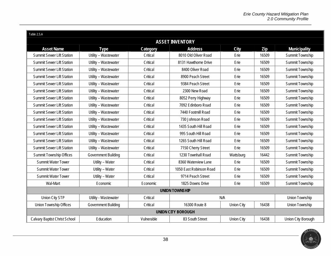
38
Erie County Hazard Mitigation Plan 2.0 Community Profile
Table 2.5.A
ASSET INVENTORY Asset Name Type Category Address City Zip Municipality
Summit Sewer Lift Station Utility – Wastewater Critical 8010 Old Oliver Road Erie 16509 Summit Township
Summit Sewer Lift Station Utility – Wastewater Critical 8131 Hawthorne Drive Erie 16509 Summit Township
Summit Sewer Lift Station Utility – Wastewater Critical 8400 Oliver Road Erie 16509 Summit Township
Summit Sewer Lift Station Utility – Wastewater Critical 8900 Peach Street Erie 16509 Summit Township
Summit Sewer Lift Station Utility – Wastewater Critical 9384 Peach Street Erie 16509 Summit Township
Summit Sewer Lift Station Utility – Wastewater Critical 2300 New Road Erie 16509 Summit Township
Summit Sewer Lift Station Utility – Wastewater Critical 8052 Perry Highway Erie 16509 Summit Township
Summit Sewer Lift Station Utility – Wastewater Critical 7092 Edinboro Road Erie 16509 Summit Township
Summit Sewer Lift Station Utility – Wastewater Critical 7440 Footmill Road Erie 16509 Summit Township
Summit Sewer Lift Station Utility – Wastewater Critical 730 Johnson Road Erie 16509 Summit Township
Summit Sewer Lift Station Utility – Wastewater Critical 1435 South Hill Road Erie 16509 Summit Township
Summit Sewer Lift Station Utility – Wastewater Critical 995 South Hill Road Erie 16509 Summit Township
Summit Sewer Lift Station Utility – Wastewater Critical 1265 South Hill Road Erie 16509 Summit Township
Summit Sewer Lift Station Utility – Wastewater Critical 7150 Cherry Street Erie 16509 Summit Township
Summit Township Offices Government Building Critical 1230 Townhall Road Wattsburg 16442 Summit Township
Summit Water Tower Utility – Water Critical 8360 Waterview Lane Erie 16509 Summit Township
Summit Water Tower Utility – Water Critical 1050 East Robinson Road Erie 16509 Summit Township
Summit Water Tower Utility – Water Critical 9714 Peach Street Erie 16509 Summit Township
Wal-Mart Economic Economic 1825 Downs Drive Erie 16509 Summit Township
UNION TOWNSHIP
Union City STP Utility - Wastewater Critical N/A Union Township
Union Township Offices Government Building Critical 16300 Route 8 Union City 16438 Union Township
UNION CITY BOROUGH
Calvary Baptist Christ School Education Vulnerable 83 South Street Union City 16438 Union City Borough

39
Erie County Hazard Mitigation Plan 2.0 Community Profile
Table 2.5.A
ASSET INVENTORY Asset Name Type Category Address City Zip Municipality
Union City Area Elementary School
Education Vulnerable 91 Miles Street Union City 16438 Union City Borough
Union City Borough Offices Government Building Critical 13 South Main Street Union City 16438 Union City Borough
Union City Fire Department Emergency Services - Fire Critical 50 2nd Avenue Union City 16438 Union City Borough
Union City Historic District Historic Historic Main Street Area Union City 16438 Union City Borough
Union City Middle & High School Education Vulnerable 105 Concord Street Union City 16438 Union City Borough
Union City Police Department Emergency Services - Police Critical 13 South Main Street Union City 16438 Union City Borough
Unites States Post Office Post Office Special Considerations 90 North Main Street Union City 16438 Union City Borough
VENANGO TOWNSHIP
Venango Township Offices Government Building Critical 9141 Townhall Road Wattsburg 16442 Venango Township
Wattsburg Hose Company Emergency Services - Fire Critical 11590 Hill Road Wattsburg 16442 Venango Township
Open Door Christian Academy Education Vulnerable 11238 Route 8 Wattsburg 16442 Venango Township
WASHINGTON TOWNSHIP
Edinboro Elementary School Education Vulnerable 5390 Route 6N Edinboro 16412 Washington Township
General McLane High School Education Vulnerable 11761 Edinboro Road Edinboro 16412 Washington Township
James W Parker Middle School Education Vulnerable 11781 Edinboro Road Edinboro 16412 Washington Township
Wal-Mart Economic Economic 108 Washington Towne Blvd Edinboro 16412 Washington Township
Washington Township Offices Government Building Critical 11800 Edinboro Road Edinboro 16412 Washington Township
Washington Township STP Utility - Wastewater Critical N/A Washington Township
WATERFORD BOROUGH
Fort LeBoeuf High School Education Vulnerable 931 High Street Waterford 16441 Waterford Borough
Fort LeBoeuf Middle School Education Vulnerable 865 Cherry Street Waterford 16441 Waterford Borough
Unites States Post Office Post Office Special Considerations 101 High Street Waterford 16441 Waterford Borough
Waterford Elementary School Education Vulnerable 323 Cherry Street Waterford 16441 Waterford Borough
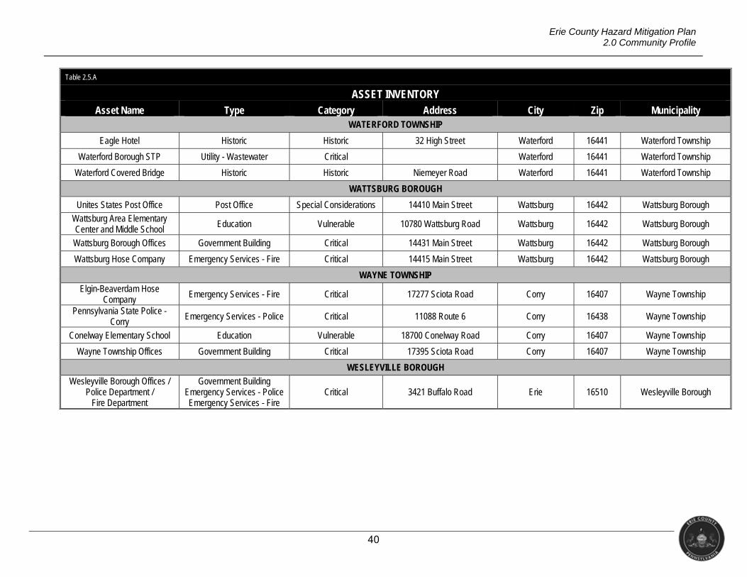
40
Erie County Hazard Mitigation Plan 2.0 Community Profile
Table 2.5.A
ASSET INVENTORY Asset Name Type Category Address City Zip Municipality
WATERFORD TOWNSHIP
Eagle Hotel Historic Historic 32 High Street Waterford 16441 Waterford Township
Waterford Borough STP Utility - Wastewater Critical Waterford 16441 Waterford Township
Waterford Covered Bridge Historic Historic Niemeyer Road Waterford 16441 Waterford Township
WATTSBURG BOROUGH
Unites States Post Office Post Office Special Considerations 14410 Main Street Wattsburg 16442 Wattsburg Borough
Wattsburg Area Elementary Center and Middle School
Education Vulnerable 10780 Wattsburg Road Wattsburg 16442 Wattsburg Borough
Wattsburg Borough Offices Government Building Critical 14431 Main Street Wattsburg 16442 Wattsburg Borough
Wattsburg Hose Company Emergency Services - Fire Critical 14415 Main Street Wattsburg 16442 Wattsburg Borough
WAYNE TOWNSHIP
Elgin-Beaverdam Hose Company Emergency Services - Fire Critical 17277 Sciota Road Corry 16407 Wayne Township
Pennsylvania State Police - Corry Emergency Services - Police Critical 11088 Route 6 Corry 16438 Wayne Township
Conelway Elementary School Education Vulnerable 18700 Conelway Road Corry 16407 Wayne Township
Wayne Township Offices Government Building Critical 17395 Sciota Road Corry 16407 Wayne Township
WESLEYVILLE BOROUGH
Wesleyville Borough Offices / Police Department /
Fire Department
Government Building Emergency Services - Police Emergency Services - Fire
Critical 3421 Buffalo Road Erie 16510 Wesleyville Borough
41
Erie County Hazard Mitigation Plan 2.0 Community Profile
2.6 CLIMATE CHANGE
Many natural hazards are climatic, such as droughts, severe weather, and floods.
There is an important distinction between weather and climate. Weather refers to the
atmospheric conditions of a geographical region over a short period of time (i.e., days or
weeks). Climate refers to atmospheric conditions of a geographical area over long periods of
time, such as years or decades (Keller & Devecchio, 2015).
According to the U.S. Global Change Research Program (2016), there are several
weather and climate changes that have already been observed in the United States. Some of
these include the following.
Since recordkeeping began in 1895, the average U.S. temperature has increased by
1.3°F to 1.9°F, with most of the increase happening since 1970. In addition, the first
decade of the 2000s was the warmest on record.
The average precipitation across the U.S. has been increasing since 1900. As a result,
heavy downpours are increasing, especially over the last 30-50 years.
Drought events have increased in the west. Changes in precipitation and runoff,
combined with changes in consumption and withdrawal, have reduced surface and
groundwater supplies in many areas.
Some types of severe weather events have experienced changes; heat waves are
more frequent and intense, and cold waves have become less frequent and intense
overall.
The intensity, frequency, and duration of North Atlantic hurricanes have increased
since the early 1980s.
Climate change can have a significant impact on human health and the environment.
The impacts mentioned above can affect the environment by leading to changes in land-use,
ecosystems, infrastructure conditions, geography and agricultural production. Extreme heat,
poor air quality, reduced food and water supply and quality and changes in infectious agents.
Population displacement resulting from changes in food/water supplies can lead to public
health concerns such as heat-related and cardio-pulmonary illnesses; food, water and vector-
borne diseases; and have consequences on mental health and stress (USGCRP, 2016).
The climate significantly impacts agriculture. Crops are affected by fluctuating
temperatures and precipitation, which can reduce local yields. For example, drought and
heavy precipitation can both damage crops. Heat stress on cows causes a reduction of milk
production. Extreme heat reduces fruit production in vineyards and raises stream
42
Erie County Hazard Mitigation Plan 2.0 Community Profile
temperatures stressing fish species. Climate change can even alter the flow of streams,
reducing water sources for livestock (Sea Grant, 2016).
The climate can also impact Erie County’s tourism industry. Extreme changes to lake
water levels, higher temperatures, excessive precipitation, and drought conditions alter
shoreline and stream habitats. Rising stream temperatures threaten cold water species of fish,
such as trout, and extinction of these species is becoming more likely. A reduction in area
wetlands can cause birds to migrate to other areas, causing a loss in hunting and bird
watching opportunities. Rising temperatures means fewer opportunities for winter activities
such as skiing and ice skating resulting in the potential loss of the skiing industry (Sea Grant,
2016).
Infrastructure is being compromised by extreme weather events and rising sea levels.
Power outages as well as road, bridge, and dam damage have all occurred during extreme
events. Essential infrastructure systems, such as water, energy supply, and transportation
may increasingly be compromised by climate change (NSTC, 2016). Water supply and sewer
services are vulnerable to both extreme drought and precipitation (Sea Grant, 2016). The
impact on infrastructure has the potential to effect the economy and security (NSTC, 2016).
The climate is now warming so rapidly that some effects can be seen within a human
lifetime. Scientists report that primarily the burning of fossil fuels as contributory. Gases such
as water vapor, ozone and carbon dioxide (greenhouse gases) regulate the earth’s climate;
however, these gases can persist in the atmosphere for decades. Accumulation of these
gases can cause abrupt climate change (Environment Erie).
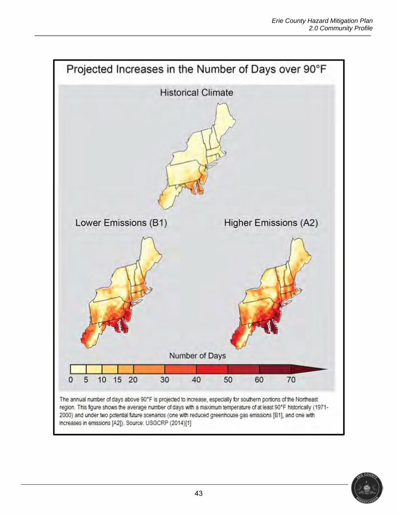
43
Erie County Hazard Mitigation Plan 2.0 Community Profile
44
Erie County Hazard Mitigation Plan 2.0 Community Profile
2.7 DATA SOURCES AND LIMITATIONS
The risk assessment, action items, etc. contained in this hazard mitigation plan rely on
various sources of data. Erie County recognizes that some data may be inaccurate or be
rendered inaccurate by environmental changes throughout the county that occur over time.
Further, as research continues on hazard resilience, new articles may reveal deficiencies in
previous scholarly efforts. This section acknowledges these limitations generally.
In order to assess risk and vulnerability, the county’s consultant gathered data on past
occurrences of damaging hazard events. For many historic natural hazard events, the
National Centers for Environmental Information (NECI) (formerly the National Climatic Data
Center), provided information. NCEI is a division of the U.S. Department of Commerce’s
National Oceanic and Atmospheric Administrations (NOAA). NCEI compiles information on
hazard events from data gathered by the National Weather Service (NWS), another division
of NOAA, and presents it on their website. The data used for this plan came from the Storm
Events Database, which documents “the occurrence of storms and other significant weather
phenomena having sufficient intensity to cause loss of life, injuries, significant property
damage, and/or disruption to commerce” (NOAA, 2017). It is important to understand that
historical event data are not the best predictors of future vulnerability due to the impact of
unforeseen or improbable events (Taleb, 2010). Additionally, in some cases, the NWS utilizes
first-hand accounts from local officials (e.g., emergency management directors), which may
be influenced by physical and social environmental factors beyond the core weather event.
Various government agency and non-government agency sources provided additional
information used to complete the risk assessment for this plan. The following narrative cites
those sources where appropriate with a full reference list included in Appendix 5. The county’s
consultant obtained numerous GIS data sets from the Pennsylvania Spatial Data Access
(PASDA) website (http://www.pasda.psu.edu/). PASDA is the official public access geospatial
information clearinghouse for the Commonwealth of Pennsylvania. Pennsylvania State
University developed PASDA as a service to the citizens, governments, and businesses of
the Commonwealth. It is a cooperative project of the Governor’s Office of Administration,
Office of Information Technology, Geospatial Technologies Office, and the Penn State
Institute of Energy and the Environment of the Pennsylvania State University. Flood hazard
area data used in this plan were taken from the FEMA Flood Insurance Risk Map released on
June 7, 2017. The Erie County Department of Planning provided GIS datasets including parcel
data, structure data, transportation layers, jurisdictional boundaries, waterways, and
45
Erie County Hazard Mitigation Plan 2.0 Community Profile
watershed boundaries. Other GIS datasets were retrieved from the U.S. Census Bureau
(https://www.census.gov/geo/maps-data/data/tiger.html).
HAZUS-MH is a risk assessment tool for analyzing potential losses from floods,
hurricane winds, and earthquakes. In HAZUS-MH, current scientific and engineering
knowledge is coupled with the GIS technology to produce estimates of hazard-related damage
before, or after, a disaster occurs. Losses were estimated for earthquakes using the HAZUS
software.
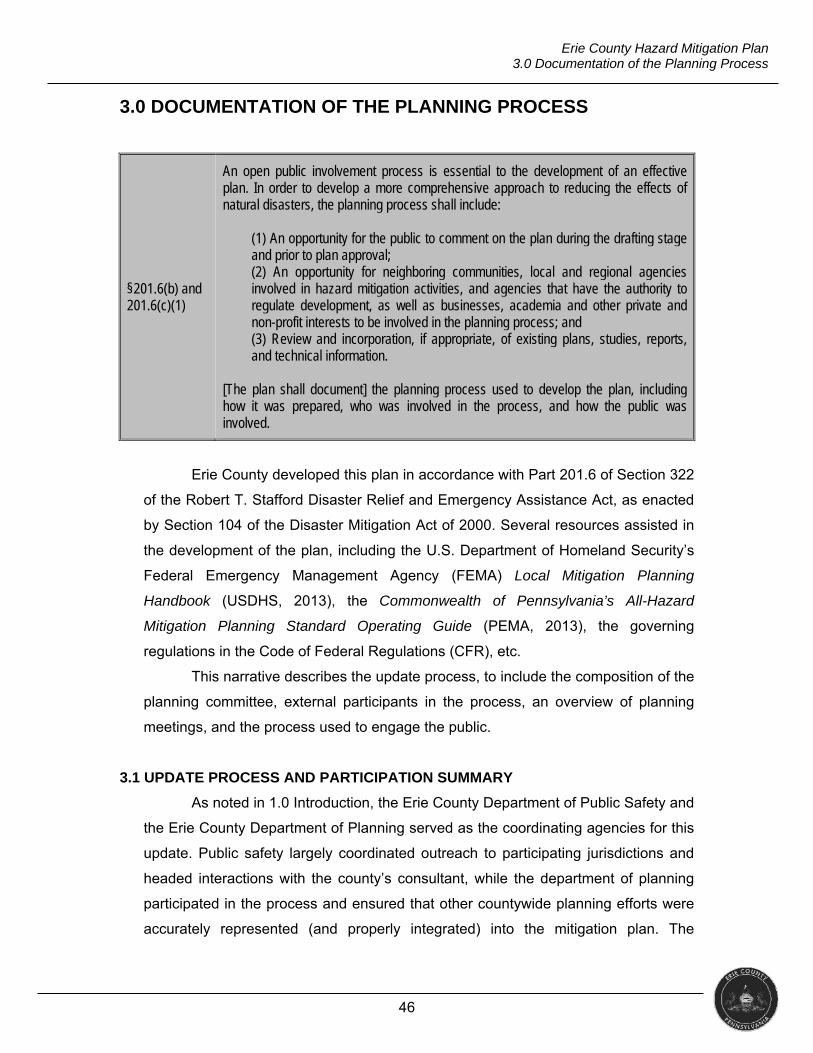
46
Erie County Hazard Mitigation Plan 3.0 Documentation of the Planning Process
3.0 DOCUMENTATION OF THE PLANNING PROCESS
§201.6(b) and 201.6(c)(1)
An open public involvement process is essential to the development of an effective plan. In order to develop a more comprehensive approach to reducing the effects of natural disasters, the planning process shall include:
(1) An opportunity for the public to comment on the plan during the drafting stage and prior to plan approval; (2) An opportunity for neighboring communities, local and regional agencies involved in hazard mitigation activities, and agencies that have the authority to regulate development, as well as businesses, academia and other private and non-profit interests to be involved in the planning process; and (3) Review and incorporation, if appropriate, of existing plans, studies, reports, and technical information.
[The plan shall document] the planning process used to develop the plan, including how it was prepared, who was involved in the process, and how the public was involved.
Erie County developed this plan in accordance with Part 201.6 of Section 322
of the Robert T. Stafford Disaster Relief and Emergency Assistance Act, as enacted
by Section 104 of the Disaster Mitigation Act of 2000. Several resources assisted in
the development of the plan, including the U.S. Department of Homeland Security’s
Federal Emergency Management Agency (FEMA) Local Mitigation Planning
Handbook (USDHS, 2013), the Commonwealth of Pennsylvania’s All-Hazard
Mitigation Planning Standard Operating Guide (PEMA, 2013), the governing
regulations in the Code of Federal Regulations (CFR), etc.
This narrative describes the update process, to include the composition of the
planning committee, external participants in the process, an overview of planning
meetings, and the process used to engage the public.
3.1 UPDATE PROCESS AND PARTICIPATION SUMMARY
As noted in 1.0 Introduction, the Erie County Department of Public Safety and
the Erie County Department of Planning served as the coordinating agencies for this
update. Public safety largely coordinated outreach to participating jurisdictions and
headed interactions with the county’s consultant, while the department of planning
participated in the process and ensured that other countywide planning efforts were
accurately represented (and properly integrated) into the mitigation plan. The
47
Erie County Hazard Mitigation Plan 3.0 Documentation of the Planning Process
department of planning also provided access to subject matter expertise in the
county (e.g., Pennsylvania Department of Environmental Protection Coastal
Resources Management, geographic information system [GIS] data and capabilities,
stormwater management planning history, etc.).
This update formally began in August of 2016 with the procurement of JH
Consulting, LLC, from Buckhannon, West Virginia, as the consultant to support the
planning process. The consultant’s role was to coordinate data collection and
analysis, interface regularly with participating jurisdictions, lead planning meetings
and public outreach, and document the planning process.
The Erie County Department of Public Safety as well as the consultant
remained in contact with municipal representatives through email and telephone.
Public safety provided initial municipal contact information and, along with the
consultant, continually updated the list to ensure correct points of contact received
notices of upcoming meetings as well as surveys and forms to complete. Section 3.2
provides a table of committee members and the jurisdiction they represented.
All individual municipal jurisdictions (i.e., two cities, 14 boroughs and 22
townships) participated in the update. Representatives from jurisdictions that were
unable to attend meetings provided input via communication with the department of
public safety and consultant. Table 3.1.A shows a summary of municipal
participation.
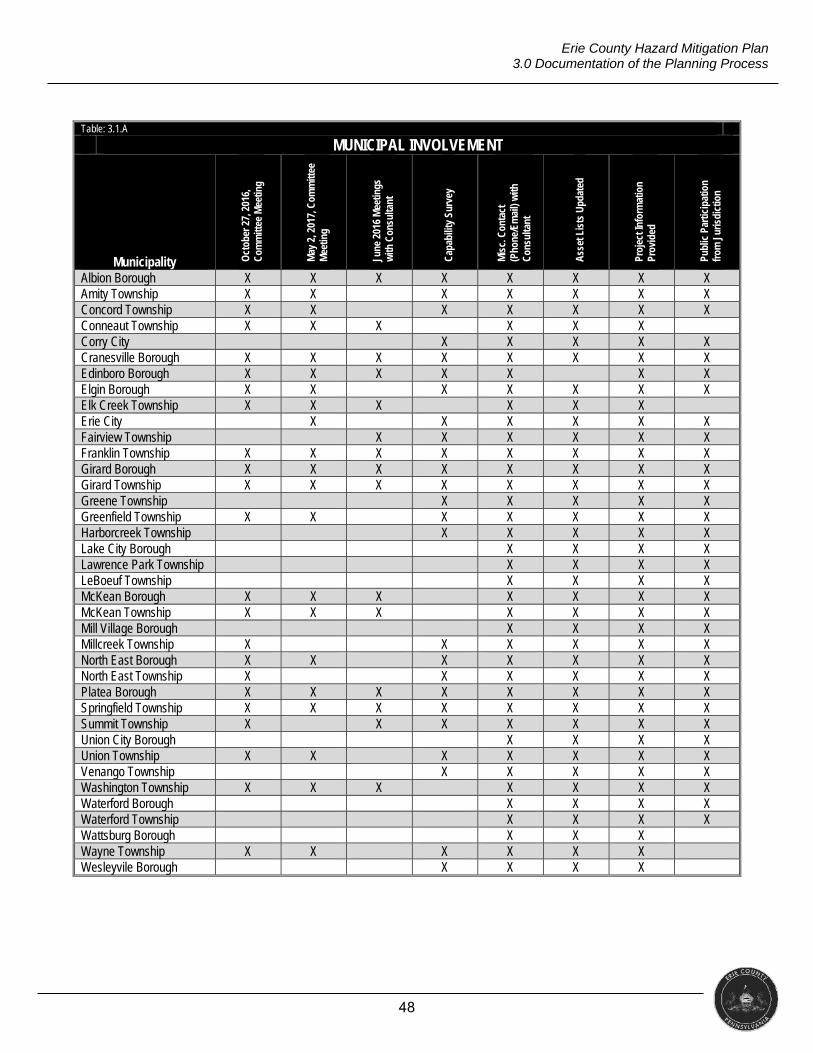
48
Erie County Hazard Mitigation Plan 3.0 Documentation of the Planning Process
Table: 3.1.A
MUNICIPAL INVOLVEMENT
Municipality Oct
ober
27,
201
6,
Com
mitt
ee M
eetin
g
May
2, 2
017,
Com
mitt
ee
Mee
ting
June
201
6 M
eetin
gs
with
Con
sulta
nt
Cap
abili
ty S
urve
y
Mis
c. C
onta
ct
(Pho
ne/E
mai
l) w
ith
Con
sulta
nt
Ass
et L
ists
Upd
ated
Proj
ect I
nfor
mat
ion
Prov
ided
Publ
ic P
artic
ipat
ion
from
Jur
isdi
ctio
n
Albion Borough X X X X X X X X Amity Township X X X X X X X Concord Township X X X X X X X Conneaut Township X X X X X X Corry City X X X X X Cranesville Borough X X X X X X X X Edinboro Borough X X X X X X X Elgin Borough X X X X X X X Elk Creek Township X X X X X X Erie City X X X X X X Fairview Township X X X X X X Franklin Township X X X X X X X X Girard Borough X X X X X X X X Girard Township X X X X X X X X Greene Township X X X X X Greenfield Township X X X X X X X Harborcreek Township X X X X X Lake City Borough X X X X Lawrence Park Township X X X X LeBoeuf Township X X X X McKean Borough X X X X X X X McKean Township X X X X X X X Mill Village Borough X X X X Millcreek Township X X X X X X North East Borough X X X X X X X North East Township X X X X X X Platea Borough X X X X X X X X Springfield Township X X X X X X X X Summit Township X X X X X X X Union City Borough X X X X Union Township X X X X X X X Venango Township X X X X X Washington Township X X X X X X X Waterford Borough X X X X Waterford Township X X X X Wattsburg Borough X X X Wayne Township X X X X X X Wesleyvile Borough X X X X
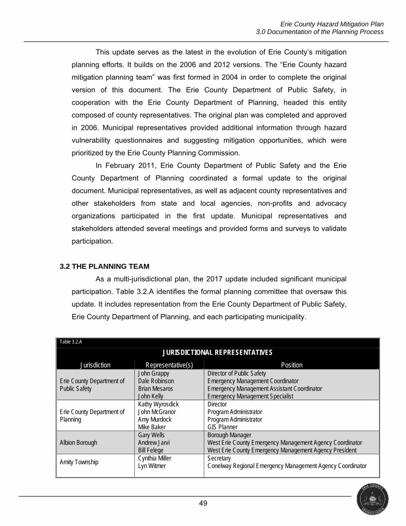
49
Erie County Hazard Mitigation Plan 3.0 Documentation of the Planning Process
This update serves as the latest in the evolution of Erie County’s mitigation
planning efforts. It builds on the 2006 and 2012 versions. The “Erie County hazard
mitigation planning team” was first formed in 2004 in order to complete the original
version of this document. The Erie County Department of Public Safety, in
cooperation with the Erie County Department of Planning, headed this entity
composed of county representatives. The original plan was completed and approved
in 2006. Municipal representatives provided additional information through hazard
vulnerability questionnaires and suggesting mitigation opportunities, which were
prioritized by the Erie County Planning Commission.
In February 2011, Erie County Department of Public Safety and the Erie
County Department of Planning coordinated a formal update to the original
document. Municipal representatives, as well as adjacent county representatives and
other stakeholders from state and local agencies, non-profits and advocacy
organizations participated in the first update. Municipal representatives and
stakeholders attended several meetings and provided forms and surveys to validate
participation.
3.2 THE PLANNING TEAM
As a multi-jurisdictional plan, the 2017 update included significant municipal
participation. Table 3.2.A identifies the formal planning committee that oversaw this
update. It includes representation from the Erie County Department of Public Safety,
Erie County Department of Planning, and each participating municipality.
Table 3.2.A
JURISDICTIONAL REPRESENTATIVES
Jurisdiction Representative(s) Position
Erie County Department of Public Safety
John Grappy Dale Robinson Brian Mesaros John Kelly
Director of Public Safety Emergency Management Coordinator Emergency Management Assistant Coordinator Emergency Management Specialist
Erie County Department of Planning
Kathy Wyrosdick John McGranor Amy Murdock Mike Baker
Director Program Administrator Program Administrator GIS Planner
Albion Borough Gary Wells Andrew Jarvi Bill Felege
Borough Manager West Erie County Emergency Management Agency Coordinator West Erie County Emergency Management Agency President
Amity Township Cynthia Miller Lyn Witmer
Secretary Conelway Regional Emergency Management Agency Coordinator
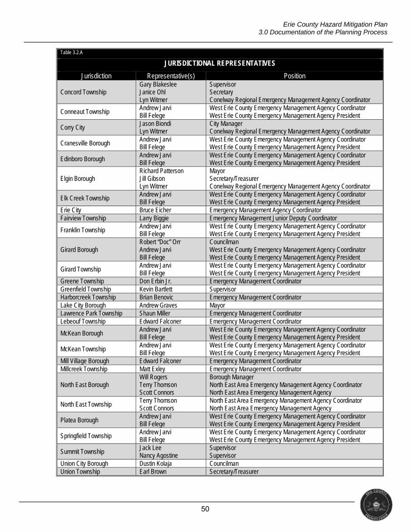
50
Erie County Hazard Mitigation Plan 3.0 Documentation of the Planning Process
Table 3.2.A
JURISDICTIONAL REPRESENTATIVES
Jurisdiction Representative(s) Position
Concord Township Gary Blakeslee Janice Ohl Lyn Witmer
Supervisor Secretary Conelway Regional Emergency Management Agency Coordinator
Conneaut Township Andrew Jarvi Bill Felege
West Erie County Emergency Management Agency Coordinator West Erie County Emergency Management Agency President
Corry City Jason Biondi Lyn Witmer
City Manager Conelway Regional Emergency Management Agency Coordinator
Cranesville Borough Andrew Jarvi Bill Felege
West Erie County Emergency Management Agency Coordinator West Erie County Emergency Management Agency President
Edinboro Borough Andrew Jarvi Bill Felege
West Erie County Emergency Management Agency Coordinator West Erie County Emergency Management Agency President
Elgin Borough Richard Patterson Jill Gibson Lyn Witmer
Mayor Secretary/Treasurer Conelway Regional Emergency Management Agency Coordinator
Elk Creek Township Andrew Jarvi Bill Felege
West Erie County Emergency Management Agency Coordinator West Erie County Emergency Management Agency President
Erie City Bruce Eicher Emergency Management Agency Coordinator Fairview Township Larry Biggie Emergency Management Junior Deputy Coordinator
Franklin Township Andrew Jarvi Bill Felege
West Erie County Emergency Management Agency Coordinator West Erie County Emergency Management Agency President
Girard Borough Robert “Doc” Orr Andrew Jarvi Bill Felege
Councilman West Erie County Emergency Management Agency Coordinator West Erie County Emergency Management Agency President
Girard Township Andrew Jarvi Bill Felege
West Erie County Emergency Management Agency Coordinator West Erie County Emergency Management Agency President
Greene Township Don Erbin Jr. Emergency Management Coordinator Greenfield Township Kevin Bartlett Supervisor Harborcreek Township Brian Benovic Emergency Management Coordinator Lake City Borough Andrew Graves Mayor Lawrence Park Township Shaun Miller Emergency Management Coordinator Lebeouf Township Edward Falconer Emergency Management Coordinator
McKean Borough Andrew Jarvi Bill Felege
West Erie County Emergency Management Agency Coordinator West Erie County Emergency Management Agency President
McKean Township Andrew Jarvi Bill Felege
West Erie County Emergency Management Agency Coordinator West Erie County Emergency Management Agency President
Mill Village Borough Edward Falconer Emergency Management Coordinator Millcreek Township Matt Exley Emergency Management Coordinator
North East Borough Will Rogers Terry Thomson Scott Connors
Borough Manager North East Area Emergency Management Agency Coordinator North East Area Emergency Management Agency
North East Township Terry Thomson Scott Connors
North East Area Emergency Management Agency Coordinator North East Area Emergency Management Agency
Platea Borough Andrew Jarvi Bill Felege
West Erie County Emergency Management Agency Coordinator West Erie County Emergency Management Agency President
Springfield Township Andrew Jarvi Bill Felege
West Erie County Emergency Management Agency Coordinator West Erie County Emergency Management Agency President
Summit Township Jack Lee Nancy Agostine
Supervisor Supervisor
Union City Borough Dustin Kolaja Councilman Union Township Earl Brown Secretary/Treasurer
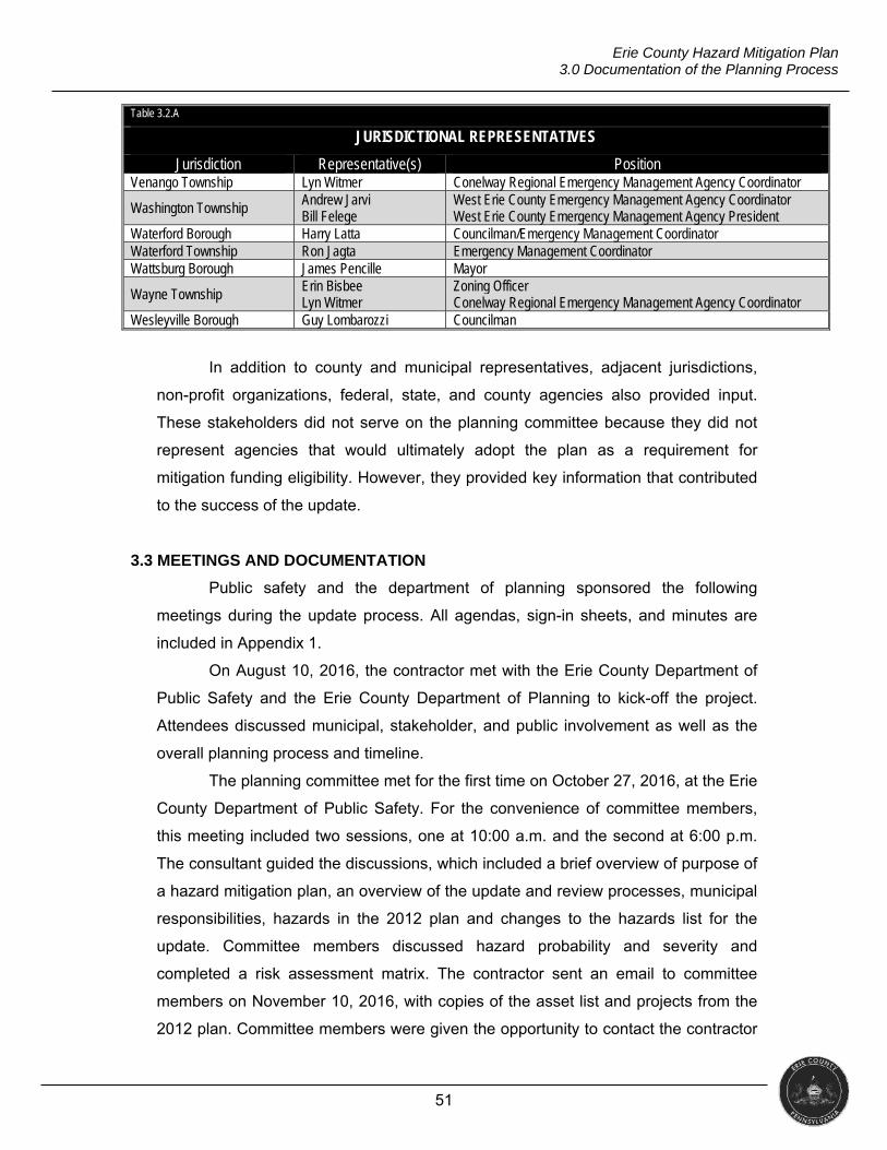
51
Erie County Hazard Mitigation Plan 3.0 Documentation of the Planning Process
Table 3.2.A
JURISDICTIONAL REPRESENTATIVES
Jurisdiction Representative(s) Position Venango Township Lyn Witmer Conelway Regional Emergency Management Agency Coordinator
Washington Township Andrew Jarvi Bill Felege
West Erie County Emergency Management Agency Coordinator West Erie County Emergency Management Agency President
Waterford Borough Harry Latta Councilman/Emergency Management Coordinator Waterford Township Ron Jagta Emergency Management Coordinator Wattsburg Borough James Pencille Mayor
Wayne Township Erin Bisbee Lyn Witmer
Zoning Officer Conelway Regional Emergency Management Agency Coordinator
Wesleyville Borough Guy Lombarozzi Councilman
In addition to county and municipal representatives, adjacent jurisdictions,
non-profit organizations, federal, state, and county agencies also provided input.
These stakeholders did not serve on the planning committee because they did not
represent agencies that would ultimately adopt the plan as a requirement for
mitigation funding eligibility. However, they provided key information that contributed
to the success of the update.
3.3 MEETINGS AND DOCUMENTATION
Public safety and the department of planning sponsored the following
meetings during the update process. All agendas, sign-in sheets, and minutes are
included in Appendix 1.
On August 10, 2016, the contractor met with the Erie County Department of
Public Safety and the Erie County Department of Planning to kick-off the project.
Attendees discussed municipal, stakeholder, and public involvement as well as the
overall planning process and timeline.
The planning committee met for the first time on October 27, 2016, at the Erie
County Department of Public Safety. For the convenience of committee members,
this meeting included two sessions, one at 10:00 a.m. and the second at 6:00 p.m.
The consultant guided the discussions, which included a brief overview of purpose of
a hazard mitigation plan, an overview of the update and review processes, municipal
responsibilities, hazards in the 2012 plan and changes to the hazards list for the
update. Committee members discussed hazard probability and severity and
completed a risk assessment matrix. The contractor sent an email to committee
members on November 10, 2016, with copies of the asset list and projects from the
2012 plan. Committee members were given the opportunity to contact the contractor
52
Erie County Hazard Mitigation Plan 3.0 Documentation of the Planning Process
with any questions or comments and were given detailed instructions on how to
review and update the lists.
On February 27, 2017, the department of public safety and the department of
planning met with the contractor to discuss upcoming opportunities for municipal
involvement. Participants also discussed public engagement through meetings and
online surveys.
The second formal committee meeting took place on May 2, 2017.
Committee members again attended one of two sessions, the first 9:00 a.m. or the
second at 6:00 p.m. The meeting included an update on the planning process,
discussion on providing statuses for existing projects, and an explanation of
mitigation goals followed by the creation of a mitigation goal to organize the projects
included in this update. Committee members discussed potential new projects and
how they aligned with the mitigation goals.
The capability survey was sent to each municipal representative on May 12,
2017, via email. The consultant developed and hosted the survey on the Survey
Monkey platform (www.surveymonkey.com). The representatives were advised to
contact the consultant with any questions, comments, or concerns. Between June 6
and June 8, 2017, the consultant visited municipalities and was available to answer
questions and assist municipal representatives with the asset list, project updates,
and/or capability survey. Several municipalities took the opportunity to meet with the
consultant.
On July 20, 2017, the Erie County Conservation District hosted the “Erie
County Resiliency Workshop” sponsored by FEMA Region III and PEMA.
Government agencies, private stakeholders, and the public were all invited. The
workshop included segments on floodplain mapping, available RiskMAP products,
mitigation implementation ideas and a presentation on the update to the Erie County
hazard mitigation plan.
On August 2, 2017, the Department of Public Safety and the Department of
Planning had a virtual meeting using the www.gotomeeting.com platform. The
discussion focused on the projects for the 2017 update and plan integration.
3.4 PUBLIC AND STAKEHOLDER PARTICIPATION
In addition to the planning team (which included relevant county
organizations and municipalities), adjacent jurisdictions, non-profit organizations,
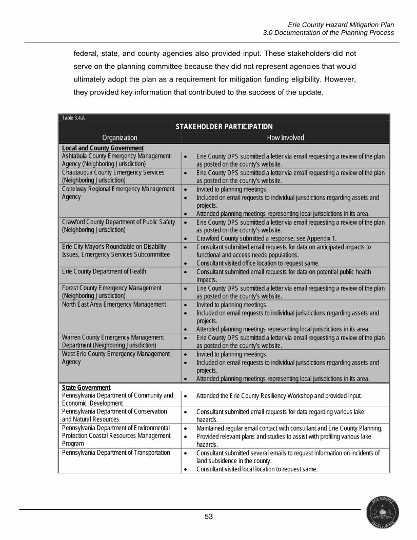
53
Erie County Hazard Mitigation Plan 3.0 Documentation of the Planning Process
federal, state, and county agencies also provided input. These stakeholders did not
serve on the planning committee because they did not represent agencies that would
ultimately adopt the plan as a requirement for mitigation funding eligibility. However,
they provided key information that contributed to the success of the update.
Table 3.4.A
STAKEHOLDER PARTICIPATION
Organization How Involved Local and County Government Ashtabula County Emergency Management Agency (Neighboring Jurisdiction)
Erie County DPS submitted a letter via email requesting a review of the plan as posted on the county’s website.
Chautauqua County Emergency Services (Neighboring Jurisdiction)
Erie County DPS submitted a letter via email requesting a review of the plan as posted on the county’s website.
Conelway Regional Emergency Management Agency
Invited to planning meetings. Included on email requests to individual jurisdictions regarding assets and
projects. Attended planning meetings representing local jurisdictions in its area.
Crawford County Department of Public Safety (Neighboring Jurisdiction)
Erie County DPS submitted a letter via email requesting a review of the plan as posted on the county’s website.
Crawford County submitted a response; see Appendix 1. Erie City Mayor’s Roundtable on Disability Issues, Emergency Services Subcommittee
Consultant submitted email requests for data on anticipated impacts to functional and access needs populations.
Consultant visited office location to request same. Erie County Department of Health Consultant submitted email requests for data on potential public health
impacts. Forest County Emergency Management (Neighboring Jurisdiction)
Erie County DPS submitted a letter via email requesting a review of the plan as posted on the county’s website.
North East Area Emergency Management Invited to planning meetings. Included on email requests to individual jurisdictions regarding assets and
projects. Attended planning meetings representing local jurisdictions in its area.
Warren County Emergency Management Department (Neighboring Jurisdiction)
Erie County DPS submitted a letter via email requesting a review of the plan as posted on the county’s website.
West Erie County Emergency Management Agency
Invited to planning meetings. Included on email requests to individual jurisdictions regarding assets and
projects. Attended planning meetings representing local jurisdictions in its area.
State Government Pennsylvania Department of Community and Economic Development
Attended the Erie County Resiliency Workshop and provided input.
Pennsylvania Department of Conservation and Natural Resources
Consultant submitted email requests for data regarding various lake hazards.
Pennsylvania Department of Environmental Protection Coastal Resources Management Program
Maintained regular email contact with consultant and Erie County Planning. Provided relevant plans and studies to assist with profiling various lake
hazards. Pennsylvania Department of Transportation Consultant submitted several emails to request information on incidents of
land subsidence in the county. Consultant visited local location to request same.
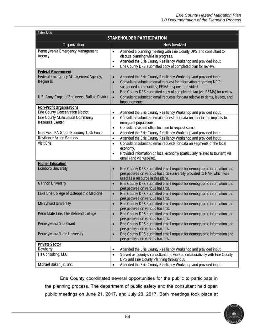
54
Erie County Hazard Mitigation Plan 3.0 Documentation of the Planning Process
Table 3.4.A
STAKEHOLDER PARTICIPATION
Organization How Involved Pennsylvania Emergency Management Agency
Attended a planning meeting with Erie County DPS and consultant to discuss planning while in progress.
Attended the Erie County Resiliency Workshop and provided input. Erie County DPS submitted copy of completed plan for review.
Federal Government Federal Emergency Management Agency, Region III
Attended the Erie County Resiliency Workshop and provided input. Consultant submitted email request for information regarding NFIP-
suspended communities; FEMA response provided. Erie County DPS submitted copy of completed plan (via PEMA) for review.
U.S. Army Corps of Engineers, Buffalo District Consultant submitted email requests for data relative to dams, levees, and impoundments.
Non-Profit Organizations Erie County Conservation District Attended the Erie County Resiliency Workshop and provided input. Erie County Multicultural Community Resource Center
Consultant submitted email requests for data on anticipated impacts to immigrant populations.
Consultant visited office location to request same. Northwest PA Green Economy Task Force Attended the Erie County Resiliency Workshop and provided input. Resilience Action Partners Attended the Erie County Resiliency Workshop and provided input. Visit Erie Consultant submitted email requests for data on segments of the local
economy. Provided information on local economy (particularly related to tourism) via
email (and via website). Higher Education Edinboro University Erie County DPS submitted email request for demographic information and
perspectives on various hazards (university provided its HMP which was used as a resource in this plan).
Gannon University Erie County DPS submitted email request for demographic information and perspectives on various hazards.
Lake Erie College of Osteopathic Medicine Erie County DPS submitted email request for demographic information and perspectives on various hazards.
Mercyhurst University Erie County DPS submitted email request for demographic information and perspectives on various hazards.
Penn State Erie, The Behrend College Erie County DPS submitted email request for demographic information and perspectives on various hazards.
Pennsylvania Sea Grant Erie County DPS submitted email request for demographic information and perspectives on various hazards.
Pennsylvania State University Erie County DPS submitted email request for demographic information and perspectives on various hazards.
Private Sector Dewberry Attended the Erie County Resiliency Workshop and provided input. JH Consulting, LLC Served as county’s consultant and worked collaboratively with Erie County
DPS and Erie County Planning throughout. Michael Baker, Jr., Inc. Attended the Erie County Resiliency Workshop and provided input.
Erie County coordinated several opportunities for the public to participate in
the planning process. The department of public safety and the consultant held open
public meetings on June 21, 2017, and July 20, 2017. Both meetings took place at
55
Erie County Hazard Mitigation Plan 3.0 Documentation of the Planning Process
the public safety office on Flower Road at 6:00 p.m. Public safety advertised the
meetings via conventional media and social media; attendance at both meetings was
minimal. Significantly, the July 20th resiliency workshop also provided an opportunity
for public participation.
In an attempt to further public participation in the planning process, the
department of public safety and the department of planning directed the consultant to
develop and administer two online surveys for residents. The consultant hosted the
surveys on the Survey Monkey platform (www.surveymonkey.com); public safety and
the department of planning distributed them through county and municipal websites
and social media. The first survey launched on October 17, 2016, and sought
information from residents on their perceptions of hazards and vulnerabilities. Public
participation with the first survey was significant; 326 residents submitted responses.
The second survey began on June 21, 2017, and targeted comment on
potential mitigation actions. Survey 2 had fewer responses; 26 residents responded.
This survey had residents answer questions about funding sources, prioritizing
hazards to be addressed via mitigation projects, and allowed the public to suggest
potential mitigation projects. Survey 2 asked questions about actions with which the
general public may not be familiar or otherwise feel it should have an active role in
determining, which could explain the significantly smaller response. In total, however,
even with minimal public meeting attendance, 352 residents participated in the
update process. Appendix 2 contains the raw data for both surveys.
3.5 MULTI-JURISDICTIONAL PLANNING
Erie County updated this plan using a multi-jurisdictional approach. The
county and stakeholders provided information that may not have been available
through the municipalities. However, municipal participation was critical to the
success of the process. Municipalities provided information on hazard events and
mitigation projects specific to their jurisdictions. Municipal involvement is
documented in Table 3.1.A above. All 38 municipalities in Erie County participated in
the planning process; thus, this plan serves as their official hazard mitigation plan for
funding eligibility (per completion of the approval and adoption processes).

56
Erie County Hazard Mitigation Plan 3.0 Documentation of the Planning Process
3.6 EXISITNG PLANNING MECHANISMS
There are numerous existing regulatory and planning mechanisms in place at
the state, county, and municipal level of government which support hazard mitigation
planning efforts. Table 3.6.A lists the plans used during this update.
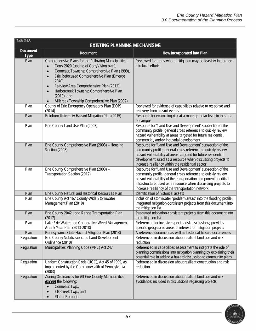
57
Erie County Hazard Mitigation Plan 3.0 Documentation of the Planning Process
Table 3.6.A
EXISTING PLANNING MECHANISMS Document
Type Document How Incorporated into Plan
Plan Comprehensive Plans for the Following Municipalities: Corry 2020 (update of CorryVision plan), Conneaut Township Comprehensive Plan (1999), Erie Refocused Comprehensive Plan (Emerge
2040), Fairview Area Comprehensive Plan (2012), Harborcreek Township Comprehensive Plan
(2010), and Millcreek Township Comprehensive Plan (2002)
Reviewed for areas where mitigation may be feasibly integrated into local efforts
Plan County of Erie Emergency Operations Plan (EOP) (2014)
Reviewed for evidence of capabilities relative to response and recovery from hazard events
Plan Edinboro University Hazard Mitigation Plan (2015) Resource for examining risk at a more granular level in the area of campus
Plan Erie County Land Use Plan (2003) Resource for “Land Use and Development” subsection of the community profile; general cross reference to quickly review hazard vulnerability at areas targeted for future residential, commercial, and/or industrial development
Plan Erie County Comprehensive Plan (2003) – Housing Section (2008)
Resource for “Land Use and Development” subsection of the community profile; general cross reference to quickly review hazard vulnerability at areas targeted for future residential development; used as a resource when discussing projects to increase resiliency within the residential sector
Plan Erie County Comprehensive Plan (2003) – Transportation Section (2012)
Resource for “Land Use and Development” subsection of the community profile; general cross reference to quickly review hazard vulnerability of the transportation component of critical infrastructure; used as a resource when discussing projects to increase resiliency of the transportation network
Plan Erie County Natural and Historical Resources Plan Identification of historical assets Plan Erie County Act 167 County-Wide Stormwater
Management Plan (2010) Inclusion of stormwater “problem areas” into the flooding profile; integrated mitigation-consistent projects from this document into the mitigation list
Plan Erie County 2042 Long Range Transportation Plan (2017)
Integrated mitigation-consistent projects from this document into the mitigation list
Plan Lake Erie Watershed Cooperative Weed Management Area 5 Year Plan (2013-2018)
Referenced for invasive species risk discussions; provides specific geographic areas of interest for mitigation projects
Plan Pennsylvania State Hazard Mitigation Plan (2013) A reference document as well as historical hazard occurrences Regulation Erie County Subdivision and Land Development
Ordinance (2010) Referenced in discussion about resilient land use and risk reduction
Regulation Municipalities Planning Code (MPC) Act 247 Referenced in capabilities assessment to integrate the role of planning commissions into mitigation planning by explaining their potential role in adding a hazard discussion to community plans
Regulation Uniform Construction Code (UCC), Act 45 of 1999, as implemented by the Commonwealth of Pennsylvania (2003)
Referenced in discussion about resilient construction and risk reduction
Regulation Zoning Ordinances for All Erie County Municipalities except the following: Conneaut Twp., Elk Creek Twp., and Platea Borough
Referenced in discussion about resilient land use and risk avoidance; included in discussions regarding projects
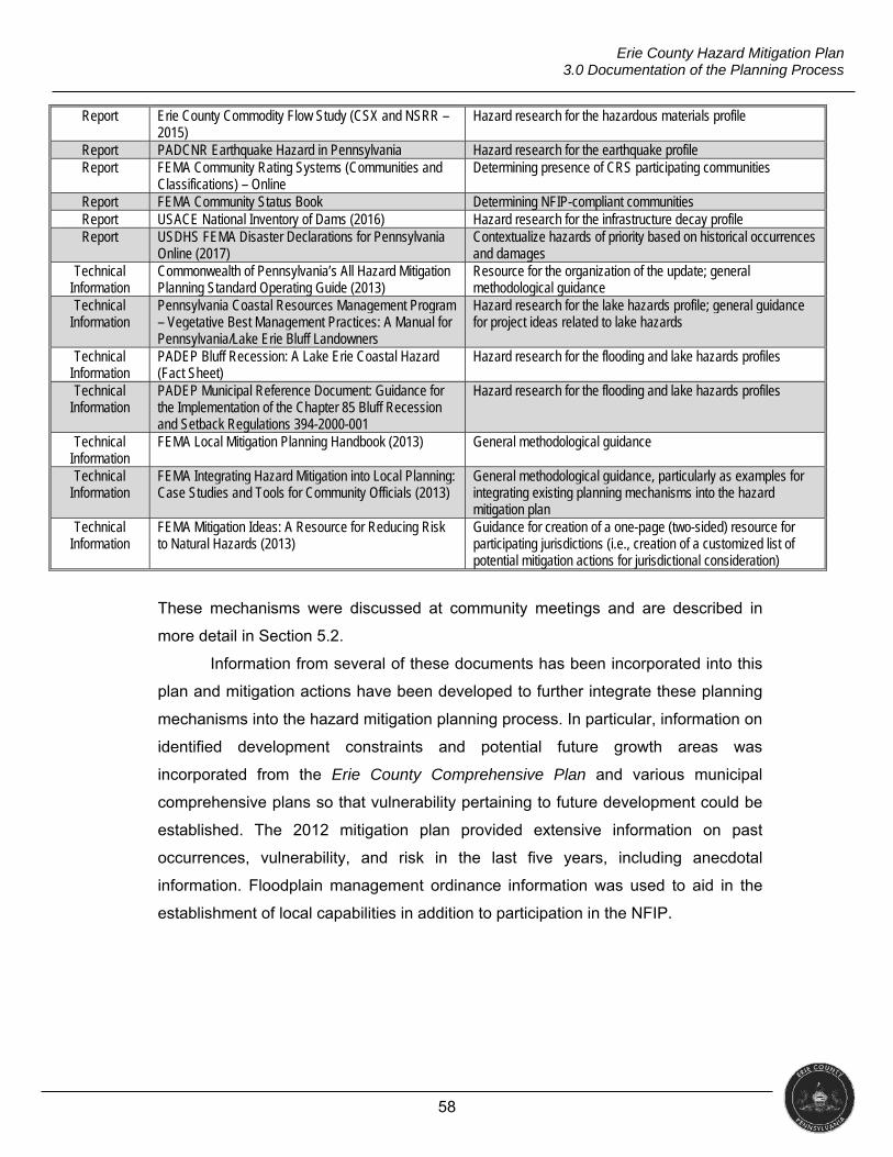
58
Erie County Hazard Mitigation Plan 3.0 Documentation of the Planning Process
Report Erie County Commodity Flow Study (CSX and NSRR – 2015)
Hazard research for the hazardous materials profile
Report PADCNR Earthquake Hazard in Pennsylvania Hazard research for the earthquake profile Report FEMA Community Rating Systems (Communities and
Classifications) – Online Determining presence of CRS participating communities
Report FEMA Community Status Book Determining NFIP-compliant communities Report USACE National Inventory of Dams (2016) Hazard research for the infrastructure decay profile Report USDHS FEMA Disaster Declarations for Pennsylvania
Online (2017) Contextualize hazards of priority based on historical occurrences and damages
Technical Information
Commonwealth of Pennsylvania’s All Hazard Mitigation Planning Standard Operating Guide (2013)
Resource for the organization of the update; general methodological guidance
Technical Information
Pennsylvania Coastal Resources Management Program – Vegetative Best Management Practices: A Manual for Pennsylvania/Lake Erie Bluff Landowners
Hazard research for the lake hazards profile; general guidance for project ideas related to lake hazards
Technical Information
PADEP Bluff Recession: A Lake Erie Coastal Hazard (Fact Sheet)
Hazard research for the flooding and lake hazards profiles
Technical Information
PADEP Municipal Reference Document: Guidance for the Implementation of the Chapter 85 Bluff Recession and Setback Regulations 394-2000-001
Hazard research for the flooding and lake hazards profiles
Technical Information
FEMA Local Mitigation Planning Handbook (2013) General methodological guidance
Technical Information
FEMA Integrating Hazard Mitigation into Local Planning: Case Studies and Tools for Community Officials (2013)
General methodological guidance, particularly as examples for integrating existing planning mechanisms into the hazard mitigation plan
Technical Information
FEMA Mitigation Ideas: A Resource for Reducing Risk to Natural Hazards (2013)
Guidance for creation of a one-page (two-sided) resource for participating jurisdictions (i.e., creation of a customized list of potential mitigation actions for jurisdictional consideration)
These mechanisms were discussed at community meetings and are described in
more detail in Section 5.2.
Information from several of these documents has been incorporated into this
plan and mitigation actions have been developed to further integrate these planning
mechanisms into the hazard mitigation planning process. In particular, information on
identified development constraints and potential future growth areas was
incorporated from the Erie County Comprehensive Plan and various municipal
comprehensive plans so that vulnerability pertaining to future development could be
established. The 2012 mitigation plan provided extensive information on past
occurrences, vulnerability, and risk in the last five years, including anecdotal
information. Floodplain management ordinance information was used to aid in the
establishment of local capabilities in addition to participation in the NFIP.
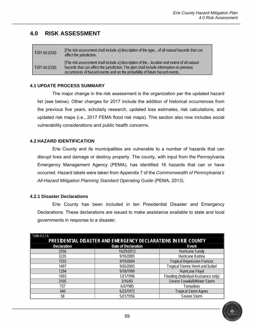
59
Erie County Hazard Mitigation Plan 4.0 Risk Assessment
4.0 RISK ASSESSMENT
§201.6(c)(2)(i) [The risk assessment shall include a] description of the type…of all natural hazards that can affect the jurisdiction.
§201.6(c)(2)(i) [The risk assessment shall include a] description of the…location and extent of all natural hazards that can affect the jurisdiction. The plan shall include information on previous occurrences of hazard events and on the probability of future hazard events.
4.1 UPDATE PROCESS SUMMARY
The major change in the risk assessment is the organization per the updated hazard
list (see below). Other changes for 2017 include the addition of historical occurrences from
the previous five years, scholarly research, updated loss estimates, risk calculations, and
updated risk maps (i.e., 2017 FEMA flood risk maps). This section also now includes social
vulnerability considerations and public health concerns.
4.2 HAZARD IDENTIFICATION
Erie County and its municipalities are vulnerable to a number of hazards that can
disrupt lives and damage or destroy property. The county, with input from the Pennsylvania
Emergency Management Agency (PEMA), has identified 16 hazards that can or have
occurred. Hazard labels were taken from Appendix 7 of the Commonwealth of Pennsylvania’s
All-Hazard Mitigation Planning Standard Operating Guide (PEMA, 2013).
4.2.1 Disaster Declarations
Erie County has been included in ten Presidential Disaster and Emergency
Declarations. These declarations are issued to make assistance available to state and local
governments in response to a disaster.
Table 4.2.1.A
PRESIDENTIAL DISASTER AND EMERGENCY DECLARATIONS IN ERIE COUNTY Declaration Date of Declaration Event
3356 10/29/2012 Hurricane Sandy 3235 9/10/2005 Hurricane Katrina 1555 9/19/2004 Tropical Depression Frances 1497 9/26/2003 Tropical Storms Henri and Isabel 1294 9/18/1999 Hurricane Floyd 1093 1/21/1996 Flooding (Individual Assistance only) 3105 3/16/93 Severe Snowfall/Winter Storm 737 6/3/1985 Tornadoes 340 6/23/1972 Tropical Storm Agnes 58 5/21/1956 Severe Storm
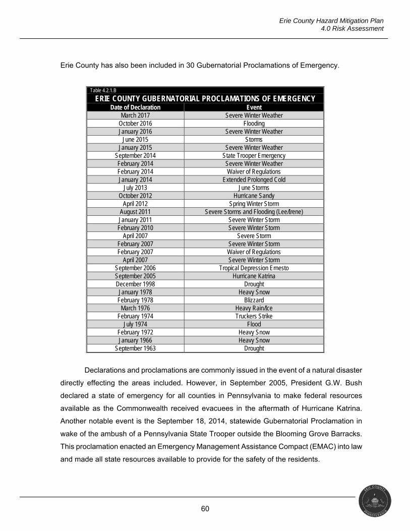
60
Erie County Hazard Mitigation Plan 4.0 Risk Assessment
Erie County has also been included in 30 Gubernatorial Proclamations of Emergency.
Table 4.2.1.B
ERIE COUNTY GUBERNATORIAL PROCLAMATIONS OF EMERGENCY Date of Declaration Event
March 2017 Severe Winter Weather October 2016 Flooding January 2016 Severe Winter Weather
June 2015 Storms January 2015 Severe Winter Weather
September 2014 State Trooper Emergency February 2014 Severe Winter Weather February 2014 Waiver of Regulations January 2014 Extended Prolonged Cold
July 2013 June Storms October 2012 Hurricane Sandy
April 2012 Spring Winter Storm August 2011 Severe Storms and Flooding (Lee/Irene) January 2011 Severe Winter Storm February 2010 Severe Winter Storm
April 2007 Severe Storm February 2007 Severe Winter Storm February 2007 Waiver of Regulations
April 2007 Severe Winter Storm September 2006 Tropical Depression Ernesto September 2005 Hurricane Katrina December 1998 Drought January 1978 Heavy Snow February 1978 Blizzard
March 1976 Heavy Rain/Ice February 1974 Truckers Strike
July 1974 Flood February 1972 Heavy Snow January 1966 Heavy Snow
September 1963 Drought
Declarations and proclamations are commonly issued in the event of a natural disaster
directly effecting the areas included. However, in September 2005, President G.W. Bush
declared a state of emergency for all counties in Pennsylvania to make federal resources
available as the Commonwealth received evacuees in the aftermath of Hurricane Katrina.
Another notable event is the September 18, 2014, statewide Gubernatorial Proclamation in
wake of the ambush of a Pennsylvania State Trooper outside the Blooming Grove Barracks.
This proclamation enacted an Emergency Management Assistance Compact (EMAC) into law
and made all state resources available to provide for the safety of the residents.
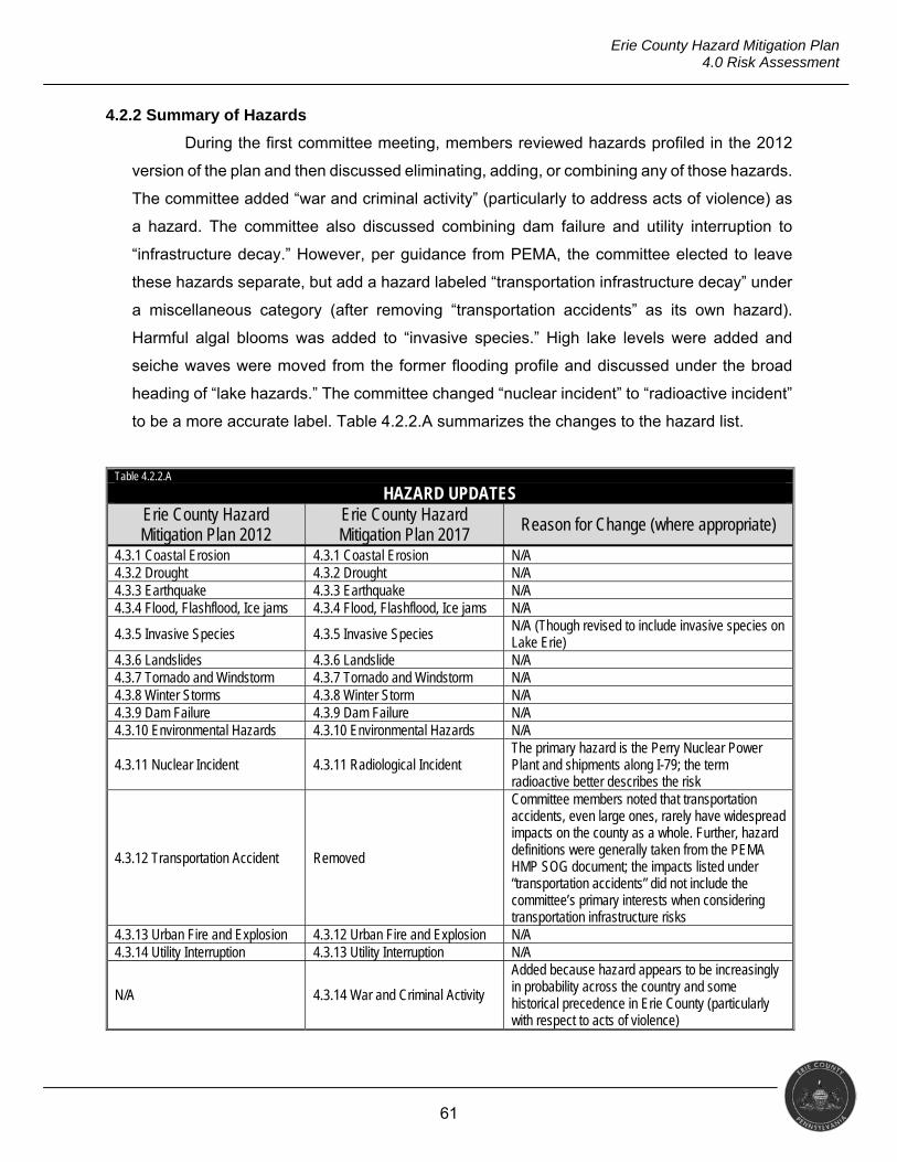
61
Erie County Hazard Mitigation Plan 4.0 Risk Assessment
4.2.2 Summary of Hazards
During the first committee meeting, members reviewed hazards profiled in the 2012
version of the plan and then discussed eliminating, adding, or combining any of those hazards.
The committee added “war and criminal activity” (particularly to address acts of violence) as
a hazard. The committee also discussed combining dam failure and utility interruption to
“infrastructure decay.” However, per guidance from PEMA, the committee elected to leave
these hazards separate, but add a hazard labeled “transportation infrastructure decay” under
a miscellaneous category (after removing “transportation accidents” as its own hazard).
Harmful algal blooms was added to “invasive species.” High lake levels were added and
seiche waves were moved from the former flooding profile and discussed under the broad
heading of “lake hazards.” The committee changed “nuclear incident” to “radioactive incident”
to be a more accurate label. Table 4.2.2.A summarizes the changes to the hazard list.
Table 4.2.2.A
HAZARD UPDATES Erie County Hazard Mitigation Plan 2012
Erie County Hazard Mitigation Plan 2017
Reason for Change (where appropriate)
4.3.1 Coastal Erosion 4.3.1 Coastal Erosion N/A 4.3.2 Drought 4.3.2 Drought N/A 4.3.3 Earthquake 4.3.3 Earthquake N/A 4.3.4 Flood, Flashflood, Ice jams 4.3.4 Flood, Flashflood, Ice jams N/A
4.3.5 Invasive Species 4.3.5 Invasive Species N/A (Though revised to include invasive species on Lake Erie)
4.3.6 Landslides 4.3.6 Landslide N/A 4.3.7 Tornado and Windstorm 4.3.7 Tornado and Windstorm N/A 4.3.8 Winter Storms 4.3.8 Winter Storm N/A 4.3.9 Dam Failure 4.3.9 Dam Failure N/A 4.3.10 Environmental Hazards 4.3.10 Environmental Hazards N/A
4.3.11 Nuclear Incident 4.3.11 Radiological Incident The primary hazard is the Perry Nuclear Power Plant and shipments along I-79; the term radioactive better describes the risk
4.3.12 Transportation Accident Removed
Committee members noted that transportation accidents, even large ones, rarely have widespread impacts on the county as a whole. Further, hazard definitions were generally taken from the PEMA HMP SOG document; the impacts listed under “transportation accidents” did not include the committee’s primary interests when considering transportation infrastructure risks
4.3.13 Urban Fire and Explosion 4.3.12 Urban Fire and Explosion N/A 4.3.14 Utility Interruption 4.3.13 Utility Interruption N/A
N/A 4.3.14 War and Criminal Activity
Added because hazard appears to be increasingly in probability across the country and some historical precedence in Erie County (particularly with respect to acts of violence)
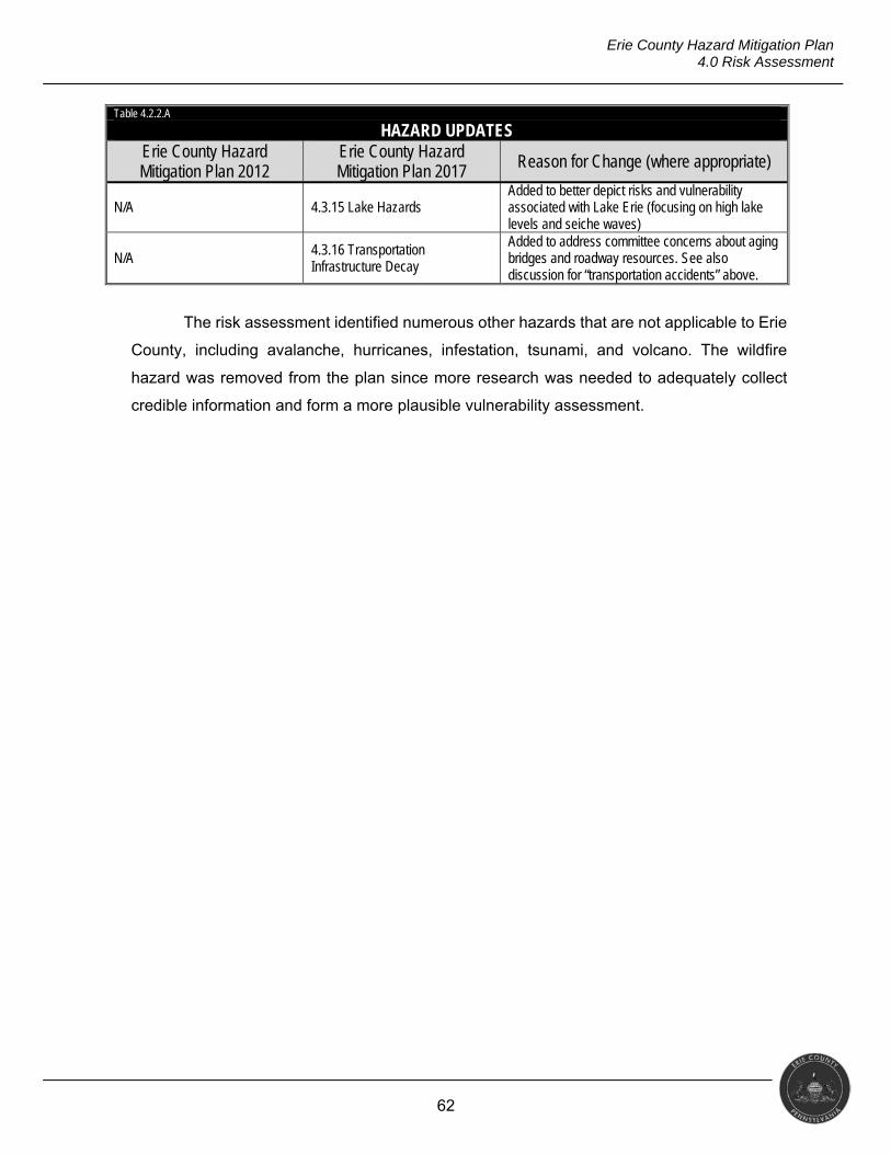
62
Erie County Hazard Mitigation Plan 4.0 Risk Assessment
Table 4.2.2.A
HAZARD UPDATES Erie County Hazard Mitigation Plan 2012
Erie County Hazard Mitigation Plan 2017 Reason for Change (where appropriate)
N/A 4.3.15 Lake Hazards Added to better depict risks and vulnerability associated with Lake Erie (focusing on high lake levels and seiche waves)
N/A 4.3.16 Transportation Infrastructure Decay
Added to address committee concerns about aging bridges and roadway resources. See also discussion for “transportation accidents” above.
The risk assessment identified numerous other hazards that are not applicable to Erie
County, including avalanche, hurricanes, infestation, tsunami, and volcano. The wildfire
hazard was removed from the plan since more research was needed to adequately collect
credible information and form a more plausible vulnerability assessment.
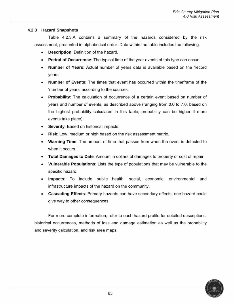
63
Erie County Mitigation Plan 4.0 Risk Assessment
4.2.3 Hazard Snapshots
Table 4.2.3.A contains a summary of the hazards considered by the risk
assessment, presented in alphabetical order. Data within the table includes the following.
Description: Definition of the hazard.
Period of Occurrence: The typical time of the year events of this type can occur.
Number of Years: Actual number of years data is available based on the ‘record
years’.
Number of Events: The times that event has occurred within the timeframe of the
‘number of years’ according to the sources.
Probability: The calculation of occurrence of a certain event based on number of
years and number of events, as described above (ranging from 0.0 to 7.0, based on
the highest probability calculated in this table; probability can be higher if more
events take place).
Severity: Based on historical impacts.
Risk: Low, medium or high based on the risk assessment matrix.
Warning Time: The amount of time that passes from when the event is detected to
when it occurs.
Total Damages to Date: Amount in dollars of damages to property or cost of repair.
Vulnerable Populations: Lists the type of populations that may be vulnerable to the
specific hazard.
Impacts: To include public health, social, economic, environmental and
infrastructure impacts of the hazard on the community.
Cascading Effects: Primary hazards can have secondary effects; one hazard could
give way to other consequences.
For more complete information, refer to each hazard profile for detailed descriptions,
historical occurrences, methods of loss and damage estimation as well as the probability
and severity calculation, and risk area maps.
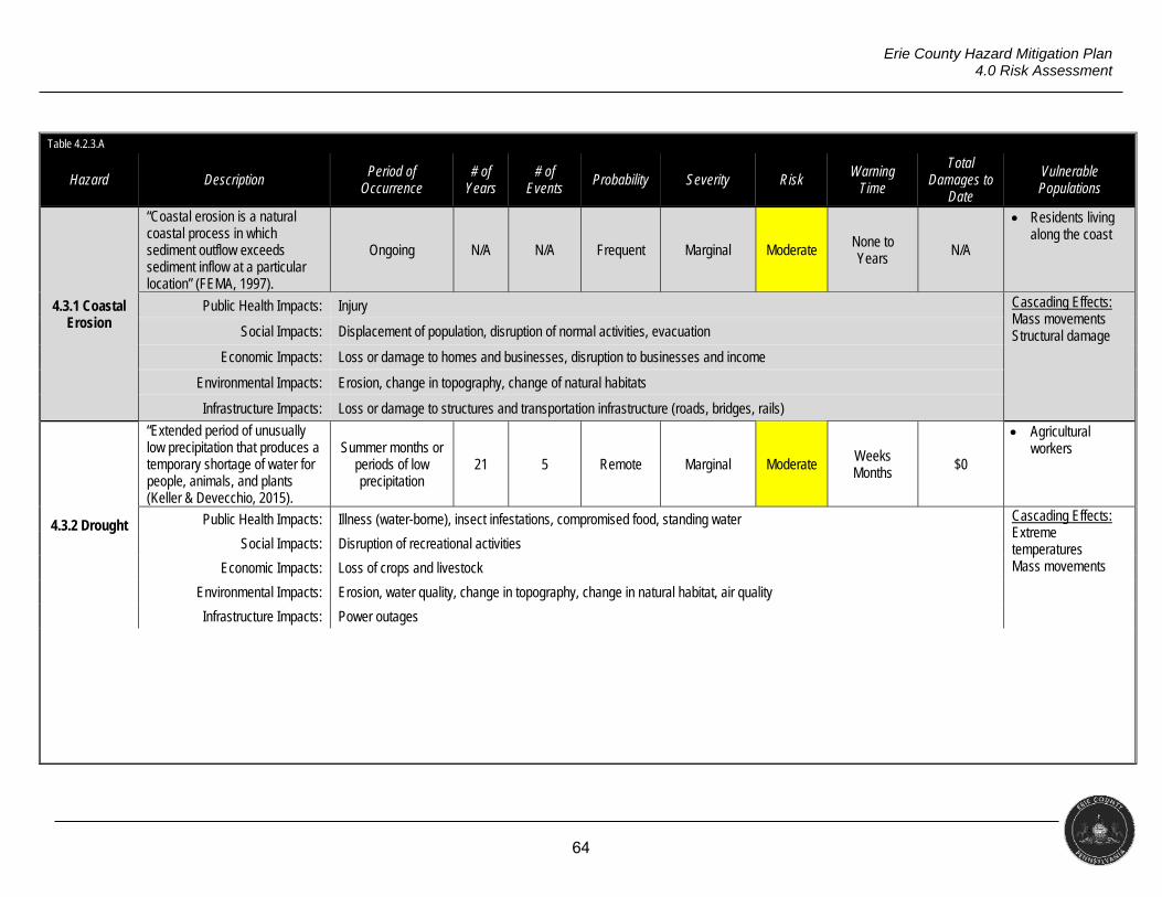
64
Erie County Hazard Mitigation Plan 4.0 Risk Assessment
Table 4.2.3.A
Hazard Description Period of
Occurrence # of
Years # of
Events Probability Severity Risk
Warning Time
Total Damages to
Date
Vulnerable Populations
4.3.1 Coastal Erosion
“Coastal erosion is a natural coastal process in which sediment outflow exceeds sediment inflow at a particular location” (FEMA, 1997).
Ongoing N/A N/A Frequent Marginal Moderate None to Years N/A
Residents living along the coast
Public Health Impacts: Injury Cascading Effects: Mass movements Structural damage Social Impacts: Displacement of population, disruption of normal activities, evacuation
Economic Impacts: Loss or damage to homes and businesses, disruption to businesses and income
Environmental Impacts: Erosion, change in topography, change of natural habitats
Infrastructure Impacts: Loss or damage to structures and transportation infrastructure (roads, bridges, rails)
4.3.2 Drought
“Extended period of unusually low precipitation that produces a temporary shortage of water for people, animals, and plants (Keller & Devecchio, 2015).
Summer months or periods of low precipitation
21 5 Remote Marginal Moderate Weeks Months
$0
Agricultural workers
Public Health Impacts: Illness (water-borne), insect infestations, compromised food, standing water Cascading Effects: Extreme temperatures Mass movements
Social Impacts: Disruption of recreational activities
Economic Impacts: Loss of crops and livestock
Environmental Impacts: Erosion, water quality, change in topography, change in natural habitat, air quality
Infrastructure Impacts: Power outages
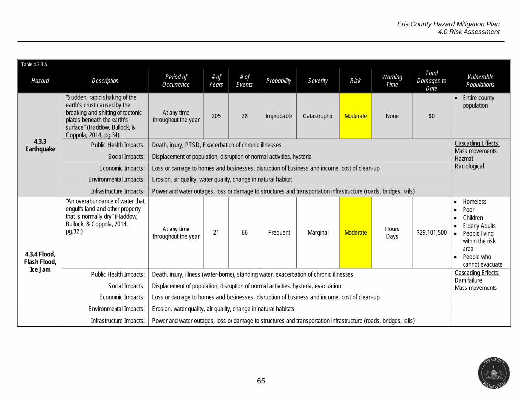
65
Erie County Hazard Mitigation Plan 4.0 Risk Assessment
Table 4.2.3.A
Hazard Description Period of
Occurrence # of
Years # of
Events Probability Severity Risk
Warning Time
Total Damages to
Date
Vulnerable Populations
4.3.3 Earthquake
“Sudden, rapid shaking of the earth’s crust caused by the breaking and shifting of tectonic plates beneath the earth’s surface” (Haddow, Bullock, & Coppola, 2014, pg.34).
At any time throughout the year
205 28 Improbable Catastrophic Moderate None $0
Entire county population
Public Health Impacts: Death, injury, PTSD, Exacerbation of chronic illnesses Cascading Effects: Mass movements Hazmat Radiological
Social Impacts: Displacement of population, disruption of normal activities, hysteria
Economic Impacts: Loss or damage to homes and businesses, disruption of business and income, cost of clean-up
Environmental Impacts: Erosion, air quality, water quality, change in natural habitat
Infrastructure Impacts: Power and water outages, loss or damage to structures and transportation infrastructure (roads, bridges, rails)
4.3.4 Flood, Flash Flood,
Ice Jam
“An overabundance of water that engulfs land and other property that is normally dry” (Haddow, Bullock, & Coppola, 2014, pg.32.) At any time
throughout the year 21 66 Frequent Marginal Moderate
Hours Days
$29,101,500
Homeless Poor Children Elderly Adults People living
within the risk area
People who cannot evacuate
Public Health Impacts: Death, injury, illness (water-borne), standing water, exacerbation of chronic illnesses Cascading Effects: Dam failure Mass movements Social Impacts: Displacement of population, disruption of normal activities, hysteria, evacuation
Economic Impacts: Loss or damage to homes and businesses, disruption of business and income, cost of clean-up
Environmental Impacts: Erosion, water quality, air quality, change in natural habitats
Infrastructure Impacts: Power and water outages, loss or damage to structures and transportation infrastructure (roads, bridges, rails)
66
Erie County Hazard Mitigation Plan 4.0 Risk Assessment
Table 4.2.3.A
Hazard Description Period of
Occurrence # of
Years # of
Events Probability Severity Risk
Warning Time
Total Damages to
Date
Vulnerable Populations
4.3.5 Invasive Species
“Invasive species are plants, animals, or pathogens that are non-native (or alien) to the ecosystem under consideration and whose introduction causes or is likely to cause harm.” (Executive Order 13112, 2006)
At any time N/A N/A Probable Marginal Moderate None to Years
N/A
Farmers Fisherman Foresters Wildland
Firefighters Landscapers
Public Health Impacts: Death, illness, compromised food, compromised drinking water Cascading Effects: Water infrastructure damage Social Impacts: Disruption of normal and recreational activities
Economic Impacts: Disruption to industry, loss of income, cost of clean-up
Environmental Impacts: Air quality, water quality, change in natural habitats
Infrastructure Impacts: Damage to water infrastructure
4.3.6 Landslide
“Sinking, settling, or other lowering of parts of the crust of the Earth” (Keller & Devecchio, 2015).
Increased chance following long
periods of heavy rain, snowmelt, or near construction
activity
10 0 Improbable Marginal Low Days
Weeks Months
$0
People living within the risk area
People who cannot evacuate
Public Health Impacts: Death, injury Cascading Effects: Infrastructure damage Social Impacts: Displacement of population, disruption of normal activities, evacuation
Economic Impacts: Loss or damage to homes and businesses, disruption to businesses and income, cost of clean-up
Environmental Impacts: Erosion, change in topography, change of natural habitats
Infrastructure Impacts: Loss or damage to structures and transportation infrastructure (roads, bridges, rails)
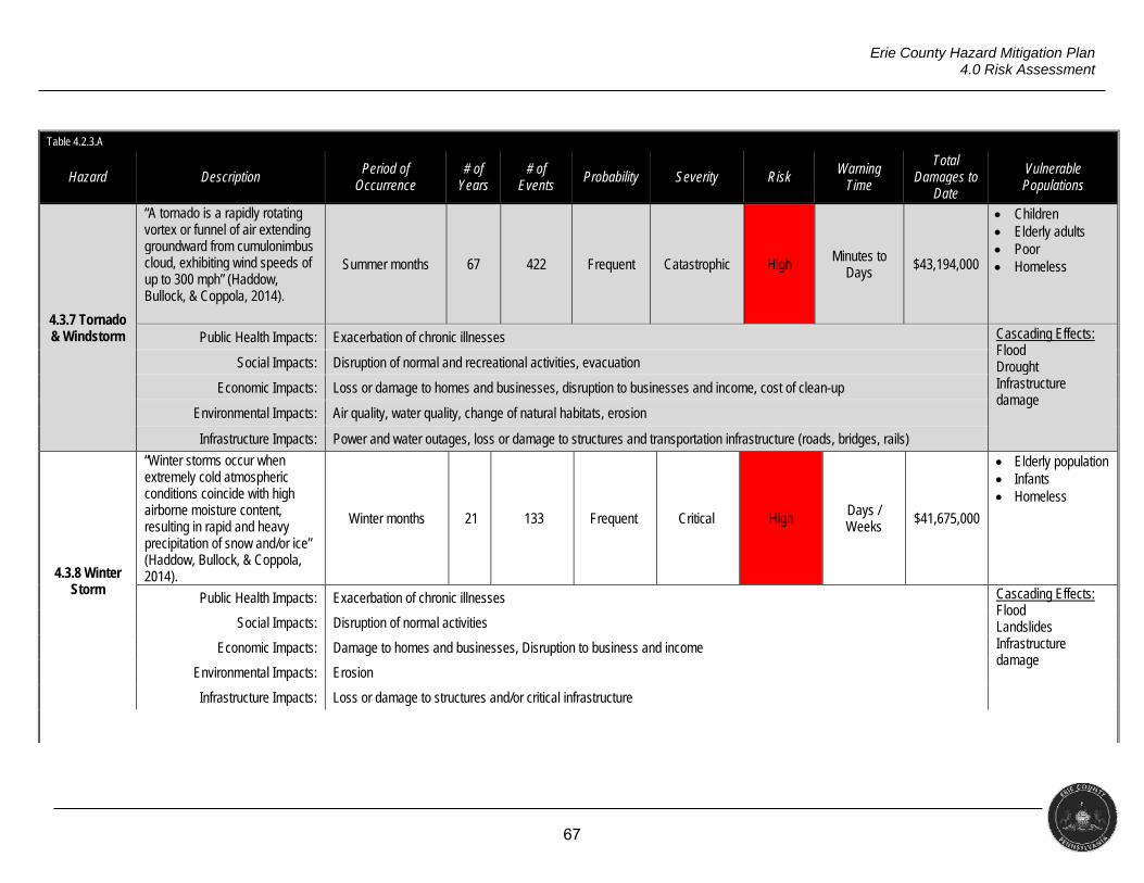
67
Erie County Hazard Mitigation Plan 4.0 Risk Assessment
Table 4.2.3.A
Hazard Description Period of
Occurrence # of
Years # of
Events Probability Severity Risk
Warning Time
Total Damages to
Date
Vulnerable Populations
4.3.7 Tornado & Windstorm
“A tornado is a rapidly rotating vortex or funnel of air extending groundward from cumulonimbus cloud, exhibiting wind speeds of up to 300 mph” (Haddow, Bullock, & Coppola, 2014).
Summer months 67 422 Frequent Catastrophic High Minutes to Days
$43,194,000
Children Elderly adults Poor Homeless
Public Health Impacts: Exacerbation of chronic illnesses Cascading Effects: Flood Drought Infrastructure damage
Social Impacts: Disruption of normal and recreational activities, evacuation
Economic Impacts: Loss or damage to homes and businesses, disruption to businesses and income, cost of clean-up
Environmental Impacts: Air quality, water quality, change of natural habitats, erosion
Infrastructure Impacts: Power and water outages, loss or damage to structures and transportation infrastructure (roads, bridges, rails)
4.3.8 Winter Storm
“Winter storms occur when extremely cold atmospheric conditions coincide with high airborne moisture content, resulting in rapid and heavy precipitation of snow and/or ice” (Haddow, Bullock, & Coppola, 2014).
Winter months 21 133 Frequent Critical High Days / Weeks $41,675,000
Elderly population Infants Homeless
Public Health Impacts: Exacerbation of chronic illnesses Cascading Effects: Flood Landslides Infrastructure damage
Social Impacts: Disruption of normal activities
Economic Impacts: Damage to homes and businesses, Disruption to business and income
Environmental Impacts: Erosion
Infrastructure Impacts: Loss or damage to structures and/or critical infrastructure
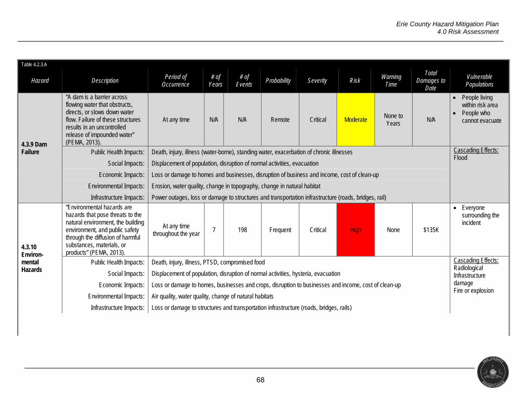
68
Erie County Hazard Mitigation Plan 4.0 Risk Assessment
Table 4.2.3.A
Hazard Description Period of
Occurrence # of
Years # of
Events Probability Severity Risk
Warning Time
Total Damages to
Date
Vulnerable Populations
4.3.9 Dam Failure
“A dam is a barrier across flowing water that obstructs, directs, or slows down water flow. Failure of these structures results in an uncontrolled release of impounded water” (PEMA, 2013).
At any time N/A N/A Remote Critical Moderate None to Years
N/A
People living within risk area
People who cannot evacuate
Public Health Impacts: Death, injury, illness (water-borne), standing water, exacerbation of chronic illnesses Cascading Effects: Flood
Social Impacts: Displacement of population, disruption of normal activities, evacuation
Economic Impacts: Loss or damage to homes and businesses, disruption of business and income, cost of clean-up
Environmental Impacts: Erosion, water quality, change in topography, change in natural habitat
Infrastructure Impacts: Power outages, loss or damage to structures and transportation infrastructure (roads, bridges, rail)
4.3.10 Environ-mental Hazards
“Environmental hazards are hazards that pose threats to the natural environment, the building environment, and public safety through the diffusion of harmful substances, materials, or products” (PEMA, 2013).
At any time throughout the year
7 198 Frequent Critical High None $135K
Everyone surrounding the incident
Public Health Impacts: Death, injury, illness, PTSD, compromised food Cascading Effects: Radiological Infrastructure damage Fire or explosion
Social Impacts: Displacement of population, disruption of normal activities, hysteria, evacuation
Economic Impacts: Loss or damage to homes, businesses and crops, disruption to businesses and income, cost of clean-up
Environmental Impacts: Air quality, water quality, change of natural habitats
Infrastructure Impacts: Loss or damage to structures and transportation infrastructure (roads, bridges, rails)
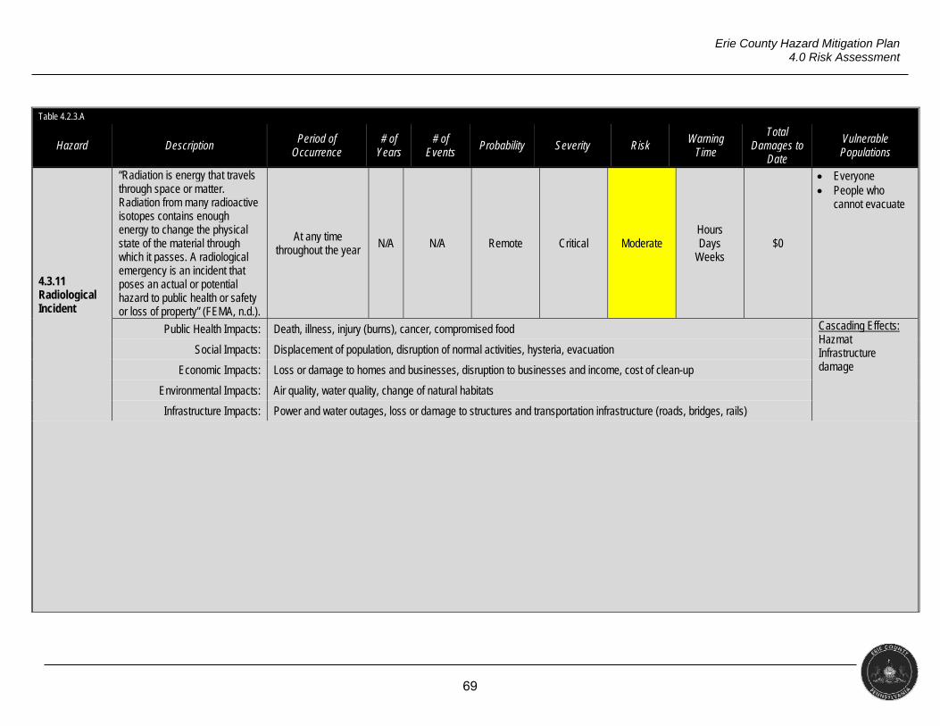
69
Erie County Hazard Mitigation Plan 4.0 Risk Assessment
Table 4.2.3.A
Hazard Description Period of
Occurrence # of
Years # of
Events Probability Severity Risk
Warning Time
Total Damages to
Date
Vulnerable Populations
4.3.11 Radiological Incident
“Radiation is energy that travels through space or matter. Radiation from many radioactive isotopes contains enough energy to change the physical state of the material through which it passes. A radiological emergency is an incident that poses an actual or potential hazard to public health or safety or loss of property” (FEMA, n.d.).
At any time throughout the year N/A N/A Remote Critical Moderate
Hours Days
Weeks $0
Everyone People who
cannot evacuate
Public Health Impacts: Death, illness, injury (burns), cancer, compromised food Cascading Effects: Hazmat Infrastructure damage
Social Impacts: Displacement of population, disruption of normal activities, hysteria, evacuation
Economic Impacts: Loss or damage to homes and businesses, disruption to businesses and income, cost of clean-up
Environmental Impacts: Air quality, water quality, change of natural habitats
Infrastructure Impacts: Power and water outages, loss or damage to structures and transportation infrastructure (roads, bridges, rails)
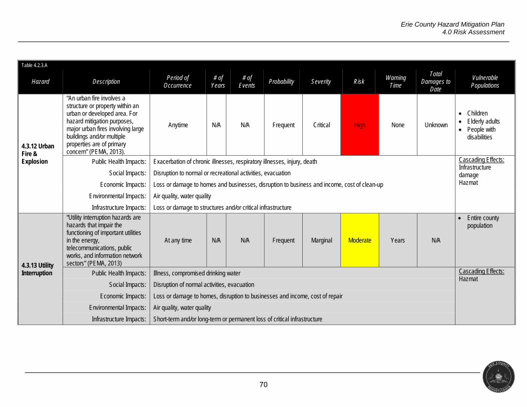
70
Erie County Hazard Mitigation Plan 4.0 Risk Assessment
Table 4.2.3.A
Hazard Description Period of
Occurrence # of
Years # of
Events Probability Severity Risk
Warning Time
Total Damages to
Date
Vulnerable Populations
4.3.12 Urban Fire & Explosion
“An urban fire involves a structure or property within an urban or developed area. For hazard mitigation purposes, major urban fires involving large buildings and/or multiple properties are of primary concern” (PEMA, 2013).
Anytime N/A N/A Frequent Critical High None Unknown
Children Elderly adults People with
disabilities
Public Health Impacts: Exacerbation of chronic illnesses, respiratory illnesses, injury, death Cascading Effects: Infrastructure damage Hazmat
Social Impacts: Disruption to normal or recreational activities, evacuation
Economic Impacts: Loss or damage to homes and businesses, disruption to business and income, cost of clean-up
Environmental Impacts: Air quality, water quality
Infrastructure Impacts: Loss or damage to structures and/or critical infrastructure
4.3.13 Utility Interruption
“Utility interruption hazards are hazards that impair the functioning of important utilities in the energy, telecommunications, public works, and information network sectors” (PEMA, 2013)
At any time N/A N/A Frequent Marginal Moderate Years N/A
Entire county population
Public Health Impacts: Illness, compromised drinking water Cascading Effects: Hazmat Social Impacts: Disruption of normal activities, evacuation
Economic Impacts: Loss or damage to homes, disruption to businesses and income, cost of repair
Environmental Impacts: Air quality, water quality
Infrastructure Impacts: Short-term and/or long-term or permanent loss of critical infrastructure
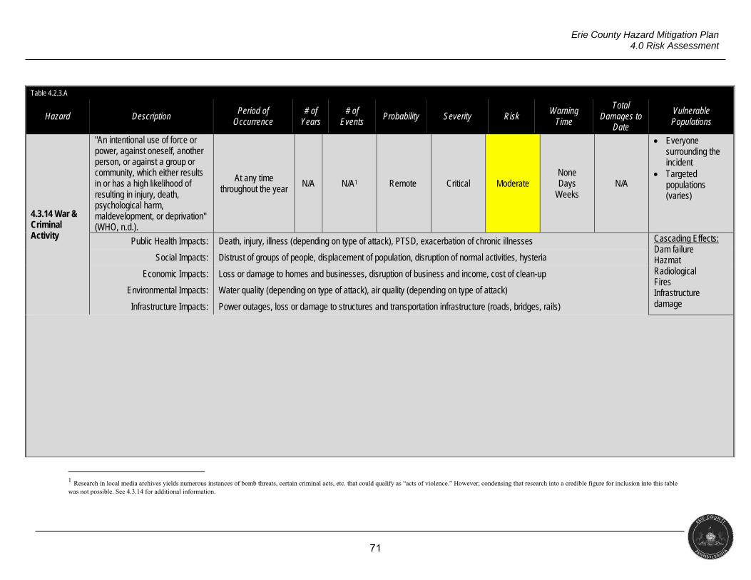
71
Erie County Hazard Mitigation Plan 4.0 Risk Assessment
Table 4.2.3.A
Hazard Description Period of
Occurrence # of
Years # of
Events Probability Severity Risk
Warning Time
Total Damages to
Date
Vulnerable Populations
4.3.14 War & Criminal Activity
"An intentional use of force or power, against oneself, another person, or against a group or community, which either results in or has a high likelihood of resulting in injury, death, psychological harm, maldevelopment, or deprivation" (WHO, n.d.).
At any time throughout the year
N/A N/A1 Remote Critical Moderate None Days
Weeks N/A
Everyone surrounding the incident
Targeted populations (varies)
Public Health Impacts: Death, injury, illness (depending on type of attack), PTSD, exacerbation of chronic illnesses Cascading Effects: Dam failure Hazmat Radiological Fires Infrastructure damage
Social Impacts: Distrust of groups of people, displacement of population, disruption of normal activities, hysteria
Economic Impacts: Loss or damage to homes and businesses, disruption of business and income, cost of clean-up
Environmental Impacts: Water quality (depending on type of attack), air quality (depending on type of attack)
Infrastructure Impacts: Power outages, loss or damage to structures and transportation infrastructure (roads, bridges, rails)
1 Research in local media archives yields numerous instances of bomb threats, certain criminal acts, etc. that could qualify as “acts of violence.” However, condensing that research into a credible figure for inclusion into this table was not possible. See 4.3.14 for additional information.
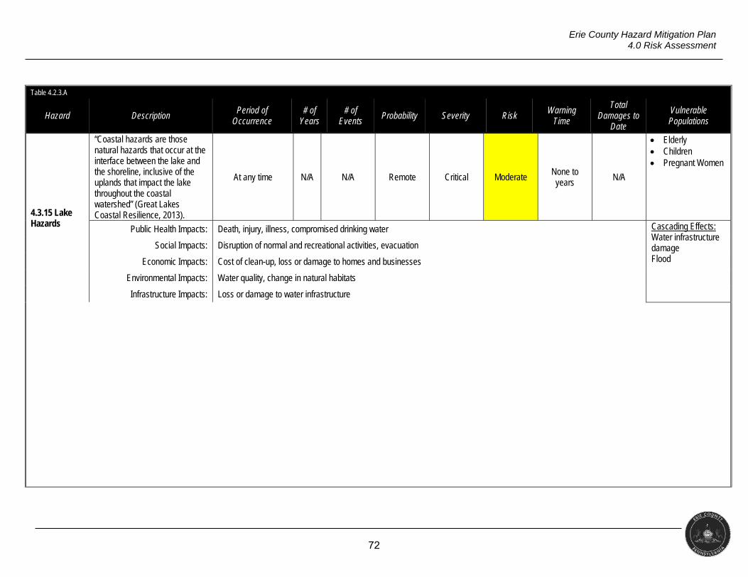
72
Erie County Hazard Mitigation Plan 4.0 Risk Assessment
Table 4.2.3.A
Hazard Description Period of
Occurrence # of
Years # of
Events Probability Severity Risk
Warning Time
Total Damages to
Date
Vulnerable Populations
4.3.15 Lake Hazards
“Coastal hazards are those natural hazards that occur at the interface between the lake and the shoreline, inclusive of the uplands that impact the lake throughout the coastal watershed” (Great Lakes Coastal Resilience, 2013).
At any time N/A N/A Remote Critical Moderate None to years N/A
Elderly Children Pregnant Women
Public Health Impacts: Death, injury, illness, compromised drinking water Cascading Effects: Water infrastructure damage Flood
Social Impacts: Disruption of normal and recreational activities, evacuation
Economic Impacts: Cost of clean-up, loss or damage to homes and businesses
Environmental Impacts: Water quality, change in natural habitats
Infrastructure Impacts: Loss or damage to water infrastructure
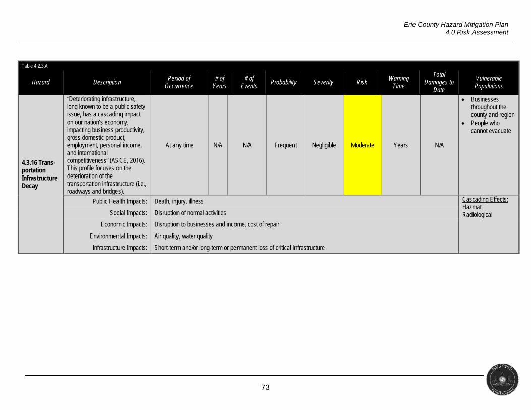
73
Erie County Hazard Mitigation Plan 4.0 Risk Assessment
Table 4.2.3.A
Hazard Description Period of
Occurrence # of
Years # of
Events Probability Severity Risk
Warning Time
Total Damages to
Date
Vulnerable Populations
4.3.16 Trans-portation Infrastructure Decay
“Deteriorating infrastructure, long known to be a public safety issue, has a cascading impact on our nation’s economy, impacting business productivity, gross domestic product, employment, personal income, and international competitiveness” (ASCE, 2016). This profile focuses on the deterioration of the transportation infrastructure (i.e., roadways and bridges).
At any time N/A N/A Frequent Negligible Moderate Years N/A
Businesses throughout the county and region
People who cannot evacuate
Public Health Impacts: Death, injury, illness Cascading Effects: Hazmat Radiological
Social Impacts: Disruption of normal activities
Economic Impacts: Disruption to businesses and income, cost of repair
Environmental Impacts: Air quality, water quality
Infrastructure Impacts: Short-term and/or long-term or permanent loss of critical infrastructure
74
Erie County Hazard Mitigation Plan 4.0 Risk Assessment
4.3 PROFILE HAZARDS
§201.6(c)(2)(i)
[The risk assessment shall include a] description of the…location and extent of all natural hazards that can affect the jurisdiction. The plan shall include information on previous occurrences of hazard events and on the probability of future hazard events.
Section Overview
Several natural and human-caused hazards affect Erie County, as noted above. This
section contains a profile of each hazard considered by this plan, which provides details on
how the hazard impacts the area. Within each profile, research and historical data informs the
following elements.
Hazard Overview: Defines the hazard.
Possible Causes: Describes a variety of causes that can contribute to the occurrence
of a hazard.
Public Health & Social Vulnerability: Describes impacts on different topics such as
health, the environment, or infrastructure that may result from the hazard as well as
specific populations that may be vulnerable.
Historical Occurrences: Summarizes significant past events related to the hazard.
Location & Extent: Identifies the physical places in the county or region that are
vulnerable to the hazard and the severity of a hazard in a given location.
Loss Estimate: Outlines the methods used for losses (of deaths, injury and/or
property damage depending on information available) and estimates them based on
historical information and vulnerable populations, structures, and infrastructure.
Probability & Severity Calculations: Detailed methods of calculating probability and
severity of each hazard.
Risk Map: Graphically shows the geographic locations in the county that are
vulnerable to each hazard.
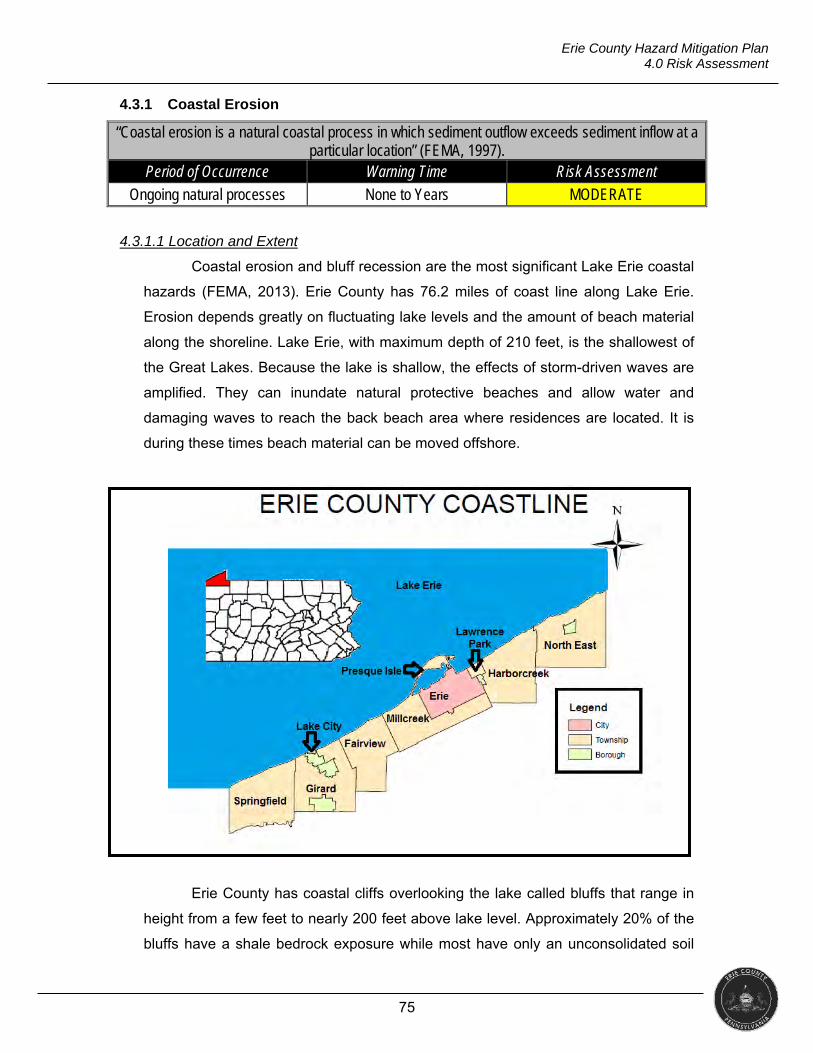
75
Erie County Hazard Mitigation Plan 4.0 Risk Assessment
4.3.1 Coastal Erosion
“Coastal erosion is a natural coastal process in which sediment outflow exceeds sediment inflow at a particular location” (FEMA, 1997).
Period of Occurrence Warning Time Risk Assessment
Ongoing natural processes None to Years MODERATE
4.3.1.1 Location and Extent
Coastal erosion and bluff recession are the most significant Lake Erie coastal
hazards (FEMA, 2013). Erie County has 76.2 miles of coast line along Lake Erie.
Erosion depends greatly on fluctuating lake levels and the amount of beach material
along the shoreline. Lake Erie, with maximum depth of 210 feet, is the shallowest of
the Great Lakes. Because the lake is shallow, the effects of storm-driven waves are
amplified. They can inundate natural protective beaches and allow water and
damaging waves to reach the back beach area where residences are located. It is
during these times beach material can be moved offshore.
Erie County has coastal cliffs overlooking the lake called bluffs that range in
height from a few feet to nearly 200 feet above lake level. Approximately 20% of the
bluffs have a shale bedrock exposure while most have only an unconsolidated soil
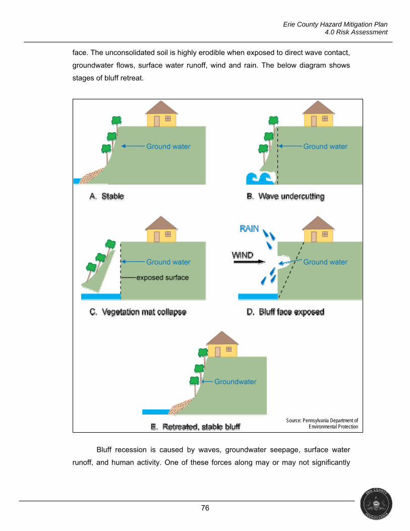
76
Erie County Hazard Mitigation Plan 4.0 Risk Assessment
face. The unconsolidated soil is highly erodible when exposed to direct wave contact,
groundwater flows, surface water runoff, wind and rain. The below diagram shows
stages of bluff retreat.
Bluff recession is caused by waves, groundwater seepage, surface water
runoff, and human activity. One of these forces along may or may not significantly
Source: Pennsylvania Department of Environmental Protection
77
Erie County Hazard Mitigation Plan 4.0 Risk Assessment
weaken a bluff, but a combination of these forces will likely start the process of
recession in motion.
Wave contact with the bluffs is especially damaging when combined with
high lake levels. High lake levels in Lake Erie are primarily caused by
increased precipitation in the upper Great Lakes Watershed. During periods
of storm events and high lake levels, waves break farther inshore and make
contact with the base of the bluff, an erosion process known as undercutting.
Once the base area is eroded, upper bluff soils and vegetation lose their
support and collapse downward causing the bluff to recede landward.
Groundwater seepage is the flow of underground water through the bluff
face. As the water flows out of the bluff, it pulls soil particles with it, causing
erosion. This action leads to slumping, which is a type of landslide.
Groundwater comes from natural inland water sources and from human-
induced water sources such as sprinkler systems, downspouts and leaking
swimming pools and septic systems.
Surface water runoff is the result of natural and human induced water flows
over the bluff face. Flows are an erosive force, causing sediment to be
dislodged and carried to the base of the bluff. Over time, flows across an
unprotected bluff produce deep gullies. Surface water includes rain, snow
melt and stormwater.
Human activity, such as construction of roads and walking paths, increases
the possibility of erosion and bluff instability. Also, dumping trash and yard
waste on the bluff accelerates recession by discouraging vegetation growth
and putting added weight on the bluff face.
The Pennsylvania Department of Environmental Protection Coastal Zone
Management Program (CZM) has defined and identified Bluff Recession Hazard
Areas (BRHAs). These BRHAs are “an area or zone where the rate of progressive
bluff recession creates a substantial threat to the safety or stability of nearby or
future structures or utility facilities.” There are nine municipalities along the Lake Erie
coast that have designated BRHAs. CZM uses control point monuments, global
position system technology, physical inspections, low-level overflights, aerial
photography, and laser mapping to monitor bluff recession rates (Pennsylvania Sea
Grant, 2000).
78
Erie County Hazard Mitigation Plan 4.0 Risk Assessment
Table 4.3.1.1.A
Municipalities with Designated Bluff Recession Hazard Area Erie, City of Fairview Township Girard Township
Harborcreek Township Lake City Borough Lawrence Park Township Millcreek Township North East Township Springfield Township
Average bluff recession for the coastal municipalities of Erie County range
from 0.24 to 1.27 feet of land lost per year. However, averages do not paint a clear
picture of the bluff recession hazard. Some areas are stable and have recession
rates of zero while other sections in the same community may lose large pieces of
land in a single collapse. Recent erosion estimates state over 417,000 cubic yards of
sediment are eroded on Erie County’s shoreline each year (PACZM, 2007).
Much of Lake Erie and its beaches and bluffs are frozen during the winter,
inhibiting the formation of storm waves and reducing erosion. However, during ice
formation in early winter and the spring thaw, erosion and recession are accelerated.
Spring rains, snowmelt and low evaporation rates cause Lake Erie’s average water
levels in June to be 30 centimeters above January levels. Several years of above-
normal precipitation can cause Lake Erie’s water level to rise above its long term
average, increasing the likelihood of erosion.
4.3.1.2 Range of Magnitude
Erie County has just over 76 miles of shoreline along Lake Erie. The average
rate of bluff recession is Pennsylvania is one foot per year; however, losses of up to
20 feet in a single year have been recorded along the lake (PSU, 2000). It is
important to understand that in some areas the shoreline is stable and in others,
large areas of land can collapse taking several feet of shoreline at one time.
The geological processes along the shoreline are continuous. Lake levels,
land use, storm impact, and the physical structures of the bluffs and shoreline affect
rates of change. The sand, gravel, and clay that make up the glacial sediment
covering most of the Erie County shoreline are exceptionally vulnerable to erosion
(www.presqueisle.org). This erosion is sped up by high lake levels and seiche
waves.
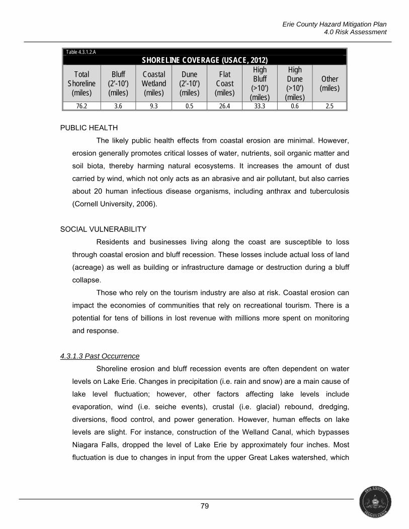
79
Erie County Hazard Mitigation Plan 4.0 Risk Assessment
Table 4.3.1.2.A
SHORELINE COVERAGE (USACE, 2012)
Total Shoreline
(miles)
Bluff (2’-10’) (miles)
Coastal Wetland (miles)
Dune (2’-10’) (miles)
Flat Coast (miles)
High Bluff
(>10’) (miles)
High Dune (>10’) (miles)
Other (miles)
76.2 3.6 9.3 0.5 26.4 33.3 0.6 2.5
PUBLIC HEALTH
The likely public health effects from coastal erosion are minimal. However,
erosion generally promotes critical losses of water, nutrients, soil organic matter and
soil biota, thereby harming natural ecosystems. It increases the amount of dust
carried by wind, which not only acts as an abrasive and air pollutant, but also carries
about 20 human infectious disease organisms, including anthrax and tuberculosis
(Cornell University, 2006).
SOCIAL VULNERABILITY
Residents and businesses living along the coast are susceptible to loss
through coastal erosion and bluff recession. These losses include actual loss of land
(acreage) as well as building or infrastructure damage or destruction during a bluff
collapse.
Those who rely on the tourism industry are also at risk. Coastal erosion can
impact the economies of communities that rely on recreational tourism. There is a
potential for tens of billions in lost revenue with millions more spent on monitoring
and response.
4.3.1.3 Past Occurrence
Shoreline erosion and bluff recession events are often dependent on water
levels on Lake Erie. Changes in precipitation (i.e. rain and snow) are a main cause of
lake level fluctuation; however, other factors affecting lake levels include
evaporation, wind (i.e. seiche events), crustal (i.e. glacial) rebound, dredging,
diversions, flood control, and power generation. However, human effects on lake
levels are slight. For instance, construction of the Welland Canal, which bypasses
Niagara Falls, dropped the level of Lake Erie by approximately four inches. Most
fluctuation is due to changes in input from the upper Great Lakes watershed, which
80
Erie County Hazard Mitigation Plan 4.0 Risk Assessment
contributes almost 90% of the total input into Lake Erie. Additional water inputs come
from sources including tributaries, groundwater, and precipitation.
Various studies, notably those developed by the U.S. Army Corps of
Engineers (Buffalo District) and the Pennsylvania Coastal Resources Management
Program, have assessed shoreline damage statistics and the costs of protection.
Shore structure inventories have also been prepared in recent years, some of which
are ongoing. These documents provide useful information for measuring losses and
recording efforts made to mitigate damage. However, studies more recent than the
1987 damage assessment are not currently available. The long-term average
historical recession rate based on 130 fixed control point monuments for the
Pennsylvania Lake Erie Coastal Zone is 1.0 ft/yr.
A study performed by the U.S. Geological Survey in cooperation with the
Pennsylvania Coastal Resources Management Program divided the Pennsylvania
Lake Erie shoreline into two areas along which recession rates were calculated
(Hapke et al., 2009). Using data from 1938-2006, the study area extending
southwest of Presque Isle had an average rate of recession of 0.98 +/- 0.33 ft/yr.
Using data from 1938-1998, the study area extending northeast of Presque Isle had
an average rate of recession of 0.66 +/- 0.33 ft/yr. A maximum rate of 3.28 +/- 0.33
ft/yr. was measured in each study area, both occurring in predominantly agricultural
areas. Due to excessive precipitation in the spring of 2011, several lakefront
properties experienced significant bluff recession. One of the properties affected by
this event receded approximately 100 ft. (ECDPS, 2011). Historical recession data is
valuable for long-term planning purposes. However, historical rates are spatially
variable and temporally episodic. During the past two decades of monitoring, losses
of up to twenty feet in a single year have been observed (Hapke et al., 2009). In
addition, low retreat rates have been measured at certain control points, while rates
in immediately adjacent areas are much higher. Therefore, the limitations of historical
rates must be recognized and data must be used appropriately for purposes of
evaluating risk.
Presque Isle
Due to the lack of ice cover during the winter of 2015-2016, significant
erosion occurred along the entire length of Presque Isle. It is estimated that 38,000
81
Erie County Hazard Mitigation Plan 4.0 Risk Assessment
cubic yards of sand is used annually to offset the impact of erosion. Federal funds
were cut, leaving only $500,000 for sand replenishment.
4.3.1.4 Future Occurrence
Bluff erosion and recession are a result of a natural process and are essential
to the ecological health of Lake Erie. The eroded materials nourish the near shore
environments with nutrients and organic matter. However, human activities have the
potential to accelerate the recession to unnatural rates (PADEP, 2013).
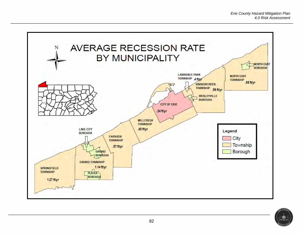
82
Erie County Hazard Mitigation Plan 4.0 Risk Assessment
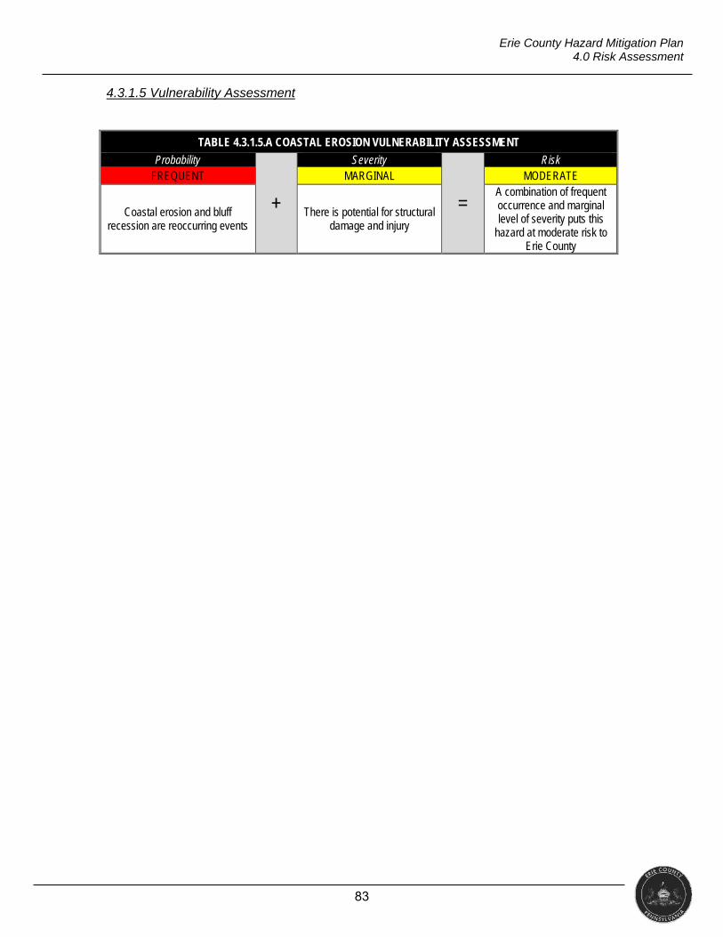
83
Erie County Hazard Mitigation Plan 4.0 Risk Assessment
4.3.1.5 Vulnerability Assessment
TABLE 4.3.1.5.A COASTAL EROSION VULNERABILITY ASSESSMENT
Probability
+
Severity
=
Risk FREQUENT MARGINAL MODERATE
Coastal erosion and bluff recession are reoccurring events
There is potential for structural damage and injury
A combination of frequent occurrence and marginal level of severity puts this
hazard at moderate risk to Erie County
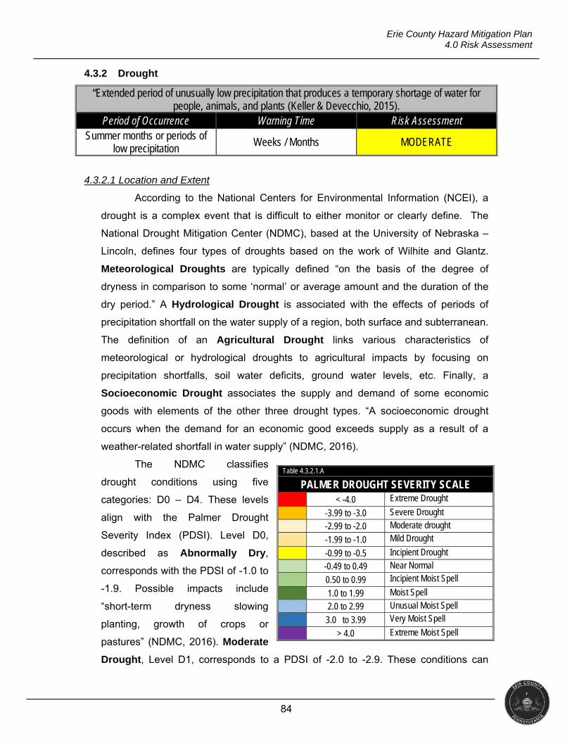
84
Erie County Hazard Mitigation Plan 4.0 Risk Assessment
4.3.2 Drought
“Extended period of unusually low precipitation that produces a temporary shortage of water for people, animals, and plants (Keller & Devecchio, 2015).
Period of Occurrence Warning Time Risk Assessment Summer months or periods of
low precipitation Weeks / Months MODERATE
4.3.2.1 Location and Extent
According to the National Centers for Environmental Information (NCEI), a
drought is a complex event that is difficult to either monitor or clearly define. The
National Drought Mitigation Center (NDMC), based at the University of Nebraska –
Lincoln, defines four types of droughts based on the work of Wilhite and Glantz.
Meteorological Droughts are typically defined “on the basis of the degree of
dryness in comparison to some ‘normal’ or average amount and the duration of the
dry period.” A Hydrological Drought is associated with the effects of periods of
precipitation shortfall on the water supply of a region, both surface and subterranean.
The definition of an Agricultural Drought links various characteristics of
meteorological or hydrological droughts to agricultural impacts by focusing on
precipitation shortfalls, soil water deficits, ground water levels, etc. Finally, a
Socioeconomic Drought associates the supply and demand of some economic
goods with elements of the other three drought types. “A socioeconomic drought
occurs when the demand for an economic good exceeds supply as a result of a
weather-related shortfall in water supply” (NDMC, 2016).
The NDMC classifies
drought conditions using five
categories: D0 – D4. These levels
align with the Palmer Drought
Severity Index (PDSI). Level D0,
described as Abnormally Dry,
corresponds with the PDSI of -1.0 to
-1.9. Possible impacts include
“short-term dryness slowing
planting, growth of crops or
pastures” (NDMC, 2016). Moderate
Drought, Level D1, corresponds to a PDSI of -2.0 to -2.9. These conditions can
Table 4.3.2.1.A
PALMER DROUGHT SEVERITY SCALE < -4.0 Extreme Drought
-3.99 to -3.0 Severe Drought -2.99 to -2.0 Moderate drought -1.99 to -1.0 Mild Drought
-0.99 to -0.5 Incipient Drought -0.49 to 0.49 Near Normal 0.50 to 0.99 Incipient Moist Spell
1.0 to 1.99 Moist Spell 2.0 to 2.99 Unusual Moist Spell 3.0 to 3.99 Very Moist Spell
> 4.0 Extreme Moist Spell
85
Erie County Hazard Mitigation Plan 4.0 Risk Assessment
cause some damage to crops and pastures and can result in water shortages
(NDMC, 2016). The D2 level, known as a Severe Drought, is a condition where crop
or pasture losses are likely and water shortages will be common (NDMC, 2016).
This correlates with a PDSI of -3.0 to -3.9. The D3 level (PDSI of -4.0 to -4.9), or
Extreme Drought, includes impacts such as major crop and pasture losses as well
as widespread water shortages and restrictions (NDMC, 2016). The most severe
drought category, D4, Exceptional Drought, with a PDSI of -5.0 or more, will cause
exceptional and widespread crop/pasture loss and will lead to water emergencies as
reservoirs, streams and wells are short of water (NDMC, 2016).
Phases of drought preparedness in Pennsylvania in order of increasing
severity are:
Drought Watch: A period to alert government agencies, public water
suppliers, water users, and the public regarding the potential for future
drought-related problems. The focus is on increased monitoring, awareness,
and preparation for response if conditions worsen. A request for voluntary
water conservation is made. The objective of voluntary water conservation
measures during a drought watch is to reduce water uses by five percent in
the affected areas. Due to varying conditions, individual water suppliers or
municipalities may ask for more stringent conservation actions.
Drought Warning: This phase involves a coordinated response to imminent
drought conditions and potential water supply shortages through concerted
voluntary conservation measures to avoid or reduce shortages, relieve
stressed sources, develop new sources and, if possible, forestall the need to
impose mandatory water use restrictions. The objective of voluntary water
conservation measures during a drought warning is to reduce overall water
usage by 10 to 15 percent in affected areas. Due to varying conditions,
individual water suppliers or municipalities may ask for more stringent
conservation actions.
Drought Emergency: This stage is a phase of concerted management
operations to marshal all available resources to respond to actual emergency
conditions, avoid depletion of water sources, assure at least minimum water
supplies to protect public health and safety, support essential and high
priority water uses, and avoid unnecessary economic dislocations. It is
possible during this phase to impose mandatory restrictions on non-essential
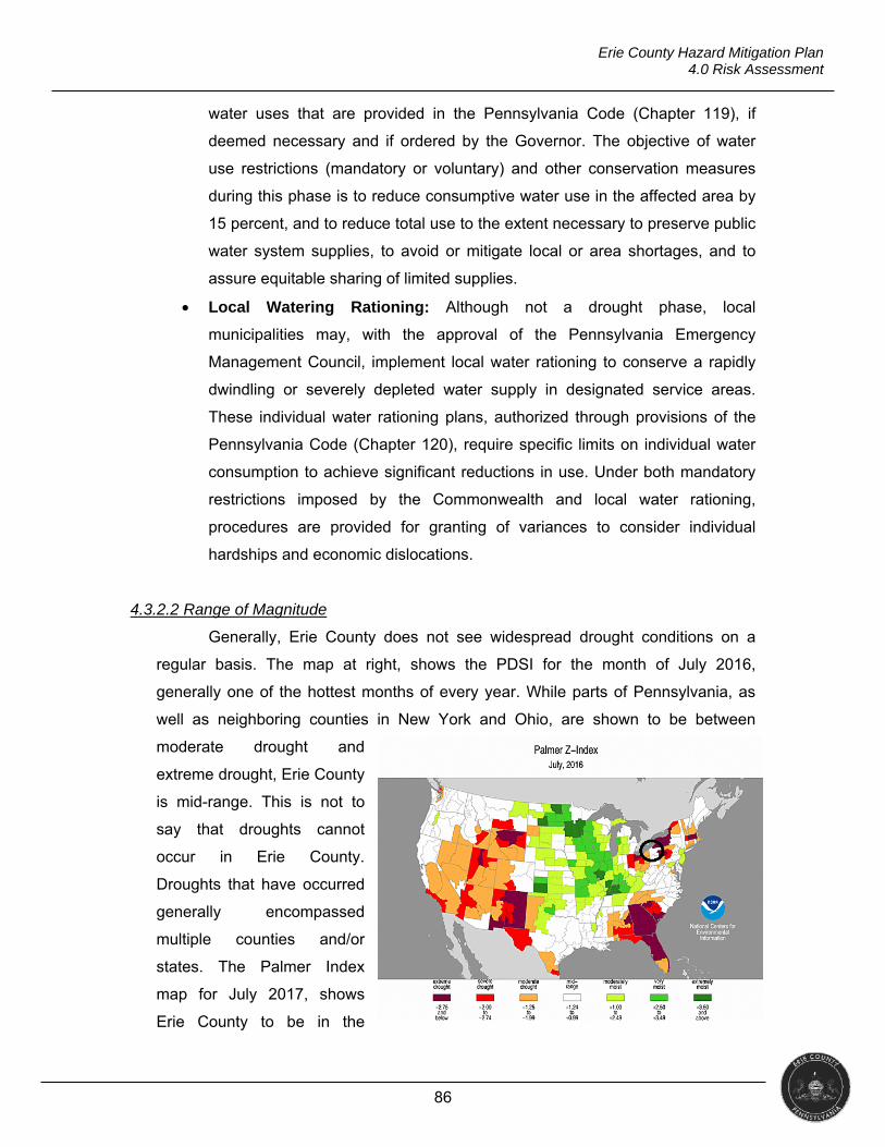
86
Erie County Hazard Mitigation Plan 4.0 Risk Assessment
water uses that are provided in the Pennsylvania Code (Chapter 119), if
deemed necessary and if ordered by the Governor. The objective of water
use restrictions (mandatory or voluntary) and other conservation measures
during this phase is to reduce consumptive water use in the affected area by
15 percent, and to reduce total use to the extent necessary to preserve public
water system supplies, to avoid or mitigate local or area shortages, and to
assure equitable sharing of limited supplies.
Local Watering Rationing: Although not a drought phase, local
municipalities may, with the approval of the Pennsylvania Emergency
Management Council, implement local water rationing to conserve a rapidly
dwindling or severely depleted water supply in designated service areas.
These individual water rationing plans, authorized through provisions of the
Pennsylvania Code (Chapter 120), require specific limits on individual water
consumption to achieve significant reductions in use. Under both mandatory
restrictions imposed by the Commonwealth and local water rationing,
procedures are provided for granting of variances to consider individual
hardships and economic dislocations.
4.3.2.2 Range of Magnitude
Generally, Erie County does not see widespread drought conditions on a
regular basis. The map at right, shows the PDSI for the month of July 2016,
generally one of the hottest months of every year. While parts of Pennsylvania, as
well as neighboring counties in New York and Ohio, are shown to be between
moderate drought and
extreme drought, Erie County
is mid-range. This is not to
say that droughts cannot
occur in Erie County.
Droughts that have occurred
generally encompassed
multiple counties and/or
states. The Palmer Index
map for July 2017, shows
Erie County to be in the
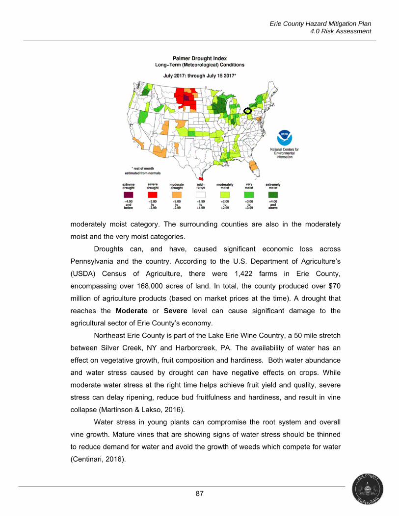
87
Erie County Hazard Mitigation Plan 4.0 Risk Assessment
moderately moist category. The surrounding counties are also in the moderately
moist and the very moist categories.
Droughts can, and have, caused significant economic loss across
Pennsylvania and the country. According to the U.S. Department of Agriculture’s
(USDA) Census of Agriculture, there were 1,422 farms in Erie County,
encompassing over 168,000 acres of land. In total, the county produced over $70
million of agriculture products (based on market prices at the time). A drought that
reaches the Moderate or Severe level can cause significant damage to the
agricultural sector of Erie County’s economy.
Northeast Erie County is part of the Lake Erie Wine Country, a 50 mile stretch
between Silver Creek, NY and Harborcreek, PA. The availability of water has an
effect on vegetative growth, fruit composition and hardiness. Both water abundance
and water stress caused by drought can have negative effects on crops. While
moderate water stress at the right time helps achieve fruit yield and quality, severe
stress can delay ripening, reduce bud fruitfulness and hardiness, and result in vine
collapse (Martinson & Lakso, 2016).
Water stress in young plants can compromise the root system and overall
vine growth. Mature vines that are showing signs of water stress should be thinned
to reduce demand for water and avoid the growth of weeds which compete for water
(Centinari, 2016).
88
Erie County Hazard Mitigation Plan 4.0 Risk Assessment
PUBLIC HEALTH
The public health effects of drought include compromised quality and quantity
of potable water, increased recreational risks, effects on air quality, diminished living
conditions, compromised food and nutrition, and increased incidence of illness and
disease. Prolonged drought conditions can cause increased particulates suspended
in the air and increase risk of disease transmitted through aerosolization of spores in
soil such as coccidioidomycosis.
Decreased rainfall can lead to water polluted with a variety of contaminants.
Incidences of vector-borne diseases can become more frequent as the size of water
bodies diminish and become stagnant. As visible surface water becomes less,
mosquitos are forced to breed in areas with swamp-like ecosystems home to many
birds and other animals. The cohabitation of mosquitos and avian hosts can lead to
outbreaks of diseases including encephalitis and West Nile Virus (Kalis, Miller, &
Wilson, 2009).
SOCIAL VULNERABILITY
The CDC lists individuals with chronic medical conditions, low income
persons, children and the elderly as vulnerable populations in its Drought
Communication Toolkit. Chronic medical conditions such as cardiovascular disease,
respiratory disease, and mental illnesses including anxiety and depression make
individuals more vulnerable to the effects of a drought (CDC, 2017). Increased
particulate matter from droughts is associated with systematic inflammation,
compromised heart function, pulmonary embolism and blood vessel dysfunction
leading to those with cardiovascular and respiratory disease to have complications
and increased incidences of hospital admissions (National Institute of Environmental
Health Sciences, 2016). The USDA recognizes farmers and those who work in
agriculture to be socially vulnerable to droughts. The USDA has multiple programs
and grants to assist these individuals with lost revenue from crop loss. (Stubbs,
2016).
Erie County residents that use private domestic wells are more vulnerable to
droughts because their wells can dry up. There are over 7,900 of these wells in Erie
County. The table below shows the number of domestic wells per municipality as
collected by the Pennsylvania Groundwater Information System (PaGWIS)
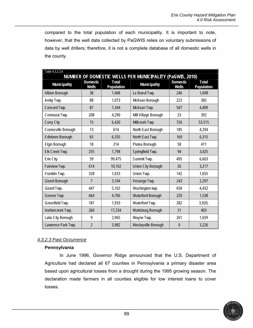
89
Erie County Hazard Mitigation Plan 4.0 Risk Assessment
compared to the total population of each municipality. It is important to note,
however, that the well data collected by PaGWIS relies on voluntary submissions of
data by well drillers; therefore, it is not a complete database of all domestic wells in
the county.
Table 4.3.2.2.A
NUMBER OF DOMESTIC WELLS PER MUNICIPALITY (PaGWIS, 2010)
Municipality Domestic
Wells Total
Population Municipality
Domestic Wells
Total Population
Albion Borough 38 1,468 Le Boeuf Twp. 246 1,698
Amity Twp. 88 1,073 McKean Borough 223 383
Concord Twp. 87 1,344 McKean Twp. 507 4,409
Conneaut Twp. 208 4,290 Mill Village Borough 23 392
Corry City 15 6,420 Millcreek Twp. 726 53,515
Cranesville Borough 13 614 North East Borough 185 4,294
Edinboro Borough 65 6,335 North East Twp. 169 6,315
Elgin Borough 18 214 Platea Borough 58 411
Elk Creek Twp. 255 1,798 Springfield Twp. 94 3,425
Erie City 59 99,475 Summit Twp. 495 6,603
Fairview Twp. 614 10,102 Union City Borough 26 3,217
Franklin Twp. 328 1,633 Union Twp. 142 1,655
Girard Borough 7 3,104 Venango Twp. 243 2,297
Girard Twp. 447 5,102 Washington twp. 658 4,432
Greene Twp. 664 4,706 Waterford Borough 220 1,538
Greenfield Twp. 181 1,933 Waterford Twp. 282 3,920,
Harborcreek Twp. 260 17,234 Wattsburg Borough 31 403
Lake City Borough 9 2,965 Wayne Twp. 261 1,659
Lawrence Park Twp. 2 3,982 Wesleyville Borough 0 3,226
4.3.2.3 Past Occurrence
Pennsylvania
In June 1996, Governor Ridge announced that the U.S. Department of
Agriculture had declared all 67 counties in Pennsylvania a primary disaster area
based upon agricultural losses from a drought during the 1995 growing season. The
declaration made farmers in all counties eligible for low interest loans to cover
losses.
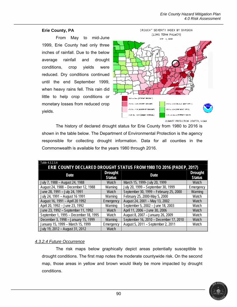
90
Erie County Hazard Mitigation Plan 4.0 Risk Assessment
Erie County, PA
From May to mid-June
1999, Erie County had only three
inches of rainfall. Due to the below
average rainfall and drought
conditions, crop yields were
reduced. Dry conditions continued
until the end September 1999,
when heavy rains fell. This rain did
little to help crop conditions or
monetary losses from reduced crop
yields.
The history of declared drought status for Erie County from 1980 to 2016 is
shown in the table below. The Department of Environmental Protection is the agency
responsible for collecting drought information. Data for all counties in the
Commonwealth is available for the years 1980 through 2016.
Table 4.3.2.3.A
ERIE COUNTY DECLARED DROUGHT STATUS FROM 1980 TO 2016 (PADEP, 2017)
Date Drought Status
Date Drought Status
July 7, 1988 – August 24, 1988 Watch March 15, 1999- July 20, 1999 Watch August 24, 1988 – December 12, 1988 Warning July 20, 1999 – September 30, 1999 Emergency June 28, 1991 – July 24, 1991 Watch September 30, 1999 – February 25, 2000 Warning July 24, 1991 – August 16 1991 Warning February 25, 2000-May 5, 2000 Watch August 16, 1991 – April 20 1992 Emergency August 24, 2001 – May 13, 2002 Watch April 20, 1992 – June 23, 1992 Warning September 5, 2002 – June 18, 2003 Watch June 23, 1992 – September 11, 1992 Watch April 11, 2006 – June 30, 2006 Watch September 1, 1995 – December 18, 1995 Watch August 8, 2007 – January 26, 2009 Watch December 3, 1998 – January 15, 1999 Warning September 16, 2010 – December 17, 2010 Watch January 15, 1999 – March 15, 1999 Emergency August 5, 2011 – September 2, 2011 Watch July 19, 2012 – August 31, 2012 Watch
4.3.2.4 Future Occurrence
The risk maps below graphically depict areas potentially susceptible to
drought conditions. The first map notes the moderate countywide risk. On the second
map, those areas in yellow and brown would likely be more impacted by drought
conditions.
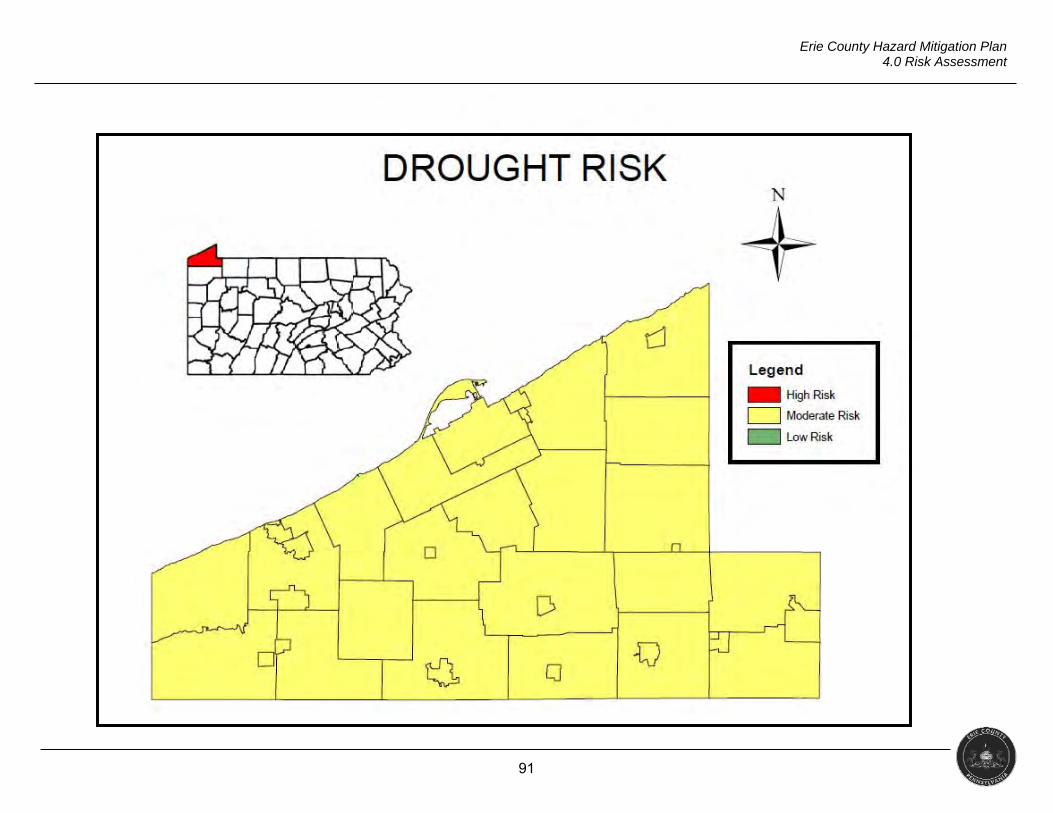
91
Erie County Hazard Mitigation Plan 4.0 Risk Assessment
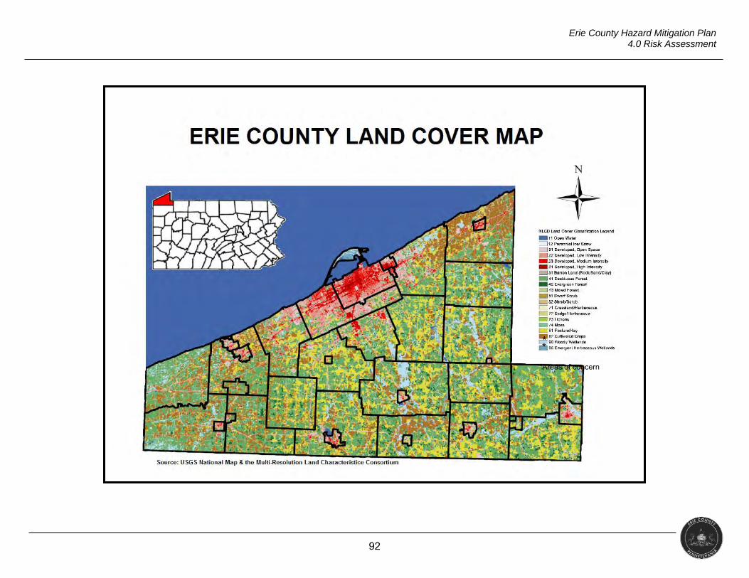
92
Erie County Hazard Mitigation Plan 4.0 Risk Assessment
* *
*Areas of concern
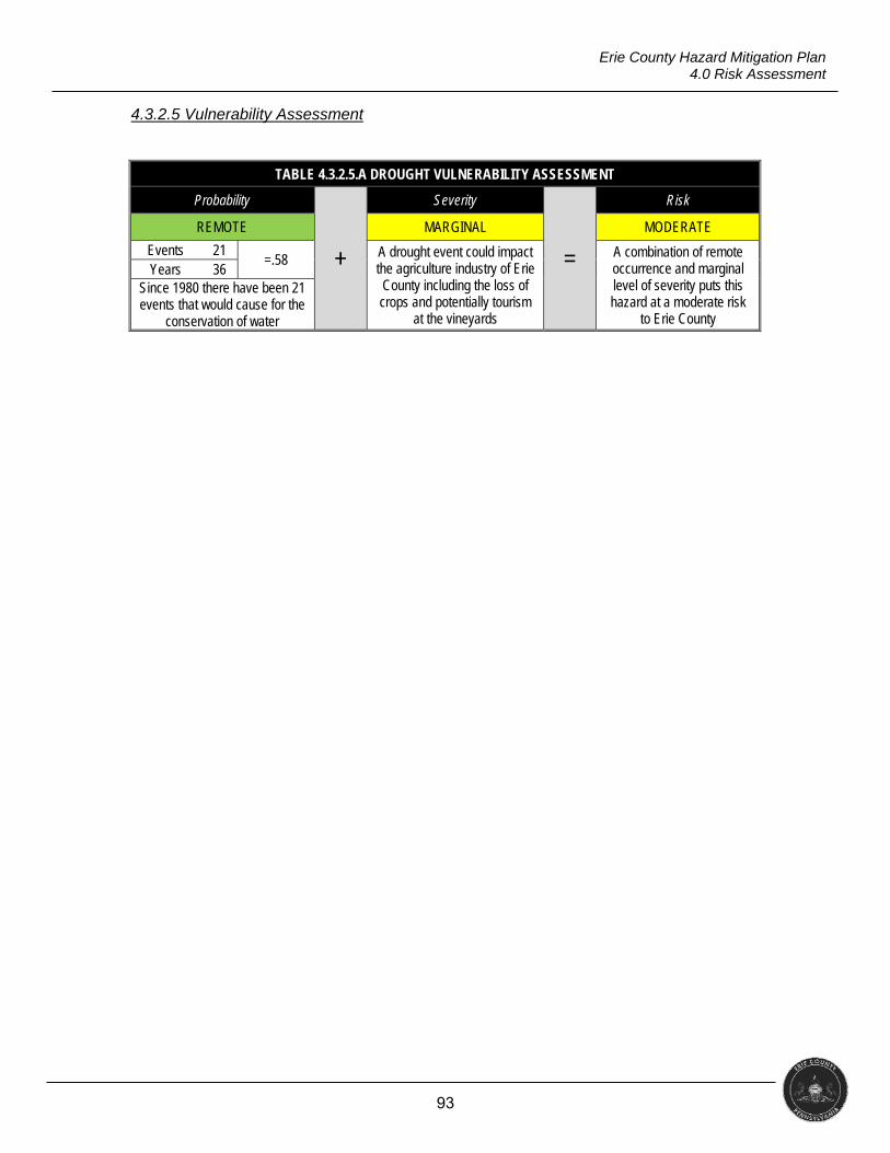
93
Erie County Hazard Mitigation Plan 4.0 Risk Assessment
4.3.2.5 Vulnerability Assessment
TABLE 4.3.2.5.A DROUGHT VULNERABILITY ASSESSMENT
Probability
+
Severity
=
Risk
REMOTE MARGINAL MODERATE
Events 21 =.58 A drought event could impact
the agriculture industry of Erie County including the loss of crops and potentially tourism
at the vineyards
A combination of remote occurrence and marginal level of severity puts this hazard at a moderate risk
to Erie County
Years 36 Since 1980 there have been 21 events that would cause for the
conservation of water
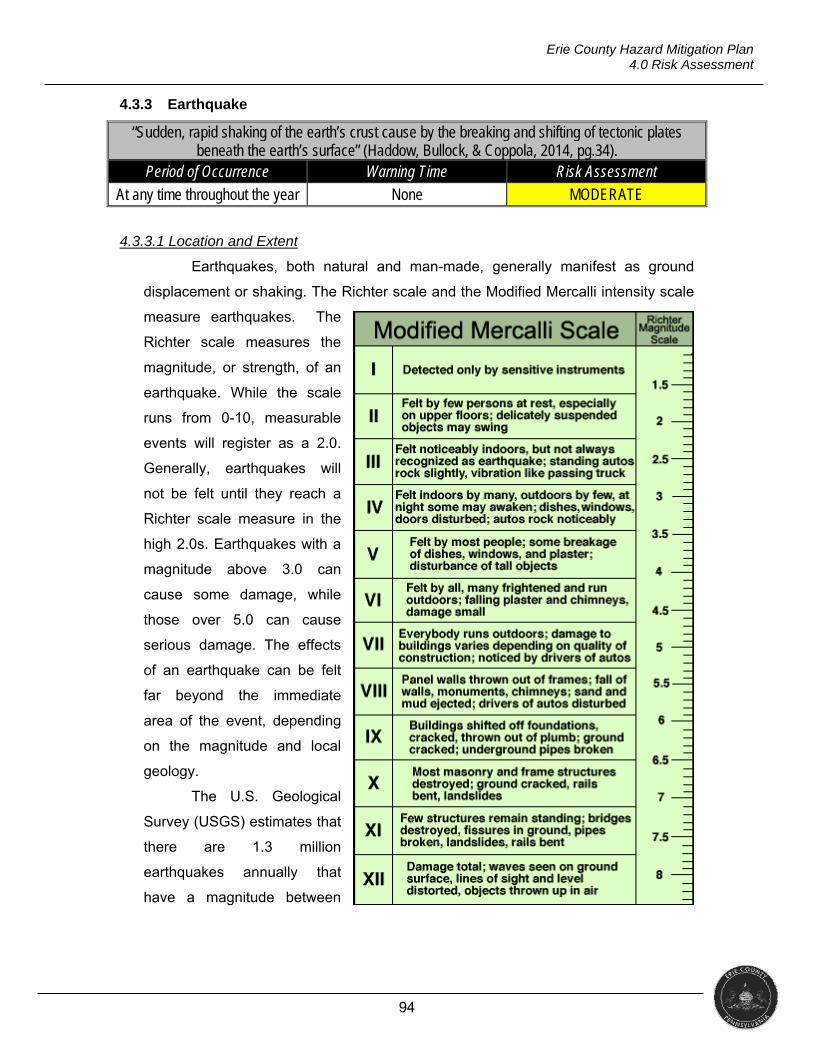
94
Erie County Hazard Mitigation Plan 4.0 Risk Assessment
4.3.3 Earthquake
“Sudden, rapid shaking of the earth’s crust cause by the breaking and shifting of tectonic plates beneath the earth’s surface” (Haddow, Bullock, & Coppola, 2014, pg.34).
Period of Occurrence Warning Time Risk Assessment
At any time throughout the year None MODERATE
4.3.3.1 Location and Extent
Earthquakes, both natural and man-made, generally manifest as ground
displacement or shaking. The Richter scale and the Modified Mercalli intensity scale
measure earthquakes. The
Richter scale measures the
magnitude, or strength, of an
earthquake. While the scale
runs from 0-10, measurable
events will register as a 2.0.
Generally, earthquakes will
not be felt until they reach a
Richter scale measure in the
high 2.0s. Earthquakes with a
magnitude above 3.0 can
cause some damage, while
those over 5.0 can cause
serious damage. The effects
of an earthquake can be felt
far beyond the immediate
area of the event, depending
on the magnitude and local
geology.
The U.S. Geological
Survey (USGS) estimates that
there are 1.3 million
earthquakes annually that
have a magnitude between
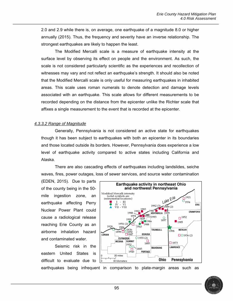
95
Erie County Hazard Mitigation Plan 4.0 Risk Assessment
2.0 and 2.9 while there is, on average, one earthquake of a magnitude 8.0 or higher
annually (2015). Thus, the frequency and severity have an inverse relationship. The
strongest earthquakes are likely to happen the least.
The Modified Mercalli scale is a measure of earthquake intensity at the
surface level by observing its effect on people and the environment. As such, the
scale is not considered particularly scientific as the experiences and recollection of
witnesses may vary and not reflect an earthquake’s strength. It should also be noted
that the Modified Mercalli scale is only useful for measuring earthquakes in inhabited
areas. This scale uses roman numerals to denote detection and damage levels
associated with an earthquake. This scale allows for different measurements to be
recorded depending on the distance from the epicenter unlike the Richter scale that
affixes a single measurement to the event that is recorded at the epicenter.
4.3.3.2 Range of Magnitude
Generally, Pennsylvania is not considered an active state for earthquakes
though it has been subject to earthquakes with both an epicenter in its boundaries
and those located outside its borders. However, Pennsylvania does experience a low
level of earthquake activity compared to active states including California and
Alaska.
There are also cascading effects of earthquakes including landslides, seiche
waves, fires, power outages, loss of sewer services, and source water contamination
(EDEN, 2015). Due to parts
of the county being in the 50-
mile ingestion zone, an
earthquake affecting Perry
Nuclear Power Plant could
cause a radiological release
reaching Erie County as an
airborne inhalation hazard
and contaminated water.
Seismic risk in the
eastern United States is
difficult to evaluate due to
earthquakes being infrequent in comparison to plate-margin areas such as
96
Erie County Hazard Mitigation Plan 4.0 Risk Assessment
California. The origins of earthquakes in the northeast are poorly understood. Most
earthquakes in the region are assumed to be associated with weakness zones in the
Earth’s crust formed about a billion years ago. Faults, which are deeply buried and
mostly unknown, cause earthquakes through periodic release of strain that is
constantly building up in the continental plate (ODNR).
According to the Earthquake Hazard in Pennsylvania report (PADCNR,
2007), if an earthquake occurred on the western extension of the St. Lawrence
Seismic Zone having a 6.0 or greater magnitude, moderate damage might be
expected in one of more of the “northern tier” counties in Pennsylvania.
PUBLIC HEALTH
Fatalities from an earthquake can be broken into three categories:
instantaneous, rapid, and delayed. Instantaneous fatalities are usually due to head
and chest injuries or internal and external bleeding. Rapid deaths occur within hours
and include hypovolemic shock, asphyxia, chest compression or environmental
exposure such as hypothermia. Delayed fatalities occur within a few days due to
wound infections, dehydration, sepsis, environmental exposure or crush syndrome
(Naghii, 2005). A large number of hospitalized patients after an earthquake require
non-surgical acute care. These individuals experience myocardial infarctions,
exacerbation of chronic illness (i.e., diabetes, hypertension, anxiety, etc.), and
respiratory injuries from exposure to building debris including asbestos. Dust from
building damage or collapse causes eye injuries and respiratory-tract irritation
(Naghii, 2005).
Another concern is damage to chemical storage tanks that may begin to leak.
Damaged infrastructure such as drinking water and sewer pipes can lead to the
spread of disease and death. Delivery of electricity and natural gas can be disrupted
causing individuals to succumb to environmental exposure. Damage to nuclear
power plants can lead to widespread contamination of radioactive materials (Naghii,
2005).
SOCIAL VULNERABILITY
The elderly, children, chronically ill and disabled individuals seem to be at an
elevated risk for injury or death following an earthquake. Mobility impairment, inability
to compensate for trauma, and underlying disease contribute to the vulnerability of
97
Erie County Hazard Mitigation Plan 4.0 Risk Assessment
these groups. (Naghii, 2005). Low income populations are also at an elevated risk.
They often live in the most vulnerable housing such as older homes and low or
moderate income apartments that are not subject to disaster resistant building
practices. They may also lack the resources to undertake mitigation or evacuation
measures. Those living in rental units are dependent on landlords for structural loss
prevention (Insurance Institute for Business & Home Safety, 2017).
FRACKING EFFECTS
The growth of the practice of hydraulic fracturing, more commonly known as
fracking, in the oil industry has led to the occurrences of earthquakes in Ohio
according to a study by a Miami University of Ohio graduate student. Skoumal,
Brudzinski and Currie found that a well in Mahoning County, in eastern Ohio, was
located near an unknown fault line and the fracking activity triggered “scores of small
earthquakes in March 2014, including on large enough to be felt in nearby towns”
(2015). A similar event occurred near Youngstown in 2011, but was related to
wastewater injection rather than hydraulic fracturing (Skoumal, Brudzinski, & Currie,
2015).
According to the USGS, wastewater disposal, rather than fracking, is the
cause of the recent increase in earthquakes in central United States (2016).
Additionally, the USGS states that “wastewater is produced at all oil wells, not just
fracturing sites,” so these incidents can occur anywhere that the injection of
wastewater is occurring (2016). While there have been no proven incidents of either
fracking or wastewater injection causing earthquakes in Erie County, the county is
home to over 3,200 active oil and gas wells on file according to the Pennsylvania
Department of Natural Resources and Conservation.
The county is also home to an aging gas distribution line system.
Earthquakes cause ground displacement that can damage this system directly. It
consists of buried piping and limited above-ground facilities for monitoring and
controlling gas flow. To withstand the effects of ground displacement, the buried
pipelines must be flexible to move with the ground or strong enough to force the
earth around the pipe. Older pipelines are much more susceptible to damage due to
weakness from corrosion, outdated construction methods, and less sturdy
construction.
98
Erie County Hazard Mitigation Plan 4.0 Risk Assessment
4.3.3.3 Past Occurrence
Jamestown, PA
The largest magnitude earthquake in Pennsylvania occurred on September
25, 1998. Tremors were reported in Erie County from this 5.2 magnitude earthquake.
This occurrence caused significant effects to the local ground water system.
Erie County
On December 31, 2011, around 3:00 p.m. the USGS reported a 4.0
magnitude earthquake with an epicenter near Youngstown, Ohio. Residents in Erie
County reported feeling the earthquake; some reported minor damage in residences
such as broken lamps. There was no structural damage reported in the county.
The table below lists earthquakes which have occurred both within and
outside Erie County that have been recorded as having an effect in the county.
Table 4.3.3.3.A
EARTHQUAKES REPORTEDLY FELT IN ERIE COUNTY Date Occurrence
January 23, 1812 – January 27 1812 3 earthquakes, New Madrid, MO
October 23, 1857 Buffalo, NY July 6, 1873 Canada August 10, 1884 New York, NY August 12, 1929 Attica, NY October 29, 1934 Erie December 20, 1934 Lake Ossipee, NH November 1, 1935 Ontario, Canada March 8, 1943 Buffalo, NY January 1, 1966 Western NY State October 7, 1983 Blue Mt. Lake, NY January 1, 1986 Lake Erie, near Perry, Ohio January 31, 1986 Southern Lake County December 17, 1990 Between Erie and Ashtabula, OH March 15, 1992 Fairport Harbor, OH February 23, 1995 Ashtabula, OH September 25, 1998 Mercer County January 25, 2001 Ashtabula, OH June 3, 2001 Ashtabula, OH June 30, 2003 Perry, OH July 16, 2003 Ashtabula, OH June 20, 2006 Lake County, OH January 3, 2007 Meadville, PA March 12, 2007 Aurora, OH September 28, 2007 Conneaut, OH December 10, 2010 Conneaut, PA
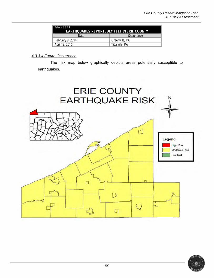
99
Erie County Hazard Mitigation Plan 4.0 Risk Assessment
Table 4.3.3.3.A
EARTHQUAKES REPORTEDLY FELT IN ERIE COUNTY Date Occurrence
February 9, 2014 Greenville, PA April 18, 2016 Titusville, PA
4.3.3.4 Future Occurrence
The risk map below graphically depicts areas potentially susceptible to
earthquakes.
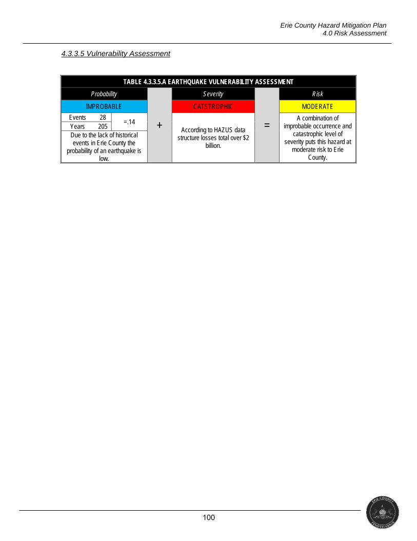
100
Erie County Hazard Mitigation Plan 4.0 Risk Assessment
4.3.3.5 Vulnerability Assessment
TABLE 4.3.3.5.A EARTHQUAKE VULNERABILITY ASSESSMENT
Probability
+
Severity
=
Risk
IMPROBABLE CATSTROPHIC MODERATE
Events 28 =.14
According to HAZUS data structure losses total over $2
billion.
A combination of improbable occurrence and
catastrophic level of severity puts this hazard at
moderate risk to Erie County.
Years 205 Due to the lack of historical events in Erie County the
probability of an earthquake is low.
101
Erie County Hazard Mitigation Plan 4.0 Risk Assessment
4.3.4 Flood, Flash Flood, and Ice Jam
Flooding is “an overabundance of water that engulfs land and other property that is normally dry” (Haddow, Bullock, & Coppola, 2014, p.32).
Period of Occurrence Warning Time Risk Assessment
At any time throughout the year Hours / Days MODERATE
4.3.4.1 Location and Extent
Flooding is the most universally experienced natural hazard and has killed
more than 10,000 people since 1900 (Keller & Devecchio, 2015). Flooding is a
natural process that will continue to impact counties as long as people live and work
within flood prone areas (Keller & Devecchio, 2015). Flooding can be caused by a
number of factors, many of which occur concurrently during an event. Generally,
floods will result from large-scale weather systems that generate prolonged rainfall or
onshore winds, but may also result from locally-intense rainfall, dam failure, or snow
melt (Haddow, Bullock, & Coppola, 2014). The National Centers for Environmental
Information (NCEI) places floods into two categories: floods and flash floods. The
primary difference between the two is the speed with which the event develops.
Generalized flooding will develop over time. Flash floods usually result from intense
storms dropping large amounts of rain in a brief time period, can occur with little in
the way of warning, and can reach full peak in a matter of minutes (Haddow, Bullock
& Coppola, 2014).
The NOAA lists the following possible causes for flooding.
Excessive Rainfall: This is the most common cause of flooding. Water
accumulates quicker than the soil can absorb and stormwater systems can
manage, resulting in flooding.
Snowmelt: It occurs when the major source of water involved is caused by
melting snow. Unlike rainfall that can reach the soil almost immediately, the
snowpack can store water for an extended amount of time until temperatures
rise above freezing and the snow melts.
Ice or Debris Jams: These are common during the winter and spring along
rivers, streams and creeks. As ice or debris moves downstream, it may get
caught on any sort of obstruction to the water flow. When this occurs, water
can be held back, causing upstream flooding. When the jam finally breaks,
flash flooding can occur downstream.
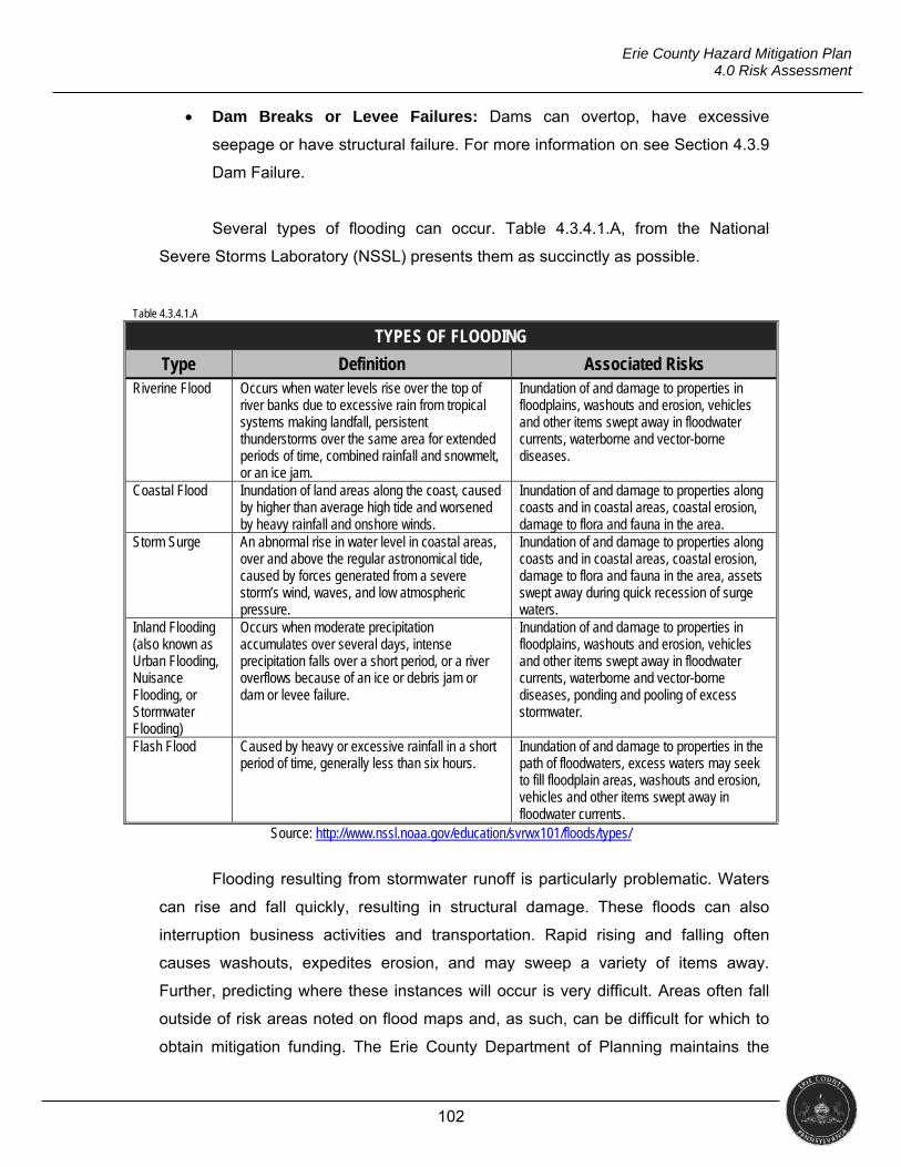
102
Erie County Hazard Mitigation Plan 4.0 Risk Assessment
Dam Breaks or Levee Failures: Dams can overtop, have excessive
seepage or have structural failure. For more information on see Section 4.3.9
Dam Failure.
Several types of flooding can occur. Table 4.3.4.1.A, from the National
Severe Storms Laboratory (NSSL) presents them as succinctly as possible.
Table 4.3.4.1.A
TYPES OF FLOODING
Type Definition Associated Risks Riverine Flood Occurs when water levels rise over the top of
river banks due to excessive rain from tropical systems making landfall, persistent thunderstorms over the same area for extended periods of time, combined rainfall and snowmelt, or an ice jam.
Inundation of and damage to properties in floodplains, washouts and erosion, vehicles and other items swept away in floodwater currents, waterborne and vector-borne diseases.
Coastal Flood Inundation of land areas along the coast, caused by higher than average high tide and worsened by heavy rainfall and onshore winds.
Inundation of and damage to properties along coasts and in coastal areas, coastal erosion, damage to flora and fauna in the area.
Storm Surge An abnormal rise in water level in coastal areas, over and above the regular astronomical tide, caused by forces generated from a severe storm’s wind, waves, and low atmospheric pressure.
Inundation of and damage to properties along coasts and in coastal areas, coastal erosion, damage to flora and fauna in the area, assets swept away during quick recession of surge waters.
Inland Flooding (also known as Urban Flooding, Nuisance Flooding, or Stormwater Flooding)
Occurs when moderate precipitation accumulates over several days, intense precipitation falls over a short period, or a river overflows because of an ice or debris jam or dam or levee failure.
Inundation of and damage to properties in floodplains, washouts and erosion, vehicles and other items swept away in floodwater currents, waterborne and vector-borne diseases, ponding and pooling of excess stormwater.
Flash Flood Caused by heavy or excessive rainfall in a short period of time, generally less than six hours.
Inundation of and damage to properties in the path of floodwaters, excess waters may seek to fill floodplain areas, washouts and erosion, vehicles and other items swept away in floodwater currents.
Source: http://www.nssl.noaa.gov/education/svrwx101/floods/types/
Flooding resulting from stormwater runoff is particularly problematic. Waters
can rise and fall quickly, resulting in structural damage. These floods can also
interruption business activities and transportation. Rapid rising and falling often
causes washouts, expedites erosion, and may sweep a variety of items away.
Further, predicting where these instances will occur is very difficult. Areas often fall
outside of risk areas noted on flood maps and, as such, can be difficult for which to
obtain mitigation funding. The Erie County Department of Planning maintains the
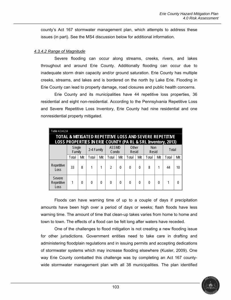
103
Erie County Hazard Mitigation Plan 4.0 Risk Assessment
county’s Act 167 stormwater management plan, which attempts to address these
issues (in part). See the MS4 discussion below for additional information.
4.3.4.2 Range of Magnitude
Severe flooding can occur along streams, creeks, rivers, and lakes
throughout and around Erie County. Additionally flooding can occur due to
inadequate storm drain capacity and/or ground saturation. Erie County has multiple
creeks, streams, and lakes and is bordered on the north by Lake Erie. Flooding in
Erie County can lead to property damage, road closures and public health concerns.
Erie County and its municipalities have 44 repetitive loss properties, 36
residential and eight non-residential. According to the Pennsylvania Repetitive Loss
and Severe Repetitive Loss Inventory, Erie County had nine residential and one
nonresidential property mitigated.
Table 4.3.4.2.A
TOTAL & MITIGATED REPETITIVE LOSS AND SEVERE REPETITIVE LOSS PROPERTIES IN ERIE COUNTY (PA RL & SRL Inventory, 2013)
Single Family
2-4 Family ASSMD Condo
Other Resid
Non Resid
Total
Total Mit Total Mit Total Mit Total Mit Total Mit Total Mit
Repetitive Loss
33 8 1 1 2 0 0 0 8 1 44 10
Severe Repetitive
Loss 1 0 0 0 0 0 0 0 0 0 1 0
Floods can have warning time of up to a couple of days if precipitation
amounts have been high over a period of days or weeks; flash floods have less
warning time. The amount of time that clean-up takes varies from home to home and
town to town. The effects of a flood can be felt long after waters have receded.
One of the challenges to flood mitigation is not creating a new flooding issue
for other jurisdictions. Government entities need to take care in drafting and
administering floodplain regulations and in issuing permits and accepting dedications
of stormwater systems which may increase flooding elsewhere (Kusler, 2009). One
way Erie County combatted this challenge was by completing an Act 167 county-
wide stormwater management plan with all 38 municipalities. The plan identified
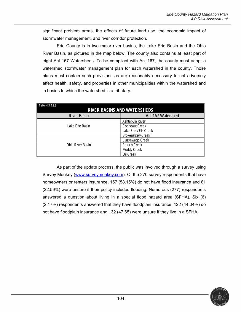
104
Erie County Hazard Mitigation Plan 4.0 Risk Assessment
significant problem areas, the effects of future land use, the economic impact of
stormwater management, and river corridor protection.
Erie County is in two major river basins, the Lake Erie Basin and the Ohio
River Basin, as pictured in the map below. The county also contains at least part of
eight Act 167 Watersheds. To be compliant with Act 167, the county must adopt a
watershed stormwater management plan for each watershed in the county. Those
plans must contain such provisions as are reasonably necessary to not adversely
affect health, safety, and properties in other municipalities within the watershed and
in basins to which the watershed is a tributary.
Table 4.3.4.2.B
RIVER BASINS AND WATERSHEDS River Basin Act 167 Watershed
Lake Erie Basin Ashtabula River Conneaut Creek Lake Erie / Elk Creek
Ohio River Basin
Brokenstraw Creek Cussewago Creek French Creek Muddy Creek Oil Creek
As part of the update process, the public was involved through a survey using
Survey Monkey (www.surveymonkey.com). Of the 270 survey respondents that have
homeowners or renters insurance, 157 (58.15%) do not have flood insurance and 61
(22.59%) were unsure if their policy included flooding. Numerous (277) respondents
answered a question about living in a special flood hazard area (SFHA). Six (6)
(2.17%) respondents answered that they have floodplain insurance, 122 (44.04%) do
not have floodplain insurance and 132 (47.65) were unsure if they live in a SFHA.
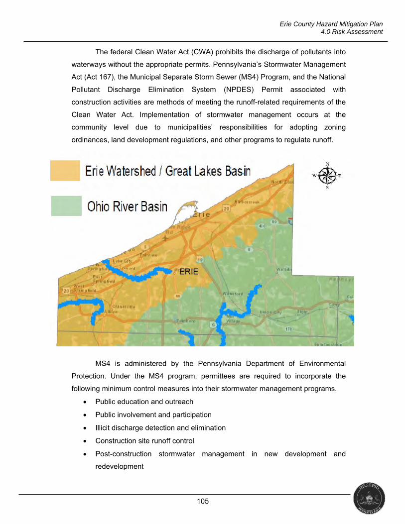
105
Erie County Hazard Mitigation Plan 4.0 Risk Assessment
The federal Clean Water Act (CWA) prohibits the discharge of pollutants into
waterways without the appropriate permits. Pennsylvania’s Stormwater Management
Act (Act 167), the Municipal Separate Storm Sewer (MS4) Program, and the National
Pollutant Discharge Elimination System (NPDES) Permit associated with
construction activities are methods of meeting the runoff-related requirements of the
Clean Water Act. Implementation of stormwater management occurs at the
community level due to municipalities’ responsibilities for adopting zoning
ordinances, land development regulations, and other programs to regulate runoff.
MS4 is administered by the Pennsylvania Department of Environmental
Protection. Under the MS4 program, permittees are required to incorporate the
following minimum control measures into their stormwater management programs.
Public education and outreach
Public involvement and participation
Illicit discharge detection and elimination
Construction site runoff control
Post-construction stormwater management in new development and
redevelopment
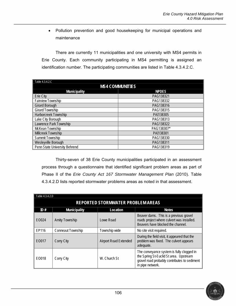
106
Erie County Hazard Mitigation Plan 4.0 Risk Assessment
Pollution prevention and good housekeeping for municipal operations and
maintenance
There are currently 11 municipalities and one university with MS4 permits in
Erie County. Each community participating in MS4 permitting is assigned an
identification number. The participating communities are listed in Table 4.3.4.2.C.
Table 4.3.4.2.C
MS4 COMMUNITIES Municipality NPDES
Erie City PAG138321 Fairview Township PAG138332 Girard Borough PAG138316 Girard Township PAG138315 Harborcreek Township PAI138305 Lake City Borough PAG138313 Lawrence Park Township PAG138322 McKean Township PAG138307* Millcreek Township PAI138301 Summit Township PAG138330 Wesleyville Borough PAG138311 Penn State University Behrend PAG138319
Thirty-seven of 38 Erie County municipalities participated in an assessment
process through a questionnaire that identified significant problem areas as part of
Phase II of the Erie County Act 167 Stormwater Management Plan (2010). Table
4.3.4.2.D lists reported stormwater problems areas as noted in that assessment.
Table 4.3.4.2.D
REPORTED STORMWATER PROBLEM AREAS
ID # Municipality Location Notes
EO024 Amity Township Lowe Road Beaver dams. This is a previous gravel roads project where culvert was installed. Beavers have blocked the channel.
EP116 Conneaut Township Township wide No site visit required.
EO017 Corry City Airport Road Extended During the field visit, it appeared that the problem was fixed. The culvert appears adequate.
EO018 Corry City W. Church St
The conveyance system is fully clogged in the Spring St-Euclid St area. Upstream gravel road probably contributes to sediment in pipe network.
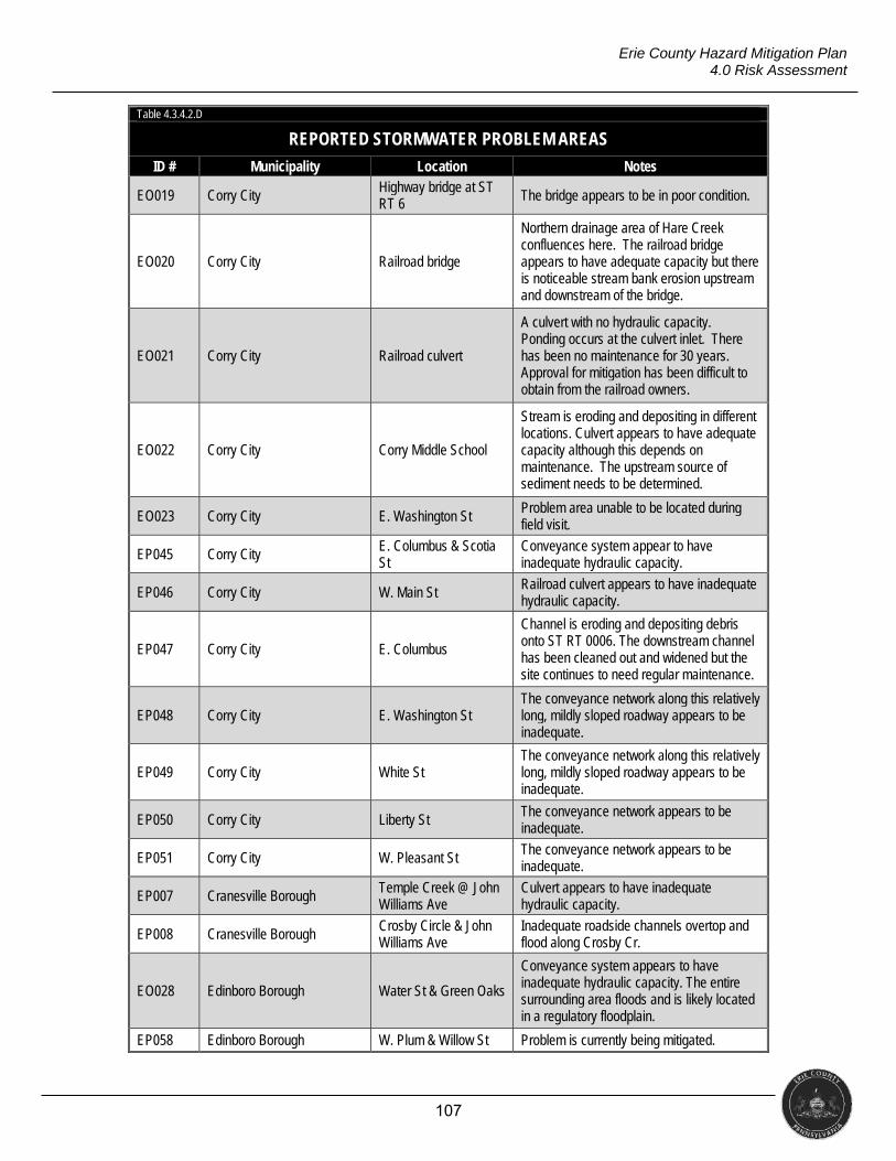
107
Erie County Hazard Mitigation Plan 4.0 Risk Assessment
Table 4.3.4.2.D
REPORTED STORMWATER PROBLEM AREAS
ID # Municipality Location Notes
EO019 Corry City Highway bridge at ST RT 6 The bridge appears to be in poor condition.
EO020 Corry City Railroad bridge
Northern drainage area of Hare Creek confluences here. The railroad bridge appears to have adequate capacity but there is noticeable stream bank erosion upstream and downstream of the bridge.
EO021 Corry City Railroad culvert
A culvert with no hydraulic capacity. Ponding occurs at the culvert inlet. There has been no maintenance for 30 years. Approval for mitigation has been difficult to obtain from the railroad owners.
EO022 Corry City Corry Middle School
Stream is eroding and depositing in different locations. Culvert appears to have adequate capacity although this depends on maintenance. The upstream source of sediment needs to be determined.
EO023 Corry City E. Washington St Problem area unable to be located during field visit.
EP045 Corry City E. Columbus & Scotia St
Conveyance system appear to have inadequate hydraulic capacity.
EP046 Corry City W. Main St Railroad culvert appears to have inadequate hydraulic capacity.
EP047 Corry City E. Columbus
Channel is eroding and depositing debris onto ST RT 0006. The downstream channel has been cleaned out and widened but the site continues to need regular maintenance.
EP048 Corry City E. Washington St The conveyance network along this relatively long, mildly sloped roadway appears to be inadequate.
EP049 Corry City White St The conveyance network along this relatively long, mildly sloped roadway appears to be inadequate.
EP050 Corry City Liberty St The conveyance network appears to be inadequate.
EP051 Corry City W. Pleasant St The conveyance network appears to be inadequate.
EP007 Cranesville Borough Temple Creek @ John Williams Ave
Culvert appears to have inadequate hydraulic capacity.
EP008 Cranesville Borough Crosby Circle & John Williams Ave
Inadequate roadside channels overtop and flood along Crosby Cr.
EO028 Edinboro Borough Water St & Green Oaks
Conveyance system appears to have inadequate hydraulic capacity. The entire surrounding area floods and is likely located in a regulatory floodplain.
EP058 Edinboro Borough W. Plum & Willow St Problem is currently being mitigated.
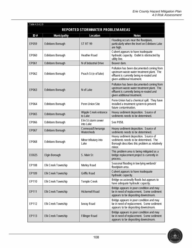
108
Erie County Hazard Mitigation Plan 4.0 Risk Assessment
Table 4.3.4.2.D
REPORTED STORMWATER PROBLEM AREAS
ID # Municipality Location Notes
EP059 Edinboro Borough ST RT 99 Flooding occurs near the floodplain, particularly when the level on Edinboro Lake are high.
EP060 Edinboro Borough Heather Road Culvert appears to have inadequate hydraulic capacity. Outlet is obstructed by utility line.
EP061 Edinboro Borough N of Industrial Drive Beaver dam.
EP062 Edinboro Borough Peach St (e of lake)
Pollution has been documented coming from upstream waste water treatment plant. The effluent is currently being re-routed and given additional treatment.
EP063 Edinboro Borough N of Lake
Pollution has been documented coming from upstream waste water treatment plant. The effluent is currently being re-routed and given additional treatment.
EP064 Edinboro Borough Penn Union Site Penn-Union had a chemical spill. They have installed a treatment system to prevent future contamination.
EP065 Edinboro Borough Wipple Creek entrance to Lake
Heavy sediment deposition. Source of sediments needs to be determined.
EP066 Edinboro Borough Elm St storm sewer into Lake See P058.
EP067 Edinboro Borough Conneaut/Shenango Watersheds
Heavy sediment deposition. Source of sediments needs to be determined.
EP068 Edinboro Borough Minor tributary into Lake
Heavy sediment deposition. Source of sediments needs to be determined. The Borough describes this problem as relatively minor.
EO025 Elgin Borough S. Main St This problem area is being mitigated as a bridge replacement project is currently in process.
EP108 Elk Creek Township Morley Road Seasonal flooding in low lying wetland/ floodplain area.
EP109 Elk Creek Township Griffis Road Culvert appears to have inadequate hydraulic capacity.
EP110 Elk Creek Township Temple Creek Bridge occasionally floods but appears to have adequate hydraulic capacity.
EP111 Elk Creek Township Hickernell Road Bridge appears in poor condition and may be in need of replacement. Some sediment appears to be depositing downstream.
EP112 Elk Creek Township Ivoray Road Bridge appears in poor condition and may be in need of replacement. Some sediment appears to be depositing downstream.
EP113 Elk Creek Township Fillinger Road Bridge appears in poor condition and may be in need of replacement. Some sediment appears to be depositing downstream.

109
Erie County Hazard Mitigation Plan 4.0 Risk Assessment
Table 4.3.4.2.D
REPORTED STORMWATER PROBLEM AREAS
ID # Municipality Location Notes
EP114 Elk Creek Township N of Carberry Road Beaver dams.
EP115 Elk Creek Township Temple Creek @ Reservoir Road
Beaver dams.
EO011 Fairview Township Trout Run
Low lying area that is heavily vegetated. Properties in this area are in the floodplain. This problem area has been mitigated since the area downstream has been cleared and maintained.
EO012 Fairview Township Bear Run Beaver dam. Frequent flooding results.
EP029 Fairview Township Trout Run See EO011.
EP030 Fairview Township Bear Run See EO012.
EP031 Fairview Township PennDOT infrastructure
Conveyance system appears to be in need of maintenance. The stream meander appears to be threatening a structure.
EP032 Fairview Township Subdivision has combined sewers
Problem is currently being mitigated.
EP033 Fairview Township Entire Township High coliform at some outfalls. Problem is currently being mitigated.
EP034 Fairview Township Walnut Creek Streambank stabilization and stormwater mitigation is needed in several locations along Walnut Creek.
EO015 Franklin Township Throughout Township There are 67 deficient culverts and bridges reported.
EP121 Franklin Township New Road Culvert appears to have inadequate hydraulic capacity.
EP122 Franklin Township New Road, Mohawk Road
Culvert appears to have inadequate hydraulic capacity.
EP123 Franklin Township Carbury Road Culvert appears to have inadequate hydraulic capacity.
EP124 Franklin Township Clair Wright Road Culvert appears to have inadequate hydraulic capacity.
EP125 Franklin Township Clair Wright Road Culvert appears to have inadequate hydraulic capacity.
EP126 Franklin Township West Stancliff Road Culvert appears to have inadequate hydraulic capacity.
EP127 Franklin Township Shadduck Road Culvert appears to have inadequate hydraulic capacity.
EP128 Franklin Township Shadduck Road Culvert appears to have inadequate hydraulic capacity.
EP129 Franklin Township Shadduck Road Culvert appears to have inadequate hydraulic capacity.
EP130 Franklin Township West 17th St Area
Conveyance system appears to be full of debris and is need of maintenance. Debris may be coming from Bizzarro's Salvage Yard.

110
Erie County Hazard Mitigation Plan 4.0 Risk Assessment
Table 4.3.4.2.D
REPORTED STORMWATER PROBLEM AREAS
ID # Municipality Location Notes
EP131 Franklin Township Sassafras St
Conveyance system on the upper part of Sassafras Road appears to be insufficient. This system appears to discharge to the lower "new" system on Sassafras Road at the Convention Center.
EP132 Franklin Township West 8th Conveyance system in the area appears to be insufficient.
EP043 Franklin Township Entire Township See EP121 to EP129.
EP018 Girard Borough Sunset Drive North
This heavily vegetated channel leading to Lake Erie is in need of maintenance. The railroad culvert may have insufficient hydraulic capacity.
EO029 Girard Township S. Creek Road Culvert appears to have inadequate hydraulic capacity.
EO030 Girard Township Cindy Lane & Daggett Runoff from upstream culverts discharges to the low point along Cindy Ln and Daggett. There is no outlet on the south side of Cindy
EO031 Girard Township Route 20
The conveyance system along ST RT 20 becomes smaller as it approaches its outfall and appears to have inadequate hydraulic capacity. New development also appears to have impacted the area.
EP073 Girard Township Gloskey Road Bridge
Bridge appears to have inadequate hydraulic capacity and is in poor overall condition. The relatively small widening leads to very high velocity (>8 ft/s in the 2-year storm event) and subsequent erosion.
EP074 Girard Township Route 20 Runoff ponds along ST RT 20 in low lying areas. There is no outlet for the runoff.
EP075 Girard Township Route 20 See EP074.
EO010 Greene Township May Road @ Gamelands
Area is in wetlands and prone to flooding. May Road is only feet away from the waterbody. It appears the water from the wetlands may back up and flood the properties on the west side of May Road.
EP019 Greene Township Sampson Road Property flooding near wetlands.
EP020 Greenfield Township German Road
Beaver dams. Dams are blocking the dual 48" HDPE culverts. Culverts may provide adequate capacity if dams were removed. The township has removed the dams several times.
EP021 Greenfield Township Ashton Road Beaver dams. Dams are blocking the dual 48" HDPE culverts. Culverts may provide adequate capacity if dams were removed.
EP022 Greenfield Township Wilson Road Culverts appear to have been recently replaced.
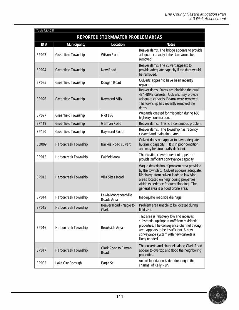
111
Erie County Hazard Mitigation Plan 4.0 Risk Assessment
Table 4.3.4.2.D
REPORTED STORMWATER PROBLEM AREAS
ID # Municipality Location Notes
EP023 Greenfield Township Wilson Road Beaver dams. The bridge appears to provide adequate capacity if the dam would be removed.
EP024 Greenfield Township New Road Beaver dams. The culvert appears to provide adequate capacity if the dam would be removed.
EP025 Greenfield Township Dougan Road Culverts appear to have been recently replaced.
EP026 Greenfield Township Raymond Mills
Beaver dams. Dams are blocking the dual 48" HDPE culverts. Culverts may provide adequate capacity if dams were removed. The township has recently removed the dams.
EP027 Greenfield Township N of I 86 Wetlands created for mitigation during I-86 highway construction.
EP119 Greenfield Township German Road Beaver dams. This is a continuous problem.
EP120 Greenfield Township Raymond Road Beaver dams. The township has recently cleared and maintained area.
EO009 Harborcreek Township Backus Road culvert Culvert does not appear to have adequate hydraulic capacity. It is in poor condition and may be structurally deficient.
EP012 Harborcreek Township Fairfield area The existing culvert does not appear to provide sufficient conveyance capacity.
EP013 Harborcreek Township Villa Sites Road
Vague description of problem area provided by the township. Culvert appears adequate. Discharge from culvert leads to low lying areas located on neighboring properties which experience frequent flooding. The general area is a flood prone area.
EP014 Harborcreek Township Lewis-Mooreheadville Roads Area Inadequate roadside drainage.
EP015 Harborcreek Township Beaver Road - Nagle to Clark
Problem area unable to be located during field visit.
EP016 Harborcreek Township Brookside Area
This area is relatively low and receives substantial upslope runoff from residential properties. The conveyance channel through area appears to be insufficient. A new conveyance system with new culverts is likely needed.
EP017 Harborcreek Township Clark Road to Firman Road
The culverts and channels along Clark Road appear to overtop and flood the neighboring properties.
EP052 Lake City Borough Eagle St An old foundation is deteriorating in the channel of Kelly Run.
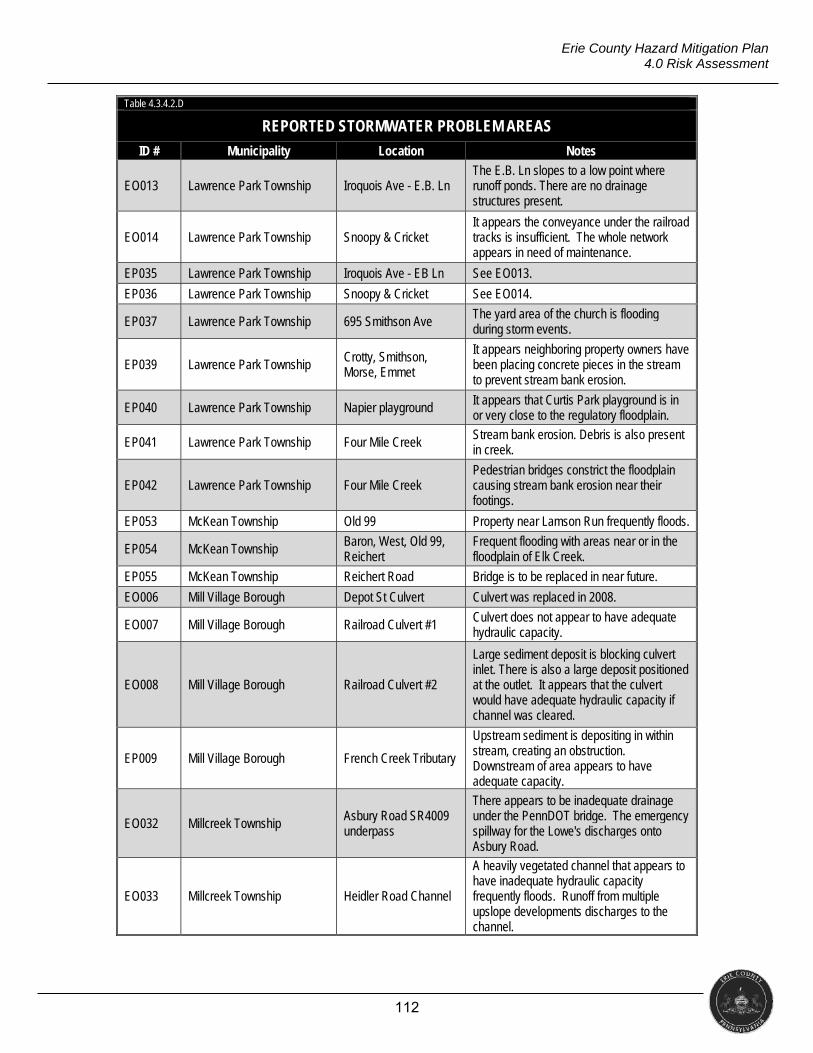
112
Erie County Hazard Mitigation Plan 4.0 Risk Assessment
Table 4.3.4.2.D
REPORTED STORMWATER PROBLEM AREAS
ID # Municipality Location Notes
EO013 Lawrence Park Township Iroquois Ave - E.B. Ln The E.B. Ln slopes to a low point where runoff ponds. There are no drainage structures present.
EO014 Lawrence Park Township Snoopy & Cricket It appears the conveyance under the railroad tracks is insufficient. The whole network appears in need of maintenance.
EP035 Lawrence Park Township Iroquois Ave - EB Ln See EO013.
EP036 Lawrence Park Township Snoopy & Cricket See EO014.
EP037 Lawrence Park Township 695 Smithson Ave The yard area of the church is flooding during storm events.
EP039 Lawrence Park Township Crotty, Smithson, Morse, Emmet
It appears neighboring property owners have been placing concrete pieces in the stream to prevent stream bank erosion.
EP040 Lawrence Park Township Napier playground It appears that Curtis Park playground is in or very close to the regulatory floodplain.
EP041 Lawrence Park Township Four Mile Creek Stream bank erosion. Debris is also present in creek.
EP042 Lawrence Park Township Four Mile Creek Pedestrian bridges constrict the floodplain causing stream bank erosion near their footings.
EP053 McKean Township Old 99 Property near Lamson Run frequently floods.
EP054 McKean Township Baron, West, Old 99, Reichert
Frequent flooding with areas near or in the floodplain of Elk Creek.
EP055 McKean Township Reichert Road Bridge is to be replaced in near future.
EO006 Mill Village Borough Depot St Culvert Culvert was replaced in 2008.
EO007 Mill Village Borough Railroad Culvert #1 Culvert does not appear to have adequate hydraulic capacity.
EO008 Mill Village Borough Railroad Culvert #2
Large sediment deposit is blocking culvert inlet. There is also a large deposit positioned at the outlet. It appears that the culvert would have adequate hydraulic capacity if channel was cleared.
EP009 Mill Village Borough French Creek Tributary
Upstream sediment is depositing in within stream, creating an obstruction. Downstream of area appears to have adequate capacity.
EO032 Millcreek Township Asbury Road SR4009 underpass
There appears to be inadequate drainage under the PennDOT bridge. The emergency spillway for the Lowe's discharges onto Asbury Road.
EO033 Millcreek Township Heidler Road Channel
A heavily vegetated channel that appears to have inadequate hydraulic capacity frequently floods. Runoff from multiple upslope developments discharges to the channel.
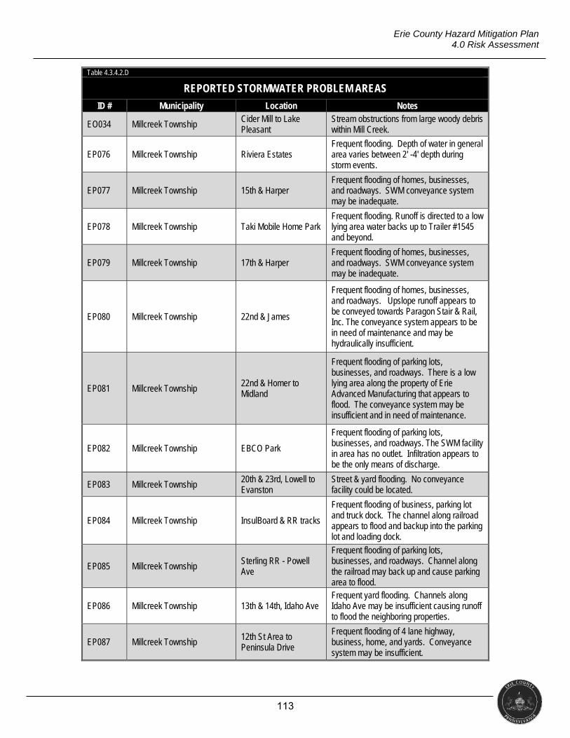
113
Erie County Hazard Mitigation Plan 4.0 Risk Assessment
Table 4.3.4.2.D
REPORTED STORMWATER PROBLEM AREAS
ID # Municipality Location Notes
EO034 Millcreek Township Cider Mill to Lake Pleasant
Stream obstructions from large woody debris within Mill Creek.
EP076 Millcreek Township Riviera Estates Frequent flooding. Depth of water in general area varies between 2' -4' depth during storm events.
EP077 Millcreek Township 15th & Harper Frequent flooding of homes, businesses, and roadways. SWM conveyance system may be inadequate.
EP078 Millcreek Township Taki Mobile Home Park Frequent flooding. Runoff is directed to a low lying area water backs up to Trailer #1545 and beyond.
EP079 Millcreek Township 17th & Harper Frequent flooding of homes, businesses, and roadways. SWM conveyance system may be inadequate.
EP080 Millcreek Township 22nd & James
Frequent flooding of homes, businesses, and roadways. Upslope runoff appears to be conveyed towards Paragon Stair & Rail, Inc. The conveyance system appears to be in need of maintenance and may be hydraulically insufficient.
EP081 Millcreek Township 22nd & Homer to Midland
Frequent flooding of parking lots, businesses, and roadways. There is a low lying area along the property of Erie Advanced Manufacturing that appears to flood. The conveyance system may be insufficient and in need of maintenance.
EP082 Millcreek Township EBCO Park
Frequent flooding of parking lots, businesses, and roadways. The SWM facility in area has no outlet. Infiltration appears to be the only means of discharge.
EP083 Millcreek Township 20th & 23rd, Lowell to Evanston
Street & yard flooding. No conveyance facility could be located.
EP084 Millcreek Township InsulBoard & RR tracks
Frequent flooding of business, parking lot and truck dock. The channel along railroad appears to flood and backup into the parking lot and loading dock.
EP085 Millcreek Township Sterling RR - Powell Ave
Frequent flooding of parking lots, businesses, and roadways. Channel along the railroad may back up and cause parking area to flood.
EP086 Millcreek Township 13th & 14th, Idaho Ave Frequent yard flooding. Channels along Idaho Ave may be insufficient causing runoff to flood the neighboring properties.
EP087 Millcreek Township 12th St Area to Peninsula Drive
Frequent flooding of 4 lane highway, business, home, and yards. Conveyance system may be insufficient.
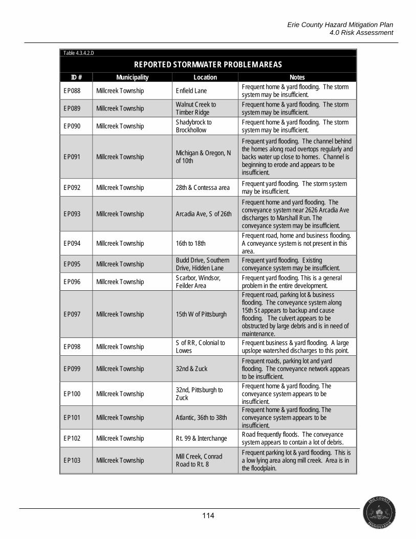
114
Erie County Hazard Mitigation Plan 4.0 Risk Assessment
Table 4.3.4.2.D
REPORTED STORMWATER PROBLEM AREAS
ID # Municipality Location Notes
EP088 Millcreek Township Enfield Lane Frequent home & yard flooding. The storm system may be insufficient.
EP089 Millcreek Township Walnut Creek to Timber Ridge
Frequent home & yard flooding. The storm system may be insufficient.
EP090 Millcreek Township Shadybrock to Brockhollow
Frequent home & yard flooding. The storm system may be insufficient.
EP091 Millcreek Township Michigan & Oregon, N of 10th
Frequent yard flooding. The channel behind the homes along road overtops regularly and backs water up close to homes. Channel is beginning to erode and appears to be insufficient.
EP092 Millcreek Township 28th & Contessa area Frequent yard flooding. The storm system may be insufficient.
EP093 Millcreek Township Arcadia Ave, S of 26th
Frequent home and yard flooding. The conveyance system near 2626 Arcadia Ave discharges to Marshall Run. The conveyance system may be insufficient.
EP094 Millcreek Township 16th to 18th Frequent road, home and business flooding. A conveyance system is not present in this area.
EP095 Millcreek Township Budd Drive, Southern Drive, Hidden Lane
Frequent yard flooding. Existing conveyance system may be insufficient.
EP096 Millcreek Township Scarbor, Windsor, Feilder Area
Frequent yard flooding. This is a general problem in the entire development.
EP097 Millcreek Township 15th W of Pittsburgh
Frequent road, parking lot & business flooding. The conveyance system along 15th St appears to backup and cause flooding. The culvert appears to be obstructed by large debris and is in need of maintenance.
EP098 Millcreek Township S of RR, Colonial to Lowes
Frequent business & yard flooding. A large upslope watershed discharges to this point.
EP099 Millcreek Township 32nd & Zuck Frequent roads, parking lot and yard flooding. The conveyance network appears to be insufficient.
EP100 Millcreek Township 32nd, Pittsburgh to Zuck
Frequent home & yard flooding. The conveyance system appears to be insufficient.
EP101 Millcreek Township Atlantic, 36th to 38th Frequent home & yard flooding. The conveyance system appears to be insufficient.
EP102 Millcreek Township Rt. 99 & Interchange Road frequently floods. The conveyance system appears to contain a lot of debris.
EP103 Millcreek Township Mill Creek, Conrad Road to Rt. 8
Frequent parking lot & yard flooding. This is a low lying area along mill creek. Area is in the floodplain.
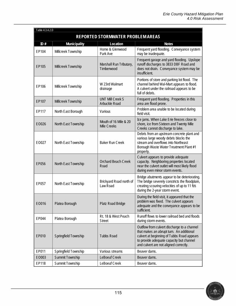
115
Erie County Hazard Mitigation Plan 4.0 Risk Assessment
Table 4.3.4.2.D
REPORTED STORMWATER PROBLEM AREAS
ID # Municipality Location Notes
EP104 Millcreek Township Home & Glenwood Park Ave
Frequent yard flooding. Conveyance system may be inadequate.
EP105 Millcreek Township Marshall Run Tributary, Timberwood
Frequent garage and yard flooding. Upslope runoff discharges to 3833 DBF Road and does not drain. Conveyance system may be insufficient.
EP106 Millcreek Township W 23rd Walmart drainage
Portions of store and parking lot flood. The channel behind Wal-Mart appears to flood. A culvert under the railroad appears to be full of debris.
EP107 Millcreek Township UNT Mill Creek S Arbuckle Road
Frequent yard flooding. Properties in this area are flood prone.
EP117 North East Borough Various Problem area unable to be located during field visit.
EO026 North East Township Mouth of 16 Mile & 20 Mile Creeks
Ice jams. When Lake Erie freezes close to shore, ice from Sixteen and Twenty Mile Creeks cannot discharge to lake.
EO027 North East Township Baker Run Creek
Debris from an upstream concrete plant and various large woody debris blocks the stream and overflows into Northeast Borough Waste Water Treatment Plant #1 property.
EP056 North East Township Orchard Beach Creek Road
Culvert appears to provide adequate capacity. Neighboring properties located near the culvert outlet will most likely flood during even minor storm events.
EP057 North East Township Brickyard Road north of Law Road
Bridge abutments appear to be deteriorating. The bridge severely constricts the floodplain, creating scouring velocities of up to 11 ft/s during the 2-year storm event.
EO016 Platea Borough Platz Road Bridge
During the field visit, it appeared that the problem was fixed. The culvert appears adequate and the conveyance appears to be sufficient.
EP044 Platea Borough Rt. 18 & West Peach Street
Runoff flows to lower railroad bed and floods during storm events.
EP010 Springfield Township Tubbs Road
Outflow from culvert discharge to a channel that makes an abrupt turn. An additional culvert at beginning of Tubbs Road appears to provide adequate capacity but channel and culvert are not aligned correctly.
EP011 Springfield Township Various streams Beaver dams.
EO003 Summit Township LeBoeuf Creek Beaver dams.
EP118 Summit Township LeBoeuf Creek Beaver dams.
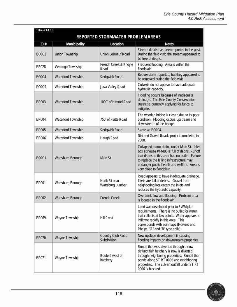
116
Erie County Hazard Mitigation Plan 4.0 Risk Assessment
Table 4.3.4.2.D
REPORTED STORMWATER PROBLEM AREAS
ID # Municipality Location Notes
EO002 Union Township Union LeBoeuf Road Stream debris has been reported in the past. During the field visit, the stream appeared to be free of debris.
EP028 Venango Township French Creek & Knoyle Road
Frequent flooding. Area is within the floodplain.
EO004 Waterford Township Sedgwick Road Beaver dams reported, but they appeared to be removed during the field visit.
EO005 Waterford Township Juva Valley Road Culverts do not appear to have adequate hydraulic capacity.
EP003 Waterford Township 1000' of Himrod Road
Flooding occurs because of inadequate drainage. The Erie County Conservation District is currently applying for funds to mitigate.
EP004 Waterford Township 750' of Flatts Road The wooden bridge is closed due to its poor condition. Flooding occurs upstream and downstream of the bridge.
EP005 Waterford Township Sedgwick Road Same as EO004.
EP006 Waterford Township Haugh Road Dirt and Gravel Roads project completed in 2008.
EO001 Wattsburg Borough Main St
Collapsed storm drains under Main St. Inlet box at house #14400 is full of debris. Runoff that drains to this area has no outlet. Failure to replace the failing infrastructure may endanger public health and welfare. Area is very close to floodplain.
EP001 Wattsburg Borough North St near Wattsburg Lumber
Road appears to have inadequate drainage. Inlets are full of debris. Gravel from neighboring lots enters the inlets and reduces the hydraulic capacity.
EP002 Wattsburg Borough French Creek Overbank flow and flooding. Problem area is located in the floodplain.
EP069 Wayne Township Hill Crest
Land was developed prior to SWM plan requirements. There is no outlet for water that collects at low points. Water appears to infiltrate rapidly in this area. This corresponds with soil maps (Howard and Phelps, "A" and "B" type soils).
EP070 Wayne Township Country Club Road Subdivision
New upslope development is causing flooding impacts on downstream properties.
EP071 Wayne Township Route 6 west of hatchery
Runoff that was diverted through a now defunct fish hatchery is now is diverted through neighboring properties. Runoff then ponds along ST RT 0006 and neighboring properties. The culvert outfall under ST RT 0006 is blocked.
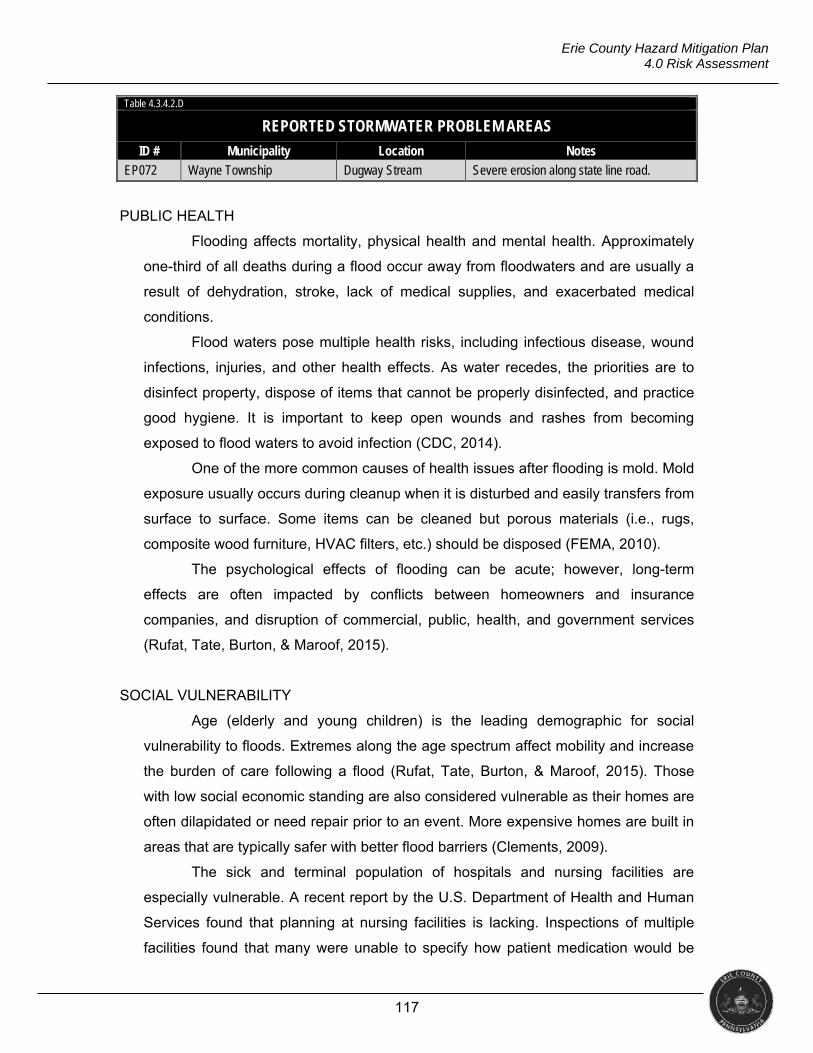
117
Erie County Hazard Mitigation Plan 4.0 Risk Assessment
Table 4.3.4.2.D
REPORTED STORMWATER PROBLEM AREAS
ID # Municipality Location Notes
EP072 Wayne Township Dugway Stream Severe erosion along state line road.
PUBLIC HEALTH
Flooding affects mortality, physical health and mental health. Approximately
one-third of all deaths during a flood occur away from floodwaters and are usually a
result of dehydration, stroke, lack of medical supplies, and exacerbated medical
conditions.
Flood waters pose multiple health risks, including infectious disease, wound
infections, injuries, and other health effects. As water recedes, the priorities are to
disinfect property, dispose of items that cannot be properly disinfected, and practice
good hygiene. It is important to keep open wounds and rashes from becoming
exposed to flood waters to avoid infection (CDC, 2014).
One of the more common causes of health issues after flooding is mold. Mold
exposure usually occurs during cleanup when it is disturbed and easily transfers from
surface to surface. Some items can be cleaned but porous materials (i.e., rugs,
composite wood furniture, HVAC filters, etc.) should be disposed (FEMA, 2010).
The psychological effects of flooding can be acute; however, long-term
effects are often impacted by conflicts between homeowners and insurance
companies, and disruption of commercial, public, health, and government services
(Rufat, Tate, Burton, & Maroof, 2015).
SOCIAL VULNERABILITY
Age (elderly and young children) is the leading demographic for social
vulnerability to floods. Extremes along the age spectrum affect mobility and increase
the burden of care following a flood (Rufat, Tate, Burton, & Maroof, 2015). Those
with low social economic standing are also considered vulnerable as their homes are
often dilapidated or need repair prior to an event. More expensive homes are built in
areas that are typically safer with better flood barriers (Clements, 2009).
The sick and terminal population of hospitals and nursing facilities are
especially vulnerable. A recent report by the U.S. Department of Health and Human
Services found that planning at nursing facilities is lacking. Inspections of multiple
facilities found that many were unable to specify how patient medication would be

118
Erie County Hazard Mitigation Plan 4.0 Risk Assessment
dealt with or how patients on ventilators or feeding tubes would be cared for after a
flood (Graham, 2012).
NATIONAL FLOOD INSURANCE PROGRAM COMPLIANCE
The NFIP provides flood insurance in communities that are members of the
program. Membership in the program is contingent on the community adopting and
enforcing floodplain management and development regulations. The NFIP is based
on the voluntary participation of communities of all sizes. In the context of this
program, a “community” is a political entity – whether an incorporated city, town,
township, borough, or village, or an unincorporated area of a county or parish – that
has legal authority to adopt and enforce floodplain management ordinances for the
area under its jurisdiction.
National flood insurance is available only in communities that apply for
participation in the NFIP and agree to implement prescribed flood mitigation
measures. Newly participating communities are admitted to the NFIP’s emergency
program. Most of these communities quickly earn “promotion” to the regular program.
The emergency program is the initial phase of a community’s participation in
the NFIP. In return for the local government’s agreeing to adopt basic floodplain
management standards, the NFIP allows local property owners to buy modest
amounts of flood insurance coverage.
By adopting more comprehensive floodplain management measures, an
emergency program community can be “promoted” to the regular program. Local
policyholders immediately become eligible to buy greater amounts of flood insurance
coverage. All participating municipalities in Erie County are in the regular program.
The minimum floodplain management requirements include the following.
Review and permit all development in the SFHA
Elevate new and substantially-improved residential structures above the base
flood elevation
Elevate or dry flood proof new and substantially improved non-residential
structures
Limit development in floodways
Locate or construct all public utilities and facilities so as to minimize or
eliminate flood damage
119
Erie County Hazard Mitigation Plan 4.0 Risk Assessment
Anchor foundations or structure-resist floatation, collapse, or lateral
movement
In addition, regular program communities are eligible to participate in the
NFIP’s Community Rating System (CRS). Under the CRS, policyholders can receive
premium discounts of 5 to 45 percent as their cities and towns adopt more
comprehensive flood mitigation measures. Currently, no municipalities in Erie County
participate in CRS.
In Erie County, 35 of the 38 municipalities are participants in the NFIP (see
Table 5.2.1.A). The program is managed by participating municipalities through
ordinance adoption and floodplain regulation. Permitting processes needed for
building construction and development in the floodplain are implemented at the
municipal level through various ordinances (e.g., zoning, subdivision/land
development, and floodplain ordinances), but the Planning Department provides
guidance upon request. FEMA Region III also makes an ordinance review checklist
listing required provisions for floodplain management ordinances available to
communities. This checklist helps communities develop an effective floodplain
management ordinance that meets federal requirements for participation in the NFIP.
The Pennsylvania Department of Community & Economic Development
provides communities with a suggested ordinance document (based on their CFR,
Title 44, Section 60.3 level of regulations) to assist municipalities in meeting the
minimum requirements of the NFIP along with the Pennsylvania Floodplain
Management Act (Act 166). These suggested or model ordinances contain
provisions that are more restrictive than state and federal requirements. Suggested
provisions include, but are not limited to the following.
Prohibiting manufactured homes in the floodway
Prohibiting manufactured homes within the area measured 50’ landward from
the top of bank of any watercourse within a special flood hazard area
Special requirements for recreational vehicles within the special flood hazard
area
Special requirements for accessory structures
Prohibiting new construction and development within the area measured 50’
landward from the top of bank of any watercourse within a special flood
hazard area
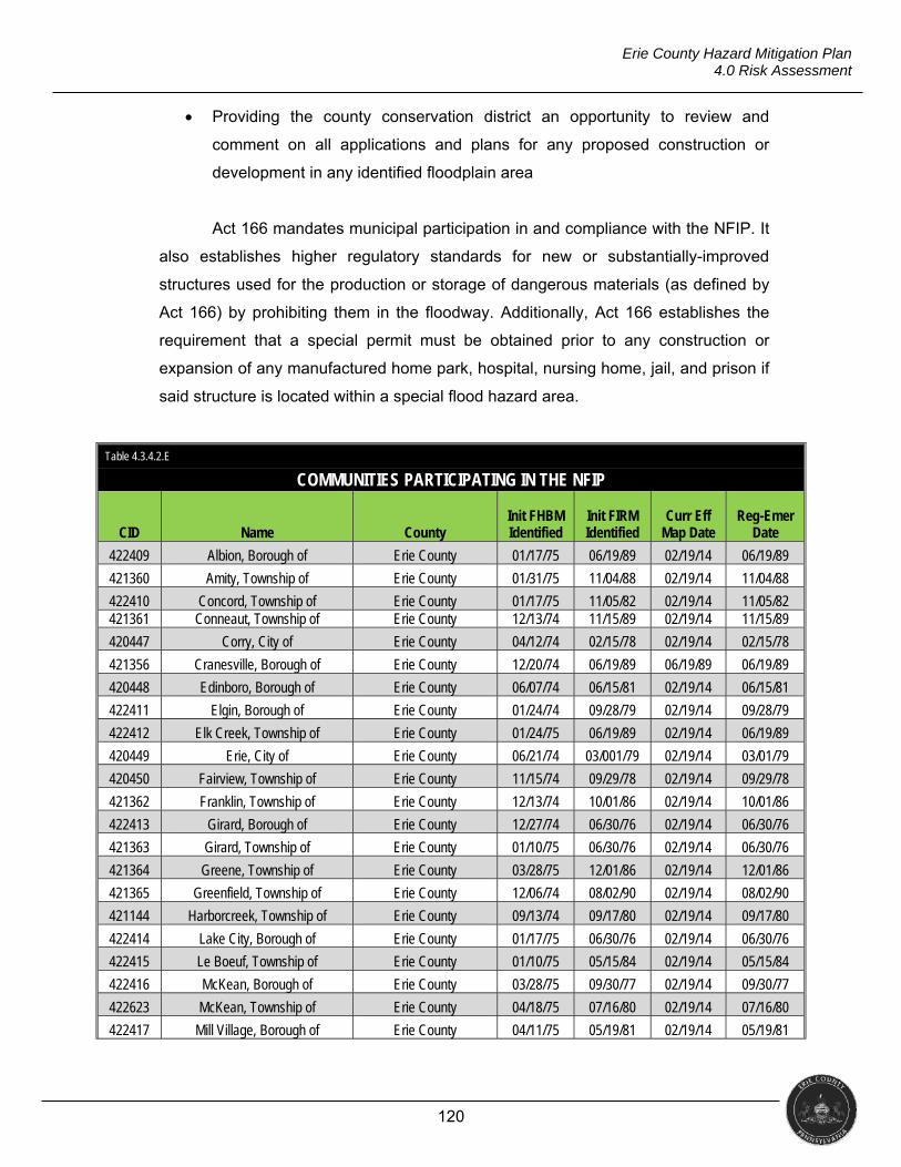
120
Erie County Hazard Mitigation Plan 4.0 Risk Assessment
Providing the county conservation district an opportunity to review and
comment on all applications and plans for any proposed construction or
development in any identified floodplain area
Act 166 mandates municipal participation in and compliance with the NFIP. It
also establishes higher regulatory standards for new or substantially-improved
structures used for the production or storage of dangerous materials (as defined by
Act 166) by prohibiting them in the floodway. Additionally, Act 166 establishes the
requirement that a special permit must be obtained prior to any construction or
expansion of any manufactured home park, hospital, nursing home, jail, and prison if
said structure is located within a special flood hazard area.
Table 4.3.4.2.E
COMMUNITIES PARTICIPATING IN THE NFIP
CID Name County Init FHBM Identified
Init FIRM Identified
Curr Eff Map Date
Reg-Emer Date
422409 Albion, Borough of Erie County 01/17/75 06/19/89 02/19/14 06/19/89
421360 Amity, Township of Erie County 01/31/75 11/04/88 02/19/14 11/04/88
422410 Concord, Township of Erie County 01/17/75 11/05/82 02/19/14 11/05/82 421361 Conneaut, Township of Erie County 12/13/74 11/15/89 02/19/14 11/15/89
420447 Corry, City of Erie County 04/12/74 02/15/78 02/19/14 02/15/78
421356 Cranesville, Borough of Erie County 12/20/74 06/19/89 06/19/89 06/19/89
420448 Edinboro, Borough of Erie County 06/07/74 06/15/81 02/19/14 06/15/81
422411 Elgin, Borough of Erie County 01/24/74 09/28/79 02/19/14 09/28/79
422412 Elk Creek, Township of Erie County 01/24/75 06/19/89 02/19/14 06/19/89
420449 Erie, City of Erie County 06/21/74 03/001/79 02/19/14 03/01/79
420450 Fairview, Township of Erie County 11/15/74 09/29/78 02/19/14 09/29/78
421362 Franklin, Township of Erie County 12/13/74 10/01/86 02/19/14 10/01/86
422413 Girard, Borough of Erie County 12/27/74 06/30/76 02/19/14 06/30/76
421363 Girard, Township of Erie County 01/10/75 06/30/76 02/19/14 06/30/76
421364 Greene, Township of Erie County 03/28/75 12/01/86 02/19/14 12/01/86
421365 Greenfield, Township of Erie County 12/06/74 08/02/90 02/19/14 08/02/90
421144 Harborcreek, Township of Erie County 09/13/74 09/17/80 02/19/14 09/17/80
422414 Lake City, Borough of Erie County 01/17/75 06/30/76 02/19/14 06/30/76
422415 Le Boeuf, Township of Erie County 01/10/75 05/15/84 02/19/14 05/15/84
422416 McKean, Borough of Erie County 03/28/75 09/30/77 02/19/14 09/30/77
422623 McKean, Township of Erie County 04/18/75 07/16/80 02/19/14 07/16/80
422417 Mill Village, Borough of Erie County 04/11/75 05/19/81 02/19/14 05/19/81
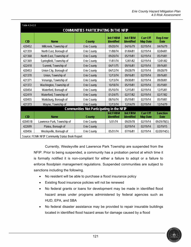
121
Erie County Hazard Mitigation Plan 4.0 Risk Assessment
Table 4.3.4.2.E
COMMUNITIES PARTICIPATING IN THE NFIP
CID Name County Init FHBM Identified
Init FIRM Identified
Curr Eff Map Date
Reg-Emer Date
420452 Millcreek, Township of Erie County 09/20/74 04/16/79 02/19/14 04/16/79
421359 North East, Borough of Erie County 11/08/74 01/04/81 02/19/14 02/04/81
421368 North East, Township of Erie County 09/20/74 05/19/81 02/19/14 05/19/81
421369 Springfield, Township of Erie County 11/01/74 12/01/82 02/19/14 12/01/82
422418 Summit, Township of Erie County 04/11/75 09/16/81 02/19/14 09/16/81
420453 Union City, Borough of Erie County 04/12/74 09/28/79 02/19/14 09/28/79
421370 Union, Township of Erie County 12/13/74 09/16/81 02/19/14 09/16/81
421371 Venango, Township of Erie County 12/13/74 09/30/81 02/19/14 09/30/81
421372 Washington, Township of Erie County 10/18/74 05/19/81 02/19/14 05/19/81
420454 Waterford, Borough of Erie County 05/10/74 12/15/81 02/19/14 12/15/81
422419 Waterford, Township of Erie County 01/24/75 02/17/82 02/19/14 02/17/82
420455 Wattsburg, Borough of Erie County 08/16/74 05/19/81 02/19/14 05/19/81
421373 Wayne, Township of Erie County 12/13/74 12/14/79 02/19/14 12/14/79
Communities Not Participating in the NFIP
CID Name County Init FHBM Identified
Init FIRM Identified
Curr Eff Map Date
Sanction Date
420451B Lawrence Park, Township of Erie County 5/31/74 09/29/78 02/19/14 09/29/78(S)
422699 Platea, Borough of Erie County 02/19/14 02/19/14 02/19/15
420456 Wesleyville, Borough of Erie County 05/31/74 07/16/81 02/19/14 02/20/14(S)
Source: FEMA NFIP Community Status Book Report
Currently, Wesleyville and Lawrence Park Township are suspended from the
NFIP. Prior to being suspended, a community has a probation period at which time it
is formally notified it is non-compliant for either a failure to adopt or a failure to
enforce floodplain management regulations. Suspended communities are subject to
sanctions including the following.
No resident will be able to purchase a flood insurance policy
Existing flood insurance policies will not be renewed
No federal grants or loans for development may be made in identified flood
hazard areas under programs administered by federal agencies such as
HUD, EPA, and SBA
No federal disaster assistance may be provided to repair insurable buildings
located in identified flood hazard areas for damage caused by a flood
122
Erie County Hazard Mitigation Plan 4.0 Risk Assessment
No federal mortgage insurance or loan guarantees may be provided in
identified flood hazard areas including policies written by FHA, VA, and
others
Federally insured or regulated lending institutions, such as banks and credit
unions, must notify applicants seeking loans for insurable buildings in flood
hazard areas that there is a flood hazard and that the property is not eligible
for federal disaster relief
Prior to and after reinstatement, the community will have conditions imposed
dependent upon the reason for suspension. Once reinstated, flood insurance will
available to the residents. However, an additional charge of $50.00 will be added to
the premium for each new or renewed policy for a period of at least one year.
4.3.4.3 Past Occurrence
Northern Erie County, Pennsylvania
On September 17, 1996, thunderstorms brought up to seven inches of rain in
some areas of the county causing streets, streams, basements and low lying areas
to flood. Evacuation took place in the City of Erie as homes were destroyed. A wall
collapsed at Central High School, businesses were damaged, sewers backed up,
roads were washed out, and bridges were damaged. Many roads were closed in
Millcreek Township due to high water. Residents from an apartment building and a
nursing home evacuated while responders rescued residents from rooftops. The Red
Cross opened shelters for displaced individuals. When the rain stopped and flooding
subsided on the morning of the 18th, property damage was estimated to be $5
million.
Erie County, Pennsylvania
Lake-enhanced showers re-intensified and shifted north of Interstate 90 on
the morning of June 30, 2009. Mill Creek began to rise rapidly over its banks flooding
roadways and homes near East Gore Road in Belle Valley. The Belle Valley Fire
Station flooded to a depth of six feet; Henderson Road was washed out; and the Erie
Zoo flooded. Emergency personnel responded to over 50 rescue calls and City of
Erie authorities requested non-essential travel to stop due to widespread flooding.
Property damage in the county was $9.25 million.
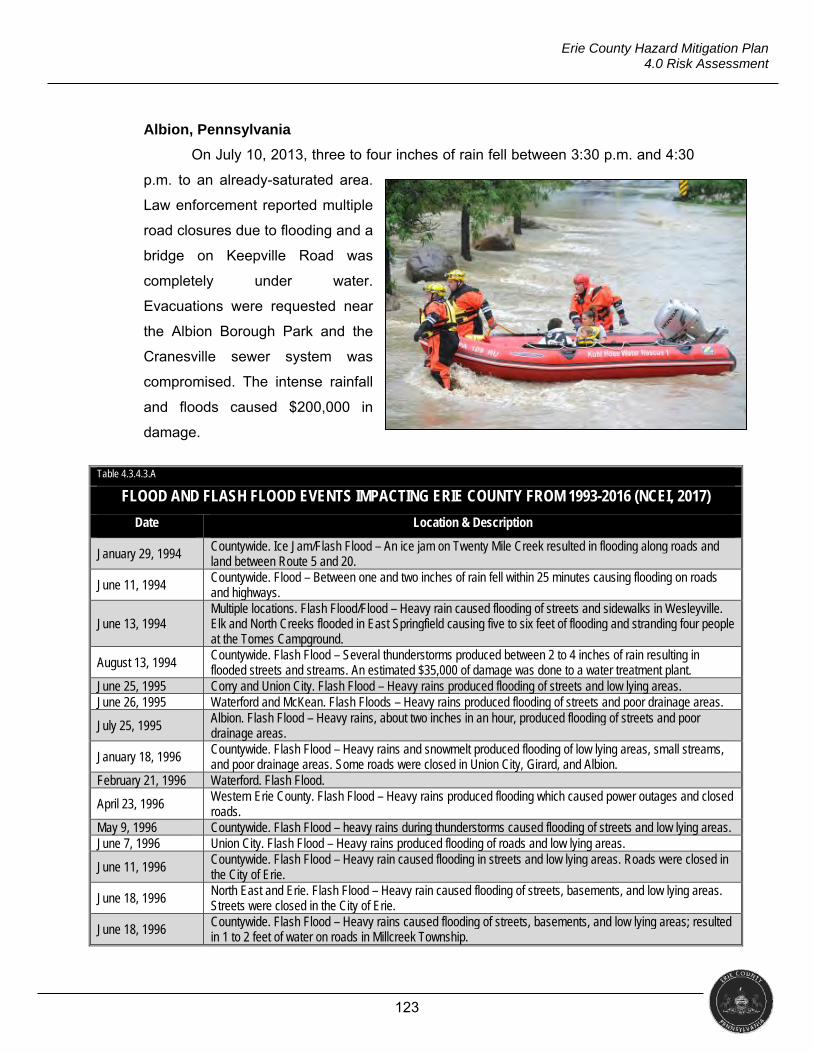
123
Erie County Hazard Mitigation Plan 4.0 Risk Assessment
Albion, Pennsylvania
On July 10, 2013, three to four inches of rain fell between 3:30 p.m. and 4:30
p.m. to an already-saturated area.
Law enforcement reported multiple
road closures due to flooding and a
bridge on Keepville Road was
completely under water.
Evacuations were requested near
the Albion Borough Park and the
Cranesville sewer system was
compromised. The intense rainfall
and floods caused $200,000 in
damage.
Table 4.3.4.3.A
FLOOD AND FLASH FLOOD EVENTS IMPACTING ERIE COUNTY FROM 1993-2016 (NCEI, 2017)
Date Location & Description
January 29, 1994 Countywide. Ice Jam/Flash Flood – An ice jam on Twenty Mile Creek resulted in flooding along roads and land between Route 5 and 20.
June 11, 1994 Countywide. Flood – Between one and two inches of rain fell within 25 minutes causing flooding on roads and highways.
June 13, 1994 Multiple locations. Flash Flood/Flood – Heavy rain caused flooding of streets and sidewalks in Wesleyville. Elk and North Creeks flooded in East Springfield causing five to six feet of flooding and stranding four people at the Tomes Campground.
August 13, 1994 Countywide. Flash Flood – Several thunderstorms produced between 2 to 4 inches of rain resulting in flooded streets and streams. An estimated $35,000 of damage was done to a water treatment plant.
June 25, 1995 Corry and Union City. Flash Flood – Heavy rains produced flooding of streets and low lying areas. June 26, 1995 Waterford and McKean. Flash Floods – Heavy rains produced flooding of streets and poor drainage areas.
July 25, 1995 Albion. Flash Flood – Heavy rains, about two inches in an hour, produced flooding of streets and poor drainage areas.
January 18, 1996 Countywide. Flash Flood – Heavy rains and snowmelt produced flooding of low lying areas, small streams, and poor drainage areas. Some roads were closed in Union City, Girard, and Albion.
February 21, 1996 Waterford. Flash Flood.
April 23, 1996 Western Erie County. Flash Flood – Heavy rains produced flooding which caused power outages and closed roads.
May 9, 1996 Countywide. Flash Flood – heavy rains during thunderstorms caused flooding of streets and low lying areas. June 7, 1996 Union City. Flash Flood – Heavy rains produced flooding of roads and low lying areas.
June 11, 1996 Countywide. Flash Flood – Heavy rain caused flooding in streets and low lying areas. Roads were closed in the City of Erie.
June 18, 1996 North East and Erie. Flash Flood – Heavy rain caused flooding of streets, basements, and low lying areas. Streets were closed in the City of Erie.
June 18, 1996 Countywide. Flash Flood – Heavy rains caused flooding of streets, basements, and low lying areas; resulted in 1 to 2 feet of water on roads in Millcreek Township.
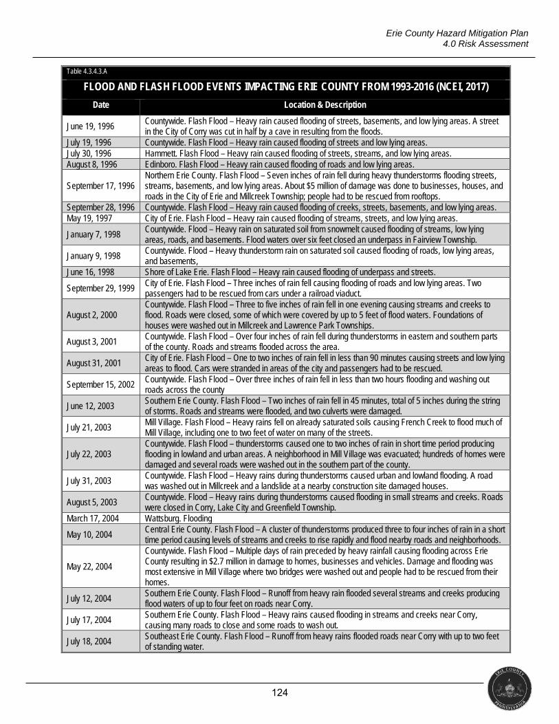
124
Erie County Hazard Mitigation Plan 4.0 Risk Assessment
Table 4.3.4.3.A
FLOOD AND FLASH FLOOD EVENTS IMPACTING ERIE COUNTY FROM 1993-2016 (NCEI, 2017)
Date Location & Description
June 19, 1996 Countywide. Flash Flood – Heavy rain caused flooding of streets, basements, and low lying areas. A street in the City of Corry was cut in half by a cave in resulting from the floods.
July 19, 1996 Countywide. Flash Flood – Heavy rain caused flooding of streets and low lying areas. July 30, 1996 Hammett. Flash Flood – Heavy rain caused flooding of streets, streams, and low lying areas. August 8, 1996 Edinboro. Flash Flood – Heavy rain caused flooding of roads and low lying areas.
September 17, 1996 Northern Erie County. Flash Flood – Seven inches of rain fell during heavy thunderstorms flooding streets, streams, basements, and low lying areas. About $5 million of damage was done to businesses, houses, and roads in the City of Erie and Millcreek Township; people had to be rescued from rooftops.
September 28, 1996 Countywide. Flash Flood – Heavy rain caused flooding of creeks, streets, basements, and low lying areas. May 19, 1997 City of Erie. Flash Flood – Heavy rain caused flooding of streams, streets, and low lying areas.
January 7, 1998 Countywide. Flood – Heavy rain on saturated soil from snowmelt caused flooding of streams, low lying areas, roads, and basements. Flood waters over six feet closed an underpass in Fairview Township.
January 9, 1998 Countywide. Flood – Heavy thunderstorm rain on saturated soil caused flooding of roads, low lying areas, and basements,
June 16, 1998 Shore of Lake Erie. Flash Flood – Heavy rain caused flooding of underpass and streets.
September 29, 1999 City of Erie. Flash Flood – Three inches of rain fell causing flooding of roads and low lying areas. Two passengers had to be rescued from cars under a railroad viaduct.
August 2, 2000 Countywide. Flash Flood – Three to five inches of rain fell in one evening causing streams and creeks to flood. Roads were closed, some of which were covered by up to 5 feet of flood waters. Foundations of houses were washed out in Millcreek and Lawrence Park Townships.
August 3, 2001 Countywide. Flash Flood – Over four inches of rain fell during thunderstorms in eastern and southern parts of the county. Roads and streams flooded across the area.
August 31, 2001 City of Erie. Flash Flood – One to two inches of rain fell in less than 90 minutes causing streets and low lying areas to flood. Cars were stranded in areas of the city and passengers had to be rescued.
September 15, 2002 Countywide. Flash Flood – Over three inches of rain fell in less than two hours flooding and washing out roads across the county
June 12, 2003 Southern Erie County. Flash Flood – Two inches of rain fell in 45 minutes, total of 5 inches during the string of storms. Roads and streams were flooded, and two culverts were damaged.
July 21, 2003 Mill Village. Flash Flood – Heavy rains fell on already saturated soils causing French Creek to flood much of Mill Village, including one to two feet of water on many of the streets.
July 22, 2003 Countywide. Flash Flood – thunderstorms caused one to two inches of rain in short time period producing flooding in lowland and urban areas. A neighborhood in Mill Village was evacuated; hundreds of homes were damaged and several roads were washed out in the southern part of the county.
July 31, 2003 Countywide. Flash Flood – Heavy rains during thunderstorms caused urban and lowland flooding. A road was washed out in Millcreek and a landslide at a nearby construction site damaged houses.
August 5, 2003 Countywide. Flood – Heavy rains during thunderstorms caused flooding in small streams and creeks. Roads were closed in Corry, Lake City and Greenfield Township.
March 17, 2004 Wattsburg. Flooding
May 10, 2004 Central Erie County. Flash Flood – A cluster of thunderstorms produced three to four inches of rain in a short time period causing levels of streams and creeks to rise rapidly and flood nearby roads and neighborhoods.
May 22, 2004
Countywide. Flash Flood – Multiple days of rain preceded by heavy rainfall causing flooding across Erie County resulting in $2.7 million in damage to homes, businesses and vehicles. Damage and flooding was most extensive in Mill Village where two bridges were washed out and people had to be rescued from their homes.
July 12, 2004 Southern Erie County. Flash Flood – Runoff from heavy rain flooded several streams and creeks producing flood waters of up to four feet on roads near Corry.
July 17, 2004 Southern Erie County. Flash Flood – Heavy rains caused flooding in streams and creeks near Corry, causing many roads to close and some roads to wash out.
July 18, 2004 Southeast Erie County. Flash Flood – Runoff from heavy rains flooded roads near Corry with up to two feet of standing water.
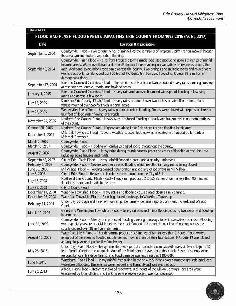
125
Erie County Hazard Mitigation Plan 4.0 Risk Assessment
Table 4.3.4.3.A
FLOOD AND FLASH FLOOD EVENTS IMPACTING ERIE COUNTY FROM 1993-2016 (NCEI, 2017)
Date Location & Description
September 8, 2004 Countywide. Flood – Two to four inches of rain fell as the remnants of Tropical Storm Francis moved through the area causing lowland and urban flooding.
September 9, 2004
Countywide. Flash Flood – Rains from Tropical Storm Francis persisted producing up to six inches of rainfall in some areas. Water overflowed a dam on Edinboro Lake resulting in evacuations of residents across the area. Additional evacuations took place across the county. Two bridges and multiple roads and routes were washed out. A landslide wiped out 500 feet of PA Route 5 in Fairview Township. Overall $5.6 million of damage was done.
September 17, 2004 Erie and Crawford Counties. Flood – The remnants of Hurricane Ivan produced heavy rains causing flooding across streams, creeks, roads, and lowland areas.
January 1, 2005 Erie and Crawford Counties. Flood – Heavy rain and snowmelt caused widespread flooding in low lying areas and across a few roads.
July 16, 2005 Southern Erie County. Flash Flood – Heavy rains produced over two inches of rainfall in an hour, flood waters reached over two feet high in some areas.
July 22, 2005 Wesleyville. Flash Flood – heavy rains produced urban flooding. Roads were closed with reports of three to four feet of flood water flowing over roads.
November 29, 2005 Northern Erie County. Flood – Heavy rains produced flooding of roads and basements in northern portions of the county.
October 28, 2006 Northern Erie County. Flood – High waves along Lake Erie shore caused flooding in this area.
December 1, 2006 Millcreek Township. Flood – Severe weather caused flooding which resulted in a flooded trailer park in Millcreek Township.
March 2, 2007 Countywide. Flood. March 15, 2007 Countywide. Flood – Flooding on roadways closed roads throughout the county.
August 7, 2007 Countywide. Flash Flood – Heavy rains during thunderstorms produced areas of flooding across the area including some houses and roads.
September 8, 2007 City of Erie. Flash Flood – Heavy rainfall flooded a creek and a nearby underpass. February 6, 2008 Countywide. Flood – Severe weather caused flooding which resulted in many roads being closed. June 30, 2008 Mill Village. Flood – Flooding caused deterioration and closure of roadways in Mill Village. July 8, 2008 City of Erie. Flood – Heavy rain flooded streets throughout the City of Erie.
July 22, 2008 Northeast Erie County. Flash Flood – Heavy rain produced 2 to 3.5 inches of rain in less than 90 minutes flooding streams and roads in the area.
July 26, 2008 City of Corry. Flood. December 11, 2008 Venango Township. Flood – Heavy rains and flooding caused road closures in Venango. December 26, 2008 Waterford Township. Flood – Flooding closed roadways in Waterford Township.
February 11, 2009 Union City Borough and Fairview Township. Ice Jams – ice jams reported on French Creek and Walnut Creek.
March 10, 2009 Girard and Washington Townships. Flood – heavy rain caused minor flooding closing two roads and flooding basements.
June 30, 2009 Countywide. Flood – Steady rain produced flooding causing roadways to be impassable and close. Flooding was especially severe near Millcreek as the creek flooded and storm drains close. Flooding across the county caused over $8 million in damage.
August 10, 2009 Waterford. Flash Flood – Thunderstorms produced 3.5 inches of rain in less than 2 hours. Flood waters rising out of the streams flooded mobile homes moving them off their foundations. PA route 19 was closed as large logs were deposited by flood waters.
May 28, 2013 Union City. Flash Flood – Heavy rains that were part of a tornadic storm caused reservoir levels to jump 30 feet. French Creek came up quick. Most of the flood damage was along this creek. Seven residents were rescued by local fire departments and flood damage was estimated at $100,000.
June 6, 2013 Wattsburg. Flash Flood – Heavy rainfall measuring between 4 to 5 inches over saturated grounds produced widespread flooding. Basements were flooded and Hamot Road was washed out.
July 20, 2013 Albion. Flash Flood – Heavy rain closed roadways. Residents of the Albion Borough Park area were evacuated by local officials and the Cranesville sewer system was compromised.

126
Erie County Hazard Mitigation Plan 4.0 Risk Assessment
Table 4.3.4.3.A
FLOOD AND FLASH FLOOD EVENTS IMPACTING ERIE COUNTY FROM 1993-2016 (NCEI, 2017)
Date Location & Description
August 10, 2016
City of Erie and Millcreek. Flash Flood – Heavy rain during thunderstorms overwhelmed storm drainage resulting in flash flooding, especially in the Millcreek area. Twenty to thirty vehicle were seen floating in the roadway. The Walnut Creek saw a rapid rise resulting in the need for sandbags to keep homes from becoming flooded.
During the planning process, FEMA hosted a resiliency workshop that
coincided with the release of new FIRM information for coastal areas of the county.
During the workshop, there were presentations on the new FIRM information. The
spreadsheet below was provided at the workshop.
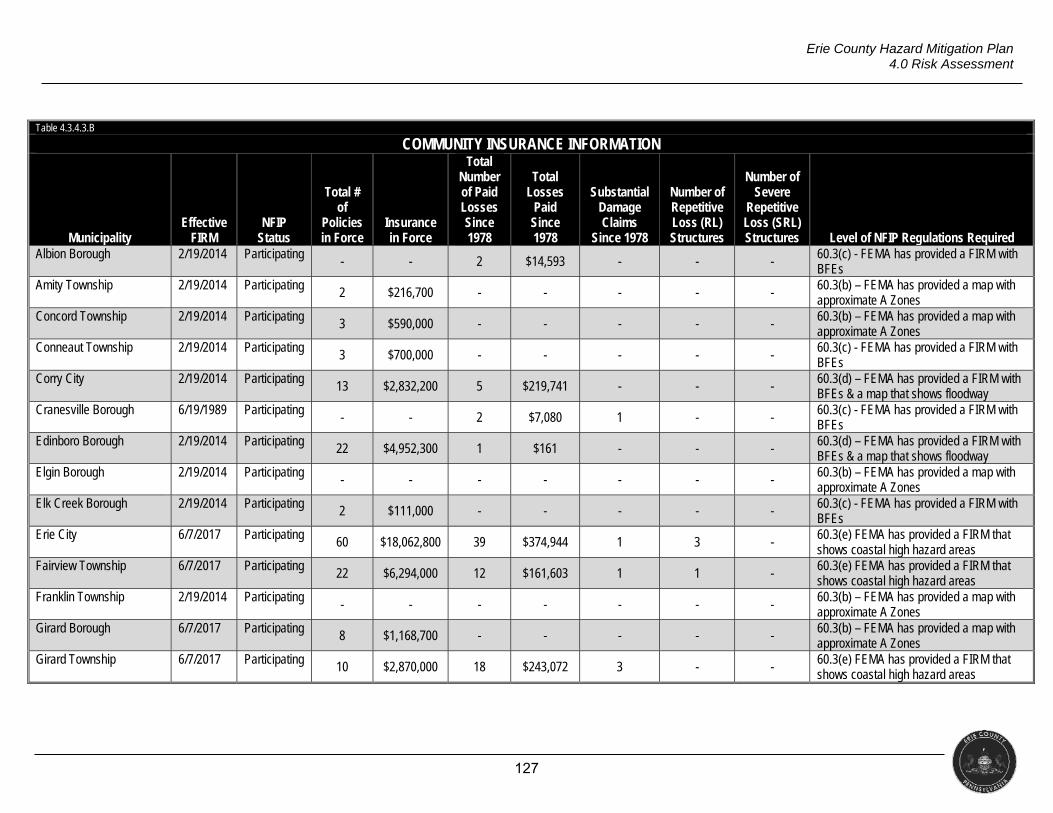
127
Erie County Hazard Mitigation Plan 4.0 Risk Assessment
Table 4.3.4.3.B
COMMUNITY INSURANCE INFORMATION
Municipality Effective
FIRM NFIP
Status
Total # of
Policies in Force
Insurance in Force
Total Number of Paid Losses Since 1978
Total Losses
Paid Since 1978
Substantial Damage Claims
Since 1978
Number of Repetitive Loss (RL) Structures
Number of Severe
Repetitive Loss (SRL) Structures Level of NFIP Regulations Required
Albion Borough 2/19/2014 Participating - - 2 $14,593 - - -
60.3(c) - FEMA has provided a FIRM with BFEs
Amity Township 2/19/2014 Participating 2 $216,700 - - - - - 60.3(b) – FEMA has provided a map with approximate A Zones
Concord Township 2/19/2014 Participating 3 $590,000 - - - - - 60.3(b) – FEMA has provided a map with approximate A Zones
Conneaut Township 2/19/2014 Participating 3 $700,000 - - - - -
60.3(c) - FEMA has provided a FIRM with BFEs
Corry City 2/19/2014 Participating 13 $2,832,200 5 $219,741 - - -
60.3(d) – FEMA has provided a FIRM with BFEs & a map that shows floodway
Cranesville Borough 6/19/1989 Participating - - 2 $7,080 1 - -
60.3(c) - FEMA has provided a FIRM with BFEs
Edinboro Borough 2/19/2014 Participating 22 $4,952,300 1 $161 - - - 60.3(d) – FEMA has provided a FIRM with BFEs & a map that shows floodway
Elgin Borough 2/19/2014 Participating - - - - - - - 60.3(b) – FEMA has provided a map with approximate A Zones
Elk Creek Borough 2/19/2014 Participating 2 $111,000 - - - - - 60.3(c) - FEMA has provided a FIRM with BFEs
Erie City 6/7/2017 Participating 60 $18,062,800 39 $374,944 1 3 -
60.3(e) FEMA has provided a FIRM that shows coastal high hazard areas
Fairview Township 6/7/2017 Participating 22 $6,294,000 12 $161,603 1 1 -
60.3(e) FEMA has provided a FIRM that shows coastal high hazard areas
Franklin Township 2/19/2014 Participating - - - - - - -
60.3(b) – FEMA has provided a map with approximate A Zones
Girard Borough 6/7/2017 Participating 8 $1,168,700 - - - - - 60.3(b) – FEMA has provided a map with approximate A Zones
Girard Township 6/7/2017 Participating 10 $2,870,000 18 $243,072 3 - - 60.3(e) FEMA has provided a FIRM that shows coastal high hazard areas
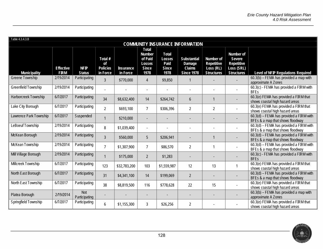
128
Erie County Hazard Mitigation Plan 4.0 Risk Assessment
Table 4.3.4.3.B
COMMUNITY INSURANCE INFORMATION
Municipality Effective
FIRM NFIP
Status
Total # of
Policies in Force
Insurance in Force
Total Number of Paid Losses Since 1978
Total Losses
Paid Since 1978
Substantial Damage Claims
Since 1978
Number of Repetitive Loss (RL) Structures
Number of Severe
Repetitive Loss (SRL) Structures Level of NFIP Regulations Required
Greene Township 2/19/2014 Participating 3 $770,000 4 $9,850 1 - -
60.3(b) – FEMA has provided a map with approximate A Zones
Greenfield Township 2/19/2014 Participating - - - - - - - 60.3(c) - FEMA has provided a FIRM with BFEs
Harborcreek Township 6/7/2017 Participating 34 $8,632,400 14 $264,742 6 1 - 60.3(e) FEMA has provided a FIRM that shows coastal high hazard areas
Lake City Borough 6/7/2017 Participating 2 $693,100 7 $306,396 2 2 -
60.3(e) FEMA has provided a FIRM that shows coastal high hazard areas
Lawrence Park Township 6/7/2017 Suspended 1 $210,000 - - - - -
60.3(d) – FEMA has provided a FIRM with BFEs & a map that shows floodway
LeBoeuf Township 2/19/2014 Participating 8 $1,039,400 - - - - -
60.3(d) – FEMA has provided a FIRM with BFEs & a map that shows floodway
McKean Borough 2/19/2014 Participating 3 $560,000 5 $206,941 - 1 - 60.3(d) – FEMA has provided a FIRM with BFEs & a map that shows floodway
McKean Township 2/19/2014 Participating 7 $1,307,900 7 $86,570 2 1 - 60.3(d) – FEMA has provided a FIRM with BFEs & a map that shows floodway
Mill Village Borough 2/19/2014 Participating 1 $175,000 2 $1,283 - - - 60.3(c) - FEMA has provided a FIRM with BFEs
Millcreek Township 6/7/2017 Participating 123 $32,783,200 103 $1,559,987 12 13 1
60.3(e) FEMA has provided a FIRM that shows coastal high hazard areas
North East Borough 6/7/2017 Participating 31 $4,341,100 14 $199,069 2 - -
60.3(d) – FEMA has provided a FIRM with BFEs & a map that shows floodway
North East Township 6/7/2017 Participating 38 $8,819,500 116 $778,628 22 15 -
60.3(e) FEMA has provided a FIRM that shows coastal high hazard areas
Platea Borough 2/19/2014 Not Participating
- - - - - - - 60.3(b) – FEMA has provided a map with approximate A Zones
Springfield Township 6/7/2017 Participating 6 $1,155,300 3 $26,256 2 - - 60.3(e) FEMA has provided a FIRM that shows coastal high hazard areas
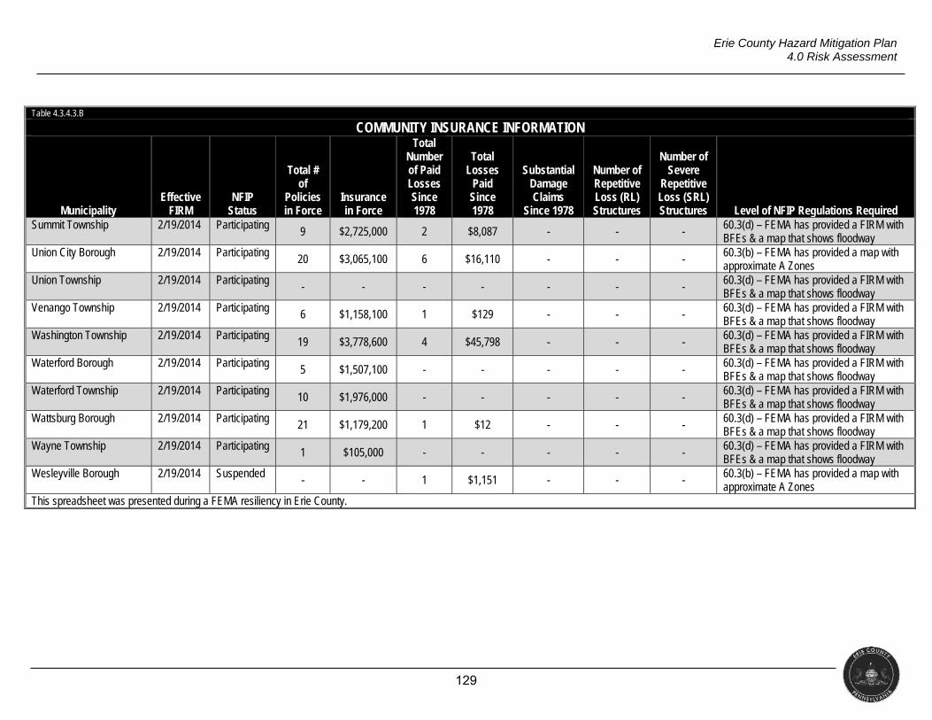
129
Erie County Hazard Mitigation Plan 4.0 Risk Assessment
Table 4.3.4.3.B
COMMUNITY INSURANCE INFORMATION
Municipality Effective
FIRM NFIP
Status
Total # of
Policies in Force
Insurance in Force
Total Number of Paid Losses Since 1978
Total Losses
Paid Since 1978
Substantial Damage Claims
Since 1978
Number of Repetitive Loss (RL) Structures
Number of Severe
Repetitive Loss (SRL) Structures Level of NFIP Regulations Required
Summit Township 2/19/2014 Participating 9 $2,725,000 2 $8,087 - - -
60.3(d) – FEMA has provided a FIRM with BFEs & a map that shows floodway
Union City Borough 2/19/2014 Participating 20 $3,065,100 6 $16,110 - - - 60.3(b) – FEMA has provided a map with approximate A Zones
Union Township 2/19/2014 Participating - - - - - - - 60.3(d) – FEMA has provided a FIRM with BFEs & a map that shows floodway
Venango Township 2/19/2014 Participating 6 $1,158,100 1 $129 - - -
60.3(d) – FEMA has provided a FIRM with BFEs & a map that shows floodway
Washington Township 2/19/2014 Participating 19 $3,778,600 4 $45,798 - - -
60.3(d) – FEMA has provided a FIRM with BFEs & a map that shows floodway
Waterford Borough 2/19/2014 Participating 5 $1,507,100 - - - - -
60.3(d) – FEMA has provided a FIRM with BFEs & a map that shows floodway
Waterford Township 2/19/2014 Participating 10 $1,976,000 - - - - - 60.3(d) – FEMA has provided a FIRM with BFEs & a map that shows floodway
Wattsburg Borough 2/19/2014 Participating 21 $1,179,200 1 $12 - - - 60.3(d) – FEMA has provided a FIRM with BFEs & a map that shows floodway
Wayne Township 2/19/2014 Participating 1 $105,000 - - - - - 60.3(d) – FEMA has provided a FIRM with BFEs & a map that shows floodway
Wesleyville Borough 2/19/2014 Suspended - - 1 $1,151 - - -
60.3(b) – FEMA has provided a map with approximate A Zones
This spreadsheet was presented during a FEMA resiliency in Erie County.
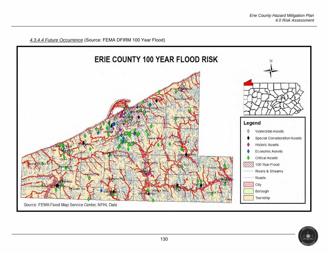
130
Erie County Hazard Mitigation Plan 4.0 Risk Assessment
4.3.4.4 Future Occurrence (Source: FEMA DFIRM 100 Year Flood)
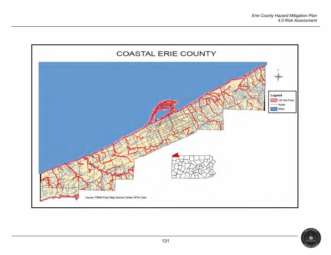
131
Erie County Hazard Mitigation Plan 4.0 Risk Assessment
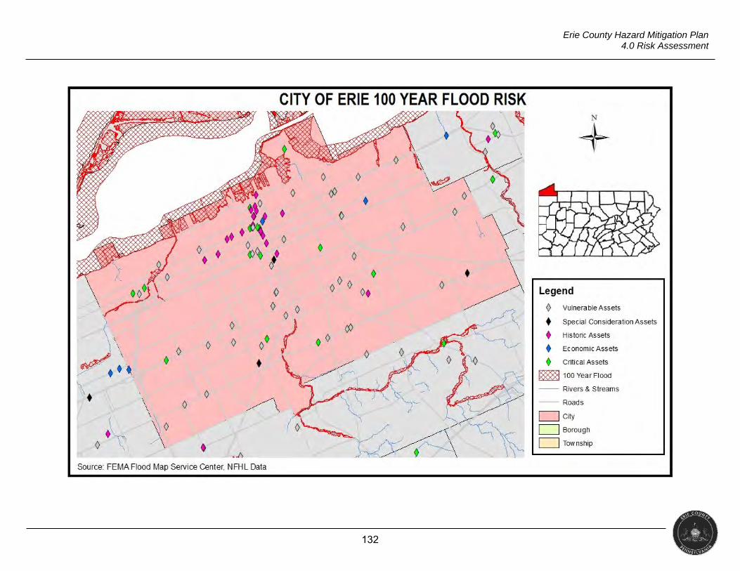
132
Erie County Hazard Mitigation Plan 4.0 Risk Assessment
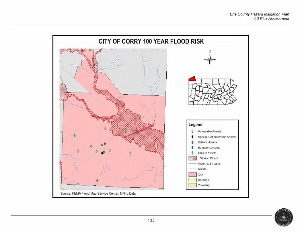
133
Erie County Hazard Mitigation Plan 4.0 Risk Assessment
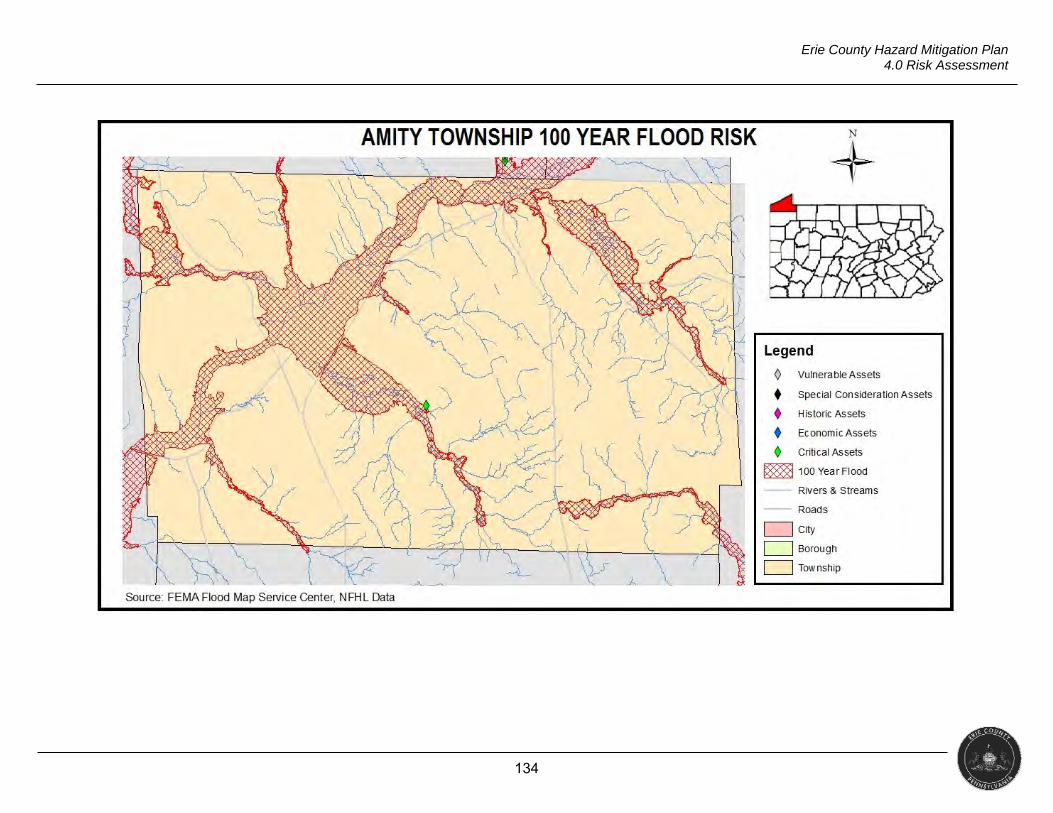
134
Erie County Hazard Mitigation Plan 4.0 Risk Assessment
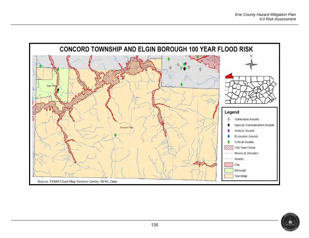
135
Erie County Hazard Mitigation Plan 4.0 Risk Assessment
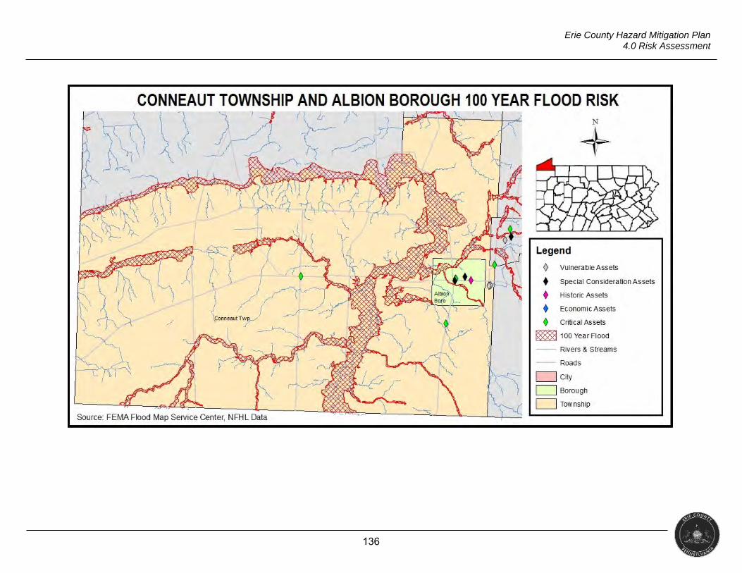
136
Erie County Hazard Mitigation Plan 4.0 Risk Assessment
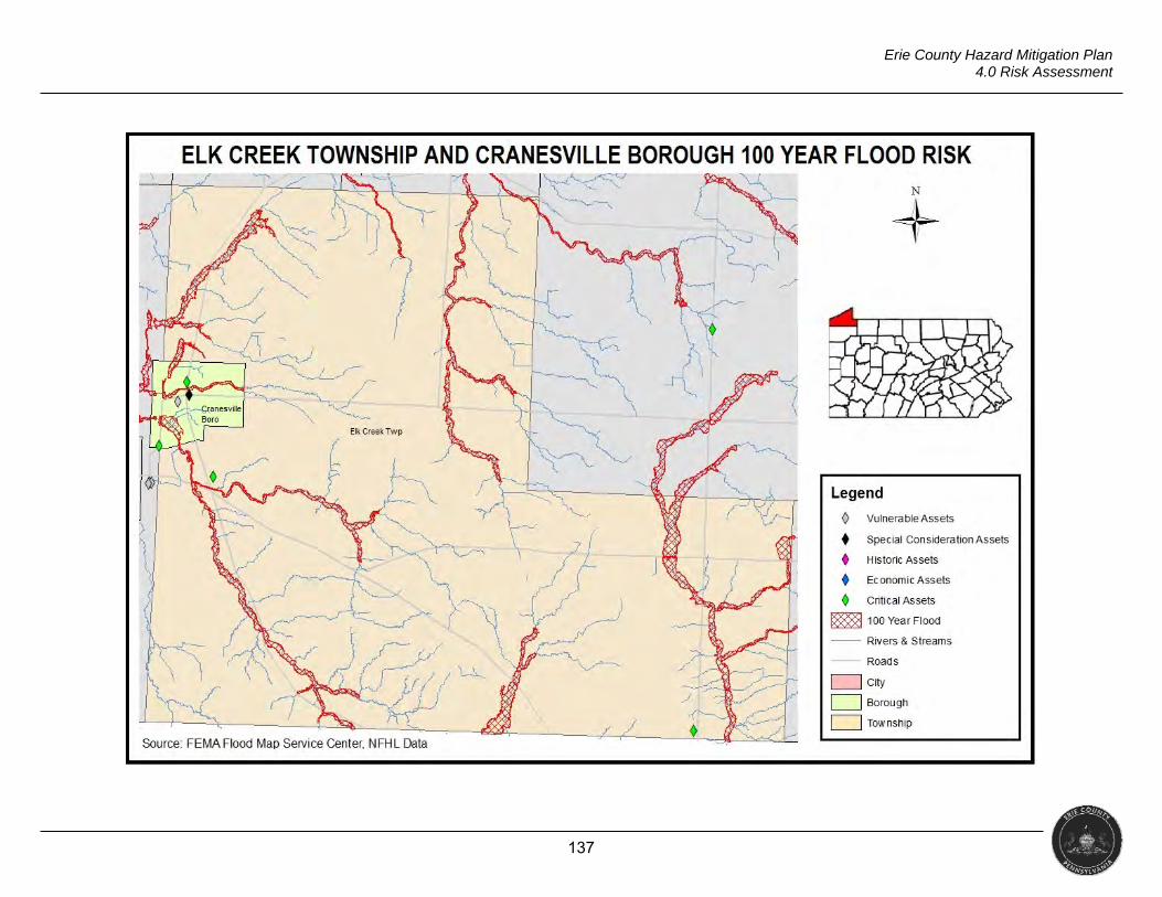
137
Erie County Hazard Mitigation Plan 4.0 Risk Assessment
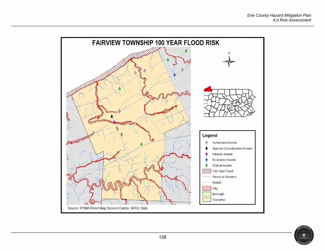
138
Erie County Hazard Mitigation Plan 4.0 Risk Assessment
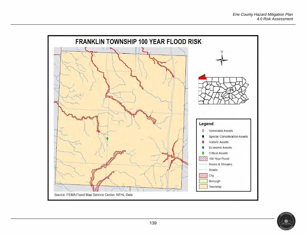
139
Erie County Hazard Mitigation Plan 4.0 Risk Assessment
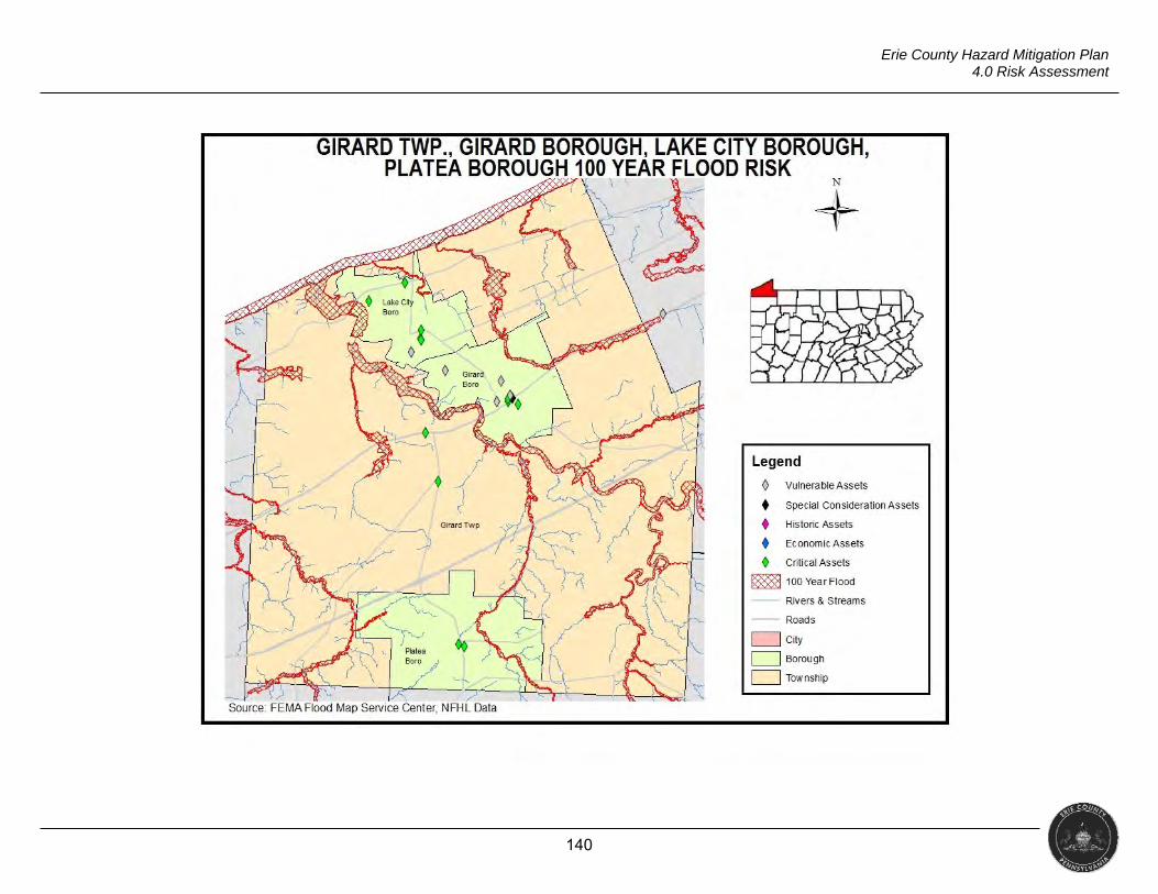
140
Erie County Hazard Mitigation Plan 4.0 Risk Assessment
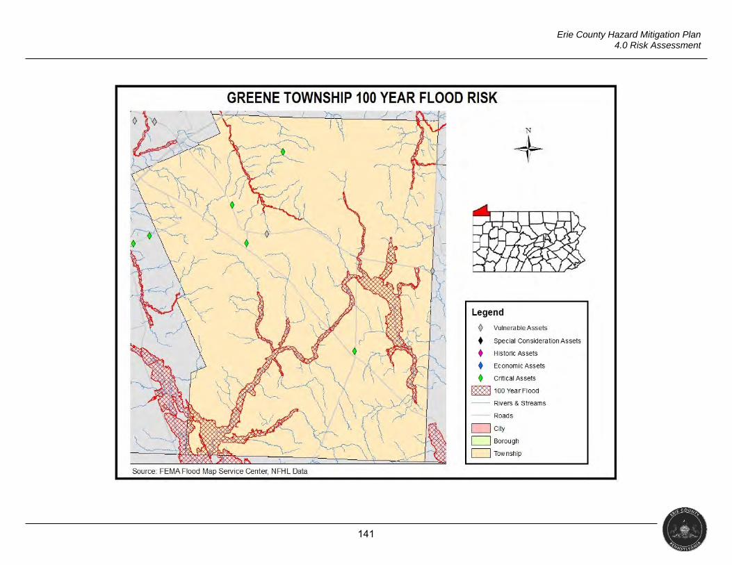
141
Erie County Hazard Mitigation Plan 4.0 Risk Assessment
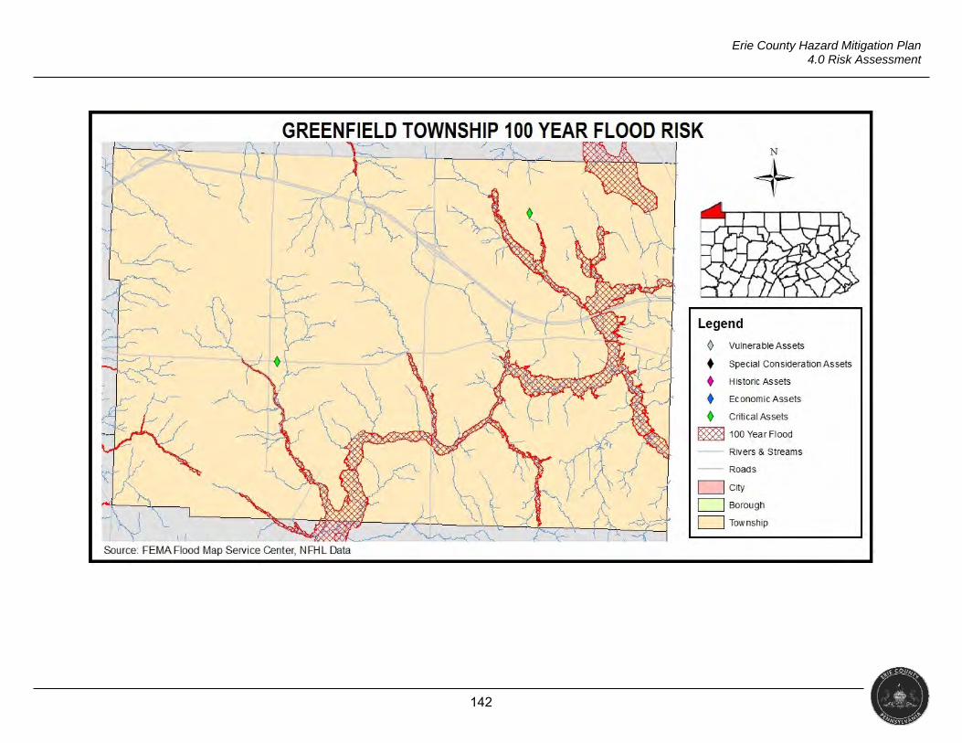
142
Erie County Hazard Mitigation Plan 4.0 Risk Assessment
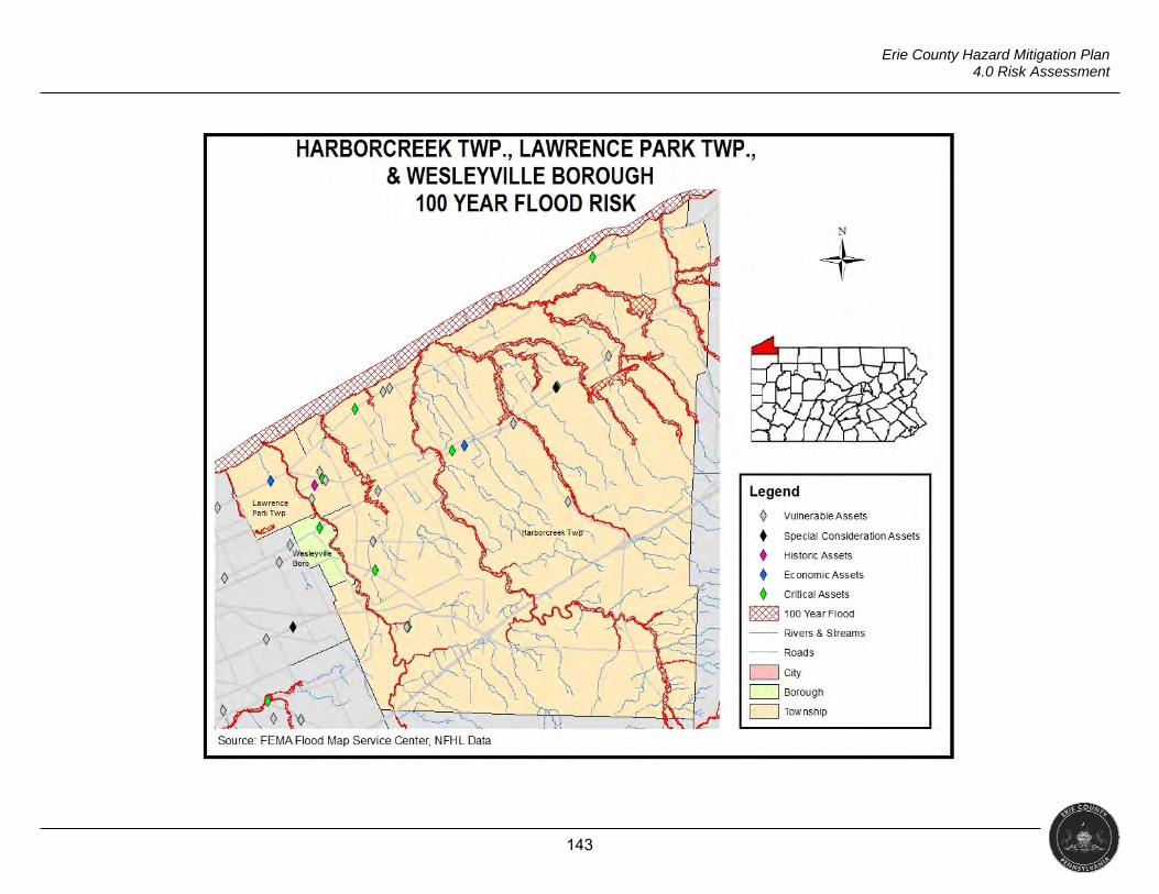
143
Erie County Hazard Mitigation Plan 4.0 Risk Assessment
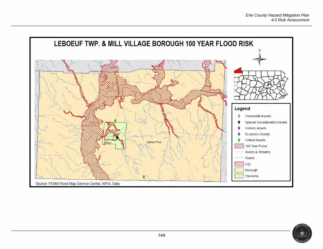
144
Erie County Hazard Mitigation Plan 4.0 Risk Assessment
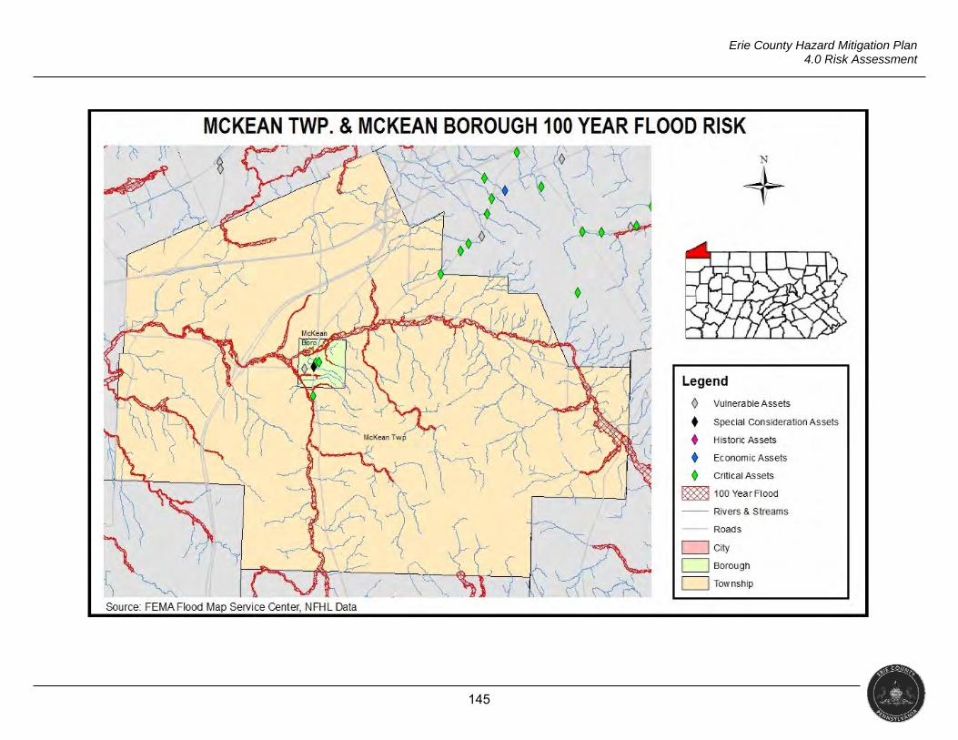
145
Erie County Hazard Mitigation Plan 4.0 Risk Assessment
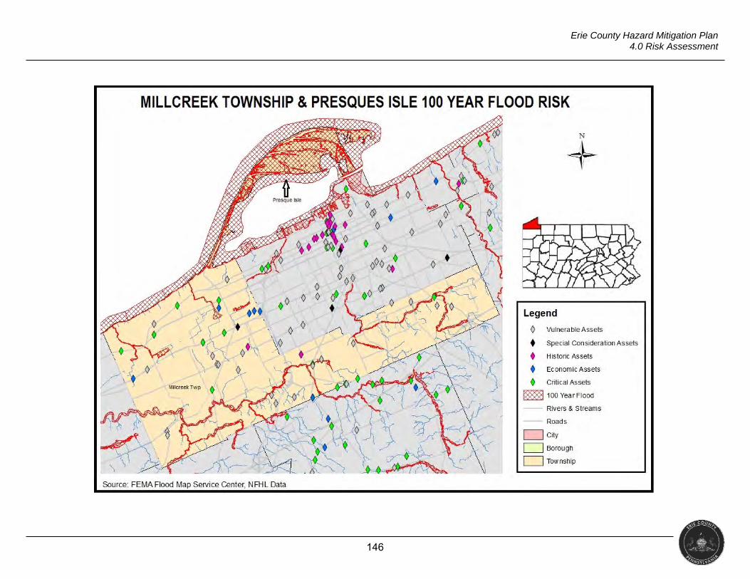
146
Erie County Hazard Mitigation Plan 4.0 Risk Assessment
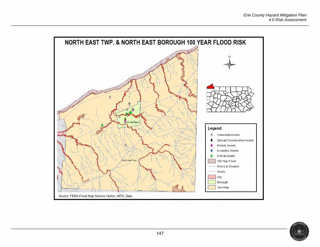
147
Erie County Hazard Mitigation Plan 4.0 Risk Assessment
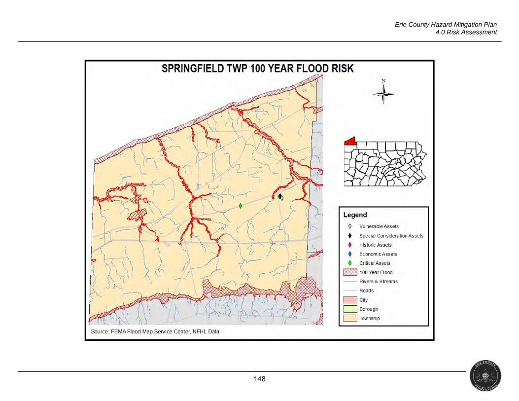
148
Erie County Hazard Mitigation Plan 4.0 Risk Assessment
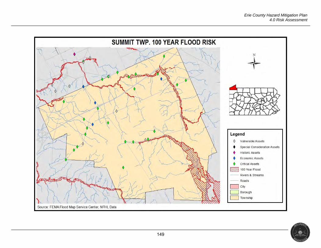
149
Erie County Hazard Mitigation Plan 4.0 Risk Assessment
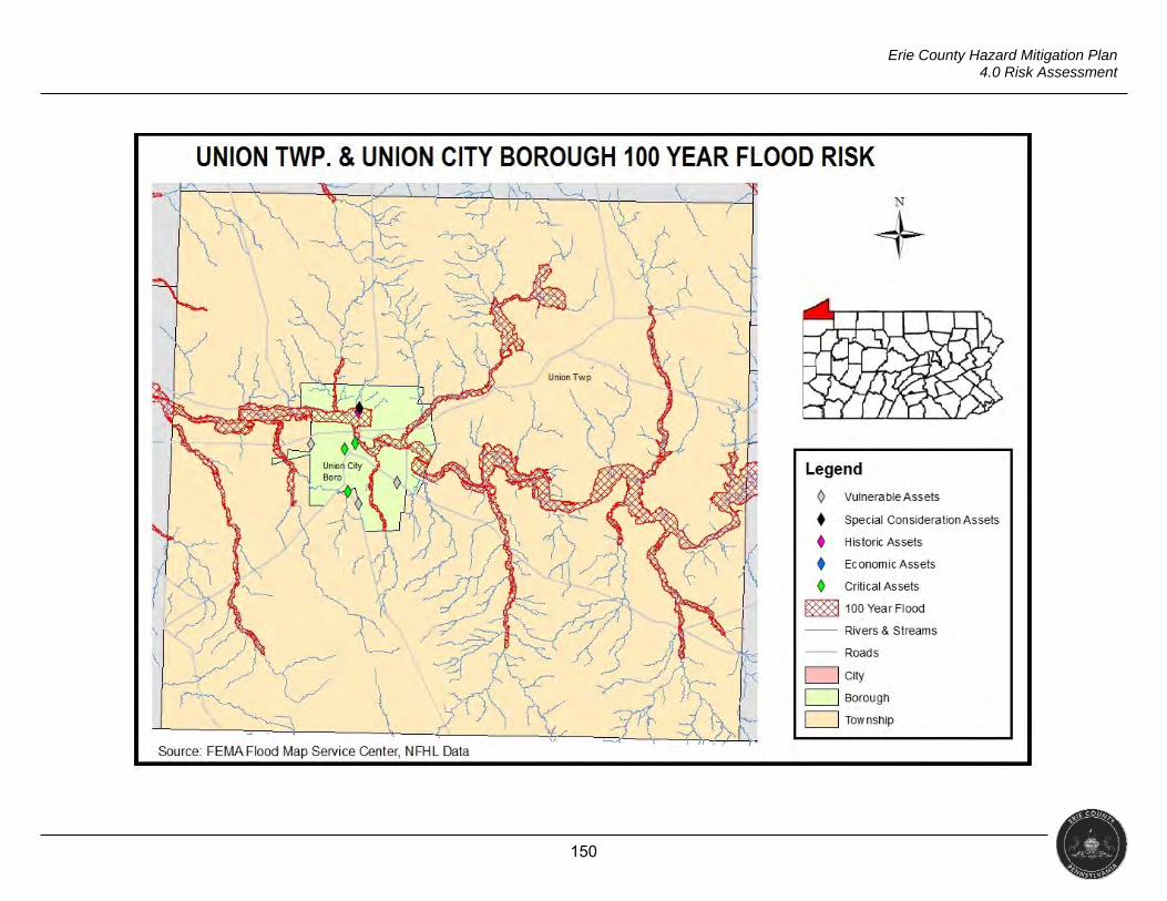
150
Erie County Hazard Mitigation Plan 4.0 Risk Assessment
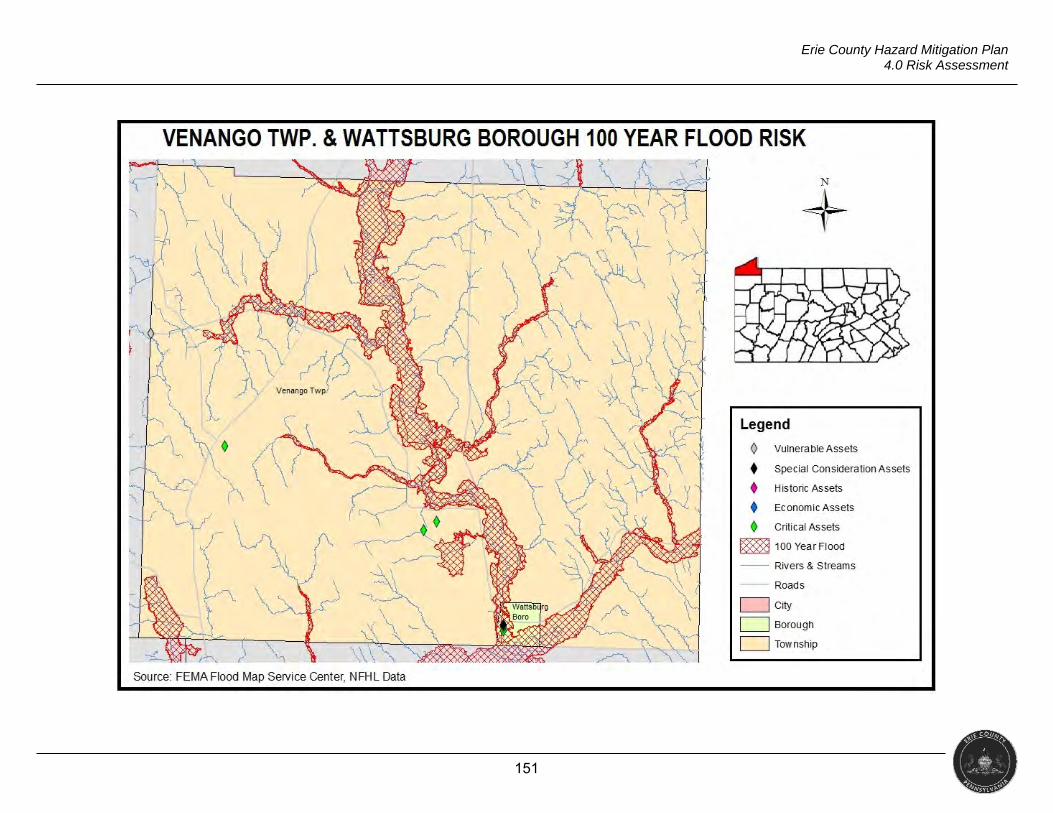
151
Erie County Hazard Mitigation Plan 4.0 Risk Assessment
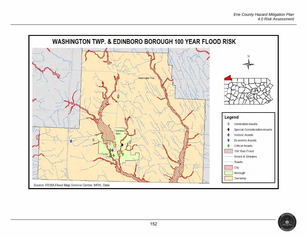
152
Erie County Hazard Mitigation Plan 4.0 Risk Assessment
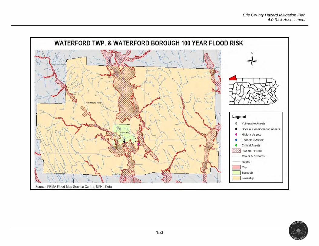
153
Erie County Hazard Mitigation Plan 4.0 Risk Assessment
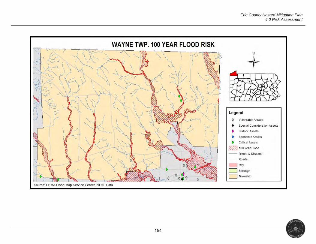
154
Erie County Hazard Mitigation Plan 4.0 Risk Assessment
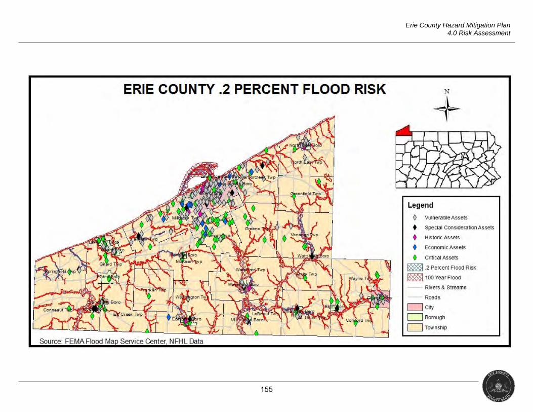
155
Erie County Hazard Mitigation Plan 4.0 Risk Assessment

156
Erie County Hazard Mitigation Plan 4.0 Risk Assessment
4.3.4.5 Vulnerability Assessment
TABLE 4.3.4.5.A FLOOD, FLASH FLOOD, ICE JAM VULNERABILITY ASSESSMENT
Probability
+
Severity
=
Risk
FREQUENT MARGINAL MODERATE
Events 66 =3.14 The average property damage
for historical events in NCEI is $441,000 with no records of
injuries or death.
A combination of frequent occurrence and marginal level of severity puts this
hazard at moderate risk to Erie County.
Years 21 There is likely a chance that a flood event will occur several
times throughout the year.
157
Erie County Hazard Mitigation Plan 4.0 Risk Assessment
4.3.5 Invasive Species
“Invasive alien species are plants, animals, or other organisms that are introduced to a given area outside their original range and cause harm in their new home” (Defenders of Wildlife).
Period of Occurrence Warning Time Risk Assessment May be introduced to the environment at any time.
None to Years MODERATE
4.3.5 Location and Extent
Invasive plants grow rapidly and aggressively, thereby displacing other
plants. Invasive plants are usually non-native species introduced to a region either
accidently or on purpose by people. These plants can be trees, shrubs, vines,
grasses, or flowers. When introduced to a new environment, the conditions within
their natural range are no longer present, allowing invasive species to aggressively
change an ecosystem (PADCNR, 2017). Harmful algal bloom (HAB) is an invasive
species that grows in water and can be extremely toxic. HABs are a type of bacteria
and have been present in Lake Erie since the 1990s. Though certain invasive
species affecting the lake are discussed below, HABs are included in the lake
hazards profile.
Invasive animals have the ability to thrive and spread aggressively outside
their native habitats. A naturally aggressive animal may be especially invasive.
Invasive animals include aquatic animals such as the zebra mussel and the quagga
mussel. Both can be found in Lake Erie (USDA, 2016).
Other types of invasive species include insects and diseases. Invasive
insects that have been identified in Pennsylvania or contiguous states include the
Asian Longhorned Beetle, Emerald Ash Borer, Gypsy Moths and the Hemlock Wooly
Adelgid. Most of the diseases that afflict trees, such as Beech Bark Disease and
Sudden Oak Death, are caused by fungi (PADCNR, 2017).
HARMFUL ALGAL BLOOMS
Harmful algal blooms (HAB) are overgrowths of algae in the water. HABs
have been plaguing the lake since the 1990s (Flesher, 2016). They have the ability
to produce toxins, but even the nontoxic blooms damage the environment and local
economies. Toxins created by HAB can cause illness or be fatal to humans and
animals. HAB raise the cost of treating drinking water and hurt industries that rely on
clean water (USEPA, 2017). The Department of Environmental Protection reports
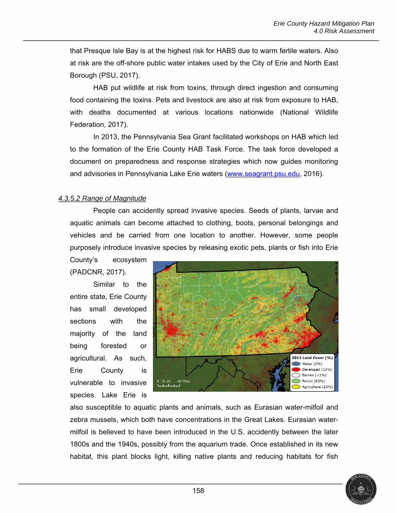
158
Erie County Hazard Mitigation Plan 4.0 Risk Assessment
that Presque Isle Bay is at the highest risk for HABS due to warm fertile waters. Also
at risk are the off-shore public water intakes used by the City of Erie and North East
Borough (PSU, 2017).
HAB put wildlife at risk from toxins, through direct ingestion and consuming
food containing the toxins. Pets and livestock are also at risk from exposure to HAB,
with deaths documented at various locations nationwide (National Wildlife
Federation, 2017).
In 2013, the Pennsylvania Sea Grant facilitated workshops on HAB which led
to the formation of the Erie County HAB Task Force. The task force developed a
document on preparedness and response strategies which now guides monitoring
and advisories in Pennsylvania Lake Erie waters (www.seagrant.psu.edu, 2016).
4.3.5.2 Range of Magnitude
People can accidently spread invasive species. Seeds of plants, larvae and
aquatic animals can become attached to clothing, boots, personal belongings and
vehicles and be carried from one location to another. However, some people
purposely introduce invasive species by releasing exotic pets, plants or fish into Erie
County’s ecosystem
(PADCNR, 2017).
Similar to the
entire state, Erie County
has small developed
sections with the
majority of the land
being forested or
agricultural. As such,
Erie County is
vulnerable to invasive
species. Lake Erie is
also susceptible to aquatic plants and animals, such as Eurasian water-milfoil and
zebra mussels, which both have concentrations in the Great Lakes. Eurasian water-
milfoil is believed to have been introduced in the U.S. accidently between the later
1800s and the 1940s, possibly from the aquarium trade. Once established in its new
habitat, this plant blocks light, killing native plants and reducing habitats for fish
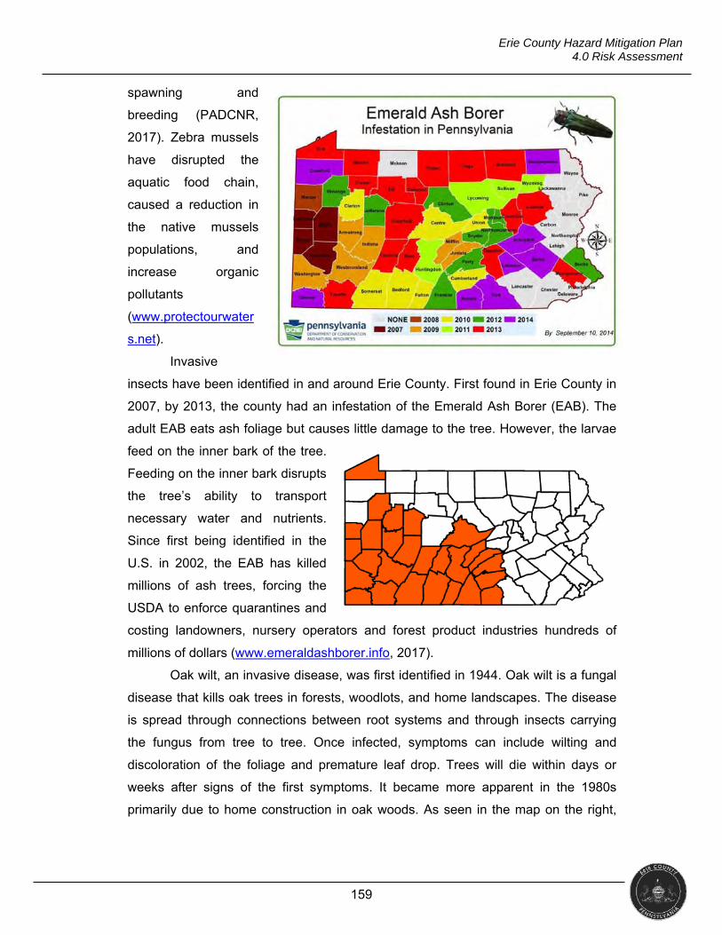
159
Erie County Hazard Mitigation Plan 4.0 Risk Assessment
spawning and
breeding (PADCNR,
2017). Zebra mussels
have disrupted the
aquatic food chain,
caused a reduction in
the native mussels
populations, and
increase organic
pollutants
(www.protectourwater
s.net).
Invasive
insects have been identified in and around Erie County. First found in Erie County in
2007, by 2013, the county had an infestation of the Emerald Ash Borer (EAB). The
adult EAB eats ash foliage but causes little damage to the tree. However, the larvae
feed on the inner bark of the tree.
Feeding on the inner bark disrupts
the tree’s ability to transport
necessary water and nutrients.
Since first being identified in the
U.S. in 2002, the EAB has killed
millions of ash trees, forcing the
USDA to enforce quarantines and
costing landowners, nursery operators and forest product industries hundreds of
millions of dollars (www.emeraldashborer.info, 2017).
Oak wilt, an invasive disease, was first identified in 1944. Oak wilt is a fungal
disease that kills oak trees in forests, woodlots, and home landscapes. The disease
is spread through connections between root systems and through insects carrying
the fungus from tree to tree. Once infected, symptoms can include wilting and
discoloration of the foliage and premature leaf drop. Trees will die within days or
weeks after signs of the first symptoms. It became more apparent in the 1980s
primarily due to home construction in oak woods. As seen in the map on the right,
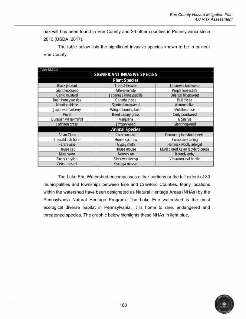
160
Erie County Hazard Mitigation Plan 4.0 Risk Assessment
oak wilt has been found in Erie County and 26 other counties in Pennsylvania since
2010 (USDA, 2017).
The table below lists the significant invasive species known to be in or near
Erie County.
Table 4.3.5.2.A
SIGNIFICANT INVASIVE SPECIES Plant Species
Black jetbead Tree-of-heaven Japanese knotweed Giant knotweed Mile-a-minute Purple loosestrife Garlic mustard Japanese honeysuckle Oriental bittersweet
Bush honeysuckles Canada thistle Bull thistle Nodding thistle Spotted knapweed Autumn olive
Japanese barberry Winged burning bush Multiflora rose Privet Reed canary grass Curly pondweed
Eurasian water-milfoil Marijuana Goatsrue Johnson grass Jimson weed Giant hogweed
Animal Species Asian Clam Common carp Common pine shoot beetle
Emerald ash borer House sparrow European starling Feral swine Gypsy moth Hemlock woolly adelgid House cat House mouse Multicolored Asian ladybird beetle Mute swan Norway rat Roundy goby
Rusty crayfish Sirex woodwasp Viburnum leaf beetle Zebra mussel Quagga mussel
The Lake Erie Watershed encompasses either portions or the full extent of 33
municipalities and townships between Erie and Crawford Counties. Many locations
within the watershed have been designated as Natural Heritage Areas (NHAs) by the
Pennsylvania Natural Heritage Program. The Lake Erie watershed is the most
ecological diverse habitat in Pennsylvania. It is home to rare, endangered and
threatened species. The graphic below highlights these NHAs in light blue.
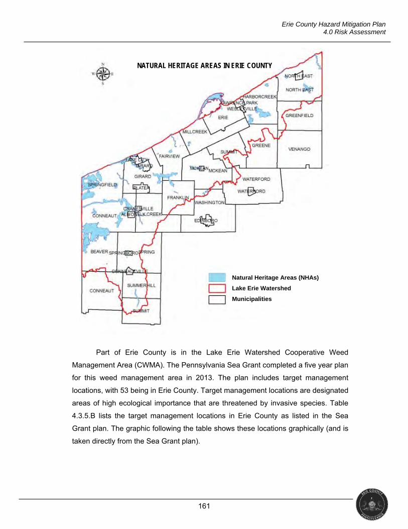
161
Erie County Hazard Mitigation Plan 4.0 Risk Assessment
Part of Erie County is in the Lake Erie Watershed Cooperative Weed
Management Area (CWMA). The Pennsylvania Sea Grant completed a five year plan
for this weed management area in 2013. The plan includes target management
locations, with 53 being in Erie County. Target management locations are designated
areas of high ecological importance that are threatened by invasive species. Table
4.3.5.B lists the target management locations in Erie County as listed in the Sea
Grant plan. The graphic following the table shows these locations graphically (and is
taken directly from the Sea Grant plan).
Source: Lake Erie WCMA 5 Year Plan (2013-2018)
NATURAL HERITAGE AREAS IN ERIE COUNTY
Natural Heritage Areas (NHAs)
Lake Erie Watershed
Municipalities
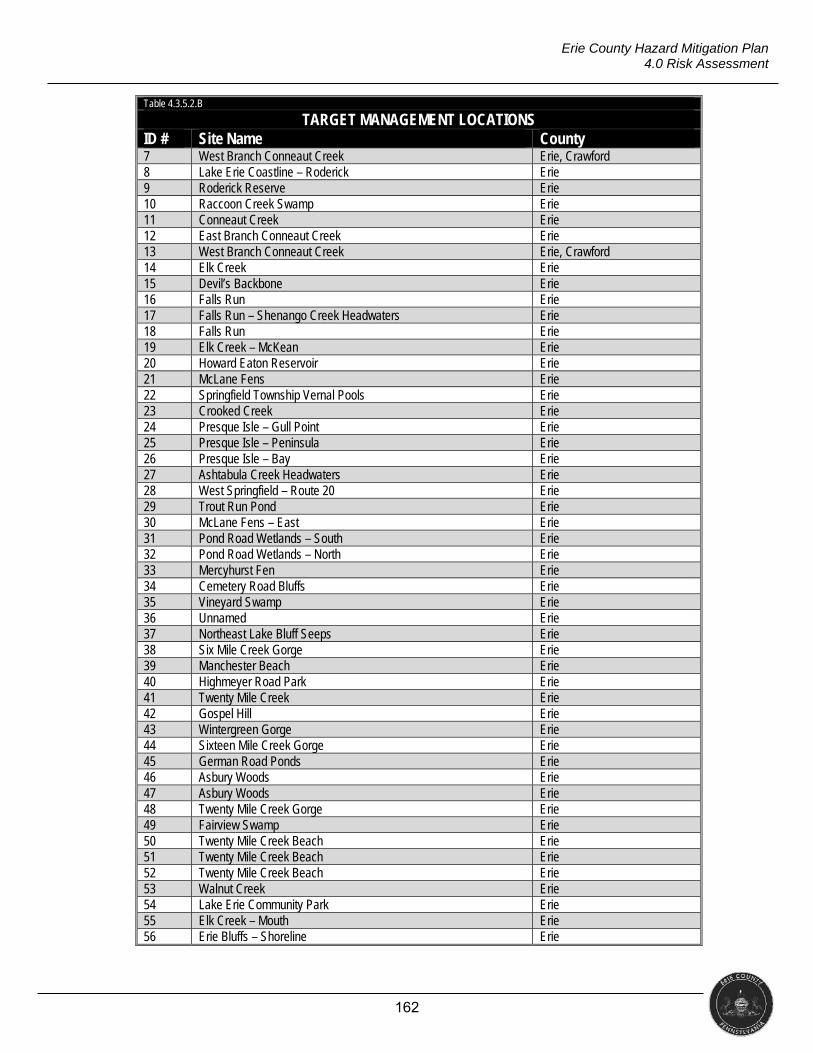
162
Erie County Hazard Mitigation Plan 4.0 Risk Assessment
Table 4.3.5.2.B
TARGET MANAGEMENT LOCATIONS ID # Site Name County 7 West Branch Conneaut Creek Erie, Crawford 8 Lake Erie Coastline – Roderick Erie 9 Roderick Reserve Erie 10 Raccoon Creek Swamp Erie 11 Conneaut Creek Erie 12 East Branch Conneaut Creek Erie 13 West Branch Conneaut Creek Erie, Crawford 14 Elk Creek Erie 15 Devil’s Backbone Erie 16 Falls Run Erie 17 Falls Run – Shenango Creek Headwaters Erie 18 Falls Run Erie 19 Elk Creek – McKean Erie 20 Howard Eaton Reservoir Erie 21 McLane Fens Erie 22 Springfield Township Vernal Pools Erie 23 Crooked Creek Erie 24 Presque Isle – Gull Point Erie 25 Presque Isle – Peninsula Erie 26 Presque Isle – Bay Erie 27 Ashtabula Creek Headwaters Erie 28 West Springfield – Route 20 Erie 29 Trout Run Pond Erie 30 McLane Fens – East Erie 31 Pond Road Wetlands – South Erie 32 Pond Road Wetlands – North Erie 33 Mercyhurst Fen Erie 34 Cemetery Road Bluffs Erie 35 Vineyard Swamp Erie 36 Unnamed Erie 37 Northeast Lake Bluff Seeps Erie 38 Six Mile Creek Gorge Erie 39 Manchester Beach Erie 40 Highmeyer Road Park Erie 41 Twenty Mile Creek Erie 42 Gospel Hill Erie 43 Wintergreen Gorge Erie 44 Sixteen Mile Creek Gorge Erie 45 German Road Ponds Erie 46 Asbury Woods Erie 47 Asbury Woods Erie 48 Twenty Mile Creek Gorge Erie 49 Fairview Swamp Erie 50 Twenty Mile Creek Beach Erie 51 Twenty Mile Creek Beach Erie 52 Twenty Mile Creek Beach Erie 53 Walnut Creek Erie 54 Lake Erie Community Park Erie 55 Elk Creek – Mouth Erie 56 Erie Bluffs – Shoreline Erie
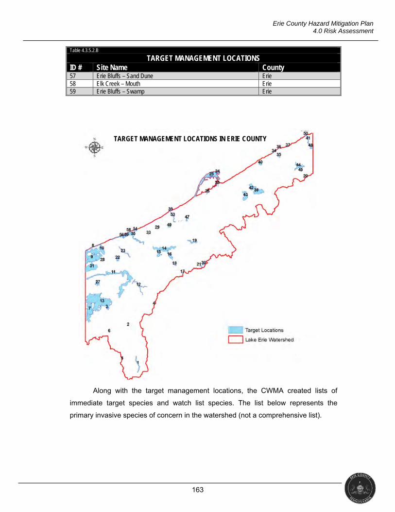
163
Erie County Hazard Mitigation Plan 4.0 Risk Assessment
Table 4.3.5.2.B
TARGET MANAGEMENT LOCATIONS ID # Site Name County 57 Erie Bluffs – Sand Dune Erie 58 Elk Creek – Mouth Erie 59 Erie Bluffs – Swamp Erie
Along with the target management locations, the CWMA created lists of
immediate target species and watch list species. The list below represents the
primary invasive species of concern in the watershed (not a comprehensive list).
Source: Lake Erie WCMA 5 Year Plan (2013-2018)
TARGET MANAGEMENT LOCATIONS IN ERIE COUNTY
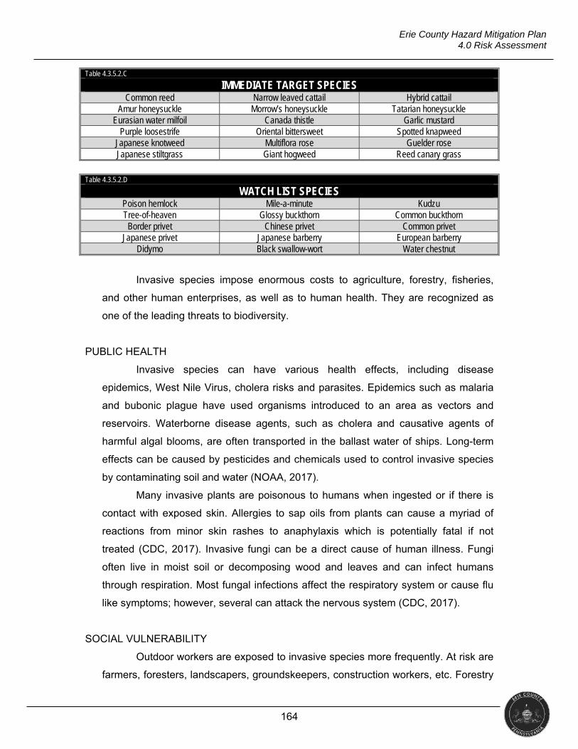
164
Erie County Hazard Mitigation Plan 4.0 Risk Assessment
Table 4.3.5.2.C
IMMEDIATE TARGET SPECIES Common reed Narrow leaved cattail Hybrid cattail
Amur honeysuckle Morrow’s honeysuckle Tatarian honeysuckle Eurasian water milfoil Canada thistle Garlic mustard
Purple loosestrife Oriental bittersweet Spotted knapweed Japanese knotweed Multiflora rose Guelder rose Japanese stiltgrass Giant hogweed Reed canary grass
Table 4.3.5.2.D
WATCH LIST SPECIES Poison hemlock Mile-a-minute Kudzu Tree-of-heaven Glossy buckthorn Common buckthorn Border privet Chinese privet Common privet
Japanese privet Japanese barberry European barberry Didymo Black swallow-wort Water chestnut
Invasive species impose enormous costs to agriculture, forestry, fisheries,
and other human enterprises, as well as to human health. They are recognized as
one of the leading threats to biodiversity.
PUBLIC HEALTH
Invasive species can have various health effects, including disease
epidemics, West Nile Virus, cholera risks and parasites. Epidemics such as malaria
and bubonic plague have used organisms introduced to an area as vectors and
reservoirs. Waterborne disease agents, such as cholera and causative agents of
harmful algal blooms, are often transported in the ballast water of ships. Long-term
effects can be caused by pesticides and chemicals used to control invasive species
by contaminating soil and water (NOAA, 2017).
Many invasive plants are poisonous to humans when ingested or if there is
contact with exposed skin. Allergies to sap oils from plants can cause a myriad of
reactions from minor skin rashes to anaphylaxis which is potentially fatal if not
treated (CDC, 2017). Invasive fungi can be a direct cause of human illness. Fungi
often live in moist soil or decomposing wood and leaves and can infect humans
through respiration. Most fungal infections affect the respiratory system or cause flu
like symptoms; however, several can attack the nervous system (CDC, 2017).
SOCIAL VULNERABILITY
Outdoor workers are exposed to invasive species more frequently. At risk are
farmers, foresters, landscapers, groundskeepers, construction workers, etc. Forestry
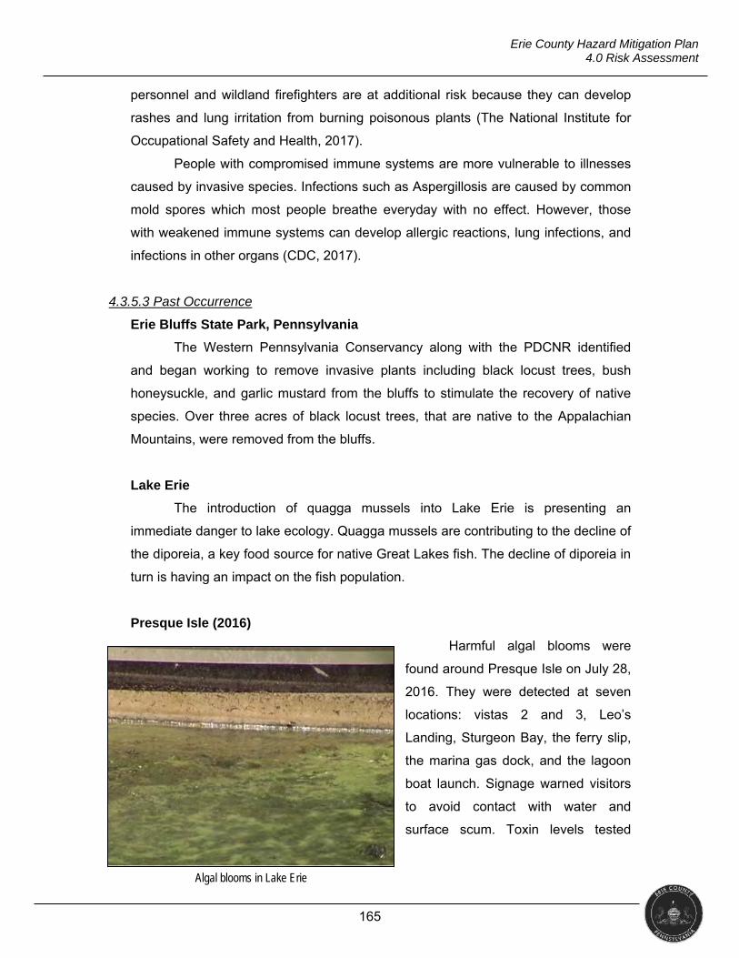
165
Erie County Hazard Mitigation Plan 4.0 Risk Assessment
personnel and wildland firefighters are at additional risk because they can develop
rashes and lung irritation from burning poisonous plants (The National Institute for
Occupational Safety and Health, 2017).
People with compromised immune systems are more vulnerable to illnesses
caused by invasive species. Infections such as Aspergillosis are caused by common
mold spores which most people breathe everyday with no effect. However, those
with weakened immune systems can develop allergic reactions, lung infections, and
infections in other organs (CDC, 2017).
4.3.5.3 Past Occurrence
Erie Bluffs State Park, Pennsylvania
The Western Pennsylvania Conservancy along with the PDCNR identified
and began working to remove invasive plants including black locust trees, bush
honeysuckle, and garlic mustard from the bluffs to stimulate the recovery of native
species. Over three acres of black locust trees, that are native to the Appalachian
Mountains, were removed from the bluffs.
Lake Erie
The introduction of quagga mussels into Lake Erie is presenting an
immediate danger to lake ecology. Quagga mussels are contributing to the decline of
the diporeia, a key food source for native Great Lakes fish. The decline of diporeia in
turn is having an impact on the fish population.
Presque Isle (2016)
Harmful algal blooms were
found around Presque Isle on July 28,
2016. They were detected at seven
locations: vistas 2 and 3, Leo’s
Landing, Sturgeon Bay, the ferry slip,
the marina gas dock, and the lagoon
boat launch. Signage warned visitors
to avoid contact with water and
surface scum. Toxin levels tested
Algal blooms in Lake Erie
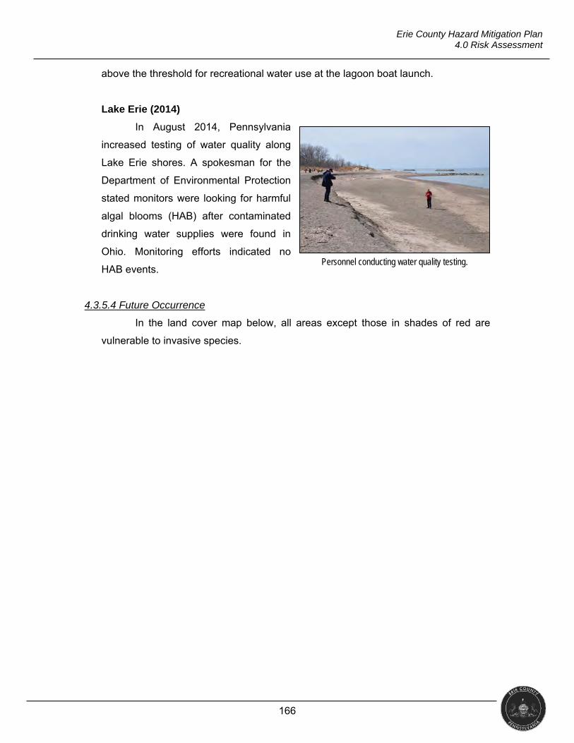
166
Erie County Hazard Mitigation Plan 4.0 Risk Assessment
above the threshold for recreational water use at the lagoon boat launch.
Lake Erie (2014)
In August 2014, Pennsylvania
increased testing of water quality along
Lake Erie shores. A spokesman for the
Department of Environmental Protection
stated monitors were looking for harmful
algal blooms (HAB) after contaminated
drinking water supplies were found in
Ohio. Monitoring efforts indicated no
HAB events.
4.3.5.4 Future Occurrence
In the land cover map below, all areas except those in shades of red are
vulnerable to invasive species.
Personnel conducting water quality testing.
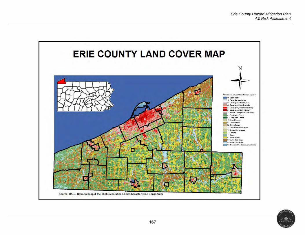
167
Erie County Hazard Mitigation Plan 4.0 Risk Assessment
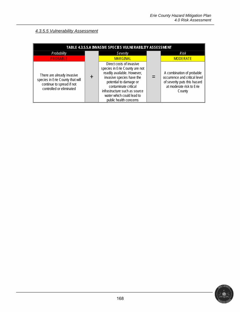
168
Erie County Hazard Mitigation Plan 4.0 Risk Assessment
4.3.5.5 Vulnerability Assessment
TABLE 4.3.5.5.A INVASIVE SPECIES VULNERABILITY ASSESSMENT
Probability
+
Severity
=
Risk PROBABLE MARGINAL MODERATE
There are already invasive species in Erie County that will
continue to spread if not controlled or eliminated
Direct costs of invasive species in Erie County are not
readily available. However, invasive species have the
potential to damage or contaminate critical
infrastructure such as source water which could lead to
public health concerns
A combination of probable occurrence and critical level of severity puts this hazard
at moderate risk to Erie County
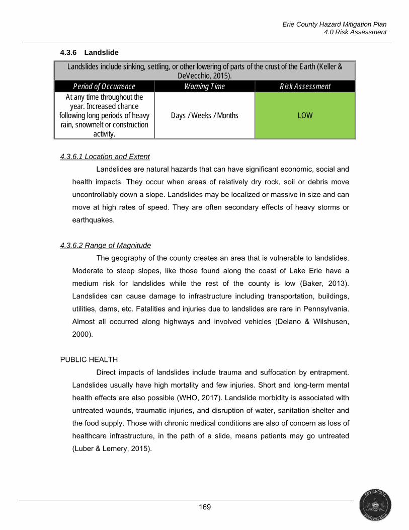
169
Erie County Hazard Mitigation Plan 4.0 Risk Assessment
4.3.6 Landslide
Landslides include sinking, settling, or other lowering of parts of the crust of the Earth (Keller & DeVecchio, 2015).
Period of Occurrence Warning Time Risk Assessment At any time throughout the
year. Increased chance following long periods of heavy rain, snowmelt or construction
activity.
Days / Weeks / Months LOW
4.3.6.1 Location and Extent
Landslides are natural hazards that can have significant economic, social and
health impacts. They occur when areas of relatively dry rock, soil or debris move
uncontrollably down a slope. Landslides may be localized or massive in size and can
move at high rates of speed. They are often secondary effects of heavy storms or
earthquakes.
4.3.6.2 Range of Magnitude
The geography of the county creates an area that is vulnerable to landslides.
Moderate to steep slopes, like those found along the coast of Lake Erie have a
medium risk for landslides while the rest of the county is low (Baker, 2013).
Landslides can cause damage to infrastructure including transportation, buildings,
utilities, dams, etc. Fatalities and injuries due to landslides are rare in Pennsylvania.
Almost all occurred along highways and involved vehicles (Delano & Wilshusen,
2000).
PUBLIC HEALTH
Direct impacts of landslides include trauma and suffocation by entrapment.
Landslides usually have high mortality and few injuries. Short and long-term mental
health effects are also possible (WHO, 2017). Landslide morbidity is associated with
untreated wounds, traumatic injuries, and disruption of water, sanitation shelter and
the food supply. Those with chronic medical conditions are also of concern as loss of
healthcare infrastructure, in the path of a slide, means patients may go untreated
(Luber & Lemery, 2015).
170
Erie County Hazard Mitigation Plan 4.0 Risk Assessment
SOCIAL VULNERABILITY
Although there have not been any instances of large, catastrophic landslides
in Erie County, there is a potential for damage. Landslides can cause death, injuries,
trauma and suffocation from entrapment. Short and long-term mental health effects
have been observed. Depending on the location, these events could cause loss or
damage to homes, infrastructure and critical facilities and block whole communities
off. There is a potential for loss of property value, livestock and crops (WHO).
4.3.6.3 Past Occurrence
As there is no agency – federal, state, or local – tasked with formally
documenting landslide occurrences, the only recorded incidents are the bluff
recession and retreats covered in Section 4.3.1, Coastal Erosion. PennDOT District
1 provided ten years of records that showed multiple occurrences for other counties
in the district, but none within Erie County. PADCNR also reported they had no
information on incidents in the county.
4.3.6.4 Future Occurrence
The PADCNR rates the lake bluffs and stream banks as high and the rest of
the county as low with local areas of high to moderate as shown in the map below.
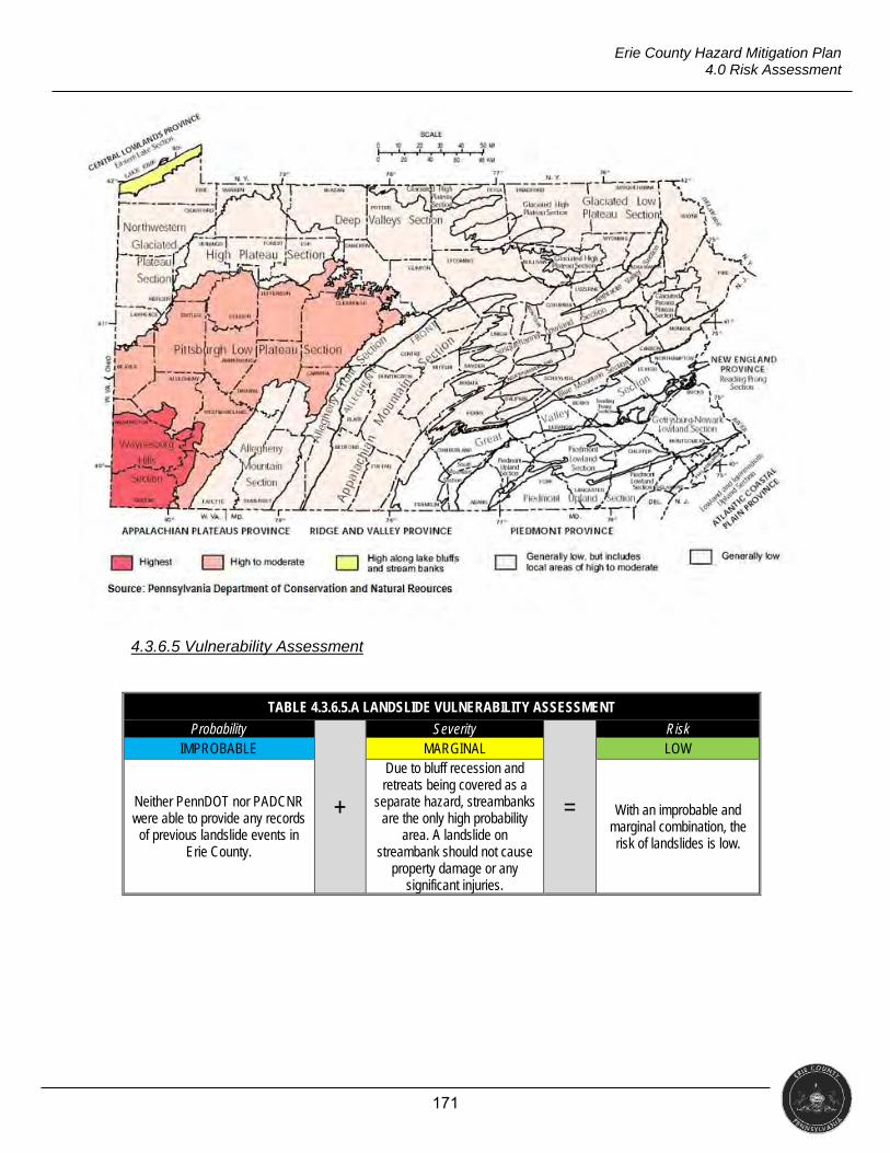
171
Erie County Hazard Mitigation Plan 4.0 Risk Assessment
4.3.6.5 Vulnerability Assessment
TABLE 4.3.6.5.A LANDSLIDE VULNERABILITY ASSESSMENT
Probability
+
Severity
=
Risk IMPROBABLE MARGINAL LOW
Neither PennDOT nor PADCNR were able to provide any records
of previous landslide events in Erie County.
Due to bluff recession and retreats being covered as a
separate hazard, streambanks are the only high probability
area. A landslide on streambank should not cause
property damage or any significant injuries.
With an improbable and marginal combination, the risk of landslides is low.
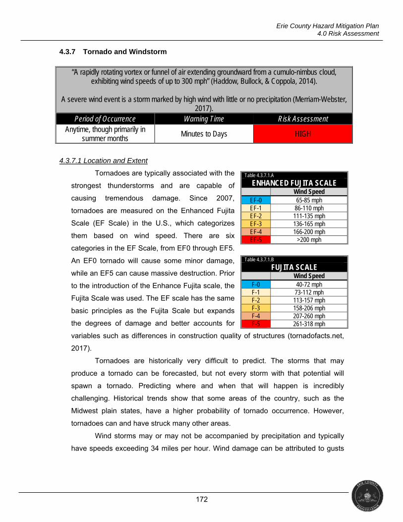
172
Erie County Hazard Mitigation Plan 4.0 Risk Assessment
4.3.7 Tornado and Windstorm
4.3.7.1 Location and Extent
Tornadoes are typically associated with the
strongest thunderstorms and are capable of
causing tremendous damage. Since 2007,
tornadoes are measured on the Enhanced Fujita
Scale (EF Scale) in the U.S., which categorizes
them based on wind speed. There are six
categories in the EF Scale, from EF0 through EF5.
An EF0 tornado will cause some minor damage,
while an EF5 can cause massive destruction. Prior
to the introduction of the Enhance Fujita scale, the
Fujita Scale was used. The EF scale has the same
basic principles as the Fujita Scale but expands
the degrees of damage and better accounts for
variables such as differences in construction quality of structures (tornadofacts.net,
2017).
Tornadoes are historically very difficult to predict. The storms that may
produce a tornado can be forecasted, but not every storm with that potential will
spawn a tornado. Predicting where and when that will happen is incredibly
challenging. Historical trends show that some areas of the country, such as the
Midwest plain states, have a higher probability of tornado occurrence. However,
tornadoes can and have struck many other areas.
Wind storms may or may not be accompanied by precipitation and typically
have speeds exceeding 34 miles per hour. Wind damage can be attributed to gusts
“A rapidly rotating vortex or funnel of air extending groundward from a cumulo-nimbus cloud, exhibiting wind speeds of up to 300 mph” (Haddow, Bullock, & Coppola, 2014).
A severe wind event is a storm marked by high wind with little or no precipitation (Merriam-Webster,
2017). Period of Occurrence Warning Time Risk Assessment
Anytime, though primarily in summer months
Minutes to Days HIGH
Table 4.3.7.1.A
ENHANCED FUJITA SCALE Wind Speed
EF-0 65-85 mph EF-1 86-110 mph EF-2 111-135 mph EF-3 136-165 mph EF-4 166-200 mph EF-5 >200 mph
Table 4.3.7.1.B
FUJITA SCALE Wind Speed
F-0 40-72 mph F-1 73-112 mph F-2 113-157 mph F-3 158-206 mph F-4 207-260 mph F-5 261-318 mph
173
Erie County Hazard Mitigation Plan 4.0 Risk Assessment
or longer periods of stronger sustained winds (Pielke, 2012). These storms include
straight-line winds, downdrafts, downbursts, microbursts, gust fronts, and derechos.
Straight-line winds are damaging winds typically 60 mph or greater. They
travel in a uniform direction as they spread across an area. Straight-line winds have
the potential to be so destructive they have been mistaken for tornadoes. Straight-
line winds inflict damage on a large area, however, unlike tornadoes that are usually
localized. Straight-line winds account for approximately 50% of all severe wind
reports during a given year (Trambley, 2017).
The Beaufort Scale of Wind Force is used to measure wind speed relative to
observed conditions. The scale ranges from zero to 12, with “12” being the strongest
winds. There are two versions of the scale: one for use on land (pictured below) and
one for use at sea. Since the scale is based on observed conditions, it is considered
to be subjective (NWS, 2017).
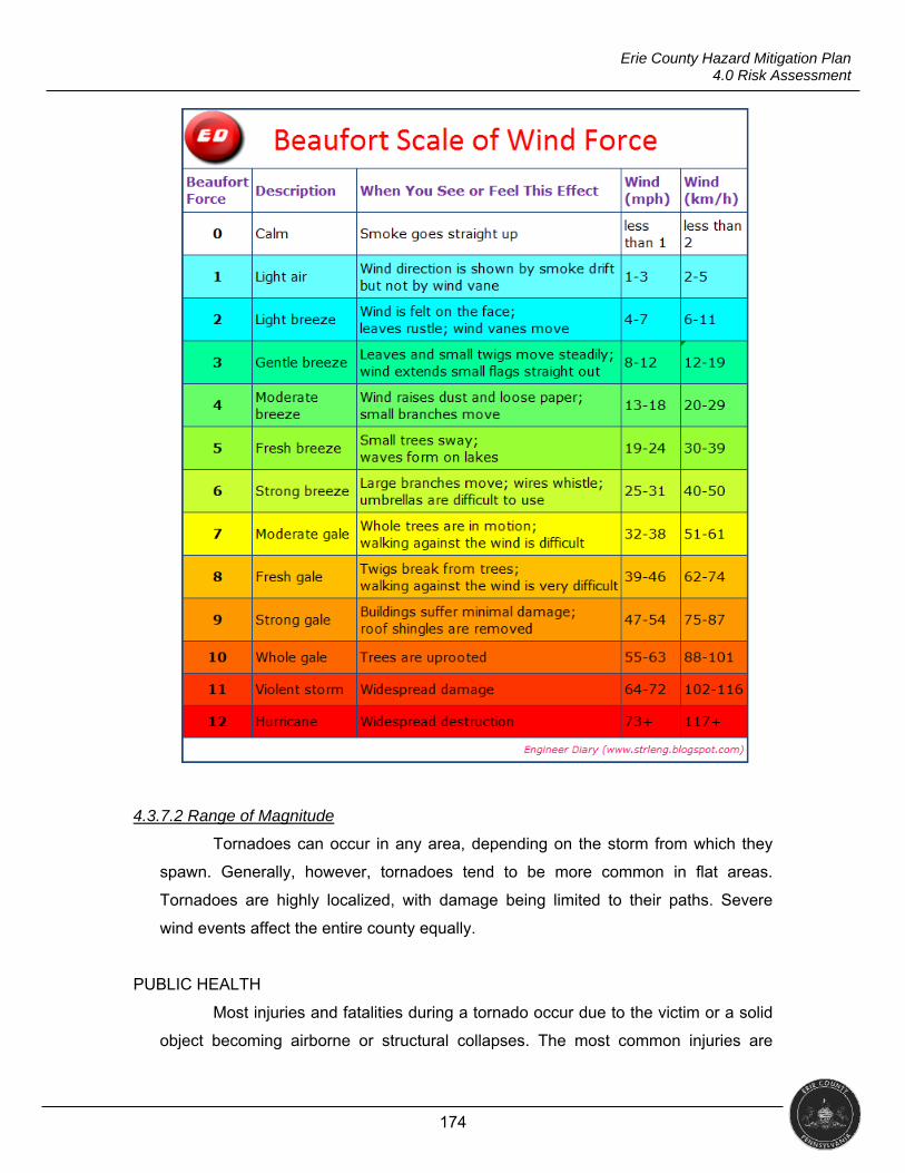
174
Erie County Hazard Mitigation Plan 4.0 Risk Assessment
4.3.7.2 Range of Magnitude
Tornadoes can occur in any area, depending on the storm from which they
spawn. Generally, however, tornadoes tend to be more common in flat areas.
Tornadoes are highly localized, with damage being limited to their paths. Severe
wind events affect the entire county equally.
PUBLIC HEALTH
Most injuries and fatalities during a tornado occur due to the victim or a solid
object becoming airborne or structural collapses. The most common injuries are
175
Erie County Hazard Mitigation Plan 4.0 Risk Assessment
contaminated lacerations, fractures, blunt trauma and head injuries. Most fatalities
occur at the scene and result from trauma such as head, spine or crushing injuries
(Weir, 2000).
Individuals are most frequently injured by flying debris during wind storms,
much like tornadoes. Falling trees and motor vehicle accidents are also common
dangers during wind storms. Post-event injuries and fatalities can be due to power
outages leading to electrocution, fires and burns and carbon monoxide poisoning
from gasoline-powered generators. Exacerbation of chronic illnesses is a risk during
both tornadoes and wind storms.
Many injuries and illnesses occur during cleanup after the disaster.
Inexperienced people using equipment such as chainsaws and the use of electrical
tools in standing water can lead to serious injury. Standing water also attracts insects
that can carry diseases as well as stray animals looking for water to drink (CDC,
2014). Injuries can occur when residents re-enter their damaged homes before
inspections have been completed. Homeowners also fail to wear proper safety
equipment such as goggles and work gloves (CDC, 2014).
Open wounds are of serious concern as they can become infected, leading to
serious complications. Spores of tetanus bacteria are found in the environment,
including soil, dust, and manure, all of which are stirred up during tornadoes and
wind storms and found in sitting water. The risk of tetanus can be minimized by
survivors, responders, and relief workers following standard immunization
recommendations and providing proper wound care (CDC, 2015).
SOCIAL VULNERABILITY
Anyone living in thunderstorm-prone areas are considered at risk since
thunderstorms produce straight-line winds. Those living in mobile homes are
especially at risk for injury and death as even an anchored mobile home can be
seriously damaged when wind gusts exceed 80 mph (NOAA, 2017).
Countywide, there are over 6,900 addressable structures in mobile home
parcels. All municipalities have at least one addressable structure within the mobile
home classification; however, Edinboro Borough, Elgin Borough, McKean Borough
and North East Borough have five structures or less. It is expected that these
municipalities will not be as vulnerable to wind impacts. At the other end of the
spectrum, Millcreek Township has over 1,300 addressable structures in mobile home
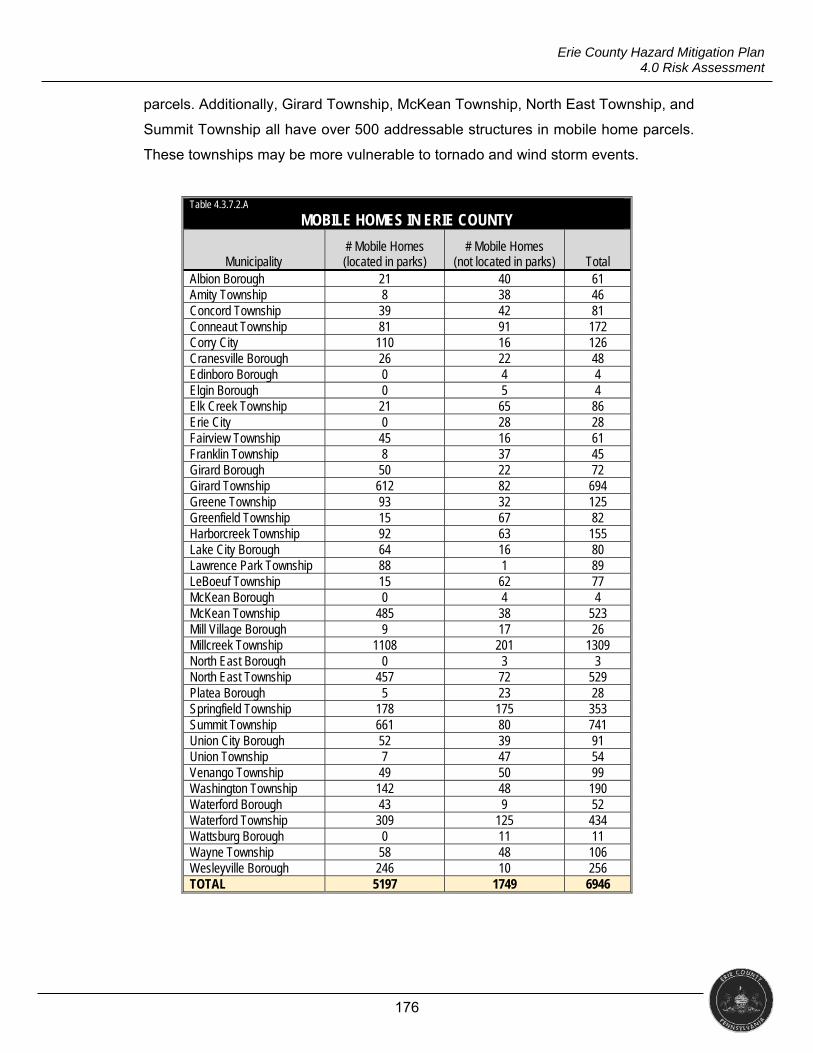
176
Erie County Hazard Mitigation Plan 4.0 Risk Assessment
parcels. Additionally, Girard Township, McKean Township, North East Township, and
Summit Township all have over 500 addressable structures in mobile home parcels.
These townships may be more vulnerable to tornado and wind storm events.
Table 4.3.7.2.A
MOBILE HOMES IN ERIE COUNTY
Municipality
# Mobile Homes (located in parks)
# Mobile Homes (not located in parks) Total
Albion Borough 21 40 61 Amity Township 8 38 46 Concord Township 39 42 81 Conneaut Township 81 91 172 Corry City 110 16 126 Cranesville Borough 26 22 48 Edinboro Borough 0 4 4 Elgin Borough 0 5 4 Elk Creek Township 21 65 86 Erie City 0 28 28 Fairview Township 45 16 61 Franklin Township 8 37 45 Girard Borough 50 22 72 Girard Township 612 82 694 Greene Township 93 32 125 Greenfield Township 15 67 82 Harborcreek Township 92 63 155 Lake City Borough 64 16 80 Lawrence Park Township 88 1 89 LeBoeuf Township 15 62 77 McKean Borough 0 4 4 McKean Township 485 38 523 Mill Village Borough 9 17 26 Millcreek Township 1108 201 1309 North East Borough 0 3 3 North East Township 457 72 529 Platea Borough 5 23 28 Springfield Township 178 175 353 Summit Township 661 80 741 Union City Borough 52 39 91 Union Township 7 47 54 Venango Township 49 50 99 Washington Township 142 48 190 Waterford Borough 43 9 52 Waterford Township 309 125 434 Wattsburg Borough 0 11 11 Wayne Township 58 48 106 Wesleyville Borough 246 10 256 TOTAL 5197 1749 6946
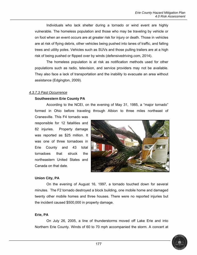
177
Erie County Hazard Mitigation Plan 4.0 Risk Assessment
Individuals who lack shelter during a tornado or wind event are highly
vulnerable. The homeless population and those who may be traveling by vehicle or
on foot when an event occurs are at greater risk for injury or death. Those in vehicles
are at risk of flying debris, other vehicles being pushed into lanes of traffic, and falling
trees and utility poles. Vehicles such as SUVs and those pulling trailers are at a high
risk of being pushed or flipped over by winds (defensivedriving.com, 2014).
The homeless population is at risk as notification methods used for other
populations such as radio, television, and service providers may not be available.
They also face a lack of transportation and the inability to evacuate an area without
assistance (Edgington, 2009).
4.3.7.3 Past Occurrence
Southwestern Erie County PA
According to the NCEI, on the evening of May 31, 1985, a “major tornado”
formed in Ohio before traveling through Albion to three miles northeast of
Cranesville. This F4 tornado was
responsible for 12 fatalities and
82 injuries. Property damage
was reported as $25 million. It
was one of three tornadoes in
Erie County and 43 total
tornadoes that struck the
northeastern United States and
Canada on that date.
Union City, PA
On the evening of August 16, 1997, a tornado touched down for several
minutes. The F2 tornado destroyed a block building, one mobile home and damaged
twenty other mobile homes and three houses. There were no reported injuries but
the incident caused $500,000 in property damage.
Erie, PA
On July 26, 2005, a line of thunderstorms moved off Lake Erie and into
Northern Erie County. Winds of 60 to 70 mph accompanied the storm. A concert at
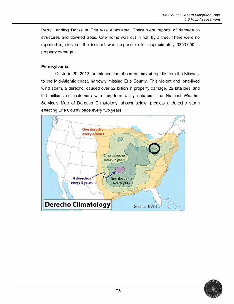
178
Erie County Hazard Mitigation Plan 4.0 Risk Assessment
Perry Landing Docks in Erie was evacuated. There were reports of damage to
structures and downed trees. One home was cut in half by a tree. There were no
reported injuries but the incident was responsible for approximately $250,000 in
property damage.
Pennsylvania
On June 29, 2012, an intense line of storms moved rapidly from the Midwest
to the Mid-Atlantic coast, narrowly missing Erie County. This violent and long-lived
wind storm, a derecho, caused over $2 billion in property damage, 22 fatalities, and
left millions of customers with long-term utility outages. The National Weather
Service’s Map of Derecho Climatology, shown below, predicts a derecho storm
effecting Erie County once every two years.
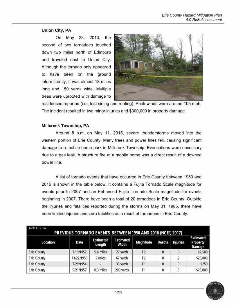
179
Erie County Hazard Mitigation Plan 4.0 Risk Assessment
Union City, PA
On May 28, 2013, the
second of two tornadoes touched
down two miles north of Edinboro
and traveled east to Union City.
Although the tornado only appeared
to have been on the ground
intermittently, it was almost 18 miles
long and 150 yards wide. Multiple
trees were uprooted with damage to
residences reported (i.e., lost siding and roofing). Peak winds were around 105 mph.
The incident resulted in two minor injuries and $300,000 in property damage.
Millcreek Township, PA
Around 8 p.m. on May 11, 2015, severe thunderstorms moved into the
western portion of Erie County. Many trees and power lines fell, causing significant
damage to a mobile home park in Millcreek Township. Evacuations were necessary
due to a gas leak. A structure fire at a mobile home was a direct result of a downed
power line.
A list of tornado events that have occurred in Erie County between 1950 and
2016 is shown in the table below. It contains a Fujita Tornado Scale magnitude for
events prior to 2007 and an Enhanced Fujita Tornado Scale magnitude for events
beginning in 2007. There have been a total of 20 tornadoes in Erie County. Outside
the injuries and fatalities reported during the storms on May 31, 1985, there have
been limited injuries and zero fatalities as a result of tornadoes in Erie County.
Table 4.3.7.3.A
PREVIOUS TORNADO EVENTS BETWEEN 1950 AND 2016 (NCEI, 2017)
Location Date Estimated Length
Estimated Width
Magnitude Deaths Injuries Estimated Property Damage
Erie County 7/19/1952 5.6 miles 27 yards F2 0 0 $2,500
Erie County 11/22/1953 2 miles 67 yards F2 0 2 $25,000
Erie County 7/29/1954 - 33 yards F1 0 0 $250
Erie County 9/21/1957 0.3 miles 200 yards F1 0 3 $25,000
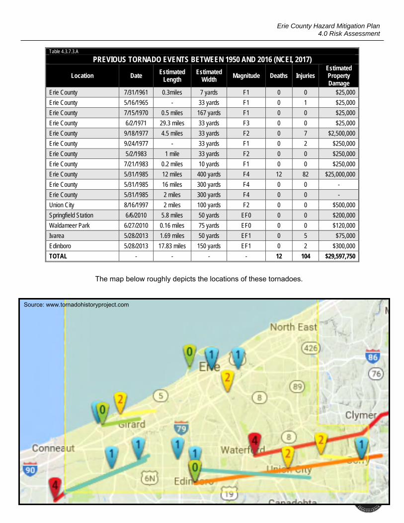
180
Erie County Hazard Mitigation Plan 4.0 Risk Assessment
Table 4.3.7.3.A
PREVIOUS TORNADO EVENTS BETWEEN 1950 AND 2016 (NCEI, 2017)
Location Date Estimated Length
Estimated Width
Magnitude Deaths Injuries Estimated Property Damage
Erie County 7/31/1961 0.3miles 7 yards F1 0 0 $25,000
Erie County 5/16/1965 - 33 yards F1 0 1 $25,000
Erie County 7/15/1970 0.5 miles 167 yards F1 0 0 $25,000
Erie County 6/2/1971 29.3 miles 33 yards F3 0 0 $25,000
Erie County 9/18/1977 4.5 miles 33 yards F2 0 7 $2,500,000
Erie County 9/24/1977 - 33 yards F1 0 2 $250,000
Erie County 5/2/1983 1 mile 33 yards F2 0 0 $250,000
Erie County 7/21/1983 0.2 miles 10 yards F1 0 0 $250,000
Erie County 5/31/1985 12 miles 400 yards F4 12 82 $25,000,000
Erie County 5/31/1985 16 miles 300 yards F4 0 0 -
Erie County 5/31/1985 2 miles 300 yards F4 0 0 -
Union City 8/16/1997 2 miles 100 yards F2 0 0 $500,000
Springfield Station 6/6/2010 5.8 miles 50 yards EF0 0 0 $200,000
Waldameer Park 6/27/2010 0.16 miles 75 yards EF0 0 0 $120,000
Ivarea 5/28/2013 1.69 miles 50 yards EF1 0 5 $75,000
Edinboro 5/28/2013 17.83 miles 150 yards EF1 0 2 $300,000
TOTAL - - - - 12 104 $29,597,750
The map below roughly depicts the locations of these tornadoes.
Source: www.tornadohistoryproject.com
181
Erie County Hazard Mitigation Plan 4.0 Risk Assessment
NCEI has seven wind storm categories: high wind, strong wind, thunderstorm
wind, hurricane, marine high wind, marine strong wind, and marine thunderstorm
wind. A list of significant wind storms occurring between 1950 and 2016 is shown in
the table below. These events had winds greater than 60 knots, property damage of
at least $5,000, and/or a direct injury or death. (The list is not exhaustive.) There
have been a total of 402 wind storm events in this time period. These events have
resulted in a total of 19 direct injuries (with 12 of them occurring during one event on
April 12, 1996) and one reported fatality from a wind storm in Erie County. NCEI
reports total property damage of $13,596,000.
Table 4.3.7.3.B
SIGNIFICANT WINDSTORM EVENTS 1950-2016 (NCEI, 2017)
Location Date Event Type Wind
Speed in Knots
Deaths Injuries Property Damage
Erie County 6/23/1956 Thunderstorm Wind 61 0 0 0
Erie County 11/1/1959 Thunderstorm Wind 70 0 0 0
Erie County 6/19/1964 Thunderstorm Wind 62 0 0 0
Erie County 4/11/1965 Thunderstorm Wind 70 0 0 0
Erie County 9/15/1965 Thunderstorm Wind 70 0 0 0
Erie County 9/15/1965 Thunderstorm Wind 73 0 0 0
Erie County 2/15/1967 Thunderstorm Wind 60 0 0 0
Erie County 6/15/1982 Thunderstorm Wind 65 0 0 0
Erie County 9/6/1983 Thunderstorm Wind 69 0 0 0
Erie County 10/13/1983 Thunderstorm Wind 66 0 0 0
Erie County 7/30/1988 Thunderstorm Wind - 0 4 0
Erie County 8/22/1989 Thunderstorm Wind - 0 1 0
Erie County 8/22/1989 Thunderstorm Wind - 0 1 0
Erie 8/4/1994 Thunderstorm Wind - 0 0 $5,000
West Springfield 8/12/1994 Thunderstorm Wind - 0 0 $5,000
Erie 8/13/1994 Thunderstorm Wind - 0 0 $5,000
Corry 8/14/1994 Thunderstorm Wind - 0 0 $5,000
Western Erie County 7/13/1995 Thunderstorm Wind - 0 0 $15,000
Elgin 7/15/1995 Thunderstorm Wind - 0 0 $45,000
Northern Erie County 1/18/1996 High Wind 50 0 0 $5,000
Northern Erie County 2/11/1996 High Wind 63 0 0 $3,000
Erie County 4/12/1996 Thunderstorm Wind 61 0 12 $800,000
Erie County 8/8/1996 Thunderstorm Wind - 0 0 $5,000
Erie County 8/15/1996 Thunderstorm Wind - 0 0 $100,000
182
Erie County Hazard Mitigation Plan 4.0 Risk Assessment
Table 4.3.7.3.B
SIGNIFICANT WINDSTORM EVENTS 1950-2016 (NCEI, 2017)
Location Date Event Type Wind
Speed in Knots
Deaths Injuries Property Damage
Erie County 8/15/1996 Thunderstorm Wind 50 0 0 $5,000
Northern Erie County 9/4/1996 Strong Wind - 0 0 $5,000
Edinboro 2/22/1997 Thunderstorm Wind 60 0 0 $5,000
Erie 5/6/1997 Thunderstorm Wind 55 0 0 $20,000
Wattsburg 6/25/1997 Thunderstorm Wind - 0 0 $50,000
Edinboro 7/2/1997 Thunderstorm Wind - 0 0 $15,000
Erie 8/16/1997 Thunderstorm Wind - 0 0 $50,000
Edinboro 8/16/1997 Thunderstorm Wind - 0 0 $5,000
Northern Erie County 3/8/1998 High Wind - 0 0 $50,000
Corry 5/29/1998 Thunderstorm Wind - 0 0 $5,000
Girard 6/16/1998 Thunderstorm Wind - 0 0 $5,000
Erie County 7/21/1998 Thunderstorm Wind - 0 0 $25,000
Union City 7/21/1998 Thunderstorm Wind - 0 0 $10,000
Erie County 8/24/1998 Thunderstorm Wind 52 0 0 $30,000
Erie County 11/10/1998 Thunderstorm Wind - 0 0 $10,000
Northern Erie County 3/17/1999 High Wind - 0 0 $10,000
Corry 6/10/1999 Thunderstorm Wind - 0 0 $25,000
Erie County 7/9/1999 Thunderstorm Wind - 0 0 $120,000
Erie County 7/31/1999 Thunderstorm Wind - 0 0 $60,000
Erie County 9/29/1999 Thunderstorm Wind - 0 0 $70,000
Erie 10/13/1999 Thunderstorm Wind - 0 0 $20,000
Erie County 10/13/1999 Thunderstorm Wind - 0 0 $25,000
Erie County 5/17/2000 Thunderstorm Wind - 0 0 $75,000
Erie 5/18/2000 Thunderstorm Wind - 0 0 $15,000
Edinboro 5/31/2000 Thunderstorm Wind - 0 0 $5,000
Girard 6/14/2000 Thunderstorm Wind - 0 0 $10,000
Waterford 6/24/2000 Thunderstorm Wind 64 0 0 $25,000
Erie 8/2/2000 Thunderstorm Wind - 0 0 $10,000
Erie 8/2/2000 Thunderstorm Wind - 0 0 $5,000
Erie County 9/20/2000 Thunderstorm Wind - 0 0 $10,000
Erie 10/4/2000 Thunderstorm Wind - 0 0 $100,000
Southern Erie County 12/12/2000 High Wind - 0 0 $150,000
Northern Erie County 12/12/2000 High Wind - 0 0 $200,000
Northern Erie County 2/9/2001 High Wind - 0 0 $100,000
Southern Erie County 2/9/2001 High Wind - 0 0 $20,000
Southern Erie County 2/25/2001 High Wind - 0 0 $15,000
Northern Erie County 2/25/2001 High Wind - 0 0 $20,000
183
Erie County Hazard Mitigation Plan 4.0 Risk Assessment
Table 4.3.7.3.B
SIGNIFICANT WINDSTORM EVENTS 1950-2016 (NCEI, 2017)
Location Date Event Type Wind
Speed in Knots
Deaths Injuries Property Damage
North East 7/10/2001 Thunderstorm Wind - 0 0 $500,000
Erie 8/26/2001 Thunderstorm Wind 57 0 0 $50,000
Erie 8/31/2001 Thunderstorm Wind - 0 0 $15,000
Northern Erie County 10/16/2001 High Wind - 0 0 $20,000
Southern Erie County 10/16/2001 High Wind - 0 0 $10,000
Erie County 10/25/2001 Thunderstorm Wind - 0 0 $15,000
Northern Erie County 10/25/2001 High Wind - 0 0 $25,000
Southern Erie County 10/25/2001 High Wind - 0 0 $20,000
Northern Erie County 2/1/2002 High Wind - 0 0 $35,000
Southern Erie County 2/1/2002 High Wind - 0 0 $25,000
Northern Erie County 3/9/2002 High Wind - 0 0 $250,000
Southern Erie County 3/9/2002 High Wind - 0 0 $150,000
Erie International Airport 4/28/2002 Thunderstorm Wind 55 0 0 $250,000
Erie County 4/28/2002 Thunderstorm Wind - 0 0 $250,000
Corry 5/9/2002 Thunderstorm Wind - 0 0 $100,000
Albion 6/5/2002 Thunderstorm Wind - 0 0 $10,000
Union City 6/14/2002 Thunderstorm Wind - 0 0 $5,000
Corry 7/27/2002 Thunderstorm Wind - 0 0 $30,000
Erie County 7/28/2002 Thunderstorm Wind - 0 0 $20,000
Corry 7/28/2002 Thunderstorm Wind - 0 0 $5,000
Union City 7/28/2002 Thunderstorm Wind - 0 0 $10,000
Erie 7/29/2002 Thunderstorm Wind - 0 0 $5,000
Northern Erie County 10/4/2002 High Wind - 0 0 $75,000
Southern Erie County 10/4/2002 High Wind - 0 0 $25,000
Northern Erie County 2/4/2003 Strong Wind 46 0 0 $250,000
Southern Erie County 2/4/2003 Strong Wind 43 0 0 $50,000
Northern Erie County 2/12/2003 High Wind 53 0 0 $50,000
Southern Erie County 2/12/2003 High Wind 50 0 0 $35,000
Northern Erie County 5/5/2003 Strong Wind 41 0 0 $75,000
Northern Erie County 5/11/2003 Strong Wind 38 0 0 $50,000
Southern Erie County 5/11/2003 Strong Wind 35 0 0 $25,000
Girard 8/5/2003 Thunderstorm Wind 50 0 0 $5,000
North East 8/16/2003 Thunderstorm Wind 50 0 0 $50,000
Erie 8/16/2003 Thunderstorm Wind 50 0 0 $10,000
Lake City 8/26/2003 Thunderstorm Wind 50 0 0 $25,000
Northern Erie County 10/14/2003 Strong Wind 35 0 0 $50,000
Southern Erie County 10/14/2003 Strong Wind 35 0 0 $30,000
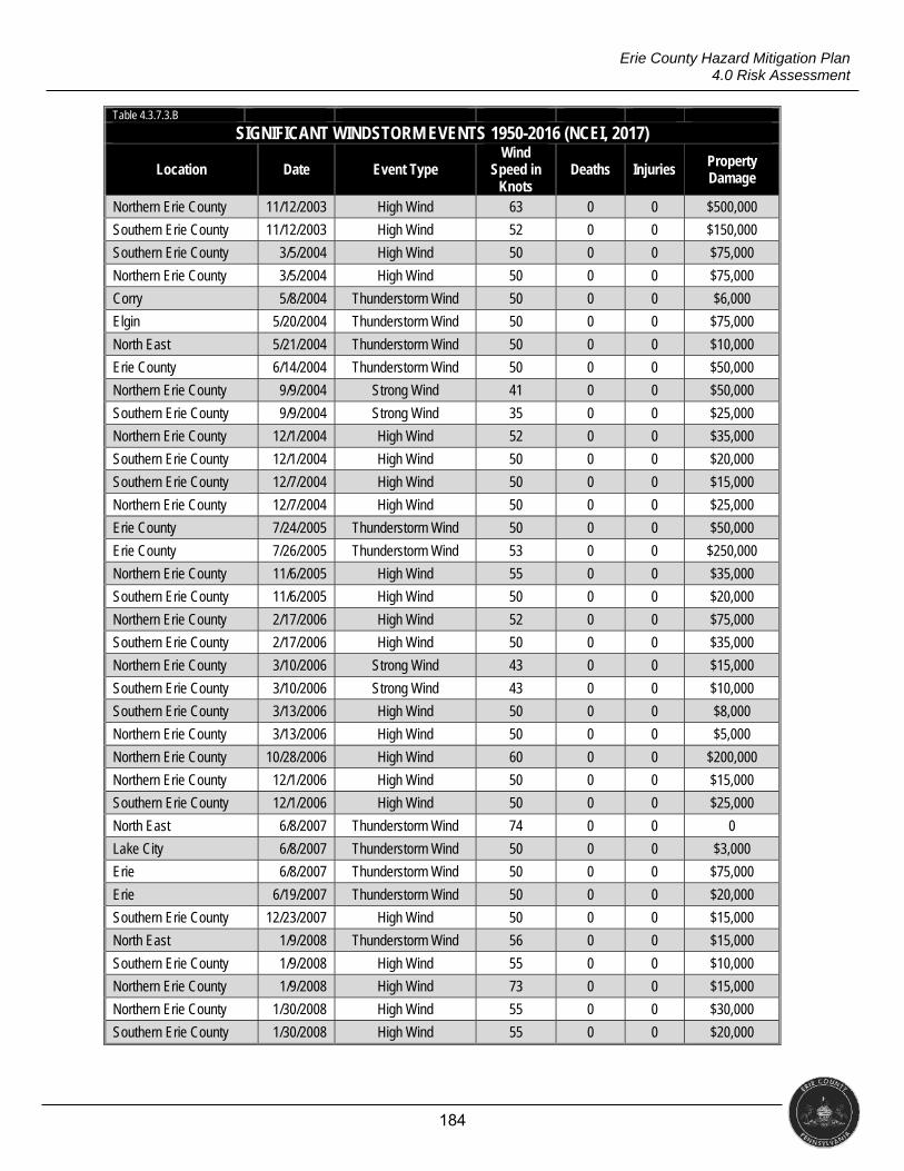
184
Erie County Hazard Mitigation Plan 4.0 Risk Assessment
Table 4.3.7.3.B
SIGNIFICANT WINDSTORM EVENTS 1950-2016 (NCEI, 2017)
Location Date Event Type Wind
Speed in Knots
Deaths Injuries Property Damage
Northern Erie County 11/12/2003 High Wind 63 0 0 $500,000
Southern Erie County 11/12/2003 High Wind 52 0 0 $150,000
Southern Erie County 3/5/2004 High Wind 50 0 0 $75,000
Northern Erie County 3/5/2004 High Wind 50 0 0 $75,000
Corry 5/8/2004 Thunderstorm Wind 50 0 0 $6,000
Elgin 5/20/2004 Thunderstorm Wind 50 0 0 $75,000
North East 5/21/2004 Thunderstorm Wind 50 0 0 $10,000
Erie County 6/14/2004 Thunderstorm Wind 50 0 0 $50,000
Northern Erie County 9/9/2004 Strong Wind 41 0 0 $50,000
Southern Erie County 9/9/2004 Strong Wind 35 0 0 $25,000
Northern Erie County 12/1/2004 High Wind 52 0 0 $35,000
Southern Erie County 12/1/2004 High Wind 50 0 0 $20,000
Southern Erie County 12/7/2004 High Wind 50 0 0 $15,000
Northern Erie County 12/7/2004 High Wind 50 0 0 $25,000
Erie County 7/24/2005 Thunderstorm Wind 50 0 0 $50,000
Erie County 7/26/2005 Thunderstorm Wind 53 0 0 $250,000
Northern Erie County 11/6/2005 High Wind 55 0 0 $35,000
Southern Erie County 11/6/2005 High Wind 50 0 0 $20,000
Northern Erie County 2/17/2006 High Wind 52 0 0 $75,000
Southern Erie County 2/17/2006 High Wind 50 0 0 $35,000
Northern Erie County 3/10/2006 Strong Wind 43 0 0 $15,000
Southern Erie County 3/10/2006 Strong Wind 43 0 0 $10,000
Southern Erie County 3/13/2006 High Wind 50 0 0 $8,000
Northern Erie County 3/13/2006 High Wind 50 0 0 $5,000
Northern Erie County 10/28/2006 High Wind 60 0 0 $200,000
Northern Erie County 12/1/2006 High Wind 50 0 0 $15,000
Southern Erie County 12/1/2006 High Wind 50 0 0 $25,000
North East 6/8/2007 Thunderstorm Wind 74 0 0 0
Lake City 6/8/2007 Thunderstorm Wind 50 0 0 $3,000
Erie 6/8/2007 Thunderstorm Wind 50 0 0 $75,000
Erie 6/19/2007 Thunderstorm Wind 50 0 0 $20,000
Southern Erie County 12/23/2007 High Wind 50 0 0 $15,000
North East 1/9/2008 Thunderstorm Wind 56 0 0 $15,000
Southern Erie County 1/9/2008 High Wind 55 0 0 $10,000
Northern Erie County 1/9/2008 High Wind 73 0 0 $15,000
Northern Erie County 1/30/2008 High Wind 55 0 0 $30,000
Southern Erie County 1/30/2008 High Wind 55 0 0 $20,000
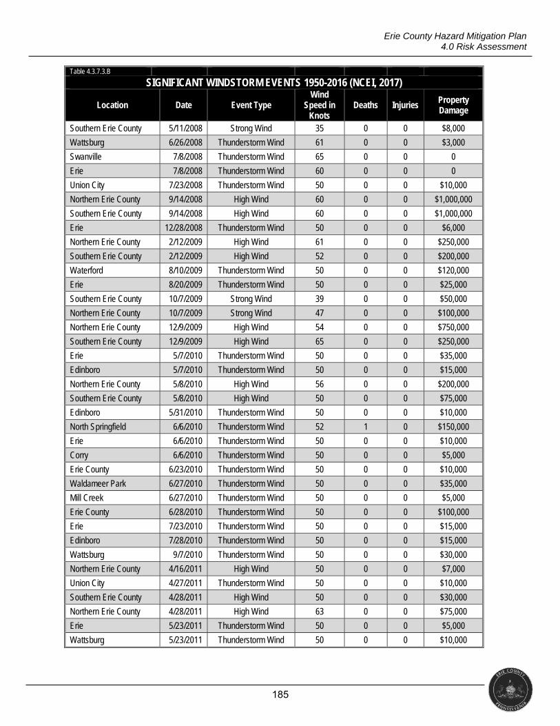
185
Erie County Hazard Mitigation Plan 4.0 Risk Assessment
Table 4.3.7.3.B
SIGNIFICANT WINDSTORM EVENTS 1950-2016 (NCEI, 2017)
Location Date Event Type Wind
Speed in Knots
Deaths Injuries Property Damage
Southern Erie County 5/11/2008 Strong Wind 35 0 0 $8,000
Wattsburg 6/26/2008 Thunderstorm Wind 61 0 0 $3,000
Swanville 7/8/2008 Thunderstorm Wind 65 0 0 0
Erie 7/8/2008 Thunderstorm Wind 60 0 0 0
Union City 7/23/2008 Thunderstorm Wind 50 0 0 $10,000
Northern Erie County 9/14/2008 High Wind 60 0 0 $1,000,000
Southern Erie County 9/14/2008 High Wind 60 0 0 $1,000,000
Erie 12/28/2008 Thunderstorm Wind 50 0 0 $6,000
Northern Erie County 2/12/2009 High Wind 61 0 0 $250,000
Southern Erie County 2/12/2009 High Wind 52 0 0 $200,000
Waterford 8/10/2009 Thunderstorm Wind 50 0 0 $120,000
Erie 8/20/2009 Thunderstorm Wind 50 0 0 $25,000
Southern Erie County 10/7/2009 Strong Wind 39 0 0 $50,000
Northern Erie County 10/7/2009 Strong Wind 47 0 0 $100,000
Northern Erie County 12/9/2009 High Wind 54 0 0 $750,000
Southern Erie County 12/9/2009 High Wind 65 0 0 $250,000
Erie 5/7/2010 Thunderstorm Wind 50 0 0 $35,000
Edinboro 5/7/2010 Thunderstorm Wind 50 0 0 $15,000
Northern Erie County 5/8/2010 High Wind 56 0 0 $200,000
Southern Erie County 5/8/2010 High Wind 50 0 0 $75,000
Edinboro 5/31/2010 Thunderstorm Wind 50 0 0 $10,000
North Springfield 6/6/2010 Thunderstorm Wind 52 1 0 $150,000
Erie 6/6/2010 Thunderstorm Wind 50 0 0 $10,000
Corry 6/6/2010 Thunderstorm Wind 50 0 0 $5,000
Erie County 6/23/2010 Thunderstorm Wind 50 0 0 $10,000
Waldameer Park 6/27/2010 Thunderstorm Wind 50 0 0 $35,000
Mill Creek 6/27/2010 Thunderstorm Wind 50 0 0 $5,000
Erie County 6/28/2010 Thunderstorm Wind 50 0 0 $100,000
Erie 7/23/2010 Thunderstorm Wind 50 0 0 $15,000
Edinboro 7/28/2010 Thunderstorm Wind 50 0 0 $15,000
Wattsburg 9/7/2010 Thunderstorm Wind 50 0 0 $30,000
Northern Erie County 4/16/2011 High Wind 50 0 0 $7,000
Union City 4/27/2011 Thunderstorm Wind 50 0 0 $10,000
Southern Erie County 4/28/2011 High Wind 50 0 0 $30,000
Northern Erie County 4/28/2011 High Wind 63 0 0 $75,000
Erie 5/23/2011 Thunderstorm Wind 50 0 0 $5,000
Wattsburg 5/23/2011 Thunderstorm Wind 50 0 0 $10,000
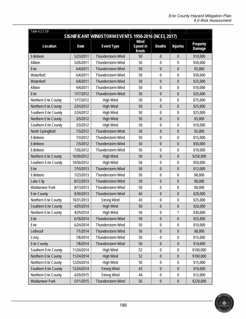
186
Erie County Hazard Mitigation Plan 4.0 Risk Assessment
Table 4.3.7.3.B
SIGNIFICANT WINDSTORM EVENTS 1950-2016 (NCEI, 2017)
Location Date Event Type Wind
Speed in Knots
Deaths Injuries Property Damage
Edinboro 5/23/2011 Thunderstorm Wind 50 0 0 $10,000
Albion 5/26/2011 Thunderstorm Wind 50 0 0 $50,000
Erie 6/4/2011 Thunderstorm Wind 50 0 0 $5,000
Waterford 6/4/2011 Thunderstorm Wind 50 0 0 $30,000
Waterford 6/4/2011 Thunderstorm Wind 50 0 0 $25,000
Albion 9/4/2011 Thunderstorm Wind 50 0 0 $10,000
Erie 1/17/2012 Thunderstorm Wind 50 0 0 $25,000
Northern Erie County 1/17/2012 High Wind 50 0 0 $75,000
Northern Erie County 2/24/2012 High Wind 50 0 0 $25,000
Southern Erie County 2/24/2012 High Wind 50 0 0 $25,000
Northern Erie County 3/3/2012 High Wind 50 0 0 $5,000
Southern Erie County 3/3/2012 High Wind 50 0 0 $10,000
North Springfield 7/3/2012 Thunderstorm Wind 50 0 0 $5,000
Edinboro 7/3/2012 Thunderstorm Wind 50 0 0 $15,000
Edinboro 7/3/2012 Thunderstorm Wind 50 0 0 $50,000
Edinboro 7/26/2012 Thunderstorm Wind 50 0 0 $10,000
Northern Erie County 10/30/2012 High Wind 50 0 0 $250,000
Southern Erie County 10/30/2012 High Wind 50 0 0 $50,000
Erie 7/10/2013 Thunderstorm Wind 50 0 0 $12,000
Edinboro 7/23/2013 Thunderstorm Wind 50 0 0 $8,000
Lake City 8/12/2013 Thunderstorm Wind 50 0 0 $8,000
Waldameer Park 8/13/2013 Thunderstorm Wind 50 0 0 $8,000
Erie County 8/30/2013 Thunderstorm Wind 60 0 0 $20,000
Northern Erie County 10/31/2013 Strong Wind 43 0 0 $25,000
Southern Erie County 4/29/2014 High Wind 50 0 0 $20,000
Northern Erie County 4/29/2014 High Wind 50 0 1 $30,000
Erie 6/18/2014 Thunderstorm Wind 50 0 0 $25,000
Erie 6/24/2014 Thunderstorm Wind 50 0 0 $10,000
LeBeouf 7/1/2014 Thunderstorm Wind 50 0 0 $8,000
Corry 7/8/2014 Thunderstorm Wind 50 0 0 $15,000
Erie County 7/8/2014 Thunderstorm Wind 50 0 0 $14,000
Southern Erie County 11/24/2014 High Wind 52 0 0 $100,000
Northern Erie County 11/24/2014 High Wind 52 0 0 $100,000
Northern Erie County 12/24/2014 High Wind 50 0 0 $15,000
Southern Erie County 12/24/2014 Strong Wind 43 0 0 $10,000
Northern Erie County 4/20/2015 Strong Wind 44 0 0 $12,000
Waldameer Park 5/11/2015 Thunderstorm Wind 56 0 0 $220,000
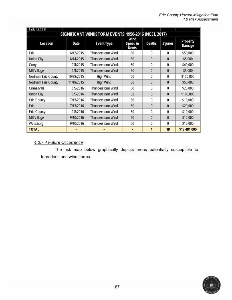
187
Erie County Hazard Mitigation Plan 4.0 Risk Assessment
Table 4.3.7.3.B
SIGNIFICANT WINDSTORM EVENTS 1950-2016 (NCEI, 2017)
Location Date Event Type Wind
Speed in Knots
Deaths Injuries Property Damage
Erie 6/12/2015 Thunderstorm Wind 50 0 0 $50,000
Union City 6/14/2015 Thunderstorm Wind 50 0 0 $5,000
Corry 9/4/2015 Thunderstorm Wind 50 0 0 $40,000
Mill Village 9/4/2015 Thunderstorm Wind 50 0 0 $5,000
Northern Erie County 10/28/2015 High Wind 50 0 0 $150,000
Northern Erie County 11/18/2015 High Wind 50 0 0 $50,000
Cranesville 6/5/2016 Thunderstorm Wind 50 0 0 $25,000
Union City 6/5/2016 Thunderstorm Wind 52 0 0 $100,000
Erie County 7/13/2016 Thunderstorm Wind 50 0 0 $10,000
Erie 7/13/2016 Thunderstorm Wind 50 0 0 $20,000
Erie County 9/8/2016 Thunderstorm Wind 50 0 0 $10,000
Mill Village 9/10/2016 Thunderstorm Wind 50 0 0 $12,000
Wattsburg 9/10/2016 Thunderstorm Wind 50 0 0 $15,000
TOTAL - - - 1 19 $13,481,000
4.3.7.4 Future Occurrence
The risk map below graphically depicts areas potentially susceptible to
tornadoes and windstorms.
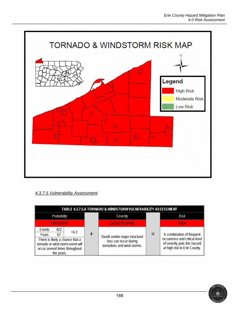
188
Erie County Hazard Mitigation Plan 4.0 Risk Assessment
4.3.7.5 Vulnerability Assessment
TABLE 4.3.7.5.A TORNADO & WINDSTORM VULNERABILITY ASSESSMENT
Probability
+
Severity
=
Risk
FREQUENT CATASTROPHIC HIGH
Events 422 =6.3
Death and/or major structural loss can occur during
tornadoes and wind storms.
A combination of frequent occurrence and critical level of severity puts this hazard at high risk to Erie County.
Years 67 There is likely a chance that a
tornado or wind storm event will occur several times throughout
the years.
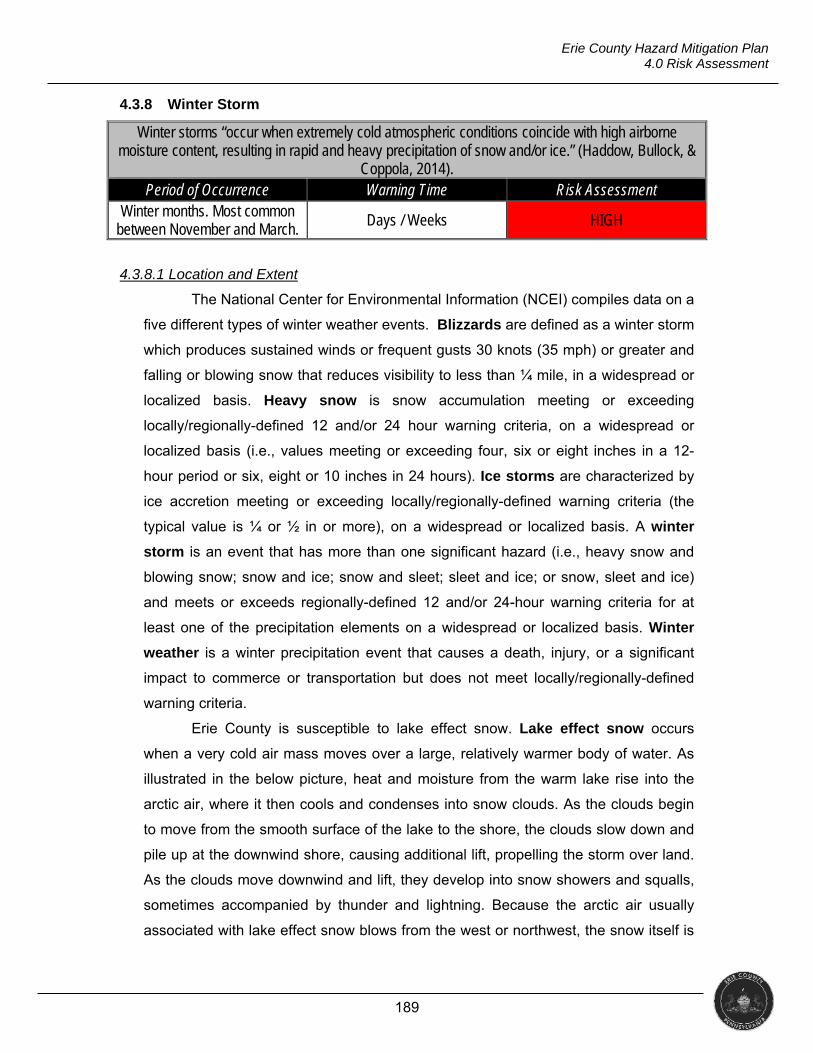
189
Erie County Hazard Mitigation Plan 4.0 Risk Assessment
4.3.8 Winter Storm
Winter storms “occur when extremely cold atmospheric conditions coincide with high airborne moisture content, resulting in rapid and heavy precipitation of snow and/or ice.” (Haddow, Bullock, &
Coppola, 2014). Period of Occurrence Warning Time Risk Assessment
Winter months. Most common between November and March.
Days / Weeks HIGH
4.3.8.1 Location and Extent
The National Center for Environmental Information (NCEI) compiles data on a
five different types of winter weather events. Blizzards are defined as a winter storm
which produces sustained winds or frequent gusts 30 knots (35 mph) or greater and
falling or blowing snow that reduces visibility to less than ¼ mile, in a widespread or
localized basis. Heavy snow is snow accumulation meeting or exceeding
locally/regionally-defined 12 and/or 24 hour warning criteria, on a widespread or
localized basis (i.e., values meeting or exceeding four, six or eight inches in a 12-
hour period or six, eight or 10 inches in 24 hours). Ice storms are characterized by
ice accretion meeting or exceeding locally/regionally-defined warning criteria (the
typical value is ¼ or ½ in or more), on a widespread or localized basis. A winter
storm is an event that has more than one significant hazard (i.e., heavy snow and
blowing snow; snow and ice; snow and sleet; sleet and ice; or snow, sleet and ice)
and meets or exceeds regionally-defined 12 and/or 24-hour warning criteria for at
least one of the precipitation elements on a widespread or localized basis. Winter
weather is a winter precipitation event that causes a death, injury, or a significant
impact to commerce or transportation but does not meet locally/regionally-defined
warning criteria.
Erie County is susceptible to lake effect snow. Lake effect snow occurs
when a very cold air mass moves over a large, relatively warmer body of water. As
illustrated in the below picture, heat and moisture from the warm lake rise into the
arctic air, where it then cools and condenses into snow clouds. As the clouds begin
to move from the smooth surface of the lake to the shore, the clouds slow down and
pile up at the downwind shore, causing additional lift, propelling the storm over land.
As the clouds move downwind and lift, they develop into snow showers and squalls,
sometimes accompanied by thunder and lightning. Because the arctic air usually
associated with lake effect snow blows from the west or northwest, the snow itself is
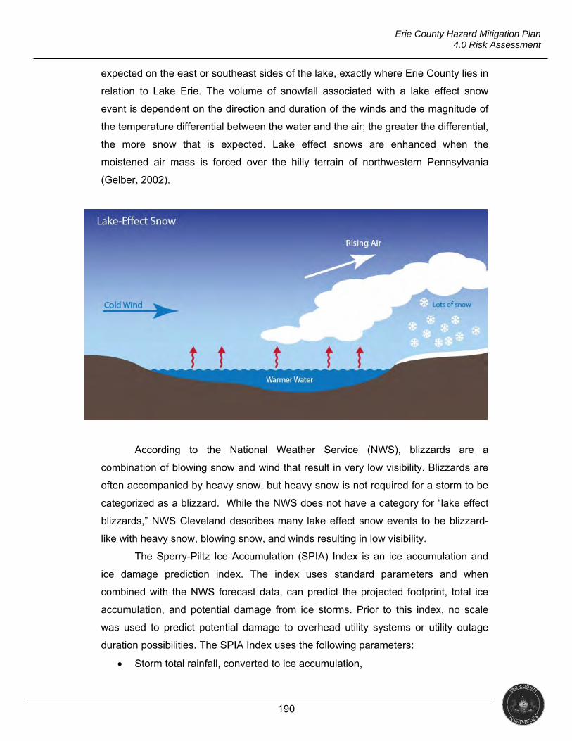
190
Erie County Hazard Mitigation Plan 4.0 Risk Assessment
expected on the east or southeast sides of the lake, exactly where Erie County lies in
relation to Lake Erie. The volume of snowfall associated with a lake effect snow
event is dependent on the direction and duration of the winds and the magnitude of
the temperature differential between the water and the air; the greater the differential,
the more snow that is expected. Lake effect snows are enhanced when the
moistened air mass is forced over the hilly terrain of northwestern Pennsylvania
(Gelber, 2002).
According to the National Weather Service (NWS), blizzards are a
combination of blowing snow and wind that result in very low visibility. Blizzards are
often accompanied by heavy snow, but heavy snow is not required for a storm to be
categorized as a blizzard. While the NWS does not have a category for “lake effect
blizzards,” NWS Cleveland describes many lake effect snow events to be blizzard-
like with heavy snow, blowing snow, and winds resulting in low visibility.
The Sperry-Piltz Ice Accumulation (SPIA) Index is an ice accumulation and
ice damage prediction index. The index uses standard parameters and when
combined with the NWS forecast data, can predict the projected footprint, total ice
accumulation, and potential damage from ice storms. Prior to this index, no scale
was used to predict potential damage to overhead utility systems or utility outage
duration possibilities. The SPIA Index uses the following parameters:
Storm total rainfall, converted to ice accumulation,
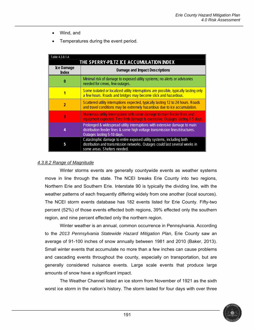
191
Erie County Hazard Mitigation Plan 4.0 Risk Assessment
Wind, and
Temperatures during the event period.
Table 4.3.8.1.A
THE SPERRY-PILTZ ICE ACCUMULATION INDEX Ice Damage
Index Damage and Impact Descriptions
0 Minimal risk of damage to exposed utility systems; no alerts or advisories needed for crews, few outages.
1 Some isolated or localized utility interruptions are possible, typically lasting only a few hours. Roads and bridges may become slick and hazardous.
2 Scattered utility interruptions expected, typically lasting 12 to 24 hours. Roads and travel conditions may be extremely hazardous due to ice accumulation.
3 Numerous utility interruptions with some damage to main feeder lines and equipment expected. Tree limb damage is excessive. Outages lasting 1-5 days.
4 Prolonged & widespread utility interruptions with extensive damage to main distribution feeder lines & some high voltage transmission lines/structures. Outages lasting 5-10 days.
5 Catastrophic damage to entire exposed utility systems, including both distribution and transmission networks. Outages could last several weeks in some areas. Shelters needed.
4.3.8.2 Range of Magnitude
Winter storms events are generally countywide events as weather systems
move in line through the state. The NCEI breaks Erie County into two regions,
Northern Erie and Southern Erie. Interstate 90 is typically the dividing line, with the
weather patterns of each frequently differing widely from one another (local sources).
The NCEI storm events database has 182 events listed for Erie County. Fifty-two
percent (52%) of those events effected both regions, 39% effected only the southern
region, and nine percent effected only the northern region.
Winter weather is an annual, common occurrence in Pennsylvania. According
to the 2013 Pennsylvania Statewide Hazard Mitigation Plan, Erie County saw an
average of 91-100 inches of snow annually between 1981 and 2010 (Baker, 2013).
Small winter events that accumulate no more than a few inches can cause problems
and cascading events throughout the county, especially on transportation, but are
generally considered nuisance events. Large scale events that produce large
amounts of snow have a significant impact.
The Weather Channel listed an ice storm from November of 1921 as the sixth
worst ice storm in the nation’s history. The storm lasted for four days with over three
192
Erie County Hazard Mitigation Plan 4.0 Risk Assessment
inches of ice accumulating. Damage was estimated at $20 million (over $250 million
in 2017 adjusted for inflation). This storm, while not directly affecting Erie County, is
an exemplar case of what could occur as ice storms travel through the prominent ice
storm alley of northern Pennsylvania, central and upstate New York into New
England.
PUBLIC HEALTH
Direct exposure to cold temperatures and wet conditions can cause
hypothermia and frostbite. Winter weather is also associated with increased rates of
respiratory illnesses and heart disease, with a concomitant increase in mortality
(McGeehin & Mirabelli, 2001). Winter storms also bring indirect public health
concerns such as injuries and/or fatalities from automobile accidents on icy roads,
heart attacks while shoveling snow, or slipping and falling on icy walkways,
roadways, or steps. These types of illnesses and injuries can be avoided by staying
inside during extreme cold temperatures and winter storms; however, carbon
monoxide poisoning then becomes a concern. Whether due to a power failure or a
heating system being inadequate to warm a structure, the need to use a generator
and/or fireplace increases the risk of CO poisoning and structure fires (CDC, 2015).
The potential risk of injury from chainsaw use increases after natural
disasters and storms. Chainsaws are widely used to remove fallen or partially fallen
trees and limbs. Each year, over 36,000 people are treated for chainsaw injuries in
emergency departments across the nation. Many of these injuries come from not
wearing appropriate protective equipment, cutting trees and limbs touching
powerlines, and cutting limbs that have tension in them that subsequently snap back
as the tension is released by being cut (CDC, 2014).
SOCIAL VULNERABILITY
Infants and the elderly are the most susceptible to the cold and wet
conditions of a winter storm. Conditions that may be uncomfortable or inconvenient
to the general population can easily become life-threatening to them (NOAA, 2017).
The homeless have a much higher risk than the general population of developing
exposure-related conditions (nationalhomeless.org, 2010). The inability to provide
adequate, dry clothing, shelter and heat accompanied by malnutrition, decreased
193
Erie County Hazard Mitigation Plan 4.0 Risk Assessment
body fat, underlying infection, lack of fitness and fatigue make homeless individuals
much more vulnerable to winter storms (O’Connell, 2004).
Tourists to the area or those not familiar with driving in snow and ice are not
only a danger to themselves but also to other drivers on the road. Although roads
may look clear, braking distance can be increased significantly during and after a
snow or ice storm. An unfamiliar driver may panic if the vehicle begins to slide.
Unfortunately, braking can make a vehicle continue to slide or, if the vehicle comes
to a stop, the driver may become stuck and unable to move the vehicle. These
drivers may also drive below the minimum speed limit, which can be just as
dangerous as speeding for other drivers (AAA, n.d.).
4.3.8.3 Past Occurrence
Erie County, PA
On the morning of March 7, 2008, snow began to fall across the county.
Initially, snow was light in the morning, but by evening, six inches had accumulated
in some areas. Snow continued through the eighth before ending on March 9. During
the storm, wind gusts of up to 30 mph were measured causing snow drifts and low
visibility. By the end of the storm, some areas had seen up to 25 inches of snow.
Property damage was estimated at $12,800,000.
Erie County, PA
Between November 9 and 15, 1996, Erie County experienced an early heavy
lake effect snow. Edinboro had an accumulation of 55 inches by the end of the
storm. Numerous trees, limbs, power lines, and telephone lines were downed and
multiple structures collapsed. By storm end, property damage was estimated at $3
million.
Erie County, PA
As temperatures fluctuated on January 2, 1999, precipitation changed from
snow to freezing rain to rain and back to snow again. Temperatures dropped into the
teens and the six inches of snow began to freeze causing slick roadways, bridges
and sidewalks. The storm led to school closings, nine related injuries and $60,000 in
property damage.

194
Erie County Hazard Mitigation Plan 4.0 Risk Assessment
Erie County, PA
Snow spread into the northwestern Pennsylvania just before daybreak on
February 1, 2015. Snow was initially light, accumulating at about a tenth of an inch
an hour. However, by mid-morning the snow intensified and visibility was less than a
half mile; snow fell at a rate of an inch or more per hour. Late in the evening, the
snow lessened but continued through the evening hours of February 2. Wind gusts of
25 mph caused considerable blowing and drifting. Accumulations of 10 to 15 inches
were common throughout Erie County. Cranesville reported 17.5 inches. Travel was
disrupted with roads in rural areas being nearly impassable at times. Most of the
area schools were closed on February 2. Property damage was estimated at
$400,000.
Erie County, PA
On December 8, 2016, cold winds blowing across Lake Erie caused lake
effect snow showers to develop. Initially, winds were close to being parallel to the
south shoreline of the lake, keeping the heavy snow, accumulations of six or more
inches, to the south shore areas. During the evening hours, the wind changed to a
westerly direction pushing heavier snow inland. The wind continued in a west to
northwest direction for two more days, causing lake effect snow to persist. The three
day snow totals included 26 inches in North East, 25 inches at Edinboro, 24 inches in
Corry, 15.3 inches in Amity, and 13.4 inches in Mill Creek. There were vehicle
accidents reported and school closings throughout northwest Pennsylvania. Property
damage for the event was estimated at $550,000.
In addition to the events described above, other winter storm events are listed
in the following table. The majority of the event types listed in the table are heavy
snow, which is defined by the National Weather Service as snowfall of six inches or
more in 12 hours or less, or eight inches in 24 hours or less.
Table 4.3.8.3.A
WINTER STORM EVENTS IMPACTING ERIE COUNTY SINCE 1996 (NCEI) Location Date Type
Erie County 1/2/1996 Heavy Snow
Southern Erie County 1/9/1996 Heavy Snow
Erie County 3/2/1996 Heavy Snow
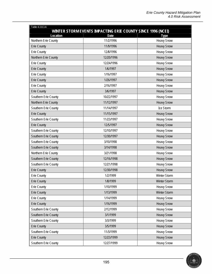
195
Erie County Hazard Mitigation Plan 4.0 Risk Assessment
Table 4.3.8.3.A
WINTER STORM EVENTS IMPACTING ERIE COUNTY SINCE 1996 (NCEI) Location Date Type
Northern Erie County 11/2/1996 Heavy Snow
Erie County 11/9/1996 Heavy Snow
Erie County 12/8/1996 Heavy Snow
Northern Erie County 12/20/1996 Heavy Snow
Erie County 12/24/1996 Heavy Snow
Erie County 1/6/1997 Heavy Snow
Erie County 1/16/1997 Heavy Snow
Erie County 1/26/1997 Heavy Snow
Erie County 2/16/1997 Heavy Snow
Erie County 3/6/1997 Heavy Snow
Southern Erie County 10/22/1997 Heavy Snow
Northern Erie County 11/12/1997 Heavy Snow
Southern Erie County 11/14/1997 Ice Storm
Erie County 11/15/1997 Heavy Snow
Southern Erie County 11/23/1997 Heavy Snow
Erie County 12/5/1997 Heavy Snow
Southern Erie County 12/10/1997 Heavy Snow
Southern Erie County 12/30/1997 Heavy Snow
Southern Erie County 3/10/1998 Heavy Snow
Southern Erie County 3/14/1998 Heavy Snow
Northern Erie County 3/21/1998 Heavy Snow
Southern Erie County 12/16/1998 Heavy Snow
Southern Erie County 12/21/1998 Heavy Snow
Erie County 12/30/1998 Heavy Snow
Erie County 1/2/1999 Winter Storm
Erie County 1/8/1999 Winter Storm
Erie County 1/10/1999 Heavy Snow
Erie County 1/13/1999 Winter Storm
Erie County 1/14/1999 Heavy Snow
Erie County 1/16/1999 Heavy Snow
Southern Erie County 2/12/1999 Heavy Snow
Southern Erie County 3/1/1999 Heavy Snow
Southern Erie County 3/3/1999 Heavy Snow
Erie County 3/5/1999 Heavy Snow
Southern Erie County 11/3/1999 Heavy Snow
Erie County 12/23/1999 Heavy Snow
Southern Erie County 12/27/1999 Heavy Snow

196
Erie County Hazard Mitigation Plan 4.0 Risk Assessment
Table 4.3.8.3.A
WINTER STORM EVENTS IMPACTING ERIE COUNTY SINCE 1996 (NCEI) Location Date Type
Southern Erie County 1/20/2000 Heavy Snow
Southern Erie County 1/21/2000 Heavy Snow
Northern Erie County 2/11/2000 Winter Storm
Northern Erie County 2/13/2000 Winter Storm
Erie County 3/11/2000 Winter Storm
Northern Erie County 11/15/2000 Heavy Snow
Southern Erie County 11/17/2000 Heavy Snow
Erie County 11/20/2000 Heavy Snow
Erie County 11/21/2000 Heavy Snow
Southern Erie County 12/5/2000 Heavy Snow
Erie County 12/6/2000 Heavy Snow
Erie County 12/13/2000 Winter Storm
Southern Erie County 12/19/2000 Heavy Snow
Northern Erie County 12/22/2000 Heavy Snow
Erie County 12/24/2000 Heavy Snow
Erie County 12/27/2000 Heavy Snow
Southern Erie County 12/31/2000 Heavy Snow
Southern Erie County 2/2/2001 Heavy Snow
Southern Erie County 3/5/2001 Heavy Snow
Northern Erie County 3/26/2001 Heavy Snow
Southern Erie County 12/20/2001 Heavy Snow
Erie County 12/28/2001 Heavy Snow
Northern Erie County 12/31/2001 Heavy Snow
Southern Erie County 1/18/2002 Heavy Snow
Southern Erie County 2/4/2002 Heavy Snow
Erie County 2/27/2002 Heavy Snow
Erie County 3/3/2002 Heavy Snow
Erie County 3/10/2002 Heavy Snow
Erie County 3/22/2002 Heavy Snow
Erie County 3/24/2002 Winter Storm
Erie County 11/22/2002 Heavy Snow
Erie County 11/27/2002 Heavy Snow
Southern Erie County 11/30/2002 Heavy Snow
Southern Erie County 12/1/2002 Heavy Snow
Erie County 12/24/2002 Heavy Snow
Southern Erie County 1/10/2003 Heavy Snow
Northern Erie County 1/11/2003 Heavy Snow
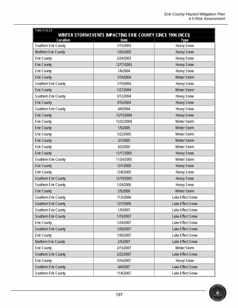
197
Erie County Hazard Mitigation Plan 4.0 Risk Assessment
Table 4.3.8.3.A
WINTER STORM EVENTS IMPACTING ERIE COUNTY SINCE 1996 (NCEI) Location Date Type
Southern Erie County 1/15/2003 Heavy Snow
Northern Erie County 1/26/2003 Heavy Snow
Erie County 2/24/2003 Heavy Snow
Erie County 12/17/2003 Heavy Snow
Erie County 1/6/2004 Heavy Snow
Erie County 1/14/2004 Winter Storm
Southern Erie County 1/19/2004 Heavy Snow
Erie County 1/27/2004 Winter Storm
Southern Erie County 3/12/2004 Heavy Snow
Erie County 3/16/2004 Heavy Snow
Southern Erie County 4/4/2004 Heavy Snow
Erie County 12/13/2004 Heavy Snow
Erie County 12/22/2004 Winter Storm
Erie County 1/5/2005 Winter Storm
Erie County 1/22/2005 Winter Storm
Erie County 3/1/2005 Winter Storm
Erie County 4/2/2005 Winter Storm
Erie County 11/17/2005 Heavy Snow
Southern Erie County 11/24/2005 Winter Storm
Erie County 12/1/2005 Heavy Snow
Erie County 12/6/2005 Heavy Snow
Southern Erie County 12/19/2005 Heavy Snow
Southern Erie County 1/24/2006 Heavy Snow
Erie County 2/5/2006 Winter Storm
Southern Erie County 11/2/2006 Lake-Effect Snow
Southern Erie County 12/7/2006 Lake-Effect Snow
Southern Erie County 1/9/2007 Lake-Effect Snow
Southern Erie County 1/19/2007 Lake-Effect Snow
Erie County 1/24/2007 Lake-Effect Snow
Southern Erie County 1/28/2007 Lake-Effect Snow
Erie County 1/30/2007 Lake-Effect Snow
Northern Erie County 2/5/2007 Lake-Effect Snow
Erie County 2/13/2007 Winter Storm
Southern Erie County 2/22/2007 Lake-Effect Snow
Erie County 3/16/2007 Heavy Snow
Southern Erie County 4/4/2007 Lake-Effect Snow
Southern Erie County 11/6/2007 Lake-Effect Snow

198
Erie County Hazard Mitigation Plan 4.0 Risk Assessment
Table 4.3.8.3.A
WINTER STORM EVENTS IMPACTING ERIE COUNTY SINCE 1996 (NCEI) Location Date Type
Erie County 12/5/2007 Lake-Effect Snow
Erie County 12/15/2007 Winter Storm
Erie County 1/1/2008 Winter Storm
Erie County 1/24/2008 Lake-Effect Snow
Erie County 2/12/2008 Winter Storm
Northern Erie County 2/19/2008 Lake-Effect Snow
Erie County 2/26/2008 Winter Storm
Erie County 3/4/2008 Winter Storm
Erie County 3/7/2008 Winter Storm
Southern Erie County 10/28/2008 Lake-Effect Snow
Erie County 11/9/2008 Lake-Effect Snow
Erie County 11/16/2008 Lake-Effect Snow
Erie County 11/20/2008 Lake-Effect Snow
Southern Erie County 12/5/2008 Lake-Effect Snow
Southern Erie County 12/6/2008 Lake-Effect Snow
Erie County 12/19/2008 Winter Storm
Erie County 12/21/2008 Lake-Effect Snow
Erie County 1/18/2009 Lake-Effect Snow
Erie County 1/27/2009 Winter Storm
Southern Erie County 2/19/2009 Lake-Effect Snow
Erie County 12/10/2009 Lake-Effect Snow
Erie County 12/27/2009 Lake-Effect Snow
Southern Erie County 1/1/2010 Lake-Effect Snow
Northern Erie County 1/7/2010 Lake-Effect Snow
Erie County 2/9/2010 Winter Storm
Southern Erie County 2/25/2010 Winter Storm
Southern Erie County 12/4/2010 Lake-Effect Snow
Southern Erie County 12/12/2010 Lake-Effect Snow
Southern Erie County 1/6/2011 Lake-Effect Snow
Erie County 1/11/2011 Winter Storm
Erie County 2/1/2011 Winter Storm
Erie County 2/20/2011 Winter Storm
Erie County 3/10/2011 Winter Storm
Southern Erie County 1/1/2012 Lake-Effect Snow
Erie County 1/12/2012 Lake-Effect Snow
Southern Erie County 2/10/2012 Lake-Effect Snow
Southern Erie County 4/23/2012 Lake-Effect Snow
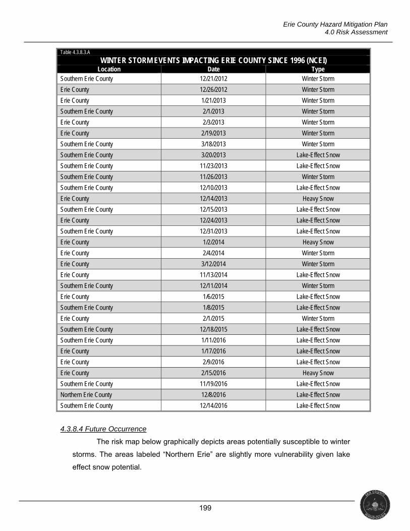
199
Erie County Hazard Mitigation Plan 4.0 Risk Assessment
Table 4.3.8.3.A
WINTER STORM EVENTS IMPACTING ERIE COUNTY SINCE 1996 (NCEI) Location Date Type
Southern Erie County 12/21/2012 Winter Storm
Erie County 12/26/2012 Winter Storm
Erie County 1/21/2013 Winter Storm
Southern Erie County 2/1/2013 Winter Storm
Erie County 2/3/2013 Winter Storm
Erie County 2/19/2013 Winter Storm
Southern Erie County 3/18/2013 Winter Storm
Southern Erie County 3/20/2013 Lake-Effect Snow
Southern Erie County 11/23/2013 Lake-Effect Snow
Southern Erie County 11/26/2013 Winter Storm
Southern Erie County 12/10/2013 Lake-Effect Snow
Erie County 12/14/2013 Heavy Snow
Southern Erie County 12/15/2013 Lake-Effect Snow
Erie County 12/24/2013 Lake-Effect Snow
Southern Erie County 12/31/2013 Lake-Effect Snow
Erie County 1/2/2014 Heavy Snow
Erie County 2/4/2014 Winter Storm
Erie County 3/12/2014 Winter Storm
Erie County 11/13/2014 Lake-Effect Snow
Southern Erie County 12/11/2014 Winter Storm
Erie County 1/6/2015 Lake-Effect Snow
Southern Erie County 1/8/2015 Lake-Effect Snow
Erie County 2/1/2015 Winter Storm
Southern Erie County 12/18/2015 Lake-Effect Snow
Southern Erie County 1/11/2016 Lake-Effect Snow
Erie County 1/17/2016 Lake-Effect Snow
Erie County 2/9/2016 Lake-Effect Snow
Erie County 2/15/2016 Heavy Snow
Southern Erie County 11/19/2016 Lake-Effect Snow
Northern Erie County 12/8/2016 Lake-Effect Snow
Southern Erie County 12/14/2016 Lake-Effect Snow
4.3.8.4 Future Occurrence
The risk map below graphically depicts areas potentially susceptible to winter
storms. The areas labeled “Northern Erie” are slightly more vulnerability given lake
effect snow potential.
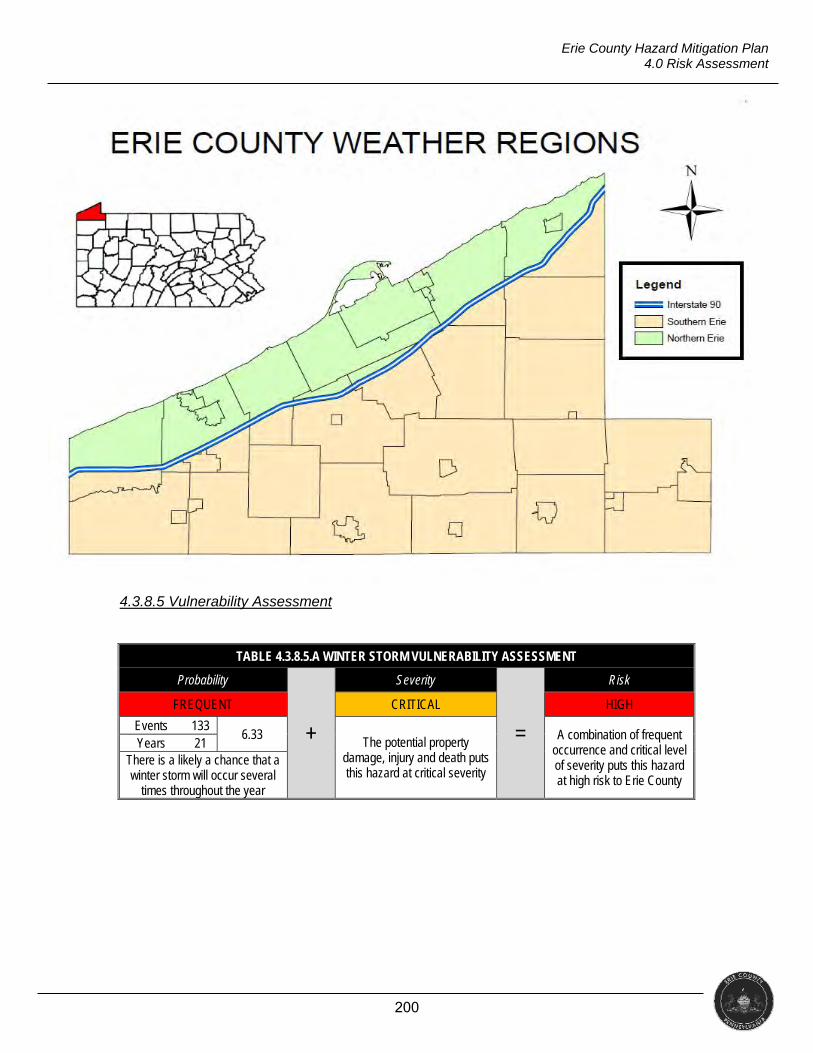
200
Erie County Hazard Mitigation Plan 4.0 Risk Assessment
4.3.8.5 Vulnerability Assessment
TABLE 4.3.8.5.A WINTER STORM VULNERABILITY ASSESSMENT
Probability
+
Severity
=
Risk
FREQUENT CRITICAL HIGH
Events 133 6.33
The potential property damage, injury and death puts this hazard at critical severity
A combination of frequent occurrence and critical level of severity puts this hazard at high risk to Erie County
Years 21 There is a likely a chance that a winter storm will occur several
times throughout the year
201
Erie County Hazard Mitigation Plan 4.0 Risk Assessment
4.3.9 Dam Failure
“A dam is a barrier across flowing water that obstructs, directs, or slows down water flow. Failure of these structures results in an uncontrolled release of impounded water” (PEMA, 2013).
Period of Occurrence Warning Time Risk Assessment
At any time throughout the year None to Years MODERATE
4.3.9.1 Location and Extent
Infrastructure encompasses a wide variety of categories including dams and
levees. Every four years, the American Society of Civil Engineers (ASCE) issues a
report card for America’s infrastructure. The ASCE offers a letter grade in 16
categories. Evaluations are based on capacity, condition, funding, future need,
operation and maintenance, public safety, resilience, and innovation. The ASCE
report for Pennsylvania in 2014 had an overall grade of C- (the ASCE does not offer
individual county reports).
The Pennsylvania Department of Environmental Protection defines a dam as
“any artificial barrier, such as an earthen embankment or concrete structure, built for
the purpose of impounding or storing water or another fluid or semi-fluid” (PADEP,
2015). The PADEP, Division of Dam Safety is required to assure proper planning,
design review, construction review, maintenance monitoring, and supervision of
dams (PADEP, 2017).
Dam failures are usually the result of poor design, improper construction,
improper operation, inadequate maintenance, or a combination of these factors. The
PADEP divides dam failures into the following three categories: hydraulic failure,
seepage failure, and structural failure.
Hydraulic Failures: Failures resulting from the erosive action of the
uncontrolled flow of water adjacent to the dam and its foundation. Earth dams
are particularly susceptible to hydraulic failure since earth erodes when
subjected to flows at relatively low gradients.
Seepage Failures: Failures resulting from seepage being uncontrolled in
velocity and amount. Seepage may occur both through the dam as well as
under and around the dam in the foundation and abutment materials.
Seepage, if uncontrolled, can erode material starting at the downstream slope
or foundation and working back toward the upstream slope to form a “pipe”
which leads to a complete failure of the structure. This phenomenon, known
202
Erie County Hazard Mitigation Plan 4.0 Risk Assessment
as piping, is defined as the progressive development of internal erosion. It
can also contribute to destabilizing movements of the embankment such as
slides or sloughs.
Structural Failures: Involve the rupture of the dam or its foundation. This is
a particularly important hazard on large dams and on those built of low-
strength clays, silts and other materials such as slag and fly ash (PADEP,
2012, pg. 3).
Dam failures generally result from a complex interrelationship of several
failure modes. Uncontrolled seepage may weaken the soil and lead to a structural
failure. Structural failure may shorten the seepage path and lead to a piping failure.
Surface erosion may lead to structural or piping failures. The PADEP classifies dams
into four hazard categories.
Category 1: A high-hazard dam that could cause substantial loss of life,
excessive economic loss, or substantial public inconvenience by its sudden
failure.
Category 2: A high-hazard dam that, in the event of operational or structural
failure, could result in the loss of a few lives, appreciable economic loss and
moderate public inconvenience.
Category 3: A non-high-hazard dam that would not likely endanger human
life, but could result in appreciable property damage or short-duration public
inconvenience.
Category 4: A non-high-hazard dam that would not likely endanger human
life, cause minimal property damage and have no significant public damage.
The National Performance of Dams Program (NPDP) from Stanford
University maintains a database of dams in the United States and identifies 13 in
Erie County; four of those are classified as “high hazard” dams, four are classified as
“significant hazard” dams, two are classified as “low hazard” dams, and three are
unknown.
Using the U.S. Army Corps of Engineers (ACE) National Inventory of Dams
and the National Performance of Dams Program (NPDP) Dams Directory, a list of
the dams in Erie County is presented below.
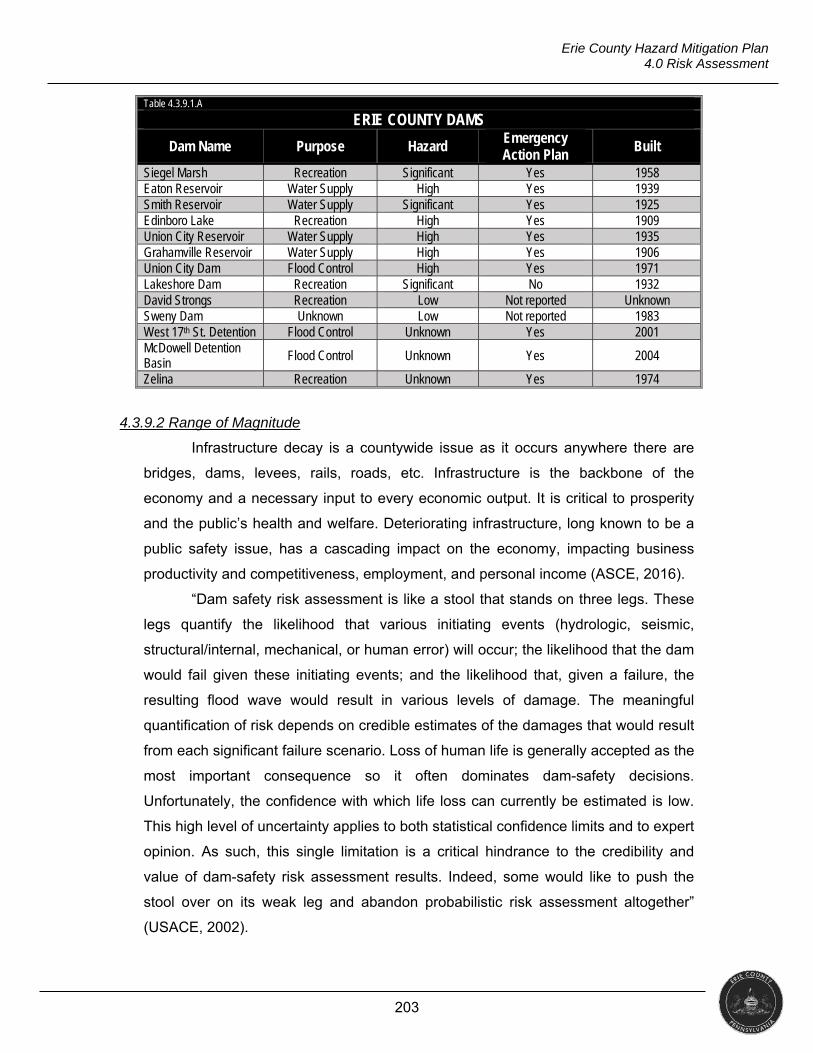
203
Erie County Hazard Mitigation Plan 4.0 Risk Assessment
Table 4.3.9.1.A
ERIE COUNTY DAMS
Dam Name Purpose Hazard Emergency Action Plan
Built
Siegel Marsh Recreation Significant Yes 1958 Eaton Reservoir Water Supply High Yes 1939 Smith Reservoir Water Supply Significant Yes 1925 Edinboro Lake Recreation High Yes 1909 Union City Reservoir Water Supply High Yes 1935 Grahamville Reservoir Water Supply High Yes 1906 Union City Dam Flood Control High Yes 1971 Lakeshore Dam Recreation Significant No 1932 David Strongs Recreation Low Not reported Unknown Sweny Dam Unknown Low Not reported 1983 West 17th St. Detention Flood Control Unknown Yes 2001 McDowell Detention Basin Flood Control Unknown Yes 2004
Zelina Recreation Unknown Yes 1974
4.3.9.2 Range of Magnitude
Infrastructure decay is a countywide issue as it occurs anywhere there are
bridges, dams, levees, rails, roads, etc. Infrastructure is the backbone of the
economy and a necessary input to every economic output. It is critical to prosperity
and the public’s health and welfare. Deteriorating infrastructure, long known to be a
public safety issue, has a cascading impact on the economy, impacting business
productivity and competitiveness, employment, and personal income (ASCE, 2016).
“Dam safety risk assessment is like a stool that stands on three legs. These
legs quantify the likelihood that various initiating events (hydrologic, seismic,
structural/internal, mechanical, or human error) will occur; the likelihood that the dam
would fail given these initiating events; and the likelihood that, given a failure, the
resulting flood wave would result in various levels of damage. The meaningful
quantification of risk depends on credible estimates of the damages that would result
from each significant failure scenario. Loss of human life is generally accepted as the
most important consequence so it often dominates dam-safety decisions.
Unfortunately, the confidence with which life loss can currently be estimated is low.
This high level of uncertainty applies to both statistical confidence limits and to expert
opinion. As such, this single limitation is a critical hindrance to the credibility and
value of dam-safety risk assessment results. Indeed, some would like to push the
stool over on its weak leg and abandon probabilistic risk assessment altogether”
(USACE, 2002).
204
Erie County Hazard Mitigation Plan 4.0 Risk Assessment
PUBLIC HEALTH
The cascading effects that occur after a dam failure are of more concern to
public health than the failure itself. The effect on public health is potentially the same
as that of a flood event. Sitting water poses multiple health risks including infectious
disease, wound infections, injuries, and other health effects. As the water recedes
the priority is to disinfect property, dispose of items that cannot be properly
disinfected and practice good hygiene. It is important to keep open wounds and
rashes from becoming exposed to sitting water to avoid infection (CDC, 2014).
During the initial release fast-flowing water carrying debris, such as boulders
and fallen trees leading to injury or death. Death can be caused by drowning,
trauma, and hypothermia. Water purification and sewage disposal systems may be
disrupted effecting public health.
As with flooding, mold becomes a concern after a dam failure. Mold
exposures usually occur during cleanup when it is disturbed and easily transfers from
surface to surface. Some items can be cleaned but porous materials (i.e., rugs,
composite wood furniture, HVAC filters, etc.) should be disposed (FEMA, 2010).
SOCIAL VULNERABILITY
As there is usually limited time for warning, those living in close proximity of a
dam are considered especially vulnerable to dam failure. Dam failures themselves do
not pose a threat to public health; the cascading effects that occur after a failure are
more concerning. When a dam fails, it results in downstream flooding that can cause
death, injury, and illnesses relating to water-borne diseases and standing water. The
consequences of flooding from a dam failure can include damage to buildings and
transportation infrastructure and power outages. People may be displaced from their
homes.
4.3.9.3 Past Occurrence
The table below shows incidents involving dams reported to the Pennsylvania
Emergency Incident Reporting System (PEIRS). PEIRS is a voluntary reporting
database, as such some incidents may not be reported. The Stanford University
National Performance of Dams Program did not list any incidents on its database.
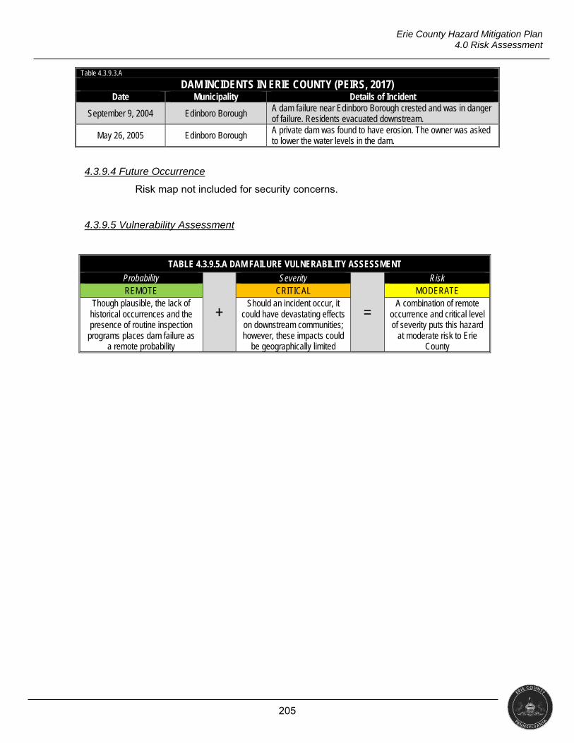
205
Erie County Hazard Mitigation Plan 4.0 Risk Assessment
Table 4.3.9.3.A
DAM INCIDENTS IN ERIE COUNTY (PEIRS, 2017) Date Municipality Details of Incident
September 9, 2004 Edinboro Borough A dam failure near Edinboro Borough crested and was in danger of failure. Residents evacuated downstream.
May 26, 2005 Edinboro Borough A private dam was found to have erosion. The owner was asked to lower the water levels in the dam.
4.3.9.4 Future Occurrence
Risk map not included for security concerns.
4.3.9.5 Vulnerability Assessment
TABLE 4.3.9.5.A DAM FAILURE VULNERABILITY ASSESSMENT
Probability
+
Severity
=
Risk REMOTE CRITICAL MODERATE
Though plausible, the lack of historical occurrences and the presence of routine inspection
programs places dam failure as a remote probability
Should an incident occur, it could have devastating effects on downstream communities; however, these impacts could
be geographically limited
A combination of remote occurrence and critical level of severity puts this hazard
at moderate risk to Erie County
206
Erie County Hazard Mitigation Plan 4.0 Risk Assessment
4.3.10 Environmental Hazards
“Environmental hazards are hazards that pose threats to the natural environment, the building environment, and public safety through the diffusion of harmful substances, materials, or products”
(PEMA, 2013). Period of Occurrence Warning Time Risk Assessment
At any time throughout the year None / Hours HIGH
4.3.10.1 Location and Extent
The use of hazardous materials is common in numerous industries and
products, including agriculture, medicine and research (Haddow, Bullock, & Coppola,
2014). The Emergency Planning and Citizens Right-to-Know Act (EPCRA) of 1984
requires facilities to report on-site chemicals and quantities. The act also requires
local governments to formulate emergency plans.
The Pipeline and Hazardous Materials Safety Administration (PHMSA), a
division of the U.S. Department of Transportation, tracks hazardous material
incidents that occur during transport. Between 2010 and 2016, PHMSA recorded 49
hazardous materials incidents during transport in Erie County. Of those, 48 occurred
on highways. Spills of hazardous materials during transportation are the most difficult
for which to plan. While commodity flow studies give local jurisdictions a snapshot of
what materials may travel through an area on any given day, responders will not
know what materials, if any, are involved until an incident occurs.
The U.S Department of Transportation (DOT) also maintains records of
hazardous materials incidents that occur during transport at the state level.
According to the DOT, there were 777 incidents in Pennsylvania in 2016, resulting in
five injuries and $1.35 million in damage. The majority of these incidents involved
highway transportation vehicles (2017).
The Right-to-Know Network (RTK Net) maintains data, per reports from the
U.S. Coast Guard’s National Response Center, on incidents that involve a hazardous
material release. In Erie County, there were 149 incidents between 2010 and 2016.
These resulted in one fatality, 15 hospitalizations, and 16 injuries. Fifty-eight percent
(58%) of these incidents (87 incidents) involved a vehicle, while 19.5% were at fixed
sites.
A CSX “density report” showed 25 products accounted for 80,009 rail
carloads in Erie County in 2015. These carloads represented 96% of all hazardous
material carloads handled. Petroleum crude oil and alcohol n.o.s., both flammable
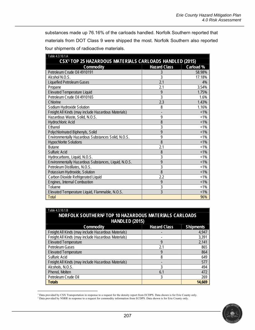
207
Erie County Hazard Mitigation Plan 4.0 Risk Assessment
substances made up 76.16% of the carloads handled. Norfolk Southern reported that
materials from DOT Class 9 were shipped the most. Norfolk Southern also reported
four shipments of radioactive materials. Table 4.3.10.1.A
CSX1 TOP 25 HAZARDOUS MATERIALS CARLOADS HANDLED (2015) Commodity Hazard Class Carload %
Petroleum Crude Oil 4910191 3 58.98% Alcohol N.O.S. 3 17.18% Liquefied Petroleum Gases 2.1 4% Propane 2.1 3.54% Elevated Temperature Liquid 9 1.75% Petroleum Crude Oil 4910165 3 1.6% Chlorine 2.3 1.43% Sodium Hydroxide Solution 8 1.16% Freight All Kinds (may include Hazardous Materials) - <1% Hazardous Waste, Solid, N.O.S. 9 <1% Hydrochloric Acid 8 <1% Ethanol 3 <1% Polychlorinated Biphenyls, Solid 9 <1% Environmentally Hazardous Substances Solid, N.O.S. 9 <1% Hypochlorite Solutions 8 <1% Butane 2.1 <1% Sulfuric Acid 8 <1% Hydrocarbons, Liquid, N.O.S. 3 <1% Environmentally Hazardous Substances, Liquid, N.O.S. 9 <1% Petroleum Distillates, N.O.S. 3 <1% Potassium Hydroxide, Solution 8 <1% Carbon Dioxide Refrigerated Liquid 2.2 <1% Engines, Internal Combustion 9 <1% Toluene 3 <1% Elevated Temperature Liquid, Flammable, N.O.S. 3 <1% Total 96%
Table 4.3.10.1.B
NORFOLK SOUTHERN2 TOP 10 HAZARDOUS MATERIALS CARLOADS HANDLED (2015)
Commodity Hazard Class Shipments Freight All Kinds (may include Hazardous Materials) - 4,947 Freight All Kinds (may include Hazardous Materials) - 3,391 Elevated Temperature 9 2,141 Petroleum Gases 2.1 865 Elevated Temperature 9 864 Sulfuric Acid 8 649 Freight All Kinds (may include Hazardous Materials) - 577 Alcohols, N.O.S. 3 494 Phenol, Molten 6.1 472 Petroleum Crude Oil 3 269 Totals 14,669
1 Data provided by CSX Transportation in response to a request for the density report from ECDPS. Data shown is for Erie County only. 2 Data provided by NSRR in response to a request for commodity information from ECDPS. Data shown is for Erie County only.
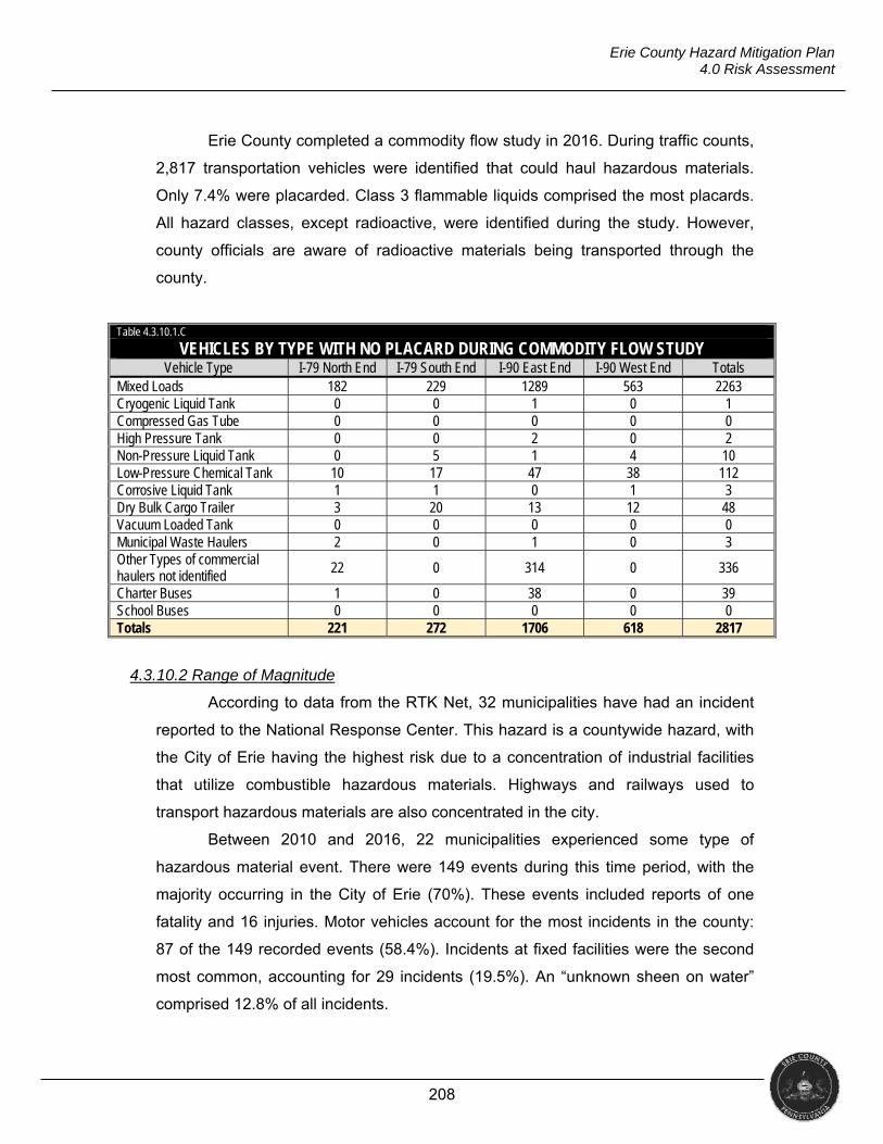
208
Erie County Hazard Mitigation Plan 4.0 Risk Assessment
Erie County completed a commodity flow study in 2016. During traffic counts,
2,817 transportation vehicles were identified that could haul hazardous materials.
Only 7.4% were placarded. Class 3 flammable liquids comprised the most placards.
All hazard classes, except radioactive, were identified during the study. However,
county officials are aware of radioactive materials being transported through the
county.
Table 4.3.10.1.C
VEHICLES BY TYPE WITH NO PLACARD DURING COMMODITY FLOW STUDY Vehicle Type I-79 North End I-79 South End I-90 East End I-90 West End Totals
Mixed Loads 182 229 1289 563 2263 Cryogenic Liquid Tank 0 0 1 0 1 Compressed Gas Tube 0 0 0 0 0 High Pressure Tank 0 0 2 0 2 Non-Pressure Liquid Tank 0 5 1 4 10 Low-Pressure Chemical Tank 10 17 47 38 112 Corrosive Liquid Tank 1 1 0 1 3 Dry Bulk Cargo Trailer 3 20 13 12 48 Vacuum Loaded Tank 0 0 0 0 0 Municipal Waste Haulers 2 0 1 0 3 Other Types of commercial haulers not identified
22 0 314 0 336
Charter Buses 1 0 38 0 39 School Buses 0 0 0 0 0 Totals 221 272 1706 618 2817
4.3.10.2 Range of Magnitude
According to data from the RTK Net, 32 municipalities have had an incident
reported to the National Response Center. This hazard is a countywide hazard, with
the City of Erie having the highest risk due to a concentration of industrial facilities
that utilize combustible hazardous materials. Highways and railways used to
transport hazardous materials are also concentrated in the city.
Between 2010 and 2016, 22 municipalities experienced some type of
hazardous material event. There were 149 events during this time period, with the
majority occurring in the City of Erie (70%). These events included reports of one
fatality and 16 injuries. Motor vehicles account for the most incidents in the county:
87 of the 149 recorded events (58.4%). Incidents at fixed facilities were the second
most common, accounting for 29 incidents (19.5%). An “unknown sheen on water”
comprised 12.8% of all incidents.
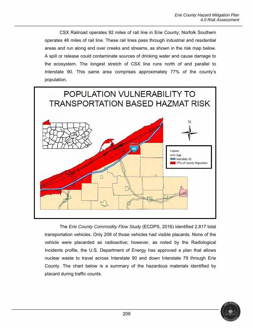
209
Erie County Hazard Mitigation Plan 4.0 Risk Assessment
CSX Railroad operates 92 miles of rail line in Erie County; Norfolk Southern
operates 46 miles of rail line. These rail lines pass through industrial and residential
areas and run along and over creeks and streams, as shown in the risk map below.
A spill or release could contaminate sources of drinking water and cause damage to
the ecosystem. The longest stretch of CSX line runs north of and parallel to
Interstate 90. This same area comprises approximately 77% of the county’s
population.
The Erie County Commodity Flow Study (ECDPS, 2016) identified 2,817 total
transportation vehicles. Only 209 of those vehicles had visible placards. None of the
vehicle were placarded as radioactive; however, as noted by the Radiological
Incidents profile, the U.S. Department of Energy has approved a plan that allows
nuclear waste to travel across Interstate 90 and down Interstate 79 through Erie
County. The chart below is a summary of the hazardous materials identified by
placard during traffic counts.
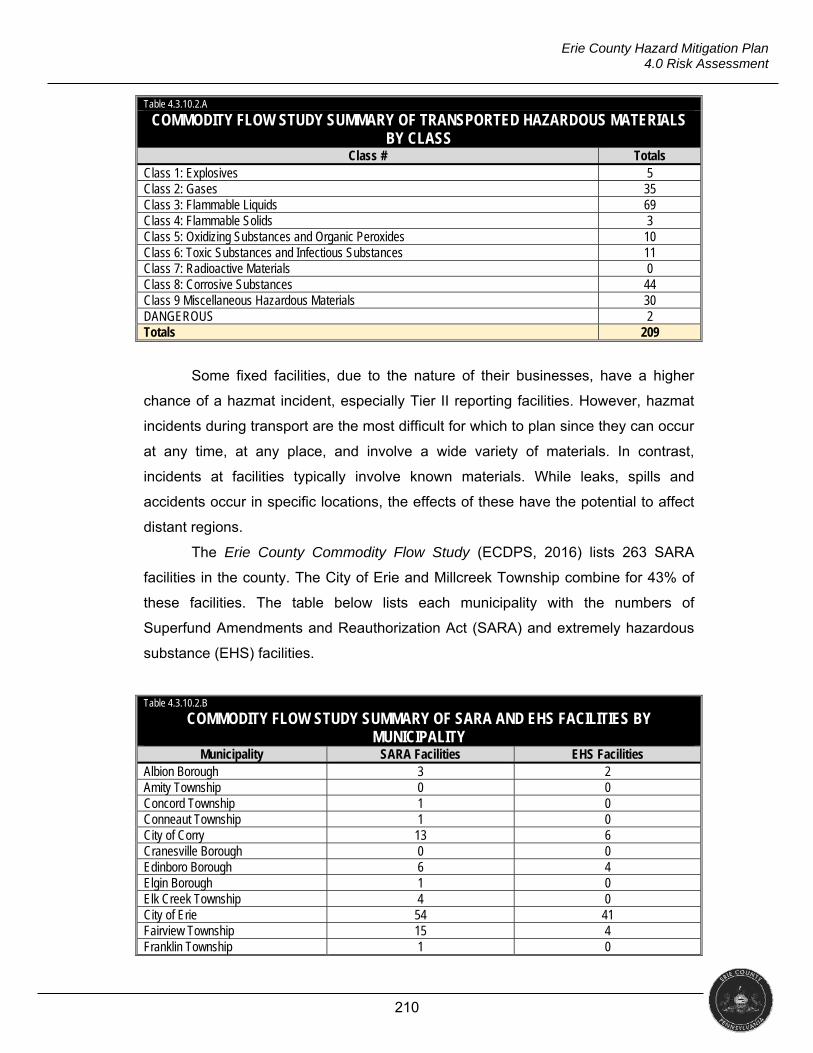
210
Erie County Hazard Mitigation Plan 4.0 Risk Assessment
Table 4.3.10.2.A
COMMODITY FLOW STUDY SUMMARY OF TRANSPORTED HAZARDOUS MATERIALS BY CLASS
Class # Totals Class 1: Explosives 5 Class 2: Gases 35 Class 3: Flammable Liquids 69 Class 4: Flammable Solids 3 Class 5: Oxidizing Substances and Organic Peroxides 10 Class 6: Toxic Substances and Infectious Substances 11 Class 7: Radioactive Materials 0 Class 8: Corrosive Substances 44 Class 9 Miscellaneous Hazardous Materials 30 DANGEROUS 2 Totals 209
Some fixed facilities, due to the nature of their businesses, have a higher
chance of a hazmat incident, especially Tier II reporting facilities. However, hazmat
incidents during transport are the most difficult for which to plan since they can occur
at any time, at any place, and involve a wide variety of materials. In contrast,
incidents at facilities typically involve known materials. While leaks, spills and
accidents occur in specific locations, the effects of these have the potential to affect
distant regions.
The Erie County Commodity Flow Study (ECDPS, 2016) lists 263 SARA
facilities in the county. The City of Erie and Millcreek Township combine for 43% of
these facilities. The table below lists each municipality with the numbers of
Superfund Amendments and Reauthorization Act (SARA) and extremely hazardous
substance (EHS) facilities.
Table 4.3.10.2.B
COMMODITY FLOW STUDY SUMMARY OF SARA AND EHS FACILITIES BY MUNICIPALITY
Municipality SARA Facilities EHS Facilities Albion Borough 3 2 Amity Township 0 0 Concord Township 1 0 Conneaut Township 1 0 City of Corry 13 6 Cranesville Borough 0 0 Edinboro Borough 6 4 Elgin Borough 1 0 Elk Creek Township 4 0 City of Erie 54 41 Fairview Township 15 4 Franklin Township 1 0
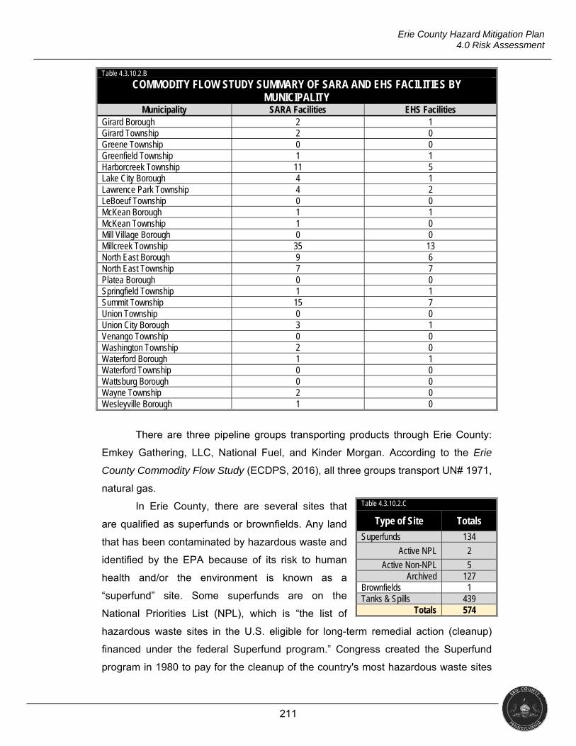
211
Erie County Hazard Mitigation Plan 4.0 Risk Assessment
Table 4.3.10.2.B
COMMODITY FLOW STUDY SUMMARY OF SARA AND EHS FACILITIES BY MUNICIPALITY
Municipality SARA Facilities EHS Facilities Girard Borough 2 1 Girard Township 2 0 Greene Township 0 0 Greenfield Township 1 1 Harborcreek Township 11 5 Lake City Borough 4 1 Lawrence Park Township 4 2 LeBoeuf Township 0 0 McKean Borough 1 1 McKean Township 1 0 Mill Village Borough 0 0 Millcreek Township 35 13 North East Borough 9 6 North East Township 7 7 Platea Borough 0 0 Springfield Township 1 1 Summit Township 15 7 Union Township 0 0 Union City Borough 3 1 Venango Township 0 0 Washington Township 2 0 Waterford Borough 1 1 Waterford Township 0 0 Wattsburg Borough 0 0 Wayne Township 2 0 Wesleyville Borough 1 0
There are three pipeline groups transporting products through Erie County:
Emkey Gathering, LLC, National Fuel, and Kinder Morgan. According to the Erie
County Commodity Flow Study (ECDPS, 2016), all three groups transport UN# 1971,
natural gas.
In Erie County, there are several sites that
are qualified as superfunds or brownfields. Any land
that has been contaminated by hazardous waste and
identified by the EPA because of its risk to human
health and/or the environment is known as a
“superfund” site. Some superfunds are on the
National Priorities List (NPL), which is “the list of
hazardous waste sites in the U.S. eligible for long-term remedial action (cleanup)
financed under the federal Superfund program.” Congress created the Superfund
program in 1980 to pay for the cleanup of the country's most hazardous waste sites
Table 4.3.10.2.C
Type of Site Totals
Superfunds 134
Active NPL 2
Active Non-NPL 5 Archived 127
Brownfields 1 Tanks & Spills 439
Totals 574
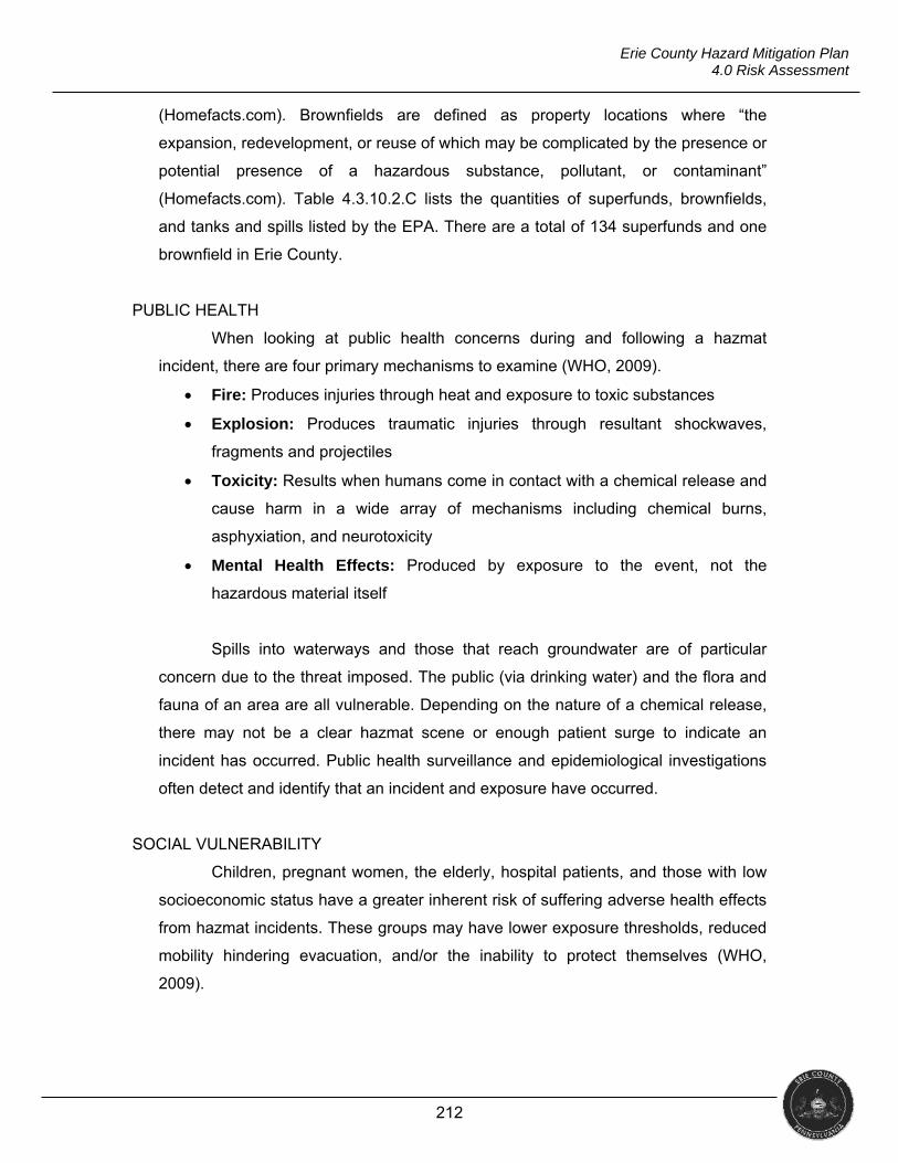
212
Erie County Hazard Mitigation Plan 4.0 Risk Assessment
(Homefacts.com). Brownfields are defined as property locations where “the
expansion, redevelopment, or reuse of which may be complicated by the presence or
potential presence of a hazardous substance, pollutant, or contaminant”
(Homefacts.com). Table 4.3.10.2.C lists the quantities of superfunds, brownfields,
and tanks and spills listed by the EPA. There are a total of 134 superfunds and one
brownfield in Erie County.
PUBLIC HEALTH
When looking at public health concerns during and following a hazmat
incident, there are four primary mechanisms to examine (WHO, 2009).
Fire: Produces injuries through heat and exposure to toxic substances
Explosion: Produces traumatic injuries through resultant shockwaves,
fragments and projectiles
Toxicity: Results when humans come in contact with a chemical release and
cause harm in a wide array of mechanisms including chemical burns,
asphyxiation, and neurotoxicity
Mental Health Effects: Produced by exposure to the event, not the
hazardous material itself
Spills into waterways and those that reach groundwater are of particular
concern due to the threat imposed. The public (via drinking water) and the flora and
fauna of an area are all vulnerable. Depending on the nature of a chemical release,
there may not be a clear hazmat scene or enough patient surge to indicate an
incident has occurred. Public health surveillance and epidemiological investigations
often detect and identify that an incident and exposure have occurred.
SOCIAL VULNERABILITY
Children, pregnant women, the elderly, hospital patients, and those with low
socioeconomic status have a greater inherent risk of suffering adverse health effects
from hazmat incidents. These groups may have lower exposure thresholds, reduced
mobility hindering evacuation, and/or the inability to protect themselves (WHO,
2009).
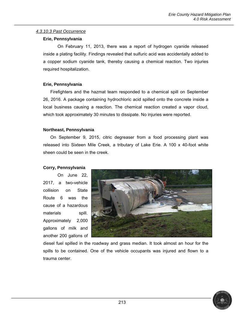
213
Erie County Hazard Mitigation Plan 4.0 Risk Assessment
4.3.10.3 Past Occurrence
Erie, Pennsylvania
On February 11, 2013, there was a report of hydrogen cyanide released
inside a plating facility. Findings revealed that sulfuric acid was accidentally added to
a copper sodium cyanide tank, thereby causing a chemical reaction. Two injuries
required hospitalization.
Erie, Pennsylvania
Firefighters and the hazmat team responded to a chemical spill on September
26, 2016. A package containing hydrochloric acid spilled onto the concrete inside a
local business causing a reaction. The chemical reaction created a vapor cloud,
which took approximately 30 minutes to dissipate. No injuries were reported.
Northeast, Pennsylvania
On September 9, 2015, citric degreaser from a food processing plant was
released into Sixteen Mile Creek, a tributary of Lake Erie. A 100 x 40-foot white
sheen could be seen in the creek.
Corry, Pennsylvania
On June 22,
2017, a two-vehicle
collision on State
Route 6 was the
cause of a hazardous
materials spill.
Approximately 2,000
gallons of milk and
another 200 gallons of
diesel fuel spilled in the roadway and grass median. It took almost an hour for the
spills to be contained. One of the vehicle occupants was injured and flown to a
trauma center.
214
Erie County Hazard Mitigation Plan 4.0 Risk Assessment
4.3.10.4 Future Occurrence
The risk map below graphically depicts areas potentially susceptible to
environmental hazards.
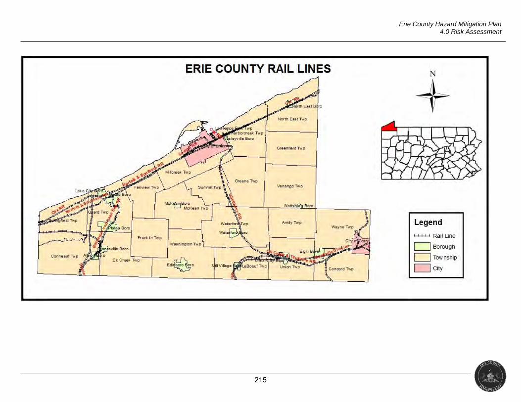
215
Erie County Hazard Mitigation Plan 4.0 Risk Assessment
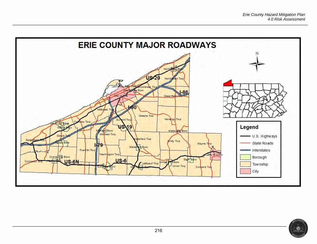
216
Erie County Hazard Mitigation Plan 4.0 Risk Assessment
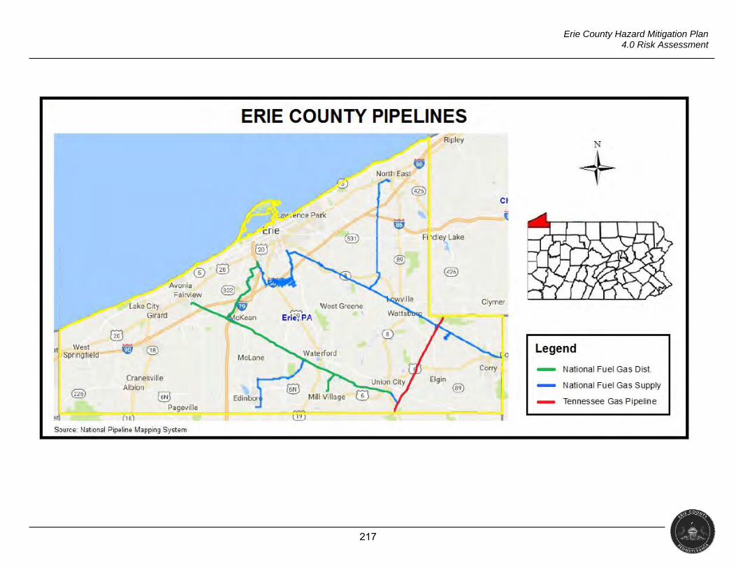
217
Erie County Hazard Mitigation Plan 4.0 Risk Assessment
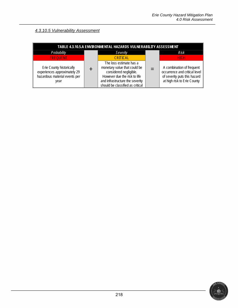
218
Erie County Hazard Mitigation Plan 4.0 Risk Assessment
4.3.10.5 Vulnerability Assessment
TABLE 4.3.10.5.A ENVIRONMENTAL HAZARDS VULNERABILITY ASSESSMENT
Probability
+
Severity
=
Risk FREQUENT CRITICAL HIGH
Erie County historically experiences approximately 29 hazardous material events per
year
The loss estimate has a monetary value that could be
considered negligible. However due the risk to life
and infrastructure the severity should be classified as critical
A combination of frequent occurrence and critical level of severity puts this hazard at high risk to Erie County
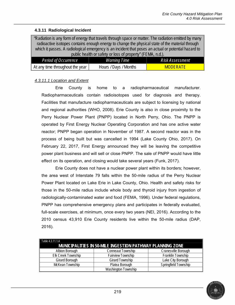
219
Erie County Hazard Mitigation Plan 4.0 Risk Assessment
4.3.11 Radiological Incident
“Radiation is any form of energy that travels through space or matter. The radiation emitted by many radioactive isotopes contains enough energy to change the physical state of the material through
which it passes. A radiological emergency is an incident that poses an actual or potential hazard to public health or safety or loss of property” (FEMA, n.d.).
Period of Occurrence Warning Time Risk Assessment
At any time throughout the year Hours / Days / Months MODERATE
4.3.11.1 Location and Extent
Erie County is home to a radiopharmaceutical manufacturer.
Radiopharmaceuticals contain radioisotopes used for diagnosis and therapy.
Facilities that manufacture radiopharmaceuticals are subject to licensing by national
and regional authorities (WHO, 2008). Erie County is also in close proximity to the
Perry Nuclear Power Plant (PNPP) located in North Perry, Ohio. The PNPP is
operated by First Energy Nuclear Operating Corporation and has one active water
reactor; PNPP began operation in November of 1987. A second reactor was in the
process of being built but was cancelled in 1994 (Lake County Ohio, 2017). On
February 22, 2017, First Energy announced they will be leaving the competitive
power plant business and will sell or close PNPP. The sale of PNPP would have little
effect on its operation, and closing would take several years (Funk, 2017).
Erie County does not have a nuclear power plant within its borders; however,
the area west of Interstate 79 falls within the 50-mile radius of the Perry Nuclear
Power Plant located on Lake Erie in Lake County, Ohio. Health and safety risks for
those in the 50-mile radius include whole body and thyroid injury from ingestion of
radiologically-contaminated water and food (FEMA, 1996). Under federal regulations,
PNPP has comprehensive emergency plans and participates in federally evaluated,
full-scale exercises, at minimum, once every two years (NEI, 2016). According to the
2010 census 43,910 Erie County residents live within the 50-mile radius (DAP,
2016).
Table 4.3.11.1.A
MUNICIPALITIES IN 50-MILE INGESTION PATHWAY PLANNING ZONE Albion Borough Conneaut Township Cranesville Borough
Elk Creek Township Fairview Township Franklin Township Girard Borough Girard Township Lake City Borough
McKean Township Platea Borough Springfield Township Washington Township
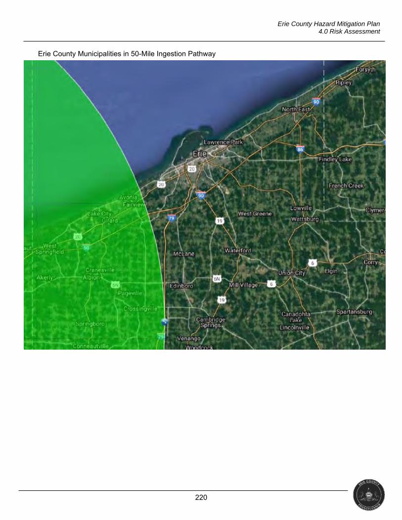
220
Erie County Hazard Mitigation Plan 4.0 Risk Assessment
Erie County Municipalities in 50-Mile Ingestion Pathway
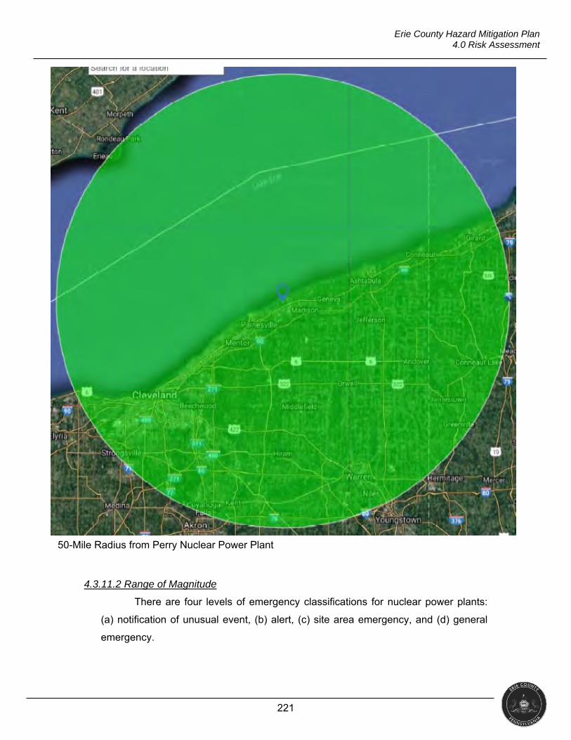
221
Erie County Hazard Mitigation Plan 4.0 Risk Assessment
4.3.11.2 Range of Magnitude
There are four levels of emergency classifications for nuclear power plants:
(a) notification of unusual event, (b) alert, (c) site area emergency, and (d) general
emergency.
50-Mile Radius from Perry Nuclear Power Plant
222
Erie County Hazard Mitigation Plan 4.0 Risk Assessment
Notification of Unusual Event: Events that are in progress or have
occurred, which indicate a potential degradation of the level of safety of the
plant or that a security threat to facility protection has been initiated. No
releases of radioactive material requiring offsite response or monitoring would
not be expected unless further degradation of safety systems occurs.
Alert: Events that are in progress or have occurred which involve an actual or
potential substantial degradation of the level of safety of the plant or a
security event that involves probable life-threatening risk to site personnel or
damage to site equipment because of hostile action. Any releases are
expected to be limited to small fractions of the U.S. Environmental Protection
Agency (EPA) protective action guides (PAG).
Site Area Emergency: Events that are in progress or have occurred which
involve actual or likely major failures of plant functions needed for protection
of the public or hostile action that results in intentional damage or malicious
acts (a) toward site personnel or equipment that could lead to likely failure or
(b) that prevent effective access to equipment needed for the protection of
the public. Any releases are not expected to result in exposure levels which
exceed EPA PAG levels beyond the site boundary.
General Emergency: Events that are in progress ort have occurred which
involve actual or imminent substantial core degradation or melting with
potential for loss of containment integrity or hostile action that results in an
actual loss of physical control of the facility. Releases can be reasonably
expected to exceed EPA PAG exposure levels offsite for more than the
immediate site area.
Each level requires messages to be sent out to specific government
agencies, commissions, and local officials. If any of the four levels are declared,
state and local agencies must be notified within 15 minutes of the declaration.
Should a site area emergency or general emergency be declared, once notified,
state and local authorities should begin to issue EAS messages, potential protective
measures (e.g., evacuate, shelter in place, etc.), and provide phone numbers for
public inquiry (FEMA, 2013).
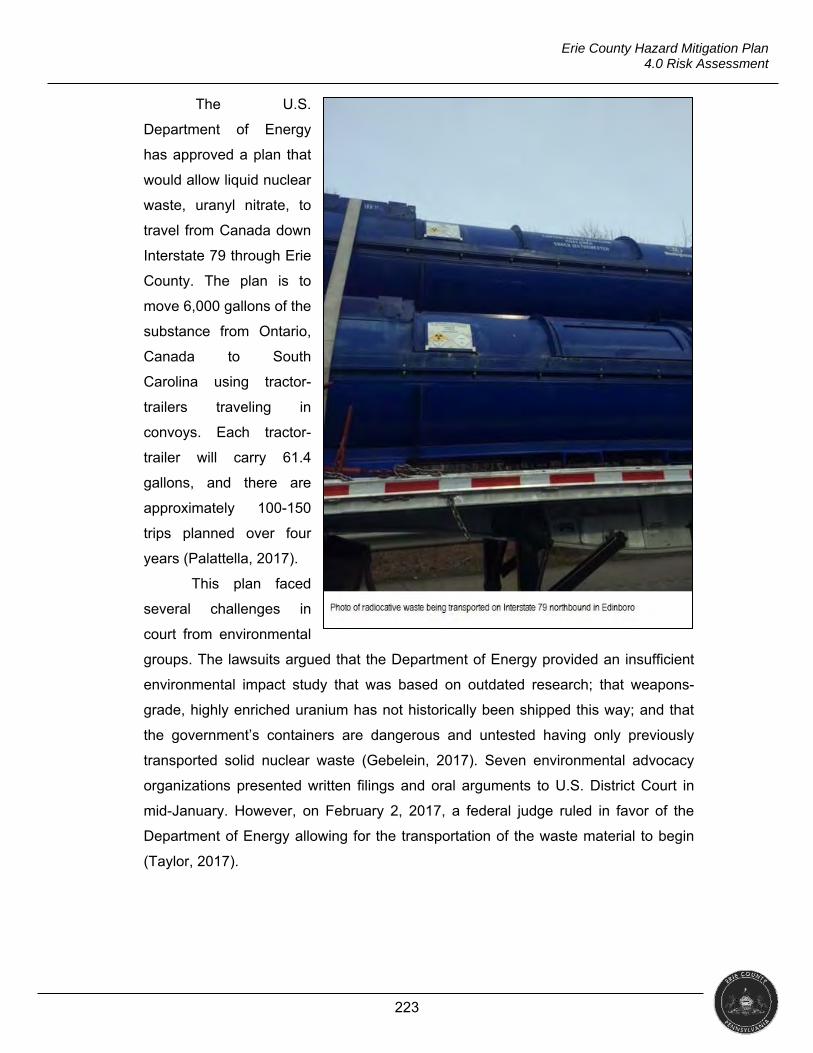
223
Erie County Hazard Mitigation Plan 4.0 Risk Assessment
The U.S.
Department of Energy
has approved a plan that
would allow liquid nuclear
waste, uranyl nitrate, to
travel from Canada down
Interstate 79 through Erie
County. The plan is to
move 6,000 gallons of the
substance from Ontario,
Canada to South
Carolina using tractor-
trailers traveling in
convoys. Each tractor-
trailer will carry 61.4
gallons, and there are
approximately 100-150
trips planned over four
years (Palattella, 2017).
This plan faced
several challenges in
court from environmental
groups. The lawsuits argued that the Department of Energy provided an insufficient
environmental impact study that was based on outdated research; that weapons-
grade, highly enriched uranium has not historically been shipped this way; and that
the government’s containers are dangerous and untested having only previously
transported solid nuclear waste (Gebelein, 2017). Seven environmental advocacy
organizations presented written filings and oral arguments to U.S. District Court in
mid-January. However, on February 2, 2017, a federal judge ruled in favor of the
Department of Energy allowing for the transportation of the waste material to begin
(Taylor, 2017).
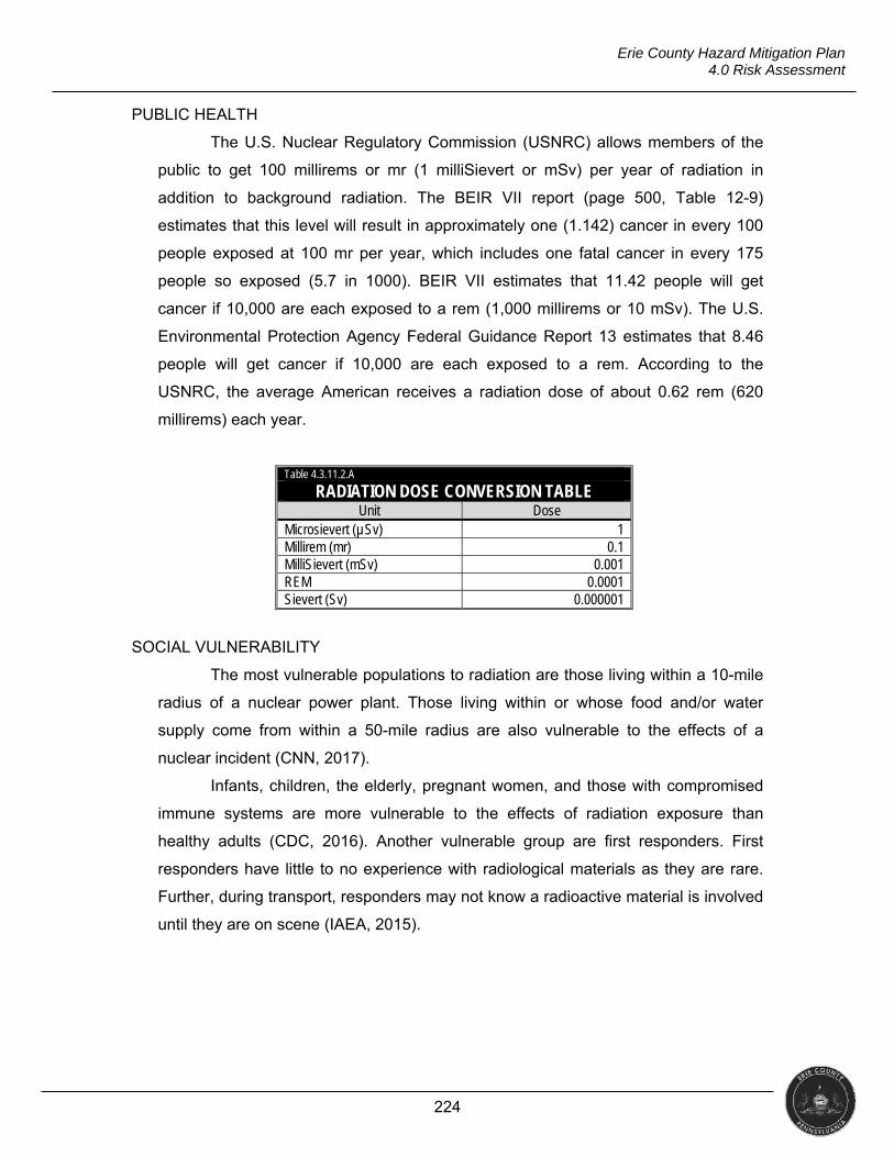
224
Erie County Hazard Mitigation Plan 4.0 Risk Assessment
PUBLIC HEALTH
The U.S. Nuclear Regulatory Commission (USNRC) allows members of the
public to get 100 millirems or mr (1 milliSievert or mSv) per year of radiation in
addition to background radiation. The BEIR VII report (page 500, Table 12-9)
estimates that this level will result in approximately one (1.142) cancer in every 100
people exposed at 100 mr per year, which includes one fatal cancer in every 175
people so exposed (5.7 in 1000). BEIR VII estimates that 11.42 people will get
cancer if 10,000 are each exposed to a rem (1,000 millirems or 10 mSv). The U.S.
Environmental Protection Agency Federal Guidance Report 13 estimates that 8.46
people will get cancer if 10,000 are each exposed to a rem. According to the
USNRC, the average American receives a radiation dose of about 0.62 rem (620
millirems) each year.
Table 4.3.11.2.A
RADIATION DOSE CONVERSION TABLE Unit Dose
Microsievert (µSv) 1 Millirem (mr) 0.1 MilliSievert (mSv) 0.001 REM 0.0001 Sievert (Sv) 0.000001
SOCIAL VULNERABILITY
The most vulnerable populations to radiation are those living within a 10-mile
radius of a nuclear power plant. Those living within or whose food and/or water
supply come from within a 50-mile radius are also vulnerable to the effects of a
nuclear incident (CNN, 2017).
Infants, children, the elderly, pregnant women, and those with compromised
immune systems are more vulnerable to the effects of radiation exposure than
healthy adults (CDC, 2016). Another vulnerable group are first responders. First
responders have little to no experience with radiological materials as they are rare.
Further, during transport, responders may not know a radioactive material is involved
until they are on scene (IAEA, 2015).
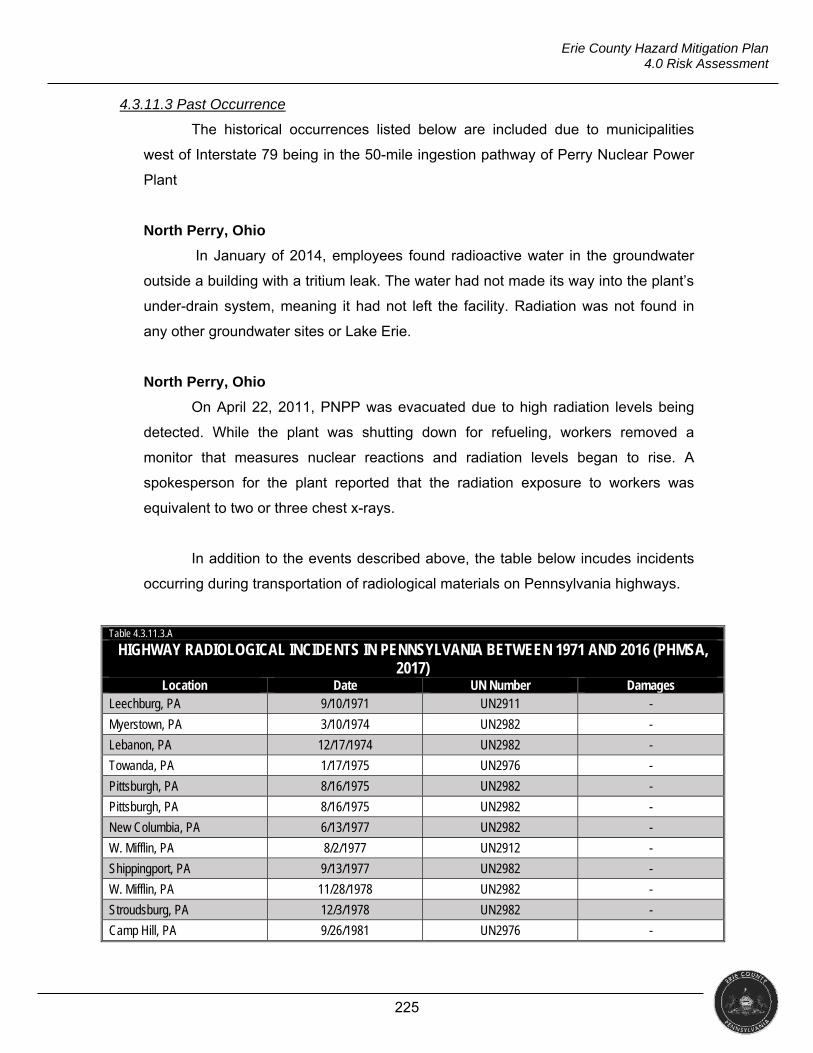
225
Erie County Hazard Mitigation Plan 4.0 Risk Assessment
4.3.11.3 Past Occurrence
The historical occurrences listed below are included due to municipalities
west of Interstate 79 being in the 50-mile ingestion pathway of Perry Nuclear Power
Plant
North Perry, Ohio
In January of 2014, employees found radioactive water in the groundwater
outside a building with a tritium leak. The water had not made its way into the plant’s
under-drain system, meaning it had not left the facility. Radiation was not found in
any other groundwater sites or Lake Erie.
North Perry, Ohio
On April 22, 2011, PNPP was evacuated due to high radiation levels being
detected. While the plant was shutting down for refueling, workers removed a
monitor that measures nuclear reactions and radiation levels began to rise. A
spokesperson for the plant reported that the radiation exposure to workers was
equivalent to two or three chest x-rays.
In addition to the events described above, the table below incudes incidents
occurring during transportation of radiological materials on Pennsylvania highways.
Table 4.3.11.3.A
HIGHWAY RADIOLOGICAL INCIDENTS IN PENNSYLVANIA BETWEEN 1971 AND 2016 (PHMSA, 2017)
Location Date UN Number Damages Leechburg, PA 9/10/1971 UN2911 -
Myerstown, PA 3/10/1974 UN2982 -
Lebanon, PA 12/17/1974 UN2982 -
Towanda, PA 1/17/1975 UN2976 -
Pittsburgh, PA 8/16/1975 UN2982 -
Pittsburgh, PA 8/16/1975 UN2982 -
New Columbia, PA 6/13/1977 UN2982 -
W. Mifflin, PA 8/2/1977 UN2912 -
Shippingport, PA 9/13/1977 UN2982 -
W. Mifflin, PA 11/28/1978 UN2982 -
Stroudsburg, PA 12/3/1978 UN2982 -
Camp Hill, PA 9/26/1981 UN2976 -
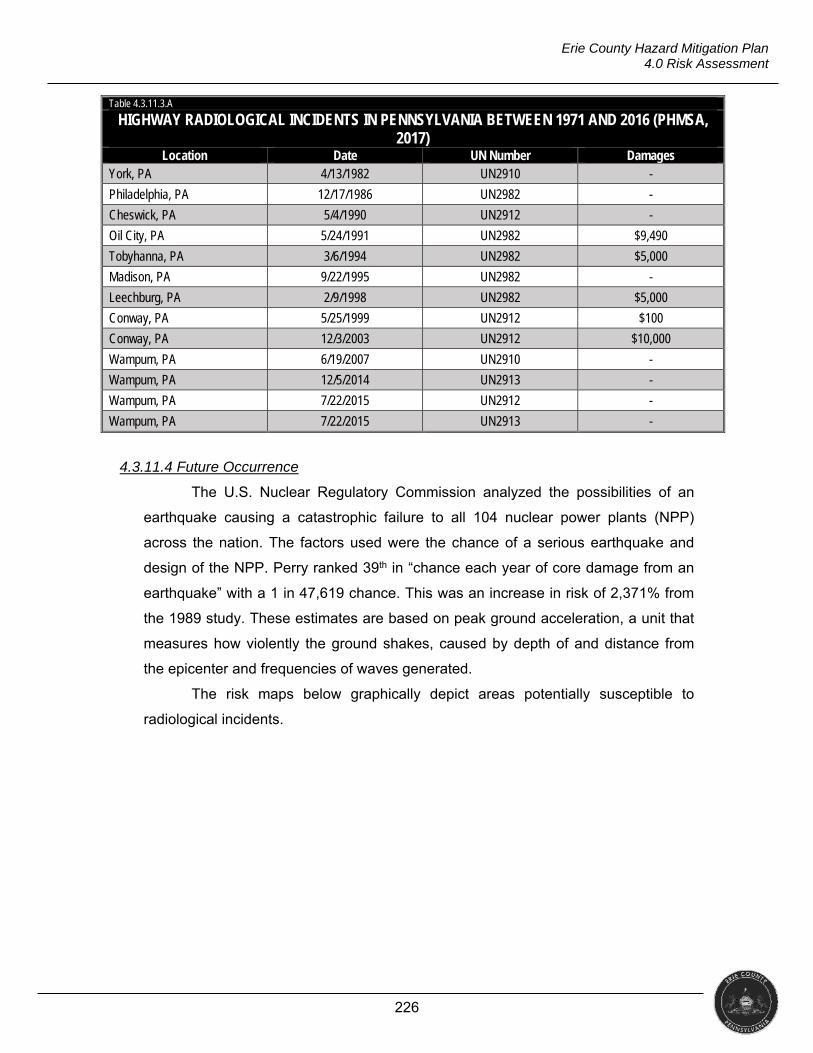
226
Erie County Hazard Mitigation Plan 4.0 Risk Assessment
Table 4.3.11.3.A
HIGHWAY RADIOLOGICAL INCIDENTS IN PENNSYLVANIA BETWEEN 1971 AND 2016 (PHMSA, 2017)
Location Date UN Number Damages York, PA 4/13/1982 UN2910 -
Philadelphia, PA 12/17/1986 UN2982 -
Cheswick, PA 5/4/1990 UN2912 -
Oil City, PA 5/24/1991 UN2982 $9,490
Tobyhanna, PA 3/6/1994 UN2982 $5,000
Madison, PA 9/22/1995 UN2982 -
Leechburg, PA 2/9/1998 UN2982 $5,000
Conway, PA 5/25/1999 UN2912 $100
Conway, PA 12/3/2003 UN2912 $10,000
Wampum, PA 6/19/2007 UN2910 -
Wampum, PA 12/5/2014 UN2913 -
Wampum, PA 7/22/2015 UN2912 -
Wampum, PA 7/22/2015 UN2913 -
4.3.11.4 Future Occurrence
The U.S. Nuclear Regulatory Commission analyzed the possibilities of an
earthquake causing a catastrophic failure to all 104 nuclear power plants (NPP)
across the nation. The factors used were the chance of a serious earthquake and
design of the NPP. Perry ranked 39th in “chance each year of core damage from an
earthquake” with a 1 in 47,619 chance. This was an increase in risk of 2,371% from
the 1989 study. These estimates are based on peak ground acceleration, a unit that
measures how violently the ground shakes, caused by depth of and distance from
the epicenter and frequencies of waves generated.
The risk maps below graphically depict areas potentially susceptible to
radiological incidents.
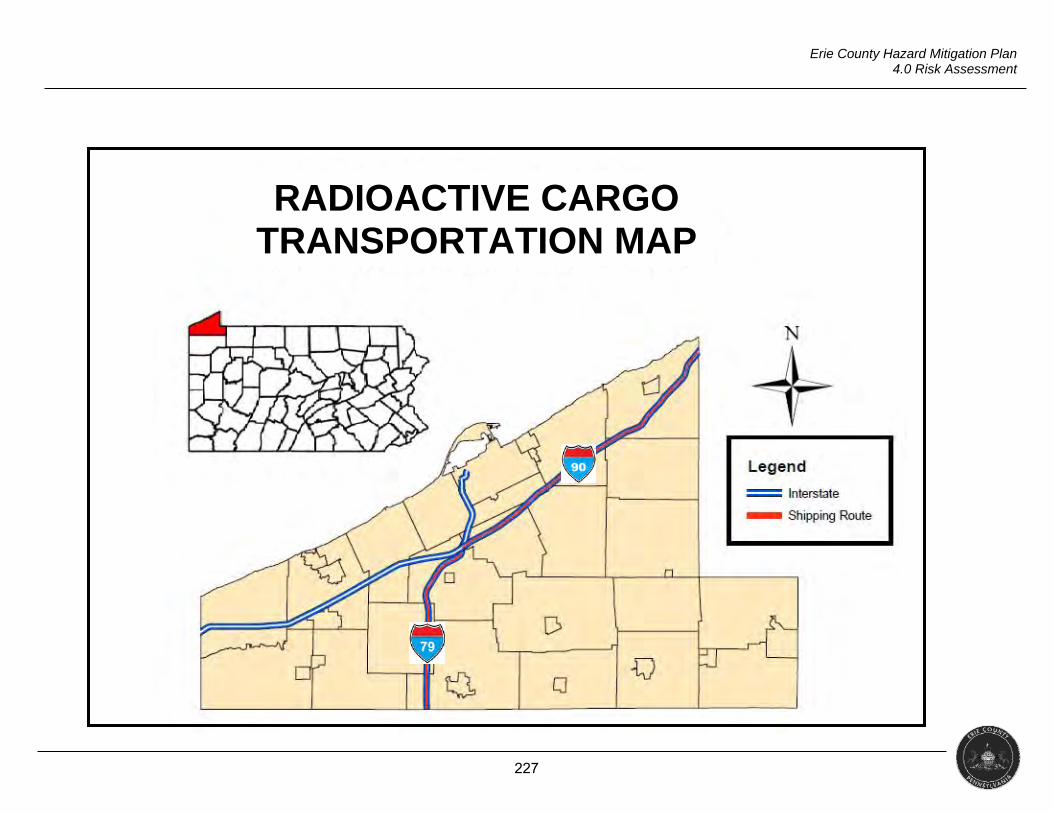
227
Erie County Hazard Mitigation Plan 4.0 Risk Assessment
RADIOACTIVE CARGO TRANSPORTATION MAP
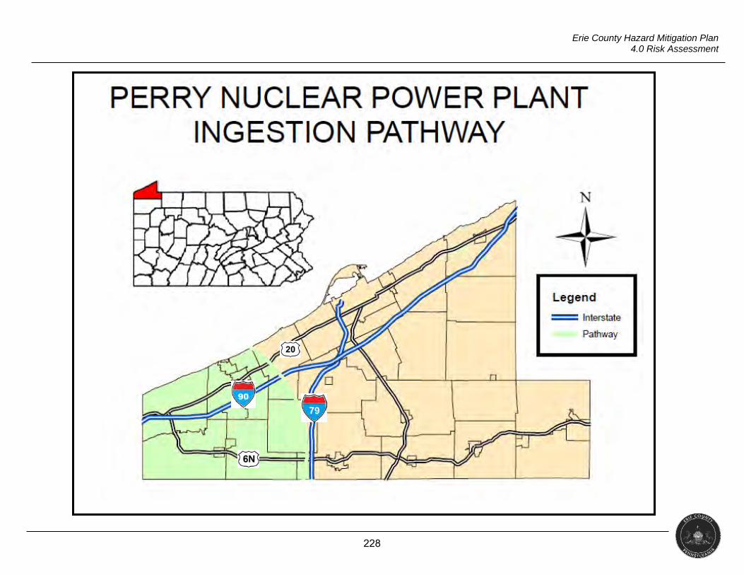
228
Erie County Hazard Mitigation Plan 4.0 Risk Assessment
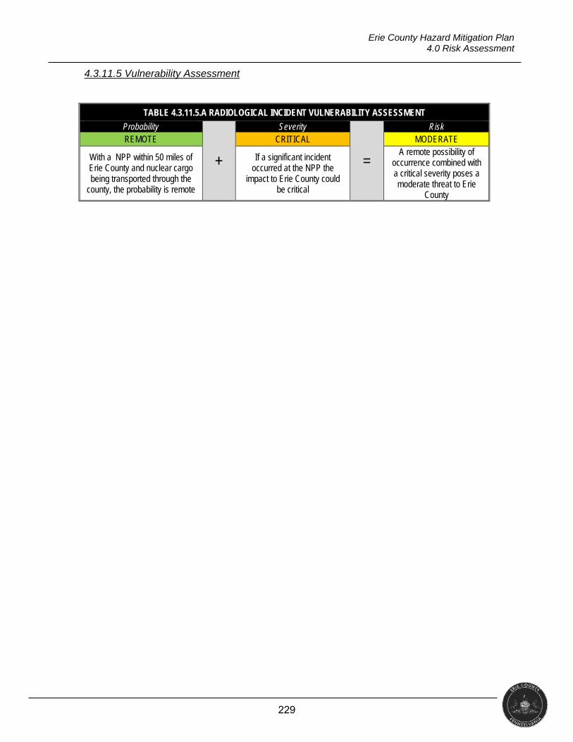
229
Erie County Hazard Mitigation Plan 4.0 Risk Assessment
4.3.11.5 Vulnerability Assessment
TABLE 4.3.11.5.A RADIOLOGICAL INCIDENT VULNERABILITY ASSESSMENT
Probability
+
Severity
=
Risk REMOTE CRITICAL MODERATE
With a NPP within 50 miles of Erie County and nuclear cargo being transported through the
county, the probability is remote
If a significant incident occurred at the NPP the
impact to Erie County could be critical
A remote possibility of occurrence combined with a critical severity poses a moderate threat to Erie
County
230
Erie County Hazard Mitigation Plan 4.0 Risk Assessment
4.3.12 Urban Fire and Explosion
“An urban fire involves a structure or property within an urban or developed area. For hazard mitigation purposes, major urban fires involving large buildings and/or multiple properties are of
primary concern” (PEMA, 2013). Period of Occurrence Warning Time Risk Assessment
Can occur at any time At any time HIGH
4.3.12.1 Location and Extent
According to the U.S. Fire Administration (USFA), structure fires comprise
39.2% of all fires in the United States with residential structures making up 78.5% of
those structure fires. Residential fires are also the leading property type for fire
fatalities (75%), fire injuries (78%) and financial loss (52%) (USFA, 2014). According
to the National Fire Protection Association, due to increased synthetic fuel loads and
new construction materials, failure time has decreased, which can speed the rate of
fire growth (2016).
There is also an increase in terrorists using fire as a weapon (Byrne, 2017).
The potential for causing large-scale damage with little to no cost or technical
expertise makes arson particularly appealing (Department of Homeland Security,
2012). An explosion is a complex process with many variables. The type of delivery,
device used, amount and type of explosive materials, whether it is intentional or
accidental, and whether it occurs indoors or outside are just a few of the major
factors.
Fire and explosions can occur anywhere there are structures. In heavily
populated areas, where buildings are closer together, the potential for greater loss of
life and property is present. Areas with lower socioeconomic characteristics have an
increased fire risk. Crowded dwellings also cause an increased vulnerability to fire.
These crowded units may also
contain room partitions which
can impede firefighter
movement, potentially leading
to injury or death. Mobile
homes are not held to the
same standard as homes built
on-site. Residents of mobile
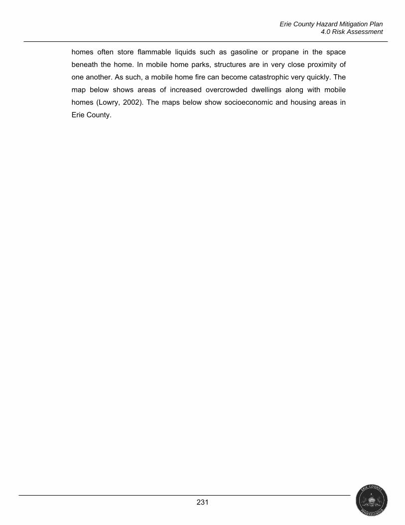
231
Erie County Hazard Mitigation Plan 4.0 Risk Assessment
homes often store flammable liquids such as gasoline or propane in the space
beneath the home. In mobile home parks, structures are in very close proximity of
one another. As such, a mobile home fire can become catastrophic very quickly. The
map below shows areas of increased overcrowded dwellings along with mobile
homes (Lowry, 2002). The maps below show socioeconomic and housing areas in
Erie County.
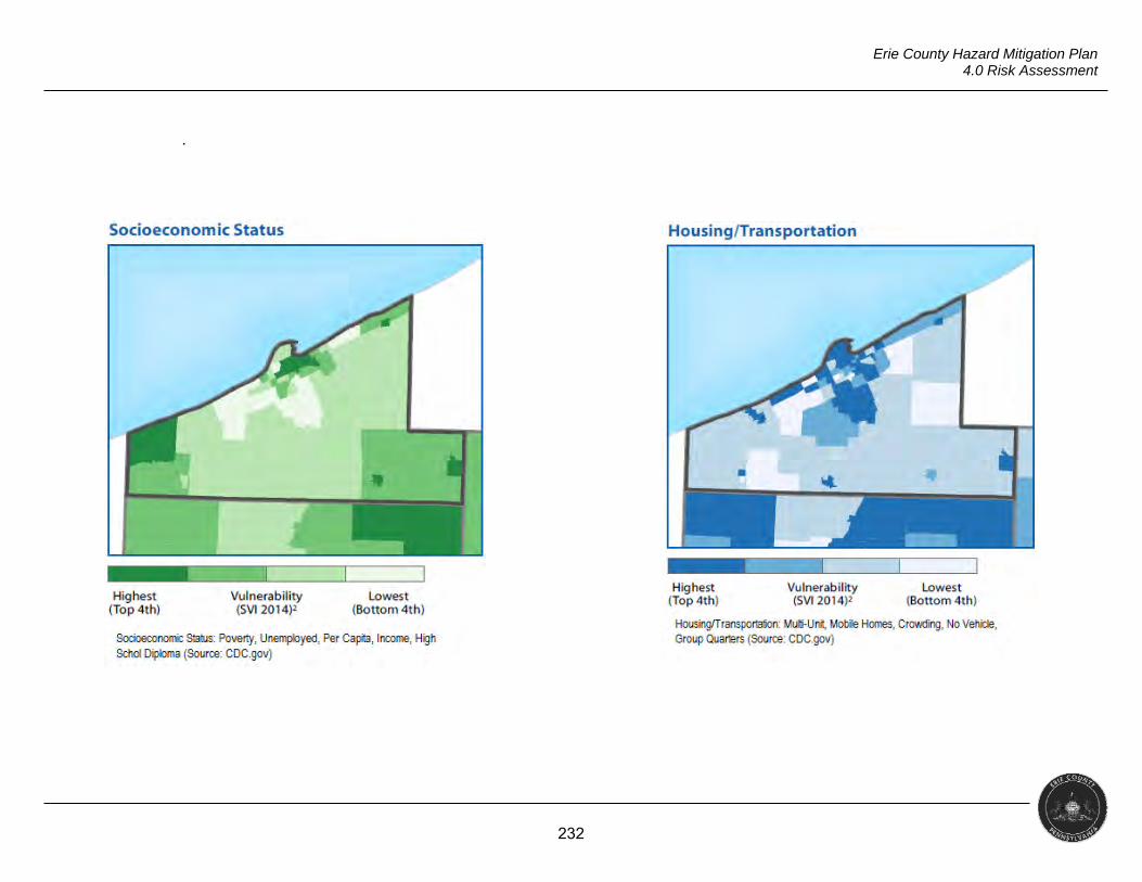
232
Erie County Hazard Mitigation Plan 4.0 Risk Assessment
.
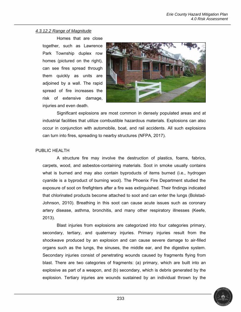
233
Erie County Hazard Mitigation Plan 4.0 Risk Assessment
4.3.12.2 Range of Magnitude
Homes that are close
together, such as Lawrence
Park Township duplex row
homes (pictured on the right),
can see fires spread through
them quickly as units are
adjoined by a wall. The rapid
spread of fire increases the
risk of extensive damage,
injuries and even death.
Significant explosions are most common in densely populated areas and at
industrial facilities that utilize combustible hazardous materials. Explosions can also
occur in conjunction with automobile, boat, and rail accidents. All such explosions
can turn into fires, spreading to nearby structures (NFPA, 2017).
PUBLIC HEALTH
A structure fire may involve the destruction of plastics, foams, fabrics,
carpets, wood, and asbestos-containing materials. Soot in smoke usually contains
what is burned and may also contain byproducts of items burned (i.e., hydrogen
cyanide is a byproduct of burning wool). The Phoenix Fire Department studied the
exposure of soot on firefighters after a fire was extinguished. Their findings indicated
that chlorinated products become attached to soot and can enter the lungs (Bolstad-
Johnson, 2010). Breathing in this soot can cause acute issues such as coronary
artery disease, asthma, bronchitis, and many other respiratory illnesses (Keefe,
2013).
Blast injuries from explosions are categorized into four categories primary,
secondary, tertiary, and quaternary injuries. Primary injuries result from the
shockwave produced by an explosion and can cause severe damage to air-filled
organs such as the lungs, the sinuses, the middle ear, and the digestive system.
Secondary injuries consist of penetrating wounds caused by fragments flying from
blast. There are two categories of fragments: (a) primary, which are built into an
explosive as part of a weapon, and (b) secondary, which is debris generated by the
explosion. Tertiary injuries are wounds sustained by an individual thrown by the
234
Erie County Hazard Mitigation Plan 4.0 Risk Assessment
blast. These injuries usually include blunt traumatic injuries and fractures.
Quaternary injuries are composed of any injury that does not meet the criteria of the
other three categories. These injuries usually consist of burns, crush injuries and
breathing problems from smoke and dust inhalation (Clements, 2009).
SOCIAL VULNERABILITY
Research indicates that the risk of a fire in the home is not the same for
everyone. Studies of socioeconomic characteristics have shown that lower levels of
income are either directly or indirectly tied to an increase risk of fire (FEMA 1997).
Other considerations in urban areas are the growing number of older adults and
people with disabilities (NFPA, 2017).
First responders are vulnerable at scenes of intentional explosions. As
responders arrive, a secondary device targeting emergency personnel may detonate
in an attempt to maximize responder injury and damage emergency infrastructure
(Thompson, Rehn, Lossius, & Lockey, 2014).
4.3.12.3 Past Occurrence
Corry, Pennsylvania
On March 29, 1970, the Corry Volunteer Fire Department responded to a box
alarm for a fire in a Sherman Williams Paint Company store. While trying to suppress
the fire, an explosion occurred and part of the building collapsed, fatally injuring five
firefighters and injuring 14 others.
Albion, Pennsylvania
On February 9, 2017, fire crews responded to an apartment fire in Albion.
The fire was determined to be arson and a suspect was arrested by authorities. All
65 units in the building had to be evacuated with residents having to be temporarily
housed with family and friends, in hotels, or a shelter set up by the American Red
Cross.
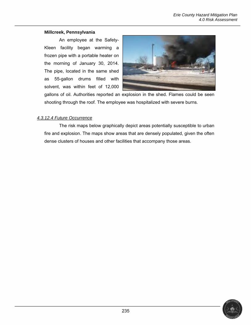
235
Erie County Hazard Mitigation Plan 4.0 Risk Assessment
Millcreek, Pennsylvania
An employee at the Safety-
Kleen facility began warming a
frozen pipe with a portable heater on
the morning of January 30, 2014.
The pipe, located in the same shed
as 55-gallon drums filled with
solvent, was within feet of 12,000
gallons of oil. Authorities reported an explosion in the shed. Flames could be seen
shooting through the roof. The employee was hospitalized with severe burns.
4.3.12.4 Future Occurrence
The risk maps below graphically depict areas potentially susceptible to urban
fire and explosion. The maps show areas that are densely populated, given the often
dense clusters of houses and other facilities that accompany those areas.
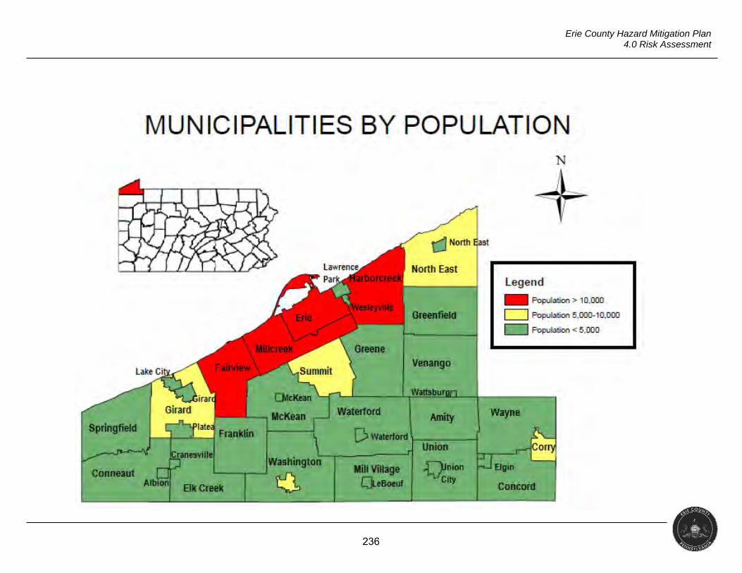
236
Erie County Hazard Mitigation Plan 4.0 Risk Assessment
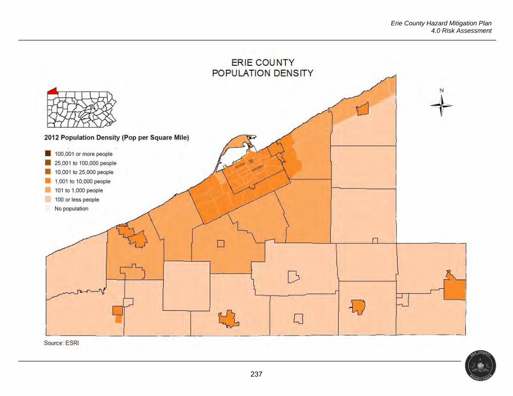
237
Erie County Hazard Mitigation Plan 4.0 Risk Assessment
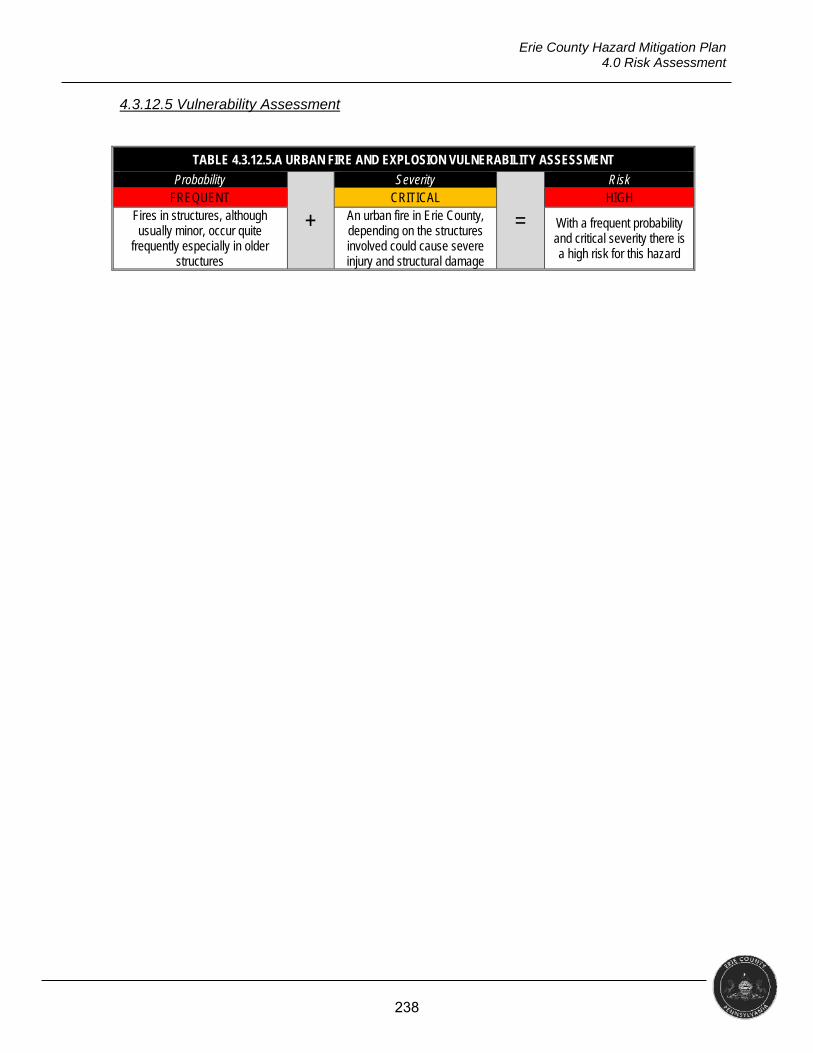
238
Erie County Hazard Mitigation Plan 4.0 Risk Assessment
4.3.12.5 Vulnerability Assessment
TABLE 4.3.12.5.A URBAN FIRE AND EXPLOSION VULNERABILITY ASSESSMENT
Probability
+
Severity
=
Risk FREQUENT CRITICAL HIGH
Fires in structures, although usually minor, occur quite
frequently especially in older structures
An urban fire in Erie County, depending on the structures involved could cause severe injury and structural damage
With a frequent probability and critical severity there is a high risk for this hazard
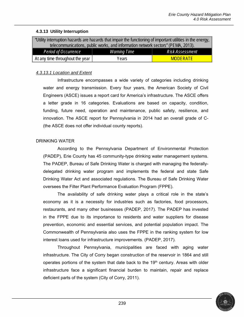
239
Erie County Hazard Mitigation Plan 4.0 Risk Assessment
4.3.13 Utility Interruption
“Utility interruption hazards are hazards that impair the functioning of important utilities in the energy, telecommunications, public works, and information network sectors” (PEMA, 2013).
Period of Occurrence Warning Time Risk Assessment
At any time throughout the year Years MODERATE
4.3.13.1 Location and Extent
Infrastructure encompasses a wide variety of categories including drinking
water and energy transmission. Every four years, the American Society of Civil
Engineers (ASCE) issues a report card for America’s infrastructure. The ASCE offers
a letter grade in 16 categories. Evaluations are based on capacity, condition,
funding, future need, operation and maintenance, public safety, resilience, and
innovation. The ASCE report for Pennsylvania in 2014 had an overall grade of C-
(the ASCE does not offer individual county reports).
DRINKING WATER
According to the Pennsylvania Department of Environmental Protection
(PADEP), Erie County has 45 community-type drinking water management systems.
The PADEP, Bureau of Safe Drinking Water is charged with managing the federally-
delegated drinking water program and implements the federal and state Safe
Drinking Water Act and associated regulations. The Bureau of Safe Drinking Water
oversees the Filter Plant Performance Evaluation Program (FPPE).
The availability of safe drinking water plays a critical role in the state’s
economy as it is a necessity for industries such as factories, food processors,
restaurants, and many other businesses (PADEP, 2017). The PADEP has invested
in the FPPE due to its importance to residents and water suppliers for disease
prevention, economic and essential services, and potential population impact. The
Commonwealth of Pennsylvania also uses the FPPE in the ranking system for low
interest loans used for infrastructure improvements. (PADEP, 2017).
Throughout Pennsylvania, municipalities are faced with aging water
infrastructure. The City of Corry began construction of the reservoir in 1864 and still
operates portions of the system that date back to the 19th century. Areas with older
infrastructure face a significant financial burden to maintain, repair and replace
deficient parts of the system (City of Corry, 2011).
240
Erie County Hazard Mitigation Plan 4.0 Risk Assessment
Stormwater systems are tools for managing the runoff from rainfall. In nature,
stormwater would be absorbed into soil and flow to streams and rivers, etc. However,
due to urban development, there has been a change to this natural process causing
concern of pollutants flowing into source water.
ENERGY
Reliable, affordable and environmentally-responsible energy use is essential
to Erie County’s economic growth and quality of life. Sufficient and resilient energy
infrastructure must be in place to ensure that the county can prosper (Cadmus
Group, 2013). The major components of electrical infrastructure are power
generation stations and distribution lines. Erie County has no generating stations
within county lines.
Perry Nuclear Power Plant (PNPP), located in North Perry, Ohio, is
approximately 32 miles from western Erie County. PNPP provides zero-carbon
electricity, preventing the emission of thousands of tons of air pollutants, and can
produce energy 24-hours a day, unlike solar and wind, which can only generate
electricity about half the time (Spitz, 2017). The Nuclear Regulatory Commission
reports that PNPP’s current license to operate expires in 2026, but the plant’s
operator, First Energy, has expressed interest in closing the plant (Horansky, 2017).
There are three major components to the natural gas infrastructure: the
interstate pipeline system and storage facilities and distribution pipelines. There are
two interstate pipelines that carry gas through Erie County and a gas storage facility
located near the City of Erie. Pennsylvania has four classes of gas pipelines
determined by building count, clustering, and boundaries of a class location unit (an
onshore area that extends 220 yards on either side of the centerline of any
continuous one-mile of pipeline.
Class 1: An offshore area or any class location unit that has 10 or fewer
buildings intended for human occupancy
Class 2: Any class location unit that has more than 10 but fewer than 46
buildings intended for human occupancy
Class 3: Any class location unit that has 46 or more buildings intended for
human occupancy; or an area where the pipeline lies within 100 yards of
either a building or a small, well-defined outside area (such as a playground,
recreation area, outdoor theater, or other place of public assembly) that is
241
Erie County Hazard Mitigation Plan 4.0 Risk Assessment
occupied by 20 or more persons on at least five days a week for 10 weeks in
any 12 month period
Class 4: Any class location unit where buildings with four or more stories
above ground are prevalent
In 2011, the Pennsylvania Public Utility Commission was given the authority
to inspect class two, three, and four pipelines, which includes over 1,200 miles of
pipe in the state. Class one lines are in rural areas and do not fall under any local,
state, or federal jurisdiction.
Taking steps toward a more efficient and renewable energy plan, both
Canada’s National Energy Board the United States’ Federal Energy Regulatory
Commission have approved the Lake Erie Connector Power Line Project (Reuters,
2017). ITC Holdings Corp. (ITC), the company that proposed the 73-mile project,
plans to have the lines operational by 2019 (Moore, 2016). With three power plants
closing in southwestern PA, ITC’s plan could fill the gap without building a new plant.
(Moore, 2016).
4.3.13.2 Range of Magnitude
Utility interruption is a countywide issue as it occurs anywhere there are
water and sewer lines, electricity lines, etc. Infrastructure is the backbone of the
economy and a necessary input to every economic output. It is critical to prosperity
and the public’s health and welfare. Deteriorating infrastructure, long known to be a
public safety issue, has a cascading impact on the economy, impacting business
productivity and competitiveness, employment, and personal income (ASCE, 2016).
In urban settings, climate-related disruption of one infrastructure system will
almost always result in cascading disruptions of one or more other systems. A loss of
electrical service can affect water treatment, transportation, and public health
services.
PUBLIC HEALTH
Although waterborne outbreaks are low, the number of incidents have been
on the rise. Poor water infrastructure can result in failure to meet water quality
standards, which can lead to unsafe drinking water and public health hazards such
as disease (ASCE, 2014). A CDC annual survey reported 431 cases of illness,
242
Erie County Hazard Mitigation Plan 4.0 Risk Assessment
causing 102 hospitalizations and 14 deaths that may have been linked to crumbling
water systems (Nixon, 2015).
SOCIAL VULNERABILITY
Urban populations depend on extensive utility systems, making them more
vulnerable to energy, water, wastewater, and public health failures. Many
infrastructure systems are reliant on each other, such that electricity failures can
affect water treatment and other services (NCA, 2014).
Thousands of people in the U.S. rely on electrically-powered durable medical
equipment (DME). During power outages, these DMEs, including medical grade
oxygen generators, power mobility devices, hospital beds, patient lifts, etc., require
either a continuous alternate source of energy, such as a backup generator, or to be
recharged after extended use. Without a way to keep these devices operational, a
power outage can become deadly. Communities have begun to create registries for
those that rely on devices and to assist in addressing their needs so hospitals do not
become overwhelmed during a power outage (Lurie, 2014).
All residents and businesses in Erie County are potentially vulnerable to
contaminated drinking water. Contaminated water causes diarrheal diseases
including cholera and other serious illnesses such as dysentery. Contaminated
drinking water can impact tourism, property values, recreational businesses, and
hospitality businesses.
4.3.13.3 Past Occurrence
Erie, Pennsylvania
On the morning of December 10, 2013, Erie Water Works responded to three
separate water main breaks. The first break occurred around 4:30 in the morning and
caused road closures.
Corry, Pennsylvania
In October 2016, several major water main breaks caused the reservoir to
lower and a disruption in water service lasting five days. The disruption left the fire
department unable to use hydrants for fire suppression and relying on neighboring
communities with water tankers. Schools and businesses closed. Approximately
3,200 water customers were affected by the disruption. Corry Memorial Hospital
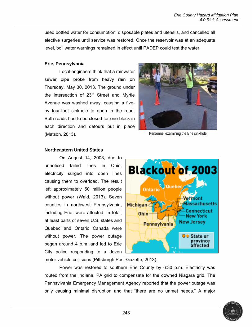
243
Erie County Hazard Mitigation Plan 4.0 Risk Assessment
used bottled water for consumption, disposable plates and utensils, and cancelled all
elective surgeries until service was restored. Once the reservoir was at an adequate
level, boil water warnings remained in effect until PADEP could test the water.
Erie, Pennsylvania
Local engineers think that a rainwater
sewer pipe broke from heavy rain on
Thursday, May 30, 2013. The ground under
the intersection of 23rd Street and Myrtle
Avenue was washed away, causing a five-
by four-foot sinkhole to open in the road.
Both roads had to be closed for one block in
each direction and detours put in place
(Matson, 2013).
Northeastern United States
On August 14, 2003, due to
unnoticed failed lines in Ohio,
electricity surged into open lines
causing them to overload. The result
left approximately 50 million people
without power (Wald, 2013). Seven
counties in northwest Pennsylvania,
including Erie, were affected. In total,
at least parts of seven U.S. states and
Quebec and Ontario Canada were
without power. The power outage
began around 4 p.m. and led to Erie
City police responding to a dozen
motor vehicle collisions (Pittsburgh Post-Gazette, 2013).
Power was restored to southern Erie County by 6:30 p.m. Electricity was
routed from the Indiana, PA grid to compensate for the downed Niagara grid. The
Pennsylvania Emergency Management Agency reported that the power outage was
only causing minimal disruption and that “there are no unmet needs.” A major
Personnel examining the Erie sinkhole
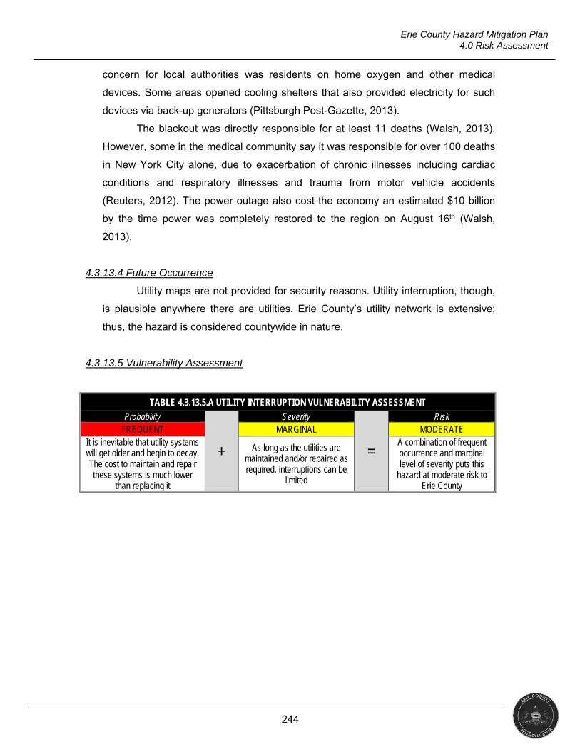
244
Erie County Hazard Mitigation Plan 4.0 Risk Assessment
concern for local authorities was residents on home oxygen and other medical
devices. Some areas opened cooling shelters that also provided electricity for such
devices via back-up generators (Pittsburgh Post-Gazette, 2013).
The blackout was directly responsible for at least 11 deaths (Walsh, 2013).
However, some in the medical community say it was responsible for over 100 deaths
in New York City alone, due to exacerbation of chronic illnesses including cardiac
conditions and respiratory illnesses and trauma from motor vehicle accidents
(Reuters, 2012). The power outage also cost the economy an estimated $10 billion
by the time power was completely restored to the region on August 16th (Walsh,
2013).
4.3.13.4 Future Occurrence
Utility maps are not provided for security reasons. Utility interruption, though,
is plausible anywhere there are utilities. Erie County’s utility network is extensive;
thus, the hazard is considered countywide in nature.
4.3.13.5 Vulnerability Assessment
TABLE 4.3.13.5.A UTILITY INTERRUPTION VULNERABILITY ASSESSMENT
Probability
+
Severity
=
Risk FREQUENT MARGINAL MODERATE
It is inevitable that utility systems will get older and begin to decay. The cost to maintain and repair these systems is much lower
than replacing it
As long as the utilities are maintained and/or repaired as required, interruptions can be
limited
A combination of frequent occurrence and marginal level of severity puts this
hazard at moderate risk to Erie County
245
Erie County Hazard Mitigation Plan 4.0 Risk Assessment
4.3.14 War and Criminal Activity
"An intentional use of force or power, against oneself, another person, or against a group or community, which either results in or has a high likelihood of resulting in injury, death, psychological
harm, maldevelopment, or deprivation" (WHO, n.d.). Period of Occurrence Warning Time Risk Assessment
At any time throughout the year None / Days / Weeks MODERATE
4.3.14.1 Location and Extent
As the nation has seen an upswing in violent acts (ABC, 2017), it is advisable
to profile types of violence and the potential impacts they could have in Erie County.
Acts of violence, for the purpose of this plan, encompass those acts that law
enforcement does not consider routine. This profile will analyze the following topics:
Terrorism/bioterrorism,
Active shooter (including workplace and school shootings), and
Civil unrest.
The Federal Bureau of Investigation (FBI) defines terrorism as “the unlawful
uses of force or violence against persons or property to intimidate or coerce a
government, the civilian population, or any segment thereof, in furtherance of political
or social objectives.” Shortly after the terrorist attacks on September 11, 2001,
government officials, news agencies, and even private citizens began reporting the
receipt of letters containing anthrax spores. Source water agencies also reported
threats against their water supplies. Due to these events, bioterrorism became a
significant threat to national security and was addressed through the Bioterrorism
Preparedness and Response Act of 2002.
“The agreed upon definition of an active shooter by U.S. government
agencies - including the White House, U.S. Department of Justice/FBI, U.S.
Department of Education, and U.S. Department of Homeland Security/Federal
Emergency Management Agency - is an individual actively engaged in killing or
attempting to kill people in a confined and populated area” (FBI, 2013). In most
cases, active shooters use firearms and there is no pattern or method to their
selection of victims (Alice Training Institute, 2017).
Erie County has what could be considered targets for terrorism. Government
buildings, industrial facilities, and mass gathering points are targets (USDHS, 2013).
Race, economic diversity, and political injustice are leading causes of protests and
246
Erie County Hazard Mitigation Plan 4.0 Risk Assessment
riots. Nationally, there are growing tensions over political ideology and perceived
authoritative abuse of power (Tillman, 2016). While Erie County has not seen a rise
in events per these tensions, many protestors travel out of state as seen in the 2016
riots in North Carolina. The Charlotte-Mecklenburg Fraternal Order of Police reported
that approximately 70% of people arrested had out-of-state identifications.
There is no single cause of acts of violence. Typically, a non-rational,
complicated, intertwined, series of events result in violence. In his article Causes of
Terrorism, Nick Grothaus lays out the most common causes cited by leaders in the
field of counterterrorism. These categories may apply to other types of violence not
related to terrorism.
Ethno-Nationalism: The desire of a population to break away from a
government or ruling power and create a state of its own.
Alienation/Discrimination: Individuals or groups face discrimination leading
to feelings of isolation. These people may become jaded towards society and
feel excluded.
Religion: Religion as a part of terrorism has been mainly attributed to Islamic
fundamentalism, although other religions have also had involvement in
terrorist activities. For example, Christian Fundamentalists target abortion
clinics, religious fundamentalists of many types may target Jews and
minorities (Post, 2007, pp. 211-212).
Socio-Economic Status: Individuals and groups may be driven by a sense
of relative depravation and lack of upward mobility within society.
Political Grievances: A lack of political inclusiveness or grievances against
a certain political order may cause individuals to join or create terrorist
groups.
4.3.14.2 Range of Magnitude
Acts of violence have the ability to affect a small area, such as a single
business or government building, or an entire community (e.g., municipality, county,
state), or even the entire nation. Due to the rise of workplace and school violence,
“homegrown” and “lone-wolf” terrorists, and racially-motivated attacks, the entire
county is at risk for acts of violence.
The U.S. Department of Labor Statistics shows in 2015, nationwide, there
were 417 workplace homicides, with 354 involving a firearm (DOL, 2015). A Centers

247
Erie County Hazard Mitigation Plan 4.0 Risk Assessment
for Disease Control (CDC) study on school-associated violent death found between
14 and 34 school-age children are victims of homicide on school grounds annually in
the U.S. (CDC, 2010). Group protests, which have become more frequent in the
current political climate, have the ability to become violent, close schools and
businesses, and block roadways and access to buildings (Callahan, 2017).
Erie County is not immune to these national trends. As seen in Section
4.3.14.3, the county has experienced school violence as well as eco-terrorism
attacks. During the 2016 presidential campaign, a Donald Trump rally at the Erie
Insurance Arena drew over 8,000 supporters as well as hundreds of protesters. Law
enforcement officials reported the protests remained peaceful; however, this was not
the case during many political rallies during this campaign season.
Estimating the economic impact of an act of violence, especially a terrorist
attack, is a difficult task. Initial impact can be measured in immediate costs such as
response to the event and closed businesses. The full economic impact would
include long-term costs.
A large-scale event could significantly affect industry and/or government and
privately-owned infrastructure. An incident involving wastewater, drinking water, or
chemical facilities could have long-term environmental effects. These variables make
it difficult to quantify the cost of repair or replacement of infrastructure.
PUBLIC HEALTH
Those victims directly affected by of acts of violence will often suffer blunt
trauma, gunshot wounds, puncture wounds, severe burns, or death. Injured survivors
may face weeks or months in hospitals and may need multiple surgeries which
increases the chance of infections and other secondary illnesses such as pneumonia
and M.R.S.A.
Survivors of violence may also experience common stress reactions lasting
several days to a few weeks. These reactions can include the following.
Emotional Reactions: Shock, fear, grief, anger, guilt, shame, helplessness,
numbness, sadness
Cognitive Reactions: Confusion, indecisiveness, worry, shortened attention
span, trouble concentrating
Physical Reactions: Tension, fatigue, edginess, insomnia, body aches,
easily startled, tachycardia, nausea, loss of appetite
248
Erie County Hazard Mitigation Plan 4.0 Risk Assessment
Interpersonal Reactions: Distrust, conflict, withdrawal, irritability, loss of
intimacy, feeling abandoned
Some individuals may experience severe stress symptoms following a violent
incident. Individuals experiencing the following are at a higher risk for post-traumatic
stress disorder (Nation Center for PTSD, 2010).
Intrusive Re-Experiencing: Terrifying memories, nightmares, and
flashbacks
Extreme Emotional Numbing: Inability to feel emotions, feeling empty
Extreme Attempts to Avoid Disturbing Memories: Such as through
substance abuse
Hyperarousal: Panic attacks, rage, extreme irritability, intense agitation,
acting out with violence
Severe Anxiety: Debilitating worry, extreme helplessness, compulsions or
obsessions
Severe Depression: Loss of ability to feel hope, pleasure, or interest; feeling
worthless; suicidal ideations or intent
Dissociation: Fragmented thoughts, spaced out, unaware of surroundings,
amnesia
Treatment and support are critical to recovery. For most, the memories will
not go away, but survivors can learn to manage responses to their memories. There
are several methods that can be used to help survivors cope, including
psychotherapy, medication, support groups, and self-care (Riggs, 2017).
SOCIAL VULNERABILITY
Deciding which groups are vulnerable is challenging. There will always be
variation between groups and the people within them in relation to the risks they face
(Brown, 2004). However, the elderly, children, homeless persons, people with
disabilities, religious groups, and members of the LGBT community experience
higher rates of exposure to violence (Phillips, Thomas, Fothergill, Blinn-Pike, 2010).
Between 2003 and 2013, the elderly reported 56% of all violent crimes
(USDOJ, 2014). A 2009 study showed that almost 40% of all American children were
victims of two or more violent acts (DOJ, 2009). In 2010, there were 113 violent acts
249
Erie County Hazard Mitigation Plan 4.0 Risk Assessment
against the homeless, twenty-four of which were fatal (National Coalition for the
Homeless, 2012). An analysis of the 2011 FBI hate-crime statistics showed “LGBT
people are more than twice as likely to be the target of a violent hate-crime than
Jews or black people” (Potok, 2011).
4.3.14.3 Past Occurrence
Edinboro, Pennsylvania
On April 24, 1998, a 14 year-old James Parker Middle School student fatally
shot a teacher, wounded another teacher, and wounded two students while
attending a school function at a banquet hall. The incident ended when the
establishment owner confronted the actor and held him at gunpoint. Parents,
unaware of the events that had occurred, arrived to pick up their children, finding a
crime scene with law enforcement, ambulances and television news crews.
Concerned, parents rushed to find their children, making it difficult for police to
maintain the integrity of the crime scene.
Erie, Pennsylvania
In March 2002, law enforcement responded to two acts of domestic eco-
terrorism at the same construction site in Erie, PA. On March 18, police responded to
a vandalism complaint and found “ELF, in the protection of mother earth” and “stop
deforestation” spray-painted on equipment used to clear trees. Later that month, on
March 24, a crane and generators were set on fire and hundreds of trees were
spiked (inserting metal rods where a logger would cut the tree to cause injury to the
logger and damage to equipment). Damage was estimated at approximately
$500,000. The Earth Liberation Front (E.L.F.) claimed responsibility for both acts.
E.L.F. is also responsible for the burning of six vehicles at a Girard Township car
dealership on January 1, 2003, as well as burning a mink farm in Harborcreek
Township on November 26, 2002.
Erie, Pennsylvania
On January 19, 2017, the CareerLink office in Erie received two bomb
threats. The office evacuated while police swept the building. Police did not locate

250
Erie County Hazard Mitigation Plan 4.0 Risk Assessment
any devices. Police arrested a 44 year-old male, who stated he was upset he was
not receiving more assistance from the office.
4.3.14.4 Future Occurrence
The risk map below graphically depicts areas potentially susceptible to war
and criminal activity (primarily focusing on acts of violence).
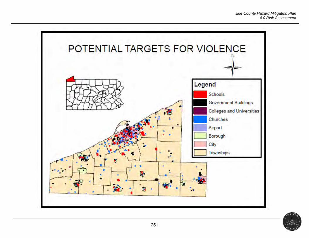
251
Erie County Hazard Mitigation Plan 4.0 Risk Assessment
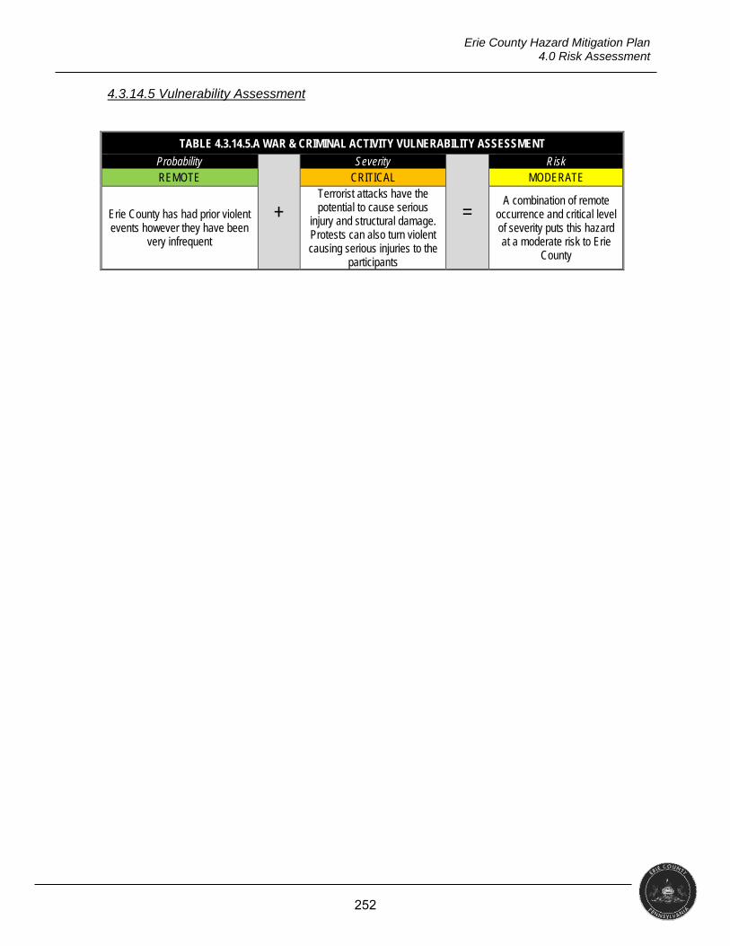
252
Erie County Hazard Mitigation Plan 4.0 Risk Assessment
4.3.14.5 Vulnerability Assessment
TABLE 4.3.14.5.A WAR & CRIMINAL ACTIVITY VULNERABILITY ASSESSMENT
Probability
+
Severity
=
Risk REMOTE CRITICAL MODERATE
Erie County has had prior violent events however they have been
very infrequent
Terrorist attacks have the potential to cause serious
injury and structural damage. Protests can also turn violent causing serious injuries to the
participants
A combination of remote occurrence and critical level of severity puts this hazard at a moderate risk to Erie
County
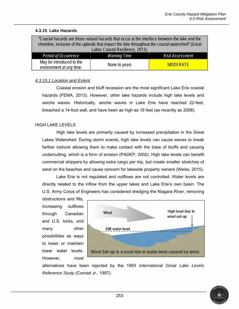
253
Erie County Hazard Mitigation Plan 4.0 Risk Assessment
4.3.15 Lake Hazards
“Coastal hazards are those natural hazards that occur at the interface between the lake and the shoreline, inclusive of the uplands that impact the lake throughout the coastal watershed” (Great
Lakes Coastal Resilience, 2013). Period of Occurrence Warning Time Risk Assessment
May be introduced to the environment at any time.
None to years MODERATE
4.3.15.1 Location and Extent
Coastal erosion and bluff recession are the most significant Lake Erie coastal
hazards (FEMA, 2013). However, other lake hazards include high lake levels and
seiche waves. Historically, seiche waves in Lake Erie have reached 22-feet,
breached a 14-foot wall, and have been as high as 16 feet (as recently as 2008).
HIGH LAKE LEVELS
High lake levels are primarily caused by increased precipitation in the Great
Lakes Watershed. During storm events, high lake levels can cause waves to break
farther inshore allowing them to make contact with the base of bluffs and causing
undercutting, which is a form of erosion (PADEP, 2002). High lake levels can benefit
commercial shippers by allowing extra cargo per trip, but create smaller stretches of
sand on the beaches and cause concern for lakeside property owners (Weiss, 2015).
Lake Erie is not regulated and outflows are not controlled. Water levels are
directly related to the inflow from the upper lakes and Lake Erie’s own basin. The
U.S. Army Corps of Engineers has considered dredging the Niagara River, removing
obstructions and fills,
increasing outflows
through Canadian
and U.S. locks, and
many other
possibilities as ways
to lower or maintain
lower water levels.
However, most
alternatives have been rejected by the 1993 International Great Lake Levels
Reference Study (Conrad Jr., 1997).
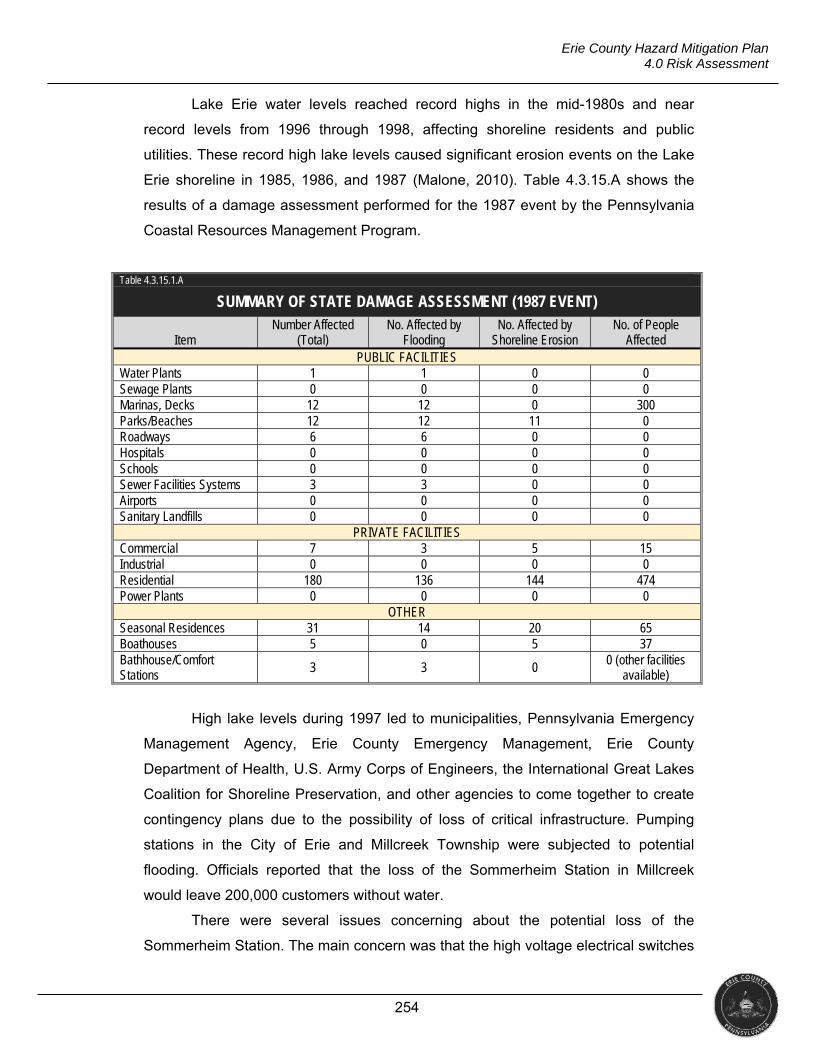
254
Erie County Hazard Mitigation Plan 4.0 Risk Assessment
Lake Erie water levels reached record highs in the mid-1980s and near
record levels from 1996 through 1998, affecting shoreline residents and public
utilities. These record high lake levels caused significant erosion events on the Lake
Erie shoreline in 1985, 1986, and 1987 (Malone, 2010). Table 4.3.15.A shows the
results of a damage assessment performed for the 1987 event by the Pennsylvania
Coastal Resources Management Program.
Table 4.3.15.1.A
SUMMARY OF STATE DAMAGE ASSESSMENT (1987 EVENT)
Item Number Affected
(Total) No. Affected by
Flooding No. Affected by
Shoreline Erosion No. of People
Affected PUBLIC FACILITIES
Water Plants 1 1 0 0 Sewage Plants 0 0 0 0 Marinas, Decks 12 12 0 300 Parks/Beaches 12 12 11 0 Roadways 6 6 0 0 Hospitals 0 0 0 0 Schools 0 0 0 0 Sewer Facilities Systems 3 3 0 0 Airports 0 0 0 0 Sanitary Landfills 0 0 0 0
PRIVATE FACILITIES Commercial 7 3 5 15 Industrial 0 0 0 0 Residential 180 136 144 474 Power Plants 0 0 0 0
OTHER Seasonal Residences 31 14 20 65 Boathouses 5 0 5 37 Bathhouse/Comfort Stations
3 3 0 0 (other facilities available)
High lake levels during 1997 led to municipalities, Pennsylvania Emergency
Management Agency, Erie County Emergency Management, Erie County
Department of Health, U.S. Army Corps of Engineers, the International Great Lakes
Coalition for Shoreline Preservation, and other agencies to come together to create
contingency plans due to the possibility of loss of critical infrastructure. Pumping
stations in the City of Erie and Millcreek Township were subjected to potential
flooding. Officials reported that the loss of the Sommerheim Station in Millcreek
would leave 200,000 customers without water.
There were several issues concerning about the potential loss of the
Sommerheim Station. The main concern was that the high voltage electrical switches
255
Erie County Hazard Mitigation Plan 4.0 Risk Assessment
were seven inches from the ground floor, making them vulnerable to high water.
Secondly, the station had already had flooding problems. The third issue was the
three ways flood water can enter the building and the possibility of any or a
combination of the three shutting down the pump (causing all Erie Water Authority
customers to be without water for an extended period of time).
Officials designated high priority customers such as hospitals and nursing
homes that would need immediate alternative water sources. Officials also engaged
in a lengthy planning process in an attempt to mitigate the vulnerability, update
emergency operations plans, and identify resources to be used in the event of a
worst case scenario situation.
SEICHE WAVES
Seiche waves occur when strong winds push water along the length of the
lake causing water levels to drop at one end and rise at the other. When the wind
stops, the water rebounds to the other side of the lake. The water will continue back
and forth for hours to days (NOAA, 2015). Seiches cause damage similar in nature to
that from a tsunami or storm surge (Sousounis, 2014).
Lake Erie produces the largest sieches of the Great Lakes. This is due to its
orientation and shallowness. Seiches are usually minor and are mistaken for tidal
activity; however, the NWS begins to issue advisories when they are expected to be
over two feet (Sousounis, 2014). Severe and deadly seiche events are rare on the
Great Lakes. Minor seiches could cause damage to property right on the lakefront,
including cottages and boats.
4.3.15.2 Range of Magnitude
The county’s 76.2 miles of coast line serves as the location of impacts from
lake hazards. The nine municipalities located along the coast could be impacted by
lake hazards. Wind speeds and barometric pressure are the largest variables to the
size of an event in a lake basin (primary of seiche waves). However, the size and
shape of the basin and water body also contributes to the magnitude of a seiche.
Larger and shallower lakes like Lake Erie tend to increase the magnitude. Large
seiches would have to be between 80 and 100 feet to cause significant damage to
property or risk of life in Erie County.
256
Erie County Hazard Mitigation Plan 4.0 Risk Assessment
Due to the varying types of lake hazards and the different impacts each can
have, economic loss is challenging to assess. Seiche waves have the ability to
breach walls and cause damage to structures and critical infrastructure including
roadways and bridges. Seiche waves can also damage utility poles and lines causing
phone, power, and broadband outages and associated financial costs to repair.
PUBLIC HEALTH
Lake disasters can force a temporary instance of people living in crowded
conditions with poor sanitation, poor management of human waste, and
impoverished nutrition. They may also result in incidences of waterborne diseases,
trauma resulting from the magnitude of the event, and low immunity or susceptibility
to infectious diseases including pneumonia and cholera (De Moura, Roges, De
Souza, Siciliano, & Rodrigues, 2012). Another concern is stress-related mental
health issues such as PTSD (CDC, 2017).
SOCIAL VULNERABILITY
Those who rely on the tourism industry are also at risk. Lake hazards can
potentially devastate ecosystem, thus impacting the economies of communities that
rely on commercial and sports fishing, boating and other recreational tourism. There
is a potential for tens of billions in lost revenue with millions more spent on
monitoring and response.
4.3.15.3 Past Occurrence
Lake Erie
From May through December 1996, above average snowmelt combined with
higher than normal amounts of precipitation, producing above-average lake levels.
High lake levels continued through 1997. The Presque Isle State Park Advisory
Committee reported “severe loss of Lake Erie shoreline due to erosion contributed in
no small part to the elevated lake levels.” The Erie County Emergency Management
Agency documented 367 structures that were potentially at risk of damage or
destruction from flooding.
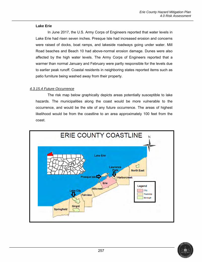
257
Erie County Hazard Mitigation Plan 4.0 Risk Assessment
Lake Erie
In June 2017, the U.S. Army Corps of Engineers reported that water levels in
Lake Erie had risen seven inches. Presque Isle had increased erosion and concerns
were raised of docks, boat ramps, and lakeside roadways going under water. Mill
Road beaches and Beach 10 had above-normal erosion damage. Dunes were also
affected by the high water levels. The Army Corps of Engineers reported that a
warmer than normal January and February were partly responsible for the levels due
to earlier peak runoff. Coastal residents in neighboring states reported items such as
patio furniture being washed away from their property.
4.3.15.4 Future Occurrence
The risk map below graphically depicts areas potentially susceptible to lake
hazards. The municipalities along the coast would be more vulnerable to the
occurrence, and would be the site of any future occurrence. The areas of highest
likelihood would be from the coastline to an area approximately 100 feet from the
coast.
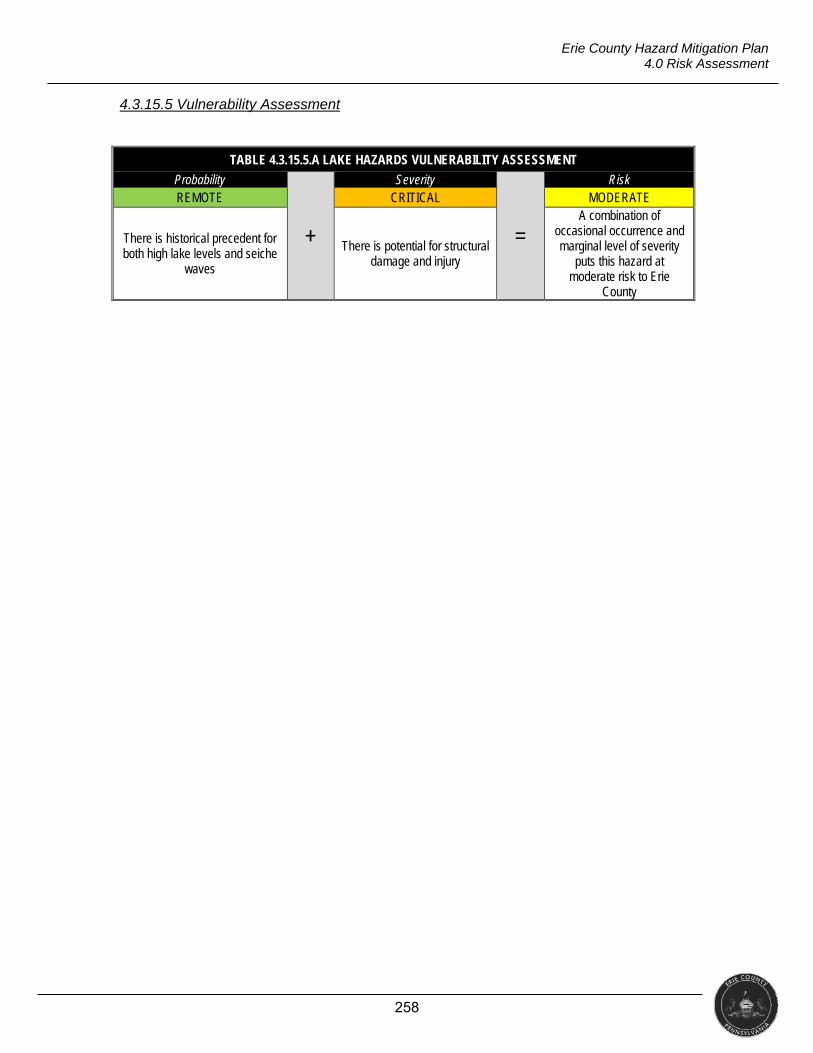
258
Erie County Hazard Mitigation Plan 4.0 Risk Assessment
4.3.15.5 Vulnerability Assessment
TABLE 4.3.15.5.A LAKE HAZARDS VULNERABILITY ASSESSMENT
Probability
+
Severity
=
Risk REMOTE CRITICAL MODERATE
There is historical precedent for both high lake levels and seiche
waves
There is potential for structural damage and injury
A combination of occasional occurrence and marginal level of severity
puts this hazard at moderate risk to Erie
County
259
Erie County Hazard Mitigation Plan 4.0 Risk Assessment
4.3.16 Transportation Infrastructure Decay
“Deteriorating infrastructure, long known to be a public safety issue, has a cascading impact on our nation’s economy, impacting business productivity, gross domestic product, employment, personal
income, and international competitiveness” (ASCE, 2016). This profile focuses on the deterioration of the transportation infrastructure (i.e., roadways and bridges).
Period of Occurrence Warning Time Risk Assessment
At any time throughout the year Years MODERATE
4.3.16.1 Location and Extent
Infrastructure encompasses a wide variety of categories including bridges,
transportation, etc. Every four years, the American Society of Civil Engineers (ASCE)
issues a report card for America’s infrastructure. The ASCE offers a letter grade in
16 categories. Evaluations are based on capacity, condition, funding, future need,
operation and maintenance, public safety, resilience, and innovation. The ASCE
report for Pennsylvania in 2014 had an overall grade of C- (the ASCE does not offer
individual county reports).
BRIDGES
Erie County has 692 bridges on state and local routes that are inspected by
the Pennsylvania Department of Transportation (PennDOT). Of the 692 bridges, 575
are on the state route system. PennDOT inspectors have found 26 bridges (4.52%)
to be structurally deficient and one bridge is listed as posted. “Structurally deficient”
indicates that the bridge has deterioration to one or more of its major components;
“posted” means the bridge is open but signs have been placed stating a weight limit
that can travel across the bridge. PennDOT inspectors have classified 43 of the 177
bridges on local routes (36.75%) to be structurally deficient and list 21 as posted.
PennDOT inspectors have also closed seven bridges on the local route system in
Erie County (PennDOT, 2017). PennDOT closes a bridge when advance
deterioration results in weight limits of less than three tons and/or no guarantee of
the traveling public’s safety (PennDOT, 2011).
The average age of bridges on the state system, statewide, is over 50 years.
Of the 688 bridges with known completion dates in Erie County, 367 (53.3%) are
over 50 years old with 19 over 100 years old. Only 62 bridges (9%) have been
completed in the last ten years.
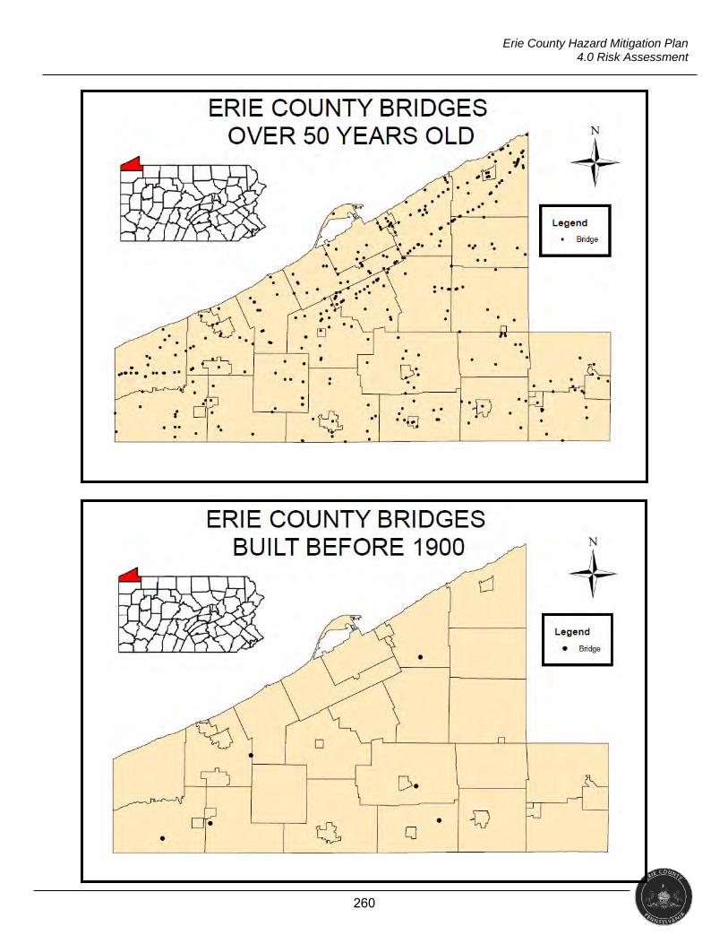
260
Erie County Hazard Mitigation Plan 4.0 Risk Assessment
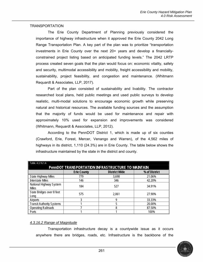
261
Erie County Hazard Mitigation Plan 4.0 Risk Assessment
TRANSPORTATION
The Erie County Department of Planning previously considered the
importance of highway infrastructure when it approved the Erie County 2042 Long
Range Transportation Plan. A key part of the plan was to prioritize “transportation
investments in Erie County over the next 20+ years and develop a financially-
constrained project listing based on anticipated funding levels.” The 2042 LRTP
process created seven goals that the plan would focus on: economic vitality, safety
and security, multimodal accessibility and mobility, freight accessibility and mobility,
sustainability, project feasibility, and congestion and maintenance. (Whitmann
Requardt & Associates, LLP, 2017).
Part of the plan consisted of sustainability and livability. The contractor
researched local plans, held public meetings and used public surveys to develop
realistic, multi-modal solutions to encourage economic growth while preserving
natural and historical resources. The available funding sources and the assumption
that the majority of funds would be used for maintenance and repair with
approximately 10% used for expansion and improvements was considered
(Whitmann, Requardt & Associates, LLP, 2012).
According to the PennDOT District 1, which is made up of six counties
(Crawford, Erie, Forest, Mercer, Venango and Warren), of the 4,562 miles of
highways in its district, 1,110 (24.3%) are in Erie County. The table below shows the
infrastructure maintained by the state in the district and county.
4.3.16.2 Range of Magnitude
Transportation infrastructure decay is a countywide issue as it occurs
anywhere there are bridges, roads, etc. Infrastructure is the backbone of the
Table. 4.3.16.1.A
PennDOT TRANSPORTATION INFRASTRUCTURE TO MAINTAIN Erie County District Wide % of District State Highway Miles 779 3,698 21.06% Interstate Miles 146 346 42.20% National Highway System Miles 184 527 34.91%
State Bridges over 8 feet Long 575 2,061 27.90%
Airports 3 9 33.33% Transit Authority Systems 1 5 20.00% Operating Railroads 7 8 87.50% Ports 1 1 100%
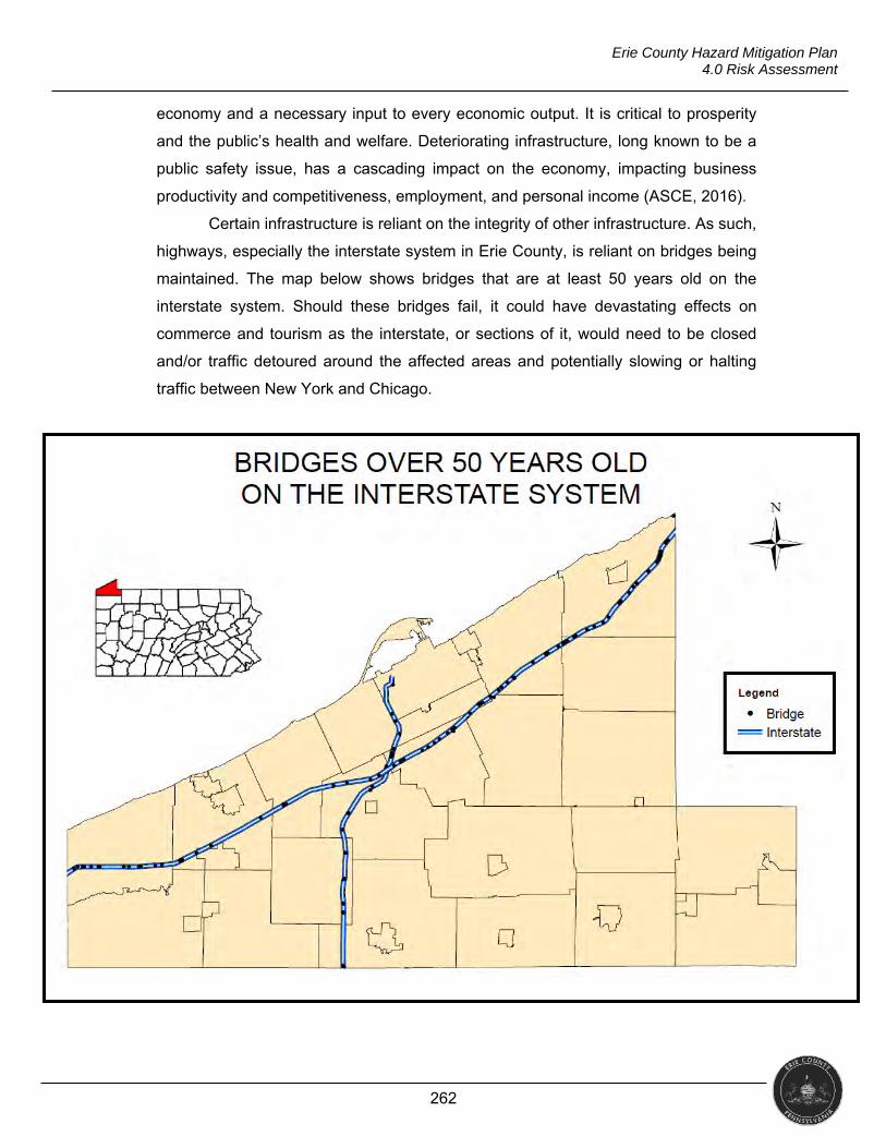
262
Erie County Hazard Mitigation Plan 4.0 Risk Assessment
economy and a necessary input to every economic output. It is critical to prosperity
and the public’s health and welfare. Deteriorating infrastructure, long known to be a
public safety issue, has a cascading impact on the economy, impacting business
productivity and competitiveness, employment, and personal income (ASCE, 2016).
Certain infrastructure is reliant on the integrity of other infrastructure. As such,
highways, especially the interstate system in Erie County, is reliant on bridges being
maintained. The map below shows bridges that are at least 50 years old on the
interstate system. Should these bridges fail, it could have devastating effects on
commerce and tourism as the interstate, or sections of it, would need to be closed
and/or traffic detoured around the affected areas and potentially slowing or halting
traffic between New York and Chicago.
263
Erie County Hazard Mitigation Plan 4.0 Risk Assessment
PUBLIC HEALTH
There is no national record-keeping of how many deaths, injuries and
illnesses are caused by failing and crumbling infrastructure. However, the data that
does exist suggests that structures in need of repair do affect public health and
safety. The federal DOT estimates poor road conditions are a factor in 14,000
fatalities each year (Nixon, 2015).
SOCIAL VULNERABILITY
Urban populations depend on extensive infrastructure systems, making them
more vulnerable to energy, water, wastewater, transportation, and public health
failures. Many infrastructure systems are reliant on each other, such that electricity
failures can affect water treatment and transportation services (NCA, 2014).
4.3.16.3 Past Occurrence
Erie, Pennsylvania
Local engineers think that a rainwater sewer pipe broke from heavy rain on
Thursday, May 30, 2013. The ground under the intersection of 23rd Street and Myrtle
Avenue was washed away, causing a five- by four-foot sinkhole to open in the road.
Both roads had to be closed for one block in each direction and detours put in place
(Matson, 2013).
Minneapolis, Minnesota
On August 1, 2007, the eight-lane Interstate 35 Bridge spanning the Saint
Anthony Falls of the Mississippi River in Minneapolis, MN collapsed during the event
rush hour, killing 13 people and injuring 145. The National Transportation Safety
Board (NTSB) ultimately concluded that the bridge’s design-specified steel gusset
plates were undersized and inadequate to support the load of the bridge (Holt &
Hartmann, 2008). Photographs showed bowing of the gusset plates.
4.3.16.4 Future Occurrence
The following risk maps depict the transportation infrastructure in Erie
County, Erie City, and Corry City.
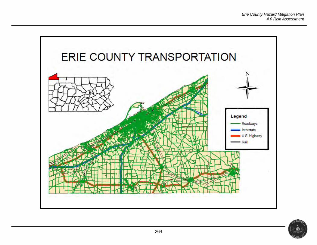
264
Erie County Hazard Mitigation Plan 4.0 Risk Assessment
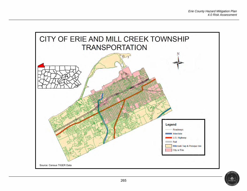
265
Erie County Hazard Mitigation Plan 4.0 Risk Assessment
Source: Census TIGER Data
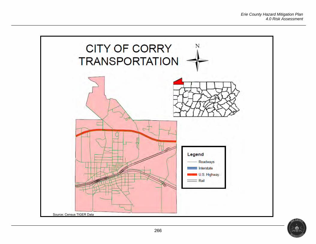
266
Erie County Hazard Mitigation Plan 4.0 Risk Assessment
Source: Census TIGER Data
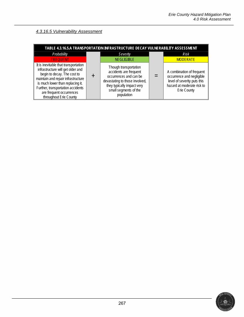
267
Erie County Hazard Mitigation Plan 4.0 Risk Assessment
4.3.16.5 Vulnerability Assessment
TABLE 4.3.16.5.A TRANSPORTATION INFRASTRUCTURE DECAY VULNERABILITY ASSESSMENT
Probability
+
Severity
=
Risk FREQUENT NEGLIGIBLE MODERATE
It is inevitable that transportation infrastructure will get older and
begin to decay. The cost to maintain and repair infrastructure is much lower than replacing it.
Further, transportation accidents are frequent occurrences throughout Erie County
Though transportation accidents are frequent
occurrences and can be devastating to those involved,
they typically impact very small segments of the
population
A combination of frequent occurrence and negligible level of severity puts this
hazard at moderate risk to Erie County
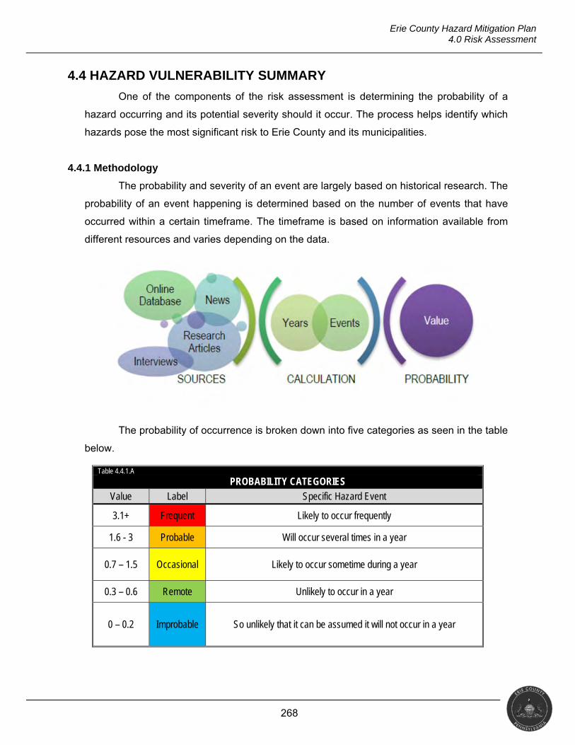
268
Erie County Hazard Mitigation Plan 4.0 Risk Assessment
4.4 HAZARD VULNERABILITY SUMMARY
One of the components of the risk assessment is determining the probability of a
hazard occurring and its potential severity should it occur. The process helps identify which
hazards pose the most significant risk to Erie County and its municipalities.
4.4.1 Methodology
The probability and severity of an event are largely based on historical research. The
probability of an event happening is determined based on the number of events that have
occurred within a certain timeframe. The timeframe is based on information available from
different resources and varies depending on the data.
The probability of occurrence is broken down into five categories as seen in the table
below.
Table 4.4.1.A
PROBABILITY CATEGORIES Value Label Specific Hazard Event
3.1+ Frequent Likely to occur frequently
1.6 - 3 Probable Will occur several times in a year
0.7 – 1.5 Occasional Likely to occur sometime during a year
0.3 – 0.6 Remote Unlikely to occur in a year
0 – 0.2 Improbable So unlikely that it can be assumed it will not occur in a year
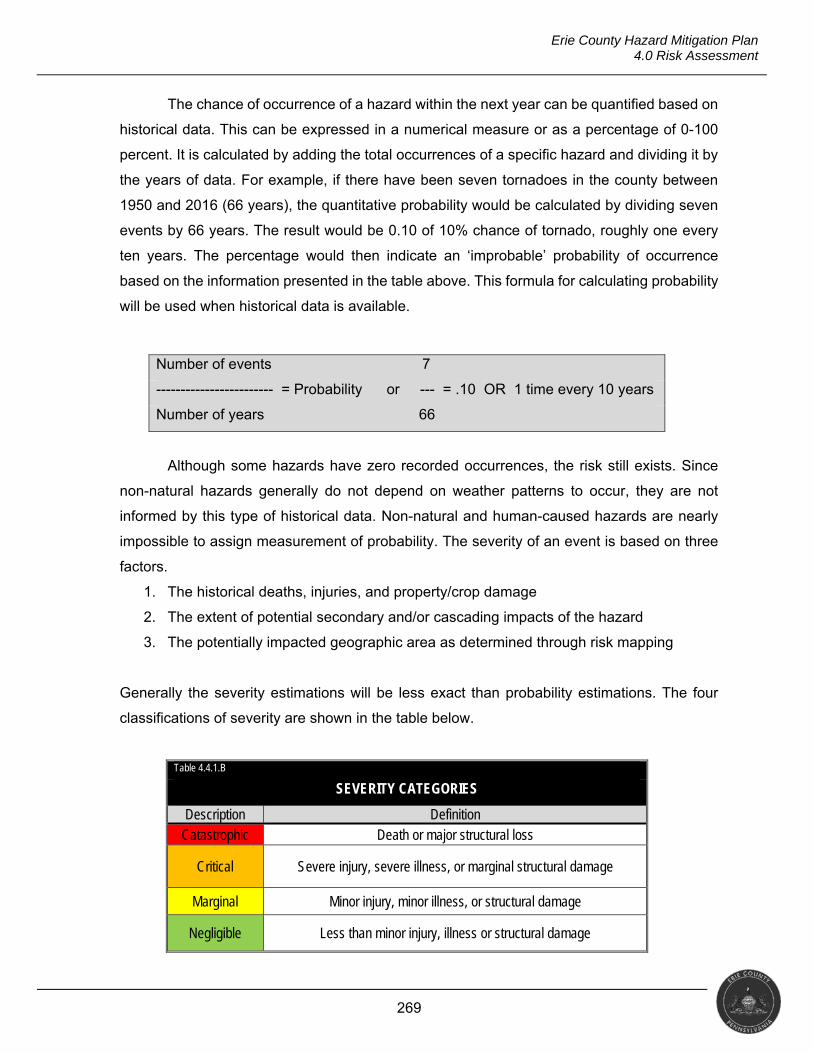
269
Erie County Hazard Mitigation Plan 4.0 Risk Assessment
The chance of occurrence of a hazard within the next year can be quantified based on
historical data. This can be expressed in a numerical measure or as a percentage of 0-100
percent. It is calculated by adding the total occurrences of a specific hazard and dividing it by
the years of data. For example, if there have been seven tornadoes in the county between
1950 and 2016 (66 years), the quantitative probability would be calculated by dividing seven
events by 66 years. The result would be 0.10 of 10% chance of tornado, roughly one every
ten years. The percentage would then indicate an ‘improbable’ probability of occurrence
based on the information presented in the table above. This formula for calculating probability
will be used when historical data is available.
Although some hazards have zero recorded occurrences, the risk still exists. Since
non-natural hazards generally do not depend on weather patterns to occur, they are not
informed by this type of historical data. Non-natural and human-caused hazards are nearly
impossible to assign measurement of probability. The severity of an event is based on three
factors.
1. The historical deaths, injuries, and property/crop damage
2. The extent of potential secondary and/or cascading impacts of the hazard
3. The potentially impacted geographic area as determined through risk mapping
Generally the severity estimations will be less exact than probability estimations. The four
classifications of severity are shown in the table below.
Table 4.4.1.B
SEVERITY CATEGORIES
Description Definition Catastrophic Death or major structural loss
Critical Severe injury, severe illness, or marginal structural damage
Marginal Minor injury, minor illness, or structural damage
Negligible Less than minor injury, illness or structural damage
Number of events 7
------------------------ = Probability or --- = .10 OR 1 time every 10 years
Number of years 66
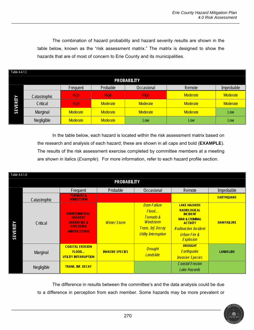
270
Erie County Hazard Mitigation Plan 4.0 Risk Assessment
The combination of hazard probability and hazard severity results are shown in the
table below, known as the “risk assessment matrix.” The matrix is designed to show the
hazards that are of most of concern to Erie County and its municipalities.
Table 4.4.1.C
PROBABILITY
SEVE
RIT
Y
Frequent Probable Occasional Remote Improbable
Catastrophic High High High Moderate Moderate
Critical High Moderate Moderate Moderate Moderate
Marginal Moderate Moderate Moderate Moderate Low
Negligible Moderate Moderate Low Low Low
In the table below, each hazard is located within the risk assessment matrix based on
the research and analysis of each hazard; these are shown in all caps and bold (EXAMPLE).
The results of the risk assessment exercise completed by committee members at a meeting
are shown in italics (Example). For more information, refer to each hazard profile section.
Table 4.4.1.D
PROBABILITY
SEVE
RIT
Y
Frequent Probable Occasional Remote Improbable
Catastrophic TORNADO & WINDSTORM EARTHQUAKE
Critical
ENVIRONMENTAL HAZARDS
URBAN FIRE & EXPLOSION
WINTER STORM
Winter Storm
Dam Failure
Flood…
Tornado & Windstorm
Trans. Inf. Decay
Utility Interruption
LAKE HAZARDS
RADIOLOGICAL INCIDENT
WAR & CRIMINAL ACTIVITY
Radioactive Incident
Urban Fire & Explosion
DAM FAILURE
Marginal COASTAL EROSION
FLOOD…
UTILITY INTERRUPTION
INVASIVE SPECIES Drought
Landslide
DROUGHT
Earthquake
Invasive Species LANDSLIDE
Negligible TRANS. INF. DECAY Coastal Erosion
Lake Hazards
The difference in results between the committee’s and the data analysis could be due
to a difference in perception from each member. Some hazards may be more prevalent or
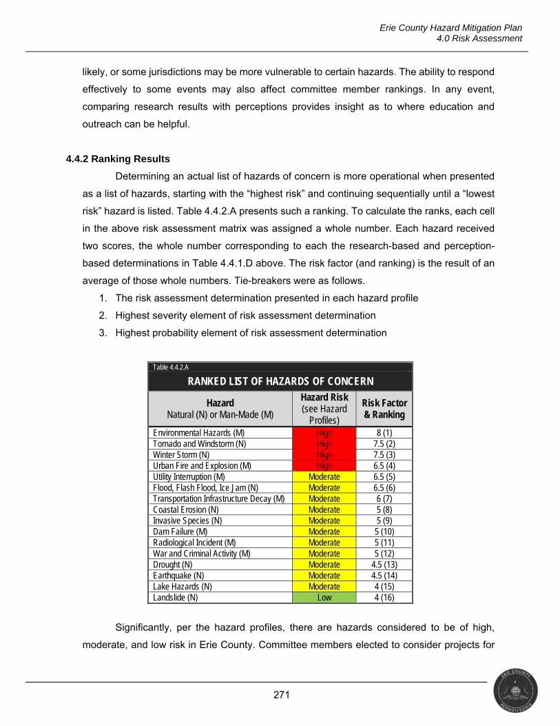
271
Erie County Hazard Mitigation Plan 4.0 Risk Assessment
likely, or some jurisdictions may be more vulnerable to certain hazards. The ability to respond
effectively to some events may also affect committee member rankings. In any event,
comparing research results with perceptions provides insight as to where education and
outreach can be helpful.
4.4.2 Ranking Results
Determining an actual list of hazards of concern is more operational when presented
as a list of hazards, starting with the “highest risk” and continuing sequentially until a “lowest
risk” hazard is listed. Table 4.4.2.A presents such a ranking. To calculate the ranks, each cell
in the above risk assessment matrix was assigned a whole number. Each hazard received
two scores, the whole number corresponding to each the research-based and perception-
based determinations in Table 4.4.1.D above. The risk factor (and ranking) is the result of an
average of those whole numbers. Tie-breakers were as follows.
1. The risk assessment determination presented in each hazard profile
2. Highest severity element of risk assessment determination
3. Highest probability element of risk assessment determination
Table 4.4.2.A
RANKED LIST OF HAZARDS OF CONCERN
Hazard Natural (N) or Man-Made (M)
Hazard Risk (see Hazard
Profiles)
Risk Factor & Ranking
Environmental Hazards (M) High 8 (1) Tornado and Windstorm (N) High 7.5 (2) Winter Storm (N) High 7.5 (3) Urban Fire and Explosion (M) High 6.5 (4) Utility Interruption (M) Moderate 6.5 (5) Flood, Flash Flood, Ice Jam (N) Moderate 6.5 (6) Transportation Infrastructure Decay (M) Moderate 6 (7) Coastal Erosion (N) Moderate 5 (8) Invasive Species (N) Moderate 5 (9) Dam Failure (M) Moderate 5 (10) Radiological Incident (M) Moderate 5 (11) War and Criminal Activity (M) Moderate 5 (12) Drought (N) Moderate 4.5 (13) Earthquake (N) Moderate 4.5 (14) Lake Hazards (N) Moderate 4 (15) Landslide (N) Low 4 (16)
Significantly, per the hazard profiles, there are hazards considered to be of high,
moderate, and low risk in Erie County. Committee members elected to consider projects for
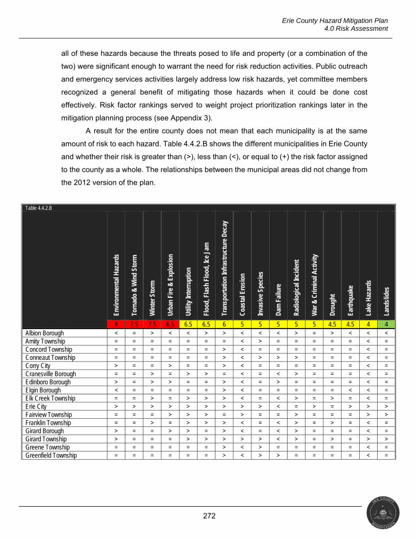
272
Erie County Hazard Mitigation Plan 4.0 Risk Assessment
all of these hazards because the threats posed to life and property (or a combination of the
two) were significant enough to warrant the need for risk reduction activities. Public outreach
and emergency services activities largely address low risk hazards, yet committee members
recognized a general benefit of mitigating those hazards when it could be done cost
effectively. Risk factor rankings served to weight project prioritization rankings later in the
mitigation planning process (see Appendix 3).
A result for the entire county does not mean that each municipality is at the same
amount of risk to each hazard. Table 4.4.2.B shows the different municipalities in Erie County
and whether their risk is greater than (>), less than (<), or equal to (+) the risk factor assigned
to the county as a whole. The relationships between the municipal areas did not change from
the 2012 version of the plan.
Table 4.4.2.B
Envi
ronm
enta
l Haz
ards
Torn
ado
& W
ind
Stor
m
Win
ter S
torm
Urb
an F
ire &
Exp
losi
on
Util
ity In
terr
uptio
n
Floo
d, F
lash
Flo
od, I
ce J
am
Tran
spor
tatio
n In
fras
truc
ture
Dec
ay
Coa
stal
Ero
sion
Inva
sive
Spe
cies
Dam
Fai
lure
Rad
iolo
gica
l Inc
iden
t
War
& C
rimin
al A
ctiv
ity
Dro
ught
Eart
hqua
ke
Lake
Haz
ards
Land
slid
es
8 7.5 7.5 6.5 6.5 6.5 6 5 5 5 5 5 4.5 4.5 4 4 Albion Borough < = > < < > > < < < > = > < < < Amity Township = = = = = = = < > = = = = = < = Concord Township = = = = = = > < = = = = = = < = Conneaut Township = = = = = = > < > > > = = = < = Corry City > = = > = = > < = = = = = = < = Cranesville Borough = = > = > > = < = < > = = = < = Edinboro Borough > = > > = = > < = > = = = = < = Elgin Borough < = = = = = > < = = = = = < < = Elk Creek Township = = > = > > > < = < > = > = < = Erie City > > > > > > > > > < = > = > > > Fairview Township = = = > > > = > = = > = = = > > Franklin Township = = > = > > > < = < > = > = < = Girard Borough > = = > > = > < = < > = = = < = Girard Township > = = = > > > > > < > = > = > > Greene Township = = = = = = > < > = = = = = < = Greenfield Township = = = = = = > < > > = = = = < =
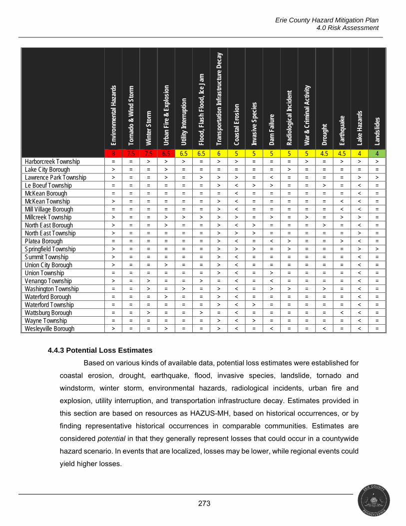
273
Erie County Hazard Mitigation Plan 4.0 Risk Assessment
Envi
ronm
enta
l Haz
ards
Torn
ado
& W
ind
Stor
m
Win
ter S
torm
Urb
an F
ire &
Exp
losi
on
Util
ity In
terr
uptio
n
Floo
d, F
lash
Flo
od, I
ce J
am
Tran
spor
tatio
n In
fras
truc
ture
Dec
ay
Coa
stal
Ero
sion
Inva
sive
Spe
cies
Dam
Fai
lure
Rad
iolo
gica
l Inc
iden
t
War
& C
rimin
al A
ctiv
ity
Dro
ught
Eart
hqua
ke
Lake
Haz
ards
Land
slid
es
8 7.5 7.5 6.5 6.5 6.5 6 5 5 5 5 5 4.5 4.5 4 4 Harborcreek Township = = > > > = > > = = = > = > > > Lake City Borough > = = > = = = = = = > = = = = = Lawrence Park Township > = = > = > > > = < = = = = > > Le Boeuf Township = = = = = = > < > > = = > = < = McKean Borough = = = = = = = < = = = = = = < = McKean Township > = = = = = > < = = = = = < < = Mill Village Borough = = = = = = > < = = = = = < < = Millcreek Township > = = > > > > > = > = > = > > = North East Borough > = = > = = > < > = = = > = < = North East Township > = = = = = > > > = = = = = > = Platea Borough = = = = = = > < = < > = = > < = Springfield Township > = = = = = > > > = > = = = > > Summit Township > = = = = = > < = = = = = = < = Union City Borough > = = > = = > < = = = = = = < = Union Township = = = = = = > < = > = = = = < = Venango Township > = > = = > = < = < = = = = < = Washington Township = = > = > = > < = > > = > = < = Waterford Borough = = = > = = > < = = = = = = < = Waterford Township = = = = = = > < > = = = = = < = Wattsburg Borough = = > = = > = < = = = = = < < = Wayne Township = = = = = = > < > = = = = = < = Wesleyville Borough > = = > = = > < = < = = < = < =
4.4.3 Potential Loss Estimates
Based on various kinds of available data, potential loss estimates were established for
coastal erosion, drought, earthquake, flood, invasive species, landslide, tornado and
windstorm, winter storm, environmental hazards, radiological incidents, urban fire and
explosion, utility interruption, and transportation infrastructure decay. Estimates provided in
this section are based on resources as HAZUS-MH, based on historical occurrences, or by
finding representative historical occurrences in comparable communities. Estimates are
considered potential in that they generally represent losses that could occur in a countywide
hazard scenario. In events that are localized, losses may be lower, while regional events could
yield higher losses.
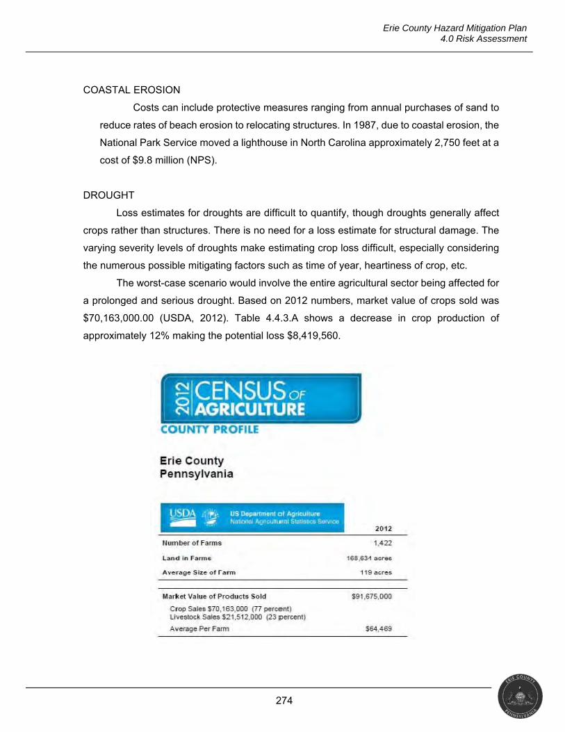
274
Erie County Hazard Mitigation Plan 4.0 Risk Assessment
COASTAL EROSION
Costs can include protective measures ranging from annual purchases of sand to
reduce rates of beach erosion to relocating structures. In 1987, due to coastal erosion, the
National Park Service moved a lighthouse in North Carolina approximately 2,750 feet at a
cost of $9.8 million (NPS).
DROUGHT
Loss estimates for droughts are difficult to quantify, though droughts generally affect
crops rather than structures. There is no need for a loss estimate for structural damage. The
varying severity levels of droughts make estimating crop loss difficult, especially considering
the numerous possible mitigating factors such as time of year, heartiness of crop, etc.
The worst-case scenario would involve the entire agricultural sector being affected for
a prolonged and serious drought. Based on 2012 numbers, market value of crops sold was
$70,163,000.00 (USDA, 2012). Table 4.4.3.A shows a decrease in crop production of
approximately 12% making the potential loss $8,419,560.
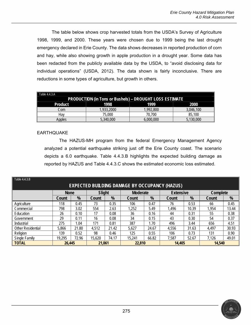
275
Erie County Hazard Mitigation Plan 4.0 Risk Assessment
The table below shows crop harvested totals from the USDA’s Survey of Agriculture
1998, 1999, and 2000. These years were chosen due to 1999 being the last drought
emergency declared in Erie County. The data shows decreases in reported production of corn
and hay, while also showing growth in apple production in a drought year. Some data has
been redacted from the publicly available data by the USDA, to “avoid disclosing data for
individual operations” (USDA, 2012). The data shown is fairly inconclusive. There are
reductions in some types of agriculture, but growth in others.
Table 4.4.3.A
PRODUCTION (in Tons or Bushels) – DROUGHT LOSS ESTIMATE Product 1998 1999 2000
Corn 1,933,2000 1,992,800 3,046,100 Hay 75,000 70,700 85,100
Apples 5,340,000 6,000,000 5,130,000
EARTHQUAKE
The HAZUS-MH program from the federal Emergency Management Agency
analyzed a potential earthquake striking just off the Erie County coast. The scenario
depicts a 6.0 earthquake. Table 4.4.3.B highlights the expected building damage as
reported by HAZUS and Table 4.4.3.C shows the estimated economic loss estimated.
Table 4.4.3.B
EXPECTED BUILDING DAMAGE BY OCCUPANCY (HAZUS) None Slight Moderate Extensive Complete
Count % Count % Count % Count % Count % Agriculture 118 0.45 73 0.35 106 0.47 76 0.53 66 0.45 Commercial 798 3.02 554 2.63 1,252 5.49 1,496 10.39 1,954 13.44 Education 26 0.10 17 0.08 36 0.16 44 0.31 55 0.38 Government 29 0.11 16 0.08 34 0.15 43 0.30 54 0.37 Industrial 275 1.04 171 0.81 387 1.70 496 3.44 656 4.51 Other Residential 5,866 21.80 4,512 21.42 5,627 24.67 4,556 31.63 4,497 30.93 Religion 139 0.52 98 0.46 125 0.55 106 0.73 131 0.90 Single Family 19,295 72.96 15,620 74.17 15,241 66.82 7,587 52.67 7,126 49.01 TOTAL 26,445 21,061 22,810 14,405 14,540
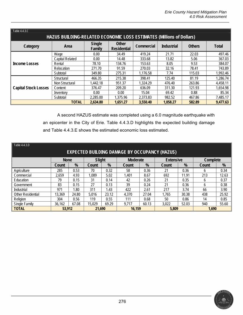
276
Erie County Hazard Mitigation Plan 4.0 Risk Assessment
Table 4.4.3.C
HAZUS BUILDING-RELATED ECONOMIC LOSS ESTIMATES (Millions of Dollars)
Category Area Single Family
Other Residential
Commercial Industrial Others Total
Income Losses
Wage 0.00 34.49 419.24 21.71 22.03 497.46 Capital Related 0.00 14.48 333.68 13.82 5.06 367.03 Rental 78.10 134.76 153.63 8.05 9.53 384.07 Relocation 271.70 91.59 270.03 32.16 78.41 743.89 Subtotal 349.80 275.31 1,176.58 7.74 115.03 1,992.46
Capital Stock Losses
Structural 466.35 215.38 398.41 125.40 81.19 1,286.74 Non Structural 1,442.18 951.37 1,324.29 476.40 263.86 4,458.11 Content 376.47 209.20 636.09 311.30 121.93 1,654.98 Inventory 0.00 0.00 15.04 69.42 0.88 85.34 Subtotal 2,285.00 1,375.96 2,373.83 982.52 467.86 7,485.17
TOTAL 2,634.80 1,651.27 3,550.40 1,058.27 582.89 9,477.63
A second HAZUS estimate was completed using a 6.0 magnitude earthquake with
an epicenter in the City of Erie. Table 4.4.3.D highlights the expected building damage
and Table 4.4.3.E shows the estimated economic loss estimated.
Table 4.4.3.D
EXPECTED BUILDING DAMAGE BY OCCUPANCY (HAZUS)
None Slight Moderate Extensive Complete Count % Count % Count % Count % Count %
Agriculture 285 0.53 70 0.32 58 0.36 21 0.36 6 0.34 Commercial 2,659 4.93 1,089 5.02 1,401 8.67 692 11.91 213 12.63 Education 79 0.15 31 0.14 42 0.26 21 0.35 6 0.37 Government 83 0.15 27 0.13 39 0.24 21 0.36 6 0.38 Industrial 971 1.80 311 1.43 422 2.61 217 3.74 66 3.90 Other Residential 13,369 24.80 5,016 23.12 4,370 27.04 1,765 30.38 438 25.92 Religion 304 0.56 119 0.55 111 0.68 50 0.86 14 0.85 Single Family 36,162 67.08 15,029 69.29 9,717 60.13 3,022 52.03 940 55.60 TOTAL 53,912 21,690 16,159 5,809 1,690
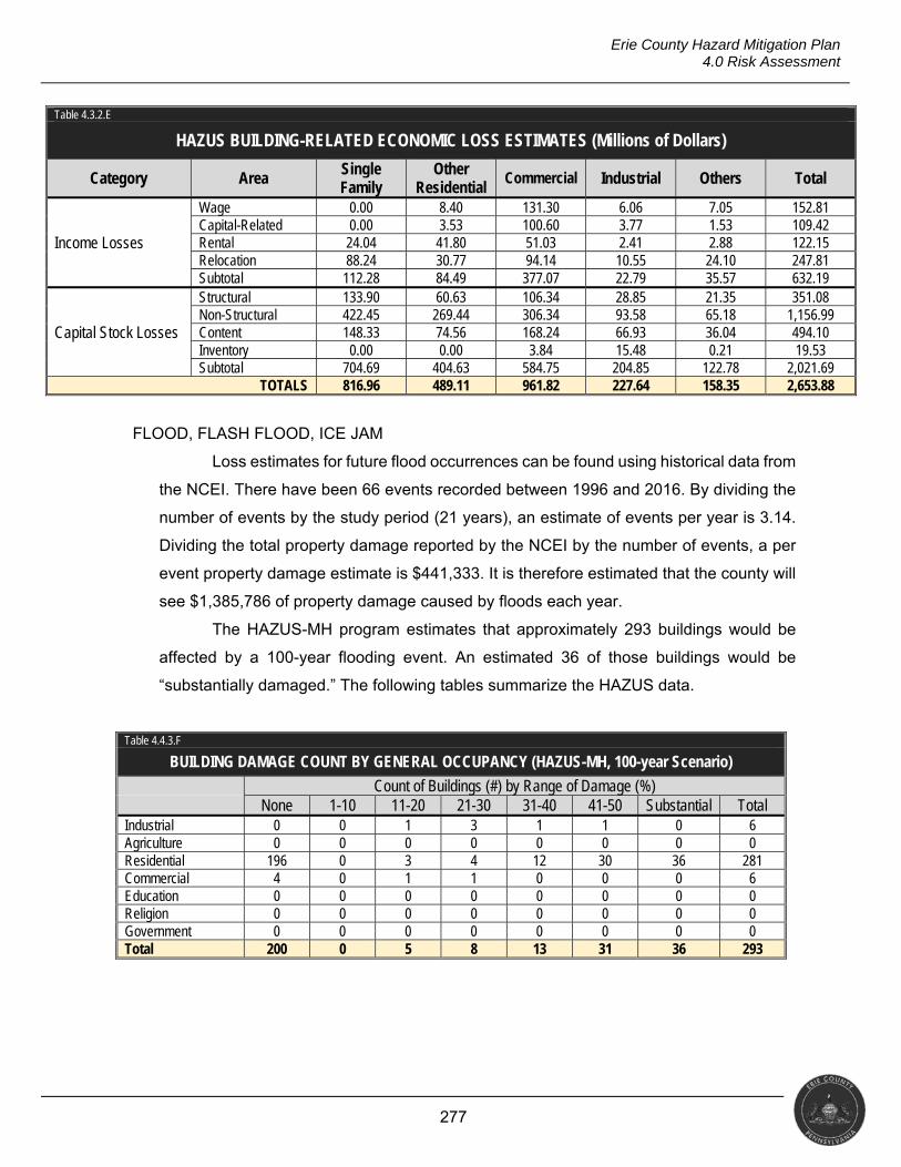
277
Erie County Hazard Mitigation Plan 4.0 Risk Assessment
Table 4.3.2.E
HAZUS BUILDING-RELATED ECONOMIC LOSS ESTIMATES (Millions of Dollars)
Category Area Single Family
Other Residential
Commercial Industrial Others Total
Income Losses
Wage 0.00 8.40 131.30 6.06 7.05 152.81 Capital-Related 0.00 3.53 100.60 3.77 1.53 109.42 Rental 24.04 41.80 51.03 2.41 2.88 122.15 Relocation 88.24 30.77 94.14 10.55 24.10 247.81 Subtotal 112.28 84.49 377.07 22.79 35.57 632.19
Capital Stock Losses
Structural 133.90 60.63 106.34 28.85 21.35 351.08 Non-Structural 422.45 269.44 306.34 93.58 65.18 1,156.99 Content 148.33 74.56 168.24 66.93 36.04 494.10 Inventory 0.00 0.00 3.84 15.48 0.21 19.53 Subtotal 704.69 404.63 584.75 204.85 122.78 2,021.69
TOTALS 816.96 489.11 961.82 227.64 158.35 2,653.88
FLOOD, FLASH FLOOD, ICE JAM
Loss estimates for future flood occurrences can be found using historical data from
the NCEI. There have been 66 events recorded between 1996 and 2016. By dividing the
number of events by the study period (21 years), an estimate of events per year is 3.14.
Dividing the total property damage reported by the NCEI by the number of events, a per
event property damage estimate is $441,333. It is therefore estimated that the county will
see $1,385,786 of property damage caused by floods each year.
The HAZUS-MH program estimates that approximately 293 buildings would be
affected by a 100-year flooding event. An estimated 36 of those buildings would be
“substantially damaged.” The following tables summarize the HAZUS data.
Table 4.4.3.F
BUILDING DAMAGE COUNT BY GENERAL OCCUPANCY (HAZUS-MH, 100-year Scenario) Count of Buildings (#) by Range of Damage (%) None 1-10 11-20 21-30 31-40 41-50 Substantial Total Industrial 0 0 1 3 1 1 0 6 Agriculture 0 0 0 0 0 0 0 0 Residential 196 0 3 4 12 30 36 281 Commercial 4 0 1 1 0 0 0 6 Education 0 0 0 0 0 0 0 0 Religion 0 0 0 0 0 0 0 0 Government 0 0 0 0 0 0 0 0 Total 200 0 5 8 13 31 36 293
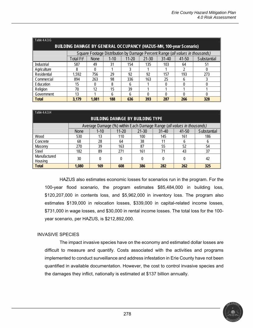
278
Erie County Hazard Mitigation Plan 4.0 Risk Assessment
Table 4.4.3.G
BUILDING DAMAGE BY GENERAL OCCUPANCY (HAZUS-MH, 100-year Scenario)
Square Footage Distribution by Damage Percent Range (all values in thousands) Total Ft2 None 1-10 11-20 21-30 31-40 41-50 Substantial Industrial 587 49 31 154 135 103 64 51 Agriculture 8 0 1 3 1 1 2 0 Residential 1,592 756 29 92 92 157 193 273 Commercial 894 263 98 336 163 25 6 3 Education 15 0 8 6 1 0 0 0 Religion 70 12 15 39 1 1 1 1 Government 13 1 6 6 0 0 0 0 Total 3,179 1,081 188 636 393 287 266 328
Table 4.4.3.H
BUILDING DAMAGE BY BUILDING TYPE
Average Damage (%) within Each Damage Range (all values in thousands) None 1-10 11-20 21-30 31-40 41-50 Substantial Wood 530 13 110 100 145 161 186 Concrete 68 28 64 38 11 6 6 Masonry 270 39 163 87 55 52 54 Steel 182 89 271 161 71 43 37 Manufactured Housing
30 0 0 0 0 0 42
Total 1,080 169 608 386 282 262 325
HAZUS also estimates economic losses for scenarios run in the program. For the
100-year flood scenario, the program estimates $85,484,000 in building loss,
$120,207,000 in contents loss, and $5,962,000 in inventory loss. The program also
estimates $139,000 in relocation losses, $339,000 in capital-related income losses,
$731,000 in wage losses, and $30,000 in rental income losses. The total loss for the 100-
year scenario, per HAZUS, is $212,892,000.
INVASIVE SPECIES
The impact invasive species have on the economy and estimated dollar losses are
difficult to measure and quantify. Costs associated with the activities and programs
implemented to conduct surveillance and address infestation in Erie County have not been
quantified in available documentation. However, the cost to control invasive species and
the damages they inflict, nationally is estimated at $137 billion annually.
279
Erie County Hazard Mitigation Plan 4.0 Risk Assessment
LANDSLIDE
Landslides historically have two costs: (a) direct cost, which is the cost to repair
damages, and (b) associated costs, which consist of lost income and productivity as
businesses are affected or closed, schools close due to damage to the drinking water
system, etc. According to the PDCNR, PennDOT incurs substantial costs due to landslide
damage and extra construction costs for new roads in known landslide-prone areas.
The only landslide cost study completed by the USGS in Pennsylvania took place
in Alleghany County from 1970 to 1976. This study found that the total public and private
costs of landslides averaged $4 million per year (approximately $17 million adjusted for
2017 dollars).
TORNADO & WINDSTORM
Loss estimates for tornado events can be calculated using the historical data
available from the NCEI. There have been 20 events recorded in the county between 1950
and 2016. By dividing the number of events by the study period (67 years), an estimate of
events per year is 0.30. It is estimated that one tornado will touch down every three years.
Dividing the total property damage reported in the NCEI by the number of events, a per-
event property damage estimate is $1,479,900. It is therefore estimated that every three
years, the county will see this amount of property damage caused by a tornado event.
As with tornado events, loss estimates for wind storms can be calculated using
historical data from the NCEI. There have been 402 events recorded in the county
between 1950 and 2016. By dividing the number of events by the study period, 67 years,
and estimate of events per year is six. Dividing the total property damage reported in NCEI,
$13,596,000, by the number of events, a per event property damage estimate is $33,821.
It is therefore estimated that the county will see $202,926, in property damage each year.
WINTER STORM
Loss estimates for future winter storm occurrences can be found using historical
data from the NCEI. There have been 133 events recorded between 1996 and 2016. By
dividing the number of events by the study period (21 years), an estimate of events per
year is 6.33. Dividing the total property damage reported by the NCEI by the number of
events, a per event property damage estimate is $313,511. It is therefore estimated that
the county will see $1,984,525 of property damage caused by winter storms each year.
280
Erie County Hazard Mitigation Plan 4.0 Risk Assessment
ENVIRONMENTAL HAZARDS
RTK Net and PHMSA both estimate monetary damage. Some incidents, because
of their size, have no cost associated with them; these incidents range from spilling a small
amount of product while filling a tank to reports of sheens on Lake Erie. Of the 149
incidents recorded by the RTK Network, none had monetary damage associated with
them. The PHMSA reported 49 incidents that had a total cost of $135,000.
Damage estimates can be calculated by using historical data provided by the RTK
Net and PHMSA databases. Over the last seven years, the county experienced $135,000
in property damage due to hazardous materials incidents. When divided by the number of
incidents, an estimated $682 in property damage per incident is reached. A yearly
estimate can be found by multiplying the average number of incidents in a year (29) by
the estimated property damage, resulting in an estimate of $19,778.00/year.
RADIOLOGICAL INCIDENT
The Three Mile Island accident in 1979 is the largest and most expensive partial
core meltdown in U.S. history. Clean-up after the accident cost $973 million and took
twelve years (World Nuclear Association). Metropolitan Edison Co., operator of Three Mile
Island NPP, was also fined $155,000 by the NRC.
According to the U.S. Department of Transportation Pipeline and Hazardous
Materials Safety Administration’s Hazardous Materials Incident Reporting System, there
have been 783 transportation incidents involving radioactive materials nationwide
between 1971 and 2017. Total damages for these incidents was $3,328,262, or
approximately $4,250 per incident.
URBAN FIRE & EXPLOSION
The National Fire Protection Association (NFPA) collects annual data and
produces reports and statistics on the loss of life and property annually. In 2015 (the last
complete year of data available), there were 1,345,500 fires in the U.S., up 3.7% from
2014. The NFPA reports 3,280 civilian fire deaths and 15,700 injuries. Property damage
was estimated to be $14.3 billion.
UTILITY INTERRUPTION
The ASCE report card on infrastructure notes on a national level that only half of
the required financial commitment needed to maintain the nation’s infrastructure is being
281
Erie County Hazard Mitigation Plan 4.0 Risk Assessment
met. By not fully meeting these requirements, the U.S. will have $3.9 trillion in losses to
the GDP, $7 trillion in lost business sales and $2.5 million lot American jobs by 2025.
Failing to maintain infrastructure has an impact on individual families as well. An
aging electric grid and water infrastructure translates to higher costs for businesses to
manufacture and distribute goods and provide services. These higher costs get passed
along, costing the average family $3,400 per year.
With no historical property loss data, estimating a loss estimate for utility
interruption is difficult. Events can range from a water main break causing loss of water
pressure for a small community, to a widespread power outage that can cause significant
economic loss.
TRANSPORTATION INFRASTRUCTURE DECAY
The ASCE report card on infrastructure notes on a national level that only half of
the required financial commitment needed to maintain the nation’s infrastructure is being
met. By not fully meeting these requirements, the U.S. will have $3.9 trillion in losses to
the GDP, $7 trillion in lost business sales and $2.5 million lot American jobs by 2025.
Failing to maintain infrastructure has an impact on individual families as well. Poor
roads and airports translate to higher costs for businesses to manufacture and distribute
goods and provide services. These higher costs get passed along, costing the average
family $3,400 per year.
4.4.4 Future Development and Vulnerability
Understanding the risk that Erie County faces from future occurrences is a multifaceted
exercise. Identifying and analyzing development trends allows for the consideration of future
vulnerability. This information comes from a variety of sources, including economic trends,
comprehensive plans, and interviews with local officials.
Local officials recognize the need for better education and training as an element of
economic growth. The need for industry-driven education to develop talents for well-paying
skilled jobs could be met by implementing a pre-kindergarten-to-workforce education system.
This system would allow for decisions on education based on data from which preschool
programs best prepare students for kindergarten to which college majors or training school
programs have the most successful graduates. To grow the county’s economy, several local
agencies engage with regional partners. These types of initiatives boost the impact of tourism
by promoting year round attractions, and developing new industries while maintaining the
282
Erie County Hazard Mitigation Plan 4.0 Risk Assessment
industries that have traditionally sustained the county’s economy. Economic growth and
employment opportunities can also be created by supporting entrepreneurism and creating
an environment conducive to entrepreneurial success.
Erie County and 35 municipalities have adopted comprehensive plans that include
discussions of future land use. The county provides a model zoning ordinance for
consideration and possible use by municipalities but does not have a zoning ordinance. Thirty-
five (35) municipalities have adopted zoning ordinances and 26 have adopted subdivision
ordinances. The Erie County Subdivision and Land Development Ordinance has jurisdiction
in the other 12 municipalities that have not adopted their own. The urban areas of the county
are losing population while suburban and rural areas are seeing increases. This trend poses
several challenges for both municipalities and the county. As an example, with population
leaving the cities, tax revenue paying for essential functions such as schools and public safety
has decreased. As people move to the outlying suburban areas, the need for improved
transportation infrastructure, including road repair and widening and extended public
transportation services, becomes critical. Longer commutes to places of employment in cities
can lead to road congestion and deterioration.
Revitalization seeks to provide environmental benefits such as pollution reduction,
biodiversity, and water quality improvements. Environment Erie is currently working with
Millcreek Township and the City of Erie, two of the most populated municipalities in the county,
to implement revitalization projects and programs.
In 2015, Erie County joined the Lake Erie Energy Development Corp (LEEDCO).
LEEDCO, whose mission is to promote regionally-consistent development of offshore wind
energy markets, created the “Icebreaker Project.” Icebreaker is a small development of six
turbines approximately eight miles offshore. It could generate 21MW of power, enough to
provide electricity to 7,000 homes. The project is currently in the scoping phase which is part
of a federal environmental assessment (Ewing, 2016). Offshore winds tend to blow harder
and more uniformly than on land. The potential energy produced from wind is directly
proportional to the cube of the wind speed. As a result, increased wind speeds of only a few
miles per hour can produce a significantly larger amount of electricity (BOEM).

283
Erie County Hazard Mitigation Plan 4.0 Risk Assessment
As seen in the map below (National Renewable Energy Laboratory), Erie County has
several options for pursuing renewable energy including wind, hydropower and geothermal.
Permitting for wind energy, often a lengthy and difficult process, is a viable option as nuclear
power plants (NPP), such as Perry and Davis-Besse in Ohio, and Beaver Valley in
Pennsylvania may be closing (Funk, 2017).
284
Erie County Hazard Mitigation Plan 5.0 Capability Assessment
5.0 CAPABILITY ASSESSMENT
§201.6(c)(4)(ii) [The plan shall include a] process by which local governments incorporate the requirements of the mitigation plan into other planning mechanisms such as comprehensive or capital improvement plans, when appropriate.
This section discusses the capabilities present with jurisdictions in Erie County
that can support mitigation implementation. It contains an overview of National Flood
Insurance Program (NFIP) compliance and participation as well as identifies the plans,
ordinances, and planning bodies that can support the management of mitigation
projects. Finally, it presents the results of a capability assessment survey administered
by the county’s consultant.
5.1 UPDATE PROCESS SUMMARY
Erie County has resources it can access to implement hazard mitigation
initiatives including emergency response measures, local planning and regulatory
tools, administrative assistance and technical expertise, fiscal capabilities, and
participation in local, regional, state, and federal programs. The presence of these
resources enables community resiliency through actions taken before, during and
after a hazard event.
Changes to this section in 2017 included updating the list of NFIP
communities in the county and moving that list to the flood hazard profile (i.e.,
Section 4.3.4), updating and adding fields (i.e., capital budget and public works
budget) to the jurisdictional capabilities table, and re-issuing the capability survey
from 2012 (and updating the findings accordingly).
5.2 CAPABILITY ASSESSMENT FINDINGS
5.2.1 Jurisdictional Capabilities
Erie County and its municipalities have capabilities that can support
mitigation efforts including comprehensive plans, floodplain regulations, building
codes, and zoning ordinances. The Erie County Planning Commission (ECPC)
provides planning advice to the county government and planning-related advice and
assistance to municipalities upon their request. Each municipality also has a
planning commission that serve as advisory boards to their municipal governing
285
Erie County Hazard Mitigation Plan 5.0 Capability Assessment
bodies. The role of the municipal planning commissions is defined in the
Municipalities Planning Code (MPC) Act 247 and includes the following.
Make recommendations to the governing body concerning the adoption or
amendment of an official map.
Prepare and present to the governing body a zoning ordinance, and make
recommendations to the governing body on proposed amendments to it.
Prepare, recommend, and administer subdivision and land development and
planned residential development regulations.
Prepare and present to the governing body a building code and a housing
code and make recommendations concerning proposed amendments
thereto.
Do such other acts or make studies as may be necessary to fulfill the duties
and obligations imposed by the MPC.
Prepare and present to the governing body an environmental study.
Submit to the governing body a recommended capital improvements
program.
Prepare and present to the governing body a water survey, which shall be
consistent with the state water plan and any applicable water resources plan
adopted by a river basin commission. The water survey shall be conducted in
consultation with any public water supplier in the area to be surveyed.
Promote public interest in, and understanding of, the comprehensive plan and
planning.
Make recommendations to governmental, civic, and private agencies and
individuals as to the effectiveness of the proposals of such agencies and
individuals.
Hold public hearings and meetings.
Present testimony before any board.
Require from other departments and agencies of the municipality such
available information as relates to the work of the planning agency.
In the performance of its functions, enter upon any land to make examination
and land surveys with the consent of the owner.
286
Erie County Hazard Mitigation Plan 5.0 Capability Assessment
Prepare and present to the governing body a study regarding the feasibility
and practicability of using renewable energy sources in specific areas within
the municipality.
Review the zoning ordinance, subdivision and land development ordinance,
official map, provisions for planned residential development, and such other
ordinances and regulations governing the development of land no less
frequently than it reviews the comprehensive plan.
Comprehensive plans promote sound land use and regional cooperation
among local governments to address planning issues. These plans serve as the
official policy guide for influencing the location, type, and extent of future
development by establishing the basic decision-making and review processes on
zoning matters, subdivision and land development, land uses, public facilities, and
housing needs over time. The existing countywide comprehensive plan for Erie
County was developed and adopted in 2003. The housing portion of the plan was
updated and adopted in 2008 and the transportation section was updated and
adopted in 2012. Most of the 38 jurisdictions have municipal comprehensive plans.
County governments are required by law to adopt a comprehensive plan while
municipalities may do so at their option. Future comprehensive plan updates and
improvements will consider 2017 hazard mitigation plan findings.
Building codes regulate construction standards for new construction and
substantially renovated buildings. Standards can be adopted that require resistant or
resilient building design practices to address hazard impacts common to a given
community. In 2003, the Commonwealth of Pennsylvania implemented Act 45 of
1999, the Uniform Construction Code (UCC), a comprehensive building code that
establishes minimum regulations for most new construction, including additions and
renovations to existing structures. All 38 municipalities in Erie County have “opted in”
to this statewide building code. On December 10, 2009, the Commonwealth adopted
regulations of the 2009 International Code Council’s codes. The effective date of the
regulations is December 31, 2009. Since all municipalities in Erie County are
required to abide by the UCC, they are required to enforce the 2009 building code
regulations for all building permits (effective December 31, 2009).
Through administration of floodplain ordinances, municipalities can ensure
that all new construction or substantial improvements to existing structures located in
287
Erie County Hazard Mitigation Plan 5.0 Capability Assessment
the floodplain are flood-proofed, dry-proofed, or built above anticipated flood
elevations. Floodplain ordinances may also prohibit development in certain areas
altogether. The National Flood Insurance Program (NFIP) establishes minimum
ordinance requirements which must be met in order for that community to participate
in the program. However, a community is permitted and (in fact) encouraged to adopt
standards which exceed NFIP requirements. Thirty-four (34) municipalities within the
county have floodplain regulations in place, but they vary in age and restrictiveness
from community to community. Significantly, two jurisdictions were suspended from
the NFIP program for not adopting floodplain ordinances and Platea does not
participate in the NFIP (at the time of the 2017 update).
Subdivision and land development ordinances (SALDOs) are intended to
regulate the development of housing, commercial, industrial or other uses, including
associated public infrastructure, as land is subdivided into buildable lots for sale or
future development. Within these ordinances, guidelines on how land will be divided,
the placement and size of roads and the location of infrastructure can reduce
exposure of development to hazard events. Twenty-six (26) of the 38 municipalities
in Erie County have adopted and enforce a subdivision and land development
ordinance. The other 12 are subject to the Erie County Subdivision and Land
Development Ordinance, which was updated and adopted in 2010.
Zoning ordinances allow for local communities to regulate the use of land in
order to protect the interests and safety of the general public. Zoning ordinances can
address unique conditions or concerns within a given community. They may be used
to create buffers between structures and high-risk areas, limit the type or density of
development and/or require land development to consider specific hazard
vulnerabilities. Thirty-five (35) of the 38 municipalities in Erie County have zoning
regulations. Table 5.2.1.A summarizes the above discussion on a jurisdiction-by-
jurisdiction basis. Data is taken from Questions 2, 3, 4, 5, 6, 7, 11, and 12 of the
capability assessment survey issued by the county’s consultant.
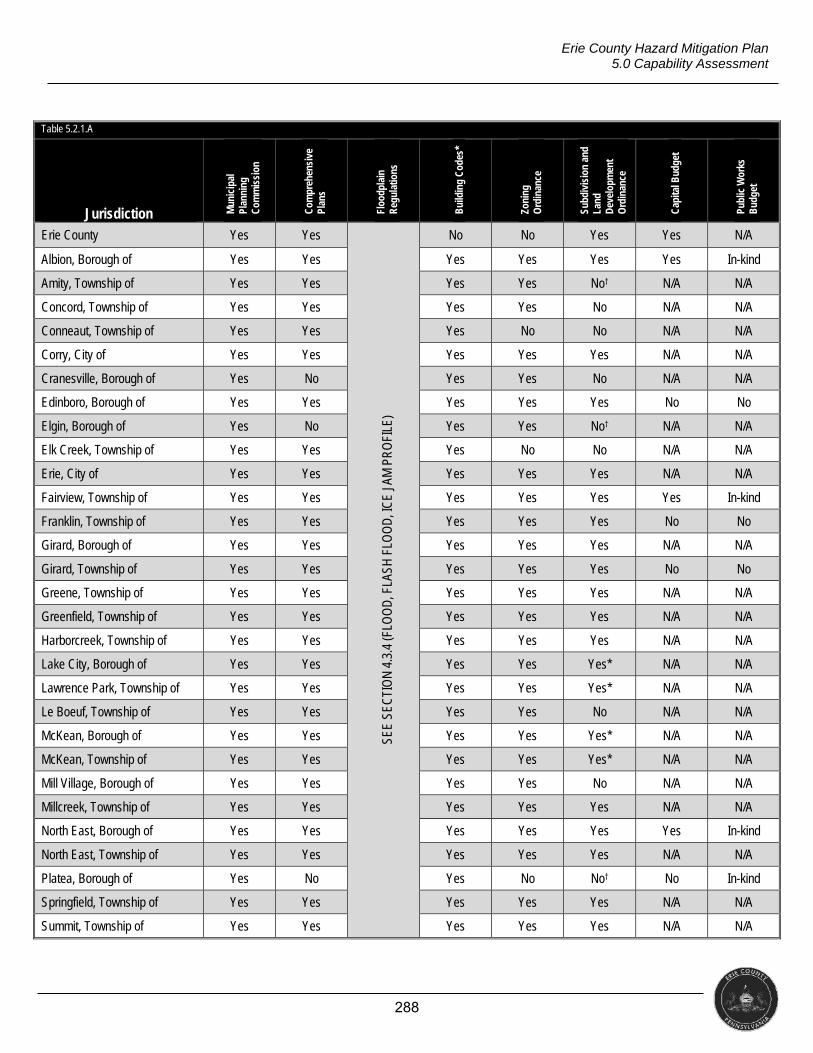
288
Erie County Hazard Mitigation Plan 5.0 Capability Assessment
Table 5.2.1.A
Jurisdiction Mun
icip
al
Plan
ning
C
omm
issi
on
Com
preh
ensi
ve
Plan
s
Floo
dpla
in
Reg
ulat
ions
Bui
ldin
g C
odes
*
Zoni
ng
Ord
inan
ce
Subd
ivis
ion
and
Land
D
evel
opm
ent
Ord
inan
ce
Cap
ital B
udge
t
Publ
ic W
orks
B
udge
t
Erie County Yes Yes
SEE
SEC
TIO
N 4
.3.4
(FLO
OD
, FLA
SH F
LOO
D, I
CE
JAM
PR
OFI
LE)
No No Yes Yes N/A
Albion, Borough of Yes Yes Yes Yes Yes Yes In-kind
Amity, Township of Yes Yes Yes Yes No† N/A N/A
Concord, Township of Yes Yes Yes Yes No N/A N/A
Conneaut, Township of Yes Yes Yes No No N/A N/A
Corry, City of Yes Yes Yes Yes Yes N/A N/A
Cranesville, Borough of Yes No Yes Yes No N/A N/A
Edinboro, Borough of Yes Yes Yes Yes Yes No No
Elgin, Borough of Yes No Yes Yes No† N/A N/A
Elk Creek, Township of Yes Yes Yes No No N/A N/A
Erie, City of Yes Yes Yes Yes Yes N/A N/A
Fairview, Township of Yes Yes Yes Yes Yes Yes In-kind
Franklin, Township of Yes Yes Yes Yes Yes No No
Girard, Borough of Yes Yes Yes Yes Yes N/A N/A
Girard, Township of Yes Yes Yes Yes Yes No No
Greene, Township of Yes Yes Yes Yes Yes N/A N/A
Greenfield, Township of Yes Yes Yes Yes Yes N/A N/A
Harborcreek, Township of Yes Yes Yes Yes Yes N/A N/A
Lake City, Borough of Yes Yes Yes Yes Yes* N/A N/A
Lawrence Park, Township of Yes Yes Yes Yes Yes* N/A N/A
Le Boeuf, Township of Yes Yes Yes Yes No N/A N/A
McKean, Borough of Yes Yes Yes Yes Yes* N/A N/A
McKean, Township of Yes Yes Yes Yes Yes* N/A N/A
Mill Village, Borough of Yes Yes Yes Yes No N/A N/A
Millcreek, Township of Yes Yes Yes Yes Yes N/A N/A
North East, Borough of Yes Yes Yes Yes Yes Yes In-kind
North East, Township of Yes Yes Yes Yes Yes N/A N/A
Platea, Borough of Yes No Yes No No† No In-kind
Springfield, Township of Yes Yes Yes Yes Yes N/A N/A
Summit, Township of Yes Yes Yes Yes Yes N/A N/A
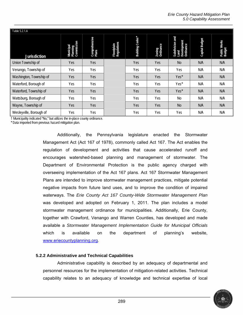
289
Erie County Hazard Mitigation Plan 5.0 Capability Assessment
Table 5.2.1.A
Jurisdiction Mun
icip
al
Plan
ning
C
omm
issi
on
Com
preh
ensi
ve
Plan
s
Floo
dpla
in
Reg
ulat
ions
Bui
ldin
g C
odes
*
Zoni
ng
Ord
inan
ce
Subd
ivis
ion
and
Land
D
evel
opm
ent
Ord
inan
ce
Cap
ital B
udge
t
Publ
ic W
orks
B
udge
t
Union Township of Yes Yes Yes Yes No N/A N/A
Venango, Township of Yes Yes Yes Yes Yes N/A N/A
Washington, Township of Yes Yes Yes Yes Yes* N/A N/A
Waterford, Borough of Yes Yes Yes Yes Yes* N/A N/A
Waterford, Township of Yes Yes Yes Yes Yes* N/A N/A
Wattsburg, Borough of Yes Yes Yes Yes No N/A N/A
Wayne, Township of Yes Yes Yes Yes No N/A N/A
Wesleyville, Borough of Yes Yes Yes Yes Yes N/A N/A
† Municipality indicated “No,” but utilizes the in-place county ordinance. * Data imported from previous hazard mitigation plan.
Additionally, the Pennsylvania legislature enacted the Stormwater
Management Act (Act 167 of 1978), commonly called Act 167. The Act enables the
regulation of development and activities that cause accelerated runoff and
encourages watershed-based planning and management of stormwater. The
Department of Environmental Protection is the public agency charged with
overseeing implementation of the Act 167 plans. Act 167 Stormwater Management
Plans are intended to improve stormwater management practices, mitigate potential
negative impacts from future land uses, and to improve the condition of impaired
waterways. The Erie County Act 167 County-Wide Stormwater Management Plan
was developed and adopted on February 1, 2011. The plan includes a model
stormwater management ordinance for municipalities. Additionally, Erie County,
together with Crawford, Venango and Warren Counties, has developed and made
available a Stormwater Management Implementation Guide for Municipal Officials
which is available on the department of planning’s website,
www.eriecountyplanning.org.
5.2.2 Administrative and Technical Capabilities
Administrative capability is described by an adequacy of departmental and
personnel resources for the implementation of mitigation-related activities. Technical
capability relates to an adequacy of knowledge and technical expertise of local
290
Erie County Hazard Mitigation Plan 5.0 Capability Assessment
government employees or the ability to contract outside resources for this expertise
to effectively execute mitigation activities. Common examples of skill sets and
technical personnel for hazard mitigation include planners with knowledge of land
development/management practices, engineers or professionals trained in
construction practices related to buildings and/or infrastructure (e.g., building
inspectors), planners or engineers with an understanding of natural and/or human
caused hazards, emergency managers, floodplain managers, land surveyors,
scientists familiar with hazards in the community, staff with the education or expertise
to assess community vulnerability to hazards, personnel skilled in geographic
information systems, resource development staff or grant writers, and fiscal staff to
handle complex grant application processes.
The Erie Conservation District and Erie County Department of Planning
provide leading technical assistance roles for municipalities. Other local
organizations that could act as partners in mitigating natural and human-made
hazards include the Penn State Cooperative Extension, environmental advocacy
groups, and watershed associations. State agencies agency which can provide
technical assistance for mitigation activities include, but are not limited to:
Pennsylvania Department of Community and Economic Development,
Pennsylvania Department of Conservation and Natural Resources,
Pennsylvania Department of Environmental Protection, and
Pennsylvania Department of Transportation.
Federal agencies which can provide technical assistance for mitigation
activities include, but are not limited to:
Army Corps of Engineers,
Department of Housing and Urban Development,
Department of Agriculture,
Economic Development Administration,
Emergency Management Institute,
Environmental Protection Agency,
Federal Emergency Management Agency, and
Small Business Administration.
291
Erie County Hazard Mitigation Plan 5.0 Capability Assessment
5.2.3 Fiscal Capabilities
The decision and capacity to implement mitigation-related activities is often
strongly dependent on the presence of local financial resources. While some
mitigation actions are less costly than others, it is important that money is available
locally to implement policies and projects. Financial resources are particularly
important if communities are trying to take advantage of state or federal mitigation
grant funding opportunities that require local-match contributions. Only three
communities indicated having a paid grants specialist on its payroll.
State programs which may provide financial support for mitigation activities
include, but are not limited to:
Community Conservation Partnerships Program,
Community Revitalization Program,
Floodplain Land Use Assistance Program,
Growing Greener Program,
Keystone Grant Program,
Local Government Capital Projects Loan Program,
Pennsylvania Heritage Areas Program
Pennsylvania Recreational Trails Program,
Shared Municipal Services, and
Technical Assistance Program.
Federal programs which may provide financial support for mitigation activities
include, but are not limited to:
Community Development Block Grant (CDBG),
Disaster Housing Program,
Emergency Conservation Program,
Emergency Management Performance Grants (EMPG),
Emergency Watershed Protection Program,
Hazard Mitigation Grant Program (HMGP),
Flood Mitigation Assistance Program,
Non-Insured Crop Disaster Assistance Program,
Pre-Disaster Mitigation Program,
Repetitive Flood Claims Program (RFC),
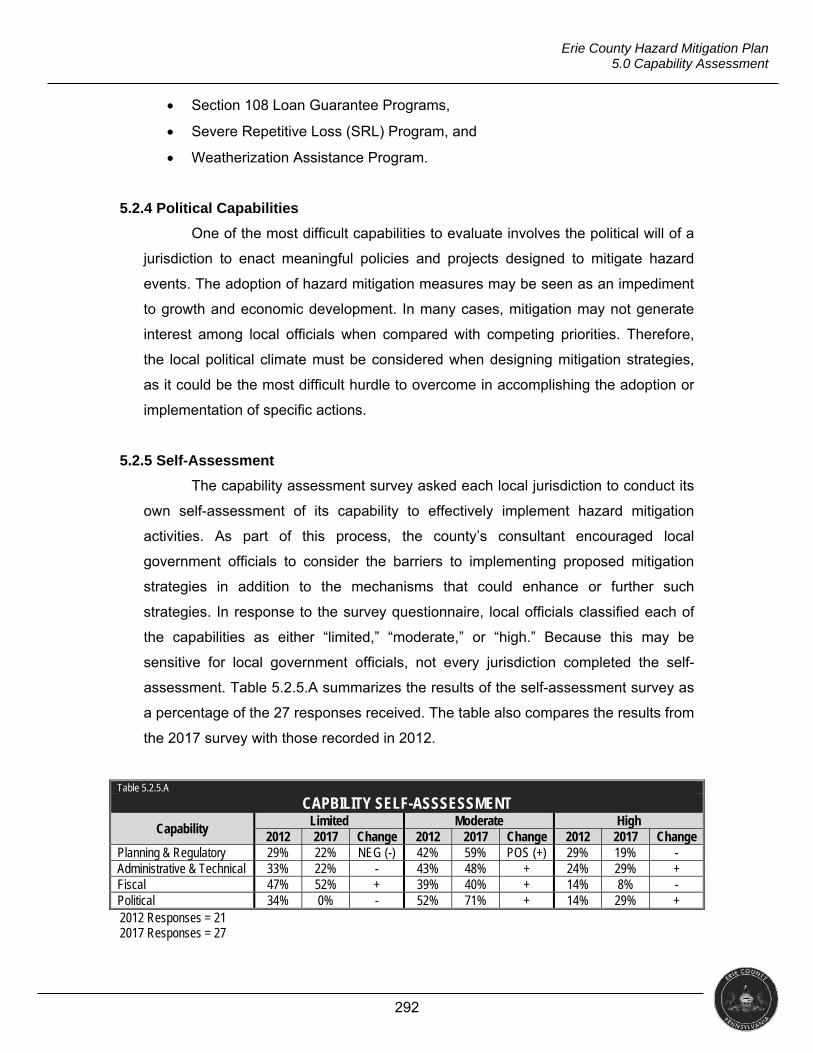
292
Erie County Hazard Mitigation Plan 5.0 Capability Assessment
Section 108 Loan Guarantee Programs,
Severe Repetitive Loss (SRL) Program, and
Weatherization Assistance Program.
5.2.4 Political Capabilities
One of the most difficult capabilities to evaluate involves the political will of a
jurisdiction to enact meaningful policies and projects designed to mitigate hazard
events. The adoption of hazard mitigation measures may be seen as an impediment
to growth and economic development. In many cases, mitigation may not generate
interest among local officials when compared with competing priorities. Therefore,
the local political climate must be considered when designing mitigation strategies,
as it could be the most difficult hurdle to overcome in accomplishing the adoption or
implementation of specific actions.
5.2.5 Self-Assessment
The capability assessment survey asked each local jurisdiction to conduct its
own self-assessment of its capability to effectively implement hazard mitigation
activities. As part of this process, the county’s consultant encouraged local
government officials to consider the barriers to implementing proposed mitigation
strategies in addition to the mechanisms that could enhance or further such
strategies. In response to the survey questionnaire, local officials classified each of
the capabilities as either “limited,” “moderate,” or “high.” Because this may be
sensitive for local government officials, not every jurisdiction completed the self-
assessment. Table 5.2.5.A summarizes the results of the self-assessment survey as
a percentage of the 27 responses received. The table also compares the results from
the 2017 survey with those recorded in 2012.
Table 5.2.5.A
CAPBILITY SELF-ASSSESSMENT
Capability Limited Moderate High
2012 2017 Change 2012 2017 Change 2012 2017 Change Planning & Regulatory 29% 22% NEG (-) 42% 59% POS (+) 29% 19% - Administrative & Technical 33% 22% - 43% 48% + 24% 29% + Fiscal 47% 52% + 39% 40% + 14% 8% - Political 34% 0% - 52% 71% + 14% 29% + 2012 Responses = 21 2017 Responses = 27
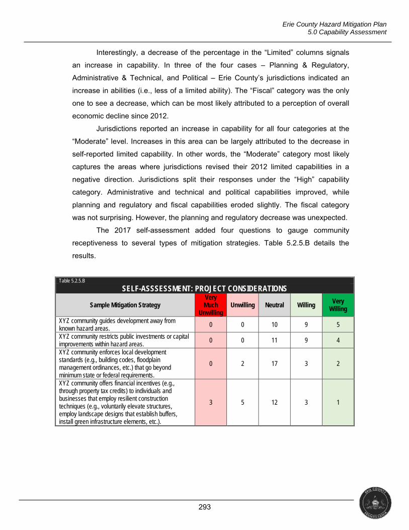
293
Erie County Hazard Mitigation Plan 5.0 Capability Assessment
Interestingly, a decrease of the percentage in the “Limited” columns signals
an increase in capability. In three of the four cases – Planning & Regulatory,
Administrative & Technical, and Political – Erie County’s jurisdictions indicated an
increase in abilities (i.e., less of a limited ability). The “Fiscal” category was the only
one to see a decrease, which can be most likely attributed to a perception of overall
economic decline since 2012.
Jurisdictions reported an increase in capability for all four categories at the
“Moderate” level. Increases in this area can be largely attributed to the decrease in
self-reported limited capability. In other words, the “Moderate” category most likely
captures the areas where jurisdictions revised their 2012 limited capabilities in a
negative direction. Jurisdictions split their responses under the “High” capability
category. Administrative and technical and political capabilities improved, while
planning and regulatory and fiscal capabilities eroded slightly. The fiscal category
was not surprising. However, the planning and regulatory decrease was unexpected.
The 2017 self-assessment added four questions to gauge community
receptiveness to several types of mitigation strategies. Table 5.2.5.B details the
results.
Table 5.2.5.B
SELF-ASSSESSMENT: PROJECT CONSIDERATIONS
Sample Mitigation Strategy Very Much
Unwilling Unwilling Neutral Willing
Very Willing
XYZ community guides development away from known hazard areas. 0 0 10 9 5
XYZ community restricts public investments or capital improvements within hazard areas.
0 0 11 9 4
XYZ community enforces local development standards (e.g., building codes, floodplain management ordinances, etc.) that go beyond minimum state or federal requirements.
0 2 17 3 2
XYZ community offers financial incentives (e.g., through property tax credits) to individuals and businesses that employ resilient construction techniques (e.g., voluntarily elevate structures, employ landscape designs that establish buffers, install green infrastructure elements, etc.).
3 5 12 3 1
294
Erie County Hazard Mitigation Plan 5.0 Capability Assessment
5.2.6 Plan Integration
The project list above identifies numerous opportunities for integrating hazard
mitigation into compatible planning efforts as well as opportunities for using
information generated in compatible planning efforts. This section serves as a
summary narrative of those opportunities. It also presents a table meant to guide
local government leaders in identifying further opportunities for plan integration.
The opportunities listed with the mitigation projects generally fall under eight
categories.
1. Marrying hazard mitigation and stormwater management efforts
2. Improving water resources management
3. Supporting bluff setback regulations
4. Supporting transportation planning
5. Bridging the gap between the use of special flood hazard area (SFHA)
information in land use planning
6. Reducing long-term risks by supporting improved emergency response
7. Providing additional recreational opportunities through green space and other
low-impact development initiatives
8. Supporting neighborhood revitalization
Identifying opportunities for integrating various planning efforts brings extended
stakeholders into the hazard mitigation process. It also supports enhanced planning
even in periods with constrained budgets by developing and taking advantage of
increased social capital in a community. Research shows that an increase in social
capital builds a network through which partners can readily access a wider range of
expertise and generate creative solutions because of access to varied perspectives
on common challenges. Extending such a network can also lead to the identification
of non-traditional funding sources for hazard mitigation projects or, conversely,
identify areas in which mitigation funding can provide additional leverage (or
matches) for other funding opportunities.
Key to identifying opportunities for plan integration was the realization of how
similar the objectives of stormwater management planning and hazard mitigation
planning are. For instance, Erie County Department of Planning maintains the
county’s Act 167 stormwater management plan, which identifies problem areas
throughout the county where water backs up during heavy rain events, causing site-
295
Erie County Hazard Mitigation Plan 5.0 Capability Assessment
specific flooding. In some cases, this site-specific flooding can result in structural
damage. It frequently impacts roadways, thus resulting in economic loss. Thus,
listing efforts to address these problem areas mitigates site-specific flooding in those
areas.
In addition to support of stormwater management initiatives, hazard mitigation
and risk reduction can support improved water resources management. Efforts to
maintain river corridors, stabilize streambanks, etc. can allow water to flow in ways
more readily consistent with the natural hydrology of an area. These efforts can take
advantage of the ecological benefits of natural flooding (when combined with steps to
limit the development of floodplains).
Local leaders also identified how considering risk reduction for coastal
erosion supported existing bluff recession planning and regulations. The
juxtaposition of these efforts serves as a classic example of how integration leads to
a network of individuals with varied backgrounds and expertise can collaborative
approach a challenge. Locally, the bluff management program seeks to engage
landowners in the process. Considering such efforts as risk reduction measures (i.e.,
a way to lessen future losses) may serve as a tactic to increase landowner
engagement.
Erie County’s planning committee demonstrated an extensive concern for the
decay of the local transportation infrastructure, noting how significant economic
losses could be (locally and regionally) should a bridge fail (for example) on
Interstate 90. Other impacts, such as more difficult evacuations, less responder
access to communities, etc. could result from a failure of the transportation
infrastructure. This concern enabled widespread integration of other efforts from
throughout the county to maintain and improve the transportation infrastructure. In
this respect, integration into the hazard mitigation context provides supporting
documentation for funding requests to address transportation issues.
In guidance on mitigation planning, the comprehensive or land-use plan often
serves as the example for plan integration. Erie County’s department of planning is
intimately involved with numerous phases of community land-use planning
throughout the county. Though those efforts consider floodplain management, the
hazard mitigation plan can provide a wealth of additional information on risks to
floodplains, identify areas considered to be floodplains, etc. that can serve as a
significant resource to comprehensive or land-use planning. As such, involving
296
Erie County Hazard Mitigation Plan 5.0 Capability Assessment
partners that work on comprehensive planning bridges a potential gap in maximizing
usage of SFHA data.
In Erie County, the departments of planning and public safety collaborated to
lead this update. Planning ensured that many traditional community development
initiatives could be considered by the process, which resulted in the identification of
several of these opportunities for integration. However, public safety’s involvement
yielded insight as to how improving the efficiency of emergency responses could
lead to a decrease in long-term impacts. Thus, efforts to educate the public, train and
equipment responders, and support capability enhancements at the response
agency level support mitigation by enabling a more rapid “resolution” of large-scale
emergencies. If an emergency situation is more quickly resolved, then it has less
time to cause losses.
In many instances, implementing traditional mitigation projects like acquisition
and relocation results in areas that must be maintained as green space.
Communities justifiably look at these efforts through the lens of minimizing its tax
base. However, when looking at these spaces as opportunities to increase
recreational offerings (and improve resident quality of life) or as “infrastructure” in
that they can reduce stormwater runoff, communities may more readily see the
potential for off-setting a small loss in the tax base.
Finally, Erie County (like many other communities) looks for ways to enhance
and revitalize its communities. Revitalization and general community development
link many other planning efforts, such as land use and transportation planning.
Mitigation planning and risk reduction can be folded into those efforts as well.
Reducing exposure to hazards can limit losses for future residents or businesses.
Limiting development in hazard-prone areas can result in green space, recreational
opportunities, and other features that enhance quality of life. Areas in which hazards
are mitigated, then, can be marketed as areas with a high quality of life, low potential
to suffer losses from weather and other features, improved public safety, etc.
The preceding paragraphs provide specific opportunities for plan integration
based on discussions with stakeholders in Erie County as this plan was updated.
Table 5.2.6.A below presents general considerations for local officials as these
discussions continue.
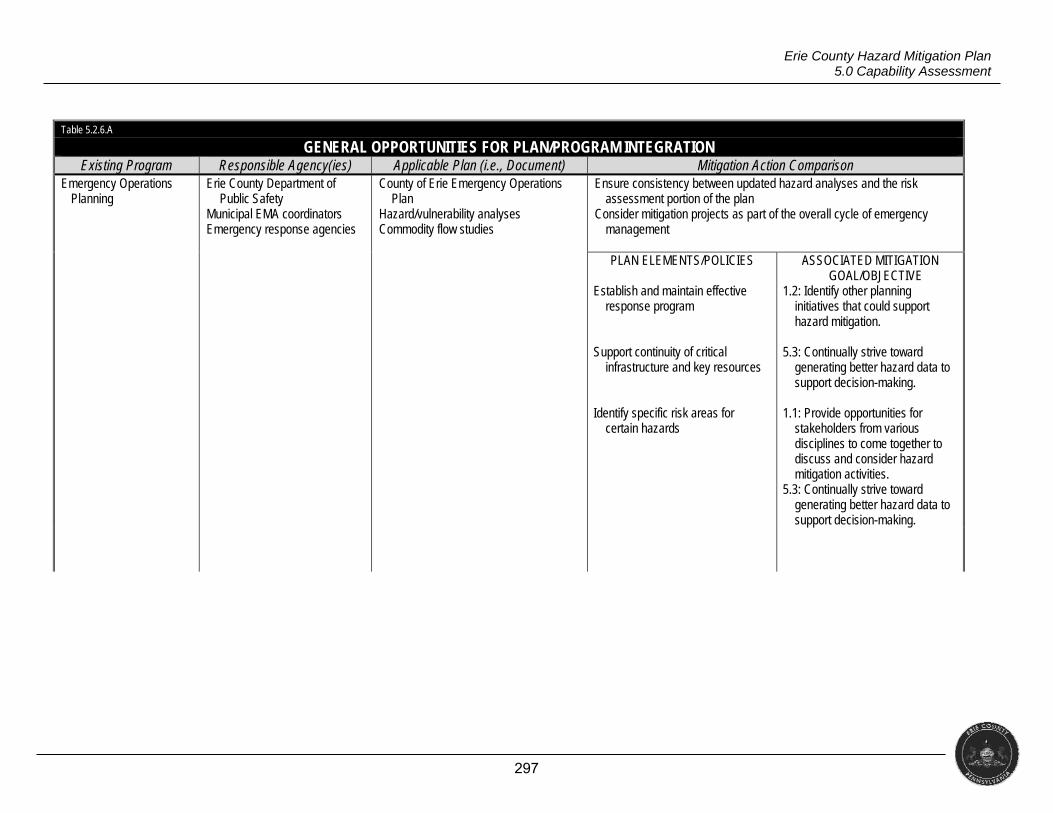
297
Erie County Hazard Mitigation Plan 5.0 Capability Assessment
Table 5.2.6.A
GENERAL OPPORTUNITIES FOR PLAN/PROGRAM INTEGRATION Existing Program Responsible Agency(ies) Applicable Plan (i.e., Document) Mitigation Action Comparison
Emergency Operations Planning
Erie County Department of Public Safety
Municipal EMA coordinators Emergency response agencies
County of Erie Emergency Operations Plan
Hazard/vulnerability analyses Commodity flow studies
Ensure consistency between updated hazard analyses and the risk assessment portion of the plan
Consider mitigation projects as part of the overall cycle of emergency management
PLAN ELEMENTS/POLICIES
Establish and maintain effective
response program Support continuity of critical
infrastructure and key resources Identify specific risk areas for
certain hazards
ASSOCIATED MITIGATION GOAL/OBJECTIVE
1.2: Identify other planning initiatives that could support hazard mitigation.
5.3: Continually strive toward
generating better hazard data to support decision-making.
1.1: Provide opportunities for
stakeholders from various disciplines to come together to discuss and consider hazard mitigation activities.
5.3: Continually strive toward generating better hazard data to support decision-making.
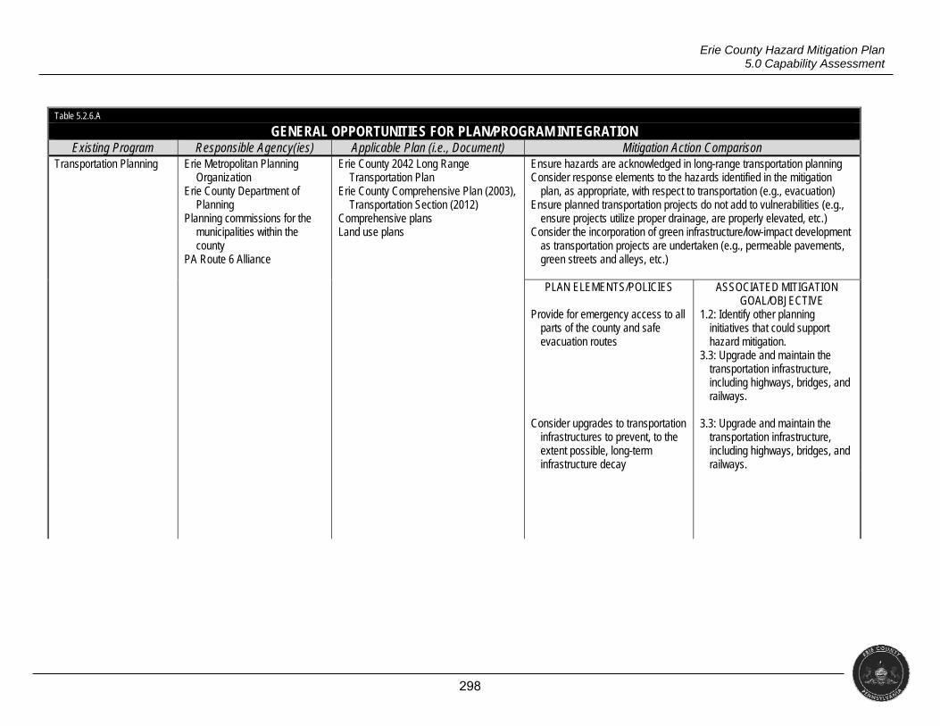
298
Erie County Hazard Mitigation Plan 5.0 Capability Assessment
Table 5.2.6.A
GENERAL OPPORTUNITIES FOR PLAN/PROGRAM INTEGRATION Existing Program Responsible Agency(ies) Applicable Plan (i.e., Document) Mitigation Action Comparison
Transportation Planning Erie Metropolitan Planning Organization
Erie County Department of Planning
Planning commissions for the municipalities within the county
PA Route 6 Alliance
Erie County 2042 Long Range Transportation Plan
Erie County Comprehensive Plan (2003), Transportation Section (2012)
Comprehensive plans Land use plans
Ensure hazards are acknowledged in long-range transportation planning Consider response elements to the hazards identified in the mitigation
plan, as appropriate, with respect to transportation (e.g., evacuation) Ensure planned transportation projects do not add to vulnerabilities (e.g.,
ensure projects utilize proper drainage, are properly elevated, etc.) Consider the incorporation of green infrastructure/low-impact development
as transportation projects are undertaken (e.g., permeable pavements, green streets and alleys, etc.)
PLAN ELEMENTS/POLICIES
Provide for emergency access to all
parts of the county and safe evacuation routes
Consider upgrades to transportation
infrastructures to prevent, to the extent possible, long-term infrastructure decay
ASSOCIATED MITIGATION GOAL/OBJECTIVE
1.2: Identify other planning initiatives that could support hazard mitigation.
3.3: Upgrade and maintain the transportation infrastructure, including highways, bridges, and railways.
3.3: Upgrade and maintain the
transportation infrastructure, including highways, bridges, and railways.
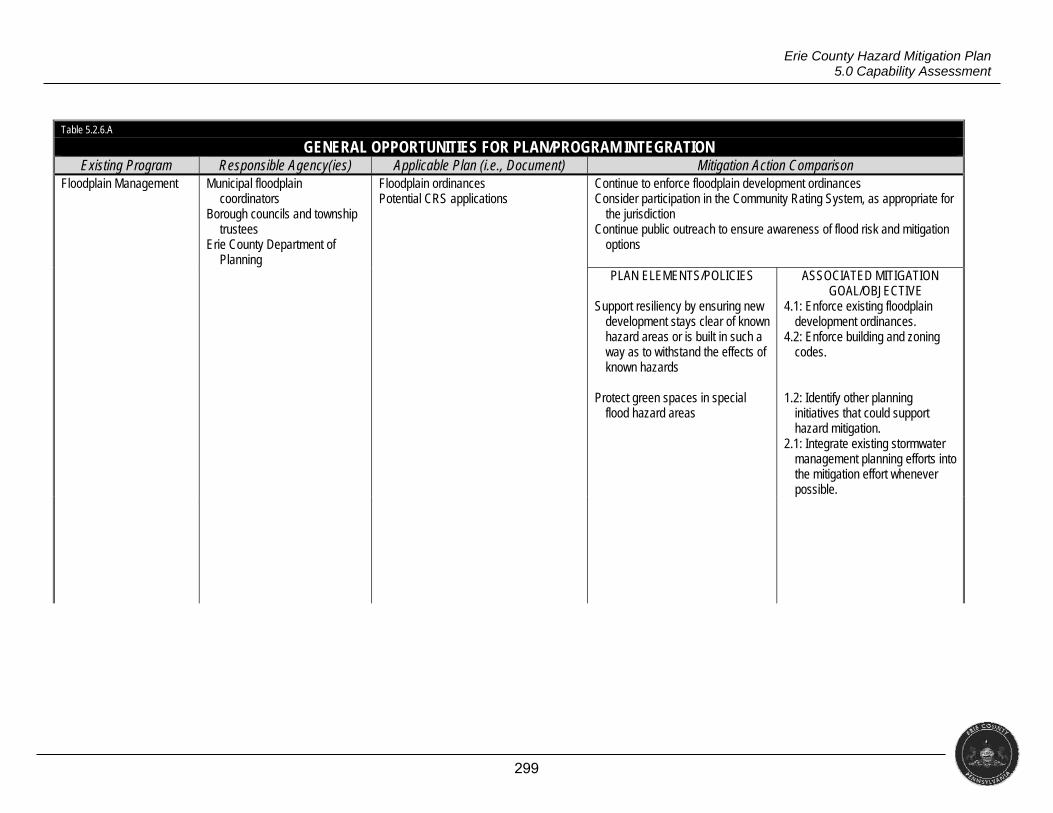
299
Erie County Hazard Mitigation Plan 5.0 Capability Assessment
Table 5.2.6.A
GENERAL OPPORTUNITIES FOR PLAN/PROGRAM INTEGRATION Existing Program Responsible Agency(ies) Applicable Plan (i.e., Document) Mitigation Action Comparison
Floodplain Management Municipal floodplain coordinators
Borough councils and township trustees
Erie County Department of Planning
Floodplain ordinances Potential CRS applications
Continue to enforce floodplain development ordinances Consider participation in the Community Rating System, as appropriate for
the jurisdiction Continue public outreach to ensure awareness of flood risk and mitigation
options
PLAN ELEMENTS/POLICIES
Support resiliency by ensuring new development stays clear of known hazard areas or is built in such a way as to withstand the effects of known hazards
Protect green spaces in special
flood hazard areas
ASSOCIATED MITIGATION GOAL/OBJECTIVE
4.1: Enforce existing floodplain development ordinances.
4.2: Enforce building and zoning codes.
1.2: Identify other planning
initiatives that could support hazard mitigation.
2.1: Integrate existing stormwater management planning efforts into the mitigation effort whenever possible.
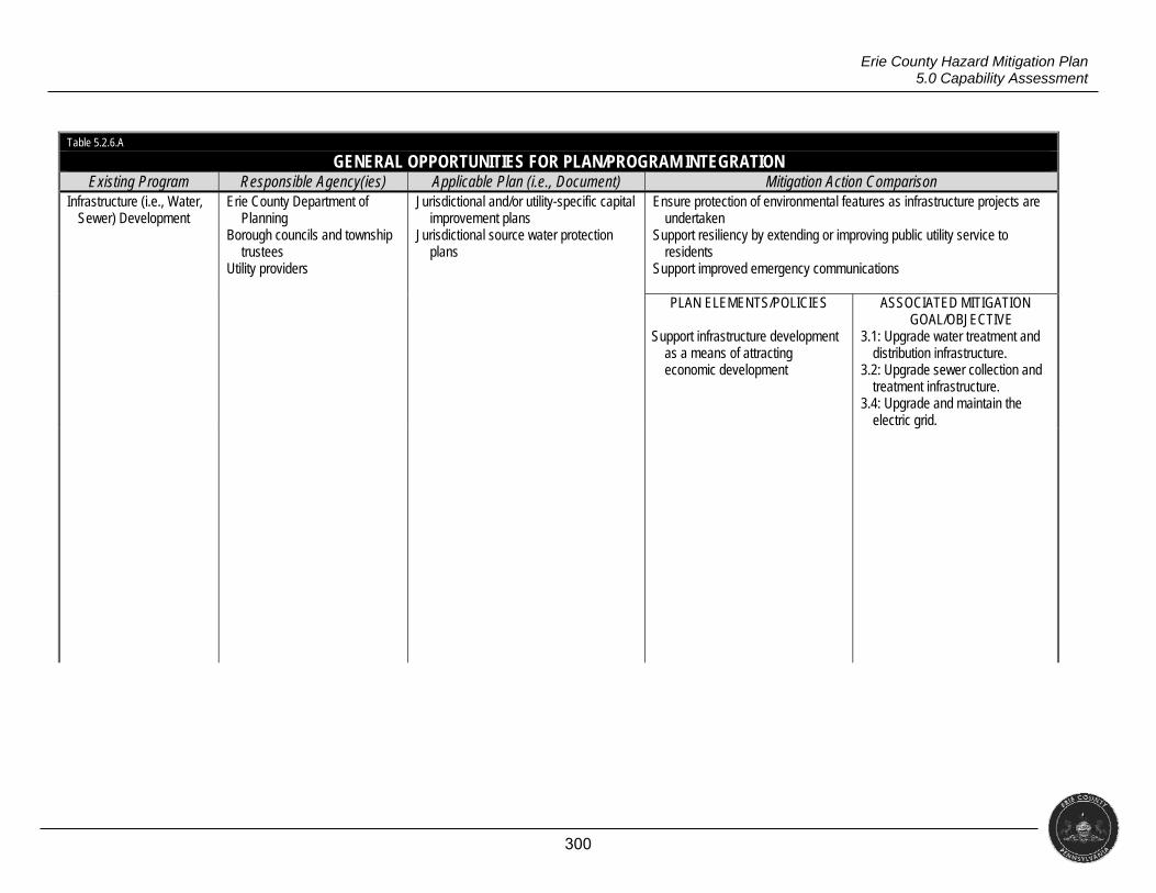
300
Erie County Hazard Mitigation Plan 5.0 Capability Assessment
Table 5.2.6.A
GENERAL OPPORTUNITIES FOR PLAN/PROGRAM INTEGRATION Existing Program Responsible Agency(ies) Applicable Plan (i.e., Document) Mitigation Action Comparison
Infrastructure (i.e., Water, Sewer) Development
Erie County Department of Planning
Borough councils and township trustees
Utility providers
Jurisdictional and/or utility-specific capital improvement plans
Jurisdictional source water protection plans
Ensure protection of environmental features as infrastructure projects are undertaken
Support resiliency by extending or improving public utility service to residents
Support improved emergency communications
PLAN ELEMENTS/POLICIES
Support infrastructure development as a means of attracting economic development
ASSOCIATED MITIGATION GOAL/OBJECTIVE
3.1: Upgrade water treatment and distribution infrastructure.
3.2: Upgrade sewer collection and treatment infrastructure.
3.4: Upgrade and maintain the electric grid.
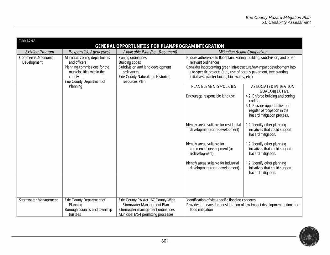
301
Erie County Hazard Mitigation Plan 5.0 Capability Assessment
Table 5.2.6.A
GENERAL OPPORTUNITIES FOR PLAN/PROGRAM INTEGRATION Existing Program Responsible Agency(ies) Applicable Plan (i.e., Document) Mitigation Action Comparison
Commercial/Economic Development
Municipal zoning departments and officers
Planning commissions for the municipalities within the county
Erie County Department of Planning
Zoning ordinances Building codes Subdivision and land development
ordinances Erie County Natural and Historical
resources Plan
Ensure adherence to floodplain, zoning, building, subdivision, and other relevant ordinances
Consider incorporating green infrastructure/low-impact development into site-specific projects (e.g., use of porous pavement, tree planting initiatives, planter boxes, bio swales, etc.)
PLAN ELEMENTS/POLICIES
Encourage responsible land use Identify areas suitable for residential
development (or redevelopment) Identify areas suitable for
commercial development (or redevelopment)
Identify areas suitable for industrial
development (or redevelopment)
ASSOCIATED MITIGATION GOAL/OBJECTIVE
4.2: Enforce building and zoning codes.
5.1: Provide opportunities for regular participation in the hazard mitigation process.
1.2: Identify other planning
initiatives that could support hazard mitigation.
1.2: Identify other planning
initiatives that could support hazard mitigation.
1.2: Identify other planning
initiatives that could support hazard mitigation.
Stormwater Management Erie County Department of Planning
Borough councils and township trustees
Erie County PA Act 167 County-Wide Stormwater Management Plan
Stormwater management ordinances Municipal MS4 permitting processes
Identification of site-specific flooding concerns Provides a means for consideration of low-impact development options for
flood mitigation
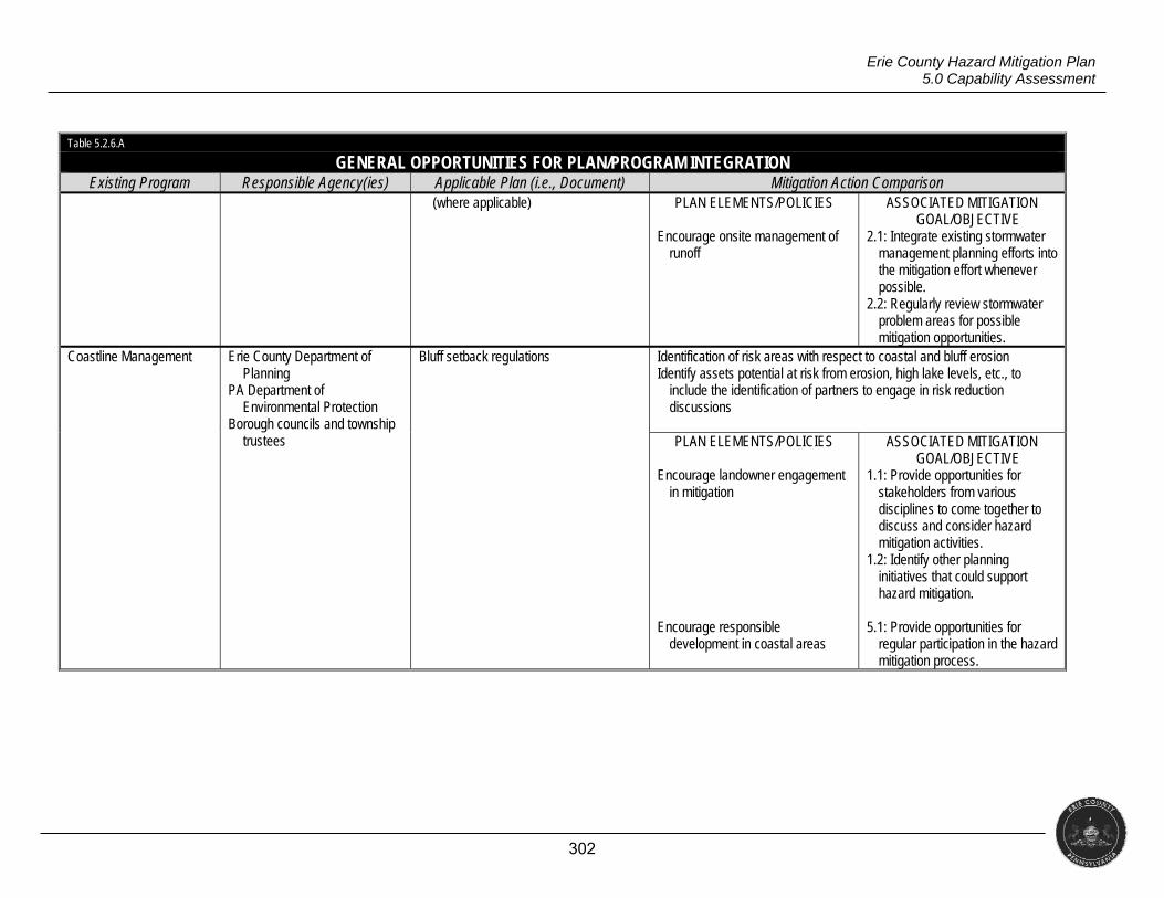
302
Erie County Hazard Mitigation Plan 5.0 Capability Assessment
Table 5.2.6.A
GENERAL OPPORTUNITIES FOR PLAN/PROGRAM INTEGRATION Existing Program Responsible Agency(ies) Applicable Plan (i.e., Document) Mitigation Action Comparison
(where applicable) PLAN ELEMENTS/POLICIES
Encourage onsite management of runoff
ASSOCIATED MITIGATION GOAL/OBJECTIVE
2.1: Integrate existing stormwater management planning efforts into the mitigation effort whenever possible.
2.2: Regularly review stormwater problem areas for possible mitigation opportunities.
Coastline Management Erie County Department of Planning
PA Department of Environmental Protection
Borough councils and township trustees
Bluff setback regulations Identification of risk areas with respect to coastal and bluff erosion Identify assets potential at risk from erosion, high lake levels, etc., to
include the identification of partners to engage in risk reduction discussions
PLAN ELEMENTS/POLICIES
Encourage landowner engagement
in mitigation Encourage responsible
development in coastal areas
ASSOCIATED MITIGATION GOAL/OBJECTIVE
1.1: Provide opportunities for stakeholders from various disciplines to come together to discuss and consider hazard mitigation activities.
1.2: Identify other planning initiatives that could support hazard mitigation.
5.1: Provide opportunities for
regular participation in the hazard mitigation process.
303
Erie County Hazard Mitigation Plan 5.0 Capability Assessment
5.3 EXISTING LIMITATIONS
As discussed above (and in Section 4.3.4), communities in Erie County use a
wide variety of floodplain regulations with an equally wide range of restrictiveness,
but there is significant technical assistance available at the county level to
standardize and use more restrictive ordinances. Municipalities that use the
Commonwealth’s model floodplain ordinance will have increased awareness of flood
risk and NFIP capabilities. During the update process, FEMA released new flood
insurance rate maps (FIRM) affecting 11 municipalities. The other 26 municipalities
all have FIRMs updated in 2014. With the updated FIRMs, municipalities have the
opportunity to update their floodplain regulations to reflect the latest information.
As mentioned, there are no communities in Erie County participating in the
NFIP Community Rating System. However, 37 of 38 municipalities in the county
have been designated as flood prone. Participation in this program can provide
premium reductions for properties located outside of special flood hazard areas
(SFHA) of up to 10 percent and reductions for properties located in SFHA of up to 45
percent. These discounts can be obtained by undertaking public information,
mapping and regulations, flood damage reduction and flood preparedness activities
(FEMA, 2009).
Numerous roads and intersections exist in the county where flooding issues
repeatedly occur. Some of these roads and intersections are state routes. The
county and local municipalities face challenges in mitigating flood events on state
routes since these roads are owned and maintained by the Commonwealth. Local
municipalities do not have the authority to independently carry out a mitigation
project. In these situations, the Pennsylvania Department of Transportation must
decide to undertake the project. Since the department of transportation is often most
concerned with larger, critical transportation routes, smaller state roads and
intersections which significantly affect a local community may not get the attention
they need for the Commonwealth to take on a mitigation project.
Finally, limited funding is a critical barrier to the implementation of hazard
mitigation activities. The county will need to rely on regional, state and federal
partnerships for financial assistance.
304
Erie County Hazard Mitigation Plan 6.0 Mitigation Strategy
6.0 MITIGATION STRATEGY
§201.6(c)(3)(i) [The hazard mitigation strategy shall include a] description of mitigation goals to reduce or avoid long-term vulnerabilities to the identified hazards.
§201.6(c)(3)(ii) [The mitigation strategy shall include a] section that identifies and analyzes a comprehensive range of specific mitigation actions and projects being considered to reduce the effects of each hazard, with particular emphasis on new and existing buildings and infrastructure.
§201.6(c)(3)(iii)
[The mitigation strategy section shall include] an action plan describing how the actions identified in section (c)(3)(ii) will be prioritized, implemented, and administered by the local jurisdiction. Prioritization shall include a special emphasis on the extent to which benefits are maximized according to a cost benefit review of the proposed projects and their associated costs.
This section uses the information presented thus far as the basis of a mitigation action
plan comprised of specific projects to reduce or eliminate hazard-related losses throughout Erie
County.
6.1 UPDATE PROCESS SUMMARY
Changes for 2017 in this section were straight forward; municipalities simply updated
the project lists from the 2012 plan and added new projects where applicable. (Projects listed
as completed, deleted, or deferred have been moved to Appendix 4.) The county’s consultant
led the planning committee in an exercise designed to create a series of overarching goals to
guide the development of on-going and future mitigation projects. The narrative below shows
the results of that exercise.
6.2 MITIGATION GOALS AND OBJECTIVES
During its May meeting, the planning committee discussed the county’s goals for
hazard mitigation. The consultant defined goals as desired end states toward which mitigation
objectives and projects could work. The consultant also provided examples of goals, mostly
designed around types of mitigation actions or specific hazard damage reduction.
Erie County’s committee organized its goals with the intent of increasing general
resilience to natural, technological, and man-made hazards. Committee members noted that
all of their efforts, under either the mitigation or preparedness label, are undertaken for the
purpose of increasing resilience and adaptability to emergencies and disasters of all scales.
Objectives serve to operationalize goals, providing more concrete ideas as to how to achieve
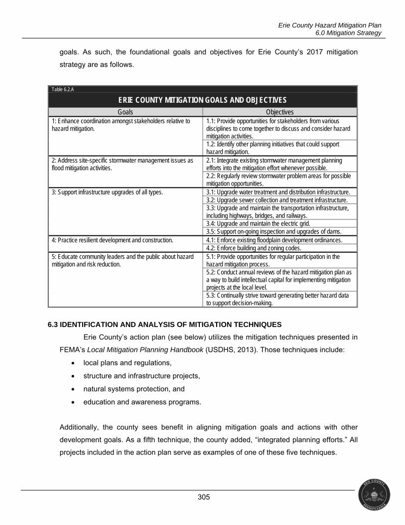
305
Erie County Hazard Mitigation Plan 6.0 Mitigation Strategy
goals. As such, the foundational goals and objectives for Erie County’s 2017 mitigation
strategy are as follows.
Table 6.2.A
ERIE COUNTY MITIGATION GOALS AND OBJECTIVES
Goals Objectives 1: Enhance coordination amongst stakeholders relative to hazard mitigation.
1.1: Provide opportunities for stakeholders from various disciplines to come together to discuss and consider hazard mitigation activities. 1.2: Identify other planning initiatives that could support hazard mitigation.
2: Address site-specific stormwater management issues as flood mitigation activities.
2.1: Integrate existing stormwater management planning efforts into the mitigation effort whenever possible. 2.2: Regularly review stormwater problem areas for possible mitigation opportunities.
3: Support infrastructure upgrades of all types. 3.1: Upgrade water treatment and distribution infrastructure. 3.2: Upgrade sewer collection and treatment infrastructure. 3.3: Upgrade and maintain the transportation infrastructure, including highways, bridges, and railways. 3.4: Upgrade and maintain the electric grid. 3.5: Support on-going inspection and upgrades of dams.
4: Practice resilient development and construction. 4.1: Enforce existing floodplain development ordinances. 4.2: Enforce building and zoning codes.
5: Educate community leaders and the public about hazard mitigation and risk reduction.
5.1: Provide opportunities for regular participation in the hazard mitigation process. 5.2: Conduct annual reviews of the hazard mitigation plan as a way to build intellectual capital for implementing mitigation projects at the local level. 5.3: Continually strive toward generating better hazard data to support decision-making.
6.3 IDENTIFICATION AND ANALYSIS OF MITIGATION TECHNIQUES
Erie County’s action plan (see below) utilizes the mitigation techniques presented in
FEMA’s Local Mitigation Planning Handbook (USDHS, 2013). Those techniques include:
local plans and regulations,
structure and infrastructure projects,
natural systems protection, and
education and awareness programs.
Additionally, the county sees benefit in aligning mitigation goals and actions with other
development goals. As a fifth technique, the county added, “integrated planning efforts.” All
projects included in the action plan serve as examples of one of these five techniques.
306
Erie County Hazard Mitigation Plan 6.0 Mitigation Strategy
The department of public safety and department of planning elected to add several
new projects related to NFIP compliance as well as enforcement of the stormwater
management ordinance. Though these efforts are technically completed and on-going, the
county added them to highlight their connection to mitigation (particularly flood mitigation).
6.4 MITIGATION ACTION PLAN
The following action plan is organized by jurisdiction. It lists project priority, its status,
a cost estimate and potential funding source, coordinating and support agencies, and
opportunities for integrating this project into other planning mechanisms. Each project also
identifies the goal and objective with which it relates. Where appropriate, the following tables
also identify when and how other planning mechanisms were integrated into this process via
specific projects.
It is important to note that the cost estimates are tentative and meant as a starting
point for research on project feasibility. More specifically, these cost estimates are only ranges
of probable costs; all figures are approximations. At the time implementation of any strategy
is considered, a full cost estimate should be sought prior to securing possible funding.
Possible funding sources identified include the following.
Community Development Block Grant (CDBG)
Flood Mitigation Assistance (FMA)
Hazard Mitigation Grant Program (HMGP)
Highway Safety Improvement Program (HSIP)
Homeland Security Grant Program (HSGP)
Local Funding
PennDOT Highway Safety Funds (HSF)
PennDOT Municipal Liquid Fuels Funding (MLFF)
Pennsylvania Infrastructure Investment Authority (PENNVEST)
Pre-Disaster Mitigation Grant (PDM)
State Funding
Surface Transportation Block Grant (STBG)
Erie County and the municipalities therein realize and acknowledge the importance of
traditional flood mitigation techniques, such as acquisition, relocation, and demolition;
mitigation reconstruction; and elevation. These techniques are high priority, but the
jurisdictions in the county further realize that absent Presidential declarations, funding is rarely
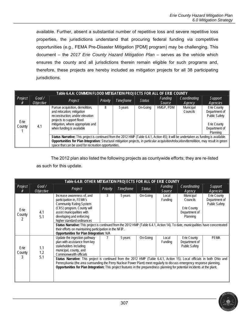
307
Erie County Hazard Mitigation Plan 6.0 Mitigation Strategy
available. Further, absent a substantial number of repetitive loss and severe repetitive loss
properties, the jurisdictions understand that procuring federal funding via competitive
opportunities (e.g., FEMA Pre-Disaster Mitigation [PDM] program) may be challenging. This
document – the 2017 Erie County Hazard Mitigation Plan – serves as the vehicle which
ensures the county and all jurisdictions therein remain eligible for such programs and,
therefore, these projects are hereby included as mitigation projects for all 38 participating
jurisdictions.
Table 6.4.A: COMMON FLOOD MITIGATION PROJECTS FOR ALL OF ERIE COUNTY Project
# Goal /
Objective Project Priority Timeframe Status
Funding Source
Coordinating Agency
Support Agencies
Erie County
1 4.1
Pursue acquisition, demolition, and relocation; mitigation reconstruction; and/or elevation projects to support flood mitigation, where appropriate and when funding is available
8 5 years On-Going HMGP, PDM Municipal Councils
Erie County Department of Public Safety
Erie County
Department of Planning
Status Narrative: This project is continued from the 2012 HMP (Table 6.4.1, Action 45); it will be undertaken as funding is available. Opportunities for Plan Integration: Structural mitigation projects, in particular acquisition/relocation/demolition, may result in green space that can be used for recreation opportunities.
The 2012 plan also listed the following projects as countywide efforts; they are re-listed
as such for this update.
Table 6.4.B: OTHER MITIGATION PROJECTS FOR ALL OF ERIE COUNTY Project
# Goal /
Objective Project Priority Timeframe Status Funding Source
Coordinating Agency
Support Agencies
Erie County
2
4.1 5.1
Increase awareness of, and participation in, FEMA’s Community Rating System (CRS) program. County will assist municipalities with developing and enforcing higher standard ordinances
3 5 years On-Going Local Funding
Municipal Councils
Erie County
Department of Planning
Erie County Department of Public Safety
Status Narrative: This project is continued from the 2012 HMP (Table 6.4.1, Action 14). To date, municipalities have concentrated their efforts on maintaining participation in the NFIP. Opportunities for Plan Integration: N/A
Erie County
3
1.1 1.2 5.1
Update the ingestion pathway plan with assistance from key stakeholders including municipal, county, and Commonwealth officials
7 5 years On-Going Local Funding
Erie County Department of Public Safety
PEMA
Status Narrative: This project is continued from the 2012 HMP (Table 6.4.1, Action 15). Local officials in both Ohio and Pennsylvania (the area surrounding the Perry Nuclear Power Plant) meet regularly to discuss emergency response planning. Opportunities for Plan Integration: This project features in the preparedness planning for potential incidents at the plant.
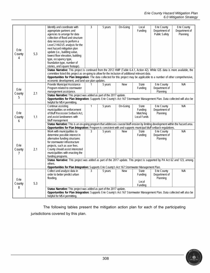
308
Erie County Hazard Mitigation Plan 6.0 Mitigation Strategy
Erie County
4 5.3
Identify and coordinate with appropriate partners and agencies to arrange for data collection of flood and structure data necessary to perform a Level 2 HAZUS analysis for the next hazard mitigation plan update (i.e., building value, lowest floor elevation, building type, occupancy type, foundation type, number of stories, and square footage).
3 5 years On-Going Local Funding
Erie County Department of Public Safety
Erie County Department of
Planning
Status Narrative: This project is continued from the 2012 HMP (Table 6.4.1, Action 42). While GIS data is more available, the committee listed this project as on-going to allow for the inclusion of additional relevant data. Opportunities for Plan Integration: The data collected for this project may be applicable to a number of other comprehensive, economic development, and land use plan updates.
Erie County
5 2.1
Provide Municipal Assistance Program related to stormwater management assistance.
1 5 years New State Funding
Erie County Department of
Planning
N/A
Status Narrative: This project was added as part of the 2017 update. Opportunities for Plan Integration: Supports Erie County’s Act 167 Stormwater Management Plan. Data collected will also be helpful for MS4 permitting.
Erie County
6 1.1
Continue assisting municipalities on enforcement of Bluff Recession Setback Act, and assist landowners with bluff management
1 5 years On-Going State Funding Matching
Local Funds
Erie County Department of
Planning
N/A
Status Narrative: This is an on-going program that addresses coastal bluff erosion by limiting development within the hazard area. Opportunities for Plan Integration: Program is consistent with and supports municipal bluff setback regulations.
Erie County
7 2.1
Work with municipalities to determine possible interest in alternative funding structures for stormwater infrastructure projects, such as user fees. County should assist interested municipalities with enacting the funding programs.
3 5 years New State Funding
Erie County Department of
Planning
N/A
Status Narrative: This project was added as part of the 2017 update. This project is supported by PA Act 62 and 123, among others. Opportunities for Plan Integration: Supports Erie County’s Act 167 Stormwater Management Plan.
Erie County
8 5.3
Collect and analyze data in order to better predict urban flooding.
3 5 years New State Funding
Local
Funding
Erie County Department of
Planning
N/A
Status Narrative: This project was added as part of the 2017 update. Opportunities for Plan Integration: Supports Erie County’s Act 167 Stormwater Management Plan. Data collected will also be helpful for MS4 permitting.
The following tables present the mitigation action plan for each of the participating
jurisdictions covered by this plan.
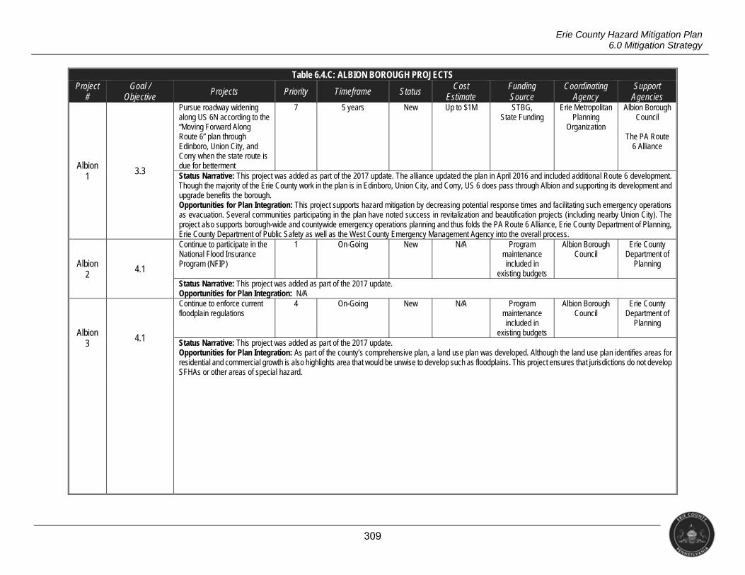
309
Erie County Hazard Mitigation Plan 6.0 Mitigation Strategy
Table 6.4.C: ALBION BOROUGH PROJECTS Project
# Goal /
Objective Projects Priority Timeframe Status Cost
Estimate Funding Source
Coordinating Agency
Support Agencies
Albion 1 3.3
Pursue roadway widening along US 6N according to the “Moving Forward Along Route 6” plan through Edinboro, Union City, and Corry when the state route is due for betterment
7 5 years New Up to $1M STBG, State Funding
Erie Metropolitan Planning
Organization
Albion Borough Council
The PA Route
6 Alliance
Status Narrative: This project was added as part of the 2017 update. The alliance updated the plan in April 2016 and included additional Route 6 development. Though the majority of the Erie County work in the plan is in Edinboro, Union City, and Corry, US 6 does pass through Albion and supporting its development and upgrade benefits the borough. Opportunities for Plan Integration: This project supports hazard mitigation by decreasing potential response times and facilitating such emergency operations as evacuation. Several communities participating in the plan have noted success in revitalization and beautification projects (including nearby Union City). The project also supports borough-wide and countywide emergency operations planning and thus folds the PA Route 6 Alliance, Erie County Department of Planning, Erie County Department of Public Safety as well as the West County Emergency Management Agency into the overall process.
Albion 2 4.1
Continue to participate in the National Flood Insurance Program (NFIP)
1 On-Going New N/A Program maintenance included in
existing budgets
Albion Borough Council
Erie County Department of
Planning
Status Narrative: This project was added as part of the 2017 update. Opportunities for Plan Integration: N/A
Albion 3
4.1
Continue to enforce current floodplain regulations
4 On-Going New N/A Program maintenance included in
existing budgets
Albion Borough Council
Erie County Department of
Planning
Status Narrative: This project was added as part of the 2017 update. Opportunities for Plan Integration: As part of the county’s comprehensive plan, a land use plan was developed. Although the land use plan identifies areas for residential and commercial growth is also highlights area that would be unwise to develop such as floodplains. This project ensures that jurisdictions do not develop SFHAs or other areas of special hazard.
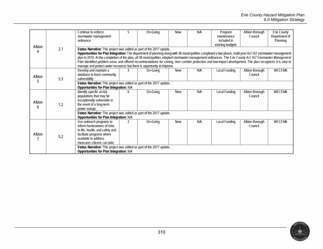
310
Erie County Hazard Mitigation Plan 6.0 Mitigation Strategy
Albion 4
2.1
Continue to enforce stormwater management ordinance
5 On-Going New N/A Program maintenance included in
existing budgets
Albion Borough Council
Erie County Department of
Planning
Status Narrative: This project was added as part of the 2017 update. Opportunities for Plan Integration: The department of planning along with 38 municipalities completed a two phase, multi-year Act 167 stormwater management plan in 2010. At the completion of the plan, all 38 municipalities adopted stormwater management ordinances. The Erie County Act 167 Stormwater Management Plan identified problem areas and offered recommendations for zoning, river corridor protection and low-impact development. The plan recognizes it is step to manage and protect water resources but there is opportunity to improve.
Albion 5 5.3
Develop and maintain a database to track community vulnerability
3 On-Going New N/A Local Funding Albion Borough Council
WECEMA
Status Narrative: This project was added as part of the 2017 update. Opportunities for Plan Integration: N/A
Albion 6
1.2
Identify specific at-risk populations that may be exceptionally vulnerable in the event of a long-term power outage
6 On-Going New N/A Local Funding Albion Borough Council
WECEMA
Status Narrative: This project was added as part of the 2017 update. Opportunities for Plan Integration: N/A
Albion 7 5.2
Use outreach programs to inform homeowners of risks to life, health, and safety and facilitate programs where available to address measures citizens can take
2 On-Going New N/A Local Funding Albion Borough Council
WECEMA
Status Narrative: This project was added as part of the 2017 update. Opportunities for Plan Integration: N/A
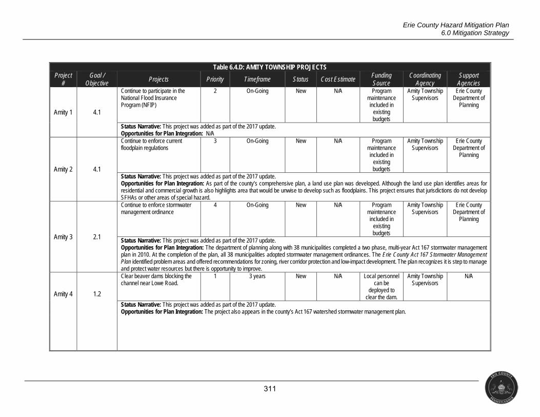
311
Erie County Hazard Mitigation Plan 6.0 Mitigation Strategy
Table 6.4.D: AMITY TOWNSHIP PROJECTS Project
# Goal /
Objective Projects Priority Timeframe Status Cost Estimate Funding
Source Coordinating
Agency Support
Agencies
Amity 1 4.1
Continue to participate in the National Flood Insurance Program (NFIP)
2 On-Going New N/A Program maintenance included in
existing budgets
Amity Township Supervisors
Erie County Department of
Planning
Status Narrative: This project was added as part of the 2017 update. Opportunities for Plan Integration: N/A
Amity 2 4.1
Continue to enforce current floodplain regulations
3 On-Going New N/A Program maintenance included in
existing budgets
Amity Township Supervisors
Erie County Department of
Planning
Status Narrative: This project was added as part of the 2017 update. Opportunities for Plan Integration: As part of the county’s comprehensive plan, a land use plan was developed. Although the land use plan identifies areas for residential and commercial growth is also highlights area that would be unwise to develop such as floodplains. This project ensures that jurisdictions do not develop SFHAs or other areas of special hazard.
Amity 3 2.1
Continue to enforce stormwater management ordinance
4 On-Going New N/A Program maintenance included in
existing budgets
Amity Township Supervisors
Erie County Department of
Planning
Status Narrative: This project was added as part of the 2017 update. Opportunities for Plan Integration: The department of planning along with 38 municipalities completed a two phase, multi-year Act 167 stormwater management plan in 2010. At the completion of the plan, all 38 municipalities adopted stormwater management ordinances. The Erie County Act 167 Stormwater Management Plan identified problem areas and offered recommendations for zoning, river corridor protection and low-impact development. The plan recognizes it is step to manage and protect water resources but there is opportunity to improve.
Amity 4 1.2
Clear beaver dams blocking the channel near Lowe Road.
1 3 years New N/A Local personnel can be
deployed to clear the dam.
Amity Township Supervisors
N/A
Status Narrative: This project was added as part of the 2017 update. Opportunities for Plan Integration: The project also appears in the county’s Act 167 watershed stormwater management plan.
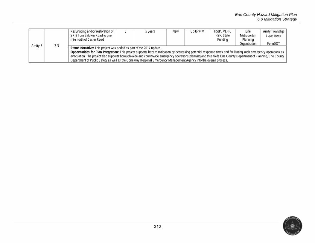
312
Erie County Hazard Mitigation Plan 6.0 Mitigation Strategy
Amity 5 3.3
Resurfacing and/or restoration of SR 8 from Baldwin Road to one mile north of Casier Road
5 5 years New Up to $4M HSIP, MLFF, HSF, State
Funding
Erie Metropolitan
Planning Organization
Amity Township Supervisors
PennDOT
Status Narrative: This project was added as part of the 2017 update. Opportunities for Plan Integration: This project supports hazard mitigation by decreasing potential response times and facilitating such emergency operations as evacuation. The project also supports borough-wide and countywide emergency operations planning and thus folds Erie County Department of Planning, Erie County Department of Public Safety as well as the Conelway Regional Emergency Management Agency into the overall process.
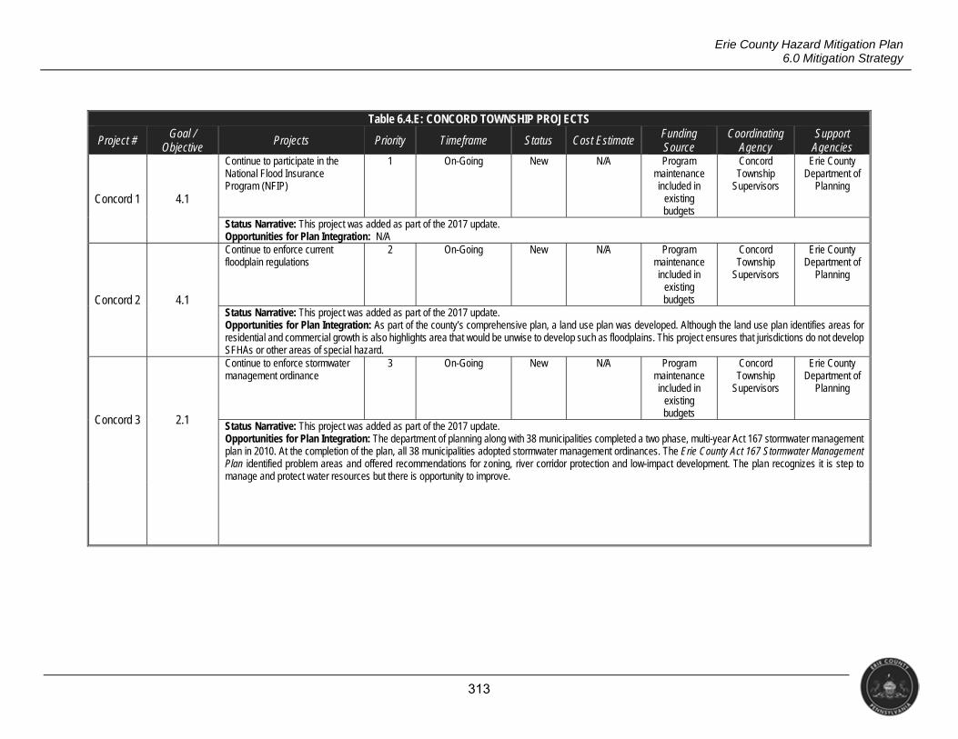
313
Erie County Hazard Mitigation Plan 6.0 Mitigation Strategy
Table 6.4.E: CONCORD TOWNSHIP PROJECTS
Project # Goal / Objective
Projects Priority Timeframe Status Cost Estimate Funding Source
Coordinating Agency
Support Agencies
Concord 1 4.1
Continue to participate in the National Flood Insurance Program (NFIP)
1 On-Going New N/A Program maintenance included in
existing budgets
Concord Township
Supervisors
Erie County Department of
Planning
Status Narrative: This project was added as part of the 2017 update. Opportunities for Plan Integration: N/A
Concord 2 4.1
Continue to enforce current floodplain regulations
2 On-Going New N/A Program maintenance included in
existing budgets
Concord Township
Supervisors
Erie County Department of
Planning
Status Narrative: This project was added as part of the 2017 update. Opportunities for Plan Integration: As part of the county’s comprehensive plan, a land use plan was developed. Although the land use plan identifies areas for residential and commercial growth is also highlights area that would be unwise to develop such as floodplains. This project ensures that jurisdictions do not develop SFHAs or other areas of special hazard.
Concord 3 2.1
Continue to enforce stormwater management ordinance
3 On-Going New N/A Program maintenance included in
existing budgets
Concord Township
Supervisors
Erie County Department of
Planning
Status Narrative: This project was added as part of the 2017 update. Opportunities for Plan Integration: The department of planning along with 38 municipalities completed a two phase, multi-year Act 167 stormwater management plan in 2010. At the completion of the plan, all 38 municipalities adopted stormwater management ordinances. The Erie County Act 167 Stormwater Management Plan identified problem areas and offered recommendations for zoning, river corridor protection and low-impact development. The plan recognizes it is step to manage and protect water resources but there is opportunity to improve.
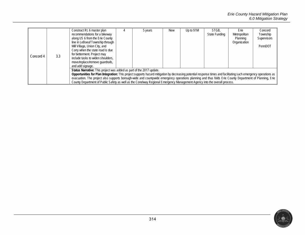
314
Erie County Hazard Mitigation Plan 6.0 Mitigation Strategy
Concord 4 3.3
Construct Rt. 6 master plan recommendations for a bikeway along US 6 from the Erie County line in LeBoeuf Township through Mill Village, Union City, and Corry when the state road is due for betterment. Project may include tasks to widen shoulders, move/replace/remove guardrails, and add signage.
4 5 years New Up to $1M STGB, State Funding
Erie Metropolitan
Planning Organization
Concord Township
Supervisors
PennDOT
Status Narrative: This project was added as part of the 2017 update. Opportunities for Plan Integration: This project supports hazard mitigation by decreasing potential response times and facilitating such emergency operations as evacuation. The project also supports borough-wide and countywide emergency operations planning and thus folds Erie County Department of Planning, Erie County Department of Public Safety as well as the Conelway Regional Emergency Management Agency into the overall process.
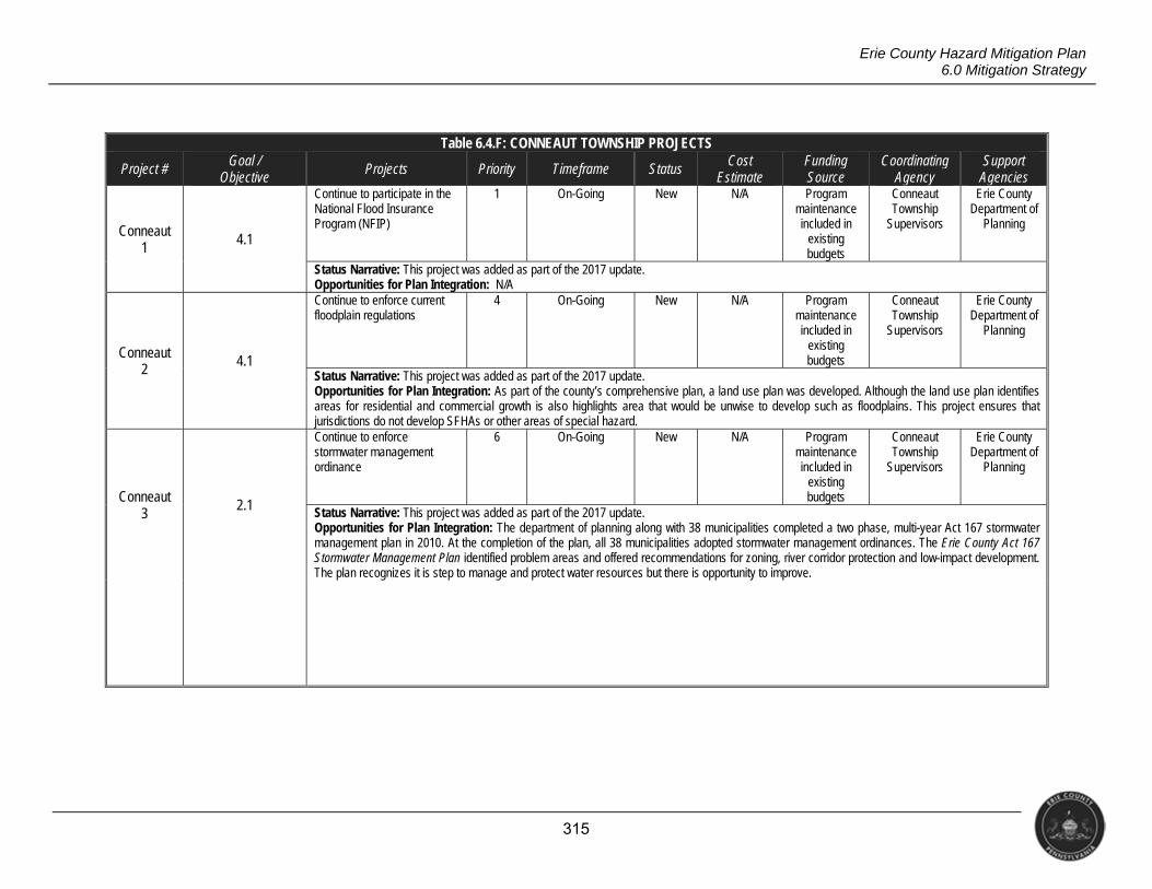
315
Erie County Hazard Mitigation Plan 6.0 Mitigation Strategy
Table 6.4.F: CONNEAUT TOWNSHIP PROJECTS
Project # Goal / Objective
Projects Priority Timeframe Status Cost Estimate
Funding Source
Coordinating Agency
Support Agencies
Conneaut 1 4.1
Continue to participate in the National Flood Insurance Program (NFIP)
1 On-Going New N/A Program maintenance included in
existing budgets
Conneaut Township
Supervisors
Erie County Department of
Planning
Status Narrative: This project was added as part of the 2017 update. Opportunities for Plan Integration: N/A
Conneaut 2
4.1
Continue to enforce current floodplain regulations
4 On-Going New N/A Program maintenance included in
existing budgets
Conneaut Township
Supervisors
Erie County Department of
Planning
Status Narrative: This project was added as part of the 2017 update. Opportunities for Plan Integration: As part of the county’s comprehensive plan, a land use plan was developed. Although the land use plan identifies areas for residential and commercial growth is also highlights area that would be unwise to develop such as floodplains. This project ensures that jurisdictions do not develop SFHAs or other areas of special hazard.
Conneaut 3
2.1
Continue to enforce stormwater management ordinance
6 On-Going New N/A Program maintenance included in
existing budgets
Conneaut Township
Supervisors
Erie County Department of
Planning
Status Narrative: This project was added as part of the 2017 update. Opportunities for Plan Integration: The department of planning along with 38 municipalities completed a two phase, multi-year Act 167 stormwater management plan in 2010. At the completion of the plan, all 38 municipalities adopted stormwater management ordinances. The Erie County Act 167 Stormwater Management Plan identified problem areas and offered recommendations for zoning, river corridor protection and low-impact development. The plan recognizes it is step to manage and protect water resources but there is opportunity to improve.
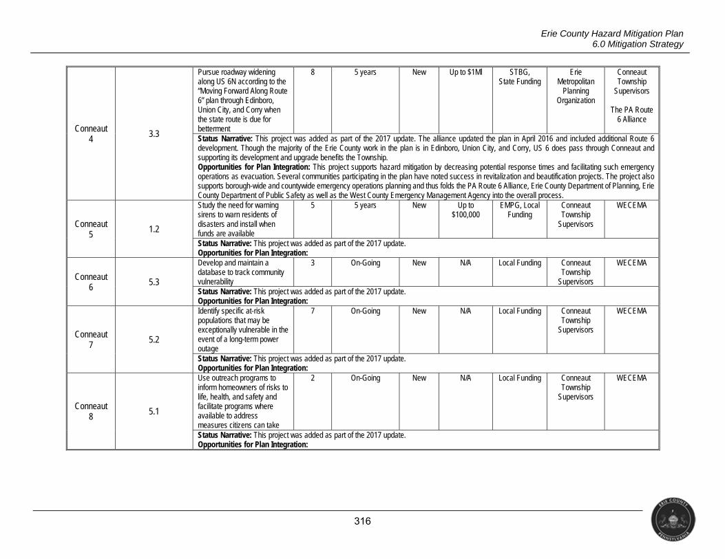
316
Erie County Hazard Mitigation Plan 6.0 Mitigation Strategy
Conneaut 4
3.3
Pursue roadway widening along US 6N according to the “Moving Forward Along Route 6” plan through Edinboro, Union City, and Corry when the state route is due for betterment
8 5 years New Up to $1Ml STBG, State Funding
Erie Metropolitan
Planning Organization
Conneaut Township
Supervisors
The PA Route 6 Alliance
Status Narrative: This project was added as part of the 2017 update. The alliance updated the plan in April 2016 and included additional Route 6 development. Though the majority of the Erie County work in the plan is in Edinboro, Union City, and Corry, US 6 does pass through Conneaut and supporting its development and upgrade benefits the Township. Opportunities for Plan Integration: This project supports hazard mitigation by decreasing potential response times and facilitating such emergency operations as evacuation. Several communities participating in the plan have noted success in revitalization and beautification projects. The project also supports borough-wide and countywide emergency operations planning and thus folds the PA Route 6 Alliance, Erie County Department of Planning, Erie County Department of Public Safety as well as the West County Emergency Management Agency into the overall process.
Conneaut 5
1.2
Study the need for warning sirens to warn residents of disasters and install when funds are available
5 5 years New Up to $100,000
EMPG, Local Funding
Conneaut Township
Supervisors
WECEMA
Status Narrative: This project was added as part of the 2017 update. Opportunities for Plan Integration:
Conneaut 6 5.3
Develop and maintain a database to track community vulnerability
3 On-Going New N/A Local Funding Conneaut Township
Supervisors
WECEMA
Status Narrative: This project was added as part of the 2017 update. Opportunities for Plan Integration:
Conneaut 7
5.2
Identify specific at-risk populations that may be exceptionally vulnerable in the event of a long-term power outage
7 On-Going New N/A Local Funding Conneaut Township
Supervisors
WECEMA
Status Narrative: This project was added as part of the 2017 update. Opportunities for Plan Integration:
Conneaut 8 5.1
Use outreach programs to inform homeowners of risks to life, health, and safety and facilitate programs where available to address measures citizens can take
2 On-Going New N/A Local Funding Conneaut Township
Supervisors
WECEMA
Status Narrative: This project was added as part of the 2017 update. Opportunities for Plan Integration:
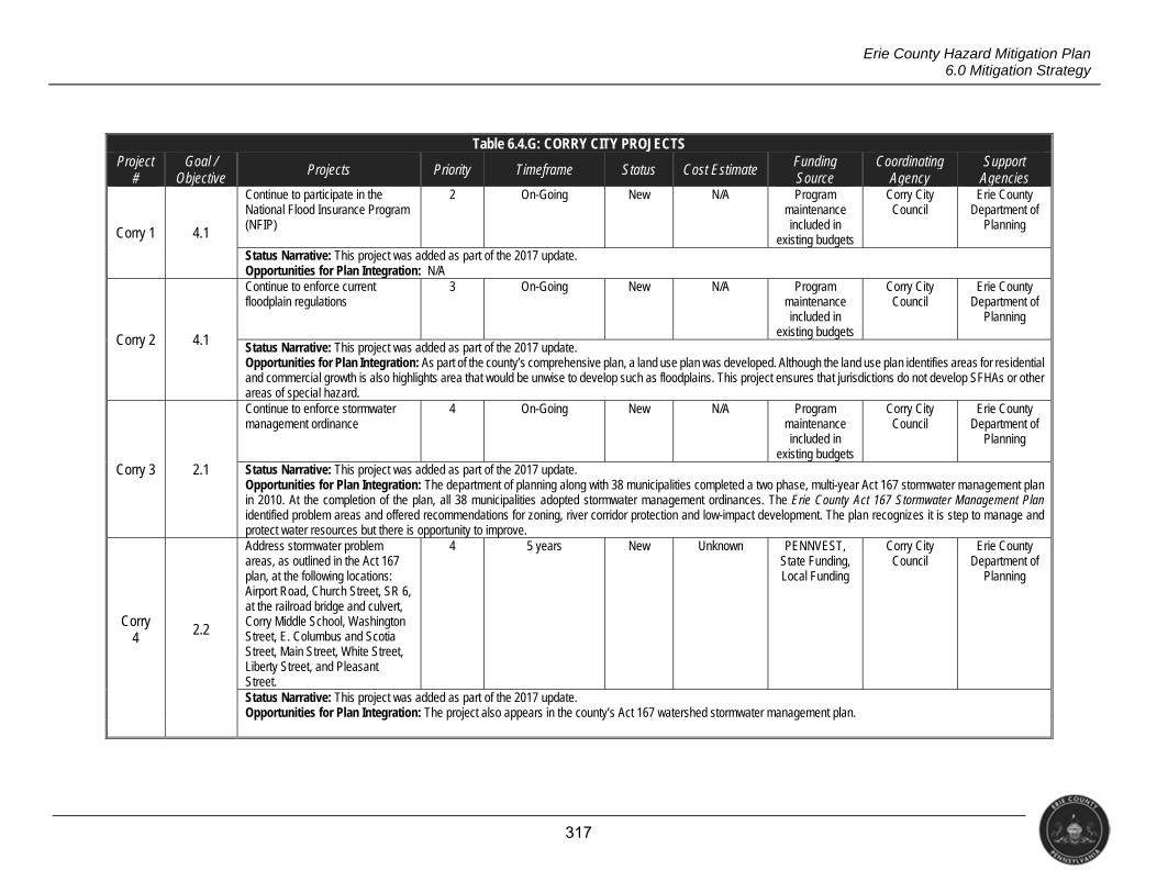
317
Erie County Hazard Mitigation Plan 6.0 Mitigation Strategy
Table 6.4.G: CORRY CITY PROJECTS Project
# Goal /
Objective Projects Priority Timeframe Status Cost Estimate Funding
Source Coordinating
Agency Support
Agencies
Corry 1 4.1
Continue to participate in the National Flood Insurance Program (NFIP)
2 On-Going New N/A Program maintenance included in
existing budgets
Corry City Council
Erie County Department of
Planning
Status Narrative: This project was added as part of the 2017 update. Opportunities for Plan Integration: N/A
Corry 2 4.1
Continue to enforce current floodplain regulations
3 On-Going New N/A Program maintenance included in
existing budgets
Corry City Council
Erie County Department of
Planning
Status Narrative: This project was added as part of the 2017 update. Opportunities for Plan Integration: As part of the county’s comprehensive plan, a land use plan was developed. Although the land use plan identifies areas for residential and commercial growth is also highlights area that would be unwise to develop such as floodplains. This project ensures that jurisdictions do not develop SFHAs or other areas of special hazard.
Corry 3 2.1
Continue to enforce stormwater management ordinance
4 On-Going New N/A Program maintenance included in
existing budgets
Corry City Council
Erie County Department of
Planning
Status Narrative: This project was added as part of the 2017 update. Opportunities for Plan Integration: The department of planning along with 38 municipalities completed a two phase, multi-year Act 167 stormwater management plan in 2010. At the completion of the plan, all 38 municipalities adopted stormwater management ordinances. The Erie County Act 167 Stormwater Management Plan identified problem areas and offered recommendations for zoning, river corridor protection and low-impact development. The plan recognizes it is step to manage and protect water resources but there is opportunity to improve.
Corry 4 2.2
Address stormwater problem areas, as outlined in the Act 167 plan, at the following locations: Airport Road, Church Street, SR 6, at the railroad bridge and culvert, Corry Middle School, Washington Street, E. Columbus and Scotia Street, Main Street, White Street, Liberty Street, and Pleasant Street.
4 5 years New Unknown PENNVEST, State Funding, Local Funding
Corry City Council
Erie County Department of
Planning
Status Narrative: This project was added as part of the 2017 update. Opportunities for Plan Integration: The project also appears in the county’s Act 167 watershed stormwater management plan.
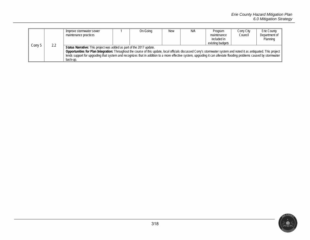
318
Erie County Hazard Mitigation Plan 6.0 Mitigation Strategy
Corry 5 2.2
Improve stormwater sewer maintenance practices
1 On-Going New N/A Program maintenance included in
existing budgets
Corry City Council
Erie County Department of
Planning
Status Narrative: This project was added as part of the 2017 update. Opportunities for Plan Integration: Throughout the course of this update, local officials discussed Corry’s stormwater system and noted it as antiquated. This project lends support for upgrading that system and recognizes that in addition to a more effective system, upgrading it can alleviate flooding problems caused by stormwater back-up.
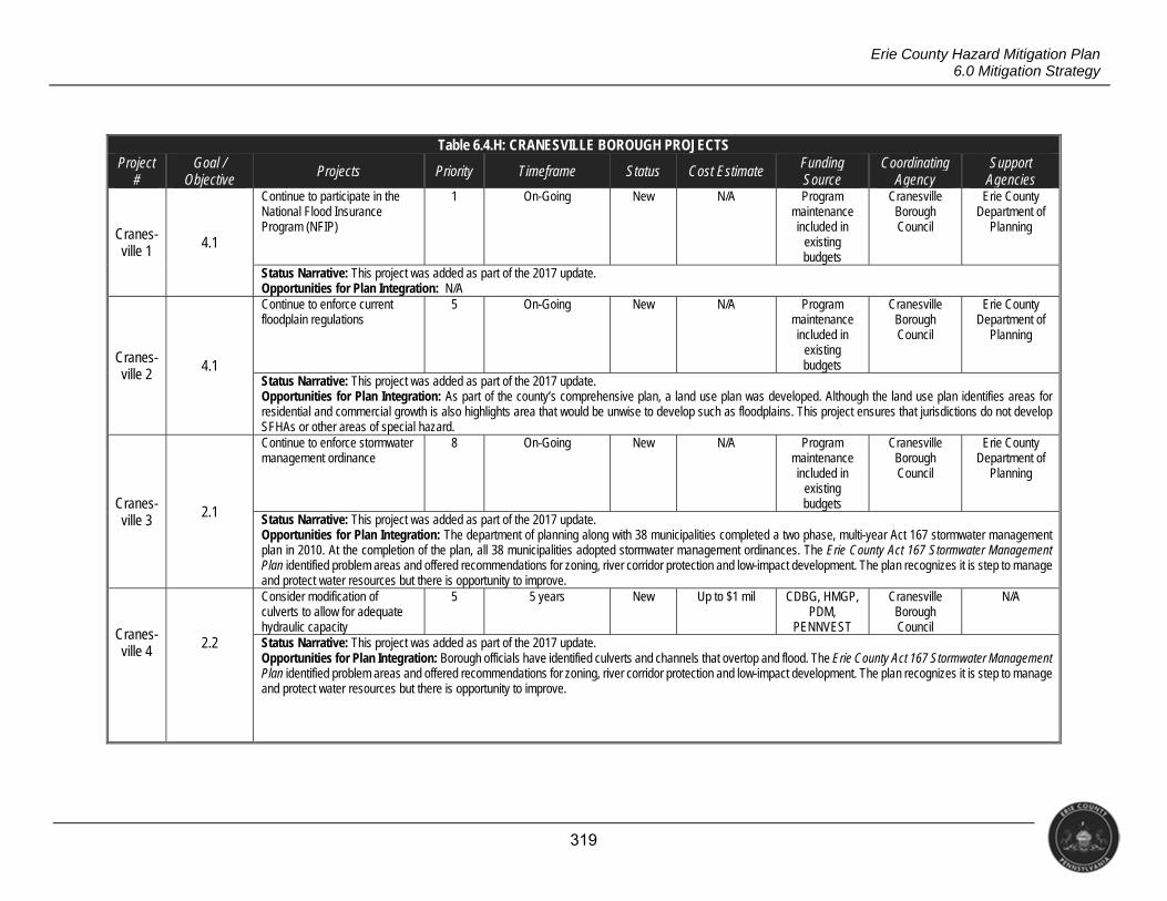
319
Erie County Hazard Mitigation Plan 6.0 Mitigation Strategy
Table 6.4.H: CRANESVILLE BOROUGH PROJECTS Project
# Goal /
Objective Projects Priority Timeframe Status Cost Estimate Funding
Source Coordinating
Agency Support
Agencies
Cranes-ville 1 4.1
Continue to participate in the National Flood Insurance Program (NFIP)
1 On-Going New N/A Program maintenance included in
existing budgets
Cranesville Borough Council
Erie County Department of
Planning
Status Narrative: This project was added as part of the 2017 update. Opportunities for Plan Integration: N/A
Cranes-ville 2
4.1
Continue to enforce current floodplain regulations
5 On-Going New N/A Program maintenance included in
existing budgets
Cranesville Borough Council
Erie County Department of
Planning
Status Narrative: This project was added as part of the 2017 update. Opportunities for Plan Integration: As part of the county’s comprehensive plan, a land use plan was developed. Although the land use plan identifies areas for residential and commercial growth is also highlights area that would be unwise to develop such as floodplains. This project ensures that jurisdictions do not develop SFHAs or other areas of special hazard.
Cranes-ville 3
2.1
Continue to enforce stormwater management ordinance
8 On-Going New N/A Program maintenance included in
existing budgets
Cranesville Borough Council
Erie County Department of
Planning
Status Narrative: This project was added as part of the 2017 update. Opportunities for Plan Integration: The department of planning along with 38 municipalities completed a two phase, multi-year Act 167 stormwater management plan in 2010. At the completion of the plan, all 38 municipalities adopted stormwater management ordinances. The Erie County Act 167 Stormwater Management Plan identified problem areas and offered recommendations for zoning, river corridor protection and low-impact development. The plan recognizes it is step to manage and protect water resources but there is opportunity to improve.
Cranes-ville 4 2.2
Consider modification of culverts to allow for adequate hydraulic capacity
5 5 years New Up to $1 mil CDBG, HMGP, PDM,
PENNVEST
Cranesville Borough Council
N/A
Status Narrative: This project was added as part of the 2017 update. Opportunities for Plan Integration: Borough officials have identified culverts and channels that overtop and flood. The Erie County Act 167 Stormwater Management Plan identified problem areas and offered recommendations for zoning, river corridor protection and low-impact development. The plan recognizes it is step to manage and protect water resources but there is opportunity to improve.
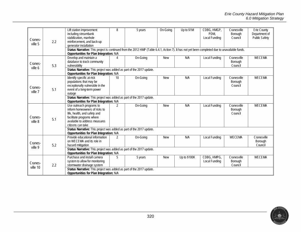
320
Erie County Hazard Mitigation Plan 6.0 Mitigation Strategy
Cranes-ville 5
2.2
Lift station improvement including streambank stabilization, manhole reinforcement, and back-up generator installation
8 5 years On-Going Up to $1M CDBG, HMGP, PDM,
Local Funding
Cranesville Borough Council
Erie County Department of Public Safety
Status Narrative: This project is continued from the 2012 HMP (Table 6.4.1, Action 7). It has not yet been completed due to unavailable funds. Opportunities for Plan Integration: N/A
Cranes-ville 6
5.3
Develop and maintain a database to track community vulnerability
4 On-Going New N/A Local Funding Cranesville Borough Council
WECEMA
Status Narrative: This project was added as part of the 2017 update. Opportunities for Plan Integration: N/A
Cranes- ville 7 5.1
Identify specific at-risk populations that may be exceptionally vulnerable in the event of a long-term power outage
10 On-Going New N/A Local Funding Cranesville Borough Council
WECEMA
Status Narrative: This project was added as part of the 2017 update. Opportunities for Plan Integration: N/A
Cranes- ville 8
5.1
Use outreach programs to inform homeowners of risks to life, health, and safety and facilitate programs where available to address measures citizens can take
2 On-Going New N/A Local Funding Cranesville Borough Council
WECEMA
Status Narrative: This project was added as part of the 2017 update. Opportunities for Plan Integration: N/A
Cranes- ville 9 5.2
Provide educational information on WECEMA and its role in hazard mitigation
2 On-Going New N/A Local Funding WECEMA Cranesville Borough Council
Status Narrative: This project was added as part of the 2017 update. Opportunities for Plan Integration: N/A
Cranes-ville 10
2.2
Purchase and install camera system to allow for monitoring stormwater drainage system
5 5 years New Up to $100K CDBG, HMPG, Local Funding
Cranesville Borough Council
WECEMA
Status Narrative: This project was added as part of the 2017 update. Opportunities for Plan Integration: N/A
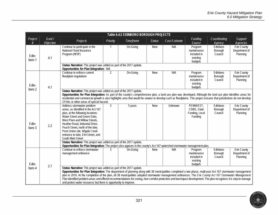
321
Erie County Hazard Mitigation Plan 6.0 Mitigation Strategy
Table 6.4.I: EDINBORO BOROUGH PROJECTS Project
# Goal /
Objective Projects Priority Timeframe Status Cost Estimate Funding
Source Coordinating
Agency Support
Agencies
Edin-boro 1 4.1
Continue to participate in the National Flood Insurance Program (NFIP)
1 On-Going New N/A Program maintenance included in
existing budgets
Edinboro Borough Council
Erie County Department of
Planning
Status Narrative: This project was added as part of the 2017 update. Opportunities for Plan Integration: N/A
Edin-boro 2
4.1
Continue to enforce current floodplain regulations
2 On-Going New N/A Program maintenance included in
existing budgets
Edinboro Borough Council
Erie County Department of
Planning
Status Narrative: This project was added as part of the 2017 update. Opportunities for Plan Integration: As part of the county’s comprehensive plan, a land use plan was developed. Although the land use plan identifies areas for residential and commercial growth is also highlights area that would be unwise to develop such as floodplains. This project ensures that jurisdictions do not develop SFHAs or other areas of special hazard.
Edin- boro 3
2.2
Address stormwater problem areas, as identified in the Act 167 plan, at the following locations: Water Street and Green Oaks, West Plum and Willow Streets, Heather Road, Industrial Drive, Peach Street, north of the lake, Penn Union site, Wipple Creek entrance to lake, Elm Street, and South Main Street
3 5 years New Unknown PENNVEST, CDBG, State
Funding, Local Funding
Edinboro Borough Council
Erie County Department of
Planning
Status Narrative: This project was added as part of the 2017 update. Opportunities for Plan Integration: The project also appears in the county’s Act 167 watershed stormwater management plan.
Edin-boro 4
2.1
Continue to enforce stormwater management ordinance
3 On-Going New N/A Program maintenance included in
existing budgets
Edinboro Borough Council
Erie County Department of
Planning
Status Narrative: This project was added as part of the 2017 update. Opportunities for Plan Integration: The department of planning along with 38 municipalities completed a two phase, multi-year Act 167 stormwater management plan in 2010. At the completion of the plan, all 38 municipalities adopted stormwater management ordinances. The Erie County Act 167 Stormwater Management Plan identified problem areas and offered recommendations for zoning, river corridor protection and low-impact development. The plan recognizes it is step to manage and protect water resources but there is opportunity to improve.
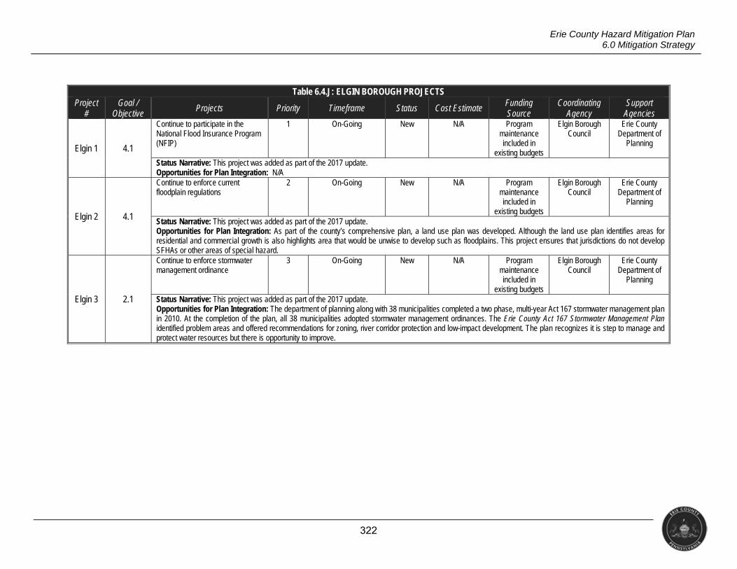
322
Erie County Hazard Mitigation Plan 6.0 Mitigation Strategy
Table 6.4.J: ELGIN BOROUGH PROJECTS Project
# Goal /
Objective Projects Priority Timeframe Status Cost Estimate Funding
Source Coordinating
Agency Support
Agencies
Elgin 1 4.1
Continue to participate in the National Flood Insurance Program (NFIP)
1 On-Going New N/A Program maintenance included in
existing budgets
Elgin Borough Council
Erie County Department of
Planning
Status Narrative: This project was added as part of the 2017 update. Opportunities for Plan Integration: N/A
Elgin 2 4.1
Continue to enforce current floodplain regulations
2 On-Going New N/A Program maintenance included in
existing budgets
Elgin Borough Council
Erie County Department of
Planning
Status Narrative: This project was added as part of the 2017 update. Opportunities for Plan Integration: As part of the county’s comprehensive plan, a land use plan was developed. Although the land use plan identifies areas for residential and commercial growth is also highlights area that would be unwise to develop such as floodplains. This project ensures that jurisdictions do not develop SFHAs or other areas of special hazard.
Elgin 3 2.1
Continue to enforce stormwater management ordinance
3 On-Going New N/A Program maintenance included in
existing budgets
Elgin Borough Council
Erie County Department of
Planning
Status Narrative: This project was added as part of the 2017 update. Opportunities for Plan Integration: The department of planning along with 38 municipalities completed a two phase, multi-year Act 167 stormwater management plan in 2010. At the completion of the plan, all 38 municipalities adopted stormwater management ordinances. The Erie County Act 167 Stormwater Management Plan identified problem areas and offered recommendations for zoning, river corridor protection and low-impact development. The plan recognizes it is step to manage and protect water resources but there is opportunity to improve.
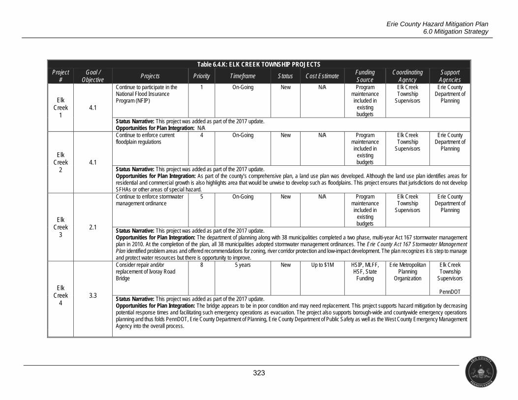
323
Erie County Hazard Mitigation Plan 6.0 Mitigation Strategy
Table 6.4.K: ELK CREEK TOWNSHIP PROJECTS Project
# Goal /
Objective Projects Priority Timeframe Status Cost Estimate Funding
Source Coordinating
Agency Support
Agencies
Elk Creek
1 4.1
Continue to participate in the National Flood Insurance Program (NFIP)
1 On-Going New N/A Program maintenance included in
existing budgets
Elk Creek Township
Supervisors
Erie County Department of
Planning
Status Narrative: This project was added as part of the 2017 update. Opportunities for Plan Integration: N/A
Elk Creek
2 4.1
Continue to enforce current floodplain regulations
4 On-Going New N/A Program maintenance included in
existing budgets
Elk Creek Township
Supervisors
Erie County Department of
Planning
Status Narrative: This project was added as part of the 2017 update. Opportunities for Plan Integration: As part of the county’s comprehensive plan, a land use plan was developed. Although the land use plan identifies areas for residential and commercial growth is also highlights area that would be unwise to develop such as floodplains. This project ensures that jurisdictions do not develop SFHAs or other areas of special hazard.
Elk Creek
3 2.1
Continue to enforce stormwater management ordinance
5 On-Going New N/A Program maintenance included in
existing budgets
Elk Creek Township
Supervisors
Erie County Department of
Planning
Status Narrative: This project was added as part of the 2017 update. Opportunities for Plan Integration: The department of planning along with 38 municipalities completed a two phase, multi-year Act 167 stormwater management plan in 2010. At the completion of the plan, all 38 municipalities adopted stormwater management ordinances. The Erie County Act 167 Stormwater Management Plan identified problem areas and offered recommendations for zoning, river corridor protection and low-impact development. The plan recognizes it is step to manage and protect water resources but there is opportunity to improve.
Elk Creek
4 3.3
Consider repair and/or replacement of Ivoray Road Bridge
8 5 years New Up to $1M HSIP, MLFF, HSF, State
Funding
Erie Metropolitan Planning
Organization
Elk Creek Township
Supervisors
PennDOT Status Narrative: This project was added as part of the 2017 update. Opportunities for Plan Integration: The bridge appears to be in poor condition and may need replacement. This project supports hazard mitigation by decreasing potential response times and facilitating such emergency operations as evacuation. The project also supports borough-wide and countywide emergency operations planning and thus folds PennDOT, Erie County Department of Planning, Erie County Department of Public Safety as well as the West County Emergency Management Agency into the overall process.
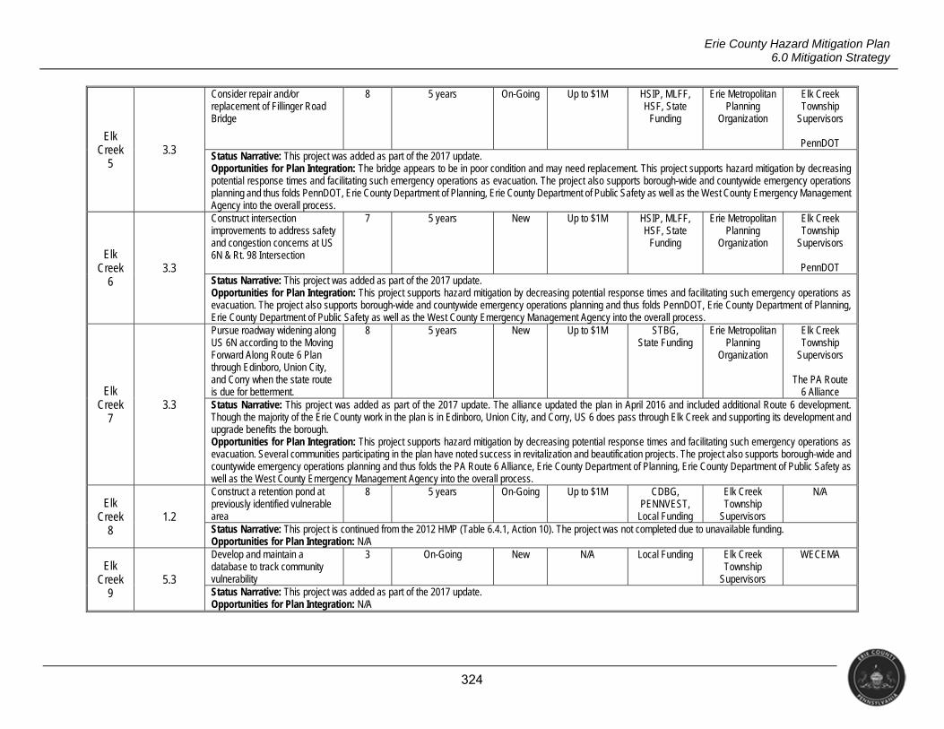
324
Erie County Hazard Mitigation Plan 6.0 Mitigation Strategy
Elk Creek
5 3.3
Consider repair and/or replacement of Fillinger Road Bridge
8 5 years On-Going Up to $1M HSIP, MLFF, HSF, State
Funding
Erie Metropolitan Planning
Organization
Elk Creek Township
Supervisors
PennDOT Status Narrative: This project was added as part of the 2017 update. Opportunities for Plan Integration: The bridge appears to be in poor condition and may need replacement. This project supports hazard mitigation by decreasing potential response times and facilitating such emergency operations as evacuation. The project also supports borough-wide and countywide emergency operations planning and thus folds PennDOT, Erie County Department of Planning, Erie County Department of Public Safety as well as the West County Emergency Management Agency into the overall process.
Elk Creek
6 3.3
Construct intersection improvements to address safety and congestion concerns at US 6N & Rt. 98 Intersection
7 5 years New Up to $1M HSIP, MLFF, HSF, State
Funding
Erie Metropolitan Planning
Organization
Elk Creek Township
Supervisors
PennDOT Status Narrative: This project was added as part of the 2017 update. Opportunities for Plan Integration: This project supports hazard mitigation by decreasing potential response times and facilitating such emergency operations as evacuation. The project also supports borough-wide and countywide emergency operations planning and thus folds PennDOT, Erie County Department of Planning, Erie County Department of Public Safety as well as the West County Emergency Management Agency into the overall process.
Elk Creek
7 3.3
Pursue roadway widening along US 6N according to the Moving Forward Along Route 6 Plan through Edinboro, Union City, and Corry when the state route is due for betterment.
8 5 years New Up to $1M STBG, State Funding
Erie Metropolitan Planning
Organization
Elk Creek Township
Supervisors
The PA Route 6 Alliance
Status Narrative: This project was added as part of the 2017 update. The alliance updated the plan in April 2016 and included additional Route 6 development. Though the majority of the Erie County work in the plan is in Edinboro, Union City, and Corry, US 6 does pass through Elk Creek and supporting its development and upgrade benefits the borough. Opportunities for Plan Integration: This project supports hazard mitigation by decreasing potential response times and facilitating such emergency operations as evacuation. Several communities participating in the plan have noted success in revitalization and beautification projects. The project also supports borough-wide and countywide emergency operations planning and thus folds the PA Route 6 Alliance, Erie County Department of Planning, Erie County Department of Public Safety as well as the West County Emergency Management Agency into the overall process.
Elk Creek
8 1.2
Construct a retention pond at previously identified vulnerable area
8 5 years On-Going Up to $1M CDBG, PENNVEST,
Local Funding
Elk Creek Township
Supervisors
N/A
Status Narrative: This project is continued from the 2012 HMP (Table 6.4.1, Action 10). The project was not completed due to unavailable funding. Opportunities for Plan Integration: N/A
Elk Creek
9 5.3
Develop and maintain a database to track community vulnerability
3 On-Going New N/A Local Funding Elk Creek Township
Supervisors
WECEMA
Status Narrative: This project was added as part of the 2017 update. Opportunities for Plan Integration: N/A
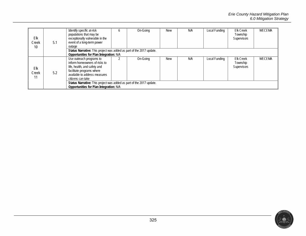
325
Erie County Hazard Mitigation Plan 6.0 Mitigation Strategy
Elk Creek
10 5.1
Identify specific at-risk populations that may be exceptionally vulnerable in the event of a long-term power outage
6 On-Going New N/A Local Funding Elk Creek Township
Supervisors
WECEMA
Status Narrative: This project was added as part of the 2017 update. Opportunities for Plan Integration: N/A
Elk Creek
11 5.2
Use outreach programs to inform homeowners of risks to life, health, and safety and facilitate programs where available to address measures citizens can take
2 On-Going New N/A Local Funding Elk Creek Township
Supervisors
WECEMA
Status Narrative: This project was added as part of the 2017 update. Opportunities for Plan Integration: N/A
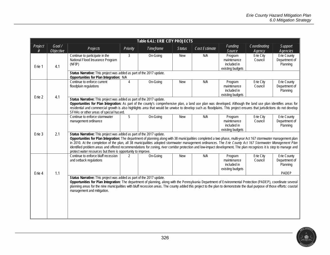
326
Erie County Hazard Mitigation Plan 6.0 Mitigation Strategy
Table 6.4.L: ERIE CITY PROJECTS Project
# Goal /
Objective Projects Priority Timeframe Status Cost Estimate Funding
Source Coordinating
Agency Support
Agencies
Erie 1 4.1
Continue to participate in the National Flood Insurance Program (NFIP)
3 On-Going New N/A Program maintenance included in
existing budgets
Erie City Council
Erie County Department of
Planning
Status Narrative: This project was added as part of the 2017 update. Opportunities for Plan Integration: N/A
Erie 2 4.1
Continue to enforce current floodplain regulations
4 On-Going New N/A Program maintenance included in
existing budgets
Erie City Council
Erie County Department of
Planning
Status Narrative: This project was added as part of the 2017 update. Opportunities for Plan Integration: As part of the county’s comprehensive plan, a land use plan was developed. Although the land use plan identifies areas for residential and commercial growth is also highlights area that would be unwise to develop such as floodplains. This project ensures that jurisdictions do not develop SFHAs or other areas of special hazard.
Erie 3 2.1
Continue to enforce stormwater management ordinance
5 On-Going New N/A Program maintenance included in
existing budgets
Erie City Council
Erie County Department of
Planning
Status Narrative: This project was added as part of the 2017 update. Opportunities for Plan Integration: The department of planning along with 38 municipalities completed a two phase, multi-year Act 167 stormwater management plan in 2010. At the completion of the plan, all 38 municipalities adopted stormwater management ordinances. The Erie County Act 167 Stormwater Management Plan identified problem areas and offered recommendations for zoning, river corridor protection and low-impact development. The plan recognizes it is step to manage and protect water resources but there is opportunity to improve.
Erie 4 1.1
Continue to enforce bluff recession and setback regulations
2 On-Going New N/A Program maintenance included in
existing budgets
Erie City Council
Erie County Department of
Planning
PADEP Status Narrative: This project was added as part of the 2017 update. Opportunities for Plan Integration: The department of planning, along with the Pennsylvania Department of Environmental Protection (PADEP), coordinate several planning areas for the nine municipalities with bluff recession areas. The county added this project to the plan to demonstrate the dual purpose of those efforts: coastal management and mitigation.
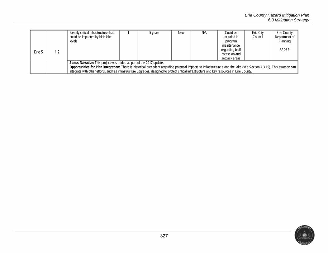
327
Erie County Hazard Mitigation Plan 6.0 Mitigation Strategy
Erie 5 1.2
Identify critical infrastructure that could be impacted by high lake levels
1 5 years New N/A Could be included in program
maintenance regarding bluff recession and setback areas
Erie City Council
Erie County Department of
Planning
PADEP
Status Narrative: This project was added as part of the 2017 update. Opportunities for Plan Integration: There is historical precedent regarding potential impacts to infrastructure along the lake (see Section 4.3.15). This strategy can integrate with other efforts, such as infrastructure upgrades, designed to protect critical infrastructure and key resources in Erie County.
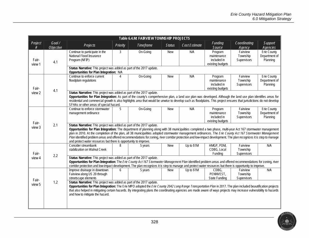
328
Erie County Hazard Mitigation Plan 6.0 Mitigation Strategy
Table 6.4.M: FAIRVIEW TOWNSHIP PROJECTS Project
# Goal /
Objective Projects Priority Timeframe Status Cost Estimate Funding
Source Coordinating
Agency Support
Agencies
Fair-view 1 4.1
Continue to participate in the National Flood Insurance Program (NFIP)
3 On-Going New N/A Program maintenance included in
existing budgets
Fairview Township
Supervisors
Erie County Department of
Planning
Status Narrative: This project was added as part of the 2017 update. Opportunities for Plan Integration: N/A
Fair-view 2
4.1
Continue to enforce current floodplain regulations
4 On-Going New N/A Program maintenance included in
existing budgets
Fairview Township
Supervisors
Erie County Department of
Planning
Status Narrative: This project was added as part of the 2017 update. Opportunities for Plan Integration: As part of the county’s comprehensive plan, a land use plan was developed. Although the land use plan identifies areas for residential and commercial growth is also highlights area that would be unwise to develop such as floodplains. This project ensures that jurisdictions do not develop SFHAs or other areas of special hazard.
Fair-view 3 2.1
Continue to enforce stormwater management ordinance
5 On-Going New N/A Program maintenance included in
existing budgets
Fairview Township
Supervisors
Erie County Department of
Planning
Status Narrative: This project was added as part of the 2017 update. Opportunities for Plan Integration: The department of planning along with 38 municipalities completed a two phase, multi-year Act 167 stormwater management plan in 2010. At the completion of the plan, all 38 municipalities adopted stormwater management ordinances. The Erie County Act 167 Stormwater Management Plan identified problem areas and offered recommendations for zoning, river corridor protection and low-impact development. The plan recognizes it is step to manage and protect water resources but there is opportunity to improve.
Fair-view 4
2.2
Consider streambank stabilization on Walnut Creek
8 5 years New Up to $1M HMGP, PDM, CDBG, Local
Funding
Fairview Township
Supervisors
N/A
Status Narrative: This project was added as part of the 2017 update. Opportunities for Plan Integration: The Erie County Act 167 Stormwater Management Plan identified problem areas and offered recommendations for zoning, river corridor protection and low-impact development. The plan recognizes it is step to manage and protect water resources but there is opportunity to improve.
Fair-view 5 1.2
Improve drainage in downtown Fairview along US 20 through streetscape elements
6 5 years New Up to $1M CDBG, PENNVEST, State Funding
Fairview Township
Supervisors
N/A
Status Narrative: This project was added as part of the 2017 update. Opportunities for Plan Integration: The Erie MPO adopted the Erie County 2042 Long Range Transportation Plan in 2017. The plan included beautification projects that also helped in mitigating certain hazards. By integrating plans the coordinating agencies are made aware of ways projects may increase vulnerability to hazards and how to mitigate the hazard.
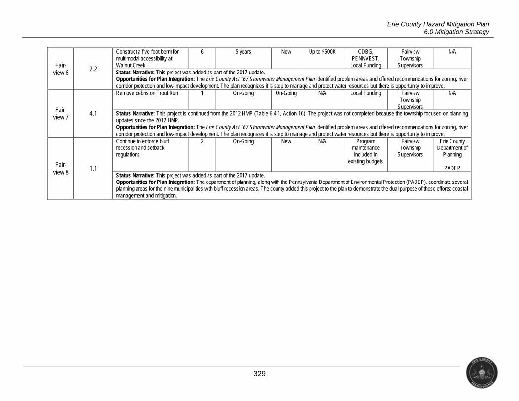
329
Erie County Hazard Mitigation Plan 6.0 Mitigation Strategy
Fair-view 6
2.2
Construct a five-foot berm for multimodal accessibility at Walnut Creek
6 5 years New Up to $500K CDBG, PENNVEST,
Local Funding
Fairview Township
Supervisors
N/A
Status Narrative: This project was added as part of the 2017 update. Opportunities for Plan Integration: The Erie County Act 167 Stormwater Management Plan identified problem areas and offered recommendations for zoning, river corridor protection and low-impact development. The plan recognizes it is step to manage and protect water resources but there is opportunity to improve.
Fair-view 7
4.1
Remove debris on Trout Run 1 On-Going On-Going N/A Local Funding Fairview Township
Supervisors
N/A
Status Narrative: This project is continued from the 2012 HMP (Table 6.4.1, Action 16). The project was not completed because the township focused on planning updates since the 2012 HMP. Opportunities for Plan Integration: The Erie County Act 167 Stormwater Management Plan identified problem areas and offered recommendations for zoning, river corridor protection and low-impact development. The plan recognizes it is step to manage and protect water resources but there is opportunity to improve.
Fair-view 8
1.1
Continue to enforce bluff recession and setback regulations
2 On-Going New N/A Program maintenance included in
existing budgets
Fairview Township
Supervisors
Erie County Department of
Planning
PADEP Status Narrative: This project was added as part of the 2017 update. Opportunities for Plan Integration: The department of planning, along with the Pennsylvania Department of Environmental Protection (PADEP), coordinate several planning areas for the nine municipalities with bluff recession areas. The county added this project to the plan to demonstrate the dual purpose of those efforts: coastal management and mitigation.
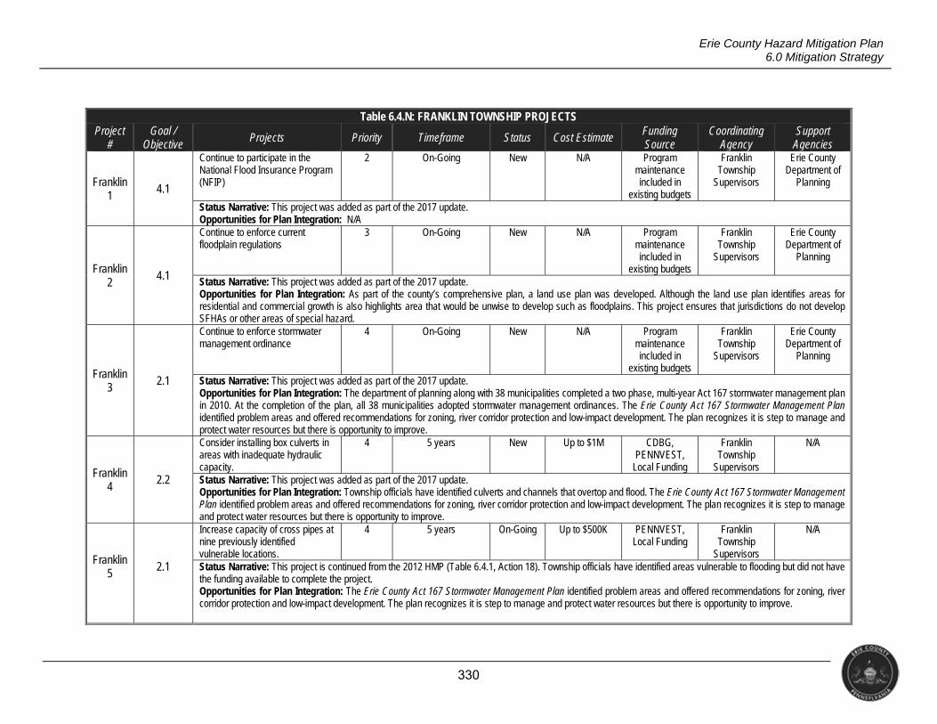
330
Erie County Hazard Mitigation Plan 6.0 Mitigation Strategy
Table 6.4.N: FRANKLIN TOWNSHIP PROJECTS Project
# Goal /
Objective Projects Priority Timeframe Status Cost Estimate Funding
Source Coordinating
Agency Support
Agencies
Franklin 1 4.1
Continue to participate in the National Flood Insurance Program (NFIP)
2 On-Going New N/A Program maintenance included in
existing budgets
Franklin Township
Supervisors
Erie County Department of
Planning
Status Narrative: This project was added as part of the 2017 update. Opportunities for Plan Integration: N/A
Franklin 2
4.1
Continue to enforce current floodplain regulations
3 On-Going New N/A Program maintenance included in
existing budgets
Franklin Township
Supervisors
Erie County Department of
Planning
Status Narrative: This project was added as part of the 2017 update. Opportunities for Plan Integration: As part of the county’s comprehensive plan, a land use plan was developed. Although the land use plan identifies areas for residential and commercial growth is also highlights area that would be unwise to develop such as floodplains. This project ensures that jurisdictions do not develop SFHAs or other areas of special hazard.
Franklin 3 2.1
Continue to enforce stormwater management ordinance
4 On-Going New N/A Program maintenance included in
existing budgets
Franklin Township
Supervisors
Erie County Department of
Planning
Status Narrative: This project was added as part of the 2017 update. Opportunities for Plan Integration: The department of planning along with 38 municipalities completed a two phase, multi-year Act 167 stormwater management plan in 2010. At the completion of the plan, all 38 municipalities adopted stormwater management ordinances. The Erie County Act 167 Stormwater Management Plan identified problem areas and offered recommendations for zoning, river corridor protection and low-impact development. The plan recognizes it is step to manage and protect water resources but there is opportunity to improve.
Franklin 4
2.2
Consider installing box culverts in areas with inadequate hydraulic capacity.
4 5 years New Up to $1M CDBG, PENNVEST,
Local Funding
Franklin Township
Supervisors
N/A
Status Narrative: This project was added as part of the 2017 update. Opportunities for Plan Integration: Township officials have identified culverts and channels that overtop and flood. The Erie County Act 167 Stormwater Management Plan identified problem areas and offered recommendations for zoning, river corridor protection and low-impact development. The plan recognizes it is step to manage and protect water resources but there is opportunity to improve.
Franklin 5 2.1
Increase capacity of cross pipes at nine previously identified vulnerable locations.
4 5 years On-Going Up to $500K PENNVEST, Local Funding
Franklin Township
Supervisors
N/A
Status Narrative: This project is continued from the 2012 HMP (Table 6.4.1, Action 18). Township officials have identified areas vulnerable to flooding but did not have the funding available to complete the project. Opportunities for Plan Integration: The Erie County Act 167 Stormwater Management Plan identified problem areas and offered recommendations for zoning, river corridor protection and low-impact development. The plan recognizes it is step to manage and protect water resources but there is opportunity to improve.
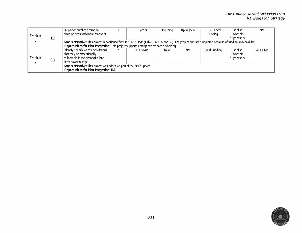
331
Erie County Hazard Mitigation Plan 6.0 Mitigation Strategy
Franklin 6 1.2
Repair or purchase tornado warning sires with radio receivers
1 5 years On-Going Up to $50K HSGP, Local Funding
Franklin Township
Supervisors
N/A
Status Narrative: This project is continued from the 2012 HMP (Table 6.4.1, Action 30). The project was not completed because of funding unavailability. Opportunities for Plan Integration: This project supports emergency response planning.
Franklin 7
5.3
Identify specific at-risk populations that may be exceptionally vulnerable in the event of a long-term power outage
7 On-Going New N/A Local Funding Franklin Township
Supervisors
WECEMA
Status Narrative: This project was added as part of the 2017 update. Opportunities for Plan Integration: N/A
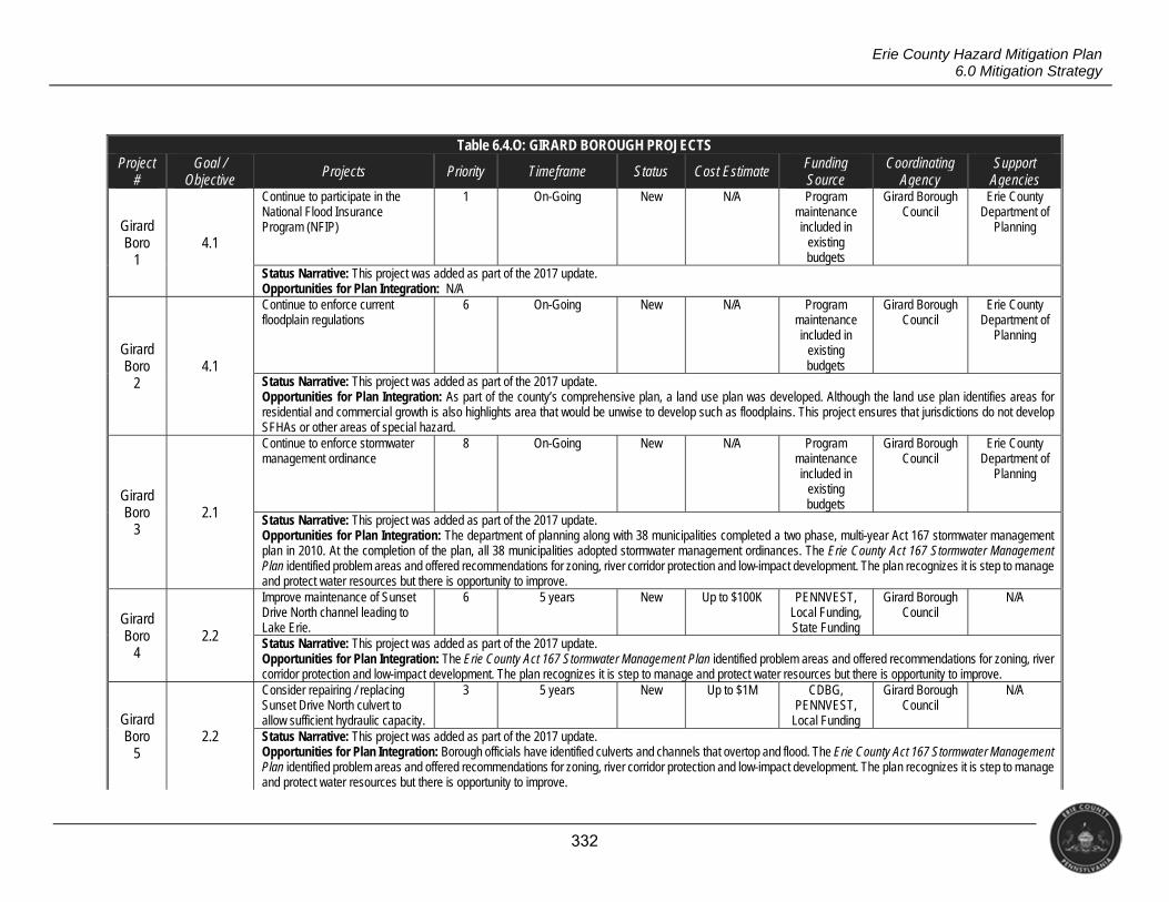
332
Erie County Hazard Mitigation Plan 6.0 Mitigation Strategy
Table 6.4.O: GIRARD BOROUGH PROJECTS Project
# Goal /
Objective Projects Priority Timeframe Status Cost Estimate Funding
Source Coordinating
Agency Support
Agencies
Girard Boro
1 4.1
Continue to participate in the National Flood Insurance Program (NFIP)
1 On-Going New N/A Program maintenance included in
existing budgets
Girard Borough Council
Erie County Department of
Planning
Status Narrative: This project was added as part of the 2017 update. Opportunities for Plan Integration: N/A
Girard Boro
2 4.1
Continue to enforce current floodplain regulations
6 On-Going New N/A Program maintenance included in
existing budgets
Girard Borough Council
Erie County Department of
Planning
Status Narrative: This project was added as part of the 2017 update. Opportunities for Plan Integration: As part of the county’s comprehensive plan, a land use plan was developed. Although the land use plan identifies areas for residential and commercial growth is also highlights area that would be unwise to develop such as floodplains. This project ensures that jurisdictions do not develop SFHAs or other areas of special hazard.
Girard Boro
3 2.1
Continue to enforce stormwater management ordinance
8 On-Going New N/A Program maintenance included in
existing budgets
Girard Borough Council
Erie County Department of
Planning
Status Narrative: This project was added as part of the 2017 update. Opportunities for Plan Integration: The department of planning along with 38 municipalities completed a two phase, multi-year Act 167 stormwater management plan in 2010. At the completion of the plan, all 38 municipalities adopted stormwater management ordinances. The Erie County Act 167 Stormwater Management Plan identified problem areas and offered recommendations for zoning, river corridor protection and low-impact development. The plan recognizes it is step to manage and protect water resources but there is opportunity to improve.
Girard Boro
4 2.2
Improve maintenance of Sunset Drive North channel leading to Lake Erie.
6 5 years New Up to $100K PENNVEST, Local Funding, State Funding
Girard Borough Council
N/A
Status Narrative: This project was added as part of the 2017 update. Opportunities for Plan Integration: The Erie County Act 167 Stormwater Management Plan identified problem areas and offered recommendations for zoning, river corridor protection and low-impact development. The plan recognizes it is step to manage and protect water resources but there is opportunity to improve.
Girard Boro
5 2.2
Consider repairing / replacing Sunset Drive North culvert to allow sufficient hydraulic capacity.
3 5 years New Up to $1M CDBG, PENNVEST,
Local Funding
Girard Borough Council
N/A
Status Narrative: This project was added as part of the 2017 update. Opportunities for Plan Integration: Borough officials have identified culverts and channels that overtop and flood. The Erie County Act 167 Stormwater Management Plan identified problem areas and offered recommendations for zoning, river corridor protection and low-impact development. The plan recognizes it is step to manage and protect water resources but there is opportunity to improve.
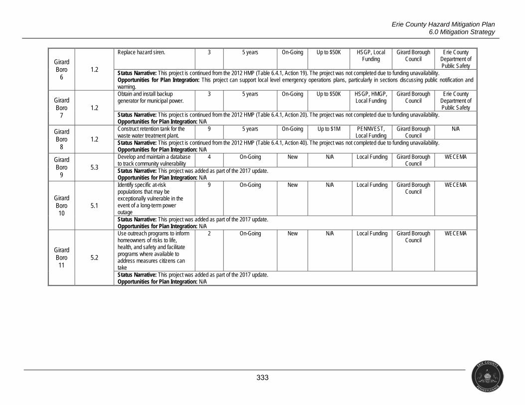
333
Erie County Hazard Mitigation Plan 6.0 Mitigation Strategy
Girard Boro
6 1.2
Replace hazard siren. 3 5 years On-Going Up to $50K HSGP, Local Funding
Girard Borough Council
Erie County Department of Public Safety
Status Narrative: This project is continued from the 2012 HMP (Table 6.4.1, Action 19). The project was not completed due to funding unavailability. Opportunities for Plan Integration: This project can support local level emergency operations plans, particularly in sections discussing public notification and warning.
Girard Boro
7 1.2
Obtain and install backup generator for municipal power.
3 5 years On-Going Up to $50K HSGP, HMGP, Local Funding
Girard Borough Council
Erie County Department of Public Safety
Status Narrative: This project is continued from the 2012 HMP (Table 6.4.1, Action 20). The project was not completed due to funding unavailability. Opportunities for Plan Integration: N/A
Girard Boro
8 1.2
Construct retention tank for the waste water treatment plant.
9 5 years On-Going Up to $1M PENNVEST, Local Funding
Girard Borough Council
N/A
Status Narrative: This project is continued from the 2012 HMP (Table 6.4.1, Action 40). The project was not completed due to funding unavailability. Opportunities for Plan Integration: N/A
Girard Boro
9 5.3
Develop and maintain a database to track community vulnerability
4 On-Going New N/A Local Funding Girard Borough Council
WECEMA
Status Narrative: This project was added as part of the 2017 update. Opportunities for Plan Integration: N/A
Girard Boro 10
5.1
Identify specific at-risk populations that may be exceptionally vulnerable in the event of a long-term power outage
9 On-Going New N/A Local Funding Girard Borough Council
WECEMA
Status Narrative: This project was added as part of the 2017 update. Opportunities for Plan Integration: N/A
Girard Boro 11
5.2
Use outreach programs to inform homeowners of risks to life, health, and safety and facilitate programs where available to address measures citizens can take
2 On-Going New N/A Local Funding Girard Borough Council
WECEMA
Status Narrative: This project was added as part of the 2017 update. Opportunities for Plan Integration: N/A
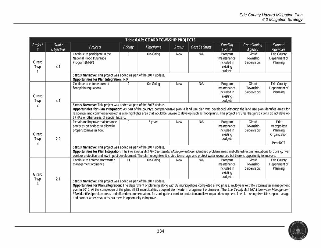
334
Erie County Hazard Mitigation Plan 6.0 Mitigation Strategy
Table 6.4.P: GIRARD TOWNSHIP PROJECTS Project
# Goal /
Objective Projects Priority Timeframe Status Cost Estimate Funding
Source Coordinating
Agency Support
Agencies
Girard Twp
1 4.1
Continue to participate in the National Flood Insurance Program (NFIP)
5 On-Going New N/A Program maintenance included in
existing budgets
Girard Township
Supervisors
Erie County Department of
Planning
Status Narrative: This project was added as part of the 2017 update. Opportunities for Plan Integration: N/A
Girard Twp
2 4.1
Continue to enforce current floodplain regulations
9 On-Going New N/A Program maintenance included in
existing budgets
Girard Township
Supervisors
Erie County Department of
Planning
Status Narrative: This project was added as part of the 2017 update. Opportunities for Plan Integration: As part of the county’s comprehensive plan, a land use plan was developed. Although the land use plan identifies areas for residential and commercial growth is also highlights area that would be unwise to develop such as floodplains. This project ensures that jurisdictions do not develop SFHAs or other areas of special hazard.
Girard Twp
3 2.2
Repair and improve maintenance practices on bridges to allow for proper stormwater flow.
9 5 years New N/A Program maintenance included in
existing budgets
Girard Township
Supervisors
Erie Metropolitan
Planning Organization
PennDOT
Status Narrative: This project was added as part of the 2017 update. Opportunities for Plan Integration: The Erie County Act 167 Stormwater Management Plan identified problem areas and offered recommendations for zoning, river corridor protection and low-impact development. The plan recognizes it is step to manage and protect water resources but there is opportunity to improve.
Girard Twp
4 2.1
Continue to enforce stormwater management ordinance
11 On-Going New N/A Program maintenance included in
existing budgets
Girard Township
Supervisors
Erie County Department of
Planning
Status Narrative: This project was added as part of the 2017 update. Opportunities for Plan Integration: The department of planning along with 38 municipalities completed a two phase, multi-year Act 167 stormwater management plan in 2010. At the completion of the plan, all 38 municipalities adopted stormwater management ordinances. The Erie County Act 167 Stormwater Management Plan identified problem areas and offered recommendations for zoning, river corridor protection and low-impact development. The plan recognizes it is step to manage and protect water resources but there is opportunity to improve.
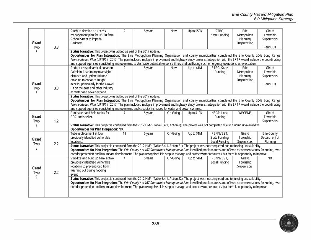
335
Erie County Hazard Mitigation Plan 6.0 Mitigation Strategy
Girard Twp
5 3.3
Study to develop an access management plan for US 20 from School Street to Imperial Parkway.
2 5 years New Up to $50K STBG, State Funding
Erie Metropolitan
Planning Organization
Girard Township
Supervisors
PennDOT Status Narrative: This project was added as part of the 2017 update. Opportunities for Plan Integration: The Erie Metropolitan Planning Organization and county municipalities completed the Erie County 2042 Long Range Transportation Plan (LRTP) in 2017. The plan included multiple improvement and highway study projects. Integration with the LRTP would include the coordinating and support agencies considering improvements to decrease potential response times and facilitating such emergency operations as evacuation.
Girard Twp
6 3.3
Reduce crest of vertical curve on Fairplain Road to improve sight distance and update railroad crossing to enhance freight access, particularly for the Gravel Pit on the east and other industry as water and sewer expand.
2 5 years New Up to $1M STBG, State Funding
Erie Metropolitan
Planning Organization
Girard Township
Supervisors
PennDOT
Status Narrative: This project was added as part of the 2017 update. Opportunities for Plan Integration: The Erie Metropolitan Planning Organization and county municipalities completed the Erie County 2042 Long Range Transportation Plan (LRTP) in 2017. The plan included multiple improvement and highway study projects. Integration with the LRTP would include the coordinating and support agencies considering improvements and capacity increases for water and sewer systems.
Girard Twp
7 1.2
Purchase hand held radios for EOC and shelter.
7 5 years On-Going Up to $10K HSGP, Local Funding
WECEMA Girard Township
Supervisors Status Narrative: This project is continued from the 2012 HMP (Table 6.4.1, Action 8). The project was not completed due to funding unavailability. Opportunities for Plan Integration: N/A
Girard Twp
8 2.2
Tube replacement at four previously identified vulnerable locations.
11 5 years On-Going Up to $1M PENNVEST, State Funding, Local Funding
Girard Township
Supervisors
Erie County Department of
Planning Status Narrative: This project is continued from the 2012 HMP (Table 6.4.1, Action 21). The project was not completed due to funding unavailability. Opportunities for Plan Integration: The Erie County Act 167 Stormwater Management Plan identified problem areas and offered recommendations for zoning, river corridor protection and low-impact development. The plan recognizes it is step to manage and protect water resources but there is opportunity to improve.
Girard Twp
9 2.2
Stabilize and build up bank at two previously identified vulnerable locations to prevent road from washing out during flooding event.
4 5 years On-Going Up to $1M PENNVEST, Local Funding
Girard Township
Supervisors
N/A
Status Narrative: This project is continued from the 2012 HMP (Table 6.4.1, Action 22). The project was not completed due to funding unavailability. Opportunities for Plan Integration: The Erie County Act 167 Stormwater Management Plan identified problem areas and offered recommendations for zoning, river corridor protection and low-impact development. The plan recognizes it is step to manage and protect water resources but there is opportunity to improve.
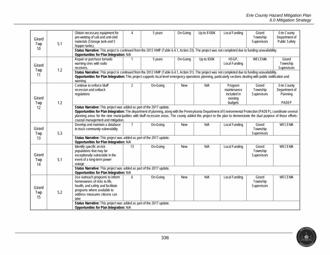
336
Erie County Hazard Mitigation Plan 6.0 Mitigation Strategy
Girard Twp 10
5.1
Obtain necessary equipment for pre-wetting of salt and anti-skid materials (Storage tank and 5 hopper tanks).
4 5 years On-Going Up to $100K Local Funding Girard Township
Supervisors
Erie County Department of Public Safety
Status Narrative: This project is continued from the 2012 HMP (Table 6.4.1, Action 23). The project was not completed due to funding unavailability. Opportunities for Plan Integration: N/A
Girard Twp 11
1.2
Repair or purchase tornado warning sires with radio receivers.
1 5 years On-Going Up to $50K HSGP, Local Funding
WECEMA Girard Township
Supervisors Status Narrative: This project is continued from the 2012 HMP (Table 6.4.1, Action 31). The project was not completed due to funding unavailability. Opportunities for Plan Integration: This project supports local-level emergency operations planning, particularly sections dealing with public notification and warning.
Girard Twp 12
1.2
Continue to enforce bluff recession and setback regulations
2 On-Going New N/A Program maintenance included in
existing budgets
Girard Township
Supervisors
Erie County Department of
Planning
PADEP Status Narrative: This project was added as part of the 2017 update. Opportunities for Plan Integration: The department of planning, along with the Pennsylvania Department of Environmental Protection (PADEP), coordinate several planning areas for the nine municipalities with bluff recession areas. The county added this project to the plan to demonstrate the dual purpose of those efforts: coastal management and mitigation.
Girard Twp 13
5.3
Develop and maintain a database to track community vulnerability
7 On-Going New N/A Local Funding Girard Township
Supervisors
WECEMA
Status Narrative: This project was added as part of the 2017 update. Opportunities for Plan Integration: N/A
Girard Twp 14
5.1
Identify specific at-risk populations that may be exceptionally vulnerable in the event of a long-term power outage
13 On-Going New N/A Local Funding Girard Township
Supervisors
WECEMA
Status Narrative: This project was added as part of the 2017 update. Opportunities for Plan Integration: N/A
Girard Twp 15
5.2
Use outreach programs to inform homeowners of risks to life, health, and safety and facilitate programs where available to address measures citizens can take
6 On-Going New N/A Local Funding Girard Township
Supervisors
WECEMA
Status Narrative: This project was added as part of the 2017 update. Opportunities for Plan Integration: N/A
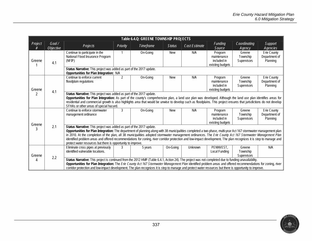
337
Erie County Hazard Mitigation Plan 6.0 Mitigation Strategy
Table 6.4.Q: GREENE TOWNSHIP PROJECTS Project
# Goal /
Objective Projects Priority Timeframe Status Cost Estimate Funding
Source Coordinating
Agency Support
Agencies
Greene 1 4.1
Continue to participate in the National Flood Insurance Program (NFIP)
1 On-Going New N/A Program maintenance included in
existing budgets
Greene Township
Supervisors
Erie County Department of
Planning
Status Narrative: This project was added as part of the 2017 update. Opportunities for Plan Integration: N/A
Greene 2
4.1
Continue to enforce current floodplain regulations
2 On-Going New N/A Program maintenance included in
existing budgets
Greene Township
Supervisors
Erie County Department of
Planning
Status Narrative: This project was added as part of the 2017 update. Opportunities for Plan Integration: As part of the county’s comprehensive plan, a land use plan was developed. Although the land use plan identifies areas for residential and commercial growth is also highlights area that would be unwise to develop such as floodplains. This project ensures that jurisdictions do not develop SFHAs or other areas of special hazard.
Greene 3 2.1
Continue to enforce stormwater management ordinance
3 On-Going New N/A Program maintenance included in
existing budgets
Greene Township
Supervisors
Erie County Department of
Planning
Status Narrative: This project was added as part of the 2017 update. Opportunities for Plan Integration: The department of planning along with 38 municipalities completed a two phase, multi-year Act 167 stormwater management plan in 2010. At the completion of the plan, all 38 municipalities adopted stormwater management ordinances. The Erie County Act 167 Stormwater Management Plan identified problem areas and offered recommendations for zoning, river corridor protection and low-impact development. The plan recognizes it is step to manage and protect water resources but there is opportunity to improve.
Greene 4
2.2
Eliminate cross pipes at previously identified vulnerable locations.
3 5 years On-Going Unknown PENNVEST, Local Funding
Greene Township
Supervisors
N/A
Status Narrative: This project is continued from the 2012 HMP (Table 6.4.1, Action 24). The project was not completed due to funding unavailability. Opportunities for Plan Integration: The Erie County Act 167 Stormwater Management Plan identified problem areas and offered recommendations for zoning, river corridor protection and low-impact development. The plan recognizes it is step to manage and protect water resources but there is opportunity to improve.
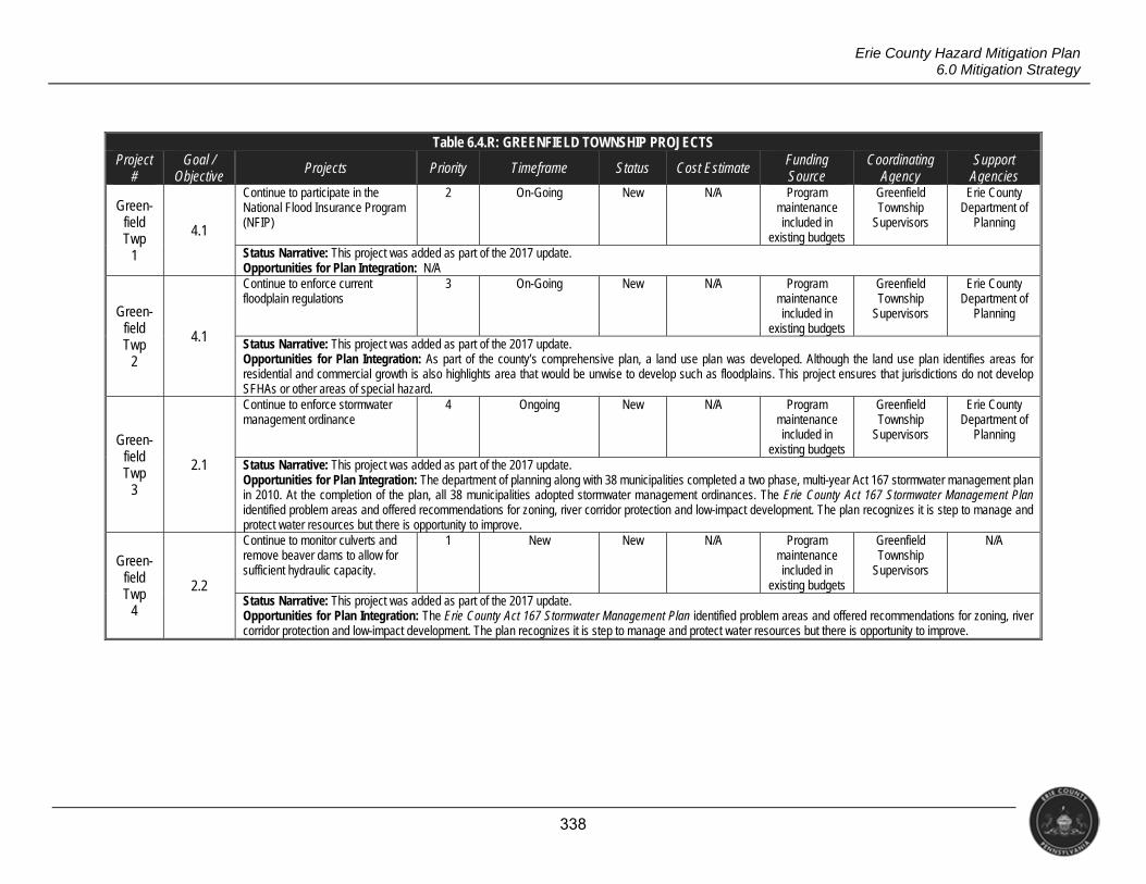
338
Erie County Hazard Mitigation Plan 6.0 Mitigation Strategy
Table 6.4.R: GREENFIELD TOWNSHIP PROJECTS Project
# Goal /
Objective Projects Priority Timeframe Status Cost Estimate Funding
Source Coordinating
Agency Support
Agencies
Green- field Twp
1
4.1
Continue to participate in the National Flood Insurance Program (NFIP)
2 On-Going New N/A Program maintenance included in
existing budgets
Greenfield Township
Supervisors
Erie County Department of
Planning
Status Narrative: This project was added as part of the 2017 update. Opportunities for Plan Integration: N/A
Green- field Twp
2
4.1
Continue to enforce current floodplain regulations
3 On-Going New N/A Program maintenance included in
existing budgets
Greenfield Township
Supervisors
Erie County Department of
Planning
Status Narrative: This project was added as part of the 2017 update. Opportunities for Plan Integration: As part of the county’s comprehensive plan, a land use plan was developed. Although the land use plan identifies areas for residential and commercial growth is also highlights area that would be unwise to develop such as floodplains. This project ensures that jurisdictions do not develop SFHAs or other areas of special hazard.
Green- field Twp
3
2.1
Continue to enforce stormwater management ordinance
4 Ongoing New N/A Program maintenance included in
existing budgets
Greenfield Township
Supervisors
Erie County Department of
Planning
Status Narrative: This project was added as part of the 2017 update. Opportunities for Plan Integration: The department of planning along with 38 municipalities completed a two phase, multi-year Act 167 stormwater management plan in 2010. At the completion of the plan, all 38 municipalities adopted stormwater management ordinances. The Erie County Act 167 Stormwater Management Plan identified problem areas and offered recommendations for zoning, river corridor protection and low-impact development. The plan recognizes it is step to manage and protect water resources but there is opportunity to improve.
Green- field Twp
4
2.2
Continue to monitor culverts and remove beaver dams to allow for sufficient hydraulic capacity.
1 New New N/A Program maintenance included in
existing budgets
Greenfield Township
Supervisors
N/A
Status Narrative: This project was added as part of the 2017 update. Opportunities for Plan Integration: The Erie County Act 167 Stormwater Management Plan identified problem areas and offered recommendations for zoning, river corridor protection and low-impact development. The plan recognizes it is step to manage and protect water resources but there is opportunity to improve.
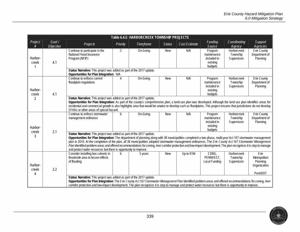
339
Erie County Hazard Mitigation Plan 6.0 Mitigation Strategy
Table 6.4.S: HARBORCREEK TOWNSHIP PROJECTS Project
# Goal /
Objective Projects Priority Timeframe Status Cost Estimate Funding
Source Coordinating
Agency Support
Agencies
Harbor- creek
1 4.1
Continue to participate in the National Flood Insurance Program (NFIP)
2 On-Going New N/A Program maintenance included in
existing budgets
Harborcreek Township
Supervisors
Erie County Department of
Planning
Status Narrative: This project was added as part of the 2017 update. Opportunities for Plan Integration: N/A
Harbor- creek
2 4.1
Continue to enforce current floodplain regulations
4 On-Going New N/A Program maintenance included in
existing budgets
Harborcreek Township
Supervisors
Erie County Department of
Planning
Status Narrative: This project was added as part of the 2017 update. Opportunities for Plan Integration: As part of the county’s comprehensive plan, a land use plan was developed. Although the land use plan identifies areas for residential and commercial growth is also highlights area that would be unwise to develop such as floodplains. This project ensures that jurisdictions do not develop SFHAs or other areas of special hazard.
Harbor- creek
3 2.1
Continue to enforce stormwater management ordinance
6 On-Going New N/A Program maintenance included in
existing budgets
Harborcreek Township
Supervisors
Erie County Department of
Planning
Status Narrative: This project was added as part of the 2017 update. Opportunities for Plan Integration: The department of planning along with 38 municipalities completed a two phase, multi-year Act 167 stormwater management plan in 2010. At the completion of the plan, all 38 municipalities adopted stormwater management ordinances. The Erie County Act 167 Stormwater Management Plan identified problem areas and offered recommendations for zoning, river corridor protection and low-impact development. The plan recognizes it is step to manage and protect water resources but there is opportunity to improve.
Harbor- creek
4 2.2
Consider installing box culverts in Brookside area to lessen effects of flooding.
6 5 years New Up to $1M CDBG, PENNVEST,
Local Funding
Harborcreek Township
Supervisors
Erie Metropolitan
Planning Organization
PennDOT
Status Narrative: This project was added as part of the 2017 update. Opportunities for Plan Integration: The Erie County Act 167 Stormwater Management Plan identified problem areas and offered recommendations for zoning, river corridor protection and low-impact development. The plan recognizes it is step to manage and protect water resources but there is opportunity to improve.
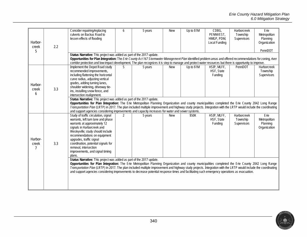
340
Erie County Hazard Mitigation Plan 6.0 Mitigation Strategy
Harbor- creek
5 2.2
Consider repairing/replacing culverts on Backus Road to lessen effects of flooding
6 5 years New Up to $1M CDBG, PENNVEST, HMGP, PDM, Local Funding
Harborcreek Township
Supervisors
Erie Metropolitan
Planning Organization
PennDOT
Status Narrative: This project was added as part of the 2017 update. Opportunities for Plan Integration: The Erie County Act 167 Stormwater Management Plan identified problem areas and offered recommendations for zoning, river corridor protection and low-impact development. The plan recognizes it is step to manage and protect water resources but there is opportunity to improve.
Harbor- creek
6 3.3
Implement the Depot Road study recommended improvements, including flattening the horizontal curve radius, adjusting vertical grades, adding turning lanes, shoulder widening, driveway tie-ins, installing snow fence, and intersection realignment.
5 5 years New Up to $1M HSIP, MLFF, HSF, State
Funding
PennDOT Harborcreek Township
Supervisors
Status Narrative: This project was added as part of the 2017 update. Opportunities for Plan Integration: The Erie Metropolitan Planning Organization and county municipalities completed the Erie County 2042 Long Range Transportation Plan (LRTP) in 2017. The plan included multiple improvement and highway study projects. Integration with the LRTP would include the coordinating and support agencies considering improvements and capacity increases for water and sewer systems.
Harbor- creek
7 3.3
Study of traffic circulation, signal warrants, left turn lane and phase warrants at approximately 12 signals in Harborcreek and Wesleyville; study should include recommendations on equipment upgrades, traffic signal coordination, potential signals for removal, intersection improvements, and signal timing plans.
2 5 years New $50K HSIP, MLFF, HSF, State
Funding
Harborcreek Township
Supervisors
Erie Metropolitan
Planning Organization
Status Narrative: This project was added as part of the 2017 update. Opportunities for Plan Integration: The Erie Metropolitan Planning Organization and county municipalities completed the Erie County 2042 Long Range Transportation Plan (LRTP) in 2017. The plan included multiple improvement and highway study projects. Integration with the LRTP would include the coordinating and support agencies considering improvements to decrease potential response times and facilitating such emergency operations as evacuation.
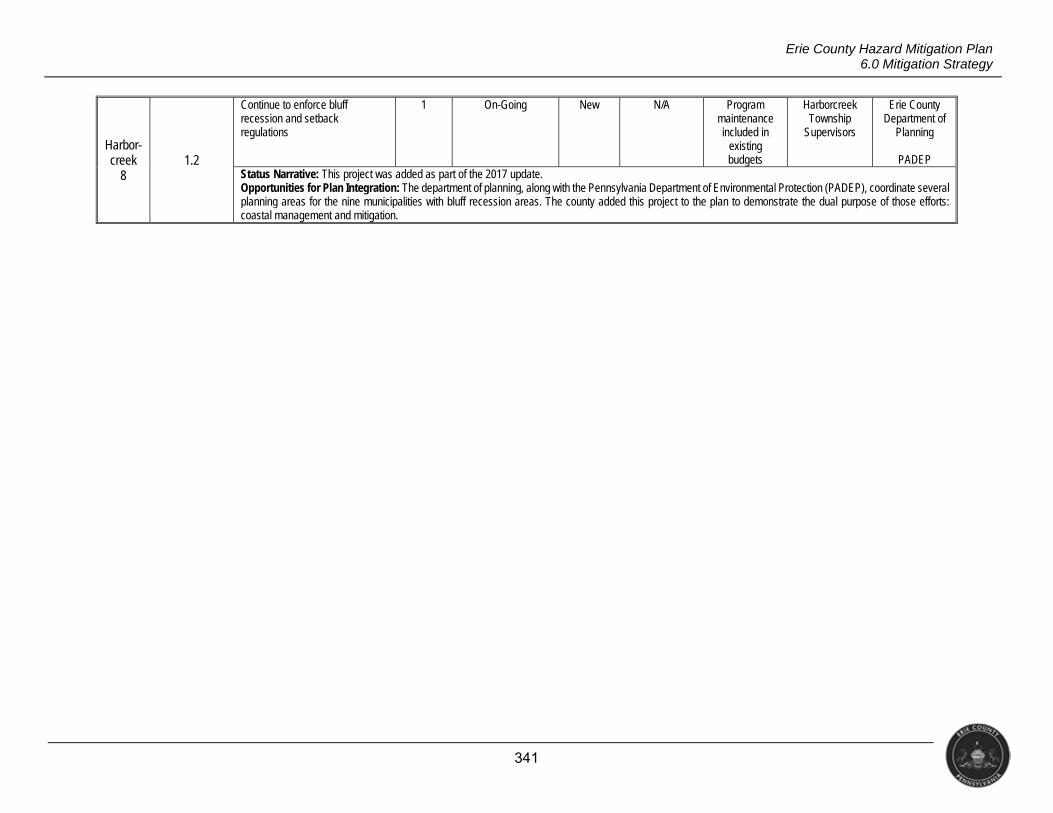
341
Erie County Hazard Mitigation Plan 6.0 Mitigation Strategy
Harbor- creek
8 1.2
Continue to enforce bluff recession and setback regulations
1 On-Going New N/A Program maintenance included in
existing budgets
Harborcreek Township
Supervisors
Erie County Department of
Planning
PADEP Status Narrative: This project was added as part of the 2017 update. Opportunities for Plan Integration: The department of planning, along with the Pennsylvania Department of Environmental Protection (PADEP), coordinate several planning areas for the nine municipalities with bluff recession areas. The county added this project to the plan to demonstrate the dual purpose of those efforts: coastal management and mitigation.
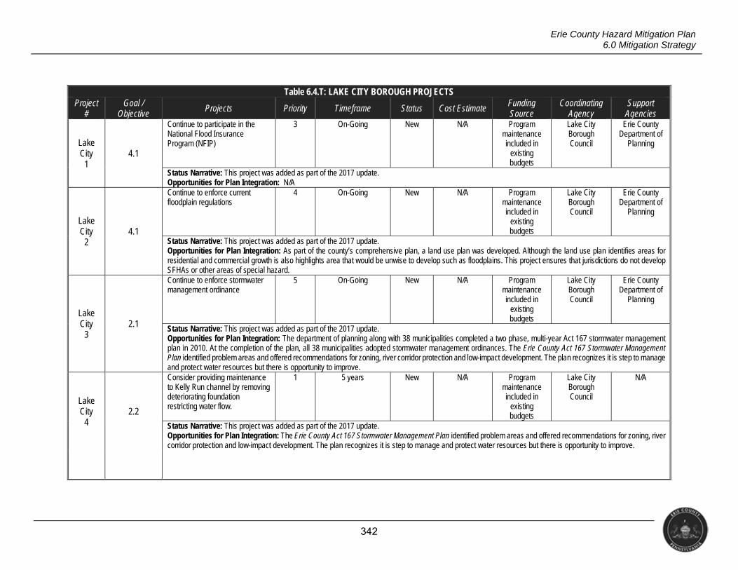
342
Erie County Hazard Mitigation Plan 6.0 Mitigation Strategy
Table 6.4.T: LAKE CITY BOROUGH PROJECTS Project
# Goal /
Objective Projects Priority Timeframe Status Cost Estimate Funding
Source Coordinating
Agency Support
Agencies
Lake City
1 4.1
Continue to participate in the National Flood Insurance Program (NFIP)
3 On-Going New N/A Program maintenance included in
existing budgets
Lake City Borough Council
Erie County Department of
Planning
Status Narrative: This project was added as part of the 2017 update. Opportunities for Plan Integration: N/A
Lake City
2 4.1
Continue to enforce current floodplain regulations
4 On-Going New N/A Program maintenance included in
existing budgets
Lake City Borough Council
Erie County Department of
Planning
Status Narrative: This project was added as part of the 2017 update. Opportunities for Plan Integration: As part of the county’s comprehensive plan, a land use plan was developed. Although the land use plan identifies areas for residential and commercial growth is also highlights area that would be unwise to develop such as floodplains. This project ensures that jurisdictions do not develop SFHAs or other areas of special hazard.
Lake City
3 2.1
Continue to enforce stormwater management ordinance
5 On-Going New N/A Program maintenance included in
existing budgets
Lake City Borough Council
Erie County Department of
Planning
Status Narrative: This project was added as part of the 2017 update. Opportunities for Plan Integration: The department of planning along with 38 municipalities completed a two phase, multi-year Act 167 stormwater management plan in 2010. At the completion of the plan, all 38 municipalities adopted stormwater management ordinances. The Erie County Act 167 Stormwater Management Plan identified problem areas and offered recommendations for zoning, river corridor protection and low-impact development. The plan recognizes it is step to manage and protect water resources but there is opportunity to improve.
Lake City
4 2.2
Consider providing maintenance to Kelly Run channel by removing deteriorating foundation restricting water flow.
1 5 years New N/A Program maintenance included in
existing budgets
Lake City Borough Council
N/A
Status Narrative: This project was added as part of the 2017 update. Opportunities for Plan Integration: The Erie County Act 167 Stormwater Management Plan identified problem areas and offered recommendations for zoning, river corridor protection and low-impact development. The plan recognizes it is step to manage and protect water resources but there is opportunity to improve.
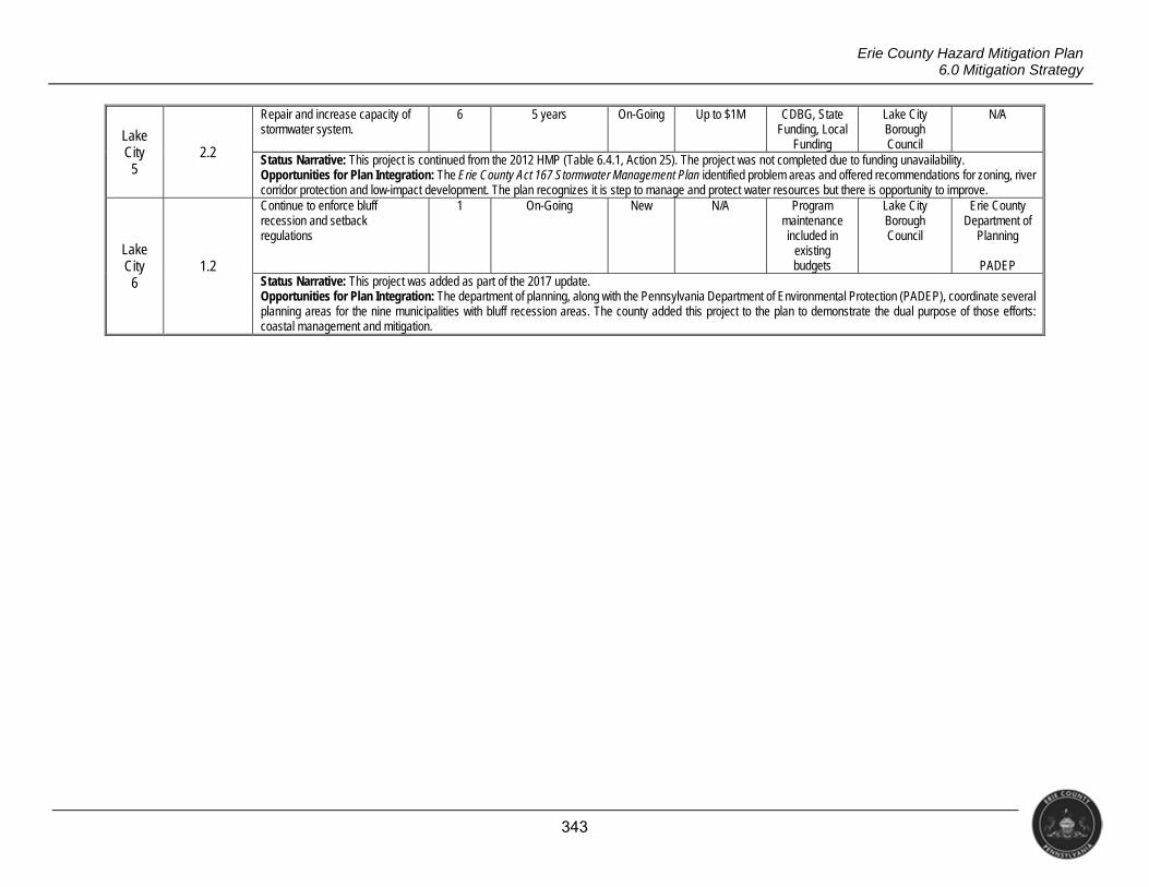
343
Erie County Hazard Mitigation Plan 6.0 Mitigation Strategy
Lake City
5 2.2
Repair and increase capacity of stormwater system.
6 5 years On-Going Up to $1M CDBG, State Funding, Local
Funding
Lake City Borough Council
N/A
Status Narrative: This project is continued from the 2012 HMP (Table 6.4.1, Action 25). The project was not completed due to funding unavailability. Opportunities for Plan Integration: The Erie County Act 167 Stormwater Management Plan identified problem areas and offered recommendations for zoning, river corridor protection and low-impact development. The plan recognizes it is step to manage and protect water resources but there is opportunity to improve.
Lake City
6 1.2
Continue to enforce bluff recession and setback regulations
1 On-Going New N/A Program maintenance included in
existing budgets
Lake City Borough Council
Erie County Department of
Planning
PADEP Status Narrative: This project was added as part of the 2017 update. Opportunities for Plan Integration: The department of planning, along with the Pennsylvania Department of Environmental Protection (PADEP), coordinate several planning areas for the nine municipalities with bluff recession areas. The county added this project to the plan to demonstrate the dual purpose of those efforts: coastal management and mitigation.
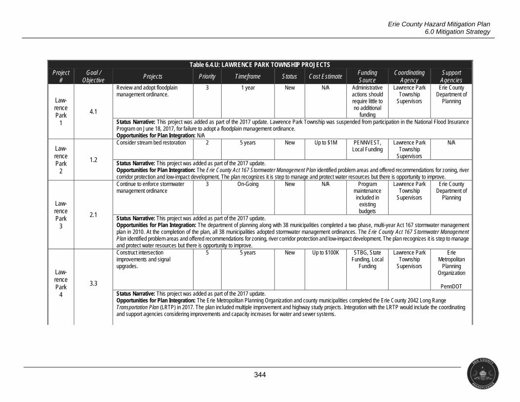
344
Erie County Hazard Mitigation Plan 6.0 Mitigation Strategy
Table 6.4.U: LAWRENCE PARK TOWNSHIP PROJECTS Project
# Goal /
Objective Projects Priority Timeframe Status Cost Estimate Funding
Source Coordinating
Agency Support
Agencies
Law- rence Park
1
4.1
Review and adopt floodplain management ordinance.
3 1 year New N/A Administrative actions should require little to no additional
funding
Lawrence Park Township
Supervisors
Erie County Department of
Planning
Status Narrative: This project was added as part of the 2017 update. Lawrence Park Township was suspended from participation in the National Flood Insurance Program on June 18, 2017, for failure to adopt a floodplain management ordinance. Opportunities for Plan Integration: N/A
Law- rence Park
2
1.2
Consider stream bed restoration 2 5 years New Up to $1M PENNVEST, Local Funding
Lawrence Park Township
Supervisors
N/A
Status Narrative: This project was added as part of the 2017 update. Opportunities for Plan Integration: The Erie County Act 167 Stormwater Management Plan identified problem areas and offered recommendations for zoning, river corridor protection and low-impact development. The plan recognizes it is step to manage and protect water resources but there is opportunity to improve.
Law- rence Park
3
2.1
Continue to enforce stormwater management ordinance
3 On-Going New N/A Program maintenance included in
existing budgets
Lawrence Park Township
Supervisors
Erie County Department of
Planning
Status Narrative: This project was added as part of the 2017 update. Opportunities for Plan Integration: The department of planning along with 38 municipalities completed a two phase, multi-year Act 167 stormwater management plan in 2010. At the completion of the plan, all 38 municipalities adopted stormwater management ordinances. The Erie County Act 167 Stormwater Management Plan identified problem areas and offered recommendations for zoning, river corridor protection and low-impact development. The plan recognizes it is step to manage and protect water resources but there is opportunity to improve.
Law- rence Park
4
3.3
Construct intersection improvements and signal upgrades.
5 5 years New Up to $100K STBG, State Funding, Local
Funding
Lawrence Park Township
Supervisors
Erie Metropolitan
Planning Organization
PennDOT
Status Narrative: This project was added as part of the 2017 update. Opportunities for Plan Integration: The Erie Metropolitan Planning Organization and county municipalities completed the Erie County 2042 Long Range Transportation Plan (LRTP) in 2017. The plan included multiple improvement and highway study projects. Integration with the LRTP would include the coordinating and support agencies considering improvements and capacity increases for water and sewer systems.
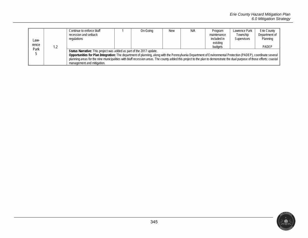
345
Erie County Hazard Mitigation Plan 6.0 Mitigation Strategy
Law- rence Park
5
1.2
Continue to enforce bluff recession and setback regulations
1 On-Going New N/A Program maintenance included in
existing budgets
Lawrence Park Township
Supervisors
Erie County Department of
Planning
PADEP Status Narrative: This project was added as part of the 2017 update. Opportunities for Plan Integration: The department of planning, along with the Pennsylvania Department of Environmental Protection (PADEP), coordinate several planning areas for the nine municipalities with bluff recession areas. The county added this project to the plan to demonstrate the dual purpose of those efforts: coastal management and mitigation.

346
Erie County Hazard Mitigation Plan 6.0 Mitigation Strategy
Table 6.4.V: LEBOEUF TOWNSHIP PROJECTS Project
# Goal /
Objective Projects Priority Timeframe Status Cost Estimate Funding
Source Coordinating
Agency Support
Agencies
LeBoeuf 1 4.1
Continue to participate in the National Flood Insurance Program (NFIP)
1 On-Going New N/A Program maintenance included in
existing budgets
LeBoeuf Township
Supervisors
Erie County Department of
Planning
Status Narrative: This project was added as part of the 2017 update. Opportunities for Plan Integration: N/A
LeBoeuf 2
4.1
Continue to enforce current floodplain regulations
2 On-Going New N/A Program maintenance included in
existing budgets
LeBoeuf Township
Supervisors
Erie County Department of
Planning
Status Narrative: This project was added as part of the 2017 update. Opportunities for Plan Integration: As part of the county’s comprehensive plan, a land use plan was developed. Although the land use plan identifies areas for residential and commercial growth is also highlights area that would be unwise to develop such as floodplains. This project ensures that jurisdictions do not develop SFHAs or other areas of special hazard.
LeBoeuf 3
2.1
Continue to enforce stormwater management ordinance
3 On-Going New N/A Program maintenance included in
existing budgets
LeBoeuf Township
Supervisors
Erie County Department of
Planning
Status Narrative: This project was added as part of the 2017 update. Opportunities for Plan Integration: The department of planning along with 38 municipalities completed a two phase, multi-year Act 167 stormwater management plan in 2010. At the completion of the plan, all 38 municipalities adopted stormwater management ordinances. The Erie County Act 167 Stormwater Management Plan identified problem areas and offered recommendations for zoning, river corridor protection and low-impact development. The plan recognizes it is step to manage and protect water resources but there is opportunity to improve.

347
Erie County Hazard Mitigation Plan 6.0 Mitigation Strategy
LeBoeuf 4
3.3
Construct Rt. 6 master plan recommendations for a bikeway along US 6 from the Erie County line in LeBoeuf Township through Mill Village, Union City, and Corry when the state road is due for betterment. Project may include tasks to widen shoulders, move/replace, remove guardrails and add signage.
4 5 years New Up to $1M STGB, State Funding
Erie Metropolitan
Planning Organization
LeBoeuf Township
Supervisors
The PA Route 6 Alliance
Status Narrative: This project was added as part of the 2017 update. Opportunities for Plan Integration: This project supports hazard mitigation by decreasing potential response times and facilitating such emergency operations as evacuation. The project also supports borough-wide and countywide emergency operations planning and thus folds the PA Route 6 Alliance, Erie County Department of Planning, Erie County Department of Public Safety as well as LeBoeuf Township.
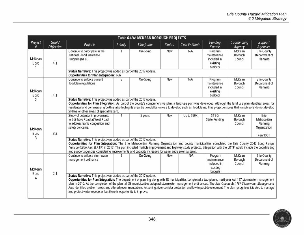
348
Erie County Hazard Mitigation Plan 6.0 Mitigation Strategy
Table 6.4.W: MCKEAN BOROUGH PROJECTS Project
# Goal /
Objective Projects Priority Timeframe Status Cost Estimate Funding
Source Coordinating
Agency Support
Agencies
McKean Boro
1 4.1
Continue to participate in the National Flood Insurance Program (NFIP)
1 On-Going New N/A Program maintenance included in
existing budgets
McKean Borough Council
Erie County Department of
Planning
Status Narrative: This project was added as part of the 2017 update. Opportunities for Plan Integration: N/A
McKean Boro
2 4.1
Continue to enforce current floodplain regulations
5 On-Going New N/A Program maintenance included in
existing budgets
McKean Borough Council
Erie County Department of
Planning
Status Narrative: This project was added as part of the 2017 update. Opportunities for Plan Integration: As part of the county’s comprehensive plan, a land use plan was developed. Although the land use plan identifies areas for residential and commercial growth is also highlights area that would be unwise to develop such as floodplains. This project ensures that jurisdictions do not develop SFHAs or other areas of special hazard.
McKean Boro
3 3.3
Study of potential improvements to Edinboro Road at West Road to address traffic congestion and safety concerns.
1 5 years New Up to $50K STBG State Funding
McKean Borough Council
Erie Metropolitan
Planning Organization
PennDOT
Status Narrative: This project was added as part of the 2017 update. Opportunities for Plan Integration: The Erie Metropolitan Planning Organization and county municipalities completed the Erie County 2042 Long Range Transportation Plan (LRTP) in 2017. The plan included multiple improvement and highway study projects. Integration with the LRTP would include the coordinating and support agencies considering improvements and capacity increases for water and sewer systems.
McKean Boro
4 2.1
Continue to enforce stormwater management ordinance
6 On-Going New N/A Program maintenance included in
existing budgets
McKean Borough Council
Erie County Department of
Planning
Status Narrative: This project was added as part of the 2017 update. Opportunities for Plan Integration: The department of planning along with 38 municipalities completed a two phase, multi-year Act 167 stormwater management plan in 2010. At the completion of the plan, all 38 municipalities adopted stormwater management ordinances. The Erie County Act 167 Stormwater Management Plan identified problem areas and offered recommendations for zoning, river corridor protection and low-impact development. The plan recognizes it is step to manage and protect water resources but there is opportunity to improve.
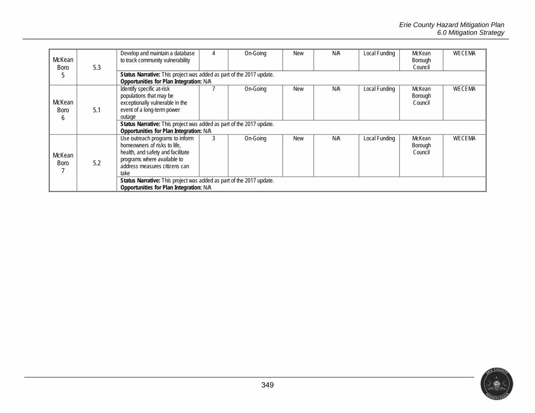
349
Erie County Hazard Mitigation Plan 6.0 Mitigation Strategy
McKean Boro
5 5.3
Develop and maintain a database to track community vulnerability
4 On-Going New N/A Local Funding McKean Borough Council
WECEMA
Status Narrative: This project was added as part of the 2017 update. Opportunities for Plan Integration: N/A
McKean Boro
6 5.1
Identify specific at-risk populations that may be exceptionally vulnerable in the event of a long-term power outage
7 On-Going New N/A Local Funding McKean Borough Council
WECEMA
Status Narrative: This project was added as part of the 2017 update. Opportunities for Plan Integration: N/A
McKean Boro
7 5.2
Use outreach programs to inform homeowners of risks to life, health, and safety and facilitate programs where available to address measures citizens can take
3 On-Going New N/A Local Funding McKean Borough Council
WECEMA
Status Narrative: This project was added as part of the 2017 update. Opportunities for Plan Integration: N/A
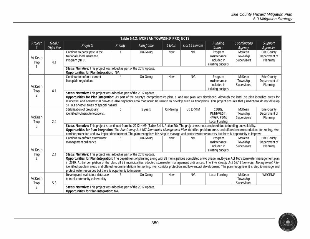
350
Erie County Hazard Mitigation Plan 6.0 Mitigation Strategy
Table 6.4.X: MCKEAN TOWNSHIP PROJECTS Project
# Goal /
Objective Projects Priority Timeframe Status Cost Estimate Funding
Source Coordinating
Agency Support
Agencies
McKean Twp
1 4.1
Continue to participate in the National Flood Insurance Program (NFIP)
1 On-Going New N/A Program maintenance included in
existing budgets
McKean Township
Supervisors
Erie County Department of
Planning
Status Narrative: This project was added as part of the 2017 update. Opportunities for Plan Integration: N/A
McKean Twp
2 4.1
Continue to enforce current floodplain regulations
4 On-Going New N/A Program maintenance included in
existing budgets
McKean Township
Supervisors
Erie County Department of
Planning
Status Narrative: This project was added as part of the 2017 update. Opportunities for Plan Integration: As part of the county’s comprehensive plan, a land use plan was developed. Although the land use plan identifies areas for residential and commercial growth is also highlights area that would be unwise to develop such as floodplains. This project ensures that jurisdictions do not develop SFHAs or other areas of special hazard.
McKean Twp
3 2.2
Stabilization of previously identified vulnerable locations.
5 5 years On-Going Up to $1M CDBG, PENNVEST, HMGP, PDM, Local Funding
McKean Township
Supervisors
Erie County Department of
Planning
Status Narrative: This project is continued from the 2012 HMP (Table 6.4.1, Action 26). The project was not completed due to funding unavailability. Opportunities for Plan Integration: The Erie County Act 167 Stormwater Management Plan identified problem areas and offered recommendations for zoning, river corridor protection and low-impact development. The plan recognizes it is step to manage and protect water resources but there is opportunity to improve.
McKean Twp
4 2.1
Continue to enforce stormwater management ordinance
5 On-Going New N/A Program maintenance included in
existing budgets
McKean Township
Supervisors
Erie County Department of
Planning
Status Narrative: This project was added as part of the 2017 update. Opportunities for Plan Integration: The department of planning along with 38 municipalities completed a two phase, multi-year Act 167 stormwater management plan in 2010. At the completion of the plan, all 38 municipalities adopted stormwater management ordinances. The Erie County Act 167 Stormwater Management Plan identified problem areas and offered recommendations for zoning, river corridor protection and low-impact development. The plan recognizes it is step to manage and protect water resources but there is opportunity to improve.
McKean Twp
5 5.3
Develop and maintain a database to track community vulnerability
3 On-Going New N/A Local Funding McKean Township
Supervisors
WECEMA
Status Narrative: This project was added as part of the 2017 update. Opportunities for Plan Integration: N/A
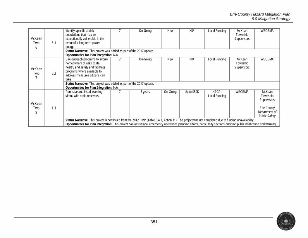
351
Erie County Hazard Mitigation Plan 6.0 Mitigation Strategy
McKean Twp
6 5.1
Identify specific at-risk populations that may be exceptionally vulnerable in the event of a long-term power outage
7 On-Going New N/A Local Funding McKean Township
Supervisors
WECEMA
Status Narrative: This project was added as part of the 2017 update. Opportunities for Plan Integration: N/A
McKean Twp
7 5.2
Use outreach programs to inform homeowners of risks to life, health, and safety and facilitate programs where available to address measures citizens can take
2 On-Going New N/A Local Funding McKean Township
Supervisors
WECEMA
Status Narrative: This project was added as part of the 2017 update. Opportunities for Plan Integration: N/A
McKean Twp
8 1.1
Purchase and install warning sirens with radio receivers.
7 5 years On-Going Up to $50K HSGP, Local Funding
WECEMA McKean Township
Supervisors
Erie County Department of Public Safety
Status Narrative: This project is continued from the 2012 HMP (Table 6.4.1, Action 31). The project was not completed due to funding unavailability. Opportunities for Plan Integration: This project can assist local emergency operations planning efforts, particularly sections outlining public notification and warning.

352
Erie County Hazard Mitigation Plan 6.0 Mitigation Strategy
Table 6.4.Y: MILL VILLAGE BOROUGH PROJECTS Project
# Goal /
Objective Projects Priority Timeframe Status Cost Estimate Funding
Source Coordinating
Agency Support
Agencies
Mill Village
1 4.1
Continue to participate in the National Flood Insurance Program (NFIP)
1 On-Going New N/A Program maintenance included in
existing budgets
Mill Village Borough Council
Erie County Department of
Planning
Status Narrative: This project was added as part of the 2017 update. Opportunities for Plan Integration: N/A
Mill Village
2 4.1
Continue to enforce current floodplain regulations
2 On-Going New N/A Program maintenance included in
existing budgets
Mill Village Borough Council
Erie County Department of
Planning
Status Narrative: This project was added as part of the 2017 update. Opportunities for Plan Integration: As part of the county’s comprehensive plan, a land use plan was developed. Although the land use plan identifies areas for residential and commercial growth is also highlights area that would be unwise to develop such as floodplains. This project ensures that jurisdictions do not develop SFHAs or other areas of special hazard.
Mill Village
3 2.1
Continue to enforce stormwater management ordinance
3 On-Going New N/A Program maintenance included in
existing budgets
Mill Village Borough Council
Erie County Department of
Planning
Status Narrative: This project was added as part of the 2017 update. Opportunities for Plan Integration: The department of planning along with 38 municipalities completed a two phase, multi-year Act 167 stormwater management plan in 2010. At the completion of the plan, all 38 municipalities adopted stormwater management ordinances. The Erie County Act 167 Stormwater Management Plan identified problem areas and offered recommendations for zoning, river corridor protection and low-impact development. The plan recognizes it is step to manage and protect water resources but there is opportunity to improve.
Mill Village
4 2.2
Re-install bridge and road and to dig creek bed down to a much lower level throughout the town.
5 5 years On-Going Up to $1M HSIP, CDBG, State Funding
Mill Village Borough Council
Erie Metropolitan
Planning Organization
PennDOT
Status Narrative: This project is continued from the 2012 HMP (Table 6.4.1, Action 39). The project was not completed due to funding unavailability. Opportunities for Plan Integration: The Erie County Act 167 Stormwater Management Plan identified problem areas and offered recommendations for zoning, river corridor protection and low-impact development. The plan recognizes it is step to manage and protect water resources but there is opportunity to improve.
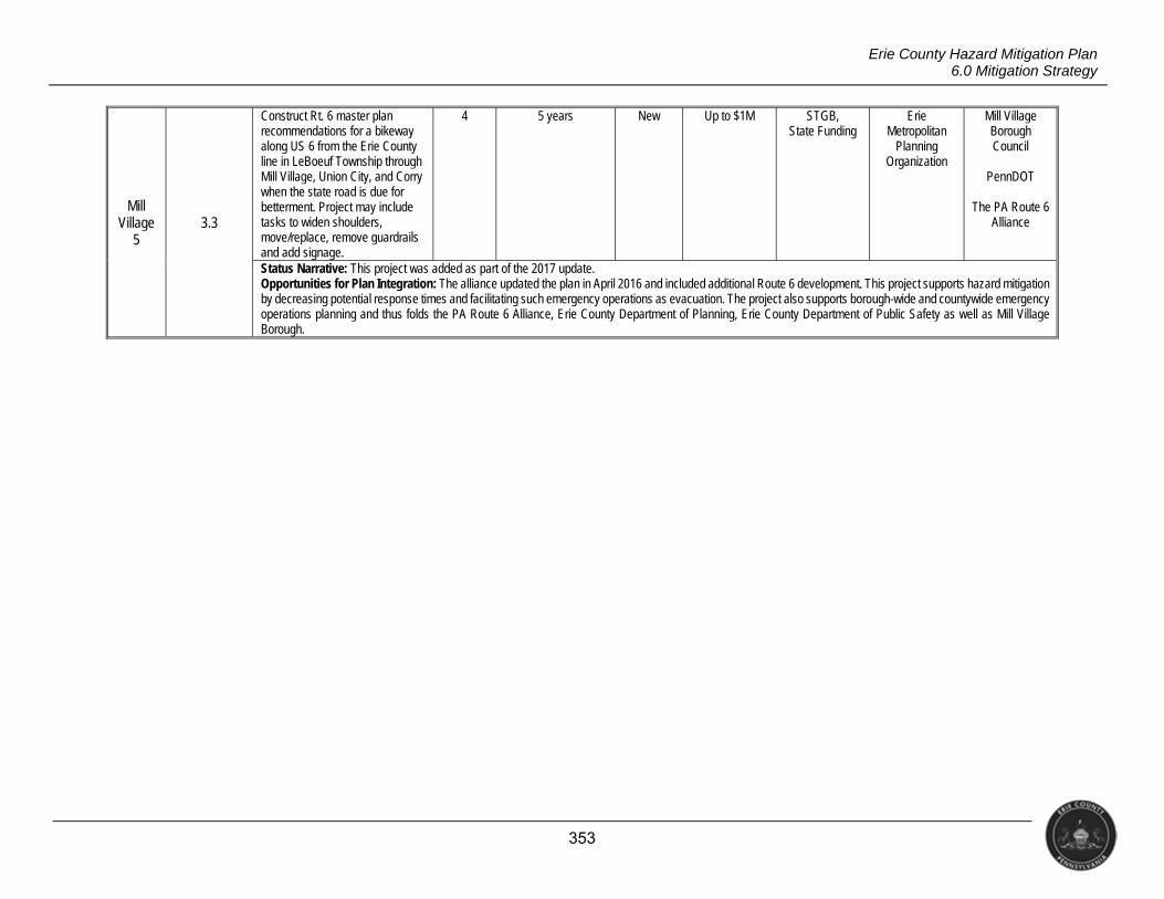
353
Erie County Hazard Mitigation Plan 6.0 Mitigation Strategy
Mill Village
5 3.3
Construct Rt. 6 master plan recommendations for a bikeway along US 6 from the Erie County line in LeBoeuf Township through Mill Village, Union City, and Corry when the state road is due for betterment. Project may include tasks to widen shoulders, move/replace, remove guardrails and add signage.
4 5 years New Up to $1M STGB, State Funding
Erie Metropolitan
Planning Organization
Mill Village Borough Council
PennDOT
The PA Route 6
Alliance
Status Narrative: This project was added as part of the 2017 update. Opportunities for Plan Integration: The alliance updated the plan in April 2016 and included additional Route 6 development. This project supports hazard mitigation by decreasing potential response times and facilitating such emergency operations as evacuation. The project also supports borough-wide and countywide emergency operations planning and thus folds the PA Route 6 Alliance, Erie County Department of Planning, Erie County Department of Public Safety as well as Mill Village Borough.
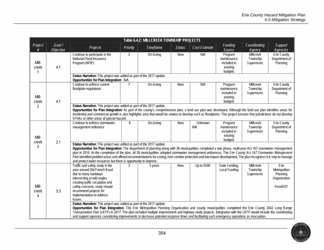
354
Erie County Hazard Mitigation Plan 6.0 Mitigation Strategy
Table 6.4.Z: MILLCREEK TOWNSHIP PROJECTS Project
# Goal /
Objective Projects Priority Timeframe Status Cost Estimate Funding
Source Coordinating
Agency Support
Agencies
Mill- creek
1 4.1
Continue to participate in the National Flood Insurance Program (NFIP)
3 On-Going New N/A Program maintenance included in
existing budgets
Millcreek Township
Supervisors
Erie County Department of
Planning
Status Narrative: This project was added as part of the 2017 update. Opportunities for Plan Integration: N/A
Mill- creek
2 4.1
Continue to enforce current floodplain regulations
7 On-Going New N/A Program maintenance included in
existing budgets
Millcreek Township
Supervisors
Erie County Department of
Planning
Status Narrative: This project was added as part of the 2017 update. Opportunities for Plan Integration: As part of the county’s comprehensive plan, a land use plan was developed. Although the land use plan identifies areas for residential and commercial growth is also highlights area that would be unwise to develop such as floodplains. This project ensures that jurisdictions do not develop SFHAs or other areas of special hazard.
Mill- creek
3 2.1
Continue to enforce stormwater management ordinance
8 On-Going New Unknown N/A
Program maintenance included in
existing budgets
Millcreek Township
Supervisors
Erie County Department of
Planning
Status Narrative: This project was added as part of the 2017 update. Opportunities for Plan Integration: The department of planning along with 38 municipalities completed a two phase, multi-year Act 167 stormwater management plan in 2010. At the completion of the plan, all 38 municipalities adopted stormwater management ordinances. The Erie County Act 167 Stormwater Management Plan identified problem areas and offered recommendations for zoning, river corridor protection and low-impact development. The plan recognizes it is step to manage and protect water resources but there is opportunity to improve.
Mill- creek
4 3.3
Traffic and safety study in the area around Old French Road due to many roadways intersecting at odd angles creating traffic circulation and safety concerns; study should recommend projects for implementation to address issues.
3 5 years New Up to $50K State Funding, Local Funding
Millcreek Township
Supervisors
Erie Metropolitan
Planning Organization
PennDOT
Status Narrative: This project was added as part of the 2017 update. Opportunities for Plan Integration: The Erie Metropolitan Planning Organization and county municipalities completed the Erie County 2042 Long Range Transportation Plan (LRTP) in 2017. The plan included multiple improvement and highway study projects. Integration with the LRTP would include the coordinating and support agencies considering improvements to decrease potential response times and facilitating such emergency operations as evacuation.
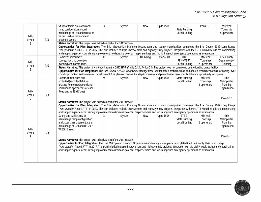
355
Erie County Hazard Mitigation Plan 6.0 Mitigation Strategy
Mill- creek
5 3.3
Study of traffic circulation and ramp configuration around interchange of I-90 at Route 8, to be pursued as development pressure occurs.
3 5 years New Up to $50K STBG, State Funding, Local Funding
PennDOT Millcreek Township
Supervisors
Status Narrative: This project was added as part of the 2017 update. Opportunities for Plan Integration: The Erie Metropolitan Planning Organization and county municipalities completed the Erie County 2042 Long Range Transportation Plan (LRTP) in 2017. The plan included multiple improvement and highway study projects. Integration with the LRTP would include the coordinating and support agencies considering improvements to decrease potential response times and facilitating such emergency operations as evacuation.
Mill- creek
6 3.5
Complete stormwater conveyance and detention planning and construction.
10 5 years On-Going Up to $500K CDBG, PENNVEST,
Local Funding
Millcreek Township
Supervisors
Erie County Department of
Planning Status Narrative: This project is continued from the 2012 HMP (Table 6.4.1, Action 28). The project was not completed due to funding unavailability. Opportunities for Plan Integration: The Erie County Act 167 Stormwater Management Plan identified problem areas and offered recommendations for zoning, river corridor protection and low-impact development. The plan recognizes it is step to manage and protect water resources but there is opportunity to improve.
Mill- creek
7 3.3
Construct turn lanes and protected/permitted left-turn phasing for the northbound and southbound approaches at Zuck Road and W 23rd Street.
9 5 years New Up to $50K State Funding, Local Funding
Millcreek Township
Supervisors
Erie Metropolitan
Planning Organization
PennDOT Status Narrative: This project was added as part of the 2017 update. Opportunities for Plan Integration: The Erie Metropolitan Planning Organization and county municipalities completed the Erie County 2042 Long Range Transportation Plan (LRTP) in 2017. The plan included multiple improvement and highway study projects. Integration with the LRTP would include the coordinating and support agencies considering improvements to decrease potential response times and facilitating such emergency operations as evacuation.
Mill- creek
8 3.3
Safety and traffic study of interchange ramp configuration and access management at the interchange of I-79 and US 20 / W 26th Street.
3 5 years New Up to $50K STBG, State Funding, Local Funding
Millcreek Township
Supervisors
Erie Metropolitan
Planning Organization
PennDOT Status Narrative: This project was added as part of the 2017 update. Opportunities for Plan Integration: The Erie Metropolitan Planning Organization and county municipalities completed the Erie County 2042 Long Range Transportation Plan (LRTP) in 2017. The plan included multiple improvement and highway study projects. Integration with the LRTP would include the coordinating and support agencies considering improvements to decrease potential response times and facilitating such emergency operations as evacuation.
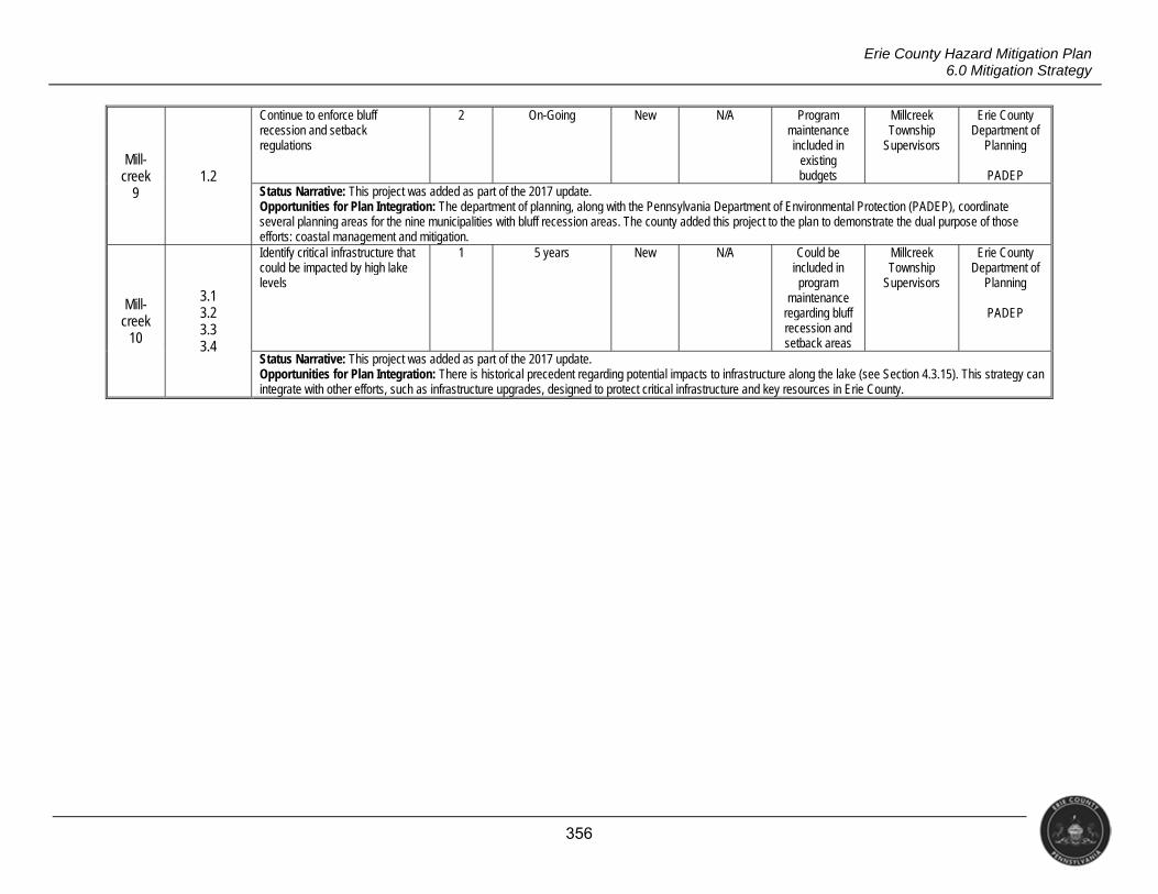
356
Erie County Hazard Mitigation Plan 6.0 Mitigation Strategy
Mill- creek
9 1.2
Continue to enforce bluff recession and setback regulations
2 On-Going New N/A Program maintenance included in
existing budgets
Millcreek Township
Supervisors
Erie County Department of
Planning
PADEP Status Narrative: This project was added as part of the 2017 update. Opportunities for Plan Integration: The department of planning, along with the Pennsylvania Department of Environmental Protection (PADEP), coordinate several planning areas for the nine municipalities with bluff recession areas. The county added this project to the plan to demonstrate the dual purpose of those efforts: coastal management and mitigation.
Mill- creek
10
3.1 3.2 3.3 3.4
Identify critical infrastructure that could be impacted by high lake levels
1 5 years New N/A Could be included in program
maintenance regarding bluff recession and setback areas
Millcreek Township
Supervisors
Erie County Department of
Planning
PADEP
Status Narrative: This project was added as part of the 2017 update. Opportunities for Plan Integration: There is historical precedent regarding potential impacts to infrastructure along the lake (see Section 4.3.15). This strategy can integrate with other efforts, such as infrastructure upgrades, designed to protect critical infrastructure and key resources in Erie County.
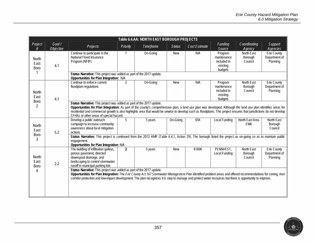
357
Erie County Hazard Mitigation Plan 6.0 Mitigation Strategy
Table 6.4.AA: NORTH EAST BOROUGH PROJECTS Project
# Goal /
Objective Projects Priority Timeframe Status Cost Estimate Funding
Source Coordinating
Agency Support
Agencies
North East Boro
1
4.1
Continue to participate in the National Flood Insurance Program (NFIP)
1 On-Going New N/A Program maintenance included in
existing budgets
North East Borough Council
Erie County Department of
Planning
Status Narrative: This project was added as part of the 2017 update. Opportunities for Plan Integration: N/A
North East Boro
2
4.1
Continue to enforce current floodplain regulations
2 On-Going New N/A Program maintenance included in
existing budgets
North East Borough Council
Erie County Department of
Planning
Status Narrative: This project was added as part of the 2017 update. Opportunities for Plan Integration: As part of the county’s comprehensive plan, a land use plan was developed. Although the land use plan identifies areas for residential and commercial growth is also highlights area that would be unwise to develop such as floodplains. This project ensures that jurisdictions do not develop SFHAs or other areas of special hazard.
North East Boro
3
5.2
Develop a public outreach campaign to increase community awareness about local mitigation actions
5 5 years On-Going $5K Local Funding North East Area EMA
North East Borough Council
Status Narrative: This project is continued from the 2012 HMP (Table 6.4.1, Action 29). The borough listed the project as on-going so as to maintain public engagement. Opportunities for Plan Integration: N/A
North East Boro
4
2.2
The building of infiltration galleys, porous pavement, directed downspout drainage, and landscaping to control stormwater runoff in municipal parking lots
2 5 years New $100K PENNVEST, Local Funding
North East Borough Council
Erie County Department of
Planning
Status Narrative: This project was added as part of the 2017 update. Opportunities for Plan Integration: The Erie County Act 167 Stormwater Management Plan identified problem areas and offered recommendations for zoning, river corridor protection and low-impact development. The plan recognizes it is step to manage and protect water resources but there is opportunity to improve.

358
Erie County Hazard Mitigation Plan 6.0 Mitigation Strategy
North East Boro
5
2.1
Continue to enforce stormwater management ordinance
4 On-Going New N/A Program maintenance included in
existing budgets
North East Borough Council
Erie County Department of
Planning
Status Narrative: This project was added as part of the 2017 update. Opportunities for Plan Integration: The department of planning along with 38 municipalities completed a two phase, multi-year Act 167 stormwater management plan in 2010. At the completion of the plan, all 38 municipalities adopted stormwater management ordinances. The Erie County Act 167 Stormwater Management Plan identified problem areas and offered recommendations for zoning, river corridor protection and low-impact development. The plan recognizes it is step to manage and protect water resources but there is opportunity to improve.
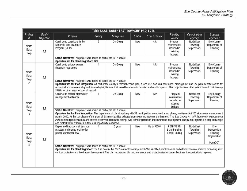
359
Erie County Hazard Mitigation Plan 6.0 Mitigation Strategy
Table 6.4.AB: NORTH EAST TOWNSHIP PROJECTS Project
# Goal /
Objective Projects Priority Timeframe Status Cost Estimate Funding
Source Coordinating
Agency Support
Agencies
North East Twp
1
4.1
Continue to participate in the National Flood Insurance Program (NFIP)
2 On-Going New N/A Program maintenance included in
existing budgets
North East Township
Supervisors
Erie County Department of
Planning
Status Narrative: This project was added as part of the 2017 update. Opportunities for Plan Integration: N/A
North East Twp
2
4.1
Continue to enforce current floodplain regulations
4 On-Going New N/A Program maintenance included in
existing budgets
North East Township
Supervisors
Erie County Department of
Planning
Status Narrative: This project was added as part of the 2017 update. Opportunities for Plan Integration: As part of the county’s comprehensive plan, a land use plan was developed. Although the land use plan identifies areas for residential and commercial growth is also highlights area that would be unwise to develop such as floodplains. This project ensures that jurisdictions do not develop SFHAs or other areas of special hazard.
North East Twp
3
2.1
Continue to enforce stormwater management ordinance
6 On-Going New N/A Program maintenance included in
existing budgets
North East Township
Supervisors
Erie County Department of
Planning
Status Narrative: This project was added as part of the 2017 update. Opportunities for Plan Integration: The department of planning along with 38 municipalities completed a two phase, multi-year Act 167 stormwater management plan in 2010. At the completion of the plan, all 38 municipalities adopted stormwater management ordinances. The Erie County Act 167 Stormwater Management Plan identified problem areas and offered recommendations for zoning, river corridor protection and low-impact development. The plan recognizes it is step to manage and protect water resources but there is opportunity to improve.
North East Twp
4
3.3
Repair and improve maintenance practices on bridges to allow for proper stormwater flow.
4 5 years New Up to $500K PENNVEST, State Funding, Local Funding
North East Township
Supervisors
Erie Metropolitan
Planning Organization
PennDOT
Status Narrative: This project was added as part of the 2017 update. Opportunities for Plan Integration: The Erie County Act 167 Stormwater Management Plan identified problem areas and offered recommendations for zoning, river corridor protection and low-impact development. The plan recognizes it is step to manage and protect water resources but there is opportunity to improve.
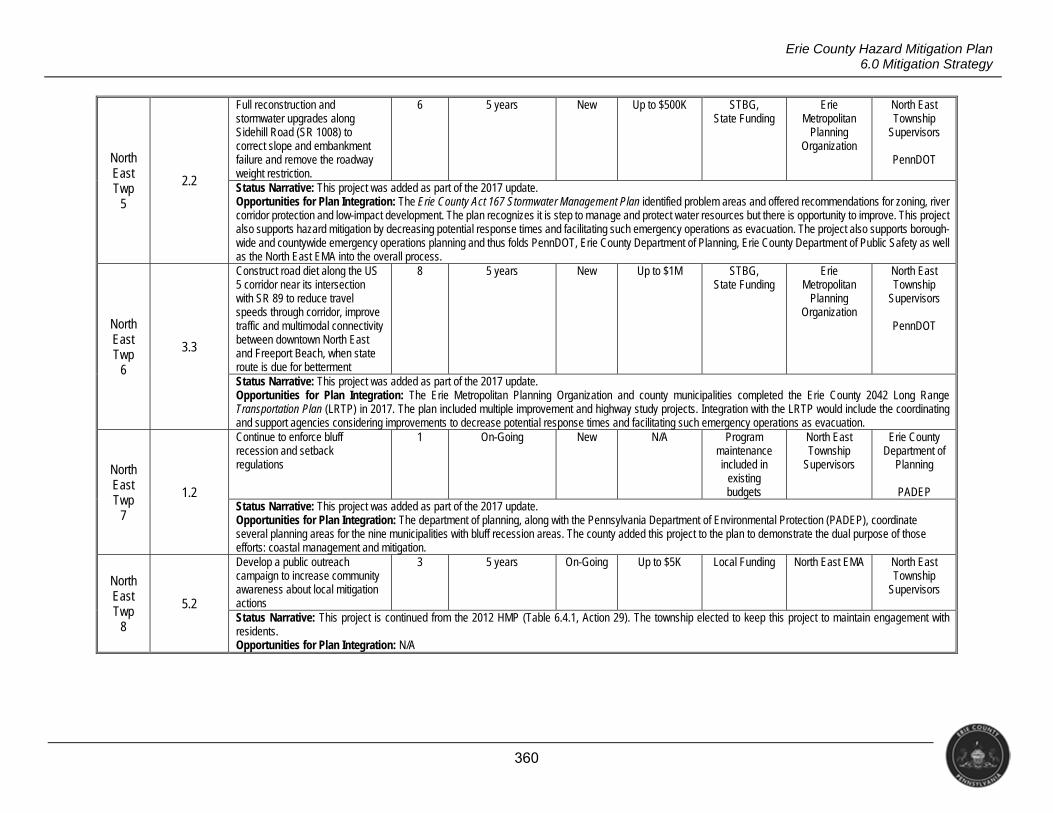
360
Erie County Hazard Mitigation Plan 6.0 Mitigation Strategy
North East Twp
5
2.2
Full reconstruction and stormwater upgrades along Sidehill Road (SR 1008) to correct slope and embankment failure and remove the roadway weight restriction.
6 5 years New Up to $500K STBG, State Funding
Erie Metropolitan
Planning Organization
North East Township
Supervisors
PennDOT
Status Narrative: This project was added as part of the 2017 update. Opportunities for Plan Integration: The Erie County Act 167 Stormwater Management Plan identified problem areas and offered recommendations for zoning, river corridor protection and low-impact development. The plan recognizes it is step to manage and protect water resources but there is opportunity to improve. This project also supports hazard mitigation by decreasing potential response times and facilitating such emergency operations as evacuation. The project also supports borough-wide and countywide emergency operations planning and thus folds PennDOT, Erie County Department of Planning, Erie County Department of Public Safety as well as the North East EMA into the overall process.
North East Twp
6
3.3
Construct road diet along the US 5 corridor near its intersection with SR 89 to reduce travel speeds through corridor, improve traffic and multimodal connectivity between downtown North East and Freeport Beach, when state route is due for betterment
8 5 years New Up to $1M STBG, State Funding
Erie Metropolitan
Planning Organization
North East Township
Supervisors
PennDOT
Status Narrative: This project was added as part of the 2017 update. Opportunities for Plan Integration: The Erie Metropolitan Planning Organization and county municipalities completed the Erie County 2042 Long Range Transportation Plan (LRTP) in 2017. The plan included multiple improvement and highway study projects. Integration with the LRTP would include the coordinating and support agencies considering improvements to decrease potential response times and facilitating such emergency operations as evacuation.
North East Twp
7
1.2
Continue to enforce bluff recession and setback regulations
1 On-Going New N/A Program maintenance included in
existing budgets
North East Township
Supervisors
Erie County Department of
Planning
PADEP Status Narrative: This project was added as part of the 2017 update. Opportunities for Plan Integration: The department of planning, along with the Pennsylvania Department of Environmental Protection (PADEP), coordinate several planning areas for the nine municipalities with bluff recession areas. The county added this project to the plan to demonstrate the dual purpose of those efforts: coastal management and mitigation.
North East Twp
8
5.2
Develop a public outreach campaign to increase community awareness about local mitigation actions
3 5 years On-Going Up to $5K Local Funding North East EMA North East Township
Supervisors
Status Narrative: This project is continued from the 2012 HMP (Table 6.4.1, Action 29). The township elected to keep this project to maintain engagement with residents. Opportunities for Plan Integration: N/A
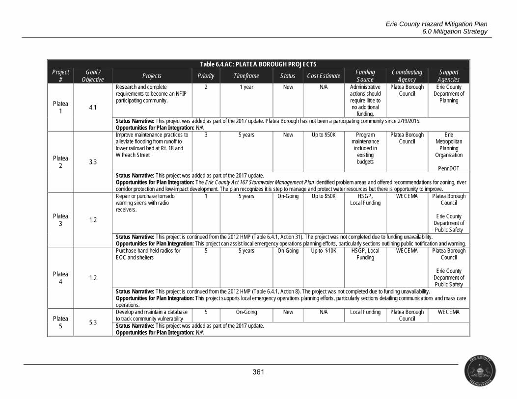
361
Erie County Hazard Mitigation Plan 6.0 Mitigation Strategy
Table 6.4.AC: PLATEA BOROUGH PROJECTS Project
# Goal /
Objective Projects Priority Timeframe Status Cost Estimate Funding
Source Coordinating
Agency Support
Agencies
Platea 1 4.1
Research and complete requirements to become an NFIP participating community.
2 1 year New N/A Administrative actions should require little to no additional
funding.
Platea Borough Council
Erie County Department of
Planning
Status Narrative: This project was added as part of the 2017 update. Platea Borough has not been a participating community since 2/19/2015. Opportunities for Plan Integration: N/A
Platea 2
3.3
Improve maintenance practices to alleviate flooding from runoff to lower railroad bed at Rt. 18 and W Peach Street
3 5 years New Up to $50K Program maintenance included in
existing budgets
Platea Borough Council
Erie Metropolitan
Planning Organization
PennDOT
Status Narrative: This project was added as part of the 2017 update. Opportunities for Plan Integration: The Erie County Act 167 Stormwater Management Plan identified problem areas and offered recommendations for zoning, river corridor protection and low-impact development. The plan recognizes it is step to manage and protect water resources but there is opportunity to improve.
Platea 3
1.2
Repair or purchase tornado warning sirens with radio receivers.
1 5 years On-Going Up to $50K HSGP, Local Funding
WECEMA Platea Borough Council
Erie County
Department of Public Safety
Status Narrative: This project is continued from the 2012 HMP (Table 6.4.1, Action 31). The project was not completed due to funding unavailability. Opportunities for Plan Integration: This project can assist local emergency operations planning efforts, particularly sections outlining public notification and warning.
Platea 4 1.2
Purchase hand held radios for EOC and shelters
5 5 years On-Going Up to $10K HSGP, Local Funding
WECEMA Platea Borough Council
Erie County
Department of Public Safety
Status Narrative: This project is continued from the 2012 HMP (Table 6.4.1, Action 8). The project was not completed due to funding unavailability. Opportunities for Plan Integration: This project supports local emergency operations planning efforts, particularly sections detailing communications and mass care operations.
Platea 5
5.3
Develop and maintain a database to track community vulnerability
5 On-Going New N/A Local Funding Platea Borough Council
WECEMA
Status Narrative: This project was added as part of the 2017 update. Opportunities for Plan Integration: N/A
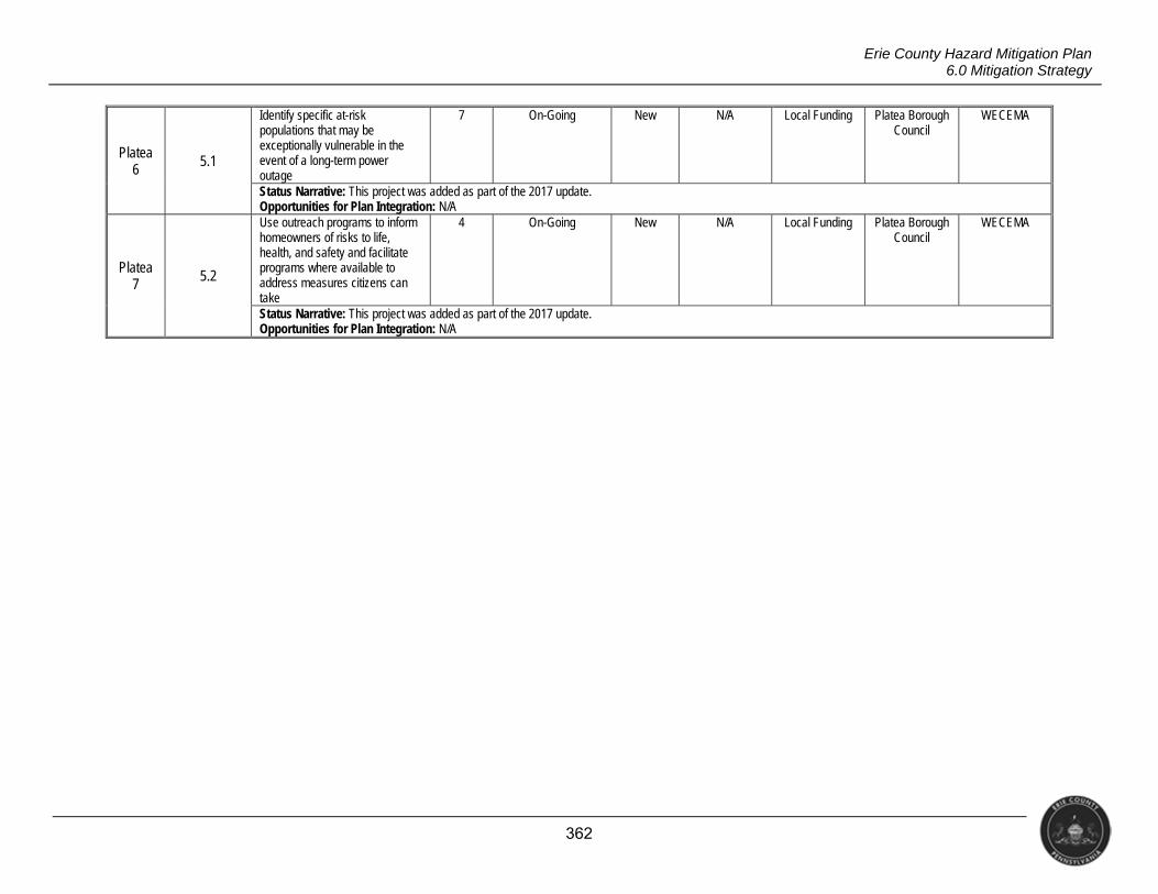
362
Erie County Hazard Mitigation Plan 6.0 Mitigation Strategy
Platea 6
5.1
Identify specific at-risk populations that may be exceptionally vulnerable in the event of a long-term power outage
7 On-Going New N/A Local Funding Platea Borough Council
WECEMA
Status Narrative: This project was added as part of the 2017 update. Opportunities for Plan Integration: N/A
Platea 7 5.2
Use outreach programs to inform homeowners of risks to life, health, and safety and facilitate programs where available to address measures citizens can take
4 On-Going New N/A Local Funding Platea Borough Council
WECEMA
Status Narrative: This project was added as part of the 2017 update. Opportunities for Plan Integration: N/A
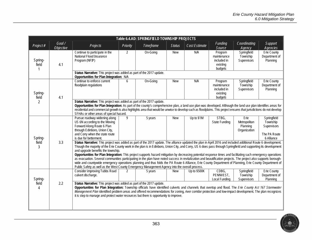
363
Erie County Hazard Mitigation Plan 6.0 Mitigation Strategy
Table 6.4.AD: SPRINGFIELD TOWNSHIP PROJECTS
Project # Goal / Objective
Projects Priority Timeframe Status Cost Estimate Funding Source
Coordinating Agency
Support Agencies
Spring- field
1 4.1
Continue to participate in the National Flood Insurance Program (NFIP)
2 On-Going New N/A Program maintenance included in
existing budgets
Springfield Township
Supervisors
Erie County Department of
Planning
Status Narrative: This project was added as part of the 2017 update. Opportunities for Plan Integration: N/A
Spring- field
2 4.1
Continue to enforce current floodplain regulations
6 On-Going New N/A Program maintenance included in
existing budgets
Springfield Township
Supervisors
Erie County Department of
Planning
Status Narrative: This project was added as part of the 2017 update. Opportunities for Plan Integration: As part of the county’s comprehensive plan, a land use plan was developed. Although the land use plan identifies areas for residential and commercial growth is also highlights area that would be unwise to develop such as floodplains. This project ensures that jurisdictions do not develop SFHAs or other areas of special hazard.
Spring- field
3 3.3
Pursue roadway widening along US 6N according to the Moving Forward Along Route 6 Plan through Edinboro, Union City, and Corry when the state route is due for betterment.
9 5 years New Up to $1M STBG, State Funding
Erie Metropolitan
Planning Organization
Springfield Township
Supervisors
The PA Route 6 Alliance
Status Narrative: This project was added as part of the 2017 update. The alliance updated the plan in April 2016 and included additional Route 6 development. Though the majority of the Erie County work in the plan is in Edinboro, Union City, and Corry, US 6 does pass through Springfield and supporting its development and upgrade benefits the township. Opportunities for Plan Integration: This project supports hazard mitigation by decreasing potential response times and facilitating such emergency operations as evacuation. Several communities participating in the plan have noted success in revitalization and beautification projects. The project also supports borough-wide and countywide emergency operations planning and thus folds the PA Route 6 Alliance, Erie County Department of Planning, Erie County Department of Public Safety as well as the West County Emergency Management Agency into the overall process.
Spring- field
4 2.2
Consider improving Tubbs Road culvert discharge.
2 5 years New Up to $500K CDBG, PENNVEST,
Local Funding
Springfield Township
Supervisors
Erie County Department of
Planning Status Narrative: This project was added as part of the 2017 update. Opportunities for Plan Integration: Township officials have identified culverts and channels that overtop and flood. The Erie County Act 167 Stormwater Management Plan identified problem areas and offered recommendations for zoning, river corridor protection and low-impact development. The plan recognizes it is step to manage and protect water resources but there is opportunity to improve.
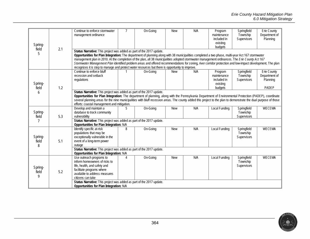
364
Erie County Hazard Mitigation Plan 6.0 Mitigation Strategy
Spring- field
5 2.1
Continue to enforce stormwater management ordinance
7 On-Going New N/A Program maintenance included in
existing budgets
Springfield Township
Supervisors
Erie County Department of
Planning
Status Narrative: This project was added as part of the 2017 update. Opportunities for Plan Integration: The department of planning along with 38 municipalities completed a two phase, multi-year Act 167 stormwater management plan in 2010. At the completion of the plan, all 38 municipalities adopted stormwater management ordinances. The Erie County Act 167 Stormwater Management Plan identified problem areas and offered recommendations for zoning, river corridor protection and low-impact development. The plan recognizes it is step to manage and protect water resources but there is opportunity to improve.
Spring- field
6 1.2
Continue to enforce bluff recession and setback regulations
1 On-Going New N/A Program maintenance included in
existing budgets
Springfield Township
Supervisors
Erie County Department of
Planning
PADEP Status Narrative: This project was added as part of the 2017 update. Opportunities for Plan Integration: The department of planning, along with the Pennsylvania Department of Environmental Protection (PADEP), coordinate several planning areas for the nine municipalities with bluff recession areas. The county added this project to the plan to demonstrate the dual purpose of those efforts: coastal management and mitigation.
Spring-field
7 5.3
Develop and maintain a database to track community vulnerability
5 On-Going New N/A Local Funding Springfield Township
Supervisors
WECEMA
Status Narrative: This project was added as part of the 2017 update. Opportunities for Plan Integration: N/A
Spring-field
8 5.1
Identify specific at-risk populations that may be exceptionally vulnerable in the event of a long-term power outage
8 On-Going New N/A Local Funding Springfield Township
Supervisors
WECEMA
Status Narrative: This project was added as part of the 2017 update. Opportunities for Plan Integration: N/A
Spring-field
9 5.2
Use outreach programs to inform homeowners of risks to life, health, and safety and facilitate programs where available to address measures citizens can take
4 On-Going New N/A Local Funding Springfield Township
Supervisors
WECEMA
Status Narrative: This project was added as part of the 2017 update. Opportunities for Plan Integration: N/A
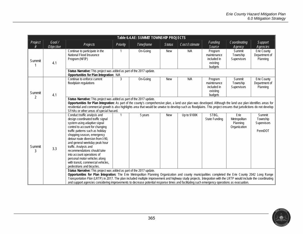
365
Erie County Hazard Mitigation Plan 6.0 Mitigation Strategy
Table 6.4.AE: SUMMIT TOWNSHIP PROJECTS Project
# Goal /
Objective Projects Priority Timeframe Status Cost Estimate Funding
Source Coordinating
Agency Support
Agencies
Summit 1 4.1
Continue to participate in the National Flood Insurance Program (NFIP)
1 On-Going New N/A Program maintenance included in
existing budgets
Summit Township
Supervisors
Erie County Department of
Planning
Status Narrative: This project was added as part of the 2017 update. Opportunities for Plan Integration: N/A
Summit 2
4.1
Continue to enforce current floodplain regulations
3 On-Going New N/A Program maintenance included in
existing budgets
Summit Township
Supervisors
Erie County Department of
Planning
Status Narrative: This project was added as part of the 2017 update. Opportunities for Plan Integration: As part of the county’s comprehensive plan, a land use plan was developed. Although the land use plan identifies areas for residential and commercial growth is also highlights area that would be unwise to develop such as floodplains. This project ensures that jurisdictions do not develop SFHAs or other areas of special hazard.
Summit 3
3.3
Conduct traffic analysis and design coordinated traffic signal system using adaptive signal control to account for changing traffic patterns such as holiday shopping season, emergency detour route diversion from I-90, and general weekday peak hour traffic. Analysis and recommendations should take into account operations of personal motor vehicles along with transit, commercial vehicles, pedestrians and bicycles.
1 5 years New Up to $100K STBG, State Funding
Erie Metropolitan
Planning Organization
Summit Township
Supervisors
PennDOT
Status Narrative: This project was added as part of the 2017 update. Opportunities for Plan Integration: The Erie Metropolitan Planning Organization and county municipalities completed the Erie County 2042 Long Range Transportation Plan (LRTP) in 2017. The plan included multiple improvement and highway study projects. Integration with the LRTP would include the coordinating and support agencies considering improvements to decrease potential response times and facilitating such emergency operations as evacuation.
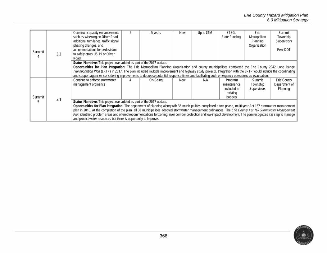
366
Erie County Hazard Mitigation Plan 6.0 Mitigation Strategy
Summit 4
3.3
Construct capacity enhancements such as widening on Oliver Road, additional turn lanes, traffic signal phasing changes, and accommodations for pedestrians to safely cross US 19 or Oliver Road
5 5 years New Up to $1M STBG, State Funding
Erie Metropolitan
Planning Organization
Summit Township
Supervisors
PennDOT
Status Narrative: This project was added as part of the 2017 update. Opportunities for Plan Integration: The Erie Metropolitan Planning Organization and county municipalities completed the Erie County 2042 Long Range Transportation Plan (LRTP) in 2017. The plan included multiple improvement and highway study projects. Integration with the LRTP would include the coordinating and support agencies considering improvements to decrease potential response times and facilitating such emergency operations as evacuation.
Summit 5
2.1
Continue to enforce stormwater management ordinance
4 On-Going New N/A Program maintenance included in
existing budgets
Summit Township
Supervisors
Erie County Department of
Planning
Status Narrative: This project was added as part of the 2017 update. Opportunities for Plan Integration: The department of planning along with 38 municipalities completed a two phase, multi-year Act 167 stormwater management plan in 2010. At the completion of the plan, all 38 municipalities adopted stormwater management ordinances. The Erie County Act 167 Stormwater Management Plan identified problem areas and offered recommendations for zoning, river corridor protection and low-impact development. The plan recognizes it is step to manage and protect water resources but there is opportunity to improve.
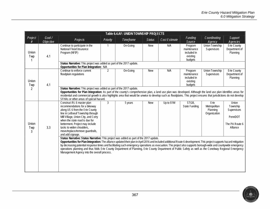
367
Erie County Hazard Mitigation Plan 6.0 Mitigation Strategy
Table 6.4.AF: UNION TOWNSHIP PROJECTS Project
# Goal /
Objective Projects Priority Timeframe Status Cost Estimate Funding
Source Coordinating
Agency Support
Agencies
Union Twp
1 4.1
Continue to participate in the National Flood Insurance Program (NFIP)
1 On-Going New N/A Program maintenance included in
existing budgets
Union Township Supervisors
Erie County Department of
Planning
Status Narrative: This project was added as part of the 2017 update. Opportunities for Plan Integration: N/A
Union Twp
2 4.1
Continue to enforce current floodplain regulations
2 On-Going New N/A Program maintenance included in
existing budgets
Union Township Supervisors
Erie County Department of
Planning
Status Narrative: This project was added as part of the 2017 update. Opportunities for Plan Integration: As part of the county’s comprehensive plan, a land use plan was developed. Although the land use plan identifies areas for residential and commercial growth is also highlights area that would be unwise to develop such as floodplains. This project ensures that jurisdictions do not develop SFHAs or other areas of special hazard.
Union Twp
3 3.3
Construct Rt. 6 master plan recommendations for a bikeway along US 6 from the Erie County line in LeBoeuf Township through Mill Village, Union City, and Corry when the state road is due for betterment. Project may include tasks to widen shoulders, move/replace/remove guardrails, and add signage.
3 5 years New Up to $1M STGB, State Funding
Erie Metropolitan
Planning Organization
Union Township
Supervisors
PennDOT
The PA Route 6 Alliance
Status Narrative: Status Narrative: This project was added as part of the 2017 update. Opportunities for Plan Integration: The alliance updated their plan in April 2016 and included additional Route 6 development. This project supports hazard mitigation by decreasing potential response times and facilitating such emergency operations as evacuation. The project also supports borough-wide and countywide emergency operations planning and thus folds Erie County Department of Planning, Erie County Department of Public Safety as well as the Conelway Regional Emergency Management Agency into the overall process.
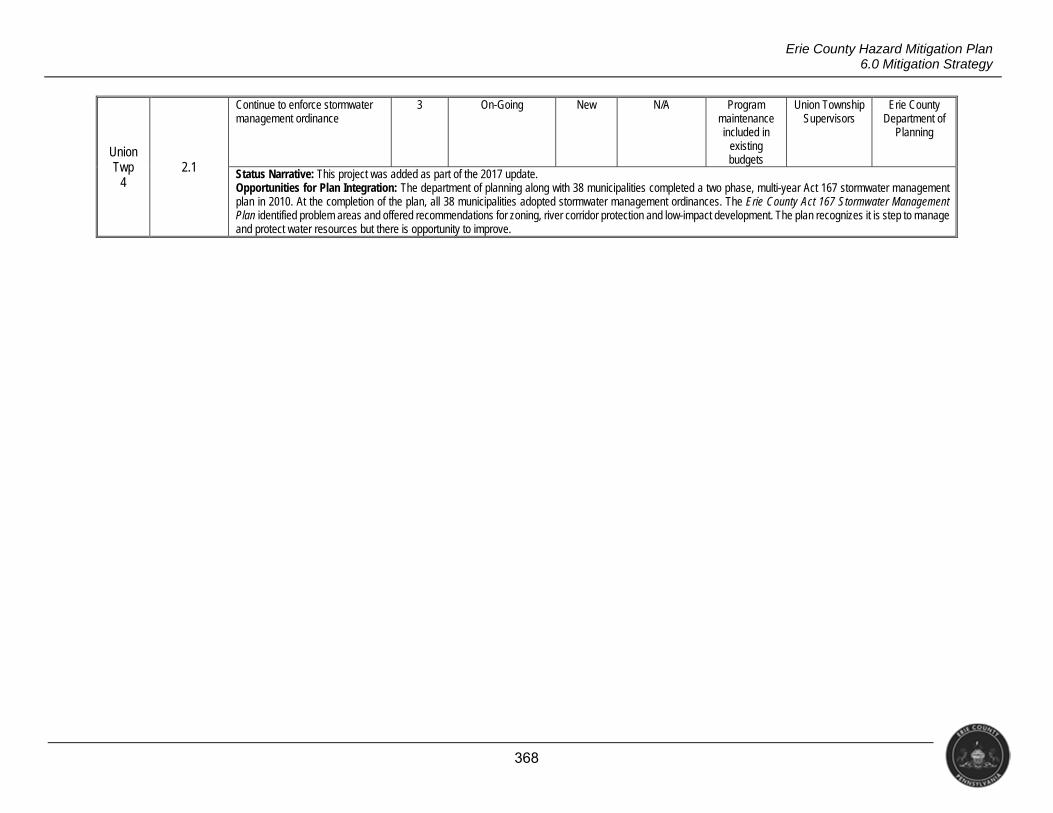
368
Erie County Hazard Mitigation Plan 6.0 Mitigation Strategy
Union Twp
4 2.1
Continue to enforce stormwater management ordinance
3 On-Going New N/A Program maintenance included in
existing budgets
Union Township Supervisors
Erie County Department of
Planning
Status Narrative: This project was added as part of the 2017 update. Opportunities for Plan Integration: The department of planning along with 38 municipalities completed a two phase, multi-year Act 167 stormwater management plan in 2010. At the completion of the plan, all 38 municipalities adopted stormwater management ordinances. The Erie County Act 167 Stormwater Management Plan identified problem areas and offered recommendations for zoning, river corridor protection and low-impact development. The plan recognizes it is step to manage and protect water resources but there is opportunity to improve.
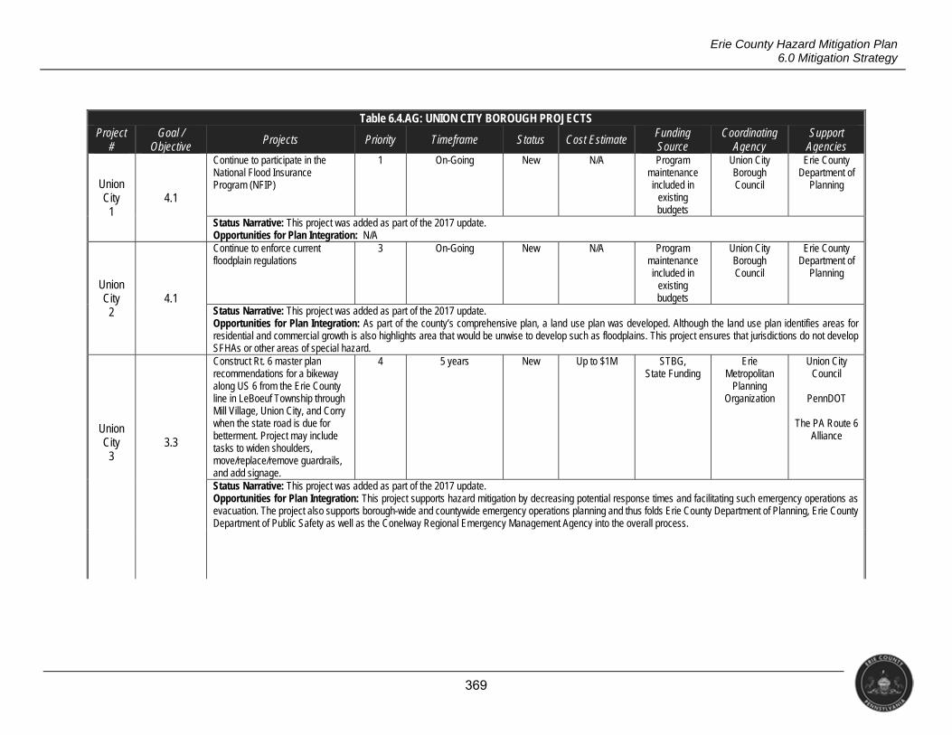
369
Erie County Hazard Mitigation Plan 6.0 Mitigation Strategy
Table 6.4.AG: UNION CITY BOROUGH PROJECTS Project
# Goal /
Objective Projects Priority Timeframe Status Cost Estimate Funding
Source Coordinating
Agency Support
Agencies
Union City
1 4.1
Continue to participate in the National Flood Insurance Program (NFIP)
1 On-Going New N/A Program maintenance included in
existing budgets
Union City Borough Council
Erie County Department of
Planning
Status Narrative: This project was added as part of the 2017 update. Opportunities for Plan Integration: N/A
Union City
2 4.1
Continue to enforce current floodplain regulations
3 On-Going New N/A Program maintenance included in
existing budgets
Union City Borough Council
Erie County Department of
Planning
Status Narrative: This project was added as part of the 2017 update. Opportunities for Plan Integration: As part of the county’s comprehensive plan, a land use plan was developed. Although the land use plan identifies areas for residential and commercial growth is also highlights area that would be unwise to develop such as floodplains. This project ensures that jurisdictions do not develop SFHAs or other areas of special hazard.
Union City
3 3.3
Construct Rt. 6 master plan recommendations for a bikeway along US 6 from the Erie County line in LeBoeuf Township through Mill Village, Union City, and Corry when the state road is due for betterment. Project may include tasks to widen shoulders, move/replace/remove guardrails, and add signage.
4 5 years New Up to $1M STBG, State Funding
Erie Metropolitan
Planning Organization
Union City Council
PennDOT
The PA Route 6
Alliance
Status Narrative: This project was added as part of the 2017 update. Opportunities for Plan Integration: This project supports hazard mitigation by decreasing potential response times and facilitating such emergency operations as evacuation. The project also supports borough-wide and countywide emergency operations planning and thus folds Erie County Department of Planning, Erie County Department of Public Safety as well as the Conelway Regional Emergency Management Agency into the overall process.
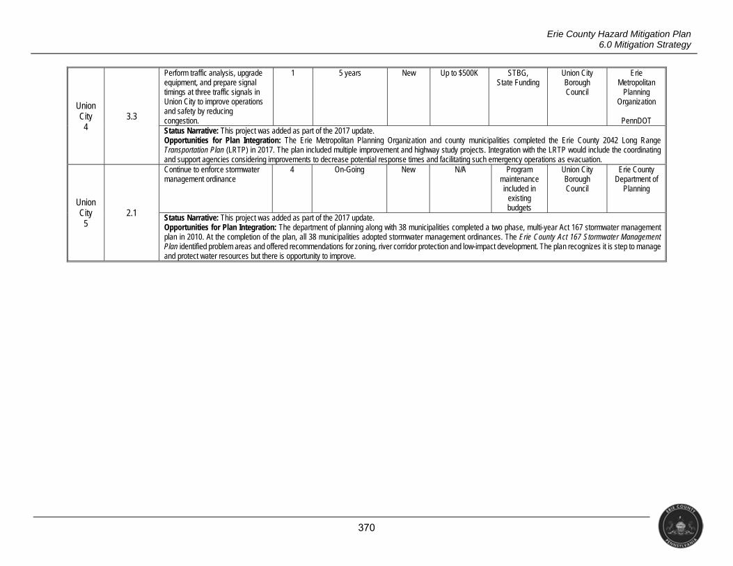
370
Erie County Hazard Mitigation Plan 6.0 Mitigation Strategy
Union City
4 3.3
Perform traffic analysis, upgrade equipment, and prepare signal timings at three traffic signals in Union City to improve operations and safety by reducing congestion.
1 5 years New Up to $500K STBG, State Funding
Union City Borough Council
Erie Metropolitan
Planning Organization
PennDOT
Status Narrative: This project was added as part of the 2017 update. Opportunities for Plan Integration: The Erie Metropolitan Planning Organization and county municipalities completed the Erie County 2042 Long Range Transportation Plan (LRTP) in 2017. The plan included multiple improvement and highway study projects. Integration with the LRTP would include the coordinating and support agencies considering improvements to decrease potential response times and facilitating such emergency operations as evacuation.
Union City
5 2.1
Continue to enforce stormwater management ordinance
4 On-Going New N/A Program maintenance included in
existing budgets
Union City Borough Council
Erie County Department of
Planning
Status Narrative: This project was added as part of the 2017 update. Opportunities for Plan Integration: The department of planning along with 38 municipalities completed a two phase, multi-year Act 167 stormwater management plan in 2010. At the completion of the plan, all 38 municipalities adopted stormwater management ordinances. The Erie County Act 167 Stormwater Management Plan identified problem areas and offered recommendations for zoning, river corridor protection and low-impact development. The plan recognizes it is step to manage and protect water resources but there is opportunity to improve.
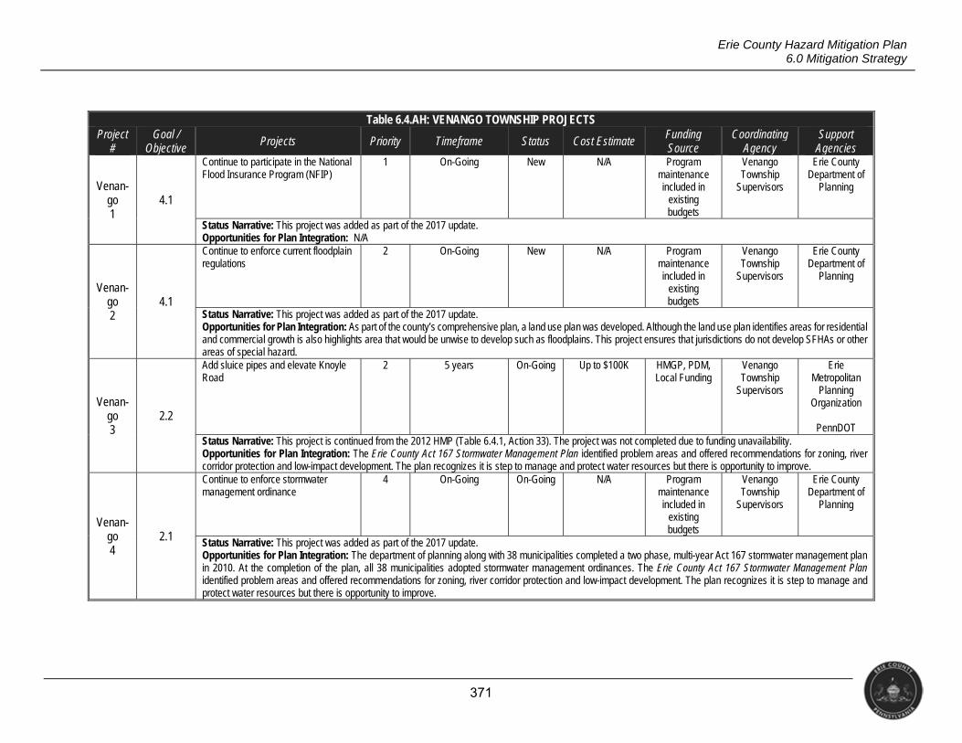
371
Erie County Hazard Mitigation Plan 6.0 Mitigation Strategy
Table 6.4.AH: VENANGO TOWNSHIP PROJECTS Project
# Goal /
Objective Projects Priority Timeframe Status Cost Estimate Funding
Source Coordinating
Agency Support
Agencies
Venan- go 1
4.1
Continue to participate in the National Flood Insurance Program (NFIP)
1 On-Going New N/A Program maintenance included in
existing budgets
Venango Township
Supervisors
Erie County Department of
Planning
Status Narrative: This project was added as part of the 2017 update. Opportunities for Plan Integration: N/A
Venan- go 2
4.1
Continue to enforce current floodplain regulations
2 On-Going New N/A Program maintenance included in
existing budgets
Venango Township
Supervisors
Erie County Department of
Planning
Status Narrative: This project was added as part of the 2017 update. Opportunities for Plan Integration: As part of the county’s comprehensive plan, a land use plan was developed. Although the land use plan identifies areas for residential and commercial growth is also highlights area that would be unwise to develop such as floodplains. This project ensures that jurisdictions do not develop SFHAs or other areas of special hazard.
Venan- go 3
2.2
Add sluice pipes and elevate Knoyle Road
2 5 years On-Going Up to $100K HMGP, PDM, Local Funding
Venango Township
Supervisors
Erie Metropolitan
Planning Organization
PennDOT
Status Narrative: This project is continued from the 2012 HMP (Table 6.4.1, Action 33). The project was not completed due to funding unavailability. Opportunities for Plan Integration: The Erie County Act 167 Stormwater Management Plan identified problem areas and offered recommendations for zoning, river corridor protection and low-impact development. The plan recognizes it is step to manage and protect water resources but there is opportunity to improve.
Venan- go 4
2.1
Continue to enforce stormwater management ordinance
4 On-Going On-Going N/A Program maintenance included in
existing budgets
Venango Township
Supervisors
Erie County Department of
Planning
Status Narrative: This project was added as part of the 2017 update. Opportunities for Plan Integration: The department of planning along with 38 municipalities completed a two phase, multi-year Act 167 stormwater management plan in 2010. At the completion of the plan, all 38 municipalities adopted stormwater management ordinances. The Erie County Act 167 Stormwater Management Plan identified problem areas and offered recommendations for zoning, river corridor protection and low-impact development. The plan recognizes it is step to manage and protect water resources but there is opportunity to improve.
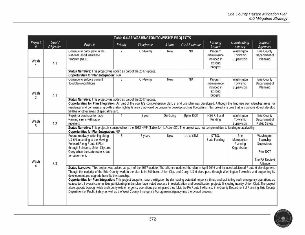
372
Erie County Hazard Mitigation Plan 6.0 Mitigation Strategy
Table 6.4.AI: WASHINGTON TOWNSHIP PROJECTS Project
# Goal /
Objective Projects Priority Timeframe Status Cost Estimate Funding
Source Coordinating
Agency Support
Agencies
Wash 1 4.1
Continue to participate in the National Flood Insurance Program (NFIP)
2 On-Going New N/A Program maintenance included in
existing budgets
Washington Township
Supervisors
Erie County Department of
Planning
Status Narrative: This project was added as part of the 2017 update. Opportunities for Plan Integration: N/A
Wash 2
4.1
Continue to enforce current floodplain regulations
5 On-Going New N/A Program maintenance included in
existing budgets
Washington Township
Supervisors
Erie County Department of
Planning
Status Narrative: This project was added as part of the 2017 update. Opportunities for Plan Integration: As part of the county’s comprehensive plan, a land use plan was developed. Although the land use plan identifies areas for residential and commercial growth is also highlights area that would be unwise to develop such as floodplains. This project ensures that jurisdictions do not develop SFHAs or other areas of special hazard.
Wash 3 1.2
Repair or purchase tornado warning sirens with radio receivers
1 5 year On-Going Up to $50K HSGP, Local Funding
Washington Township
Supervisors
Erie County Department of Public Safety
Status Narrative: This project is continued from the 2012 HMP (Table 6.4.1, Action 30). The project was not completed due to funding unavailability. Opportunities for Plan Integration: N/A
Wash 4 3.3
Pursue roadway widening along US 6N according to the Moving Forward Along Route 6 Plan through Edinboro, Union City, and Corry when the state route is due for betterment.
8 5 years New Up to $1M STBG, State Funding
Erie Metropolitan
Planning Organization
Washington Township
Supervisors
PennDOT
The PA Route 6 Alliance
Status Narrative: This project was added as part of the 2017 update. The alliance updated the plan in April 2016 and included additional Route 6 development. Though the majority of the Erie County work in the plan is in Edinboro, Union City, and Corry, US 6 does pass through Washington Township and supporting its development and upgrade benefits the township. Opportunities for Plan Integration: This project supports hazard mitigation by decreasing potential response times and facilitating such emergency operations as evacuation. Several communities participating in the plan have noted success in revitalization and beautification projects (including nearby Union City). The project also supports borough-wide and countywide emergency operations planning and thus folds the PA Route 6 Alliance, Erie County Department of Planning, Erie County Department of Public Safety as well as the West County Emergency Management Agency into the overall process.
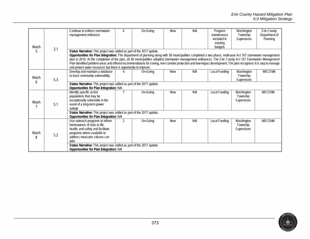
373
Erie County Hazard Mitigation Plan 6.0 Mitigation Strategy
Wash 5
2.1
Continue to enforce stormwater management ordinance
6 On-Going New N/A Program maintenance included in
existing budgets
Washington Township
Supervisors
Erie County Department of
Planning
Status Narrative: This project was added as part of the 2017 update. Opportunities for Plan Integration: The department of planning along with 38 municipalities completed a two phase, multi-year Act 167 stormwater management plan in 2010. At the completion of the plan, all 38 municipalities adopted stormwater management ordinances. The Erie County Act 167 Stormwater Management Plan identified problem areas and offered recommendations for zoning, river corridor protection and low-impact development. The plan recognizes it is step to manage and protect water resources but there is opportunity to improve.
Wash 6 5.3
Develop and maintain a database to track community vulnerability
4 On-Going New N/A Local Funding Washington Township
Supervisors
WECEMA
Status Narrative: This project was added as part of the 2017 update. Opportunities for Plan Integration: N/A
Wash 7
5.1
Identify specific at-risk populations that may be exceptionally vulnerable in the event of a long-term power outage
7 On-Going New N/A Local Funding Washington Township
Supervisors
WECEMA
Status Narrative: This project was added as part of the 2017 update. Opportunities for Plan Integration: N/A
Wash 8 5.2
Use outreach programs to inform homeowners of risks to life, health, and safety and facilitate programs where available to address measures citizens can take
2 On-Going New N/A Local Funding Washington Township
Supervisors
WECEMA
Status Narrative: This project was added as part of the 2017 update. Opportunities for Plan Integration: N/A
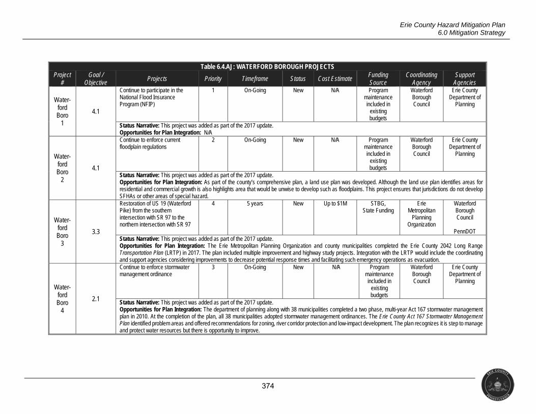
374
Erie County Hazard Mitigation Plan 6.0 Mitigation Strategy
Table 6.4.AJ: WATERFORD BOROUGH PROJECTS Project
# Goal /
Objective Projects Priority Timeframe Status Cost Estimate Funding
Source Coordinating
Agency Support
Agencies
Water- ford Boro
1
4.1
Continue to participate in the National Flood Insurance Program (NFIP)
1 On-Going New N/A Program maintenance included in
existing budgets
Waterford Borough Council
Erie County Department of
Planning
Status Narrative: This project was added as part of the 2017 update. Opportunities for Plan Integration: N/A
Water- ford Boro
2
4.1
Continue to enforce current floodplain regulations
2 On-Going New N/A Program maintenance included in
existing budgets
Waterford Borough Council
Erie County Department of
Planning
Status Narrative: This project was added as part of the 2017 update. Opportunities for Plan Integration: As part of the county’s comprehensive plan, a land use plan was developed. Although the land use plan identifies areas for residential and commercial growth is also highlights area that would be unwise to develop such as floodplains. This project ensures that jurisdictions do not develop SFHAs or other areas of special hazard.
Water- ford Boro
3
3.3
Restoration of US 19 (Waterford Pike) from the southern intersection with SR 97 to the northern intersection with SR 97
4 5 years New Up to $1M STBG, State Funding
Erie Metropolitan
Planning Organization
Waterford Borough Council
PennDOT
Status Narrative: This project was added as part of the 2017 update. Opportunities for Plan Integration: The Erie Metropolitan Planning Organization and county municipalities completed the Erie County 2042 Long Range Transportation Plan (LRTP) in 2017. The plan included multiple improvement and highway study projects. Integration with the LRTP would include the coordinating and support agencies considering improvements to decrease potential response times and facilitating such emergency operations as evacuation.
Water- ford Boro
4
2.1
Continue to enforce stormwater management ordinance
3 On-Going New N/A Program maintenance included in
existing budgets
Waterford Borough Council
Erie County Department of
Planning
Status Narrative: This project was added as part of the 2017 update. Opportunities for Plan Integration: The department of planning along with 38 municipalities completed a two phase, multi-year Act 167 stormwater management plan in 2010. At the completion of the plan, all 38 municipalities adopted stormwater management ordinances. The Erie County Act 167 Stormwater Management Plan identified problem areas and offered recommendations for zoning, river corridor protection and low-impact development. The plan recognizes it is step to manage and protect water resources but there is opportunity to improve.
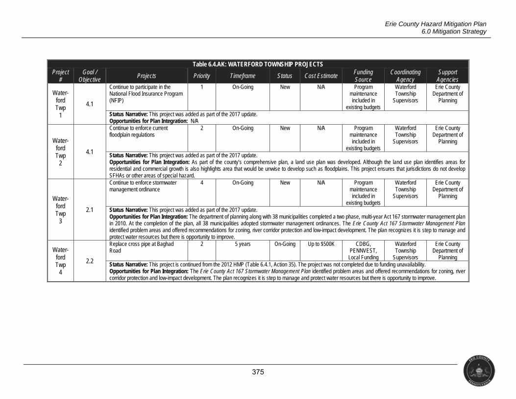
375
Erie County Hazard Mitigation Plan 6.0 Mitigation Strategy
Table 6.4.AK: WATERFORD TOWNSHIP PROJECTS Project
# Goal /
Objective Projects Priority Timeframe Status Cost Estimate Funding
Source Coordinating
Agency Support
Agencies
Water- ford Twp
1
4.1
Continue to participate in the National Flood Insurance Program (NFIP)
1 On-Going New N/A Program maintenance included in
existing budgets
Waterford Township
Supervisors
Erie County Department of
Planning
Status Narrative: This project was added as part of the 2017 update. Opportunities for Plan Integration: N/A
Water- ford Twp
2
4.1
Continue to enforce current floodplain regulations
2 On-Going New N/A Program maintenance included in
existing budgets
Waterford Township
Supervisors
Erie County Department of
Planning
Status Narrative: This project was added as part of the 2017 update. Opportunities for Plan Integration: As part of the county’s comprehensive plan, a land use plan was developed. Although the land use plan identifies areas for residential and commercial growth is also highlights area that would be unwise to develop such as floodplains. This project ensures that jurisdictions do not develop SFHAs or other areas of special hazard.
Water- ford Twp
3
2.1
Continue to enforce stormwater management ordinance
4 On-Going New N/A Program maintenance included in
existing budgets
Waterford Township
Supervisors
Erie County Department of
Planning
Status Narrative: This project was added as part of the 2017 update. Opportunities for Plan Integration: The department of planning along with 38 municipalities completed a two phase, multi-year Act 167 stormwater management plan in 2010. At the completion of the plan, all 38 municipalities adopted stormwater management ordinances. The Erie County Act 167 Stormwater Management Plan identified problem areas and offered recommendations for zoning, river corridor protection and low-impact development. The plan recognizes it is step to manage and protect water resources but there is opportunity to improve.
Water- ford Twp
4
2.2
Replace cross pipe at Baghad Road
2 5 years On-Going Up to $500K CDBG, PENNVEST,
Local Funding
Waterford Township
Supervisors
Erie County Department of
Planning Status Narrative: This project is continued from the 2012 HMP (Table 6.4.1, Action 35). The project was not completed due to funding unavailability. Opportunities for Plan Integration: The Erie County Act 167 Stormwater Management Plan identified problem areas and offered recommendations for zoning, river corridor protection and low-impact development. The plan recognizes it is step to manage and protect water resources but there is opportunity to improve.
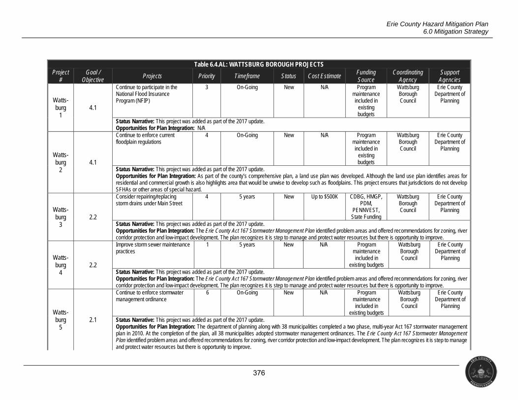
376
Erie County Hazard Mitigation Plan 6.0 Mitigation Strategy
Table 6.4.AL: WATTSBURG BOROUGH PROJECTS Project
# Goal /
Objective Projects Priority Timeframe Status Cost Estimate Funding
Source Coordinating
Agency Support
Agencies
Watts- burg
1 4.1
Continue to participate in the National Flood Insurance Program (NFIP)
3 On-Going New N/A Program maintenance included in
existing budgets
Wattsburg Borough Council
Erie County Department of
Planning
Status Narrative: This project was added as part of the 2017 update. Opportunities for Plan Integration: N/A
Watts- burg
2 4.1
Continue to enforce current floodplain regulations
4 On-Going New N/A Program maintenance included in
existing budgets
Wattsburg Borough Council
Erie County Department of
Planning
Status Narrative: This project was added as part of the 2017 update. Opportunities for Plan Integration: As part of the county’s comprehensive plan, a land use plan was developed. Although the land use plan identifies areas for residential and commercial growth is also highlights area that would be unwise to develop such as floodplains. This project ensures that jurisdictions do not develop SFHAs or other areas of special hazard.
Watts- burg
3 2.2
Consider repairing/replacing storm drains under Main Street
4 5 years New Up to $500K CDBG, HMGP, PDM,
PENNVEST, State Funding
Wattsburg Borough Council
Erie County Department of
Planning
Status Narrative: This project was added as part of the 2017 update. Opportunities for Plan Integration: The Erie County Act 167 Stormwater Management Plan identified problem areas and offered recommendations for zoning, river corridor protection and low-impact development. The plan recognizes it is step to manage and protect water resources but there is opportunity to improve.
Watts- burg
4 2.2
Improve storm sewer maintenance practices
1 5 years New N/A Program maintenance included in
existing budgets
Wattsburg Borough Council
Erie County Department of
Planning
Status Narrative: This project was added as part of the 2017 update. Opportunities for Plan Integration: The Erie County Act 167 Stormwater Management Plan identified problem areas and offered recommendations for zoning, river corridor protection and low-impact development. The plan recognizes it is step to manage and protect water resources but there is opportunity to improve.
Watts- burg
5 2.1
Continue to enforce stormwater management ordinance
6 On-Going New N/A Program maintenance included in
existing budgets
Wattsburg Borough Council
Erie County Department of
Planning
Status Narrative: This project was added as part of the 2017 update. Opportunities for Plan Integration: The department of planning along with 38 municipalities completed a two phase, multi-year Act 167 stormwater management plan in 2010. At the completion of the plan, all 38 municipalities adopted stormwater management ordinances. The Erie County Act 167 Stormwater Management Plan identified problem areas and offered recommendations for zoning, river corridor protection and low-impact development. The plan recognizes it is step to manage and protect water resources but there is opportunity to improve.
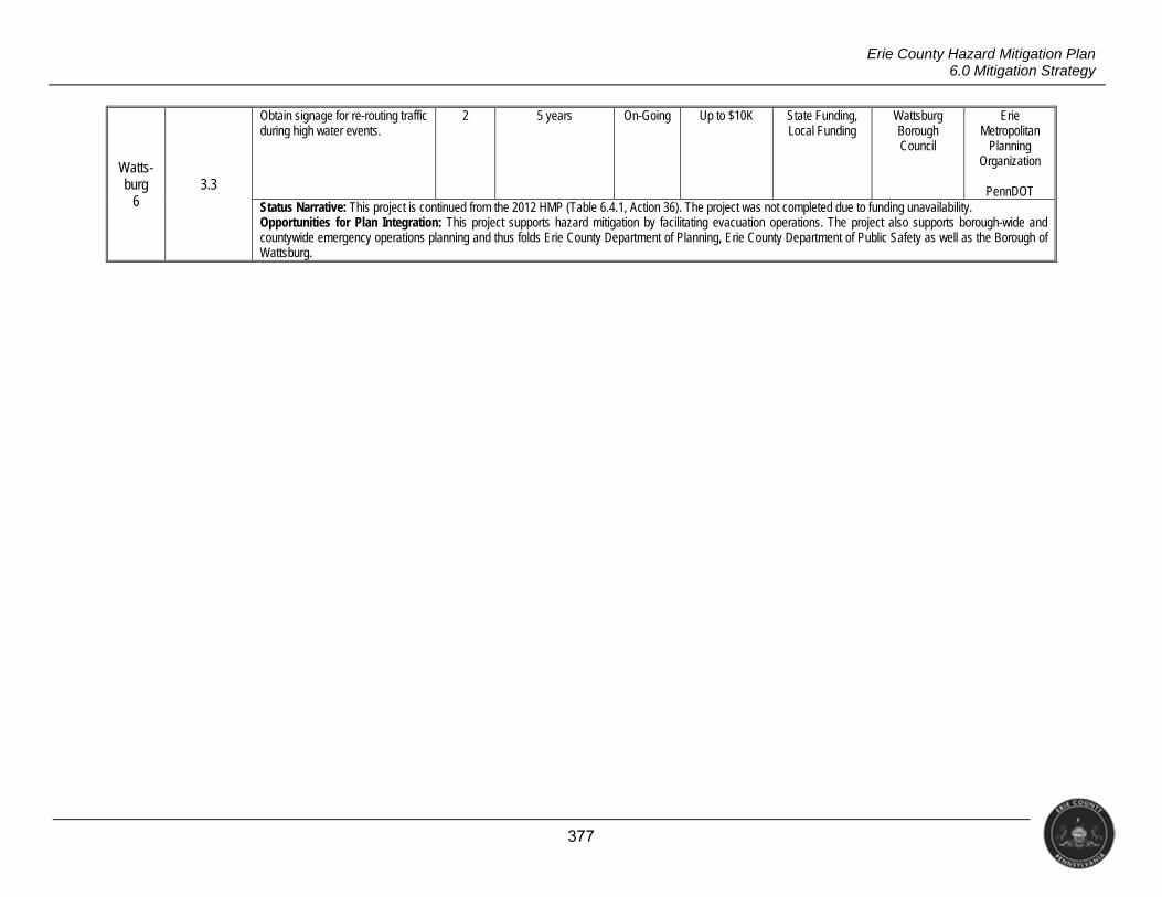
377
Erie County Hazard Mitigation Plan 6.0 Mitigation Strategy
Watts- burg
6 3.3
Obtain signage for re-routing traffic during high water events.
2 5 years On-Going Up to $10K State Funding, Local Funding
Wattsburg Borough Council
Erie Metropolitan
Planning Organization
PennDOT
Status Narrative: This project is continued from the 2012 HMP (Table 6.4.1, Action 36). The project was not completed due to funding unavailability. Opportunities for Plan Integration: This project supports hazard mitigation by facilitating evacuation operations. The project also supports borough-wide and countywide emergency operations planning and thus folds Erie County Department of Planning, Erie County Department of Public Safety as well as the Borough of Wattsburg.
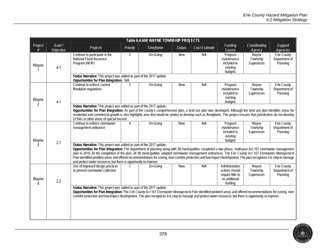
378
Erie County Hazard Mitigation Plan 6.0 Mitigation Strategy
Table 6.4.AM: WAYNE TOWNSHIP PROJECTS Project
# Goal /
Objective Projects Priority Timeframe Status Cost Estimate Funding
Source Coordinating
Agency Support
Agencies
Wayne 1 4.1
Continue to participate in the National Flood Insurance Program (NFIP)
2 On-Going New N/A Program maintenance included in
existing budgets
Wayne Township
Supervisors
Erie County Department of
Planning
Status Narrative: This project was added as part of the 2017 update. Opportunities for Plan Integration: N/A
Wayne 2
4.1
Continue to enforce current floodplain regulations
3 On-Going New N/A Program maintenance included in
existing budgets
Wayne Township
Supervisors
Erie County Department of
Planning
Status Narrative: This project was added as part of the 2017 update. Opportunities for Plan Integration: As part of the county’s comprehensive plan, a land use plan was developed. Although the land use plan identifies areas for residential and commercial growth is also highlights area that would be unwise to develop such as floodplains. This project ensures that jurisdictions do not develop SFHAs or other areas of special hazard.
Wayne 3
2.1
Continue to enforce stormwater management ordinance
4 On-Going New N/A Program maintenance included in
existing budgets
Wayne Township
Supervisors
Erie County Department of
Planning
Status Narrative: This project was added as part of the 2017 update. Opportunities for Plan Integration: The department of planning along with 38 municipalities completed a two phase, multi-year Act 167 stormwater management plan in 2010. At the completion of the plan, all 38 municipalities adopted stormwater management ordinances. The Erie County Act 167 Stormwater Management Plan identified problem areas and offered recommendations for zoning, river corridor protection and low-impact development. The plan recognizes it is step to manage and protect water resources but there is opportunity to improve.
Wayne 4 2.2
Use of improved design practices to prevent stormwater collection
1 On-Going New N/A Administrative actions should require little to no additional
funding
Wayne Township
Supervisors
Erie County Department of
Planning
Status Narrative: This project was added as part of the 2017 update. Opportunities for Plan Integration: The Erie County Act 167 Stormwater Management Plan identified problem areas and offered recommendations for zoning, river corridor protection and low-impact development. The plan recognizes it is step to manage and protect water resources but there is opportunity to improve.
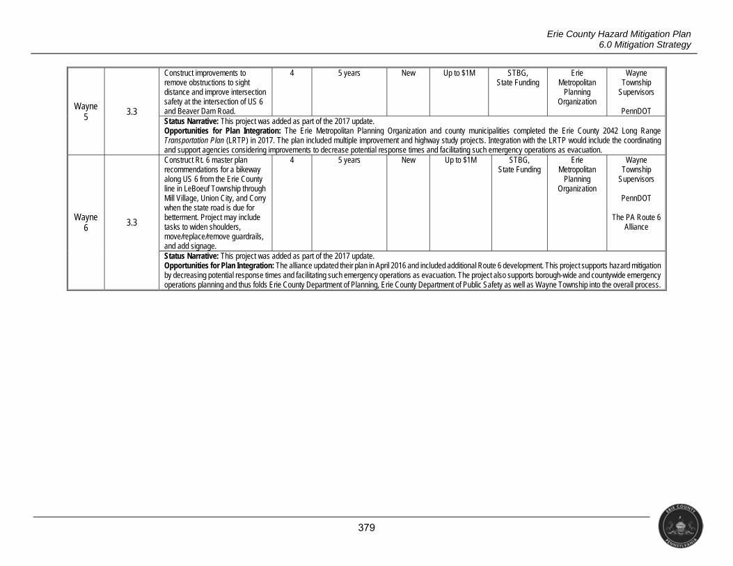
379
Erie County Hazard Mitigation Plan 6.0 Mitigation Strategy
Wayne 5
3.3
Construct improvements to remove obstructions to sight distance and improve intersection safety at the intersection of US 6 and Beaver Dam Road.
4 5 years New Up to $1M STBG, State Funding
Erie Metropolitan
Planning Organization
Wayne Township
Supervisors
PennDOT Status Narrative: This project was added as part of the 2017 update. Opportunities for Plan Integration: The Erie Metropolitan Planning Organization and county municipalities completed the Erie County 2042 Long Range Transportation Plan (LRTP) in 2017. The plan included multiple improvement and highway study projects. Integration with the LRTP would include the coordinating and support agencies considering improvements to decrease potential response times and facilitating such emergency operations as evacuation.
Wayne 6
3.3
Construct Rt. 6 master plan recommendations for a bikeway along US 6 from the Erie County line in LeBoeuf Township through Mill Village, Union City, and Corry when the state road is due for betterment. Project may include tasks to widen shoulders, move/replace/remove guardrails, and add signage.
4 5 years New Up to $1M STBG, State Funding
Erie Metropolitan
Planning Organization
Wayne Township
Supervisors
PennDOT
The PA Route 6 Alliance
Status Narrative: This project was added as part of the 2017 update. Opportunities for Plan Integration: The alliance updated their plan in April 2016 and included additional Route 6 development. This project supports hazard mitigation by decreasing potential response times and facilitating such emergency operations as evacuation. The project also supports borough-wide and countywide emergency operations planning and thus folds Erie County Department of Planning, Erie County Department of Public Safety as well as Wayne Township into the overall process.
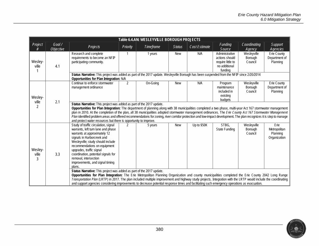
380
Erie County Hazard Mitigation Plan 6.0 Mitigation Strategy
Table 6.4.AN: WESLEYVILLE BOROUGH PROJECTS Project
# Goal /
Objective Projects Priority Timeframe Status Cost Estimate Funding
Source Coordinating
Agency Support
Agencies
Wesley- ville
1 4.1
Research and complete requirements to become an NFIP participating community.
1 1 years New N/A Administrative actions should require little to no additional
funding
Wesleyville Borough Council
Erie County Department of
Planning
Status Narrative: This project was added as part of the 2017 update. Wesleyville Borough has been suspended from the NFIP since 2/20/2014 Opportunities for Plan Integration: N/A
Wesley- ville
2 2.1
Continue to enforce stormwater management ordinance
2 On-Going New N/A Program maintenance included in
existing budgets
Wesleyville Borough Council
Erie County Department of
Planning
Status Narrative: This project was added as part of the 2017 update. Opportunities for Plan Integration: The department of planning along with 38 municipalities completed a two phase, multi-year Act 167 stormwater management plan in 2010. At the completion of the plan, all 38 municipalities adopted stormwater management ordinances. The Erie County Act 167 Stormwater Management Plan identified problem areas and offered recommendations for zoning, river corridor protection and low-impact development. The plan recognizes it is step to manage and protect water resources but there is opportunity to improve.
Wesley- ville
3 3.3
Study of traffic circulation, signal warrants, left turn lane and phase warrants at approximately 12 signals in Harborcreek and Wesleyville; study should include recommendations on equipment upgrades, traffic signal coordination, potential signals for removal, intersection improvements, and signal timing plans.
2 5 years New Up to $50K STBG, State Funding
Wesleyville Borough Council
Erie Metropolitan
Planning Organization
Status Narrative: This project was added as part of the 2017 update. Opportunities for Plan Integration: The Erie Metropolitan Planning Organization and county municipalities completed the Erie County 2042 Long Range Transportation Plan (LRTP) in 2017. The plan included multiple improvement and highway study projects. Integration with the LRTP would include the coordinating and support agencies considering improvements to decrease potential response times and facilitating such emergency operations as evacuation.
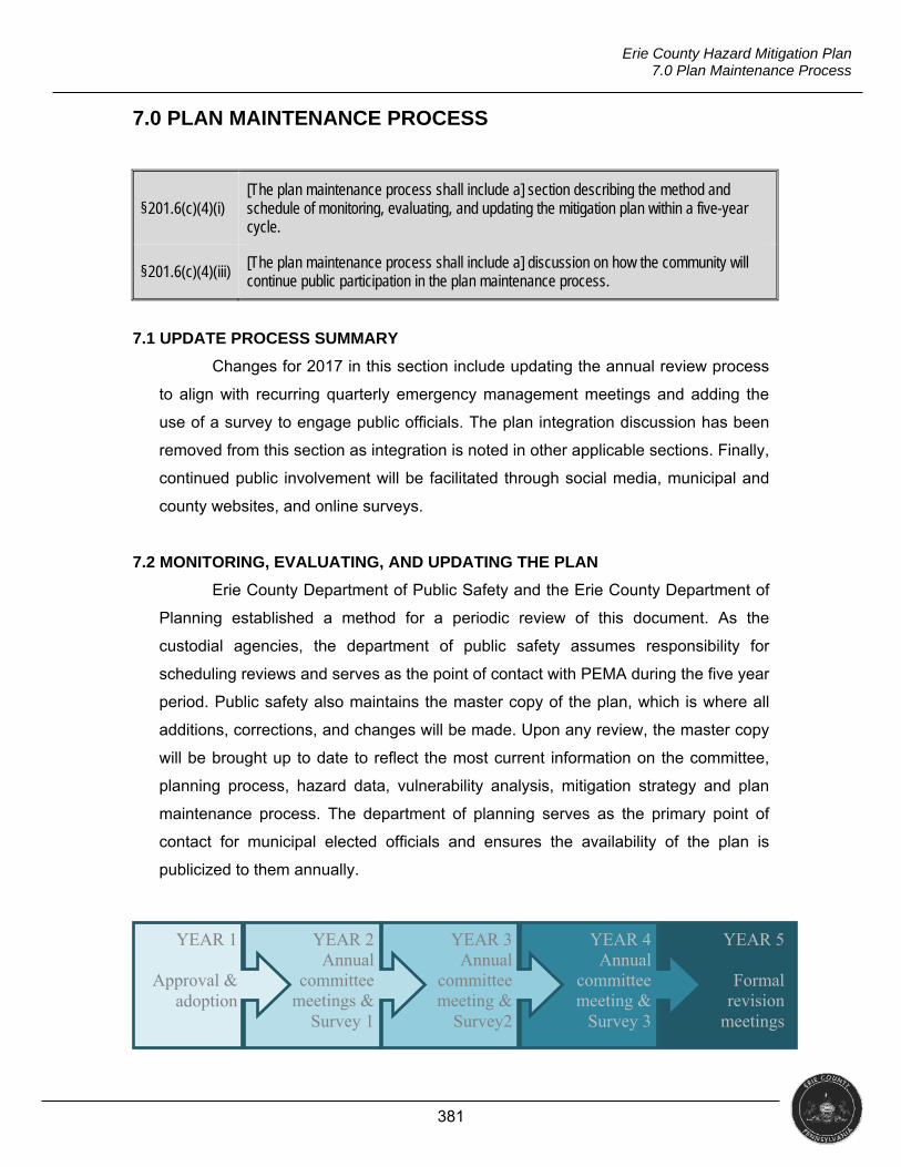
381
Erie County Hazard Mitigation Plan 7.0 Plan Maintenance Process
7.0 PLAN MAINTENANCE PROCESS
§201.6(c)(4)(i)
[The plan maintenance process shall include a] section describing the method and schedule of monitoring, evaluating, and updating the mitigation plan within a five-year cycle.
§201.6(c)(4)(iii)
[The plan maintenance process shall include a] discussion on how the community will continue public participation in the plan maintenance process.
7.1 UPDATE PROCESS SUMMARY
Changes for 2017 in this section include updating the annual review process
to align with recurring quarterly emergency management meetings and adding the
use of a survey to engage public officials. The plan integration discussion has been
removed from this section as integration is noted in other applicable sections. Finally,
continued public involvement will be facilitated through social media, municipal and
county websites, and online surveys.
7.2 MONITORING, EVALUATING, AND UPDATING THE PLAN
Erie County Department of Public Safety and the Erie County Department of
Planning established a method for a periodic review of this document. As the
custodial agencies, the department of public safety assumes responsibility for
scheduling reviews and serves as the point of contact with PEMA during the five year
period. Public safety also maintains the master copy of the plan, which is where all
additions, corrections, and changes will be made. Upon any review, the master copy
will be brought up to date to reflect the most current information on the committee,
planning process, hazard data, vulnerability analysis, mitigation strategy and plan
maintenance process. The department of planning serves as the primary point of
contact for municipal elected officials and ensures the availability of the plan is
publicized to them annually.
YEAR 5
Formal revision
meetings
YEAR 4 Annual
committee meeting &
Survey 3
YEAR 3 Annual
committee meeting &
Survey2
YEAR 2 Annual
committee meetings &
Survey 1
YEAR 1
Approval & adoption
382
Erie County Hazard Mitigation Plan 7.0 Plan Maintenance Process
The formal updating process will consist of a series of meetings and surveys
to review mitigation projects, the hazard list, and the asset inventory. Each
municipality will be given three opportunities to participate in the plan maintenance
process annually. The Erie County Department of Public Safety (DPS) feels it is
beneficial to coordinate the mitigation review meetings with other planning efforts.
The department of public safety offers quarterly training for municipal emergency
managers, who are required to attend at least three training sessions annually. As
such, the department of public safety will coordinate mitigation review during the first
and third training sessions each year and discuss hazards/assets at one and projects
at the other. As the third opportunity, the department of public safety or department
of planning will distribute an annual survey to municipal elected officials to keep them
engaged in the process. Erie County DPS will compile an annual summary of these
meetings for submission to PEMA and FEMA Region III.
Additionally, municipal emergency managers update one another on
completed or underway mitigation projects. Each project listed in this plan includes
resources that aid in implementation; such resources may include potential funding
sources. Many of these funding sources require stringent project administration tasks
(including performance measures and close-out procedures), all of which would be
followed by the jurisdiction implementing a project. Adherence to these requirements
will ensure the successful implementation of projects funded by such programs. For
projects funded locally, existing purchasing policies are followed, including
competitive bidding, maintenance of invoice copies, regular departmental budget
reviews, etc. All files associated with purchasing at the local level are maintained.
Public safety will ask municipal emergency management coordinators to
evaluate the performance of their projects based on several criteria. For instance,
coordinators should consider revising mitigation strategies if it appears strategies are
failing according to one of the following measures.
Cost Effectiveness: Is sufficient funding available to implement the project
at a cost manageable by the local government? If not, is funding available? Will the
costs of implementing the project be significantly less than the cumulative future
costs potentially incurred by an un-corrected situation?
Property Protection: How significant will the action be at eliminating or
reducing damage to structures and infrastructure?
383
Erie County Hazard Mitigation Plan 7.0 Plan Maintenance Process
Life Safety: How effectively will the action protect lives and prevent injuries?
Environmental Impacts: Will implementing the project adversely affect the
environment in any way? Will implementing the project actually benefit the
environment?
Social Impacts: Will the public perceive the project as positively lessening
hazard-related losses? Will implementing the project adversely affect any segment of
the population?
Legal Impacts: Do your governmental organizations and/or partner agencies
have the authority to implement the actions?
Political Impacts: Will implementing the project create negative political
issues?
Overall Feasibility: Do local policies and capabilities currently allow for the
implementation of the project? Are programs available to assist in funding the
implementation of the project? Do local leaders generally agree that implementing
the project will be beneficial to the community?
7.3 CONTINUED PUBLIC INVOLVEMENT
Erie County understands that the general public must be involved in the initial
planning process as well as the updates to the completed plan. As such, the Erie
County Department of Public Safety and the Erie County Department of Planning will
invite the public to participate as the plan is updated through a variety of formats
including the following.
Social media posts
County website
Municipal websites
Online surveys
Further, as the plan is adopted, the public will be given the chance to
comment on the updated plan prior to its adoption by passage of resolution or
ordinance. The department of public safety will maintain a copy of the hazard
mitigation plan on the county website and file copies that are available for review and
inspection by the public. The department of public safety intends to log all comments
received regarding the mitigation plan.
Erie County Hazard Mitigation Plan Appendix 1: Meeting Documentation
APPENDIX 1: MEETING DOCUMENTATION
This appendix contains evidence of participation and involvement throughout the
hazard mitigation plan update. It includes the following materials.
Meeting Notices
o Invitations sent to planning committee members
o Newspaper advertisement for first public meeting
o Screen shot of website with second public meeting date posted
o Announcements via social media advertising public meetings
o Signage denoting public meetings
Evidence of Attendance
o Sign-in sheets from stakeholder and public meetings
o Sign-in sheets from resiliency workshop
o Scans of handwritten activity sheets (from planning committee meetings)
Presentation Materials
o Slide decks from October and May planning committee meetings
o Planning committee handouts regarding hazard mitigation overview and
potential mitigation strategies
o Slide deck from public meetings
o Handouts from public meetings
o Photos of room set-up for public meetings
o Resiliency workshop agenda
o Slide deck from resiliency workshop
o Resiliency workshop handouts (i.e., hazard overview, top strategies)
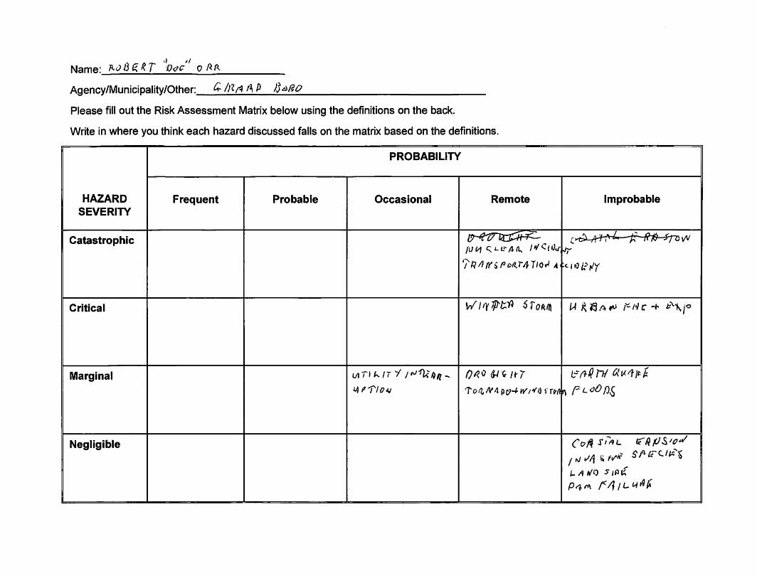

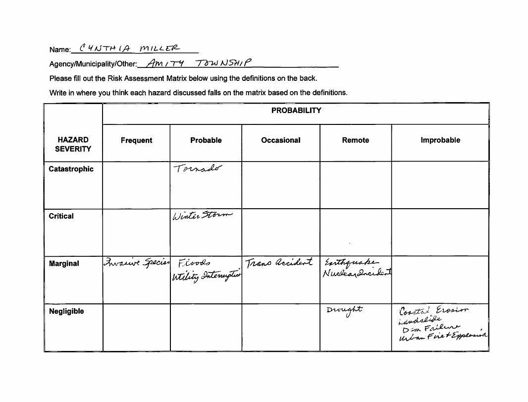

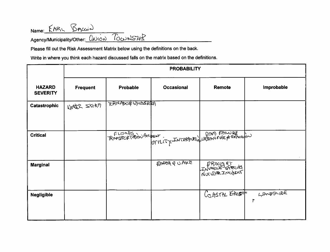

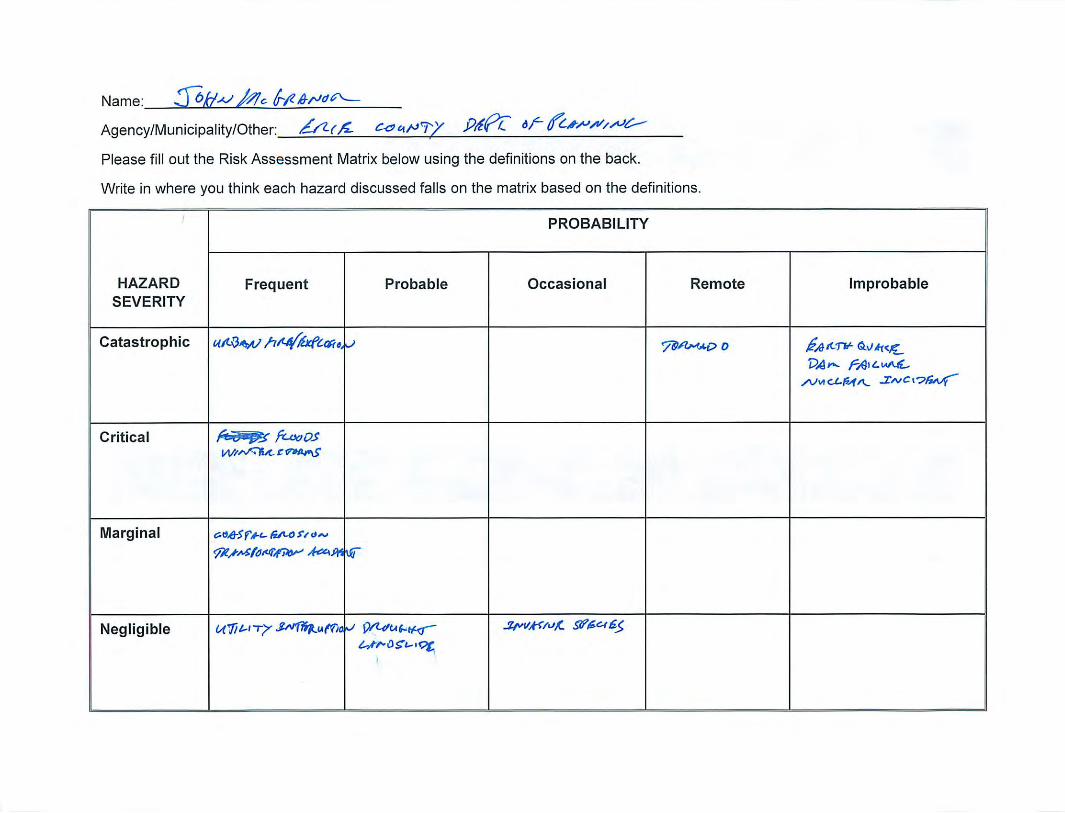

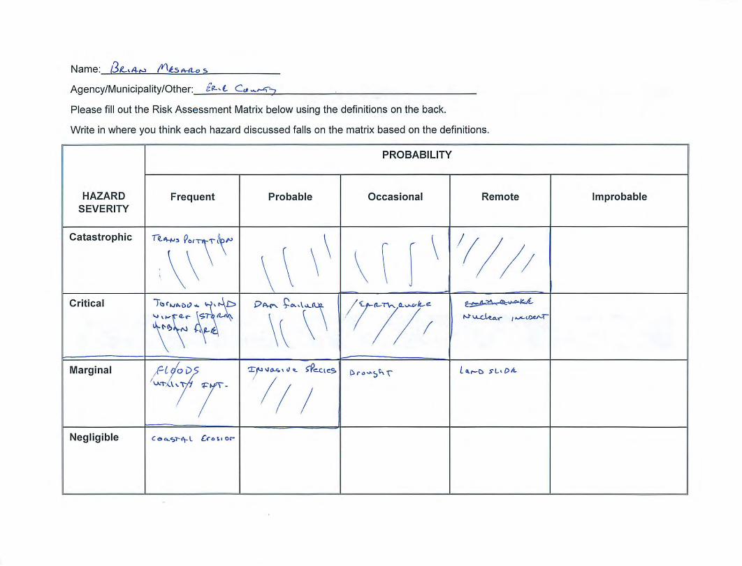

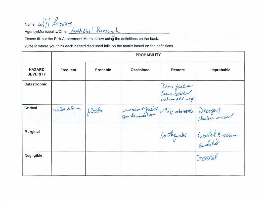
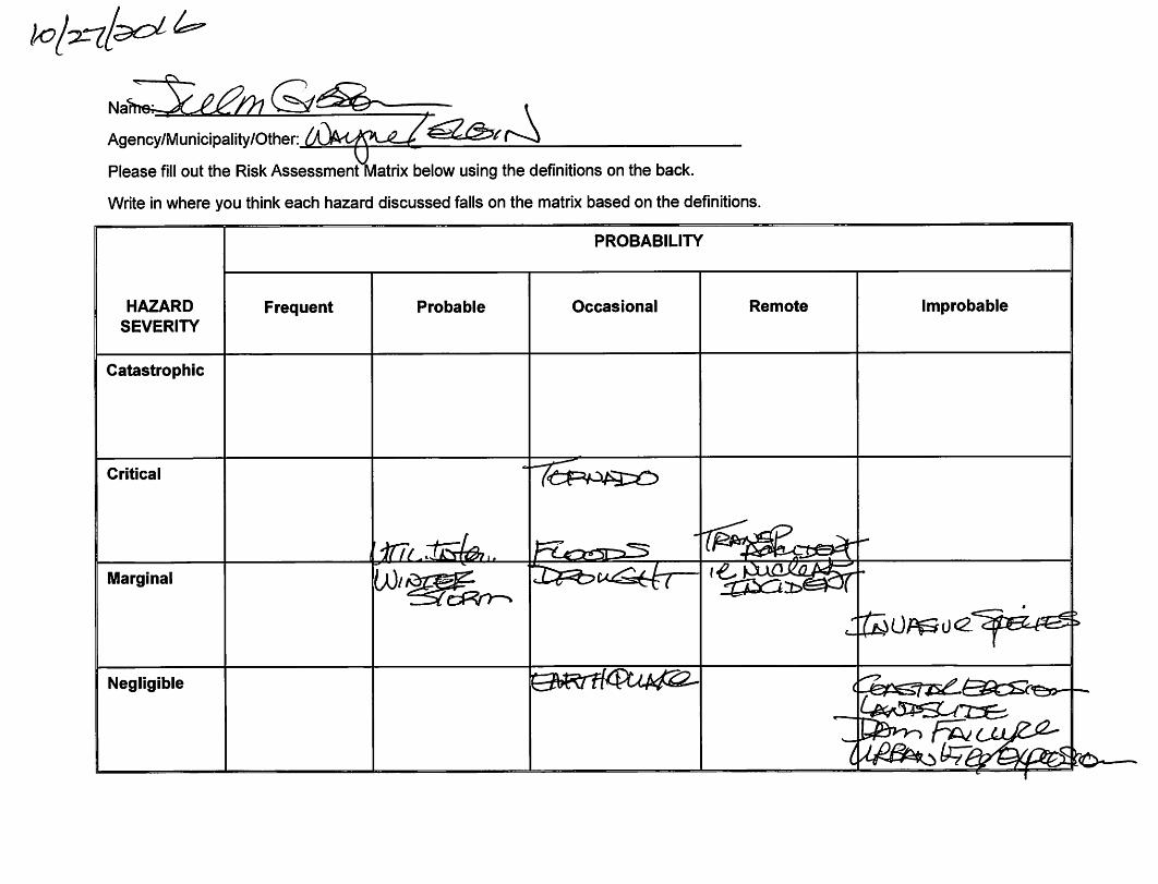

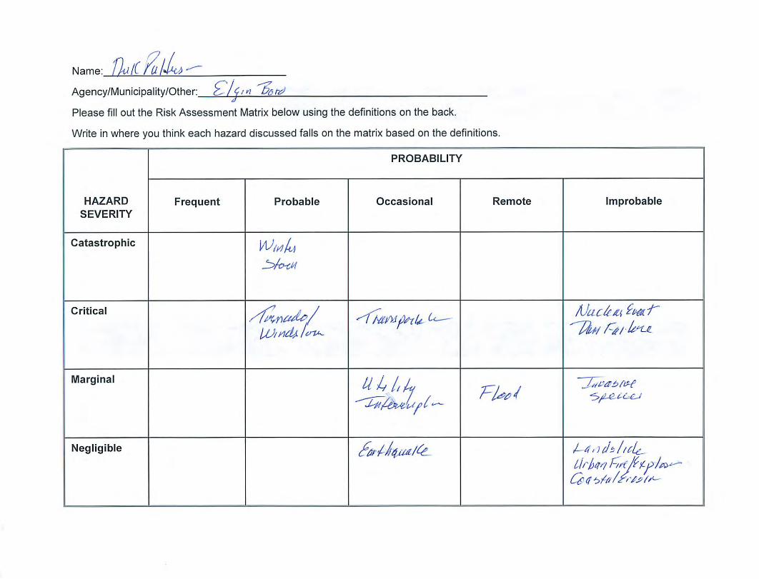

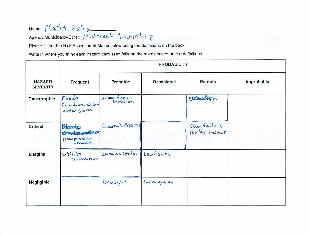
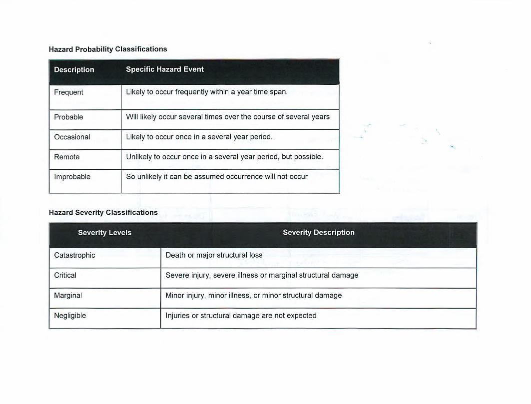


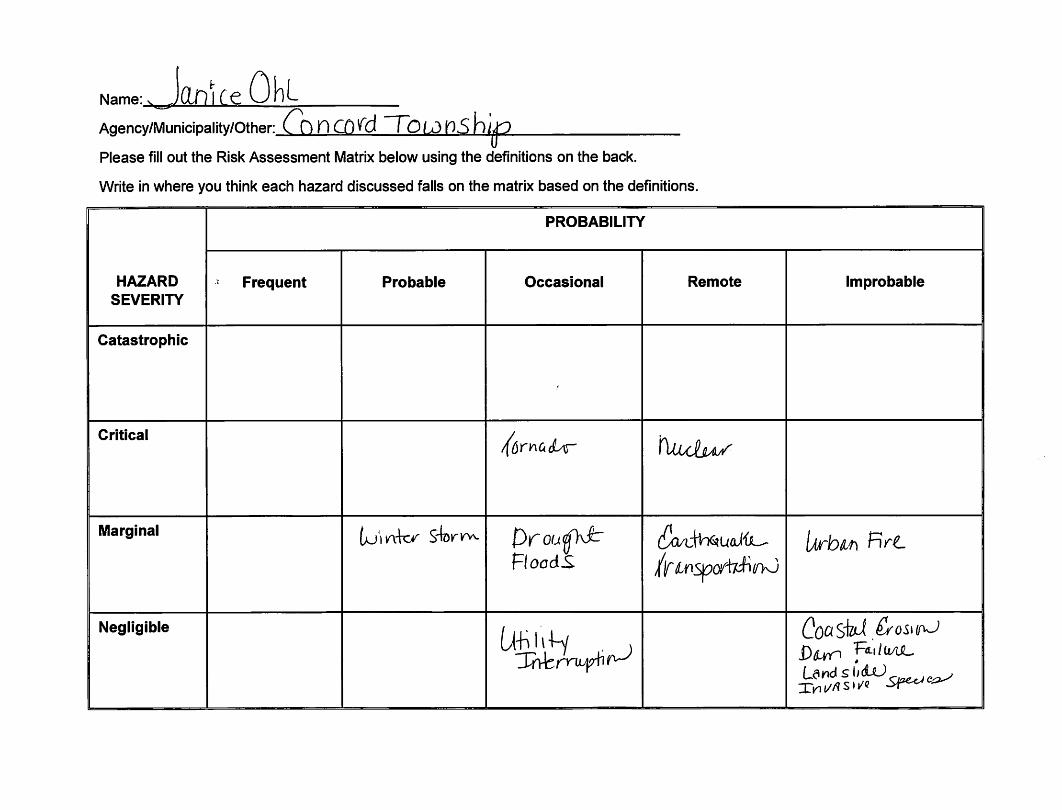
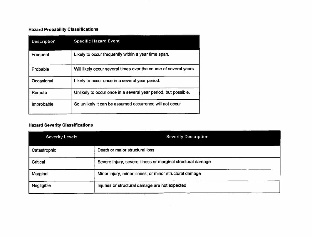
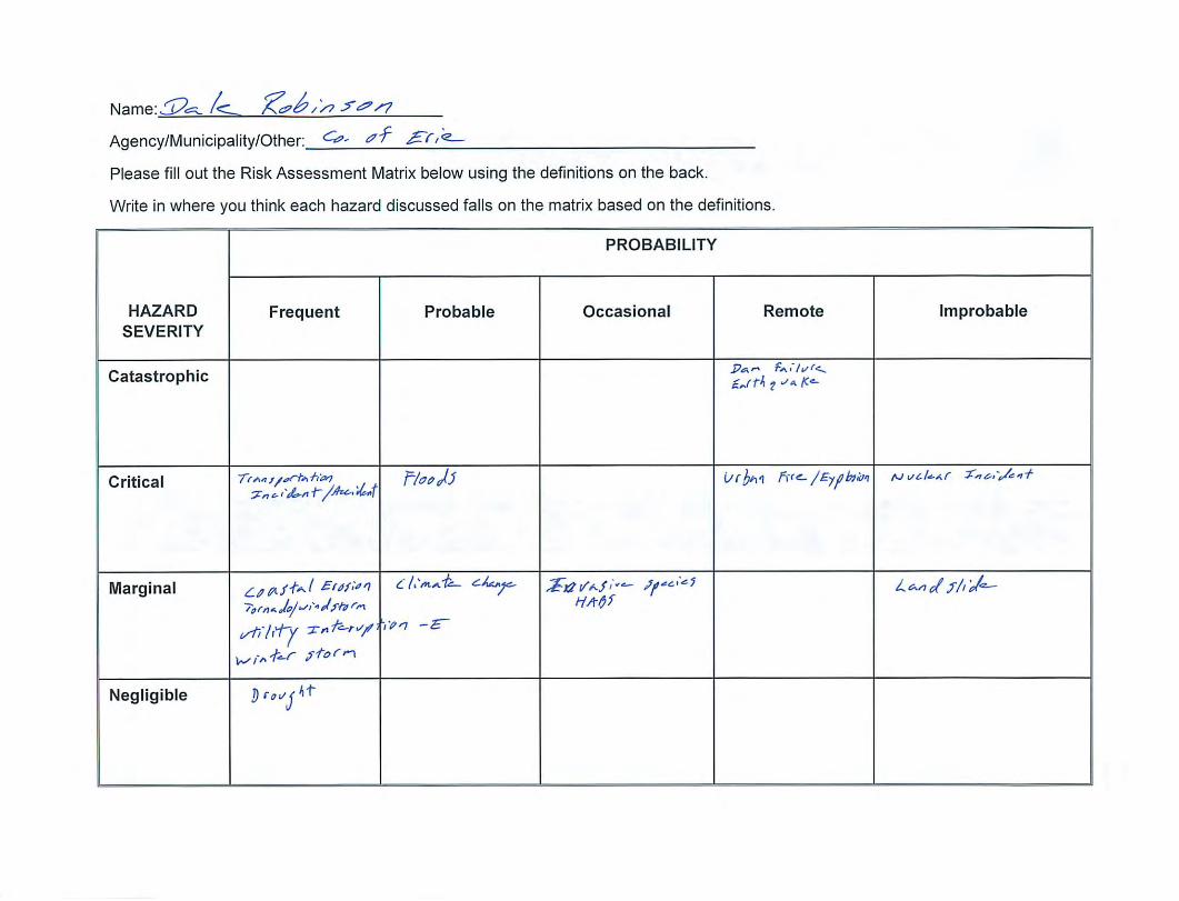
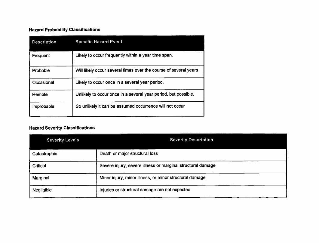
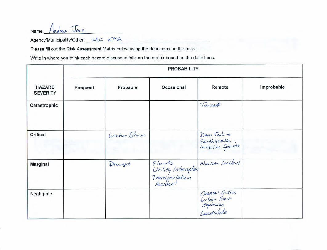

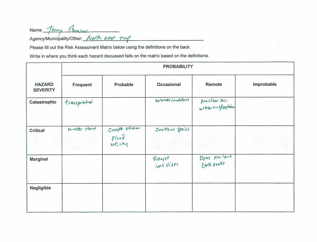

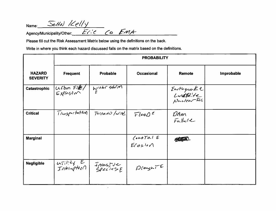

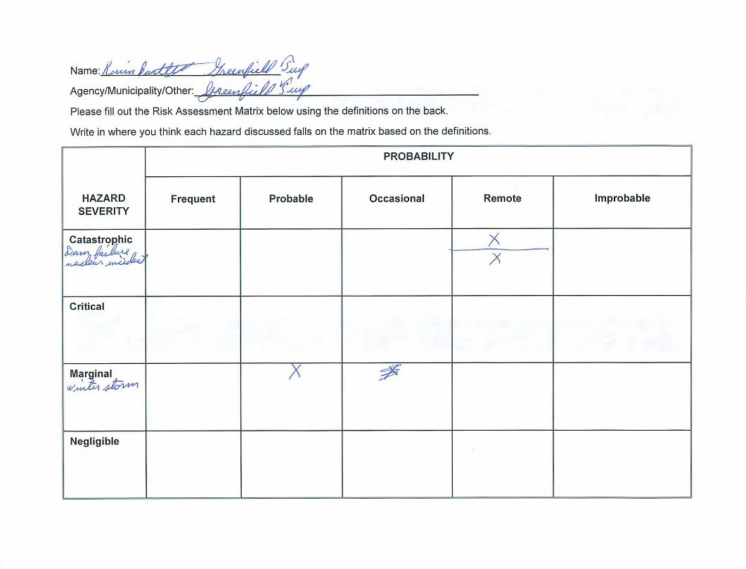

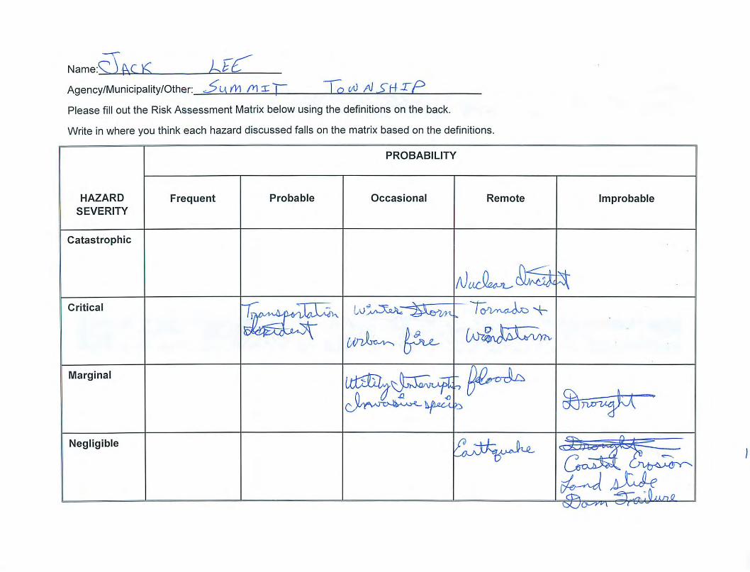
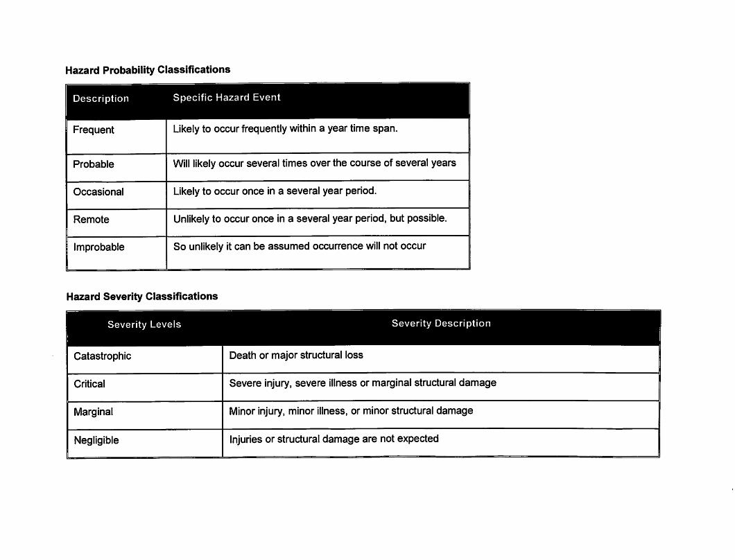
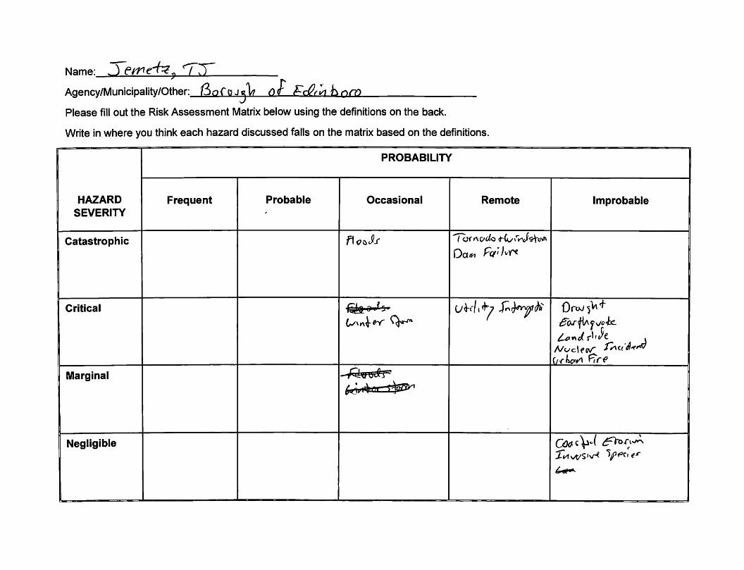
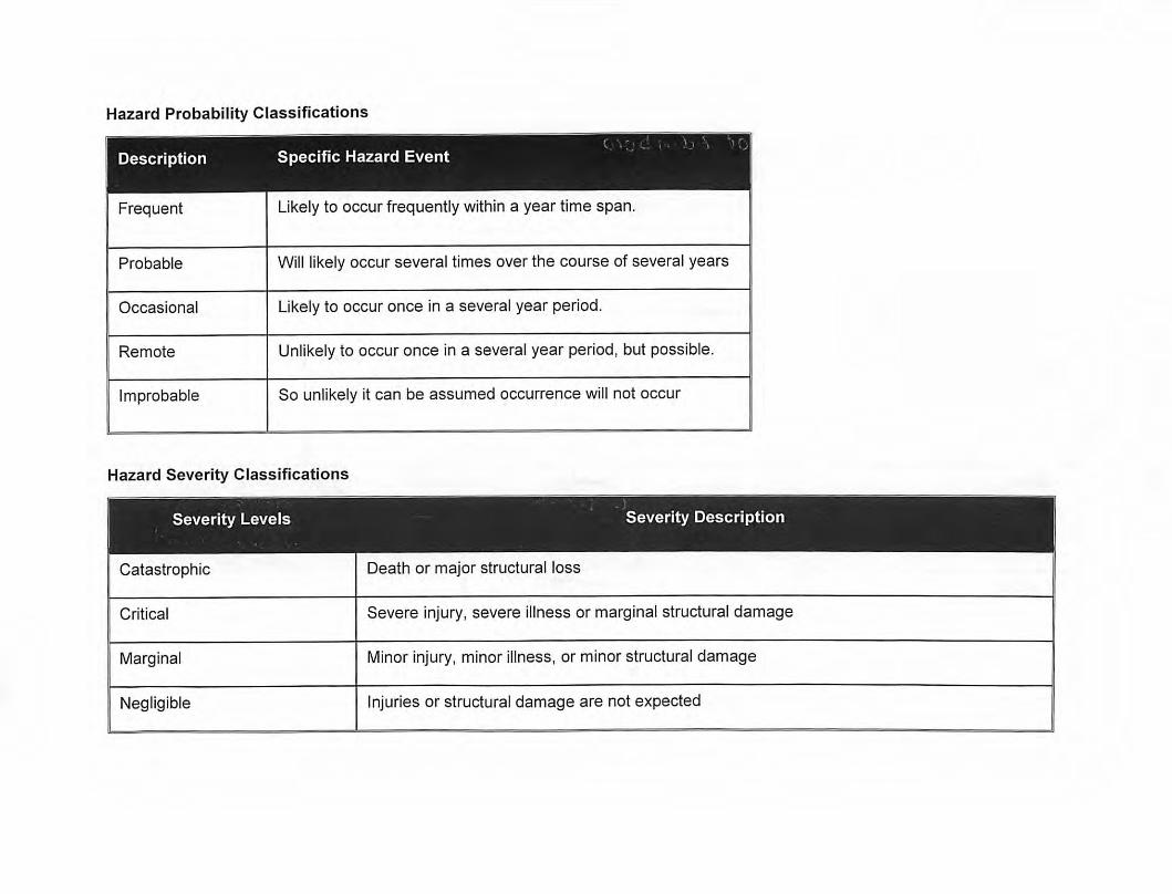
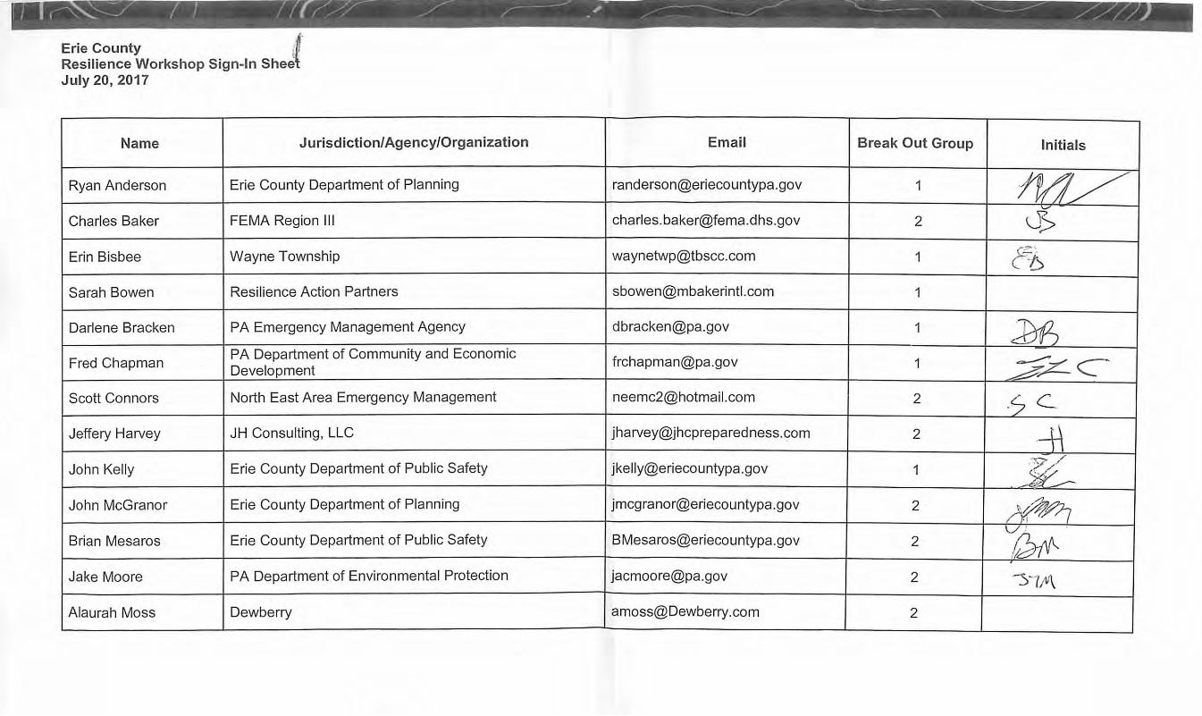
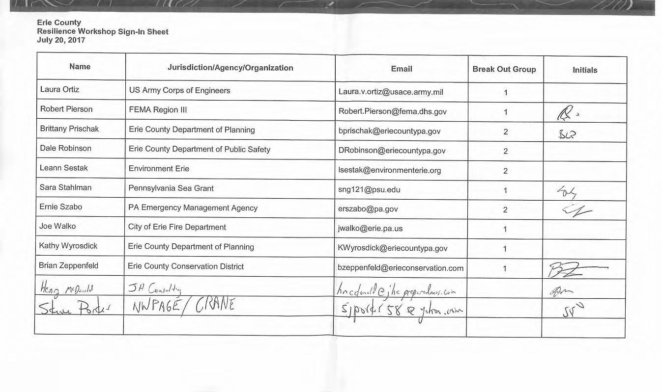
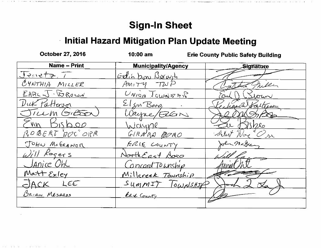
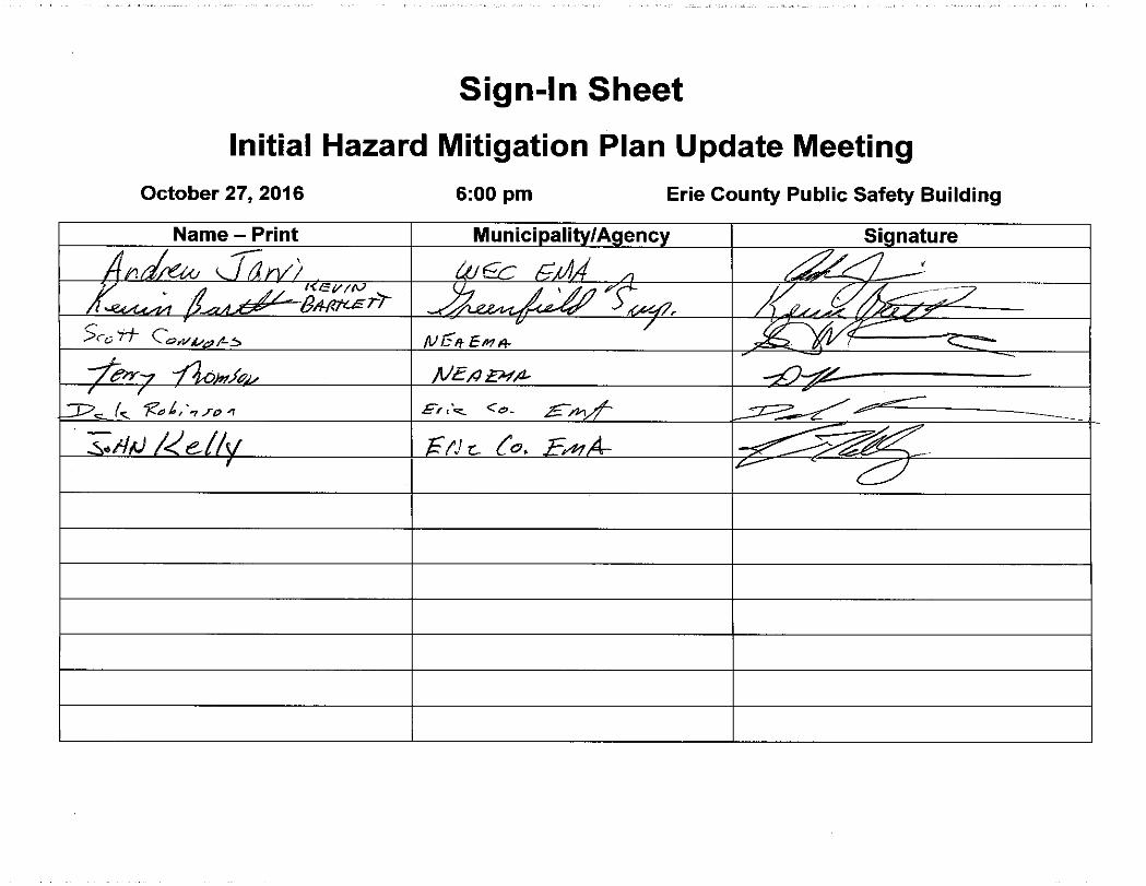
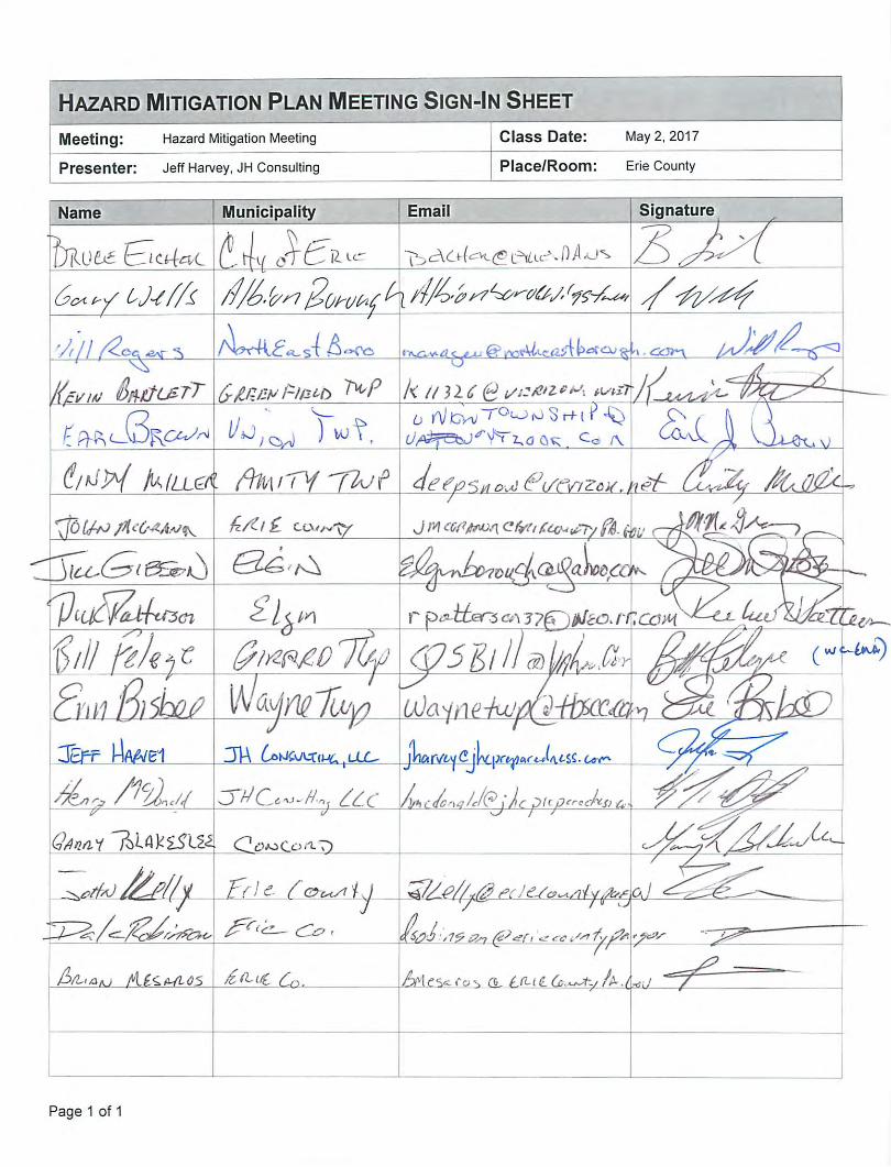
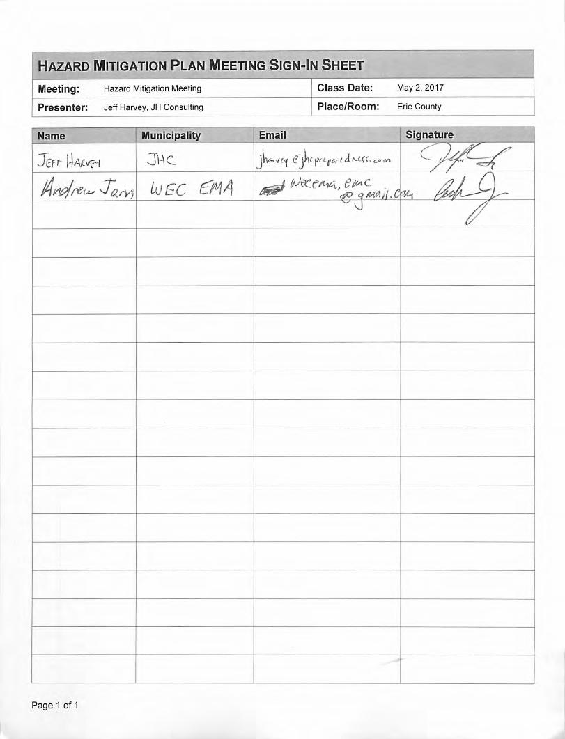
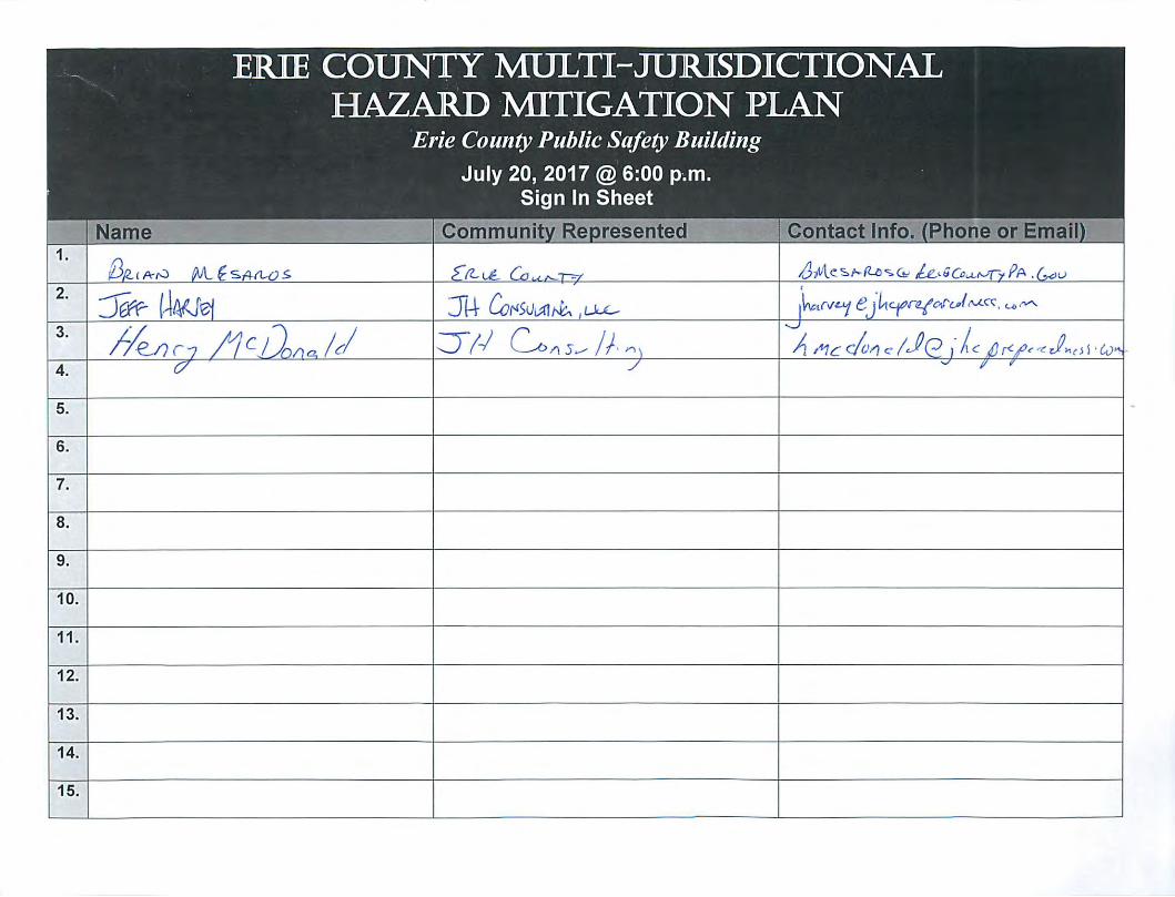
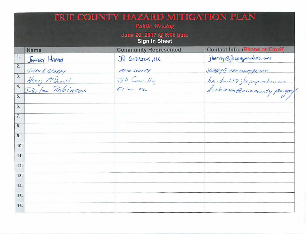
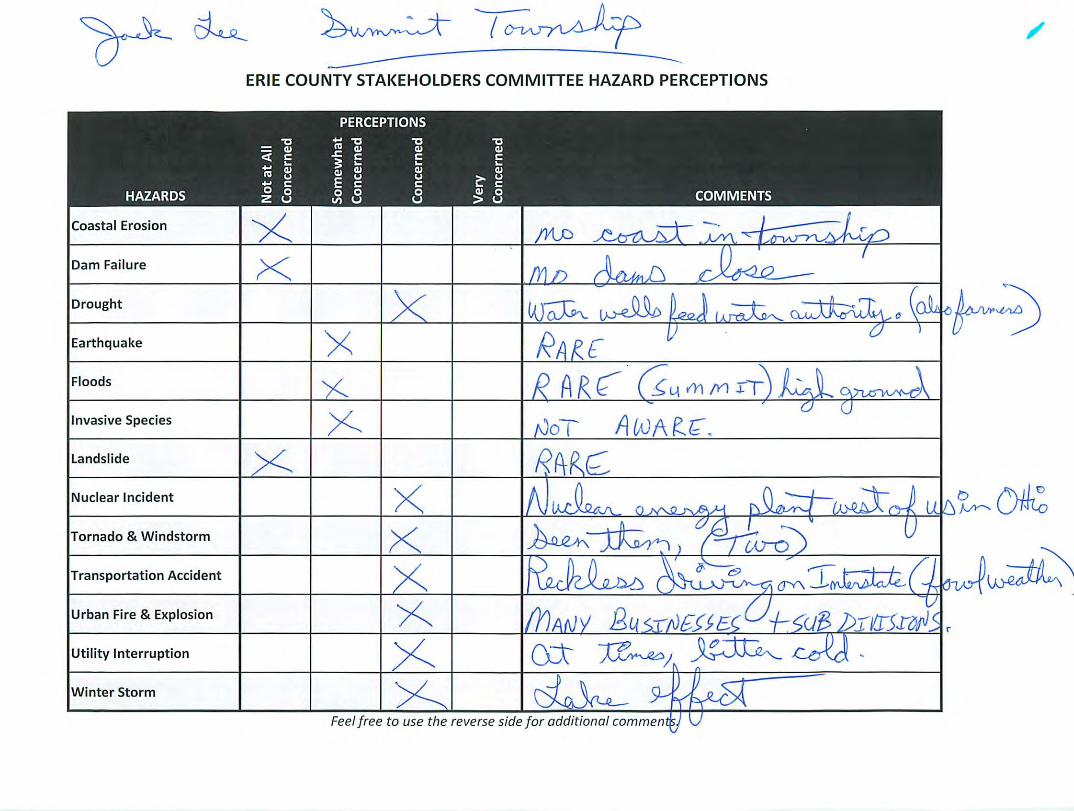
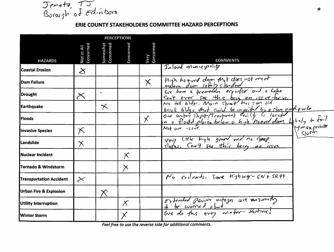
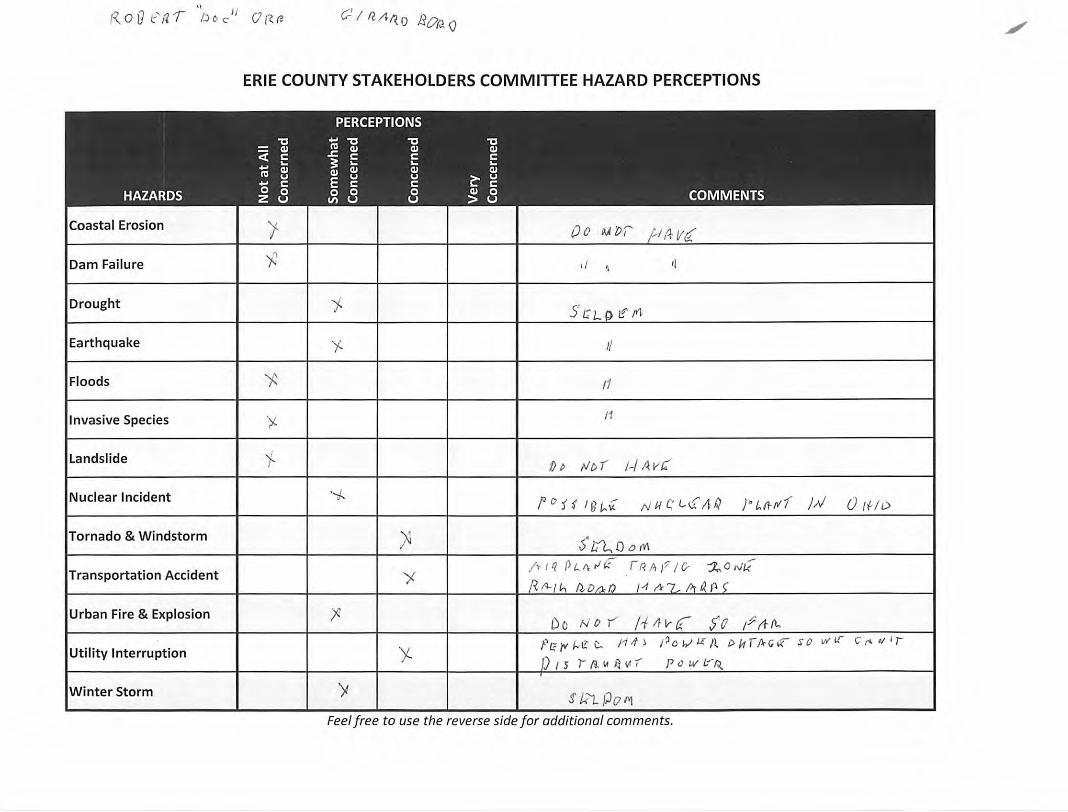
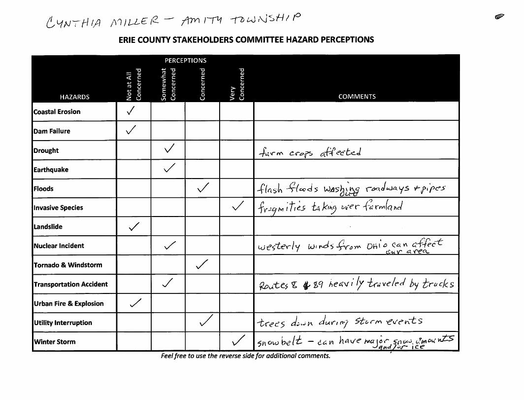
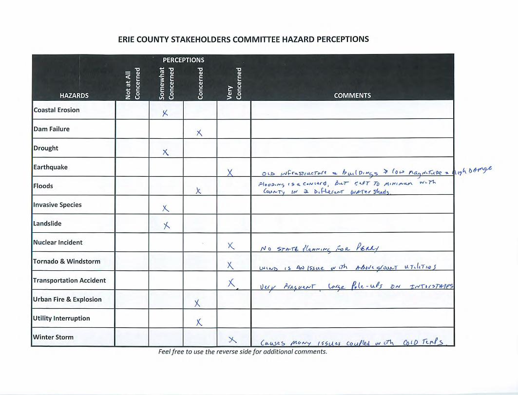
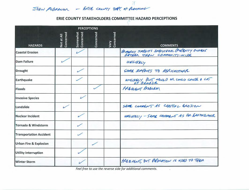
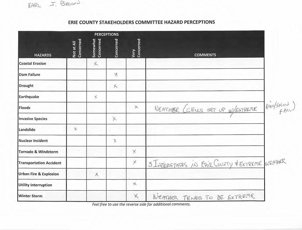
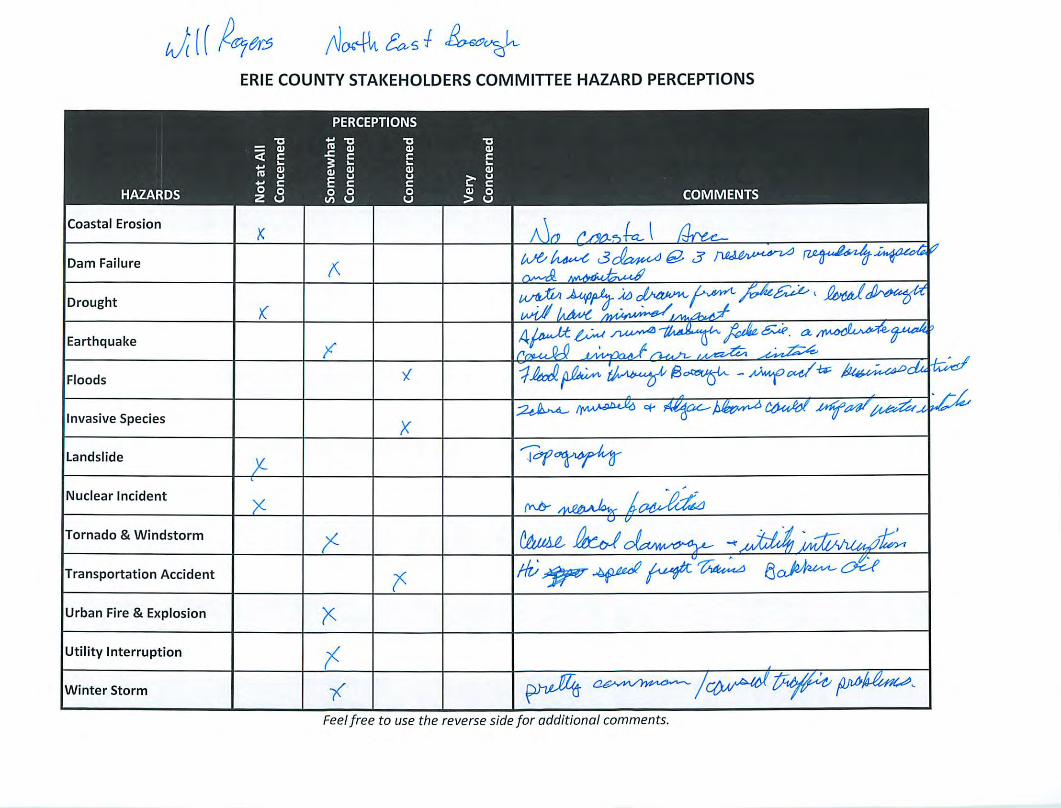

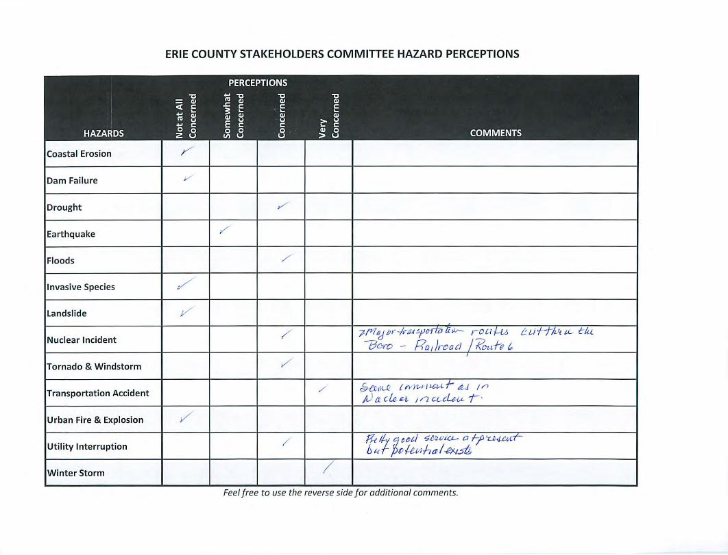
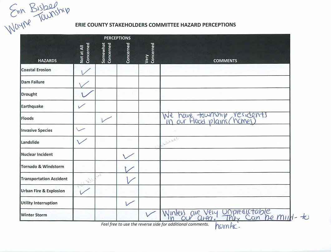
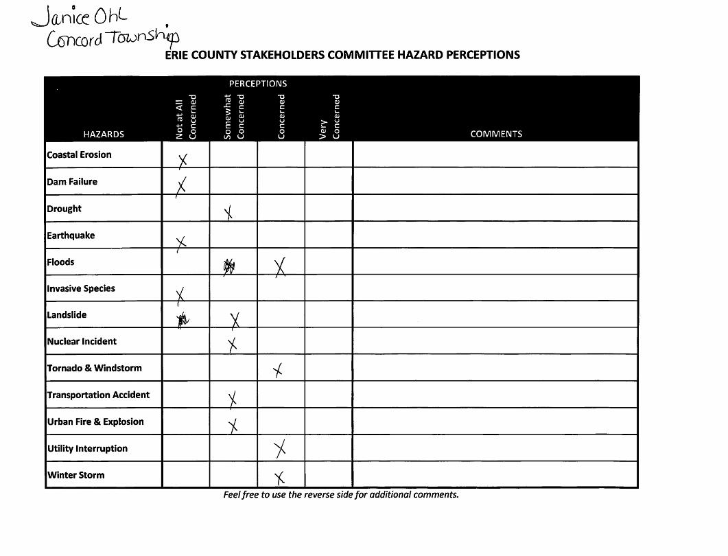
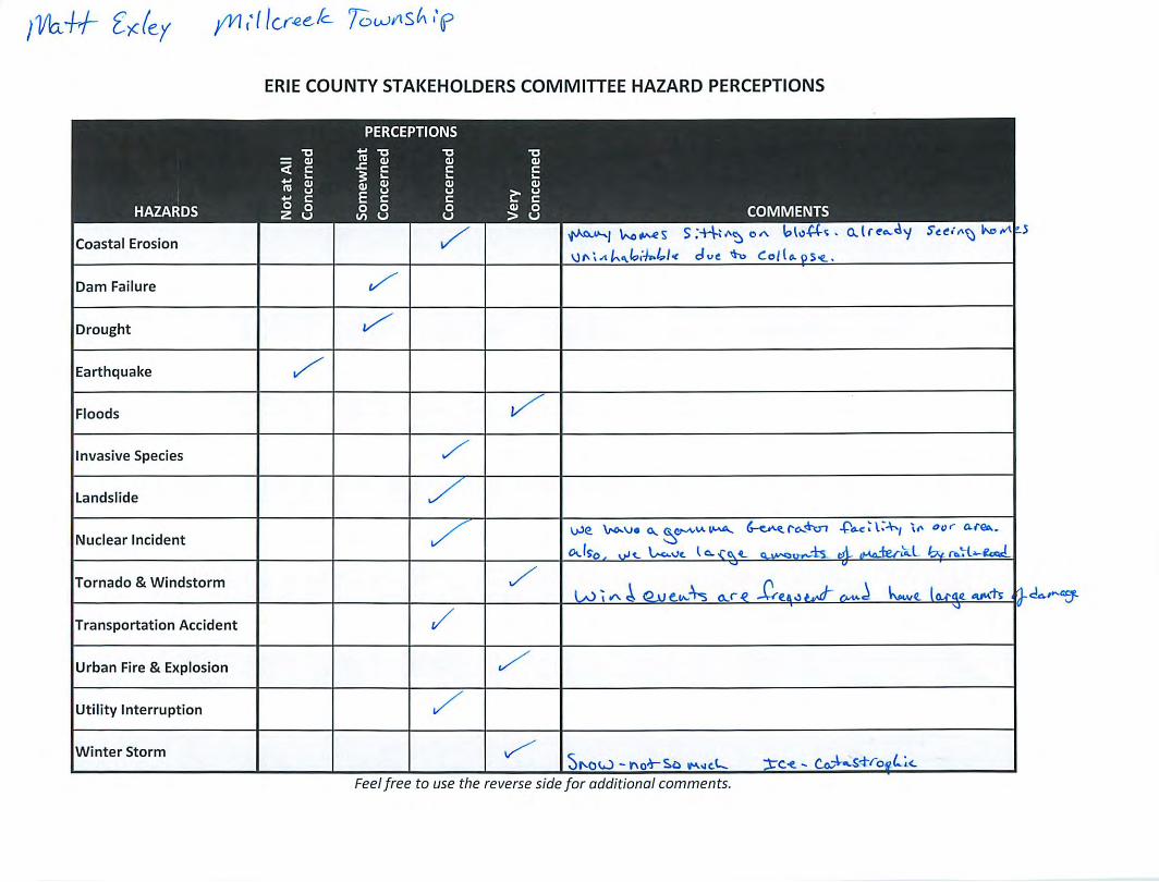
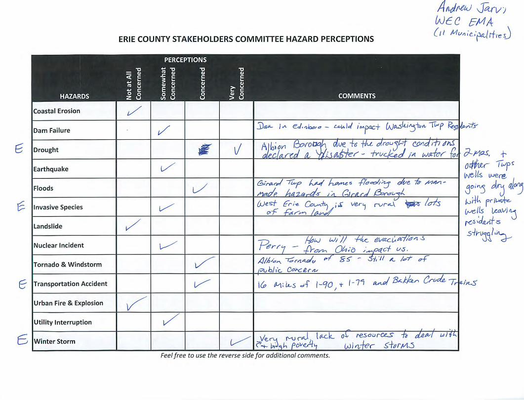
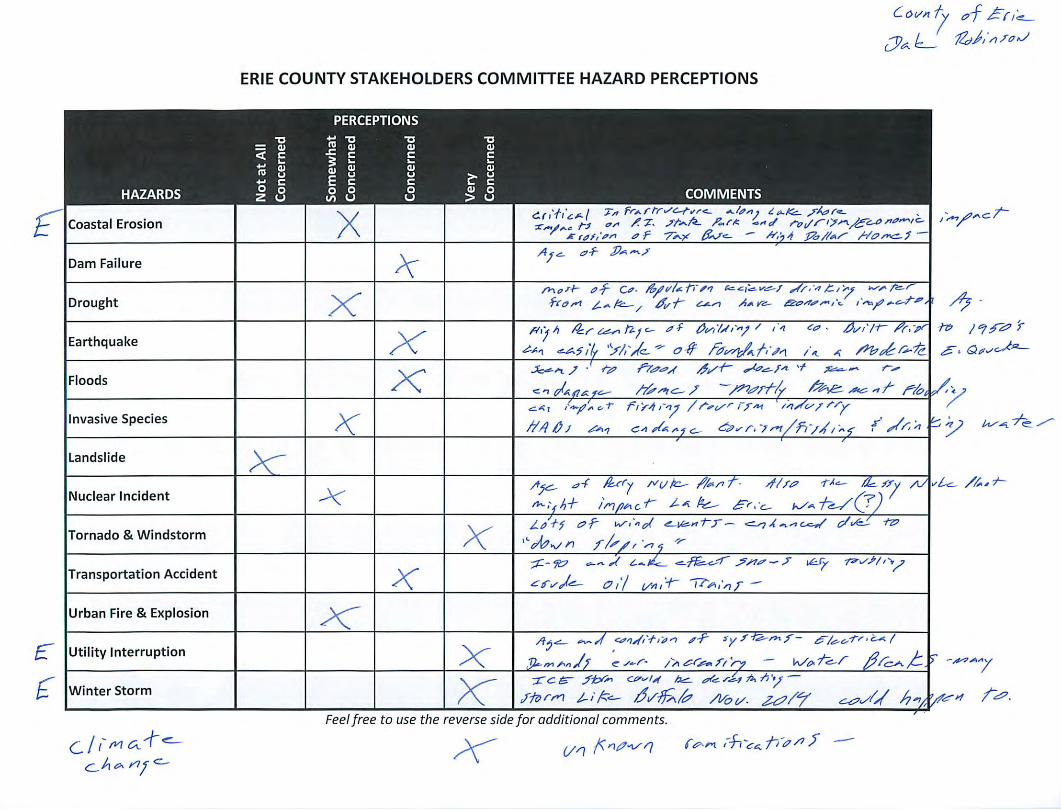
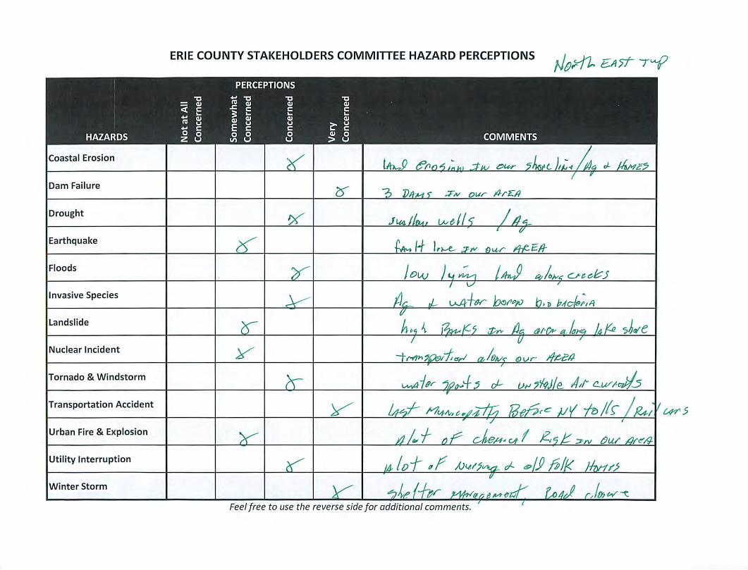
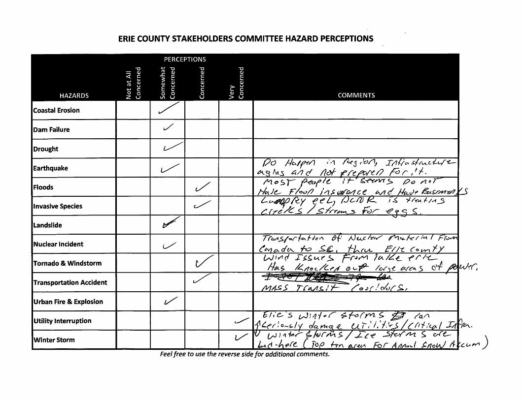
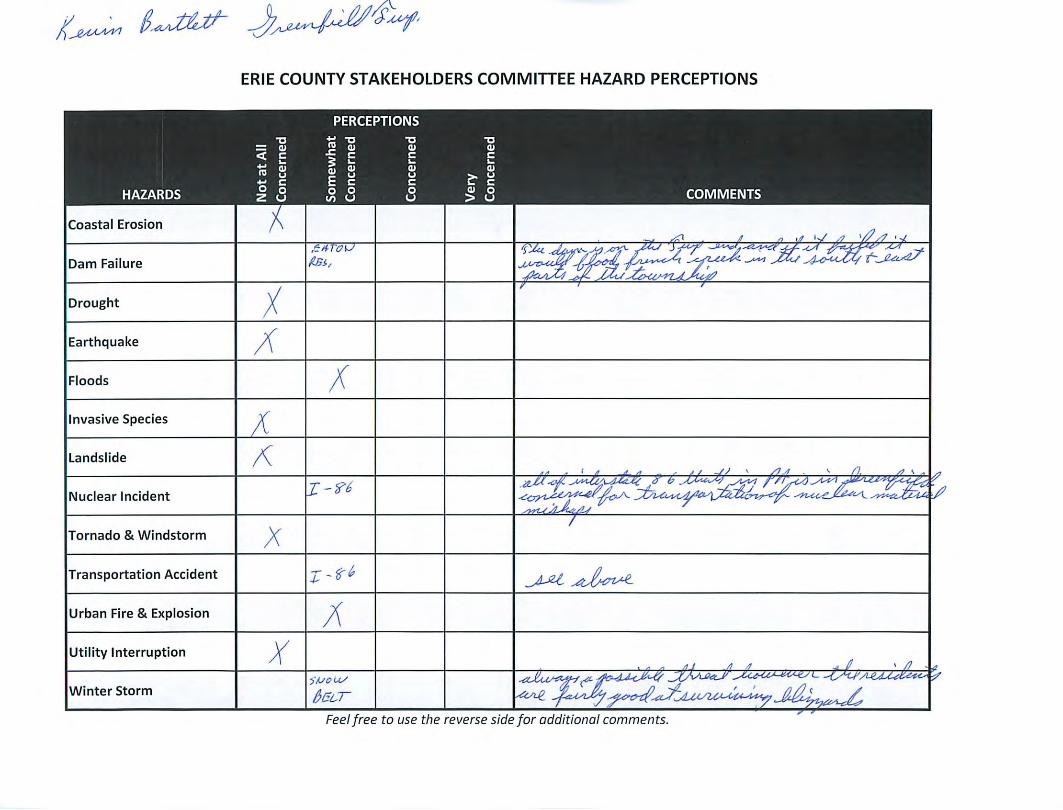
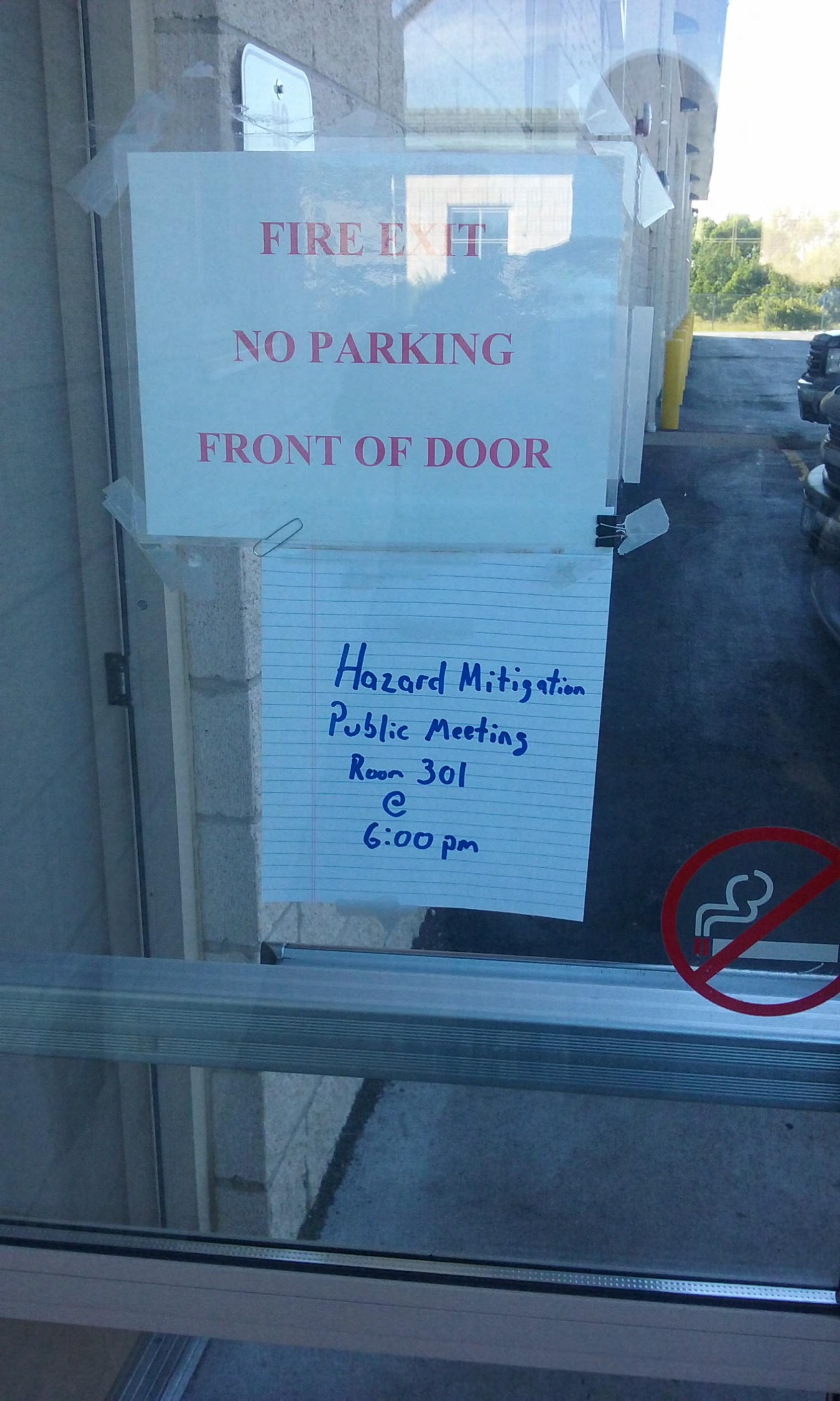
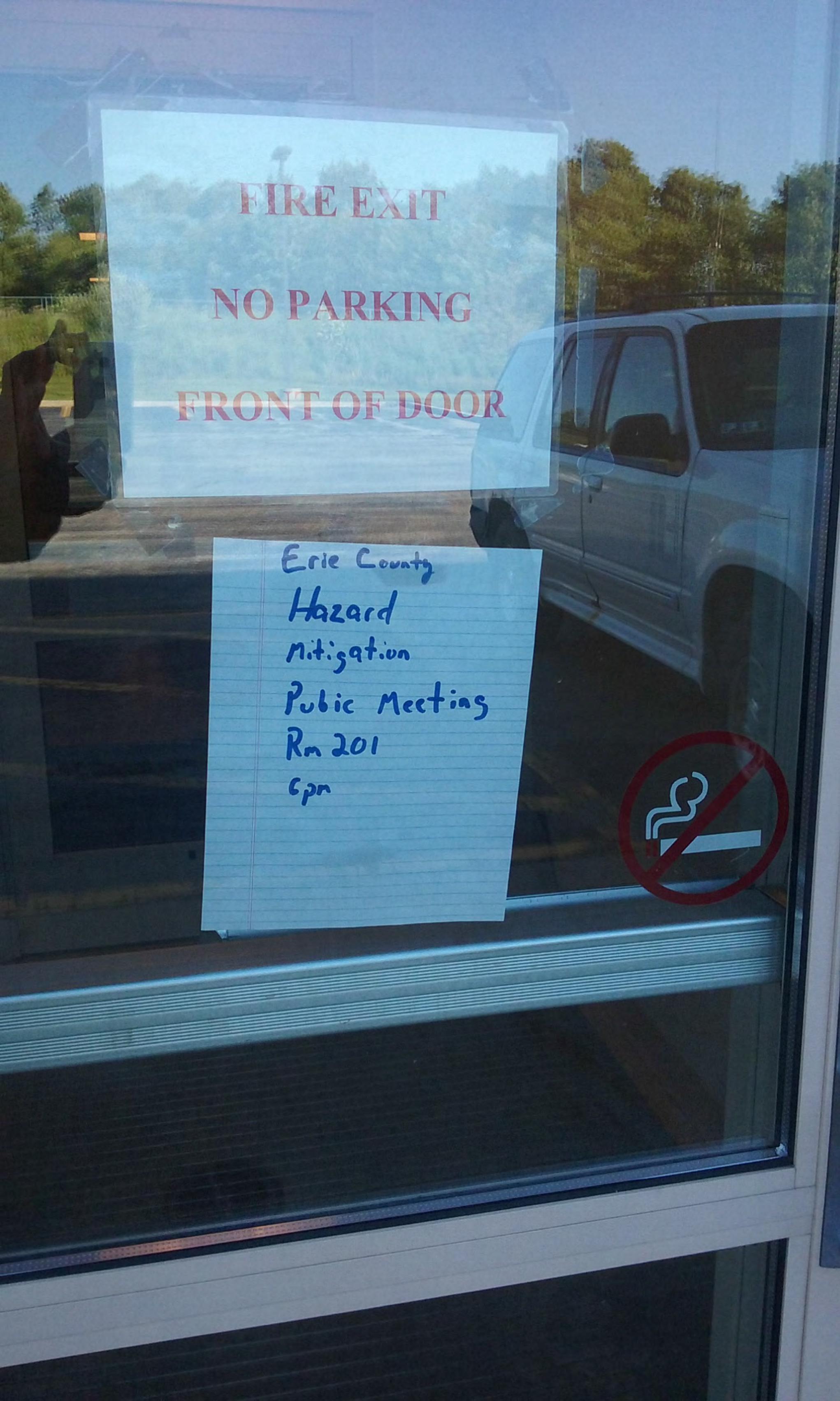
Erie County Department of Public Safety Links
Calendar
2880 Flower Rd. Erie PA, 16509 Phone: (814) County Press Release & News
Hazard Mitigation Plan Update Public Meeting - 07/20/17
Erie County Receieves Storm Ready Designation
Erie County Unveils New Spill Response Trailers
New Dispatch Console System at Public Safety
Telecommunicators are "first first responders"
Erie Times 911 Center Video
NWPAERG Regional Emergency Notification System Self-Registration Portal
Next Generation Radio System - Project Update 06/21/17
MISSION
Provide for the safety and welfare of the public through the preservation of life, health, property, economy, environment, and contingovernment.
Public Safety LEPC Fire Contact
Advisory Committee Photo Archives
Purpose
Provide for the citizens, visitors, businesses, organizations and emergency responders of Erie County a comprehensive program of 9-1-1 / communications, emergency management, innovative technology systems and services through mitigation, preparedness, response, and recovery. The Department of Public Safety works closely with appropriate municipal, county, state, and federal agencies in order to carry out its mission.
Erie CouSafeTown
Registration
Autism form for inclusion in the Computer Aided Dispatch Syst
Special Needs form for inclusion in the Computer Aided Dispatch S
CUSTOMERS
• Residents of Erie County• 38 Municipalities of Erie County• Emergency Service Providers of Erie County• Schools, Civic and Public Service Organizations• Local business and industry• State, County and Local Officials• State and Federal Emergency Management Officials• Media Broadcast Stations
NGR Update
AUTHORITY
• Pennsylvania Emergency Services Code, 35 Pa. C.S.• 4 PA Code Chapter 120b Public Safety Emergency
Telephone Act.• 4 PA Code Chapter 120c Training and Certification
Standards.• 4 PA Code Chapter 120d Performance Review and
Quality Assurance Standards• Pennsylvania Public Utilities Commission.• Erie County Administrative Code as revised and reenacted
November 1, 2007, Section 11, “Department of Public Safety".
• Erie County Directives, Policies and Procedures
∠ July 2017 ∠
Get weekly updates to this calendar: Subs
Sunday Monday Tuesday WednesdayThursdayFriday Sa
25+1 event 26+1 event 27 28 29 30 +1
2 3 4 5 6 7 +1
RESPONSIBILITIES AND SERVICES
• Provide emergency and non-emergency public safety (9-1-1) call taking and dispatch services to the citizens and visitors of Erie County.
• Provide individual and organizational training programs for public safety telecommunications staff and emergency service providers to ensure prompt, efficient, and effective disaster emergency services and response, in compliance with applicable Pennsylvania State Laws and Regulations.
• Provide Quality Assurance / Quality Management programs to ensure the services provided meet and/or exceed the highest standard of customer service to the citizens and visitors of Erie County.
• Provide Public Education programs to the Erie Community to help educate the citizens on the resources and services provided by the Public Safety Department to include 9-1-1, Emergency Management, Hazardous Materials Response and Special Teams.
• Provide programs and services to the citizens of Erie County, such as:
◦ Safe Town "Household Profiles," a quick, easy and secure way to provide critical information about your home and family to the people who can provide emergency services to you and your family.
◦ Public Alert Siren System – An all-hazard alert (siren) system used to warn the general population of potential danger.
• Cooperate and collaborate with Local, State, and Federal Government Officials / Organizations to provide the highest standard of customer service as it pertains to emergency services and communications
TRENDS IN USE OF SERVICES
• Continued participation (direct involvement) as a member of the Legislative Government Affairs Committee as it relates to the legislative re-write of the Pennsylvania Emergency Services Code, 35 Pa. C.S.
• Enhancement of staff expertise and competency levels.• Continuation of the consolidation of countywide
emergency communications services.• Implementation of Next Generation Public Safety Radio
System (APCO P25 Phase II Trunked UHF Simulcast Repeated Radio System) to provide reliable, interoperable communications among Emergency Service Providers on a common frequency that meets or exceeds National Industry Standards with consideration given to include Public Transportation, Public Works, School Districts, etc.
• Continued participation in the Regional Shared Services Assessment
• Establish redundancy of the Erie County Public Safety Answering Point (PSAP) / Dispatch Center among other County PSAPs with a regional approach, eliminating the need for a physical redundant center located in Erie County in the event of an evacuation or catastrophic failure.
• Maintain current on emerging technology / systems (i.e. Next Generation 9-1-1), offering the most advanced services such as "Text-to-911, Photos, Streaming Video, Telematics, etc.
• Establish a centralized record management system for all County Law Enforcement Agencies, a central repository of crime data; sharing information across jurisdictional boundaries; crime mapping; outstanding warrants, etc.
• Remain current on geo-referenced, aerial, oblique image libraries and software (Pictometry) that are incorporated with the Computer-aided Dispatch (CAD) and Geographic Information System (GIS) software. These software resources are utilized 24/7 to provide a fast response to emergencies that threaten the lives and property of citizens of Erie County.
GOALS
• Continue to improve the operational capabilities of the Community Emergency Response Team to support Search & Rescue, Hazardous Materials, Medical, Logistical and Emergency Operations Center activities.
• Improve the operational capabilities of the county animal response team. Specifically the areas of recruitment/retention, public education and pet sheltering.
• In cooperation with municipal governments and local fire departments, establish a consolidated specialized technical rescue team with confined space, trench, high angle, collapse, hazardous materials, and water rescue capabilities.
• Obtain a comprehensive, independent report that includes short, intermediate, and long term goals with best practice recommendations to enhance the emergency management program.
• Develop a rail safety (all hazard) plan for emergency preparedness to potential incidents and identify associated risk(s) to the community.
• Continue to build a “stop gap” cache of equipment and supplies to meet the immediate response needs of the County.
• Re-organize the County Emergency Operations Center Staff positions.
• Implement an on-line damage reporting system for use by the public for reporting damages to municipal and county governments.
• Assist and support the voluntary regionalization of municipal emergency management.
• Expand the use of Knowledge Center within the County.• Work with various community groups to develop and
promote “community resiliency” initiatives.• Update the County Hazard Mitigation Plan.
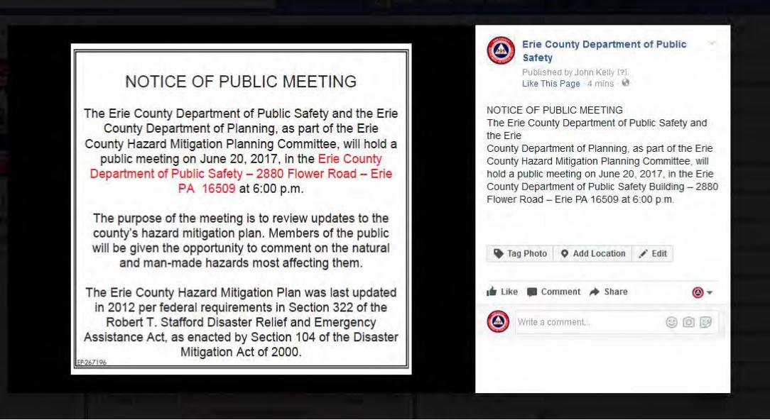
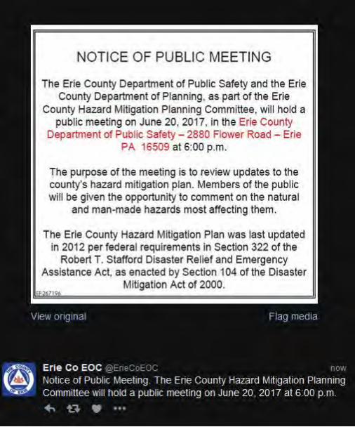
Hazard Mitigation Plan Committee Meeting The effective period of Erie County’s current Multi-Jurisdictional All-Hazards Mitigation Plan will end in December of 2017. Formally adopted by the county’s 37 of the County’s political subdivisions in 2012, Section 322 of the Robert T. Stafford Disaster Relief and Emergency Assistance Act requires the plan be updated every five years if covered communities are to remain eligible to receive funding under FEMA’s mitigation grant programs. To ensure the continued countywide scope and application of our plan, we are respectfully seeking official representation from your jurisdiction to assist in the update process. The person(s) selected should be familiar with Erie County’s risks/vulnerabilities and able to help develop mitigation strategies and projects for inclusion in the revised plan. The first update committee meeting is scheduled for Thursday, October 27, 2016 at the Erie County Department of Public Safety, 2880 Flower Rd., Erie, Pa 16509. The meeting, which will be facilitated by JH Consulting, LLC, will begin at 10:00 a.m. In order to make it as convenient as possible for jurisdictions to attend, we will hold two meetings on October 27th. The second meeting will begin at 6:00 p.m. The goal of the meeting will be to kick-off the project as well as discuss existing mitigation strategies, their status, thoughts on countywide risks, and to outline committee member responsibilities. Additional planning committee meetings will be scheduled in early 2017. Thank you, in advance, for your help with this important initiative. Once chosen, please have your representative contact me via email at [email protected] by October 21st so they may be added to the update committee roster.
Kathy Dahlkemper County Executive
John R. Grappy Director of Public Safety
COUNTY OF ERIE
Department of Public Safety
2880 Flower Road Erie, PA 16509
Office (814) 451-7920 ● Fax (814) 451-7930 Web Site: www.ecdops.org
MEMORANDUM – INVITATION To: Municipal Officials From: Brian Mesaros, Assistant Emergency Management Coordinator Date: April 12, 2017 Re: Hazard Mitigation Plan Update – Mitigation Projects In the fall of 2016, we began the process of updating Erie County’s multi-jurisdictional hazard mitigation plan. We met with representatives from the county’s thirty-eight (38) political subdivisions in October 2016 to discuss the various risks and vulnerabilities faced by the county. The second committee meeting will be facilitated by JH Consulting, LLC, and has been scheduled for Tuesday, May 2, 2017 at the Department of Public Safety, 2880 Flower Road, Erie, PA 16509. In order to make it as convenient as possible for jurisdictions to attend, we will hold two separate meetings on May 2nd. The morning meeting will begin at 09:00 AM, and the evening meeting will begin at 6:00 p.m. The goal of the meeting will be to discuss mitigation projects for your jurisdiction. You should be prepared to discuss and/or provide comment on the status of the projects included in the 2012 hazard mitigation plan. As a reminder, the effective period of Erie County’s current Multi-Jurisdictional All-Hazards Mitigation Plan will end in December of 2017; formally adopted by the county’s thirty-eight (38) political subdivisions in 2012. Section 322 of the Robert T. Stafford Disaster Relief and Emergency Assistance Act requires the plan be updated every five (5) years if covered communities are to remain eligible to receive funding under FEMA’s mitigation grant programs. Please plan to attend one of the two meetings. If you are unable to attend, please feel free to send a representative. Your representative should be able to help develop mitigation strategies and projects for inclusion in the revised plan. Thank you, in advance, for your continued support of this important initiative. Should you have any questions, please do not hesitate to contact me at my office or via email at [email protected].
Kathy Dahlkemper County Executive
John R. Grappy Director of Public Safety
COUNTY OF ERIE
Department of Public Safety 2880 Flower Road Erie, PA 16509
Office (814) 451-7920 ● Fax (814) 451-7930 Web Site: www.eriecountypa.gov
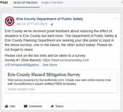
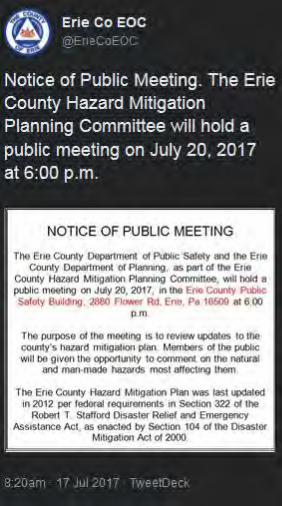

Erie CountyHazard Mitigation Plan
2017 Update
Public Meeting – Erie, PA
20 June 2017

Agenda
• ‘Hazard Mitigation’ Overview
• Risk vs. Vulnerability• Erie County Hazard Mitigation Plan Overview• Activity• Discussion

‘Hazard Mitigation’ Overview
• Hazard mitigation is the effort to reduce loss of life and property by lessening the impact of disasters.
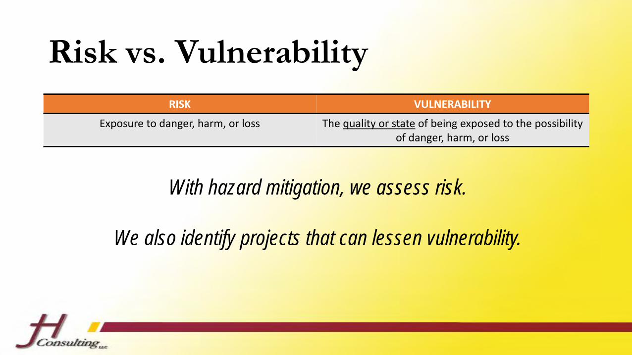
Risk vs. Vulnerability
RISK VULNERABILITY
Exposure to danger, harm, or loss The quality or state of being exposed to the possibility of danger, harm, or loss
With hazard mitigation, we assess risk.
We also identify projects that can lessen vulnerability.
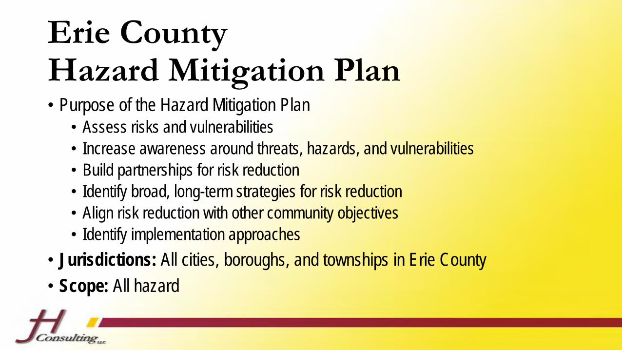
Erie CountyHazard Mitigation Plan• Purpose of the Hazard Mitigation Plan
• Assess risks and vulnerabilities• Increase awareness around threats, hazards, and vulnerabilities• Build partnerships for risk reduction• Identify broad, long-term strategies for risk reduction• Align risk reduction with other community objectives• Identify implementation approaches
• Jurisdictions: All cities, boroughs, and townships in Erie County
• Scope: All hazard
Activity
• Select three hazards.
• Break into three groups.
• Take 10 minutes and brainstorm the topic assigned to your group.• Designate a spokesperson.• Summarize your group’s discussion.
RISKS CHALLENGESPROJECTS

General Discussion
Erie CountyHazard Mitigation Plan
2017 Update
Public Meeting – Erie, PA
19 July 2017
Agenda
• ‘Hazard Mitigation’ Overview
• Risk vs. Vulnerability• Erie County Hazard Mitigation Plan Overview• Activity• Discussion
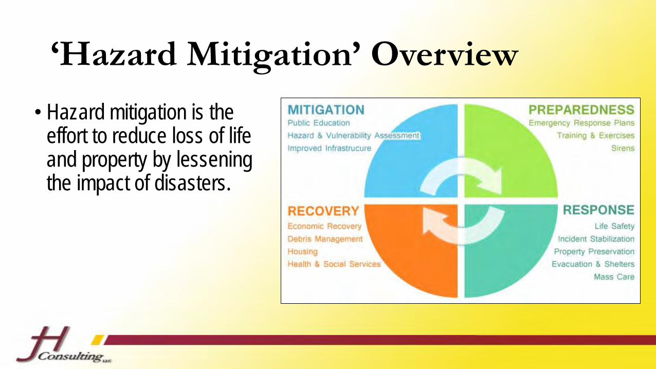
‘Hazard Mitigation’ Overview
• Hazard mitigation is the effort to reduce loss of life and property by lessening the impact of disasters.

Risk vs. Vulnerability
RISK VULNERABILITY
Exposure to danger, harm, or loss The quality or state of being exposed to the possibility of danger, harm, or loss
With hazard mitigation, we assess risk.
We also identify projects that can lessen vulnerability.

Erie CountyHazard Mitigation Plan• Purpose of the Hazard Mitigation Plan
• Assess risks and vulnerabilities• Increase awareness around threats, hazards, and vulnerabilities• Build partnerships for risk reduction• Identify broad, long-term strategies for risk reduction• Align risk reduction with other community objectives• Identify implementation approaches
• Jurisdictions: All cities, boroughs, and townships in Erie County
• Scope: All hazard

Activity
• Select three hazards.
• Break into three groups.
• Take 10 minutes and brainstorm the topic assigned to your group.• Designate a spokesperson.• Summarize your group’s discussion.
RISKS CHALLENGESPROJECTS

General Discussion
Erie CountyHazard Mitigation Plan
2017 Update
Presentation at the Erie County Resiliency Workshop – Erie, PA
19 July 2017
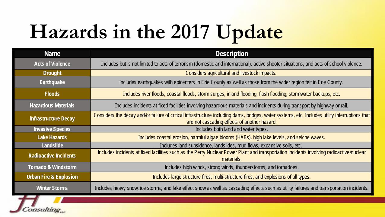
Hazards in the 2017 UpdateName Description
Acts of Violence Includes but is not limited to acts of terrorism (domestic and international), active shooter situations, and acts of school violence.
Drought Considers agricultural and livestock impacts.
Earthquake Includes earthquakes with epicenters in Erie County as well as those from the wider region felt in Erie County.
Floods Includes river floods, coastal floods, storm surges, inland flooding, flash flooding, stormwater backups, etc.
Hazardous Materials Includes incidents at fixed facilities involving hazardous materials and incidents during transport by highway or rail.
Infrastructure DecayConsiders the decay and/or failure of critical infrastructure including dams, bridges, water systems, etc. Includes utility interruptions that
are not cascading effects of another hazard.Invasive Species Includes both land and water types.
Lake Hazards Includes coastal erosion, harmful algae blooms (HABs), high lake levels, and seiche waves.
Landslide Includes land subsidence, landslides, mud flows, expansive soils, etc.
Radioactive IncidentsIncludes incidents at fixed facilities such as the Perry Nuclear Power Plant and transportation incidents involving radioactive/nuclear
materials.
Tornado & Windstorm Includes high winds, strong winds, thunderstorms, and tornadoes.
Urban Fire & Explosion Includes large structure fires, multi-structure fires, and explosions of all types.
Winter Storms Includes heavy snow, ice storms, and lake effect snow as well as cascading effects such as utility failures and transportation incidents.

Goals & Objectives
GOAL (Big Picture, Stretch Item)
OBJECTIVE (More Specific, Organizational) OBJECTIVE (More Specific, Organizational)
STRATEGY / ACTION / PROJECT
STRATEGY / ACTION / PROJECT
STRATEGY / ACTION / PROJECT
STRATEGY / ACTION / PROJECT
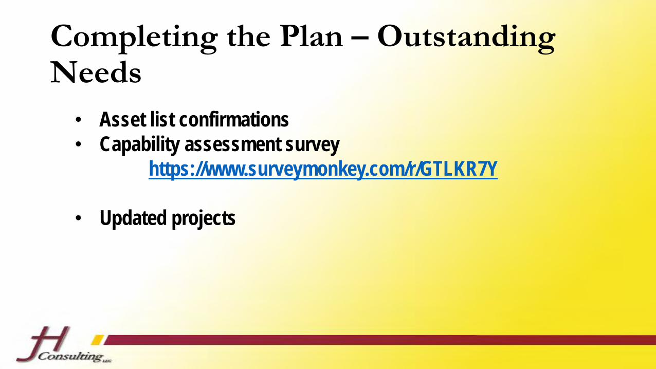
Completing the Plan – Outstanding Needs
• Asset list confirmations• Capability assessment survey
https://www.surveymonkey.com/r/GTLKR7Y
• Updated projects
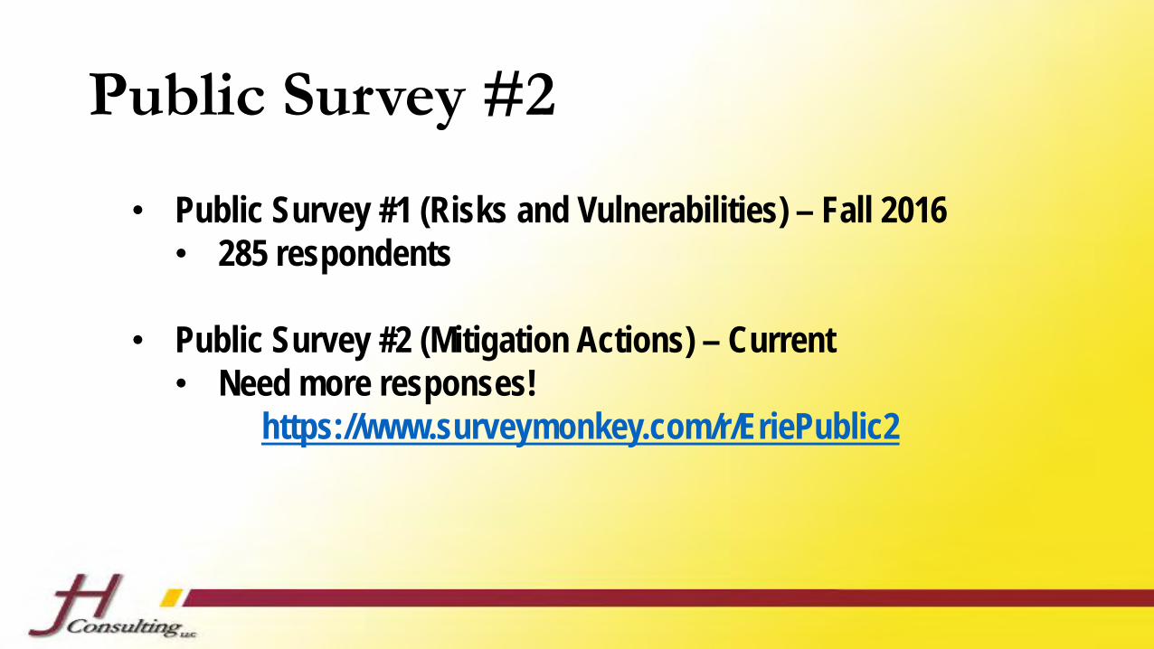
Public Survey #2
• Public Survey #1 (Risks and Vulnerabilities) – Fall 2016• 285 respondents
• Public Survey #2 (Mitigation Actions) – Current • Need more responses!
https://www.surveymonkey.com/r/EriePublic2

General Discussion
Erie County Multi-Jurisdictional Hazard Mitigation Plan
2017 Update
Planning Meeting #1
October 27, 2016 ~ 10:00 a.m. & 6:00 p.m.

Agenda1. Welcome & Introductions
2. Overview of the Hazard Mitigation Process
3. Hazard Review
– Hazards in the Existing Plan
– Hazards to Add?
– Committee Member Homework!
4. Preparation for Next Stakeholder Committee Meeting
– Discussion of Date
– Introduction: Asset Inventorying
5. Q&A
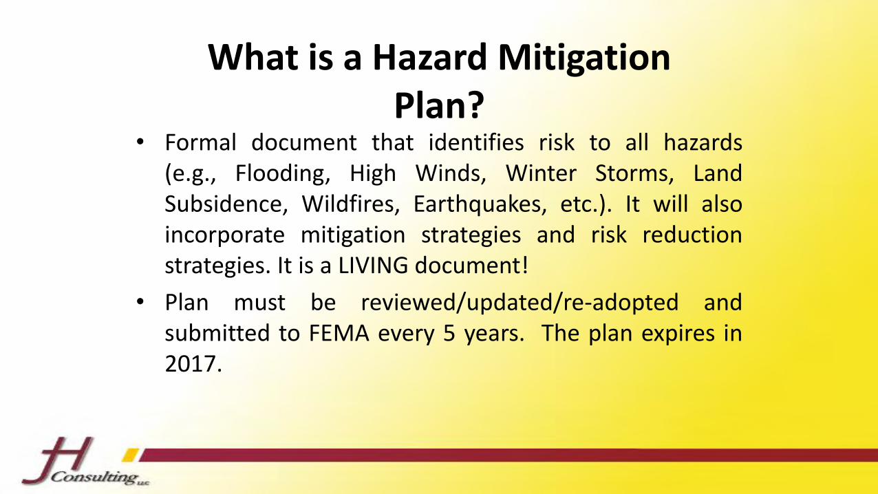
What is a Hazard Mitigation Plan?
• Formal document that identifies risk to all hazards(e.g., Flooding, High Winds, Winter Storms, LandSubsidence, Wildfires, Earthquakes, etc.). It will alsoincorporate mitigation strategies and risk reductionstrategies. It is a LIVING document!
• Plan must be reviewed/updated/re-adopted andsubmitted to FEMA every 5 years. The plan expires in2017.

Hazard Mitigation Planning Process
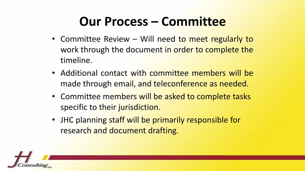
Our Process – Committee • Committee Review – Will need to meet regularly to
work through the document in order to complete thetimeline.
• Additional contact with committee members will bemade through email, and teleconference as needed.
• Committee members will be asked to complete tasks specific to their jurisdiction.
• JHC planning staff will be primarily responsible for research and document drafting.
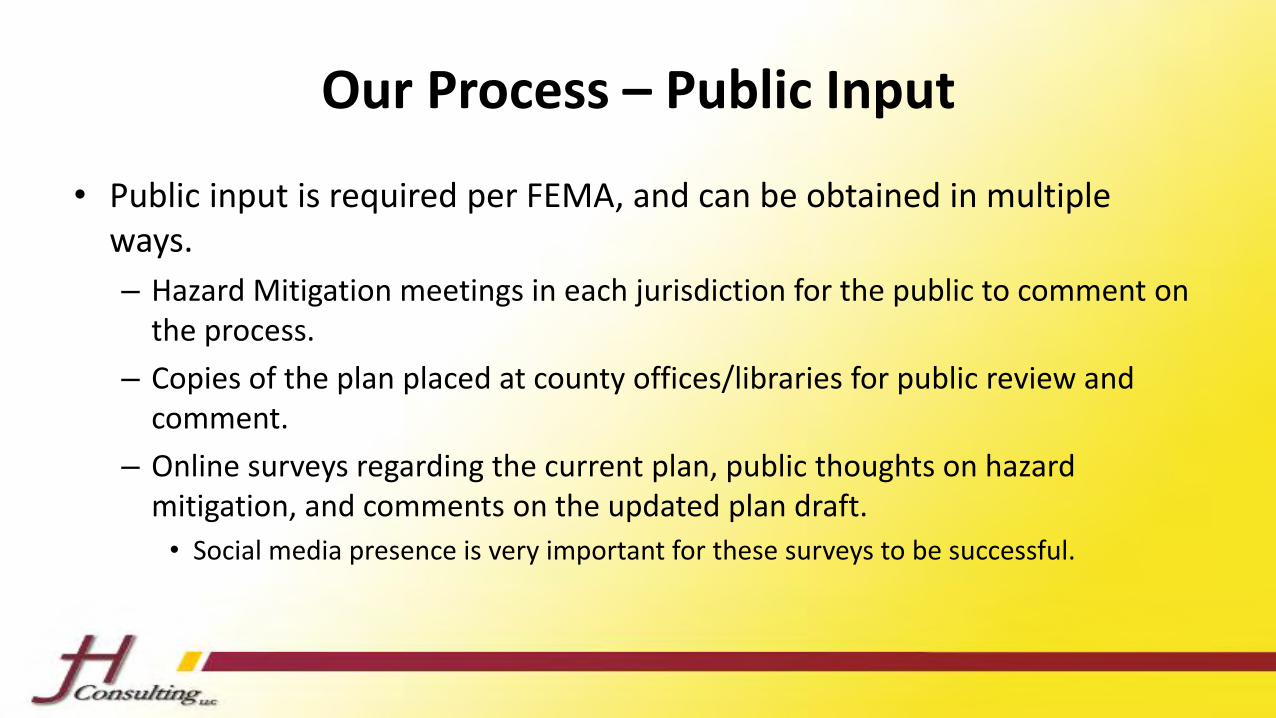
Our Process – Public Input
• Public input is required per FEMA, and can be obtained in multiple ways.
– Hazard Mitigation meetings in each jurisdiction for the public to comment on the process.
– Copies of the plan placed at county offices/libraries for public review and comment.
– Online surveys regarding the current plan, public thoughts on hazard mitigation, and comments on the updated plan draft.
• Social media presence is very important for these surveys to be successful.
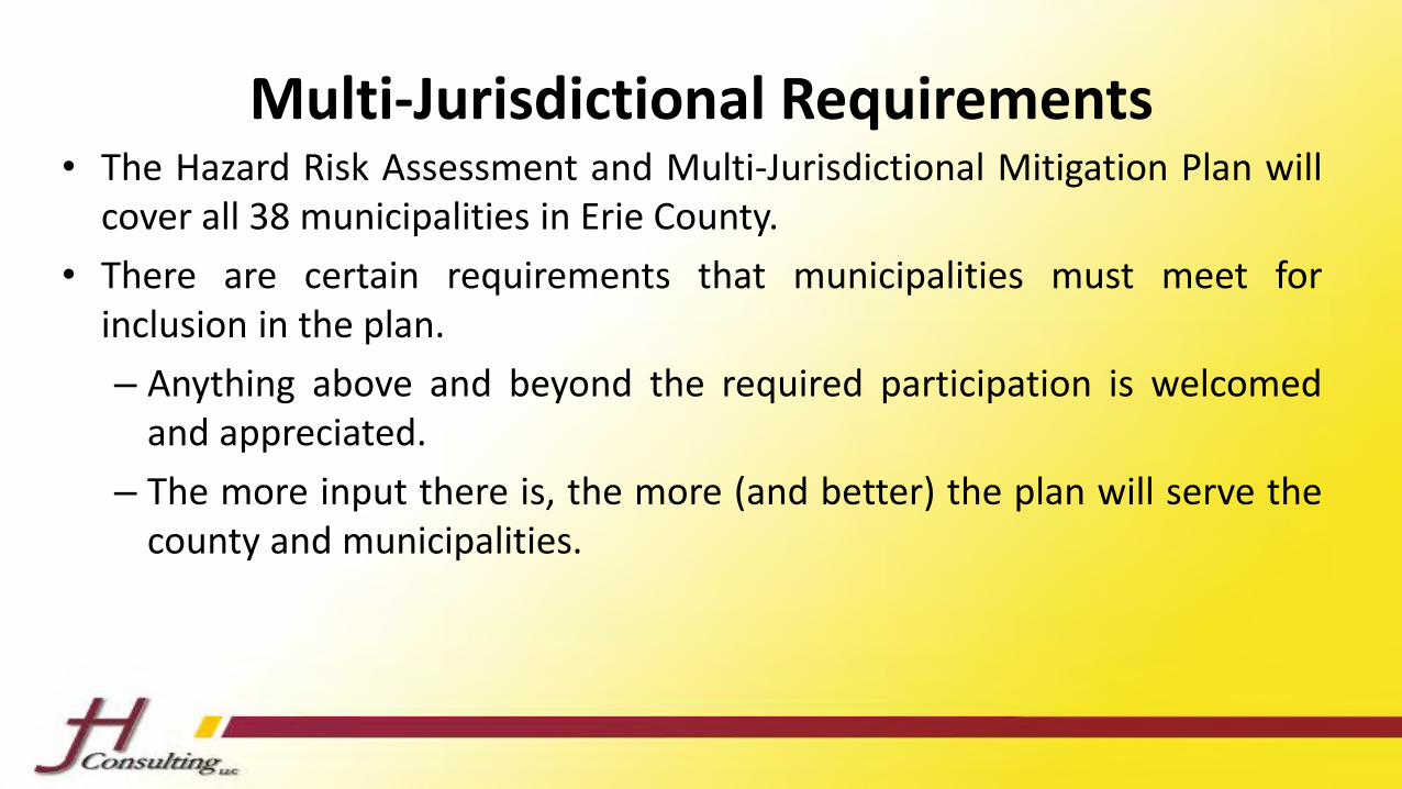
Multi-Jurisdictional Requirements• The Hazard Risk Assessment and Multi-Jurisdictional Mitigation Plan will
cover all 38 municipalities in Erie County.
• There are certain requirements that municipalities must meet forinclusion in the plan.
– Anything above and beyond the required participation is welcomedand appreciated.
– The more input there is, the more (and better) the plan will serve thecounty and municipalities.
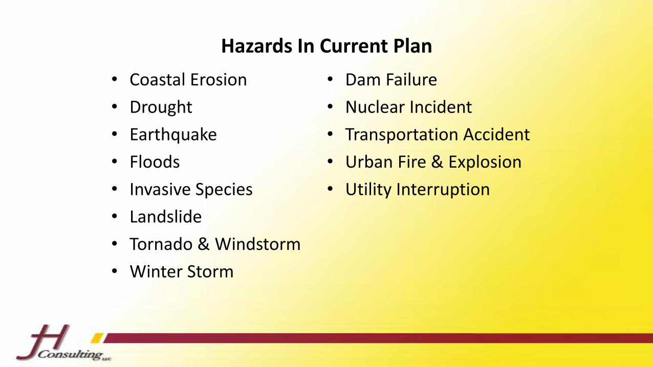
Hazards In Current Plan
• Coastal Erosion
• Drought
• Earthquake
• Floods
• Invasive Species
• Landslide
• Tornado & Windstorm
• Winter Storm
• Dam Failure
• Nuclear Incident
• Transportation Accident
• Urban Fire & Explosion
• Utility Interruption
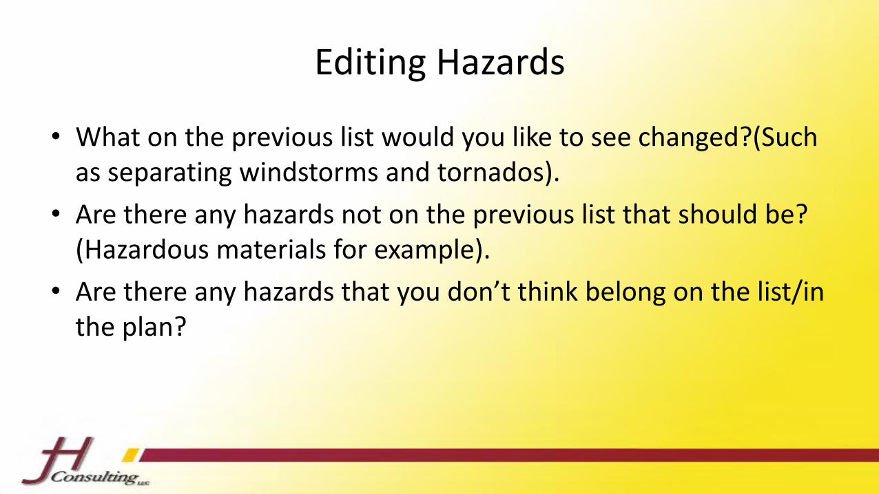
Editing Hazards
• What on the previous list would you like to see changed?(Such as separating windstorms and tornados).
• Are there any hazards not on the previous list that should be? (Hazardous materials for example).
• Are there any hazards that you don’t think belong on the list/in the plan?
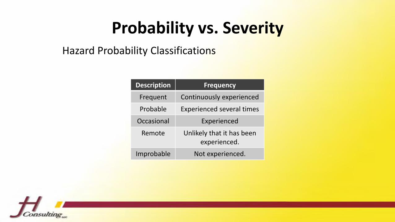
Probability vs. Severity
Description Frequency
Frequent Continuously experienced
Probable Experienced several times
Occasional Experienced
Remote Unlikely that it has been experienced.
Improbable Not experienced.
Hazard Probability Classifications
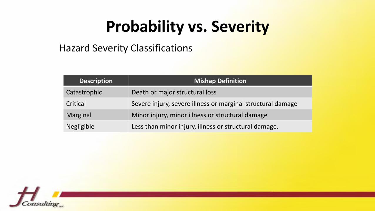
Probability vs. Severity
Description Mishap Definition
Catastrophic Death or major structural loss
Critical Severe injury, severe illness or marginal structural damage
Marginal Minor injury, minor illness or structural damage
Negligible Less than minor injury, illness or structural damage.
Hazard Severity Classifications
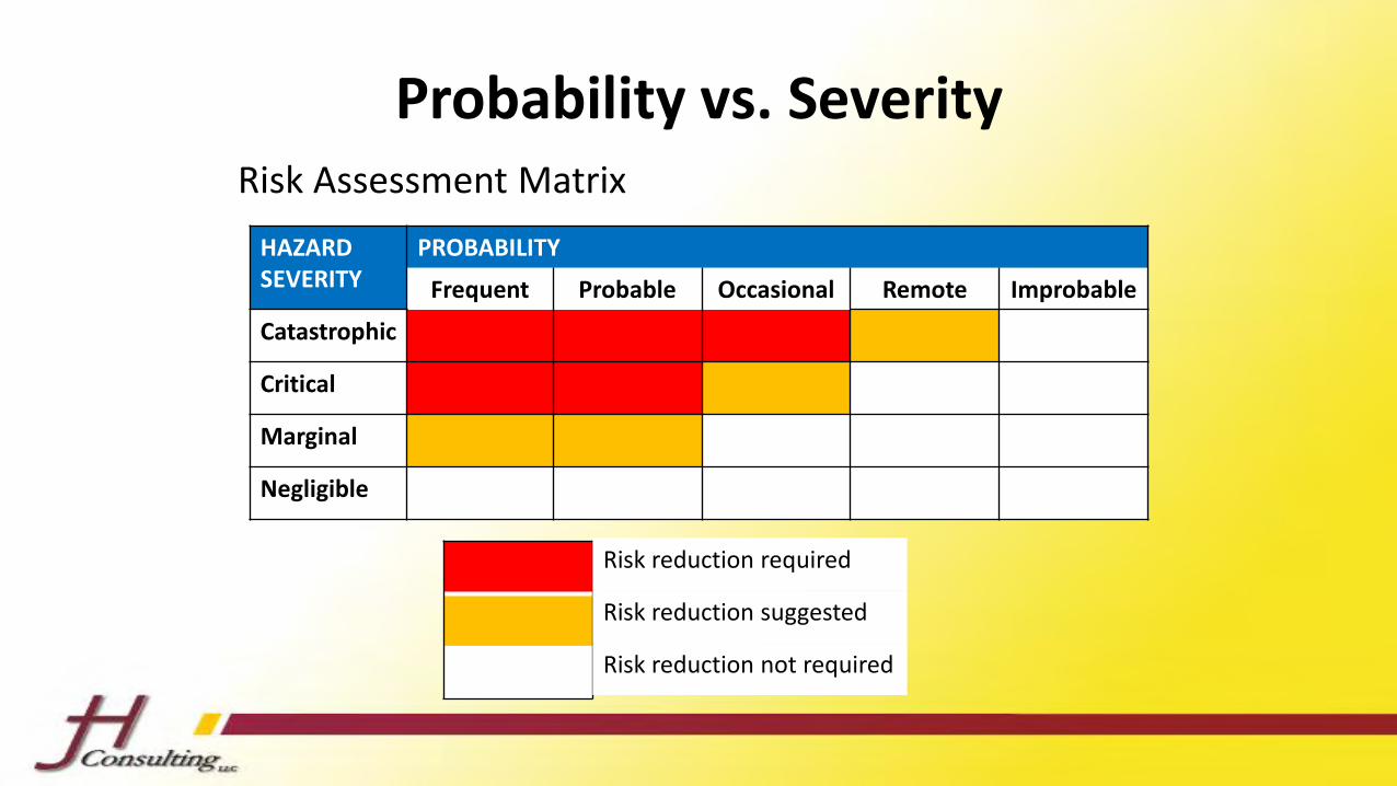
Probability vs. Severity
HAZARDSEVERITY
PROBABILITY
Frequent Probable Occasional Remote Improbable
Catastrophic
Critical
Marginal
Negligible
Risk Assessment Matrix
Risk reduction required
Risk reduction suggested
Risk reduction not required
Worksheet
• Please fill out the worksheet that has been distributed. This will allow us to see what the perception of vulnerability is in Erie County for the hazards discussed earlier.
• Please leave this worksheet behind after the meeting for us to collect.
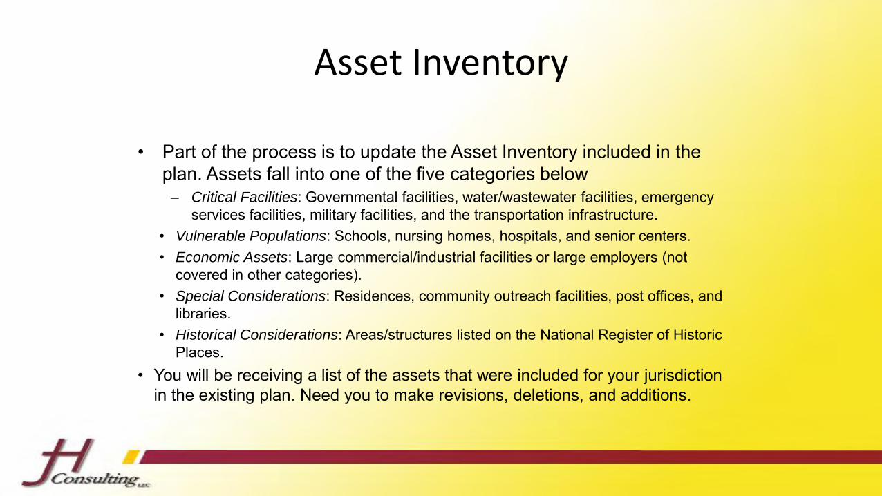
Asset Inventory
• Part of the process is to update the Asset Inventory included in the plan. Assets fall into one of the five categories below
– Critical Facilities: Governmental facilities, water/wastewater facilities, emergency services facilities, military facilities, and the transportation infrastructure.
• Vulnerable Populations: Schools, nursing homes, hospitals, and senior centers.• Economic Assets: Large commercial/industrial facilities or large employers (not
covered in other categories).• Special Considerations: Residences, community outreach facilities, post offices, and
libraries.• Historical Considerations: Areas/structures listed on the National Register of Historic
Places.• You will be receiving a list of the assets that were included for your jurisdiction
in the existing plan. Need you to make revisions, deletions, and additions.

Municipal Committee Member Homework• Asset Inventory Pages
– Confirm
– Add
– Delete
• Project Discussions
– Lists will be emailed out
– Note projects for:
• Status
• Narrative explanation of the status.

Adjournment
• Thanks for your input!
• Look for survey links and asset inventories to be sent out soon.
Erie County Multi-Jurisdictional Hazard Mitigation Plan
2017 Update
Planning Meeting #2
May 2, 2017 ~ 9:00 a.m. & 6:00 p.m.

Agenda1. Welcome & Introductions
2. Update: Where We Are in the Process
3. Existing Projects
– Distribute lists
– Status labels
– Status narratives
4. Mitigation Goals
– Overview and samples
– Activity: Determination of goals
5. New Projects
6. Q&A

Update: Where We Are in the Process
• Hazard Profiles
• Drafts under review by steering committee
• Drafts to be distributed to remaining committee members
• Asset Lists
• No asset lists returned from municipalities• If anyone has updated lists with them today, thank you!
• If you would like a printed list for your municipality, see one of us after themeeting.
• We will begin telephone follow-ups next week
Hazard Mitigation Planning Process
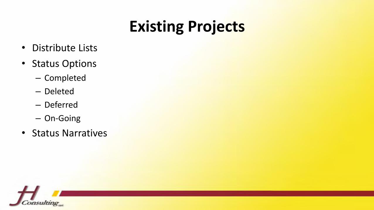
Existing Projects• Distribute Lists
• Status Options
– Completed
– Deleted
– Deferred
– On-Going
• Status Narratives
Existing Projects: Discussion• Who has undertaken traditional mitigation projects such as buy-
outs?
– Was the project started after 2012?
• Who has undertaken non-traditional mitigation projects?
– Example: Stormwater management and/or system upgrades
– Example: Educate the public about hazard mitigation
– Example: Safe rooms
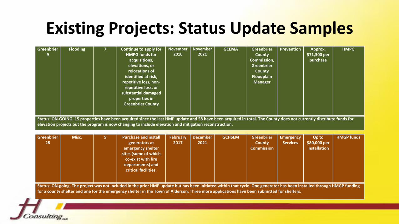
Existing Projects: Status Update SamplesGreenbrier
9Flooding 7 Continue to apply for
HMPG funds for acquisitions, elevations, or relocations of
identified at risk, repetitive loss, non-
repetitive loss, or substantial damaged
properties in Greenbrier County
November 2016
November 2021
GCEMA Greenbrier County
Commission, Greenbrier
County Floodplain Manager
Prevention Approx. $71,300 per
purchase
HMPG
Status: ON-GOING. 15 properties have been acquired since the last HMP update and 58 have been acquired in total. The County does not currently distribute funds for elevation projects but the program is now changing to include elevation and mitigation reconstruction.
Greenbrier 28
Misc. 5 Purchase and install generators at
emergency shelter sites (some of which
co-exist with fire departments) and critical facilities.
February 2017
December 2021
GCHSEM Greenbrier County
Commission
Emergency Services
Up to $80,000 per installation
HMGP funds
Status: ON-going. The project was not included in the prior HMP update but has been initiated within that cycle. One generator has been installed through HMGP funding for a county shelter and one for the emergency shelter in the Town of Alderson. Three more applications have been submitted for shelters.
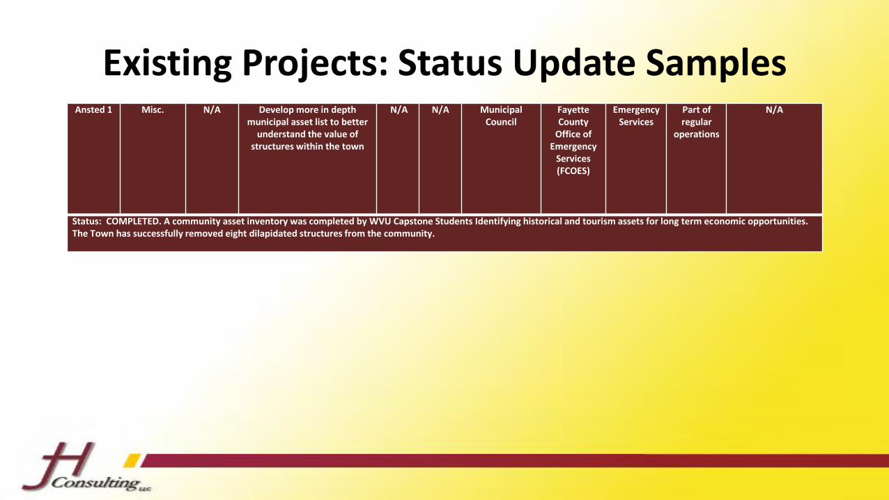
Existing Projects: Status Update SamplesAnsted 1 Misc. N/A Develop more in depth
municipal asset list to better understand the value of
structures within the town
N/A N/A Municipal Council
Fayette County
Office of Emergency
Services (FCOES)
Emergency Services
Part of regular
operations
N/A
Status: COMPLETED. A community asset inventory was completed by WVU Capstone Students Identifying historical and tourism assets for long term economic opportunities. The Town has successfully removed eight dilapidated structures from the community.
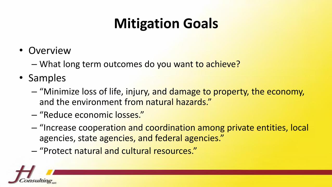
Mitigation Goals
• Overview– What long term outcomes do you want to achieve?
• Samples– “Minimize loss of life, injury, and damage to property, the economy,
and the environment from natural hazards.”
– “Reduce economic losses.”
– “Increase cooperation and coordination among private entities, local agencies, state agencies, and federal agencies.”
– “Protect natural and cultural resources.”
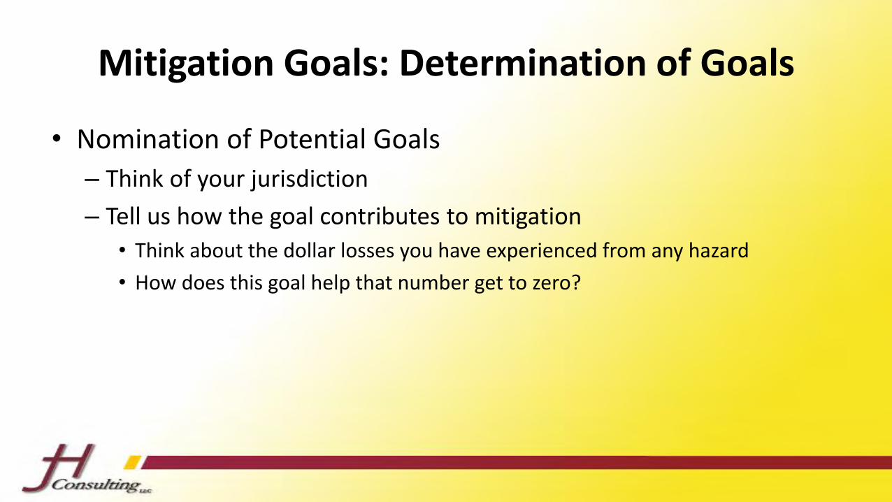
Mitigation Goals: Determination of Goals
• Nomination of Potential Goals
– Think of your jurisdiction
– Tell us how the goal contributes to mitigation
• Think about the dollar losses you have experienced from any hazard
• How does this goal help that number get to zero?
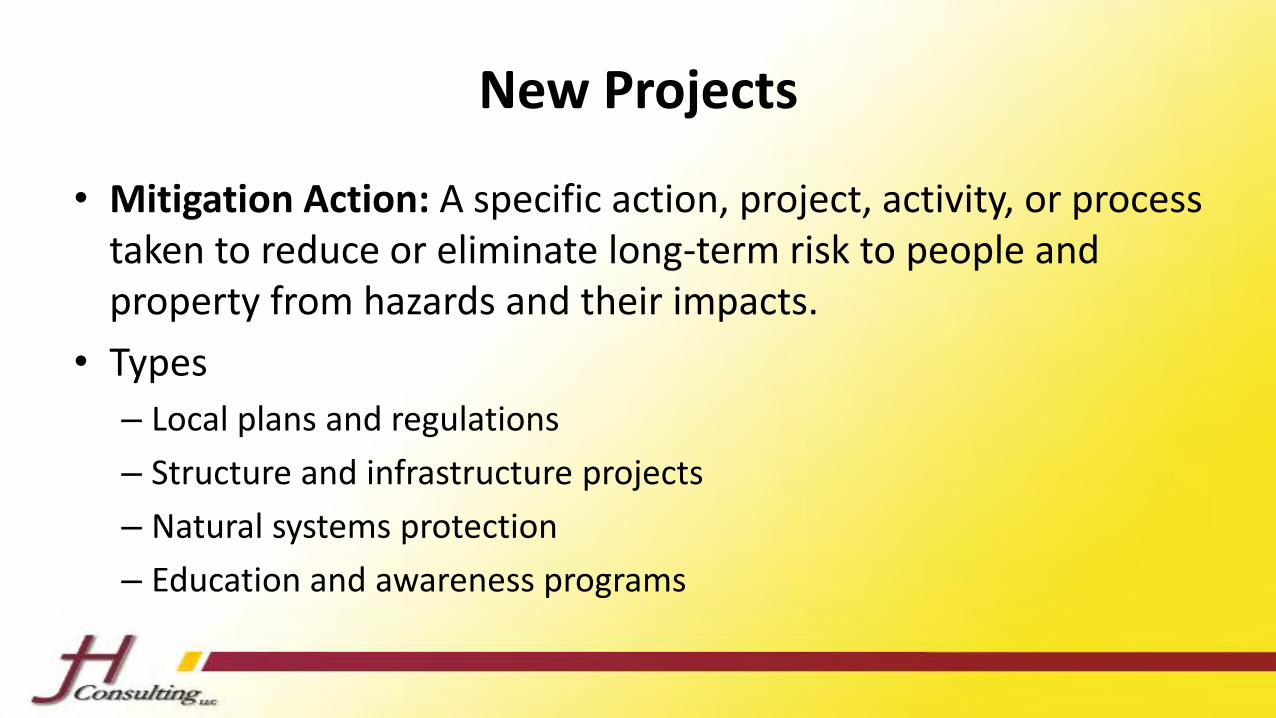
New Projects
• Mitigation Action: A specific action, project, activity, or process taken to reduce or eliminate long-term risk to people and property from hazards and their impacts.
• Types
– Local plans and regulations
– Structure and infrastructure projects
– Natural systems protection
– Education and awareness programs

New Projects
• We need to be able to align new projects with the goals we just worked to develop.

Moving Forward
• Capabilities Survey
• Future Meetings
– Project prioritization
– Draft review
• Final Review
• Approval and Adoption
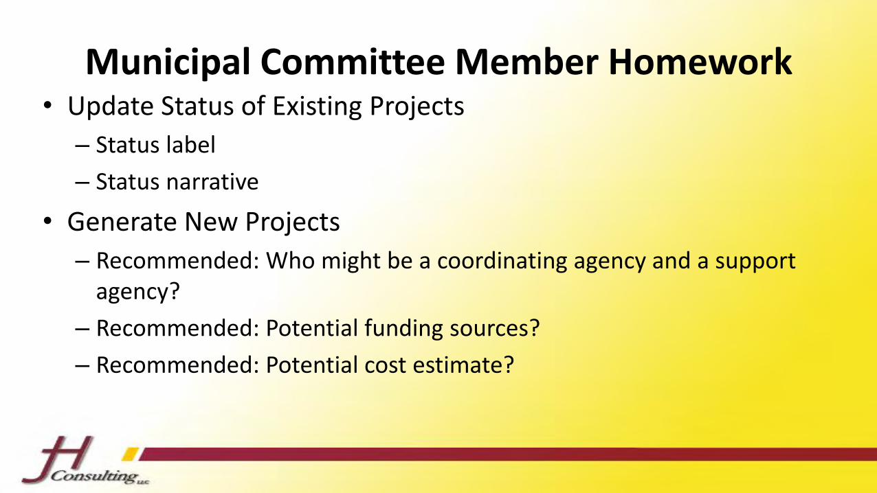
Municipal Committee Member Homework• Update Status of Existing Projects
– Status label
– Status narrative
• Generate New Projects
– Recommended: Who might be a coordinating agency and a support agency?
– Recommended: Potential funding sources?
– Recommended: Potential cost estimate?

Adjournment
• Thanks for your input!
• Look for capabilities survey links and draft profiles soon.
“FEMA’s mission is to support our citizens and first responders to ensure that as a nation we work together to build, sustain, and improve our capability to prepare for, protect against, respond to, recover from, and mitigate all hazards.”
Page 1 of 2
Fact SheetFederal Insurance and Mitigation Administration
LOCAL HAZARD MITIGATION PLANNING Hazard Mitigation Planning for Resilient Communities Disasters can cause loss of life; damage buildings and infrastructure; and have devastating consequences for a community’s economic, social, and environmental well-being. Hazard mitigation is the effort to reduce loss of life and property by lessening the impact of disasters. In other words, hazard mitigation keeps natural hazards from becoming natural disasters. Hazard mitigation is best accomplished when based on a comprehensive, long-term plan developed before a disaster strikes. Mitigation planning is the process used by state, tribal, and local leaders to understand risks from natural hazards and develop long-term strategies that will reduce the impacts of future events on people, property, and the environment.
The Local Mitigation Planning Process The mitigation plan is a community-driven, living document. The planning process itself is as important as the resulting plan because it encourages communities to integrate mitigation with day-to-day decision making regarding land use planning, floodplain management, site design, and other functions. Mitigation planning includes the following elements: Public Involvement – Planning creates a way to solicit and consider input from diverse interests, and promotes discussion about creating a safer, more disaster-resilient community. Involving stakeholders is essential to building community-wide support for the plan. In addition to emergency managers, the planning process involves other government agencies, businesses, civic groups, environmental groups, and schools. Risk Assessment – Mitigation plans identify the natural hazards and risks that can impact a community based on historical experience, estimate the potential frequency and magnitude of disasters, and assess potential losses to life and property. The risk assessment process provides a factual basis for the activities proposed in the mitigation strategy. Mitigation Strategy – Based on public input, identified risks, and available capabilities, communities develop mitigation goals and objectives as part of a strategy for mitigating hazard-related losses. The strategy is a community’s approach for implementing mitigation activities that are cost-effective, technically feasible, and environmentally sound as well as allowing strategic investment of limited resources.
Disaster Mitigation Act of 2000
The Robert T. Stafford Disaster Relief and Emergency Assistance Act, as amended by the Disaster Mitigation Act of 2000, is intended to “reduce the loss of life and property, human suffering, economic disruption, and disaster assistance costs resulting from natural disasters.” Under this legislation, state, tribal, and local governments must develop a hazard mitigation plan as a condition for receiving certain types of non-emergency disaster assistance through the Hazard Mitigation Assistance Programs. The regulatory requirements for local hazard mitigation plans can be found at Title 44 Code of Federal Regulations §201.6. For more information about FEMA’s Hazard Mitigation Assistance Grants, visit: www.fema.gov/hazard-mitigation-assistance.
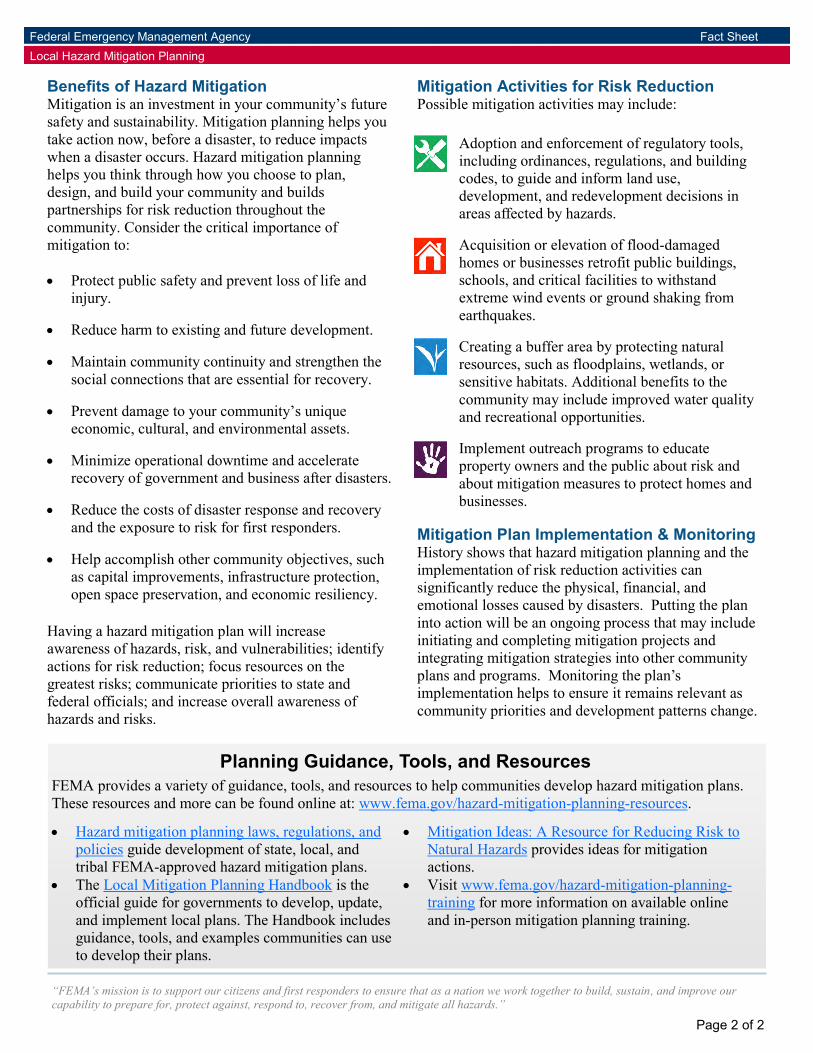
“FEMA’s mission is to support our citizens and first responders to ensure that as a nation we work together to build, sustain, and improve our capability to prepare for, protect against, respond to, recover from, and mitigate all hazards.”
Federal Emergency Management Agency Fact Sheet Local Hazard Mitigation Planning
Page 2 of 2
Benefits of Hazard Mitigation Mitigation is an investment in your community’s future safety and sustainability. Mitigation planning helps you take action now, before a disaster, to reduce impacts when a disaster occurs. Hazard mitigation planning helps you think through how you choose to plan, design, and build your community and builds partnerships for risk reduction throughout the community. Consider the critical importance of mitigation to: Protect public safety and prevent loss of life and
injury. Reduce harm to existing and future development. Maintain community continuity and strengthen the
social connections that are essential for recovery. Prevent damage to your community’s unique
economic, cultural, and environmental assets. Minimize operational downtime and accelerate
recovery of government and business after disasters. Reduce the costs of disaster response and recovery
and the exposure to risk for first responders.
Help accomplish other community objectives, such as capital improvements, infrastructure protection, open space preservation, and economic resiliency.
Having a hazard mitigation plan will increase awareness of hazards, risk, and vulnerabilities; identify actions for risk reduction; focus resources on the greatest risks; communicate priorities to state and federal officials; and increase overall awareness of hazards and risks.
Mitigation Activities for Risk Reduction Possible mitigation activities may include:
Adoption and enforcement of regulatory tools, including ordinances, regulations, and building codes, to guide and inform land use, development, and redevelopment decisions in areas affected by hazards. Acquisition or elevation of flood-damaged homes or businesses retrofit public buildings, schools, and critical facilities to withstand extreme wind events or ground shaking from earthquakes. Creating a buffer area by protecting natural resources, such as floodplains, wetlands, or sensitive habitats. Additional benefits to the community may include improved water quality and recreational opportunities. Implement outreach programs to educate property owners and the public about risk and about mitigation measures to protect homes and businesses.
Mitigation Plan Implementation & Monitoring History shows that hazard mitigation planning and the implementation of risk reduction activities can significantly reduce the physical, financial, and emotional losses caused by disasters. Putting the plan into action will be an ongoing process that may include initiating and completing mitigation projects and integrating mitigation strategies into other community plans and programs. Monitoring the plan’s implementation helps to ensure it remains relevant as community priorities and development patterns change.
Planning Guidance, Tools, and Resources FEMA provides a variety of guidance, tools, and resources to help communities develop hazard mitigation plans. These resources and more can be found online at: www.fema.gov/hazard-mitigation-planning-resources.
Hazard mitigation planning laws, regulations, and policies guide development of state, local, and tribal FEMA-approved hazard mitigation plans.
The Local Mitigation Planning Handbook is the Visit www.fema.gov/hazard-mitigation-planning-training for more information on available online and in-person mitigation planning training.
official guide for governments to develop, update, and implement local plans. The Handbook includes guidance, tools, and examples communities can use to develop their plans.
Mitigation Ideas: A Resource for Reducing Risk to Natural Hazards provides ideas for mitigation actions.
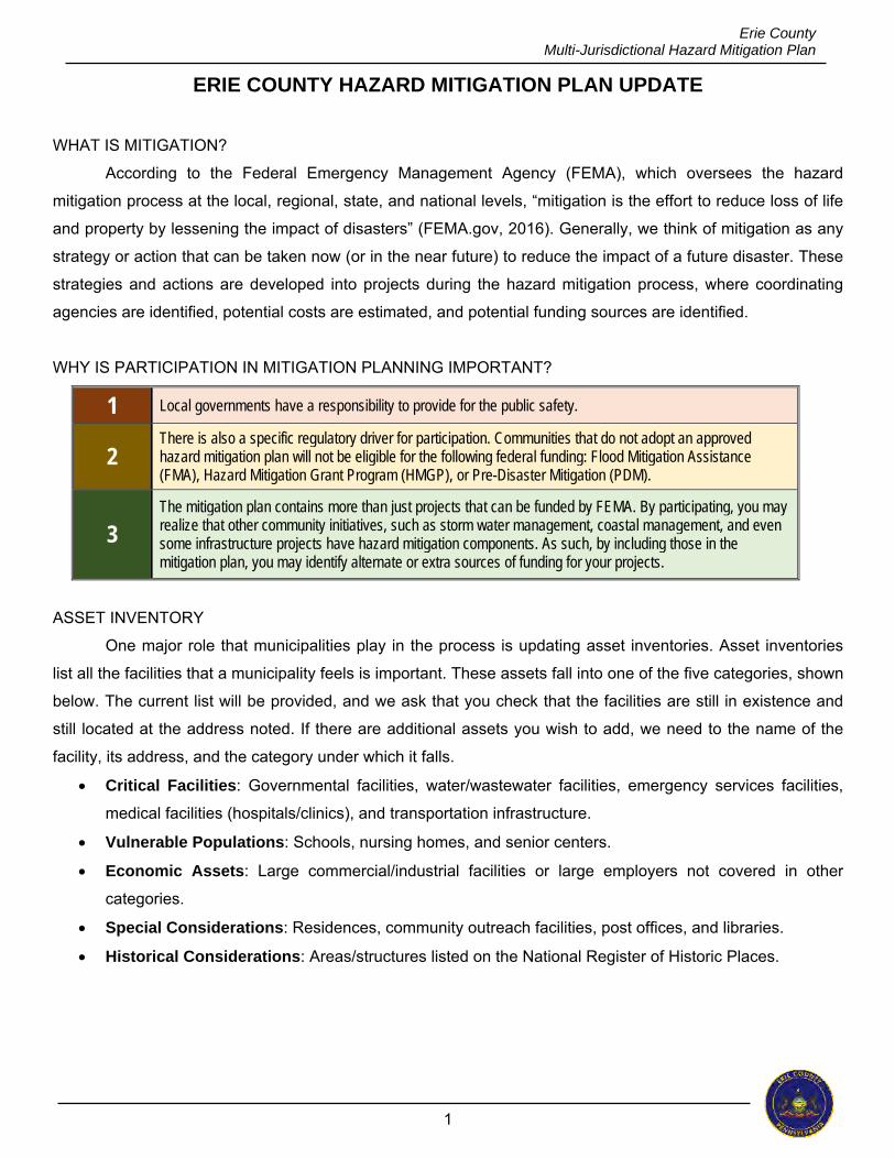
1
Erie County Multi-Jurisdictional Hazard Mitigation Plan
ERIE COUNTY HAZARD MITIGATION PLAN UPDATE
WHAT IS MITIGATION?
According to the Federal Emergency Management Agency (FEMA), which oversees the hazard
mitigation process at the local, regional, state, and national levels, “mitigation is the effort to reduce loss of life
and property by lessening the impact of disasters” (FEMA.gov, 2016). Generally, we think of mitigation as any
strategy or action that can be taken now (or in the near future) to reduce the impact of a future disaster. These
strategies and actions are developed into projects during the hazard mitigation process, where coordinating
agencies are identified, potential costs are estimated, and potential funding sources are identified.
WHY IS PARTICIPATION IN MITIGATION PLANNING IMPORTANT?
1 Local governments have a responsibility to provide for the public safety.
2 There is also a specific regulatory driver for participation. Communities that do not adopt an approved hazard mitigation plan will not be eligible for the following federal funding: Flood Mitigation Assistance (FMA), Hazard Mitigation Grant Program (HMGP), or Pre-Disaster Mitigation (PDM).
3 The mitigation plan contains more than just projects that can be funded by FEMA. By participating, you may realize that other community initiatives, such as storm water management, coastal management, and even some infrastructure projects have hazard mitigation components. As such, by including those in the mitigation plan, you may identify alternate or extra sources of funding for your projects.
ASSET INVENTORY
One major role that municipalities play in the process is updating asset inventories. Asset inventories
list all the facilities that a municipality feels is important. These assets fall into one of the five categories, shown
below. The current list will be provided, and we ask that you check that the facilities are still in existence and
still located at the address noted. If there are additional assets you wish to add, we need to the name of the
facility, its address, and the category under which it falls. Critical Facilities: Governmental facilities, water/wastewater facilities, emergency services facilities,
medical facilities (hospitals/clinics), and transportation infrastructure.
Vulnerable Populations: Schools, nursing homes, and senior centers.
Economic Assets: Large commercial/industrial facilities or large employers not covered in other
categories.
Special Considerations: Residences, community outreach facilities, post offices, and libraries.
Historical Considerations: Areas/structures listed on the National Register of Historic Places.
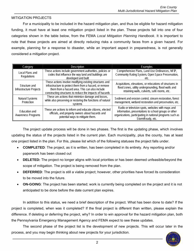
2
Erie County Multi-Jurisdictional Hazard Mitigation Plan
MITIGATION PROJECTS
For a municipality to be included in the hazard mitigation plan, and thus be eligible for hazard mitigation
funding, it must have at least one mitigation project listed in the plan. These projects fall into one of four
categories shown in the table below, from the FEMA Local Mitigation Planning Handbook. It is important to
note that these projects are aimed at directly reducing risks a community faces from a given hazard. For
example, planning for a response to disaster, while an important aspect in preparedness, is not generally
considered a mitigation project.
Category Description Examples
Local Plans and Regulations
These actions include government authorities, policies or codes that influence the way land and buildings are
developed and built
Comprehensive Plans, Land Use Ordinances, NFIP, Community Rating System, Open Space Preservation,
etc.
Structure and Infrastructure Projects
These actions involve modifying existing structures and infrastructure to protect them from a hazard, or remove
them from a hazard area. This can also include constructing structures to reduce the impacts of hazards
Acquisitions, elevations, or relocations of structures in flood zones, utility undergrounding, flood walls and
retaining walls, culverts, safe rooms, etc.
Natural Systems Protection
These are actions that minimize damage and losses, while also preserving or restoring the functions of natural
systems
Sediment and erosion control, stream restoration, forest management, wetland restoration and preservation, etc.
Education and Awareness Programs
These are actions to inform and educate citizens, elected officials, and property owners about hazards and
potential ways to mitigate them.
Radio or television spots, websites with maps and information, presentations to school groups or other
organizations, participating in national programs such as StormReady, etc.
The project update process will be done in two phases. The first is the updating phase, which involves
updating the status of the projects listed in the current plan. Each municipality, plus the county, has at least
one project listed in the plan. For this, please list which of the following statuses the project falls under.
COMPLETED: The project, as it is written, has been completed in its entirety. Any reporting and/or
paperwork has been closed out
DELETED: The project no longer aligns with local priorities or has been deemed unfeasible/beyond the
scope of mitigation. The project is being removed from the plan.
DEFERRED: The project is still a viable project; however, other priorities have forced its consideration
to be moved into the future.
ON-GOING: The project has been started; work is currently being completed on the project and it is not
anticipated to be done before the date current plan expires.
In addition to this status, we need a brief description of the project. What has been done to date? If the
project is completed, when was it completed? If the final project is different than written, please explain the
difference. If deleting or deferring the project, why? In order to win approval for the hazard mitigation plan, both
the Pennsylvania Emergency Management Agency and FEMA expect to see these updates.
The second phase of the project list is the development of new projects. This will occur later in the
process, and you may begin thinking about new projects for your jurisdiction.
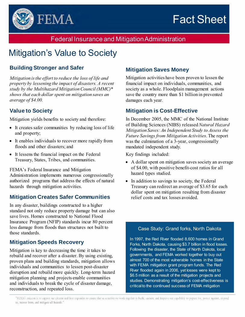
Fact Sheet Federal Insurance and Mitigation Administration
Mitigation’s Value to Society Building Stronger and Safer
Mitigation is the effort to reduce the loss of life and property by lessening the impact of disasters. A recent study by the Multihazard Mitigation Council (MMC)* shows that each dollar spent on mitigation saves an average of $4.00.
Value to Society Mitigation yields benefits to society and therefore:
• It creates safer communities by reducing loss of life and property;
• It enables individuals to recover more rapidly from floods and other disasters; and
• It lessens the financial impact on the Federal Treasury, States, Tribes, and communities.
FEMA’s Federal Insurance and Mitigation Administration implements numerous congressionally authorized programs that address the effects of natural hazards through mitigation activities.
Mitigation Creates Safer Communities In any disaster, buildings constructed to a higher standard not only reduce property damage but can also save lives. Homes constructed to National Flood Insurance Program (NFIP) standards incur 80 percent less damage from floods than structures not built to those standards.
Mitigation Speeds Recovery Mitigation is key to decreasing the time it takes to rebuild and recover after a disaster. By using existing, proven plans and building standards, mitigation allows individuals and communities to lessen post-disaster disruption and rebuild more quickly. Long-term hazard mitigation planning and projects enable communities and individuals to break the cycle of disaster damage, reconstruction, and repeated loss.
Mitigation Saves Money Mitigation activities have been proven to lessen the financial impact on individuals, communities, and society as a whole. Floodplain management actions save the country more than $1 billion in prevented damages each year.
Mitigation is Cost-Effective In December 2005, the MMC of the National Institute of Building Sciences (NIBS) released Natural Hazard Mitigation Saves: An Independent Study to Assess the Future Savings from Mitigation Activities. The report was the culmination of a 3-year, congressionally mandated independent study. Key findings included: • A dollar spent on mitigation saves society an average
of $4.00, with positive benefit-cost ratios for all hazard types studied.
• In addition to savings to society, the Federal Treasury can redirect an average of $3.65 for each dollar spent on mitigation resulting from disaster relief costs and tax losses avoided.
Case Study: Grand forks, North Dakota
In 1997, the Red River flooded 8,600 homes in Grand Forks, North Dakota, causing $3.7 billion in flood losses. Following the disaster, the State of North Dakota, local governments, and FEMA worked together to buy out almost 700 of the most vulnerable homes in the State with FEMA mitigation grant program funds. The Red River flooded again in 2006, yet losses were kept to $6.5 million as a result of the mitigation projects and studies. Demonstrating mitigation’s cost-effectiveness is critical to the continued success of FEMA mitigation
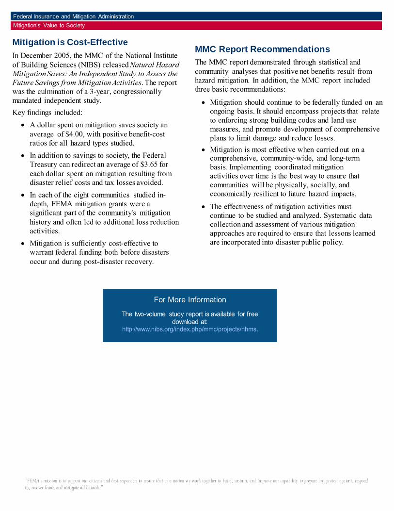
Mitigation is Cost-Effective In December 2005, the MMC of the National Institute of Building Sciences (NIBS) released Natural Hazard Mitigation Saves: An Independent Study to Assess the Future Savings from Mitigation Activities. The report was the culmination of a 3-year, congressionally mandated independent study. Key findings included:
• A dollar spent on mitigation saves society an average of $4.00, with positive benefit-cost ratios for all hazard types studied.
• In addition to savings to society, the Federal Treasury can redirect an average of $3.65 for each dollar spent on mitigation resulting from disaster relief costs and tax losses avoided.
• In each of the eight communities studied in-depth, FEMA mitigation grants were a significant part of the community's mitigation history and often led to additional loss reduction activities.
• Mitigation is sufficiently cost-effective to warrant federal funding both before disasters occur and during post-disaster recovery.
MMC Report Recommendations The MMC report demonstrated through statistical and community analyses that positive net benefits result from hazard mitigation. In addition, the MMC report included three basic recommendations:
• Mitigation should continue to be federally funded on an ongoing basis. It should encompass projects that relate to enforcing strong building codes and land use measures, and promote development of comprehensive plans to limit damage and reduce losses.
• Mitigation is most effective when carried out on a comprehensive, community-wide, and long-term basis. Implementing coordinated mitigation activities over time is the best way to ensure that communities will be physically, socially, and economically resilient to future hazard impacts.
• The effectiveness of mitigation activities must continue to be studied and analyzed. Systematic data collection and assessment of various mitigation approaches are required to ensure that lessons learned are incorporated into disaster public policy.
Federal Insurance and Mitigation Administration Mitigation’s Value to Society
For More Information
The two-volume study report is available for free download at:
http://www.nibs.org/index.php/mmc/projects/nhms.
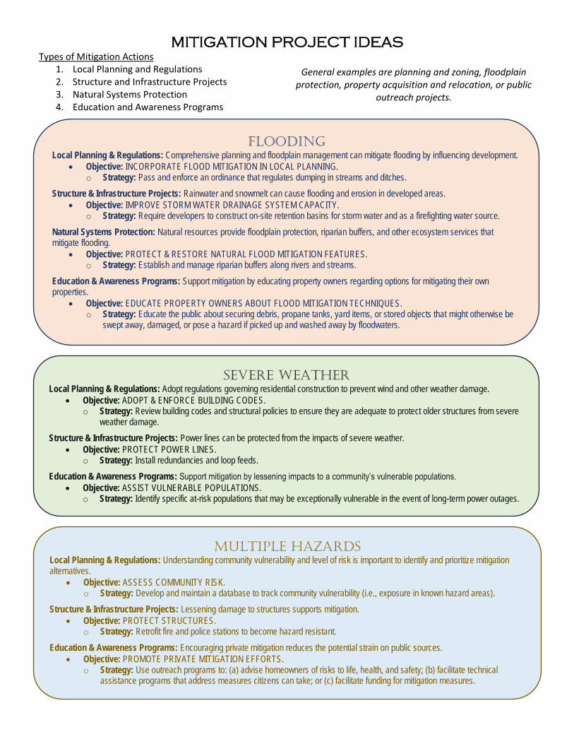
MITIGATION PROJECT IDEAS
Types of Mitigation Actions 1. Local Planning and Regulations 2. Structure and Infrastructure Projects 3. Natural Systems Protection 4. Education and Awareness Programs
General examples are planning and zoning, floodplain protection, property acquisition and relocation, or public
outreach projects.
FLOODING
Local Planning & Regulations: Comprehensive planning and floodplain management can mitigate flooding by influencing development. Objective: INCORPORATE FLOOD MITIGATION IN LOCAL PLANNING.
o Strategy: Pass and enforce an ordinance that regulates dumping in streams and ditches.
Structure & Infrastructure Projects: Rainwater and snowmelt can cause flooding and erosion in developed areas. Objective: IMPROVE STORM WATER DRAINAGE SYSTEM CAPACITY.
o Strategy: Require developers to construct on-site retention basins for storm water and as a firefighting water source.
Natural Systems Protection: Natural resources provide floodplain protection, riparian buffers, and other ecosystem services that mitigate flooding.
Objective: PROTECT & RESTORE NATURAL FLOOD MITIGATION FEATURES. o Strategy: Establish and manage riparian buffers along rivers and streams.
Education & Awareness Programs: Support mitigation by educating property owners regarding options for mitigating their own properties.
Objective: EDUCATE PROPERTY OWNERS ABOUT FLOOD MITIGATION TECHNIQUES. o Strategy: Educate the public about securing debris, propane tanks, yard items, or stored objects that might otherwise be
swept away, damaged, or pose a hazard if picked up and washed away by floodwaters.
SEVERE WEATHER
Local Planning & Regulations: Adopt regulations governing residential construction to prevent wind and other weather damage. Objective: ADOPT & ENFORCE BUILDING CODES.
o Strategy: Review building codes and structural policies to ensure they are adequate to protect older structures from severe weather damage.
Structure & Infrastructure Projects: Power lines can be protected from the impacts of severe weather. Objective: PROTECT POWER LINES.
o Strategy: Install redundancies and loop feeds.
Education & Awareness Programs: Support mitigation by lessening impacts to a community’s vulnerable populations. Objective: ASSIST VULNERABLE POPULATIONS.
o Strategy: Identify specific at-risk populations that may be exceptionally vulnerable in the event of long-term power outages.
MULTIPLE HAZARDS
Local Planning & Regulations: Understanding community vulnerability and level of risk is important to identify and prioritize mitigation alternatives.
Objective: ASSESS COMMUNITY RISK. o Strategy: Develop and maintain a database to track community vulnerability (i.e., exposure in known hazard areas).
Structure & Infrastructure Projects: Lessening damage to structures supports mitigation. Objective: PROTECT STRUCTURES.
o Strategy: Retrofit fire and police stations to become hazard resistant.
Education & Awareness Programs: Encouraging private mitigation reduces the potential strain on public sources. Objective: PROMOTE PRIVATE MITIGATION EFFORTS.
o Strategy: Use outreach programs to: (a) advise homeowners of risks to life, health, and safety; (b) facilitate technical assistance programs that address measures citizens can take; or (c) facilitate funding for mitigation measures.
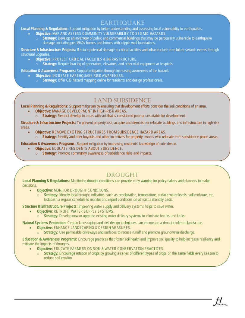
EARTHQUAKE
Local Planning & Regulations: Support mitigation by better understanding and assessing local vulnerability to earthquakes. Objective: MAP AND ASSESS COMMUNITY VULNERABILITY TO SEISMIC HAZARDS.
o Strategy: Develop an inventory of public and commercial buildings that may be particularly vulnerable to earthquake damage, including pre-1940s homes and homes with cripple wall foundations.
Structure & Infrastructure Projects: Reduce potential damage to critical facilities and infrastructure from future seismic events through structural upgrades.
Objective: PROTECT CRITICAL FACILITIES & INFRASTRUCTURE. o Strategy: Require bracing of generators, elevators, and other vital equipment at hospitals.
Education & Awareness Programs: Support mitigation through increasing awareness of the hazard. Objective: INCREASE EARTHQUAKE RISK AWARENESS.
o Strategy: Offer GIS hazard mapping online for residents and design professionals.
LAND SUBSIDENCE
Local Planning & Regulations: Support mitigation by ensuring that development efforts consider the soil conditions of an area. Objective: MANAGE DEVELOPMENT IN HIGH-RISK AREAS.
o Strategy: Restrict develop in areas with soil that is considered poor or unsuitable for development.
Structure & Infrastructure Projects: To prevent property loss, acquire and demolish or relocate buildings and infrastructure in high-risk areas.
Objective: REMOVE EXISTING STRUCTURES FROM SUBSIDENCE HAZARD AREAS. o Strategy: Identify and offer buyouts and other incentives for property owners who relocate from subsidence-prone areas.
Education & Awareness Programs: Support mitigation by increasing residents’ knowledge of subsidence. Objective: EDUCATE RESIDENTS ABOUT SUBSIDENCE.
o Strategy: Promote community awareness of subsidence risks and impacts.
DROUGHT
Local Planning & Regulations: Monitoring drought conditions can provide early warning for policymakers and planners to make decisions.
Objective: MONITOR DROUGHT CONDITIONS. o Strategy: Identify local drought indicators, such as precipitation, temperature, surface water levels, soil moisture, etc.
Establish a regular schedule to monitor and report conditions on at least a monthly basis.
Structure & Infrastructure Projects: Improving water supply and delivery systems helps to save water. Objective: RETROFIT WATER SUPPLY SYSTEMS.
o Strategy: Develop new or upgrade existing water delivery systems to eliminate breaks and leaks.
Natural Systems Protection: Certain landscaping and civil design techniques can encourage a drought-tolerant landscape. Objective: ENHANCE LANDSCAPING & DESIGN MEASURES.
o Strategy: Use permeable driveways and surfaces to reduce runoff and promote groundwater discharge.
Education & Awareness Programs: Encourage practices that foster soil health and improve soil quality to help increase resiliency and mitigate the impacts of droughts.
Objective: EDUCATE FARMERS ON SOIL & WATER CONSERVATION PRACTICES. o Strategy: Encourage rotation of crops by growing a series of different types of crops on the same fields every season to
reduce soil erosion.
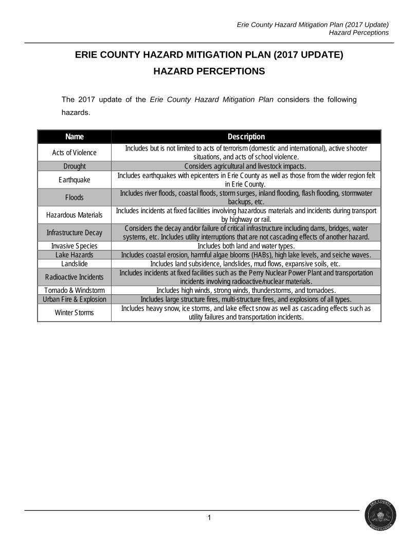
1
Erie County Hazard Mitigation Plan (2017 Update) Hazard Perceptions
ERIE COUNTY HAZARD MITIGATION PLAN (2017 UPDATE)
HAZARD PERCEPTIONS
The 2017 update of the Erie County Hazard Mitigation Plan considers the following
hazards.
Name Description
Acts of Violence Includes but is not limited to acts of terrorism (domestic and international), active shooter
situations, and acts of school violence. Drought Considers agricultural and livestock impacts.
Earthquake Includes earthquakes with epicenters in Erie County as well as those from the wider region felt
in Erie County.
Floods Includes river floods, coastal floods, storm surges, inland flooding, flash flooding, stormwater
backups, etc.
Hazardous Materials Includes incidents at fixed facilities involving hazardous materials and incidents during transport
by highway or rail.
Infrastructure Decay Considers the decay and/or failure of critical infrastructure including dams, bridges, water systems, etc. Includes utility interruptions that are not cascading effects of another hazard.
Invasive Species Includes both land and water types. Lake Hazards Includes coastal erosion, harmful algae blooms (HABs), high lake levels, and seiche waves.
Landslide Includes land subsidence, landslides, mud flows, expansive soils, etc.
Radioactive Incidents Includes incidents at fixed facilities such as the Perry Nuclear Power Plant and transportation incidents involving radioactive/nuclear materials.
Tornado & Windstorm Includes high winds, strong winds, thunderstorms, and tornadoes. Urban Fire & Explosion Includes large structure fires, multi-structure fires, and explosions of all types.
Winter Storms Includes heavy snow, ice storms, and lake effect snow as well as cascading effects such as utility failures and transportation incidents.
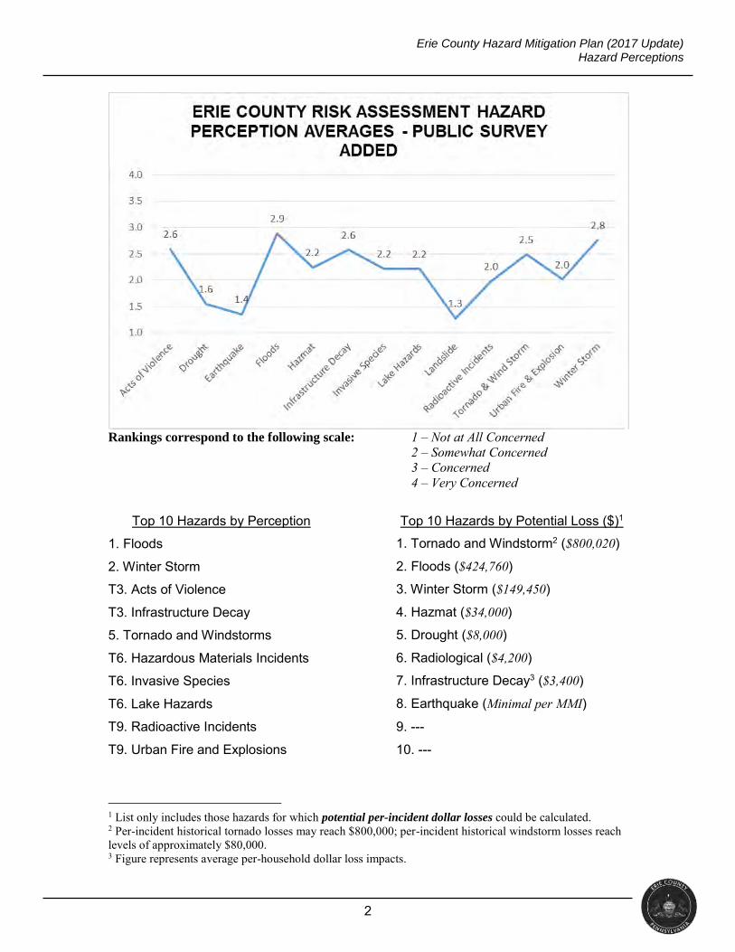
2
Erie County Hazard Mitigation Plan (2017 Update) Hazard Perceptions
Rankings correspond to the following scale: 1 – Not at All Concerned 2 – Somewhat Concerned 3 – Concerned 4 – Very Concerned
Top 10 Hazards by Perception Top 10 Hazards by Potential Loss ($)1
1. Floods 1. Tornado and Windstorm2 ($800,020)
2. Winter Storm 2. Floods ($424,760)
T3. Acts of Violence 3. Winter Storm ($149,450)
T3. Infrastructure Decay 4. Hazmat ($34,000)
5. Tornado and Windstorms 5. Drought ($8,000)
T6. Hazardous Materials Incidents 6. Radiological ($4,200)
T6. Invasive Species 7. Infrastructure Decay3 ($3,400)
T6. Lake Hazards 8. Earthquake (Minimal per MMI)
T9. Radioactive Incidents 9. ---
T9. Urban Fire and Explosions 10. ---
1 List only includes those hazards for which potential per-incident dollar losses could be calculated. 2 Per-incident historical tornado losses may reach $800,000; per-incident historical windstorm losses reach levels of approximately $80,000. 3 Figure represents average per-household dollar loss impacts.
1
Erie County Hazard Mitigation Plan (2017 Update) Frequently-Appearing Strategies
ERIE COUNTY HAZARD MITIGATION PLAN (2017 UPDATE)
FREQUENTLY-APPEARING STRATEGIES
The following are the four strategies that appear most frequently in the updated
mitigation plan.
Floodplain management – i.e., enforcement of floodplain development
regulations.
Consider participation in the Community Rating System (CRS).
MS4 permitting considerations (to include considering applying for an MS4 permit
as well as continuing to meet obligations under the permit).
Public outreach as to personal flood mitigation.
The planning process has yielded the following opportunities that could enhance
implementation of mitigation strategies.
General education and outreach as to the departments, offices, and individuals at
the local government level that could (or should) be responsible for coordinating
mitigation projects.
o For example, would the responsibility best lie with the emergency
management coordinator, zoning officials, etc.?
See the attached handout for additional strategy ideas.

Erie County Hazard Mitigation Plan Appendix 2: Public Survey
APPENDIX 2: PUBLIC SURVEY
This appendix contains raw data from both public surveys conducted as part of
the plan update.

Q1 Please indicate how concerned you are about the following hazards,specifically where you live.
Answered: 326 Skipped: 0
10.84%35
39.01%126
29.41%95
20.74%67
323
2.60
59.32%191
28.88%93
9.01%29
2.80%9
322
1.55
72.36%233
22.36%72
4.04%13
1.24%4
322
1.34
Acts ofViolence...
Drought
Earthquake
HazardousMaterials...
InfrastructureDecay (The...
InvasiveSpecies...
Lake Hazards(Includes...
Landslides
RadioactiveEvents...
Tornados &Windstorms
Urban Fire &Explosion
Winterstorms
0 1 2 3 4 5 6 7 8 9 10
NOT AT ALLCONCERNED
SOMEWHATCONCERNED
CONCERNED VERYCONCERNED
TOTAL WEIGHTEDAVERAGE
Acts of Violence (Including but not limited toacts of terrorism [domestic andinternational], active shooter situations, andacts of school violence)
Drought
Earthquake
1 / 35
Erie County Hazard Mitigation Survey
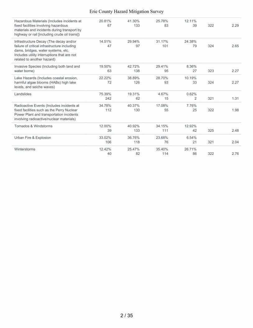
20.81%67
41.30%133
25.78%83
12.11%39
322
2.29
14.51%47
29.94%97
31.17%101
24.38%79
324
2.65
19.50%63
42.72%138
29.41%95
8.36%27
323
2.27
22.22%72
38.89%126
28.70%93
10.19%33
324
2.27
75.39%242
19.31%62
4.67%15
0.62%2
321
1.31
34.78%112
40.37%130
17.08%55
7.76%25
322
1.98
12.00%39
40.92%133
34.15%111
12.92%42
325
2.48
33.02%106
36.76%118
23.68%76
6.54%21
321
2.04
12.42%40
25.47%82
35.40%114
26.71%86
322
2.76
Hazardous Materials (Includes incidents atfixed facilities involving hazardousmaterials and incidents during transport byhighway or rail [including crude oil trains])
Infrastructure Decay (The decay and/orfailure of critical infrastructure includingdams, bridges, water systems, etc.Includes utility interruptions that are notrelated to another hazard)
Invasive Species (Including both land andwater borne)
Lake Hazards (Includes coastal erosion,harmful algae blooms (HABs) high lakelevels, and seiche waves)
Landslides
Radioactive Events (Includes incidents atfixed facilities such as the Perry NuclearPower Plant and transportation incidentsinvolving radioactive/nuclear materials)
Tornados & Windstorms
Urban Fire & Explosion
Winterstorms
2 / 35
Erie County Hazard Mitigation Survey
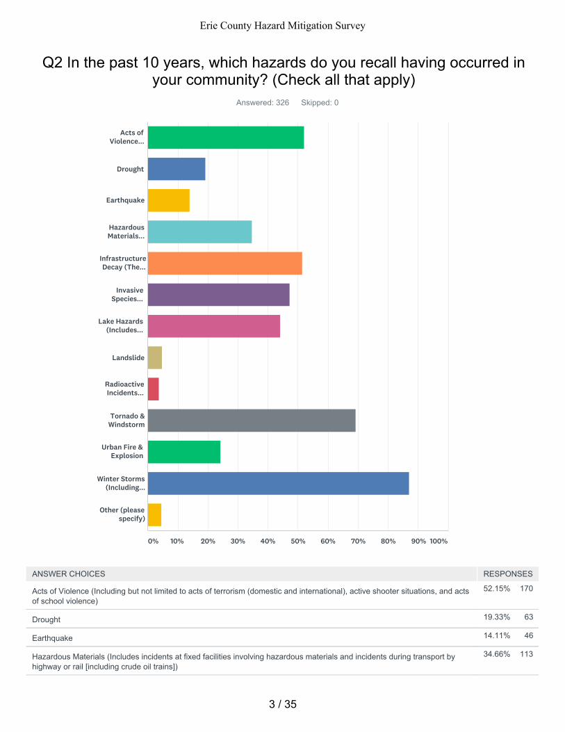
52.15% 170
19.33% 63
14.11% 46
34.66% 113
Q2 In the past 10 years, which hazards do you recall having occurred inyour community? (Check all that apply)
Answered: 326 Skipped: 0
Acts ofViolence...
Drought
Earthquake
HazardousMaterials...
InfrastructureDecay (The...
InvasiveSpecies...
Lake Hazards(Includes...
Landslide
RadioactiveIncidents...
Tornado &Windstorm
Urban Fire &Explosion
Winter Storms(Including...
Other (pleasespecify)
0% 10% 20% 30% 40% 50% 60% 70% 80% 90% 100%
ANSWER CHOICES RESPONSES
Acts of Violence (Including but not limited to acts of terrorism (domestic and international), active shooter situations, and actsof school violence)
Drought
Earthquake
Hazardous Materials (Includes incidents at fixed facilities involving hazardous materials and incidents during transport byhighway or rail [including crude oil trains])
3 / 35
Erie County Hazard Mitigation Survey
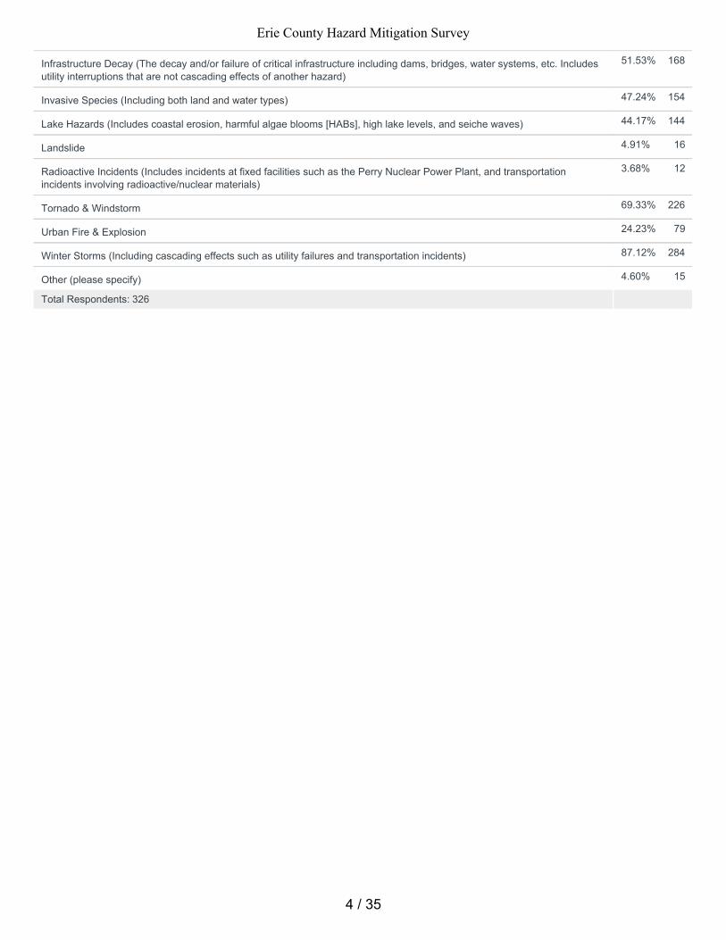
51.53% 168
47.24% 154
44.17% 144
4.91% 16
3.68% 12
69.33% 226
24.23% 79
87.12% 284
4.60% 15
Total Respondents: 326
Infrastructure Decay (The decay and/or failure of critical infrastructure including dams, bridges, water systems, etc. Includesutility interruptions that are not cascading effects of another hazard)
Invasive Species (Including both land and water types)
Lake Hazards (Includes coastal erosion, harmful algae blooms [HABs], high lake levels, and seiche waves)
Landslide
Radioactive Incidents (Includes incidents at fixed facilities such as the Perry Nuclear Power Plant, and transportationincidents involving radioactive/nuclear materials)
Tornado & Windstorm
Urban Fire & Explosion
Winter Storms (Including cascading effects such as utility failures and transportation incidents)
Other (please specify)
4 / 35
Erie County Hazard Mitigation Survey
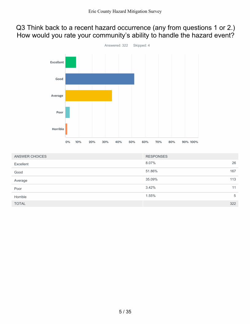
8.07% 26
51.86% 167
35.09% 113
3.42% 11
1.55% 5
Q3 Think back to a recent hazard occurrence (any from questions 1 or 2.)How would you rate your community’s ability to handle the hazard event?
Answered: 322 Skipped: 4
TOTAL 322
Excellent
Good
Average
Poor
Horrible
0% 10% 20% 30% 40% 50% 60% 70% 80% 90% 100%
ANSWER CHOICES RESPONSES
Excellent
Good
Average
Poor
Horrible
5 / 35
Erie County Hazard Mitigation Survey
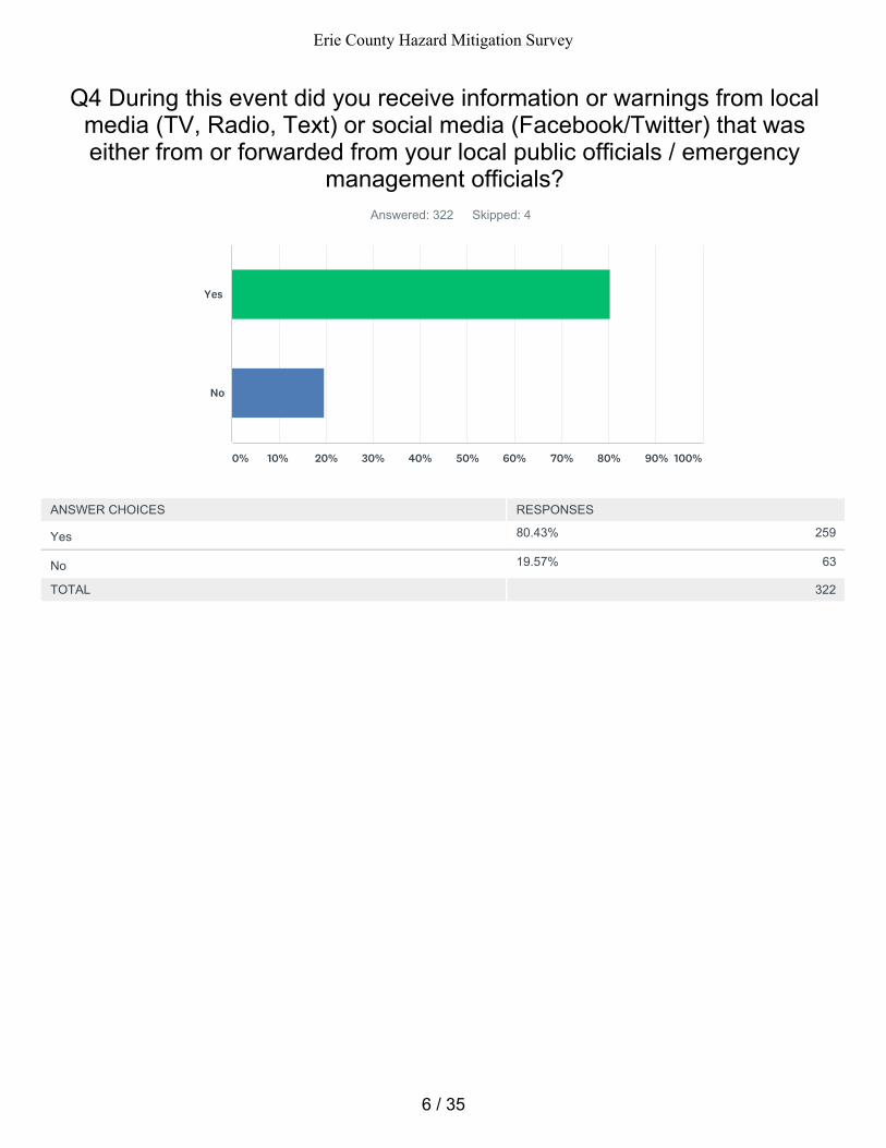
80.43% 259
19.57% 63
Q4 During this event did you receive information or warnings from localmedia (TV, Radio, Text) or social media (Facebook/Twitter) that waseither from or forwarded from your local public officials / emergency
management officials?Answered: 322 Skipped: 4
TOTAL 322
Yes
No
0% 10% 20% 30% 40% 50% 60% 70% 80% 90% 100%
ANSWER CHOICES RESPONSES
Yes
No
6 / 35
Erie County Hazard Mitigation Survey
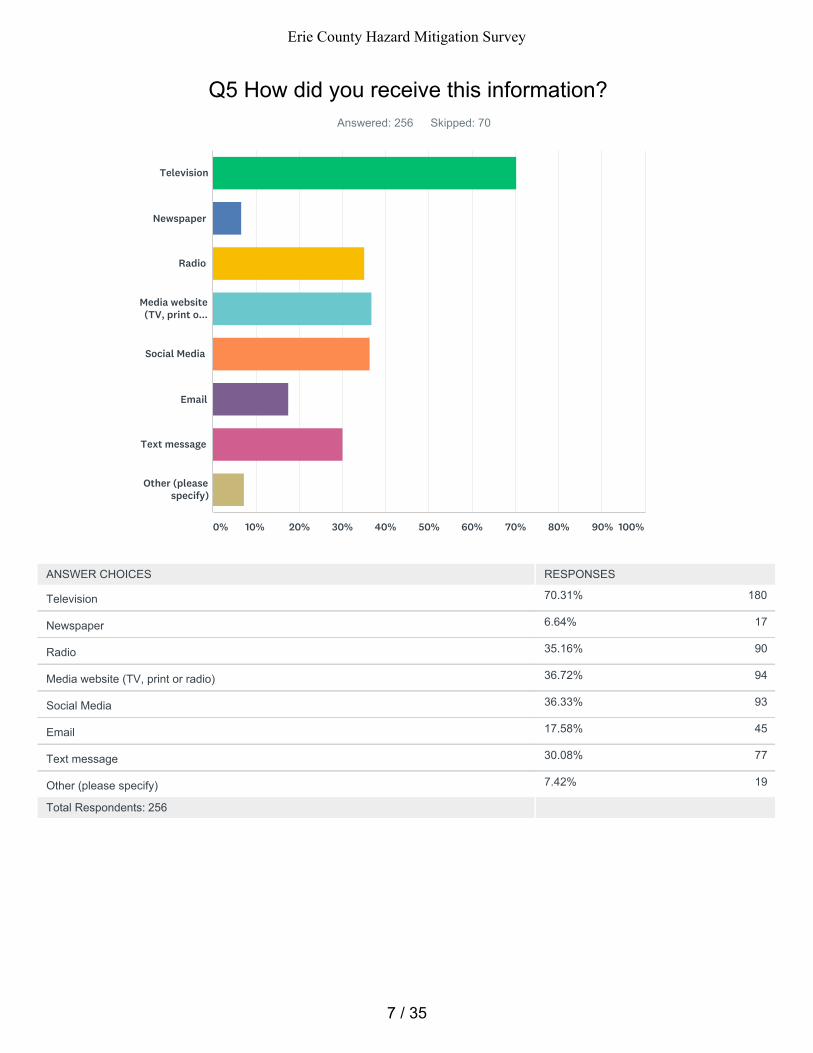
70.31% 180
6.64% 17
35.16% 90
36.72% 94
36.33% 93
17.58% 45
30.08% 77
7.42% 19
Q5 How did you receive this information?Answered: 256 Skipped: 70
Total Respondents: 256
Television
Newspaper
Radio
Media website(TV, print o...
Social Media
Text message
Other (pleasespecify)
0% 10% 20% 30% 40% 50% 60% 70% 80% 90% 100%
ANSWER CHOICES RESPONSES
Television
Newspaper
Radio
Media website (TV, print or radio)
Social Media
Text message
Other (please specify)
7 / 35
Erie County Hazard Mitigation Survey
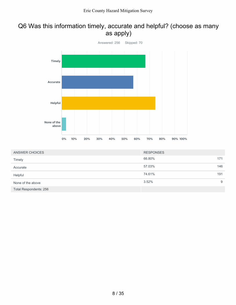
66.80% 171
57.03% 146
74.61% 191
3.52% 9
Q6 Was this information timely, accurate and helpful? (choose as manyas apply)
Answered: 256 Skipped: 70
Total Respondents: 256
Timely
Accurate
Helpful
None of theabove
0% 10% 20% 30% 40% 50% 60% 70% 80% 90% 100%
ANSWER CHOICES RESPONSES
Timely
Accurate
Helpful
None of the above
8 / 35
Erie County Hazard Mitigation Survey
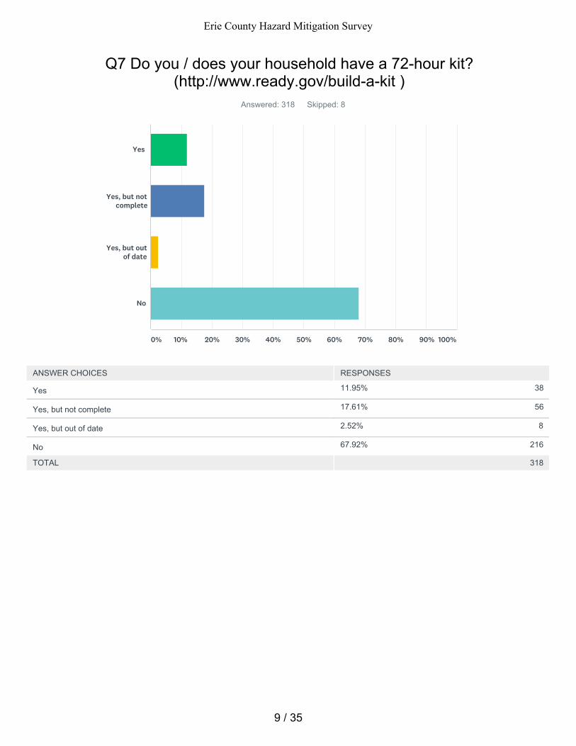
11.95% 38
17.61% 56
2.52% 8
67.92% 216
Q7 Do you / does your household have a 72-hour kit?(http://www.ready.gov/build-a-kit )
Answered: 318 Skipped: 8
TOTAL 318
Yes
Yes, but notcomplete
Yes, but outof date
No
0% 10% 20% 30% 40% 50% 60% 70% 80% 90% 100%
ANSWER CHOICES RESPONSES
Yes
Yes, but not complete
Yes, but out of date
No
9 / 35
Erie County Hazard Mitigation Survey
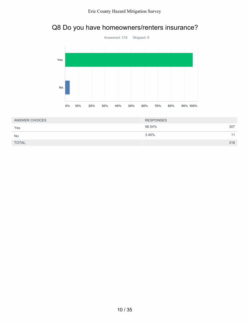
96.54% 307
3.46% 11
Q8 Do you have homeowners/renters insurance?Answered: 318 Skipped: 8
TOTAL 318
Yes
No
0% 10% 20% 30% 40% 50% 60% 70% 80% 90% 100%
ANSWER CHOICES RESPONSES
Yes
No
10 / 35
Erie County Hazard Mitigation Survey
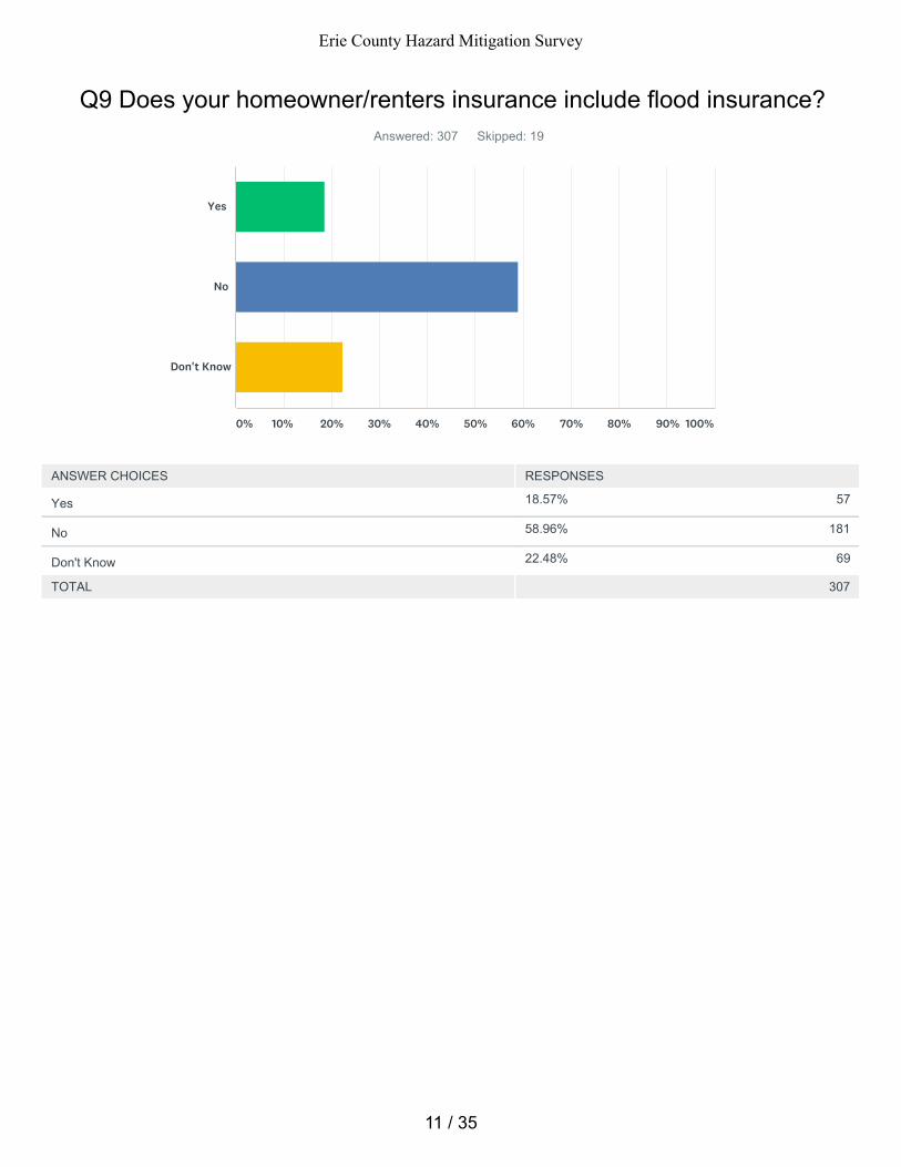
18.57% 57
58.96% 181
22.48% 69
Q9 Does your homeowner/renters insurance include flood insurance?Answered: 307 Skipped: 19
TOTAL 307
Yes
No
Don't Know
0% 10% 20% 30% 40% 50% 60% 70% 80% 90% 100%
ANSWER CHOICES RESPONSES
Yes
No
Don't Know
11 / 35
Erie County Hazard Mitigation Survey
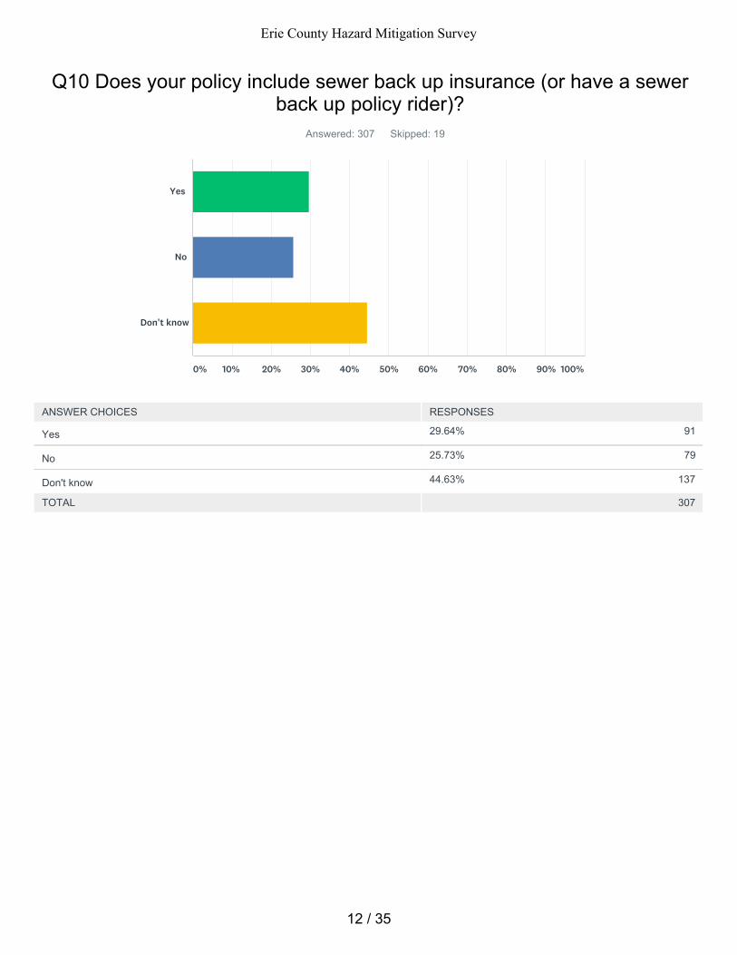
29.64% 91
25.73% 79
44.63% 137
Q10 Does your policy include sewer back up insurance (or have a sewerback up policy rider)?
Answered: 307 Skipped: 19
TOTAL 307
Yes
No
Don't know
0% 10% 20% 30% 40% 50% 60% 70% 80% 90% 100%
ANSWER CHOICES RESPONSES
Yes
No
Don't know
12 / 35
Erie County Hazard Mitigation Survey
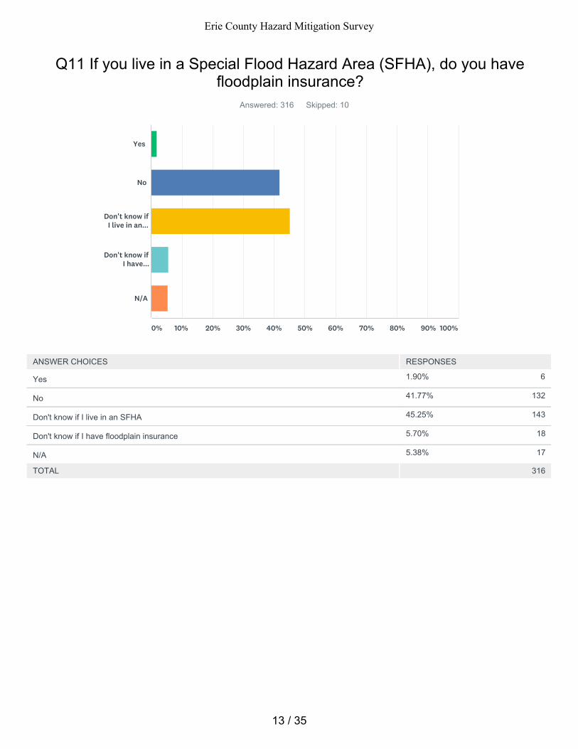
1.90% 6
41.77% 132
45.25% 143
5.70% 18
5.38% 17
Q11 If you live in a Special Flood Hazard Area (SFHA), do you havefloodplain insurance?
Answered: 316 Skipped: 10
TOTAL 316
Yes
No
Don't know ifI live in an...
Don't know ifI have...
N/A
0% 10% 20% 30% 40% 50% 60% 70% 80% 90% 100%
ANSWER CHOICES RESPONSES
Yes
No
Don't know if I live in an SFHA
Don't know if I have floodplain insurance
N/A
13 / 35
Erie County Hazard Mitigation Survey
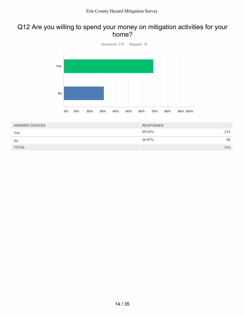
69.03% 214
30.97% 96
Q12 Are you willing to spend your money on mitigation activities for yourhome?
Answered: 310 Skipped: 16
TOTAL 310
Yes
No
0% 10% 20% 30% 40% 50% 60% 70% 80% 90% 100%
ANSWER CHOICES RESPONSES
Yes
No
14 / 35
Erie County Hazard Mitigation Survey
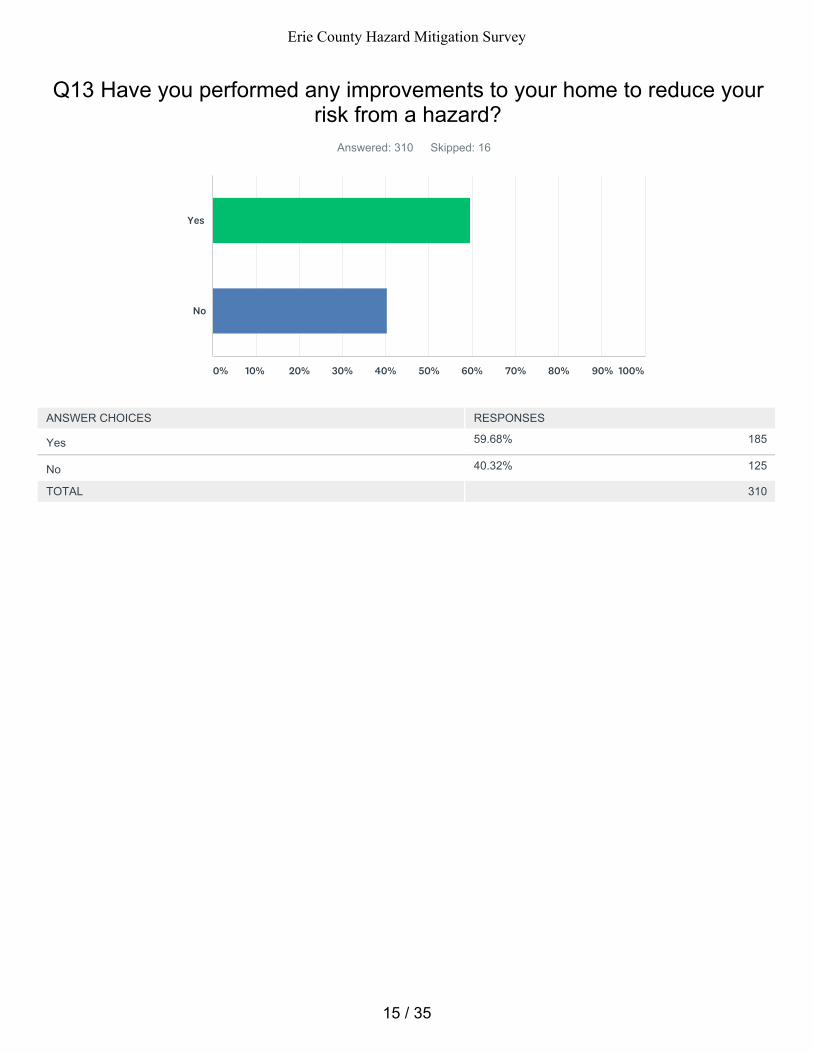
59.68% 185
40.32% 125
Q13 Have you performed any improvements to your home to reduce yourrisk from a hazard?
Answered: 310 Skipped: 16
TOTAL 310
Yes
No
0% 10% 20% 30% 40% 50% 60% 70% 80% 90% 100%
ANSWER CHOICES RESPONSES
Yes
No
15 / 35
Erie County Hazard Mitigation Survey
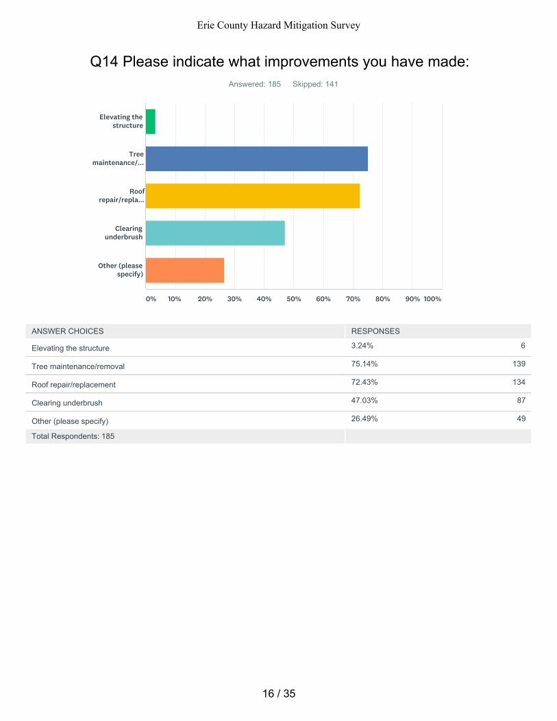
3.24% 6
75.14% 139
72.43% 134
47.03% 87
26.49% 49
Q14 Please indicate what improvements you have made:Answered: 185 Skipped: 141
Total Respondents: 185
Elevating thestructure
Treemaintenance/...
Roofrepair/repla...
Clearingunderbrush
Other (pleasespecify)
0% 10% 20% 30% 40% 50% 60% 70% 80% 90% 100%
ANSWER CHOICES RESPONSES
Elevating the structure
Tree maintenance/removal
Roof repair/replacement
Clearing underbrush
Other (please specify)
16 / 35
Erie County Hazard Mitigation Survey
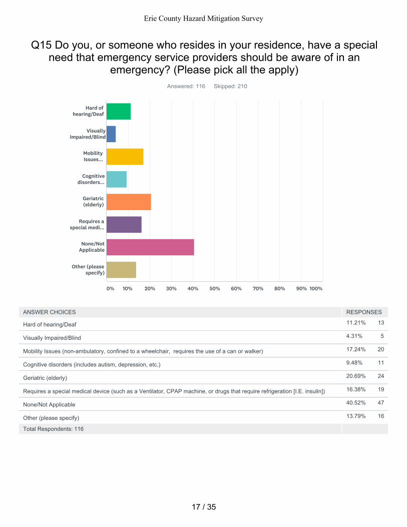
11.21% 13
4.31% 5
17.24% 20
9.48% 11
20.69% 24
16.38% 19
40.52% 47
13.79% 16
Q15 Do you, or someone who resides in your residence, have a specialneed that emergency service providers should be aware of in an
emergency? (Please pick all the apply)Answered: 116 Skipped: 210
Total Respondents: 116
Hard ofhearing/Deaf
VisuallyImpaired/Blind
MobilityIssues...
Cognitivedisorders...
Geriatric(elderly)
Requires aspecial medi...
None/NotApplicable
Other (pleasespecify)
0% 10% 20% 30% 40% 50% 60% 70% 80% 90% 100%
ANSWER CHOICES RESPONSES
Hard of hearing/Deaf
Visually Impaired/Blind
Mobility Issues (non-ambulatory, confined to a wheelchair, requires the use of a can or walker)
Cognitive disorders (includes autism, depression, etc.)
Geriatric (elderly)
Requires a special medical device (such as a Ventilator, CPAP machine, or drugs that require refrigeration [I.E. insulin])
None/Not Applicable
Other (please specify)
17 / 35
Erie County Hazard Mitigation Survey
Q16 Please provide your ageAnswered: 297 Skipped: 29
18
19
20
21
22
23
24
25
26
27
28
29
30
31
32
33
34
35
36
18 / 35
Erie County Hazard Mitigation Survey
37
38
39
40
41
42
43
44
45
46
47
48
49
50
51
52
53
54
55
56
57
19 / 35
Erie County Hazard Mitigation Survey
57
58
59
60
61
62
63
64
65
66
67
68
69
70
71
72
73
74
75
76
77
20 / 35
Erie County Hazard Mitigation Survey
78
79
80
81
82
83
84
85
86
87
88
89
90
91
92
93
94
95
96
97
98
21 / 35
Erie County Hazard Mitigation Survey
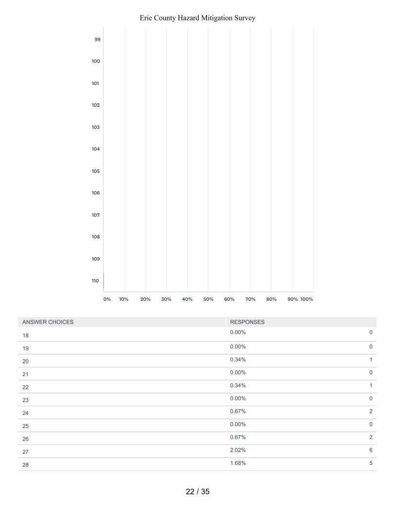
0.00% 0
0.00% 0
0.34% 1
0.00% 0
0.34% 1
0.00% 0
0.67% 2
0.00% 0
0.67% 2
2.02% 6
1.68% 5
99
100
101
102
103
104
105
106
107
108
109
110
0% 10% 20% 30% 40% 50% 60% 70% 80% 90% 100%
ANSWER CHOICES RESPONSES
18
19
20
21
22
23
24
25
26
27
28
22 / 35
Erie County Hazard Mitigation Survey
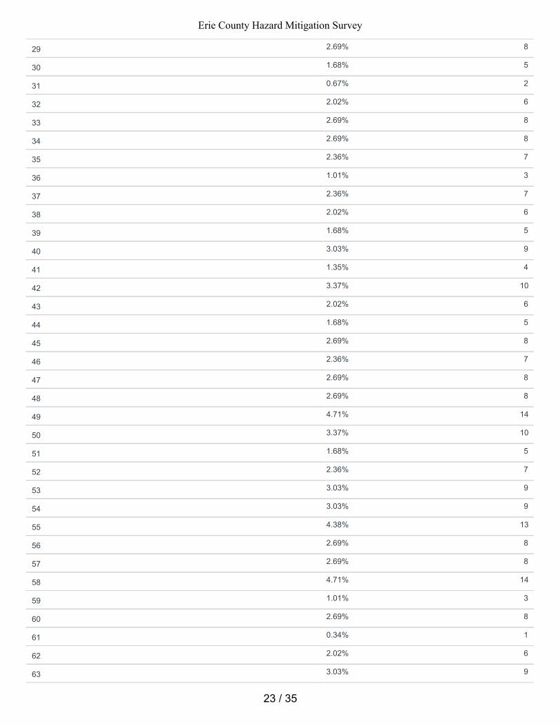
2.69% 8
1.68% 5
0.67% 2
2.02% 6
2.69% 8
2.69% 8
2.36% 7
1.01% 3
2.36% 7
2.02% 6
1.68% 5
3.03% 9
1.35% 4
3.37% 10
2.02% 6
1.68% 5
2.69% 8
2.36% 7
2.69% 8
2.69% 8
4.71% 14
3.37% 10
1.68% 5
2.36% 7
3.03% 9
3.03% 9
4.38% 13
2.69% 8
2.69% 8
4.71% 14
1.01% 3
2.69% 8
0.34% 1
2.02% 6
3.03% 9
29
30
31
32
33
34
35
36
37
38
39
40
41
42
43
44
45
46
47
48
49
50
51
52
53
54
55
56
57
58
59
60
61
62
63
23 / 35
Erie County Hazard Mitigation Survey
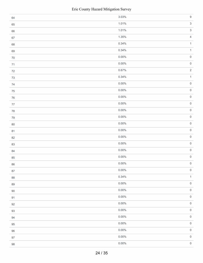
3.03% 9
1.01% 3
1.01% 3
1.35% 4
0.34% 1
0.34% 1
0.00% 0
0.00% 0
0.67% 2
0.34% 1
0.00% 0
0.00% 0
0.00% 0
0.00% 0
0.00% 0
0.00% 0
0.00% 0
0.00% 0
0.00% 0
0.00% 0
0.00% 0
0.00% 0
0.00% 0
0.00% 0
0.34% 1
0.00% 0
0.00% 0
0.00% 0
0.00% 0
0.00% 0
0.00% 0
0.00% 0
0.00% 0
0.00% 0
0.00% 0
64
65
66
67
68
69
70
71
72
73
74
75
76
77
78
79
80
81
82
83
84
85
86
87
88
89
90
91
92
93
94
95
96
97
98
24 / 35
Erie County Hazard Mitigation Survey
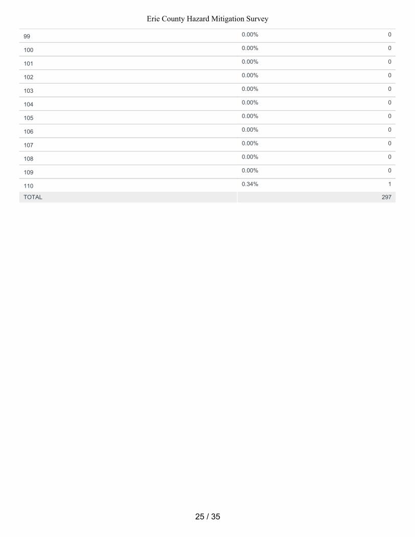
0.00% 0
0.00% 0
0.00% 0
0.00% 0
0.00% 0
0.00% 0
0.00% 0
0.00% 0
0.00% 0
0.00% 0
0.00% 0
0.34% 1
TOTAL 297
99
100
101
102
103
104
105
106
107
108
109
110
25 / 35
Erie County Hazard Mitigation Survey
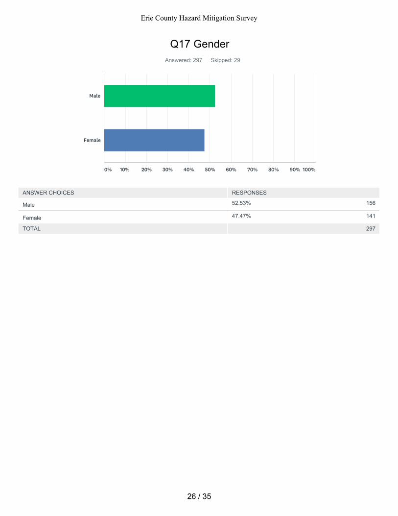
52.53% 156
47.47% 141
Q17 GenderAnswered: 297 Skipped: 29
TOTAL 297
Male
Female
0% 10% 20% 30% 40% 50% 60% 70% 80% 90% 100%
ANSWER CHOICES RESPONSES
Male
Female
26 / 35
Erie County Hazard Mitigation Survey
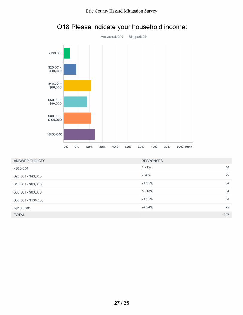
4.71% 14
9.76% 29
21.55% 64
18.18% 54
21.55% 64
24.24% 72
Q18 Please indicate your household income:Answered: 297 Skipped: 29
TOTAL 297
<$20,000
$20,001 -$40,000
$40,001 -$60,000
$60,001 -$80,000
$80,001 -$100,000
>$100,000
0% 10% 20% 30% 40% 50% 60% 70% 80% 90% 100%
ANSWER CHOICES RESPONSES
<$20,000
$20,001 - $40,000
$40,001 - $60,000
$60,001 - $80,000
$80,001 - $100,000
>$100,000
27 / 35
Erie County Hazard Mitigation Survey
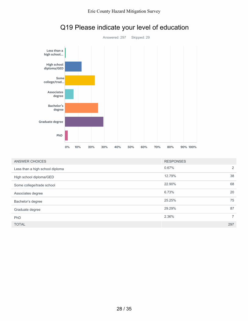
0.67% 2
12.79% 38
22.90% 68
6.73% 20
25.25% 75
29.29% 87
2.36% 7
Q19 Please indicate your level of educationAnswered: 297 Skipped: 29
TOTAL 297
Less than ahigh school...
High schooldiploma/GED
Somecollege/trad...
Associatesdegree
Bachelor’sdegree
Graduate degree
PhD
0% 10% 20% 30% 40% 50% 60% 70% 80% 90% 100%
ANSWER CHOICES RESPONSES
Less than a high school diploma
High school diploma/GED
Some college/trade school
Associates degree
Bachelor’s degree
Graduate degree
PhD
28 / 35
Erie County Hazard Mitigation Survey
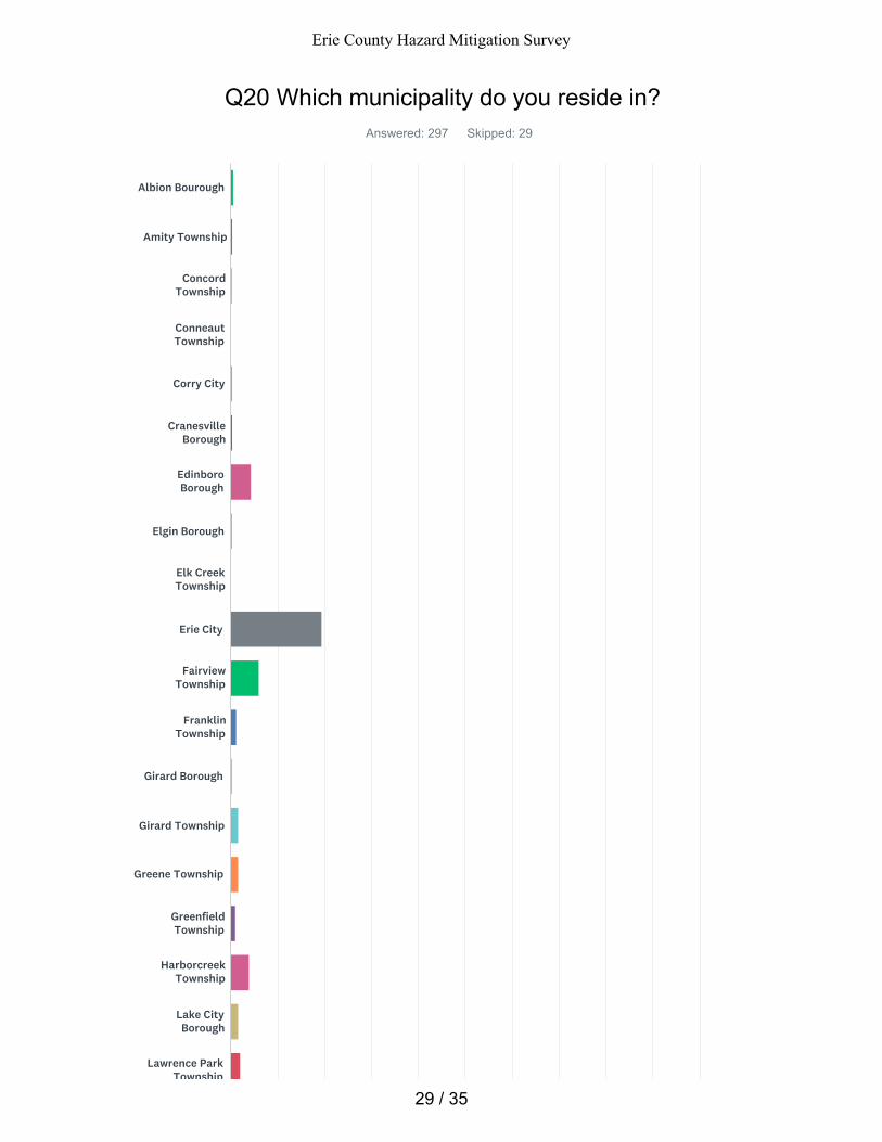
Q20 Which municipality do you reside in?Answered: 297 Skipped: 29
Albion Bourough
Amity Township
ConcordTownship
ConneautTownship
Corry City
CranesvilleBorough
EdinboroBorough
Elgin Borough
Elk CreekTownship
Erie City
FairviewTownship
FranklinTownship
Girard Borough
Girard Township
Greene Township
GreenfieldTownship
HarborcreekTownship
Lake CityBorough
Lawrence ParkTownship
29 / 35
Erie County Hazard Mitigation Survey
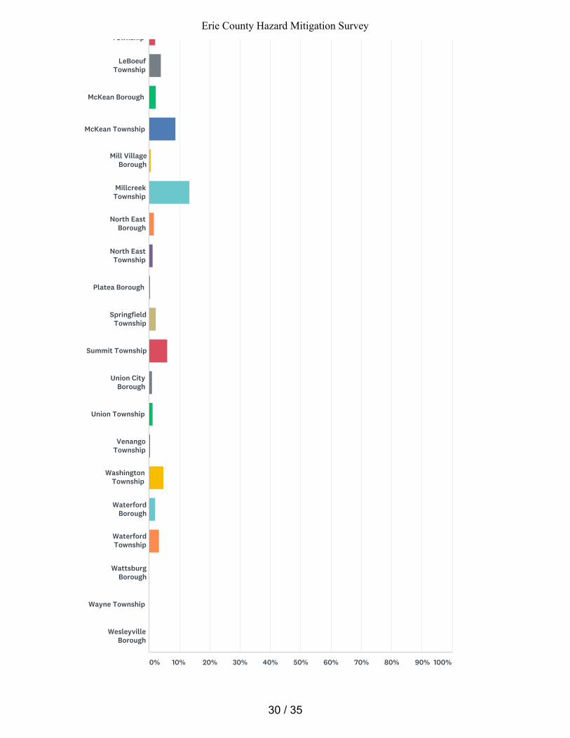
Township
LeBoeufTownship
McKean Borough
McKean Township
Mill VillageBorough
MillcreekTownship
North EastBorough
North EastTownship
Platea Borough
SpringfieldTownship
Summit Township
Union CityBorough
Union Township
VenangoTownship
WashingtonTownship
WaterfordBorough
WaterfordTownship
WattsburgBorough
Wayne Township
WesleyvilleBorough
0% 10% 20% 30% 40% 50% 60% 70% 80% 90% 100%
30 / 35
Erie County Hazard Mitigation Survey
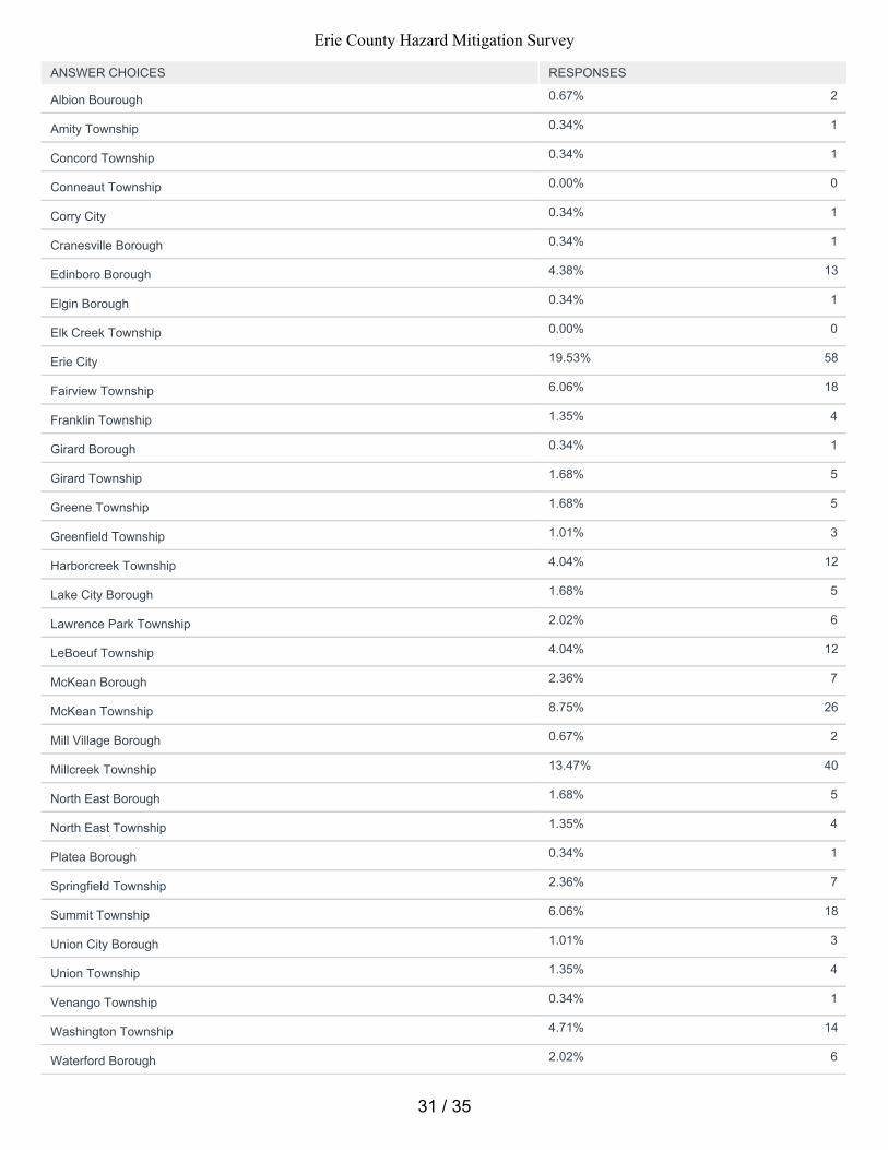
0.67% 2
0.34% 1
0.34% 1
0.00% 0
0.34% 1
0.34% 1
4.38% 13
0.34% 1
0.00% 0
19.53% 58
6.06% 18
1.35% 4
0.34% 1
1.68% 5
1.68% 5
1.01% 3
4.04% 12
1.68% 5
2.02% 6
4.04% 12
2.36% 7
8.75% 26
0.67% 2
13.47% 40
1.68% 5
1.35% 4
0.34% 1
2.36% 7
6.06% 18
1.01% 3
1.35% 4
0.34% 1
4.71% 14
2.02% 6
ANSWER CHOICES RESPONSES
Albion Bourough
Amity Township
Concord Township
Conneaut Township
Corry City
Cranesville Borough
Edinboro Borough
Elgin Borough
Elk Creek Township
Erie City
Fairview Township
Franklin Township
Girard Borough
Girard Township
Greene Township
Greenfield Township
Harborcreek Township
Lake City Borough
Lawrence Park Township
LeBoeuf Township
McKean Borough
McKean Township
Mill Village Borough
Millcreek Township
North East Borough
North East Township
Platea Borough
Springfield Township
Summit Township
Union City Borough
Union Township
Venango Township
Washington Township
Waterford Borough
31 / 35
Erie County Hazard Mitigation Survey
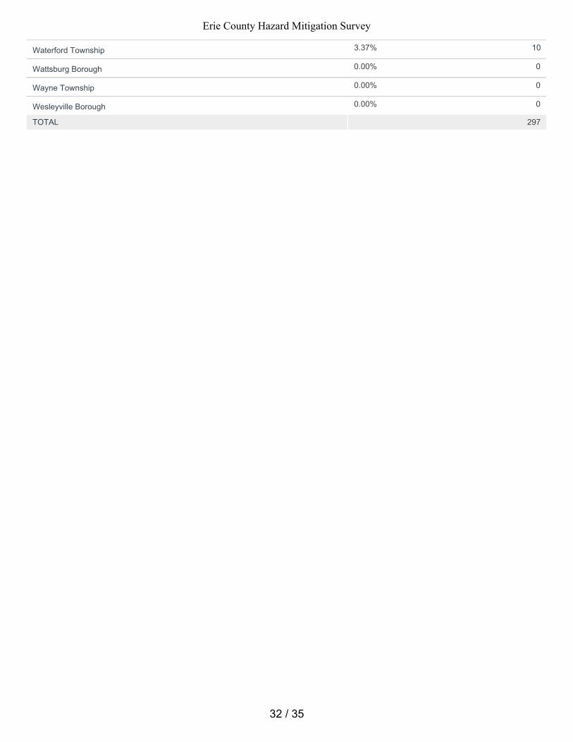
3.37% 10
0.00% 0
0.00% 0
0.00% 0
TOTAL 297
Waterford Township
Wattsburg Borough
Wayne Township
Wesleyville Borough
32 / 35
Erie County Hazard Mitigation Survey
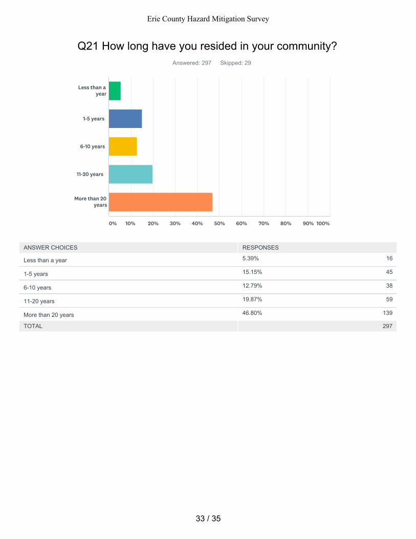
5.39% 16
15.15% 45
12.79% 38
19.87% 59
46.80% 139
Q21 How long have you resided in your community? Answered: 297 Skipped: 29
TOTAL 297
Less than ayear
1-5 years
6-10 years
11-20 years
More than 20years
0% 10% 20% 30% 40% 50% 60% 70% 80% 90% 100%
ANSWER CHOICES RESPONSES
Less than a year
1-5 years
6-10 years
11-20 years
More than 20 years
33 / 35
Erie County Hazard Mitigation Survey

Q22 If you would like to take part in additional surveys regarding potentialhazard mitigation projects please provide a valid email address.
Answered: 41 Skipped: 285
34 / 35
Erie County Hazard Mitigation Survey

Q23 Please share any other comments you haveAnswered: 9 Skipped: 317
35 / 35
Erie County Hazard Mitigation Survey
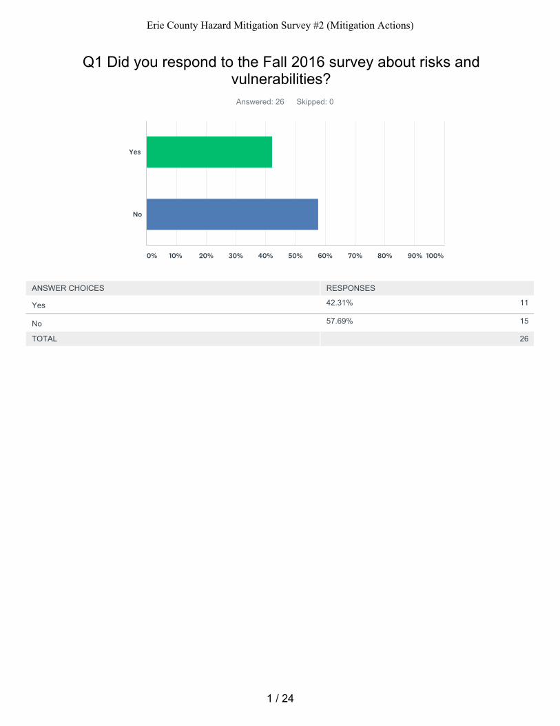
42.31% 11
57.69% 15
Q1 Did you respond to the Fall 2016 survey about risks andvulnerabilities?
Answered: 26 Skipped: 0
TOTAL 26
Yes
No
0% 10% 20% 30% 40% 50% 60% 70% 80% 90% 100%
ANSWER CHOICES RESPONSES
Yes
No
1 / 24
Erie County Hazard Mitigation Survey #2 (Mitigation Actions)

Q2 Our mitigation plan seeks to outline projects to lessen our exposure tothese types of hazards. What do you feel our priorities should be?
Answered: 19 Skipped: 7
2 / 24
Erie County Hazard Mitigation Survey #2 (Mitigation Actions)
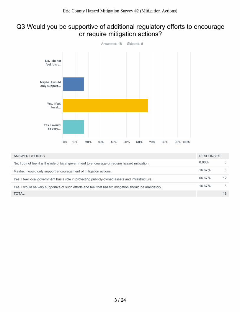
0.00% 0
16.67% 3
66.67% 12
16.67% 3
Q3 Would you be supportive of additional regulatory efforts to encourageor require mitigation actions?
Answered: 18 Skipped: 8
TOTAL 18
No. I do notfeel it is t...
Maybe. I wouldonly support...
Yes. I feellocal...
Yes. I wouldbe very...
0% 10% 20% 30% 40% 50% 60% 70% 80% 90% 100%
ANSWER CHOICES RESPONSES
No. I do not feel it is the role of local government to encourage or require hazard mitigation.
Maybe. I would only support encouragement of mitigation actions.
Yes. I feel local government has a role in protecting publicly-owned assets and infrastructure.
Yes. I would be very supportive of such efforts and feel that hazard mitigation should be mandatory.
3 / 24
Erie County Hazard Mitigation Survey #2 (Mitigation Actions)
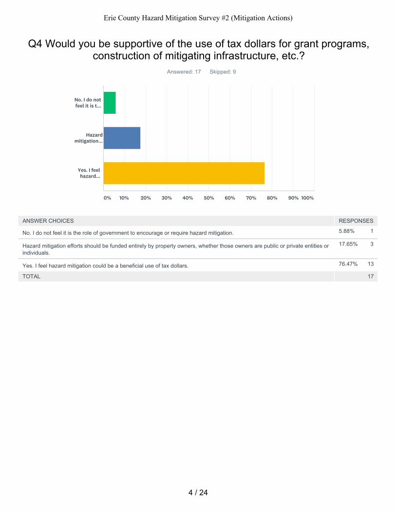
5.88% 1
17.65% 3
76.47% 13
Q4 Would you be supportive of the use of tax dollars for grant programs,construction of mitigating infrastructure, etc.?
Answered: 17 Skipped: 9
TOTAL 17
No. I do notfeel it is t...
Hazardmitigation...
Yes. I feelhazard...
0% 10% 20% 30% 40% 50% 60% 70% 80% 90% 100%
ANSWER CHOICES RESPONSES
No. I do not feel it is the role of government to encourage or require hazard mitigation.
Hazard mitigation efforts should be funded entirely by property owners, whether those owners are public or private entities orindividuals.
Yes. I feel hazard mitigation could be a beneficial use of tax dollars.
4 / 24
Erie County Hazard Mitigation Survey #2 (Mitigation Actions)
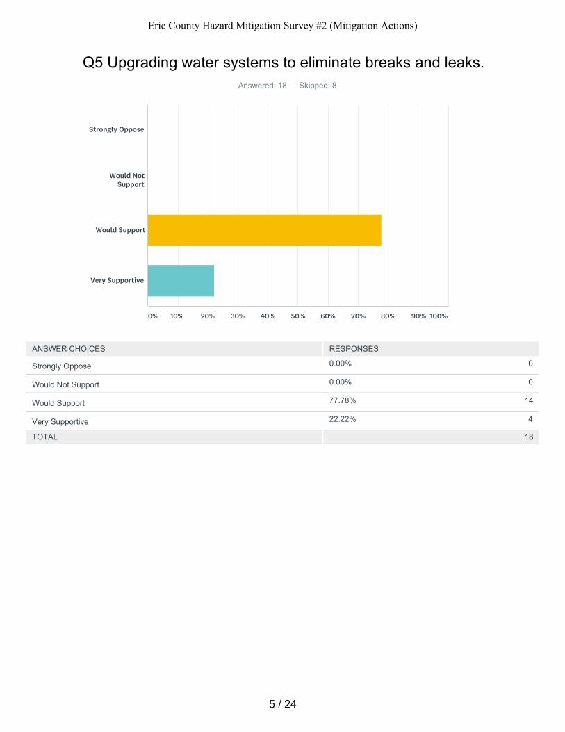
0.00% 0
0.00% 0
77.78% 14
22.22% 4
Q5 Upgrading water systems to eliminate breaks and leaks.Answered: 18 Skipped: 8
TOTAL 18
Strongly Oppose
Would NotSupport
Would Support
Very Supportive
0% 10% 20% 30% 40% 50% 60% 70% 80% 90% 100%
ANSWER CHOICES RESPONSES
Strongly Oppose
Would Not Support
Would Support
Very Supportive
5 / 24
Erie County Hazard Mitigation Survey #2 (Mitigation Actions)
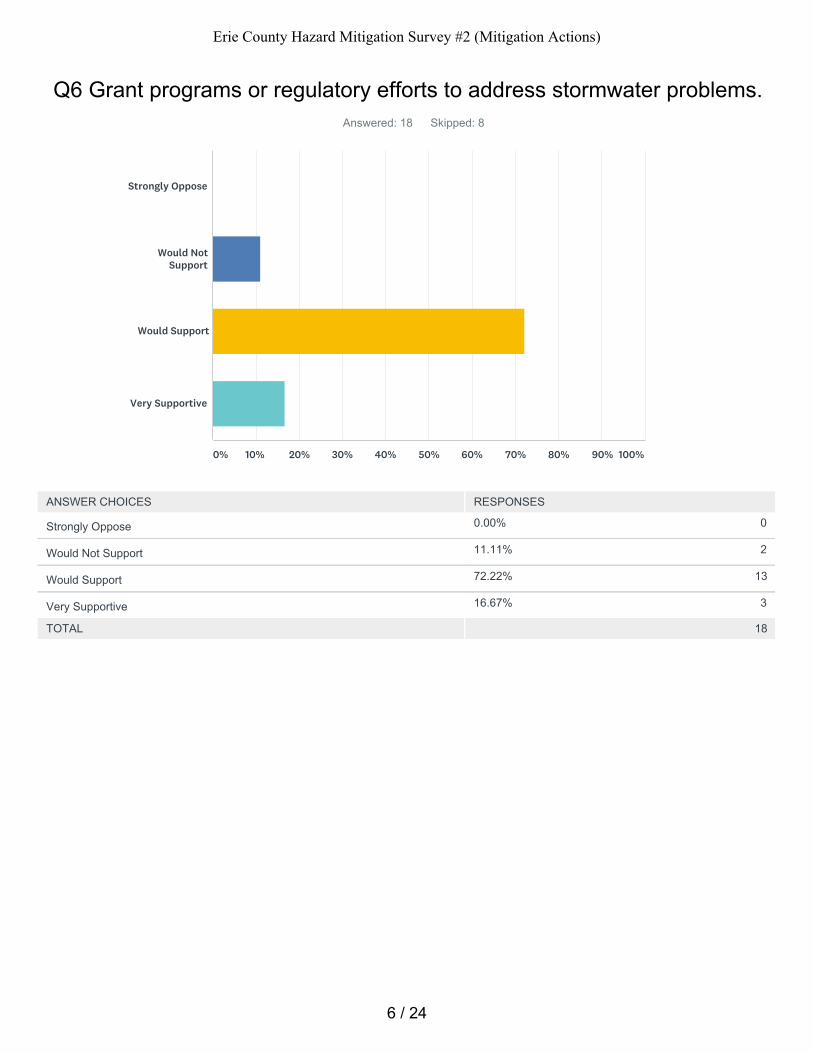
0.00% 0
11.11% 2
72.22% 13
16.67% 3
Q6 Grant programs or regulatory efforts to address stormwater problems.Answered: 18 Skipped: 8
TOTAL 18
Strongly Oppose
Would NotSupport
Would Support
Very Supportive
0% 10% 20% 30% 40% 50% 60% 70% 80% 90% 100%
ANSWER CHOICES RESPONSES
Strongly Oppose
Would Not Support
Would Support
Very Supportive
6 / 24
Erie County Hazard Mitigation Survey #2 (Mitigation Actions)
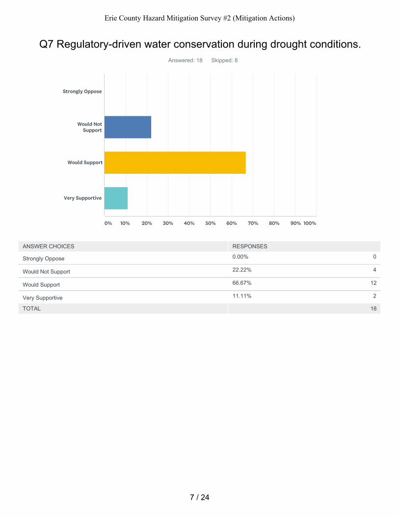
0.00% 0
22.22% 4
66.67% 12
11.11% 2
Q7 Regulatory-driven water conservation during drought conditions.Answered: 18 Skipped: 8
TOTAL 18
Strongly Oppose
Would NotSupport
Would Support
Very Supportive
0% 10% 20% 30% 40% 50% 60% 70% 80% 90% 100%
ANSWER CHOICES RESPONSES
Strongly Oppose
Would Not Support
Would Support
Very Supportive
7 / 24
Erie County Hazard Mitigation Survey #2 (Mitigation Actions)
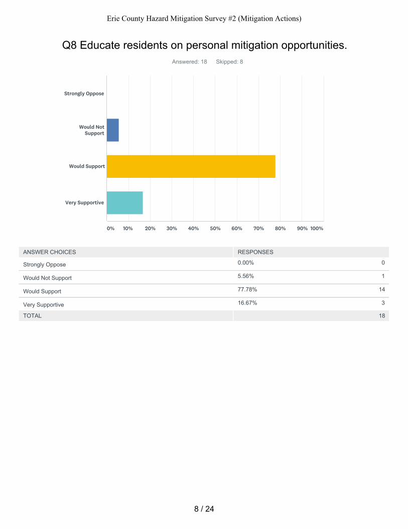
0.00% 0
5.56% 1
77.78% 14
16.67% 3
Q8 Educate residents on personal mitigation opportunities.Answered: 18 Skipped: 8
TOTAL 18
Strongly Oppose
Would NotSupport
Would Support
Very Supportive
0% 10% 20% 30% 40% 50% 60% 70% 80% 90% 100%
ANSWER CHOICES RESPONSES
Strongly Oppose
Would Not Support
Would Support
Very Supportive
8 / 24
Erie County Hazard Mitigation Survey #2 (Mitigation Actions)
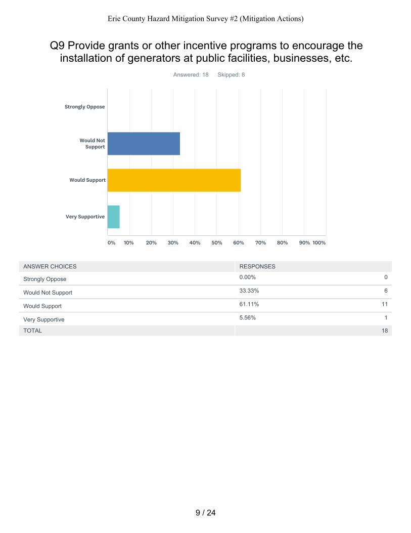
0.00% 0
33.33% 6
61.11% 11
5.56% 1
Q9 Provide grants or other incentive programs to encourage theinstallation of generators at public facilities, businesses, etc.
Answered: 18 Skipped: 8
TOTAL 18
Strongly Oppose
Would NotSupport
Would Support
Very Supportive
0% 10% 20% 30% 40% 50% 60% 70% 80% 90% 100%
ANSWER CHOICES RESPONSES
Strongly Oppose
Would Not Support
Would Support
Very Supportive
9 / 24
Erie County Hazard Mitigation Survey #2 (Mitigation Actions)
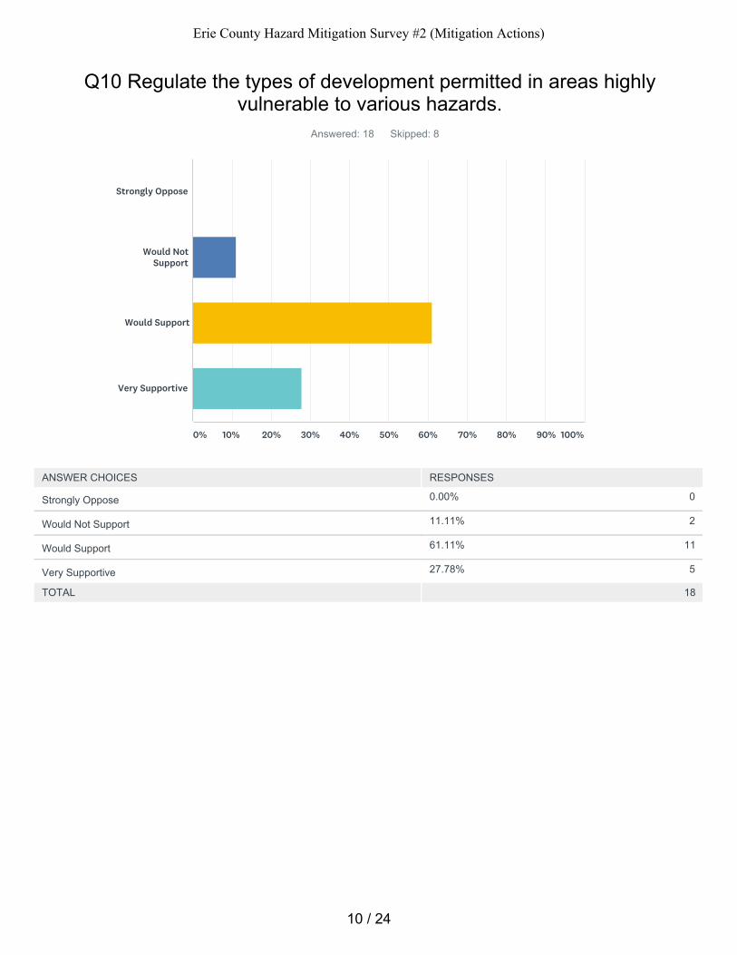
0.00% 0
11.11% 2
61.11% 11
27.78% 5
Q10 Regulate the types of development permitted in areas highlyvulnerable to various hazards.
Answered: 18 Skipped: 8
TOTAL 18
Strongly Oppose
Would NotSupport
Would Support
Very Supportive
0% 10% 20% 30% 40% 50% 60% 70% 80% 90% 100%
ANSWER CHOICES RESPONSES
Strongly Oppose
Would Not Support
Would Support
Very Supportive
10 / 24
Erie County Hazard Mitigation Survey #2 (Mitigation Actions)
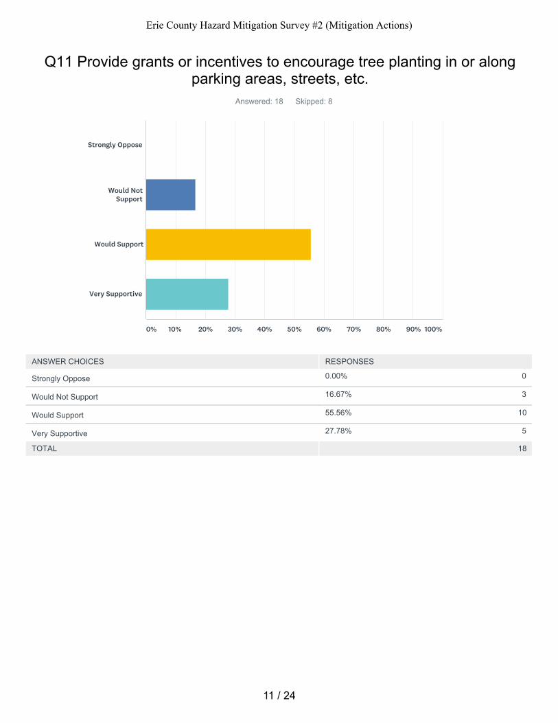
0.00% 0
16.67% 3
55.56% 10
27.78% 5
Q11 Provide grants or incentives to encourage tree planting in or alongparking areas, streets, etc.
Answered: 18 Skipped: 8
TOTAL 18
Strongly Oppose
Would NotSupport
Would Support
Very Supportive
0% 10% 20% 30% 40% 50% 60% 70% 80% 90% 100%
ANSWER CHOICES RESPONSES
Strongly Oppose
Would Not Support
Would Support
Very Supportive
11 / 24
Erie County Hazard Mitigation Survey #2 (Mitigation Actions)
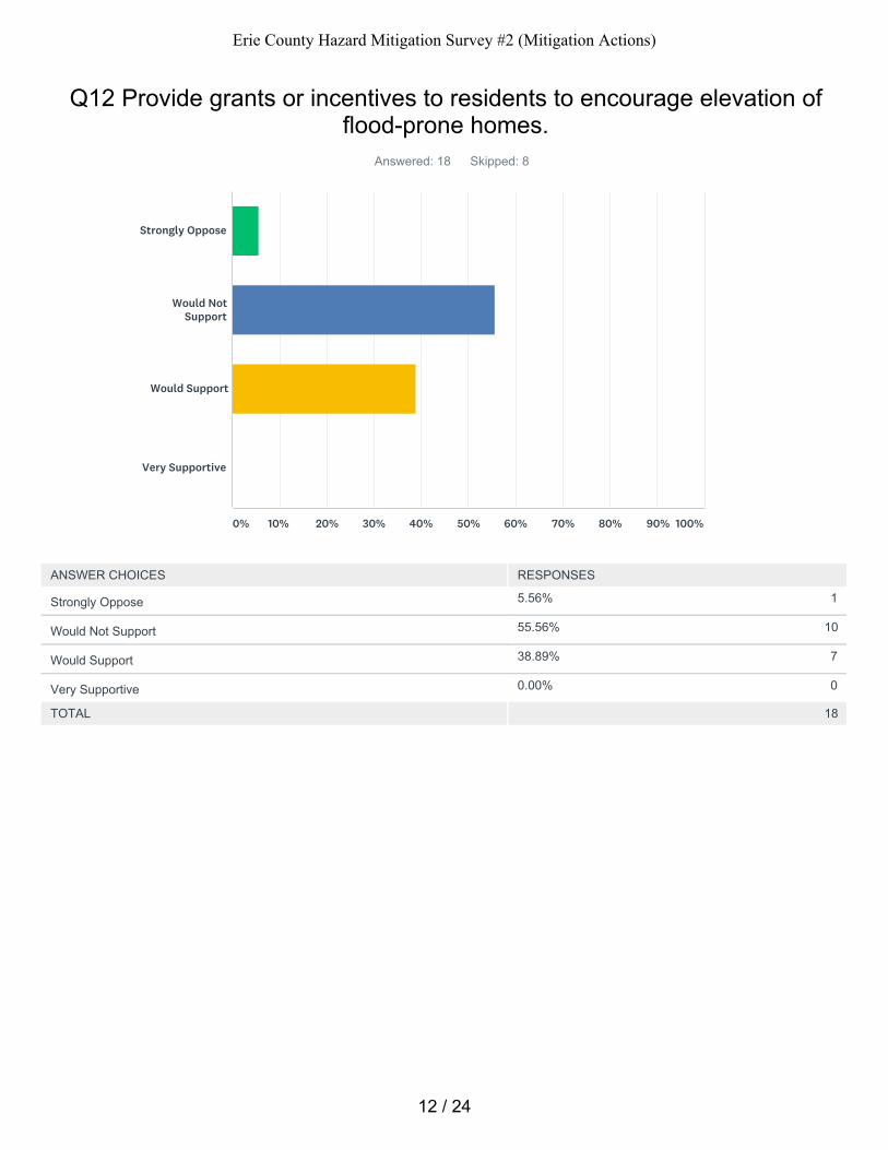
5.56% 1
55.56% 10
38.89% 7
0.00% 0
Q12 Provide grants or incentives to residents to encourage elevation offlood-prone homes.
Answered: 18 Skipped: 8
TOTAL 18
Strongly Oppose
Would NotSupport
Would Support
Very Supportive
0% 10% 20% 30% 40% 50% 60% 70% 80% 90% 100%
ANSWER CHOICES RESPONSES
Strongly Oppose
Would Not Support
Would Support
Very Supportive
12 / 24
Erie County Hazard Mitigation Survey #2 (Mitigation Actions)

Q13 What other mitigation actions not mentioned above (if any) wouldyou support?Answered: 6 Skipped: 20
13 / 24
Erie County Hazard Mitigation Survey #2 (Mitigation Actions)
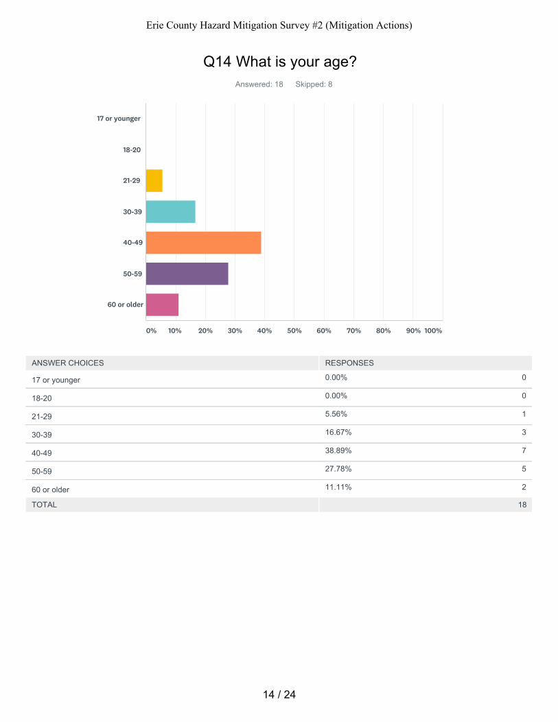
0.00% 0
0.00% 0
5.56% 1
16.67% 3
38.89% 7
27.78% 5
11.11% 2
Q14 What is your age?Answered: 18 Skipped: 8
TOTAL 18
17 or younger
18-20
21-29
30-39
40-49
50-59
60 or older
0% 10% 20% 30% 40% 50% 60% 70% 80% 90% 100%
ANSWER CHOICES RESPONSES
17 or younger
18-20
21-29
30-39
40-49
50-59
60 or older
14 / 24
Erie County Hazard Mitigation Survey #2 (Mitigation Actions)
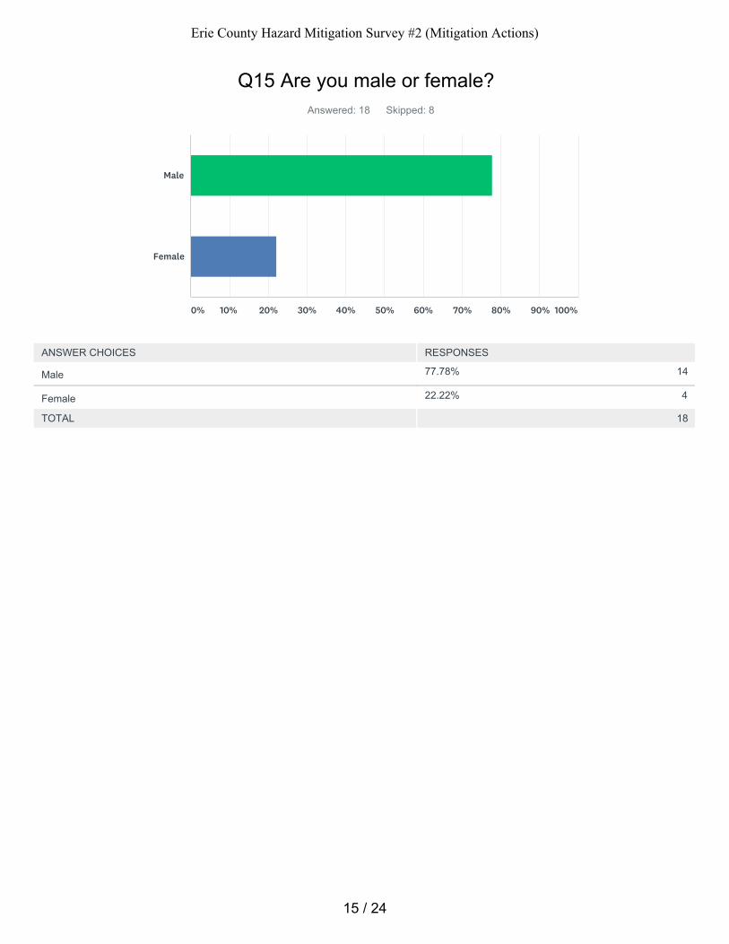
77.78% 14
22.22% 4
Q15 Are you male or female?Answered: 18 Skipped: 8
TOTAL 18
Male
Female
0% 10% 20% 30% 40% 50% 60% 70% 80% 90% 100%
ANSWER CHOICES RESPONSES
Male
Female
15 / 24
Erie County Hazard Mitigation Survey #2 (Mitigation Actions)
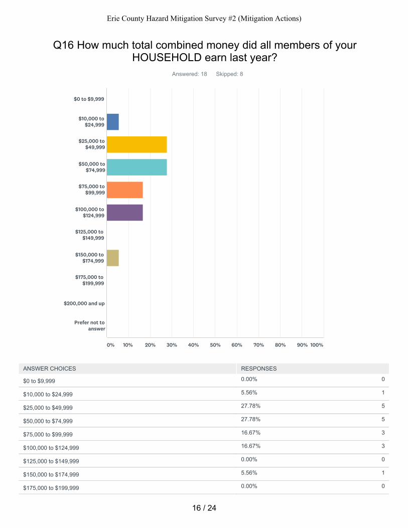
0.00% 0
5.56% 1
27.78% 5
27.78% 5
16.67% 3
16.67% 3
0.00% 0
5.56% 1
0.00% 0
Q16 How much total combined money did all members of yourHOUSEHOLD earn last year?
Answered: 18 Skipped: 8
$0 to $9,999
$10,000 to$24,999
$25,000 to$49,999
$50,000 to$74,999
$75,000 to$99,999
$100,000 to$124,999
$125,000 to$149,999
$150,000 to$174,999
$175,000 to$199,999
$200,000 and up
Prefer not toanswer
0% 10% 20% 30% 40% 50% 60% 70% 80% 90% 100%
ANSWER CHOICES RESPONSES
$0 to $9,999
$10,000 to $24,999
$25,000 to $49,999
$50,000 to $74,999
$75,000 to $99,999
$100,000 to $124,999
$125,000 to $149,999
$150,000 to $174,999
$175,000 to $199,999
16 / 24
Erie County Hazard Mitigation Survey #2 (Mitigation Actions)
0.00% 0
0.00% 0
TOTAL 18
$200,000 and up
Prefer not to answer
17 / 24
Erie County Hazard Mitigation Survey #2 (Mitigation Actions)
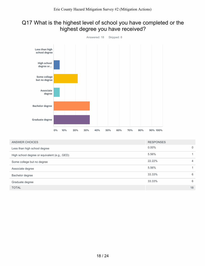
0.00% 0
5.56% 1
22.22% 4
5.56% 1
33.33% 6
33.33% 6
Q17 What is the highest level of school you have completed or thehighest degree you have received?
Answered: 18 Skipped: 8
TOTAL 18
Less than highschool degree
High schooldegree or...
Some collegebut no degree
Associatedegree
Bachelor degree
Graduate degree
0% 10% 20% 30% 40% 50% 60% 70% 80% 90% 100%
ANSWER CHOICES RESPONSES
Less than high school degree
High school degree or equivalent (e.g., GED)
Some college but no degree
Associate degree
Bachelor degree
Graduate degree
18 / 24
Erie County Hazard Mitigation Survey #2 (Mitigation Actions)
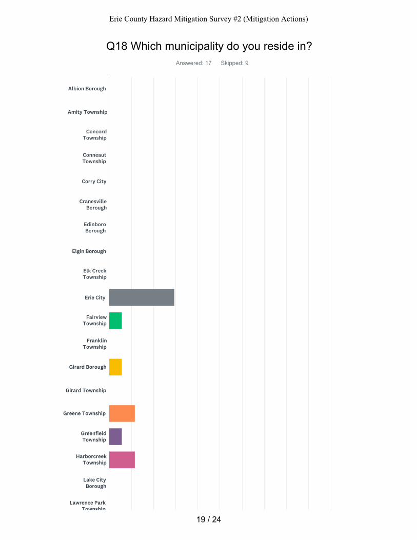
Q18 Which municipality do you reside in?Answered: 17 Skipped: 9
Albion Borough
Amity Township
ConcordTownship
ConneautTownship
Corry City
CranesvilleBorough
EdinboroBorough
Elgin Borough
Elk CreekTownship
Erie City
FairviewTownship
FranklinTownship
Girard Borough
Girard Township
Greene Township
GreenfieldTownship
HarborcreekTownship
Lake CityBorough
Lawrence ParkTownship
19 / 24
Erie County Hazard Mitigation Survey #2 (Mitigation Actions)
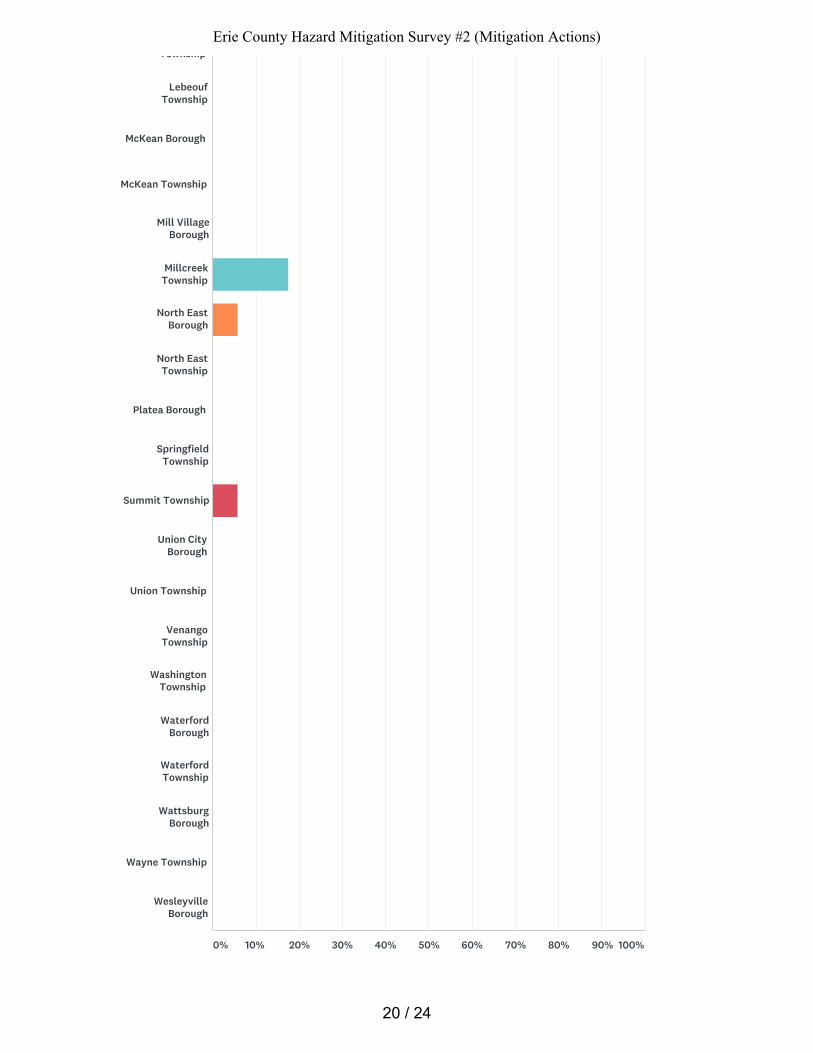
Township
LebeoufTownship
McKean Borough
McKean Township
Mill VillageBorough
MillcreekTownship
North EastBorough
North EastTownship
Platea Borough
SpringfieldTownship
Summit Township
Union CityBorough
Union Township
VenangoTownship
WashingtonTownship
WaterfordBorough
WaterfordTownship
WattsburgBorough
Wayne Township
WesleyvilleBorough
0% 10% 20% 30% 40% 50% 60% 70% 80% 90% 100%
20 / 24
Erie County Hazard Mitigation Survey #2 (Mitigation Actions)
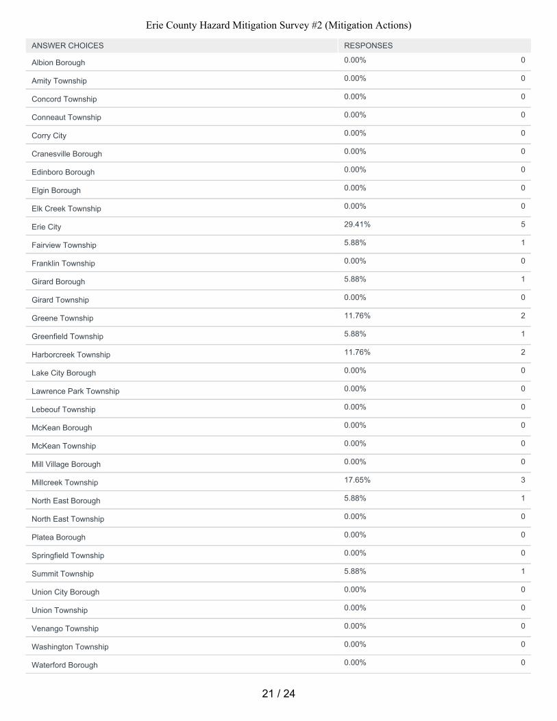
0.00% 0
0.00% 0
0.00% 0
0.00% 0
0.00% 0
0.00% 0
0.00% 0
0.00% 0
0.00% 0
29.41% 5
5.88% 1
0.00% 0
5.88% 1
0.00% 0
11.76% 2
5.88% 1
11.76% 2
0.00% 0
0.00% 0
0.00% 0
0.00% 0
0.00% 0
0.00% 0
17.65% 3
5.88% 1
0.00% 0
0.00% 0
0.00% 0
5.88% 1
0.00% 0
0.00% 0
0.00% 0
0.00% 0
0.00% 0
ANSWER CHOICES RESPONSES
Albion Borough
Amity Township
Concord Township
Conneaut Township
Corry City
Cranesville Borough
Edinboro Borough
Elgin Borough
Elk Creek Township
Erie City
Fairview Township
Franklin Township
Girard Borough
Girard Township
Greene Township
Greenfield Township
Harborcreek Township
Lake City Borough
Lawrence Park Township
Lebeouf Township
McKean Borough
McKean Township
Mill Village Borough
Millcreek Township
North East Borough
North East Township
Platea Borough
Springfield Township
Summit Township
Union City Borough
Union Township
Venango Township
Washington Township
Waterford Borough
21 / 24
Erie County Hazard Mitigation Survey #2 (Mitigation Actions)
0.00% 0
0.00% 0
0.00% 0
0.00% 0
TOTAL 17
Waterford Township
Wattsburg Borough
Wayne Township
Wesleyville Borough
22 / 24
Erie County Hazard Mitigation Survey #2 (Mitigation Actions)
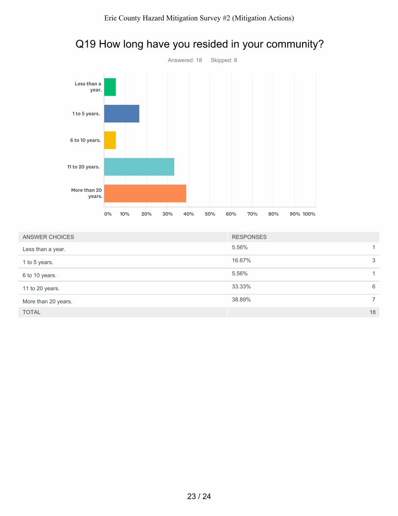
5.56% 1
16.67% 3
5.56% 1
33.33% 6
38.89% 7
Q19 How long have you resided in your community?Answered: 18 Skipped: 8
TOTAL 18
Less than ayear.
1 to 5 years.
6 to 10 years.
11 to 20 years.
More than 20years.
0% 10% 20% 30% 40% 50% 60% 70% 80% 90% 100%
ANSWER CHOICES RESPONSES
Less than a year.
1 to 5 years.
6 to 10 years.
11 to 20 years.
More than 20 years.
23 / 24
Erie County Hazard Mitigation Survey #2 (Mitigation Actions)

Q20 Please share any other comments you have.Answered: 2 Skipped: 24
24 / 24
Erie County Hazard Mitigation Survey #2 (Mitigation Actions)
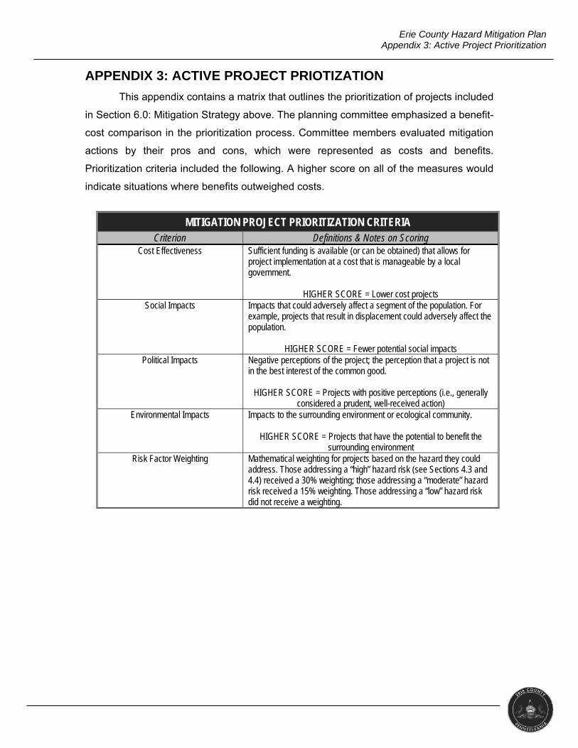
Erie County Hazard Mitigation Plan Appendix 3: Active Project Prioritization
APPENDIX 3: ACTIVE PROJECT PRIOTIZATION
This appendix contains a matrix that outlines the prioritization of projects included
in Section 6.0: Mitigation Strategy above. The planning committee emphasized a benefit-
cost comparison in the prioritization process. Committee members evaluated mitigation
actions by their pros and cons, which were represented as costs and benefits.
Prioritization criteria included the following. A higher score on all of the measures would
indicate situations where benefits outweighed costs.
MITIGATION PROJECT PRIORITIZATION CRITERIA
Criterion Definitions & Notes on Scoring Cost Effectiveness Sufficient funding is available (or can be obtained) that allows for
project implementation at a cost that is manageable by a local government.
HIGHER SCORE = Lower cost projects Social Impacts Impacts that could adversely affect a segment of the population. For
example, projects that result in displacement could adversely affect the population.
HIGHER SCORE = Fewer potential social impacts Political Impacts Negative perceptions of the project; the perception that a project is not
in the best interest of the common good.
HIGHER SCORE = Projects with positive perceptions (i.e., generally considered a prudent, well-received action)
Environmental Impacts Impacts to the surrounding environment or ecological community.
HIGHER SCORE = Projects that have the potential to benefit the surrounding environment
Risk Factor Weighting Mathematical weighting for projects based on the hazard they could address. Those addressing a “high” hazard risk (see Sections 4.3 and 4.4) received a 30% weighting; those addressing a “moderate” hazard risk received a 15% weighting. Those addressing a “low” hazard risk did not receive a weighting.
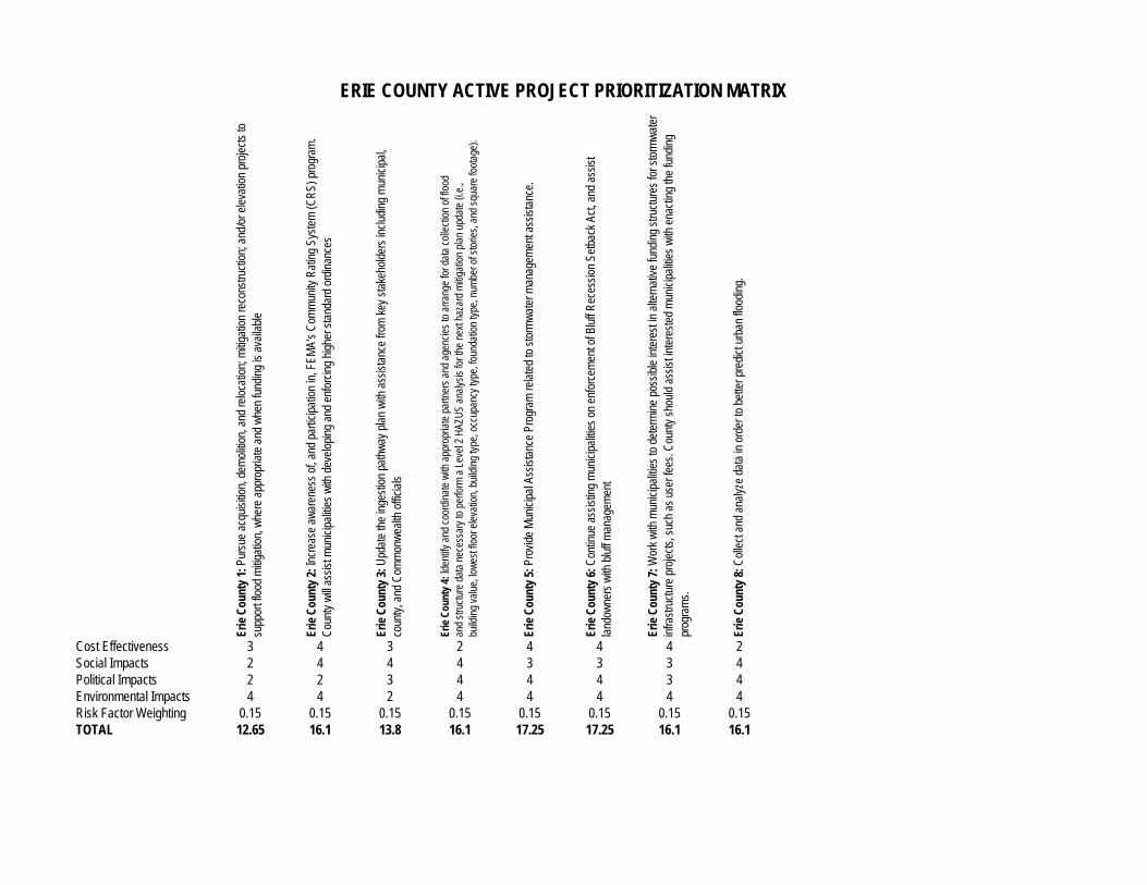
Erie
Cou
nty
1: P
ursu
e ac
quis
ition
, dem
oliti
on, a
nd re
loca
tion;
miti
gatio
n re
cons
truct
ion;
and
/or e
leva
tion
proj
ects
to
supp
ort f
lood
miti
gatio
n, w
here
app
ropr
iate
and
whe
n fu
ndin
g is
ava
ilabl
e
Erie
Cou
nty
2: In
crea
se a
war
enes
s of
, and
par
ticip
atio
n in
, FEM
A’s
Com
mun
ity R
atin
g Sy
stem
(CR
S) p
rogr
am.
Cou
nty
will
assi
st m
unic
ipal
ities
with
dev
elop
ing
and
enfo
rcin
g hi
gher
sta
ndar
d or
dina
nces
Erie
Cou
nty
3: U
pdat
e th
e in
gest
ion
path
way
pla
n w
ith a
ssis
tanc
e fro
m k
ey s
take
hold
ers
incl
udin
g m
unic
ipal
,
coun
ty, a
nd C
omm
onw
ealth
offi
cial
s
Erie
Cou
nty
4: Id
entif
y an
d co
ordi
nate
with
app
ropr
iate
par
tner
s an
d ag
enci
es to
arra
nge
for d
ata
colle
ctio
n of
floo
d
an
d st
ruct
ure
data
nec
essa
ry to
per
form
a L
evel
2 H
AZU
S an
alys
is fo
r the
nex
t haz
ard
miti
gatio
n pl
an u
pdat
e (i.
e.,
bu
ildin
g va
lue,
low
est f
loor
ele
vatio
n, b
uild
ing
type
, occ
upan
cy ty
pe, f
ound
atio
n ty
pe, n
umbe
r of s
torie
s, a
nd s
quar
e fo
otag
e).
Erie
Cou
nty
5: P
rovi
de M
unic
ipal
Ass
ista
nce
Prog
ram
rela
ted
to s
torm
wat
er m
anag
emen
t ass
ista
nce.
Erie
Cou
nty
6: C
ontin
ue a
ssis
ting
mun
icip
aliti
es o
n en
forc
emen
t of B
luff
Rec
essi
on S
etba
ck A
ct, a
nd a
ssis
t
la
ndow
ners
with
blu
ff m
anag
emen
t
Erie
Cou
nty
7: W
ork
with
mun
icip
aliti
es to
det
erm
ine
poss
ible
inte
rest
in a
ltern
ativ
e fu
ndin
g st
ruct
ures
for s
torm
wat
er
in
frast
ruct
ure
proj
ects
, suc
h as
use
r fee
s. C
ount
y sh
ould
ass
ist i
nter
este
d m
unic
ipal
ities
with
ena
ctin
g th
e fu
ndin
g
pr
ogra
ms.
Erie
Cou
nty
8: C
olle
ct a
nd a
naly
ze d
ata
in o
rder
to b
ette
r pre
dict
urb
an fl
oodi
ng.
Cost Effectiveness 3 4 3 2 4 4 4 2Social Impacts 2 4 4 4 3 3 3 4Political Impacts 2 2 3 4 4 4 3 4Environmental Impacts 4 4 2 4 4 4 4 4Risk Factor Weighting 0.15 0.15 0.15 0.15 0.15 0.15 0.15 0.15TOTAL 12.65 16.1 13.8 16.1 17.25 17.25 16.1 16.1
ERIE COUNTY ACTIVE PROJECT PRIORITIZATION MATRIX
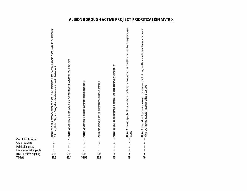
Alb
ion
1: P
ursu
e ro
adw
ay w
iden
ing
alon
g U
S 6N
acc
ordi
ng to
the
“Mov
ing
Forw
ard
Alon
g R
oute
6” p
lan
thro
ugh
Edin
boro
, Uni
on C
ity, a
nd C
orry
whe
n th
e st
ate
rout
e is
due
for b
ette
rmen
t
Alb
ion
2: C
ontin
ue to
par
ticip
ate
in th
e N
atio
nal F
lood
Insu
ranc
e Pr
ogra
m (N
FIP)
Alb
ion
3: C
ontin
ue to
enf
orce
cur
rent
floo
dpla
in re
gula
tions
Alb
ion
4: C
ontin
ue to
enf
orce
sto
rmw
ater
man
agem
ent o
rdin
ance
Alb
ion
5: D
evel
op a
nd m
aint
ain
a da
taba
se to
trac
k co
mm
unity
vul
nera
bilit
y
Alb
ion
6: Id
entif
y sp
ecifi
c at
-risk
pop
ulat
ions
that
may
be
exce
ptio
nally
vul
nera
ble
in th
e ev
ent o
f a lo
ng-te
rm p
ower
ou
tage
Alb
ion
7: U
se o
utre
ach
prog
ram
s to
info
rm h
omeo
wne
rs o
f ris
ks to
life
, hea
lth, a
nd s
afet
y an
d fa
cilit
ate
prog
ram
s
w
here
ava
ilabl
e to
add
ress
mea
sure
s ci
tizen
s ca
n ta
ke
Cost Effectiveness 1 4 4 4 3 4 4Social Impacts 4 3 3 3 4 2 4Political Impacts 3 3 2 1 4 3 4Environmental Impacts 2 4 4 4 4 4 4Risk Factor Weighting 0.15 0.15 0.15 0.15 0 0 0TOTAL 11.5 16.1 14.95 13.8 15 13 16
ALBION BOROUGH ACTIVE PROJECT PRIORITIZATION MATRIX
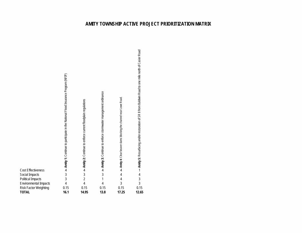
Am
ity 1
: Con
tinue
to p
artic
ipat
e in
the
Nat
iona
l Flo
od In
sura
nce
Prog
ram
(NFI
P)
Am
ity 2
: Con
tinue
to e
nfor
ce c
urre
nt fl
oodp
lain
regu
latio
ns
Am
ity 3
: Con
tinue
to e
nfor
ce s
torm
wat
er m
anag
emen
t ord
inan
ce
Am
ity 4
: Cle
ar b
eave
r dam
s bl
ocki
ng th
e ch
anne
l nea
r Low
e R
oad.
Am
ity 5
: Res
urfa
cing
and
/or r
esto
ratio
n of
SR
8 fr
om B
aldw
in R
oad
to o
ne m
ile n
orth
of C
asie
r Roa
d
Cost Effectiveness 4 4 4 4 1Social Impacts 3 3 3 4 4Political Impacts 3 2 1 4 3Environmental Impacts 4 4 4 3 3Risk Factor Weighting 0.15 0.15 0.15 0.15 0.15TOTAL 16.1 14.95 13.8 17.25 12.65
AMITY TOWNSHIP ACTIVE PROJECT PRIORITIZATION MATRIX
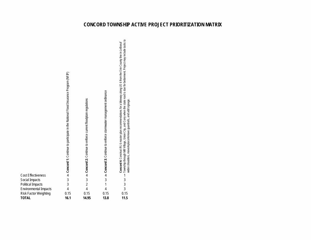
Con
cord
1: C
ontin
ue to
par
ticip
ate
in th
e N
atio
nal F
lood
Insu
ranc
e Pr
ogra
m (N
FIP)
Con
cord
2: C
ontin
ue to
enf
orce
cur
rent
floo
dpla
in re
gula
tions
Con
cord
3: C
ontin
ue to
enf
orce
sto
rmw
ater
man
agem
ent o
rdin
ance
Con
cord
4: C
onst
ruct
Rt.
6 m
aste
r pla
n re
com
men
datio
ns fo
r a b
ikew
ay a
long
US
6 fro
m th
e Er
ie C
ount
y lin
e in
LeB
oeuf
Tow
nshi
p th
roug
h M
ill Vi
llage
, Uni
on C
ity, a
nd C
orry
whe
n th
e st
ate
road
is d
ue fo
r bet
term
ent.
Proj
ect m
ay in
clud
e ta
sks
to
w
iden
sho
ulde
rs, m
ove/
repl
ace/
rem
ove
guar
drai
ls, a
nd a
dd s
igna
ge.
Cost Effectiveness 4 4 4 1Social Impacts 3 3 3 3Political Impacts 3 2 1 3Environmental Impacts 4 4 4 3Risk Factor Weighting 0.15 0.15 0.15 0.15TOTAL 16.1 14.95 13.8 11.5
CONCORD TOWNSHIP ACTIVE PROJECT PRIORITIZATION MATRIX
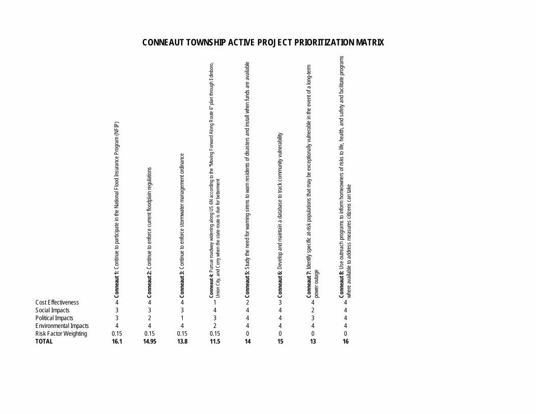
Con
neau
t 1: C
ontin
ue to
par
ticip
ate
in th
e N
atio
nal F
lood
Insu
ranc
e Pr
ogra
m (N
FIP)
Con
neau
t 2: C
ontin
ue to
enf
orce
cur
rent
floo
dpla
in re
gula
tions
Con
neau
t 3: C
ontin
ue to
enf
orce
sto
rmw
ater
man
agem
ent o
rdin
ance
Con
neau
t 4: P
ursu
e ro
adw
ay w
iden
ing
alon
g U
S 6N
acc
ordi
ng to
the
“Mov
ing
Forw
ard
Alon
g R
oute
6” p
lan
thro
ugh
Edin
boro
,
U
nion
City
, and
Cor
ry w
hen
the
stat
e ro
ute
is d
ue fo
r bet
term
ent
Con
neau
t 5: S
tudy
the
need
for w
arni
ng s
irens
to w
arn
resi
dent
s of
dis
aste
rs a
nd in
stal
l whe
n fu
nds
are
avai
labl
e
Con
neau
t 6: D
evel
op a
nd m
aint
ain
a da
taba
se to
trac
k co
mm
unity
vul
nera
bilit
y
Con
neau
t 7: I
dent
ify s
peci
fic a
t-ris
k po
pula
tions
that
may
be
exce
ptio
nally
vul
nera
ble
in th
e ev
ent o
f a lo
ng-te
rm
pow
er o
utag
e
Con
neau
t 8: U
se o
utre
ach
prog
ram
s to
info
rm h
omeo
wne
rs o
f ris
ks to
life
, hea
lth, a
nd s
afet
y an
d fa
cilit
ate
prog
ram
s
w
here
ava
ilabl
e to
add
ress
mea
sure
s ci
tizen
s ca
n ta
ke
Cost Effectiveness 4 4 4 1 2 3 4 4Social Impacts 3 3 3 4 4 4 2 4Political Impacts 3 2 1 3 4 4 3 4Environmental Impacts 4 4 4 2 4 4 4 4Risk Factor Weighting 0.15 0.15 0.15 0.15 0 0 0 0TOTAL 16.1 14.95 13.8 11.5 14 15 13 16
CONNEAUT TOWNSHIP ACTIVE PROJECT PRIORITIZATION MATRIX
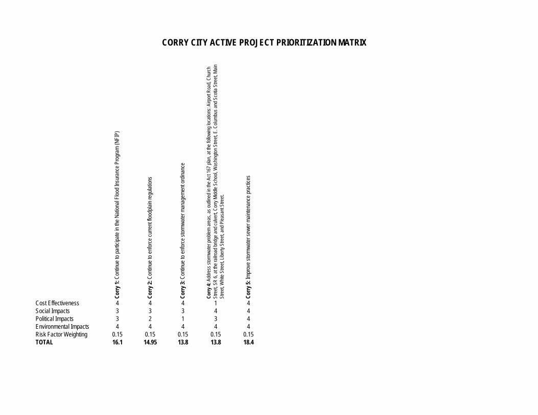
Cor
ry 1
: Con
tinue
to p
artic
ipat
e in
the
Nat
iona
l Flo
od In
sura
nce
Prog
ram
(NFI
P)
Cor
ry 2
: Con
tinue
to e
nfor
ce c
urre
nt fl
oodp
lain
regu
latio
ns
Cor
ry 3
: Con
tinue
to e
nfor
ce s
torm
wat
er m
anag
emen
t ord
inan
ce
Cor
ry 4
: Add
ress
sto
rmw
ater
pro
blem
are
as, a
s ou
tline
d in
the
Act 1
67 p
lan,
at t
he fo
llow
ing
loca
tions
: Airp
ort R
oad,
Chu
rch
Stre
et, S
R 6
, at t
he ra
ilroa
d br
idge
and
cul
vert,
Cor
ry M
iddl
e Sc
hool
, Was
hing
ton
Stre
et, E
. Col
umbu
s an
d Sc
otia
Stre
et, M
ain
St
reet
, Whi
te S
treet
, Lib
erty
Stre
et, a
nd P
leas
ant S
treet
.
Cor
ry 5
: Im
prov
e st
orm
wat
er s
ewer
mai
nten
ance
pra
ctic
es
Cost Effectiveness 4 4 4 1 4Social Impacts 3 3 3 4 4Political Impacts 3 2 1 3 4Environmental Impacts 4 4 4 4 4Risk Factor Weighting 0.15 0.15 0.15 0.15 0.15TOTAL 16.1 14.95 13.8 13.8 18.4
CORRY CITY ACTIVE PROJECT PRIORITIZATION MATRIX
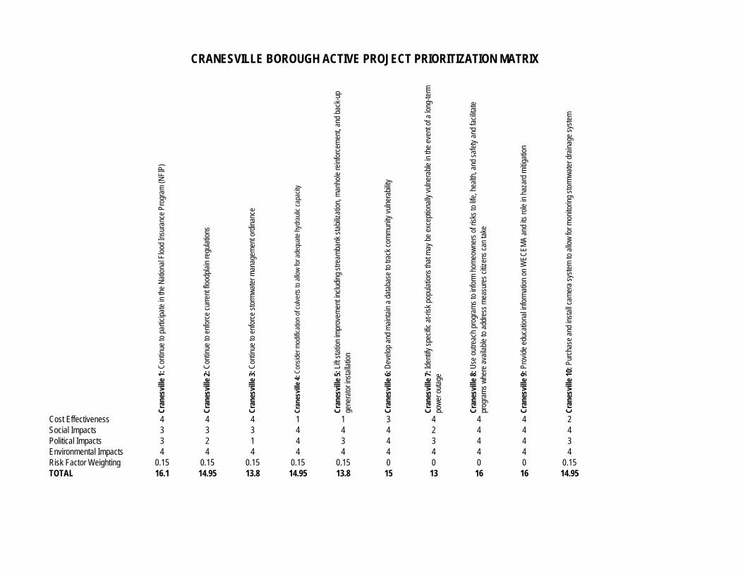
Cra
nesv
ille
1: C
ontin
ue to
par
ticip
ate
in th
e N
atio
nal F
lood
Insu
ranc
e Pr
ogra
m (N
FIP)
Cra
nesv
ille
2: C
ontin
ue to
enf
orce
cur
rent
floo
dpla
in re
gula
tions
Cra
nesv
ille
3: C
ontin
ue to
enf
orce
sto
rmw
ater
man
agem
ent o
rdin
ance
Cra
nesv
ille
4: C
onsi
der m
odifi
catio
n of
cul
verts
to a
llow
for a
dequ
ate
hydr
aulic
cap
acity
Cra
nesv
ille
5: L
ift s
tatio
n im
prov
emen
t inc
ludi
ng s
tream
bank
sta
biliz
atio
n, m
anho
le re
info
rcem
ent,
and
back
-up
ge
nera
tor i
nsta
llatio
n
Cra
nesv
ille
6: D
evel
op a
nd m
aint
ain
a da
taba
se to
trac
k co
mm
unity
vul
nera
bilit
y
Cra
nesv
ille
7: Id
entif
y sp
ecifi
c at
-risk
pop
ulat
ions
that
may
be
exce
ptio
nally
vul
nera
ble
in th
e ev
ent o
f a lo
ng-te
rm
po
wer
out
age
Cra
nesv
ille
8: U
se o
utre
ach
prog
ram
s to
info
rm h
omeo
wne
rs o
f ris
ks to
life
, hea
lth, a
nd s
afet
y an
d fa
cilit
ate
pr
ogra
ms
whe
re a
vaila
ble
to a
ddre
ss m
easu
res
citiz
ens
can
take
Cra
nesv
ille
9: P
rovi
de e
duca
tiona
l inf
orm
atio
n on
WEC
EMA
and
its ro
le in
haz
ard
miti
gatio
n
Cra
nesv
ille
10: P
urch
ase
and
inst
all c
amer
a sy
stem
to a
llow
for m
onito
ring
stor
mw
ater
dra
inag
e sy
stem
Cost Effectiveness 4 4 4 1 1 3 4 4 4 2Social Impacts 3 3 3 4 4 4 2 4 4 4Political Impacts 3 2 1 4 3 4 3 4 4 3Environmental Impacts 4 4 4 4 4 4 4 4 4 4Risk Factor Weighting 0.15 0.15 0.15 0.15 0.15 0 0 0 0 0.15TOTAL 16.1 14.95 13.8 14.95 13.8 15 13 16 16 14.95
CRANESVILLE BOROUGH ACTIVE PROJECT PRIORITIZATION MATRIX
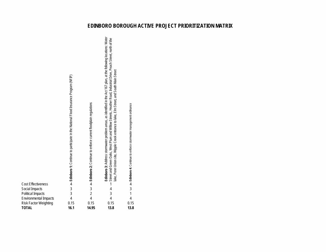
Edin
boro
1: C
ontin
ue to
par
ticip
ate
in th
e N
atio
nal F
lood
Insu
ranc
e Pr
ogra
m (N
FIP)
Edin
boro
2: C
ontin
ue to
enf
orce
cur
rent
floo
dpla
in re
gula
tions
Edin
boro
3: A
ddre
ss s
torm
wat
er p
robl
em a
reas
, as
iden
tifie
d in
the
Act 1
67 p
lan,
at t
he fo
llow
ing
loca
tions
: Wat
er
St
reet
and
Gre
en O
aks,
Wes
t Plu
m a
nd W
illow
Stre
ets,
Hea
ther
Roa
d, In
dust
rial D
rive,
Pea
ch S
treet
, nor
th o
f the
lake
, Pen
n U
nion
site
, Wip
ple
Cre
ek e
ntra
nce
to la
ke, E
lm S
treet
, and
Sou
th M
ain
Stre
et
Edin
boro
4: C
ontin
ue to
enf
orce
sto
rmw
ater
man
agem
ent o
rdin
ance
Cost Effectiveness 4 4 1 4Social Impacts 3 3 4 3Political Impacts 3 2 3 1Environmental Impacts 4 4 4 4Risk Factor Weighting 0.15 0.15 0.15 0.15TOTAL 16.1 14.95 13.8 13.8
EDINBORO BOROUGH ACTIVE PROJECT PRIORITIZATION MATRIX
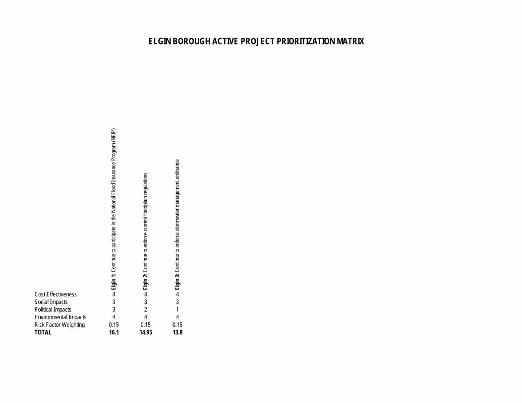
Elgi
n 1:
Con
tinue
to p
artic
ipat
e in
the
Nat
iona
l Flo
od In
sura
nce
Prog
ram
(NFI
P)
Elgi
n 2:
Con
tinue
to e
nfor
ce c
urre
nt fl
oodp
lain
regu
latio
ns
Elgi
n 3:
Con
tinue
to e
nfor
ce s
torm
wat
er m
anag
emen
t ord
inan
ce
Cost Effectiveness 4 4 4Social Impacts 3 3 3Political Impacts 3 2 1Environmental Impacts 4 4 4Risk Factor Weighting 0.15 0.15 0.15TOTAL 16.1 14.95 13.8
ELGIN BOROUGH ACTIVE PROJECT PRIORITIZATION MATRIX
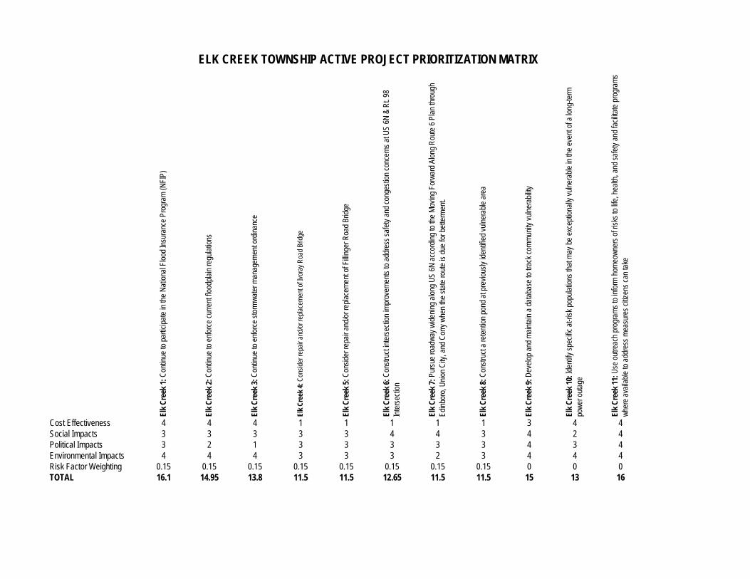
Elk
Cre
ek 1
: Con
tinue
to p
artic
ipat
e in
the
Nat
iona
l Flo
od In
sura
nce
Prog
ram
(NFI
P)
Elk
Cre
ek 2
: Con
tinue
to e
nfor
ce c
urre
nt fl
oodp
lain
regu
latio
ns
Elk
Cre
ek 3
: Con
tinue
to e
nfor
ce s
torm
wat
er m
anag
emen
t ord
inan
ce
Elk
Cre
ek 4
: Con
side
r rep
air a
nd/o
r rep
lace
men
t of I
vora
y R
oad
Brid
ge
Elk
Cre
ek 5
: Con
side
r rep
air a
nd/o
r rep
lace
men
t of F
illing
er R
oad
Brid
ge
Elk
Cre
ek 6
: Con
stru
ct in
ters
ectio
n im
prov
emen
ts to
add
ress
saf
ety
and
cong
estio
n co
ncer
ns a
t US
6N &
Rt.
98
Inte
rsec
tion
Elk
Cre
ek 7
: Pur
sue
road
way
wid
enin
g al
ong
US
6N a
ccor
ding
to th
e M
ovin
g Fo
rwar
d Al
ong
Rou
te 6
Pla
n th
roug
h
Edin
boro
, Uni
on C
ity, a
nd C
orry
whe
n th
e st
ate
rout
e is
due
for b
ette
rmen
t.
Elk
Cre
ek 8
: Con
stru
ct a
rete
ntio
n po
nd a
t pre
viou
sly
iden
tifie
d vu
lner
able
are
a
Elk
Cre
ek 9
: Dev
elop
and
mai
ntai
n a
data
base
to tr
ack
com
mun
ity v
ulne
rabi
lity
Elk
Cre
ek 1
0: Id
entif
y sp
ecifi
c at
-risk
pop
ulat
ions
that
may
be
exce
ptio
nally
vul
nera
ble
in th
e ev
ent o
f a lo
ng-te
rm
po
wer
out
age
Elk
Cre
ek 1
1: U
se o
utre
ach
prog
ram
s to
info
rm h
omeo
wne
rs o
f ris
ks to
life
, hea
lth, a
nd s
afet
y an
d fa
cilit
ate
prog
ram
s
w
here
ava
ilabl
e to
add
ress
mea
sure
s ci
tizen
s ca
n ta
ke
Cost Effectiveness 4 4 4 1 1 1 1 1 3 4 4Social Impacts 3 3 3 3 3 4 4 3 4 2 4Political Impacts 3 2 1 3 3 3 3 3 4 3 4Environmental Impacts 4 4 4 3 3 3 2 3 4 4 4Risk Factor Weighting 0.15 0.15 0.15 0.15 0.15 0.15 0.15 0.15 0 0 0TOTAL 16.1 14.95 13.8 11.5 11.5 12.65 11.5 11.5 15 13 16
ELK CREEK TOWNSHIP ACTIVE PROJECT PRIORITIZATION MATRIX
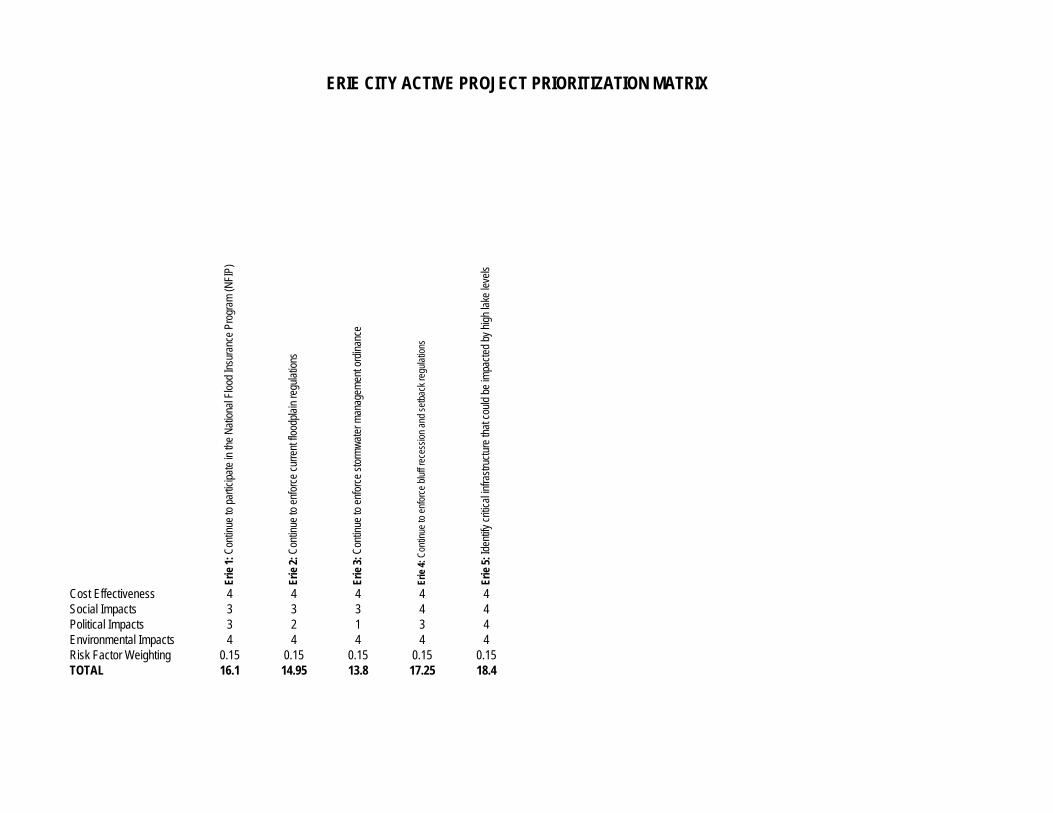
Erie
1: C
ontin
ue to
par
ticip
ate
in th
e N
atio
nal F
lood
Insu
ranc
e Pr
ogra
m (N
FIP)
Erie
2: C
ontin
ue to
enf
orce
cur
rent
floo
dpla
in re
gula
tions
Erie
3: C
ontin
ue to
enf
orce
sto
rmw
ater
man
agem
ent o
rdin
ance
Erie
4: C
ontin
ue to
enf
orce
blu
ff re
cess
ion
and
setb
ack
regu
latio
ns
Erie
5: I
dent
ify c
ritic
al in
frast
ruct
ure
that
cou
ld b
e im
pact
ed b
y hi
gh la
ke le
vels
Cost Effectiveness 4 4 4 4 4Social Impacts 3 3 3 4 4Political Impacts 3 2 1 3 4Environmental Impacts 4 4 4 4 4Risk Factor Weighting 0.15 0.15 0.15 0.15 0.15TOTAL 16.1 14.95 13.8 17.25 18.4
ERIE CITY ACTIVE PROJECT PRIORITIZATION MATRIX
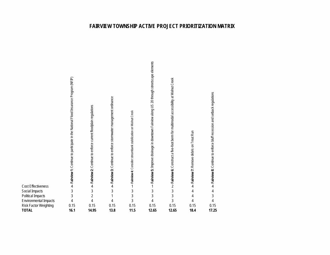
Fairv
iew
1: C
ontin
ue to
par
ticip
ate
in th
e N
atio
nal F
lood
Insu
ranc
e Pr
ogra
m (N
FIP)
Fairv
iew
2: C
ontin
ue to
enf
orce
cur
rent
floo
dpla
in re
gula
tions
Fairv
iew
3: C
ontin
ue to
enf
orce
sto
rmw
ater
man
agem
ent o
rdin
ance
Fairv
iew
4: C
onsi
der s
tream
bank
sta
biliz
atio
n on
Wal
nut C
reek
Fairv
iew
5: I
mpr
ove
drai
nage
in d
ownt
own
Fairv
iew
alo
ng U
S 20
thro
ugh
stre
etsc
ape
elem
ents
Fairv
iew
6: C
onst
ruct
a fi
ve-fo
ot b
erm
for m
ultim
odal
acc
essi
bilit
y at
Wal
nut C
reek
Fairv
iew
7: R
emov
e de
bris
on
Trou
t Run
Fairv
iew
8: C
ontin
ue to
enf
orce
blu
ff re
cess
ion
and
setb
ack
regu
latio
ns
Cost Effectiveness 4 4 4 1 1 2 4 4Social Impacts 3 3 3 3 3 3 4 4Political Impacts 3 2 1 3 3 3 4 3Environmental Impacts 4 4 4 3 4 3 4 4Risk Factor Weighting 0.15 0.15 0.15 0.15 0.15 0.15 0.15 0.15TOTAL 16.1 14.95 13.8 11.5 12.65 12.65 18.4 17.25
FAIRVIEW TOWNSHIP ACTIVE PROJECT PRIORITIZATION MATRIX
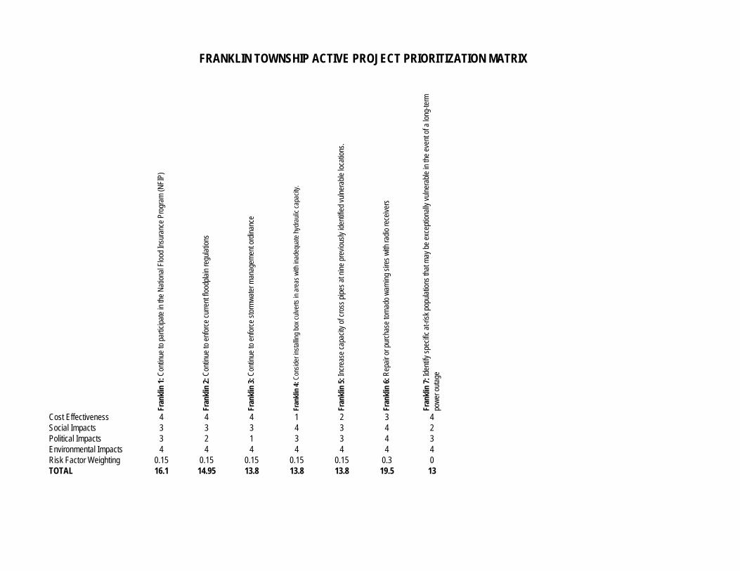
Fran
klin
1: C
ontin
ue to
par
ticip
ate
in th
e N
atio
nal F
lood
Insu
ranc
e Pr
ogra
m (N
FIP)
Fran
klin
2: C
ontin
ue to
enf
orce
cur
rent
floo
dpla
in re
gula
tions
Fran
klin
3: C
ontin
ue to
enf
orce
sto
rmw
ater
man
agem
ent o
rdin
ance
Fran
klin
4: C
onsi
der i
nsta
lling
box
culv
erts
in a
reas
with
inad
equa
te h
ydra
ulic
cap
acity
.
Fran
klin
5: I
ncre
ase
capa
city
of c
ross
pip
es a
t nin
e pr
evio
usly
iden
tifie
d vu
lner
able
loca
tions
.
Fran
klin
6: R
epai
r or p
urch
ase
torn
ado
war
ning
sire
s w
ith ra
dio
rece
iver
s
Fran
klin
7: I
dent
ify s
peci
fic a
t-ris
k po
pula
tions
that
may
be
exce
ptio
nally
vul
nera
ble
in th
e ev
ent o
f a lo
ng-te
rm
po
wer
out
age
Cost Effectiveness 4 4 4 1 2 3 4Social Impacts 3 3 3 4 3 4 2Political Impacts 3 2 1 3 3 4 3Environmental Impacts 4 4 4 4 4 4 4Risk Factor Weighting 0.15 0.15 0.15 0.15 0.15 0.3 0TOTAL 16.1 14.95 13.8 13.8 13.8 19.5 13
FRANKLIN TOWNSHIP ACTIVE PROJECT PRIORITIZATION MATRIX
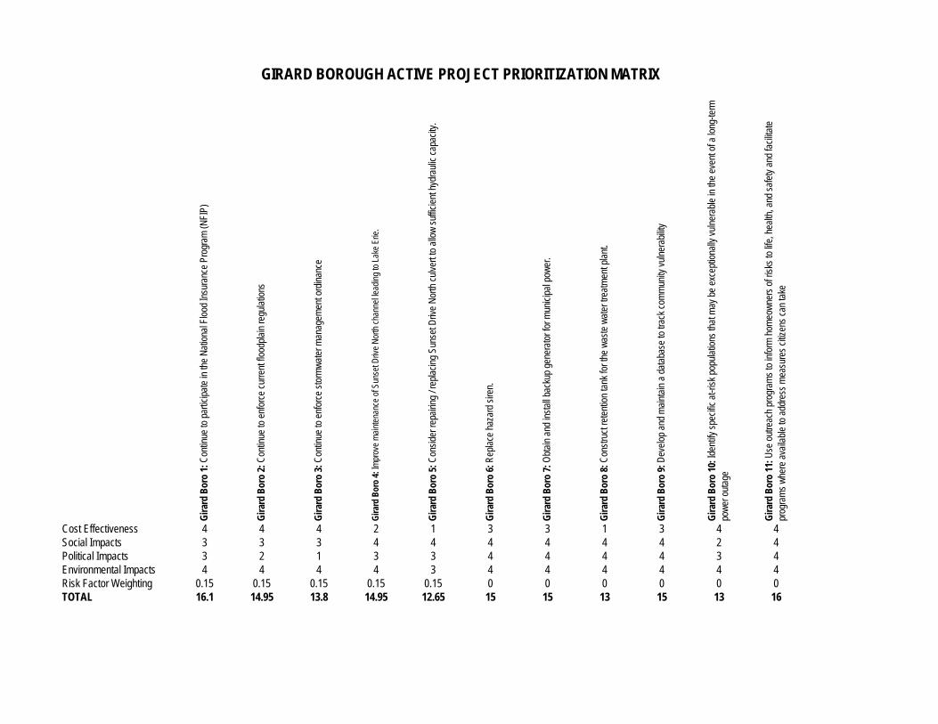
Gira
rd B
oro
1: C
ontin
ue to
par
ticip
ate
in th
e N
atio
nal F
lood
Insu
ranc
e Pr
ogra
m (N
FIP)
Gira
rd B
oro
2: C
ontin
ue to
enf
orce
cur
rent
floo
dpla
in re
gula
tions
Gira
rd B
oro
3: C
ontin
ue to
enf
orce
sto
rmw
ater
man
agem
ent o
rdin
ance
Gira
rd B
oro
4: Im
prov
e m
aint
enan
ce o
f Sun
set D
rive
Nor
th c
hann
el le
adin
g to
Lak
e Er
ie.
Gira
rd B
oro
5: C
onsi
der r
epai
ring
/ rep
laci
ng S
unse
t Driv
e N
orth
cul
vert
to a
llow
suf
ficie
nt h
ydra
ulic
cap
acity
.
Gira
rd B
oro
6: R
epla
ce h
azar
d si
ren.
Gira
rd B
oro
7: O
btai
n an
d in
stal
l bac
kup
gene
rato
r for
mun
icip
al p
ower
.
Gira
rd B
oro
8: C
onst
ruct
rete
ntio
n ta
nk fo
r the
was
te w
ater
trea
tmen
t pla
nt.
Gira
rd B
oro
9: D
evel
op a
nd m
aint
ain
a da
taba
se to
trac
k co
mm
unity
vul
nera
bilit
y
Gira
rd B
oro
10: I
dent
ify s
peci
fic a
t-ris
k po
pula
tions
that
may
be
exce
ptio
nally
vul
nera
ble
in th
e ev
ent o
f a lo
ng-te
rm
pow
er o
utag
e
Gira
rd B
oro
11: U
se o
utre
ach
prog
ram
s to
info
rm h
omeo
wne
rs o
f ris
ks to
life
, hea
lth, a
nd s
afet
y an
d fa
cilit
ate
prog
ram
s w
here
ava
ilabl
e to
add
ress
mea
sure
s ci
tizen
s ca
n ta
ke
Cost Effectiveness 4 4 4 2 1 3 3 1 3 4 4Social Impacts 3 3 3 4 4 4 4 4 4 2 4Political Impacts 3 2 1 3 3 4 4 4 4 3 4Environmental Impacts 4 4 4 4 3 4 4 4 4 4 4Risk Factor Weighting 0.15 0.15 0.15 0.15 0.15 0 0 0 0 0 0TOTAL 16.1 14.95 13.8 14.95 12.65 15 15 13 15 13 16
GIRARD BOROUGH ACTIVE PROJECT PRIORITIZATION MATRIX
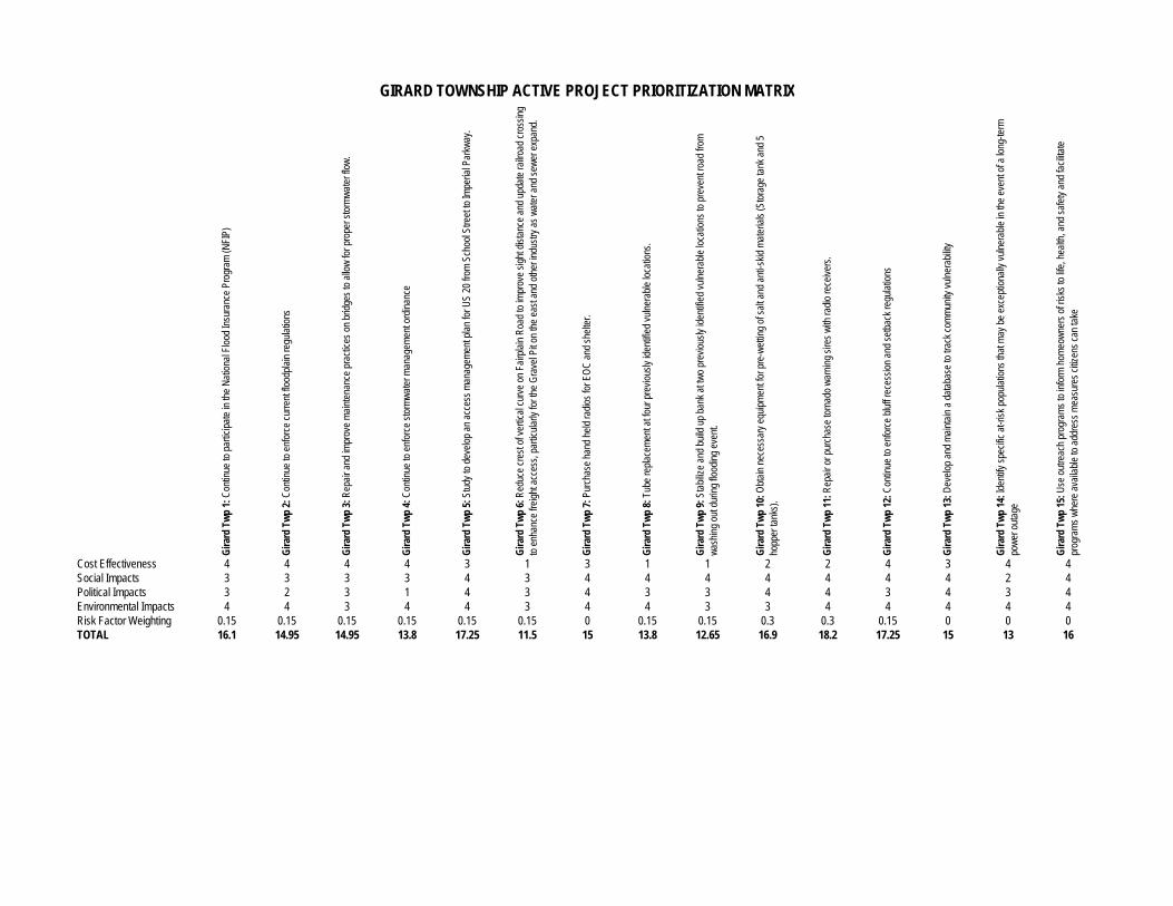
Gira
rd T
wp
1: C
ontin
ue to
par
ticip
ate
in th
e N
atio
nal F
lood
Insu
ranc
e Pr
ogra
m (N
FIP)
Gira
rd T
wp
2: C
ontin
ue to
enf
orce
cur
rent
floo
dpla
in re
gula
tions
Gira
rd T
wp
3: R
epai
r and
impr
ove
mai
nten
ance
pra
ctic
es o
n br
idge
s to
allo
w fo
r pro
per s
torm
wat
er fl
ow.
Gira
rd T
wp
4: C
ontin
ue to
enf
orce
sto
rmw
ater
man
agem
ent o
rdin
ance
Gira
rd T
wp
5: S
tudy
to d
evel
op a
n ac
cess
man
agem
ent p
lan
for U
S 20
from
Sch
ool S
treet
to Im
peria
l Par
kway
.
Gira
rd T
wp
6: R
educ
e cr
est o
f ver
tical
cur
ve o
n Fa
irpla
in R
oad
to im
prov
e si
ght d
ista
nce
and
upda
te ra
ilroa
d cr
ossi
ng
to e
nhan
ce fr
eigh
t acc
ess,
par
ticul
arly
for t
he G
rave
l Pit
on th
e ea
st a
nd o
ther
indu
stry
as
wat
er a
nd s
ewer
exp
and.
Gira
rd T
wp
7: P
urch
ase
hand
hel
d ra
dios
for E
OC
and
she
lter.
Gira
rd T
wp
8: T
ube
repl
acem
ent a
t fou
r pre
viou
sly
iden
tifie
d vu
lner
able
loca
tions
.
Gira
rd T
wp
9: S
tabi
lize
and
build
up
bank
at t
wo
prev
ious
ly id
entif
ied
vuln
erab
le lo
catio
ns to
pre
vent
road
from
w
ashi
ng o
ut d
urin
g flo
odin
g ev
ent.
Gira
rd T
wp
10: O
btai
n ne
cess
ary
equi
pmen
t for
pre
-wet
ting
of s
alt a
nd a
nti-s
kid
mat
eria
ls (S
tora
ge ta
nk a
nd 5
hopp
er ta
nks)
.
Gira
rd T
wp
11: R
epai
r or p
urch
ase
torn
ado
war
ning
sire
s w
ith ra
dio
rece
iver
s.
Gira
rd T
wp
12: C
ontin
ue to
enf
orce
blu
ff re
cess
ion
and
setb
ack
regu
latio
ns
Gira
rd T
wp
13: D
evel
op a
nd m
aint
ain
a da
taba
se to
trac
k co
mm
unity
vul
nera
bilit
y
Gira
rd T
wp
14: I
dent
ify s
peci
fic a
t-ris
k po
pula
tions
that
may
be
exce
ptio
nally
vul
nera
ble
in th
e ev
ent o
f a lo
ng-te
rm
pow
er o
utag
e
Gira
rd T
wp
15: U
se o
utre
ach
prog
ram
s to
info
rm h
omeo
wne
rs o
f ris
ks to
life
, hea
lth, a
nd s
afet
y an
d fa
cilit
ate
prog
ram
s w
here
ava
ilabl
e to
add
ress
mea
sure
s ci
tizen
s ca
n ta
ke
Cost Effectiveness 4 4 4 4 3 1 3 1 1 2 2 4 3 4 4Social Impacts 3 3 3 3 4 3 4 4 4 4 4 4 4 2 4Political Impacts 3 2 3 1 4 3 4 3 3 4 4 3 4 3 4Environmental Impacts 4 4 3 4 4 3 4 4 3 3 4 4 4 4 4Risk Factor Weighting 0.15 0.15 0.15 0.15 0.15 0.15 0 0.15 0.15 0.3 0.3 0.15 0 0 0TOTAL 16.1 14.95 14.95 13.8 17.25 11.5 15 13.8 12.65 16.9 18.2 17.25 15 13 16
GIRARD TOWNSHIP ACTIVE PROJECT PRIORITIZATION MATRIX
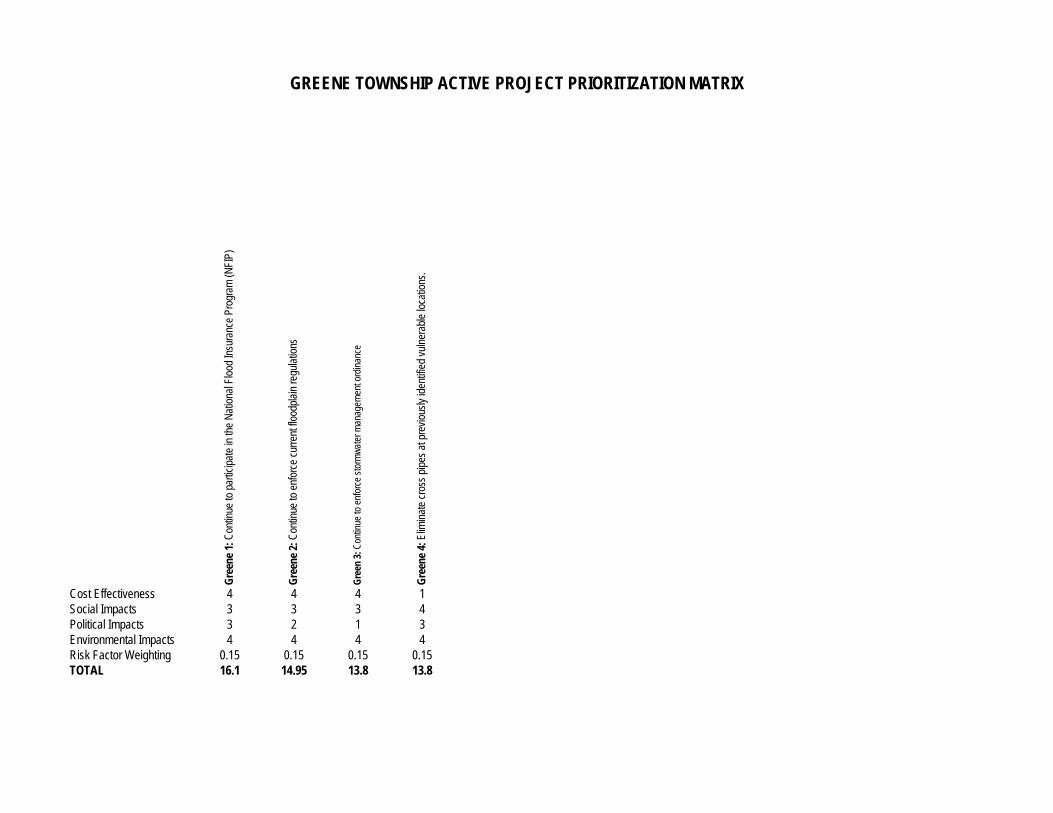
Gre
ene
1: C
ontin
ue to
par
ticip
ate
in th
e N
atio
nal F
lood
Insu
ranc
e Pr
ogra
m (N
FIP)
Gre
ene
2: C
ontin
ue to
enf
orce
cur
rent
floo
dpla
in re
gula
tions
Gre
en 3
: Con
tinue
to e
nfor
ce s
torm
wat
er m
anag
emen
t ord
inan
ce
Gre
ene
4: E
limin
ate
cros
s pi
pes
at p
revi
ousl
y id
entif
ied
vuln
erab
le lo
catio
ns.
Cost Effectiveness 4 4 4 1Social Impacts 3 3 3 4Political Impacts 3 2 1 3Environmental Impacts 4 4 4 4Risk Factor Weighting 0.15 0.15 0.15 0.15TOTAL 16.1 14.95 13.8 13.8
GREENE TOWNSHIP ACTIVE PROJECT PRIORITIZATION MATRIX
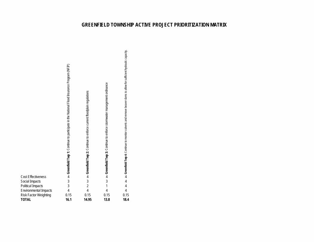
Gre
enfie
ld T
wp
1: C
ontin
ue to
par
ticip
ate
in th
e N
atio
nal F
lood
Insu
ranc
e Pr
ogra
m (N
FIP)
Gre
enfie
ld T
wp
2: C
ontin
ue to
enf
orce
cur
rent
floo
dpla
in re
gula
tions
Gre
enfie
ld T
wp
3: C
ontin
ue to
enf
orce
sto
rmw
ater
man
agem
ent o
rdin
ance
Gre
enfie
ld T
wp
4: C
ontin
ue to
mon
itor c
ulve
rts a
nd re
mov
e be
aver
dam
s to
allo
w fo
r suf
ficie
nt h
ydra
ulic
cap
acity
.
Cost Effectiveness 4 4 4 4Social Impacts 3 3 3 4Political Impacts 3 2 1 4Environmental Impacts 4 4 4 4Risk Factor Weighting 0.15 0.15 0.15 0.15TOTAL 16.1 14.95 13.8 18.4
GREENFIELD TOWNSHIP ACTIVE PROJECT PRIORITIZATION MATRIX
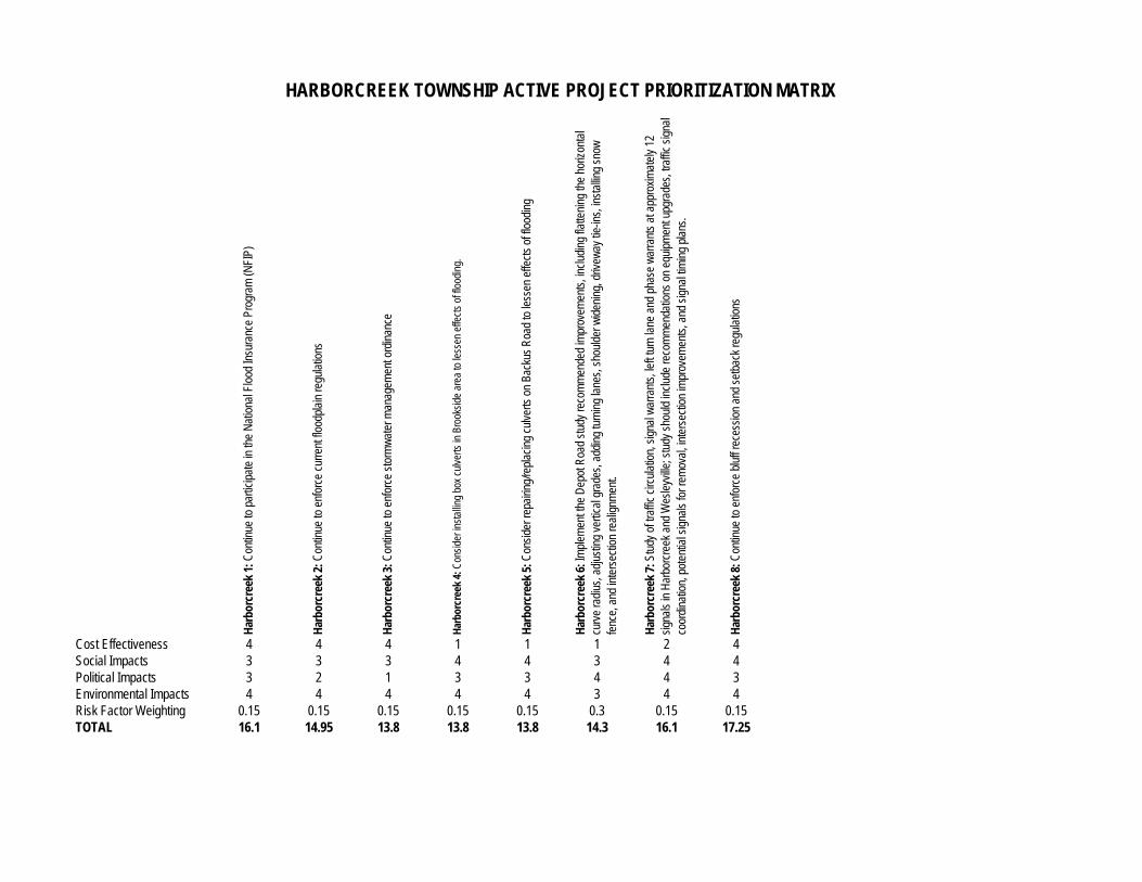
Har
borc
reek
1: C
ontin
ue to
par
ticip
ate
in th
e N
atio
nal F
lood
Insu
ranc
e Pr
ogra
m (N
FIP)
Har
borc
reek
2: C
ontin
ue to
enf
orce
cur
rent
floo
dpla
in re
gula
tions
Har
borc
reek
3: C
ontin
ue to
enf
orce
sto
rmw
ater
man
agem
ent o
rdin
ance
Har
borc
reek
4: C
onsi
der i
nsta
lling
box
culv
erts
in B
rook
side
are
a to
less
en e
ffect
s of
floo
ding
.
Har
borc
reek
5: C
onsi
der r
epai
ring/
repl
acin
g cu
lver
ts o
n Ba
ckus
Roa
d to
less
en e
ffect
s of
floo
ding
Har
borc
reek
6: I
mpl
emen
t the
Dep
ot R
oad
stud
y re
com
men
ded
impr
ovem
ents
, inc
ludi
ng fl
atte
ning
the
horiz
onta
l
curv
e ra
dius
, adj
ustin
g ve
rtica
l gra
des,
add
ing
turn
ing
lane
s, s
houl
der w
iden
ing,
driv
eway
tie-
ins,
inst
allin
g sn
ow
fenc
e, a
nd in
ters
ectio
n re
alig
nmen
t.
Har
borc
reek
7: S
tudy
of t
raffi
c ci
rcul
atio
n, s
igna
l war
rant
s, le
ft tu
rn la
ne a
nd p
hase
war
rant
s at
app
roxi
mat
ely
12
sign
als
in H
arbo
rcre
ek a
nd W
esle
yville
; stu
dy s
houl
d in
clud
e re
com
men
datio
ns o
n eq
uipm
ent u
pgra
des,
traf
fic s
igna
l
co
ordi
natio
n, p
oten
tial s
igna
ls fo
r rem
oval
, int
erse
ctio
n im
prov
emen
ts, a
nd s
igna
l tim
ing
plan
s.
Har
borc
reek
8: C
ontin
ue to
enf
orce
blu
ff re
cess
ion
and
setb
ack
regu
latio
ns
Cost Effectiveness 4 4 4 1 1 1 2 4Social Impacts 3 3 3 4 4 3 4 4Political Impacts 3 2 1 3 3 4 4 3Environmental Impacts 4 4 4 4 4 3 4 4Risk Factor Weighting 0.15 0.15 0.15 0.15 0.15 0.3 0.15 0.15TOTAL 16.1 14.95 13.8 13.8 13.8 14.3 16.1 17.25
HARBORCREEK TOWNSHIP ACTIVE PROJECT PRIORITIZATION MATRIX
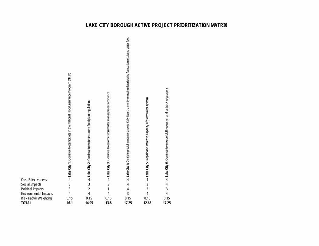
Lake
City
1: C
ontin
ue to
par
ticip
ate
in th
e N
atio
nal F
lood
Insu
ranc
e Pr
ogra
m (N
FIP)
Lake
City
2: C
ontin
ue to
enf
orce
cur
rent
floo
dpla
in re
gula
tions
Lake
City
3: C
ontin
ue to
enf
orce
sto
rmw
ater
man
agem
ent o
rdin
ance
Lake
City
4: C
onsi
der p
rovi
ding
mai
nten
ance
to K
elly
Run
cha
nnel
by
rem
ovin
g de
terio
ratin
g fo
unda
tion
rest
rictin
g w
ater
flow
.
Lake
City
5: R
epai
r and
incr
ease
cap
acity
of s
torm
wat
er s
yste
m.
Lake
City
6: C
ontin
ue to
enf
orce
blu
ff re
cess
ion
and
setb
ack
regu
latio
ns
Cost Effectiveness 4 4 4 4 1 4Social Impacts 3 3 3 4 3 4Political Impacts 3 2 1 4 3 3Environmental Impacts 4 4 4 3 4 4Risk Factor Weighting 0.15 0.15 0.15 0.15 0.15 0.15TOTAL 16.1 14.95 13.8 17.25 12.65 17.25
LAKE CITY BOROUGH ACTIVE PROJECT PRIORITIZATION MATRIX
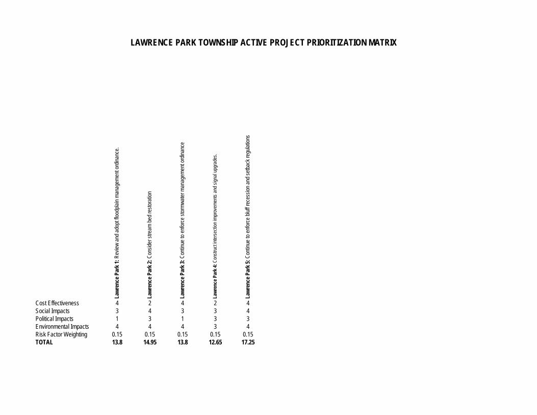
Law
renc
e Pa
rk 1
: Rev
iew
and
ado
pt fl
oodp
lain
man
agem
ent o
rdin
ance
.
Law
renc
e Pa
rk 2
: Con
side
r stre
am b
ed re
stor
atio
n
Law
renc
e Pa
rk 3
: Con
tinue
to e
nfor
ce s
torm
wat
er m
anag
emen
t ord
inan
ce
Law
renc
e Pa
rk 4
: Con
stru
ct in
ters
ectio
n im
prov
emen
ts a
nd s
igna
l upg
rade
s.
Law
renc
e Pa
rk 5
: Con
tinue
to e
nfor
ce b
luff
rece
ssio
n an
d se
tbac
k re
gula
tions
Cost Effectiveness 4 2 4 2 4Social Impacts 3 4 3 3 4Political Impacts 1 3 1 3 3Environmental Impacts 4 4 4 3 4Risk Factor Weighting 0.15 0.15 0.15 0.15 0.15TOTAL 13.8 14.95 13.8 12.65 17.25
LAWRENCE PARK TOWNSHIP ACTIVE PROJECT PRIORITIZATION MATRIX
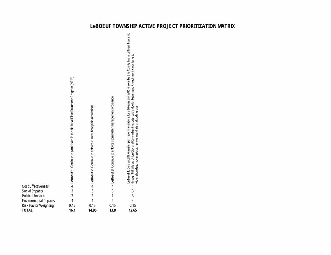
LeB
oeuf
1: C
ontin
ue to
par
ticip
ate
in th
e N
atio
nal F
lood
Insu
ranc
e Pr
ogra
m (N
FIP)
LeB
oeuf
2: C
ontin
ue to
enf
orce
cur
rent
floo
dpla
in re
gula
tions
LeB
oeuf
3: C
ontin
ue to
enf
orce
sto
rmw
ater
man
agem
ent o
rdin
ance
LeB
oeuf
4: C
onst
ruct
Rt.
6 m
aste
r pla
n re
com
men
datio
ns fo
r a b
ikew
ay a
long
US
6 fro
m th
e Er
ie C
ount
y lin
e in
LeB
oeuf
Tow
nshi
p th
roug
h M
ill Vi
llage
, Uni
on C
ity, a
nd C
orry
whe
n th
e st
ate
road
is d
ue fo
r bet
term
ent.
Proj
ect m
ay in
clud
e ta
sks
to
w
iden
sho
ulde
rs, m
ove/
repl
ace,
rem
ove
guar
drai
ls a
nd a
dd s
igna
ge.
Cost Effectiveness 4 4 4 1Social Impacts 3 3 3 3Political Impacts 3 2 1 3Environmental Impacts 4 4 4 4Risk Factor Weighting 0.15 0.15 0.15 0.15TOTAL 16.1 14.95 13.8 12.65
LeBOEUF TOWNSHIP ACTIVE PROJECT PRIORITIZATION MATRIX
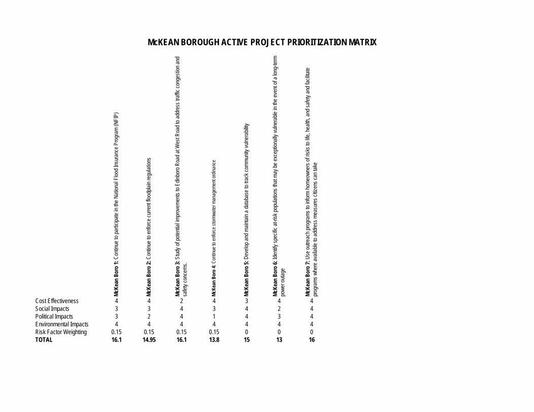
McK
ean
Bor
o 1:
Con
tinue
to p
artic
ipat
e in
the
Nat
iona
l Flo
od In
sura
nce
Prog
ram
(NFI
P)
McK
ean
Bor
o 2:
Con
tinue
to e
nfor
ce c
urre
nt fl
oodp
lain
regu
latio
ns
McK
ean
Bor
o 3:
Stu
dy o
f pot
entia
l im
prov
emen
ts to
Edi
nbor
o R
oad
at W
est R
oad
to a
ddre
ss tr
affic
con
gest
ion
and
safe
ty c
once
rns.
McK
ean
Bor
o 4:
Con
tinue
to e
nfor
ce s
torm
wat
er m
anag
emen
t ord
inan
ce
McK
ean
Bor
o 5:
Dev
elop
and
mai
ntai
n a
data
base
to tr
ack
com
mun
ity v
ulne
rabi
lity
McK
ean
Bor
o 6:
Iden
tify
spec
ific
at-ri
sk p
opul
atio
ns th
at m
ay b
e ex
cept
iona
lly v
ulne
rabl
e in
the
even
t of a
long
-term
po
wer
out
age
McK
ean
Bor
o 7:
Use
out
reac
h pr
ogra
ms
to in
form
hom
eow
ners
of r
isks
to li
fe, h
ealth
, and
saf
ety
and
faci
litat
e
prog
ram
s w
here
ava
ilabl
e to
add
ress
mea
sure
s ci
tizen
s ca
n ta
ke
Cost Effectiveness 4 4 2 4 3 4 4Social Impacts 3 3 4 3 4 2 4Political Impacts 3 2 4 1 4 3 4Environmental Impacts 4 4 4 4 4 4 4Risk Factor Weighting 0.15 0.15 0.15 0.15 0 0 0TOTAL 16.1 14.95 16.1 13.8 15 13 16
McKEAN BOROUGH ACTIVE PROJECT PRIORITIZATION MATRIX

McK
ean
Twp
1: C
ontin
ue to
par
ticip
ate
in th
e N
atio
nal F
lood
Insu
ranc
e Pr
ogra
m (N
FIP)
McK
ean
Twp
2: C
ontin
ue to
enf
orce
cur
rent
floo
dpla
in re
gula
tions
McK
ean
Twp
3: S
tabi
lizat
ion
of p
revi
ousl
y id
entif
ied
vuln
erab
le lo
catio
ns.
McK
ean
Twp
4: C
ontin
ue to
enf
orce
sto
rmw
ater
man
agem
ent o
rdin
ance
McK
ean
Twp
5: D
evel
op a
nd m
aint
ain
a da
taba
se to
trac
k co
mm
unity
vul
nera
bilit
y
McK
ean
Twp
6: Id
entif
y sp
ecifi
c at
-risk
pop
ulat
ions
that
may
be
exce
ptio
nally
vul
nera
ble
in th
e ev
ent o
f a lo
ng-te
rm
pow
er o
utag
e
McK
ean
Twp
7: U
se o
utre
ach
prog
ram
s to
info
rm h
omeo
wne
rs o
f ris
ks to
life
, hea
lth, a
nd s
afet
y an
d fa
cilit
ate
prog
ram
s w
here
ava
ilabl
e to
add
ress
mea
sure
s ci
tizen
s ca
n ta
ke
McK
ean
Twp
8: P
urch
ase
and
inst
all w
arni
ng s
irens
with
radi
o re
ceiv
ers.
Cost Effectiveness 4 4 1 4 3 4 4 2Social Impacts 3 3 4 3 4 2 4 4Political Impacts 3 2 3 1 4 3 4 3Environmental Impacts 4 4 4 4 4 4 4 4Risk Factor Weighting 0.15 0.15 0.15 0.15 0 0 0 0TOTAL 16.1 14.95 13.8 13.8 15 13 16 13
McKEAN TOWNSHIP ACTIVE PROJECT PRIORITIZATION MATRIX
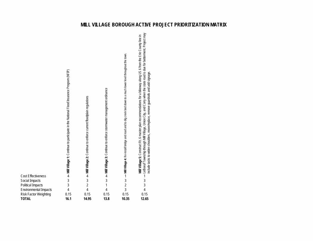
Mill
Vill
age
1: C
ontin
ue to
par
ticip
ate
in th
e N
atio
nal F
lood
Insu
ranc
e Pr
ogra
m (N
FIP)
Mill
Vill
age
2: C
ontin
ue to
enf
orce
cur
rent
floo
dpla
in re
gula
tions
Mill
Vill
age
3: C
ontin
ue to
enf
orce
sto
rmw
ater
man
agem
ent o
rdin
ance
Mill
Vill
age
4: R
e-in
stal
l brid
ge a
nd ro
ad a
nd to
dig
cre
ek b
ed d
own
to a
muc
h lo
wer
leve
l thr
ough
out t
he to
wn.
Mill
Vill
age
5: C
onst
ruct
Rt.
6 m
aste
r pla
n re
com
men
datio
ns fo
r a b
ikew
ay a
long
US
6 fro
m th
e Er
ie C
ount
y lin
e in
Le
Boeu
f Tow
nshi
p th
roug
h M
ill Vi
llage
, Uni
on C
ity, a
nd C
orry
whe
n th
e st
ate
road
is d
ue fo
r bet
term
ent.
Proj
ect m
ay
incl
ude
task
s to
wid
en s
houl
ders
, mov
e/re
plac
e, re
mov
e gu
ardr
ails
and
add
sig
nage
.
Cost Effectiveness 4 4 4 1 1Social Impacts 3 3 3 3 3Political Impacts 3 2 1 2 3Environmental Impacts 4 4 4 3 4Risk Factor Weighting 0.15 0.15 0.15 0.15 0.15TOTAL 16.1 14.95 13.8 10.35 12.65
MILL VILLAGE BOROUGH ACTIVE PROJECT PRIORITIZATION MATRIX
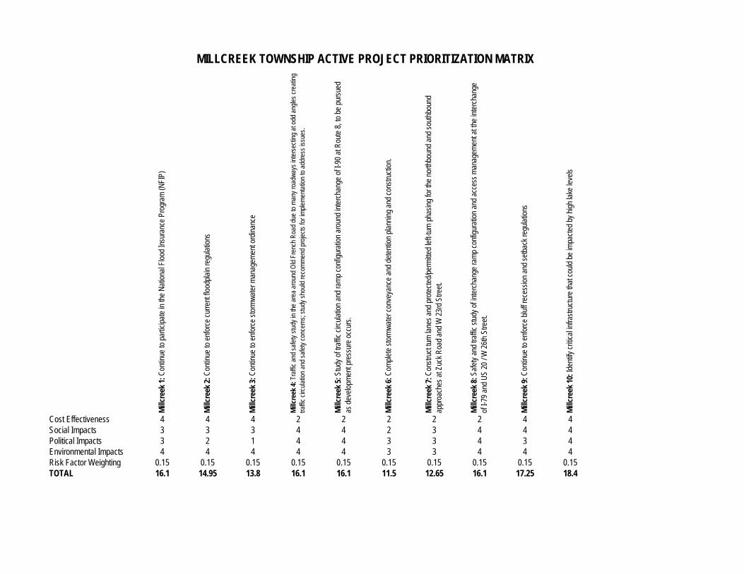
Mill
cree
k 1:
Con
tinue
to p
artic
ipat
e in
the
Nat
iona
l Flo
od In
sura
nce
Prog
ram
(NFI
P)
Mill
cree
k 2:
Con
tinue
to e
nfor
ce c
urre
nt fl
oodp
lain
regu
latio
ns
Mill
cree
k 3:
Con
tinue
to e
nfor
ce s
torm
wat
er m
anag
emen
t ord
inan
ce
Mill
cree
k 4:
Tra
ffic
and
safe
ty s
tudy
in th
e ar
ea a
roun
d O
ld F
renc
h R
oad
due
to m
any
road
way
s in
ters
ectin
g at
odd
ang
les
crea
ting
traffi
c ci
rcul
atio
n an
d sa
fety
con
cern
s; s
tudy
sho
uld
reco
mm
end
proj
ects
for i
mpl
emen
tatio
n to
add
ress
issu
es.
Mill
cree
k 5:
Stu
dy o
f tra
ffic
circ
ulat
ion
and
ram
p co
nfig
urat
ion
arou
nd in
terc
hang
e of
I-90
at R
oute
8, t
o be
pur
sued
as
dev
elop
men
t pre
ssur
e oc
curs
.
Mill
cree
k 6:
Com
plet
e st
orm
wat
er c
onve
yanc
e an
d de
tent
ion
plan
ning
and
con
stru
ctio
n.
Mill
cree
k 7:
Con
stru
ct tu
rn la
nes
and
prot
ecte
d/pe
rmitt
ed le
ft-tu
rn p
hasi
ng fo
r the
nor
thbo
und
and
sout
hbou
nd
ap
proa
ches
at Z
uck
Roa
d an
d W
23r
d St
reet
.
Mill
cree
k 8:
Saf
ety
and
traffi
c st
udy
of in
terc
hang
e ra
mp
conf
igur
atio
n an
d ac
cess
man
agem
ent a
t the
inte
rcha
nge
of
I-79
and
US
20 /
W 2
6th
Stre
et.
Mill
cree
k 9:
Con
tinue
to e
nfor
ce b
luff
rece
ssio
n an
d se
tbac
k re
gula
tions
Mill
cree
k 10
: Ide
ntify
crit
ical
infra
stru
ctur
e th
at c
ould
be
impa
cted
by
high
lake
leve
ls
Cost Effectiveness 4 4 4 2 2 2 2 2 4 4Social Impacts 3 3 3 4 4 2 3 4 4 4Political Impacts 3 2 1 4 4 3 3 4 3 4Environmental Impacts 4 4 4 4 4 3 3 4 4 4Risk Factor Weighting 0.15 0.15 0.15 0.15 0.15 0.15 0.15 0.15 0.15 0.15TOTAL 16.1 14.95 13.8 16.1 16.1 11.5 12.65 16.1 17.25 18.4
MILLCREEK TOWNSHIP ACTIVE PROJECT PRIORITIZATION MATRIX
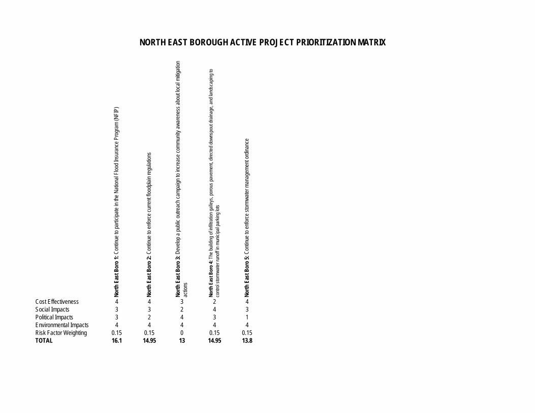
Nor
th E
ast B
oro
1: C
ontin
ue to
par
ticip
ate
in th
e N
atio
nal F
lood
Insu
ranc
e Pr
ogra
m (N
FIP)
Nor
th E
ast B
oro
2: C
ontin
ue to
enf
orce
cur
rent
floo
dpla
in re
gula
tions
Nor
th E
ast B
oro
3: D
evel
op a
pub
lic o
utre
ach
cam
paig
n to
incr
ease
com
mun
ity a
war
enes
s ab
out l
ocal
miti
gatio
n
ac
tions
Nor
th E
ast B
oro
4: T
he b
uild
ing
of in
filtra
tion
galle
ys, p
orou
s pa
vem
ent,
dire
cted
dow
nspo
ut d
rain
age,
and
land
scap
ing
to
cont
rol s
torm
wat
er ru
noff
in m
unic
ipal
par
king
lots
Nor
th E
ast B
oro
5: C
ontin
ue to
enf
orce
sto
rmw
ater
man
agem
ent o
rdin
ance
Cost Effectiveness 4 4 3 2 4Social Impacts 3 3 2 4 3Political Impacts 3 2 4 3 1Environmental Impacts 4 4 4 4 4Risk Factor Weighting 0.15 0.15 0 0.15 0.15TOTAL 16.1 14.95 13 14.95 13.8
NORTH EAST BOROUGH ACTIVE PROJECT PRIORITIZATION MATRIX
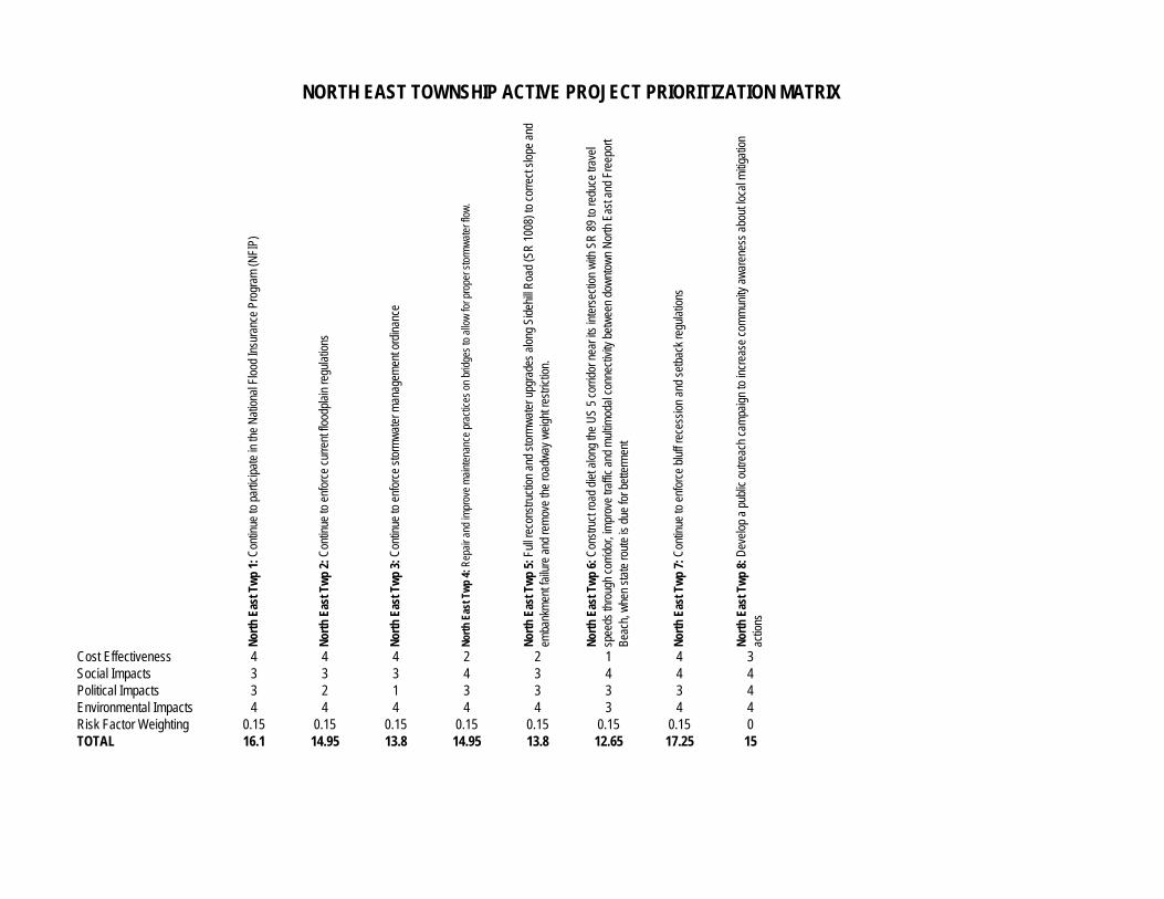
Nor
th E
ast T
wp
1: C
ontin
ue to
par
ticip
ate
in th
e N
atio
nal F
lood
Insu
ranc
e Pr
ogra
m (N
FIP)
Nor
th E
ast T
wp
2: C
ontin
ue to
enf
orce
cur
rent
floo
dpla
in re
gula
tions
Nor
th E
ast T
wp
3: C
ontin
ue to
enf
orce
sto
rmw
ater
man
agem
ent o
rdin
ance
Nor
th E
ast T
wp
4: R
epai
r and
impr
ove
mai
nten
ance
pra
ctic
es o
n br
idge
s to
allo
w fo
r pro
per s
torm
wat
er fl
ow.
Nor
th E
ast T
wp
5: F
ull r
econ
stru
ctio
n an
d st
orm
wat
er u
pgra
des
alon
g Si
dehi
ll R
oad
(SR
100
8) to
cor
rect
slo
pe a
nd
emba
nkm
ent f
ailu
re a
nd re
mov
e th
e ro
adw
ay w
eigh
t res
trict
ion.
Nor
th E
ast T
wp
6: C
onst
ruct
road
die
t alo
ng th
e U
S 5
corri
dor n
ear i
ts in
ters
ectio
n w
ith S
R 8
9 to
redu
ce tr
avel
spee
ds th
roug
h co
rrido
r, im
prov
e tra
ffic
and
mul
timod
al c
onne
ctiv
ity b
etw
een
dow
ntow
n N
orth
Eas
t and
Fre
epor
t
Be
ach,
whe
n st
ate
rout
e is
due
for b
ette
rmen
t
Nor
th E
ast T
wp
7: C
ontin
ue to
enf
orce
blu
ff re
cess
ion
and
setb
ack
regu
latio
ns
Nor
th E
ast T
wp
8: D
evel
op a
pub
lic o
utre
ach
cam
paig
n to
incr
ease
com
mun
ity a
war
enes
s ab
out l
ocal
miti
gatio
n
ac
tions
Cost Effectiveness 4 4 4 2 2 1 4 3Social Impacts 3 3 3 4 3 4 4 4Political Impacts 3 2 1 3 3 3 3 4Environmental Impacts 4 4 4 4 4 3 4 4Risk Factor Weighting 0.15 0.15 0.15 0.15 0.15 0.15 0.15 0TOTAL 16.1 14.95 13.8 14.95 13.8 12.65 17.25 15
NORTH EAST TOWNSHIP ACTIVE PROJECT PRIORITIZATION MATRIX
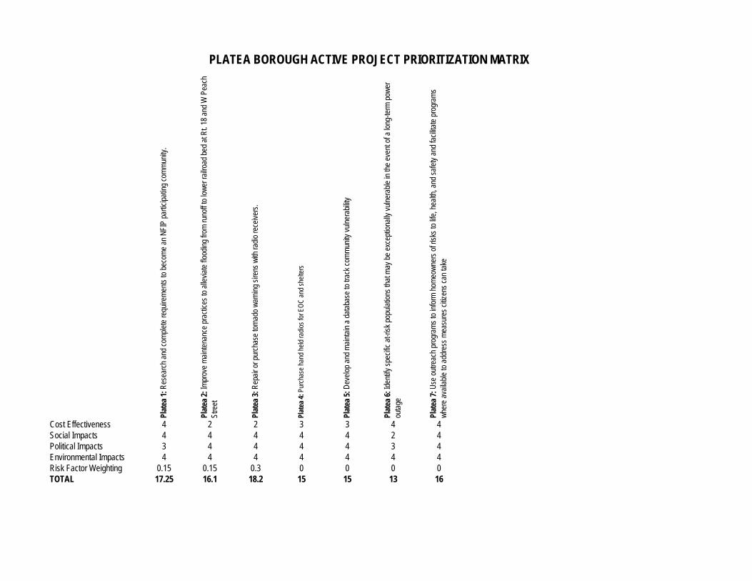
Plat
ea 1
: Res
earc
h an
d co
mpl
ete
requ
irem
ents
to b
ecom
e an
NFI
P pa
rtici
patin
g co
mm
unity
.
Plat
ea 2
: Im
prov
e m
aint
enan
ce p
ract
ices
to a
llevi
ate
flood
ing
from
runo
ff to
low
er ra
ilroa
d be
d at
Rt.
18 a
nd W
Pea
ch
St
reet
Plat
ea 3
: Rep
air o
r pur
chas
e to
rnad
o w
arni
ng s
irens
with
radi
o re
ceiv
ers.
Plat
ea 4
: Pur
chas
e ha
nd h
eld
radi
os fo
r EO
C a
nd s
helte
rs
Plat
ea 5
: Dev
elop
and
mai
ntai
n a
data
base
to tr
ack
com
mun
ity v
ulne
rabi
lity
Plat
ea 6
: Ide
ntify
spe
cific
at-r
isk
popu
latio
ns th
at m
ay b
e ex
cept
iona
lly v
ulne
rabl
e in
the
even
t of a
long
-term
pow
er
outa
ge
Plat
ea 7
: Use
out
reac
h pr
ogra
ms
to in
form
hom
eow
ners
of r
isks
to li
fe, h
ealth
, and
saf
ety
and
faci
litat
e pr
ogra
ms
whe
re a
vaila
ble
to a
ddre
ss m
easu
res
citiz
ens
can
take
Cost Effectiveness 4 2 2 3 3 4 4Social Impacts 4 4 4 4 4 2 4Political Impacts 3 4 4 4 4 3 4Environmental Impacts 4 4 4 4 4 4 4Risk Factor Weighting 0.15 0.15 0.3 0 0 0 0TOTAL 17.25 16.1 18.2 15 15 13 16
PLATEA BOROUGH ACTIVE PROJECT PRIORITIZATION MATRIX
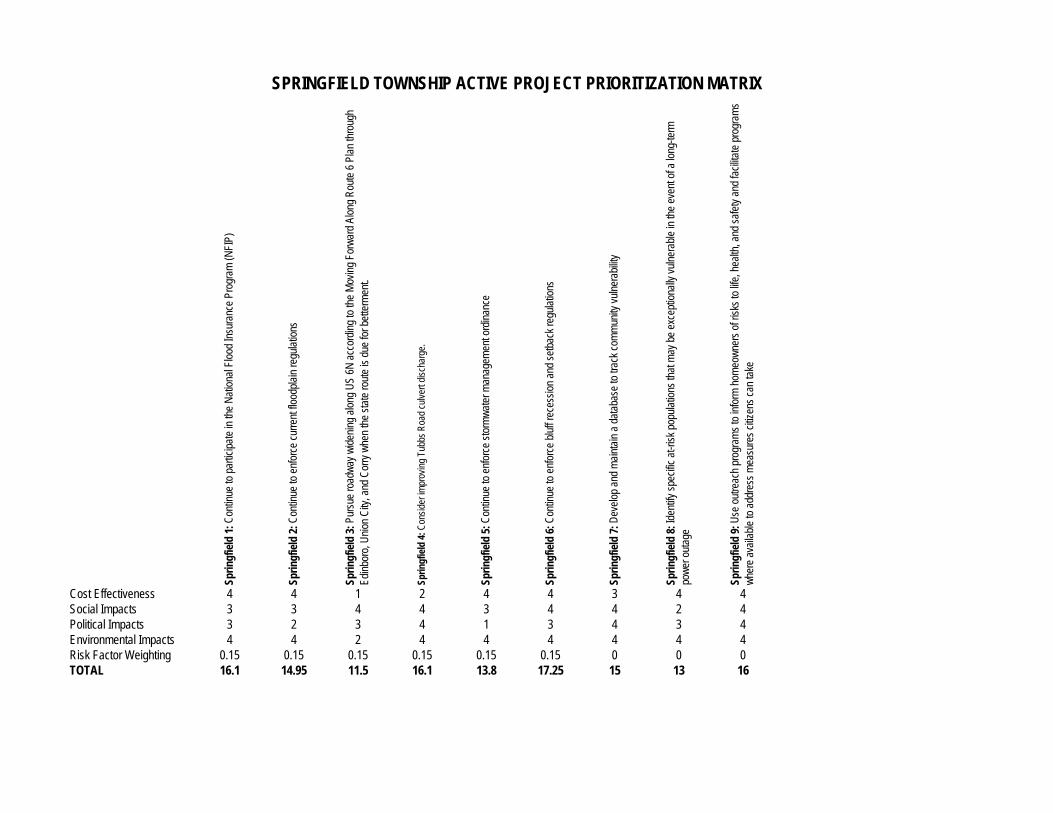
Sprin
gfie
ld 1
: Con
tinue
to p
artic
ipat
e in
the
Nat
iona
l Flo
od In
sura
nce
Prog
ram
(NFI
P)
Sprin
gfie
ld 2
: Con
tinue
to e
nfor
ce c
urre
nt fl
oodp
lain
regu
latio
ns
Sprin
gfie
ld 3
: Pur
sue
road
way
wid
enin
g al
ong
US
6N a
ccor
ding
to th
e M
ovin
g Fo
rwar
d Al
ong
Rou
te 6
Pla
n th
roug
h
Ed
inbo
ro, U
nion
City
, and
Cor
ry w
hen
the
stat
e ro
ute
is d
ue fo
r bet
term
ent.
Sprin
gfie
ld 4
: Con
side
r im
prov
ing
Tubb
s R
oad
culv
ert d
isch
arge
.
Sprin
gfie
ld 5
: Con
tinue
to e
nfor
ce s
torm
wat
er m
anag
emen
t ord
inan
ce
Sprin
gfie
ld 6
: Con
tinue
to e
nfor
ce b
luff
rece
ssio
n an
d se
tbac
k re
gula
tions
Sprin
gfie
ld 7
: Dev
elop
and
mai
ntai
n a
data
base
to tr
ack
com
mun
ity v
ulne
rabi
lity
Sprin
gfie
ld 8
: Ide
ntify
spe
cific
at-r
isk
popu
latio
ns th
at m
ay b
e ex
cept
iona
lly v
ulne
rabl
e in
the
even
t of a
long
-term
pow
er o
utag
e
Sprin
gfie
ld 9
: Use
out
reac
h pr
ogra
ms
to in
form
hom
eow
ners
of r
isks
to li
fe, h
ealth
, and
saf
ety
and
faci
litat
e pr
ogra
ms
whe
re a
vaila
ble
to a
ddre
ss m
easu
res
citiz
ens
can
take
Cost Effectiveness 4 4 1 2 4 4 3 4 4Social Impacts 3 3 4 4 3 4 4 2 4Political Impacts 3 2 3 4 1 3 4 3 4Environmental Impacts 4 4 2 4 4 4 4 4 4Risk Factor Weighting 0.15 0.15 0.15 0.15 0.15 0.15 0 0 0TOTAL 16.1 14.95 11.5 16.1 13.8 17.25 15 13 16
SPRINGFIELD TOWNSHIP ACTIVE PROJECT PRIORITIZATION MATRIX
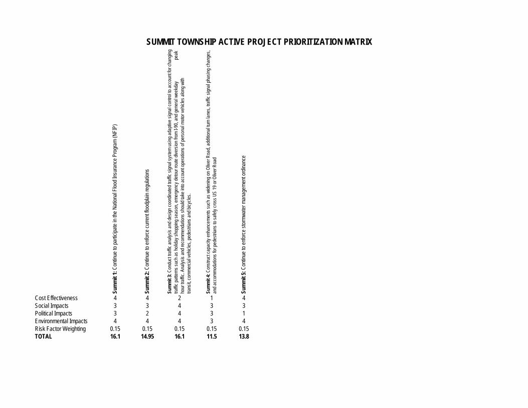
Sum
mit
1: C
ontin
ue to
par
ticip
ate
in th
e N
atio
nal F
lood
Insu
ranc
e Pr
ogra
m (N
FIP)
Sum
mit
2: C
ontin
ue to
enf
orce
cur
rent
floo
dpla
in re
gula
tions
Sum
mit
3: C
ondu
ct tr
affic
ana
lysi
s an
d de
sign
coo
rdin
ated
traf
fic s
igna
l sys
tem
usi
ng a
dapt
ive
sign
al c
ontro
l to
acco
unt f
or c
hang
ing
traffi
c pa
ttern
s su
ch a
s ho
liday
sho
ppin
g se
ason
, em
erge
ncy
deto
ur ro
ute
dive
rsio
n fro
m I-
90, a
nd g
ener
al w
eekd
ay
p
eak
hour
traf
fic. A
naly
sis
and
reco
mm
enda
tions
sho
uld
take
into
acc
ount
ope
ratio
ns o
f per
sona
l mot
or v
ehic
les
alon
g w
ith
trans
it, c
omm
erci
al v
ehic
les,
ped
estri
ans
and
bicy
cles
.
Sum
mit
4: C
onst
ruct
cap
acity
enh
ance
men
ts s
uch
as w
iden
ing
on O
liver
Roa
d, a
dditi
onal
turn
lane
s, tr
affic
sig
nal p
hasi
ng c
hang
es,
and
acco
mm
odat
ions
for p
edes
trian
s to
saf
ely
cros
s U
S 19
or O
liver
Roa
d
Sum
mit
5: C
ontin
ue to
enf
orce
sto
rmw
ater
man
agem
ent o
rdin
ance
Cost Effectiveness 4 4 2 1 4Social Impacts 3 3 4 3 3Political Impacts 3 2 4 3 1Environmental Impacts 4 4 4 3 4Risk Factor Weighting 0.15 0.15 0.15 0.15 0.15TOTAL 16.1 14.95 16.1 11.5 13.8
SUMMIT TOWNSHIP ACTIVE PROJECT PRIORITIZATION MATRIX

Uni
on T
wp
1: C
ontin
ue to
par
ticip
ate
in th
e N
atio
nal F
lood
Insu
ranc
e Pr
ogra
m (N
FIP)
Uni
on T
wp
2: C
ontin
ue to
enf
orce
cur
rent
floo
dpla
in re
gula
tions
Uni
on T
wp
3: C
onst
ruct
Rt.
6 m
aste
r pla
n re
com
men
datio
ns fo
r a b
ikew
ay a
long
US
6 fro
m th
e Er
ie C
ount
y lin
e in
Le
Boeu
f Tow
nshi
p th
roug
h M
ill Vi
llage
, Uni
on C
ity, a
nd C
orry
whe
n th
e st
ate
road
is d
ue fo
r bet
term
ent.
Proj
ect m
ay
incl
ude
task
s to
wid
en s
houl
ders
, mov
e/re
plac
e/re
mov
e gu
ardr
ails
, and
add
sig
nage
.
Uni
on T
wp
4: C
ontin
ue to
enf
orce
sto
rmw
ater
man
agem
ent o
rdin
ance
Cost Effectiveness 4 4 1 4Social Impacts 3 3 4 3Political Impacts 3 2 3 1Environmental Impacts 4 4 4 4Risk Factor Weighting 0.15 0.15 0.15 0.15TOTAL 16.1 14.95 13.8 13.8
UNION TOWNSHIP ACTIVE PROJECT PRIORITIZATION MATRIX

Uni
on C
ity 1
: Con
tinue
to p
artic
ipat
e in
the
Nat
iona
l Flo
od In
sura
nce
Prog
ram
(NFI
P)
Uni
on C
ity 2
: Con
tinue
to e
nfor
ce c
urre
nt fl
oodp
lain
regu
latio
ns
Uni
on C
ity 3
: Con
stru
ct R
t. 6
mas
ter p
lan
reco
mm
enda
tions
for a
bik
eway
alo
ng U
S 6
from
the
Erie
Cou
nty
line
in
Le
Boeu
f Tow
nshi
p th
roug
h M
ill Vi
llage
, Uni
on C
ity, a
nd C
orry
whe
n th
e st
ate
road
is d
ue fo
r bet
term
ent.
Proj
ect m
ay
incl
ude
task
s to
wid
en s
houl
ders
, mov
e/re
plac
e/re
mov
e gu
ardr
ails
, and
add
sig
nage
.
Uni
on C
ity 4
: Per
form
traf
fic a
naly
sis,
upg
rade
equ
ipm
ent,
and
prep
are
sign
al ti
min
gs a
t thr
ee tr
affic
sig
nals
in U
nion
City
to im
prov
e op
erat
ions
and
saf
ety
by re
duci
ng c
onge
stio
n.
Uni
on C
ity 5
: Con
tinue
to e
nfor
ce s
torm
wat
er m
anag
emen
t ord
inan
ce
Cost Effectiveness 4 4 1 2 4Social Impacts 3 3 4 4 3Political Impacts 3 2 3 4 1Environmental Impacts 4 4 4 4 4Risk Factor Weighting 0.15 0.15 0.15 0.15 0.15TOTAL 16.1 14.95 13.8 16.1 13.8
UNION CITY BOROUGH ACTIVE PROJECT PRIORITIZATION MATRIX
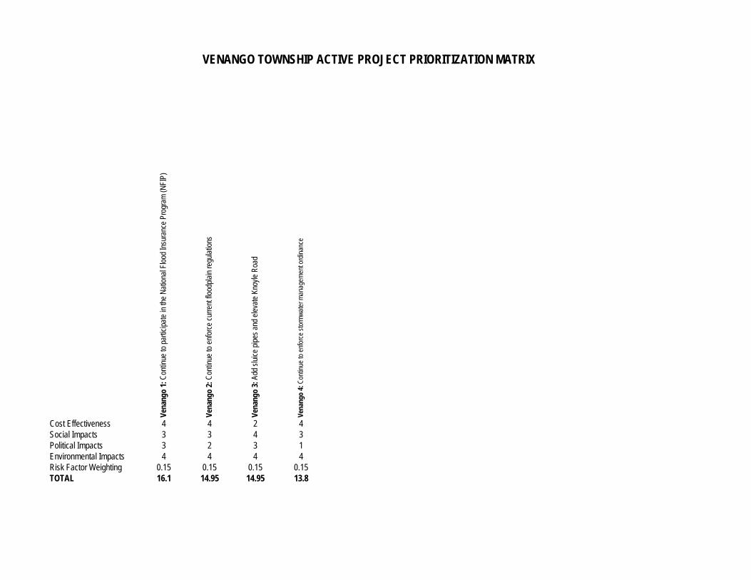
Vena
ngo
1: C
ontin
ue to
par
ticip
ate
in th
e N
atio
nal F
lood
Insu
ranc
e Pr
ogra
m (N
FIP)
Vena
ngo
2: C
ontin
ue to
enf
orce
cur
rent
floo
dpla
in re
gula
tions
Vena
ngo
3: A
dd s
luic
e pi
pes
and
elev
ate
Knoy
le R
oad
Vena
ngo
4: C
ontin
ue to
enf
orce
sto
rmw
ater
man
agem
ent o
rdin
ance
Cost Effectiveness 4 4 2 4Social Impacts 3 3 4 3Political Impacts 3 2 3 1Environmental Impacts 4 4 4 4Risk Factor Weighting 0.15 0.15 0.15 0.15TOTAL 16.1 14.95 14.95 13.8
VENANGO TOWNSHIP ACTIVE PROJECT PRIORITIZATION MATRIX
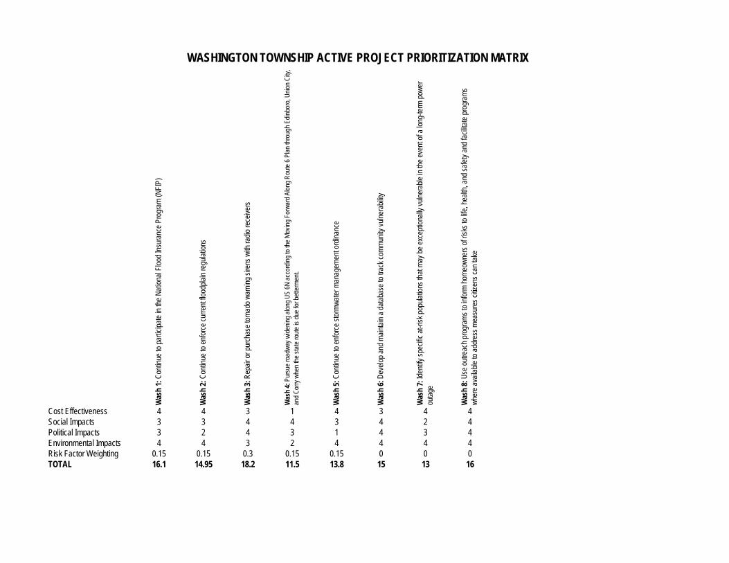
Was
h 1:
Con
tinue
to p
artic
ipat
e in
the
Nat
iona
l Flo
od In
sura
nce
Prog
ram
(NFI
P)
Was
h 2:
Con
tinue
to e
nfor
ce c
urre
nt fl
oodp
lain
regu
latio
ns
Was
h 3:
Rep
air o
r pur
chas
e to
rnad
o w
arni
ng s
irens
with
radi
o re
ceiv
ers
Was
h 4:
Pur
sue
road
way
wid
enin
g al
ong
US
6N a
ccor
ding
to th
e M
ovin
g Fo
rwar
d Al
ong
Rou
te 6
Pla
n th
roug
h Ed
inbo
ro, U
nion
City
, an
d C
orry
whe
n th
e st
ate
rout
e is
due
for b
ette
rmen
t.
Was
h 5:
Con
tinue
to e
nfor
ce s
torm
wat
er m
anag
emen
t ord
inan
ce
Was
h 6:
Dev
elop
and
mai
ntai
n a
data
base
to tr
ack
com
mun
ity v
ulne
rabi
lity
Was
h 7:
Iden
tify
spec
ific
at-ri
sk p
opul
atio
ns th
at m
ay b
e ex
cept
iona
lly v
ulne
rabl
e in
the
even
t of a
long
-term
pow
er
ou
tage
Was
h 8:
Use
out
reac
h pr
ogra
ms
to in
form
hom
eow
ners
of r
isks
to li
fe, h
ealth
, and
saf
ety
and
faci
litat
e pr
ogra
ms
whe
re a
vaila
ble
to a
ddre
ss m
easu
res
citiz
ens
can
take
Cost Effectiveness 4 4 3 1 4 3 4 4Social Impacts 3 3 4 4 3 4 2 4Political Impacts 3 2 4 3 1 4 3 4Environmental Impacts 4 4 3 2 4 4 4 4Risk Factor Weighting 0.15 0.15 0.3 0.15 0.15 0 0 0TOTAL 16.1 14.95 18.2 11.5 13.8 15 13 16
WASHINGTON TOWNSHIP ACTIVE PROJECT PRIORITIZATION MATRIX
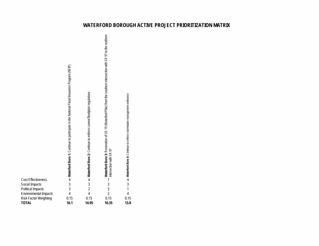
Wat
erfo
rd B
oro
1: C
ontin
ue to
par
ticip
ate
in th
e N
atio
nal F
lood
Insu
ranc
e Pr
ogra
m (N
FIP)
Wat
erfo
rd B
oro
2: C
ontin
ue to
enf
orce
cur
rent
floo
dpla
in re
gula
tions
Wat
erfo
rd B
oro
3: R
esto
ratio
n of
US
19 (W
ater
ford
Pik
e) fr
om th
e so
uthe
rn in
ters
ectio
n w
ith S
R 9
7 to
the
north
ern
in
ters
ectio
n w
ith S
R 9
7
Wat
erfo
rd B
oro
4: C
ontin
ue to
enf
orce
sto
rmw
ater
man
agem
ent o
rdin
ance
Cost Effectiveness 4 4 1 4Social Impacts 3 3 3 3Political Impacts 3 2 3 1Environmental Impacts 4 4 2 4Risk Factor Weighting 0.15 0.15 0.15 0.15TOTAL 16.1 14.95 10.35 13.8
WATERFORD BOROUGH ACTIVE PROJECT PRIORITIZATION MATRIX
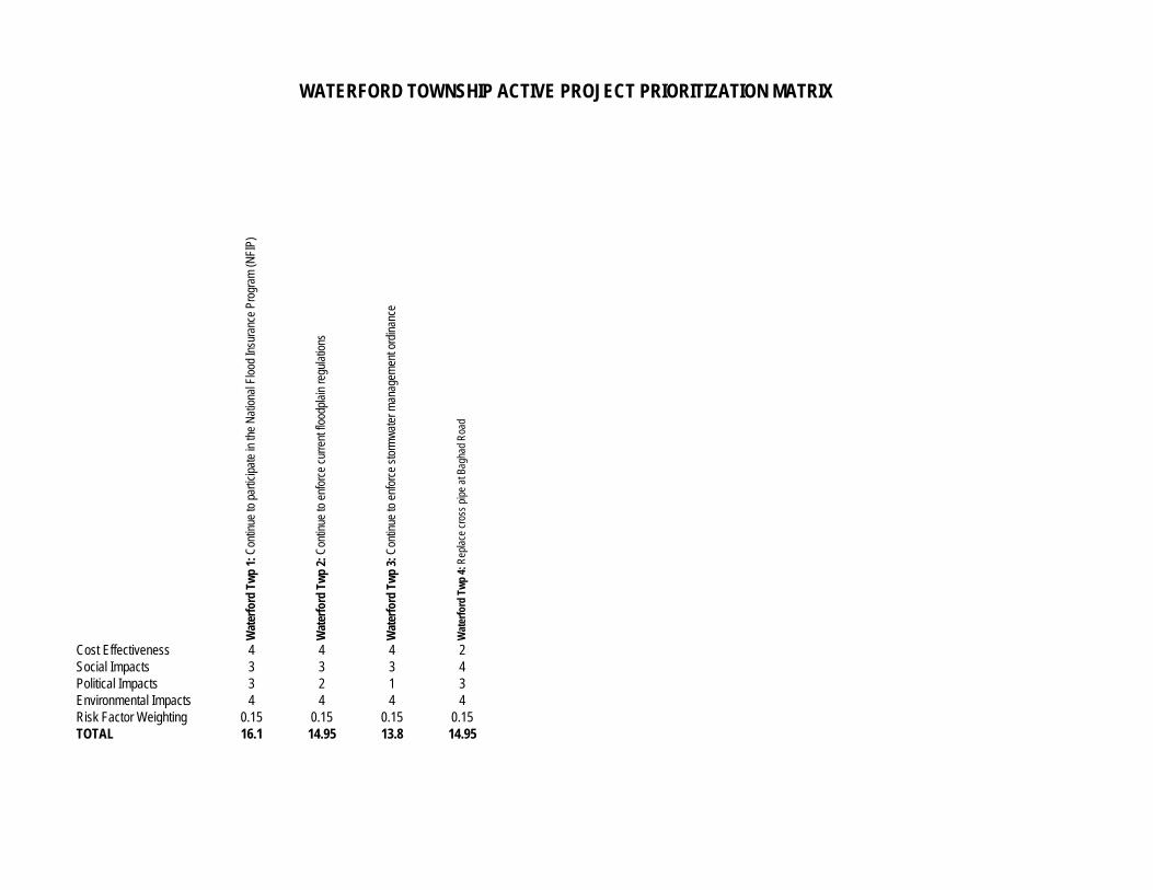
Wat
erfo
rd T
wp
1: C
ontin
ue to
par
ticip
ate
in th
e N
atio
nal F
lood
Insu
ranc
e Pr
ogra
m (N
FIP)
Wat
erfo
rd T
wp
2: C
ontin
ue to
enf
orce
cur
rent
floo
dpla
in re
gula
tions
Wat
erfo
rd T
wp
3: C
ontin
ue to
enf
orce
sto
rmw
ater
man
agem
ent o
rdin
ance
Wat
erfo
rd T
wp
4: R
epla
ce c
ross
pip
e at
Bag
had
Roa
d
Cost Effectiveness 4 4 4 2Social Impacts 3 3 3 4Political Impacts 3 2 1 3Environmental Impacts 4 4 4 4Risk Factor Weighting 0.15 0.15 0.15 0.15TOTAL 16.1 14.95 13.8 14.95
WATERFORD TOWNSHIP ACTIVE PROJECT PRIORITIZATION MATRIX
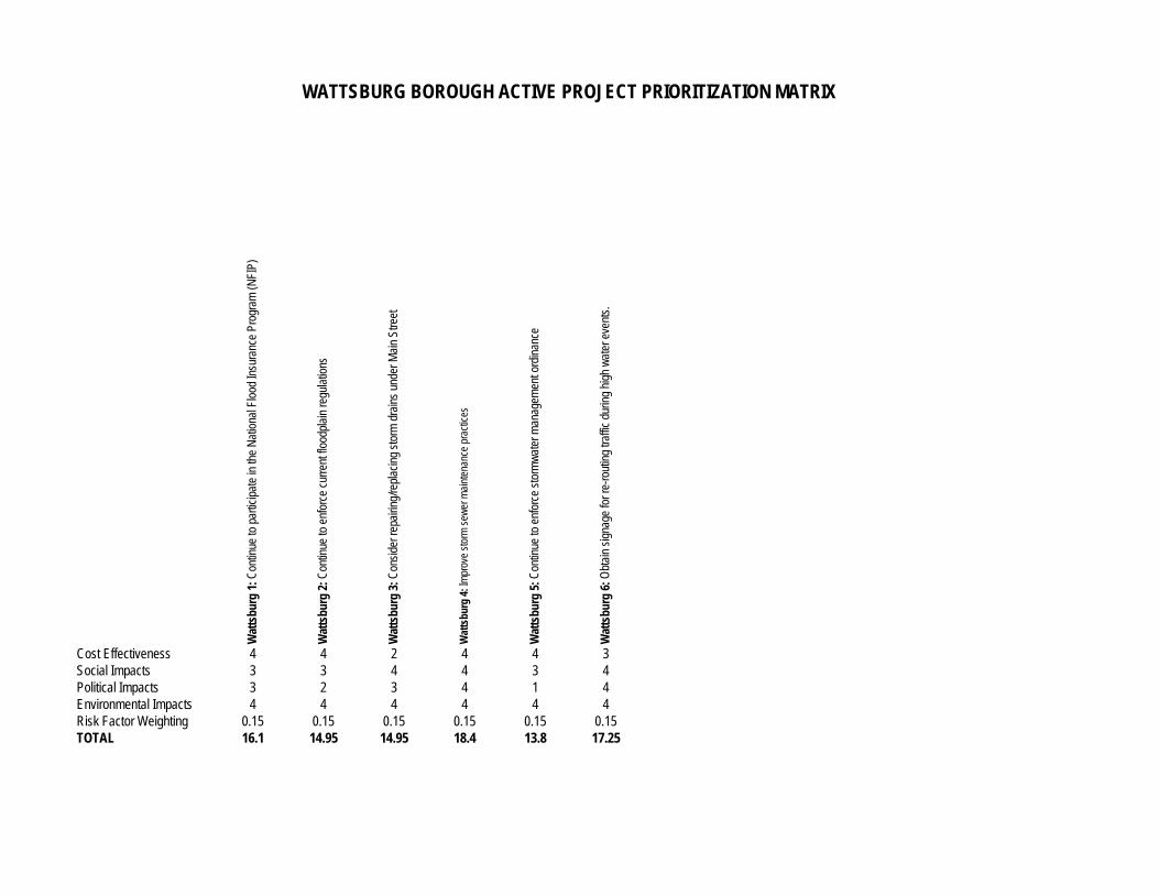
Wat
tsbu
rg 1
: Con
tinue
to p
artic
ipat
e in
the
Nat
iona
l Flo
od In
sura
nce
Prog
ram
(NFI
P)
Wat
tsbu
rg 2
: Con
tinue
to e
nfor
ce c
urre
nt fl
oodp
lain
regu
latio
ns
Wat
tsbu
rg 3
: Con
side
r rep
airin
g/re
plac
ing
stor
m d
rain
s un
der M
ain
Stre
et
Wat
tsbu
rg 4
: Im
prov
e st
orm
sew
er m
aint
enan
ce p
ract
ices
Wat
tsbu
rg 5
: Con
tinue
to e
nfor
ce s
torm
wat
er m
anag
emen
t ord
inan
ce
Wat
tsbu
rg 6
: Obt
ain
sign
age
for r
e-ro
utin
g tra
ffic
durin
g hi
gh w
ater
eve
nts.
Cost Effectiveness 4 4 2 4 4 3Social Impacts 3 3 4 4 3 4Political Impacts 3 2 3 4 1 4Environmental Impacts 4 4 4 4 4 4Risk Factor Weighting 0.15 0.15 0.15 0.15 0.15 0.15TOTAL 16.1 14.95 14.95 18.4 13.8 17.25
WATTSBURG BOROUGH ACTIVE PROJECT PRIORITIZATION MATRIX
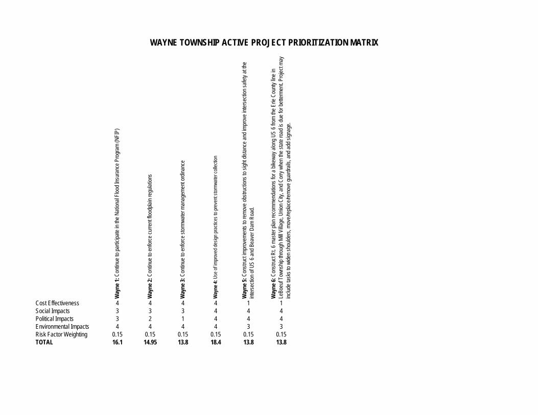
Way
ne 1
: Con
tinue
to p
artic
ipat
e in
the
Nat
iona
l Flo
od In
sura
nce
Prog
ram
(NFI
P)
Way
ne 2
: Con
tinue
to e
nfor
ce c
urre
nt fl
oodp
lain
regu
latio
ns
Way
ne 3
: Con
tinue
to e
nfor
ce s
torm
wat
er m
anag
emen
t ord
inan
ce
Way
ne 4
: Use
of i
mpr
oved
des
ign
prac
tices
to p
reve
nt s
torm
wat
er c
olle
ctio
n
Way
ne 5
: Con
stru
ct im
prov
emen
ts to
rem
ove
obst
ruct
ions
to s
ight
dis
tanc
e an
d im
prov
e in
ters
ectio
n sa
fety
at t
he
in
ters
ectio
n of
US
6 an
d Be
aver
Dam
Roa
d.
Way
ne 6
: Con
stru
ct R
t. 6
mas
ter p
lan
reco
mm
enda
tions
for a
bik
eway
alo
ng U
S 6
from
the
Erie
Cou
nty
line
in
Le
Boeu
f Tow
nshi
p th
roug
h M
ill Vi
llage
, Uni
on C
ity, a
nd C
orry
whe
n th
e st
ate
road
is d
ue fo
r bet
term
ent.
Proj
ect m
ay
incl
ude
task
s to
wid
en s
houl
ders
, mov
e/re
plac
e/re
mov
e gu
ardr
ails
, and
add
sig
nage
.
Cost Effectiveness 4 4 4 4 1 1Social Impacts 3 3 3 4 4 4Political Impacts 3 2 1 4 4 4Environmental Impacts 4 4 4 4 3 3Risk Factor Weighting 0.15 0.15 0.15 0.15 0.15 0.15TOTAL 16.1 14.95 13.8 18.4 13.8 13.8
WAYNE TOWNSHIP ACTIVE PROJECT PRIORITIZATION MATRIX
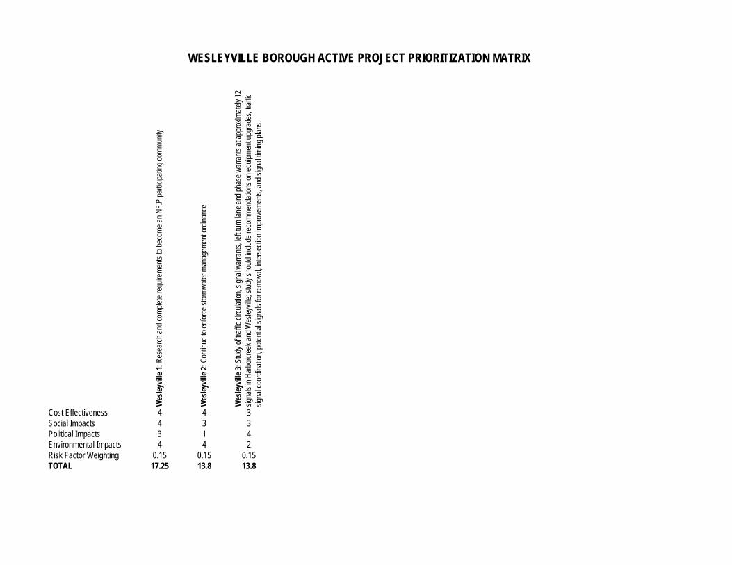
Wes
leyv
ille
1: R
esea
rch
and
com
plet
e re
quire
men
ts to
bec
ome
an N
FIP
parti
cipa
ting
com
mun
ity.
Wes
leyv
ille
2: C
ontin
ue to
enf
orce
sto
rmw
ater
man
agem
ent o
rdin
ance
Wes
leyv
ille
3: S
tudy
of t
raffi
c ci
rcul
atio
n, s
igna
l war
rant
s, le
ft tu
rn la
ne a
nd p
hase
war
rant
s at
app
roxi
mat
ely
12
sign
als
in H
arbo
rcre
ek a
nd W
esle
yville
; stu
dy s
houl
d in
clud
e re
com
men
datio
ns o
n eq
uipm
ent u
pgra
des,
traf
fic
si
gnal
coo
rdin
atio
n, p
oten
tial s
igna
ls fo
r rem
oval
, int
erse
ctio
n im
prov
emen
ts, a
nd s
igna
l tim
ing
plan
s.
Cost Effectiveness 4 4 3Social Impacts 4 3 3Political Impacts 3 1 4Environmental Impacts 4 4 2Risk Factor Weighting 0.15 0.15 0.15TOTAL 17.25 13.8 13.8
WESLEYVILLE BOROUGH ACTIVE PROJECT PRIORITIZATION MATRIX
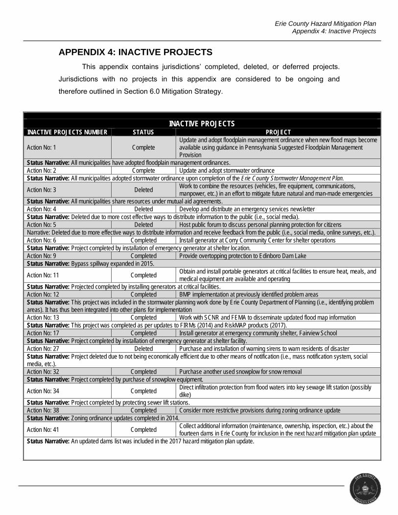
Erie County Hazard Mitigation Plan Appendix 4: Inactive Projects
APPENDIX 4: INACTIVE PROJECTS
This appendix contains jurisdictions’ completed, deleted, or deferred projects.
Jurisdictions with no projects in this appendix are considered to be ongoing and
therefore outlined in Section 6.0 Mitigation Strategy.
INACTIVE PROJECTS INACTIVE PROJECTS NUMBER STATUS PROJECT
Action No: 1 Complete Update and adopt floodplain management ordinance when new flood maps become available using guidance in Pennsylvania Suggested Floodplain Management Provision
Status Narrative: All municipalities have adopted floodplain management ordinances. Action No: 2 Complete Update and adopt stormwater ordinance Status Narrative: All municipalities adopted stormwater ordinance upon completion of the Erie County Stormwater Management Plan.
Action No: 3 Deleted Work to combine the resources (vehicles, fire equipment, communications, manpower, etc.) in an effort to mitigate future natural and man-made emergencies
Status Narrative: All municipalities share resources under mutual aid agreements. Action No: 4 Deleted Develop and distribute an emergency services newsletter Status Narrative: Deleted due to more cost effective ways to distribute information to the public (i.e., social media). Action No: 5 Deleted Host public forum to discuss personal planning protection for citizens Narrative: Deleted due to more effective ways to distribute information and receive feedback from the public (i.e., social media, online surveys, etc.). Action No: 6 Completed Install generator at Corry Community Center for shelter operations Status Narrative: Project completed by installation of emergency generator at shelter location. Action No: 9 Completed Provide overtopping protection to Edinboro Dam Lake Status Narrative: Bypass spillway expanded in 2015.
Action No: 11 Completed Obtain and install portable generators at critical facilities to ensure heat, meals, and medical equipment are available and operating
Status Narrative: Projected completed by installing generators at critical facilities. Action No: 12 Completed BMP implementation at previously identified problem areas Status Narrative: This project was included in the stormwater planning work done by Erie County Department of Planning (i.e., identifying problem areas). It has thus been integrated into other plans for implementation Action No: 13 Completed Work with SCNR and FEMA to disseminate updated flood map information Status Narrative: This project was completed as per updates to FIRMs (2014) and RiskMAP products (2017). Action No: 17 Completed Install generator at emergency community shelter, Fairview School Status Narrative: Project completed by installation of emergency generator at shelter facility. Action No: 27 Deleted Purchase and installation of warning sirens to warn residents of disaster Status Narrative: Project deleted due to not being economically efficient due to other means of notification (i.e., mass notification system, social media, etc.). Action No: 32 Completed Purchase another used snowplow for snow removal Status Narrative: Project completed by purchase of snowplow equipment.
Action No: 34 Completed Direct infiltration protection from flood waters into key sewage lift station (possibly dike)
Status Narrative: Project completed by protecting sewer lift stations. Action No: 38 Completed Consider more restrictive provisions during zoning ordinance update Status Narrative: Zoning ordinance updates completed in 2014.
Action No: 41 Completed Collect additional information (maintenance, ownership, inspection, etc.) about the fourteen dams in Erie County for inclusion in the next hazard mitigation plan update
Status Narrative: An updated dams list was included in the 2017 hazard mitigation plan update.

Erie County Hazard Mitigation Plan Appendix 4: Inactive Projects
Action No: 43 Completed Develop a countywide winter storm task force to meet regularly to address winter storm preparedness and operations
Status Narrative: Erie County Department of Public Safety regularly supports municipal EMA coordinators in general, all-hazard preparedness (to include severe winter weather)
Action No: 44 Completed Work with municipalities to update local floodplain management ordinances and collect and record information on provisions for freeboard, restrictions of hazardous materials in the floodplain, and restriction of critical facilities in the floodplain
Status Narrative: This project was completed as per information shared at the 2017 resiliency workshop. In instances where discrepancies were highlighted or a municipality was suspended from the NFIP, a new project was added to the active project list under those municipalities.
Erie County Hazard Mitigation Plan Appendix 5: Citations
APPENDIX 5: CITATIONS
This appendix lists the research materials collected throughout the planning
process. As a general note, citations for some resources appear in the hazard profiles
(e.g., websites or local media references) or in relevant tables (e.g., listing the plans,
reports, and technical guidance used as resources during the planning process).
Alice Training Institute. (2017). Active shooter. Retrieved from
https://www.alicetraining.com/active-shooter/
Bates, Samuel P. (1884). History of Erie County, Pennsylvania. Retrieved from
https://archive.org/details/cu31924096783489
Broad Band Now. (2016). Internet Service Providers. Retrieved from
http://broadbandnow.com/Pennsylvania/Erie
Byrne, D. (2017). Public Education: Fire as a Weapon. Retrieved from
http://www.firehouse.com/article/12295657/public-education-fire-as-a-weapon
Centers for Disease Control and Prevention. (2014). Clean Up Safely After a Disaster.
Retrieved from https://www.cdc.gov/disasters/cleanup/facts.html
Centers for Disease Control and Prevention. (2014). Preventing Chain Saw Injuries
During Tree Removal After a Disaster. Retrieved from
https://www.cdc.gov/disasters/chainsaws.html
Centers for Disease Control and Prevention. (2014). Prevent Injury After a Disaster.
Retrieved from https://www.cdc.gov/disasters/injury/facts.html
Centers for Disease Control and Prevention. (2015). Protect Yourself from the Dangers
of Winter Weather. Retrieve from
https://www.cdc.gov/nceh/toolkits/winterweather/
Centers for Disease Control and Prevention. (2015). Tetanus Prevention after a
Disaster. Retrieved from https://www.cdc.gov/disasters/disease/tetanus.html
Centinari, M. (2016). Notes on the 2016 Growing Season and Drought Conditions.
Retrieved from
https://psuwineandgrapes.wordpress.com/tag/water-stressed-vines/
City of Erie. (2011). Review of Finances and Management Practices. Retrieved from
http://www.corrypa.com/wp-content/uploads/2016/03/Corry-EIP-Part-2.pdf
Conrad Jr., M.J. (1997, June 2). [Letter to John C. Lyons]. Copy in possession of Erie
County Department of Public Safety.
Erie County Hazard Mitigation Plan Appendix 5: Citations
Cornell University. (2006). Soil Erosion Threatens Environment and Human Health,
Study Reports. ScienceDaily, 23. Online.
https://www.sciencedaily.com/releases/2006/03/060322141021.htm
Defensivedriving .com. (2014). How to Drive Safely In Strong Winds. Retrieved from
https://www.defensivedriving.com/blog/how-to-drive-safely-in-strong-wind/
Extension Disaster Education Network. (2015). Earthquakes: Disaster Fact Sheet.
Retrieved from
http://eden.lsu.edu/Topics/Hazards/Earthquake/Pages/default.aspx
Ewing, T. (2016). Lake Erie’s Icebreaker Offshore Wind Project Moves to Scoping
Phase. Retrieved from
http://www.renewableenergyworld.com/articles/2016/10/lake-erie-s-project-
icebreaker-moves-to-scoping-phase.html
Federal Bureau of Investigations. (2017). Active Shooter Resources. Retrieved from
https://www.fbi.gov/about/partnerships/office-of-partner-engagement/active-
shooter-resources
Federal Emergency Management Agency. (2006) guide for All-Hazard Emergency
Operations Planning. Retrieved from:
https://www.fema.gov/pdf/plan/6-ch-f-1.pdf
Federal Emergency Management Agency. (2016). National Flood Insurance Program:
Who’s Eligible. Retrieved from
https://www.fema.gov/news-release/2016/01/30/national-flood-insurance-
program-whos-eligible
Flanagan, B.E., Gregory, E.W., Hallisey, E.J., Heitgerd, J.L., & Lewis, B. (2011). A
Social Vulnerability Index for Disaster Menagement. Retrieved from
https://gis.cdc.gov/grasp/svi/a%20social%20vulnerability%20index%20for%20dis
aster%20management.pdf
Funk, J. (2017). First Energy Corp. to Sell or Close its Nuclear Power Plants. Retrieved
from
http://www.cleveland.com/business/index.ssf/2017/02/firstenergy_corp_to_sell_o
r_cl.html
Gelber, B. (2002). The Pennsylvania Weather Book. New Brunswick, NJ: Rutgers
University Press.
Erie County Hazard Mitigation Plan Appendix 5: Citations
Insurance Institute for Business & Home Safety. (2017). Vulnerable Populations.
Retrieved from https://disastersafety.org/ibhs-public-policy/vulnerable-
populations/
Kalis, M.A., Miller, M.D., & Wilson, R.A. (2009). Public Health and Drought. Journal of
Environmental Health. Retrieved from
https://www.cdc.gov/nceh/ehs/docs/jeh/2009/july-aug_09_kalis_miller.pdf
Keller, E.A., & DeVecchio, D.E. (2015). Natural Hazards. Earth’s Processes as Hazards,
Disasters and Catastrophes (4th ed.). Santa Barbara, CA: Pearson.
Martinson, T., & Lakso, A. (2016). Grapes 101. How Grapevines Respond to Water
Stress. Retrieved from
https://grapesandwine.cals.cornell.edu/newsletters/appellation-cornell/2016-
newsletters/issue-26-august-2016/grapes-101
McGeehin, M.A., Mirabelli, M. (2001). The Potential Impacts of Climate Variability and
Change on Temerature-related morbidity and mortality in the United States.
Retrieved from https://www.ncbi.nlm.nih.gov/pmc/articles/PMC1240665/
National Coalition for the Homeless. (2010). Winter Homeless Services: Bringing Our
Neighbors In From the Cold. Retrieved from:
http://www.nationalhomeless.org/publications/winter_weather/report.html
National Drought Mitigation Center. (2016). Types of Drought. Retrieved from
http://drought.unl.edu/DroughtBasics/TypesofDrought.aspx
National Institute of Environmental Health Sciences. (2016). Cardiovascular Disease and
Stroke. Health Impacts of Climate Change. Retrieved from
https://www.niehs.nih.gov/research/programs/geh/climatechange/health_impacts/
cardiovascular_diseases/index.cfm
National Science and Technology Council. (2016). Climate Change Impacts in the
United States. Retrieved from http://nca2014.globalchange.gov/report
National Weather Services. (2017). Beaufort Wind Scale. Retrieved from
https://www.weather.gov/mfl/beaufort
Pennsylvania Department of Environmental Protection. (2013). Municipal Reference
Document: Guidance for the Implementation of the Chapter 85 Bluff Recession
and Setback Regulations. Retrieved from
http://www.elibrary.dep.state.pa.us/dsweb/GetRendition/Document-94560/html
Pennsylvania Department of Environmental Protection. (2015). Coastal Resource
Management Program: About the Program. Retrieved from
Erie County Hazard Mitigation Plan Appendix 5: Citations
http://www.dep.pa.gov/Business/Water/Compacts%20and%20Commissions/Coa
stal%20Resources%20Management%20Program/Pages/About-the-
Program.aspx
Pennsylvania Department of Labor and Industry. (2016). Top 50 Employers, 3rd Quarter
2016. Retrieved from
http://www.workstats.dli.pa.gov/Documents/Top%2050/Erie_County_Top_50.pdf
Pennsylvania Emergency Management Agency. (2013). 2013 Pennsylvania Statewide
Hazard Mitigation Plan. Retrieved from
http://www.pema.pa.gov/responseandrecovery/Disaster-
assistance/Documents/General%20Mitigation%20Forms%20and%20Information/
Pennsylvania%20State%20Hazard%20Mitigation%20Plan%20-
%20Oct%2031%202013.pdf
Pennsylvania Public Utility Commission. (2016). Telephone Carriers by County.
Retrieved from
http://www.puc.state.pa.us/consumer_info/telecommunications/telephone_compa
nies.aspx
Pennsylvania Sea Grant. (2016). Climate Impacts to Lake Erie Agriculture. Retrieved
from
http://seagrant.psu.edu/sites/default/files/Agriculture%20Infographic%20Print%20
2016.pdf
Pennsylvania Sea Grant. (2016). Climate Impacts To Pennsylvania’s Lake Erie Tourism.
Retrieved from https://seagrant.psu.edu/sites/default/files/infographic%20PA.pdf
Ralston, E.P., Kite-Powell, H, and Beet, A. (2011). An Estimate of the Cost of Acute
Food and Water Borne Health Effects from Marine Pathogens and Toxins in the
Unites States. Retrieved from
https://www.ncbi.nlm.nih.gov/pmc/articles/PMC5439350/
Stubbs, M. (2016). Agricultural Disaster Assistance. Retrieved from
https://fas.org/sgp/crs/misc/RS21212.pdf
Taleb, N.N. (2010). The Black Swan. The Impact of the Highly Improbable (2nd ed.). New
York, NY: Random House Trade
Trambley, P. (2017) What are Straight-Line Winds. Retrieved from
http://weatherology.com/articles/160/What+are+Straight-Line+Winds%3F.html
United States Army Corps of Engineers. (n.d.). Buffalo district Projects Story Map.
Retrieved from https://rsc-
Erie County Hazard Mitigation Plan Appendix 5: Citations
agisu.usace.army.mil/s1portal/apps/MapTour/index.html?appid=b645d99aaa6c4
5f687004586b12cdc0f&webmap=dea7c5ab0fd24fe9a322a73a577fc14d#map
United States Census Bureau. (2015). Quick Facts, Erie County Pennsylvania.
Retrieved from
https://www.census.gov/quickfacts/table/PST045214/42049/embed/accessible
United States Department of Agriculture. (2012). Census of Agriculture County Profile.
Retrieved from
https://www.agcensus.usda.gov/Publications/2012/Online_Resources/County_Pr
ofiles/Pennsylvania/cp42049.pdf
United States Department of Agriculture. (2016). National Invasive Species Information
Center: Animals. Retrieved from
https://www.invasivespeciesinfo.gov/animals/main.shtml
United States Global Change Research Program. (2016). Human Health. Retrieved from
http://www.globalchange.gov/browse/federal-adaptation-resources/human-health
World Health Organization. (2008). Radiopharmaceuticals: Final text addition to The
International Pharmacopoeia. Retrieved from
http://www.who.int/medicines/publications/pharmacopoeia/Radgenmono.pdf

Erie County Hazard Mitigation Plan Appendix 6: Adopting Resolutions
APPENDIX 6: ADOPTING RESOLUTIONS
This appendix contains copies of the resolutions signed by participating
jurisdictions, thereby officially adopting this update.
*NOTE: This appendix will be empty during the PEMA/FEMA review and approval
process.


