Embed Size (px)
Citation preview

IntroductionIntroduction
Armstrong F. Sompotan, SSi / UNIMA/ ITB

Many holidaymakers are forsaking Mediterranean locations such asSpain and Greece for longer haul destinations in the Caribbean andthe south-eastern states of the USA like Florida. Bermuda in place ofBenidorm, Miami instead of Magalluf!
Armstrong F. Sompotan, SSi / UNIMA/ ITB

A wise move it would seem; warm i l hi h dtropical seas, high temperatures and
sunshine are guaranteed…. Armstrong F. Sompotan, SSi / UNIMA/ ITB

...but it is just these characteristics that make Tropical cyclones such a danger in late
summer and early autumn.Why???
Armstrong F. Sompotan, SSi / UNIMA/ ITB

In the west Atlantic and C ibb J l ACaribbean July, August and September are the
h hmonths when most Tropical cyclones (H i )(Hurricanes) occur.
Armstrong F. Sompotan, SSi / UNIMA/ ITB

These intense storms are found in most tropical oceans; calledHurricanes in the Atlantic and Caribbean, Typhoons in the Pacific,Cyclones in the Indian Ocean and Willy Willies in northernCyclones in the Indian Ocean and Willy Willies in northernAustralia, they all originate in the same way.
Armstrong F. Sompotan, SSi / UNIMA/ ITB

InfraInfra--RedRedDark areas are relatively warm.
Lighter areas are relatively cold.relatively cold.
Question
Why are they so y ymany clouds in equatorial regions?g
Armstrong F. Armstrong F. SompotanSompotan, , SSiSSi / UNIMA/ ITB/ UNIMA/ ITB

Focus / QuestionsFocus / QuestionsFocus / QuestionsFocus / Questions
What is Tropical Cyclone?What is Tropical Cyclone?HHowow Tropical cyclones (Hurricanes)Tropical cyclones (Hurricanes) form and form and movemove??What does cyclone need?What does cyclone need?What makes it happen?What makes it happen?ppppWhy does the system rotate?Why does the system rotate?What are the problems/What are the problems/damagedamagess caused?caused?What are the problems/What are the problems/damagedamagess caused?caused?How can these How can these Tropical RegionsTropical Regions prepare for prepare for future natural disasters?future natural disasters?future natural disasters?future natural disasters?
Armstrong F. Armstrong F. SompotanSompotan, , SSiSSi / UNIMA/ ITB/ UNIMA/ ITB
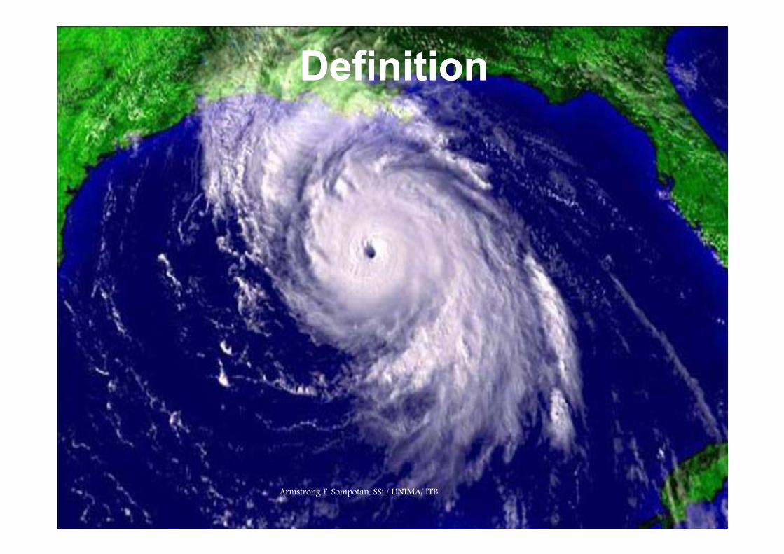
DefinitionDefinition
Armstrong F. Sompotan, SSi / UNIMA/ ITB

Tropical Cyclones are defined by the following characteristics:
• They are tropical, meaning that they are generated in tropical areas of the ocean near the Equatorof the ocean near the Equator.
• They are cyclonic, meaning that their winds swirl around a central eye. Wind direction is counterclockwise (west to east) in the Northern Hemisphere and clockwise (east to west) in the SouthernNorthern Hemisphere and clockwise (east to west) in the Southern Hemisphere (more about this later).
• They are low-pressure systems. The eye of a hurricane is always a low-pressure area. The lowest barometric pressures ever recorded h d i id h ihave occurred inside hurricanes.
• The winds swirling around the center of the storm have a sustained speed of at least 74 mph (119 kph / 64 kt).

Parts of a Hurricane
AArmstrong F. Somm
potan, SSi / UN
IMMA/ ITB

E Th l l t f i l tiEye : The low-pressure, calm center of circulation Eye wall : Area around the eye with the fastest, most violent winds Rain bands : Bands of thunderstorms circulating outward from the eye
th t t f th ti / d ti l th tthat are part of the evaporation/condensation cycle that feeds the storm

Hurricane FormsHurricane Forms
Armstrong F. Sompotan, SSi / UNIMA/ ITB

Hurricanes form in tropical regions where there is warm gwater (at least 80 degrees Fahrenheit / 26,5 degrees Celsius), moist air and converging equatorial winds. Most Atlantic hurricanes begin off the west coast of Africa, starting as thunderstorms that move out over the warm, tropical ocean waters.
Armstrong F. Sompotan, SSi / UNIMA/ ITB

Peaks of activity worldwidePeaks of activity worldwide

Warm sea temperatures needed
f l !for cyclones!Armstrong F. Sompotan, SSi / UNIMA/ ITB
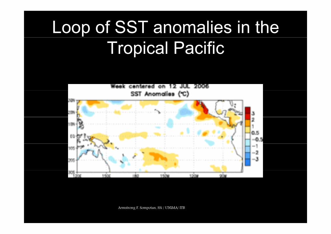
Loop of SST anomalies in the Tropical Pacific
Armstrong F. Sompotan, SSi / UNIMA/ ITB

Stages of development of a tropical cyclone
Stage Description
Tropical wave A trough of low pressure in the trade-wind easterlies
T i l A moving area of thunderstorms in the Tropical disturbance
gtropics that maintains its identity for 24 hours or more
T i l A tropical cyclone in which the maximum Tropical depression
p ysustained surface wind is _38 miles/hour ( _61 km/hour; _33 knots)
Tropical storm A tropical cyclone in which the maximum p p ysustained surface wind ranges from 39 miles/hour (62 km/hour; >33 knots) to 73 miles/hour (117 km/hour; <64 knots)
Hurricane/ typhoon/ cyclone
A tropical cyclone in which maximum sustained surface wind is _74 miles/hour ( _118 km/hour; _64 knots)
Armstrong F. Armstrong F. SompotanSompotan, , SSiSSi / UNIMA/ ITB/ UNIMA/ ITB

Three events must happen for hurricanes to form:
• A continuing evaporation-condensation cycle of warm,humid ocean air.
• Patterns of wind characterized by converging windsat the surface and strong, uniform-speed winds athigher altitudes.
• A difference in air pressure (pressure gradient)b h f d hi h l i dbetween the surface and high altitude.

Armstrong F. Sompotan, SSi / UNIMA/ ITB

Armstrong F. Sompotan, SSi / UNIMA/ ITB

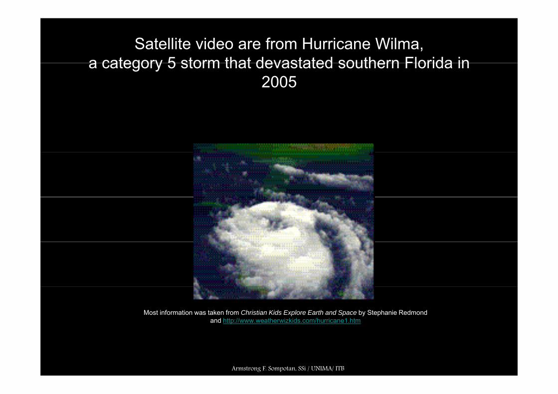
Tracking a Hurricane g
Satellite images and video are from Hurricane Wilma, a category 5 storm that devastated southern Florida in 2005.
M t i f ti t k f Ch i ti Kid E l E th d S b St h i R d d dMost information was taken from Christian Kids Explore Earth and Space by Stephanie Redmond andhttp://www.weatherwizkids.com/hurricane1.htm
Armstrong F. Sompotan, SSi / UNIMA/ ITB
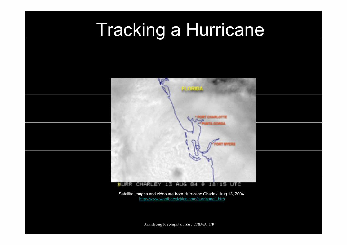
Tracking a Hurricane g
Satellite images and video are from Hurricane Charley, Aug 13, 2004http://www.weatherwizkids.com/hurricane1.htm
Armstrong F. Sompotan, SSi / UNIMA/ ITB
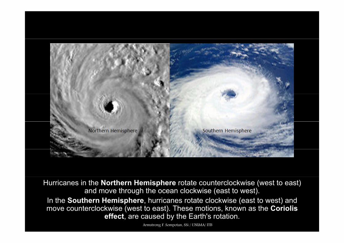
Hurricanes in the Northern Hemisphere rotate counterclockwise (west to east) and move through the ocean clockwise (east to west).
In the Southern Hemisphere, hurricanes rotate clockwise (east to west) and p ( )move counterclockwise (west to east). These motions, known as the Coriolis
effect, are caused by the Earth's rotation. Armstrong F. Sompotan, SSi / UNIMA/ ITB

Theoryy
Armstrong F. Sompotan, SSi / UNIMA/ ITB
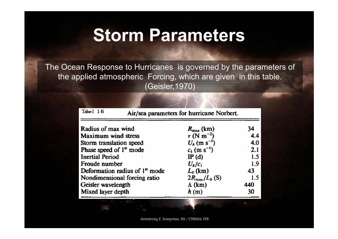
Storm ParametersStorm ParametersTh O R t H i i d b th t fThe Ocean Response to Hurricanes is governed by the parameters of
the applied atmospheric Forcing, which are given in this table. (Geisler,1970)
Armstrong F. Sompotan, SSi / UNIMA/ ITB

Wind StressWind Stress
A common reprasentation of a Hurricane Wind Strees Distribution is the Rankine Vortex (Chang and Athens 1978).
The tangential and radial Wind Stress components are given by :
Notes : Rmax is radius of maximum windsRout is radius to the outer edge of the Hurricaneout g
Armstrong F. Sompotan, SSi / UNIMA/ ITB

Nondimensional FrameworkNondimensional FrameworkAn important nondimensional number in the mixed layer is the BurgerAn important nondimensional number in the mixed layer is the BurgerNumber (M), which measures the importance of the horizontal pressuregradients (Price,1983):
M = (1 + 1/S2)g’ h / (2Rmax f)2
Notes: S is the nondimensional storm speed (Uh/2Rmaxf)h is the mixed layer depthg’ is reduced gravityg is reduced gravityUh is the storm translation speed2Rmax is ratio of the scale of the wind stress
Price (1983) suggests that the frequency shift above the local inertialfrequency {(σ-f)/f} is equal to M/2.
Armstrong F. Sompotan, SSi / UNIMA/ ITB

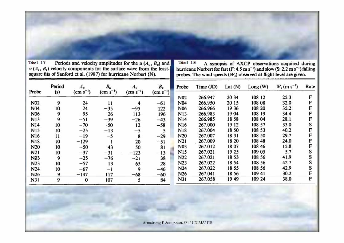
Ocean CurrentOcean CurrentU i d b dUpper ocean current measurements are contaminated by storm-generatedsurface wave. Sanford et al (1987) developed a least-squares model toaccount for surface wave motion, which for the u-component of currentvelocity is
um = [Au cos (σt) + Bu sin (σt)]ekz
Notes : Au and Bu are the least squares coefficients for the u-velocity componet (Table 17)σ is the surface wave frequency (2π/T)T is wave periode (nominally 5 15s)T is wave periode (nominally 5-15s)k is the wavenumber (σ2/g)g is the acceleration of gravity.
These current velocities are subtracted from the original AXCP current profiles using the coefficients in Table 17 and 18.p g
Armstrong F. Sompotan, SSi / UNIMA/ ITB
Armstrong F. Sompotan, SSi / UNIMA/ ITB

Armstrong F. Sompotan, SSi / UNIMA/ ITB

CATEGORIESArmstrong F. Sompotan, SSi / UNIMA/ ITB

SAFFIRSAFFIR--SIMPSON SCALESIMPSON SCALESS S M SON SCS M SON SC
Meteorologists rate hurricanes according to their Meteorologists rate hurricanes according to their wind speeds. The higher the wind speeds, the wind speeds. The higher the wind speeds, the higher the category, the more severe damage higher the category, the more severe damage
the hurricane will cause. the hurricane will cause. CategoryCategory Sustained Winds (MPH)Sustained Winds (MPH) Storm SurgeStorm Surge EffectsEffects DamageDamage
11 7474--9595 44--5 ft5 ft Some floodingSome floodingLittle or no structural damageLittle or no structural damage MinimalMinimalLittle or no structural damageLittle or no structural damage
22 9696--110110 66--8 ft8 ft Trees downTrees downRoof damageRoof damage ModerateModerate
33 111111--130130 99--12 ft12 ft Severe floodingSevere floodingStructural damage in houseStructural damage in house ExtensiveExtensiveStructural damage in houseStructural damage in house
44 131131--155155 1313--18 ft18 ft Severe flooding inlandSevere flooding inlandMajor structural damageMajor structural damage ExtremeExtreme
55 > 155> 155 > 18 ft> 18 ft Severe flooding further inlandSevere flooding further inlandSerious damage to mostSerious damage to most CatastrophicCatastrophicSerious damage to most Serious damage to most
wooden strctureswooden strctures
Armstrong F. Armstrong F. SompotanSompotan, , SSiSSi / UNIMA/ ITB/ UNIMA/ ITB

HurricaneHurricane namesnamesHurricane Hurricane namesnames
Atl ti N20072007 20082008 20092009 20102010 20112011 20122012 The World Meteorological
Atlantic Names
AndreaAndreaBarry Barry ChantalChantalDean Dean
ArthurArthurBerthaBerthaCristobalCristobalDollyDolly
AnaAnaBillBillClaudetteClaudetteDannyDanny
AlexAlexBonnieBonnieCharleyCharleyDanielleDanielle
ArleneArleneBretBretCindyCindyDennisDennis
AlbertoAlbertoBerylBerylChrisChrisDebbyDebby
The World Meteorological Organization names hurricanes, rotating between men and women’s names.
ffErin Erin Felix Felix Gabrielle Gabrielle HumbertoHumbertoIngridIngrid
EdouardEdouardFayFayGustavGustavHannaHannaIsidoreIsidore
ErikaErikaFabianFabianGraceGraceHenriHenriIsabelIsabel
EarlEarlFrancesFrancesGastonGastonHermineHermineIvanIvan
EmilyEmilyFranklinFranklinGertGertHarveyHarveyIreneIrene
ErnestoErnestoFlorenceFlorenceGordonGordonHeleneHeleneIsaacIsaac
There's 6 different name lists that alternate each year. If a hurricane does significant damage its name is retiredIngrid Ingrid
Jerry Jerry Karen Karen Lorenzo Lorenzo Melissa Melissa NoelNoel
IsidoreIsidoreJosephineJosephineKyleKyleLiliLiliMarcoMarcoNanaNana
IsabelIsabelJuanJuanKateKateLarryLarryMindyMindyNicholasNicholas
IvanIvanJeanneJeanneKarlKarlLisaLisaMatthewMatthewNicoleNicole
IreneIreneJoseJoseKatrinaKatrinaLeeLeeMariaMariaNateNate
IsaacIsaacJoyceJoyceKirkKirkLeslieLeslieMichaelMichaelNadineNadine
damage, its name is retired and replaced with another.
Noel Noel Olga Olga Pablo Pablo RebekahRebekahSebastienSebastien
NanaNanaOmarOmarPalomaPalomaReneReneSallySally
NicholasNicholasOdetteOdettePeterPeterRoseRoseSamSam
NicoleNicoleOttoOttoPaulaPaulaRichardRichardSharyShary
NateNateOpheliaOpheliaPhilippePhilippeRitaRitaStanStan
NadineNadineOscarOscarPattyPattyRafaelRafaelSandySandy
No hurricane names begin with
the letters Tanya Tanya Van Van Wendy Wendy
TeddyTeddyVickyVickyWilfred Wilfred
TeresaTeresaVictorVictorWanda Wanda
TomasTomasVirginieVirginieWalter Walter
TammyTammyVinceVinceWilma Wilma
TonyTonyValerieValerieWilliamWilliam
q,u,x,y,z.
Armstrong F. Sompotan, SSi / UNIMA/ ITB

Eastern North Pacific Names2007 2008 2009 2010 2011 20122007 2008 2009 2010 2011 2012
AlvinBarbaraCosmeD lil
AlmaBorisCristinaD l
AndresBlancaCarlosD l
AgathaBlasCeliaD b
AdrianBeatrizCalvinD
AlettaBudCarlottaD i lDalila
ErickFlossieGilHenriette
DouglasElidaFaustoGenevieveHernan
DoloresEnriqueFeliciaGuillermoHilda
DarbyEstelleFrankGeorgetteHo ard
DoraEugeneFernandaGregHilar
DanielEmiliaFabioGilmaHectorHenriette
IvoJulietteKikoLorena
HernanIselleJulioKarinaLowell
HildaIgnacioJimenaKevinLinda
HowardIsisJavierKayLester
HilaryIrwinJovaKennethLidia
HectorIleanaJohnKristyLaneLorena
ManuelNardaOctavePriscilla
LowellMarieNorbertOdilePolo
LindaMartyNoraOlafPatricia
LesterMadelineNewtonOrlenePaine
LidiaMaxNormaOtisPilar
LaneMiriamNormanOliviaPaulPriscilla
RaymondSoniaTicoVelma
PoloRachelSimonTrudyVance
PatriciaRickSandraTerryVivian
PaineRoslynSeymourTinaVirgil
PilarRamonSelmaToddVeronica
PaulRosaSergioTaraVicenteVelma
WallisXinaYorkZelda
VanceWinnieXavierYolandaZeke
VivianWaldoXinaYorkZelda
VirgilWinifredXavierYolandaZeke
VeronicaWileyXinaYorkZelda
VicenteWillaXavierYolandaZekeZelda Zeke Zelda Zeke Zelda Zeke
These lists are also re-cycled every six years (the 2006 list will be used again in 2012).

Hurricane WilmaHurricane Wilma
Satellite images and video are from Hurricane Wilma, a category 5 storm that devastated southern Florida in 2005.
Armstrong F. Sompotan, SSi / UNIMA/ ITB
Satellite video are from Hurricane Wilma,a category 5 storm that devastated southern Florida ina category 5 storm that devastated southern Florida in
2005
Most information was taken from Christian Kids Explore Earth and Space by Stephanie Redmond and http://www.weatherwizkids.com/hurricane1.htm
Armstrong F. Sompotan, SSi / UNIMA/ ITB

Hurricane Gilbert(J i )(Jamaica)
•• September 12, 1988September 12, 1988•• Tore directly through the islandTore directly through the islandTore directly through the islandTore directly through the island•• Caused inland floodingCaused inland flooding
Destroyed crops buildings roadsDestroyed crops buildings roads•• Destroyed crops, buildings, roadsDestroyed crops, buildings, roads•• Damaged half of entire water supplyDamaged half of entire water supply•• Damage: $4 billionDamage: $4 billion•• Casualty: 45 peopleCasualty: 45 peopleCasua y 5 peop eCasua y 5 peop e•• Homeless: 500,000 peopleHomeless: 500,000 people
Armstrong F. Sompotan, SSi / UNIMA/ ITB

Hurricane Gilbert’s PathHurricane Gilbert’s Pathu ca e G be t s atu ca e G be t s at
Armstrong F. Armstrong F. SompotanSompotan, , SSiSSi / UNIMA/ ITB/ UNIMA/ ITB

Hurricane IvanHurricane Ivan(Jamaica)
• September 11-12, 2004• Caused severe wind and flood damage• Looters roamed the streets of KingstonLooters roamed the streets of Kingston• Robbed emergency workers at gunpoint• Damage: $360 million• Casualty: 17 people• Casualty: 17 people• Homeless: 18,000 people
Armstrong F. Sompotan, SSi / UNIMA/ ITB

Hurricane Ivan’s PathHurricane Ivan’s Pathu ca e a s atu ca e a s at
Armstrong F. Armstrong F. SompotanSompotan, , SSiSSi / UNIMA/ ITB/ UNIMA/ ITB

Hurricane Ivan Hurricane Ivan (USA)(USA)
Photo courtesy NOAAHurricane Ivan over the Gulf Coast of the United States
2:45 p.m. EDT, September 15, 2004Armstrong F. Armstrong F. SompotanSompotan, , SSiSSi / UNIMA/ ITB/ UNIMA/ ITB

Armstrong F. Armstrong F. SompotanSompotan, , SSiSSi / UNIMA/ ITB/ UNIMA/ ITB

Hurricane Andrew
Hurricane Andrew as the most destructive and costly Hurricane of all time. Andrew had devastated the holiday coast of Florida between Palm Beach and Miami in latecoast of Florida between Palm Beach and Miami in late August 1992, causing $18 billion worth of damage.
Armstrong F. Sompotan, SSi / UNIMA/ ITB

Hurricane Andrew’s path
Photo courtesy NASAPhoto courtesy NASAThis photo is a composite of three days' views (August 23, 24 and 25, 1992) of Hurricane Andrew as it slowly moved across south Florida from east to west.
Armstrong F. Sompotan, SSi / UNIMA/ ITB
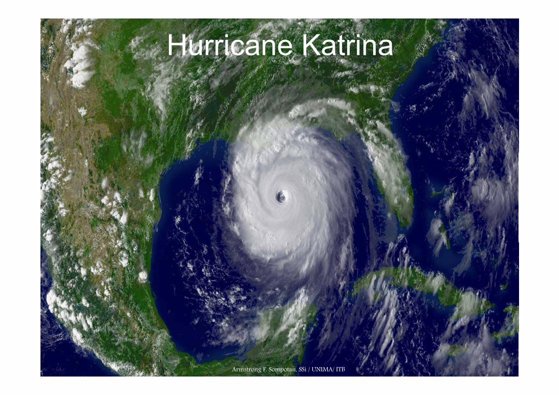
Hurricane Katrina
Armstrong F. Sompotan, SSi / UNIMA/ ITB

In late August 2005 Katrina crossed Florida and entered the Gulf of Mexico Here fuelled by the high summer temperatures of this partiallyMexico. Here, fuelled by the high summer temperatures of this partially enclosed sea, the storm intensified to reach a maximum 5 on the Saffir-Simpson Hurricane scale. Once inside the confines of the Gulf its movement became as unpredictable as a ‘bull in a china shop’movement became as unpredictable as a bull in a china shop .
Armstrong F. Sompotan, SSi / UNIMA/ ITB
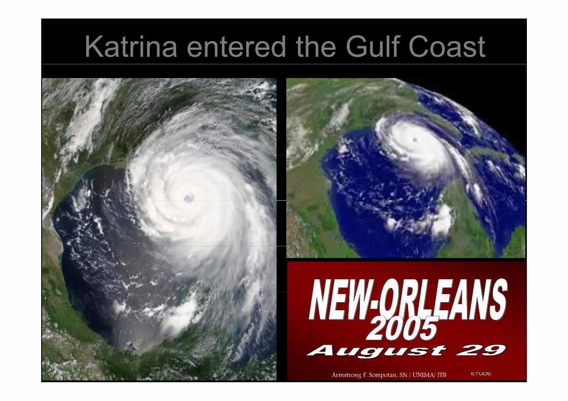
Katrina entered the Gulf Coast
Armstrong F. Sompotan, SSi / UNIMA/ ITB

Katrina hit New OrleansKatrina hit New Orleans
When it hit the Gulf Coast of the USA at New Orleans wind speeds topped 150 When it hit the Gulf Coast of the USA at New Orleans wind speeds topped 150 mph and a 25mph and a 25 foot storm surge destroyed levees flooding 80% of the cityfoot storm surge destroyed levees flooding 80% of the citymph and a 25mph and a 25--foot storm surge destroyed levees, flooding 80% of the city. foot storm surge destroyed levees, flooding 80% of the city. Almost 2000 people were killed, a million homes destroyed and $75 billion of Almost 2000 people were killed, a million homes destroyed and $75 billion of damage done to an area around the same size as the UK.damage done to an area around the same size as the UK.
Armstrong F. Armstrong F. SompotanSompotan, , SSiSSi / UNIMA/ ITB/ UNIMA/ ITB

Hurricane KatrinaAugust 29 2005August 29, 2005Katrina made landfall near Buras-Triumph,Louisiana at 6:10a.m160 MPH WindsTorrential Rains30 Foot Storm SurgeTornadoesTornadoes90,000 Square Miles declared a disaster zone(the same size as the UK.Almost 2000 people were killedOver a million people affectedTh it f N O l i ith t th b i d f lif ThThe city of New Orleans is without the basic needs of life. There is no running water, electricity, or sewage. The standing water is a breeding ground for bacteria.The estimated cost of Katrina is said to be around 200 Billion Dollars. could pay for 100 Space Shuttles or the War in Iraq.
Armstrong F. Armstrong F. SompotanSompotan, , SSiSSi / UNIMA/ ITB/ UNIMA/ ITB

Hurricane FloydHurricane Floyd
Photo courtesy NASA/GSFCHurricane Floyd, which hit the eastern United States in September 1999, was felt
from the Caribbean islands to New England ItIt was a Category 3 storm that
Photo courtesy NASA/GSFCHurricane Floyd, which hit the eastern United States in September 14th 1999, was from the Caribbean islands to New England. ItIt was a Category 3 storm that
brought intense rains and record flooding to the eastern United States and Canada. Nearly 90 percent of the fatalities associated with this storm were
drownings due to inland flooding
y , p ,felt from the Caribbean islands to New England. ItIt was a Category 3 storm that
brought intense rains and record flooding to the eastern United States and Canada. Nearly 90 percent of the fatalities associated with this storm were drownings due to inland flooding.drownings due to inland flooding.
Armstrong F. Armstrong F. SompotanSompotan, , SSiSSi / UNIMA/ ITB/ UNIMA/ ITB

Hurricane BerthaHurricane Bertha
Photo courtesy National Oceanic & Atmospheric Administration (NOAA)Photo courtesy National Oceanic & Atmospheric Administration (NOAA)Hurricane Bertha (July 1996) was also a Category 3 storm, but Bertha's Hurricane Bertha (July 1996) was also a Category 3 storm, but Bertha's power and impact were contained in a much smaller area than Floyd's.power and impact were contained in a much smaller area than Floyd's.
Armstrong F. Armstrong F. SompotanSompotan, , SSiSSi / UNIMA/ ITB/ UNIMA/ ITB

Huriicane GraceHuriicane GraceHuriicane GraceHuriicane Grace
Satellite images from Hurricane Grace,The Flemish Cap (Bermuda) 1991.
Armstrong F. Armstrong F. SompotanSompotan, , SSiSSi / UNIMA/ ITB/ UNIMA/ ITB

Hurricane MitchHurricane MitchHurricane MitchHurricane Mitch
Hurricane Mitch east of Florida, US
Armstrong F. Armstrong F. SompotanSompotan, , SSiSSi / UNIMA/ ITB/ UNIMA/ ITB

Hurricanes Over Western Hurricanes Over Western EuropeEurope
A depression over Western EuropeArmstrong F. Armstrong F. SompotanSompotan, , SSiSSi / UNIMA/ ITB/ UNIMA/ ITB

Western North Pacific NamesContributor I II III IV VCambodiaChina
DamreyLongwang
Kong-reyYutu
NakriFengshen
KrovanhDujuan
SarikaHaima
DPR KoreaHK, ChinaJapanLao PDRMacau
KirogiKai-TakTembinBolavenChanchu
TorajiMan-yiUsagiPabukWutip
KalmaegiFung-wongKanmuriPhanfoneVongfong
MaemiChoi-wanKoppuKetsanaParma
MeariMa-onTokageNock-tenMuifaMacau
MalaysiaMicronesiaPhilippinesRO KoreaThailand
ChanchuJelawatEwiniarBilisGaemiPrapiroon
WutipSepatFitowDanasNariVipa
VongfongRusaSinlakuHagupitChangmiMegkhla
ParmaMelorNepartakLupitSudalNida
MuifaMerbokNanmadolTalasNoruKularb
These names are also used Thailand
U.S.A.VietnamCambodiaChina
PrapiroonMariaSaomaiBophaWukong
VipaFranciscoLekimaKrosaHaiyan
MegkhlaHigosBaviMaysakHaishen
NidaOmaisConsonChanthuDianmu
KularbRokeSoncaNesatHaitang
sequentially. If the last storm of the year is Cimaron, the first
DPR KoreaHK, ChinaJapanLao PDRMacau
SonamuShanshanYagiXangsaneBebinca
PodulLinglingKazikiFaxaiVamei
PongsonaYanyanKuziraChan-homLinfa
MinduleTingtingKompasuNamtheunMalou
NalgaeBanyanWashiMatsaSanvu
storm of the next year is Chebi.
MalaysiaMicronesiaPhilippinesRO KoreaThailand
RumbiaSoulikCimaronChebiDurian
TapahMitagHagibisNoguriRamasoon
NangkaSoudelorImbudoKoniHanuman
MerantiRananinMalakasMegiChaba
MawarGucholTalimNabiKhanunThailand
U.S.A.Vietnam
DurianUtorTrami
RamasoonChataanHalong
HanumanEtauVamco
ChabaKodoSongda
KhanunViceteSaola
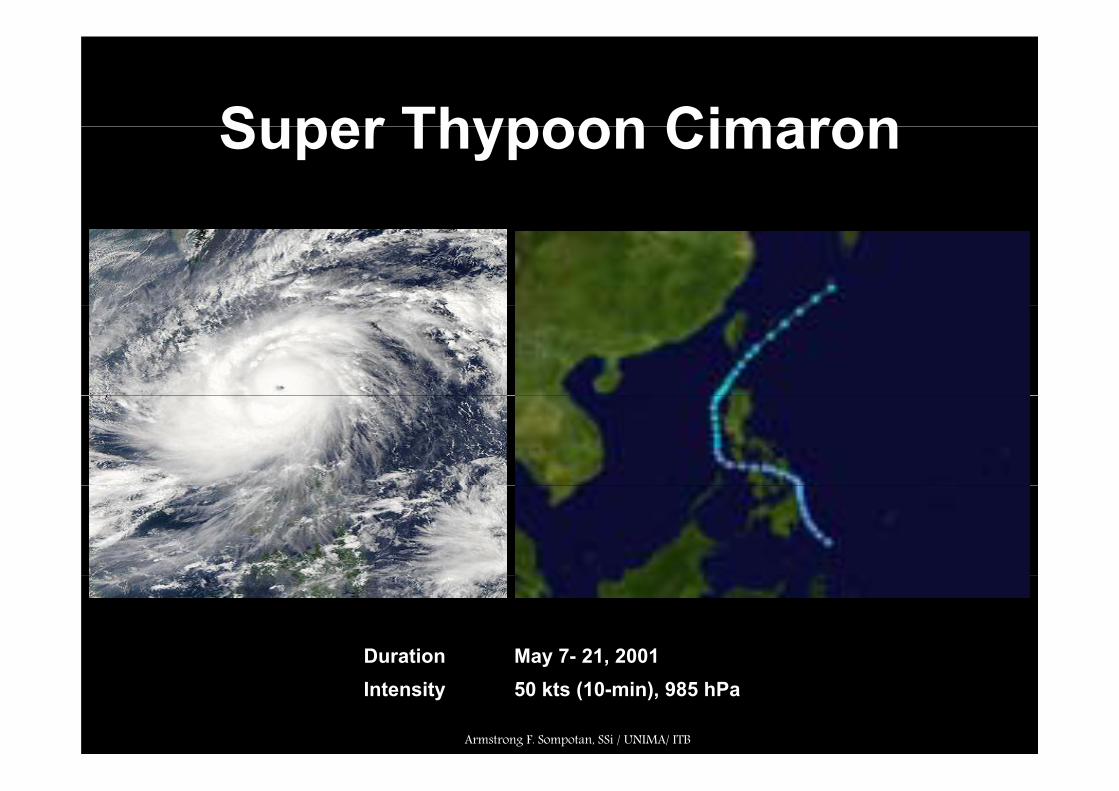
Super Thypoon CimaronSuper Thypoon Cimaron
Duration May 7- 21, 2001y ,Intensity 50 kts (10-min), 985 hPa
Armstrong F. Sompotan, SSi / UNIMA/ ITB

Typhoon Chebi (Emong)Typhoon Chebi (Emong)
Duration June 19-27, 2001,Intensity 75 kts (10-min), 960 hPa
Armstrong F. Sompotan, SSi / UNIMA/ ITB

Typhoon Linda (Openg)yp ( p g)
Typhoon Linda, after moving through the Philippines and the South China Sea, hit theMalay Peninsula on November 3 1997. It restrengthened in the Bay of Bengal, but verticalshear caused Linda to dissipate on the 9th. Linda caused 330 deaths from flooding andh dheavy damage.
Armstrong F. Sompotan, SSi / UNIMA/ ITB

Tropical Depression Barok
Duration April 18- 19, 2001p ,Intensity 25 kts
Armstrong F. Sompotan, SSi / UNIMA/ ITB

Tropical Depression Auring
Duration Feb 17-20, 2001,Intensity 30 kts
Armstrong F. Sompotan, SSi / UNIMA/ ITB

Tropical Storm Levi (Bining)p ( g)
Tropical Depression 5W drifted eastward through the Philippines in late May The heavyTropical Depression 5W drifted eastward through the Philippines in late May. The heavyrain it brought caused mudslides that killed 33 people. The depression continuednortheastward, becoming a tropical storm, and transitioning to an extratropical stormon May 30 1997. From May 26-29 1997, Philippine Atmospheric, Geophysical andy y , pp p , p yAstronomical Services Administration tracked the storm, and named it Bining.
Armstrong F. Sompotan, SSi / UNIMA/ ITB

Super Typhoon Paka (Rubing)p yp ( g)
Paka remained a tropical storm until December 10 1997, when it was able to become atyphoon. Five days later, Paka reached Super Typhoon strength, the eleventh of theyear. The next day it crossed over Guam, and on December 18, Paka reached a peak of185 h i d Aft i j d th ll W t P ifi i l d185 mph winds. After causing major damage across the smaller Western Pacific islandgroups, Paka rapidly weakened and dissipated on December 22

Super Typhoon IsaSuper Typhoon Isa
Isa very gradually intensified, and on April 20 1997 the typhoon reached peak 1-min winds of70 km/h (165 mph), as reported by the Joint Typhoon Warning Center; Japan Meteorological( p ), p y yp g ; p gAgency reported maximum 10-min winds of 155 km/h (100 mph). After turning northward, itaccelerated to the northeast, and merged with a larger extratropical cyclone on April 24.
Armstrong F. Sompotan, SSi / UNIMA/ ITB
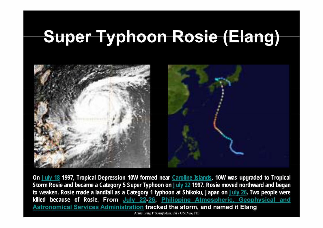
Super Typhoon Rosie (Elang)Super Typhoon Rosie (Elang)
On July 18 1997, Tropical Depression 10W formed near Caroline Islands. 10W was upgraded to TropicalStorm Rosie and became a Category 5 Super Typhoon on July 22 1997. Rosie moved northward and beganto weaken Rosie made a landfall as a Category 1 typhoon at Shikoku Japan on July 26 Two people wereto weaken. Rosie made a landfall as a Category 1 typhoon at Shikoku, Japan on July 26. Two people werekilled because of Rosie. From July 22-26, Philippine Atmospheric, Geophysical andAstronomical Services Administration tracked the storm, and named it Elang
Armstrong F. Sompotan, SSi / UNIMA/ ITB

Super Typhoon Winnie (Ibiang)Super Typhoon Winnie (Ibiang)
On August 5 1997, a tropical depression formed near the Marshall Islands. It headed northwestward,slowly strengthening to a tropical storm on the 9th. Intensification became more rapid as conditionsbecame more favorable, and Winnie reached typhoon strength on the 10th. 2 days later, it became, yp g y ,the 4th Super Typhoon of the season with peak winds of 160 mph. Soon after, the eye became raggedand large, with an outer eyewall reaching 200 miles in diameter. On the 18th, a minimal TyphoonWinnie passed north of Taiwan and hit eastern China,
Armstrong F. Sompotan, SSi / UNIMA/ ITB

Typhoon Amber (Miling)Typhoon Amber (Miling)
By August 26 1997, Tropical Storm Cass formed to the west-southwest, whichaccelerated Amber's forward motion to the northwest due to a fujiwara interaction Itaccelerated Amber s forward motion to the northwest due to a fujiwara interaction. Itunderwent eyewall replacement cycles from August 25 through August 27, and trackedacross Taiwan/Taipei with maximum sustained winds of 95 kts, then through theFormosa Strait into China as a minimal typhoon. Throughout much of its duration,Philippine Atmospheric, Geophysical and Astronomical Services Administration trackedthe storm, and named it Miling.
Armstrong F. Sompotan, SSi / UNIMA/ ITB

Super Typhoon Oliwap yp
Oliwa rapidly strengthened on September 9 1997 to reach a peak of 160 mph winds; thesixth Super Typhoon of the year. Oliwa slowly weakened as it moved westward, and hitJapan on September 15 and September 16. It turned to the northeast, and dissipated onSeptember 17 after causing 7 deaths and widespread damage from floodingSeptember 17 after causing 7 deaths and widespread damage from flooding.
Armstrong F. Sompotan, SSi / UNIMA/ ITB

Super Typhoon KeithSuper Typhoon Keith
Keith formed at low latitudes in the Marshall Islands on August 19 1997 It was one of ten TCs whichKeith formed at low latitudes in the Marshall Islands on August 19 1997. It was one of ten TCs whichformed east of 160° E and south of 20° N — within the "El Niño". Keith was a recurving TC whichpassed between the Islands of Rota and Tinian (only 50 nm (93 km) apart) on the west-bound leg ofits recurving track. NEXRAD imagery from Guam indicated the eye wall cloud of Keith never touchedland as it threaded the narrow channel between these two islandsland as it threaded the narrow channel between these two islands.
Armstrong F. Sompotan, SSi / UNIMA/ ITB

Hurricane DamagesHurricane Damages
• Hurricane create inland floodingH i ’ i d• Hurricane’s winds
• Hurricane push a wall of water (a storm surge)
Armstrong F. Sompotan, SSi / UNIMA/ ITB
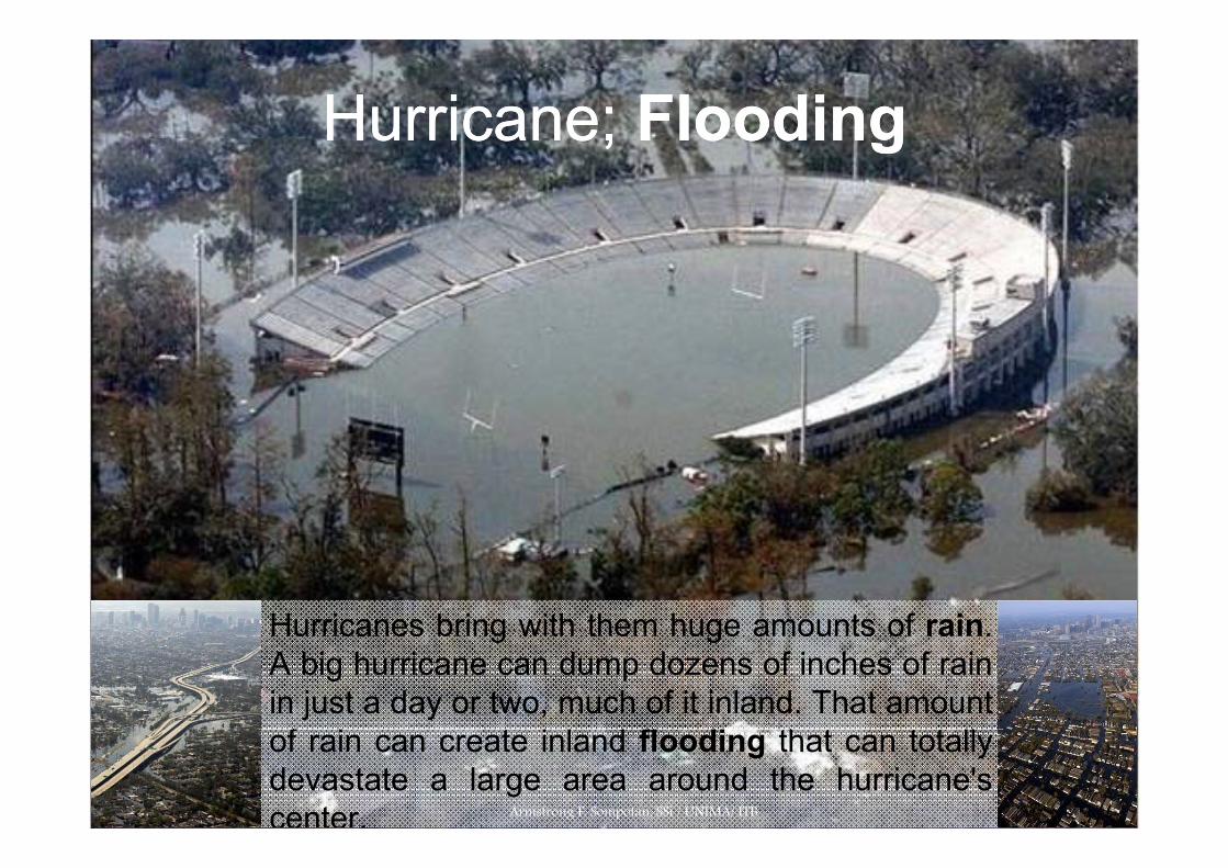
Hurricane;Hurricane; FloodingFloodingHurricane; Hurricane; FloodingFlooding
Hurricanes bring with them huge amounts of rainHurricanes bring with them huge amounts of rain.A big hurricane can dump dozens of inches of rainin just a day or two, much of it inland. That amountf i t i l d fl di th t t t llof rain can create inland flooding that can totally
devastate a large area around the hurricane'scenter. Armstrong F. Sompotan, SSi / UNIMA/ ITB

Hurricane windsHurricane winds
• High sustained windscause structural damage. Th i d l llThese winds can also roll cars, blow over trees and erode beaches
• Hurricane winds oftenHurricane winds often spawn tornadoes, which are smaller, more intense cyclonic storms that cause additional damageadditional damage
Armstrong F. Sompotan, SSi / UNIMA/ ITB

Hurricane; a storm surgeHurricane; a storm surge
Bands of thunderstorms circulating outward from the eye are part of theoutward from the eye are part of the
water cycle that feeds the storm.
If the storm surge happens during a high tide,it causes beach erosion and significant inlandflooding.
Armstrong F. Sompotan, SSi / UNIMA/ ITB

Armstrong F. Armstrong F. SompotanSompotan, , SSiSSi / UNIMA/ ITB/ UNIMA/ ITB