Embed Size (px)
Citation preview

How can Location Based Services benefit today’s enterprise?
A Do Big Webinar presented by Tata Docomo Business Services in association with ITNEXT
Presented by Rohan Verma, Director – MapmyIndia23rd Sep, 2015
© CE Info Systems Pvt. Ltd.
© CE Info Systems Pvt. Ltd.
Agenda
• Executive Summary
• What is LBS and how does it work?
• What different LBS can enterprises leverage for their benefit?
• Where can it be used?
• How can it be leveraged?
• Q&A
© CE Info Systems Pvt. Ltd.
Executive Summary
• Enterprises – across industries and size – and Enterprise users – across departments and functions – have objectives and requirements that can be addressed through maps and location technologies.
• After understanding objectives and knowing the capabilities of various LBS products/solutions, Enterprises and Users should start by location-mapping their data, and then proceed to leveraging location technologies to serve their needs.

© CE Info Systems Pvt. Ltd.
What is LBS? What are its components?
Map & Data Products
LBS/GIS Software
GPS Devices/ Hardware
Map & Data Services
Application Solutions
Hardware Solutions
End to End GIS/GPS/LBS Systems Integration
Third Party Technologies
Map & Data Products

© CE Info Systems Pvt. Ltd.
Evolution of mapping technology (in India)
Car Survey with Video with GPS
Sync
• In house video processing & data extraction
High resolution satellite
imageries
• Drive Survey through Vehicle mounted GPS Devices
Handheld GPS
Devices
• 2.5 meter resolution satellite imageries
Low accuracy
GPS
• Low Resolution Satellite Imageries
Paper Sources
• Foot Survey• Manual
measurement with tapes
© CE Info Systems Pvt. Ltd.
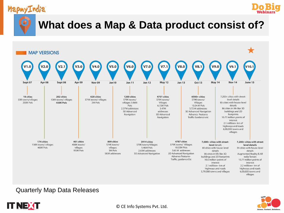
What does a Map & Data product consist of?
Quarterly Map Data Releases

© CE Info Systems Pvt. Ltd.
Administrative Layer Group in Map Data
India International Boundary
State/UT Boundaries including 29 states and 7 Union Territories
District Boundaries – all 640 in number
Sub-district Boundaries – 5965 in number
Town Boundaries defining municipal limits - 7933
Ward Boundary for towns
Villages, both as points and boundaries –648,000
Villages & Towns as listed in census of India 2011 were placed t the centroid of the main habitation
as observed on high resolution satellite imageries
Taking reference form census of India handbook sub district boundaries were digitised ensuring that
it covers corresponding villages/towns
Sub districts where then grouped to create district boundaries
District boundaries were grouped to form state boundaries
Sub districts/district/state boundaries are fine tuned using GPS data of roads at borders time to time
Updated in accordance with Census 2011 data
© CE Info Systems Pvt. Ltd.
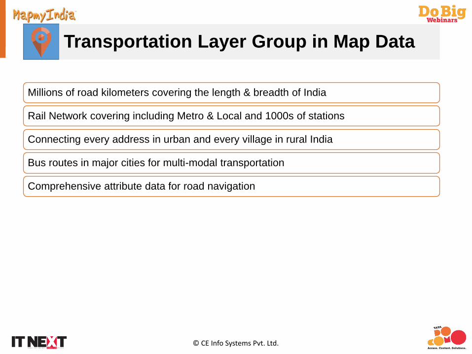
Transportation Layer Group in Map Data
Millions of road kilometers covering the length & breadth of India
Rail Network covering including Metro & Local and 1000s of stations
Connecting every address in urban and every village in rural India
Bus routes in major cities for multi-modal transportation
Comprehensive attribute data for road navigation

© CE Info Systems Pvt. Ltd.
Land Cover Layer Group in Map Data
Water BodiesNala & DrainStreamCanalRiverPondLakeReservoirSeasonal WaterSalt PansMuddy AreaBaySea and OceanBack Water
Green CoverForest - Low DensityForest - Medium DensityForest - High DensityGolf Course Urban Park Race Course Rural Open GreenUrban Open GreenNational Park & Wildlife Sanctuary
Open Area
Airport & Helipad AreaBeach & Sea Bed AreaGeneral Open AreaDesertRoad & Rail Network Associated Land
Land cover maps for India with major categories and sub categories
Seamlessly integrated at all scales
Built-up AreaResidentialIndustrialCommercialTransportationInstitutionalEducationalRecreationCommunityEmergencyHistoric SiteOther
© CE Info Systems Pvt. Ltd.
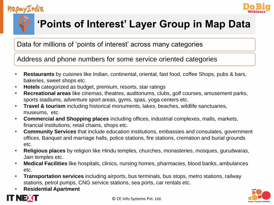
‘Points of Interest’ Layer Group in Map Data
Data for millions of ‘points of interest’ across many categories
Address and phone numbers for some service oriented categories
• Restaurants by cuisines like Indian, continental, oriental, fast food, coffee Shops, pubs & bars, bakeries, sweet shops etc.
• Hotels categorized as budget, premium, resorts, star ratings• Recreational areas like cinemas, theatres, auditoriums, clubs, golf courses, amusement parks,
sports stadiums, adventure sport areas, gyms, spas, yoga centers etc.• Travel & tourism including historical monuments, lakes, beaches, wildlife sanctuaries,
museums, etc.• Commercial and Shopping places including offices, industrial complexes, malls, markets,
financial institutions, retail chains, shops etc.• Community Services that include education institutions, embassies and consulates, government
offices, Banquet and marriage halls, police stations, fire stations, cremation and burial grounds etc.
• Religious places by religion like Hindu temples, churches, monasteries, mosques, gurudwaras, Jain temples etc.
• Medical Facilities like hospitals, clinics, nursing homes, pharmacies, blood banks, ambulances etc.
• Transportation services including airports, bus terminals, bus stops, metro stations, railway stations, petrol pumps, CNG service stations, sea ports, car rentals etc.
• Residential Apartment

© CE Info Systems Pvt. Ltd.
Address DB & Postal Boundaries Group
1000s of cities with boundaries as defined by considering urban agglomerates, extended coverage of towns due to development over past years
Localities within cities
Sub-localities within localities within a city
House numbers and/or Names for large cities
Postal boundaries of India covering entire country
Organisations have come across various challenges in implementingdestination search for addresses in India. Good map data providers extend andensure full support in educating partners with respect to local addressingnuances, address hierarchy, algorithm to be used for implementing bestpossible searches and geo-code tools.
© CE Info Systems Pvt. Ltd.
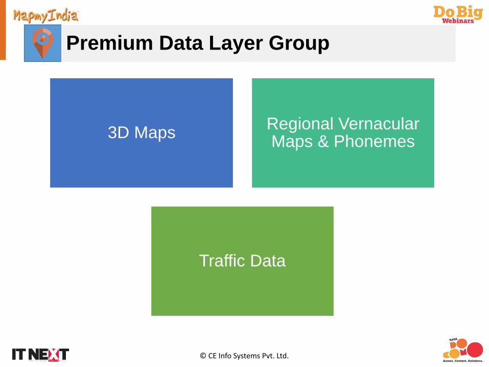
Premium Data Layer Group
3D Maps Regional Vernacular Maps & Phonemes
Traffic Data

© CE Info Systems Pvt. Ltd.
Map Coverage – Map View at Zoom Levels
Seamless scale integration From 1:10k (National) to 1:1k (City Level)

© CE Info Systems Pvt. Ltd.
State Boundaries with NH & SH
Seamless scale integration From 1:10k (National) to 1:1k (City Level)

© CE Info Systems Pvt. Ltd.
District , Sub District Boundaries & Village
Seamless scale integration From 1:10k (National) to 1:1k (City Level)
© CE Info Systems Pvt. Ltd.
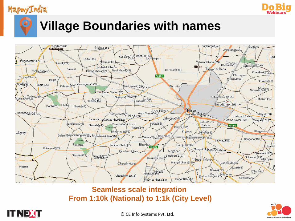
Village Boundaries with names
Seamless scale integration From 1:10k (National) to 1:1k (City Level)
© CE Info Systems Pvt. Ltd.
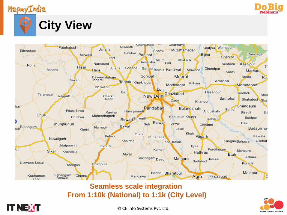
City View
Seamless scale integration From 1:10k (National) to 1:1k (City Level)
© CE Info Systems Pvt. Ltd.
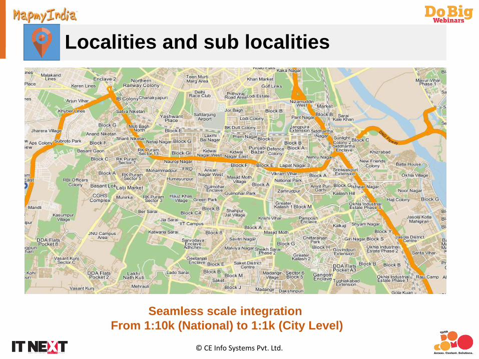
Localities and sub localities
Seamless scale integration From 1:10k (National) to 1:1k (City Level)
© CE Info Systems Pvt. Ltd.
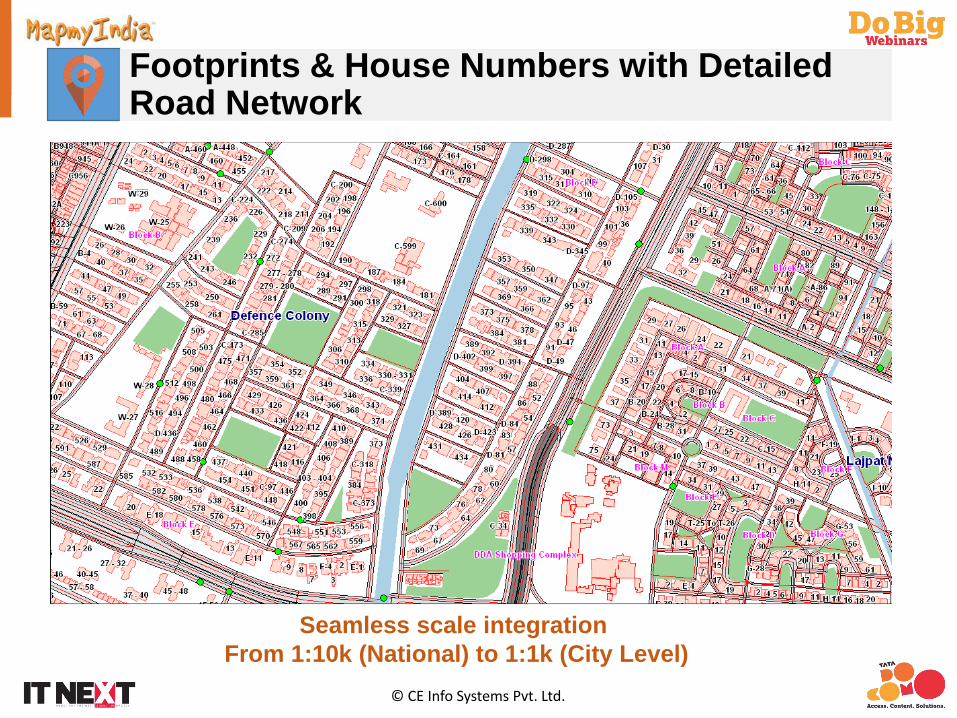
Footprints & House Numbers with Detailed Road Network
Seamless scale integration From 1:10k (National) to 1:1k (City Level)

© CE Info Systems Pvt. Ltd.
Premium Data Sets3D LandmarksJunction Views
Traffic Data3D City View

© CE Info Systems Pvt. Ltd.
How is Map & Data delivered/used by enterprises?
Access through APIs
LBS/GIS/GPS Solutions
Standard GIS Formats for Large
Government/Enterprise Customers
CustomisedData Models
for Navigation
Vector Map & Data
APIs
Web, Mobile, Cloud, PND & All Standard GIS Desktop and Web Platforms
Map & Data Services

© CE Info Systems Pvt. Ltd.
Physical and Car-based GPS Video Survey
Road Name, Route Number, Form of Ways, Point of Interest, Imp POI entry,
Bridge Start, Bridge End (ref screen shot), etc.
Data Collected: Videos & Images in different angles
Geo Data: All Navigation attributesPoints of Interest
Per car per day coverage of 80km in the city & 150km on the highway
Car Video / Images System Feature Capture Tool (for quicker production of data)
Two Collection Sources
© CE Info Systems Pvt. Ltd.
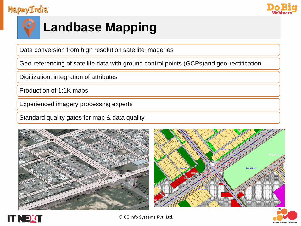
Landbase Mapping
Data conversion from high resolution satellite imageries
Geo-referencing of satellite data with ground control points (GCPs)and geo-rectification
Digitization, integration of attributes
Production of 1:1K maps
Experienced imagery processing experts
Standard quality gates for map & data quality

© CE Info Systems Pvt. Ltd.
Data Collection & Mapping Services
Survey & Data Collection
• Electrical/Telecom Network survey and mapping• GIS based property tax survey and assessment• Oil & Gas pipeline survey and mapping• Rural & Urban Land records survey and mapping under NLRMP• Home Pass survey for digital cable operators• Drive feeds for retail universe using car survey technology
Customised Maps & Services
• Creation of customised themes for Government and enterprise customers• Integration of enhanced data sets with maps • Geo-coding services for large address databases
Data Migration
• Data Migration services for specific enterprise GIS systems

© CE Info Systems Pvt. Ltd.
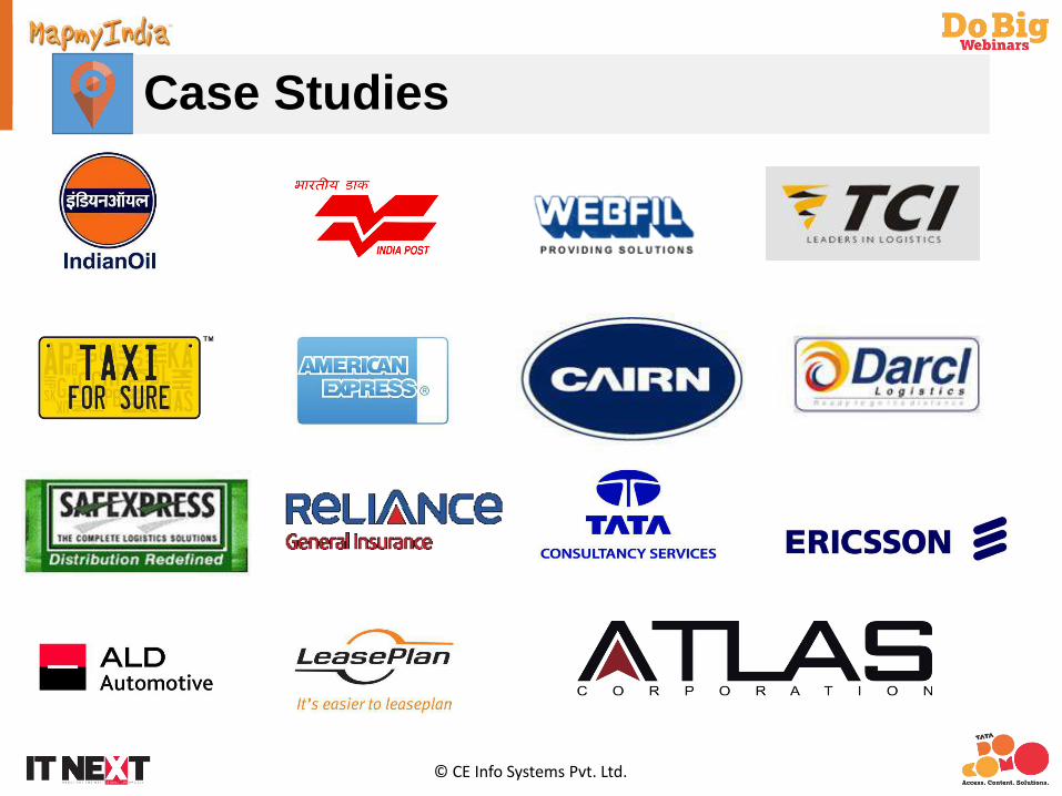
Case Studies
© CE Info Systems Pvt. Ltd.
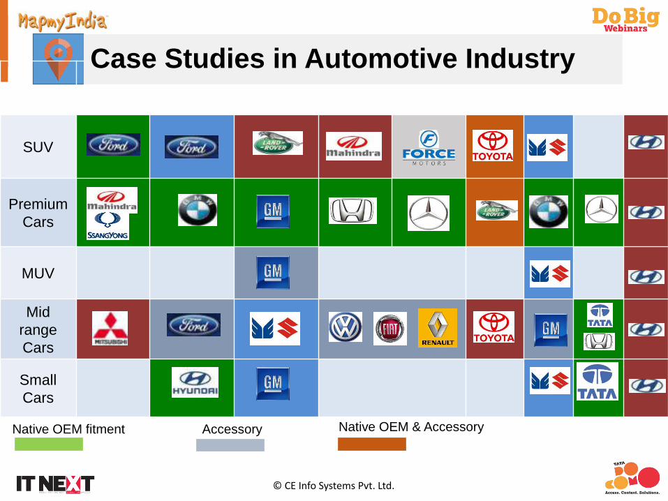
Native OEM fitment
2009 2010 2011 2012 2013
SUV
PremiumCars
MUV
Mid range Cars
Small Cars
Accessory Native OEM & Accessory
Case Studies in Automotive Industry

LBS/GIS Software Products

© CE Info Systems Pvt. Ltd.
LBS/GIS Software Products & Solutions
Map & Data
GIS/LBS Map Portal & App
APIs & Mobile SDK
Navigation Tracking Route Optimization CAD
Software Products
Store/Outlet/Service
Locator App
Local Search App
Location Sharing App
AssetTracking
Emergency Response
Taxi Dispatch
Logistics Planning
Fleet Management
Emergency Management
Solutions
LBS/GIS Platform
Geo-Analytics
Mobile Navigation
Site Selection
Sales Analysis
Market Planning
People Tracking
Vehicle Tracking
Automotive Navigation
Multimodal Navigation

© CE Info Systems Pvt. Ltd.
Map APIs
APIs or Web Service is a process of accessing data over the Internet usingWWW (World Wide Web) and HTTP (Hypertext Transfer Protocol) as astandardised messaging system.
Interactive Map API (JavaScript API)
• The Maps JavaScript API is a set of programming interfaces that enables developers to build web or mobile browser applications using feature rich, interactive MapmyIndia Maps.
Geocoding API (REST)
• A REST API that finds the most accurate latitude longitude combination for a provided address
Reverse Geocoding API (REST)
• A REST API that finds the nearest street-level address for a provided latitude longitude combination.
Routing API (REST)
• A REST API that calculates up to three routes between provided start and end locations provided as latitude longitude points.
Distance API (REST)
• A REST API that provides driving distance and time from a given center point to any number of points. Note that no route information is provided in this API
Map Image API (REST)
• A REST API that provides map images (PNG) of size 256x256 and 512x512 (for high DPI screens, like retina display) for a given latitude longitude point and zoom level
© CE Info Systems Pvt. Ltd.
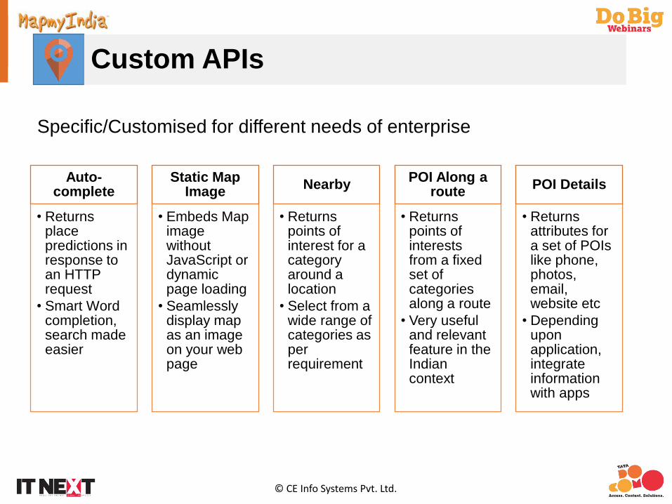
Custom APIs
Auto-complete
• Returns place predictions in response to an HTTP request
• Smart Word completion, search made easier
Static Map Image
• Embeds Map image without JavaScript or dynamic page loading
• Seamlessly display map as an image on your web page
Nearby
• Returns points of interest for a category around a location
• Select from a wide range of categories as per requirement
POI Along a route
• Returns points of interests from a fixed set of categories along a route
• Very useful and relevant feature in the Indian context
POI Details
• Returns attributes for a set of POIs like phone, photos, email, website etc
• Depending upon application, integrate information with apps
Specific/Customised for different needs of enterprise

© CE Info Systems Pvt. Ltd.
Mobile SDK
The Mobile SDK allows access to a URL scheme that lets developers to invoke the maps within a mobile app
SDK provides APIs to integrate maps, search and routing features
The SDK is available on Android and iOS platforms
Mobile SDK offers following functionalities to the Mobile Apps
• Interactive Map with tools for zoom, pan• Geocoding• Reverse-geocoding• Routing and directions

© CE Info Systems Pvt. Ltd.
Tracking
Ability to stream data from range of devices including vehicles/asset/personal trackers and mobile phones
Enables visualisation of live positions of vehicles/people
Enables various alerts for monitoring of speed, route deviations, unplanned stops etc.
User configuration of planned delivery/visit locations thru geo-fencing
Reports on different parameters
© CE Info Systems Pvt. Ltd.
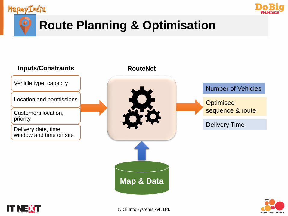
Route Planning & Optimisation
Vehicle type, capacity
Location and permissions
Customers location, priority
Delivery date, time window and time on site
RouteNetInputs/Constraints
Map & Data
Number of Vehicles
Optimisedsequence & route
Delivery Time

© CE Info Systems Pvt. Ltd.
Route Planning
Driver manifests
Delivery details
Delivery summary
Route maps
Vehicle and driver utilisation
Delivery frequency and amount of delivered goods in specific geographic area

© CE Info Systems Pvt. Ltd.
Computer Aided Dispatch (CAD)
Comprehensive Incident Management Platform for Emergency Response and Enterprise-Grade Dispatch
Consistent Incident Handling using Standard Operating Procedures (SOP)
Robust Workflow Engine to manage SOPs
Use of High Quality MapmyIndia GIS & Navigation Tools
Mobile Unit Dispatch and real-time tracking
Features
© CE Info Systems Pvt. Ltd.
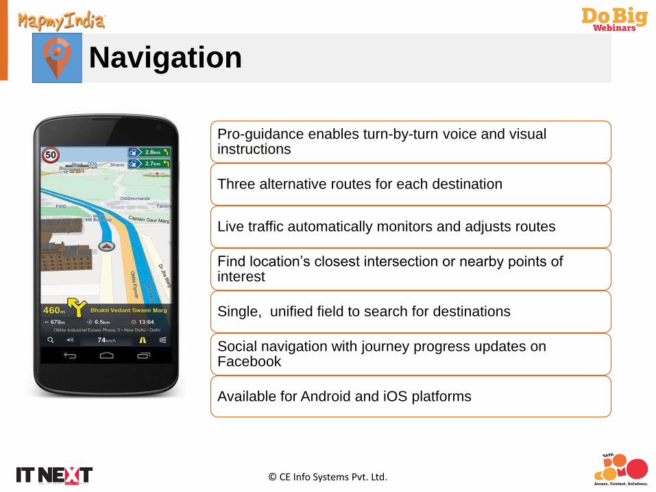
Navigation
Pro-guidance enables turn-by-turn voice and visual instructions
Three alternative routes for each destination
Live traffic automatically monitors and adjusts routes
Find location’s closest intersection or nearby points of interest
Single, unified field to search for destinations
Social navigation with journey progress updates on Facebook
Available for Android and iOS platforms

© CE Info Systems Pvt. Ltd.
Case Studies

GPS Devices / Hardware
© CE Info Systems Pvt. Ltd.
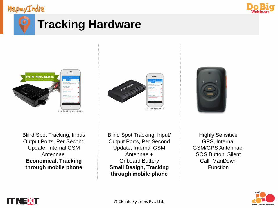
Tracking Hardware
Blind Spot Tracking, Input/ Output Ports, Per Second
Update, Internal GSM Antennae.
Economical, Tracking through mobile phone
Blind Spot Tracking, Input/ Output Ports, Per Second
Update, Internal GSM Antennae +
Onboard BatterySmall Design, Tracking through mobile phone
Highly Sensitive GPS, Internal
GSM/GPS Antennae, SOS Button, Silent
Call, ManDownFunction

© CE Info Systems Pvt. Ltd.
Peripherals
Two Way Calling/ Listen In
Panic ButtonOver Speeding/ Security Hooter
ImmobilizerDriver Identification System
Employee/ Children Identification
© CE Info Systems Pvt. Ltd.
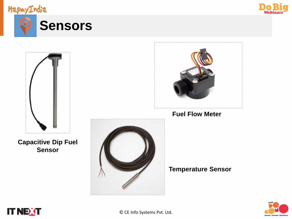
Sensors
Fuel Flow Meter
Capacitive Dip Fuel Sensor
Temperature Sensor
© CE Info Systems Pvt. Ltd.
Case Studies

Systems Integration

© CE Info Systems Pvt. Ltd.
Successful approach towards leveraging LBS
3-phase approach:• Understand enterprise requirements
• The first phase is location mapping your enterprise data using and integrating standard map data, software & hardware products
• Second phase is to customise or optimise the product to your specific requirement –requires customised services (data, survey, application, hardware)
Understand enterprise requirements
Location map your enterprise data with appropriate standard
map data, software and hardware products and third
party components (if required)
Develop/deploy customisedsolution optimised for specific
industry/enterprise/usage requirement

© CE Info Systems Pvt. Ltd.
Case Studies

© CE Info Systems Pvt. Ltd.
Case StudiesSolutions are developed with the help of standard products
Distribution Optimisation
APIs
Map Data
FleetMapmyIn
dia VT Hardware
CRM
Integration with the CRM
Field Force Management
APIs & Mobile SDK
Map Data
Mobile Tracker
ERP/SAP
Integration with the ERP/SAP
© CE Info Systems Pvt. Ltd.
Case Studies
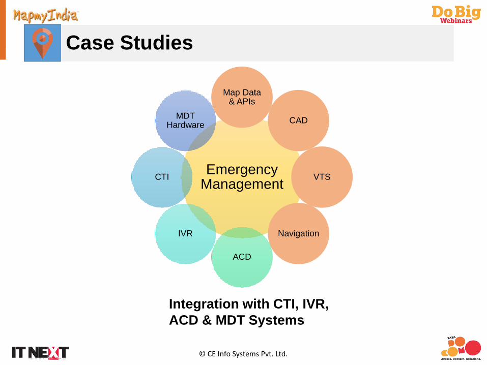
Emergency Management
Map Data & APIs
CAD
VTS
Navigation
ACD
IVR
CTI
MDT Hardware
Integration with CTI, IVR, ACD & MDT Systems
© CE Info Systems Pvt. Ltd.
How to get started with LBS in your enterprise?
1. Learn more about the possibilities of LBS and how it can benefit your enterprise –
today’s webinar is an introduction
2. Identify the specific requirements and specific needs of your enterprise/businessusers
3. Build a strong LBS foundation – modernising an enterprise from an IT perspectivestarts with centralising and standardising data, allowing collaboration, and extendingsupport and empowerment to all users – to leverage LBS, start with centralising andstandardising the ‘location’ / ‘map’ data of your business i.e. turn your data into GIS
4. Then incorporate and leverage the power of various LBS/GIS apps/software as wellas GPS hardware to ‘solve’ your requirements. You will be able to extracttremendous benefits and unlock tremendous value in your enterprise by leveraginglocation
5. Happy journey and stay in touch!

© CE Info Systems Pvt. Ltd.
Thank you
For further details, please contact us:
Email : [email protected]
Call : 1800 266 1800
Visit : www.tatadocomo.com/business