Embed Size (px)
Citation preview

goGPSgoGPSa navigation software to enhance the a navigation software to enhance the accuracy of low-cost GPS receiversaccuracy of low-cost GPS receivers
Eugenio RealiniEugenio RealiniOsaka City University, JapanOsaka City University, Japan

Why goGPS?Why goGPS?
diffusion of GPS-enabled devices
(smartphones, PDAs, cameras)
miniaturization of low-cost and low-
power GPS modules and antennas
!!! BAD ACCURACY !!!(~ 5 meters)

Basic ideas behind goGPSBasic ideas behind goGPS
develop a tool which allows to modify Kalman filter parameters
to study new approaches to GPS navigation
(not possible with black-boxcommercial algorithms)
exploit the availability of networks of permanent GPS stations and
wireless connectivity
to enhance the navigation accuracy of low-cost GPS
devices
Kinematic surveyingPrecise off-road navigationLocation Based Services
Low-cost mapping...

Italy ← goGPS → JapanItaly ← goGPS → Japan
Geomatics LaboratoryGeomatics LaboratoryPolitecnico di MilanoPolitecnico di Milano
Como CampusComo Campus
Media CenterMedia CenterOsaka City UniversityOsaka City University
goGPS

Double freq. vs single freq.Double freq. vs single freq.
GPS satellites broadcast signal on two carriers: L1 and L2
High-end professional receiversuse both L1 and L2
(double frequency receivers)
Accuracy: 2-3 cm (real-time)
Low-cost commercial receiversuse just L1
(single frequency receivers)
Accuracy: 3-5 m (real-time)

RTK vs stand-aloneRTK vs stand-alone
Real-Time Kinematic (RTK)positioning
(via Internet connection)
2-3 cm (real-time)
Stand-alone(but nowadays it is easyto add Internet access)
3-5 m (real-time)
US $ 15000 - 25000 US $ 70 - 150
nothingin between?

DGPS vs stand-aloneDGPS vs stand-alone
Single frequencyDifferential GPS (DGPS)
positioning(via Internet connection)
15-30 cm (real-time)
Stand-alone(but still they cost much
less)
3-5 m (real-time)
US $ 1000 - 1500
nothingin between!
US $ 70 - 150

goGPS nichegoGPS niche
15-30 cm 3-5 m2-3 cm
RTK DGPS Stand-alone
goGPSL1 RTK positioning
40 cm - 1 m
US $ 15000 - 25000 US $ 1000 - 1500 US $ 70 - 150

Raw GPS data!Raw GPS data!
goGPS: L1 RTK positioning(via Internet connection)
To apply RTKraw GPS observations
are needed!
u-blox Evaluation Kits(AEK-4T / EVK-5T)

Raw GPS data!Raw GPS data!
goGPS Navit, TomTom SW, ...

Kalman filter/1Kalman filter/1
It is the core of the software.
It updates the position of the receiver in real-time on the basis of:
• new measurements
• the state of the system at the previous epoch
To implement it, it is needed to define:
state variables
dynamic model
observations
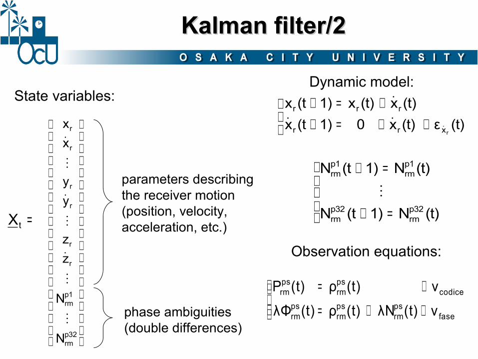
parameters describing the receiver motion(position, velocity, acceleration, etc.)
phase ambiguities(double differences)
p32rm
p1rm
r
r
r
r
r
r
N
N
zz
yy
xx
⋮
⋮
˙
⋮
˙
⋮
˙
=tX
State variables:Dynamic model:
Observation equations:
Kalman filter/2Kalman filter/2
++=++=+
(t)ε(t)x01)(tx(t)x(t)x1)(tx
rxrr
rrr
˙˙˙˙
=+
=+
(t)N1)(tN
(t)N1)(tN
p32rm
p32rm
p1rm
p1rm
⋮
++=
+=
fasepsrm
psrm
psrm
codicepsrm
psrm
ν(t)λN (t)ρ(t)λΦν(t)ρ(t)P

In order to improve the heigth positioning quality, a new observation from a DTM is introduced:
≈ 30 cm
Tile search
detection of the 4 nearest vertices Interpolation
DTM loading time was optimized by subdividing the DTM in buffered tiles.
A DTM obtained from a LiDAR DSM 2m x 2m produced by Lombardy Region (Italy) was used during tests.
DTMrrrDTM v)z,y,h(xh +=
vσ
DTM observationDTM observation
approx.position KF

Constrained motionConstrained motion
If the rover is moving along a path that is known a priori (e.g. road, railway, …) a linear constraint can be introduced, making the motion mono-dimensional
The constraint is modeled as 3D interconnected segments and the motion is described by a curvilinear coordinate (c):
new state variable:
c0
c1
c2
(X0,Y0,Z0)
(X1,Y1,Z1)(X2,Y2,Z2) (X3,Y3,Z3)
c
p32rm
p1rm
r
r
N
N
cc
⋮
⋮
˙
=tX

Software/1Software/1
- developed in MATLAB environment
- 1 Hz data acquisition rate by means of “Instrument Control” toolbox (standard TCP-IP and USB)
- real-time update of receiver position (computation time about 15 ms on Intel Centrino CPU 1.66 GHz)
- real-time update of the position with respect to a known reference or on Google Earth
- Post-processing (post-mission) analysis by means of RINEX files or goGPS data saved during a real-time test

Software/2Software/2

Hardware/1Hardware/1
Internet
3G
Base station(s)NTRIP(RTCM 3.1)
USB
goGPS
USB
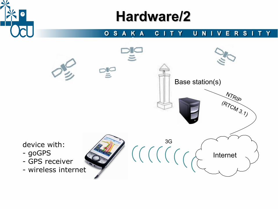
Hardware/2Hardware/2
Internet
3G
Base station(s)NTRIP(RTCM 3.1)
device with:- goGPS- GPS receiver- wireless internet

Accuracy test/1Accuracy test/1
eBonTek egps597 chipset: ANTARIS 4signal: C/A, L1
Provides NMEA in output over a Bluetooth connection. Stand-alone positioning.
u-blox AEK–4Tchipset: ANTARIS 4signal: C/A, L1
It has an external patch antenna and it provides raw data and/or processed data (NMEA format) by USB connection. Its parameters are fully customizable.

Accuracy test/2Accuracy test/2
Leica GPS1200 signal: C/A, P L1, L2
Double frequency receiverwith RTK capabilities.
Leica GS20signal: C/A, L1
Mid-level receiver (single freq.), designed for cartographic update and quick decimeter-level surveys. It supports DGPS positioning.

Accuracy test/3Accuracy test/3
Como permanent station, used as base station(through GPSLombardia positioning service)

Accuracy test/4Accuracy test/4
Devices:- Leica GPS1200- Leica GS20- eBonTek eGPS 597- ev. kit u-blox + goGPS
Fixed on the rooftop of a car driven on a road with good sky visibility.

Accuracy test/5Accuracy test/5
goGPS(cutoff = 30°)
eBonTek
mean 0.78 mstd 0.47 m
mean 4.03 mstd 1.70 m
Leica GS20(mod. “Max Accuracy”)
mean 0.30 mstd 0.15 m
Devices:- Leica GPS1200- Leica GS20- eBonTek eGPS 597- ev. kit u-blox + goGPS
goGPS(cutoff = 10°)
mean 1.13 mstd 0.67 m

goGPS in JapangoGPS in Japan
goGPS testing and development in Japan requires to get access to RTK services (data coming from one or more permanent stations).
Three choices:
Commercial providers
- great coverage- advanced services (e.g. VRS)
BUT:- expensive
“Free” providers
Example:Kyoto Universitypermanent station
- data stream is publicly available
BUT:- high distance- no NTRIP- RTCM 2.3
Build up our own service
Base station (not necessarily permanent) at OCU
- highest freedom
BUT:- buy/rent dual freq. receiver- set up NTRIP caster

goGPS & RTKLIBgoGPS & RTKLIB
goGPS conversion from MATLAB to C/C++
- positioning func.- input/output- GPS formats- (...)
RTKLIBby T.Takasu(GPLv3)
http://gpspp.sakura.ne.jp/rtklib/rtklib.htm
goGPS core Kalman filter
GUI
alreadyexisting (C)
MATLAB → C
goGPS GUInew (C++)

goGPS & WPSgoGPS & WPS
goGPS development could also include WPS functionality, to shift the computational / storage burden from the rovers to a central server.
Examples:
Server running goGPSwith WPS functionality
Server providingDTM data interpolation
as WPS
Rovers running goGPS
Rovers just acquiringraw data
rough position
DTM height
raw code and phaseobservations
accurate positioning

goGPS@SourceforgegoGPS@Sourceforge
goGPS MATLAB code (GPLv3):
http://sourceforge.net/projects/gogps
Thank you!Thank you!