Embed Size (px)
Citation preview

Baptiste Tripard
Driving forces in the
commercial drone market

SenseFly in a few words
A Parrot company since 2012
More than 100 employees (Europe + USA)
More than 100 eBee produced each month
Research center in the US (Iowa) dedicated to AG applications
#1 in fixed-wing mapping drones (worldwide volume) in 2014
Over 30% stated usage by US Commercial Drone Flyers (USCDFs) – in terms
of FAA exemptions received for fixed-wing platforms

Our family of UAS
The professional
GIS drone
The survey-
grade mapping
drone
The precision
agriculture
drone
The professional
mapping drone
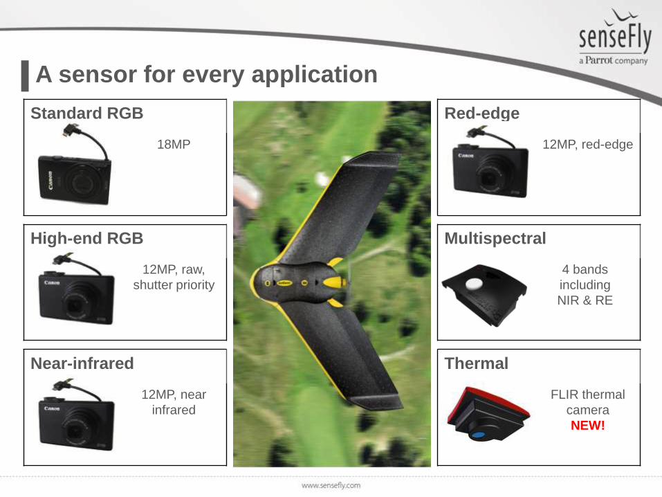
A sensor for every application
High-end RGB
12MP, raw,
shutter priority
Near-infrared
12MP, near
infrared
Red-edge
12MP, red-edge
Multispectral
4 bands
including
NIR & RE
Thermal
FLIR thermal
camera
NEW!
Standard RGB
18MP

Coming (really) soon…

Hardware & software
companies
1.

A great mix of expertise

Users &
Applications
2.

Mining / Construction
Calculating volume extraction in Chile
• One of world’s largest open pits
• 3 km across, total depth 1,000 m
• 100,000 tons per day
• Lidar data collection problematic:
– Security risk (cliff top locations)
– Blind spot due to topography
• 10 GCPs set
• 6 x 30-min eBee flights
• 3D DTM created
• Volume measured
• Repeated 4 weeks later
“Our two-man team completed each
of its mapping sessions in a single day,
compared to seven using lidar”Eric Romersa, WSdata3D co-founder

Agriculture
Range of beneficial applications
• Water and nitrogen management
• Drainage tiles analysis
• Insurance claims
• Yield predictions, index maps
• Prescription maps

GIS / conservation
Hawaii
Damage assessment following a volcano
eruption on the Big Island
Race for Water project

Flight authorizations
3. Regulations

“The integration of RPAS will be
based on the principle that all
operations will have an equivalent
level of safety in comparison to
regular, manned, aviation.”
What does it concretely mean?
COMMUNICATION FROM THE COMMISSION TO THE EUROPEAN PARLIAMENT AND THE COUNCIL

Equivalent level of safety
• MIT proposed a method to
compute and compare the level of
safety between manned and
unmanned aircrafts
• Ex.: Current aviation operations
impose a risk to the general public
on the order of 5x10⁻⁷ fatalities per
hour of operation

• ELS: Estimated Level of Safety (nb. of occurrences / flight hours)
• MTBF: Mean Time Before Failure (leading to an uncontrolled crash)
• Aexp: Area of exposure (depending
on aircraft size & shape)
• ρ: Population density
• PPen: Probability of penetration (depending on
vehicle energy)
Ex. Ground Impact Hazard Analysis
Setting desired level of safety allows to compute minimum MTBF for a
given aircraft, situation, etc.

How to minimize the ELS?
Golf ball Soccer Ball eBee Small UAS
Weight (g) 46 450 700 2 000
Kinetic
energy (J)150 100 60 600
- Using ultra-light UAS

How to minimize the ELS?
UAS out of working area
Low Battery
GPS loss
Strong wind conditions
Radio link loss
AUTOPILOT
SAFETYeBee ELS = 5x10⁻⁹
- Automatic management of critical situations

Interesting results (example)
<0.9kg 0.9 to 14kg 14 to 450kg

Correlation with the situation in the US
WE LIKE
- Proposition of micro-UAS class
- Pilot requirements
WE DO NOT LIKE
- Requirement for manual control of the
aircraft under the micro-UAS class
- No flights over people
WE WOULD LIKE TO SEE
- Extended Line of Sight operations
NPRMEXEMPTION PROCESS
WE LIKE
- Streamlined process
- Blanket COA
- Communication
WE DO NOT LIKE
- Pilot requirements
- Processing time
- Flight ceiling at 200 ft.
for the blanket COA

What is the impact of regulations?
Situation in France (FPDC)


![senseFly eBeex - BrochureChez senseFly RSYW GVS]SRW IR PE XIGLRSPSKMI TSYV VIRHVI PI XVEZEMP TPYW W ²V IX TPYW I ¾GEGI 2SW WSPYXMSRW HI HVSRIW £TVSYZ £IW WMQTPM ¼IRX PE GSPPIGXI](https://img.dokumen.tips/doc/110x75/5f0eff5e7e708231d441fa32/sensefly-ebeex-brochure-chez-sensefly-rsyw-gvssrw-ir-pe-xiglrspskmi-tsyv-virhvi.jpg)