Embed Size (px)
Citation preview

An INSPIRE-based vocabulary for the publication of Agricultural Linked Data
OWLED Workshop 2015Bethlehem, PA. USA
9th October 2015
Raul Palma, Tomas Reznik, Miguel Esbri, Karel Charvat, and Cezary Mazurekw w w . f o o d i e - p r o j e c t . e u
Grant agreement no: 621074
CIP-ICT-PSP-2013-7 Pilot Type B

2www.foodie-project.eu
Presentation Outline1. Motivation and context
2. Transformation Process
3. Ontology
4. Discussion and Future Work
3www.foodie-project.eu
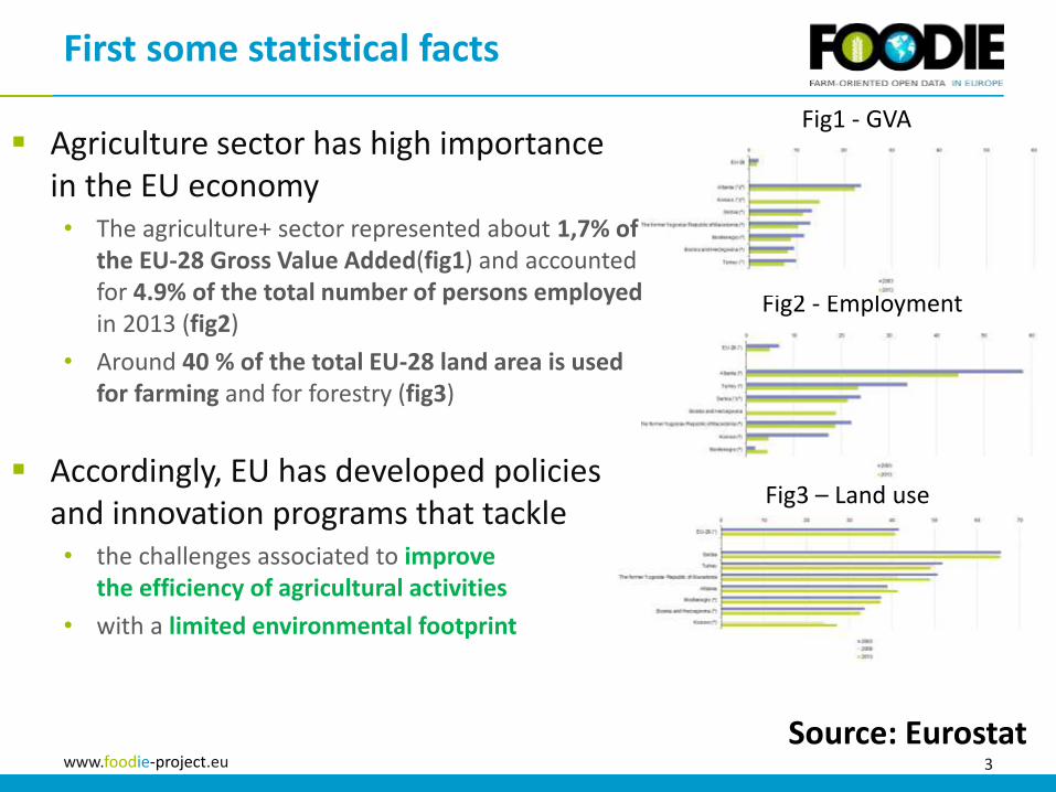
Fig1 - GVA
Fig2 - Employment
Fig3 – Land use
Agriculture sector has high importance in the EU economy• The agriculture+ sector represented about 1,7% of
the EU-28 Gross Value Added(fig1) and accounted for 4.9% of the total number of persons employedin 2013 (fig2)
• Around 40 % of the total EU-28 land area is used for farming and for forestry (fig3)
Accordingly, EU has developed policies and innovation programs that tackle • the challenges associated to improve
the efficiency of agricultural activities
• with a limited environmental footprint
First some statistical facts
Source: Eurostat
4www.foodie-project.eu
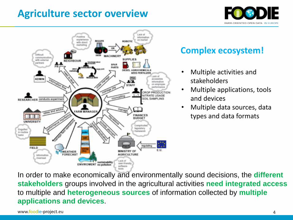
Agriculture sector overview
• Multiple activities and stakeholders
• Multiple applications, tools and devices
• Multiple data sources, data types and data formats
In order to make economically and environmentally sound decisions, the different
stakeholders groups involved in the agricultural activities need integrated access
to multiple and heterogeneous sources of information collected by multiple
applications and devices.
Complex ecosystem!
5www.foodie-project.eu
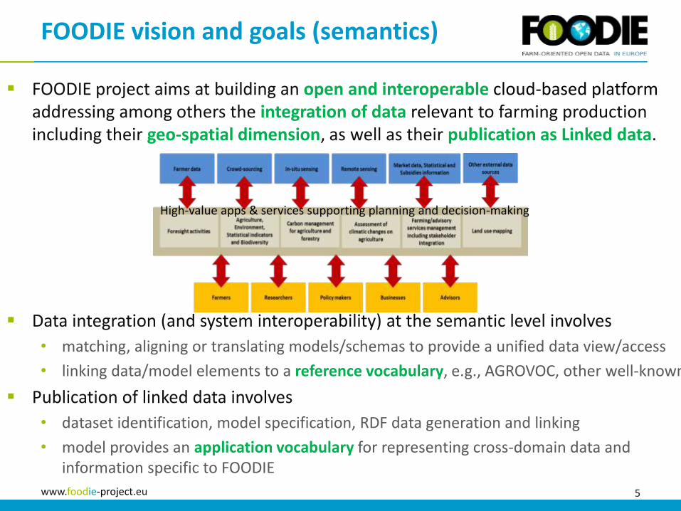
FOODIE project aims at building an open and interoperable cloud-based platform addressing among others the integration of data relevant to farming production including their geo-spatial dimension, as well as their publication as Linked data.
Data integration (and system interoperability) at the semantic level involves
• matching, aligning or translating models/schemas to provide a unified data view/access
• linking data/model elements to a reference vocabulary, e.g., AGROVOC, other well-known
Publication of linked data involves
• dataset identification, model specification, RDF data generation and linking
• model provides an application vocabulary for representing cross-domain data and information specific to FOODIE
FOODIE vision and goals (semantics)
High-value apps & services supporting planning and decision-making
6www.foodie-project.eu
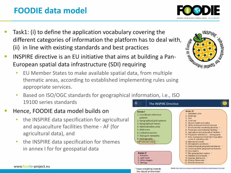
Task1: (i) to define the application vocabulary covering the different categories of information the platform has to deal with, (ii) in line with existing standards and best practices
INSPIRE directive is an EU initiative that aims at building a Pan-European spatial data infrastructure (SDI) requiring
• EU Member States to make available spatial data, from multiple thematic areas, according to established implementing rules using appropriate services.
• Based on ISO/OGC standards for geographical information, i.e., ISO 19100 series standards
Hence, FOODIE data model builds on
• the INSPIRE data specification for agricultural and aquaculture facilities theme - AF (for agricultural data), and
• the INSPIRE data specification for themes in annex I for for geospatial data
FOODIE data model

7www.foodie-project.eu
INSPIRE data specifications are defined as UML models and are available in different XML-based formats
FOODIE extensions on the UML model developed by domain experts
Task2: Transform model into OWL ontology
FOODIE data model class Foodie Core Data Model v 4.1 proposal
«featureType»
Agricultural and
Aquaculture Facilities
Model::Holding
«featureType»
Agricultural and Aquaculture Facilities Model::
Site
+ code :Identifier
+ geometry :GM_Object
+ activity :EconomicActivityNACEValue [1..*]
+ validFrom :DateTime
+ validTo :DateTime [0..1]
+ beginLifespanVersion :DateTime
+ endLifeSpanVersion :DateTime [0..1]
«voidable»
+ includesAnimal :FarmAnimalSpecies [0..*]
«dataType»
Agricultural and Aquaculture Facilities Model::
FarmAnimalSpecies
«voidable»
+ livestock :LivestockSpeciesValue [0..*]
+ aquaculture :AquacultureSpeciesValue [0..*]
«featureType»
Activ ity Complex::Activ ityComplex
+ inspireId :Identifier
+ thematicId :ThematicIdentifier [0..*]
+ geometry :GM_Object
+ function :Function [1..*]
+ userId :CharacterString
«voidable»
+ name :CharacterString [0..1]
+ validFrom :DateTime
+ validTo :DateTime [0..1]
«voidable, l ifeCycleInfo»
+ beginLifespanVersion :DateTime
+ endLifespanVersion :DateTime [0..1]
«featureType»
Plot
+ code :Identifier
+ validFrom :DateTime
+ validTo :DateTime [0..1]
+ beginLifeSpanVersion :DateTime
+ endLifeSpanVersion :DateTime [0..1]
+ geometry :GM_Object [1..*]
+ description :CharacterString [0..1]
+ originType :OriginTypeValue
«featureType»
Treatment
+ quantity :Measure [1..*]
+ tractorId :CharacterString [0..*]
+ machineId :CharacterString [0..*]
+ motionSpeed :Measure [0..1]
+ pressure :Measure [0..1]
+ flowAdjustment :Measure [0..1]
+ applicationWidth :Measure [0..1]
+ areaDose :DoseUnit [0..1]
+ formOfTreatment :FormOfTreatmentValue [1..*]
+ treatmentPurpose :TreatmentPurposeValue [0..*]
+ treatmentDescription :CharacterString [0..1]
«dataType»
NutrientsType
+ N :Measure [0..1]
+ P2O5 :Measure [0..1]
+ K2O :Measure [0..1]
+ MgO :Measure [0..1]
+ CaO :Measure [0..1]
+ S :Measure [0..1]
+ Zn :Measure [0..1]
+ Cu :Measure [0..1]
+ Fe :Measure [0..1]
+ B :Measure [0..1]
+ Mn :Measure [0..1]
+ Mo :Measure [0..1]
«codeList»
TreatmentPurposeValue
+ weed
+ pest
+ disease
«featureType»
CropSpecies
+ beginDate :Date
+ endDate :Date [0..1]
+ cropArea :GM_Object
+ cropSpecies :CropType [1..*]
+ production :ProductionType [0..*]
«featureType»
Product
+ productCode :CharacterString [0..*]
+ productName :CharacterString [1..*]
+ productType :CharacterString
+ productSubType :CharacterString [0..*]
+ productKind :ProductKindValue
+ description :CharacterString [0..1]
+ manufacturer :CI_ResponsibleParty [1..*]
+ nutrients :NutrientsType [0..*]
+ safetyInstructions :CharacterString [0..1]
+ storageHandling :CharacterString [0..1]
+ registrationCode :CharacterString [0..*]
+ registerUrl :URL [0..*]
«featureType»
SoilNutrients
+ nutrientName :GenericName
+ nutrientAmount :Measure
+ nutrientMeasure :CharacterString
«codeList»
ProductKindValue
+ organic
+ mineral
«dataType»
SoilTextureType
+ clay :Percent
+ silt :Percent
+ sand :Percent
«dataType»
ProductionType
+ productionDate :Date
+ variety :CharacterString
+ productionAmount :Measure
+ productionAnalysis :ProductionAnalysisType [0..*]
«dataType»
ProductionAnalysisType
+ productionAnalysisDate :Date
+ property :Measure
«codeList»
OriginTypeValue
+ manual
+ system
«featureType»
Alert
+ code :Identifier
+ type :CharacterString [1..*]
+ description :CharacterString [0..1]
+ checkedByUser :Boolean
+ alertDate :Date
+ alertGeometry :GM_Object
«featureType»
Interv ention
+ type :CharacterString
+ description :CharacterString
+ notes :CharacterString [0..1]
+ status :CharacterString
+ creationDateTime :DateTime
+ interventionStart :DateTime
+ interventionEnd :DateTime [0..1]
+ interventionGeometry :GM_Object [1..*]
+ supervisor :CI_ResponsibleParty [0..1]
+ operator :CI_ResponsibleParty [0..*]
+ evidenceParty :CI_ResponsibleParty [1..*]
«featureType»
TreatmentPlan
+ treatmentPlanCode :CharacterString [0..*]
+ description :CharacterString [1..*]
+ type :CharacterString
+ campaign :TM_Period [1..*]
+ treatmentPlanCreation :DateTime
+ notes :CharacterString [0..1]
«featureType»
ProductPreparation
+ productQuantity :Measure
+ solventQuantity :Measure [0..*]
+ safetyPeriod :TM_Period
«dataType»
Activ eIngredients
+ code :CharacterString [0..1]
+ ingredientName :CharacterString
+ ingredientAmount :Measure
«codeList»
DoseUnit
+ minimumDose :Measure
+ maximumDose :Measure
«codeList»
FormOfTreatmentValue
+ manual
+ applicationMachine
+ aerial
«featureType»
ManagementZone
+ code :Identifier
+ validFrom :DateTime [0..1]
+ validTo :DateTime [0..1]
+ beginLifeSpanVersion :DateTime
+ endLifeSpanVersion :DateTime [0..1]
+ geometry :GM_Object [1..*]
+ notes :CharacterString
+ dateOfAnalysis :DateTime [0..*]
«featureType»
SoilType
+ soilType :CharacterString [1..*]
«featureType»
SoilTexture
+ soilTexture :SoilTextureType [1..*]
«featureType»
pH
+ pH :Measure [1..*]
«featureType»
OrganicMatter
+ organicMatter :Percent
«featureType»
ElectricConductiv ity
+ electricConductivity :Measure [1..*]
«featureType»
ZonePolygon
+ area :Measure
«dataType»
CropType
+ name :CharacterString
+ scientificName :CharacterString
+ description :CharacterString
+ notes :CharacterString
+ seedingAdvice :CharacterString
+ harvestingAdvice :CharacterString
0..*
1..*
+contains
1..*HoldingSites
1..*
0..*
+containsZone
0..*
+HoldingPlot
0..*
+containsPlot 1..*
HoldingPlots
0..*
0..1 0..1
0..*
0..*
+crop 0..*
8www.foodie-project.eu
Presentation Outline1. Motivation and context
2. Transformation Process
3. Ontology
4. Discussion and Future Work
9www.foodie-project.eu
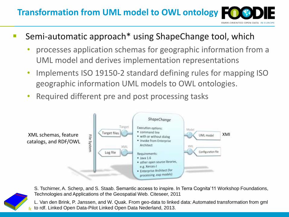
Semi-automatic approach* using ShapeChange tool, which
• processes application schemas for geographic information from a UML model and derives implementation representations
• Implements ISO 19150-2 standard defining rules for mapping ISO geographic information UML models to OWL ontologies.
• Required different pre and post processing tasks
Transformation from UML model to OWL ontology
S. Tschirner, A. Scherp, and S. Staab. Semantic access to inspire. In Terra Cognita’11 Workshop Foundations, Technologies and Applications of the Geospatial Web. Citeseer, 2011
L. Van den Brink, P. Janssen, and W. Quak. From geo-data to linked data: Automated transformation from gmlto rdf. Linked Open Data-Pilot Linked Open Data Nederland, 2013.
XMIXML schemas, feature catalogs, and RDF/OWL
10www.foodie-project.eu
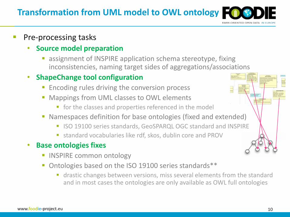
Pre-processing tasks• Source model preparation
assignment of INSPIRE application schema stereotype, fixing inconsistencies, naming target sides of aggregations/associations
• ShapeChange tool configuration
Encoding rules driving the conversion process
Mappings from UML classes to OWL elements for the classes and properties referenced in the model
Namespaces definition for base ontologies (fixed and extended) ISO 19100 series standards, GeoSPARQL OGC standard and INSPIRE
standard vocabularies like rdf, skos, dublin core and PROV
• Base ontologies fixes
INSPIRE common ontology
Ontologies based on the ISO 19100 series standards** drastic changes between versions, miss several elements from the standard
and in most cases the ontologies are only available as OWL full ontologies
Transformation from UML model to OWL ontology
11www.foodie-project.eu
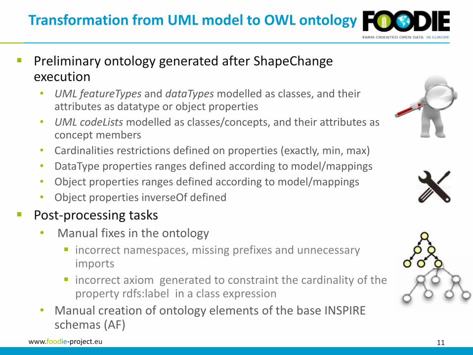
Preliminary ontology generated after ShapeChangeexecution• UML featureTypes and dataTypes modelled as classes, and their
attributes as datatype or object properties
• UML codeLists modelled as classes/concepts, and their attributes as concept members
• Cardinalities restrictions defined on properties (exactly, min, max)
• DataType properties ranges defined according to model/mappings
• Object properties ranges defined according to model/mappings
• Object properties inverseOf defined
Post-processing tasks• Manual fixes in the ontology
incorrect namespaces, missing prefixes and unnecessary imports
incorrect axiom generated to constraint the cardinality of the property rdfs:label in a class expression
• Manual creation of ontology elements of the base INSPIRE schemas (AF)
Transformation from UML model to OWL ontology
12www.foodie-project.eu
Presentation Outline1. Motivation and context
2. Transformation Process
3. Ontology
4. Discussion and Future Work

13www.foodie-project.eu
For the purposes of FOODIE, we found the lack of a feature on a more detailed level than Site that is already part of the INSPIRE AF data model.
Main concept: Plot
FOODIE ontology
foodie:Plot
INSPIRE-AF:Site
foodie:Alert Foodie:InterventionFoodie:CropSpecies
Foodie:ManagementZone
containsPlot
containsManagementZone
interventionPlotspeciesPlotalertPlot
plotAlert
Foodie:ProductionType
production
One lower level is ManagementZone• Enables a more precise description
of the land characteristics in fine-grained area
• Represents a continuous area of agricultural land with one type of crop species, cultivated by one user in one farming mode
• Two kinds of data associated:• metadata information
• agro-related information
Foodie:SoilNutrients
zoneNutrients

14www.foodie-project.eu
The Intervention is the basic feature type for any kind of (farming) application with explicitly defined geometry, e.g., tillage or pruning.
• Has multiple indirect associations with different concepts
FOODIE ontology
Foodie:Intervention
Foodie:Treatment
Foodie:TreatmentPlan
Foodie:Product Foodie:ProductPreparation
Foodie:ActiveIngredients
is-a
plan
productPlan
planProduct
preparationProduct preparation
productTreatment
treatmentProduct
preparationPlan
ingredientProduct
Foodie:FormOfTreatmentValue
Foodie:TreatmentPurposeValue
formOfTreatmenttreatmentPurpose
15www.foodie-project.eu
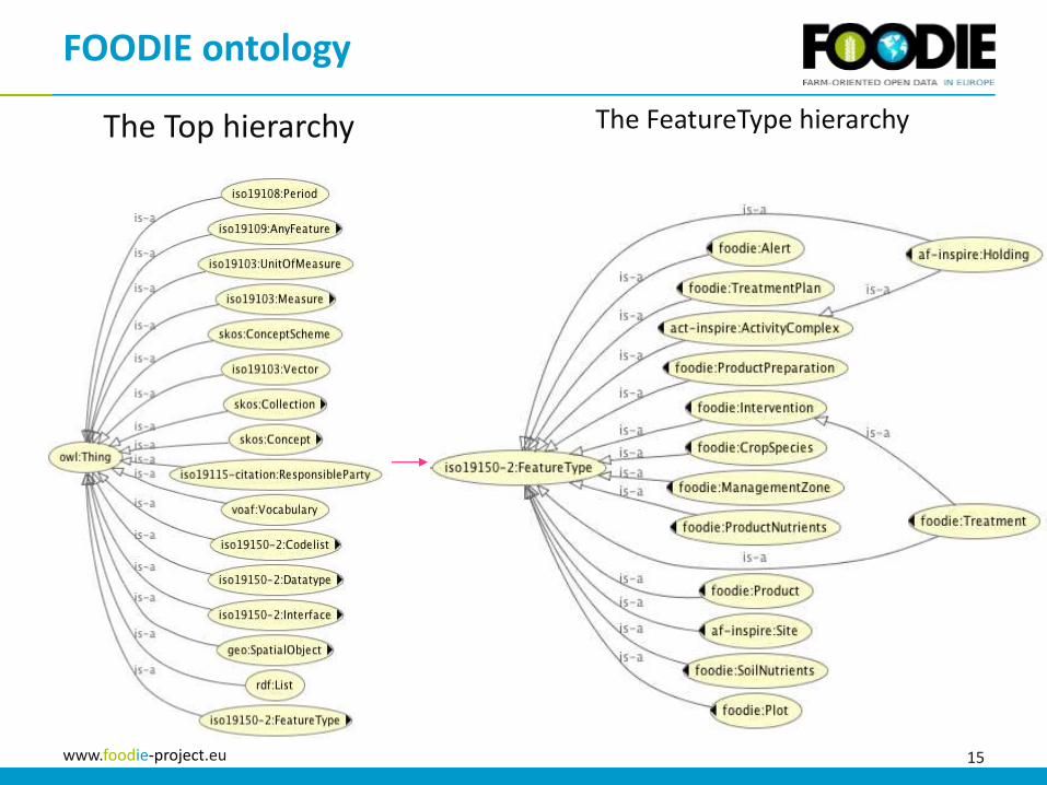
FOODIE ontology
The Top hierarchy The FeatureType hierarchy
16www.foodie-project.eu
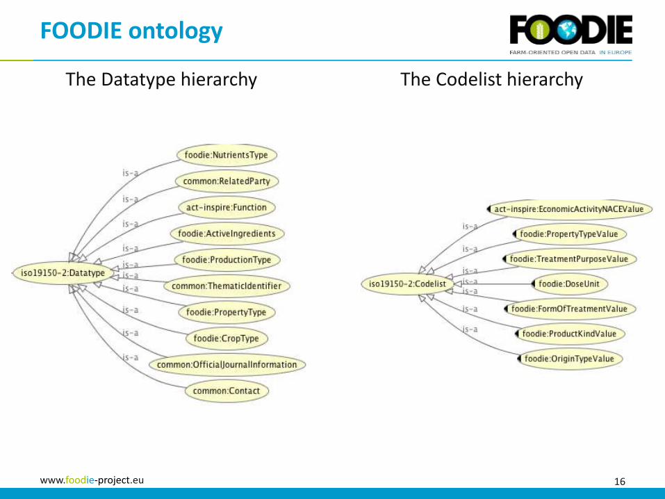
FOODIE ontology
The Datatype hierarchy The Codelist hierarchy

17www.foodie-project.eu
Presentation Outline1. Motivation and context
2. Transformation Process
3. Ontology
4. Discussion and Future Work

18www.foodie-project.eu
Not a straightforward process, needed substantial manual intervention
Need to clarify the issues with the ontologies based on the ISO 19100 series standard.
FOODIE ontology to be aligned with standard vocabularies, so that data can be integrated with existing sources• FAO vocabularies
AGROVOC Agrontology
• Datacube (e.g., for integration with EUROSTAT)
Source data collected and generated in compliance with FOODIE model will be made available in a relational database• FOODIE has a clustered postgres-XL (with postgis) installation• UML model has been translated into a relational schema just recently
and data has started to be collected
Publication of linked data will require data conversion (e.g., data upgrade or on-the-fly query translation)
Discussion & Future Work
Partners
www.foodie-project.eu
This project has received funding from the European Union’s Seventh FrameworkProgramme for research, technological development and demonstration under grantagreement no. 621074
Thank you for your attention
Raul Palma (PSNC)[email protected]
http://www.foodie-project.euhttp://twitter.com/foodie_project