Embed Size (px)
Citation preview
Regional Groundwater Flow Systems
in the Kenya Rift Valley
MSc. RESEARCH PROJECT
MSc. CANDIDATE: Patrick Murunga Wakhungu
Student Number: s6024882
SUPERVISORS : Dr. Robert Becht
Ir. Gabriel Parodi
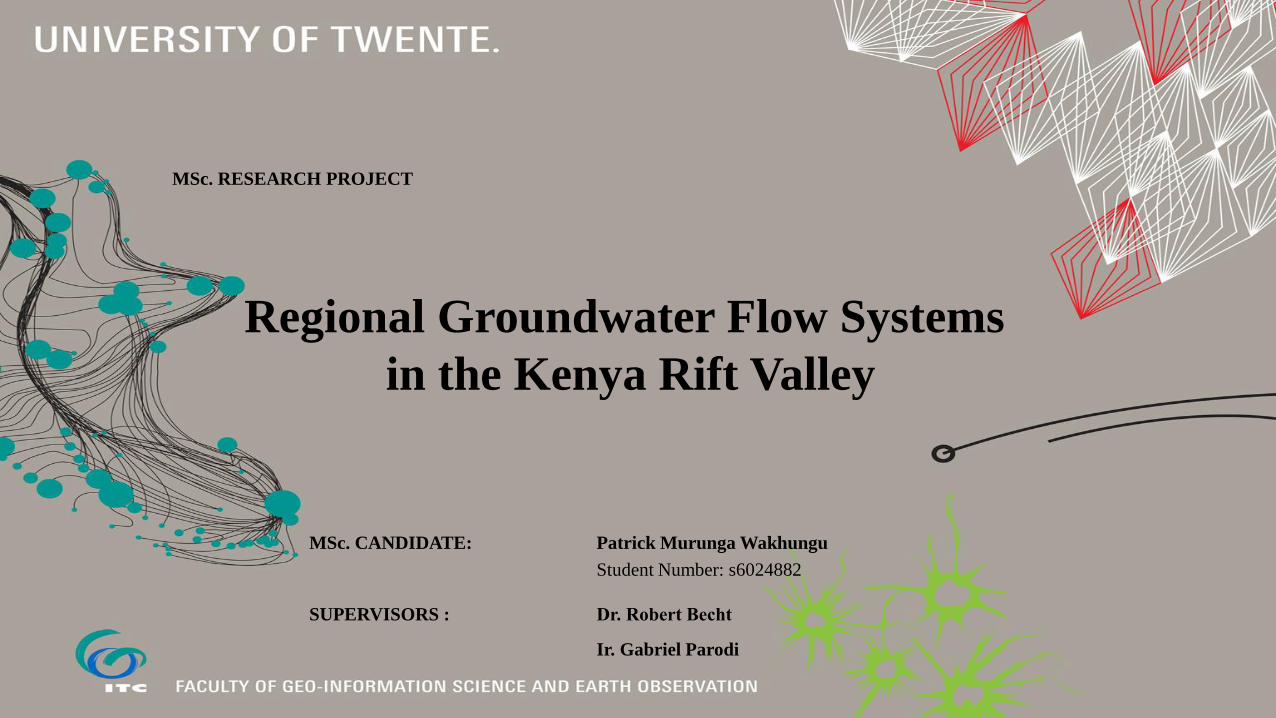
Problem Definition
• Regional linkages between the surface and groundwater regimes in the RV is not known. Natural
and anthropogenic factors that influence the system are not properly understood
• Only lake Naivasha has been studied extensively due to its freshness.
• Lack of a tool provides technical basis for decisions on groundwater utilization activities in the
region for sustainable development
• The effect of geothermal cells on groundwater flow patterns is not known
University of Twente, Faculty of Geo-information and Earth Observation _Regional Groundwater Flow Systems in the Rift Valley
2
Adapted from Pearson Prentice Hall Inc. (2005)

Study Area 3
University of Twente, Faculty of Geo-information and Earth Observation _Regional Groundwater Flow Systems in the Rift Valley
No legend. Figures have an illustrative meaning only
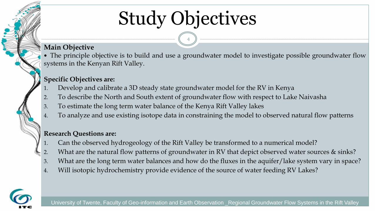
Study Objectives
Main Objective The principle objective is to build and use a groundwater model to investigate possible groundwater flow systems in the Kenyan Rift Valley.
Specific Objectives are:
1. Develop and calibrate a 3D steady state groundwater model for the RV in Kenya
2. To describe the North and South extent of groundwater flow with respect to Lake Naivasha
3. To estimate the long term water balance of the Kenya Rift Valley lakes
4. To analyze and use existing isotope data in constraining the model to observed natural flow patterns
Research Questions are:
1. Can the observed hydrogeology of the Rift Valley be transformed to a numerical model?
2. What are the natural flow patterns of groundwater in RV that depict observed water sources & sinks?
3. What are the long term water balances and how do the fluxes in the aquifer/lake system vary in space?
4. Will isotopic hydrochemistry provide evidence of the source of water feeding RV Lakes?
4
University of Twente, Faculty of Geo-information and Earth Observation _Regional Groundwater Flow Systems in the Rift Valley
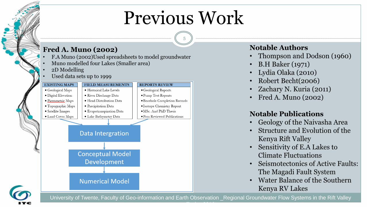
Previous Work 5
University of Twente, Faculty of Geo-information and Earth Observation _Regional Groundwater Flow Systems in the Rift Valley
Topics 2016
Fred A. Muno (2002) • F.A Muno (2002)Used spreadsheets to model groundwater • Muno modelled four Lakes (Smaller area) • 2D Modelling • Used data sets up to 1999
IWRAP/Deltares • iMOD Numerical Modelling for L. Naivasha • Use of current hydrological data (Beyond 1999) • 3D modelling and visualization as opposed to Muno’s 2D • Multi layer aquifers
Notable Authors • Thompson and Dodson (1960) • B.H Baker (1971) • Lydia Olaka (2010) • Robert Becht(2006) • Zachary N. Kuria (2011) • Fred A. Muno (2002)
Notable Publications • Geology of the Naivasha Area • Structure and Evolution of the
Kenya Rift Valley • Sensitivity of E.A Lakes to
Climate Fluctuations • Seismotectonics of Active Faults:
The Magadi Fault System • Water Balance of the Southern
Kenya RV Lakes
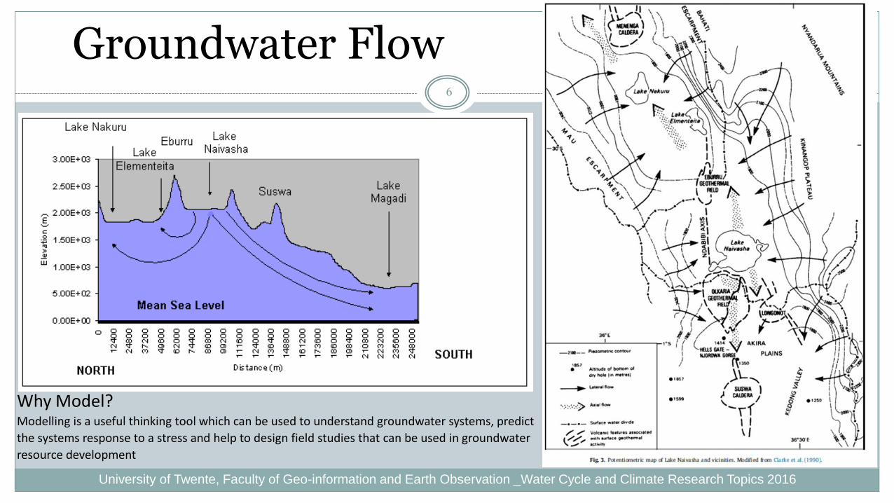
Groundwater Flow 6
University of Twente, Faculty of Geo-information and Earth Observation _Water Cycle and Climate Research Topics 2016
Why Model? Modelling is a useful thinking tool which can be used to understand groundwater systems, predict
the systems response to a stress and help to design field studies that can be used in groundwater
resource development

Methodology 7
Required Data Method
Tools
Purpose
Topographical Maps Satellite Maps Precipitation Data Evaporation Data Digital Elevation Models Lake Bathymetry Data Geomorphology
Hydrological Model/Conceptual Model
ILWIS • Partly answers Research Question 3 • Preparation and visualization of sub-catchment files for
precipitation, evaporation, river networks, lake surface area
Pros: Ease of use of software, Use of different Datasets Cons: Need for many versions of ILWIS to do some tasks
Well Hydraulic Heads Stream Flow Data Lake level measurements Aquifer parameter data 3D Visualization
Numerical Model
iMOD • Answers Research Question 1 • Perform a numerical model that estimates total inflow
and outflows from every sub-basin as well as estimating Storage
Pros: Interactive User interphase, Use of variable resolution Datasets Regular and irregular grid sizes Cons: The lake package is yet to be published officially
Water Inflow Data Water Outflow Data Water Abstraction Data Aquifer Thickness Estimates Loss Estimates
Water Balance
Spreadsheets
• Answers Research Question 3 and 2 • Estimates fluxes and changes in storage • To caution against groundwater overdraft/Mining Pros: Possible to estimate volumes of water losses Cons: Does not resolve unaccounted for water appropriately

Conceptual Model
8
University of Twente, Faculty of Geo-information and Earth Observation _Regional Groundwater Flow Systems in the Rift Valley
Adapted from R. Becht (2006) Extracted from the National WMP
Boundary Conditions Hydraulic Conditions Faults

Numerical Model
Software Selection iMOD (Interactive editing the geometry of the subsurface)
Spatial extends of the input parameters do not have to be the same
Easy to improve a model whenever new data becomes available
9
University of Twente, Faculty of Geo-information and Earth Observation _Regional Groundwater Flow Systems in the Rift Valley
State Variables Lake levels
Hydraulic Heads
River Discharge
Boundary Conditions No flow boundary
Constant Head boundary
Driving Forces Precipitation/Recharge
Evapotranspiration
Abstraction
Grid Design Rows – 560
Columns – 190
Layers - 6
Model Area Area – 35206 Km2
Length – 500 Km
Width – 50- 100Km
Grid Design Coarse Grids - 1000m
Fine Grids - 500m
Model Calibration
R2 = 0.8666
1774
1775
1776
1777
1778
1779
1775,00 1776,00 1777,00 1778,00 1779,00Ca
lc. L
eve
l (m
a s
l)
Observed Level (m a s l)
CORRELATION BETWEEN CALCULATED AND OBSERVED LEVELS(JAN 1958 TO AUG
1978)

Why iMOD? 10
University of Twente, Faculty of Geo-information and Earth Observation _Regional Groundwater Flow Systems in the Rift Valley
Topics 2016
Key features of iMOD: Spatial extends of the input parameters do not have to be the
same
Easy to improve a model whenever new data becomes available
One expandable data set covering all possible future areas of interest
Efficient numerical modelling
Fast interactive 2D- and 3D-analysis and visualization
Interactive editing the geometry of the subsurface
Consistency between regional and sub-domain models
Leaving the era of building series of individual models behind
Flow model nesting, toggling between grid resolutions and moving to new areas of interest

Expected Results 11
University of Twente, Faculty of Geo-information and Earth Observation _Water Cycle and Climate Research Topics 2016
Expected Results Time invariant groundwater regional model
Long term lake water balances
Spatial variability in groundwater fluxes
Groundwater flow map
END OF PRESENTATION ☺
12
University of Twente, Faculty of Geo-information and Earth Observation _Regional Groundwater Flow Systems in the Rift Valley
Thank You