Embed Size (px)
Citation preview

What is Wind?By: Mhykaela T.
BautistaBSED II- T
@ menuemitch

WINDWind is moving air and is caused by differences in air pressure within our atmosphere. Air under high pressure moves toward areas of low pressure. The greater the difference in pressure, the faster the air flows.
@menuemitch

Air Pressure and Wind menuemitch
Wind is the movement of air across the Earth’s surface and is produced by differences in air pressure between one places to another. Wind strength can vary from a light breeze to hurricane force. Winds are named from the direction from which they originate. Since wind is produced by differences in air pressure, it is important to understand that concept when studying wind as well. Air pressure is created by the motion, size, and number of gas molecules present in the air. This varies based on the temperature and density of the air mass.
menuemitch

Pressure Gradient Force
menuemitch

Within the atmosphere, there are several forces that impact the speed and direction of winds. The most important though is the Earth’s gravitational force. As gravity compresses the Earth’s atmosphere, it creates air pressure- the driving force of wind. Without gravity, there would be no atmosphere or air pressure and thus, no wind.The force actually responsible for causing the movement of air though is the pressure gradient force.
menuemitch

Pressure Gradient Force and Wind menuemitch

Differences in air pressure and the pressure gradient force are caused by the unequal heating of the Earth’s surface when incoming solar radiation concentrates at the equator. Because of the energy surplus at low latitudes for example, the air there is warmer than that at the poles. Warm air is less dense and has a lower barometric pressure than the cold air at high latitudes. These differences in barometric pressure are what create the pressure gradient force and wind as air constantly moves between areas of high and low pressure.Finally, the Coriolis force and friction both significantly affect wind across the globe. The Coriolis force makes wind deflect from its straight path between high and low pressure areas and the friction force slows wind down as it travels over the Earth’s surface.
menuemitch

Upper Level Winds
menuemitch

Within the atmosphere, there are different levels of air circulation. However those in the middle and upper troposphere are an important part of the entire atmosphere's air circulation. To map these circulation patterns upper air pressure maps use 500 millibars (mb) as a reference point. This means that the height above sea level is only plotted in areas with an air pressure level of 500 mb.
menuemitch

The jet stream is a fast flowing, river of air found in the atmosphere at around 12 km above the surface of the Earth just under the tropopause. They form at the boundaries of adjacent air masses with significant differences in temperature, such as of the polar region and the warmer air to the south. Because of the effect of the Earth's rotation the streams flow west to east, propagating in a serpentine or wave-like manner at lower speeds than that of the actual wind within the flow.
Jet Stream menuemitch
Rossby Waves
Rossby Waves are like rivers of air in the upper troposphere and they gradually meander. The meander loops get bigger and bigger until their wavelength from trough to trough could be as much as 8000 kms. When the Waves are well developed and cover a wide range of latitude they are said to have a low zonal index - which leads to the formation of ridges of blocking, high pressure systems and dry stable conditions. When they are almost straight and cover a narrow zone of latitude they are said to have a high zonal index - which leads to a succession of low pressure systems and unsettled weather. The waves evolve then they straighten up and then meanders form again in an endless cycle. The wave evolution cycle lasts about 6 weeks.
menuemitch

menuemitch

Local and Regional Winds
menuemitch

Sta Ana Winds
The Santa Ana winds are strong, extremely dry down-slope winds that originate inland and affect coastal Southern California and northern Baja California. Santa Ana winds blow mostly in autumn and winter, but can arise at other times of the year. They can range from hot to cold, depending on the prevailing temperatures in the source regions, the Great Basin and upper Mojave Desert. The winds are known especially for the hot dry weather (often the hottest of the year) that they bring in the fall, and are infamous for fanning regional wildfires. For these reasons, they are sometimes known as the "devil winds" across Southern California.
menuemitch

Wind Pattern
menuemitch

Sea Breeze menuemitch

On a warm summer day along the coast, this differential heating of land and sea leads to the development of local winds called sea breezes. As air above the land surface is heated by radiation from the Sun, it expands and begins to rise, being lighter than the surrounding air. To replace the rising air, cooler air is drawn in from above the surface of the sea. This is the sea breeze, and can offer a pleasant cooling influence on hot summer afternoons.
menuemitch

Land Breeze
menuemitch

A land breeze occurs at night when the land cools faster than the sea. In this case, it is air above the warmer surface water that is heated and rises, pulling in air from the cooler land surface.
menuemitch

Valley Breeze
menuemitch

A valley breeze develops during the day as the Sun heats the land surface and air at the valley bottom and sides . As the air heats it becomes less dense and buoyant and begins to flow gently up the valley sides. Vertical ascent of the air rising along the sides of the mountain is usually limited by the presence of a temperature inversion layer. When the ascending air currents encounter the inversion they are forced to move horizontally and then back down to the valley floor. This creates a self-contained circulation system. If conditions are right, the rising air can condense and form into cumuliform clouds.
menuemitch

Mountain Breeze
menuemitch

During the night, the air along the mountain slopes begins to cool quickly because of longwave radiation loss. As the air cools, it becomes more dense and begins to flow downslope causing a mountain breeze. Convergence of the draining air occurs at the valley floor and forces the air to move vertically upward. The upward movement is usually limited by the presence of a temperature inversion which forces the air to begin moving horizontally. This horizontal movement completes the circulation cell system. In narrowing terrain, mountain winds can accelerate in speed because of the venturi effect. Such winds can attain speeds as high has 150 kilometers per hour.
menuemitch

Monsoon menuemitch
A monsoon is a seasonal wind, found especially in Asia that reverses direction between summer and winter and often brings heavy rains. In the summer, a high pressure area lies over the Indian Ocean while a low exists over the Asian continent. The air masses move from the high pressure over the ocean to the low over the continent, bringing moisture-laden air to south Asia. During winter, the process is reversed and a low sits over the Indian Ocean while a high lies over the Tibetan plateau so air flows down the Himalaya and south to the ocean. The migration of trade winds and westerlies also contributes to the monsoons. Smaller monsoons take place in equatorial Africa, northern Australia, and, to a lesser extent, in the southwestern United States.
menuemitch


The cause of this wind shift, or monsoon.
menuemitch
The monsoon, which is essentially the seasonal reversal in wind direction, causes most of the rainfall received in India and some other parts of the world. The primary cause of monsoons is the difference between annual temperature trends over land and sea. The apparent position of the Sun with reference to the Earth oscillates from the Tropic of Cancer to the Tropic of Capricorn. Thus the low pressure region created by solar heating also changes latitude. The northeast and southeast trade winds converge in this low pressure zone, which is also known as the Intertropical Convergence Zone or ITCZ. This low pressure regions sees continuous rise of moist wind from the sea surface to the upper layers of the atmosphere, where the cooling means the air can no longer hold so much moisture resulting in precipitation. The rainy seasons of East Asia, sub-Saharan Africa, Australia and the southern parts of North America coincide with the shift of ITCZ towards these regions.
menuemitch

Effects of the monsoon
menuemitch

Though monsoons are often associated with devastating effects, including famine, the overall effects of the season are positive.
Drought: The countries affected by monsoon season welcome the rain as a point at which drought ends. However, if the rainfall in this season is below average then further drought can be devastating. This leads to food supplies dwindling and crops unable to grow, and many of the area's inhabitants may die of famine.
Floods: Those who make their living from the land welcome the season, where the rains will make a large contribution to the crops they produce. However, when too much rain comes in a short period of time this can cause flash floods that not only damage crops and drown livestock, but also harm inhabitants of the area. However, in less extreme forms these floods help to fertilise the soil.
Agriculture and Economy: The patterns of the monsoon have a huge impact on farmers and their crops and livestock. If the rains don't come as expected then farming patterns can be disrupted. Not to mention the effects of drought and flood, as covered above. The economy of many Indian countries greatly depends on agriculture, meaning that the disruption not only harms health and availability of food, but the economy as a whole and food prices rise dramatically.
menuemitch

Prevailing wind patterns in the Philippines
menuemitch

Amihan menuemitch

Amihan refers to the season dominated by the trade winds, which are experienced in the Philippines as a cool northeast wind. It is characterized by moderate temperatures, little or no rainfall, and a prevailing wind from the east.As a general rule of thumb, the Philippines' Amihan weather pattern begins sometime in September or October and ends sometime in May or June. There may, however, be wide variations from year to year.
menuemitch


The trade winds are just air movements toward the equator. They are warm, steady breezes that blow almost continuously. The Coriolis Effect makes the trade winds appear to be curving to the west, whether they are traveling to the equator from the south or north.
What are the trade winds?
menuemitch

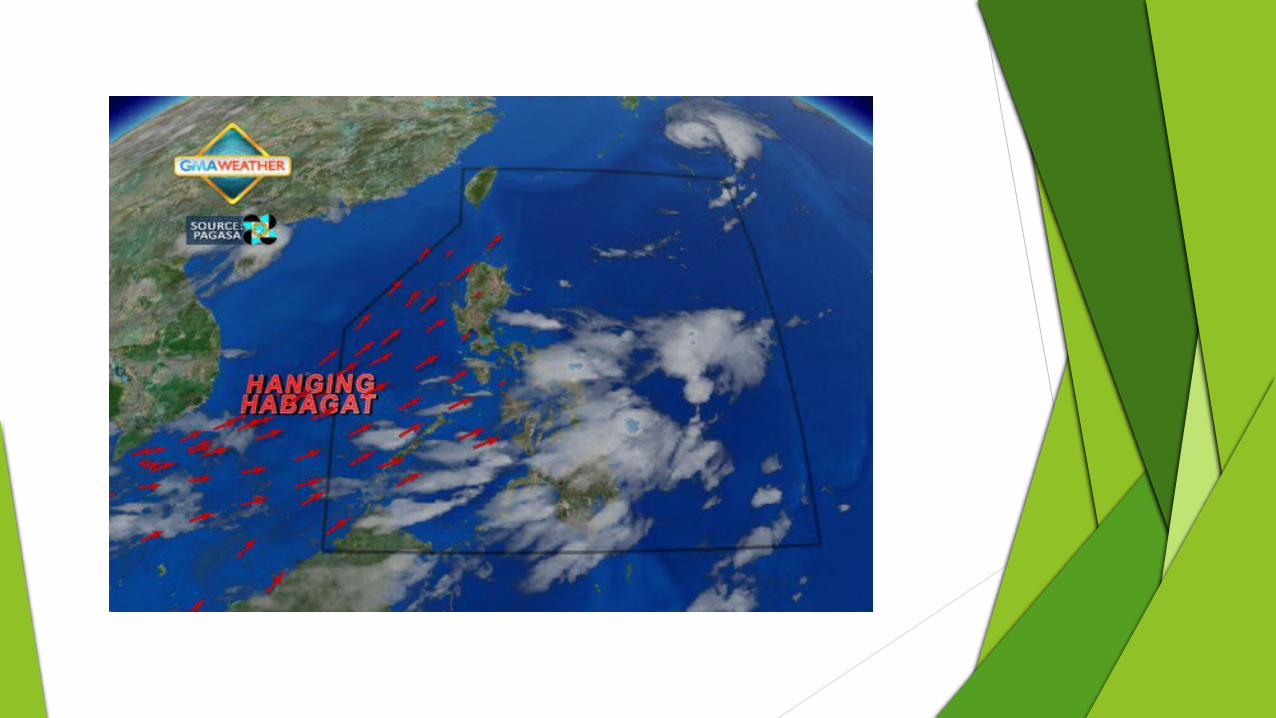
Habagat menuemitch

The Philippines experiences the west or southwest wind; south-west monsoon, which in turn is referred to as the Habagat. The Habagat season is characterized by hot and humid weather, frequent heavy rainfall, and a prevailing wind from the west. Habagat is also known as monsoon or southwest monsoon in the Philippines.
menuemitch

Different Wind Patterns found across the Earth
menuemitch

Global Wind Patterns menuemitch

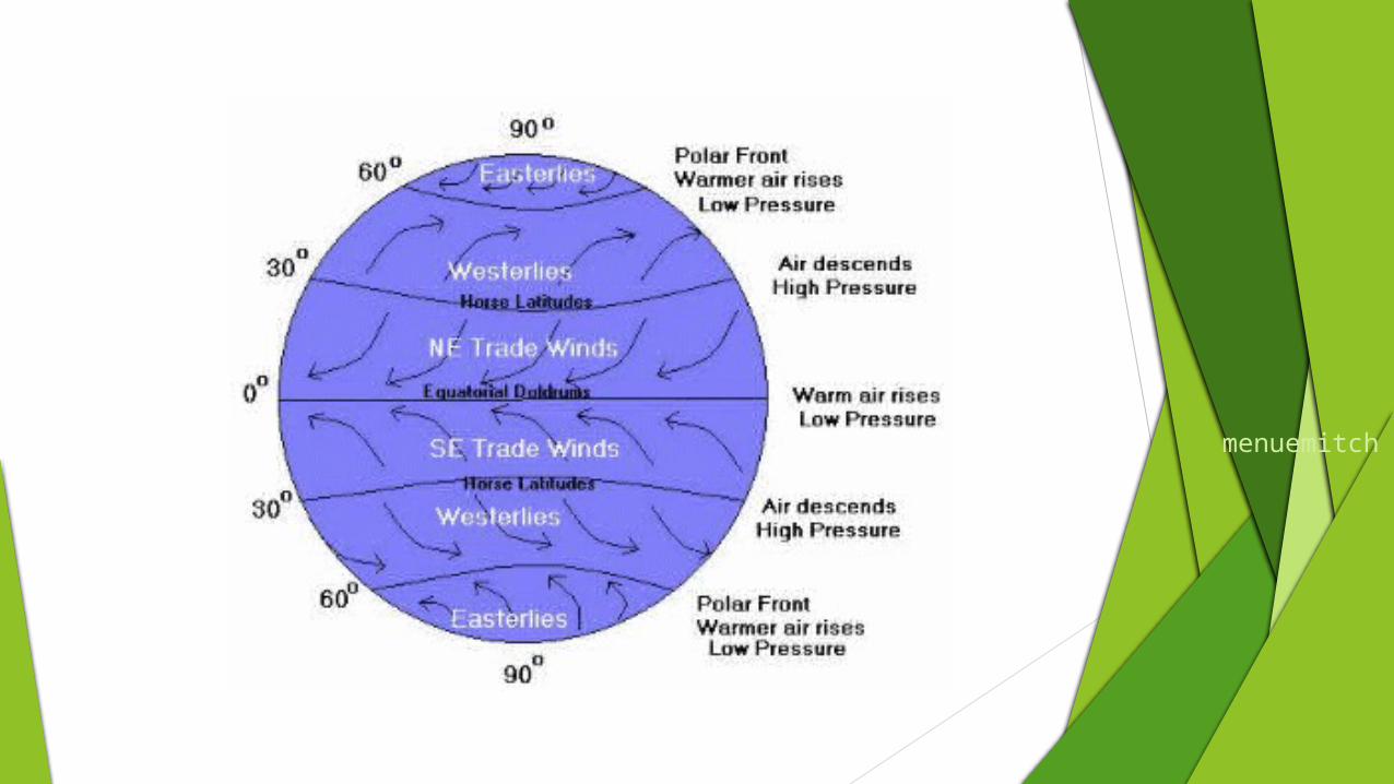
The equator receives the Sun's direct rays. Here, air is heated and rises, leaving low pressure areas behind. Moving to about thirty degrees north and south of the equator, the warm air from the equator begins to cool and sink. Between thirty degrees latitude and the equator, most of the cooling sinking air moves back to the equator. The rest of the air flows toward the poles.
menuemitch

menuemitch

Polar Easterlies menuemitch

At about sixty degrees latitude in both hemispheres, the prevailing westerlies join with the polar easterlies to reduce upward motion. The polar easterlies form when the atmosphere over the poles cools. This cool air then sinks and spreads over the surface. As the air flows away from the poles, it is turned to the west by the Coriolis effect. Again, because these winds begin in the east, they are called easterlies.
menuemitch


Prevailing Westerlies menuemitch

Between thirty and sixty degrees latitude, the winds that move toward the poles appear to curve to the east. Because winds are named from the direction in which they originate, these winds are called prevailing westerlies. Prevailing westerlies in the Northern Hemisphere are responsible for many of the weather movements across the United States and Canada.
menuemitch


Trade Winds menuemitch

The trade winds are just air movements toward the equator. They are warm, steady breezes that blow almost continuously. The Coriolis Effect makes the trade winds appear to be curving to the west, whether they are traveling to the equator from the south or north.
menuemitch


What are the doldrums?
The doldrums is an area of calm weather. The trade winds coming from the south and the north meet near the equator. These converging trade winds produce general upward winds as they are heated, so there are no steady surface winds.
menuemitch


Southern Hemisphere
menuemitch

In the southern hemisphere the belts are reversed. The southeast trade winds blow from the southeast toward the equator. The southern equivalent of the horse latitudes (or Variables of Cancer) is called the Variables of Capricorn. The southern westerlies start somewhat south of South Africa. They tend to be stronger than the northern westerlies because they are mostly over water (roaring forties). The southern polar easterlies are mostly over Antarctica.
menuemitch

Seasonal shifts menuemitch

All of the belts move north during the northern summer and south during the northern winter. Because global heating and cooling lags behind the position of the sun, they reach their northernmost latitude at or after the end of the northern summer. This brought the trade winds within reach of the Spain and Portugal and determined the sailing time of the Spanish treasure fleet. The northernmost position of the wind belts corresponds to the Atlantic hurricane season.
menuemitch

Land and Sea Breezes
menuemitch

Land gains and loses heat more rapidly than water. During the day, the land warms more rapidly than the water. The air above land warms, becomes thinner, and rises, drawing cooler air landward from the sea. At night, the process reverses, and cool heavy air from the land flows out to sea. These land and sea breezes are important along the coast.
menuemitch

Monsoon menuemitch

The annual equivalent of the daily land and sea breezes is the yearly monsoon. During summer, the continents heat more rapidly than the oceans. Air over the continents warms, thins and rises drawing cooler moist ocean air landward, producing a wet season. During winter, the process reverses and cold, dry heavy air flows outward from the continents, producing a dry season. The monsoon is most striking in south Asia because of the size of the Eurasian landmass and because the Himalayas tend to bottle up the air above the continent. Approximations of the Indian monsoon exist in other places, but they are poorly developed.
menuemitch

The Five Major Ocean Gyres
menuemitch

Ocean Gyre menuemitch

The fact that the westerlies and trade winds blow in opposite directions and that the continents prevent water from circling the globe contributes to the formation of circular ocean currents, clockwise in the northern hemisphere and counterclockwise in the southern hemisphere. The Coriolis force also plays a part. The trade winds push water west. At the doldrums it flows back east producing the equatorial counter current.
menuemitch

Coriolis force, Hadley cell and
other things menuemitch
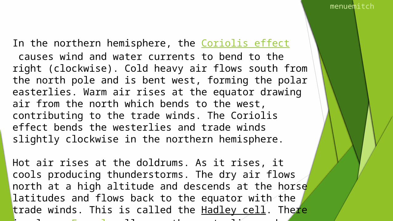
In the northern hemisphere, the Coriolis effect causes wind and water currents to bend to the right (clockwise). Cold heavy air flows south from the north pole and is bent west, forming the polar easterlies. Warm air rises at the equator drawing air from the north which bends to the west, contributing to the trade winds. The Coriolis effect bends the westerlies and trade winds slightly clockwise in the northern hemisphere.
Hot air rises at the doldrums. As it rises, it cools producing thunderstorms. The dry air flows north at a high altitude and descends at the horse latitudes and flows back to the equator with the trade winds. This is called the Hadley cell. There is also a Ferrel cell over the westerlies and a polar cell over the pole. There are other complexities, not all of which are properly understood.
menuemitch