Embed Size (px)
Citation preview

The best-known effect that clearance of tropical rainforests has on global climate is release of the CO2 contained in its vegetative biomass. But what are the less obvious effects on all the complex, interactive, and dynamic processes that constitute weather and climate? How might these effects make themselves felt half a world away? This question of how tropical deforestation could effect weather and climate in distant regions is not so daunting as it may at first seem. There are very few candidates for natural processes that could connect climate dynamics between regions thousands of kilometers apart. The only realistic possibilities are global atmospheric and oceanic circulations. The rest is just all the mechanistic details of how this plays out. Tropical rainforests not only actively participate in global atmospheric circulation, they play an indispensable role in providing the kinetic and thermal energy that powers this circulation. Among the most widely recognized features of global atmospheric circulation are the meandering jet streams that we see mapped in daily weather forecasts. Convection over tropical forests and oceans not only drives the subtropical jet streams, it is the subtropical jet streams. The air, moisture, thermal and kinetic energy that comprise the jet streams begin their circulatory journey at the surface of tropical oceans and forests (Figure 1). Sunlight heats the surface, generating warm air and water vapor that are less dense than the surrounding atmospheric column. Warm or moist air with density lower than its surroundings rises, which is called convection. Convection is powered by the amount of sunlight absorbed by a given surface area, and is greatly assisted when abundant moisture and dense vegetation are also present. Because the tropics get the most insolation of any other location on the planet, that is where convection is most intense, and where most global atmospheric circulation is powered. Land masses, especially those with dense vegetation, are darker than ocean surfaces, and so absorb more sunlight. Vegetation surfaces themselves are also much rougher and uneven than ocean surfaces, so that a square meter of densely layered rainforest vegetation actually presents more than a square meter of effective surface area to air and sunlight. A hectare of undisturbed tropical rainforest can therefore absorb a higher proportion of incoming sunlight, release more water vapor, and support more intense convection than a hectare of tropical ocean. Tropical oceans and forests are thus the solar-powered steam engines that propel atmospheric circulation. The moisture, heat, and vertical motion carried by these rising air masses are the steam that drives and becomes the subtropical jet streams. All heat engines operate by moving thermal energy between a source and a sink. Here, tropical surface heating is the source, with the upper atmosphere and cooler subtropics as the sink.
FIGURE 1 Schematic cross section of atmospheric circulation, showing relationship between Hadley circulation and subtropical jet. The tropopause is the top of the troposphere, the upper limit for most convection. Divergence occurs at

or below the tropopause. Due to higher temperatures and vigorous convection, the equatorial tropopause is taller than the polar tropopause. The top of the tropical troposphere is thus uphill from that at the poles. Because air is a fluid, it flows freely downhill toward the poles. This means that gravity is an indirect, or intermediate, driver of the jet streams. But the Arctic is warming much faster than the tropics. A taller Arctic tropopause reduces this height difference, effectively reducing the gravitational contribution to jet stream motion, diminishing the overall kinetic energy carried by this high-altitude river of air. Buoyant air masses ascending over the tropics eventually find their way to the upper troposphere, 10-15 kilometers above. Convected air cools as it rises, at some point becoming cool enough for moisture to condense out as rain, while the remaining air continues upward. At the top of the troposphere, ascending air changes direction from vertical to horizontal. This vertical-to-horizontal transition aloft is called divergence, and creates a ridge of high pressure at the altitude and latitude where it occurs. Most of the air driven to such altitudes above the tropics diverges north and south into the subtropics, with a smaller proportion taking eastward and westward paths along the equator. East-west divergence along the equator is called Walker, or zonal circulation. Whether air diverges north/south or east/west depends primarily on the season and latitude of the surface from which it ascends. Walker circulation is a phenomenon confined mostly to the equator. Convected air that diverges north and south to become the subtropical jet streams is called Hadley circulation. The latitude at which the ascending branch of Hadley circulation is most intense is called the Intertropical Convergence Zone (ITCZ, Figures 2 and 3), where a high pressure ridge prevails at the top of the troposphere, while low pressure dominates at the surface. Convection intensity refers to the amount of moisture, thermal energy, kinetic energy, and mass of air per second that is driven into the upper troposphere. “Convergence zone” means that this is where returning surface air makes the transition from horizontal to vertical motion, the counterpart of the divergence and high pressure that occurs near the tropopause. The ITCZ exhibits a seasonal, north-south oscillation.
FIGURE 2 The red dashed lines in the above images depict the seasonal extremes of the ITCZ in January and July, near the two solstices.

FIGURE 3 Schematic of global atmospheric and Hadley circulation. Dash-dot line with red “L’s” is the Intertropical convergence zone (ITCZ) The ITCZ was called the “doldrums” in earlier times, since most atmospheric motion there is vertical instead of horizontal, causing sailing vessels to stall and get stuck at these latitudes. The ITCZ is the region with the most intense convection, where trade winds (curved, orange arrows) converge to make the transition from horizontal to vertical motion. So, if high-altitude air diverging north and south away from the tropics accounts for most of the energy and substance of the jet streams, what imparts the overall eastward motion to the jet streams’ north-south meanders? Earth rotates on its axis, and the highest rotational velocities occur at the equator. Air beginning its northward or southward journey carries this rotational velocity along with it. After moving a few thousand kilometers away from the equator, its eastward rotational velocity is higher than the air already residing at that latitude. Hence, convected air masses aloft moving away from the equator acquire a relative eastward component to their overall motion. However, these large-scale, high-altitude motions are only half the story. Vigorous, sustained ascent of buoyant air forms regions of low pressure at the surface, creating structured wind patterns as air from higher-pressure regions flows along the surface into the void left by rising air masses. "Circulation" implies that an approximately equal volume of the fluid of interest eventually finds its way back to where it started. Air that diverges north and south from the ascending limb of Hadley circulation sheds heat and moisture as it moves away from the convection center, a large portion becoming sufficiently cool and dense to sink back toward the surface at about 30°, or 3,200 kilometers, north and south of where its journey began. This dry air is heated by the compression of increasing atmospheric pressure as it descends, or subsides, establishing regions of hot, dry, high-pressure air at the surface. These warm, subtropical, surface high-pressure zones establish the planet’s best-known deserts, while pushing air back toward the low-pressure zones created by tropical convection. As this warm, dry air passes over tropical forests and oceans, it assimilates the abundant water vapor provided along these surfaces. Earth’s rotation in the subtropics imparts less eastward velocity than those present at the equator or ITCZ. As high-pressure surface air moves southward toward the ITCZ, eastward velocity deficits impart a net westward component to its motion, giving rise to the easterly (moving out of the east toward the west) trade winds. These so-called easterly trade winds are shown as curved, orange arrows converging on the

low pressure defined by the ITCZ. (Figure 3). The trade winds represent the surface return limb of Hadley circulation, and this nominally closed circulatory loop is called a Hadley cell. Convection across tropical continents and oceans, especially at coastlines and mountain ranges, does not exhibit homogenous spatial distribution. Once the cycle of convection and ensuing precipitation becomes established in a region, dense cloud formation limits the amount of sunlight available to power the whole process. Large convective cells and their associated precipitation are not necessarily static entities: they may show periodic migration. Large, intense, tropical convection systems develop their own intrinsic dynamics, such as feedback loops and migrating pressure waves. Emergent phenomena like feedback loops and migrating pressure waves are often mechanistically quite complex, and need not be detailed here. But the net result of such emergent dynamics is the intrinsic inhomogeneity of tropical convection. Inhomogeneity is just a fancy way of saying that tropical convection develops distinct, dynamic, large-scale structure and spatial distribution. This is important because the large-scale structure and spatial distribution within Hadley circulation shape the subtropical jet streams, influencing the number, location, and north-south expanse of its meanders, as well as their velocity and the mass of air they transport. In other words, the spatial distribution of tropical convection can be a significant influence on the north-south extent (amplitude) of a meander, where it reverses direction. These properties, or configuration, of the jet stream-- the number of meanders, how far north and south these meanders extend, and the quantity and velocity of air that is transported along them, in turn exert enormous influence on global weather patterns. The jet streams are primary factors in the delivery of atmospheric heat, moisture, and kinetic energy across the globe. They can determine whether local or regional conditions favor or disfavor deposition of atmospheric moisture as precipitation. The jet streams can split and rejoin, writhe, twist and loop like a serpent or a coiled spring as they change course. In the last 15 years, the jet streams have found ways of becoming “stuck” in fixed configurations for weeks at a time, exacerbating floods, drought, and heat waves. This contribution to extreme weather has been partially attributed to a weakening of jet stream flow caused by rapid Arctic warming and upward expansion of the polar tropopause In addition to the heat, air mass, and kinetic energy delivered to the subtropical jet streams, there is another important property that relates directly to the influence of tropical convection on jet stream configuration. This is the large-scale vorticity, or rotational motion, which has considerable influence on the course and configuration of the subtropical jet streams. This vorticity, or rotational motion, is completely separate from and independent of the Coriolis forces of planetary rotation that are responsible for the jet streams’ overall eastward course. In this regard, a question that might help to grasp the concept of large scale vorticity is: what causes the north-south meanders of the jet streams to reverse direction? The overall eastward progression of the jet streams proceeds through a series of north-south oriented “waves”, or meanders. What causes northward- or southward-moving waves to reverse direction? One factor that ends up causing “baseline” vorticity are the shear forces generated where the northward, high altitude and southward, low altitude branches of Hadley circulation meet in the middle atmosphere. But this intrinsic, background vorticity is of secondary interest here. An important influence on the jet’s vorticity and flow reversal, which might be potentially anomalous, is the structure and spatial distribution of tropical convection and precipitation. The upward velocity of air within mesoscale convection/precipitation cells can be significantly different between adjacent regions. This difference of convection velocity most often occurs where regions with extensive deforestation are adjacent to regions with minimal deforestation. The air column above deforested regions tends to be drier, more thermally stratified in its lower reaches, and cooler at higher altitudes than air ascending above forested regions. These differences in vertical velocity and thermal stratification generate horizontal winds of modest strength. These regional-scale horizontal winds at 1.5-5.5 kilometers altitude usually move in a direction different from that of the prevailing, continental-scale winds [1]. At the interface where these winds meet in the middle atmosphere, frictional shear forces arise from the differing directions of their horizontal motions. These shear forces establish anomalous, large-scale rotational motion, or vorticity, in the ascending air column. This vorticity becomes part of the jet streams, and can exert substantial, anomalous influence on their course and configuration. Think of the jet stream as a very long, coiled spring-- like a slinky. Winding the spring to increase or decrease its tension would change its behavior, make it more or less springy, changing the way it twists and turns when in motion. An example of how

anomalous vorticity and pressure can influence jet stream course can be seen in Fig. 5. Spatial distribution of tropical convection/precipitation cells is a critical factor when considering large-scale tropical deforestation. Climate scientists discovered the importance of spatial distribution of tropical convection/precipitation when investigating the El-Niño phase of the El-Niño Southern Oscillation (ENSO), a phenomenon confined to within a few degrees of the equator. They noticed dramatic effects on the jet stream’s course and configuration when intense regions of convection and precipitation over warm, equatorial Pacific waters migrated eastward from this ocean’s western flank to bring El-Niño to the central or eastern Pacific Ocean. The jet stream effects of El-Niño have global reach, and often bring drought to central Africa and the Amazon Basin. Removal and replacement of tropical rainforests with agriculture, roads, and cities, involves pronounced changes of land surface features and their behavior. Tropical rainforests exhibit characteristically unique ecosystem-climate dynamics, and so in turn make their own unique brand of weather. An intact rainforest’s deep root systems extract water from subsurface aquifers, pumps this water through its vasculature to leaves, where it is released as vapor during photosynthesis. This is called transpiration. Water vapor is less dense than air, confers buoyancy to the surrounding air when released, which drives convection. The canopy of undisturbed rainforest also intercepts and stores about 15% of precipitation, most of which is converted back into water vapor by solar heating, supplementing the convective output of transpiration. The combination of evaporation and transpiration is called evapotranspiration. Pasture, savannah, and most agricultural root systems are generally shallower than those of displaced native vegetation, extracting and releasing less groundwater to the atmosphere via transpiration at a given temperature. Most agricultural land features also have higher albedo than the rainforest they have replaced, returning a larger proportion of solar energy to the atmosphere and beyond into space. Convective intensity is proportional to the solar energy available to drive it. Lower absorbtion of solar radiation further diminishes convective intensity. This generally reduces the thermal and kinetic energy, as well as air mass, carried by convective plumes. Roads, towns, and cities also exhibit properties and behavior quite different than the cleared rainforest. These man-made surface features intercept and store very little precipitation, leading to increased runoff and additional reductions of moist convection. Due to the latent heat contained in water vapor, moist air carries much more thermal energy than dry air. The moisture deficits that accompany deforestation thus diminish the thermal and kinetic energy, as well as air mass, carried by convection. Large-scale replacement of rainforests with ecosystems that have sharply altered dynamics will change the local and regional weather. If the size of deforested regions continues to expand, and their number continue to grow to span a continent, there is mounting evidence that this can significantly effect weather and climate in areas quite remote form the cleared rainforest. These effects on weather and climate thousands of kilometers away are referred to as teleconnections. There have been many modeling exercises to asses the effects of extensive Amazonian deforestation on persistent alterations of the northern hemispheric subtropical jet stream’s historically prevailing, seasonal course. Modeling studies of complete replacement of Amazonian rainforest with pasture showed reductions of thermal and kinetic energy, reductions of air mass flow, and anomalous vorticity, all embedded within the ascending, convective limb of Hadley circulation. These consequences of rainforest replacement made significant contributions to jet stream rerouting during austral Summer (Dec-Feb), bringing drought to the coastal, northwestern US (northern California, Oregon, and Washington) and to the mountainous Sierra-Nevada ridge along eastern California (Figure 4) [1].
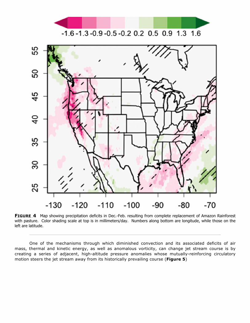
FIGURE 4 Map showing precipitation deficits in Dec.-Feb. resulting from complete replacement of Amazon Rainforest with pasture. Color shading scale at top is in millimeters/day. Numbers along bottom are longitude, while those on the left are latitude.
One of the mechanisms through which diminished convection and its associated deficits of air mass, thermal and kinetic energy, as well as anomalous vorticity, can change jet stream course is by creating a series of adjacent, high-altitude pressure anomalies whose mutually-reinforcing circulatory motion steers the jet stream away from its historically prevailing course (Figure 5)

FIGURE 5 Modeled pressure anomalies and resulting jet stream flow in July at 10.4 kilometers altitude resulting from complete replacement of Amazonian rainforest. Red arrows show clockwise circulation around high pressure zones, while blue arrows show counterclockwise circulation around low pressure zones. Green line and arrows show approximate path of jet stream as forced by this spatial distribution of pressure anomalies. Note that jet stream flow is diverted northward into Canada, returning southward to bring cool, dry, subsiding air into the American Midwest. This suppresses precipitation during the Summer growing season, when rainfall would otherwise be at its maximum. (Adapted from [2]) The general consensus gathering around extensive observational datasets, and the modeling efforts based on such datasets, is that large scale deforestation, especially in tropical Africa and the Amazon Basin, substantially weaken convection in terms of the energy (thermal and kinetic), air mass, and moisture sent aloft to the upper troposphere per hectare of disrupted tropical rainforest. Such deficits of terrestrial convective mass flow must be considered within the global context of greenhouse-gas-induced heating and its effects on oceanic convective mass flow. In other words, land-based convective mass flow from compromised, drying tropical rainforests is generally decreasing, while the convective mass output of tropical ocean surfaces increases due to greenhouse warming. Tropical rainforests become drier, while greenhouse warming drives growing convective output from tropical ocean surfaces. This inevitably shifts the overall, global-scale spatial distribution of convection intensity. Likewise, the hemispheric flows of jet stream courses and configurations are shifted. The subtropical jet streams wield decisive influence on the location and deposition of atmospheric heat and moisture. Tropical convection cells can also exhibit upper tropospheric east-west divergence that gives rise to Walker, or zonal, circulation, which is usually confined to within a few degrees of the equator. While zonal circulation cells are generally a global phenomenon, the discussion here will focus on Walker cells in the equatorial Pacific Ocean and South America, and their relationship to ENSO. Just as Hadley circulation is driven by tropical convection combined with the temperature difference between tropical and subtropical regions, Walker circulation is driven by east-west differences in sea surface temperatures (SST), as well as by temperature differences between land and ocean surfaces. The familiar sequence of convection, precipitation, and divergence occurs over tropical waters or continents with relatively higher surface

temperatures. Air aloft moves westward and eastward along or near the equator until descending over regions with lower surface temperatures, creating high pressure zones that push air along the equatorial surface back toward the convection center (Figure 6). In the central and eastern tropical Pacific Ocean, this surface flow helps maintain the easterly (out of the east, moving west) trade winds near the equator. Here again we see a classical heat engine operating at oceanic and continental scales. Hadley and Walker circulations are coupled to each other via their surface, easterly flow across equatorial oceans and continents. It is important to note that convergence and ascent of Hadley circulation follows the ITCZ. Within the ITCZ, there is very little, if any, horizontal flow unless it is supplemented by easterly Walker circulation. Walker circulation is confined mostly to the equator, and does not follow the seasonal, north-south, excursions of the ITCZ. Because of this, the east-west distribution of Walker cells is a decisive factor in determining the state of ENSO, since it is a primarily equatorial phenomenon.
FIGURE 6 Walker cell configuration during the La-Niña phase of ENSO. Note that the cell over South America has its ascending branch over the Amazon Basin, and its descending branch co-located with the descending branch of the neighboring Walker cell to the east, over the eastern Pacific Ocean. These two co-located, descending Walker cell branches create and mutually reinforce the high pressure that feeds the easterly, equatorial trade winds, which are the primary factor that establishes and maintains La-Niña. This high pressure system also feeds Hadley circulation, which in turn provides air mass flow that helps maintain subtropical high pressure zones in the eastern south Pacific, roughly 1,000 kilometers west of the Chilean coast. The counterclockwise circulation of this high pressure zone in the subtropical eastern Pacific contributes to the easterly trade winds. Modeling experiments suggest that the strength of this subtropical high pressure zone is sensitive to deforestation in equatorial Africa [4a and 4b]. Separate modeling experiments suggest that the ascending Walker cell branch over Amazonia is weakened by extensive deforestation, which likewise weakens its descending branch over the eastern Pacific [3]. This deprives the subtropical Pacific high pressure zone that helps power the easterly trade winds of a source of air mass flow, enhancing the conditions for development of an El-Niño event. ENSO has taught us that changes in tropical convection can influence weather and climate on a global scale. ENSO is one of many control levers of the planet’s climate systems. The fulcrum of this particular lever is the easterly trade winds that push warm surface waters across the equatorial Pacific to accumulate at its western flank (Figure 7). ENSO and Walker circulation are mostly confined to the equator. Although the easterly trade winds driven by Walker circulation are frequently assisted by Hadley circulation and subtropical highs in the eastern south Pacific, it is the periodic oscillations of Walker cell distribution that are critical during transitions of ENSO from one to another state. Accumulation of warm surface water driven into the “warm pool” in the western Pacific can persist for years, especially if assisted by Hadley circulation and subtropical highs in the southern east Pacific. The accumulating warm pool can

raise sea levels in the western Pacific warm pool by as much as 2cm. This years-long accumulation of the warm pool is the La-Niña phase of ENSO, and is associated with the Walker cell configuration depicted in Figure 6. The two neighboring Walker cells whose descending branches meet in the eastern tropical Pacific off the South American coast are a critical region with respect to the strength and maintenance of the easterly trade winds. Persistent, large-scale winds are driven by pressure differentials. Air flows naturally from high pressure regions to low pressure regions. But pressure differentials are not the only means for explaining and understanding the operation of prevailing, large-scale winds. These winds can also be viewed in terms of the mass flow of air required to maintain periodically stationary, high and low pressure regions for extended periods. How are Pacific trade winds effected by weakening of convection over the Amazon Basin? Are there other sources of air flow that help feed easterly trade winds and stabilize the La-Niña state? What happens when air flow deficits form “other sources” are simultaneous with deficits from Amazonia? Maintenance and stabilization of La-Niña depends on the strength with which the trade winds push warm surface waters westward into the warm pool, raising its surface height above the surrounding sea level. The warm pool can be up to 2 centimeters uphill from the surrounding ocean. That might not seem like very much, until one considers that the warm pool occupies tens of thousands of square kilometers in the western Pacific. Due to gravity, this immense mass and volume of water can push back against the trade winds with considerable force (Figure 7).

FIGURE 7 Relationship between trade wind strength and state of ENSO. Top panel shows El-Niño, middle panel is the neutral, or normal state, and bottom is La-Niña. Coupled ocean-atmosphere modeling studies of extensive Amazonian deforestation and its influence on Hadley and Walker circulations show weakened equatorial, easterly Pacific trade winds [3]. In addition, attenuated Hadley circulation weakens the subtropical highs in the eastern south Pacific and adjacent regions. In the Southern Hemisphere, high pressure systems rotate counterclockwise, generating easterly winds on their northern flank. These subtropical highs thus contribute to the air flow that drives warm surface water westward across the Pacific and help stabilize La-Niña. When high pressure in this region is weakened, so are the easterly trade winds, which can destabilize La-Niña. This

study also quantifies phenomena that serve as key indictors of La-Niña strength that provide indices of the overall state of ENSO. These quantified factors include the east-west SST gradient and subsurface thermocline, east-west currents and countercurrents down to 160 meters depth, and the upwelling along the Ecuadorian coast caused by the surface high pressure zone maintained by the two descending Walker branches there. Their overall conclusions were that extensive Amazonian deforestation weakens easterly Pacific trade winds sufficiently to induce a bias of ENSO toward the El Niño state. Considered in isolation, these modeling results are a matter of modest concern. But large-scale climate dynamics are far too complex to operate or be realistically evaluated in isolation. When considered within their full, native context of climate dynamics, these results lend a more sobering tone to the large-scale, long-term consequences of extensive Amazonian deforestation. Emergence of El Niño events frequently bring drought to central Africa and parts of the Amazon Basin. In the past 15 years, the droughts in Amazonia have become increasingly severe. Each successive El-Niño seems to set a new record for rainfall deficits there. The 2015-2016 El-Niño brought unprecedented drought to Amazonia. The deep convection and Walker cell position that accompanies an an El-Niño event can send eastward flow high over the Andes, where it descends to create high surface pressure in the western and central Amazon Basin, suppressing rainfall (Figure 8). The links between ENSO and Amazonian drought are a significant factor when considering the consequences of deforestation in the region. Large-scale deforestation weakens convection. In this weakened state, convection is more vulnerable to disruption by other large-scale atmospheric circulatory phenomena. When regional atmospheric disruptions such as El Niño occur, precipitation deficits and drought are the result. If the modeling results in reference [3] are correct, it suggests that a positive feedback loop between Amazonian deforestation and the state of ENSO might exist. If it exists, such a loop would operate as follows. Convection weakened by Amazonian deforestation deprives the easterly trade winds of the air flow and strength needed for long-term maintenance of La-Niña, as previously described. Conditions for development of El Niño are thus more favorable. Drought induced by El Niño promotes vegetation morbidity, fire risk, and forest dieback in Amazonia. This loss of rainforest is in addition to anthropogenic deforestation. Accumulating losses of rainforest lead to accumulating weakness of convection, further enhancing conditions for development of El Niño.
FIGURE 8 Depiction of eastern Pacific El-Niño event. Notice the divergent branch of the Walker cell extending eastward from the convection zone toward the Ecuadorian coast. This eastern branch passes over the Andes, with its descending limb residing over the Amazon Basin. Descent, or subsidence, of high-altitude air flow to the surface is the opposite of convection, and suppresses precipitation. This is how El-Niño can bring drought to the Amazon rainforest.

If such a feedback loop could in fact develop as a consequence of expanding Amazonian deforestation, are there other phenomena that could reinforce or amplify it? A pair of closely related articles by a research group at UCLA used models to examine the sensitivity of global climate to perturbations of tropical convection in rainforests via altered land surface processes [4a and 4b]. The exercise compared paired simulations, each member of the pair using a different algorithm for land surface processes (LSP), represented by albedo and the connections between vegetation water use and groundwater resources. In one algorithmic module, (referred to here as SLS) vegetation water use does not interact with groundwater resources, effectively simulating an unlimited supply of groundwater to fuel transpiration and convection. In the other module, (referred to here as SSiB) vegetation water use interacts with groundwater resources, providing a realistic representation of groundwater depletion. This modeling approach emphasizes the contribution of vegetative transpiration fed by groundwater to total convection intensity. Limiting water availability simulates substantial reductions of convective output by vegetation, which in effect models large-scale, partial deforestation. The intent of this sort of modeling is to probe the sensitivity of global atmospheric and oceanic circulations to changes of a specific process. These two articles probed the effect of land surface processes (vegetative transpiration limited by water availability) on convection over tropical rainforests. Using this approach, altered convection in tropical Africa had pronounced effects on global circulations, In the paired simulations, two regions were shown to be relevant to easterly Pacific trade winds and ENSO, with pronounced sensitivity to changes of convective intensity over tropical African rainforests [4b]. The first is the subtropical high in the southern east Pacific. This surface high pressure zone is partially maintained by subsidence of the descending limb of local Hadley circulation, but also by outflow from divergence over tropical Africa via the southern subtropical jet stream. High pressure zones (anticyclones) rotate counterclockwise in the Southern Hemisphere, generating easterly winds along their northern flank. In the eastern south Pacific, this easterly surface flow reinforces the easterly trade winds. Diminution of this subtropical high pressure zone reduces the flow of air mass helping support the easterly trade winds and destabilizes the La-Niña state, while increasing its strength has the opposite effects. Simulations using SLS (unlimited water supply) show enhanced high pressure, easterly Pacific trade winds, and La-Niña stability, while those using SSiB (available water constrained by depletion effects) yield opposite results. The other region showing sensitivity to alterations of tropical African convection is the Southeast Asian archipelago in the western Pacific, north of Australia, near the warm pool that accompanies La-Niña. Simulations with SLS showed strong convection and upper-atmospheric divergence there, representing a stabilization of the La-Niña state. Simulations using SSiB instead showed sinking and subsidence of air mass over this region, destabilizing La-Niña. While the modeling methodology employed by Ma et. al. does not explicitly represent deforestation, it is an effective proxy for widespread, spatially homogenous, partial deforestation in that transpiration and convection by vegetation is constrained by water availability. If tropical African deforestation, as represented here by perturbed convection, can weaken the Pacific easterly trade winds and additionally destabilize La-Niña via atmospheric subsidence over the western Pacific warm pool, this might function to reinforce, or amplify, any putative positive feedback between Amazonian deforestation and biasing of ENSO toward the El Niño state. The drought stress visited upon African and Amazonian rainforests by El Niño events increases vegetation morbidity, fire risk, and forest dieback, adding to the results of anthropogenic deforestation. Tropical drought stress can also be exacerbated by greenhouse warming and drying, since the tropics are subjected to the greatest insolation on the planet. Loss of forests equals reduction of convected air mass, which might feed back into the loop that biases ENSO toward the El Niño state. If such a feedback dynamic is in fact operating, it could lead to unanticipated acceleration of rainforest loss in both Africa and Amazonia, and could become irreversible when some critical threshold within the dynamically linked chain of processes is exceeded. Such patterns of feedbacks, thresholds, (“tipping points”) and amplifications are the rule, and not the exception, for the planet’s climate systems. Feedbacks, tipping points, and amplifications are in fact the way complex, biological and other natural systems operate to maintain homeostasis. But when natural systems are forced beyond their limits and homeostasis is lost, chaotic, extreme, and irreversible changes can be triggered. The irreversible conversion of rainforests to savannah and grasslands may be an example of such changes.

A WORD ABOUT WIND DIRECTION TERMINOLOGY:
Conventions for designating wind direction can be very confusing. For instance, the surface limb of Hadley circulation depicted in Figure 3 as the “NE” (northeasterly) and “SE” (southeasterly) trade winds are named according to the direction from which they appear to originate to an observer at the surface. So a northeasterly wind actually flows toward the southwest. Likewise, the easterly trade winds that blow across the Pacific and Atlantic oceans flow westward. So an easy way to keep track of this is: easterly = westward flow northeasterly = southwestward flow southeasterly = northwestward flow
REFERENCES [1] Medvigy, D., Walko, R., Otte, M., Avissar, R.; (2013) Simulated Changes in Northwest U.S.
Climate in Response to Amazon Deforestation; J. Climate, 26, 9115-9136; 10.1175/JCLI-D-12-00775.1
http://www.princeton.edu/scale/publications/Medvigy_etal_2013.pdf [2] Werth, D., Avissar, R.; 10.6 Teleconnections Resulting from Tropical Deforestation; https://ams.confex.com/ams/pdfpapers/86278.pdf [3] Nobre, P., Malagutti, M., Urbano, D. F., de Almeida, R. A. F., Giarolla, E.; (2009) Amazon
Deforestation and Climate Change in a Coupled Model Simulation; J. Climate, 22, 5686-5697; 10.1175/2009JCLI2757.1 https://www.researchgate.net/profile/Paulo_Nobre2/publication/40597753_Amazon_Deforestation_
and_Climate_Change_in_a_Coupled_Model_Simulation/links/0c960528343c607a64000000.pdf [4a] Ma, H-Y., Xiao, H., Mechoso, C. Roberto, Xue, Y.; (2013) Sensitivity of Global Tropical Climate to
Land Surface Processes: Mean State and Interannual Variability; J. Climate, 26, 1818-1837; 10.1175/JCLI-D-12-00142.1 https://www.researchgate.net/profile/Hsi-
Yen_Ma/publication/258795493_Sensitivity_of_Global_Tropical_Climate_to_Land_Surface_Processes_Mean_State_and_Interannual_Variability/links/549528270cf29b9448210a8b.pdf
[4b] Ma, H-Y., Mechoso, C. Roberto, Xue, Y., Xiao, H., Neelin, J. David., Ji, X.; (2013) On the
Connection between Continental-Scale Land Surface Processes and the Tropical Climate in a Coupled Ocean–Atmosphere–Land System; J. Climate, 26, 9006-9025;
10.1175/JCLI-D-12-00819.1 https://www.researchgate.net/profile/Hsi-
Yen_Ma/publication/269726881_On_the_Connection_between_Continental-Scale_Land_Surface_Processes_and_the_Tropical_Climate_in_a_Coupled_OceanAtmosphereLand_System/links/54952b270cf29b9448210be8.pdf