Embed Size (px)
Citation preview

IOSR Journal of Applied Geology and Geophysics (IOSR-JAGG) e-ISSN: 2321–0990, p-ISSN: 2321–0982.Volume 3, Issue 5 Ver. I (Sep. - Oct. 2015),PP 51-60
www.iosrjournals.org
DOI: 10.9790/0990-03515160 www.iosrjournals.org 51 | Page
Structural Analysis and Tectonic Evolution based on Seismic
Interpretation in East of Nile valley, BeniSuef basin, Egypt.
Mohamed H. Abd El-Aal1, Tamer E. Attia
2 and Mohamed A. Aboulmagd
3
1(Biology and Geology Department, Faculty of Education/ Ain Shams University, Cairo, Egypt) 2(Geology Department, Faculty of science/ Port Said University, Egypt)
3(Qarun petroleum company (Apache J.V), Egypt)
Abstract: the subsurface tectonic evolution of the East of Nile valley (EON) of the Beni Suef basin, Egypt, were
studied using twenty seismic profiles representing the desired structural framework of the EON - four of these
were selected for illustration - supported by the vertical seismic profile (VSP) logs of three deep wells drilled in
the study area. In addition, the analysis encompasses the detailed investigation of two (TWT) two way time
structure-contour maps and the rose diagrams representing the general trends of the recorded fault systems.
The study proved that the Upper Cretaceous rocks were dissected by systems of normal faults, trending in
WNW-ESE, NW-SE. These fault systems were originated in association to Cretaceous-Early Tertiary tectonic
deformations related to the Tethyan plate tectonics.
Keywords: Beni Suef basin, EON, seismic, basin evolution, tectonics.
I. Introduction Beni Suef Basin is a basin under exploration for the purpose of petroleum accumulations. It is located
along the both banks of the Nile Valley, west of Beni-Suef City, Egypt (Fig. 1). The basin is considered as one
of the promising areas, newly introduced in the plan of future exploration for hydrocarbon potentialities in
Eastern Desert, Egypt. Tectonically, the concerned basin is just situated with the beginnings of the Egyptian
unstable-shelf zone of [19]; about 150 km south of Cairo. The basin is bisected by the present day Nile Valley
into two provinces; West of Nile Province (WON) and East of Nile Province (EON), (Fig. 1). As regards to the
stratigraphic succession and tectonic evolution of Beni Suef basin, little has been published about its situation.
However, it is, to large extent, quiet similar to that of the Western Desert, with the exception that the basin is
controlled by the Aptian/Albian NE-SW extension movement [22]. This movement resulted in the removal of
the pre-Albian succession, where the Kharita Formation (Albian) was deposited directly on basement.
This study aims to utilize the structural analysis of East Beni Suef basin during the Upper Cretaceous in
the light of the general structural framework of Egypt to state the progressive tectonic evolution of the study
area. The present work is ground on the basis of the analysis oftwo way time (TWT) structure-contour maps
and rose diagrams for two of the Upper Cretaceous rock units namely from the base: Abu Roash "G" Member
(Cenomanian age)and, Khoman Formation (Campanian-Maastrichtian age)which enable the structural
interpretationto state thetectonic evolution during this time interval.
II. Study area: The area of East Nile valley (EON), Beni Suef basin, lies between latitudes 29° 5' 55.881" , 28° 31'
33.797 " N and longitudes 31° 30' 51.372", 30° 50' 7.779" E, approximately 1584 Km2 (Fig.1).
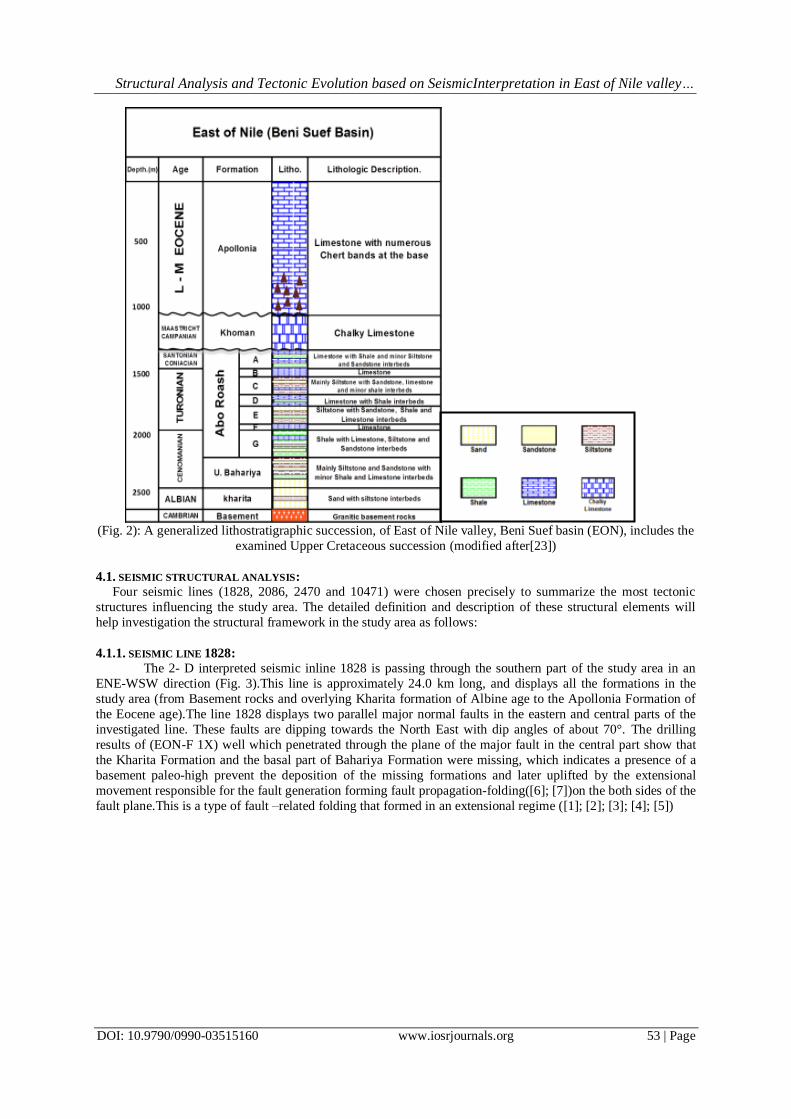
Stratigraphically, East Beni Suef basin comprises a sedimentary succession of a number old rock units
namelyfrom base to top as; Bahariya Formation (Early Cenomanian), Abu Roash Formation (Late Cenomanian-
Turonian-Santonian), and Khoman Formation (Campanian–Maastrichtian).This stratigraphic succession rests
conformably over the Albian Kharita Member as the latest stage of the Lower Cretaceous that, in-turn, non-
conformably overlying the basement rocks. The topmost contact of the examined Upper Cretaceous succession
uncomfortably underlies the Lower-Middle Eocene Apollonia Formation which forms the exposed rolling land-
surface in the study area (Fig. 2).

Structural Analysis and Tectonic Evolution based on SeismicInterpretation in East of Nile valley…
DOI: 10.9790/0990-03515160 www.iosrjournals.org 52 | Page
(Fig.1) Location map of the study area East of Nile valley, Beni Suef basin (EON) and a base map illustrating
the studied seismic lines.
III. Methods: To achieve the above mentioned objectives, 20 seismic lines were analyzed in details to describe and
define the different structural features affecting the study area. Also, picking the horizons of Abu Roash
"G"andKhoman through the seismic lines to construct the two way time (TWT) structure-contour maps, The
picking starts usually with the seismic lines passing through wells having (VSP & check shot) data to achieve
the seismic to well tie. Finally, a rose diagrams for faults trends were constructed by counting the faults numbers
and defining its striking direction.TWT maps, seismic lines interpretation and rose diagrams used to emphasize
the regional tectonics responsible for the evolution of the concerned basin during the Upper Cretaceous.
IV. Results and Discussion The discussion of the available information to deduce the evolutionary phases of the examined Upper
cretaceous succession involves the precise analyses at three steps:
4.1. THE SEISMIC STRUCTURAL ANALYSIS
4.2. ANALYSIS OF THE TWO WAY TIME (TWT) STRUCTURE CONTOUR MAPS
4.3. ANALYSIS OF THE FAULT-TRENDS
The following is the discussion of each step:
Structural Analysis and Tectonic Evolution based on SeismicInterpretation in East of Nile valley…
DOI: 10.9790/0990-03515160 www.iosrjournals.org 53 | Page
(Fig. 2): A generalized lithostratigraphic succession, of East of Nile valley, Beni Suef basin (EON), includes the
examined Upper Cretaceous succession (modified after[23])
4.1. SEISMIC STRUCTURAL ANALYSIS:
Four seismic lines (1828, 2086, 2470 and 10471) were chosen precisely to summarize the most tectonic
structures influencing the study area. The detailed definition and description of these structural elements will
help investigation the structural framework in the study area as follows:
4.1.1. SEISMIC LINE 1828:
The 2- D interpreted seismic inline 1828 is passing through the southern part of the study area in an
ENE-WSW direction (Fig. 3).This line is approximately 24.0 km long, and displays all the formations in the
study area (from Basement rocks and overlying Kharita formation of Albine age to the Apollonia Formation of
the Eocene age).The line 1828 displays two parallel major normal faults in the eastern and central parts of the
investigated line. These faults are dipping towards the North East with dip angles of about 70°. The drilling
results of (EON-F 1X) well which penetrated through the plane of the major fault in the central part show that
the Kharita Formation and the basal part of Bahariya Formation were missing, which indicates a presence of a
basement paleo-high prevent the deposition of the missing formations and later uplifted by the extensional
movement responsible for the fault generation forming fault propagation-folding([6]; [7])on the both sides of the
fault plane.This is a type of fault –related folding that formed in an extensional regime ([1]; [2]; [3]; [4]; [5])

Structural Analysis and Tectonic Evolution based on SeismicInterpretation in East of Nile valley…
DOI: 10.9790/0990-03515160 www.iosrjournals.org 54 | Page
Fig. 3: 2- D interpreted seismic inline number 1828 passing through the southern part of the study area(EON).
4.1.2. SEISMIC LINE2086
The 2- D interpreted seismic inline 2086 is passing through near the southern part of the study area in
an ENE-WSW direction (Fig. 4). This line is approximately 41.0 km long, and runs parallel to seismic line 1828
in the southern part of the study area.Several normal faults were distinguished by interpretation of this cross
section. These faults strongly affect the Upper Cretaceous deposits and define a series of graben geometry.
A major graben structure appears between two sets of opposite dipping normal faults form the
conjugate faults system ([8]; [9]), in the central part of the transect, a number of faults from the ENE set which
dipping towards the South west have subordinate antithetic faults dip towards the North East with an average
dip angle of 75°. Also, two intersected faults are clearly appear, the north east dipping fault wasinterpreted to be
the older one due to the displacement on its plane.At the ENE side of the section another minor graben structure,
the faults forming structure dipping with an average angle of (60°-70°).
The WSW set consists mainly of two major normal faults and a third minor one. All these faults are dip towards
to the North East, with an average dip angle of 70°. All faults of the both sets striking towards NW-SE and
WNW-ESE direction.
Also, a syn-sedimentary or growth faultstructure ([15]; [12]; [13]; [14]) is easily distinguished on the
hanging wall of the WSW major fault due to the greater thickness of hanging wall sediments than those of foot
wall. Which indicate the presence of tectonic movements leads to the activation of fault plane during the
sedimentation. The activation time of this fault is during the deposition of Albine Kharita Formation.
Another unique structure in this line is a roll-over anticline ([10]; [11])which appears on the down-
thrown side of the central major normal fault which dips towards the ENE. This Roll-over anticline formed due
to a local compression created from the displacement of the hanging wall of the adjacent normal fault which
dips towards the opposite direction WSW. The displacement of the hanging wall of this fault leads to reducing
the space between the opposite dipping faults, hence local compression creation.
KHOMAN
A/R"G"
A/R "D"
TIM
E (m
sec)
ENEWSW

Structural Analysis and Tectonic Evolution based on SeismicInterpretation in East of Nile valley…
DOI: 10.9790/0990-03515160 www.iosrjournals.org 55 | Page
Fig.4: 2- D interpreted seismic inline number 2086 passing through near the southern part of the study area
(EON). The highlighted part is the syn-sedimentary structure and its activation period and the roll-over anticline
structure is bounded with the red dotted circle
4.1.3. SEISMIC LINE 2470
The 2- D interpreted seismic inline 2470 is passing through near the northern part of the study area in
an ENE-WSW direction (Fig. 6). This line is approximately 49.0 km long. The most remarkable feature in this
line is the major normal listric fault in the ENE side of the seismic section which dips towards the South West,
with an average dip angle of 70°. And its subordinate synthetic fault which dip towards the same direction, with
an average dip angle of 70°. The slip of the hanging wall block causes a local compression resulting in
Anticlinal feature formation[16].
Fig.5: 2- D interpreted seismic inline number 2470 passing through near the northern part of the study
area(EON).
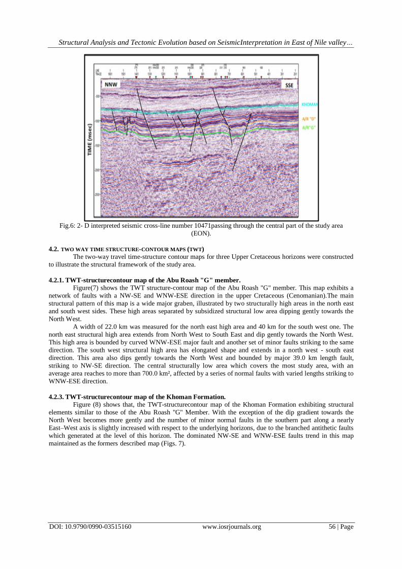
4.1.4. SEISMIC LINE 10471
The 2- D interpreted seismic cross-line 10471 is passing through the central part of the study area in an
NNW-SSE direction (Fig. 7). This line is approximately 43.0 km long. The most important structural feature in
this line is the intersected faults which previously described in detail in the former seismic inline number 2086.
Beside these faults, three major normal faults and large number of separate minor faults distributed along the
seismic section are clearly seen in this line. The major fault in the right hand side of the section is accompanied
with a clearly appearing normal drag[17].
Structural Analysis and Tectonic Evolution based on SeismicInterpretation in East of Nile valley…
DOI: 10.9790/0990-03515160 www.iosrjournals.org 56 | Page
Fig.6: 2- D interpreted seismic cross-line number 10471passing through the central part of the study area
(EON).
4.2. TWO WAY TIME STRUCTURE-CONTOUR MAPS (TWT)
The two-way travel time-structure contour maps for three Upper Cretaceous horizons were constructed
to illustrate the structural framework of the study area.
4.2.1. TWT-structurecontour map of the Abu Roash "G" member.
Figure(7) shows the TWT structure-contour map of the Abu Roash "G" member. This map exhibits a
network of faults with a NW-SE and WNW-ESE direction in the upper Cretaceous (Cenomanian).The main
structural pattern of this map is a wide major graben, illustrated by two structurally high areas in the north east
and south west sides. These high areas separated by subsidized structural low area dipping gently towards the
North West.
A width of 22.0 km was measured for the north east high area and 40 km for the south west one. The
north east structural high area extends from North West to South East and dip gently towards the North West.
This high area is bounded by curved WNW-ESE major fault and another set of minor faults striking to the same
direction. The south west structural high area has elongated shape and extends in a north west - south east
direction. This area also dips gently towards the North West and bounded by major 39.0 km length fault,
striking to NW-SE direction. The central structurally low area which covers the most study area, with an
average area reaches to more than 700.0 km², affected by a series of normal faults with varied lengths striking to
WNW-ESE direction.
4.2.3. TWT-structurecontour map of the Khoman Formation.
Figure (8) shows that, the TWT-structurecontour map of the Khoman Formation exhibiting structural
elements similar to those of the Abu Roash "G" Member. With the exception of the dip gradient towards the
North West becomes more gently and the number of minor normal faults in the southern part along a nearly
East–West axis is slightly increased with respect to the underlying horizons, due to the branched antithetic faults
which generated at the level of this horizon. The dominated NW-SE and WNW-ESE faults trend in this map
maintained as the formers described map (Figs. 7).

Structural Analysis and Tectonic Evolution based on SeismicInterpretation in East of Nile valley…
DOI: 10.9790/0990-03515160 www.iosrjournals.org 57 | Page
Fig.7: TWT-Structure contour map of top Abu Roash "G" Member.
Fig.8: TWT-Structure contour map of top Khoman Formation.
4.3. ROSE DIAGRAMS
The rose diagrams of faults numbers for the two Upper Cretaceous horizons were constructed to
illustrate the faults trendsin the study area.
The rose diagram of the top Abu Roash "G" member (Fig. 9) displays a faults trend stranded between
N45W and N80W. Where, The rose diagram of the top Khoman Formation (Fig. 10) experiences no great

Structural Analysis and Tectonic Evolution based on SeismicInterpretation in East of Nile valley…
DOI: 10.9790/0990-03515160 www.iosrjournals.org 58 | Page
difference in the fault trends with the previous underlying horizon Abu Roash "G" member, with the exception
of increasing the faults numbers towards the WNW direction. The main fault trends are recognized in the study
area is a NW-SE and WNW- ESE.
Fig.9: The rose diagram of the top Abu Roash "G" member.
Fig.10: The rose diagram of the top Khoman Formation.
V. Interpretation and Tectonic Evolution. Based on the resulted data presented in the previously interpreted seismic lines, TWT-structure contour
maps and rose diagrams, all recognized faults are normal faults with dominated NW-SE and WNW-ESE trend
inthe Abu Roash "G" Member andthe Khoman Formation.These general trendsare interpreted in the light of
general tectonic framework of Egypt, as a result of two main tectonic deformations affecting the Mesozoic
rocks:
6.1. Jurassic and Early Cretaceous Faulting (rifting) Deformation:
Moustafa (2008) has documented that two different rifting episodes took place; one during the Jurassic
and the other during the Early Cretaceous. The Early Cretaceous rifting led to the development of a series of
WNW-ESE and NW-SE oriented normal faults resulted in the remarkable thickening of the Cretaceous rocks
against these faults. The author (ibid) added that this Early Cretaceous rifting, although started mainly during
the Early Cretaceous, it continued locally till the end of the Coniacian. This explains the reason of syn-
sedimentary or growth fault formation (previously described in figs 4) during the Early Cretaceous Albian
Kharita formation deposition in the study area.
6.2. Late Cretaceous-Early Tertiary Folding (shortening) Deformation: By the Late Cretaceous-Early Tertiary, a strong folding phase took place along the northern territories
of the Western Desert [18]. As a result, an indicated crustal-shortening took place due to the development of
NE-SW oriented doubly plunging anticlinal folds affected the Jurassic and Cretaceous rocks in the northern
Western Desert. However, the early formed WNW-ESE and NW-SE oriented normal faults developed during
the Early Cretaceous rifting phase show no evidence of positive structural inversion due to the NW shortening
and continued their normal slip during the Late Cretaceous-Early Tertiary [18]. It was believed that continued
normal slip of these faults is related to the fact that they lie parallel to the Late Cretaceous-Early Tertiary
shortening direction and perpendicular to the lengthening direction. This assumption simply explains the reason

Structural Analysis and Tectonic Evolution based on SeismicInterpretation in East of Nile valley…
DOI: 10.9790/0990-03515160 www.iosrjournals.org 59 | Page
why the encountered fault systems display similar trends over the different age of horizons of the Upper
Cretaceous Abu Roash and Khoman formations in the study area.
Smith (1971)mentioned that the previous two tectonic deformations are related to Tethyan plate
tectonics ) due to successive sinistral and dextral shear events extending from Late Jurassic to the Early Tertiary
as follows (Fig.11):
(Fig. 11): Transcurrent motion between Africa and Laurasia ([21]).
1. The sinistral shear during late Jurassic to early Cretaceous:
The destruction of the Paleotethys, north and east of present day northeast Africa, was accompanied by
the opening up of the Alpine Tethys, or Neotethys, as a result of the opening of the central Atlantic Ocean in
early Jurassic time. As a result of the Jurassic initial stage of the Alpine Tethys, Africa moved eastward relative
to Laurasia [21]. This sinistral lateral motion continued until the late Cretaceous, resulting in some 2000 km of
transcurrent motion [20]. Such movement during the Early Cretaceous to Santonian time (142-84 Ma) was NE-
SW, perhaps exerting an extension in this direction on the plate boundary leading to the development of the
WNW-ESE and NW-SE oriented normal faults [18].
2. The dextral shear during the late Cretaceous to Paleocene time:
Due to the Movement direction changing of Africa relative to Eurasia since the Santonian time (84-0
Ma) to roughly northward[21], a dextral shear was generated and either partially accompanied or partially
followed by N-S or NNW-SSE compressive forces[20].
VI. Conclusion Seismic interpretations of selected lines displaythe following:
- Some parallel major normal faults in the eastern and central parts of the line. These faults are dipping
towards the North East with dip angles of about 70°. And several small normal faults were strongly affecting the
Upper Cretaceous deposits and define a series of graben geometry. Also, two intersected faults are clearly
appear, the north east dipping fault wasinterpreted to be the older one due to the displacement on its plane.At the
ENE side of the section another minor graben structure, the faults forming structure dipping with an average
angle of (60°-70°). All faults of the both sets striking towards NW-SE and WNW-ESE direction.
- Also, a syn-sedimentary fault structure distinguished due to the greater thickness of hanging wall
sediments than those of foot wall. Which indicate the presence of tectonic movements leads to the activation of
fault plane during the sedimentation. The activation time of this fault is during the deposition of Albine Kharita
formation.
- While line 2086 contains a unique structure, a roll-over anticline dips towards the ENE. Roll-over
anticline formed due to a local compression created from the displacement of the hanging wall of the adjacent
normal fault which dips towards the opposite direction WSW.
- The most remarkable feature in line 2470 is the major normal listric fault in the ENE side of the
seismic section which dips towards the South West, with an average dip angle of 70°.
- The most important structural feature in lines 10471 and 2086 is the intersected faults which besides to
three major normal faults and large number of separate minor faults distributed along the seismic section.
- The drilling results of (EON-F 1X) well which penetrated through the plane of the major fault in the
central part show that the Kharita formation and the basal part of Bahariya formation were missing, which

Structural Analysis and Tectonic Evolution based on SeismicInterpretation in East of Nile valley…
DOI: 10.9790/0990-03515160 www.iosrjournals.org 60 | Page
indicates a presence of a basement paleo-high prevent the deposition of the missing formations and later uplifted
by the extensional movement responsible for the fault generation forming fault propagation-folding on the both
sides of the fault plane.
- TWT structure-contour maps of the Abu Roash "G" andKhoman Formation members exhibit a network
of faults with a NW-SE and WNW-ESE direction in the upper Cretaceous.The main structural pattern of this
map is a wide major graben, illustrated by two structurally high areas in the north east and south west sides.
These high areas separated by subsidized structural low area dipping gently towards the North West. With the
exception Khoman Formation member, where the dip gradient towards the North West becomes more gently
and the number of minor normal faults in the southern part along a nearly East–West axis is slightly increased
with respect to the underlying horizons, due to the branched antithetic faults which generated at the level of this
horizon.
Based on the resulted data presented in the previously interpreted seismic lines, TWT-structure contour
maps and rose diagrams, all recognized faults are normal faults with dominated NW-SE and WNW-ESE trend
in the Abu Roash "G" Member and the Khoman Formation.These general trends are interpreted in the light of
general tectonic framework of Egypt, as a result of two main tectonic deformations affecting the Mesozoic
rocks:the Jurassic and Early Cretaceous Faulting (rifting) Deformation and Late Cretaceous-Early
Tertiary Folding (shortening) Deformation.
Acknowledgements We are deeply indebted to Prof. Farouk El Fawal, Geology Department, Faculty of Science, Port Said
University, Port Said, Egypt, for enthusiastic encouragement, fruitful discussion, and careful revising an earlier
version of the manuscript. We wish to express our gratitude to the Egyptian General Petroleum Corporation
(EGPC) and Qarun Petroleum Company for releasing the seismic sections, and E-logs.
References [1]. S. M. Khalil, K. R. McClay, Extensional fault-related folding, northwestern Red Sea, Egypt. J. Struct. Geol. 24, 2002, 743–762
[2]. K. A. Howard, B. E. John, Fault-related folding during extension: plunging basement-cored folds in the Basin and Range. Geology,
25, 1997, 223–226.
[3]. S. Corfield, I. R. Sharp,Structural style and stratigraphic architecture of fault propagation folding in extensional settings: a seismic example from the Smorbukk area, Halten Terrace, Mid-Norway. Basin Res., 12, 2000, 329–341.
[4]. I. R. Sharp,R. L. Gawthorpe, J. R. Underhill, S. Gupta,Fault-propagation folding in extensional settings: examples of structural style
and synrift sedimentary response from the Suez rift, Sinai, Egypt. GSA Bull., 112, 2000, 1877–1899.
[5]. M. O. Withjack, J. Olson, E. Peterson,Experimental models of extensional forced folds. AAPG Bull., 74, 1990, 1038–1054.
[6]. S. Hardy, K. McClay,Kinematic modelling of extensional fault-propagation folding. J. Struct. Geol., 21, 1999, 695–702. [7]. Jin, G., Groshong, R.H., 2006. Trishear kinematic modeling of extensional fault propagation folding. J. Struct. Geol. 28, 170–183
[8]. D. Ferrill, , A. Morris, J. Stamatakos, D. Sims,Crossing conjugate normal faults, AAPG Bull., 84, 2000, 1543–1559
[9]. A. Nicol, J. Walsh, J. Watterson, P. Bretan,Three-dimensional geometry and growth of conjugate normal faults, J. Struct. Geol., 17,
1995, 847–862
[10]. Y. Yamada, K. McClay, 3-D Analog modeling of inversion thrust structures. In: McClay, K.R. (Ed.), Thrust tectonics and hydrocarbon systems AAPG Mem., 82, 2004, 276–301.
[11]. F.Storti,F. Salvini,Progressive rollover fault-propagation folding: a possible kinematic mechanism to generate regional-scale
recumbent folds in shallow foreland belts. AAPG Bull., 80, 1996, 174–193.
[12]. S. Hardy, J. Poblet, K. McClay, D. Waltham,Mathematical modelling of growth strata associated with fault-related fold structures.
Modern Developments in Structural Interpretation, Validation and Modeling,1996, pp. 265–282 [13]. M. Ford, E. A. Williams, A. Artoni, J. Vergés, S. Hardy,Progressive evolution of a fault-related fold pair from growth strata
geometries, Sant Liorenc de Morunys, SE Pyrenees. J. Struct. Geol. 19, 1997, 413–441.
[14]. J. Poblet, K. McClay, F. Storti, J. A. Muñoz,Geometries of syntectonic sediments associated with single-layer detachment folds. J.
Struct. Geol., 19, 1997, 369–381.
[15]. W. Crans, G. Mandl, On the theory of growth faulting. Journal of Petr. Geol., v.2, 1980, Pt. 3 and v.3, Pts. 2 to 4. [16]. W. Goudswaard, M.K. Jenyon, Seismic atlas of structural and stratigraphic features. EAEG,normal and growth faults, 1988, B5.
[17]. B. Grasemann, S. Martel, C. Passchier,Reverse and normal drag along a fault. J. Struct. Geol., 27, 2005, 999–1010.
[18]. A. R. Moustafa,Mesozoic-Cenozoic Basin Evolution in the Northern Western Desert of Egypt. Geology of East Libya, vol. 3, 2008,
pp. 35-42
[19]. R. Said, Geology of Egypt.1962, 36 pp. Amsterdam, Elsevier Science Publishing Company Inc [20]. W. M. Meshref, Tectonic framework of Egypt. In Said, R. (Ed.), Geology of Egypt,1990, 113-156, Balkema, Rotterdam.
[21]. A. G.Smith, Alpine deformation and the oceanic areas of the Tethys. Mediterranean and Atlantic.Bull. Geol. Soc. Am. 85, 1971,
2039-2070.
[22]. H. Zahran, K. Abu Elyazid, M. El-Aswany,Beni Suef Basin the Key for Exploration Future Success in Upper Egypt. Adapted from
oral presentation at AAPG Annual Convention and Exhibition, Houston, Texas, USA, 2011. [23]. Schlumberger, Well evaluation conference - Egypt., France, 1984, p21