Embed Size (px)
Citation preview

Where is my technology going?
Mapping of adoption of technologies and assessing diffusion pathwaysusing geospatial technologies
Sander Zwart
Africa Rice Center, Cotonou

Rural landscape

Rural landscape

Demonstration site (2013)
Project intervention

Demonstration site (2013)
Smart-valley demonstration site
Project intervention

Demonstration site (2013)
Smart-valley demonstration site
Project intervention
Smart-valleys:Participatory low-cost development approach for rice-based systems in inland valleys that is easy to replicate.(drainage canals, field bunds, land levelling and where possible irrigation canals)
Project approach:Development of demonstration sites and stimulate diffusion and adoption.Training field technicians from national partners, extension services and NGO’s, as well as lead-farmers.
Achievements:60+ demonstration sites developed in Togo and Benin (2012-13)100+ field technicians trained100’s of farmers trained on-the-jobLarge-scale adoption observed (2014)

Demonstration site (2013)
Adoption site (2014)
Adoption site (2014)
Site expansion(2014)
Project adoption

Demonstration site (2013)
Adoption site (2014)
Adoption site (2014)
Site expansion(2014)
Site expansion(2015)
Adoption site (2015)
Adoption site (2015)
Adoption site (2015)
Site expansion(2015)
Project adoption
Adoption site (2015)

Demonstration site (2013)
Adoption site (2014)
Adoption site (2014)
Site expansion(2014)
Site expansion(2015)
Adoption site (2015)
Adoption site (2015)
Adoption site (2015)
Site expansion(2015)
Project adoption
Adoption site (2015)

Demonstration site (2013)
Adoption site (2014)
Adoption site (2014)
Site expansion(2014)
Site expansion(2015)
Adoption site (2015)
Adoption site (2015)
Adoption site (2015)
Site expansion(2015)
Project adoption
Adoption site (2015)
Large-scale adoption of Smart-valley approach takes place:
• Farmers expand existing demonstration sites• Farmers in demonstration sites develop new sites elsewhere• Farmers develop new sites supervised by trained field officers• Farmers develop new sites supervised by trained lead-farmers• Farmers copy the approach and develop sites without project
support• NGO’s and national agricultural development projects adopt the
approach and develop sites with farmers.

Demonstration site (2013)
Adoption site (2014)
Adoption site (2014)
Site expansion(2014)
Site expansion(2015)
Adoption site (2015)
Adoption site (2015)
Adoption site (2015)
Site expansion(2015)
Project adoption
Adoption site (2015)
- Can we monitor adoption with geo-spatial techniques?
- Can we map and model the diffusion pathways?
- Can impact surveys be targeted better using geo-spatial information?

April 2, 2010 Gnatre demonstration site, Kara province, TOGO
Can we monitor adoption with geo-spatial techniques?
Inland valley boundary

April 2, 2010 Gnatre demonstration site, Kara province, TOGO
Can we monitor adoption with geo-spatial techniques?
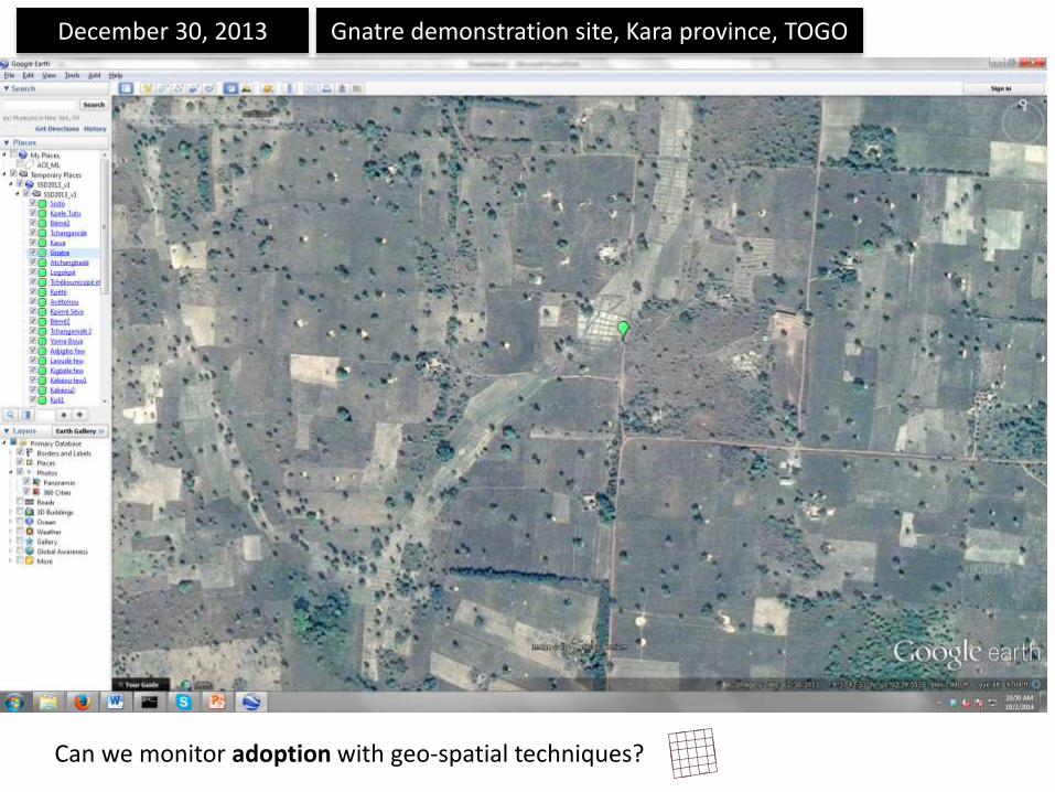
December 30, 2013 Gnatre demonstration site, Kara province, TOGO
Can we monitor adoption with geo-spatial techniques?

December 30, 2013 Gnatre demonstration site, Kara province, TOGO
Can we monitor adoption with geo-spatial techniques?
Inland valleyrice development
Upland rice development?

April 2, 2010 Gnatre demonstration site, Kara province, TOGO
Can we monitor adoption with geo-spatial techniques?

December 30, 2013 Gnatre demonstration site, Kara province, TOGO
Can we monitor adoption with geo-spatial techniques?

December 30, 2013 Gnatre demonstration site, Kara province, TOGO
Can we monitor adoption with geo-spatial techniques?
- Can we monitor adoption with geo-spatial techniques?
Object-based image classification + change detection analysisUsing high-resolution imagery.

December 30, 2013 Gnatre demonstration site, Kara province, TOGO
Can we monitor adoption with geo-spatial techniques?
- Can we map and model the diffusion pathways?
• Adoption takes place in inland valleys• Adoption take place close to
demonstration sites (buffers)• Adoption requires a road network (travel distances from
extension services)
Spatial analysis & modelling in GIS
Required: detailed inventory of adoption sitesand existing diffusion pathways
Can we map and model the diffusion pathways?

December 30, 2013 Gnatre demonstration site, Kara province, TOGO
Can we monitor adoption with geo-spatial techniques?
- Can impact surveys be targeted better using geo-spatial information?
?
Improved accuracy?Improved sample selection?