Embed Size (px)
Citation preview

LEVERAGING TECHNOLOGY IN MANAGING DISASTERS
PREPARED BY DHAN SINGH
Dhan@ximb

An indicative list of agencies providing technological services in Disaster Management
AGENCIES TECHNOLOGICAL SUPPORT PLATFORMS/SERVICES
NDMA Vision: To build disaster resilient India by developing a holistic, pro-active, multi-disaster & technology-driven strategy ;Framed guidelines for CBRN...
NIDM,MoH India Disaster Resource Network(IDRN)
ISRO Disaster Management Support (DMS) Programme , National Database for Emergency Management (NDEM)
NRSC ‘Bhuvan’ ,Bhuvan mapper, DMIS , Decision Support Centre(DSC)
INCOIS (MoES) Tsunami warning, Argo floats etc.
NIOT,Chennai Deep Ocean Assessment and Reporting System
IMD DWR
DST NSDI
ISCRAM CFP - Special issue on ICT and Crisis, Disaster, and Catastrophe Management - Journal of Homeland Security and Emergency Management
UN OCHA Disaster Relief 2.0:The future of Information sharing in Humanitarian emergencies (2011)
FEMA Federal Emergency Management Agency of the US of A
Dhan@ximb

PRE-DISASTER PHASE
Dhan@ximb

Dhan@ximb

Disaster Management Support (DMS)
Programme • Creation of digital data base for facilitating hazard
zonation
• Damage assessment
• Monitoring of major natural disasters using satellite and aerial data
• Techniques & tools for decision support
• Establishes satellite based reliable communication network
• Deployment of emergency communication equipments
• R&D towards early warning of disasters
Dhan@ximb

Schematic of DMS
Source: ISRO Dhan@ximb

Nowcasting: Detailed description of the current weather along with forecasts obtained by extrapolation for a period of 0 to 6 hours ahead which facilitates forecast of small features such as individual storms with reasonable accuracy
Uses of Nowcasting : • aviation weather forecasts in both the terminal &
en-route environment, • marine safety, • water & power management, • off-shore oil drilling, • construction industry • leisure industry
Dhan@ximb

Dhan@ximb

Dhan@ximb

Indian National Centre for Ocean Information Services (INCOIS), Hyderabad Provides operational ocean information & advisory services by ocean-
atmosphere modelling (potential areas of fish abundance & ocean state)
Dhan@ximb

Prediction of extreme weather events needs to be a multi-tiered process:
Advisory Watch Outlook Indian Ocean Forecast System (INDOFOS) http://www.incois.gov.in/Incois/indofos_islands.jsp
International Argo Project in the Indian Ocean region http://www.incois.gov.in/Incois/argo/argo_home.jsp
Dhan@ximb

The Observing-System Research and Predictability Experiment (THORPEX)
Aim is to improve accuracy of prediction of high-impact 1-14 day weather forecasts
Dhan@ximb

NATIONAL EMERGENCY COMMUNICATION PLAN
POLNET HUB
-
NDMA EOC
PHASE – I
NICNET HUB OPTIONAL BACK-UP FOR SEOC /DEOC CONNECTIVITY
PUBLIC ISDN
NETWORK
DEOC-N
NQRT VSAT
SPACENET HUB
OPTIONAL BACK-UP FOR SEOC CONNECTIVITY
HOSPITAL VSAT
MOBILE EOC
Reserved VSATs
GMPCS PHONE
GMPCS PHONE
PUBLIC ISDN
NETWORK
DEOC-N
PHASE – II
POLNET
NOTE: Terrestrial Link
Satellite Link
SEOC
DEOC-1
DEOC-2
Dhan@ximb

IRIDUM GMPCS PHONES
VSAT IDU
IP PHONE CONVERTER
TO POLNET HUB VIA INSAT SATELLITE VIDEO
CONFERENCE PHONE
VIDEO CAMERA
VHF HANDSETS
1.2 METER PORTABLE VSAT ANTENNA
PORTABLE GEN.SET, BATTERY ETC.
TRANSPORTABLE COMMUNICATION SETS FOR SEARCH AND RESCUE TEAMS
PUBLIC ADDRESS SYSTEM
LAPTOP COMPUTER
Dhan@ximb

National Spatial Data Infrastructure (NSDI)
• Much of the information is “spatial” - it refers to a coordinate system & is representable in map form
• Marrying GIS & GPS technologies to produce spatially referenced data in digital form on a wider variety of topics or themes (e.g., population, land use, economic transactions, hydrology, agriculture, climate, soils)
Dhan@ximb

Multi-layered Geo-spatial Database
Model to analyze and predict impact of events to desired level
Data level Country State District Taluk Block Village
Multiple Scenario based on data level & event
Dhan@ximb

Aerial Imagery
Elevation
Geodetic Control
Boundaries
Surface Waters
Transportation
Land Ownership
Other Thematic Data Framework Data
Relationships Among Data Build Once, Use Many Times
Soils
Sewer Lines
Water Lines
Landcover
Demographics
Flood Zones
Dhan@ximb

Data bases on Hazards & Disasters
• EM-DAT is an International Disaster Database prepared by Centre for Research on Epidemiology of Disasters (CRED),Brussels
• EM-DAT contains essential core data on the occurrence and effects of over 18,000 mass disasters in the world from 1900 to present
• Unique feature of EM-DAT is that each disaster is uniquely identified by an 8-digit number
• Can apply filters like time filter, location filter, & disaster filter on the aggregated data
http://www.emdat.be/database
Dhan@ximb

EM-DAT
http://www.emdat.be/database Dhan@ximb

Dhan@ximb

Disaster Databases
Global Risk Identification Program (GRIP),UNDP has created:
• Data & Informational Portal information on disasters and risks at all levels, i.e. National, Regional, and Global
http://www.gripweb.org/gripweb/?q=data-information
• Early Warning Systems (EWS) Portal http://www.flickr.com/people/gripweb/
Dhan@ximb

Databases on Hazards & Disasters
US Geological Survey (USGS):
• provides detailed information of different types of natural hazards, not only of USA but also of various places around the world
National Earthquake Information Center (NEIC):
• It is an extensive, global seismic database on earthquake parameters & their effects
Dhan@ximb

SOCIAL MEDIA
Before Disaster Strikes • Sign up to receive RSS feeds from some of your trusted sources
• A 2009 study commissioned by American Red Cross found that social media sites are the 4th most popular source to access emergency information
• Research & follow or various entities that help prepare for disasters
• Provides increased capacities for networking between stakeholders
• Crowdsourcing of local disaster information
• use social media to conduct emergency communications & issue warnings
• Make sure all electronic devices are fully charged & back up batteries or chargers are in multiple location
• American Red Cross similarly uses Facebook to issue alerts of potential disasters
Dhan@ximb

DURING DISASTERS
Dhan@ximb

Technology-assisted disaster response
• During Haiti earthquake of 2010, Ushahidi, was quickly deployed by a group of international volunteers to tap into various information channels & create actionable information that could be embedded onto a map
utility of a mobile phone number was highlighted because it proved an invaluable information channel on the Ushahidi platform
• Ohio Center of Excellence in Knowledge-enabled Computing (Kno.e.sis),Wright State University, Ohio
Demonstrated how a technology assisted response could help in managing the situation during 2013 Uttarakhand floods better
tried to push(but failed) for a free SMS service number to enable people to channelise information
lack of awareness about how a technology assisted response could help in managing the situation better
http://knoesis.org/showcase
Dhan@ximb

What is crisis mapping?
http://www.youtube.com/watch?v=qRG_Rue1a-s&feature=youtube_gdata
‘CrisisMappers’ leverage mobile & web-based applications, participatory maps & crowdsourced event data, aerial & satellite imagery, geospatial platforms, advanced visualization, live simulation, and computational & statistical models to power effective early warning for rapid response to complex humanitarian emergencies. Also extract meaning from mass volumes of real-time data exhaust.
http://crisismappers.net/
Dhan@ximb

Use of Crisis Maps during Disasters
• Some more online mapping organizations with a humanitarian focus: OpenStreetMap, Sahana
• Google , Microsoft ,and OpenStreetMap have democratized mapping
• OpenStreetMap became an open-source service that allowed people to view an online map and contribute information about what they saw
• Google & Microsoft bought expensive satellite photo images and mapping data and created consumer services from them
• Google had set-up Uttarakhand crisis-map
• Uttarakhand government had set up 'Operation Connect', a Facebook page to help reunite missing people
Dhan@ximb

http://irevolution.net/2013/09/18/micromappers/ Dhan@ximb

Map service has been set up for Libya:
libyacrisismap.net mainly to track
media reports, accounts of violence
& the flow of refugees
Dhan@ximb

General Software Tools • Groove:
Facilitates collaboration by creating a shared workspace
Synchronises copies among users via the Net or a network
• Voxiva Inc.’s technology
Platform solves two primary
problems:
To collect data in real-time from
large no. of dispersed people
To enable communication &
messaging services that effect
immediate change
• First used in Peru in 2002 for
Surveillance of infectious diseases
Dhan@ximb

Microsoft FACTS (Food and Commodity Tracking System)
Strengths:
• Highly mobile
• Internet-based
• Good process coverage
• User-friendly system
• System uses clear receipts and waybills for tracking
Weaknesses:
• Poor logistics management
• Poor workflow integration
• Developed through Microsoft and Mercy Corps partnership; designed in collaboration with several global NGOs
• Program is designed to cover the “last mile” of the logistics process
Dhan@ximb

Some more Social Enterprises in Digital Disaster Response Space
• Technology for the People (TFTP),Bangalore: Deployed SMS app ‘sms4help’ during Bihar flood disaster of 2008 http://www.tftpeople.org/home.htm
• Crowdcrafting: http://crowdcrafting.org/
• ‘Digital Humanitarian Network’: Example: Typhoon Yolanda/Haiyan (Philippines),Nov’13 http://digitalhumanitarians.com/profiles/blogs/yolanda
http://micromappers.com/
• ‘Map Action’ http://www.mapaction.org/
• ‘Humanity Road ’ http://humanityroad.org/yolandaphsitrep/
Dhan@ximb

Satellite-based low-cost HAM/Amateur radios is entering its 2nd century of disaster communications (1st use: Midwest (USA) Floods, 1913)
Source: Hindustan Times Kolkata, June 27, 2013
Ham Radio
Examples of P2P based Communication: Telephone lines, leased lines, WLAN etc.
Dhan@ximb

Challenges in using technology in managing disasters
"Digital humanitarian response must be demand-driven to work. Humanitarian organizations need to request activation & in doing so specify precisely what their information needs are & how they are going to use the resulting data to improve their decision making."
Patrick Meier, Co-founder of CrisisMappers
Dhan@ximb
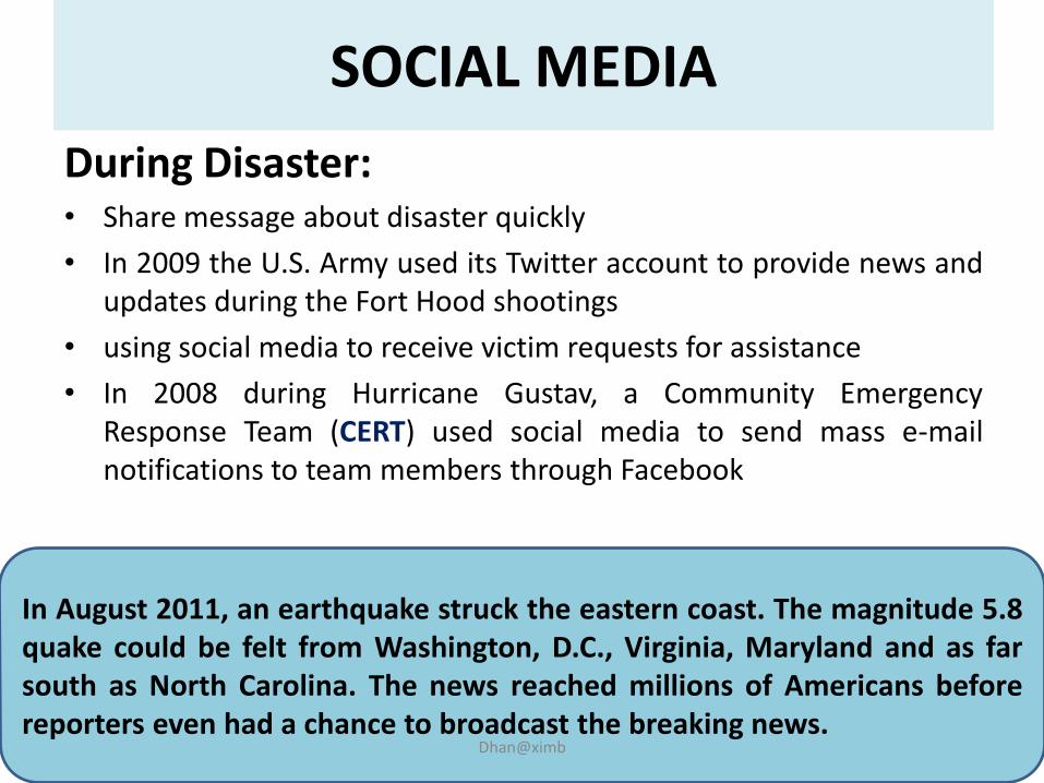
SOCIAL MEDIA
During Disaster: • Share message about disaster quickly
• In 2009 the U.S. Army used its Twitter account to provide news and updates during the Fort Hood shootings
• using social media to receive victim requests for assistance
• In 2008 during Hurricane Gustav, a Community Emergency Response Team (CERT) used social media to send mass e-mail notifications to team members through Facebook
In August 2011, an earthquake struck the eastern coast. The magnitude 5.8 quake could be felt from Washington, D.C., Virginia, Maryland and as far south as North Carolina. The news reached millions of Americans before reporters even had a chance to broadcast the breaking news.
Dhan@ximb

Use of Social Media & ICT during Disasters
• In March 2011,Japanese earthquake & tsunami found that individuals with Twitter accounts “tweeted” for assistance when they could not use a phone
• http://www.fas.org/sgp/crs/homesec/R41987.pdf
• Google Person Finder helps people reconnect with friends & loved ones during/after natural & humanitarian disasters
• http://google.org/personfinder/global/home.html
Dhan@ximb

POST-DISASTER PHASE
Dhan@ximb

Use of Technology after Disasters
Systematic use of social media as an emergency management tool:
• monitoring user activities & postings to establish situational awareness
• using uploaded images to create damage estimates
1st Risk: Inaccurate information by social media could jeopardize the safety of first responders and the community
2nd Risk: Privacy issues related data mining of personal info
Use social media to accelerate the damage estimate process by transmitting images of damaged structures such as dams, levees, bridges, & buildings taken from cell phones
Source: Lindsay(2011)
Dhan@ximb

In Kansas (USA), a smartphone application has been used to help the Army Corps of Engineers to identify & report breeches, seepage, & other areas of structural weakness in levees. The application allows Corps engineers to take a photo of problem area and then “geotag” its precise location. “How Smartphones Are Fighting Floods,” Homeland Security Newswire, August 2, 2011
Geotagging can also help in crowdsourced mapping Dhan@ximb

Example of ‘Geotagging’
• Nigel Snoad, strategy adviser in OCHA who was in Haiti after the quake in 2010, where he was trying to put together a map of health clinics, to guide the dispatch of health care workers & suppliers, & he had 400 street addresses that might be health centers. Mr. Snoad asked student volunteers at Tufts University to help “geotag” the addresses- put coordinates on a map -with assistance from Haitians living outside the country
• Nearly all 400 addresses were mapped online within 24 hours, while having people physically check locations might well have taken weeks.
• Source: New York Times, March 28,2011
Dhan@ximb

Toshiharu Kato/Japanese Red Cross, via Agence France-Presse, Getty images
In Japan, crowd-sourced maps have helped local relief workers after Tsunami of 2010
Japanese use online maps mainly to assist in their own recovery efforts
Dhan@ximb

Intelligent ICTs such as smartphones and social media platforms (e.g., Twitter, Facebook, YouTube and blogs) are providing increased capacities for networking, enabling citizens & communities to actively engage with government in disaster management through crowdsourcing of local disaster information & playing increasingly important roles in all phases of a comprehensive disaster management cycle: disaster preparedness, response, recovery, and mitigation BUT......
In Sum....
Overdependence on technology could become problematic in case of prolonged outages since smartphones, tablets have battery life lasting 12 hours or less (Power outages were more than 48 hours during Hurricane Irene, Aug ‘11)
Dhan@ximb

References: Weblinks: At global level: http://www.emdat.be/disaster-profiles http://www.usgs.gov/natural_hazards/ http://earthquake.usgs.gov/regional/neic/ http://leafletjs.com/ http://www.gripweb.org/gripweb/ At country level: http://www.ndmindia.nic.in/ http://idrn.gov.in/default.asp http://ndma.gov.in/ndma/index.htm http://bhuvan3.nrsc.gov.in/bhuvan/bhuvannew/bhuvan2d.php# At local level: http://dmmc.uk.gov.in/pages/display/78-g.i.s.-database http://www.osdma.org/
Dhan@ximb

THANK YOU FOR YOUR ATTENTION!
PRESENTED BY DHAN SINGH,XIMB
Dhan@ximb