AUTHORS
F. N. Sadooni � Department of Geology,University of United Arab Emirates, Al-Ain, UnitedArab Emirates; [email protected]
F. N. Sadooni has been an associate professorand chairman of the Department of Geology,United Arab Emirates University, since Septem-ber 2001. He received a Ph.D. in petroleumgeology from the University of Bristol, UnitedKingdom, in 1978. After working with IraqNational Oil Company as a senior explorationgeologist for 13 years, Fadhil joined YarmoukUniversity, Jordan, in 1991 and then worked asa consultant petroleum geologist in Auckland,New Zealand. In 1998, he joined the Universityof Qatar as assistant professor before movingto the United Arab Emirates University. His re-search interests include carbonate reservoircharacterization and evaporites. He is a mem-ber of the AAPG.
A. S. Alsharhan � Department of Geology,University of United Arab Emirates, Al-Ain, UnitedArab Emirates; [email protected]
A. S. Alsharhan is professor of geology at theUnited Arab Emirates University. He received aPh.D. in petroleum geology from the Universityof South Carolina in 1985. He has authored andpublished more than 80 scientific papers. Hecoauthored Sedimentary Basins and PetroleumGeology of the Middle East (1997) with A. E.Nairn and Hydrogeology of an Arid Region:Arabian Gulf and Adjacent Areas (2001) withZ. Rizk, A. E. Nairn, D. Bakhit, and S. Al-Hajari.He coedited Quaternary Deserts and ClimateChange (1998) with K. W. Glennie, G. Whittle,and C. Kendall and Middle East Models ofJurassic/Cretaceous Carbonate Systems (2000)with R. W. Scott. His research interests includeHolocene coastal sabkhas of the Arabian Gulfregion and the geology and hydrocarbon hab-itats of the Middle East and North Africa. He is amember of the AAPG, SEPM, the InternationalAssociation of Sedimentologists, and the Geo-logical Society of London.
Stratigraphy, lithofaciesdistribution, and petroleumpotential of the Triassic strataof the northern Arabian plateF. N. Sadooni and A. S. Alsharhan
ABSTRACT
Triassic strata of the northern part of the Arabian plate mark the
establishment of the Neo-Tethys passive margin. This ocean first
opened in the western part of the Mediterranean region directly
after the Hercynian orogeny. The strata were deposited on a shallow
carbonate platform surrounded by clastic-evaporitic lagoons and
continental fluvial and eolian settings. The rocks are divided be-
tween continental clastics (such as the Budra and the Ga’ara for-
mations), continental-marine clastics and evaporites (such as the
Mohilla, Abu Ruweis, Beduh, and Baluti formations) and epiconti-
nental marine facies (such as the Saharonim, Salit, and Kurra Chine
formations). These settings are comparable to those of the German
Triassic and have matching lithofacies and eustatic sea level changes.
The succession has been divided into four ‘‘high-frequency’’ sequences
dominated by highstand systems tract carbonates and highstand sys-
tems tract–lowstand systems tract evaporites and clastics: the Mu-
lussa Formation, the Kurra Chine dolomite and oolitic limestones,
the clastics in the Euphrates–Anah graben in Syria and Iraq, and
the Triassic buildups in the northern parts of the Levant form at-
tractive hydrocarbon reservoirs when they are overlain by the Triassic–
Jurassic evaporite sequence and are in communication with Silurian
source rocks. In Syria, the Kurrachine Formation contains both source
and reservoir rocks. On the Aleppo plateau, this formation is believed
to lie at the beginning of the thermal maturation window, whereas
in the areas of Jebbissa, Soukhne, and Souedie, it is in the mature or
overmature windows. The Triassic strata produced fair amounts of
light oil, gas, and condensates from some fields in Syria and Iraq with
a high potential of gas and condensate accumulations in the Levant
region.
AAPG Bulletin, v. 88, no. 4 (April 2004), pp. 515–538 515
Copyright #2004. The American Association of Petroleum Geologists. All rights reserved.
Manuscript received June 28, 2003; provisional acceptance September 29, 2003; revised manuscriptreceived October 30, 2003; final acceptance December 3, 2003.
INTRODUCTION
The discovery of economic hydrocarbons in both Iraq and Syria in the
Triassic rocks of the northern Arabian plate makes these sediments
increasingly important. This has created further interest in these strata
that are already considered important within the context of Neo-
Tethys development. They are distributed across diverse geologic
settings that range from continental, epicontinental, Neo-Tethyan
margins, rift-zone belts, and pelagic seaways. These rocks have been
described from both surface and subsurface localities in most parts
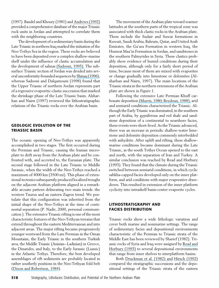
of the Arabian basin (Figure 1). The succession changes gradually
upward from clastics in the lower part to alternations of limestone,
dolomite, anhydrite, shale, and occasionally halite. The average thick-
ness of these Triassic rocks is around 2000 m (6600 ft).
The regional distribution and the depositional setting of the
Upper Triassic rocks on the northern part of the Arabian plate and
around the eastern Mediterranean Sea have been discussed by sev-
eral workers, including Druckman et al. (1975), Basha (1981), and
Sharief (1982, 1983). They have suggested that the submergence
and emergence of a platform during the late Middle to Late Triassic
has led to the establishment of marginal marine peritidal flats to
the north, which are associated with deposition in sabkhas and shal-
low lagoons. Fluvial and eolian conditions dominated the southern
part of the platform, whereas deep-water rocks (clastics with cherts,
radiolarite, and reefal limestone associated with pillow lava) were
laid down to the north and beyond the margin of the platform.
Druckman et al. (1982) compared the Triassic section in the
eastern Mediterranean region with the typical Alpine Triassic. They
divided these strata into four sedimentary cycles, which they relate
to the German Triassic facies. The Triassic rocks of Syria were re-
viewed by Bebeshev et al. (1988). They concluded that the bound-
ary between the Permian and the Triassic is probably positioned at
the base of the mottled sandstones of the Ammanus Formation,
representing a halt in sedimentation separated by two major regional
tectonic events.
The first to examine Triassic eustatic cycles of the Mediter-
ranean region, including the northern parts of Arabia, was Hirsch
(1992). He found that the Triassic cycles in this region are closely
matched to the global eustatic sea level changes and are comparable
with the European Triassic section. According to him, the initial
opening of the Neo-Tethys during the late Spathian–Aegean was
represented by a regression in the Levant region. The transgression
that followed during the early late Anisian was in the form of
platform carbonates with Tethyan and endemic fauna. During the
late Carnian and Norian, most of the region was dominated by a
dolomitic, shallow-marine Tethyan facies. Alsharhan and Kendall
(1986) suggested the upper Permian–Triassic carbonate and
evaporite rocks of the Arabian basin accumulated on an epeiric
shelf, punctuated by a series of transgressive and regressive events.
A review of the lithostratigraphic relations of the Triassic rocks
over the Arabian basin was conducted by Alsharhan and Nairn
ACKNOWLEDGEMENTS
We are grateful to Andrew Horbury for a dis-cussion on the sequence stratigraphy of north-ern Iraq. The manuscript benefited considerablyfrom extensive revisions by D. E. Eby, K. W.Glennie, C. G. Kendall, A. E. M. Nairn, andR. W. Scott. A. Fowler read the final version andmade many useful amendments, and HamdiKandeel drafted the figures. Varda Arad pro-vided some valuable archives for the study.
516 Stratigraphy, Lithofacies Distribution, and Potential of the Northern Arabian Plate

Figu
re1
.Ba
sem
apof
the
nort
hern
part
sof
the
Ara
bian
plat
esh
owin
gth
em
ain
loca
tions
men
tione
din
the
text
.
Sadooni and Alsharhan 517
(1997). Bandel and Khoury (1981) and Andrews (1992)
provided a comprehensive database of the major Triassic
rock units in Jordan and attempted to correlate them
with the neighboring countries.
The development of a sedimentary basin during the
Late Triassic in northern Iraq marked the initiation of the
Neo-Tethys Sea in the region. These rocks are believed
to have been deposited over a complex shallow-marine
shelf under the influence of clastic accumulation and
the development of salinas (Sadooni, 1995). The sub-
surface Triassic section of Jordan was divided into sev-
eral unconformity-bounded sequences by Shinaq (1996),
whereas Sadooni and Dalqamouni (1998) found that
the Upper Triassic of northern Jordan represents part
of a regressive evaporitic-clastic succession that marked
the shrinkage phase of the Late Triassic basin. Alshar-
han and Nairn (1997) reviewed the lithostratigraphic
relations of the Triassic rocks over the Arabian basin.
GEOLOGIC EVOLUTION OF THETRIASSIC BASIN
The oceanic opening of Neo-Tethys was apparently
accomplished in two stages. The first occurred during
the Permian and Triassic, causing the Iranian micro-
plate to drift away from the Arabian plate and be con-
fronted with, and accreted to, the Eurasian plate. The
second stage followed in the Late Triassic to Middle
Jurassic, when the width of the Neo-Tethys reached a
maximum of 4000 km (3500 mi). This phase of exten-
sional tectonics subsequently produced localized troughs
on the adjacent Arabian platform aligned in a remark-
able arcuate pattern delineating two main trends: the
western Taurus and an eastern Zagros trend. We pos-
tulate that this configuration was inherited from the
initial shape of the Neo-Tethys at the time of conti-
nental separation (P. Nadir, 2000, personal communi-
cation ). The extensive Triassic rifting is one of the most
characteristic features of the Neo-Tethyan terrains that
extend throughout the eastern Mediterranean and into
adjacent areas. The major rifting became progressively
younger westward from the Late Permian in the Oman
Mountains, the Early Triassic in the southern Turkish
area, the Middle Triassic (Anisian–Ladinian) in Greece,
the Dinarides, and Italy, to the Early Jurassic (Liassic)
in the Atlantic Tethys. Therefore, the best developed
assemblages of rift sediments are probably located in
rather southerly positions in the Neo-Tethyan fold belt
(Dixon and Robertson, 1984).
The movement of the Arabian plate toward warmer
latitudes at the southern parts of the tropical zone was
associated with thick clastic rocks in the Arabian plate.
These include the Sudair and Suwai formations in
Kuwait, Saudi Arabia, Bahrain, Qatar, and United Arab
Emirates, the Ga’ara Formation in western Iraq, the
Humrat Maa’in Formation in Jordan, and sandstones in
the southern Palmyrides in Syria. These clastics prob-
ably show evidence of humid conditions during their
deposition, although only for a fairly short period of
time, because most of them are mixed with evaporites
or change gradually into limestone or dolomites (Al-
sharhan and Nairn, 1997). The main locations of the
Triassic strata in the northern extensions of the Arabian
plate are shown in Figure 1.
Following the extensive Late Permian Khuff car-
bonate deposition (Murris, 1980; Beydoun, 1988), arid
and semiarid conditions characterized the Triassic. Al-
though the Early Triassic was dominated, in the southern
part of Arabia, by gypsiferous and red shale and sand-
stone deposition of a continental to nearshore facies,
these events were short-lived. As the Triassic advanced,
there was an increase in periodic shallow-water lime-
stone and dolomite deposition commonly interbedded
with anhydrite. After uplift and rifting, these shallow-
marine conditions became dominant during the Late
Triassic, as the south Tethys Ocean opened to the east
and north, with the separation of Iran and Turkey. A
similar conclusion was reached by Read and Horbury
(1993). They found that the climate during the Triassic
switched between semiarid conditions, in which cyclic
sabkha-capped facies developed only on the inner plat-
form, and arid conditions with major evaporative draw-
down. This resulted in extension of the inner platform
cyclicity into intrashelf basin-center evaporite cycles.
LITHOSTRATIGRAPHY ANDFACIES DISTRIBUTION
Triassic rocks show a wide lithologic variation and
cover both marine and nonmarine settings. The range
of sedimentary facies and depositional environments
characteristic of the Permian to Triassic strata of the
Middle East has been reviewed by Sharief (1982). Tri-
assic rocks of Syria and Iraq were assigned by Read and
Horbury (1993) to several depositional environments
that range from inner shelves to interplatform basins.
Both Druckman et al. (1982) and Hirsch (1992)
compared the stratigraphic successions and the depo-
sitional settings of the Triassic strata of the eastern
518 Stratigraphy, Lithofacies Distribution, and Potential of the Northern Arabian Plate
Mediterranean region to the Alpine Triassic. This ap-
proach has facilitated regional correlation and enabled a
better understanding of the development of Neo-
Tethys. We have followed a similar approach in this
paper (Table 1). The major Triassic lithofacies of the
northern parts of the Arabian plate have been described
and compared with the classic German Triassic litho-
facies and depositional settings described by Aigner and
Bachmann (1992).
The Bunter-Type Facies
This facies consists of conglomerate, cross-bedded
sandstone and shale and contains wood and plant re-
mains. These strata are believed to have been laid down
in terrestrial, lacustrine, and fluviatile settings with
some eolian influence (Hirsch 1992). In the northern
parts of the Arabian plate, this facies is represented by
the Ga’ara Formation (Anisian/Ladinian) in western
Iraq, the Um Irna Formation (Induan) in Jordan, the
Budra Formation (Ladinian) in the southern parts of
the Levant region, and the Ammanus Sandstone For-
mation (Induan) in Syria (Table 2).
The Ga’ara Formation is exposed on the fringes of
the Ga’ara depression, about 60 km (37 mi) to the west
of the town of Ga’ara, a town on the Iraqi-Jordanian
border (Figure 2). The formation, which is around 150 m
(492 ft) thick, consists of coarse-graded, current-bedded
sandstones that may be brown or rusty in weathered ex-
posures, but may also be white. Subordinate bands of
purple and red sandy marls with gray and greenish
sandy or silty marls are found in the uppermost part of
the unit.
Ctyroky (1973) described some palynoflora from
the Ga’ara Formation. These include Lobatannulariaheianensis, Plagiozamites oblongitolius, Sigillaria sp., and
Taeniopteris sp. from which he suggested a Permian–
Carboniferous age for the formation. Al-Ameri (1990),
however, proposed that these floras better support a
Middle Triassic (Anisian/Ladinian) age. This age is in
agreement with the age of similar facies in other parts of
the Arabian plate.
The Ga’ara Formation is underlain by the Nijili
Formation and then by the Paleozoic clastics. These
Paleozoic strata are formed by a thick succession of
alternating sandstones and shales that have been as-
signed to the Sufi Formation, a new formation intro-
duced to accommodate these clastics (Aqrawi, 1998).
Without proper dating, it is very difficult to assign an
accurate age to these continental rocks, but they may
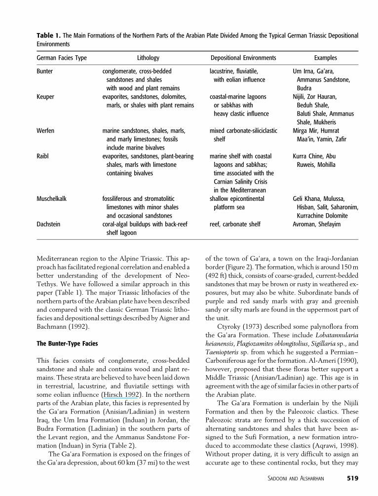
Table 1. The Main Formations of the Northern Parts of the Arabian Plate Divided Among the Typical German Triassic Depositional
Environments
German Facies Type Lithology Depositional Environments Examples
Bunter conglomerate, cross-bedded
sandstones and shales
with wood and plant remains
lacustrine, fluviatile,
with eolian influence
Um Irna, Ga’ara,
Ammanus Sandstone,
Budra
Keuper evaporites, sandstones, dolomites,
marls, or shales with plant remains
coastal-marine lagoons
or sabkhas with
heavy clastic influence
Nijili, Zor Hauran,
Beduh Shale,
Baluti Shale, Ammanus
Shale, Mukheris
Werfen marine sandstones, shales, marls,
and marly limestones; fossils
include marine bivalves
mixed carbonate-siliciclastic
shelf
Mirga Mir, Humrat
Maa’in, Yamin, Zafir
Raibl evaporites, sandstones, plant-bearing
shales, marls with limestone
containing bivalves
marine shelf with coastal
lagoons and sabkhas;
time associated with the
Carnian Salinity Crisis
in the Mediterranean
Kurra Chine, Abu
Ruweis, Mohilla
Muschelkalk fossiliferous and stromatolitic
limestones with minor shales
and occasional sandstones
shallow epicontinental
platform sea
Geli Khana, Mulussa,
Hisban, Salit, Saharonim,
Kurrachine Dolomite
Dachstein coral-algal buildups with back-reef
shelf lagoon
reef, carbonate shelf Avroman, Shefayim
Sadooni and Alsharhan 519
belong to the so-called Nubian sandstones, which are
widespread over the Mediterranean area and north-
eastern Africa.
The Ga’ara Formation was probably deposited in
continental fluviatile and lacustrine settings, but the
presence of some littoral marine clastics may not be
excluded (Buday, 1980). The Ga’ara Formation in the
western desert of Iraq consists of many fining-upward
cycles, each of which begins with coarse-grained, cross-
bedded sandstone that grades into fine-grained, cross-
bedded sandstone and, sometimes, into cross-laminated
sandstone, siltstone, and claystone. The coarse fraction
of the formation represents channel sediments, where-
as the fine one is of flood-plain type. The dark color of
some of the claystone beds may suggest their deposition
in a vegetated site on the flood plain (Al-Ameri, 1990).
In Jordan, a similar facies has been assigned to the
Um Irna Formation (Makhlouf et al., 1991) (Table 2).
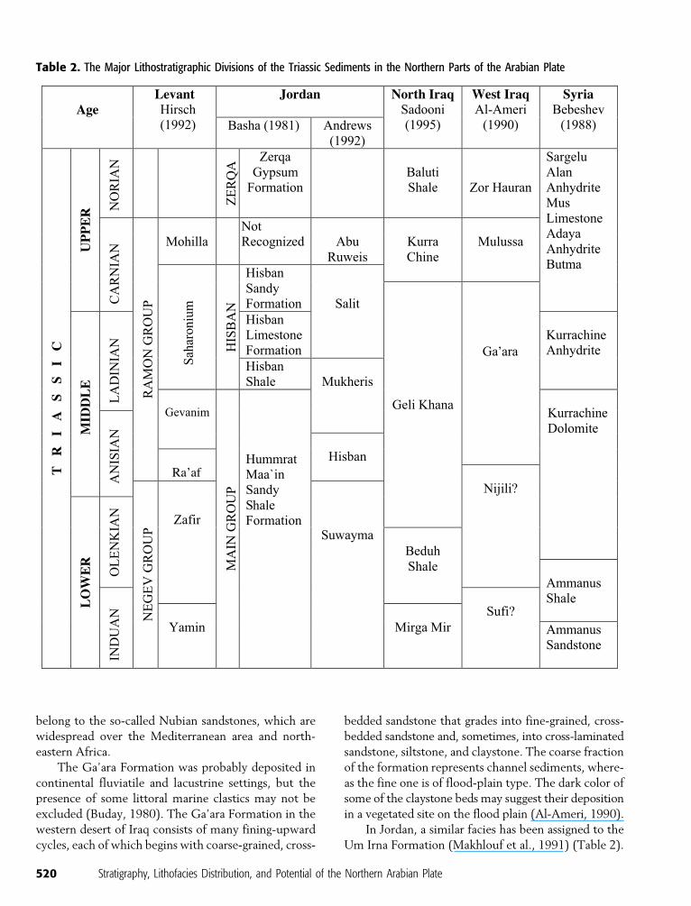
Table 2. The Major Lithostratigraphic Divisions of the Triassic Sediments in the Northern Parts of the Arabian Plate
520 Stratigraphy, Lithofacies Distribution, and Potential of the Northern Arabian Plate
This unit is believed to be of Permian to Triassic age
(probably Induan). It consists of 60 m (197 ft) of flu-
vial sandstone, maroon siltstone, and silty shale locally
containing pebbly sandstone horizons with abundant
ferruginous concretions. The formation also contains
abundant plant remains in gray clay. It consists of six
sedimentary cycles of terrestrial deposits without any
trace of bioturbation (Bandel and Khoury, 1981). The
base of the formation, however, is characterized by
the first occurrence of bioturbation and purplish color
of the beds. The presence of flaser bedding, mud cracks,
ripple surfaces, laminations, bioturbations, marine bi-
valves, and burrows are interpreted by the authors to
indicate a tidal zone with shallow-water conditions
(Bandel and Khoury, 1981). The formation was prob-
ably laid down in an unconfined braided plain sloping
northwest away from a raised source area (the Arabian-
Nubian shield) (Makhlouf et al., 1991).
In the southern parts of the Levant and Sinai, the
continental facies is represented by the Budra Forma-
tion, which may be Ladinian. The formation consists
of red beds that were deposited under fluviatile and
eolian conditions. In eastern Egypt, this facies has been
designated as the Qiseib Formation, which is probably
equivalent to the Jilh Formation in the southern parts
of the Arabian plate (Druckman, 1974).
The Ammanus Sandstone Formation occurs widely
in Syria and consists of varicolored sandstone, siltstone,
and some argillite. The formation consists mainly of
sandy-clayey beds that lack fossils and have local cross-
bedding. These strata are also believed to have been
deposited in a fluvial regime with shallow-marine in-
fluence (Bebeshev et al., 1988).
The Keuper-Type Facies
The Keuper facies consists of evaporites, sandstones,
dolomites, marls, or shales with plant remains and
monospecific shallow-water marine, hypersaline, or
brackish to freshwater bivalves and ostracods (Hirsch,
1992). This facies is represented in the northern parts
of the Arabian basin by the Nijili (Anisian/Ladinian)
and Zor Hauran (Rhatian) formations of the western
desert of Iraq, the Beduh Shale (Induan–Olenekian)
and Baluti Shale formations (Rhatian) of northern Iraq,
the Mukheris Formation (Anisian) of Jordan, and the
Ammanus Shale Formation (Induan) of Syria (Table 2).
The Nijili Formation (Anisian/Ladinian) was de-
scribed from outcrops near the Ga’ara depression in the
western desert of Iraq as consisting of flaky, saliferous,
yellow and green marls and shales with frequent pur-
plish bands and two thin beds of sandstone near the
base. The main fossils found in the formation are in-
determinate plant remains at the contact with the over-
lying Ga’ara Formation (Bellen et al., 1959). Because of
the lateral interfingering and vertical alternations of this
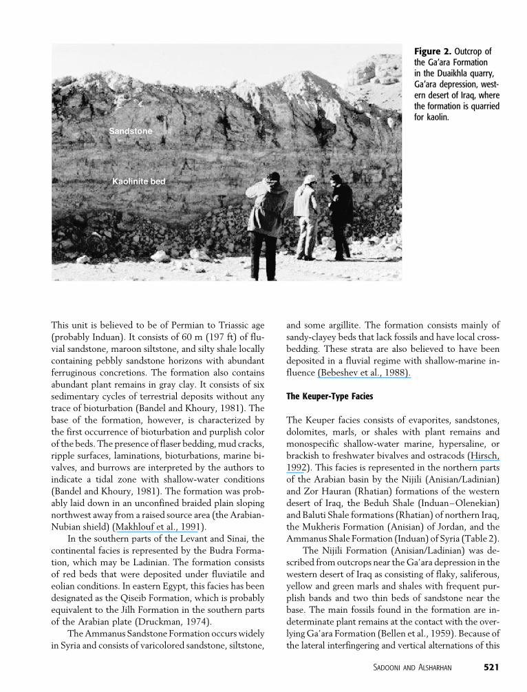
Figure 2. Outcrop ofthe Ga’ara Formationin the Duaikhla quarry,Ga’ara depression, west-ern desert of Iraq, wherethe formation is quarriedfor kaolin.
Sadooni and Alsharhan 521
formation with those of the overlying Ga’ara Forma-
tion, it was recommended by Jassim et al. (unpublished
report, cited by Sadooni and Aqrawi, 2000) to abandon
the term Nijili and use the term Ga’ara for the entire
single succession. This practice has not been followed
here because there is a difference in lithology and dep-
ositional settings of the two formations. First, the orig-
inal description of the Nijili Formation includes beds of
saliferous marls, which cannot be accommodated with-
in the definition of the Ga’ara Formation, and second,
there are similar strata of equivalent age to the Nijili
Formation in northern Iraq. The rocks of this formation
may have been deposited in coastal lagoons and sabkhas
with significant continental clastics.
The Zor Hauran Formation (Rhaetian) was also
described from the western desert of Iraq and has a
similar lithology to the Nijili Formation. It consists
of yellow and green gypsiferous marls and shales with
marly limestone, oolitic and peloidal limestone, and
dolomitic limestone. Near the top, a conglomeratic bed
with an indurated ferruginous crust occurs, suggesting
emergence at the end of the deposition of the for-
mation. The formation has a poorly preserved fossil
assemblage that includes Lingula sp., Myophoria sp.,
Archaediscus sp., Glomospira spp., Trocholina sp., os-
tracods, and echinoid. The age of the Zor Hauran For-
mation is not known with certainty and is based largely
on tentative correlation with the Baluti Shale Forma-
tion of northern Iraq. The formation has been recog-
nized by its argillaceous and evaporitic characteristics in
contrast to the calcareous strata of the underlying Mu-
lussa and the overlying Uba’id formations. The for-
mation, however, was deposited in coastal evaporitic
lagoons on the evidence of the oolitic and peloidal lime-
stone facies, with a greater marine influence than the
Nijili Formation.
The Beduh Shale Formation (Induan–Olenekian)
of northern Iraq has a distinctive purple color, which
makes it an excellent marker. The type locality for this
formation lies in the Amadia district of northern Iraq
(Figure 1), where it consists of red-brown and purplish
shales and marls, some silty with subordinate ribs of
limestone with sandy streaks. According to Bellen et al.
(1959), the red color of this formation may be related to
the indirect influence of Triassic vulcanicity. In the
subsurface, the formation is more arenaceous and cal-
careous and is probably thicker than its surface expo-
sures. The characteristic red and purple colors are not
well developed in the subsurface.
The Baluti Shale Formation (Rhatian) of northern
Iraq belongs also to this facies. In its type locality south
of the city of Amadia (Figure 1), the formation consists
of gray and green, calcareous, and dolomitized shale
with intercalations of thin-bedded dolomitized lime-
stone showing solution brecciation that may have
resulted from the dissolution of anhydrite. The fossils
found in the Baluti Shale include Glomospira sp., os-
tracods, and indeterminate mollusks. The limestone
and dolomite lithologies are found only as thin bands,
not exceeding 10 cm (4 in.) thick. The dolomite is fine
grained and may be of sabkha type. The formation may
be correlated with the green shale hosting estuarine
plant and fish debris described from the Persian Zagros
region (Bellen et al., 1959).
The Mukheris Formation of Jordan consists mainly
of reddish brown, silty shale and claystone with some
beds of buff-brown to beige and dark gray fossiliferous
limestone (Bandel and Khoury, 1981; Andrews, 1992;
Shinag, 1996). The formation is widely distributed in
the northern parts of Jordan and recognized in all the
Northern Highland and western Risha wells (Figure 1).
The thickness of the formation ranges between 70 and
100 m (230 and 328 ft).
The Werfen-Type Facies
The Werfen-type facies consists of interbeds of marine
sandstone with plant remains, shale, marls, and marly
limestone. Fossils include the bivalves Claraia, Ano-dontophora, and Myophoria (Hirsch, 1992). This facies
is represented in the northern parts of the Arabian plate
by the Mirga Mir Formation (Induan) in northern Iraq,
the Humrat Maa’in Formation (Induan) in Jordan, the
Yamin and Zafir formations (Olenekian–Anisian) in
the Levant, and the Ammanus Shale Formation (Induan)
in Syria (Table 2).
The Mirga Mir Formation of northern Iraq was
described from the area of Mirga Mir near the city of
Amadia (Figure 1). The formation consists of around
200 m (660 ft) of thin-bedded, gray and yellow, marly
limestone with shale characterized by slump beds and
crystallization breccia, oolitic limestone (at the base)
with wisps of sandstone. The characteristic faunas in-
clude the typical Werfen-type fossils, including Claraiaclarai Emmrich, Anodontophora fassaensis Wissman,
and Myophoria cf. ovata Goldfuss.
The Mirga Mir Formation shows the same general
facies as the overlying Beduh Shale Formation. The two
units, however, are separated on the basis of color, re-
lative proportions of limestone, and the argillaceous
strata in the Mirga Mir Formation (Bellen et al., 1959;
Buday, 1980).
522 Stratigraphy, Lithofacies Distribution, and Potential of the Northern Arabian Plate
The Humrat Maa’in Formation of Jordan is ex-
posed only along the course of the Wadi Zerqa Maa’in
River (Figure 1). This formation consists of reddish,
limonitic, and gray-greenish sandstone interbedded
with varicolored clayey sandstone and claystone with
mud cracks, ripple marks, rain prints, trace fossils, in-
tercalations of dark shale rich in plant remains, and
partly dolomitized rocks. The formation contains the
same fossils described from the Mirga Mir Formation
(Basha, 1981).
The finding of the same Lower Triassic conodonts
of the Pachycladina-Hadrodontina assemblages in the
upper part of the Yamin Formation and in the lower
part of the Zafir Formation, and in the upper part of
the Humrat Maa’in Formation, suggests an age equiv-
alency between these formations across the Levant
(Druckman et al., 1982). Both of the Yamin and the
Zafir formations are composed of interbedded sand-
stone, shale, and limestone, totaling 430–759 m (1411–
2490 ft) thickness. Judging from the lithofacies types,
the fossil content, and the sheet geometry of the sand-
stone units, Druckman et al. (1982) assumed that these
strata were deposited in a nearshore marine setting,
where the mixed clastic-carbonate facies were laid
down in the littoral zone or in lagoons, whereas the
sand bodies accumulated as barriers.
The Ammanus Shale Formation in central Syria,
despite having the term shale associated with its name,
consists of intercalated gray sandstone and argillite that
grade into limestone. The formation becomes more
calcareous upward, and at its top, dolomitized lime-
stone appears. In the subsurface, Pseudomontis claraiEmmrich has been found in the formation (Bebeshev
et al., 1988).
The Raibl-Type Facies
This is a regressive facies consisting of evaporites, sand-
stone, plant-bearing shale, marl with limestone, and
containing bivalve Myophorids and ostracods. This fa-
cies accumulated mainly during the Pan-Mediterranean
salinity crisis during the early Carnian (Hirsch, 1992).
This facies is represented, partially at least, by the Kurra
Chine Formation of northern Iraq, the Abu Ruweis For-
mation of Jordan, and the Mohilla Formation of the
Levant, all of which are of Carnian age (Table 2).
The Kurra Chine Formation consists of approxi-
mately 834 m (2736 ft) of dark brown and black lime-
stone alternating with intercalations of papery shale and
thick-bedded dolomite showing slump structures. In
some of its exposures, the formation contains lenses of
gypsum, for example, those being quarried in the Sir-
wan area. The formation contains anhydrite and salt
layers at its middle part and a prominent sandstone bed
at its base in the Mileh Tharthar-1 well (Bellen et al.,
1959; Sadooni, 1995) (Figure 1).
The Abu Ruweis Formation represents the final
stage of Triassic deposition in northern Jordan. In the
subsurface, the formation consists of dolomite, anhydrite
with limestone, and claystone. There are sparse beds of
olive gray to pale claystone and argillaceous mudstone
(Andrews, 1992; Sadooni and Dalqamouni, 1998).
The deposition of the Mohilla Formation in the
Levant was associated with the peak of the regressive
phase that began during the Ladinian and intensified
during the Carnian and Norian. The Mohilla Formation
consists, in its lower parts, of aphanitic dolomite with
abundant algal laminations and stromatolites grading
upward into nodular and laminated anhydrite. The Mo-
hilla Formation may have been deposited in sabkha and
shallow lagoon settings (Druckman, 1974). The Geva-
nim Formation (Anisian) in the Negev represents the
clastic facies of the Raibl type, whereas the Mohilla
Formation belongs to the evaporitic facies of the Raibl
type (Hirsch, 1992).
The Muschelkalk-Type Facies
This facies consists of fossiliferous and stromatolitic
limestone with minor shales and occasional sandstones
with plant remains and reptile bones, lithographic
limestone with fish remains, and some gypsum inter-
calations (Druckman et al., 1975; Hirsch, 1992). The
main faunal assemblages of the Muschelkalk facies
include bivalves, ammonites, conodonts, and crinoids.
These strata were deposited in a large shallow epicon-
tinental platform sea (Druckman et al., 1975; Hirsch,
1992). The Muschelkalk facies is well represented in a
fairly large number of formations in the northern parts
of the Arabian basin. These include the Geli Khana
Formation (Anisian–Ladinian) of northern Iraq, the
Mulussa Formation (Carnian) of western Iraq, Hisban
(Anisian) and Salit (Ladinian–Carnian) formations of
Jordan, Saharonim (Ladinian) of the Levant, and the
Kurrachine (written as a single word in Syria) Dolomite
Formation (Anisian,Table 2).
The Geli Khana Formation of northern Iraq con-
sists of approximately 575 m (1890 ft) of laminated
dolomite, dolomitic limestone containing abundant re-
crystallized gastropods, and fine-grained limestone with
Sadooni and Alsharhan 523

intercalations of olive green shale and yellow brown
marl. The formation has yielded some important faunas,
including Daonella indica Bittner, Myophoria sp., Spi-riferina sp., Trocholina spp., and Glomospira spp. The
Geli Khana is thought to have been deposited approx-
imately at the same time as the Ga’ara Formation in the
western desert. The Nijili Formation, which underlies
the Ga’ara, closely resembles the basal beds of the Geli
Khana (Bellen et al., 1959; Sadooni, 1995).
The Mulussa Formation of the western desert is
probably the most important prominently exposed
Triassic rock unit in that part of Iraq (Figure 3). The
formation has a variable thickness that is the product of
erosion and consists of a wide variety of lithologies that
include oolitic, peloidal, and sandy limestones alter-
nating in thin beds with yellow marl and marly lime-
stone. The Mulussa is divided into two parts separated
by the ‘‘(i) marker,’’ which consists of conspicuous
oolitic-peloidal, locally conglomeratic limestone. Most
of the fossils were recovered from the (i) marker and
include Myophoria aff. Postera Moore, Mytilus minus-
trus (Goldfuss), Gervillia sp., Archaediscus spp., and
Trocholina spp., with frondicularids, textularids, and
ostracods (Bellen et al., 1959; Buday, 1980).
In its type locality at the well Northern Highlands
(NH)-2 (Figure 1), the Hisban Formation of northern
Jordan consists of fossiliferous limestone, oolitic lime-
stone, minor fossiliferous argillites, and subordinate
beds of dolomite and anhydrite at the top (Andrews,
1992). Similarly, the Salit Formation is composed of
peloidal, oolitic, bioclastic limestone, which is carbo-
naceous and glauconitic in places, and contains a con-
siderable amount of dolomite. The formation contains
a 20–30-m (66–98-ft) unit of shale in the upper part,
called the B2 shale (Andrews, 1992).
The Saharonim Formation of the eastern Medi-
terranean region consists of intercalations of fossilifer-
ous limestone and marl with ammonites, nautiloids,
pelecypods, and benthonic foraminifera in the lower
parts. In the upper parts of the formation, the amount
and diversity of the fauna are significantly reduced,
and the formation contains stromatolites, flat-pebble
Figure 3. Bolton’s Ship, the spectacular exposure of the Mulussa Formation in the western desert of Iraq. The exposure is namedafter C. M. G. Bolton, head of the Geology Department, Baghdad University, during the 1950s and 1960s. For a scale, see the personstanding in the middle of the photo.
524 Stratigraphy, Lithofacies Distribution, and Potential of the Northern Arabian Plate
conglomerates, lumpy limestone, and tidal channels
(Zak, 1963; Druckman, 1974).
The Kurrachine Dolomite Formation is the most
widespread Triassic formation of Syria. It is made up
of various types of dolomite. The lower part of the
formation consists of clayey dolomite, and the upper
part is composed of interbedded anhydrite and dolo-
mite. In the subsurface section of the formation, bi-
valves belonging to the genera Halobia or Daonellawere found (Bebeshev et al., 1988).
Dachstein Limestone-Type Facies
This facies consists mainly of coral-algal buildups with
back-reef shelf lagoons hosting foraminifera, algal
mats, large bivalves, and gastropods. The only record
of this facies is in the Shefayim Formation (Norian–
Rhaetian) of the Levant (Hirsch, 1992). Buday (1980)
recorded an informal formation called the Avroman
Limestone Formation (Rhaetian?) from northern Iraq,
as consisting of thick-bedded limestone and marly lime-
stone, which may represent marine depositional con-
ditions (Table 2).
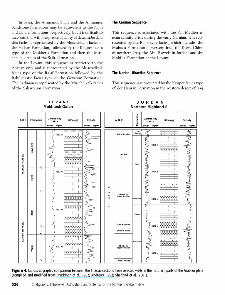
A regional lithostratigraphic correlation between
the different Triassic strata across the northern exten-
sions of the Arabian plate is shown in Figure 4.
SEQUENCE STRATIGRAPHY
The transgression that started the deposition of the
Khuff Formation (and its equivalent the Chia Zairi
Formation in the Mesopotamian basin) marked the
establishment of a shallow carbonate platform over all
the northern parts of Arabia that was bordered by a
clastic province (Sharland et al., 2001). The low sub-
sidence rates and the consequent low rates of develop-
ment of accommodation space eventually led to the
deposition of fairly clean limestones, but no deep-
marine shale, even in the northeastern parts of the
basin.
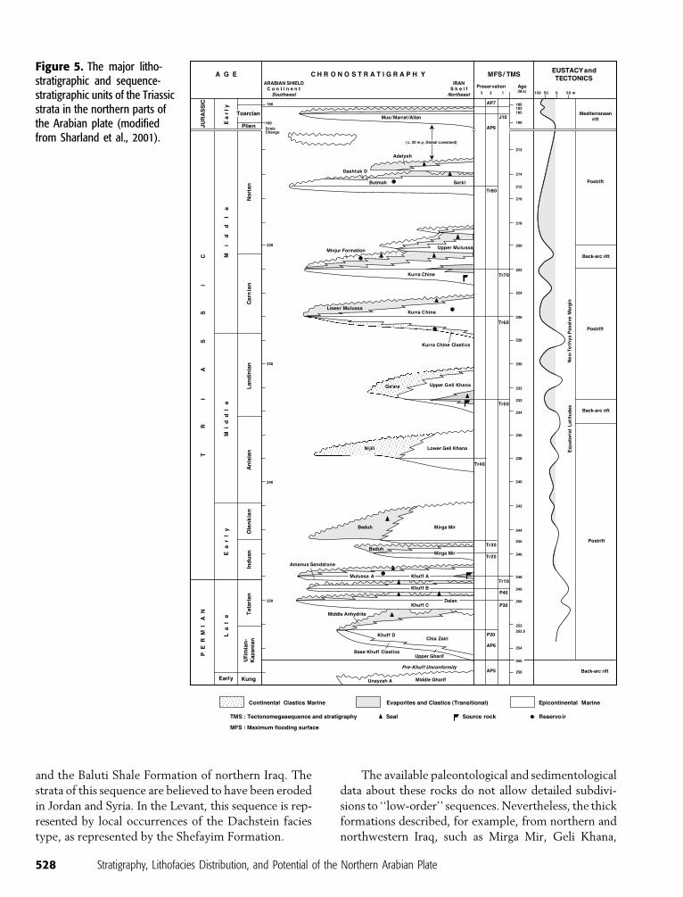
The Triassic strata of the northern extension of the
Arabian plate display a series of long-lived highstand
systems tract successions, beginning with the base of
the Khuff Formation (or its equivalent in the Mesopo-
tamian basin). The succession can be divided into at
least four depositional sequences (Sharland et al., 2001)
(Figure 5).
Some of these sequences represent a basal trans-
gressive systems tract in which carbonate and evaporite
strata were deposited (either Werfen or Muschelkalk
facies types) over continental or marine clastics (Bun-
ter, Keuper, or Raibl facies types) or regressive system
tracts where the stacking is reversed. There are differ-
ences in the various locales of the Arabian plate, and
some of these sequences may be missing. In other
locales, there may be more than four sequences. In
northern Iraq, as much as six maximum flooding sur-
faces may be recognized in the outcrops and the sub-
surface sections (Table 3). These surfaces, however, are
difficult to trace across the northern parts of the Ara-
bian plate because of the lack of enough paleontological
and sedimentological data. The following is a summary
of the main sequences that are found over most of the
northern extensions of the Arabian plate.
The Induan–Olenekian Sequence
The oldest Triassic unit in northern Iraq is the Mirga
Mir Formation (Werfen facies type) that rests con-
formably on the Permian Chia Zairi Formation. The
contact between the two formations is gradational with
a substantial upward increase in the marls and shales
from the massive Permian dolomites. The Mirga Mir is
overlain by the Beduh Shale Formation (Keuper-type
facies). It appears that the equivalent of this sequence is
missing in the western desert of Iraq.
In Jordan, this sequence begins with the Bunter-
type continental clastics of the Um Irna Formation (In-
duan) and Ammanus Sandstone Formation (Induan) of
Syria, followed by the mixed clastic-carbonate facies of
the Keuper type, represented by the Suwayma Forma-
tion (Olenkian), or the Werfen-type facies, represented
by the Humrat Maa’in Formation (Induan) in Jordan
and the Ammanus Shale Formation (Induan) in Syria.
In the Levant region, this sequence is represented by the
Werfen-type facies of the Yamin and Zafir formations.
The Anisian–Ladinian Sequence
In northern Iraq, this sequence is represented by the
Muschelkalk facies type of the Geli Khana Formation.
In the western desert of Iraq, this sequence begins with
the Keuper-type facies, represented by the Nijili For-
mation, followed by the continental clastic of the
Bunter-type facies, represented by the Ga’ara Forma-
tion. According to Bellen et al. (1959), the Ga’ara
Formation was nearly contemporaneous with the Geli
Khana, whereas the Nijili Formation is equivalent to
the basal beds of that formation.
Sadooni and Alsharhan 525
In Syria, the Ammanus Shale and the Ammanus
Sandstone formations may be equivalent to the Nijili
and Ga’ara formations, respectively, but it is difficult to
ascertain this with the present quality of data. In Jordan,
this facies is represented by the Muschelkalk facies of
the Hisban Formation, followed by the Keuper facies
type of the Mukheris Formation and then the Mus-
chelkalk facies of the Salit Formation.
In the Levant, this sequence is restricted to the
Anisian only and is represented by the Muschelkalk
facies type of the Ra’af Formation followed by the
Rabil-clastic facies type of the Gevanim Formation.
The Ladinian is represented by the Muschelkalk facies
of the Saharonim Formation.
The Carnian Sequence
This sequence is associated with the Pan-Mediterra-
nean salinity crisis during the early Carnian. It is rep-
resented by the Raibl-type facies, which includes the
Mulussa Formation of western Iraq, the Kurra Chine
of northern Iraq, the Abu Ruweis in Jordan, and the
Mohilla Formation of the Levant.
The Norian–Rhaetian Sequence
This sequence is represented by the Keuper facies type
of Zor Hauran Formation in the western desert of Iraq
Figure 4. Lithostratigraphic comparison between the Triassic sections from selected wells in the northern parts of the Arabian plate(compiled and modified from Druckman et al., 1982; Andrews, 1992; Sharland et al., 2001).
526 Stratigraphy, Lithofacies Distribution, and Potential of the Northern Arabian Plate
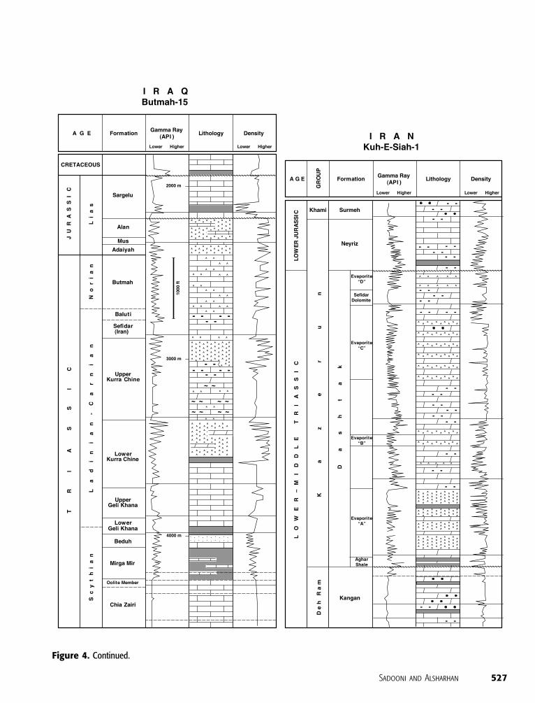
Figure 4. Continued.
Sadooni and Alsharhan 527
and the Baluti Shale Formation of northern Iraq. The
strata of this sequence are believed to have been eroded
in Jordan and Syria. In the Levant, this sequence is rep-
resented by local occurrences of the Dachstein facies
type, as represented by the Shefayim Formation.
The available paleontological and sedimentological
data about these rocks do not allow detailed subdivi-
sions to ‘‘low-order’’ sequences. Nevertheless, the thick
formations described, for example, from northern and
northwestern Iraq, such as Mirga Mir, Geli Khana,
Figure 5. The major litho-stratigraphic and sequence-stratigraphic units of the Triassicstrata in the northern parts ofthe Arabian plate (modifiedfrom Sharland et al., 2001).
528 Stratigraphy, Lithofacies Distribution, and Potential of the Northern Arabian Plate
Kurra Chine, and Mulussa formations, provide evi-
dence of interruptions in the sedimentation.
GEOLOGIC HISTORY
Early Triassic
The overall sedimentary sequence deposited on the
northern Arabian platform during the Early and Middle
Triassic is essentially a continuation of the sedimentary
cycle that began during the Late Permian. Sedimenta-
tion continued to be controlled by the Mardin, Khle-
issia, and Rutbah highs. The Rutbah and Khleissia highs
were still separated by the Euphrates–Anah trough
during the remaining part of the cycle. At times, in-
tervening areas between the Mardin and Khleissia highs
were also exposed. This ridge was subjected to erosion
and was fringed on its northeastern side by the large
Mesopotamian basin that extended from Turkey in the
northwest to central Iran in the southeast. To the west
of the Rutbah–Khleissia ridge, the Palmyra–Sinjar
trough was connected to the Mediterranean Tethys to
the west and continued to subside (Alsharhan and
Nairn, 1997).
The Lower Triassic depositional facies is charac-
terized by abundant clastics over most of the region
east of the Rutbah–Khleissia high, indicating an epi-
sode of regression in the Tethys, probably related to
uplift as the precursor of the initiation of the Neo-
Tethys rifts. This uplift is well documented in the cen-
tral part of the craton along the Rutbah–Khleissia high.
Fine-grained clastics, with carbonate-evaporite depos-
its of restricted shelf, lagoonal, and tidal-flat origin,
accumulated in a rather narrow northwest-southeast–
trending belt in eastern Iraq (Buday, 1980). These
shallow-marine shelf deposits can be traced into similar
shallow-marine carbonate and shale or mudstone shelf
facies in Iran (Figure 6).
Middle Triassic
Middle Triassic rocks conformably overlie Lower Tri-
assic beds and were deposited during a major marine
transgression, which interrupted the formerly domi-
nant clastic regime with carbonate sedimentation. The
Middle Triassic carbonate shelf deposits (east of the
Rutbah–Khleissia high) formed in very shallow-marine
conditions (Alsharhan and Nairn, 1997). A restricted
shelf of carbonates and evaporites with lagoons, tidal
flats, and sabkhas dominated the central part of the Ara-
bian platform and the Palmyra–Sinjar and Euphrates–
Anah troughs. The facies grade into variably textured
carbonates with some shales of shallow-marine to shelf-
margin origin in Iran, northern Iraq, southern Turkey,
and most of Syria and Jordan. Close to the western edge
of the Afro-Arabian massif, the Middle Triassic dep-
ositional facies is represented by continental sand-
stones intercalated with nearshore sandstones and shales
(Figure 7).
The Middle Triassic evaporites, with younger Tri-
assic evaporites, form an effective regional seal to major
gas accumulations in the underlying Permian carbonate
and Lower Triassic clastic reservoirs. In the Palmyra–
Sinjar and Euphrates–Anah troughs in Lebanon and
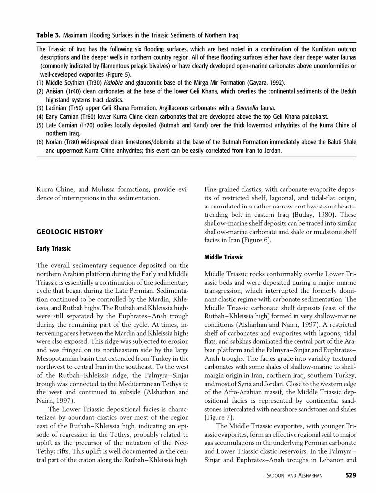
Table 3. Maximum Flooding Surfaces in the Triassic Sediments of Northern Iraq
The Triassic of Iraq has the following six flooding surfaces, which are best noted in a combination of the Kurdistan outcrop
descriptions and the deeper wells in northern country region. All of these flooding surfaces either have clear deeper water faunas
(commonly indicated by filamentous pelagic bivalves) or have clearly developed open-marine carbonates above unconformities or
well-developed evaporites (Figure 5).
(1) Middle Scythian (Tr30) Halobia and glauconitic base of the Mirga Mir Formation (Gayara, 1992).
(2) Anisian (Tr40) clean carbonates at the base of the lower Geli Khana, which overlies the continental sediments of the Beduh
highstand systems tract clastics.
(3) Ladinian (Tr50) upper Geli Khana Formation. Argillaceous carbonates with a Daonella fauna.
(4) Early Carnian (Tr60) lower Kurra Chine clean carbonates that are developed above the top Geli Khana paleokarst.
(5) Late Carnian (Tr70) oolites locally deposited (Butmah and Kand) over the thick lowermost anhydrites of the Kurra Chine of
northern Iraq.
(6) Norian (Tr80) widespread clean limestones/dolomite at the base of the Butmah Formation immediately above the Baluti Shale
and uppermost Kurra Chine anhydrites; this event can be easily correlated from Iran to Jordan.
Sadooni and Alsharhan 529
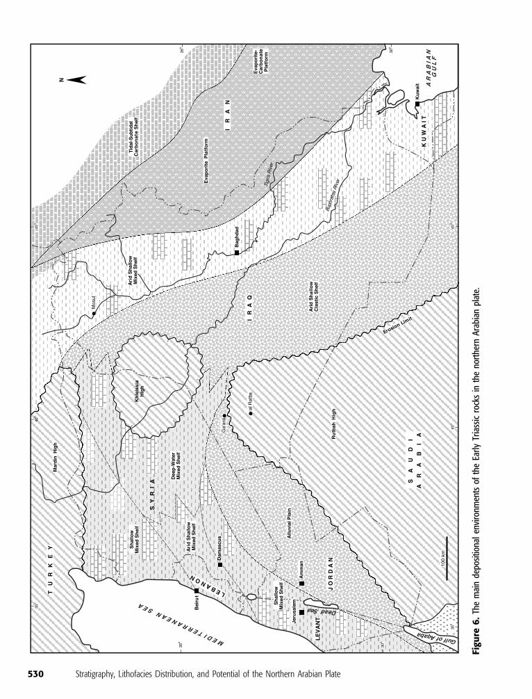
Figu
re6
.Th
em
ain
depo
sitio
nal
envi
ronm
ents
ofth
eEa
rly
Tria
ssic
rock
sin
the
nort
hern
Ara
bian
plat
e.
530 Stratigraphy, Lithofacies Distribution, and Potential of the Northern Arabian Plate
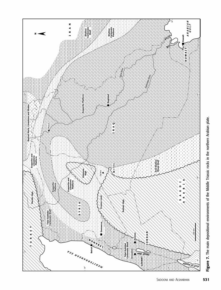
Figu
re7
.Th
em
ain
depo
sitio
nal
envi
ronm
ents
ofth
eM
iddl
eTr
iass
icro
cks
inth
eno
rthe
rnA
rabi
anpl
ate.
Sadooni and Alsharhan 531
Syria, the basal Triassic sequence includes shales de-
posited in the central parts of the troughs, which grade
into fluviatile and deltaic sands on the southern flanks
of the troughs. The basinal shales, with the shales in the
underlying Paleozoic section, could act as sources of
hydrocarbons for the reservoir sands deposited on the
southern margin of the troughs. The overlying Triassic
evaporites could act as an effective seal for such hydro-
carbon accumulations.
Late Triassic
Regional instability began during the Late Triassic and
ended the stable shelf conditions, which had persisted
on the northern Arabian platform throughout the
Paleozoic and into the Middle Triassic. This instability
(recorded by rapid lateral facies changes, volcanic
activity, and, in places, metamorphism) developed in
response to the opening of Neo-Thethys (Sharief,
1983). The western Taurus basin originated in the
Early–Middle Triassic, as indicated by the onset of
volcanism in the Bassit-Amanos areas of Turkey and in
Cyprus (Ponikarov et al., 1967). In the eastern Zagros,
basin development began in the Liassic (Furst, 1970).
Following the regional regression at the beginning
of the Late Triassic, a major marine transgression reached
far beyond the southern and southwestern limits of the
Early to Middle Triassic seas. The whole stable shelf
area of Iraq was flooded by the Tethyan Sea (Buday,
1980), with the shoreline extending into northern
Saudi Arabia, where continental to littoral clastic sed-
iments were deposited. The Rutbah–Khleissia ridge
system was also submerged by this transgression. Com-
pared with the areally reduced Early Triassic basins,
with their shaly sedimentation affected by a terrige-
nous supply, the Upper Triassic strata of Iraq are most-
ly calcareous and evaporitic in nature. The lack of a
terrigenous supply testifies to the remoteness of the
continental areas during the Late Triassic.
Continuous carbonate deposition in southeastern
Turkey started in the Late Triassic and continued until
the end of the Jurassic (Cordey, 1971). As much as
1000 m (3280 ft) of carbonates and evaporites were
deposited. Similarly, in western Syria and the Palmyr-
ides, a thick carbonate-anhydrite sequence (with some
salt) was deposited over the Lower to Middle Triassic
clastics and limestones of the Palmyra and Sinjar troughs.
Here, as in southeastern Turkey, the carbonate-evaporate
depositional sequence continued until the Late Jurassic
(Figure 8).
MAJOR TRIASSIC STRUCTURES
Several extension-related structures (for example,
basins and highs) began to develop in the platform re-
gions during the Middle and Late Triassic. We assume
that this extension was related to extensive rifting in
the Tethyan regions to the north, which began during
Ladinian–Norian times and continued intermittently
throughout the Mesozoic and Tertiary. These struc-
tures are important to hydrocarbon exploration be-
cause they resulted in abrupt changes in thicknesses
and facies over short distances in southeastern Turkey,
northern Syria, and Iraq.
The major basins or troughs on the Arabian plat-
form are the Palmyra and Sinjar zones of Syria and
northwestern Iraq, respectively. These two zones were
originally united, before being offset by northwest-
southeast–trending strike-slip faults. Therefore, these
troughs once formed an aulacogen connecting the Lev-
ant continental margin in the west to the main Tethyan
continental margin in the east. The Euphrates–Anah
trough formed at the same time as the Palmyra–Sinjar
aulacogen and is considered to be an arm of the Palmyra–
Sinjar aulacogen that passed to the south of the Khleissia
high.
Stratigraphic studies show that the Palmyra–Sinjar
and Euphrates–Anah troughs began to subside during
the Late Permian and Early–Late Triassic, respectively.
These troughs are not obviously fault controlled, but
are areas of broad downwarping. It seems more likely
that these areas of subsidence developed above blind
extension faults deeper in the section (in the Paleozoic
or the basement). Another area of marked subsidence is
the central Iraq basin (Lovelock, 1984). This structure
is bounded on the southwest by the Abu Jir zone and
on the northeast by the Makhul zone. It records al-
most continuous subsidence from the Triassic to the
present day.
The most important uplift is the Rutbah–Ga’ara
high, which is a northward projecting promontory of
the Arabian shield extending from northern Saudi
Arabia into southern Iraq. On this structural high, the
Precambrian basement is now covered by 4–6 km
(13,000–19,700 ft) of mainly lower Paleozoic clastic
strata (Lovelock, 1984). To the north is the Khleissia
high, which consists of a condensed Mesozoic and Ter-
tiary sequence and a thicker Paleozoic sequence overlying
the basement. Until the Jurassic, the Khleissia high
formed an integral part of the Rutbah high, but by the
Campanian–Maastrichtian, the two structures were
separated by the Anah trough. The Euphrates–Anah
532 Stratigraphy, Lithofacies Distribution, and Potential of the Northern Arabian Plate
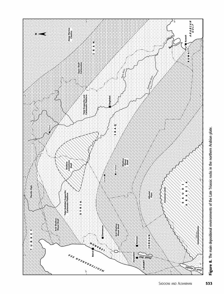
Figu
re8
.Th
em
ain
depo
sitio
nale
nvir
onm
ents
ofth
eLa
teTr
iass
icro
cks
inth
eno
rthe
rnA
rabi
anpl
ate.
Sadooni and Alsharhan 533
trough began to form much earlier in the early Late
Triassic.
TRIASSIC PLAY POTENTIAL
Source Rocks
Triassic source rocks are among the least studied strata
of the Middle East. The absence of thick marine shales
suggests a lack of potential source rocks to generate
commercial quantities of hydrocarbons. Metwalli et al.
(1972) studied the chemical characteristics of the crude
oil from Jebissa field in Syria (Figure 1) and found that
the Triassic oils have different characteristics from the
Cretaceous and Tertiary oils. May (1991) suggested
that the Triassic oil in the Syrian and Iraqi oil fields may
be sourced from the Middle to Lower Triassic and Per-
mian shales and limestones, or possibly from a distant
Jurassic source rocks. Beydoun (1988, 1993), however,
favored an indigenous oil source represented by the thin
interbedded shales in the Triassic carbonates. Grunau
(1983) and Sadooni (1995) agreed and suggested that
the Kurra Chine Formation contains both source and
reservoir rocks in northern Iraq.
Using fluid inclusions, Bilal (1988) has examined
the paleothermal history of the Triassic rocks of Syria.
He suggested that the thermal gradient in these strata
ranges between 5 and 7% and increases from the north-
northeast toward the west-southwest, the direction of
the tectonic and volcanic activities associated with the
Great Syrian rift, a northern extension of the great
African rift. The initial Permian clastic rocks deposited
in Syria are locally more than 500 m (1640 ft) thick in
the Sinjar–Palmyra trough. Much thinner accumula-
tions were deposited on the flanks of the trough. Some
minor oil-prone source rocks have been identified in
the clastic sequence, as well as sandstones of fair to good
reservoir characteristics.
The Kurrachine Formation consists of alternations
of limestones and dolomites, shales, and anhydrites,
which may contain local source rocks. The formation
may be at the beginning of thermal maturation on the
Aleppo plateau and in thermal or overmature zones
in areas of Jebbissa, Soukhne, and Souedie (Figure 1),
which are situated in the eastern part of Syria (Al-
Sakini, 1992).
In northern parts of Jordan, shales and argillaceous
limestones in the Triassic strata may represent poten-
tial indigenous source rocks. In the NH-1 well (Fig-
ure 1), these rocks contain a fairly high total organic
carbon, ranging between 0.5 and 1.9%, and hence,
they represent oil-prone source rocks. Mature and oil-
prone source rocks are expected at depths greater
than 1900 m (6200 ft) in the Risha area (Figure 1),
but they may be at shallower depths in the Northern
Highlands (Dungworth et al., unpublished report, cited
by Sadooni and Dalqamouni, 1998). Finally, the lower
part of the Abu Ruweis Formation (Carnian) contains
shale beds that represent fair to good source rocks
(Sadooni and Dalqamouni, 1998).
Reservoirs
The Triassic–Jurassic sequence of the northern Arabi-
an platform includes reservoir and cap-rock lithologies
and is considered the primary objective for future oil
exploration in eastern Syria and northwestern Iraq. The
lower Mulussa Formation and the Kurra Chine dolo-
mite in northwestern Iraq may be attractive reservoirs.
To be so, they should be overlain by the Triassic–Jurassic
evaporite sequence and are in communication with
Silurian source rocks at the time they were generat-
ing oil or in areas where, in response to overthrusting,
this reservoir overlies oil-rich Cretaceous source rocks
(Sadooni, 1995). The Triassic–Jurassic reservoirs also ap-
pear to reach a depth of burial in the Palmyra–Sinjar
and Euphrates–Anah troughs, which would have al-
lowed bordering oil-prone source rocks to source struc-
tures along the south flank of the troughs.
Toward the close of the Late Triassic (Rhaetian),
subsidence on the Arabian platform slowed, and the
influx of terrigenous clastics increased (Murris, 1980).
The climate became less arid, with restriction of arid
conditions to the northern part of the Mesopotamian
basin. The fluviatile and coastal sandstones belonging
to this period have good reservoir properties, but so
far, they are unproductive, probably a response to a
lack of access to adequate hydrocarbon sources. This
stage terminated with emergence after the Rhaetian.
The break is well marked over the stable shelf, with
removal of notable parts of the Upper Triassic se-
quence, mainly on the Rutbah and Khleissia highs.
Currently, the Triassic reservoirs of the Middle
East are not significant. They contain some 1% of
the total Iraqi proven oil reserve. Other countries do
not fare much better. The main Triassic reservoir
rocks are the dolomites, oolitic limestones, and sand-
stones in northern Iraq and Syria. The main accumula-
tions are within the Kurra Chine Formation in north-
ern Iraq, mainly in the Butmah, Sufaiya, and Alan oil
fields and in the fields of Souedie, Rumailan, Jebbissa,
534 Stratigraphy, Lithofacies Distribution, and Potential of the Northern Arabian Plate
and Tishreen in Syria (May, 1991; Sadooni, 1995). In
the Euphrates graben, oil was recovered during tests
from Triassic carbonates and clastics (Al-Sakini, 1992).
Although the Rutba sandstone is the most prolific
reservoir in the graben, other reservoir-quality rocks
have been documented in the Triassic and Carbonif-
erous (Litak et al., 1998). Some of these clastics may
belong to the Kurra Chine Formation, because Sadooni
(1995) reported that the lower part of the Kurra Chine
Formation becomes increasingly clastic toward the cen-
tral parts of Iraq. Minor oil accumulations and shows
were reported from different parts in Jordan and the
Levant region.
Exploration History
In the Middle East, Syria has the highest oil and gas
potential in Triassic rocks. Since the late 1960s, ex-
ploration of these reservoirs has commenced in several
fields that produce also from the Upper Cretaceous
massif limestone. In the Souedia field, which is a large
seismic dome, drilling of the well S-40 proved the ex-
istence of economic hydrocarbons in the Liassic But-
mah Formation and the Triassic Kurrachine Formation.
Both reservoirs were sealed by the anhydrite of the
Adaiyah Formation. The well produced 36j API oil
with sulfur content of 0.85% from the Liassic and 31.70jAPI oil with 0.9% sulfur content from the Triassic.
The well R-4 in the Rumailan field encountered
gas and condensate in the Triassic Kurrachine Forma-
tion (Dolaa Group) at around 2900 m (9500 ft). The
reservoir contains an important quantity of gas accom-
panied with the production of 2830 bbl/day of con-
densate. The total reserves in the Triassic are around
85 million tons. The Hamzah field is a small domal
structure, 9 km (6 mi) in diameter, situated between
Souedia and Karatchok. Oil has been found in the Tri-
assic at a depth of 3100 m (10,200 ft). Similar findings
were reported from other fields, such as Karatchok,
Jebbissa, and Tishreen, and the Euphrates graben, but
details are not available at this time (Wetzel, 1974).
In Iraq, with a total estimated reserve of 22.8 million
tons of oil and 6.6 � 109 m3 of gas, the Triassic strata
are still not important reservoir rocks. These figures,
however, depend on rudimentary data derived from a
few scattered wells. The Triassic sedimentary strata are
composed of more than 500 m (1640 ft) of porous and
fractured dolomite in most of the wells that penetrated
the Triassic succession in northwestern Iraq. They may
contain larger quantities of oil and gas than anticipated.
Furthermore, most of the drilled fields in that region
are structurally inverted, and there is a considerable
shift between surface and subsurface structures. There-
fore, many of the drilled wells were shifted and missed
the intended reservoir targets. There are, however, sev-
eral fields that produced significant amounts of oil and
gas during production tests. In Alan field, several for-
mation tests were carried out on the Kurra Chine For-
mation. In the well Alan-1, free oil was encountered at
the depth of 2569–2570 m (8428–8431 ft) and gas
shows at 2564 m (8412 ft). In Alan-2, a formation test
was carried out in the Kurra Chine at the depth of
2408–2466 m (7900–8090 ft), and the well produced
an average of 343 bbl/day of oil with a gravity of 29.6jAPI. At the depth of 2762–2799 m (9081–9183 ft),
gas and gas condensate were also recovered. After main-
tenance, the well produced an average of 6000 bbl/day.
The total calculated oil reserves in this field are around
12 million tons.
In Butmah field, gas-bearing zones were encountered
in the well Butmah-2 between 3198–3233 and 3253–
3255 m (10,491–10,607 and 10,672–10,679 ft), oil zone
between 3262 and 3278 m (10,701 and 10,754 ft), and
oil shows at 3266–3269 m (10,715–10,725 ft). The
average porosity of the Upper Triassic rocks in that well
is approximately 10%. Oil and gas shows were reported
also from the well Butmah-15. The average porosity in
that well is between 3 and 12%, and the total reserves are
7 million tons of oil and 5.5 � 109 m3 of gas.
In Ibrahim-1, a small amount of oil and gas was
reported from the dolomite rocks at the lower part of the
Kurra Chine Formation. Friable tar and dead oil were
found at the interval of 2756–2778 m (9041–9114 ft).
Gas and oil were noticed during coring on the fracture
planes of the dolomite interval of 3078–3165 m
(10,098–10,383 ft). Preliminary reservoir evaluation
suggested the presence of a total oil column of ap-
proximately 82 m (269 ft) in thickness containing 26jAPI oil. The total estimated oil in this field in the Upper
Triassic rocks is 3.7 million tons.
In the field of Sufaiya, the well Sf-1 produced on
test gas and condensate at the interval of 2884–2906 m
(9461–9534 ft) and oil and water at the interval of
2927–3045 m (9602–9990 ft). The estimated gas
reserve in this field is 1.1� 109 m3 gas. Furthermore, oil
and gas shows were reported from the wells of Atshan-1,
Kand-1, and Kifl-3, oil shows were reported from the
wells of Qalain-1 and Tel Hajar-1, and heavy oil shows
were reported from the well Mileh Tharthar-1.
In the Levant region, 18 wells were drilled down to
the Triassic rocks. No significant hydrocarbons were
found in any of these wells, although many of them had
Sadooni and Alsharhan 535

oil shows in the Triassic strata. Living oil shows were
noticed in the Saharonim and the Gevanim formations in
the Heimar well, and asphalt and heavy oil were found in
small quantities in the Gevanim Formation of Qanaim-3.
Furthermore, the entire Triassic sequences of the wells
Heimar-1, Lot-1, and Zohar-8 contain high amounts of
gaseous hydrocarbons (Druckman et al., 1975; Basha,
1981).
Recently, exploration efforts were directed to ex-
plore the offshore Ma’anit area, which is a buried plat-
form or barrier reef more than 2438 m (8000 ft) thick.
The reef is thought to be sealed by shales and anhydrites
of the Upper Triassic and Lower Jurassic. Other targets
include the Lower Jurassic Nirim Formation and the
Lower Triassic Ra’af Formation. Exploring Triassic reefs
is a significant departure from the conventional con-
ception about the Triassic rocks of the northern Ara-
bian plate, where these rocks are formed of clastics,
dolomites, and evaporites. Early estimations suggest the
presence of 2–2.5 tcf of gas plus 100 million bbl or more
of condensate or oil in only part of that concession. Four
more leads may contain similar or greater quantities of
condensate or oil.
In Jordan, no significant oil or gas shows were
reported from the Triassic sediments. However, good
clastic and carbonate reservoirs were encountered in
the areas of Risha and Northern Highlands. Porosity
values range between 15 and 25% and as much as 100
md of permeability. Some of these rocks were tested
in the well NH-2 and produced saline water.
In Iran, it appears that the Triassic reservoirs are
more gas prone than oil prone. Important gas reserves
have been discovered in these strata in the Surkhes oil
field on the Russian-Afghani borders. There are also
important gas deposits in the Kangan reservoirs (Lower
Triassic) in the Pars oil field of southwestern Iran (Al-
Sakini, 1992).
Future Potential
There is fair to good oil, gas, or condensate potential in
several parts of the northern extension of the Arabian
plate. In northwestern Iraq, the Triassic rocks along the
Syrian borders may contain considerable hydrocarbon
accumulations. A similar situation can be found along
the junction between Syria, Jordan, and Iraq. Sadooni
and Dalqamouni (1998) suggested that a Triassic play
might be found under the Hauran basalts in north-
eastern Jordan. The Triassic strata in the extension of
the Euphrates–Anah graben in Iraq may also represent
a high-potential petroleum system. Triassic coral-algal
buildups in the onshore northern areas of the Levant
are under investigation now to test the possible oc-
currence of several trillion cubic feet of gas and several
hundred million barrels of liquid (Oil & Gas Journal,
2002). Such buildups may be found also in Syria.
CONCLUSIONS
Compilation of the available data on the Triassic strata
of the northern parts of the Arabian plate from the
limited outcrops and subsurface sections enabled clas-
sifying them according to their environmental settings.
These settings were then compared with the German
Triassic system to facilitate regional correlation and
examine their hydrocarbon potentials. The major con-
clusions of this study are as follows.
1. Triassic strata of the northern extensions of the
Arabian plate mark the establishment of the Neo-
Tethys passive margin.
2. They consist of more than 2000 m (6500 ft) of rock,
divided among several depositional settings that are
comparable with the German Triassic rocks and have
evidence of the same eustatic sea level changes they
represent. They were deposited on a carbonate plat-
form surrounded by clastic-evaporitic lagoons and
continental clastic settings.
3. The climate during the Triassic varied between semi-
arid conditions, in which cyclic sabkha-capped facies
accumulated only on the inner platform, and an arid
phase with major evaporite drawdown, resulting in
extension of the inner platform cyclicity into intra-
shelf basin center evaporite cycles.
4. The succession may be divided into four high-
frequency sequences that were dominated by high-
stand systems tract carbonates and highstand systems
tract–lowstand systems tract evaporites and clastics.
5. A group of extension-related structures began to
develop in the platform regions during the Middle–
Late Triassic as a result of the extensive rifting. These
structures are important in terms of hydrocarbon
exploration, as they resulted in abrupt changes in
thickness and facies over short distances in south-
eastern Turkey, northern Syria, and Iraq.
6. The Triassic succession of the northern Arabian plat-
form includes reservoir and cap-rock lithologies and
is considered the primary objective of future hydro-
carbon exploration in eastern Syria and northwest-
ern Iraq. These include the Mulussa Formation and
the Kurra Chine dolomite in northwestern Iraq and
536 Stratigraphy, Lithofacies Distribution, and Potential of the Northern Arabian Plate
Syria, the Triassic strata in the Euphrates–Anah
graben in Syria and Iraq, and the Triassic buildups in
the northern parts of the Levant. The Kurrachine
Formation represents both source and reservoir rocks
and may be at the beginning of thermal maturation
at Aleppo plateau and in thermal or overmature zones
in areas of Jebbissa, Soukhne, and Souedie of Syria.
7. The Triassic strata produced light oil, gas, and con-
densates in several fields, such as the Souedia, Ru-
mailan, and Hamza in Syria and Alan and Sufaiya in
Iraq. High potential of gas and condensate may be
found in the northern parts of the Levant.
NOTE ABOUT NOMENCLATURE
We used the collective term Levant to encompass both
Israel and the Palestinian territories to avoid geographic
confusion related to the unresolved territorial pro-
blems of the region.
REFERENCES CITED
Aigner, T., and G. Bachmann, 1992, Sequence stratigraphic frame-work of the German Triassic: Sedimentary Geology, v. 80,p. 115–135.
Al-Ameri, T., 1990, Palynofloral evidence for Middle Triassic age,palaeoenvironments and sedimentary provenance of sedimentsin borehole 5/8, western Iraqi desert: Review of Palaeobotanyand Palynology, v. 65, p. 267–274.
Al-Sakini, J., 1992, Summary of the petroleum geology of Iraq andthe Middle East (in Arabic): Naft-Al-shamal Co., Iraq, 179 p.
Alsharhan, A. S., and C. G. St. C. Kendall, 1986, Precambrian toJurassic rocks of the Arabian Gulf and adjacent areas: Theirfacies, depositional setting and hydrocarbon habitat: AAPGBulletin, v. 70, p. 977–1002.
Alsharhan, A. S., and A. E. M. Nairn, 1997, Sedimentary basins andpetroleum geology of the Middle East: Amsterdam, Elsevier,843 p.
Andrews, I. J., 1992, Permian, Triassic and Jurassic lithostratigraphyin the subsurface of Jordan: Subsurface Geology Bulletin, v. 4,p. 15–38.
Aqrawi, A. A. M., 1998, Paleozoic stratigraphy and petroleumsystems of the western and southwestern deserts of Iraq: Geo-Arabia, v. 3, p. 229–248.
Bandel, K., and H. Khoury, 1981, Lithostratigraphy of the Triassicin Jordan: Facies, v. 4, p. 1–26.
Basha, S., 1981, Distribution of Triassic rocks in Jordan and Levant:Dirasat, Natural Sciences, The University of Jordan, v. 8, p. 49–67.
Bebeshev, I. I., Yu. M. Dzhalilov, L. A. Portnyagina, G. T. Yudin,A. Mualla, T. Zaza, and A. Jusef, 1988, The stratigraphy ofSyria: International Geology Review, v. 30, p. 1292–1301.
Bellen, R. C., H. V. Dunnington, R. Wetzel, and D. M. Morton,1959, Iraq: Lexique Stratigraphique International: CentreNational Recherche Scientifique, III, Asia, Fascicule 10a, Paris,333 p.
Beydoun, Z. R., 1988, The Middle East: Regional geology andpetroleum resources: United Kingdom, Scientific Press, 292 p.
Beydoun, Z. R., 1993, Evolution of the northeastern Arabia Platemargin and shelf: Hydrocarbon habitat and conceptual futurepotential: Revue de l’Institut Francais du Petrole, v. 48,p. 311–345.
Bilal, A., 1988, Paleothermal study of Triassic formation in Syriaby using fluid inclusion (abs.): AAPG Bulletin, v. 72, p. 988–989.
Buday, T., 1980, The regional geology of Iraq, stratigraphy andpaleontology: Baghdad, State Organization for Minerals, 445 p.
Cordey, W. G., 1971, Stratigraphy and sedimentation of theCretaceous Mardin Formation in southeastern Turkey, in A. S.Campbell, ed., Geology and history of Turkey: 13th AnnualField Conference of the Petroleum Exploration Society ofLibya, p. 317–348.
Ctyroky, P., 1973, Permian flora from the Ga’ara region (westernIraq): Neues Jahrbuch fur Geologie und Palaontologie, Monats-hefte, v. 7, p. 383–388.
Dixon, J. E., and A. H. F. Robertson, eds., 1984, The geologicalevolution of the eastern Mediterranean: Oxford, UnitedKingdom, Blackwell Scientific Publishers, 836 p.
Druckman, Y., 1974, The stratigraphy of the Triassic sequence insouthern Israel: Geological Survey of Israel Bulletin, v. 64,p. 5– 54.
Druckman, Y, G. Gvirtzman, and E. Kashai, 1975, Distribution andenvironments of deposition of Upper Triassic on the northernmargins of the Arabian shield and around the MediterraneanSea: Proceedings of the IX International Congress on Sedimen-tology, Nice, Theme 5, Tome 1, p. 183–192.
Druckman, Y., F. Hirsch, and T. Weissbrod, 1982, The Triassic ofthe southern margin of the Tethys in the Levant and its cor-relation across the Jordan Rift Valley: Geologische Rundschau,v. 71, p. 919–936.
Furst, M., 1970, Stratigraphic und wedegang der ostlichen Zag-rosketten (Iran) Erlanger: Geologische Abhandlungen Hessen,v. 80, p. 1–51.
Gayara, A. D., 1992, Permian–Triassic boundary in northern Iraq:Iraqi Geological Journal, v. 25, p. 103–112.
Grunau, H. R., 1983, Abundance of source rocks for oil and gasworldwide: Journal of Petroleum Geology, v. 6, p. 39–54.
Hirsch, F., 1992, Circum-Mediterranean Triassic eustatic cycles:Israel Journal of Earth Sciences, v. 40, p. 29–38.
Litak, R. K., M. Barazangi, G. Brew, T. Sawaf, A. Al-Imam, andW. Al-Youssef, 1998, Structure and evolution of the petroli-ferous Euphrates graben system, southeast Syria: AAPG Bul-letin, v. 82, p. 1173–1190.
Lovelock, P. E. R., 1984, A review of the tectonics of the north-ern Middle East region: Geologic Magazine, v. 121, p. 577–587.
Makhlouf, I. M., B. R. Turner, and A. M. Abed, 1991, Depositionalfacies and environments in the Permian Umm Irna FormationDead Sea area, Jordan: Sedimentary Geology, v. 73, p. 117–139.
May, P. R., 1991, The eastern Mediterranean Mesozoic basin: Evo-lution and oil habitat: AAPG Bulletin, v. 75, p. 1215–1232.
Metwalli, M. H., G. Philip, and M. Moussly, 1972, Oil geology,geochemical characteristics and the problem of source-reservoirrelations of the Jebissa crude oils, Syrian Arab Republic: 8thArab Petroleum Congress, Algiers, paper no. 66 (B-3), 20 p.
Murris, R. J., 1980, Middle East: Stratigraphic evolution and oilhabitat: AAPG Bulletin, v. 64, p. 597–618.
Oil & Gas Journal, 2002, Search for gas in Triassic reefs progressesin northern Israel, Middle East update: February 18, p. 66–68.
Ponikarov, V. P., V. G. Kazmin, I. A. Mikhailov, et al., 1967, The
Sadooni and Alsharhan 537
geology of Syria, Explanatory notes on the geological map ofSyria, scale 1:500,000, part 1, stratigraphy, igneous rocks andtectonics: Syria, Ministry of Industry, 229 p.
Read, J. F., and A. D. Horbury, 1993, Eustatic and tectonic controlson porosity evolution beneath sequence-bounding unconform-ities and parasequence disconformities on carbonate platforms,in A. D. Horbury and A. G. Robinson, eds., Diagenesis and basindevelopment: AAPG Studies in Geology 36, 155–198.
Sadooni, F. N., 1995, Petroleum prospects of the Upper Triassiccarbonates in northern Iraq: Journal of Petroleum Geology,v. 18, p. 171–190.
Sadooni, F. N., and A. Aqrawi, 2000, Cretaceous sequence stra-tigraphy and petroleum potential of the Mesopotamian basin,Iraq, in A. S. Alsharhan and B. Scot, eds., Middle East models ofJurassic/Cretaceous carbonate systems: SEPM Special Publica-tion 69, p. 315–334.
Sadooni, F., and A. Dalqamouni, 1998, Geology and petroleumprospects of the Upper Triassic sediments, Jordan: Journal ofMarine and Petroleum Geology, v. 15, p. 783–801.
Sharief, F. A. M., 1982, Lithofacies distribution of the Permian–Triassic rocks of the Middle East: Journal of Petroleum Geol-ogy, v. 5, p. 95–102.
Sharief, F. A. M., 1983, Permian and Triassic geological history andtectonics of the Middle East: Journal of Petroleum Geology,v. 6, p. 95–102.
Sharland, P. R., R. Archer, D. M. Casey, R. B. Davies, S. H. Hall,A. P. Heward, A. D. Horbury, and M. D. Simmons, 2001,Arabian plate sequence stratigraphy: GeoArabia Special Pub-lication 2, 369 p.
Shinaq, R., 1996, Subsurface Triassic sediments in Jordan: Strat-igraphic and depositional characteristics and hydrocarbon po-tential: Journal of Petroleum Geology, v. 19, p. 57–76.
Wetzel, R., 1974, Etapes de la prospection petroliere en Syrie et auLiban: Notes et Memoirs, Campagnie Francaise Petrole, v. 11,p. 40–70.
Zak, I., 1963, Remarks on the stratigraphy and tectonics of theTriassic of Makhtesh Ramon: Israel Journal of Earth Sciences,v. 12, p. 87–89.
538 Stratigraphy, Lithofacies Distribution, and Potential of the Northern Arabian Plate
Recommended