2004
Local Implementation Plan
2005
www.southwark.gov.uk
Transport
This plan is part of a package of documents that makes up Southwark Council’s transport strategy.
Southwark’s transport strategy is also known as te Local implementation Plan and sets out how the council will plan and deliver an integrated package of transport improvements from 2005-10.
The other documents that comprise the strategy include
• Road Safety Plan
• Walking Plan
• Cycle Plan
• School Travel Plan Strategy
• Parking and Enforcement Plan
The Borough Spending Plan is also related to these palns as it sets out bids for funding to implement transport improvements.
Contact Us
Transport groupRegeneration departmentSouthwark CouncilChiltern HousePortland StreetLondonSE17 2ES
www.southwark.gov.uk
Any enquiries relating to this Plan can be directed to the Transport Group on 020 7525 5317 or email: [email protected]
This plan is part of a package of documents that makes up Southwark Council’s transport strategy.
Southwark’s transport strategy is also known as the Local implementation Plan and sets out how the council will plan and deliver an integrated package of transport improvements from 2005-10.
The other documents that comprise the strategy include
• Road Safety Plan
• Walking Plan
• Cycling Plan
• School Travel Plan Strategy
• Parking and Enforcement Plan
The Borough Spending Plan is also related to these plans as it sets out bids for funding to implement transport improvements.
Contact Us
Transport groupRegeneration departmentSouthwark CouncilChiltern HousePortland StreetLondonSE17 2ES
www.southwark.gov.uk
Any enquiries relating to this Plan can be directed to the Transport Group on 020 7525 5317 or email: [email protected]
CONTENTS
1 INTRODUCTION.............................................................................................................1
2 CONTEXT & ISSUES .....................................................................................................4
3 POLICY CONTEXT AND PRIORITIES.........................................................................12
4 BEYOND 2010 ..............................................................................................................23
5 IMPROVING TRANSPORT IN SOUTHWARK..............................................................28
6 PARTNERSHIPS ........................................................................................................121
7 DELIVERING THE PLAN............................................................................................129
8 MONITORING OUR ACHIEVEMENT.........................................................................162
9 CONSULTATION ........................................................................................................183
10 EQUALITIES IMPACT ASSESSMENT.......................................................................187
11 ABBREVIATIONS .......................................................................................................209
1
1 INTRODUCTION 1.1 Setting the scene Southwark is an inner London borough that has undergone massive social, cultural and environmental change in recent years. It is now one of the most, vibrant, exciting and culturally diverse areas of London, although there are still severe inequalities between the most and least deprived parts of the borough and between various local communities.
The history of Southwark’s evolution, from its Roman beginnings to its current status as part of the heart of the modern metropolis of London, is almost as exciting as the potential for future change. New housing, improved business opportunities, better educational and social services and improved leisure facilities will bring about the economic and physical regeneration of the borough. Integral to this, and most importantly for this plan, is the need for improved transport infrastructure and services.
1.2 A vision for Southwark Southwark’s community strategy sets a vision for the borough that has been developed following consultation with local people and a wide range of partners. At its heart is the belief of making Southwark a better place to live, to learn, to work and to have fun.
The community strategy and the other strategies and plans that flow from it, are compatible with the Mayor of London’s vision to make London:
A city for people;
An accessible city;
A prosperous city;
A fair city;
A green city.
The emerging Unitary development plan (UDP) sets Southwark’s vision as a place where access to work, shops, leisure and other services for all members of the community is quick and convenient, and where public transport systems, the road network, footways and cycleways enable people to travel quickly, conveniently, safely and comfortably to and from their destination, causing minimum impact on local communities and the environment.
However, the Mayor’s Transport Strategy cannot provide detail about the specific needs of local communities or the challenges we face.
Accordingly, it is considered that the objectives that should guide transport improvements in Southwark, also need to closely consider the borough’s overarching policy document, the community strategy.
Stemming from its vision statement, the community strategy sets out five priorities:
Tackling poverty;
Making Southwark cleaner and greener;
Cutting crime and fear of crime;
Raising standards in our schools;
Improving the health of the borough.
2
The current community strategy 2003 to 2006 is currently being revised and the council has prepared a strategy to take us to 2016. This draft strategy will set the direction for the council for the next ten years and is currently undergoing consultation. The draft strategy seeks to build upon the 2003 community strategy and contains the following ambitions:
Improving individual life chances;
Making the borough a place for people;
Ensuring quality public services.
By considering the transport aims derived from the community strategy alongside national transport and regional policy, a set of ten overarching transport objectives for Southwark has been developed. The ten objectives are as follows:
Lip1. Improve accessibility throughout the borough;
Lip2. Promote more sustainable modes of travel and improve travel choice;
Lip3. Improve safety and personal security;
Lip4. Promote greater integration of land use development and transport;
Lip5. Improve the quality, efficiency and reliability of transport;
Lip6. Improve the efficiency, reliability and safety of freight distribution;
Lip7. Promote and improve social inclusion, economic development, education, employment and housing;
Lip8. Improve visual amenity and the quality of the environment;
Lip9. Reduce energy use;
Lip10. Work with partners to progress and promote transport improvements.
What is sustainable transport?
Sustainable transport includes modes of transport that minimal impact on the environment, this includes walking, cycling and public transport and in some circumstances car clubs and car sharing. These modes of transport while being less damaging to the environment contribute less to traffic congestion.
Walking and cycling also have added health benefits, while all these modes also have positive impacts in promoting social inclusion.
Alongside these ten transport objectives, Southwark also sees the importance to setting priority areas for their achievement and to reflect the local demand and need for improvement and as such Southwark sets the following priorities:
Provide access to sustainable transport for all;
Increase economic opportunity for all and promote social inclusion;
Improve safety on our roads;
Improve personal safety and security;
Improve the public realm;
Enhance integration of transport and land use.
These transport priority areas take into account the set priorities of the community strategy as a reflection of community expectations. The following table shows the relationship between the priority areas.
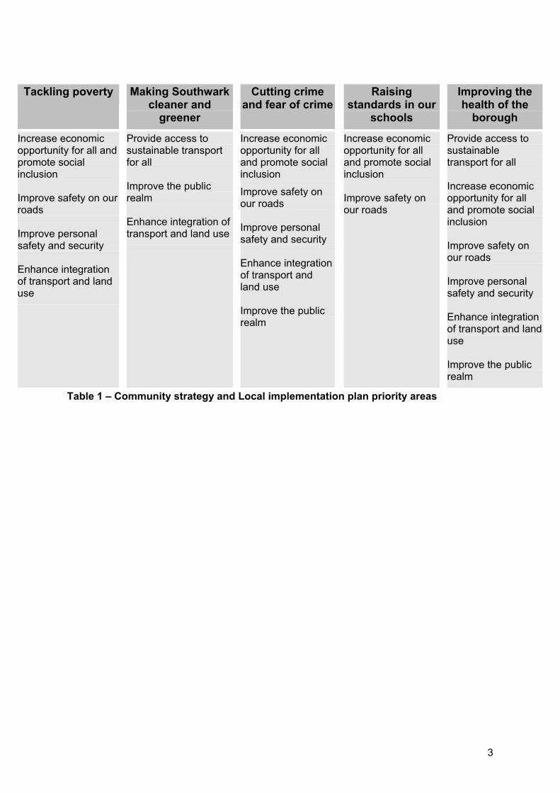
3
Table 1 – Community strategy and Local implementation plan priority areas
Tackling poverty Making Southwark cleaner and
greener
Cutting crime and fear of crime
Raisingstandards in our
schools
Improving the health of the
borough
Increase economic opportunity for all and promote social inclusion
Improve safety on our roads
Improve personal safety and security
Enhance integration of transport and land use
Provide access to sustainable transport for all
Improve the public realm
Enhance integration of transport and land use
Increase economic opportunity for all and promote social inclusion
Improve safety on our roads
Improve personal safety and security
Enhance integration of transport and land use
Improve the public realm
Increase economic opportunity for all and promote social inclusion
Improve safety on our roads
Provide access to sustainabletransport for all
Increase economic opportunity for all and promote social inclusion
Improve safety on our roads
Improve personal safety and security
Enhance integration of transport and land use
Improve the public realm
4
2 CONTEXT & ISSUES 2.1 Demographics Southwark is an inner London borough covering an area of approximately 2,876 hectares. The borough occupies a key position within London, bordered by the river Thames with the City and West End to the north.
With a population of approximately 244,866 (Office for National Statistics, ONS 2004), Southwark has the tenth fastest population growth of all London boroughs and is the eighth most densely populated local authority in the capital. With major new housing development and densification within its borders, it is anticipated that the borough will have a population of approximately 257,000 by 2011.
There is also a vast working population that adds to the number of people within the borough. The average daily working population in 2001 was estimated at approximately 141,914 jobs (Census 2001) that are, on average, highly skilled and amongst the highest paid in London. The Tate Modern alone attracted more than 5 million visitors in its first year, making it one of the most visited galleries in the world.
As illustrated in the following figure, Southwark’s population increase in recent years has mainly been in the younger working age groups (20 to 30 year olds), which currently comprise approximately 20% of the total population. The under 16 years also make up approximately 20% of the population, which is similar to the national average. By contrast however, the proportion of over 65 years has been declining and they currently comprise only 10% of all residents, which is less than the national average of about 16%.
Figure 1 – Southwark’s age profile
Southwark is an ethnically diverse borough, with some 37% of people identifying themselves as belonging to minority (non white) ethnic groups.1 Over 100 languages are spoken in Southwark schools and 43% of pupils speak English as an additional language. The African communities have been increasing as the largest ethnic minority in the borough, comprising approximately 16% of all residents, almost double the number of people with a Caribbean background. The south Asian and Chinese communities only make up about 5% of Southwark’s population, significantly less than the inner London average of 11%.
2.2 Socio economics 2.2.1 Education Despite the fact that 34.8% of Southwark residents have higher qualifications and that 12% are managers or senior professionals, education deprivation is high in Southwark and many of the young people in the borough are simply not qualified for the jobs that are available.
The 2003/04 (provisional) primary school attendance figure of 93.7% is above the inner London average and the (provisional) secondary school attendance figure of 91.7% is within 2% of the England average.
Educational attainment in Southwark is low but is improving. In 2003, 36% of pupils in Southwark schools achieved five or more A* to C grade GSCEs, compared to 29% in 1998, double the national increase during the same time.
2.2.2 Employment Of the working population (i.e. people aged 16 to 74 years) in Southwark, 56.1% are employed however, 6.2% are unemployed with the balance being full time students, already retired, looking after home and family, unable to work because of long term sickness or disability or economically inactive for some other reason. This is almost double the national average and means that the borough has the fourth highest unemployment rate in London.
1 Projected 2001, LRC 1999
5
There has been a large increase in the proportion of people employed by the property, renting and business service sectors and a large decrease in the proportion employed by the wholesale, retail and repair sector.
2.2.3 Housing The number of households has risen since the last Census from 104,684 in 1991 to 114,700 in 2001. However, owner occupancy of housing remains relatively low and is currently 31.4%. Of the remaining housing, the council owns almost 70% with the rest split between private landlords and housing associations. It is estimated that 61% of housing in the borough is purpose built, multi occupancy dwellings, including high rise blocks, medium rise slab blocks and mansion buildings2. This compares to the Greater London average for owner occupied and rented households of 56.5% and 26.2%, respectively.
At present a number of major regeneration programmes based within the borough are replacing traditional high density housing estates with lower density housing types. It is, therefore, expected that the housing split within the borough will change significantly over the coming years.
2.2.4 Crime The risk of criminal attack whilst travelling is a key issue affecting usage of different travel modes, especially for vulnerable sectors of the community such as women and the elderly. In terms of recorded offences, such as violence against the person, sexual offences, robbery, burglary of a dwelling, theft of a motor vehicle and theft from a motor vehicle, Southwark could be classified as having a high level of crime, in comparison to greater London and on a national basis.
Particularly problematic areas include violence against the person and sexual offences, where Southwark ranks as fourth highest in London in terms of offences per 1,0003, as shown in the following figure. As much crime occurs in the public domain and on our streets this is particularly relevant to the range of transport initiatives outlined in this plan.
Figure 2 – Southwark crime figures 2005 compared to the London average
Although the actual crime rate on public transport has declined in recent years, it is the perceived risk that has the most direct impact on people’s choices. The perceived rate may also be affected by experiences such as vandalism and graffiti, or the need to use poorly lit or lonely passageways, which may add to a sense of unease or vulnerability.
However, over the last four years Southwark has made good progress on improving perception of safety. This is measured by public opinion poll surveys of daytime and night time safety. In 2004, 85% of residents felt safe walking outside in the daytime (a small improvement on 2002) and 55% felt safe walking outside at night time (9% more than in 2002).
Crime has been identified as a major factor hindering the long term regeneration of the borough. Crime associated with transport forms part of this strategy and action to tackle the issues is being developed. Opportunities to contribute towards the community safety through the Local implementation plan (Lip) are therefore recognised and underpin many of the Lip’s objectives and targets.
Stress, anxiety and perceived danger Use of an increasingly congested and complicated road network can result in adverse mental and psychological effects including discomfort, fear and frustration. Research into driver
2 ONS, 2002 3 It should be noted that Census statistics in respect of crime are limited to notifiable offences recorded by the police. Although useful for some analysis, these figures do provide any information on another important consideration, fear of crime.
6
stress indicates that it leads to a direct fall in driving standards where drivers are more inclined to take risks and compromise safety.
Traffic volumes and composition also have an effect on perceived and actual danger within the community, especially amongst more vulnerable groups such as the elderly. As vehicle numbers increase, public perception of possible dangers heightens. As road traffic levels increase and people become more concerned about potential casualties and other dangers, more of them choose to travel by car if they are able to. This can result in a spiral of increasing traffic and concern over the dangers that have to be addressed.
Traffic can contribute to community severance, affect pedestrian journeys and have a visual impact that intrudes on the environment. Increases in vehicular speeds are also a cause for concern, especially for pedestrians and cyclists.
The Lip identifies numerous opportunities and measures to address these issues within Southwark. The overall objectives to reduce traffic levels, to provide and promote more sustainable travel and to develop safer and healthier transport will help to reduce transport related stress, anxiety and perceived danger.
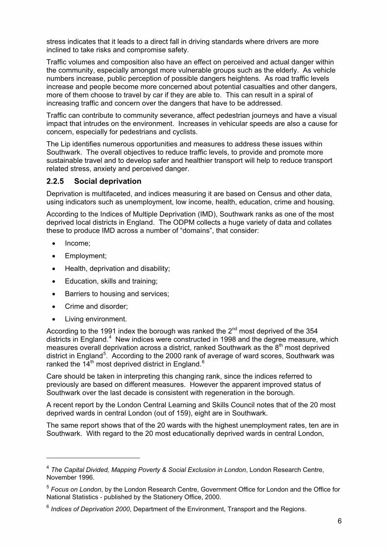
2.2.5 Social deprivation Deprivation is multifaceted, and indices measuring it are based on Census and other data, using indicators such as unemployment, low income, health, education, crime and housing.
According to the Indices of Multiple Deprivation (IMD), Southwark ranks as one of the most deprived local districts in England. The ODPM collects a huge variety of data and collates these to produce IMD across a number of “domains”, that consider:
Income;
Employment;
Health, deprivation and disability;
Education, skills and training;
Barriers to housing and services;
Crime and disorder;
Living environment.
According to the 1991 index the borough was ranked the 2nd most deprived of the 354 districts in England.4 New indices were constructed in 1998 and the degree measure, which measures overall deprivation across a district, ranked Southwark as the 8th most deprived district in England5. According to the 2000 rank of average of ward scores, Southwark was ranked the 14th most deprived district in England.6
Care should be taken in interpreting this changing rank, since the indices referred to previously are based on different measures. However the apparent improved status of Southwark over the last decade is consistent with regeneration in the borough.
A recent report by the London Central Learning and Skills Council notes that of the 20 most deprived wards in central London (out of 159), eight are in Southwark.
The same report shows that of the 20 wards with the highest unemployment rates, ten are in Southwark. With regard to the 20 most educationally deprived wards in central London,
4 The Capital Divided, Mapping Poverty & Social Exclusion in London, London Research Centre, November 1996. 5 Focus on London, by the London Research Centre, Government Office for London and the Office for National Statistics - published by the Stationery Office, 2000. 6 Indices of Deprivation 2000, Department of the Environment, Transport and the Regions.
7
Southwark has 14 wards. It should be noted that these wards relate to the ward boundaries prior to the May 2002 local government elections, for which data is readily available.
Further analysis of this information reveals that the core area of deprivation in the borough extends from the northwest corner to Camberwell, Peckham and Bermondsey.
Figure 3 - Southwark’s deprivation levels
2.3 Transport 2.3.1 Existing infrastructure Due to Southwark’s central London location the borough benefits from a wide range of transport infrastructure. However, the quantity and quality of this varies throughout the borough and the borough also suffers some of the disadvantages that its central position brings, such as heavy congestion, and the convergence of traffic seeking river crossings.
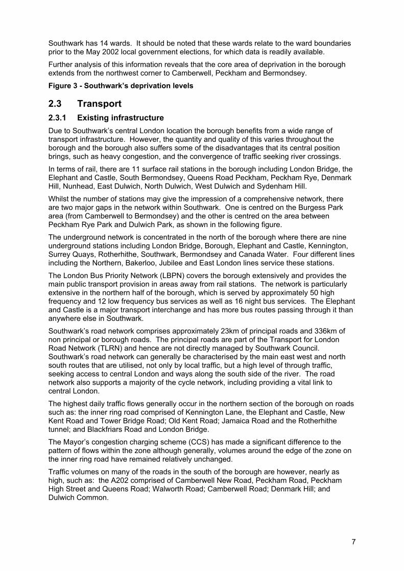
In terms of rail, there are 11 surface rail stations in the borough including London Bridge, the Elephant and Castle, South Bermondsey, Queens Road Peckham, Peckham Rye, Denmark Hill, Nunhead, East Dulwich, North Dulwich, West Dulwich and Sydenham Hill.
Whilst the number of stations may give the impression of a comprehensive network, there are two major gaps in the network within Southwark. One is centred on the Burgess Park area (from Camberwell to Bermondsey) and the other is centred on the area between Peckham Rye Park and Dulwich Park, as shown in the following figure.
The underground network is concentrated in the north of the borough where there are nine underground stations including London Bridge, Borough, Elephant and Castle, Kennington, Surrey Quays, Rotherhithe, Southwark, Bermondsey and Canada Water. Four different lines including the Northern, Bakerloo, Jubilee and East London lines service these stations.
The London Bus Priority Network (LBPN) covers the borough extensively and provides the main public transport provision in areas away from rail stations. The network is particularly extensive in the northern half of the borough, which is served by approximately 50 high frequency and 12 low frequency bus services as well as 16 night bus services. The Elephant and Castle is a major transport interchange and has more bus routes passing through it than anywhere else in Southwark.
Southwark’s road network comprises approximately 23km of principal roads and 336km of non principal or borough roads. The principal roads are part of the Transport for London Road Network (TLRN) and hence are not directly managed by Southwark Council. Southwark’s road network can generally be characterised by the main east west and north south routes that are utilised, not only by local traffic, but a high level of through traffic, seeking access to central London and ways along the south side of the river. The road network also supports a majority of the cycle network, including providing a vital link to central London.
The highest daily traffic flows generally occur in the northern section of the borough on roads such as: the inner ring road comprised of Kennington Lane, the Elephant and Castle, New Kent Road and Tower Bridge Road; Old Kent Road; Jamaica Road and the Rotherhithe tunnel; and Blackfriars Road and London Bridge.
The Mayor’s congestion charging scheme (CCS) has made a significant difference to the pattern of flows within the zone although generally, volumes around the edge of the zone on the inner ring road have remained relatively unchanged.
Traffic volumes on many of the roads in the south of the borough are however, nearly as high, such as: the A202 comprised of Camberwell New Road, Peckham Road, Peckham High Street and Queens Road; Walworth Road; Camberwell Road; Denmark Hill; and Dulwich Common.
8
Figure 4 – Major transport infrastructure
Due to its location adjacent to the river Thames, Southwark also contains various river crossings and piers. The main road crossings are Blackfriars Bridge, Southwark Bridge, London Bridge, Tower Bridge and the Rotherhithe Tunnel. In addition, there are two rail bridges, Blackfriars and Cannon Street, three tube tunnels (including the Brunel Tunnel) and the Millennium Bridge footbridge.
There are eight piers on the south bank of the Thames, within Southwark’s boundaries. These piers serve varying functions including public passenger transfer, private passenger trips and waste transport. Ownership and operation of the piers is shared between London River Services (LRS), the Port of London Authority (PLA), and various private interests. The PLA generally has responsibility for the safe operation of the piers and performs a regulatory function in terms of licensing operators. Only two piers are serviced by public passenger ferries run by LRS, these being Bankside Pier and London Bridge City Pier.
2.3.2 Travel patterns According to the 2001 Census data, 76.3% of Southwark’s actively employed residents commute to work by means other than a private motor vehicle, including 16.3% that either walk or cycle to work.
Table 2 – Travel to work by mode
Travel to work by mode England
2001Inner London
2001Southwark
1991Southwark
2001
% by rail/tube/tram 8.1 42.0 22.7 33.1
% by bus or coach 8.3 15.7 24.7 24.0
% by private car 67.2 23.5 29.3 23.7
% by bicycle 3.1 3.8 2.9 4.0
% on foot 11.0 12.0 12.9 12.3
Source: ONS Census Data 2001 and 2002
By contrast to the Census data, which only relates to the journey to work, the 2001 London Area Transport Study (LATS) indicated that up to 29% of all journeys in Southwark were carried out by private car, 35% were carried out by public transport and 36% by non motorised means. Transport for London (TfL) has predicted an overall growth in travel, both within the borough and from the wider regional area particularly the south east.
In terms of distance travelled, 16.3% of Southwark residents that work within the borough travel less than 2km to work. Indeed 46.4% of residents travel less than 5km to work and 75% travel less than 10km. This raises the question as to why so many residents (23.7%) choose to travel to work by private motor vehicle, when the distances travelled are eminently suitable for more sustainable modes such as walking, cycling or even public transport.
Figure 5 – Travel to work by mode
2.3.3 Car ownership According to the 2001 Census, of the 105,806 households in Southwark, 51.9% do not have access to a car, which is similar to the inner London average but considerably higher than the greater London average of 37.5%. Despite this, the number of cars in Southwark has been steadily increasing, from 38,029 vehicles in 1981 to 62,733 vehicles in 2001.
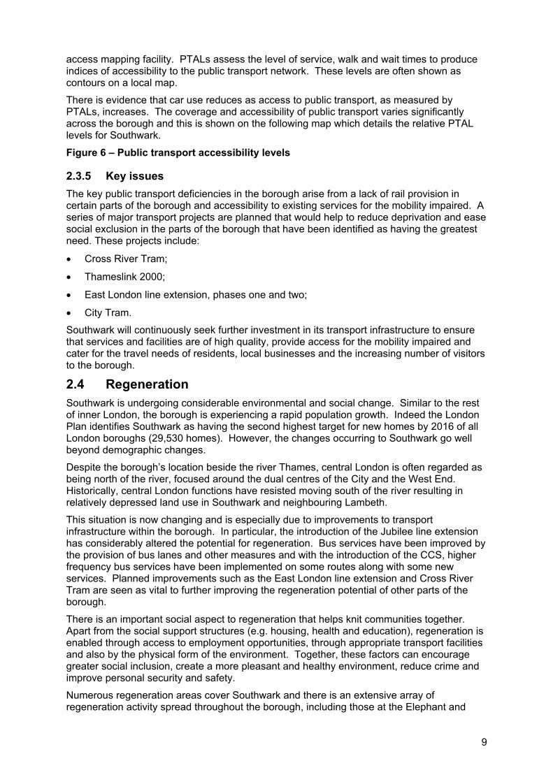
2.3.4 Public Transport Accessibility Levels Public Transport Accessibility Levels (PTALs) are a method of assessment utilised by TfL and a majority of London boroughs to produce a consistent Londonwide public transport
9
access mapping facility. PTALs assess the level of service, walk and wait times to produce indices of accessibility to the public transport network. These levels are often shown as contours on a local map.
There is evidence that car use reduces as access to public transport, as measured by PTALs, increases. The coverage and accessibility of public transport varies significantly across the borough and this is shown on the following map which details the relative PTAL levels for Southwark.
Figure 6 – Public transport accessibility levels
2.3.5 Key issues The key public transport deficiencies in the borough arise from a lack of rail provision in certain parts of the borough and accessibility to existing services for the mobility impaired. A series of major transport projects are planned that would help to reduce deprivation and ease social exclusion in the parts of the borough that have been identified as having the greatest need. These projects include:
Cross River Tram;
Thameslink 2000;
East London line extension, phases one and two;
City Tram.
Southwark will continuously seek further investment in its transport infrastructure to ensure that services and facilities are of high quality, provide access for the mobility impaired and cater for the travel needs of residents, local businesses and the increasing number of visitors to the borough.
2.4 Regeneration Southwark is undergoing considerable environmental and social change. Similar to the rest of inner London, the borough is experiencing a rapid population growth. Indeed the London Plan identifies Southwark as having the second highest target for new homes by 2016 of all London boroughs (29,530 homes). However, the changes occurring to Southwark go well beyond demographic changes.
Despite the borough’s location beside the river Thames, central London is often regarded as being north of the river, focused around the dual centres of the City and the West End. Historically, central London functions have resisted moving south of the river resulting in relatively depressed land use in Southwark and neighbouring Lambeth.
This situation is now changing and is especially due to improvements to transport infrastructure within the borough. In particular, the introduction of the Jubilee line extension has considerably altered the potential for regeneration. Bus services have been improved by the provision of bus lanes and other measures and with the introduction of the CCS, higher frequency bus services have been implemented on some routes along with some new services. Planned improvements such as the East London line extension and Cross River Tram are seen as vital to further improving the regeneration potential of other parts of the borough.
There is an important social aspect to regeneration that helps knit communities together. Apart from the social support structures (e.g. housing, health and education), regeneration is enabled through access to employment opportunities, through appropriate transport facilities and also by the physical form of the environment. Together, these factors can encourage greater social inclusion, create a more pleasant and healthy environment, reduce crime and improve personal security and safety.
Numerous regeneration areas cover Southwark and there is an extensive array of regeneration activity spread throughout the borough, including those at the Elephant and
10
Castle, London Bridge, Canada Water, Peckham, Bermondsey Spa and the Aylesbury Estate. The impact of these regeneration areas is discussed in greater detail in section 5.2.
2.5 EnvironmentSouthwark has a hugely varied physical environment, from the dense and historical riverside, through its central area of social housing as well as extensive Victorian and Georgian housing to the leafier areas in the south of which 20% of the borough is green open space.
The borough contains 130 parks and green spaces and is currently regenerating of several major parks including Bermondsey Spa, Peckham Rye Common and Paterson Park.
The council is striving to make everyone’s environment as attractive, safe and healthy as possible through programmes of regeneration, ‘greening’ and air quality improvements.
2.6 Health Lifestyle, genetic tendencies, together with deprivation levels and environmental factors, predispose Southwark residents to a greater than average burden of ill health.
Local health issues pertinent to the borough include:
High mortality from stroke;
High rates of teenage pregnancy;
Increased prevalence of diabetes;
High mental health section rates, particularly for younger black males.
Southwark maintains high fertility rates and the maternal age profile is unusual in its high proportion of births by older women (aged 35 and over) and teenage women (aged 16 to 19). We have one of the highest teenage pregnancy rates in the country, double the national average.
Over the past twenty to thirty years there has been an overall decrease in levels of physical activity in the population which has contributed to rising levels of obesity.7 There has actually been a slight increase in the proportion of people taking part in physical activity for leisure during this period but there has been a major decline in physical activity as part of daily routines i.e. work, travel and household chores. For example, the total miles travelled on foot and by bicycle for non-leisure journeys both fell by 26% 1975/6 -1999/2000.8 This suggests that there is substantial potential in promoting travel on foot or bicycle for non leisure journeys as well as cycling and walking for leisure.
An increasing health issue is the prevalence of obesity with half the British population being overweight and 20% are obese. In Southwark a conservative estimate for the future prevalence of obesity among children under 15 years old is that the proportion will triple from 12% in 2001 to over 36% in 20109.
Leading a sedentary lifestyle, being overweight or obese can increase your predisposition to illness, including type 2 diabetes. Current trends could mean that by 2015, it is estimated that there could be 8,000 more diabetes related deaths every year within the UK.
The 2001 Census asked people to describe their health, over the preceding 12 months as 'good', 'fairly good' or 'not good'. For all of Southwark, 8.6 % described themselves as in ‘not good health’, 2.1% in ‘fairly good’ health and 70.3% in ‘good’ health.
7 Department of Health (2004) At least five a week: Evidence on the impact of physical activity and its relationship to health A report from the Chief Medical Officer DoH: London8 Department of Transport (2001) National Travel Survey 1999- 2001 Update. DoT: London 9 Salimee, S & Ferguson, J (2004) ‘Epidemiology of obesity in Lambeth and Southwark’ Lambeth PCT
11
There are two main monetary benefits associated with health that are available to people needing help with personal care. They are the disability living allowance and the attendance allowance.
Within Southwark 7,625 people received the disability living allowance10 and 3,145 people received the attendance allowance11.
Therefore approximately 4.4% of the population receives either of these allowances and may have restricted mobility and accessibility to transport services.
It is estimated that around that around 20% of residents have significant minor depression or anxiety at any given time (compared with a national average of 12%) with mental health being a key issue in Southwark.
Residents of Southwark and neighbouring boroughs (Lambeth & Lewisham) experience higher rates of premature deaths (under age 75) and greater ill health from almost all causes compared to the averages for England and Wales. Life expectancy in Southwark is lower than the national average and the gap is widening.
2.6.1 Health and physical activity Increasing levels of physical activity in Southwark’s population can bring about benefits to mental and physical health. There is review level evidence for physical activity interventions which promote moderate intensity physical activity, particularly walking, and are not facility dependent being associated with longer term changes in behaviour.12
A systematic review to assess which interventions are effective in promoting a population shift from using cars towards walking and cycling found the best available evidence of effectiveness in promoting a modal shift is for targeted behaviour change programmes i.e. offering information and advice tailored to people’s particular requirements or offering an intervention only to a motivated subgroup of the population.13
10 Department for Work and Pensions, 2000 11 Department for Work and Pensions, 2000 12 Health Development Agency (2004) The effectiveness of public health interventions for increasing physical activity a review of reviews HDA: London 13 D. Ogilvie et al.(2004) Promoting walking and cycling as an alternative to using cars: systematic review BMJ
12
3 POLICY CONTEXT AND PRIORITIES This section sets out the national and regional policy framework for the Lip. It will also detail the borough policies and how this transport policy document links into the wider policy objectives of the council.
3.1 National & regional policy 3.1.1 Mayor’s Transport Strategy (July 2001) The sets out the policy framework for transport provision in London. It provides the context for the detailed plans and proposals of TfL and other implementation agencies over a ten year period.
The Mayor’s Transport Strategy seeks to increase the capacity, quality and integration of the transport system and endorses a coordinated approach to ‘improvements to transport integration and facilitating greater use of public transport, walking and cycling’.
The Mayor’s Transport Strategy contains ten transport objectives for the implementation of transport measures within London. From these ten objectives, the Mayor has established eight priority areas which include:
Improving road safety;
Improving bus journey times and reliability;
Relieving traffic congestion and improving journey time reliability including through the use of travel demand measures;
Improving the working of parking and loading arrangements to provide fair, reasonable, effective enforcement of regulations, recognising the needs of business for servicing and delivery as well as other road users, thus contributing to easing congestion and improving access to town centres and regeneration areas;
Improving accessibility and social inclusion on the transport network, with particular regard to safety and security for women and vulnerable users;
Encourage walking by improving the street environment, conditions for pedestrians and through the use of travel demand measures;
Encourage cycling by improving conditions for cyclists and through use of travel demand measures;
Bringing transport infrastructure into a state of good repair.
Southwark supports the Mayor’s objectives and priority areas for implementation but seeks to provide a local context to their implementation within the borough.
The Mayor’s Transport Strategy is the key government policy document in relation to transport provision within London. However, this was developed from a number of government agenda’s and supports a number of key government policy documents.
A New Deal for Transport: Better for Everyone (July 1998) In 1998, the government published its integrated transport White Paper, A New Deal for Transport: Better for Everyone. This paper represented a major shift in policy, moving the focus from private transport to public transport and was a cornerstone document in the governments sustainable transport agenda.
The plan sought to promote public transport by better integration within and between different types of transport, with the environment, with land use planning; and between government policies in relation to education, health and wealth creation.
13
The plan also sought to reduce congestion, improve towns and cities and encourage vitality and diversity locally, helping to reduce the need to travel and avoid the urban sprawl that has lengthened journeys and consumed precious countryside.
Transport 2010 (April 2001) In April 2001, Transport 2010: The ten year plan came into effect. This document also draws on the 1998 White Paper and sets out the proposals for the modernisation and reform of transport systems and provision in the UK. The Transport 2010 plan advocates the provision of:
An integrated response to the problems of congestion and pollution that detract from quality of life and future economic well being;
A significant increase in public and private partnerships;
The targeting of increasing resources across rail, road, and public transport to deliver real improvements which make transport more effective and attractive for everyone.
A number of improvements and programmes to transport systems across England are based on the investment package set out in the Paper (£180bn over 10 years).
The Future of Transport (July 2004) The Future of Transport White Paper supersedes the New Deal for Transport White Paper and sets out the government’s agenda for transport over the short to medium term and promotes numerous proposals for achieving these aims. This paper does not diverge from the policy direction set out in the New Deal for Transport (1998). It continues and builds upon the approach set out in the 1998 Paper and stresses the need to maximise the benefits of transport while minimising the negative impact on people and the environment.
However, this paper does identify how past land use planning decisions are contributing to the increasing trend of longer journeys through the policies that dispersed travel patterns, e.g. out of town developments. Better land use planning is identified as having a key role in reversing this trend.
London’s spatial development strategy (February 2004) The Mayor of London has produced a spatial development strategy, known as the London Plan. This document is the planning strategy for London and provides a regional context for the London boroughs to develop their local planning policies. This document will enable the boroughs to meet the priorities that are agreed for the whole of the London region.
The plan sets out an integrated social, economic and environmental framework for the future development of London, for the next 15 to 20 years. The document also identifies broad locations for change and provides a framework for land use management and development, which is strongly linked to improvements in infrastructure, particularly transport.
The strategic objectives for transport contained in the London Plan primarily relate to improving London’s accessibility. The five dimensions to the transport policies contained within the London Plan are as follows:
The integration of transport and spatial development;
Enhancing international, national and regional transport links;
Better public transport in London;
Reducing congestion and making better use of London’s streets;
Improving freight movements and the distribution of goods and services.
The London Plan identifies two major opportunity areas being London Bridge and the Elephant and Castle. The plan also identifies major transport schemes, namely the Cross River Tram, Thameslink and Orbirail (East London line extension) and that will significantly affect Southwark.
14
Choosing Health Choosing Health, the Public Health White Paper, emphasises the importance of increasing levels of physical activity in the population to improve health through promoting and facilitating active lifestyles.14 Some of the key action points raised in Delivering Choosing Health: Making Healthier Choices Easier in relation to walking and cycling are as follows:
Ensure school travel plans are in place;
Develop new cycle lanes;
Integrate rights of way and cycle networks in to local transport plans;
Develop scheme to promote health and wellbeing in larger workplaces;
Develop a comprehensive care pathway for obesity including prevention and treatment15.
The council is currently a member of the London health commission and works in partnership with the local primary care trust (PCT) to maximise health benefits to the community.
Road danger reduction charter The road danger reduction forum (RDRF) is a network of road safety professionals (road safety officers, traffic engineers, transport planners, public health doctors and others) who wish to develop a new approach to road safety, based on danger reduction at source. Since its inception in November 1993 some 40 local authorities have signed or supported the RDRF's Road Danger Reduction Charter.
The road danger reduction charter promoted by the RDRF is supported by Southwark and the council pledges:
Seek a genuine reduction in danger for all road users by identifying and controlling the principal sources of threat;
Find new measures to define the level of danger on our roads. These would more accurately monitor the use of and threat to benign modes;
Discourage the unnecessary use of private motor transport where alternative benign modes or public transport are equally or more viable;
Pursue a transport strategy for environmentally sustainable travel based on developing efficient, integrated public transport systems. This would recognise that current levels of motor traffic should not be increased;
Actively promote cycling and walking, which pose little threat to other road users, by taking positive and co-ordinated action to increase the safety and mobility of these benign modes;
Promote the adoption of this charter as the basis of both national and international transport policy.
3.2 Existing and proposed legislation The legislation detailed in the following section does not constitute an exhaustive list of all existing and relevant legislation. It does, however, highlight those that will have the most impact on transport provision and services.
3.2.1 Disability Discrimination Act 1995 The Disability Discrimination Act 1995 (DDA) seeks to ensure disabled people are not discriminated against when accessing employment, goods and services. The Act defines
14 Department of Health(2004) Choosing Health: making healthy choices easier15 Department of Health(2005) Delivering Choosing Health: making healthier choices easier
15
disability as any person who ‘has a physical or mental impairment which has a substantial and long term adverse effect upon a disabled person’s ability to carry out normal day to day activities’. In transport terms, this means a substantial and long term adverse effect upon a disabled person’s ability to gain access to or travel independently on transport systems.
The DDA sets out clear requirements for the provision of transport services and any barriers, be these physical or attitudinal, that must be removed to satisfy the requirement of this Act. The delivery of more effective and efficient accessible transport services for residents with a mobility need is paramount.
3.2.2 Race Relations Amendment Act 2000 The Race Relations Amendment Act 2000 (RRAA) requires all public bodies to examine how their policies, services and practices affect the local community across three overlapping areas of responsibility:
To eliminate discrimination;
To promote equality of opportunity;
To promote good race relations.
In May 2002, the council published a race equality scheme setting out how it would meet this duty from 2002 to 2005. The council has recently reviewed this scheme and adopted a new equality scheme (October 2005). This scheme sets new priorities for the council over the coming three years. These priorities have been informed by work done during the lifetime of the first scheme and by a review of all the councils services, functions, existing and new policies that will form the council’s business over the next three years.
3.2.3 Traffic Management Act 2004 The Traffic Management Act 2004 (TMA) proposes a network management duty on traffic authorities, which would require active and coordinated management of the road network consistent with wider local, regional and national policies and guidance.
The four cornerstones of the Act are outlined as follows:
Provide for the TfL to develop its role as a network manager, empowering TfL to recruit traffic officers to manage planned and unplanned incidents on the trunk road network;
Ensure a coordinated approach, the act will require local traffic authorities to have someone (the traffic manager) responsible for ensuring they meet a statutory duty to keep traffic flowing on their roads;
Provide a new regulatory regime for utility companies' street works, amending existing legislation to give highway authorities effective controls over those works;
Allow for more civil enforcement of parking and moving traffic offences.
3.2.4 Road Traffic Reduction (National Targets) Act 1998 The Road Traffic Reduction Act 1998 (RTRA) places a duty on the borough to assess current levels of local road traffic, forecast future growth in those levels and identify targets for reduction. Southwark Council as an inner London borough has adopted a target reduction of 25% by 2010.
16
3.3 Local policy 3.3.1 A community strategy for Southwark The community strategy sets out the council’s and its partner’s vision and priorities for the borough for 2003 to 2006. The vision set by this strategy is ‘the belief of making Southwark a better place to live, to learn, to work and have fun’ which was developed in consultation with the local community.
The strategy sets five priorities to improve life in Southwark, which are:
Tackling poverty;
Making Southwark cleaner and greener;
Cutting crime and fear of crime;
Raising standards in our schools;
Improving the health of the borough.
In order to deliver the strategy the following community values will underpin these priorities:
Equality and diversity, promoting equality for everyone, and responding to the needs of the many diverse communities;
Community involvement and cohesion, engaging with all sections of the community so that the vision is representative, reflects local need and encourages good community spirit and relations;
Investing in young people, targeting efforts on those who will provide for the future needs of Southwark;
Fairness, delivering priorities in a way that eliminates unfair disadvantages against any one person or group in Southwark;
Sustainability, ensuring actions today benefit future generations;
Quality, ensuring that quality rather than quantity drives the vision to continuously improve the borough;
Value for money, using scarce resources efficiently.
The objectives and policies of Southwark’s Lip are derived from the council’s vision and reflect the council’s community strategy.
3.3.2 Neighbourhood renewal strategy Southwark’s neighbourhood renewal strategy (NRS) sets out the main actions that will be taken to address poverty and social exclusion to improve quality of life within the most deprived neighbourhoods in Southwark.
The NRS identifies sixteen priority neighbourhoods determined by community boundaries, geography, levels of unemployment, income, health and well being, education levels achieved, crime and the IMD. These priority neighbourhoods, range from those with major regeneration schemes, like the Elephant and Castle and the Aylesbury Estate, to others where renewal is targeting particular service improvements related to crime reduction, educational achievement and better health.
The priority neighbourhoods are divided into three categories, depending on whether they are already part of any major regeneration programme, and on the level of deprivation. The groupings reflect what the next steps need to be to address deprivation within that neighbourhood and are detailed and shown in the following figure:
17
Neighbourhoods already within major regeneration and renewal programmes (areas 1c, 3a, 4a, 4d, 6a);
Neighbourhoods that are the most deprived in Southwark and not in existing major schemes. These will be targeted immediately for significant attention (areas 1b, 2b, 4b, 4c, 5a);
Neighbourhoods that are deprived, where some existing development is planned that will support renewal and where further attention may be needed in future years (areas 1a, 1d, 2a, 3b, 5b, 5c).
3.3.3 Crime and drugs strategy (2005) The crime and drugs strategy (2005 to 2008) follows on from the 2001 crime and disorder strategy as a key means of directing and coordinating the statutory agencies response to reduce crime levels and improve people’s perception of public safety.
The strategy supports the key themes from the previous strategy being preventing and reducing youth crime, tackling and reducing anti social behaviour, challenging and reducing hate crime, preventing and reducing the harm caused by drug and substance abuse and serious and violent crime. This strategy also introduces three additional work areas being tackling violent crime, improving support for victims and witnesses and alcohol related crime.
In 2005 the Safer Southwark Partnership (SSP) established a regular multi agency meeting, which includes the police, council with representatives from the community safety, and transport leads and the TfL community safety manager to look at borough level issues. At a sub regional level the director of environment and leisure and the director of regeneration represent Southwark on a range of issues including transport. Both directors are members of the SSP.
To date there has not been a formal consultation between the borough and the Greater London Authority (GLA), however Southwark is eager is keen to improve links with TfL and the GLA to provide a more coordinated approach to improving safety within the borough.
Much of the crime that is undertaken in Southwark takes place as specific hotspots, these locations include the Elephant and Castle, Peckham High Street, Camberwell and East Street/Walworth Road.
Figure 7 – Priority neighbourhood areas
3.3.4 Unitary development plan (July 1995) The UDP is a statutory plan, which sets out Southwark’s long term strategic goals for land use together with the planning policies and standards, that will be used to make decisions on planning applications.
The plan covers the whole of the borough and contains policies on a wide range of matters including, housing, the environment, transport, leisure and economic and community uses. The council’s UDP is currently being reviewed and updated to form a Local development framework (LDF) as part of the government’s agenda to implement a range of reforms to the UK planning system. The review is now reaching its final stages and the draft plan titled ‘The Southwark Plan’ contains three main objectives being, to:
Achieve sustainable development that meets the needs of people from all cultures and the economy whilst improving the environment;
Enable people to have meaningful opportunities to participate fully in important planning decisions that affect their quality of life, their ability to participate in wealth creation and the quality of their environment, and to remove barriers which hinder access to that process;
Improve people’s life chances by achieving the highest possible quality developments with the entire infrastructure required to meet people’s needs within Southwark.
18
The document follows on to detail policy statements of which the following relate specifically to transport:
Promote more sustainable transport choices for all members of the community in order to reduce congestion, pollution and increase ease in movement;
Reduce congestion and pollution within Southwark by minimising the need to travel, especially by car.
The council is currently preparing a Supplementary planning document relating to transport, to improve integration between land use and transport policies.
3.3.5 Air quality strategy and improvement plan (version two January 2002) Southwark’s air quality strategy and improvement plan (AQIP) describes the responsibilities and actions that need to be taken by the council in partnership with residents, businesses and visitors to improve air quality in Southwark.
A detailed analysis of air quality has been completed and the document seeks to estimate and mitigate the impact an integrated package of measures will have on air quality. It also considers whether these measures would be socially and politically acceptable as well as economically and technically feasible. It assesses what other impacts will be associated with the required action in terms of costs incurred and the need to accept possibly unpopular measures, as well as in terms of non air quality benefits that Southwark will enjoy as positive side effects of air quality improvement measures. This document is in the initial stages of review and it is anticipated that the revised document will be finalised following public consultation in early 2007.
3.3.6 Waste management strategy (2003) The waste management strategy sets out policies and aspirational targets with regard to the management of Southwark’s waste well into the future, for which provision will have to be made.
The strategy highlights the key challenges that face Southwark are:
Levels of recycling that are not keeping pace with changes in waste arising;
Unsustainable increase in waste arisings;
Limited landfill space for London authorities;
Rising costs of waste management services;
More value must be recovered from waste through recycling, composting or used in energy recovery scheme;
Pressure from the European Union (EU) and UK government to reduce reliance on landfill;
Ambitious recycling and recovery targets for London contained in Mayoral strategies (the London Plan and The Mayor’s Municipal Waste Management Strategy);
Statutory targets for recycling and treatment of waste beyond current levels; and
New legislation requiring increasing segregation of waste.
3.3.7 Obesity prevention and management strategy Healthy Southwark is developing a multi agency strategy for tackling the rising trend in obesity. The Southwark obesity prevention and management strategy will provide a comprehensive pathway of healthy eating and physical activity opportunities from perinatal care through to adulthood. This strategy will provide links to clear referral pathways into obesity management programmes, and will include detailed action plans which will be updated biannually.
19
3.3.8 Tourism strategy The council’s tourism strategy 2005 to 2010 recognises the importance of tourism to Southwark’s economy and Southwark place as an emerging tourism destination. The strategy seeks to guide development and promote tourism both within and to the borough that will bring benefits to all of the borough and its residents.
The strategy recognises the role of transport in promoting and facilitating tourism and alongside this plan seeks to improve transport provision within the borough.
3.3.9 Future council documents The council is currently preparing a number of documents that are linked to transport services. Transport should be carefully considered in the preparation of these documents.
Streetscape design guide The council is currently developing the streetscape design guide to enable those responsible for the public realm to create high quality streetscapes through the application of specific design principles and the use of preferred materials and products. It will be a key element in achieving our aim of having visually attractive, safe, and cared for streets that work well for all users and have a proper balance of functions.
The council intends to implement an innovative design strategy across the borough that sets out our priorities and provides coherent management that integrates and coordinates all the various functions involved in the street scene.
The adopted six indicators of quality for Southwark’s streets are:
Comfort and safety for pedestrians and the disabled;
Designed to accommodate all sorts of functions, not dominated by any one function;
Visually simple and free of clutter;
Well cared for and where utilities or extraneous’ advertising are subordinate to all other street functions;
Sympathetic to local character and activity context, in design and detail;
Ordered to provide appropriate access and deliveries and storage of vehicles.
The guide is anticipated to under go public consultation in the coming months with adoption of the document towards the end of 2006.
Older person strategy The strategy was developed in partnership with older people, the voluntary sector and statutory providers, such as the primary care trust, fire brigade and police, and focuses on making improvements in the following four key areas:
Actively enjoying life, a positive approach to ageing;
Independence and safety in the home and community;
Economic well being and opportunities in later years;
Health and care that older people need.
The plan aims to take a preventative approach to make changes to services and attitudes that will sustain good health and well being into later years.
The preventative model will be supported through actions taken under ‘actively enjoying life’, which will foster the positive contribution made by older people to the community through volunteering and active citizenship.
The plan has recently undergone public consultation and is currently being reviewed for finalisation in the coming months.
20
Southwark children and young people’s plan The council are currently preparing a children and young people’s plan, due to the completed in April 2006. It is a strategic plan covering all local services provided by Southwark Council and relevant partners that affect children and young people in the borough. The aim of the plan is to improve all aspects of the well being of all children and young people in Southwark. The plan covers three years 2006 to 2009. It will be reviewed and rolled forward annually as part of a cycle of continuous improvement.
This document refers to the importance of school travel plans, stating that all schools in Southwark should have a school travel plan in place to promote active journeys to and from school as milestone to reduce childhood obesity.
Biodiversity action plan The council are preparing the Southwark biodiversity action plan, committing the borough to conserve, enhance and promote biodiversity in the UK. The plan seeks to support and build on the Mayor’s biodiversity strategy.
The biodiversity action plan will act as a toolkit, outlining specific actions and guidance to officers, residents and key stakeholders on protecting, managing and promoting key wildlife habitats in Southwark. The plan will be implemented in May 2006, with additional actions being added later in 2006 and in 2007.
The Lip supports the biodiversity action plan and will promote and integrate the actions wherever possible. There are strong links in enhancing access to parks and green spaces, promoting walking through these areas and encouraging education in green spaces through walking school buses.
Policy under development Plans in the initial stages of preparation include:
Boulevard strategy;
Sport and physical activity strategy;
Liveability strategy;
Supplementary planning document, transport.
21
3.4 Southwark’s transport priority areas Southwark seeks to make the local environment a more pleasant place to live and work, encourage social inclusion and economic vitality and improve safety, personal security and the health of the local community. We want to ensure the road network, cycleways and pedestrian footways are kept in good order, which in turn will encourage more people to walk, cycle and use public transport in the borough by increasing their levels of safety and comfort.
From the community strategy and the consultation undertaken as part of its preparation, we have developed priority areas to help us focus on what needs to be done and meet the needs of the community.
The council has set six priority areas for improving transport within the borough which are detailed as follows, they also seek to address the Mayor’s five cross cutting goals. Further details on the cross cutting goals and how they are addressed in the document can be found in appendix F.
Provide access to sustainable transport for all
Southwark recognises that the growth of travel by private car is unsustainable and is keen to look at ways to restrain this growth. We have a diverse community who deserve to be able to access the public transport system and feel safe and secure when doing so. The level of accessibility for all residents is a high priority in order that they may access local services, jobs, social and recreational facilities. Increasing the level of accessibility to public transport is also essential in helping to reduce the relatively high level of unemployment in the borough.
Increase economic opportunity for all and promote social inclusion
Personal safety and security is a priority in Southwark due to the high levels of crime and fear of crime. Determining factors can include numerous areas of deprivation and the relatively high levels of unemployment in the borough. Southwark seeks to address these issues by focusing resources on improvements to the transport network that have a particular impact on these areas of concern.
Improve safety on our roads
Road safety is a major concern affecting everyone’s quality of life. Southwark residents should be able to walk or cycle to school, to work, to the shops or anywhere else in safety.
Improve personal safety and security
The real and perceived dangers within the public realm can keep children indoors, stop people taking up walking or cycling, restrict the movement of people with disabilities and encourage the use of cars with all the congestion, noise and pollution that comes with them.Alongside crime prevention measures, improving the streetscape by designing a safer and more pleasant environment for pedestrians both along existing streets and in regeneration areas will create a sense of community where people will feel more secure.
22
Improve the public realm
Southwark seeks to maintain the public realm including the road network, cycleways, pedestrian footways, parks and open spaces to a high standard. By making the local environment a more pleasant, safe and comfortable place to be, this will encourage more people to walk, cycle and use public transport in the borough.
Enhance integration of transport and land use
The borough is undergoing significant regeneration in the coming years, we must ensure that development is planned to reduce the need for travel and, when appropriate, contribute towards local transport needs. This integration of land use and transport must have a clear view that use of the private car is restrained in the future and measures to promote sustainable transport introduced.
23
4 BEYOND 2010 The Southwark landscape is in a state of change with much of the borough subject to both major transport projects and regeneration initiatives. Due to their complexity these projects have a long life and some of those detailed will extend beyond the life of this plan. It is therefore imperative that we consider not only the next five years but look beyond to consider the needs of current and future residents in our planning.
Southwark’s strategy for the regeneration of the borough as expressed in the emerging Southwark’s unitary development plan (UDP) promotes the growth of central London land uses including cultural and commercial developments in the north of the borough in the area often referred to as London South Central. This area contains two major growth points identified in the London Plan as opportunity areas, London Bridge and the Elephant and Castle. The economic regeneration of these areas should bring benefits that spread further into the borough to the areas for regeneration where the council is pursuing its neighbourhood renewal strategy. The key to this is improved public transport links.
Several of the regeneration projects currently being undertaken will extend beyond the life of this plan and how we provide for them will be crucial to their success. Several major transport projects both within the borough and outside will also aide the successful regeneration of key areas of the borough.
The most significant transport improvement within the borough is the introduction of the Cross River Tram and it is crucial to the regeneration of large parts of the borough where major growth in population is planned along its proposed route. The tram links the major regeneration areas of the Elephant and Castle, the Aylesbury Estate and Peckham. Peckham should also benefit from the East London line extension, which will also link it to the borough’s other main location for significant population growth, Canada Water.
The regeneration within the borough provides the opportunity for a major rethink of transport provision and allows us to be more aspirational in promoting sustainable transport from first principles rather than to retrofit to the existing streetscape. We also seek to combine major initiatives in the borough including transport, regeneration and public realm improvements as a means of promoting mode shift.
4.1 Public transport projects To improve public transport provision the Mayor has proposed several major public transport improvements. The projects that will bring most benefits to Southwark residents are the Cross River Tram, Thameslink 2000, East London line extension, Crossrail and City Tram.
The provision of these major transport projects will provide the opportunity to address the needs of Southwark residents, in particular those with low levels of public transport accessibility within deprived communities. The following figure shows the route of these major projects in relation to the levels of deprivation.
Figure 8 – Major projects and local levels of deprivation
Southwark Council also recognises the need for improvements to accessibility to public transport and seeks a station at Camberwell, and rezoning of Kennington and Bermondsey stations and the extension of both the Bakerloo and Victoria line services.
4.1.1 Cross River Tram The proposed Cross River Tram is intended to be a street running tram operating through the centre of London. The proposed core route is between Euston and Waterloo with branches to Camden & Kings Cross in the north and Brixton and Peckham in the south.
The tram is the most significant future transport improvement within the borough providing easy access to public transport in areas not only facing major regeneration but which are also currently bereft of public transport opportunities.
24
The Cross River Tram is currently within planning phases and may commence construction beyond the life of this plan. Regardless of this the council sees the implementation of this project as a key component of increased public transport usage within the borough, and the tram is discussed in detail in section 5.2.1.
4.1.2 Thameslink 2000 Thameslink 2000 is a scheme promoted by Network Rail and Transport for London and involves several major work sites in the borough:
London Bridge involving station reconstruction and rearrangement of track work between the through and terminating lines;
In the Borough Market area where a new viaduct is proposed;
At Blackfriars involving station reconstruction, extending new 12 car platforms over the Thames and a new station entrance on the South Bank;
South Bermondsey the construction of a grade separated junction,
Minor signalling works, track works and ancillary activities at various sites throughout the borough.
The previous public inquiry into the Thameslink proposals was held between June 2000 and May 2001. At that time Southwark’s position was to support the public transport improvement in principle but to oppose certain details of the proposals as they affected Borough Market and London Bridge station.
The inspector reporting on that public inquiry identified three deficiencies:
The design of London Bridge station;
The absence of proposals for the reinstatement of buildings to be demolished in the Borough High Street Conservation Area;
The absence of proposals for the ‘missing tooth’ at Blackfriars station.
Network Rail has submitted a revised scheme, which is currently being examined at a public inquiry. The design of London Bridge station has previously been revised and a new scheme has been approved. The issue to be considered now is whether the revised scheme deals adequately with the issue of replacing the listed buildings and other buildings in the conservation area.
It is Southwark’s position, confirmed by the Planning Committee on 8 February 2005, to support the scheme as a whole in principle and the conclusion of the previous public inquiry that the benefits of the scheme may outweigh the heritage issues if the right scheme is prepared. However, the scheme as currently presented has significant failings in the way that it treats the conservation issues around Borough Market and the council is opposing the proposals until these have been properly dealt with.
The council feels that the following issues are imperative to the design of the scheme and Network Rail (NR) and their partners should provide greater consideration of the following design elements:
The London Bridge area is a high demand pedestrian area and the detail design should meet all the needs of pedestrians to cross the roads and circulate within the area, including the station and traffic circulation on the roads, including the arrangements at the bus station;
There will obviously be some issues relating to traffic management during construction and these will need to be developed between the London Borough of Southwark, TfL and chosen contractors before construction starts.
Southwark places pedestrians at the top of our road user hierarchy and we would be keen to see their needs addressed as priority during the construction of the project.
25
4.1.3 Camberwell station A new station at Camberwell was originally featured in earlier versions of the Thameslink scheme until as late as the mid 1990s. The council views this as a missed opportunity to address the limited transport needs of Camberwell residents, particularly given the existing basic railway platform infrastructure at the proposed station.
The council sees the provision of a service to this area as a vital community asset. In view of the absence of a new station at Camberwell as part of Thameslink the council pursued this project as an Rail Passenger Partnership (RPP) with the support of several bodies including the train operating companies involved (Thameslink Trains and Connex), Network Rail, TfL, the London Development Association (LDA), South east London Transport Strategy (Seltrans), Cross River Partnership (CRP) and the London Borough of Lambeth.
It is envisaged that a station could be served by about eight trains per hour, including a new shuttle service operating between Herne Hill and Blackfriars. The bid was for any funding gap to cover the capital costs of the works and for revenue support to operate the shuttle service.
However, the transport needs of Camberwell residents remains and Network Rail should undertake further assessment in conjunction with Transport for London to consider the provision of a metro train service to Camberwell. Additionally consideration should be given to the extension of the Cross River Tram to Camberwell.
4.1.4 East London Line extension The section of the East London line under the Thames is one of the oldest deep tunnels on the underground system built by Brunel 150 years ago. In the late 1990s, the tunnel was closed for major repairs.
With the extensive redevelopment of all parts of Docklands it was realised that the existing line could be enhanced and extended to provide useful extra links into the area. Southwark has been an advocate for the extension of the East London line since the late 1980s and originally supported a southern extension that would link the existing service to Queens Road Peckham, Peckham Rye and then south through East Dulwich. The project is to be taken forward in two phases, as shown in the following figure.
The phase one scheme has impacted upon Southwark and extends northwards from Whitechapel to Shoreditch High St, Hoxton, Haggerston and Dalston Junction. Southwards the proposal is to extend from New Cross Gate to Brockley, Honor Oak Park, Forest Hill, Sydenham with a branch to Crystal Palace with the main route continuing to Penge West, Annerley, Norwood Junction and West Croydon.
The phase two scheme would involve extending the northern end to Canonbury and Highbury and Islington. Within Southwark and south of the Thames a new branch would be created from Surrey Quays under the South Bermondsey lines to a new station at Surrey Canal Road, then on to Queens Road Peckham, Peckham Rye, Denmark Hill, Clapham High St, Wandsworth Road and Clapham Junction as shown in the following figure.
The majority of both phases one and two use existing rail routes so the resulting new tube/metro line can be delivered for substantially lower cost than an equivalent new tube line.
Figure 9 – East London line extension
Detailed design works and early planning are now well under way and the tendering process for the main works on phase one are well advanced. Unfortunately no funding commitment has yet been made for phase two.
With the completion of phase one in 2011 it is intended that the existing train sets will be replaced with trains similar to those recently introduced on South East trains. The East London Line extension will enable access the Olympic venues and relieve passenger congestion during these events. Complementary measures such as improving footways, lighting and increasing safety on the journey to the station will be provided to encourage use of this line.
26
The service frequency will also be upgraded to five minutes headway or 12 trains per hour in each direction giving a capacity of about 7500 passengers per hour in each direction.
Phase two would add another four trains per hour between Clapham Junction and Highbury and Islington and although no funding for this phase has yet been identified, it is hoped that it will follow soon after phase one.
The council will continue to advocate for the extension of the East London line phase two and support a southern extension that would link the existing service to Queens Road Peckham, Peckham Rye and then south through East Dulwich and North Dulwich to Wimbeldon.
The East London Line extension will enable access the Olympic venues and relieve passenger congestion during these events. The borough should indicate in the final Lip how it plans to support the project, e.g. in ensuring footways are accessible.
4.1.5 Crossrail Crossrail, as presently proposed, will have a direct connection to the East London line at Whitechapel and link with north Kent lines at Abbey Wood. It also has a connection with Stratford which is, and will be even more, a major public transport hub in (north) east London.
With the East London line being developed southwards towards Crystal Palace and Croydon and also to Peckham and Brixton. The proposed connection at Whitechapel allows many south Londoners with limited accessibility relative to other areas of London, more opportunities to gain good access to the whole central London and north London tube network.
The connection at Abbey Wood will allow many residents in outer south east London and particularly the Thames Gateway area direct access to the Crossrail stations in central London and ready access to the whole tube network. This will also reduce the load on some of the busiest and most congested surface railway lines into London Bridge station and also potentially reduce the overcrowding on the Jubilee line.
Southwark with our regional partners Seltrans are concerned that certain commercial interests are proposing alternative solutions to Crossrail without these three critical connections. We would petition strongly against consideration of such alternatives that do not meet existing transport problems in south east London and could result in further delay to this long overdue rail scheme.
4.1.6 City Tram The City Tram is proposed to run from Battersea to Hackney through the Elephant and Castle, along Borough High Street to Shoreditch. This scheme would complement the Cross River Tram and provide an additional line to central London and relieve pressure on the Northern line within Southwark.
This project is in the initial stages of feasibility and Southwark supports the further development of the understanding of the tram.
4.1.7 Rezoning of underground stations In recent years, Southwark has seen many changes to transport provision in the borough. In 2003, the Mayor introduced his congestion charging zone to the borough.
Geographically both Bermondsey and Kennington station are located in close proximity to the City of London and there is a perception that if they were north of the river they would be included within zone one. They are in any case much closer to the core of London’s centre than some other stations in zone one.
With the increasingly urban density surrounding Bermondsey and Kennington stations there is an increasing drive for equality in fare charges. Whilst Kennington has been within zone two for over 20 years, this area of London has and is undergoing significant change. Southwark would urge the Mayor to consider rezoning both of these stations to zone one.
27
4.1.8 Extension of Victoria & Bakerloo lines The council seeks to look to the future and provide for the needs of the local community. The London footprint is expanding and we should be providing the transport services to meet this growing need.
Southwark will pursue the investigation and the feasibility of extending both the Victoria line to Herne Hill and the Bakerloo line to Camberwell.
28
5 IMPROVING TRANSPORT IN SOUTHWARK 5.1 Introduction This chapter details the specific transport issues and challenges in Southwark and sets out a series of actions that the borough proposes to take forward over the life of this plan. These actions will help to achieve the council’s vision as set out in the community strategy and the objectives as set out in the Mayor’s Transport Strategy .
Transport is multifaceted and there are many ways to outline specific issues and proposals. The historical way to discuss transport has been on a modal basis. Notwithstanding this, Southwark recognises that transport cannot always be considered in isolation and that a more holistic approach to delivering a ‘step change’ in our local communities is needed.
The first part of this chapter discusses some of the most pressing and important proposals in Southwark, the major transport infrastructure projects and the major regeneration projects. The approach being taken with the latter of these areas of work is the methodology that the council believes should ultimately be used in the future to deliver transport improvements.
The remainder of this chapter is primarily structured along the more traditional way of considering transport and is based on a road user hierarchy that favours more sustainable forms of transport. Accordingly, this chapter is structured as follows:
Major projects;
Road safety;
Accessibility;
Travel planning and awareness;
Air and noise quality;
Road user hierarchy;
Walking;
Cycling;
Public transport;
Powered two wheelers;
Motor vehicles;
Managing and maintaining the network;
Freight;
Partnerships.
29
5.2 Major projects
(a) Create a sustainable working and living environment through planned development linked with enhanced transport provision.
(b) Advocate for the delivery of new large scale public transport infrastructure.
(c) Improve accessibility to and from central London.
(d) Secure the vitality and vibrancy of local town centres by improving public transport accessibility.
(e) Improve the streetscape and promote social spaces.
Southwark has a unique opportunity over the coming five years to capitalise on large scale regeneration and transport infrastructure projects which will dramatically change the face of this area of London, south of the Thames. These key regeneration proposals offer a unique opportunity to illustrate how good urban design and excellent transport infrastructure can work together to maximise the benefits of sustainable developments. As a result of regeneration, local communities will benefit dramatically from improvements to their quality of life, bringing vitality and prosperity to the area and changing the environment in which they live enabling their communities to thrive.
Inextricably linked with the regeneration projects in Southwark are major public transport infrastructure proposals such as the Cross River Tram. The Cross River Tram is considered to be vital to providing public transport to an area currently bereft of public transport opportunities and as link to and through large regeneration areas of the borough. The tram will significantly relieve congestion on the road network, enabling bus and cycle priority lanes to be improved, to encourage modal shift. There will also be opportunities to increase the size, connectivity, function and appearance of pedestrian areas, improving the public realm.
The economic regeneration of opportunity areas, the Elephant and Castle and London Bridge, should bring benefits that spread further into the borough to the areas for regeneration. The regeneration of key areas of the borough including, Canada Water, Bermondsey Spa, the Aylesbury Estate and Peckham with sustainable transport initiative at the heart of their development will increase opportunities for walking, cycling and access to public transport.
The council also seeks to provide improvements to the public realm, as a key way of improving the social inclusion, promoting healthier lifestyles and a heightened sense of community. Several major projects have been undertaken in recent years and the council seeks to build upon this success with additional projects in the coming years.
Southwark Council sees these major projects as key to the delivery of its transport objectives and those priority areas in the Mayor’s Transport Strategy. As well as our own priorities of providing access to sustainable transport for all, increasing economic opportunity for all and promote social inclusion, improving personal safety and security, improving the public realm and enhancing the integration of transport and land use, the actions contained within this section will go towards achieving the following Lip objectives:
Lip1. Improve accessibility throughout the borough;
Lip2. Promote more sustainable modes of travel and improve travel choice;
Lip3. Improve safety and personal security;
Lip4. Promote greater integration of land use development and transport
Lip7. Promote and improve social inclusion, economic development, education, employment and housing;
Lip8. Improve visual amenity and the quality of the environment;
Lip10. Work with partners to progress and promote transport improvements.
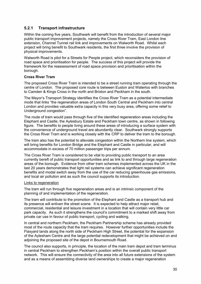
30
5.2.1 Transport infrastructure Within the coming five years, Southwark will benefit from the introduction of several major public transport improvement projects, namely the Cross River Tram, East London line extension, Channel Tunnel rail link and improvements on Walworth Road. Whilst each project will bring benefit to Southwark residents, the first three involve the provision of physical improvements.
Walworth Road is pilot for a Streets for People project, which reconsiders the provision of road space and prioritisation for people. The success of this project will provide the framework for the reassessment of road space provision and prioritisation within the borough.
Cross River Tram The proposed Cross River Tram is intended to be a street running tram operating through the centre of London. The proposed core route is between Euston and Waterloo with branches to Camden & Kings Cross in the north and Brixton and Peckham in the south.
The Mayor’s Transport Strategy identifies the Cross River Tram as a potential intermediate mode that links “the regeneration areas of London South Central and Peckham into central London and provides valuable extra capacity in this very busy area, offering some relief to Underground congestion”.
The route of tram would pass through five of the identified regeneration areas including the Elephant and Castle, the Aylesbury Estate and Peckham town centre, as shown in following figure. The benefits to people living around these areas of introducing a surface system with the convenience of underground travel are abundantly clear. Southwark strongly supports the Cross River Tram and is working closely with the CRP to deliver the tram to the borough.
The tram also has the potential to alleviate congestion within the Northern line system, which will bring benefits for London Bridge and the Elephant and Castle in particular, and will accommodate in excess of 70 million passenger trips per annum.
The Cross River Tram is considered to be vital to providing public transport to an area currently bereft of public transport opportunities and as link to and through large regeneration areas of the borough. Evidence from other tram schemes implemented across the UK in the last 20 years demonstrates that light rail systems can achieve significant regeneration benefits and modal switch away from the use of the car reducing greenhouse gas emissions, and local air pollution and as such the council supports its introduction.
Links to regeneration
The tram will run through five regeneration areas and is an intrinsic component of the planning of and implementation of the regeneration.
The tram will contribute to the promotion of the Elephant and Castle as a transport hub and its presence will enliven the street scene. It is expected to help attract major retail, commercial, residential and leisure investment in a location that will contain very little car park capacity. As such it strengthens the council’s commitment to a marked shift away from private car use in favour of public transport, cycling and walking.
In central and northern Peckham, the Peckham Partnership scheme has already provided most of the route capacity that the tram requires. However further opportunities include the Flaxyard lands along the north side of Peckham High Street, the potential for the expansion of the Aylesham Centre and the large potential redevelopment that might be achieved on and adjoining the proposed site of the depot in Bournemouth Road.
The council also supports, in principle, the location of the main tram depot and tram terminus in central Peckham to strengthen Peckham’s position within the overall public transport network. This will ensure the connectivity of the area into all future extensions of the system and as a means of assembling diverse land ownerships to create a major regeneration
31
opportunity in central Peckham. The council is currently preparing the Peckham area masterplan, which at its heart will consider the Cross River Tram.
Along the Southwark section of the route three consultation zones have been agreed, at the Elephant and Castle, Burgess Park and Peckham town centre. The route within these zones is yet to be determined and will be the subject of local consultation, ensuring that residents and businesses have an opportunity to influence the final choice of route.
Outstanding issues
Whilst recognising the benefits the tram brings to the borough and supporting its introduction, the council holds remaining concerns upon:
The impact upon Burgess Park;
The possibility of extending the alignment into Camberwell.
Burgess Park is classed as a metropolitan open space and a strategic park within Southwark and the council wishes to avoid any further fragmentation or loss of integrity of the park.
It is apparent that the most convenient route from a tram operating point of view is to cross the park from the southern end of Thurlow Street to the northern end of Chandler Way. This has raised the fear amongst some park users that the open space will be further severed and reduced in scale if a new crossing is introduced. Insufficient information has so far been available to assess how sensitively the crossing will be designed in terms of track layouts, safety features, power supply etc.
The council's view is that the severance impact of a tram crossing the park should be avoided by one of two means:
By the routing of the tram along Wells Way;
By the full closure of Wells Way as a public highway. This would achieve a long term ambition of pushing private cars onto the Old Kent Road and Camberwell Road and thereby reducing or alleviating rat running through a predominantly residential area. The resultant loss of local movement capacity would be offset by the public transport capacity of the tram and the total number of park crossings would not have increased.
If Wells Way can be closed, the overall severance effect of a direct tram crossing from Thurlow Street to Chandler Way would be substantially reduced. The council’s strong preference is for powers to introduce a full closure of Wells Way to be secured in advance of tram building and to be implemented at the point of commencement of the tram service. A partial or phased closure is not desirable and would be considered as a last resort only in the case of an insurmountable technical obstacle.
Southwark commissioned JMP Consultants to undertake a detailed traffic survey of routes and junctions surrounding Wells Way in order to assess the practicality of these options.
The study concluded that the closure of Wells Way is not an immediate practical proposition. However, the traffic management measures necessary to facilitate the introduction of the tram coupled with the proposed highway changes on Walworth Road, and at the Elephant and Castle would potentially create network conditions, which can accommodate its closure.
Whilst recognising and supporting TfL's desire to achieve a core north south alignment through central London the council wishes to see a route to Camberwell established at the earliest possible time. This would secure the capacity previously hoped for from the Thameslink proposals and in this respect would to some degree mirror the arrangements to the north of the alignment which serve both Camden Town and Kings Cross north.
Economic benefits
Over recent years, the Southwark association of street traders (SAST) has raised concerns about the decline in trading activity in East Street Market. Southwark Council is keen to progress improvements in the area as part of its drive to encourage local enterprise and prosperity in the borough. The market is a real asset to the area and provides an invaluable service to the local community.
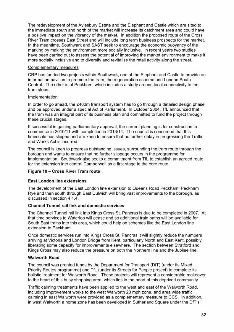
32
The redevelopment of the Aylesbury Estate and the Elephant and Castle which are sited to the immediate south and north of the market will increase its catchment area and could have a positive impact on the vibrancy of the market. In addition the proposed route of the Cross River Tram crosses East Street and will include long term business prospects for the market. In the meantime, Southwark and SAST seek to encourage the economic buoyancy of the marking by making the environment more socially inclusive. In recent years two studies have been carried out to assess the potential of improving the market environment to make it more socially inclusive and to diversify and revitalise the retail activity along the street.
Complementary measures
CRP has funded two projects within Southwark, one at the Elephant and Castle to provide an information pavilion to promote the tram, the regeneration scheme and London South Central. The other is at Peckham, which includes a study around local connectivity to the tram stops.
Implementation
In order to go ahead, the £400m transport system has to go through a detailed design phase and be approved under a special Act of Parliament. In October 2004, TfL announced that the tram was an integral part of its business plan and committed to fund the project through these crucial stages.
If successful in gaining parliamentary approval, the current planning is for construction to commence in 2010/11 with completion in 2013/14. The council is concerned that this timescale has slipped and are keen to ensure that no further delay in progressing the Traffic and Works Act is incurred.
The council is keen to progress outstanding issues, surrounding the tram route through the borough and wants to ensure that no further slippage occurs in the programme for implementation. Southwark also seeks a commitment from TfL to establish an agreed route for the extension into central Camberwell as a first stage to the core route.
Figure 10 – Cross River Tram route
East London line extensions The development of the East London line extension to Queens Road Peckham, Peckham Rye and then south through East Dulwich will bring vast improvements to the borough, as discussed in section 4.1.4.
Channel Tunnel rail link and domestic services The Channel Tunnel rail link into Kings Cross St. Pancras is due to be completed in 2007. At that time services to Waterloo will cease and so additional train paths will be available for South East trains into this area, which could help on schemes like the East London line extension to Peckham.
Once domestic services run into Kings Cross St. Pancras it will slightly reduce the numbers arriving at Victoria and London Bridge from Kent, particularly North and East Kent, possibly liberating some capacity for improvements elsewhere. The section between Stratford and Kings Cross may also reduce the pressure on both the Northern line and the Jubilee line.
Walworth Road The council was granted funds by the Department for Transport (DfT) (under its Mixed Priority Routes programme) and TfL (under its Streets for People project) to complete its holistic treatment for Walworth Road. These projects will represent a considerable makeover to the heart of this busy shopping area, which lies in the heart of this deprived community.
Traffic calming treatments have been applied to the west and east of the Walworth Road, including improvement works to the west Walworth 20 mph zone, and area wide traffic calming in east Walworth were provided as a complementary measure to CCS. In addition, in west Walworth a home zone has been developed in Sutherland Square under the DfT’s
33
home zone challenge and part of this area is the subject of a neighbourhood renewal scheme, as discussed in section 5.3.1.
The council is developing the Walworth Road scheme in partnership with a variety of organisations, including TfL’s street management, London buses and the Metropolitan Police (in terms of both crime reduction and road safety divisions).
The council has explored more interventionist options for this scheme than were originally envisaged, involving full or partial removal of bus lanes. The option that includes the partial removal of bus lanes has been agreed in principal by TfL and is now moving to the detail design stage with further public consultation planned.
However, the role of Walworth Road as a busy bus route is acknowledged and the approach being taken is to reallocate road space between users so as to improve conditions for all without reducing the efficiency of the bus operation in this sensitive corridor. The scheme includes significant road safety, pedestrian and streetscape improvements thereby assisting the promotion of the economic prospects for the area and the business community.
The project represents a high value and quality scheme within a highly deprived area. The streetscape improvements, particularly the provision of CCTV and improved lighting will promote safety and help to address the Mayor’s safer travel at night initiative. It will also set the standard for the regeneration providing a vital link between the regeneration of the Elephant and Castle and that of the Aylesbury Estate. This project will be well documented to help in the monitoring of road safety as well as the economic development of the road.
5.2.2 Regeneration projects Regeneration areas provide a comprehensive treatment of all the main problems within an area to bring about a significant change to people’s quality of life and their local environment. This allows us to design the street environment to reduce the dominance of the car by improving conditions for walking, cycling and making public transport more accessible. Streets are not just for transport but also places where people meet, shop, socialise and do many other things. Key regeneration areas within the borough are shown in the following figure.
The Elephant and Castle The London Plan identifies the Elephant and Castle as a key development area due to its excellent public transport accessibility, proximity to the Central Activities Zone (CAZ) and relatively affordable land. It has also been recognised as an opportunity area and a transport development area in the UDP. Being a key redevelopment site the 170 acre area will be subject to £1.5 billion regeneration project, including the proposed construction of 5,300 new and replacement homes and 75,000m2 of retail and office space.
Planning guidanceThe council’s planning guidance as detailed in Southwark’s UDP establishes Elephant and Castle as opportunity area and a transport development area. The council believes that a high density, high quality, mixed use town centre will address the need for new homes, an enhanced public transport interchange, employment and retail space. The opportunity to achieve these objectives in a sustainable way arises from the location’s high levels of public transport accessibility in conjunction with its recognised status as a southern gateway to London South Central. The London South Central area lies south of the river Thames between Vauxhall Bridge and Tower Bridge, including Vauxhall, Waterloo, London Bridge, Bankside and the Elephant and Castle and is identified in the London plan as a strategic regeneration opportunity area.
The supplementary planning guidance (SPG) adopted by the council in February 2004 also promotes an enhanced public transport interchange and addresses the government’s objectives in Planning Policy Guidance 13 to integrate planning and transport by:
Promoting more sustainable transport choices for people;
Promoting accessibility to jobs, shopping, leisure facilities and services by public transport, walking and cycling;

34
Reducing the need to travel, especially by car.
In order to achieve these objectives development must make the make full use of the public transport potential while at the same time reducing the need to travel. This will be encouraged through the availability of a wide range of shops, employment, services and amenities to which people will have access by a choice of means of transport, and day to day facilities are to be located so that they are easily accessible by walking and cycling.
Figure 11 - Regeneration areas
Existing conditionsThe Elephant and Castle is a central node in the south London road network facilitating both orbital movements around the inner ring road and radial movements to and from the centre of the capital. The inner ring road runs through the area via Kennington Lane, Newington Butts, Elephant and Castle and New Kent Road and then onto Bakers Arms. A number of TfL network routes and district distributors meet at the centre of the area. As a consequence traffic flows through the area are extremely high.
The 1960’s road system comprising two roundabouts with a broad central link between the two (Elephant and Castle road) was designed to deal with these high traffic flows generated by this confluence of strategic routes. The high traffic levels have resulted in higher than average noise and air pollution.
The existing road system has generally coped with the levels of traffic but this has been at the expense of pedestrians who are forced to use a system of subways, which have overtime become hostile and environmentally unpleasant locations where crime levels both real and perceived are high. This has prevented the area realising its economic potential and frustrated the development of an efficient public transport interchange, which can improve intermodal movement.
The area is highly accessible with a PTAL rating of over 6a to 6b. The area is served by two zone one underground stations (Northern and Bakerloo lines), an over ground station (Thameslink connections to the city) and around 35 bus services providing connections to all part of central London. Its high levels of accessibility make it an ideal location for employment uses and the provision of retail, leisure and other services to local residents.
The shopping centre is hemmed in by the busy gyratory system, which separates it from the surrounding area to which it is connected by means of a series of underpasses. The existing urban realm inhibits pedestrian movements and weakens the local economy. Currently connections between public transport modes are poor and difficult to navigate making interchanging tortuous and unattractive, thereby reducing the significance of the area. The existing pedestrian subway system is unattractive, creates opportunity for crime and increases the feeling of unease and danger.
The Elephant and Castle is the focal point of buses in the borough and there are significant amounts of interchanging between bus services. There is also multi modal interchanging between buses and the underground’s Northern and Bakerloo lines and the high level national rail station.
The existing deficiencies can only be addressed through significant investment. These conclusions have been supported by the findings of Transport for London’s own Interchange Plan (August 2002) which categorised interchanges in London according to their role in the capital’s transport network. The Elephant and Castle interchange was ranked highest in Category B other major central London interchanges. This indicates that in its category it has the highest priority for investment based on where the quality gap is greatest.
ProposalThe council's vision for the regeneration of the Elephant and Castle involves realigning Walworth Road to meet the northern roundabout. It is proposed that the existing retail centre will be demolished along with housing on a nearby council estate to create a new large scale
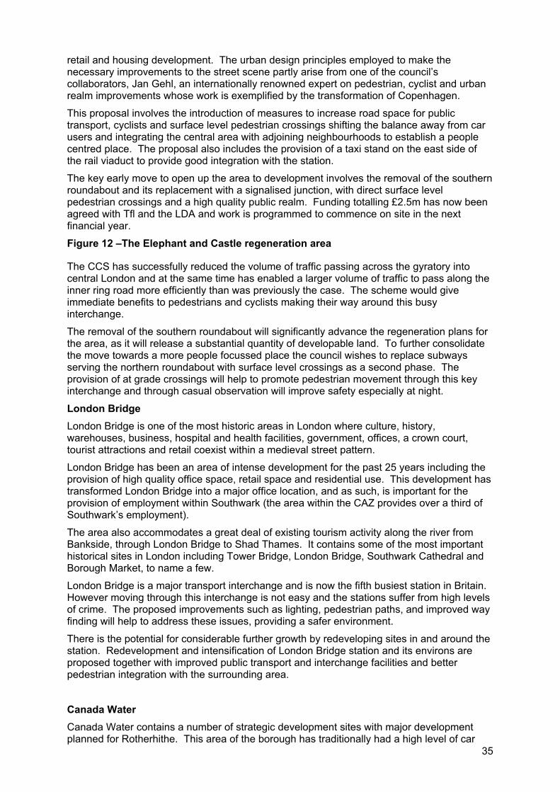
35
retail and housing development. The urban design principles employed to make the necessary improvements to the street scene partly arise from one of the council’s collaborators, Jan Gehl, an internationally renowned expert on pedestrian, cyclist and urban realm improvements whose work is exemplified by the transformation of Copenhagen.
This proposal involves the introduction of measures to increase road space for public transport, cyclists and surface level pedestrian crossings shifting the balance away from car users and integrating the central area with adjoining neighbourhoods to establish a people centred place. The proposal also includes the provision of a taxi stand on the east side of the rail viaduct to provide good integration with the station.
The key early move to open up the area to development involves the removal of the southern roundabout and its replacement with a signalised junction, with direct surface level pedestrian crossings and a high quality public realm. Funding totalling £2.5m has now been agreed with Tfl and the LDA and work is programmed to commence on site in the next financial year.
Figure 12 –The Elephant and Castle regeneration area
The CCS has successfully reduced the volume of traffic passing across the gyratory into central London and at the same time has enabled a larger volume of traffic to pass along the inner ring road more efficiently than was previously the case. The scheme would give immediate benefits to pedestrians and cyclists making their way around this busy interchange.
The removal of the southern roundabout will significantly advance the regeneration plans for the area, as it will release a substantial quantity of developable land. To further consolidate the move towards a more people focussed place the council wishes to replace subways serving the northern roundabout with surface level crossings as a second phase. The provision of at grade crossings will help to promote pedestrian movement through this key interchange and through casual observation will improve safety especially at night.
London Bridge London Bridge is one of the most historic areas in London where culture, history, warehouses, business, hospital and health facilities, government, offices, a crown court, tourist attractions and retail coexist within a medieval street pattern.
London Bridge has been an area of intense development for the past 25 years including the provision of high quality office space, retail space and residential use. This development has transformed London Bridge into a major office location, and as such, is important for the provision of employment within Southwark (the area within the CAZ provides over a third of Southwark’s employment).
The area also accommodates a great deal of existing tourism activity along the river from Bankside, through London Bridge to Shad Thames. It contains some of the most important historical sites in London including Tower Bridge, London Bridge, Southwark Cathedral and Borough Market, to name a few.
London Bridge is a major transport interchange and is now the fifth busiest station in Britain. However moving through this interchange is not easy and the stations suffer from high levels of crime. The proposed improvements such as lighting, pedestrian paths, and improved way finding will help to address these issues, providing a safer environment.
There is the potential for considerable further growth by redeveloping sites in and around the station. Redevelopment and intensification of London Bridge station and its environs are proposed together with improved public transport and interchange facilities and better pedestrian integration with the surrounding area.
Canada Water Canada Water contains a number of strategic development sites with major development planned for Rotherhithe. This area of the borough has traditionally had a high level of car
36
ownership and the redevelopment will help to provide improvements to the accessibility of sustainable modes of transport including cycling and walking.
The masterplan development area is approximately 16.7 hectares and includes the sites of the Surrey Quays shopping centre, the Decathlon store, Canada Water underground and bus station, Canada Water dock, and vacant sites at Deal Porters Way and Surrey Quays Road/Needleman Street.
The site is located close to Canada Water and Surrey Quays stations with good access to the Jubilee and East London lines. Canada Water incorporates a bus station/interchange with routes connecting to both central and south east London.
The development in the masterplan area totals almost 250,000 square metres of residential, commercial and community floor space, and will include:
A new public library and community resource centre, including a proposed police shop and community health network centre;
A leisure centre to serve the local population as well as visitors from across London;
Approximately 2,800 new residential units in a mix of styles and tenures, including a significant allocation of affordable accommodation and housing suitable for larger families;
More than 100,000 square feet of new shops and cafes;
100,000 square feet of new office, business start up and live work space;
Substantial dedicated car parking spaces to serve the new shops, homes and offices;
New pedestrian links, cycleways and road network improvements and enhanced ecological habitat for the diversity of wildlife that make Canada Water home.
One of the key objectives of the Canada Water masterplan is to improve permeability through some of the large sites and improve pedestrian linkages between development sites to encourage walking and cycling throughout Rotherhithe. The proposed routes have been determined in response to consultation with residents and in response to pedestrian desire lines.
With the development the council, in conjunction with relevant partners, will commission a multi modal transport study for the peninsula. This study would investigate possible improvements to existing transport infrastructure and seek opportunities for the provision of additional public transport facilities, alongside the development. This study is anticipated to be completed by March 2007 and will be used as a guide to future improvements within the Rotherhithe area.
Bermondsey Spa Bermondsey Spa is characterised by a predominance of local authority housing. Additional uses include small areas of private housing, vacant industrial properties, industry, educational facilities, offices, local shops and a variety of community facilities.
The regeneration area covers 50 acres and the plan is to deliver around 2,000 new homes (a quarter of which will be affordable), 16 GP surgery places, a dental practice, new youth facilities, 6.5 acres of relandscaped open space, over four car club spaces, 108 secure bicycle parking spaces, new council offices and a one stop shop as well as new shops including a food retail stores.
The regeneration of Bermondsey Spa is well underway and has been supplemented by a series of complementary measures to CCS, which the council undertook in 2002/03.
In order to add value to the proposals currently being progressed, the council wishes to implement a series of home zones within or in the vicinity of the regeneration area. Some funding has already been set aside for the development of traffic management areas with a basic level of home zone design however, match funding is required to develop full home
37
zones that will contribute significantly to achievement of sustainable development in this area.
The Aylesbury EstateThe Aylesbury Estate is situated just south of the Elephant and Castle in the Walworth district. This is an area of social need, is immediately adjacent to the opportunity area and is identified for complementary growth, redevelopment and densification, as it benefits from improved transport connectively to the Elephant and Castle opportunity area.
The estate, which comprises 2,759 dwellings and a population 7,500, occupies an area of 28.5 hectares. The area will be rebuilt beginning with phased demolition of the existing estate and its replacement with a new mixed tenure development comprising of around 2,200 social housing units and approximately 2,700 homes for sale or shared ownership.
A reconfigured and redeveloped Aylesbury Estate would enjoy major complementary benefits from that development ranging from housing/decant opportunities to improved transport access to retail, leisure and employment opportunities. In return the Walworth Road retail area would enjoy a considerable uplift from a new mixed tenure community on its doorstep.
Southwark will develop a masterplan for the regeneration of the Aylesbury Estate, this would also consider and incorporate the Cross River Tram and provide complementary measures and key access corridors to the service.
The Aylesbury Estate is a 1960’s housing estate with multiple raised walkways. These walkways sever communities and create poor environments. They also create hiding locations and have proven difficult for police to carry out enforcement. Therefore the regeneration of this estate and the removal of these elevated walkways will improve safety for these local communities and promote safer travel within this area, particularly at night.
38
5.2.3 Public realm Southwark Council values public realm and recognises the numerous benefits that it brings to social inclusion and enhancing the strengths of local community. Improvements to public space are beneficial to all residents and promote healthier living by encouraging walking and recreation and an improved sense of community. They also have the added benefit of improving safety and reducing fear of crime, particularly at night when many retail facilities are closed.
In recent years a number of regional public realm improvements have been commenced including Peckham Town Square and Bankside improvement works. Southwark has also undertaken a programme of improving our parks and town centres, such as Peckham Town Square.
Improving our town centres Southwark seeks for all town centres within the borough to be vibrant, attractive, interesting places where people of all ages happily interact with good transport access. These centres should also be economically viable and meet the demands for delivery and parking, including cycle parking.
PeckhamThe Peckham area is subject to major regeneration, with the first phase of this regeneration being the largest single regeneration budget rehousing project in Britain focusing on the north Peckham estates.
A new town square is being established around the award winning Peckham Library and Peckham Pulse with this space an integral part of the regeneration area as a whole, and is a key destination as a cultural hub. With the proposed Cross River Tram opening up transport opportunities in Peckham, the town square will be the geographical and cultural centre of the area.
Peckham features in the Mayor’s London Plan as one of the capital’s 35 ‘major’ town centres however, currently suffers from a high level of deprivation. Whilst improvements have been made, regeneration of the town centre and surrounds is of a large scale and will take a number of years to undertake. As such, further work is required to meet the council’s vision of creating an easily accessible, vibrant town centre and to optimise the area’s potential as a shopping and leisure destination.
To help meet this vision the council is currently undertaking a masterplan exercise, which will inform the UDP that is undergoing revision and masterplan is due for consultation in mid 2006. This masterplan will build on the Peckham town centre strategy study (November 2001). This study identified the strengths and weaknesses of the town centre, and considered that it consisted of a ‘high street’ section with multiple traders between the new northerly focus of Peckham Library and Peckham Rye station, and an ethnic oriented trading section south of the station that would be desirable to promote as a unique feature.
In recognition of the potential of Peckham, particularly with the introduction of the Cross River Tram but also acknowledging the long term timeframes for delivery, the council wishes to engage in a series of relatively small scale improvements to the urban realm that will further encourage inward investments into Peckham. The following are the transport improvements that the council wishes to pursue:
Gateway improvements to Peckham north and south which involve a series of treatments in and around Peckham Road and Peckham High Street (the A202). These roads are part of the TLRN and the council will work in partnership with TfL;
Streetscape improvements within the Peckham precinct;
Providing safety improvements on key routes to Peckham;
Peckham Rye station access improvements.
39
Peckham Rye station The station is at the heart of Peckham and its improvement is key to the regeneration and revitalisation of the town centre. The council commissioned a study of the station and forecourt area completed in September 2003, which identified opportunities for improvement.
It is recognised that crime levels are high in the Peckham town centre and personal security and safety issues exist, particularly accessing Peckham Rye station. Key stakeholders are aware of safety concerns at the station and are improving CCTV coverage within the station itself.
CCTV may not resolve all security issues in and around the station, however they are a key first step for providing a safer environment, particularly at night when many of the retail businesses are closed. Comprehensive development in and around the station including the fronting onto Rye Lane is considered necessary to promote safety and use of the station.
Cross River Tram The Cross River Tram will provide significant benefit to Peckham opening up transport opportunities in Peckham. The council is actively exploring with TfL how depoting arrangements for the Cross River Tram may be developed, including terminus facilities in Peckham, as discussed in section 5.2.1. The Peckham Rye station study regarding the redevelopment of the station will be reviewed alongside the development of the sites to the east of Rye Lane where depot facilities are currently being considered.
While these possibilities are undergoing refined analysis as the Cross River Tram develops, Peckham has emerged as the most likely depot site and its location there would give a very considerable spur to the regeneration of the town centre. The inception of Cross River Tram and the extended East London line services into Peckham will offer greater scope for the regeneration of Peckham.
Dulwich Village/Lordship LaneDulwich Village is identified in the London Plan as a district town centre and maintains a unique character catering predominantly for the local community. Its commercial strip boasts a dynamic array of retail and commercial businesses including a range of restaurants, gift shops, banks and grocery shops. It is the largest commercial centre within the East Dulwich area and provides an important hub for not only the local community but also for visitors as well.
The council seeks to provide improvements to the streetscape of the village whilst maintain the individual characteristics that lead to the popularity of this shopping precinct, particularly retaining and promoting the existing shop frontages.
Wide footpaths on the eastern side of the street contribute to the usability of the commercial centre, however, the public realm is in poor condition and is in need of an overhaul. Street furniture has been haphazardly located, lighting caters for the automobile and few street trees have survived in the currently car orientated environment.
Providing improvements to the footways and paths leading to Lordship Lane would significantly improve the usability and permeability of the commercial centre for both pedestrians and cyclists. A redevelopment of the public realm would further contribute to the viability and vitality of the commercial strip by making the setting of existing businesses more attractive. It would also contribute to the liveability of the area for local residents and visitors alike.
Lower RoadLower Road is a major connection between Deptford, Greenwich to the east and Bermondsey and central London to the west. The road also contains a commercial element and is located adjacent Surrey Quays shopping precinct, which is classified as a District centre within the London Plan. The area also maintains links to the regeneration proposed for the Canada Water area.
Lower Road is also the major access to Rotherhithe in particular for buses, with six bus services using Lower Road. The area also has strong links to rail services, with both Surrey
40
Quays station (East London line) and Canada Water station (Jubilee line) in easy walking distance.
In 2004 the council commissioned a study into this area to look at improvements to local traffic congestion focussing on the Lower Road gyratory system. The review provided several short term recommendations for improving traffic flows. Strategically the Rotherhithe multimodal study will focus on the wider implications for transport within this area and is discussed in section 5.2.2.
Butlers WharfThe Butlers Wharf area is bounded by the Thames path to the north, Tower Bridge Road to the West, Tooley Street (east) to the south and Shad Thames to the east. Due to its riverside location, restaurants and key tourist facilities including the Design Museum, the area is popular with visitors and residents alike. The area has a historic layout and a streetscape that has been developed to reflects it conservation status.
In 2004 a study was undertaken of the Butlers Wharf area, which proposed a series of improvements focusing on improving safety, accessibility, improving the streetscape and providing information of local area. It also recognised that due to the restaurants and night time uses the area has a significant level of night time pedestrian movement. Therefore a key component of the study was improving pedestrian safety at night.
The council has since provided a number of improvements to the area including a review of parking provision, a review of signage and traffic calming measures and however further improvements to this area are necessary.
Nunhead VillageThe council is currently undertaking an area wide review of Nunhead Village to look at ways of improving the local area making the village a place for people and reducing the impact of the motor vehicle, by reducing through traffic. Drivers seeking short cuts through the area have an adverse affect on the quality of life in the area, creating conditions that are unsafe and in conflict with the trips pedestrians and cyclists would make naturally in the area if the motorised traffic would not be there.
The review area is bounded by:
Peckham Rye/ Forest Hill Road/Honor Oak Park;
Stondon Park/Brockley Road;
Drakefield Road/Gellantly Road;
Nunhead Lane/Brockley/Honor Oak.
Nunhead is located on the borough boundary, with the review area comprising sections of both Southwark and Lewisham. Southwark Council is working closely with Lewisham Council to ensure that the review meets the objectives of both councils and provides positive improvements for all residents of the area.
Public spaces BanksideBankside is a very important part of the borough in terms of open space, public amenity and tourism opportunity. There are various schemes underway in the region, including enhancing of pocket parks, provision of a gardening club for elderly residents, the ‘Light at the End of the Tunnel’ refurbishment scheme, lighting schemes, signage and way finding projects as discussed in section 5.8, and continued improvements for public access to the foreshore as part of the Thames path.
These schemes will provide improvements to the area and encourage more people to visit and will retain its status as a major pedestrian thoroughfare along the riverside.
41
Bermondsey SquareBermondsey Square is currently the site of an antiques market and will undergo a major redevelopment that will see improvements to the market including space for 200 new market stalls. The site will also accommodate residential units, a hotel, commercial units and an outdoor cinema.
A key part of this redevelopment will be the creation of a new public square. The area will become increasingly dominated by pedestrians and will be the focal point for the new residents and the surrounding community.
Potter’s Field, Mayor’s 100 spacesWith the vision of improving the quality of life and increasing community vitality in London, the Mayor has produced a strategy with the aim to create or upgrade 100 public spaces over the next ten years.
Potters Field, a riverside green space between Tower Bridge and City Hall, has been chosen for phase three of the 100 Public Spaces programme. This will create a public realm where people are encouraged to walk and be will used as a commuter thoroughfare.
The space will be made up of several green landscaped sections. Towards Tooley Street, the land will be densely planted to create a more intimate environment. Closer to the river the space will be open and flowing so as to keep the river views towards the Tower of London and Tower Bridge uncluttered. The area has also been designed to cope with a large volume of people and occasional events. Beside the new river footway, patterned seating providing scenic resting locations will be installed.
This work will complement the existing Thames walk and provide for a heavier flow of pedestrian traffic.
Green spaces Southwark has many parks and open spaces that provide recreational opportunity benefiting the health or residents and a heightened sense of community. From the council’s emerging UDP, the borough offers a large number of parks and green spaces and contains 85 sites of classed as of metropolitan importance, 102 of borough importance, 39 other sites of local importance and 61 sites of nature conservation importance.
Improvements to our parks are undertaken in conjunction with the women’s design service to help design out crime and reduce fear of crime, particularly for women and vulnerable users.
In recent years, several of our major parks have undergone recent improvements or are scheduled for improvements as detailed following.
Peckham Rye ParkImprovements to the park have encouraged the local community to use the extensive space for walking and recreation. Peckham Rye Park reopened mid 2005 after a £3.5 million facelift. Environmental improvements have been made, including the replanting of foliage and improvements to drainage.
The surrounding streets benefit from the flow effect that the restored park creates from the integration of the green space and surrounding area with increased pedestrian traffic and improved public perception of safety. Recent TfL funding will provide complementary pedestrian improvements around the park.
Bermondsey SpaThe extensive regeneration of Bermondsey Spa involves plans to completely re landscape Spa Park with the objective of making it the focal point for the whole area. The designs have been based around the traditional concept of the village green and will link the community together.
The park will be used to socialise, play and relax by the local community and will act as a thoroughfare to many of the planned facilities, including a youth centre and a health centre.
42
Southwark ParkMany parts of the park were restored in 1998 after a substantial lottery grant. A new bandstand and bowling pavilion were built along with a new children’s play area. The lake has been restored and the main entrance has had a major overhaul, and the gates repaired.
This has made the entrance more accessible to pedestrians and links the streetscape well with the open land. This has added significantly to local amenity, thus benefiting the local community and encouraging recreation and promoting healthy living.
Dulwich ParkThe improvements to Dulwich Park have had a significant impact on park accessibility for both pedestrians and cyclists. The works have increased the ease of movement from the north entrance through to the main western entrance. Recent TfL funding will provide complimentary pedestrian improvements around the park.
There are well established walking groups who meet on a regular basis and promote healthy lifestyles through recreational walking. Because of the improved amenity and ease of access, more users are encouraged to use the park both as a thoroughfare and also for recreation, adding to the character of the local community.
All parts of the park are accessible to those who are mobility impaired including wheelchair users and ramps are provided for access to the cafe and toilets.
Burgess Park The proposed scheme involves a grey to green programme that would remove disused roads that are not currently required to create new and increased open space in an area of open space deficiency. This deficiency will get increasingly acute as the residential density in the north of the borough increases. The proposal would also support the Cross River Tram particularly in Burgess Park, as the increase in new green space will offset any potential loss due to the construction of the tram route across the park. There may also be scope to downgrade some roads into park roads (similar to those in Hyde Park), which would further enhance the recreational potential of the park.
In 2005, the council allocated £40,000 towards the upgrade of recreational facilities within the park, namely the existing BMX track. Burgess Park is significant to the borough in that it provides green space for significantly deprived areas.
43
5.3 Road safety
(a) Improve the safety and security of all road users, particularly children, pedestrians, cyclists and powered two wheelers.
(b) Work with the Metropolitan Police service to improve safety and discourage unsafe road user behaviour.
(c) Improve the safety and security of the environment around our schools and encourage more sustainable journeys to schools.
(d) Reduce the incidence and severity of road casualties.
Southwark Council is committed to improving the safety of the environment so as to reduce the potential for road user casualties and reduce casualty severity.
In the past ten years Southwark has seen a steady decline in road user casualty rates. However, the council has not become complacent as road safety remains firmly in the council’s key vision and is one of the six priority areas for this plan.
The council’s road safety plan (RSP), contained in appendix A, provides three key priority areas for the reduction in road casualties, these include:
Speed reduction, including physical measures such as 20 mph zones, local safety schemes and streets for people schemes;
Enforcement of traffic rules and regulations;
Education and training of all users of transport, including the development of school travel plans and safe routes to schools.
The RSP and its initiatives have a wide range of benefits to the community and will make much progress towards the achievement of the Lip objectives. The relevant Lip objectives include:
Lip1. Improve accessibility throughout the borough;
Lip2. Promote more sustainable modes of travel and improve travel choice;
Lip3. Improve safety and personal security;
Lip7. Promote and improve social inclusion, economic development, education, employment and housing;
Lip8. Improve visual amenity and the quality of the environment;
Lip9. Reduce energy use;
Lip10. Work with partners to progress and promote transport improvements.
Southwark and the Mayor recognise the importance of improving road safety in that it is a priority action area for both.
44
5.3.1 Speed reduction In the UK as a whole, it is estimated that at least one third of road deaths (around 1,300 per year) are the result of excessive or inappropriate speed. There is a clear link between speed and collision frequency, a 1% increase in average speed results in a 2.5% increase in frequency of collisions. High rates of casualties occur due to the quantity of motor vehicle traffic, excessive speed and other dangerous behaviour by drivers.
At present, throughout most of Southwark’s roads the standard urban speed limit of 30 mph is habitually broken by many drivers. The appropriate speed for many roads, especially at times of poor visibility, is below the legal speed limit. It should be recognised that 30 mph cannot be considered an inherently safe speed when more than four out of ten pedestrians hit by a vehicle travelling at that speed will die. Southwark seeks to reduce vehicular speeds within the borough as a critical method of reducing the number and severity of road casualties.
20 mph zonesThe council sees speed reduction as a vital key to reducing road casualties and one of the key measures is the implementation of boroughwide 20 mph zones. These measures serve the immediate purpose of reducing speed, improving streetscapes and promoting the urban realm and a sense of community. Southwark also seeks to implement neighbourhood renewal schemes and home zones within the borough. The principles of the two programmes and 20 mph zones are complementary and when they are completed alongside one another they can bring added benefit to the community.
Currently about 40% of Southwark’s roads are in 20 mph zones or traffic management areas. The council intends to install 20 mph restrictions throughout the rest of the borough, excluding the TLRN over the next five years. There are 13 main logical geographical areas that have been prioritised for implementation. They are ordered according to their feasibility, deprivation levels, regeneration capability and casualty statistics. To complete this ambitious aim Southwark intends to implement three to four schemes per year. The existing zones and the prioritised order for implementation is shown on the following figure.
The council is currently undertaking a traffic calming study, which will collect information from Southwark, TfL, DfT and other boroughs. The study will focus on measures to reduce speed that are currently used in the UK such as speed cushions, raised tables and speed humps. Once the study has been finished the information will be used to help implement effective traffic calming measures at appropriate locations in the borough. The study is anticipated to be finished May 2006.
The council will also continue to review existing and newly implemented 20 mph zones and the measures used within them, to ensure that they are effective and that they appropriately balance the needs of all road users, including cyclists, bus passengers, mobility impaired people and powered two wheelers. Southwark will continue to lobby and work in partnership with the police and TfL to ensure the enforcement of the speed limit on all roads, particularly those where a self enforcing 20 mph limit is not able to be implemented.
Local safety schemes A local safety scheme is a location specific scheme that introduces physical measure to address an identified casualty trend. A scheme may involve works to remove identified hazards including single site treatment and the treatment of multiple sites along a corridor.
Southwark will continue to develop procedures to record traffic collisions and casualty data and the presence of hazard and continue to monitor and review incidents and sites to identify patterns and review the priorities for the schemes.
Lessons learnt from local safety scheme remedial measures should be used by the council in its own redevelopment and renewal programmes, which can help to address more immediate reaction to critical hazards and sites within the borough.
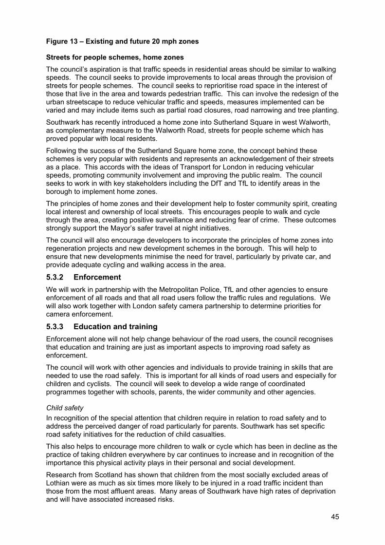
45
Figure 13 – Existing and future 20 mph zones
Streets for people schemes, home zones The council’s aspiration is that traffic speeds in residential areas should be similar to walking speeds. The council seeks to provide improvements to local areas through the provision of streets for people schemes. The council seeks to reprioritise road space in the interest of those that live in the area and towards pedestrian traffic. This can involve the redesign of the urban streetscape to reduce vehicular traffic and speeds, measures implemented can be varied and may include items such as partial road closures, road narrowing and tree planting.
Southwark has recently introduced a home zone into Sutherland Square in west Walworth, as complementary measure to the Walworth Road, streets for people scheme which has proved popular with local residents.
Following the success of the Sutherland Square home zone, the concept behind these schemes is very popular with residents and represents an acknowledgement of their streets as a place. This accords with the ideas of Transport for London in reducing vehicular speeds, promoting community involvement and improving the public realm. The council seeks to work in with key stakeholders including the DfT and TfL to identify areas in the borough to implement home zones.
The principles of home zones and their development help to foster community spirit, creating local interest and ownership of local streets. This encourages people to walk and cycle through the area, creating positive surveillance and reducing fear of crime. These outcomes strongly support the Mayor’s safer travel at night initiatives.
The council will also encourage developers to incorporate the principles of home zones into regeneration projects and new development schemes in the borough. This will help to ensure that new developments minimise the need for travel, particularly by private car, and provide adequate cycling and walking access in the area.
5.3.2 Enforcement We will work in partnership with the Metropolitan Police, TfL and other agencies to ensure enforcement of all roads and that all road users follow the traffic rules and regulations. We will also work together with London safety camera partnership to determine priorities for camera enforcement.
5.3.3 Education and training Enforcement alone will not help change behaviour of the road users, the council recognises that education and training are just as important aspects to improving road safety as enforcement.
The council will work with other agencies and individuals to provide training in skills that are needed to use the road safely. This is important for all kinds of road users and especially for children and cyclists. The council will seek to develop a wide range of coordinated programmes together with schools, parents, the wider community and other agencies.
Child safety In recognition of the special attention that children require in relation to road safety and to address the perceived danger of road particularly for parents. Southwark has set specific road safety initiatives for the reduction of child casualties.
This also helps to encourage more children to walk or cycle which has been in decline as the practice of taking children everywhere by car continues to increase and in recognition of the importance this physical activity plays in their personal and social development.
Research from Scotland has shown that children from the most socially excluded areas of Lothian were as much as six times more likely to be injured in a road traffic incident than those from the most affluent areas. Many areas of Southwark have high rates of deprivation and will have associated increased risks.

46
Southwark is currently participating in the DfT pilot Kerbcraft. Kerbcraft is a child pedestrian training scheme targeting five to six year olds that seeks to reduce future casualties by providing training to cross the road safely. Southwark was granted funding for three years to take part in the pilot and is currently providing the programme in ten schools.
Given the success of the Kerbcraft programme, the council will investigate extending it to older age groups and to be provided as part of the school transition programmes for years six and seven.
Southwark will also establish a system of child road safety audits so as to measure the safety of children in the road environment and to help prepare actions plans that include education and promotion as well as physical works.
School travel plan strategy
The council has developed a school travel plan strategy (STPS) which sets out how to implement school travel plans (STPs). STPs which will be the primary impetus to provide road safety and education at schools, and how to coordinate with schools, parents, the wider community and other agencies. This is discussed in greater detail in section 5.5.2 and the STPS itself is contained in appendix B.
School travel plan implementation
More and more parents and guardians are driving their children to school in their private car because there is a growing concern for their children’s safety and security when they walk, cycle or even catch public transport to school.
The implementation of STPs can incorporate both educational measures such as walking school buses and physical measures to address identified issues. These measures encourage sustainable, safe and secure travel and can reduce the real and perceived dangers of children travelling independently.
The council will work with schools, students and parents to establish a set of priorities in terms of the implementation of the STPs throughout the borough.
47
5.4 Accessibility
(a) Improve accessibility to a range of services, facilities and jobs, particularly for mobility impaired and older persons.
(b) Consult with local voluntary and community organisations, including disabled groups, on relevant transport proposals.
(c) Improve access to amenities and public services for disabled drivers at existing blue badge bays.
(d) Provide high standard and cost effective local transport options that are widely available and used where appropriate.
When people travel they want the journey to be convenient, safe and as short as possible and accessibility holds the key part in this journey. If the destination, transport mode or environment is perceived to be inaccessible it may deter all of the community from using it.
Southwark seeks to improve the streetscape environment and provide a seamless journey to make the borough fully accessible for all. Travelling in London can be difficult especially for those with disabilities or mobility impairments. Being a disabled16, mobility impaired or elderly person can inhibit one from performing everyday activities and from a transport perspective, prevents one from travelling in the same way that a mobile person does.
We seek to provide accessibility improvements to benefit the entire community, whether it be for the elderly, people with dependants, parents with young children, disabled or the mobility impaired.
Improvements will provide everybody with same ability to access their surrounding environment and help to achieve the following Lip objectives:
Lip1. Improve accessibility throughout the borough;
Lip2. Promote more sustainable modes of travel and improve travel choice;
Lip3. Improve safety and personal security;
Lip4. Promote greater integration of land use development and transport;
Lip5. Improve the quality, efficiency and reliability of transport;
Lip7. Promote and improve social inclusion, economic development, education, employment and housing;
Lip9. Work with partners to progress and promote transport improvements.
Southwark seeks to provide access to sustainable transport for all as a priority area for the borough. The Mayor also considers accessibility to be an important issue and has set the priority to improve accessibility and social inclusion on the transport network.
16 According to the Disability Discrimination Act 1995 a disabled person is defined as someone ‘who has a physical or mental impairment which
has a substantial and long-term adverse effect on his ability to carry out normal day to day activities.’
48
5.4.1 Accessibility planning Accessibility planning can provide the framework and direction for the promotion of social inclusion and provide the means to improve accessibility by identifying and addressing obstacles to accessing transport and key facilities.
By having a more strategic view of the issues affecting accessibility and planning for them, we can bring consistency to the coordination and provision of services and resources. It also helps to identify and prioritise improvements to the services we currently deliver.
The DfT have done much work in the area of accessibility planning and have developed comprehensive guidance. The DfT require all boroughs within the UK, excluding those in London, to undertake accessibility planning. However, the DfT, in principle, support the development of a pilot scheme to adapt accessibility planning to the London context. The council welcomes this initiative and would relish the opportunity to work with both the DfT and TfL to adapt and implement accessibility planning within Southwark.
Accessibility strategy The council aims to make the borough fully accessible for all. To enable this and to provide a coordinated approach to accessibility issues, it is proposed to develop an accessible transport strategy.
This strategy will be formed around the following three principles:
Maximise independence and access to key services;
Establish clear accessible transport standards;
Assess, prioritise and meet the needs for all.
The accessibility strategy will promote social inclusion, improve perceptions of and actual safety and identify the barriers of travelling with ease. The strategy will also review services currently provided, such as Dial a Ride and Taxicard, and consider the accessibility of key services, map need and look for opportunities to address gaps where there are no accessible links or transport provided. The strategy will set out an action plan for addressing these challenges identified.
The mobility subgroup along with other community groups such as the disabilities forum will be consulted with closely throughout the process of developing the strategy. It is anticipated that the strategy will be adopted mid 2007.
Mobility subgroup To gain a better understanding of accessibility and mobility issues, a mobility subgroup of the transport consultative forum (TCF) has been formed. Membership of this group includes key stakeholders such as disabled groups, elderly groups, council members, key transport operators and providers.
This subgroup will be crucial in both the development of the accessibility strategy but also the ongoing review and monitoring of obstacles to accessibility. Through regular meetings, the council will work with the mobility subgroup to gain an understanding of the accessibility issues.
This group will help to ensure all the needs of groups are considered throughout the process of implementing transport programmes in the boroughs.
Londonwide mobility forum The council intends to provide a representative from Southwark’s own mobility subgroup to the Londonwide strategic mobility forum when it is established. The council will also facilitate communication between the local mobility subgroup and the Londonwide group by continuing regular liaison with TfL and Southwark Council wherever the needs of disabled people are to be considered.
49
Provision of council services Within the council a variety of departments operate accessible transport initiatives, including social services, environment, education and transport planning.
This division of service has created a shortfall in the coordination of services and the council seeks to provide a central point of contact for accessible transport.
This will enable residents to access information about providers, eligibility, limitations to the service and booking systems. The information could be provided by a transport brokerage. The brokerage would provide information and a streamlined booking process for eligible clients and also offer a telephone hotline. It is proposed that the brokerage be operated by a local voluntary organisation or incorporated into Southwark’s customer service centre.
5.4.2 Initiatives to provide a more accessible environment The council seeks to establish and provide services to aid the independent mobility of disabled people throughout the community. The council intends to investigate opportunities for the provision of powered wheelchairs and mobility aids and will work closely with the mobility subgroup to develop schemes within the borough. One such scheme is the shopmobility scheme. Shopmobility is a scheme that lends manual wheelchairs, powered wheelchairs and powered scooters to members of the public, with limited mobility, to shop and visit leisure and commercial facilities within the town, city or shopping centre. Shopmobility schemes actively encourage inclusion and equality by providing mobility aids. The council will investigate opportunities for the provision of this scheme within the borough and will work closely with the mobility subgroup to identify suitable locations to set the potential schemes up.
Accessibility infrastructure Southwark seeks to create a seamless journey for all throughout the borough, irrespective of the mode. We have made large steps towards achieving this and have set the challenge of making all bus stops fully accessible by 2009, this is discussed further in section 5.10.2.
Other measures include working with our partners to improve the environment around transport interchanges, and to improve the transition between modes for all, as discussed in section 5.10.5. The council will also ensure that when any new taxi ranks are implemented within the borough they are fully accessible.
The council will utilise the mobility subgroup and liaise regularly with the transport service providers to identify locations requiring accessibility improvements and provide appropriate improvements. When providing improvements to accessibility in the borough the council will take into account the standards set out in the DfT’s inclusive mobility best practice guide.
We are currently developing the streetscape design guide, which will also help to provide consistency in both new schemes and through the maintenance programme.
Through our UDP we also promote accessible development, this considers both the development itself and any works conducted in the surrounding public area.
Improving access to existing blue badge bays Southwark will commence a programme of reviewing and improving the pedestrian environment around existing blue badge bays. We will also ensure that any additional disabled bays installed will have an adequate pedestrian environment.
Access to recreational facilities Access to recreational facilities as key to improving accessibility and the promotion of social inclusion, as discussed in section 5.2.3. Three parks within Southwark are currently subject to access improvements. Burgess Park, where work is currently being undertaken to provide additional pedestrian crossing facilities to the park across Albany Road. Dulwich Park, where the western entrance is being upgraded for pedestrians and cyclists. Peckham Rye, where the council is undertaking a survey of pedestrian movement, with a view to improving crossing points between Peckham Rye Common and Peckham Rye Park.
50
5.4.3 Initiatives to improve the delivery of accessible transport Southwark Council works in partnership with health, education social services and housing divisions, the police and voluntary sectors to ensure people with social care needs are provided with support, care and protection to help them live a safe and independent life. Part of the council’s responsibility is to provide safe and independent travel opportunities.
There are a variety of transport services offered and supported by the council including:
Freedom pass;
Dial a Ride;
Taxicard;
Blue badges;
Community transport;
Private hire vehicles;
Day centre accessibility services.
These services empower those less able to use transport. Each of the services are available to those with different needs. They enable people to carry out everyday functions and activities that they previously would not have been able to do.
The council recognises the need to improve these transport services, as they are increasing in patronage due to the complex nature of the service at times suffer from unavailability or unreliability. The council intends to work with key stakeholders to ensure that all these transport schemes are delivered efficiently, effectively and are beneficial to the client. Regular consultation will take place with community councils, the TCF and the mobility subgroup. The improvements taken on board must ensure that eligibility for the services is consistent Londonwide.
Once the reviews and improvements have occurred information about availability, eligibility, should be promoted through the proposed brokerage, the council and also through existing networks such as health services.
When providing door to door services such as Taxicard and Dial a Ride, Southwark Council will take TfL’s door to door services review into account once the consultation has taken place later in 2006. The mobility subgroup will be consulted on any of the proposals that TfL suggest as a review as a result of the review and the council will work closely with TfL to ensure that the community transport needs of Southwark are considered with any of the proposed changes to the services.
Freedom pass A freedom pass provides free travel to public transport users who live in London who are over 60 years or who are eligible disabled persons and have proven both popular and highly utilised.
Freedom passes can be used on public transport including buses, the underground, Docklands Light Rail and Tramlink between 9am and 4.30am on the weekdays and any time in the weekend and public holidays. National Rail usage is limited to between 9.30am and 4.30pm on the weekdays and any time in the weekend and public holidays. Freedom pass holders are eligible for a discount on many of the Thames riverboat services.
Those eligible for a freedom pass due to a disability are not subject to these time restrictions and can travel free at all times.
The 33 London Boroughs provide funding for the freedom pass and the system managed by Association of Local Government. The council remains committed to the freedom pass as a key initiative to aid mobility within the borough.
51
Dial a Ride Dial a Ride is a convenient door to door transport option and is used by disabled and frail elderly people. This scheme is very popular within the borough as it allows those unable to travel independently to have the opportunity to access key services. It has flexible routing and its vehicles are specially adapted with wheelchair lifts and removable seats.
Users automatically qualify for membership of Dial a Ride and may register with TfL if they meet one of the following criteria:
Receipt of higher rate mobility component of the disability living allowance17;
Registered blind or have a permanent disability/injury that seriously impairs their eligibility to walk;
Receipt of higher rate attendance allowance18 (for women aged over 60 and men aged over 65);
Receipt of war pensioner’s mobility supplement19.
Users of Dial a Ride pay a contribution to the cost of travel, of up to £3.00 depending upon the distanced travelled.
Dial a Ride is only available for travel between 8am and 12am and needs to be booked at least 48 hours in advance. The council understands that the limited operating time and the required notice can be a deterrent to using the system and will explore options for partnership working with Dial a Ride to improve the service provided.
The council will continue to work closely in partnership with Dial a Ride, through regular Transport Consultative Forum (TCF) and mobility subgroup meetings, especially with the development of the accessibility strategy.
TaxicardTaxicard is a scheme that allows Londoners with mobility impairments to travel in black cabs at a subsidised rate, and has the same eligibility as that for Dial a Ride. It is jointly funded by Southwark Council and the Mayor of London, and is administered by the Association of London Government. Taxicard services are available 24hours a day, 365 days a year, subject to availability of the taxis.
Blue badges Blue badges are parking permits for cars that are carrying people who are registered blind or have severe walking difficulties to park close to shops and services. Blue badges are vital for those using or travelling by private car as it increases the ability to access key services conveniently.
Applicants for the blue badge scheme are eligible for the scheme if they meet one of the following criteria:
Receive higher rate of mobility component of the disability living allowance;
Receive a war pensioner’s mobility supplement;
Use a vehicle supplied for disabled people by a government health department;
Are registered blind;
They have a severe disability in both arms, which make them unable to turn a steering wheel by hand;
17 The higher rate mobility component is for people who cannot walk at all or who have difficulties with walking, perhaps because of severe pain or breathlessness. 18 The higher attendance allowance is for people who have difficulties caring for themselves (i.e. find dressing and washing difficult, need someone to make sure they are safe, have a terminal illness both during the day and night) 19 The war pensioner’s mobility supplement is for war pensioners who are unable or virtually unable to walk due to a disablement which has been assessed at 40% or more, and for which they receive a basic War Disablement Pension
52
They have a disability, which makes it very difficult or impossible to walk.
To ensure the scheme is operating effectively boroughs, TfL and the government need to work in partnership and Southwark encourages all London boroughs to participate in the scheme. All partners need to work together to review the scheme nationally and implement improvements. An example of improvements to the scheme is the introduction of ID cards. They have been adopted by other councils and have proved very successful in preventing misuse of parks by non blue badge holders and non disabled passengers.
As part of the preparation of the parking and enforcement plan (PEP), the council reviewed blue badge services and is currently considering the following improvements:
Parking in residents parking areas or introduction of shared use bays;
Review of the distribution of dedicated disabled parking bays throughout the borough;
Additional badges that include user’s car number, for overnight use outside a disabled persons house;
24 hour ‘on call’ enforcement to help prevent misuse of dedicated bays;
Inclusion of disability issues in induction training for parking attendants to ensure enforcement is carried out in a way, which is sensitive to the needs of people with a disability.
Disabled parking issues and proposals are discussed further in the PEP (appendix C).
Community transport Community transport services provide accessible transport at cost to local users. It is generally run by not for profit organisations and is funded by the local borough. This transport service is provided to those that live in or are based in the area.
Lambeth and Southwark Community Transport (LASCoT) is a community transport service jointly run by the Lambeth and Southwark boroughs. LASCoT has a fleet of 23 buses and provides accessible transport to a range of voluntary and council users as well as to individual users.
LASCoT promotes:
The availability of transport services in the local area;
The provision of transport services;
Training, i.e. minibus driver training;
Vehicle purchase advice for groups.
Currently LASCoT only has two clients in Southwark, Southwark sports development projects for children and South Bermondsey neighbourhood renewal who operate transport for five South Bermondsey schools. LASCoT provide a very high standard of service, which is a cost effective and reliable alternative for many voluntary organisations that are struggling to provide transport for their users.
Southwark supports the use of this service and recognises that it has been previously under utilised and should be more widely promoted. The council will continue to work closely with LASCoT through the mobility forum and regular liaison with LASCoT officers.
Private hire vehicles The learning disabilities team use private hire vehicles for the transport of adults with learning disabilities, particularly for access to education. Passenger services have a very high use of private hire vehicles for transport of children with special educational needs to schools. Southwark social services commissioning unit use private hire vehicles from Ruskin Cars for the Fix Yourself a Break scheme, which is funded by the carers’ grant and administered by Southwark Carers.
53
In order to ensure that the services are reliable a more consistent approach should be taken to providing all the services via private hire vehicles. The council also endorses the use of private hire vehicles regulated by the Public Carriage Office (PCO) and their legislation. All new drivers must have a criminal records bureau check carried out and the PCO reviews the companies approximately every two months as well as carrying out checks at random on drivers to ensure that regulations are being met.
Ruskin Cars are PCO licensed so are subject to their regulations. Passengers can be confident that the organisation is professional and they will reach their destination with an honest, reliable driver in a safe vehicle. This is of particular importance in the transportation of vulnerable passengers such as the elderly, children, or the disabled. The council seeks to maintain these services and will carry out reviews before any new contracts are established.
Day centre accessibility Social services have a total of 44 buses for transport of day centre users, 43 of these buses are leased under an internal service level agreement with fleet services. Three of the leased vehicles are considered spare, but are often in use.
The individual day centres handle the day to day management and scheduling of social services transport. The vehicles are parked overnight at the day centres and driven by day centre staff.
The council recognises that the vehicles used for the day centre transport experience high idle time in the middle of the day, because the drivers are the day centre staff and need to be in the day centre during this time and the vehicles are also mostly unused at nights and in the weekends. The service needs to be more flexible so as to meet the actual needs of the client and not use up valuable time of the staff who should be working at the day centre instead of driving.
The council recognises that the provision of this kind of service is much more costly than the other transport services and sees the need for users of this service to be provided with travel training to enable them to travel more independently with schemes such as the freedom pass, Dial a Ride or Taxicard.
54
5.5 Managing travel patterns and land use development
(a) Reduce the need to travel through land use planning controls by integrating sustainable transport into all land use developments and regeneration proposals.
(b) Improve the range and quality of services and promote more sustainable transport choices for all.
(c) Promote the use of car clubs, car sharing and car pooling in all existing and proposed land use developments.
(d) Encourage Southwark’s schools to develop and implement school travel plans.
(e) Promote sustainable travel and travel planning for all.
Southwark seeks to promote sustainable travel choices for all. Travel planning provides incentives towards sustainable travel alternatives, such as walking, cycling and public transport. This includes the development of travel plans, promotional and educational events to raise the awareness and provide information of travel choices as a way to reducing car dependency.
Travel planning and awareness initiatives have a wide range of benefits to the environment and the community and will make much progress towards the achievement of the following Lip objectives:
Lip1. Improve accessibility throughout the borough;
Lip2. Promote more sustainable modes of travel and improve travel choice;
Lip4. Promote greater integration of land use development and transport;
Lip5. Improve the quality, efficiency and reliability of transport;
Lip7. Promote and improve social inclusion, economic development, education, employment and housing;
Lip10. Work with partners to progress and promote transport improvements.
The council supports the Mayor’s Transport Strategy objectives to make London a more sustainable city by changing travel patterns, reducing traffic congestion and related pollution levels.
Through land use, travel planning and awareness programmes, the council is committed not only to encouraging modal shift, but also to encouraging greater awareness of alternatives to the private motor vehicle and streetscape improvements to secure wider environmental and energy benefits. This is also a priority area for Southwark to provide access to sustainable transport for all.
55
5.5.1 Land use development Land use and transport are intrinsically linked and have a detailed and complex relationship. Southwark, as the local planning authority, has the power to control the effects of new development on the borough’s road network and transport system.
The Southwark Plan’s (emerging UDP) policies for sustainable transport are linked to the community strategy and are designed to ensure that significant new developments provide a sustainability appraisal including a transport assessment with a travel plan. The objective is to ensure that new development minimises the need for travel, particularly by private car, and provides funding for new or improved public transport, cycle and walking routes in the area.
New transport infrastructure can stimulate extensive development on adjoining or nearby land. Conversely, intensification of land use without the provision of public transport can create high car dependency and/or the need for additional transport infrastructure. The London Plan encourages patterns and forms of development that reduce the need to travel, especially by car and this is supported by the council.
Southwark will experience much development and regeneration in the coming five years, our land use policies intend to restrain demand for travel as a whole and promote the increased usage of sustainable transport. Major regeneration initiatives will be developed alongside transport improvements as discussed in section 5.2.2.
Developing near transport nodes Land use policies help keep local facilities viable and suited to the catchments they serve. The most important long term land use objective should be to match job opportunities and other facilities to residential populations and ensure easy accessibility.
Through the development and approval of the emerging UDP, the council will promote and encourage development that follows the sustainable travel philosophy.
The council also supports high trip generating development at locations with high levels of public transport accessibility and with spare capacity to meet the transport requirement of the development. Any development should consider and respond to the transport capacity of the local transport network, accordingly large developments should be located near public transport nodes.
Southwark's emerging UDP promotes the efficient use of land and sets guidelines for the density of development that take into account the high levels of accessibility in the central area and those areas with higher public transport accessibility elsewhere in the borough. It proposes public transport accessibility zones (PTAZs) in areas with higher levels of accessibility where higher density of development may be permitted when it can show an exemplary standard of design and where the development will bring significant environmental improvements to further benefit public transport, cycling and pedestrian movement.
All development should consider measures to promote sustainable transport such as:
Comprehensive travel plans;
Introduce car clubs;
Car sharing;
School travel plans and their implementation;
Improvements to cycle, pedestrian and public transport networks;
Bicycle pools;
Parking and storage facilities for cycles and powered two wheelers as well as showering and changing facilities.
Southwark Council require all large new developments to prepare a travel plans alongside their planning applications and also encourage all existing businesses to prepare a business travel plan to improve their organisation and environment in which it works.
56
Car free developments Within high density housing areas in controlled parking zones with good levels of accessibility to public transport, the council will support car free developments. However, we recognise the needs of the mobility impaired and their potential need for parking provision within car free developments.
Transport development areasThere are two transport development areas (TDAs) in Southwark, the opportunity areas London Bridge and Elephant and Castle, as shown on figure 14. The London Plan defines TDA, as “well designed, higher density, mixed use areas, situated around good public transport access points, in urban areas. Within a TDA, permission may be granted for higher density development, compared with existing development plan policy.”
Application of the TDA concept can contribute to achievement of sustainable development through reducing the need to travel, particularly by car, improving accessibility and quality of major transport interchanges, promoting social inclusion and maximising use of the most accessible sites.
Figure 14 – Public transport and development areas
ParkingRestriction of the number of parking spaces within new developments may be used as a way of encouraging people and organisations to seek alternative modes of transport to the private car, subsequently reducing congestion and pollution.
Access to services, leisure, shops and a range of amenities by public transport versus the private car must also be considered when providing less car parking in order to ensure efficiency and social inclusion. As such, access for the mobility impaired must be considered including the provision of convenient parking spaces.
The council emerging UDP requires that developers meet the parking requirements in the London Plan. Additionally, requirements for accessible car parking spaces should correspond with the size and nature of the development, in accordance with British Standard 8300 (2001).
Secure cycle parking is required for all residents and visitors in all developments.
Details of the parking requirements for new developments are contained within section 16 of the emerging UDP and appendix G of this plan.
5.5.2 Travel planning The council uses travel plans to encourage people to think about their travel choice and to consider alternatives to private transport such as walking, cycling, rail or bus.
Travel plans to be effective need to:
Tackle the car culture of companies and individuals;
Provide incentives to those using sustainable modes and disincentives to those using private car especially for single occupancy vehicles;
Adopt an integrated holistic approach for which examples should include linking modes of transport and removing any incentives encouraging car use (e.g. reserved car spaces).
One of the keys to travel planning is travel blending (using a mixture of modes) and providing choice on any given day, where alternatives are considered which may lead to reduced car use.
57
Business travel plans In particular, Southwark is encouraging employers to develop travel plans aimed at reducing car use for travel to work and for travel for business. These plans typically include a package of practical measures to encourage staff to choose alternatives to car use and particularly by single occupancy to reduce the need to travel at all for their work.
Business travel plans are tailored around a particular site and business needs and include a range of measures that will make a positive impact at that site to make the alternatives more feasible and attractive. This may include setting up a car sharing scheme, providing cycle facilities, negotiating improved bus services and offering attractive flexible working practices.
Practical measures provided within the plans could include:
Encouragement and financial support for staff to travel to work by public transport;
Encouragement and support for staff to cycle, run or walk to work;
Provision of pool cars/bikes for those who need them during the day for work;
Implementation of a car sharing scheme;
Parking management such as reserved spaces for car sharers, charging for parking etc;
Flexible working for employees;
Video conferencing to reduce business mileage;
Improvements to the fuel efficiency of the business fleet;
Ceasing of company car provision or at least opt out arrangements of equal financial value for staff not wishing to take leased cars.
The range of benefits of business travel plans to both the operator and the staff is extensive and may include such items as, reduced congestion, travel costs and local parking, greater travel and work options, improved health and fitness.
The council travel planSouthwark Council is one of the largest employers in the borough, and recognises the adverse environmental impact of staff travelling to and from work and in the course of delivering services on a daily basis. As such the council is in the final stages of preparing a travel plan to reduce this impact.
In the last few years there has been progress on traffic reduction and presently only one third of our staff use cars to travel to work, but we are still lagging behind overall figures for central and inner London.
Targets for car use set for the whole of the council show a need for an overall reduction in car use of 22% (from 32% to 25% car drivers) with more stringent targets for council premises in areas with higher public transport accessibility. This represents each person regularly travelling by car, to change one journey in five to sustainable travel so is expected to be achievable.
The council’s travel plan will include the full range of practical measures listing in the previous section and is particularly directed at the phased removal of any measures which encourage car use such as any assistance provided for parking.
The council travel plan is all about the council doing its bit as a leader in reducing car use wherever possible and is intended to be an example for others in what can be achieved in a travel plan. This is in the context of being a community leader and as the authority imposing planning, traffic and air quality restrictions on others. It applies to every member of staff and to councillors and where possible to visitors to the council or in accessing council services.
Bikes for businessSouthwark Council recently participated in the bikes for businesses project (as part of the European funded Optimum2 project). This scheme offered pool bikes to local organisations on a free trial basis, to determine whether this results in long term change in the travel
58
choices made by the companies involved. Businesses involved were encouraged to use the bikes for both commuting and travel to meetings.
The initiative provided between one and five bikes to local organisations for a period of six months together with a full support package.
The equipment and assistance provided includes: cycle training, reflective vests, maps, locks, helmets, third party insurance cover and bike servicing on a regular basis by technicians at a professional pool bike company.
At the end of the trial period, companies had the option of buying the bikes at cost, hiring them with maintenance support, or returning them. Feedback received has been extremely positive.
Optimum2
The council’s 4 year EU funded Optimum2 programme is attempting to test ways of encouraging people working in the north of the borough to try alternative ways of moving around, both their daily commute and during the working day.
Many people get into a fixed routine and with encouragement may find that walking instead of using the bus, or cycling instead of a taxi or taking the bus instead of the car can have many advantages that they had not thought of.
Optimum2 is using a range of tools and has set up a local travel plan group to see what methods are successful in encouraging people to look at their travel patterns in a different way.
It is recognised that increasing links between transport and health are one way for working people who feel that they have no time to go to the gym or take part in a sport to take exercise. There is no doubt that doing things that improve their fitness, health and appearance motivates people.
Optimum2 has found that when they go into companies and offer accompanied walks and health checks and individual advice on changing travel patterns, people are very keen and that the personal touch is far more effective than leaflets and posters. Companies too are increasingly interested in how to improve their workers health and for the opportunities for a more pleasant journey to work or lunchtime can improve retention of staff.
Local travel planning groupsA key objective for Southwark is to encourage sustainable travel amongst local businesses. To do this, Southwark with the European funded Optimum2 project are establishing a number of local travel planning groups (LTPG) within the borough.
An LTPG is a group of businesses that are sharing the process of preparing and delivering a business travel plan. LTPGs have significant benefits for car sharing so have even greater benefits in outlying areas of Southwark where car use is greater and public transport less comprehensive. These groups enable businesses to combine their efforts to tackle the transport problems in their areas. It provides a collective voice for local businesses when negotiating with the council and public transport operators over local infrastructure and services. It also makes planning simpler and cheaper for the businesses as they are able to pool their resources to achieve common objectives.
Southwark Council will consult the LTPG whenever planning applications and investment decisions relevant to the area need to be made. The LTPG will be linked more closely with S106 funding to ensure that the local people can see where the funding is going within the community and that it is being spent appropriately.
Southwark will work in conjunction with LTPGs to incorporate them into policy frameworks and to identify barriers to travel choices and methods to overcome them. The LTPG will be used as a test bed for travel planning initiatives and tools.
59
School travel plans A school travel plan (STP) sets out what a school has done and what they are going to do to tackle issues with the journey to school while encouraging a reduction in car journeys made to school.
A STP sets out practical measures to:
Incorporate road safety into the school curriculum;
Encourage sustainable transport choices on the journey to school;
Make the area around the school safer;
Develop cooperative/sharing travelling schemes;
Improve the level of fitness of our pupils and parents;
Stress the importance of healthy lifestyles;
Instil in our children a commitment to protecting the environment.
The development of a STP will be the primary impetus to providing road safety education at schools and to coordinate the efforts of schools, parents, the wider community and other agencies. STPs encourage initiatives such as ‘walking buses’, providing education and training cycle parking facilities and other measures. Southwark has prepared a school travel plan strategy (STPS) to supplement the Lip and to deliver an effective, integrated STP programme from 2005 to 2009.
The strategy aims to increase the number of children walking and cycling to school. It also aims to improve the health, safety and well being of young people in Southwark by reducing congestion and pollution around schools, improving safety on the journey to school, and increasing levels of active travel.
The STPS addresses the need to reduce the actual and perceived dangers associated with children travelling independently so that the risks won’t be a barrier to increasing the numbers of children cycling and walking to school.
Schools are encouraged to participate in local travel awareness campaigns, such as bike week. This helps to encourage schools to build on and maintain their own cycle activities. The schools can also benefit from involvement with stakeholders, such as Southwark Cyclists.
Southwark Council follows a programme for development of school travel plans for all schools to have a school travel plan by 2009. The programme includes:
Working with schools to develop STPs;
Providing support to existing schools with travel plans;
Implementing the school travel plan programmes at schools with travel plans;
Encouraging schools to get involved in travel awareness campaigns.
The council will provide ongoing input and support to schools once STPs are completed to ensure effective delivery. STPs are the first stage to providing improvements around schools, following their completion, the implementation of the plans can include the promotion of walking, provision of cycle training as well as physical measures to improve the safety of the journey to school.
5.5.3 Travel awareness Another aspect of travel planning is travel awareness and travel campaigns. Travel awareness is about changing people’s behaviour to adopt more sustainable modes of travel and reduce dependency on private vehicles. The council aims to raise awareness of the ease and availability of sustainable transport options.
60
Car clubsA car club provides members of the club access to a car when required without the need to actually own a car, it is a similar system to a car rental scheme. Generally members are required to pay an annual membership fee and then an additional pay as you drive fee to cover maintenance, insurance and fuel.
Cars are located in car club ‘stations’ in central locations to people’s homes and offices (generally within 5mins walk). Members have 24 hour access to cars and bookings can be made over the phone or on the internet, weeks in advance or at a moments notice. There are a range of benefits to using a car club instead of a privately owned car, including:
Considerable environmental benefits due to reduced car usage: such as less traffic congestion; less space taken up by parked cars; reduced emissions and pollutants (through the use of low emission vehicles);
Increased use of sustainable modes of transport;
Reduced cost of transport;
Contribute to social inclusion within the community.
Car clubs are designed to complement public transport, walking and cycling. Research has shown that one car club car replaces five privately owned vehicles which can help to relieve on street parking demand.
Southwark Council supports the development of car clubs within the borough. There are already two bays situated in the north of the borough on Great Guildford Street and the council anticipates that the number of bays will increase dramatically in the coming years with implementation of eight to ten new bays in 2006/07 (with four to be provided in the Bermondsey Spa regeneration area) and eight to 12 in 2007/08. The council will help to promote the concept of car clubs through local travel awareness events and the council website, this will support the promotion and marketing by the (privately owned) operators.
A recent study investigated the key aspects for a successful car club and the preferred areas for implementation, the four key aspects included:
Good public transport links;
High parking pressure/parking problems;
Population density;
Affluence.
Given the criteria, Bankside is considered a prime location for the implementation of car club bays as it is an area with high numbers of residential dwellings, retail outlets and business premises, therefore maximising the potential for membership uptake.
In assessing the viability of car clubs in Southwark, an assessment of all wards has been undertaken considering the criteria. Wards have been given a high, medium and low ranking for their ability to support a car club, which is as shown on the following figure.
The consideration of car clubs should be introduced to the borough on the basis of this prioritisation. However, this does not preclude any other areas being depending on local circumstances and demand.
Doctor bikeDoctor bike is a bicycle maintenance education programme for school children. A Cycle Training United Kingdom (CTUK) representative teaches the children and their families how to properly maintain their bikes. Southwark officers provide promotional support prior to the day and assistance on the event day. Schools that participate are selected based on having an interest in the scheme, the geographical location of the school and a completed STP.
Last year there was a cycling event held at the Burgess Park bike track with activities, races, and games etc and over 200 people attended the event. The event focused on cycling as an enjoyable leisure activity and promoted cycling as a healthy lifestyle choice.
61
5.5.4 Campaigns Southwark events will range from simple stands to health and fitness checks to guided walks and incentives will be offered to those who attend, ranging from maps to a prize draw for a bicycle. Southwark is looking for businesses that are interested in taking the opportunity to raise travel awareness among their staff, free of charge, and are willing to host a series of travel awareness events.
Good going campaign Good going is a Londonwide campaign to promote a wide range of sustainable transport and travel awareness initiatives. There is a year round programme of promotion, pledge cards and newsletters to educate, encourage and maintain a shift in travel patterns.
Good going week takes place during September for two weeks, with the objective of raising awareness of travel options with emphasis on business travel.
There are a variety of days each with different themes. Southwark Council will be participating in several of these days, including:
The clever commuter travel awareness event is a commuter race between various modes of transport including walking, cycling, public transport and the motor vehicle. This year the race was from Peckham Pulse to Potters Fields, the riverside park by Tower Bridge with the commuter choosing their own mode of transport. A nurse was on hand for information on general health and diet at Potters Fields. In the future, Southwark Council hopes to expand on this event to be a Londonwide challenge.
Fit Friday provides free of charge health checks available throughout different areas of London;
Worth the walk, two guided walks from Potters Field to Trafalgar Square;
Going by bike, participants have breakfast at their local bike shop and get a discount on your bike shopping;
Wise walk or going the green mile, there will be a number of guided walks in southeast London;
Car free day, this year was centred on the launch of much needed cycle parking in Tower Bridge.
The Southwark website will promote good going week and will also report throughout the year about awards and events.
Walk on Wednesday The walk on Wednesday programme extends walk to school week with the focus on regular walking throughout the year. Participating schools encourage all children to walk to school regularly on Wednesday to help reduce congestion and pollution around the schools while also improving the health of the children. This programme started in June 2005 and will continue throughout the year, two schools have taken up the initiative already while a further ten have suggested they wish to run with the scheme.
Walk to school Walk to school week takes place in both May and October. During the week the children are encouraged to walk to and from school and to write a travel journey relating to their walking experience. This diary could include things that happened, problems they encountered and ways they think they could be overcome. The results will be correlated and presented to the local community council with the intention of influencing policy and future bids for funding. The children and schools would be rewarded with prizes for the best diaries. Currently 15 schools in Southwark participate in the event. Southwark hopes to build on that number, and will strive to increate the numbers in 2006. Schools are also encouraged to draw up an event in their STP that will take place during and relate to walk to school week.

62
Bike week Bike week is an annual event that takes place in June. It is a series of events designed to encourage people to cycle more. The council encourages local businesses, schools, local community groups and individuals to arrange events such as bike breakfasts, pedalling picnics and bike rides during bike week.
Organisations, businesses and schools are generally selected to participate because they have completed or are considering a travel plan.
63
5.6 Air and noise quality
(a) Reduce overall levels of traffic and traffic congestion and promote sustainable modes of transport.
(b) Reduce pollution caused by vehicle emissions and support the use of cleaner / alternative fuelled vehicles.
(c) Reduce negative effects of noise from transport infrastructure.
Initiatives included within this section will help to address the following Lip objectives;
Lip2. Promote more sustainable modes of travel and improve travel choice;
Lip7. Improve visual amenity and the quality of the environment;
Lip8. Reduce energy use.
Southwark seeks to improve our environment by increasing the number of people using sustainable modes of transport moving away from private vehicles, this provides a link to our priority to provide access to sustainable transport for all.
64
5.6.1 Air quality Local pollution arises predominantly from road traffic sources. Parts of Southwark are congested for the majority of the day and this in turn exposes the local community and visitors alike to air and noise pollution.
In response to monitored air pollution an Air Quality Management Area (AQMA) was declared over a majority of the borough in late 2000. In response to the designation of the AQMA, the council produced an air quality strategy and improvement plan (AQIP), which contains a number of measures to improve air quality within the borough. The current AQIP is due for review commencing in 2006, this review will consider the Mayor’s Air Quality Strategy in providing initiatives to improve air quality in the borough.
Quality of the environment and ambient air quality correlates to general health and wellbeing. Health in Southwark is below the national average for a number of areas that are identified as deprived in comparison with national data. Southwark’s residential population is increasing and the borough is a growth area for investment in business and leisure development. This places heavy demands on the need to travel both privately and by public transport, increasing air and noise pollution. This drives the need to improve the airborne environment.
Southwark seeks to continue to explore opportunities to establish additional permanent continuous pollution monitors at locations on strategic transport routes to monitor the borough’s air quality. Additionally, the council will encourage the Greater London Authority and TfL to continue to monitor the traffic and pollution impacts of the congestion charging scheme.
Improvements to air quality will be achieved through promoting mode shift towards more sustainable travel options with initiatives to include Streets for People schemes, detection of poorly maintained vehicles and encouraging the introduction of cleaner vehicles. The council will work in partnership with heavy and light goods freight operators to reduce their vehicular emissions.
The Mayor seeks to introduce the London Low Emissions Zone (LEZ). The LEZ is an environmental measure to reduce the number of older, more polluting vehicles on the road network and introduce greater numbers of cleaner vehicles. An LEZ is a defined area (greater London) that can only be entered by specified vehicles meeting certain emissions criteria or standards, e.g. certain Euro standards. Older vehicles are prohibited from operating within the area, and this therefore accelerates the turnover of vehicle fleet. Although traffic volumes do not necessarily change, a higher number of vehicles travelling in an area are cleaner vehicles with lower emissions, and this leads directly to air quality improvements.
Southwark supports the introduction of the Londonwide LEZ but recognises the significant logistical implications of such a ban. However, the council will continue to work in partnership with TfL, the logistics and business sectors to mitigate these issues.
Air quality measures and monitoring are discussed in greater detail in appendix J of this document within the strategic environmental assessment of this plan.
5.6.2 Noise Noise is generated from road maintenance, poor quality street surfaces and stop start traffic. While vehicles have become quieter in terms of the official noise test, urban traffic noise does not generally appear to have fallen.
In the London Household Survey 2002, 13% rated noise from road traffic where they lived to be a ‘serious’ problem, compared with aircraft 6%, roadworks/construction/demolition 4%, noise neighbours 4%, trains/tubes 2%, industrial/commercial premises 2%, and pubs/clubs/entertainment 2%.
Presently very little information is available on noise levels within the borough. The Department for Environment, Food and Rural Affairs have produced a noise map that
65
predicts noise levels across London. The council has 30 newly established traffic monitoring stations that will be used to verify this map.
Londonwide, TfL will develop a traffic noise action programme to provide better integration between transport and noise reduction measures and Southwark supports the development of this programme.
In recognition of the impact of noise on residents, we seek to provide improvements at the source through land use planning, development control and building design and traffic management.
Railway corridors can be a significant source of noise and we will work in partnership with the Train Operating Companies (TOCs) to facilitate noise reduction measures on the railway system, including track replacement works.
Southwark is affected by noise from aircraft landing in a westerly direction at Heathrow. The noise is particularly noticeable and therefore more disturbing at night. We consider that that night flights over London (as a densely populated area) particularly to Heathrow are inappropriate and should be reduced with a view to their eventual elimination.
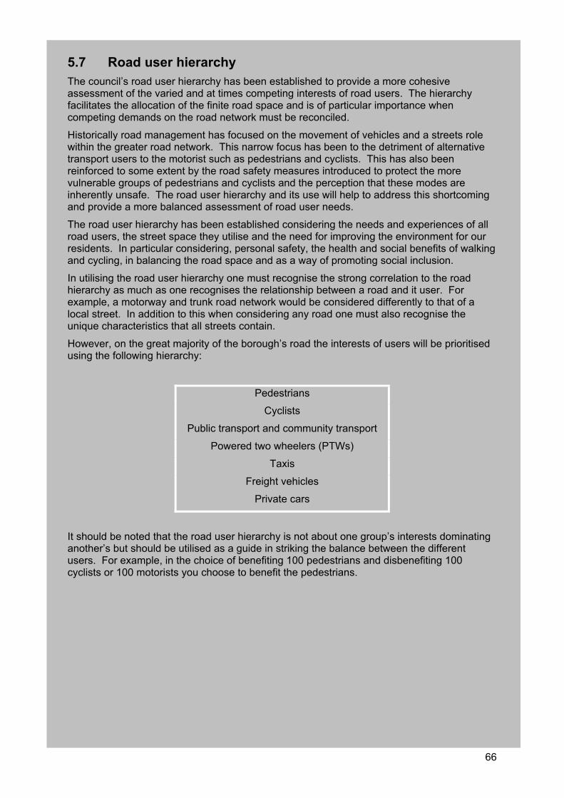
66
5.7 Road user hierarchy The council’s road user hierarchy has been established to provide a more cohesive assessment of the varied and at times competing interests of road users. The hierarchy facilitates the allocation of the finite road space and is of particular importance when competing demands on the road network must be reconciled.
Historically road management has focused on the movement of vehicles and a streets role within the greater road network. This narrow focus has been to the detriment of alternative transport users to the motorist such as pedestrians and cyclists. This has also been reinforced to some extent by the road safety measures introduced to protect the more vulnerable groups of pedestrians and cyclists and the perception that these modes are inherently unsafe. The road user hierarchy and its use will help to address this shortcoming and provide a more balanced assessment of road user needs.
The road user hierarchy has been established considering the needs and experiences of all road users, the street space they utilise and the need for improving the environment for our residents. In particular considering, personal safety, the health and social benefits of walking and cycling, in balancing the road space and as a way of promoting social inclusion.
In utilising the road user hierarchy one must recognise the strong correlation to the road hierarchy as much as one recognises the relationship between a road and it user. For example, a motorway and trunk road network would be considered differently to that of a local street. In addition to this when considering any road one must also recognise the unique characteristics that all streets contain.
However, on the great majority of the borough’s road the interests of users will be prioritised using the following hierarchy:
Pedestrians
Cyclists
Public transport and community transport
Powered two wheelers (PTWs)
Taxis
Freight vehicles
Private cars
It should be noted that the road user hierarchy is not about one group’s interests dominating another’s but should be utilised as a guide in striking the balance between the different users. For example, in the choice of benefiting 100 pedestrians and disbenefiting 100 cyclists or 100 motorists you choose to benefit the pedestrians.
67
5.8 Walking
(a) Promote walking as a sustainable mode of travel.
(b) Promote the benefits of walking for improving health, social inclusion and economic vitality.
(c) Improve the quality of walking environments reducing crime and fear of crime.
For some walking is a choice, whilst for others it is a necessity. Southwark seeks to improve walking for all and to encourage walking as an alternative mode of travel. Walking is the most economical, widely available, accessible and healthy transport option available and its often very necessary. Walking is eminently suitable in Southwark as the borough has a high proportion of households without access to a car.
The council aims for walking to be the first choice of travel for all, this is reflected by the placement of pedestrians as the highest priority in the road user hierarchy. The council seeks to promote walking as a way to reduce car use and dependency, improve the health of those that live and work in the borough, and to revitalise the borough both socially and economically.
Walking improvements have a wide range of benefits to the environment and the community and will make much progress towards the achievement of the Lip objectives. The relevant Lip objectives to walking initiatives include:
Lip1. Improve accessibility throughout the borough;
Lip2. Promote more sustainable modes of travel and improve travel choice;
Lip3. Improve safety and personal security;
Lip5. Improve the quality, efficiency and reliability of transport;
Lip7. Promote and improve social inclusion, economic development, education, employment and housing;
Lip8. Improve visual amenity and the quality of the environment;
Lip9. Reduce energy use.
The council has recently prepared a walking plan (contained in appendix D), which includes specific actions for the promotion of walking as a sustainable, safe and healthy means of travel. The objectives and targets of Southwark’s walking plan consider and support the Mayor’s Transport Strategy and London’s walking plan.
The Southwark walking plan sets the following targets:
The short term target is to stop the decline in the number of journeys per person made on foot.
The long term 2015 targets are:
(a) To increase the modal share of walking for trips under two miles by 10%
(b) To increase the average number of trips made of foot per person/per year by 10%
(c) To increase the level of London’s ‘walkability’ both in terms of people’s perceptions and in actual measured terms against other world cities.
In addition, TfL have set a new target as part of the guidance issued for the preparation of borough Lips, TfL and boroughs are to achieve an increase of 10% in journeys made of foot between 2001 and 2015.
Southwark own target expands upon this TfL target, we seek to increase the number journeys made on foot by 15% between 2001 and 2015.
68
This links to our priorities of increasing accessibility of sustainable transport, the integration of transport and land use and providing a safe environment for pedestrians. The Mayor also acknowledges the importance of walking and has set the priority of encouraging walking by improving the street environment and conditions for pedestrians through the use of travel demand measures.
The council seeks to work in partnership with TfL and others to progress the delivery of the Lip over the coming years as well as the borough’s walking plan.
5.8.1 Education and promotion A key component of increasing the number of people walking is education and encouraging people to reconsider their travel options. While road users may find a reasonable amount of information for driving around the borough and catching public transport, it is generally a lot more difficult to find succinct and clear information for the more sustainable modes of transport such as walking and cycling. This shortfall needs to be addressed to raise awareness of the ease and convenience of walking and should be location and route specific.
5.8.2 Review of current information The council will review what material is currently publicly available as well as what information is disseminated to interest groups. The council will provide more consistent information in the form of maps, guides and signage for pedestrian routes and to improve direct access to facilities such as schools, shops and public transport. Signage and literature should be consistent boroughwide to provide uniformity. However consideration and variation should be provided in special circumstances, such as conservation areas or tourist precincts.
5.8.3 Walking initiatives The council will promote walking through the development of travel plans for schools and businesses, walking schemes and publicity campaigns that highlight the benefits of walking. Examples of current programmes include walk to school week and walk on Wednesday, which are part funded by the council and through TfL. The walk on Wednesday programme (designed to encourage walking to school) has proven to be very successful, reflecting the schools’ enthusiasm for involving their children in healthy living campaigns. The council will work with the schools to incorporate travel awareness within their existing tight schedules.
These travel awareness programmes are augmented by the EU funded Optimum2 project which will be piloting a range of sustainable transport programmes to 2008. The walking action programme intends to cover as wide a range of initiatives as possible, to attract both residents and commuters to include more walking in their daily routine.
Compared to cycling, initiatives to increase walking are in their early days and this plan reflects the aim to test as many opportunity areas as possible with the success and failures shaping the details of the following years programme.
Walking for leisure In recognising the health benefits of walking, the council conducts many initiatives to promote and encourage leisure walking, such as the Southwark walking festival and many hosted walks. There is a strong correlation between leisure walking and purpose walking. If one can enjoy and recognise the benefits of leisure walking then it is a smaller step towards purpose walking than for those that do not walk. Therefore initiatives to promote walking as a mode of transport must recognise and link to the current and future initiatives to promote leisure walking.
Organised walks, as detailed previously, encourage people to explore a range of spaces in a secure environment, encouraging more people to walk. This increase in walking can enhance informal surveillance improving safety within the public realm
69
5.8.4 Walking environment and improvements One of the major barriers to more people walking is the perception of the environment they have to walk through to get to their destination. Unlike car drivers and passengers who are somewhat isolated from the environment in which they are travelling, pedestrians are exposed to all aspects of their surroundings.
Walking hierarchy Walking has suffered from preferential neglect in the past. In recognition of the health, economic and environmental benefits of walking, the council ranks walking as the highest priority transport mode.
As a way of improving our understanding of walkers and addressing their needs a walking hierarchy, similar to the established road hierarchy will be established. The walking hierarchy will be a key component of the promotion of walking to building confidence of the level of facilities provided within the hierarchy and will help the council to understand, rank and provide improvements to walking facilities.
This hierarchy will be developed considering the following information:
Pedestrian numbers;
Proximity to activity nodes, such as health centres, schools, shops, transport interchanges, etc;
Location and connectivity within the network;
Links to the leisure walking network and cycling network.
The walking hierarchy will also be developed alongside the streetscape design guide and will be used to inform design levels and maintenance regimes.
Understanding current conditions A key component of responding to the needs of the pedestrian is understanding where and why people are walking as well as where and why they are not. This helps to recognise where physical improvements need to be undertaken.
Pedestrian surveys and analysis will be undertaken to measure existing movements and demand and street audits will be undertaken to catalogue the existing facilities and provide recommendations on their improvement. The type and level of detail of an audit would be assessed on a case by case basis to best suit the site location and the required information.
Long term, we would like to have coordinated street audits throughout the borough and the first stage of the process will be to amalgamate the existing audits where possible and establish a framework for future audit processes.
Following on from this the council proposes an ongoing programme of three to four major street audits being carried out per year, depending on the breadth of the assessment area. The council will implement an ongoing programme monitoring areas previously audited to ensure that the information stays current, relevant and usable.
Streetscape environment To encourage walking, the network of walking routes must be maintained to a high standard, be appropriately lit, signposted and provide a connection between areas and facilities that people wish to utilise. People cannot be expected to walk in a poor environment. Therefore we must provide improvements before we expect people to consider changing transport modes.
The council is currently in the process of developing the streetscape design guide, which will provide guidance for all streetscape works including the maintenance of the existing streetscape, design of new works and improvements within the public realm.
70
Pedestrian signage Provision of well designed signage across Southwark will not only complement the streetscape environment, reducing unsightly and confusing street clutter but will assist in promoting walking routes, local attractions and places of interest to people living, working and visiting the borough. The key considerations when updating or implementing new signage schemes is to ensure that the signage is discrete whilst being legible, clear, concise and accessible and provide continuity.
In 2004 the council carried out an in depth audit of signage in Bankside and Bermondsey to address shortfalls and gaps from the previous schemes and to incorporate lessons learnt. The attractions and businesses in Bankside and Bermondsey/Pool were widely consulted on their views and these have been incorporated into the new scheme.
Southwark Council has worked with TfL and developers in the area to deliver a comprehensive pedestrian signage scheme for north Southwark. Through this project the council has identified key routes and transport nodes and the most efficient ways of moving visitors through the north of the borough and extending their walking experience beyond their end destination.
There still remains the opportunity to create improved links between these areas and other parts of the borough as well as across borough boundaries to widen the walking network.
Improvements for the mobility impaired People who are mobility impaired often face greater difficulty in negotiating the street environment. Improvements for the mobility impaired can also provide benefits for other users, such as parents with prams.
The council will undertake a programme of assessing facilities such as drop kerbs and tactile paving, as well as reviewing signage, around high activity nodes such as health care centres, shops, town centres, tourist facilities and transport interchanges. This work will be done in conjunction with the mobility subgroup of the TCF, discussed in section 5.4.
Rest facilitiesPedestrian areas should also be supplied with appropriate seating so that people have the opportunity to rest before carrying on with their journey. Street furniture in general should be well designed and kept to a minimum allowing free pedestrian flow.
The visual amenity at these rest locations is also important for encouraging people to take the time to walk and enjoy the public realm. Street furniture, landscaping and public amenities should be provided where appropriate.
Railway viaducts and subways In 2003 CRP initiated a successful programme to treat railway underpasses and viaducts called the Light at the End of the Tunnel project. This programme seeks to turn these often neglected areas and barriers to pedestrian movements into creative public spaces or desirable commercial space, making the tunnels feel safer, easier to move through, while generating jobs for local people.
The project has been extremely successful to date although many untreated railway underpasses exist within Southwark that are located outside of the scope of the original scheme. Given the proven success of the Light at the End of the Tunnel project, it is proposed to extend the programme throughout all of Southwark. The project framework would be utilised to identify, rank, audit, treat and monitor railway underpasses.
The council has undertaken a review of all viaducts within the borough to assess the current condition, surrounding environment and its potential as a barrier to pedestrians. Following this review, officers assessed identified key viaducts for improvement. These have been identified considering local levels of deprivation, existing pedestrian levels, surrounding land uses, proximity to schools and public transport links as well as the overall visual amenity of the viaduct.
71
The council recognises that dark and unattractive viaducts can be barriers to people walking through them, particularly at night. This project and the improvements it will bring will increase the feelings of safety and security. This is likely to bring the most benefits to areas close to public transport facilities such as west Walworth and south Bermondsey creating greater links to public transport especially at night.
A key initiative is to improve pedestrian links from Bankside to the Elephant and Castle. Therefore priority locations are those that run southward toward the Elephant and Castle as these are proving to be barriers to pedestrian movement. Improving pedestrian access and community safety between these two regeneration areas will assist in broadening the benefits to a wider area.
There is also scope for improving the workspace provision of the arches, creating better access to potential markets and potential employment opportunities throughout various locations within the borough including key opportunities in Peckham with the redevelopment of Peckham Rye station.
The council has seven subways within the borough, aside from the existing subways at Elephant and Castle which will be removed and at grade crossings provided. Similar to the railway viaducts, officers have assessed each of these subways to look for opportunity to provide at grade crossings or alternatively providing improvements to the safety, cleanliness and visual amenity.
Signalised crossing facilities It is important for pedestrian provision and safety that all signalised junctions should include pedestrian phasing and as such the council will undertake a review of all signalised junctions to identify where pedestrian phases could feasibly be introduced.
Equally as important to pedestrians is the amount of time they are required to wait, the extra distance they may be required to walk to reach a crossing facility and the amount of time given to cross the road.
The traffic signal network within Southwark is complex with a majority of signals, particularly in the north of the borough set to synchronise with each other for vehicle flows. All road users are affected by the timings or ‘cycles’ including motor vehicles, buses, cyclists, delivery vehicles, emergency services and pedestrians.
Historically, signal timings were set to achieve the most efficient use of a junction, in terms of allowing vehicle traffic movement. The road user hierarchy places pedestrians as our highest priority and signal timings should be amended to reflect this priority. This could help to provide an uninterrupted pedestrian network.
However, this would increase journey times for other modes of transport and therefore a balance must be struck between the competing demands of these users. TfL manage the traffic signals within the borough and the council will work with them to optimise the crossing conditions for pedestrians.
Air quality Walking can bring about improvements to air quality by reducing traffic congestion and subsequent vehicular emissions whilst improving personal health and fitness. Consultation preceding the publication of the Mayor’s Air Quality Strategy in 2002 revealed that 71% of Londoners consider traffic exhaust fumes a serious problem, making walking unappealing.
Reducing the amount of pollution will also make the environment more attractive to walk in and so a virtuous circle may be created. This issue is discussed at greater length within Southwark’s AQIP 2002 to 2005. Related key actions from that plan are also included within the walking plan contained in appendix D.
Regional improvement programme Improvement programmes within Southwark will also link into key regional initiatives including the South East London green chain and the Thames path which both traverse Southwark.
72
The South East London green chain, and the network of routes that links them is known simply as the green chain walk. The walk extends from the Thames in the northeast to Crystal Palace Park in the southwest. It connects with other key routes including the Capital Ring, London Loop and Thames path. It contains ten sections and covers a distance of 65km. The council has undertaken a feasibility study for the extension of the green chain walk into Southwark. The extension would provide an increased use and awareness of our parks, create links between open spaces and places of interest and provide health benefits to users. The proposed walk is likely to follow the route of the Old Crystal Palace high level railway, with potential to further extend into Dulwich Park and Belair Park via Cox’s Walk and stretch up into Peckham Rye Park and Common. This would open up 60 hectares of open space and a 4.6 mile extension of the green chain walk.
The Thames path extends along both banks through London and continues to the river's source in the Cotswold Hills. The council supports the path as a major national initiative to promote leisure walking and enjoyment of the public realm. The council supports both of these recreation walks and will work with our partners for their enhancement.
5.8.5 Accessibility to transport and services Access to public transport facilities and activity nodes, such as shops and community facilities, is of particular importance to pedestrians, especially the mobility impaired.
The environment around rail stations and bus stop interchanges should be designed with particular consideration to pedestrians, as should the environs of local shops and other services. Finding appropriate routes to these facilities is important if people are to be encouraged to walk rather than use other forms of transport.
It is also important that car parking is provided within walking distance to pedestrian priority areas for people with mobility impairments as discussed in the PEP, contained in appendix C.
Southwark is committed to identifying priority locations for accessibility improvements and working with our transport partners to achieve these.
The particular locations include:
Bus stops;
Rail and tube interchanges;
River crossings;
Local and district shopping centres;
Major employment centres;
Tourist attractions.
5.8.6 Safety and security One of the major deterrents to more pedestrians on our streets is the safety and security of the roads and surrounding environments. There are several ways in which the council can improve pedestrian safety as well as for other road users.
Road safety The safety of pedestrians is essential, a safe walking environment gives people confidence to walk and cross the road without fear. The promotion of road safety involves the education of both pedestrians and car drivers and physical measures such as crossings and traffic calming to make the roads safer for all users.
Another key element of increasing pedestrian safety is the speed reduction of vehicular traffic, as there is an established link between vehicle speeds and casualty rates. The council will implement boroughwide 20 mph zones, new and better crossing facilities and provide better lighting throughout the pedestrian environment.
73
One of the council’s major initiatives is the promotion of STPs, which help to encourage children and staff to walk the whole or part of the way to school.
Road safety measures are in the main designed to slow vehicles and reduce traffic volumes. These measures can be key in attracting people to walking. Therefore the monitoring of road safety programmes will include the monitoring of pedestrian numbers. The issues raised are more fully discussed in section 5.3 of this plan and within the council’s RSP.
Young pedestrians Although child casualty numbers have dropped, concern remains as to the numbers of children being injured. The walking action plan proposes a comprehensive programme of child road safety training and activities.
The council participates in the pilot child pedestrian training programme Kerbcraft which is designed to teach pedestrian skills to five to seven year olds by means of practical roadside training rather than in the classroom.
It is built around teaching three skills, choosing safe places and routes, crossing safely at parked cars and crossing safely near junctions. Trained volunteers near their schools assist in teaching the children. This programme has shown success in previous years and it is proposed to continue this programme in coming years, subject to ongoing funding.
Crime and the fear of crime People will only choose to walk if they feel an area is safe and unthreatening, especially after dark. Recent consultation with local residents showed that they want to feel safe in the immediate vicinity of their home and for local journeys. If people are to be encouraged to walk more they should not feel intimidated into staying away from an area or using their car because they feel that the area is unsafe. Many factors can contribute to the perception that an area is unsafe particularly for vulnerable groups including women, such as poor design, dark and deserted spaces, etc.
The Safer Southwark Partnership (SSP) works with numerous stakeholders including the police to identify crime and fear of crime hotspots. The 2005 crime and drugs strategy includes measures to reduce crime and fear of crime within the public realm.
In addition to this, the council intends to improve security, along with better lighting, increase CCTV and passive surveillance through streetscape and building design. Southwark also aims to replace all subways with surface level crossings as well as implementing the Light at the End of the Tunnel project within railway arches, as discussed in section 5.8.4.
Through the community safety capital programme the council delivers numerous projects to reduce fear of crime and street crime, this year totalled an investment of £2m. Current year projects include lighting, CCTV, graffiti removal, signage and vegetation removal at numerous sites throughout the borough.
The council has also established an ongoing programme of promoting safety, in our local parks, particularly targeting women. For the first project, the council’s parks community outreach team in partnership with the women’s design service conducted an audit of Burgess Park to highlight any particular concerns. Additionally, the women’s design service have also undertaken gender and community safety training for the council’s wardens and community outreach officers.
These initiatives will help to improve safety within Southwark and complement the Mayor’s safer travel at night initiative.
5.8.7 Monitoring Walking is difficult to monitor and assess, however it must primarily take into account our current position to give us a better understanding of the current network and identify where there are missed opportunities. As previously stated, initiatives to increase walking are in their early days and this plan reflects the aim to test as many opportunity areas as possible, the success and failures shaping the details of the following years programme. Therefore the monitoring methodology must be as adaptable to the walking plan initiatives.
74
There are quite a few useful indicators such as travel behaviour, trip purpose, personal information and the route accessibility. Where relevant these indicators could be used to monitor progress in implementing the walking plan and targets will be set to give some measurements of progress.
The council aims to survey pedestrian numbers and movements, particularly where newly implemented infrastructure or improvements have occurred but generally within areas where there are high footfall numbers.
Southwark will also utilise the community councils to generate and record feedback about pedestrian areas and improvements with regard to recording attitudes to these pedestrian areas.
5.8.8 Future initiatives Tate ModernThe Tate Modern masterplan identified the area to the south of the gallery as a key area of opportunity to create a new urban space including the potential closure of Sumner Street. This would support the Tate's aspiration to create a new north south route through the Tate, which would link the river to the proposals currently under construction for Bankside 1,2,3 and Southwark Street.
To support this new urban space, the Tate also wishes to create a cultural hub to the south of the gallery that may contain a range of artist studios, film suites, support services such as childcare facilities and vastly improved and expanded educational facilities. Work is currently being undertaken through our partners in CRP to investigate pedestrian improvements to the south of the Tate Modern.
Thameslink complementary measures Thameslink will have a considerable impact on pedestrian access to key areas of the borough that experience high levels of pedestrian movement particularly during peak hours.
Interim improvements should be provided during the construction phase with long term improvements provided in the future. Southwark will investigate the impacts on existing and potential new business space in the area and investigate potential walking improvements.
BanksideIn recognition of the role that lighting plays in improving conditions for pedestrians, Southwark Council with the development company Land Security have recently completed the Bankside lighting strategy. This strategy considered the current level of lighting provided, key pedestrian routes and desire lines as well as crime statistics to direct where improvements were required.
This study identified four project sites as detailed as follows:
Southwark Street to Union Street area, street lighting improvements, feature lighting to tunnels and surrounds;
Bear Gardens street lighting improvement;
Clink Street viaduct feature lighting treatment;
Hop exchange façade lighting treatment.
Links to the Elephant and Castle The council seeks pedestrian improvements from the north of the borough to the Elephant and Castle, this will complement and extend the benefits of the walking improvements around the Tate Modern, lighting improvements at Bankside and benefits from the Light at the End of the Tunnel project.
These improvements will assist in attracting tourists and visitors further south, benefiting access to the Imperial War Museum and the proposed Discovery Centre and other support services at the Elephant and Castle. It improves linkages for the commercial, residential and

75
student populations of the Elephant and Castle area, and will allow greater access to jobs and facilities in the north of the borough.
Bermondsey Street Southwark seeks to create a fashion market and potential Streets for People approach to Bermondsey Street. Significant (predominantly residential) development has occurred along and adjacent to the street that has provided an increase in retail and restaurant use at ground floor.
In particular the pavements could be modifies, traffic calmed and shared use investigated to create a vibrant link from London Bridge to the Bermondsey Square development.
76
5.9 Cycling (a) Promote cycling as a safe and sustainable mode of travel.
(b) Promote the benefits of cycling for improving health, social inclusion and economic vitality.
(c) Improve conditions for cyclists, including the interchange to other modes of travel.
(d) Provide secure cycle parking throughout the borough.
(e) Promote, encourage and provide cycle training to increase cyclist’s confidence.
The council promotes cycling to the community as a means to reducing congestion, pollution and increasing the ease of movement, health benefits and promoting social inclusion. Cycling is ideally suited for local trips, over a third of which are under a kilometre long and 85% of which are less than 8km long.
The council has prepared a cycling plan (see appendix E) that aims to promote cycling as a viable, safe, healthy, economical and convenient means of transport and to encourage a shift from the use of the car to the cycle for local trips.
Southwark supports the London cycling action plan targets:
To achieve at least an 80% increase in cycling levels by 2010 and a 200% increase by 2020 compared to cycling levels in 2000;
To achieve measurable increases in cycling levels and to establish benchmarks;
To increase the modal share of cycling trips;
To increase the number of cycle trips per person per year;
To increase the level of London’s ‘cyclability’ and user satisfaction with London’s cycling infrastructure and environment in terms of people’s perceptions.
In addition to the Londonwide targets, Southwark Council has set the following annual targets relating to cycle training in schools:
Increase by 10% the number of students receiving cycle training;
Provide cycle training to five additional schools
Southwark will seek to develop ways of monitoring cycle use and user satisfaction in order to assess progress towards meeting these targets.
The cycling plan and its actions also support the following Lip overarching objectives:
Lip1. Improve accessibility throughout the borough;
Lip2. Promote more sustainable modes of travel and improve travel choice;
Lip3. Improve safety and personal security;
Lip4. Promote greater integration of land use development and transport;
Lip7. Promote and improve social inclusion, economic development, education, employment and housing;
Lip9. Reduce energy use;
Lip10. Work with partners to progress and promote transport improvements.
Cycling and the promotion of cycling is a key priority for Southwark to increase the access to sustainable modes of transport, improve road safety and provide a better integration between transport and land use, creating environments that are eminently suitable for cycling.
The Mayor also prioritises improvements to cycling and has a set priority to encourage cycling by improving conditions for cyclists via travel demand measures.
77
5.9.1 Promoting cycling Marketing initiatives and campaigns are complementary to improvements in cycling facilities, whenever possible the council will assist in supporting or facilitating promotional events. Southwark partakes in a number of publicity and education campaigns for cycling throughout the year including good going week, bike week, and national and regional cycle events.
The council, working in partnership with Southwark Cyclists and TfL, will ensure that these events are all adequately promoted and supported. Promotion and education should equally encourage people to cycling while encouraging those who already cycle to continue to do so.
5.9.2 Improving the cycling environment National cycle network The Thames cycle route, which is part of the National cycle network (NCN), runs through the north of the borough providing an almost vehicle free route between Vauxhall and Kent and is developed in partnership with Sustrans.
This is a key recreational cycling route and tourist facility within the borough. The path also enables residents and visitors in the borough to enjoy the Southwark atmosphere and presents an opportunity for the council to promote our own cycling facilities.
A key way of doing this is to provide bike hire, ideally located at the Southwark tourist office located on the Thames cycle route.
London cycle network plus The London cycle network plus (LCN+) is a Londonwide 900km formal predominantly on road cycle network being incrementally implemented across London. The LCN+ was established as a network of high demand routes that are fast, safe, comfortable, coherent, of high quality and easy for cyclists to use.
In 2004/2005, a new form of assessment of cyclists needs was developed for the LCN+ to help direct infrastructure improvements and to incorporate local knowledge to these improvements. This process includes local cyclists, representatives from the LCN+ and the boroughs cycling officer jointly riding the route to identify any difficulties. Following this route assessment a report is prepared and is known as a cycle route implementation and stakeholder plan (Crisp). The council sees this process as a way of looking at the cycling network strategically and allowing us with the help of our partners to identify and prioritise improvements.
The council is currently in the process of completing three Crisp reports for LCN+ routes 2, 22 and 23 as shown on the following figure. Through the LCN+ and TfL, Southwark seeks the implementation of the measures contained within these reports.
There are still a number of LCN+ routes and links that require review. Southwark seeks to complete a Crisp report for all outstanding routes and links within 2005/2006 and implement all improvements recommended by 2009/2010.
Future initiatives Sustrans GOALSustrans GOAL 2012 (greenways for Olympics and London) is a vision for London to create a network of traffic free walking and cycling routes, linked by quiet tree lined streets, together with an iconic new cycling and walking bridge across the Thames. The key to the project for south London is the traffic free river crossing at Rotherhithe. This bridge has the potential to make communities in Southwark and neighbouring boroughs feel directly connected to the Olympic Park. This bridge will enable quick and easy access from the Rotherhithe area to Canary Wharf. The council intends to investigate the potential for the project to be integrated into existing regeneration schemes and the implications for sustainable transport in the borough. The council will also consider the needs of our local residents to ensure that the impacts of this bridge are positive.
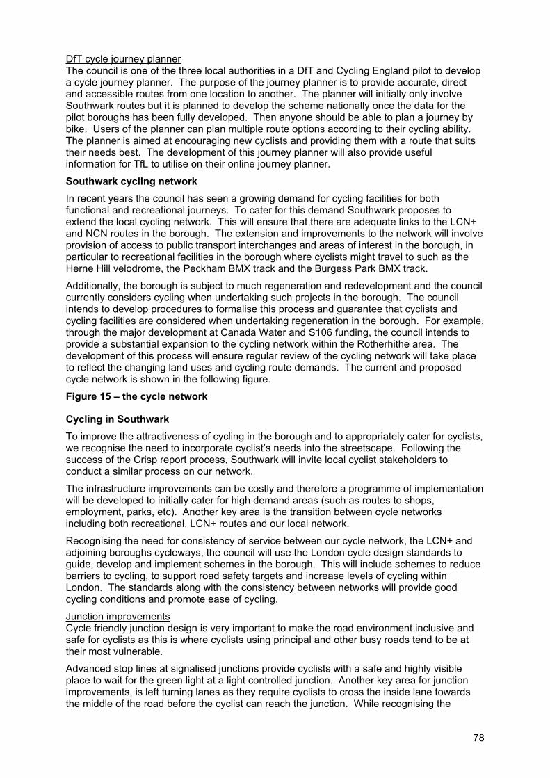
78
DfT cycle journey plannerThe council is one of the three local authorities in a DfT and Cycling England pilot to develop a cycle journey planner. The purpose of the journey planner is to provide accurate, direct and accessible routes from one location to another. The planner will initially only involve Southwark routes but it is planned to develop the scheme nationally once the data for the pilot boroughs has been fully developed. Then anyone should be able to plan a journey by bike. Users of the planner can plan multiple route options according to their cycling ability. The planner is aimed at encouraging new cyclists and providing them with a route that suits their needs best. The development of this journey planner will also provide useful information for TfL to utilise on their online journey planner.
Southwark cycling network In recent years the council has seen a growing demand for cycling facilities for both functional and recreational journeys. To cater for this demand Southwark proposes to extend the local cycling network. This will ensure that there are adequate links to the LCN+ and NCN routes in the borough. The extension and improvements to the network will involve provision of access to public transport interchanges and areas of interest in the borough, in particular to recreational facilities in the borough where cyclists might travel to such as the Herne Hill velodrome, the Peckham BMX track and the Burgess Park BMX track.
Additionally, the borough is subject to much regeneration and redevelopment and the council currently considers cycling when undertaking such projects in the borough. The council intends to develop procedures to formalise this process and guarantee that cyclists and cycling facilities are considered when undertaking regeneration in the borough. For example, through the major development at Canada Water and S106 funding, the council intends to provide a substantial expansion to the cycling network within the Rotherhithe area. The development of this process will ensure regular review of the cycling network will take place to reflect the changing land uses and cycling route demands. The current and proposed cycle network is shown in the following figure.
Figure 15 – the cycle network
Cycling in Southwark To improve the attractiveness of cycling in the borough and to appropriately cater for cyclists, we recognise the need to incorporate cyclist’s needs into the streetscape. Following the success of the Crisp report process, Southwark will invite local cyclist stakeholders to conduct a similar process on our network.
The infrastructure improvements can be costly and therefore a programme of implementation will be developed to initially cater for high demand areas (such as routes to shops, employment, parks, etc). Another key area is the transition between cycle networks including both recreational, LCN+ routes and our local network.
Recognising the need for consistency of service between our cycle network, the LCN+ and adjoining boroughs cycleways, the council will use the London cycle design standards to guide, develop and implement schemes in the borough. This will include schemes to reduce barriers to cycling, to support road safety targets and increase levels of cycling within London. The standards along with the consistency between networks will provide good cycling conditions and promote ease of cycling.
Junction improvementsCycle friendly junction design is very important to make the road environment inclusive and safe for cyclists as this is where cyclists using principal and other busy roads tend to be at their most vulnerable.
Advanced stop lines at signalised junctions provide cyclists with a safe and highly visible place to wait for the green light at a light controlled junction. Another key area for junction improvements, is left turning lanes as they require cyclists to cross the inside lane towards the middle of the road before the cyclist can reach the junction. While recognising the
79
function that left turn lanes have in the road network, Southwark intends to review all junctions with left turning only lanes and with the aim to their removal, where feasible.
Well designed signalised junctions can help improve the space for cyclists and make the cyclist feel safer on the road. The council will review all signalised junctions and undertake a programme of measures (i.e. advanced stop lines) where appropriate to improve the cycling environment.
Barriers to cyclistsPerceptions surrounding traffic conditions, fear of collisions and unsuitable road design are key issues affecting people’s propensity to cycle. This section discusses improvements to cyclist safety through physical improvements to the cycling environment. Cyclist safety is discussed at length in the RSP contained in appendix A.
Cyclists being more exposed to the road conditions are more sensitive to the conditions of pavements. Therefore regular and careful maintenance needs to be undertaken on Southwark’s cycle network. The council, in conjunction with Southwark Cyclists, will develop a detailed programme for ongoing maintenance of cycleways, parking and general environment including passive monitoring of lighting conditions.
Additionally, cycle signage needs to be reviewed regularly and we will undertake a programme of improvements where appropriate.
Cyclists can also be inconvenienced by physical barriers such as road closures and one way streets, which often expose them to longer journeys and worse traffic conditions. Arrangements that permit cyclists to use these streets in both directions are popular with cyclists and can redress the situation, improving the permeability of the cycle network. Such is the case in Highshore Road where the council installed a contra flow cycle lane and has seen an increase in cyclist numbers.
Southwark will review all current one way streets to assess the viability of converting such streets to two way or introduce contra flow cycle lanes and ensure any future plans assess the possibility of providing cycling.
High vehicular speeds can affect cyclists safety and in recognising this danger, Southwark Cyclists support Southwark’s aim to reduce speeds throughout the borough by making 20 mph the default speed.
To successfully achieve this the council will install traffic calming measures (such as speed humps and width restrictions). To help understand and address the needs of cyclists safety audits will be carried out before and after traffic management measures are installed. These audits will also identify any opportunities for how additional minor works could improve the road environment for cyclists.
5.9.3 Parking The provision of secure, convenient and available parking is important to increase and maintain cycling’s popularity. Southwark has undertaken an audit on cycle parks in the borough and is now implementing a programme to increase on street cycle parking.
Along with providing adequate cycle parking it is essential the area surrounding the parking facilities are safe and secure. Cycle parking should be located in areas with good lighting, high activity (for observation), close to user destination and locations monitored by CCTV should be used wherever possible.
Southwark sheffield stands are the norm however the council will investigate the provision of more secure long term cycle parking such as the BikeAway lockers that have previously been used. These lockers are excellent for housing/residential areas where cyclists can store their bikes safely and securely overnight.
The council will also investigate advances in cycle parking stands and facilities to increase the security and user friendly nature of cycle parking.
80
Cycle parking mapThe council mapped the existing cycle parking facilities in the borough when the audit of cycle parking was undertaken. This map is being currently rolled out and will be fully accessible on the council website mid 2006. The map will be very user friendly, cyclists will be able to visually mark on the map where they want to go and zoom in and locate the cycle parking. They will also be able to identify what cycle parking is available at the location and photos will be linked to the map so they can see what the parking looks like.
Cycle parking at transport interchangesSouthwark Council needs to improve interchange between cycling and alternate modes, in particular interchanges train/tube stations to help promote cycling for longer multi modal journeys and increase the numbers of cyclists.
Following a review of cycle parking provision in the vicinity of all train stations concern is raised at the lack of cycling parking facilities at Borough station and the poorly located and utilised cycle parking at Canada Water and Southwark stations. The council will work with TfL to improve parking facilities at these locations.
The London cycle action plan supports the TfL flagship scheme to implement bike stations at transport interchanges throughout London. The bike stations will offer a full range of cycling facilities such as adequate secure cycle parking and access to bicycle storage, hire and repair services.
The council will use the opportunity of the refurbishment works at London Bridge as part of the Thameslink project to promote the installation of a bike station. Due to London Bridge’s central location and ease of access to both the business district and mainline train services there is an established high demand for secure cycle parking facilities. This is a prime opportunity to look at advanced bike parking facilities similar to that provided in European cities, which have proven successful in increasing cycling use.
Similar opportunities are present within the Elephant and Castle regeneration and it’s reprioritisation away from the motor vehicle to provide increased and more secure cycle parking facilities.
In addition to this, the council will advocate for and provide bike stations with the refurbishment of Peckham Rye station and through the regeneration of Canada Water.
5.9.4 Training Cycle training gives the rider more confidence and can increase the amount of journeys taken by cycle. Increasing availability of cycle training to more people in the borough will lead to better cycling standards and adherence to the highway code.
Southwark currently use CTUK who use fully qualified instructors to teach to the National Standards (as set by DfT).
The council currently provide heavily discounted lessons for anyone living, studying or working in Southwark through CTUK and dependant upon funding hope to continue this service annually.
The council has set the following annual targets that are aimed at increasing cycle training at schools: increase by 10% the number of students receiving cycle training; and provide cycle training to five additional schools. The council provided training to over 200 school children and 25 schools throughout 2005/2006 year. This is an ever increasing figure with more and more schools taking up the opportunity to provide their pupils with cycle training.
Southwark also recognises that initiatives to educate the motorist and other road users so that they understand cycle facilities and transport policies that are necessary to improve road user, particularly cycle user awareness.
81
Cycle saturation project Rotherhithe community council allocated £20,000 to Southwark Cyclists to undertake a cycling training project. Local primary schools were invited to apply and St John’s RC primary school was selected to receive cycle saturation. Year five and six pupils of St John’s RC primary school had previously received cycle skills training funded by Southwark Council. However the school only had two pupils cycling to school although 84% were interested in doing so and there was a high number of pupils coming by car.
Having determined there was a high degree of suppressed interest in cycling among the school community the approach of cycle saturation was to deliver a concentrated burst of cycling promotion and training to pupils, parents and staff to achieve an increase in cycling activity. Cycle training was given to nearly 40% of pupils and cycle instructor training was also offered to staff and parents. Cycle parking for 60 cycles was installed just in time for the launch in summer 2005 and this is often full during the summer term. In excess of 80 bikes are now parked at the school on special event days.
The success of this project is very clear and it is recognised as helping the council reach the cycle training targets, while also supporting the road safety targets by enhancing the children’s safety. The council intends to investigate opportunities and work closely with Southwark Cyclists to roll this programme out to other schools in the borough.
Cycle training at Salmon Youth centre The council has received funding through the borough spending plan to provide cycle training to the Salmon youth centre in Bermondsey for up to 80 youths. The objective of this proposal is to improve road safety for youth cyclists in a deprived part of the borough. This proposal has arisen out of consultation undertaken during ‘bike week’ in Southwark over recent years, for which social inclusion was considered by many to be of importance where such training schemes are proposed.
The training sessions will address issues such as cycle control and maintenance, hand signals and the Highway Code, the importance of being clearly visible to other road users and negotiation of particular road situations, such as junctions. In addition, the council will purchase ten bicycles for the youth centre to continue this training regularly. Cycle Training UK will undertake the training and it will be launched during bike week 2006/2007 and continue through the remainder of the financial year.
5.9.5 Enforcement Enforcement is a key tool to improve cyclist’s safety on our roads and encourage cycling in the borough. We will therefore work with the police to provide appropriate enforcement of cycling infrastructure. We encourage and support the introduction of police on bicycles and see this as an opportunity for a cooperative approach with other cyclists.
Pedestrians often come into conflict with cyclists riding on pavements. Areas with a high use of pavement cycling will be assessed to see if this is due to perceived dangerous road conditions rather than inconsiderate behaviour. Measures to discourage cycling on pavements will be investigated and could include improvements to the cycling conditions and infrastructure on the road, provision of training and education, shared use paths, and increased enforcement. In areas with high footfall, such as the Thames path, alternative routes will be signed, including destinations, and every effort will be made to encourage cyclists to use these.
Cyclists are covered by the regulations in the highway code like all other road users and ignoring traffic rules and signals is both illegal and dangerous. The Metropolitan Police currently enforce cycling on pavements, however are unable to issues penalty notices to cyclists aged 16 and under.
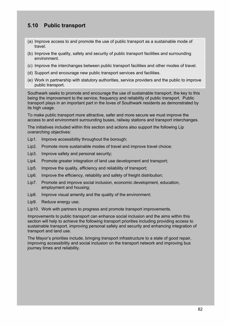
82
5.10 Public transport
(a) Improve access to and promote the use of public transport as a sustainable mode of travel.
(b) Improve the quality, safety and security of public transport facilities and surrounding environment.
(c) Improve the interchanges between public transport facilities and other modes of travel.
(d) Support and encourage new public transport services and facilities.
(e) Work in partnership with statutory authorities, service providers and the public to improve public transport.
Southwark seeks to promote and encourage the use of sustainable transport, the key to this being the improvement to the service, frequency and reliability of public transport. Public transport plays in an important part in the loves of Southwark residents as demonstrated by its high usage.
To make public transport more attractive, safer and more secure we must improve the access to and environment surrounding buses, railway stations and transport interchanges.
The initiatives included within this section and actions also support the following Lip overarching objectives:
Lip1. Improve accessibility throughout the borough;
Lip2. Promote more sustainable modes of travel and improve travel choice;
Lip3. Improve safety and personal security;
Lip4. Promote greater integration of land use development and transport;
Lip5. Improve the quality, efficiency and reliability of transport;
Lip6. Improve the efficiency, reliability and safety of freight distribution;
Lip7. Promote and improve social inclusion, economic development, education, employment and housing;
Lip8. Improve visual amenity and the quality of the environment;
Lip9. Reduce energy use;
Lip10. Work with partners to progress and promote transport improvements.
Improvements to public transport can enhance social inclusion and the aims within this section will help to achieve the following transport priorities including providing access to sustainable transport, improving personal safety and security and enhancing integration of transport and land use.
The Mayor’s priorities include, bringing transport infrastructure to a state of good repair, improving accessibility and social inclusion on the transport network and improving bus journey times and reliability.
83
5.10.1 Safety on public transport Crime and fear of crime on and around public transport can create a poor environment and reduce the appeal of public transport. To improve security we seek to work closely with our partners including TfL, British Transport Police (BTP) and the Metropolitan Police.
Currently TfL are providing safety improvements which include:
Increasing uniformed presence;
Installing CCTV units;
Improving bus shelters and stations;
Increasing the number of night and 24 hour bus services;
Providing visible deterrents.
The council supports all safety improvements within the borough and the measures to be implemented by TfL. The council recognises that crime and fear of crime can be a barrier to people using public transport and that by providing safety improvements we can encourage greater use of the public transport system, at all hours of the day.
London Buses install CCTV on all new buses and will extend this technology to the entire fleet within three years. This protects passengers and staff acting as a deterrent to possible offenders and provides evidence in the event of an incident. London Buses are currently researching the possibility of using CCTV at bus stops. It is hoped that this added security measure will improve safety, bus stop environment and increase usage. Safety concerns have been raised on the low floor bendy buses within the borough and the council will work with TfL to target crime on these bus routes.
BTP is the national police force for the railways including the London Underground system. Data supplied by the BTP indicate that London Bridge suffers from the highest rate of robberies within Southwark, however this is probably based on the size of the station, as well as including data from the two underground stations.
Of more significance are Peckham Rye and Nunhead stations that don’t have as many passengers passing through but have a comparable level of robbery. This indicates that the chances of becoming a victim at these stations is higher than at London Bridge.
Officers patrolling the system in both uniform and plain clothes providing high profile policing can act as a deterrent to crime and improve the perception of crime in and around railway stations. Southwark would like to see additional BTP presence in and around train stations in the borough.
Improving safety will be a positive action that will increase the representation of target equality groups and the mobility impaired on public transport. Southwark will work in partnership with SSP, BTP, Metropolitan Police, TOCs and TfL to provide safety improvements and monitor safety on public transport in Southwark. The council seeks to work in partnership with key transport stakeholders to ensure that all staff are trained and understand the needs of passengers particularly those with mobility impairments using public transport.
5.10.2 Buses Southwark has traditionally had a high usage of bus services. Areas in the south of the borough which have limited train facilities, such as Dulwich, Camberwell and Peckham, rely heavily on bus services.
Evidence can be seen of this on Walworth Road, the link to the south of the borough, that maintains one of the highest levels of bus service in London, second only to Oxford Street. Southwark recognises that priority bus services are a necessity in order to reduce journey times and congestion, improve reliability and promote modal shift.
84
The provision of efficient bus services is even more important in Southwark than other inner London boroughs as there are several serious gaps in the fixed rail network in the borough as outlined in section 2.3.
Although the proposed Cross River Tram would fill the fixed line transport gap centred on the Aylesbury Estate and Burgess park area, this project has only recently received formal support from the SRA and TfL and is not likely to be completed during the life of this plan. In addition, proposals for a rail station in Camberwell, primarily to be considered as part of Thameslink has been ruled out (see section 4.1.3).
In addition to improving journey times and promoting modal shift, buses play an important role in assisting neighbourhood renewal and the social and economic regeneration of the borough. Furthermore, they contribute to tourism and this is especially important in the north of Southwark, which is fast becoming one of the tourist centres of London.
From September 2005 the Mayor provided free bus and tram travel for all children under the age of 16 and those in full time education under the age of 18. This scheme is recognised as being a significant measure to encourage young people to use public transport and reduce dependency on the private car. It will also ease congestion, pollution and casualties by reducing the school run. It will help families and young people to access education, sports and leisure services at a more affordable price. Southwark Council supports the Mayor’s initiative and believes that it will help improve transport services throughout the entire region.
Driver training In response to the need to improve bus driver development and to make training standards consistent across all London bus companies, TfL has established the fully funded BTEC training scheme. The qualification was introduced in 2004 and it is compulsory that all London bus drivers complete the training.
In order to help achieve the Mayor’s Transport Strategy objective of making all London buses reliable, quick, convenient, accessible, comfortable, clean, easy and safe to use and affordable, the course covers issues such as health, safety and security, communication skills and defensive driving skills.
Both new and existing bus drivers are given the knowledge and skills they need to respond professionally to incidents on the road. The training also provides drivers with an understanding of customers’ needs and expectations and an awareness of the issues faced by disabled and elderly customers.
London Bus Priority Network The LBPN was established in 1994 and was originally a network of borough roads across the whole of London that complemented Priority (Red) Routes. The LBPN now covers all roads that carry buses and is administered by the LBPN Partnership on behalf of TfL and the boroughs.
In order to continue to provide an efficient, desirable and more sustainable option to the private motor vehicle, and to provide interim accessibility to the gaps in Southwark’s fixed line network, there is a need to continue the work that has been undertaken through the LBPN initiatives to provide designated bus priority lanes and priority at some junctions.
Southwark supports the approach taken by the LBPN partnership and proposes to continue working with them, TfL and local communities, to ensure that the existing network is maintained and extended where appropriate.
A Roads and busy bus routes The borough has progressively undertaken review of all A roads and busy bus routes to provide bus priority. The following table details the relevant routes, their initial review date and their proposed future review.
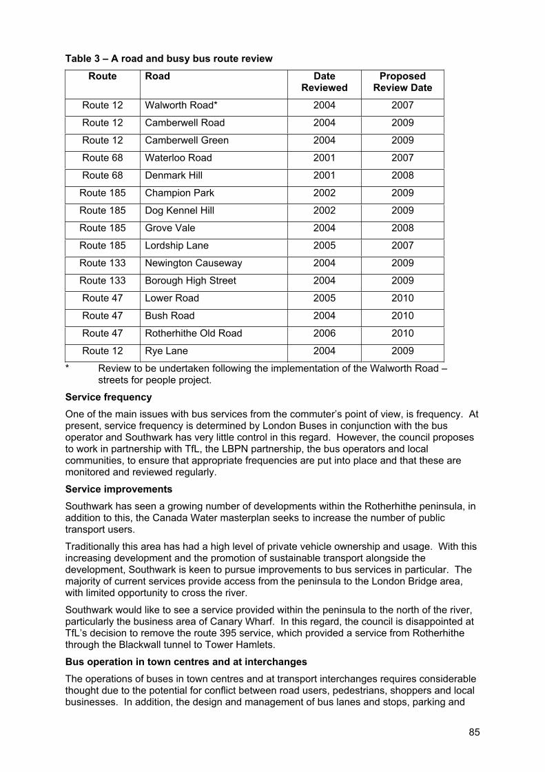
85
Table 3 – A road and busy bus route review
Route Road Date Reviewed
ProposedReview Date
Route 12 Walworth Road* 2004 2007
Route 12 Camberwell Road 2004 2009
Route 12 Camberwell Green 2004 2009
Route 68 Waterloo Road 2001 2007
Route 68 Denmark Hill 2001 2008
Route 185 Champion Park 2002 2009
Route 185 Dog Kennel Hill 2002 2009
Route 185 Grove Vale 2004 2008
Route 185 Lordship Lane 2005 2007
Route 133 Newington Causeway 2004 2009
Route 133 Borough High Street 2004 2009
Route 47 Lower Road 2005 2010
Route 47 Bush Road 2004 2010
Route 47 Rotherhithe Old Road 2006 2010
Route 12 Rye Lane 2004 2009
* Review to be undertaken following the implementation of the Walworth Road – streets for people project.
Service frequency One of the main issues with bus services from the commuter’s point of view, is frequency. At present, service frequency is determined by London Buses in conjunction with the bus operator and Southwark has very little control in this regard. However, the council proposes to work in partnership with TfL, the LBPN partnership, the bus operators and local communities, to ensure that appropriate frequencies are put into place and that these are monitored and reviewed regularly.
Service improvements Southwark has seen a growing number of developments within the Rotherhithe peninsula, in addition to this, the Canada Water masterplan seeks to increase the number of public transport users.
Traditionally this area has had a high level of private vehicle ownership and usage. With this increasing development and the promotion of sustainable transport alongside the development, Southwark is keen to pursue improvements to bus services in particular. The majority of current services provide access from the peninsula to the London Bridge area, with limited opportunity to cross the river.
Southwark would like to see a service provided within the peninsula to the north of the river, particularly the business area of Canary Wharf. In this regard, the council is disappointed at TfL’s decision to remove the route 395 service, which provided a service from Rotherhithe through the Blackwall tunnel to Tower Hamlets.
Bus operation in town centres and at interchanges The operations of buses in town centres and at transport interchanges requires considerable thought due to the potential for conflict between road users, pedestrians, shoppers and local businesses. In addition, the design and management of bus lanes and stops, parking and
86
loading arrangements, as well as pedestrian and cycle facilities is vital to ensure the safety and security of all and to promote greater use of other sustainable modes of travel.
Southwark carefully considers and monitors bus operations in our town centres.
Enforcement To ensure that the network runs smoothly and that buses are given priority over motor vehicles, it is a necessity that bus lanes are kept clear from obstruction. Although London Buses currently provides mobile and camera enforcement of red routes20, it is often difficult to enforce bus lanes on borough roads, as sufficient resources do not exist for parking attendants to monitor every bus route. Accordingly, there has been an increasing desire to use cameras to supplement enforcement by wardens and attendants on busy bus lanes and at priority junctions. At present, Southwark has numerous bus lanes monitored by CCTV cameras and the council supports greater use of this technology in appropriate locations.
Since 2002, the council has participated in partnership arrangements with the London Bus Initiative (LBI) for the enforcement of bus lanes. This service level agreement with the LBI was renewed in 2005 for a further three years. Originally CCTV cameras were installed within the Walworth Road corridor from Newington Causeway to Denmark Hill. Following the renewal of the agreement the camera network was extended.
The camera network is monitored by the council’s parking enforcement contractors who also undertake enforcement action at agreed levels. In addition, regular meetings are held with the LBI and bus operators to review reported hotspots where buses are regularly held up by traffic congestion or parked vehicles. Typically action following these meetings involves modifying local enforcement arrangements, but in some instances revisions will be introduced in local waiting restrictions or traffic management.
Bus stops In Southwark, much work has been undertaken in recent years to improve the bus stop environment and improve access, comfort and safety for passengers. These improvements have been driven by auditing the accessibility of the bus stop and surrounds to provide a clear picture of the needs of bus users.
Given the success of this process, the council is keen to pursue the auditing of all our bus stops on a route by route basis to assess accessibility and provide improvements. However, given the extent of bus services within the borough, there are still many stops that are in need of improvements.
Improving the bus stop environment not only entails bus to stop access (thereby reducing dwell times and improving disabled access and reliability) but also improves passenger to stop access (whereby passengers of all ages and ability are assisted in gaining access to fixed bus stops). Improvements carried out at bus stops are done in accordance with TfL’s streetscape guidance and the requirements under the DDA. Where possible, waiting environments are upgraded to provide essential infrastructure such as shelters, lighting and stop specific timetables.
Bus shelters will preferentially be located in busy locations that are well lit and have opportunities for informal observation. Improving the bus stop environment is particularly important for mobility impaired persons and for women, who traditionally use public transport more than men and who have greater feelings of insecurity waiting at bus stops for long periods of time, especially at night. TfL are progressively installing countdown devices on all high frequency bus routes and the council supports their installation. We also recognise the benefit that this real time information can provide to bus users, and support their introduction on all bus routes.
As the majority of bus routes in Southwark traverse residential streets, the council recognises the importance of balancing the need for local resident on street parking and achieving fully 20 Red routes are roads that have stopping and parking restrictions in place and are regulated by red no-stopping lines and signage.
87
accessible bus stops. However, as the council has prioritised public transport above motor vehicles in the road user hierarchy and the potential benefit to a higher number of users, bus stop provision must be considered as a priority over on street parking provision or indeed general traffic flow along the routes used by buses.
In addition, many busy bus routes traverse shopping high streets and town centres and the balance between bus priority/stop accessibility and parking and loading arrangements is particularly acute. Accordingly, the council is continually engaging with local residents, businesses and service operators to achieve equitable compromises.
Bus stands Southwark seeks to retain the existing bus stand facilities. However, we recognise that with the increasing frequency and number of services additional facilities may be required. Southwark will seek to provide bus stands in locations that are practical for the operators in that they are located near bus routes and terminus location but maintain minimal impact on residential amenity in terms of noise, parking and street environment. This is a difficult balance to strike, however we will work closely with TfL address this issue.
Southwark currently has six bus garages located within the borough at a number of locations including:
Mandela Way (two);
Camberwell New Road (one in Walworth and one in Camberwell);
Blackpool Road;
Peckham High Street.
The council seeks to retain the existing bus garages as bus services that the commence and terminate within the borough bring about an increased availability and reliability in service.
Partnerships and liaison The overarching controller of buses in London is TfL, through their agency London Buses. All service issues and complaints are directed directly to London Buses rather than to the bus operators or to the council. However, the council actively represents Southwark’s residents and businesses on major complaints or service issues and will continue to do so.
At an operational level, the LBPN partnership is the main body that administers improvements to the bus network and acts as a liaison between TfL and the boroughs. Southwark will continue to work through the LBPN partnership in terms of identifying the need for improvements, bidding for funding and monitoring progress.
Southwark also believes that greater liaison and interaction is required at lower levels to enable local members, residents and businesses to directly influence the outcome of bus improvements. The council currently liaises between the various stakeholders, local representatives, council officers, bus operators and TfL representatives to improve bus services within the borough.
5.10.3 Tube Three tube lines are contained within the borough, the Northern line that extends from London Bridge to Kennington (on the borough boundary). The Jubilee line links the West End, Waterloo and London Bridge with the Rotherhithe peninsula and on via Canary Wharf to Stratford. The Bakerloo line runs from the north east of London, through Oxford Circus, terminating at Elephant and Castle.
Northern line The northern line enters the borough at the river Thames (London Bridge station) and travels to the south west to Kennington station (located on the borough boundary with Lambeth).
Of the three lines within Southwark, the Northern is the oldest, opening in 1890. The line was progressively extended to the north and extended to Morden in 1926. The line was completed as we see it today in 1941.
88
The Northern line has suffered from neglect in the past and is currently due for a replacement signalling system in 2011. This signalling system will improve journey times by 18%, this will be of particular importance with the additional homes being constructed within the Elephant and Castle area placing an increasing demand on the service.
Extensive rail replacement and refurbishment of over 60km in length and drainage repairs in excess of 4km is proposed by 2010.
Bakerloo line Originally constructed in 1906 with a service between Baker Street and Lambeth North with the Elephant & Castle station opening in late 1906. The line has been progressively extended to the north, Queen's Park , Watford Junction by 1917 and in 1939, a new tunnelled section was built from Baker Street to Finchley Road.
In 1982, the service beyond Queen's Park to Watford Junction was withdrawn. Queen's Park again became the northern terminus until the service was extended again to service Harrow & Wealdstone in 1989.
The current fleet of trains is one of the oldest on the tube system and a new fleet of trains is proposed by 2020. In addition to this it is proposed to upgrade the line in 2020 to increase capacity by 17%. Meanwhile, Elephant and Castle is subject to station improvements which are due for completion in mid 2006.
The council welcomes these improvements to the service and station and seeks to work cooperatively with LUL.
Jubilee line The first section of the Jubilee line was opened in about 1977 (the Queens Silver Jubilee) and extended in 1999 to service development at Canary Wharf.
Certain economies were made in the extension of the Jubilee line in only ordering six car trains and a cheaper but proven signalling system. This has presented future difficulties and in late 2005, additional carriages for all train sets will be added to every train.
New signalling to be introduced by 2009 will allow up to a maximum of 30 to 32 trains per hour. The new signalling will also allow theoretical average journey times to be reduced by 18%, increasing the utilisation of each train and producing a better service for passengers. Thus the scheduled improvements to the Jubilee line should create a 45.8% increase in capacity.
At times the Jubilee line experiences crowding particularly between Westminster and Canary Wharf. There is without doubt considerable potential for further development along the Jubilee line route. With the capacity increase as discussed, the line should be able to cope with the additional development and patronage.
Major development and regeneration is planned for the Rotherhithe peninsula, including Canada Water. As part of the development of this area, further understanding is required on transport provision within the area. Southwark seeks to work in partnership with our neighbours, London boroughs of Greenwich and Lewisham, TfL, PLA and others to develop a multi modal transport study of the Rotherhithe peninsula.
5.10.4 Trains Southwark is particularly well served by the overland rail network however, the accessibility of stations on this network and the frequency of service continue to be the major concerns of users. There are 11 surface rail stations and these are operated by two train operating companies (TOCs), Southern and South Eastern, as well as Network Rail.
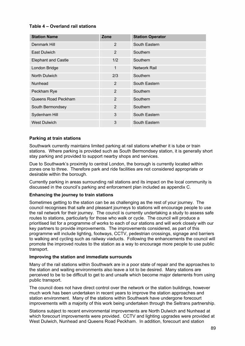
89
Table 4 – Overland rail stations
Station Name Zone Station Operator
Denmark Hill 2 South Eastern
East Dulwich 2 Southern
Elephant and Castle 1/2 Southern
London Bridge 1 Network Rail
North Dulwich 2/3 Southern
Nunhead 2 South Eastern
Peckham Rye 2 Southern
Queens Road Peckham 2 Southern
South Bermondsey 2 Southern
Sydenham Hill 3 South Eastern
West Dulwich 3 South Eastern
Parking at train stationsSouthwark currently maintains limited parking at rail stations whether it is tube or train stations. Where parking is provided such as South Bermondsey station, it is generally short stay parking and provided to support nearby shops and services.
Due to Southwark’s proximity to central London, the borough is currently located within zones one to three. Therefore park and ride facilities are not considered appropriate or desirable within the borough.
Currently parking in areas surrounding rail stations and its impact on the local community is discussed in the council’s parking and enforcement plan included as appendix C.
Enhancing the journey to train stations Sometimes getting to the station can be as challenging as the rest of your journey. The council recognises that safe and pleasant journeys to stations will encourage people to use the rail network for their journey. The council is currently undertaking a study to assess safe routes to stations, particularly for those who walk or cycle. The council will produce a prioritised list for a programme of works to each of our stations and will work closely with our key partners to provide improvements. The improvements considered, as part of this programme will include lighting, footways, CCTV, pedestrian crossings, signage and barriers to walking and cycling such as railway viaducts. Following the enhancements the council will promote the improved routes to the station as a way to encourage more people to use public transport.
Improving the station and immediate surrounds Many of the rail stations within Southwark are in a poor state of repair and the approaches to the station and waiting environments also leave a lot to be desired. Many stations are perceived to be to be difficult to get to and unsafe which become major deterrents from using public transport.
The council does not have direct control over the network or the station buildings, however much work has been undertaken in recent years to improve the station approaches and station environment. Many of the stations within Southwark have undergone forecourt improvements with a majority of this work being undertaken through the Seltrans partnership.
Stations subject to recent environmental improvements are North Dulwich and Nunhead at which forecourt improvements were provided. CCTV and lighting upgrades were provided at West Dulwich, Nunhead and Queens Road Peckham. In addition, forecourt and station
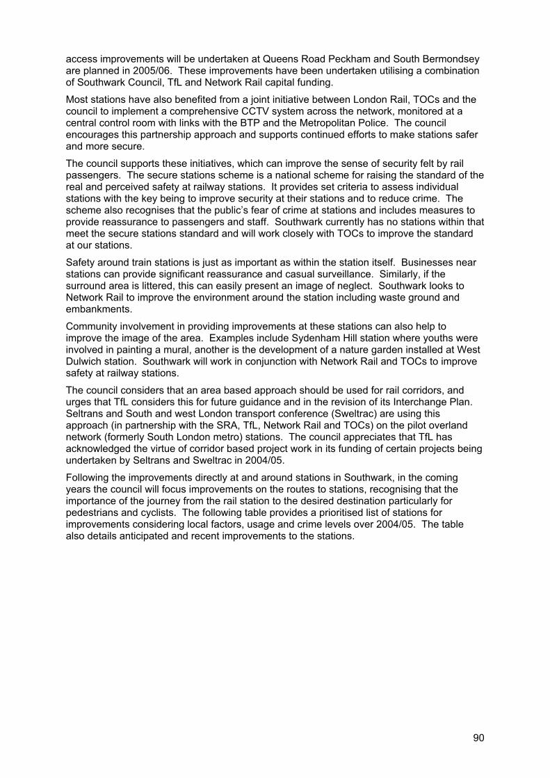
90
access improvements will be undertaken at Queens Road Peckham and South Bermondsey are planned in 2005/06. These improvements have been undertaken utilising a combination of Southwark Council, TfL and Network Rail capital funding.
Most stations have also benefited from a joint initiative between London Rail, TOCs and the council to implement a comprehensive CCTV system across the network, monitored at a central control room with links with the BTP and the Metropolitan Police. The council encourages this partnership approach and supports continued efforts to make stations safer and more secure.
The council supports these initiatives, which can improve the sense of security felt by rail passengers. The secure stations scheme is a national scheme for raising the standard of the real and perceived safety at railway stations. It provides set criteria to assess individual stations with the key being to improve security at their stations and to reduce crime. The scheme also recognises that the public’s fear of crime at stations and includes measures to provide reassurance to passengers and staff. Southwark currently has no stations within that meet the secure stations standard and will work closely with TOCs to improve the standard at our stations.
Safety around train stations is just as important as within the station itself. Businesses near stations can provide significant reassurance and casual surveillance. Similarly, if the surround area is littered, this can easily present an image of neglect. Southwark looks to Network Rail to improve the environment around the station including waste ground and embankments.
Community involvement in providing improvements at these stations can also help to improve the image of the area. Examples include Sydenham Hill station where youths were involved in painting a mural, another is the development of a nature garden installed at West Dulwich station. Southwark will work in conjunction with Network Rail and TOCs to improve safety at railway stations.
The council considers that an area based approach should be used for rail corridors, and urges that TfL considers this for future guidance and in the revision of its Interchange Plan. Seltrans and South and west London transport conference (Sweltrac) are using this approach (in partnership with the SRA, TfL, Network Rail and TOCs) on the pilot overland network (formerly South London metro) stations. The council appreciates that TfL has acknowledged the virtue of corridor based project work in its funding of certain projects being undertaken by Seltrans and Sweltrac in 2004/05.
Following the improvements directly at and around stations in Southwark, in the coming years the council will focus improvements on the routes to stations, recognising that the importance of the journey from the rail station to the desired destination particularly for pedestrians and cyclists. The following table provides a prioritised list of stations for improvements considering local factors, usage and crime levels over 2004/05. The table also details anticipated and recent improvements to the stations.
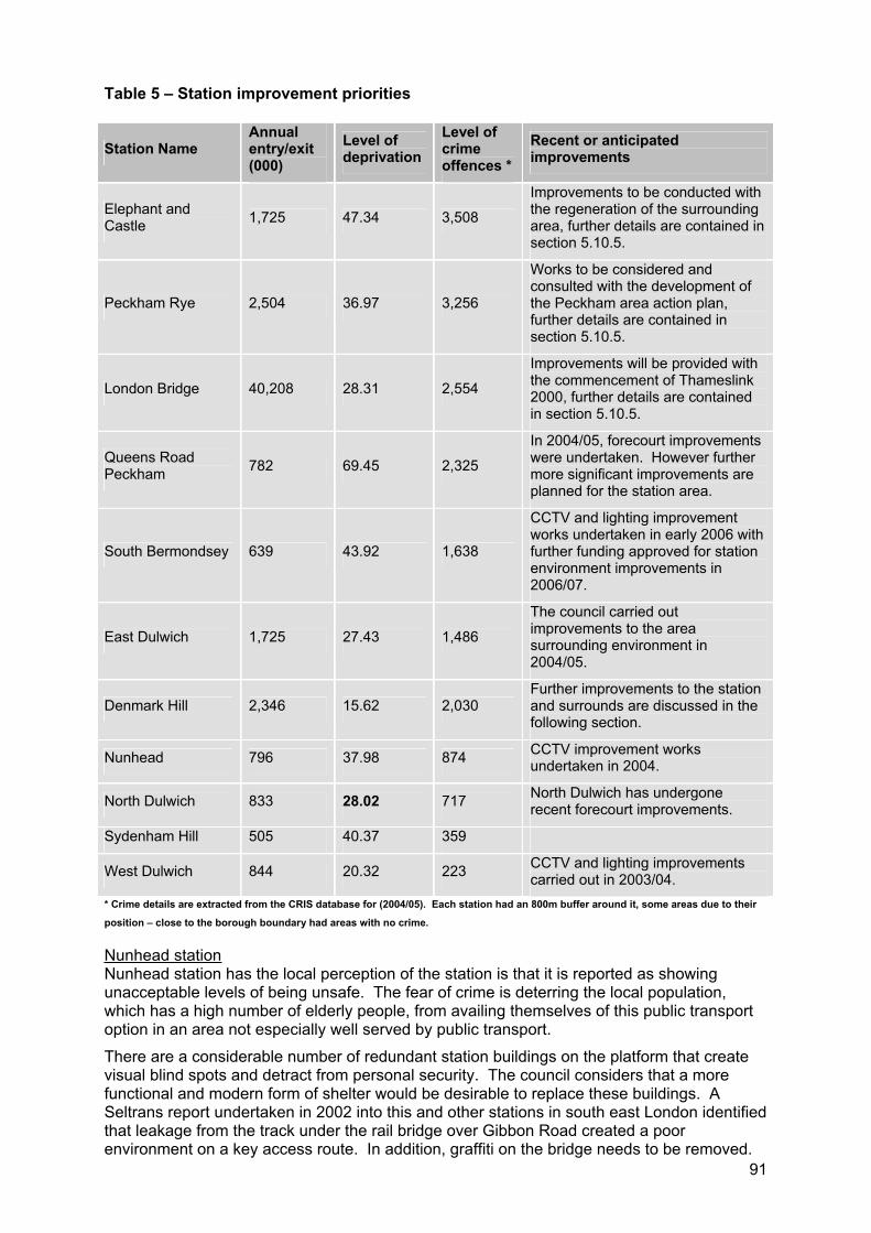
91
Table 5 – Station improvement priorities
Station Name Annual entry/exit (000)
Level of deprivation
Level of crimeoffences *
Recent or anticipated improvements
Elephant and Castle 1,725 47.34 3,508
Improvements to be conducted with the regeneration of the surrounding area, further details are contained in section 5.10.5.
Peckham Rye 2,504 36.97 3,256
Works to be considered and consulted with the development of the Peckham area action plan, further details are contained in section 5.10.5.
London Bridge 40,208 28.31 2,554
Improvements will be provided with the commencement of Thameslink 2000, further details are contained in section 5.10.5.
Queens Road Peckham 782 69.45 2,325
In 2004/05, forecourt improvements were undertaken. However further more significant improvements are planned for the station area.
South Bermondsey 639 43.92 1,638
CCTV and lighting improvement works undertaken in early 2006 with further funding approved for station environment improvements in 2006/07.
East Dulwich 1,725 27.43 1,486
The council carried out improvements to the area surrounding environment in 2004/05.
Denmark Hill 2,346 15.62 2,030Further improvements to the station and surrounds are discussed in the following section.
Nunhead 796 37.98 874 CCTV improvement works undertaken in 2004.
North Dulwich 833 28.02 717 North Dulwich has undergone recent forecourt improvements.
Sydenham Hill 505 40.37 359
West Dulwich 844 20.32 223 CCTV and lighting improvements carried out in 2003/04.
* Crime details are extracted from the CRIS database for (2004/05). Each station had an 800m buffer around it, some areas due to their
position – close to the borough boundary had areas with no crime.
Nunhead stationNunhead station has the local perception of the station is that it is reported as showing unacceptable levels of being unsafe. The fear of crime is deterring the local population, which has a high number of elderly people, from availing themselves of this public transport option in an area not especially well served by public transport.
There are a considerable number of redundant station buildings on the platform that create visual blind spots and detract from personal security. The council considers that a more functional and modern form of shelter would be desirable to replace these buildings. A Seltrans report undertaken in 2002 into this and other stations in south east London identified that leakage from the track under the rail bridge over Gibbon Road created a poor environment on a key access route. In addition, graffiti on the bridge needs to be removed.
92
Accessing the station Many of the stations within Southwark are in a poor state of repair and the approaches to the station and waiting environments are dire and accessibility for the mobility impaired is particularly limited.
The Strategic Rail Authority (SRA) published for consultation its Railways for All document in March 2005, which describes the proposed programme for investment across the United Kingdom, to bring stations in line with the DDA. Within Southwark, the document designates West Dulwich, Denmark Hill, Herne Hill and Peckham Rye as priority stations for improvement. Although the council supports this first step, much more is needed in order to address the concerns of residents.
Denmark HillThe council is particularly keen that lifts are installed at Denmark Hill given the stations proximity to Kings College and Maudsley Hospitals. Patients visiting the hospitals come from far a field, including those accessing them through rail services via London Bridge station. The council wishes to work in partnership with the rail industry, TfL, the NHS and other partners to pursue the installation of lifts at this station. Denmark Hill, like Queens Road Peckham and Peckham Rye, are stations on the proposed extended East London line (phase two).
5.10.5 Interchanges Interchanges are a key feature of transport journey, particularly for journeys involving public transport. Good interchanges allow passengers to travel more efficiently and can reduce congestion and improve the travelling experience.
The basic requirements for good interchange facilities include, sufficient appropriately located secure cycle parking, convenient links to walking routes, bus stops and pick up/set down facilities. Journeys are not just the travelling, it is also important to provide users with information of their journey, such as real time information, as well as ease of ticket purchase, all things that can add to the time and inconvenience of your journey.
Within Southwark the three strategic transport interchanges identified by the TfL Interchange Plan are London Bridge, Elephant and Castle and Peckham Rye. London Bridge provides interchange between the underground, National Rail network and a bus station. The station also provides key access to the Bankside business district. Refurbishment of the station is proposed as part of the Thameslink project. This will improve interchange between modes of transport as discussed in section 5.2. Currently Southwark’s only operating taxi rank is located at London Bridge and the council supports the retention of this key service to this area with the redevelopment of the station and environs.
Elephant and Castle provides interchange between the underground and overland rail network. The station is also a busy bus area, with a larger number of buses servicing areas to the south of the borough and into Lambeth. Improvement to the station and surrounds is proposed through the regeneration of the Elephant and Castle, with improvements generally provided around the overland station. With redevelopment some time in the future, currently the area is difficult to negotiate, poorly lit and suffers from crime and perception of crime. Southwark seeks to improve this situation by providing improved signage, lighting and CCTV.
The third strategic station is Peckham Rye. This station is currently in a state of poor repair. The council commissioned a study of the station and forecourt area completed in September 2003 which identified opportunities for improvement. These will be taken forward through the emerging Peckham area action plan. This station is likely to grow in importance with the delivery of the Cross River Tram terminus within the vicinity. Easy interchange between the two modes is a key issue for the development of the tram route and final stop into Peckham.
Southwark however seeks improvements to our many stations as inevitably all stations provide interchange between modes of transport. Section 5.10.4 details the councils prioritised list for improvements at stations within the borough. Due to the many stakeholders involved in railway stations Southwark recognises that partnership is key to any
93
successful work on interchanges and we seek to work will all stakeholders to achieve the best outcome for the community.
5.10.6 Trams Section 5.2 discusses the implications for the Cross River Tram within Southwark.
5.10.7 Ferries The potential of the river Thames is a key opportunity in Southwark and is recognised as an under utilised asset in the Mayors economic development strategy. Within Southwark there are two passenger piers, being the London Bridge City Pier and Bankside Pier providing access to Shakespeare’s Globe and the Tate Modern.
Southwark’s position adjacent the Thames provides us with a unique opportunity. The council seeks to encourage water borne movement that can be combined with measures to increase the use of the river for transport in general. However this must be balanced with the environmental and amenity impact on the riverside and surrounds.
Aside from the two publicly available piers, within Southwark there are six additional piers, which are operated by LRS, part of TfL. LRS licenses a range of scheduled and charter river boat services from these piers and requires operators of party boats using them to fit noise monitors to amplification equipment to enable noise to be controlled by the operator of the vessel.
However, these party boats may also operate from other piers not controlled by LRS and may not be regulated by the LRS licensing. Complaints about moving late night noise sources on the river are more difficult to deal with than similar complaints about a nearby pub. The licensing situation of party boats is inconsistent and the council will advocate for noise control to be included in licensing reform.
Southwark’s position adjacent the Thames provides us with a unique opportunity. The potential of the river Thames for the transport of freight is a key opportunity in Southwark and is recognised as an under utilised asset in the Mayors economic development strategy.
94
5.11 Powered two wheelers
(a) Improve road safety for powered two wheelers.
(b) Provide additional parking opportunity for powered two wheelers.
(c) Promote, encourage and provide powered two wheeler training to increase rider confidence and safety.
Powered two wheelers (PTWs) provide an alternative means of travel to the motor vehicle, particularly in urban areas. They have the advantage of being relatively efficient and economical to run, capable of long distances, manoeuvrable and provide a flexible, door to door solution to transport needs for the user.
The use of PTWs has been increasing in recent years, this is particularly noticeable in the north of the borough and may be due to their exemption from the Mayor’s congestion charge. Their exemption from the congestion charge is a positive incentive to the usage of powered two wheelers and in turn we have identified a growing demand for parking within the congestion charging zone.
In recognition of the limited road space they require in comparison to that of the motor vehicle, we have placed PTWs above motor vehicles in the road user hierarchy.
The key issues in regard to PTWs are the growing safety concerns associated with increased PTW casualties, the maintenance of roads, the provision of secure parking facilities and the use of bus lanes by PTWs.
Relevant Lip objectives are:
Lip3. Improve safety and personal security;
Lip4. Improve the quality, efficiency and reliability of transport.
The council acknowledges the safety implications for PTW and seeks to improve the safety of our roads, this is reiterated by the Mayor who seeks to improve road safety as a priority.
95
5.11.1 Safety Southwark Council is very concerned about the high rate of PTW casualties in the borough, this is discussed in length within the RSP.
The council will establish an annual program of reviewing road casualties, including identifying and addressing PTW casualty trends. PTWs can be sensitive to road conditions and casualties will be assessed in line with the boroughs resurfacing programme.
Alongside physical improvements, Southwark will actively participate in PTW safety programmes, training and campaigns, such as TfL’s Bikesafe programme where PTW riders are invited to attend a skills day. These days combine observed rides, led by serving police officers on marked police motorcycles, with presentations looking at the system of motorcycle control, filtering and the most common causes of motorcycle collisions in London.
PTW riders have a range of needs, therefore the council will investigate additional training programmes to meet PTW needs.
5.11.2 Road maintenance PTWs are more sensitive to the condition of roads and pavements, this is due to the ground clearance, the suspension and the wheel base area of some PTWs. This can be particularly important for smaller PTWs, such as scooters and mopeds and is a key aspect of reducing PTW casualties.
General road and pavement condition of speed reduction measures can greatly affect both rider safety and comfort. Awareness of hazardous road defects and their prompt remediation can greatly improve PTW safety and comfort, this is of particular importance in winter months.
An increasing number of speed reduction measures such as raised tables and chicanes are being provided within the borough. These devices can often be at a higher risk of deterioration due to vehicles hitting the device causing damage to the surface and creating grooves, within the pavement. It is therefore critical that maintenance regimes ensure that roads and any traffic calming measures are maintained to a good standard.
5.11.3 Parking facilities Alongside their growing popularity, the borough has also seen an increasing demand for parking facilities. In response to this demand the council over the past two years has been installing PTW parking, as shown on the following figure.
The council is seeking to provide secure destination PTW parking in a number of areas where current parking demand is high, specifically targeting business and leisure nodes. The council will target in particular the office commuter and create high quality secure parking facilities. This will also be supplemented by PTW parking provided as part of developments in the northern section of the borough. The opportunity areas of London Bridge and Elephant and Castle have been suggested as locations suitable for powered two wheeler parking and this will be considered within the development of these areas.
In recognition of road space as a resource, Southwark seeks to install metered PTW parking bays as a pilot project and as part of this provide a meaningful assessment of the practicalities of installing such parking bays.
The council has recently undertaken surveys to identify where PTW parking would be practical and could be successfully introduced through this programme. The criteria for site selection includes the number of PTW’s parked on and off street, the surrounding land uses, road status and local security issues. One of the target areas are within the ‘Better Bankside’, Business Improvement District and it is proposed to link to the business and streetscape initiatives undertaken within this area. The other sites are in the locality of the Elephant and Castle, Southwark Bridge, Borough Market and Bankside.
Figure 16 – Secure PTW parking in Borough and Bankside
96
Secure, high quality motorcycle parking in these areas would provide a valuable amenity for adjacent office workers and other users associated with attractions such as Borough Market, the Tate Modern and the riverside.
Careful consideration needs to be made on the provision of PTW parking in public spaces. Although this can aid security because of high visibility, it must be balanced with the environmental disturbance created by the starting of vehicles.
Through the PEP the council seeks to provide PTW parking amongst residential parking bays. Currently bays for motorcycles are provided in all zones except HH, M2, N and TR, free of cost.
Discounted residents permits are available in six zones. These include three recent zones, HH, M2, and T, where there are no dedicated bays. The borough aims to adjust all zones to permitting motorcycle parking in general residents’ bays at a reduced charge.
5.11.4 PTW emissions Two wheel vehicles emit substantial quantities of hydrocarbons (HC), carbon monoxide (CO) and particulate matter. These pollutants have significant adverse health effects and deteriorate environmental quality.
All PTWs are subject to emissions limits imposed under European Community legislation.This set that all new models introduced from 1991 should comply with, pollutant emissions limits (Euro 1). An Italian study has suggested that this has achieved a 70% reduction of pollutant emissions from unregulated vehicles. The council support this legislation as a means of improving air quality.
5.11.5 Bus lanes TfL and other London boroughs have provided the opportunity for PTWs to use bus lanes.Southwark maintains concerns about balancing the needs of all road users. In particular we are concerned that by allowing PTWs to use bus lanes this will be at the detriment of bus services and other road users, particularly cyclists.
We will carefully follow the trials currently being undertaken by TfL, to assess the implications of PTWs using bus lanes.
We would only consider allowing PTWs to utilise bus lanes if the Londonwide trials established that this would not negatively impact upon other road users and improved road safety for PTWs.
97
5.12 Motor vehicles
(a) Reduce traffic congestion and overall levels of traffic.
(b) Manage a firm but fair parking and loading enforcement regime.
(c) Provide appropriate waiting and loading controls, particularly along bus routes.
(d) Introduce and review controlled parking zones where necessary.
(e) Develop CCTV camera enforcement to cover moving traffic offences.
Southwark’s road network is a complex system, with many competing demands the network is currently over capacity and suffers from congestion particularly during peak hours. It is neither practicable nor desirable to allow the use of the private motor vehicle to continue unrestrained.
In recognition of this, along with environmental and social considerations, the road user hierarchy places the motor vehicle as a low priority for provision of road space. This is particularly important when you look at the amount of space that a car requires over and above that of a pedestrian or cyclist. Additionally travelling by private car requires more road space per person that a private motor vehicle requires over a bus passenger. This is particularly important as many of Southwark’s roads are limited in width and do not present the opportunity for major works.
However, the council does acknowledge that motor vehicles play an important part in many people’s lives and need to be catered for within our road network. In fact in 2001 52% of Southwark residents owned a car. Motor vehicles can be of particular importance to those who are mobility impaired.
Southwark seeks to relieve congestion on our roads through a combination of strategies. These strategies include managing road space in favour of more sustainable modes of transport by providing bus and cycleways and adequate pedestrian footways. This is combined with encouraging the use of sustainable transport by making it attractive, safe and convenient for everyone to use.
Southwark will also provide improvements to the efficiency of the road network, provided it doesn’t detrimentally affect other road users.
A recent study found that on average cars are in use for 2% of the time, therefore for 98% of the time they are parked. Therefore parking controls can be another significant tool that can be used to help control the use of the private car.
To gain the most impact in relieving congestion, Southwark will focus on tackling journeys in the peak hours, both business generated and the school run. Managing travel demand is a priority in Southwark’s transport strategy and will help to address the following objectives:
Lip2. Promote more sustainable modes of travel and improve travel choice;
Lip5. Improve the quality, efficiency and reliability of transport;
Lip6. Improve the efficiency, reliability, and safety of freight distribution.
These objectives are also in line with the Mayoral priority area to relieve traffic congestion and improving journey time reliability. The actions within this section also seek to address Southwark’s priority to improve the public realm, which includes the road network as well as increasing economic opportunity for all promoting social inclusion.
The Mayor has set ambitious targets for traffic reduction across the capital, with a set target of zero growth in weekday traffic by 2011 within Southwark. There are many tools available to the highway authority to control and manage travel demand by private car and the following paragraphs cover Southwark’s approach to these.
98
5.12.1 Car travel, reducing congestion and providing alternativesSouthwark seeks to relieve congestion on our roads through a combination of strategies. We recognise that motor vehicles play an important part in many people’s lives and need to be catered for within our road network. However allowing unrestrained car ownership and vehicular movement would be detrimental adding to vehicular emissions, increasing traffic congestion, promoting social exclusion and add to maintenance costs.
While the borough has seen a reduction of vehicles, particularly in the north of the borough with the introduction of the congestion charging scheme, car ownership within the borough is growing and we are set the significant challenge of curbing this growth. To gain the most impact in relieving congestion, Southwark will focus on tackling journeys in the peak hours, both business generated and the school run.
A recent study found that on average cars are in use for 2% of the time, therefore for 98% of the time they are parked. Parking controls can be another significant tool that can be used to help control the use of the private car.
The council seeks to focus on providing alternatives to the private car. With a majority of the borough undergoing regeneration, it provides the opportunity to design out car ownership and usage. All the major regeneration areas are planned with sustainable transport principles and personal safety at their core.
The council supports a range of travel demand measures which are discussed in greater detail in section 5.5.
5.12.2 Road space allocation On our roads, we need to cater for many users, pedestrians, cyclists, powered two wheelers, private cars, buses, road freight, as well as in many locations considering the surrounding uses, whether they are shops, schools, and residential homes. This means that the network is very complicated and we need to address the needs of all these people within the space given (i.e., from building to building).
As discussed in section 5.13 different roads have different roles to play in the network. However to help us to prioritise the needs of all, the council has established a road user hierarchy, detailed in section 5.7. In developing this hierarchy we have considered a number of issues, namely, safety of all, environmental and social implications and the road space each requires. The road user hierarchy gives priority to sustainable modes of transport with pedestrians and cyclists heading the list, followed by public transport, PTWs, taxis, freight vehicles and private cars.
All road schemes will be designed and reviewed with this priority in mind. This will ensure that demand for road space by the private car is restrained in favour of more sustainable modes, as part of the overall strategy to deter their use and encourage people to consider alternatives.
5.12.3 CCTV camera enforcement Static parking offences Southwark aims to achieve maximum compliance with parking regulations and sees the use of CCTV enforcement as a vital tool in working towards that end. CCTV enables permanent enforcement cover for a street, ensuring that all contraventions will be seen and is therefore often more effective that parking attendants.
At present, CCTV is used for bus lane enforcement between Denmark Hill station and Newington Causeway and for the enforcement of loading restrictions at two locations, as shown on figure 17. Southwark have a programme to expand this operation along additional bus lanes and at hotspots, installing more cameras by the end of 2005, including the additional use of mobile CCTV cameras.
Figure 17 – Roadside CCTV camera locations
99
Moving traffic offences Following the success of earlier pilot schemes in London, Southwark has set up a project to introduce the enforcement of moving traffic offences under powers in the London Local Authorities Act 2003. The project team consists of officers from the council, Metropolitan Police, TfL and the Association of Local Government (ALG).
The pilot schemes found that the combination of both types of enforcement, moving and static, presented a greater deterrent to contravention of regulatory signs by private motorists, controlling their movement and keeping bus and cycleways clear for their intended use.
Southwark receives regular complaints about the lack of enforcement of motorists abusing banned turns, no entry points and yellow box markings, causing potentially dangerous situations to arise on the road network. For this reason, Southwark is keen to develop this enforcement project across the borough. A boroughwide survey has been undertaken to identify those locations where this regularly occurs and that are suitable for CCTV camera enforcement. It is anticipated that ten CCTV cameras will be in operation by March 2006.
It should be noted that the penalty charges income can only be used by the council to fund enforcement and for maintenance of the road network.
5.12.4 Congestion charging scheme The northern section of the borough is included within the Mayor’s CCS and the council generally supported its introduction. The CCS came into force in February 2003, since that time traffic patterns along the inner ring road have been carefully monitored and have not significantly altered. The council supports TfL’s ongoing monitoring of the scheme, particularly the benefits of reduced traffic conditions and the improvements to local amenity including improving local air and noise quality.
However, careful consideration needs to be given to further extensions into Southwark particularly with regard to buffer zones and the effect on local residents and businesses.
5.12.5 Parking and enforcement plan In 2001 residents in the borough had access to over to 63,000 cars or vans, over twice as many as in 1971 with many households owning more than two cars. Whether or not residents in Southwark own or have access to a car, the control of parking is vital in their daily lives.
Since comprehensive parking controls were first introduced in the early 1970s and more so since the decriminalisation of parking enforcement in 1994 pressure for parking has built up dramatically. The number of vehicles on our streets has grown to the point where it is not possible to meet all demands. There is simply not sufficient space on the roads in many parts of the borough. Parking controls now cover 40% of households in the borough, as shown on the following figure.
Southwark have refocused on managing demand for travel and parking regulation has played a major role in putting this approach into practice. To guide and detail Southwark’s policies and programmes, the council has prepared a PEP, which is contained in appendix C.
Analysis of existing parking controls Analysis of supply and demand within the existing controlled parking zones (CPZs) indicates that pressures on available parking space vary significantly suggesting that a one size fits all approach to the CPZ regime may not be appropriate, a point which has been regularly been reflected in public attitudes to parking controls.
The CPZs in the city centre areas of Camberwell and Peckham perform the traditional function of managing parking in areas of intense demand and protecting residents’ and other local interests. In some predominantly residential areas where demand outstrips the available street space controls assist in managing demand. But in other areas there appears to be sufficient parking to meet local demand, and the primary function of parking controls is to restrict long stay parking by commuters.
100
The analysis also indicates that parking controls may not be performing effectively in supporting local economic and social activities. The level of use made of meter spaces appears to be low in most areas, the exceptions are areas in the vicinity of the two major hospitals, Guys near London Bridge and Kings in Camberwell. This suggests that the visitor spaces are not located where they are readily accessible to local businesses and community facilities. The use of the largest publicly operated off street car park, the multi story facility in Peckham, is also low. There are regular complaints that free limited waiting bays near to business premises provided for customers and other business visitors are regularly ‘blocked’ by long term parking.
It is proposed to gradually review all existing CPZ, monitoring their usage, recognising their location and any unique characteristics and provide an appropriate controls to best manage parking within the area.
Figure 18 – Controlled parking zones
CPZ regimes As CPZ reviews are undertaken consideration will be given to introducing a greater variation in the control regimes based on the following framework. Consideration will also be given to the size of CPZs, with the objective of reducing the level of local car based commuting, and improving the fit between control regimes and developments characteristics by relating zones more precisely to residential and non residential areas.
Table 6 – CPZ controls, charges and restrictions
Period of control
Level of charges Restricted or open bays
Application to current zones
Central zone 7 days
All day
Top level charges (meters and permits)
Segregated bays
C1, C2, D, F
Commuter areas 5 days
2 hours
Low level charges Shared use bays
May not have application in current zones Southwark
Town centre areas
6 days
Business hours
Low level charges See main text E, J, M1, M2, B
High density residential areas
7 days
Daytime hours
Medium level for permits
Low level for meters
Segregated bays
K, L
Review programme Currently, comprehensive parking controls in Southwark embrace the following areas as shown in figure 18. Looking ahead, areas where the council may consider the provision of new zones or reviews of existing zones include:
Other areas adjacent to commercial areas such as north Camberwell (between zones J and K, and the district centre of Lordship Lane);
Zones around the remaining rail stations: South Bermondsey, Queens Road, Nunhead, East Dulwich, North Dulwich, West Dulwich and Sydenham Hill stations;
Residential areas in which there is a high density of car ownership, particularly where there are also major employers or other attractions to visit the areas.
A prioritised order for the review is contained within table 4 of the PEP, contained in appendix C.
101
In some areas where there are zones pressure for street space appears to be less than had been expected when the zones were introduced, and there may be a case for reassessment of boundaries.
Local issues and hotspots Aside from area wide parking restrictions it is at times necessary to provide localised parking restrictions, areas in which they are provided include:
Bus routes;
Cycle routes;
Local shopping parades and smaller centres throughout the borough;
Areas in the vicinity of schools and other community facilities where there is a concentration of pedestrian activity;
Junctions and pedestrian crossing points where uncontrolled waiting forms a safety hazard;
Wider area safety schemes and home zones.
The council has a running list of localised parking issues. These include requests for disabled parking bays (or their removal), localised congestion, access or safety issues and difficulties with loading restrictions. There are separate procedures for bus lane reviews and school safety and transport related issues. The importance of coordination in action on these issues is, however, recognised.
Procedures for review of hotspot issues and implementation of improvements have recently been revised to ensure a faster turn around and better consultation linked to the council’s local community councils.
Enforcement policy The aim of current enforcement arrangements is to be firm but fair. The level of enforcement activity is pitched at a level, which is intended to keep traffic moving, avoid frequent obstructions and safety hazards, and encourage adherence to the regulations.
The council operates an externally contracted, decriminalised parking service throughout the borough. Although there are several contracts, parking attendant, clamping and removal services are integrated. There is also integration with the enforcement of parking restrictions within council owned housing estates. An external contractor manages permit services and a parking shop but the representations service has been retained in house.
The focus of enforcement activity is reflected in the reasons for issuing Penalty Charge Notices (PCNs) with over 70% of PCNs issued for offences relating to yellow lines, bus lane and pavement parking. Offences relating to permits and meters make up a significantly smaller proportion at 20%.
It is planned to improve the monitoring of enforcement operations by appointing two monitoring officers. Other developments will include the introduction of further CCTV camera enforcement and improved communications links with parking attendants. The transfer of powers to enforce some moving traffic regulations will provide a further opportunity to improve the effectiveness of parking enforcement by developing a combine enforcement operation.
Future initiatives The major enforcement contract is subject to review in 2006, which will offer the opportunity of introducing a range of improvements including:
An enforcement charter;
A set of customer services standards;
Renegotiation of the enforcement contract to include a wider range of performance measures and a clearer specification of the scope to which the client may set
102
operational objectives;
New customer service facilities linked to the council’s new customer service points;
Improved customer information.
Limited routine action will, however, continue on these issues prior to the development of more detailed policies, including:
Periodic reviews of meter and permit charges consistent with current policies;
Routine introduction of disabled parking bays where a specific need is demonstrated.
ConsultationThe council is committed to public consultation on significant changes in parking arrangements and regulations.
With the adoption of the PEP further boroughwide consultations will be undertaken on:
Permit changes;
Allocation of disabled parking bays in ‘destination’ areas;
Best practice policy for loading and unloading facilities;
Charging for very short stay parking adjacent to shops and other commercial, leisure and social facilities;
Disabled parking bays (following demand survey);
Motorcycle parking (based on demand survey);
Energy efficient vehicles;
Provision of car club and car share bays (based on demand survey).
In future the council’s local community councils will be given a bigger role in consultation. Changes proposed will also be more clearly based on the policy framework set out in the PEP.
103
5.13 Managing and maintaining the network
(a) Improve and maintain the condition of the principal and local road networks and all highway structures in the borough.
(b) Ensure the safe and efficient movement of traffic on the road network.
(c) Improve the visual quality of the street environment and open spaces in the borough.
(d) Improve the cleanliness of the street environment.
(e) Provide a public lighting service maintained and designed to the correct standard.
Southwark is committed to maintaining and improving the existing road network and to making the best use of it through careful management and considered improvements.
The continued maintenance of the road network within Southwark, both along the TLRN and the borough road network, underpins the successful delivery of all aspects of the transport strategy. The local community expects the roads and footways to be kept in a safe and clean condition and for visual and environmental improvements to be made as a continuous process throughout the borough.
The management of the borough road network will be undertaken in accordance with the borough’s road user hierarchy, which gives priority to pedestrians, cyclists and public transport and other essential traffic including service, delivery and emergency vehicles. This approach addresses the need for a reduction in road traffic levels by promoting the use of sustainable travel modes, which is a key objective for the borough.
Minimising the need for travel by private car will be achieved through the management of new developments and the use of tight parking controls. Forward planning of road works will avoid unnecessary disruption on the network. All aspects of management of the road network are the responsibility of Southwark Council as the highway authority.
The TLRN within the borough is maintained and managed by TfL in close consultation with the council to ensure a coordinated approach to maximise the efficiency and reliability of the network for all users.
This section details the numerous functions and initiatives undertaken by Southwark Council that contribute towards achieving the following overarching transport objectives:
Lip1. Improve accessibility throughout the borough;
Lip3. Improve safety and personal security;
Lip5. Improve the quality, efficiency and reliability of transport;
Lip6. Improve the efficiency, reliability and safety of freight distribution;
Lip8. Improve visual amenity and the quality of the environment.
These objectives support the Mayor’s priority to bring transport infrastructure into good repair. Southwark Council seeks to improve and maintain the network to make roads in the borough more accessible and safer for all users, as well as improving economic opportunities and land use integration as stated in the priority areas.
104
5.13.1 Managing the network The management of the network seven days a week, 24 hours a day is essential to keep all traffic moving on Southwark’s road network. A key aspect of this is the management of both planned and unplanned operations on the road such as utility companies, development sites and other temporary uses of the road. The impact of these temporary uses of road space can have a significant effect on the surrounding road network, and needs to be managed proactively if delays are to be avoided.
All development sites and other temporary works situations need to submit traffic management proposals for approval to meet our obligation under the Traffic Management Act. This is to ensure that the council can facilitate the safe and expeditious movement of traffic, not only on own network, but also on the networks of adjacent highway authorities. The council intends to inform and educate all those operators affected by the obligations of not only the Traffic Management Act, but also the Road Traffic Regulation Act and the Highways Act.
Network planning and operations In response to the obligations under the Traffic Management Act, the council has appointed a traffic manager and has also developed a network planning team who manage all aspects of the road network in the borough. This team has the day to day responsibility for ensuring the network operates safely and efficiently, which will improve the reliability and attractiveness of public transport in the borough. The role of the network planning team will be to:
Review the network regularly;
Identify congestion hotspots;
Manage the public utility and developer works on the road, coordinating these with the borough’s own works programme (including maintenance);
Liaise with TfL on works on the strategic road network (SRN);
Provide information to the London traffic control centre;
Develop a programme of parallel initiatives for the SRN within Southwark’s control.
Southwark are currently in discussions with the London traffic control centre and support the concept of providing information with the service. However the transport network is managed by a number of key partners and all their input is necessary. Southwark would encourage TfL to actively participate in the programme and provide a similar level of data input and availability to that of the borough.
Working hoursThe hours that works are carried out not only affects the network but also the surrounding local community. In the majority of the council’s contracts, other than emergency situations, work shall not be undertaken before 8.00am or after 5.00pm Monday to Friday or before 8.00am or after 1.00pm on a Saturday, nor on a Sunday or public bank holidays without prior written consent of the client.
Within the integrated road maintenance term contract, the contractor:
Is encouraged to seek alternative technology and minimise materials utilised;
Must adhere to maximum noise levels for all working situations;
Must meet the minimum expected use of recycled materials in the borough and encourage further investigation and use of recycling material.
Must ensure green debris arising from the arboricultural contract is 100% recycled and where possible made into mulch to place onto flower and rose beds within the borough.
105
Parallel initiativesIn recent years there has been a growing recognition of the importance of reviewing the existing road network to consider the shift of focus from the motor vehicle to consideration of all road users and to optimise the efficiency of the road network for all. This has in some part been driven by the need to provide facilities for cyclists as well as providing bus priority in order to improve bus journey times and reliability.
The proposed reviews are based on a defined section on road or a particular route. A key focus of these assessments is to consider the use and where possible optimise the use of the kerbside lane where parking, loading, bus and cycle lanes, and general traffic movement all contend.
Assessments will firstly be undertaken of principal roads and main bus routes through the borough, recognising their importance within the road network. The council is currently reviewing the network to break the principal roads and main bus routes into logical lengths that best reflects stakeholder uses and the relative importance of that use for review.
The proposed approach will be similar to that currently undertaken for cycle route assessment and that of the bus route audits. As a result of this, the council will use the following criteria in determining strategic importance of routes and then to identify those routes within the borough for a route assessment:
Traffic volumes;
Number of bus services;
Pedestrian and cyclist usage;
Number and location of casualties, particularly considering vulnerable users;
Surrounding land uses (retail facilities);
Parking and loading demands;
Areas highlighted as having high levels of street furniture and signing;
Proximity to activity notes such as bus stations, car parks, schools, emergency services, etc.
Through the implementation of the parking and enforcement plan and the review of parking and loading restrictions will also inform the review the prioritisation for route assessment of roads.
To ensure that the assessments address the needs of the various interest groups and accurately reflect the needs of all, the council will involve representatives of all appropriate stakeholders in the process of assessment, scheme proposal and implementation.
Following the completion of the review a set of recommendations and a prioritised schedule and timetable for the assessments will be produced. This will be coordinated with TfL where joint assessments are required
A roads and busy bus routes The council understands the need to maintain and support A roads and busy bus routes whose primary purpose is supporting distribution alongside the TLRN. The government through the Road Traffic Reduction Act as well as the Mayor has set significant targets for traffic reduction for all of London including Southwark. The management of these roads should not jeopardise the Mayor’s traffic reduction target and require a much larger (and unlikely) offsetting reduction on other local roads to compensate.
These roads also serve the borough’s employment and town centres in which the needs of pedestrians, local access and bus services are afforded priority. The Traffic Management Act 2004 includes a duty to facilitate the prompt movement of all traffic, including pedestrians and cyclists.
106
5.13.2 Maintaining the network Maintenance of the road network in Southwark covers an extensive list of assets including the following; roads, footways, subways, tunnels, bridges, street lighting, trees, grounds maintenance, road signs, gully and drainage systems. This network requires continual inspection, maintenance and improvement, on a planned and emergency basis to keep the system working safely and efficiently for everyone.
Road hierarchy Roads in Southwark are categorised in a hierarchy, which reflects their purpose, level of importance for traffic movement within and through the borough and role within the overall road network.
The road network follows the following hierarchy:
TLRN, classified ‘A’ roads owned and managed by TfL;
Strategic Road Network (SRN), under the Traffic Management Act 2004. This road designation gives TfL increased powers over any proposed road works which need prior approval by notification. The functions of strategic routes are to provide for longer journeys, particularly coach and freight vehicles, to link with the national road network and reduce traffic demands on distributor roads;
Borough principal road network (BPRN), classified ‘A’ roads and busy bus routes, these roads provide links to the TLRN for journeys between boroughs and access to town centres;
Non principal ‘B’ roads, roads primarily used as distributor roads used as bus routes and heavy goods vehicle routes and local journeys;
Non principal ‘C’ roads, local distributor roads for movement within the borough between ‘B’ distributor roads and the SRN;
Unclassified local roads, all other roads in the borough with a local function including access to adjacent land.
MaintenanceThe road network within Southwark requires constant monitoring to maintain a high level of safety and efficiency for all road users. Each publicly owned road in the borough is inspected regularly, depending on its status in the hierarchy. Roads are inspected on a rolling programme; once a month for principal roads; quarterly for non principal roads; and at least twice a year for unclassified roads, to assess their condition and to identify potentially hazardous defects. Maintenance work is prioritised, taking into account work already in the planned maintenance programme and according to resources and funding.
Principal roadsThe state of repair of the principal road network is measured to an agreed Londonwide assessment system, which provides a structural condition index rating for each road. The structural condition indices are grouped into four categories as follows:
0 to 30 Good state of repair
30 to 50 Requires resurfacing, patching or surface treatment
50 to 70 Urgent need for resurfacing to prevent major works
70 + Need for reconstruction
Funding for maintenance of these roads is made available in priority order on an annual basis from TfL. The current five year programme for structural maintenance in Southwark is shown in table 7.
In addition to the carriageways, all footways and street furniture are repaired or replaced and street lighting is upgraded as necessary.
107
Non principal roadsCondition assessments of local roads are currently being undertaken using the same methodology as for principal roads. Using this information together with consideration of the level of importance of each road for the bus and cycle network, a priority list of roads will be established. This will identify the extent of work and level of funding required to improve the standard of the local road network.
Currently, funds from Southwark’s capital receipts have been utilised to improve carriageways, footways, renewal of road markings, gully replacement, dropped crossings and tactile paving at crossing points. A £4m programme has been identified for 2005/06 and continued funding for the following two years has been indicated. However, there remains a huge funding requirement over future years to raise this network to an acceptable standard of repair.
The maintenance of these roads is important in terms of casualty reduction, local noise and vibration, visual amenity and plays an important part in encouraging modal shift to cycling and walking.
The council is committed to using recycled materials were feasible to do so and currently reuse gully waste material to be reused as sand. Additionally, the council is about to embark on a project in Straker’s Road, Peckham in resurfacing the road in recycled material.
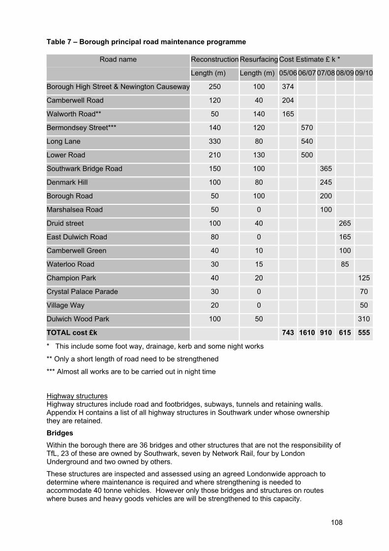
108
Table 7 – Borough principal road maintenance programme
Reconstruction ResurfacingCost Estimate £ k * Road name
Length (m) Length (m) 05/0606/0707/0808/09 09/10
Borough High Street & Newington Causeway 250 100 374
Camberwell Road 120 40 204
Walworth Road** 50 140 165
Bermondsey Street*** 140 120 570
Long Lane 330 80 540
Lower Road 210 130 500
Southwark Bridge Road 150 100 365
Denmark Hill 100 80 245
Borough Road 50 100 200
Marshalsea Road 50 0 100
Druid street 100 40 265
East Dulwich Road 80 0 165
Camberwell Green 40 10 100
Waterloo Road 30 15 85
Champion Park 40 20 125
Crystal Palace Parade 30 0 70
Village Way 20 0 50
Dulwich Wood Park 100 50 310
TOTAL cost £k 743 1610 910 615 555
* This include some foot way, drainage, kerb and some night works
** Only a short length of road need to be strengthened
*** Almost all works are to be carried out in night time
Highway structuresHighway structures include road and footbridges, subways, tunnels and retaining walls. Appendix H contains a list of all highway structures in Southwark under whose ownership they are retained.
BridgesWithin the borough there are 36 bridges and other structures that are not the responsibility of TfL, 23 of these are owned by Southwark, seven by Network Rail, four by London Underground and two owned by others.
These structures are inspected and assessed using an agreed Londonwide approach to determine where maintenance is required and where strengthening is needed to accommodate 40 tonne vehicles. However only those bridges and structures on routes where buses and heavy goods vehicles are will be strengthened to this capacity.
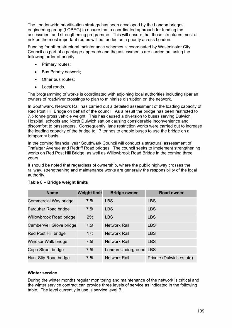
109
The Londonwide prioritisation strategy has been developed by the London bridges engineering group (LOBEG) to ensure that a coordinated approach for funding the assessment and strengthening programme. This will ensure that those structures most at risk on the most important routes will be funded as a priority across London.
Funding for other structural maintenance schemes is coordinated by Westminster City Council as part of a package approach and the assessments are carried out using the following order of priority:
Primary routes;
Bus Priority network;
Other bus routes;
Local roads.
The programming of works is coordinated with adjoining local authorities including riparian owners of road/river crossings to plan to minimise disruption on the network.
In Southwark, Network Rail has carried out a detailed assessment of the loading capacity of Red Post Hill Bridge on behalf of the council. As a result the bridge has been restricted to 7.5 tonne gross vehicle weight. This has caused a diversion to buses serving Dulwich Hospital, schools and North Dulwich station causing considerable inconvenience and discomfort to passengers. Consequently, lane restriction works were carried out to increase the loading capacity of the bridge to 17 tonnes to enable buses to use the bridge on a temporary basis.
In the coming financial year Southwark Council will conduct a structural assessment of Trafalgar Avenue and Redriff Road bridges. The council seeks to implement strengthening works on Red Post Hill Bridge, as well as Willowbrook Road Bridge in the coming three years.
It should be noted that regardless of ownership, where the public highway crosses the railway, strengthening and maintenance works are generally the responsibility of the local authority.
Table 8 – Bridge weight limits
Name Weight limit Bridge owner Road owner
Commercial Way bridge 7.5t LBS LBS
Farquhar Road bridge 7.5t LBS LBS
Willowbrook Road bridge 25t LBS LBS
Camberwell Grove bridge 7.5t Network Rail LBS
Red Post Hill bridge 17t Network Rail LBS
Windsor Walk bridge 7.5t Network Rail LBS
Cope Street bridge 7.5t London Underground LBS
Hunt Slip Road bridge 7.5t Network Rail Private (Dulwich estate)
Winter service During the winter months regular monitoring and maintenance of the network is critical and the winter service contract can provide three levels of service as indicated in the following table. The level currently in use is service level B.
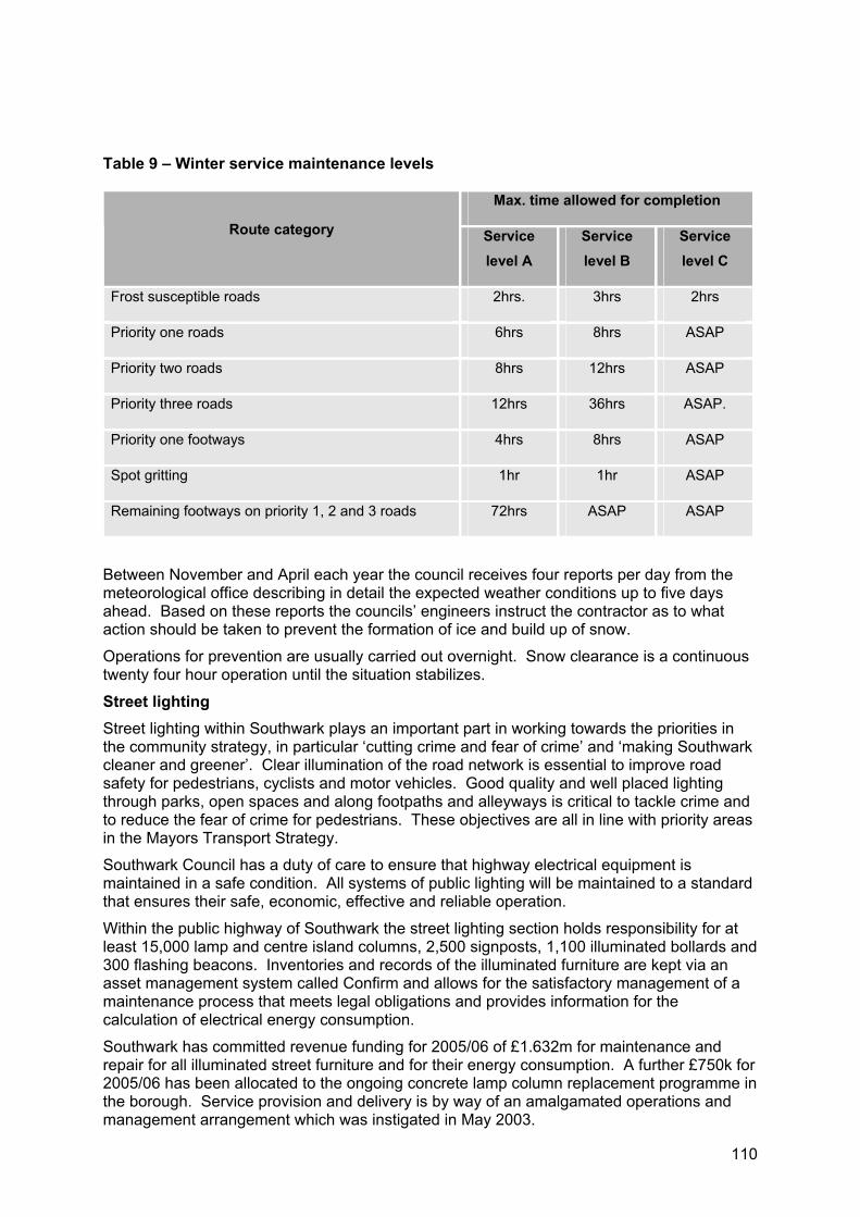
110
Table 9 – Winter service maintenance levels
Max. time allowed for completion
Route category Service level A
Service level B
Service level C
Frost susceptible roads 2hrs. 3hrs 2hrs
Priority one roads 6hrs 8hrs ASAP
Priority two roads 8hrs 12hrs ASAP
Priority three roads 12hrs 36hrs ASAP.
Priority one footways 4hrs 8hrs ASAP
Spot gritting 1hr 1hr ASAP
Remaining footways on priority 1, 2 and 3 roads 72hrs ASAP ASAP
Between November and April each year the council receives four reports per day from the meteorological office describing in detail the expected weather conditions up to five days ahead. Based on these reports the councils’ engineers instruct the contractor as to what action should be taken to prevent the formation of ice and build up of snow.
Operations for prevention are usually carried out overnight. Snow clearance is a continuous twenty four hour operation until the situation stabilizes.
Street lighting Street lighting within Southwark plays an important part in working towards the priorities in the community strategy, in particular ‘cutting crime and fear of crime’ and ‘making Southwark cleaner and greener’. Clear illumination of the road network is essential to improve road safety for pedestrians, cyclists and motor vehicles. Good quality and well placed lighting through parks, open spaces and along footpaths and alleyways is critical to tackle crime and to reduce the fear of crime for pedestrians. These objectives are all in line with priority areas in the Mayors Transport Strategy.
Southwark Council has a duty of care to ensure that highway electrical equipment is maintained in a safe condition. All systems of public lighting will be maintained to a standard that ensures their safe, economic, effective and reliable operation.
Within the public highway of Southwark the street lighting section holds responsibility for at least 15,000 lamp and centre island columns, 2,500 signposts, 1,100 illuminated bollards and 300 flashing beacons. Inventories and records of the illuminated furniture are kept via an asset management system called Confirm and allows for the satisfactory management of a maintenance process that meets legal obligations and provides information for the calculation of electrical energy consumption.
Southwark has committed revenue funding for 2005/06 of £1.632m for maintenance and repair for all illuminated street furniture and for their energy consumption. A further £750k for 2005/06 has been allocated to the ongoing concrete lamp column replacement programme in the borough. Service provision and delivery is by way of an amalgamated operations and management arrangement which was instigated in May 2003.
111
SignageSouthwark Council is responsible for the provision and maintenance of street nameplates across the entire network including the TLRN.
Standard guidelines have been developed for the design and location of these signs for a range of applications. Street naming and numbering is a separate function operating to part 2 of the London Buildings Acts (Amendment Act) 1939.
A number of initiatives linked to the transport objectives of the community strategy to improve the visual amenity and accessibility for residents in the borough are underway:
A renewal programme of street name plates (SNP) is currently taking place funded by a mix of one off revenue and capital funding. It is anticipated that all SNP will be renewed by the end of the year 05/06;
A programme for the removal of clutter is also in progress. Again funded by a mix of one off revenue and capital the programme includes the removal of redundant signage and the removal/rationalisation of posts;
All public access points (identified in the face to face review) have had signage renewed except listed buildings which await planning permission;
A programme to renew signage to all schools throughout the borough is taking place.
Gateway signage at the borough and community council borders has been agreed for implementation by the end of March 2006
Directional signs are also a key part of the road network whose function is to give clear information to road users to enable them to move across the borough road network using the most suitable roads without getting lost. Regulations govern the use, design, location and illumination of directional signs.
Southwark maintains all signage and lining of bus lanes within the borough to the DfT standards. Council officers regularly monitor the provision and quality of signage and lining and when deficiencies are identified they are promptly dealt with.
Asset management plan
The council will develop an asset management plan to take into consideration the needs of the network and to look at the whole life costs of our assets. In doing this, we must consider the highway as an asset with a defined value, which requires an asset management regime (or maintenance regime) in order to optimise use and maintain its value.
The highway network makes an important contribution to integrated transport systems. In developing and utilising the asset management plan the demands of the users and the need to maintain our assets will be considered in determining priorities. Network safety, serviceability and sustainability will be key factors as will network reliability and availability. The overall aim is to maximise all these areas with minimal disruption to users.
Southwark is currently taking stock of what information we currently have to identify missing information, with a view to seeking additional data collection. This information is currently being collated into the asset inventory system. This information will then help to inform and develop an asset management plan for the borough. Due to the anticipated level of information required to be collated as well as the complexity and variety of information to be obtained it is anticipated that the asset management plan will be finalised in two to three years.
The asset management plan will provide a vital piece of understand as by looking at whole life costs, it will be possible to direct funding to those areas where it is most needed to give maximum benefit and value.
112
5.13.3 Street cleansing and waste management Keeping the streets clean is an expectation from all residents and visitors alike and is a clear objective in Southwark’s community strategy. A clean street environment not only enhances street conditions but also improves the perception of safety of an area.
Issues such as waste disposal, street trading, cleansing, and public conveniences can all impact on the way we view our streets.
To work towards achieving the council’s vision of a cleaner, greener, safer Southwark, there is a clear need for these services to be innovative, performance driven and have a different approach that would begin to change the behaviour, hearts and minds of the residents, tenants, businesses and visitors of the borough and to bring about sustainable improvements to the environment.
Therefore the council maintains a responsibility to:
Delivery an integrated cleansing service to households, commercial, recycling collections;
Ensuring regulatory compliance in respect of waste and street scene related activities;
Manage the council’s markets;
Progressing and develop the council’s environmental crime policy, recognising its links with reducing anti social behaviour;
Developing links with schools and community groups highlighting the importance of recycling and care for the local environment;
Leading the introduction and implementation of eco schools;
Regulating the licensing of builders skips and materials on the highway;
Developing innovative ideas for reducing environmental crime and other forms of anti social behaviour.
The unit has prosecuted 110 environmental criminals during the year 2004/2005, 1,550 fixed penalty notices with a payment rate of 87%, the national average being between 35% and 39%.
Access for refuse collection In 2003/04, accessibility issues contributed to approximately 60% of all missed refuse and recycling collections. However, the number of missed collections due to accessibility has fallen significantly over the last eighteen months and has been a major driver in raising performance and customer satisfaction and reducing complaints. This has been achieved through joint working by the waste section with both housing and the street scene section, in undertaking car lifting blitzes, ticketing illegally parked cars, putting down yellow lines and hatching in front of bin stores on housing estates, to assist access.
The street cleansing budget for 2005/06 is £6.9m and Southwark employs approximately 220 street cleansing staff. The level of service assigned to any given area/street is dependant on its zoning. Zone details are as follows:
Zone one* are those areas considered to be the highest profile e.g. town centres, major thoroughfares etc. Zone one* areas have a permanent presence i.e. continual cleansing between 6.00am to 6.00pm;
Zone two are those areas considered to have a high throughput of pedestrians and vehicles, zone one areas are cleansed daily (Monday to Sunday). Zone two are those areas which are predominately high density residential areas and are cleansed three times per week;
Zone three areas are predominately lower density residential areas and are cleansed two times per week.
113
In order to maintain a high level of cleanliness and visual amenity, Southwark's main roads are serviced as a daily occurrence for commercial waste. The additional costs associated with these daily commercial collections is around £150k annually.
Whilst the council maintains a very limited number of pedestrianised areas or streets, these areas tend to be in high profile areas such as town centres and are therefore maintained to a zone one standard.
A time banding pilot is currently underway along Rye Lane to ensure certain periods of the day are maintained free of all waste. This is being monitored by the street wardens and will be rolled out further if successful.
Operation scrap it Operation scrap it was an ALG initiative to remove to a secure pound any vehicles, which are untaxed and abandoned from the public highway. The initiative was designed to improve Londoners' quality of life by providing a Free Take Back service for those who wanted to surrender their vehicles and increasing the levels of enforcement against those who persisted in abandoning vehicles on the streets.
Within Southwark, the current operation has been a huge success, enabling us to reduce the blight of nuisance vehicles across the borough, disrupt criminal gangs and reduce the amount of arson attacks.
This initiative was previously funded by central government, however this funding has been withdrawn. The council is keen to continue the operation scrap it programme and is currently seeking funding for the coming financial year.
5.13.4 Monitoring our roads Community wardens The community warden scheme was launched in Bermondsey two years ago and has progressively been extended to now cover Peckham, Camberwell, the Aylesbury, Bankside, Rotherhithe, Dulwich and the Elephant and Castle. There are now 80 wardens working across the borough.
Community wardens are important members of the community, there primary responsibilities are environmental tackling grime, fly tipping and fly posting, abandoned vehicles and graffiti while assisting police by reporting crime and suspicious behaviour. They also provide their local community significant reassurance through their presence.
Wardens currently patrol their local area between the hours of 8.30am and midnight and operate seven days a week. The community warden scheme has proved to be highly effective in improving the streetscape but also proven highly popular and effective within the community. This Southwark initiative complements the Mayor’s safer travel at night initiatives
Street leader scheme Set up in 2003, the scheme operates as a partnership between more than 315 local residents and the support team of Southwark Council support staff. Street leaders volunteer to keep an eye on the streets they pass through whilst going about their day to day lives. They make a commitment to report any ‘envirocrimes’ and eye sores, such as graffiti, abandoned vehicles, illegal street trading and potholes, to name a few. Following reporting of the problem the council then fixes the problem. This has proven an effective way in enabling local people to be able to improve their local area.
Safer neighbourhood teams The Mayor announced in January 2006 that funding would be provided for dedicated local policing teams throughout the city, increasing their number from 285 to a total of 625. The aim is to reduce the room for crime and fear of crime, disrespect and anti social behaviour in every London neighbourhood.

114
Safer neighbourhood teams in Southwark are made up of one police sergeant, two police constables and three police community support officers. Communities throughout the borough have a say in identifying priorities for their area allowing the Metropolitan Police to provide local solutions to local problems. Currently there are eight teams in Southwark and this will substantially increase by 2008, making borough streets a much safer place to be.
115
Freight
(a) Improve the efficiency, safety and reliability of freight operations to minimise the adverse impacts of freight.
(b) Appropriately manage the impacts of transporting domestic and trade waste.
(c) Appropriately manage the storage and transfer of waste relating to construction.
(d) To lead by example in running of an effective, clean and sustainable fleet
(e) Promote the use of cleaner fuels.
The council’s policy is to develop Southwark as a place with a thriving and sustainable economy where local people can have the full benefits of wealth creation, with access to choice and quality in services, goods and employment opportunities. Freight is a key contributor to this objective and has the ability to support economic growth by providing an integrated, sustainable distribution system.
Freight can also have adverse impacts on society and the environment. The use of the boroughs roads by heavy goods vehicles can damage residential and environmental amenity.
The nature of freight is in a period of transition with an increasing demand for door to door and home delivery services. In recognition of the regional impact of freight Southwark will work with our partners to improve the understanding, performance and efficiency of freight distribution in the borough and improve ways of servicing businesses. The council will work in partnership with TfL, the London Sustainable Distribution Partnership and all other contributors to develop the London Freight Plan and improve freight service within London. Relevant Lip objectives include:
Lip4. Promote greater integration of land use development and transport;
Lip6. Improve the efficiency, reliability and safety of freight distribution;
Lip8. Improve visual amenity and the quality of the environment;
Lip9. Reduce energy use;
Lip10. Work with partners to progress and promote transport improvements.
Southwark recognises the importance freight has in providing economic opportunity and seeks to increase the economic opportunity for all and promote social inclusion. The Mayor’s priorities that will provide for freight include: bringing transport infrastructure to a state of good repair, relieving traffic congestion and improving journey time reliability.
116
5.13.5 Road freight Southwark is a base for numerous transport companies and wholesale businesses with storage/warehousing facilities or conducting operations requiring supplies of raw materials. The construction industry in particular is placing an additional demand for carriage of raw material and building waste and will continue to do so whilst regeneration and redevelopment continues in the borough.
Aside from the localised freight traffic generated by industry and the servicing needs of businesses within the borough, Southwark also experiences freight movements passing through the borough on its way to and from central London.
The council is well aware of the issues associated with road freight movements and is specifically concerned with the air and noise pollution, environmental intrusion, traffic congestion and damage to road infrastructure caused by this form of transport. Recent research indicates that heavy goods vehicles only pay for around 59% to 69% of the full (including the social and environmental) costs they impose upon society, these costs include greenhouse gas emissions, air pollution, noise, congestion, casualties and deaths.21
The council supports the Mayor’s moves toward addressing these concerns by way of the CCZ and the recently announced LEZ for Greater London, to be in force by 2007. Southwark welcomes the opportunity to work in partnership with the London sustainable distribution partnerships, freight organisations, central and local government, road, rail and river authorities to explore other ways of delivering goods efficiently with the least harm to the environment and our health.
5.13.6 Freight quality partnership Southwark and Lewisham councils initiated a freight quality partnership (FQP) in 2003, in cooperation with the University of Westminster. The aim of the FQP is to bring the freight industry, other businesses, local policymakers and the local community closer together, by helping to overcome some of the impacts that local residents and businesses currently experience as a result of freight operations. It is therefore based on the concept of inclusion.
The FQP has recently completed a study of van activity within Lewisham and Southwark, and we will work with the FQP to take forward the recommendations of this study. Contact details within the council on freight and fleet related issues can be found on the council’s website.
5.13.7 London lorry control scheme The London lorry control scheme is an environmental measure that restricts the movement of heavy goods vehicles (over 18 tonnes in weight) during the night time and at weekends.
The ALG maintains the scheme, issuing permits to those lorry operators with essential business in London (around 56,000 permits per year) and produces the London lorry map which shows those roads affected by the scheme and provides assistance to lorry operators with information on routing. The permit system requires operators to register and confirm that they understand the requirements the scheme imposes on them.
A team of enforcement officers operate through the ALG to ensure compliance and prosecute about 2,000 offences under the ban each year. There is also a complaints hotline which any member of the public can ring to report any night time and weekend lorry disturbance.
5.13.8 Construction and demolition waste The council requires that all major developments prepare a waste management strategy to demonstrate how waste will be managed during any demolition, construction and the long term occupier waste management. These strategies should contain information on the predicted tonnage of construction and demolition waste and will include details of how this 21 Environmental and Social Costs of Heavy Goods Vehicles and Options for Reforming the Fiscal System, Oxford Economic Research Associates, report prepared for English Welsh and Scottish Railway, January 1999
117
will be managed and disposed of in the most sustainable manner in line with the waste hierarchy . This will help improve the level of information available on the waste arisings from this waste stream. Further avenues for consideration include allowing temporary consturction and demolition processors to be located on development sites encouraging on site management and processing of waste.
5.13.9 Encouraging greener fleets The council’s green fleetThrough Southwark Council’s fuel policy (2003) the council seeks to minimise the impact of its fleet on the environment and seeks to lead the way in sustainable transport in reaching for higher and higher standards of vehicle emission performance.
This innovative and ambitious approach has seen Southwark successfully run the European Zeus (zero and low emission vehicles in urban society) project within the borough as well as winning the green fleet award for this project in 1999 and the TfL green fleet award in 2005.
As the fleet is being renewed preference has been given to the vehicles with the highest emission standards and soon the entire fleet will meet Euro III or IV standards. By frequently renewing the fleet Southwark can maintain a very low average fleet age and ensure that it functions with the newest, cleanest vehicles on the market.
The council reviews its fleet regularly to ensure that we are operating an efficient fleet and minimising our impact on the local environment.
Through the development of contracts and within their service delivery plans, the council requests that the contractor introduce or use such low emission vehicles and machinery. The council also requests that all contractors clearly specify the vehicle type and the equipment fitted to reduce emissions.
Where it is not possible to use environmentally friendly vehicles and machinery, the council takes into account the extent to which this condition is complied with when evaluating the tenders received.
Currently, before being able to drive fleet vehicles all officers must undertake a driver training course, this promotes good driving techniques. It also enables staff through good road craft to mitigate the impact of vehicles on the environment and improves road safety.
The routes utilised by the council’s waste services are area based and are carefully considered to ensure that the minimum distance is travelled in collecting household waste.
Promoting cleaner vehicles The council is committed to improving the environment for the people of the borough and the council is keen to promote the use of environmentally friendly vehicles and plant, whether hybrid, electric, gas or diesel powered incorporating emission reduction technologies.
The council currently supports lower cost parking permits for environmentally friendly vehicles as discussed within the parking and enforcement plan contained in appendix C.
Promoting cleaner fuels Currently 72 of the total diesel fleet of 140 vehicles run on a 20 percent blend of modified vegetable oil known as biodiesel. Southwark is the first local authority in the capital to power almost half its vehicle fleet on a high blend of modified vegetable oil.
As well as a renewable fuel using vegetable oil reduce carcinogenic and greenhouse gas emissions to virtually zero, improving air quality. In 2006, the council will also be trialling five vehicles to run on pure plant oil that is unmodified vegetable oil as part of a Defra pilot project.
The council will identify and publicise availability of LPG fuel locations (and electric vehicle charging bays) in South East London jointly with adjacent boroughs and fuel distributors and promote the grants available through the Energy savings trust.
118
5.13.10 Seltrans biodiesel project Southwark as a member of Seltrans is currently participating in a biodiesel project is a lifecycle project that has positive benefits crossing transport, waste, air quality and health issues. The five year project takes a waste product and creates a reusable fuel by collecting used cooking oil from the used cooking oil outlets (restaurants/cafes etc) which are then transferred to a plant that uses a chemical process to refine and convert the oil into biodiesel. This diesel with then be used in, primarily, council fleets and then extended out to other fleet users such as hospitals.
This project seeks to reduce the negative air quality impact that burning conventional diesel and releasing new CO2 has on our atmosphere and promote the use of sustainable fuels. This scheme will address and work towards meeting the challenges established in the Mayors Air Quality Strategy and will also help to the meet the requirements of the proposed Londonwide LEZ.
Through this project and the Seltrans partnership the council will engage with local businesses and suppliers to promote the use of alternative fuels.
5.13.11 Waste management Council managed waste collection Southwark is responsible for the collection, treatment and final disposal of all municipal waste. Of the household waste collected in 2002/2003, 4% was recycled/composted, 25% was incinerated at SELCHP and 71% was transferred to landfill.
The number of households in the borough has risen since the last census from 104,684 in 1991 to 114,700 in 2001. The London Plan has set a target of 29,530 additional residential units to be built in Southwark by 2016.
The council maintains a responsibility to provide a kerbside service to residents and businesses alike. With the increased provision for recycling services there may also be an increased number of waste collection vehicles on the road network. To promote the ease of recycling services convenient locations for bottle banks and household recycling pickup. Therefore a balance must be struck between provision of services and the provision of street space.
The predicted rise in population and new homes in the borough over the life time if the plan indicates that there will be an increase in the amount of waste created through the construction and demolition during development and through the production of waste once the development is occupied.
Old Kent Road gas works siteCurrently waste facility is located at the Manor Place depot, following significant consideration, capacity analysis and research the council established that a new site or sites need to be identified. This will enable the borough to process waste in a more sustainable manner and significantly enhance recycling and recovery rates.
Southwark takes responsibility for waste produced within the borough and as such we propose an integrated waste facility at the Old Kent Road gas works site.
Facilities proposed at this site include:
A mechanical and biological treatment plant;
Recycling facility;
Materials recycling bulking facility; and
A new household waste recycling centre.
During the consideration of the suitability and viability of the site, a transport assessment was carried out. Although it was noted that there are no suitable sites located near to the river or the railway that access could be reasonably obtained.
119
The site located on the Old Kent Road is part of the A2 and defines Southwark’s road network together with New Kent Road. A transport assessment will be carried out as part of the development of the masterplan for the site, as achieving safe and direct vehicle movement will be pivotal to the operation of the facility.
The allocation of land at the gas works site will present the council with opportunities to target high levels of recycling in line with the aspirations within the Mayor’s municipal waste management strategy and landfill allowance trading scheme. The site will also enable Southwark to have a degree of local self sufficiency and move towards meeting the proximity principle in terms of provision of waste facilities.
Waste handling sites in SouthwarkThe borough contains 22 existing waste management sites, they are set out in the following figure and detailed as follows:
Eight of which are located in industrial areas and will be protected through the town planning system;
Six of the sites identified as managing construction and demolition wastes where the council encourages the on site management and processing of construction and demolition waste on site;
Three are small scale composting facilities;
Two small scale processing centres;
Two are small scale reuse sites;
The existing Manor Place depot.
Figure 19 - waste handling sites
5.13.12 Rail freight As the council and TfL advocate for increased usage of rail transport as a more sustainable mode of transport than road, rail transport needs the ability to expand. Consideration of the noise generated by rail transport needs to be carefully considered and monitored.
Southwark is subject to a number of transport improvements on a dense network of overland railway lines very close to residential shopping and other noise sensitive areas.
Railway noise should be considered in the design, quality, and maintenance of track and rolling stock, noise screening and railway structures. This future investment in rail transport provides the opportunity to minimise noise in many different aspects of railway design, maintenance and operation.
Integrated management of the wheel rail interface is critical to minimising railway noise. TfL, the government and the rail industry are working together to improve noise control and more direct measurement and monitoring of track condition.
The arguments in favour of transferring freight traffic from road to rail are largely environmental. As an example, rail overall produces less than 1% of the total UK emissions of carbon dioxide compared to 21% from road transport.22 However the environmental benefit must be balanced with considerations of the economic, efficiency and social elements.
A London Rail Land Strategy Group has been established to identify rail freight handling sites and protect them from future development. Sites in London will be covered by direction from the GLA (through SPG) or as part of the London Freight Plan which is itself due to be published in late 2006.
22 Railway Forum 2005
120
5.13.13 Water Within Southwark there are eight piers, which are operated by London River Services (LRS), part of TfL. LRS licenses a range of scheduled and charter river boat services from these piers and requires operators of party boats using them to fit noise monitors to amplification equipment to enable noise to be controlled by the operator of the vessel.
However, these party boats may also operate from other piers not controlled by LRS and may not be regulated by the LRS licensing. Complaints about moving late night noise sources on the river are more difficult to deal with than similar complaints about a nearby pub. The licensing situation of party boats is inconsistent and the council will advocate for noise control to be included in licensing reform.
Southwark’s position adjacent the Thames provides us with a unique opportunity. The potential of the river Thames for the transport of freight is a key opportunity in Southwark and is recognised as an under utilised asset in the Mayors economic development strategy.
Southwark currently has no working wharves for waste or freight movement and therefore there is no opportunity to safeguard wharves. Although Southwark maintains a long river frontage, the western frontage is located within the CAZ whilst to the east supports significant levels of residential development. Opportunities for the movement of waste by water including the provision of access roads are extremely limited within the borough. Southwark recognises the benefit of water borne freight movement can bring including a reduction in the reliance on road based freight. However this must be balanced with the environmental and amenity impact on the riverside and surroundings.
Southwark will work with the freight quality partnership to investigate the potential for a review of water borne freight movement within both of the boroughs.
5.13.14 Aviation Whilst aircraft have been becoming quieter, weight for weight, numbers and size have been increasing as international travel increases for both Londoners travelling abroad and visitors alike. People may notice bigger aircraft more as they manoeuvre to join the busy airport approach path. The UK government is responsible for national aviation policy and for key regulatory decisions about noise from aircraft. The council will continue to advocate for improvements to noise abatement and to consider aircraft noise during land use planning and building design.
121
6 PARTNERSHIPS Partnerships allow us to work within a regional context and provide the opportunity to share knowledge and pool resources to achieve the best outcome. Southwark values our partners and seeks to continue to work closely with them to promote and progress transport improvements within the borough and beyond. We recognise the vital role that many of these partnerships play in the development and implementation of a variety of initiatives within the borough.
6.1 Cross River Partnership The CRP was formed at the suggestion of the Government Office for London in May 1994 and has grown to be one of our closest partnership organisations. The partnership comprises members from the London boroughs of City of Westminster, Corporation of London, Lambeth and Southwark, Business Link of London, Groundwork London, Learning and Skills Council, Visit London, Port of London Authority, Network Rail, South Bank employers group and TfL.
The partnership has worked to expand the heart of central London to relieve development pressure on the north of the Thames, and extend the benefits of regeneration to the south. The partnership boundary within Southwark is illustrated in the following figure.
The CRP delivers projects designed to impact on the regeneration of London South Central as a cohesive whole and bring the benefits of this investment to the excluded communities within all four local authority areas. It aims to maximise the contribution of London South Central and will move towards the continued success of London as a world city. This is governed by three core objectives:
Create the conditions for an expanded, integrated and accessible heart of central London, including the transformation of the London South Central area, where the opportunities offered by central London are maximised and made accessible to all;
Maximise the benefit of past and proposed investment and regeneration activity within the London South Central area;
More actively engage the diverse communities of central London in shaping the vision and strategy for the area, and to participate and benefit fully from the transformation process.
The London South Central concept has grown out of much of the work that CRP has been engaged in, and is developing a coherent policy framework within the Mayor’s Transport and Spatial strategies.
CRP is becoming more actively engaged in helping to reduce the imbalance in socio economic conditions between the north and south of the Thames.
Regenerating the area to the south of the Thames will expand the capacity of central London’s economy and ensure that future success of the capital on the world stage, and at the same time cater for all the needs of all Londoners. The London South Central Transport Strategy, published in 2002, identified transport and accessibility as key requirements of the regeneration of the London south central area, and a precondition for the investment and job creation. The strategy proposes six themes for action:
Improved public realm, such as improving road surface or introducing additional security, will make it easier for people to make all or part of their journeys by foot or by bike;
Better networks, improving the legibility of networks, through way finding initiatives;
Better interchanges, making it easier to change between different modes of transport which will encourage more people to use public transport;
Opening up the river, making it easier to get to the river from transport interchanges as well as making it easier to cross it and travel on it;
122
Improved accessibility, introducing specific measures to alleviate pockets where high congestions levels, low transport capacity, poor accessibility and social factors have created social exclusion;
Orbital movement, making it easier to travel within London south central as well as through it, will help alleviate social exclusion and unlock regeneration potential.
Cross River Partnership is working in partnership with the London Borough of Southwark and other partners, on a bid for transport and access programmes which consider and promote the needs of central London. CRP’s bid supports the partnership’s wider objective of strengthening the links between the north and south sides of the river.
Joint schemes put forward in CRP’s bid will engender a consistent approach to problem resolution and contribute to ameliorating both the existing problems and the impact of London’s proposed growth. The proposals are complementary and additional to the other programmes and projects in Southwark’s bid.
Through CRP, Southwark is seeks to continue the following programmes:
Light at the End of the Tunnel;
Tram complementary measures;
Walking over water.
New area based projects will be raised to consider riverside improvements, area accessibility and corridor management, these include schemes for the Cut and the area surrounding the Tate Modern.
The CRP, through the four local authorities of the partnership work closely together to achieve the agreed targets.
Figure 20 – Cross River Partnership
6.2 Safer Southwark partnership The Safer Southwark partnership (SSP) has been operating since the early 1990's and is a partnership between the council, police and other local agencies.
The partnership seeks to make Southwark a safe place to live, work and play by reducing crime and anti social behaviour, tackling substance misuse and increasing public reassurance across all sections of the community.
The key actions of the partnership include:
Carry out an audit of crime and disorder, drug and substance misuse;
Consult with local people and organisations on what they think our priorities should be;
Develop a local three year strategy for reducing crime and the impact of crime and drug related activity, as discussed in section 3.3.3;
Implement the national drugs strategy at a local level;
Work with a wide range of local community and voluntary organisations.
The partnership board which meets four times a year and is chaired by the council's chief executive, or in his absence, the police borough commander.
This partnership is the key to monitoring safety in Southwark and regularly monitors crime statistics in the borough.
123
6.3 South east London transport strategy Seltrans was established in 1998 as a partnership between the seven south east London boroughs of Bexley, Bromley, Croydon, Greenwich, Lambeth, Lewisham, Southwark, transport providers and operators, and groups representing the interests of businesses and passengers.
In recent years the Seltrans partnership has been vital in supporting improvements around our railway stations, as well as progressing knowledge of freight distribution within the partnership boundary. The knowledge contained within the Seltrans partnership has also been pertinent to Southwark in commenting on many of the large transport infrastructure projects proposed within the borough.
The overall objectives of Seltrans are to improve the quality of life of all its communities by working with our partners to improve the area’s economic welfare, environment and social inclusion.
The following objectives have been agreed in the light of the Mayor’s transport and other strategies:
Identify and deliver strategic projects to reduce the growth in traffic congestion;
Improve accessibility to stimulate regeneration and reduce exclusion;
Identify and facilitate public transport network improvements linking important centres of activity;
Support regional economic vitality by improving town centre environments;
Help develop safe and secure transport choices and greater responsibility in personal travel behaviour.
Seltrans, through its role to identify strategic issues and to develop projects and discussion for the benefit of the region, has special responsibility for rail integration, cross borough bus projects, identifying priorities for town centre area bids and, developing regional campaigns to change travel behaviour.
The sub regional partnership’s priorities for investment are:
Town centres;
Transport interchanges;
Rail improvements;
Travel awareness and green travel.
The London boroughs that are part of Seltrans are committed to transport improvements in south east London for the benefit of its residents and economy.
Through Seltrans, Southwark is involved in these four programmes:
Freight quality partnership;
Improving stations and forecourt environment;
Biodiesel project;
South East London green chain.
6.4 Optimum2
As part of its commitment to promoting sustainable transport, Southwark Council is participating in the European Regional Development Fund Interreg IIIB, financed Optimum2
project. In Southwark, the project aims to develop a mechanism for encouraging workplace travel planning, with the ultimate goal of creating modal shift to more sustainable modes of transport.
124
The Optimum2 project has allowed us to progress sustainable transport initiatives with greater force and we seek to maintain this good working relationship to promote modal shift within the borough.
The Optimum2 project started in 2004 and is due to run until the end of 2007. On completion of the project, the London Borough of Southwark will continue to facilitate the formation and operation of new LTPGs and support the ongoing operation of the pilot LTPGs, should they prove successful at promoting modal shift.
6.5 The London European Partnership for Transport The London European Partnership for Transport (LEPT) is a recently established partnership between London boroughs and the European Union that seeks to improve the level of communication, cooperation and investment within London.
The development of the partnership between London boroughs and other European cities/organisations was fostered by the London access group (the informal forerunner to the LEPT). This resulted in a successful pan European project in 2005 and provided the opportunity to submit two further proposals to the European Commission for consideration. In 2004 the EU had around €1bn budgeted for transport projects and yet the amount allocated to transport projects in London was less than 0.1% of this total. One of the EU’s prime objectives is to assist the advancement of new member states and objective one regions and whilst London does not qualify under these categories, if the EU are to reach targets to reduce air pollution, cut road deaths and improve the quality of life for people in urban centres, then London is an area that demands attention and investment from the EU.
Southwark supports the LEPT to allow a coordinated approach to European project work and provide efficient communication between London and European stakeholders. The partnership will also provide a consistent and effective management structure for European projects and coordinate future bids for funding.
6.6 Central London Partnership (CLP) CLP acts as a facilitator and coordinator, bringing partners together to achieve change to improve central London as a place to live, work, invest and visit. CLP intends to progress strategic schemes that are sub regional in nature, have potential to deliver benefits across a wider area of central London or make a best value use of resource through a consistent cross boundary approach.
CLP in recent years has formed a knowledge bank and allows us to learn from the best practice of our inner London partners.
The CLP focus on an interlinked series of interventions that are designed to contribute to:
An increase in the number of people walking, cycling and using other sustainable forms of transport in central London and to address, wherever possible, the deterrents to use these;
A reduction in dependency on the car, with associated benefits for air quality and safety on the streets;
Addressing problems of social inclusion by tackling some of the transport related causes and meeting the needs of some of the less visible sectors of society;
Bringing about better conditions for walking in central London by contributing to an improved physical environment and public realm, which in turn helps to create both more, and also more equitable economic opportunities;
An increase in the number of employees cycling, and an associated improvement in their business’s cycling infrastructure.
CLP schemes engender a consistent approach to problem resolution and contribute to ameliorating both the existing problems and the impact of London’s proposed growth. The schemes address walking, cycling, car share and car club initiatives, with particular reference to joint working with business where appropriate. The projects are cross borough strategic in
125
order to develop a consistent approach to scheme identification, development and implementation and to champion emerging “best practice”.
Further partners, including the Royal Parks, the Crown estate and English Heritage, on the walking projects and London Cycle Campaign, Sustrans and business representatives of the cycling projects, have also been invited to participate in the development and implementation of ideas to promote and assist transport initiatives in central London.
TfL is also included in several steering groups, for instance, for walking to ensure coordination is achieved and overlaps avoided and the TLRN is considered an integral part of the network.
CLP current projects include:
South London estates, exploring housing estates to break down barriers;
Civilising spaces in central London;
CCTV area based installation in South Bank;
Signage and way finding pilot project.
6.7 Pool of London Partnership (PLP) The Pool of London Partnership operates in an area stretching east from London Bridge to the Butler's Wharf/St. Katherine's Dock area and includes the communities in north Southwark and the Wapping area of Tower Hamlets.
The programme focuses on promoting the pool of London area as a tourist destination, improving the environment and infrastructure, supporting small businesses and enhancing the skills and employability of local residents.
Southwark has seen much development within the PLP, particularly the recent major commercial investment within the borough including City Hall, More London and the proposed London Bridge redevelopment.
These developments could bring an extra 11 million visitors to the area each year, creating 7,000 jobs for local residents. The partnership's work with Southwark focuses on ensuring that local residents and businesses benefit from these opportunities.
6.8 London South Central partnership London South Central (LSC) strategic regeneration area in central London, launched by the London Development Agency in partnership with the London Boroughs of Southwark, Lambeth, Wandsworth, the City of Westminster and the Corporation of London.
The focus is on tackling social and economic deprivation and physical degradation in the LSC area, and the programme looks to build on regeneration work undertaken over the past ten years. The partnership boundary within Southwark is illustrated in the following figure.
The aim of the LSC programme is to help foster and guide economic development in the area, making sure that it benefits all and ensuring that local businesses and residents are well placed to take advantage of new opportunities. There are still many barriers to this including high levels of deprivation in the area, skills shortage in the local population preventing people from accessing jobs, transportation problems for potential workers and the lack of small business support. Through this partnership, Southwark seeks improvements for local businesses and residents alike.
Figure 21 – London South Central strategic priority area
6.9 LCN+ The London cycling action plan, published in 2004, provides a comprehensive and interlinked set of actions that will deliver significant improvements in London’s cycling environment, encourage more Londoners to switch to using the bicycle, and thus help to realise the many wider benefits that increased levels of cycling will bring. Southwark actively participates in
126
the LCN+ partnership and has seen many improvements on the LCN+ within the borough and seeks to continue our good work into the future.
Objective one of the London cycling action plan is to complete the delivery of the LCN+. This is a 900km network of high demand routes where cycle user needs will be met by providing conditions that making cycling easy, safe and comfortable.
LCN+ is committed to achieving the following objectives:
Make a significant contribution to raising London’s status as an exemplary sustainable world city, where people of all ages and abilities have the incentive, confidence and facilities to cycle whenever it suits them;
Promote cycling in London and encourage more people to cycle;
Improve conditions for cycling along the 900km of route in the GLA, bringing conditions up to a standard where they are fast, safe, comfortable, convenient, attractive and easy to access;
Offer a socially inclusive environment of a consistent quality that respects local differences and reduces transport inequalities;
Develop, programme, implement and maintain routes within a consistent Londonwide framework;
Give cycle users increased priority and improved safety at junctions and other locations of potential conflict with other road users;
Improve local access to LCN+ routes so as to contribute to attracting increased cycle flows: 100 to 200% with consequent benefits for the local economy, as well as individual, physical and mental health;
Provide a strategic framework for the development of more local networks of cycling access and improvement schemes, set exemplary standards for the design, management, coordination and promotion of quality cycling environments, and link different authorities;
Provide opportunities for people to cycle in confidence in parts of London that are not familiar to them;
Contribute to overall road safety as well as to the achievement of the 40% reduction target in the number of cyclist fatalities or seriously injured in road accidents;
Improve overall network capacity to result in journey time savings;
Minimise and mitigate the risks and nuisance that cycle users can present to pedestrians;
Increase the value of London’s highway and transport infrastructure;
Provide cycle users with a consistency of treatment along similar sections of a link.
Works carried out through the LCN+ partnership will be complementary and additional to other works relating to cycling contained in Southwark that impact on the cycling environment and public attitudes towards cycling.
Strategies for providing a consistent high quality for cycle users along LCN+ links will be developed through a flexible local consultation and feasibility process. This process has been piloted and a generic brief adopted for use by this council and TfL area teams. This enables the views of local stakeholders to be included at the outset to influence the development of options and decisions as to measures to be progressed.
6.10 London Bus Priority Network The LBPN was originally an 865 km network of borough roads across London that complemented the priority (red) routes. It was developed in 1994 by the 33 boroughs and London Transport (predecessor to TfL) who jointly developed with the Government Office for
127
London and the then traffic director for London, a cross boundary bus network for the whole of London. To aid boroughs with funding and to assist buses off the original network from 2003, the LBPN covers all borough roads that carry buses. The LBPN partnership is well established, as is our relationship with them and Southwark will continue to seek improvements on the LBPN through the partnership.
Southwark is committed to the continued support of the LBPN as a partnership that will:
Allow a coordinated approach to bus priority and provide a Londonwide strategy that all boroughs could follow;
Ensure that the management structure remains in place to allow the boroughs to retain their independence but at the same time provide a coordinated approach and effective working on the project;
Coordinate future year’s package bids for funding through the appropriate bidding processes.

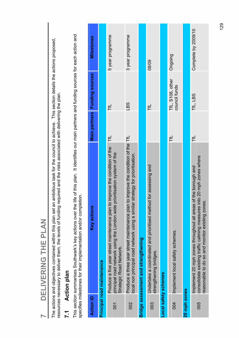
129
7 D
ELIV
ERIN
G T
HE
PLA
N
The
actio
ns a
nd o
bjec
tives
con
tain
ed w
ithin
this
pla
n se
t an
ambi
tious
task
for t
he c
ounc
il to
ach
ieve
. Th
is s
ectio
n de
tails
the
actio
ns p
ropo
sed,
re
sour
ces
nece
ssar
y to
del
iver
them
, the
leve
ls o
f fun
ding
requ
ired
and
the
risks
ass
ocia
ted
with
del
iver
ing
the
plan
.
7.1
Act
ion
plan
Th
is s
ectio
n su
mm
aris
es S
outh
war
k’s
key
actio
ns o
ver t
he li
fe o
f thi
s pl
an.
It id
entif
ies
our m
ain
partn
ers
and
fund
ing
sour
ces
for e
ach
actio
n an
d sp
ecifi
es m
ilest
ones
for t
heir
impl
emen
tatio
n an
d/or
com
plet
ion.
Act
ion
ID
Key
act
ions
M
ain
part
ners
Fund
ing
sour
ces
Mile
ston
es
Prin
cipa
l roa
d m
aint
enan
ce
001
Pro
duce
a fi
ve y
ear s
treet
mai
nten
ance
pla
n to
impr
ove
the
cond
ition
of t
he
prin
cipa
l roa
d ne
twor
k us
ing
the
Lond
on w
ide
prio
ritis
atio
n sy
stem
of t
he
Stra
tegi
c R
oad
Net
wor
k.
TfL
TfL
5 ye
ar p
rogr
amm
e
002
Pro
duce
a th
ree
year
stre
et m
aint
enan
ce p
lan
to im
prov
e th
e co
nditi
on o
f the
lo
cal n
on p
rinci
pal r
oad
netw
ork
usin
g a
sim
ilar s
trate
gy fo
r prio
ritis
atio
n.
TfL
LBS
3 ye
ar p
rogr
amm
e
Brid
ge a
sses
smen
t and
str
engt
heni
ng
003
Und
erta
ke a
coo
rdin
ated
and
prio
ritis
ed m
etho
d fo
r ass
essi
ng a
nd
stre
ngth
enin
g br
idge
s.
TfL
08/0
9
Loca
l saf
ety
sche
mes
004
Impl
emen
t loc
al s
afet
y sc
hem
es.
TfL
TfL,
S10
6, o
ther
co
unci
l fun
ds
Ong
oing
20 m
ph z
ones
005
Impl
emen
t 20
mph
zon
es th
roug
hout
all
area
s of
the
boro
ugh
and
cons
olid
ate
exis
ting
traffi
c ca
lmin
g m
easu
res
into
20
mph
zon
es w
here
re
ason
able
to d
o so
and
mon
itor e
xist
ing
zone
s.
TfL
TfL,
LB
S
Com
plet
e by
200
9/10
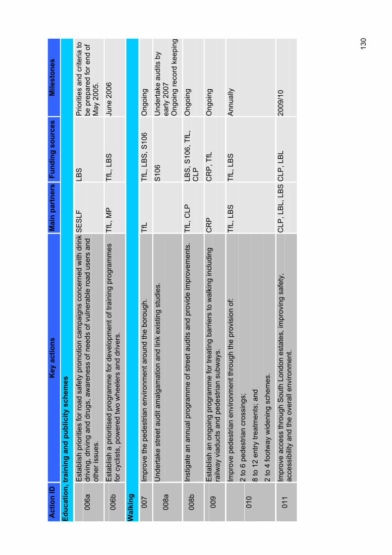
130
Act
ion
ID
Key
act
ions
M
ain
part
ners
Fund
ing
sour
ces
Mile
ston
es
Educ
atio
n, tr
aini
ng a
nd p
ublic
ity s
chem
es
006a
Est
ablis
h pr
iorit
ies
for r
oad
safe
ty p
rom
otio
n ca
mpa
igns
con
cern
ed w
ith d
rink
driv
ing,
driv
ing
and
drug
s, a
war
enes
s of
nee
ds o
f vul
nera
ble
road
use
rs a
nd
othe
r iss
ues.
SE
SLF
LBS
Prio
ritie
s an
d cr
iteria
to
be p
repa
red
for e
nd o
f M
ay 2
005.
006b
Est
ablis
h a
prio
ritis
ed p
rogr
amm
e fo
r dev
elop
men
t of t
rain
ing
prog
ram
mes
fo
r cyc
lists
, pow
ered
two
whe
eler
s an
d dr
iver
s.
TfL,
MP
Tf
L, L
BS
Ju
ne 2
006
Wal
king
007
Impr
ove
the
pede
stria
n en
viro
nmen
t aro
und
the
boro
ugh.
Tf
LTf
L, L
BS
, S10
6 O
ngoi
ng
008a
Und
erta
ke s
treet
aud
it am
alga
mat
ion
and
link
exis
ting
stud
ies.
S
106
Und
erta
ke a
udits
by
early
200
7 O
ngoi
ng re
cord
kee
ping
008b
Inst
igat
e an
ann
ual p
rogr
amm
e of
stre
et a
udits
and
pro
vide
impr
ovem
ents
. Tf
L, C
LP
LBS
, S10
6, T
fL,
CLP
Ong
oing
009
Est
ablis
h an
ong
oing
pro
gram
me
for t
reat
ing
barri
ers
to w
alki
ng in
clud
ing
railw
ay v
iadu
cts
and
pede
stria
n su
bway
s.
CR
PC
RP
, TfL
O
ngoi
ng
010
Impr
ove
pede
stria
n en
viro
nmen
t thr
ough
the
prov
isio
n of
:
2 to
6 p
edes
trian
cro
ssin
gs;
8 to
12
entry
trea
tmen
ts; a
nd
2 to
4 fo
otw
ay w
iden
ing
sche
mes
.
TfL,
LB
S
TfL,
LB
S
Ann
ually
011
Impr
ove
acce
ss th
roug
h S
outh
Lon
don
esta
tes,
impr
ovin
g sa
fety
, ac
cess
ibili
ty a
nd th
e ov
eral
l env
ironm
ent.
CLP
, LB
L, L
BS
CLP
, LB
L 20
09/1
0
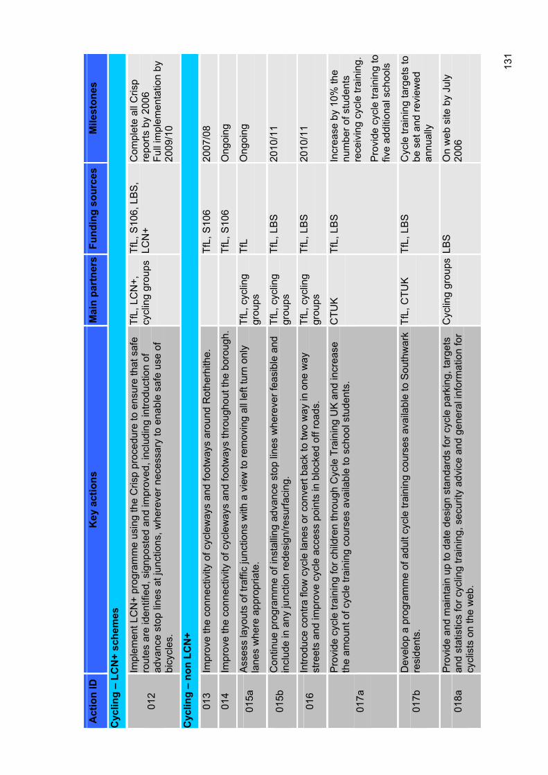
131
Act
ion
ID
Key
act
ions
M
ain
part
ners
Fund
ing
sour
ces
Mile
ston
es
Cyc
ling
– LC
N+
sche
mes
012
Impl
emen
t LC
N+
prog
ram
me
usin
g th
e C
risp
proc
edur
e to
ens
ure
that
saf
e ro
utes
are
iden
tified
, sig
npos
ted
and
impr
oved
, inc
ludi
ng in
trodu
ctio
n of
ad
vanc
e st
op li
nes
at ju
nctio
ns, w
here
ver n
eces
sary
to e
nabl
e sa
fe u
se o
f bi
cycl
es.
TfL,
LC
N+,
cycl
ing
grou
psTf
L, S
106,
LB
S,
LCN
+C
ompl
ete
all C
risp
repo
rts b
y 20
06
Full
impl
emen
tatio
n by
20
09/1
0
Cyc
ling
– no
n LC
N+
013
Impr
ove
the
conn
ectiv
ity o
f cyc
lew
ays
and
foot
way
s ar
ound
Rot
herh
ithe.
Tf
L, S
106
2007
/08
014
Impr
ove
the
conn
ectiv
ity o
f cyc
lew
ays
and
foot
way
s th
roug
hout
the
boro
ugh.
Tf
L, S
106
Ong
oing
015a
Ass
ess
layo
uts
of tr
affic
junc
tions
with
a v
iew
to re
mov
ing
all l
eft t
urn
only
la
nes
whe
re a
ppro
pria
te.
TfL,
cyc
ling
grou
psTf
LO
ngoi
ng
015b
Con
tinue
pro
gram
me
of in
stal
ling
adva
nce
stop
line
s w
here
ver f
easi
ble
and
incl
ude
in a
ny ju
nctio
n re
desi
gn/re
surfa
cing
. Tf
L, c
yclin
g gr
oups
TfL,
LB
S
2010
/11
016
Intro
duce
con
tra fl
ow c
ycle
lane
s or
con
vert
back
to tw
o w
ay in
one
way
st
reet
s an
d im
prov
e cy
cle
acce
ss p
oint
s in
blo
cked
off
road
s.
TfL,
cyc
ling
grou
psTf
L, L
BS
20
10/1
1
017a
Pro
vide
cyc
le tr
aini
ng fo
r chi
ldre
n th
roug
h C
ycle
Tra
inin
g U
K a
nd in
crea
se
the
amou
nt o
f cyc
le tr
aini
ng c
ours
es a
vaila
ble
to s
choo
l stu
dent
s.
CTU
KTf
L, L
BS
In
crea
se b
y 10
% th
e nu
mbe
r of s
tude
nts
rece
ivin
g cy
cle
train
ing.
Pro
vide
cyc
le tr
aini
ng to
fiv
e ad
ditio
nal s
choo
ls
017b
Dev
elop
a p
rogr
amm
e of
adu
lt cy
cle
train
ing
cour
ses
avai
labl
e to
Sou
thw
ark
resi
dent
s.Tf
L, C
TUK
Tf
L, L
BS
C
ycle
trai
ning
targ
ets
to
be s
et a
nd re
view
ed
annu
ally
018a
Pro
vide
and
mai
ntai
n up
to d
ate
desi
gn s
tand
ards
for c
ycle
par
king
, tar
gets
an
d st
atis
tics
for c
yclin
g tra
inin
g, s
ecur
ity a
dvic
e an
d ge
nera
l inf
orm
atio
n fo
r cy
clis
ts o
n th
e w
eb.
Cyc
ling
grou
ps L
BS
On
web
site
by
July
20
06
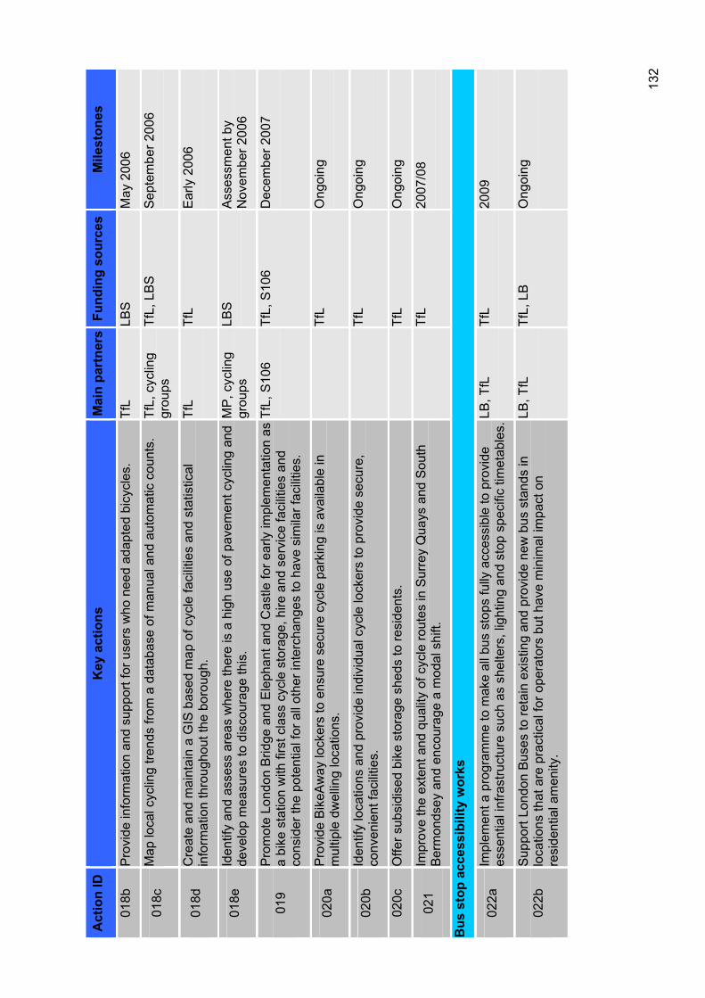
132
Act
ion
ID
Key
act
ions
M
ain
part
ners
Fund
ing
sour
ces
Mile
ston
es
018b
Pro
vide
info
rmat
ion
and
supp
ort f
or u
sers
who
nee
d ad
apte
d bi
cycl
es.
TfL
LBS
May
200
6
018c
Map
loca
l cyc
ling
trend
s fro
m a
dat
abas
e of
man
ual a
nd a
utom
atic
cou
nts.
Tf
L, c
yclin
g gr
oups
TfL,
LB
S
Sep
tem
ber 2
006
018d
Cre
ate
and
mai
ntai
n a
GIS
bas
ed m
ap o
f cyc
le fa
cilit
ies
and
stat
istic
al
info
rmat
ion
thro
ugho
ut th
e bo
roug
h.
TfL
TfL
Ear
ly 2
006
018e
Iden
tify
and
asse
ss a
reas
whe
re th
ere
is a
hig
h us
e of
pav
emen
t cyc
ling
and
deve
lop
mea
sure
s to
dis
cour
age
this
. M
P, c
yclin
g gr
oups
LBS
Ass
essm
ent b
y N
ovem
ber 2
006
019
Pro
mot
e Lo
ndon
Brid
ge a
nd E
leph
ant a
nd C
astle
for e
arly
impl
emen
tatio
n as
a
bike
sta
tion
with
firs
t cla
ss c
ycle
sto
rage
, hire
and
ser
vice
faci
litie
s an
d co
nsid
er th
e po
tent
ial f
or a
ll ot
her i
nter
chan
ges
to h
ave
sim
ilar f
acili
ties.
TfL,
S10
6Tf
L, S
106
Dec
embe
r 200
7
020a
Pro
vide
Bik
eAw
ay lo
cker
s to
ens
ure
secu
re c
ycle
par
king
is a
vaila
ble
in
mul
tiple
dw
ellin
g lo
catio
ns.
TfL
Ong
oing
020b
Iden
tify
loca
tions
and
pro
vide
indi
vidu
al c
ycle
lock
ers
to p
rovi
de s
ecur
e,
conv
enie
nt fa
cilit
ies.
Tf
LO
ngoi
ng
020c
Offe
r sub
sidi
sed
bike
sto
rage
she
ds to
resi
dent
s.
TfL
Ong
oing
021
Impr
ove
the
exte
nt a
nd q
ualit
y of
cyc
le ro
utes
in S
urre
y Q
uays
and
Sou
th
Ber
mon
dsey
and
enc
oura
ge a
mod
al s
hift.
Tf
L20
07/0
8
Bus
sto
p ac
cess
ibili
ty w
orks
022a
Impl
emen
t a p
rogr
amm
e to
mak
e al
l bus
sto
ps fu
lly a
cces
sibl
e to
pro
vide
es
sent
ial i
nfra
stru
ctur
e su
ch a
s sh
elte
rs, l
ight
ing
and
stop
spe
cific
tim
etab
les.
LB, T
fL
TfL
2009
022b
Sup
port
Lond
on B
uses
to re
tain
exi
stin
g an
d pr
ovid
e ne
w b
us s
tand
s in
lo
catio
ns th
at a
re p
ract
ical
for o
pera
tors
but
hav
e m
inim
al im
pact
on
resi
dent
ial a
men
ity.
LB, T
fL
TfL,
LB
Ong
oing
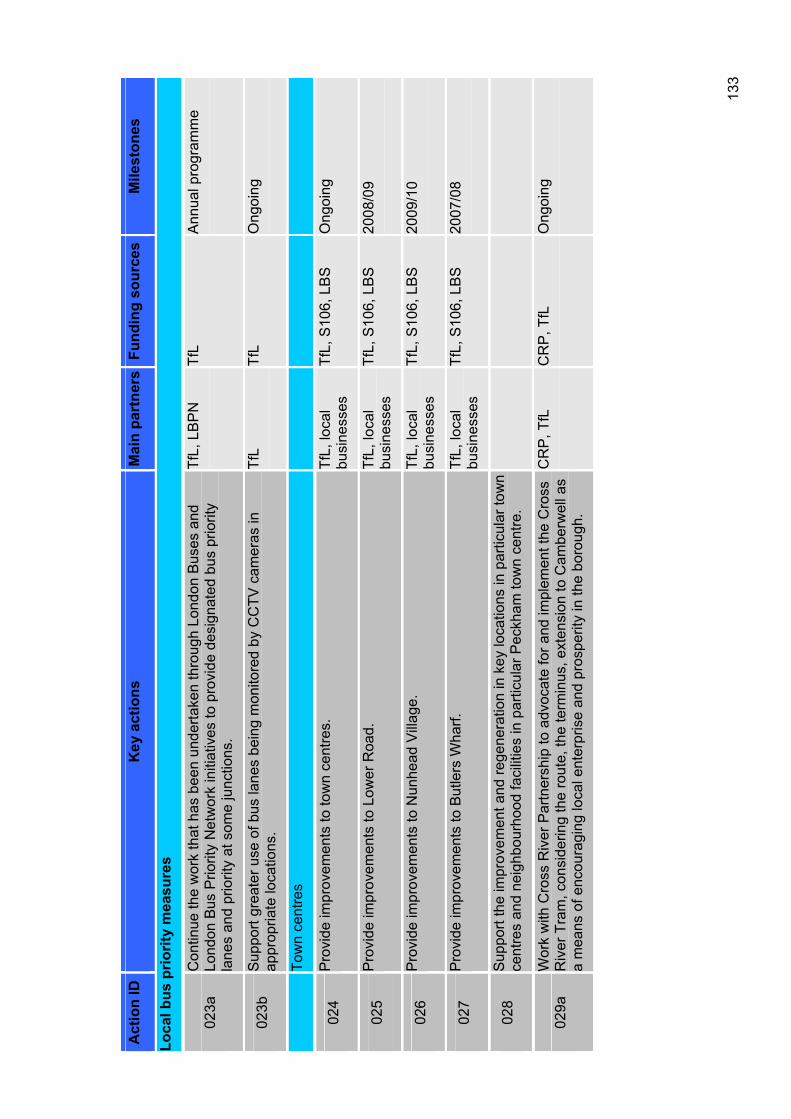
133
Act
ion
ID
Key
act
ions
M
ain
part
ners
Fund
ing
sour
ces
Mile
ston
es
Loca
l bus
prio
rity
mea
sure
s
023a
Con
tinue
the
wor
k th
at h
as b
een
unde
rtake
n th
roug
h Lo
ndon
Bus
es a
nd
Lond
on B
us P
riorit
y N
etw
ork
initi
ativ
es to
pro
vide
des
igna
ted
bus
prio
rity
lane
s an
d pr
iorit
y at
som
e ju
nctio
ns.
TfL,
LB
PN
Tf
LA
nnua
l pro
gram
me
023b
Sup
port
grea
ter u
se o
f bus
lane
s be
ing
mon
itore
d by
CC
TV c
amer
as in
ap
prop
riate
loca
tions
.Tf
LTf
LO
ngoi
ng
Tow
n ce
ntre
s
024
Pro
vide
impr
ovem
ents
to to
wn
cent
res.
Tf
L, lo
cal
busi
ness
es
TfL,
S10
6, L
BS
O
ngoi
ng
025
Pro
vide
impr
ovem
ents
to L
ower
Roa
d.
TfL,
loca
l bu
sine
sses
Tf
L, S
106,
LB
S
2008
/09
026
Pro
vide
impr
ovem
ents
to N
unhe
ad V
illag
e.
TfL,
loca
l bu
sine
sses
Tf
L, S
106,
LB
S
2009
/10
027
Pro
vide
impr
ovem
ents
to B
utle
rs W
harf.
Tf
L, lo
cal
busi
ness
es
TfL,
S10
6, L
BS
20
07/0
8
028
Sup
port
the
impr
ovem
ent a
nd re
gene
ratio
n in
key
loca
tions
in p
artic
ular
tow
n ce
ntre
s an
d ne
ighb
ourh
ood
faci
litie
s in
par
ticul
ar P
eckh
am to
wn
cent
re.
029a
Wor
k w
ith C
ross
Riv
er P
artn
ersh
ip to
adv
ocat
e fo
r and
impl
emen
t the
Cro
ss
Riv
er T
ram
, con
side
ring
the
rout
e, th
e te
rmin
us, e
xten
sion
to C
ambe
rwel
l as
a m
eans
of e
ncou
ragi
ng lo
cal e
nter
pris
e an
d pr
ospe
rity
in th
e bo
roug
h.
CR
P, T
fL
CR
P, T
fL
Ong
oing
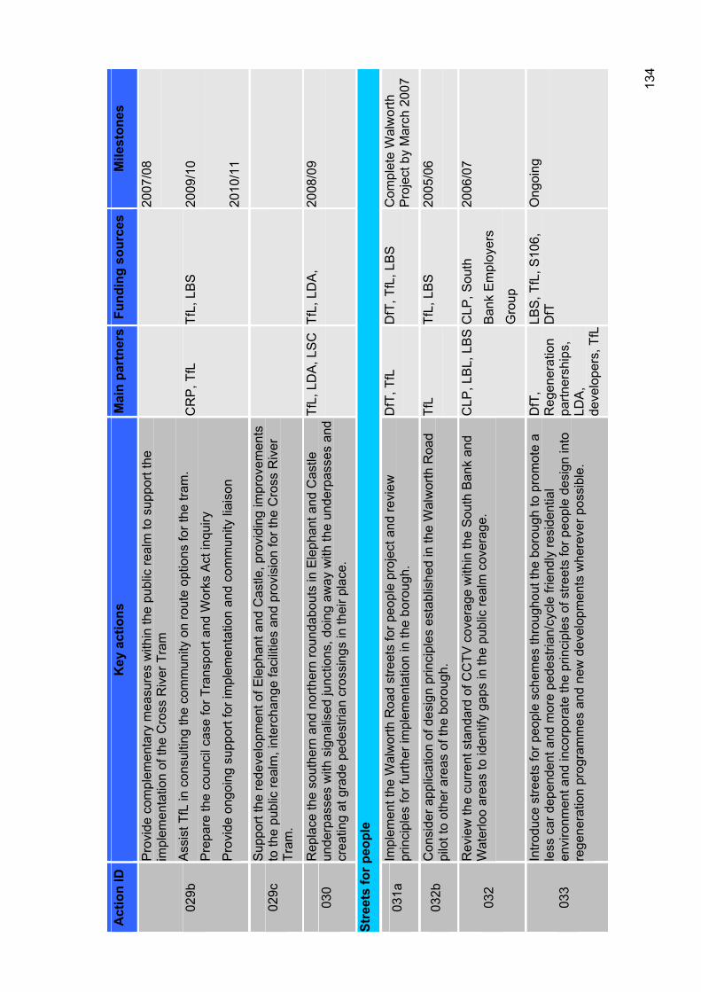
134
Act
ion
ID
Key
act
ions
M
ain
part
ners
Fund
ing
sour
ces
Mile
ston
es
029b
Pro
vide
com
plem
enta
ry m
easu
res
with
in th
e pu
blic
real
m to
sup
port
the
impl
emen
tatio
n of
the
Cro
ss R
iver
Tra
m
Ass
ist T
fL in
con
sulti
ng th
e co
mm
unity
on
rout
e op
tions
for t
he tr
am.
Pre
pare
the
coun
cil c
ase
for T
rans
port
and
Wor
ks A
ct in
quiry
Pro
vide
ong
oing
sup
port
for i
mpl
emen
tatio
n an
d co
mm
unity
liai
son
CR
P, T
fL
TfL,
LB
S
2007
/08
2009
/10
2010
/11
029c
Sup
port
the
rede
velo
pmen
t of E
leph
ant a
nd C
astle
, pro
vidi
ng im
prov
emen
ts
to th
e pu
blic
real
m, i
nter
chan
ge fa
cilit
ies
and
prov
isio
n fo
r the
Cro
ss R
iver
Tr
am.
030
Rep
lace
the
sout
hern
and
nor
ther
n ro
unda
bout
s in
Ele
phan
t and
Cas
tle
unde
rpas
ses
with
sig
nalis
ed ju
nctio
ns, d
oing
aw
ay w
ith th
e un
derp
asse
s an
d cr
eatin
g at
gra
de p
edes
trian
cro
ssin
gs in
thei
r pla
ce.
TfL,
LD
A, L
SC
TfL,
LD
A,
2008
/09
Stre
ets
for p
eopl
e
031a
Impl
emen
t the
Wal
wor
th R
oad
stre
ets
for p
eopl
e pr
ojec
t and
revi
ew
prin
cipl
es fo
r fur
ther
impl
emen
tatio
n in
the
boro
ugh.
D
fT, T
fL
DfT
, TfL
, LB
S
Com
plet
e W
alw
orth
P
roje
ct b
y M
arch
200
7
032b
Con
side
r app
licat
ion
of d
esig
n pr
inci
ples
est
ablis
hed
in th
e W
alw
orth
Roa
d pi
lot t
o ot
her a
reas
of t
he b
orou
gh.
TfL
TfL,
LB
S
2005
/06
032
Rev
iew
the
curr
ent s
tand
ard
of C
CTV
cov
erag
e w
ithin
the
Sou
th B
ank
and
Wat
erlo
o ar
eas
to id
entif
y ga
ps in
the
publ
ic re
alm
cov
erag
e.
CLP
, LB
L, L
BS
CLP
, Sou
th
Ban
k E
mpl
oyer
s
Gro
up
2006
/07
033
Intro
duce
stre
ets
for p
eopl
e sc
hem
es th
roug
hout
the
boro
ugh
to p
rom
ote
a le
ss c
ar d
epen
dent
and
mor
e pe
dest
rian/
cycl
e fri
endl
y re
side
ntia
l en
viro
nmen
t and
inco
rpor
ate
the
prin
cipl
es o
f stre
ets
for p
eopl
e de
sign
into
re
gene
ratio
n pr
ogra
mm
es a
nd n
ew d
evel
opm
ents
whe
reve
r pos
sibl
e.
DfT
,R
egen
erat
ion
partn
ersh
ips,
LDA
,de
velo
pers
, TfL
LBS
, TfL
, S10
6,
DfT
Ong
oing
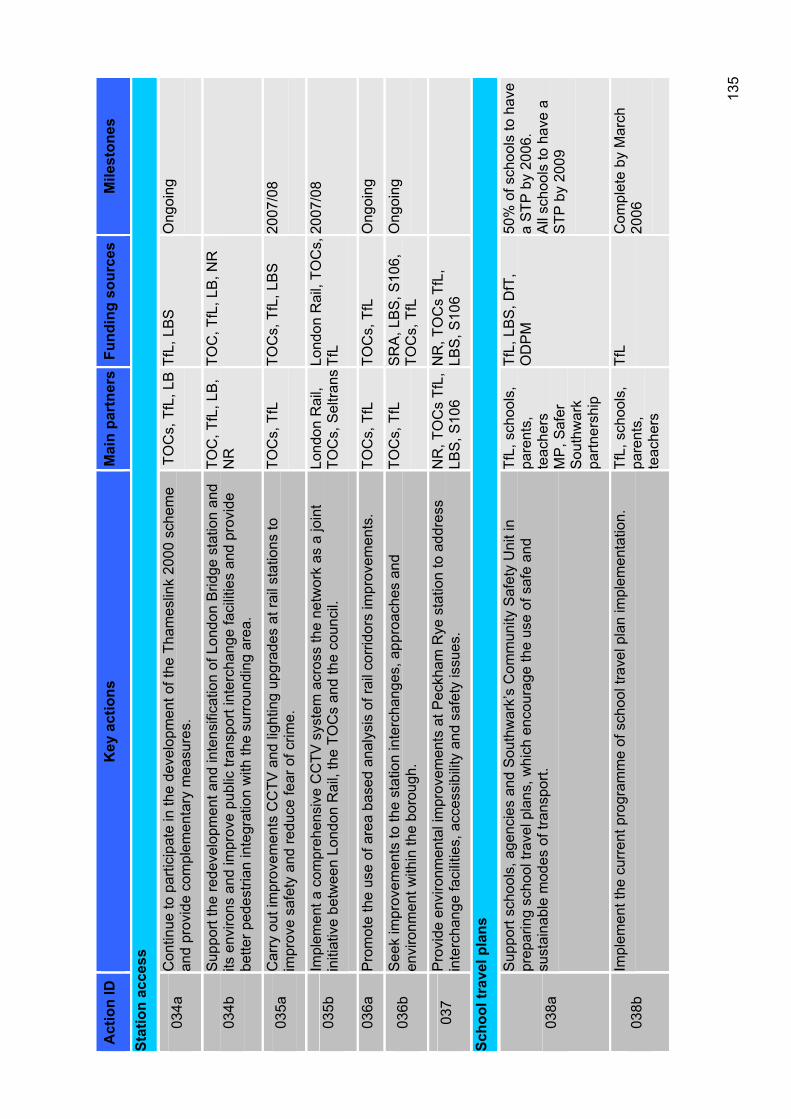
135
Act
ion
ID
Key
act
ions
M
ain
part
ners
Fund
ing
sour
ces
Mile
ston
es
Stat
ion
acce
ss
034a
Con
tinue
to p
artic
ipat
e in
the
deve
lopm
ent o
f the
Tha
mes
link
2000
sch
eme
and
prov
ide
com
plem
enta
ry m
easu
res.
T
OC
s, T
fL, L
BTf
L, L
BS
O
ngoi
ng
034b
Sup
port
the
rede
velo
pmen
t and
inte
nsifi
catio
n of
Lon
don
Brid
ge s
tatio
n an
d its
env
irons
and
impr
ove
publ
ic tr
ansp
ort i
nter
chan
ge fa
cilit
ies
and
prov
ide
bette
r ped
estri
an in
tegr
atio
n w
ith th
e su
rrou
ndin
g ar
ea.
TOC
, TfL
, LB
, N
RTO
C, T
fL, L
B, N
R
035a
Car
ry o
ut im
prov
emen
ts C
CTV
and
ligh
ting
upgr
ades
at r
ail s
tatio
ns to
im
prov
e sa
fety
and
redu
ce fe
ar o
f crim
e.
TOC
s, T
fL
TOC
s, T
fL, L
BS
20
07/0
8
035b
Impl
emen
t a c
ompr
ehen
sive
CC
TV s
yste
m a
cros
s th
e ne
twor
k as
a jo
int
initi
ativ
e be
twee
n Lo
ndon
Rai
l, th
e TO
Cs
and
the
coun
cil.
Lo
ndon
Rai
l, TO
Cs,
Sel
trans
Lond
on R
ail,
TOC
s,
TfL
2007
/08
036a
Pro
mot
e th
e us
e of
are
a ba
sed
anal
ysis
of r
ail c
orrid
ors
impr
ovem
ents
. TO
Cs,
TfL
TO
Cs,
TfL
O
ngoi
ng
036b
See
k im
prov
emen
ts to
the
stat
ion
inte
rcha
nges
, app
roac
hes
and
envi
ronm
ent w
ithin
the
boro
ugh.
TO
Cs,
TfL
S
RA
, LB
S, S
106,
TO
Cs,
TfL
O
ngoi
ng
037
Pro
vide
env
ironm
enta
l im
prov
emen
ts a
t Pec
kham
Rye
sta
tion
to a
ddre
ss
inte
rcha
nge
faci
litie
s, a
cces
sibi
lity
and
safe
ty is
sues
. N
R, T
OC
s Tf
L,
LBS
, S10
6 N
R, T
OC
s Tf
L,
LBS
, S10
6
Scho
ol tr
avel
pla
ns
038a
Sup
port
scho
ols,
age
ncie
s an
d S
outh
war
k’s
Com
mun
ity S
afet
y U
nit i
n pr
epar
ing
scho
ol tr
avel
pla
ns, w
hich
enc
oura
ge th
e us
e of
saf
e an
d su
stai
nabl
e m
odes
of t
rans
port.
TfL,
sch
ools
, pa
rent
s,te
ache
rsM
P, S
afer
S
outh
war
kpa
rtner
ship
TfL,
LB
S, D
fT,
OD
PM
50
% o
f sch
ools
to h
ave
a S
TP b
y 20
06.
All
scho
ols
to h
ave
a S
TP b
y 20
09
038b
Impl
emen
t the
cur
rent
pro
gram
me
of s
choo
l tra
vel p
lan
impl
emen
tatio
n.
TfL,
sch
ools
, pa
rent
s,te
ache
rs
TfL
Com
plet
e by
Mar
ch
2006
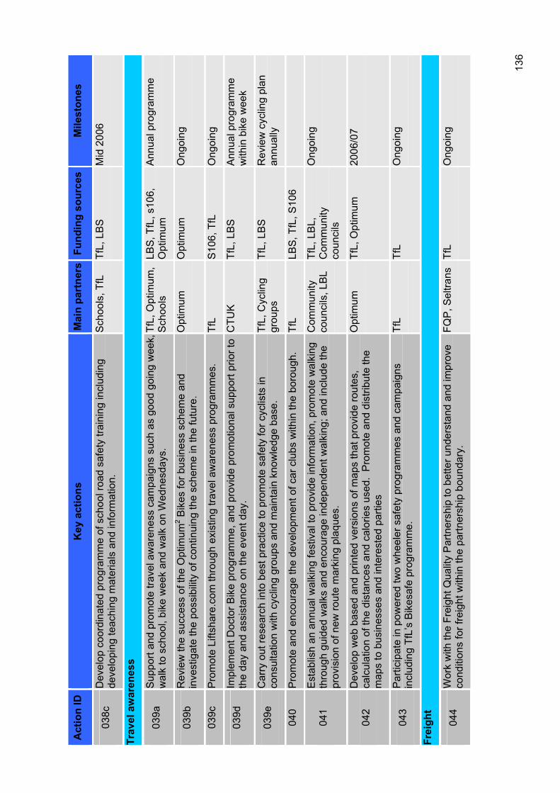
136
Act
ion
ID
Key
act
ions
M
ain
part
ners
Fund
ing
sour
ces
Mile
ston
es
038c
Dev
elop
coo
rdin
ated
pro
gram
me
of s
choo
l roa
d sa
fety
trai
ning
incl
udin
g de
velo
ping
teac
hing
mat
eria
ls a
nd in
form
atio
n.
Sch
ools
, TfL
Tf
L, L
BS
M
id 2
006
Trav
el a
war
enes
s
039a
Sup
port
and
prom
ote
trave
l aw
aren
ess
cam
paig
ns s
uch
as g
ood
goin
g w
eek,
w
alk
to s
choo
l, bi
ke w
eek
and
wal
k on
Wed
nesd
ays.
Tf
L, O
ptim
um,
Sch
ools
LBS
, TfL
, s10
6,
Opt
imum
A
nnua
l pro
gram
me
039b
Rev
iew
the
succ
ess
of th
e O
ptim
um2 B
ikes
for b
usin
ess
sche
me
and
inve
stig
ate
the
poss
ibili
ty o
f con
tinui
ng th
e sc
hem
e in
the
futu
re.
Opt
imum
O
ptim
um
Ong
oing
039c
Pro
mot
e Li
ftsha
re.c
om th
roug
h ex
istin
g tra
vel a
war
enes
s pr
ogra
mm
es.
TfL
S10
6, T
fL
Ong
oing
039d
Impl
emen
t Doc
tor B
ike
prog
ram
me,
and
pro
vide
pro
mot
iona
l sup
port
prio
r to
the
day
and
assi
stan
ce o
n th
e ev
ent d
ay.
CTU
KTf
L, L
BS
A
nnua
l pro
gram
me
with
in b
ike
wee
k
039e
Car
ry o
ut re
sear
ch in
to b
est p
ract
ice
to p
rom
ote
safe
ty fo
r cyc
lists
in
cons
ulta
tion
with
cyc
ling
grou
ps a
nd m
aint
ain
know
ledg
e ba
se.
TfL,
Cyc
ling
grou
psTf
L, L
BS
R
evie
w c
yclin
g pl
an
annu
ally
040
Pro
mot
e an
d en
cour
age
the
deve
lopm
ent o
f car
clu
bs w
ithin
the
boro
ugh.
Tf
LLB
S, T
fL, S
106
041
Est
ablis
h an
ann
ual w
alki
ng fe
stiv
al to
pro
vide
info
rmat
ion,
pro
mot
e w
alki
ng
thro
ugh
guid
ed w
alks
and
enc
oura
ge in
depe
nden
t wal
king
; and
incl
ude
the
prov
isio
n of
new
rout
e m
arki
ng p
laqu
es.
Com
mun
ityco
unci
ls, L
BL
TfL,
LB
L,
Com
mun
ityco
unci
ls
Ong
oing
042
Dev
elop
web
bas
ed a
nd p
rinte
d ve
rsio
ns o
f map
s th
at p
rovi
de ro
utes
, ca
lcul
atio
n of
the
dist
ance
s an
d ca
lorie
s us
ed.
Pro
mot
e an
d di
strib
ute
the
map
s to
bus
ines
ses
and
inte
rest
ed p
artie
s
Opt
imum
Tf
L, O
ptim
um
2006
/07
043
Par
ticip
ate
in p
ower
ed tw
o w
heel
er s
afet
y pr
ogra
mm
es a
nd c
ampa
igns
in
clud
ing
TfL’
s B
ikes
afe
prog
ram
me.
Tf
LTf
LO
ngoi
ng
Frei
ght
044
Wor
k w
ith th
e Fr
eigh
t Qua
lity
Par
tner
ship
to b
ette
r und
erst
and
and
impr
ove
cond
ition
s fo
r fre
ight
with
in th
e pa
rtner
ship
bou
ndar
y.
FQP
, Sel
trans
Tf
LO
ngoi
ng
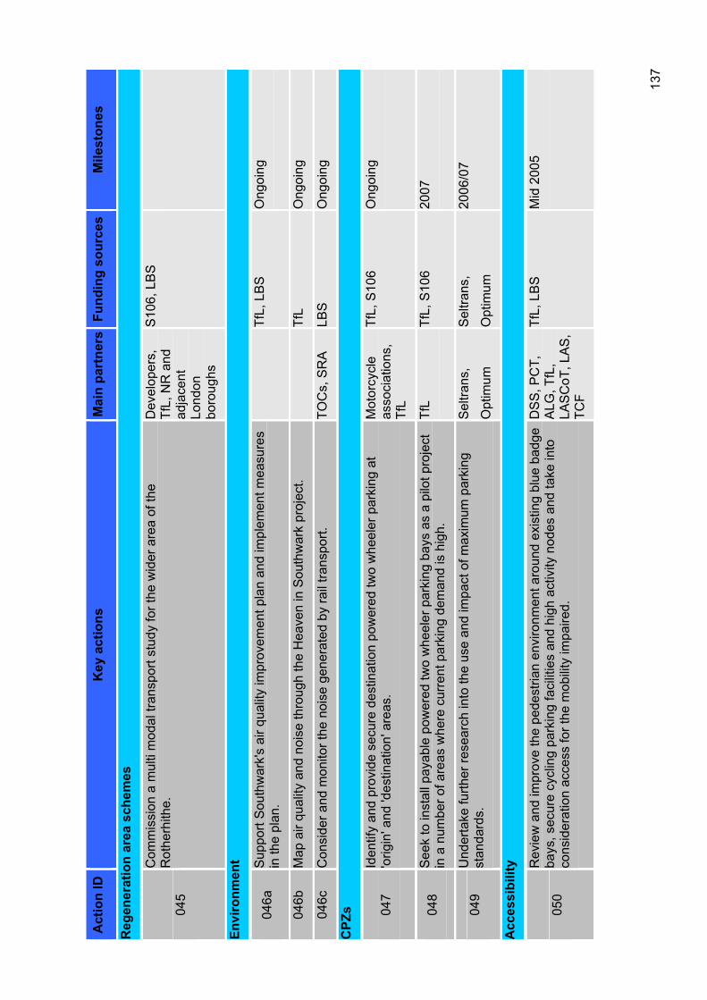
137
Act
ion
ID
Key
act
ions
M
ain
part
ners
Fund
ing
sour
ces
Mile
ston
es
Reg
ener
atio
n ar
ea s
chem
es
045
Com
mis
sion
a m
ulti
mod
al tr
ansp
ort s
tudy
for t
he w
ider
are
a of
the
Rot
herh
ithe.
Dev
elop
ers,
TfL,
NR
and
ad
jace
ntLo
ndon
boro
ughs
S10
6, L
BS
Envi
ronm
ent
046a
Sup
port
Sou
thw
ark'
s ai
r qua
lity
impr
ovem
ent p
lan
and
impl
emen
t mea
sure
s in
the
plan
. Tf
L, L
BS
O
ngoi
ng
046b
Map
air
qual
ity a
nd n
oise
thro
ugh
the
Hea
ven
in S
outh
war
k pr
ojec
t. Tf
LO
ngoi
ng
046c
Con
side
r and
mon
itor t
he n
oise
gen
erat
ed b
y ra
il tra
nspo
rt.
TOC
s, S
RA
LB
SO
ngoi
ng
CPZ
s 047
Iden
tify
and
prov
ide
secu
re d
estin
atio
n po
wer
ed tw
o w
heel
er p
arki
ng a
t 'o
rigin
' and
'des
tinat
ion'
are
as.
Mot
orcy
cle
asso
ciat
ions
, Tf
L
TfL,
S10
6 O
ngoi
ng
048
See
k to
inst
all p
ayab
le p
ower
ed tw
o w
heel
er p
arki
ng b
ays
as a
pilo
t pro
ject
in
a n
umbe
r of a
reas
whe
re c
urre
nt p
arki
ng d
eman
d is
hig
h.
TfL
TfL,
S10
6 20
07
049
Und
erta
ke fu
rther
rese
arch
into
the
use
and
impa
ct o
f max
imum
par
king
st
anda
rds.
Sel
trans
,
Opt
imum
Sel
trans
,
Opt
imum
2006
/07
Acc
essi
bilit
y
050
Rev
iew
and
impr
ove
the
pede
stria
n en
viro
nmen
t aro
und
exis
ting
blue
bad
ge
bays
, sec
ure
cycl
ing
park
ing
faci
litie
s an
d hi
gh a
ctiv
ity n
odes
and
take
into
co
nsid
erat
ion
acce
ss fo
r the
mob
ility
impa
ired.
DS
S, P
CT,
A
LG, T
fL,
LAS
CoT
, LA
S,
TCF
TfL,
LB
S
Mid
200
5
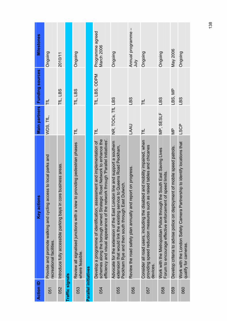
138
Act
ion
ID
Key
act
ions
M
ain
part
ners
Fund
ing
sour
ces
Mile
ston
es
051
Pro
vide
and
pro
mot
e w
alki
ng a
nd c
yclin
g ac
cess
to lo
cal p
arks
and
re
crea
tiona
l fac
ilitie
s.
WD
S, T
fL,
TfL
Ong
oing
052
Intro
duce
fully
acc
essi
ble
park
ing
bays
in c
ore
busi
ness
are
as.
TfL,
LB
S
2010
/11
Traf
fic s
igna
ls
053
Rev
iew
all
sign
alis
ed ju
nctio
ns w
ith a
vie
w to
pro
vidi
ng p
edes
trian
pha
ses
whe
re fe
asib
le.
TfL
TfL,
LB
S
Ong
oing
Para
llel i
nitia
tives
054
Dev
elop
a p
rogr
amm
e of
iden
tific
atio
n, a
sses
smen
t and
impl
emen
tatio
n of
sc
hem
es a
long
the
boro
ugh
owne
d S
trate
gic
Roa
d N
etw
ork
to e
nhan
ce th
e ef
ficie
ncy
and
visu
al a
ppea
ranc
e of
the
netw
ork
thro
ugh
'Par
alle
l Ini
tiativ
es'.
TfL
TfL,
LB
S, O
DP
M
Pro
gram
me
agre
ed
Mar
ch 2
006
055
Adv
ocat
e fo
r the
ext
ensi
on o
f the
Eas
t Lon
don
line
and
supp
ort a
sou
ther
n ex
tens
ion
that
wou
ld li
nk th
e ex
istin
g se
rvic
e to
Que
ens
Roa
d P
eckh
am,
Pec
kham
Rye
and
then
sou
th th
roug
h E
ast D
ulw
ich.
NR
, TO
Cs,
TfL
LBS
Ong
oing
056
Rev
iew
the
road
saf
ety
plan
ann
ually
and
repo
rt on
pro
gres
s.
LAA
ULB
SA
nnua
l pro
gram
me
– Ju
ly
057
Con
side
r all
road
use
rs, i
nclu
ding
the
disa
bled
and
mob
ility
impa
ired,
whe
n pr
ovid
ing
spee
d re
duct
ion
mea
sure
s su
ch a
s ra
ised
tabl
es a
nd c
hica
nes
devi
ces.
TfL
TfL
Ong
oing
058
Wor
k w
ith th
e M
etro
polit
an P
olic
e th
roug
h th
e S
outh
Eas
t Sav
ing
Live
s Fo
rum
to e
ncou
rage
effe
ctiv
e en
forc
emen
t of s
peed
lim
its.
MP
, SE
SLF
LB
SO
ngoi
ng
059
Dev
elop
crit
eria
to a
dvis
e po
lice
on d
eplo
ymen
t of m
obile
spe
ed p
atro
ls.
MP
LBS
, MP
M
ay 2
006
060
Wor
k w
ith th
e Lo
ndon
Saf
ety
Cam
era
Par
tner
ship
to id
entif
y lo
catio
ns th
at
qual
ify fo
r cam
eras
. LS
CP
LBS
Ong
oing
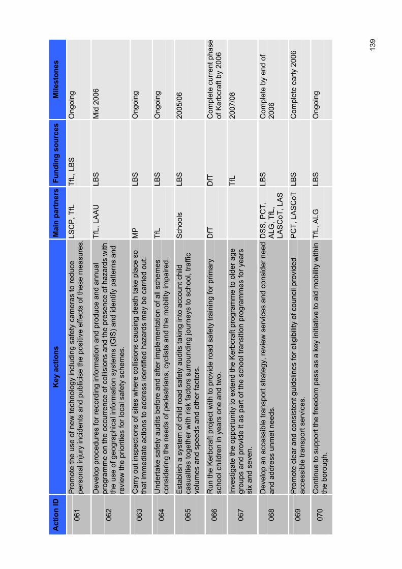
139
Act
ion
ID
Key
act
ions
M
ain
part
ners
Fund
ing
sour
ces
Mile
ston
es
061
Pro
mot
e th
e us
e of
new
tech
nolo
gy in
clud
ing
safe
ty c
amer
as to
redu
ce
pers
onal
inju
ry in
cide
nts
and
publ
icis
e th
e po
sitiv
e ef
fect
s of
thes
e m
easu
res.
LSC
P, T
fL
TfL,
LB
S
Ong
oing
062
Dev
elop
pro
cedu
res
for r
ecor
ding
info
rmat
ion
and
prod
uce
and
annu
al
prog
ram
me
on th
e oc
curre
nce
of c
ollis
ions
and
the
pres
ence
of h
azar
ds w
ith
the
use
of g
eogr
aphi
cal i
nfor
mat
ion
syst
ems
(GIS
) and
iden
tify
patte
rns
and
revi
ew th
e pr
iorit
ies
for l
ocal
saf
ety
sche
mes
.
TfL,
LA
AU
LB
SM
id 2
006
063
Car
ry o
ut in
spec
tions
of s
ites
whe
re c
ollis
ions
cau
sing
dea
th ta
ke p
lace
so
that
imm
edia
te a
ctio
ns to
add
ress
iden
tified
haz
ards
may
be
carr
ied
out.
MP
LBS
Ong
oing
064
Und
erta
ke s
afet
y au
dits
bef
ore
and
afte
r im
plem
enta
tion
of a
ll sc
hem
es
cons
ider
ing
the
need
s of
ped
estri
ans,
cyc
lists
and
the
mob
ility
impa
ired.
Tf
LLB
SO
ngoi
ng
065
Est
ablis
h a
syst
em o
f chi
ld ro
ad s
afet
y au
dits
taki
ng in
to a
ccou
nt c
hild
ca
sual
ties
toge
ther
with
risk
fact
ors
surr
ound
ing
jour
neys
to s
choo
l, tra
ffic
volu
mes
and
spe
eds
and
othe
r fac
tors
.
Sch
ools
LBS
2005
/06
066
Run
the
Ker
bcra
ft pr
ojec
t with
to p
rovi
de ro
ad s
afet
y tra
inin
g fo
r prim
ary
scho
ol c
hild
ren
in y
ears
one
and
two.
D
fTD
fTC
ompl
ete
curr
ent p
hase
of
Ker
bcra
ft by
200
6
067
Inve
stig
ate
the
oppo
rtuni
ty to
ext
end
the
Ker
bcra
ft pr
ogra
mm
e to
old
er a
ge
grou
ps a
nd p
rovi
de it
as
part
of th
e sc
hool
tran
sitio
n pr
ogra
mm
es fo
r yea
rs
six
and
seve
n.
TfL
2007
/08
068
Dev
elop
an
acce
ssib
le tr
ansp
ort s
trate
gy, r
evie
w s
ervi
ces
and
cons
ider
nee
d an
d ad
dres
s un
met
nee
ds.
DS
S, P
CT,
A
LG, T
fL,
LAS
CoT
, LA
S
LBS
Com
plet
e by
end
of
2006
069
Pro
mot
e cl
ear a
nd c
onsi
sten
t gui
delin
es fo
r elig
ibili
ty o
f cou
ncil
prov
ided
ac
cess
ible
tran
spor
t ser
vice
s.
PC
T, L
AS
CoT
LB
SC
ompl
ete
early
200
6
070
Con
tinue
to s
uppo
rt th
e fre
edom
pas
s as
a k
ey in
itiat
ive
to a
id m
obili
ty w
ithin
th
e bo
roug
h.
TfL,
ALG
LB
SO
ngoi
ng
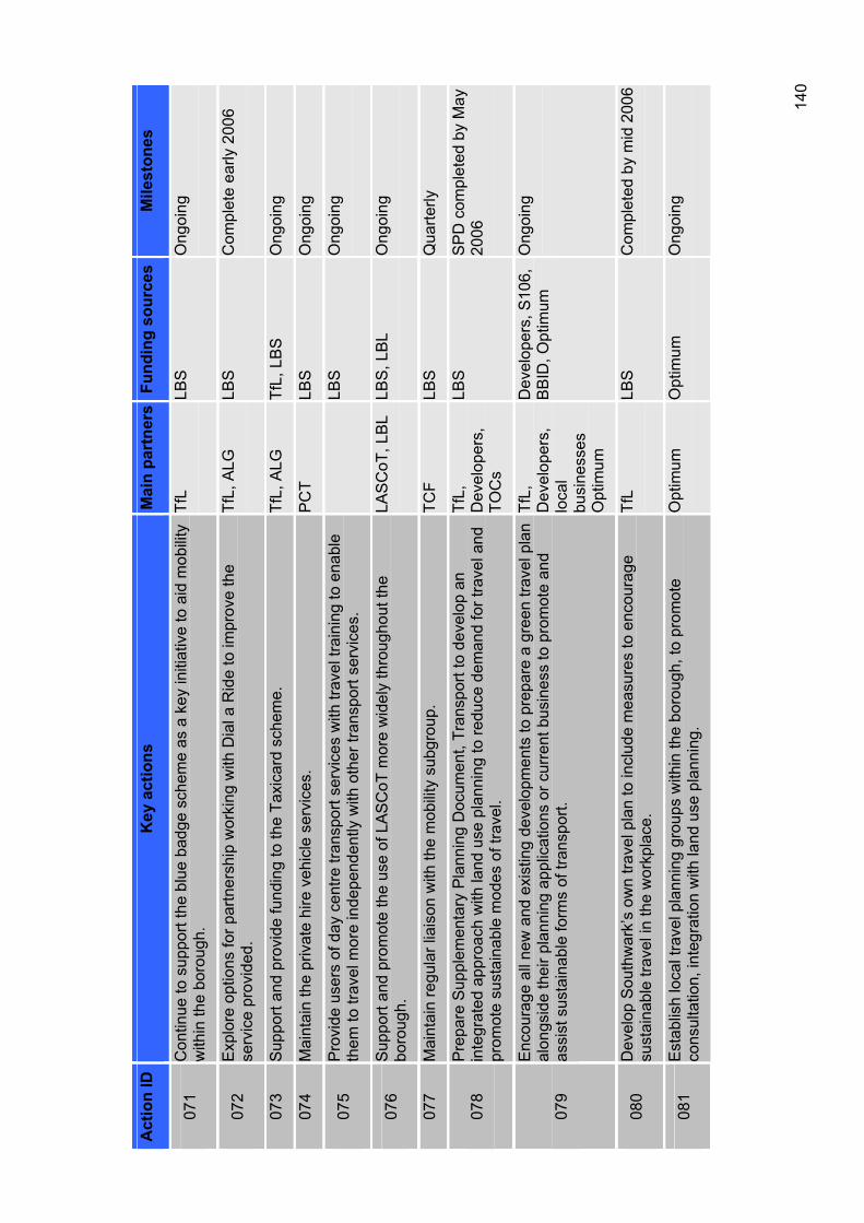
140
Act
ion
ID
Key
act
ions
M
ain
part
ners
Fund
ing
sour
ces
Mile
ston
es
071
Con
tinue
to s
uppo
rt th
e bl
ue b
adge
sch
eme
as a
key
initi
ativ
e to
aid
mob
ility
w
ithin
the
boro
ugh.
Tf
LLB
SO
ngoi
ng
072
Exp
lore
opt
ions
for p
artn
ersh
ip w
orki
ng w
ith D
ial a
Rid
e to
impr
ove
the
serv
ice
prov
ided
. Tf
L, A
LG
LBS
Com
plet
e ea
rly 2
006
073
Sup
port
and
prov
ide
fund
ing
to th
e Ta
xica
rd s
chem
e.
TfL,
ALG
Tf
L, L
BS
O
ngoi
ng
074
Mai
ntai
n th
e pr
ivat
e hi
re v
ehic
le s
ervi
ces.
P
CT
LBS
Ong
oing
075
Pro
vide
use
rs o
f day
cen
tre tr
ansp
ort s
ervi
ces
with
trav
el tr
aini
ng to
ena
ble
them
to tr
avel
mor
e in
depe
nden
tly w
ith o
ther
tran
spor
t ser
vice
s.
LBS
Ong
oing
076
Sup
port
and
prom
ote
the
use
of L
ASC
oT m
ore
wid
ely
thro
ugho
ut th
e bo
roug
h.LA
SC
oT, L
BL
LBS
, LB
L O
ngoi
ng
077
Mai
ntai
n re
gula
r lia
ison
with
the
mob
ility
sub
grou
p.
TCF
LBS
Qua
rterly
078
Pre
pare
Sup
plem
enta
ry P
lann
ing
Doc
umen
t, Tr
ansp
ort t
o de
velo
p an
in
tegr
ated
app
roac
h w
ith la
nd u
se p
lann
ing
to re
duce
dem
and
for t
rave
l and
pr
omot
e su
stai
nabl
e m
odes
of t
rave
l.
TfL,
Dev
elop
ers,
TOC
s
LBS
SP
D c
ompl
eted
by
May
20
06
079
Enc
oura
ge a
ll ne
w a
nd e
xist
ing
deve
lopm
ents
to p
repa
re a
gre
en tr
avel
pla
n al
ongs
ide
thei
r pla
nnin
g ap
plic
atio
ns o
r cur
rent
bus
ines
s to
pro
mot
e an
d as
sist
sus
tain
able
form
s of
tran
spor
t.
TfL,
Dev
elop
ers,
loca
lbu
sine
sses
O
ptim
um
Dev
elop
ers,
S10
6,
BB
ID, O
ptim
um
Ong
oing
080
Dev
elop
Sou
thw
ark’
s ow
n tra
vel p
lan
to in
clud
e m
easu
res
to e
ncou
rage
su
stai
nabl
e tra
vel i
n th
e w
orkp
lace
. Tf
LLB
SC
ompl
eted
by
mid
200
6
081
Est
ablis
h lo
cal t
rave
l pla
nnin
g gr
oups
with
in th
e bo
roug
h, to
pro
mot
e co
nsul
tatio
n, in
tegr
atio
n w
ith la
nd u
se p
lann
ing.
O
ptim
um
Opt
imum
O
ngoi
ng
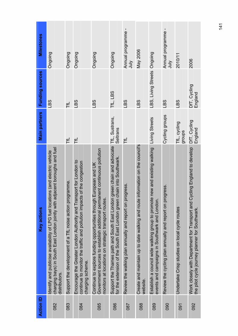
141
Act
ion
ID
Key
act
ions
M
ain
part
ners
Fu
ndin
g so
urce
sM
ilest
ones
082
Iden
tify
and
publ
icis
e av
aila
bilit
y of
LP
G fu
el lo
catio
ns (a
nd e
lect
ric v
ehic
le
char
ging
bay
s) in
Sou
th E
ast L
ondo
n jo
intly
with
adj
acen
t bor
ough
s an
d fu
el
dist
ribut
ors.
LBS
Ong
oing
083
Sup
port
the
deve
lopm
ent o
f a T
fL n
oise
act
ion
prog
ram
me.
Tf
LTf
LO
ngoi
ng
084
Enc
oura
ge th
e G
reat
er L
ondo
n A
utho
rity
and
Tran
spor
t for
Lon
don
to
cont
inue
to m
onito
r the
traf
fic a
nd p
ollu
tion
impa
cts
of th
e co
nges
tion
char
ging
sch
eme.
TfL
LBS
Ong
oing
085
Con
tinue
to e
xplo
re fu
ndin
g op
portu
nitie
s th
roug
h E
urop
ean
and
UK
G
over
nmen
t sou
rces
to e
stab
lish
addi
tiona
l per
man
ent c
ontin
uous
pol
lutio
n m
onito
rs a
t loc
atio
ns o
n st
rate
gic
trans
port
rout
es.
LBS
Ong
oing
086
Sup
port
the
Tham
es p
ath
and
Sou
th E
ast L
ondo
n gr
een
chai
n an
d ad
voca
te
for t
he e
xten
sion
of t
he S
outh
Eas
t Lon
don
gree
n ch
ain
into
Sou
thw
ark.
Tf
L, S
ustra
ns,
Sel
trans
TfL,
LB
S
Ong
oing
087
Rev
iew
the
wal
king
pla
n an
nual
ly a
nd re
port
on p
rogr
ess.
Tf
LLB
SA
nnua
l pro
gram
me
- Ju
ly
088
Cre
ate
and
mai
ntai
n up
to d
ate
wal
king
and
rout
e in
form
atio
n on
the
coun
cil's
web
site
.LB
SM
ay 2
006
089
Est
ablis
h a
coun
cil w
ide
wal
king
gro
up to
pro
mot
e ne
w a
nd e
xist
ing
wal
king
ev
ents
and
cam
paig
ns in
Sou
thw
ark
and
Lond
on.
Livi
ng S
treet
s LB
S, L
ivin
g S
treet
sO
ngoi
ng
090
Rev
iew
the
cycl
ing
plan
ann
ually
and
repo
rt on
pro
gres
s.
Cyc
ling
grou
ps
LBS
Ann
ual p
rogr
amm
e -
July
091
Und
erta
ke C
risp
stud
ies
on lo
cal c
ycle
rout
es
TfL,
cyc
ling
grou
psLB
S20
10/1
1
092
Wor
k cl
osel
y w
ith D
epar
tmen
t for
Tra
nspo
rt an
d C
yclin
g E
ngla
nd to
dev
elop
th
e pi
lot c
ycle
jour
ney
plan
ner f
or S
outh
war
k.
DfT
, Cyc
ling
Eng
land
DfT
, Cyc
ling
Eng
land
2006
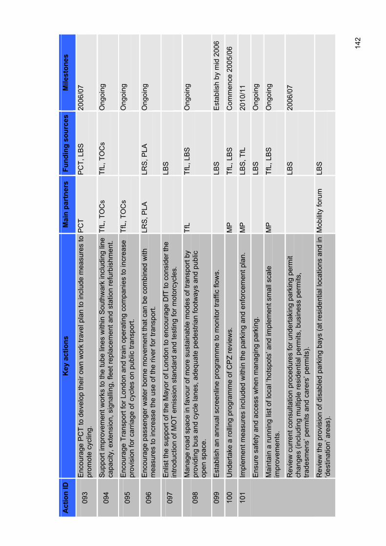
142
Act
ion
ID
Key
act
ions
M
ain
part
ners
Fu
ndin
g so
urce
sM
ilest
ones
093
Enc
oura
ge P
CT
to d
evel
op th
eir o
wn
wor
k tra
vel p
lan
to in
clud
e m
easu
res
to
prom
ote
cycl
ing.
P
CT
PC
T, L
BS
20
06/0
7
094
Sup
port
impr
ovem
ent w
orks
to th
e tu
be li
nes
with
in S
outh
war
k in
clud
ing
line
capa
city
, ext
ensi
on, s
igna
lling
, fle
et re
plac
emen
t and
sta
tion
refu
rbis
hmen
t. Tf
L, T
OC
s Tf
L, T
OC
s O
ngoi
ng
095
Enc
oura
ge T
rans
port
for L
ondo
n an
d tra
in o
pera
ting
com
pani
es to
incr
ease
pr
ovis
ion
for c
arria
ge o
f cyc
les
on p
ublic
tran
spor
t. Tf
L, T
OC
s O
ngoi
ng
096
Enc
oura
ge p
asse
nger
wat
er b
orne
mov
emen
t tha
t can
be
com
bine
d w
ith
mea
sure
s to
incr
ease
the
use
of th
e riv
er fo
r tra
nspo
rt.
LRS
, PLA
LR
S, P
LA
Ong
oing
097
Enl
ist t
he s
uppo
rt of
the
May
or o
f Lon
don
to e
ncou
rage
DfT
to c
onsi
der t
he
intro
duct
ion
of M
OT
emis
sion
sta
ndar
d an
d te
stin
g fo
r mot
orcy
cles
. LB
S
098
Man
age
road
spa
ce in
favo
ur o
f mor
e su
stai
nabl
e m
odes
of t
rans
port
by
prov
idin
g bu
s an
d cy
cle
lane
s, a
dequ
ate
pede
stria
n fo
otw
ays
and
publ
ic
open
spa
ce.
TfL
TfL,
LB
S
Ong
oing
099
Est
ablis
h an
ann
ual s
cree
nlin
e pr
ogra
mm
e to
mon
itor t
raffi
c flo
ws.
LB
SE
stab
lish
by m
id 2
006
100
Und
erta
ke a
rolli
ng p
rogr
amm
e of
CP
Z re
view
s.
MP
TfL,
LB
S
Com
men
ce 2
005/
06
Impl
emen
t mea
sure
s in
clud
ed w
ithin
the
park
ing
and
enfo
rcem
ent p
lan.
M
PLB
S, T
fL
2010
/11
Ens
ure
safe
ty a
nd a
cces
s w
hen
man
agin
g pa
rkin
g.
LBS
Ong
oing
Mai
ntai
n a
runn
ing
list o
f loc
al ‘h
otsp
ots’
and
impl
emen
t sm
all s
cale
im
prov
emen
ts.
MP
TfL,
LB
S
Ong
oing
Rev
iew
cur
rent
con
sulta
tion
proc
edur
es fo
r und
erta
king
par
king
per
mit
chan
ges
(incl
udin
g m
ultip
le re
side
ntia
l per
mits
, bus
ines
s pe
rmits
, tra
desm
ens’
per
mits
and
car
ers’
per
mits
).
LBS
2006
/07
101
Rev
iew
the
prov
isio
n of
dis
able
d pa
rkin
g ba
ys (a
t res
iden
tial l
ocat
ions
and
in
‘des
tinat
ion’
are
as).
Mob
ility
foru
m
LBS
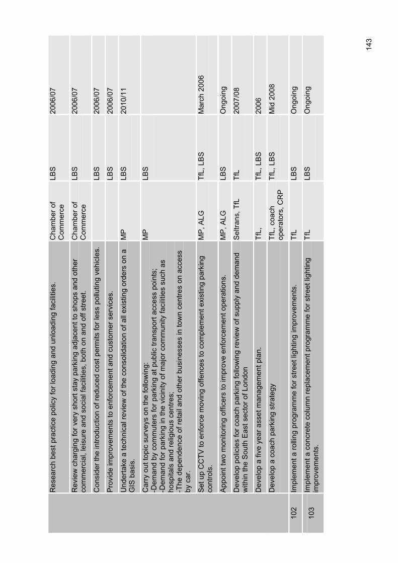
143
Res
earc
h be
st p
ract
ice
polic
y fo
r loa
ding
and
unl
oadi
ng fa
cilit
ies.
C
ham
ber o
f C
omm
erce
LBS
2006
/07
Rev
iew
cha
rgin
g fo
r ver
y sh
ort s
tay
park
ing
adja
cent
to s
hops
and
oth
er
com
mer
cial
, lei
sure
and
soc
ial f
acili
ties,
bot
h on
and
off
stre
et.
Cha
mbe
r of
Com
mer
ceLB
S20
06/0
7
Con
side
r the
intro
duct
ion
of re
duce
d co
st p
erm
its fo
r les
s po
llutin
g ve
hicl
es.
LBS
2006
/07
Pro
vide
impr
ovem
ents
to e
nfor
cem
ent a
nd c
usto
mer
ser
vice
s.
LBS
2006
/07
Und
erta
ke a
tech
nica
l rev
iew
of t
he c
onso
lidat
ion
of a
ll ex
istin
g or
ders
on
a G
IS b
asis
. M
PLB
S20
10/1
1
Car
ry o
ut to
pic
surv
eys
on th
e fo
llow
ing:
-D
eman
d by
com
mut
ers
for p
arki
ng a
t pub
lic tr
ansp
ort a
cces
s po
ints
; -D
eman
d fo
r par
king
in th
e vi
cini
ty o
f maj
or c
omm
unity
faci
litie
s su
ch a
s ho
spita
ls a
nd re
ligio
us c
entre
s;
-The
dep
ende
nce
of re
tail
and
othe
r bus
ines
ses
in to
wn
cent
res
on a
cces
s by
car
.
MP
LBS
Set
up
CC
TV to
enf
orce
mov
ing
offe
nces
to c
ompl
emen
t exi
stin
g pa
rkin
g co
ntro
ls.
MP
, ALG
Tf
L, L
BS
M
arch
200
6
App
oint
two
mon
itorin
g of
ficer
s to
impr
ove
enfo
rcem
ent o
pera
tions
. M
P, A
LG
LBS
Ong
oing
Dev
elop
pol
icie
s fo
r coa
ch p
arki
ng fo
llow
ing
revi
ew o
f sup
ply
and
dem
and
with
in th
e S
outh
Eas
t sec
tor o
f Lon
don
Sel
trans
, TfL
Tf
L20
07/0
8
Dev
elop
a fi
ve y
ear a
sset
man
agem
ent p
lan.
Tf
L,Tf
L, L
BS
20
06
Dev
elop
a c
oach
par
king
stra
tegy
Tf
L, c
oach
op
erat
ors,
CR
P
TfL,
LB
S
Mid
200
8
102
Impl
emen
t a ro
lling
pro
gram
me
for s
treet
ligh
ting
impr
ovem
ents
. Tf
LLB
SO
ngoi
ng
103
Impl
emen
t a c
oncr
ete
colu
mn
repl
acem
ent p
rogr
amm
e fo
r stre
et li
ghtin
g im
prov
emen
ts.
TfL
LBS
Ong
oing
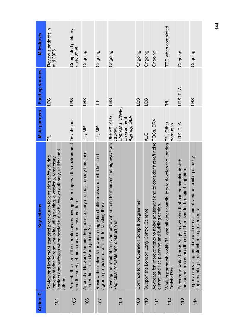
144
Act
ion
ID
Key
act
ions
M
ain
part
ners
Fu
ndin
g so
urce
sM
ilest
ones
104
Rev
iew
and
impl
emen
t sta
ndar
d pr
oced
ures
for e
nsur
ing
safe
ty d
urin
g im
plem
enta
tion
of ro
ad w
orks
incl
udin
g si
gnin
g, d
iver
sion
s, te
mpo
rary
ba
rrie
rs a
nd s
urfa
ces
whe
n ca
rrie
d ou
t by
high
way
s au
thor
ity, u
tiliti
es a
nd
othe
rs.
TfL
LBS
Rev
iew
sta
ndar
ds in
m
id 2
006
105
Pro
mot
e th
e us
e of
the
stre
etsc
ape
desi
gn g
uide
to im
prov
e th
e en
viro
nmen
t an
d th
e sa
fety
of m
ain
road
s an
d to
wn
cent
res.
D
evel
oper
sLB
SC
ompl
eted
gui
de b
y ea
rly 2
006
106
App
oint
a N
etw
ork
Pla
nnin
g E
ngin
eer t
o ca
rry
out t
he s
tatu
tory
func
tions
un
der t
he T
raffi
c M
anag
emen
t Act
. Tf
L, M
P
LBS
Ong
oing
107
Rev
iew
the
netw
ork
for w
orst
con
gest
ion
bottl
enec
ks a
nd e
stab
lish
and
agre
e a
prog
ram
me
with
TfL
for t
ackl
ing
thes
e.
TfL,
MP
Tf
LO
ngoi
ng
108
Dev
elop
the
rem
it of
the
clie
nt e
nfor
cem
ent u
nit t
o m
aint
ain
the
high
way
s ar
e ke
pt c
lear
of w
aste
and
obs
truct
ions
. D
EFR
A, A
LG,
OD
PM
, E
NC
AM
S, C
IWM
, E
nviro
nmen
t A
genc
y, G
LA
LBS
Ong
oing
109
Con
tinue
to ru
n O
pera
tion
Scr
ap It
pro
gram
me
LBS
Ong
oing
110
Sup
port
the
Lond
on L
orry
Con
trol S
chem
e.
ALG
LBS
Ong
oing
111
Adv
ocat
e fo
r im
prov
emen
ts to
noi
se a
bate
men
t and
to c
onsi
der a
ircra
ft no
ise
durin
g la
nd u
se p
lann
ing
and
build
ing
desi
gn.
TOC
s, S
RA
O
ngoi
ng
112
Wor
k in
par
tner
ship
with
TfL
and
all
othe
r con
tribu
tors
to d
evel
op th
e Lo
ndon
Fr
eigh
t Pla
n.
TfL,
Oth
er
boro
ughs
TfL
TBC
whe
n co
mpl
eted
113
Enc
oura
ge w
ater
bor
ne fr
eigh
t mov
emen
t tha
t can
be
com
bine
d w
ith
mea
sure
s to
incr
ease
the
use
of th
e riv
er fo
r tra
nspo
rt in
gen
eral
. LR
S, P
LA
LRS
, PLA
O
ngoi
ng
114
Impr
ove
recy
clin
g an
d di
spos
al c
apab
ilitie
s at
var
ious
exi
stin
g si
tes
by
impl
emen
ting
infra
stru
ctur
e im
prov
emen
ts.
LBS
Ong
oing
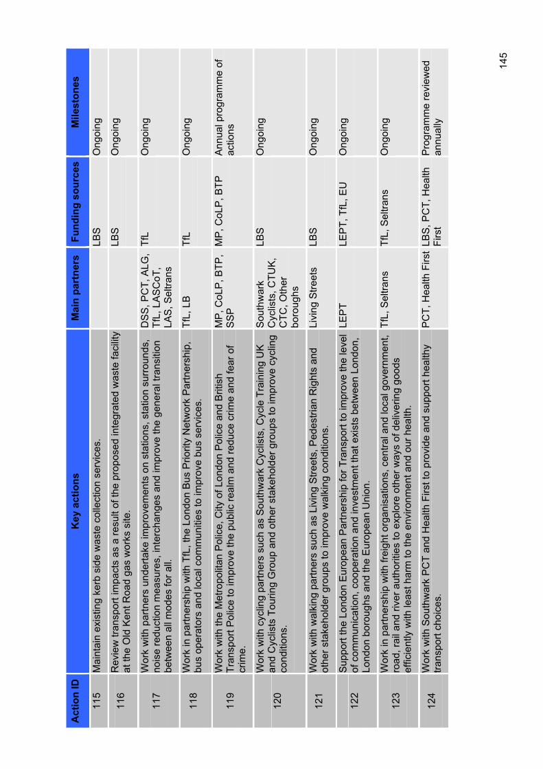
145
Act
ion
ID
Key
act
ions
M
ain
part
ners
Fu
ndin
g so
urce
sM
ilest
ones
115
Mai
ntai
n ex
istin
g ke
rb s
ide
was
te c
olle
ctio
n se
rvic
es.
LBS
Ong
oing
116
Rev
iew
tran
spor
t im
pact
s as
a re
sult
of th
e pr
opos
ed in
tegr
ated
was
te fa
cilit
y at
the
Old
Ken
t Roa
d ga
s w
orks
site
. LB
SO
ngoi
ng
117
Wor
k w
ith p
artn
ers
unde
rtake
impr
ovem
ents
on
stat
ions
, sta
tion
surr
ound
s,
nois
e re
duct
ion
mea
sure
s, in
terc
hang
es a
nd im
prov
e th
e ge
nera
l tra
nsiti
on
betw
een
all m
odes
for a
ll.
DS
S, P
CT,
ALG
, Tf
L, L
AS
CoT
, LA
S, S
eltra
ns
TfL
Ong
oing
118
Wor
k in
par
tner
ship
with
TfL
, the
Lon
don
Bus
Prio
rity
Net
wor
k P
artn
ersh
ip,
bus
oper
ator
s an
d lo
cal c
omm
uniti
es to
impr
ove
bus
serv
ices
. Tf
L, L
B
TfL
Ong
oing
119
Wor
k w
ith th
e M
etro
polit
an P
olic
e, C
ity o
f Lon
don
Pol
ice
and
Brit
ish
Tran
spor
t Pol
ice
to im
prov
e th
e pu
blic
real
m a
nd re
duce
crim
e an
d fe
ar o
f cr
ime.
MP
, CoL
P, B
TP,
SS
PM
P, C
oLP
, BTP
A
nnua
l pro
gram
me
of
actio
ns
120
Wor
k w
ith c
yclin
g pa
rtner
s su
ch a
s S
outh
war
k C
yclis
ts, C
ycle
Tra
inin
g U
K
and
Cyc
lists
Tou
ring
Gro
up a
nd o
ther
sta
keho
lder
gro
ups
to im
prov
e cy
clin
g co
nditi
ons.
Sou
thw
ark
Cyc
lists
, CTU
K,
CTC
, Oth
er
boro
ughs
LBS
Ong
oing
121
Wor
k w
ith w
alki
ng p
artn
ers
such
as
Livi
ng S
treet
s, P
edes
trian
Rig
hts
and
othe
r sta
keho
lder
gro
ups
to im
prov
e w
alki
ng c
ondi
tions
. Li
ving
Stre
ets
LBS
Ong
oing
122
Sup
port
the
Lond
on E
urop
ean
Par
tner
ship
for T
rans
port
to im
prov
e th
e le
vel
of c
omm
unic
atio
n, c
oope
ratio
n an
d in
vest
men
t tha
t exi
sts
betw
een
Lond
on,
Lond
on b
orou
ghs
and
the
Eur
opea
n U
nion
.
LEP
TLE
PT,
TfL
, EU
O
ngoi
ng
123
Wor
k in
par
tner
ship
with
frei
ght o
rgan
isat
ions
, cen
tral a
nd lo
cal g
over
nmen
t, ro
ad, r
ail a
nd ri
ver a
utho
ritie
s to
exp
lore
oth
er w
ays
of d
eliv
erin
g go
ods
effic
ient
ly w
ith le
ast h
arm
to th
e en
viro
nmen
t and
our
hea
lth.
TfL,
Sel
trans
Tf
L, S
eltra
ns
Ong
oing
124
Wor
k w
ith S
outh
war
k P
CT
and
Hea
lth F
irst t
o pr
ovid
e an
d su
ppor
t hea
lthy
trans
port
choi
ces.
P
CT,
Hea
lth F
irst
LBS
, PC
T, H
ealth
Fi
rst
Pro
gram
me
revi
ewed
an
nual
ly
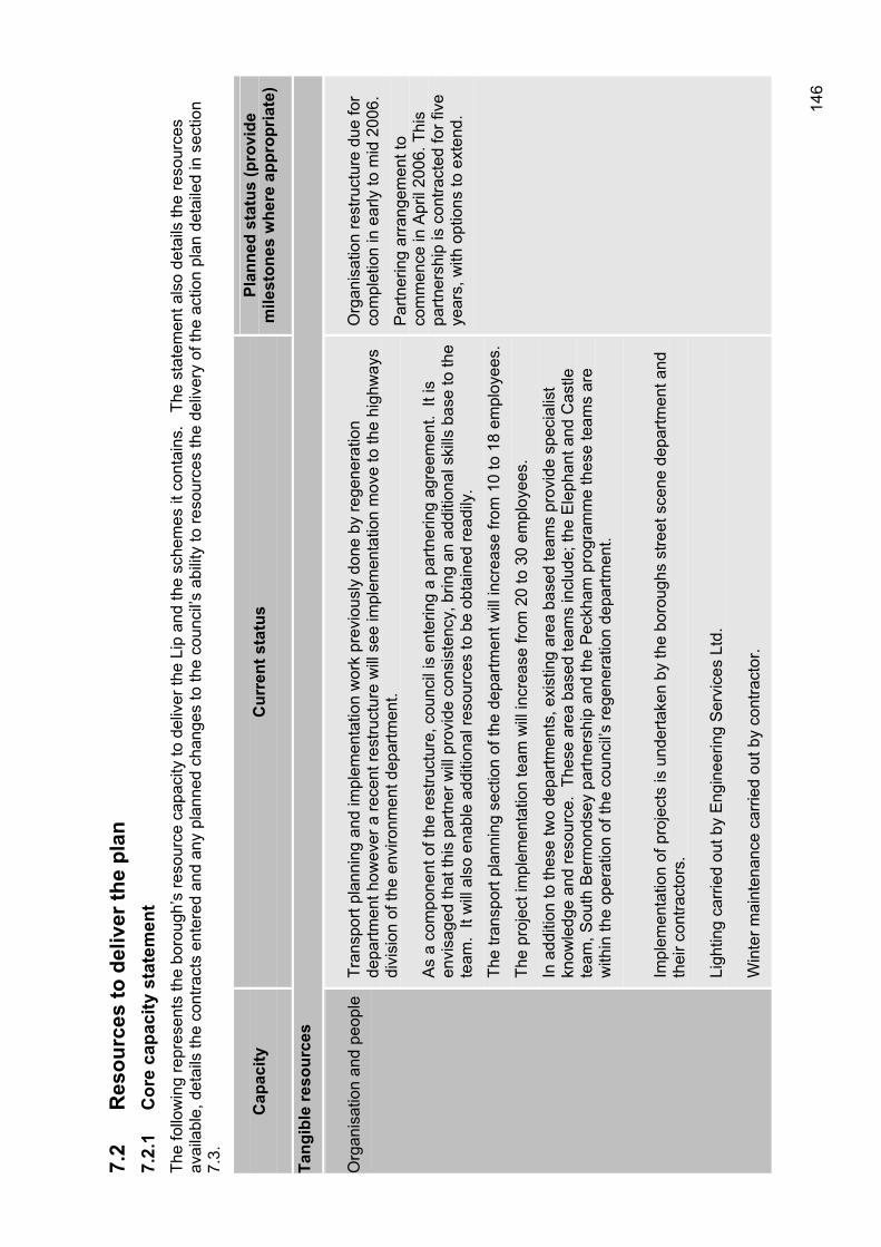
146
7.2
Res
ourc
es to
del
iver
the
plan
7.
2.1
Cor
e ca
paci
ty s
tate
men
t Th
e fo
llow
ing
repr
esen
ts th
e bo
roug
h’s
reso
urce
cap
acity
to d
eliv
er th
e Li
p an
d th
e sc
hem
es it
con
tain
s.
The
stat
emen
t als
o de
tails
the
reso
urce
s av
aila
ble,
det
ails
the
cont
ract
s en
tere
d an
d an
y pl
anne
d ch
ange
s to
the
coun
cil’s
abi
lity
to re
sour
ces
the
deliv
ery
of th
e ac
tion
plan
det
aile
d in
sec
tion
7.3.
Cap
acity
C
urre
nt s
tatu
s Pl
anne
d st
atus
(pro
vide
m
ilest
ones
whe
re a
ppro
pria
te)
Tang
ible
reso
urce
s
Org
anis
atio
n an
d pe
ople
Tran
spor
t pla
nnin
g an
d im
plem
enta
tion
wor
k pr
evio
usly
don
e by
rege
nera
tion
depa
rtmen
t how
ever
a re
cent
rest
ruct
ure
will
see
impl
emen
tatio
n m
ove
to th
e hi
ghw
ays
divi
sion
of t
he e
nviro
nmen
t dep
artm
ent.
As
a co
mpo
nent
of t
he re
stru
ctur
e, c
ounc
il is
ent
erin
g a
partn
erin
g ag
reem
ent.
It is
en
visa
ged
that
this
par
tner
will
pro
vide
con
sist
ency
, brin
g an
add
ition
al s
kills
bas
e to
the
team
. It
will
als
o en
able
add
ition
al re
sour
ces
to b
e ob
tain
ed re
adily
.
The
trans
port
plan
ning
sec
tion
of th
e de
partm
ent w
ill in
crea
se fr
om 1
0 to
18
empl
oyee
s.
The
proj
ect i
mpl
emen
tatio
n te
am w
ill in
crea
se fr
om 2
0 to
30
empl
oyee
s.
In a
dditi
on to
thes
e tw
o de
partm
ents
, exi
stin
g ar
ea b
ased
team
s pr
ovid
e sp
ecia
list
know
ledg
e an
d re
sour
ce.
Thes
e ar
ea b
ased
team
s in
clud
e; th
e E
leph
ant a
nd C
astle
te
am, S
outh
Ber
mon
dsey
par
tner
ship
and
the
Pec
kham
pro
gram
me
thes
e te
ams
are
with
in th
e op
erat
ion
of th
e co
unci
l’s re
gene
ratio
n de
partm
ent.
Impl
emen
tatio
n of
pro
ject
s is
und
erta
ken
by th
e bo
roug
hs s
treet
sce
ne d
epar
tmen
t and
th
eir c
ontra
ctor
s.
Ligh
ting
carri
ed o
ut b
y E
ngin
eerin
g S
ervi
ces
Ltd.
Win
ter m
aint
enan
ce c
arrie
d ou
t by
cont
ract
or.
Org
anis
atio
n re
stru
ctur
e du
e fo
r co
mpl
etio
n in
ear
ly to
mid
200
6.
Par
tner
ing
arra
ngem
ent t
o co
mm
ence
in A
pril
2006
. Thi
s pa
rtner
ship
is c
ontra
cted
for f
ive
year
s, w
ith o
ptio
ns to
ext
end.
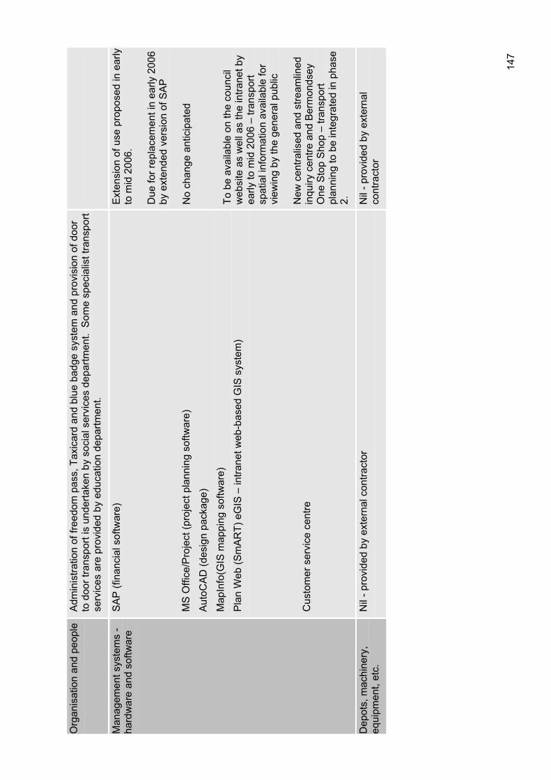
147
Org
anis
atio
n an
d pe
ople
Adm
inis
tratio
n of
free
dom
pas
s, T
axic
ard
and
blue
bad
ge s
yste
m a
nd p
rovi
sion
of d
oor
to d
oor t
rans
port
is u
nder
take
n by
soc
ial s
ervi
ces
depa
rtmen
t. S
ome
spec
ialis
t tra
nspo
rt se
rvic
es a
re p
rovi
ded
by e
duca
tion
depa
rtmen
t.
Man
agem
ent s
yste
ms
- ha
rdw
are
and
softw
are
SA
P (f
inan
cial
sof
twar
e)
MS
Offi
ce/P
roje
ct (p
roje
ct p
lann
ing
softw
are)
Aut
oCA
D (d
esig
n pa
ckag
e)
Map
Info
(GIS
map
ping
sof
twar
e)
Pla
n W
eb (S
mA
RT)
eG
IS –
intra
net w
eb-b
ased
GIS
sys
tem
)
Cus
tom
er s
ervi
ce c
entre
Ext
ensi
on o
f use
pro
pose
d in
ear
ly
to m
id 2
006.
Due
for r
epla
cem
ent i
n ea
rly 2
006
by e
xten
ded
vers
ion
of S
AP
No
chan
ge a
ntic
ipat
ed
To b
e av
aila
ble
on th
e co
unci
l w
ebsi
te a
s w
ell a
s th
e in
trane
t by
early
to m
id 2
006
– tra
nspo
rt sp
atia
l inf
orm
atio
n av
aila
ble
for
view
ing
by th
e ge
nera
l pub
lic
New
cen
tralis
ed a
nd s
tream
lined
in
quiry
cen
tre a
nd B
erm
onds
ey
One
Sto
p S
hop
– tra
nspo
rt pl
anni
ng to
be
inte
grat
ed in
pha
se
2.
Dep
ots,
mac
hine
ry,
equi
pmen
t, et
c.
Nil
- pro
vide
d by
ext
erna
l con
tract
or
Nil
- pro
vide
d by
ext
erna
l co
ntra
ctor
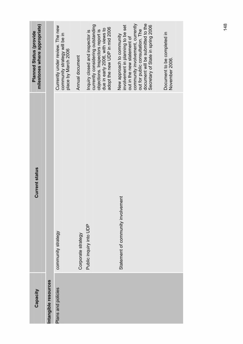
148
Cap
acity
C
urre
nt s
tatu
s Pl
anne
d St
atus
(pro
vide
m
ilest
ones
whe
re a
ppro
pria
te)
Inta
ngib
le re
sour
ces
Pla
ns a
nd p
olic
ies
com
mun
ity s
trate
gy
Cor
pora
te s
trate
gy
Pub
lic in
quiry
into
UD
P
Sta
tem
ent o
f com
mun
ity in
volv
emen
t
Cur
rent
ly u
nder
revi
ew. T
he n
ew
com
mun
ity s
trate
gy w
ill b
e in
pl
ace
by M
arch
200
6
Ann
ual d
ocum
ent
Inqu
iry c
lose
d an
d in
spec
tor i
s cu
rren
tly c
onsi
derin
g ou
tsta
ndin
g ob
ject
ions
. Ins
pect
ors
repo
rt is
du
e in
ear
ly 2
006,
with
vie
ws
to
adop
t the
new
UD
P in
mid
200
6
New
app
roac
h to
com
mun
ity
invo
lvem
ent i
n pl
anni
ng to
be
set
out i
n th
e ne
w s
tate
men
t of
com
mun
ity in
volv
emen
t, cu
rren
tly
out f
or p
ublic
con
sulta
tion.
The
do
cum
ent w
ill b
e su
bmitt
ed to
the
Sec
reta
ry o
f Sta
te in
spr
ing
2006
Doc
umen
t to
be c
ompl
eted
in
Nov
embe
r 200
6.
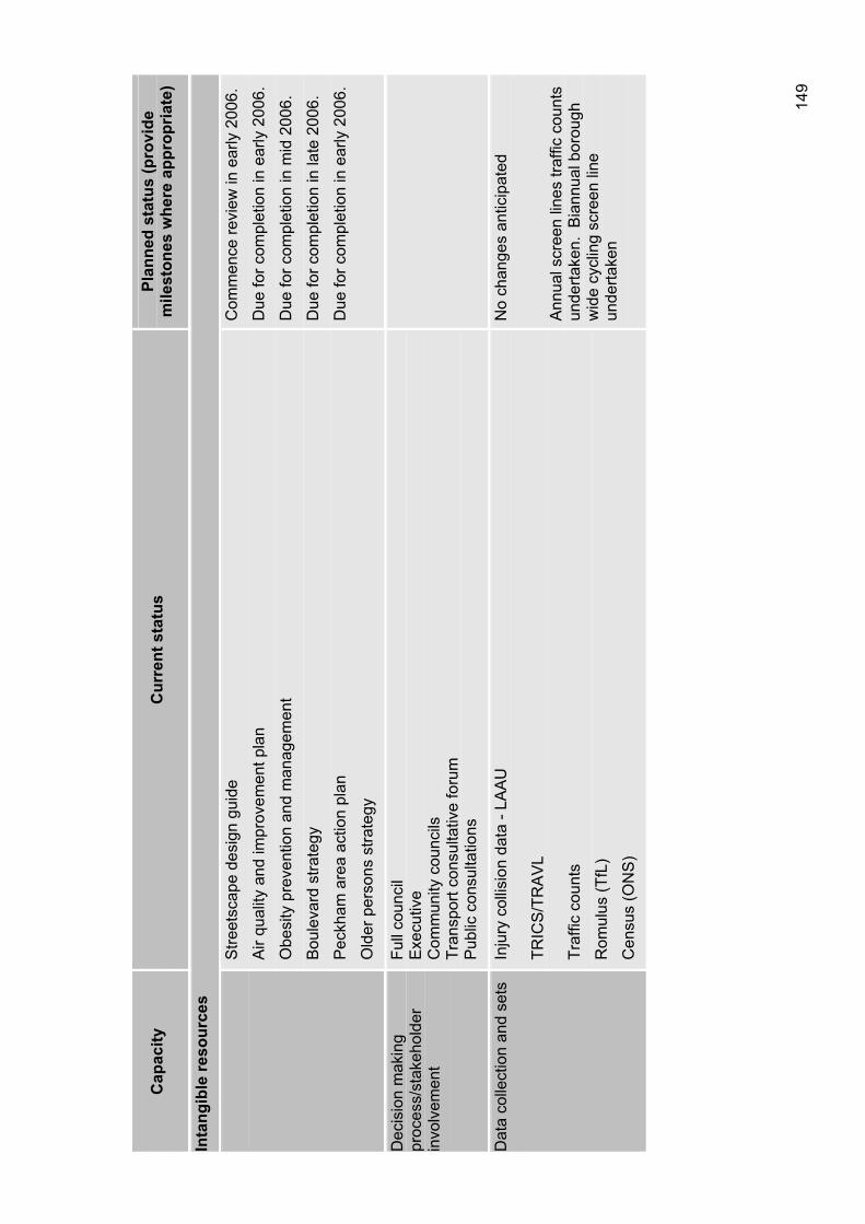
149
Cap
acity
C
urre
nt s
tatu
s Pl
anne
d st
atus
(pro
vide
m
ilest
ones
whe
re a
ppro
pria
te)
Inta
ngib
le re
sour
ces
Stre
etsc
ape
desi
gn g
uide
Air
qual
ity a
nd im
prov
emen
t pla
n
Obe
sity
pre
vent
ion
and
man
agem
ent
Bou
leva
rd s
trate
gy
Pec
kham
are
a ac
tion
plan
Old
er p
erso
ns s
trate
gy
Com
men
ce re
view
in e
arly
200
6.
Due
for c
ompl
etio
n in
ear
ly 2
006.
Due
for c
ompl
etio
n in
mid
200
6.
Due
for c
ompl
etio
n in
late
200
6.
Due
for c
ompl
etio
n in
ear
ly 2
006.
Dec
isio
n m
akin
g pr
oces
s/st
akeh
olde
r in
volv
emen
t
Full
coun
cil
Exe
cutiv
eC
omm
unity
cou
ncils
Tr
ansp
ort c
onsu
ltativ
e fo
rum
P
ublic
con
sulta
tions
Dat
a co
llect
ion
and
sets
In
jury
col
lisio
n da
ta -
LAA
U
TRIC
S/T
RA
VL
Traf
fic c
ount
s
Rom
ulus
(TfL
)
Cen
sus
(ON
S)
No
chan
ges
antic
ipat
ed
Ann
ual s
cree
n lin
es tr
affic
cou
nts
unde
rtake
n. B
iann
ual b
orou
gh
wid
e cy
clin
g sc
reen
line
un
derta
ken
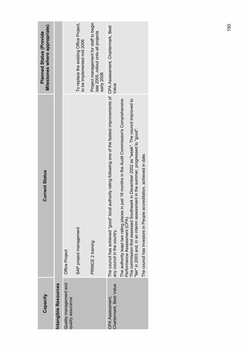
150
Cap
acity
C
urre
nt S
tatu
s Pl
anne
d St
atus
(Pro
vide
M
ilest
ones
whe
re a
ppro
pria
te)
Inta
ngib
le R
esou
rces
Qua
lity
man
agem
ent a
nd
qual
ity a
ssur
ance
O
ffice
Pro
ject
SA
P p
roje
ct m
anag
emen
t
PR
INC
E 2
trai
ning
To re
plac
e th
e ex
istin
g O
ffice
Pro
ject
, to
be
impl
emen
ted
mid
200
6
Pro
ject
man
agem
ent f
or s
taff
to b
egin
la
te 2
005,
rollo
ut o
nto
all p
roje
cts
early
200
6
CP
A A
sses
smen
t, C
harte
rmar
k, B
est V
alue
Th
e co
unci
l has
ach
ieve
d “g
ood”
loca
l aut
horit
y ra
ting
follo
win
g on
e of
the
fast
est i
mpr
ovem
ents
of
any
coun
cil i
n th
e co
untry
.
The
auth
ority
leap
t tw
o ra
ting
plac
es in
just
18
mon
ths
in th
e A
udit
Com
mis
sion
's C
ompr
ehen
sive
P
erfo
rman
ce A
sses
smen
t (C
PA
).
The
com
mis
sion
firs
t ass
esse
d S
outh
war
k in
Dec
embe
r 200
2 as
"wea
k". T
he c
ounc
il im
prov
ed to
"fa
ir" in
200
3 an
d, in
an
inte
rim a
sses
smen
t in
the
sum
mer
, pro
gres
sed
to "g
ood"
.
The
coun
cil h
as In
vest
ors
in P
eopl
e ac
cred
itatio
n, a
chie
ved
in d
ate.
CP
A A
sses
smen
t, C
harte
rmar
k, B
est
Val
ue
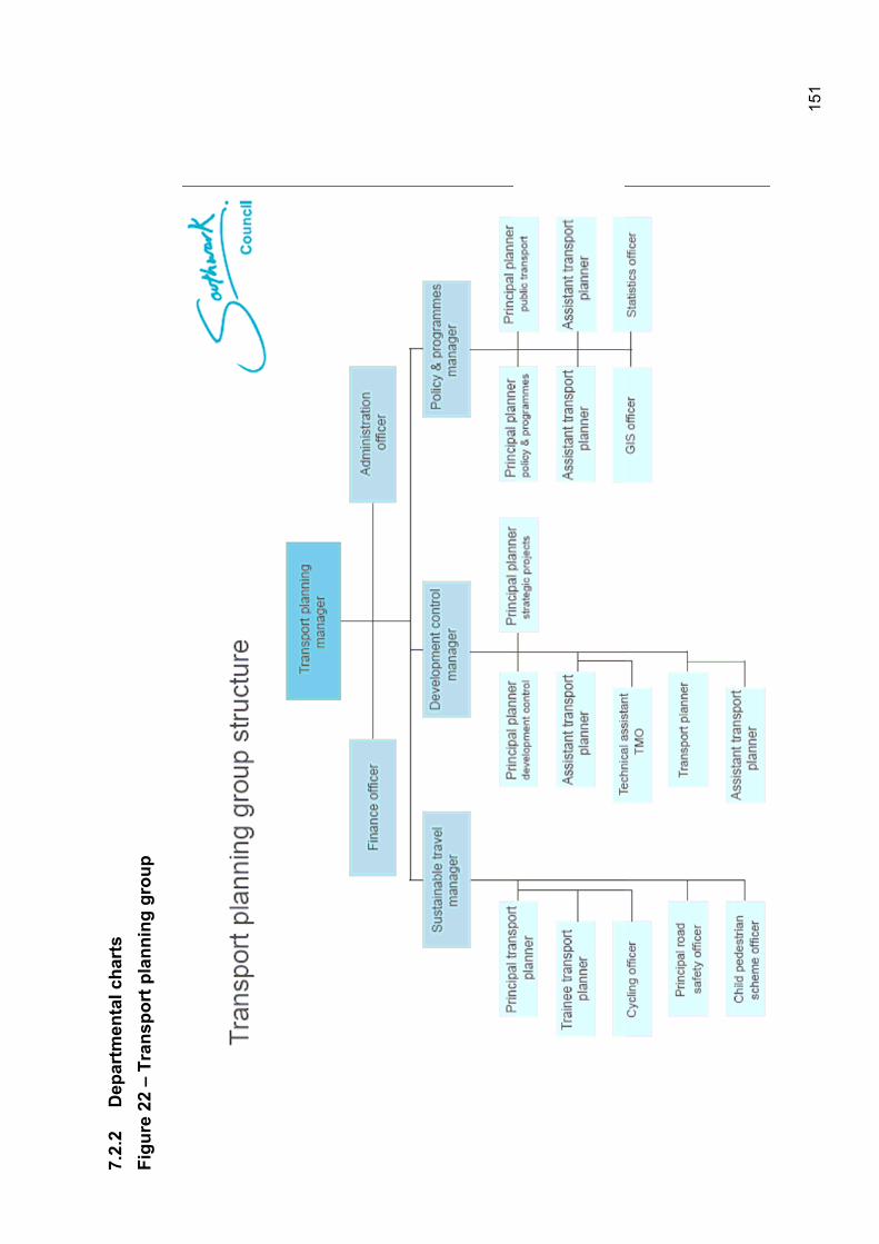
151
7.2.
2 D
epar
tmen
tal c
hart
s Fi
gure
22
– Tr
ansp
ort p
lann
ing
grou
p

152
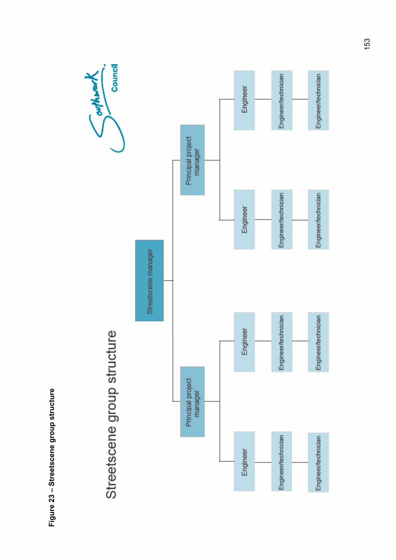
153
Figu
re 2
3 –
Stre
etsc
ene
grou
p st
ruct
ure
154
7.2.3 Decision making processes The administration operates with a ten member Executive, one of whom holds an Environment and Transport portfolio. This provides a clear focus for the policies on transport. The Executive is the ultimate decision making body on transport policies however this is supplemented by the eight area based community councils whom were consulted on the Lip. The final approval of the Lip is by the council assembly of which all 63 elected member sit, as discussed in the following section.
The council assembly The council assembly is the monthly meeting of all 63 elected councillors sit on the council assembly, and is chaired by the Mayor of Southwark.
The council assembly’s functions include:
Adopting and changing the constitution;
Approving or adopting the 'policy framework', the budget, and the council tax;
Appointing the Leader and members of the Executive;
Agreeing and amending the terms of reference for committees, deciding on their composition and making appointments to them;
Appointing representatives to outside bodies;
Adopting an allowances scheme; and
Making, amending, revoking, re enacting or adopting bylaws and promoting or opposing the making of local legislation.
The executive The executive works in a similar way to the government’s cabinet. Southwark’s Executive is made up of 10 councillors and is headed by the Leader. Each councillor holds a special ‘portfolio’ of responsibility. However, unlike the Government’s Cabinet, Southwark’s executive meetings are open to the public.
The role of the executive is to:
Lead the community planning process and search for best value, with input and advice from overview and scrutiny committees, area forums and any other appropriate people or organisations;
Draft the budget and policy framework for approval by council assembly;
Take decisions on resources and priorities, together with other stakeholders and partners in the local community, to deliver and implement the budget and policy framework as approved by the council assembly;
Oversee the authority’s services;
Ensure consultation on the development of the council’s policy framework, other key strategic documents and key decisions;
Be the focus for forming partnerships with other local public, private, voluntary and community sector organisations to address local needs.
This Local implementation plan was approved by the council’s executive at its meeting on the 22 March 2006.
Community councils Southwark has eight community councils based on council ward boundaries as shown in figure 27. Community councils meet every six to seven weeks with each having elected councillors as voting members.
155
Community councils were developed as a way of empowering local people to have a say about what goes on in their area.
A community council meeting may scrutinise local street cleaning, bid for new equipment for a play area, parking issues, consider local planning policy or receive updates on crime issues.
Community councils make decisions on:
Environmental improvements;
Community safety;
Traffic;
Planning;
Appointment of school governors.
Further details of the community councils can be found in section 9.2.1 of this document.
7.2.4 Organisational strategy Southwark is an improving authority, but we are working hard to improve further. The council recognises that people and skills are key to our success and that by investing in, and developing staff we will be able to assure quality services for the people of Southwark.
The council is currently developing an organisational strategy to set a clear direction for improvement, identifying the resources and capabilities needed to achieve change and developing the capabilities needed to deliver that change.
The strategy outlines how we will provide learning and development interventions that support wider changes in the way services are delivered. The corporate plan identifies those changes we need to achieve and the national priorities including:
Providing services that are focused on delivering improved outcomes for people;
Service redesign towards choice and personalisation;
Joint working, seamless service provision through effective partnership working;
Improving efficiency of support services to increase investment in frontline services;
Balancing national and local priorities;
Strengthening communities to enable engagement and involvement in service delivery.
The established priorities of the organisational strategy includes:
Developing a culture of learning and development;
Strong leadership;
Southwark, an employer of choice;
Embedding performance management
156
7.3 Funding the plan Aside from having the people and physical resources to achieve the actions contained within the Lip, appropriate levels of funding are crucial to the successful delivery of the Lip.
The Lip will be implemented with a combination of the council’s own spending, using funding that comes via a variety of government departments including Transport for London as well as other sources, through its development planning and other regulatory functions and through lobbying and partnership working with other organisations.
The main forms of funding for the actions set out in this plan are detailed as follows. Aside from the funding bodies listed, the council will develop a comprehensive bidding strategy to seek to take forward all strands of the Lip action plan.
7.3.1 Southwark Council The council budget The council supports the Lip through revenue funding of many of the services involved. The council also has capital programmes, which are coordinated to support a range of objectives flowing from the community strategy.
Cleaner, greener, safer The ‘cleaner, greener, safer’ programme can be used to improve the environment. It is our belief that initiatives that improve Southwark, making it cleaner, greener and safer.
Development control process The council is also responsible for regeneration programmes, which often include general area improvements. There are also planning obligations which are used to mitigate the effects of developments in a wide range of circumstances. The council has prepared a draft Section 106 contributions strategy which includes the methodology for the collection of development contributions.
Parking revenue The council also receives income from parking penalty charges notices, this money is spent solely on funding enforcement and reinvestment in the transport network.
7.3.2 Transport for London Transport for London distributes much of the funding for highway maintenance, safety improvements, provision of cycling facilities, bus priority measures and improvements to freight delivery. Until 2004 London boroughs have submitted an annual Borough Spending Plan (BSP) the purpose of which is primarily to demonstrate to Transport for London how the borough will implement the Mayor’s Transport Strategy. From 2006 onwards boroughs will still prepare an annual programme but this will be guided by a longer term Lip which will set out priorities for several years ahead.
Aside from this annual process, there are other opportunities to receive funding from TfL…….
In addition, funding is available for other measures such as promoting sustainable transport, preparing STPs and implementing their recommendations, and undertaking walking and cycling education and training.
7.3.3 Department for Transport Some funding is obtained directly from the Department for Transport especially for demonstration projects such as the Walworth Project which is part of a national programme of ‘streets for people’ pilots and has been successful in receiving funding for the Sutherland Square home zone.
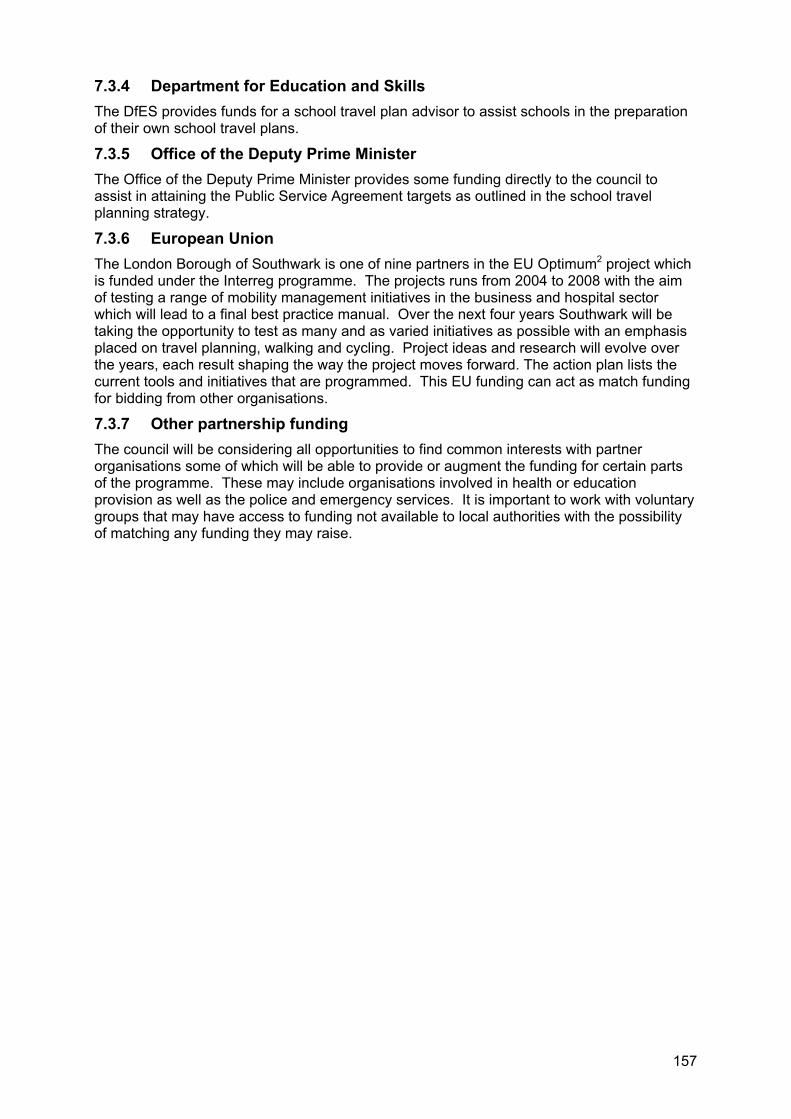
157
7.3.4 Department for Education and Skills The DfES provides funds for a school travel plan advisor to assist schools in the preparation of their own school travel plans.
7.3.5 Office of the Deputy Prime Minister The Office of the Deputy Prime Minister provides some funding directly to the council to assist in attaining the Public Service Agreement targets as outlined in the school travel planning strategy.
7.3.6 European Union The London Borough of Southwark is one of nine partners in the EU Optimum2 project which is funded under the Interreg programme. The projects runs from 2004 to 2008 with the aim of testing a range of mobility management initiatives in the business and hospital sector which will lead to a final best practice manual. Over the next four years Southwark will be taking the opportunity to test as many and as varied initiatives as possible with an emphasis placed on travel planning, walking and cycling. Project ideas and research will evolve over the years, each result shaping the way the project moves forward. The action plan lists the current tools and initiatives that are programmed. This EU funding can act as match funding for bidding from other organisations.
7.3.7 Other partnership funding The council will be considering all opportunities to find common interests with partner organisations some of which will be able to provide or augment the funding for certain parts of the programme. These may include organisations involved in health or education provision as well as the police and emergency services. It is important to work with voluntary groups that may have access to funding not available to local authorities with the possibility of matching any funding they may raise.
158
7.3.
8 Fu
ndin
g re
quire
d Th
is p
lan
cons
ider
s a
five
year
per
iod
from
200
5/06
to 2
009/
10, t
he le
vel o
f fun
ding
requ
ired
for e
ach
of th
ese
year
s is
det
aile
d in
the
follo
win
g ta
ble.
Tabl
e 10
– Y
ear b
y ye
ar fu
ndin
g re
quire
d to
del
iver
the
Lip
Ant
icip
ated
sou
rce
of fu
ndin
g 20
05/0
6£0
0020
06/0
7£0
0020
07/0
8£0
0020
08/0
9£0
0020
09/1
0£0
00To
tal
£000
Sout
hwar
k C
ounc
il 15
,797
15,0
0913
,846
12,0
0112
,071
68,7
84
Sout
hwar
k C
ounc
il Se
ctio
n 10
6*
760
3,39
82,
244
2,49
11,
817
10,7
10
Tran
spor
t for
Lon
don
Lip
impl
emen
tatio
n 4,
474
5,25
89,
155
9,45
58,
866
37,2
07
Tran
spor
t for
Lon
don
Oth
er-
-46
814
014
074
8
Dep
artm
ent f
or T
rans
port
30
616
30-
-67
6
Oth
er s
ourc
es
537
1,19
935
611
145
1,97
0
YEA
RLY
TO
TAL
21,5
9825
,480
26,1
4924
,208
22,9
3912
0,37
3
* S
ectio
n 10
6 ag
reem
ents
are
lega
l agr
eem
ents
bet
wee
n th
e co
unci
l and
a d
evel
oper
whe
re th
e de
velo
per a
gree
s to
pro
vide
con
tribu
tions
to m
itiga
te th
e im
pact
s of
the
deve
lopm
ent.
159
Southwark’s key projects The following information details each of the major areas of funding for each year and provides a brief explanation for the rational behind the need for funding.
2005/20062005/06 has seen major investment by the council in the road renewal of the boroughs non principal roads to the order of £4m as well as substantial investment in the upgrading of the boroughs street lighting.
The council has also made significant investment in local areas streetscape improvements through its cleaner, greener, safer programme. TfL have provided major investment in the LCN+, providing local safety improvements and bus priority measures.
2006/20072006/07 follows similar investment profiles as 2005/06 with emphasis being placed on improving the LCN+, local safety and bus priority measures and in improving the condition of principal roads.
2007/2008From this year, there is a major shift in the level of funding required to meet the objectives of the action plan. This increase includes a major increase in the level of funding required to meet the Mayor’s target of completing the LCN+ by 2010, with the required investment jumping from £596,000 in 2006/07 to £900,000 in 2007/08 for the LCN+, and implementing all school travel plans by 2008/09.
2007/08 also sees the completion of the CRT consultation and gives the council some surety in providing complementary measures to its introduction. This year is also likely to see the completion of the Peckham area action plan, which will also require implementation works, with this project extending over several years.
2007/08 also sees major investment required for the completion of works at the Elephant and Castle including the removal of the northern roundabout and the provision of at grade pedestrian crossings.
2008/2009Similar to 2007/08, investment for 2008/09 is focused on the delivery of the LCN+ and school travel plans.
Following the commencement of Southwark’s review of specific routes under the parallel initiatives programme, 2008/09 sees major investment in both area and route based schemes. With the area based schemes focused on providing streets for people schemes as well as improving Southwark’s town centres, as well as continuing the improvements works in Peckham.
The borough’s commitments to the creation of a boroughwide 20 mph zone as well as having all bus stops fully accessible by 2008/09 sees significant investment within these core areas.
In addition, this year sees the commencement of improvements at London Bridge anticipated to be alongside the delivery of Thameslink 2000. This is discussed in further detail in section 4.1.2.
2009/2010This is the last year for the delivery of the LCN+ and again funding levels are high for this area. This year sees the implementation of the final 30 school travel plans completed in 2008/09 to meet the Mayors target.
Funding levels are also significant for the Elephant and Castle, Peckham town centre, local residential based streets for people schemes,
160
7.4 Risks to delivering the plan 7.4.1 School travel plans The council receives funding support from the DfT to assist in the development of school travel plans in the borough. As a component of this funding the DfT has set targets for the number and percentage of schools with approved travel plans.
As the schools are charged with completing the plans, there is a risk that the school travel plans developed will not meet the standards set by the DfT. Alternatively the percentage of completed school travel plans will not meet the DfT targets and the council would as a result lose this funding.
7.4.2 Regeneration Southwark is undergoing significant regeneration, which is being driven by two factors. Firstly, the identification of areas of the borough as areas for intensification in the London Plan, which sets targets for the increase in homes within the borough. The second driving force for regeneration is the level of deprivation within the borough combined the ODPM’s target for all housing within council ownership to be at a decent homes standard by 2010.
A majority of housing contained within Peckham, the Aylesbury Estate, the Heygate Estate (incorporated with the regeneration of Elephant and Castle) is within the council’s ownership and regeneration is required to bring them to decent homes standards.
Canada Water regeneration is being done in partnership with British Land, this development has progressed significantly with outline submissions for the first two sites recently submitted to the council. Due to the long lead in to this project and the substantial level of commitment shown by all parties, with significant community consultation already undertaken, there is considered to be little risk that this regeneration will not go ahead.
The regeneration of this area will create increased links to the East London line and provide opportunities to access Olympic sites. The proposed bridge linking Rotherhithe with Canary Wharf, proposed by Sustrans also provides the opportunity to create walking and cycling links to key Olympic sites.
As discussed in sections 5.2.1 and 4.1.4, the provision of major transport projects, specifically the Cross River Tram and the East London line extension (particularly phase two) provide transport services to areas that suffer from deprivation as well as having limited access to public transport services.
7.4.3 Cross River Tram The delivery and opportunities that the Cross River Tram brings to the borough through regeneration are heavily interwoven. With the proposed route traversing the centre of the Elephant and Castle, the Aylesbury Estate and Peckham town centre surety of both the delivery and the route of the tram is key to regeneration schemes.
The proposed tram route provides significant transport opportunity to Southwark residents who currently have poor access to public transport. Non delivery of the tram creates the risk that residents to the south of the borough will remain reliant on both the private car and bus services, affecting the boroughs capacity to deliver the mode shift targets set by the Mayor.
As discussed in section 5.2.1, the route for the tram is to undergo public consultation in mid 2006. Whilst there is anticipated to be high levels of support for the tram, the risk remains that the outcome of this consultation will not be positive impeding the progress of the tram.
Currently funding is secured for the detailed design of the Cross River Tram and not for any implementation works, this creates further risk that the tram will not be delivered, therefore the benefits anticipated will not be fulfilled.
161
To a lesser extent further delays to the delivery of the tram will create a lag time between new homes being created and an available tram service, allowing people to establish travel patterns which could negatively impact on tram usage within these key areas.
Delays in finalising the tram route will also affect the delivery of complementary measures, particularly in our district town centres of the Elephant and Castle and Peckham.
7.4.4 East London line extension Southwark will benefit from the delivery of the East London line extension phase one and two. Phase two provides significantly greater benefit to the borough, particularly to those areas currently experiencing deprivation.
The East London line extension phase one is a key transport deliverable for the Olympics with construction underway. Phase two as yet has not received funding for implementation, but is a key opportunity to provide a metro rail services to areas of the borough with limited public transport.
This project is key to meeting targets set around modal shift, as well as providing easy access for the ethnically diverse communities of Peckham. This will also provide and improved service to Denmark Hill, which will in turn promote access to Kings College hospital, promoting public transport usage to the mobility impaired.
7.4.5 Thameslink 2000 In recent years London Bridge has undergone major improvement, and with the introduction of Thameslink 2000 this is likely to continue. Currently the project is at a public enquiry. Works associated within this area have been programmed to coincide with this project and delay or non delivery of this project will affect scheduled improvements within this core business and employment centre within the borough.

162
8 MONITORING OUR ACHIEVEMENT 8.1 TARGETS AND PERFORMANCE INDICATORS 8.1.1 Introduction This chapter brings together performance indicators that describe the amount and pace of change within Southwark and London over the period to 2011. This section is divided into three components, the first discusses the targets Southwark has set, and the second our London targets set by the Mayor and the third establishes our annual monitoring framework.
We seek to provide comprehensive monitoring of all targets, however we face significant challenges in providing annual monitoring of the document. Specifically, many of the baseline data sources utilised come from long interval monitoring, including the ten year cycle for the LATs and Census data collection. Alternative sources of information may need to be developed to adequately monitor our progress. The council seeks direction from TfL and our other transport partners to ensure the adequate annual monitoring of this plan.
8.1.2 Local targets The local targets we have set include targets relating to our key transport priority areas, including; provide access to sustainable transport for all, improving safety on our roads, improving personal safety and security and enhance integration of transport and land use.
Road safety The national and the London targets are further refined by Southwark’s own target to reduce overall total casualties by 10% regardless of distance travelled, in 2004 a total of 1,254 casualties in the borough.
Southwark has adopted further targets as part of the Youth Public Service Agreement (PSA) relating to safety on children’s journeys to school. These include:
A reduction in the percentage of children aged 10 to 16 years surveyed reporting dangerous incidents (bullying, violence or threat of violence) in the preceding three months on the school journey from 31% in 2003 to not more than 21% in 2005
A reduction in the percentage of children aged 10 to 16 and parents surveyed who report that their/their child’s journey to or from school in the preceding three months was unsafe, from 12% (young people), 20% (parents) and 16% (average) in 2003 to not more than 11% (average) in 2005.
WalkingSouthwark has set the following targets to increase the number journeys made on foot by 15% between 2001 and 2015. This will be measured from a number of sources.
Information from the 2001 Census showed that 12% of Southwark residents currently walk to work. In addition to this during the preparation of the walking plan the rate of pupils was found to be reasonably high with an average of 59%.
Cycling In addition to the Londonwide targets, Southwark Council has set the following annual targets relating to cycle training in schools:
Increase by 10% the number of students receiving cycle training;
Provide cycle training to five additional schools.
Public transport The council seeks for all bus stops to be full accessible by 2009, currently 585 or 90% of 578 or 89% of our bus stops are fully accessible. We have set the following milestones for the delivery of this target, with 93% in the first year, 98% in the second year and 100% by 2008/09.
163
Neighbourhood renewal strategy Safety is a key issue within the public realm and a reduction in crime will positively improve the environment. The NRS sets the target of reducing the overall crime rate in Southwark to the London average for similar boroughs. In March 2002, average crime rate was 201 per 1000 population and we seek to reduce this rate to 179 per 1000.
Crime and drugs strategy Within the crime and drugs strategy we seek to increase the percentage of residents feeling ‘safe’ and ‘very safe’ in both the daytime and night time.
The 2004 MORI poll residents 80% of residents felt safe or very safe during the daytime we seek to increase this to 90% by 2007/08. At night time 18% of residents felt safe or very safe and we seek to increase this to 36% by 2007/08.
164
8.1.3 London targets The information supplied here is provided in line with the priority areas the Mayor’s Transport Strategy and TfL’s Lip guidance.
In each case a baseline is shown and where a target is set, the tables set out a trajectory towards the target. The milestone years are 2006/07 and 2008/09 and if the target is not due to be achieved by 2010 or 2011 then the table indicates which year the target should be achieved.
Improving road safety
TfL are currently consulting the London boroughs on extending the current road safety target contained herein. Southwark Council supports the proposed targets and recognises them as a way of prioritising this area of work to help reduce the number of casualties within the borough and all of London.
The proposed targets are to reduce:
Total number killed or seriously injured by 50%;
Total pedestrians killed or seriously injured by 50%;
Total cyclists killed or seriously injured by 50%;
Total children killed or seriously injured by 60%;
Slight casualties by 25%.
Target 1 The following table sets out Southwark’s actual and trajectory casualty data.
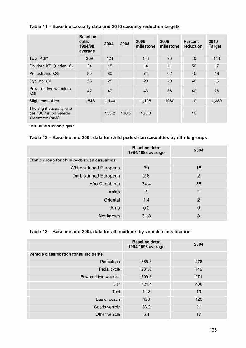
165
Table 11 – Baseline casualty data and 2010 casualty reduction targets
Baselinedata: 1994/98 average
2004 2005 2006milestone
2008milestone
Percent reduction
2010Target
Total KSI* 239 121 111 93 40 144
Children KSI (under 16) 34 15 14 11 50 17
Pedestrians KSI 80 80 74 62 40 48
Cyclists KSI 25 25 23 19 40 15
Powered two wheelers KSI 47 47 43 36 40 28
Slight casualties 1,543 1,148 1,125 1080 10 1,389
The slight casualty rate per 100 million vehicle kilometres (mvk)
133.2 130.5 125.3 10
* KSI – killed or seriously injured
Table 12 – Baseline and 2004 data for child pedestrian casualties by ethnic groups
Baseline data: 1994/1998 average 2004
Ethnic group for child pedestrian casualties
White skinned European 39 18
Dark skinned European 2.6 2
Afro Caribbean 34.4 35
Asian 3 1
Oriental 1.4 2
Arab 0.2 0
Not known 31.8 8
Table 13 – Baseline and 2004 data for all incidents by vehicle classification
Baseline data: 1994/1998 average 2004
Vehicle classification for all incidents
Pedestrian 365.8 278
Pedal cycle 231.8 149
Powered two wheeler 299.8 271
Car 724.4 408
Taxi 11.8 10
Bus or coach 128 120
Goods vehicle 33.2 21
Other vehicle 5.4 17
166
Target 2 Southwark has reviewed road safety around 20 of the 102 primary and secondary schools with the borough as at September 2005, this represents 19.6% of schools within the borough. All schools will have been reviewed by 2008/09.
Nine of Southwark’s primary and secondary schools have schemes implemented as of September 2005, this represents 8.8% of schools in the borough.
Improving bus journey times and reliability
Target 3 TfL are to reduce excess wait time (EWT) to 1.3 minutes per passenger journey by 2009/2010. Southwark contains approximately 50 high frequency services (five or more per hour) for which EWT is calculated. In 2002/03 EWT was 1.8 minutes and was 1.4 minutes in 2003/04.
Southwark will work in conjunction with the LBI to provide bus journey priority and reliability on our roads. Additionally we will undertake waiting and loading review of all A roads and busy bus routes and indicated in table 3, which will provide continual review and assessment of the bus network within Southwark.
Target 4 Southwark retains 42km of bus lanes and 38 bus priority junctions within the borough. In terms of bus stops, 585 or 90% of our bus stops are within clearways and 578 or 89% of our bus stops are fully accessible.
The Mayor has set boroughs the target of reducing, or maintaining bus journey times on London Bus Initiative (LBI) bus routes at 2005 levels. The existing levels are shown in table 14.
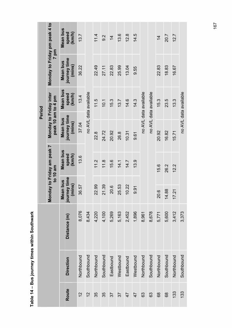
167
Tabl
e 14
– B
us jo
urne
y tim
es w
ithin
Sou
thw
ark
Perio
d
Mon
day
to F
riday
am
pea
k 7
to 1
0 am
M
onda
y to
Frid
ay in
ter
peak
10
am to
4 p
m
Mon
day
to F
riday
pm
pea
k 4
to
7 pm
Rou
teD
irect
ion
Dis
tanc
e (m
)M
ean
bus
jour
ney
time
(min
s)
Mea
n bu
s sp
eed
(km
/h)
Mea
n bu
s jo
urne
y tim
e (m
ins)
Mea
n bu
s sp
eed
(km
/h)
Mea
n bu
s jo
urne
y tim
e (m
ins)
Mea
n bu
s sp
eed
(km
/h)
12N
orth
boun
d
8,
076
36
.57
13.6
37.0
413
.436
.22
13.7
12S
outh
boun
d
8,4
34
no A
VL
data
ava
ilabl
e
35N
orth
boun
d
4,2
20
22.9
911
.222
.811
.522
.49
11.4
35S
outh
boun
d
4,1
00
21.3
911
.824
.72
10.1
27.1
19.
2
37E
astb
ound
5
,269
20
.615
.620
.92
15.3
22.8
314
37W
estb
ound
5,1
63
25.5
314
.126
.813
.725
.99
13.6
47E
astb
ound
2
,452
10
.22
14.7
10.3
114
.613
.04
12.8
47W
estb
ound
1,8
96
9.91
13.9
9.61
14.3
9.55
14.5
63N
orth
boun
d
8,9
61
no A
VL
data
ava
ilabl
e
63S
outh
boun
d
8,6
78
no A
VL
data
ava
ilabl
e
68N
orth
boun
d
5,7
71
20.6
15.6
20.9
215
.322
.83
14
68S
outh
boun
d
5,6
00
14.8
826
.216
.82
23.5
18.8
320
.7
133
Nor
thbo
und
3
,412
17
.21
12.2
15.7
113
.316
.67
12.7
133
Sou
thbo
und
3
,373
no
AV
L da
ta a
vaila
ble
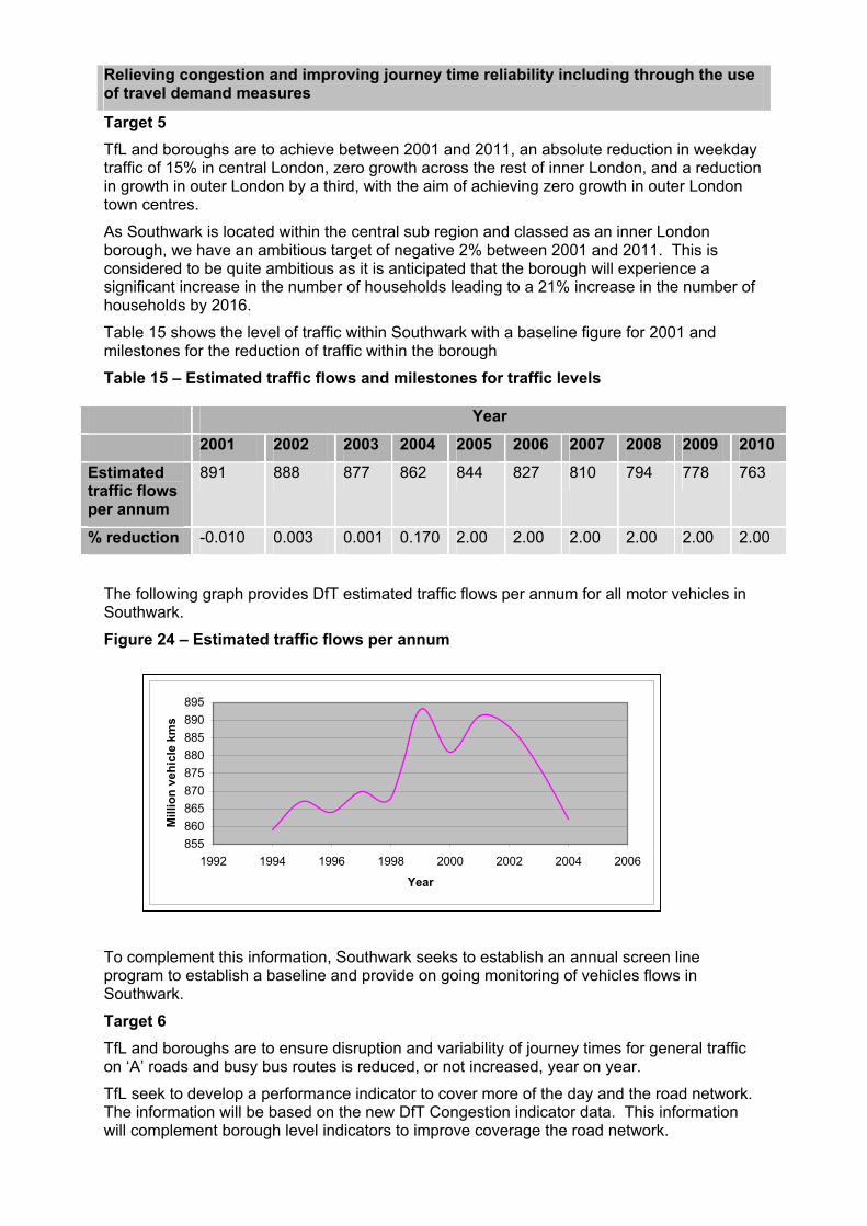
Relieving congestion and improving journey time reliability including through the use of travel demand measures
Target 5 TfL and boroughs are to achieve between 2001 and 2011, an absolute reduction in weekday traffic of 15% in central London, zero growth across the rest of inner London, and a reduction in growth in outer London by a third, with the aim of achieving zero growth in outer London town centres.
As Southwark is located within the central sub region and classed as an inner London borough, we have an ambitious target of negative 2% between 2001 and 2011. This is considered to be quite ambitious as it is anticipated that the borough will experience a significant increase in the number of households leading to a 21% increase in the number of households by 2016.
Table 15 shows the level of traffic within Southwark with a baseline figure for 2001 and milestones for the reduction of traffic within the borough
Table 15 – Estimated traffic flows and milestones for traffic levels
Year
2001 2002 2003 2004 2005 2006 2007 2008 2009 2010
Estimatedtraffic flows per annum
891 888 877 862 844 827 810 794 778 763
% reduction -0.010 0.003 0.001 0.170 2.00 2.00 2.00 2.00 2.00 2.00
The following graph provides DfT estimated traffic flows per annum for all motor vehicles in Southwark.
Figure 24 – Estimated traffic flows per annum
To complement this information, Southwark seeks to establish an annual screen line program to establish a baseline and provide on going monitoring of vehicles flows in Southwark.
Target 6 TfL and boroughs are to ensure disruption and variability of journey times for general traffic on ‘A’ roads and busy bus routes is reduced, or not increased, year on year.
TfL seek to develop a performance indicator to cover more of the day and the road network. The information will be based on the new DfT Congestion indicator data. This information will complement borough level indicators to improve coverage the road network.
855860865870875880885890895
1992 1994 1996 1998 2000 2002 2004 2006
Year
Mill
ion
vehi
cle
kms
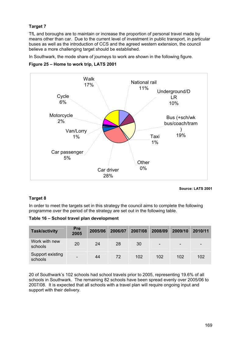
169
Target 7 TfL and boroughs are to maintain or increase the proportion of personal travel made by means other than car. Due to the current level of investment in public transport, in particular buses as well as the introduction of CCS and the agreed western extension, the council believe a more challenging target should be established.
In Southwark, the mode share of journeys to work are shown in the following figure.
Figure 25 – Home to work trip, LATS 2001
Van/Lorry1%
Car passenger5%
Car driver28%
Motorcycle2%
Cycle6%
Walk17%
Taxi1%
Other0%
Bus (+sch/wk bus/coach/tram
)19%
Underground/DLR
10%
National rail11%
Source: LATS 2001
Target 8 In order to meet the targets set in this strategy the council aims to complete the following programme over the period of the strategy are set out in the following table.
Table 16 – School travel plan development
Task/activity Pre2005 2005/06 2006/07 2007/08 2008/09 2009/10 2010/11
Work with new schools 20 24 28 30 - - -
Support existing schools - 44 72 102 102 102 102
20 of Southwark’s 102 schools had school travels prior to 2005, representing 19.6% of all schools in Southwark. The remaining 82 schools have been spread evenly over 2005/06 to 2007/08. It is expected that all schools with a travel plan will require ongoing input and support with their delivery.
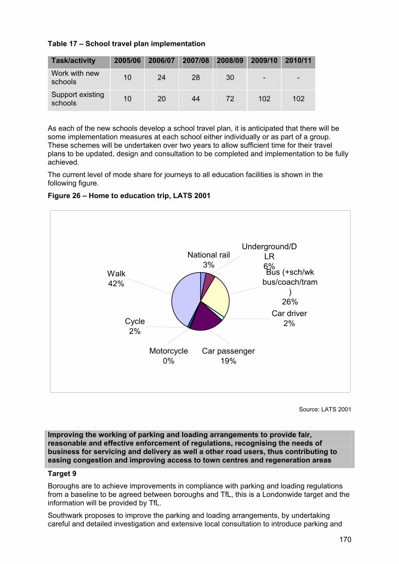
170
Table 17 – School travel plan implementation
Task/activity 2005/06 2006/07 2007/08 2008/09 2009/10 2010/11
Work with new schools 10 24 28 30 - -
Support existing schools 10 20 44 72 102 102
As each of the new schools develop a school travel plan, it is anticipated that there will be some implementation measures at each school either individually or as part of a group. These schemes will be undertaken over two years to allow sufficient time for their travel plans to be updated, design and consultation to be completed and implementation to be fully achieved.
The current level of mode share for journeys to all education facilities is shown in the following figure.
Figure 26 – Home to education trip, LATS 2001
Underground/DLR6%
Walk42%
Motorcycle0%
Cycle2%
Car passenger19%
Car driver2%
Bus (+sch/wk bus/coach/tram
)26%
National rail3%
Source: LATS 2001
Improving the working of parking and loading arrangements to provide fair, reasonable and effective enforcement of regulations, recognising the needs of business for servicing and delivery as well a other road users, thus contributing to easing congestion and improving access to town centres and regeneration areas
Target 9 Boroughs are to achieve improvements in compliance with parking and loading regulations from a baseline to be agreed between boroughs and TfL, this is a Londonwide target and the information will be provided by TfL.
Southwark proposes to improve the parking and loading arrangements, by undertaking careful and detailed investigation and extensive local consultation to introduce parking and
171
loading controls as detailed within the PEP. The council proposes to measure our performance through the number of railway stations included within a CPZ, which currently stands at 10.
This will be measured primarily through TfL compliance monitoring surveys, new TfL business surveys and annual changes in the parking supply at town centres. TfL will provide baseline information for compliance survey for business survey.
Improving accessibility and social inclusion on the transport network
Target 10 TfL and boroughs are to achieve year on year improvements in the proportion of trips made by equality and inclusion target groups under represented in the public transport travel market, particularly disabled people and women travelling at night.
Currently, trips per disabled person per day = 2.2 compared to 3.1 by all people.
Trips on public transport per disabled person per day = 0.6 compared to 0.9 by all people.
In 2004/2005 the council met its target for all pedestrian crossings (including pelican, puffin and toucan crossings, and traffic lights with a pedestrian phase) to have facilities for disabled people
Target 11 The council proposes to review all accessible transport services, including Taxicard as part of the development of our accessibility strategy. With this, we will ensure that our Taxicard scheme conforms to an agreed all London standard in terms of service quality, eligibility assessment and entitlement. The accessibility strategy will be developed over the coming year and it is anticipated that a finalised strategy will be adopted early 2007.
Encourage walking by improving the street environment, condition for pedestrians and through the use of travel demand measures
Target 12 Londonwide target to increase journeys by foot per person by at least 10% between 2001 and 2015. In 2001, 31% of Southwark residents made a walking journey daily.
Encourage cycling by improving conditions for cyclists and through the use of travel demand measures
Target 13 Londonwide target to increase cycling trips per person by at least 80% between 2001 and 2015. In 2001, 3.4% of Southwark residents made a cycling journey daily.
Bringing transport infrastructure to a state of good repair
Target 14 TfL and boroughs are to bring all A roads and busy bus routes up to a serviceable standard, that is a UKPMS score of 70 or below by 2010. The condition of the road network is measured by the following best value performance indicators.
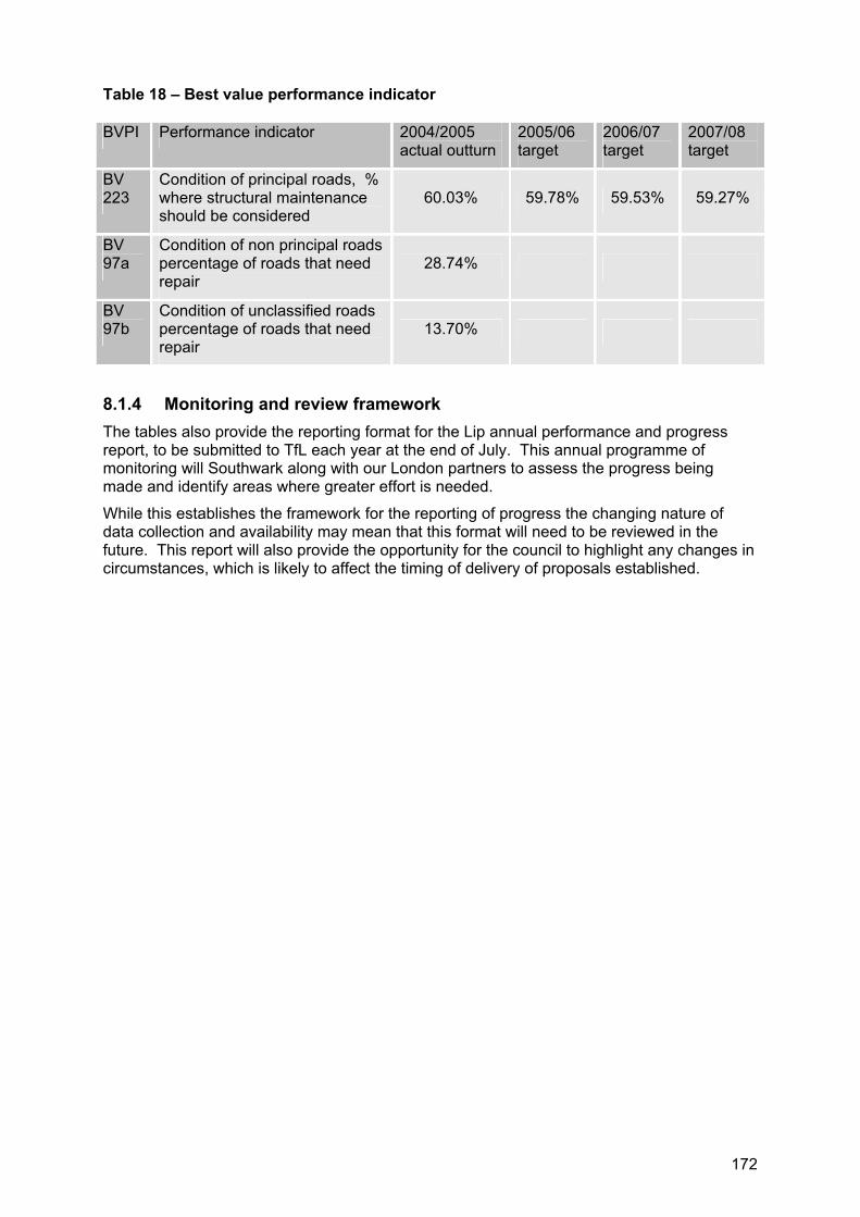
172
Table 18 – Best value performance indicator
BVPI Performance indicator 2004/2005actual outturn
2005/06target
2006/07target
2007/08target
BV223
Condition of principal roads, % where structural maintenance should be considered
60.03% 59.78% 59.53% 59.27%
BV97a
Condition of non principal roads percentage of roads that need repair
28.74%
BV97b
Condition of unclassified roads percentage of roads that need repair
13.70%
8.1.4 Monitoring and review framework The tables also provide the reporting format for the Lip annual performance and progress report, to be submitted to TfL each year at the end of July. This annual programme of monitoring will Southwark along with our London partners to assess the progress being made and identify areas where greater effort is needed.
While this establishes the framework for the reporting of progress the changing nature of data collection and availability may mean that this format will need to be reviewed in the future. This report will also provide the opportunity for the council to highlight any changes in circumstances, which is likely to affect the timing of delivery of proposals established.
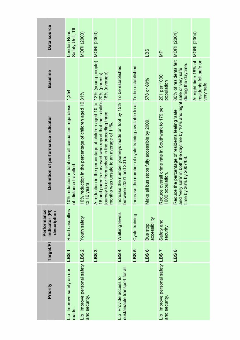
Prio
rity
Targ
et/P
IPe
rfor
man
ce
indi
cato
r (PI
) de
scrip
tion
Def
initi
on o
f per
form
ance
indi
cato
r B
asel
ine
Dat
a so
urce
Lip
Impr
ove
safe
ty o
n ou
r ro
ads.
LBS
1 R
oad
casu
altie
s 10
% re
duct
ion
in to
tal o
vera
ll ca
sual
ties
rega
rdle
ss
of d
ista
nce
trave
lled.
1,
254
Lond
on R
oad
Saf
ety
Uni
t, Tf
L
LBS
2 Y
outh
saf
ety
10%
redu
ctio
n in
the
perc
enta
ge o
f chi
ldre
n ag
ed 1
0 to
16
year
s.31
%M
OR
I (20
03)
Lip
Impr
ove
pers
onal
saf
ety
and
secu
rity.
LBS
3 A
redu
ctio
n in
the
perc
enta
ge o
f chi
ldre
n ag
ed 1
0 to
16
and
par
ents
sur
veye
d w
ho re
port
that
thei
r chi
ld’s
jo
urne
y to
or f
rom
sch
ool i
n th
e pr
eced
ing
thre
e m
onth
s w
as u
nsaf
e to
an
aver
age
of 1
1%.
12%
(you
ng p
eopl
e)20
% (p
aren
ts)
16%
(ave
rage
)
MO
RI (
2003
)
LBS
4 W
alki
ng le
vels
In
crea
se th
e nu
mbe
r jou
rney
s m
ade
on fo
ot b
y 15
%
betw
een
2001
and
201
5.
To b
e es
tabl
ishe
d
LBS
5 C
ycle
trai
ning
In
crea
se th
enu
mbe
r of c
ycle
trai
ning
ava
ilabl
e to
all.
To
be e
stab
lishe
d
Lip
Pro
vide
acc
ess
to
sust
aina
ble
trans
port
for a
ll.
LBS
6 B
us s
top
acce
ssib
ility
M
ake
all b
us s
tops
fully
acc
essi
ble
by 2
009.
57
8 or
89%
LB
S
LBS
7 S
afet
y an
d se
curit
y R
educ
e ov
eral
l crim
e ra
te in
Sou
thw
ark
to 1
79 p
er
1000
pop
ulat
ion.
20
1 pe
r 100
0 po
pula
tion
MP
80%
of r
esid
ents
felt
safe
or v
ery
safe
du
ring
the
dayt
ime.
MO
RI (
2004
)
Lip
Impr
ove
pers
onal
saf
ety
and
secu
rity.
LBS
8 R
educ
e th
e pe
rcen
tage
of r
esid
ents
feel
ing
‘saf
e’
and
‘ver
y sa
fe’ i
n bo
th th
e da
ytim
e by
10%
and
nig
ht
time
by 3
6% b
y 20
07/0
8.
At n
ight
tim
e 18
% o
f re
side
nts
felt
safe
or
very
saf
e.
MO
RI (
2004
)
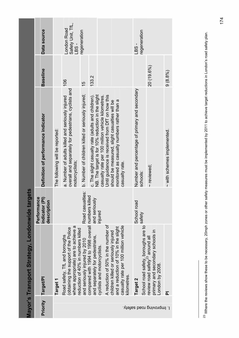
174
23W
here
the
revi
ews
show
thes
e to
be
nece
ssar
y, 2
0mph
zon
es o
r oth
er s
afet
y m
easu
res
mus
t be
impl
emen
ted
by 2
011
to a
chie
ve ta
rget
redu
ctio
ns in
Lon
don’
s ro
ad s
afet
y pl
an.
May
or’s
Tra
nspo
rt S
trat
egy,
Lon
donw
ide
targ
ets
Prio
rity
Targ
et/P
IPe
rfor
man
ce
indi
cato
r (PI
) de
scrip
tion
Def
initi
on o
f per
form
ance
indi
cato
rB
asel
ine
Dat
a so
urce
The
follo
win
g w
ill b
e re
porte
d:
a. N
umbe
r of a
dults
kill
ed a
nd s
erio
usly
inju
red
over
all a
nd s
epar
atel
y fo
r ped
estri
ans,
cyc
lists
and
m
otor
cycl
ists
;
106
b. N
umbe
r of c
hild
ren
kille
d or
ser
ious
ly in
jure
d;
15 133.
2
Lond
on R
oad
Saf
ety
Uni
t, Tf
L,
LBS
- re
gene
ratio
n
Targ
et 1
R
oad
safe
ty, T
fL a
nd b
orou
ghs
(obt
aini
ng th
e su
ppor
t of t
he P
olic
e w
here
app
ropr
iate
) are
to a
chie
ve a
re
duct
ion
of 4
0% in
num
bers
kill
ed
and
serio
usly
inju
red
by 2
010
com
pare
d w
ith 1
994
to 1
998
over
all
and
sepa
rate
ly fo
r ped
estri
ans,
cy
clis
ts a
nd m
otor
cycl
ists
.
A re
duct
ion
of 5
0% in
the
num
ber o
f ch
ildre
n ki
lled
or s
erio
usly
inju
red
and
a re
duct
ion
of 1
0% in
the
slig
ht
casu
alty
rate
per
100
mill
ion
vehi
cle
kilo
met
res.
Roa
d ca
sual
ties:
nu
mbe
rs k
illed
an
d se
rious
ly
inju
red
c. T
he s
light
cas
ualty
rate
(adu
lts a
nd c
hild
ren)
. N
B. T
he ta
rget
is fo
r 10%
redu
ctio
n in
the
slig
ht
casu
alty
rate
per
100
mill
ion
vehi
cle
kilo
met
res.
U
ntil
guid
ance
is re
ceiv
ed fr
om D
fT o
n ho
w th
is
shou
ld b
e m
easu
red,
slig
ht c
asua
lties
will
be
mon
itore
d as
cas
ualty
num
bers
rath
er th
an a
ca
sual
ty ra
te.
Num
ber a
nd p
erce
ntag
e of
prim
ary
and
seco
ndar
y sc
hool
s:
Targ
et 2
S
choo
l roa
d sa
fety
, bor
ough
s ar
e to
re
view
road
saf
ety23
aro
und
all
prim
ary
and
seco
ndar
y sc
hool
s in
Lo
ndon
by
2008
.
~ re
view
ed;
20 (1
9.6%
)
I. Improving road safety.
PI
Sch
ool r
oad
safe
ty
~ w
ith s
chem
es im
plem
ente
d.
9 (8
.8%
)
LBS
- re
gene
ratio
n
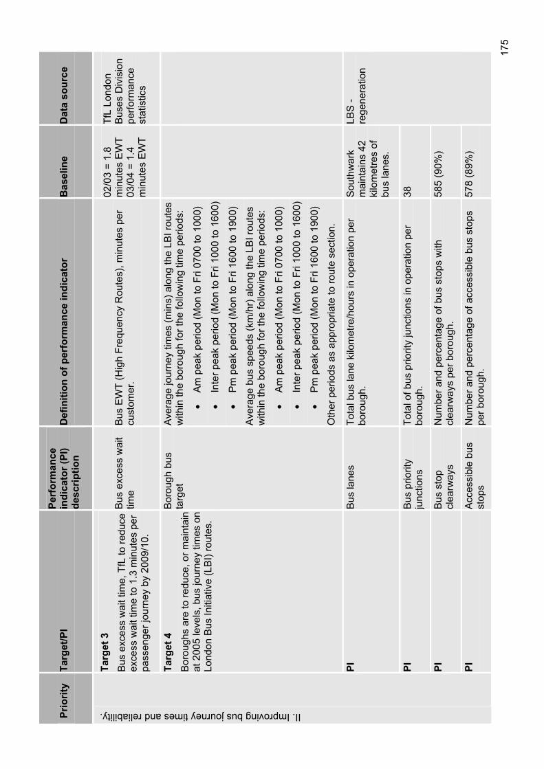
175
Prio
rity
Targ
et/P
IPe
rfor
man
ce
indi
cato
r (PI
) de
scrip
tion
Def
initi
on o
f per
form
ance
indi
cato
rB
asel
ine
Dat
a so
urce
Targ
et 3
B
us e
xces
s w
ait t
ime,
TfL
to re
duce
ex
cess
wai
t tim
e to
1.3
min
utes
per
pa
ssen
ger j
ourn
ey b
y 20
09/1
0.
Bus
exc
ess
wai
t tim
eB
us E
WT
(Hig
h Fr
eque
ncy
Rou
tes)
, min
utes
per
cu
stom
er.
02/0
3 =
1.8
min
utes
EW
T 03
/04
= 1.
4 m
inut
es E
WT
TfL
Lond
on
Bus
es D
ivis
ion
perfo
rman
cest
atis
tics
Targ
et 4
B
orou
ghs
are
to re
duce
, or m
aint
ain
at 2
005
leve
ls, b
us jo
urne
y tim
es o
n Lo
ndon
Bus
Initi
ativ
e (L
BI)
rout
es.
Bor
ough
bus
ta
rget
Ave
rage
jour
ney
times
(min
s) a
long
the
LBI r
oute
s w
ithin
the
boro
ugh
for t
he fo
llow
ing
time
perio
ds:
Am
pea
k pe
riod
(Mon
to F
ri 07
00 to
100
0)
Inte
r pea
k pe
riod
(Mon
to F
ri 10
00 to
160
0)
Pm
pea
k pe
riod
(Mon
to F
ri 16
00 to
190
0)
Ave
rage
bus
spe
eds
(km
/hr)
alo
ng th
e LB
I rou
tes
with
in th
e bo
roug
h fo
r the
follo
win
g tim
e pe
riods
:
Am
pea
k pe
riod
(Mon
to F
ri 07
00 to
100
0)
Inte
r pea
k pe
riod
(Mon
to F
ri 10
00 to
160
0)
Pm
pea
k pe
riod
(Mon
to F
ri 16
00 to
190
0)
Oth
er p
erio
ds a
s ap
prop
riate
to ro
ute
sect
ion.
PIB
us la
nes
Tota
l bus
lane
kilo
met
re/h
ours
in o
pera
tion
per
boro
ugh.
Sou
thw
ark
mai
ntai
ns 4
2 ki
lom
etre
s of
bu
s la
nes.
PIB
us p
riorit
y ju
nctio
nsTo
tal o
f bus
prio
rity
junc
tions
in o
pera
tion
per
boro
ugh.
38
PIB
us s
top
clea
rway
sN
umbe
r and
per
cent
age
of b
us s
tops
with
cl
earw
ays
per b
orou
gh.
585
(90%
)
II. Improving bus journey times and reliability.
PIA
cces
sibl
e bu
s st
ops
Num
ber a
nd p
erce
ntag
e of
acc
essi
ble
bus
stop
s pe
r bor
ough
. 57
8 (8
9%)
LBS
- re
gene
ratio
n
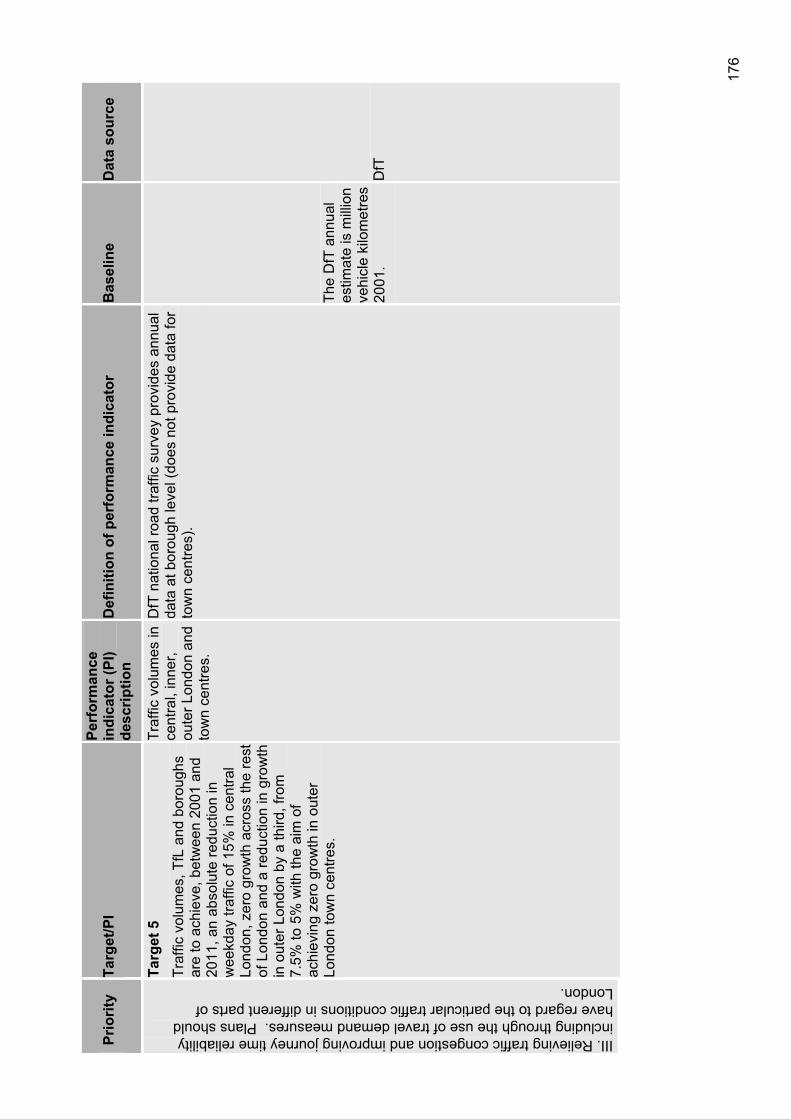
176
Prio
rity
Targ
et/P
IPe
rfor
man
ce
indi
cato
r (PI
) de
scrip
tion
Def
initi
on o
f per
form
ance
indi
cato
rB
asel
ine
Dat
a so
urce
III. Relieving traffic congestion and improving journey time reliability including through the use of travel demand measures. Plans should have regard to the particular traffic conditions in different parts of London.
Targ
et 5
Tr
affic
vol
umes
, TfL
and
bor
ough
s ar
e to
ach
ieve
, bet
wee
n 20
01 a
nd
2011
, an
abso
lute
redu
ctio
n in
w
eekd
ay tr
affic
of 1
5% in
cen
tral
Lond
on, z
ero
grow
th a
cros
s th
e re
st
of L
ondo
n an
d a
redu
ctio
n in
gro
wth
in
out
er L
ondo
n by
a th
ird, f
rom
7.
5% to
5%
with
the
aim
of
achi
evin
g ze
ro g
row
th in
out
er
Lond
on to
wn
cent
res.
Traf
fic v
olum
es in
ce
ntra
l, in
ner,
oute
r Lon
don
and
tow
n ce
ntre
s.
DfT
nat
iona
l roa
d tra
ffic
surv
ey p
rovi
des
annu
al
data
at b
orou
gh le
vel (
does
not
pro
vide
dat
a fo
r to
wn
cent
res)
.
The
DfT
ann
ual
estim
ate
is m
illio
n ve
hicl
e ki
lom
etre
s 20
01.
DfT
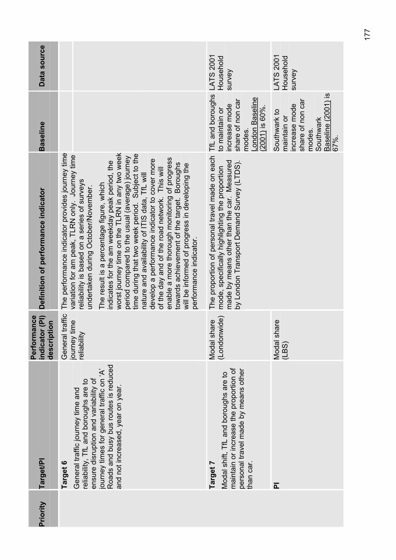
177
Prio
rity
Targ
et/P
IPe
rfor
man
ce
indi
cato
r (PI
) de
scrip
tion
Def
initi
on o
f per
form
ance
indi
cato
rB
asel
ine
Dat
a so
urce
Targ
et 6
G
ener
al tr
affic
jour
ney
time
and
relia
bilit
y, T
fL a
nd b
orou
ghs
are
to
ensu
re d
isru
ptio
n an
d va
riabi
lity
of
jour
ney
times
for g
ener
al tr
affic
on
‘A’
Roa
ds a
nd b
usy
bus
rout
es is
redu
ced
and
not i
ncre
ased
, yea
r on
year
.
Gen
eral
traf
fic
jour
ney
time
relia
bilit
y
The
perfo
rman
ce in
dica
tor p
rovi
des
jour
ney
time
varia
tion
for a
m p
eak,
TLR
N o
nly.
Jou
rney
tim
e re
liabi
lity
is b
ased
on
a se
ries
of s
urve
ys
unde
rtake
n du
ring
Oct
ober
/Nov
embe
r.
The
resu
lt is
a p
erce
ntag
e fig
ure,
whi
ch
indi
cate
s fo
r the
am
wee
kday
pea
k pe
riod,
the
wor
st jo
urne
y tim
e on
the
TLR
N in
any
two
wee
k pe
riod
com
pare
d to
the
usua
l (av
erag
e) jo
urne
y tim
e du
ring
that
two
wee
k pe
riod.
Sub
ject
to th
e na
ture
and
ava
ilabi
lity
of IT
IS d
ata,
TfL
will
de
velo
p a
perfo
rman
ce in
dica
tor t
o co
ver m
ore
of th
e da
y an
d of
the
road
net
wor
k. T
his
will
en
able
a m
ore
thor
ough
mon
itorin
g of
pro
gres
s to
war
ds a
chie
vem
ent o
f the
targ
et.
Bor
ough
s w
ill b
e in
form
ed o
f pro
gres
s in
dev
elop
ing
the
perfo
rman
ce in
dica
tor.
Targ
et 7
M
odal
shi
ft, T
fL a
nd b
orou
ghs
are
to
mai
ntai
n or
incr
ease
the
prop
ortio
n of
pe
rson
al tr
avel
mad
e by
mea
ns o
ther
th
an c
ar.
Mod
al s
hare
(L
ondo
nwid
e)Tf
L an
d bo
roug
hs
to m
aint
ain
or
incr
ease
mod
e sh
are
of n
on c
ar
mod
es.
Lond
on B
asel
ine
(200
1) is
60%
.
LATS
200
1 H
ouse
hold
surv
ey
PIM
odal
sha
re
(LB
S)
The
prop
ortio
n of
per
sona
l tra
vel m
ade
on e
ach
mod
e, s
peci
fical
ly h
ighl
ight
ing
the
prop
ortio
n m
ade
by m
eans
oth
er th
an th
e ca
r. M
easu
red
by L
ondo
n Tr
ansp
ort D
eman
d S
urve
y (L
TDS
).
Sou
thw
ark
to
mai
ntai
n or
in
crea
se m
ode
shar
e of
non
car
m
odes
.S
outh
war
kB
asel
ine
(200
1)is
67%
.
LATS
200
1 H
ouse
hold
surv
ey
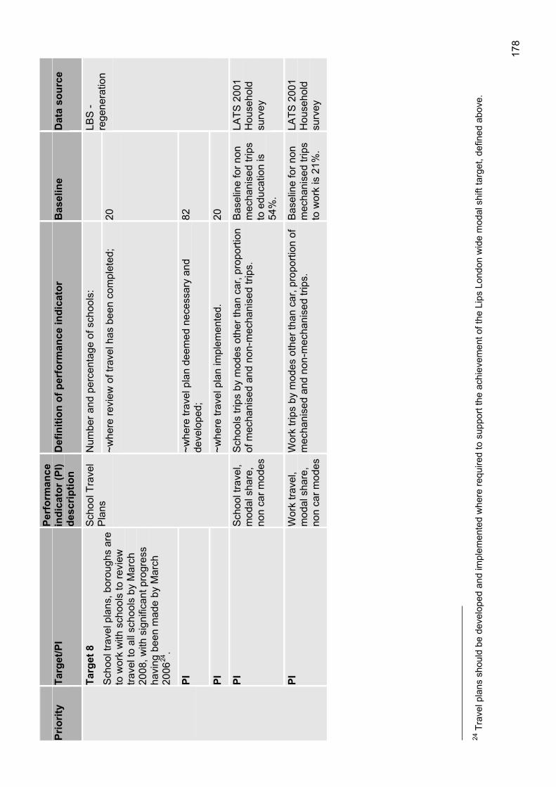
178
24 T
rave
l pla
ns s
houl
d be
dev
elop
ed a
nd im
plem
ente
d w
here
requ
ired
to s
uppo
rt th
e ac
hiev
emen
t of t
he L
ips
Lond
on w
ide
mod
al s
hift
targ
et, d
efin
ed a
bove
.
Prio
rity
Targ
et/P
IPe
rfor
man
ce
indi
cato
r (PI
) de
scrip
tion
Def
initi
on o
f per
form
ance
indi
cato
rB
asel
ine
Dat
a so
urce
Num
ber a
nd p
erce
ntag
e of
sch
ools
: Ta
rget
8
Sch
ool t
rave
l pla
ns, b
orou
ghs
are
to w
ork
with
sch
ools
to re
view
tra
vel t
o al
l sch
ools
by
Mar
ch
2008
, with
sig
nific
ant p
rogr
ess
havi
ng b
een
mad
e by
Mar
ch
2006
24.
~whe
re re
view
of t
rave
l has
bee
n co
mpl
eted
; 20
PI~w
here
trav
el p
lan
deem
ed n
eces
sary
and
de
velo
ped;
82
PI
Sch
ool T
rave
l P
lans
~whe
re tr
avel
pla
n im
plem
ente
d.
20
LBS
- re
gene
ratio
n
PIS
choo
l tra
vel,
mod
al s
hare
, no
n ca
r mod
es
Sch
ools
trip
s by
mod
es o
ther
than
car
, pro
porti
on
of m
echa
nise
d an
d no
n-m
echa
nise
d tri
ps.
Bas
elin
e fo
r non
m
echa
nise
d tri
ps
to e
duca
tion
is
54%
.
LATS
200
1 H
ouse
hold
surv
ey
PIW
ork
trave
l, m
odal
sha
re,
non
car m
odes
Wor
k tri
ps b
y m
odes
oth
er th
an c
ar, p
ropo
rtion
of
mec
hani
sed
and
non-
mec
hani
sed
trips
. B
asel
ine
for n
on
mec
hani
sed
trips
to
wor
k is
21%
.
LATS
200
1 H
ouse
hold
surv
ey
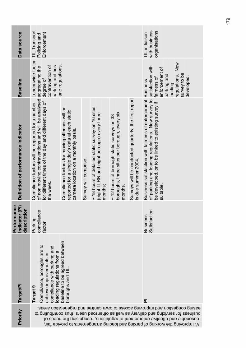
179
Prio
rity
Targ
et/P
IPe
rfor
man
ce
indi
cato
r (PI
) de
scrip
tion
Def
initi
on o
f per
form
ance
indi
cato
rB
asel
ine
Dat
a so
urce
Com
plia
nce
fact
ors
will
be
repo
rted
for a
num
ber
of n
on m
ovin
g co
ntra
vent
ions
and
will
be
anal
ysed
fo
r diff
eren
t tim
es o
f the
day
and
diff
eren
t day
s of
th
e w
eek.
Com
plia
nce
fact
ors
for m
ovin
g of
fenc
es w
ill b
e re
porte
d fo
r a s
ingl
e da
y's
data
at e
ach
stat
ic
cam
era
loca
tion
on a
mon
thly
bas
is.
Sur
vey
will
com
pris
e:
~ 18
hou
rs o
f det
aile
d st
atic
sur
vey
on 1
6 si
tes
(eig
ht T
LRN
and
eig
ht b
orou
gh) e
very
thre
e m
onth
s;
~ 12
hou
rs o
f bor
ough
sta
tic s
urve
ys o
n 33
bo
roug
hs, t
hree
site
s pe
r bor
ough
, eve
ry s
ix
mon
ths.
Targ
et 9
C
ompl
ianc
e, b
orou
ghs
are
to
achi
eve
impr
ovem
ents
in
com
plia
nce
with
par
king
and
lo
adin
g re
gula
tions
from
a
base
line
to b
e ag
reed
bet
wee
n bo
roug
hs a
nd T
fL.
Par
king
com
plia
nce
fact
or
Sur
veys
will
be
cond
ucte
d qu
arte
rly; t
he fi
rst r
epor
t is
due
sum
mer
200
4.
Lond
onw
ide
fact
or
aggr
egat
ing
the
degr
ee o
f co
ntra
vent
ion
of
park
ing
and
bus
lane
regu
latio
ns.
TfL
Tran
spor
t P
olic
ing
and
Enf
orce
men
t
IV. Improving the working of parking and loading arrangements to provide fair, reasonable and effective enforcement of regulations, recognising the needs of business for servicing and delivery as well as other road users, thus contributing to easing congestion and improving access to town centres and regeneration areas.
PIB
usin
ess
Sat
isfa
ctio
nB
usin
ess
satis
fact
ion
with
fairn
ess
of e
nfor
cem
ent
of p
arki
ng a
nd lo
adin
g re
gula
tions
. N
ew s
urve
y to
be
dev
elop
ed, o
r to
be li
nked
to e
xist
ing
surv
ey if
su
itabl
e.
Bus
ines
ssa
tisfa
ctio
n w
ith
fairn
ess
of
enfo
rcem
ent o
f pa
rkin
g an
d lo
adin
gre
gula
tions
. N
ew
surv
ey to
be
deve
lope
d.
TfL
in li
aiso
n w
ith b
usin
ess
orga
nisa
tions
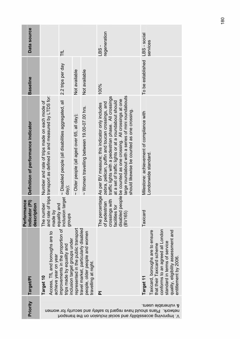
180
Prio
rity
Targ
et/P
IPe
rfor
man
ce
indi
cato
r (PI
) de
scrip
tion
Def
initi
on o
f per
form
ance
indi
cato
rB
asel
ine
Dat
a so
urce
Num
ber a
nd ra
te o
f trip
s m
ade
on e
ach
mod
e of
tra
nspo
rt as
def
ined
in a
nd m
easu
red
by L
TDS
for:
~ D
isab
led
peop
le (a
ll di
sabi
litie
s ag
greg
ated
, all
day)
;2.
2 tri
ps p
er d
ay
~ O
lder
peo
ple
(all
aged
ove
r 65,
all
day)
; N
ot a
vaila
ble
Targ
et 1
0 A
cces
s, T
fL a
nd b
orou
ghs
are
to
achi
eve
year
on
year
im
prov
emen
ts in
the
prop
ortio
n of
tri
ps m
ade
by e
qual
ity a
nd
incl
usio
n ta
rget
gro
ups
unde
r re
pres
ente
d in
the
publ
ic tr
ansp
ort
trave
l mar
ket,
parti
cula
rly d
isab
led
peop
le, o
lder
peo
ple
and
wom
en
trave
lling
at n
ight
.
The
num
ber
and
rate
of t
rips
mad
e by
eq
ualit
y an
d in
clus
ion
targ
et
grou
ps
~ W
omen
trav
ellin
g be
twee
n 19
.00-
07.0
0 hr
s.
Not
ava
ilabl
e
TfL
PITh
e pe
rcen
tage
of
ped
estri
an
cros
sing
s w
ith
faci
litie
s fo
r di
sabl
ed p
eopl
e (B
V16
5)
As
per B
V m
easu
re; t
his
indi
cato
r onl
y in
clud
es
zebr
a, p
elic
an, p
uffin
and
touc
an c
ross
ings
, and
tra
ffic
light
s w
ith a
ped
estri
an p
hase
. A
ll cr
ossi
ngs
at a
set
of t
raffi
c lig
hts
or a
t a ro
unda
bout
sho
uld
be c
ount
ed a
s on
e cr
ossi
ng.
All
cros
sing
s at
one
la
rge
roun
dabo
ut w
ith a
ser
ies
of m
ini r
ound
abou
ts
shou
ld li
kew
ise
be c
ount
ed a
s on
e cr
ossi
ng.
100%
LBS
- re
gene
ratio
n
V. Improving accessibility and social inclusion on the transport network. Plans should have regard to safety and security for women & vulnerable users.
Targ
et 1
1 Ta
xica
rd, b
orou
ghs
are
to e
nsur
e th
at th
eir T
axic
ard
sche
me
conf
orm
s to
an
agre
ed a
ll Lo
ndon
st
anda
rd in
term
s of
ser
vice
qu
ality
, elig
ibili
ty a
sses
smen
t and
en
title
men
t by
2006
.
Taxi
card
Mile
ston
e: a
chie
vem
ent o
f com
plia
nce
with
Lo
ndon
wid
e st
anda
rd.
To b
e es
tabl
ishe
d LB
S -
soci
al
serv
ices
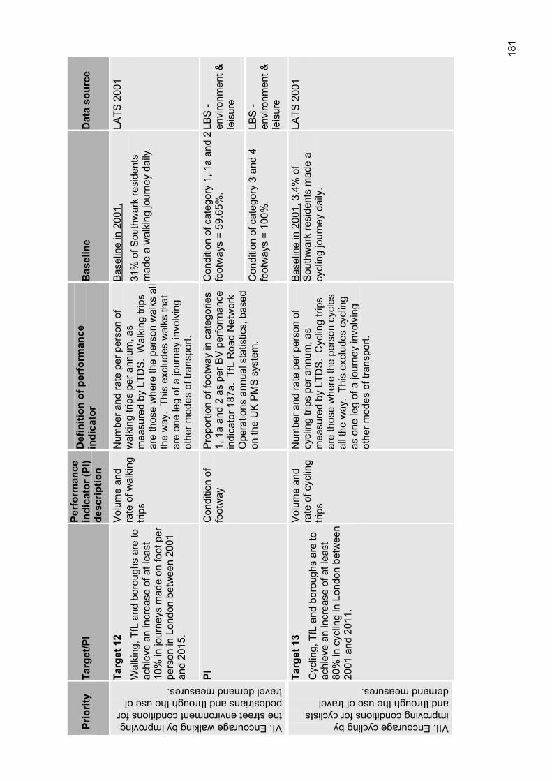
181
Prio
rity
Targ
et/P
IPe
rfor
man
ce
indi
cato
r (PI
) de
scrip
tion
Def
initi
on o
f per
form
ance
in
dica
tor
Bas
elin
eD
ata
sour
ce
Targ
et 1
2 W
alki
ng, T
fL a
nd b
orou
ghs
are
to
achi
eve
an in
crea
se o
f at l
east
10
% in
jour
neys
mad
e on
foot
per
pe
rson
in L
ondo
n be
twee
n 20
01
and
2015
.
Vol
ume
and
rate
of w
alki
ng
trips
Num
ber a
nd ra
te p
er p
erso
n of
w
alki
ng tr
ips
per a
nnum
, as
mea
sure
d by
LTD
S.
Wal
king
trip
s ar
e th
ose
whe
re th
e pe
rson
wal
ks a
ll th
e w
ay.
This
exc
lude
s w
alks
that
ar
e on
e le
g of
a jo
urne
y in
volv
ing
othe
r mod
es o
f tra
nspo
rt.
Bas
elin
e in
200
1,
31%
of S
outh
war
k re
side
nts
mad
e a
wal
king
jour
ney
daily
.
LATS
200
1
Con
ditio
n of
cat
egor
y 1,
1a
and
2 fo
otw
ays
= 59
.65%
. LB
S -
envi
ronm
ent &
le
isur
e
VI. Encourage walking by improving the street environment conditions for pedestrians and through the use of travel demand measures.
PIC
ondi
tion
of
foot
way
Pro
porti
on o
f foo
tway
in c
ateg
orie
s 1,
1a
and
2 as
per
BV
per
form
ance
in
dica
tor 1
87a.
TfL
Roa
d N
etw
ork
Ope
ratio
ns a
nnua
l sta
tistic
s, b
ased
on
the
UK
PM
S s
yste
m.
Con
ditio
n of
cat
egor
y 3
and
4 fo
otw
ays
= 10
0%.
LBS
- en
viro
nmen
t &
leis
ure
VII. Encourage cycling by improving conditions for cyclists and through the use of travel demand measures.
Targ
et 1
3 C
yclin
g, T
fL a
nd b
orou
ghs
are
to
achi
eve
an in
crea
se o
f at l
east
80
% in
cyc
ling
in L
ondo
n be
twee
n 20
01 a
nd 2
011.
Vol
ume
and
rate
of c
yclin
g tri
ps
Num
ber a
nd ra
te p
er p
erso
n of
cy
clin
g tri
ps p
er a
nnum
, as
mea
sure
d by
LTD
S.
Cyc
ling
trips
ar
e th
ose
whe
re th
e pe
rson
cyc
les
all t
he w
ay.
This
exc
lude
s cy
clin
g as
one
leg
of a
jour
ney
invo
lvin
g ot
her m
odes
of t
rans
port.
Bas
elin
e in
200
1, 3
.4%
of
Sou
thw
ark
resi
dent
s m
ade
a cy
clin
g jo
urne
y da
ily.
LATS
200
1
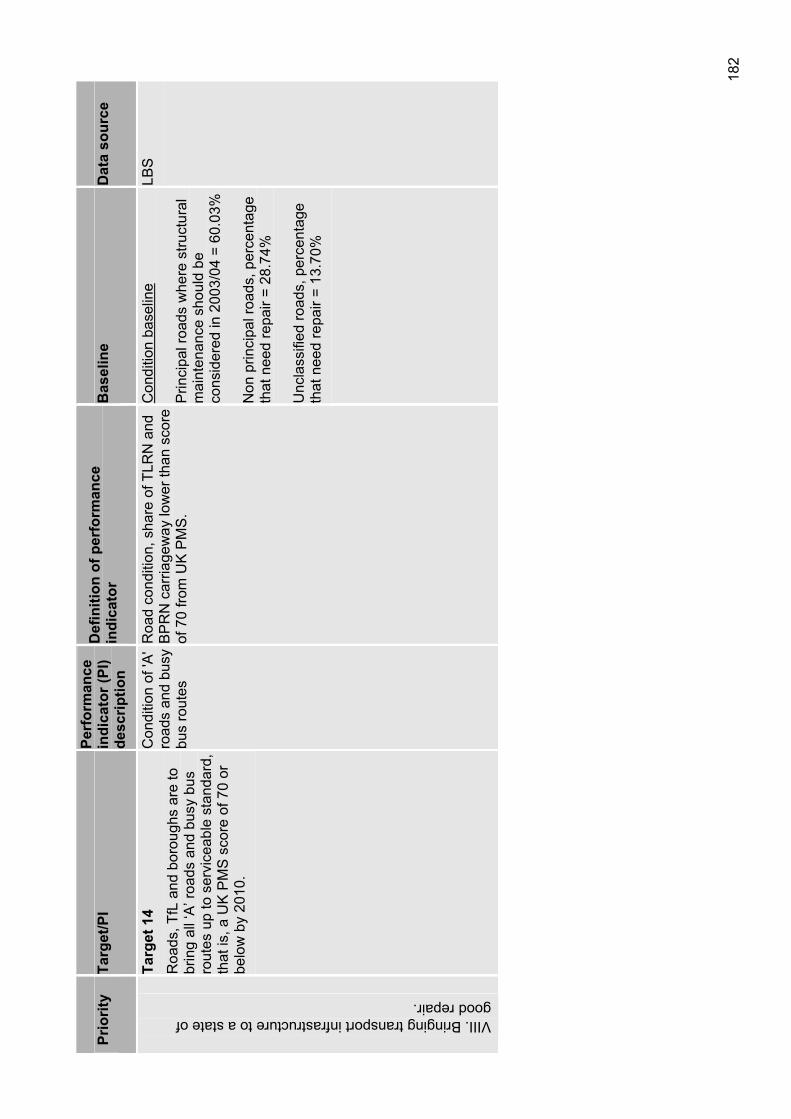
182
Prio
rity
Targ
et/P
IPe
rfor
man
ce
indi
cato
r (PI
) de
scrip
tion
Def
initi
on o
f per
form
ance
in
dica
tor
Bas
elin
eD
ata
sour
ceVIII. Bringing transport infrastructure to a state of good repair.
Targ
et 1
4 R
oads
, TfL
and
bor
ough
s ar
e to
br
ing
all ‘
A’ r
oads
and
bus
y bu
s ro
utes
up
to s
ervi
ceab
le s
tand
ard,
th
at is
, a U
K P
MS
sco
re o
f 70
or
belo
w b
y 20
10.
Con
ditio
n of
'A'
road
s an
d bu
sy
bus
rout
es
Roa
d co
nditi
on, s
hare
of T
LRN
and
B
PR
N c
arria
gew
ay lo
wer
than
sco
re
of 7
0 fro
m U
K P
MS
.
Con
ditio
n ba
selin
e
Prin
cipa
l roa
ds w
here
stru
ctur
al
mai
nten
ance
sho
uld
be
cons
ider
ed in
200
3/04
= 6
0.03
%
Non
prin
cipa
l roa
ds, p
erce
ntag
e th
at n
eed
repa
ir =
28.7
4%
Unc
lass
ified
road
s, p
erce
ntag
e th
at n
eed
repa
ir =
13.7
0%
LBS
9 CONSULTATION 9.1 Consultation framework The preparation of this plan has taken into consideration previous consultation undertaken by various parts of the council organisation. This includes the following:
Unitary development plan During the preparation of Southwark’s Unitary development plan (UDP) there has been considerable consultation with the community and key stakeholders. This included a detailed consultation exercise in 2001 including key and local issues papers. The feedback from this exercise has gone into the development of the UDP and the transport related elements have been considered in the formulation of the Lip documents. The most recent consultation in 2005 engaged over 2000 key stakeholders, statutory groups and individuals.
Statement of community involvement The purpose of the statement of community involvement (SCI) is to set out the process of community involvement that will be undertaken in the development and review of planning documents and in the processing of planning applications. During the two rounds of consultation, key stakeholders, community groups and local residents were asked if they would like to be consulted specifically on transport planning issues. Those who responded yes were included in the consultation for the Lip
Borough spending planThe BSP is an annual bidding document to TfL, for funding to undertake traffic and transport improvements in the borough. Until 2004 London boroughs have submitted an annual BSP the purpose of which is primarily to demonstrate to Transport for London.
For the past three cycles (2004/05, 2005/06 and 2006/07 financial years), the council’s transport group has engaged with the community councils, to ascertain their transport priorities, affirm proposed projects and initiatives and where possible, feed ideas into the development of future bids. The feedback from the past two cycles has also guided the development of the objectives and proposals within the Lip documents.
From 2006 onwards boroughs will still prepare an annual programme but this will be guided by a longer term Lip that will set out priorities for several years ahead.
Individual traffic & transport projectsThe council’s transport group undertake many individual traffic and transport projects such as road safety schemes, walking and cycling improvements and some bus network improvements. Through the individual consultations on these schemes, a picture of community needs and wants has been developed, which is reflected within the Lip.
9.2 Community involvement and consultation In Southwark, involvement of the local community is considered to be of great importance in the identification and prioritisation of transport related issues. Furthermore, there are many other bodies and organisations as well as regional partnerships that influence the ability to implement transport improvements that have a tangible benefit for the residents and businesses within the borough.
This section outlines the engagement process, how the community is being invited to take part in the transport improvements and how other organisations and partners have been consulted in the preparation of this Lip.
9.2.1 Community councils In 2003, Southwark Council established eight community councils to enable residents to have a greater role in discussing their local issues and to take an active part in the decision making process. Community council meetings are open to the public and are a key opportunity for regular engagement with the community as meetings are held each month.
184
They also provide the means for other interest groups such as attendees of area forums and tenant’s council to have greater participation in consultation.
The community councils have the power to allocate some budgets and make decisions on issues including community safety, environmental improvement, traffic, planning and licensing. They are typically based on agglomerations of three wards apiece (see figure 27) and each have up to nine elected Councillors as voting members. All meetings are advertised in advance through public notices, newspapers and on the council website to encourage all local residents to become actively involved, and measures are taken to ensure that the meetings are fully accessible.
In the development of the Lip, community councils were engaged in two different phases. Council officers attended all community councils in June and July 2005 and individuals were invited to raise generic and specific transport issues that related to their area. This was done in the form of an open discussion and by way of a questionnaire and the initial sessions laid the foundation for the second round of consultation in November/December.
Community councils often prefer workshops to presentations and vice versa when being consulted. Preliminary research for the second round was undertaken in conjunction with chairpersons and clerks to determine what form of consultation was preferred. As a result, each meeting was individually tailored to meet the wishes of the attendees and encourage maximum participation.
The Lip workshops involved breaking up the meeting into small groups with a council officer leading discussion on a number of issues specifically tailored to the group. Tasks with maps were completed which identified areas seen to have transport problems and flip charts were incorporated which encouraged participants to expand on their initial ideas. The exercise was a useful tool for officers and provided insight into residents’ views and aspirations for transport. Where presentations were given, discussions focused on defined transport issues where it was known that there were specific concerns or interests for the local community. Residents were also asked to fill out the consultation questionnaires and provide feedback during question and answer sessions.
The council responded to each community council by preparing detailed handouts outlining actions to be incorporated into the Lip and they also addressed specific issues raised in the meetings. These documents were distributed in the January and February meetings and received positive feedback.
Community councils play a very important role in highlighting local transport issues and prioritising the schemes identified in the Lip. The council will continue to involve community councils in all stages of consultation and revision of the Lip strategies and actions.
Figure 27 – Community council boundaries
9.2.2 Transport consultative forum The TCF was established in 2004 and members include an assembly of representatives from various interest groups. The number of attendees and groups represented is continually growing and the panel has proven to be an extremely effective means of engagement and consultation.
The TCF holds meetings on a bimonthly basis and officers will attend these to brief the group and discuss strategic transport issues. Key stakeholders can become actively involved in the development of strategic policy and find out what matters of interest will be arising in the future. The council sees the forum as a gateway to effective consultation of the wider community and a key component of the Lip consultation as a whole.
9.2.3 Mobility subgroup The mobility subgroup is a forum for communication and consultation between a range of accessible transport providers and users. It addresses the problems in accessible transport provision in Southwark, which is an ongoing issue that frequently arises in meetings with service users, carers and the voluntary sector.
185
The group have made valuable recommendations for the development of accessible transport strategy and policies within the Lip. They meet on a quarterly basis and will continue to give advice on the impact of transport and accessibility of key services for older people and people with disabilities.
9.2.4 Formal consultation The formal letter and relevant consultation documents were sent out to 240 interest groups, residents and statutory authorities on 14 November 2005. A number of meetings were organised during this period to discuss the document in depth with key stakeholders. The formal consultation on the draft Lip and its components ran for approximately six weeks and the documents consulted on were:
The main Lip document;
The road safety plan;
The walking plan;
The cycling plan;
The school travel plan strategy;
The parking and enforcement plan;
The Strategic Environmental Assessment (SEA); and,
The Equalities Impact Assessment (EqIA).
Information about consultation and how to get involved was provided at various meetings including at community councils, the TCF and the mobility subgroup.
Southwark Council’s website is now fully accessible and is an extremely important tool in conveying large amounts of information and involving the community in the consultation process. A specific area has been established under the transport section of the website on which all relevant documents, consultation information and also contact details are available and updated on a regular basis.
Brochures were sent to all borough public libraries and relevant meetings proved useful in creating awareness and disseminating information. The details contained within outlined what the document was, how it would affect residents and detailed consultation and contact information and how to access alternative language and translation services.
The equality and diversity panel meets monthly and has assisted with preparing the EqIA. The panel also provided further assistance to refine the consultation methods and a workshop on the Lip was also undertaken with the panel during the consultation period.
9.2.5 Interest groups Southwark Cyclists campaign on all cycling issues in the borough and the council regularly consult with them on issues such as cycle network design, improving the safety of cycling, and the location of cycle parking. During the consultation period officers attended the Southwark Cyclists meeting in December 2005 and also two TCF meetings where various cyclist groups are represented.
Walking groups such as Living Streets and Southwark Pedestrian Rights group have been active in the development of the walking plan and relevant elements of the Lip and also attend the TCF. Officers attended a number of Living Streets meetings and asked members to comment on draft documents prior to formal consultation.
The council will continue to support and pursue interaction with special interest groups and recognise their value in developing and implementing a successful transport strategy.
186
9.3 Consultation and accessibility Both the TCF and the mobility subgroup are held at the Town Hall in Peckham, while the Community councils are held in various community centres throughout the borough. All of these buildings are accessible to wheelchair users and those who are on mobility scooters. Specific details for the specific venue are outlined on the agendas which are available one week prior to each meeting via the website, email, mail, or newspaper depending on which meeting it is.
All Southwark residents wishing to attend these meetings who are paying for someone to look after their children, elderly dependants, or dependant with disabilities are eligible for a carer allowance from the council. The council also offers a translation service and will provide a signer or interpreter if required.
Disabled members of the public are given the option of transport assistance in order to access these meetings and information on how to arrange this is stated on the meeting agenda issued prior to the event. Clerks will organise the requirements prior to the event and this service is free of charge to all residents needing assistance in reaching the venue.
10 EQUALITIES IMPACT ASSESSMENT 10.1 Introduction The purpose of this appraisal is to assess whether draft Lip incorporates the principles of equalities and to identify areas for improvement and ensure that if appropriate, measures are taken to revise, promote and support the council’s corporate policies on equalities.
As part of council’s commitments under the RRAA, the council is required to assess how their policies, services and practices affect the local community across three overlapping areas of responsibility:
To eliminate discrimination;
To promote equality of opportunity; and
To promote good race relations.
To meet these responsibilities, Southwark has published its equality scheme 2005 to 2008. The scheme sets out our overall policy for addressing equality, diversity and social cohesion in the borough. The equality scheme recognises that people may face discrimination, or experience adverse impact on their lives as a result of age, disability, ethnicity, faith, gender or sexuality.
These assessments are known as Equality Impact Assessments (EqIAs) and must be applied to documents and policies where:
(a) The policy’s aims could conflict with the three areas of responsibility; or
(b) Aspects of the policy could contribute to inequality; or
(c) The policy will have a high impact upon the lives of local people; or
(d) There are particular communities/groups likely to have different needs/experiences/attitudes in relation to the policy.
EqIAs are intended to examine the aims, implementation and effects of policies, practices and services to check that no groups are receiving or are likely to receive differential treatment or outcomes that are discriminatory or unfair in nature. They should cover the following areas of potential inequality:
Race and ethnicity;
Gender;
Disability;
Age;
Faith/belief;
Sexual orientation.
10.2 Methodology The council is committed to the mainstreaming of the equalities agenda and has produced a generic template to ensure that equalities impacts are considered at each stage of the policy development process across departments.
The EqIA comprising three distinctive stages as detailed as follows and has been alongside the consultation Lip. The three stages are:

188
Stage one Scoping
Stage two Assessing the impacts
Stage three Making recommendations, taking decisions and formulation and implementation of an action plan
All three stages ensure that the Lip complies with our responsibilities under RRAA and wider equalities legislation and directives. An assessment of this plan is incorporated into this equalities template in section 10.
10.2.1 The role of the equality and diversity panel In 2003, the council established an equality and diversity panel. This panel comprises representatives from forums and organisations in Southwark with a particular interest in issues of equality, diversity and social cohesion. Members of the group include representatives from black and minority ethnic, lesbian, gay, bisexual and transgender, traveller, age related and disabled people’s groups. An important function of the equality and diversity panel is to receive and review equality impact assessments, to comment on the way that they were carried out and to make recommendations for any further actions that should be taken in addition to those identified through the assessment exercise.
The EqIA for this plan, in accordance with the requirements of Southwark’s equality scheme as a plan of high relevance to equality groups was taken before the equality and diversity panel at the end of stage one and stage two of its assessment.
As part of the consultation the transport plan was also tabled at the Southwark disability forum, the mobility subgroup of the TCF, offers were also extended to the multi faith forum, pensioners groups, and the Asian forum. Further details on the consultation of the plan can be found in section 9.
The EqIA has been amended to reflect the panel’s comments and suggestions. The assessment has also been reviewed in following the public consultation of this plan.
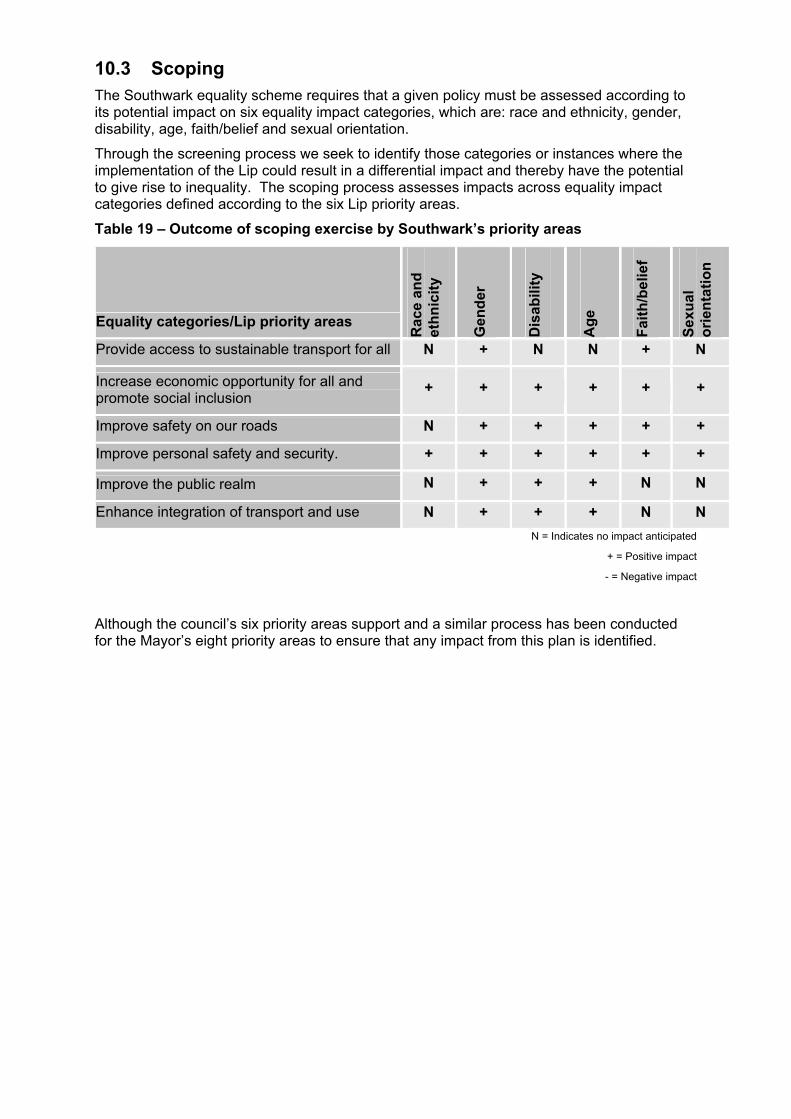
10.3 Scoping The Southwark equality scheme requires that a given policy must be assessed according to its potential impact on six equality impact categories, which are: race and ethnicity, gender, disability, age, faith/belief and sexual orientation.
Through the screening process we seek to identify those categories or instances where the implementation of the Lip could result in a differential impact and thereby have the potential to give rise to inequality. The scoping process assesses impacts across equality impact categories defined according to the six Lip priority areas.
Table 19 – Outcome of scoping exercise by Southwark’s priority areas
Equality categories/Lip priority areas
Rac
e an
d et
hnic
ity
Gen
der
Dis
abili
ty
Age
Faith
/bel
ief
Sexu
alor
ient
atio
n
Provide access to sustainable transport for all N + N N + N
Increase economic opportunity for all and promote social inclusion
+ + + + + +
Improve safety on our roads N + + + + +
Improve personal safety and security. + + + + + +
Improve the public realm N + + + N N
Enhance integration of transport and use N + + + N NN = Indicates no impact anticipated
+ = Positive impact
- = Negative impact
Although the council’s six priority areas support and a similar process has been conducted for the Mayor’s eight priority areas to ensure that any impact from this plan is identified.

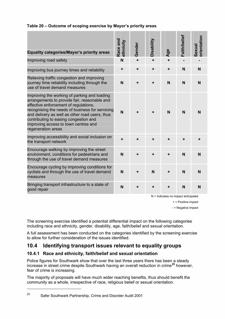
Table 20 – Outcome of scoping exercise by Mayor’s priority areas
Equality categories/Mayor’s priority areas
Rac
e an
d et
hnic
ity
Gen
der
Dis
abili
ty
Age
Faith
/bel
ief
Sexu
alor
ient
atio
n
Improving road safety N + + + - -
Improving bus journey times and reliability + + + + N N
Relieving traffic congestion and improving journey time reliability including through the use of travel demand measures
N + + N N N
Improving the working of parking and loading arrangements to provide fair, reasonable and effective enforcement of regulations, recognising the needs of business for servicing and delivery as well as other road users, thus contributing to easing congestion and improving access to town centres and regeneration areas
N + + N N N
Improving accessibility and social inclusion on the transport network + + + + + +
Encourage walking by improving the street environment, conditions for pedestrians and through the use of travel demand measures
N + + + N N
Encourage cycling by improving conditions for cyclists and through the use of travel demand measures
N + N + N N
Bringing transport infrastructure to a state of good repair N + + + N N
N = Indicates no impact anticipated
+ = Positive impact
- = Negative impact
The screening exercise identified a potential differential impact on the following categories including race and ethnicity, gender, disability, age, faith/belief and sexual orientation.
A full assessment has been conducted on the categories identified by the screening exercise to allow for further consideration of the issues identified.
10.4 Identifying transport issues relevant to equality groups 10.4.1 Race and ethnicity, faith/belief and sexual orientation Police figures for Southwark show that over the last three years there has been a steady increase in street crime despite Southwark having an overall reduction in crime25 however, fear of crime is increasing.
The majority of proposals will have much wider reaching benefits, thus should benefit the community as a whole, irrespective of race, religious belief or sexual orientation. 25 Safer Southwark Partnership, Crime and Disorder Audit 2001
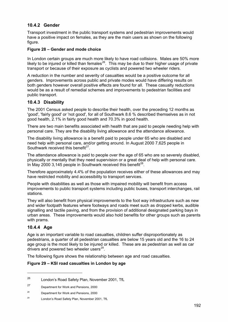
192
10.4.2 Gender Transport investment in the public transport systems and pedestrian improvements would have a positive impact on females, as they are the main users as shown on the following figure.
Figure 28 – Gender and mode choice
In London certain groups are much more likely to have road collisions. Males are 50% more likely to be injured or killed than females26. This may be due to their higher usage of private transport or because of their exposure as cyclists and powered two wheeler riders.
A reduction in the number and severity of casualties would be a positive outcome for all genders. Improvements across public and private modes would have differing results on both genders however overall positive effects are found for all. These casualty reductions would be as a result of remedial schemes and improvements to pedestrian facilities and public transport.
10.4.3 Disability The 2001 Census asked people to describe their health, over the preceding 12 months as 'good', 'fairly good' or 'not good', for all of Southwark 8.6 % described themselves as in not good health, 2.1% in fairly good health and 70.3% in good health.
There are two main benefits associated with health that are paid to people needing help with personal care. They are the disability living allowance and the attendance allowance.
The disability living allowance is a benefit paid to people under 65 who are disabled and need help with personal care, and/or getting around. In August 2000 7,625 people in Southwark received this benefit27.
The attendance allowance is paid to people over the age of 65 who are so severely disabled, physically or mentally that they need supervision or a great deal of help with personal care. In May 2000 3,145 people in Southwark received this benefit28.
Therefore approximately 4.4% of the population receives either of these allowances and may have restricted mobility and accessibility to transport services.
People with disabilities as well as those with impaired mobility will benefit from access improvements to public transport systems including public buses, transport interchanges, rail stations.
They will also benefit from physical improvements to the foot way infrastructure such as new and wider footpath features where footways and roads meet such as dropped kerbs, audible signalling and tactile paving, and from the provision of additional designated parking bays in urban areas. These improvements would also hold benefits for other groups such as parents with prams.
10.4.4 Age Age is an important variable to road casualties, children suffer disproportionately as pedestrians, a quarter of all pedestrian casualties are below 15 years old and the 16 to 24 age group is the most likely to be injured or killed. These are as pedestrian as well as car drivers and powered two wheeler users29.
The following figure shows the relationship between age and road casualties.
Figure 29 – KSI road casualties in London by age
26 London’s Road Safety Plan, November 2001, TfL 27 Department for Work and Pensions, 2000 28 Department for Work and Pensions, 2000 29 London’s Road Safety Plan, November 2001, TfL
193
Source: TfL London Road Safety Unit
Southwark’s RSP as a contributory document to the Lip acknowledges the detrimental effect traffic casualties can have on the community and supports the current national targets of:
40% reduction in KSI (killed and seriously injured);
50% reduction in child KSI (under 16 years);
10% reduction in slight rate.
A reduction in the number and severity of casualties would be a positive outcome for all ages and in particular for younger persons. These casualty reductions would be as a result of remedial schemes and improvements to pedestrian facilities and public transport.
In Southwark children and young people make up 20% of the population compared with 25% of the population of London as a whole. Young people’s use of the transport system is influenced by five key factors:
An inability for independent travel by car;
Very low average incomes;
Concentrated demand for travel;
Inexperience of using the transport system;
High proportion of journeys being accompanied by an adult.
As far as the journey to and from school is concerned the council has developed a STPS. It was found that approximately a quarter of school children are currently driven to school by car. Measures that seek to encourage children and parents to use means of travel other than the car could potentially place children at greater risk of road collisions, unless appropriate road sense training and safe routes to schools.
10.4.5 Persons with dependants Dependants include younger people, older people or those with disabilities and their permanent carers. There would be differential positive impacts arising, in particular, from improvements in bus vehicles and services, accessibility initiatives that make walking easier and safety improvements.
10.5 Assessment of impact by Lip priority area 10.5.1 Provide access to sustainable transport for all Southwark will encourage more people to use sustainable modes of transport through various methods including physical infrastructure improvements, educational and promotional events.
Travel planning Travel awareness plans are designed to promote greater use of public transport within the borough by raising awareness of the public transport services available. In particular, Southwark is encouraging employers to develop travel plans aimed at reducing car use for travel to work and for business. These plans typically include a package of practical measures to encourage staff to choose alternatives to single occupancy car use and to reduce the need to travel at all for their work.
Travel plans will reduce car use, especially single occupancy cars and will encourage more attractive and sustainable alternatives. The development and use of travel plans will improve traffic congestion, which in turn will improve air quality, therefore the whole community benefits. The support and promotion of travel plans will benefit all those working in the Lip area with no differential impacts on any particular group.

194
This will aide all sectors of the community, although consideration of those with special needs i.e. people with English as a second language is required to ensure that the information is available to all.
School Travel Plans The council has prepared a STPS, which aims for all schools to implement a STP plan by 2008. STPs set out what a school has done and what they are going to do to tackle issues with the journey to school while encouraging a reduction in car journeys made to school.
STPs can help to reduce the perceived dangers associated with children travelling independently so that the dangers won’t be a barrier to increasing the numbers of children cycling and walking to school.
Accessibility planning Southwark proposed to develop an accessibility strategy to maximise independence and access to key services, establish transport standards and assess, prioritise and meet the needs for all. We have established a mobility forum to create dialogue between the various stakeholders.
A key initiative is to create an accessible environment, this will be done through improvements to the streetscape environment, access to transport services, reviewing the environment around key services and blue badge bays.
Southwark seeks to improve the coordination of transport services, particularly at interchanges. The Lip proposes to establish a programme of works to improve the environment at all bus stops with particular attention to bus to stop, passenger to stop and passenger to bus movements.
Through development and regeneration we seek to create an accessible environment, this is further developed within the council’s land use planning policies.
We seek to increase people’s travel choices through the development of travel plans and through promoting sustainable modes of transport.
The council will also liaise with TfL, Network Rail and TOCs to provide adequate cycle parking in the vicinity of all tube and rail stations and advocate for sufficient and adequate cycle facilities on trains.
WalkingThe council has prepared a walking plan, which proposes the creation of a walking hierarchy. The walking plan includes initiatives to promote walking, provide education activities, comprehensive walking audits and physical improvements to the walking environment such as improved surfacing, removal of street clutter, improvements to street lighting while also providing additional footways.
It is also considered important to have better display route information and therefore it is proposed to provide greater signage and prepare suitable literature such as maps and guides to improve route finding. These proposals will improve safety and security of the pedestrian environment and improve access to services and facilities for all users of the walking infrastructure.
The proposals will benefit people with disabilities, young people, older people and people with dependants. Some elements of the infrastructure improvements, e.g. lighting, may improve safety for women resulting in a differential positive impact.
Cycling The council has produced a cycling plan proposes improvements to cycling through four streams being cycle links, priority and access improvements (generally consisting of infrastructure improvements), cycle parking and cycle training.
Improvements proposed consist of improving the quality of cycleways, junction improvements and signposting to provide a high quality integrated cycle network. The

195
provision of additional cycle parking will improve the accessibility of cyclists to urban services such as shops, public buildings and transport interchanges through security improvements. Cycle training improves cyclist’s skills and confidence improving cyclist safety.
The proposals will benefit all cyclists and potential cyclists by improving safety and accessibility of services and facilities. This is likely to have disproportional benefit of young people and males as they represent a high proportion of cyclists.
Some elements of the cycle network improvement proposals, where infrastructure is shared with pedestrians, may affect people with disabilities, older people and people with dependants.
Public transport The council has limited control in the management of the public transport services, although the Lip proposes to improve access to these services within the public realm. The Lip proposes to establish a programme of works to improve the environment at all bus stops with particular attention to bus to stop, passenger to stop and passenger to bus movements.
To improve travel choice and the service it provides, Southwark Council will advocate for improvements to the public transport system to central government.
To improve the quality, efficiency and reliability of the public transport, the council will continue its ongoing programme of bus priority improvements.
Bus priority measures will reduce journey times and reduce bus delays benefiting journey efficiency and improve the reliability of bus journey times. The council will also continue regular liaison with London Buses.
Bus priority measures on the road network will increase the reliability of and improve bus journey times in a way that minimises the impact on general traffic. Improved bus stop facilities will also benefit all users. Priority measures also include enforcing the parking restrictions within the lanes.
It is proposed to undertake a review of the street environment in the vicinity of transport interchanges and key services to identify potential access and safety improvements. These improvement works will give a positive impact to various groups, namely people with dependants, older people and people with a disability.
10.5.2 Promote economic development and social inclusion Social inclusion serves to unite entire communities to remove all of the barriers that prevent some members of the community accessing services such as work, home, shops, health care. The Lip promotes the provision of a fully accessible environment to people regardless of age, mobility, financial status, etc. Examples of these improvements include upgrading the street environment, accessibility improvements at transport interchanges and improved bus reliability.
Southwark Council proposes to improve the economic development of the borough by improving transport to businesses, reducing distance between home and work and improving conditions for freight/deliveries and parking/loading around businesses.
Initiatives to improve road safety education and the promotion of public transport will be provided through the travel planning process. This also links to the promotion of the development of business travel plans, currently being progressed through OPTIMUM2 and the newly established LTPGs.
The regeneration of areas provides the council with the opportunity to promote accessibility to sustainable transport. Land use policies and transport planning can work hand in hand to help achieve this objective.
10.5.3 Improve safety on our roads The RSP proposes to improve road safety and reduce traffic casualties. These aims will be achieved through a variety of schemes including remedial schemes, speed limitation schemes, improved enforcement in consultation with the police and TfL, improved training for
196
powered two wheelers, cyclists and drivers, and improvements to the streetscape and public transport interchange improvements.
A reduction in the number and severity of accidents will be a positive outcome for all ages, particularly for men and younger persons who are currently over represented within traffic casualties.
10.5.4 Improve personal safety and security Improvements to the safety and perceived safety of areas will create opportunities for increased movement within the borough, making the area more accessible to all.
The council proposes to reduce the overall crime rate, reduce fear of crime, provide road safety improvements and improve safety on our streets.
Liaison with the police in relation to enforcement is essential to this aim and this will be provided through regular liaison meetings and with our partners within the Safer Southwark Partnership (SSP). To counteract fear of crime and victim support the SSP will provide crime prevention information and advice to victims of crime and their families.
Safety improvements will have a positive impact on all sections of the community, but specifically those groups vulnerable to crime which are older persons, persons with a disability, race, religious beliefs and sexual orientation.
10.5.5 Improve the public realm Southwark Council initiatives include the removal of street clutter (hiding/dark locations), increased provision of CCTV at transport interchanges, improved street lighting and improved passive surveillance. The emerging streetscape design guide will provide an improved and consistent public realm improving the visual amenity and quality of the environment.
Route management strategies on the strategic road network will comprise measures to improve efficiency and safety by reducing traffic speeds and providing for improved pedestrian safety.
Improvements to freight will help to relieve traffic congestion, which in turn will improve air quality, thus benefiting the community as a whole. These measures will increase the capacity and efficiency of the network and traffic calming will be introduced to reduce the impact that traffic has on local roads and residential areas. These measures will benefit all road users, but may have a differential positive impact on the most vulnerable road users (young people, older people and people with dependants).
Transport is the majority source for noise emissions, Southwark’s Lip proposes to reduce this air pollution and noise emissions through promoting mode shift to reduce vehicle levels and road traffic congestion.
Improvements to the environment including water quality, noise and air pollution will have positive benefits for all although sensitive persons such as those with a disability may reap more benefit from environmental improvements.
10.5.6 Integration of land use and transport The council supports high trip generating development at locations with both high levels of public transport accessibility and capacity to meet the transport requirement of the development. Any development should consider and respond to the transport capacity of the local transport network, accordingly large developments should be located near transport nodes. This will serve to reduce the distance that people have to travel to and from locations such as work, home, shopping etc. This will also promote the use of public transport for more trips if it is more convenient than using the private car.
The council encourages developers through the planning approval process to develop green travel plans. The transport supplementary planning document is currently being prepared. This document will guide the transport group’s input into the development control and help to achieve the council’s transport planning aims. This document will outline the council’s levels
197
of acceptability in order to mitigate negative impacts on the highway when assessing planning applications.
10.6 Consultation The consultation of this document forms part of the consultation of the Lip as a whole. The formal consultation period will run from the 14 November 2005 to 23 December 2005.
The key issues raised in the consultation process will be identified and explanation provided to show how these were considered, taken on board, discounted and any mitigating or policy options examined and changed as a result of the complete process.
Key issues raised by the equalities and diversity panel as well as key interest groups include;
Need to improve personal safety, although community wardens are helpful in this regard;
The council should also address fear of crime;
Lots of information to meet DDA requirements but should also include training to address attitudinal barriers;
Way finding information should be provided in more accessible forms, large type, other languages, etc;
Many Southwark residents that are from black and minority ethnicity find employment within the transport sector and this should be supported and encouraged;
Disabled bays should be provided around key services, such as banks and the council should ensure the surrounding environment is accessible;
There is a strong link between inaccessibility of transport and social isolation and the plan should acknowledge this;
We should be helping small businesses that support our diverse community (particularly in relation to parking);
Difficulties with cyclists riding on footways impeding the less able.
10.7 Monitoring An integral component of the policy making process is monitoring the performance of the document and its outcomes.
The development and delivery of the plan will be monitored at various stages to ensure that:
All consultation responses are taken into consideration;
The plan contributes positively to the corporate equalities agenda;
Any initiatives, proposals and/or programmes, as they relate to ensuring access to all and promoting equal opportunities, are adequately meeting the requirements of the plan.
Annual monitoring of this information will be contained within the annual Lip monitoring report and will relate to the lifecycle or timescale of Lip plans, policies or programmes.
Where evaluation of the monitoring information indicates that the policy is bringing about an adverse impact, or identifies an opportunity to promote greater equality of opportunity, then this will be acted upon and the results provided within the monitoring report.

198
10.8 Stage one: scoping 1. What policy/strategy is this assessment addressing?
The transport plan is a boroughwide plan that seeks to benefit all users of the transport system. There are few topics that will affect so many people as much as transport. Virtually all of us walk, cycle, catch buses and trains, or drive a car every day.
In July 2001, the Mayor’s Transport Strategy was published. London boroughs, including Southwark, will play a key role in the planning and delivery of the Mayor’s plans for the future of transport in London and are required to produce a plan known as a Local implementation plan under the Greater London Authority Act 1999.
This transport plan or Local implementation plan, includes transport initiatives and programmes to promote the use of sustainable transport, increase economic opportunity for all and promote social inclusion, improve safety on our roads, improve personal safety and security, improve the public realm (streets and their surrounding environment) and improve integration between transport and land use.
This plan also shows how and when they will deliver the Mayor’s Transport Strategy in a way that is coherent and comprehensive with regard to the council’s own priorities.
2. Is this a new or an existing policy/strategy?
This document supersedes the Interim local implementation plan 2000 (Ilip) however transport policy and initiatives have significantly progressed since the adoption of this plan.
Due to these substantial changes this document is considered a new policy. No equality impact assessment was prepared as part of the Interim local implementation plan.
3. If existing, has the policy/strategy already been reviewed under the previous Equality Impact Assessment programme? If so, what were the findings to come out of this and has the agreed action plan been implemented? What has changed since the last assessment was undertaken (in terms of context, nature of the policy/strategy or the type of people affected by the policy/ strategy).
Not applicable.
4. What do you think are the main issues for your policy or strategy in relation to equality, diversity and social cohesion?
Transport affects our everyday lives, from how we get to work, our children get to school, how often we see our friends. The way we move within our local area affects our lives everyday and helps create our sense of community.
Yet it is something we take for granted, this plan seeks to address many of the issues that are so common place and everyday that we take for granted the situation will not or can not change. The plan seeks to create to make the streets a place we would like to be and enjoy and this will in turn help create a safer more cohesive communities in Southwark.
The transport plans initiatives, programmes and schemes that are discussed and recommended will help to meet the council’s equality agenda. The plan seeks to make the transport network accessible for all, from when you leave your house to when you return, and all journeys in between.
As mentioned in question one, the council is required to produce this plan to show how the borough will implement the Mayor’s transport strategy. The Mayor’s strategy sets us many
200
tasks however a key mayoral objective is to increase the number of women and people from minority groups using public transport.
Road safety We also recognise the safety implications that people face on our roads and factors such as age and level of deprivation can increase the risk that people face on our roads. For example, the young (under 16) tend to be more vulnerable on our roads but also are more likely to be on our streets than other age groups.
There is much variation in risk categories for example young men (19 to 25) are more likely to be in collisions with powered two wheelers (motor bikes and scooters) and improvements their road safety.
More women tend to use bus services and therefore improvements to the safety of buses travel will help women particularly.
There is much information on road safety for various age groups and this information is partly included within the road safety plan and is available on request. It should be noted however, that ever road casualty is a disaster and no matter the person the council seeks to continue to improve safety on our roads.
Personal safety Personal safety is a core issue for Southwark and of the transport plan. During the consultation of the document, the community raised personal safety as one of their core issues.
The communities comments surrounding safety on public transport, particularly buses has ranged from groups of teenagers being intimidating, actual crime and fear of crime. The other key issue is the safety on our streets, being afraid to walk home from the bus stop, to the local shop after dark etc.
Safety goes further than this though, Southwark’s Youth Public Service Agreement (PSA) sets targets for improve safety on children’s journeys to school. This considers not only road safety but also children experiencing bullying, violence or threat of violence on their journey to school. It is also important that parents understand and perceive the journey to school as a safety journey, so they allow their children to go to school unattended.
How safe we feel in our own community is a key to encouraging more people to walk, cycle and use public transport and is at the heart of the transport plan.
Access to employment and freedom of movement Our ability to move about in our environments is some thing that many of us take for granted. Yet how long it takes to get to work, where we are able to work is a fundamental issue to access employment.
Access is not just about employment through; it can also be how long it takes to get to family and friends. As a person ages and mobility decreases the importance of being able to access their surrounding environment and public transport (particularly buses due to their wider coverage) grows considerably and that an inability to access can be a major isolating factor. As an example of this, freedom pass’s (free travel card) operate during off peak hours which often means that the elderly are often travelling home at school leaving time, creating conflict with school children. In addition to this, they can be hesitant to leave their homes after dark because of safety concerns. Which creates a great deal of time that they are within their homes this is a complex issue but it is both equally upsetting and isolating.
Another key issue for the older people and disabled people is the ability to use accessible transport services, such as taxi card, dial a ride, etc. The transport plan contains an action to prepare an Accessibility plan, which would give more key direction to addressing accessibility issues as well as establishing a central contact information point for all accessible transport which is currently operated between three different departments (social services, education, and transport planning).
201
Southwark is undergoing significant regeneration and this provides us with the opportunity to consider how people will move within their local area before they live there. One of the key aims of the transport plan is to create an environment where people are able to easily access public transport and the place is designed as a safe and secure place to be.
ConsultationThe Local implementation plan consultation was held for a six week period, 14 November 2005 till 23 December 2005. Consultation information was sent out to 240 interest groups and residents and information about consultation was provided at various meetings including community councils, the TCF, the mobility subgroup and interest group meetings such as Living Streets and Southwark Cyclists. A list of people and groups consulted is contained in appendix I.
During the consultation period 63 responses were received. Of the responses received 32 were completed questionnaires, 4 were completed summary sheets and 26 were general comments and suggestions. The quality of the submissions was high and many constructive comments were provided. The following summarises the key issues from the consultation.
The community supported the council’s desire to increase the number of people walking, cycling and using public transport in the borough. Although the plan should recognise that a significant number of Southwark residents currently rely on cars for transport. People also commented that walking and cycling could be unreasonable during wet weather, carrying shopping and at night.
It was also felt that the council should focus on teaching responsible behaviour on the roads and promote the health benefits of cycling and walking.
The community supported reducing the speed of cars by measures such as 20mph zones and also supported providing improvements for local residents by home zones, which provide street improvements to promote walking and cycling to in local areas. People felt that it was important that these measures were adequately enforced.
When encouraging public transport improvements to the reliability and availability of buses and trains were the most supported. Boroughwide personal security was an important issue for people using buses, trains, cycling or walking. Walkers also had concerns with people cycling on pavements.
202
10.9 Stage two: assessment of impacts Part A: Purpose and aims of policy/strategy
1. What is the overall purpose of the policy/ strategy?
The transport plan is being developed to make the local environment a more pleasant place to live and work, as a means to encouraging social inclusion, economic vitality, improve safety, personal security and the health of the community.
Many stakeholders are involved in providing transport in and to Southwark, this plan has been prepared in consultation with Transport for London, Network Rail, adjacent London boroughs, accessible transport providers and train operating companies.
2. What are its aims?
The plan seeks to improve access and safety of transport for all within the borough through transport improvements and to provide transport initiatives and programmes.
The transport plan contains the following ten objectives for the improvement of transport within the borough:
Improve accessibility throughout the borough;
Promote more sustainable modes of travel and improve travel choice;
Improve safety and personal security;
Improve the quality, efficiency and reliability of transport;
Improve the efficiency, reliability and safety of freight distribution;
Promote and improve social inclusion, economic development, education, employment and housing;
Improve the visual amenity and the quality of the environment;
Reduce energy use;
Work with partners to progress and promote transport improvements.
From these ten objectives, six local priority areas for implementation of the plan have been established:
Provide access to sustainable transport for all;
Increase economic opportunity for all and promote social inclusion;
Improve safety on our roads;
Improve personal safety and security;
Improve the public realm;
Enhance integration of transport and land use.
This is further supported by the Mayor’s transport strategy that contains the following eight priority areas:
I. Improving road safety;
II. Improving bus journey times and reliability;
III. Relieving traffic congestion and improving journey time reliability including through the use of travel demand measures
IV. Improving the working of parking and loading arrangements to provide fair,
203
reasonable and effective enforcement of regulations, recognising the needs of business for servicing and delivery as well as other road users, thus contributing to easing congestion and improving access to town centres and regeneration areas;
V. Improving accessibility and social inclusion on the transport network;
VI. Encourage walking by improving the street environment, conditions for pedestrians and through the use of travel demand measures;
VII. Encourage cycling by improving conditions for cyclists and through the use of travel demand measures;
VIII. Bringing transport infrastructure to a state of good repair.
3. Could these aims be in conflict with the council’s responsibility to:
Eliminate discrimination
Promote equality of opportunity
Promote good relations between different groups
We do not believe that the aims of the transport plan are in conflict with the council’s responsibilities to eliminate discrimination, promote equality of opportunity and promote good relations between the different groups however ongoing monitoring of the plan will help to ensure that it does.
The plan seeks to provide equality in access to transport services and this helps to address the responsibilities outlined. As well, the plan seeks to address existing and historical inequalities.
4. Does the documentation relating to this policy/strategy include specific reference to the council’s responsibility and a commitment to work to meet this?
Yes.
The document will work towards meeting the council’s obligations under the Disability Discrimination Act 2005. The Act sets out clear requirements for the provision of transport services and any barriers, be these physical or attitudinal that must be removed to satisfy the requirement of this Act.
The Disability Discrimination Act 1995 (DDA) seeks to ensure disabled people are not discriminated against when accessing employment, goods and services. The Act defines disability as any person who ‘has a physical or mental impairment which has a substantial and long term adverse effect upon a disabled person’s ability to carry out normal day to day activities’. In transport terms, this means a substantial and long term adverse effect upon a disabled person’s ability to gain access to or travel independently on transport systems.
The DDA sets out clear requirements for the provision of transport services and any barriers, be these physical or attitudinal that must be removed to satisfy the requirement of this Act.
The delivery of more effective and efficient accessible transport services for residents with a mobility need is paramount.
The transport plan sees the delivery of more effective and efficient accessible transport services for residents with a mobility need as being paramount to the implementation of the plan.
The plan will aid the work towards the general duty to be enforced by the Disability Discrimination Act 2005 in December 2006.

204
205
Part B: Application of this policy/strategy
5. What steps are you taking to ensure that the policy/strategy is being implemented consistently and fairly?
The delivery and development of the plan will be monitored at various stages to ensure that:
All consultation responses are taken into consideration;
Consultation methods consider and are tailored to specific needs of our community;
The plan contributes positively to the corporate equalities agenda;
The requirements of the plan, as they relate to ensuring access to all and promoting equal opportunities are being adequately met by any initiatives, proposals and/or programmes.
Annual monitoring of this information will be contained within the annual monitoring report and will relate to the lifecycle or timescale of transport plans, policies or programmes. In addition to this quarterly monitoring will be carried out in accordance with the council’s EqIA guidance.
Where evaluation of the monitoring information indicates that the policy is bringing about an adverse impact, or identifies an opportunity to promote greater equality of opportunity, then this will be acted upon and the results provided within the monitoring report.
6. Could the way that this policy/strategy is being implemented be discriminating against any particular individuals or groups or be detrimental to relations between different groups?
We believe that the transport plan will provide benefit or disbenefits between groups, however this would address existing and historical inequalities. As an example, an improvement to bus services will improve conditions for women, who have historically been at greater risk when using public transport. Another example would be children, by improving crossing facilities of our roads, this will provide a safer environment for a vulnerable road user.
The following details how the transport plan may affect individuals or groups or relations between groups via the set six priority areas.
Provide access to sustainable transport for all: Southwark will encourage more people to use sustainable modes of transport through various methods including physical infrastructure improvements, educational and promotional events.
Travel planning
The council uses travel plans to encourage people to think about their travel choice and to consider alternatives to private transport such as walking, cycling, rail or bus. Travel plans look at the way people currently get to work or school or in the case of a new development, there home. Then raise awareness of the availability of public transport to reduce car use, especially single occupancy cars and will encourage more attractive and sustainable alternatives.
The development and use of travel plans will improve traffic congestion, which in turn will improve air quality, therefore the whole community benefits.
This will aide all sectors of the community, although consideration of those with special needs i.e. people with English as a second language is required to ensure that the information is available to all.
Accessibility planning
206
Southwark proposed to develop an accessibility strategy to maximise independence and access to key services, establish transport standards and assess, prioritise and meet the needs for all. We have established a mobility forum to create dialogue between the various stakeholders.
This will improve service provision for the mobility impaired including the older person and disabled people. Accessibility improvements can also have added benefit for all such as parents with prams and younger children.
Walking
The walking plan includes initiatives to promote walking, provide education activities, comprehensive walking audits and physical improvements to the walking environment such as improved surfacing, removal of street clutter, improvements to street lighting while also providing additional footways.
The proposals will benefit people with disabilities, young people, older people and people with dependants.
Cycling
The council has produced a cycling plan, which proposes improvements to cycling through four streams being cycle links, priority and access improvements (generally consisting of infrastructure improvements), cycle parking and cycle training.
Some elements of the cycle network improvement proposals, where infrastructure is shared with pedestrians, may affect people with disabilities, older people and people with dependants.
Public transport
The council has limited control in the management of the public transport services, for example, London buses, Transport for London, Network Rail and the London Underground service are all responsible for providing public transport in the borough. Therefore the council is unable to control things such as the frequency of buses or trains. We do provide improvements to our street and therefore are key to providing accessible bus stops, bus priority measures and providing a safe environment in areas surrounding rail stations.
These improvement works will give a positive impact to various groups, namely people with dependants, older people and people with a disability.
Promote economic development and social inclusion Social inclusion serves to unite entire communities to remove all of the barriers that prevent some members of the community accessing services such as work, home, shops, health care.
The plan proposes to improve the economic development of the borough by improving transport to businesses, reducing distance between home and work and improving conditions for freight/deliveries and parking/loading around businesses.
Improve safety on our roads The transport plan proposes to improve road safety and reduce traffic casualties. A reduction in the number and severity of accidents will be a positive outcome for all ages, particularly for men and younger persons who are currently over represented within traffic casualties.
Improve personal safety and security Improvements to the safety and perceived safety of areas will create opportunities for increased movement within the borough, making the area more accessible to all.
The council proposes to reduce the overall crime rate, reduce fear of crime, provide road safety improvements and improve safety on our streets. Safety improvements will have a positive impact on all sections of the community.
207
Improve the public realm The transport plan initiatives include the removal of street clutter (hiding/dark locations), increased provision of CCTV at transport interchanges, improved street lighting and improved passive surveillance. Route management strategies on the strategic road network will comprise measures to improve efficiency and safety by reducing traffic speeds and providing for improved pedestrian safety.
These improvements will bring benefit to the community as a whole. These measures may have a positive impact on the most vulnerable road users (young people, older people and people with dependants).
Integration of land use and transport The council supports high trip generating development at locations with both high levels of public transport accessibility and capacity to meet the transport requirement of the development.
This will reduce the distance that people have to travel to and from locations such as work, home, shopping etc and provide a positive benefit for the community.
7. What information do you collect to monitor the impact of this policy/strategy on different groups?
The transport plan has a set comprehensive annual monitoring programme, as contained in section 6 of the plan. The annual monitoring report will be viewed alongside that of all other London boroughs to provide a comprehensive assessment of transport provision and service within London.
Information to be monitored specific to Southwark and this EqIA includes:
Road safety:
Identifying overall casualty trends, as well as trends by age, specifically children (under 16), gender and ethnicity.
Number of overall total casualties regardless of distance travelled
Number and percentage of Southwark primary and secondary schools with school travel plans
Number and percentage of Southwark primary and secondary schools with safe routes to school scheme implemented.
Number and percentage of Southwark primary and secondary schools with schemes implemented as of September
Sustainable travel
Bus Excess Wait Time (EWT) minutes per passenger journey
Proportion of personal travel made by means other than car
Proportion of trips made by equality and inclusion target groups under-represented in the public transport travel market, particularly disabled people and women travelling at night
Number and percentage of pedestrian crossing facilities for the disabled.
Personal safety and security
Identify crime levels and residents perception of safety in the public realm;
Number of dangerous incidents (bullying, violence or threat of violence) on the school journey and perception of safety on the school journey.

208
8. What changes could you make to either the policy/strategy itself or the way it is applied to improve the positive outcomes for all groups and to reduce or eliminate any negative outcomes?
The transport plan aims to address the needs of all. The plan will highlight current services to improve the positive outcomes for all groups and reduce or eliminate any negative outcomes, such as discrimination or accessibility barriers.
The plan contains a comprehensive monitoring framework that should promptly identify any shortcomings in meeting this aim. Any deficiencies identified can be incorporated into the plan on an annual basis in accordance with its monitoring and review.
209
11 ABBREVIATIONS
ALG Association of Local Government
AQIP Air quality improvement plan
AQMA Air quality management area
BSP Borough Spending Plan
BTP British Transport Police
CAZ Central Activity Zone
CCS Congestion charging scheme
CCTV Closed Circuit Television
CPZ Controlled parking zone
Crisp Cycle route implementation and stakeholder plan
CRP Cross River Partnership
CTUK Cycle Training UK
DDA Disability Discrimination Act
DETR Department for the Environment, Transport and the Regions (Now the DTLR)
DHS Decent homes standard
DfT Department for Transport
DTLR Department for Transport, Local Government and Regions
ELLX East London line extension
EU European Union
GLA Greater London Authority
Ilip Interim local implementation plan
IMD Indices of Multiple Deprivation
KSI Killed and seriously injured (casualties)
LAAU London Accident Analysis Unit
LASCoT Lambeth and Southwark community transport
LATS London Area Travel Survey
LBPN London Bus Priority Network
LCN+ London Cycle Network Plus
LDA London Development Association
LDF Local development framework
LEZ London Low Emission Zone
Lip Local implementation plan
LRS London River Services
210
LTPG Local travel planning group
NCN National cycle network
NHS National Health Service
NRS Neighbourhood renewal strategy
ODPM Office of the Deputy Prime Minister
ONS Office for National Statistics
PCN Penalty Charge Notice
PEP Parking and enforcement plan
PLA Port of London Authority
PTAL Public Transport Accessibility Level
PTAZ Public Transport Accessibility Zones
PTW Powered two wheeler
RRAA Race Relations Amendment Act
RPP Rail passenger partnership
RSP Road safety plan
SAST Southwark association of street traders
SELCHP South East London combined heat and power limited
Seltrans South East London Transport Strategy
SEU Social Exclusion Unit of the Cabinet Office
SPD Supplementary planning document
SRA Strategic Rail Authority
SRN Strategic Road Network
SRB Single regeneration budget
SRN Strategic Road Network
SRtS Safe routes to schools
STPS School travel plan strategy
Sustrans Sustainable Transport
Sweltrac South and west London transport conference
TCF Transport consultative forum
TfL Transport for London
TLRN Transport for London Road Network
TMA Traffic Management Act
TOC Train operating companies
UDP Unitary development plan
WDS Women's Design Service

2004Part Two
Appendix A Road safety plan
Local Implementation Plan

2004
Road safety plan
2005
www.southwark.gov.uk
Transport
This plan is part of a package of documents that makes up Southwark Council’s transport strategy.
Southwark’s transport strategy is also known as the Local implementation Plan and sets out how the council will plan and deliver an integrated package of transport improvements from 2005-10.
The other documents that comprise the strategy include
• Road safety plan
• Walking plan
• Cycling plan
• School travel plan strategy
• Parking and enforcement plan
The Borough Spending Plan is also related to these plans as it sets out bids for funding to implement transport improvements.
Contact Us
Transport groupRegeneration departmentSouthwark CouncilChiltern HousePortland StreetLondonSE17 2ES
www.southwark.gov.uk
Any enquiries relating to this Plan can be directed to the Transport Group on 020 7525 5317 or email: [email protected]

Contents
Foreword...........................................................................................................................1
1 Introduction ................................................................................................................2
2 Policy context and priorities .......................................................................................3
3 Why road casualties happen......................................................................................6
4 Creating safer environments....................................................................................11
5 Improving our children’s safety ................................................................................16
6 Monitoring our progress ...........................................................................................18
7 Coordination with other strategies ...........................................................................19
8 Delivering the plan ...................................................................................................21
9 Consultation.............................................................................................................25
10 Working with partners ..............................................................................................26
1
Foreword
Road safety is no accident.
That was the slogan for World Health Day last year. The fact that over 1.2 million people are killed on the roads every year worldwide indicates that it is a public health problem on a planetary scale. Road crashes are the second leading cause of death globally among young people aged 5 to 29.
Equally, here in Southwark, road safety is a major concern affecting everyone’s quality of life. The council is committed to improving the health of the borough and making the borough cleaner and greener. Improving road safety is a key way of doing this. I believe that Southwark residents should be able to walk or cycle to school, to work, to the shops or anywhere else in safety. But the real and perceived dangers on the roads still keep children indoors, stop people taking up healthy walking or cycling, restrict the movement of people with disabilities and encourage the use of cars with all the congestion, noise and pollution that comes with them. Fears about safety were prominent among reasons given by all age groups for not adopting healthy lifestyles revealed in research carried out this year for the Southwark NHS primary care trust.
The council is equally committed to tackling poverty. Recent studies have shown that children in the most deprived areas are up to five times more likely to be involved in a road incident than those in the least deprived areas.
This road safety plan sets out ways in which the council can work with partners to deal with the sources of danger, mainly excessive speed and irresponsible use of motor vehicles.
Councillor Richard Thomas
Executive member for environment and transport
2
1 Introduction
‘though the rules of the road have been lodged
It's only people's games that you got to dodge’
Bob Dylan
The purpose of this road safety plan is to make Southwark safer, to remove, as far as possible, the concerns that people have about using more sustainable ways of getting about such as walking and cycling and, ultimately, to save lives. As part of the overarching transport strategy for Southwark two of the main objectives support the aims of the road safety plan. These objectives are to improve safety and personal security and to encourage and promote a shift to more sustainable modes of transport such as walking and cycling.
In Southwark walking and cycling are a natural priority because a large proportion of the population do not have access to cars, 51.9% of households compared to 26.8% nationally. This road safety plan intends to help the council provide a safer and more convenient environment for the more sustainable modes of transport as well and reducing the dangers that are inherent with the use of vehicular traffic.
The plan sets out engineering and promotional measures that will help improve the overall road safety for the community. Such measures include: speed reduction measures; the creation of more sustainable environments; provision of training to improve road user behaviour; and developing and undertaking initiatives to improve our children’s safety on the road. These measures will go a long way to help the council reach the targets of reducing road deaths and casualties while also making transport safer and secure.
3
2 Policy context and priorities Improving road safety will make a crucial contribution to the achievement of the priorities set out in the community strategy for Southwark 2003 to 2006. The road safety plan is most closely linked to the council’s priorities of tackling poverty, making Southwark cleaner and greener and improving the health of the borough.
The plan acknowledges that one of the most important contributing factors in road casualties is speed and that speed reduction should be a priority for action in Southwark. One of the principal methods proposed in the plan is to implement a programme of 20 mph zones across the whole of the borough as detailed in section 3.2.
The road safety plan has been prepared in response to a request by Transport for London (TfL) and will help to coordinate road safety improvements across London. The plan is also a response to the UK Government’s targets for road casualty reduction set out in its road safety strategy Tomorrow’s Roads – Safer for Everyone and these targetswere reaffirmed in the first three year review of that strategy which was published in April 2004.
The plan explains how actions taken in Southwark will support the Mayor of London’s Transport Strategy. Progress towards meeting the targets will be reviewed annually and the whole plan will be reviewed after five years in 2010.
The plan shows Southwark Council’s support for the Road Danger Reduction Charter promoted by the Road Danger Reduction Forum (RDRF). The RDRF is a network of road safety professionals (road safety officers, traffic engineers, transport planners, public health doctors and others) who wish to develop a new approach to road safety, based on danger reduction at source. Since its inception in November 1993 some 40 local authorities have signed or supported the RDRF's Road Danger Reduction Charter. The charter pledges the council to:
1. Seek a genuine reduction in danger for all road users by identifying and controlling the principal sources of threat
2. Find new measures to define the level of danger on our roads. These would more accurately monitor the use of and threat to benign modes
3. Discourage the unnecessary use of private motor transport where alternative benign modes or public transport are equally or more viable
4. Pursue a transport strategy for environmentally sustainable travel based on developing efficient, integrated public transport systems. This would recognise that current levels of motor traffic should not be increased
5. Actively promote cycling and walking, which pose little threat to other road users, by taking positive and coordinated action to increase the safety and mobility of these benign modes
6. Promote the adoption of this charter as the basis of both national and international transport policy.
2.1 National and London road safety targets In March 2000 the government announced new targets for reducing casualties nationally. The targets are compared with the average of the base years 1994 to 1998. By 2010 there should be:
A 40% reduction in the total number of people killed or seriously injured;
A 50% reduction in children killed or seriously injured;
4
A 10% reduction in the slight casualty rate based on distance travelled.
In November 2001 TfL published London’s Road Safety Plan. This notes that the government’s targets are challenging and London has particular difficulties with high numbers of pedestrian casualties and casualties from people riding cycles and powered two wheelers. The plan further refines the targets to achieve a 40% reduction in casualties sustained by pedestrians, cyclists and powered two wheeler riders to ensure that attention and action is focused on these groups.
2.2 Local context
Community strategy The community strategy for Southwark 2003 to 2006 sets the following priorities to help achieve the vision of making Southwark a better place to live, to learn, to work and to have fun:
Tackling poverty;
Making Southwark cleaner and greener;
Cutting crime and the fear of crime;
Raising standards in our schools;
Improving the health of the borough.
The community strategy 2003 to 2006 is currently being revised and the council has prepared a strategy to take us to 2016. This strategy will set the direction for the council for the next ten years and is currently undergoing consultation. The draft strategy seeks to build upon the 2003 community strategy and contains the following ambitions:
Improving individual life chances;
Making the borough a place for people;
Ensuring quality public services.
The road safety plan will form part of a strategy for transport in the borough which will be contained in the Local implementation plan (Lip). The ten overarching transport plan objectives are derived from and complement those contained in Southwark’s community strategy, national transport policy and the Mayor’s Transport Strategy. These ten objectives are:
Improve accessibility throughout the borough;
Promote more sustainable modes of travel and improve travel choice;
Improve safety and personal security;
Promote greater integration of land use development and transport;
Improve the quality, efficiency and reliability of transport;
Improve the efficiency, reliability and safety of freight distribution;
Promote and improve social inclusion, economic development, education, employment and housing;
Improve visual amenity and the quality of the environment;
Reduce energy use;
Work with partners to progress and promote transport improvements.
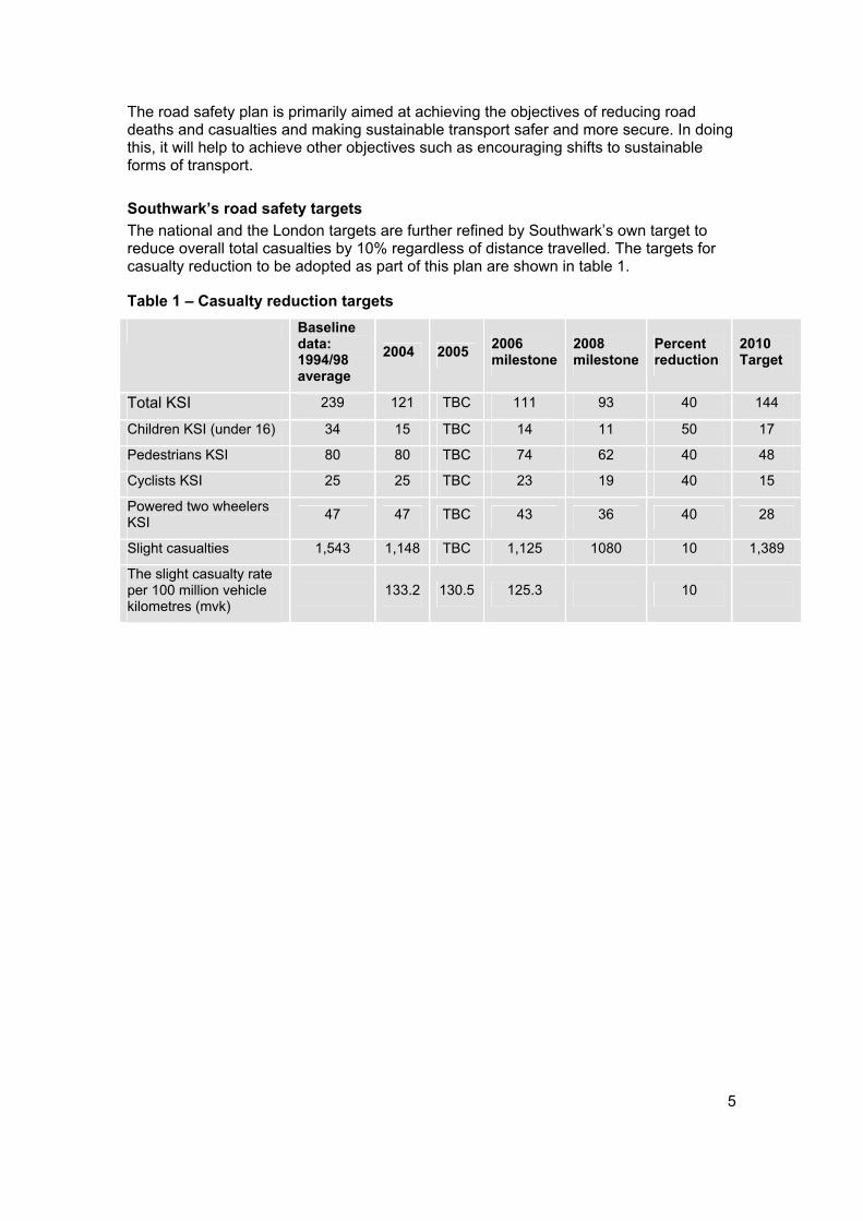
5
The road safety plan is primarily aimed at achieving the objectives of reducing road deaths and casualties and making sustainable transport safer and more secure. In doing this, it will help to achieve other objectives such as encouraging shifts to sustainable forms of transport.
Southwark’s road safety targets The national and the London targets are further refined by Southwark’s own target to reduce overall total casualties by 10% regardless of distance travelled. The targets for casualty reduction to be adopted as part of this plan are shown in table 1.
Table 1 – Casualty reduction targets Baselinedata: 1994/98 average
2004 2005 2006milestone
2008milestone
Percent reduction
2010Target
Total KSI 239 121 TBC 111 93 40 144
Children KSI (under 16) 34 15 TBC 14 11 50 17
Pedestrians KSI 80 80 TBC 74 62 40 48
Cyclists KSI 25 25 TBC 23 19 40 15
Powered two wheelers KSI 47 47 TBC 43 36 40 28
Slight casualties 1,543 1,148 TBC 1,125 1080 10 1,389
The slight casualty rate per 100 million vehicle kilometres (mvk)
133.2 130.5 125.3 10
6
3 Why road casualties happen In order to meet the targets for reductions in road casualties, the first priority for the council is to identify the sources of threat. In many ways these are obvious. High rates of casualties occur due to the quantity of motor traffic, excessive speed and other dangerous behaviour by drivers. In support of the principles of the Road Danger Reduction Charter, Southwark Council will continue to research and analyse in more detail the factors that lead to casualties in order to develop more effective measures to reduce them.
3.1 Vehicular traffic Southwark has seen a steady rise in motor traffic over many years. With more motor traffic comes more danger. Statistics may show that increases in walking and cycling often go together with increases in road casualties but this is because pedestrians and cyclists are the victims of the danger, not the causes of it. It is recognised however, that there is a growing body of evidence to suggests that pedestrians and cyclists gain from safety in numbers.
In any event, the Road Danger Reduction Charter states current levels of motor traffic should not be increased and Southwark supports this vision. Southwark is pursuing strategies to go further and reduce the overall levels of motor traffic. This is in line with the Mayor’s Transport Strategy that seeks a 15% reduction in traffic in central London and zero growth in inner London, while expecting boroughs to play a key role in achieving or exceeding these targets through road traffic reduction initiatives introduced at a local level.
In light of Southwark’s targets for housing under the London Plan (29,530 new homes by 2016), it is also important that the potential for increased traffic is appropriately managed. To this end, Southwark will continue to promote more sustainable development that is close to public transport and encourage the use of more sustainable modes of travel such as walking and cycling. Regeneration work already underway in Elephant and Castle, Canada Water and Bermondsey Spa, have this at the core of their objectives.
3.2 Speed In the UK it is estimated that at least one third of road deaths (around 1,300 per year) are the result of excessive or inappropriate speed. There is a clear link between speed and collision frequency, a 1% increase in average speed results in a 2.5% increase in frequency of collisions.
Research often quoted by the Department for Transport (DfT) and by the Prime Minister in his speech announcing the government’s road safety plan in March 2000 concludes that 85% of pedestrians who are hit at 40 mph will die, compared to 45% at 30 mph and 5% at 20 mph1.
At present, throughout most of Southwark’s roads, the standard urban speed limit of 30 mph is habitually broken by many drivers. The appropriate speed for many roads, especially at times of poor visibility, is something below the legal speed limit. It should be recognised that 30 mph cannot be considered an inherently safe speed when more than four out of ten pedestrians hit by a vehicle travelling at that speed will die.
1 Ashton SJ and MacKay GM (1979), Some characteristics of the population who suffer trauma as pedestrians when hit by cars and some resulting implications, 4th IRCOBI International Conference, Gothenburg
7
Southwark’s road safety plan approaches the issue of speed in a number of ways. Firstly, this is done by ensuring that drivers drive at appropriate speeds within the given speed limit. This is to be achieved through enforcement, education and the redesign of streets to achieve speed reduction. Further, the question of what is the appropriate speed limit needs to be considered and Southwark aims to be the first 20 mph borough in London.
Research carried out for the government by the Transport Research Laboratory (TRL) in 1996 found that 20 mph zones reduced collisions by 60% and collisions involving child pedestrians and child cyclists by 67%. Collisions involving cyclists were reduced by 29%. These reductions were only achieved where traffic calming measures were also taken. In such areas there was an average reduction in vehicle speed of nearly 10 mph, to less than 20 mph2.
According to a further report published by the Health Development Agency in October 2003, the introduction of a 20 mph speed limit in residential areas and the provision of traffic calming measures to enforce it could save 13,000 children a year from death or injury3.
Currently about 40% of Southwark’s roads are in 20 mph zones or traffic management areas (see figure 1). Our aim is for the default speed limit across the whole of Southwark to be 20 mph. The only exception to this will be the Transport for London Road Network (TLRN), which is managed by TfL and which the council cannot directly make changes to. However, the council will lobby TfL to implement 20 mph restrictions wherever it can and to incorporate the principles of speed reduction wherever possible on its network.
The council also notes that further justification for the implementation of 20 mph restrictions may be required on road that make up the recently established Strategic Road Network due to the influence of TfL on those roads. However, a 20 mph limit will remain the council’s default position.
As only 40% of Southwark is currently covered by 20 mph restrictions, there is high demand for new 20 mph zones to be rolled out across the borough. The following criteria will be used to determine the priority areas and the programme of 20 mph zones will be progressed on this basis, as funding becomes available:
The ability to treat a particular street or area as part of wider regeneration activity such as at Canada Water and Elephant and Castle;
The priority of a particular area in accordance with the Southwark neighbourhood renewal strategy;
The social deprivation level of the area based on the national index of multiple deprivation for wards;
Streets and areas that can be converted with minimal effort and expense due to their physical arrangement and existing speed reduction features;
The ability to incorporate restrictions as part of other planned local safety schemes or proposed highway schemes, particularly where these would benefit from coordinated implementation, that is to limit cost and disturbance to residents;
2 D C Webster and A M Mackie, TRL Report 215 Review of traffic calming schemes in 20 mph zones, Transport Research Laboratory, 1996 3 Prevention and reduction of accidental injury in children and older people Evidence briefing June 2003 Louise M. Millward, Antony Morgan and Michael P. Kelly Health Development Agency
8
Areas where there are high levels of casualties, particularly killed and seriously injured (KSI) casualties in vulnerable road user categories including pedestrians, pedal cyclists, power two wheelers and children);
The proximity of certain built and natural features such as schools, parks/playgrounds, childcare centres, hospitals, aged care centres.
In addition to the above criteria, where it is evident that vehicle speeds are particularly high, the council will notify the police and the south east saving lives forum that these locations are priorities for mobile safety camera enforcement as an interim measure to the implementation of the 20 mph zone.
There will be a preference for the use of emerging speed reduction technology such as cameras. However, it is recognised that in the shorter term, physical measures such as horizontal deflectors like chicanes and vertical deflectors like humps and cushions will be required. These will be implemented to ensure that the 20 mph limit is as self enforcing as possible, whilst recognising the needs of various road users, such as cyclists and bus passengers.
The council is currently undertaking a traffic calming study which will collect information from Southwark, TfL, DfT and other boroughs. The study will focus on measures to reduce speed that are currently used in the UK such as speed cushions, raised tables and speed humps. Once the study has been finished the information will be used to help implement effective traffic calming measures at appropriate locations in the borough. The study is anticipated to be finished May 2006.
The council will also continue to review existing and newly implemented 20 mph zones and the measures used within them, to ensure that they are effective and that they appropriately balance the needs of all road users, including cyclists, bus passengers, mobility impaired people and powered two wheelers. Southwark will continue to lobby and work in partnership with the police and TfL to ensure the enforcement of the speed limit on all roads, particularly those where a self enforcing 20 mph limit is not able to be implemented.

9
Figure 1 – 20 mph zones
10
3.3 Irresponsible behaviour Motor vehicles are not only a source of danger when they are being driven too fast.They are also a danger when they are driven carelessly, without consideration for other road users and especially when they are being driven by people under the influence of drink or drugs.
Other road users may, of course, increase the level of danger to themselves by not taking care when using bicycles or crossing the road.
As made clear above road users and mainly motor vehicle drivers determine road safety by their behaviour. Some basic issues about driver behaviour are generally understood, such as drinking and driving, although that message has to be constantly repeated and still does not get through to everyone. The need to keep vehicle speed down is not so widely understood and supported. Indeed, enforcing speed controls is sometimes portrayed as persecution of motorists and simply an excuse to raise revenue through fines.
The council will work to raise awareness of road safety issues among the population as a whole and among particular targeted vulnerable groups. In addition, as indicated in section 3.2, the council will work in partnership with the police to enforce the Highway Code.
As well as raising awareness of road safety issues, the council can work with other agencies and individuals to provide training in the skills that are needed to use the road safely. This is particularly important for children and training in general road sense and cycling is becoming more rigorous.
London safety camera partnership The London safety camera partnership (LSCP) is responsible for implementing a comprehensive safety camera programme to reduce speed and red light running road casualties in London (see section 10). Southwark Council supports the partnership through the ALG and its work:
To target collision hotspots and areas of community concern around London;
To improve driver behaviour using sustained education and enforcement;
To increase the support of Londoners for safety camera deployment.
The LSCP is currently restricted by legislation controlling where and when cameras can be implemented. The council will lobby the DfT and other partners to relax these restrictions to allow broader use of safety cameras, where there is a demonstrable need to reduce traffic offences and bad driver behaviour. In addition, the council will produce proposals for the use of new powers under the Traffic Management Act 2004 to enforce illegal manoeuvres such as no right turns and no entries. This will be coordinated with any proposed traffic calming or 20 mph zone implementation.
Despite the perception portrayed in the media there is general support for the use of safety cameras as a way of preventing road casualties and as a deterrent to speeding. Surveys undertaken by the LSCP in December 2004 indicate that 87% of respondents say that the use of safety cameras should be supported as a method of reducing casualties. This was confirmed in the consultation on this road safety plan, where the vast majority of respondents agreed with the use of safety cameras.
11
4 Creating safer environments
4.1 Home zones People sometimes refer to particular sections of the road as being dangerous. This is generally a misconception because it is almost invariably the way that people use the road that results in the danger. However it is possible to design streets so that they are more likely to be used safely. In many cases making it clear that the pedestrian and the cyclist have priority over motor traffic will make areas safer. This is the general concept behind home zones. This is not a concept that is solely restricted to residential areas and the council recognises that there are situations, such as local shopping areas, where the principles of home zones can be implemented. This is an approach that is being taken forward as part of the Walworth Project.
Southwark Council strongly supports the concept of home zones and is seeking to introduce these kinds of initiatives throughout the borough. This will primarily be dependant on support from partners such as the DfT and TfL and the council will lobby these agencies to commence a roll out of home zones, following a successful programme of pilot projects. The council will continue to bid for funding that may be made available mainly through the DfT and at this stage, will incorporate the principles of home zone design into its regeneration programmes wherever possible. The council will also promote the use of home zone design concepts in all new developments wherever appropriate and may use planning obligations to achieve this.
In certain circumstances it is necessary to provide for appropriate segregation between road users, such as on major distributors where the volume and type of motor vehicles requires it to be separated from more vulnerable users like pedestrians. That is not to say that motor vehicles, bicycles and pedestrians must all be strictly segregated. On the contrary, it is the impression given to drivers that the road is reserved for them and that bicycles and pedestrians have to be kept out of their way that makes many roads more dangerous. There has to be appropriate separation of space. In many cases, such as in home zones, separation is not appropriate. Drivers must be aware that they are sharing the space with vulnerable road users and must adjust their behaviour accordingly, mainly by driving cautiously.
The principles of home zones and their development help to foster community spirit, creating local interest and ownership of local streets. This encourages people to walk and cycle through the area, creating positive surveillance and reducing fear of crime. These outcomes strongly support the Mayor’s safer travel at night initiatives.
Emerging design guidance from the DfT and the Institution of Highways and Transportation (IHT) will be utilised and home zones principles will also be included in the council’s own streetscape design guide. In the longer term, subject to increased funding, a more detailed strategy for the implementation of home zones throughout the borough, will also have to be prepared.
The streetscape design guide The council is developing the streetscape design guide to enable those responsible for the public realm to create high quality streetscapes through the application of specific design principles and the use of preferred materials and products. It will be a key element in achieving our aim of having visually attractive, safe, and cared for streets that work well for all users and have a proper balance of functions.
12
The council intends to implement an innovative design strategy across the borough that sets out our priorities and provides coherent management that integrates and coordinates all the various functions involved in the street scene.
The adopted six indicators of quality for Southwark’s streets are:
Comfort and safety for pedestrians and the disabled;
Designed to accommodate all sorts of functions, not dominated by any one function;
Visually simple and free of clutter;
Well cared for and where utilities or extraneous’ advertising are subordinate to all other street functions;
Sympathetic to local character and activity context, in design and detail;
Ordered to provide appropriate access and deliveries and storage of vehicles.
The government encourages the adoption of a road user hierarchy which is a formal order in which local authorities consider the needs of different user types. This would typically favour, in descending order:
Pedestrians including the needs of disabled people;
Cyclists;
Public transport;
Motorcyclists;
Taxis;
Freight;
The private car.
This would not necessarily be an order of precedence for actual provision but simply an order of consideration that ensures decisions are consistent with encouraging changes in attitudes and culture and delivering planning and transport objectives4. Southwark Council operates this approach.
4.2 How we make local areas safer Southwark Council has an area wide approach to improving road safety in the borough. Measures to do this include traffic management, enforcement, education, public transport, town planning and other processes, as well as road safety. Deaths, injuries and damage in collisions on urban roads, and people’s apprehensions about traffic risk in towns and cities can all be reduced by applying the following ten principles5:
1. Consider all kinds of road user especially the most vulnerable;
2. Consider the functions and use of different kinds of road;
3. Formulate a safety strategy for each urban area as a whole;
4. Integrate existing collision reduction efforts into the safety strategy;
5. Relate safety objectives to other objectives for the urban area;
4 Department of Environment Transport and the Regions Guidance on Full Local Transport Plans March 2000 5 Urban safety management guidelines from Institution of Highways and Transportation (IHT)
13
6. Encourage all professional groups to help to achieve safety objectives;
7. Guard against adverse effects of other programmes upon safety;
8. Use the scarce expertise of road safety specialists effectively;
9. Translate strategy and objectives into local area safety schemes;
10. Monitor progress towards safety objectives.
On many roads, especially those that carry heavy traffic, pedestrians need to be clear about where they have priority so that they can feel safe using the street. Cyclists should be able to share space on the road with motorised traffic and there should be continuous efforts to ensure that the behaviour of drivers and cyclists is appropriate to allow this to happen safely. However many cyclists will benefit from being allocated space on the road. This could be a cycle lane along a significant length of road or just an advanced stop line (ASL) at a junction that allows cyclists to be positioned at a safe point while waiting for traffic lights to change.
On many streets there may be avoidable hazards that could be removed. This should help all road users to take appropriate precautions to ensure that they can see and be seen. This means providing suitable lighting and it also means taking care over the positioning of vehicle access points.
4.3 How we identify local safety schemes A local safety scheme is a location specific scheme that introduces physical measure to address an identified casualty trend. A scheme may involve works to remove identified hazards including single site treatment and the treatment of multiple sites along a corridor.
It has been common practice to identify locations where collisions have occurred and seek to analyse whether there are aspects of the road layout that could be improved. However, as collisions are mainly the result of driver behaviour, the occurrence of collisions in the past is not the only and best indicator of where collisions may occur in the future. Other factors need to be taken into account when planning area improvements such as the level of social deprivation, the presence of schools and shops and prevailing speed of traffic. Southwark Council has devised a more sophisticated methodology to prioritise environmental safety works taking these factors into account.
Methodology for selection of safety schemes Until 2003, local safety schemes and 20 mph zones in Southwark were generally prioritised based on the total number of casualties in a specific location. This methodology has now been revised and potential safety engineering schemes are assessed using a scorecard that takes the following factors into consideration:
1. The number of KSI casualties in vulnerable road user categories including pedestrians, pedal cyclists, power two wheelers and children. Road user categories that are not achieving the corresponding TfL targets at the required rate are given greater weighting;
2. The ability to treat the problem based on an analysis of the major contributing factors relating to the casualties;
3. The cost effectiveness, often referred to as first year rate of return (FYRR) of potential schemes. This is determined by considering possible treatments, cost of implementation and likely casualty reductions;
4. The social deprivation level of the area based on the national index of multiple deprivation for wards;
14
5. The proximity to other existing safety schemes or proposed schemes that will be undertaken within the next 12 months;
6. Facilities and features close to the location concerned. For example schools, parks/playgrounds, child care centres, hospitals, aged care centres;
7. The vehicle, pedestrian and traffic flows in the proposed locations, where such data is available.
As the information in point 7 is not yet widely available it will be used where it can and it is envisaged that these additional factors will form part of the prioritisation scorecard when a sufficient database of traffic volumes has been compiled. This will be an ongoing task over the next few years.
This scorecard methodology is applied by a panel of the council’s road safety engineers and confirmed with the Metropolitan Police. It is possible to rank the schemes through this process.
As well as designing streets so that they do not cause unnecessary hazards, streets should be kept in a good state of repair. For example, the object of creating a cycle lane, where cyclists can travel without being impeded by motor traffic, will be defeated if it is not clearly marked out or if its surface is so badly damaged that it becomes an obstacle course.
Further detail on how the council proposes to take forward a programme of cycling improvements will be included in its cycling plan.

15
Figure 2 – Local safety schemes
16
5 Improving our children’s safety The safety of children on the road requires special attention as they have particular needs. Encouraging more children to walk or cycle is important for their personal and social development, but these activities are declining as the practice of taking children everywhere by car continues to increase. This is often as a response to perceived road dangers.
Research from Scotland has shown that children from the most socially excluded areas of Lothian were as much as six times more likely to be injured in a road traffic incident than those from the most affluent areas7. Many areas of Southwark have high rates of deprivation and will have associated increased risks.
It was the research in Lothian that led to the DfT pilot Kerbcraft. Kerbcraft is a national pilot of child pedestrian training schemes that was launched in 2002 to determine if training five and six year olds to cross the road will reduce future casualties. Southwark was granted funding for three years to take part in the pilot and a full time Kerbcraft officer within the transport team is taking forward the project in ten schools. Action plans for child safety in these schools are currently being implemented.
Given the success of the Kerbcraft programme, the council will investigate extending it to older age groups and providing it as part of the school transition programmes for years six and seven.
Southwark will establish a system of child road safety audits to measure the safety of children in the road environment and to help prepare actions plans that include education and promotion as well as physical works. Reviews of road safety around all schools is required by 2008 as part of the council’s Lip and Southwark aims to meet this target. Furthermore, as indicated in section 2.3, schools will be part of the criteria for the prioritisation of 20 mph zones.
These reviews will be undertaken in conjunction with the development of school travel plans (STPs). The development of an STP is a national requirement for all schools with children up to the age of 16 years. The DfT and Department for Educational Services (DfES) have provided funding for an STP advisor to assist schools in the preparation of their own travel plans. The council is required to prepare a school travel plan strategy (STPS) as part of it’s Lip and this will guide the council in achieving the government’s target of an STP for every school by the end of 2008/2009.
Southwark will also seek to develop its expertise in road safety and better links with schools by appointing a road safety officer to work with other education and training staff as outlined above, as part of a road safety and sustainable travel team. This team will be primarily responsible for taking forward the actions set out in this plan and the STPS, where the following are key factors:
1. Reported child road collision casualties and hospital records of child casualties;
2. How children get to school and other facilities;
3. The proportion of children having access to pedestrian and cycle training conforming to national standards;
4. Proportion of residential areas that are home zones or 20 mph zones;
5. Availability of safe routes to schools;
6 “The Socio-Economic Influences on the Risk of Child Involvement in Road Traffic Accidents” Dr David White and Robert Raeside
17
6. Availability of safe crossing, cycling and related facilities to and at places, other than schools, which children would visit i.e. shops, leisure facilities and parks;
7. Compliance with speed limits;
8. Consultation with children to discover where they feel at risk, what services they would like and their experience of existing services;
9. The particular needs of socially deprived areas.
Road safety training in schools needs to be given a very high priority. The council will seek to develop a wide range of coordinated programmes together with the schools, parents, the wider community and other agencies. These programmes are needed to halt and reverse the decline in the numbers of children walking and cycling to school. STPs will be the primary impetus for this and will set out various initiatives to encourage walking and cycling, such as walking buses7, appropriate training, cycle storage facilities and other measures. These measures will also need to be coordinated with measures to combat the perceived dangers associated with children travelling independently to school such as bullying, which are set out in various other council strategies.
7 A walking bus is a safe and healthy way for children to walk to school in a group with an adult ‘driver’, along a set route, picking up ‘passengers’ at specific ‘stops’ along the way.
18
6 Monitoring our progress The targets set down by the government in 2000 form the basis of a best value performance indicator (BVPI). Southwark Council is required to report regularly on its performance against these BVPIs and information is posted on the council’s web site. Information on BV 99 concerning road safety is reported quarterly.
In support of the Road Danger Reduction Charter, Southwark Council is committed to finding new measures to define the level of danger on our roads. This is needed because simply reducing the number of casualties could theoretically be achieved by keeping vulnerable road users such as pedestrians, cyclists, powered two wheeler riders and children off the streets. This is not the result that Southwark wants to achieve.
On the contrary, the council strongly believes that the pursuit of road safety objectives should complement and not contradict its wider objectives to increase walking and cycling in accordance with the safety in numbers principle. The council will therefore devise monitoring processes that show progress towards reducing the volume of motor traffic and the overall speed of vehicles and improving the standard of driving and report on these annually. An annual report will also show progress towards meeting the goals set out in this plan such as progress on the introduction of 20 mph zones.
19
7 Coordination with other strategies
Neighbourhood renewal strategy Making a difference together, the Southwark neighbourhood renewal strategy was published in October 2002 and sets out the main actions to be taken across Southwark to address poverty and social exclusion within the most deprived neighbourhoods in the borough. One of the seven main themes of this strategy is environment, housing and community safety. The actions set out in this road safety plan will be coordinated with other actions to address poverty and reduce social exclusion in the priority neighbourhoods.
Unitary development plan The Southwark plan, the revised deposit unitary development plan was published in March 2004. This plan which is going through several phases of extensive public consultation is expected to be adopted late in 2006. In line with government advice, the plan aims to be a spatial development plan and provide a translation of the aims of the community strategy into actions in the physical environment. It aims to encourage Southwark’s objective to be a compact city area with efficient use of land, so that the need to travel by private car is reduced and cycling and walking are much more viable. The plan also supports the neighbourhood renewal strategy in addressing poverty and social exclusion. It contains sections on promoting prosperity, improving life chances and making Southwark cleaner and greener.
The Southwark plan should have a profound impact on the design quality of new developments and this should include their performance with regard to achieving better standards of road safety. Where road safety issues arise in the consideration of applications for planning permission the plan provides for the impacts of developments to be taken into account and any adverse effects to be mitigated through planning obligations.
The Southwark plan supports the school organisational education plan in providing for improvements to schools and, where necessary, new schools. New schools and other community facilities need to be carefully located according to a range of criteria including issues of road safety.
Local implementation plan (Lip) The Lip will be a statutory plan that sets out how the borough proposes to implement the Mayor’s Transport Strategy, which was published in 2001. The development of the Lip also provides Southwark with an opportunity to develop a coordinated range of local transport initiatives. The Lip will be completed by the end of the summer of 2005.
The Lip will identify transport issues, such as road safety and sustainable travel and demonstrate how they will be addressed. The plan will contain various programmes, projects, implementation mechanisms, resource requirements and coordination activities.
The Lip will be an overarching transport strategy for the borough and will be supplemented by a series of more detailed documents including this road safety plan, the school travel plan strategy, a parking and enforcement plan and the emerging walking plan and cycling plan.
As part of the development of the Lip an assessment of the plan against the council’s equality scheme was undertaken. This equalities impact assessment (EqIA) helps to identify areas for improvement and ensure that, if appropriate, measures are taken to revise, promote and support the council’s corporate policies on equalities.
20
This road safety plan, as a supplementary document to the Lip was incorporated into this assessment, which was tabled at the equality and diversity panel in February 2006.
The delivery and development of the Lip and its EqIA will be monitored at various stages to ensure that:
The plan contributes positively to the corporate equalities agenda;
The requirements of the plan, as they relate to ensuring access to all and promoting equal opportunities are being adequately met by any initiatives, proposals and/or programmes.
Annual monitoring of this information will be contained within the annual monitoring report and will relate to the lifecycle or timescale of transport plans, policies or programmes. In addition to this quarterly monitoring will be carried out in accordance with the council’s EqIA guidance.
Southwark crime and drugs strategy (2005) The crime and drugs strategy 2005 to 2008 follows on from the 2001 crime and disorder strategy as a key means of directing and coordinating the statutory agencies response to reduce crime levels and improve people’s perception of public safety.
The strategy supports the key themes from the previous strategy being preventing and reducing youth crime, tackling and reducing anti social behaviour, challenging and reducing hate crime, preventing and reducing the harm caused by drug and substance abuse and serious and violent crime. This strategy also introduces three additional work areas being tackling violent crime, improving support for victims and witnesses and alcohol related crime.
In 2005 the SSP established a regular multi agency meeting, which includes the police, council with representatives from the community safety, and transport leads and the TfL community safety manager to look at borough level issues. At a sub regional level the director of Environment and Leisure and the director of Regeneration represent Southwark on a range of issues including transport. Both directors are members of the SSP.
To date there has not been a formal consultation between the borough and the GLA, however Southwark is eager to improve links with TfL and the GLA to provide a more coordinated approach to improving safety within the borough.
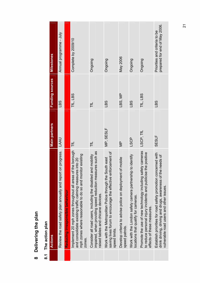
8 D
eliv
erin
g th
e pl
an
8.1
The
actio
n pl
an
Act
ions
Mai
n pa
rtne
rsFu
ndin
g so
urce
sM
ilest
ones
Rev
iew
the
road
saf
ety
plan
ann
ually
and
repo
rt on
pro
gres
s.
LAA
ULB
SA
nnua
l pro
gram
me
- Jul
y
Red
ucin
g irr
espo
nsib
le b
ehav
iour
Impl
emen
t 20
mph
zon
es th
roug
hout
all
area
s of
the
boro
ugh
and
cons
olid
ate
exis
ting
traffi
c ca
lmin
g m
easu
res
into
20
mph
zon
es w
here
reas
onab
le to
do
so a
nd m
onito
r exi
stin
g zo
nes.
TfL
TfL,
LB
S
Com
plet
e by
200
9/10
Con
side
r all
road
use
rs, i
nclu
ding
the
disa
bled
and
mob
ility
im
paire
d, w
hen
prov
idin
g sp
eed
redu
ctio
n m
easu
res
such
as
rais
ed ta
bles
and
chi
cane
dev
ices
.
TfL
TfL
Ong
oing
Wor
k w
ith th
e M
etro
polit
an P
olic
e th
roug
h th
e S
outh
eas
t sa
ving
live
s fo
rum
to e
ncou
rage
the
effe
ctiv
e en
forc
emen
t of
spee
d lim
its.
MP
, SE
SLF
LB
SO
ngoi
ng
Dev
elop
crit
eria
to a
dvis
e po
lice
on d
eplo
ymen
t of m
obile
sp
eed
patro
ls.
MP
LBS
, MP
M
ay 2
006
Wor
k w
ith th
e Lo
ndon
saf
ety
cam
era
partn
ersh
ip to
iden
tify
loca
tions
that
qua
lify
for c
amer
as.
LSC
PLB
SO
ngoi
ng
Pro
mot
e th
e us
e of
new
tech
nolo
gy in
clud
ing
safe
ty c
amer
as
to re
duce
per
sona
l inj
ury
inci
dent
s an
d pu
blic
ise
the
posi
tive
effe
cts
of th
ese
mea
sure
s.
LSC
P, T
fL
TfL,
LB
S
Ong
oing
Est
ablis
h pr
iorit
ies
for r
oad
safe
ty p
rom
otio
n co
ncer
ned
with
dr
ink
driv
ing,
driv
ing
and
drug
s, a
war
enes
s of
the
need
s of
vu
lner
able
road
use
rs a
nd o
ther
issu
es.
SE
SLF
LBS
Prio
ritie
s an
d cr
iteria
to b
e pr
epar
ed fo
r end
of M
ay 2
006.
21
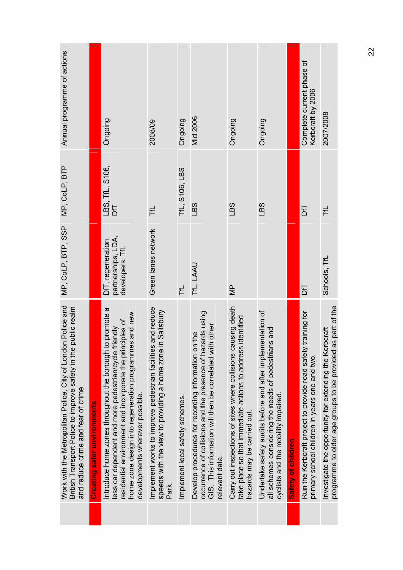
Wor
k w
ith th
e M
etro
polit
an P
olic
e, C
ity o
f Lon
don
Pol
ice
and
Brit
ish
Tran
spor
t Pol
ice
to im
prov
e sa
fety
in th
e pu
blic
real
m
and
redu
ce c
rime
and
fear
of c
rime.
MP
, CoL
P, B
TP, S
SP
M
P, C
oLP
, BTP
A
nnua
l pro
gram
me
of a
ctio
ns
Cre
atin
g sa
fer e
nviro
nmen
ts
Intro
duce
hom
e zo
nes
thro
ugho
ut th
e bo
roug
h to
pro
mot
e a
less
car
dep
ende
nt a
nd m
ore
pede
stria
n/cy
cle
frien
dly
resi
dent
ial e
nviro
nmen
t and
inco
rpor
ate
the
prin
cipl
es o
f ho
me
zone
des
ign
into
rege
nera
tion
prog
ram
mes
and
new
de
velo
pmen
ts w
here
ver p
ossi
ble.
DfT
, reg
ener
atio
n pa
rtner
ship
s, L
DA
, de
velo
pers
, TfL
LBS
, TfL
, S10
6,
DfT
Ong
oing
Impl
emen
t wor
ks to
impr
ove
pede
stria
n fa
cilit
ies
and
redu
ce
spee
ds w
ith th
e vi
ew to
pro
vidi
ng a
hom
e zo
ne in
Sal
isbu
ry
Par
k.
Gre
en la
nes
netw
ork
TfL
2008
/09
Impl
emen
t loc
al s
afet
y sc
hem
es.
TfL
TfL,
S10
6, L
BS
O
ngoi
ng
Dev
elop
pro
cedu
res
for r
ecor
ding
info
rmat
ion
on th
e oc
curr
ence
of c
ollis
ions
and
the
pres
ence
of h
azar
ds u
sing
G
IS.
This
info
rmat
ion
will
then
be
corr
elat
ed w
ith o
ther
re
leva
nt d
ata.
TfL,
LA
AU
LB
SM
id 2
006
Car
ry o
ut in
spec
tions
of s
ites
whe
re c
ollis
ions
cau
sing
dea
th
take
pla
ce s
o th
at im
med
iate
act
ions
to a
ddre
ss id
entifi
edha
zard
s m
ay b
e ca
rrie
d ou
t.
MP
LBS
Ong
oing
Und
erta
ke s
afet
y au
dits
bef
ore
and
afte
r im
plem
enta
tion
of
all s
chem
es c
onsi
derin
g th
e ne
eds
of p
edes
trian
s an
d cy
clis
ts a
nd th
e m
obili
ty im
paire
d.
LBS
Ong
oing
Safe
ty o
f chi
ldre
n
Run
the
Ker
bcra
ft pr
ojec
t to
prov
ide
road
saf
ety
train
ing
for
prim
ary
scho
ol c
hild
ren
in y
ears
one
and
two.
D
fTD
fTC
ompl
ete
curr
ent p
hase
of
Ker
bcra
ft by
200
6
Inve
stig
ate
the
oppo
rtuni
ty fo
r ext
endi
ng th
e K
erbc
raft
prog
ram
me
to o
lder
age
gro
ups
to b
e pr
ovid
ed a
s pa
rt of
the
Sch
ools
, TfL
Tf
L20
07/2
008
22
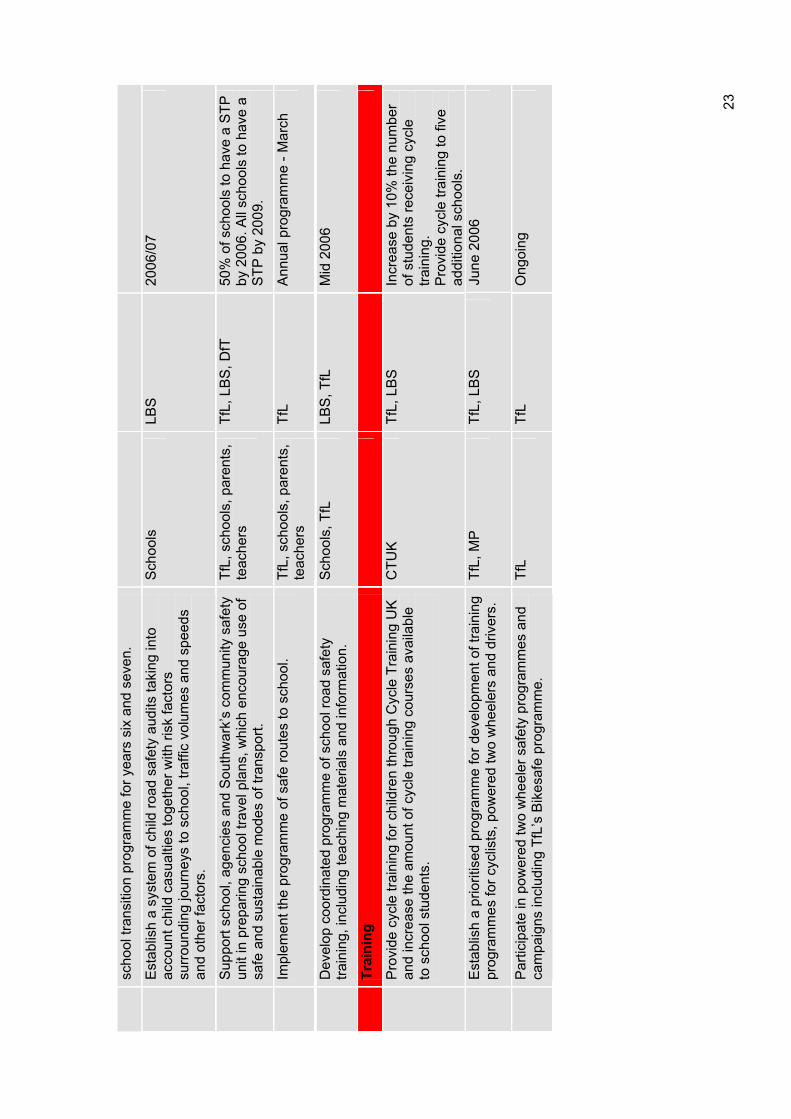
scho
ol tr
ansi
tion
prog
ram
me
for y
ears
six
and
sev
en.
Est
ablis
h a
syst
em o
f chi
ld ro
ad s
afet
y au
dits
taki
ng in
to
acco
unt c
hild
cas
ualti
es to
geth
er w
ith ri
sk fa
ctor
s su
rrou
ndin
g jo
urne
ys to
sch
ool,
traffi
c vo
lum
es a
nd s
peed
s an
d ot
her f
acto
rs.
Sch
ools
LBS
2006
/07
Sup
port
scho
ol, a
genc
ies
and
Sou
thw
ark’
s co
mm
unity
saf
ety
unit
in p
repa
ring
scho
ol tr
avel
pla
ns, w
hich
enc
oura
ge u
se o
f sa
fe a
nd s
usta
inab
le m
odes
of t
rans
port.
TfL,
sch
ools
, par
ents
, te
ache
rsTf
L, L
BS
, DfT
50
% o
f sch
ools
to h
ave
a S
TP
by 2
006.
All
scho
ols
to h
ave
a S
TP b
y 20
09.
Impl
emen
t the
pro
gram
me
of s
afe
rout
es to
sch
ool.
TfL,
sch
ools
, par
ents
, te
ache
rsTf
LA
nnua
l pro
gram
me
- Mar
ch
Dev
elop
coo
rdin
ated
pro
gram
me
of s
choo
l roa
d sa
fety
tra
inin
g, in
clud
ing
teac
hing
mat
eria
ls a
nd in
form
atio
n.
Sch
ools
, TfL
LB
S, T
fL
Mid
200
6
Trai
ning
Pro
vide
cyc
le tr
aini
ng fo
r chi
ldre
n th
roug
h C
ycle
Tra
inin
g U
K
and
incr
ease
the
amou
nt o
f cyc
le tr
aini
ng c
ours
es a
vaila
ble
to s
choo
l stu
dent
s.
CTU
KTf
L, L
BS
In
crea
se b
y 10
% th
e nu
mbe
r of
stu
dent
s re
ceiv
ing
cycl
e tra
inin
g.P
rovi
de c
ycle
trai
ning
to fi
ve
addi
tiona
l sch
ools
. E
stab
lish
a pr
iorit
ised
pro
gram
me
for d
evel
opm
ent o
f tra
inin
g pr
ogra
mm
es fo
r cyc
lists
, pow
ered
two
whe
eler
s an
d dr
iver
s.
TfL,
MP
Tf
L, L
BS
Ju
ne 2
006
Par
ticip
ate
in p
ower
ed tw
o w
heel
er s
afet
y pr
ogra
mm
es a
nd
cam
paig
ns in
clud
ing
TfL’
s B
ikes
afe
prog
ram
me.
Tf
LTf
LO
ngoi
ng
23
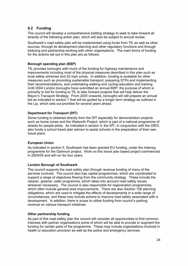
24
8.2 Funding The council will develop a comprehensive bidding strategy to seek to take forward all strands of the following action plan, which will also be subject to annual review.
Southwark’s road safety plan will be implemented using funds from TfL as well as other sources, through its development planning and other regulatory functions and through lobbying and partnership working with other organisations. The main forms of funding for the actions set out in this plan are as follows:
Borough spending plan (BSP) TfL provides boroughs with much of the funding for highway maintenance and improvements including most of the physical measures described in this plan such as local safety schemes and 20 mph zones. In addition, funding is available for other measures such as promoting sustainable transport, preparing STPs and implementing their recommendations, and undertaking walking and cycling education and training. Until 2004 London boroughs have submitted an annual BSP, the purpose of which is primarily to bid for funding to TfL to take forward projects that will help deliver the Mayor’s Transport Strategy. From 2005 onwards, boroughs will still prepare an annual bid as indicated in section 7 that will be guided by a longer term strategy as outlined in the Lip, which sets out priorities for several years ahead.
Department for Transport (DfT) Some funding is obtained directly from the DfT especially for demonstration projects such as home zones and the Walworth Project, which is part of a national programme of streets for people pilots. As indicated in section 4, the DfT, in conjunction with the DfES, also funds a school travel plan advisor to assist schools in the preparation of their own travel plans.
European Union As indicated in section 5, Southwark has been granted EU funding, under the Interreg programme for the Optimum project. Work on this travel plan based project commenced in 2004/05 and will run for four years.
London Borough of Southwark The council supports the road safety plan through revenue funding of many of the services involved. The council also has capital programmes, which are coordinated to support a range of objectives flowing from the community strategy. These include the cleaner, greener, safer programme, which takes into account road safety issues wherever necessary. The council is also responsible for regeneration programmes, which often include general area improvements. There are also Section 106 planning obligations, which are used to mitigate the effects of developments in a wide range of circumstances, and these may include actions to improve road safety associated with a development. In addition, there is scope to utilise funding from council’s parking revenue on various transport initiatives.
Other partnership funding As part of this road safety plan the council will consider all opportunities to find common interests with partner organisations some of which will be able to provide or augment the funding for certain parts of the programme. These may include organisations involved in health or education provision as well as the police and emergency services.
25
9 Consultation Public consultation on a draft of this road safety plan was undertaken during September and October 2004. Consultation was carried out with partner organisations such as TfL, the Metropolitan Police, other boroughs and with local groups and organisations such as Southwark Cyclists, Southwark Pedestrian Rights Group and the Southwark branch of Living Streets.
The draft plan was considered at the inaugural meeting of the Southwark transport consultative forum in September 2004 and was discussed at all of the autumn community council meetings.
A questionnaire on the themes and actions proposed in the draft plan was circulated to key stakeholder groups and was available to the general public at each of the community council meetings, in all official council offices, on the Southwark Council website and upon request. The results of the questionnaire feedback was collated and the results highlighted the following:
There was agreement that children, cyclists and pedestrians are the more vulnerable road users;
There was agreement that drink/drug driving, poor driver skills and speeding were serious factors contributing to road casualties;
The majority of respondents agreed with combating vehicle speeds by using driver education, police enforcement, 20 mph zones and safety cameras;
The majority of respondents agreed with cameras, driver education, police enforcement and tougher penalties as ways of combating poor driver behaviour.
In addition, there were many detailed comments relating to the draft plan. The key issues arising from these comments can be summarised as follows:
The rationale for defining where 20 mph zone restrictions would apply;
The criteria to be used to prioritise the implementation of 20 mph zones;
Further details on the speed reduction measures to be used within zones;
The importance of police enforcement and of road safety education and training;
The potential for use of new powers to use camera technology for moving traffic offences;
Recognition of the benefits to safety of cycling in numbers.
Accordingly, as a result of the consultation this plan has been revised to address these issues and to incorporate, where reasonably possible, many other suggested improvements.
The road safety plan is an integral component of the council’s Lip. The Lip and its supplementary documents, including this road safety plan was consulted on during November and December 2005. The community again supported the key issues above.
26
10 Working with partners
The Metropolitan Police The police have a key role in enforcing speed controls and other traffic management regulations. Enforcement must be an integral part of any road safety programme and can lead to significant road casualty reduction. The police deal with the after effects of collisions and are also responsible for collecting data on collisions resulting in personal injury, essential for use in collision analysis. The borough holds liaison meetings with all of the emergency services. In order to provide a better service to London boroughs and the public, the Metropolitan Police have recently formed the Traffic Operational Command Unit (TOCU). The unit has been specifically tasked to work in partnership with local authorities to tackle traffic crime and help to meet government casualty reduction targets. Their major focus over this year will be:
To play a significant role in reducing road casualties;
To assist in increasing awareness, through education, of the importance of road safety;
To assist in the application of engineering solutions to road problems;
To secure greater compliance with road safety legislation through enforcement.
Transport for London (TfL) The borough relies on TfL to provide funding and technical advice in working towards the 2010 targets. In addition, TfL is responsible for strategic roads, the TLRN, which run through the borough. These roads generate a large proportion of the casualties within Southwark and we look to continue our association with TfL in helping to reduce casualties on the TLRN in line with the national targets. To this end, the borough regularly meets TfL to discuss matters arising on both trunk roads and adjacent borough roads.
All personal injury collisions involving a motor vehicle must be reported to the police, by law, within 24 hours of the incident. This data is collated by the police and passed on to the London Accident Analysis Unit (LAAU), which is now part of TfL. London boroughs are provided with this information, which is essential in planning our strategies and programme of initiatives aimed at reducing casualties.
London safety camera partnership Following changes in legislation in April 2000, the government has recently formed the London safety camera partnership to take a strategic overview on the installation of safety cameras on the TLRN and borough road network in London. Government research into existing camera sites shows that average speeds can be reduced by up to four to five mph and collisions reduced by 28%. Safety cameras also reduce the number of killed and seriously injured casualties. The members of the partnership are:
Metropolitan Police Service;
City of London Police;
Association of London Government;
Greater London Magistrates' Courts Authority;
Transport for London.
27
Safer Southwark partnership The safer Southwark partnership has been operating since the early 1990s and consists of council, police and other local agency representatives. The partnership exists to make Southwark a safe place to live, work and play by reducing crime and anti-social behaviour, tackling substance misuse and increasing public reassurance across all sections of the community. The Crime and Disorder Act 1998 placed specific responsibilities on the council and police to set up crime and disorder partnerships and to work together and with other agencies to tackle crime and disorder issues. Accordingly, in 2003, the crime and disorder partnership and the drug and alcohol action team formally integrated under the banner of the safer Southwark partnership.
The partnership developed a crime and disorder strategy for 2002 to 2005 and has recently developed a new strategy for 2005 to 2008 called the crime and drugs strategy. The new strategy recognises the role that the partnership can play in combating road safety and other transport related issues such as drink and drug driving; poor driver behaviour including speeding and illegal manoeuvres; personal safety particularly at transport nodes and rail interchanges; and other anti social issues such as the theft of blue badges. The new strategy was completed after the consultation on the draft of this road safety plan and accordingly, the two documents are fully coordinated in their approach to delivering road safety improvements in the borough.
Southwark primary care trust Southwark primary care trust (PCT) is the local NHS organisation responsible for all local primary and community care services. In addition, it is responsible for improving the health of local people and tackling health inequalities as well as commissioning hospital services. The road safety plan can assist the PCT in improving the health of the borough by reducing the incidence of personal injury and by making walking and cycling safer and thereby encouraging these healthy forms of exercise.
At the same time, the PCT can work with the council to raise awareness of the health costs of the dangers on our roads and it is already working with Southwark to promote the health benefits of walking and cycling. The PCT is also a partner of the Southwark walking forum, which aims to promote the health benefits of walking, particularly for those recovering from serious medical treatment such as major heart surgery.
SeltransThe South East London transport strategy (Seltrans) was established in 1998 as a partnership between the seven south east London boroughs of Bexley, Bromley, Croydon, Greenwich, Lambeth, Lewisham and Southwark, transport providers and operators, and groups representing the interests of businesses and passengers. The broadest objective of Seltrans is to find ways in which an integrated transport system can help enhance London’s economic prosperity, environment, promote social inclusion and the quality of life of Londoners. Southwark works with Seltrans in particular to improve the environment and, as a result, the road safety at transport interchanges.
Regeneration agencies and other public authorities The council works with a range of regeneration agencies and public authorities to reduce social exclusion and improve the quality of life. These agencies include:
1. London Development Agency;
2. Greater London Authority;
3. Cross River Partnership;
4. Pool of London Partnership.
28
The council will continue to work with these and other agencies to achieve the aims of the plan. In particular, the council recognises the need to take a proactive approach to understanding road safety issues and will lobby and work in partnership with these agencies to undertake detailed research into the causes of casualties, the potential solutions and the views of local communities.
Public involvementThis is an important principle for all actions taken by local authorities but is particularly important for road safety. Public support is needed for virtually all of the measures to promote road safety. People need to feel that they have ownership of schemes such as traffic calming in their neighbourhoods. For example, if they have been involved in the planning of a 20 mph zone they are more likely accept this practice themselves and set an example to others. When measures are proposed to benefit cyclists such as ASLs at junctions, they must be shown to be relevant to the needs of that client group.
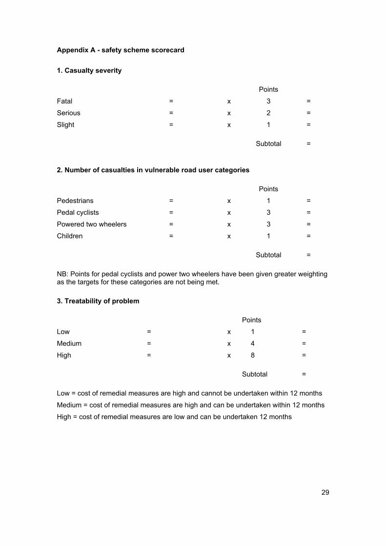
Appendix A - safety scheme scorecard
1. Casualty severity
Points
Fatal = x 3 =
Serious = x 2 =
Slight = x 1 =
Subtotal =
2. Number of casualties in vulnerable road user categories
Points
Pedestrians = x 1 =
Pedal cyclists = x 3 =
Powered two wheelers = x 3 =
Children = x 1 =
Subtotal =
NB: Points for pedal cyclists and power two wheelers have been given greater weighting as the targets for these categories are not being met.
3. Treatability of problem
Points
Low = x 1 =
Medium = x 4 =
High = x 8 =
Subtotal =
Low = cost of remedial measures are high and cannot be undertaken within 12 months
Medium = cost of remedial measures are high and can be undertaken within 12 months
High = cost of remedial measures are low and can be undertaken 12 months
29
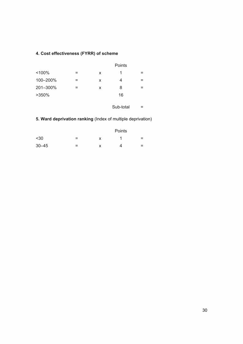
4. Cost effectiveness (FYRR) of scheme
Points
<100% = x 1 =
100–200% = x 4 =
201–300% = x 8 =
>350% 16
Sub-total =
5. Ward deprivation ranking (Index of multiple deprivation)
Points
<30 = x 1 =
30–45 = x 4 =
30

2004Part Two
Appendix B School travel plan strategy
Local Implementation Plan

2004
Draft School Travel Plan Strategy
2005
www.southwark.gov.uk
Regeneration department
This plan is part of a package of documents that makes up Southwark Council’s transport strategy.
Southwark’s transport strategy is also known as te Local implementation Plan and sets out how the council will plan and deliver an integrated package of transport improvements from 2005-10.
The other documents that comprise the strategy include
• Road Safety Plan
• Walking Plan
• Cycle Plan
• School Travel Plan Strategy
• Parking and Enforcement Plan
The Borough Spending Plan is also related to these palns as it sets out bids for funding to implement transport improvements.
Contact Us
Transport groupRegeneration departmentSouthwark CouncilChiltern HousePortland StreetLondonSE17 2ES
www.southwark.gov.uk
Any enquiries relating to this Plan can be directed to the Transport Group on 020 7525 5317 or email: [email protected]
This plan is part of a package of documents that makes up Southwark Council’s transport strategy.
Southwark’s transport strategy is also known as the Local implementation Plan and sets out how the council will plan and deliver an integrated package of transport improvements from 2005-10.
The other documents that comprise the strategy include
• Road Safety Plan
• Walking Plan
• Cycling Plan
• School Travel Plan Strategy
• Parking and Enforcement Plan
The Borough Spending Plan is also related to these plans as it sets out bids for funding to implement transport improvements.
Contact Us
Transport groupRegeneration departmentSouthwark CouncilChiltern HousePortland StreetLondonSE17 2ES
www.southwark.gov.uk
Any enquiries relating to this Plan can be directed to the Transport Group on 020 7525 5317 or email: [email protected]

Contents
Foreword 1
1 Introduction 2
2 Policy context and priorities 3
3 School travel plans 9
4 Improving the journey to school 10
5 Making school travel plans a success in all schools 13
6 Meeting the challenge 21
7 Working with our partners 22
8 Coordination with other strategies 24
ForewordFor years now public authorities such as Southwark have been talking about sustainable development and putting this phrase into all of our plans and policy documents. This may seem an abstract idea and it’s hard to detect when this mysterious thing called ‘sustainability’ is being achieved. One thing I am clear about is that it is not being achieved when I see traffic jams made up of private cars taking children to school. It tells me that something is not working properly and needs to change.
Streets need to be made safer for children to walk or cycle. This is not just about road safety training and reducing road danger. It is also about community cohesion and people being confident that their children are safe from bullying or more serious attack when travelling independently. Public transport needs to be affordable, convenient and safe. Parents/carers also need to have confidence in their local education services. Then they won’t feel the need to take their children across London to a school far away because they think this is the only way to give them a fair start in life.
When all of these things start to improve we should see more children walking, cycling and using public transport to get to school. This will mean that children are healthier and more self confident. In fact, I think this could be one of the most important measures of success for the community that we live in.
This school travel plan strategy explains how Southwark is working with schools to make this happen. Travel plans can be used by all sorts of organisations to give people more options to make sensible choices in how they travel. The government has recognised the importance of school travel plans and has set a national target for all schools to have a travel plan by 2009. When teachers, parents or carers and children work together on a school travel plan they can make major changes to travel patterns and eliminate much of the problem of the school run. They are also making a very important contribution to the benefit of the community as a whole.
Councillor Richard Thomas
Executive member for environment and transport
1

1 Introduction This document sets out Southwark Council’s strategy for delivering an effective, integrated school travel plan programme over the period 2005 to 2009 which will be the primary impetus to provide road safety and education at schools and to coordinate the efforts of schools, parents/carers, the wider community and other agencies.
In response to growing levels of childhood obesity and the problems associated with the school journey and congestion around schools the council have produced this document in accordance with local and national policy and objectives.
A school travel plan sets out what a school has done and what they are going to do to tackle issues with the journey to school while encouraging a reduction in car journeys made to school. A school travel plan is a whole initiative that sets out practical measures to:
Incorporate road safety into the school curriculum;
Improve the physical environment through engineering measures;
Encourage sustainable transport choices on the journey to school;
Make the area around the school safer;
Develop cooperative/sharing travelling schemes;
Improve the level of fitness of our pupils and parents/carers;
Stress the importance of healthy lifestyles;
Instil in our children a commitment to protecting the environment.
Delivering an effective school travel plan programme will help the council achieve the priorities set out in the Southwark community strategy 2003 to 2006 which include tackling poverty, making Southwark cleaner and greener, cutting crime and fear of crime, raising standards in our schools and improving the health of the borough. It will also help the council to deliver against the national and regional school travel plan targets.
This strategy also sets out the how school travel plans can help to reduce the perceived and real dangers associated with children travelling independently so that the dangers won’t be a barrier to increasing the numbers of children cycling and walking to school.
2
2 Policy context and priorities 2.1 National and regional context The Government recognises that growing levels of obesity among young people is partly attributed to lowering levels of physical activity and high child casualty rates can be partially explained by the lack of practical experience young people have when they reach an age of independent travel.
Increasing the proportion of children walking and cycling on the journey to school can help begin to tackle these problems. School travel plans provide a means by which to achieve this as part of a comprehensive package of measures that make these modes safer and more attractive.
Measures to promote sustainable travel and tackle the school run have a number of recognised benefits in cross cutting policy areas such as health, air quality, quality of life and road safety. In reducing unnecessary car use on the journey to school, local traffic conditions, air quality and quality of life are improved. Increases in walking and cycling to school improve young people’s health and fitness, encourage lasting sustainable travel patterns and offer air quality and quality of life benefits.
Road safety improvements and training linked to the school travel plan programme contribute to a reduction in casualties. These linkages are acknowledged in the national strategies to address each including the government’s Future of Transport, the National Air Quality Strategy, the public health White Paper Choosing Health: Making healthier choices easier, and Walking And Cycling: An action plan.
Everyday Sport In September 2005 Sport England launched a national campaign called Everyday Sport with the aim of getting more people active. The programme is designed to get people to incorporate physical activity into daily routine with the target of 30 Everyday Sport minutes a day. Schools can integrate Everyday Sport into a school travel plan by joining the campaign and utilising the resources available to them via the website or 0800 hotline. The National Lottery supports the scheme and funding is available to schools for the provision of posters and promotional packs.
Choosing Health In November 2004 the government published the White Paper, Choosing Health which addresses the importance of tackling the issues associated with the school journey by reducing congestion and improving health. The paper also highlights the need to implement formal cycle training schemes and establish national curriculum standards in addition to funding instructor training and accrediting existing training schemes and centres.
Walking and Cycling: An action plan In June 2004 the Department for Transport (DfT) published Walking and Cycling: An action plan which sets out measures to be taken in promoting walking and cycling as viable means of travel over short distances. Specific actions include creating places that people want to cycle and walk in, providing high quality facilities for safe travel, influencing travel behavior, building skills and capacity and monitoring performance.
Mayor’s Children and Young People’s Strategy In January 2004 the Mayor’s Children and Young People’s Strategy was published. It outlines the support for the government’s commitment to reducing the number of trips to school by car through school travel plan implementation. The Mayor has stated that every school in London should have a school travel plan in place by 2009, one year earlier than the national goal. The Mayor supports the role of the National Healthy School Scheme in promoting the walk to school campaign and will also consider the possibility of the National Healthy School Scheme rewarding pupils who walk or cycle to school on a regular basis.
3
Traveling to School InitiativeThe DfT and DfES have developed a joint initiative in 2003 to promote school travel plans in schools. The programme has been developed to tackle the fact that car use on the school run had doubled in the ten years previous to a national travel survey undertaken in 1997. Studies highlighted the issues of increased congestion and rising levels of childhood obesity as growing trends. The initiative supports the funding of 250 local authority based school travel advisors to help schools develop and implement school travel plans. Small capital grants for items such as helmets, secure cycle parking and safety equipment are also supported.
While the target of having all schools develop a travel plan applies to local authorities, the DfT and DfES have offered an appealing incentive for schools to get involved. Schools that complete a travel plan that meets the national standards are eligible for a capital grant of approximately £5,000 to £10,000 to assist in its implementation. Annual funding is available to the council until 2008 to fund a school travel advisor and the London region also has a regional school travel advisor who provides support and guidance to the various boroughs.
Traveling to School: An action plan
This document sets out the Government’s proposals to improve and increase physically active travel habits by helping children, schools and parents/carers make more sustainable travel choices. It sets out a directional strategy for achieving 50% of schools with a travel plan by 2006, and all schools by 2010. This differs from the London-spacific target of all schools having a travel plan by 2009.
Travelling to School: Good practice
This document was published in conjunction with the action plan to provide practical advice to schools and school travel advisors (STAs) using outstanding examples from schools around the country that have achieved successes in specific schemes or programmes. The action plan and the good practice guide help schools to develop an integrated package in conjunction with the STA that establish an innovative and successful school travel plan.
Mayor’s Air Quality Strategy Consultation preceding the publication of the Mayor’s Air Quality Strategy in 2002 revealed that 71% of Londoners consider traffic exhaust fumes a serious problem, making walking unappealing. Reducing the amount of pollution will make the environment more attractive and healthy to walk and live in.
The strategy states that the majority of nitrogen dioxide at a local level is created through road transport. Because during peak times as many as one in five cars on the road is on the school run, reducing car use for the home school journey can help to improve local air quality.
Mayor’s Transport Strategy The Mayor’s Transport Strategy was published in July 2001 and sets out the policy framework for transport provision in London. It provides the context for the detailed plans and proposals of TfL and other implementation agencies over a ten year period.
The strategy seeks to increase the capacity, quality and integration of the transport system and endorses a coordinated approach to ‘improvements to transport integration and facilitating greater use of public transport, walking and cycling’.
National Healthy Schools Standard In 1999 the Department for Education and Skills (DfES) and the Department of Health (DoH) published the National Healthy School Standard (NHSS). This is a programme developed between two departments that schools must work towards with support and guidance from local healthy school coordinators. Specific criteria must be met to achieve the standard, some of which can be fulfilled by the development and implementation of a school travel plan.
One NHSS element is that schools must encourage staff and pupils to consider cycling and walking to and from school and provide training in safety and security supported by safer travel policies.
4
A New Deal for Transport: Better for everyone In 1998 the government published A New Deal for Transport: Better for everyone in response to increasing levels of congestion in the UK. The White Paper seeks to increase travel choice, encouraging a modal shift from private car to more sustainable forms of transport. The school journey is identified as a particular problem, highlighting the issue that up to 18% of cars on the road during peak periods were taking part in the school run.
2.2 National and regional targets The Government’s national target is for all schools to have a travel plan by 2010, the Mayor of London’s aim is by 2009. Policy and programmes developed over the past ten years set objectives and policies to tackle the issues associated with school travel.
This school travel plan strategy responds to these targets and has been prepared for approval by Transport for London (TfL) in conjunction with Southwark’s Local implementation plan (Lip). TfL provides funding for local authorities to implement borough transport improvements as part of a Londonwide programme. The Lip sets out local priorities for spending this funding. This strategy is one of a number that support the Lip including the road safety plan, walking plan, cycling plan and parking and enforcement plan. As many of the objectives of these strategies are complementary, each has been developed to coordinate with and complement the others.
2.3 Local context Southwark is a vibrant, central inner London borough with a young population and a rich diversity of communities. It has a wide range of diverse economic and social communities and there are severe inequalities between the most and least deprived parts of the borough and between various local communities such as Dulwich, Bankside, and Peckham and Camberwell.
This diversity is reflected by the different needs of the schools in these communities. At the extremes there are more independent schools in the affluent areas drawing children from wide catchments and attracting high levels of travel to school by car. Their travel plans need to focus on ways to reduce car use. Schools in the more deprived communities generally attract children from the surrounding streets and estates and therefore have local catchments and high levels of walking to school. Travel plans in these schools tend to focus on the issues relevant to them of personal safety, unaccompanied travel and road safety.
Southwark’s approach to school travel plans is to encourage schools to include initiatives in their plans that address the issues most pertinent to their school’s needs. As such, many of Southwark’s school travel plans address personal safety, intimidation and bullying and unaccompanied travel.
The councils’ school travel plan programme encourages schools to consider the whole journey to school and all associated issues and develop initiatives to improve their pupils’ journeys.
HealthAn increasing health issue is the prevalence of obesity with half the British population being overweight and 20% are obese. In Southwark a conservative estimate for the future prevalence of obesity among children under 15 years old is that the proportion will triple from 12% in 2001 to over 36% in 2010. Southwark Council aims to increase levels of physical activity by increasing the number of children walking and cycling to school, thereby improving their health and fitness. In reducing car use for the school journey, congestion and air pollution will be reduced around schools which will further safeguard their health.
Child safety In addition to health and fitness, the borough is also committed to improving the safety of its young people. Research from Scotland has shown that children from the most socially excluded areas of Lothian were as much as six times more likely to be injured in a road traffic incident than those from the most affluent areas. Many areas of Southwark have high rates of deprivation and will have associated increased risks. As such, improving road safety and reducing casualty rates, especially for sustainable modes, is a priority for the council.
5
The council is also aware that a number of schools, pupils and parents/carers are concerned about personal safety, crime and intimidation pupils may experience on the journey to school. In response to these issues the council has prepared a public service agreement that includes two targets dedicated to improving safety and the perception of safety on the journey to school.
Many schools are concerned about the young age at which some of their children are being allowed to travel unaccompanied to school. These targets are relevant to the school journey as it is important for young people gaining independence and travelling alone or in peer groups to feel safe and confident in their journeys.
The issues outlined above suggest that the context for school travel plan delivery in Southwark reflects the national priorities but also includes a number of local issues that need to be taken into account.
Southwark’s community strategy Southwark’s community strategy 2003 to 2006 was developed in consultation with the local community and partners sets out the vision of making Southwark a better place to live, learn, work and have fun. To deliver this vision, the council has identified five priorities which include: tackling poverty; making Southwark cleaner and greener; cutting crime and fear of crime; raising standards in schools; improving the health of the borough.
The current community strategy 2003 to 2006 is currently being revised and the council has prepared a strategy to take us to 2016. This draft strategy will set the direction for the council for the next ten years and is currently undergoing consultation. The draft strategy seeks to build upon the 2003 community strategy and contains the following ambitions:
Improving individual life chances;
Making the borough a place for people;
Ensuring quality public services.
Transport has an important role to play in making Southwark cleaner and greener and in improving the health of the borough.
Southwark’s air quality strategy and improvement plan The council produced an air quality strategy and improvement plan (AQIP) in 2002, which contains a number of measures to improve air quality within the borough. Reducing car use for the home-school run will have a significant impact on improving local air quality. The current AQIP is due for review commencing in 2006, this review will consider the Mayor’s Air Quality Strategy in providing initiatives to improve air quality in the borough.
Metropolitan Police safer neighbourhood initiative The Mayor announced in January 2006 that funding would be provided for dedicated local policing teams throughout the city, increasing their number from 285 to a total of 625. The aim is to reduce the room for crime and fear of crime, disrespect and anti social behaviour in every London neighbourhood.
Schools can have a say in identifying priorities for their area. Currently there are eight teams in Southwark and this will substantially increase by 2008, and there is increasing opportunity for schools to work with these teams in the development of school travel plans.
Safer schools initiativePolice officers are based in selected schools in areas with high levels of street crime. This is a joint initiative between the DfES, Home Office, the Youth Justice Board and the Association of Chief Police Officers and is called Safer School Partnerships (SSPs).
SSPs build on previous police involvement in schools where police officers have tended to take an essentially teaching role; as part of an SSP their role is more operational. They provide a much fuller level of resource and develop a much closer relationship with the school and its community.
6

The karrot project The karrot project is a young people’s access and inclusion project in Southwark. The Metropolitan Police lead the project, which is delivered in partnership with Southwark Council. The project is open to all of the 8,500 11 to15 year-olds living or educated in the borough. It was set up to increase school attendance and reduce youth crime.
The project began in winter 2001 as a pilot initiative funded by HM Treasury and the Cabinet Office. Now central government funding has ceased and it has been adopted as an important element of the borough’s own core youth strategy. Elements of this project are very important in the task of increasing levels of safety and security on the school journey and assuring parents and carers.
Southwark’s children and young people's strategy The council are currently preparing a children and young people's strategy, due to be completed in April 2006. It is a strategic plan covering all local services provided by Southwark Council and relevant partners that affect children and young people in the borough. The aim of the plan is to improve all aspects of the well being of all children and young people in Southwark. The plan covers three years from 2006/07. It will be reviewed and rolled forward annually as part of a cycle of continuous improvement.
The plan refers the importance of school travel plans, stating that all schools in Southwark should have a school travel plan in place to promote active journeys to and from school as a milestone to reduce childhood obesity.
2.4 Local targets The council recognises the importance of transport in people’s daily life and is committed to developing and maintaining a safe, efficient, accessible and sustainable transport system.
Southwark council’s ten overarching transport plan objectives are derived from and complement those contained in Southwark’s community strategy, national transport policy and the Mayor’s transport strategy. These ten objectives are:
Improve accessibility throughout the borough;
Promote more sustainable modes of travel and improve travel choice;
Improve safety and personal security;
Promote greater integration of land use development and transport;
Improve the quality, efficiency and reliability of transport;
Improve the efficiency, reliability and safety of freight distribution;
Promote and improve social inclusion, economic development, education, employment and housing;
Improve visual amenity and the quality of the environment;
Reduce energy use;
Work with partners to progress and promote transport improvements.
The school travel plan strategy will contribute to achieving many of these objectives, in particular those to promote more sustainable modes of travel and improve travel choice; improve safety and personal security; promote and improve social inclusion, economic development, education, employment and housing; and reduce energy use.
The specific targets of this strategy in relation to the school travel plan programme are:
To increase the number of children who walk to school;
To increase the number of children who cycle to school;
To reduce the number of children who are driven to school;
7
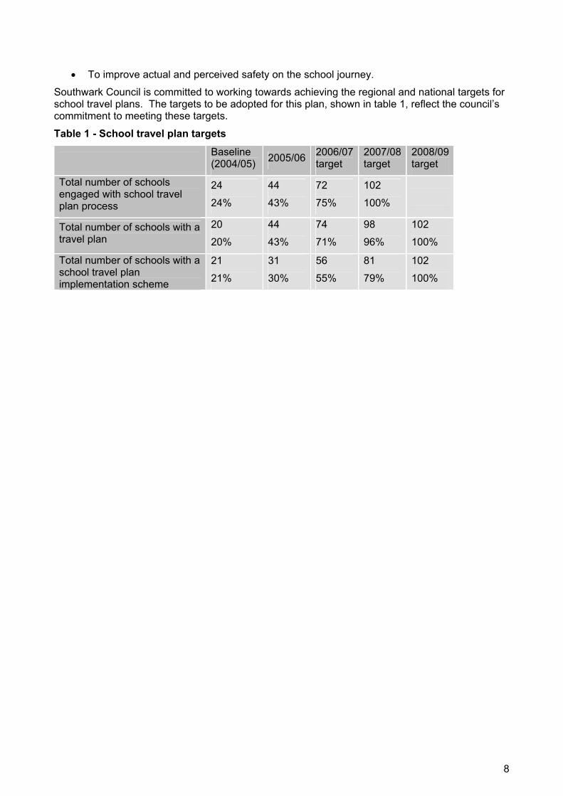
To improve actual and perceived safety on the school journey.
Southwark Council is committed to working towards achieving the regional and national targets for school travel plans. The targets to be adopted for this plan, shown in table 1, reflect the council’s commitment to meeting these targets.
Table 1 - School travel plan targets
Baseline(2004/05) 2005/06 2006/07
target2007/08target
2008/09target
Total number of schools engaged with school travel plan process
24
24%
44
43%
72
75%
102
100%
Total number of schools with a travel plan
20
20%
44
43%
74
71%
98
96%
102
100%
Total number of schools with a school travel plan implementation scheme
21
21%
31
30%
56
55%
81
79%
102
100%
8
3 School travel plans The school travel issue first began to be addressed nationally with the safer routes to school (SRtS) initiative which emphasised improving safety on the journey to school by making local improvements to walking and cycling environments. Initially this programme emphasised physical measures such as safer crossing points and traffic calming measures.
It soon became evident there was a role for travel plans in the former SRtS which would leave a legacy of continued activity and implementation once the physical measures had been implemented. Thus the former SRtS programme has been integrated into school travel plans.
Increasingly it has been evident that while SRtS schemes are desirable and beneficial, they are not essential to a school having an effective school travel plan. As such, the emphasis has shifted and school travel plans are now a programme in their own right supported and complemented with SRtS programmes. As a result of complete integration SRtS is now called school travel plan implementation.
The publication of Travelling to School: An action plan has now moved school travel plan delivery to the top of the school travel agenda as local authorities are working to achieve the 100% target by the London 2009 deadline.
CriteriaThe criterion for participation in a school travel plan implementation scheme is the completion of a satisfactory school travel plan. The opportunity to benefit from local road safety improvements associated with school travel plan implementation offers a further incentive for schools to develop a travel plan. Each plan must include:
A description of the location, size and type of school;A description of the travel problems faced by the school or cluster of schools. This should include all pupils' travel needs: journeys to and from school at normal start/finish times, journeys to attend pre and after school events; The results of a survey to identify how children currently travel to and from school and how they would like to travel to and from school; Clearly defined targets and objectives that are appropriate and linked to the problem and the objectives. Short, medium and long term targets; Details of proposed measures; A detailed timetable for implementation; Clearly defined responsibilities; Evidence that all interested parties have been consulted; Proposals for monitoring and review.
In addition, the Mayor of London’s election manifesto pledged funding for all schools to have school travel plan implementation scheme by 2009 which makes significant sources of funding available to assist in the delivery of these plans.
9
4 Improving the journey to school At the end of March 2006, 20 Southwark schools had travel plans and 24 more schools had secured funding and were in the process of preparing plans. Of the prepared plans, 16 were developed in 2004/05 and four had been developed prior to this in connection with a school travel plan implementation scheme. As there are 102 schools in the borough, at present 20% have a travel plan and by 2006, it is expected that that number will increase to 44, meaning that 43% of all Southwark schools will have a completed plan.
Southwark Council has had a successful school travel plan implementation programme for the past five years during which time the council has worked with 21 schools.
Travel awareness The main travel awareness raising activity in Southwark schools is the biannual walk to school week and this is now being complemented by walk on Wednesday. Schools are also encouraged to participate in other awareness activities such as good going week and bike week.
Southwark Council has worked with a number of its schools over the years in a variety of ways on walk to school week activities and events. Each year a number of schools are provided with walk to school week packs which includes information about additional resources such as the walk to school and walking buses websites. Incentives such as travel logs and stickers are distributed to participating schools. The council also works with some of the schools to undertake walk to school week activities such as themed assemblies, lessons, guided walks and art workshops and has completed two school travel plan websites.
Redriffe Primary School
International walk to school week ran from October 3 to 7 2005 and two million children from around the country took part in the events. The theme was walk to school: It's good for the heart. Pupils from Redriffe School, Salter Road in Rotherhithe celebrated the start of the week by forming a red heart on their playing field, making the national news.
Throughout the week a council officer attended local schools encouraging children to walk to school by giving out goody bags to those arriving by foot. The Metropolitan Police also got involved in the weeks activities, advising on best practice for parking at pick up and drop off times at schools.
Walking to school benefits kids because children with higher physical activity levels are more likely to have improved concentration, memory and problem solving skills throughout the day. Research shows that physically active people feel happier and more satisfied with life, and it is also a social time. Parents and carers get quality time with their young children and young people enjoy talking to friends while they walk.
The council will work to promote walking to school on a regular basis throughout the entire school year, and walk on Wednesday has been developed to encourage this. Participating schools encourage all children to walk to school regularly on Wednesday to help reduce congestion and pollution around the schools while also improving the health of the children.
In addition, many Southwark schools independently coordinate their own initiatives for walk to school week as part of implementing their travel plans, environment action plans or healthy schools programmes.
One of the strengths of Southwark’s school travel plan programme has been the leadership and engagement from within the community in these projects. A number of schools have approached the council with their ideas and it has been these projects that have been most successful as they are owned and supported by the local community.
Dulwich cluster
The Dulwich school travel plan cluster consists of three independent schools and two state schools that have formed a working group of parents/carers, local residents and staff from each of the schools to address their collective school travel issues.
10
A parent/carer from one of the schools leads this group which meets each term to discuss the progress of the plan and agree their collective course of action. A consultant was provided between 2001 and 2002 through the government’s site specific advice programme to support the development of this school travel plan. This group developed their plan and then approached the council with it to secure funds for implementation. Improvements to local walking routes around the schools have now been implemented.
In developing and implementing their travel plan, the schools have introduced dedicated school buses to reduce the number of children being driven to school, held walk to school week events and worked with the council to develop and refine physical highways improvements to improve the school journey.
This example illustrates how schools can work together to maximise the investment of a school travel plan implementation scheme and demonstrates the value of the plans being driven by the schools. The level of commitment behind this plan is a key element of its success.
Making cycling safer for our children Southwark Council offers a successful cycle training programme to schools which trains approximately 150 pupils in 20 schools each year. The demand for this service is rising and this is expected to continue in conjunction with school travel plan work and ongoing improvements to cycling facilities.
Rotherhithe cycle saturation
Rotherhithe community council allocated £20,000 to Southwark Cyclists to undertake a cycling training project. Local primary schools were invited to apply and St John’s RC Primary School was selected to receive cycle saturation. The school was in the process of completing a travel plan and had applied to TfL for cycle parking to be installed. The school is in an area with a lot of good off road cycle routes on the Rotherhithe Peninsula and close to the Thames Path, Surrey Quays and Southwark Park. Year five and six pupils had previously received cycle skills training funded by Southwark Council. However the school only had two pupils cycling to school although 84% were interested in doing so and there was a high number of pupils coming by car.
Having determined there was a high degree of suppressed interest in cycling among the school community the approach of cycle saturation was to deliver a concentrated burst of cycling promotion and training to pupils, parents, carers and staff to achieve an increase in cycling activity.
Kicked off by a mini festival of cycling at the school in April 2005, cycle training was given to nearly 40% of pupils and cycle instructor training was also offered to staff and parents/carers.
Cycle parking for 60 cycles was installed just in time for the launch in summer 2005 and this is often full during the summer term. In excess of 80 bikes are parked at the school on special event days.
A cycle club has since been set up to sustain the benefits into the future, possibly shared with other schools and Alfred Salter school has teamed up with St John’s for cycle picnic events and rides and it is hoped that the network will grow.
The school has had visitors and enquiries from local authorities and other groups of interest from London and further afield due to interest in the project. The project provided children with the level of cycling they needed and formula will be adapted to be used at other schools and colleges in 2006. The success of this project is very clear and it is recognised as helping the council reach the cycle training targets, while also supporting the road safety targets by enhancing the children’s safety.
The council intends to investigate opportunities to work closely with Southwark Cyclists to roll this programme out to other schools in the borough
Making the roads safer Each year, schools throughout the borough are invited to apply for funding to implement physical measures to make the school journey more appealing. Because demand is so high, schools are ranked on the following factors:
11
An approved school travel plan;
The number of pedestrian, cycle and child casualties in the vicinity;
A demonstrable need for improvements already identified;
Index of multiple deprivation level;
The extent of other traffic schemes in the area.
St Peter’s school
In response to a high incidence of pedestrian and cyclist injuries within a 350m radius of St Peter’s school, significant funding has been secured through TfL for their school travel plan implementation programme.
After studies identifying pedestrian desire lines, a raised pedestrian crossing is to be installed on Portland Street in conjunction with road resurfacing. A weather shelter is to be constructed outside the school entrance to provide shelter for parents/carers waiting for children after school. Physical measures are expected be in place by the middle of 2006. The works will help to complement the East Walworth 20mph zone and existing traffic calming measures to reduce vehicle speeds in the local area.
The school travel plan implementation scheme will work in conjunction with continuing education and promotion of walking and cycling as set out in the school travel plan. The overall result is increased safety and security and will be extremely beneficial for cyclists and pedestrians, particularly for the children attending St Peter’s School.
An important element of supporting the schools with travel plans is ensuring that the physical measures proposed in the school travel plan are delivered once the plans are in place. Appendix A contains details of the physical measures undertaken to date for each school or cluster in the borough and the actual funding allocated. The list also sets out schemes that funding has been secured for which will be undertaken in the future.
The travel plan development process identifies initial, feasible measures, and in some cases rudimentary designs may be produced. In all cases, the council assesses the measures identified in each plan and prioritises them for implementation. Those measures that are agreed for implementation must then have designs produced and consultation completed with the local community before the measures can be implemented as appropriate.
School travel plan implementation has historically funded physical measures, however it is now recognised that other measures such as school cycle training is of equal importance.
Making our children safer on the roadKerbkraft
Southwark was granted funding for three years to take part in the pilot and is currently providing the programme in ten schools. Kerbcraft is a child pedestrian training scheme targeting five to six year olds that seeks to reduce future casualties by providing training to cross the road safely. The scheme offers a practical pedestrian skills programme in borough schools.
Given the success of this programme, the council seeks to roll out the programme in more schools in the borough and employ a Kerbcraft officer in the future. The DfT funded this programme until March 2006, and the programme has been reviewed and funding from the council secured for 2006/2007.
Junior Citizens
Southwark schools are also offered a chance to send their year six pupils to participate in an annual Junior Citizen’s programme which covers road safety awareness training and they receive various road safety educational materials. The council delivered road safety training at the junior citizenship scheme held in February 2006. This was attended by other school agencies and emergency services in Southwark.
TfL Traffic Club
12
Transport for London in conjunction with the council launched the Children’s Traffic Club in Southwak this year, with the aim of reducing the number of children hurt on London roads by 50% by 2010. The programme develops good road safety habits early in life and is free to all preschool children in the borough. It aims:
To reduce casualty rates for the targeted age group;
To influence long term behaviour of children who become members;
To increase parents/carers' awareness of road safety issues and to give them knowledge of safe practices;
To indirectly benefit other members of the family, such as older children and parents/carers themselves.
Southwark Council fully supports the scheme and has assisted in the distribution of Children’s Traffic Club starter packs to all preschools in January 2006.
Walking school buses
Walking school bus schemes encourage parents, carers, volunteers or employed helpers to walk children to school along a set route, picking up children along the way. The council support these schemes as an important part of successful school travel plans. The aim is to provide a safe, environmentally friendly way of getting to school. Walking school bus programmes will be encouraged to incorporate green spaces on their route to and from school. This is to promote mental health and encourage a better understanding of biodiversity and nature in the borough.
Coin Street walking school bus
Coin Street family and children’s centre is a not for profit organisation that works to ensure the safety of the young pupils from a number of Southwark schools on their journey to and from school. In 2006 the centre managed walking buses to service six schools. The routes incorporate green space as much as possible and volunteers include parents/carers staff and students from Kings College as well as Coin Street child minders. How’s My Driving?, an organisation designed to promote safe driving provides the funding for high visibility vests and caps for the ‘driver’, ‘conductor’ and children on the scheme.
Making our children healthier
Anti bullying scheme
The agencies supporting schools programme (ASSP) has developed an anti bullying programme that brings together a range of agencies and interventions into a coordinated programme of support for schools.
The programme’s components have been structured to support and complement the anti bullying alliance, Don’t Suffer in Silence DfES guidance for developing a whole school policy on bullying. The programme additionally supports schools to work towards healthy school status or to further develop their commitment as a healthy school. As part of the coordination of this programme with other related schools schemes, the agencies delivering the programme will address bullying and safety on the journey to school as one element of the programme.
To maximise this multi agency partnership, ASSP have asked that schools make a commitment to engaging with all aspects of the programme, and have incorporated a commitment for each school to develop a school travel plan that will address, as one element, personal safety, intimidation and bullying on the journey to school.
5 Making school travel plans a success in all schools
Hearts and minds
Southwark Council’s experience has shown that the most successful travel plans are those with the greatest degree of buy in from the school and local community. This is the most effective way
13

to win the hearts and minds of the staff, parents/carers and pupils and is therefore the most effective way to approach delivering this programme if it is to be a success.
The council’s approach is therefore one which provides guidance, facilitation and information but which is ultimately led, owned and delivered by the schools.
As the process is for and about children, the council strongly encourages all schools to actively involve their pupils as much as possible throughout.
The key elements of the Southwark school travel plan programme for 2005 to 2009 are as follows:
Working with new schools to develop school travel plans;
Providing support to existing schools with travel plans;
Delivering school travel plan implementation programmes at schools with travel plans.
In addition to these, the council will encourage all participating schools to get involved in travel awareness campaigns and events such as walk to school week and walk on Wednesday, and will ensure schools are aware of relevant resources, training and opportunities such as cycle parking grants as these arise.
In order to meet the targets set in this strategy the number of schools the council aims to engage on each of the key elements of the programme over the period of the strategy are set out in table 2.
Table 2 - School travel plan programme
Task/activity 2005/06 2006/07 2007/08 2008/09 2009/10 2010/11
Work with new schools 24 28 30 0 0 0
Support existing schools 20 44 72 102 102 102
Start new school travel plan implementation schemes
10 25 25 21 0 0
Complete school travel plan implementation schemes
2 10 25 25 25 15
The figures for school travel plan development have been devised on the basis that 20 of the 102 schools in Southwark have travel plans so the remaining 82 have been spread over 2005/2006 to 2007/2008. Additional time has been allowed for to work with schools that have special challenges or prove particularly resistant to the programme. This will also allow any residual schools from previous years to get extra assistance and be finished in time to meet the final target. It is expected that all schools with a travel plan will require ongoing input and support with their delivery.
Of the 21 schools that currently have school travel plan implementation schemes, two were completed in 2005/2006 and the rest will be completed 2006/2007. In 2004/2005, ten schools with no prior involvement in school travel plan implementation completed travel plans. These are the only schools that were eligible to participate in a new school travel plan implementation scheme for 2005/2006. As each of the new schools develops a travel plan, it is anticipated that there will be some implementation measures at each school either individually or as part of a group. These schemes will be undertaken over two years to allow sufficient time for their travel plans to be updated, design and consultation to be completed and implementation to be fully achieved.
Wherever possible schools will be grouped to increase the efficiency of the work programme. This will also maximise the coordination of school travel plan implementation initiatives with the implementation of local traffic management schemes such as 20 mph zones, local safety schemes and home zones near to these schools.
14

Working with new schools to develop school travel plans 30 new schools indicated a willingness to develop a travel plan in the two years 2005/06 and 2006/07. A number of these have contacted the council to ask for support. Others have signed up as part of a charter for the anti bullying scheme being delivered by the council’s ASSP that addresses personal safety on the journey to school.
Of the 30, 24 are bring developed for 2005/2006. The remainder have been given priority for 2006/2007. Table 3 shows the schools and groups programmed for 2005/2006 and the schools with travel plans in place.
The selection of schools in future years will be based on a number of factors including whether they have requested help, their proximity to a planned local safety scheme and 20 mph zones for 2006/2007 and their proximity to other schools for inclusion in a group.
It is anticipated that word of mouth and the capital grant incentive will encourage most schools to participate. The school communities will be involved to assist with recruitment and programming and numbers will be topped up as needed each year by directly contacting and recruiting schools. There will undoubtedly be some schools that initially resist or refuse.
The council believes that the momentum and success of the programme will win over those schools that are initially resistant. Early indications are that there will be little difficulty getting all of the schools to participate in some fashion to develop a plan.
Methodology Schools are initially engaged in the process through a phone call to the head teacher or personal, social and health education (PSHE) coordinator in September each year. At least three meetings are held between the school travel advisors, the identified school travel plan coordinator and the travel plan steering group during the development of the travel plan. The council employs four officers to assist schools with the development of their travel plans.
All initial contact from the school travel advisor with schools is made by telephone, and further correspondence if appropriate. Transfer of written materials is done by fax or email.
15

Table 3 - Schools and the travel plan process
Primary Secondary Special Schools*
Crampton City of London Academy (Southwark) Haymerle (SEN) Redriff Charter Highshore (SEN) Townsend Waverly Summerhouse (PRU) Peter Hills with St Mary's and St Paul's Sacred Heart St Joseph's (Gomm Road) Archbishop Michael Ramsay Dulwich Hamlet Dulwich Village Herne Hill John Ruskin Peckham Park Rye Oak Surrey Square St Mary Magdalene Dog Kennel Hill IvydaleLyndhurst
2005
/06
prog
ram
me
Grange Spa School (SEN)
Albion Primary School Alfred Salter Primary School Bellenden Primary School Charles Dickens Primary School Charlotte Sharman Primary School Crawford Primary School Gloucester School Goodrich Community School Goose Green Primary School Hollydale Primary School Oliver Goldsmith Primary School Riverside Primary School St John's and St Clement's St John's Roman Catholic Primary School
2004
/05
prog
ram
me
St Jude's Church of England Primary School
St Peter's Walworth James Allen's
Hav
e ST
P pr
e-20
04
* Defined as either a Special Educational Needs (SEN) school or a Pupil Referral Unit (PRU)
ProcessThe process of developing and implementing a school travel plan takes place in eight stages:
1. Selection of a school travel plan coordinator;
2. Setting up a steering group;
3. Assessment of current travel patterns and issues;
16

4. Identification of objectives;
5. Identification of appropriate measures;
6. Development of an action plan;
7. Awareness raising;
8. Implementation and monitoring.
Schools developing a travel plan receive hands on support from the council throughout the process. This includes the provision of resources and support including the explanation of the travel plan benefits and processes; provision of travel plan resources for classroom activities, a travel plan template and school curriculum information; support to aide the development of an appropriate timetable for particular school travel plan projects. The council will also attend and facilitate travel plan steering group meetings with the schools when required and provide assistance with travel plan assemblies and launches. Officers will provide GIS postcode mapping and engineering advice about possible on and off street improvements that can be included in the travel plan as well as providing road safety education support and information. The council will also coordinate any additional support needed by the schools developing and implementing school travel plans.
Partnership At present there are limited links between the school travel plan team and the officers in the education department. The council will aim to improve this in the future by ensuring that the healthy schools and curriculum officers are fully briefed on the school travel plan strategy. This should take place before the end of this academic year so that measures to integrate the healthy schools and school travel plan programmes will be in place for the 2006/07 academic year.
There is capacity for the school travel advisor and the healthy schools coordinator to work together and coordinate projects that complement each other and these partnerships should be actively sought wherever possible.
Southwark Council would encourage healthy schools status to only be provided if a school is developing or implementing a travel plan. The council would also encourage curriculum guidance on the integrating of the travel plan into the wider curriculum.
Monitoring Schools with a travel plan must include a commitment to annual monitoring and review in their initial travel plans. The council contacts each school towards the time that the monitoring and review is required and provides the necessary guidance and monitoring templates.
Every school is required to provide the council with results of an annual hands up survey of how pupils travel to and from school. This information is stored in an access database as well as in a GIS system along with additional information about the various programmes and activities in each of the schools such as cycle training, Kerbcraft and walk to school week.
iTRACE software is being rolled out across London and was introduced in November 2005. The system records information on travel plans and their targets as well as survey data and can produce reports from captured this information.
Southwark Council have secured funding for an officer to incorporate all travel plans into the system and it is expected that the borough will be fully integrated by mid 2006. By incorporating GIS mapping the system can readily identify and link travel plan location sites and show transport linkages nearby.
Providing support to existing schools with travel plans The schools that have an approved travel plan continue to receive support in the implementation, monitoring, awareness raising and promotion phases from the STAs. Regular telephone calls are made with the travel plan coordinators to provide general advice and support. Officers in
17

Southwark Council who lead walk on Wednesday and walk to school week will visit schools and liase with partners to ensure that schools are provided with the resources they require.
The council operates a hotline, which all schools can ring to get information and advice about travel plans. This facility enables travel plan coordinators to contact their respective advisor if they have any specific queries with regards to travel plan implementation. In addition to the hot line, schools are directly contacted regularly with information about opportunities such as conferences, training and promotional events such as walk to school week. Schools are also directly reminded of their annual survey obligation and contacted for the results.
The council let schools know of other school travel plans in their local vicinity and encourage them to work together and support each other. The schools in the Dulwich Cluster already work very closely together and a similar scheme is being developed around the St George Cluster in Borough and Bankside and the Village Cluster in Peckham.
DfT database
The DfT database of classroom materials is a catalogue of information on teaching and other relevant resources relating to encouraging greater use of walking, cycling, public transport and car sharing for school journeys. The resources contained in the database are primarily concerned with sustainable travel, but some also address issues of road safety. Road safety materials can be found at the ROSALIND database.
Everyday Sport
Schools in the borough can look to raise the awareness of participation in physical activities and the benefits for students and staff, as well as surrounding schools and the community as a whole. Walking and cycling as a mode of transport can be promoted as part of students 30 Everyday Sport minutes and help achieve school travel plan success. Online resources are available to record and monitor students’ progress.
5.1 Promotion and communication The council regularly contacts those schools it is or has worked with to provide information about local and regional travel plan opportunities and promotions. The main initiatives include good going week, walk to school week, walk on Wednesday and bike week. Additional opportunities include school travel plan conferences and training events, cycle shelter funding and competitions.
The council is planning to set up a network among the travel plan coordinators in each school so that they can share their travel plan ideas and experiences. A number of the schools have indicated their support of this concept which needs to be developed and piloted further.
In the first year of delivering the programme (2004/05), the council held a successful launch event for all the schools that had developed travel plans. The Mayor attended and awarded prizes to children from each school that had produced winning designs in a travel plan cover design contest run in each school. The council intends to hold this event or something similar every year to reward the schools and children involved and to give the school travel plan coordinators a chance to meet their counterparts and network.
Further communication and promotion of the programme will be undertaken using the education department newsletter News for Schools, meetings of the eight school communities and conventional public media such as the residents’ newsletter Southwark Life, local press releases and information on the Southwark website.
18

5.2 Resources and funding The DfES has provided all local authorities with a grant, the amount of which varies depending on the number of schools in the local authority’s area. The grant is intended to support local authorities working with schools to develop travel plans. Southwark Council receives annual funding to employ a school travel plan team of £29,000 from DfT which is guaranteed until 2008. After this time, funding will come from the council. The funding is used to employ school travel advisors working for the council. TfL also provide funding through the borough spending plan (BSP) for physical measures which can be used to develop and deliver school travel plans.
While the target of having all schools develop a travel plan applies to local authorities, the DfT and DfES have offered an appealing incentive for schools to get involved. Schools that complete a travel plan that meets the national standards are eligible for a capital grant of approximately £5,000 to £10,000 to assist in its implementation. Table 4 shows the funding allocated to schools in 2004/05
Table 4 - Capital grants received by schools in 2004/05 School Funding received
Albion Primary School £4,685
Alfred Salter Primary School £6,010
Bellenden Primary School £4,750
Charles Dickens Primary School £5,335
Charlotte Sharman Primary School £5,745
Crawford Primary School £5,840
Gloucester School £7,070
Goodrich Community School £7,220
Goose Green Primary School £5,660
Hollydale Primary School £5,230
Oliver Goldsmith Primary School £6,720
Riverside Primary School £5,260
Spa School £5,455
Southwark Council intends to maximise these resources as far as possible and the council will explore opportunities to secure additional funding through avenues such as European project funding and Section 106 contributions from new developments. Schools have a number of funding streams open to them and the council want to promote and assist in securing funding from as many sources as possible. Some possibilities include:
Local Education Authority funding for specific improvements such as cycle racks, traffic-free entrenches and additional locker space;
Local employers have been known to provide cycle stands, reflective jackets, school road signs and competition prizes;
Single Regeneration Budget fund to safer routes schemes in areas of low income and high unemployment;
School fundraising
Kia Cars, free tabards for walking buses www.walkingbus.org
How’s my Driving, free tabards for walking buses www.howsmy.co.uk
19

Sustrans, 35 King Street, Bristol BS1 4DZ 0117 926 8893 www.sustrans.org.uk
RAC Grass Routes Challenge. Streets Ahead explores the concept of safe, sustainable transport. Since 1999 RAC Grass Routes has been helping schools and pupils find safer journeys to school and alternatives to the school run by providing maps, traffic flow data, interview sheets, photographic stimuli, posters and advice on STPss. www.rac.co.uk
20
6 Meeting the challenge Southwark Council endorses the intention of the national target to deliver travel plans in all schools within the next five years, and sets to achieve the London target of all schools by 2009. While the council acknowledges the capital grants provide an attractive incentive for schools to participate, the council has a few concerns regarding:
The feasibility of achieving the 100% target;
The availability of resources to deliver the programme long term.
As the production of travel plans is set as a target for local authorities and not the schools, the main incentive for the schools is the capital grants.
The council is fully committed to trying to deliver these targets and will do all it can to meet them. The council is optimistic that that the momentum, word of mouth and benefits of a plan will encourage even resistant schools to participate by the end of the programme. However, in the end, if schools refuse there will be little the council can do.
The council believes that it would be beneficial to the delivery and long term effectiveness of the programme if schools were in some way encouraged or compelled by the DfES to deliver a travel plan (beyond the grant), for example through closer links to Ofsted performance. To this end, the council intends to work with TfL and the DfES to encourage these agencies to offer some additional incentive or place some of the responsibility for delivering this target with the schools.
ResourcesFor the 2005/06 and 2006/07 financial years Southwark Council has adequate resources available to deliver the programme in line with the incremental targets. However, as the programme advances and demand for implementation support mounts, meeting the resource requirements will become more challenging.
A reduction in available resource could compromise the council’s ability to meet its targets and support the schools. The Mayor of London has pledged to ensure that all schools have a school travel plan implementation scheme by 2009 and the DfT and DfES have guaranteed the capital grants for the schools until the end of the programme. These measures go some way to ensuring the success of the programme. Funding has been guaranteed until 2007/08 for travel plans and after that time, it is hoped that funding will be secured through S106 agreements and from the council.
In the absence of certainty, the council will continue to deliver the programme and make the most of the resources that are available while they are guaranteed. The council will also actively explore alternative funding opportunities and aims to deliver a highly successful programme that will attract further funding.
21
7 Working with our partners The council has a number of established partnerships to coordinate delivery in priority areas. These partnerships are being made aware of this programme and strategy and are invited to contribute as appropriate.
The partnerships that are relevant to the school travel plan programme include:
Safer Southwark partnership;
Children and young people’s partnership;
Safer schools partnership (Metropolitan Police school liaison officers);
Southeast saving lives forum.
The safer Southwark partnership is a multi agency partnership that works to make Southwark a safe place to live, work and play by reducing crime and anti-social behaviour, tackling substance misuse and increasing public reassurance across all sections of the community.
The safer schools partnership formed by the Metropolitan Police has seen school liaison officers placed in each of Southwark’s 15 secondary schools with two officers sharing Southwark’s 73 primary schools. These officers work with the schools on personal and road safety, drug awareness and education and a number of other issues. Southwark’s school travel plan programme has so far focused on primary schools during which time the primary school liaison officers have been involved. As the programme expands to cover secondary schools the relevant officers will be invited to get involved, and the ongoing involvement of these officers will be encouraged.
Southwark’s children and young people partnership board, which forms part of the local strategic partnership the Southwark Alliance, brings together senior representatives from a range of organisations who have an interest in children's services in Southwark. They work to promote the well being of children and young people in the borough. Members of this group have been consulted in the development of the strategy and are aware of the links between this programme and others in the borough.
7.1 Consultation on this strategy Public consultation on the draft Local implementation plan and its supplementary documents, including this school travel plan strategy was undertaken during November and December 2005. Consultation was carried out with the community, partner organisations such as TfL, the Metropolitan Police, other London boroughs and with local groups and organisations such as Southwark Cyclists, Southwark Pedestrian Rights Group and Southwark branch of Living Streets.
A copy of this document was sent to each of the 102 schools in the borough in December 2005. Accompanying the plan was a letter detailing the purpose of the plan and information on how schools could make comments and utilise the information contained within.
The draft plan was also considered by the Southwark disability forum, equality and diversity panel, the transport consultative forum and its mobility subgroup during this period. The plan was also discussed at all of the winter community council meetings with workshops held at Walworth and Camberwell community councils.
A questionnaire on the themes and actions proposed in the draft plan was circulated to key stakeholder groups and was available to the general public at each of the community council meetings, in all official council offices, on the Southwark Council website and upon request. The results of the questionnaire feedback was collated and the results relating to school travel plans highlighted the following:
Support for investment in creating a safer environment in and around schools;
Acknowledgement of the difficulties and congestion around our schools;
Need to provide road safety and cycle training for our children;
Making walking to school fun;
22
Recognition of the health and social benefits of walking to school.
Accordingly, as a result of the consultation this plan has been revised to address these issues and to incorporate, where reasonably possible, many other suggested improvements.
7.2 Ongoing consultation School travel plans contribute to delivery in a number of policy areas including child, personal and road safety, environmental quality, health and physical activity. As such, the programme crosses over delivery of a number of programmes and there are a number of partnerships, organisations and programmes involved.
Southwark’s ASSP provides a central coordination role for the various external agencies that engage schools such as educational theatre and art programmes. ASSP has had a significant input into the programme development and have assisted by linking their anti bullying programme to school travel planning. They have also provided valuable input into the related schemes and agencies that can input into the delivery of the programme.
The council’s environmental education programmes including eco schools and junior street leaders which deal with issues such as waste, recycling and transport are closely linked to this programme and are therefore actively being coordinated to complement delivery. Cooperation between the programmes offers opportunities to gain access to schools and combine delivery to reduce the requirement of schools while meeting both programmes’ objectives.
While the school travel plan programme is not currently actively integrated with programmes such as the healthy schools partnership and London environmental schools award scheme, the intention is to seek more active coordination between these programmes. In the meantime, the programme delivery takes account of these schemes and actively encourages schools to account for and integrate the delivery of these programmes in the delivery of their travel plans.
The council intends to ensure that other key partners and agencies concerned with the health and well being of young people in the borough are involved in and aware of the programme.
23
8 Coordination with other strategies As part of the development of the Local implementation plan an assessment of the plan against the council’s equality scheme was undertaken. This equalities assessment helps to identify areas for improvement and ensure that, if appropriate, measures are taken to revise, promote and support the council’s corporate policies on equalities.
This school travel plan strategy, as a supplementary document to the Lip was incorporated into this assessment, which was tabled at the equality and diversity panel in February 2006.
The delivery and development of the Lip and its EqIA will be monitored at various stages to ensure that:
The plan contributes positively to the corporate equalities agenda;
The requirements of the plan, as they relate to ensuring access to all and promoting equal opportunities are being adequately met by any initiatives, proposals and/or programmes.
Annual monitoring of this information will be contained within the annual monitoring report and will relate to the lifecycle or timescale of transport plans, policies or programmes. In addition to this quarterly monitoring will be carried out in accordance with the council’s EqIA guidance.
24
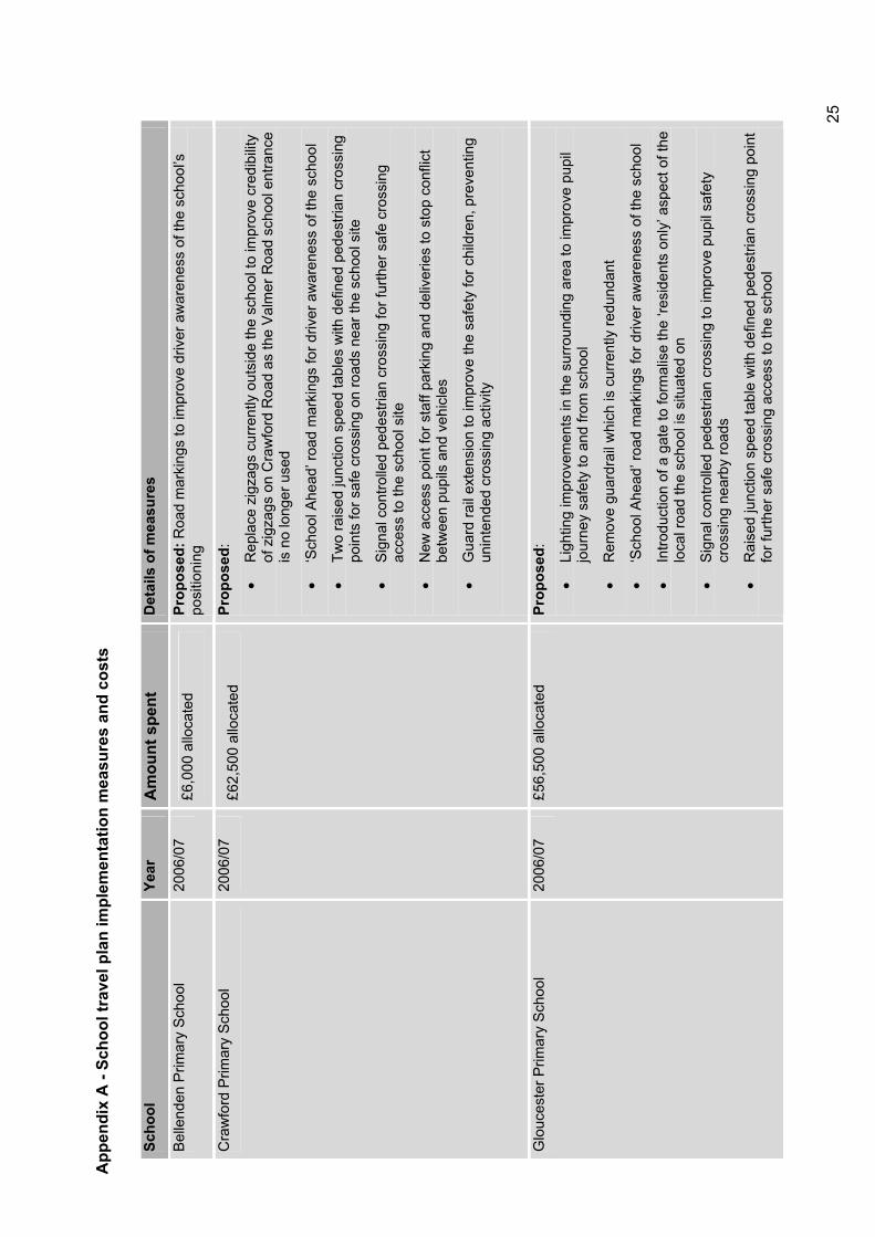
App
endi
x A
- Sc
hool
trav
el p
lan
impl
emen
tatio
n m
easu
res
and
cost
s
Scho
olYe
arA
mou
nt s
pent
D
etai
ls o
f mea
sure
s
Bel
lend
en P
rimar
y S
choo
l 20
06/0
7 £6
,000
allo
cate
d Pr
opos
ed: R
oad
mar
king
s to
impr
ove
driv
er a
war
enes
s of
the
scho
ol’s
po
sitio
ning
Cra
wfo
rd P
rimar
y S
choo
l 20
06/0
7 £6
2,50
0 al
loca
ted
Prop
osed
:
Rep
lace
zig
zags
cur
rent
ly o
utsi
de th
e sc
hool
to im
prov
e cr
edib
ility
of z
igza
gs o
n C
raw
ford
Roa
d as
the
Val
mer
Roa
d sc
hool
ent
ranc
e is
no
long
er u
sed
‘Sch
ool A
head
’ roa
d m
arki
ngs
for d
river
aw
aren
ess
of th
e sc
hool
Two
rais
ed ju
nctio
n sp
eed
tabl
es w
ith d
efin
ed p
edes
trian
cro
ssin
g po
ints
for s
afe
cros
sing
on
road
s ne
ar th
e sc
hool
site
Sig
nal c
ontro
lled
pede
stria
n cr
ossi
ng fo
r fur
ther
saf
e cr
ossi
ng
acce
ss to
the
scho
ol s
ite
New
acc
ess
poin
t for
sta
ff pa
rkin
g an
d de
liver
ies
to s
top
conf
lict
betw
een
pupi
ls a
nd v
ehic
les
Gua
rd ra
il ex
tens
ion
to im
prov
e th
e sa
fety
for c
hild
ren,
pre
vent
ing
unin
tend
ed c
ross
ing
activ
ity
Glo
uces
ter P
rimar
y S
choo
l 20
06/0
7 £5
6,50
0 al
loca
ted
Prop
osed
:
Ligh
ting
impr
ovem
ents
in th
e su
rroun
ding
are
a to
impr
ove
pupi
l jo
urne
y sa
fety
to a
nd fr
om s
choo
l
Rem
ove
guar
drai
l whi
ch is
cur
rent
ly re
dund
ant
‘Sch
ool A
head
’ roa
d m
arki
ngs
for d
river
aw
aren
ess
of th
e sc
hool
Intro
duct
ion
of a
gat
e to
form
alis
e th
e ‘re
side
nts
only
’ asp
ect o
f the
lo
cal r
oad
the
scho
ol is
situ
ated
on
Sig
nal c
ontro
lled
pede
stria
n cr
ossi
ng to
impr
ove
pupi
l saf
ety
cros
sing
nea
rby
road
s
Rai
sed
junc
tion
spee
d ta
ble
with
def
ined
ped
estri
an c
ross
ing
poin
t fo
r fur
ther
saf
e cr
ossi
ng a
cces
s to
the
scho
ol
25
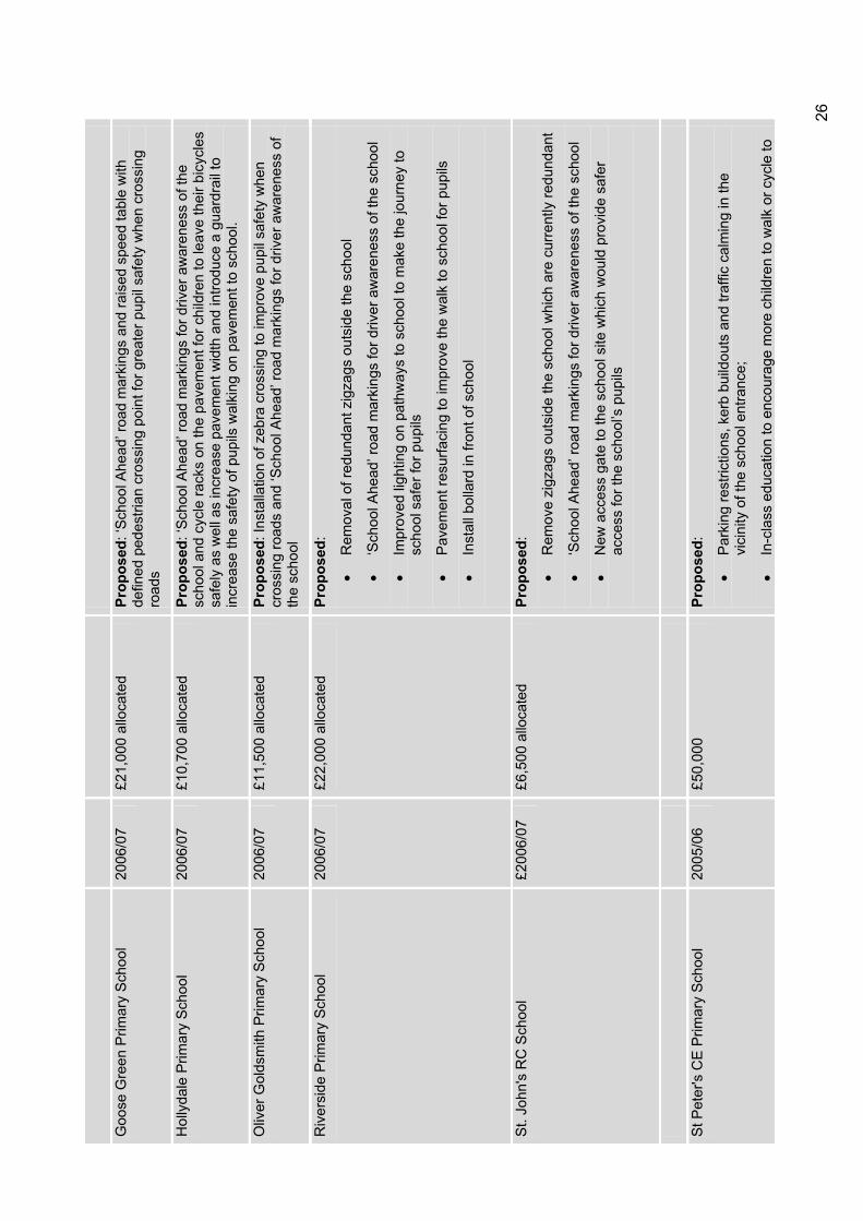
Goo
se G
reen
Prim
ary
Sch
ool
2006
/07
£21,
000
allo
cate
d Pr
opos
ed: ‘
Scho
ol A
head
’ roa
d m
arki
ngs
and
rais
ed s
peed
tabl
e w
ith
defin
ed p
edes
trian
cro
ssin
g po
int f
or g
reat
er p
upil
safe
ty w
hen
cros
sing
ro
ads
Hol
lyda
le P
rimar
y S
choo
l 20
06/0
7 £1
0,70
0 al
loca
ted
Prop
osed
: ‘Sc
hool
Ahe
ad’ r
oad
mar
king
s fo
r driv
er a
war
enes
s of
the
scho
ol a
nd c
ycle
rack
s on
the
pave
men
t for
chi
ldre
n to
leav
e th
eir b
icyc
les
safe
ly a
s w
ell a
s in
crea
se p
avem
ent w
idth
and
intro
duce
a g
uard
rail
to
incr
ease
the
safe
ty o
f pup
ils w
alki
ng o
n pa
vem
ent t
o sc
hool
.
Oliv
er G
olds
mith
Prim
ary
Sch
ool
2006
/07
£11,
500
allo
cate
d Pr
opos
ed: I
nsta
llatio
n of
zeb
ra c
ross
ing
to im
prov
e pu
pil s
afet
y w
hen
cros
sing
road
s an
d ‘S
choo
l Ahe
ad’ r
oad
mar
king
s fo
r driv
er a
war
enes
s of
th
e sc
hool
Riv
ersi
de P
rimar
y S
choo
l 20
06/0
7 £2
2,00
0 al
loca
ted
Prop
osed
:
Rem
oval
of r
edun
dant
zig
zags
out
side
the
scho
ol
‘Sch
ool A
head
’ roa
d m
arki
ngs
for d
river
aw
aren
ess
of th
e sc
hool
Impr
oved
ligh
ting
on p
athw
ays
to s
choo
l to
mak
e th
e jo
urne
y to
sc
hool
saf
er fo
r pup
ils
Pav
emen
t res
urfa
cing
to im
prov
e th
e w
alk
to s
choo
l for
pup
ils
Inst
all b
olla
rd in
fron
t of s
choo
l
St.
John
's R
C S
choo
l £2
006/
07
£6,5
00 a
lloca
ted
Prop
osed
:
Rem
ove
zigz
ags
outs
ide
the
scho
ol w
hich
are
cur
rent
ly re
dund
ant
‘Sch
ool A
head
’ roa
d m
arki
ngs
for d
river
aw
aren
ess
of th
e sc
hool
New
acc
ess
gate
to th
e sc
hool
site
whi
ch w
ould
pro
vide
saf
er
acce
ss fo
r the
sch
ool’s
pup
ils
St P
eter
's C
E P
rimar
y S
choo
l 20
05/0
6 £5
0,00
0 Pr
opos
ed:
Par
king
rest
rictio
ns, k
erb
build
outs
and
traf
fic c
alm
ing
in th
e vi
cini
ty o
f the
sch
ool e
ntra
nce;
In-c
lass
edu
catio
n to
enc
oura
ge m
ore
child
ren
to w
alk
or c
ycle
to
26
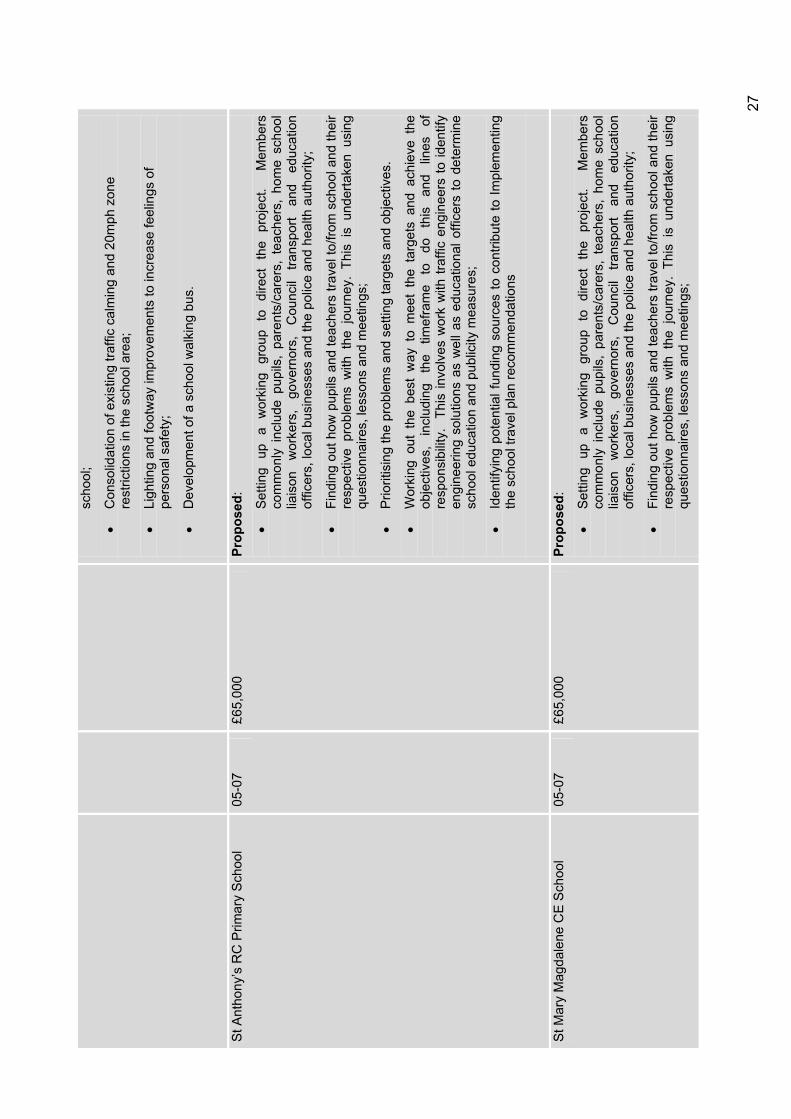
scho
ol;
Con
solid
atio
n of
exi
stin
g tra
ffic
calm
ing
and
20m
ph z
one
rest
rictio
ns in
the
scho
ol a
rea;
Ligh
ting
and
foot
way
impr
ovem
ents
to in
crea
se fe
elin
gs o
f pe
rson
al s
afet
y;
Dev
elop
men
t of a
sch
ool w
alki
ng b
us.
St A
ntho
ny’s
RC
Prim
ary
Sch
ool
05-0
7 £6
5,00
0 Pr
opos
ed:
Set
ting
up
a w
orki
ng
grou
p to
di
rect
th
e pr
ojec
t.
Mem
bers
co
mm
only
inc
lude
pup
ils,
pare
nts/
care
rs,
teac
hers
, ho
me
scho
ol
liais
on
wor
kers
, go
vern
ors,
C
ounc
il tra
nspo
rt an
d ed
ucat
ion
offic
ers,
loca
l bus
ines
ses
and
the
polic
e an
d he
alth
aut
horit
y;
Find
ing
out h
ow p
upils
and
teac
hers
trav
el to
/from
sch
ool a
nd th
eir
resp
ectiv
e pr
oble
ms
with
the
jou
rney
. Th
is i
s un
derta
ken
usin
g qu
estio
nnai
res,
less
ons
and
mee
tings
;
Prio
ritis
ing
the
prob
lem
s an
d se
tting
targ
ets
and
obje
ctiv
es.
Wor
king
out
the
bes
t w
ay t
o m
eet
the
targ
ets
and
achi
eve
the
obje
ctiv
es,
incl
udin
g th
e tim
efra
me
to
do
this
an
d lin
es
of
resp
onsi
bilit
y.
This
invo
lves
wor
k w
ith tr
affic
eng
inee
rs to
iden
tify
engi
neer
ing
solu
tions
as
wel
l as
educ
atio
nal o
ffice
rs to
det
erm
ine
scho
ol e
duca
tion
and
publ
icity
mea
sure
s;
Iden
tifyi
ng p
oten
tial f
undi
ng s
ourc
es to
con
tribu
te to
Impl
emen
ting
the
scho
ol tr
avel
pla
n re
com
men
datio
ns
St M
ary
Mag
dale
ne C
E S
choo
l 05
-07
£65,
000
Prop
osed
:
Set
ting
up
a w
orki
ng
grou
p to
di
rect
th
e pr
ojec
t.
Mem
bers
co
mm
only
inc
lude
pup
ils,
pare
nts/
care
rs,
teac
hers
, ho
me
scho
ol
liais
on
wor
kers
, go
vern
ors,
C
ounc
il tra
nspo
rt an
d ed
ucat
ion
offic
ers,
loca
l bus
ines
ses
and
the
polic
e an
d he
alth
aut
horit
y;
Find
ing
out h
ow p
upils
and
teac
hers
trav
el to
/from
sch
ool a
nd th
eir
resp
ectiv
e pr
oble
ms
with
the
jou
rney
. Th
is i
s un
derta
ken
usin
g qu
estio
nnai
res,
less
ons
and
mee
tings
;
27
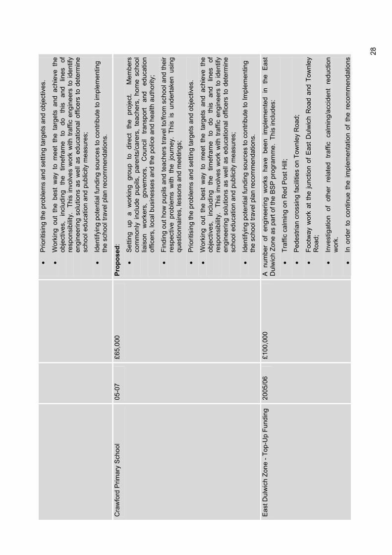
Prio
ritis
ing
the
prob
lem
s an
d se
tting
targ
ets
and
obje
ctiv
es.
Wor
king
out
the
bes
t w
ay t
o m
eet
the
targ
ets
and
achi
eve
the
obje
ctiv
es,
incl
udin
g th
e tim
efra
me
to
do
this
an
d lin
es
of
resp
onsi
bilit
y.
This
invo
lves
wor
k w
ith tr
affic
eng
inee
rs to
iden
tify
engi
neer
ing
solu
tions
as
wel
l as
educ
atio
nal o
ffice
rs to
det
erm
ine
scho
ol e
duca
tion
and
publ
icity
mea
sure
s;
Iden
tifyi
ng p
oten
tial f
undi
ng s
ourc
es to
con
tribu
te to
impl
emen
ting
the
scho
ol tr
avel
pla
n re
com
men
datio
ns.
Cra
wfo
rd P
rimar
y S
choo
l 05
-07
£65,
000
Prop
osed
:
Set
ting
up
a w
orki
ng
grou
p to
di
rect
th
e pr
ojec
t.
Mem
bers
co
mm
only
inc
lude
pup
ils,
pare
nts/
care
rs,
teac
hers
, ho
me
scho
ol
liais
on
wor
kers
, go
vern
ors,
C
ounc
il tra
nspo
rt an
d ed
ucat
ion
offic
ers,
loca
l bus
ines
ses
and
the
polic
e an
d he
alth
aut
horit
y;
Find
ing
out h
ow p
upils
and
teac
hers
trav
el to
/from
sch
ool a
nd th
eir
resp
ectiv
e pr
oble
ms
with
the
jou
rney
. Th
is i
s un
derta
ken
usin
g qu
estio
nnai
res,
less
ons
and
mee
tings
;
Prio
ritis
ing
the
prob
lem
s an
d se
tting
targ
ets
and
obje
ctiv
es.
Wor
king
out
the
bes
t w
ay t
o m
eet
the
targ
ets
and
achi
eve
the
obje
ctiv
es,
incl
udin
g th
e tim
efra
me
to
do
this
an
d lin
es
of
resp
onsi
bilit
y.
This
invo
lves
wor
k w
ith tr
affic
eng
inee
rs to
iden
tify
engi
neer
ing
solu
tions
as
wel
l as
educ
atio
nal o
ffice
rs to
det
erm
ine
scho
ol e
duca
tion
and
publ
icity
mea
sure
s;
Iden
tifyi
ng p
oten
tial f
undi
ng s
ourc
es to
con
tribu
te to
Impl
emen
ting
the
scho
ol tr
avel
pla
n re
com
men
datio
ns.
Eas
t Dul
wic
h Zo
ne -
Top-
Up
Fund
ing
2005
/06
£100
,000
A
num
ber
of e
ngin
eerin
g w
orks
hav
e be
en i
mpl
emen
ted
in t
he E
ast
Dul
wic
h Zo
ne a
s pa
rt of
the
BS
P p
rogr
amm
e. T
his
incl
udes
:
Traf
fic c
alm
ing
on R
ed P
ost H
ill;
Ped
estri
an c
ross
ing
faci
litie
s on
Tow
nley
Roa
d;
Foot
way
wor
k at
the
junc
tion
of E
ast
Dul
wic
h R
oad
and
Tow
nley
R
oad;
Inve
stig
atio
n of
oth
er r
elat
ed t
raffi
c ca
lmin
g/ac
cide
nt r
educ
tion
wor
k.
In o
rder
to
cont
inue
the
impl
emen
tatio
n of
the
rec
omm
enda
tions
28
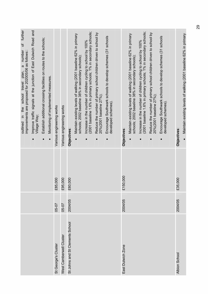
outli
ned
in
the
scho
ol
trave
l pl
an,
a nu
mbe
r of
fu
rther
im
prov
emen
ts a
re p
ropo
sed
for 2
0200
5/06
as
follo
ws:
:
Impr
ove
traffi
c si
gnal
s at
the
junc
tion
of E
ast
Dul
wic
h R
oad
and
Villa
ge W
ay;
Est
ablis
h ad
ditio
nal c
ross
ing
faci
litie
s on
rout
es to
the
scho
ols;
Mon
itorin
g of
impl
emen
ted
mea
sure
s.
St G
eorg
e's
Clu
ster
05
-07
£85,
000
Var
ious
eng
inee
ring
wor
ks
Wes
t Cam
berw
ell C
lust
er
05-0
7 £9
5,00
0 V
ario
us e
ngin
eerin
g w
orks
St J
ohns
and
St C
lem
ents
Sch
ool
2004
/05
£60,
000
Obj
ectiv
es:
Mai
ntai
n ex
istin
g le
vels
of w
alki
ng (2
001
base
line
62%
in p
rimar
y sc
hool
s; 2
002
base
line
38%
in s
econ
dary
sch
ools
);
Incr
ease
in th
e nu
mbe
r of c
hild
ren
cycl
ing
to s
choo
l by
100%
(2
001
base
line
1.6%
in p
rimar
y sc
hool
s; 1
% in
sec
onda
ry s
choo
ls;
Red
uce
the
num
ber o
f prim
ary
scho
ol c
hild
ren
driv
en to
sch
ool b
y 20
%(2
001
base
line
27%
);
Enc
oura
ge S
outh
war
k sc
hool
s to
dev
elop
sch
emes
(31
scho
ols
deve
lope
d sc
hem
es).
Eas
t Dul
wic
h Zo
ne
2004
/05
£150
,000
O
bjec
tives
:
Mai
ntai
n ex
istin
g le
vels
of w
alki
ng (2
001
base
line
62%
in p
rimar
y sc
hool
s; 2
002
base
line
38%
in s
econ
dary
sch
ools
);
Incr
ease
in th
e nu
mbe
r of c
hild
ren
cycl
ing
to s
choo
l by
100%
(2
001
base
line
1.6%
in p
rimar
y sc
hool
s; 1
% in
sec
onda
ry s
choo
ls;
Red
uce
the
num
ber o
f prim
ary
scho
ol c
hild
ren
driv
en to
sch
ool b
y 20
%(2
001
base
line
27%
);
Enc
oura
ge S
outh
war
k sc
hool
s to
dev
elop
sch
emes
(31
scho
ols
deve
lope
d sc
hem
es).
Alb
ion
Sch
ool
2004
/05
£35,
000
Obj
ectiv
es:
Mai
ntai
n ex
istin
g le
vels
of w
alki
ng (2
001
base
line
62%
in p
rimar
y
29
scho
ols;
200
2 ba
selin
e 38
% in
sec
onda
ry s
choo
ls)
Incr
ease
in th
e nu
mbe
r of c
hild
ren
cycl
ing
to s
choo
l by
100%
(2
001
base
line
1.6%
in p
rimar
y sc
hool
s; 1
% in
sec
onda
ry s
choo
ls
Red
uce
the
num
ber o
f prim
ary
scho
ol c
hild
ren
driv
en to
sch
ool b
y 20
%(2
001
base
line
27%
)
Enc
oura
ge S
outh
war
k sc
hool
s to
dev
elop
sch
emes
(31
scho
ols
deve
lope
d sc
hem
es)
Spa
Sch
ool
2004
/05
£40,
000
Obj
ectiv
es:
Mai
ntai
n ex
istin
g le
vels
of w
alki
ng (2
001
base
line
62%
in p
rimar
y sc
hool
s; 2
002
base
line
38%
in s
econ
dary
sch
ools
)
Incr
ease
in th
e nu
mbe
r of c
hild
ren
cycl
ing
to s
choo
l by
100%
(2
001
base
line
1.6%
in p
rimar
y sc
hool
s; 1
% in
sec
onda
ry s
choo
ls
Red
uce
the
num
ber o
f prim
ary
scho
ol c
hild
ren
driv
en to
sch
ool b
y 20
%(2
001
base
line
27%
)
Enc
oura
ge S
outh
war
k sc
hool
s to
dev
elop
sch
emes
(31
scho
ols
deve
lope
d sc
hem
es)
The
Bor
ough
Clu
ster
- C
harle
s D
icke
ns P
rimar
y S
choo
l, C
athe
dral
P
rimar
y S
choo
l, S
t Jos
ephs
RC
S
choo
l.
03/0
4£1
00,0
00
Sig
nage
and
lini
ng.
Ped
estri
an im
prov
emen
ts in
clud
ing
build
outs
, ent
ry
treat
men
ts a
nd c
ross
ing
poin
ts
Gal
leyw
all S
choo
l 03
/04
£40,
000
Sig
nage
and
lini
ng.
Ped
estri
an im
prov
emen
ts in
clud
ing
build
outs
, ent
ry
treat
men
ts a
nd c
ross
ing
poin
ts
Goo
dric
h S
choo
l 03
/04
£40,
000
Sig
nage
and
lini
ng.
Ped
estri
an im
prov
emen
ts in
clud
ing
build
outs
, ent
ry
treat
men
ts a
nd c
ross
ing
poin
ts
Gra
nge
Prim
ary
Sch
ool
02/0
3£4
2,50
0 M
easu
res
incl
ude
safe
r cro
ssin
g po
ints
, pav
emen
t im
prov
emen
ts, s
peed
hu
mps
, dro
pped
ker
bs, b
uild
out
s, p
rom
otio
n of
cyc
ling/
wal
king
and
gre
en
trave
l pla
ns fo
r sch
ools
Jose
ph L
anca
ster
Prim
ary
Sch
ool
02/0
3£4
2,50
0 M
easu
res
incl
ude
safe
r cro
ssin
g po
ints
, pav
emen
t im
prov
emen
ts, s
peed
hu
mps
, dro
pped
ker
bs, b
uild
out
s, p
rom
otio
n of
cyc
ling/
wal
king
and
gre
en
trave
l pla
ns fo
r sch
ools
30
Geo
ffrey
Cha
ucer
Sec
onda
ry S
choo
l 02
/03
£42
,500
Mea
sure
s in
clud
e sa
fer c
ross
ing
poin
ts, p
avem
ent i
mpr
ovem
ents
, spe
ed
hum
ps, d
ropp
ed k
erbs
, bui
ld o
uts,
pro
mot
ion
of c
yclin
g/w
alki
ng a
nd g
reen
tra
vel p
lans
for s
choo
ls
St S
avio
urs
& S
t Ola
ves
CE
Sch
ool
02/0
3£4
2,50
0
Mea
sure
s in
clud
e sa
fer c
ross
ing
poin
ts, p
avem
ent i
mpr
ovem
ents
, spe
ed
hum
ps, d
ropp
ed k
erbs
, bui
ld o
uts,
pro
mot
ion
of c
yclin
g/w
alki
ng a
nd g
reen
tra
vel p
lans
for s
choo
ls
Key
wor
th P
rimar
y S
choo
l 02
/03
£42,
500
Mea
sure
s in
clud
e sa
fer c
ross
ing
poin
ts, p
avem
ent i
mpr
ovem
ents
, spe
ed
hum
ps, d
ropp
ed k
erbs
, bui
ld o
uts,
pro
mot
ion
of c
yclin
g/w
alki
ng a
nd g
reen
tra
vel p
lans
for s
choo
ls
St P
auls
CE
Sch
ool
02/0
3£4
2,50
0 M
easu
res
incl
ude
safe
r cro
ssin
g po
ints
, pav
emen
t im
prov
emen
ts, s
peed
hu
mps
, dro
pped
ker
bs, b
uild
out
s, p
rom
otio
n of
cyc
ling/
wal
king
and
gre
en
trave
l pla
ns fo
r sch
ools
John
Rus
kin
Prim
ary
Sch
ool
02/0
3£4
2,50
0
Mea
sure
s in
clud
e sa
fer c
ross
ing
poin
ts, p
avem
ent i
mpr
ovem
ents
, spe
ed
hum
ps, d
ropp
ed k
erbs
, bui
ld o
uts,
pro
mot
ion
of c
yclin
g/w
alki
ng a
nd g
reen
tra
vel p
lans
for s
choo
ls
Cra
mpt
on P
rimar
y S
choo
l 02
/03
£42,
500
M
easu
res
incl
ude
safe
r cro
ssin
g po
ints
, pav
emen
t im
prov
emen
ts, s
peed
hu
mps
, dro
pped
ker
bs, b
uild
out
s, p
rom
otio
n of
cyc
ling/
wal
king
and
gre
en
trave
l pla
ns fo
r sch
ools
Bor
ough
-wid
e S
RTS
Pro
gram
me
01/0
2£1
05,0
00
Gen
eral
upg
rade
mea
sure
s
31
2004Part Two
Appendix C Parking and enforcement plan
Local Implementation Plan

2004
Draft parking and enforcement plan
2005
www.southwark.gov.uk
Transport
This plan is part of a package of documents that makes up Southwark Council’s transport strategy.
Southwark’s transport strategy is also known as the Local implementation Plan and sets out how the council will plan and deliver an integrated package of transport improvements from 2005-10.
The other documents that comprise the strategy include
• Road Safety Plan
• Walking Plan
• Cycling Plan
• School Travel Plan Strategy
• Parking and Enforcement Plan
The Borough Spending Plan is also related to these plans as it sets out bids for funding to implement transport improvements.
Contact Us
Transport groupRegeneration departmentSouthwark CouncilChiltern HousePortland StreetLondonSE17 2ES
www.southwark.gov.uk
Any enquiries relating to this Plan can be directed to the Transport Group on 020 7525 5317 or email: [email protected]
Contents
Foreword 1
1 Introduction 2
2 Parking and the community 3
3 The strategic principles of the plan 7
4 The purpose of controls and CPZ review programme 13
5 Parking hierarchy 22
6 Implementation principles 24
7 Retail and commercial centres, waiting and loading 34
8 Consultation 35
9 Enforcement 36
10 Customer services 42
11 Implementation of the plan 44
12 Management 46
13 Finance 47
14 Monitoring and equality assessment 50
ForewordAlthough the council is responsible for a very wide range of issues that affect people’s prosperity, safety and well being, it is often car parking issues that provoke the strongest reactions mobilising people to prepare petitions and send deputations to the Town Hall. As the number of people who own cars continually rises the competition simply for places to put them becomes ever higher. This is especially so in an area like Southwark with lots of older housing built at a time when providing driveways and garages was not a consideration.
London is not well adapted to allow the full range of journeys that people want to make to be made by car. This is a good thing. Places that are adapted to the car are full of elevated motorways and vast car parks and still don’t escape major congestion, and don’t ask about air quality and noise pollution. London is an attractive city because it is, or has the potential to be, well adapted to walking and cycling and has a reasonably good and improving public transport system. This means that road space has to be rationed. It also means that people need to be encouraged to make sensible choices when planning journeys.
Sometimes people are not clear whose interests a restriction on car parking is meant to serve. One purpose of this plan is to explain what parking controls are for and how they should be used to meet a number of goals.
I hope that this parking and enforcement plan will show that parking controls are being used in the interests of the community to create a better environment for all. Of course, if space is available to park cars on the street we want to make sure that it is used to benefit our local people and businesses so that they can use their cars wisely. This often means making less of it available to those who want to use Southwark as a car park for central London when they could be starting their journeys by public transport closer to home in outer London or beyond or making other more sustainable and responsible transport choices.
Councillor Richard Thomas Executive member for environment and transport
1
1 Introduction
1.1 Why is a parking and enforcement plan needed?
Parking matters to us all every day. With the increase in the pressure on street space, the increase in the number of vehicles on our streets and new demands for clear bus routes and cycle ways it has become one of the most contentious issues in managing our streets.
Comprehensive parking controls were first introduced in Southwark over 30 years ago. Since then they have been extended to cover 40% of the households in the borough and waiting restrictions have been introduced to many other main roads and junctions.
This plan presents a broad stocktaking of parking policy in the borough and proposes a new strategic framework, and includes a number of actions to improve levels of service and facilities together with proposals for reviews on specific issues. It is hoped that the plan will also raise the level of public appreciation of the ways in which control over parking serves a wide range of community interests.
The European Parking Congress held in London in October 2003 declared that:
“…making the most of our parking policies and operations is essential for healthy and vital cities in the future. Parking policies are:
Integral parts of transport and traffic policies;
Essential to support accessibility and economic growth;
Critical for the management of our urban areas.
Parking policies must also consider their impact on the environment and ensure that they are contributing to a future that is sustainable over the long term.
Above all, any approach to planning and operating parking must be recognised as a partnership matter with many stakeholders involved, whether they have an indirect or direct interest and whether from the private or public sectors.”
This plan has been drawn up in the spirit of this international declaration.
The parking and enforcement plan (PEP) has been developed in response to the wide public interest in parking and is the first comprehensive review of parking policy in the borough for a number of years. The plan also meets the requirement of Transport for London (TfL) for a PEP to be submitted alongside the borough’s overall transport plan otherwise known as a Local implementation Plan (Lip).
2
2 Parking and the community
2.1 Problems tackled by this plan
Although in 2001, 52% of households in Southwark did not have access to a car or a van, parking has a vital place in the lives of everyone, even for those who do not have direct access to a car or van. Parking is important to the community because:
We want to park our cars near to where we live;
Many businesses such as shops and local services value the opportunity for their customers and suppliers being able to park near to their premises;
Health workers and carers, whether professionals, friends or relatives, need to be able to park near to where the people they are looking after live;
Builders and service contractors need to park near where they are carrying out work;
Many people, some would argue too many, use their cars to get to work and want somewhere to park near to where they work;
Key facilities such as hospitals and higher education institutions attract visitors who want to park nearby;
The borough’s tourist attractions create a demand for parking for both cars and coaches.
If parking is not controlled it can become a problem for everyone, as:
Indiscriminate parking at pressure points may result in obstruction slowing down all traffic and producing gridlock in busy streets;
Parking in the wrong place is unsafe. It obstructs sightlines and requires both drivers and other road users, cyclists, pedestrians and people with a disability, to put themselves at risk as they negotiate the parked vehicles;
Uncontrolled parking results in a free for all in popular locations which may mean that those who have the greatest need for parking such as local residents, people with a disability, essential workers and carers and local businesses are squeezed out by longstay parking by visitors, for whom parking their vehicle is more of a convenience than a necessity.
Since comprehensive parking controls were first introduced in the early 1970s the pressure has built up dramatically. The number of vehicles on our streets has grown to the point where it is not possible to meet all demands. There is simply not sufficient space on the roads in many parts of the borough.
In 2001 residents in the borough had access to over 63,000 cars or vans, over twice as many as in 1971. The reasons are that there are more households, and more households have access to a car or a van. There has also been some increase in the proportion of households with more than two cars, though this is a less significant factor.
3
2.2 What we can do to control parking
This increasing pressure has resulted in changes to parking control. When comprehensive regulations were first introduced the objective was to control the impact of parking on the immediate area in which the controls were located. The original extent of controls was limited to:
Waiting and loading restrictions;
Designated short stay parking bays, either free limited period parking or charged using meters to encourage a turnover of users and prevent blocking by all day parking;
Systems of permits associated with designated bays for residents and other priority users to protect their interests against visitors to an area;
Direct provision of off street parking and controls over development through the planning system, which required minimum levels of off street parking.
We now recognise that the incessant rise in the demand for travel by road cannot be met within the road system without an unsustainable level of congestion and an unacceptable impact on the safety and environment of all other users of our roads. As a result transport strategies have refocused on:
Managing the demand for travel by private vehicles by a combination or deterrents, the most notable of which is the congestion charge, and investment in faster and more comfortable public transport. Travel planning has been introduced both for organisations and individuals to encourage changes in lifestyles, which reduce dependence on the car;
Managing street space as a safe and pleasant environment for all;
Supporting economic and social activities: for example by improving access by all means of transport (by car, but also on foot, by bicycle and by public transport) to retail, leisure and other business premises, to community facilities such as hospitals and health centres and to points of access to public transport.
Parking regulation has played a major role in putting these new approaches into practice. The original toolbox of controls has been updated to include the following tools:
Waiting and loading restrictions are now closely linked to other ways of controlling the use of street space: bus lanes, cycle lanes, streets used by both vehicles and pedestrians, and traffic calming features;
Permit systems have been extended to provide parking priority to a wider range of essential service providers and greater opportunities for people with a disability;
Parking regulation has become one of the ways in which unnecessary trips by private vehicle are discouraged to tackle the root causes of congestion and the impact of traffic on the environment. This has been achieved by preventing or reducing longstay parking or making it more expensive;
Control over new development has moved from requiring minimum levels of off street parking provision to maximum levels;
Parking controls have been extended beyond areas in which local congestion is the primary issue to other areas where there are concentrations of employment, or locations such as railway stations, tube stations, and major bus corridors which are used by commuters as informal park and ride facilities;
Facilities have been introduced to provide designated parking for car clubs in residential areas, and car share schemes in destination areas;
Environmental objectives have been supported through reduced permit charges for alternative fuel vehicles.
4
In many areas, controls are now implemented through controlled parking zones (CPZs). In CPZs the restrictions on waiting applying generally throughout an area are notified at the entry points to an area. This replaces a clutter of individual signs on every stretch of yellow line, it should be noted that CPZ only operate of public highway, not housing estates. CPZs are also the legal basis for permits for residents and other users.
At the same time, methods of enforcement have changed to match the changes in traffic volumes and the increasing scope of restrictions:
The most significant change was decriminalisation of enforcement, shifting enforcement from the police to local authorities and replacing court proceedings to impose penalties with penalty charge notices (PCNs);
Parking attendants have become more mobile, and have at their disposal handheld computers which provide direct communications with central controllers;
Enforcement using CCTV cameras has been introduced into some of the busiest streets.
2.3 The objectives of parking regulation
Southwark’s Community strategy sets a vision for the borough that has been developed following consultation with local people and a wide range of partners. At its heart is the belief of making Southwark a better place to live, to learn, to work and to have fun.
The objectives of this plan are derived from the borough’s community strategy with parking regulation now being linked to wider transport, social and economic policy objectives.
Community strategy theme Objectives for parking and enforcement plan
Tackling poverty 1. Support regeneration of the borough and the vitality of local employment and business centres through appropriate parking arrangements.
2. Provide adequate parking facilities for people with a disability which makes them dependent on transport in private vehicles.
Making Southwark cleaner and greener
3. Encourage travellers to use means of transport other than cars, by keeping public transport moving and discouraging long stay parking in destination areas.
4. Encourage the use of less polluting vehicles.
5. Make car parking and its associated signage less obtrusive within the streetscape.
Cutting crime and the fear of crime
6. Enforce parking regulations firmly but fairly.
7. Ensure that the emergency services are not obstructed when attending emergencies.
Raising the standards in our schools
8. Working with school travel planning to assist safe access for both pupils and teachers.
Improving the health of the borough
9. Promote safer streets through control over hazardous and obstructive parking.
10. Facilitate access by emergency services, health workers and carers.
11. Assist free passage for pedestrians and cyclists.
5

The community strategy 2003 to 2006, on which the PEP has been based is currently being revised and the council has prepared a strategy to take us to 2016. This draft strategy will set the direction for the council for the next ten years and is currently undergoing consultation. The draft strategy seeks to build upon the 2003 community strategy and contains the following ambitions:
Improving individual life chances;
Making the borough a place for people;
Ensuring quality public services.
It is anticipated that the PEP will be consistent with this new strategy, contributing to all three ambitions.
6
3 The strategic principles of the plan
3.1 The development of controls in Southwark
Comprehensive parking controls were first introduced in Southwark over 30 years ago and now cover 40% of households in the borough as shown in figure 1. Historically CPZs have been introduced in a number of phases, which have reflected an evolving strategy:
Town and city centre areas: Zones C (later split into C1 and C2), and D (city centre area) and B (Peckham) were introduced in the early 1970s to control parking in the major town centres.
Sequential extensions to Walworth and Camberwell: Zones E and J were introduced in the late 1990s to cope with spillover from the central area zones around the Elephant and Castle. They were followed by M1 in 2001. Zones K and L (Camberwell) were introduced in 2000 to manage parking in the vicinity of Kings hospital and the retail centre of Camberwell.
Jubilee line: Zones F, G, H and N were introduced in 1999 to prevent all day commuter parking in the vicinity of the new Jubilee line stations. Zone F has since been the scene of extensive office development
Congestion charge: The most recent zones, GR, SB, TR (Grange and Bermondsey), M2 (South Walworth) and HH (Herne Hill) were introduced to cope with the anticipated pressure on areas around key rail stations and major bus routes following the introduction of the congestion charge.
The regimes in each CPZ have developed over time as shown in table 1. But the underlying principles have been broadly similar for all CPZs implemented.
3.2 Taking stock
In recent years the council has undertaken initial community consultation for zones in a number of other areas which have received a mixed response. Some of the reactions may reflect growing resistance by the public to CPZs. But equally there has been support for additional zones, particularly in areas where the demand for parking by residents is outstripping the available streetspace. In some areas there remain localised conflicts between residents’ needs and parking by all day commuters to local employment centres and using public transport facilities.
Analysis of supply and demand within existing CPZs (figure 1) indicates that pressures on available parking space vary significantly suggesting that a one size fits all approach to the CPZ regime may not be appropriate, a point which has regularly been reflected in public attitudes to parking controls. The CPZs in the city centre areas of Camberwell and Peckham perform the traditional function of managing parking in areas of intense demand and protecting residents’ and other local interests. In other areas there appears to be sufficient parking to meet local demand, and the primary function of parking controls is to restrict long stay parking by commuters.
A recent review of parking indicated that some parking controls may not be performing effectively in supporting local economic and social activities. The level of use made of meter spaces appears to be low in most areas with the exception of the areas surrounding the two major hospitals, Guys near London Bridge, and Kings in Camberwell. This suggests that the visitor spaces are not located where they are readily accessible to local businesses and community facilities. The use of the largest publicly operated off street car park, the multi storey facility in Peckham, is also low. The council also receives regular complaints that free limited waiting bays near to business premises provided for customers are often blocked by long term parking.
7
3.3 New strategic principles for parking control
Reflecting this analysis and the review of the functions of parking regulation in the previous section the following strategic principles have been established.
The purpose of each CPZ and other parking controls should be defined in relation to local circumstances in the context of the council’s wider development and transport plans;
Priority for available parking space should be based on a clear hierarchy of road users including pedestrians, cyclists and people with a disability;
The regimes applied, geographical extent and detailed design of CPZs and other controls should fit the designated purpose and wider objectives of sustainability;
Parking regulations in the vicinity of retail and business centres and community facilities should be designed to support their operations and more generally the continued vitality of town centres throughout the borough;
Consultation on reviews of current regulations and proposed changes should be based on a clear strategic framework as the context for evaluating the views of local residents, businesses and other local organisations;
Enforcement should be firm but fair and aim to secure the underlying purpose of parking controls: safety for all road users, the free flow of traffic, particularly public transport, maintenance of access for all road users and essential and emergency services, protecting the interests of residents and local businesses and other organisations, and maintaining a regular turnover in parking spaces which are intended to support local business and other social activities;
There should be a commitment to clear standards of customer service, and a high level of public information on both services and policy.
These principles form the basis for the further assessment of parking and are addressed systematically in the follow sections.
8

Figure 1 - Existing CPZs
9
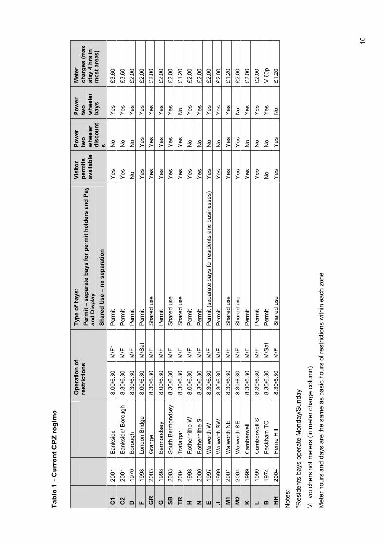
Tabl
e 1
- Cur
rent
CPZ
regi
me
Ope
ratio
n of
re
stric
tions
Ty
pe o
f bay
s:
Perm
it –
sepa
rate
bay
s fo
r per
mit
hold
ers
and
Pay
and
Dis
play
Sh
ared
Use
– n
o se
para
tion
Visi
tor
perm
itsav
aila
ble
Pow
er
two
whe
eler
di
scou
nts
Pow
er
two
whe
eler
ba
ys
Met
erch
arge
s (m
ax
stay
4 h
rs in
m
ost a
reas
)
C1
2001
B
anks
ide
8.00
/6.3
0 M
/F*
Per
mit
Yes
No
Yes
£3.6
0C
220
01
Ban
ksid
e/ B
orou
gh
8.30
/6.3
0M
/F
Per
mit
Yes
No
Yes
£3.6
0D
1970
B
orou
gh
8.30
/6.3
0 M
/F
Per
mit
No
No
Yes
£2.0
0F
1998
Lo
ndon
Brid
ge
8.00
/6.3
0 M
/Sat
Per
mit
Yes
Yes
Yes
£2.0
0G
R20
03
Gra
nge
8.30
/6.3
0 M
/F
Sha
red
use
Yes
Yes
Yes
£2.0
0G
1998
B
erm
onds
ey
8.00
/6.3
0 M
/F
Per
mit
Yes
Yes
Yes
£2.0
0SB
2003
S
outh
Ber
mon
dsey
8.
30/6
.30
M/F
S
hare
d us
e Y
esY
esY
es£2
.00
TR20
04
Traf
alga
r 8.
30/6
.30
M/F
S
hare
d us
e Y
esY
esN
o£1
.20
H19
98
Rot
herh
ithe
W
8.00
/6.3
0 M
/FP
erm
itY
esN
oY
es£2
.00
N20
00
Rot
herh
ithe
S
8.30
/6.3
0 M
/FP
erm
itY
esN
oY
es£2
.00
E19
97
Wal
wor
th W
8.
30/6
.30
M/F
P
erm
it (s
epar
ate
bays
for r
esid
ents
and
bus
ines
ses)
Y
esN
oY
es£2
.00
J19
99
Wal
wor
th S
W
8.30
/6.3
0 M
/F
Per
mit
Yes
No
Yes
£2.0
0M
120
01
Wal
wor
th N
E
8.30
/6.3
0 M
/F
Sha
red
use
Yes
Yes
Yes
£1.2
0M
220
04
Wal
wor
th S
E
8.30
/6.3
0 M
/F
Sha
red
use
Yes
Yes
No
£2.0
0K
1999
C
ambe
rwel
l 8.
30/6
.30
M/F
P
erm
itY
esN
oY
es£2
.00
L19
99
Cam
berw
ell S
8.
30/6
.30
M/F
P
erm
itY
esN
oY
es£2
.00
B19
74
Pec
kham
TC
8.
30/6
.30
M/S
atP
erm
itN
oN
oY
esV
60p
H
H20
04
Her
ne H
ill 8.
30/6
.30
M/F
Sha
red
use
Yes
Yes
No
£1.2
0
Not
es:
*Res
iden
ts b
ays
oper
ate
Mon
day/
Sun
day
V:
vouc
hers
not
met
ers
(in m
eter
cha
rge
colu
mn)
Met
er h
ours
and
day
s ar
e th
e sa
me
as b
asic
hou
rs o
f res
trict
ions
with
in e
ach
zone
10
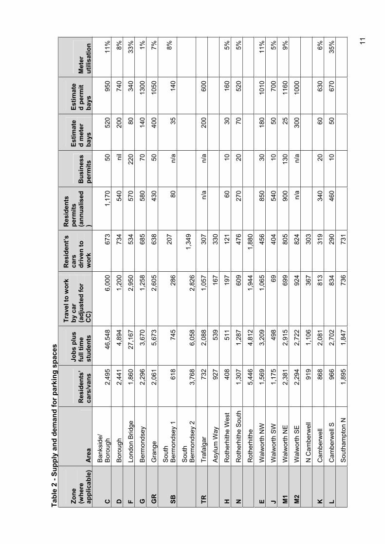
Tabl
e 2
- Sup
ply
and
dem
and
for p
arki
ng s
pace
s
Zone
(whe
re
appl
icab
le)
Are
aR
esid
ents
’ ca
rs/v
ans
Jobs
plu
s fu
ll tim
e st
uden
ts
Trav
el to
wor
k by
car
(a
djus
ted
for
CC
)
Res
iden
t’s
cars
driv
en to
w
ork
Res
iden
ts
perm
its(a
nnua
lised
)B
usin
ess
perm
its
Estim
ate
d m
eter
ba
ys
Estim
ate
d pe
rmit
bays
M
eter
utili
satio
n
CB
anks
ide/
Bor
ough
2,
495
46,5
486,
000
673
1,17
050
520
950
11%
DB
orou
gh
2,44
14,
894
1,20
073
454
0ni
l20
074
08%
FLo
ndon
Brid
ge
1,86
027
,167
2,95
053
457
022
080
340
33%
GB
erm
onds
ey
2,29
63,
670
1,25
868
558
070
140
1300
1%
GR
Gra
nge
2,06
15,
673
2,60
563
843
050
400
1050
7%
SBS
outh
Ber
mon
dsey
1
618
745
286
207
80n/
a35
140
8%
Sou
thB
erm
onds
ey 2
3,
768
6,05
82,
826
1,34
9
TRTr
afal
gar
732
2,08
81,
057
307
n/a
n/a
200
600
Asy
lum
Way
92
753
916
733
0
HR
othe
rhith
e W
est
408
511
197
121
6010
3016
05%
NR
othe
rhith
e So
uth
1,30
71,
287
609
476
270
2070
520
5%
Rot
herh
ithe
5,44
64,
812
1,94
41,
880
EW
alw
orth
NW
1,
569
3,20
91,
065
456
850
3018
010
1011
%
JW
alw
orth
SW
1,
175
498
6940
454
010
5070
05%
M1
Wal
wor
th N
E 2,
381
2,91
569
980
590
013
025
1160
9%
M2
Wal
wor
th S
E 2,
294
2,72
292
482
4n/
an/
a30
010
00
N C
ambe
rwel
l 91
91,
106
367
303
KC
ambe
rwel
l 86
82,
081
813
319
340
2060
630
6%
LC
ambe
rwel
l S
966
2,70
283
429
046
010
5067
035
%
Sou
tham
pton
N
1,89
51,
847
736
731
11
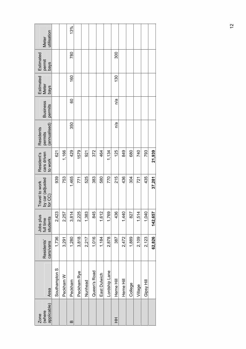
Zone
(whe
re
appl
icab
le)
Are
aR
esid
ents
’ ca
rs/v
ans
Jobs
plu
s fu
ll tim
e st
uden
ts
Trav
el to
wor
k by
car
(adj
uste
d fo
r CC
)
Res
iden
t’s
cars
driv
en
to w
ork
Res
iden
ts
perm
its
(ann
ualis
ed)
Bus
ines
s pe
rmits
Est
imat
ed
Met
erba
ys
Est
imat
ed
perm
itba
ysM
eter
utili
satio
n
Sou
tham
pton
S
1,73
62,
423
939
621
Pec
kham
W
3,29
12,
257
753
1,16
6
BP
eckh
am1,
280
3,81
41,
465
429
350
6016
078
013
%
Pec
kham
Rye
3,
818
2,22
577
115
79
Nun
head
2,
217
1,38
352
592
1
Que
en's
Roa
d 1,
016
845
383
372
Eas
t Dul
wic
h 1,
184
1,61
258
046
4
Lord
ship
Lan
e 2,
878
1,76
977
01,
134
HH
Her
ne H
ill
387
436
215
125
n/a
n/a
130
300
Her
ne H
ill
2,47
21,
440
436
849
Col
lege
1,
889
827
304
680
Vill
age
2,10
91,
514
721
740
Gip
sy H
ill
2,12
31,
040
435
793
62,8
2614
2,65
737
,281
21,9
39
12
4 The purpose of controls and CPZ review programme The purpose of each CPZ and other parking controls should be defined in relation to local circumstances in the context of the council’s wider development and transport plans.
4.1 Considerations in introducing controls or maintaining existing controls
In applying the strategic principle above to reviewing or introducing CPZs and other parking controls the following considerations will be taken into account:
Links to road safety measures including schemes in the vicinity of schools and other community facilities or area wide road safety schemes;
Reduction of congestion caused by parking, in particular to improve the efficiency of bus routes;
Protection of local occupiers’ interests in areas where there is pressure all day from visitors to specific destinations. This may include areas such as hospitals, town centres, employment concentrations and points of access to public transport or periodic or evening pressure for parking for special events or specific periods including football grounds, places of worship, and major leisure venues;
The needs of the local business community and other local organisations, particularly in opportunity areas and town centres as designated in the unitary development plan (UDP) as shown in figure 2;
Links to UDP policies where high density development is being introduced;
Management of parking in areas where demand by residents and businesses exceeds the streetspace available during much of the day;
Discouraging commuting to work by car in support of policies to reduce congestion; Widespread safety or access problems, including footway parking and inappropriate parking of lorries.
4.2 Implications for existing and future areas, review programme
Currently, comprehensive parking controls in Southwark embrace:
The major concentrations of employment in the city centre within the congestion zone area, Peckham, Walworth Road, much of the employment zones off the Old Kent Road, Camberwell and Peckham;
The major retail and business centres in Peckham and Walworth Road/Elephant and Castle, and the district centres at Borough and Bankside, Camberwell and Old Kent Road;
Most of the major visitor attractions, particularly the central cultural zone including facilities such as the Tate Modern, the Globe Theatre, the Imperial War Museum and the London Dungeon, and the major hospitals including Guys in the central area and Kings in Camberwell;
Areas in the vicinity of rail stations including Herne Hill, Peckham, Surrey Quays and Canada Water as well as the tube stations in the city centre area and the major bus corridors of Walworth Road, Camberwell Road and Old Kent Road.
13
The existing zones are shown in relation to the spheres of influence of major attractors of visitors on figure 2.
Looking ahead, areas where the considerations set out above may justify consideration of new zones or reviews of existing zones include:
Other areas adjacent to commercial areas such as North Camberwell between zones J and K, and the district centre of Lordship Lane;
Zones around the remaining rail stations: South Bermondsey, Queens Road, Nunhead, East Dulwich, North Dulwich, West Dulwich and Sydenham Hill stations;
Residential areas in which there is a high density of car ownership, particularly where there are also major employers or other attractions to visit the areas. Many of these areas are associated with a high proportion of houses converted into flats. Figure 3 shows where these are located. Areas include north Herne Hill, East Dulwich, Brunswick/Southampton Way, Peckham Rye, Nunhead and Livesey. In the Southampton Way area and Livesey there are also concentrations of employment (Figure 4)
Locations where high density development is taking place such as Bermondsey Spa and the Elephant and Castle, and areas adjacent to council housing schemes where permit schemes are being considered
In some areas where there are zones pressure for street space appears to be less than had been expected when the zones were introduced, and there may be a case for reassessment of boundaries. Such zones include Trafalgar (completed in November 2005), and some parts of Bermondsey.
A provisional CPZ review programme is set out in table 4.
4.3 A roads and busy bus routes
The major through routes and busy bus routes will continue to be regulated as corridors, rather than on a zonal basis, although where they pass through CPZs they will be regulated in a manner consistent with the rest of the CPZ.
Many are red routes on which TfL manages regulation. The bulk of the routes in the borough have been subject to inspections, and appropriate controls over waiting and loading have been introduced. These routes are regularly reviewed; table 3 shows the dates of previous review and the anticipated future review date.
Table 3 – Previous CPZ review programme
Route Road Date reviewed Proposed review date
Route 12 Walworth Road 2004 2007
Route 12 Camberwell Road 2004 2009
Route 12 Camberwell Green 2004 2009
Route 68 Waterloo Road 2001 2007
Route 68 Denmark Hill 2001 2008
Route 185 Champion Park 2002 2009
Route 185 Dog Kennel Hill 2002 2009
Route 185 Grove Vale 2004 2008
Route 185 Lordship Lane 2005 2007
Route 133 Newington Causeway 2004 2009
14
Route 133 Borough High Street 2004 2009
Route 47 Lower Road 2005 2010
Route 47 Bush Road 2004 2010
Route 47 Rotherhithe Old Road 2006 2010
Route 12 Rye Lane 2004 2009
In undertaking future reviews priority will be given to proposed new bus routes, and to congestion hotspots with reviews planned over the next six years.
4.4 Local issues
Hotspots are specific locations both within and outside CPZs where waiting and loading restrictions are required to tackle specific points of congestion or local safety hazards that are not identified through comprehensive reviews of CPZs, A routes or busy bus routes. New hotspots are reported regularly as a result in changes in the pattern of traffic, new traffic schemes, safety issues or new development. Typically waiting restrictions have been introduced outside the framework of comprehensive reviews for:
Cycle routes;
Local shopping parades and smaller centres throughout the borough;
Areas in the vicinity of schools and other community facilities where there is a concentration of pedestrian activity;
Junctions and pedestrian crossing points where uncontrolled waiting forms a safety hazard;
Wider area safety schemes and home zones.
The council maintains a running list of new hotspots as they emerge. The criteria for implementing parking controls in hotspots will be the same as the criteria for CPZs.
4.5 Liaison with neighbouring boroughs
The council liaises regularly with other boroughs on cross boundary issues, over the last year the following discussions have been held with neighbouring boroughs including:
Collaboration with Lambeth on new controls in Gipsy Hill;
Review of parking arrangements around Herne Hill Station;
A joint scheme for parking for football matches in the vicinity for the Millwall football stadium;
Planned liaison on parking in the vicinity of Kings Hospital (K zone);
Lambeth Council will also be consulted on the programmed reviews for C1, C2 and E zones.
This list covers most of the locations at which there are CPZs in Southwark adjacent to CPZs in neighbouring boroughs. This is supplemented by regular liaison through Londonwide forums.
15
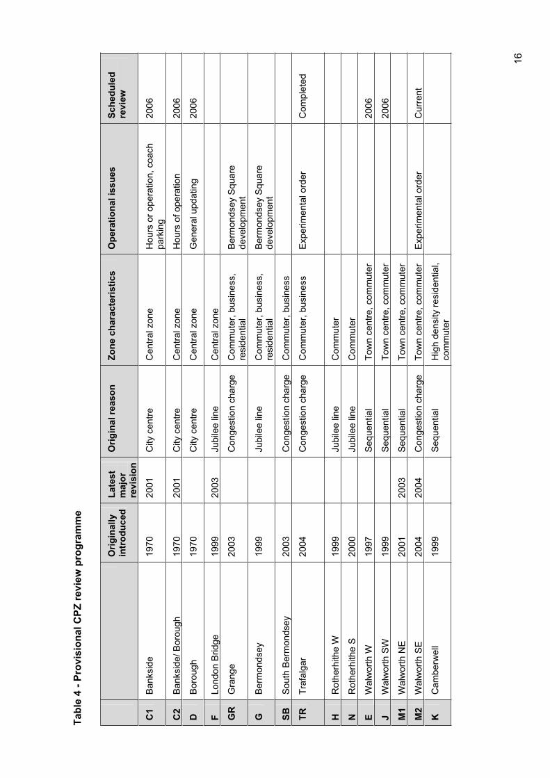
Tabl
e 4
- Pro
visi
onal
CPZ
revi
ew p
rogr
amm
e
Orig
inal
ly
intr
oduc
ed
Late
st
maj
orre
visi
on
Orig
inal
reas
on
Zone
cha
ract
eris
tics
O
pera
tiona
l iss
ues
Sche
dule
dre
view
C1
Ban
ksid
e19
7020
01C
ityce
ntre
Cen
tralz
one
Hou
rs o
r ope
ratio
n, c
oach
pa
rkin
g20
06
C2
Ban
ksid
e/ B
orou
gh
1970
2001
City
cen
tre
Cen
tral z
one
Hou
rs o
f ope
ratio
n 20
06
DB
orou
gh
1970
City
cen
tre
Cen
tral z
one
Gen
eral
upd
atin
g 20
06
FLo
ndon
Brid
ge
1999
2003
Jubi
lee
line
Cen
tral z
one
GR
Gra
nge
2003
Con
gest
ion
char
ge
Com
mut
er, b
usin
ess,
re
side
ntia
l B
erm
onds
ey S
quar
e de
velo
pmen
t
GB
erm
onds
ey
1999
Jubi
lee
line
Com
mut
er, b
usin
ess,
re
side
ntia
l B
erm
onds
ey S
quar
e de
velo
pmen
t
SBS
outh
Ber
mon
dsey
20
03C
onge
stio
n ch
arge
C
omm
uter
, bus
ines
s
TRTr
afal
gar
2004
Con
gest
ion
char
ge
Com
mut
er, b
usin
ess
Exp
erim
enta
l ord
er
Com
plet
ed
HR
othe
rhith
e W
19
99Ju
bile
e lin
e C
omm
uter
NR
othe
rhith
e S
2000
Jubi
lee
line
Com
mut
er
EW
alw
orth
W
1997
Seq
uent
ial
Tow
n ce
ntre
, com
mut
er
2006
JW
alw
orth
SW
19
99S
eque
ntia
lTo
wn
cent
re, c
omm
uter
20
06
M1
Wal
wor
th N
E 20
0120
03S
eque
ntia
lTo
wn
cent
re, c
omm
uter
M2
Wal
wor
th S
E 20
0420
04C
onge
stio
n ch
arge
To
wn
cent
re, c
omm
uter
E
xper
imen
tal o
rder
C
urre
nt
KC
ambe
rwel
l 19
99S
eque
ntia
lH
igh
dens
ity re
side
ntia
l, co
mm
uter
16
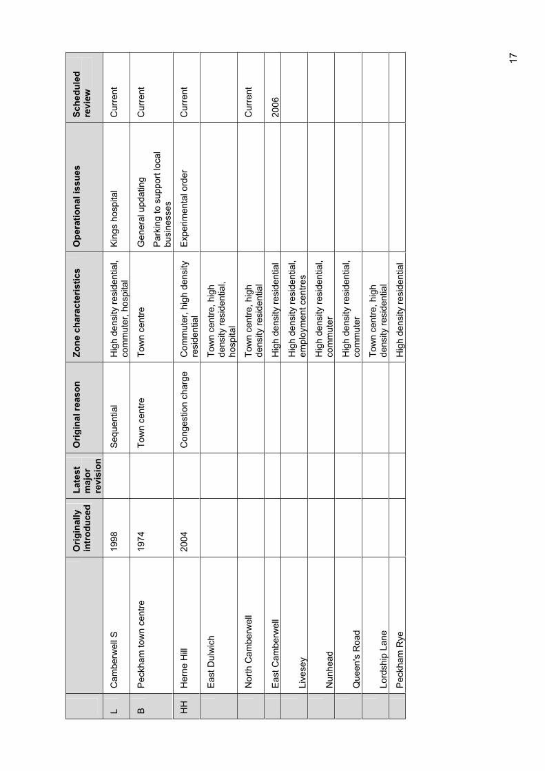
Orig
inal
ly
intr
oduc
ed
Late
st
maj
orre
visi
on
Orig
inal
reas
on
Zone
cha
ract
eris
tics
O
pera
tiona
l iss
ues
Sche
dule
dre
view
LC
ambe
rwel
l S
1998
Seq
uent
ial
Hig
h de
nsity
resi
dent
ial,
com
mut
er, h
ospi
tal
Kin
gs h
ospi
tal
Cur
rent
BP
eckh
am to
wn
cent
re
1974
Tow
n ce
ntre
To
wn
cent
re
Gen
eral
upd
atin
g
Par
king
to s
uppo
rt lo
cal
busi
ness
es
Cur
rent
HH
Her
ne H
ill
2004
Con
gest
ion
char
ge
Com
mut
er, h
igh
dens
ity
resi
dent
ial
Exp
erim
enta
l ord
er
Cur
rent
Eas
t Dul
wic
h To
wn
cent
re, h
igh
dens
ity re
side
ntia
l, ho
spita
l
Nor
th C
ambe
rwel
l To
wn
cent
re, h
igh
dens
ity re
side
ntia
l C
urre
nt
Eas
t Cam
berw
ell
Hig
h de
nsity
resi
dent
ial
2006
Live
sey
Hig
h de
nsity
resi
dent
ial,
empl
oym
ent c
entre
s
Nun
head
H
igh
dens
ity re
side
ntia
l, co
mm
uter
Que
en's
Roa
d H
igh
dens
ity re
side
ntia
l, co
mm
uter
Lord
ship
Lan
e To
wn
cent
re, h
igh
dens
ity re
side
ntia
l
Pec
kham
Rye
H
igh
dens
ity re
side
ntia
l
17

Figure 2 - Facilities that generate parking demand
18

Figure 3 - Concentrations of houses converted to flats
19

Figure 4 - Concentrations of employment
20

Figure 5 – Opportunity areas and town centres
21
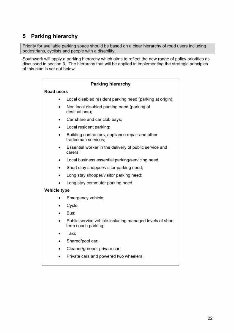
5 Parking hierarchy Priority for available parking space should be based on a clear hierarchy of road users including pedestrians, cyclists and people with a disability.
Southwark will apply a parking hierarchy which aims to reflect the new range of policy priorities as discussed in section 3. The hierarchy that will be applied in implementing the strategic principles of this plan is set out below.
Parking hierarchy Road users
Local disabled resident parking need (parking at origin);
Non local disabled parking need (parking at destinations);
Car share and car club bays;
Local resident parking;
Building contractors, appliance repair and other tradesman services;
Essential worker in the delivery of public service and carers;
Local business essential parking/servicing need;
Short stay shopper/visitor parking need;
Long stay shopper/visitor parking need;
Long stay commuter parking need.
Vehicle type
Emergency vehicle;
Cycle;
Bus;
Public service vehicle including managed levels of short term coach parking;
Taxi;
Shared/pool car;
Cleaner/greener private car;
Private cars and powered two wheelers.
22
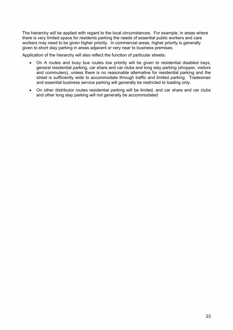
The hierarchy will be applied with regard to the local circumstances. For example, in areas where there is very limited space for residents parking the needs of essential public workers and care workers may need to be given higher priority. In commercial areas, higher priority is generally given to short stay parking in areas adjacent or very near to business premises.
Application of the hierarchy will also reflect the function of particular streets:
On A routes and busy bus routes low priority will be given to residential disabled bays, general residential parking, car share and car clubs and long stay parking (shopper, visitors and commuters), unless there is no reasonable alternative for residential parking and the street is sufficiently wide to accommodate through traffic and limited parking. Tradesman and essential business service parking will generally be restricted to loading only.
On other distributor routes residential parking will be limited, and car share and car clubs and other long stay parking will not generally be accommodated
23
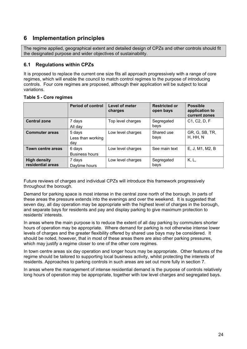
6 Implementation principles The regime applied, geographical extent and detailed design of CPZs and other controls should fit the designated purpose and wider objectives of sustainability.
6.1 Regulations within CPZs
It is proposed to replace the current one size fits all approach progressively with a range of core regimes, which will enable the council to match control regimes to the purpose of introducing controls. Four core regimes are proposed, although their application will be subject to local variations.
Table 5 - Core regimes
Period of control Level of meter charges
Restricted or open bays
Possibleapplication to current zones
Central zone 7 days All day
Top level charges Segregated bays
C1, C2, D, F
Commuter areas 5 days Less than working day
Low level charges Shared use bays
GR, G, SB, TR, H, HH, N
Town centre areas 6 days Business hours
Low level charges See main text E, J, M1, M2, B
High density residential areas
7 days Daytime hours
Low level charges Segregated bays
K, L,
Future reviews of charges and individual CPZs will introduce this framework progressively throughout the borough.
Demand for parking space is most intense in the central zone north of the borough. In parts of these areas the pressure extends into the evenings and over the weekend. It is suggested that seven day, all day operation may be appropriate with the highest level of charges in the borough, and separate bays for residents and pay and display parking to give maximum protection to residents’ interests.
In areas where the main purpose is to reduce the extent of all day parking by commuters shorter hours of operation may be appropriate. Where demand for parking is not otherwise intense lower levels of charges and the greater flexibility offered by shared use bays may be considered. It should be noted, however, that in most of these areas there are also other parking pressures, which may justify a regime closer to one of the other core regimes.
In town centre areas six day operation and longer hours may be appropriate. Other features of the regime should be tailored to supporting local business activity, whilst protecting the interests of residents. Approaches to parking controls in such areas are set out more fully in section 7.
In areas where the management of intense residential demand is the purpose of controls relatively long hours of operation may be appropriate, together with low level charges and segregated bays.
24
6.2 Geographic size of CPZs
There are significant variations in the geographic size of the existing CPZs. This leads to significant differences in the opportunity to take car trips within the zone of residence and the extent of privileged parking opportunities for residents and local businesses.
The differences are to some extent historical, although they also reflect the results of public consultations and the differences in the problems which were required to be tackled at the time.
Government guidance is that zones should be quite small in order to reduce the level of travel by car within the borough’s boundaries. Very local travel makes up 12% of all travel by car in the borough suggesting that this would help to reduce congestion in the borough resulting from car use for very short trips. However other boroughs have opted for single zone approaches to increase the range of opportunities for visiting local shops and businesses. A balance has to be struck.
The following principles will be applied progressively in determining the size of CPZs in the borough:
Zones should be designed to discourage the use of cars for short trips, less than 1km, to sources of employment or facilities such as shops. This also means avoiding mixed use zones although this may not be practical everywhere;
Predominantly residential areas should generally be relatively large, to provide maximum choice for both residents and visitors, but non residential zones should generally be drawn tightly to discourage local commuter parking;
Very small zones may be appropriate at specific pressure points such as the streets around stations, hospitals and small shopping areas.
The current zones that do not conform consistently to these principles will be reviewed to consider these principles.
6.3 Physical layout principles of CPZs
The council will apply the following general design principles to new zones or reviewed zones. The definition of boundaries to minimise immediate displacement effects:
Maximisation of the number of parking spaces available consistent with safety, other needs and the objectives of the CPZ;
A balance between residents and business bays, longer stay meter bays and short stay bays (free or metered) based on numbers of residents’ vehicles, specific visitor attractors and numbers of businesses in the area;
Meter spaces distributed throughout zones, with very short stay spaces located close to business premises within the constraints of the overall balance between different types of spaces;
Appropriate provision for parking for people with a disability, car clubs and car share schemes;
Provision of loading and unloading spaces, in the form of yellow line drop off points;
Restrictions at junctions to ensure safety without unnecessarily restricting the amount of parking available;
Provision of passing gaps, particularly in streets with extensive parking bays on both sides where there is insufficient width for vehicles to pass.
6.4 Waiting and loading restrictions
Waiting and loading restrictions outside CPZs will be drawn up to take account of:
The width of the carriageway and traffic levels
25
The presence of bus lanes
In streets where there are shopping parades off peak loading will generally provided on the principle road or at the end of side streets in the form of single yellow lines or free, limited stay parking
In residential streets the aim will be to retain the maximum possible number of parking spaces
These principles are consistent with loading and waiting restrictions applied by TfL on red routes.
6.5 Car share and car club schemes
The council is committed to promoting car club and car share schemes. Car clubs offer private car rental facilities to scheme members. They offer access to cars without individual ownership. They generally encourage members to make maximum use of other forms of transport and reduce overall demand for parking. To operate in areas where there is no off street parking available they require dedicated on street bays. The council has already provided such bays in C1 zone. Further studies of demand will be undertaken and bays introduced into other zones progressively to meet general demand linked to new developments. Many larger developments incorporate travel plans, which include provision for a car club.
Car share schemes offer to match potential travellers to drivers who have spare space in their cars. This can have a direct impact on congestion, as well as reducing the need for car ownership. Such schemes can be supported by providing dedicated on street parking in destination areas. The demand for such schemes in Southwark will be assessed.
Proposals for the development of car club and car share schemes have been put forward for funding through the BSP.
26
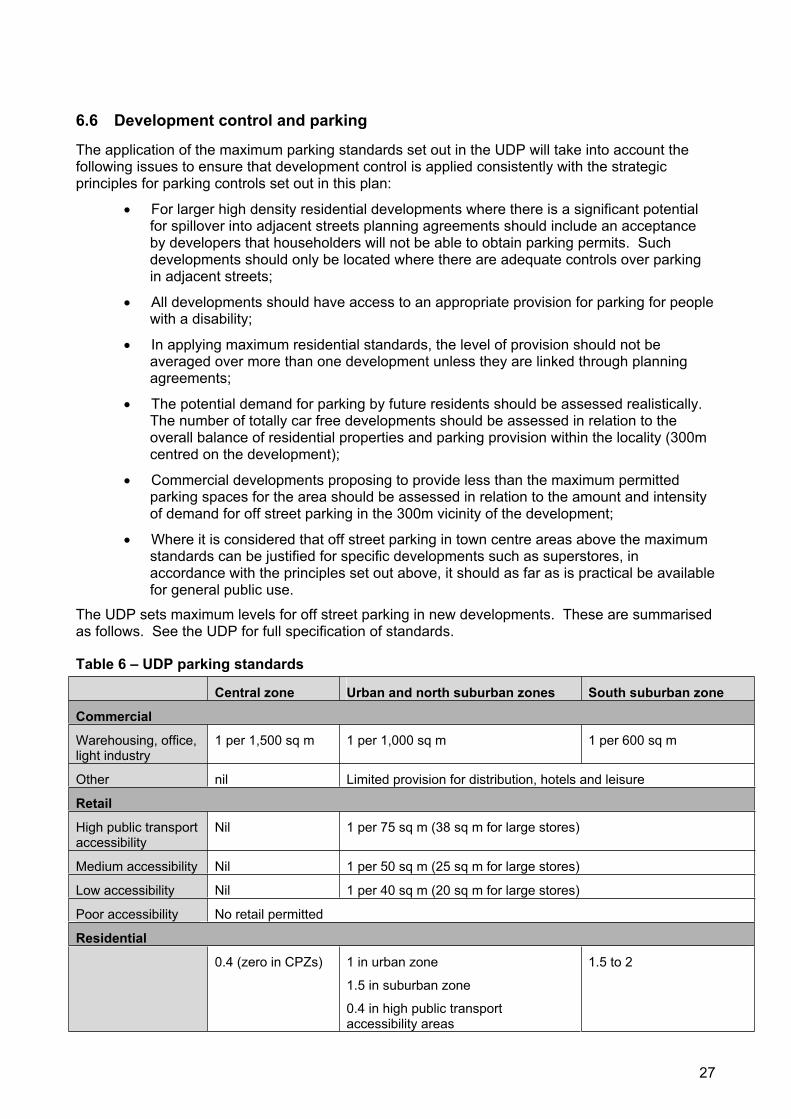
6.6 Development control and parking
The application of the maximum parking standards set out in the UDP will take into account the following issues to ensure that development control is applied consistently with the strategic principles for parking controls set out in this plan:
For larger high density residential developments where there is a significant potential for spillover into adjacent streets planning agreements should include an acceptance by developers that householders will not be able to obtain parking permits. Such developments should only be located where there are adequate controls over parking in adjacent streets;
All developments should have access to an appropriate provision for parking for people with a disability;
In applying maximum residential standards, the level of provision should not be averaged over more than one development unless they are linked through planning agreements;
The potential demand for parking by future residents should be assessed realistically. The number of totally car free developments should be assessed in relation to the overall balance of residential properties and parking provision within the locality (300m centred on the development);
Commercial developments proposing to provide less than the maximum permitted parking spaces for the area should be assessed in relation to the amount and intensity of demand for off street parking in the 300m vicinity of the development;
Where it is considered that off street parking in town centre areas above the maximum standards can be justified for specific developments such as superstores, in accordance with the principles set out above, it should as far as is practical be available for general public use.
The UDP sets maximum levels for off street parking in new developments. These are summarised as follows. See the UDP for full specification of standards.
Table 6 – UDP parking standards
Central zone Urban and north suburban zones South suburban zone
Commercial
Warehousing, office, light industry
1 per 1,500 sq m 1 per 1,000 sq m 1 per 600 sq m
Other nil Limited provision for distribution, hotels and leisure
Retail
High public transport accessibility
Nil 1 per 75 sq m (38 sq m for large stores)
Medium accessibility Nil 1 per 50 sq m (25 sq m for large stores)
Low accessibility Nil 1 per 40 sq m (20 sq m for large stores)
Poor accessibility No retail permitted
Residential
0.4 (zero in CPZs) 1 in urban zone
1.5 in suburban zone
0.4 in high public transport accessibility areas
1.5 to 2
27
6.7 Range of permits available
The range of permits currently available is set out in table 8. A number of modifications have been suggested on which no decision has yet been taken. These are detailed in table 9. It is proposed that a full assessment of the arguments for and against each is undertaken, together with further consultation and a comparison with arrangements in other boroughs.
This will include a review of current prices for permits. The view is taken that permit prices should reflect administrative costs and an element reflecting the value of the benefit. This is considered to be greater for businesses than individual households. A true evaluation of the benefit would be related to the cost of private off street parking, adjusted because on street spaces are not dedicated to individual households or businesses, and are not as secure as some off street parking. Permits also bring a benefit by permitting parking elsewhere in the same zone. It is considered that the current level of charges reasonably reflects the cost of administration and may underestimate the level of benefit in some areas.
The review will consider whether different levels for permit charges should be set for second, third and fourth cars (there is a maximum in most zones of four permits per household). Consideration will also be given to the proportion of the cost of enforcement which should be met from permit charges, meter income and penalty charges.
6.8 Disability parking provision
Southwark provides dedicated parking bays outside residential properties where requested by registered disabled people who have access to a car. Set criteria are used for assessing whether they can be provided safely and without excessive disruption to traffic on busy streets
The council recognises that there is not always sufficient opportunity for people with a disability to park at trip destinations such as town centres, medical centres, public service outlets, post offices and social, religious and leisure facilities. Suitable locations for additional disability parking will be identified progressively in CPZ reviews and in response to specific requests. In addition a proposal is included in the BSP to undertake a boroughwide survey of destination bays in order to draw up a framework for allocation and to undertake demonstration schemes in two areas exploring options for physical improvements to the street layout to provide improved facilities for parking for people with a disability. These reviews will include consultation with groups representing people with a disability under the auspices of the councils transport consultative forum that has a separate group focussing on disability issues called the mobility subgroup. The review is programmed for 2007.
Blue badge holders may also park on yellow lines for up to three hours, where loading and unloading is permitted and as long as they are not causing an obstruction, and in meter bays. Blue badge holders are not currently permitted to park in residents’ bays in CPZs, but they may park in shared use bays. This provides opportunities for parking in destination areas as well as outside residential properties.
Following a recent review consideration is being given to the following improvements:
Parking by blue badge holders in residents’ parking areas, or the introduction of shared use bays, where parking by disabled people is also permitted on a consistent basis throughout the borough;
Additional badges which include the user’s car number the for use overnight outside a disabled person’s house as there is a high risk of theft of blue badges, which do not contain the car registration number which has recently been implemented;
24 hour on call enforcement to help prevent misuse of dedicated bays.
28
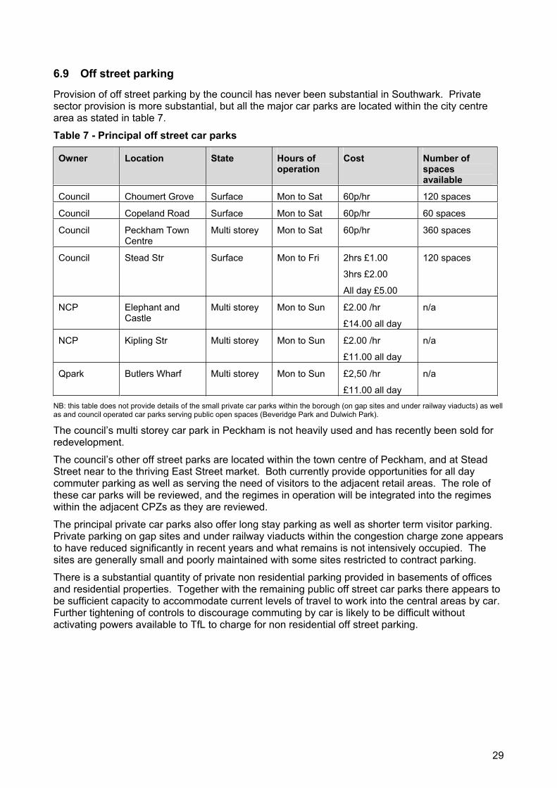
6.9 Off street parking
Provision of off street parking by the council has never been substantial in Southwark. Private sector provision is more substantial, but all the major car parks are located within the city centre area as stated in table 7.
Table 7 - Principal off street car parks
Owner Location State Hours of operation
Cost Number of spaces available
Council Choumert Grove Surface Mon to Sat 60p/hr 120 spaces
Council Copeland Road Surface Mon to Sat 60p/hr 60 spaces
Council Peckham Town Centre
Multi storey Mon to Sat 60p/hr 360 spaces
Council Stead Str Surface Mon to Fri 2hrs £1.00
3hrs £2.00
All day £5.00
120 spaces
NCP Elephant and Castle
Multi storey Mon to Sun £2.00 /hr
£14.00 all day
n/a
NCP Kipling Str Multi storey Mon to Sun £2.00 /hr
£11.00 all day
n/a
Qpark Butlers Wharf Multi storey Mon to Sun £2,50 /hr
£11.00 all day
n/a
NB: this table does not provide details of the small private car parks within the borough (on gap sites and under railway viaducts) as well as and council operated car parks serving public open spaces (Beveridge Park and Dulwich Park).
The council’s multi storey car park in Peckham is not heavily used and has recently been sold for redevelopment.
The council’s other off street parks are located within the town centre of Peckham, and at Stead Street near to the thriving East Street market. Both currently provide opportunities for all day commuter parking as well as serving the need of visitors to the adjacent retail areas. The role of these car parks will be reviewed, and the regimes in operation will be integrated into the regimes within the adjacent CPZs as they are reviewed.
The principal private car parks also offer long stay parking as well as shorter term visitor parking. Private parking on gap sites and under railway viaducts within the congestion charge zone appears to have reduced significantly in recent years and what remains is not intensively occupied. The sites are generally small and poorly maintained with some sites restricted to contract parking.
There is a substantial quantity of private non residential parking provided in basements of offices and residential properties. Together with the remaining public off street car parks there appears to be sufficient capacity to accommodate current levels of travel to work into the central areas by car. Further tightening of controls to discourage commuting by car is likely to be difficult without activating powers available to TfL to charge for non residential off street parking.
29
6.10 Coaches
The area attracts a number of tourist coaches to sites within the cultural zone mainly within the central activity area. These include the Tate Modern, the London Dungeon, the Imperial War Museum and the Globe Theatre. A significant proportion of coaches carry school parties and others for whom travel by public transport is not a practical option. There are also some commuter services which terminate within the borough.
The council has signed up to the Concordat for Coaches in London promoted by TfL. This sets out agreed principles for routeing of coaches, the provision of set down and pickup points, the way in which enforcement of parking regulations will be carried out and the provision of information.
The council will also review the provision of coach parking opportunities within its programme for the review of CPZs. Coach bays are currently provided in zones C1, C2, and F. There may be further opportunities for the provision of on street short to medium term parking in some exisiting meter bays, particularly in C2 Zone (review programmed for 2006).
The council will also cooperate with The Greater London Assembly, and TfL in seeking to identify opportunities for the provision of off street, including longstay, parking facilities. Provision for coach parking will be incorporated into planning agreement for relevant developments.
An overall policy and strategy for coach parking in the borough will be drawn up within the framework of the concordat.
6.11 Powered two wheelers
Bays for motorcycles are provided in all zones except HH, M2, N and TR. There is free parking in these bays.
Discounted residents permits are available in six zones. These include three recent zones, HH, M2, and T, where there are no dedicated bays. The borough has been planning to adjust all zones to permit motorcycle parking in general residents’ bays at a reduced charge.
No recent survey has been carried out on the adequacy of supply of bays in either residential or destination areas.
The BSP includes proposals for the installation of secure motorcycle parking throughout the borough.
6.12 Streetscene, pavement parking, crossovers
The council is currently tendering for a partner to assist in setting new design principles for the streetscene. This will cover all types or road furniture including parking fixtures and lining. The aim will be to produce standards and guidelines, which form an integrated design framework, which reflects the character and function of different types of areas. This can help to reduce unsightly clutter of signs and lines, whilst leaving members of the public with a clear understanding of where parking is or is not permissible.
Such treatment is likely, however, to be costly, and could only be rolled out throughout the borough progressively over a period of years. In the meantime shorter term action will be considered to reduce the impact of the most inappropriate areas of clutter.
The contractors will be required to draw up standards and guidance consistent with TfL’s recently published manual.
Pavement parking is generally forbidden. Designations of locations where it is permitted have been used sparingly.
The council’s policy on pavement crossovers is currently to permit them where they can be provided safely. This has not to date resulted in a proliferation of front garden parking in areas where they are inappropriate within the streetscape, although the impact will be monitored.
30
6.13 Environmental incentives
Discounted residents’ permits for alternative fuel vehicles are currently available in the most recently introduced CPZs. Vehicles must be eligible for a powershift grant. These are available for LPG, electric and hybrid powered vehicles. These types of vehicles are eligible for a 75% discount.
A further incentive could be introduced to encourage the use of more fuel efficient vehicles. This could be based on the level of carbon dioxide emissions as used for determining the level of company car tax. A break point of 200gm per km would include most smaller, more city friendly vehicles. The discount level available could be less than the full discount available for alternative fuel vehicles. An engine capacity limit of two litres could be applied to older vehicles for which emissions data is not contained in registration documents such vehicles will generally exceed the suggested emissions limit, but a lower limit might discriminate unfairly against older vehicles.
The introduction of such a discount would be a major change in the current permit system. It is proposed to consider this in the context of an overall realignment of permit charges in the context of the core regimes set out above.
6.14 Database of regulations
The council has a database register of all traffic management orders, together with a full library of orders. But these orders have only been consolidated when the opportunity has arisen. As a result it can be difficult to establish the definitive regulatory provisions for a specific location. There are also variations it the details of exceptions provided for in the orders for similar circumstances. It is planned to register the details of all orders on a GIS database as the basis for consolidation and rationalisation.
31
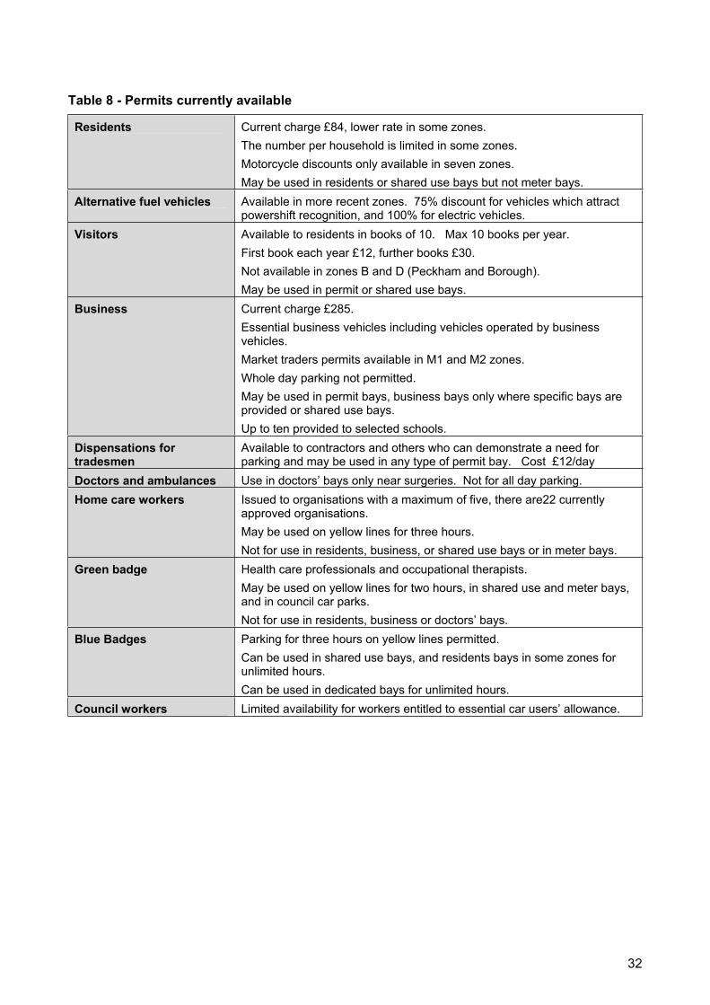
Table 8 - Permits currently available
Residents Current charge £84, lower rate in some zones. The number per household is limited in some zones. Motorcycle discounts only available in seven zones. May be used in residents or shared use bays but not meter bays.
Alternative fuel vehicles Available in more recent zones. 75% discount for vehicles which attract powershift recognition, and 100% for electric vehicles.
Visitors Available to residents in books of 10. Max 10 books per year. First book each year £12, further books £30. Not available in zones B and D (Peckham and Borough). May be used in permit or shared use bays.
Business Current charge £285. Essential business vehicles including vehicles operated by business vehicles. Market traders permits available in M1 and M2 zones. Whole day parking not permitted. May be used in permit bays, business bays only where specific bays are provided or shared use bays. Up to ten provided to selected schools.
Dispensations for tradesmen
Available to contractors and others who can demonstrate a need for parking and may be used in any type of permit bay. Cost £12/day
Doctors and ambulances Use in doctors’ bays only near surgeries. Not for all day parking. Home care workers Issued to organisations with a maximum of five, there are22 currently
approved organisations. May be used on yellow lines for three hours. Not for use in residents, business, or shared use bays or in meter bays.
Green badge Health care professionals and occupational therapists. May be used on yellow lines for two hours, in shared use and meter bays, and in council car parks. Not for use in residents, business or doctors’ bays.
Blue Badges Parking for three hours on yellow lines permitted. Can be used in shared use bays, and residents bays in some zones for unlimited hours. Can be used in dedicated bays for unlimited hours.
Council workers Limited availability for workers entitled to essential car users’ allowance.
32
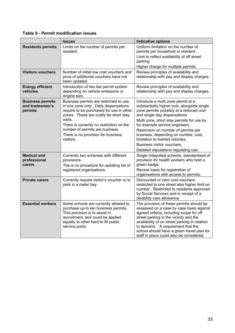
Table 9 - Permit modification issues
Issues Indicative options Residents permits Limits on the number of permits per
resident. Uniform limitation on the number of permits per household or resident. Limit to reflect availability of off street parking.Higher charge for multiple permits.
Visitors vouchers Number of initial low cost vouchers and price of additional vouchers have not been updated.
Review principles of availability and relationship with pay and display charges.
Energy efficient vehicles
Introduction of two tier permit system depending on vehicle emissions or engine size.
Review principles of availability and relationship with pay and display charges.
Business permits and tradesmen’s permits
Business permits are restricted to use in one zone only. Daily dispensations require to be purchased for use in other zones. These are costly for short stay visits. There is currently no restriction on the number of permits per business. There is no provision for business visitors.
Introduce a multi zone permit at a substantially higher cost, alongside single zone permits possibly at a reduced cost and single day dispensations Multi zone, short stay permits for use by for example service engineers. Restriction on number of permits per business, depending on number, cost, limitation to liveried vehicles. Business visitor vouchers. Detailed stipulations regulating use.
Medical and professional carers
Currently two schemes with different provisions. The is no procedure for updating list of registered organisations.
Single integrated scheme, standardised of provision for health workers who hold a green badge. Review basis for registration of organisations with access to permits.
Private carers Currently require visitor’s voucher or to park in a meter bay.
Discounted or zero cost vouchers restricted to one street also higher limit on number. Restricted to residents approved by Social Services and in receipt of a disability care allowance.
Essential workers Some schools are currently allowed to purchase up to ten business permits. This provision is to assist in recruitment, and could be applied equally to other hard to fill public service posts.
The provision of these permits should be assessed on a case by case basis against agreed criteria, including scope for off street parking in the vicinity and the availability of on street parking in relation to demand. A requirement that the school should have a green travel plan for staff in place could also be considered.
33
7 Retail and commercial centres, waiting and loading Parking regulations in the vicinity of retail and business centres and community facilities should be designed to support their operations and more generally the continued vitality of town centres throughout the borough.
Retail and commercial businesses depend on loading and unloading facilities for deliveries. Some businesses also require convenient parking for their own delivery vehicles or transport used to visit customers and suppliers. Businesses have a general interest, to a varying degree, in accessibility by car and car parking facilities for customers although a relatively high percentage of visitors to town centres in Southwark generally use public transport.
7.1 Loading and unloading
Southwark generally provides for loading and unloading through the provision of limited stay, free parking bays, dedicated business bays, and stretches of single yellow lines near to shops and other commercial premises. In some CPZs a limited number of loading bays have been provided.
It is considered that loading bays are difficult to enforce, and that single yellow lines are generally more practical. However, the overall approach will be reviewed and a consistent framework will be drawn up for application progressively as CPZ reviews are undertaken, and for incorporation into controls introduced as a result of hotspot reviews (see section 4).
The BSP includes a proposal for a demonstration project in three areas, Southwark Park Road, Lordship Lane, and Lower Road to explore the most appropriate provision for loading and unloading and options for physical streetspace modifications to provide for loading and unloading.
The BSP also includes major proposals for the improvement of Walworth Road and Rye Lane, which will include reengineering of loading and unloading facilities.
These projects will incorporate the best practice guidance issued by TfL.
7.2 Town centre parking provision and controls
Within the context of the parking regimes set out in the previous section a range of measures will be considered to support businesses in town centres. The application of these measures will be tailored to the requirements of each town centre. Each town centre in Southwark is distinct in its business composition, the availability of off street parking, and the areas they serve. A balance needs to be struck in all centres between the interest of businesses in maintaining access by car and the potential for encouraging customers and business suppliers to make greater use of public transport. Specific surveys of the dependence on car access will be considered.
A specific issue which will be the subject of review is whether to charge for short stay parking in the vicinity of retail, leisure, social and other commercial facilities. Currently the practice of the council is to provide free limited stay parking bays. But these are difficult to enforce, and consideration will be given to introducing pay and display meters at such locations, possibly with a low cost or nominal charge. The measures will include:
Very short stay parking at metered bays, possibly at a low cost, to encourage maximum use of limited parking space;
Limited provision of short stay off street parking based on the overall needs of the town centre loading bays and where possible rear servicing;
Voluntary agreement on managing loading times drawn up by town centre managers, possibly linked to schemes promoted through freight quality partnership;
Retailers and other owners of private off street parking should be encouraged to operate complementary regimes, and make their parking available to the general public for short stay parking.
34
8 Consultation Consultation on reviews of current regulations and proposed changes should be based on a clear strategic framework as the context for evaluating the views of local residents, businesses and other local organisations.
Consultation on new CPZs or reviews of existing CPZs will normally involve the following stages:
For new zones a preliminary questionnaire based consultation may be undertaken to establish the general attitude the introduction of a CPZ and to establish the geographical extent for consultation on detailed proposals;
Consultation of the relevant community council, which are local committees of the council held in public forum format, on the planned consultation programme including the geographical area;
Questionnaire based consultation together with a local exhibition on detailed designs, detailed plans will also be exhibited at a community council meeting;
Preparation of a review report for consideration by the council. Recommendations will reflect the consultation responses, but will also be set in the context of other assessments of local issues and the policy principles set out in this plan;
Formal notice of the proposed order, and consideration as required of objections under the relevant statutory procedures.
Local schemes will follow a simplified consultation procedure. There will not normally be a questionnaire sent out or exhibition. However proposals will be subject to consideration at community councils at which members of the public have the opportunity to make representations. Directly affected proprietors will also be consulted.
CPZs will generally be introduced using experimental orders. These offer the public a better basis for making representations, and allow the council to assess scheme in operation. Before schemes are made permanent a questionnaire based consultation will normally be carried out.
If it becomes apparent during consultation on a scheme that overspill into adjacent streets is a concern more extended consultations will be carried out.
Generally questionnaire responses will only be given major weight if at least 50% of respondents are in favour of the proposals, and they represent at least 20% of the householders and businesses in the area. Lower level responses will be considered alongside the community council’s views and other information on local views. If responses clearly diverge within the area consulted consideration will be given to redrawing the boundaries of proposed zones.
35
9 Enforcement Enforcement should be firm but fair and aim to secure the underlying purpose of parking controls: safety for all road users, the free flow of traffic, particularly public transport, maintenance of access for all road users and essential and emergency services, protecting the interests of residents and local businesses and other organisations, and maintaining a regular turnover in parking spaces which are intended to support local business and other social activities.
9.1 Current arrangements
The whole of the borough has been designated for decriminalised enforcement of on street parking and bus lanes.
All enforcement is contracted out to a private enforcement company. There are four separate contracts, all with one company. The principle enforcement contract is for ten years, with a five year point at which either side can withdraw without penalty. There is a review point in 2006. Although it is not intended to renegotiate the contract formally, a programme of agreed operational improvements is being drawn up with the contractor.
The contract as currently specified requires the contractor to provide the resources necessary for effective enforcement of all regulations throughout the borough. The contract includes two key quality provisions:
A bonus payment is made if the number of PCNs issued exceeds 120,000 across the borough. This is not extended to incentive payments for individual attendants;
The contractor is penalised if the number of PCNs challenged and shown to have been issued in error exceeds 1 in 1,000.
These two provisions taken together are aimed to ensure that the contractor operates a firm but fair approach to enforcement.
Powers which became available in 2001 to use CCTV observation of parking and bus lane offences as the basis for issuing PCNs have been applied at two locations:
Enforcement using CCTV cameras has been introduced along the whole of Walworth Road/ Camberwell Road extending from the Crown Court in Newington Causeway to Denmark Hill. This installation was funded by TfL through the London bus initiative;
Enforcement using CCTV cameras was introduced into Rye Lane through the centre of Peckham in 2003. The council funded these CCTV cameras.
Additional cameras are programmed for introduction by the council in the Lower Road corridor.
The borough has recently received approval from the ALG for a scheme for using powers introduced in 2003 for enforcement of moving traffic offences. A full survey of all proposed locations has been completed and operation of the scheme to enforce moving traffic offences will commence in May 2006.
Additional CCTV cameras will be introduced to monitor moving traffic offences will contribute to the more effective enforcement of parking regulations as well as moving traffic offences. The council has been reviewing its CCTV systems, including monitoring and control arrangements in advance of taking these extended powers.
Forms of enforcement contract
Contracts for enforcement vary between those which specify the level of resources to be provided and the frequency of visits to different areas, and those which leave the contractor to manage the allocation of resources to achieve specified outcome objectives. Both approaches have advantages and disadvantages; the former is easy to monitor but takes little or no account of changing circumstances. The latter is more difficult to monitor but can react swiftly to changes in
36
the location or level of parking problems. Either form of contract can have incentives for success or penalties for failure.
Arrangements also vary between the styles of enforcement. Recent press criticism of enforcement arrangements elsewhere led to some authorities modifying or removing incentive payments, particularly incentive for individual attendants, and requiring a more conciliatory approach. The Southwark concept is that to achieve the objective of improved traffic flow and safety the aim should be to change the pattern of driver behaviour and focus on discouraging inappropriate parking by providing convenient alternatives.
The British Parking Association has recently published a new model contract for enforcement. Whilst it retains a system of financial bonuses and penalties for performance it also makes provision for a broad range of performance indicators. These are aggregated up into single composite performance measures. The model contract prohibits bonuses for individual parking attendants. The suggested bonus and penalty scheme provides, however, for a more substantial fluctuation in income based on performance, measured at more frequent time periods than the current contract in Southwark. Consideration will be given to introducing some or all of the features of the model contract when the current contractual arrangements become due for replacement.
9.2 Enforcement activity
The purpose of enforcement is to support the objectives of parking controls: that is the prevention of obstructions and compliance with the arrangements for managing access to limited parking space. There is no general evidence that levels of traffic obstruction or abuse of parking management arrangements are higher or lower in Southwark than elsewhere. But these have not been directly monitored.
It is proposed to appoint two monitoring officers to undertake surveys of the proportion of observed infringements which are subject to enforcements action.
In the meantime the only indicator of the level of enforcement activity is the number of PCNs issued. An analysis of PCNs has been carried out, which indicates that:
Over 70% of PCNs are issued for offences relating to yellow lines, bus lane and pavement parking, offences relating to permits and meters make up a significantly smaller proportion at 20%;
Enforcement using CCTV cameras, which targets yellow line and bus lane offences, has been effective;
PCNs issued for zone A, which are mainly for yellow line and bus lane offences outside CPZs and the roads covered by CCTV, account for 44% of the total PCNs issued;
The bulk of other PCNs issued relate to the principle town centres in Peckham and the central activity zone.
The analysis also considered comparisons with other inner London boroughs. But this is inconclusive because of the wide range a variations in circumstances which could be expected to affect levels of infringements of parking controls.
The effectiveness of enforcement and public respect for parking controls also depend on how parking attendants apply the regulations. They need to be firm and they cannot apply unlimited discretion. But at the same time enforcement action should be proportionate to the severity of the infringement. Generally traffic offences involving parking on yellow lines or in bus lanes have the potential to cause an immediate traffic hazard or congestion. Permit offences and meter offences have a less immediate impact, they are more about ensuring that drivers are responsible in observing parking management arrangements which have been introduced in the wider interests of the whole community. The proportion of PCNs issued for yellow line and bus lane infringements indicates that current enforcement activity is well focused on more serious infringements.
37

Figure 6 – Fixed roadside camera locations
38
A secondary indicator of whether enforcement activity is generally fair is the level of challenge and appeal against PCNs issued. Around 12% of PCNs issued in 2003/04 were cancelled at various stages, around three quarters because owners could not be traced, and most of the rest on the basis of new information supplied at each stage in following up the PCNs.
The rate of cancellations due to contractor error or following representations were both small, 0.6% and 3.7% respectively. Representations which are accepted by the council generally contain information which could not have been available to the parking attendant when the PCN was issued. 1% of PCNs were subject to a formal appeal to the adjudication service, 60% of which were upheld, adding a further 0.6% to the number of cancellations. The only comparison, which can be made with other authorities, is in the levels of formal appeals. Variations cannot be considered to be statistically significant, and are more likely to reflect different practices in considering representations prior to formal appeals being heard. No comparisons are available on the more substantial volume of cancellations at this earlier stage, however it is understood that Southwark has a relatively low level of cancellations.
9.3 Enforcement priorities
Whilst the council considers that its current enforcement arrangements are generally firm but fair it is recognised that there is always scope for improvement. Two key changes are proposed:
The appointment of two contract monitoring officers;
Introduction of an agreed improvement programme with the current contractor which will include specific improvements targets and improved opportunity for council officers to set priorities which reflect wider transport objectives and reported concerns of the public.
The effectiveness of enforcement depends on action being taken consistently in areas where parking attendants are present, and the frequency of visits by parking attendants. However diligent parking attendants are in taking enforcement activity high levels of compliance may be difficult to achieve if they are not in the right places at the right time. Equally, effective programming of beats may be compromised if attendants fail to take action on observed infringements. Without independent monitoring it is impossible to establish what level of compliance is being achieved, and whether improvements depend on more consistent enforcement or changes in the scheduling of parking attendants’ beats and their method of operation. The monitoring officers will undertake systematic surveys both of the consistency of the contractor in serving penalty notices and the overall level of compliance with the regulations.
Under the current enforcement contract council officers work closely with the contractors to target key locations and categories of offenders. However priorities are not set in a way that systematically relates them to council’s wider transport objectives. It is proposed that the new contract supervision arrangements will allow council officers to take a fuller role in setting priorities. This would make it possible to focus on particular concerns which might be considered less critical by the contractor working to the current broad performance targets. Examples where focused action might be required include:
Cycle lanes;
Parking at school gates;
Abuse of disabled parking bays;
Regular large gatherings for social, religious or leisure events;
Localised difficulties resulting from particular business activities;
Major construction works.
This more formal working partnership in managing enforcement operations will be assisted by the monitoring officers who, as well as carrying out regular surveys of compliance levels, will be detailed to investigate specific problems reported by the public.
39
9.4 Meters and use of new technology
Equipment used by parking attendants
All parking attendants have handheld computers for recording offences and issuing tickets. These now incorporate global positioning systems. This offers the potential for monitoring the beats covered and detailed analysis of hotspots, which could be used in targeting enforcement activity and identifying areas where waiting controls are unsatisfactory.
All parking attendants now have digital cameras for recording observed offences to assist in resolving complaints and appeals.
Meters
Individual stalk meters are being progressively replaced by pay and display meters. Meters throughout the borough are subject to regular vandalism. In common with experience elsewhere pay and display meters are targeted less frequently than single bay meters.
All new pay and display machines are solar powered. All meters will be connected to a central information point progressively over the next two years. This will enable the contractors to identify faults and vandalism remotely.
Networked meters also provide the potential to introduce other payment facilities including payment by credit or debit card, electronic prepayment cards, and payment by mobile phone. No evaluation of the potential for such systems in Southwark has been carried out to date. They would have the advantage of reduced cash handling. As a result of providing more ways for the public to pay there might be some increase in the level of payment. These technologies are all relatively new, and experience in other areas is still being evaluated.
The council’s surface and multi story car parks are operated using pay and display machines. Pay on foot ticket issuing equipment combined with exit barriers have been found to be generally effective elsewhere, since it is not possible to leave without payment for a ticket. The capital and maintenance costs are substantial, and they are unlikely to be appropriate for the car parks in Southwark, which are small or, in the case of the multi story, have low usage.
CCTV
Enforcement using CCTV cameras has been successful at two locations and extension of CCTV monitoring to the Lower Road area is programmed. Monitoring is currently carried out by the enforcement contractor.
An option to extend enforcement using CCTV cameras cameras to 24 hours, seven days a week has been evaluated. It appears that this would be cost effective as well as providing higher levels of enforcement. During the quieter hours overnight monitoring officers would be expected to complete the paperwork for busier periods, reducing the number of staff required at peak times.
Currently all installations currently in use are fixed however CCTV may also be used in mobile units. These may be highly visible, to act as a deterrent, or in unmarked cars designed to act as a more general deterrent. These units will be evaluated for use in Southwark for both parking and moving traffic offences.
9.5 Persistent offenders
Over the past three years the following number of people have received three or more PCNs:
2001/02 1,159
2002/03 585
2003/04 1,509
The improvement in 2002/03 was the result of a generally higher level of enforcement. The fallback in 2003/04 was associated with a substantial number of PCNs resulting from enforcement
40
using CCTV cameras, and would be expected to reduce along with the number of PCNs issued in these locations.
The handheld computers used by the parking attendants are now programmed with information on persistent offenders, which has made it possible for their vehicles to be clamped in addition to issuing PCNs. Because of the other variables it is difficult to assess how effective this procedure has been.
The borough provides data input to the persistent evaders database. This is a database is held by the ALG to support Londonwide parking enforcement.
The total number of offences carried out by persistent offenders is not a significant proportion of total PCNs, although special measures to deal with persistent offenders are critical for the overall credibility of the enforcement regime.
9.6 Penalties and debt recovery
The level of penalty charge is currently £100 for most of the borough, and £80 in the southern part of the borough. There is a 50% discount for payment within 14 days. Additional penalties are payable if further debt recovery procedures have to tbe undertaken by the council.
Charges for removal of a clamp are £115 (which includes the discounted rate penalty charge). The charge for recovery of a vehicle which has been removed to the council’s pound is £150 (plus the charge for the PCN, and storage costs of £25 per day after 24 hours).
The council sets a number of targets for following up unchallenged PCNs:Notice to owner sent within 32 days of issue of a PCN
Charge certificate within 67 days
Order for recovery of debt within 96 days
Warrant of execution within 140 days.
All targets are currently being met.
41
10 Customer services A commitment to clear standards of enforcement, high quality of customer service, and a high level of public information on both services and policy.
There is one dedicated parking shop on the Old Kent Road. This is operated by the enforcement contractor. As well as offering counter services for obtaining permits and collecting PCN charges it is the operational centre for the contractor. The telephone caller facility is also operated from the shop. A best value review carried out in 2001 suggested that the premises were cramped and inconvenient for the operations involved.
Opening hours for both the shop and the telephone calling facility are currently 9.00 to 6.30 Monday to Saturday. PCNs can be paid by credit or debit card by phone. Permits can be obtained by post as well as through the shop.
The council has set the following key service standards:
Five working days turnaround of postal permit requests;
Maximum of 15 minutes for call answering;
Three cashiers available at all times in the parking shop;
Two days to respond to informal representations. This may be critical since the discount period for paying PCNs ends after 14 days;
Ten days to respond to formal representations;
Ten days to respond to general complaints.
All targets are currently being met.
There are currently few complaints about the administrative and customer facilities available. The principal focus of complaints has been the limitations of operating only one customer services outlet, itself in a relatively inaccessible location particularly for car drivers.
The council provides parking information on its website. It is recognised that the information could be improved. In particular the sections which provide information on the process for challenging PCNs do not provide the level of advice on the grounds for a successful challenge or the advice which may be found in the ALG’s leaflets and web site. This information may be critical in assisting members of the public to decide whether they should pay at the discount rate or challenge a PCN. Better access to information could result in a higher level of payment within the 14 day discount period, and generally greater satisfaction with the procedures.
No information is published on service standards for responding to customer requests, challenges to PCNs or other complaints.
The site includes a facility for downloading permit application forms.
The only leaflet information currently available sets out the regulations relating to people with a disability.
No recent customer satisfaction surveys have been carried out.
42
A clearer set of customer service standards together with an enforcement charter will be introduced aimed at providing a high level of customer service and raising awareness of the reasons for parking control, and the alternatives to travel by car. These will include commitments to:
Readily accessible facilities for obtaining permits and paying penalties;
Courteous enforcement based on sound procedures;
Fair and efficient disputes handling;
Good quality information on parking facilities and regulations;
Clear statements of service levels to be expected; permit sales, information enquiries and disputes handling;
Maintaining a channel for public feedback on operational issues;
Public information on the principles underlying regulations, enforcement performance and improvement programmes linked to travel plans;
Measures to raise awareness of the responsibilities of drivers and owners;
Continuous monitoring of customer satisfaction, together with periodic in depth surveys.
43
11 Implementation of the plan There will be five strands in the implementation of this plan.
11.1 Cross borough reviews
Boroughwide consultations will be undertaken on:
Permit changes, including charges to reflect the energy efficiency of vehicle. Section 5 programmed for 2006;
Allocation of disabled parking bays in destination areas. Section 6 programmed for 2007;
Best practice policy for loading and unloading facilities, in conjunction with the Freight Quality Partnership (FQP) . Section 7 ongoing through the FQP;
Charging for very short stay parking adjacent to shops and other commercial, leisure and social facilities. Section 7;
Disabled parking bays in residential areas;
Motorcycle parking;
Provision of car club and car share bays based;
A policy and strategy for coach parking.
Limited routine action will, however, continue on these issues prior to the development of more detailed policies, including:
Periodic reviews of meter and permit charges consistent with current policies
Routine introduction of disabled parking bays where a specific need is demonstrated
11.2 A rolling programme of CPZ reviews
A rolling programme of reviews of individual CPZs is set out in table 4. These will introduce:
Regimes based on the core regimes;
The geographic size and design principles;
A consistent approach to business parking and loading and unloading based on the proposed pilot studies;
A consistent approach to town centre provision;
Integration of off street car parks into the CPZ regimes;
Provision for coach parking.
11.3 Continuous improvements at local hotspots
The council will continue to maintain a running list of local hotspots and will set aside an appropriate level of funding and technical staff time to implement small scale improvements on a continuous basis.
11.4 The implementation of enforcement and customer service improvements
These improvements will include:
An enforcement charter;
A set of customer services standards;
44
A new agreement with the enforcement contractor on improvement targets and procedures to enable the council’s officers to set operational objectives;
New customer service facilities linked to the council’s new customer service points;
Improved information.
11.5 Technical reviews and surveys
These will include:
Documentation and subsequent consolidation of all orders on a GIS basis;
The development of a set of design principles for signage and road markings;
Topic surveys on:
- Demand by commuters for parking at public transport access points;
- Demand for parking in the vicinity of major community facilities such as hospitals and religious centres;
- The dependence of retail and other businesses in town centres on access by car.
45
12 Management The management arrangements for parking policy review and implementation have recently been reorganised. Responsibility for design and consultation on parking controls has been transferred from the regeneration department to the environment and leisure department, where it sits alongside management of enforcement. The regeneration department retains responsibility for overall transport policy including the Lip and liaison with TfL. Regeneration will also continue to be engaged in promoting traffic safety schemes and schemes to improve the flow of traffic including bus lanes.
Under the new arrangements there will be improved integration of the detail of design and consultation with enforcement and physical implementation. This will provide an opportunity to establish a regular programme of review, consolidation and improvement of parking measures. However the success of these changes in the management arrangements will depend on:
The allocation of sufficient funds from the parking account to build up a team with the capacity to maintain a consistent programme of review and consultation, and sufficient funds for the implementation of improvements;
Effective liaison between the programme managers in the environment and leisure department and the policy team in the regeneration department;
Maintenance of effective operational liaison with the regeneration department on new traffic orders to ensure consistency and avoid duplication. This will need to include arrangements for liaison with the emergency services and public transport operators.
46
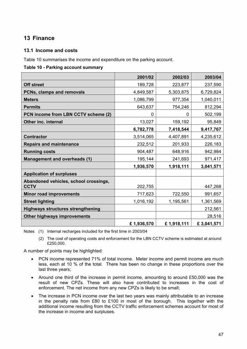
13 Finance
13.1 Income and costs
Table 10 summarises the income and expenditure on the parking account.
Table 10 - Parking account summary
2001/02 2002/03 2003/04Off street 189,728 223,877 237,590PCNs, clamps and removals 4,849,587 5,303,875 6,729,824Meters 1,086,799 977,354 1,040,011Permits 643,637 754,246 812,294PCN income from LBN CCTV scheme (2) 0 0 502,199Other inc. internal 13,027 159,192 95,849
6,782,778 7,418,544 9,417,767Contractor 3,514,065 4,407,891 4,235,612Repairs and maintenance 232,512 201,933 226,183Running costs 904,487 648,916 942,984Management and overheads (1) 195,144 241,693 971,417
1,936,570 1,918,111 3,041,571Application of surpluses Abandoned vehicles, school crossings, CCTV 202,755 447,268Minor road improvements 717,623 722,550 991,657Street lighting 1,016,192 1,195,561 1,361,569Highways structures strengthening 212,561Other highways improvements 28,516
£ 1,936,570 £ 1,918,111 £ 3,041,571Notes (1) Internal recharges included for the first time in 2003/04
(2) The cost of operating costs and enforcement for the LBN CCTV scheme is estimated at around £250,000.
A number of points may be highlighted:
PCN income represented 71% of total income. Meter income and permit income are much less, each at 10 % of the total. There has been no change in these proportions over the last three years;
Around one third of the increase in permit income, amounting to around £50,000 was the result of new CPZs. These will also have contributed to increases in the cost of enforcement. The net income from any new CPZs is likely to be small;
The increase in PCN income over the last two years was mainly attributable to an increase in the penalty rate from £80 to £100 in most of the borough. This together with the additional income resulting from the CCTV traffic enforcement schemes account for most of the increase in income and surpluses.
47
It is estimated that overall it costs £0.75 to collect £1 of income, excluding income from PCNs issued as a result of enforcement using CCTV cameras. The bulk of the income to the account derives from the CCTV monitored schemes, roads outside CPZs (A zone), Peckham and the zones in the central activity zone. CPZs elsewhere contribute little to the overall surplus. In contrast, enforcement using CCTV cameras appears to contribute a substantial operating surplus.
Legislation requires that the total fees and charges collected must exceed the operating costs. There are also restrictions on the way in which the council can use these surpluses. They must, in summary, be used for other traffic management schemes, or for schemes which improve road safety such as pedestrian safety measures, street lighting, and removal of obstructions. Table 9 shows how Southwark has utilised the surpluses on the account. Although limited sums have been available for maintenance of existing parking infrastructure the council has not reinvested any surpluses in extending or updating its CPZs. The initial investment costs of new zones introduced in recent years have been met entirely for funds from TfL for new zones in areas potentially affected by the congestion charge.
Some of the changes proposed in the regimes operating within CPZs, and some specific CPZ reviews may result in reduced income or increased enforcement costs. The borough adopts the view that parking controls and enforcement levels should be driven by parking policy objectives. Whilst some changes may reduce income or increase costs, there is probably an underlying upward trend in income resulting from an increased number of vehicles on the road and the overall extension of controls. Given the current surplus on the account there is unlikely to be any barrier in principle to any of the changes set out in this plan in the short term, although the budgetary implications of a changing level of surplus will require to be recognised.
The borough takes a firm view that the parking account should be managed on a boroughwide basis. No CPZ is a local, self contained area, they all fit into a bigger picture with wider interests. Residents benefit from controls not only in the areas where they live, but also in areas through which they travel and in destination areas for trips. In this policy context, no significance can be attached to the balance of income and expenditure for an individual zone.
13.2 Future funding requirements and sources of funds
Management, monitoring and continuous maintenance of parking and enforcement arrangements requires funding and staffing for:
Enforcement and customer services, externally contracted;
Management of enforcement including responding to representations and monitoring;
Policy, programme development and review including costs of surveys, outline designs, and consultation;
Maintenance of infrastructure including meter replacement, IT system maintenance, signage and road markings;
New scheme or revised scheme implementation including fees costs of detailed designs and legal costs of orders;
Sources of funding include:
The parking revenue account. Since this is likely to remain in surplus there is unlikely to be a case for funding parking operations, maintenance or the implementation of new schemes from the council’s core budget or capital programme;
External public funding for new scheme implementation: in the past this has included TfL, but there is little likelihood of funding from this source in the immediate future;
Private developer contributions: these are likely to be limited to developer contributions associated with specific development schemes. But it may be possible to secure contributions from developers to wider area schemes if these are clearly specified in the forward programme.
48
The surplus on the parking revenue account has increased significantly over the last three years. There is the potential for further increases from:
Year on year increases in the level of enforcement activity, including the extension to moving traffic offences and the introduction of further enforcement using CCTV cameras, both fixed and mobile;
Improvements in the recovery rate for PCNs;
Increased meter charges in line with the proposed core regimes;
Increased permit income from additional households and higher levels of car ownership;
Modifications and extensions of CPZs;
Introduction of additional localised waiting restrictions.
Implementation of the recommendations of this PEP would result in a number of increases in costs of over £500,000 per annum for high priority projects including:
A programme of investment in undertaking and implementing CPZ reviews;
Progressive extension of enforcement using CCTV cameras;
Introduction of discounts for low pollution vehicles and other changes in permit charges;
Improved customer services;
Regular customer satisfaction surveys;
Topic reviews and surveys.
49
14 Monitoring and equality assessment
14.1 Performance indicators
TfL have set out three performance indicators which they will use in monitoring the parking targets in the London transport strategy:
Compliance: number of contraventions, moving and non moving offences, based on quarterly surveys;
Business satisfaction with parking and loading restrictions, based on surveys;
Public provision of long stay parking at major town centres: reductions in actual number and proportion of total.
It is proposed that Southwark should develop local versions of the first two indicators, in the context of the proposed survey of businesses and the proposed review of the enforcement contract. It is not proposed to establish a local indicator to replicate TfL’s third indicator because there is relatively little long stay parking directly under the control of the council in Southwark, apart from permit bays in CPZs.
Other local indicators will also be established covering:
The balance between loading activity, short stay and long stay parking;
Enforcement activities;
Customer services delivery;
General customer satisfaction;
Traffic flow obstructions by parked vehicles;
Adherence to development control guidelines on parking;
Levels of general public complaints about parking not parking services;
Speed of resolving hotspot issues.
14.2 Consultation
Public consultation on the draft Local implementation plan and its supplementary documents, including this parking and enforcement plan was undertaken during November and December 2005. Consultation was carried out with the community, partner organisations such as TfL, the Metropolitan Police, other London boroughs and with local groups and organisations such as Southwark Cyclists, Southwark Pedestrian Rights Group and Southwark branch of Living Streets.
The draft plan was considered by the Southwark disability forum, equality and diversity panel, the transport consultative forum and its mobility subgroup during this period. The plan was also discussed at all of the winter community council meetings with workshops held at Walworth and Camberwell community councils.
A questionnaire on the themes and actions proposed in the draft plan was circulated to key stakeholder groups and was available to the general public at each of the community council meetings, in all official council offices, on the Southwark Council website and upon request. The results of the questionnaire feedback was collated and the results relating to parking and enforcement highlighted the following:
Support was found for higher parking permit charges for vehicles which pollute more and lower for more environmentally friendly vehicles;
Short stay parking (free bays) should be provided around shops, schools and health centres;
50

2004Part Two
Appendix D Walking plan
Local Implementation Plan

2004
Draft walking plan
2005
www.southwark.gov.uk
Transport
This plan is part of a package of documents that makes up Southwark Council’s transport strategy.
Southwark’s transport strategy is also known as te Local implementation Plan and sets out how the council will plan and deliver an integrated package of transport improvements from 2005-10.
The other documents that comprise the strategy include
• Road Safety Plan
• Walking Plan
• Cycle Plan
• School Travel Plan Strategy
• Parking and Enforcement Plan
The Borough Spending Plan is also related to these palns as it sets out bids for funding to implement transport improvements.
Contact Us
Transport groupRegeneration departmentSouthwark CouncilChiltern HousePortland StreetLondonSE17 2ES
www.southwark.gov.uk
Any enquiries relating to this Plan can be directed to the Transport Group on 020 7525 5317 or email: [email protected]
This plan is part of a package of documents that makes up Southwark Council’s transport strategy.
Southwark’s transport strategy is also known as the Local implementation Plan and sets out how the council will plan and deliver an integrated package of transport improvements from 2005-10.
The other documents that comprise the strategy include
• Road safety plan
• Walking plan
• Cycling plan
• School travel plan strategy
• Parking and enforcement plan
The Borough Spending Plan is also related to these plans as it sets out bids for funding to implement transport improvements.
Contact Us
Transport groupRegeneration departmentSouthwark CouncilChiltern HousePortland StreetLondonSE17 2ES
www.southwark.gov.uk
Any enquiries relating to this Plan can be directed to the Transport Group on 020 7525 5317 or email: [email protected]
Contents
Foreword 1
1 Introduction 2
2 Policy context and priorities 3
3 Walking for all 8
4 Promoting walking 11
5 Improving the walking environment 12
6 Improving links to recreation 17
7 Walking as part of a journey 19
8 Improving safety and security 21
9 Monitoring our progress 23
10 Delivering the plan 24
11 Consultation 28
12 Working with partners 29
ForewordIn 1961 the American academic, Jane Jacobs, wrote her seminal work The Death and Life of Great American Cities. This has been a very influential book among planners throughout the world as, using her experience of living in Greenwich Village in New York, she identified the unique value of the street as a place where people meet, interact and live. Yet over forty years later we hear about places in the United States where it is now impossible to walk. In some places you have to get in a car to cross a street because there are no footways and no crossings. Let’s be thankful that we live in London.
In London, especially in our part of inner London, you can have a very satisfactory experience walking just about everywhere. We have convenient neighbourhood shops and pubs. Schools and health facilities are usually only a short walk away. In many parts of Southwark (not all) we have easy access to pleasant parks and we have the very special asset of the riverside walk. This is a good position to be in, but we need to protect what we have got and there is also still a lot of room for improvement.
The improvement can come with major redevelopments of areas such as the Elephant and Castle that were designed for the car and can now be reclaimed for pedestrians. They can also come in small ways like making sure pedestrian crossings are properly designed, in the right places and give you enough time to cross before the green man starts flashing.
In all our transport policies now we are introducing the idea of a road user hierarchy, which puts the needs of pedestrians, including the needs of people with disabilities, at the top. This is as it should be because we are all pedestrians, as soon as we get off the bus or our bikes and as soon as we get out of a car. Walking is the most sustainable form of transport and one of the healthiest. It is also an integral part of what makes living in a city potentially such a rewarding experience for people of all ages.
Councillor Richard Thomas Executive Member for Environment and Transport
1
1 Introduction Southwark Council aims for walking to be the first choice of travel. Whilst the council recognises that travel choices depend upon circumstances. Walking presents the greatest benefits to Southwark residents, visitors and businesses alike. Improving conditions for walking can bring a range of benefits to the everyday lives of people, to their health, safety, improve access to services and an increased sense of community.
In recent years there has been a growing recognition of the importance of walking, walking is often underestimated but has the ability of create quick convenient journeys. A majority of journeys that we make are within our local area, to the shops, to schools etc and walking often represents a beneficial option for these journeys. For example, for trips up to one and a half miles, it is often faster to walk than to catch a bus.
This walking plan outlines how the council will promote walking as a viable alternative to less sustainable modes of travel, such as the car, with particular emphasis on the travel planning process.
The council’s emphasis on walking within this plan is on the functional, purpose driven, day to day walking, as transport from one place to another. However, leisure walking is intrinsically linked to purpose driven walking. By encouraging people to walk for fun we can influence the way they view walking as a viable travel option, whilst opening people’s eyes to local walking routes.
2
2 Policy context and priorities Walking has many underlying personal benefits including health, economic and social benefits. In recognition of this, the Department for Transport (DfT) and the Mayor of London have both produced walking action plans in 2004. Southwark supports these documents and also the increasing emphasis on improving local conditions for local people.
2.1 National and regional policies
In 2002 the Mayor’s Transport Strategy which included initiatives to help create and promote a connected, safe, convenient and attractive environment for walking. The actions aim to encourage people to walk and enrich their experience of being out and about and to make London one of the most walking friendly cities for pedestrians by 2015.
In 2004, the DfT produced a Walking and Cycling: An action plan, which sought to create places that people want to walk and cycle in by providing high quality facilities. The plan also sought to influence travel behavior through education, training, marketing and promotion and to build skills and capacity.
In February 2004, the Mayor published the Walking Plan for London which built on his transport strategy. The Walking Plan for London objectives include:
Improving coordination and inclusiveness in walking plan development;
Promoting walking;
Improving street conditions;
Improving developments and interchanges;
Improving safety and security;
Plan delivery and monitoring.
In preparing the walking plan for London, the London Planning Advisory Committee did in detailing the 5 C’s as the key attributes for a walkable city. Southwark will utilise these characteristics in the assessment of future walking schemes and initiatives. The 5 C’s are described as:
Connected, the connectivity of walking network to key attractors such as public transport interchanges, homes, employment and leisure nodes;
Convivial, how pleasant walking is in terms of interaction with people, the built and natural environment as well as other road users;
Conspicuous, the safety and visibility of walking routes and public spaces, including aspects such as lighting, mapping, signage and surveillance;
Comfortable, how enjoyable walking is through high quality pavement surfaces, attractive landscaping, architecture and the allocation of road space and control of traffic;
Convenient, the ability of walking to compete as a mode of transport in terms of efficiency.
This walking plan recognises and supports these objectives and sets out what Southwark’s response to each of these areas.
3
2.2 Southwark’s walking policy and targets
This walking plan will contribute significantly to achieving the vision set out in the community strategy1 of making Southwark a better place to live, to learn, to work and to have fun and of supporting its priorities which include:
Tackling poverty;
Making Southwark cleaner and greener;
Cutting crime and the fear of crime;
Raising standards in our schools;
Improving the health of the borough.
The current community strategy 2003 to 2006 is being revised and the council has prepared a strategy to take us to 2016. This draft strategy will set the direction for the council for the next ten years and is currently undergoing consultation. The draft strategy seeks to build upon the 2003 community strategy and contains the following ambitions:
Improving individual life chances;
Making the borough a place for people;
Ensuring quality public services.
The walking plan will form part of Southwark’s Local implementation plan (Lip), which is a strategy for transport. The ten overarching transport plan objectives are derived from and complement those contained in Southwark’s community strategy, national transport policy and the Mayor’s Transport Strategy.
The objectives of this walking plan are to:Promote walking as a sustainable mode of travel;
Promote the benefits of walking for improving health, social inclusion and economic vitality;
Improve the quality of walking environments;
Improve accessibility to transport and other services;
Improve pedestrian safety and security;
Improve the perception of walking;
Improve the environment including air and noise quality through increased usage of walking and reduced dependence on cars.
Unitary development plan
The Southwark Plan, the revised deposit unitary development plan was published in March 2004. This plan, which is going through several phases of extensive public consultation is expected to be adopted in late 2006. The plan aims to provide a translation of the aims of the community strategy into actions in the physical environment. One of its main aims is to guide development so that Southwark continues to develop as a compact city area with efficient use of land so that the need to travel by private car is reduced and cycling and walking are much more viable.
Work, shops, schools, health and leisure facilities and other services should always be near at hand in other words, a short walk or cycle ride away.
1 ‘A Community strategy for Southwark 2003-2006’ published April 2003
4
The draft plan contains strategic policies to improve the range and quality of services available in Southwark to ensure that they are easily accessible by foot, cycle and public transport and to promote more sustainable transport choices for all members of the community in order to reduce congestion and pollution and increase ease of movement.
Local implementation plan (Lip)
The Lip will be a statutory plan that sets out how the borough proposes to implement the Mayor’s Transport Strategy which was published in 2001. The development of the Lip also provides Southwark with an opportunity to develop a coordinated range of local transport initiatives.
The Lip will identify transport issues, such as road safety and sustainable travel, and demonstrate how they will be addressed. The plan will contain various programmes, projects, implementation mechanisms, resource requirements and coordination activities.
The Lip will be an overarching transport strategy for the borough and will be supplemented by a series of more detailed documents including the road safety plan, the school travel plan strategy, a parking and enforcement plan, cycling plan and this walking plan.
As part of the development of the Lip an assessment of the plan against the council’s equality scheme was undertaken. This equalities impact assessment (EqIA) helps to identify areas for improvement and ensure that, if appropriate, measures are taken to revise, promote and support the council’s corporate policies on equalities.
This walking plan, as a supplementary document to the Lip was incorporated into this assessment, which was tabled at the equality and diversity panel in February 2006.
The delivery and development of the Lip and its EqIA will be monitored at various stages to ensure that:
The plan contributes positively to the corporate equalities agenda;
The requirements of the plan, as they relate to ensuring access to all and promoting equal opportunities are being adequately met by any initiatives, proposals and/or programmes.
Annual monitoring of this information will be contained within the annual monitoring report and will relate to the lifecycle or timescale of transport plans, policies or programmes. In addition to this quarterly monitoring will be carried out in accordance with the council’s EqIA guidance.
Local delivery plan 2005 to 2008
The Department of Health requires every primary care trust (PCT) to produce a local delivery plan (LDP). The LDP is the means for delivering national health targets at a local level and provide improvements to Southwark’s health care service.
An important aspect of the LDP is its partnership between Southwark Council, NHS Trusts, primary care groups and other professionals to work in partnership to improve local standards of health and social care.
The LDP for 2005 to 2008 supports the four NHS national priority areas being: Improving the management of long term conditions;
Improving health of our population;
Improving access to services;
Improving the patient’s experience.
5
Obesity prevention and management strategy
Healthy Southwark is developing a multi agency strategy for tackling the rising trend in obesity. The Southwark obesity prevention and management strategy will provide a comprehensive pathway of healthy eating and physical activity opportunities from perinatal care through to adulthood. This strategy will provide links to clear referral pathways into obesity management programmes, and will include detailed action plans which will be updated biannually.
Biodiversity action plan
The council are preparing the Southwark biodiversity action plan, committing the borough to conserve, enhance and promote biodiversity in the UK. The plan seeks to support and build on the Mayor’s biodiversity strategy.
The biodiversity action plan will act as a toolkit, outlining specific actions and guidance to officers, residents and key stakeholders on protecting, managing and promoting key wildlife habitats in Southwark. The plan will be implemented in May 2006, with additional actions being added later in 2006 and in 2007.
The walking plan supports the biodiversity action plan and will promote and integrate the actions wherever possible. There are strong links in enhancing access to parks and green spaces, promoting walking through these areas and encouraging education in green spaces through walking school buses.
Future strategies
The council is currently preparing a number of documents that are linked to transport services. Transport should be carefully considered in the preparation of these documents.
Plans currently being prepared: Boulevard strategy;
Sport and physical activity strategy;
Liveability strategy;
Transport supplementary planning document;
Children and young persons plan.
Streetscape design guide
The council is developing the streetscape design guide to enable those responsible for the public realm to create high quality streetscapes through the application of specific design principles and the use of preferred materials and products. It will be a key element in achieving our aim of having visually attractive, safe, cared for streets that work well for all users and have a proper balance of functions.
The council intends to implement an innovative design strategy across the borough that sets out our priorities and provides coherent management that integrates and coordinates all the various functions involved in the street scene.
The adopted six indicators of quality for Southwark’s streets are: Comfort and safety for pedestrians and the disabled;
Designed to accommodate all sorts of functions, not dominated by any one function;
Visually simple and free of clutter;
Well cared for and where utilities or extraneous’ advertising are subordinate to all other street functions;
6
Sympathetic to local character and activity context, in design and detail;
Ordered to provide appropriate access and deliveries and storage of vehicles.
2.3 Setting targets for walking
The walking plan for London states that walking should generally be measures by the number or proportion of trips made rather than by the distance traveled by foot as most walking trips are short in length and local in nature. The plan states the following targets:
In the short term To stop the decline in the number of journeys per person made on foot.
In the long term (2015)
Increase the modal share of walking for trips under two miles by 10%;
Increase the average number of trips made on foot per person / per year by 10%;
Increase the level of London’s walkability both in terms of people’s perceptions and in actual measured terms against other world cities.
The Mayor and Transport for London (TfL) have set a new target in 2004 to achieve an increase of 10% in journeys made on foot between 2001 and 2015. Southwark has set its own challenging target which expands upon this TfL target to increase the number journeys made on foot by 15% between 2001 and 2015.
Whilst this is very ambitious, with the level of redevelopment to and the associated public space improvements, we feel we are in the position to be bold in promoting walking. Social inclusion is a core area for the borough and walking and enjoying your local area and community is critical to this.
7
3 Walking for all
3.1 Walking in London
The London Area Travel Survey (LATS) 2001 indicates that walking accounts for the second highest proportion of all trips made in London after driving at 49%. However, the past decade has seen a marked decline in the number of walking trips in greater and inner London, which have decreased by 13% and 20% respectively. While it is difficult to account precisely for the decline, the general reasons seem clear. The convenience of the car has made it the preferred form of transport for those who can afford it for most journeys as importantly, limited improvements in the public realm for pedestrians have been provided. Conversely, central London has seen an increase in walking of 18%, this may be due to the convenience of walking within this densely populated area.
London remains a growing city and the rising numbers of residents, workers and visitors will result in an increasing demand for travel. Walking presents itself as one of the most beneficial modes of transport to address this increasing demand. However, much work between all transport partners needs to be undertaken to reverse the declining rate of walking and promote walking as a viable mode of transport.
3.2 Walking in Southwark
Southwark is a prime place to walk, with significant green spaces throughout the borough, numerous cultural facilities, key local facilities within ready walking distance, high land use density and employment centres particularly in the north of the borough, which all make the area ideal for walking.
We have a rapidly growing population and have the tenth fastest population growth of all London boroughs. The council is the eighth most densely populated local authority in the capital. The borough is also undergoing rapid change and this is like to continue as the London Plan, which is the Mayor’s spatial development strategy) has set targets for substantial new housing growth and densification in Southwark. We are therefore faced with the challenge of how we will provide for the increase in residents and their need to travel.
Currently 12% of Southwark residents walk to work2, which is similar to other inner London boroughs. We also need to consider that there is a vast working population that lives outside the borough but travel to Southwark for employment. The main employment node is in the northern area of the borough, concentrated on the Bankside area. These jobs are, on average, highly skilled and amongst the highest paid in London. This means that this area of the borough experiences a high proportion of commuting walking as well as multi modal trips which incorporate walking. The average daily working population in 2001 within Southwark was estimated at approximately 141,914 jobs3. The following figure shows the areas of employment throughout the borough.
Southwark also attracts many visitors, again to the Bankside area to the cultural and heritage sites such as Shakespeare’s Globe, the Design Museum, the Borough market, Southwark Cathedral and the Tate Modern. Walking provides the perfect pace for experiencing the sights and atmosphere of Southwark and we encourage our visitors to walk.
In Southwark many of our younger residents are currently walking to school. During the preparation of the 21 school travel plans completed, 59% of school children currently walked to school and that most pupils lived within walking distance of their school. While there are a
2 ONS Census Data 2001 3 Census 2001
8
significant number of children walking to school, there is ample opportunity to build upon this walking level.
3.3 The benefits of walking
For most of us walking is something we do everyday whether it be from walking to the train or bus, walking to school or work or even to get some last minute groceries. Yet we often do not think of the added benefits of walking, these can be health, social, economic and environmental benefits.
Health
Walking is the perfect exercise; it costs nothing and requires no special equipment or facility. Walking at a reasonable pace for up to 30 minutes per day uses 400 calories and has enormous health benefits such as reduced risk of heart disease, stroke, osteoporosis, diabetes, high blood pressure and some cancers, especially colon. Any form of exercise, including walking, also increases levels of endorphins and feelings of well being.
Half the British population is overweight and 20% are obese. Obesity in children is increasing due to both a high fat and sugar diet and low levels of physical activity. In Southwark a conservative estimate for the future prevalence of obesity among children under 15 years old is that the proportion will triple from 12% in 2001 to over 36% in 20104 as highlighted within the Southwark obesity prevention and management strategy. This is a worrying figure with medical experts considering that these children will have increased health problems as adults and a shorter life expectancy.
This is not just an issue for children, Preventing Chronic Diseases, a Vital Investment shows by 2015, 80% of men and 73% of women over 30 will be overweight this is a rise of 4% for men and 3% for women in under ten years. Leading a sedentary lifestyle, being overweight or obese can increase your predisposition to illness, including type 2 diabetes. Current trends could mean that by 2015, it is estimated that there could be 8,000 more diabetes related deaths each year within the UK.
The promotion of walking and other physical activity would cost a fraction of the funds that will be needed by the Southwark health authorities to treat the diseases associated with obesity in the years to come.
Walking is particularly important for an ageing population. A brisk walk of 30 to 60 minutes a day will increase longevity as well as independence and quality of life. The 10,000 steps a day campaign claim that this is all that is necessary to maintain the correct weight without dieting.
Social inclusion
Walking is unique in being able to promote equality and reduce social exclusion, as it is accessible to all social groups, ages, religions and cultures. Walking is a free means of travel that can provide access to most facilities and financial status does not limit opportunity.
Southwark ranks as one of the most deprived local districts in England. Deprivation is multifaceted and indicators include unemployment, low income, poor health, education, crime and housing. A recent report by the London Central Learning and Skills Council notes that of the 20 most deprived wards in central London (out of 159), 8 are in Southwark.
Southwark is an ethnically diverse borough, with some 37% of people identifying themselves as belonging to minority (non white) ethnic groups.5 Over 100 languages are spoken in Southwark schools and 43% of pupils speak English as an additional language. The African communities have been increasing as the largest ethnic minority in the borough, comprising approximately 16%
4 Salimee, S & Ferguson, J (2004) ‘Epidemiology of obesity in Lambeth and Southwark’ Lambeth PCT 5 Projected 2001, LRC 1999
9
of all residents, almost double the number of people with a Caribbean background. The south Asian and Chinese communities only make up about 5% of Southwark’s population, significantly less than the inner London average of 11%.
The social inclusion benefits that are found in walking can be beneficial to all of the community. Creating a walkable environment has the ability to promote accessibility by:
Improving access to passenger transport links;
Supporting the local economy;
Strengthening the local community;
Providing a no cost alternative to public transport;
Improving travel opportunities.
Economic
Getting people out of cars and onto the street has a whole range of economic benefits. The Central London Partnership’s A Walking Strategy for Central London considers that increasing walking will have substantial benefits for the capital. Walking gives opportunities for window shopping and the use of smaller local retailers, and helps people to move away from vehicle based shopping habits.
The vast majority of visitors to the European capitals tend to travel by public transport and by foot. The pleasant squares and pedestrian priority areas of Paris, Prague, Barcelona and central Rome and their comparison with London gives London a reputation for not being pedestrian friendly and for having congested roads. A pleasant walking environment has the power to create a positive memory of Southwark and London and in turn to encourage tourism.
Many business operators would benefit from providing servicing and deliveries by foot as this can be cheaper and more time effective by the elimination of delays due to vehicular congestion and parking issues. Walking also provides an opportunity to conduct a great deal of business between meetings and this should not be underestimated.
Environmental
Car ownership levels in Southwark have traditionally been low with 48% of households owning a car in 2001. However, the national trend is that growth will be the highest for those areas with a current low base level. Vehicle emissions are the cause of 50% of air pollution and estimated to cause 24,000 deaths per year in the UK. Consultation preceding the publication of the Mayor’s Air Quality Strategy in 2002 revealed that 71% of Londoners consider traffic exhaust fumes a serious problem making walking unappealing. Reducing the amount of pollution will also make the environment more attractive to walk in and so a virtuous circle may be created.
Car ownership not only adds to road congestion, it creates parking problems and environmental damage. Car journeys that are less than a mile account for 8% of the total car journeys and 25% are less than 2 miles. It is the short car trips that this strategy is focusing on, either substituting the car for walking or combining walking with public transport. Walking frees up public transport for longer journeys as pedestrians take less time than bus passengers on journeys up to one and a half miles.
10

4 Promoting walking We now know the benefits of walking but how do we get more people to walk. One way is to inform people of the benefits of walking, the lesser impact it has on the environment, the economic and the personal benefits. While also advising people of their local walking routes and asking them to reconsider their travel options to include walking and this is called travel planning. The council’s current programme targets schools, businesses, their employees and community groups.
Whilst other road users may find a reasonable amount of information for getting around the borough, it is generally more difficult to find succinct and clear information about walking routes. This shortfall needs to be addressed to raise awareness of the ease and convenience of walking and should be location and route specific.
To address this shortfall, the council will review what material is currently publicly available as well as what information is currently distributed to interest groups. The council will provide more consistent information in the form of maps, guides and signage for pedestrian routes and to improve direct access to facilities such as schools, shops and public transport.
Signage, maps and information should be consistent borough wide to provide uniformity. However consideration and variation should be provided in special circumstances, such as conservation areas or tourist precincts. The first step will be the implementation of the streetscape design guidelines due to be completed in mid 2006.
The council will promote walking through the development of school travel plans. We currently work with our schools on such programmes as walk to school week and walk on Wednesday. The walk on Wednesday programme, designed to encourage walking to school, has been one of the most successful in London, reflecting schools’ enthusiasm for involving their children in healthy living campaigns. The council will work with the schools to incorporate travel awareness within their existing tight schedules.
The council will also promote walking through advertising and promoting walking schemes, led walks and publicity campaigns that highlight the benefits of walking.
We also encourage and facilitate local businesses and developments to create green travel plans and the council is developing its own travel plan which is due for completion in mid 2006.
These travel awareness programmes are augmented by the EU funded Optimum2 project which will be piloting a range of sustainable transport programmes from 2004 to 2008. Initiatives conducted as part of this programme include bikes for businesses, establishment of local travel planning groups, car clubs and travel awareness events.
The walking action programme intends to cover as wide a range of initiatives as possible, to attract both residents and commuters to include more walking in their daily routine. Compared to cycling, initiatives to increase walking are in their early days and this plan reflects the aim to test as many opportunity areas as possible, the success and failures shaping the details of the following years programme.
4.1 Walking for enjoyment
In recognising the health benefits of walking, the council conducts many initiatives to promote and encourage walking for fun, such as the Southwark walking festival and many hosted walks. There is a strong correlation between leisure walking and purpose walking. If one can enjoy and recognise the benefits of leisure walking then it is a smaller step towards purpose walking than for those that do not walk. Initiatives to promote walking as a mode of transport must recognise and correlate to the current and future work to promote leisure walking.
11
5 Improving the walking environment As well as understanding the importance of promoting walking we also understand the need to improve the walking environment. One of the major barriers to more people walking is the perception of the environment they have to walk through to get to their destination. Unlike car drivers and passengers, who are somewhat isolated from the environment in which they are travelling, pedestrians are exposed to all aspects of their surroundings. Some of the problems that a pedestrian can encounter include:
Uneven, poorly maintained or narrow footways;
A lack of rest locations;
Unattractive street environments;
Street clutter including obstructions;
Poor crossing facilities, inconveniently located or a lack of crossing facilities;
A lack of provision of public facilities;
Air and noise pollutants.
Just encountering one of these issues can be a major deterrent to walking. Southwark Council is determined to improve the street environment and make it more attractive and accessible to all.
To improve upon the existing condition we must first consider how we came to the current position. The above issues are derived from a key areas including:
Low investment in maintenance;
Historical preferential treatments of motorist needs;
Ad hoc improvements, including inconsistent designs;
Uncoordinated maintenance between stakeholders of road space.
The introduction of the Traffic Management Act and the legislated Network Management Duty provides an opportunity for better coordination between road space stakeholders.
Establishing a walking hierarchy
Walking has suffered from preferential neglect in the past. In recognition of the health, economic and environmental benefits of walking, the council ranks walking as the highest priority transport mode. This is carried through to the council’s road user hierarchy.
As a way of improving our understanding of walkers and addressing their needs a walking hierarchy, similar to the established road hierarchy will be established. This will help us as the stakeholders of the walking environment to understand, rank and improve walking facilities.
This hierarchy will be developed from the following information: Pedestrian numbers;
Proximity to activity nodes, including health centres, schools, transport interchanges, etc;
Location and connectivity within the network;
Links to the leisure walking network and cycling network.
This information will be gained from street audits, GIS mapping and local knowledge. The walking hierarchy will be a key component of the promotion of walking to building confidence for pedestrians of the level of facilities provided within the hierarchy.
12
The walking hierarchy will also be developed alongside the streetscape design guidelines and will be used to inform design levels and maintenance regimes.
Understanding current walking conditions
A key component of responding to the needs of the pedestrian is understanding where and why people are walking as well as where and why they are not. This helps to recognise where physical improvements need to be undertaken. At present, there is a distinct lack of coordinated, quality information on existing pedestrian movements, desired movements and pedestrian numbers in many parts of Southwark.
To address this deficiency pedestrian surveys and analysis will be undertaken to measure existing movements and demand and street audits will be undertaken to catalogue the existing facilities and provide recommendations on their improvement.
Whilst there are various methodologies for auditing pedestrian facilities and movements the two most commonly utilised are as follows:
Public consultation is used to identify particular locations and issues. From this information an appropriate audit template is prepared. Reviewers then undertake a physical audit of the identified locations gathering pedestrian information and providing recommendations for improvements;
Existing pedestrian movements or desire lines are monitored by a physical survey of patterns of pedestrian movement. This information is then utilised to determine pedestrian desire lines. This method is particularly useful if a location has been already identified such as determining the specific pedestrian crossing location at an junction, school, transport interchange, etc or on a localised pedestrian route.
The type and level of detail of an audit would be assessed on a case by case basis to best suit the site location and the required information. The council will investigate industry best practice for audit methodology and adopt an appropriate template for Southwark.
A number of street audits have already been undertaken by the council and by some of our partners. This includes Elephant and Castle, Borough High Street (Living Streets), Borough and Bankside (Cross River Partnership), Walworth Road (Living Streets) and Borough Road. In addition to this, many street audits have been undertaken as part of the analysis of the Cross River Tram as part of regeneration projects and development applications.
Long term, we would like to have coordinated street audits throughout the borough and the first stage of the process will be to amalgamate the existing audits where possible and establish a framework for future audit processes. Following on from this the council proposes an ongoing programme of 3 to 4 major street audits being carried out per year, depending on the breadth of the assessment area. All specific schemes to include audits as part of initial investigations. We would also carry out an ongoing monitoring programme of the areas previously audited to ensure that the information stays current, relevant and usable.
Improving our streets for walking
To encourage walking the network of walking routes must be maintained to a high standard, be appropriately lit, signposted and provide a connection between areas and facilities that people wish to utilise. People cannot be expected to walk in a poor environment. Therefore we must improve it before we expect people to consider changing transport modes.
The council is currently in the process of developing its streetscape design guidelines, which will provide guidance for all streetscape works including the maintenance of the existing streetscape, design of new works and improvements within the public realm.
Issues discussed within this document will include:
13
Footway surfacing, including condition, materials, dimensions, facilities for the sensory and/or mobility impaired;
Lighting, location, level and maintenance;
Signing, directional, tourist and information signage;
Street furniture, including the rationalisation of street clutter;
Maintenance of physical environment, including landscaping;
Cleaning schedule.
The council has received funding to complete its holistic treatment for Walworth Road. The project will represent a considerable makeover to the heart of this busy shopping area, which lies in the heart of this deprived community. This project is underpinned by the removal/reduction of the impact of private motorised transport and the consequent commercial benefit that will occur to that location.
It will also set the standard for the regeneration providing a vital link between the regeneration of Elephant and Castle and that of the Aylesbury Estate. The combination of these three projects will create a high quality pedestrian environment as a powerful tool in the revitalisation of retail and commercial centres.
Southwark Council seeks to provide area based pedestrian improvements within heavily utilised areas, such as town centres and shopping districts. Whilst no decision has been made, due to the deprivation levels, proximity to health services and hospitals, current poor pedestrian facilities. Camberwell will be investigated for the opportunity to undertake an area based pedestrian audit and carry out improvements over the coming years.
It has been proposed to erect a footbridge on the Cannon Street rail bridge, which is located to the west of London Bridge providing a rail crossing over the Thames. A supplementary planning document is currently being prepared for the Borough and Bankside action area in which the potential impacts and benefits will be investigated.
Maintaining the walking environment The highway network within Southwark requires constant monitoring to maintain a high level of safety and efficiency for all road users including pedestrians. Each borough owned road is regularly inspected relative to its status in the hierarchy. Roads are inspected on a rolling programme: once a month for principal roads; quarterly for non principal roads and at least twice a year for unclassified roads, to assess their condition and to identify potentially hazardous defects. Maintenance work is prioritised, taking into account work already in the planned maintenance programme and according to resources and funding. The following figure shows the road hierarchy.
Improvements for the mobility impaired
People who are mobility impaired often face greater difficulty in negotiating the street environment. Improvements for the mobility impaired can also provide benefits for other users, such as parents with prams.
The council will undertake a programme of assessing facilities such as drop kerbs and tactile paving, as well as reviewing signage, around high activity nodes such as health care centres, shops, town centres, tourist facilities and transport interchanges. This work will be done in conjunction with the mobility subgroup of the transport consultative forum
14
Providing places to restPedestrian areas should also be supplied with appropriate seating so that people have the opportunity to rest before carrying on with their journey. Street furniture in general should be well designed and kept to a minimum allowing free pedestrian flow.
The visual amenity at these rest locations is also important for encouraging people to take the time to walk and to enjoy the public realm. Street furniture, landscaping and public amenities should be provided where appropriate. When considering locations for street furniture, in particular seating, the following elements will be taken into account:
Geographical location;
Information from street audits;
Proximity to activity nodes;
Safe, secure, visible and well lit locations;
Locations with good vistas.
Crossing the road
It is important for pedestrian provision and safety that all signalised junctions should include pedestrian phasing. The council will undertake a review of all signalised junctions to ensure that pedestrian phases are included where feasible. Equally as important to pedestrians is the amount of time they are required to wait, and the amount of time given to cross the road.
The traffic signal network within Southwark is complex with a majority of signals, particularly in the north of the borough set to synchronise with each other for vehicle flows. All road users are affected by the timings or phases including motor vehicles, buses, cyclists, and delivery vehicles, emergency services and pedestrians.
Historically, signal timings were set to achieve the most efficient use of a junction, in terms of allowing vehicle traffic movement. The road user hierarchy places pedestrians as our highest priority and signal timings should be amended to reflect this priority. This could help to provide an uninterrupted pedestrian network.
However, this would increase journey times for other modes of transport and therefore a balance must be struck between the competing demands of these users. TfL manage the traffic signals within the borough and the council will work with them to optimise the crossing conditions for pedestrians. Signals for investigation will be highlighted through the proposed pedestrian audit programme.
When reviewing or installing signals the physical elements of the crossing should also be considered, these include:
Street lighting;
Pedestrian tactiles;
Provision of pedestrian phasing;
Vertical displacement or raised pavements to slow traffic.
In addition to this it is important to ensure that the crossing facilities are appropriately located and coincide with the established pedestrian desire lines.
Walking through railway viaducts and subways In 2003 Cross River Partnership initiated a successful programme to treat railway underpasses and viaducts called the Light at the End of the Tunnel project. This programme seeks to turn these often neglected areas and barriers to pedestrian movements into creative public spaces or
15

desirable commercial space, making the tunnels feel safer, easier to move through, while generating jobs for local people.
The project has been extremely successful to date although many untreated railway underpasses exist within Southwark that are located outside of the scope of the original scheme. Given the proven success of the Light at the End of the Tunnel project, it is proposed to extend the programme throughout all of Southwark. The project framework would be utilised to identify, rank, audit, treat and monitor railway underpasses.
The council has undertaken a review of all viaducts within the borough to assess the current condition, surrounding environment and its potential as a barrier to pedestrians. Following this review, officers assessed identified key viaducts for improvement. These have been identified considering local levels of deprivation, existing pedestrian levels, surrounding land uses, proximity to schools and public transport links as well as the overall visual amenity of the viaduct.
The council recognises that dark and unattractive viaducts can be barriers to people walking through them, particularly at night. This project and the improvements it will bring will increase the feelings of safety and security. This is likely to bring the most benefits to areas close to public transport facilities such as west Walworth and south Bermondsey creating greater links to public transport especially at night.
The council has seven subways within the borough, aside from the existing subways at Elephant and Castle which will be removed and at grade crossings provided. Similar to the railway viaducts, officers have assessed each of these subways to look for opportunity to provide at grade crossings or alternatively providing improvements to the safety, cleanliness and visual amenity.
16
6 Improving links to recreation Improvement programmes within Southwark will also link into key regional initiatives including the South East London green chain and the Thames path which both traverse Southwark.
The South East London green chain, and the network of routes that links them is known simply as the green chain walk. The walk extends from the Thames in the northeast to Crystal Palace Park in the southwest. It connects with other key routes including the Capital Ring, London Loop and Thames Path. It contains ten sections and covers a distance of 65km. The council has undertaken a feasibility study for the extension of the green chain walk into Southwark. The extension would provide an increased use and awareness of our parks, create links between open spaces and places of interest and provide health benefits to users. The proposed route is likely to follow the route of the Old Crystal Palace high level railway, with potential to further extend into Dulwich Park and Belair Park via Cox’s Walk and stretch up into Peckham Rye Park and Common. This would open up 60 hectares of open space and a 4.6 mile extension of the green chain walk.
The Thames path extends along both banks through London and continues to the river's source in the Cotswold Hills. The council supports the path as a major national initiative to promote leisure walking and enjoyment of the public realm. The council supports both of these recreation walks and will work with our partners for their enhancement.
Walking for enjoyment There is ample opportunity for recreational walking in Southwark our position adjacent the Thames alongside our many parks and greens spaces such as Burgess Park, Dulwich Park, Southwark Park and Peckham Rye.
Thames path
In recent times, we have seen a vast increase in the use of the path along the Thames. This represents a truly continental style of perambulation of which any other European capital would be proud. The most notable section is from the Southbank through to the Tate Modern but extends right the way along to beyond Tower Bridge and Butlers Wharf. This has occurred due to the following factors:
The walk is virtually traffic free with all the bridges having pedestrian underpasses;
The excellent accessibility to public transport;
The views afforded and setting provided;
The pedestrian facilities provided, rest locations;
New cafes at the Southbank area; between London Bridge and Tower Bridge.
While no other area in the borough may offer quite the opportunities that this stretch does for walking and the enormous financial benefit that this clearly brings, there are real opportunities to recreate this type of success in other parts of Southwark.
Southwark supports the extension of the green chain walk into Southwark to connect the existing end point at Crystal Palace to Nunhead taking in Sydenham Hill Wood, Camberwell Old Cemetery, Brenchley Gardens, One Tree Hill and Nunhead Cemetery.
This path takes in the many green spaces and points of historical and ecological interest that are remnants of the old high level railway track from Crystal Palace to Nunhead. Further opportunity exists on route to extend into Dulwich and up through Peckham towards the Thames path.
Green garter
The proposed green garter walking route circumnavigates the Elephant and Castle going through a wide variety of areas architecturally, culturally and historically. It passes through many pleasant green spaces as well as through areas of high-density urban accommodation.
17

Local residents and workers will be invited to participate in street audits of this route which will look at how it can be made more people friendly and safe. Problems to be looked at might include roads that are difficult to cross, the timings of pedestrian traffic signals, narrow pavements that increase feelings of fear when passing another person, lighting, as well as perceived and real dangers along the route.
18
7 Walking as part of a journey Access to public transport facilities and activity nodes, such as shops and community facilities, is of particular importance to pedestrians, especially mobility impaired persons. The environment around rail stations and bus stop interchanges should be designed with particular consideration to pedestrians, as should the environs of local shops and other services. Finding appropriate routes to these facilities is important if people are to be encouraged to walk rather than use other forms of transport.
It is also important that car parking is provided within walking distance to pedestrian priority areas for people with mobility impairments. This is discussed further in the parking and enforcement plan.
Southwark is committed to identifying priority locations for accessibility improvements and working with our transport partners to achieve these. The particular locations include:
Bus stops;
Rail and tube interchanges;
River crossings;
Local and district shopping centres;
Major employment centres;
Tourist attractions.
Improving access to bus stops
In Southwark, much work has been undertaken in recent years to improve the bus stop environment and improve access, comfort and safety for passengers. Where possible, waiting environments are upgraded to provide essential infrastructure such as shelters, lighting and stop specific timetables.
However, given the extent of bus services within the borough, there are still many stops that are in need of improvement. This is particularly important for mobility impaired persons and for women, who use public transport more than men and who tend to have greater feelings of insecurity waiting at bus stops for long periods of time, especially at night. The council will continue its programme of bus stop improvements and will consider issues such as safety, comfort and lighting as highlighted above.
Improving access to train stationsThe council does not have direct control over station buildings. However, in recent years much work has been undertaken in partnership with Network Rail and TfL to improve the station environment including the pedestrian approaches to the station. This includes forecourt improvements at North Dulwich and Nunhead and closed circuit television (CCTV) and lighting upgrades at most stations.
Additional forecourt and station access improvements are planned at Queens Road Peckham and South Bermondsey. However, many of the stations within Southwark are in a poor state of repair and the approaches to the station and waiting environments are dire. Furthermore, only four rail stations within Southwark have disabled access.
The former Strategic Rail Authority (SRA) published its draft rail for all accessibility strategy for consultation in March 2005, which describes the proposed programme for investment across the United Kingdom, to bring stations in line with the Disability Discrimination Act. Although the council supports this first step and recognises the high cost of improvement works, much more is needed from the SRA and TfL in order to address the needs and concerns of residents.
The council will pursue improvements to station accesses and forecourts in conjunction with SRA and TfL and will also undertake street audits in the areas surrounding train stations.
19

Enhancing the journey to train stations Sometimes getting to the station can be as challenging as the rest of your journey. The council recognises that safe and pleasant journeys to stations will encourage people to use the rail network for their journey. The council is currently undertaking a study to assess safe routes to stations, particularly for those who walk or cycle. The council will produce a prioritised list for a programme of works to each of our stations and will work closely with our key partners to provide improvements. The improvements considered as part of this programme will include lighting, footways, CCTV, pedestrian crossings, signage and barriers to walking and cycling such as railway viaducts. Following the enhancements the council will promote the improved routes to the station as a way to encourage more people to use public transport.
20
8 Improving safety and security One of the major deterrents to more pedestrians on our streets is the safety and security of the roads and surrounding environments. There are several ways in which the council can improve pedestrian safety as well as for other road users.
Making our road safer
The safety of people is central to this strategy. A safe walking environment gives people, particularly the vulnerable, the elderly and children, the confidence to walk and cross the road without fear. This is discussed more fully in the council’s road safety plan.
The promotion of road safety involves the education of both pedestrians and car drivers and the provision of physical measures such as crossings and traffic calming to make the roads safer for all users.
Another key element of increasing pedestrian safety is the speed reduction of vehicular traffic, as there is an established link between vehicle speeds and casualty rates. The council will implement borough wide 20 mph zones; new and better crossing facilities and provide better lighting throughout the pedestrian environment.
One of the council’s major initiatives is the promotion of school travel plans, which help to encourage children and staff to walk, or walk part of the way, to school. Schools with school travel plans will be asked to conduct an annual survey to measure the changes in the numbers of pupils and teachers walking to school. The government has set an ambitious target of every school to have its own school travel plan by 2010, while the Mayor aims to have full travel planning in schools by 2009.
Road safety measures are mainly designed to slow vehicles and reduce traffic volumes, however additional measures to reduce dangers are improved parking controls and enforcement, as discussed in the parking and enforcement plan and the provision of driver education.
Improving safety and perception of safety can be key in attracting people to walking. Therefore the monitoring of road safety programmes will include the monitoring of pedestrian numbers.
Improving child safety Although child casualty numbers have dropped, concern remains as to the numbers of children being injured.
The council participates in the pilot child pedestrian training programme Kerbcraft which is designed to teach pedestrian skills to five to seven year olds by means of practical roadside training rather than in the classroom. It is built around teaching three skills: choosing safe places and routes, crossing safely at parked cars and crossing safely near junctions. Trained volunteers near their schools assist in teaching the children. This programme has shown success in previous years and it is proposed to continue this programme in coming years, subject to ongoing funding.
Given the success of the Kerbcraft programme, the council will investigate extending it to older age groups and to be provided as part of the school transition programmes for years six and seven.
Reducing crime and the fear of crime
People will only choose to walk if they feel an area is safe and unthreatening, especially after dark. If people are to be encouraged to walk more they should not feel intimidated into staying away from an area or using their car because they feel that the area is unsafe. Many factors can contribute to the perception that an area is unsafe particularly for vulnerable groups including women, for example:
Poor design and layout including corners or recessed areas, hiding locations;
Dark and deserted spaces;
Areas that are often littered with rubbish and covered with graffiti;
21
Groups of youths loitering who can be intimidating;
Locations with limited access to help;
Surrounding land uses such as pubs that can attract undesirable persons;
Poorly designed crossing facilities.
The Safer Southwark Partnership works with numerous stakeholders including the police to identify crime and fear of crime hotspots. The 2005 Crime and Drugs Strategy include measures to reduce crime and fear of crime within the public realm.
In addition to this, the council intends to improve security, along with better lighting, increase CCTV surveillance and passive surveillance through streetscape and building design. Southwark also aims to replace all subways with surface level crossings as well as implementing the Light at the End of the Tunnel project within railway arches, as discussed in section 4.
To help combat crime and fear of crime in our parks, the council’s parks community outreach team in partnership with the Women’s Design Service (WDS) conducted an audit of Burgess Park to highlight any particular concerns. This programme is an ongoing programme of promoting safety, in particular women’s, in our local parks. To gain a better understanding of issues faced by women, the WDS recently conducted gender and community safety training for the council’s wardens and community outreach officers.
These initiatives will help to improve safety within Southwark and complement the Mayor’s safer travel at night initiative.
Community wardens
The community warden scheme was launched in Bermondsey two years ago and has progressively been extended to now cover Peckham, Camberwell, the Aylesbury, Bankside, Rotherhithe, Dulwich and the Elephant and Castle. There are now 80 wardens working across the borough.
Community wardens are important members of the community, there primary responsibilities are environmental tackling grime, fly tipping and fly posting, abandoned vehicles and graffiti while assisting police by reporting crime and suspicious behaviour. They also provide their local community significant reassurance through their presence.
Wardens currently patrol their local area between the hours of 8.30am and midnight and operate seven days a week. The community warden scheme has proved to be highly effective in improving the streetscape but also proven highly popular and effective within the community.
22
9 Monitoring our progress Walking is difficult to monitor and assess. As previously stated, initiatives to increase walking are in their early days and this plan reflects the aim to test as many opportunity areas as possible, the success and failures shaping the details of the following years programme. Therefore the monitoring methodology must be as adaptable as the walking plan initiatives.
However, there are some existing methods for monitoring pedestrian activity that can be utilised, such as:
Attitudinal surveys;
Pedestrian flows;
Number of people crossing at formal crossing versus those that don’t;
Proportion of people using walking to journey to work, education and shops;
Scoring against LPAC’s 5 C’s of walking.
However, the first step in monitoring our progress is to understand our current position therefore one of the key actions is to establish a walking hierarchy and then conduct a review of walking routes and facilities higher prioritised areas. This will also give a better understanding of the current network and identify where there are missing links.
There are quite a few useful indicators such as travel behaviour, trip purpose, personal information and the route accessibility. Where relevant these indicators could be used to monitor progress in implementing the walking plan, and targets will be set to give some measurements of progress.The targets adopted by this plan are set out and are largely based on the actions outlined in the action plan.
Annual monitoring of this information will be contained within the annual monitoring report and will relate to the lifecycle or timescale of transport plans, policies or programmes. In addition to this quarterly monitoring will be carried out in accordance with the council’s EqIA guidance.
23
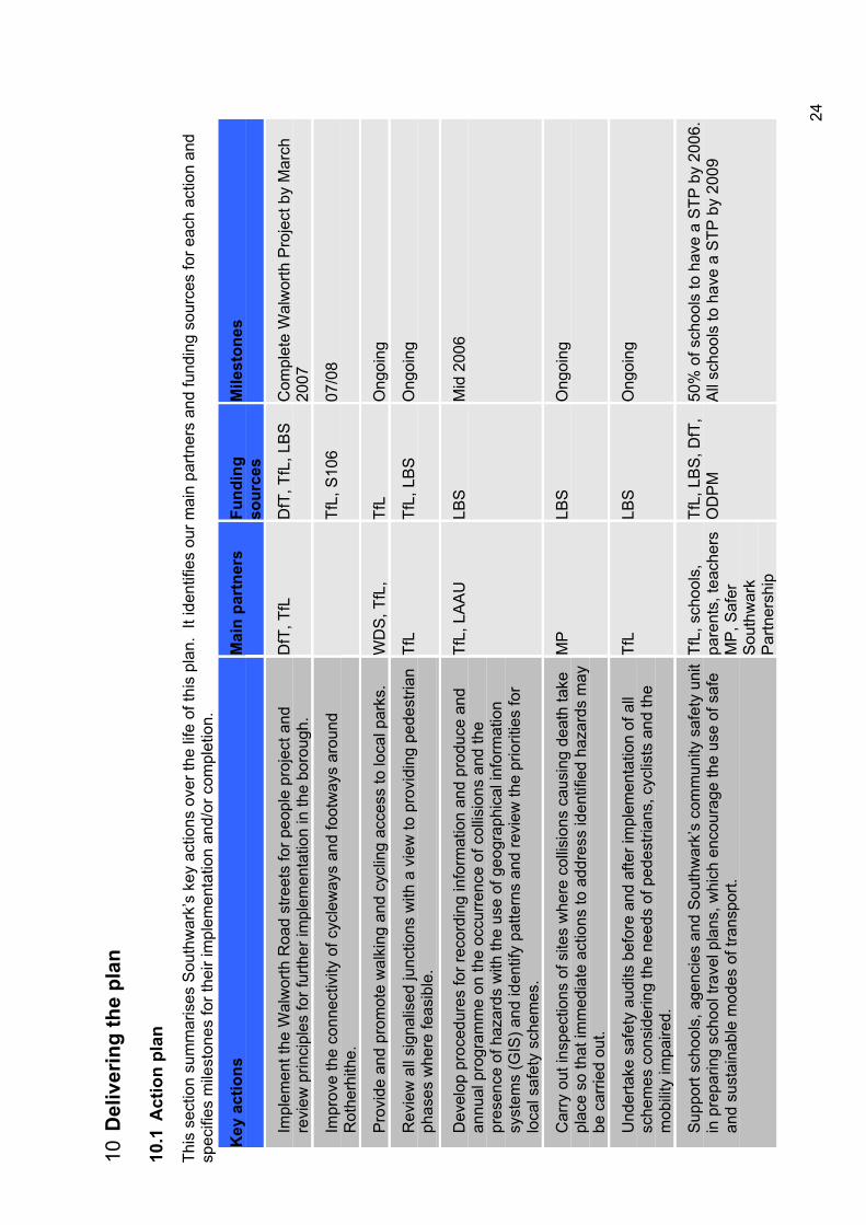
10D
eliv
erin
g th
e pl
an
10.1
Act
ion
plan
This
sec
tion
sum
mar
ises
Sou
thw
ark’
s ke
y ac
tions
ove
r the
life
of t
his
plan
. It
iden
tifie
s ou
r mai
n pa
rtner
s an
d fu
ndin
g so
urce
s fo
r eac
h ac
tion
and
spec
ifies
mile
ston
es fo
r the
ir im
plem
enta
tion
and/
or c
ompl
etio
n.
Key
act
ions
M
ain
part
ners
Fu
ndin
gso
urce
sM
ilest
ones
Impl
emen
t the
Wal
wor
th R
oad
stre
ets
for p
eopl
e pr
ojec
t and
re
view
prin
cipl
es fo
r fur
ther
impl
emen
tatio
n in
the
boro
ugh.
D
fT, T
fL
DfT
, TfL
, LB
S
Com
plet
e W
alw
orth
Pro
ject
by
Mar
ch
2007
Impr
ove
the
conn
ectiv
ity o
f cyc
lew
ays
and
foot
way
s ar
ound
R
othe
rhith
e.Tf
L, S
106
07/0
8
Pro
vide
and
pro
mot
e w
alki
ng a
nd c
yclin
g ac
cess
to lo
cal p
arks
. W
DS
, TfL
,Tf
LO
ngoi
ng
Rev
iew
all
sign
alis
ed ju
nctio
ns w
ith a
vie
w to
pro
vidi
ng p
edes
trian
ph
ases
whe
re fe
asib
le.
TfL
TfL,
LB
S
Ong
oing
Dev
elop
pro
cedu
res
for r
ecor
ding
info
rmat
ion
and
prod
uce
and
annu
al p
rogr
amm
e on
the
occu
rren
ce o
f col
lisio
ns a
nd th
e pr
esen
ce o
f haz
ards
with
the
use
of g
eogr
aphi
cal i
nfor
mat
ion
syst
ems
(GIS
) and
iden
tify
patte
rns
and
revi
ew th
e pr
iorit
ies
for
loca
l saf
ety
sche
mes
.
TfL,
LA
AU
LB
SM
id 2
006
Car
ry o
ut in
spec
tions
of s
ites
whe
re c
ollis
ions
cau
sing
dea
th ta
ke
plac
e so
that
imm
edia
te a
ctio
ns to
add
ress
iden
tified
haz
ards
may
be
car
ried
out.
MP
LBS
Ong
oing
Und
erta
ke s
afet
y au
dits
bef
ore
and
afte
r im
plem
enta
tion
of a
ll sc
hem
es c
onsi
derin
g th
e ne
eds
of p
edes
trian
s, c
yclis
ts a
nd th
e m
obili
ty im
paire
d.
TfL
LBS
Ong
oing
Sup
port
scho
ols,
age
ncie
s an
d S
outh
war
k’s
com
mun
ity s
afet
y un
it in
pre
parin
g sc
hool
trav
el p
lans
, whi
ch e
ncou
rage
the
use
of s
afe
and
sust
aina
ble
mod
es o
f tra
nspo
rt.
TfL,
sch
ools
, pa
rent
s, te
ache
rs
MP
, Saf
er
Sou
thw
ark
Par
tner
ship
TfL,
LB
S, D
fT,
OD
PM
50
% o
f sch
ools
to h
ave
a S
TP b
y 20
06.
All
scho
ols
to h
ave
a S
TP b
y 20
09
24
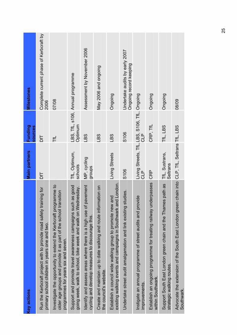
Key
act
ions
M
ain
part
ners
Fu
ndin
gso
urce
sM
ilest
ones
Run
the
Ker
bcra
ft pr
ojec
t with
to p
rovi
de ro
ad s
afet
y tra
inin
g fo
r pr
imar
y sc
hool
chi
ldre
n in
yea
rs o
ne a
nd tw
o.
DfT
DfT
Com
plet
e cu
rren
t pha
se o
f Ker
bcra
ft by
20
06
Inve
stig
ate
the
oppo
rtuni
ty to
ext
end
the
Ker
bcra
ft pr
ogra
mm
e to
ol
der a
ge g
roup
s an
d pr
ovid
e it
as p
art o
f the
sch
ool t
rans
ition
pr
ogra
mm
es fo
r yea
rs s
ix a
nd s
even
.
TfL
07/0
8
Sup
port
and
prom
ote
trave
l aw
aren
ess
cam
paig
ns s
uch
as g
ood
goin
g w
eek,
wal
k to
sch
ool,
bike
wee
k an
d w
alk
on W
edne
sday
. Tf
L, O
ptim
um,
scho
ols
LBS
, TfL
, s10
6,
Opt
imum
A
nnua
l pro
gram
me
Iden
tify
and
asse
ss a
reas
whe
re th
ere
is a
hig
h us
e of
pav
emen
t cy
clin
g an
d de
velo
p m
easu
res
to d
isco
urag
e th
is.
MP
, cyc
ling
grou
psLB
SA
sses
smen
t by
Nov
embe
r 200
6
Cre
ate
and
mai
ntai
n up
to d
ate
wal
king
and
rout
e in
form
atio
n on
th
e co
unci
l's w
ebsi
te.
LBS
May
200
6 an
d on
goin
g
Est
ablis
h a
coun
cil w
ide
wal
king
gro
up to
pro
mot
e ne
w a
nd
exis
ting
wal
king
eve
nts
and
cam
paig
ns in
Sou
thw
ark
and
Lond
on.
Livi
ng S
treet
s LB
SO
ngoi
ng
Und
erta
ke s
treet
aud
it am
alga
mat
ion
and
link
exis
ting
stud
ies.
S
106
S10
6U
nder
take
aud
its b
y ea
rly 2
007
Ong
oing
reco
rd k
eepi
ng
Inst
igat
e an
ann
ual p
rogr
amm
e of
stre
et a
udits
and
pro
vide
im
prov
emen
ts.
Livi
ng S
treet
s, T
fL,
CLP
LBS
, S10
6, T
fL,
CLP
Ong
oing
Est
ablis
h an
ong
oing
pro
gram
me
for t
reat
ing
railw
ay u
nder
pass
es
with
in S
outh
war
k.
CR
PC
RP
, TfL
O
ngoi
ng
Sup
port
Sou
th E
ast L
ondo
n gr
een
chai
n an
d th
e Th
ames
pat
h as
st
rate
gic
wal
king
rout
es.
TfL,
Sus
trans
, S
eltra
nsTf
L, L
BS
O
ngoi
ng
Adv
ocat
e th
e ex
tens
ion
of th
e S
outh
Eas
t Lon
don
gree
n ch
ain
into
S
outh
war
k.C
LP, T
fL, S
eltra
ns T
fL, L
BS
08
/09
25
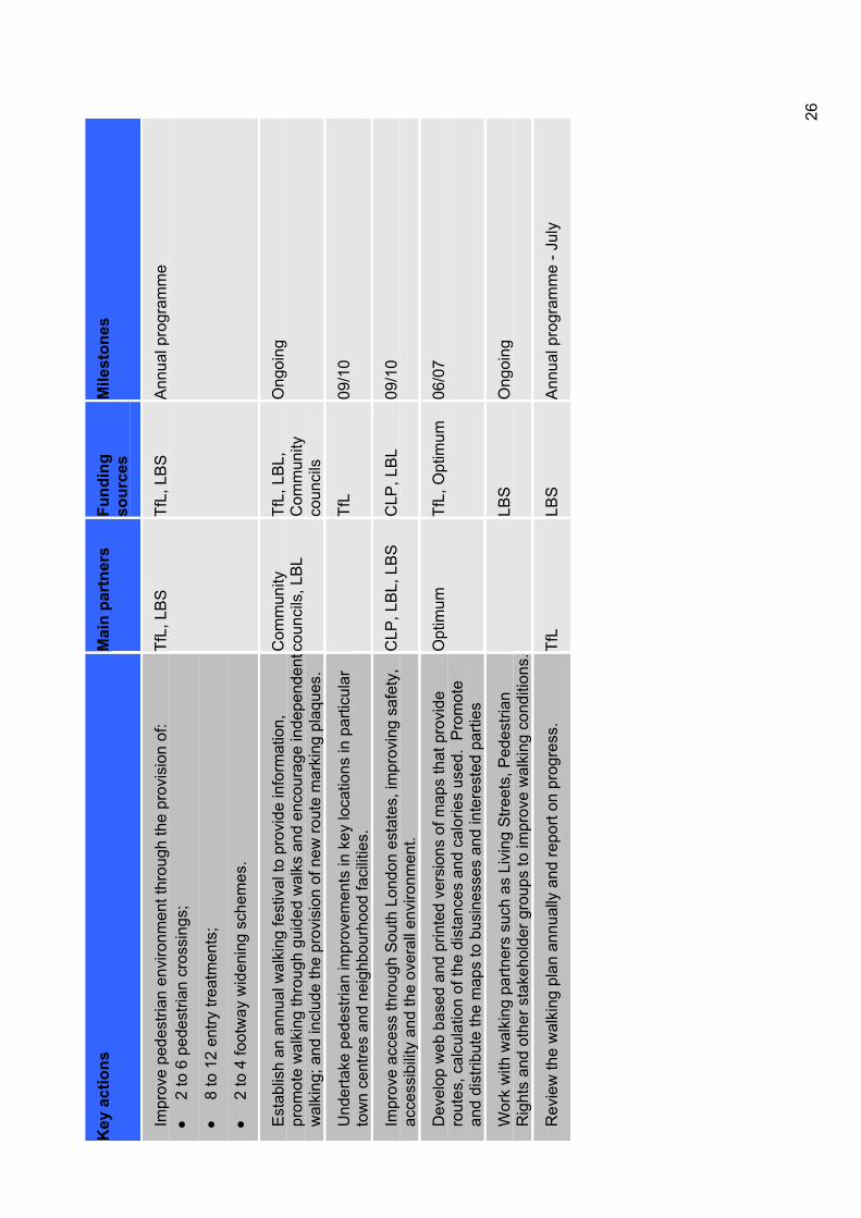
Key
act
ions
M
ain
part
ners
Fu
ndin
gso
urce
sM
ilest
ones
Impr
ove
pede
stria
n en
viro
nmen
t thr
ough
the
prov
isio
n of
: 2
to 6
ped
estri
an c
ross
ings
;
8 to
12
entry
trea
tmen
ts;
2 to
4 fo
otw
ay w
iden
ing
sche
mes
.
TfL,
LB
S
TfL,
LB
S
Ann
ual p
rogr
amm
e
Est
ablis
h an
ann
ual w
alki
ng fe
stiv
al to
pro
vide
info
rmat
ion,
pr
omot
e w
alki
ng th
roug
h gu
ided
wal
ks a
nd e
ncou
rage
inde
pend
ent
wal
king
; and
incl
ude
the
prov
isio
n of
new
rout
e m
arki
ng p
laqu
es.
Com
mun
ityco
unci
ls, L
BL
TfL,
LB
L,
Com
mun
ityco
unci
ls
Ong
oing
Und
erta
ke p
edes
trian
impr
ovem
ents
in k
ey lo
catio
ns in
par
ticul
ar
tow
n ce
ntre
s an
d ne
ighb
ourh
ood
faci
litie
s.
TfL
09/1
0
Impr
ove
acce
ss th
roug
h S
outh
Lon
don
esta
tes,
impr
ovin
g sa
fety
, ac
cess
ibili
ty a
nd th
e ov
eral
l env
ironm
ent.
CLP
, LB
L, L
BS
C
LP, L
BL
09/1
0
Dev
elop
web
bas
ed a
nd p
rinte
d ve
rsio
ns o
f map
s th
at p
rovi
de
rout
es, c
alcu
latio
n of
the
dist
ance
s an
d ca
lorie
s us
ed.
Pro
mot
e an
d di
strib
ute
the
map
s to
bus
ines
ses
and
inte
rest
ed p
artie
s
Opt
imum
Tf
L, O
ptim
um
06/0
7
Wor
k w
ith w
alki
ng p
artn
ers
such
as
Livi
ng S
treet
s, P
edes
trian
R
ight
s an
d ot
her s
take
hold
er g
roup
s to
impr
ove
wal
king
con
ditio
ns.
LBS
Ong
oing
Rev
iew
the
wal
king
pla
n an
nual
ly a
nd re
port
on p
rogr
ess.
Tf
LLB
SA
nnua
l pro
gram
me
- Jul
y
26
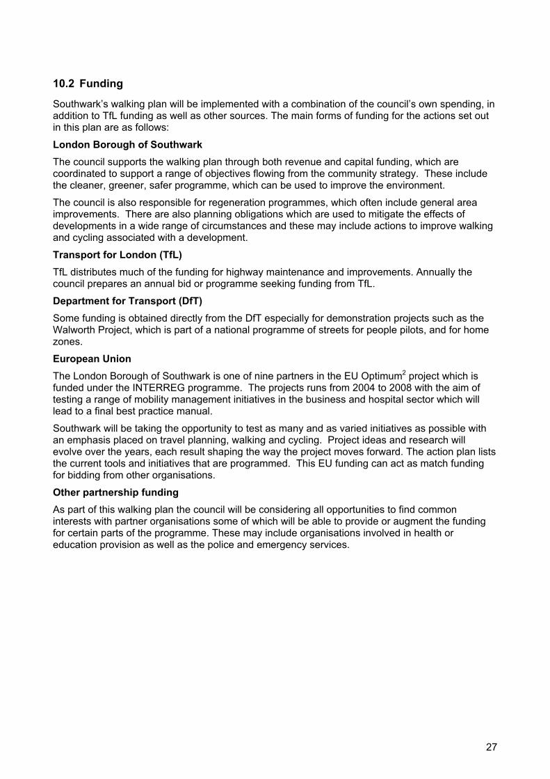
10.2 Funding
Southwark’s walking plan will be implemented with a combination of the council’s own spending, in addition to TfL funding as well as other sources. The main forms of funding for the actions set out in this plan are as follows:
London Borough of Southwark The council supports the walking plan through both revenue and capital funding, which are coordinated to support a range of objectives flowing from the community strategy. These include the cleaner, greener, safer programme, which can be used to improve the environment.
The council is also responsible for regeneration programmes, which often include general area improvements. There are also planning obligations which are used to mitigate the effects of developments in a wide range of circumstances and these may include actions to improve walking and cycling associated with a development.
Transport for London (TfL)TfL distributes much of the funding for highway maintenance and improvements. Annually the council prepares an annual bid or programme seeking funding from TfL.
Department for Transport (DfT) Some funding is obtained directly from the DfT especially for demonstration projects such as the Walworth Project, which is part of a national programme of streets for people pilots, and for home zones.
European Union The London Borough of Southwark is one of nine partners in the EU Optimum2 project which is funded under the INTERREG programme. The projects runs from 2004 to 2008 with the aim of testing a range of mobility management initiatives in the business and hospital sector which will lead to a final best practice manual.
Southwark will be taking the opportunity to test as many and as varied initiatives as possible with an emphasis placed on travel planning, walking and cycling. Project ideas and research will evolve over the years, each result shaping the way the project moves forward. The action plan lists the current tools and initiatives that are programmed. This EU funding can act as match funding for bidding from other organisations.
Other partnership funding As part of this walking plan the council will be considering all opportunities to find common interests with partner organisations some of which will be able to provide or augment the funding for certain parts of the programme. These may include organisations involved in health or education provision as well as the police and emergency services.
27
11 Consultation Public consultation on the draft Lip and its supplementary documents, including this walking plan was undertaken during November and December 2005. Consultation was carried out with the community, partner organisations such as TfL, the Metropolitan Police, other London boroughs and with local groups and organisations such as Southwark Cyclists, Southwark Pedestrian Rights Group and the Southwark branch of Living Streets.
The draft plan was considered by the Southwark disability forum, equality and diversity panel, the transport consultative forum and its mobility subgroup during this period. The plan was also discussed at all of the winter community council meetings with workshops held at Walworth and Camberwell community councils.
A questionnaire on the themes and actions proposed in the draft plan was circulated to key stakeholder groups and was available to the general public at each of the community council meetings, in all official council offices, on the Southwark Council website and upon request. The results of the questionnaire feedback was collated and the results relating to walking highlighted the following:
Practical issues of walking such as safety, ability for the mobility impaired, time and distance;
Conflict with other road users, particularly cyclists on pavements;
The greatest barrier to walking was identified as the poor crossing facilities, inconveniently located crossing points or a lack of crossing facilities followed by street clutter;
More promotion of recreation walking links.
Accordingly, as a result of the consultation this plan has been revised to address these issues and to incorporate, where reasonably possible, many other suggested improvements.
28
12 Working with partners
12.1 The Metropolitan Police
The police have a pivotal role in the promotion of walking, from road management to personal safety and security. Their enforcement programme can also lead to significant reduction in road casualties as well as reducing street crime and fear of crime.
The police deal with street crime, personal safety issues and road collisions and are also responsible for collecting data on crime, essential for use in crime prevention. The borough holds liaison meetings with all of the emergency services. In order to provide a better service to London boroughs and the public, the Metropolitan Police have recently formed the traffic operational command unit (TOCU). The unit has been specifically tasked with working in partnership with local authorities in tackling traffic crime and helping to meet the government casualty reduction targets. Their major focus over this year will be:
To play a significant role in reducing road casualties;
To assist in increasing awareness, through education, of the importance of road safety;
To assist in the application of engineering solutions to road problems for all road users;
To secure greater compliance with road safety legislation through enforcement.
12.2 Transport for London (TfL)
The borough relies on TfL to provide funding and technical advice in working towards all transport targets. Through the BSP process, TfL provide funding for both promoting walking and improving the walking environment.
TfL are responsible for strategic roads within the borough. Due to the strategic nature of these roads they are often heavily used by pedestrians and we will ensure that there is close liaison between the TfL area teams and council to achieve the best results. To this end the borough regularly meets TfL to discuss matters arising on strategic roads, adjacent borough roads and their interrelationship.
12.3 Seltrans
The South East London Transport Strategy (Seltrans) was established in 1998 as a partnership between the seven southeast London boroughs of Bexley, Bromley, Croydon, Greenwich, Lambeth, Lewisham and Southwark, transport providers and operators, and groups representing the interests of businesses and passengers. The broadest objective of Seltrans is to find ways in which an integrated transport system can help enhance London’s economic prosperity, environment, promote social inclusion and the quality of life of Londoners. Southwark works with Seltrans in particular to improve the environment and, as a result, modal shift at transport interchanges are an important element in this partnership.
12.4 Green chain walk
The south east London green chain, and the network of routes that links them is known simply as the green chain walk. The walk extends from the Thames in the northeast to its tip at Crystal Palace Park in the southwest. It connects with other key routes including the capital ring, London loop and Thames path. It contains 10 sections and covers a distance of 65km. Southwark Council works with the green chain group to enable the appropriate implementation of the walk within the borough.
29
12.5 Thames path national trail
The Thames path extends along both banks through London and continues to the river's source in the Cotswold Hills. Southwark Council supports the path as a major national initiative to promote leisure walking and enjoyment of the public realm by working with our partners to achieve the implementation and maintenance of the Thames path.
12.6 Southwark primary care trust
Southwark primary care trust is the local NHS organisation responsible for all local primary and community care services. In addition, it is responsible for improving the health of local people and tackling health inequalities as well as commissioning hospital services. Southwark works in partnership with the PCT under the strategic guidance of the Healthy Southwark Partnership Board, which ensures a whole system approach to addressing the health needs of the borough. The board includes representation from the public health department of the PCT, acute trusts, the voluntary sector as well as Southwark Council.
12.7 Regeneration partnerships
The council works with a range of regeneration agencies and public authorities to reduce social exclusion and improve the quality of life, including:
London Development Agency;
Greater London Authority;
Cross River Partnership;
Central London Partnership;
Pool of London Partnership.
The council will continue to work with these and other agencies to achieve the aims of the plan.
30

2004Part Two
Appendix E Cycling plan
Local Implementation Plan

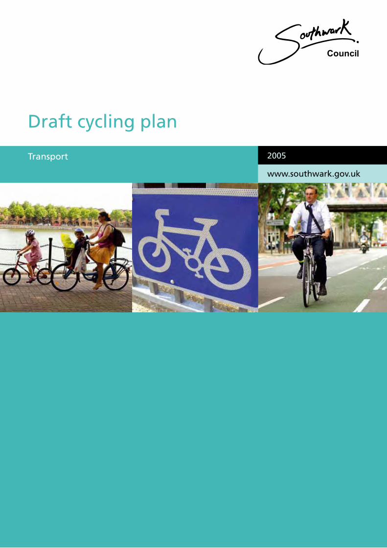
2004
Draft cycling plan
2005
www.southwark.gov.uk
Transport
This plan is part of a package of documents that makes up Southwark Council’s transport strategy.
Southwark’s transport strategy is also known as te Local implementation Plan and sets out how the council will plan and deliver an integrated package of transport improvements from 2005-10.
The other documents that comprise the strategy include
• Road Safety Plan
• Walking Plan
• Cycle Plan
• School Travel Plan Strategy
• Parking and Enforcement Plan
The Borough Spending Plan is also related to these palns as it sets out bids for funding to implement transport improvements.
Contact Us
Transport groupRegeneration departmentSouthwark CouncilChiltern HousePortland StreetLondonSE17 2ES
www.southwark.gov.uk
Any enquiries relating to this Plan can be directed to the Transport Group on 020 7525 5317 or email: [email protected]
This plan is part of a package of documents that makes up Southwark Council’s transport strategy.
Southwark’s transport strategy is also known as the Local implementation Plan and sets out how the council will plan and deliver an integrated package of transport improvements from 2005-10.
The other documents that comprise the strategy include
• Road safety plan
• Walking plan
• Cycling plan
• School travel plan strategy
• Parking and enforcement plan
The Borough Spending Plan is also related to these plans as it sets out bids for funding to implement transport improvements.
Contact Us
Transport groupRegeneration departmentSouthwark CouncilChiltern HousePortland StreetLondonSE17 2ES
www.southwark.gov.uk
Any enquiries relating to this Plan can be directed to the Transport Group on 020 7525 5317 or email: [email protected]
Contents
Foreword ........................................................................................................................1
1 Introduction .............................................................................................................2
2 Policy context and priorities ....................................................................................3
3 Cycling for all...........................................................................................................5
4 Promoting cycling....................................................................................................8
5 Improving the cycling environment........................................................................10
6 Improving links to recreational cycling ..................................................................16
7 Providing parking ..................................................................................................17
8 Improving cycling skills..........................................................................................19
9 Making cycling safer..............................................................................................21
10 Monitoring our progress.....................................................................................22
11 Coordination with other strategies.....................................................................23
12 Delivering the action plan ..................................................................................27
13 Consultation.......................................................................................................34
14 Working with partners........................................................................................35
Foreword
The remarkable thing about the bicycle is that it provides a cheap and simple answer to many of the problems in London life that are often thought to require huge investment or advanced technology to solve.
Bikes are most suited to local trips and most traffic is local, so cycling can cut congestion on the roads and reduce crowding in public transport without spending hundreds of millions of pounds. Cycling is nearly always quicker door to door than the bus, train or car. Bikes are the clean and quiet solution to problems of poor air quality and noise pollution from traffic.
There are growing concerns about deterioration in the health of much of the population particularly with obesity and heart disease. We know that getting people, especially children, onto bikes is one of the most effective ways of dealing with this.
Just about anyone can have access to these benefits of quick, convenient, reliable transport. It is not even restricted to the fit and able bodied. People of all ages and many people with mobility problems can find that they are more mobile with pedal power.
Often all it takes is that first push, for me it was being broke in London. For others it might be to get fit, avoid the jams or keep up with the kids.
This draft cycling plan explains how Southwark Council will encourage people to make that first step and to make life easier for those who already use their bikes for some trips.
It shows how making small changes can make a big difference. It is just as much about giving people the inspiration and the confidence to bring cycling more into their lives as adapting the environment to make it better at accommodating cyclists (and pedestrians) safely. Just as the road safety plan that Southwark has recently approved seeks to make 20 mph the normal speed limit for Southwark’s roads, this cycling plan seeks to make getting on a bike the normal thing to do for as many people as possible when they want to get around, for a cleaner, quieter, healthier, safer and all round pleasanter borough.
Councillor Richard Thomas Executive member for environment and transport
1
1 Introduction The popularity of cycling continues to grow. It is appreciated by more and more people as a healthy, enjoyable, economical and efficient way of getting about.
Measures to promote cycling and tackle the barriers that may prevent people cycling will have number of immediate benefits in improving local traffic conditions, reducing congestion and improving air quality. Increases in cycling will improve people’s health and fitness, encourage lasting sustainable travel patterns and offer air quality and quality of life benefits.
Cycling is ideally suited for local trips over a third of which are under a mile long, and 85% of which are less than five miles in length1. Cycling, together with other measures such as travel plans, safe routes to school and initiatives to encourage more walking, is crucial to reducing congestion, improving the environment and promoting social inclusion and better health.
This cycling plan sets out what Southwark Council intends to do to encourage more people to cycle by improving the cycling conditions, making it more convenient and safer wherever possible and promote cycling as a viable and sustainable alternative to other modes of travel such as the car.
1 London Area Transport Survey 2001
2
2 Policy context and priorities
2.1 National and regional context A walking and cycling action plan was produced by the Department for Transport (DfT) in 2004 which sets out broad areas for action:
Creating places that people want to walk and cycle in;
Providing high quality facilities for safe walking and cycling;
Influencing travel behaviour through education, training, marketing and promotion;
Building skills and capacity;
Monitoring success through better targets and indicators.
This cycling plan also recognises these as being the broad areas for action and the plan sets out what the council are going to do in each of these areas.
The Mayor’s Transport Strategy 2004 states that Transport for London (TfL) and the London boroughs, in consultation with cycling groups, will undertake and support measures to make the cycling environment safer and more convenient for all users.
The London cycling action plan published February 2004 states the Mayor’s vision for cycling in London and sets out strategic targets, objectives and actions. These relate to the London cycle network plus (LCN+), resources, maintenance, design standards, safety, auditing, cycle parking, promotion, inclusiveness, transport, contributions from other schemes, integration and coordination, partnership and legislation.
2.2 National objectives The London cycling action plan contains the following headline target:
To achieve at least an 80% increase in cycling levels by 2010 and a 200% increase by 2020 compared to cycling levels in 2000.
In addition to this it contains a short term target:
To achieve measurable increases in cycling levels and to establish benchmarks.
And medium term targets:
To increase the modal share of cycling trips;
To increase the number of cycle trips per person per year;
To increase the level of London’s cyclability and user satisfaction with London’s cycling infrastructure and environment in terms of people’s perceptions.
Southwark supports these targets and will seek to develop ways of monitoring cycle use and user satisfaction in order to assess progress towards meeting them.
2.3 Local context Cycling can play a key part in achieving the vision set out in Southwark’s community strategy2 of making Southwark a better place to live, to learn, to work and to have fun and in supporting the priorities of:
2 ‘A community strategy for Southwark 2003 to 2006’ published April 2003
3
Tackling poverty;
Making Southwark cleaner and greener;
Cutting crime and the fear of crime;
Raising standards in our schools;
Improving the health of the borough.
The current community strategy 2003 to 2006 is being revised and the council has prepared a strategy covering through to 2016. This draft strategy will set the direction for the council for the next ten years and is currently undergoing consultation. The draft strategy seeks to build upon the 2003 community strategy and contains the following ambitions:
Improving individual life chances;
Making the borough a place for people;
Ensuring quality public services.
The cycling plan will form part of a strategy for transport in the borough which will be contained in the Local implementation plan (Lip). The ten overarching transport plan objectives are derived from and complement those contained in Southwark’s community strategy, national transport policy and the Mayor’s Transport Strategy. These ten objectives are:
Improve accessibility throughout the borough;
Promote more sustainable modes of travel and improve travel choice;
Improve safety and personal security;
Promote greater integration of land use development and transport;
Improve the quality, efficiency and reliability of transport
Improve the efficiency, reliability and safety of freight distribution;
Promote and improve social inclusion, economic development, education, employment and housing;
Improve visual amenity and the quality of the environment;
Reduce energy use;
Work with partners to progress and promote transport improvements.
2.4 Local objectives In addition to the London wide targets set above, Southwark Council has set the following annual targets relating to cycle training in schools:
Increase by 10% the number of students receiving cycle training;
Provide cycle training to five additional schools.
Southwark will seek to develop ways of monitoring cycle use and user satisfaction in order to assess progress towards meeting these targets.
4
3 Cycling for all London is fast becoming a cycling city. Following the introduction of the congestion charge in 2003, the number of people cycling into the charging zone has increased by over 20%3.
Southwark will use this cycling plan to achieve the following:
Create the conditions where almost anyone can easily choose to make at least some journeys by bike;
Make the main highway network, especially locations that experience the highest density of collisions, safer through road danger reduction so that cyclists can integrate with other traffic;
Redefine the hierarchy of road users as follows:
1. Pedestrians (including the needs of disabled people)
2. Cyclists
3. Public transport
4. Powered two wheelers
5. Taxis
6. Freight
7. Private cars
Provide cycle training to increase cyclists’ confidence to make use of the whole available network.
3.1 The benefits of cycling HealthThe British Medical Association (BMA) recognises that cycling is an activity which can have many benefits, not only for those who cycle, but for everyone. In Cycling Towards Health and Safety4 the BMA wishes to encourage safe participation in cycling by, among other measures, urging the government to support cycling as a means of transport.
The government has demonstrated its commitment to increase participation in cycle use both as a leisure pursuit and mode of transport in its 2004 Public Health White Paper Choosing Health.5 The chief medical officer recommends that adults achieve at least five 30 minute periods of moderate intensity activity each week and children achieve at least 60 minutes of moderate intensity activity each day.6 Choosing Health aims to enable people to use cycling to achieve these activity levels through improved infrastructure, cycling promotion and support for service providers.
Regular cycling can produce a number of impressive health gains, including protection against coronary heart disease, stroke, type two diabetes, colon cancer, stress, high blood pressure and obesity. On average, people who cycle 20 miles or more a week 3 Congestion Charging Third Annual Monitoring Report, Transport for London, April 2005
4 British Medical Association. Cycling: Towards health and safety. Oxford Univ, P, 1992.5 DoH (2004) Choosing health: making healthy choices easier Department of Health: London6 DoH (2004) At least five a week: Evidence on the impact of physical activity and its relationship to health Department of Health: London
5
experience the health of people ten years younger7. New cyclists covering short distances can reduce their risk of premature death mainly due to the reduction of heart disease by up to 22 per cent 8. Cycling can provide both a realistic alternative to the car and public transport for short journeys and an excellent form of exercise that is very inexpensive and can be incorporated into daily routines
Social inclusion High volumes of traffic can cut people off from essential facilities such as shops, schools and parks. A significant proportion of the population, including children, the elderly, people on low incomes and disabled people do not have access to private cars for transport. Many people may not be able to get to or afford to use public transport regularly. Cycling is a leveller, promoting inclusion because of the parity it gives to all whatever their financial status.
However, although cycling costs little and is widely available, Londoners with lower incomes actually cycle only about half as much as higher income groups and cycling is half as popular among women as it is among men. The London cycling action plan suggests that possible barriers to cycling among lower income groups include the cost of cycles, lack of storage space and lack of security at home9.
The pedal cycle also offers the opportunity to fill a transport gap for many people with disabilities. The London Cycling Campaign’s all abilities cycling group demonstrates that disabled people can benefit from the fitness, inclusion and independence that cycling can bring.
Economic benefits An average four mile journey in central London can take 40 minutes in a car, 30 minutes on the tube, an hour on the bus and just 22 minutes on a bicycle. The annual cost of running a bicycle is just £250. By comparison, running a car costs on average £6,000 per year.
Roughly half of all cycled trips in London are journeys to work. Employers benefit if their employees cycle to work, advantages include higher productivity, increased loyalty, less absence due to transport disruption and fewer days off sick. As a result, cycling is now a central feature of travel plans.
EnvironmentIncreasing the proportion of journeys made by bicycle will improve air quality for all and reduce noise.
Bicycles use considerably less resources to manufacture and run than motor vehicles. They also require considerably less space and more pleasant, human scale urban environments can easily accommodate bicycles in contrast to the extensive areas of road and car parking needed to accommodate cars.
Liveability Liveability is a name for a certain quality that a neighbourhood may have when it is clear that people care about it and it meets their needs very well. Just as run down areas where there is litter, noise and fumes can create a sense of despair and lack of
7 Tuxworth, W., Nevill, A.White, C. and Jenkins, C. 1986 Health, fitness, physical activity and morbidity of middle-aged factory workers, British Journal of Industrial Medicine, Vol 43, pp 733-75
8 Rutter H. Modal shift. Transport and health. A policy report on the health benefits of increasing levels of cycling in Oxfordshire. 9 London Cycling Action Plan, Transport for London, February 2004
6

responsibility so spaces that are bright, clean, accessible and well looked after have a positive effect.
With more people using bicycles as well as walking and using public transport, our streets and public places can become a lot more lively with infinitely more opportunities for people to meet and be sociable than if travelling by car. This should lead to a number of positive consequences. With more people to watch out the streets are safer. There will tend to be more people caring about their environment and prepared to improve it. With more people walking and cycling there may be more value put on local services and greater patronage for local businesses so that they have more chance to thrive. This combination of positive aspects of urban living contributes to a quality of liveability and cycling has a special part to play in achieving it.
7
4 Promoting cycling Southwark Council recognises that promotion of cycling is an important measure to encourage more people to cycle and also to provide the necessary information to the current cyclists to ensure that their journey is as convenient and accessible as possible.
The council provides information to cyclists about route information, cycle parking, cycle hire and promotional events via the council website. Information is also provided through the council’s libraries and council offices.
The council assists in supporting or facilitating promotional events organised by local cycling groups. These include bike week, good going week and sustainability week. These events provide opportunities for the distribution of information and the promotion of cycling within the borough. Participation in cycling events in the borough also helps create a more inclusive environment for cycling and generates community involvement in developing the cycling network.
Marketing initiatives and campaigns are complementary to investment in infrastructure and will improve the value for money offered by that investment. The Cycling Centre of Excellence is the organisation responsible for promoting cycling in the capital.
The council is currently developing a work travel plan and within this travel plan the council will promote cycling among its own staff. It will support the setting up of an employees cycling group to help meet the needs of staff who cycle to work. Other measures to encourage more staff to cycle to work and to meetings and site visits from the office include the provision of cycle training for staff, pool bikes and discounted bicycle buying schemes.
The council is also working with local businesses to encourage the development of their own work travel plans. Many workplace journeys can be made using the bicycle. The council has been involved in a scheme called bikes for business, which has proved very successful. The scheme offered the free use of bikes for journeys to and from work. The council intends to investigate funding opportunities to continue this to provide to more businesses in the future.
The council has developed a school travel plan strategy that provides guidance to schools for delivering an effective, integrated school travel plan (STP) programme over the period 2005 to 2009. The council works closely with schools in the borough to aide the development of STP. An STP sets out what a school has done and what they are going to do to tackle issues with the journey to school while encouraging a reduction in car journeys made to school. An STP is a whole initiative that sets out practical measures to:
Incorporate road safety into the school curriculum;
Improve the physical environment through engineering measures;
Encourage sustainable transport choices on the journey to school;
Make the area around the school safer;
Develop cooperative/sharing travelling schemes;
Improve the level of fitness of our pupils and parents/carers;
Stress the importance of healthy lifestyles;
Instil in our children a commitment to protecting the environment.
8

STPs support and encourage cycling to school and many STPs set out a programme of providing cycle training to their pupils and teachers. Through the implementation of STPs the council has seen an increase in the number of pupils cycling and this in turn helps the council meet the cycle training targets for the borough.
Events such as the Southwark Show and Rotherhithe Festival are used to promote cycling in general and to give people the opportunity to test new safety products. Cyclists need to be aware of the importance of proper lighting on the bike and these events offer advice to cyclists on such accessories.
9
5 Improving the cycling environment 5.1 Land use planning The strategy set out in the Southwark Plan10 builds upon the borough’s success as a compact city with mixed use areas and efficient use of land so that the need to travel is reduced. Work, shops, schools, health and leisure facilities and other things that people needs should always be near at hand, a short walk or cycle ride away. The draft plan contains strategic policies to promote more sustainable transport choices for all members of the community in order to reduce congestion and pollution and increase ease of movement. The plan will also require developers to provide for cycle parking and other cycling infrastructure as part of their developments or through planning obligations. This will often be part of a travel plan that the council will expect to see prepared for a wide range of developments. Further details of the requirements for cycling contained in the Southwark Plan are set out in appendix 1 of this plan.
5.2 Transport planning Southwark operates a road user hierarchy approach, we consider the needs of different user types, favouring in order:
Pedestrians including the needs of disabled people;
Cyclists;
Public transport;
Motorcyclists;
Taxis;
Freight;
The private car.
This means that improving the conditions for pedestrians and cyclists are the highest priorities. Actions to improve the conditions for other road users might be acceptable as long as they do not adversely affect those higher up in the hierarchy.
We should recognise that the cyclists use all of the borough’s roads but for those cyclists who do not wish to integrate with all the other traffic on busy roads alternative routes are identified. To do this, the cyclists’ network can be expanded through the provision of additional links that are not adequately provided for by the road network.
DfT pilot journey planner The council is one of the three local authorities in a DfT and Cycling England pilot to develop a cycle journey planner. The purpose of the journey planner is to provide accurate, direct and accessible routes from one location to another. The planner will initially only involve Southwark routes but it is planned to develop the scheme nationally once the data for the pilot boroughs has been fully developed. Then anyone should be able to plan a journey by bike. Users of the planner can plan multiple route options according to their cycling ability. The planner is aimed at encouraging new cyclists and providing them with a route that suits their needs best.
10 The Southwark Unitary Development Plan, ‘The Southwark Plan’, has been in preparation in consultation with the community since 2001. It is to be examined at a public inquiry in April to June 2005 with a view to being formally adopted in late 2006.
10
5.3 Providing cycling infrastructure The council recognises the importance of cycling in the borough and the need to increase the number of cyclists, they also recognise that in order to increase the number of cyclists the conditions of the environment and cycling infrastructure need to be improved to an adequate standard.
The national cycle network The national cycle network consists of 10,000 miles of signed cycle routes throughout the UK, with almost 75% of the UK population within two miles of the network. One third of the network is on traffic free paths, with the rest on quiet minor roads and traffic calmed streets. These well marked routes provide fantastic leisure opportunities, as well as links into towns for schools, work and stations. The Thames cycle route, which is route 4 of the national cycle network, travels through Southwark along the Thames River from the Rotherhithe peninsula through Bermondsey and London Bridge to Lambeth. The council supports and promotes the use of the Thames cycle route and works closely with Sustrans to ensure this route is maintained to a good condition.
The London cycle network plus (LCN+) This is the Londonwide 900 kilometre formal cycle network, which is being implemented at borough level with dedicated funding from TfL. According to TfL, implementation of the whole network will be completed by 2009/10.
The vision for the LCN+ is a network of high demand routes that are fast, safe, comfortable, coherent, of high quality and easy for cyclists to use. The routes will also give cyclists greater priority over other traffic.
The council is in full agreement with the aims and objectives of the LCN+ concept and will continue to develop the LCN+ throughout the borough.
Future initiatives Sustrans GOAL 2012 is a vision for London to create a network of traffic free walking and cycling routes, linked by quiet tree lined streets, providing greenways for Olympics and London as a whole. The initiative is advocating for an iconic new cycling and walking bridge across the Thames. The key to the project for South London is the traffic free river crossing at Rotherhithe.
This bridge has the potential to make communities in Southwark and neighbouring boroughs feel directly connected to the Olympic Park. This bridge will enable quick and easy access from the Rotherhithe area to Canary Wharf. The council intends to investigate the potential for the project to be integrated into existing regeneration schemes and the implications for sustainable transport in the borough. The council will also consider the needs of our local residents to ensure that the impacts of this bridge are positive.
11

Figure 1 – The Southwark cycle network
12
Cycling in Southwark The council seeks to improve cycling within the borough and will invest in infrastructure to do this. As well as providing new routes and infrastructure, we will ensure that when maintenance or new works is being undertaken parallel initiatives that consider cycling infrastructure is taken into account. For example if the road is being resurfaced we would also consider if there was opportunites to provide a cycle lane or if a traffic signal is being moved it may also be possible to provide an advanced stop line for cyclists.
Cycle friendly junction design Principal roads and other busy through routes enable cyclists to make faster and more direct journeys. They are also key locations for shops, workplaces and other facilities that cyclists along with everyone else wish to get to.
Cyclists using principal and other busy roads tend to be at their most vulnerable when going through junctions. One major improvement that can be carried out in the interests of cyclists is installation of advanced stop lines (ASLs). The ASL gives the cyclist a safe place to wait for the green light at light controlled junctions where they are visible to all other road users. The council is pursuing a programme of laying out ASLs at junctions wherever this is feasible. It will also work with the police and TfL publicise the status of ASLs and ensure that they are enforced.
Another aspect of junction design that requires particular care is where there is a left turn only lane. These should be avoided as they tend to require cyclists to cross the inside lane towards the middle of the road before the junction or come into conflict with left turning traffic when they reach the junction. Southwark will initiate a programme to review the safety of all junctions with left turn only lanes and, wherever possible, redesign them to remove this feature.
There are safety audits before and after traffic management measures on schemes that involve any changes to junctions to ensure the safety of cyclists is taken into account. The highways agency is currently in the process of publishing such a standard for inclusion in the design manual for roads and bridges. In addition, Southwark Council intends to develop vulnerable road user audits to identify improvements that are needed to improve the safety of pedestrians, people with disabilities and children as well as cyclists.
One way streets and road closures Road closures and one way streets can be a barrier to cycling. One way operation is often a response to growing traffic volumes but it frequently lengthens the cyclist’s journey and, in the process, exposes them to worse traffic conditions with more junctions to negotiate. Arrangements that permit cyclists to use these streets in both directions are popular with cyclists and can redress the situation and give cyclists an advantage over other traffic. This is often referred to as greater permeability. Southwark will look at all one way streets with a view implementing two way cycling and any future plans should assess the possibility of contra flow cycling. Any road closures implemented by the council should allow for cycle access and existing road closures will be investigated to allow for cycle access. The council has received funding through the borough spending plan (BSP) to convert one way to two way streets for cyclists for the 2006/07 year and plan to continue to bid for more in the future.
13
Best practice example of a cycle contra flow lane in Southwark This road was of the first contra flow schemes implemented to help Southwark reach the target of providing two way access for cycling on all one way streets where it is reasonable to do so. Highshore Road was converted to a one way street several years ago to prevent rat running through quiet areas of Peckham. The provision of cycle contra flow here enables cyclists to use the signalised junction at Peckham Road to link in with the main shopping centre of Rye Lane and a LCN+ route. Highshore Road is in a 20 mph zone and was illegally used previously by cyclists.
The council is looking at the feasibility of implementing a similar scheme in Bellenden Road to link in with Highshore.
London cycle design standards The London cycle design standards set out the principles, guidance and standards for designing cycling infrastructure and facilities to reduce barriers to cycling, support road safety targets and encourage the increased number of cyclists in London. The standards provide guidance for the implementation of improvements,such as cycleways, junctions and crossings, signs and markings, surfacing, and parking. The council considers these standards when planning or implementing improvements within the borough.
5.4 Improving streetscapes
Reducing traffic speeds Southwark has an overall aim of becoming a 20 mph borough. The council wants 20 mph to be seen as the default speed limit throughout the borough and higher speed limits will only apply when specifically justified. Details are set out in the road safety plan. Such traffic calming will be achieved with a combination of engineering and enforcement measures, which will benefit all road users but particularly cyclists. Reducing the speed of motor vehicles will reduce the real and perceived danger that these vehicles pose to cyclists and other vulnerable road users. The council will give very careful consideration to the design of engineering measures such as speed humps and width restrictions to ensure the safety of cyclists. For example, the benefits of using specially profiled speed humps (sinusoidal humps), which are more comfortable for cyclists to ride over, will be investigated.
Streets for people The principles of the road user hierarchy referred to in section 5.2 are demonstrated in the design of our first home zone in Sutherland Square, Walworth. An ambitious and innovative project to radically improve the experiences of pedestrians and cyclists in Walworth Road under the streets for people initiative promoted by the DfT is now being planned. These projects are establishing principles that can be applied elsewhere and the council will be particularly keen to see the principles applied in the master planning of the major regeneration projects that are planned for the coming years at Elephant and Castle, Canada Water and at other locations.
Home zones Home zones improve the experience for cyclists by designing the surrounding streets to meet the interests of pedestrians and cyclists rather than motorists and opening up the street for social use. The key to creating a home zone is to develop street design
14

that makes drivers feel it is normal to drive slowly and carefully. Features often include traffic calming, shared surfaces, trees and planters, benches and play areas.
National campaigning organisations assert that home zones can provide a better quality of life. A home zone can turn streets into valued public spaces, which are safer for everyone. They believe that home zones can provide a safer place for children to play near their homes, and are safer places for older people and disabled people to walk in the street.
Home zones create attractive urban environments, which could help in cutting the demand for new housing in the countryside. They have the potential to be better for the environment as they are likely to encourage more local trips on foot or by bicycle, in turn cutting levels of noise and air pollution.
15
6 Improving links to recreational cycling By providing convenient and accessible routes, safe and secure cycle parking facilities and adequate cycle information such as maps and signage we can not only promote and encourage cycling for transport purposes but also encourage more cycling purely for leisure.
Cycling is a leisure activity that can be undertaken by all. Cycling is often used for recreational activities whether to take up a healthier lifestyle, to socialise or just to spend time outdoors. Cycling can offer effortless access to many sights and cultural and social points of interest. Therefore, it presents an excellent way for individuals to explore local areas of Southwark or to venture out further and discover the rest of London.
Southwark has good access to recreational cycling which can encourage more people to take up cycling for purpose journeys.
London’s only velodrome is situated right here in Southwark. The Herne Hill velodrome was built in 1891 and it has been regenerated to provide cycling facilities which will help play a key role in the development of cycling at a national level, while also encouraging the increase of participation in cycling at a more local and regional level. The velodrome was reopened in August 2005 and is host to local, regional and national events.
The Peckham BMX club is situated on Peckham Park Road, Peckham. The club provides weekly training sessions for over 35 children and has a number of national BMX champions in their midst. The club has been successful in developing practical cycling skills for children and providing them with more life choices. The club also gets children interested in leisure activities such as BMX riding and competing and there have been opportunities for travel where the members have achieved national success.
The council has recently received funding to upgrade the current BMX track facilities that are located in Burgess Park. The council is currently deciding upon options for track capacity and design. It is anticipated that the track will be completed and ready for use by July 2006.
Many people cycle to these facilities and the council will review cycling routes to ensure safe and convenient access.
16
7 Providing parking Security is a major problem in built up areas. Southwark Council has conducted an audit of all cycle parking facilities in the borough and is implementing programmes to increase on street parking, which is led by demand. The stand generally used in Southwark is the Sheffield stand but it is acknowledged that these are only suitable for short term parking and different options need to be available for longer periods of time. At some sites BikeAway lockers have been installed. These are lockable, secure lockers, which are available to local residents for a small annual fee.
All new cycle stands should be located in areas with good lighting, high footfall and close to user destinations. Locations monitored by closed circuit television (CCTV) will be used wherever possible. Cycle stands will also be fitted with stickers promoting the use of good quality locks and contact information for the council.
The council supports the provision of cycle parking at housing estates throughout the borough. The council is planning to install the BikeAway lockers on some housing estates in partnership with the local tenants and residents associations. The council is currently undertaking an audit of existing storage that is provided at housing estates. Through this the council will investigate locations where there are gaps or opportunities for need. The council is also refurbishing some of the existing pram sheds on housing estates that could provide safe and secure cycle parking facilities for residents.
The council fully supports the Mayors school cycle parking programme, which aims to provide and install effective cycle parking facilities throughout greater London schools.
Two examples of good cycle provision at schools in Southwark are Alfred Salter and St Johns RC primary schools in Rotherhithe. Alfred Salter had 60 cycle parks installed as part of the cycle saturation project that took place last summer and St Johns have just recently had a cycle parking cage installed at their school with an average of 25 bikes parked there daily. The usage of this cage will be monitored and if it proves successful the council would like to utilise the cage at other schools in the borough.
Cycle parking map The council mapped the existing cycle parking facilities in the borough when the audit of cycle parking was undertaken. This map is being currently rolled out and will be fully accessible on the council website mid 2006. The map will be very user friendly, cyclists will be able to visually mark on the map where they want to go and zoom in and locate the cycle parking. They will also be able to see what kind of cycle parking is available at the location and photos will be linked to the map so they can see what the parking looks like. Figure 2 shows the current location of cycle parking facilities in the borough.
17

Figure 2 – Cycle parking in the borough
18
Parking at interchanges and stations Cycling may become an attractive option for more people to choose when they can conveniently transfer to public transport for part of their journey. This means that safe cycle parking at rail and underground stations is particularly important. Southwark will also consider very carefully the ways in which cycling is catered for whenever improvements to public transport systems are being planned. In the coming years it is hoped that this will include the East London Line extension to Crystal Palace and the Cross River Tram linking Peckham to Camden Town. Good cycle parking at planned tram stops will open up the benefits of this project to a much wider area with fast, convenient access to central London.
The London cycling action plan includes the objective of developing the concept of bike stations with a full range of cycle facilities to provide first class cycle parking and cycle hire at main interchange points. It proposes ten such stations to be provided by 2010 subject to available funding. Southwark will promote Elephant and Castle as being one of the bike stations to be delivered early in this programme and will investigate the potential of other major interchanges in the borough (London Bridge, Canada Water, Peckham Rye) as being bike stations.
8 Improving cycling skills Southwark provides training through Cycle Training UK, a national organisation who use fully qualified instructors to teach to the national standards set by the DfT. Southwark also runs promotions offering heavily discounted lessons and feedback indicates that this gives the rider more confidence and increases the amount of journeys on bikes. The increased availability of cycle training will lead to better general cycling standards and adherence to the highway code.
ASLs and cycle lanes are relatively new to many motorists. Current driving licence regulations mean that someone may well only read the highway code at the time they past their driving test so may not be aware of new regulations. Initiatives are also needed to educate motorists so they understand cycle facilities and other transport policies such as the proposed default 20 mph speed limit throughout Southwark.
More resources should be concentrated on encouraging children to cycle. While good cycling infrastructure is vital, cycling being seen as an everyday activity is crucial. Not only will this encourage children to cycle more but it will also encourage families to ride together socially. While training provided by Cycle Training UK in the schools is initially off road there is a high proportion of on road training as this is the only way students will get used to cycling in traffic. Subject to available funding Southwark aims to offer all schools cycle training. Currently this is just for year six but should be extended at least to include year seven students starting at secondary schools.
The council has set annual targets to improve the provision of cycle training at schools by increasing the number of students receiving cycle training by 10% each year and providing cycle training to five additional schools annually. The council provided training to over 200 school children and 25 schools throughout 2005/06 year. This is an ever increasing figure with more and more schools taking up the opportunity to provide their pupils with cycle training.
Cycle saturation project Rotherhithe community council allocated £20,000 to Southwark Cyclists to undertake a cycling training project. Local primary schools were invited to apply and St John’s RC Primary School was selected to receive cycle saturation. The school was in the process of completing a travel plan and had applied to TfL for cycle parking to be installed. The school is in an area with good off road cycle routes on the Rotherhithe peninsula and close to the Thames path, Surrey Quays and Southwark park. Year five and six pupils had previously
19
received cycle skills training funded by Southwark Council. However the school only had two pupils cycling to school although 84% were interested in doing so and there was a high number of pupils coming by car.
Having determined there was a high degree of suppressed interest in cycling among the school community the approach of cycle saturation was to deliver a concentrated burst of cycling promotion and training to pupils, parents and staff to achieve an increase in cycling activity.
Kicked off by a mini festival of cycling at the school in April 2005, cycle training was given to nearly 40% of pupils and cycle instructor training was also offered to staff and parents. Cycle parking for 60 cycles was installed just in time for the launch in summer 2005 and this is often full during the summer term. In excess of 80 bikes are parked at the school on special event days.
A cycle club has since been set up to sustain the benefits into the future, possibly shared with other schools and Alfred Salter school has teamed up with St John’s for cycle picnic events and rides and it is hoped that the network will grow.
The school has had visitors and enquiries from local authorities and other groups of interest from London and further afield due to interest in the project. The project provided children with the level of cycling they needed and formula will be adapted to be used at other schools and colleges in 2006. The success of this project is very clear and it is recognised as helping the council reach the cycle training targets, while also supporting the road safety targets by enhancing the children’s safety. The council intends to investigate opportunities and work closely with Southwark Cyclists to roll this programme out to other schools in the borough.
Cycle training at Salmon Youth centre The council has received funding through the borough spending plan to provide cycle training to the Salmon youth centre in Bermondsey for up to 80 youths. The objective of this proposal is to improve road safety for youth cyclists in a deprived part of the borough. This proposal has arisen out of consultation undertaken during bike week in Southwark over recent years, for which social inclusion was considered by many to be of importance where such training schemes are proposed.
The training sessions will address issues such as cycle control and maintenance, hand signals and the Highway Code, the importance of being clearly visible to other road users and negotiation of particular road situations, such as junctions. In addition, the council will purchase ten bicycles for the youth centre to continue this training regularly. Cycle Training UK will undertake the training and it will be launched during bike week 2006/2007 and continue through the remainder of the financial year.
20
9 Making cycling safer 9.1 Safety Perceptions surrounding traffic conditions, fear of collisions and unsuitable road design are key issues affecting people’s propensity to cycle. The chance of an individual cyclist being struck by a motorist varies inversely with the amount of walking and cycling that takes place in a locality (BMJ Vol.9 et al). Locally, the number of collisions involving cyclists has decreased over ten years from 1993 to 2003.
This cycling plan is intended to support the road safety plan in setting out actions that should help meet the national target of reducing the number of people killed or seriously injured (KSI) in road collisions by 40%, and the number of children killed or seriously injured by 50% by 2010 compared with the average for 1994 to 1998. The road safety plan has adopted as policy the road danger reduction charter (RDRF 2001), which seeks to reduce and eliminate road hazards at source. This includes pursuing a transport strategy for environmentally friendly sustainable travel based on developing efficient, integrated public transport systems. Current levels of motor traffic should not be increased. The charter also calls on councils to actively promote walking and cycling, which pose little threat to other road users, by taking positive and coordinated action to increase the safety and mobility of these benign modes.
Cycle use in the UK has increased by 10% between 1993 and 2002, yet the number of reported pedal cyclist casualties has decreased by 34% over the same period. Furthermore, European cities with a higher level of cycling than London are also safer. For example in York around one in five trips are cycled and in the peak hours cycling has increased by a third, yet over the past ten years casualties have been reduced by 30%.
Within Southwark there has been an 8% reduction in cyclist casualties between 1994 and 2003.
9.2 Enforcement Enforcement of cycle infrastructure is vital if we are to encourage cycling in the borough. The council’s parking enforcement officers are aware of current legislation regarding cycle lanes and ASLs and the council will use the new powers available to issue tickets for traffic violations. This will not be limited to motorised traffic as sometimes cyclists are in breach of traffic regulations too, and this can be one of the biggest barriers to cycling becoming generally accepted in London.
Pedestrians often come into conflict with cyclists riding on pavements. Areas with a high use of pavement cycling will be assessed to see if this is due to perceived dangerous road conditions rather than inconsiderate behaviour. Measures to discourage cycling on pavements will be investigated and could include improvements to the cycling conditions and infrastructure on the road, provision of training and education, shared use paths, and increased enforcement. In areas with high footfall, such as the Thames path, alternative routes will be signed, including destinations, and every effort will be made to encourage cyclists to use these.
Cyclists are covered by the regulations in the Highway Code like all other road users and ignoring traffic rules and signals is both illegal and dangerous. The Metropolitan Police currently enforce cycling on pavements, however are unable to issues penalty notices to cyclists aged 16 and under.
21
10 Monitoring our progress Southwark Council is fully committed to achieving the cycling plan targets. There are some existing methods for monitoring cycling activity that can be utilised, such as:
Attitudinal surveys;
Cycling flows;
Proportion of people using cycling to journey to work, education and shops;
Number of school children and schools being trained by Cycle Training UK.
Monitoring of cycling numbers and additional information about cycling in the borough is not up to standard and the council intends to improve this with the implementation of the cycling plan and achievement of its action plan. The council also intends to conduct a review of the cycle network and through this investigate opportunities to measure cycling numbers and cycle parking usage. This will also give a better understanding of the current network and identify where there are missing links.
Annual monitoring of this information will be contained within the annual monitoring report and will relate to the lifecycle or timescale of transport plans, policies or programmes. In addition to this quarterly monitoring will be carried out in accordance with the council’s equalities impact assessment (EqIA) guidance.
10.1 Bicycle policy audit In 2004 Southwark Council participated in a European research project, known as BYPAD, to develop a methodology for evaluating the cycling policies of European cities. The resulting evaluation of cycling policy in Southwark will help set targets and objectives to improve aspects of cycling policy. The audit found that, among other issues, the council could do more make accessible data on user needs, and measure the effects of cycle policy. A number of other weaknesses identified in Southwark’s approach to cycle policy should be rectified by the publishing of this draft cycling plan.
10.2 Research and other support Southwark Cyclists received a Millennium Awards for All grant to carry out a cycle survey of the whole of Southwark. The group distributed 10,000 survey questionnaires and 1,300 replies were generated. At present, the data is still being analysed. However, Cycle Maps Ltd have produced a hot spot map that highlights collisions in red and difficult places for cyclists to cross in yellow (www.cyclemaps.com). It is the council’s intention to repeat this exercise. The council will instigate a method of counting cyclists throughout the borough throughout the year and work to develop automatic counters. Existing CCTV cameras may also be used to manually count cyclists in specific locations.
10.3 Census data According to the London Area Transport Survey (LATS) 1991 and 2001 Household Surveys the number of cycle trips made by Southwark residents increased by 27% between 1991 and 2001 compared to a Londonwide average of 2.8%.
22
11 Coordination with other strategies
11.1 Regional strategies
London cycling action plan The council’s cycling plan supports the London cycling action plan. It is the Mayor’s vision to make London a city where people of all ages, abilities and cultures have the incentive, confidence and facilities to cycle whenever it suits them. Cycling is integral to the Mayor’s vision to develop London as an exemplary sustainable world city.
The cycling action plan will deliver significant benefits to London’s cycling environment and encourage more Londoners to take to their bicycles. The plan will ensure that cyclists’ needs are addressed in all transport projects. The Mayor’s long term target, to increase cycling in London by 200%, reflects the important benefits that cycling can bring to the capital, and by 2010 the target is to see 80% increase in cycling.
Mayor’s Transport Strategy The Mayor’s Transport Strategy sets out the policy framework for transport provision in London. It provides the context for the detailed plans and proposals of TfL and other implementation agencies over a ten-year period.
The Mayor’s Transport Strategy seeks to increase the capacity, quality and integration of the transport system and endorses a co-ordinated approach to ‘improvements to transport integration and facilitating greater use of cycling, walking and public transport.
Choosing Health, the Public Health White Paper This paper emphasises the importance of increasing levels of physical activity in the population to improve health through promoting and facilitating active lifestyles. Some of the key action points that relate to cycling and support the council’s own cycling plan are:
Ensure school travel plans are in place;
Develop new cycle lanes;
Integrate rights of way and cycle networks into local transport plans;
Develop schemes to promote health and wellbeing in larger workplaces;
Develop a comprehensive car pathway for obesity including prevention and treatment.
23
11.2 Southwark strategies
Community strategy This cycling plan sets out how cycling can play its part in achieving the vision set out in Southwark’s community strategy of making Southwark a better place to live, to learn, to work and to have fun in supporting the strategies of:
Tackling poverty;
Making Southwark cleaner and greener;
Cutting crime and the fear of crime;
Raising standards in our schools;
Improving the health of the borough.
Unitary development plan The Southwark plan, the revised deposit unitary development plan was published in March 2004. This plan, which is going through several phases of extensive public consultation, is expected to be adopted in 2006. The plan aims to provide a translation of the aims of the community strategy into actions in the physical environment. One of its main aims is to guide development so that Southwark continues to develop as a compact city area with efficient use of land so that the need to travel by private car is reduced and cycling and walking are much more viable.
Work, shops, schools, health and leisure facilities and other services should always be near at hand, in other words, a short walk or cycle ride away.
The draft plan contains strategic policies to improve the range and quality of services available in Southwark to ensure that they are easily accessible by foot, cycle and public transport and to promote more sustainable transport choices for all members of the community in order to reduce congestion and pollution and increase ease of movement.
Local implementation plan (Lip)The Lip will be a statutory plan that sets out how the borough proposes to implement the Mayor’s Transport Strategy, which was published in 2001. The development of the Lip also provides Southwark with an opportunity to develop a coordinated range of local transport initiatives.
The Lip will identify transport issues, such as road safety and sustainable travel, and demonstrate how they will be addressed. The plan will contain various programmes, projects, implementation mechanisms, resource requirements and coordination activities.
The Lip will be an overarching transport strategy for the borough and will be supplemented by a series of more detailed documents including the road safety plan, the school travel plan strategy, a parking and enforcement plan, walking plan and this cycling plan. As part of the development of the Local implementation plan an assessment of the plan against the council’s equality scheme was undertaken. This EqIA helps to identify areas for improvement and ensure that, if appropriate, measures are taken to revise, promote and support the council’s corporate policies on equalities.
This cycling plan, as a supplementary document to the Lip was incorporated into this assessment, which was tabled at the equality and diversity panel in February 2006.
The delivery and development of the Lip and its EqIA will be monitored at various stages to ensure that:
24
The plan contributes positively to the corporate equalities agenda;
The requirements of the plan, as they relate to ensuring access to all and promoting equal opportunities are being adequately met by any initiatives, proposals and/or programmes.
Annual monitoring of this information will be contained within the annual monitoring report and will relate to the lifecycle or timescale of transport plans, policies or programmes. In addition to this quarterly monitoring will be carried out in accordance with the council’s EqIA guidance.
Local delivery plan 2005-2008 The Department of Health requires every primary care trust (PCT) to produce a local delivery plan (LDP). The LDP is the means for delivering national health targets at a local level and provide improvements to Southwark’s health care service.
An important aspect of the LDP is its partnership between Southwark Council, NHS Trusts, Primary Care Groups and other professionals to work in partnership to improve local standards of health and social care.
The LDP for 2005 to 2008 supports the four NHS national priority areas being:
Improving the management of long term conditions;
Improving health of our population;
Improving access to services;
Improving the patient’s experience.
Obesity prevention and management strategy Healthy Southwark is developing a multi-agency strategy for tackling the rising trend in obesity. The Southwark obesity prevention and management strategy will provide a comprehensive pathway of healthy eating and physical activity opportunities from perinatal care through to adulthood. This strategy will provide links to clear referral pathways into obesity management programmes, and will include detailed action plans which will be updated biannually.
Future strategies The council is currently preparing a number of documents that are linked to transport services. Transport should be carefully considered in the preparation of these documents.
Plans currently being prepared:
Boulevard strategy;
Sport and physical activity strategy;
Liveability strategy;
Transport supplementary planning document;
Children and young person’s strategy.
Streetscape design guide The council is developing the streetscape design guide to enable those responsible for the public realm to create high quality streetscapes through the application of specific design principles and the use of preferred materials and products. It will be a key element in
25
achieving our aim of having visually attractive, safe, cared for streets that work well for all users and have a proper balance of functions.
The council intends to implement an innovative design strategy across the borough that sets out our priorities and provides coherent management that integrates and coordinates all the various functions involved in the street scene.
The adopted six indicators of quality for Southwark’s streets are:
Comfort and safety for pedestrians and the disabled;
Designed to accommodate all sorts of functions, not dominated by any one function;
Visually simple and free of clutter;
Well cared for and where utilities or extraneous’ advertising are subordinate to all other street functions;
Sympathetic to local character and activity context, in design and detail;
Ordered to provide appropriate access and deliveries and storage of vehicles.
26
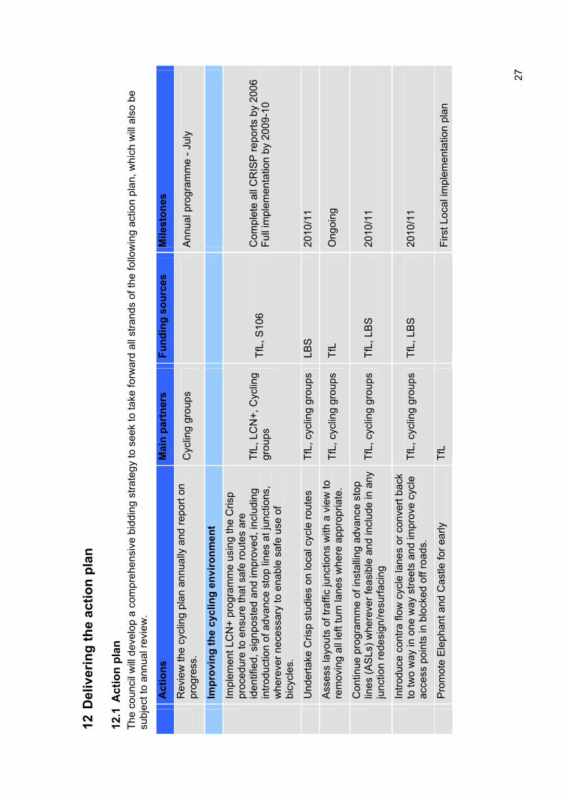
12 D
eliv
erin
g th
e ac
tion
plan
12.1
Act
ion
plan
Th
e co
unci
l will
dev
elop
a c
ompr
ehen
sive
bid
ding
stra
tegy
to s
eek
to ta
ke fo
rwar
d al
l stra
nds
of th
e fo
llow
ing
actio
n pl
an, w
hich
will
als
o be
su
bjec
t to
annu
al re
view
.
Act
ions
Mai
n pa
rtne
rs
Fund
ing
sour
ces
Mile
ston
es
Rev
iew
the
cycl
ing
plan
ann
ually
and
repo
rt on
pr
ogre
ss.
Cyc
ling
grou
ps
Ann
ual p
rogr
amm
e - J
uly
Impr
ovin
g th
e cy
clin
g en
viro
nmen
t
Impl
emen
t LC
N+
prog
ram
me
usin
g th
e C
risp
proc
edur
e to
ens
ure
that
saf
e ro
utes
are
id
entif
ied,
sig
npos
ted
and
impr
oved
, inc
ludi
ng
intro
duct
ion
of a
dvan
ce s
top
lines
at j
unct
ions
, w
here
ver n
eces
sary
to e
nabl
e sa
fe u
se o
f bi
cycl
es.
TfL,
LC
N+,
Cyc
ling
grou
psTf
L, S
106
Com
plet
e al
l CR
ISP
repo
rts b
y 20
06
Full
impl
emen
tatio
n by
200
9-10
Und
erta
ke C
risp
stud
ies
on lo
cal c
ycle
rout
es
TfL,
cyc
ling
grou
ps
LBS
2010
/11
Ass
ess
layo
uts
of tr
affic
junc
tions
with
a v
iew
to
rem
ovin
g al
l lef
t tur
n la
nes
whe
re a
ppro
pria
te.
TfL,
cyc
ling
grou
ps
TfL
Ong
oing
Con
tinue
pro
gram
me
of in
stal
ling
adva
nce
stop
lin
es (A
SLs
) whe
reve
r fea
sibl
e an
d in
clud
e in
any
ju
nctio
n re
desi
gn/re
surfa
cing
Tf
L, c
yclin
g gr
oups
Tf
L, L
BS
20
10/1
1
Intro
duce
con
tra fl
ow c
ycle
lane
s or
con
vert
back
to
two
way
in o
ne w
ay s
treet
s an
d im
prov
e cy
cle
acce
ss p
oint
s in
blo
cked
off
road
s.
TfL,
cyc
ling
grou
ps
TfL,
LB
S
2010
/11
Pro
mot
e E
leph
ant a
nd C
astle
for e
arly
Tf
LFi
rst L
ocal
impl
emen
tatio
n pl
an
27
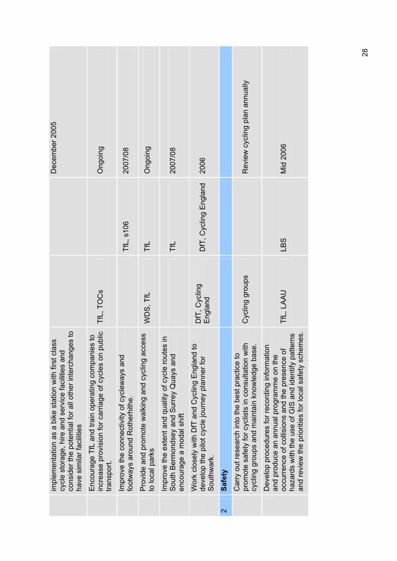
impl
emen
tatio
n as
a b
ike
stat
ion
with
firs
t cla
ss
cycl
e st
orag
e, h
ire a
nd s
ervi
ce fa
cilit
ies
and
cons
ider
the
pote
ntia
l for
all
othe
r int
erch
ange
s to
ha
ve s
imila
r fac
ilitie
s
Dec
embe
r 200
5
Enc
oura
ge T
fL a
nd tr
ain
oper
atin
g co
mpa
nies
to
incr
ease
pro
visi
on fo
r car
riage
of c
ycle
s on
pub
lic
trans
port.
TfL,
TO
Cs
Ong
oing
Impr
ove
the
conn
ectiv
ity o
f cyc
lew
ays
and
foot
way
s ar
ound
Rot
herh
ithe.
Tf
L, s
106
2007
/08
Pro
vide
and
pro
mot
e w
alki
ng a
nd c
yclin
g ac
cess
to
loca
l par
ks
WD
S, T
fL
TfL
Ong
oing
Impr
ove
the
exte
nt a
nd q
ualit
y of
cyc
le ro
utes
in
Sou
th B
erm
onds
ey a
nd S
urre
y Q
uays
and
en
cour
age
a m
odal
shi
ft Tf
L20
07/0
8
Wor
k cl
osel
y w
ith D
fT a
nd C
yclin
g E
ngla
nd to
de
velo
p th
e pi
lot c
ycle
jour
ney
plan
ner f
or
Sou
thw
ark.
DfT
, Cyc
ling
Eng
land
DfT
, Cyc
ling
Eng
land
20
06
2Sa
fety
Car
ry o
ut re
sear
ch in
to th
e be
st p
ract
ice
to
prom
ote
safe
ty fo
r cyc
lists
in c
onsu
ltatio
n w
ith
cycl
ing
grou
ps a
nd m
aint
ain
know
ledg
e ba
se.
Cyc
ling
grou
ps
Rev
iew
cyc
ling
plan
ann
ually
Dev
elop
pro
cedu
res
for r
ecor
ding
info
rmat
ion
and
prod
uce
an a
nnua
l pro
gram
me
on th
e oc
curr
ence
of c
ollis
ions
and
the
pres
ence
of
haza
rds
with
the
use
of G
IS a
nd id
entif
y pa
ttern
s an
d re
view
the
prio
ritie
s fo
r loc
al s
afet
y sc
hem
es.
TfL,
LA
AU
LB
SM
id 2
006
28
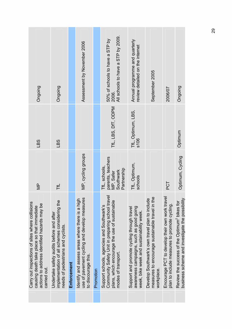
Car
ry o
ut in
spec
tions
of s
ites
whe
re c
ollis
ions
ca
usin
g de
ath
take
pla
ce s
o th
at im
med
iate
ac
tions
to a
ddre
ss id
entif
ied
haza
rds
may
be
carr
ied
out.
MP
LBS
Ong
oing
Und
erta
ke s
afet
y au
dits
bef
ore
and
afte
r im
plem
enta
tion
of a
ll sc
hem
es c
onsi
derin
g th
e ne
eds
of p
edes
trian
s an
d cy
clis
ts.
TfL
LBS
Ong
oing
Enfo
rcem
ent
Iden
tify
and
asse
ss a
reas
whe
re th
ere
is a
hig
h us
e of
pav
emen
t cyc
ling
and
deve
lop
mea
sure
s to
dis
cour
age
this
. M
P, c
yclin
g gr
oups
A
sses
smen
t by
Nov
embe
r 200
6
Pro
mot
ion
Sup
port
scho
ols,
age
ncie
s an
d S
outh
war
k’s
Com
mun
ity S
afet
y U
nit i
n pr
epar
ing
scho
ol tr
avel
pl
ans,
whi
ch e
ncou
rage
the
use
of s
usta
inab
le
mod
es o
f tra
nspo
rt.
TfL,
sch
ools
, pa
rent
s, te
ache
rs
MP
, Saf
er
Sou
thw
ark
Par
tner
ship
TfL,
LB
S, D
fT, O
DP
M50
% o
f sch
ools
to h
ave
a S
TP b
y 20
06.
All
scho
ols
to h
ave
a S
TP b
y 20
09.
Sup
port
and
prom
ote
cycl
ing
thro
ugh
trave
l aw
aren
ess
cam
paig
ns, s
uch
as g
ood
goin
g w
eek,
bik
e w
eek
and
sust
aina
bilit
y w
eek.
TfL,
Opt
imum
, sc
hool
sTf
L, O
ptim
um, L
BS
, s1
06A
nnua
l pro
gram
me
and
quar
terly
re
view
det
aile
d on
the
inte
rnet
Dev
elop
Sou
thw
ark’
s ow
n tra
vel p
lan
to in
clud
e m
easu
res
to e
ncou
rage
sus
tain
able
trav
el in
the
wor
kpla
ce.
Sep
tem
ber 2
005
Enc
oura
ge P
CT
to d
evel
op th
eir o
wn
wor
k tra
vel
plan
to in
clud
e m
easu
res
to p
rom
ote
cycl
ing.
P
CT
2006
/07
Rev
iew
the
succ
ess
of th
e O
ptim
um2 b
ikes
for
busi
ness
sch
eme
and
inve
stig
ate
the
poss
ibili
ty
Opt
imum
, Cyc
ling
Opt
imum
O
ngoi
ng
29
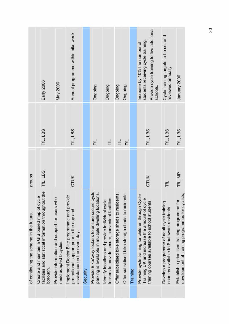
of c
ontin
uing
the
sche
me
in th
e fu
ture
. gr
oups
Cre
ate
and
mai
ntai
n a
GIS
bas
ed m
ap o
f cyc
le
faci
litie
s an
d st
atis
tical
info
rmat
ion
thro
ugho
ut th
e bo
roug
h.Tf
L, L
BS
Tf
L, L
BS
E
arly
200
6
Pro
vide
info
rmat
ion
and
supp
ort f
or u
sers
who
ne
ed a
dapt
ed b
icyc
les.
M
ay 2
006
Impl
emen
t Doc
tor B
ike
prog
ram
me
and
prov
ide
prom
otio
nal s
uppo
rt pr
ior t
o th
e da
y an
d as
sist
ance
on
the
even
t day
. C
TUK
TfL,
LB
S
Ann
ual p
rogr
amm
e w
ithin
bik
e w
eek
Sec
urity
Pro
vide
Bik
eAw
ay lo
cker
s to
ens
ure
secu
re c
ycle
pa
rkin
g is
ava
ilabl
e in
mul
tiple
dw
ellin
g lo
catio
ns.
TfL
Ong
oing
Iden
tify
loca
tions
and
pro
vide
indi
vidu
al c
ycle
lo
cker
s to
pro
vide
sec
ure,
con
veni
ent f
acili
ties.
Tf
LO
ngoi
ng
Offe
r sub
sidi
sed
bike
sto
rage
she
ds to
resi
dent
s.
TfL
Ong
oing
Offe
r sub
sidi
sed
bike
sto
rage
she
ds to
resi
dent
s.
TfL
Ong
oing
Trai
ning
Pro
vide
cyc
le tr
aini
ng fo
r chi
ldre
n th
roug
h C
ycle
Tr
aini
ng U
K a
nd in
crea
se th
e am
ount
of c
ycle
tra
inin
g co
urse
s av
aila
ble
to s
choo
l stu
dent
s C
TUK
TfL,
LB
S
Incr
ease
by
10%
the
num
ber o
f st
uden
ts re
ceiv
ing
cycl
e tra
inin
g.
Pro
vide
cyc
le tr
aini
ng to
five
add
ition
al
scho
ols.
Dev
elop
a p
rogr
amm
e of
adu
lt cy
cle
train
ing
cour
ses
avai
labl
e to
Sou
thw
ark
resi
dent
s.
TfL
TfL,
LB
S
Cyc
le tr
aini
ng ta
rget
s to
be
set a
nd
revi
ewed
ann
ually
Est
ablis
h a
prio
ritis
ed tr
aini
ng p
rogr
amm
e fo
r de
velo
pmen
t of t
rain
ing
prog
ram
mes
for c
yclis
ts,
TfL,
MP
Tf
L, L
BS
Ja
nuar
y 20
06
30
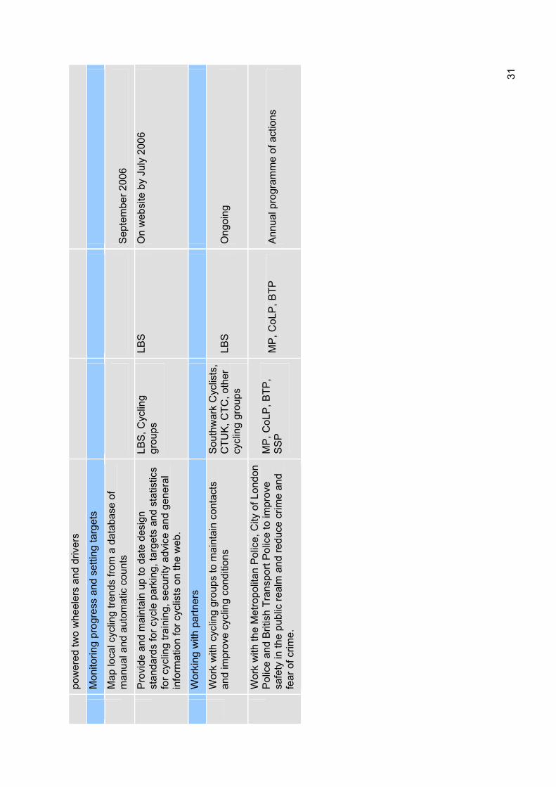
pow
ered
two
whe
eler
s an
d dr
iver
s
Mon
itorin
g pr
ogre
ss a
nd s
ettin
g ta
rget
s
Map
loca
l cyc
ling
trend
s fro
m a
dat
abas
e of
m
anua
l and
aut
omat
ic c
ount
s S
epte
mbe
r 200
6
Pro
vide
and
mai
ntai
n up
to d
ate
desi
gn
stan
dard
s fo
r cyc
le p
arki
ng, t
arge
ts a
nd s
tatis
tics
for c
yclin
g tra
inin
g, s
ecur
ity a
dvic
e an
d ge
nera
l in
form
atio
n fo
r cyc
lists
on
the
web
.
LBS
, Cyc
ling
grou
psLB
SO
n w
ebsi
te b
y Ju
ly 2
006
Wor
king
with
par
tner
s
Wor
k w
ith c
yclin
g gr
oups
to m
aint
ain
cont
acts
an
d im
prov
e cy
clin
g co
nditi
ons
Sou
thw
ark
Cyc
lists
, C
TUK
, CTC
, oth
er
cycl
ing
grou
ps
LBS
Ong
oing
Wor
k w
ith th
e M
etro
polit
an P
olic
e, C
ity o
f Lon
don
Pol
ice
and
Brit
ish
Tran
spor
t Pol
ice
to im
prov
e sa
fety
in th
e pu
blic
real
m a
nd re
duce
crim
e an
d fe
ar o
f crim
e.
MP
, CoL
P, B
TP,
SS
PM
P, C
oLP
, BTP
A
nnua
l pro
gram
me
of a
ctio
ns
31
12.2 Funding Southwark’s cycling plan will be implemented with a combination of the council’s own spending, using funding that comes via TfL as well as other sources, through its development planning and other regulatory functions and through lobbying and partnership working with other organisations. The main forms of funding for the actions set out in this plan are as follows:
Borough spending plan (BSP) TfL distributes much of the funding for highway maintenance and improvements including bids for LCN+ funding and other cycling bids. Until 2004 London boroughs have submitted an annual BSP the purpose of which is primarily to demonstrate to TfL how the borough will implement the Mayor’s Transport Strategy. From 2005 onwards boroughs will still prepare an annual programme but this will be guided by a longer term Lip which will set out priorities for several years ahead.
Department for Transport (DfT) Some funding is obtained directly from the DfT especially for demonstration projects such as the Walworth Project, which is part of a national programme of ‘streets for people’ pilots, and for home zones. Southwark will ensure that the needs for all road users are taken into account in these schemes.
London Borough of Southwark The council supports the cycling plan through revenue funding of many of the services involved. The council also has capital programmes which are coordinated to support a range of objectives flowing from the community strategy. These include the cleaner, greener, safer programme which can be used to improve the environment. It is our belief that initiatives that improve the public realm also help to promote walking and cycling. The council is also responsible for regeneration programmes which often include general area improvements. There are also planning obligations which are used to mitigate the effects of developments in a wide range of circumstances and these may include actions to improve walking and cycling associated with a development.
European UnionThe London Borough of Southwark is one of nine partners in the EU Optimum2 project which is funded under the INTRREG programme. The projects runs from 2004 to 2008 with the aim of testing a range of mobility management initiatives in the business and hospital sector which will lead to a final best practice manual. Over the next four years Southwark will be taking the opportunity to test as many and as varied initiatives as possible with an emphasis placed on travel planning, walking and cycling. Project ideas and research will evolve over the years, each result shaping the way the project moves forward. The action plan lists the current tools and initiatives that are programmed. This EU funding can act as match funding for bidding from other organisations.
Other partnership funding As part of this cycling plan the council will be considering all opportunities to find common interests with partner organisations some of which will be able to provide or augment the funding for certain parts of the programme. These may include organisations involved in health or education provision as well as the police and emergency services. It is important to work with voluntary groups that may have
32

access to funding not available to local authorities with the possibility of matching any funding they may raise.
33
13 Consultation Public consultation on the draft Lip and its supplementary documents, including this cycling plan was undertaken during November and December 2005. Consultation was carried out with the community, partner organisations such as TfL, the Metropolitan Police, other London boroughs and with local groups and organisations such as Southwark Cyclists, Southwark Pedestrian Rights Group and Southwark branch of Living Streets.
The draft plan was considered by the Southwark disability forum, equality and diversity panel, the transport consultative forum and its mobility subgroup during this period. The plan was also discussed at all of the winter community council meetings with workshops held at Walworth and Camberwell community councils.
A questionnaire on the themes and actions proposed in the draft plan was circulated to key stakeholder groups and was available to the general public at each of the community council meetings, in all official council offices, on the Southwark Council website and upon request. The results of the questionnaire feedback was collated and the results relating to cycling highlighted the following:
Adequacy of cycle parking facilities;
Additional locations for cycle ways;
Highlighted suitable locations for cycle parking;
Need to provide cycle training for our children;
Promotion of more recreational cycling events and links;
Ensuring appropriate facilities to discourage cyclists using footways.
Accordingly, as a result of the consultation this plan has been revised to address these issues and to incorporate, where reasonably possible, many other suggested improvements.
34
14 Working with partners 14.1 The Metropolitan Police The police have a key role in enforcement of speed controls and other traffic management regulations. Enforcement must be an integral part of any road safety programme and can lead to significant road casualty reduction. The police deal with after effects of collisions and are also responsible for collecting data on collisions resulting in personal injury, essential for use in collision analysis. The borough holds liaison meetings with all of the emergency services. In order to provide a better service to London boroughs and the public, the Metropolitan Police have recently formed the Traffic Operational Command Unit (TOCU). The unit has been specifically tasked with working in partnership with local authorities in tackling traffic crime and helping to meet the government casualty reduction targets. Their major focus over this year will be:
To play a significant role in reducing road casualties;
To assist in increasing awareness, through education, of the importance of road safety, we intend to see that this includes cycle lanes and ASL’s;
To assist in the application of engineering solutions to road problems for all road users;
To secure greater compliance with road safety legislation through enforcement.
LBS will continue to encourage the police to expand their force of bicycle mounted officers
14.2 Transport for London (TfL) The borough relies on TfL to provide funding and technical advice in working towards all transport targets targets. In addition TfL is responsible for strategic roads which run through the borough. These roads are heavily used by cyclists and although we have no responsibility over these roads we will ensure that there is close liaison between the TfL area teams and Southwark. To this end the borough regularly meets TfL to discuss matters arising on both trunk roads and adjacent borough roads.
14.3 Seltrans The South East London Transport Strategy (Seltrans) was established in 1998 as a partnership between the seven southeast London boroughs of Bexley, Bromley, Croydon, Greenwich, Lambeth, Lewisham and Southwark, transport providers and operators, and groups representing the interests of businesses and passengers. The broadest objective of Seltrans is to find ways in which an integrated transport system can help enhance London’s economic prosperity, environment, promote social inclusion and the quality of life of Londoners. Southwark works with Seltrans in particular to improve the environment and, as a result, modal shift at transport interchanges are an important element in this partnership.
14.4 Sustrans Sustrans is the UK's leading sustainable transport charity, working on practical projects so people can choose to travel in ways that benefit their health and the environment. Sustrans provides creative, imaginative solutions to transport, environmental and health challenges.Sustrans and Southwark Council work closely together to improve the cycling environment, in particular on the national cycle network, the Thames Route.
35
14.5 Southwark primary care trust Southwark primary care trust (PCT) is the local NHS organisation responsible for all local primary and community care services. In addition, it is responsible for improving the health of local people and tackling health inequalities as well as commissioning hospital services. Southwark works in partnership with the PCT under the strategic guidance of the Healthy Southwark Partnership Board which ensures a whole system approach to addressing the health needs of the borough and particularly the local implementation of Choosing Health.11
The board includes representation from the Public Health department of the PCT, acute trusts, the voluntary sector as well as Southwark Council. Southwark’s close links with the PCT ensure coordination of cycling promotion activity and knowledge sharing.
14.6 Healthy Southwark partnership The healthy Southwark partnership board provides overall strategic leadership and ties together the work of sub partnerships. Its membership involves senior managers from across the health and social care sector, together with other statutory and voluntary sector partner agencies. These include Southwark primary care trust, Southwark Council, Guys and St. Thomas's Hospital, Kings College Hospital, South London and Maudsley Mental Health Trust, Metropolitan Police, and Southwark community care forum.
14.7 Regeneration partnerships The council works with a range of regeneration agencies and public authorities to reduce social exclusion and improve the quality of life. Such as:
London Development Agency;
Greater London Authority;
Cross River Partnership;
Pool of London Partnership.
The council will continue to work with these and other agencies to achieve the aims of the plan.
14.8 Public involvement This is an important principle for all actions taken by local authorities so they can understand the objectives of the plan and help achieve these objectives. As outlined previously we need to link together actions from this plan as well as the walking and road safety plans. When measures are proposed to benefit cyclists such as advance stop lines at junctions, they must be shown to be relevant to the needs of that client group.
11 DoH (2004) Choosing Health: making healthy choices easier Department of Health: London
36
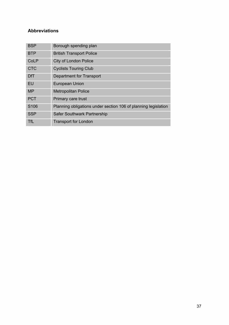
Abbreviations
BSP Borough spending plan
BTP British Transport Police
CoLP City of London Police
CTC Cyclists Touring Club
DfT Department for Transport
EU European Union
MP Metropolitan Police
PCT Primary care trust
S106 Planning obligations under section 106 of planning legislation
SSP Safer Southwark Partnership
TfL Transport for London
37
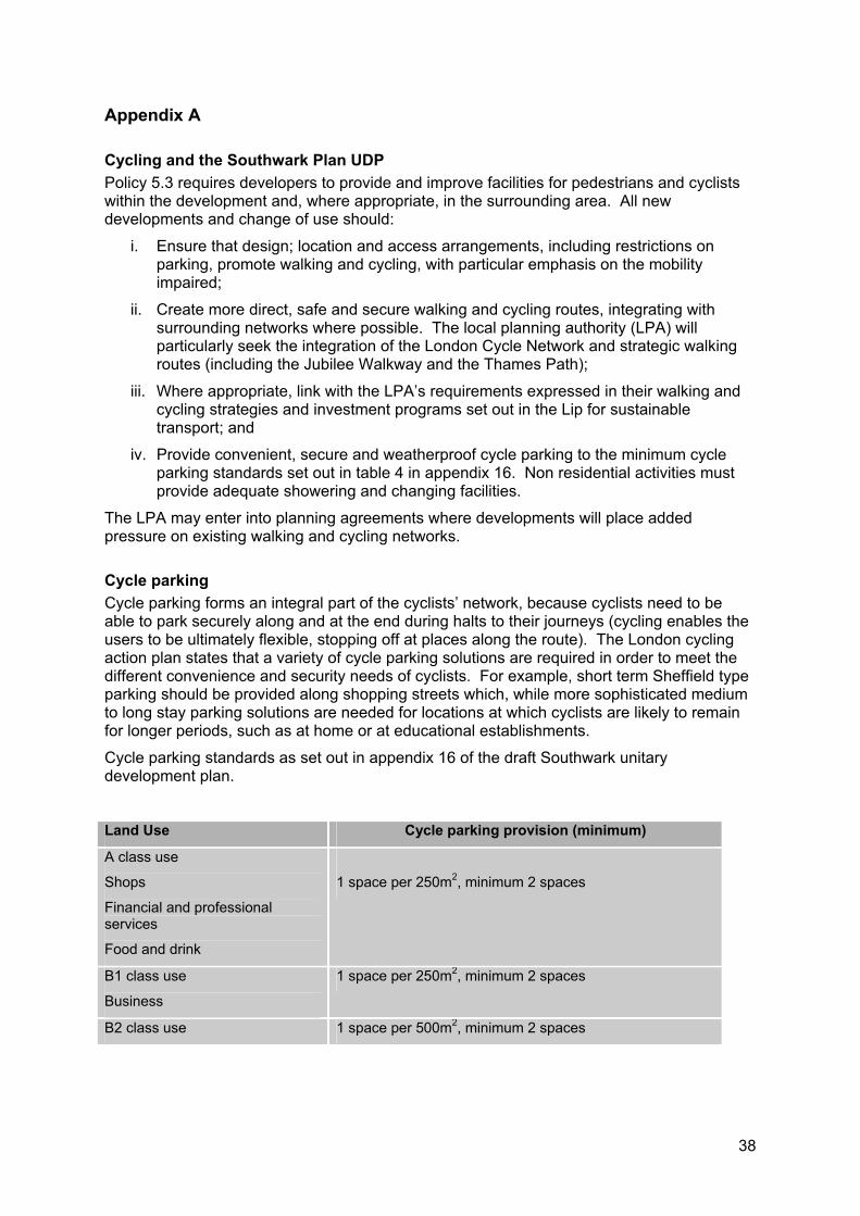
Appendix A
Cycling and the Southwark Plan UDP Policy 5.3 requires developers to provide and improve facilities for pedestrians and cyclists within the development and, where appropriate, in the surrounding area. All new developments and change of use should:
i. Ensure that design; location and access arrangements, including restrictions on parking, promote walking and cycling, with particular emphasis on the mobility impaired;
ii. Create more direct, safe and secure walking and cycling routes, integrating with surrounding networks where possible. The local planning authority (LPA) will particularly seek the integration of the London Cycle Network and strategic walking routes (including the Jubilee Walkway and the Thames Path);
iii. Where appropriate, link with the LPA’s requirements expressed in their walking and cycling strategies and investment programs set out in the Lip for sustainable transport; and
iv. Provide convenient, secure and weatherproof cycle parking to the minimum cycle parking standards set out in table 4 in appendix 16. Non residential activities must provide adequate showering and changing facilities.
The LPA may enter into planning agreements where developments will place added pressure on existing walking and cycling networks.
Cycle parking Cycle parking forms an integral part of the cyclists’ network, because cyclists need to be able to park securely along and at the end during halts to their journeys (cycling enables the users to be ultimately flexible, stopping off at places along the route). The London cycling action plan states that a variety of cycle parking solutions are required in order to meet the different convenience and security needs of cyclists. For example, short term Sheffield type parking should be provided along shopping streets which, while more sophisticated medium to long stay parking solutions are needed for locations at which cyclists are likely to remain for longer periods, such as at home or at educational establishments.
Cycle parking standards as set out in appendix 16 of the draft Southwark unitary development plan.
Land Use Cycle parking provision (minimum)
A class use
Shops
Financial and professional services
Food and drink
1 space per 250m2, minimum 2 spaces
B1 class use
Business
1 space per 250m2, minimum 2 spaces
B2 class use 1 space per 500m2, minimum 2 spaces
38

General industry
B8 class use
Storage or distribution
1 space per 500m2, minimum 2 spaces
Residential dwellings 1 space per unit plus visitor parking at 1 space per 10 units
The design and positioning of cycle parking and off road cycle links will have regard to the needs of partially sighted pedestrians and the likelihood of interference with footway continuity and desire lines.
39

APPENDIX F – CROSS CUTTING GOALS

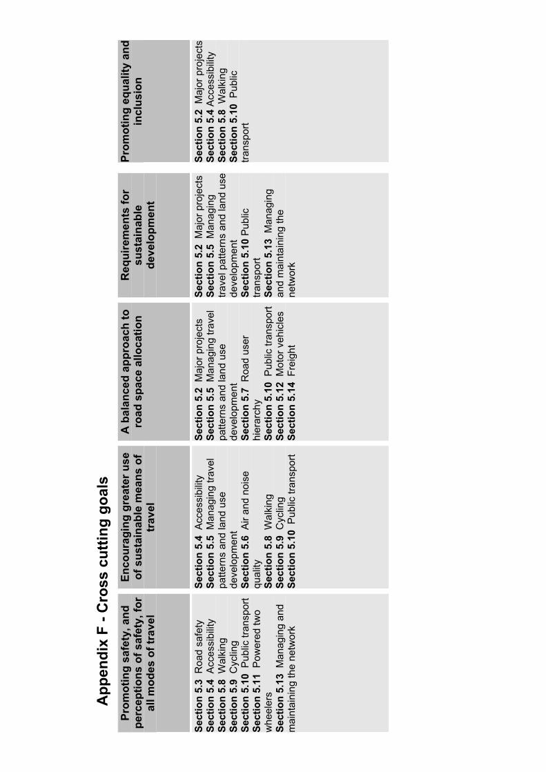
App
endi
x F
- Cro
ss c
uttin
g go
als
Prom
otin
g sa
fety
, and
pe
rcep
tions
of s
afet
y, fo
r al
l mod
es o
f tra
vel
Enco
urag
ing
grea
ter u
se
of s
usta
inab
le m
eans
of
trav
el
A b
alan
ced
appr
oach
to
road
spa
ce a
lloca
tion
Req
uire
men
ts fo
r su
stai
nabl
ede
velo
pmen
t
Prom
otin
g eq
ualit
y an
d in
clus
ion
Sect
ion
5.3
Roa
d sa
fety
Se
ctio
n 5.
4 A
cces
sibi
lity
Sect
ion
5.8
Wal
king
Se
ctio
n 5.
9 C
yclin
g Se
ctio
n 5.
10 P
ublic
tran
spor
t Se
ctio
n 5.
11 P
ower
ed tw
o w
heel
ers
Sect
ion
5.13
Man
agin
g an
d m
aint
aini
ng th
e ne
twor
k
Sect
ion
5.4
Acc
essi
bilit
y Se
ctio
n 5.
5 M
anag
ing
trave
l pa
ttern
s an
d la
nd u
se
deve
lopm
ent
Sect
ion
5.6
Air
and
nois
e qu
ality
Sect
ion
5.8
Wal
king
Se
ctio
n 5.
9 C
yclin
g Se
ctio
n 5.
10 P
ublic
tran
spor
t
Sect
ion
5.2
Maj
or p
roje
cts
Sect
ion
5.5
Man
agin
g tra
vel
patte
rns
and
land
use
de
velo
pmen
t Se
ctio
n 5.
7 R
oad
user
hi
erar
chy
Sect
ion
5.10
Pub
lic tr
ansp
ort
Sect
ion
5.12
Mot
or v
ehic
les
Sect
ion
5.14
Fre
ight
Sect
ion
5.2
Maj
or p
roje
cts
Sect
ion
5.5
Man
agin
g tra
vel p
atte
rns
and
land
use
de
velo
pmen
t Se
ctio
n 5.
10 P
ublic
tra
nspo
rtSe
ctio
n 5.
13 M
anag
ing
and
mai
ntai
ning
the
netw
ork
Sect
ion
5.2
Maj
or p
roje
cts
Sect
ion
5.4
Acc
essi
bilit
y Se
ctio
n 5.
8 W
alki
ng
Sect
ion
5.10
Pub
lic
trans
port


APPENDIX G – EXTRACT FROM THE UDP

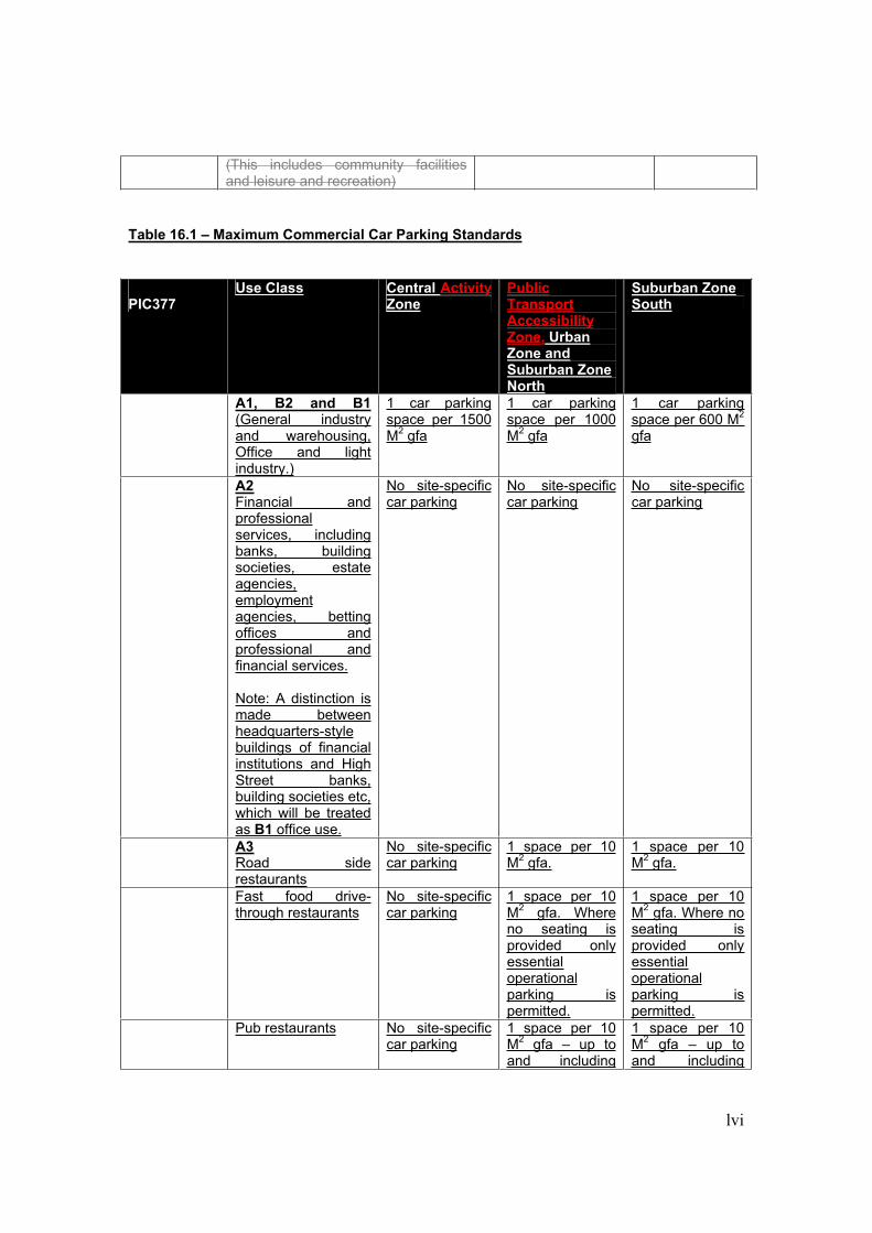
lvi
(This includes community facilities and leisure and recreation)
Table 16.1 – Maximum Commercial Car Parking Standards
PIC377Use Class Central Activity
ZonePublicTransportAccessibility Zone, Urban Zone and Suburban Zone North
Suburban Zone South
A1, B2 and B1 (General industry and warehousing, Office and light industry.)
1 car parking space per 1500 M2 gfa
1 car parking space per 1000 M2 gfa
1 car parking space per 600 M2
gfa
A2 Financial and professionalservices, including banks, building societies, estate agencies,employmentagencies, betting offices and professional and financial services.
Note: A distinction is made between headquarters-stylebuildings of financial institutions and High Street banks, building societies etc, which will be treated as B1 office use.
No site-specific car parking
No site-specific car parking
No site-specific car parking
A3 Road side restaurants
No site-specific car parking
1 space per 10 M2 gfa.
1 space per 10 M2 gfa.
Fast food drive-through restaurants
No site-specific car parking
1 space per 10 M2 gfa. Where no seating is provided only essentialoperationalparking is permitted.
1 space per 10 M2 gfa. Where no seating is provided only essentialoperationalparking is permitted.
Pub restaurants No site-specific car parking
1 space per 10 M2 gfa – up to and including
1 space per 10 M2 gfa – up to and including
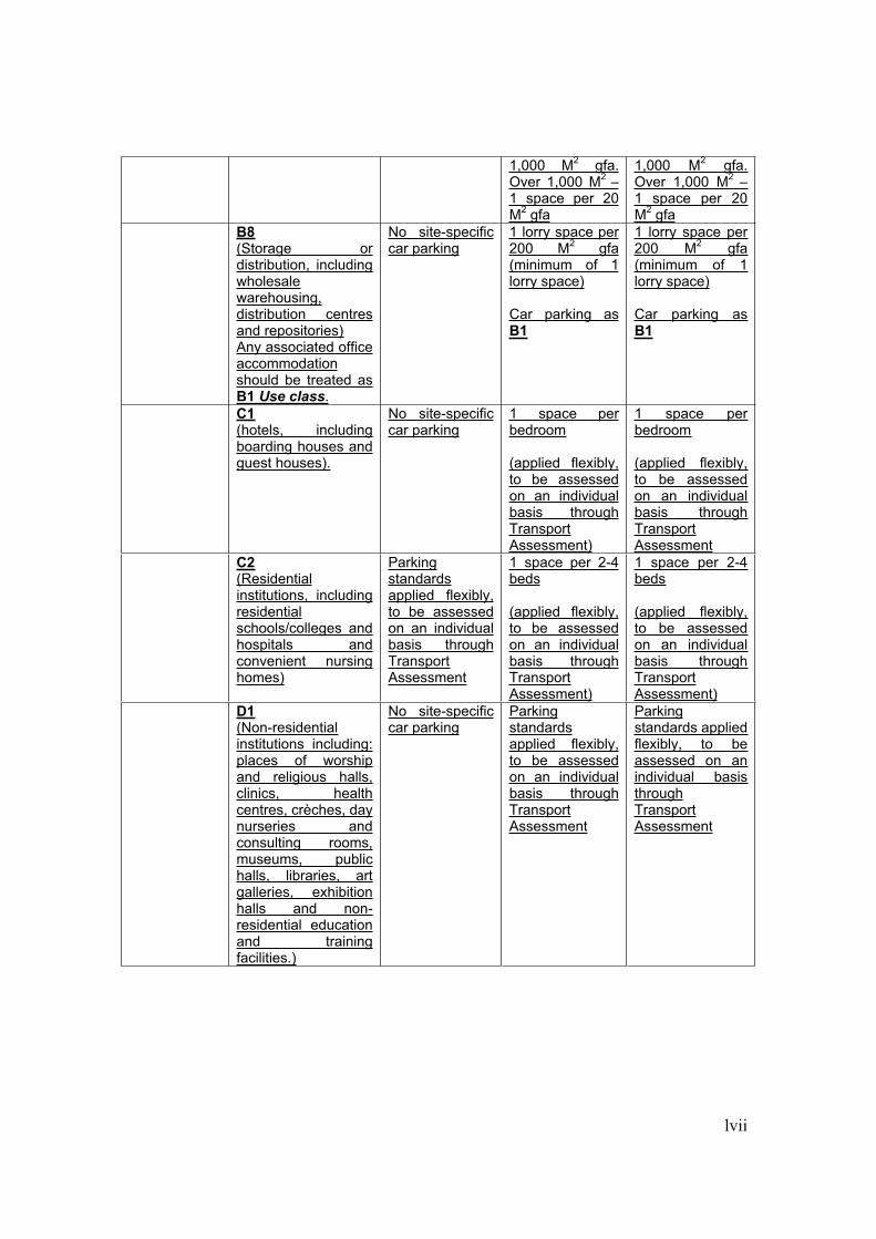
lvii
1,000 M2 gfa. Over 1,000 M2 –1 space per 20 M2 gfa
1,000 M2 gfa. Over 1,000 M2 –1 space per 20 M2 gfa
B8(Storage or distribution, including wholesalewarehousing,distribution centres and repositories)Any associated office accommodationshould be treated as B1 Use class.
No site-specific car parking
1 lorry space per 200 M2 gfa (minimum of 1 lorry space)
Car parking as B1
1 lorry space per 200 M2 gfa (minimum of 1 lorry space)
Car parking as B1
C1(hotels, including boarding houses and guest houses).
No site-specific car parking
1 space per bedroom
(applied flexibly, to be assessed on an individual basis through TransportAssessment)
1 space per bedroom
(applied flexibly, to be assessed on an individual basis through TransportAssessment
C2(Residentialinstitutions, including residentialschools/colleges and hospitals and convenient nursing homes)
Parkingstandardsapplied flexibly, to be assessed on an individual basis through TransportAssessment
1 space per 2-4 beds
(applied flexibly, to be assessed on an individual basis through TransportAssessment)
1 space per 2-4 beds
(applied flexibly, to be assessed on an individual basis through TransportAssessment)
D1(Non-residentialinstitutions including: places of worship and religious halls, clinics, health centres, crèches, day nurseries and consulting rooms, museums, public halls, libraries, art galleries, exhibition halls and non-residential education and training facilities.)
No site-specific car parking
Parkingstandardsapplied flexibly, to be assessed on an individual basis through TransportAssessment
Parkingstandards applied flexibly, to be assessed on an individual basis throughTransportAssessment
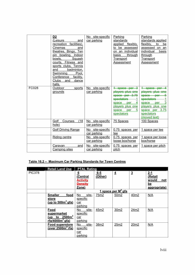
lviii
D2(Leisure and recreation facilities), Cinemas and theatres, Bingo, Ten pin bowling, Indoor bowls, Squash courts, Fitness and sports clubs, Tennis and badminton, Swimming Pool, Conference facility, Clubs and dance halls.
No site-specific car parking
Parkingstandardsapplied flexibly, to be assessed on an individual basis through TransportAssessment
Parkingstandards applied flexibly, to be assessed on an individual basis throughTransportAssessment
FC028 Outdoor sports grounds
No site-specific car parking
1 space per 3 players plus one space per 3.75 spectators 1space per 4 players plus one space per 5 spectators
1 space per 4 players plus one space per 5 spectators 1space per 3 players plus one space per 3.75 spectators (moved text)
Golf Courses (18 hole)
No site-specific car parking
75 Spaces 100 Spaces
Golf Driving Range No site-specific car parking
0.75 spaces per tee
1 space per tee
Riding centre No site-specific car parking
0.75 spaces per loose box/horse
1 space per loose box/horse
Caravan and Camping sites
No site-specific car parking
0.75 spaces per pitch
1 space per pitch
Table 16.2 – Maximum Car Parking Standards for Town Centres
Retail Land Use PTAL RatingPIC378 6
(CentralActivityDensityZone)
6-5(Other)
4 3 2-1(Retailwould not beappropriate)
1 space per M2 gfa Smaller food
store(up to 500m2 gfa)
No site-specificcarparking
75m2 50m2 40m2 N/A
Food supermarket(up to 2500m2
rfa/4000m2 gfa)
No site-specificcarparking
45m2 30m2 24m2 N/A
Food superstore(over 2500m2 rfa)
No site-specificcarparking
38m2 25m2 20m2 N/A
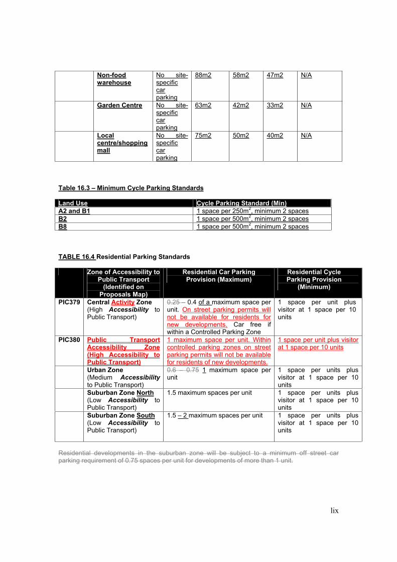
lix
Non-food warehouse
No site-specificcarparking
88m2 58m2 47m2 N/A
Garden Centre No site-specificcarparking
63m2 42m2 33m2 N/A
Local centre/shoppingmall
No site-specificcarparking
75m2 50m2 40m2 N/A
Table 16.3 – Minimum Cycle Parking Standards
Land Use Cycle Parking Standard (Min)A2 and B1 1 space per 250m2, minimum 2 spacesB2 1 space per 500m2, minimum 2 spacesB8 1 space per 500m2, minimum 2 spaces
TABLE 16.4 Residential Parking Standards
Zone of Accessibility to Public Transport
(Identified on Proposals Map)
Residential Car Parking Provision (Maximum)
Residential Cycle Parking Provision
(Minimum)
PIC379 Central Activity Zone (High Accessibility to Public Transport)
0.25 – 0.4 of a maximum space per unit. On street parking permits will not be available for residents for new developments. Car free if within a Controlled Parking Zone
1 space per unit plus visitor at 1 space per 10 units
PIC380 Public Transport Accessibility Zone (High Accessibility to Public Transport)
1 maximum space per unit. Within controlled parking zones on street parking permits will not be available for residents of new developments.
1 space per unit plus visitor at 1 space per 10 units
Urban Zone (Medium Accessibilityto Public Transport)
0.6 – 0.75 1 maximum space per unit
1 space per units plus visitor at 1 space per 10 units
Suburban Zone North(Low Accessibility to Public Transport)
1.5 maximum spaces per unit 1 space per units plus visitor at 1 space per 10 units
Suburban Zone South(Low Accessibility to Public Transport)
1.5 – 2 maximum spaces per unit 1 space per units plus visitor at 1 space per 10 units
Residential developments in the suburban zone will be subject to a minimum off street car parking requirement of 0.75 spaces per unit for developments of more than 1 unit.

APPENDIX H – HIGHWAY STRUCTURES

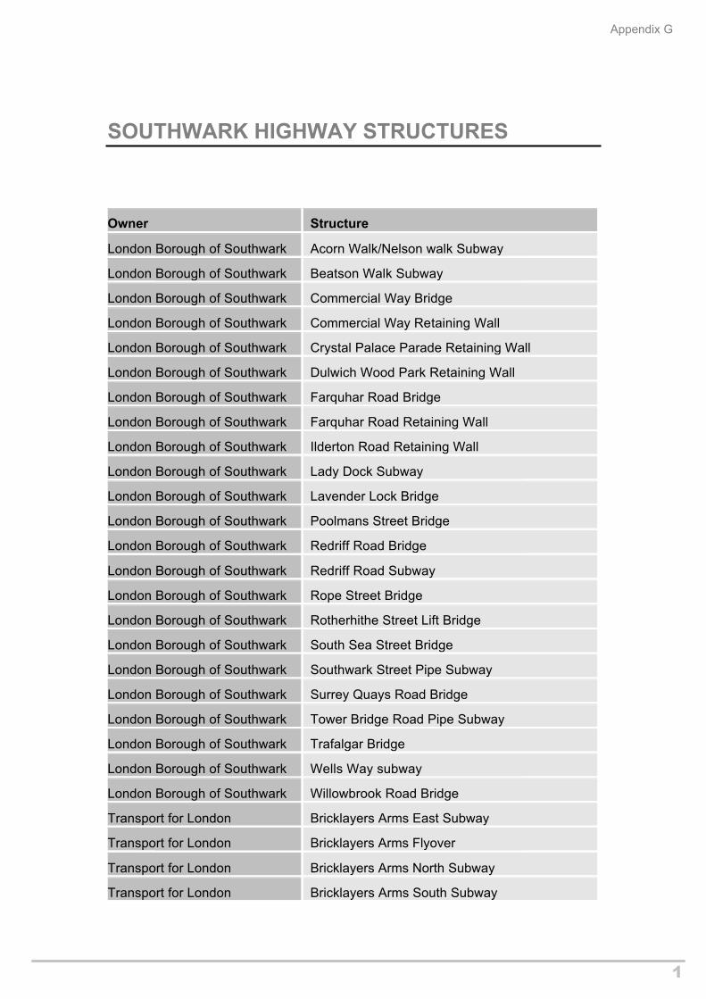
Appendix G
1
SOUTHWARK HIGHWAY STRUCTURES
Owner Structure
London Borough of Southwark Acorn Walk/Nelson walk Subway
London Borough of Southwark Beatson Walk Subway
London Borough of Southwark Commercial Way Bridge
London Borough of Southwark Commercial Way Retaining Wall
London Borough of Southwark Crystal Palace Parade Retaining Wall
London Borough of Southwark Dulwich Wood Park Retaining Wall
London Borough of Southwark Farquhar Road Bridge
London Borough of Southwark Farquhar Road Retaining Wall
London Borough of Southwark Ilderton Road Retaining Wall
London Borough of Southwark Lady Dock Subway
London Borough of Southwark Lavender Lock Bridge
London Borough of Southwark Poolmans Street Bridge
London Borough of Southwark Redriff Road Bridge
London Borough of Southwark Redriff Road Subway
London Borough of Southwark Rope Street Bridge
London Borough of Southwark Rotherhithe Street Lift Bridge
London Borough of Southwark South Sea Street Bridge
London Borough of Southwark Southwark Street Pipe Subway
London Borough of Southwark Surrey Quays Road Bridge
London Borough of Southwark Tower Bridge Road Pipe Subway
London Borough of Southwark Trafalgar Bridge
London Borough of Southwark Wells Way subway
London Borough of Southwark Willowbrook Road Bridge
Transport for London Bricklayers Arms East Subway
Transport for London Bricklayers Arms Flyover
Transport for London Bricklayers Arms North Subway
Transport for London Bricklayers Arms South Subway
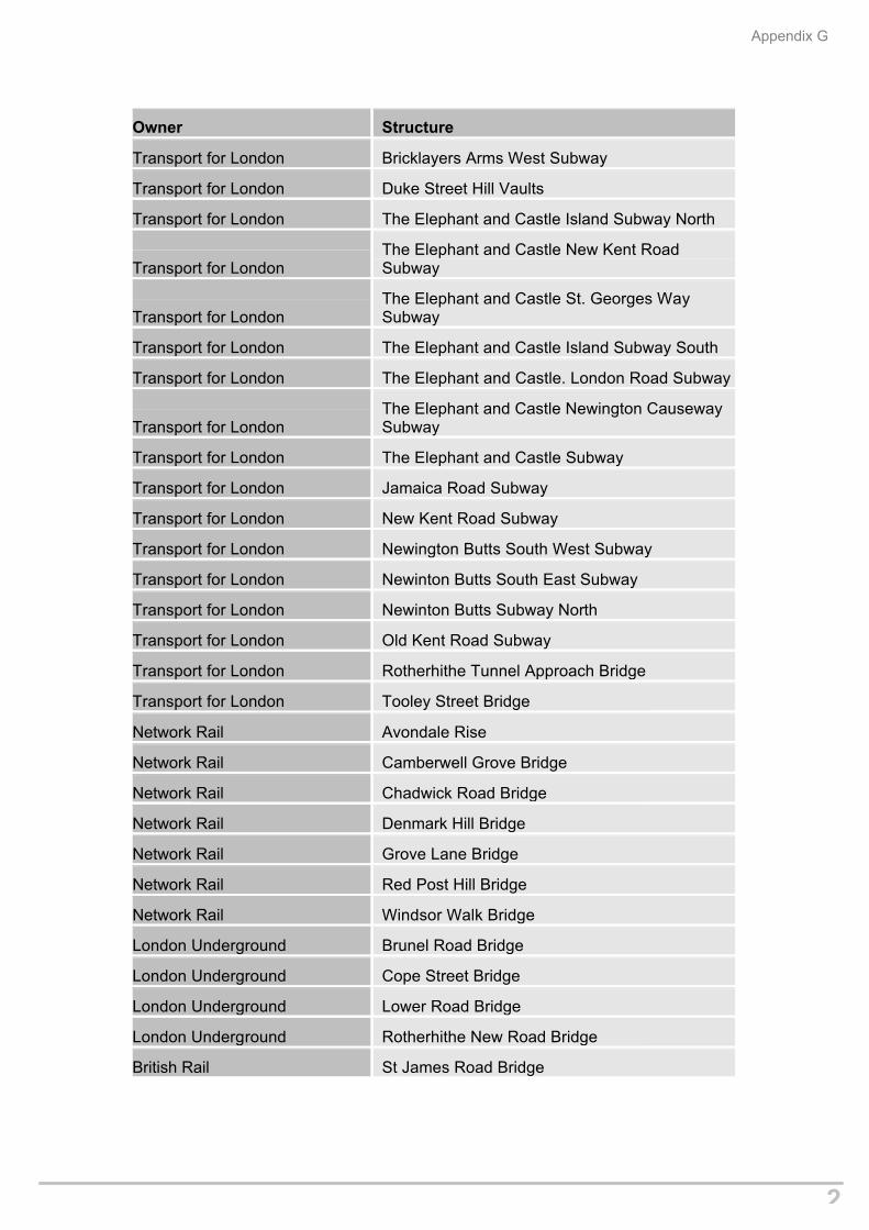
Appendix G
2
Owner Structure
Transport for London Bricklayers Arms West Subway
Transport for London Duke Street Hill Vaults
Transport for London The Elephant and Castle Island Subway North
Transport for LondonThe Elephant and Castle New Kent Road Subway
Transport for LondonThe Elephant and Castle St. Georges Way Subway
Transport for London The Elephant and Castle Island Subway South
Transport for London The Elephant and Castle. London Road Subway
Transport for LondonThe Elephant and Castle Newington Causeway Subway
Transport for London The Elephant and Castle Subway
Transport for London Jamaica Road Subway
Transport for London New Kent Road Subway
Transport for London Newington Butts South West Subway
Transport for London Newinton Butts South East Subway
Transport for London Newinton Butts Subway North
Transport for London Old Kent Road Subway
Transport for London Rotherhithe Tunnel Approach Bridge
Transport for London Tooley Street Bridge
Network Rail Avondale Rise
Network Rail Camberwell Grove Bridge
Network Rail Chadwick Road Bridge
Network Rail Denmark Hill Bridge
Network Rail Grove Lane Bridge
Network Rail Red Post Hill Bridge
Network Rail Windsor Walk Bridge
London Underground Brunel Road Bridge
London Underground Cope Street Bridge
London Underground Lower Road Bridge
London Underground Rotherhithe New Road Bridge
British Rail St James Road Bridge

APPENDIX I – LIST OF THOSE CONSULTED

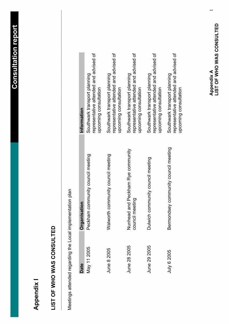
……
……
……
……
……
……
……
……
……
……
……
……
……
…_
Con
sulta
tion
repo
rt_
App
endi
x I
LIST
OF
WH
O W
AS
CO
NSU
LTED
__________________________________________________________________________________________________________________________________
Mee
tings
atte
nded
rega
rdin
g th
e Lo
cal i
mpl
emen
tatio
n pl
an
Dat
eO
rgan
isat
ion
Info
rmat
ion
May
11
2005
P
eckh
am c
omm
unity
cou
ncil
mee
ting
Sou
thw
ark
trans
port
plan
ning
re
pres
enta
tive
atte
nded
and
adv
ised
of
upco
min
g co
nsul
tatio
n
June
8 2
005
Wal
wor
th c
omm
unity
cou
ncil
mee
ting
Sou
thw
ark
trans
port
plan
ning
re
pres
enta
tive
atte
nded
and
adv
ised
of
upco
min
g co
nsul
tatio
n
June
28
2005
N
unhe
ad a
nd P
eckh
am R
ye c
omm
unity
co
unci
l mee
ting
Sou
thw
ark
trans
port
plan
ning
re
pres
enta
tive
atte
nded
and
adv
ised
of
upco
min
g co
nsul
tatio
n
June
29
2005
D
ulw
ich
com
mun
ity c
ounc
il m
eetin
g S
outh
war
k tra
nspo
rt pl
anni
ng
repr
esen
tativ
e at
tend
ed a
nd a
dvis
ed o
f up
com
ing
cons
ulta
tion
July
6 2
005
Ber
mon
dsey
com
mun
ity c
ounc
il m
eetin
g S
outh
war
k tra
nspo
rt pl
anni
ng
repr
esen
tativ
e at
tend
ed a
nd a
dvis
ed o
f up
com
ing
cons
ulta
tion
App
endi
x A
LI
ST O
F W
HO
WA
S C
ON
SULT
ED
1
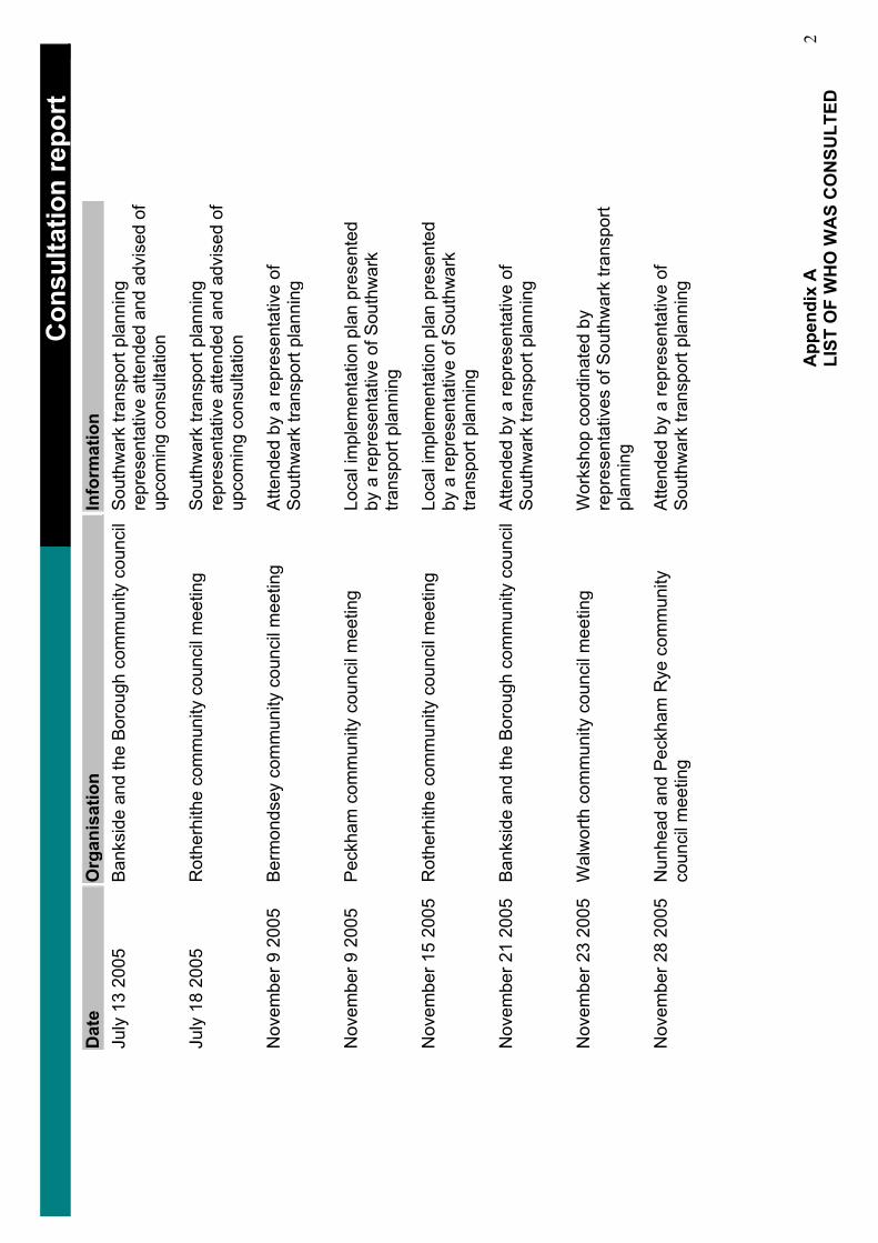
……
……
……
……
……
……
……
……
……
……
……
……
……
…_
Con
sulta
tion
repo
rt_
Dat
eO
rgan
isat
ion
Info
rmat
ion
July
13
2005
B
anks
ide
and
the
Bor
ough
com
mun
ity c
ounc
il S
outh
war
k tra
nspo
rt pl
anni
ng
repr
esen
tativ
e at
tend
ed a
nd a
dvis
ed o
f up
com
ing
cons
ulta
tion
July
18
2005
R
othe
rhith
e co
mm
unity
cou
ncil
mee
ting
Sou
thw
ark
trans
port
plan
ning
re
pres
enta
tive
atte
nded
and
adv
ised
of
upco
min
g co
nsul
tatio
n
Nov
embe
r 9 2
005
Ber
mon
dsey
com
mun
ity c
ounc
il m
eetin
g A
ttend
ed b
y a
repr
esen
tativ
e of
S
outh
war
k tra
nspo
rt pl
anni
ng
Nov
embe
r 9 2
005
Pec
kham
com
mun
ity c
ounc
il m
eetin
g Lo
cal i
mpl
emen
tatio
n pl
an p
rese
nted
by
a re
pres
enta
tive
of S
outh
war
k tra
nspo
rt pl
anni
ng
Nov
embe
r 15
2005
R
othe
rhith
e co
mm
unity
cou
ncil
mee
ting
Loca
l im
plem
enta
tion
plan
pre
sent
ed
by a
repr
esen
tativ
e of
Sou
thw
ark
trans
port
plan
ning
Nov
embe
r 21
2005
B
anks
ide
and
the
Bor
ough
com
mun
ity c
ounc
il A
ttend
ed b
y a
repr
esen
tativ
e of
S
outh
war
k tra
nspo
rt pl
anni
ng
Nov
embe
r 23
2005
W
alw
orth
com
mun
ity c
ounc
il m
eetin
g W
orks
hop
coor
dina
ted
by
repr
esen
tativ
es o
f Sou
thw
ark
trans
port
plan
ning
Nov
embe
r 28
2005
N
unhe
ad a
nd P
eckh
am R
ye c
omm
unity
co
unci
l mee
ting
Atte
nded
by
a re
pres
enta
tive
of
Sou
thw
ark
trans
port
plan
ning
App
endi
x A
LI
ST O
F W
HO
WA
S C
ON
SULT
ED
2
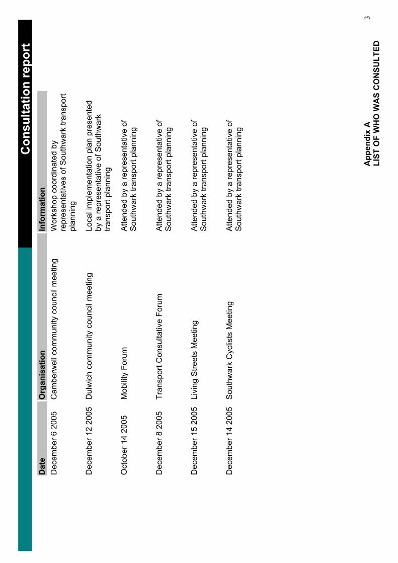
……
……
……
……
……
……
……
……
……
……
……
……
……
…_
Con
sulta
tion
repo
rt_
Dat
eO
rgan
isat
ion
Info
rmat
ion
Dec
embe
r 6 2
005
Cam
berw
ell c
omm
unity
cou
ncil
mee
ting
Wor
ksho
p co
ordi
nate
d by
re
pres
enta
tives
of S
outh
war
k tra
nspo
rt pl
anni
ng
Dec
embe
r 12
2005
D
ulw
ich
com
mun
ity c
ounc
il m
eetin
g Lo
cal i
mpl
emen
tatio
n pl
an p
rese
nted
by
a re
pres
enta
tive
of S
outh
war
k tra
nspo
rt pl
anni
ng
Oct
ober
14
2005
M
obili
ty F
orum
A
ttend
ed b
y a
repr
esen
tativ
e of
S
outh
war
k tra
nspo
rt pl
anni
ng
Dec
embe
r 8 2
005
Tran
spor
t Con
sulta
tive
Foru
m
Atte
nded
by
a re
pres
enta
tive
of
Sou
thw
ark
trans
port
plan
ning
Dec
embe
r 15
2005
Li
ving
Stre
ets
Mee
ting
Atte
nded
by
a re
pres
enta
tive
of
Sou
thw
ark
trans
port
plan
ning
Dec
embe
r 14
2005
S
outh
war
k C
yclis
ts M
eetin
g A
ttend
ed b
y a
repr
esen
tativ
e of
S
outh
war
k tra
nspo
rt pl
anni
ng
App
endi
x A
LI
ST O
F W
HO
WA
S C
ON
SULT
ED
3
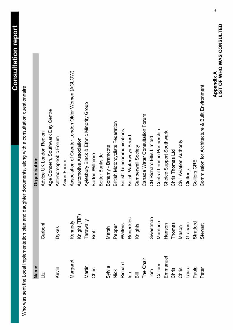
……
……
……
……
……
……
……
……
……
……
……
……
……
…_
Con
sulta
tion
repo
rt_
Who
was
sen
t the
Loc
al im
plem
enta
tion
plan
and
dau
ghte
r doc
umen
ts, a
long
with
a c
onsu
ltatio
n qu
estio
nnai
re
Nam
eO
rgan
isat
ion
Liz
Car
boni
Adv
ice
UK
Lon
don
Reg
ion
Age
Con
cern
, Sou
thw
ark
Day
Cen
tre
Kev
inD
ykes
Ant
i-hom
opho
bic
Foru
m
Asi
an F
orum
M
arga
ret
Ken
nedy
Ass
ocia
tion
of G
reat
er L
ondo
n O
lder
Wom
en (A
GLO
W)
Kni
ght (
TIP)
A
utom
otiv
e A
ssoc
iatio
n M
artin
Tara
wal
lyA
yles
bury
Bla
ck &
Eth
nic
Min
ority
Gro
up
Chr
isB
rett
Bar
ton
Will
mor
e B
ette
r Ban
ksid
e S
ylvi
aM
arsh
Bon
amy
- Bra
mco
te
Nic
kP
eppe
rB
ritis
h M
otor
cycl
ists
Fed
erat
ion
Ric
hard
Wal
ters
Brit
ish
Tele
com
mun
icat
ions
Ia
nR
unec
kles
B
ritis
h W
ater
way
s B
oard
B
illK
nigh
ts
Cam
berw
ell S
ocie
ty
The
Cha
ir C
anad
a W
ater
Con
sulta
tion
Foru
m
Tom
Sw
eetm
anC
B R
icha
rd E
llis
Lim
ited
Cal
lum
Mur
doch
Cen
tral L
ondo
n P
artn
ersh
ip
Em
man
uel
Han
son
Cho
ice
Sup
port
Sou
thw
ark
Chr
isTh
omas
Chr
is T
hom
as L
td
Chr
isM
ason
Civ
il A
viat
ion
Aut
horit
y La
ura
Gra
ham
Clu
ttons
Pau
laS
tratfo
rdC
ollie
rs C
RE
P
eter
Ste
war
tC
omm
issi
on fo
r Arc
hite
ctur
e &
Bui
lt E
nviro
nmen
t
App
endi
x A
LI
ST O
F W
HO
WA
S C
ON
SULT
ED
4
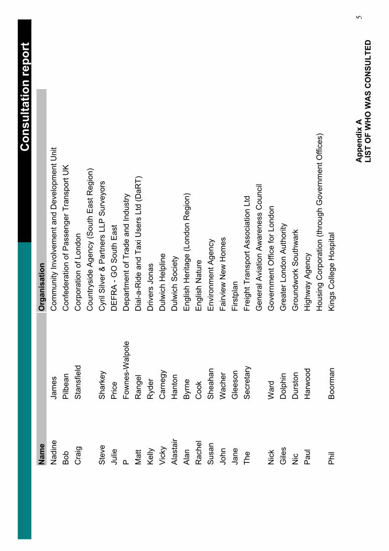
……
……
……
……
……
……
……
……
……
……
……
……
……
…_
Con
sulta
tion
repo
rt_
Nam
eO
rgan
isat
ion
Nad
ine
Jam
esC
omm
unity
Invo
lvem
ent a
nd D
evel
opm
ent U
nit
Bob
Pilb
ean
Con
fede
ratio
n of
Pas
seng
er T
rans
port
UK
C
raig
Sta
nsfie
ldC
orpo
ratio
n of
Lon
don
Cou
ntry
side
Age
ncy
(Sou
th E
ast R
egio
n)
Ste
veS
hark
eyC
yril
Silv
er &
Par
tner
s LL
P S
urve
yors
Ju
lieP
rice
DE
FRA
- G
O S
outh
Eas
t P
Fow
nes-
Wal
pole
D
epar
tmen
t of T
rade
and
Indu
stry
M
att
Ran
gel
Dia
l-a-R
ide
and
Taxi
Use
rs L
td (D
aRT)
Ke
llyR
yder
Driv
ers
Jona
s V
icky
Car
negy
Dul
wic
h H
elpl
ine
Ala
stai
rH
anto
nD
ulw
ich
Soc
iety
Al
anB
yrne
Eng
lish
Her
itage
(Lon
don
Reg
ion)
R
ache
lC
ook
Eng
lish
Nat
ure
Sus
anS
heah
anE
nviro
nmen
t Age
ncy
John
Wac
her
Fairv
iew
New
Hom
es
Jane
Gle
eson
Firs
tpla
nTh
eS
ecre
tary
Frei
ght T
rans
port
Ass
ocia
tion
Ltd
Gen
eral
Avi
atio
n A
war
enes
s C
ounc
il N
ick
War
dG
over
nmen
t Offi
ce fo
r Lon
don
Gile
sD
olph
in
Gre
ater
Lon
don
Aut
horit
y N
icD
urst
onG
roun
dwor
k S
outh
war
k Pa
ulH
arw
ood
Hig
hway
Age
ncy
Hou
sing
Cor
pora
tion
(thro
ugh
Gov
ernm
ent O
ffice
s)
Phil
Boo
rman
Kin
gs C
olle
ge H
ospi
tal
App
endi
x A
LI
ST O
F W
HO
WA
S C
ON
SULT
ED
5
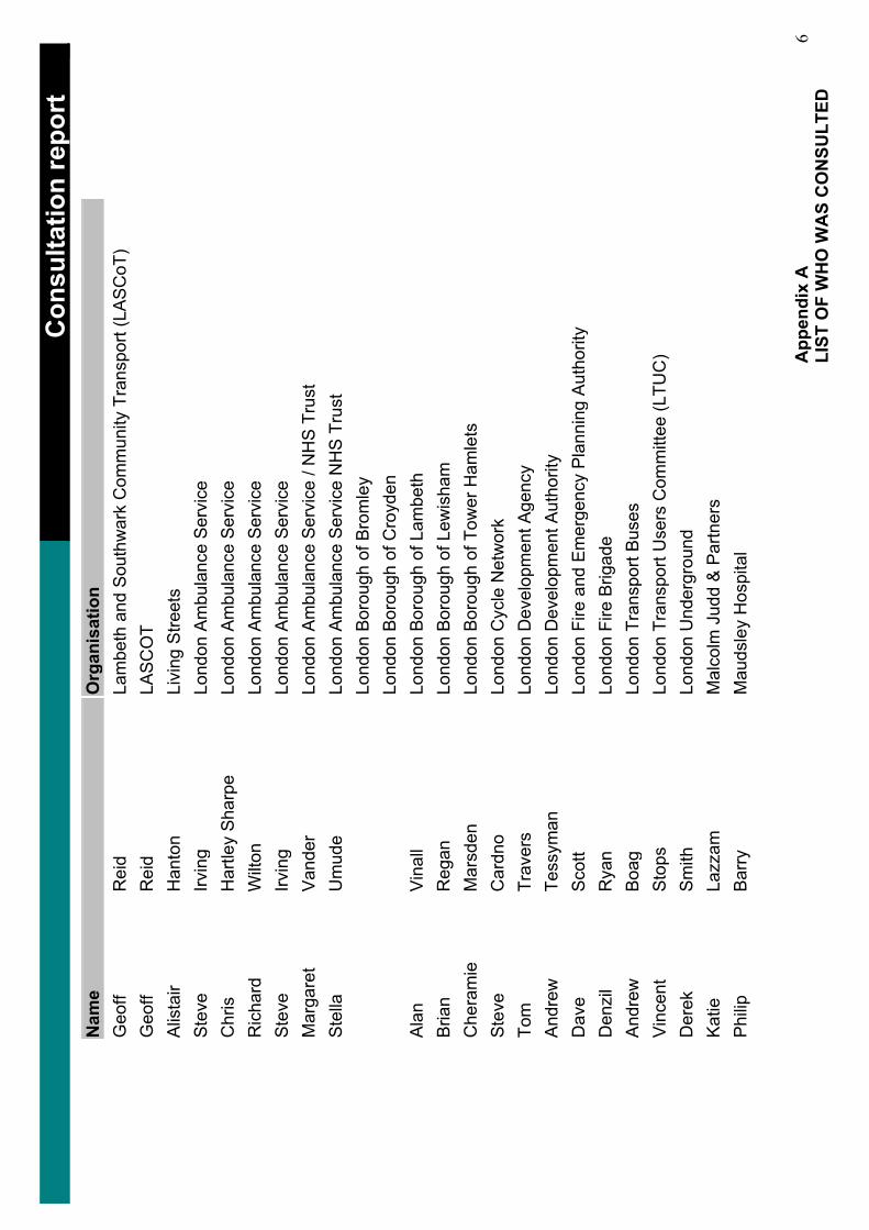
……
……
……
……
……
……
……
……
……
……
……
……
……
…_
Con
sulta
tion
repo
rt_
Nam
eO
rgan
isat
ion
Geo
ffR
eid
Lam
beth
and
Sou
thw
ark
Com
mun
ity T
rans
port
(LA
SC
oT)
Geo
ffR
eid
LAS
CO
TA
lista
irH
anto
nLi
ving
Stre
ets
Ste
veIrv
ing
Lond
on A
mbu
lanc
e S
ervi
ce
Chr
isH
artle
y S
harp
e Lo
ndon
Am
bula
nce
Ser
vice
R
icha
rdW
ilton
Lond
on A
mbu
lanc
e S
ervi
ce
Ste
veIrv
ing
Lond
on A
mbu
lanc
e S
ervi
ce
Mar
gare
tV
ande
rLo
ndon
Am
bula
nce
Ser
vice
/ N
HS
Tru
st
Ste
llaU
mud
eLo
ndon
Am
bula
nce
Ser
vice
NH
S T
rust
Lo
ndon
Bor
ough
of B
rom
ley
Lond
on B
orou
gh o
f Cro
yden
Al
anVi
nall
Lond
on B
orou
gh o
f Lam
beth
B
rian
Reg
anLo
ndon
Bor
ough
of L
ewis
ham
C
hera
mie
Mar
sden
Lond
on B
orou
gh o
f Tow
er H
amle
ts
Ste
veC
ardn
oLo
ndon
Cyc
le N
etw
ork
Tom
Trav
ers
Lond
on D
evel
opm
ent A
genc
y A
ndre
wTe
ssym
anLo
ndon
Dev
elop
men
t Aut
horit
y D
ave
Sco
ttLo
ndon
Fire
and
Em
erge
ncy
Pla
nnin
g A
utho
rity
Den
zil
Rya
nLo
ndon
Fire
Brig
ade
And
rew
Boa
gLo
ndon
Tra
nspo
rt B
uses
V
ince
ntS
tops
Lond
on T
rans
port
Use
rs C
omm
ittee
(LTU
C)
Der
ekS
mith
Lond
on U
nder
grou
nd
Kat
ieLa
zzam
Mal
colm
Jud
d &
Par
tner
s P
hilip
Bar
ryM
auds
ley
Hos
pita
l
App
endi
x A
LI
ST O
F W
HO
WA
S C
ON
SULT
ED
6
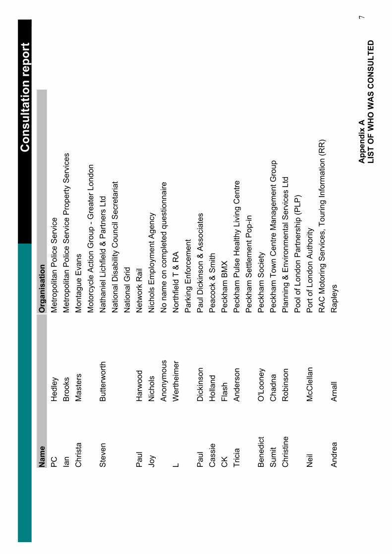
……
……
……
……
……
……
……
……
……
……
……
……
……
…_
Con
sulta
tion
repo
rt_
Nam
eO
rgan
isat
ion
PCH
edle
yM
etro
polit
an P
olic
e S
ervi
ce
Ian
Bro
oks
Met
ropo
litan
Pol
ice
Ser
vice
Pro
perty
Ser
vice
s C
hris
taM
aste
rsM
onta
gue
Eva
ns
Mot
orcy
cle
Act
ion
Gro
up -
Gre
ater
Lon
don
Ste
ven
But
terw
orth
Nat
hani
el L
ichf
ield
& P
artn
ers
Ltd
Nat
iona
l Dis
abilit
y C
ounc
il S
ecre
taria
t N
atio
nal G
rid
Paul
Har
woo
dN
etw
ork
Rai
l Jo
yN
icho
ls
Nic
hols
Em
ploy
men
t Age
ncy
Ano
nym
ous
No
nam
e on
com
plet
ed q
uest
ionn
aire
L
Wer
thei
mer
Nor
thfie
ld T
& R
A
Par
king
Enf
orce
men
t Pa
ulD
icki
nson
Pau
l Dic
kins
on &
Ass
ocia
tes
Cas
sie
Hol
land
Pea
cock
& S
mith
C
KFl
ash
Pec
kham
BM
X
Tric
iaA
nder
son
Pec
kham
Pul
se H
ealth
y Li
ving
Cen
tre
Pec
kham
Set
tlem
ent P
op-in
B
ened
ict
O'L
oone
yP
eckh
am S
ocie
ty
Sum
itC
hadn
aP
eckh
am T
own
Cen
tre M
anag
emen
t Gro
up
Chr
istin
eR
obin
son
Pla
nnin
g &
Env
ironm
enta
l Ser
vice
s Lt
d P
ool o
f Lon
don
Par
tner
ship
(PLP
) N
eil
McC
lella
nP
ort o
f Lon
don
Aut
horit
y R
AC
Mot
orin
g S
ervi
ces,
Tou
ring
Info
rmat
ion
(RR
) A
ndre
aA
rnal
lR
aple
ys
App
endi
x A
LI
ST O
F W
HO
WA
S C
ON
SULT
ED
7
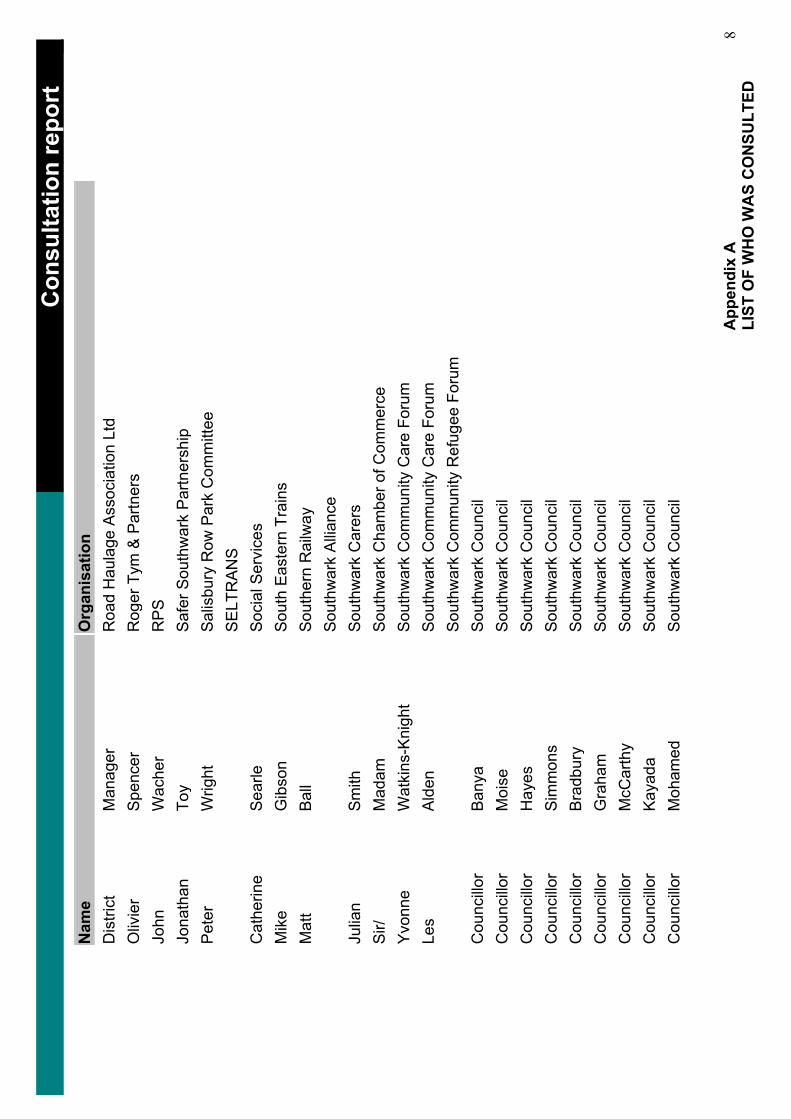
……
……
……
……
……
……
……
……
……
……
……
……
……
…_
Con
sulta
tion
repo
rt_
Nam
eO
rgan
isat
ion
Dis
trict
Man
ager
Roa
d H
aula
ge A
ssoc
iatio
n Lt
d O
livie
rS
penc
erR
oger
Tym
& P
artn
ers
John
Wac
her
RPS
Jona
than
Toy
Saf
er S
outh
war
k P
artn
ersh
ip
Pet
erW
right
Sal
isbu
ry R
ow P
ark
Com
mitt
ee
SE
LTR
AN
S
Cat
herin
eS
earle
Soc
ial S
ervi
ces
Mik
eG
ibso
nS
outh
Eas
tern
Tra
ins
Mat
tBa
llS
outh
ern
Rai
lway
S
outh
war
k A
llianc
e Ju
lian
Sm
ithS
outh
war
k C
arer
s S
ir/M
adam
Sou
thw
ark
Cha
mbe
r of C
omm
erce
Y
vonn
eW
atki
ns-K
nigh
tS
outh
war
k C
omm
unity
Car
e Fo
rum
Le
sA
lden
Sou
thw
ark
Com
mun
ity C
are
Foru
mS
outh
war
k C
omm
unity
Ref
ugee
For
um
Cou
ncillo
r B
anya
Sou
thw
ark
Cou
ncil
Cou
ncillo
r M
oise
Sou
thw
ark
Cou
ncil
Cou
ncillo
r H
ayes
Sou
thw
ark
Cou
ncil
Cou
ncillo
r S
imm
ons
Sou
thw
ark
Cou
ncil
Cou
ncillo
r B
radb
ury
Sou
thw
ark
Cou
ncil
Cou
ncillo
r G
raha
mS
outh
war
k C
ounc
il C
ounc
illor
McC
arth
yS
outh
war
k C
ounc
il C
ounc
illor
Kay
ada
Sou
thw
ark
Cou
ncil
Cou
ncillo
r M
oham
edS
outh
war
k C
ounc
il
App
endi
x A
LI
ST O
F W
HO
WA
S C
ON
SULT
ED
8
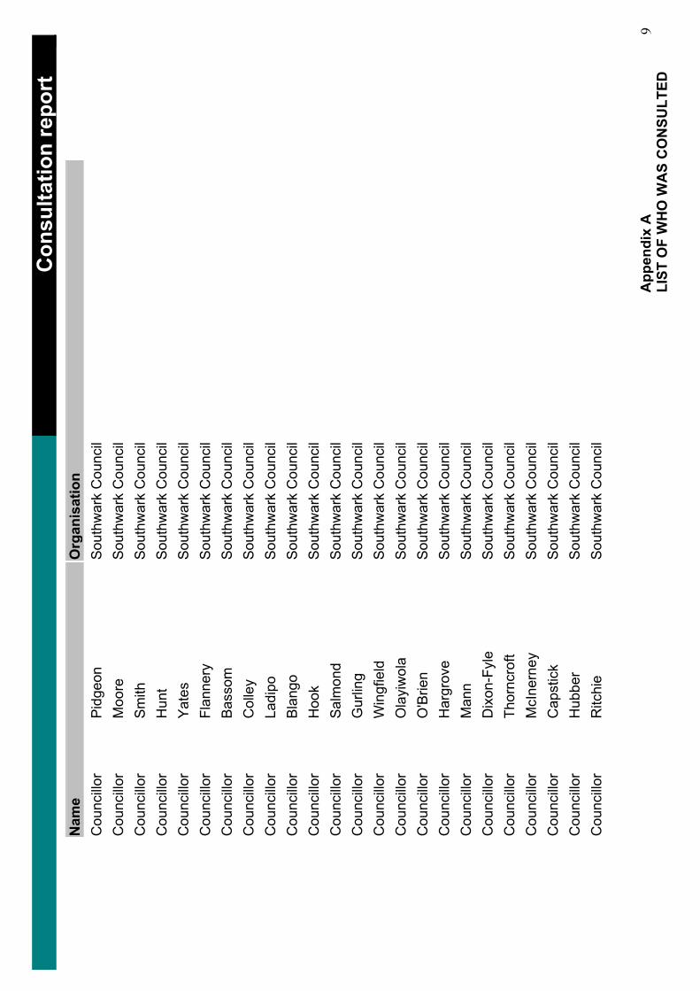
……
……
……
……
……
……
……
……
……
……
……
……
……
…_
Con
sulta
tion
repo
rt_
Nam
eO
rgan
isat
ion
Cou
ncillo
r P
idge
onS
outh
war
k C
ounc
il C
ounc
illor
Moo
reS
outh
war
k C
ounc
il C
ounc
illor
Sm
ithS
outh
war
k C
ounc
il C
ounc
illor
Hun
tS
outh
war
k C
ounc
il C
ounc
illor
Yat
esS
outh
war
k C
ounc
il C
ounc
illor
Flan
nery
Sou
thw
ark
Cou
ncil
Cou
ncillo
r B
asso
mS
outh
war
k C
ounc
il C
ounc
illor
Col
ley
Sou
thw
ark
Cou
ncil
Cou
ncillo
r La
dipo
Sou
thw
ark
Cou
ncil
Cou
ncillo
r B
lang
oS
outh
war
k C
ounc
il C
ounc
illor
Hoo
kS
outh
war
k C
ounc
il C
ounc
illor
Sal
mon
dS
outh
war
k C
ounc
il C
ounc
illor
Gur
ling
Sou
thw
ark
Cou
ncil
Cou
ncillo
r W
ingf
ield
Sou
thw
ark
Cou
ncil
Cou
ncillo
r O
layi
wol
a S
outh
war
k C
ounc
il C
ounc
illor
O'B
rien
Sou
thw
ark
Cou
ncil
Cou
ncillo
r H
argr
ove
Sou
thw
ark
Cou
ncil
Cou
ncillo
r M
ann
Sou
thw
ark
Cou
ncil
Cou
ncillo
r D
ixon
-Fyl
eS
outh
war
k C
ounc
il C
ounc
illor
Thor
ncro
ftS
outh
war
k C
ounc
il C
ounc
illor
McI
nern
eyS
outh
war
k C
ounc
il C
ounc
illor
Cap
stic
kS
outh
war
k C
ounc
il C
ounc
illor
Hub
ber
Sou
thw
ark
Cou
ncil
Cou
ncillo
r R
itchi
eS
outh
war
k C
ounc
il
App
endi
x A
LI
ST O
F W
HO
WA
S C
ON
SULT
ED
9
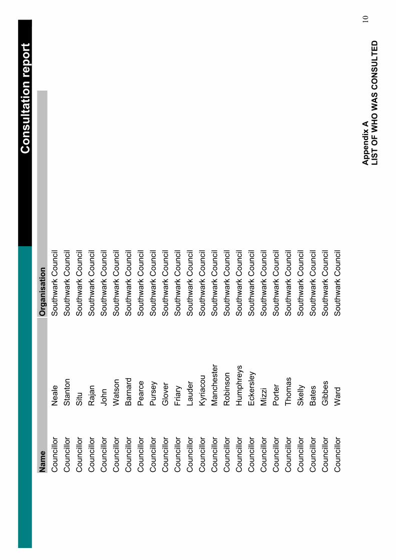
……
……
……
……
……
……
……
……
……
……
……
……
……
…_
Con
sulta
tion
repo
rt_
Nam
eO
rgan
isat
ion
Cou
ncillo
r N
eale
Sou
thw
ark
Cou
ncil
Cou
ncillo
r S
tant
onS
outh
war
k C
ounc
il C
ounc
illor
Situ
Sou
thw
ark
Cou
ncil
Cou
ncillo
r R
ajan
Sou
thw
ark
Cou
ncil
Cou
ncillo
r Jo
hnS
outh
war
k C
ounc
il C
ounc
illor
Wat
son
Sou
thw
ark
Cou
ncil
Cou
ncillo
r B
arna
rdS
outh
war
k C
ounc
il C
ounc
illor
Pea
rce
Sou
thw
ark
Cou
ncil
Cou
ncillo
r P
urse
yS
outh
war
k C
ounc
il C
ounc
illor
Glo
ver
Sou
thw
ark
Cou
ncil
Cou
ncillo
r Fr
iary
Sou
thw
ark
Cou
ncil
Cou
ncillo
r La
uder
Sou
thw
ark
Cou
ncil
Cou
ncillo
r K
yria
cou
Sou
thw
ark
Cou
ncil
Cou
ncillo
r M
anch
este
rS
outh
war
k C
ounc
il C
ounc
illor
Rob
inso
nS
outh
war
k C
ounc
il C
ounc
illor
Hum
phre
ys
Sou
thw
ark
Cou
ncil
Cou
ncillo
r E
cker
sley
Sou
thw
ark
Cou
ncil
Cou
ncillo
r M
izzi
Sou
thw
ark
Cou
ncil
Cou
ncillo
r P
orte
rS
outh
war
k C
ounc
il C
ounc
illor
Thom
asS
outh
war
k C
ounc
il C
ounc
illor
Ske
llyS
outh
war
k C
ounc
il C
ounc
illor
Bat
esS
outh
war
k C
ounc
il C
ounc
illor
Gib
bes
Sou
thw
ark
Cou
ncil
Cou
ncillo
r W
ard
Sou
thw
ark
Cou
ncil
App
endi
x A
LI
ST O
F W
HO
WA
S C
ON
SULT
ED
10
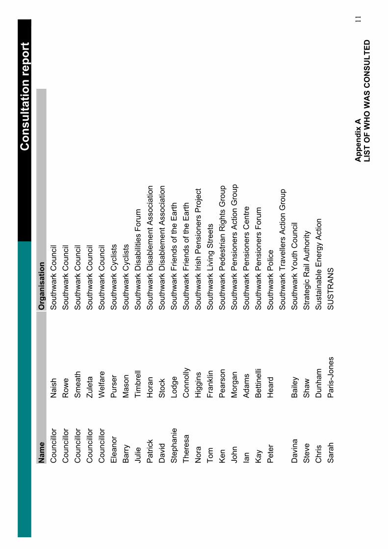
……
……
……
……
……
……
……
……
……
……
……
……
……
…_
Con
sulta
tion
repo
rt_
Nam
eO
rgan
isat
ion
Cou
ncillo
r N
aish
Sou
thw
ark
Cou
ncil
Cou
ncillo
r R
owe
Sou
thw
ark
Cou
ncil
Cou
ncillo
r S
mea
thS
outh
war
k C
ounc
il C
ounc
illor
Zule
taS
outh
war
k C
ounc
il C
ounc
illor
Wel
fare
Sou
thw
ark
Cou
ncil
Ele
anor
Pur
ser
Sou
thw
ark
Cyc
lists
B
arry
Mas
onS
outh
war
k C
yclis
ts
Julie
Tim
brel
lS
outh
war
k D
isab
ilitie
s Fo
rum
P
atric
kH
oran
Sou
thw
ark
Dis
able
men
t Ass
ocia
tion
Dav
idS
tock
Sou
thw
ark
Dis
able
men
t Ass
ocia
tion
Ste
phan
ieLo
dge
Sou
thw
ark
Frie
nds
of th
e E
arth
Th
eres
aC
onno
llyS
outh
war
k Fr
iend
s of
the
Ear
th
Nor
aH
iggi
ns
Sou
thw
ark
Irish
Pen
sion
ers
Pro
ject
To
mFr
ankl
inS
outh
war
k Li
ving
Stre
ets
Ken
Pea
rson
Sou
thw
ark
Ped
estri
an R
ight
s G
roup
Jo
hnM
orga
nS
outh
war
k P
ensi
oner
s A
ctio
n G
roup
Ia
nA
dam
sS
outh
war
k P
ensi
oner
s C
entre
K
ayB
ettin
elli
Sou
thw
ark
Pen
sion
ers
Foru
m
Pet
erH
eard
Sou
thw
ark
Pol
ice
Sou
thw
ark
Trav
elle
rs A
ctio
n G
roup
D
avin
aB
aile
yS
outh
war
k Y
outh
Cou
ncil
Ste
veSh
awS
trate
gic
Rai
l Aut
horit
y C
hris
Dun
ham
Sus
tain
able
Ene
rgy
Act
ion
Sar
ahP
aris
-Jon
esS
US
TRA
NS
App
endi
x A
LI
ST O
F W
HO
WA
S C
ON
SULT
ED
11
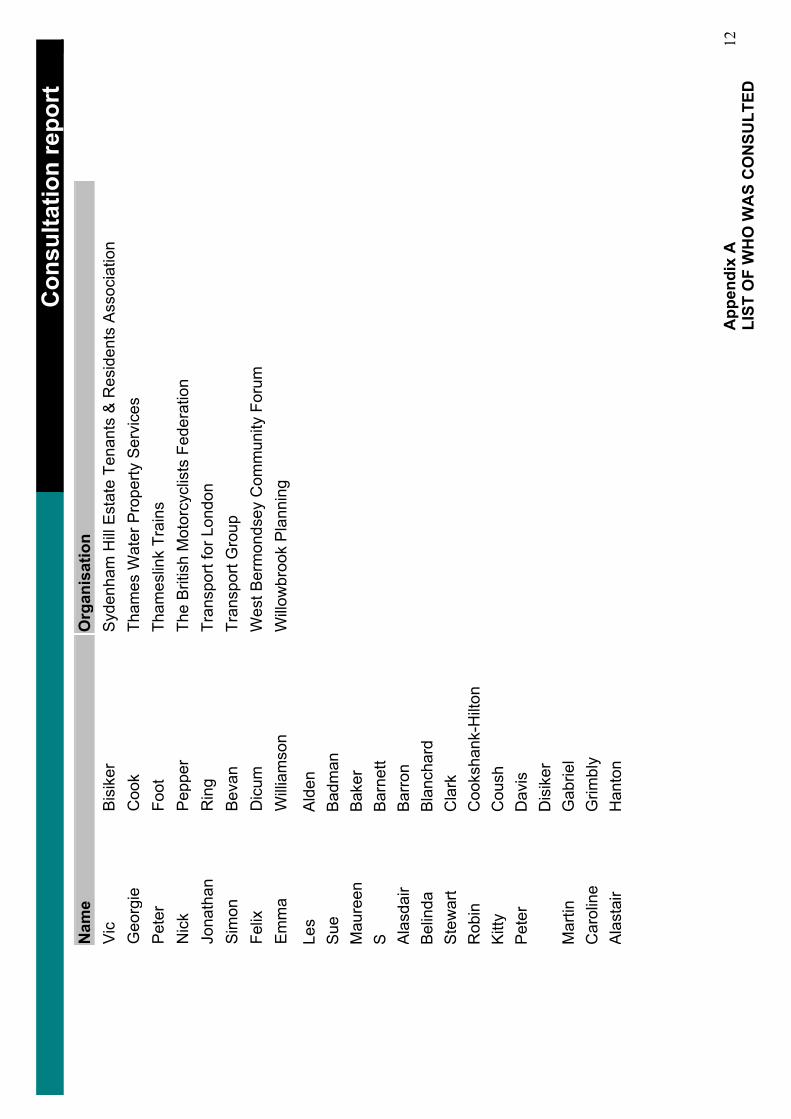
……
……
……
……
……
……
……
……
……
……
……
……
……
…_
Con
sulta
tion
repo
rt_
Nam
eO
rgan
isat
ion
Vic
Bis
iker
Syd
enha
m H
ill E
stat
e Te
nant
s &
Res
iden
ts A
ssoc
iatio
n G
eorg
ieC
ook
Tham
es W
ater
Pro
perty
Ser
vice
s P
eter
Foot
Tham
eslin
k Tr
ains
N
ick
Pep
per
The
Brit
ish
Mot
orcy
clis
ts F
eder
atio
n Jo
nath
anR
ing
Tran
spor
t for
Lon
don
Sim
onB
evan
Tran
spor
t Gro
up
Felix
Dic
umW
est B
erm
onds
ey C
omm
unity
For
um
Em
ma
Will
iam
son
Will
owbr
ook
Pla
nnin
g
Les
Ald
enS
ueB
adm
anM
aure
enB
aker
SB
arne
ttA
lasd
air
Bar
ron
Bel
inda
Bla
ncha
rdS
tew
art
Cla
rkR
obin
Coo
ksha
nk-H
ilton
K
itty
Cou
shP
eter
Dav
isD
isik
er
Mar
tinG
abrie
lC
arol
ine
Grim
bly
Ala
stai
rH
anto
n
App
endi
x A
LI
ST O
F W
HO
WA
S C
ON
SULT
ED
12
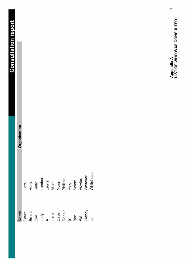
……
……
……
……
……
……
……
……
……
……
……
……
……
…_
Con
sulta
tion
repo
rt_
Nam
eO
rgan
isat
ion
Pet
erH
ore
Em
ma
Hor
nE
veKe
llyJu
dyLa
mbe
rtA
Lew
isLu
keM
iller
Dav
eN
ixon
Don
ald
Phi
llips
GR
eid
Ben
Sal
emP
atV
owle
sW
endy
Whi
take
rJi
mW
hite
head
App
endi
x A
LI
ST O
F W
HO
WA
S C
ON
SULT
ED
13
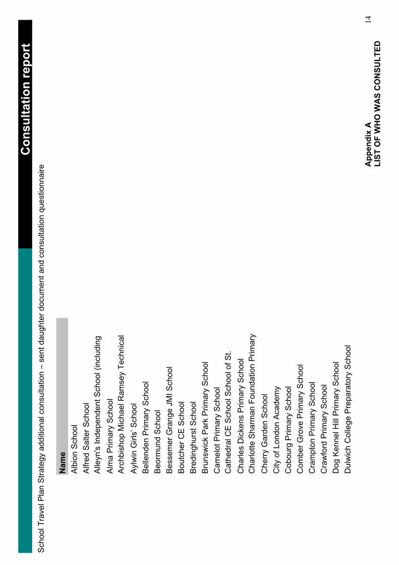
……
……
……
……
……
……
……
……
……
……
……
……
……
…_
Con
sulta
tion
repo
rt_
Sch
ool T
rave
l Pla
n S
trate
gy a
dditi
onal
con
sulta
tion
– se
nt d
augh
ter d
ocum
ent a
nd c
onsu
ltatio
n qu
estio
nnai
re
Nam
eA
lbio
n S
choo
l A
lfred
Sal
ter S
choo
l A
lleyn
's In
depe
nden
t Sch
ool (
incl
udin
g A
lma
Prim
ary
Sch
ool
Arc
hbis
hop
Mic
hael
Ram
sey
Tech
nica
l A
ylw
in G
irls’
Sch
ool
Bel
lend
en P
rimar
y S
choo
l B
eorm
und
Sch
ool
Bes
sem
er G
rang
e JM
I Sch
ool
Bou
tche
r CE
Sch
ool
Bre
ding
hurs
t Sch
ool
Bru
nsw
ick
Par
k P
rimar
y S
choo
l C
amel
ot P
rimar
y S
choo
l C
athe
dral
CE
Sch
ool S
choo
l of S
t. C
harle
s D
icke
ns P
rimar
y S
choo
l C
harlo
tte S
harm
an F
ound
atio
n P
rimar
y C
herr
y G
arde
n S
choo
l C
ity o
f Lon
don
Aca
dem
y C
obou
rg P
rimar
y S
choo
l C
ombe
r Gro
ve P
rimar
y S
choo
l C
ram
pton
Prim
ary
Sch
ool
Cra
wfo
rd P
rimar
y S
choo
l D
og K
enne
l Hill
Prim
ary
Sch
ool
Dul
wic
h C
olle
ge P
repa
rato
ry S
choo
l
App
endi
x A
LI
ST O
F W
HO
WA
S C
ON
SULT
ED
14
……
……
……
……
……
……
……
……
……
……
……
……
……
…_
Con
sulta
tion
repo
rt_
Nam
eD
ulw
ich
Ham
let J
unio
r Sch
ool
Dul
wic
h V
illage
CE
Infa
nt S
choo
l E
nglis
h M
arty
rs R
C S
choo
l E
velin
e Lo
we
Prim
ary
Sch
ool
Fria
rs P
rimar
y S
choo
l G
alle
ywal
l Prim
ary
Sch
ool
Geo
ffrey
Cha
ucer
Sec
onda
ry S
choo
l G
louc
este
r Prim
ary
Sch
ool
Goo
dric
h P
rimar
y S
choo
l G
oose
Gre
en P
rimar
y S
choo
l G
rang
e P
rimar
y S
choo
l G
uys
Hos
pita
l Sch
ool
Hay
mer
le S
choo
l H
eber
Prim
ary
Sch
ool
Her
ne H
ill S
choo
l H
ighs
hore
Sch
ool
Hol
lyda
le P
rimar
y S
choo
l Ic
hthu
s P
rimar
y S
choo
l Ild
erto
n S
choo
l Iv
ydal
e S
choo
l Ja
mes
Alle
n's
Girl
s S
choo
l Ja
mes
Alle
n's
Pre
para
tory
Jo
hn D
onne
Prim
ary
Sch
ool
John
Rus
kin
Prim
ary
Sch
ool
Jose
ph L
anca
ster
Prim
ary
Sch
ool
App
endi
x A
LI
ST O
F W
HO
WA
S C
ON
SULT
ED
15
……
……
……
……
……
……
……
……
……
……
……
……
……
…_
Con
sulta
tion
repo
rt_
Nam
eK
eyw
orth
Prim
ary
Sch
ool
Kin
gsda
le S
econ
dary
Sch
ool
Lang
bour
ne P
rimar
y S
choo
l Ly
ndhu
rst S
choo
l M
auds
ley
and
Bet
hlem
Hos
pita
l Sch
ool
Mic
hael
Far
aday
Prim
ary
Sch
ool
Not
re D
ame
RC
Sch
ool
Oliv
er G
olds
mith
Prim
ary
Sch
ool
Pec
kham
Par
k P
rimar
y S
choo
l P
eckh
am R
ye P
rimar
y S
choo
l P
eter
Hills
with
St M
ary'
s an
d S
t Pau
l's C
E
Pilg
rims
Way
Prim
ary
Sch
ool
Red
riff S
choo
l R
iver
side
Prim
ary
Sch
ool
Rob
ert B
row
ning
Prim
ary
Sch
ool
Rot
herh
ithe
Prim
ary
Sch
ool
Sac
red
Hea
rt R
C S
choo
l S
now
sfie
ld P
rimar
y S
choo
l S
outh
war
k P
ark
Sch
ool
Spa
Sch
ool
St A
ntho
nys
RC
Sch
ool
St F
ranc
esca
Cab
rini R
C S
choo
l S
t Fra
ncis
RC
Sch
ool
St G
eorg
e's
Cat
hedr
al R
C S
choo
l S
t Geo
rges
CE
Sch
ool
App
endi
x A
LI
ST O
F W
HO
WA
S C
ON
SULT
ED
16
……
……
……
……
……
……
……
……
……
……
……
……
……
…_
Con
sulta
tion
repo
rt_
Nam
eS
t Jam
es th
e G
reat
RC
Sch
ool
St J
ames
's C
E S
choo
l S
t Joh
n's
and
St.
Cle
men
t's C
E S
choo
l S
t Joh
n's
CE
Wal
wor
th S
choo
l S
t Joh
n's
RC
Sch
ool
St J
osep
h's
RC
Infa
nts'
Sch
ool
St J
osep
h's
RC
Jun
ior S
choo
l S
t Jos
eph'
s R
C P
rimar
y S
choo
l S
t Jos
eph'
s R
C P
rimar
y S
choo
l S
t Jos
eph'
s R
C P
rimar
y S
choo
l S
t Jud
e's
CE
Sch
ool
St M
ary
Mag
dale
ne C
E S
choo
l S
t Mic
hael
s R
C S
choo
l S
t Pau
l's C
E S
choo
l S
t Pet
er's
CE
Sch
ool
St S
avio
urs
and
St.
Ola
ves
CE
Sch
ool
Sum
mer
hous
e P
RU
S
urre
y S
quar
e In
fant
Sch
ool
Sur
rey
Squ
are
Juni
or S
choo
l Th
e A
cade
my
at P
eckh
am
The
Cha
rter S
choo
l To
wer
Brid
ge S
choo
l To
wns
end
Sch
ool
Tuke
Sch
ool
Vic
tory
Sch
ool
App
endi
x A
LI
ST O
F W
HO
WA
S C
ON
SULT
ED
17
……
……
……
……
……
……
……
……
……
……
……
……
……
…_
Con
sulta
tion
repo
rt_
Nam
eW
alw
orth
Sec
onda
ry S
choo
l W
arw
ick
Par
k S
econ
dary
Sch
ool
Wav
erle
y S
choo
l
A le
tter e
xpla
inin
g th
e Li
p an
d co
nsul
tatio
n pr
oces
s w
as s
ent w
ith a
ll co
pies
of t
he L
ip in
vitin
g pe
ople
to re
spon
d. A
cop
y of
this
lette
r is
follo
win
g.
App
endi
x A
LI
ST O
F W
HO
WA
S C
ON
SULT
ED
18

www.southwark.gov.ukLocal implementation plan

Recommended


