Embed Size (px)
Citation preview
Hydrogeology of the Merti Aquifer
Impact of abstractions on drawdown of water level and salinity
Arjen Oord Jan de Leeuw (presenter)

Impacts of abstractions?
• Abstractions have two major geo-hydrological risks
• Boreholes running dry
– What is expected drawdown of groundwater as a result of the proposed abstractions
• Boreholes turning saline
– What is the risk of water from boreholes turning saline?
• Additional risks of reduced recharge (Climate change, dams and abstractions upstream)
• Acacia Water did research to assess these two risks
2

Overview of the presentation
• Current knowledge about the Merti Aquifer
• The Wajir Habaswein project
• Impacts on water level – drawdown
• Impacts on salinity level of the groundwater
• Impacts of oil mining
• Impacts of dams upstream
• Mitigation options
• Conclusion
3

What do we know about the MertiAquifer
Area Water Paper (2011) in Dutch
• 139,000 km2 Merti Beds and related units
• 61,000 km2 fresh-brackish groundwater
• 10,000 km2 fresh water Habaswein + downstream
Vertical
• Water depth: ~100 m
• Known aquifer thickness: 20 – 80 m
• Possible thickness up to 300-400 m
Water volume:
200 - 300 billion m3 (fresh-brackish)
50 billion m3 fresh water
Large uncertainty around estimates

5

Geology of the Merti Aquifer
100
200
300
me
ter
Archers’ Post
(150 km)
Habaswein
Wajir (100 km)
*
**
**
* **
*
** *
***
Ewaso Ng’iro
fresh
salt

The Wajir Habaswein Water Supply
Project
• Total proposed yield Habaswein well field: 6000 m3/day
• Well field: multiple wells (12) at safe distance (> 700m apart)
• Fresh water is currently abstracted in Habaswein, this much is certain
• The proposed water abstraction is far greater than current abstraction rates around Habaswein
7

Drawdown and the drying Boreholes?
• Pumping leads to lowering of groundwater levels (drawdown)
• If groundwater levels drop below pump level / well screen failure
• Drawdown depends on aquifer properties (thickness, conductivity, storativity) and recharge.
• Most of these parameters are uncertain
• Uncertainty Modelling will give better estimates and insight
8

Modeling Drawdown
• MODFLOW (USGS) is a model that allows to estimate drawdown for a given set of parameters
• Model was run multiple times (stochastic model) using a range of parameters
• Variables included (95% confidence intervals):
– Volume abstracted: 6000 m3/day (from project report)
– Recharge: 0.6 to 40 Million m3/year
– Aquifer thickness: 40 – 200 m
– Conductivity: 2 – 30 m/day (fine to coarse sand)
• Uncertainty of the variables that affect the range of calculated drawdowns
• Model was run 5000 times, using randomly selected parameter values from the estimated parameter ranges
9
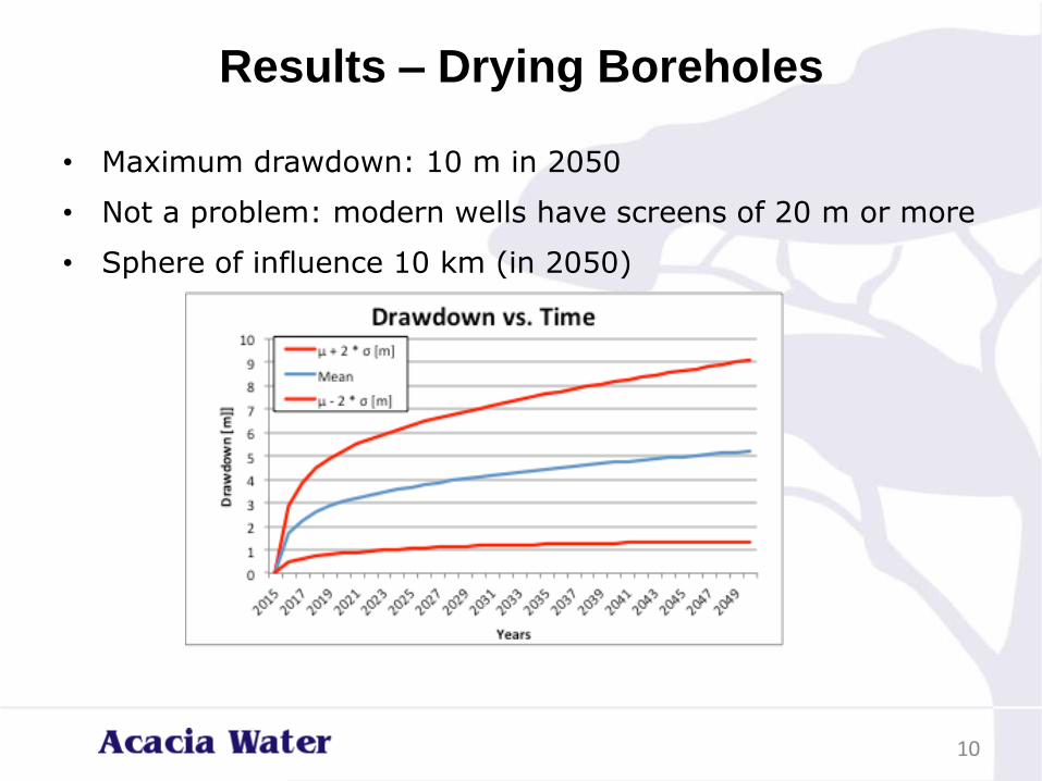
Results – Drying Boreholes
• Maximum drawdown: 10 m in 2050
• Not a problem: modern wells have screens of 20 m or more
• Sphere of influence 10 km (in 2050)
10

Increased salinity
• Two processes responsible for increased salinity risk
• Upconing of groundwater from below
• Lateral flow of water from peripheral areas
11
fresh

Salinity
• Large volumes of fresh groundwater known to exist in central Merti Aquifer (Habaswein)
• Quality (salinity) underneath fresh water is unknown
• Quality is decreasing in some boreholes, so saline water is expected to exist underneath fresh water
• Depth to saline layer?
– At least 40 m underneath current boreholes (or we would have seen more saline boreholes). Could be more than 200 m
• So, uncertainty approach…
12

Risk of upconing
• Upconing is upward movement of saline groundwater caused by the abstractions
• Significant cause of salinity increase in similar situations elsewhere (e.g. coastal water supply the Netherlands)
13

14Source: Deltares.nl

Upconing
• Wells located over saltwater can draw the saltwater upward, creating a saltwater cone that might reach and contaminate the well
15
• Severity is influenced by:
– Depth to salt water (40 – 250 m below top aquifer)
– Density of salt water
– Degree of mixing (or sharp interface)
– Aquifer properties (e.g. porosity)
• National Limit Kenya salinity: 1500 mg/L

Modeling approach upconing
• To predict the upward movement of the saline water, the 3D MODFLOW groundwater model was used, combined with a transport routine (MT3DMS/SEAWAT)
• Transport modelling is slow (one complex model run can take hours or even a full day)
• Therefore, a limited number of (simplified) model runs was done, using different combinations of aquifer parameters and , more importantly, depth to the saline water.
• Sensitivity analysis of the parameter shows that depth to the saline layer is the most sensitive parameter. Unfortunately, this is very uncertain.
16

MODFLOW model
17

Salinity – Model parameters
• Aquifer properties:
– Conductivity ( 2 – 30 m/day)
– Aquifer thickness (40 – 200 m)
– Depth to saline layer (40 m – 200 m)
• Assumptions:
– Sharp interface between fresh and saline layer
– Salinity is lower than seawater
– If the salinity in the well is higher than the national limit, the borehole cannot be used for water supply (failure)
18

Results upconing studies
• Result: there is a 50% risk of boreholes turning saline in 2050 when depth is 40 -200 m below top aquifer
• Risk is much reduced at depth of >120 m below top aquifer
• Lateral movement of salt water: very small chance
One run of the salinity risk assessment:
19
• Model was run several times with various depths of the fresh to saline water layer

Salinity in 2050
• This illustrates the differences in salinity in 2050, depending on at what depth the saline water is found currently: if more than 140 m below top aquifer, chances of drawing saline water decrease
20

Conclusion salinity risk assessment
• Risk of salinity depends on depth of boundary between fresh and saline water :
• It is very high when the boundary is at 40 m below aquifer top
• It is very low when boundary is at 200 - 250m below top aquifer
• Depth of boundary layer is unknown
21

Mitigation options salinity
• Establish depth of fresh to saline water boundary before implementation of phase 2 of the project
• Design – create separate boreholes for Habaswein 1 to 10 km away from the main borehole field
• Provide artificial groundwater recharge
• Intercept saline water below the boreholes
• Mitigation is costly: should be incorporated in feasibility studies
22
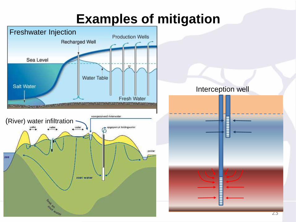
Examples of mitigation
23
Freshwater Injection
Interception well
(River) water infiltration

Scenarios – Oil drilling
• Scenario: Oil Drillings
– Comes with significant groundwater abstraction
– Distance to nearest exploration site: more than 20 km
– Assumption: abstraction will be less than
– Estimated additional abstraction – 400 m3/day nearest site
• In 2050, the Habaswein well field is not (yet) influenced by oil exploitation: oil drilling outside sphere of influence (based on current exploitation sites)
• If oil drilling takes place at a distance of less than 20 km, (chances of project failure will increase)
24

Scenarios - Upstream Dams
• Upstream Storage dams
– Plans for large scale storage dams in Ewaso Ng’iro
– Dams decrease flooding, but increase baseflow
– Recharge Merti is believed to (partly) depend on flooding of Ewaso Ng’iro
– Scenario: dams decrease Ewaso Ng’iro recharge by 50% (rough estimate)
• Decrease in recharge as a result of dams is a slow process. Groundwater levels will not (yet) be influenced by dams in 2050, due to current distance to the flood area (over 50 km)
• These scenarios do not change the situation in Habasweinuntil 2050
25

Conclusions hydrological risks
• Drawdown - Maximum drawdown 250 is 10 m; planned abstractions unlikely to lead to drying of boreholes.
• Existing (shallower) boreholes in Habaswein might be effected, depending on their depth.
• Salinity – this could be a serious (irreversible) problem. Two ways to manage this
– Establish depth to the fresh to saline water boundary allowing more accurate predictions of upconing.
– Design the boreholes such as to mitigate negative effects on water supply to Habaswein (costly)
• Abstractions upstream – not considered a threat in 2050, might be significant in the longer run
26

27