Embed Size (px)
Citation preview

NATURAL DEFENSES IN ACTION H A R N E S S I N G N A T U R E T O P R O T E C T O U R C O M M U N I T I E S

Copyright © 2016 National Wildlife Federation
Suggested citation: Small-Lorenz, S.L., B. A. Stein, K. Schrass, D.N. Holstein, and A.V. Mehta. 2016. Natural Defenses in Action:
Harnessing Nature to Protect Our Communities. Washington, DC: National Wildlife Federation.
Natural Defenses in Action is available online at: www.nwf.org/nature-in-action
Cover photo: Oystercatchers, Jamaica Bay, New York City. Photo: Don Riepe/ALS
National Wildlife Federation
1990 K Street NW
Washington, DC 20006
www.nwf.org

ii N A T U R A L D E F E N S E S I N A C T I O N |
NATURAL DEFENSES IN ACTIONHARNESSING NATURE TO PROTECT OUR COMMUNITIES
Stacy L. Small-Lorenz, Bruce A. Stein, Karl Schrass, D. Nicole Holstein, and Avalon V. Mehta
Dunes, Stone Harbor, NJ. Photo: Stacy Small-Lorenz/NWF

iii
CONTENTS . . . . . . . . . . . . . . . . . . . . . . . . . . . . . . . . . . . . . . . . . . . . . . . . . . . . . . . . . . . . . . . . . . . . . . . . . . . . . . . . . . . . . . i i i
EXECUTIVE SUMMARY . . . . . . . . . . . . . . . . . . . . . . . . . . . . . . . . . . . . . . . . . . . . . . . . . . . . . . . . . . . . . . . . . . . . . 1
NATURAL DEFENSES IN ACTION . . . . . . . . . . . . . . . . . . . . . . . . . . . . . . . . . . . . . . . . . . . . . . . . . . . . . . . . 2 Mounting Risks, Increasing Losses . . . . . . . . . . . . . . . . . . . . . . . . . . . . . . . . . . . . . . . . . . . . . . . . . . . . . . . . . . . . . . . . . . . . . . . . . . . . . . . . . . . . . . . 2
Using Nature to Better Protect Communities . . . . . . . . . . . . . . . . . . . . . . . . . . . . . . . . . . . . . . . . . . . . . . . . . . . . . . . . . . . . . . . . . . . . . . . . . . . . 3
What Are Natural Defenses? . . . . . . . . . . . . . . . . . . . . . . . . . . . . . . . . . . . . . . . . . . . . . . . . . . . . . . . . . . . . . . . . . . . . . . . . . . . . . . . . . . . . . . . . . . . . . 4
HIGHLIGHTING WHAT WORKS: PROFILES OF RESILIENCE ALLIES . . . . . . . . . 7 Discouraging Risky Development: Preserving Barrier Islands on Alabama’s Gulf Coast . . . . . . . . . . . . . . . . . . . . . . . . . . . . . . . . . 8
Keeping Pace with Rising Tides: San Francisco Baylands Restoration . . . . . . . . . . . . . . . . . . . . . . . . . . . . . . . . . . . . . . . . . . . . . . . . . . . . 1 0
Bringing Back the Bayou: Restoring Flows to Protect Coastal Louisiana . . . . . . . . . . . . . . . . . . . . . . . . . . . . . . . . . . . . . . . . . . . . . . . . . 1 2
Leave It to Beavers: Partnering with Ecosystem Engineers in Oregon . . . . . . . . . . . . . . . . . . . . . . . . . . . . . . . . . . . . . . . . . . . . . . . . . . . . 1 4
Making Way for the River: Moving Out of Mississippi River Floodplains . . . . . . . . . . . . . . . . . . . . . . . . . . . . . . . . . . . . . . . . . . . . . . . . 1 6
Managing Extremes of Wet and Dry: Floodplain Restoration in California’s Central Valley . . . . . . . . . . . . . . . . . . . . . . . . . . . . . 1 8
Taking a Softer Approach: Creating Living Shorelines in the Mid-Atlantic . . . . . . . . . . . . . . . . . . . . . . . . . . . . . . . . . . . . . . . . . . . . . . . 2 0
Breaking the Fire–Flood Cycle: Forest Management to Reduce Floods in Flagstaff, Arizona . . . . . . . . . . . . . . . . . . . . . . . . . . . . . 2 2
Dynamic Dunes: Ecological Approaches to Reduce Risk in Cape May County, New Jersey . . . . . . . . . . . . . . . . . . . . . . . . . . . . . . 2 4
Plant Power: Stabilizing Great Lakes Shorelines with Native Vegetation . . . . . . . . . . . . . . . . . . . . . . . . . . . . . . . . . . . . . . . . . . . . . . . . . . 2 6
Linked Futures: Shared Ecosystem and Community Resilience in Coastal Massachusetts . . . . . . . . . . . . . . . . . . . . . . . . . . . . . . . . 2 8
Blending Green and Gray: Hybrid Approaches to Protect New York’s Jamaica Bay . . . . . . . . . . . . . . . . . . . . . . . . . . . . . . . . . . . . . . 3 0
RECOMMENDATIONS TO EXPAND THE USE OF NATURAL DEFENSES . . . . 32 Reform Key Policies . . . . . . . . . . . . . . . . . . . . . . . . . . . . . . . . . . . . . . . . . . . . . . . . . . . . . . . . . . . . . . . . . . . . . . . . . . . . . . . . . . . . . . . . . . . . . . . . . . . . . . . 3 2
Target Research . . . . . . . . . . . . . . . . . . . . . . . . . . . . . . . . . . . . . . . . . . . . . . . . . . . . . . . . . . . . . . . . . . . . . . . . . . . . . . . . . . . . . . . . . . . . . . . . . . . . . . . . . . 3 4
Promote Best Practices. . . . . . . . . . . . . . . . . . . . . . . . . . . . . . . . . . . . . . . . . . . . . . . . . . . . . . . . . . . . . . . . . . . . . . . . . . . . . . . . . . . . . . . . . . . . . . . . . . . . 3 4
ACKNOWLEDGMENTS . . . . . . . . . . . . . . . . . . . . . . . . . . . . . . . . . . . . . . . . . . . . . . . . . . . . . . . . . . . . . . . . . . . . . . 35
REFERENCES . . . . . . . . . . . . . . . . . . . . . . . . . . . . . . . . . . . . . . . . . . . . . . . . . . . . . . . . . . . . . . . . . . . . . . . . . . . . . . . . . . . . 36
C O N T E N T S

N A T U R A L D E F E N S E S I N A C T I O N : Executive Summary | 1
Natural Defenses in Action highlights the important role that
natural and nature-based approaches can play in reducing the
mounting risks to our communities from weather and climate-
related natural hazards. Harnessing nature to protect people
and property is not just a good idea—it already is being done
across the country.
This report profiles a dozen case studies that highlight best-in-
class examples of how natural defenses are being put to use to
avoid or reduce risks from flooding, coastal storms, erosion,
and wildfire. These examples of what we call “Resilience Allies”
demonstrate that ecological approaches to risk reduction can
be good for both people and nature.
A collaboration among National Wildlife Federation, Allied
World Assurance Company, and Association of State Floodplain
Managers, this publication builds on our 2014 report Natural
Defenses from Hurricanes and Floods, which focused on needed
policy changes related to natural disasters.
The best protection from natural hazards is to avoid
developing in risky places altogether, such as in active
floodplains or on geologically dynamic coastal barrier islands.
Conserving open space and intact natural ecosystems will be
particularly important for maintaining and enhancing the
nation’s natural defenses.
Where pre-existing developments are already exposed to
risks from severe weather, storm surge, flooding, and other
hazards, a variety of risk reduction approaches are emerging
that make use of natural features, or that emulate them with
human-engineered features. Clearly, there are many places
where engineered hard structures will continue to be needed to
protect people and property, but even there, blending green and
gray approaches can be used to create multiple lines of defense.
Deploying natural defenses is good not only for the environment,
but also for the economy. Natural and nature-based approaches
can be as, or more, cost-effective as traditional man-made
structures, and by avoiding or reducing community risks can
decrease taxpayer liabilities for disaster response and recovery
and result in lower insurance costs to property owners.
Expanding the use of natural defenses across the country will,
however, require policy reforms that strengthen incentives for
the use of nature-based approaches and that discourage the
proliferation of hard structures like seawalls, bulkheads, levees,
and dams. It will also require better understanding and research
into how nature-based features perform under different
conditions, and additional guidance on when and where they
are most appropriate, either on their own or in concert with gray
infrastructure. And there will be a need to develop and promote
best practices for these ecologically promising approaches to
disaster risk reduction, through creating and disseminating
technical guidance, growing communities of practice, and
designing projects that take advantage of emerging principles
for climate adaptation and resilience.
As risks from natural hazards mount in the face of rapid
climate change, urban population growth, and development
pressure, working with, rather than against, the power of nature
to protect our communities will only become more imperative.
E X E C U T I V E S U M M A R Y
Parker River National Wildlife Refuge, MA. Photo: Kelly Fike/USFWS
Hatteras Village, NC. Photo: Cynthia Hunter/FEMA

2
N A T U R A L D E F E N S E S I N A C T I O NMOUNTING RISKS, INCREASING LOSSES
From hurricanes and floods to drought and wildfire, extreme
weather and climate events impact our communities in many
ways. While some effects, like periodically flooded streets,
might be considered an inconvenience, other impacts can be
devastating, causing loss of life, property, and lasting economic
damage. Unfortunately, the frequency and severity of such
extreme events is on the rise, and associated costs from natural
disasters are spiraling upward.
The National Oceanic and Atmospheric Administration
(NOAA) has tracked the rising number of billion-dollar-plus
natural disasters over the years. Taking inflation into account,
from 1980 to 2015 NOAA recorded a yearly average of 5.2
billion-dollar U.S. weather and climate-related disasters, but
between 2011 and 2015 the annual number of such costly
disasters more than doubled.1 In 2015 alone the United States
suffered from historic levels of flooding, long-term droughts,
and record-breaking wildfires.
The rising frequency, severity, and consequences of these
extreme events has multiple causes, some due to patterns of
population growth and development, and others rooted in
the changing nature of our climate.2 Coasts and waterways
have always been magnets for population centers, providing
abundant opportunities for transportation, economic activity,
and recreation. Nearly 40 percent of the U.S. population lives
in coastal counties, even though those counties constitute just
10 percent of the total land area (excluding Alaska).3 Similarly,
floodplains account for just 7 percent of overall land area, but
are home to 15 percent of the nation’s urban areas and nearly
10 million households.4 Continued population growth along
our coasts and waterways—and the increasing value of those
developments—increases overall risks and costs from floods
and coastal storms.
A more recent trend has been the dramatic expansion of
population into often fire-prone wildland areas, especially
in the western United States. The so-called “wildland–urban
interface” now contains at least 44 million houses, equivalent
to one in every three houses in the country, with the highest
concentrations in California, Texas, and Florida.5 Development
in the wildland–urban interface is greatly increasing wildfire
risks to people and structures, escalating the costs of major
conflagrations, and constraining forest management efforts
needed to actually reduce wildfire risks.
Rapid climate change—a phenomenon already underway and
accelerating6,7—is exacerbating and amplifying the potency of
weather and climate-related risks and further compounding
problems of development in hazard-prone areas. Warming
temperatures and other climatic changes already have led
to an increase in the amount of precipitation falling as
heavy downpours, increasing risks of localized and regional
flooding. Over the past 50 years, for instance, the Northeast has
experienced a 71 percent increase in precipitation falling in very
heavy events.8 Rising sea levels, a well-documented symptom
of climate change, has been especially acute along parts of
the Eastern Seaboard, rising over the past century by more
than a foot in places like Philadelphia.9,10 Coastal cities such
as Annapolis, Norfolk, and Miami already are experiencing
frequent incidences of “nuisance” flooding, where high tides
routinely flood streets and impede normal life.11 Quite apart
from the nuisance factor, elevated sea levels increase the risk of
serious coastal flooding by providing an elevated launch pad for
storm-driven waves and storm surge, such as occurred during
Hurricane Sandy.12 And as sea levels continue to rise, millions
of people in coastal communities will experience increased risk
of major flooding, jeopardizing critical infrastructure such as
water treatment plants, transportation facilities, and hurricane
evacuation routes.13
West Alton, MO. Photo: Steve Zumwalt/FEMA
Mississippi River levee break. Photo: Joceyln Augustino/FEMA

3 N A T U R A L D E F E N S E S I N A C T I O N : Introduction |
Development patterns have contributed to an increase
in these risks by putting more and more people in harm’s
way—often encouraged by outdated public policies and
incentives—and by undermining the ability of nature itself
to provide protective services. Loss or degradation of natural
habitats along our coasts, floodplains, and uplands has
diminished the ability of these features to absorb stormwater,
buffer wave impacts, and prevent erosion. The unbridled
expansion of impervious surfaces is of particular concern,
and pavement and other hard surfaces cover more than
43,000 square miles of the United States—an area nearly
the size of Ohio.14 Rain falling on these surfaces cannot be
absorbed into the soil, and instead funnels directly into
increasingly rain-swollen waterways.
Rapid climate change and sea-level rise are creating new
stresses on natural ecosystems, and some habitats, like tidal salt
marshes, will need to shift in order to track suitable conditions
and remain viable.15 The pathways for such coastal and inland
habitat shifts increasingly are blocked by development and
other hard infrastructure, contributing to deterioration of
these natural defenses just when they are most needed.
The mounting risks from weather and climate-related disasters
are having an enormous cost to both individuals and society
as a whole. Total economic losses from Hurricane Sandy alone
are estimated to have reached $70 billion, of which about $30
billion were insured losses.16 The National Flood Insurance
Program, which offers federally subsidized flood insurance for
homeowners, is now at least $23 billion in the red.17
USING NATURE TO BETTER PROTECT COMMUNITIES
Over the past few decades there has been growing appreciation
for the value of nature to people, specifically through the
provision of “ecosystem services” that promote human well-
being and sustain livelihoods.18 In addition to such important
services as clean water and productive soils, there has been
increasing attention to the role nature plays, or could play, in
moderating extreme weather events and reducing risks from
natural hazards.19,20 Unfortunately, due to historical land use,
resource extraction, and development patterns, many of the
protective functions that nature provides have been degraded
or lost altogether.
In many places, these natural protective features have been
replaced by engineered hard structures, such as breakwaters,
sea walls, and storm drains. While there are places where such
structural approaches are and will continue to be essential
for safeguarding property and other human interests, there
are other places where a natural approach can be as or more
effective.21 Relying on nature has a number of additional
benefits not typically found in engineered structures, including
provision of fish and wildlife habitat and enhancement of
recreational opportunities.22 One recent study found that
existing coastal habitats reduce by approximately half the
proportion of people and property that are most exposed to
coastal storms and sea-level rise.23
Regrettably, current approaches for managing risks from
weather and climate-related hazards frequently fail to take
advantage of the protective functions that natural systems
can provide. Instead, public policies and governmental
programs at local, state, and federal levels often continue
to encourage development in risky areas. At the same time,
natural catastrophe policies traditionally have focused on
post-disaster response and recovery, rather than emphasizing
Black skimmers. Photo: Heather Paul/Flickr
South Cape May Meadows, NJ. Photo: Stacy Small-Lorenz/NWF
Rim Fire, Stanislaus National Forest, CA. Photo: USFS

4
pre-disaster preparedness and risk reduction. Even where
policies and programs encourage pre-disaster mitigation and
pre-positioning of emergency resources, there is still a heavy
reliance on structural and mechanical solutions and numerous
impediments to employing natural defenses.
This publication is a follow-up to our 2014 report Natural
Defenses from Hurricanes and Floods: Protecting America’s
Communities and Ecosystems in an Era of Extreme Weather.24
That previous report focused on needed policy reforms to
address the growing threats of floods and hurricanes across
the country. That report laid out five principles for guiding
development of public policies capable of safeguarding people
and conserving nature in an era of rapid change:
• Better understanding of actual risks can lead to more risk reduction
• Investing in certain risk reductions now can produce large
savings over the long term
• Investments in natural infrastructure can maximize resilience
• Actuarially sound insurance provides incentives to reduce risk
• Consideration of social equity is a necessary component of
natural catastrophe policy
WHAT ARE NATURAL DEFENSES?
Simply put, the term natural defenses refers to the use of natural
systems—or engineered systems designed to emulate natural
features—that provide protective benefits to people, property, or
other valued assets. Natural defenses can be used on their own,
or in combination with more traditional engineered structures.
Because the science and practice of natural defenses is young and
rapidly evolving, questions remain regarding the effectiveness of
different approaches in mitigating risks, and therefore when and
where various forms of natural defenses may be appropriate, either
on their own or in concert with other risk reduction measures.
The U.S. Army Corps of Engineers has characterized the array
of coastal risk reduction measures as including natural and
nature-based features, non-structural measures, and structural
measures.25 They note that natural features “are created and
evolve over time through the actions of physical, biological,
geologic, and chemical processes operating in nature,” while
nature-based features are those that “may mimic characteristics
of natural features but are created by human design, engineering,
and construction to provide specific services such as coastal risk
reduction.” Non-structural measures, as defined by the Army
Corps, include such things as “modifications in public policy,
management practices, regulatory policy, and pricing policy”
that can either reduce the probability of exposure to a hazard,
or reduce the consequences of exposure. More broadly, non-
structural approaches can be viewed as various measures to make
existing and future development more resilient to hazards, with
techniques including regulations, zoning, buyouts, construction
standards, and protection of natural systems like streams,
floodplains, and wetlands.26 For our purposes, we consider non-
structural measures that encourage or mandate the use of natural
or nature-based approaches for risk reduction—for instance,
avoidance of development in hazard-prone and environmentally
sensitive areas—as forms of natural defenses.
Risks often are evaluated in terms of how likely they are to occur
(i.e., probability) and the damages that would result if they did
happen (consequences). Natural defenses, depending on the
circumstances, can be used either to reduce the likelihood that
Shorebirds, San Francisco Bay. Photo: Judy Irving
Boca Chica Key, FL. Photo: NPS

5 N A T U R A L D E F E N S E S I N A C T I O N : Introduction |
an extreme event may affect a community, or to ameliorate
its impact if it should occur. Understanding the possible
consequences of failures in protective measures (whether
structural or nature based) is a key element of preparedness and
risk management. As dramatically illustrated by levee failures
during Hurricane Katrina, however, communities can be lulled
into a false sense of security regarding degree of actual risk.
Avoiding Risk
The best way to reduce risk, of course, is to avoid it altogether.
This depends on having an accurate understanding of where
natural hazards exist, as well as which areas may be exposed
to those hazards in the future. For example, as climate change
affects precipitation patterns, the footprint of so-called “100-year
floods” (which really means areas with a 1 percent probability of
flooding in any given year) will expand dramatically.
Policies or incentives to avoid development of ecologically
sensitive and hazard-prone areas are one of the most important
and effective means of protecting people and sustaining the
protective value of natural habitats. Where development
already has occurred in such risky areas, which often are subject
to repetitive losses from floods or other hazards, relocating
development and restoring the areas to a more natural state
(for instance, reconnecting floodplains with their river) can
similarly protect people and communities and reestablish
natural protective functions.
Reducing Risk
Most natural and nature-based approaches offer opportunities
to reduce rather than completely avoid risks, often because they
are being applied retroactively in efforts to protect properties
already occupying hazard-prone sites. Such risk reduction
approaches can range from protecting intact ecosystems
on nearby lands and waters to blending green and gray
infrastructure approaches.
Protecting Intact Natural Systems
Protecting open space and existing natural habitats are among
the most cost-effective ways of reducing risk to communities.
Such natural areas can also provide other important
services to local communities, from clean water, recreational
opportunities, and fish and wildlife habitat. Numerous studies
have also found significant positive effects on local property
values from adjacency to parks and other protected open
space.27 There are a variety of mechanisms used to protect open
spaces and priority habitats from development, ranging from
federal and state designations, such as parks, nature reserves,
and wildlife refuges, to land acquisition and conservation
easements, local zoning (e.g., development restrictions in
floodplains, designation of riparian buffers), and policies
that restrict federal subsidies that promote developments
(e.g., Coastal Barrier Resources System). In the face of climate
change–induced habitat shifts, conserving undeveloped open
space adjacent to natural ecosystems (for instance, inland
from tidal marshes) will become increasingly important in
sustaining the protective function of these habitats.28
Cumberland Island, GA. Photo: NPS
Floodplain buyout property, Crystal City, MO. Photo: Anna Westervelt/FEMA

6
Restoring Natural Systems
Because many natural habitats have been lost or degraded,
ecological restoration is an important approach for not only
rebuilding protective functions, but providing a host of other
environmental benefits and enhancements. Restoration efforts
can vary greatly, depending on the type of system, degree of
remaining system functionality, and complexity and scale
of the task. Ecological restoration efforts can range from
rehabilitating a small site (a single wetland, for instance)
to major regional restoration efforts (e.g., restoring coastal
Louisiana marshlands). Although considerable ecological
restoration expertise exists for certain system types, there is
less experience in designing restoration efforts specifically to
provide protective benefits and natural hazard risk reduction.29
Restoration efforts focused on risk reduction can include
practices like prescribed burns to reduce wildfire and associated
floods and mudslides, tidal marsh restoration to buffer coastal
waves, and restoring hydrological connections between rivers
and their floodplains to reduce downstream flood impacts.
Creating Nature-Based Features
Constructing engineered features designed to mimic natural
features and functions can also be an effective approach for
reducing risks. Nature-based features can include such things
as engineered dune complexes to buffer coastal communities,
and living shorelines that use mostly native materials
(biological and physical) to stabilize shorelines.30 Engineered
reefs, built from or serving as substrate for oysters or corals, are
another focus of active experimentation with potential wave
attenuation and shoreline protection benefits.31 Because many
traditional ecological restoration efforts require engineering,
design, and construction, restoration of purely natural systems
and construction of nature-based features are probably best
viewed as occurring on a continuum, and any given project
may have elements of both.
Combining Natural and Manmade Features
Increasingly, practitioners are identifying opportunities to
blend green and gray approaches to risk reduction. In some
places the protective functions of a structural feature can be
augmented with those provided by a natural or nature-based
feature—such as dunes, marsh, or natural floodplain—
creating “multiple lines of defense.”32 Creating such green–gray
hybrids, where ecologically appropriate, can soften the impacts
of the structural feature and provide other environmental
benefits typically associated with natural infrastructure.33
Integrating natural, nature-based, non-structural, and
structural approaches recognizes that risk reduction needs and
opportunities are highly site specific and depend very much on
the geophysical and ecological setting as well as the type and
sensitivity of the assets to be protected. Given the traditional
reliance on structural measures in most heavily populated
areas, opportunities to promote and expand the use of natural
and nature-based features will often involve incorporating
them into such integrated, hybrid risk reduction systems.
Dealing with Residual Risk
No matter what risk avoidance and reduction measures are
put into place—whether structural, non-structural, or nature-
based—a certain level of risk often remains, particularly in the
face of extreme events and major natural catastrophes. For
example, properties behind levees or below dams may have
flood risks that are not well-recognized by the public.
“Residual risk” traditionally is addressed through the use
of insurance, offered through private insurers or through
federal or state programs, which serves to spread the financial
burden of that risk across a broad population pool. Flood
hazard maps generally do not reflect residual risks behind
“protective” structures, however, and as a result flood insurance
is not required or typically purchased for such properties.
A secondary mechanism to address residual risk is through
government disaster response and recovery programs, such
as those authorized under the Stafford Act and administered
by the Federal Emergency Management Agency. Although
important, such programs typically do not make people whole
after a flood event.
Insurance not only can allow homeowners and communities
to recover and rebuild from disasters, but properly priced
can provide powerful market signals and incentives for them
to take steps to avoid or reduce risks, including through
the use of natural defenses. Similarly, disaster response and
recovery programs can be used to more proactively reduce
risks, including by promoting nature-based measures and
encouraging and rewarding more resilient designs during
reconstruction, through protecting open space and natural
buffers, and through offering voluntary buyouts of properties
subject to repetitive losses.34
Oyster reef installation, Mobile Bay, AL. Photo: Craig Guillot

7 N A T U R A L D E F E N S E S I N A C T I O N : Introduction |
H I G H L I G H T I N G W H A T W O R K S PROFILES OF RESILIENCE ALLIES
Natural defenses not only are a good idea, they already are
being put into practice. To promote the broader adoption of
natural and nature-based approaches to risk reduction, this
report highlights a number of best-in-class examples of how
this is being carried out, followed by a set of recommendations
for advancing the broader adoption of natural defenses. The
pages that follow offer profiles of how nature is being harnessed
to protect people and communities across the country. These
case studies address different types of hazards—ranging from
coastal and inland flooding to wildfires and drought—and
employ a range of approaches, from preserving open space,
restoring wetlands, and thinning forests, to employing beavers
as restoration assistants.
These case studies were drawn from a national solicitation that
was carried out in late 2015, and supplemented by background
research and interviews with leading practitioners. The case
studies focus on projects, communities, or landscapes where
natural or nature-based approaches to reducing risk are being
developed and implemented. These examples are as varied
as the American landscape itself, and reflect the ingenuity
and innovation that is underway as people grapple with how
to use nature to address the hazards currently facing their
communities, as well as prepare for the rapid changes that are
yet to come.
Carpenter Fire, Toiyabe National Forest, NV. Photo: USFS Hurricane Joaquin, Oct. 2015. Photo: NOAA
Heinz National Wildlife Refuge with Philadelphia skyline. Photo: Jim, the Photographer/Flickr

8
D I S C O U R A G I N G R I S K Y D E V E L O P M E N TPRESERVING BARRIER ISLANDS ON ALABAMA’S GULF COAST
I don’t understand why people build on sandbars.
They are dynamic things. They are not fixed.
They will move. They will decay. They will grow.
And trying to nail one down by building houses
on it, we’re fighting Mother Nature.
– John Christy, Alabama State Climatologist35
Along our coastal barrier islands an ounce of prevention is
worth more than a pound of cure, something nowhere more
vividly illustrated than Dauphin Island, Alabama. Avoiding the
risks associated with putting houses in harm’s way is at the heart
of the Coastal Barrier Resources Act (CBRA), a law that has
helped to keep environmentally sensitive portions of Dauphin
Island intact and free of development and storm-related losses.
Strung along the Atlantic and Gulf coastlines like a strand of
jewels, barrier islands buffer many parts of the mainland from
the power of the open ocean. In their intact state, these islands
serve as one of our most powerful natural defenses. Subject
to the constant forces of the wind and waves, though, barrier
islands are shape-shifters and in constant flux. Sediment is
transported from one location to another, dunes form and shift
across the landscape, maritime forests spring up to the rear, and
the sheltered bays behind the islands sustain highly productive
fish and shellfish habitat.
As climate change results in stronger and more frequent coastal
storms, a healthy system of barrier islands can prevent more
devastating impacts to cities and towns on the mainland. These
sand banks are also highly valued as oceanfront property.
From Portland, Maine, to Galveston, Texas, barrier islands
have been the sites of increasing concentrations of wealth in
the form of beachfront real estate. The permanence of human
settlements does not lend itself to the ever-changing nature
of barrier islands, however, something repeatedly made clear
by the astronomical cost of storm damage to barrier island
developments in places such as Atlantic City, New Jersey, and
the Outer Banks of North Carolina.
In 1982, President Ronald Reagan signed into law the CBRA
to prevent additional risky development on remaining intact
and environmentally sensitive portions of our barrier islands.
The Act was passed not just to protect against further loss of
important natural resources, but to reduce threats to human
life, health, and property, as well as to protect U.S. taxpayers
from the burden of paying again and again to rebuild in these
risky and storm-prone areas. Administered by the U.S. Fish
and Wildlife Service, there are now 585 designated units in
the system covering about 1.3 million acres. The Act does not
bar development outright from designated areas, but rather
removes federal incentives for new development, making these
areas ineligible for most new federal expenditures and financial
assistance, including federal flood insurance. Savings to federal
taxpayers from 1983 through 2010 are estimated at about $1.3
billion, with another $200 million in avoided disaster relief
estimated through 2050.36
Dauphin Island, Alabama, a barrier island located three miles
south of Mobile Bay, provides an excellent example of how the
Act, in concert with other federal, state and local policies, can be
effective in avoiding risks to people and property from hurricanes
and coastal storms. When the western spit of Dauphin Island
was designated a Coastal Barrier Resources System Unit, state
and local level legislation was enacted to align with and codify
the goals of the Act. The State of Alabama drew their coastal
construction control line to match the boundary of the federal
designation. Local officials then zoned the land as conservation
and parkland, effectively prohibiting future development. U.S.
Fish and Wildlife officials cite such coordination among federal,
state, and local regulations as a best practice applied in those
areas where the Act has been most effective.37
The effectiveness of these measures are highlighted by
comparing the island’s undeveloped areas—protected under
the CBRA—to the highly developed portions of the island, such
as the Town of Dauphin Island. Dr. Robert Young, Director of
the Program for the Study of Developed Shorelines at Western Monarch butterflies, Dauphin Island. Photo: Barbara Ashe
9 N A T U R A L D E F E N S E S I N A C T I O N : Discouraging Risky Development |
At a Glance› Barrier islands buffer the mainland
from the power of the open ocean; development interferes with natural processes like dune formation, reducing the island’s protective value.
› Designations under the Coastal Barrier Resources Act (CBRA) remove federal incentives for risky development; complementary state and local regulations can help conserve these dynamic and protective ecosystems.
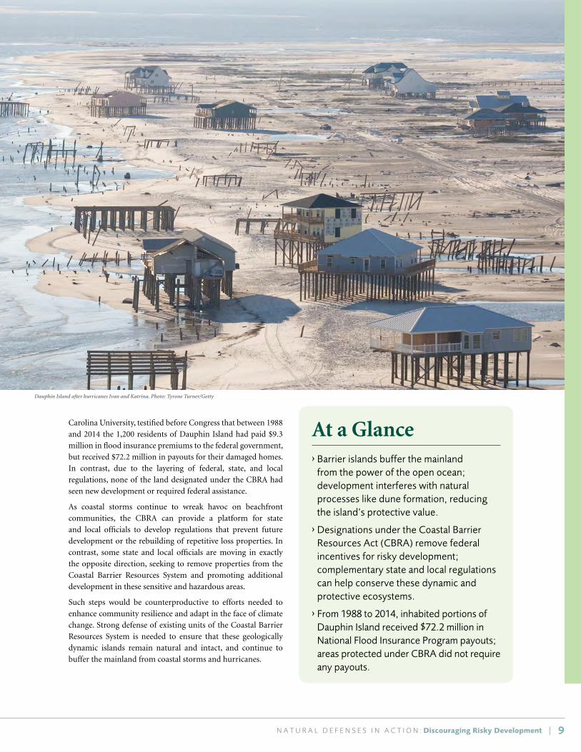
› From 1988 to 2014, inhabited portions of Dauphin Island received $72.2 million in National Flood Insurance Program payouts; areas protected under CBRA did not require any payouts.
Carolina University, testified before Congress that between 1988
and 2014 the 1,200 residents of Dauphin Island had paid $9.3
million in flood insurance premiums to the federal government,
but received $72.2 million in payouts for their damaged homes.
In contrast, due to the layering of federal, state, and local
regulations, none of the land designated under the CBRA had
seen new development or required federal assistance.
As coastal storms continue to wreak havoc on beachfront
communities, the CBRA can provide a platform for state
and local officials to develop regulations that prevent future
development or the rebuilding of repetitive loss properties. In
contrast, some state and local officials are moving in exactly
the opposite direction, seeking to remove properties from the
Coastal Barrier Resources System and promoting additional
development in these sensitive and hazardous areas.
Such steps would be counterproductive to efforts needed to
enhance community resilience and adapt in the face of climate
change. Strong defense of existing units of the Coastal Barrier
Resources System is needed to ensure that these geologically
dynamic islands remain natural and intact, and continue to
buffer the mainland from coastal storms and hurricanes.
Dauphin Island after hurricanes Ivan and Katrina. Photo: Tyrone Turner/Getty

| N A T U R A L D E F E N S E S I N A C T I O N : Keeping Pace with Rising Tides10
K E E P I N G P A C E W I T H R I S I N G T I D E S SAN FRANCISCO BAYLANDS RESTORATION
Look at a map of the Bay today and around
most of its shoreline, you’ll see a clear boundary
between water and land. That’s partly
mapmakers’ convenience and partly a reflection
of the way we’ve reengineered the Bay shore. But
300 years ago, you might have found it hard to
tell just where the Bay ended and the land began.
The interface between land and water was ever-
shifting, pulsing like the heart of California.
– Chris Clarke, San Francisco Bay’s Lost World38
Tidal marshes and other
coastal ecosystems can
function as natural
infrastructure in the San
Francisco Bay region,
providing cost-effective
protection against extreme
floods and sea-level rise,
but only if their restoration
and protection are made an
urgent priority.39
Numerous factors put
South San Francisco Bay
cities at high flood risk,
including low elevations,
sea-level rise, and historical conversion of tidal wetlands to
commercial salt ponds. Sea-level rise, in particular, threatens the
long-term survival of the marshes that serve as critical natural
buffers. According to the 2015 climate science update to the
1999 Baylands Ecosystem Habitat Goals (“Baylands Goals”),
most of San Francisco Bay’s protective marshes will be damaged
or destroyed by 2100 without immediate intervention.40
The Baylands Goals update represents “the most current state
of climate science and impacts for San Francisco Bay, and the
highest priority adaptation actions to save habitat and protect
communities” according to Marilyn Latta of the California
Coastal Conservancy. It calls for new adaptation approaches
to restoring the bay’s tidal marshes to meet an established
restoration goal of 100,000 acres. That represents half of the
original tidal marshes and would result in a more resilient
shoreline. Restoring ecological integrity to significant portions
of the baylands by 2030 is anticipated to help them flourish by
the time sea-level rise accelerates in the mid-21st century.
It also calls for conservation of transitional zones between the
baylands and uplands to allow marshes to migrate landward,
where space allows, as sea level continues to rise. This is made
especially urgent by the fact that old earthen levees, flood control
channels, and other engineered infrastructure that were built right
at the edge of the bay will provide inadequate future protection in
places like Silicon Valley under projected sea-level rise.
Restoring baylands ecosystems and conserving upland
transition zones to allow for inland migration of wetlands
is a multi-benefit way to offset rising water levels and storm
impacts in the future. However, critical processes like water
and sediment flows must be restored to allow these baylands
to keep pace with sea-level rise, coastal scientists say. Current
sediment supply is not adequate to allow marshes to grow
vertically in response to sea-level rise, and scientists are
calling for application of clean dredged materials as part of a
comprehensive regional sediment management plan.
One promising effort being implemented in the region is the
South Bay Salt Pond Restoration Project, a combination of
infrastructure modifications and restoration of former salt
ponds to tidal marsh, as recommended under the South San
Francisco Bay Shoreline Study.41 The project is the largest tidal
wetland restoration effort on the West Coast, and aims to
restore 15,100 acres of former commercial salt ponds in South
San Francisco Bay to functional tidal marsh when complete, for
purposes of flood management for South Bay cities, habitat,
and public access. So far, 1,500 acres of functional tidal marsh
have been restored.
Another project, the San Francisco Bay Living Shorelines
Project, demonstrates how natural features such as submerged
aquatic vegetation and native oysters in the subtidal and
intertidal zones can reduce wave energy (up to 30–50 percent)
and potentially protect adjacent shorelines from erosion and
storm impacts.
Coordination of permitting for living shorelines among coastal
resource agencies and stakeholder engagement will be two
key elements to successful and more widespread adoption of
living shorelines efforts in California and beyond, keeping in
mind that ecological approaches to shoreline management
bring habitat, fisheries, and water quality co-benefits that hard
armored shoreline engineering projects do not.
Large-scale tidal marsh restoration, open space planning, and
living shorelines pilot projects are showing great promise to
provide storm surge reduction benefits and protect adjacent
shorelines at a much larger scale throughout the San
Francisco Bay region.
Clapper rail, Corte Madera, CA. Photo: Len Blumin/Flickr
Opposite Page : Alameda Creek, San Francisco Bay. Photo: Doc Searls/Flickr

Keeping Pace with Rising Tides | 11
At a Glance› Sea-level rise makes restoring tidal marshes
an urgent priority; regional goals call for 100,000 acres of restored marsh around San Francisco Bay.
› Living shorelines using submerged aquatic vegetation and native oysters can reduce wave energy and protect shorelines from erosion and storm impacts.
› Regional open-space planning provides room for wetlands to migrate inland as sea level rises.
› Outdated hard infrastructure at the edge of the Bay offers inadequate flood protection for future conditions in places like Silicon Valley.
› Coordination of permitting processes among agencies will be key to more widespread adoption of living shorelines approaches.

| N A T U R A L D E F E N S E S I N A C T I O N : Bringing Back the Bayou12
B R I N G I N G B A C K T H E B A Y O U RESTORING FLOWS TO PROTECT COASTAL LOUISIANA
The marshes of coastal Louisiana are a national treasure that
is fast disappearing. Innovative ecological restoration efforts
in places like the Barataria Basin, however, showcase how
reconnecting the Mississippi River to its historic delta can
both enhance fish and wildlife habitat and rebuild the natural
defenses these marshes provide to protect coastal communities.
The Mississippi River delta is home to a rich diversity of
habitats, including approximately 40 percent of the coastal
wetlands in the continental United States, and serves as the first
line of defense against the impacts of storm surge to coastal
Louisiana’s communities, from the city of New Orleans to the
tiniest coastal fishing community. It was a dynamic system.
Because the river was free to wander, switching channels
and breaching its own natural levee confinement, the delta
contained both growing freshwater areas of riverine influence
and retreating brackish estuarine areas of Gulf of Mexico
marine influence. For thousands of years, sediment flowing
into the delta from the great Mississippi River built new land
while sustaining existing marshes, swamps, and barrier islands,
and keeping the delta in balance.
Construction of levees for flood protection, canals for oil
and gas access, and channels around the river’s entrance for
the transport of goods have had great near-term economic
benefits, but came at a grave ecological cost. They also came
with long-term economic and social costs, now coming due.
These levees and channels cut off the natural flow of freshwater
and sediment into the delta, upsetting the freshwater–saltwater
balance, and tipping the system toward victory for the erosive
forces of the Gulf, resulting in an astonishing rate of land loss.
Land loss not offset by inputs of new sediment will increasingly
be exacerbated by the effects of climate change—including
increasingly severe storms and rising sea levels—and
channeling and ditching from oil and gas operations. Because
erosion and subsidence are vastly outpacing sediment accretion
in the Delta, some of the most ecologically valuable marsh
and estuarine ecosystems in the world are drowning, putting
many coastal Louisiana communities at increased risk from
hurricanes and coastal storms.
The town of Jean Lafitte, located just west of the Mississippi
River in the Barataria Basin is a small fishing community, like
many other towns in the area. The flood protection benefits
from the levees surrounding the New Orleans metropolitan
area just to the north do not reach as far as Jean Lafitte.
Moreover, the marsh systems and barrier islands, a natural first
line of defense from storms for Jean Lafitte and metropolitan
New Orleans beyond, are quickly disappearing. Recent strong
storms, including Hurricane Rita in 2005 and Hurricane Isaac
in 2012, demonstrated how vulnerable towns like Jean Lafitte
have become to storm events. Alisha Renfro, a coastal scientist
at National Wildlife Federation, says that “rebuilding and
enhancing the natural buffer system provides towns like Jean
Lafitte, which lack federal 100-year levee systems, the protection
they don’t currently have from storm surge.”
Restoring river flows and sediment into the Barataria Basin is
one of the most important components of Louisiana’s landmark
Coastal Master Plan. Penalties from the Deepwater Horizon oil
spill are now providing a major source of financing for coastal
Louisiana restoration, including Barataria Basin, through
the federal RESTORE Act. Two linked projects that exemplify
new approaches to putting sediment from the river back into
its delta are the large-scale marsh creation that will lead to a
restored Barataria Basin Land-Bridge and the Mid-Barataria
Sediment Diversion. These projects are using sand from the
Mississippi River’s bottom along with silts and clays carried in
its streamflow to build new land, nourish existing marsh, and
help prevent saltwater from the Gulf of Mexico from penetrating
into freshwater marshes and swamps in the mid to upper
reaches of the basin. These newly built and restored marshes
The river built the coast; the river is required to sustain it.
– Virginia Burkett, U.S. Geological Survey42
Jean Lafitte Swamp, LA. Photo: Donna Pomeroy/Flickr Bottom Opposite Page: Sediment transport pipeline. Photo: KDW/NWF

Keeping Pace with Rising Tides | 1313
will also help reduce storm surge and tidal flooding for the
coastal community of Jean Lafitte, as well as for metropolitan
New Orleans and nearby Jesuit Bend and Myrtle Grove.44
The land-bridge project uses an extensive pipeline system to
pump sand and sediment from the Mississippi River. More
than 1,000 acres of marsh have been built so far and 1,000
more are currently under construction. Ultimately, the project
will create more than 8,000 acres of marsh, forming an intact
marsh land bridge that will help separate the Gulf ’s saltwater
from freshwater marshes farther inland.
A related project, the Mid-Barataria Sediment Diversion, will
supplement the Barataria Land-Bridge restoration by using
a gated structure built through the levee system, which can
redirect sediment and freshwater flow into the Barataria Basin
and mimic natural fluvial patterns, building a new sub-delta
adjacent to the land bridge. The gates can be strategically
opened and closed, to account for changes in river levels, thus
minimizing effects on river navigation while advancing marsh
restoration goals.
Although sediment diversion projects might be difficult to
apply elsewhere due to the specific set of conditions needed,
the Barataria Basin projects demonstrate how to supplement
existing restoration initiatives in a sustainable way. These
projects in the Barataria Basin illustrate the kind of forward-
thinking and bold vision that is necessary to reverse years of
decline in the nation’s “vanishing paradise” and to rebuild the
protective functions of these ecosystems for coastal Louisiana’s
culturally rich local communities.
At a Glance› Louisiana’s 2012 Coastal Master Plan is a
visionary and large-scale restoration plan that recognizes the role of healthy coastal habitats in protecting people and the economy, while addressing land subsidence and sea-level rise.
› To reverse large-scale land losses, delta restoration efforts seek to build new land, nourish existing marsh, and reestablish the saltwater–freshwater balance needed for coastal habitats to flourish.
› Engineered structures are providing water and sediment flows needed to restore marshland, and to reestablish and sustain the marsh’s protective benefits.
› Penalties from the Deepwater Horizon oil spill are now a major source of financing for coastal Louisiana restoration, and the federal RESTORE Act mandates that significant funding be directed to ecosystem protection and restoration.
Great egret, Jean Lafitte, LA. Photo: Larry Daugherty/Flickr
Barataria Bay. Photo: Kenneth Garcia/Flickr

14
L E A V E I T T O B E A V E R S PARTNERING WITH ECOSYSTEM ENGINEERS IN OREGON
The beavers have taken back what they’d lost–not
only for themselves but for so many other species.
– Kendra Smith, Bonneville Environmental Foundation45
In the Columbia River watershed of western Oregon, beavers
are proving to be an invaluable partner in taming floods,
moderating water shortages, cooling water temperatures, and
restoring habitat for fish and wildlife, including coveted salmon.
They are a prime example of how re-establishing nature’s own
engineers can help reduce the need for human engineering.
The Tualatin River basin drains 712 square miles of land,
its main river flowing from forested mountains, through
agricultural valleys, and finally tumbling past the densely
populated communities of Tualatin and West Linn before
entering the Willamette River, upstream from its confluence
with the Columbia River.46 Flooding is nothing new to Tualatin
Basin communities. Flood risks can be high, especially near
the mouth of the Tualatin River—the most urban area. —
and Clackamas County has nearly 10,000 individual parcels
partially or entirely located within the floodplain.47
Under changing climatic conditions, the Pacific Northwest is
projected to experience an increase in heavier rainfall events and
potential for flooding in the fall and winter, along with enhanced
drought conditions and lower streamflows in the summer
months—including in western Oregon. Water managers are
faced with the problem of both too much and too little water.48
A comprehensive survey of the Tualatin Basin revealed that
many heavily incised streams no longer had functional
connections to their floodplains. Water rushing through the
channelized system was causing erosion and sedimentation
and failing to recharge groundwater, and floodplains were
dominated by invasive reed canary grass. Watershed managers
recognized that a basin-wide approach was needed to restore
the system to improve water quality and groundwater recharge,
and to moderate flood risks.
Kendra Smith, principal author of the 2005 Healthy Streams
Plan, realized that native beavers and their preferred food
sources were missing from the system. As a result, she worked
with city governments to plant native riparian vegetation,
end beaver extirpation efforts, and refocus trapping efforts
on nutria, an invasive mammal that can cause considerable
streamside erosion. By 2014, the number of beavers in the
area had almost doubled and their impact was clear: What
had once been dense thickets of invasive reed canary grass
had transformed into forested, healthy wetlands, improving
resilience against drought, enhancing biodiversity, and reducing
flood risk to downstream communities.49
Beavers don’t single-handedly prevent floods, of course. But
when active in a watershed they can provide significant flood
attenuation benefits. Beaver activity slows water flow and
spreads water across the floodplain, helping create vibrant
riparian habitats and wetlands. Wetlands in turn can store excess
water, increase infiltration, and facilitate groundwater recharge,
helping to maintain summer flows. Diminished flow velocities
reduce channel incision and erosion. These various hydrologic
benefits all help to improve water quality and mitigate against
seasonal and climate-driven flood-drought cycles.50
Beaver restoration in the Tualatin Basin also helped a wastewater
treatment facility avoid building an expensive and energy-
intensive wastewater chiller, which otherwise would have been
needed to comply with water temperature regulations. Instead,
riparian vegetation generated by beaver activity helps keep
water cool for salmon and other temperature-sensitive aquatic
species. The increased water residence time, combined with
shade from streamside trees and shrubs, significantly slows the
rate of surface water warming.
Further down the watershed, beaver also helped solve a
challenging ecological restoration problem in the Mason Flats
area of northeast Portland. At this site, beaver activity naturally
improved water infiltration, a problem that would have been
difficult and costly to fix mechanically. An adjacent industrial
park and airport are now drained more effectively by this
restored wetland, reducing flooding hazards and lowering the
cost of stormwater infrastructure and maintenance.
Beaver. Photo: Bob Armstrong

15 N A T U R A L D E F E N S E S I N A C T I O N : Leave it to Beavers |
Regulations protecting riparian zones have been important to
the success of restoring beavers. In the Tualatin River Basin,
riparian buffers reduced human-animal conflict in suburban
and urban areas and ensured that adequate space was available
in the floodplain for water storage and infiltration during
storms. If development wasn’t set back from stream banks,
flood damage would occur more often, and the capacity of
beavers to restore riparian wetlands would be compromised.
“Beavers were really the limiting factor here,” said Smith. In
many cases, beaver activity provides similar or better results
than human-engineered wetland restoration projects, and
practitioners can achieve many of their aims more cost
effectively by allowing beavers to perform their natural feats
of ecological engineering. Based on such experiences, land
and water managers across the West are looking to beavers to
help enhance riparian and wetland habitats, and improve flows
while offsetting drought and flood extremes.
At a Glance› Beavers are important ecosystem
engineers that can be highly effective at restoring wetlands and riparian forests.
› Beaver-created wetlands can reduce downstream flood risk by slowing and retaining floodwaters, and help recharge groundwater and sustain summer water flows.
› Existing regulations protecting riparian buffers in the Tualatin Basin were key to beaver recovery and wetland regeneration.
› Beaver-created wetlands and riparian forests keep water temperatures cool for salmon, and eliminated the need for a costly chiller for urban wastewater treatment.
1996 Tualatin River Flood Peak. Photo: SoulRider.222/Flickr
Tualatin National Wildlife Refuge. Photo: Darryll DeCoster/Flickr

16
M A K I N G W A Y F O R T H E R I V E R MOVING OUT OF MISSISSIPPI RIVER FLOODPLAINS
You know, they straightened out the Mississippi
River in places, to make room for houses and
livable acreage. Occasionally the river floods
these places. “Floods” is the word they use, but
in fact it is not flooding; it is remembering.
Remembering where it used to be. All water has
a perfect memory and is forever trying to get
back to where it was.
– Toni Morrison, The Site of Memory51
At the confluence of the Illinois and Mississippi rivers, 40
miles upstream from St. Louis, sits the city of Grafton, Illinois.
Because of its location, Grafton suffers from frequent floods
when waters rise in the Mississippi, Illinois, or the even the
Missouri River. In its 150-year history the city has flooded, on
average, every two years.
This history of repetitive flooding is played out in numerous
cities and towns built on the historic floodplains of the
Mississippi River and its tributaries. While many of these
communities use hard structures, such as floodwalls and levees,
in an attempt to control the river and reduce flood risk, history
has shown that these structural measures can fail, often with
disastrous consequences. In the Great Midwest Flood of 1993,
hundreds of levees were breached.52
In light of repetitive flooding, and the prospect for even higher
flood risks in the future due to a changing climate, communities
along the Mississippi are beginning to acknowledge that at
times, it is better to move out of harm’s way than continue to
fight floodwaters. Grafton illustrates how making way for the
river can work—and how it could be improved in the future.
In 1993 both the Missouri and Mississippi rivers exceeded
the 100-year flood stage, and in sections even surpassed the
500-year flood mark.53 Grafton was submerged for more than
six months and floodwaters were up to 15 feet deep. As the
waters receded, town officials, led by Mayor Richard Mosby,
began to assess the damage. Two-hundred sixty structures were
damaged. One hundred experienced damages over 50 percent
of market value and were required to be elevated or were bought
out and relocated. In total, 88 properties were bought out using
$2.3 million in Federal Emergency Management Agency (FEMA)
Hazard Mitigation Grant Program funds and $773,636 in
matching funds from the state.54 In conjunction with buyouts of
damaged properties within the floodplain, the town purchased
land on top of the bluff and made it available for purchase
by those who wished to relocate to higher ground. In total,
70 homes and 18 businesses relocated out of flood-prone areas.
While relocation is often considered a measure of last resort,
it has been extremely effective at reducing risk in Grafton. In
2015 the town experienced the fourth highest floodwaters in
its history but the relocations, combined with the decision to
maintain the riverfront as open space, meant the impact on the
town was minimal despite the absence of a levee.
Voluntary, proactive relocations and rezoning of flood-prone
areas as open space and parklands not only makes economic
sense, it keeps lives and property out of harm’s way. It also
allows the river to reconnect with its natural floodplains,
supporting more productive and diverse ecosystems. On top
of that, floodplain wetlands and forests can dissipate and
slow floodwaters, increase flood storage capacity, and reduce
downstream flood peaks.
Mississippi River, Grafton, IL. Photo: bk1bennett/Flickr

17 N A T U R A L D E F E N S E S I N A C T I O N : Making Way for the River |
At a Glance› Reconnecting the Mississippi River to its
floodplains reduces pressure on levees and dams, reduces downstream flood peaks, and creates valuable wildlife habitat.
› In light of increasing flood risks due to climate change, relocation of some flood-prone communities, or portions of communities, can be an economically sound option for risk reduction and avoidance.
› Discouraging building or rebuilding in active floodways can limit flood losses; rezoning floodplains as community open space helps reduce risks from future floods.
› Timely payout of federal funding for voluntary relocation of properties subject to repetitive flooding is essential to help people move out of harm’s way.
Relocation efforts can also be effective in larger urban areas
within the Mississippi River watershed. In 2008, Cedar Rapids,
Iowa, experienced a devastating flood that dislocated 18,000
people, damaged more than 7,000 properties, and caused
billions of dollars in losses.55 In response, the city undertook
a massive buyout and relocation program, purchasing 1,300
damaged properties. Many of the properties were commercial,
and owners used the funds to relocate elsewhere within the
city. Cedar Rapids is now moving forward in creating a system
of parks and open space along their riverbanks that will be
designed to accommodate floods.
Restricting new development in floodplains, and especially the
active floodway, is the best way to limit flood losses, but voluntary
buyouts and relocation can be an effective means to avoid
repeated loss. The process to access FEMA buyout and relocation
assistance can be onerous, however. Paul Osman, the State
Floodplain Manager for Illinois, says that this process can take
up to three years, post-disaster. As midwestern flooding events
continue to increase in frequency and magnitude, there will be
a need to streamline the process for communities interested in
buyouts and relocation to access available public funds. Providing
communities with more options for reconnecting rivers to their
floodplains, including by moving communities out of harm’s
way, can have enduring public safety and economic benefits, even
as it enhances the river’s ecological value.
1993 flood, Grafton, IL. Photo: Liz Roll/FEMA

18
M A N A G I N G E X T R E M E S O F W E T A N D D R Y FLOODPLAIN RESTORATION IN CALIFORNIA’S CENTRAL VALLEY
I know as well as the next person that there
is considerable transcendent value in a river
running wild and undimmed…but I have also
lived beneath such a river when it was running
in flood, and gone without showers when it was
running dry.”
– Joan Didion, Holy Water56
The floodplains of California’s Central Valley are a place of
near-mythical agricultural abundance that have also seen rapid
urban population growth in recent years, including the greater
Sacramento region. They’re also facing growing extremes of
flood and drought in the face of climate change and population
pressures on California’s highly managed water system. In light
of such observed and anticipated extremes of wet and dry,
ecological floodplain management is a cost-effective strategy
that is robust to the uncertainties of future climates.
Several significant projects
throughout the Central
Valley are striving to
manage floodplains in
ways that increase a their
capacity to take on and
dissipate floodwaters in
natural areas, resulting
in reduced downstream
flooding, recharging of
dwindling groundwater
supplies, and improved
habitat for fish, birds, and
other wildlife.
Techniques include setting back or breaching levees to
reconnect the river channel to the floodplain in undeveloped
locations; restoring marginal flood-prone farmland to native
riparian vegetation; using floodplain easements and water
management infrastructure to reroute floodwaters around
dense urban areas; and re-creating more complex floodplain
topography in ways that increase the channel roughness to slow
and capture floodwaters, while creating or improving fish and
wildlife habitat on the floodplain.
A key example is the Cosumnes River, a tributary of the
Mokelumne River in the Sacramento–San Joaquin Bay delta, and
the only river without a major dam flowing out of the western
slope of the Sierra Nevada range. “The Cosumnes is a premier
laboratory for levee setbacks and re-engineering,” according to
Dr. Joshua Viers at University of California Merced. “It’s a place
that was once perennially wet, but groundwater overdraft from
pumping and water diversions, compounded by drought, have
left the river dry every summer and fall now.”
Accidental and intentional levee breaches, levee removal, and
setbacks have reopened hundreds of acres of undeveloped
floodplain, allowing natural areas to take on and absorb
floodwaters from heavy rains and seasonal snowmelt.
Conservation and flood easements purchased by The Nature
Conservancy have set the stage for such experiments, with
results that have application throughout the Valley and beyond.
Sierra Nevada snowpack is the state’s largest natural surface
water reservoir, sustaining Central Valley rivers, cities, and
farms via a highly engineered water delivery system of dams,
levees, and conveyance structures. Climate change–related
precipitation shifts, including snowpack decline and more
winter precipitation falling as rain, combined with growing
urban populations and groundwater depletion, make water
management issues in times of floods and droughts some of
the most pressing issues facing California.57
In addition to dwindling snowpack, groundwater resources are
being vastly depleted via pumping for cities and agriculture,
causing land subsidence in parts of the San Joaquin Valley so
extreme that it puts water conveyance and levee structures at
risk and leaves rivers running dry in places.
Ecological floodplain management techniques have the
potential for reducing risks of catastrophic flood losses in
developed areas while recharging dwindling groundwater
resources as insurance against drought and land subsidence.
Furthermore, sand and sediment is captured on the floodplain
in ways that contribute to land building, rather than sending it
out to sea.
Such actions increase the floodplain’s capacity to take on
floodwaters in places where people and assets will not be
harmed, thereby reducing downstream flood risk. Floodwaters
are slowed and, where soil conditions permit, filtered as they
percolate back into the water table, supporting surface–
groundwater exchange and recharging aquifers.
“Allowing the river to reconnect to its floodplains also
facilitates the geomorphic evolution of the floodplain, increases
topographic complexity, and results in a mosaic of habitats
that evolve over time,” says Dr. Viers. He points out that soil
core samples and radiocarbon dating have also shown that
floodplains store carbon for long periods of time, sequestering
a potent contributor to climate change.
Sand hill cranes. Photo: Bob Wick/BLM

Cosumnes River Preserve, CA. Photo: Bob Wick/BLM
Cosumnes River levee breach. Photo: Lorenzo Booth/UC Merced
19 N A T U R A L D E F E N S E S I N A C T I O N : Managing Extremes of Wet and Dry |
A related nearby example is the Yolo Bypass, a designated
floodway of 60,000 public and private acres between the cities
of Davis and Sacramento, created via flood easements that
allow the state to flood the land for public safety and ecological
benefit. The floodway detours floodwaters around the
Sacramento region, flooding roughly six out of ten years. The
16,600-acre Yolo Bypass Wildlife Area managed by California
Department of Fish and Wildlife provides essential habitat
for fish, waterfowl, shorebirds and wading birds, Neotropical
migratory birds, and an array of other wildlife species.
Studies from the Yolo Bypass and Cosumnes River floodplains
also show that juvenile salmon grow relatively faster in the
relatively warm, shallow, and biologically rich waters of these
inundated floodplains, and there is recent evidence that native
fish are adapted to find their way out of floodplains as they
drain, so as not to be stranded.
A portion of the $7.5 billion in California State water bond
funds (“Prop. 1”) are to be allocated to riparian and floodplain
restoration and management, which could be a significant
opportunity to advance ecological floodplain management
practices. Debate is heating up, however, regarding allocation
of funds for costly dam building versus more ecologically
sound “natural infrastructure” floodplain projects.
California is a leading innovator in ecological floodplain
management. Projects are underway throughout the Central
Valley that demonstrate the feasibility of reconnecting rivers to
their floodplains as a low-cost, large-benefit way to capture and
store precious western water, while at the same time providing
flood risk reduction and wildlife habitat benefits.
At a Glance› Climate change, groundwater overdraft,
and urban expansion into floodplains exacerbate pressures on California’s already overtaxed water system.
› Ecological floodplain management, including levee setbacks, is a vital strategy for urban flood protection, groundwater recharge, and fish habitat.
› Reconnecting rivers to floodplains is a cost-effective and ecologically beneficial approach to managing for both flood and drought extremes.
› California’s $7.5 billion Water Bond (“Prop. 1”) is a significant opportunity for advancing ecological floodplain restoration projects.

Eastern Neck National Wildlife Refuge. Photo: Maryland DNR
20
T A K I N G A S O F T E R A P P R O A C H CREATING LIVING SHORELINES IN THE MID-ATLANTIC
We’re trying to change people’s perceptions of
what they can do with their shorelines. What’s
good for the bay doesn’t have to be exclusive of
what people’s goals are [for] their properties.
–Bhaskar Subramanian, Maryland Department of Natural Resources59
Over the past decade a quiet revolution has been underway
in the Mid-Atlantic region in how property owners and
municipalities are protecting their shorelines from erosion.
Rather than relying on riprap, bulkheads, and other more
traditional hard structures, landowners increasingly are taking
greener approaches to shoreline stabilization, known as “living
shorelines.” These living shorelines seek to re-create or emulate
more natural and resilient shoreline conditions.
Estuaries like the Chesapeake and Delaware bays are some
of the most productive ecosystems on earth: the mixture of
saltwater and freshwater provide unique conditions optimal
for many fish and wildlife to spawn, find shelter, and feed.
Although they are some of North America’s most productive
aquatic habitats, they also are quite vulnerable to the combined
impacts of climate change, sea-level rise, and long-term land
subsidence. In particular, the combination of extreme storm
events and exceptionally high relative rates of sea-level rise is
having dramatic effects on communities lining these estuaries
from erosion and flooding, and leading to accelerated land loss.
The Chesapeake Bay alone has more than 11,000 miles of
shoreline, much of it still in natural condition, but with a
considerable amount adjacent to low-lying communities
and homes. As an alternative to the revetments, riprap, and
sea walls that traditionally have been used to slow erosion,
an active collaboration among scientists, state and federal
agencies, and nonprofit organizations has been developing new
and innovative techniques for protecting these shorelines with
nature-based approaches. Living shorelines have been defined
by Partnership for the Delaware Estuary (PDE) as a “method of
shoreline stabilization that protects the coast from erosion while
also preserving or enhancing environmental conditions.”60 The
concept of living shorelines captures a variety of shoreline
stabilization techniques that use site-appropriate, native
biological materials, taking ecological dynamics, tides, currents,
and wave energy into consideration. Living shorelines projects
can use rock sills or shellfish structures to attenuate wave
energy, in combination with coir fiber logs, native plants, and
other native materials that capture sediment and contribute to
marsh accretion and shoreline stabilization.61
Not only do living shorelines have greater habitat value for
many of the iconic species of the region, like blue crabs and
oysters, but once established they can have lower maintenance
costs, and can be self-renewing following storms. The PDE and
the states of Maryland, Delaware, and New Jersey have been
leaders in the promotion, design, and installation of living
shorelines.
In 2007 PDE along with the Rutgers Haskin Shellfish Laboratory
launched an investigation into some nature-based armoring
tactics and their applicability within the Delaware Estuary.
Living shoreline. Photo: Josh Moody/PDE

21 N A T U R A L D E F E N S E S I N A C T I O N : Taking a Softer Approach |
The group varied the configuration of ribbed mussels, coir-fiber
logs, and marsh grasses along the shoreline, and documented
the performance of each arrangement. In 2011 they published
the results of the study, describing the optimal configuration as
the “DELSI Tactic” (DELSI: “Delaware Estuary Living Shoreline
Initiative”). This approach has now been used for more than
a dozen living shorelines projects in Delaware and New Jersey.
The State of Maryland has also been active in promoting living
shorelines for coastal defenses around the Chesapeake. In 2008
the State passed the Living Shorelines Protection Act, which
requires all shoreline stabilization efforts to be living shorelines,
unless otherwise proven that the area would not be suitable for
such a project. By 2013 more than 130 living shoreline projects
had been installed in the state. While a great advance over
hardened shore protection designs, most of these projects have
not adequately taken into account one of the most significant
long-term threats to the region’s coastlines and the future
effectiveness of living shorelines—accelerated sea-level rise. To
help address this, National Wildlife Federation is collaborating
with the Maryland Department of Natural Resources on design
of a living shoreline on Maryland’s Eastern Shore that explicitly
plans for a projected sea-level rise of 2.1 feet by 2050, and
3.7 feet by 2100. Construction of this “climate-smart” living
shoreline is slated to begin in July of 2016, and will stabilize
1,350 linear feet of shoreline around a Dorchester County park.
Although techniques for designing and constructing living
shorelines have advanced rapidly, permitting and funding still
pose challenges for scaling up these efforts. In most places,
hardened shoreline structures are relatively easy to permit,
because they are covered by “general permits” issued by the
U.S. Army Corps of Engineers under Section 404 of the Clean
Water Act. For living shorelines, property owners often must go
through a more onerous special permit process, even though
the results are more environmentally benign.
Although there has been great success in the Mid-Atlantic
region moving from hard infrastructure like riprap and
seawalls toward softer stabilization techniques, implementation
of living shorelines still faces cultural and technical barriers. As
Joshua Moody, Restoration Coordinator at the PDE, put it, for
living shorelines to truly take off, the “culture of fear needs to
disappear, and become a culture of learning.” Fortunately, this
region is setting a national example for how natural defenses
can be put to work protecting both communities and richly
productive ecosystems.
At a Glance› Living shorelines mimic more complex
natural conditions and provide a wildlife-friendly alternative to shoreline armoring.
› Ecosystem engineers, like oysters, can be used as part of living shorelines to reduce wave energy and anchor marsh vegetation.
› Maryland’s 2008 Living Shorelines Act has spurred many innovative projects by requiring that, when feasible, living shorelines be used for coastal protection.
› The Mid-Atlantic is experiencing exceptionally high rates of sea-level rise, and living shorelines in the region now are being designed to accommodate rising tides.
Blue crab. Photo: Benjamin Wilson/Flickr Background: Chesapeake living shoreline. Photo: Stacy Small-Lorenz/NWF

22
B R E A K I N G T H E F I R E – F L O O D C Y C L E FOREST MANAGEMENT TO REDUCE FLOODS IN FLAGSTAFF, ARIZONA
Fires, of course, are a natural part of the forest
lifecycle...What is not natural is the frequency
and destructiveness of the wildfires in the past
decade—fires which move faster, burn hotter, and
are proving harder to manage than ever before.
– Richard Schiffman, The Atlantic63
Nestled within the 1.5-million-acre Coconino National Forest,
Flagstaff, Arizona, is no stranger to having wildfires burn
through the mountains surrounding the city. Unfortunately,
fire is often just the first threat, as vegetation on the surrounding
hillsides is a critical element of natural infrastructure for
regulating both the quality and quantity of water flowing to
the city. After a severe fire the hillsides, charred and devoid
of vegetation and soil cover, can no longer absorb and retain
rainfall. A severe rainstorm can send torrents of muddy,
sediment-filled water rushing downstream toward the 70,000
residents of the Flagstaff metro region.
This fire-and-flood cycle is a serious risk in much of the
Intermountain West. As the population of this region has grown
significantly faster than the national average, pushing ever
farther into the “wildland–urban interface,” there is pressure to
suppress most wildfires. While often necessary, suppression is
a short-term solution that disrupts natural fire cycles, and can
lead to unnaturally high densities of fuel sources. When fire does
break out in these fuel-dense forests, it can lead to more severe
conflagrations than if smaller, more frequent fires had been
allowed to burn. In addition, climate change has led to fire seasons
that are 78 days longer, on average, than they were in 1970.64
In addition to the threat catastrophic fires pose to people,
property, and ecosystems, they are extremely expensive. Fire
suppression now consumes more than 50 percent of the U.S.
Forest Service’s annual budget, compared with just 16 percent
in 1995.65 This figure is growing due to the practice of budgeting
for fire on the basis of historical averages, rather than current
and future trends, and then “borrowing” from other accounts
to pay for growing fire control costs. As a result, in many years
there is limited funding and staff capacity to engage in other
activities, including proactive forest treatments to reduce the
risk of severe fires, and associated impacts such as flooding,
erosion, and wildlife habitat changes.
In the summer of 2010 the Schultz Fire quickly burned through
15,000 acres of forest northeast of Flagstaff. Three weeks
after the fire, the fourth largest monsoon event on record in
Arizona brought torrential rains onto bare mountain slopes.
As the water rushed downstream, it caused extensive property
damage in Flagstaff neighborhoods and killed a teenage girl.
Following this disaster, Northern Arizona University did a full
cost-accounting study and conservatively estimated the impacts
of the fire and flood at $133–147 million.66
The Flagstaff City Stormwater Department reacted by
developing flooding projections for a similar fire in the nearby
Dry Lake Hills and Rio de Flag watershed. These projections
showed that severe flooding would likely inundate downtown
Flagstaff, Northern Arizona University, and several other
densely populated city neighborhoods. Likewise, fire in nearby
Mormon Mountain would wash sediment and ash into Lake
Mary, threatening an important part of the city’s water supply.
Both city officials and citizens realized that accelerated forest
treatments were needed on the Coconino National Forest
to reduce these risks. Paul Summerfelt, Flagstaff Watershed
Protection Project Manager, feels that “the connection between
Flagstaff below Mt. Elden. Photo: Brady Smith/USFS

23 N A T U R A L D E F E N S E S I N A C T I O N : Breaking the Fire-Flood Cycle |
Mexican spotted owl. Photo: Chris West
fire and water quality and quantity” facilitated citizen support
and engagement on the issue. In response, a 2012 ballot
measure passed with overwhelming public support, leading to
a $10 million bond for forest treatments in the Rio de Flag and
Lake Mary watersheds. This project is the only example in the
nation of federal forest management being funded through a
municipal bond.
Groundwork for this was laid as a result of nearly two
decades of community outreach and education by the Greater
Flagstaff Forests Partnership (GFFP), a coalition of scientific,
environmental nonprofit, federal, and political representatives.
Throughout the late 1990s and 2000s, this coalition advocated
for and engaged in numerous forest treatment efforts. By 2012
the partnership had successfully treated more than 70,000 acres
of forest, had the mayor participate in a controlled burn, and
had been recognized as a leader in innovative and collaborative
forest management. Most importantly for this project, their
outreach activities resulted in a community with high scientific
literacy on the value of forest treatments. As Diane Vosick,
a member of the citizens group promoting the watershed
protection project, said “It’s amazing how much a few engaged
citizens can achieve. We were just 12 people and only had
$8,000 in funding.”
This spirit of outreach and engagement continues as the
watershed protection effort brings together a range of
partners with a common focus on reducing flood and fire
risks to the Flagstaff community. A combination of shared
vision and a culture of innovative thinking has resulted in
continued progress, including an expedited environmental
impact assessment process designed to balance protection of
endangered Mexican spotted owl habitat with the need to begin
fuel treatments quickly.
The success of this broad-based partnership demonstrates
the importance of engaging a range of stakeholders early and
often around a common goal, and is a model for a new type
of local collaboration in forest planning and management that
is taking hold across the West. In this instance, local citizens
recognized that reducing unnaturally high fuel loads on
surrounding federal forest lands was so important for avoiding
potential post-fire floods and for protecting water supplies and
infrastructure, that they were willing to invest local tax revenues
in those treatments. Developing a robust understanding of
the social and economic vulnerability of a community, and
continuously communicating with citizens can create new and
innovative pathways for project funding and can help ensure
long-term success in breaking the fire–flood cycle.
At a Glance› Proactive forest management can reduce
unnaturally high fuel loads and wildfire risks and help protect communities from the flooding that can follow wildfires.
› Innovative project finance models, such as municipal bonds, create new opportunities for funding ecosystem restoration and risk reduction activities.
› Long-term community engagement is a foundation for collaborative forest planning and management and can help expedite regulatory and permitting processes.

| N A T U R A L D E F E N S E S I N A C T I O N : Dynamic Dunes24
Piping plover. Photo: Matt Poole/USFWS
Bottom Opposite Page: Dunes and beach, Avalon, NJ. Photo: Scott Wahl
D Y N A M I C D U N E S ECOLOGICAL APPROACHES TO REDUCE RISK IN CAPE MAY COUNTY, NEW JERSEY
Travelers bold enough to follow now rusting
highway signs to Moores Beach and Thompsons
Beach are headed for consternation. In two
decades, these bayside communities went from
shore towns to ghost towns to no towns as the
roads leading out to them surrendered to marsh
and the houses fell (literally) under the dominion
of the tide.
– Pete Dunne, Bayshore Summer67
How can a New Jersey barrier island resort town support
million-dollar beach homes, endangered beach-nesting birds,
and maintain a Triple A S&P bond rating, all while receiving 25
percent discounts on flood insurance?
“We take coastal resilience and the management of our
protective natural resources—beaches, dunes, and wetlands very
seriously,” says Avalon Mayor Marty Pagliughi. “Resilience is our
highest priority, and we’ve understood for a long time the value
and protection that these ecosystems bring to our community.”
As it turns out, investing in natural ecosystems, along with other
practical measures like elevating properties above flood level,
has made this community a very good investment.
Entering Avalon’s lushly forested beach and dune trail system
feels like stepping back in time, when the more famous
Wildwoods resort towns to the south were truly “wild woods.”
However, it’s no accident of history that this vegetated dune
system is in place, with development setbacks established
behind secondary and tertiary dunes.
In the 1940s, bulldozing dunes to make way for development
was all the rage, but then the Great March Storm of 1962
walloped the Jersey Shore. Avalon subsequently developed
a beach and dune conservation strategy that’s grown into
a proactive, decades-long effort toward property and
environmental protection, serving as a model for other coastal
New Jersey communities.
A spring walk along Avalon’s sheltering dune trail system,
following the sound of pounding surf through dense, wind-
sculpted maritime forest, past beach grasses sprouting out of
younger dunes and out onto exposed, wind-whipped beaches
makes it abundantly clear why wide beaches, dune complexes,
and mature dune vegetation offer so much protection to this
community during stormy weather, and how a barrier island
resort community that swells from a population of 1,300 winter
residents to 35,000 in the summer can survive and thrive year-
round, alongside biologically rich ecosystems.
Tourists and migratory birds alike flock to Cape May County, at
the southern tip of New Jersey, where the Delaware Bay meets
the Atlantic Ocean. The region attracts seasonal beachgoers and
year-round ecotourists in droves. Cape May’s legendary resort
towns, from the Victorian-era Cape May City to the rollicking
boardwalks of The Wildwoods, are situated on densely developed
barrier islands, exposing them to the full brunt of coastal storms,
including both hurricanes and frequent nor’easters.
Part of what makes Cape May a world-class destination for
human and avian travelers, though, is that 42%, or 76,567 acres,
of the county is in protected open space—beaches, dunes,
forest, and marsh. There are 81,668 acres of wetlands in total,
representing 45% of the county area. On the other hand, all but
11.5% of the developable uplands are built out, and most of
the “buildable” open space is currently in agriculture and under
intense development pressure.68
The South Jersey coastline has always been a dynamic
environment, formed of highly mobile sedimentary material—
sand and silt—in a setting of high wind and wave energy. Low
elevation and flat coastal plain topography put Cape May
County at high risk for sea-level rise, storm surge, and back-
bay flooding.
Two feet of sea-level rise projected by 2050 makes Cape May’s
coastal communities and critical facilities even more vulnerable
to storm surge, erosion, regular “nuisance flooding” of roads
with spring tides after full and new moons, and even permanent
inundation in places where the coastline is projected to move
significantly landward.69
Some communities have already succumbed to the power of
wind and waves to re-shape the coastline. Just to the south of
Cape May City once stood another resort town, South Cape May,
which fell to erosion and storm surge in the mid-20th century.

Keeping Pace with Rising Tides | 2525
Dunes, Stone Harbor, NJ. Photo: Stacy Small-Lorenz/NWF
In its footprint now stands the biologically-rich South Cape May
Meadows, a 200-acre area of constructed dunes and wetlands,
where water levels are managed in anticipation of storms and
heavy precipitation and for seasonal needs of migratory birds.
The project provides measurable flood risk reduction for
surrounding communities and eco-tourism revenue.70
After Hurricane Sandy, Cape May communities that had
participated in U.S. Army Corps of Engineers dune and beach
nourishment projects, starting in 1989 with Cape May City,
had relatively little storm and flooding damages in places where
wider beaches and deeper dune systems provided adequate
buffers. However, Sandy brought four-foot waves on top of
storm surge to some Delaware Bayshore communities, causing
significant damage from reverse winds after the storm made
landfall to the north. Damages were especially severe where
narrow beaches afforded little buffer for dunes.71 Coastal storms
Joaquin and Jonas subsequently brought even more significant
flooding and damages to some Cape May County communities.
In anticipation of sea-level rise and growing coastal storm
threats, Cape May municipalities, alongside county, state, federal
resource agencies, and the U.S. Army Corps of Engineers, are
shoring up with strategically placed natural infrastructure. In
collaboration with conservation organizations, they are testing
techniques to manage and restore coastal ecosystems in ways that
allow dunes and low marshes to gain elevation and potentially
keep pace with sea-level rise, making their communities more
resilient to coastal storms. Restoration scenarios currently are
being developed with many coastal communities at the highest
risk for sea-level rise, erosion, and inundation.
Restoring and maintaining resilient ecosystems in the
surrounding landscape has brought economic benefits to
local communities in the form of storm, flood, and erosion
protection and—according to Cape May City’s Mayor, Ed
Mahaney, Jr.—has extended the region’s ecotourism season
well beyond summer.
At a Glance› Low elevation combined with a high rate of
sea-level rise puts this coastal biodiversity hotspot at great risk of erosion and inundation.
› Restoration and high-quality stewardship of beaches, dunes, and maritime forest provide valuable protection for communities in Cape May County from storm surge, erosion, and long-term inundation.
› Nearly half of Cape May County is protected open space, allowing room for nature to move in response to dynamic coastal processes and sea-level rise.
› Planning is underway for ecological resilience of bayshore communities, where shoreline is migrating inland from erosion and sea-level rise.
› Back-bay flooding and erosion are growing problems for barrier island communities; tidal marsh restoration is a part of the solution.

26
Great Lakes. Photo: Jeff Schmaltz, NASA/GSFC
P L A N T P O W E R STABILIZING GREAT LAKES SHORELINES WITH NATIVE VEGETATION
Time was beating against the shore. It had
rounded stones one wave-tumble every ten
seconds for ten thousand years, buried them in
ice for a hundred centuries, then rounded them
for another ten thousand years. And the work has
just begun.
– Jerry Dennis, The Windward Shore72
The Great Lakes, their watersheds and connecting waterways
are the planet’s largest surface freshwater system, holding 20
percent of the world’s fresh surface water. Water levels fluctuate
dramatically on long- and short-term cycles. Strong winds,
high wave energy, sometimes massive storms, and seasonally
thick ice make the Great Lakes a great laboratory for vegetated
living shoreline projects designed for erosion and sediment
control. “Water levels can fluctuate as much as five feet in Lakes
Michigan and Huron on decadal cycles, making these very
dynamic environments,” says Brian Majka of GEI Consultants.
Plants native to Great Lakes shorelines have evolved to thrive
in dynamic conditions. In places where high wave energy and
ice continually disturb sediments and chew away at lake edges,
vegetated living shorelines can often be more naturally durable
and resilient than human-engineered hard armoring. Making
slopes more gradual and roughening unnaturally straight
edges have proven to be successful techniques to facilitate
the establishment of native vegetation and create long term
stability in these ever-changing conditions.
In the past, industrialization of some Great Lakes shorelines for
saw mills and manufacturing resulted in extensively engineered,
walled shorelines. There is now a movement afoot to find “softer,”
greener alternatives to shoreline stabilization rather than walls
and bulkheads that create a bathtub effect around developed
lake edges. Through extensive trial and error, native vegetation
has been established on re-graded, more natural shoreline
slopes and is proving to be a resilient alternative to bulkheads
and sheet-pile walls for bank stabilization, says Majka.
At Muskegon Lake, a drowned river mouth lake (also known
as a lacustrine estuary) connected to Lake Michigan by a

27 N A T U R A L D E F E N S E S I N A C T I O N : Plant Power |
Lake Muskegon shoreline. Photo: GEI Consultants
Vegetated bluffs. Photo: GEI Consultants
deep-draft navigation channel, 27 percent of open water and
wetlands had been lost to historic industrial filling by the start
of the 21st century. The National Oceanic and Atmospheric
Administration (NOAA) has partnered with the Great Lakes
Commission and local communities to stabilize shorelines and
restore wetlands with native habitat at a number of former saw
mill and industrial sites. More than 33 acres of wetland and
13,000 linear-feet of hardened shoreline have been restored
with native vegetation so far.
Citing a Great Lakes Commission study, NOAA says the
$10 million investment in restoration efforts at Muskegon
Lake project will generate $66 million in economic benefits,
including:73,74
• $12 million increase in property values
• $600,000 in new tax revenues annually
• more than $1 million a year in new recreational spending
in Muskegon
• 65,000 additional visitors annually
• an additional 55 cents in the local economy for every federal
dollar spent
They go on to say, “The project also created jobs in an area with
an unemployment rate higher than 12 percent, while creating
healthier habitat and more fish.”
A primary driver for Great Lakes shoreline restoration has been
the remediation of contaminated industrial sites, which has set
the stage for subsequent vegetated shoreline restoration efforts.
Some living shorelines projects have been motivated by de-listing
of toxic sites from the EPA Great Lakes Areas of Concern that
spotlights contaminated industrial areas. In places where legacy
contaminants have been detected, remediation efforts via the
historic Great Lakes Legacy Act have set the stage for restoration
with native vegetation for bank stabilization and habitat.
Michigan resource agencies have been especially supportive
of Great Lakes living shoreline restoration projects that yield
multiple resilience, health, habitat, and regulatory benefits.
Through the subsequent Great Lakes Restoration Initiative,
Congress has made the largest investment in two decades in the
Great Lakes. Federal resources are filtered through federal and
state agencies to local groups, with focus areas ranging from
toxins to restoring wetlands and other native shoreline habitats.
Much of the decision-making for Great Lakes shoreline
restoration has been driven by local stakeholders, says Majka,
and communities have being laying the groundwork for
many years. “A local, stakeholder-based approach to shoreline
restoration is far more successful than communities being told
what to do by Federal agencies.”
At a Glance› Native vegetation is being used to
successfully stabilize shorelines and restore industrialized lakefronts to healthy habitat, and can result in tens of millions of dollars of economic benefit.
› Strong winds, high wave energy, fluctuating water levels, and seasonally thick ice present special challenges for living shoreline design in the Great Lakes.
› The federally funded Great Lakes Restoration Initiative has spurred significant investments in habitat restoration using native plants, providing significant erosion and sediment control benefits.
› Shoreline restoration efforts have been aided by strong stakeholder engagement and community involvement in decision-making.

28
Marsh monitoring. Photo: Chris Hilke/NWF
L I N K E D F U T U R E SSHARED ECOSYSTEM AND COMMUNITY RESILIENCE IN COASTAL MASSACHUSETTS
To stand at the edge of the sea, to sense the ebb
and flow of the tides, to feel the breath of a mist
moving over a great salt marsh…is to have
knowledge of things that are as nearly eternal as
any earthly life can be.
– Rachel Carson, The Edge of the Sea75
Ipswich, Rowley, Newbury, Essex. These and other picturesque
towns along the Great Marsh in Massachusetts were some of the
first colonial settlements in New England. Today, these vibrant
coastal communities are at risk from the threats of rising sea
levels and increasingly powerful coastal storms.
The Great Marsh—spread along the North Shore of
Massachusetts—is the largest salt marsh in New England,
spanning more than 20,000 acres of marsh habitat, barrier
beaches, and tidal estuaries. This natural ecosystem plays a
significant role in buffering nearby communities from the
impact of coastal storms and nor’easters. Yet these same storms,
in concert with rising sea levels, warmer water temperatures,
and an influx of non-native invasive species, are contributing
to high rates of marsh loss and coastal erosion, which in
turn is degrading the ecosystem’s ability to buffer adjacent
communities. Along Massachusetts’ North Shore, the resilience
of the communities is inextricably linked with the resilience of
the Great Marsh.
The Great Marsh Resiliency Partnership is working to
strengthen that linkage. With support from the U.S. Department
of Interior Hurricane Sandy Coastal Resiliency Program, the
project includes a host of partners working together to enhance
resilience of the coastal towns and the marsh itself. Key to this
work has been engaging the communities in vulnerability
assessment workshops designed to identify those assets that
are of greatest concern to local citizens and most crucial to
protect. The broad-based project partnership, which includes
National Wildlife Federation, U.S. Fish and Wildlife Service,
several universities, Massachusetts state agencies, and a number
of local environmental nonprofits, are working together to
reduce those vulnerabilities and protect key assets through
implementing nature-based measures designed to work at
near-, medium-, and long-term timescales.
Among the most important near-term needs is addressing
flooding from both the coast as well as from inland. As climate
change increases the severity of heavy precipitation events, sea-
level rise, and coastal storms, both inland and coastal flooding
risks to these coastal towns are growing. To help mitigate
the impacts of inland flooding, the project partnership is
inventorying and assessing some 1,500 hydrologic barriers
in the region—including dams, bridges, and road crossings
of streams and marshes. These barriers are being subjected
to risk assessments from both ecological and infrastructure
perspectives. High-risk barriers will receive further evaluation,
with site-specific upgrades recommended to immediately
reduce risks from flooding, as well as to enhance the capacity of
nutrients and sediment to flow throughout the marsh.
To address near- to medium-term threats of sea-level rise
and coastal storms, project partners are carrying out several
ecological restoration efforts to enhance the natural features,
and associated resilience benefits, of the Great Marsh. For
example, to stabilize existing dune systems, which provide
significant community flood protection benefits, native dune
flora is being planted, and dunes are being fenced to decrease
trampling and other disturbance. Similarly, native vegetation is
being restored to hundreds of acres of marsh to help stabilize the
ecosystem and bolster its capacity to provide flood protection
and attenuate wave energy. These ecological restorations will
continue to grow and develop over time, providing the coastal
communities with benefits well into the future. As Chris Hilke,
NWF’s project manager says, “The advantage of well-designed
restoration projects is that they become more effective with
time, while hard infrastructure degrades over time.”
To inform science-based management and restoration in
light of future climate projections, the project is developing
a hydrodynamic model for the entire marsh system. This

29 N A T U R A L D E F E N S E S I N A C T I O N : Linked Futures |
Parker River National Wildlife Refuge. Photo: Matt Poole/USFWS
Community workshop. Photo: Chris Hilke/NWF
model will help researchers understand sediment and salinity
distributions throughout the marsh, and thereby identify
sediment deposition patterns into the marsh and tidal creeks,
as well as sediment transport and erosional forces on the
barrier beaches. Understanding salinity dynamics in the marsh
will directly inform invasive species control efforts and other
restoration activities. Ultimately this hydrodynamic model will
help guide long-term ecosystem management and community
resilience in the Great Marsh.
As degradation of estuarine ecosystems in the Great Marsh
and many other tidal marshes around the country is poised
to accelerate due to climate change and other factors, nearby
coastal communities will be left increasingly vulnerable.
These communities require operationally feasible adaptation
strategies to address both current impacts as well as guidance
on interventions that can mitigate future threats. Within the
Great Marsh this is being achieved by conducting community-
based vulnerability assessments, coupled with the design and
implementation of restoration activities specifically intended
to reduce those vulnerabilities. By explicitly linking restoration
actions to both current risks and future climate impacts, the
Great Marsh Resiliency Partnership serves as an illustration
for how restoring natural systems can directly contribute to
enhancing the resilience of local communities.
At a Glance› To reduce community risks from coastal
storms and sea-level rise, project partners are working to restore ecosystem structure and function in dunes, salt marsh, and subaquatic vegetation.
› Local citizens are working together to identify community assets most at risk from the impacts of climate change, and to set priorities for enhancing resilience.
› Community adaptation plans are being designed to identify nature-based risk reduction strategies that can be carried out in near- and long-term.

30
Osprey nest near JFK Airport. Photo: Don Riepe/ALS
Marsh restoration, Jamaica Bay, NY. Photo: Don Riepe/ALS
B L E N D I N G G R E E N A N D G R A Y HYBRID APPROACHES TO PROTECT NEW YORK’S JAMAICA BAY
We’ve learned that there is a false dichotomy
between green and built infrastructure; the best
solutions are often hybrids that complement
the geomorphology and land use of a specific
neighborhood.
– Daniel Zarrilla, Director of Resiliency, City of New York76
If you’ve ever flown into New York City by way of JFK Airport,
then you know Jamaica Bay. As your plane makes its descent,
stretched out below is the Bay, a mosaic of open water, small
islands, coastal marshes, and infrastructure. At the back,
looking as if it is trying to crowd the green space straight off
Long Island and into the water, is the dense development of
Brooklyn and Queens. Jamaica Bay is actually New York City’s
largest open space (even larger than Central Park) and is a mix
of federal, state, and city parkland. It is vital stopover habitat
for migratory birds among the gray desert of the city, as well
as important habitat for many other species. It contains the
only National Wildlife Refuge accessible by subway, and city
residents are passionate about protecting this cultural and
environmental resource.77
Especially after the devastation brought by Hurricane Sandy.
Thirteen feet of storm surge, $19 billion in damage, and tragic
loss of life drove home the urgency of building resilience in
the face of rising seas and strong coastal storms. The Bay faces
many challenges. As the lowest-lying part of New York City,
nearby communities experience street flooding at almost every
full-moon tide, yet local sea levels are expected to rise a further
11–31 inches by 2050.78
A century of development and pollution from runoff has
seriously stressed the health of the ecosystem, and about
1,400 acres of tidal salt marsh have been lost since 1924.79
Furthermore, the communities behind the Bay are not built
for current and projected conditions—most homes are
freestanding and old, and the population is relatively elderly.
Most homes are not elevated above the Federal Emergency
Management Agency–recommended levels, and the time and
money it would take to elevate them would be many times
more than other resiliency options, and probably insufficient
in the face of climate change. Frequent and intense storms
are expected to become the new normal for coastal New York
by 2050, and the many industrial and recreational canals in
Jamaica Bay only increase its vulnerability.
At the request of the city, The Nature Conservancy conducted
an extensive benefit–cost analysis of four resiliency options for
the Howard Beach neighborhood in Jamaica Bay. Two options
relied entirely on natural and nature-based features, while
the other two incorporated varying levels of traditional hard
infrastructure along with green infrastructure. The planners
found that the hybrid approaches by far provided the greatest
risk reduction and avoided losses from a 100-year storm. The
best hybrid option considered had a benefit–cost ratio 8–16
times higher than the green infrastructure–only options,
providing an estimated $662,000 in ecosystem services while
avoiding $466 million in damages to Howard Beach alone. In
addition, hybrid options offered reduced maintenance costs
compared with only hard infrastructure and provide other co-
benefits that hard infrastructure alone cannot, like providing
essential habitat for wildlife.80

31 N A T U R A L D E F E N S E S I N A C T I O N : Blending Green and Gray |
Brooklyn and Jamaica Bay. Photo: Joe Mabel
Oystercatchers and Manhattan skyline. Photo: Don Riepe/ALS
New York City has made a significant commitment to climate
adaptation, as outlined in its landmark 2013 “PlaNYC,” with
Jamaica Bay at the epicenter of coastal resiliency efforts.81
PlaNYC states that relying only on hard engineering solutions,
like bulkheads and floodwalls, would actually incur more costs
and pose serious threats to the city that would outweigh the
protective benefits of those engineering solutions. Taking into
account the results of the Conservancy’s study, the Jamaica Bay
plan includes a mix of stone bulkheads, living shorelines, and
restoration and creation of wetlands and reefs.82
Many organizations are working to improve the resilience
of Jamaica Bay and its communities, including the National
Park Service and U.S. Fish and Wildlife Service, city and state
agencies, The Nature Conservancy, and others. The American
Littoral Society, for instance, has been leading an on-the-
ground effort to restore marshes. “Marshes are the lifeblood
of the Bay,” said their Chapter Director, Don Riepe. Working
with EcoWatchers (a coalition of other nonprofits and local
government agency representatives) and the U.S. Army Corps
of Engineers, they are using dredged materials to rebuild the
marshland. The effort is assisted by thousands of community
volunteers and participants in the Littoral Society’s green-jobs
program, which has the side benefit of providing hands-on
job opportunities for disadvantaged youths and unemployed
citizens. By engaging community members, the project has
saved millions of dollars in labor and increased public interest
in the success of restoration.83
As the Howard Beach experience demonstrates, sometimes
a hybrid approach can provide greater resilience and cost-
effectiveness than green or gray solutions alone. Furthermore,
hybrid solutions can provide multiple co-benefits, including
improved water quality, wildlife habitat, recreation, and
tourism benefits.
At a Glance› A combination of green and gray
approaches, incorporating both ecosystem features and engineered structures, are being used to protect Jamaica Bay communities from coastal hazards.
› Restoring marshlands in Jamaica Bay provides water quality, habitat, and storm protection benefits.
› Broad partnerships among public and private groups are at the heart of efforts to restore Jamaica Bay’s marshes and enhance community resilience.
› Involving youth and community volunteers in marsh restoration has provided on-the-job training, educated the public about ecological principals, and saved thousands of dollars in restoration costs.

32
High-tide flooding, Queens, NY. Photo: Don Riepe/ALS
R E C O M M E N D A T I O N S T O E X P A N D T H E U S E O F N A T U R A L D E F E N S E SRisks from extreme weather and climate-related events are
escalating, and there is an urgent need to dramatically scale
up the application of natural defenses to better protect our
communities. As the preceding profiles of these resilience allies
show, innovative and promising work is underway across the
country designed to harness the power of nature to reduce
risks from natural hazards such as floods, coastal storms,
and hurricanes. For natural and nature-based risk reduction
measures to be adopted and applied more broadly, effort is
needed in three areas:
• REFORM KEY POLICIES to promote and incentivize the
use of natural defenses
• TARGET RESEARCH to improve effectiveness and advance
appropriate applications
• PROMOTE BEST PRACTICES to accelerate on-the-ground
implementation
We offer suggestions in each of these categories for what will be
needed for the nation to dramatically expand the use of—and
receive the greatest benefit from—our natural defenses.
REFORM KEY POLICIES
Protect natural systems already providing natural defenses
• Protect and restore healthy rivers, wetlands, and other
natural ecosystems, including by adopting policies that
promote or require the use of nature-based or non-
structural risk reduction measures, where such solutions
can provide an appropriate level of protection and benefits.
• Ensure protection of headwaters and wetlands, which are
essential for retaining floodwaters, by implementing updated
wetland protection rules under the Clean Water Act.
• Adopt policies encouraging new or reconstructed levees to
be set back from the water’s edge in order to sustain and
enhance riparian habitat, reduce erosion and scour, reduce
flood levels, and allow natural floodplain ecosystems to
better serve their natural functions.
• Support conservation programs that protect and/or acquire
environmentally sensitive natural systems and open space.
• Study and propose additional areas for inclusion in the
Coastal Barrier Resources System, to ensure that federal
subsidies do not provide incentives for new development in
these environmentally sensitive and hazard-prone areas.
Adopt flood and natural catastrophe insurance reforms
• Reform the National Flood Insurance Program (NFIP)
to reduce subsidies and incentives for developing and re-
developing in environmentally sensitive and risky place in
coastal areas and floodplains; move the program toward
risk-based rates for all properties, with means-tested
assistance for those who cannot afford actuarial rates.
• Enhance opportunities in the NFIP Community Rating
System to provide credit for natural and nature-based
approaches that provide erosion control and flood risk
mitigation benefits; develop methods for incorporating
natural protective features into flood insurance risk maps.
• Fully fund and implement the National Flood Mapping
Program, and finalize updates of Federal Emergency
Management Agency (FEMA) 100- and 500-year flood
hazard maps, taking into account climate change, sea-level
rise, and other watershed and land-use changes.
• Align policies and regulations to ensure that property
owners have options to satisfy mortgage requirements for
flood insurance through either NFIP or the commercial
insurance market.
• Ensure that state windstorm insurance programs send risk-
based pricing signals that help guide better coastal land-use
planning, incentivize risk mitigation, and don’t displace
private insurance markets.

33 N A T U R A L D E F E N S E S I N A C T I O N : Recommendations to Expand the Use of Natural Defenses |
Beach grasses, Jamaica Bay, NY. Photo: Don Riepe/ALS
Adopt disaster preparedness and response reforms
• Increase emphasis under the Stafford Act on pre-disaster
planning and mitigation and encourage communities
to focus more fully on risk reduction, emphasizing
nature-based approaches; reduce cost share required for
pre-disaster planning and mitigation.
• Better target and increase FEMA hazard mitigation grant
funding in ways that encourage meaningful community-
wide risk reduction efforts, particularly through application
of natural and nature-based approaches; reduce cost share
required for voluntary property buyouts under the flood
hazard mitigation program.
• Encourage communities to enhance their resilience as part
of the disaster recovery process by removing disincentives
and funding restrictions for rebuilding to higher and more-
resilient standards than existed pre-disaster.
• Discourage building or rebuilding in active floodways,
the most dangerous part of the floodplain, and require
that any new development does not cause an increase in
flood elevations or velocity; end the current regulatory
loophole where buildings can be rebuilt in a floodway if the
“footprint” does not increase.
Enhance funding for use of natural defenses
• Permanently reauthorize and provide full funding for the
Land and Water Conservation Fund, the nation’s premiere
land acquisition funding program.
• Ensure that robust allocations for enhancing ecosystem
resilience and deploying nature-based risk reduction
measures are a part of major funding programs, such as
disaster recovery and mitigation efforts, regional restoration
initiatives, and water resource development programs.
• Establish a dedicated source of funding for wildfire disaster
response to ensure that escalating wildfire control and
suppression costs do not routinely divert resources from other
forest conservation and management activities, particularly
those designed to reduce underlying wildfire risks.
• Encourage states, counties, and local communities to adopt
innovative financing mechanisms to support nature-based
hazard mitigation measures, including use of public bonds,
ecosystem service markets, and public–private partnerships.
Reduce regulatory barriers to deploying natural defenses
• Reduce regulatory barriers to well-designed and ecologically
appropriate living shorelines through issuance of a new
nationwide general permit for living shorelines under
Section 404 of the Clean Water Act; increase environmental
scrutiny of permits to install hardened shoreline erosion
control structures by tightening nationwide permit
standards for such structures.
• Improve coordination and alignment among permitting
agencies at federal, state, and local levels to increase
consistency and predictability in deployment of living
shorelines and other nature-based approaches; ensure
consideration of system-wide impacts beyond the parcel
being permitted.

34 | N A T U R A L D E F E N S E S I N A C T I O N : Recommendations to Expand the Use of Natural Defenses
Living shoreline installation, Port Norris, NJ. Photo: PDE/Flickr Opposite Page: Avocets and other shorebirds, San Francisco Bay. Photo: Don McCullough/Flickr
TARGET RESEARCH
Improve research base on effectiveness of natural defenses
• Accelerate research on the performance and effectiveness of
various forms of natural defenses for meeting risk reduction
objectives; develop improved specifications on when and
where these approaches can be used most reliably.
• Expand social and economic research needed to quantify
the benefits of different types of natural defenses (protective
benefits as well as co-benefits) and to improve understanding
of socioeconomic barriers to and opportunities for
deploying natural and nature-based measures.
• Refine criteria for evaluating the success of natural
infrastructure projects and continue developing metrics to
quantify enhancement in resilience resulting from such projects.
• Advance development of up-to-date digital map products
depicting local and regional hazards, such as sea-level rise and
flooding, and continue improving public access to such products.
PROMOTE BEST PRACTICES
Promote creation and adoption of best practices
• Develop and disseminate best practices for natural and
nature-based approaches that are locally applicable and
flexible in implementation; advance development of tools
and practices that encourage the synthesis of ecological and
engineering expertise.
• Foster communities of practice in the application of natural
defenses to spur innovation, collaboration, sharing of best
practices; promote practitioner documentation of the full
range of lessons learned.
• Develop national and regional best practices for managing
and restoring sediment flows, and on ecologically
appropriate use of clean dredge materials for the benefit of
ecological restoration and coastal defense projects.
• Encourage reestablishment and use of native ecosystem
engineers to enhance the restoration and resilience of
coastal and inland systems.
Apply climate adaptation and resilience principles in design of natural defenses
• Develop guidance for regional and local planners on
incorporating climate change considerations into open
space, conservation, and disaster preparedness planning;
encourage protection of open spaces needed to allow for
climate-related shifts of habitats, such as tidal marshes, that
provide natural defenses.
• Ensure the design of nature-based features takes future
precipitation patterns, sea-level rise, and other climatic
factors into account; encourage designs that are functional
across multiple scenarios of future change.

35 N A T U R A L D E F E N S E S I N A C T I O N : References |
A C K N O W L E D G E M E N T SNatural Defenses in Action is a collaboration among the National
Wildlife Federation, Allied World Assurance Company, and
Association of State Floodplain Managers. Financial support
for this report was provided by Allied World. Authors of this
report were: Stacy Small-Lorenz, Bruce Stein, Karl Schrass,
Nicole Holstein, and Avalon Mehta. Special thanks to Adam
Kolton for his role in supporting development of this work.
We would like to thank the many partners and other
collaborators who contributed in some way to this report.
National Wildlife Federation staff who assisted the authors
include: Melissa Gaydos, Patty Glick, Jan Goldman-Carter,
Chris Hilke, David Muth, Alisha Renfro, Jessie Ritter,
Josh Saks, Taj Schottland, and Melissa Samet. Allied World
staff involved in this collaboration include: Wesley Dupont,
Cara Gallagher, and Rachel Pankratz. Association of State
Floodplain Managers staff that contributed to the effort
include: Chad Berginnis and Alan Lulloff. We would also like
to thank the many individuals who assisted us in developing
the case studies of natural defenses in action that are at the
heart of this report, including: Mark Brehl, Marilyn Latta,
Ed Mahaney, Jr., Brian Majka, Elizabeth Manclark, Joshua
Moody, Paul Osman, Kendra Smith, Marty Pagliughi, Nicholas
Pinter, Don Riepe, Paul Summerfelt, Joshua Viers, Diane
Vosick, and Scott Wahl.

36
R E F E R E N C E S1 N ational Oceanic and Atmospheric Administration
(NOAA). 2016. Billion-dollar weather and climate disasters: Overview. Asheville, NC: National Centers for Environmental Information, NOAA. https://www.ncdc.noaa.gov/billions/
2 H erring, S.C., M.P. Hoerling, J.P. Kossin, T.C. Peterson, and P.A. Stott, eds. 2015. Explaining extreme events of 2014 from a climate perspective. Bulletin of the American Meteorological Society 96: S1–S172.
3 N ational Oceanic and Atmospheric Administration (NOAA) and the U.S. Census Bureau. 2013. National Coastal Population Report: Population Trends from 1970 to 2020. Silver Spring, MD: National Ocean Service, NOAA. http://oceanservice.noaa.gov/facts/coastal-population-report.pdf
4 W right, J.M. 2008. Floodplain Management: Principles and Current Practices. Knoxville: University of Tennessee.
5 M artinuzzi, S., S.I. Stewart, D.P. Helmers, M.H. Mockrin, R.B. Hammer, and V.C. Radeloff. 2015. The 2010 wildland-urban interface of the conterminous United States. Research Map NRS-8. Newtown Square, PA: U.S. Department of Agriculture, Forest Service, Northern Research Station.
6 M elillo, J.M., T.C. Richmond, and G.W. Yohe, eds. 2014. Highlights of Climate Change Impacts in the United States: The Third National Climate Assessment. U.S. Global Change Research Program. Washington, DC: U.S. Government Printing Office.
7 N ational Academy of Sciences. 2014. Climate Change: Evidence & Causes: An Overview from the Royal Society and the U.S. National Academy of Sciences. Washington, DC: National Academies Press.
8 M elillo et al., Highlights of Climate Change Impacts.9 S allenger, A.H., K.S. Doran, and P.A. Howd. 2012. Hotspot
of accelerated sea-level rise on the Atlantic coast of North America. Nature Climate Change 2: 884–888.
10 M elillo et al., Highlights of Climate Change Impacts.11 N ational Oceanic and Atmospheric Administration
(NOAA). 2014. Sea Level Rise and Nuisance Flood Frequency Changes around the United States. NOAA Technical Report NOS CO-OPS 073. Silver Spring, MD: National Ocean Service, NOAA. http://tidesandcurrents.noaa.gov/publications/NOAA_Technical_Report_NOS_COOPS_073.pdf
12 T ebaldi, C., B.H. Strauss, and C.E. Zervas. 2012. Modelling sea level rise impacts on storm surges along US coasts. Environmental Research Letters 7: 014032.
13 D eConto, R.M. and D. Pollard. 2016. Contribution of Antarctica to past and future sea-level rise. Nature 531: 591–597.
14 F razer, L. 2005. Paving paradise: The peril of impervious surfaces. Environmental Health Perspectives 113: A456–A462.
15 C raft, C., J. Clough, J. Ehman, S. Joye, R. Park, S. Pennings, H. Guo, and M. Machmuller. 2009. Forecasting the effects
of accelerated sea-level rise on tidal marsh ecosystem services. Frontiers in Ecology and the Environment 7: 73–78.
16 A llianz Global Corporate & Specialty (AGCS). 2013. Superstorm Sandy. Lessons Learned: A Risk Management Perspective. AGCS Risk Bulletin 45. Chicago: AGCS. http://www.agcs.allianz.com/assets/PDFs/risk%20bulletins/Sandy%20risk%20bulletin.pdf
17 G overnment Accountability Office (GAO). 2015. High-Risk Series: An Update. GAO-15-290. Washington, DC: GAO. http://www.gao.gov/assets/670/668415.pdf
18 N ational Ecosystem Services Partnership. 2014. Federal Resource Management and Ecosystem Services Guidebook. Durham, NC: National Ecosystem Services Partnership, Duke University. www.nespguidebook.com
19 R eeve, K.E. and R. Kingston. 2014. Green Works for Climate Resilience: A Guide to Community Planning for Climate Change. Washington, DC: National Wildlife Federation. http://www.nwf.org/~/media/PDFs/Global-Warming/Climate-Smart-Conservation/2014/green-works-final-for-web.pdf
20 M artin, T.G. and J.E.M. Watson. 2016. Intact ecosystems provide best defence against climate change. Nature Climate Change 6: 122–124.
21 G ittman, R.K., F.J. Fodrie, A.M. Popowich, D.A. Keller, J.F. Bruno, C.A. Currin, C.H. Peterson, and M.F. Piehler. 2015. Engineering away our natural defenses: An analysis of shoreline hardening in the US. Frontiers in Ecology and the Environment 13: 301–307.
22 S utton-Grier, A.E., K. Wowka, and H. Bamford. 2015. Future of our coasts: The potential for natural and hybrid infrastructure to enhance the resilience of our coastal communities, economies and ecosystems. Environmental Science & Policy 51: 137–148.
23 A rkema, K.K., G. Guannel, G. Verutes, S.A. Wood, A. Guerry, M. Ruckelshaus, P. Kareiva, M. Lacayo, and J.M. Silver. 2013. Coastal habitats shield people and property from sea-level rise and storms. Nature Climate Change 3: 913–918.
24 G lick, P., J. Kostyack, J. Pittman, T. Briceno, and N. Wahlund. 2014. Natural Defenses from Hurricanes and Floods: Protecting America’s Communities and Ecosystems in an Era of Extreme Weather. Washington, DC: National Wildlife Federation. http://www.nwf.org/~/media/PDFs/Global-Warming/2014/Natural-Defenses-Final-Embargoed-Until-102114-10amET.pdf
25 U .S. Army Corps of Engineers. 2013. Coastal Risk Reduction and Resilience. CWTS 2013-3. Washington, DC: Directorate of Civil Works, U.S. Army Corps of Engineers. http://www.corpsclimate.us/docs/USACE_Coastal_Risk_Reduction_final_CWTS_2013-3.pdf
26 A ssociation of State Floodplain Managers (ASFM). 2007. National Flood Programs and Policies in Review—2007. Madison, WI: ASFM.
27 M cConnell, V. and M. Walls. 2005. The Value of Open Space: Evidence from Studies of Nonmarket Benefits. RFF Working

37 N A T U R A L D E F E N S E S I N A C T I O N : References |
Paper. Washington, DC: Resources for the Future. http://www.rff.org/files/sharepoint/WorkImages/Download/RFF-REPORT-Open%20Spaces.pdf
28 S tein, B.A., P. Glick, N. Edelson, and A. Staudt, eds. 2014. Climate-Smart Conservation: Putting Adaptation Principles into Practice. Washington, DC: National Wildlife Federation. www.nwf.org/climatesmartguide
29 H obbs, R.J. and V.A. Cramer. 2008. Restoration ecology: Interventionist approaches for restoring and maintaining ecosystem function in the face of rapid environmental change. Annual Review of Environment and Resources 33: 39–61.
30 N OAA Living Shorelines Group. 2015. Guidance for Considering the Use of Living Shorelines. Silver Spring, MD: NOAA. http://www.habitat.noaa.gov/pdf/noaa_guidance_for_considering_the_use_of_living_shorelines_2015.pdf
31 S cyphers, S.B, S.P. Powers, K.L. Heck, and D. Byron. 2011. Oyster reefs as natural breakwaters mitigate shoreline loss and facilitate fisheries. PLoS ONE 6(8): e22396.
32 L opez, J. 2009. The multiple lines of defense strategy to sustain coastal Louisiana. Journal of Coastal Research, Special Issue 54: 186–197.
33 Sutton-Grier et al., Future of our coasts.34 B erke, P. and T.J. Campanella. 2006. Planning for
postdisaster resiliency. Annals of the American Academy of Political and Social Science 604: 192–207.
35 C usick, D. 2014. Ala.’s Dauphin Island meets ‘Years of Living Dangerously.’ ClimateWire, July 18, 2014. http://www.eenews.net/stories/1060003085
36 U .S. Fish and Wildlife Service. 2002. The Coastal Barrier Resources Act: Harnessing the Power of Market Forces to Conserve America’s Coasts and Save Taxpayers’ Money. Arlington, VA: Division of Federal Program Activities, U.S. Fish and Wildlife Service. http://www.fws.gov/cbra/Docs/TaxpayerSavingsfromCBRA.pdf
37 T uggle, B.N. 2004. Statement of Dr. Benjamin N. Tuggle, U.S. Fish and Wildlife Service: Oversight hearing on the John H. Chafee Coastal Barrier Resources System. U.S. House of Representatives, Committee on Resources, Subcommittee on Fisheries Conservation, Wildlife and Oceans. Washington, DC: Government Printing Office.
38 C larke, C. 2015. San Francisco Bay’s lost world: The saltmarsh. Burbank, CA: KCET, Bay Delta Project. https://www.kcet.org/redefine/san-francisco-bays-lost-world-the-saltmarsh
39 S an Francisco Bay Area Wetlands Ecosystem Goals Project. 2015. The Baylands and Climate Change: What We Can Do. Baylands Ecosystem Habitat Goals Science Update 2015. Oakland: California State Coastal Conservancy. http://baylandsgoals.org/science-update-2015/
40 Ibid.41 U .S. Army Corps of Engineers. 2015. South San Francisco
Bay Shoreline Phase I Study. San Francisco: San Francisco District, U.S. Army Corps of Engineers. http://www.spn.usace.army.mil/Portals/68/docs/FOIA%20Hot%20Topic%20Docs/SSF%20Bay%20Shoreline%20Study/Final%20Shoreline%20Main%20Report.pdf
42 R osen, J. 2016. Flooding the Mississippi River Delta. Hakai Magazine, March 23, 2016. http://bit.ly/1U6d6tm
43 S tate of Louisiana. 2012. Louisiana’s Comprehensive Master Plan for a Sustainable Coast. Baton Rouge: State of Louisiana. http://coastal.la.gov/a-common-vision/2012-coastal-master-plan/
44 M ississippi River Delta Restoration Coalition. 2014. Restoring the Mississippi River Delta for People and Wildlife: Recommended Projects and Priorities. New Orleans: Environmental Defense Fund, National Audubon Society, and National Wildlife Federation. http://www.mississippiriverdelta.org/files/2014/12/Restoring-the-Mississippi-River-Delta-for-People-and-Wildlife.pdf
45 Smith, K. 2016. Personal communications.46 T ualatin River Watershed Council (TRWC). 2015.
Tualatin Basin information. Hillsboro, OR: TRWC. http://trwc.org/tualatin-basin-information/
47 C lackamas County. 2016. County floodplain overview. Beaver City, OR: Clackamas County Planning and Zoning Division. http://www.clackamas.us/planning/flood.html
48 T ualatin Basin Water Supply. 2016. About the project. Hillsboro, OR: Clean Water Services. http://www.tualatinbasinwatersupply.org/about
49 Smith, K., personal communications. 50 P ollock, M.M., G. Lewallen, K. Woodruff, C.E. Jordan, and
J.M. Castro, eds. 2015. The Beaver Restoration Guidebook: Working with Beaver to Restore Streams, Wetlands, and Floodplains. Portland, OR: U.S. Fish and Wildlife Service. http://www.fws.gov/oregonfwo/ToolsForLandowners/RiverScience/Beaver.asp
51 M orrison, T. 1995. The site of memory. p. 83–102. In: W. Zinsser, ed. Inventing the Truth: The Art and Craft of Memoir, 2nd ed. Boston and New York: Houghton Mifflin.
52 L arson, L.W. 1997. The great USA flood of 1993. IAHS Publications-Series of Proceedings and Reports-Intern Assoc. Hydrological Sciences 239: 13-20.
53 Ibid.54 F ederal Emergency Management Agency (FEMA).
2003. The 1993 Great Midwest Flood: Voices 10 Years Later. Washington, DC: FEMA. http://www.fema.gov/media-library-data/20130726-1515-20490-4930/voices_anthology1.pdf
55 C arter, N.T. 2009. Federal flood policy challenges: Lessons from the 2008 Midwest flood. Washington, DC: Congressional Research Service. http://www.floods.org/PDF/2008_MidwestFloods/CR_Lessons_Learned_from_the_2008_Midwest_Flood.pdf
56 D idion, J. 1979. Holy water. p. 59-66. In: The White Album. New York: Simon and Schuster.
57 H anak, E., J. Lund, A. Dinar, B. Gray, R. Howitt, J. Mount, P. Moyle, and B. Thompson. 2011. Managing California’s Water: From Conflict to Resolution. San Francisco: Public Policy Institute of California.
58 J effres, C.A., J.J. Opperman, and P.B. Moyle. 2008. Ephemeral floodplain habitats provide best growth conditions for juvenile Chinook salmon in a California river. Environmental Biology of Fishes 83: 449–458.

38
59 P opkin, G. 2016. Reshaping the Chesapeake Bay, one living shoreline at a time. Washington Post, March 14, 2016. https://www.washingtonpost.com/national/health-science/reshaping-the-chesapeake-bay-one-living-shoreline-at-a-time/2016/03/14/9c223a4c-c51d-11e5-8965-0607e0e265ce_story.html
60 W halen, L., D. Kreeger, D. Bushek, J. Moody, and A. Padelleti. 2011. Practitioners Guide: Shellfish-Based Living Shorelines for Salt Marsh Erosion Control and Environmental Enhancement in the Mid-Atlantic. PDE Report 11-04. Wilmington, DE: Partnership for the Delaware Estuary and Rutgers’ Haskin Shellfish Research Laboratory. http://delawareestuary.s3.amazonaws.com/pdf/Living%20Shorelines/Final_DELSI%20Practitioners%20Guide_2012.pdf
61 NOAA Living Shorelines Group, Guidance. 62 Whalen et al., Practitioners Guide.63 S chiffman, R. 2013. The Southwest’s forests may never
recover from megafires: “Abnormal” fire risks have become the new normal. The Atlantic, July 5, 2013. http://www.theatlantic.com/technology/archive/2013/07/the-southwests-forests-may-never-recover-from-megafires/277545/
64 U .S. Forest Service. 2015. The Rising Cost of Wildfire Operations: Effects on the Forest Service’s Non-Fire Work. Washington, DC: U.S. Forest Service, Department of Agriculture. http://www.fs.fed.us/sites/default/files/2015-Rising-Cost-Wildfire-Operations.pdf
65 Ibid. 66 C ombrink, T., C. Cothran, W. Fox, J. Peterson, and G. Snider.
2013. A Full Cost Accounting of the 2010 Schultz Fire. Flagstaff, AZ: Ecological Restoration Institute, Northern Arizona University. http://nau.edu/eri/banner/schulz-fire/
67 D unne, P. 2010. Bayshore Summer: Finding Eden in a Most Unlikely Place. Boston and New York: Houghton Mifflin Harcourt.
68 M aser Consulting. 2016. Cape May County Strategic Recovery Planning Report. Prepared for Cape May County Board of Chosen Freeholders. Cape May County, New Jersey.
69 Ibid. 70 S chuster, E. 2014. Lower Cape May Meadows Ecological
Restoration: Analysis of Economic and Social Benefits. Chester, NJ: New Jersey Chapter, The Nature Conservancy. http://www.nature.org/ourinitiatives/regions/northamerica/unitedstates/newjersey/cape-may-meadows-economic-report.pdf
71 Maser Consulting. Cape May County. 72 Dennis, J. 2012. The Windward Shore: A Winter on the Great Lakes. Ann Arbor: University of Michigan Press.73 I sley, P., E.S. Isley, and C. Hause. 2011. Muskegon Lake Area
of Concern Habitat Restoration Project: Socio-Economic Assessment. Allendale, MI: Grand Valley State University. ftp://geoportal.wri.gvsu.edu/awri_website/final%20socio%20economic%202.pdf
74 N ational Oceanic and Atmospheric Administration (NOAA). 2012. Habitat restoration in Michigan: A big bang for the buck. Silver Spring, MD: NOAA
Fisheries. http://www.habitat.noaa.gov/highlights/michiganhabitatrestoration.html
75 C arson, R. 1955. The Edge of the Sea. New York: Houghton Mifflin.
76 F reed, A., E. Percifull, C. Kaiser, J. Goldstick, M. Wilson, and E. Maxwell. 2013. Integrating Natural Infrastructure into Urban Coastal Resilience: Howard Beach, Queens. New York: The Nature Conservancy. http://www.nature.org/media/newyork/howard-beach-report-12-23-2013.pdf
77 S igal, D. 2016. Saving Jamaica Bay: A Documentary Film. http://www.savingjamaicabay.com/
78 N ew York City Panel on Climate Change. 2013. Climate Risk Information 2013: Observations, Climate Change Projections, and Maps. Prepared for use by the City of New York Special Initiative on Rebuilding and Resiliency. NY: City of New York.
79 U .S. Army Corps of Engineers. 2016. Jamaica Bay Marsh Islands. New York: U.S. Army Corps of Engineers, New York District. http://www.nan.usace.army.mil/Missions/CivilWorks/ProjectsinNewYork/EldersPointJamaicaBaySaltMarshIslands.aspx
80 F reed et al., Integrating Natural Infrastructure.81 C ity of New York. 2013. PlaNYC: A Stronger, More Resilient
New York. New York: City of New York. http://s-media.nyc.gov/agencies/sirr/SIRR_singles_Lo_res.pdf
82 Ibid.83 Riepe, D. and E. Manclark. 2016. Personal communications.


National Wildlife Federation
1990 K Street NW
Washington, DC 20006
www.nwf.org
www.fsc.org
MIXPaper from
responsible sources
FSC® C000000
This book is printed on paper that is 100% PCW fiber, FSC-certified, carbon neutral, and manufactured with windpower.