Embed Size (px)
Citation preview
FOSS4G Europe, July 14th-17th 2015, Como, Italy
Daria Svidzinska Taras Shevchenko National University of Kyiv
OSGeo Research and Education Lab
Oleksij Vasyliuk Institute of Zoology of National Academy of Sciences of Ukraine
Ukrainian Nature Conservation Group
Oleg Seliverstov V. N. Karazin Kharkiv National University
Daria Shyriaieva Taras Shevchenko National University of Kyiv
Ukrainian Nature Conservation Group
Anton Biatov National Nature Park “Slobojanskiy”
Ukrainian Nature Conservation Group
Development of
the Open Cadastre of
Protected Areas in Ukraine
Dmytro Diadin O. M. Beketov National University of Urban Economy in Kharkiv
Alevtyna Pnomarova V. N. Karazin Kharkiv National University
Oleh Sklyar National Nature Park “Hetmanskyi”
Svitlana Vinokurova Institute of Zoology of National Academy of Sciences of Ukraine
Ievgeniia Luchnykova Intetics-Geo Company
National Scientific Center “ISSAR”
Alexander Kleshnin Intetics-Geo Company

Development of the Open Cadastre of Protected Areas in Ukraine
Cadastre is a single common source of information
and data about protected areas
up-to-date
reliable
exhaustive
publicly available
updatable
Development of the Open Cadastre of Protected Areas in Ukraine
Outline
1.Rationale
2.Work practices
3.Results
4.Discussion
Development of the Open Cadastre of Protected Areas in Ukraine
1. Rationale
or why it is so important to develop the open
cadastre of protected areas in Ukraine ...
Development of the Open Cadastre of Protected Areas in Ukraine
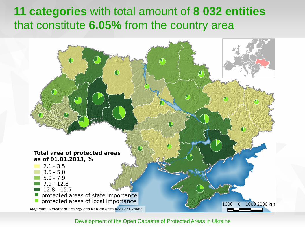
11 categories with total amount of 8 032 entities
that constitute 6.05% from the country area
Development of the Open Cadastre of Protected Areas in Ukraine
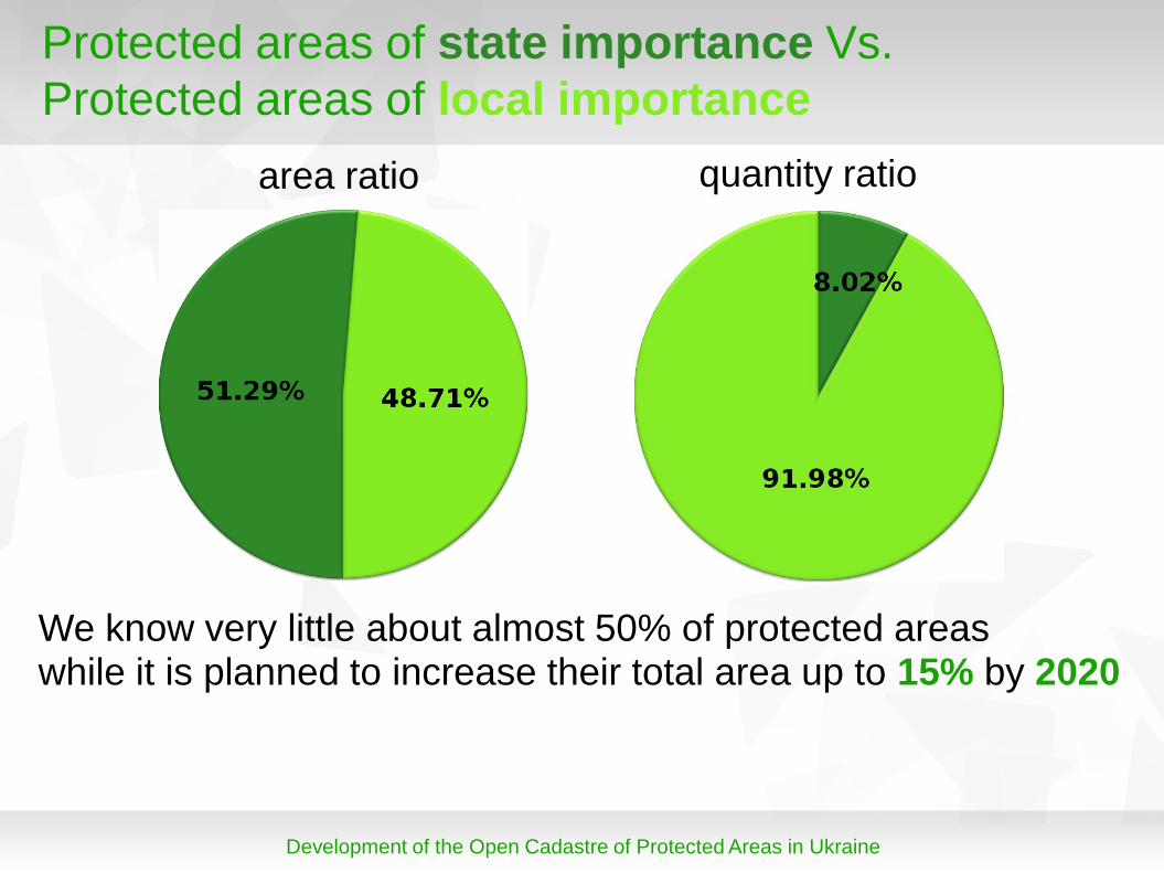
Protected areas of state importance Vs.
Protected areas of local importance
area ratio quantity ratio
We know very little about almost 50% of protected areas while it is planned to increase their total area up to 15% by 2020
Development of the Open Cadastre of Protected Areas in Ukraine
2. Work practices
or how do we do this ...
Development of the Open Cadastre of Protected Areas in Ukraine
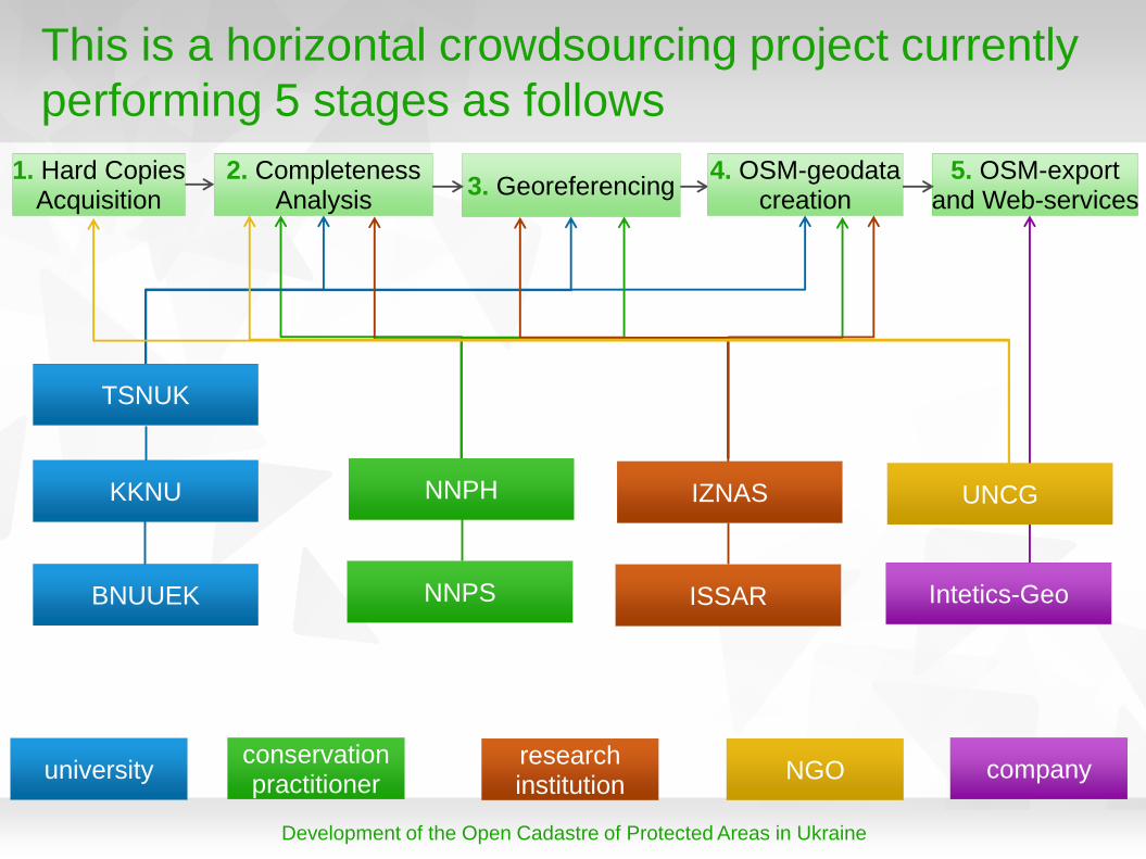
This is a horizontal crowdsourcing project currently
performing 5 stages as follows
TSNUK
2. Completeness Analysis
1. Hard Copies Acquisition
3. Georeferencing 4. OSM-geodata
creation 5. OSM-export
and Web-services
NNPS
KKNU
BNUUEK Intetics-Geo ISSAR
IZNAS UNCG NNPH
conservation practitioner
university research institution
NGO company

Development of the Open Cadastre of Protected Areas in Ukraine
Stage 1. Hard Copies Acquisition
Sources
Department of Ecology and Natural Resources,
Regional State Administration
Ministry of Ecology and Natural Resources of Ukraine
Documents
Designation Decision
Statute
Map
Preservation Order
Primary Reference Card
other
Development of the Open Cadastre of Protected Areas in Ukraine
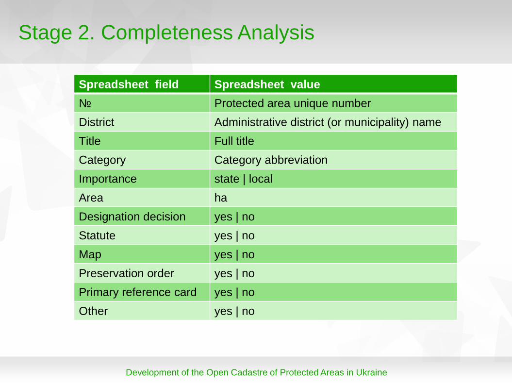
Stage 2. Completeness Analysis
Spreadsheet field Spreadsheet value
№ Protected area unique number
District Administrative district (or municipality) name
Title Full title
Category Category abbreviation
Importance state | local
Area ha
Designation decision yes | no
Statute yes | no
Map yes | no
Preservation order yes | no
Primary reference card yes | no
Other yes | no
Development of the Open Cadastre of Protected Areas in Ukraine
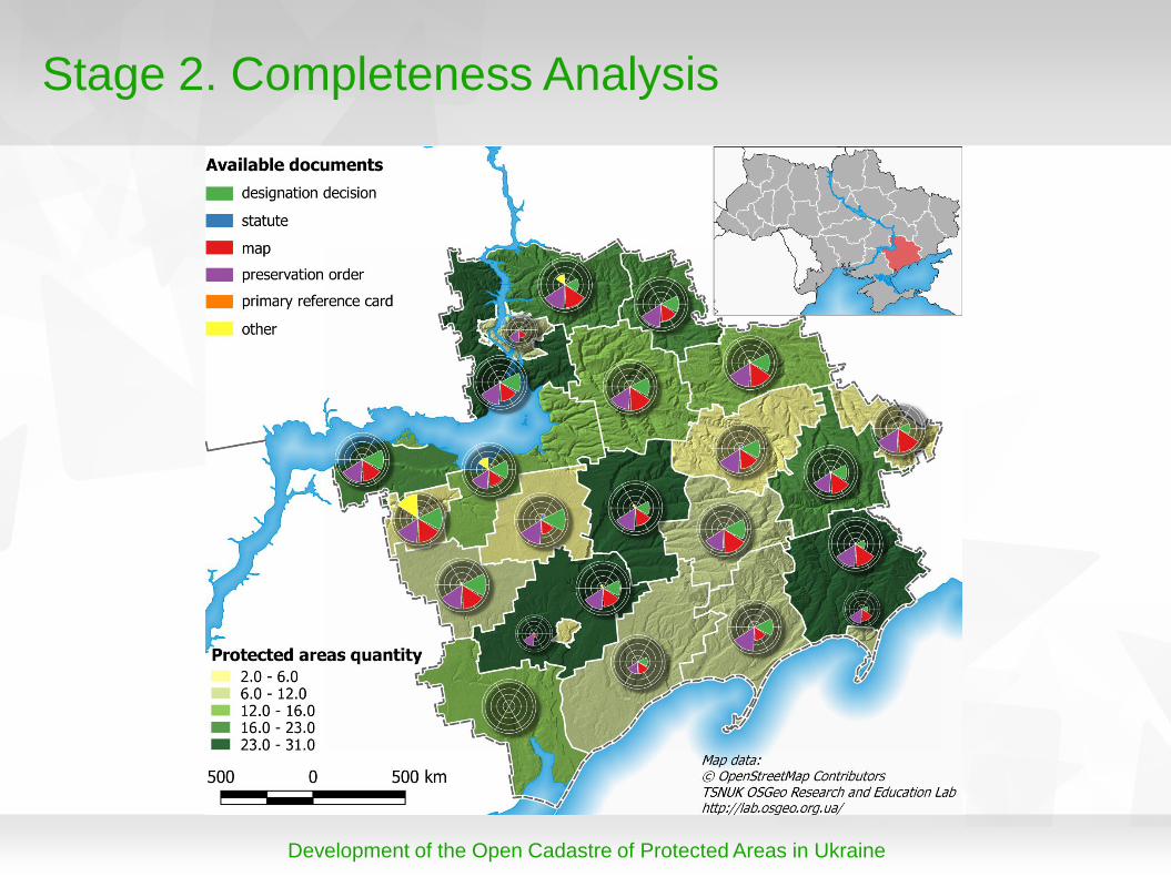
Stage 2. Completeness Analysis
Development of the Open Cadastre of Protected Areas in Ukraine
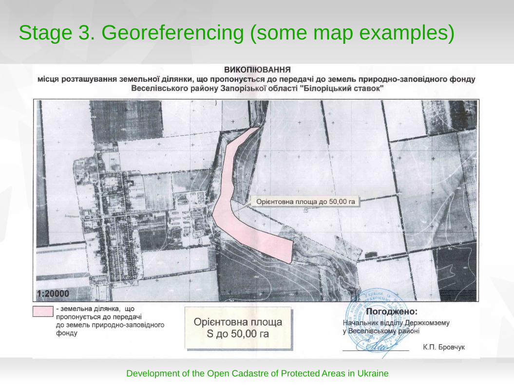
Stage 3. Georeferencing (some map examples)
Development of the Open Cadastre of Protected Areas in Ukraine
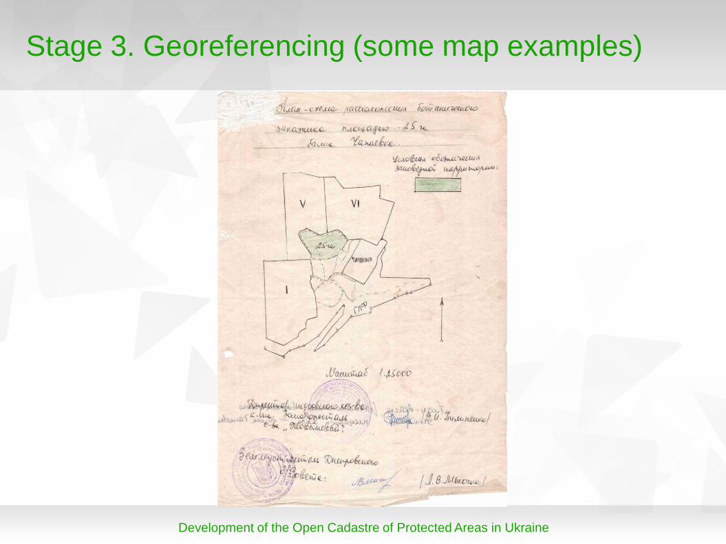
Stage 3. Georeferencing (some map examples)
Development of the Open Cadastre of Protected Areas in Ukraine
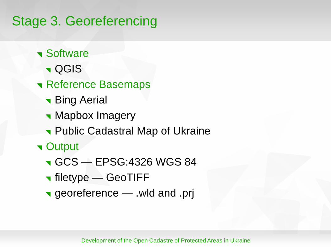
Stage 3. Georeferencing
Software
QGIS
Reference Basemaps
Bing Aerial
Mapbox Imagery
Public Cadastral Map of Ukraine
Output
GCS — EPSG:4326 WGS 84
filetype — GeoTIFF
georeference — .wld and .prj
Development of the Open Cadastre of Protected Areas in Ukraine
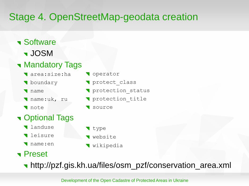
Stage 4. OpenStreetMap-geodata creation
Software
JOSM
Mandatory Tags area:size:ha
boundary
name
name:uk, ru
note
Optional Tags landuse
leisure
name:en
Preset
http://pzf.gis.kh.ua/files/osm_pzf/conservation_area.xml
operator
protect_class
protection_status
protection_title
source
type
website
wikipedia
Development of the Open Cadastre of Protected Areas in Ukraine
3. Results
or what we have achieved...
Development of the Open Cadastre of Protected Areas in Ukraine
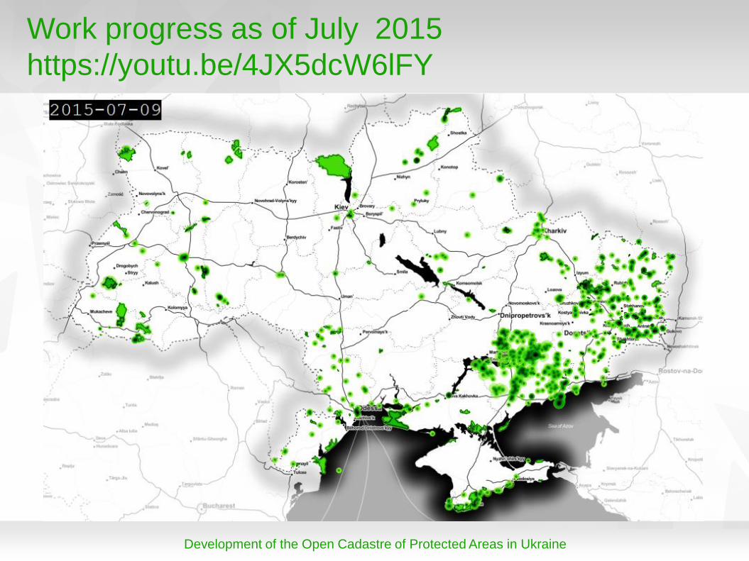
Work progress as of July 2015
https://youtu.be/4JX5dcW6lFY
Development of the Open Cadastre of Protected Areas in Ukraine
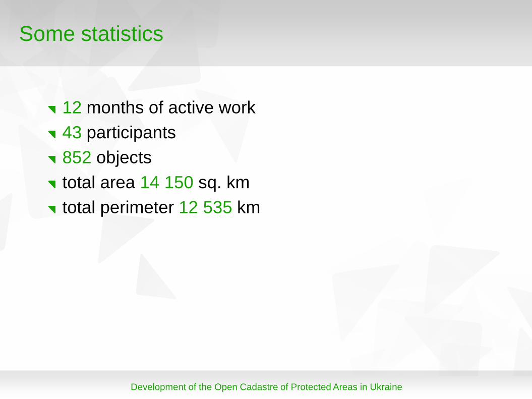
Some statistics
12 months of active work
43 participants
852 objects
total area 14 150 sq. km
total perimeter 12 535 km
Development of the Open Cadastre of Protected Areas in Ukraine
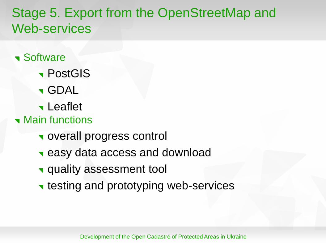
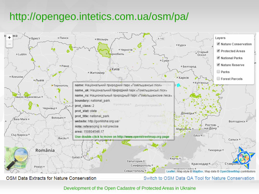
Stage 5. Export from the OpenStreetMap and
Web-services
Software
PostGIS
GDAL
Leaflet Main functions
overall progress control
easy data access and download
quality assessment tool
testing and prototyping web-services
Development of the Open Cadastre of Protected Areas in Ukraine
http://opengeo.intetics.com.ua/osm/pa/

Development of the Open Cadastre of Protected Areas in Ukraine
4. Discussion
or gained experience and future plans...
Development of the Open Cadastre of Protected Areas in Ukraine
Plans for 2015
datasets for 5 regions and 1 city
project official web-site
seeking for funding — any ideas?
Development of the Open Cadastre of Protected Areas in Ukraine
Prospective key deliverables
spatial database of protected areas in Ukraine
non-restricted access to the data, documentation, codes
approach and methodology of the project available for adoption
dissemination practices
community
FOSS4G Europe, July 14-17 2015, Como, Italy
Thank you for attention …
Daria Svidzinska
TSNUK OSGeo Research and Education Lab
http://lab.osgeo.org.ua/