Embed Size (px)
Citation preview

Assessment of Spatial and Temporal Variations of Soil Salinity using Remote
Sensing and Geographic Information System in the north west of Libya.
Hamdi Zurqani, Bashir Nwer and Ezzdein RhomaGEOS 2012
Dep
art
men
tN
atu
ral
Res
ou
rces

Universityof Tripoli Assessment of Spatial and Temporal Variations of Soil Salinity
using Remote Sensing and Geographic Informationin the north west of Libya.
Dep
art
men
tN
atu
ral
Res
ou
rces
• Introduction
• Aim
• Methodology
• Findings
• ConclusionMR. HAMDI ZURQANI GEOS 2012
Universityof Tripoli
Dep
art
men
tN
atu
ral
Res
ou
rces
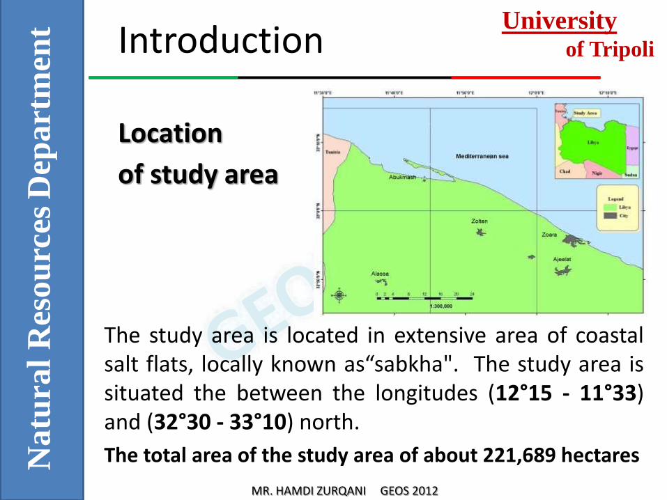
Introduction
The study area is located in extensive area of coastal salt flats, locally known as“sabkha". The study area is situated the between the longitudes (12°15 - 11°33) and (32°30 - 33°10) north.
The total area of the study area of about 221,689 hectares
Location
of study area
MR. HAMDI ZURQANI GEOS 2012

Universityof Tripoli
Dep
art
men
tN
atu
ral
Res
ou
rces
Introduction
• Desertification and land degradation are the main problems facing arid and semi-arid regions.
• Soil salinity problems in Libya started to be noticed after the extensive agricultural activities, coupled with increasing population, through the use of lands suitable for farming and overdraw of fresh groundwater to an extent of causing seawater intrusion.
• In addition, the nature of harsh climate featuring low amount of rainfall ranges, and high temperatures are also contributes to the soil salinity problems.
MR. HAMDI ZURQANI GEOS 2012

Universityof Tripoli
Dep
art
men
tN
atu
ral
Res
ou
rces
Introduction
• Saline soils in Libya cover around 12 % of the north region, 16.5% of the west region and 23.4% of the middle region.
• Remote sensing techniques are very useful for monitoring and control of salinity problems especially in arid and semi-arid environment due to sparse vegetation cover.
• The integration of remote sensing data, in the form of satellite imagery, with the GIS has boosted up the ability of delineating and mapping soil salinity.
• hese paper asses the change of salt-affected areas from 1971 to 2001 along the coastal area in the north west of Libya.
MR. HAMDI ZURQANI GEOS 2012
Universityof Tripoli
Dep
art
men
tN
atu
ral
Res
ou
rces
Aim of the paper
The aim of this paper is :
“To aim of this paper is to identify the change in saline soils (Sehbkha) using Remote Sensing (RS)
and geographic information system (GIS) techniques”.
MR. HAMDI ZURQANI GEOS 2012

Universityof Tripoli
Dep
art
men
tN
atu
ral
Res
ou
rces
Methodology
The assessment of the salinity has been structured under two main phases:
1. Soil Salinity Detection Using Remote Sensing and GIS.
Remotely sensed data, multi–temporal Landsat-7 ETM image (Enhanced Thematic Mapper) acquired in 1971, 1987 and 2001 has been used to detect coastal saline areas.
MR. HAMDI ZURQANI GEOS 2012

Universityof Tripoli
Dep
art
men
tN
atu
ral
Res
ou
rces
Methodology
2. Site Observations.
• Soil samples were collected from the study in two different sites ( Zolten and Abukmash).
• The selection of the Sebkhes were based upon the distance to sea and the area were the saline soils area are found to be decreased.
MR. HAMDI ZURQANI GEOS 2012

Universityof Tripoli
Dep
art
men
tN
atu
ral
Res
ou
rces
Findings
1. Detection Using Remote Sensing Data
Visual assessment were conducted for satellite images data for the years 1972, 1987 and 2001.
The results show that in 1972 the soil saline area covered about 43,639 hectares.

Universityof Tripoli
Dep
art
men
tN
atu
ral
Res
ou
rces
Findings
1. Detection Using Remote Sensing Data
And in 1987 is decreased to 40,898 hectares.
MR. HAMDI ZURQANI GEOS 2012

Universityof Tripoli
Dep
art
men
tN
atu
ral
Res
ou
rces
Findings
1. Detection Using Remote Sensing Data
And in 2001 is decreased to 38,043 hectares.
MR. HAMDI ZURQANI GEOS 2012

Universityof Tripoli
Dep
art
men
tN
atu
ral
Res
ou
rces
Findings
2. Temporal and Spatial Variations in Soil Salinity
• The area of saline soils has decreased through the last 29 years.
• For instance, in a period of 15 years (1972-1987), the area of saline soil decreased by 6.28 % .
• The total Sebkha’s area in the period of 29 years (1972 to the year 2001) has decreased at a rate of 12.82%.
MR. HAMDI ZURQANI GEOS 2012

Universityof Tripoli
Dep
art
men
tN
atu
ral
Res
ou
rces
Findings
2. Temporal and Spatial Variations in Soil Salinity
MR. HAMDI ZURQANI GEOS 2012

Universityof Tripoli
Dep
art
men
tN
atu
ral
Res
ou
rces
Findings
For further assessment of the salinity patterns in the study area two sites were selected to collect soil samples for ground truth.
• Soil samples were collected from the study in two different sites (Zolten and Abukmash).
(Abukmash Shbkha) (Zolten Shbkha)
MR. HAMDI ZURQANI GEOS 2012

Universityof Tripoli
Dep
art
men
tN
atu
ral
Res
ou
rces
Findings
• The results revealed most of the study area soils are saline soils. Aridisols are the main soils in the two sites.
SOIL CLASSIFICATION FOR THE STUDY AREA
(USDA SOIL TAXONOMY)
Soil Classification ( USDA Soil Taxonomy)Abukmash site Zolten Site
Calcic AquisalidsCalcic PetrocalcidsNatric Petrocalcids
Calcic HaplosalidsXeric HaplocalcidsCalcic HaplosalidsLithic Haplosalids
MR. HAMDI ZURQANI GEOS 2012

Universityof Tripoli
Dep
art
men
tN
atu
ral
Res
ou
rces
Findings
• The outputs from the data analysed from remote sensing or concluded from soil samples results show that there were a decrease in the area covered by saline soils.
• The decrease in soil saline area can be explained by the sand movements which covered the soil surface.
• The sand movements prevent remote sensing technique from picking up saline soils in the study area.
• Therefore, a methodology based on site observation and remote sensing techniques can be an optimal tool to map soil salinity spatially and in time scale.
MR. HAMDI ZURQANI GEOS 2012

Universityof Tripoli
Dep
art
men
tN
atu
ral
Res
ou
rces
CONCLUSION
• The remote sensing and GIS, cheaper and faster technique than the traditional ones in delineating and mapping soil salinity.
• Soil salinity is considered as an important factor in desertification in arid regions and semi-arid regions such as Libya.
• Developing a model integrate remote sensing and GIS techniques with site observation to optimize the accuracy of the outputs to be used in rehabilitations programs of saline soils is the only way forward for soil salinity assessment, especially in Libya.
MR. HAMDI ZURQANI GEOS 2012

Dep
art
men
tN
atu
ral
Res
ou
rces