Embed Size (px)
Citation preview

About ADMi
• Advanced Data Mining International, LLC
– Greenville, SC; founded 2002
– Clients – Alcoa, BP, B&V, state agencies, water utilities,
USACOE, USGS, USDOE, WERF, WRF…………..
• Focus
– Problem solving through data mining
– Solutions deployed with Decision Support Systems (DSS)
• Expertise
– Industrial – polymers, metals, oil & gas
– Water – treatment optimization, DBPs, event detection
systems (EDS)
– Natural Systems – surface & ground water modeling for
resource management, TMDLs
• Projects in FL, GA, OR, SC, WI

Estimating Salinity Effects
Due to Climate
Change on the Georgia and
South Carolina Coasts
Water Research Foundation (WRF) Project 4285
Beaufort-Jasper Water and Sewer Authority (BJWSA)
ADMi
U.S. Geological Survey (USGS)
University of South Carolina (USC)
South Carolina Sea Grant Consortium (Sea Grant)

• Published Sept. 2012
• Shortened version of full USGS report to come
• Written for utility personnel
• Even shorter white paper is available

Utilities with intakes at risk from
climate change & sea-level rise (SLR)
Source: modified from Furlow et al. 2002
Beaufort
Savannah
Grand Strand
Myrtle Beach
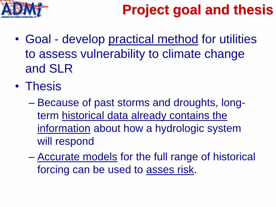
Project goal and thesis
• Goal - develop practical method for utilities
to assess vulnerability to climate change
and SLR
• Thesis
– Because of past storms and droughts, long-
term historical data already contains the
information about how a hydrologic system
will respond
– Accurate models for the full range of historical
forcing can be used to asses risk.

Droughts, El Niño, intrusion
events (Savannah River Estuary)
Days 4/1/1994 to 5/1/2005
Meas. & Pred. Salinity (psu) Q (cfs)
record
drought
El Niño

Technical
Approach

Integrate 3 models
ECHO-G global circulation
model (GCM) with A2
future carbon emissions
scenario
Hydrologic Simulation Program-
Fortran (HSPF) watershed model
Artificial Neural Network (ANN)
estuary model embedded in
decision support systems
(DSS)

Decision support systems (DSS)
color gradient
scenarios
streaming
graphics
simulation
controls
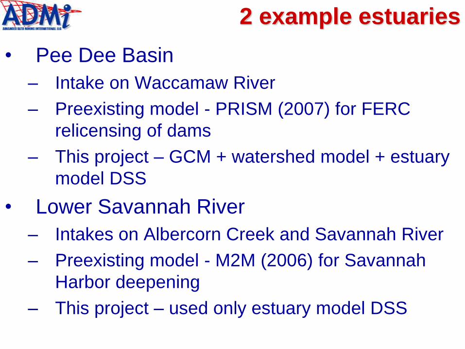
2 example estuaries
• Pee Dee Basin
– Intake on Waccamaw River
– Preexisting model - PRISM (2007) for FERC
relicensing of dams
– This project – GCM + watershed model + estuary
model DSS
• Lower Savannah River
– Intakes on Albercorn Creek and Savannah River
– Preexisting model - M2M (2006) for Savannah
Harbor deepening
– This project – used only estuary model DSS

Pee Dee Basin
• PRISM DSS (Pee Dee
River and Atlantic
Intracoastal Waterway
Salinity Intrusion Model)
• FERC relicensing of
NC dams
• Calibrated 1995-2009
– added new data for
this project intake next to
021108125
model
inputs

Lower Savannah River
• M2M DSS (Model to
Marsh)
• Modeled impacts of
harbor deepening on
SNWR
• Connects EFDC to
UFL’s “Plant
Succession Model”
• Calibrated 1994-2005
intakes

Roles of participants
• WRF & BJWSA - sponsors
• USGS – originated idea, tech team coordination, climate change modeling
• USC* – downscaling model to Pee Dee River basin, outreach workshops with DSSs to Grand Strand and Savannah stakeholders
• ADMi+ – developed estuary models and DSSs
• SC Sea Grant* – outreach workshops
* funded by NOAA
+ co-funded by WRF & NOAA

About ANN
Modeling

Process modeling with artificial
neural networks (ANN)
• Multivariate curve
fitting
• Fits are “learned”,
not prescribed
like least-squares
• Used in
continuous
process industries no data
non-linear “response
surface” fitted by ANN
model represents
normal behavior
deviation
from normal
better
conditions?

M2M – salinity intrusion
measured
predicted
02198840 low f SC 24-hr MWA

Model
Calibration

Evaluated 4 GCMs (with calibrated HSPF)
ECHO-G global circulation
model (GCM) with A2
future carbon emissions
scenario
Hydrologic Simulation Program-
Fortran (HSPF) watershed model
Artificial Neural Network (ANN)
estuary models embedded in
decision support systems
(DSS)

GCM selection
Measured
CCSM3
PCM
ECHO-G
GFDL
Q (cfs)
Cu
mu
lati
ve
Pe
rcen
t
Measured
PCM
ECHO-G
Q (cfs)
Cu
mu
lati
ve
Pe
rcen
t
PCM & ECHO-G
best at low flows
Detail - ECHO-G
best at low flows

HSPF Calibration
ECHO-G global circulation
model (GCM) with A2
future carbon emissions
scenario
Hydrologic Simulation Program-
Fortran (HSPF) watershed model
Artificial Neural Network (ANN)
estuary models embedded in
decision support systems
(DSS)

PRISM inputs
intake next to
021108125
model
inputs
2 highest
flows

HSPF Calibration
Q at 02110500 on the
Waccamaw River (cfs)
Measured
HSPF Predictions
R2 = 0.70
Hourly Observations - July 1995 to December 2002

cont. - HSPF Calibration
Q at 02131000 on
Pee Dee River (cfs)
Hourly Observations - July 1995 to December 2002
Measured
HSPF Predictions
R2 = 0.85

PRISM Calibration
ECHO-G global circulation
model (GCM) with A2
future carbon emissions
scenario
Hydrologic Simulation Program-
Fortran (HSPF) watershed model
Artificial Neural Network (ANN)
estuary models embedded in
decision support systems
(DSS)

PRISM Calibration (near intake)
Days 8/12/1995 to 8/21/2009
Measured & Predicted SC at 021108125
on Waccamaw River (mS/cm)Q (cfs)
Measured SC
Predicted SC
Q
R2=0.86

M2M inputs
intakes inputs
output

M2M Calibration
Days 4/1/1994 to 5/1/2005
Measured & Predicted
Salinity at 02198840 (psu)Q (cfs)
Measured Salinity
Predicted Salinity
Q
R2=0.81

Lower Savannah - EFDC vs. M2M
This window
EFDC R2=0.10
M2M R2=0.90S
alin
ity,
Pra
ctical S
alin
ity U
nits
Str
eam
flow
(cfs
)
Conrads, P., and Greenfield, J., (2008), “Effects of Reduced Controlled Releases from Lake Thurmond on Salinity
Intrusion in the Lower Savannah River Estuary”, 2008 South Carolina Water Resources Conferences.

Pee Dee Basin
Results

Pee Dee - 3 prediction scenarios
• DQ=0% = historical flow
– 1.0 ft SLR increases event magnitude and duration
• Future = 1995-2005 study period +60 = 2055-2069
– ECHO-G with IPCC “business as usual “ A2 emissions scenario
• Intergovernmental Panel on Climate Change
– Future is wetter, more events of shorter duration
Days with missing data gaps removed
Predicted SC at 021108125 (mS/cm)
DQ=0% + 0.0 SLR
DQ=0% + 1.0 ft SLR
Future + 1.0 ft SLR

Modulate historical Q and SL
%days > x mS/cm
SLR
slope
DQ slope
• 42
simulations
• SLR has
bigger
impact than
Q decrease
Decrease
Q
Increase SLR

# Consecutive day events > x mS/cm
#1,000+ mS/cm
events
#3,000+ mS/cm
events
# 7-day 1,000+ mS/cm events # 14-day 1,000+ mS/cm events

Compare historical and future
%days > x mS/cm
• Predicted wetter future has fewer %days > x

Lower
Savannah
Results

Predicted Salinity at 02198840 (psu)
DQ=0% + 0.0 SLR
DQ=0% + 1.0 ft SLR
DQ=-10% + 1.0 ft SLR
Days 4/1/1994 to 5/1/2005
detail
Savannah - 3 prediction scenarios
• No future scenario for Savannah
• 3rd scenario obscures other 2 – see detail

Detail – 3 Savannah scenarios
• 3rd (worst) scenario really is worst!
• Some spikes – DQ+SLR effect >> SLR alone
– unlike Pee Dee
Days 4/1/1994 to 5/1/2005
Predicted Salinity at 02198840 (psu)
DQ=0% + 0.0 SLR
DQ=0% + 1.0 ft SLR
DQ=-10% + 1.0 ft SLR

%days > x mS/cm
exponential
SLR response large DQ
response

Conclusions

Conclusions
• The Method1. Site-specific estuary model needed to credibly assess
vulnerability• empirical model may be
– more accurate
– easier to develop, operate, and update with new data
– faster turn-around for “What ifs?”
2. Long-term, site-specific data needed to calibrate model• past behaviors likely span much of future range
• droughts, hurricanes / storms, El Nino
• If in hand, ready to model. If not, start collecting.
3. Run scenarios easy-to-understand tables & graphs• modify historical data
• future forecasts, e.g., GCM+carbon emissions scenarios
• Method applicable to other resources, e.g., groundwater.