Embed Size (px)
Citation preview

Harmonization of soil methods and data
Allan Lilly and Helaina Black

What do we mean by harmonization?
Harmonize –
‘an interweaving of different accounts into a single narrative’
‘To bring into agreement’
Interoperability –
‘ability of a system to work with or use the parts or equipment of another system’
‘Able to operate in conjunction’
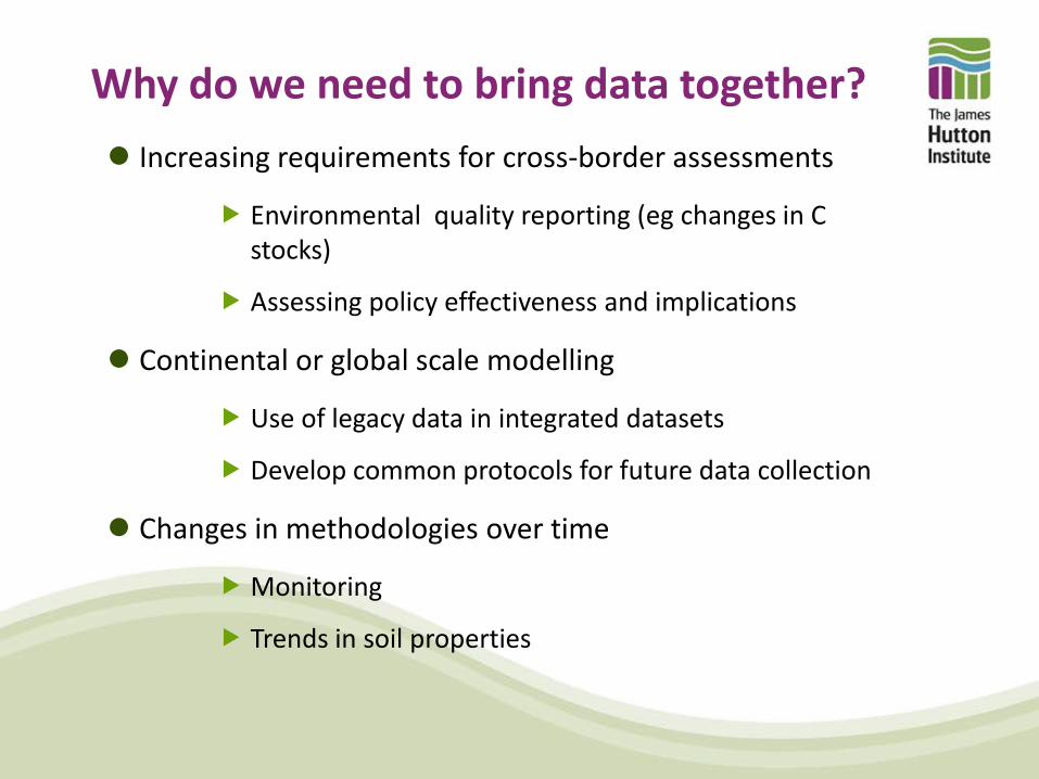
Why do we need to bring data together?
Increasing requirements for cross-border assessments
Environmental quality reporting (eg changes in C stocks)
Assessing policy effectiveness and implications
Continental or global scale modelling
Use of legacy data in integrated datasets
Develop common protocols for future data collection
Changes in methodologies over time
Monitoring
Trends in soil properties
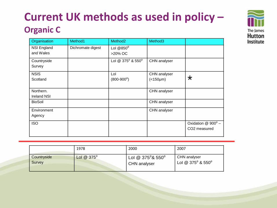
Current UK methods as used in policy – Organic C
Organisation Method1 Method2 Method3
NSI England and Wales
Dichromate digest LoI @850⁰ >20% OC
Countryside Survey
LoI @ 375⁰ & 550⁰ CHN analyser
NSIS Scotland
LoI (800-900⁰)
CHN analyser (<150μm) *
Northern. Ireland NSI
CHN analyser
BioSoil CHN analyser
Environment Agency
CHN analyser
ISO Oxidation @ 900⁰ – CO2 measured
1978 2000 2007
Countryside Survey
LoI @ 375⁰ LoI @ 375⁰& 550⁰ CHN analyser
CHN analyser LoI @ 375⁰ & 550⁰

Current UK methods as used in policy – pH in water
Organisation Vol/wt soil Vol water Time (min) Method
NSI England and Wales
10ml air dried 25ml 15 PH electrode
Countryside Survey
10g field moist and air dried
25 ml 30 PH electrode
NSIS Scotland
20ml air dried 50ml 120 PH electrode
Northern. Ireland NSI
15g 45ml 240 Skalar SP10 robotic analyser
BioSoil 5ml air dried 25ml 125 ?
Environment Agency
20g air dried 50ml 60 ?
ISO 5ml air dried 25 >120 <240 ?
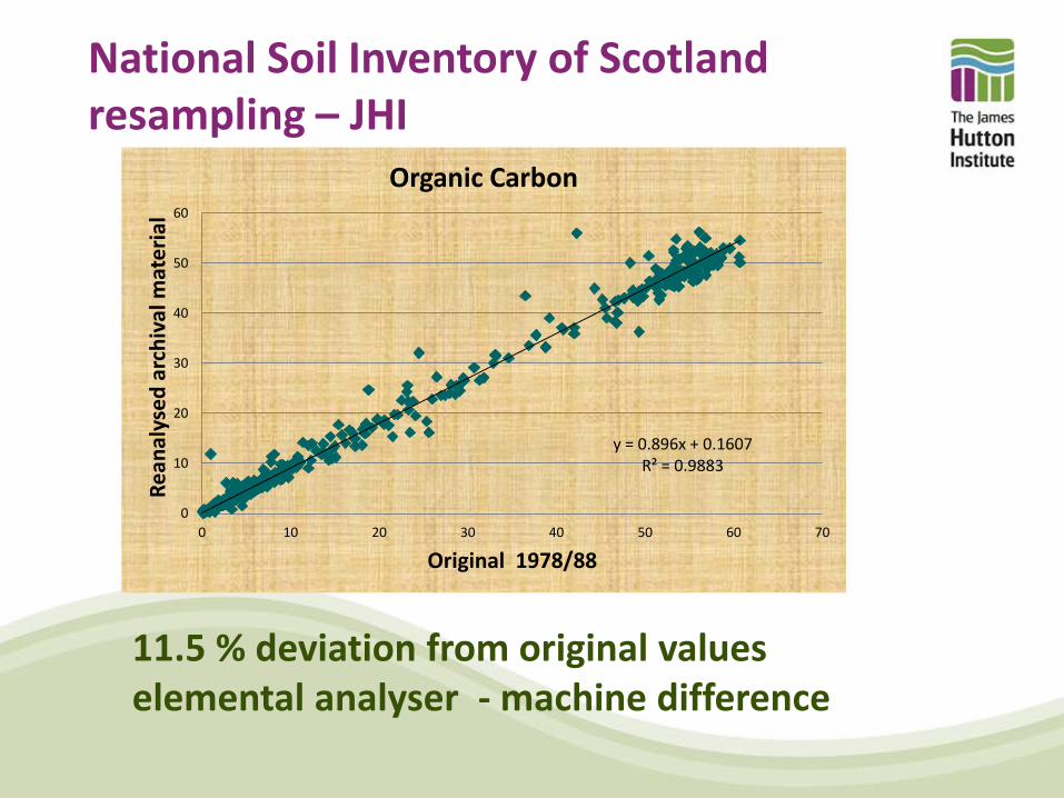
National Soil Inventory of Scotland resampling – JHI
y = 0.896x + 0.1607 R² = 0.9883
0
10
20
30
40
50
60
0 10 20 30 40 50 60 70
Rean
alys
ed a
rchi
val m
ater
ial
Original 1978/88
Organic Carbon
11.5 % deviation from original values elemental analyser - machine difference
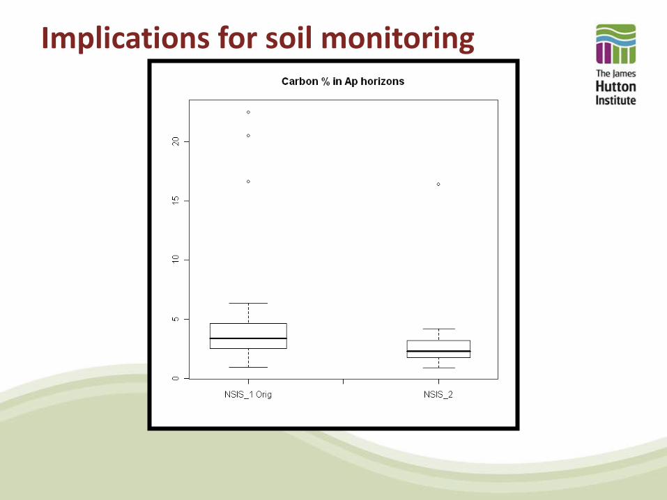
Implications for soil monitoring
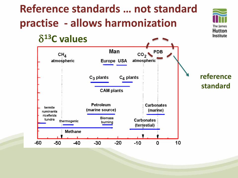
Reference standards … not standard practise - allows harmonization
reference standard
δ13C values
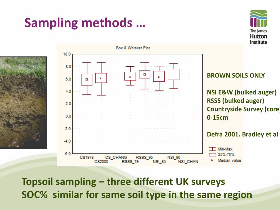
Topsoil sampling – three different UK surveys SOC% similar for same soil type in the same region
Sampling methods …
BROWN SOILS ONLY NSI E&W (bulked auger) RSSS (bulked auger) Countryside Survey (core) 0-15cm Defra 2001. Bradley et al
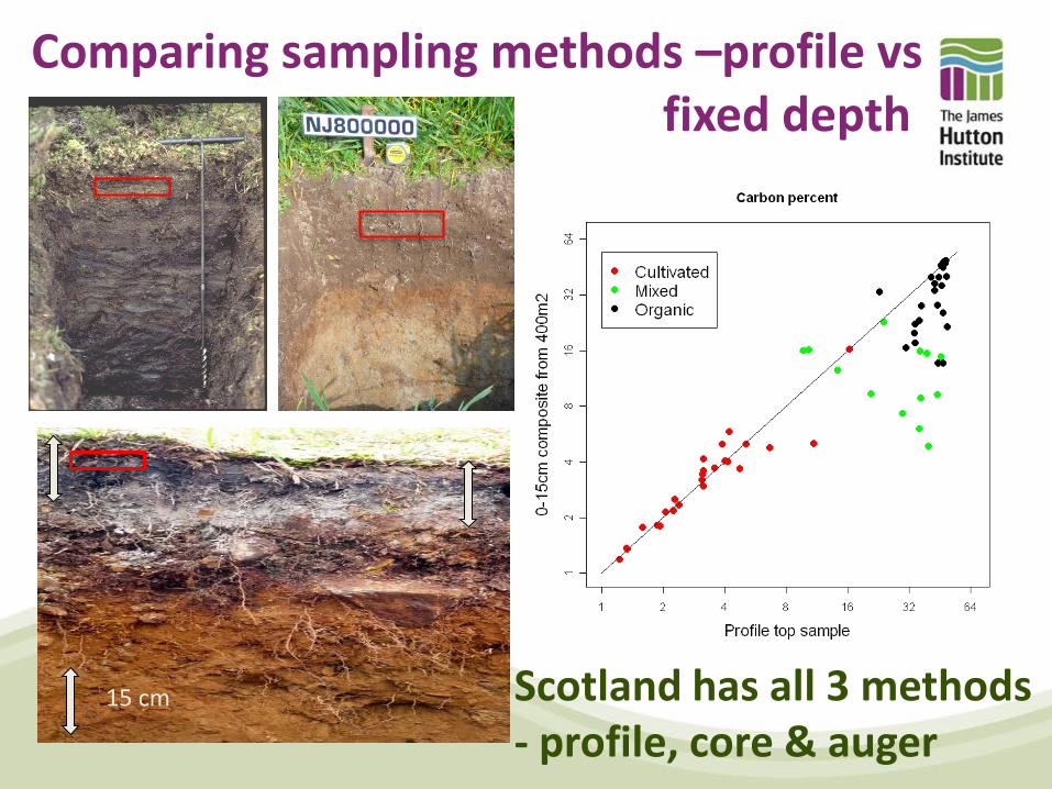
Comparing sampling methods –profile vs fixed depth
15 cm Scotland has all 3 methods - profile, core & auger

Cross-border harmonization based on legacy data– Hydrology of soil Types
• Covers 4 territories and 3 soil survey organisation • Based on soil morphology incl gleyic and stagnic properties Built from basic soil properties (colour, texture, structure, PTR)
Single, unified method to predict river flows for water managers.
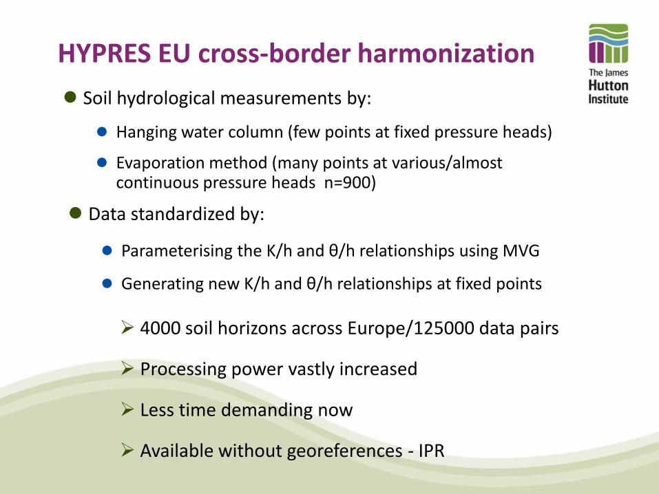
HYPRES EU cross-border harmonization Soil hydrological measurements by:
Hanging water column (few points at fixed pressure heads)
Evaporation method (many points at various/almost continuous pressure heads n=900)
Data standardized by:
Parameterising the K/h and θ/h relationships using MVG
Generating new K/h and θ/h relationships at fixed points
4000 soil horizons across Europe/125000 data pairs
Processing power vastly increased
Less time demanding now
Available without georeferences - IPR
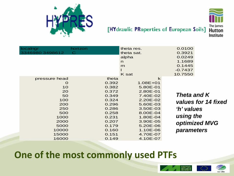
Theta and K values for 14 fixed ‘h’ values using the optimized MVG parameters
localngr horizon theta res. 0.01003346980 3498612 C theta sat. 0.3921
alpha 0.0249n 1.1689m 0.1445l -0.7437K sat 10.7550
pressure head theta k0 0.392 1.08E+01
10 0.382 5.80E-0120 0.372 2.80E-0150 0.349 7.40E-02
100 0.324 2.20E-02200 0.296 5.60E-03250 0.286 3.50E-03500 0.258 8.00E-04
1000 0.231 1.80E-042000 0.207 3.90E-055000 0.179 5.20E-06
10000 0.160 1.10E-0615000 0.151 4.70E-0716000 0.149 4.10E-07
One of the most commonly used PTFs
Geodata Services Soil/INSPIRE
EU initiative (GS Soil) to allow member states to easily
share spatial data
INSPIRE compliance stresses ‘interoperability’ rather than
harmonization
Methods do not need be the same
Data doesn’t need to be transferred
Soil science community is working towards developing
interoperability in both polygon and profile data
Summary Interoperability rather than harmonization?
Legacy data owned and managed by data collectors
We can reuse and revitalise legacy data
Going forward
New data requires reference standards
new data requires standardized, reproducible methods
But which