Embed Size (px)
Citation preview

ARCH 416
Spring ‘15
Class 10 Cities, Transport & Industry

agenda 2.25.15
exam results
exam review
The Mercantile City (18th century)
The Industrial City (19th century)
transport
horse-drawn omnibus
canals
railroads
Union Stockyards, Chicago
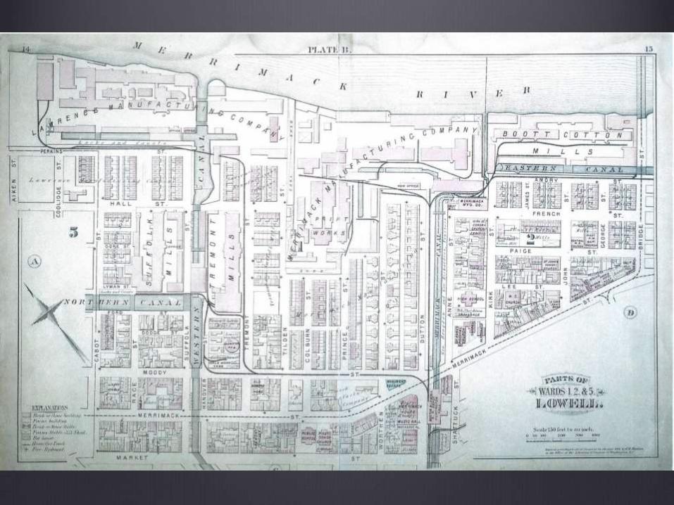
Bootts Mills, Lowell, MA
William Flagler and the Making of Florida

Hour Test 1 grade distribution
0
5
10
15
20
25
30

Hour Test 1 Statistics
Minimum Value 66.25
Maximum Value 98.00
Range 31.75
Average 83.55
Median 81.67


Please use this map of Edenton, North Carolina from 1769 to answer the
following questions. Which of the following are TRUE of this city (choose ALL
that apply)?
a. This is an inland city.
b. This is a port city.
c. This city grew organically from the docks inward, much like the city of
Boston.
d. This city was planned and laid out in a regular grid.
e. This city had only one multi-purpose meeting house in the center of
town.
f. This city has public buildings serving several different functions.
g. The justice system in this city includes a building for isolating prisoners
over time and reforming them.
h. This city's wealth is probably based around trade.
i. The church is one of the city's largest buildings and occupies a large
piece of open land.


A burial such as this one (shown in a museum reconstruction here) suggests (choose ALL of the following that are TRUE):
a. a society with little prosperity.
b. a society with ample prosperity.
c. a society with a developed social hierarchy.
d. a society with minimal social hierarchy.
e. a society with religious beliefs regarding an afterlife.
f. a society with few or no religious beliefs.
g. a society with toolmaking traditions and a degree of craftsmanship in toolmaking.
h. a society with few tools and traditions of craftsmanship.


The buildings shown in this photograph are characteristic of
(choose ALL that apply):
a. an agricultural setting.
b. an urban setting.
c. the South.
d. New England.
e. the midAtlantic.
f. the midwest.
g. facilities run primarily by wage labor.
h. facilities run primarily by slave labor.

urbanization of USA
in 1790, only 5% of US population lived in cities
why? what factors would constrain urban population?

pattern of preindustrial city
it is typically a port city, because of the nature of trade (by sea)
it is very compact: people walk, goods are transported by cart
here’s the pattern you can expect to see:
waterfront—wharves, workers, warehouses, activities
merchant offices, workshops
public buildings, churches, shops, homes for elite famiilies
quarters/districts for specific occupations, which were conducted in live/work spaces
housing for shopkeepers, laborers
town edges: commercial activities that needed more space, breweries, tanneries, slaughterhouses, mills
very poor living in back alleys or edges of city

Boston, 1768
Boston, 1768

Philadelphia, 1768

Newport, RI (1795)


characteristic pattern of
colonial development
on the water: using windpower for transport
compact: walkable distances
trade is the priority: unloading, storage, some workshops at the water’s edge
next ribbon is public buildings, commerce, and churches
next ribbon is best houses in town
followed by less significant housing
US cities better connected with Great Britain than with each other (sea routes much easier to cross than land routes)
early nationhood: need to build an infrastructure for commerce within the USA
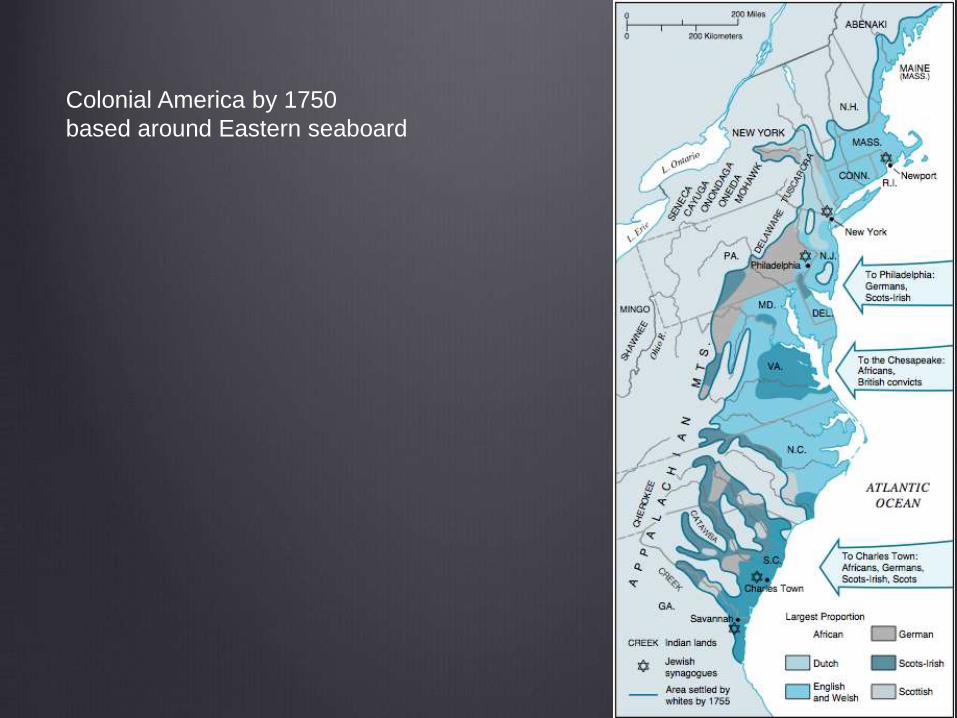
Colonial America by 1750
based around Eastern seaboard


purpose of a colony
to provide natural resources to the mother country
to serve as a market for finished goods from the mother
country

after Independence
This pattern is obviously going to change.
The states need to become connected with one another.
The seaboard cities need to become connected with the
agricultural hinterlands.

Philadelphia and Lancaster
Turnpike
begun in 1792
financed by a private company
first toll road built using engineered plans
opened in 1795
in decline by the 1840s due to rise of canals and railroads

Erie Canal (1825)
New York State chartered the Erie Canal, financed through a bond sale.
363 miles long; elevation differential of 565 ft.; 36 locks
artificial waterway connecting Great Lakes with the Atlantic Ocean
connects Albany, NY (on Hudson) with Buffalo, NY (on Lake Erie)
major impact on growth of midwest, connecting farmers with large eastern markets
became profitable very quickly and initiated a boom in canal building that ended in 1850 when railroads became seriously competitive

Blackstone Canal (1828)
Connected Providence, RI with Worcester, MA.
Completed in 1828, was defunct by 1848.
Blackstone Valley was where Samuel Slater built his first
textile mill.


So, what happened in the 1840s?
famines in Ireland in 1830s and 40s
impact of industrialization in Europe in 1850s
mechanization of agriculture ruralurban migration
waves of mass migration to USA
German-speaking countries, France, Belgium
Scandinavian countries in the 1870s
Italians, and Eastern Europeans in the 1880s and 1890s
within the USA: same increases in agricultural productivity (triggering rural to urban migration)
canals and railroads support growth by delivering food
freight capacity
speed
reliability


these new cities will not look
the same
new patterns of development will be superimposed upon
the old
new cities will develop along new lines

new cities, first
sites with abundant energy resources nearby
coal
Allentown
Harrisburg, PA
water power
on the Fall Line in New England

mining towns to supply coal
Norton, VA

transportation hubs
where the new transport infrastructure intersects
canal towns and rail towns

heavy manufacturing towns
Pittsburgh, PA is a classic example

but, the biggest growth will
be in already existing large
cities…
why?

initial advantage
largest pools of labor
largest markets
existing traditions in craftsmanship, entrepreneurship
pools of capital for investment and lending

nonetheless these cities will
have to change
the old, compact walkable model will no longer suffice with
massive influxes of population

urban transport
initially
the wealthy had carriages
everyone else walked
new idea: create ways to move passengers around

The earliest form of urban mass transport:
1828 Abraham Brower founded the first company to do this.
12-passenger, horse drawn carriage carrying passengers along Broadway in New York City.
Ran from the Battery to Greenwich Village.
Flat fare of 12 cents.
Philadelphia had this in 1831 and Boston in 1835.
By the 1840s, hundreds of horse-drawn omnibuses in NYC alone.
Also in Brooklyn, St. Louis, New Orleans, Baltimore, Washington, DC

horse-drawn omnibus
pros: many
passengers=low fare
cons=very hard on
horses
what came next?

Horse-Drawn Streetcar, NYC

Washington, GA (1905)

transportation infrastructure
overview
turnpikes (1790-1840)
canals (1820s-1840s)
railroads (c. 1840)
interstate highway system (c. 1950)
what will be next?


Urban Centers 2014

World’s Largest Cities
1975
1. Tokyo 19.8 m
2. New York 15.9 m
3. Shanghai 11.4 m
4. Mexico City 11.2 m
5. São Paulo 9.9 m
6. Osaka 9.8 m
7. Buenos Aires 9.1 m
8. Los Angeles 8.9 m
9. Paris 8.9 m
10. Beijing 8.5 m
2015
1. Tokyo 28.7 million
2. Bombay 27.4 million
3. Lagos 24.4 million
4. Shanghai 23.4 million
5. Jakarta 21.2 million
6. São Paulo 20.8 million
7. Karachi 20.6 million
8. Beijing 19.4 million
9. Dhaka 19.0 million
10. Mexico City 18.8 million