
WELCOME TO Eurobodalla OIESS
2020
Dr R.J. (Bob) Williams [Retired] Cartographer
Topographic Surveyor, Geographer & Geospatial Scientist
QUALIFICATIONS – Professional BA Computing Studies (Canberra CAE) MSc (Cartography) (U Wisconsin) PhD (UNSW)
QUALIFICATIONS – Trade Topographic Surveyor Photogrammetrist Cartographic Technician
1
[OCEANIA INFRASTRUCTURE AND ENVIRONMENTAL SUPPORT SYSTEM]
SURVEYING & MAPPING SCIENCES
A VISION FOR THE FUTURE

WELCOME TO Eurobodalla OIESS 2020
Ø EEPCOTAT & Eurobodalla OIESS EEPCOTAT
Eurobodalla OIESS 2
Eurobodalla Experimental Prototype Community of Today and Tomorrow
Oceania Infrastructure and Environmental Support System

3
The beginning of this decade witnessed an array of natural and man-made events that seriously challenged many nations’ abilities to predict, respond, recover and progress from the effects of tragic events. Ø Iceland’s Eyjafjallajökull volcanic eruption
Ø Haiti’s and Christchurch’s earthquakes
Ø Queensland’s, New South Wale’s and Victoria’s floods
Ø Western Australia’s fires
Ø Japan’s earthquakes and tsunami
Ø Poland’s Tu-154 air crash
Ø Shen Neng 1 grounding on Great Barrier Reef & Rena grounding on Astrolabe Reef, NZ
Ø LOST – MH370 and SHOT DOWN – MH17
The eruption of the Eyjafjallajökull volcano on 14 April 2010 affected the economic, political and cultural activities in Europe and across the world. There was extensive air travel disruption caused by the closure of airspace over many countries
On 3 April 2010, Shen Neng 1 was transiting from Gladstone, Queensland to China carrying a cargo of 65,000 tonnes of coal. She ran aground around 70 kilometres off Great Keppel Island in a restricted area which forms part of the Great Barrier Reef Marine Park
WELCOME TO Eurobodalla OIESS 2020
Ø Some serious events 2010-14

4
WELCOME TO Eurobodalla OIESS 2020
Ø It is now 2020 & a complex environment
By 2020 the Oceania has become a truly complex environment: Ø International trade and associated infrastructure costs have become contemporary challenges driven by very competitive markets in the region. The efficient management of the infrastructure and the protection of the infrastructure are vitally important.
Ø Terrorism remains a serious concern in the South-East Asia – Oceania region; concerns that include the safety of transportation. National security is a high priority for the nation’s government.
Ø Environmental incidents seem to have become far more extreme and more common. The past decade has witnessed devastating events that have contributed to loss of life and high financial costs.
5
WELCOME TO Eurobodalla OIESS 2020
Ø Eurobodalla OIESS 2020
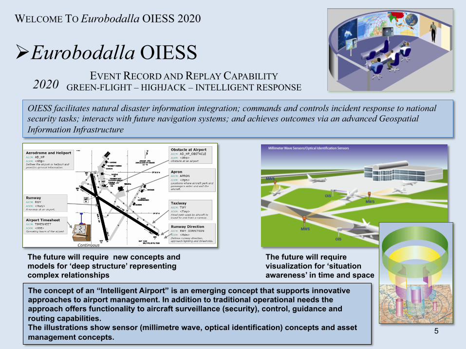
OIESS facilitates natural disaster information integration; commands and controls incident response to national security tasks; interacts with future navigation systems; and achieves outcomes via an advanced Geospatial Information Infrastructure
EVENT RECORD AND REPLAY CAPABILITY GREEN-FLIGHT – HIGHJACK – INTELLIGENT RESPONSE
The future will require new concepts and models for ‘deep structure’ representing complex relationships
The future will require visualization for ‘situation awareness’ in time and space
The concept of an “Intelligent Airport” is an emerging concept that supports innovative approaches to airport management. In addition to traditional operational needs the approach offers functionality to aircraft surveillance (security), control, guidance and routing capabilities. The illustrations show sensor (millimetre wave, optical identification) concepts and asset management concepts.

6
WELCOME TO Eurobodalla OIESS 2020
Ø Eurobodalla OIESS 2020
OIESS facilitates natural disaster information integration; commands and controls incident response to national security tasks; interacts with future navigation systems; and achieves outcomes via an advanced Geospatial Information Infrastructure
EVENT RECORD AND REPLAY CAPABILITY VOLCANO – FIRES– INTELLIGENT RESPONSE
Images of Black Saturday
STANLEY is an autonomous vehicle created by Stanford University’s Stanford Racing Team in cooperation with Volkswagen Electronics Research Laboratory. It competed in, and won, the 2005 DARPA Grand Challenge, earning the team the two million dollar prize, the largest prize money in robotic history. Stanley covered the 212 km (132 mi) off-road course in 6 hours 54 minutes.
What Robots See Robots don't see the world like humans do. They don't recognize discrete objects and have little common sense. Instead of seeing, today's robots measure. The Stanford team invented a technique called ”ADAPTIVE VISION," which allows its robot, STANLEY, to see farther and drive faster, even as the road changes over different types of terrain.

7
1. The CanberraWorkshop [Yet to occur] o Theme – Develop a Strategic Plan for the Future Infrastructure and
Environmental Information Infrastructure for Oceania
2. Capability Development Process [To follow sometime in the future] o Theme – Development as a Major Capability Study
OUTCOMES: Description of the domain of geographic features Agreement of a broad scope of incidents and activities Agreement on concept and definition of an Environmental & Geographic Information Infrastructure Action Group development of EGII Capability
OUTCOMES: Detailed design of OIESS Design of EEPCOTAT FORMAL POLICY as a National Capability
Virtual advisers – autonomous vehicles – four-dimensional models of the natural world and events Revolution in education and training programs
WELCOME TO Eurobodalla OIESS 2020
Ø Towards Eurobodalla OIESS
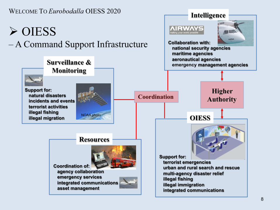
OIESS
Support for: terrorist emergencies urban and rural search and rescue multi-agency disaster relief illegal fishing illegal immigration integrated communications
Resources
Coordination of: agency collaboration emergency services integrated communications asset management
Intelligence
Collaboration with: national security agencies maritime agencies aeronautical agencies emergency management agencies
Higher Authority
8
WELCOME TO Eurobodalla OIESS 2020
Ø OIESS – A Command Support Infrastructure
Coordination
Surveillance & Monitoring
Support for: natural disasters incidents and events terrorist activities illegal fishing illegal migration
NOAA photo

WELCOME TO Eurobodalla OIESS 2020
Ø Geographic Information Infrastructure – Application module - OIESS
Photogrammetry Remote sensing Cartography
INFORMATION PRODUCTION
OIESS
DATA ACQUISITION
Information Management & Dissemination
Geodetic surveying Satellite and airborne surveying Remote sensing Photogrammetry Cartography
Readiness assessment
POLICY, DOCTRINE & MANAGEMENT
Needs assessment
“A Geospatial Information Infrastructure provides information about the world and is vital is supporting the development of the nation and the region and the defence of the nation and its interests.”
Imagery analysts Geospatial analysts
10
WELCOME TO Eurobodalla OIESS 2020
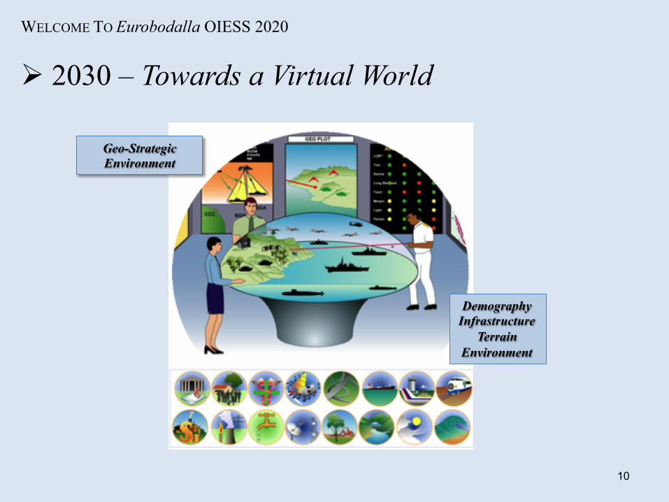
Ø 2030 – Towards a Virtual World
Geo-Strategic Environment
Demography Infrastructure
Terrain Environment

11
Ø It really is all about culture: Ø It’s about having an intelligence view with engineering skills
It’s about CARTOGRAPHY: It’s about Claudius Ptolemy and Gerardus Mercator
It’s about CARTOGRAPHIC INTELLIGENCE: It’s about Henry VIII and Nain Singh
It’s about EXPLORATION and DISCOVERY: It’s about James Cook and Thomas Mitchell
It’s about the SHAPE OF THE EARTH: It’s about Giovanni Domenico Cassini and Charles-Marie de la Condamine
It’s about INNOVATION and INVENTION: It’s about Nicholas Chrisman and F Vivian Thompson
It’s about MANAGEMENT and DIRECTION: It’s about Vanessa Lawrence and Lawrence FitzGerald

12
It is time for a new era to begin! It is time for the Surveying and Mapping discipline to take a preeminent place in our nation’s management
It is time for Geodesists and Cartographers to take lead scientific roles in key organisations and agencies
It will be then that the vision of EEPCOTAT & Eurobodalla OIESS will be realised!
It is time for IMAGINATION!

SSGT Bob Williams Programming a military symbol overlay
on a Tektronix 4014 in 1978
Dr Bob Williams
Thank You – Videre Parare Est
Indocti discant et ament meminisse periti The unlearned may here learn, and the learned may reflect on what they knew before
With Vision!
2013 photo
Recommended


![GII Primary ST2[1]](https://img.dokumen.tips/doc/110x75/5534c5e04a7959ae4b8b4c08/gii-primary-st21.jpg)


