!n
!n
!n
!n
!o
!o
!n
!n
!H
!o
!n
!n
!n
!n
!n
!n
!n
!n
!H
!n
!n
!n
!o
!n
!n
!n
!n
!n
!n
!n
!n
!n
!n!n
!n
!n
!n
!n
T O LLA N D
ELLIN G T O N
S T A FFO R D
S O M E R S
V E R N O N
EN FIELD
CO V EN T R Y
W ILLIN G T O N
S O U T H W IN D S O R
M A N S FIELD
M A N CH E S T E R
EA S T W IN D S O R
AA
A
B
A
B
B AA
Scitico
Orcutts
Rockville
Ellithorpe
Somersville
Quarryville
Windsorville
Talcottville
Crystal Lake
Vernon Center
West Stafford
West Willington
Stafford Springs
South Willington
Lake View Terrace
Fox Hill
Crow Hill
Reed Hill
Neff Hill
Sugar Hill
Grant Hill
Murry Hill
Paulk Hill
Newell Hill
Pinney Hill
Cassidy Hill
Tolland HillVillage Hill
Kendall Hill
Buff Cap Hill
Chestnut Hill
Bald Mountain
Chestnut Mountain
Soapstone Mountain
B
A
AA
A
B
AA
A
AA
A
A
AA
A
A
B
A
B
B
B
B
B
B
B
B
B
A
A
B
A
B
B
A B
A
A
B
A
AA
Lord Dam
Res No 1
West Pond
Cyril Dam
Plum Pond
West Brook
Reed Brook
Neft Brook
Farm Brook
Steep Pond
Shady Lake
Runde Pond
Reeds Pond
Moody Pond
Minor Pond
Ladds Pond
Halls Pond
Gages Pond
Duker Pond
Copse Pond
Cigar Pond
Bruce PondAbbey Pond
Wells Brook
Terry Brook
Spice Brook
Shady Brook
Shady Brook
Pecks Brook
Pease Brook
Ogden Brook
Muddy Brook
Marsh Brook
Kalis Brook
Hydes Brook
Gulf Stream
Green Brook
Gages Brook
Ellis Brook
Edson Brook
Davis Brook
Clark Brook
Broll Brook
Broad BrookBroad Brook
Baker Brook
Avery Brook Alden Brook
Aborn Brook
Abbey Brook
Abbey Brook
Warren Pond
Phoenix Dam
Gladyzs Dam
Springs Dam
Taitro Pond
Sumner Lake
Stowes Pond
Spring Pond
Previs Pond
Middle Lake
Lennon Pond
Lake Bonair
Knofla Pond
Greens Pond
Grants Pond
Dennis Pond
Dennis Pond
Cuccia Pond
Bugbee Pond
Brooks Pond
Woods Stream
Turkey Brook
Tucker Brook
Sucker Brook
Spring Brook
School Brook
Rustic Brook
Pinney Brook
Pierce Brook
Patten Brook
Nelson Brook
Middle River
Lievre Brook
Larson Brook
Kibbes Brook
Grover Brook
Grants Brook
Conant Brook
Clarks Brook
Browns Brook
Brooks Brook
Averys Brook
Webster Pond
Service Pond
Parizek Pond
Orcutts Pond
Millers Pond
Metcalf Pond
Melrose Pond
Krawski Pond
JR High Pond
Ginholt Pond
Crystal Lake
Crandau Pond
Charter Pond
Bradway Pond
Bowlers Pond
Bentons Pond
Belding Pond
Ackerly Pond
Winding Brook
Tunnell Brook
Scantic River
Roaring Brook
Newcomb Brook
Metcalf Brook
Martins Brook
Labonte Brook
Hopyard Brook
Furnace Brook
Charter Brook
Belding Brook
Barrows Brook
Bahlers Brook
Reed Road Dam
Triangle Pond
Thompson Pond
Palizari Pond
Kolarnik Pond
Envelope Pond
Converse Pond
Charters Pond
Cemetery Pond
Bradleys Pond
Ano-Coil Pond
Thompson Brook
Railroad Brook
Kraniski Brook
Kimballs Brook
Hockanum River
Hockanum River
Hockanum River
Creamery Brook
Chestnut Brook
Charters Brook
Cemetery Brook
Cemetery Brook
Bradleys Brook
Bonemill Brook
Shenipsit Lake
Riverside Pond
Poehnerts Pond
Lafayette Pond
Kingsbury Pond
Goodstein Pond
Glenville Pond
Gillettes Pond
Einsteins Pond
Coggswall Pond
Affricano Pond
White Lot Brook
Mitchells Brook
McIntyres Brook
Gillettes Brook
Campbells Brook
Kent Hollow Dam
Sweetheart Lake
Sun Valley Lake
Sadds Mill Pond
Richardson Pond
Paper Mill PondCider Mill Pond
Brisseette Pond
Skungamaug River
Skungamaug River
Rickenback Brook
Paulk Hill Brook
Hendersons Brook
Grapeville Brook
West Street Pond
Sturtevants Pond
Somersville Pond
Sharps Mill Pond
Ogden Brook Pond
Miller Road Pond
Forestville Pond
Dobsonville Pond
Skungamaug Marsh
Willimantic River
Willimantic River
Willimantic River
Willimantic River
Willimantic River
Bugbee Pond Brook
Windsorville Pond
Valley Falls Pond
Training Dam No 2
Charter Marsh Dam
Tobacco Pond No 2Tobacco Pond No 1
Tankerhoosen Lake
Talcottville PondUpper Bolton Lake
Tillinghasts Brook
Tankerhoosen River
Marsh Meadow Brook
Crystal Lake Brook
Tolland Marsh Pond
Thompson Pond No 1
Rhode Island Ponds
Charnley Road Pond
Middle Bolton Lake
Bamforth Road Pond
Diamond Ledge Brook
Cambells Farm Brook
North Cemetery Pond
Libkamans Pond No 2
Libkamans Pond No 1
Creamery Brook Pond
Shenipsit Lake Brook
Chapins Meadow Brook
River Road Pond No 2 River Road Pond No 1
Devils Hopyard Swamp
Walker Reservoir West
Walker Reservoir East
Broad Brook Reservoir
South Willington Brook
Howard Crandells Brook
Charter Brothers Brook
John Wittenzellner Dam
Tolland Reservoir Brook
Broad Brook Village Brook
Mountain Springs Road Dam
Tolland Water Supply Pond
North Branch Bonemill Brook
SwiftAirport
EllingtonAirport
Laurie FieldAirport
Wysocki FieldAirport
Johnson Memorial Hospital
Center School
Northeast School
Somers Elementary
Windermere School
Somers High School
Borough Elementary
Center Road School
Nathan Hale School
Lake Street School
Tolland High School
Skinner Road School
Crystal Lake School
Birch Grove Primary
Maple Street School
Orchard Hill School
Stafford High School
Hazardville Memorial
West Stafford School
Hall Memorial School
Philip R Smith School
Ellington High School
Tolland Middle School
Rockville High School
Parker Memorial School
Stafford Middle School
Timothy Edwards School
Ellington Middle School
Enrico Fermi High School
Earl M Witt Intermediate
Vernon Center Middle School
Mabelle B Avery Middle School
I 84
River St
State Hwy 83
State Hwy 74
River Rd
State
Hwy 3
2
State Hwy 190
Wilbur Cross Hwy
State Hwy 140
Main St
East
Rd
State
Hwy 3
0
Route
83
Gulf Rd
Melrose Rd
Route 31
Abbo
tt Rd
East
St
Merrow Rd
Some
rs Rd
Goose Ln
State Hwy 195
Route 74
State Hwy 31 Av
ery St
Broadbrook Rd
West
St
State
Hwy 1
91
Pinne
y StMiddle Rd
Bolton Rd
Old Staff
ord Rd
Mons
on R
d
Jobs
Hill R
d
West Rd
Grant Hill Rd
Route
19
Old Post Rd
Abbe Rd
South
Rd
Billings Rd
Webster Rd
Route 319 Pinney Rd
Gree
ne R
d
Buff Cap Rd
Sadds Mill Rd
Talcottville Rd
Mile Hill Rd
Egypt Rd
Plains Rd
Stafford Rd
Sugar Hill Rd
Orcuttville Rd
South St
Boyer Rd
Handel Rd
Dart Hill Rd
State
Hwy 2
86
North St
Shenipsit Lake Rd
Hazard Ave
Hunte
r Rd
Hampden Rd
Cook Rd
Foste
r St
Conk
lin R
d
Villag
e Hill R
d
Reservoir Rd
9th D
istric
t Rd
State
Hwy 1
9
Barber Hill Rd
Tunnel Rd
Ellingt
on Rd
State Hwy 319
Furna
ce Av
e
Taylor St
Depot St
Park St
Dunn Rd
Tripp
Rd
Kemp Rd
Chestnut Hill Rd
Field
Rd
Sandy Beach Rd
Burba
nk R
d
Storrs Rd
Kate Ln
Ninth
Distric
t Rd
Gehring
Rd
Old Springfield Rd
Babcock Rd
Maple
St
Torry Rd
Pinna
cle R
d
Taylor Rd
Fletch
er Rd
Crysta
l Lake
Rd
Baxter St
Windsorville Rd
Metcalf Rd
Hoffm
an R
d
Kibbe
Rd
Crane Rd
State Hwy 85
Forest S
t
State Hwy 527
Turnpike Rd
Frog Hollow Rd
New Rd
Kelly Rd
Schofield Rd
Broad Way
Slater Rd
Racker Rd
Ellington AveVernon Ave
Rockville Rd
Kibbe
Ave
Center Rd
Tolland Stage Rd
Battle St
Reeves Rd
Felt R
d
Forest Rd
Docke
rel Rd
Diamond Ledge Rd
Thral
l Rd
Deming St
Merline Rd
Hall H
ill Rd
Reed
Rd
Weigold Rd
Leonard Rd
Kozley Rd
Shen
ipsit F
orest R
d
Baxter Rd
Hopkins Rd
Niederwerfer Rd
Hopyard Rd
Charles St
Moody Rd
Tolland Ave
VL Falls Rd
Loehr Rd
Charter Rd
School Rd
Grahaber Rd
R Road A
Union St
Windermere Ave
Sodo
m Rd
Miller Rd
Blair Rd
Shaker Rd
Mountain St
Hatch Hill Rd
Phoenix St
Scully Rd
Lake St
Eaton Rd
Snipsic Lake Rd
Cider
Mill R
d
Four Bridges Rd
Hany
Ln
Bald Hill Rd
Regan Rd
Spusta Rd
Springfield Rd
Echo Dr
Bailey Rd
Tollan
d Tpke
Sokol
Rd
Parker Rd
Rhodes Rd
Old Monson Rd
St Ro
ute 30
Charter
Hts
Griffin Rd
McCle
lland
Rd
Peter Green Rd
Bamforth Rd
Middle T
pkeUS
Hwy 44
Boston Tpke
Hartford Tpke
High St
Spousta Rd
Gran
t Rd
Haney Ln
Chamberlain Rd
Grove St
Hurlbut Rd
Tetrault Rd
Orchard St
County Rd
Valley Falls Rd
Florida R
d
Vlge H
ill Rd
Shenipsit St
Laughlin Rd
Anderson Rd
Mountain View Rd
State Hwy 186
Grand Ave
Bakos Rd
Stebbins Rd
Shore
Rd
Baker Rd
Derek Dr
Reservoir Ave
Wappingwood Rd
Irene
Dr
Farms Rd
Route 30
Dobson Rd
Tracy Dr
Timber Ln
Oak S
t
Clark Rd
Newell Hill Rd
Wapping Wood Rd
Old Cathole Rd
Cooper Ln
Muddy Brook Rd
Ceda
r Swa
mp R
d
Steep Gutter Rd
Beelzebub Rd
Warren Ave
Risley Rd
Grier
Rd
Hurlburt
Rd
Upper R
d
Bread and Milk St
Sunset Ridge Rd
Gail Dr
Fishe
r Hill R
d
Westford Ave
Hayes Ave
Lanz Ln
Elm Hill Rd
Willin
gton A
ve
Sandy Dr
Pinney Hill Rd
Franklin St
Colton Rd
Bald Mountain Rd
Old Kent Rd
Kollar Rd
Avery
Rd
Noah Ln
Kreyssig Rd
Latham Rd
Perri
Ln
Doyle Rd
Taft Ln
Docke
ral Rd
Bran
dy H
ill Rd
Mountain Spring Rd
Greaves Rd
Walbridge Hill Rd
Galbraith Rd
Trask Rd
State Hwy 192
Apple Rd
Ladd Rd
Folly Ln
Scitico Rd
Ryan Dr
Gran
t Ave
Gottier
Rd
Color
ado D
r
Satari Dr
Scott Dr
Mountain
Rd
Porter Rd
Ellsw
orth L
n
Reed St
Charnley Rd
Minor Hill Rd
Grisw
old R
d
Wolfersd
orf Rd
Spring St
Pine Hill Rd
Windsor Ave
Oakland Rd
Bridg
e St
Cassidy Hill Rd
Monroe Rd
Wildwood Rd
School House Rd
Anthony Rd
Stein Rd
Wells Rd
Johnson Rd
Pioneer Hts
Everg
reen R
d
White Rd
Patten Rd
Patton Rd
Williams Way
Lawrence Rd
Town Farm Rd
Fairview Dr
Zeya Dr
Montauk Dr
Rest Area
Standish St
Fish and Game Rd
Hillsdale Dr
Bryan D
r
Navratil Rd
Pond Cir
Hale St
Tallw
ood D
r
Hale
Rd
Trumb
ull Ln
Gray Rd
Highland View Dr
Clinton Dr
Palmer Dr
Tyler Rd
Crystal Ridge Dr
Cooper Lane Rd
Brent Dr
Doe Run
Ludw
ig Rd
Lance Dr
Skinner Rd
Laure
l St
Quinn
St
Spak Rd
Burt L
atham
Rd
Eric Dr
Debbie Dr
River V
iew Dr
Geraldine Dr
Brooklyn St
Pine Rd
Birch St
Huntington Dr
Broad B
rook R
d
School St
Angela Dr
Meadow Brook Rd
Levinthal Run
Timber TrlSu
tton D
r
Lee Ln
Hutton Rd
Denison Rd
Birch Hill Dr
Potter Rd
Rimfield Dr
Shanda Ln
Deerwood Rd
Browns Bridge Rd
Woodhenge Dr
Wapping
Rd
Virginia Ln
Columbia Rd
Snipsic St
Wood
land D
r
Angel Trce
Davis Ave
Neff Hill Rd
Old Tow
n Rd
Glenn Dr
Cemetary Rd
Birch Rd
Furnace Hollow Rd
Merlo
t Way
Gerald Dr
Orchard Hill Dr
Dogwood Ln
Tolland Grn
Laure
l Dr
Sapphire St
Foste
r Stre
et Ex
t
Marbella Ln
Stardust Dr
Talcott Ave
Powder Hill Rd
Lower Butcher Rd
Jackson Rd
Sherry Cir
Cornell Dr
Ryan Rd
Upper Butcher Rd
Norto
n Ln
Spellman
Rd
Diane
Dr
Kent
Ln
Ridgewood Dr
Cider Mill Road 1
Middle Butcher Rd Tyler Dr
High Ridge Dr
Fox R
idge L
n
Luchon Rd
Coun
try Ln
Pilgri
m Dr
Edith RdHyde Ave
Allen
St
Butternut Ln
Autumn Chase
Eagle Hl
Pond Ln
Wilson Ln
Hubbard Ln
Midland Dr
Hillside Dr
Cora Rd
Sharon Dr
Old River Rd
Earl St
Tower Rd
Lindsay Ln
Kenn
edy D
r
Hannah Ln
Barba
ra Ln
Elna D
r
Maple Ridge Dr
Cindy Rd
Fairv
iew Av
e
Slater St
White StRidge Dr
Welles Rd
Frontage Rd
Glass
Facto
ry Rd
Phea
sant
Way
Laurel
Ln
Lawren
ce St
Adamec Rd
Bonemill Rd
Forest Ln
Sheridan Rd
Beec Rd
Burke Rd
Still Ln
Peas
e Rd
Churc
h St
Daryl DrQuail Xing
Cornerstone Dr
Carter D
r
Mt Laurel Dr
Hublard Dr
Dimock Rd
Brigham Tavern Rd
Fox Hill Dr
Arbor Rd
Gren
nan R
d
Carriage Dr
Webber RdSu
nset
Dr
Cervans Rd
Colonial Dr
Elm St
R Road 2
Brand
en W
ay
Highland Ave
Grant St
Prospect St
Kingsbury Ave
Bayberry Trl
Lawlor Rd
Gerbe
r Dr
Barstow Ln
Leary Rd
Buch
anan
Rd
Mary
Ln
Legion Dr
Sykes Rd
Long Hill Dr
Wend
all Rd
Wend
ell R
d
Green Manor Rd
Battye Rd
Gehring Road Ext
North
Park
St
Autum
n Dr
Hillcr
est D
r
St Moritz Cir
Mead
owlar
k Rd
Plymouth DrTree Top Rd
Robin Cir
Ches
tnut S
t
Indian
Trl
Garry
Rd
Lord Rd
Corrine Dr
Center St
Partridge Ln
Hansen Dr
Benedict Dr
Northfield Rd
Hillvie
w Dr
Industrial Dr
Hidden Vly
Evergreen Dr
Lamont Ln
Reily Pl
Hathe
way R
d
Rang
e Hill D
r
Florence Ave
Bucks Xing
Willie Cir
Chaffe
e Rd
Partridge Run
Cedar St
Carpenter Rd
Krawski Dr
Pero
Rd
Vernwood Dr
Blue Ridge Dr
Baldw
in Rd
Hilltop Rd
Cemetery Rd
Aborn RdOverhill Rd
Willo
w St
Gabriel Dr
Tyco Dr
Mask
el Rd
Neill Rd
Hockanum Blvd
Antrim Rd
Depot Rd
Kenneth Dr
Robb
ie Rd
Punk
in Dr
Wheelock Rd
Brett Ln
Stags Trl
Nedweid Rd
Bourbon
St
Sherman Rd
Sunc
rest D
r
Sky Ridge Dr
Collette Rd
Marga
ret D
r
Holid
ay Ln
Birchview Dr
Cooper St
Arnold Dr
Mountain Ridge Dr
Conc
ord R
d
Brookmoor Rd
Edge
wood
St
Peterson Rd
Redwing Rd
Georg
e Dr
Lookout Lndg
Lisa Ln
Gem Dr
Dunn Hill Rd
Washington St
Hillside Ave
Ryefield Dr
Heron Rd
Virginia Dr
Zoey Dr
Lisa Dr
Grandview St
Highla
nd Dr
Campbell Ave
Pine Knob Dr
Jane
t Ln
Ketchbrook Ln
Greens
Road Ext
Club Rd
Long Hollow Rd
Fores
t Dr
Newm
arker
Rd
Lakeview Hts
Willard Dr
Woodfield Dr
Mohegan Trl
Brian Rd
Justin Way
Crossen Dr
Lewis St
Amy Ln
Vinetta Dr
Miller Dr
Jonathan Dr
Vista
Vw
Fernwood Rd
Bren
dan S
t
Hunters Run
Mayflower Hill Rd
Elm Rd
Belle
vue A
ve
Hickory Hill Dr
Rogers Ln
Glenstone Dr
Summit Dr
VL View Dr
Bouldercrest Ln
Candlewood Dr
Staffo
rd St
Jeff Rd
Julia Rd
Minor Rd
Judge Ln
Village St
Rollingview Dr
Heritage Ln
Wood
mont
Dr
Paula Joy LnPatricia Dr
Lindell Dr
Kevin Dr
Nye St
Jewe
l St
Pine Knob Rd
Deepwood Dr
Emma Ln
Luce
rne Dr
Soap Stone Rd
Eva Cir
Discovery Rd
Ridgeview Dr
Stuart Dr
Mill St
Justin Dr
Cliffwood Dr
Ruops RdElizabeth St
Starr Ln
Cherrywood Dr
Bowles Dr
Echo
Ridg
e Dr
Bobli
ck Ln
Alfred Dr
Saler
no Dr
Murray Rd
Hayes Dr
Allan Dr
Trout Stream Dr
Settlers Way
Katie
Ln
Crown St
Bradw
ay Po
nd Rd
Carol Dr
Kibbe Dr
Ridgefield Dr
Carson Way
Crest Dr
Leela Way
Rand
y Rd
Glen
wood
Dr
Joshua Ln
Hammond St
Henry Pkwy
Lily L
n
Cheshire Dr
Sunview DrCarman Rd
Luca
y Rd
Rothe Ln
Long
view
Rd
Patsun Rd
View Ter
Donn
ell R
d
Water St
Williamson
Rd
Holm
es R
d
Wind
shire
Dr
Cranberry Ln
Eliot Dr
Murph
y Rd
Clover Springs Dr
Danny Trl
Dartmouth Rd
Patricia Ln
Meadowood Rd
Piper
Ln
Stonefield Trl
Willow Crk
Duncaster Ln
Loomis Rd
Ann Dr
Sawmill Rd
Fields
tone D
r
Pioneer Dr
Hartl Dr
End St
Alpert
Dr
Laure
l Rd
Homestead Dr
Susan Dr
Elean
or St
Brimwood Dr
Midd
le Riv
er Dr
Farm
brook
Dr
Natsisky Farm Rd
Cider Mill Road 2
Windmill Rd
Lanc
aster
Rd
Collins Rd
Acorn
Dr
Pine Cone Rd
Kocher Dr
Rave
ns C
roft R
d
Oxbow Dr
Bradfield Dr
Jessica Dr
Donna Mae Ln
Allen Ridge Dr
Sullivan Farms Rd
Bobolink Ln
Penfie
ld Dr
Chapin Dr
Austin Dr
Skyview Dr
Cortla
nd D
r
For View Dr
Brockway Rd
Rau St
Susan Rd
Abbe
Roa
d Ext
Knollwood Dr
Mountain Dr
Gree
n St
Berr Ave
Meacham Dr
Columbine Rd
Perrin Ln
Pitkin Rd
Joel Dr
Hare Rd
Crestwood Rd
Hillside Manor Ave
Gerbe
r Rd
Clover Dr
Jones Crossing Rd
Raspberry LnFa
rmste
ad Ln
Lorra
ine D
r
Ellridge Pl
Cedarwood Dr
Miller
Ln
Blueberry CirBlueberry RdMichele Dr
Broo
kview
Dr
Jamestown Rd
Green Rd
Old B
irch R
d
Tolland Farms Rd
Mano
r Ln
Ardsley Ln
Amanda Way
Alden Cir
Courtney Dr
Rainb
ow Tr
l
Tomo
ka Av
e
Foste
r Dr
Maria Dr
Pine T
ree Ln
Shanti Pl
Deepwood
Rd
Woodlan
d St
Bonair Rd
Riversid
e Dr
Hilltop Ave
Highv
iew R
d
Gottie
r Dr
Vaalcom Rd
Worcester Rd
Crestr
idge D
r
Deer
Run
Oakmoor Dr
Whee
ler Rd
Jennifer Ln
Texa
s St
Miriam Dr
Gerber Blvd
Russell Dr
Brookfield Dr
Hallie LnRo
yal M
nr
Charlotte Dr
Juniper Hl
Regan St
Evergreen Ln
Sprucewood Dr
4WD Road
Saginaw St
Barbara Rd
Gold St
John DrTerrace Dr
Old Farm Rd
Van B
uren R
d
Banc
roft R
d
Stephanie Ln
Sunset Rd
Kim Cir
Overbrook Dr
Devonshire Dr
Bronisz Dr
Gordon Ln
Sugar Bush Ln
Sunshine Farms Dr
David Dr
Elgin Dr
Vasalie Rd
Tedford Dr
Deborah Dr
Cadbury Ln
Allison Dr
Industrial Park Rd
Park Hl
Summerwood Rdg
Jaco
bs Hi
ll Rd
Daisy Ln
Settin
g Sun
Trl
Deerf
ield Dr
Harvey Ln
Hunter Ln
VLK Rd
Perry Ln
Olde Farm Rd
Hemlock Trl
Noor Dr
Mass
achu
setts
Ave
Pillsbury Hl
Haylin Dr
Sharps Mill Rd
Winwood Cir
Benn
ett D
r
Bramble
brae
Melissa Way
Old Country Ln
Cedar Rd
Milridge Rd
Ellen Dr
Breb
urn D
r
Nutmeg Dr
Fairw
ay Dr
Elizabeth Dr
Madison Way
Thomas St
Jona
than L
n
Elizabeth Ln
Eastwood Dr
Suns
et Te
r
Rockledge Dr
Mount Vernon Dr
Brittanis Way
Lawle
r Rd
Betty Cir
Sage Meadow Dr
Valerie Dr
Mihalia
k Rd
Overlook Pass
Old Farms Rd
Maplewood Dr
Crystal Ridge Rd
Bette Cir
Stillwater Ln
Birchwood
Dr
Gloria Ln
Olse
n Dr
Fernwood Ln
Middle Ter
Oakwood Dr
Benjamin Rd
Deer Mdw
Grange Dr
Field
Dr
Pearl Dr
Grassy Hill Rd
Charter Ave
Elean
or Rd
Maxwell Dr
Barbaras Way
Avery Park
Gardn
er Rd
Stony Brook Rd
Walnut St
Heather Ln
Zimmerman Way
Teab
erry R
idge R
d
Whitney Ferguson Rd
Fox Hollow Rd
Pinewood Dr
Quarterhorse Dr
Grand Blvd
Adam Ln
Green Cir
Quail
Run
Pinewood Ln
Baile
y Ln
Oxford Dr
High Meadow Ln
Walker Ter
Esther Ave
Scitic
o St
Boxwood Dr
Beverly Dr
Matth
ew Ln
Laurel Ridge Rd
Phelps Way
Quarry St
Oviatt S
t
Thom
as D
r
Heather Rd
Abby Rd
Manse Hill Rd
Leah Ln
Simone Dr
Gasek Farms Rd
Woodland Trl
Rudn
ansky
Ln
Ironwood Dr
Linden Pl
Werner Dr
Viewside Dr
Wolcott Ln
Brook Wood Ct
Frederick Rd
Rand
olph S
t
Whippoorwill Ln
Fores
t Hill R
d
Manor Ct
Herbert Dr
Davis
Rd
Nile Rd
Stonehedge Dr
Snipsic Ter
Gree
nwoo
d Dr
Tall Oak Dr
Old Stone Rd
Harvest Ln
Donkeyville Rd
Weige
l Vall
ey D
r
Pepp
erwoo
d Dr
Deer Hill Ln
Snipsic View Hts
Olym
pic Av
e
Westla
nd Rd
Gaynor P
l
Lemek Ln
Pease Farm Rd
White Oak Dr
Cliffo
rd Dr
Judson
Ln
Louise Dr
Sweet Meadow Dr
Terry
Rd
Hemlock Dr
Eric Cir
Gale Rd
Cathe
rine D
r
Fawn Trl
Whitetail Way
Pamela Ct
Rasch Dr
White Birch Dr
Hughs Rd
Goodwin Dr
Yale Rd
Cros
s Dr
Peach
Tree
Ln
Clearwater Dr
Oakwood Ln
Fairv
iew St
Imperial Dr
Willi Ln
Kingsley Dr
Dadalt St
Astra
St
Flicker Ln
Lamson Dr
Watson Rd
La Cabana Rd
Crestview Dr
Mark Cir
Bradley Dr
Townho
use Rd
Lady Bug Ln
Bruce St
Majus Cir
Jose
ph Fa
rm R
d
Peach
Dr
Louise St
Share
s Ln
Polk Dr
Hillcrest Rd
Homestead Hl
Hicko
ry Ct
Jared Ct
Tech D
r
Deer
Run D
r
Lafaye
tte Sq
Olde
Salem
Dr
Stedman Cir
Taylor Ct
Crest R
d
Dump Rd
Trumb
ull St
Boulder Ridge Dr
Bugbee Ln
Newsome Ave
Camelot Dr
Glenview Ter
Leila Ln
Regin
a Dr
Bamfort
h Ct
Avery Dr
Prospec
t Hts
Tunnel View Ter
Rau R
d
Central St
Lantern Ln
Flax Hl
Paper Chase
Aborn
Priva
te Rd
Hotel Rd
Woodside Dr
Hami
lton R
d
Balsam Cir
Joe Sabbath Dr
Eudy Ct
Dow St
Roy R
d
Copley Cir
Field Cir
Filmore Dr
Tobias Ct
Stone Pond Dr
Staffo
rd Rd
Laurel Ln
Nutmeg Dr
Somers Rd
Prospect St
Grove St
Rest Area
Center St
Russell Dr
Bancroft Rd
River St
Timber Ln
Highla
nd Av
e
Merrow Rd
Sugar Hill Rd
Main St
Susa
n Dr
Cooper Lane Rd
Clark
Rd
West
St
Skinner Rd
Autumn Dr
Summit Dr
Mountain Rd
Jobs Hill Rd
Abbe Rd
Staffor
d Rd
Old Kent Rd
Miller Rd
High Meadow Ln
Maple St
School S
t
Crystal Lake Rd
Wilbur Cross Hwy
Cooper Ln
Park St
Main St
Greaves Rd
Pinney Rd
Bradle
y Dr
East St
Deerfield
Dr
Birch
Rd
Thrall Rd
George Dr
Hartford
Tpke
Center Rd
Tolland Stage Rd
Mount
ain St
Park St
Ellington Rd
Fox Hill Dr
South Rd
Chart
er Rd
River Rd
Crystal Lake Rd
Grove St
Abbe Rd
Timber T
rl
Buff Cap Rd
Crystal Lake Rd
County Rd
Chart
er Rd
White Rd
Main St
Pinewood Ln
Thomas Dr
Heather Ln
Tolland Tpke
Diane Dr
River R
d
Scott Dr
I 84
Tolland Ave
Rand
y Rd
County Rd
Tolland Tpke
Hillcr
est D
r
Elm St
Denison
Rd
Village St
Birch Hill Dr
Avery R
d
Porter Rd
Ardsley Ln
Hall Hill Rd
Laure
l Dr
Route 74
Woodland St
River Rd
River Rd
Main St
Gerbe
r Rd
Route 30
Tolland Tpke
Slater
Rd
Shore Rd
Baxter Rd
Austin Dr
High St
Wildwood RdMaple St
Ridgeview Dr
Wells Rd
Oak St
Burbank Rd
Lee L
n
Woodland Dr
Exit 69
Exit 68
Exit 66
Exit 65
Exit 67
Exit 70
Exit 64
Exit 64-65
Exit 69
Exit 67
Exit 66
Exit 68
§̈¦84
£¤44
SV190
SV32
SV30
SV74
SV140SV191
SV195
SV527
SV83
SV19
SV31
SV286
SV186
SV85
SV192
SV30
Rockville General Hospital
6 4 3
57
122
88
MAP LOCATION
EllingtonEllington
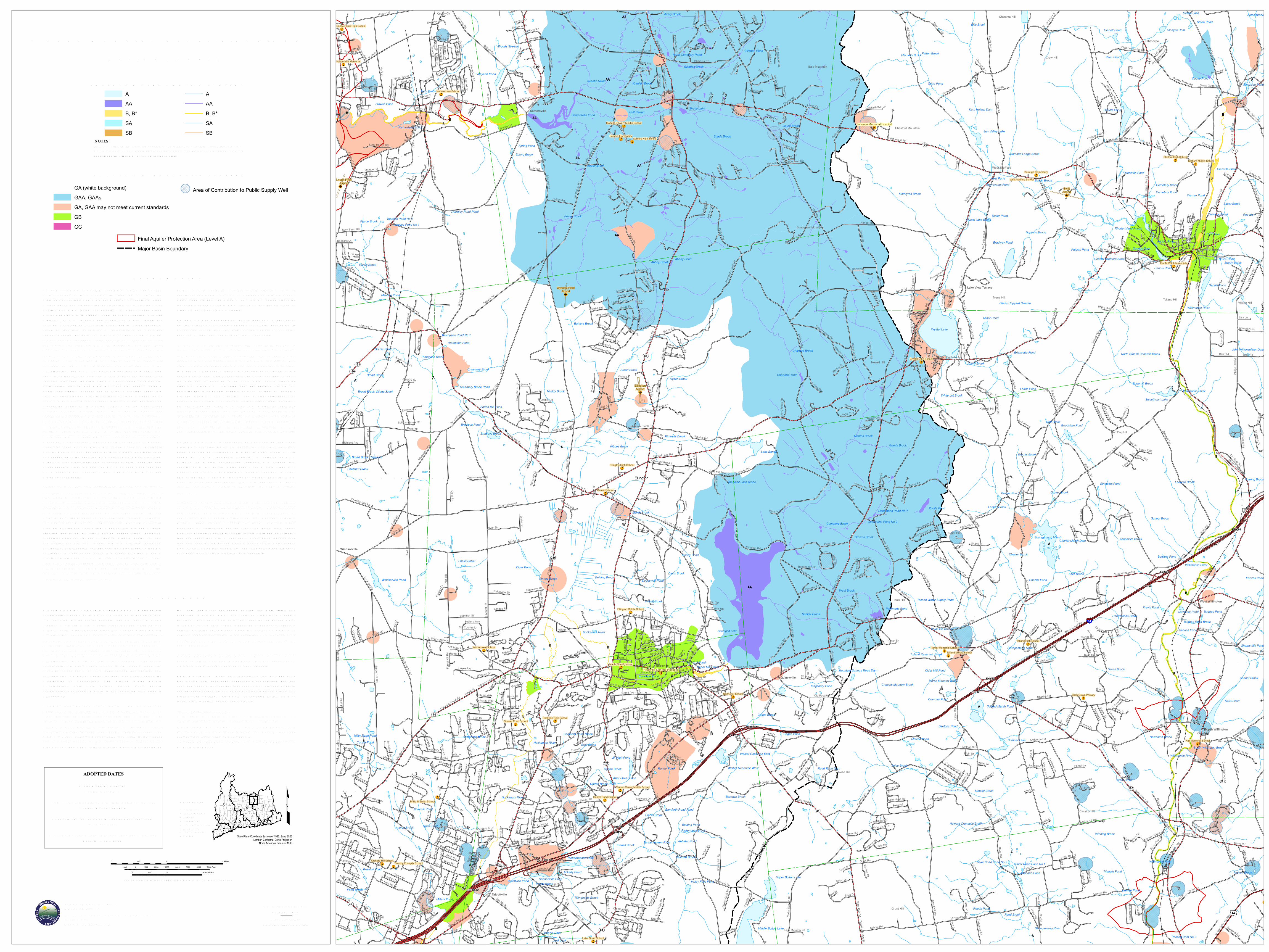
W ATER Q UALITY CLAS S IFICATIONSELLINGTON, CT
SCALE 1:24,000 (1 inch = 2000 feet) when map is printed at original size
1 0 10.5 Miles
1 0 10.5 Kilometers
1000 0 1000 2000 3000 4000 5000 6000 7000 Feet
ADOPTED DATES
W ater Q uality S tandardsFebruary 25, 2011
Thames R iver, Pawcatuck R iver and Southeast CoastalBasins: December 1986
Connecticut R iver and South Central Coastal Basins:February 1993
Housatonic R iver, Hudson R iver and Southw est CoastalBasins: March 1999
S TATE OF CONNECTICUTDEPAR TMENT OFENER GY & ENV IR ONMENTAL PR OTECTION79 Elm S treetHartford, CT 06106-5127
State Plane Coordinate System of 1983, Zone 3526Lambert Conformal Conic Projection
North American Datum of 1983
MAJOR BASINS1 Paw catuck2 Southeast Coast3 Thames4 Connecticut5 South Central Coast6 Housatonic7 Southw est Coast8 Hudson
£
S UR FACE W ATER Q UALITY CLAS S ES
Final Aquifer Protection Area (Level A)Major Basin Boundary
GR OUND W ATER Q UALITY CLAS SES
NOTES:S urface W ater Classifications beginning w ith S refer to Coastal and Marine S urface W ater.B* is a subset of Class B where no direct w astew ater discharges are allow ed other than thoseconsistent with Class AA, A and SA surface w aters.
GA (white background)GAA, GAAsGA, GAA may not meet current standardsGBGC
Area of Contribution to Public Supply Well
AAAB, B*SASB
AAAB, B*SASB
EX PLANATIONW ATER Q UALITY CLAS S IFICATIONS (W Q C) MAPS are oneof the elements of the W ater Q uality S tandards (W Q S ) for theS tate of Connecticut. The W Q S are a part of Connecticut's cleanw ater program and are essential for protecting and improving waterquality. The W Q S follow the principles of Connecticut's CleanW ater Act which is in Chapter 446K of the Connecticut GeneralS tatutes. The W Q S provide policy guidance in many areas, forexample decisions on acceptable discharges to water resources,siting of landfills, remediation or prioritization of municipalsew erage system projects. The first two elements of the W Q S arethe S tandards, which set an overall policy for management of waterquality, and the Criteria, which are descriptive and numericalstandards that describe the allowable parameters and goals forvarious water quality classifications. A discussion of these twoelements is found in the W ater Q uality S tandards documentavailable on the CT DEEP website. The third element is theClassifications and the W ater Q uality Classification Maps whichshow the Classification assigned to each surface and groundw aterresource throughout the S tate. The W Q S are adopted using a publicparticipation process. The W Q C maps are also adopted using apublic participation process but go through hearings separatelyfrom the S tandards and Criteria hearings. R evision and adoption ofthe W Q C data occurs in accordance with the public participationprocedures contained in S ection 22a-426 of the ConnecticutGeneral S tatutes. Ground W Q C is subject to Connecticutregulation and changes must be review ed and adopted. All changesto the S urface W Q C require an adoption process which is subjectto federal review and approval in addition to CT regulation. Theadoption dates for the W Q C by major drainage basin are:Housatonic R iver, Hudson R iver and Southw est Coastal Basins -March 1999; Connecticut R iver and South Central Coastal Basins -February 1993; Thames R iver, Pawcatuck R iver and SoutheastCoastal Basins - December 1986. S urface W ater Classifications donot change after the adoption date until the next major revision.Ground W ater Classifications may change after the adoption dateunder specific circumstances. The map may have more than oneW Q C adoption date because a town may be in more than onemajor drainage basin.SUR FACE W ATER S in Connecticut are divided into freshw aterclassified as AA, A, B or B* and saline waters classified as SA orSB. Class AA designated uses are existing or proposed drink ingw ater supplies; habitat for fish and other aquatic life and wildlife;recreation; and water supply for industry and agriculture. Class Adesignated uses are habitat for fish and other aquatic life andw ildlife; potential drink ing water supplies; recreation; navigation;and water supply for industry and agriculture. Class SA designateduses are habitat for marine fish, other aquatic life and wildlife;shellfish harvesting for direct human consumption; recreation;industrial water supply; and navigation. Class B designated usesare habitat for fish and aquatic life and wildlife; recreation;navigation; and industrial and agricultural water supply. Class B*,applicable to Candlewood Lak e, is a subset of Class B and isidentical in all ways to the designated uses, criteria and standardsfor Class B waters except for the restriction on direct discharges.Class SB designated uses are habitat for marine fish and aquaticlife and wildlife; commercial shellfish harvesting; recreation;industrial water supply; and navigation.
S urface waters which are not specifically classified shall beconsidered as Class A or Class AA. S urface waters in GA groundw ater areas are assumed Class A or Class SA unless otherwiseindicated. S urface waters in GAA ground water areas are assumedClass AA unless otherwise indicated.On the W Q C map a surface water quality goal of A is representedby blue colored water bodies. S urface water quality goal of AA isrepresented by purple colored water bodies. S urface water qualitygoal of B is represented by gold colored water bodies.GR OUND W ATER S in Connecticut are classified as GAA, GA,GB and GC. Class GAA designated uses are existing or potentialpublic supply of w ater suitable for drink ing without treatment andbaseflow for hydraulically-connected surface water bodies. TheClass GAAs is a subclass of GAA for ground water that is tributaryto a public water supply reservoir. The area of contribution to apublic water supply well is represented by a 500-foot radius aroundthe well and is assumed to be Class GAA unless otherwiseclassified. Class GA designated uses are existing private andpotential public or private supplies of water suitable for drink ingw ithout treatment and baseflow for hydraulically-connectedsurface water bodies. All ground waters not specifically classifiedare considered as Class GA. Class GB designated uses areindustrial process water and cooling waters and baseflow forhydraulically-connected water bodies and is presumed not suitablefor human consumption without treatment. Class GC designateduses are assimilation of discharges authorized by theCommissioner pursuant to S ection 22a-430 of the General S tatutes.On the W Q C map GA is represented by white colored land areas.Class GAA and class GAAs are represented by blue colored landareas. The area of contribution to a public water supply well isshown by a blue cross-hatch overprint. A notation of GAAfollowed by a state abbreviation indicates a watershed thatcontributes to the public water supply for a state other thanConnecticut. Class GA or Class GAA areas that currently may notbe meeting the GA or GAA standards are represented on the W Q Cmaps by tan colored land areas. Class GB is represented by greencolored land areas. Class GC is represented by magenta coloredland areas.FINAL AQ UIFER PR OTECTION AR EAS (Level A) are includedon the W Q C maps for informational purposes. These areas areanticipated to be reclassified GAA during the next major basinupdates, subject to public participation. The Aquifer ProtectionProgram helps protect Connecticut’s public drink ing waterresources by delineating aquifer protection areas (also calledw ellhead protection areas) for public supply wells and establishingland use regulations within these areas. These areas represent theland area contributing ground water to active public water supplywells or well fields that serve more than 1000 people and are set insand and gravel aquifers (stratified drift deposits).
DATA SOUR CESW ATER Q UALITY CLAS S IFICATIONS DATA – W ater qualityclassifications shown on this map are based on information fromthe following digital spatial datasets that are typically showntogether – Ground W ater Q uality Classifications Poly, S urfaceW ater Q uality Classifications Line, and S urface W ater Q ualityClassifications Poly. The map legend above reflects the content ofthese three data sources. These W Q C data were initially compiledon 1:24,000-scale 7.5 minute USGS topographic quadrangle mapsand later digitized at 1:24,000 scale. For example, the S urfaceW ater Q uality Classifications Line and S urface W ater Q ualityClassifications Poly digital data assigns surface water qualityclassifications to water bodies such as rivers, streams, reservoirs,lak es, ponds and coves found in 1:24,000-scale hydrography dataavailable from CT DEEP. The hydrography may not include all thew aterbodies in Connecticut. The Ground W ater Q ualityClassifications Poly data assigns ground water qualityclassifications, at 1:24,000 scale, to the remaining land areas inConnecticut.AQ UIFER PR OTECTION AR EA DATA – Aquifer ProtectionAreas shown on this map are from the Aquifer Protection Areadigital dataset which contains polygon data intended to be used at1:24,000 scale. The dataset contains regulated areas classified asLevel A Aquifer Protection Area (Final) and Level B AquiferProtection Area (Preliminary). The Level B areas are not shown onthe W Q C maps. The data was collected from 1991 to the presentand is actively updated as Final area mapping replaces earlierPreliminary areas. The Aquifer Protection Areas are delineated by
the individual water companies owning the well fields andsubmitted to the CT DEEP for approval. Preliminary mappingprovides a general estimate of the area contributing ground waterto the well field. Final mapping is based on extensive, site-specific,detailed modeling of the ground water flow system. CT DEEP mayadjust Final area boundaries to be consistent with 1:24,000 scaletopography and base map data where appropriate during theapproval process.MAJOR DR AINAGE BASIN DATA – Major drainage basinsshown on this map are from Major Basin Line data developed byCT DEEP and intended to be used at 1:24,000 scale.BASE MAP DATA - Based on data originally from 1:24,000-scaleUSGS 7.5 minute topographic quadrangle maps published betw een1969 and 1992. It includes political boundaries, railroads, airports,hydrography, geographic names and geographic places. S treets andstreet names are from Tele Atlas® copyrighted data. Base mapinformation is neither current nor complete.R ELATED INFOR MATIONThis map is intended to be printed at its original dimensions inorder to maintain the 1:24,000 scale (1 inch = 2000 feet).W ATER Q UALITY S TANDAR DS - Go to the CT DEEP websitefor a summary and the full text of the “W ater Q uality S tandards”and for other information on water quality.AQ UIFER PR OTECTION AR EAS - Go to the CT DEEP websitefor more information.
Map created by CT DEEPOctober 2017Map is not colorfast
Protect from light and moisture
Recommended