Victorian
Coastal Acid Sulfate Soils Strategy

Published by the Victorian Government Department of Sustainability and Environment Melbourne, July 2009
© The State of Victoria Department of Sustainability and Environment 2009
This publication is copyright. No part may be reproduced by any process except in accordance with the provisions of the Copyright Act 1968.
Authorised by the Victorian Government, 8 Nicholson Street, East Melbourne.
Printed by Stream Solutions Printed on 100% Recycled paper
ISBN 978-1-74242-117-9 (print) ISBN 978-1-74242-118-6 (online)
For more information contact the DSE Customer Service Centre 136 186
DisclaimerThis publication may be of assistance to you but the State of Victoria and its employees do not guarantee that the publication is without flaw of any kind or is wholly appropriate for your particular purposes and therefore disclaims all liability for any error, loss or other consequence which may arise from you relying on any information in this publication.
Accessibility If you would like to receive this publication in an accessible format, such as large print or audio, please telephone 136 186, 1800 122 969 (TTY), or email [email protected] This document is also available in PDF format on the Internet at www.dse.vic.gov.au

i
Strategy
Foreword . . . . . . . . . . . . . . . . . . . . . . . . . . . . . . . . . . . . . . . . . . . . . . . . . . . 1
List of acronyms . . . . . . . . . . . . . . . . . . . . . . . . . . . . . . . . . . . . . . . . . . . . . 2
Terminology and definitions used in conjunction with acid sulfate soils . . . . . . . . . . . . . . . . . . . . . . . . . . . . . . . . . . . . . . . . 3
1 . Victorian Coastal Acid Sulfate Soils Strategy . . . . . . . . . . . . . . . . . . . 5Purpose of this strategy . . . . . . . . . . . . . . . . . . . . . . . . . . . . . . . . . . . . 5Scope . . . . . . . . . . . . . . . . . . . . . . . . . . . . . . . . . . . . . . . . . . . . . . . . . . . 6Consultation . . . . . . . . . . . . . . . . . . . . . . . . . . . . . . . . . . . . . . . . . . . . . 6
2 . Why we need a coordinated strategy for CASS . . . . . . . . . . . . . . . . . 7
3 . The national and state policy context . . . . . . . . . . . . . . . . . . . . . . . . . 8National policy context . . . . . . . . . . . . . . . . . . . . . . . . . . . . . . . . . . . . 8Victorian policy context . . . . . . . . . . . . . . . . . . . . . . . . . . . . . . . . . . . . 8Figure1 . National and state policy context for CASS . . . . . . . . . . . . . 9
4 . How are coastal acid sulfate soils formed? . . . . . . . . . . . . . . . . . . . . 10Figure 2 . How CASS are formed . . . . . . . . . . . . . . . . . . . . . . . . . . . . 10Figure 3 . How CASS present a risk . . . . . . . . . . . . . . . . . . . . . . . . . . 11Figure 4 . How monosulfidic black ooze is formed . . . . . . . . . . . . . 11
5 . Why are CASS a problem? . . . . . . . . . . . . . . . . . . . . . . . . . . . . . . . . . . 12
6 . Where are CASS found in Victoria? . . . . . . . . . . . . . . . . . . . . . . . . . . 14
7 . Activities that can disturb CASS . . . . . . . . . . . . . . . . . . . . . . . . . . . . . 15
8 . CASS in a time of climate change . . . . . . . . . . . . . . . . . . . . . . . . . . . . 16
9 . Decision-making principles for managing CASS . . . . . . . . . . . . . . . . 17
10 . Objectives and actions . . . . . . . . . . . . . . . . . . . . . . . . . . . . . . . . . . . . 18
11 . Legislation with direct relevance to managing CASS in Victoria . 21Current legislation and approvals processes . . . . . . . . . . . . . . . . . . 21
12 . Roles and responsibilities . . . . . . . . . . . . . . . . . . . . . . . . . . . . . . . . . 25Ministerial interests (in alphabetical order) . . . . . . . . . . . . . . . . . . . 25CASS roles and responsibilities (in alphabetical order) . . . . . . . . . . 26
Maps . . . . . . . . . . . . . . . . . . . . . . . . . . . . . . . . . . . . . . . . . . . . . . . . . . . . . 31Map 1: Far South West Coast . . . . . . . . . . . . . . . . . . . . . . . . . . . . . . 32Map 2: West Coast . . . . . . . . . . . . . . . . . . . . . . . . . . . . . . . . . . . . . . . 33Map 3: Central Coast . . . . . . . . . . . . . . . . . . . . . . . . . . . . . . . . . . . . . 34Map 4: South Coast . . . . . . . . . . . . . . . . . . . . . . . . . . . . . . . . . . . . . . 35Map 5: Gippsland Lakes . . . . . . . . . . . . . . . . . . . . . . . . . . . . . . . . . . . 36Map 6: East Coast . . . . . . . . . . . . . . . . . . . . . . . . . . . . . . . . . . . . . . . . 37
Contents

ii
Stra
teg
y
1
Strategy
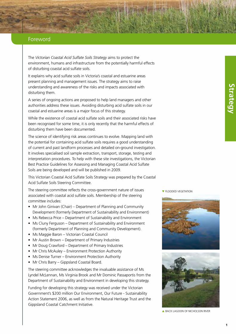
The Victorian Coastal Acid Sulfate Soils Strategy aims to protect the environment, humans and infrastructure from the potentially harmful effects of disturbing coastal acid sulfate soils.
It explains why acid sulfate soils in Victoria’s coastal and estuarine areas present planning and management issues. The strategy aims to raise understanding and awareness of the risks and impacts associated with disturbing them.
A series of ongoing actions are proposed to help land managers and other authorities address these issues. Avoiding disturbing acid sulfate soils in our coastal and estuarine areas is a major focus of this strategy.
While the existence of coastal acid sulfate soils and their associated risks have been recognised for some time, it is only recently that the harmful effects of disturbing them have been documented.
The science of identifying risk areas continues to evolve. Mapping land with the potential for containing acid sulfate soils requires a good understanding of current and past landform processes and detailed on-ground investigation. It involves specialised soil sample extraction, transport, storage, testing and interpretation procedures. To help with these site investigations, the Victorian Best Practice Guidelines for Assessing and Managing Coastal Acid Sulfate Soils are being developed and will be published in 2009.
This Victorian Coastal Acid Sulfate Soils Strategy was prepared by the Coastal Acid Sulfate Soils Steering Committee.
The steering committee reflects the cross-government nature of issues associated with coastal acid sulfate soils. Membership of the steering committee includes:• MrJohnGinivan(Chair)–DepartmentofPlanningandCommunityDevelopment(formerlyDepartmentofSustainabilityandEnvironment)
• MsRebeccaPrice–DepartmentofSustainabilityandEnvironment• MsClunyFerguson–DepartmentofSustainabilityandEnvironment(formerlyDepartmentofPlanningandCommunityDevelopment).
• MsMaggieBaron–VictorianCoastalCouncil• MrAustinBrown–DepartmentofPrimaryIndustries• MrDougCrawford–DepartmentofPrimaryIndustries• MrChrisMcAuley–EnvironmentProtectionAuthority• MsDeniseTurner–EnvironmentProtectionAuthority• MrChrisBarry–GippslandCoastalBoard.
The steering committee acknowledges the invaluable assistance of Ms LyndelMcLennan,MsVirginiaBrookandMrDominicPassaportisfromtheDepartmentofSustainabilityandEnvironmentindevelopingthisstrategy.
FundingfordevelopingthisstrategywasreceivedundertheVictorianGovernment’s$200millionOurEnvironment,OurFuture-SustainabilityAction Statement 2006, as well as from the Natural Heritage Trust and the Gippsland Coastal Catchment Initiative.
Foreword
▼FLOODEDVEGETATIOn
▲BACkLAGOOnOFnIChOLSOnRIVER

2
Stra
teg
y
List of acronyms
AASS Actual acid sulfate soilAHD AustraliaheightDatumASRIS AustralianSoilResourceInformationSystemASS acid sulfate soil CAMBA China–AustraliaMigratoryBirdAgreementCASS coastal acid sulfate soil CASSIC Coastal Acid Sulfate Soil Strategy Implementation CommitteeCASSKC Victorian CASS Knowledge Centre DPCD DepartmentofPlanningandCommunityDevelopmentDPI DepartmentofPrimaryIndustries DSE DepartmentofSustainabilityandEnvironmentEPA EnvironmentProtectionAuthority EPBC Environment Protection and Biodiversity Conservation Act 1999 IASS inland acid sulfate soilIWMP Industrial Waste Management PolicyJAMBA Japan-AustraliaMigratoryBirdAgreementMBO monosulfidic black ooze, see glossaryNRMMC nationalResourceManagementMinisterialCouncilOH&S occupational health and safetyPASS potential acid sulfate soilSEPP StateEnvironmentProtectionPoliciesSPPF StatePlanningPolicyFrameworkVCS Victorian Coastal Strategy 2008WASS waste acid sulfate soil
▼InThEFIELDATLAkEwELLInGTOn
▲GyPSuMCRySTALS
▲InTACTCORESFORDESCRIBInGSOILS ▲SOILBLEAChEDByACIDAThEARTMORASS
3
Strategy
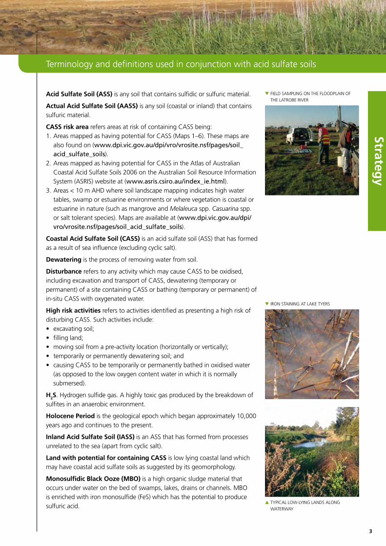
Acid Sulfate Soil (ASS) is any soil that contains sulfidic or sulfuric material.
Actual Acid Sulfate Soil (AASS)isanysoil(coastalorinland)thatcontainssulfuric material.
CASS risk area refers areas at risk of containing CASS being: 1.AreasmappedashavingpotentialforCASS(Maps1–6).Thesemapsarealsofoundon(www .dpi .vic .gov .au/dpi/vro/vrosite .nsf/pages/soil_acid_sulfate_soils).
2. Areas mapped as having potential for CASS in the Atlas of Australian CoastalAcidSulfateSoils2006ontheAustralianSoilResourceInformationSystem(ASRIS)websiteat(www .asris .csiro .au/index_ie .html).
3.Areas<10mAhDwheresoillandscapemappingindicateshighwatertables, swamp or estuarine environments or where vegetation is coastal or estuarineinnature(suchasmangroveandMelaleuca spp. Casuarina spp. orsalttolerantspecies).Mapsareavailableat(www .dpi .vic .gov .au/dpi/vro/vrosite .nsf/pages/soil_acid_sulfate_soils).
Coastal Acid Sulfate Soil (CASS)isanacidsulfatesoil(ASS)thathasformedasaresultofseainfluence(excludingcyclicsalt).
Dewatering is the process of removing water from soil.
Disturbance refers to any activity which may cause CASS to be oxidised, includingexcavationandtransportofCASS,dewatering(temporaryorpermanent)ofasitecontainingCASSorbathing(temporaryorpermanent)ofin-situ CASS with oxygenated water.
High risk activities refers to activities identified as presenting a high risk of disturbing CASS. Such activities include: • excavatingsoil;• fillingland;• movingsoilfromapre-activitylocation(horizontallyorvertically);• temporarilyorpermanentlydewateringsoil;and• causingCASStobetemporarilyorpermanentlybathedinoxidisedwater(asopposedtothelowoxygencontentwaterinwhichitisnormallysubmersed).
H2S. Hydrogen sulfide gas. A highly toxic gas produced by the breakdown of sulfites in an anaerobic environment.
Holocene Period is the geological epoch which began approximately 10,000 years ago and continues to the present.
Inland Acid Sulfate Soil (IASS) is an ASS that has formed from processes unrelatedtothesea(apartfromcyclicsalt).
Land with potential for containing CASS is low lying coastal land which may have coastal acid sulfate soils as suggested by its geomorphology.
Monosulfidic Black Ooze (MBO) is a high organic sludge material that occurs under water on the bed of swamps, lakes, drains or channels. MBO isenrichedwithironmonosulfide(FeS)whichhasthepotentialtoproducesulfuric acid.
Terminology and definitions used in conjunction with acid sulfate soils
▼FIELDSAMPLInGOnThEFLOODPLAInOF
ThELATROBERIVER
▼IROnSTAInInGATLAkETyERS
▲TyPICALLOw-LyInGLAnDSALOnG
wATERwAy
4
Stra
teg
y
Potential Acid Sulfate Soil (PASS)isanysoil(coastalorinland)thatcontains sulfidic material but not sulfuric material.
Prospective land refers to land whose geomorphology indicates that there is a potential or prospect of encountering sulfidic material or sulfuric material.
Ramsar SiteisawetlandlistedontheRamsarlistofwetlandsofInternationalimportance.TheRamsarconventionisaninternationaltreatyfortheconservation and sustainable utilisation of wetlands.
Sulfidic materialisanysoil,sedimentorpeatlayer(horizon)thatcontainsmetalsulfides(generallypyriteorironsulfide;FeS2).Thismaterialonlyexistsunder oxygen free or anoxic, waterlogged conditions.
Sulfuric materialisanysoil,sedimentorpeatlayer(horizon)thatcontainssulfuricacid(h
2SO
4).Sulfuricacidisproducedbyoxidationofsulfidicmaterial.
Waste: means waste as defined in Section 4 of the Environment Protection Act 1970. (a)anymatterwhethersolid,liquid,gaseousorradio-activewhichis
discharged, emitted or deposited in the environment in such volume, constituency or manner as to cause an alteration in the environment
(b)anydiscarded,rejected,unwanted,surplusorabandonedmatter(c) anyotherwisediscarded,rejected,abandoned,unwantedorsurplus
matter intended foró(i) recycling,reprocessing,recoveryorpurificationbyaseparateoperation
from that which produced the matter, or(ii) saleand
(d)anymatterprescribedtobewaste.
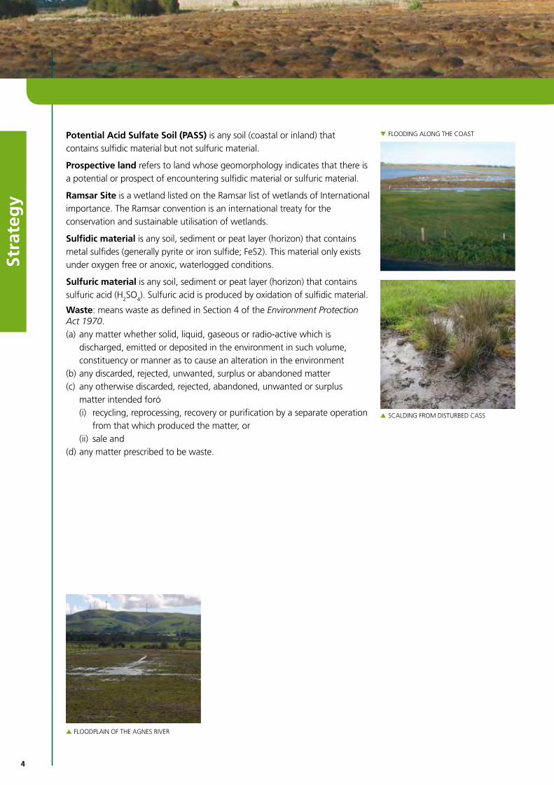
▼FLOODInGALOnGThECOAST
▲SCALDInGFROMDISTuRBEDCASS
▲FLOODPLAInOFThEAGnESRIVER

5
Strategy
1. Victorian Coastal Acid Sulfate Soils Strategy
The Victorian Coastal Acid Sulfate Soils Strategy aims to help protect the environment, humans and our infrastructure from the harmful effects which canoccurwhencoastalacidsulfatesoils(CASS)aredisturbed.
Acid sulfate soils occur naturally in both coastal and inland settings. These soils contain metal sulfide minerals. Left undisturbed these soils are harmless, but if drained, excavated or exposed to air the metal sulfides react with oxygen and form sulfuric acid. This acid can trigger the release of other toxic elements(suchasheavymetalsandothercontaminants)andwhencombinedwith acid kills plants and animals and can contaminate drinking water and food(suchasoysters)aswellascorrodeconcreteandsteel.
It is important that land use planners and managers can identify areas where development is best avoided due to acid sulfate soils. Already, there are many examples of costly mistakes in Australia involving considerable damage to land, buildings and waterways as a result of disturbing CASS.
The strategy explains why CASS are a management issue in Victoria and outlines actions to address issues identified.
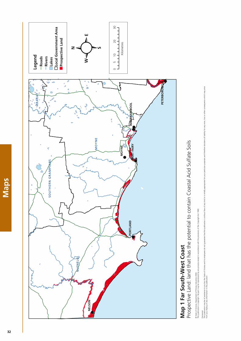
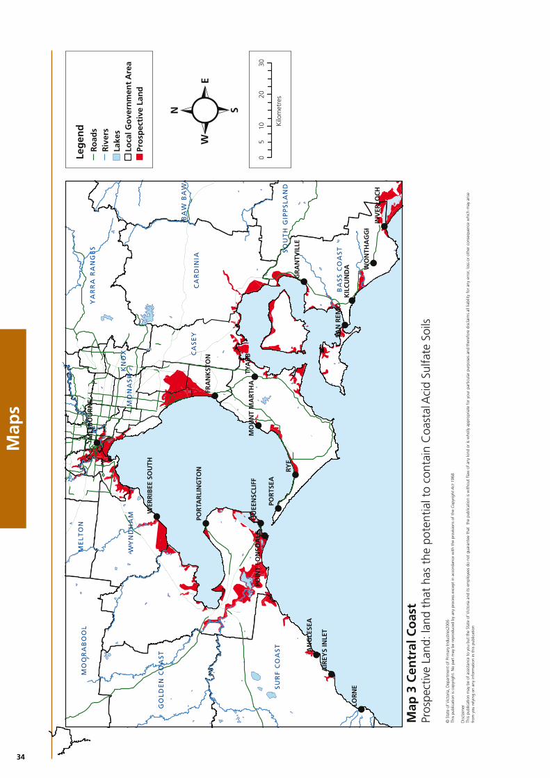
To date, the extent of CASS and the risks associated with their disturbance have not been well documented nor integrated in land resource assessment and management processes. As a first step in addressing this, mapping has beenconductedtoidentifylandthatpotentiallycontainsCASS(seeMaps1–6).
Mapping areas with potential for CASS is time-consuming and at this stage it remains at a broad-scale rather than detailed. However, given the complexities of chemical change caused by disturbing CASS and the exponential increase in areas of impact if disturbed, a precautionary approach has been adopted in this strategy.
In this sense the strategy should be considered as the first stage of a work in progress(seeScopebelow).
It is envisaged that as mapping of CASS progresses and the need to avoid disturbing CASS is better understood, maps identifying land with potential for containing CASS will be updated to provide more detail. The objective to avoid disturbing CASS will be promoted by adopting the Victorian Best PracticeManagementGuidelinesforAssessingandManagingCASS(tobepublishedin2009)inlandresourceassessmentandmanagementprocesses.
▼IROnSTAInInGInThEhEARTMORASS
▲IROnSTAInInGInThEDOwDMORASS
▲COASTALPLAInVEGETATIOn

6
Stra
teg
y
Purpose of this strategy
The Victorian Coastal Acid Sulfate Soils Strategy aims to protect the environment, humans and infrastructure from the harmful effects of disturbing CASS. It aims to build the capacity of land owners and land and water managers to plan and manage activities in CASS risk areas. It identifies principles and promotes a risk management approach to guide decision-making. The emphasis of the strategy is on avoiding disturbing CASS.
Scope
This strategy applies to all coastal and estuarine lowlands in Victoria at or lessthan10mAhD(AustralianheightDatum)wherethereisintentiontoundertake‘highriskactivities’.Thestrategyalsoappliestolandbetween10–20mAhDwhichhasbeenmappedandidentifiedaspotentiallycontainingCASS or where the land immediately adjacent has been mapped and potentialidentifiedforcontainingCASS(seeMaps1–6).
The focus of this strategy is on acid sulfate soils in coastal areas, as the greatest risks to the Victorian environment are currently seen to be from potential mismanagement of soils along our coastline. This strategy does notapplytoareasknowntohaveinlandacidsulfatesoils(IASS).IASSmaybe included in a second phase of this strategy once further soil mapping has identified areas with the potential of containing IASS across Victoria.
The strategy and its associated mapping does not apply to CASS under permanentwaterbodies(suchaslakes)andwaterways(riversorcreeks)orareasbelowthehightidemark(oceanbays,estuariesorinlets).
The strategy applies to the potential development of new sites and not to the rehabilitation of existing sites, although it is recognised that aspects of the strategy could help in assessing and rehabilitating already disturbed sites.
Consultation
The Draft Strategy for Coastal Acid Sulfate Soils in Victoria was released for consultationinJuly2008and25submissionswerereceived.
FromAugusttoSeptember2008,membersofthesteeringcommitteeconducted five workshops with key stakeholders from a range of organisations, groups and agencies, including from the Victorian and local governments.
▼ESTuARInEVEGETATIOn
▲GEO-PROBESOILSAMPLER
▲IROnSTAInInGInwATER–DOwDS
MORASS,GIPPSLAnD

7
Strategy
2. Why we need a coordinated strategy for CASS
Victoria has little documented history of CASS causing environmental degradation. However, anecdotal evidence is emerging that past acid discharge events may have occurred but the environmental impacts were attributed to other causes. While knowledge and evidence of the immediate and long-term impacts of disturbing sulfidic materials in CASS builds, it is appropriate for Victoria to take a preventative approach to ensure adverse impacts experienced in other areas of Australia are not repeated here.
A number of factors indicate the need for a coordinated strategy to manage CASS in Victoria:• increased pressure to develop low-lying coastal areas, which
increases the risk of disturbing CASS and the potential to trigger acid and other toxic releases into fragile coastal and estuarine ecosystems
• increased evidence that CASS issues should be addressed at the planning stage before approving any development
• the need to educate decision-makersontherisks(environmental,socialandeconomic)associatedwithdisturbingCASS
• increased need to improve sustainable land management with a focus on the capability of the land to support proposed activities now and in future
• the current commitment to manage CASS in both the National Cooperative Approach to Integrated Coastal Zone Management: framework and implementation plan 2006 and the Victorian Coastal Strategy 2008
• Victoria’s current commitment as a signatory to the National Strategy for Coastal Acid Sulfate Soils Management 2000
• the need to coordinate CASS investigations, studies and training conducted at a local and / or regional level
• the need to better coordinate and strengthen existing policy and statutory instruments relating to CASS.
▼BLEAChEDAnDIROn-STAInEDSOILS
▲FLOCCuLATEInDRAIn,PORTALBERT▲AnGLESEARIVERESTuARy

8
Stra
teg
y
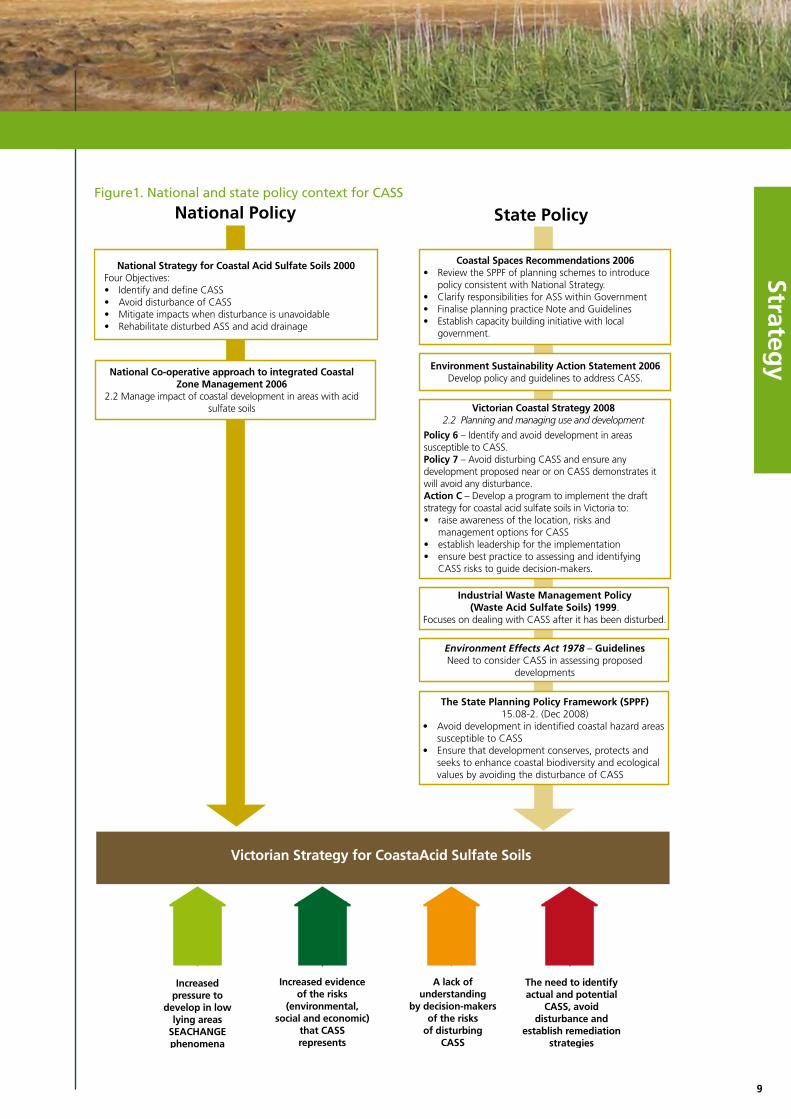
3. The national and state policy context
ThereisastrongnationalandstatepolicycontextforCASS(seeFigure1).
National policy contextThe National Strategy for Coastal Acid Sulfate Soil Management 2000 has four key objectives:• IDENTIFY and define CASS• AVOID disturbance of CASS• MITIGATE IMPACTS when CASS disturbance is unavoidable• REHABILITATE disturbed CASS and acid drainage.
The National Cooperative Approach to Integrated Coastal Zone Management 2006 identified the need to manage the impact of coastal development in areas with acid sulfate soils.
Victorian policy contextThe Victorian Coastal Acid Sulfate Soils Strategy builds on several policy and legislative initiatives: 1. The Industrial Waste Management Policy (IWMP): Waste acid sulfate soils
(WASS) was developed in reference to the Environment Protection Act 1970. This policy was developed in response to increasing development pressure in the Lower Yarra Basin, an area renowned for its Coode Island Silts, which contain high levels of CASS. The limitation of this policy is its focus on dealing with CASS after it has been disturbed, rather than assessing the risks of CASS disturbance at the planning stages.
2. The state Planning Policy framework (SPPF)15.08-2(gazettedDecember2008)whichstatesthatplanningforcoastalareasshould:• AvoiddevelopmentinidentifiedcoastalhazardareassusceptibletoCASS• Ensurethatdevelopmentconserves,protectsandseekstoenhance
biological diversity and ecological values by avoiding the disturbance of CASS.
3. The Environment Effects Act 1978 Guidelines made in terms of the Environment Effects Act 1978 which highlight the need to consider CASS in assessing proposed developments.
4. The Coastal Spaces Recommendations 2006 which provides recommendations that seek to improve and clarify strategic planning policies, provisions and tools for managing sustainable coastal development in non-metropolitan coastal areas. A key recommendation is that the government “establish clear planning policy that discourages disturbance ofcoastalacidsulfatesoils”(Recommendation6).
5.ThefirstprincipleoftheVictorianCoastalStrategy2008(VCS)is“toprotect significant environment and cultural values, based upon a sound understanding of coastal features, vulnerability and risks”. The VCS contains as a policy the need to “avoid disturbing coastal acid sulfate soils and ensure any development proposed near or on CASS demonstrates that it will avoid any disturbance”. The VCS further commits the Victorian Government to developing a strategy and planning tools for managing CASS.
6. Preliminary strategy work and risk assessment methodology for CASS undertakenbyFitzsimonsandBrown(2003).
7. Other Victorian Government policy documents that recognise the risks posed by disturbing CASS and which require it acts to mitigate these risks.
▼FIELDSAMPLInGATThELATROBERIVER
FLOODPLAIn
▲GEO-PROBESOILSAMPLER
▲PEATSCALDInGOnThEnIChOLSOnRIVER
9
Strategy
Figure1 . National and state policy context for CASS
National Policy State Policy
National Strategy for Coastal Acid Sulfate Soils 2000Four Objectives:• Identify and define CASS• Avoid disturbance of CASS• Mitigate impacts when disturbance is unavoidable• Rehabilitate disturbed ASS and acid drainage
National Co-operative approach to integrated Coastal Zone Management 2006
2.2 Manage impact of coastal development in areas with acid sulfate soils Victorian Coastal Strategy 2008
2.2 Planning and managing use and development
Policy 6 – Identify and avoid development in areas susceptible to CASS.Policy 7 – Avoid disturbing CASS and ensure any development proposed near or on CASS demonstrates it will avoid any disturbance.Action C – Develop a program to implement the draft strategy for coastal acid sulfate soils in Victoria to:• raise awareness of the location, risks and
management options for CASS• establish leadership for the implementation• ensure best practice to assessing and identifying
CASS risks to guide decision-makers.
Coastal Spaces Recommendations 2006• Review the SPPF of planning schemes to introduce
policy consistent with National Strategy.• Clarify responsibilities for ASS within Government• Finalise planning practice Note and Guidelines• Establish capacity building initiative with local
government.
Environment Sustainability Action Statement 2006Develop policy and guidelines to address CASS.
Industrial Waste Management Policy (Waste Acid Sulfate Soils) 1999.
Focuses on dealing with CASS after it has been disturbed.
The State Planning Policy Framework (SPPF) 15.08-2. (Dec 2008)
• Avoid development in identified coastal hazard areas susceptible to CASS
• Ensure that development conserves, protects and seeks to enhance coastal biodiversity and ecological values by avoiding the disturbance of CASS
Environment Effects Act 1978 – Guidelines Need to consider CASS in assessing proposed
developments
Victorian Strategy for CoastaAcid Sulfate Soils
Increased pressure to
develop in low lying areas
SEACHANGE phenomena
Increased evidence of the risks
(environmental, social and economic)
that CASS represents
A lack of understanding
by decision-makers of the risks
of disturbing CASS
The need to identifyactual and potential
CASS, avoid disturbance and
establish remediation strategies

10
Stra
teg
y
4. How are coastal acid sulfate soils formed?
Coastalacidsulfatesoils(CASS)containsulfuricacidorhavethepotentialtoform sulfuric acid when exposed to oxygen.
CASSformsnaturallywhensulfaterichwater(suchasseawater,seweragewatersorminewaters)mixeswithsoilscontainingironandorganicmatter(seeFigure2).MostCASSfoundinVictoriawasformedwithinthelast10,000yearsafterthelastmajorsealevelrise,whenlevelswereabout1.5mhigherthan today. When sea water flooded the land, the sulfate it contained mixed with land sediments containing iron oxides and organic matter. Under these waterlogged,anaerobic(oxygen-free)conditions,bacteriaassistinconvertingsulfates into sulfides. These sulfides react with metals to form metal sulfides, typically pyrite.
Ifleftundisturbedandcoveredinwater,sulfidicmaterials(orpotentialacidsulfatesoil–PASS)poselittleornothreat.however,whenexposedtooxygenthrough drying under drought conditions or from excavating or dredging, chemicalreactionsmayleadtotheformationofsulfuricmaterials(ph<4)(oractualacidsulfatesoil–AASS)andthegenerationofsulfuricacid(seeFigure3).whensulfuricmaterialsareexposedtowateragain,thereisariskthat significant amounts of sulfuric acid are released which can cause the acidification of wetlands and estuaries. Other heavy metals and metalloids (suchasarsenic)canalsobemobilised.
Figure 2 . Natural setting: PASS insulated from exposure to oxygen by watertable. Waterway well flushed, mitigating impact from incidental acid discharge events.
▼FLOODPLAInATThEhEARTMORASS
▲IROnSTAInInGATThEhEARTMORASS

11
Strategy
Figure 3 . Post drainage: Lowered watertable exposes PASS soils to oxygen. Increased drainage density and volume leads to increased acid export.
Monosulfidicblackooze(MBO)formsinwaterbodiesandstillwaterways,where sulfate and iron from surrounding ASS combine with abundant organic matter(seeFigure4).Suchenvironmentsprovideexcellentconditionsforsulfate reduction, leading to iron monosulfide precipitation. The production ofswampgas(hydrogensulphide;h
2S)isacommonoccurrenceinthese
environments. When water containing MBO is oxygenated through swirling orstirring(suchasfloodevents),theMBOinafinelysuspendedstatecancompletely consume the dissolved oxygen and cause massive fatalities for fish and other aquatic life, within minutes.
Figure 4 . The Formation of Monosulfidic Black Ooze (MBO)
▲GASBuBBLInGFROMPEATSwAMPOn
nIChOLSOnRIVER

12
Stra
teg
y
5.whyareCASSaproblem?
When sulfidic material in CASS is disturbed and exposed to air, an oxidation process occurs and sulfuric acid is produced. Sulfuric acid has the potential to mobilise heavy metals such as arsenic and aluminium which may be dissolved in the soil. These metals can become soluble in toxic quantities. The combination of sulfuric acid and heavy metals can have severely detrimental effects on land and water, including:
• Acidification of waterways, wetlands, and estuaries which leads to massive fish kills. In turn, deoxygenation of the water can lead to toxic algal blooms. Acid has also been linked to chronic effects on aquatic systems that include disease, reduced hatching survival and growth rates for a wide range of species.
• Degradation of the ecology of wetlands, shallow freshwater and brackish aquifer systems through loss of water quality, degradation of habitat and decline in dependent ecosystems. Apart from the direct affect of acid production which causes fish kills and the decline in number and diversity of invertebrate populations, acidification and heavy metal toxicity can have a negative impact on macrophytes and other aquatic vegetation that aquatic animals depend on for food, shelter and reproduction. Loss of aquatic animal life can, in turn, have serious consequences for other species along the food chain, such as birds. Sulfuric materials in CASS can potentially affect important breeding and feeding habitat for various waterbirds, including migratory species listed under international agreementssuchasJAMBAandCAMBA.
• Adverse impacts on commercial and recreational fisheries and rural productivity. In New South Wales, it is estimated the annual cost to the commercial fishing industry from fish kills and disease is $2 million dollars. In2001,theRichmondRiverwasclosedtofishingforsixmonthsfollowingamajorfishkill.In1995,over$1millionofseamulletwasdiscardedbynewSouthwalescommercialfishersbecauseofEpizooticulcerativeSyndrome(redspot).LossesinproductionofSydneyrockoystersfromCASS impacts were estimated at $7 million from 1994 to 2000.
• Corrosion of concrete and steel infrastructure, such as foundations and footings,culverts,pipes(includingdrinkingwaterconduits),bridgesand floodgates, reducing their functional life span. The costs associated with damage to public and private infrastructure is significant. Local governments have spent millions of dollars in New South Wales replacing iron water pipes corroded by acid groundwater in areas that contain CASS. Concrete corrosion of road and rail bridges and other structures has been identified from the Shoalhaven area in southern New South Wales to Cairns in northern Queensland. Anecdotal evidence from Victorian water authorities suggests that areas exposed to a high risk of CASS require more frequent infrastructure replacements.
▼yARRARIVERESTuARy,DOCkLAnDS
▲BEAChEROSIOnAT90-MILEBEACh

13
Strategy
• Immediate detrimental human health effects such as skin and eye irritations and burns. The long-term impacts of exposure to heavy metals on human health are not well understood but are thought to include increasedrisksofcancers(skinandlung)andskinlesions.waterpollutedby toxic quantities of soluble heavy metals has led to human and animal ill health. Corrosion of pipes can also lead to contamination of drinking water supplies and increased sewerage spills.
• Occupational health and safety (OH&S) risks associated with disturbing CASS such as the inhalation of H
2S associated with working in confined
spaces. Health risks associated with handling contaminated wastes and exposure to acid dust also exist.
• Loss of high recreational and environmental value.DisturbingCASSand the acidification of waters could result in areas being unsuitable for recreation and tourism due to unsightly environmental impacts, potential disagreeable odours and human health issues.
• Irreversible change to landforms and soils. It is now recognised that certain environmental effects of the oxidation of acid sulfate soils can last for hundreds and thousands of years. Acid discharge can lead to changes in the soil fabric, leading to irreversible shrinking and lowering of ground surfaces.
All these impacts generally occur off-site, so managing CASS must consider a wider area than a particular site under development. One on-site activity which can have off-site impacts is the dewatering of areas surrounding a development site.
TheCSIROestimatesthecostofmitigatingtheimpactofCASSaroundAustraliafromcoastaldevelopmentisaround$10billion(Fitzpatricketal1999“RisksseenfromAcidSulfateSoils”)Thehighcostoftreatingandrehabilitating acid-affected areas has led to many developments being stalled or abandoned. To reduce this problem and to better manage coastal resources, there is a need for greater recognition of the occurrence, severity, risk and avoidance of CASS in Victoria.
In addition to the ecological costs and loss of amenity associated with disturbing CASS, ongoing liability issues include:• infrastructuredamageandmaintenancecosts• humanhealthcosts• occupationalhealthandsafetycosts• dredgingandspoilmanagementcosts• environmentalmanagementcosts• opportunitycostsassociatedwithtourism.
Avoiding disturbing CASS is more cost effective than managing, mitigating and / or remedying adverse results once it is disturbed.
▼CORRODEDCOnCRETEInThEhEART
MORASS
▼BEAChEROSIOnAT90-MILEBEACh
▲ExPOSEDLAGOOnPEATSAT90-MILEBEACh

14
Stra
teg
y
6. Where are CASS found in Victoria?
CASS are generally found in low lying areas within coastal plains and along the edges of water bodies. This includes flood plains and lower slopes, abandonedrivermeandersandoxbowlakes,swamps(includingback-swamps,peatswampsandreclaimedswamps),morasses,beaches,coastaldunes and swales and tidal flats. Tidal influence can also extend many kilometres inland up incised valleys.
The mapping of land with the potential for CASS utilised a geomorphological approach by identifying sea levels during the mid-Holocene geological periodofEarth(about10,000yearsago)andtheknowledgethatassociatedsediments often contain appreciable contents of pyrite. It should be noted that at the scale of investigation conducted, the boundaries defining areas with potential for containing CASS should be regarded as a guide only.
On-ground investigation was concentrated on priority areas where pressure for land development is high and where CASS issues are known to have occurred.TheresultsoftheseinvestigationsareshowninMaps1–6.
AreasmappedashavingpotentialforCASScoversapproximately250,000haof land. The majority of land with potential for CASS was found surrounding Port Phillip Bay and east to the Gippsland Lakes. However, environmentally sensitive areas are scattered along the entire coastline of Victoria, which may be affected from relatively small point sources of acid production.
In addition to the boundaries for land with potential for containing CASS, mappingalsoincludedaprecautionaryboundaryatthe10mAhDcontour,which is the area between the two boundaries where CASS may still be present.
The maps indicating land with potential for CASS are attached to the strategy and also available at www .dpi .vic .gov .au/dpi/vro/vrosite .nsf/pages/soil_acid_sulfate_soils
This strategy defines areas at risk of containing CASS as:1.areasmappedashavingpotentialforCASS(Maps1-6).Thesemapsarealsofoundat(www .dpi .vic .gov .au/dpi/vro/vrosite .nsf/pages/soil_acid_sulfate_soils).
2. areas mapped as having potential for CASS in the Atlas of Australian CoastalAcidSulfateSoils2006)ontheAustralianSoilResourceInformationSystem(ASRIS)websiteat(www .asris .csiro .au/index_ie .html).
3.areas<10mAhDwheresoillandscapemappingindicateshighwatertables,swamporestuarineenvironments(thatissoilswithamarineoriginandpotentialtocontainironsulfurinanoxiccondition).Vegetationis coastal or estuarine in nature, such as mangrove, Melaleuca spp., Casuarinaspp.orsalttolerantspecies.Mapsareavailableat(www .dpi .vic .gov .au/dpi/vro/vrosite .nsf/pages/soil_acid_sulfate_soils).
▼COASTALFOOTSLOPES
▲FLOODPLAInOFThEnIChOLSOnRIVER
(uPPERMOSTLIMITOFCASS24kILOMETRES
InLAnD)

15
Strategy
7. Activities that can disturb CASS
The emphasis of this strategy is on avoiding the disturbance of CASS.
Disturbancereferstoanyactivitythatdisturbsoraltersthesulfidicmaterialsin CASS and causes oxidation. Types of activities that have a high risk of disturbing CASS are: • excavatingsoil;• fillingland;• movingsoilfromitspre-activitylocation(horizontallyorvertically);• temporarilyorpermanentlydewateringsoil;and• causingCASStobetemporarilyorpermanentlybathedinoxidisedwater(asopposedtothelowoxygencontentwaterinwhichitisnormallysubmersed).
Examplesoftheseactivitiesinclude:• agricultural activities that involve land drainage, particularly deep drainage(suchasworkstopreventfloodandtidalinundationorloweringofthewatertable)
• dredging in low land areas and low land waterways and drains which deposits acid sulfate soil that acidifies if disposed of on-shore without dewatering and requires expensive neutralisation treatment
• drilling for bores• drought(suchasdryingofsoilprofilestodepth)• extractiveindustries(sandandgravelextractionfromriversorfloodplains)
• infrastructure works(floodmanagement,drainageworks,installationofutilitiessuchasrailways,roads,andwaterandseweragepipelines)
• land use change(includingdecommissioningofirrigationorlandorvegetationmanagementpracticesthatalterwatertables.Forexample,Blue Gum plantations in Western Australia have been recorded to have significantlyloweredthewatertable,thusexposingCASStooxygen)
• urban and tourism development(suchasforhousing,resortsormarinas)
• water extraction.
The risks and impacts of disturbing CASS may vary between sites and affect the environment well beyond a disturbed site. The onus is on the potential disturber of a site to prove that CASS are not present or will not be activated. This will require detailed site investigations.
This strategy proposes the completion of the Victorian Best Practice Guidelines for Assessing and Managing Coastal Acid Sulfate Soils(draftreleasedJune2008).TheGuidelinesproposeadecisionmakingtreetoassistinidentifyingrisks from CASS. Is a high risk activity proposed in an area with potential to contain CASS? The guidelines will also outline site investigation requirements. The investigations are necessary to Identify risks and impacts. Once risks and impacts are identified, avoidance or a low risk solution can be planned.
▼FLOCCuLATEInDRAIn,PORTALBERT
▲COASTALFLOODPLAIn,hEARTMORASS

16
Stra
teg
y
The risks and impact of climate change and related sea level rises are acknowledged at all levels of government in Australia. The Victorian Coastal Strategy 2008 identifies climate change as one of three significant issues likely to impact on Victoria’s coastline over the medium to long term. Potential climate change impacts on the Victorian coastline include sea level rises and increased frequency and severity of storm events which are likely to lead to inundation and erosion. Potential environmental effects of climate change that could expose CASS include erosion of ocean foreshores and inlets, including cliffs, dune systems, sandbars and tidal mud flats as well as estuary river beds and banks. Salinisation through sea water flooding into aquifers is also a potential threat.
Climate change has the potential to increase CASS exposure which highlights the importance of this CASS strategy to act as a significant tool to help manage high risk activities along Victoria’s coast.
8.CASSinatimeofclimatechange
▲LAGOOnPEATExPOSEDByBEAChEROSIOn
AT90-MILEBEACh
▲BEAChEROSIOnATAPOLLOBAy▲EROSIOnOFThEnORThShOREOFLAkE
wELLInGTOn

17
Strategy
1. Avoid disturbing CASS.
2. Ensure any use and / or development proposed near, or on potential CASScandemonstrateitwillavoidanydisturbance(Victorian Coastal Strategy 2008).
3. Take a precautionary (risk management) approach* when planning and managing high risk activities in areas with potential to containCASS(CASSriskareas).
4. Discourage the intensification of use and / or development in areas with potential to contain CASS.
5.Assess impacts and risks of CASS on any land, waterway and water body with a connection to a CASS risk area. Consider the cumulative effect of any use and / or development proposal in areas with potential to contain CASS.
6. Assess risks and impacts on the basis of the Victorian Coastal Acid Sulfate Soils Strategy and any subsequent Victorian Best Practice Guidelines for Assessing and Managing Coastal Acid Sulfate Soils.
7. Consider the potential risks and impacts to the environment, humans and infrastructure from disturbing CASS.
8.Remediate detrimental effects arising from the past and current disturbance of CASS.
* The precautionary principle of sustainability advocates taking action now despite a level of uncertainty
to minimise future risks. The principle may lead to a decision not to take action or not to proceed
with a proposal because of a high level of uncertainty about beneficial outcomes.
9.Decision-makingprinciplesformanagingCASS
▲FERRuGInISEDBAxTERFORMATIOnAT
HASTINGS
▲BEAChEROSIOnATLAkEwELLInGTOn

18
Stra
teg
ySt
rate
gy
Gu
idel
ines
The objectives of this strategy are to:
EstablishLEADERSHIP for implementing the Victorian Coastal Acid Sulfate Soils Strategy.
RaiseAWARENESS of the location, risks and impacts of CASS in Victoria. To identify existing CASS risk areas, avoid disturbance in high risk areas and ensure appropriate management or remediation actions in moderate or low risk areas.
EnsureBEST PRACTICE in assessing and identifying CASS risks and impacts.
Implementingtheseactionsissubjecttofundingavailability(seeObjective1,Action2below– Develop a five-year funding strategy).
Objective 1 Establish LEADERSHIP Responsibility Timeframe
Action 1 FinaliseandreleasetheVictorian Best Practice Guidelines for Assessing and Managing Coastal Acid Sulfate Soils.
DSE yR1
Action 2 EstablishaninterdepartmentalCASSImplementationCommittee(CASSIC)to lead implementation of this CASS strategy across Victoria. The role of the implementation committee will be to:
lead the collection and coordination of knowledge, information and research •into CASSobtain resources for CASS planning and management•develop a five-year funding strategy for implementing the CASS strategy•develop a CASS strategy implementation program across government •strengthen the institutional arrangements that give affect to the strategy, such •as clearly defining roles and responsibilities and associated resources.
DSE
CASSIC
yR1
yR1–5
Action 3 EstablishaVictorianCASSknowledgeCentreVIC(CASSkC).maintainalevelofexpertiseinandanabilitytoassess(review)casestudies/•sampling undertaken by land owners and managers.
CASSIC yR1
Ongoing
Action 4 EstablishandmaintainaCASSinvestigationsdatabase:investigate legal and / or other mechanisms to ensure that CASS risk assessment •reports are routinely added to the database, allowing sharing of assessment knowledge for sites, avoiding the need to repeat previous assessment undertaken and building greater certainty into the CASS risks mapsinvestigate data sharing agreements to ensure CASS soil risk information is •distributed as widely as possible.
DPIlead
CASSIC
yR2
Action 5 Continue site investigations to increase the accuracy and quality of CASS soil information(DPIrole).
DPI yR1
Ongoing
Action 6 Continuously update CASS risk mapping for Victoria and publish on the DepartmentofPrimaryIndustrieswebsiteathttp://www .dpi .vic .gov .au/dpi/vro/vrosite .nsf/pages/soil_acid_sulfate_soils
DPI Ongoing
10. Objectives and actions

19
Strategy
Strategy
Objective 2 – Raising AWARENESS Responsibility Timeframe
Action 7 Developanongoingcommunicationstrategytargetingkeystakeholderssuchas decision-makers, land and water managers and utility providers. This strategy should include:
regularly promoting CASS issues in newsletters, publications, conferences and •other communication toolsdeveloping fact sheets and advisory notes and planning practice notes•developing information kits for farmers, council workers and construction •workers.
CASSIC yR1–5Ongoing
Action 8 DevelopandimplementaVictorianCASSeducationstrategywhichincludes:training programs for decision-makers in CASS policy and practice, particularly •relating to any changes in land use planning policy and / or legal requirements.
VIC CASSKC yR1–5
Objective 3 – Ensuring BEST PRACTICE Responsibility Timeframe
Action 9 Work with land and water managers and utility providers to:modify internal procedures and approvals to adopt best practice CASS •assessment and management. develop a code of practice for utilities providers that incorporates a CASS risk •identification process. develop a simple CASS guide handbook for construction supervisors, planners, •environmental engineers and others.
CASSICLand and water managers and utility providers
yR2–5
Action 10 Developaplanningadvisory/practicenoteexplainingbestpracticeCASSassessment and management.
DPCD yR1–2
Action 11 ReviewtheStatePlanningPolicyFramework(SPPF)intheVictoriaPlanningProvisions(VPP)toincludeclearandcomprehensivepolicystatementsreflectingthe principles and guidelines of the CASS strategy.
DPCD yR1
Action 12 DeterminethemostappropriatemechanismsforCASSriskmanagementintheVictorianplanningsystem.Facilitateimplementationacrossthestate.
DPCD yR1–5
Action 13 Ensurelocalgovenmentplannersandlandmanagersareawareandhaveknowledge of the CASS strategy and risk maps when considering planning permit applications and undertaking strategic planning processes and planning scheme amendments.
DPCDLocal Government
Immediate
Action 14 Contribute to the review of national and state Building Codes to reduce the likelihood of adverse impacts from CASS on structures and materials and to further protect the environment during construction processes.
CASSIC As required
Action 15 EnsurerisksfromCASSareidentifiedinanyguidelinesforgrantingconsentunder the Coastal Management Act 1995.
DSE Immediate yR1
Action 16 Ensurethatguidelinesfordevelopingregionalcatchmentstrategiesreflectrequirements to address risks from CASS as outlined in this strategy.
DSE yR1Immediate
Action 17 EnsurethatcatchmentmanagementauthoritieswithcoastallandwithintheirboundariesincludeCASSmanagementissues(awareness,leadershipandbestpractice)whendevelopingregionalcatchmentstrategies.
DSE Ongoing
Action 18 ReviewEPAPublication655toensureitalignswiththisCASSstrategyandanysubsequent Victorian Best Practice Guidelines for Assessing and Managing CASS.
EPA yR1–2

20
Stra
teg
ySt
rate
gy
Gu
idel
ines
Objective 4 – MONITORING and REVIEW Responsibility Timeframe
Action 19 Monitor and review implementation of this CASS strategy and report to the MinisterforEnvironmentandClimateChange.
CASSIC Fiveyears
Action 20 Ensurecontinuouslearningasscience,technologyandunderstandingofCASSissues change.
CASSIC Continuous
Action 21 Monitor implementation of the Victorian Best Practice Guidelines for Managing CASS.
CASSIC Continuous
Action 22 Reviewtheseguidelinesinlightofmonitoringresultsandasadvancesinbestpractice emerge.
CASSIC–DSElead Fiveyears
▲IROnSTAInInGATLAkETyERS
21
Strategy
11. Legislation with direct relevance to managing CASS in Victoria
Current legislation and approvals processes
Legislation listed and described below has most direct relevance to CASS issues in Victoria.
1 . The Catchment and Land Protection Act 1994 Section 20 of the Catchment and Land Protection Act 1994 clearly outlines
the duty of land owners to take all reasonable steps to avoid causing or contributing to land degradation which causes or may cause damage to the land of another land owner, as well as to conserve soil and protect water resources.
2 . The Coastal Management Act 1995 Section 37 of the Coastal Management Act 1995 requires the written
consent of the Minister for proposals for use and development on coastal Crownland(Crownland200mfromhightide).Thereisopportunityfora CASS risk identification process to be triggered under these consent provisions.
3 . The Crown Land (Reserves) Act 1978 The Crown Land (Reserves) Act 1978 provides for the reservation of Crown
lands for public purposes including: watersheds and gathering grounds forwatersupplypurposes;thesupplyanddistributionofwaterandworksincludingreservoirs,aqueducts,pipe-lineschannelsandwaterways;theprotectionofthebedsorchannelsandthebanksofwaterways;anddrainage and sewerage works.
Section 13 of the Act provides for regulating Crown lands for: its “care,protectionandmanagement”;“thecarryingoutofworksorimprovements”;“thesafetyofpersonsontheland”;andfor“issuingpermits and licences and entering into agreements in relation to the land”. Section 14 of the Act provides for the appointment of Committees of Management.whiletheCrownLand(Reserves)Actdoesnotmakespecificreference to CASS, there is scope under these provisions for any CASS risk identification process to be triggered or for regulations to be made.
4 . The Environment Effects Act 1978 The Environment Effects Act 1978 establishes a mechanism for
assessing projects with potentially significant environmental effects. The consideration of CASS is included in best practice guidelines for developing environmental effects statements under the Act.
5 . The Environment Protection Act 1970 The Environment Protection Act 1970 was established to regulate
pollution. It also establishes the ability to develop State environment protectionpolicies(SEPP)andindustrialwastemanagementpolicieswithinspecific sectors of the environment.
Policy has been established in Victoria to prevent and regulate pollution from acid sulfate soils. These include the State Environment Protection Policy (Prevention and management of contamination of land)S95,4June2002and the Industrial Waste Management Policy (Waste acid sulfate soils 1999).
▼SAMPLInGATThELOwESTPOInT
▲SOILSCALDInGAThEARTMORASS

22
Stra
teg
y
Foracidsulfatesoils,Clause18oftheSEPPisintendedtopointtotheIndustrial Waste Management Policy (IWMP) for waste acid sulfate soils. Off-site impacts refer to the off-site reuse or disposal of acid sulfate soils. Inthiscontext,theSEPPstatesthat“occupiers of land which, due to its physical or chemical properties (including naturally elevated levels of indicators or acid sulfate characteristics) has the potential to adversely impact on protected beneficial uses, must manage the land in a manner that ensures that adverse impacts on the beneficial uses of the sites are avoided by taking into account the properties of the land when disturbing, developing or using the site; or that the risks of adversely affecting any beneficial use of any element of the environment off-site is reduced to a level acceptable to the EPA; and that the disposal or reuse of any material off-site is undertaken in accordance with any legislative requirements and procedures approved by the EPA”.
The Industrial Waste Management Policy (Waste acid sulfate soil) sets out the management regime for the off-site disposal and reuse of waste acid sulfate soils and specifies the responsibilities of those involved. This policy states that the off-site disposal and reuse of waste acid sulfate soils cannot occur except where the occupier of the premises has an appropriate EPAlicenceorhassubmittedforapprovalbytheEPAanenvironmentalmanagement plan for the off-site disposal or reuse of waste acid sulfate soils.
TheEPA’sBest Practice Management Guidelines for Dredging (BPEMG) provide broad policy principles for what needs to be considered and aframeworkforassessingapplicationsfordredging.Page18oftheguidelines specifically refers to CASS, consistent with the provisions ofClause18oftheSEPPandtheIwMP.TheBPEMGuidelinesgenerally encourage the disposal of spoil to land, where practical and environmentallybeneficial.however,theEPAwillconsiderdisposaltowater if this disposal method can be justified as more environmentally beneficial.
6 . The Environment Protection and Biodiversity Conservation Act 1997 (Australian Government)
The Environment Protection and Biodiversity Conservation Act 1999 (EPBC Act) protects the environment, particularly in areas of national environmentalsignificance(protectedmatters).Itstreamlinesthenationalenvironmental assessment and approvals process, protects Australian biodiversity and integrates management of important natural and cultural places. CASS in Victoria is located in or near many listed wetlands areas ofnationalenvironmentalsignificance(suchasRamsarsitesinPortPhillipBayatEdithvaleandSeaford,atCornerInletandintheGippslandlakes).Potential exposure of CASS near an area of national environmental significancemayneedapprovalundertheEPBCAct.
▼VEGETATIOnLOSSFROMCASS,
OVERGRAzInG,DROuGhTAnDSALInITyAT
hEARTMORASS
▲FLOCCuLATEInDRAIn,PORTALBERT

23
Strategy
7 . The Flora & Fauna Guarantee Act 1988 The Flora & Fauna Guarantee Act 1988 was developed to conserve
Victoria’s communities of flora and fauna, to manage potentially threatening processes and to ensure the genetic diversity of flora and faunaismaintained.TheActprovidesforaFlora&FaunaGuaranteeStrategy which makes provision for “guaranteeing the survival, abundance and evolutionary development in the wild of all taxa and communities of flora and fauna” and “ensuring the proper management of potentially threatening processes”.
Part5oftheAct(ConservationandControlMeasures)providesfor“theconservation protection or management of flora, fauna, land or water” and for “the prohibition or regulation of any “detrimental activity” or process which takes place on the land or in relation to the water or the use, management or development of the land or water”.
8 . The Occupational Health & Safety Act 2004 (OH&S) Act Disturbingacidsulfatesoilscanpotentiallyimpactonthehealthof
workers. In particular, issues associated with working in confined spaces (inhalationofhydrogensulfideh
2Sandaciddust)andthedisposalof
contaminated waste materials are relevant.
Section 3.4.7 of the Occupational Health & Safety Act 2007 regulations provide that “An employer must ensure that any risk associated with work in a confined space is eliminated” and WorkSafe Victoria’s Industry StandardContaminationandConstructionSitesJune2005providesbestpractice guidelines for the removal and / or re-use of contaminated waste soils.
9 . The Planning and Environment Act 1987 The planning system is the primary means for regulating land use and
approving development and is an important mechanism for triggering the consideration of CASS.• ThePlanning and Environment Act 1987 requires that when preparing a
planning scheme or a planning scheme amendment a planning authority should “take into account any significant effects which it considers the scheme or amendment might have on the environment or which it considers the environment might have on the use and development envisagedintheschemeoramendment”(section12).
• TheActalsorequiresthatbeforedecidingonaplanningpermitapplication, a responsible authority must consider “any significant effects which the responsible authority considers the use or development may have on the environment or which the responsible authority considers the environment may have on the use or development” (Section60).
The State Planning Policy Framework (SPPF),clause15.08,stressestheneedto avoid disturbing acid sulfate soils. The planning system provides further opportunity at the local level to include more accurate and confident mapping of CASS risk areas directly into planning schemes and to identify a
▼LOSSOFDIVERSITyInwATERwAySInDOwD
MORASS
▲SOILSCALDInGAThEARTMORASS
24
Stra
teg
y
planning trigger for implementing a CASS risk identification process when considering development proposals.
10 . The Water Act 1989 Groundwater and surface water extraction is controlled under provisions
of the Water Act 1989. A licence is required for constructing a bore and forextractingandusingwaterfromanaquifer(otherthanfordomesticandstockuse).InissuingalicenceunderthewaterAct,considerationmust be given to any adverse effect that issuing the licence may have on “water quality”, the “need to protect the environment” and “the proper management of the aquifer”.
CASS is not mentioned directly in the Water Act. However, the process of issuing licences does give some opportunity for implementing a CASS risk identification process as an important consideration in regard to water quality and the need to protect the environment.
The intent of licensing groundwater extraction is generally about protecting aquifers. CASS sediments are seldom deep enough to be considered for water supply.
11 . The Water Industry Act 1994 The objectives of the Water Industry Act 1984 are to ensure that
regulatory decision-making has regard to the health, safety, environmental sustainabilityandsocialobligationsofregulatedentities.Regulationsunderthis Act may be made for managing and protecting land, waterways and works, for using environmental and recreational areas and for sanitary drainage.
CASS is not mentioned directly in the Water Industry Act. However, the process of issuing water, sewerage, drainage and sewage treatment licences does give some opportunity for implementing a CASS risk identification process as an important consideration in regard to “water quality standards”, “the planning, construction, operation or maintenance of works”, “technical performance standards” and “the discharge of trade waste”.
▲POwLETTRIVER,nEARkILCunDA
▼IROnSLuDGEOnShORESOFLAkE
wELLInGTOn
▲POwLETTRIVER,nEARkILCunDA

25
Strategy
12.Rolesandresponsibilities
Ministerial interests (in alphabetical order)
Ministerial Portfolio interest Legislative & policy framework
Relevant agencies Role in CASS management
Agriculture Fisheries
Extractive Industries Development Act 1990
Fisheries Act 1995
Mineral Resources Development Act 1990
Pipeline Act 1967
DPI Researchandextension,knowledgeandcapacity,•expertise in science and technology, information and advice:
house soils science expertise and research for –Victoriastorage of databases and intellectual knowledge for –Victoria.
Policy direction for agriculture, fisheries and minerals •and extractive industries.
Environment(Minister to lead whole-of-government approach)
Catchment and Land Protection Act 1994
Coastal Management Act 1995
Crown Land (Reserves) Act 1978
Flora and Fauna Guarantee Act 1988
PolicyVictoria’s Native Vegetation Management: a framework for action 2002
Environment Protection Act 1970
PolicyIndustrial Waste Management Policy (Waste Acid Sulfate Soils) 2000
DSEEPA
Policy direction for CASS coastal, land and catchment •management.
Embracesastrategiclong-termviewofenvironmental•protection, and the concepts of public good.
Decision-makingforconsentforuseanddevelopment•of coastal Crown land under the Coastal Management Act.
Decision-makingforconsentforuseanddevelopment•of Crown land under the Crown Land (Reserves) Act.
Decision-makingandregulationthrough•administration of the Flora & Fauna Guarantee and Victoria’s Native Vegetation Management Framework.
Regulationthroughenvironmentalcontrols(EPA),State•environment protection policies and industrial waste management policies.
Pollution control.•
DevelopmentandenforcementofStateenvironment•protection policies.
Planning Planning and Environment Act 1987
Environment Effects Act 1978
DPCD Policy direction for planning and development.•
Implementation in statutory and strategic planning •building and environmental assessment procedures.
LeadimplementationoftheEnvironmentalEffects•Assessment for Victoria.
Water Water Act 1989
Water Industry Act 1994
DSE
DSE,Ruralandregional water
authorities
Policy direction for CASS in water and groundwater •management.
Decision-makingforissuinglicencesunderthe• Water Act.
Regulationthroughlicensingandinspectionsofwater,•sewerage, drainage and sewage treatment licences under the Water Industry Act.

26
Stra
teg
y
CASS roles and responsibilities (in alphabetical order)
Who Role Responsibility Responsibility in relation to CASS
Australian Government
Coordination of matters of national environmental significance and cooperative policy development.
Provision of resources.
Facilitateimplementationofandset•the national agenda for managing CASS.
Provide benchmarks for the CASS •strategy.
Provide the National Atlas and CASS •Knowledge Initiative.
Catchment Management Authorities
Caretakers of river / estuary health. •
Management of wetland health.•
Recognisetheimpactofcatchment•activities on river and estuary health.
Recognisethatdrainageandflood•management activities / works may disturb CASS if present.
Understand detrimental •consequences of CASS disturbance.
Raiseawarenessofneedtoavoid•disturbing CASS and consequences.
Identify regional hotspots and priorities •for managing CASS through regional catchment strategies.
Ensureawarenessandrelevanttriggers•for CASS identification process are contained within internal procedures, particularly where approvals for high risk activities are given.
Construction industry/ Developer
Developlandforhousing,tourism, industry, etc.
To develop the land to ensure no •detrimental impacts to the use and enjoyment of neighbours and future users and generations.
Note: legislative requirements are the •same as for land owner / manager.
ResponsibleforimplementingaCASS•risk identification process if property is in a CASS risk area and proposing a high risk activity.
Seek expert advice if planning activities •thatmaydisturbCASS(highriskactivities).
Plan development to avoid risk of CASS •disturbance. Be aware that work is taking place in a CASS risk area.
EnsureallworkersareawareofCASS•risks and associated health and safety issues.
EnsureanyCASSmanagementplanis•followed.
EnsureattendanceatanyCASS•identification training opportunities.
Department of Planning and Community Development
Developpolicydirectionforplanning and development.
Lead the implementation ofEnvironmentalEffectsAssessment for Victoria
Developmentofthestateplanning•policy framework to reflect agreed state policy for CASS.
Implementation in statutory •and strategic planning, building and environmental assessment procedures.
Determinethemostappropriate•mechanism for CASS risk management in the Victorian planning system.
EnsureCASSrisksareadequately•addressed in accordance with best practice CASS management in any EnvironmentalEffectsAssessment.
Coordinate and assist local government •in incorporating CASS risk areas identifiedbytheDPImappingprojectinto planning schemes appropriately as a trigger for considering and managing CASS through the planning system.
IntroducesuitablepoliciesintotheSPPF.•
Lead the introduction of state-wide •planning scheme amendment for any necessary changes to overlays or other controls determined as appropriate.

27
Strategy
Who Role Responsibility Responsibility in relation to CASS
Department of Primary Industries
House soil science expertise and research for Victoria.
Storage of data bases, intellectual knowledge / property.
DeveloppolicydirectionforFisheries.•
Developpolicydirectionfor•Agriculture.
Influence the development of •agricultural policy to ensure that disturbance of CASS is avoided.
Influence the development of •fisheries policy in respect to CASS and consequences to fisheries if CASS are disturbed.
Developandmaintainadatabaseof•CASS soil survey data.
Manage the interface of this database •with the community.
Meet requirements to complete and •provide Victorian component to the National Atlas of CASS.
Provide expertise in CASS science and •technology to provide information and advice on the use and management of resources.
Advise the administration of assessment •guidelines and standards.
Encouragesamplingtobeundertaken•to meet Australian best practice standards.
Maintain a level of internal expertise •and an ability to assess CASS studies / sampling undertaken by land owners / managers and advice on best practice standards.
Department of Sustainability and Environment
Developpolicydirectionforcoastal management.
Developpolicydirectionforland, water and catchment management.
Administer approvals for the use and/or development of coastal, Crown land.
Administer approvals for the use and/or development of Crown land reserves.
Administer the Flora & Fauna Guarantee and Victoria’s Native Vegetation: a framework for management.
Obligation to meet commitments •ofthenRMMC–nationalstrategyfor management coastal acid sulfate soils.
Commitment to• Integrated Coastal Zone Management.
Developmentofthe• Victorian Coastal Acid Sulfate Soils Strategy.
Developmentofthestatewetlands•strategy.
Protect Victoria’s native vegetation •against decline caused by soil disturbance(changestophandwatertable).
Lead development of state-wide policy •relating to CASS management in coastal, land, catchment and water management areas.
Facilitateimplementationofthe•Victorian CASS Strategy across government.
Monitor implementation of the strategy •across government.
Developprogramstoraiseawarenessof•detrimental consequences of disturbing CASS and management strategies to avoid it.
EnsureCASSriskidentificationprocess•is observed in consent process under the Coastal Management Act 1995.
EnsureCASSriskidentificationprocess•is observed in administering approvals under the Crown Land (Reserves) Act 1978.
Manage the CASS implementation •committee(CASSIC)andprovideguidance to decision-makers, in particular relating to achieving avoidance.
Advise on issues relating to CASS •management and decision-making under the CASS risk management process and in relation to the Victorian Best Practice Management Guidelines for Assessing and Managing CASS.
28
Stra
teg
y
Who Role Responsibility Responsibility in relation to CASS
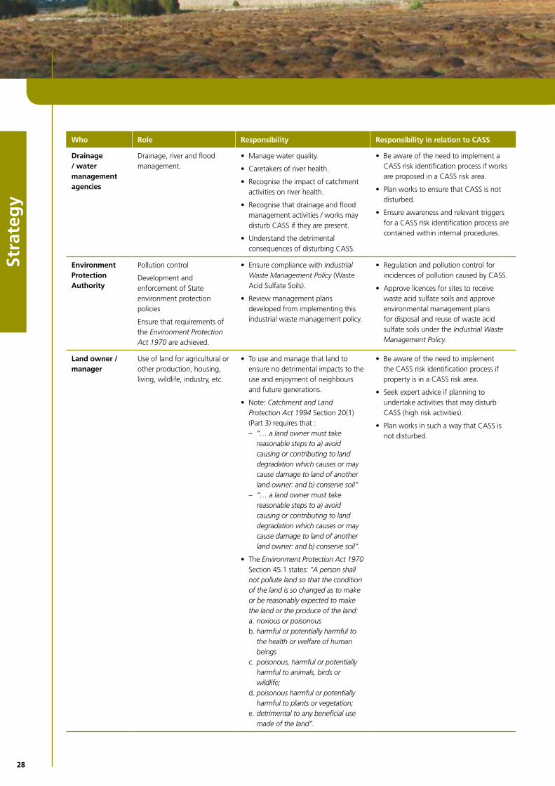
Drainage / water management agencies
Drainage,riverandfloodmanagement.
Manage water quality. •
Caretakers of river health. •
Recognisetheimpactofcatchment•activities on river health.
Recognisethatdrainageandflood•management activities / works may disturb CASS if they are present.
Understand the detrimental •consequences of disturbing CASS.
Be aware of the need to implement a •CASS risk identification process if works are proposed in a CASS risk area.
Plan works to ensure that CASS is not •disturbed.
Ensureawarenessandrelevanttriggers•for a CASS risk identification process are contained within internal procedures.
Environment Protection Authority
Pollution control
Developmentandenforcement of State environment protection policies
Ensurethatrequirementsofthe Environment Protection Act 1970 are achieved.
Ensurecompliancewith• Industrial Waste Management Policy(wasteAcidSulfateSoils).
Reviewmanagementplans•developed from implementing this industrial waste management policy.
Regulationandpollutioncontrolfor•incidences of pollution caused by CASS.
Approve licences for sites to receive •waste acid sulfate soils and approve environmental management plans for disposal and reuse of waste acid sulfate soils under the Industrial Waste Management Policy.
Land owner / manager
Use of land for agricultural or other production, housing, living, wildlife, industry, etc.
To use and manage that land to •ensure no detrimental impacts to the use and enjoyment of neighbours and future generations.
Note: • Catchment and Land Protection Act 1994Section20(1)(Part3)requiresthat:
“… a land owner must take –reasonable steps to a) avoid causing or contributing to land degradation which causes or may cause damage to land of another land owner: and b) conserve soil”“… a land owner must take –reasonable steps to a) avoid causing or contributing to land degradation which causes or may cause damage to land of another land owner: and b) conserve soil”.
The • Environment Protection Act 1970 Section45.1states: “A person shall not pollute land so that the condition of the land is so changed as to make or be reasonably expected to make the land or the produce of the land:
noxious or poisonousa. harmful or potentially harmful to b. the health or welfare of human beingspoisonous, harmful or potentially c. harmful to animals, birds or wildlife;poisonous harmful or potentially d. harmful to plants or vegetation; detrimental to any beneficial use e. made of the land”.
Be aware of the need to implement •the CASS risk identification process if property is in a CASS risk area.
Seek expert advice if planning to •undertake activities that may disturb CASS(highriskactivities).
Plan works in such a way that CASS is •not disturbed.

29
Strategy
Who Role Responsibility Responsibility in relation to CASS
Land management agencies
Manage land for the public good, for environmental, forestry and protection of natural resources.
Recognisetheimpactofcatchment•activities on river health.
Recognisethatsomeland•management activities, earth moving, drainage, mining etc may disturb CASS if present.
Understand detrimental •consequences of CASS disturbance.
Be aware of the need to implement the •CASS risk identification process if works are proposed in a CASS risk area.
Plan works in such a way that CASS is •not disturbed.
Ensureawarenessandrelevanttriggers•for CASS risk management process are contained within internal procedures.
Local government
Local government acting as planning and responsible authorities.
Local councils undertake strategic planning, develop strategies and identify appropriate planning scheme controls to regulate the use and development of the land, administer the planning scheme for their municipality and make decisions on individual applications for development proposals.
Planning and responsible authorities must consider “any significant effects which the authority considers the use or development may have on the environment or which the authority considers the environment may have on the use or development”.
Local governments also have a role as the land managers for public land. In many locations they are Committee of Management for Crown land.
When considering a request for a •planning scheme amendment or planning permit application the authority must consider the impact the proposal may have on the environment, including how the proposal will avoid disturbing CASS.
At the local level identify high risk •areas and develop land use and development strategies which are implemented through planning appropriate scheme response to avoid disturbing CASS.
Promote understanding in the •community of the detrimental consequences of disturbing CASS.
Identify land use changes in CASS risk •areas.
Recognisehighriskactivitiesthatmay•be proposed in a municipal area.
EnsureCASSresponsibilitiesofland•owner/developer(implementationoftheCASSriskmanagementprocess)is undertaken before any planning approvals are given.
Raiseawarenessinthegeneral•community of CASS and the CASS risk management process.
Administer any requirements to fulfil •this obligation under the Planning and Environment Act 1987.
Ensuredecision-makingisconsistent•with the decision-making principles for CASS management in the Victorian Best Practice Management Guidelines for Assessing and Managing CASS and the planning scheme.
EnforceanybreachofCASS•management requirements required by the planning scheme and overlay or a permit.
Regional Coastal Boards
Coastal planning advisory bodies.
Implement objectives and actions •identified in the Victorian Coastal Strategy2008(VCS).
Assist in communicating CASS issues to •the wider community.
Facilitateresponsetoproblemsthat•occur due to exposure of CASS.
Regional Water Authorities Victoria
Issuing of ground water licences •across
Administering drainage works.•
Note areas where CASS risks are identified and consider these risks to water quality in a groundwater licence application process.
Plan infrastructure works with the objective of avoiding disturbing CASS.
Victorian Coastal Council
Implement objectives and actions identified in the Victorian Coastal Strategy2008(VCS).
Ensureanydevelopmentproposednearoron coastal acid sulfate soils will avoid any disturbance.

30
31
Map
s
Map 1: Far South West Coast 32Map 2: West Coast 33Map 3: Central Coast 34Map 4: South Coast 35Map 5: Gippsland Lakes 36Map 6: East Coast 37
32
Map
s
●
●
●●●
●
●
MO
YN
E
GL
EN
EL
G
SO
UT
HE
RN
GR
AM
PIA
NS
AR
AR
AT
MO
YN
E
NEL
SON
POR
TLA
ND
POR
T FA
IRY
WA
RR
NA
MB
OO
L PETE
RB
OR
OU
GH
© S
tate
of
Vic
toria
, Dep
artm
ent
of P
rimar
y In
dust
ries
2006
Th
is p
ublic
atio
n is
cop
yrig
ht.
No
part
may
be
repr
oduc
ed b
y an
y pr
oces
s ex
cep
t in
acc
ord
ance
with
the
pro
visi
ons
of t
he C
opyr
ight
Act
196
8.
Dis
clai
mer
This
pub
licat
ion
may
be
of a
ssis
tanc
e to
yo
u bu
t th
e St
ate
of V
icto
ria a
nd it
s em
plo
yees
do
not
guar
ante
e th
at t
he p
ublic
atio
n is
with
out
flaw
of
any
kind
or
is w
holly
app
ropr
iate
for
yo
ur p
artic
ular
pur
pose
s an
d th
eref
ore
dis
clai
ms
all l
iabi
lity
for
any
erro
r, lo
ss o
r ot
her
cons
eque
nce
whi
ch m
ay a
rise
from
you
rel
yin
g on
any
info
rmat
ion
in t
his
publ
icat
ion
.
Map
1 F
ar S
ou
th-W
est
Co
ast
Pros
pect
ive
Land
: lan
d th
at h
as t
he p
oten
tial t
o co
ntai
n C
oast
al A
cid
Sulfa
te S
oils
010
2030
5
Kilo
met
res
Leg
end
Ro
ads
Riv
ers
Lake
sLo
cal G
ove
rnm
ent
Are
aPr
osp
ecti
ve L
and
N S
EW

33
Map
s
● ●●
●
●
●
●●
●
●●
●
CO
RA
NG
AM
ITE
CO
LA
C O
TW
AY
MO
YN
E
SU
RF
CO
AS
T
GR
EA
TE
R G
EE
LO
NG
LOR
NE
JOH
AN
NA
AN
GLE
SEA
WY
E R
IVER
APO
LLO
BA
Y
PRIN
CET
OW
N
QU
EEN
SCLI
FF
HO
RD
ERN
VA
LE
PETE
RB
OR
OU
GH
AIR
EYS
INLE
T
POR
TAR
LIN
GTO
N
POIN
T LO
NSD
ALE
Map
2 W
est
Co
ast
Pros
pect
ive
Land
: lan
d th
at h
as t
he p
oten
tial t
o co
ntai
n C
oast
al A
cid
Sulfa
te S
oils
© S
tate
of
Vic
toria
, Dep
artm
ent
of P
rimar
y In
dust
ries
2006
This
pub
licat
ion
is c
opyr
igh
t. N
o pa
rt m
ay b
e re
prod
uced
by
any
proc
ess
exce
pt
in a
cco
rdan
ce w
ith t
he p
rovi
sion
s of
the
Cop
yrig
ht A
ct 1
968.
Dis
clai
mer
This
pub
licat
ion
may
be
of a
ssis
tanc
e to
yo
u bu
t th
e St
ate
of V
icto
ria a
nd it
s em
plo
yees
do
not
guar
ante
e th
at t
he p
ublic
atio
n is
with
out
flaw
of
any
kind
or
is w
holly
app
ropr
iate
for
yo
ur p
artic
ular
pur
pose
s an
d th
eref
ore
dis
clai
ms
all l
iabi
lity
for
any
erro
r, lo
ss o
r ot
her
cons
eque
nce
whi
ch m
ay a
rise
from
you
rel
yin
g on
any
info
rmat
ion
in t
his
publ
icat
ion.
010
2030
5
Kilo
met
res
Leg
end
Ro
ads
Riv
ers
Lake
sLo
cal G
ove
rnm
ent
Are
aPr
osp
ecti
ve L
and
N S
EW
GO
LD
EN
PL
AIN
S
34
Map
s
●
●
●●
●●
●●
●
●●
●
●
●●
●
●●
CA
RD
INIA
SU
RF
CO
AS
T
BA
W B
AW
BA
SS
CO
AS
T
YA
RR
A R
AN
GE
S
CA
SE
Y
GO
LD
EN
CO
AS
T
WY
ND
HA
M
MO
OR
AB
OO
L
SO
UT
H G
IPP
SL
AN
D
ME
LT
ON
KN
OX
MO
NA
SH
RYE
LOR
NE
TYA
BB
POR
TSEA
KIL
CU
ND
ASA
N R
EMO
AN
GLE
SEA
INV
ERLO
CH
WO
NTH
AG
GI
FRA
NK
STO
N
MEL
BO
UR
NE
GR
AN
TVIL
LE
QU
EEN
SCLI
FF
AIR
EYS
INLE
T
MO
UN
T M
AR
THA
POR
TAR
LIN
GTO
N
POIN
T LO
NSD
ALE
WER
RIB
EE S
OU
TH
Map
3 C
entr
al C
oas
tPr
ospe
ctiv
e La
nd: l
and
that
has
the
pot
entia
l to
cont
ain
Coa
stal
Aci
d Su
lfate
Soi
ls
© S
tate
of
Vic
toria
, Dep
artm
ent
of P
rimar
y In
dust
ries2
006
This
pub
licat
ion
is c
opyr
igh
t. N
o pa
rt m
ay b
e re
prod
uced
by
any
proc
ess
exce
pt
in a
cco
rdan
ce w
ith t
he p
rovi
sion
s of
the
Cop
yrig
ht A
ct 1
968.
Dis
clai
mer
This
pub
licat
ion
may
be
of a
ssis
tanc
e to
yo
u bu
t th
e St
ate
of V
icto
ria a
nd it
s em
plo
yees
do
not
guar
ante
e th
at t
he p
ublic
atio
n is
with
out
flaw
of
any
kind
or
is w
holly
app
ropr
iate
for
yo
ur p
artic
ular
pur
pose
s an
d th
eref
ore
dis
clai
ms
all l
iabi
lity
for
any
erro
r, lo
ss o
r ot
her
cons
eque
nce
whi
ch m
ay a
rise
from
you
rel
yin
g on
any
info
rmat
ion
in t
his
publ
icat
ion
010
2030
5
Kilo
met
res
Leg
end
Ro
ads
Riv
ers
Lake
sLo
cal G
ove
rnm
ent
Are
aPr
osp
ecti
ve L
and
N S
EW

35
Map
s
●
●
●●
●
●●
●
●●
●●
●●
●
●
WE
LLIN
GT
ON
SOU
TH
GIP
PSL
AN
D
LAT
RO
BE
BA
SS C
OA
ST
BA
W B
AW
BA
W B
AW
FOST
ER
TAR
WIN
ALB
ERTO
N
KIL
CU
ND
A
SEA
SPR
AY
WEL
SHPO
OL
INV
ERLO
CH
WO
NTH
AG
GI
GR
AN
TVIL
LE
WA
LKER
VIL
LE
POR
T A
LBER
T
REE
VES
BEA
CH
SHA
LLO
W IN
LET
POR
T W
ELSH
POO
LMC
LOU
GH
LIN
S B
EAC
H
Map
4 S
ou
th C
oas
tPr
ospe
ctiv
e La
nd: l
and
that
has
the
pot
entia
l to
cont
ain
Coa
stal
Aci
d Su
lfate
Soi
ls
© S
tate
of
Vic
toria
, Dep
artm
ent
of P
rimar
y In
dust
ries
2006
This
pub
licat
ion
is c
opyr
igh
t. N
o pa
rt m
ay b
e re
prod
uced
by
any
proc
ess
exce
pt
in a
cco
rdan
ce w
ith t
he p
rovi
sion
s of
the
Cop
yrig
ht A
ct 1
968.
Dis
clai
mer
This
pub
licat
ion
may
be
of a
ssis
tanc
e to
yo
u bu
t th
e St
ate
of V
icto
ria a
nd it
s em
plo
yees
do
not
guar
ante
e th
at t
he p
ublic
atio
n is
with
out
flaw
of
any
kind
or
is w
holly
app
ropr
iate
for
yo
ur p
artic
ular
pur
pose
s an
d th
eref
ore
dis
clai
ms
all l
iabi
lity
for
any
erro
r, lo
ss o
r ot
her
cons
eque
nce
whi
ch m
ay a
rise
from
you
rel
yin
g on
any
info
rmat
ion
in t
his
publ
icat
ion.
010
2030
5
Kilo
met
res
Leg
end
Ro
ads
Riv
ers
Lake
sLo
cal G
ove
rnm
ent
Are
aPr
osp
ecti
ve L
and
N S
EW

36
Map
s
●●
●
●
●
●
EA
ST G
IPP
SLA
ND
WE
LLIN
GT
ON
SALE
MA
RLO
SEA
SPR
AY
LOC
H S
POR
T
BA
IRN
SDA
LE
LAK
ES E
NTR
AN
CE
.
Map
5 G
ipp
slan
d L
akes
Pros
pect
ive
Land
: lan
d th
at h
as t
he p
oten
tial t
o co
ntai
n C
oast
al A
cid
Sulfa
te S
oils
© S
tate
of
Vic
toria
, Dep
artm
ent
of P
rimar
y In
dust
ries
2006
This
pub
licat
ion
is c
opyr
igh
t. N
o pa
rt m
ay b
e re
prod
uced
by
any
proc
ess
exce
pt
in a
cco
rdan
ce w
ith t
he p
rovi
sion
s of
the
Cop
yrig
ht A
ct 1
968.
Dis
clai
mer
Th
is p
ublic
atio
n m
ay b
e of
ass
ista
nce
to y
ou
but
the
Stat
e of
Vic
toria
and
its
empl
oye
es d
o no
t gu
aran
tee
that
the
pub
licat
ion
is w
ithou
t fla
w o
f an
y ki
nd o
r is
who
lly a
ppro
pria
te f
or y
our
par
ticul
ar p
urpo
ses
and
ther
efo
re d
iscl
aim
s al
l lia
bilit
y fo
r an
y er
ror,
loss
or
othe
r co
nseq
uenc
e w
hich
may
aris
efr
om y
ou r
elyi
ng
on a
ny in
form
atio
n in
thi
s pu
blic
atio
n
010
2030
5
Kilo
met
res
Leg
end
Ro
ads
Riv
ers
Lake
sLo
cal G
ove
rnm
ent
Are
aPr
osp
ecti
ve L
and
N S
EW

37
Map
s
●
●●
●
EA
ST G
IPP
SLA
ND
MA
RLO
TAM
BO
ON
BEM
M R
IVE
R
MA
LLA
CO
OTA
Map
6 E
ast
Co
ast
Pros
pect
ive
Land
: lan
d th
at h
as t
he p
oten
tial t
o co
ntai
n C
oast
al A
cid
Sulfa
te S
oils
© S
tate
of
Vic
toria
, Dep
artm
ent
of P
rimar
y In
dust
ries2
006
This
pub
licat
ion
is c
opyr
igh
t. N
o pa
rt m
ay b
e re
prod
uced
by
any
proc
ess
exce
pt
in a
cco
rdan
ce w
ith t
he p
rovi
sion
s of
the
Cop
yrig
ht A
ct 1
968.
Dis
clai
mer
This
pub
licat
ion
may
be
of a
ssis
tanc
e to
yo
u bu
t th
e St
ate
of V
icto
ria a
nd it
s em
plo
yees
do
not
guar
ante
e th
at t
he p
ublic
atio
n is
with
out
flaw
of
any
kind
or
is w
holly
app
ropr
iate
for
yo
ur p
artic
ular
pur
pose
s an
d th
eref
ore
dis
clai
ms
all l
iabi
lity
for
any
erro
r, lo
ss o
r ot
her
cons
eque
nce
whi
ch m
ay a
rise
from
you
rel
yin
g on
any
info
rmat
ion
in t
his
publ
icat
ion.
010
2030
5
Kilo
met
res
Leg
end
Ro
ads
Riv
ers
Lake
sLo
cal G
ove
rnm
ent
Are
aPr
osp
ecti
ve L
and
N S
EW

www.dse.vic.gov.au
Recommended