Using GIS for Land Use Compatibility Planning Near Airports
Wednesday, November 20, 20192:00-3:30 PM ET
TRANSPORTATION RESEARCH BOARD

Purpose
To discuss ACRP Research Report 200: Using GIS for Collaborative Land Use Compatibility Planning Near Airports.
Learning Objectives
At the end of this webinar, you will be able to:
• Describe how GIS can be used to help airports realize their land use compatibility goals
• Apply the tools that will help airports and community organizations implement GIS data and applications
• Discuss how to navigate the complexities of the various types of stakeholder organizations involved in airport land use compatibility planning

ACRP WebinarUsing GIS for Land Use Compatibility
Planning Near AirportsNovember 20, 2019

Five Ways to Get Involved!
Visit us online: www.trb.org/ACRP
Randy MurphyArora Engineers, Inc.
Today’s Speakers
Presenting
ACRP Report 200 Using GIS for Collaborative Land Use Compatibility
Planning Near Airports

Geospatial Technical LeadFocused on Airport IT solutions for over 25 yearsHas helped numerous airports in the US and abroad implement GISTechnical focus on data standards and database designDeveloped airspace analysis toolsLed development of a U.S. DOT funded Airport Planning & Analysis ToolFormer ACRP Ambassador
Randy MurphyPrincipal Investigator

ACRP REPORT 200
Using GIS for Collaborative Land Use Compatibility Planning Near Airports
Randy Murphy
Arora Engineers, Inc.

Daniel P. Bartholomew, Reno-Tahoe Airport Authority, Reno, NV (Chair)
Ataa Aly, San Diego County Regional Airport Authority, San Diego, CA
Scott R. Brummond, Wisconsin DOT, Madison, WI
Andrew Taylor, Cubic Transportation Systems Inc., Alexandria, VA
Diana Umpierre, Pembroke Pines, FL
Daniel White, Fairfax Co. Dept. of Planning & Zoning, Fairfax, VA
Michael Lawrance, FAA Liaison
Christopher J. Oswald, Airports Council International—North America Liaison
Thomas Palmerlee, TRB Liaison
ACRP Report 200 Oversight Panel

Illustrates how and why GIS is an effective tool for land use compatibility planning around airportsProvides technical guidance for developing he necessary data and deploying best-of-breed solutionsProvides several case studies of successful solutions Provides a road map for navigating airport, FAA, and local agency organizational structures, procedures, and policiesEstablished a framework for and encourages collaboration amongst stakeholders in the land around airports
ACRP Report 200: Using GIS for Collaborative Land Use Compatibility Planning Near Airports
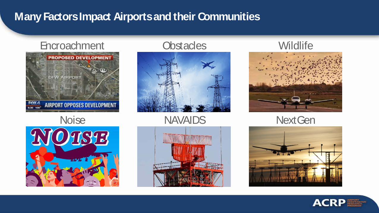
Many Factors Impact Airports and their Communities
Obstacles
NextGenNoise NAVAIDS
WildlifeEncroachment

Airports Face Challenges
Encroachment from surrounding communitiesChanges to airspace and obstaclesNew / newly enforced regulation Broad and diverse set of stakeholders

Most Recognize the Importance of Collaboration
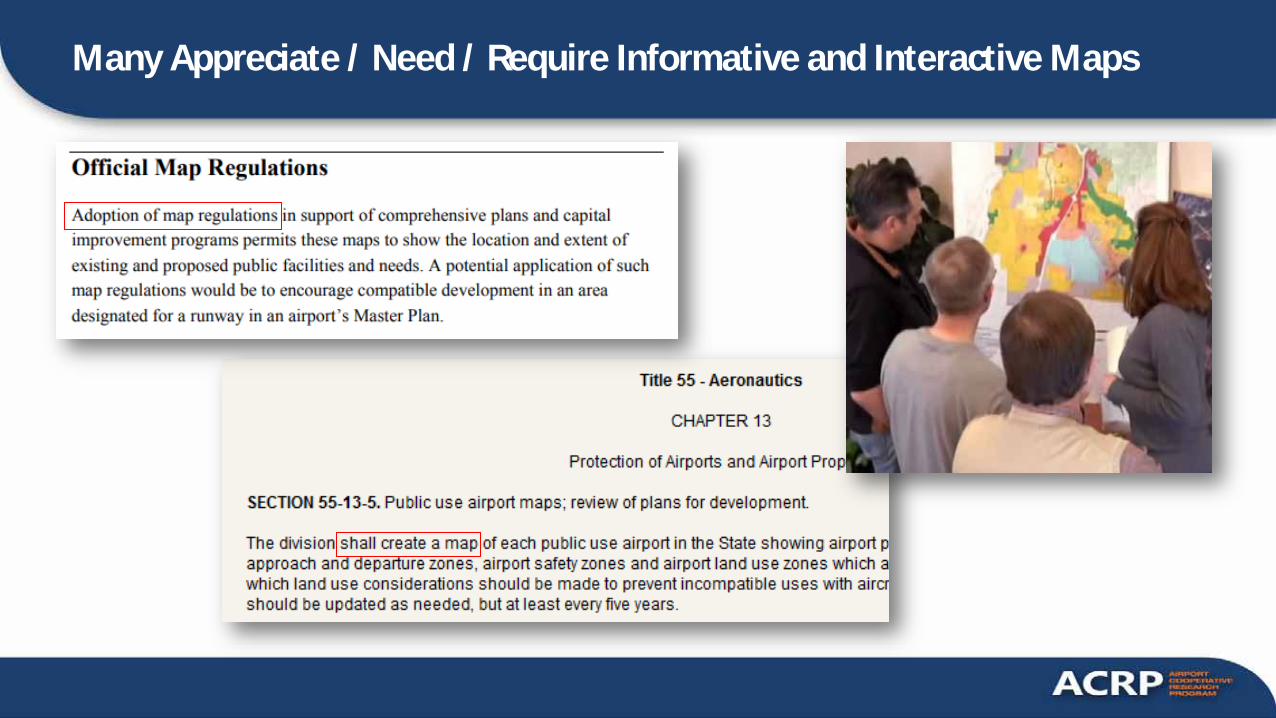
Many Appreciate / Need / Require Informative and Interactive Maps

Some Have Made Interactive Maps Accessible to the Public

GIS Has Helped
Collect a broad variety of relevant dataAnalyze trends, what-if-scenarios and geographic patternsCommunicate the results in an intuitive mannerFoster collaboration

The Problem
GIS has not been used as broadly as it could to address airport land use compatibility problems
The Problem

Reasons Behind the Problem
Airport and community planners are often not aware of The benefits of using GISHow to approach the problemHow much it costs
GIS Managers, Analysts, and Developers often don’t know Where to get dataHow to address underlying needs

Objectives of this Research
Increase awareness of the benefits of GISProvide guidance on how to get startedIdentify data resources and common functional requirementsIllustrate success storiesFoster collaboration

Prioritization of Land Use Issues

Our Deliverables
Guidance Checklists
Toolkit
Training
Outreach
www.AirportLandUse.com

Guidebook

ARP Compliance: Grant Assurances
Acceptance of Federal funding obligates airports to comply with an extensive list of grant assurances
1. General Federal Requirements2. Responsibility and Authority of the Sponsor 3. Sponsor Fund Availability 4. Good Title 5. Preserving Rights and Powers 6. Consistency with Local Plans 7. Consideration of Local Interest 8. Consultation with Users 9. Public Hearings 10. Air and Water Quality Standards 11. Pavement Preventive Maintenance 12. Terminal Development Prerequisites 13. Accounting System, Audit, and Record Keeping Requirements14. Minimum Wage Rates 15. Veteran's Preference 16. Conformity to Plans and Specifications 17. Construction Inspection and Approval 18. Planning Projects
19. Operation and Maintenance 20. Hazard Removal and Mitigation 21. Compatible Land Use 22. Economic Nondiscrimination 23. Exclusive Rights 24. Fee and Rental Structure 25. Airport Revenues 26. Reports and Inspections 27. Use by Government Aircraft 28. Land for Federal Facilities 29. Airport Layout Plan 30. Civil Rights 31. Disposal of Land 32. Engineering and Design Services 33. Foreign Market Restrictions 34. Policies, Standards, and Specifications 35. Relocation and Real Property Acquisition 36. Access By Intercity Buses 37. Disadvantaged Business Enterprises 38. Hangar Construction 39. Competitive Access
Assurances Related to Projects Arora Supports

Overview of FAA Requirements
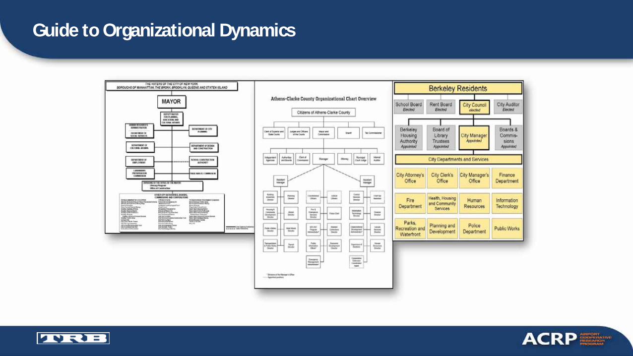
Guide to Organizational Dynamics
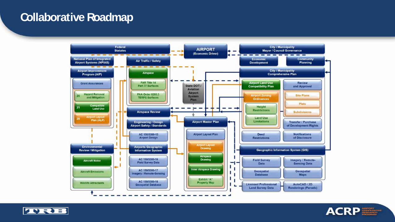
Collaborative Roadmap

Data Resources & Functional Specs
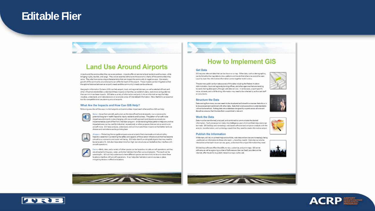
Editable Flier

Editable Training MaterialEDITABLE TRAINING MATERIAL

CASE STUDIES

Obstruction Evaluation at ATL

Noise Mitigation at FLL
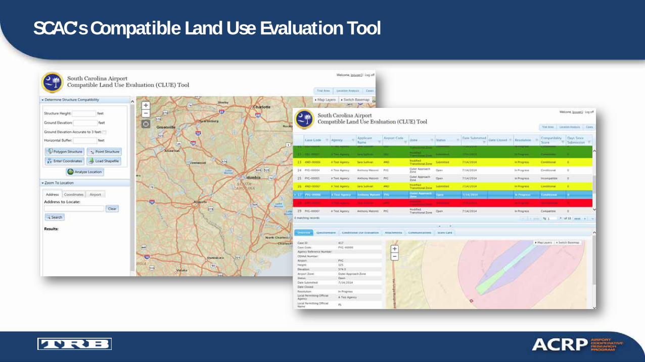
SCAC’s Compatible Land Use Evaluation Tool
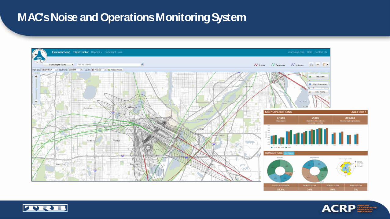
MAC’s Noise and Operations Monitoring System

DFW – Procedure Studies

Puget Sound Regional Study

Today’s Speakers• Dan Bartholomew, Reno-Tahoe
Airport Authority, [email protected]
• Randy Murphy, Arora Engineers, Inc., [email protected]

ACRP is an Industry–Driven Program
Managed by TRB and sponsored by the Federal Aviation Administration (FAA).Seeks out the latest issues facing the airport industry.Conducts research to find solutions.Publishes and disseminates research results through free publications and webinars.

Other Ways to Participate
Become an Ambassador. Ambassadors represent ACRP at events and conferences across the country!
Sponsor or become an ACRP Champion. The champion program is designed to help early- to mid-career, young professionals grow and excel within the airport industry.
Visit ACRP’s Impacts on Practice webpage to submit leads on how ACRP’s research is being applied at any airport.

Report 80: Guidebook for Incorporating Sustainability into Traditional Airport Projects
Report 108: Guidebook for Energy Facilities Compatibility with Airports and Airspace
Report 141: Renewable Energy as an Airport Revenue Source
Report 151: Developing a Business Case for Renewable Energy at Airports
Synthesis 66: Lessons Learned from Airport Sustainability Plans
Synthesis 85: Alternative Fuels in Airport Fleets
Synthesis 93: Sustainability’s Role in Enhancing Airport Capacity
Synthesis 100: Airport Greenhouse Gas Reduction Efforts
Additional ACRP Publications Available on Today’s Topic

November 20Using GIS for Land Use Compatibility Planning
Near Airports
December 10Give the ‘All Clear’—Hazard Zoning
at GA Airports
Stay Tuned for ACRP’s 2020 Webinar Series!
Upcoming ACRP Webinars

Recommended