USGS-OFR-83-386 RHO-B¥-CR-139 P/
UNITED STATES DEPARTMENT OF THE INTERIOR
GEOLOGICAL SURVEY
Principal Facts and Density Estimates for Borehole Gravity Stations
in Boreholes RRL-3, -4, -5, -6B, -7, -8, and -9
at the Hanford Site, Benton County, Washington
by
1 2 1 S. L. Robbins , J. R. Kunk , and F. G. Clutsom
Open-File Report 83-386
Prepared for Rockwell Hanford Operations, a prime contractor to the U.S. Department of Energy under Contract DE-AC06-77RL01030
This report is preliminary and has not been reviewed for conformity with U.S. Geological Survey editorial standards and stratigraphic nomenclature. Any use of trade names is for descriptive purposes only and does not imply endorsement by the USGS.
«U.S. Geological Survey, Denver, Colorado Rockwell Hanford Operations, Richland, Washington
1983
USGS-OFR-83-386 RHO-BW-CR-139 P/
TABLE OF CONTENTSPage
Introduction 1 Borehole data 1 Borehole gravity meter interpretative summary 31 References 42
ILLUSTRATIONS
Figure 1. Index map showing location of boreholegravity surveys 2
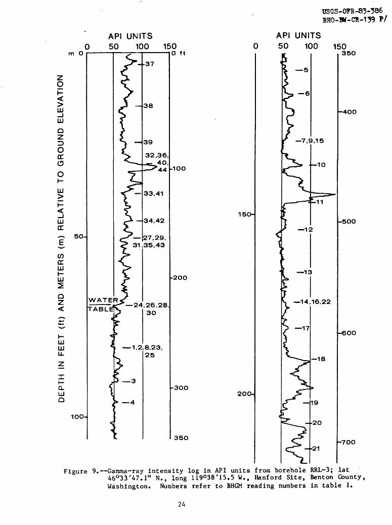
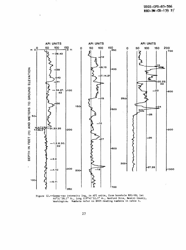
2. Drift correction curve for BH-6 in borehole RRL-3 173. Drift correction curve.for BH-6 in borehole RRL-4 184- Drift correction curve for BH-6 in borehole RRL-5 195- Drift correction curve for BH-6 in borehole RRL-6B 206. Drift correction curve for BH-6 in borehole RRL-7 217. Drift correction curve for BH-6 in borehole RRL-8 228. Drift correction curve for BH-6 in borehole RRL-9 239. Gamma-ray log from borehole RRL-3 2410. Gamma-ray log from borehole RRL-4 2511. Gamma-ray log from borehole RRL-5 2612. . Gamma-ray log from borehole RRL-6B 2713- Gamma-ray log from borehole RRL-7 2814- Gamma-ray log from borehole RRL-8 2915. Gamma-ray log from borehole RRL-9 30
TABLES
Table 1. Principal facts for borehole RRL-3 42. Principal facts for borehole RRL-4 63. Principal facts for borehole RRL-5 84. Principal facts for borehole RRL-6B 105. Principal facts for borehole RRL-7 126. Principal facts for borehole RRL-8 147. Principal facts for borehole RRL-9 158. Density estimates for borehole RRL-3 339. Density estimates for borehole RRL-4 3410. Density estimates for borehole RRL-5 3511. Density estimates for borehole RRL-6B 3612. Density estimates for borehole RRL-7 3713- Density estimates for borehole RRL-8 3814. Density estimates for borehole RRL-9 3915. Stratigraphic section and unit depths in boreholes
RRL-8, -7, -3, -9, and -4 4016. Stratigraphic section and unit depths in boreholes
RRL-7, -5, and -6B 41

USGS-OFR-83-386 RHO-BW-CR-139 P/
INTRODUCTION
Borehole gravity surveys were conducted in seven boreholes, located within a 10 square mile (25 square km) area in the northwestern portion of the Hanford Site, Washington (fig. 1), in June and July, 1982, by the U.S. Geological Survey (USGS) using La Coste and Romberg slim-hole borehole gravity meter (BHGM) BH-6.
Borehole gravity meters (BHGMs) are primarily density logging tools having a large radius of investigation compared to conventional logging tools and are not significantly affected by casing, borehole rugosity, or other near-borehole conditions. Therefore, a BHGM survey provides a unique and independent measurement of in-situ bulk density, which, when integrated with data from conventional logs and (or) cores, can provide a better understanding of the physical properties of subsurface rocks in areas of "simple" geology, or the structure (remote sensing) when there are density changes horizontally away from the well. Robbins (1980) contains a complete listing of references pertaining to borehole gravimetry.
The primary objective of these surveys was to obtain accurate, average, in-situ densities of the sediments that overlie the basalts in the area. These density values along with lithology data and other well-log information will be integrated into a three-dimensional density model to be used with a detailed surface gravity survey of the area to determine the location of the top of the basalt, which varies between about 600 and 800 ft (200 and 270 m) below the surface. This study is part of the U.S. Department of Energy's assessment as to whether the basalt is suitable for the storage of radioactive wastes.
This report contains the principal facts obtained during the surveys (tables 1 through 7) and estimates of in-situ bulk densities from these data (tables 8 through 14). Also included are reduced sections of the gamma-ray logs with the BHGM station locations indicated (figs. 9 through 15) and summaries of the stratigraphic section for each borehole (tables 15 and 16).
This study was carried out in cooperation with Rockwell Hanford Operations at Richland, Washington. This is the second BHGM study that has been made in the area by the USGS (Robbins and others, 1979). Other BHGM studies by the USGS in other radioactive waste storage study areas include Schmoker (1980) and Robbins and others (1982).
BOREHOLE DATA
Tables 1 through 7 present the principal facts for the gravity stations occupied during the BHGM surveys. The column headings for these tables are explained in the following list:
Reading #: The order in which the borehole gravity stations were read.
Depth: Depth of station in feet (ft) and meters (m). Datum is the ground elevation at the well.
Time: Coordinated Universal Time (CUT) of the mean of each set of gravity slope readings (beam velocities).

USGS-OFR-83-386 RHO-BW-CR-139 P/
UNITED STATES DEPARTMENT OF ENERGY
HANFORD SIT
RRL-B
33
\ !
2OO WEST j BOUNDARY
___ SMILES
2 KILOMETERS
CONTOUR INTERVALS 20 FEET AND 100 FEET
BHGM SURVEYS TH.S REPORT o BHeM SURVEV (Robbins , n<J o , hers> , 97g)
Figure 1. Index map showing locations of borehole gravity survey
USGS-OFR-83-386 RHO-BV-CR-139 P/
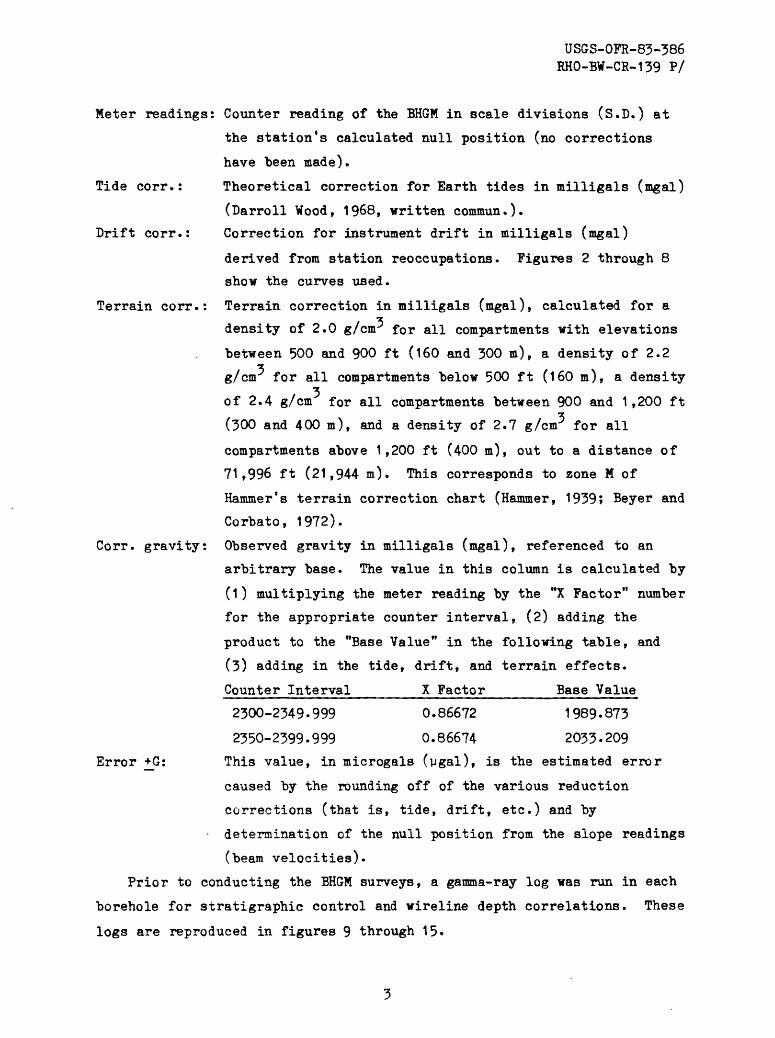
Meter readings: Counter reading of the BHGM in scale divisions (S.D.) at
the station's calculated null position (no corrections
have been made).
Tide corr.: Theoretical correction for Earth tides in milligals (mgal)
(Darroll Wood, 1968, written commun.).
Drift corr.: Correction for instrument drift in milligals (mgal)
derived from station reoccupations. Figures 2 through 8
show the curves used.
Terrain corr.: Terrain correction in milligals (mgal), calculated for a
density of 2.0 g/cm* for all compartments with elevations
between 500 and 900 ft (160 and 300 m), a density of 2.2 z
g/cm for all compartments below 500 ft (160 m), a density
of 2.4 g/cm for all compartments between 900 and 1,200 ft z
(300 and 400 m), and a density of 2.7 g/cnr for all
compartments above 1,200 ft (400 m), out to a distance of
71,996 ft (21,944 m). This corresponds to zone M of
Hammer's terrain correction chart (Hammer, 1939; Beyer and
Corbato, 1972).
Corr. gravity: Observed gravity in milligals (mgal), referenced to an
arbitrary base. The value in this column is calculated by
(1) multiplying the meter reading by the "X Factor" number
for the appropriate counter interval, (2) adding the
product to the "Base Value" in the following table, and
(3) adding in the tide, drift, and terrain effects.
Counter Interval______X Factor______Base Value
2300-2349.999 0.86672 1989.873
2350-2399.999 0.86674 2033-209
Error +G: This value, in microgals (vgal), is the estimated error
caused by the rounding off of the various reduction
corrections (that is, tide, drift, etc.) and by
determination of the null position from the slope readings
(beam velocities).
Prior to conducting the BHGM surveys, a gamma-ray log was run in each
borehole for stratigraphic control and wireline depth correlations. These
logs are reproduced in figures 9 through 15-

USGS-OFR-83-386 RHO-BW-CR-139 P/
Table 1. Principal Facts for Borehole RRL-3, Hanford Site,Benton County, Washington
[Located at lat" 46° 33* 47.07" N., long 119° 38' 15.48" ¥.; ground elevation 686.8 ft (209.3 )!
Reading*
Depth (ft) (m)
Logged 06-30-82
1
2
3
4
5
6
7
8
9
10
11
12
13
14
15
16
17
18
19
20
21
22
23
24
25
26
27i
263.1
263.1
294.0
313.1
362.1
384.1
425.1
263.1
425.1
449.1
482.1
506.1
543.1
571.1
425.1
571.1
' 596.1
624.1
664.1
683.1
705.1
571.1
263.1
225.2
263.1
225.2
164.?
80.19
80.19
89.61
95.43
110.37
117.07
129.57
80.19
129.57
136.89
145.94
154.26
165.54
174.07
129.57
174.07
181.59
190.23
202. 42
203.21
214.91
174.0?
60.19
68.64
PJ.19
£3.61 !
69.05
Time (CUT)
1618
1629
1647
1702
1714
1724
1740
1756
1813
1822
1836
1848
1900
1912
1927
1942
1958
- 2010
2019
2032
2042
2056
2117
2133
2143
2157
2215
Meter readings
(SD)
2344.966
2344.959
2346.133
2346.828
2348.659
2349.549
2351.129
2344.946
2351.130
2352.086
2353.579
2354.505
2355.617
2356.312
2351.130
2356.313
2356.888
2357.538.
2359.482
2361.442
2351,560
2356.305
2344.959
2343.599
2344.908
2343. 6f>0
23-11.181
Tidal corr. (mgal)
+0.058
+0.059
+0.061
+0.062
+0.062
+0.061
+0.060
+0.058
+0.055
+0.053
+0.050
+0.047
+0.043
+0.040
+0.034
+0.029
+0.023
+0.018
+0.015
+0.009
+0.005
0.000
-0.003
-0.015
-0.018
-0.023
-0.029
Drift corr.(mgal )
-0.005
0.000
+0.001
+0.003
+0.004
+0.005
+0.007
+0.012
+0.012
+0.014
+0.016
+0.018
+0.020
+0.023
+0.033
+0.033
+0.040
+0.046
+0.050
+0.057
+0.062
+0.069
+0.067
+0.068
+0.069
0.032
-0.035
Terrain corr.
(mgal)
0.190
0.190
0.194
0.197
0.203
0.206
0.210
0.190
0.210
0.212
0.215
0.217
0.219
0.221
0.210
0.221
0.222
0.224
0.225
0.226
0.227
0.221
0.190
0.183
0.190
0.1C3
0.171
Corr. Gravity (mgal )
2029.089
2029.089
2030.113
2030.722
2032.316
2033.090
2034.465
2029.089
2034.465
2035.296
2036.592
2037.396
2038.359
2038.964
2034.465
2038.964
2039.464
2040.030
2041.717
2042.551
2043.523
2038.964
2029. OS9
2027.897
2029.089
2027.897
2025.671
Error +G
(pgal)
+3
+4
+2.5
+3
+3
+5
+2.5
±3
+3.5
+3.5
+3
+2.5
+2.5
+3
+4
+3
±4
±3
+2.5
+2
±2-5
+3
+2.5
+3
+2.5
±3
±3

USGS-OFR-83-386 RHO-BW-CR-139 P/
Table 1. Principal Facts for Borehole RRL-3, Hanford Site,Benton County t Washington
[Located at lat 46° 33* 47.07" N., long 119° 38 f 15.48" W.; ground elevation 686.8 ft (209-3 «)1.
CSheet 2 of 2)
Reading1
28
29
30
31
32
33
34
35
36
37
38
39
40
41
42
43
44
Depth (ft) (m)
225.2
164.2
225.2
164.2
96.2
122.2
149.2
164.2
96.2
7.2
45.2
77.2
96.2
122.2
149.2
164.2
96.2
68.64
50.05
68.64
50.05
29.32
37.25
45.48
50.05
29.32
2.19
13.78
23.53
29.32
37.25
45.48
50.05
29.32
Time (CUT)
2227
2241
2254
2307
2322
2333
2346
2359
0011
0026
0038
0048
0101
0112
0122
0132
0142
Heter readings "
(SD)
2343.777
2341.228
2343.786
2341.227
2337.965
2339.488
2340.744
2341.365
2388.094
2333.627
2335.569
2337.093
2338.113
2339.616
2340.827
2341.424
2338.114
Tidal corr. (mgal)
-0.032
-0.036
-0.039
-0.042
-0.045
-0.046
-0.048
-0.049
-0.050
-0.051
-0.051
-0.051
-0.051
-0.051
-0.050
-0.049
-0.049
Drift corr. (mgal)
-0.069
-0.070
-0.070
-0.063
-0.102
-0.119
-0.156
-0.176
-0.209
-0.213
-0.217
-0.220
-0.224
-0.225
-0.226
-0.227
-0.227
Terrain corr. (mgal)
0.183
0.171
0.183
0.171
0.153
0.160
0.167
0.171
0.153
0.117
0.135
0.147
0.153
0.160
0.167
0.171
0.153
Corr. gravity (mgal)
2027.837
2025.671
2027.897
2025.671
2022.784
2024.093
2025.150
2025.671
2022.784
2018.871
2020.568
2021.898
2022.784
2024.093
2025.150
2025.671
2022.784
Error +G
(ygai)±5
±2.5
±4
±4
±2.5
±2.5
±3
±3
±3
±3
±2.5
±3
±4
±3
±3.5
±4
±4
USGS-OFR-83-386 RHO-BW-CR-139 P/
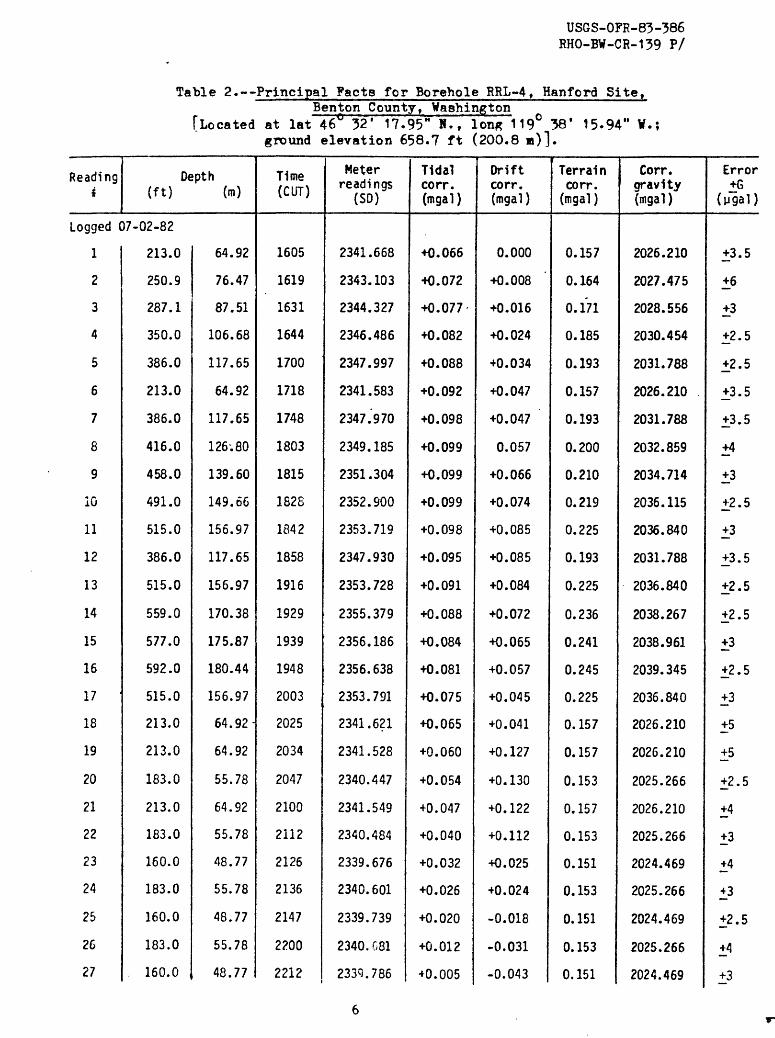
Table 2. Principal Facts for Borehole RRL-4, Hanford Site,Benton County, Washington
[Located at lat 46° 32' 17.95" M. f Ion* 119° 38' 15-94" W.; ground elevation 658.7 ft (200.8 m)].
Readingi
Depth (ft) (m)
Logged 07-02-82
1
2
3
4
5
6
7
8
9
10
11
12
13
14
15
16
17
18
19
20
21
22
23
24
25
26
27
213.0
250.9
287.1
350.0
386.0
213.0
386.0
416.0
458.0
491.0
515.0
386.0
515.0
559.0
577.0
592.0
515.0
213.0
213.0
183.0
213.0
183.0
160.0
183.0
160.0
183.0
. 160.0 ,
64.92
76.47
87.51
106.68
117.65
64.92
117.65
126-.80
139.60
149.66
156.97
117.65
156.97
170.38
175.87
180.44
156.97
64.92-
64.92
55.78
64.92
55.78
48.77
55.78
48.77
55.78
48.77
Time (CUT)
1605
1619
1631
1644
1700
1718
1748
1803
1815
1828
1842
1858
1916
1929
1939
1948
2003
2025
2034
2047
2100
2112
2126
2136
2147
2200
2212
Meter readings
(SO)
2341.668
2343.103
2344.327
2346.486
2347.997
2341.583
2347 .'9 70
2349.185
2351.304
2352.900
2353.719
2347.930
2353.728
2355.379
2356.186
2356.638
2353.791
2341.621
2341.528
2340.447
2341.549
2340.484
2339.676
2340.601
2339.739
2340. G81
2339.786
Tidal corr. (tngal )
+0.066
+0.072
+0.077
+0.082
+0.088
+0.092
+0.098
+0.099
+0.099
+0.099
+0.098
+0.095
+0.091
+0.088
+0.084
+0.081
+0.075
+0.065
+0.060
+0.054
+0.047
+0.040
+0.032
+0.026
+0.020
+0.012
+0.005
Drift corr.(mgal )
0.000
+0.008
+0.016
+0.024
+0.034
+0.047
+0.047
0.057
+0.066
+0.074
+0.085
+0.085
+0.084
+0.072
+0.065
+0.057
+0.045
+0.041
+0.127
+0.130
+0.122
+0.112
+0.025
+0.024
-0.018
-0.031
-0.043
Terrain corr.
(mgal }
0.157
0.164
0.171
0.185
0.193
0.157
0.193
0.200
0.210
0.219
0.225
0.193
0.225
0.236
0.241
0.245
0.225
0.157
0.157
0.153
0.157
0.153
0.151
0.153
0.151
0.153
0.151
Corr. gravity (mgal )
2026.210
2027.475
2028.556
2030.454
2031.788
2026.210
2031.788
2032.859
2034.714
2036.115
2036.840
2031.788
2036.840
2038.267
2038.961
2039.345
2036.840
2026.210
2026.210
2025.266
2026.210
2025.266
2024.469
2025.266
2024.469
2025.266
2024.469
Error +G
(ygal)
+3.5
±6
+3
+2.5
+2.5
+3.5
+3.5
+4
+3
+2.5
+3
+3.5
+2.5
+2.5
+3
+2.5
+3
+5
+5
+2.5
+4
+3
+4
±3
+2.5
+4
±3

USGS-OFP-83-386 RHO-BW-CR-139 P/
Table 2. Principal Facts for Borehole RRL-4, Hanford Site,Benton County, Washington
[Located at lat 46° 32' 17.95" K., Ion* 119° 38* 15-94" V.; ground elevation 658.7 ft (200.8 )].
(Sheet 2 of 2)
Reading 1
28
29
30
31
32
33
34
35
36
37
38
39
40
41
42
43
44
45
Depth (ft) (n)
183.0
160.0
90.0
107.0
140.0
160.0
160.0
90.0
107.0
140.0
160.0
90.0
9.1
38.1
58.1
77.1
90.0
9.1
55.78
48.77
27.43
32.61
42.67
48.77
48.77
27 .~43
32.61
42.67
48.77
27.43
2.77
11.61
17.71
23.50
27.43
2.77'
Tims (CUT)
2225
2234
2250
2301
2311
2324
2328
2340
2349
0000
0010
0023
0037
0048
0059
0109
0119
0131
Meter readings
(SD)
2340.718
2339.806
2336.000
2337.030
2338.968
2339.993
2340.016
2336.168
2337.179
2339.085
2341.066
2336.191
2331.732
2333.281
2334.241
2335.380
2336.131
2331.696
Tidal corr. (mgal)
-0.003
-0.008
-0.017
-0.023
-0.028
-0.035
-0.037
-0.042
-0.046
-0.050
-0.054
-0.058
-0.062
-0.065
-0.067
-0.069
-0.071
-0.072
Driftcorr. (mgal)
-0.048
-0.048
-0.103
-0.119
-0.146
-0.183
-0.201
-0.224
-0.225
-0.226
-0.227
-0.227
-0.203
-0.193
-0.182
-0.173
-0.162
-0.162
Terraincorr. (mgal)
0.153
0.151
0.149
0.149
0.149
0.151
0.151
0.149
0.149
0.149
0.151
0.149
0.169
0.158
0.153
0.150
0.149
0.169
Corr. gravity (mgal)
2025.266
2024.469
2021.104
2021.975
2023.622
2024.469
2024.469
2021.104
2021.975
2023.622
2024.469
2021.104
2017.280
2018.618
2019.454
2020.446
2021.104
2017.280
Error +G
(ygal)
+4
±2.5
±3
±3.5
±3.5
±4
±3
±4
±2
±3.5
±2
±2.5
±4
±2.5
±3
±3
±3
±5

USGS-OFR-83-386 RHO-BW-CR-139 P/
Table 3. Principal Facts for Borehole_RRL-5, Hanford Site,Benton County, Washington
[Located at lat 46 33' 26.09" N. f long 119° 40' 41.35" ¥.; ground elevation 642.1 ft (195.7 «)!
Reading4
Depth (ft) (m)
Logged 06-25-82
I
2
3
A
5
6
7
8
9
10
11
12
13
14
15
16
17
18
19
70
?1
?2
23
24
25
26
27
P1.6
198.5
239.6'
239.6
171.6
198.5
198.5
239.6
284.6
312.6
336.6
336.6
363.7
239.6
363.7
384.7
423.7
464. 7
' 85.7
5G3.7
363.7
508.7
529.7
562.7
6P4.7
6C9.7
508.7
52.30
60.50
73.03
73.03
52.30
60.50
60.50
73.03
86.75
95.28
102.60
102.60
110.86
73.03
110.86
117.26
129.14
141.64
148.04
155.05
110.86
155.05
161.45
171.51
190.41
201.08
155.05
Time(CUT)
1656
1735
1754
1832
1850
1903
1910
1922
1938
1952
2002
2006
2021
2037
2052
2103
2115
2127
2145
2157
2211
2230
2242
2254
2306
2318
2335
Meter readings
(3D)
2341.341
2341.981
2343.465
2343.617
2341.349
2342.298
2342.281
2343.668
2345.179
2346.134
2346.974
2346.965
2346.960
2343.607
2347.936
2348.738
2350.255
2352.294
2353.350
2354.346
2346.909
2354.325
2355.094
2356.290
2359.132
2360.162
2354.342
Tidal corr. (mgal)
-0.056
-0.046
-0.039
-0.024
-0.016
-0.010
-0.006
0.000
+0.009
+0.016
+0.021
+0.023
+0.031
+0.038
+0.046
+0.051
+0.056
+0.061
+0.068
+0.072
+0.076
+0.080
+0.082
+0.084
+0.085.
+0.085
+0.085
Drift corr.(mgal)
0.000
+0.264
+0.179
+0.032
-0.047
-0.047
-0.036
-0.036
-0.034
-0.032
-0.030
-0.025
-0.023
-0.021
-0.017
-0.018
-0.019
-0.020
-0.022
-0.023
-0.024
-0.013
-0.016
-0.020
-0.023
-0.027
-0.032
Terrain corr. (mgal)
0.361
0.384
C.418
0.418
0.361
0.384
0.384
0.418
0.455
0.477
0.496
0.496
0.518
0,418
0.518
0.534
0.564
0.595
0.611
0.628
0.518
0.623
0.644
0.668
0.712
0.737
0.628
Corr. gravity(mqa 1 )
2026.009
2026.861
2028.103
2028.103
2026.009
2026.861
2026.861
2028.103
2029.461
2030.319
2031.073
2031.073
2031.967
2028.103
2031.967
2032.682
2034.031
2035.833
2036.770
2037.653
2031.967
2037.653
2038.334
2039.393
2041.898
2042.812
2037.653
Error +G
(pgal)
+2.5
+2.5
+4
+4
+3.5
+3
+4
+2
+3
+3
+3
+2.5
+3
+3.5
+3
+2.5
+2.5
+2.5
+3
+5
+2.5
+3.5
+3.5
+2.5
+4.5
+3.5
+2.5

USGS-OFR-83-386 RHO-BW-CR-139 P/
Table 3» Principal Facts for Borehole_RRL-5, Hanford Site,Benton County, Washington
("Located at lat 46 33* 26.09" H. ( long 119° 40* 41.35" W.; ground elevation 642.1 ft (195-7 «)!
{Sheet 2 of 2)
Reading*
23
29
30
31
32
33
34
Depth (ft) (m)
171.6
142.6
171.6
142.6
114.7
114.7
114.7
Logged 06-26-82 .
35
36
37
38
39
40
41
42
43
114.7
8.7
28.7
51.7
100.7
114.7.
142.6
114.7
100.7
52.30
43.46
52.30
43.46
34.96
34.96
34.96
34.96
2.65
8.75
15.76
30.69
34.96
43.46
34.96
30.69
Time(CUT)
2400
0016
0030
0041
0057
0101
0117
1605
1625
1638
1651
1706
1718
1730
1742
1752
Meter readings
(SD)
2341.197
2340.243
2341.398
2341.363
2338.920
2338.905
2338.950
2338.821
2333.293
2334.434
2335.722
2337.924
2338.834
2340.457
2338.821
2337.926
Tidal .corr.(mgal)
^ +0.082
+0.079
+0.075
+0.071
+0.066
+0.035
+0.026
-0.042
-0.043
-0.043
-0.043
-0.042
-0.042
-0.041
-0.040
-0.039
Drift corr. (irigal)
-0.013
-0.107
-0.180
-0.203
-0.361
-0.317
-0.347
-0.167
-0.167
-0.167
-0.167
-0.167
-0.178
-0.173
-0.169
-0.172
Terrain corr. (mgal)
0.361
0.336
0.361
0.336
0.312
0.312
0.312
0.312
0.215
0.233
0.255
0.299
0.312
0.336
0.312
0.299
Corr. gravity(mgal)
2026.009
2024.060
2026.009
2025.060
2023.623
2023.623
2023.623
2023.623
2018.738
2019.741
2020.879
2022.832
2023.623
2025.060
2023.623
2022.832
Error+G
(ygai)+3
+4
+5
+6
+4
+5
+4
+3.5
+3
+3
+3.5
+3
+3
+4
+3.5
+2.5
USGS-OFR-83-386 RHO-BW-CR-139 P/
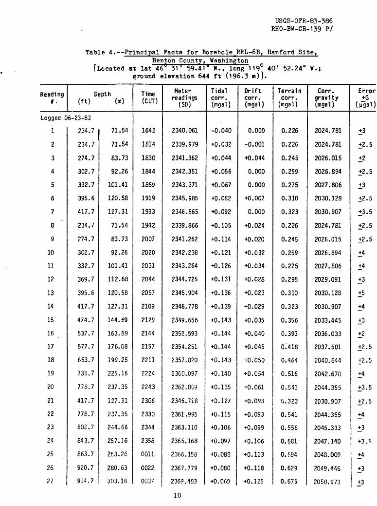
Table 4. Principal Facts for Borehole^RRL-SB, Hanford Site,Benton County, Washington
[Located at lat 46° ?1 ' 59-41" H. t long 119° 40' 52.24" ¥.; ground elevation 644 ft (196.3 »)]
Reading *.
Depth (ft) (m)
Logged 05-23-82
1
2
3
4
5
6
7
8
9
10
11
12
13
14
15
16
17
18
19
20
21
22
23
24
25
26
27
234.7
234.7
274.7
302.7
332.7
395.6
417.7
234.7
274.7
302.7
332.7
369.7
395.6
417.7
474.7
537.7
577.7
653.7
738.7
778.7
417.7
778.7
802.7
843.7
863.7
920.7
994.7
71.54
71.54
83.73
92.26
101.41
120.58
127.31
71.54
83.73
92.26
101.41
112.68
120.58
127.31
144.69
163.89
176.08
199.25
225.16
237.35
127.31
237.35
244.65
257.16
263.26
280.63
303.18
Time (CUT)
1642
1814
1830
1844
1859
1919
1933
1942
2007
2020
2031
2044
2057
2109
2129
2144
2157
2211
2224
2243
2306
2330
2344
2358
0011
0022
0037
Meter readings
(SD)
2340.061
2339.979
2341.362
2342.351
2343.371
2345.985
2346.865
2339.866
2341.262
2342.238
2343.264
2344.725
2345.904
2346.778
2349.656
2352.593
2354.251
2357.820
2360.097
2362.009
2345.718
2361.995
2363.110
2365.168
2366.158
2367.779
2369.493 <
Tidal corr. (rngal)
-0.040
+0.032
+0.044
+0.056
+0.067
+0.082
+0.092
+0.105
+0.114
+0.121
+0.125
+0.131
+0.136
+0.139
+0.143
+0.144
+0.144
+0.143
+0.140
+0.135
+0.127
+0.115
+0.106
+0.097
+0.088
+0.080
+0.069 ,
Drift corr. (mgal )
0.000
-0.001
+0.044
0.000
0.000
+0.007
0.000
+0.024
+0.020
+0.032
+0.034
+0.028
+0.023
+0.029
+0.035
+0.040
+0.045
+0.050
+0.054
+0.061
+0.093
+0.093
+0.099
+0.106
+0.113
+0.118
+0.125
Terrain corr.
(mgal)
0.226
0.226
0.245
0.259
0.275
0.310
0.323
0.226
0.245
0.259
0.275
0.295
0.310
0.323
0.356
0.393
0.418
0.464
0.516
0.541
0.323
0.541
0.556
0.581
0.594
0.629
0.675
Corr. gravity (mgal )
2024.781
2024.781
2026.015
2026.894
2027.806
2030.128
2030.907
2024.781
2026.015
2026.894
2027.806
2029.091
2030.128
2030.907
2033.445
2036.033
2037.501
2040.644
2042.670
2044.355
2030.907
2044.355
2045.333
2047.140
2048.009
2049.446
2050.973
Error +G
(ygai)
+3
+2.5
+2
+2.5
±3
+2.5
+3.5
+2.5
+2.5
+4
+4
+3
±5
+4
+3
±2
+2.5
+2.5
+4
+3.5
+2.5
+4
+3
+3.^
+4
+3
±3
10

USGS-OPR-83-386 RHO-BW-CR-139 P/
Table 4. Principal Fact a for Borehole^RL-SB, Man ford Site,Benton County, Washington
[Located at lat 46^ 31 f 59-41" N. f long 119° 40* 52.24" W. ground elevation 644 ft (196.3 «)!
(Sheet 2 of 2)
Readingif
26
29
30
31
32
33
34
35
36
37
36
39
40
41
42
43
Depth (ft) On)
994.7
778.7
234.7
196.6
234.7
196.6
98.6
196.6
132.7
98.6
6.4
47.8
67.7
78.7
98.6
6.4
303.18
237.35
71.54
59.92
71.54
59.92
30.05
59.92
40.45
30.05
1.95
14.57
20.63
23.99
30.05
1.95
Time (CUT)
0042
0101
0131
0148
0201
0214
0229
0244
0259
0311
0330
0345
0354
0407
0418
0436
Meterreadings
(SD)
2369. 46S
2362.003
2339.813
2338.510
2339.901
2338.551
2334.544
2338.669
2366.064
2334.609
2329.631
2332.215
2333.441
2334.066
2334.884
2329.743
Tidalcorr. (mgal)
+0.065
+0.050
+0.025
+0.011
+0.001
-0.011
-0.022
-0.033
-0.043
-0.051
-0.062
-0.070
-0.075
-0.080
-0.084
-0.090
Drift corr. (mgal)
+0.150
+0.152
+0.150
+0.112
+0.098
+0.098
+0.045
+0.018
+0.018
+0.018
-0.119
-0.142
-0.154
-0.172
-0.188
-0.188
Terrain corr. (mgal)
0.675
0.541
0.226
0.209
0.226
0.209
0.185
0.209
0.189
0.185
0.260
0.201
0.190
0.187
0.185
0.260
Corr.gravity(mgal)
2050.973
2044.355
2024.781
2023.582
2024.781
2023.582
2020.021
2023.582
2021.29^
2020.021
2015.634
2017.783
2018.818
2019.334
2020.021
2015.634
Error+G
(ygai)±4
+2.5
+2.5
+2.5
+2.5
+2.5
+3
+3.5
±2 - 5
+5
+3.5
+3
+2.5
+3
+3
+2.5
11

USGS-OFR-83-386 RHO-BW-CR-139 P/
Table 5. Principal Facts for Borehole RRL-7, Hanford Site,Benton County, Washington
[Located at lat 46" 34' 1.31" N., -lon« 119° 39* 47.08" V, ground elevation 791 ft (241.1 «)].
(Sheet 2 of 2)
Reading1
28
29
30
31
32
33
34
35
36
37
38
39
40
41
42
43
44
45
46
47
48
49
50
51
52
53
54
Depth (ft) (m)
323.0
296.0
323.0
364.0
364.0
323.0
364.0
391.0
417.0
467.0
487.0
364.0
467.0
487.0
524.0
569.0
587.0
604.0
487.0
604.0
616.0
647. C
679.0
604.0
364.0
323.0
296.0
98.45
90.22
98.45
110.95
110.95
98.45
110.95
-119.18
127.10
142.34
148.44
110.95
142.34
148.44
159.72
173.43
178.92
184.10
148.44
184.10
187.76
197.21
206.96
184.10
110.95
98.45
90.22
Time (CUT)
1914
1926
1936
1947
1953
2003
2015
2023
2032
2041
2054
2115
2127
2136
2147
2156
2205
2214
2227
2238
2246
2256
2305
2314
2332
2344
2357
Meter readings
(SO)
2340.547
2339.342
2340.459
2342.046
2341.988
2340.331
2341.965
2342.938
2343.961
2345.755
2346.501
2342.003
2345.752
2346.494
2347.988
2349.943
2350.890
2351.708
2346.533
2351.710
2352.291
2353.424
2354.704
2351.727
2342.106
2340.520
2339.445
Tidal corr. (mgal )
+0.155
+0.159
+0.163
40.165
+0.167
+0.168
+0.169
+0.168
+0.168
+0.166
+0.164
+0.157
+0.151
+0.147
+0.141
+0.136
+0.129
+0.123
+0.114
+0.104
+0.098
+0.090
+0.081
+0.073
+0.056
+0.045
+0.033
Drift corr. (mgal )
+0.089
+0.155
+0.157
+0.197
+0.245
+0.263
+0.263
+0.253
+0.243
«0.233
+0.230
+0.242
+0.248
+0.253
+0.250
+0.247
+0.245
+0.242
+0.252
+0.259
+0.262
+0.267
+0.271
+0.275
+0.254
+0.223
+0.190
Terrain corr.
(mgal )
-0.383
-0.344
-0.383
-0.440
-0.440
-0.383
-0.440
-0.476
-0.510
-0.572
-0.595
-0.440
-0.572
-0.595
-0.638
-0.687
-0.706
-0.723
-0.595
-0.723
-0.735
-0.766
-0.796
-0.723
-0.440
-0.383
-0.344
Corr, gravity (mgal )
2024.877
2023.941
2024.877
2026.237
2026.237
2024.877
2026.237
2027.033
2027.876
2029.354
2029.975
2026.237
2029.354
2029.975
2031.218
2032.856
2033.648
2034.331
2029.975
2034.331
2034.820
2035.768
2036.842
2034.331
2026.237
2024.877
2023.941
Error+G
(pgal)
+3
+2.5
+2.5
+4
+3
+3
+3
+2.5
+3
+3
+3.5
+3
+2.5
+3.5
+2.5
+3
+2.5
+3.5
+2.5
+2.5
+5
+2.5
+5
+2.5
±2.5
+3
+4
13
USGS-OPR-83-386 RHO-BW-CR-139 P/
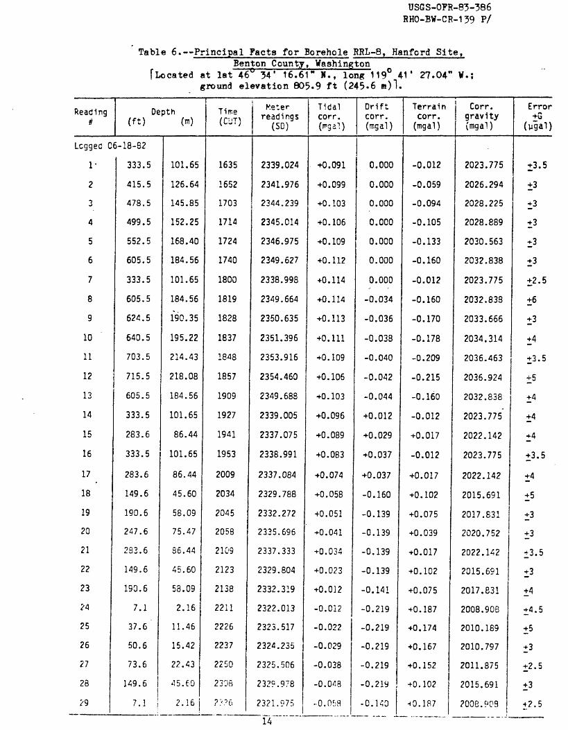
Table 6. Principal Facts for Borehole RRL-8, Hanford Site,Bent.on County, Washington
[Located at lat 46° 34* 16.61" »., long 119° 41' 27.04" W.; ground elevation 805.9 ft (245-6 m)1.
Reading«f
Depth (ft) (w)
Lcggec C6-18-82
1*
2
3
4
5
6
7
8
9
10
11
12
13
14
15
16
17
18
19
20
21
22
23
24
25
26
27
28
?9
333.5
415.5
478.5
499.5
552.5
605.5
333.5
605.5
624.5
640.5
703.5
715.5
605.5
333.5
283.6
333.5
283.6
149.6
190.6
247.6
283.6
149.6
190.6
7.1
37.6
50.6
73.6
149.6
101.65
126.64
145.85
152.25
168.40
184.56
101.65
184.56
190.35
195.22
214.43
218.08
184.56
101.65
86.44
101.65
86.44
45.60
58.09
75.47
56.44
45.60
58.09
2.16
11.46
15.42
22.43
45.60
7.1 2.16
Tirce (CUT)
1635
1652
1703
1714
1724
1740
1800
1819
1828
1837
1848
1857
1909
1927
1941
1953
2009
2034
2045
2058
2109
2123
2138
2211
2226
2237
2250
2305
???6
Meter readings
(SD)
2339.024
2341.976
2344.239
2345.014
2346.975
2349.627
2338.998
2349.664
2350.635
2351.396
2353.916
2354.460
2349.688
2339.005
2337.075
2338.991
2337.084
2329.788
2332.272
2335.696
2337.333
2329.804
2332.319
2322.013
2323.517
2324.235
2325.506
2329.978
2321.975
Tidal corr. (rngal)
+0.091
+0. 099
+0.103
+0.106
+0.109
+0.112
+0.114
+0.114
+0.113
+0.111
+0.109
+0.106
+0.103
+0.096
+0.089
+0.083
+0.074
+0.058
+0.051
+0.041
+0.034
+0.023
+0.012
-0.012
-0.022
-0.029
-0.038
-0.048
-0.058
Drift corr. (mgal)
0.000
0.000
0.000
0.000
0.000
0.000
0.000
-0.034
-0.036
-0.038
-0.040
-0.042
-0.044
+0.012
+0.029
+0.037
+0.037
-0.160
-0.139
-0.139
-0.139
-0.139
-0.141
-0.219
-0.219
-0.219
-0.219
-0.219
-0.140
Terrain corr.(mgal)
-0.012
-0.059
-0.094
-0.105
-0.133
-0.160
-0.012
-0.160
-0.170
-0.178
-0.209
-0.215
-0.160
-0.012
+0.017
-0.012
+0.017
+0.102
+0.075
+0.039
+0.017
+0.102
+0.075
+0.187
+0.174
+0.167
+0.152
+0.102
t0.1R7
Corr. gravity (mgal)
2023.775
2026.294
2028.225
2028.889
2030.563
2032.838
2023.775
2032.838
2033.666
2034.314
2036.463
2036.924
2032.838
2023.775
2022.142
2023.775
2022.142
2015.691
2017.831
2020.752
2022.142
2015.691
2017.831
2008.903
2010.169
2010.797
2011.875
2015.691
2008.903
Error +G
(ugal)
+3.5
+3
+3
+3
+3
+3
+2.5
+6
+3
+4
+3.5
+5
+4
+4
+4
+3.5
+4
+5
+3
+3
±3.5
+3
+4
+4.5
+5
+3
+2.5
+3
+2.5
14

USGS-OFB-83-386 RHO-BW-CH-139 P/
Table 5- Principal Facts for Borehole RRL-7, Hanford Site,Benton County, Washington
[Located at lat 46° 34* 1.31" H., -long 119° 39* 47.08" W.; ground elevation 791 ft (241.1 m)].
Reading*
Depth (ft) (m)
Logged 06-20-82
1
2
3
4
S
6
7
8
9
10
11
12
13
14
15
28.0
5.2
28.0
58.0
102.0
132.0
149.0
188.0
28.0
5.2
188.0
206.0
232.0
262.0
188.0
8.53
1.58
8.53
17.68
31.09
40.23
45.42
57.30
8.53
1.58
57.30
62.79
70.71
79.86
57.30
Time (CUT)
1701
1722
1732
1747
1759
1811
1827
1848
1906
1917
1938
1957
2015
2029
2100
Meter readings
(SO)
2324.746.
2323.281
2324.701
2326.460
2328.540
2330.333
2331.241
2333.548
2324.641
2323.177
2333.531
2334.493
2335.914
2337.876
2333.659
Tidal corr.(mgal )
+0.091
+0.108
+0.115
+0.126
+0.133
+0.140
+0.148
+0.155
+0.160
+0.161
+0.162
+0.160
+0.155
+0.150
+0.135
Drift corr.(mgal )
+0.054
+0.050
+0.069
+0.070
+0.071
+0.072
+0.074
+0.076
+0.076
+0.087
+0.084
+0.154
+0.177
+0.090
0.000
Terrain corr.
(mgal)
+0.127
+0.176
+0.127
+0.066
-0.020
-0.075
-0.106
-0.173
+0.127
+0. 176
-0.173
-0.203
-0.245
-0.292
-0.173
Corr. gravity fmgal )
2011.593
2010.385
2011.593
2013.068
2014.793
2016.300
2017.066
2019.008
2011.593
2010.385
2019.003
2019.880
2021.087
2022.649
2019.003
Error +G
(ygai)
+2.5
+3
+3
+3
+2.5
+4
+3.5
+3.5
+3
+3
+2.5
±3
+2.5
+5
+3
Logged 06-21-82
16
17
18
19
20
21
22
23
24
25
26
27
188.0
188.0
206.0
232.0
262.0
277.0
296.0
188.0
232.0
262.0
277.0
296.0 ,
57.30
57.30
62.79
70.71
79.86
84.43
90.22
57.30
70.71
79.86
84.43
90. 22
1645
1659
1713
1723
1735
1748
1800
1817
1828
1839
1848
1859
2333.783
2333.753
2334.753
2336.164
2337.991
2338.771
2339.519
2333.615
2336.088
2337.936
2338.703
2339.473
+0.040
+0.054
+0.067
+0.076
+0.037
0.033
+0.108
+0.121
+0.129
+0.136
+0.142
+0.148
-0.012
0.000
+0.022
+0.039
+0.053
+0.039
+0.052
+0.052
+0.052
+0.052
+0.054
0.052
-0.173
-0.173
-0.203
-0.245
-0.292
-0.315
-0.344
-0.173
-0.245
-0.292
-0.315
-0.344
2019.008
2019.008
2019.880
2021.087
2022.649
2023.299
2023.941
2019.008
2021. OS7
2022.649
2023.299
2023.941
+3.5
±4
±4
+3
+3
±3
+5
+4
±4
+3
+4
+3.J>
12

USGS-OFR-83-386 RHO-BW-CR-139 P/
Table 7. Principal Facts for Borehole RRL-9, Hanford Site,Benton County, Washington
I" Located at lat 46^ 33' 1.62" »., long 119° 38' 43.61" W.; ground elevation 655 ft (199«6 )].
Reading1
Depth (ft) (m)
Logged 06-28-82
1
2
3
4
5
6
7
8
9
10
11
12
13
14
15
16
17.
18
19
20
21
22
23
24
25
26
27
258.2
279.0
294.0
325.0
348.0
386.0
258.2
386.0
402.1
402.1
443.1
467.1
493.1
515.1
386.0
443.1
467.1
493.1
385.0
258.2
183.3
218.3
234.3
258.2
183.3
164.4
183.3
78.70
85.04
89.61
99.06
106.07
117.65
78.70
^117.65
122.56
122.56
135.06
142.37
150.30
157.00
117.65
135.06
142.37
150.30
117.65
78.70
55.87
66.54
71.41
78.70
55.87
50.11
55.87
Time (CUT)
1704
1715
1724
1735
1744
1756
1812
1824
1833
1835
1845
1852
1859
1908
1921
1932
1940
1950
2000
2013
2027
2039
2C47
2058
2108
2118
2127
Meter readings
(SD)
2344.754
2345.493
2346.024
2347.107
2348.009
2349.565
2344.820
2349.584
2350.372
2350.390
2352.023
2353.407
2354.434
2355.197
2349.650
2351.996
2353.190
2354.404
2349.637
2344.873
2342.074
2343.363
2343.924
2344.880
2342.098
2341.406
2342.096
Tidal corr. (irgal)
+0.009
+0.008
40.007
+0.005
+0.004
+0.002
-0.001
-0.003
-0.004
-0.005
-0.006
-0.007
-0.008
-0.010
-0.012
-0.013
-0.014
-0.016
-0.017
-0.018
-0.019
-0.020
-0.021
-0.021
-0.022
-0.022
-0.022
Drift corr. (mgal)
0.000
-0.008
-0.014
-0.023
-0.029
-0.037
-0.047
-0.048
-0.050
-0.065
-0.117
-0.280
-0.117
-0.109
-0.097
-0.087
-0.085
-0.083
-0.080
-0.076
-0.075
-0.076
-0.077
-0.079
-0.093
-0.092
-0.091
Terrain corr. (mgal)
0.324
0.336
0.344
0.360
0.372
0.390
0.324
0.390
0.398
0.398
0.416
0.427
0.438
0.447
0.390
0.416
0.427
0.438
0.390
0.324
0.280
0.301
0.311
0.324
0.280
0.268
0.280
Corr. gravity(mgal)
2028.995
2029.639
2030.100
2031.044
2031.830
2033.187
2028.995
2033.187
2033.875
2033.875
2035.255
2036.302
2037.365
2038.041
2033.187
2035.255
2036.302
2037.365
2033.187
2028.995
2026.525
2027.662
2028.156
2028.995
2026.525
2025.914
2026.525
Error
(ygal)
+4
±4
±3
+3
+5
+4.5
+3.5
+3.5
+3
+4
+5
+2
+3
+3
+2
+3
+2.5
+3
+2.5
+2.5
+2.5
±3
+3
+2.5
+3
+3.5
±*
15

USGS-OPB-83-386 RHO-BW-CR-139 P/
Table 7. Principal Facts for Borehole RRL-9 t Hanford Site tBenton County, Washington
("Located at lat 46° 33' 1.62" N., Ion* 119° 38* 43.61" V, ground elevation 655 ft (199.6 »)]
(Sheet 2 of 2)
Reading*
.28
29
30
31
32
33
34
35
36
37
38
39
40
41
42
43
44
45
46
47
4S
49
50
51
Depth (ft) (m)
164.4
114.4
128.4
152.4
164.4
114.4
8.4
26.4
66.4
103.4
114.4
128.4
152.4
164.4
114.4
128.4
152,4
164.4
114.4
8.4
26.4
66.4
103.4
114.4
50.11
34.87
39.14
46.45
50.11
34.87
2.56
8.05
20.24
31.52
34.87
39.14
46.45
50.11
34.87
39.14
46.45
50.11
34.87
2.56
8.05
20.24
31.52
34.87..
Time (CUT)
2138
2149
2157
2208
2215
2225
2238
2248
2257
2306
2314
2325
2335
2343
2353
0007
0015
0023
0031
0043
0058
0114
0123
0133
Meter . readings
(SO)
2341.423
2339.053
2339.804
2340.996
2341.521
2339.146
2333.870
2334.681
2336.362
2338.612
2339.240
2339.968
2341.087
2341.589
2339.195
2339.918
2341.067
2341.578
2339.182
2333.846
2334.655
2336.321
2338.556
2339.171
Tidal corr. (mgal )
-0.022
-0.022
-0.022
-0.021
-0.021
-0.020
-0.019
-0.018
-0.018
-0.017
-0.016
-0.015
-0.014
-0.013
-0.012
-0.011
-0.010
-0.009
-0.009
-0.008
-0.007
-0.006
-0.005
-0.005
Drift corr.(mgal)
-0.107
-0.127
-0.146
-0.182
-0.193
-0.210
-0.261
-0.262
-0.272
-0.284
-0.295
-0.295
-0.268
-0.260
-0.260
-0.256
-0.255
-0.254
-0.252
-0.251
-0.250
-0.2-18
-0.247
-0.246
Terrain corr.
(mgal)
0.268
0.236
0.245
0.261
0.268
0.236
0.167
0.177
0.203
0.228
0.236
0.245
0.261
0.268
0.236
0.245
0.261
0.268
0.236
0.167
0.177
0.203
0.228
0.236
Corr. gravity [mgal )
2025.914
2023.808
2024.449
2025.463
2025.914
2023.808
2019.116
2019.829
2021.302
2023.266
2023.808
2024.449
2025.463
2025.914
2023.808
2024.449
2025.463
2025.914
2023.808
2019.116
2019.829
2021.302
2023.266
2023.808
Error +G
(pgai)±3
±3
±5
I4
+2.5
±3
+4
±4
±5
+3.5
±3
±2
±3
±3
±3
±2
±5
±3
±3.5
±4
12.5
14
14
±3
16
.1OO
.O50
CO o> z O - O5O
H O
UJ
QC
QC O O u. QC
O
-.1OO
-.150
-.2OO
16OO
18OO
6-30-82
21OO
TIME (
hours-CUT)
24OO
O2 OO
7-1-82
100
+ O5O
-.O5O
-.1O
O
-.150
-.2OO
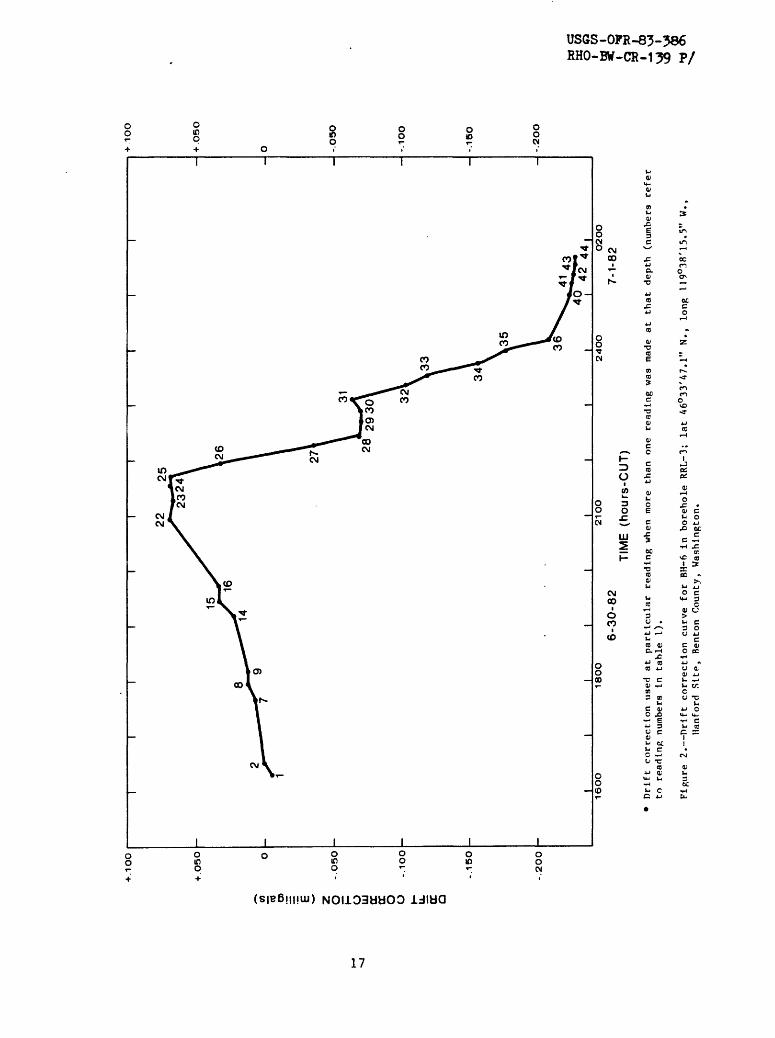
Drift correction us
ed at
particular reading when more th
an on
e re
adin
g was ma
de at
that depth
(num
bers
refer
to re
adin
g numbers
In ta
ble
I).
Figure 2. Drift correction curve
for
BH-6
In borehole RR
L-3;
lat
46°33'47.1" N.
, long 11
9°38
'15.
5" W.,
Hanf
ord
Sltp,
Renton County,
Washington.
s§

.100 -
-KO
5O
to O) z
- 050
cc
cc
O
O u. 5:
-.10
0O
-.1
50
-.2O
O
16O
O18
OO
21O
O
TIM
E
(ho
urs
-CU
T)
24O
O
7-2
-82
I
7-3
-82
O2O
O
D
rift
co
rrecti
on
u
sed
at
part
icu
lar
read
ing
w
hen
mor
e th
an
one
readin
g
was
m
ade
at
that
depth
(n
um
ber
s re
fer
to
readin
g
num
ber
s In
ta
ble
2).
Fig
ure
3.
Drif
t co
rrecti
on
cu
rve
for
BH
-6 in
bore
hole
R
RL
-4;
lat
46
°32
'18
.0"
N.,
long
119°3
8'1
5.9
" W
.,
Han
ford
S
ite,
Ben
ton
County
, W
ash
ing
ton
.
+ .1
OO
.O5O
-.O
5O
-.1O
O
-.1
50
-.2O
O
II
I CO

28y
-.050 - -
-.100 -
-tn to O) Z O H O
UJ
CC cc O
O cc
a
-.15
0 -
-
-.200 -
-
-.250 -
.
-.3OO
-
-.350 -
180O
21OO
6-25
-82
35____
' X 4
3
2400
32
~\j 1600
6-26
-82
TIME (hours-CUT)
-.O5O
-.1O
O
-.150
-.2OO
-.250
-.3OO
-.350
18OO
Dr
ift
corr
ecti
on used at
particular re
adin
g when more th
an on
e re
adin
g wa
s made at that de
pth
(num
bers
re
fer
to re
adin
g nu
mber
s In ta
ble
3).
Figure 4. Drift co
rrec
tion
cu
rve
for
BH-6 In borehole RR
L-5;
la
t 46°33'26.1"
N.,
long
11
9°AO
'A1.
A" W.
, Ha
nfor
d Si
te,
Bent
on Co
unty
, Wa
shin
gton
.
O

DRIFT CORRECTION (milligals)
(B 3
rr aia> it cr
C H»3 O
sl3- o
OCIV}
03 i
00 IV3 10
O)
09ro

+ .3
OO
-
18O
O2
1O
O1
8O
O21 O
O
6-2
0-8
26-2
1-8
2
TIM
E
(hours
-CU
T)
-
+.3
OO
- +
.25
0
.2O
O
- +
.150
-
+-1O
O
-
+.O
5O
24
OO
D
rift
co
rrecti
on
u
sed at
part
icula
r re
adin
g
whe
n m
ore
than
on
e re
adin
g
was
m
ade
at
that
dep
th
(num
bers
re
fer
to
read
ing
num
bers
In
ta
ble
5).
»
C{
W
COO
O
I O
3
Fig
ure
6
. D
rif
t corr
ecti
on
curv
e fo
r B
H-6
In
bore
hole
R
RL
-7;
lat
46
°34
'1.3
" N
.,
lon
g
119°3
9'4
7.1
W
. ,
Han
ford
S
ite,
Ben
ton
Co
un
ty,
Was
hin
gto
n.

DR
IFT
C
OR
RE
CT
ION
(m
illig
als
)
ft
VO
OO
rr** H
" f
O
- 3
N
J
3
X
">
I O
O
- ft
tz)
o(y
H-
»d
n>r» o
yo3
pC
00
K
-rt
(j
\O
3
O
it to
to
D.
D.
H-
m 3-
o c O C
00 00 I\J00
10 I CO t

DR
IFT
C
OR
RE
CT
ION
(m
illig
als
)
NJ
LO
*" 3 n
rt §3
fp
I
O
vOe
sr 3
rt
rt
(u(o
3
m o c
O) is? oo i oo is? O) is? (O i oo
O O
I C£
Si
I ^
g » fi o
» .
C rt
3
DE
PT
H
IN
FE
ET
(f
t)
AN
D
ME
TE
RS
(m
) R
ELA
TIV
E
TO
G
RO
UN
D
ELE
VA
TIO
N
C/>
O oo o
01 o o
o oG
)O
01 o
33 '

DEPTH IN
FEET (f
t) AND METERS (m
) RELATIVE TO GROUND ELEVATION
NJ
09
Id
*- o
p3
CT^
Qi
3*
to 1
H-
N>
03
3
o |
OP
H
- n
rt
oo
W
O
V
J3
O
3
H«
3a
^25
0)
cr M
n>
o
i 3
0)
00 i
O
Ou>
H«
00 3
CO
M
»
vO
S =§
i
? t?
(T>
< CO
0) f%
j H
pt
33^
O
Q
*~h
O
(X
O*
O
cr o
M 3
rt> ro o
c
3
01 O I
\
I |W
*^ ''V
'0
) -x
I
n i
ff*
*
0) o o
vp
*
1 CO
V ^
r
O I o o
Vv
jX
JV
.^
to
o o
O o
So
'
o
c
z H
COa
w
o o
I CO

to
n H-
00
DE
PT
H
IN
FE
ET
(f
t)
AN
D
ME
TE
RS
(m
) R
ELA
TIV
E
TO
G
RO
UN
D
EL
EV
AT
ION
en
oo
ro
o
901 o
0) o oCJ
l o o
1 * o o
11 '
' W
l
wo
CD O
I 03
vO00
DE
PT
H
IN
FE
ET
(f
t)
AN
D
ME
TE
RS
T
O
GR
OU
ND
E
LE
VA
TIO
N
o o
I W
vX>

NJ co
DE
PT
H
IN
FE
ET
(f
t)
AN
D
ME
TE
RS
(m
) R
ELA
TIV
E
TO
G
RO
UN
D
EL
EV
AT
ION
oo
O
O01 9 0)
?8
0 o
I 01 0 0o 0
-
Ol
a) o
01 o
I g 00

00 n ft) I I£
* °
QJ
Q\
Q}
en
oB
Jj
C
J 0
DE
PT
H
IN
FE
ET
(f
t)
AN
D
ME
TE
RS
(m
) R
ELA
TIV
E
TO
G
RO
UN
D
ELE
VA
TIO
N
s :
§ O*
H*
CD
O
1
3CO
00
1
»
(D r-t>
CD
O OO
oo
rt
»O
N
J >
v
j ^
D3
M
W O
S =§
ff
00
H»
O
3
S
9
§a
a1
o
o* c
/i ^
(t»
H»
CD^t
rt
sr
co
n»
o-
MH
- rt)
rt
p
>d0>
rt
r
4a-
o
IH
- 3
00ID
«
ro
o
o01 ?

oo c
DE
PT
H
IN
FE
ET
(f
t)
AN
D
ME
TE
RS
(m
) R
ELA
TIV
E
TO
G
RO
UN
D
EL
EV
AT
ION
CJi
10
O
c; *
> o
0>
ON
P
CO
O0
gr1
U)
9H
- LO
55
p »
IO
O
H-
Mft
0>o 3
S
g
M
en
a*
o
H-
ft)
3
rt
i-t
CW
V-
0)»-
» M
>-»
t-
4 O
(D
CO o
o
ro
o
oo o
vv01
-^
O
TJ c
-L
ZO
H
0
C0
01oo
-«
OO
H
-
03 i-t -
rt
ft)
(n
OJ
33 <
Q
L »
H
- 3
t^
i p
H
I ^
CW
O
O^
3
3
CL
0
CO
OO
* H
- r-
j0)
rt
<D
-» n>
3*CO
<
O H
* H
- W
(D
o ro
rt
rt j*
0>
O
t"
1cr
3
iM
SO
C
M3
0)
rt rt
C71 ?
CJI o o
o
o
o
o
0)O o
o
»
Gj
ac w
o o
I W
I g
L °°
1^
I

USGS-OFR-83-386 RHO-BW-CR-139 P/
BOREHOLE GRAVITY METER INTERPRETATIVE SUMMARY
References to fundamentals of borehole gravity logging, data
interpretation, and relationships between subsurface gravity measurements
and mass distribution in the Earth can be found in Robbins (1980). In the
absence of complicating factors (assuming near-horizontal beds), the in-situ 5 bulk density (PB , in g/cm ) between two points in a borehole is given by:
PB F - AZ"0.02556
where F is the free-air gradient of gravity in mgal/ft (Robbins, 1981),AG is the measured gradient of gravity between the two stations on a
(D
and AZvertical line underground in mgal/ft.
Tables 8 through 14 present the calculated bulk densities, and the column
headings are explained in the following list:
Station depth:
Interval (AZ):
AG:
(.09406):
Point in borehole in feet (ft), at which the BHGM was read
one or more times. The points are in descending order
relative to the ground surface at the borehole.
Vertical distance between the two adjacent station points in
the borehole. Values are given in both feet (ft) and meters
(m).
Gravity difference between the two adjacent stations in the
borehole in milligals (mgal). z
In-situ bulk density (in g/cm ) as determined by equation (1)
using the "normal" value of 0.09406 for F. This assumed
value can vary from area to area and is probably on the high
side when used for wells located within sediment-filled
basins. Therefore, caution should be exercised in using
these densities. If the actual value of F is lower than
"normal," the computed densities will then have a DC shift
and be too high. However, density differences (contrasts)
between intervals will not be affected. Efforts are
presently being made to determine the correct values of F at
the boreholes in figure 1.
USGS-OFR-83-386 RHO-BW-CR-139 P/
Error: The first value listed is the sum of the estimated errors
(error column, tables 1 through 7) of the two adjacent
stations in microgals (ugal). The second value is the z
equivalent error in g/cm The values in this column do not
include any error associated with uncertainties in the drift
curves or depth measurements. Schmoker (1978) found the
accuracy of most measurements between two points to be about
+_1 0^4 gals. The mean errors for the data in this report are
about +6 ygals which are similar to the errors in three
previous BHGM studies, including Bobbins (1982; a total of 19
wells including this report). This suggests that 4y gals for
drift and depth uncertainties be added to the values in this
column for a total error.
A stratigraphic section and unit depths for each borehole (as interpreted
by B. N. Bjornstad, 1983, Rockwell Hanford Operations) are provided in tables
15 and 16. A comprehensive discussion of the geology of the area can be found
in Myers and Price (1981).
32

USGS-OFR-83-386 RHO-BW-CR-139 P/
Table 8. Density Estimates for Borehole RRL-3, Hanford Site,Benton County, Washington
[Located at lat 46° 33* 47.07" H. f long 119° 38* 15.48" W.; ground elevation 686.8 ft. (209-3 n)l
Station depth (ft)
7.2
45.2
77.2
96.2
122.2
149.2
164.2
225.2
263.1
294.0
313.1
362.1
384.1
425.1
449.1
482.1
506.1
543.1
571.1
596.1
624.1
664.1
683.1
705.1
Interval (AZ) (ft) (m)
38.0
32.0
19.0
26.0
27.0
15.0
61.0
37.9
30.9
19.1
49.0
22.0
41.0
24.0
. 33.0
24.0
37.0
28.0
25.0
28.0
40.0
19.0
22.0
11.58
9.75
5.79
7.92
8.23 ,
4.57
18.59
11.55
9.42
5.82
14.94
6.71
12.50
7.32
10.06
7.32
11.28
8.53
7.62
8.53
12.19
5.79
6.71
AG (mgal)
1.697
1.330
0.886
1.309
1.057
0.521
2.226
1.192
1.024
0.609
1.594
0.774
1.375
0.831
1.296
0.804
0.963
0.605
0.500
0.566
1.687
0.834
0.972
p(g/cm3 ) for F=
0.09406 mgal/ft
1.933
2.054
1.856
1.710
2.148
2.321
2.252
2.449
2.383
2.433
2.407
2.304
2.368
2.325
2.143
2.369
2.662
2.835
2.897
2.889
2.030
1.963
1.951
Error ±G(pgal ±p(g/cm3 )
±5.5
±5.5
±6
±5
±5.5
±6
±6
±5.5
±5.5.
±5.5
±6
±8
±7.5
±7
±6.5
±5.5
±5
±5.5
±7
±7
±5.5
±4.5
±4.5
±0.005
±0.007
±0.012
±0.008
±0.008
±0.015
±0.004
±0.005
±0.007
±0.011
±0.005
±0.015
±0.007
±0.011
±0.008
±0.009
±0.006
±0.008
±0.010
±0.010
±0.005
±0.010
±0.008
33

USGS-OFR-83-386 RHO-BW-CR-139 P/
Table °. Density Estimates for Borehole RRL-4 t Hanford Site,Benton County, Washington
[Located at lat 46° 32* 17-95 »., long 119° 38' 15-94" V.; ground elevation 658.7 ft. (200.8 m)l
Station depth (ft)
9.1
38.1
58.1
77.1
90.0
107.0
140.0
160.0
183.0
213.0
250.9
287.1
350.0
386.0 '
416.0
458.0
491.0
515.0
559.0
577.0
592.0
Interval (AZ) (ft) (m)
' 29.0
20.0
19.0
12.9
17.0
33.0
20.0
23.0
30.0
37.9
36.2
62.9
36.0
30.0
42.0
33.0
24.0
44.0
18.0
15.0
8.84
6.10
5.79
3.93
5.18
10.06
6.10
7.01
9.14
11.55
11.03
19.17
10.97
9.14
12.80
10.06
7.32
13.41
5.49
4.57
AG (mgal)
1.338
0.836
0.992
0.658
0.871
1.647
0.847
0.797
0.944
1.265
1.081
1.898
1.334
1.071
1.855
1.401
0.725
1.427
0.694
0.384
p(g/on3)for F=
0.09406 mgal/ft
1.875
2.045
1.637
1.684
1.675
1.727
2.023
2.324
2.449
2.374
2.512
2.499
2.230
2.283
1.952
2.019
2.498
2.411
2.172
2.678
Error ±G(ygal ±p(g/cm3 )
±6.5
±5.5
±6
±7
±5
±5.5
±5.5
±5.5
±6.5
±9.5
±9
±5.5
±5
±6.5
±7
±5.5
±5
±5
±5.5
±5.5
±0.009
±0.010
±0.012
±0.022
±0.011
±0.007
±0.011
±0.010
±0.009
±0.010
±0.010
±0.004
±0.005
±0.008
±0.007
±0.007
±0.008
±0.005
±0.012
±0.014
34

USGS-OFR-83-386 RHO-BW-CR-139 P/
table 10, Density Estimates for Borehole RRL-3, Hanford Site,Benton County, Washington
[Located at lat 46° 33' ?6.09 N., long 119° 40' 41.35" W.; ground elevation 642.1 ft. (195.7 n)l
Station depth (ft)
8.7
28.7
51.7
100.7
114.7
142.6
171.6
198.5
239.6
284.6
312.6
336.6
363.7
384.7
423.7
464.7
485.7
508.7
529.7
562.7
624.7
659.7
Interval (ft)
20.0
23.0
49.0
14.0
27.9
29.0
26.9
41.1
45.0
28.0
24.0
27.1
21.0
39.0
41.0
21.0
23.0
21.0
33.0
62.0
35.0
(AZ) (m)
6.10
7.01
14.94
4.27
8.50
8.84
8.20"
12.53
13.72
8.53
7.32
8.26
6.40
11.89
12.50
6.40
7.01
6.40
10.06
18.90
10.67
AG (mgal)
1.003
1.138
1.953
0.791
1.437
0.949
0.852
1.242
1.358
0.858
0.754
0.894
0.715
1.349
1.802
0.937
0.883
0.681
1.059
2.505
0.914
p(g/on3 )for F=
0.09406 mgal/ft
1.718
1.744
2.121
1.469
1.665
2.400
2.441
2.498
2.499
2.48.1
2.451
2.389
2.348
2.327
1.960
1.934
2.178
2.411
2.424
2.099
2.658
Error ±G(pgal ±p(g/cm3 )
±6
±6.5
+6.5
±6
±7
±7
±5
±6
+5
±6
±5.5
±5.5
±5.5
±5
±5
±5.5
±7
±7
±6
±7
±8
±0.012
±0.011
±0.006
±0.016
±0.010
±0.009
±0.007
±0.006
±0.005
±0.008
±0.009
±0.008
±0.010
±0.005
±0.004
±0.011
±0.012
±0.013
±0.008
±0.004
±0.009
35
USGS-OFR-83-386 RHO-BW-CR-139 P/
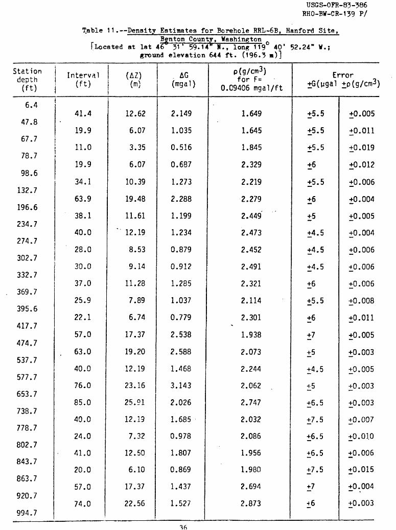
Table 11. Density Estimates for Borehole RRL-6B, Hanford Site,Benton County, Washington
[Located at lat 46 31* 59.14 H., long 119 40' 52.24" W.; ground elevation 644 ft. (196.3 )]
Station depth (ft)
6.4
47.8
67.7
78.7
98.6
132.7
196.6
234.7
274.7
302.7
332.7
369.7
395.6
417.7
474.7
537.7
577.7
653.7
738.7
778.7
802.7
843.7
863.7
920.7
994.7
Interval (ft)
41.4
19.9
11.0
19.9
34.1
63.9
38.1
40.0
28.0
30.0
37.0
25.9
22.1
57.0
63.0
40.0
76.0
85.0
40.0
24.0
41.0
20.0
57.0
74.0
(AZ)(m)
12.62
6.07
3.35
6.07
10.39
19.48
11.61
" 12.19
8.53
9.14
11.28
7.89
6.74
17.37
19.20
12.19
23.16
25.91
12.19
7.32
12.50
6.10
17.37
22.56
1
AG (mgal)
2.149
1.035
0.516
0.687
1.273
2.288
1.199
1.234
0.879
0.912
1.285
1.037
0.779
2.538
2.588
1.468
3.143
2.026
1.685
0.978
1.807
0.869
1.437
1.527
p(g/cm3)for F=
O.C9406 mgal/ft
1.649
1.645
1.845
2.329
2.219
2.279
2.449
2.473
2.452
2.491
2.321
2.114
2.301-
1.938
2.073
2.244
2.062
2.747
2.032
2.086
1.956
1.980
2.694
2.873
Error +G(pgal +p(g/cm3 )
+5.5
±5.5
+5.5
±6
±5.5
±6
+5
+4.5
+4.5
+4.5
+6
+5.5
+6
+7
+5
+4.5
+5
+6.5
+7.5
+6.5
±6.5
+7.5
+7
±6
+0.005
+0.011
+0.019
+0.012
+0.006
±0.004
+0.005
+0.004
+0.006
±0.006
+0.006
+0.008
+0.011
+0.005
+0.003
+0.005
+0.003
+0.003
+0.007
+0.01.0
+0.006
+0.015
+0.004
+0.003
USGS-OFR-83-386 RHO-BW-CR-139 P/
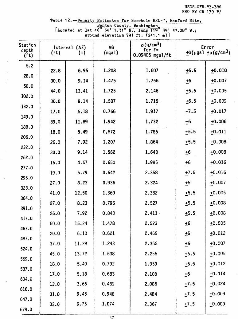
liable 12. Density Estimates for Borehole RRL-7, Hanford Site,Benton County, Washington
[Located at lat 46 34' 1.31 N., long 119 39* 47.08" ¥.; ground elevation 791 ft. (241.1 )!
Station depth (ft)
5.2
28.0 '
58.0
102.0
132.0
149.0
188.0
206.0
232.0
262.0
277.0
296.0
323.0
364.0
391.0.
417.0
467.0
487.0
524.0
569.0
587.0
604.0
616.0
647.0
679.0
Interval (AZ) (ft) (n)
22.8
30.0
44.0
30.0
17.0
39.0
18.0
26.0
30.0
15.0
19.0
27.0
41.0
27.0
26.0
50.0
20.0
37.0
45.0
18.0
17.0
12.0
31.0
32.0
6.95
9.14
13.41
9.14
5.18
11.89
5.49
7.92
9.14
4.57
5.79
8.23
12.50
8.23
7.92
15.24
6.10
11.28
13.72
5.49
5.18
3.66
9.45
9.75
AG (mgal)
1.208
1.475
1.725
1.507
0.766
1.942
0.872
1.207
1.562
0.650
0.642
0.936
1.360
0.796
0.843
1.478
0.621
1.243
1.638
0.792
0.683
0.489
0.948
1.074
p(g/cm3) for F=
0.09406 mgal/ft
1.607
1.756
2.146
1.715
1.917
1.732. .
1.785
1.864
1.643
1.985
2.358
2.324
2.382
2.527
2.411
2.523
2.465
2.365
2.256
1.959
2.108
2.086
2.484
2.367
Error ±G(w9 a1 ±p(g/cm3 )
±5.5
±6
±5.5
±6.5
±7.5
±6
±5.5
±5.5
±6
±6
±7.5
±5
±5.5
±5.5
±5.5
±6
±6
±6
±5.5
±5.5
±6
±7.5
±7.5
±7.5
±0.010
±0.007
±0.005
±0.009
±0.017
±0.006
±0.011
±0.008
±0.008
±0.016
±0.016
±0.007
±0.005
±0.008
±0.008
±0.005
±0.012
±0.007
±0.005
±0.012.
±0.014
±0.024
±0.009
±0.009

USGS-OFR-83-386 RHO-BW-CR-139 P/
Table 13. Density Estimates for Borehole RRL-8, Hanford Site,Benton County, Washington
[Located at lat 46 34' 16.61 1" N., long 119 41^ 27.04" V.; ground elevation 805-9 ft. (245-6 m)]
Stationdepth (ft)
7.1
37.6
50.6
73.6
149. §
190.6
247.6
283.6
333.5
415.5
478.5
499.5
552.5
605.5
624.5
640.5
703.5
715.5
Interval (ft)
30.5
13.0
23.0
76.0
41.0
57.0
36.0
49.9
82.0
63.0
21.0
53.0
53.0
19.0
16.0
63.0
12.0
(AZ) (m)
9.30
3.96
7.01
23.16
12.50
17.37
- 10.97
15.21
24.99
19.20
6.40
16.15
16.15
5.79
4.88
19.20
3.66
AG (mgal)
1.281
0.608
1.078
3.816
2.140
2.921
1.390
1.633
2.519
1.931
0.664
1.674
2.275
0.828
0.648
2.149 .
0.461
p(g/cm3)for F=
0.09406 mgal/ft
2.037
1.850
1.846
1.716
1.638
1.675
2.169
2.400
2.478
2.481
2.443
2.444
2.001
1.975
2.095
2.345
2.177
Error ±G(pgal ±p(g/cm3 )
±7.5
±8
±5.5
±5.5
±7
±6
±6.5
±7.5
±5.5
±6
±6
±6
±6
±6
±7
±7.5
±8.5
±0.010
±0.024
±0.010
±0.002
±0.007
±0.004
±0.007
±0.006
±0.003
±0.004
±0.011
±0.004
±0.005
±0.012
±0.018
±0.005
±0.028
38

USGS-OFR-83-386 RHO-BW-CR-139 P/
Table 14. Density Estimates for Borehole RRL-9, Hanford Site,Benton County, Washington^
[Located at lat 46° 33' 1.62" H., long 119° 38' 43.61" W.; ground elevation 655 ft. (199^6 a)]
Stationdepth (ft)
8.4
26.4
66.4
103.4
114.4
128.4
152.4
164.4
183.3
218.3
234.3
258.2
279.0
294.0
325.0
348.0
386.0
402.1
443.1
467.1
493.1
515.1
Interval (ft)
18.0
40.0
37.0
11.0
14.0
24.0
12.0
18.9
35.0
16.0
23.9
20.8
15.0
31.0
23.0
38.0
16.1
41.0
24.0
26.0
22.0
(AZ) (m)
5.49
12.19
11.28
3.35
4.27
7.32
3.66
5.76
10.67
4.88
7.28
6.34
4.57
9.45
7.01
11.53
4.91
12.50
7.32
7.92
6.71
AG (mgal)
0.713
1.473
1.964
0.542
0.641
1.014
0.451
0.611
1.137
0.494
0.839
0.644
0.461
0.944 .
0.786
1.357
0.688
1.380
1.047
1.063
0.676
p(g/cm3 )for F=
0.09406 mgal/ft
2.130
2.239
1.603
1.752
1.889
2.027
2.210
2.415
2.409
2.472
2.307
2.469
2.478
2.489.
2.343
2.283
2.008
2.363
1.973
2.080
2.478
Error +G(pgal +p(g/cm3)
+6.5
+6.5
±8
+6.5
+5-
+5
+6.5
+6.5
+5.5
±6
+5.5
+8
+7
+6
+8
+8.5
+6.5
±6
+5.5
+5
+6
+0.014
+0.006
+0.008
+0.023
+0.014
+0.008
+0.022
+0.013
+0.006
+0.015
+0.009
+0.015
+0.019
+0.008
+0.014
+0.009
+0.016
+O.C06
+0.009
+0.007
+0.010
39

US
GS
-OP
R-8
3-38
6 R
HO
-BW
-CR
-139
P
/
Tab
le 13. S
traM
gra
phic
1 Sec
tio
n
and
Unit
D
epth
s in
B
ore
hole
s R
RL
-8,
RR
L-7
, R
RL
-3,
RR
L-9
, an
d R
RL
-4
H^n
ford
G
itq,
Ben
ton
jCpji
nty
, W
aahi
ngtO
Ti
Tfr
om
B
. N
.Bjo
rng
ted
,1
98
3,
wri
tten
co
mm
un.)
[T.D
. =
bott
om
of
BHGM
su
rvey
] [w
.t.
» w
ater
ta
ble
]
Str
«*ti
gra
phic
U
nit
s
Man
ford
F
orm
atio
n
Upp
er
Rin
go
ld
Mid
dle
Rin
gold
C
onglo
mer
ate
Low
er
Rin
go
ld
Bas
al
Rin
gold
C
onglo
mer
ate
Sle
phan
t M
ount
ain
Bas
alt
Rat
tles
nak
e R
idge
In
terb
ed
Pono
ma
Bas
alt
RR
L-8
1
50 ft
(4
6 m
)
24
8 ft
(7
5 m
)
~334
ft
(1
02
m)
w.t
.
55
3 ft
(1
68
m)
64
0 ft
(1
95
m)
716
ft
(218
m)
T.D
.
*7 A
\
fL.
f O
O^
.*\
B<
RR
L-7
20
6 ft
(6
3 m
)
OT
»
.i»4
. fa
t
_^
~323
ft
(9
9 m
) w
.t.
56
9 ft
(1
73
m)
60
4 ft
(1
84
ra)
679
ft
(207
m
) T
.D.
7/V
7
flL
. (l*
C
~*
\
. ...
_ ,,.
. _
,_.. .
,. . .
, .,
.....
..J
ireh
ole
s an
d dep
ths
RR
L-3
96
ft
(2
9 m
)
16
4 ft
(4
9 m
)
~225
ft
(6
9 m
) w
.t.
44
9 ft
(1
37
m)
J O
O
^"l
. / 1
A
*7
.. \
50
6 ft
(1
54
ra)
6
24 ft
( 1
90
m)
705
ft
(215
ra
) T
.D.
f7r%
J £»±
f O
O 1
_\
RR
L-9
11
4 ft
(3
5 m
)
15
2 ft
(4
6 m
)
~183
ft
(5
6 ra
) w
.t.
-443 ft
(1
35
ra)
-49
3 ft
(1
50 m
)
515
ft
(-15
7 m
) T
.D.
-547 ft
(1
68 m
)
RR
L-4
-107 ft
(3
3 ra
)
-16
0 ft
(4
9 m
)
"183
ft
(5
6 m
) w
.t.
-^16 ft
(1
27
m)
--49
1 ft
(1
50 m
)
-577 ft
(1
76 m
)
592
ft
(180
m)
T.D
. -6
42 ft
(1
96
m)
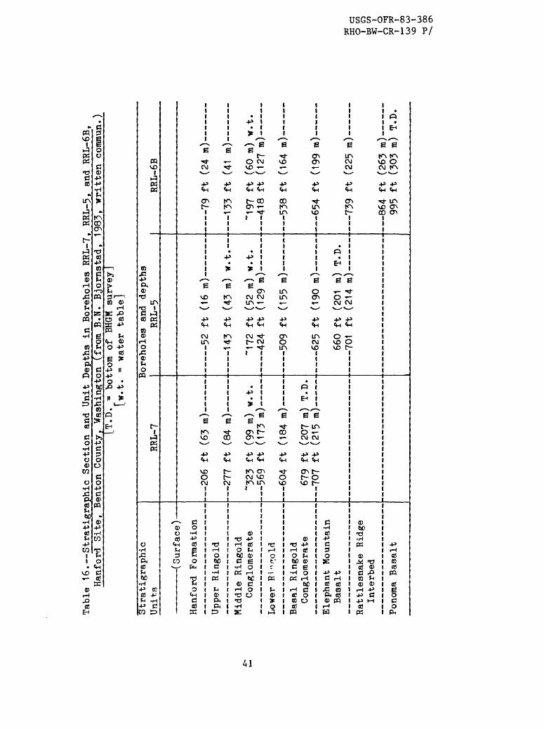
Table
16. Stratigraphi
c Section
and
Unit De
pths
in
Bor
ehol
es RR
L-7, RRL-5, an
d RRL-6B,
Hanfordf Site, Bent
on C
ounty. Wa
shin
gton
(from
B.N.
Bj
orns
tad, 1983,
written
comm
un.)
[T.D.
= bo
ttom
of
BH
GM su
rvey
] [w
.t.
= wa
ter
tabl
e]
Stra
tigr
aphi
c Un
its
\ VJ
IAJ.
JL CLW *7 y
Hanf
ord
Formation
Upper
Ringold
Midd
le Ri
ngol
d Co
nglo
mera
te
Lower
Ri -^o
ld
Basa
l Ri
ngol
d Co
nglo
mera
te
Elep
hant
Mo
unta
in
Basa
lt
Ratt
lesn
ake
Ridg
e Interbed
Pono
ma Ba
salt
I RR
L-7
206 ft
(63
m) -
OTT
4>A. foA
. \
277
ft (84
m;
~323
ft (99
m) w.t.
569
ft
(173 m
)
604 ft (1
84 m
)
679
ft (2
07 m
) T.
D.TOT
-P4-
fO1C
»»S
Joreholes
and
dept
hs
RRL-
5
co
-P4-
( \ c.
«
143 ft (43
m) w.t.
~172
ft (52
m) w.t.
. 42
4 ft
(129 m
)
509
ft
(155 m) -
62
5 ft (190 m
) -
660
ft (201 m) T.D.
<~lf
\4
J>±.
f *}4
A
- . \
70
1 ft
(214 m
;
RRL-6B
79
ft (2
4 m)
133
ft
(41
m)
~197 ft (6
0 m) w.t.
A A O
ft,
f 1
OT \
41
8 ft (1
27 n
)
538
ft (164 m
)
654
ft
(1
99 m)
Tin
J>4. /OOC
»
86
4 ft (263 m)
995
ft (303 m
) T.D.
o c
oi
ow
</>
s:
i\
a
i i
H-
CO
C
O
U>
v£>
I U>
>ti
C
O

USGS-OFR-85-386 RHO-BW-CR-139 P/
REFERENCES
Beyer, L. A., and Corbato, C. E., 1972, A Fortran IV computer program for calculating borehole gravity terrain corrections: U.S. Geological Survey Open-File Report, 27 p.
Hammer, Sigmund, 1939, Terrain corrections for gravimeter stations: Geophysics, v. 4, no. 3, p. 184-193.
Myers, C. W., and Price, S. M., eds., 1981, Subsurface geology of the Cold Creek syncline: Rockwell International, Richland, Washington, RHO-BWI-ST-14, 377 p., 10 tables, 114 figures.
Robbins, S. L., 1980, Bibliography ¥ith abridged abstracts of subsurface gravimetry (especially borehole) and corresponding in-situ rock density determinations: U.S. Geological Survey Open-File Report 80-710, 47 p.
____1981, Reexamination of the values used as constants in calculating rock density from borehole gravity data: Geophysics, v. 46, no. 2, p. 208-210.
Robbins, S. L., Martinez, R. J., and Smith, D. L., 1979, Principal facts for borehole gravity stations in wells DC-3, DC-5, DC-7 at the Hanford Site, Washington, and in well RSH #1 on Rattlesnake Hills, Washington: U.S. Geological Survey Open-File Report 79-849, 27 p.
Robbins, S. L., Schmoker, J. W., and Hester, T. C., 1982, Principal facts and density estimates for borehole gravity stations in exploratory wells Ue4ah, Ue7j, Ue1h, Ue1q, Ue2co, and USW-H1 at the Nevada Test Site, Nye County, Nevada: U.S. Geological Survey Open-File Report 82-277, 33 p.
Schmoker, J. W., 1978, Accuracy of borehole gravity data: Geophysics, v. 43, no. 3, p. 538-542.
____1980, Effect upon borehole-gravity data of salt structures typical of the WIPP Site (northern Delaware Basin), Eddy County, New Mexico: U.S. Geological Survey Oil and Gas Investigations Chart OC-109*
42
Recommended