7/31/2019 Topographic Map of Farnsworth
http://slidepdf.com/reader/full/topographic-map-of-farnsworth 1/1
3 0 0 0
3 0 0 0
3 0 0 0
2 9 5 0
3 0 0 0
3 0 0 0
15
15
15
C O R D P
CO RD K
C O R D N
C O
R D
1 0
C O R
D
9
CO RD M
C O
R D
1 1
C O R D K CO RD K
C O
R D 1 1
F M
3 7 6
C O
R D
7
CO
RD
8
C O R D Q
CO RD M
F M
3 7 6
C O R D K
F M 3 0 4 5
CO
RD
8
A D A M
C O
R D 1 1
F M 3 0 4 5
C O R D N
CO RD R
C O
R D 9
C O
R D 9
C O
R D 1 1
F M3 0 4 5
C O R D
7
F M
3 7 6
15
15
15
C O R D P
CO RD K
C O R D N
C O
R D
1 0
C O R
D
9
CO RD M
C O
R D
1 1
C O R D K CO RD K
C O
R D 1 1
F M
3 7 6
C O
R D
7
CO
RD
8
C O R D Q
CO RD M
F M
3 7 6
C O R D K
F M 3 0 4 5
CO
RD
8
A D A M
C O
R D 1 1
F M 3 0 4 5
C O R D N
CO RD R
C O
R D 9
C O
R D 9
C O
R D 1 1
F M3 0 4 5
C O R D
7
F M
3 7 6
W o l f C r e
e k
W o l f
C r e e k
W ol f C r e e k
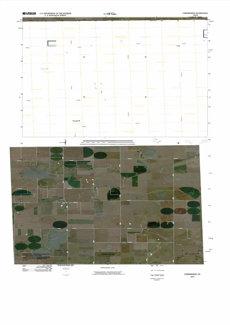
Deer Lake
Truax Lake
Farns wor th
Lord
SourdoughCreek NE
Farnsworth
Perryton
NW
PerrytonSE
HorseshoeHill
SpearmanNE
Waka
SourdoughCreek NW
Perryton
14
15
000
30
17
30"
330"
321
40
40
000m
29
E
21
15
839
30"
140
N
2330"
20'
000m
40
3
40
000m
22'
22
40
3 29
18
24
101°
40
15
2436°
40
3
4
25
40
323
30"
19
30
3
40
3
17'
40
31
14
100°
00
40
100°
17'
40
22
26
40
00'
36°
325
40
19
326 000
16
27
52'
22
4
30
40
40
40
23
40
15'3
3
25
36°
40
40
26
110
101°
27
3
3
000m
3
28
22
55'
30"
40
40
00'
40
52'
21
20'
36°
57'
57'
22
55'
FEET
E3
40
40
3
40
3
40
3 3
24
16
25
20
26
27
21
20
31
17
23
27
FEET
FEET
FEET810 000
U.S. DEPARTMENT OF THE INTERIOR
U. S. GEOLOGICAL SURVEY
TEXAS
ADJOINING7.5' QUADRANGLES
QUADRANGLE LOCATION
TX36100-232
FARNSWORTH, TX
2010
Interstate Route State Route
ROAD CLASSIFICATION
Interstate Route StateRouteUSRoute
Ramp 4WD
US Route Local Road
FARNSWORTH QUADRANGLE
TEXAS
7.5-MINUTE SERIES
1000 0 1000 2000500 METERS
1000 0 1000 2000 3000 4000 5000 6000 7000 8000 9000 10000
FEET
This map was produced to conform with version 0.5.10 of thedraft USGS Standards for 7.5-Minute Quadrangle Maps.
A metadata file associated with this product is also draft version 0.5.10
SCALE 1:24 000
1 0 10.5
MILES
1 0 1 20.5 KILOMETERS
Zone 14S
Imagery...................................................NAIP, August 2008Roads.....................................US Census Bureau TIGER data
with limited USGS updates, 2005Names...............................................................GNIS, 2008Hydrography.................National Hydrography Dataset, 1995Contours............................National Elevation Dataset, 2002
North American Datum of 1983 (NAD83) World Geodetic System of 1984 (WGS84). Projection and1 000-meter grid: Universal Transverse Mercator,
Produced by the United States Geological Survey
10 000-foot ticks: Texas Coordinate System of 1983(north zone)
MN
GN
UTM GRID AND 2010MAGNETIC NORTHDECLINATIONAT CENTEROF SHEET
1°9´
20MILS
6°38´
118MILS
U.S. National Grid
100,000-mSquare ID
GridZone Designation
14S
LF
CONTOUR INTERVAL 10 FEET
Recommended