UNITED STATES DEPARTMENT OF THE INTERIOR Harold L. Ickes, Secretary
GEOLOGICAL SURVEY W. C. Mendenhall, Director
Bulletin 935-C
TIN DEPOSITS OF THE REPUBLIC OF MEXICO
BY
WILLIAM F. FOSHAG AND CARL FRIES, JR.
Geologic Investigations in the American Republics, 1941-42 (Pages 99-1W
UNITED STATES
GOVERNMENT PRINTING OFFICE
WASHINGTON : 1942
For sale by the Superintendent of Documents, Washington, D. C. Price 40 cents

CONTENTS
. Page
Abstract.................................................. 99Introduction.............................................. 100
Distribution of the tin deposits...................... 100Climate and topography................................ 101Accessibility......................................... 101History and production................................ 103Field and laboratory work............................. 105Acknowledgments....................................... 106
Tin deposits.............................................. 107Deposits associated with granite...................... 107
Location and history.............................. 107General features.................................. 108Rock formations................................... 109
Limestone..................................... 109Granite....................................... 110Fan deposits.................................. IllSecondary deposits of gravel.................. 112
Placers........................................... 113Heavy minerals in the gravels................. 113Grade of the deposits......................... 116Possible production........................... 117
Deposits associated with lead-zinc-silver ores........ 117Deposits associated with extrusive rocks.............. 118
Geology........................................... 119Vein deposits..................................... 122
Occurrence.........'........................... 122Mineralogy and paragenesis.................... 123Alteration.................................... 125Origin........................................ 129Mining and concentration...................... 133Possible production........................... 137
Placers........................................... 137Occurrence.................................... 137Mining and concentration...................... 139Possible production........................... 140
Summary of possible tin production.................... 141Mines, deposits, and districts examined................... 142
Michoacan............................................. 142Los Cabires mine.................................. 142
Hidalgo............................................... 144Deposits near Zlmap&n............................. 144
Guanajuato............................................ 145District west and northwest of Dolores Hidalgo.... 145
Vein deposits................................. 145Placers....................................... 146
Deposits near Tlachiquera......................... 151Deposits near San Felipe.......................... 152Queensland mine................................... 153El Santin mine.................................... 155Deposits north of San Luis de la Paz.............. 158
Aguascalientes........................................ 158Deposits near Calvillo............................ 158
Jalisco............................................... 160Deposits near Paso de Sotos and Teocaltiche....... 160Los Amigos mine................................... 161
III
IV CONTENTS
Page
Mines, deposits, and districts examined Continued.Zacatecas............................................. 162
Deposits west of the city of Zacatecas............ 162Deposits between Fresnillo and Sain Alto.......... 162
Durango............................................... 164Deposits south of the city of Durango............. 164Deposits on the Cerro de los Remedies............. 165Deposits in the Sierra de Cacaria................. 167
Vein deposits................................. 168Placer deposits............................... 170
Deposits in the Sierra de San Francisco........... 170Vein deposits................................. 171Placer deposits............................... 174
ILLUSTRATIONS
Page
Plate 25. Map of Mexico showing distribution of reportedtin districts................................ 102
26. Geologic sketch map of the Guadalcazar dis trict, San Luis Potosi....................... 110
27. A, Small abandoned tin mine near San Felipe,Guanajuato; B_, Small tin placer near Tlachi- quera, Guanajuato............................ 138
28. Plan and section of Los Cabires mine, Tepux-tepec, Michoacan............................. 142
29. Geologic map of placer area west of DoloresHidalgo, Guana juato.......................... 146
30. Geologic sketch map of Cerro de los Remedies,Durango...................................... 166
31. Sketch map of tin district in Sierra de SanFrancisco, Durango............................ 170
Figure 10. Geologic map of placer area along Arroyo deGalvez, west of Dolores Hidalgo, Guanajuato.. 147
11. Geologic map of placer area along Arroyo delEstanlto, southwest of La Quemada, Guanajuato 150
TABLES
Page
Table 3. Production of tin in Mexico................... 1054. Heavy minerals in the gravel deposits in the
Guadalcazar and Realejo "basins,............. 1145. Mineral composition of the rocks and tin veins
in some of the tin districts of Mexico..,... 122,6. Chemical analyses of vein material, cassiter-
ite, and bars of smelted tin................ 126
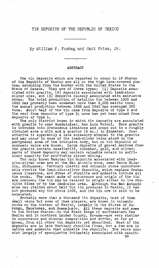
TIN DEPOSITS OF THE REPUBLIC OF MEXICO
By William F. Foshag and Carl Fries, Jr.
ABSTRACT
The tin deposits which are reported to occur in 19 States of the Republic of Mexico are all on the high lava-covered pla teau extending from the border with the United States to the State of Oaxaca. They are of three types: (1) Deposits asso ciated with granite. (2) deposits associated with lead-zinc- silver ores, and (3; deposits closely associated with extrusive rocks. The total production of metallic tin between 1800 and 1940 has probably been somewhat more than 6,000 metric tons; the annual production between 1936 and 1940 has averaged 330 tons. About half of the tin came from deposits of type 2 and the rest from deposits of type 3; none has yet been mined from deposits of type 1.
The only district known in which tin deposits are associated with granite is near Guadalcazar, San Luis Potos£. Here granite is intruded into Cretaceous limestone and crops out in a roughly circular area a mile and a quarter (2 km.) in diameter. Cas- siterite is apparently a late accessory mineral in the granite and may occur in some of the lead-silver veins mined in the peripheral zone of the intrusive body, but no tin deposits of economic value are known. Large deposits of gravel derived from the granite contain cassiterite, cinnabar, gold, and silver; parts of these deposits may contain valuable metals in suffi cient quantity for profitable placer mining.
The only known Mexican tin deposits associated with lead- zinc-silver ores are at the San Antonio mine, near Santa Eula- lia, Chihuahua. Tertiary clastic and volcanic rocks unconform- ably overlie the lead-zinc-silver deposits, which replace Creta ceous limestone, and dikes of rhyolite and andesite intrude all the rocks. The exact mode of occurrence and origin of the tin are unknown; the tin may be related in origin either to the rhy olite dikes or'to the lead-zinc ores. Although the San Antonio mine has yielded about half the tin produced in Mexico, it has not produced any tin since 1939, and its tin ore is said to be exhausted.
Probably more than a thousand tin deposits, most of them small veins but some of them placers, are known in volcanic rocks on the plateau of Mexico, largely in the States of Du- rango, Zacatecas, and Guanajuato. All these deposits and some in the United States--in the Black Range of southwestern New Mexico and in northern Lander County, Nevada are very similar in occurrence and mineral composition and differ, so far as known, from all other tin deposits yet described. Most- of the deposits are in late Tertiary rhyolite flows, but a few are in latite and andesite that underlie the rhyolite. The veins con sist largely of specularite intimately associated with cassit-
99

100 GEOLOGIC INVESTIGATIONS IN THE AMERICAN REPUBLICS, 1941-42
erite. The cassiterite forms pockety incrustations on walls of irregular, branching, steeply dipping fissures, and is nowhere disseminated through large bodies of rock. The deposits, in general, are believed to have formed within 2,000 feet (600 m.) of the surface and shortly after extrusion of the lavas. Most of the cassiterite is believed to have come from small bodies of crystallizing rhyolitic magma that had been intruded near the surface, though some of it may have come from crystallizing flows. The deposits appear to have been localized by minor faults near the centers of eruption of the rhyolitic lavas.
Production of tin from the veins in the lavas has been spo radic; most of the veins have yielded less than 5 tons of tin and only a few have yielded more than 20 tons. Pour attempts to mine deposits on a large scale have proved unprofitable, apparently owing to the small size of the individual ore bodies. No valid estimate of reserves can be made. No deposit has been proved to contain more than 120,000 tons of rock containing 0.5 percent tin, and most of the deposits probably contain a much smaller tonnage of rock of that grade. There may be as much as 10,000 tons of tin in rock containing 0.1 percent or more of tin, but no method has yet been developed by which material of such low grade can be profitably mined.
Most of the tin produced between 1936 and 1941 came from placers derived from the veins. Most of these placers are extremely small and are mined entirely b'y hand methods. One of the deposits, indeed, may be more than 1,000,000 cubic yards in volume, but the results of extensive sampling indicate that it contains less than half a pound of tin to a cubic yard. There may be more than 10,000 tons of tin in placers containing half a pound or more of tin to a cubic yard, but most of it is in small deposits that cannot be worked profitably with machinery and that can be mined only during the rainy season from July to December.
Under the mining conditions and at the prices prevailing in 1941 the probable production of tin from veins and placers in the lavas is not likely to exceed 400 tons a year, and even at double the 1941 price of tin the probable production is not likely to exceed 800 tons a year.
\ INTRODUCTION
Distribution of the tin deposits
Tin deposits have been reported to occur in 19 States of the
Republic of Mexico, from the United States boundary on the north
to the State of Oaxaca on the south. The deposits are most
thickly distributed in the central part, in the States of Du-
rango, Zacatecas, San Luis Potosi, Aguascalientes, Jalisco, Gua-
najuato,.and Quere'taro (see pi. 25); a few deposits each have
been reported in Sonora, Chihuahua, Coahuila, Nuevo Leon, Naya-
rit, Michoacan, Hidalgo, Mexico, Morelos, Puebla, OaXBCa, and
Guerrero. There are probably more than a thousand individual
deposits scattered throughout this belt, but they occur in more
or less distinct groups. Only the groups are located on the map,
TIN DEPOSITS OP THE REPUBLIC OP MEXICO 101
Climate and topography
The tin deposits are almost wholly on the lava-covered semi-
arid central plateau, at elevations between 4,000 and 10,000
feet (1,200 and 3,000 m.). Although rainfall is extremely light
during the greater part of the year, a rainy season, beginning
in May or June in the southern part of the country and in June
or July in the northern part, lasts until mid-October. During
the rainy season water runs in many of the arroyos, but during
the remainder of the year most of them are dry. Although there
is an occasional light snowfall over the northern part of the
plateau during the winter, frosts rarely occur south of San
Luis Potosi except at high altitudes. Temperatures during the
summer are not excessive, owing in part to the high altitude of
the plateau and in part to the frequent rainfall.
North of the city of San Luis Potos£ the plateau is char
acterized by interior drainage; more or less isolated mountain
ranges and mesas rising from 1,000 to about 5,000 feet (300 to
about 1,520 m.) above the general level separate the various
basins, some of which contain saline or playa lakes. South of
San Luis Potosf, except for a few basins of interior drainage,
of which the valley of Mexico is best known, the drainage flows
eastward into the Gulf of Mexico or westward into the Pacific
Ocean. Westward drainage leaves the plateau through precipitous
canyons (barrancas), some of which are nearly as deep as the
Grand Canyon of the Colorado River; eastward drainage flows
through somewhat shallower canyons.
Accessibility
An excellent all-weather highway connects Laredo, Tex., with
Mexico City via Monterrey, Victoria, and Zimapan. (See pi. 25.)
From Mexico City surfaced highways extend south to Acapulco, on
the Pacific Ocean, west to Guadalajara, and east to Veracruz,
on the Gulf of Mexico. A road extends from Guadalajara north-
102 GEOLOGIC INVESTIGATIONS IN THE AMERICAN REPUBLICS, 1941-42
westward along the-coast through Cullacan, Guaymas, and Nogales
to Tucson, Ariz., but it is now not passable to through traffic
except from Guaymas to Tucson. A surfaced highway runs from El
Paso, Tex., to Chihuahua, Mexico. Prom Chihuahua to Mexico City
there is a road passing through Durango, Zacatecas, Aguascal-
ientes, and Quere'taro, which is unsurfaced except for short
stretches near those cities. This road can be travelled, with
some difficulty in the dry season, but it is impassable for
automobiles in the rainy season.
A road, of which it is planned to make a highway, from
Monterrey westward to Mazatlan, on the coast, is surfaced as
far as Torreon; it is passable from there to Durango during the
dry season but is impassable for automobiles between Durango
and Mazatlan. Prom Guadalajara to the border of the United
States, a distance of about 900 miles, there is not a single
road that crosses the barranca country between the plateau and
the west coast. The highway from Victoria, or from Antiguo
Morelos, on the Laredo-Mexlco City highway, to San Luis Potosi
is surfaced and passable throughout the year and an extension
of it from there to Guadalajara is projected. A surfaced high
way extends eastward from the Mexico City highway to Tampico,
on the Gulf of Mexico..
It is possible to travel in trucks or cars with high clear
ance on wagon roads over much of the plateau country during the
dry season; during the rainy season most of the plateau country
is virtually inaccessible by automobile. Many of the tin depos
its, located mainly along the western edge of the plateau, can
be reached by automobile during the dry season, but some can be
reached only by a day's ride on horseback from the nearest road.
A main railroad line extends southward from Tucson, Ariz.,
through Guaymas, Cullacan, Mazatlan, and GfuadalajflFfl tO MeXlCO
City; another extends from El Paso, Tex., to Mexico City through
Chihuahua, Torreon, Zacatecas, Aguascalientes, Leon, and Quere-

TIN DEPOSITS OP THE REPUBLIC OP MEXICO . 103
taro. From Mexico City a line.extends eastward to Veracruz.
There are railroads from Laredo and Brownsville, Tex., to Mon
terrey, from which a main line continues southward through San
Luis Potosf and Quere'taro to Mexico City; a branch line extends
from Monterrey to Tampico and another to Torredn and Durango.
Branches run from San Luis Potosl to Tampico and to Aguascal-
ientes, and several others extend from the main lines for short
distances. Pour seaports are on the railroads: Tampico and
Veracruz on the Gulf of Mexico, Guaymas on the Gulf of Califor
nia, and Mazatlan on the Pacific Ocean.
History and production
I/ Ingalls records the fact that the Indians knew of tin in
Mexico before the Spaniards arrived in the New World. Accord- 27
ing to Hanks,-'the Spaniards began to mine tin in the Ame'rica-
Potrillos district in Durango as early as 1790. A summary of
the history of tin mining during the nineteenth century is given3/ 4/
by Ingalls. When Garcfa reviewed the history of tin mining
up to 1926, he found that there had been little change in either
methods or scale of mining from those described by Ingalls.
Even in 1941, except for a few relatively extensive deposits,
described farther on in this report, mining methods were the
same as during the past two centuries. Most of the tin ore has
been recovered on a small scale, with hand tools and without
explosives, by washing the arrpyo gravels and the soil on hill
sides near small vein deposits, and by crushing and washing
material mined from small veins.
I/ Ingalls, W. R., The tin deposits of Durango, Mexico: Am. Inst. Min. Eng. Trans. , vol. 25, p. ll|6, 1896.
2/ Hanks, H. G., On the occurrence of durangite in the tin-tearing region of Durango, Mexico: Am. Jour. Sci., 3d ser., vol. 12, p. 276, 1876.
2/ Ingalls, W. R., op. cit., pp. 1U6-163.Jf/ Garc£a, J. A., Monograffa del estano: Bol. minero, vol. 22* pp. 6-29,
1926.
104 GEOLOGIC INVESTIGATIONS IN THE AMERICAN REPUBLICS, 1941-42
Records of the production of tin in Mexico prior to 1916 are
meager, only a few figures appearing in published reports.5/
Ingalls quotes Humboldt as reporting that 4.602 metric tons of
metallic tin was produced in 1802 in the administrative district
6/Mexico in 1003. Manzano -1 states that 44 tons of ore was pro
duced in 1882 from a deposit near Santa Maria del Rio, S. L. P.,
and that it yielded possibly 10 tons of metallic tin. According7/
to Ingalls, a deposit that was being operated in 1883 near
Teocaltiche, Jalisco, had a maximum monthly production of about
3 tons of metallic tin during the short period it was operated.
Mines in the America-Potrillos district in Durango were most
during that period was a few thousand tons of ore; he does not
state the tin content of the ore, but it was probably much less
than 10 percent. Prom these few figures it seems reasonable to
infer that the average annual production from 1800 to 1916 was
about 10 metric tons of metallic tin, or about 1,100 metric tons
in all. The table on page 105 shows the production of tin in
Mexico compiled from statistics given in Boletfn Minero and
Boletin Petroleo y Minero, publications of the Mexican govern
ment. The figures are incomplete, and some of them are undoubt
edly too low, but they are probably of the right order of mag
nitude .
5/ Innalls, Y;. H., pp. cit., p. 147.&_/ Manzano, J. P., Informs sobre la exploraci6n.de la zona minera de
Santa Mnrfa del Hfo, S. L. P.: Bol. agriculture, minerfa 6 industries, vol. 3, No. 2, p. 101, 1893.
7/ Ingalls, ;. H., op. cit., p. 160.8/ Rangel, Manuel, Apuntes sobre la distribuci6n de minerales en el
Lstadb de Durango: Soc. geol. mexicana, Bol. 7, p. Ill, 1910.
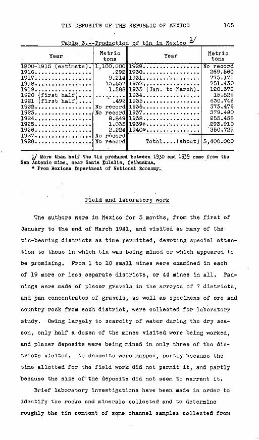
TIN DEPOSITS OP THE REPUBLIC OP MEXICO 105
Table 3. Production of tin in Mexico
Year
1800-1915 (estimate).1916.... .............n QI 71918.................19191920 (first half)....1921 (first half)....T Qpp
1923. ................1QP41925.................1926.................1927................. 1 QPA
Metric tons
1,100.000?Q?
Q PI 413.5371.588
4Q?No recordNo record
fl R4Qi o 1^2.224
No record
Year
1 Q?Qi Q^n1931......... ........1932.................1933 (Jan. to March) .1934.................1 Q^R1 Q^R
1937.................1938.................1939-:*..... ...........1940*................
Total. . . .(about)
Metric tons
269.560773.171751.430120.37815.829630.749373.476379.480255.458.293.910350.729
5,400.000
I/ More than half the tin produced between 1930 and 1939 ceme from the San Antonio mine, near Santa Eulalia, Chihuahua.
* From Mexican Department of National Economy..
Field and laboratory work
The authors were in Mexico for 3 months, from the first of
January to' the end of March 1941, and visited as many of the
tin-bearing districts as time permitted, devoting special atten
tion to those in which tin was being mined or which appeared to
be promising. Prom 1 to 10 small mines were examined in each
of 19 more or less separate districts, or 44 mines in all. Pan-
nings were made of placer gravels in the arroyos of 7 districts,
and pan concentrates of gravels, as well as specimens of ore and
country rock from each district, were collected for laboratory
study. Owing largely to scarcity of water during the dry sea
son, only half a dozen of the mines visited were being worked,
and placer deposits were being mined in only three of the dis
tricts visited. No deposits were mapped, partly because the
time allotted for the field work did not permit it, and partly
because the size of°the deposits did not seem to warrant it.
Brief laboratory investigations have been made in order to
identify the rocks and minerals collected and to determine
roughly the tin content of some channel samples collected from

106 GEOLOGIC INVESTIGATIONS IN THE AMERICAN REPUBLICS, 1941-42
the most promising deposits. Miss Jewell J. Glass of the Geo
logical Survey collaborated in this work. Some of the results
are presented in subsequent sections.
Acknowledgments
The field work was done by the Geological Survey, United
States Department of the Interior, and the Smithsonian Insti
tution, in cooperation with the United States Department of
State, and with the permission and aid of the Government of Mex
ico. The authors wish to thank the staff of the Institute geo-
logico de Mexico for expediting the field work and for the many
valuable suggestions they have offered. Further aid in the
field was given by more persons than can be enumerated here, but
the authors must acknowledge particularly the assistance and
courtesies extended by P. W. Avery, Antonio Cano, Carlos Prey-
mann, Manuel Heyser, S. G. Jenkin, Jesus de Lara, D. B. McAl-
lister, E. Mouret, Francisco Salazar, Rafael Solfs, and Martin
Sutti; they are indebted also to many persons for valued infor
mation, especially to W. E. Brock, Colonel Gordon McCoy, E. M.
Flynn, Francisco Galarza, Major H. K. Kicklighter, J. F. Morton,
the Cia. Minera de Penoles, S. A., and members of the Consular
staff of the United States in Mexico. The many kindnesses
extended the authors by the Mexican miners and ranchers are
also gratefully acknowledged. For aid in the office the authors
are indebted to many members of the Geological Survey, partic
ularly to J. J. Glass for assistance in petrographic and miner-
alogic studies; to R. C. Wells, J. J. Fahey, and George Steiger
for chemical and spectrographic work; and to H. G. Ferguson and
F. C. Calkins for constructive criticism of the manuscript.

TIN DEPOSITS OP THE REPUBLIC OP MEXICO 107
TIN DEPOSITS
The known tin deposits in Mexico are of three types: (1)
Deposits associated with granite, (2) deposits associated with
lead-zinc-silver ores, and (3) deposits closely associated with
extrusive rocks (lava flows, breccia, and tuff). Deposits of
the first and second types are thus far known to occur in only
one district each, but more than a thousand small deposits of
the third type are known in the more or less separate districts
scattered over the plateau. The deposits of the first two types
are younger than Cretaceous, though it is not known how much
younger; the deposits in the lavas are largely late Tertiary.
Erosion of the tin-bearing veins has given rise to many small
placers, for the most part of recent origin.
Deposits associated with granite
Location and history i
The only tin deposits in Mexico known to be directly asso
ciated with granite occur near the town of Guadalcazar, San
Luis Potosf, in a famous old mining region 60 miles (96 km.)
by road northeast of the city of San Luis Potosf and 12 miles
(19 km.) northeast of the Villar station on the Tampico branch
of the Mexican Central Railroad. The district is easily reached
by car during the dry season over 11 miles (18 km.) of narrow
dirt road from a point on the San Luis Potosi-Victoria highway
48 miles (78 km.) from the city of San Luis Potosf. The ancient
mines «near Guadalcazar, in which stone hammers have been found,
were probably worked for mercury by the Indians before the colo
nization which took place between 1614 and 1620. This district
contained important silver mines as early as 1622, and it later
became the largest producer of mercury in Mexico. Gold has been
washed from placer deposits in the district intermittently for
many years, but cassiterite was not recognized there until about

108 GEOLOGIC INVESTIGATIONS IN THE AMERICAN REPUBLICS, 1941-42
1937. Since then parts of the gravel deposits have been tested
for tin, mercury, gold, and silver, but no tin had been mined up
to December 1941.
General features
The district is .dominated by the Sierra de Guadalcazar, a
westward-trending mountain range flanked on the east by the
Abrego basin, on the south by the Guadalc&zar basin, and on the
northwest by the Realejo basin. The highest point in the range
is Cerro San Cristobal, which is 7,382 feet (2,250 m.) above sea
level and about 1,500 feet (460 m.) above the Guadalcazar basin.
(See pi. 26.) This peak forms the center of a small roughly
circular body of granite intruded into Cretaceous limestone,
which surrounds the granite on all sides except the northwest,
where fan deposits lap directly against the granite. The gran
ite is a little higher than the surrounding limestone and is
outlined by arroyos that, have developed along the greater part
of the contact. Debris eroded from the contact zone was depos
ited in large alluvial fans along the sides of the contiguous
basins. Subsequent erosion lowered the arroyo bottoms, dis
sected the fans, and caused the formation of secondary deposits
of gravel. The basins are now drained largely through sinks
(resumideros) in the underlying limestone.
The western part of the Sierra de Guadalcazar is a gently
rolling upland, which gradually decreases in altitude westward
from Cerro San Cristobal and which appears to be about in the
same plane as the tops of the granite hills. This upland is
underlain by limestone and is characterized by sink holes, col
lapsed slopes, and deep caverns open to the surface. It
undoubtedly represents an old karst topography that was formed
prior to erosion of the steep-walled canyons. A broad, shallow
valley at a high elevation, into which the Arroyo Las Papas has
been cut, south of Cerro San Cristobal, and a narrow bench on the
limestone along the front of the range east of Arroyo Las Papas,
TIN DEPOSITS OF THE REPUBLIC OF MEXICO 109
facing the Guadalcazar basin, probably are remnants of this old
topography.
Broad, gently 'sloping alluvial fans extend out from the
Sierra de Guadalcazar into the Abrego, Guadalcazar, and Realejo
basins. The distribution of these fans is such that they could
not have been formed by the present drainage but must have been
built by ancestral streams flowing at higher levels. The east
ernmost fan in the Guadalcazar basin was built at the mouth of
a high valley that corresponds in position to Arroyo Minas
Viejas. This fan has a gentle, slope toward the soiitheast and
forms the low divide that separates the Guadalc&zar and Abrego
basins. A second large fan was built by drainage carried
through a high valley having the approximate position of Arroyo
Las Papas, and a third fan was constructed at.the mouth of
another high valley a little farther west. These fans have
coalesced to form a .continuous alluvial apron along the moun
tain front. The small Realejo basin is filled with a large
fan that slopes gently toward the northwest, away from the /gran
ite. These old fans are.more closely related to the old upland
surface than to the present more youthful topography.
All the arroyos are steep-walled and narrow, and the old
topography and the fan deposits are being actively dissected,
parts of the fans having typical badlands topography. During
this recent period of erosion the soft, highly altered contact
zone of the granite has also been extensively eroded, and at the
edge of the Realejo basin this altered granite has a badlands
topography similar to that of the eroded fans.
Rock formations
Limestone. The oldest formation in the district is ai/
cherty, light-gray limestone of middle Cretaceous age. Its
2/ Wittich, Ernesto, and Ragotey, Federlco, La geologla de la regi6n minera de Guadalcazar, San Luis Potosi: Bol. ninero, vol. 12, p. 665, 1921.
110 GEOLOGIC INVESTIGATIONS IN THE AMERICAN REPUBLICS, 1941-42
thickness exceeds 1,500 feet (450 m.). In places along its con
tact with the granite, the limestone is partly marmorized and
contains lime-bearing silicate minerals, such as diopside,
andradite, epidote, and vesuvianite. Some of the silicate bod
ies contain sulfides of iron, lead, silver, copper, zinc, and
antimony. The large mercury deposits at San Antonio and Trin
idad, as well as some of the other sulfide deposits, are wholly
within this limestone. The numerous caverns that have formed
in the limestone in the upland areas and in the broad basins are
due to the relatively high solubility of this rock.
Granite. The granite is a light-gray rock, whose texture is
variable, but most of which is porphyritic., with a medium- to
fine-grained groundmassc The principal minerals are quartz
and orthoclase, which occur both as phenocrysts and as smaller
crystals in the groundmass. There are smaller quantities of
biotite, sericite, muscovite, oligoclase, hornblende, and chlo-
rite. A specimen from near the top of Cerro San Crist6bal (see
pi. 26), apparently representative of the granite in that area,
proved to contain a small quantity of microscopic grains of
fluorite, zircon, hematite, apatite, epidote, tourmaline, gar
net, topaz, brookite/ cassiterite, scheelite, and molybdenite.
A sample from the north side of Cerro Piedras contained, besides
the common accessory minerals, a few grains of scheelite but
apparently no cassiterite. Samples of granite taken at three
places on the north side of Arroyo Las Papas between Casa de los
Arcos and Socav6n Dolores each contained cassiterite, and two
also contained scheelite.
Tourmaline occurs in patches scattered through much of the
granite and also with quartz in narrow veinlets cutting the
granite. Ill-defined pegmatitic veinlets containing beryl,
topaz, and dumortierite are present in some places, and Wittictl
reports that danburite and axinite have been found.
IO/ Wittich, Ernesto, and Rogotzy, Federico, op. cit., p. 669.

UNITED STATES DEPARTMENT OF THE INTERIOR GEOLOGICAL SURVEY BULLETIN 935 PLATE 26
GEOLOGIC SKETCH MAP OF THE GUADALCAZAR -DISTRICT, SAN LUIS POTOSI CROQUIS GEOLOGICO DEL DISTRITO DE GUADALCAZAR, SAN LUIS POTOSI
300 0
Adapted from unpublished sketch and claim location maps of Cia de Winerales de Potosi, S.A.,and Cia Metalur^ica Mexicans,
Adaptado de un croquis y mapas meditos de /as pertenencias la Cia de Minera/es ye Potos^S.A^y /<? Cta Metd/urg/cg Mexi
EXPLANATION EXPLICAGJON
A/uviones y abanicos aluviales(Contienen'depdsitos de placer)
(U+i imiGray limestone
Call'za gris
Contact accurately jocated Contacto de/ineado corfexacti tud
Contact approximately located Contacto delineado aproximadamente
Landmark Punto sobresaliente
BShaft Tiror""/Adit /
Socavdn
XMine entrance
BOCB mina
XProspect
Cata
^ ^ t I Direction of^ drainage
Oirecio'n del c/errame del agua
cg Mexicans1500 Feet
100 0 500 Metros V. S. GOVERNMENT PRINTING OFFICE : 1942 O - 480115 (faces p. 110)
TIN DEPOSITS OP THE REPUBLIC OP MEXICO 111
A small sample taken from one of these veinlets near Casa de los
Arcos contained a few grains of cassiterite but no scheelite.
Along the southern border of the granite, there are a few dikes
of fine-grained aplite with patches of tourmaline, and a sample
from one of these at the junction of Arroyo La Luz with Arrpyo
Las Papas contained cassiterite and scheelite. It thus appears
that small quantities of cassiterite and scheelite are widely
distributed as late accessory minerals of the granite.
The border zone of the granite, except along the northeast
side, is a soft rock in which the feldspars are more or less
completely altered to clays. Samples of this rock taken at
four places contained small quantities of cinnabar. Most of the
ore deposits mined are in this peripheral altered zone, as shown
in plate 26, and contain gold and sulfides of iron, zinc, lead,
silver, antimony, and copper. Pluorite and quartz form a large"> x_-
part of the gangue in these ores at some places. The lime-
silicate minerals are abundant immediately adjacent to the lime
stone contact.
Fan deposits. The deposits of gravel along the east, south,
and northwest base of the Sierra de Guadalcazar were derived
mainly.from the limestone-granite contact zone. The exposed
thickness of gravel in the walls of the arroyos that have dis
sected the deposits is about 70 feet (21 m.), but the maximum
thickness is somewhat greater, for most of the arroyos have not
cut down to the underlying limestone. The bedding in the depos
its is indistinct in most places, and the observed dips are
generally less than 10°.
The deposits are composed in large part of poorly cemented
coarse sands with a reddish clay matrix. Owing to this reddish
color, the dissected parts of the fans are known locally as
tierras coloradas, or red ground. Texturally the material
changes within short horizontal distances from sand to silt or
from sand to fine-grained conglomerate. A section through 53
480115 O - 42 - 2

112 GEOLOGIC INVESTIGATIONS IN THE AMERICAN REPUBLICS, 1941-42
feet (16 m.), which is exposed along one of the arroyos and
which is characteristic of the deposits, shows: Caliche-cemented
coarse angular sand, 3 feet (0.9 m.); coarse angular sand, 2 feet
(0.6 m.); brown bentonitic clay, 3 feet (0.9 m.); gray sand, 2
feet (0.6 m.); iron-cemented sand, 2 feet (0.6 m.)j silty sand,
4 feet (1.2 m.); and coarse sand with small pebbles, interbedded
with 6-lnch (0.15-m.) lenses of brown soapy clay, 25 feet (7.6
m.). Beds of fine-grained gravel are most abundant near the
heads of the fans and along their axes, where clay occurs only
as part of the matrix rather than as separate beds. There are
boulder beds in only a few places. Beds of bentonitic clay are
most abundant and thickest along the lateral margins of the
fans.
The deposits are almost, wholly derived from the granite.
They contain only a small proportion of limestone pebbles, even
though the material was transported across the limestone; Ero
sion may have been slow enough to permit the limestone to be
largely removed by solution, leaving only fine clays; or it is
possible that some of the limestone pebbles, small in amount to
begin with, may have been dissolved from the gravels after their
deposition. Heavy minerals, to be described later, form between
0.5 and 1.0 percent of the material.
Secondary deposits of gravel. Erosion of the fans has
resulted in extensive dissection of parts of the deposits. A
cover of from 1 to 5 feet (0.3 to 1.5 m.) of secondary gravel
was left on top of the primary gravel at many places while the
arroyo bottoms were being lowered, and the present beds of the
arroyos generally contain 1 to 3 feet (0.3 to 0.9 m.) of the
secondary gravel. This material differs from the primary gravel
mainly in that the clay has been washed out, resulting in a
greater concentration of the heavier and more resistant min
erals. Limestone pebbles are more abundant in the gravel in

TIN DEPOSITS OF THE REPUBLIC OF MEXICO 113
the bottoms of the arroyos that now drain the limestone-granite
contact zone than they are in.the primary fan gravels.
Placers
Gold has been recovered on a small scale intermittently for
many years from the secondary deposits of gravel in the bottoms
of the arroyos in the fan gravels in the Guadalcazar basin.
This work has been done entirely by individual miners, who pan
the gravels by hand when water flows in the.arroyos during the
rainy season. So far as known, the grade of the primary fan
gravels is too low for profitable mining. Some attempts have
been made to diatill mercury from the pan concentrates of thell/
secondary gravels on a small scale. An examination of the
heavy minerals proves that all the gravel deposits sampled con
tain mercury, tin, and tungsten; assays show small quantities of
gold and silver.
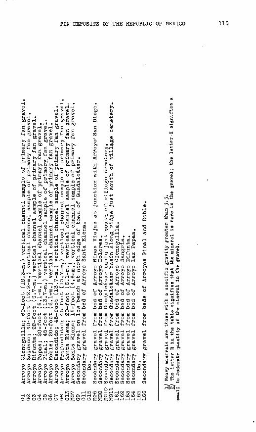
Heavy minerals in the gravels. Vertical channel samples of
the primary gravels were taken by the authors from the walls of
10 arroyos that cut the fan deposits in the Guadalcazar and
Realejo basins; none were taken in the Abrego basin. These
samples ranged from 20 to 60 feet (6.6 to 20 m.) in length and
averaged about 35 pounds (16 kg.) each in weight. After screen
ing out the gravel larger than a quarter of an inch (0.6 cm.),
the undersize was concentrated by hand-panning to a ratio of 1
part to 25. Rough pannings were also made of the secondary
gravel from the beds of some of the arroyos. All these concen
trates were separated in methylene'iodide (sp. gr. 3.3), and the
heavy minerals were identified by their optical or crystal-
lographic properties. Qualitative results of the mineral stu
dies, which are presented in table 4, show a wide distribution
of the mercury, tin, and tungsten minerals.
ll/ Wittich, Erneeto, Observed ones e.cerca de placeres de cine'brio y oro, encontrados en el Distrito de Guadalcazar, San Luis Potosf: Bol. minero, vol. 10, p. 256, 1920.
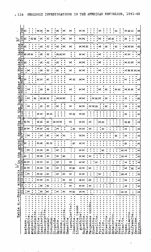
Table 4. Heavy minerals -> in
the
graV
el de
posi
ts in th
e Gu
adal
aca'
zar
and Realelo basins
Ay%
/^T
>Q
y^-?
"I
" O
Bin
dheim
ite ...
....
.B
rookit
e. ........
..G
assit
eri
te. ..
.....
Epid
ote
............
Cio
~\
OT
I Q
»
Hem
ati
te
( specula
rite
) .
. .
.
Lim
onit
e
(som
e goett
iite
) ..
......
Tvr*
T Q
r*V
i "1
"t~ ^
P r»
w A
1 1
"1
"t~ P
Pyri
te. ..........
..R
uti
le. ..
....
....
. o
Clr
tVi^
fll
T
1-O
Sid
eri
te. ..
....
....
Sp
hale
rite
...
....
..
Svabit
e. ........
...
Tit
anit
e. ..
....
....
T*
*~
IT\Q
*7
Wolf
ram
ite .........
Zir
con. ..........
...
til X R ft X y X R X R X
ay R R X X X y X
U3 R R R X X X X X X x
G4 R R R X y X X X R R
Ub R X R R R X X R X X X X X
G6 R X R R R X X X y R X X
(jy R R R R y X X R y R
(18 X R R R X X X R R X
G13 R R R R R R X X R X
MG
7
X X R X X X X R X X
G9 R y R R R R X y X R R X
Gil R X R R R R X X X X X X X R R R X
G15 R R R R R X R X
MG
6
R R X X X X X R R R
MG
8
R R R R X X X X R X R R R
MG
10
R R X R R R R R X
MG
11R R R R X R X X X
161
R R R X X X X R R R X
162
R R R R X R R X
163
R R R R R R X X
16
4'
R R R R R R R R R
165
R R R R R X X X R-
R R R
166
R R .R R R y R R R X
fj
H3
c? W
tr« H
o CO
Gl
Arroyo Cieneguilla; 60-foot (1
8.3-
m.)
vertical channel sa
mple
of primary fan gr
avel
.G2
Arroyo So
ldad
o; 40-foot (1
2.2-
m.)
vert
ical
channel sample of
primary fan gr
avel
,G3
Arroyo Difunta; 22-foot (3
.7-m
.) ve
rtic
al channel sample of
primary fan gravel.
G4
Arroyo Papas; 20-foot (6.1-m.) vertical channel sample of primary fan
gravel.
35
Arroyo Final; 45-foot (1
3.7-
m.)
vert
ical
channel sample of pr
imar
y, fan
gr
avel
.G6
Arroyo Ro
ble;
20-foot (6.1-m.) vertical channel sample of primary fan
gravel.
G7
Arroyo Escondido; 45-foot (13.7-m.)
vertical channel sa
mple
of primary fan gravel.
G8
Arroyo Profundidad; 45-foot (1
3.7-
m.)
vertical channel sa
mple
of
primary fan
grav
el.
^3G1
3 Arroyo Sa
nta
Elen
a; 20-foot (6.1-m.) vertical channel sa
mple
of
primary fan gr
avel
o m
MG7
Arroyo Sa
nta
Elen
a; 15-foot (4.6-m.) vertical channel sa
mple
of primary fan gravel.
aG9
Secondary gravel on
low bench at north edge of
town of Guadalcazar.
MGi
l Secondary gravel from bed of
Arroyo Sa
nta
Elen
a.
oG1
5 Do
. g
MG6
Secondary gravel from bed of
Arroyo Mi
has
Viejas at
junction with Arroyo
1 San
Diego.
gMG8
Secondary gravel from bed of
Arroyo Do
lore
s.MG10 Secondary gravel from Guadalcazar basin just south of village
ceme
tery
. {§
MG11 Secondary gravel from Guadalcazar basin along ri
dge
just south of
village
cemetery.
161
Secondary gravel from bed of
Arroyo Ci
eneg
uill
a.
K16
2 Secondary gravel from bed of
Arroyo Sa
ngri
a.
163
Secondary gravel from bed of
Arroyo Difunta.
2164
Secondary gravel from bed of
Arroyo Las
Papa
s.
+3165
Do.
g16
6 S
econdar
y g
rav
el
from
bed
s of
Arr
oy
os
Pin
al
and
R
oble
. t-
I/
Hea
vy m
iner
als
are
th
ose
n
ith
a
specif
ic g
rav
ity
fr
eate
r th
an 3
.3.
a2
/ T
he le
tter
R in
th
e ta
ble
si-
nif
ies th
at
the
min
eral
is
ra
re
in
the
«re
.vel
; th
e le
tter.
X si
gn
ifie
s a
psm
all
to
moder
ate
qu
an
tity
o
f th
e m
iner
al
in
the
gra
vel.
H o

116 GEOLOGIC INVESTIGATIONS IN THE AMERICAN REPUBLICS, 1941-42
The mineral cassiterlte, which occurs mainly in small crys
tals and crystal fragments but also in sparse fragments of
banded wood tin, appears to be the only tin-bearing mineral
present. The color of the cassiterite ranges from red to yellow
to dark brown or nearly black. The mercury is in the mineral
cinnabar, which occurs as rounded bright- to dull-red crystal
fragments. The tungsten-bearing minerals are wolframite and
scheelite, the former occurring as shiny black rectangular and
platy crystal fragments and the latter as white to cream-col
ored grains with greasy luster. The wolframite in the concen
trates is similar in appearance to the specularite. The gold
forms small warty grains. No silver minerals have been recog
nized, but some of the silver shown by assays may be in the
galena, which occurs as subrounded grains partly incrusted with
white anglesite.
Grade of the deposits. Rather detailed studies of the quan
tities of tin, mercury, gold, and silver in parts of the gravel
deposits were made by the Cia. Minera de Penoles, S. A., in
1938, and by the Cia. Mlnera de Guadalcdzar, S. A., in 1940 and
1941, and tests were being conducted by the San Luis Mining Co.
in December 1941. The studies by these companies and by the
authors show that the primary fan gravels north of the town of
Guadalc6zar contain from 0.005 to 0.03 percent tin and between
0.0008 and 0.04 percent mercury; they also.contain from 0.0006
to 0.003 ounce (0.017 to 0.085 gm..) of gold and about 0.2 ounce
(5.7 gm.) of silver per metric ton. About 40 percent of the
gold and silver, 35 percent of the mercury, and 30 percent of
the tin appear to be in the fines, which form about 20 percent
of these primary gravels. No quantitative tests for tungsten
have been made.
Rough channel samples of the primary fan gravels taken by
the authors indicate that the gravels in the Realejo basin con
tain more tin and mercury than those in the Guadalcazar basin.
TIN DEPOSITS OF THE REPUBLIC OF MEXICO . 117
Preliminary tests indicate that the secondary gravels in the
beds of the arroyos contain appreciably larger quantities of
the metals than the primary fan gravels.
Possible production. The total amount of alluvial material
in the Guadalcazar and Realejo basins may be more than 75,000,000
tons, of which all but a few million tons are in the Guadal
cazar basin. It is doubtful whether, at 1941 prices, the valu
able metals tin, mercury, gold> and silver could be extracted
at a profit from the primary gravels in the Guadalcfizar basin,
not only because of the low grade of this placer material but
also because too great a percentage of the metals are in the
fines. However, the primary gravels of the Realejo basin seem
to be of a somewhat better grade.
The secondary gravels, which are confined mainly to the
Guadalcazar basin, appear to contain -enough of the metals for
profitable mining, and their volume is moderately large.
Although these deposits have not been sampled in*detail, it is
believed that they are well worth testing.
It is probable that enough water for placer mining could
easily be obtained by pumping, since wells in the Guadalcazar
basin reach the water table 15 to 30 feet (4 to 10 m.) below
the surface.
Deposits associated with lead-zinc-silver ores
Deposits associated with lead-zinc-silver ores are known to
occur in only one district in Mexico, and only in a part of a
single mine the San Antonio mine at Santa Eulalia, 12 miles
(20 km.) east of the city of Chihuahua. Tin was first dis
covered in milling and smelting some of the ore in 1926. A
process was devised for recovering the tin, and by 1939 about
3,000 tons of tin had been produced, which is about half of
Mexico's total production. No tin has been recovered from the
mine since 1939, the tin ore having then apparently been

118 GEOLOGIC INVESTIGATIONS IN THE AMERICAN REPUBLICS, 1941-42
exhausted, although the other metals are still being produced.
The authors did not examine the deposit 12/The dominant rocks in the region, according to Prescott, '
are Cretaceous limestones, which are overlain by beds of Terti
ary clastic and volcanic rocks. Sills of diabase and a larger
intrusive mass of diorite have been discovered in the mine work
ings in recent years. All the formations are cut by dikes of
light-colored fine-grained aplitic rock, called "rhyolite", and
of a dark-colored dioritic rock, called "andesite". One of the
largest of the "rhyolite" dikes is exposed in the San Antonio
mine. The lead-zinc-silver ores are described by Prescott as
replacement deposits in the limestone. They consist largely of
pyrite, pyrrhotite, galena, sphalerite, and iron-lime-silicate
minerals. No description of the exact mode of occurrence of the
tin has been published so far as known.
In 1927 Poshag collected from the ore pile specimens of rock
similar in appearance to the "rhyolite" dikes; these specimens
consisted of porous quartzose rock containing small crystals of
brown casslterite and black specularite. The cassiterite may,
however, be more closely related to the lead-zinc ores than to
the dikes. In the Sullivan mine, at Kimberly, British Columbia,
IVaccording to Schwartz,-=^ cfassiterite occurs in a lead-zinc-
silver deposit very similar to the Santa Eulalia deposit and is
closely associated with the sulfide ores.
Deposits associated with extrusive rocks
Most of the tin deposits of Mexico are in extrusive rocks.
About half the total production of tin in Mexico has come from
these deposits and from placers associated with them. As the
general features described in the introductory section of this
report refer mainly to deposits in extrusive rocks, it will not
\2j Prescott, Basil, The main mineral zone of the Santa Eulalia dis trict, Chihuahua: Am."lost. Win. Eng. Trans., vol. 51, pp. 57-99, 1916.
\jf/ Sch^artz, G. M., Microscopic features of Sullivan ore: Eng. and Min. Jour., vol. 122, pp. 375-377, 1926.
TIN DEPOSITS OF THE REPUBLIC OP MEXICO 119
be necessary to describe them here. These deposits appear to
form a unique type. Two districts in the United States in which
deposits of this type are known have recently been described by
Fries. One of these is in southwestern New Mexico, the other
in northern Lander County, Nevada. ' Apparently no other such
deposits have been described, though some specimens received by
LIndgren from Bolivia suggested to him that similar deposits may
occur in acidic lavas there. is/
Geology
The volcanic rocks that contain the tin deposits of the 18
districts that have been investigated in the States of Micho-
acan, Guana juato, San Luis Potosi, Aguascalientes, Zacatecas,
and Durango are predominantly rhyolitic. In the Jaula district,
In Guana juato, the veins are in latite, and at El Santin mine
in the same State they are in andesite, but in both localities
these rocks are overlain by rhyolite. Throughout the plateau,
particularly along its west side and in its northern part, the
rhyolitic lava flows are interbedded with volcanic breccia and
tuff. The pyroclastics are not abundant, however, In the tin' " i
districts. Most of the tin-bearing veins are in the lava flows;
a few are in breccia; none of those examined are in rocks
clearly identified as tuff. The age of the rhyolitic rocks ',17/ according to Ordonez, 'probably ranges from Miocene to Plio
cene, thus being about the same as that of the tin-bearing rhy
olite in New Mexico and Nevada.
14 / Fries, Carl, Jr., Tin deposits of the Black Range, Catron and Sierra Counties, N. M., a preliminary report: U. S. Cool. Survey Bull. 922-M, pp. 355-370, 1940.
15/ Fries, Carl, Jr., Tin deposits of northern Londer County, Nov.: U. S. Geol. Survey Bull. 931-L, pp. 279-294, 1942.
16_/ Lindgren, Waldemax, Mineral deposits, 4th ad., p. 659, New York," McGraw-Hill Book Co., 1933.
IT/ OrdoTiez, Ezequiel, Las rhyolitas de Mexico: M6xino Inst. geol. Bol., No. U, pp. 66-67, 1900.
120 GEOLOGIC INVESTIGATIONS IN THE AMERICAN REPUBLICS, 1941-42
The rhyolite flows are in general distinctly layered. The
layers are nearly horizontal in most of the places where the
lavas are interbedded with pyroclastic rocks, but in the vicin
ity of the tin-bearing veins this attitude is the exception
rather than the rule. There the layers generally have irregular
strikes and steep dips, which change markedly within short dis
tances. No attempts were made to interpret in detail the mean
ing of this confused structure, but in most places it was
clearly a result of original flow rather than of later tectonic
movements. This peculiar structure and the relative scarcity of
pyroclastic rocks suggest that the tin-bearing areas are near
the centers of eruption of the lavas.
The rhyolite is reddish brown to light gray or white; the
latite and andesite are dark reddish brown. Lithophysae, vugs,
and cavities of all shapes are abundant in some parts of all the
flows. The rocks are generally lighter in color around the
cavities than in the rest of the groundmass, apparently owing
to coarser crystallization; some of the rocks consequently have
a spotted or mottled appearance. In all the tin districts the
tin-bearing rocks are porphyritic, and their groundmasses are
completely devitrified, finely crystalline, and more or les.s
spherulitic. The phenocryst-s, which make up from about 5 to
nearly 30 percent of the rocks examined, are largely sanidine
and quartz, but most of the flows also contain a few percent
of plagioclase phenocrysts, ranging in composition from .calcic
albite to sodic andesine in different flows. In general the
flows contain less than 1 percent biotite or hornblende, or
both, now mostly altered to hematite, quartz, and feldspar.
Most of the alteration apparently occurred just before and
during the crystallization of the groundmass. The phenocrysts
in the andesite are chiefly calcic andesine or sodic labra-
dorite, and less than 2 percent of them are biotite and pyrox-
TIN DEPOSITS OP THE REPUBLIC OP MEXICO 121
ene. A brief description of the rocks in each of 15 of the
districts visited is given in table 5.
The fine-grained groundmass of most of the rhyolite flows is
composed largely of sanidine and quartz, but in some of the
flows the silica forms tridymite and cristobalite, which may or
may not be accompanied by quartz. A fine dust of hematite and
tiny crystals of specularite form a small part of the ground-
mass. Magnetite is scarce in most of the rocks. In most of the
rhyolites the only nonopaque microscopic accessory mineral is
zircon, but the andesite and latite contain both zircon and
apatite. The most abundant mineral in the lithophysae and cav
ities of the rhyolitlc lavas is quartz, but lithophysal trid
ymite is abundant in some of the flows and opal and chalcedony
in others. Small quantities of lithophysal sanidine, specular
ite, topazj pseudobrookite, cristobalite, zeolites, and fluorite
also occur in parts of some flows.
Overlying the tin-bearing formations are lava flows and
pyroclastic rocks ranging in composition from rhyolite to ba
salt. The moat recent of these are largely basalt. Still more
recent deposits consist of fan gravels, which lap against and
surround the ridges and ranges of volcanic rocks that rise above
the general level of the. plateau. Many of these deposits of
detritus have been deeply dissected by arroyos, in which sec
ondary deposits of gravel have been formed. Some of the gravel
deposits contain placer tin near the veins.
The lavas and pyroclastic beds of the Mexican plateau
country are for the most part nearly horizontal. None of these
late volcanic rocks are known to be folded, although they appear
to be gently tilted in places. Many of the lava-capped ridges
and ranges undoubtedly owe their elevation to normal faulting,
but no Important faults were observed close to any of the tin
deposits.

122 GEOLOGIC INVESTIGATIONS IN THE AMERICAN REPUBLICS, 1941-42
Vein deposits
Occurrence. The tin-bearing veins are largely incrustations
on the walls of narrow open fissures, and they appear to occur
mainly in the more open parts of the fissures. These fissures
are in most places extremely irregular in strike and dip and
pass within short distances into tight joints. In some places
they branch at various angles and connect with other parallel
or diverging fissures. Most of the veins are less than 50 feet
(15 m.) in length, a few of those examined are as much as 200
or 300 feet (60 or 90 m.) long, and one vein appears to be con
tinuous for about 1,000 feet (300 m.) on the surface. The ma
jority of the deposits have been mined to depths of from 20 to
50 feet (6 to 15 m.), where the vein material seems to pinch
out. The deepest exploration known extends about 300 feet (90
m.) from the surface. The thickness of the vein material varies
along the fissures and is generally less than half an inch (1.3
cm.), but some bodies as thick as 10 inches (25 cm.) have been
mined. These thicker bodies, which have the form of small
lenses or pockets, are locally enlarged parts of the veins, but,
as the fissures leading to sone of them are very obscure, they
have been mistakenly regarded as local segregations from the
lavas. In places the incrustations follow branching and retic
ulating fissures and form lodes from 1 to 5 feet (0.3 to 1.5 m.)
wide. The length of these lodes appears to be generally less
than 20 feet (6 m.) and the depth about the same.
The vein minerals were deposited for the most part in open
fissures, but they occur locally in the wall rocks of all the
deposits, filling cavities and tiny openings or replacing the
wall rock to a slight extent. No large bodies of rock have
been found through which the vein minerals are uniformly dis
seminated, and all dissemination of these minerals appears to be
limited to the immediate vicinity of the small tin-bearing fis-<?
sures, ordinarily extending only an inch or two (2.5 to 5 cm.)
Table 5. HIneral composition of the rocks and tin veins in some of the tin districts of Mexico I/
Locality (Numbers refer to numbers in text and on pi. 25. )
1. Los Cablrea mine,Tepuxtepec, Mi-choacfin.
2. Tin deposit 15miles (24 km. )west of DoloresHidalgo, on roadto Guana Juato,Gto.
3. Tin deposits 2miles (3 km. )east of Tlachi-quera, betweenSan Pellpe andLedn, Gto.
4. Tin deposits inCerro del Toro,northwest ofTlachlquera, between San Pellpeand Le6n, Gto.
5. Tin deposits 10miles (16 km. )north of SanPelipe, Gto.
6. 'Queensland mine near Santa Bar bara, northwest of San Pellpe, Gto.
7. El San tfn mine near Santa Cata- rJiia, southeast of San Luia dela Paz, Gto.
8. Tin deposlta on Hacienda Sau- ceda, about 25 miles (40 km.)north of SanLuis de la Faz,Gto.
9. Tin deposits on road from San Luis Potosi to SanLuis de la Paz,between Santa Domingo, 3. L. P.,and Jaula, Gto.
10. Tin deposits 10 miles (16 km. ) southwest of Cal-villo, Aguascal- lentes.
11. Tin deposits at La Quemada Indian ruins, about 40miles (64 km. )southwest of thecity of Zacate-
. cas.
12. Tin deposlta 25 miles (40 km. ) northwest ofPresnlllo, Zac-atecaa.
13. Cerro de loa Remedloa at the city of Durango .
14. Cacaria dis trict northwest of city of Du rango; rocks from El Dlablo and Las Auras mines.
15. Potrillos district in Sierra de San Francisco, Du rango .
Rock name
Porphyriticrhyollte.
....do.....
1
....do.....
....do.....
....do.....
....do.....
Porphyrltlc andesite.
Porphyrltlc rhyollte .
Porphyritic latlte.
Porphyritic rhyollte.
....do.....
....do.....
....do.....
....do.....
do
Rock description
Reddiah brown to light gray; inplaces spotted, vuggy, llthophysal; largely well layered;coarsely porphyritic; spher-ulltic; lava flows.
Reddiah brown to light gray; Inplaces vuggy and llthophysal;In part well flow-layered;porphyritic; highly spher-ulitic in part; lava flows.
Reddish brown to light gray; Inplaces spotted, vuggy, llthophysal; moderately well layered; coarsely porphyrltlo;lava flows.
Light reddiah brown to lightgray; in places vuggy andllthophysal; porphyrltlc,with some spherulites Inthe crystalline groundmasa;flow-layered; lava flows.
Reddish brown to light gray; inpart vuggy and llthophysal;moderately coarse porphyry;groundmaaa crystalline, withspherulites; in part wellflow-layered; lava flows.
Reddish brown to light gray; In part vuggy and lithophysal;' moderately coarse porphyry, with some spherulites in fine ly crystalline groundmaaa; inpart well layered; lava f Iowa .
Dark reddiah brown to dark gray; In part vuggy; porphyrltlc, with aome spherulites In fine ly crystalline groundmass; Inplaces spotted; in part welllayered; lava flows.
Reddish brown to light gray; In part vuggy and llthophysal; moderately coarse pheno- cryats; aome spherulltea Infinely crystalline ground-mass; well flow-layered, lavaflows .
Light brown; in part vuggy; finely porphyritic; well layered; probably lava flow.
Reddish brown to light gray; In part vuggy and lithophysal; porphyrltlc, with aome spher-ulltes in groundmass; in part well flow- layered; lavaflows .
Reddish brown to light gray; In places vuggy and lithophysal; fine-grained porphyry, withsome spherulites in crystalline groundmass; well flow-layered; lava flows.
Reddish brown to light gray; in part vuggy and lithophysal; porphyritic, with aome spherulites in groundmass; In partwell flow- layered; lava flowa.
Reddish brown to light gray; in places vuggy and llthophyaal; fine-grained porphyry, withspherulltea; in part wellflow-layered and in part flowbreccia; mainly lava flows.
Reddish brown to light gray; in places vuggy and lithophysal; moderately coarse porphyry; groundmaaa apherulitic In placea; generally well lay ered; lava flows.
Reddish brown to light gray; In places highly vuggy and litho physal, in other places' dense and firm; generally a very fine-grained porphyry; inplaces well layered; appearsto be mainly lava flows.
Phenocrysta
Percent
15
10
oc GO
10
20
20
15
15
10
15
10
10
10
15
5
Minerals ( In order of
SanldineQuartzOllgoclaseBiotlte(Hydroblo-
tlte)
QuartzSanidlneHornblende?
SanldineQuartzOllgoclaseBiotlte?
QuartzSanidlneAlb it eBiotite
SanidineQuartzBiotite? orhornblende?
Sanidlne Quartz Biotlte? or hornblende?
Calcic an- desine
Biotite Pyroxene
Quartz Sanidlne Biotite
Andeaine SanidlneBiotlte
Sanldine Quartz AlbiteHydroblo-
tlte
Sanldine Quartz Biotite?
Sanldine Quartz Biotlte
Sanldine Quartz OligoclaseBiotite
Sanidine Quartz Hydrobio-
tite
Sanidlne Quartz Biotlte Hornblende
Minerals in groundnaas =*
SanidlneQuartzTridymiteCrlstobaliteHematite
SanidlneQuartzHematite
SanidineQuartzHematiteTridymlte?
QuartzSanidineHematiteTridymlte?
SanidlneQuartzTridymiteHematite
Sanldine Quartz Tridymlte Hematite
Plagioclase Sanidlne Hematite
Sanldine Tridymite Quartz Hematite
Sanidlne PlagioclaseHematite
Sanldine Quartz Hematite
Sanidlne Quartz
Sanidlne Quartz Hematite
Sanldine Quartz Hematite
Sanldine QuartzHematite
Sanidlne Quartz Hematite
Microscopic accessory minerals
Zircon
....do.....
....do.....
....do.....
....do.....
....do.....
Apatite Zircon
Zircon
Apatite Zircon
Zircon
....do.....
....do.....
....do.....
....do.....
....do.....
Minerala In vugs and ]/
lithophysae -'
SpeculariteTridymiteTopazQuartzChalcedonyOpal
SpeculariteTridymiteQuartzChalcedonyOpal
SpeculariteTopazTridymlteQuartzChalcedony
Opal
SpeculariteTridymlteQuartzChalcedonyOpal
SpecularitePseudobrooklteTopazTridymiteQuartzSanldine
Specularite Pseudobrooklte Sanidlne Tridymlte Quartz
Specularite Tridymite Quartz Others not
determined.
Specularite Topaz Tridymite QuartzChalcedonyOpal
Specularite QuartzChalcedonyOpal
Not determined.
Specularite Tridymlte Quartz
Specularite Topaz. Quartz
Specularite Pseudobrooklte TopazSanldineTridymiteQuartzChalcedonyOpalPluorite
Not determined.
Specularite Pseudobrooklte Topaz Sanidlne TridymlteQuartzChalcedonyOpalZeolitesPlucrrlte
Minerals in the veins I/
MagnetiteSpeculariteCassiteriteCristobaliteTridymlteQuartzOpalMontmorillonite
MagnetiteSpeculariteCaaslterlteCriatobaliteTridymiteQuartzMimetiteOpalZeolitesMontmorillonite
MagnetiteSpeculariteCaasiteriteCrlstoballteTridymiteChalcedonyQuartzOpalClays
MagnetiteSpeculariteCassiteriteClays
MagnetiteSpeculariteCassiteriteTopazCristobaliteTridymiteQuartzHuebnerlte?ChalcedonyOpalClays
Magnetite Specularite Cassiterite Tridymlte QuartzChalcedonyOpalClays
Magnetite Specularite Cassiterite TridymlteQuartzZeolitesOpalMontmorillonite
Magnetite Specularite Cassiterite TridymiteQuartzOpalChalcedony
Magnetite SpeculariteCasalteriteChalcedonyQuartzOpalMontmorillonlte
Magnetite Specularite CassiteriteChalcedony QuartzOpal
Magnetite Specularite CassiteriteTridymlteQuartzChalcedonyOpal
Magnetite Specularite CasalteriteQuartzChalcedonyOpal
Magnetite Specularite CassiteriteSanidlneCristobaliteTridymlteQuartzChalcedonyOpalPluoriteMontmorillonlte
Magnetite Specularite Caaaiterite Cristoballte Tridymite Chalcedony OpalMimetiteMontmorillonite
Magnetite Specularite Cassiterite Topaz SanidlneCrlstobaliteDuranglteTridymiteChalcedonyOpalZeolitesPluoriteClays
Alteration 2/
In placea highly porous;contains zeolites and minorquantities of clay minerala;phenocrysta unaltered.
In places highly porous;contains some zeolites andminor quantities of clay minerals; phenocrysts unaltered.
In places somewhat porous;rock generally fresh.
In places plagioclase alteredto a mixture of quartz and clays;sanldine fresh; rock somewhatporous near aome veins.
Wall rock porous in places;groundmasa containa aome clays;along one vein there was brec-ciatlon and recementatlon withopal and chalcedony; feldapars freah.
Rock generally denae and firm near veins, but in a few places porous; some clays in ground- mass; phenocryats not altered.
In places plagioclase phenocrysts altered to claya; in aome zones feldspars in grbundmass strongly altered; alteration not along allveins; zeolites present in places.
Rock somewhat porous near some veins; apparently some clays In groundmass; phenocrysts unaltered.
Some phenocrysts largely altered to kaolinlte; some blotlte altered in part to chlorlte; mont-morlllonite and other clays,possibly some zeolites, in ground-mass.
Rock along some veins highly porous; along other veins there has been slight brecclatlon andrecementatlon with chalcedony and opal; apparently some clays ingroundmass of porous rock.
None observed; phenocrysts entirely fresh.
Rock along some veins porous; possibly aome clays In groundmass; phenocrysts unaltered.
Rock porous In places; along one vein some phenocrysts partly altered to clay; clays In groundmass in someplacea; some tridymlte inverted toquartz; some sanldine in the veinsaltered to clays; fluorlte In ground-mass; in most placea all phenocryatsunaltered.
Rock generally denae and firm, but porous In a few places along veins; in placea groundmaaa contains claya; phenocryata In wall rock along veins generally unaltered.
Rock generally dense and firm, but highly porous In some places ; where porous, rock containa zeolites, fluorite, and clay minerala; phenocryata generally unaltered.
I/ The minerala listed are only' fhbse actually found taring a brief examination of the deposits, and it should not be assumed that all the lists are complete."Z/ Owing to the extremely small size and the intergrowth of the minerals in the groundmasa, it is not possible to identify all the minerals by ordinary methods. There may be a much wider
distribution of oristobalite and tridymlte than is indicated. A small quantity of magnetite occurs in moat of the rocka.3/ There la alao a amall quantity of llmonlte in many placea, most of it apparently aupergene. U. 3. GOVERNMENT PRINTING OFFICE: 1942 O - 4801 IS (faces p. 122)

TIN DEPOSITS OP THE REPUBLIC OF MEXICO 123
on either side of the fissure. In a few places where two fis
sures containing vein material were separated by only a few
Inches of wall rock, all this rock was found to be impregnated
with small quantities of the vein minerals.
There has been minor faulting along at least one of the tin-
bearing fissures in each district visited, but none of the veins
examined appear to be on major faults. Possibly, however, all
the tin-bearing fissures may be related to extremely small
faults. In a few places the rocks are sheeted, but in general
adjacent blocks are not relatively displaced by more than a
small fraction of an inch (less than a centimeter). In one
place a slickensided wall incrusted with vein minerals was
found, indicating that movement preceded mineralization; in
other places crushed vein material gives evidence of slight
movement after mineralization.
Mineralogy and paragenesis. The veins consist of incrusta
tions that are composed for the most part of specularite and
cass_it_erj.t.e-.. Specularite is generally more abundant than cas-
siterite. These are the only minerals In parts of many veins;
other parts of the same veins contain cristobalite, tridymite,
quartz, chalcedony, and opal, usually in small quantity, though
the last two are abundant locally. Other vein minerals include'
magnetite, sanidine, topaz, fluorite, zeolites, montmorillonite
and other clay minerals, calcite, and llmonite. Mimetite <has
been found in three localities, and the rare mineral duranglte
has been found in one. Wolframite has been reported to occur in
some of the veins in Durango, but the report has not been ver
ified. A few tiny crystals collected by the authors from one
locality in Guanajuato have the optical properties of huebner-
ite, but not enough material was found for chemical tests. The
identity of two other minerals collected by the authors is
unknown, owing to the. extremely small quantities found, but one

124 GEOLOGIC INVESTIGATIONS IN THE AMERICAN REPUBLICS, 1941-42
appears to be closely related to mlmetite, the lead chloro-arse-
nate. Pyrite and other sulfide minerals are completely lacking.
The cassiterite occurs in small, well-formed crystals and in
botryoidal, banded masses known as wood tin and called rinones
(kidneys) or guijilos (little pebbles) by the local miners.
Both varieties are harder than a knife blade and have a specific
gravity close to 6.5. The color of the crystals is generally
bright red, but some are" orange, greenish yellow, smoky, or
brown. The banded wood tin varies in color from place to place
in the same vein and also from layer to layer in a single piece;
the colors range from nearly white through all shades of yellow,
greenish yellow, and reddish brown to nearly black. Both vari- v
eties of cassiterite occur in all. the veins, but the wood tin
is much the more common. Both varieties incrust and are inti
mately intergrown with the specularite and have in places
replaced it pseudomorphously. This association of the two min
erals is so close that they cannot be separated completely by
crushing as fine as 200 mesh probably not even at 500 mesh.
Published chemical analyses, most of which are presented in
table 6, show that small quantities of copper, lead, zinc, anti
mony, bismuth, or arsenic occur in the deposits; very little
sulfur is reported in four analyses. Spectrograms of concen
trates of samples collected by the authors from five tin dis
tricts,, were made by George Steiger in the laboratories of the
Geological Survey. The elements thus looked for were: Lead,
zinc, antimony, bismuth, silver, beryllium, arsenic, boron,
tungsten, and germanium. All the samples contained one or more
of all these elements except tungsten and germanium, neither
of which was found. Qualitative chemical tests showed small
quantities, also, of manganese and titanium in all the samples.
The only separate mineral recognized in which one of the minor
metallic elements found in the deposits forms an essential part
was mimetite. It is possible that the metals occur in submicro-
TIN DEPOSITS OF THE REPUBLIC OF MEXICO 125
scopic mineral grains in the vein material, or some of them
may replace the iron in specularite. None of them form sul-
fldes, for the quantity of sulfur in the veins is negligible.
Some may form rare arsenic minerals, enclosed in the wood tin,
as suggested by Genth =2/in his description of cassiterite from
Durango.
The specularite, magnetite, cassiterite, topaz, sanidine,
cristobalite, tridymite, and some of the quartz in the incrusta-
"tlons appear to have been deposited at nearly .the same time.
The specularite and magnetite were in general deposited first,
and the cassiterite next, but at one place both specularite and
cassiterite deposited on cristobalite were found. Some of the
specularite seems to have been deposited after some of the cas
siterite. Some crystals of cassiterite are coated with a film
of wood tin, but some of the fibrous wood tin is encrusted with
small crystals of cassiterite. The'Other minerals enumerated
above are intergrown with or deposited on the specularite and
cassiterite. The mimetite, durangite, opal, chalcedony, zeo
lites, fluorite, clay minerals, calcite, limonite, and $ome of
the quartz are all clearly later than the other vein minerals.
In a few pla-ces the vein material has been brecciated and rece-
mented with opal or chalcedony, some of which, together with
some of the clay minerals and of the calcite and limonite, may
be supergene (deposited by descending surface water). None of
the cassiterite is supergene, so far as could be determined.
Alteration.--The country rock close to many of the tin veins
is more or less altered, the most strongly altered rock observed
being the andesite adjacent to some of the veins at the El San-
tin mine, in Guanajuato; but in a few places it is no different
from any of the surrounding lava. Although much of the rhyolite
is highly vesicular, indicating that it contained large quanti
ties of gases when extruded, its porosity is in general espe-
13/ Genth, P. A.. Contributions to mineralogy: Am. Philos. Soc. Proc., vol. 2U, pp. 30-31, 18S7.
126 GEOLOGIC INVESTIGATIONS IN THE AMERICAN REPUBLICS, 1941-42
r
r\j
r
t<
0
4
w
<M
<D
d
(1
n
.
H
........ O'CDCn»«CM«'<<t<««»tO«CO««»
........ m «HCO «CM «CM m CM
^_ ^^^ -^^ ^_........ in«Qjrl««rj«cO« O uj
. ....... cQ«a)C^««co»<^*« m 10
/ > ^ s Irt rt /1^ 7^******* rn*r^r^** [ * Hr . (y L
. ....... 05«dC««CO«CM«. . d 'CM
***** * *"«; Q> CP CV * J^7 *^*ir^"*
co P< 5 o fe pq <; co co PL^ o w s o (JH <5 co co co PQ <; <; w pu, co o
H
H
COCO
CD
cn
CM 0
cn
toCO
cn
toCO
cn
cn
COto
rncn
cn
CO to
O
H
O.
H
OO
0 H
o
o oH
O
0OH
d OJ -P
m H O d o aj ofn -H
PH M0)
d SaJ
CO » o
fl) bO
at ^ fn 3 J^Q d)
vH <Mco o<D <n ^-P-P T-J
COd o
H & <D-d -d
0-p dH -H <D -PSra a>
£H E-i a)-P > a)
d r*» 03 H "2 tO-H p o d
* H Oi ^H CO Cd ^OH k H
rH 0 K"»co to d nd to "H do d co g d-P H cn <o
CO O PL.m H -P CM <*
o o m o t^>fH H -H -P
CO -P «HOS ji5 COCO (D ftp Pit>sS -H 0)
0} ->iO -P -Hd <D CM d d cd k o |D
o o o o H --p > ^43
<! d<H W > (DO c5
<D O dbO 0) cd ><! cd -d fn ^d
a> d fe
} « bOCt) «-p d -P
co W co !>> CM

a. Vein material containing ca
ssit
erit
e, specularite, miraetite, and yellowish earthy material from
Mina de
l Diablo,
Cacaria di
stri
ct,
Durango.
b. Bright-red fibrous crystalline*cassiterite from Du
rang
o.
c. Red wood ti
n from Coneto di
stri
ct,
Durango.
d. Da
rk reddish-brown fi
brou
s cassiterite from Coneto di
stri
ct,
Durango.
e. Average of
tw
o an
alys
es of bright-red finely crystalline cassiterite from Mina de
l Diablo,
Cacaria
district,
Durango.
f. Dark reddish-brown wood tin
from Guanajuato, Guanajuato.
g. Average of th
ree
samp
les
of ye
llow
is.h
fibrous wood tin from Mina Varosa, Du
rang
o.
[j|
h. Fi
brou
s, concentrically laminated,
yellowish wood tin from Mina Varosa, Durango.
93. Concentrates from th
e Queensland mi
ne,
Santa Ba
rbar
a, Guanajuato.
Analyst, S. D. Br
idge
, Monterrey,
y
Nuevo
Le6n.
Brom
ly,
A. H.
, Tin mining and smelting at
Santa Ba
rbar
a, Guanajuato, Me
xico
: Am
. In
st.
Min.
W
Eng.
Trans.,
vol. 36,
p. 23
3, 1905.
(Recalculated as
oxides.)
o4. Wittich, Ernesto, El estano en
la Sierra de
' Guanajuato:
Soc. ge
ol.
Mexicana, Bo
l. 6,
p. 19
2. 19
10.
^5.
Stream tin.
Analysts,
John
H. Ba
nks
& Son. New
York
. Sa
mpso
n, E. H« S.
, Unpublished report on
£3
placer deposits near Dolores Hidalgo, Guanajuato,
for natural Products Producers Corporation, New
York.
6. Stream ti
n.
Analysts,
Ledoux & Co
., In
c.,
New
York.
Samp
son,
E.
H.
S.
, op.
cit.
§
7. Partial analysis of sh
ipme
nt of 15
to
ns of concentrates from El Santin mine,
Guanajuato.
Analysts,
Williams,
Harvey & Co
., Liverpool, En
glan
d.
(Recalculated as
ox
ides
.)
W

128 GEOLOGIC INVESTIGATIONS IN THE AMERICAN REPUBLICS, 1941-42
dally great near the tin veins, where the groundmass appears to
be weakly leached. In these places the rock is so friable that
it can be easily crushed. In some places the groundmass of the
altered rock contains small qxiantities of clay minerals, which
appear to be mainly of the montmorillonite group but in smaller
part kaolin; in other places the groundmass contains zeolites or
fluorite or both. Generally the feldspar phenocrysts are unal
tered, but in a few places, particularly where there has been
faulting, they are almost completely altered to clay minerals.
Silica was deposited almost entirely'within the fissures, but
it extends an inch or two (2.5 to 5 cm.) into the walls along/
some parts of the veins. Some of the quartz phenocrysts and a
few sanidine phenocrysts are secondarily enlarged.
Although alteration of the vein minerals is not common, many
crystals of specularite are weakly corroded. Part of this cor
rosion may have occurred at the time the cassiterite was depos
ited; but in some places the corrosion was clearly later, for
cavities have been left where the crystals of specularite have
been dissolved out of the mixtures of the two minerals. In one
place the sanidine in the incrustation is partly altered to
clay, whereas that in the wall rock is unaltered. In a few"
places the tridymite has inverted to quartz but has retained its
characteristic crystal form. The cassiterite apparently was
highly resistant to attack by later solutions.
It is clear that alteration and leaching of the wall rock
occurred after the deposition of the specularite and cassit
erite. In some places the incrustations cover small cavities
that would have been filled up if they had been present before
the deposition of the specularite and cassiterite. Had the wall
rock been porous prior to the deposition of the cassiterite,
this mineral should be widely disseminated throughout the rock,
but very little disseminated cassiterite has been found. The
TIN DEPOSITS OP THE REPUBLIC OP MEXICO 129
minerals deposited in the altered rock are the same minerals
that were last deposited In the veins.
Origin. As no one deposit has been thoroughly explored,
the origin of this type of tin deposit must be Inferred from
scattered bits of evidence gathered not only in Mexico but in
southwestern New Mexico and in northern Nevada. It is believed
that the source of the tin was largely rhyolitic magma that was
Intruded near the surface of.the earth rather than deep down;
some deposits were possibly derived in minor part from the lava
flows themselves. It is-believed, further, that the veins were
deposited in fissures formed by minor structural adjustments
after extrusion of the lavas and during the waning stages of
volcanism. The mineralization is thought to have occurred dur
ing one continuous cycle, in whose initial stages residual
gases, depositing cassiterite from the crystallizing rhyolitic
magma, escaped at temperatures probably above 600° C., and in
whose final stages hot waters filled the fissures, forming
zeolites and clay minerals. As sulfide minerals are absent
from the deposits, it would seem that, when temperatures had
dropped low enough to permit the presence of aqueous solutions
at the existing pressures, the magmatic fluids must have con
tained little but water.
The veins apparently were formed soon after the extrusion
of the Thyolite, for In a few places they are overlain by»unmin-
eralized basalt and in other places by other unmineralized lavas
probably extruded after mineralization. The cassiterite was
clearly deposited at relatively shallow depths. The lavas have
not been either folded or metamorphosed, and field relations
indicate that no great thicknesses of rock have been eroded
from the deposits. The fissures in which the incrustations
were deposited are not in general filled with the vein minerals.-
They are extremely irregular and discontinuous, many of them
branching or feathering out in a manner characteristic of fis-
130 GEOLOGIC INVESTIGATIONS IN THE AMERICAN REPUBLICS, 1941-42
sure veins formed at shallow depth. Although some of the veins
are at least 1,000 feet (300 m.) below the present upland sur
face and may have been formed at a depth of 2,000 to 3,000 feet
(600 to 1,000 m.), others may have been formed within a few
hundred feet (less than 100 m.) of the surface. Evidence from
outcrops and from explored veins indicates that some groups of
veins have a vertical range of at least 400 feet (120 m.), but
exploration has been insufficient to prove how much greater the
range may be.
The fact that the veins occur only in certain parts of the
lavas, there being vast quantities of rhyolitic lava that .do not
contain tin veins, indicates that certain localizing factors
were operative. One such factor appears to have been proximity
to the vents from which the lavas were extruded; some of the
deposits clearly occur near centers of extrusion, whereas few
deposits occur in the thin flows, with interbedded pyroclastic
rocks, which apparently are distant from these centers. Fault
ing is known to have occurred along some fissures before the
incrustations were formed, and faults occur in some part of each
deposit examined. Although none of these appear to be of large
displacement, it is believed that they provided channelways
extending from some depth below the present outcrops of the
veins, and that these faults resulted from structural adjustment
consequent upon the extrusion of the lavas rather than from
later earth movements.
The source of the tin is believed to have been the rhyo
litic magma. .All the tin deposits are closely associated with
rhyolitic extrusive rocks, and most of them are actually in such
rocks. Spectrograms of the freshest rhyolite from two districts
show about 0.0005 percent tin, indicating that tin is a minor
element of the rhyolite in those districts. All the minerals
of the incrustations, except the arsenic minerals and possibly
cassiterite, occur also in the lithophysae of the rhyolite
TIN DEPOSITS OF THE REPUBLIC OF MEXICO 131
flows, as normal late products of crystallization deposited
after the lavas solidified. Some of these minerals are abun
dant throughout all the rhyolite flows, while others are of
rare occurrence. The relative scarcity of tin in the rhyolite
may account for the apparent absence of cassiterite in the
lithophysae.
The tin-bearing fluids that formed the minable deposits
must have been concentrated in small areas or directed along
a few conouits. The relatively small extent of the mineraliza
tion indicates that the fluids were of small volume and there
fore that the bodies of magma from which they came were either
small or poor in fluids. The localization of the deposits indi
cates that the mineralizing fluids did not come entirely, though
they may have come in part, from the flows themselves; it seems
probable, rather, that they came chiefly from crystallizing rhy-
olitic magma that never reached the surface. Some of the depos
its may have been formed,.while the lavas were cooling, by
intermingled fluids from both sources. The solutions that
formed the tin veins in the latite and andesite of eastern
Guanajuato are believed to have had their source in the reser
voir of rhyolitic magma from which the rhyolitic flows overlying
these more basic lavas came.
The early formed vein minerals are believed to have been
deposited from gases at moderately high temperatures, possibly
at first above 600° Co and later at somewhat lower temperatures.
The minerals in the incrustations that are generally believed to
form at high temperature are magnetite, specularite, cassiter
ite, sanidine (the high-temperature form of potash feldspar),
cristobalite and tridymite (generally formed at fairly high
temperature), topaz, garnet (in New Mexico and Nevada), and
bixbyite (only in New Mexico). The fact that the early metallic
vein minerals are oxides and mixtures of oxides, not accompanied
by sulfides, indicates that the environment was an oxidizing one
132 GEOLOGIC INVESTIGATIONS IN THE AMERICAN REPUBLICS, 1941-42
and that the temperatures were high enough to permit the sulfur,
which must certainly have been present in the ore-forming flu-19/
ids, to be carried away in the gases. Zies points out that
in the fumarolic incrustations of the Valley of Ten Thousand
Smokes in Alaska the sulfides and sulfates were formed abun
dantly at the vents where temperatures had dropped below the
boiling point of water, and only rarely at the high-temperature
gas vents, where the compounds formed most abundantly were
oxides. Although these fumarolic incrustations were formed at
the surface, whereas the tin-bearing incrustations under con
sideration were formed below the surface, the physical conditions
under which the two sorts of deposits were formed were probably
not very different, except that the gas pressures in the fissures
during the formation of the tin deposits were greater.
Most of the alteration and leaching of the wall rocks along
the tin veins occurred after the deposition of the cassiterite
(see p. 128). Some of this alteration may have been effected in
part by hot gases, but in the final stages it probably was the
work of liquids, as indicated by the occurrence in the veins and
altered rock of clay minerals, chalcedony, opal, and zeolites.
This hydrothermal stage appears in most of the deposits to have
been of short duration, for in general its effects are slight.
The liquids must have been nearly neutral and have carried very
little material in solution, since most of the specularite is
unattacked, ealcite is rare in the deposits, and little silic-
ification has taken place. In discussing the lavas of the San20/
Juan region in Colorado, Larsen points out that where the
lavas are strongly altered by hydrothermal agencies tridymlte
and cristobalite invert to the more stable form, quartz. Such
inversion is rare in 'the tin deposits.
jj/ Ziee, E. 0., The Valley of Ten Thousand Smokes; I. The fumarolic incrustations and their bearing on ore deposition: Nat. Geog. Soc,, Con tributed Technical Paners, Xatmai series, vol. 1., No. U, pp. 5-61, 1929-
?Q/ Larsen, E. S., Irving, John, Gonyer, F. A., and Larsen, E. S., jd, Petrologic results of a study of the minerals from the Tertiary volcanic rocks of the San Juan region, Colo. 2. The silica minerals (by E. S. Lar sen): Am. Mineralogist, vol. 21, pp. 692-69U, 1936.
TIN DEPOSITS OP THE REPUBLIC OP MEXICO 133
Mining and concentration. Many of the small tin deposits
have been mined with profit to the operators, mostly without the
aid of machinery or even of explosives. The mining has consisted
in the gouging out of rich vein material from between relatively
barren walls. The openings in most of the mines are, in the
main, only wide enough for one man to squeeze through, though
they widen somewhat where pockets of ore have been found. Some
of these mines' are reported to have yielded as much as 50 tons
of metallic tin, but most have yielded probably less than 5 tons.
Renewed work in some of the abandoned mines has revealed addi
tional small pockets of ore. "Dead work" has not usually
proved profitable. A typical small mine is illustrated in plate
27, A, a photograph of a mine 10 miles (16 km.) north of San
Pelipe, Guanajuato.
The ore obtained from the veins is crushed by hand and is
washed and concentrated on gently sloping rock or earth plat
forms (planillas) or in shallow wooden pans (bateas). Some of
the miners may lose more than 50 percent of the cassiterite dur
ing these operations, but in general the recovery is somewhat
higher. The concentrates consist almost entirely of cassiterite
and specularite and contain from 15 to 70 percent tin, averaging
around 45 percent. Some of the kidneys of wood tin contain as
much as 75 percent tin, but none are completely free from iron.
The amount of cassiterite disseminated in the wall rock of
the veins in rhyolite is extremely small, and the cassiterite.
is generally confined to a very narrow zone immediately adjacent
to the vein. Since the veins are almost without exception less
than 10 inches thick and are usually mere incrustations on the
walls of narrow fissxires, punctuated erratically by small pock
ets or kidneys of ore, very little of the material that must be
mined to extract the ore contains recoverable tin. Workings
must therefore be kept to minimum dimensions and regular methods
of development by machine methods obviously will failo

134 GEOLOGIC INVESTIGATIONS IN THE AMERICAN REPUBLICS, 1941-42
There are few figures showing grade of ore and production
for deposits that have been mined on a large scale, but those
available suffice to show that such mining has nowhere been
profitable. Bromly reports that around 1900 an attempt was made
at Santa Barbara, Guanajuato, to mine with the aid of machinery
a deposit that proved to average only 0.4 percent tin to a depth
of 130 feet (40 m.). He remarks, "On the whole, it would be
correct to describe the deposit as one that carries a small per
centage of iron contaminated with tin." '
The Pittsburgh & Mexico Tin Mining Co., according to Rangel,
spent more than $200,000 (United States currency) on the depos
its in the America-Potrillos district in Durango around 1907 but
recovered only a few thousand tons of ore. The operation
failed, it is said, because of poor management and lack of knowl-22/
edge. The amount of tin recovered is not recorded, but the
grade of the ore was presumably low, as no further large-scale
mining has been done.
The Durango Tin Mining Co. of St. Louis, as Ingalls was
informed by Mr. H. Winninghoff, operated mines in the Cacaria
district in Durango from 1881 to 1882; the most extensive work
was in the Diablo mine, which was opened to a depth of 273 feet
(83.2 m.). It is said that the vein material contained about
3 percent tin; how much barren rock had to be mined to obtain
the vein material is not known. The enterprise was abandoned as
unprofitable. Ingalls makes the comment that "The delusion as
to the extraordinary richness of the Durango tin fields is
largely due to the assay of specimens of the remarkable nodules
of cassiterite found there." ' No further large-scale mining
has been attempted in the Cacaria district, although several
small veins have been mined or prospected.
21/ Bromly, A. K., Tin mining and smelting at Santa Barbara, Guanejuato, Mexico; An. Inst. Min. Eng. Trans., vol. 3^i p. 229, 1905.
22/ Rengel, Manuel, Apuntes sot>re la distril>uci6n de minerales en el Bstado de Durango: Soc. geol. roexicana, Bol. 7i PP. 110-111, 1910.
2J/ Ingelle, W. R., The tin deposits of Durango, Mexico: An. Inst. Min. Eng. Trsns., vol. 25, p. 159, 1896.
TIN DEPOSITS OP THE REPUBLIC OP MEXICO 135
It is doubtful whether any of the deposits can be profitably
mined and milled by bulk methods. Judging from the few pub
lished descriptions of deposits that have been mined and from
studies of samples collected by the authors from the most prom
ising deposits in several districts, it seems very doubtful
whether any deposit contains as much as 120,000 tons of ore aver
aging more than 0.5 percent tin; indeed, it is doubtful whether
many deposits averaging even 0.1 percent tin contain that much
ore. The small size of the individual deposits thus precludes
large-scale raining by bulk methods, for few of the deposits con
tain enough tin to pay for the equipment needed for efficient
large-scale operation.
The recovery of tin from these low-grade ores is likely to
be low, partly because the abundance of specularite and its
intimate association with the cassiterite would prevent a clean
separation, and partly because much cassiterite would be lost in
the slimes when the ore was milled. Furthermore, the smelting
of concentrates high in iron, such as these would be, results in
loss of some of the tin or in increased costs. At the Queens
land mine, near Santa Barbara, Guanajuato, where rock assaying
0.4 percent tin was crushed and concentrated by means of tables,
the concentrates, according to Bromly,^/contained only 29 per
cent of the tin. When a sample of these concentrates, contain
ing about 15 percent tin, was panned down to half its weight and
smelted with charcoal in a small furnace constructed at the
mine, only 40 percent of the tin in the concentrates, or 12 per
cent of the tin in the ore, was recovered as metal. The recov
ery from ore of that grade would undoubtedly be much higher with
more efficient, modern methods of milling, gravity concentra
tion, and smelting, but the losses would probably still be high.
Tests conducted by the Bureau of Mines on rock from deposits
of this type in southwestern New Mexico, averaging 0.03 percent
Bromly, A. H., op. cit., pp. 230-232.
136 GEOLOGIC INVESTIGATIONS IN THE AMERICAN REPUBLICS, 1941-42
tin, gave concentrates ranging from 0.05 to 0.8 percent tin,
with a recovery of from 10 to 47 percent. Although no attempt
was made to concentrate this material further nor to smelt the
concentrates, it was considered doubtful whether concentrates
could be made that would be suitable for smelting and yet give25/a satisfactory recovery of tin. '
Although ,every commercial method of recovering cassiterite
from its ores is based largely on separation by gravity, flota
tion is also being applied to some ores. The standard procedure
for treating the cassiterite-sulfide ores of Bolivia is to
depress the cassiterite and to float off the sulfides in concen
trates made by gravity methods. Processes also have been devel
oped for floating off cassiterite in ores containing quartz,
feldspar, sericite, and tourmaline. Gaudin 'outlines a pro
cess that gives concentrates containing 50 percent tin from an
ore of this type assaying 0.8 percent tin; the recovery is 70
percent of the tin in the ore. Experiments were being conducted
at Mexico City in 1941 on the flotation of cassiterite in ores
from the tin deposits in rhyolite. It is said that 90 percent
of the tin can thus be recovered, but the process has not yet
been used commercially.\.
A process for recovering tin as a byproduct from the iead-
zinc ores of the Sullivan mine in British Columbia, Canada, was
developed and put into operation in March 1941, by the Consol-27/ idated Mining & Smelting Co. at Trail. ' The material treated,
which consists of the flotation tailings remaining after the
recovery of zinc and lead, contains only 0.05 percent tin; but
by concentrating to a ratio of more than 2,000 to 1, concen
trates containing 67 percent tin are obtained. These, when
smelted in an electric furnace, yield plus-99 percent "standard"
25/ Strategic minernle investigations; progress report on exploration of tin deposits: U. S. Bur. Mines Inf. Circ. ?15U, p. 5, March 19^1.
26/ Gaudin, A. M., Flotation, p. 379, New York, McGrat-Hill Book Co., 1932.
27/ Banks, H. H., Tin at the Sullivan concentrator: Canadian Inst. Min. Met. Eng. Irene., vol. Wt, pp. 611-622,
TIN DEPOSITS OF JHE REPUBLIC OP MEXICO 137
tin.. The recovery, of tin is' about 45. percent of that shown by
assay in the' "tailings ore." It should be emphasized that the
lead and zinc pay for all costs of mining and milling and that
the tin need pay only for the. additional cost of its recovery
from the tailings, whereas the tin deposits in rhyolite, now»
under consideration, contain no appreciable quantity of any
other metals of commercial value.
Possible production. At the present stage of tin metallurgy
it is doubtful whether any of the tin deposits in rhyolite can
be mined profitably on a large scale. The future value of the
deposits depends on the development of efficient, low-cost meth
ods of recovering tin from low-grade ores by means of processing
plants that, owing to the small size of the individual deposits,
would have to be small and portable. Until such methods are
developed, the production of tin from these deposits will con
tinue to come from many small mines and will not be appreciably
greater .than during the past few decades probably no more than
a few hundred tons a year. It has been suggested by persons who
have bought cassiterite concentrates from the miners that the
lending of tools and equipment, to be paid for in concentrates
subsequently mined, would stimulate production somewhat.
Placers
Occurrence. Most of the tin-bearing veins exposed at the
surface have given rise to small placers, many of which are
eluvial; that is, they consist merely of the soil mantle that
overlies and extends downhill from the outcrops. These soil
deposits are thin, because of the steep slopes and arid climate,
and none of them contains much tin, as the supply of cassiterite
at the source is small. Most of the cassiterite is carried down
the hillsides into small arroyos, where it accumulates in small
alluvial placers. Where denudation is the dominant process, the
thickness of the gravel in the arroyos is at most only a few
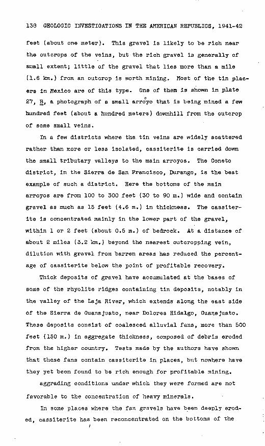
138 GEOLOGIC INVESTIGATIONS IN THE AMERICAN REPUBLICS, 1941-42
feet (about one meter). This gravel is likely to be rich near
the outcrops of the veins, but the rich gravel is generally of
small extent; little of the gravel that lies more than a mile
(1.6 km.) from an outcrop is worth mining. Most of the tin plac
ers in Mexico are of this type. One of them is shown in plateo
27, B, a photograph of a small arroyo that is being mined a few
hundred feet (about a hundred meters) downhill from the outcrop
of some small veins.
In a few districts where the tin veins are widely scattered
rather than more or less isolated, cassiterite is carried down
the small tributary valleys to the main arroyos. The Coneto
district, in the Sierra de San Francisco, Durango, is the best
example of such a district. Here the bottoms of the main
arroyos are from 100 to 300 feet (30 to 90 m.) wide and contain
gravel as much as 15 feet (4.6 m.) in thickness. The cassiter
ite is concentrated mainly in the lower part of the gravel,
within 1 or 2 feet (about 0.5 m.) of bedrock. At a distance of
about 2 miles (3.2 km.) beyond the nearest outcropping vein,
dilution with gravel from barren areas has reduced the percent
age of cassiterite below the point of profitable recovery.
Thick deposits of gravel have accumulated at the bases of
some of the rhyolite ridges containing tin deposits, notably in
the valley of the Laja River, which extends along the east side
of the Sierra de Guanajuato, near Dolores Hidalgo, Guanajuato.
These deposits consist of coalesced alluvial fans, more than 500
feet (150 m.) in aggregate thickness, composed of debris eroded
from the higher country. Tests made by the authors have shown
that these fans contain cassiterite in places, but nowhere have
they yet been found to be rich enough for profitable mining.
aggrading conditions under which they were formed are not
favorable to the concentration of heavy minerals.
In some places where the fan gravels have been deeply erod
ed, cassiterite has been reconcentrated on the bottoms of the

GEOLOGICAL SURVEY BULLETIN1 935 PLATE 27
A. SMALL ABANDONED TIN MINE NEAU SAN FELII'E, GLAN AJLA'I U.
IS. .SMALL UN I'LACEK NEAK TLAC1UO.LEK A, GLANAJLATO.
TIN DEPOSITS OP THE REPUBLIC OP MEXICO 139
arroyos in secondary gravels, which have been further enriched
with cassiterite freed by further erosion of the tin veins.
Probably because of this two-fold enrichment, the gravels yield
a profit in the little small-scale mining that has been done.
But even these reworked gravels, though richer than any of the
other gravel deposits and in part adapted to dredging or to the
use of a dragline, have not been proved by the tests made thus
far to be worth mining on a large scale.
In most of the placers worked hitherto the gravels are less
than 4 feet (1.2 m.) thick, but in some they are as much as 15
feet (4.6 m.) thick. Boulders as much as 3 feet (0.9 m.) in
diameter are common where the gravels are thin, but in the
thicker deposits most of the material is less than 1 foot (0»3
m.) in diameter, though only a minor percentage consists of
clay. The heavy minerals are chiefly specularite and magnetite;
cassiterite is generally much scarcer. In many places topaz is
abundant, but, being much lighter than caositerite, it can be
washed out of the concentrates with relative ease. There arexsmall quantities of zircon and other heavy silicate minerals,
which also can easily be eliminated from the concentrates. As
in the vein material, cassiterite and specularite are so inti
mately intergrown that they cannot be completely separated.
Mining and concentration. The placers have been mined
entirely by hand, not even the simplest machinery being
employed. The gravel, like the vein material, is concentrated
by washing it first on inclined rock or dirt platforms (planil-
las) and then in shallow wooden pans (bateas). As concentrates
containing much iron bring low prices, the miners wash the con
centrates vigorously to eliminate as much of the specularite as
possible. In so doing they lose a part of the cassiterite but
obtain concentrates containing from 45 to 65 percent tin. The
loss is naturally much greater if the concentrates are fine than
if the cassiterite occurs as large kidneys, and therefore most
140 .GEOLOGIC INVESTIGATIONS IN THE AMERICAN REPUBLICS, 1941-42
of the mining is done near the veins, where the material is
coarse. ..
' As "the. cgratle; of .the gravel must be fairly high to permit
this, waatefui; method of mining, large tonnages undoubtedly
remain1 .o^;.'grayei.'that contains more than half a pound of tin to
a cubic yard (-0.1 percent) (the lower limit for minable gravel
in the Malay States). Such gravel might "be worked by mechanical
methods, but, as almost all the deposits are small, any mechan
ical equipment used in mining and milling them should be small
and portable. Small jigs and tables could probably be used to
obtain rough concentrates, which would then, like those from the.
vein material, have to be treated further to separate the cas-
siterite from the iron minerals. In this respect' the Mexican
deposits differ from those in the Malay States ̂ ;wher'e concen
trates of nearly pure cassiterite can re£tdfiy;be vriiiade, and
therefore the lower limit for minable gravel would: probably be
somewhat higher in Mexico than in Malaya.
Water supply for placer operations presents a serious prob
lem over much of the plateau country during the dry season;
hence most of the placer mining is done between July and Jan
uary, when small streams of water flow in the larger arroyos.
As the miners eliminate the coarse material before washing the
gravel and wash.only small quantities of fairly rich material,
using the same water repeatedly, not much water is required,
A few tanks for storing water have been made by building earthen
and stone dams, and additional tanks would undoubtedly aid some
what in maintaining a supply during at least a part of the dry
season. In most of the tin districts, enough water for small-
scale mechanical concentrating plants could be obtained during
the dry season from shallow wells in the larger arroyos.
Possible production. It is impossible to estimate reserves
of tin in the placers, because the number of small placer depos
its, though large, is unknown and none have been sampled and
TIN DEPOSITS OP THE REPUBLIC OP MEXICO 141
blocked out in an engineering sense. It is clear that several
thousand tons of tin can be obtained from placers that contain
half a pound or more of tin a cubic yard (more than 0.1 percent
tin). Even with a moderate amount of stimulation, however, it
is doubtful whether the' annual production could exceed a few
hundred tons with present methods of mining. The use of small
portable power jigs or tables would increase the production, but
it is doubtful whether any placer containing enough cassiterite
for profitable mining is large enough for dredging or the use of
a dragline or scraper.
Summary of possible tin production
Production of tin in Mexico is not likely to exceed 400 tons
of metallic tin a^year if the price of tin remains at 50 cents
(United States currency) a pound (5.50 pesos a kilogram) and
mining conditions and methods continue as in the past. The
production might be doubled by making loans to miners and by
paying higher prices for concentrates. The large pla-cer depos
its at Guadalcazar, San Luis Potosi, are of extremely low grade,
and it is not yet certain whether any tin can be produced from
them. The tin ore in the lead-zinc-silver deposits at Santa
Eulalia, Chihuahua, is said to be exhausted, and unless more of
such ore has already been found no tin is likely to be produced
there in the near future. The vein deposits in rhyolite and the
placers related to them, though numerous, are all small and of
low grade. Production from them cannot be greatly increased
unless machinery can be employed in mining and milling, and no
satisfactory methods for doing this have yet been devised. If
such methods could be devised, all vein deposits containing 0.1
percent or more of tin could perhaps be mined. The total amount
of recoverable tin in the known vein deposits might then exceed
10,000 tons. Large-scale working of the gravel deposits con-
142 GEOLOGIC INVESTIGATIONS IN THE AMERICAN REPUBLICS, .1941-42
taining half a pound a cubic yard (28 grams a metric ton) or
more might yield another 10,000 tons.
MINES, DEPOSITS, AND DISTRICTS EXAMINED
The number of individual tin deposits in Mexico is so great,
and exact information concerning most of them is so scanty, that
only those deposits or districts actually visited by the authors
are described in this report. The most recent compilation of
the location and occurrence of the deposits known in 1926 was
made by Garcia £§/and presented in his monograph on tin. All
other important references have been cited on previous pages of
this report. Brief notes on the rocks and on the mineralogy of
the veins in the individual districts described in the following
sections are given in table 5. The numbers in parentheses that
follow the headings refer to those on plate 25 and table 5.
Michoaca'n
Los Cabires mine (1)
Los Cabires mine is near the crest of Cerro Frfo, about 10
miles (16 km.) northwest of the village of Tepuxtepec in the
district of Contepec, and is only a few miles south of the
Guanajuato-Mlchoaoan State line. The mine is at the head of a
deep arroyo known as the Canada de los Lobos. A small mill, a
repair shop, bunk houses, and stables have been erected in the
valley at an altitude 600 feet (180 m.) lower than the mine,
which is reached from the mill by a good pack trail. A dirt
road extends from the mill to Tepuxtepec, which is at the end
of a branch railroad line connecting with Mexico City. A dam
impounding about 31 billion cubic feet (900,000,000 cubic
meters) of water when the reservoir is full has been built at
the edge of Tepuxtepec, where there is a small plant for gen
erating light and power. Several hundred tons of ore have been
28/ Garcia, J. Aurelio, Monografia del estafio: Bol. minero, vol. 22, pp. £29. 1926.
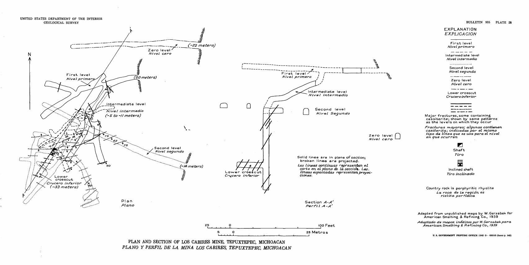
UNITED STATES DEPARTMENT OF THE INTERIOR GEOLOGICAL SURVEY
First, level Nivel primer
Nivel intermedia (-5 to -//meters)
:<. / Lowercrosscut
*". /Crucero inferior .- *' ( 33 meters)
--- >^-__,(~22 me^ rs)Zero level Nivel cero
CO.O meters)
Q
\.1
Second level Nivel seo-uncfo
""" ... (-14-meters')
1y-
Crucero in fiarior
YPlan Piano
Intermediate level Nivel intermedia
Q Second level Nivol Sec/undo
Zero level f| Nivel cero '
Solid lines are in plane of section;broken lines are projected.
Las lineas continuas r-epresentan elcorte en. el piano de la seccion. Las,lineas espacicLdas representan. proyec-Ciornes.
Section A-A'
BULLETIN 935 PLATE 28
EXPLANATION EXPLICACION
First level /VtVeZ prim ero
Intermediate level Nivel intermedia
Second level Nivel segundo
Zero level Nivel cero
Lower crosscut Crucero inferior
Major fractures, some containing cassiterite; shown by same patterns as the levels on which they occur
fracturas mayores; algunas contienen casiterita; indicadas por el misrno tipo de linea que se usa para el nivel en tjfue ocurren
BShaft
Tiro
Inclined shaft Tiro inclinacto
Country rock is porphyritic rhyoliteLa. roca de la region, es
riolito. porfidico.
25
PLAN AND SECTION OF LOS CABIRES MINE, TEPUXTEPEC, MICHOACAN PLANO Y PERFIL DE LA MINA LOS CABIRES, TEPUXTEPEC, MICHOACAN
too Feet
25 Metros
Adapted from unpublished maps by W.Gerzabek for American Smelting 8, Refining Co., 1939
Adaptado de mapas ineditos por W. Gerzabek para. American Smelting <J Refining Co., 1939
U. 3. GOVERNMENT PRINTING OFFICE: 1942 O - 480115 (faces p. 142)

TIN DEPOSITS OP THE REPUBLIC OP MEXICO 143
mined, but the mine is still in a stage of development and no
tin has yet been produced.
The crest of the Cerro Frfo is about 9,800 feet (3,000 m.)
above sea level and about 1,000 feet (300 m.) above the valley.
The upper 400 feet (120 m.) of the ridge in the vicinity of the
mine is composed of rhyolite flows, which are underlain by 200
feet (60 m.) of bedded tuff. Other volcanic rocks underlie the
tuff. ' The rhyolite at the mine is well layered, and its layers
dip steeply into the hill. The flows exposed in the Caftada de
los Lobos, east of the mine, appear to be nearly horizontal.
Small tin veins that crop out on the hillside have been
'explored by means of three adits and several drifts and shafts.
(See pi. 28.) The vertical range of exploration is 150 feet
(46 m.), and the total length of the workings is about 1,200
feet (365 m.). The rock is more or less strongly fractured, and
many of the fractures contain sporadic incrustations of cassit-
erite. The strike of most of the fissures varies from east to
northeast, but a few strike northwest; the dip averages about
60° S. The fissures apparently show no regularity of pattern,
many of them seeming to branch and feather out. There is no
positive evidence of displacement along most of the fractures,
and sllckensldes are rare.
The incrustations in the tin-bearing fissures are composed
largely of botryoidal wood tin with a little specularite, and in
some places there are drusy crusts of small red cassiterite
crystals and black specularite. Tridymite incrusts some of the
cassiterite and also occurs in fissures without cassiterite.
The wall rock appears to be essentially barren, although in a few
places cassiterite is disseminated in the walls for a few inches.
The incrustations, to judge from the few available exposures,
pinch out somewhat in the lower part of the mine, where the wall
rock is less altered than above. There is no apparent change in
the mineralogical character of the veins with depth.
480115 O - 42 - 4
144 GEOLOGIC INVESTIGATIONS IN THE AMERICAN REPUBLICS, 1941-42
The rhyolite throughout most of the mine is fairly firm and
dense, but in places it is altered to a porous, friable, light-
gray rock. Although some of the fissures are partly filled with
clay minerals, the wall rocks do not seem to contain much clay.
The devitrified groundmass of the rhyolite along the vein has
undergone much leaching, and a small quantity of zeolites has
been introduced into the altered rock, but there apparently is
no silicification. It is notable that the sanidine, a mineral
that in general is readily altered, is here completely fresh.
As far as can be determined by the limits of exploration,
the mineralized body forms an elliptical stockwork, which has
a maximum diameter of about 150 feet (46 m.) and dips about 60*
SW. The vertical extent of mineralization is not less than 150
feet (46 m.). A block of-rock containing about 120,000 tons has
been explored, but as this material has not been adequately
sampled its tin content is uncertain. Judging from assays made
for the owners and from a study of samples taken by the authors,
this block probably averages less than 0.5 percent tin and may
average less than 0.1 percent. Thorough sampling should be done
before attempting to mine the material blocked out. Several
tons of tin could undoubtedly be recovered by mining the veins.
Owing to the steepness of the arroyo leading from the vein out
crops at Los Cabires, no placer appears to have been formed near
the mine.
Other vein deposits in the Cerro Fr£o have been reported,
but none of them have yet been mined.
Hidalgo
Deposits near Zimapan (18)
Gasaiterite-bearing veins have recently been discovered in
rhyolite about 7 miles (11 km.) west of Zimapan, an important
lead-silver mining center, on the Laredo-Mexico City Highway.
TIN DEPOSITS OF THE REPUBLIC OF MEXICO 145
The topography in the region is extremely rugged, and at present
the tin locality can be reached only over a rough mountain trail,
The deposit has not yet been mined.
The rhyollte caps Cretaceous limestone on the high mountains
.that form one side of the canyon of the Moctezuma River. It is
a dark reddish-brown fine-grained rock, differing markedly from
the lighter-colored, porphyritic rhyolite in most of the other
tin districts. The cassiterite forms small broken kidneys in a
brecciated zone partly cemented with chalcedony and opal. Clays
and fine-grained yellow mimetite (?) are abundant in some of the
fractures. Owing to the small amount of prospecting, the size
of the deposits and the extent of the mineralized area are
unknown.
Guanajuato
District west and northwest of Dolores Hidalgo (2)
Small tin deposits occur on the west side of the northward-
trending Sierra de Guanajuato west and northwest of Dolores
Hidalgo. The mountain range consists of folded and metamor
phosed pre-Tretiary igneous and sedimentary rocks overlain by
Tertiary volcanic rocks, including rhyolite. The tin deposits,
are in the rhyolite. Thick deposits of gravel lap against the
rhyolite on the east side of the mountains and extend eastward
to the Laja River, which flows southward through Dolores
Hidalgo. The gravels are deeply dissected by steep-sided, flat-
bottomed arroyos floored with secondary deposits of gravel, some
of which contain placer cassiterite. Tin-bearing veins and plac
ers have been mined in this district for many years, but at
most only a few tons of tin has been produced annually.
Vein deposits. Small vein deposits have been mined along
the road from Dolores Hidalgo to Guanajuato at a point about 15
miles (24 km.) west of Dolores Hidalgo. All the old workings
are merely shallow cuts in the bedrock, none apparently extend-
146 GEOLOGIC INVESTIGATIONS IN THE AMERICAN REPUBLICS, 1941-42
Ing more than 10 feet (3m.) below the surface. All the vein
material in sight has been removed, and the deposits offer no
promise of containing any large amount of tin.
A small mine known as the San Marcos has recently been
opened in the rhyolite on the northwest side of the Guadalupe
dam and reservoir, about 2 miles (3 km.) northeast of the depos
its along the road. The vein has been stoped for a length of 15
feet (4.6 m.) and to a maximum depth of 12 feet (3.7 m.). Not
all the vein material has been removed, but that exposed is
scarcely more than an inch (2.5 cm.) wide. As the wall rock is
essentially barren, it is doubtful whether much tin can be ,
recovered from the deposit. A few other small veins crop out
nearby.
Placers.--Some of the gravel deposits that have yielded
placer casslterite are on the Trancas estate, near the Guadalupe
dam in the Canada de Gonzales; others are in the Arroyo de
Galvez, on the north side of the Dolores Hidalgo-Guanajuato road
and 14 miles (23 km.) west of Dolores Hidalgo. (See pi. 29 and
fig. 10.) These deposits were extensively sampled from 1926 to
1928 by E. H. S. Sampson for the Natural Products Producers
Corporation of New York. The placers have not been mined on a
large scale, but local miners now and then recover a little cas-
siterite. T-he district is easily reached by automobile.
The gravels consist of debris deposited in coalesced allu
vial fans extending eastward from the front of the mountains.
The contact of the gravels with the older volcanic rocks is near
the Guadalupe dam. The gravels are partly consolidated and well
exposed in both the Canada de Gonzales and the Arroyo de Galvez
and are at least 500 feet (150 m.) thick. They are composed of
fragments ranging in size from fines to boulders 3 feet (0.9 m.)
in diameter. The Canada de Gonzales has a nearly flat though
terraced bottom. The stream bed is mainly in secondarily depos
ited gravel averaging about 10 feet (3 m.) thick, but some of it
UNITED STATES DEPARTMENT OF THE INTERIOR GEOLOGICAL SURVEY
EXPLANATION EXPLICACION
Alluvium (Contains some placer deposits)
. Aluvion (Contiene depositos de placer)
Conglomerate Conqlomerado
Porphyritic rhyollte with inter- bedded tuffand breccia
(Rhyolite contains tin veins) Riolitaporfidlca intercalada entfe
lechos de toba y brecha (La riollta contiene vetas de estano)
XProspect shaft Tirode cateo
Contact approximately located Contacto delineado apro&imadamerrte
BULLETIN 935 PLATE 29
Prospect adit Socavon de cateo
Contact inferred Contacto inferido
Elevations approximate Elcvaciones aproximadas
. ' i. X^'-v- . -vv V:--:-*^5i!
m. 6 220Om.
]!&\ - x .' '?' ' "V.; «
Adapted from unpublished^ map by Ernest J. h.Sampson, 1926 Adaptado deunmapa insditopor Ernest J. H. Sampson, 1926
3000 Feet
1000 Metros
Piano de referenda es el nival del mar
GEOLOGIC MAP OF PLACER AREA WEST OF DOLORES HIDALGO, GUANAJUATO MAPA GEOLOGICO DE LOS PLACERES DE ESTANO AL OESTE DE DOLORES HIDALGO. GUANAJUATO
U. S. GOVERNMENT PRINTING OFFICE: 1942 O - 480115 (faces p. 146)
s (-* ct
P* P p. rj P 3q H1
P*
CD O *3 CO o P CD co
P } J
CO o sT P < CD ct
0 0* 0 3 H-
3 CD P- a
1
ct o CD CO CD H CD O ct
H-
<3 CD
P.
^i CD P-
(73 CD s CD CD CO CD P.
ct
O £3 H-
CD ct
P1
CD P.
CD *d o ca H-
ct ca
O o £3 ct P 3 0 r~'
oV
J 3
C
P
b|'
CD ^a
S
^K
;
EX
PL
AN
AT
ION
EX
PL
ICA
CIO
N
!;. ]
1 .'
.' *J
Allu
viu
m(C
onta
ins
som
e pl
acer
dep
osits
]A
/e/iS
/on
(Co
ntie
ne
de
po
sito
r de
pla
ce
r)
^% '
F
7^
d
^
L- t
'l*
El?
-o
5^j
a>
§
sct o H>
' "
Co
ng
lom
era
teC
on
tfto
me
rad
o
XP
rosp
ect
sh
aft
T
iro
de
cate
o
O
(Conta
ct a
ppro
xim
ate
ly lo
ca
ted
c
I 1
Co
nia
cto
def
inea
do a
pro
xim
adatn
ente
P CO P
. 0
o .
' o
. -
o
'"
' °
»
'
o
' -
'
3
.'
. -o
"
"
. '
P-
A. o
. o
. .
.-.' . " <
>.-
.ct
vv%
,-0
^%
°0
0
.
.
.
,° .
' .
°
' "
"
0
.
.
°
0
o ^ I--
'/
Ap
pro
xim
ate
ele
vati
on
ab
ove s
ea
le
ve
l, 6
,890 f
ee
t E
/ev
ac
idn
ap
rox
ima
da
so
bre
e
l n
ivel
de
l m
ar:
2,I
OO
mc
tro
s
o o
.o
. "
o
' "
- ..
-
Adapte
d f
rom
u
np
ub
lish
ed
ma
p b
y
o
.
"
°
Ern
est
H.S
.Sa
mp
son
, 19
26A
dapta
do d
e un m
apa in
ed
ito
po
r E
rnest
H.S
.Sa
mp
son
, /3
26
Figure
10. Geologic ma
p of placer
area
along
Arro
yo de Galvez we
st of Do
lore
s Hidalgo, Gu
anaj
uato
.
P.
CD
d
o
CO
01 o
3 d I OT P
CD O
3 ct
CD
P
CD P
TO
CD d CD O CD 3
ct
H3
M
S$ t) M
O
148 GEOLOGIC INVESTIGATIONS IN THE AMERICAN REPUBLICS, 1941-42
An area covering about 80 acres (32 hectares) in the Canada
de Gonzales and just below the Guadalupe dam (see pi. 29) was
prospected by Sampson ^/by means of 73 pits, 3 short adits, and
3 shafts. Channel samples a foot square (0.09 square meter) and
a foot (0.3 m.) deep were taken at 3-foot (0.9-m.) intervals
from one or more of the walls of each pit. After screening on
a 1-inch (2.5-cm.) screen and washing the undersize in Klondike
rockers, the concentrates were collected and weighed. Precau
tions were taken to recover as much of the heavy material in the
gravel as possible, and the tailings were occasionally rewashed
in order to check the recovery. Some of the heavy minerals
undoubtedly were lost in washing but the quantity lost was prob
ably no greater than that recovered.
Some of the concentrates were assayed for tin and gold. The
concentrates averaged 0.03 percent of the total gravel. Assum
ing that half the heavy minerals were lost, their original aver
age weight would be 0.06 percent. Assays of the concentrates
ranged from 0.45 to 13.43 percent tin, probably averaging less
than 10 percent. Assuming that the concentrates co.ntained 10
percent tin, the average tin content of the gravel would be
about OoOOG percent, or nearly 0.2 pound a cubic yard (60 gm. a
metric ton). As some of the pits were partly in the primary
gravel, which in general does not contain as much tin as the
secondary gravel, the grade of the secondary gravel is probably
somewhat higher than the figure given. The gravels appear to
contain also about 0.003 ounce of gold a cubic yard (0.57 gm. a
metric ton).
The authors briefly examined these deposits and estimate
that the volume of secondary gravel may be about one million
cubic yards (760,000 cubic meters). From the results of the
§2/ Sampson, 3. H. S., The tin end gold-besring grevels of the Stn Joa- quin de Tre.neas, Sen Jose de la Quamcda, snd La Palma. estetes, Guenajuato, Mexico: Unpublished private report for Nsturel Products Producers Corpor ation, Mew York, l^2Z.
TIN DEPOSITS OP THE REPUBLIC OP MEXICO 149
sampling by Sampson, the authors infer that this gravel probably
contains between 0.1 and 0.5 pound of tin a cubic yard (28 to
140 gm. of tin a metric ton), of which possibly half might be
recovered. Possibly 0.0003 ounce of gold a cubic yard (0.06 gm.
of gold a metric ton) about one-tenth of the gold shown by
assay might be recovered.
A small permanent stream flows through the Canada de Gon-
zales, and an abundant supply of water could be obtained from
shallow wells.
An area covering about 5 acres (2 hectares) near the old
mill in Arroyo de Galvez, 2 miles (3 km.) west of Paredones, was
also tested by Sampson.£°-/ (See pi. 29 and fig. 11.) The sec
ondary gravel here averages about 6 feet (1.8 m.) in thickness.
The total volume of gravel is about 45,000 cubic yards (34,000
cubic meters), and the grade is somewhat lower than in Canada
,de Gonzales probably less than 0.1 pound of tin a cubic yard
(28 gm. of tin a metric ton). A supply of water can be obtained
from wells in the gravel.
The secondary gravels farther downstream in both the Canada
de Gonzales and the Arroyo de Galvez contain cassiterite, but
their tin content appears to be much lower than that of the grav
el farther upstream.
Placer cassiterite is mined intermittently southeast of the
Guadalupe dam in the Arroyo de Salta Pena Colorado, which is on
the south side of the ridge traversed by the road to Guanajuato.
(See pi. 29.) The arroyo carries drainage from areas containing
tin veins, and its bottom, though fairly narrow, contains thin
secondary deposits of gravel at several places. Pannings made
by the authors show that some of this gravel contains as much
as 1 percent tin, but its volume is small. One bench or terrace
150 feet (46 m.) wide is covered with 2 feet (0.6 m.) of gravel
that may contain a few pounds of tin a cubic yard (more than a
30/ Sanroson, E. H. S., op. cit.
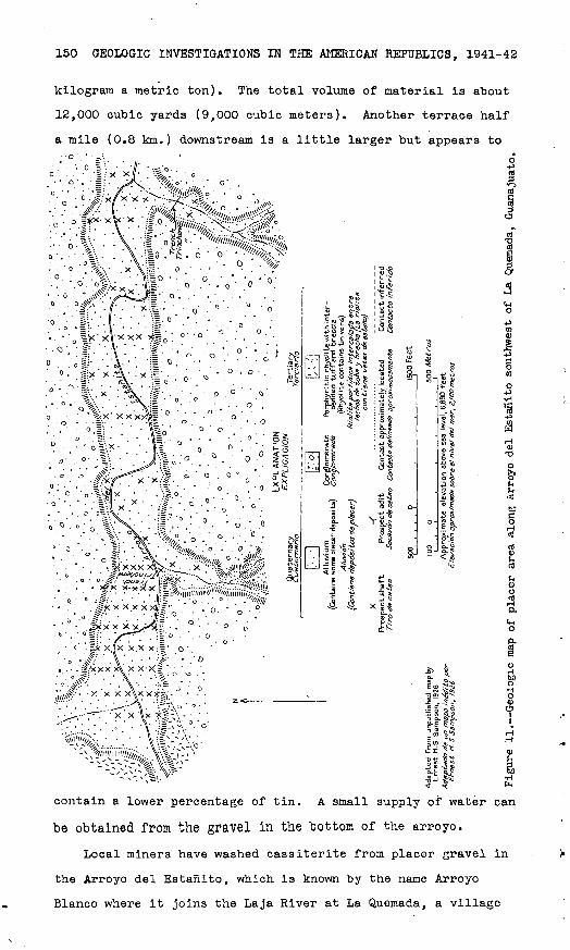
150 GEOLOGIC INVESTIGATIONS IN THE AMERICAN REPUBLICS, 1941-42
kilogram a metric ton). The total volume of material is about
12,000 cubic yards (9,000 cubic meters). Another terrace half
a mile (0.8 km.) downstream is a little larger but appears to
£ II-5§
E,n
&
contain a lower percentage of tin. A small supply of water can
"be obtained from the gravel in the bottom of the arroyo.
Local miners have washed cassiterite from placer gravel in
the Arroyo del Estanito, which is known by the name Arroyo
Blanco where it joins the Laja River at La Quemada, a village

TIN DEPOSITS OP THE REPUBLIC OP MEXICO 151
4 miles (6 km.) northeast of the placer area and 18 miles (29
km.) northwest of Dolores Hidalgo. The Guadalupana mercury
mine is a quarter of a mile (0.4 km.) upstream from the placer
area. The geology here is much the same as in the Caflada de
Gonzales. (See fig. 11.) The placers in both places were sam-31/
pled by Sampson, who tested a total area of 189 acres (76.5
hectares) by means of 104 prospect pits, 2 trenches, and 2 short
adits. The average depth of the pits was about 12 feet (3.7
m.). The authors estimate that the average depth of the sec
ondary gravels in the area is about 7 feet (2.1 m.) and that,
therefore, about half the material sampled by Sampson was pri
mary gravel. The secondary gravel sampled has a volume of prob
ably 2,000,000 cubic yards (1,500,000 cubic meters). Sampson's
figures are interpreted as indicating that the gravel may aver
age about 0.1 pound of tin a cubic yard (28 gm. a metric ton)
and jthe primary gravel somewhat less. There is a little cin
nabar in some of the gravel. The arroyo does not contain water
during the dry season, and although some water might be obtained
from wells it does not appear to be plentiful.
Deposits near Tlachiquera (3 and 4)
Tlachiquera lies nearly halfway between San Pelipe and Le<5n
and is west-northwest of Dolores Hidalgo. A ton of cassiterite
concentrates a week is said to be produced in the region during
the rainy season, most of it from placer deposits. There is a
small tin-smelting furnace in the village, but it was not being
used in February 1941.
Small tin deposits occur in the rhyolite flows on Cerr'o de
los Charcos about 2 miles (3 km.) east of the village. Beds of
tuff crop out on the south side of the hill about 200 feet (60
m.) below the tin veins; they may be interbedded with the flows.
Although half a dozen small vein deposits are scattered over the
3I/ Sampson, E. H. S., op. cit.

152 GEOLOGIC INVESTIGATIONS IN THE AMERICAN REPUBLICS, 1941-42
upland, only four were examined. The length of the veins mined
ranges from 30 to 100 feet (9 to 30 m.), and their maximum depth
is about 40 feet (12 m.). Apparently the veins were small, for
the average width of mining was about 3 feet v (l m.) and most of
the material mined is barren rhyolite, now piled on the dumps.
The veins appear to be mined out. A few small placers, such as
that shown in plate 27, B, have been mined in arroyos draining
this area.
Other small veins occur in rhyolite flows on Cerro del Toro,
northwest of Tlachiquera. These veins appear to be even smaller
than those east of the village, for one was mined to a depth of
only 3 feet (1m.) and another to a depth of 6 feet (2 m.).
Small mercury mines have been operated in the vicinity. It is
reported that, a few weeks before the authors' visit, two miners
recovered a few hundred pounds (about 150 kg.) of cassiterite
from the arroyo leading from one of the tin deposits examined.
Many of the small arroyos in this region contain a little cas
siterite.
Deposits near San Pelipe (5.)
Half a dozen tin veins have been prospected and mined in the
rhyolite flows on a mesa known as Boquillas, 10 miles (16 km.)
north of San Pelipe. No .pyroclastic rocks were observed in the
vicinity of the tin veins. The broad, nearly flat upland is cut
by deep, steep-sided arroyos, which drain into the broad valley
wherein San Pelipe lies. Some of the tin veins, such as the one
shown in plate 27, A, are on top of the mesa; others are on the
steep sides of the arroyos. The mine shown in the photograph
has a maximum depth of 20 feet (6 m.) and is about 100 feet
(30 m.) long. The veins have an average strike of N. 60° W. and
dip about 65° SW., tut in detail they are irregular and branch
ing. The wall rock is little altered and quite firm. No vein
material is visible in the mine, but some is in crusts on blocks
TIN DEPOSITS OP THE REPUBLIC OF MEXICO 153
In the dump. Barren rock would have to be mined in order to
find more ore.
The Esperanza mine, which was prospected in 1940, is about
10 feet (3 m.) across and 15 feet (4.6 m.) deep. The flow lay
ers of the rhyolite strike N. 20° E. and dip steeply toward the
west. The deposit consists of a mass traversed by many irreg
ular fractures in which vein material has been deposited. Some
of the small blocks of rock that are taken out are almost com
pletely incrusted with a thin layer of specularite and cassit-
erite, but the central parts of these blocks are essentially
barren, the vein minerals being virtually confined to the frac
tures. The ore had not all been mined out at the time of the
authors' visit.
Another small deposit along a steeply dipping, slickensided
fracture was mined to a depth of 20 feet (6m.) for about 30
feet (9m.) along the strike. The vein material on the dump
appears to be largely specularite, and no ore was visible in
the mine. A small deposit prospected near the bottom of one of
the arroyos consists of a zone of silicified breccia about a
foot (0.3 m.) wide, in which there are small fragments of nod-\
ules of wood tin and crystals of a specular hematite. Several
other deposits that were visited had apparently been mined out.
Queensland mine (6)
. The Queensland mine is on a low, gently sloping rhyolite
ridge extending northwest from the base of the cliffs of rhyo
lite that form the southeastern part of the Sierra del Pajaro.
It is about 2 miles (3 km.) south of Santa Barbara^ a small vil
lage 9 miles (15 km.) west of San Felipe, and 18 miles (29 km.)
by road from San Felipe. It was opened and operated around 1900
by an English-controlled company but was soon closed down
because of the low grade of the ore. The amount of ore mined is
154 GEOLOGIC INVESTIGATIONS IN THE AMERICAN REPUBLICS, 1941-42
not recorded, but, to judge from the extent of the workings, at
least a few tons of tin must have been produced,, The mine work
ings were inaccessible in 1941.
The deposits are in massive flows of rhyolite, and no pyro-32/ clastic rocks were observed in the vicinity. Bromly 'reports
that the veins were mined to a depth of 130 feet (40 m.) and for
'a maximum length of 330 feet (100 m.) along the strike. There
are three nearly parallel groups of northward-trending veins,
the main veins dipping 70° to 80° E., and one group was exten
sively mined. It is said that the veins appeared to die out,
branching in many places and following joints and crevices that
ramified in every direction. Some of the tin fissures mined
were partly filled with a barren waxy clay. The specularite
and cassiterite were frozen to the walls in some places; else
where they appeared to be loosely held in the clayey matrix,
as if broken from the walls. The wall rocks proved to be vir
tually barren. Bromly believes that a large part of the rhyo
lite near the deposits contains traces of tin but that the grade
of tin is much too low for profitable mining. The ore in the
upper part of the veins averaged from 2 to 3 percent tin, but
the average for all the ore mined to a depth of 130 feet (40 m.)
was only about 0.4 percent.
The cassiterite was intimately associated with speculari'te,
and it was found impossible to separate the two without losing
a large part of the cassiterite. A Krupp ball mill, a Wilfley
table, and a Wilfley slime-table were used in milling the ore.
The concentrates from 0.4-percent ore contained only 15 percent
tin indicating a recovery of only 29 percent from the ore. The
concentrates were smelted in a small furnace constructed at the
mine.
It seems doubtful whether there is any more ore readily
available in the mine. An examination of the dumps indicates
32/ Bromly, A. H., Tin raining and smelting st St.nta Barbara, Gu.anejufi.to, Mexico: An. Inst. Min. Eng. Trans., vol. 36, pp. 22J-233, 1905.
TIN DEPOSITS OP THE REPUBLIC OP MEXICO 155
that most of the rhyolite near the veins is dense and firm, and
it is improbable that cassiterite is disseminated through any
significant volume of this rock. Bromly says "Doubtless, better
knowledge would have given better results, but r strongly doubt
whether the Queensland ores, even if sufficiently abundant33/
instead of the reverse, would have commercial value." Small
placers have been mined in shallow arroyos near the Queensland,
but most of these appear to be worked out.
El Santin mine (7)t
El Santin mine is on the south side of the Mesa de la Fajas
In the southeVn part of the Sierra Gorda; it is about 4 3/4
miles (7.8 km.) by trail south-southeast of Santa Catarina, a
small village in the valley of the Tierra Blanca River. Santa
Catarina lies 42 miles (68 km.) by road southeast of San Luis de
la Paz, a city at the end of a branch line of the railroad. A
fair road extends from San Luis de la Paz to Victoria, but trav
el by truck from there to Santa Catarina, a distance of 16
miles (26 km.), is possible only at times when the trail has
just been repaired. There is no road from Santa Catarina to the34/
mine. The tin deposits, according to Antunez, are at an al
titude of 6,400 feet (1,940 m.), about 900 feet (270 m.) higher
than the village. About 20 tons of tin has probably been pro-i
duced from the mine.
Cretaceous limestone is said to crop out in the valley at
a few places near Santa Catarina. The limestone is overlain by
at least 2,000 feet (600 m.) of volcanic rocks, which include
flows of andesite in the lower part and flows of rhyolite near
the to«p. The tin deposits consist of several northwest-trending
groups of veins in the andesite about 1,000 feet (300 m.) below
the top of the Mesa de la Pajas. Faulting has occurred along
some of the tin-Tbearing fissures, a few of the walls being
33/ Bromly, X. H., op. cit., pp. 232-233.2*/ Xntuflez E., Francisco, Mina II Santin y anezae: Unpublished report,
1939-
156 GEOLOGIC INVESTIGATIONS IN THE AMERICAN REPUBLICS, 1941-42
slickensided, but there is little or no brecciation along moat
of the veins. The authors could not determine whether the
faulting preceded or followed mineralization.
In detail the tin veins are similar to most of the others
in the lava flows. They are highly irregular and ramify along
'Joints and fractures in the country rock. Some of them are
merely tight seams, many of which open into pockets more than
a foot wide; some of these pockets have yielded as much as 220
pounds (100 kg.) of cassiterite. The vein material consists
in part of arborescent and stalactitic aggregates of small,
crystals of cassiterite, with only minor quantities of spec-
ularite. These bodies are apparently unique; at least none so
well developed have been found elsewhere. The upper parts of
the veins are said to have contained mainly the ordinary banded v
wood tin. Minor quantities of clay partly fill some of the
fissures. In some places along the veins the wall rock is
strongly altered and contains a large percentage of clay, but
in other places there appears to be virtually no alteration.
Tests of specimens of the wall rock collected by the authors
prove that cassiterite is not disseminated through large bodies
of the andesite, although there is a little cassiterite in the
andesite immediately adjacent to some of the tin-bearing fis
sures. A spectrogram of one specimen collected near a vein
showed no tin.
The workings at El Santln consist mainly of an irregular
inclined shaft with a maximum depth of 130 feet (40 m.), several
shallow shafts, and an adit about 260 feet t,80 m.) long. Short
drifts, winzes, and raises of all shapes extend out from the
main shaft at different levels; mining was done only where vein
material was found. The largest stope is about 12 feet (3.7 m.)
in diameter and 10 feet (3 m,) high, and the smallest passages
are just large enough for a man to squeeze through. The stopes
represent places where groups of closely spaced fissures con-

TIN DEPOSITS OF THE REPUBLIC OP MEXICO 157
taining vein material were found. The adit, intended to inter
sect the ore zone in depth, started from a point near the bottom
of a small arroyo, a few hundred feet (about 100 m.) southeast*
of the head of the shaft, but it had not been completed in March
1941. No tin veins were cut in the adit. Several small shafts
on the surface show that the fissures are mineralized at inter
vals along the strike for a distance of at least 300 feet (90
m.). The width of the zone of mineralized fractures may be 30
feet (9 m.).
It is impossible to make any close estimate of the amount of
tin in the deposit at El Santfn, for no channel samples have
been taken and no assays have been made. The maximum limits of
the workings, however, outline roughly a body of rock 300 feet
(90 m,). long, 30 feet (9 m,) wide, and 130 feet (40 m.) deep.
This block contains about 43,000 cubic yards (32,400 cubic
meters), or possibly 75,000 metric tons. It certainly averages
no more than 0.5 percent tin, and it may.average less than 0.1
percent. At the higher figure the block would contain 375 tons
of tin and at the lower figure 75 tons. It is doubtful whether
more than half the tin could be recovered, even if it were pos
sible to mine such low grade ore. Thus the limitations of the
deposit are evident.
A small arroyo leading from El Santln mine contains placer
cassiterite, which is mined during the rainy season. These grav
els are only a few feet (1 to 2m.) thick and quite bouldery.
There may be as much as 10,000 cubic yards (15,000 metric tons)
of gravel containing possibly 1 pound of tin a cubic yard (0.035
percent tin). A supply of water could probably be obtained from
wells in the main arroyo a few hundred feet (about a hundred
meters) below the mine.
Many other vein deposits have been worked in the district
around Santa Catarina, but none were visited. The Peril ta mine,
on the Cerro del Rincon del Carrizal, is said to have yielded

158 GEOLOGIC INVESTIGATIONS IN THE AMERICAN REPUBLICS, 1941-42
over 20 tons of tin during the past 20 years. The natives
intermittently mine the small placer deposits in the district,
but the annual production of tin is only a few tons./
Deposits north of San Luis de la Paz (8 and 9)
Small deposits of tin have been mined on the Hacienda Sau-
ceda, 25 miles (40 km.) by road northwest of San Luis de la Paz
and 6 miles (10 km.) by trail east of the main group of build
ings on the hacienda. The area is one of low relief near the "
head of one of the main arroyos in the district. The veins are
in flows of rhyolite and apparently contain very little cassit-
erite. Two prospect pits, about 6 feet (2 m.) deep, excavated
along the veins showed only thin seams of vein material. Most
of the cassiterite produced in the area is mined from the
arroyos below the vein outcrops. The concentrates from the
gravel contain many well-formed crystals of topaz, some of which
are as much as 2 inches (5 cm.) long. Virtually all the mining
is done during the rainy season.
Other small tin veins between Santo Domingo, S. L. P., and
Jaula, Gto., along the road from San Luis Potosi to San Luis de
la Paz have been explored by two shallow pits. These veins are
in latite. Apparently the miners did not find enough cassiter
ite for profitable mining.
Aguascalientes
Deposits near Calvillo (10)
Several tin veins have been explored on the north slopes of
the Sierra del Laurel south of Calvillo. A road extends from
Calvillo to the Rancho Jaltiche de Arriba, a distance of 9 miles
(15 km.), and the tin deposits are about 4 miles (6 km.) by
trail from the ranch and perhaps 800 feet (240 in.) higher. The
main workings, known as La Virgen mine, are on a hillside near
TIN DEPOSITS OP THE REPUBLIC OF MEXICO 159
the bottom of a steep-sided arroyo, and several veins cropping
out on the same hillside have been explored. A few hundred
tons of rock had been mined from La Virge.n when the mine was
visited. No attempt had been made to recover the cassiterite
from this low-grade ore, but several hundred pounds (possibly
200 kg.) of vein material had been picked out by hand.
The veins are in flows of white and highly porous rhyolite
whose flow layers have variable strikes and steep dips. Heavy
concentrates panned from, the crushed rock suggested that cassit
erite might be disseminated through this porous zone, but assays
of three rough channel samples collected from different parts of
the workings prove that the cassiterite is not evenly dissem
inated, for one sample contained about 0.2 percent tin and
another only about 0.002 percent. There is no direct relation
between the degree of alteration and the quantity of tin; the
sample of the most altered-appearing and porous rock contained
the smallest quantity of tin. No veinlets were observed where
the samples were taken, but the cassiterite is probably in thin
seams or tight fractures cutting through the rock. The miners
report that they found small veins and pockets of ore while
making excavations.
The maximum depth of the La Virgen workings is aboiit 15 feet
(4.6 m.), and the short drifts outline an area about 50 feet
(15 m.) in diameter. The samples taken from this area contain
on the average less than 0.5 percent tin. The general average
is probably somewhat higher than this, because of the small
pockets and veins of cassiterite scattered through the rock,
but it seems unlikely to be much^higher. Moreover, unless fur
ther work reveals a much larger body of tin-bearing rock than
has thus far been blocked out, the deposit is too small to be
mined by bulk methods even if the grade were fairly high.
All the other veins prospected near La Virgen mine are in
moderately dense, firm rhyolite. One of the veins has been
480115 O - 42 - 5

160 GEOLOGIC INVESTIGATIONS IN THE AMERICAN REPUBLICS, 1941-42
slightly brecciated and receinented with chalcedony and opal, "but
the others are merely thin incrustations on fissure walls and
contain a high percentage of specularite. Owing to the steep
ness of the arroyo below the tin veins, no gravel deposits have
been formed near the mine, and no significant amount of work
able placer has been found elsewhere in the area.
Jallaco
Deposits near Paso de Sotos and Teocaltlche
Tin deposits have been mined for many years in northern
Jalisco near the villages of Paso de Sotos and Teocaltiche.
None of these deposits were being mined when the authors visited
this region, and it was not feasible to enter any of the mines.
Some concentrates, however, that had been sold in Paso de Sotos
were examined and found to be fairly typical of those from the
rhyolite tin deposits, though rather high in iron. These con
centrates were reported to have come from small placer and vein
deposits in the rhyolite on the south side of the Sierra del
Laurel. Alluvial material was panned at several places in one
of the arroyos heading in the Sierra del Laurel, but no cassit-
erite was visible in the heavy concentrates.35/Ingalls 'reported that Los Vallecitos mine, near Teocal
tiche, which in 1883 had been opened to a depth of 100 feet
(30 m.) and for a length of 650 feet (200 m.), produced a max
imum of about 3 tons of metallic tin a month. Cassiterite is
still being mined from the rhyolite flows in the hills around
Teocaltiche during the rainy season, and the concentrates are
sold to buyers in the village.
35/ Ingalls, W. R., The tin deposits of Durango, Mexico: Am. Inst. Min. Eng. Tracs., vol. 25, p. 160, 1896.
TIN DEPOSITS OP THE REPUBLIC OF MEXICO 161
Los Amigos mine
Los Amigos mine is in rhyolite flows on the Cerro de la
Pefia, 19 miles (30 km.) by road northeast of Encarnaci6n. It
was operated by the Cia. Minera Los Amigos, S. A., until May
1932, when work was discontinued. As the workings are said to
be inaccessible, the mine was not visited by the authors, and
most of the following statements are from a report by Mar-
tfnez.^2/ The mine is said to have produced 80 tons-of concen
trates in 1924 and metallic tin valued at 28,890 pesos between
May 1931 and February 1932.
The mine, according to Martinez, consists of an inclined
shaft 390 feet (120 m.) long, four levels, several winzes, and
a few crosscuts. The total length of all the workings is 2,800
feet (853.m.), and the maximum depth, of the mine is 253 feet
(77 m.). The ore was crushed, jigged, tabled, and smelted in
plants built near the mine. Ores from the Minitas region, on
the Cerro de la Pachona, which is separated' from the Cerro de
la Pefla by the Arroyo de la Pena, were also treated in the mill.
The mill did not operate properly, so that the concentrates were
not clean and the cassiterite was not all extracted from the
middlings and tailings. The percentage of tin recovered was
not known, however, since assays of heads and tailings were
lacking. Martlnez concluded that the project could not be con
sidered profitable.
Raines and Partridge, who were associated with the Cia.
Minera Los Amigos, estimated that in 1933 the mine had reserves37/ of 9,000 tons of ore containing 1 percent tin, 'but as this
estimate was not based on systematic sampling it may have been
too high. As far as known, no ore has been mined from the
deposit since 1933.
36/ Martfnez, Juan, La mina LOB Amigos, de la Cia. Minera LOB Amigot, S. A.: Hev. industrial, vol. 1, pp. 390-391, 1933. ££/ Idem, p. 390.

162 GEOLOGIC INVESTIGATIONS IN THE AMERICAN REPUBLICS, 1941-42
Zacatecas
Deposits west of the city of Zacatecas (11)
A small tin deposit occurs near La Quemada, which is about
40 miles (64 km.) southwest of Zacatecas. The deposit is on the
south end of a rhyolite hill on which there are ruins of pre
historic stone dwellings. The largest excavation, which is 10
feet (3 m.) deep and 30 feet (9 m.) long, reveals a single mas
sive face of rhyolite partly incrusted with specularite and cas-
siterlte. The incrustations also extend out along some less
well defined cross fractures. The surrounding rock is light
gray, quite dense, and apparently unaltered. The main fissure
is nearly vertical and cuts sharply across the steeply dipping
flow layers of the rhyolite. Apparently the vein was too nar
row to be mined; at any rate it evidently has not been worked
for several years.
Many other deposits have been reported In the region south
west of Zacatecas but 'none were examined.
Deposits between Presnillo and Sain Alto (12)
Many small tin deposits are scattered over the Sierra de
Chapultepec, the central part of which is 37 miles (59 km.) by
road northwest of Fresnillo and about 15 miles (24 km.) south
of Sain Alto. The Sierra de Chapultepec is underlain by pre-
Tertiary rocks, which crop out at places in the lower parts
of the deeper valleys. The tin deposits are in the rhyolite
flows which form the upper part of the mountain range. The tin-
bearing region is drained largely by the San Francisco River,
on the south side of the mountains. Raise 'reports that about
62^- tons of cassiterite concentrates a year, or roughly 30 tonsr
of metallic tin, were being smelted at Las Cuevas, a small vil
lage near Sain Alto, around 1894. It is said that about 8 tons
38/ Halse, Edward, The occurrence of tin ore at Sain Alto, Zacatecas, with reference to similar deposits in San Luis Potosi and Durango, Mexico: M. Inst. Min. Eng. Trans., vol. 29, p. 506, 1899.
TIN DEPOSITS OP THE REPUBLIC OP MEXICO 163
of cassiterite concentrates a month is now being produced from
this region during the rainy season; the annual production may
be about 20 tons of metallic tin, or about the same that it was
45 years ago.
The largest tin deposit visited is at the Leona mine, which
is on the Cerro de Leona, near the crest of the Sierra de Cha-
pultepec. About 20 men were working the mine in February 1941.
The authors were not permitted to enter the mine, but the men
were then said to be working at a depth of 60 feet (18 m.), and
the maximum length of the workings was apparently about 30 feet
(9 m.). The shaft is on a well-defined vertical fissure, which
is at right angles to the steeply dipping flow layers of the
rhyolite. The rhyolite that was being mined was nearly white,
and moderately porous though fairly firm. The miners said that
an ore pocket had been found which they had been mining for a
week. The largest pieces of vein material, about an inch and a
half (4 cm.) thick, were composed largely of specularite. The
quantity of ore mined from the pocket was not revealed but was
probably small.
Some concentrates from the Mufieca mine, said.to be about 6
miles (10 km.) southeast of the Leona mine, were found to con
sist mainly of cassiterite. This mine is in the rhyolite flows
north of the village of El Aguila. Several small veins are said
to have been prospected in its vicinity.39/ Halse 'describes three small tin deposits in the Sain Alto
district, which were being mined in 1895 but have apparently
long since been forgotten, for the inhabitants knew nothing of
them in 1941. The La Desparramada deposit, about 16 miles (25
km.) southeast of Sombrerete, was mined for a length of 50 feet
(15 m.) and to a depth of 40 feet (12 m.). It is a vein in
rhyolite, striking N. 38° W. and dipping 75° NE., and containing
wood tin and specularite. The workings of El Refugio mine,
Halse, Edward, op. cit. , pp. 502-50S.

164 GEOLOGIC INVESTIGATIONS IN THE AMERICAN REPUBLICS, 1941-42
which is about 10 miles (16 km.) southwest of Fresnillo,
extended to a depth of 30 feet (9m.) along intersecting veins
in rhyolite. The El Calabrote deposit, 20 miles (32 km.) west
of Fresnillo, was mined for a length of 63 feet (19 m.) and to
a depth of 50 feet (15 m.). It is in rhyolite cut by irregular,
steeply dipping fractures; the cassiterite in the fractures is
mainly wood tin.
Many small placer deposits in the region are mined during
the rainy season. One of these, in an arroyo near the Leona
mine, was being worked in March 1941. The concentrates con
tained well-formed crystals of topaz, besides cassiterite and
a little specularite. The arroyo may contain 1,000 cubic yards
(1,500 metric tons) of gravel averaging a few pounds of tin a
yard (possibly 0.15 percent tin). Another placer deposit, in
the valley of the San Francisco River, is said to contain cas
siterite, but althoxigh this deposit has not been tested it prob
ably contains no large body of gravel that is not of extremely
low grade.
Durango
Deposits south of the city of Durango
None of the deposits between the town of Chalchihultes, in
Zacatecas, and the city of Durango were visited by the authors,
but concentrates from several were examined. Only a few tons
of tin a year is produced from this region, and little work
appears to have been done on its deposits since 1897, when they40/ were described by Ingalls. ' Some ore consisting mainly of
specularite is said to have come from the rhyolite near the
crest of the mountains at a place that is half a day's horse-.
back ride possibly 12 miles (20 km.) west of Chalchihuites.
It'was said that the deposits at that place had not been exten
sively mined, owing to the narrowness of the veins and their
IjO/'Ingalls, W. R. , Notes on the tin deposits of Mexico: An. last. Min. Eng. Irons., vol. 27, pp. U2S-U29, 1898.
TIN DEPOSITS OF THE REPUBLIC OP MEXICO 165
high iron content. Some concentrates, consisting of small
pieces of wood tin moderately low in iron, that were being sold
in Vicente Guerrero were said to have been washed from small
placer deposits in the rhyolite on the Cerro Blanco, -about 28
miles (45 km.) southwest of that village. Vein deposits have
been mined intermittently on the Cerro Blanco and in the Sierra
de Michis northwest of Mezqultal, a town in the valley of the
Mezquital River, west of the Cerro Blanco. It was also said
that tin deposits had been mined in the lavas near the crest of
the Sierra de Sacrificio, northeast of Vicente Guerrero.
Deposits on the Cerro de los Remedies (13)
Tin deposits have been mined intermittently for at least
50 years on the Cerro de los Remedies at the southwest edge of
the city of Durango. This hill is composed of gently dipping
well-layered flows of rhyolite (see pi. 30). These deposits
have been mined intermittently and have yielded more than 10
tons of tin.
Most of the tin veins are on the northeastern side and on
the summit of the hill. The main workings are on La Vanguardia
claim (see pi. 30) and consist of a narrow trench 500 feet (150
m.) long and 4 feet (1.2 m.) in average width, excavated to a
depth of 3 to 95 feet (1 to 29 m.). The trench is along a
poorly defined, nearly vertical fault, the footwall of.which is
less fractured than the hanging wall. The fault is exposed in
two small pits 500 feet (150 m.) farther along its strike, mak
ing its total known length 1,000 feet (300 m.). Cassiterite
and specularite locally incrust the walls of the fault and occur
in some of the fissures branching from the fault. As the maxi
mum width of the trench is about 6 feet (2 m.), the vein mate
rial apparently was not deposited far from the fault. Some of
the faulting occurred after the cassiterite was deposited, as
evidenced by slickensides on incrustations firmly frozen to the^~VV
walls. The rhyolite along a-part of the fault contains small

166 GEOLOGIC INVESTIGATIONS IN THE AMERICAN REPUBLICS, 1941-42
quantities of clay minerals, but only a few of the sanidine
phenocrysts are altered, and these only slightly,,
Most of the cassiterite was mined from the vicinity of the
"shaft", the deepest part of La Vanguardia open cut (see pi.
30), where fairly large pockets of ore are said to have been«/
found. Jenkin reports that the largest pocket contained as
much as 8 tons of vein material assaying possibly 50 percent
tin. The last operator had constructed some concrete planillas,
on which the crushed ore was concentrated. It is said that for
a short time 14 men were producing daily about 700 pounds (320
kg.) of concentrates assaying about 50 percent tin. According
to Jenkin, a pocket which might contain several tons of high-
grade ore had. just been \mcovered in the bottom of the "shaft"
when work was halted because of the death of the owner of the
mine. This discovery, however, could not be verified by the
authors, the bottom of the "shaft" being flooded at the time of
their visit.
The north "shaft" had been excavated along a tin-bearing
fissure to a depth of 62 feet (19 m.) when city authorities
halted the work for fear that the blasting might damage the
city's water reservoir nearby. The rhyolite in the shaft is
light-colored, and some of it is moderately porous, but in gen-42/
eral it is little altered. Jenkin - states that a pocket of
vein material weighing 450 pounds (204 kg.) and containing 60
percent.of tin was excavated at a depth of 26 feet (8 m.).
Another pocket of vein material of the same grade weighing 855
pounds (388 kg.) was excavated at a depth of 40 feet (12 m.).
The fissures in the bottom of the shaft are said to contain thin
incrustations that have not been mined out.
The south "shafts", one of which is about 30 feet (10 m.)
deep and the other 100 feet (30 m.) deep, were excavated along
Ul./ Jenkin, S. G., Unpublished report on the tin deposits of Cerro de loa Bemedios, Durango,
H2/ Idem.
UNITED STATES DEPARTMENT OF THE INTERIOR GEOLOGICAL SURVEY BULLETIN 935 PLATE SO
Worth shaft^- ^, Tfro.de/nqrte: -\
Summit of hi ' N -SCumbre de la loma XL
EXPLANATION EXPLICACION
(Contains some placer deposits)
(Contiene depositos de placer)
Porphyritic rhyolite, with some interbedded breccia
Riolita porfidica interca/ada entre /ecnos de toba y brecha
Prospect trench Cat a
B
Shaft Tiro
900 Feet
300 Metros
Adapted from unpublished map by S.G.Jenkins, 1940 Adapt ado de un mapa ine'dito por5.GJenkinsi !940
GEOLOGIC SKETCH MAP OF CERRO DE LOS REMEDIOS, DURANGO CROQUIS GEOLOGICO DEL CERRO DE LOS REMEDIOS, DURANGO
V. 3. GOVERNMENT PRINTING OFFICE: 1942 O - 480115 (faces p. 188)
TIN DEPOSITS OP THE REPUBLIC OP MEXICO 167
poorly defined fissures containing thin incrustations of spec-
ularite and cassiterite at the surface. A zone of flow breccia,
possibly representing the division between two superposed flows,
was cut by the shafts, and the rhyollte In general is highly
vesicular and lithophysal. Although the porosity of the rock
is high, the sanidine is entirely fresh and clays apparently
are quite subordinate or absent in the groundmass. Incrusta
tions composed of a mixture of chalcedony, quartz, and fluorite
occur on the walls of one of the fissures. According to Jenkln
small bodies of vein material were found in excavating the deep
er shaft, and yielded a maximum daily production of about 65
pounds (30 kg.) of ore containing 40 percent tin. The authors
collected a channel sample across the width, of the shaft at 95
feet (29 m.). A separation of the crushed rock in the laboratory
of the Geological Survey gave only 0.1 percent heavy minerals,
and of this only about 1.0 percent was cassiterite, which
probably came from a tight fissure containing a thin film of
vein material. Thus it is evident that the quantity of tin in
the wall rock is negligible.
Incrustations have been found in other fissures on the hill,
but none of them except those already mentioned have been
explored to a depth of more than 10 feet (3 m.). Small quan
tities of placer cassiterite have been mined intermittently
around the base of Cerro de los Remedies. During the summer
and fall of 1941 the alluvium north of La Vanguardia claim was
extensively mined, but the qxiantity of cassiterite recovered is
not known.
Deposits in the Sierra de Cacaria (14)
Tin deposits have been mined in the Sierra de Cacaria, about
25 miles (40 km.) northwest of the city of Durango. The dis
trict can be reached by automobile by way of Otinapa and R£O
Verde, a total distance of 65 miles (104 km.). Vein and placer
168 GEOLOGIC INVESTIGATIONS'IN THE AMERICAN REPUBLICS, 1941-42
deposits are scattered over a large area in the rhyolite flows
that cover the upper, mesa-like part of the mountains; some can
be reached by automobile but others only on horseback or on
foot. The authors examined three groups of mines and three
placers considered to be representative of the district. It is
reported that about a thousand men mine the placers during the
rainy season, and that during this period the production'of
concentrates reaches a maximum of about 3 tons a week. The
annual production in the district, though not definitely known,
may exceed 30 tons of metallic tin, so that the district is one
of the most important in Mexico.
Vein deposits. The largest mine in the district is El
Diablo, which was operated by the Durango Tin Mining Co. in
1881 and 1882. It is on a vein that occupies a fairly well
defined northeast-trending fault zone in the rhyolite flows.
43/ Genth ' quotes Kleinschmidt as saying that the fault zone can
be traced on the surface for a nile (1.6 km.), but the authors
were unable to trace it so far, and its tin-bearing part is
apparently no more than 1,000 feet (300 m.) in length. The mine
consists of a vertical shaft 273 feet (83 m.) deep, to which a
connecting adit has been driven from the bottom of an arroyo
below the collar of the shaft, together with some narrow stopes
along the vein. Except for the adit, which was driven in 1935,
these workings were inaccessible in 1941.
Shallow excavations near the shaft expose a zone of breccia
about 5 feet (1.5 m.) wide between walls of more massive rock.
Specularite.and cassiterite incrust some of the pieces of brec
cia and occupy some of the irregular fissures in the precciated
zone, but apparently they were not deposited in the less-frac
tured walls. Most of the rock excavated is fairly dense and
firm. The more open of the fissures that were mined apparently
contained a good deal of clay, clearly formed after the cassit-
*)3/ Oenth, F. A., Contributions to mineralogy: An. Philos. Soc. Proc., vol. 24. p. 2k t 1887.
TIN DEPOSITS OP THE REPUBLIC OP MEXICO . 169
44/ erite was deposited. Ingalls 'was informed by Winninghoff
that the vein material (presumably the rock in the brecciated
zone) did not average more than 15 percent ore, of which pos
sibly 25 percent was cassiterite. The quantity of tin produced
from the mine is not recorded, but it was not large enough to
cover the cost of mining. The vein has not been mined out com
pletely, but no estimate can be made of the quantity and grade
of the ore remaining.
Two small excavations on the Las Auras claims expose an ill-
defined vein trending northwest. The workings consist of a
stope about 8 feet (2.4 m.) long and 20 feet (6m.) deep and a
small cut in the bedrock near the bottom of a small arroyo. The
rhyolite in the excavations is moderately fractured and fairly
porous, and in places the groundmass contains a little clay.
The cassiterite seems to be concentrated in the fissures along
which the pit was excavated, and it apparently is associated
with a high percentage of specularite. A horizontal channel
sample taken across 4 feet (1.2 m.) of rhyolite in one of the
excavations was found, in the laboratories of the Geological
Survey, to contain 0.5 percent tin, but the quantity of rock
containing as much as this is probably small.
At Los Alamitos mine an old vertical shaft had been sunk to
a depth of about 60 feet (18 m.), and two intersecting veins had
been irregularly stoped for from 200 to 300 feet (60 to 90 m.)
southeast and southwest from the shaft. No vein material was
observed in the accessible part of the workings, but apparently
the veins were narrow and pockety, for large bodies of the rock
along their strike were left unstoped. A new, smaller excava
tion about 8 feet (2.4 m.) deep and 10 feet (3 m.) in diameter,
near the old shaft exposes moderately fractured rhyolite in
which a few of the fissures contain specularite and cassiterite.
, W. R., The tin deposits of Durango, Mexico: Am. Inst. Min. Eng. Trans., vol.' 25, p. 259, 1896.
170 GEOLOGIC INVESTIGATIONS IN THE AMERICAN REPUBLICS, 1941-42
This body of tin-bearing rock "is probably small, and its grade
is obviously low. The production from these deposits is not
known.
Placer deposits. Small placer deposits in the arroyo below
El Diablo mine and others below Las Auras and Los Alamitos
mines, have been worked. The largest one examined is in the
Canada de las Auras, a shallow, flat-bottomed valley on the
rhyolite upland which had been extensively prospected for a
length of half a mile (0.9 km.) and is probably tin-bearing for
a greater distance. At one place a prospect pit in the gravel
exposes a vein of cassiterite in the rhyolite bedrock, indicat
ing that at least some of the cassiterite in the gravel has not
been transported far. Material on the dumps of some of the pits
was panned by the authors and the concentrates were found to
contain enough cassiterite to suggest that the gravel might be
mined profitably. Most of the gravel is smaller in size than 2
inches (5 cm.). The width of the valley bottom may average
about 100 feet (30 m.) for a distance of half a mile (0.9 km.),
and the thickness of the gravel may average about 3 feet (1 m.).
Thus the area examined contains at least 20,000 cubic yards of
gravel (15,000 cubic meters). Although the grade is not def
initely known, the authors believe it may be higher than half
a pound of tin a cubic yard (0.02 percent tin). The other plac
ers in the district were not examined, but some of them, to
judge from reports, may be at least as large as that in the
Canada de las Auras.
Deposits in the Sierra de San Francisco (15)
The Sierra de San Francisco lies along the northeast side
of the plains of Guatimap6 and northeast of Patos, a village
that lies about 100 miles (160 km.) north-northwest of the city
of Durango and is connected with it by a branch railroad line.
Tir occurs in what is commonly known as the Potrillos district,

UNITED STATES DEPARTMENT OF THE INTERIOR GEOLOGICAL SURVEY
BULLETIN 935 PLATE 31
EXPLANATION EXPLICACION
XTin mine
Mina de estano
Trail Camino de herradura
N
\
V-
Adapted from unpublished map by Gustave Favela for Cia. Miners de Coneto, S. A.
Adaptado de un maps inedito por Gustavo Favela ara Cia. Minera de Coneto, 5. A.
/y Ojo deX/ A £UJ
/'/^
/ /
O/
$> ^X
> : ^-^ /
: ,tf C iX'' ' ': \
V*./TX/ 4 ^ ) \
^/ v--//V x-y K
X '/ 6;/ y/ ^ -*1
/ __--^ o 1' "' A A / O i / \/ ^v^--«i ^^...-~-/ i
« / x
A ^i\
SKETCH MAP OF TIN DISTRICT IN SIERRA DE SAN FRANCISCO, DURANGO DEL DISTRITOESTANIFERO EN LA SIERRA DE SAN FRANCISCO, DURANGO
3,000 Metros
U. S. GOVERNMENT PRINTING OFFICE: 1942 O - 480115 (faces p. 170)

TIN DEPOSITS OP THE REPUBLIC OP MEXICO 171
on the northeast slope of the range. The district is not acces
sible by automobile. The shortest trail by which it can be
reached is about 6 miles (10 km.) long and extends from the
Rancho Tobozo, located at the southwest foot of the mountains,
to the small tin-mining settlement of America in the Arroyo de
America. From Tobozo the trail rises about 2,000 feet (600 m.)
over a pass near the crest of the range and drops down about
1,000 feet (300 m.) to America. A wagon road from Tobozo to
America was constructed about 40 years ago, but it has been
washed out and would have to be completely rebuilt and possibly
relocated to be passable for motor trucks.
The lower part of the Sierra de San Francisco consists of
pre-Tertiary rocks and early Tertiary andesite, which contain
the important silver deposits that are being mined near Promon-
torio, about 12 miles-(19 km.) northwest of the tin district.
All the known tin deposits, however, are in the late Tertiary
rhyolitic rocks which form the upper part of the mountain range.
All the veins examined are in what appear to be flows, and none
were seen in rocks definitely identified as tuff, although thick
beds of tuff and breccia occur southeast of the tin-bearing
zone. The maximum monthly production in the district is
reported to be about 50 tons of cassiterite concentrates con
taining about 50 percent tin, and the annual production of me
tallic tin may be as great as 100 tons. The district is now the
most productive in Mexico.
Vein deposits. The largest mines in the Potrillos district
are the Candelaria and the Grant. (See pi. 31.) These mines45/
were inaccessible in 1941, but Ingalls, who described the
workings as far as they were developed in 1894, showed that the
ore was mined from narrow, pockety veins similar to the many
that have been described earlier in this report. The deposits
were later worked by the Pittsburgh & Mexico Tin Mining Co.,
Ingalls, W. R., op. cit. (vol. 25), pp.

172 GEOLOGIC INVESTIGATIONS IN THE AMERICAN REPUBLICS, 1941-42
but after mining several thousand tons of ore at a loss the46/
company discontinued operations. The maximum depth of the
workings is said to be about 330 feet (100 m.).
The authors took a horizontal channel sample across 6 feet
(1.8 m.) of the rhyolite in a small adit near the main shaft of
the Candelaria mine, and this sample was found to contain about
0.005 percent tin. Little if any of the rhyolite on the dxunps
has the appearance of being any richer than this sample, and,
even though material on dumps is presumably waste, it seems fair
to infer that cassiterite is not disseminated in commercially
recoverable quantities through any large body of the rhyolite
near these deposits. The amount of tin recovered from the large
mines is not known.
The Varocitos mine, in the hill above the Candelaria mine,
consists of an open cut along two parallel fissures containing
vein material. The veins have been stoped at irregular inter
vals for about 600 feet (180 m.) along the strike; the stopes
have a maximum width of 6 feet (1.8 m.) and depths varying from
5 to about 30 feet (1.5 to 9 m.). So far as could be seen, the
cassiterite is virtually confined to the fissures. The rhyolite
is moderately firm and dense along the greater part of the
stoped veins, but in a few places it is porous and contains
fluori.te and zeolites. The amount of tin recovered is not
known.
The Golondrina mine is an old working on the west side of
the Arroyo de America, north of the village of America. The
deposit consists of pockety veins along irregular, branching
fissures in moderately firm rhyolite containing small quantities
of clay. The veins form a northwest-trending lode, which has
been stoped at irregular intervals for about 300 feet (90 m.)
along the strike; the maximum width of the stope is -about 6 feet
(1.8 m.). A shaft said to be 260 feet (80 m.) deep had been
U6/ Rangel, Manuel, Apuntes sobre la distribuci&n de minerales en el Estado de Durango; Soc. geol. mexicana, Bol. 7. p. HI, 1910.
TIN DEPOSITS OP THE REPUBLIC OP MEXICO 173
sunk at one end "but was inaccessible in 1941, The vein material
apparently contains a large percentage of specularite, for min
ers who were reworking the dumps found little but specularite,
and some veins exposed in the open cuts along the lode were also
largely specularite. The quantity of tin recovered is not
known.
A short distance north of the Golondrina mine a vein had
been discovered, only about a week before the authors' visit,
under the gravel in the Arroyo de America in the course of
placer mining. A shaft had been sunk into the rhyolite bedrock
to a depth of 10 feet (3 m.), and the miners were concentrating
orange-colored casslterite from the soft, porous rock along the
vein. Much of the cassiterite was being lost in panning-, and
some of it was so fine that it colored the water orange.
A small inclined shaft 15 feet (4.6 m.) deep, located on the
east side of Arroyo de America at its junction with Arroyo de
Potrillos and at an altitude about 100 feet (30 m.) above the
bottom of the valley, exposes an irregular vein 2 inches (5 cm.)
in maximum width. The vein contains specularite, thin pencil-
like crystals of topaz, and a little cassiterite. The mine was
abandoned because of the leanness of the vein.
The Orosco mine, a mile and a half (2 km.) north of the
Candelaria mine, consists of a group of half a dozen shafts
and some small cuts excavated at irregular intervals for about
1,000 feet (300 m.) along the strike of a moderately well
defined fracture zone in the rhyolite. The deepest shaft was
60 feet (18 m.) in depth. The miners who were working in this
shaft had discovered a pocket of ore from which they said they
had been recovering about 220 pounds (100 kg.) of concentrates
daily for'three weeks. The concentrates probably contained
about 40 percent tin. Other miners who were working in shafts
on either side of this one were getting nothing at that time,
174 GEOLOGIC ...INVESTIGATIONS IN THE AMERICAN REPUBLICS, 1941-42
although they had previously found small pockets of ore. This
deposit seems very similar to the Grant and Candelaria deposits.
The'Veintinueve de Junio mine, about three-quarters of a
mile (1.2 km.) east-northeast of the Orosco mine, consists of a
low harrow adit 460 feet (140 m.) long, driven along an ill-
defined fissure in moderately hard rhyolite. Pockets of botry-
oidal cassiterite weighing as much as 55 pounds (25 kg.) are
said to have occurred along the fissure. The width of the
largest pocket mined is said to be 8 inches (20 cm.). Two small
mines nearby, obviously not on the same fissure, were being
worked, but the quantity of cassiterite being recovered was
small.
Several other small mines were visited, but as they had long
been abandoned no information was obtained as to their produc
tion. Some mines were being operated northeast of the small
village of. Sapiorfs, and it was reported that a large pocket of
high-grade ore had been discovered in one of these, but the
authors did not visit the mine nor verify the report. Many
other small deposits in this district have been mined and for
gotten.
Placer deposits. Most of the tin produced in the Sierra de
San Francisco in recent years has been recovered from placer
deposits. It is said that about 2,000 miners work these plac
ers during the rainy season. Assuming that 100 tons of tin a
year is produced in the district, the average annual production
of each miner is worth less than $50 (United States currency).
The largest deposits are in the Arroyo de America, the Arroyo de
Sapior£s, and the Arroyo de Liendres, and many of the tribu
taries to these arroyos contain small placers. Other deposits
are merely soil mantle on the hillsides below the vein deposits.
It is probable that most of the placer deposits in the district
are already known but that many of them are left unworked
because it has been possible to mine deposits of higher grade.

TIN DEPOSITS OP THE REPUBLIC OP MEXICO 175
As the recovery of cassiterite from the gravel is poor and the
small dumps cover patches of unworked ground, seemingly worked-
out deposits may at some future time be reworked.
The only part of the Arroyo de America that may contain a
volume of gravel large enough to warrant mining with machinery
extends 3,300 feet (1 km.) upstream and 5,900 feet (1.8 km.)
downstream from the settlement of America. The average thick
ness of the gravel in this 8,200-foot stretch may be 5 feet
(1.5 m.), and its total volume about 100,000 cubic yards (76,000
cubic meters). The percentage of tin in this gravel cannot be
closely estimated for want of accurate sampling, but it is cer
tainly low perhaps too low for profitable mining by any method.
The abundance of large boulders, moreover, is detrimental to
mining. There is another body of gravel in this arroyo in the
vicinity of the Golondrina mine, but it is only about one-third
as large. There are also gravel deposits near the junction of
Arroyo de America with Arroyo de Potrillos, but they appear to
be of extremely low grade. Water flows in the arroyo during
most of the year. '
In the Arroyo de Sapioris, which is merely the upper part
of the Arroyo de America, gravel deposits extend from a point
about 4,900 feet (1.5 km.) upstream from the settlement of
Saploris to a point 8,200 feet (2.5 km.) downstream from Sap-
ioris. The arroyo in this section may contain over 200,000
cubic yards (152,000 cubic meters) of gravel, having a maximum
thickness of about 25 feet (7.6 m.) and consisting principally
of material less than 4 Inches (10 cm.) in diameter. The grade
of this gravel also is unknown, but it may contain more than
half a pound of tin per cubic yard .(0.02 percent). Water flows
in the arroyo only during the rainy season.
The Arroyo de Llendres, In which water flows during most of
the year, contains gravel deposits for a distance of 6,500 feet
(2 km.) upstream from its junction with the Arroyo de Tejabanes.
.-480115 O - 42 - 6

176 GEOLOGIC INVESTIGATIONS IN THE AMERICAN REPUBLICS, 1941-42
(See pi. 31.) The maximum thickness of the deposit is about 15
feet (4.6 m.) and averages about 8 feet (2.4 m.). Most of the
material is less than 4 inches-(10 cm.) in diameter. The volume**.
of gravel in this deposit may approach 200,000 cubic yards
(152,000 cubic meters). The tin content of the deposit is
unknown, but it may exceed half a pound of tin a cubic yard
(0.02 percent).
O
Recommended


![elb - USGS · [For detailed descriptions, thickness, and references, see full-length "Description of Map Units" in accompanying pamphlet] Disintegrated deposits and periglacial deposits,](https://img.dokumen.tips/doc/110x75/5e0b54e91e73a745da693a78/elb-usgs-for-detailed-descriptions-thickness-and-references-see-full-length.jpg)