Geo-Mar Lett (2006) 26: 31–41DOI 10.1007/s00367-005-0013-z
ORIGINAL
T. Mulder . P. Lecroart . V. Hanquiez . E. Marches .E. Gonthier . J.-C. Guedes . E. Thiébot . B. Jaaidi .N. Kenyon . M. Voisset . C. Perez . M. Sayago .Y. Fuchey . S. Bujan
The western part of the Gulf of Cadiz: contour currentsand turbidity currents interactions
Received: 6 June 2005 / Accepted: 28 November 2005 / Published online: 3 February 2006# Springer-Verlag 2006
Abstract Recent multibeam bathymetry and acoustic im-agery data provide a new understanding of the morphologyof the western part of the Gulf of Cadiz. The gulf is underthe influence of a strong current, the Mediterranean Out-flow Water (MOW). This current is at the origin of theconstruction of the giant Contourite Depositional System.Canyons and valleys with erosive flanks are observed.Only the Portimao Canyon is presently connected to thecontinental shelf. Channels occur on the continental shelfbut are presently disconnected from the deeper network ofchannels and valleys. Slumps are localized in steep slopeareas. They are caused by oversteepening and overloading,sometimes probably associated with earthquake activity.Slumps transform sharply into turbidity currents, deposit-ing turbidites on the floor of deep valleys. Interaction of theMOWand gravity currents is suggested by the filling of theincisions located on the drifts below the present seafloor,
the shifting of valleys and canyons in the direction of theMOW flow inducing an unusual phenomenon of capture ofsubmarine valleys.
Introduction
The Gulf of Cadiz is located in the northeastern AtlanticOcean, northwest of the Strait of Gibraltar. It extends alongthe south Spanish and Portuguese continental margins(Fig. 1). The study area is situated at the termination of theAzores–Gibraltar transform fault (Srisvastava et al. 1990),where Iberia and Africa converge in a NNW–SSE direction(Argus et al. 1989). An east-dipping subduction zone, witha shallow dipping fault plane, is present in the Gulf ofCadiz and extends below the Betic–Rif arc (Lajat et al.1975; Maldonado et al. 1999; Gutscher et al. 2002). Con-
T. Mulder (*) . P. Lecroart . V. Hanquiez .E. Marches . E. Gonthier . S. BujanDépartement de Géologie et Océanographie,UMR 5805 EPOC, Université Bordeaux 1,Avenue des Facultés,33405 Talence Cedex, Francee-mail: [email protected]
J.-C. GuedesGenavir, Port Brégaillon,83500 LA Seyne sur Mer France
E. ThiébotIUEM, 4 Place Nicolas Copernic,29280 Plouzané France
B. JaaidiUnité de Formation et de RechercheOcéanologie-Géologie-Environnement-Aménagement,Département des Sciences de la Terre,University of Rabat,Avenue Ibn Battouta, B.P. 1014,Rabat Morocco
N. KenyonChallenger Division for Seafloor Processes,Southampton Oceanography Centre,Empress Dock,Southampton SO14 3ZH, UK
M. VoissetDRO/GM, Ifremer Centre de Brest,B.P. 7029280 Plouzané France
C. PerezFacultad de Ciencas del Mar, Universidad de Cadiz,11510 Puerto Real Cadiz, Spain
M. SayagoDépartement de Géologie, Université de Genève,13 Rue des Maraîchers,1211 Geneva Switzerland
Y. FucheyDepartment of Geology, University of Geneva,13 Rue des Maraîchers,1205 Geneva Switzerland
sequently, the area is potentially seismogenic. For example,it is close to the source region of the Great Lisbon earth-quake (M 8.7) of 1755 (Zitellini et al. 1999; Fig. 1).
The present circulation in the Gulf of Cadiz is controlledby the dynamics of the Mediterranean Outflow Water(MOW, Fig. 1), a strong current resulting from the ex-change of water masses between the Mediterranean Seaand the Atlantic Ocean. This current has been active sincethe early Pliocene, after the Mediterranean basin was flood-ed following the Messinian salinity crisis (Vanney andMougenot 1981; Mougenot and Vanney 1982; Mougenot1988; Nelson et al. 1993). Presently, the MOW is a strong,warm (13°C), and saline (38 g l−1) current flowing out ofthe Mediterranean below the Atlantic waters (Ambar andHowe 1979; Ambar 1983). The water flux is balanced bythe less-saline, cool water mass of the Atlantic inflow(Nelson et al. 1999) that flows back from the Atlantic intothe Mediterranean. After passing the Strait of Gibraltar, theMOW is constrained in a W-SW channel and reaches ve-locities of 2.5 m s−1. West of 06°20’ W, the MOW temper-ature, salinity and velocity decrease. It veers northwestwardunder the influence of the Coriolis force. The main MOWcore (MC in Fig. 1) divides into two major cores thatflow along the seabed at water depths of 300–1,400 m(Madelain 1970; Zenk 1975; Ambar and Howe 1979;Gardner and Kidd 1983; Ochoa and Bray 1991; Johnsonand Stevens 2000; Borenäs et al. 2002): the MediterraneanUpper Water (MU in Fig. 1), and the Mediterranean LowerWater (ML in Fig. 1).
The Mediterranean Upper Water represents the upper,less-dense (salinity of 37.07‰), warm (13.7°C) core that
flows at the base of the upper Spanish and Portuguese con-tinental slopes at depths of 500–800 m. Its average velocityis 0.46 m s−1 (Meincke et al. 1975; Johnson et al. 2002).
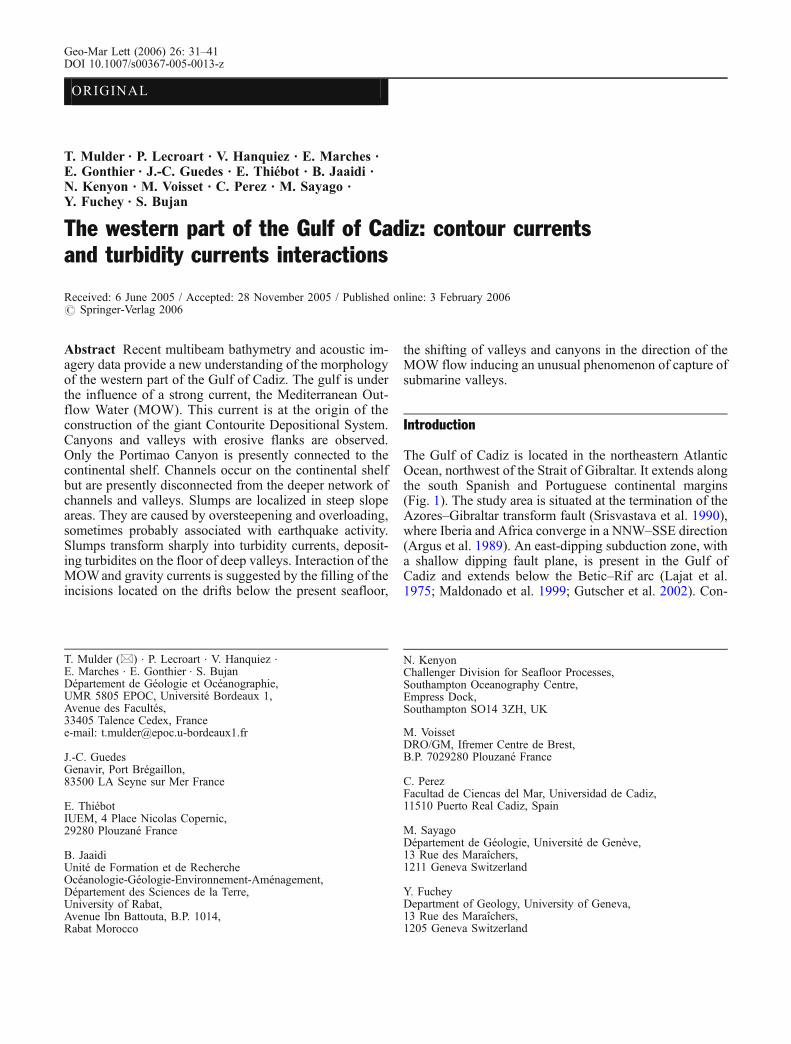
The Mediterranean Lower Water constitutes the lower,more-saline (salinity of 37.42‰) core that forms the mainMOW nucleus. Its mean temperature is 13.6°C and itsvelocity varies in the range 0.2–0.3 m s−1 (Zenk and Armi1990; Bower et al. 1997). The ML divides into three minorbranches between 6°20’ and 7° W, which each follow a sep-arate deep channel (Madelain 1970; Kenyon and Belderson1973; Mélières 1974; Nelson et al. 1993, 1999; García2002): (1) the Intermediate Branch (IB in Fig. 2a), whichmoves northwestward through the Diego Cao Channel;(2) the Principal Branch (PB in Fig. 2a), considered topresently transport the MOW major flow (Madelain 1970)passing south of the Guadalquivir Bank through theGuadalquivir Contourite Channel, and (3) the SouthernBranch (SB in Fig. 2a), which follows a steep valley towardthe southwest through the Cadiz Contourite Channel(Figs. 1 and 2).
At approximately 1,400 m water depth in the westernpart of the Gulf of Cadiz, and at 1,200 m in the eastern part,the MOW loses contact with the seafloor. The velocity ofthe MOW is strongly influenced by seafloor morphology(Heezen and Johnson 1969; Madelain 1970; Thorpe 1972,1976; Mélières 1974). The MOW accelerates when it islaterally constrained, and decelerates when it spreads.
The impact of the MOWon the sedimentation in the Gulfof Cadiz is considerable (Faugères et al. 1985b; McCaveand Tucholke 1986). The strong MOW locally reworkssediment carried by rivers discharging into the gulf, mainly
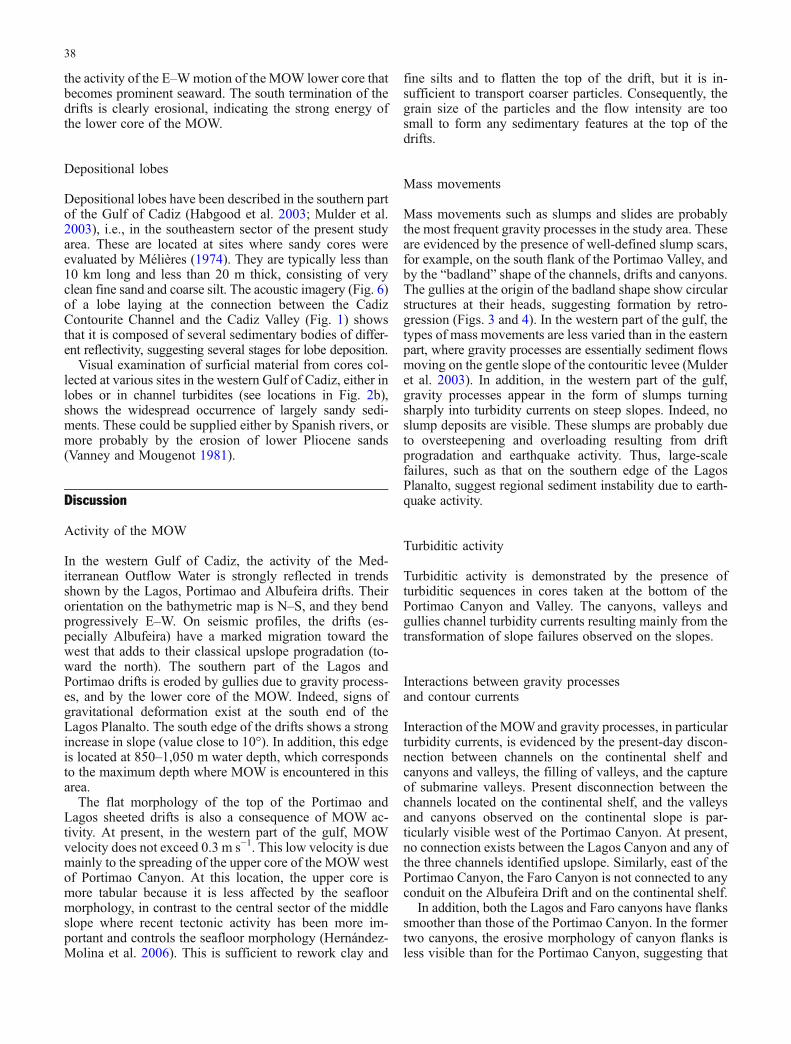
Fig. 1 General map of the Gulfof Cadiz, showing the cores ofthe Mediterranean OutflowWater (MOW) and site ofdownslope gravity processes.Plain frame Area studied duringthe Cadisar 2 cruise (this study).Dashed frame Area studiedduring the Cadisar 1 cruise.CCC Cadiz Contourite Channel,FC Faro Canyon, FP FaroPlanalto, GB GuadalquivirBank, GCC GuadalquivirContourite Channel, LC LagosCanyon, LP Lagos Planalto, MCmain MOW core, PC PortimaoCanyon, PP Portimao Planalto,SP Sagres Planalto, SVC St.Vincent Canyon. The starindicates the epicenter of the1755 Lisbon earthquake
32
the Guadalquivir and Guadiana rivers (Fig. 1). The averagegrain size of the surface sediments decreases as the MOWvelocity decreases westward. Consequently, the deposition-al system evolves from east to west. Close to Gibraltar,the energetic, main MOW core erodes, forming scours andgravel lags, followed westward by sand patches and ribbons(Habgood et al. 2003). Westward along the Spanish slope,contourite deposition forms large, elongated, mounded andsheeted contourite drifts (Faugères et al. 1984, 1985a; Stowet al. 1986; Llave et al. 2001; Llave 2003; Hernández-
Molina et al. 2003). These drifts are composed essentiallyof thoroughly bioturbated, fine-grained sedimentary stackedsequences called contourites (Gonthier et al. 1984). Theconstruction of the drifts is cyclic, being controlled by cli-matic and eustatic oscillations (Llave et al. 2001, 2006a,b).
At the bend west of the Strait of Gibraltar, the MOWbuilds a giant, unstable dissymmetric contouritic levee(Mulder et al. 2002, 2003). This levee is covered withmixed silt and mud waves, eventually only mud waves inits southern part (Kenyon and Belderson 1973; Gardner
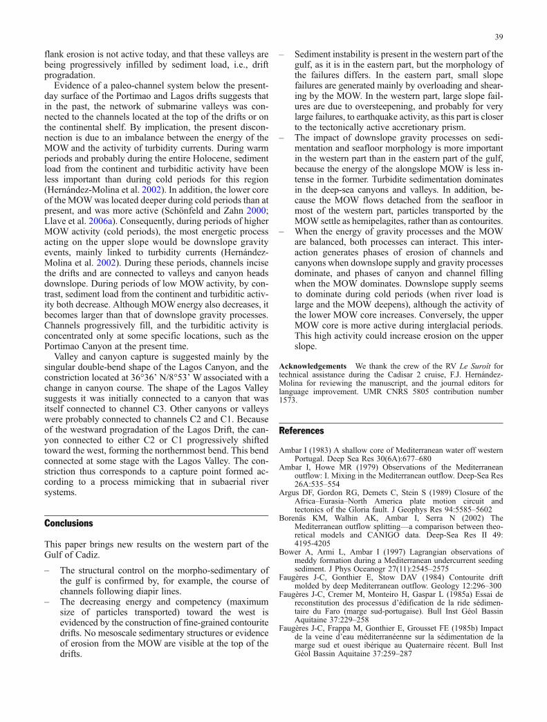
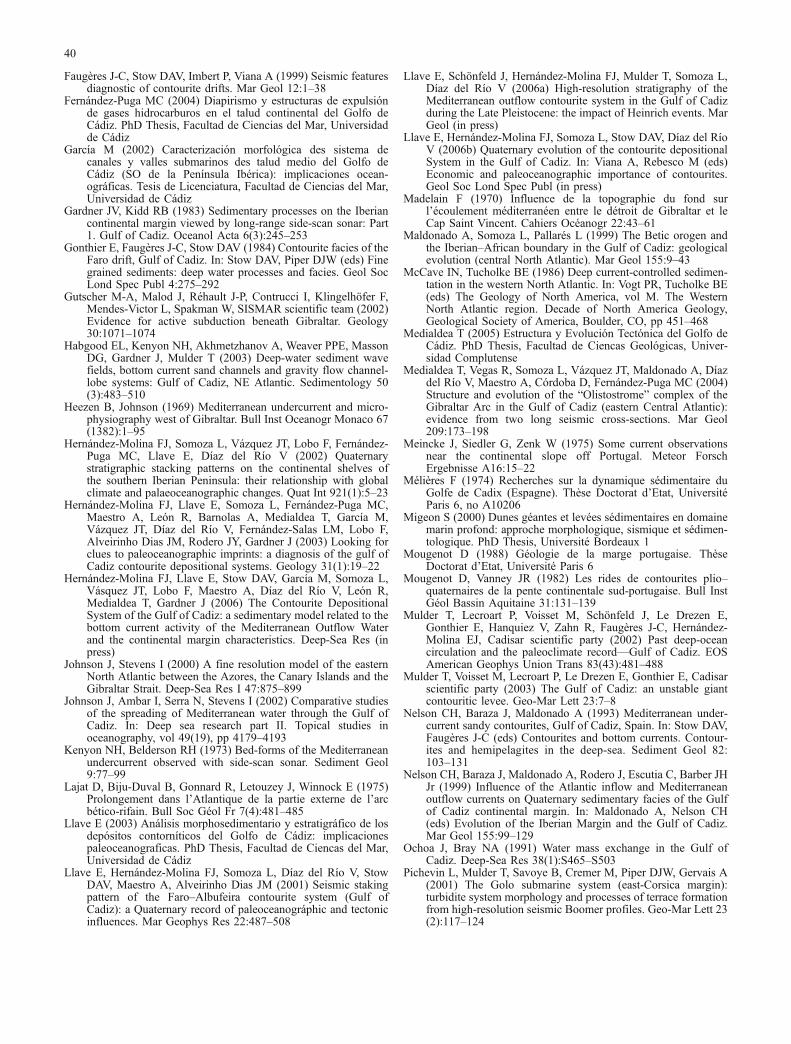
Fig. 2 a High-resolution(30×30 m grid) EM 300bathymetric map of the westernpart of the Gulf of Cadiz studiedduring the Cadisar 2 cruise.ACM Alvares Cabral Moat, ADAlbufeira Drift, AH AlbufeiraHigh, b1, b2 bends of the LagosCanyon, BDD Bartolome DiasDrift, c1, c2 chutes of the LagosCanyon, C1-C3 channels on thecontinental shelf, CV CadizValley, CPt constriction point,sd sediment deformation, nb,sbGCC north branch, southbranch Guadalquivir ContouriteChannel, DCC Diego CaoChannel, DCV Don CarlosValley, DSD deformed sheeteddrift, FD Faro Drift, FV FaroValley, FS failure scars, GDRGuadalquivir Diapiric Ridge,GSS giant slump scar, HAPHorseshoe Abyssal Plain, HCCHuelva Contourite Channel, IVIntermediate Valley, LD LagosDrift, LV Lagos Valley, LMVLolita Mud Volcano, PDPortimao Drift, PH PortimaoHigh, PV Portimao Valley. Thindotted line Location of theseismic profile in Fig. 7, thickdotted line diapir line (D). Forother abbreviations, see Fig. 1.b High-resolution (12.5×12.5 mgrid) EM 300 acoustic imagerymap of the western part of theGulf of Cadiz studied during theCadisar 2 cruise. Crossesindicate core locations
33
and Kidd 1983; Nelson et al. 1993, 1999; Migeon 2000),and with numerous sediment failures and flows in its north-ern part (Mulder et al. 2003). It is dissected by channelsshifting progressively southward. Some of the most activechannels (e.g., Gil Eanes in Fig. 1) terminate with smallsandy lobes.
The morphology of the western part of the Gulf of Cadizis known only by the pioneer work of Vanney andMougenot (1981). More recently, large-coverage bathy-metric tools have been used in the region (Hernández-Molina et al. 2003), but they do not match the accuracy ofthe EM300 multibeam used in present study.
In this paper, we present the new morphology of thewestern part of the Gulf of Cadiz, derived from high-resolution multibeam bathymetry and acoustic imagerydatasets in an area extending between 8°00’/9°20’ W and36°00’/37°00’ N.
Materials and methods
The data were collected during the Cadisar 2 cruise aboardthe RV Le Suroît in September 2004. This cruise followedthe Cadisar 1 cruise dedicated to the study of the easternpart of the gulf (Mulder et al. 2003). Bathymetric data andacoustic imagery were acquired with a SIMRAD EM300multibeam echosounder. This system operates at a fre-quency of 30 kHz and a maximum angle of 150°, the swathwidth varying between 300 and 5,000 m at water depths of100 and 5,000 m, respectively. Ship speed was 5–5.5 kn.
The acoustic data were corrected for salinity and densityeffects using three conductivity-temperature-depth (SBE19)probes and 85 thermoprobes (Sippican). The tops of 21Kullenberg piston cores and three USNEL box cores
were used to visually control for grain size and interpretthe acoustic imagery.
Results
The western part of the Gulf of Cadiz presents five kindsof geomorphological structures: canyons and channels,deep-sea valleys and contourite channels, lobes, drifts, andabyssal plains. These data show essentially large contouritedrifts extending parallel to the continental slope, interactingwith erosional features formed by gravity currents movingdownslope (Figs. 2, 3, 4, 5, 6, and 7). Geographical namesare based on Mougenot and Vanney (1982), Hernández-Molina et al. (2003), and Mulder et al. (2003).
Canyons and channels
Three canyons are visible on the map in Fig. 2a (from eastto west): the Faro Canyon (FC in Figs. 1 and 2a), thePortimao Canyon (PC in Figs. 1 and 2a), and the LagosCanyon (LC in Figs. 1 and 2a). The canyons are narrow,with erosive flanks. The Faro and Lagos canyons incise theupper continental slope, whereas the Portimao Canyon in-cises the continental shelf.
The Faro Canyon is 20 km long. It originates on thesouthern slope of the Albufeira Drift (AD in Fig. 2a). Thecanyon is bordered eastward by the Bartolome Dias Drift(BDD in Fig. 1), and merges sharply with the PortimaoValley (PV in Fig. 2a).
The Portimao Canyon is a slightly sinuous (sinuos-ity=1.125) canyon running N–S (Figs. 2a and 4). It isrooted on a N–S fault (Mougenot and Vanney 1982). The
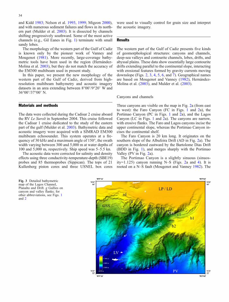
Fig. 3 Detailed bathymetricmap of the Lagos Channel,Planalto and Drift. g Gullies oncanyon and valley flanks; forother abbreviations, see Figs. 1and 2
34
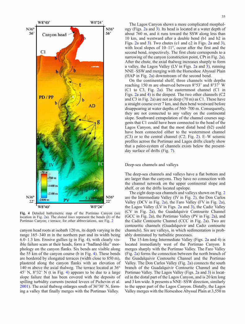
canyon head roots at isobath 120 m, its depth varying in therange 165–340 m in the northern part and its width being6.0–1.3 km. Erosive gullies (g in Fig. 4), with clearly vis-ible failure scars at their heads, form a “badland-like” mor-phology on the canyon flanks. Six bends are visible alongthe 55 km of the canyon course (b in Fig. 4). These bendsare bordered by elongated terraces (width close to 850 m),plastered along the canyon flanks with an elevation of140 m above the axial thalweg. The terrace located at 36°45’ N, 8°32’ N (t in Fig. 4) appears to be due to a largeslope failure that has been covered with the deposits ofspilling turbidity currents (nested levees of Pichevin et al.2001). The axial thalweg enlarges south of 36°30’ N, form-ing a valley that finally merges with the Portimao Valley.
The Lagos Canyon shows a more complicated morphol-ogy (Figs. 2a and 3). Its head is located at a water depth ofabout 760 m, and it runs toward the SSW along less than10 km, and westward after a double bend (b1 and b2 inFigs. 2a and 3). Two chutes (c1 and c2 in Figs. 2a and 3),with local slopes of 10–11°, occur after the first and thesecond bend, respectively. The first chute corresponds to anarrowing of the canyon (constriction point, CPt in Fig. 2a).After the chute, the axial thalweg increases sharply to forma valley, the Lagos Valley (LV in Figs. 2a and 3), runningNNE–SSWand merging with the Horseshoe Abyssal Plain(HAP in Fig. 2a) downstream of the second bend.
On the continental shelf, three channels with depthsreaching 150 m are observed between 8°53’ and 8°37’ W(C1 to C3, Fig. 2a). The easternmost channel (C1 inFigs. 2a and 4) is the deepest. The two other channels (C2and C3 in Fig. 2a) are not as deep (70 m) as C1. These havea straight course over 7 km, and then bend westward beforedisappearing at water depths of 560–700 m. Consequently,they are not connected to any valley on the continentalslope. Southward extrapolation of the channel courses sug-gests that C1 could have been connected to the head of theLagos Canyon, and that the most distal bend (b2) couldhave been connected either to the westernmost channel(C3) or to the central channel (C2; Fig. 2). E–W seismicprofiles across the Portimao and Lagos drifts clearly showthat a paleo-system of channels exists below the present-day surface of drifts (Fig. 7).
Deep-sea channels and valleys
The deep-sea channels and valleys have a flat bottom andare larger than the canyons. They have no connection withthe channel network on the upper continental slope andshelf, or on the drifts located upslope.
The eight deep-sea channels and valleys shown on Fig. 2are the Intermediate Valley (IV in Fig. 2), the Don CarlosValley (DCV in Fig. 2a), the Faro Valley (FV in Fig. 2a),the Lagos Valley (LV in Figs. 2a and 3), the Cadiz Valley(CV in Fig. 2a), the Guadalquivir Contourite Channel(GCC in Fig. 2a), the Portimao Valley (PV in Fig. 2a), andthe Cadiz Contourite Channel (CCC in Fig. 2a). Two arecontouritic channels (Guadalquivir and Cadiz contouritechannels). Six are valleys, in which sedimentation is prob-ably dominated by turbiditic processes.
The 15-km-long Intermediate Valley (Figs. 2a and 4) islocated immediately west of the Portimao Canyon. Itmerges sharply with the Portimao Valley. The Faro Valley(Fig. 2a) forms the connection between the north branch ofthe Guadalquivir Contourite Channel and the PortimaoValley. The Don Carlos Valley (Fig. 2a) connects the southbranch of the Guadalquivir Contourite Channel and thePortimao Valley. The Lagos Valley (Figs. 2a and 3) is locat-ed in the distal part of the Lagos Canyon, and is 20 km longand 3 km wide. It presents a NNE–SSW direction, similarlyto the upper part of the Lagos Canyon. Distally, the LagosValley merges with the Horseshoe Abyssal Plain at 3,550 m
Fig. 4 Detailed bathymetric map of the Portimao Canyon (seelocation in Fig. 2a). The dotted lines represent the bends (b) of thePortimao Canyon; t terrace; for other abbreviations, see Fig. 2
35
water depth. The Cadiz Valley is located southward of theAlbufeira High (AH in Fig. 2a), immediately west of theLolita Mud Volcano (Somoza et al. 2003; LMV in Fig. 2a).It runs E–W and merges westward with the HorseshoeAbyssal Plain.
The Guadalquivir Contourite Channel (Hernández-Molina et al. 2003) runs on the southern side of theGuadalquivir Bank (GB in Fig. 2a). At this location, thechannel forms a bend with a large radius of curvature. Itdivides along the Portimao High (PH in Fig. 2a) into anorth and a south branch. The north branch (nbGCC inFig. 2a) passes north of the Portimao High, and connectssharply with the Faro Valley and then with the Faro Canyon.The south branch (sbGCC in Fig. 2a) passes south of thePortimao High, and connects with the Don Carlos Valley.West of 8°03’ W, the channel enlarges, merging with thePortimao Valley.
The Portimao Valley is longer than 50 km and has fourmain sources: (1) the Guadalquivir Contourite Channel, (2)the Faro Canyon, (3) the Portimao Canyon, and (3) the
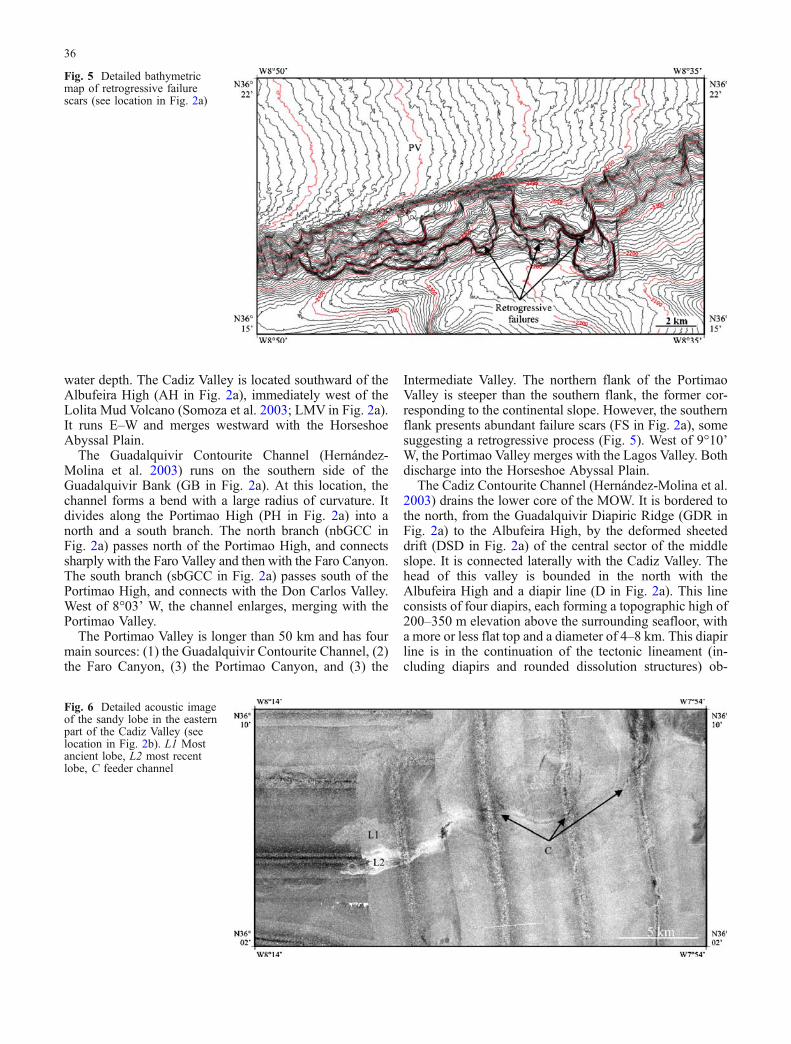
Intermediate Valley. The northern flank of the PortimaoValley is steeper than the southern flank, the former cor-responding to the continental slope. However, the southernflank presents abundant failure scars (FS in Fig. 2a), somesuggesting a retrogressive process (Fig. 5). West of 9°10’W, the Portimao Valley merges with the Lagos Valley. Bothdischarge into the Horseshoe Abyssal Plain.
The Cadiz Contourite Channel (Hernández-Molina et al.2003) drains the lower core of the MOW. It is bordered tothe north, from the Guadalquivir Diapiric Ridge (GDR inFig. 2a) to the Albufeira High, by the deformed sheeteddrift (DSD in Fig. 2a) of the central sector of the middleslope. It is connected laterally with the Cadiz Valley. Thehead of this valley is bounded in the north with theAlbufeira High and a diapir line (D in Fig. 2a). This lineconsists of four diapirs, each forming a topographic high of200–350 m elevation above the surrounding seafloor, witha more or less flat top and a diameter of 4–8 km. This diapirline is in the continuation of the tectonic lineament (in-cluding diapirs and rounded dissolution structures) ob-
Fig. 5 Detailed bathymetricmap of retrogressive failurescars (see location in Fig. 2a)
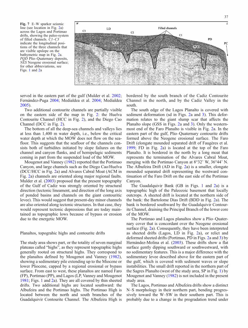
Fig. 6 Detailed acoustic imageof the sandy lobe in the easternpart of the Cadiz Valley (seelocation in Fig. 2b). L1 Mostancient lobe, L2 most recentlobe, C feeder channel
36
served in the eastern part of the gulf (Mulder et al. 2002;Fernández-Puga 2004; Medialdea et al. 2004; Medialdea2005).
Two additional contourite channels are partially visibleon the eastern side of the map in Fig. 2: the HuelvaContourite Channel (HCC in Fig. 2), and the Diego CaoChannel (DCC in Fig. 2).
The bottom of all the deep-sea channels and valleys liesat less than 1,400 m water depth, i.e., below the criticalwater depth at which the MOW does not flow on the sea-floor. This suggests that the seafloor of the channels con-sists both of turbidites initiated by slope failures on thechannel and canyon flanks, and of hemipelagic sedimentscoming in part from the suspended load of the MOW.
Mougenot and Vanney (1982) reported that the PortimaoCanyon, and large channels such as the Diego Cao/Huelva(DCC/HCC in Fig. 2a) and Alvares Cabral Moat (ACM inFig. 2a) channels are oriented along major regional faults.Mulder et al. (2003) proposed that the present topographyof the Gulf of Cadiz was strongly oriented by structuraldirection (tectonic lineament, and direction of the long axisof ponded basins and channels on the giant contouriticlevee). This would suggest that present-day minor channelsare also oriented along tectonic structures. In that case, theywould represent tectonic depressions that are today main-tained as topographic lows because of bypass or erosiondue to the energetic MOW.
Planaltos, topograhic highs and contourite drifts
The study area shows part, or the totality of seven marginalplateaus called “highs”, as they represent topographic highsgenerally rooted on structural highs. They correspond tothe planaltos defined by Mougenot and Vanney (1982),showing a sedimentary pile extending up to the Miocene orlower Pliocene, capped by a regional erosional or bypasssurface. From east to west, these planaltos are named Faro(FP), Portimao (PP), and Lagos (LP, Vanney and Mougenot1981; Figs. 1 and 2a). They are all covered by thin sheeteddrifts. Two additional highs are located southward: theAlbufeira and the Portimao highs. The Portimao High islocated between the north and south branches of theGuadalquivir Contourite Channel. The Albufeira High is
bordered by the south branch of the Cadiz ContouriteChannel in the north, and by the Cadiz Valley in thesouth.
The south edge of the Lagos Planalto is covered withsediment deformation (sd in Figs. 2a and 3). This defor-mation relates to the giant slump scar that affects thePlanalto slope (GSS in Figs. 2a and 3). Only the western-most end of the Faro Planalto is visible in Fig. 2a. In theeastern part of the gulf, Plio–Quaternary contourite driftsformed above the Neogene erosional surface. The FaroDrift (elongate mounded separated drift of Faugères et al.1999; FD in Fig. 2a) is located at the top of the FaroPlanalto. It is bordered in the north by a long moat thatrepresents the termination of the Alvares Cabral Moat,merging with the Portimao Canyon at 8°32’ W, 36°44’ N.The Albufeira Drift (AD in Fig. 2a) is a smaller, elongatemounded separated drift representing the westward con-tinuation of the Faro Drift on the east side of the PortimaoCanyon.
The Guadalquivir Bank (GB in Figs. 1 and 2a) is atopographic high of the Paleozoic basement that locallyoutcrops. A sheeted drift is located at the northern side ofthe bank: the Bartolome Dias Drift (BDD in Fig. 2a). Thebank is bordered southward by the Guadalquivir Contour-ite Channel, draining the Principal Branch of the lower coreof the MOW.
The Portimao and Lagos planaltos show a Plio–Quater-nary cover that is concordant over the Neogene erosionalsurface (Fig. 2a). Consequently, they have been interpretedas sheeted drifts (Lagos, LD in Fig. 2a), or relict anddeformed sheeted drifts (Portimao, PD in Figs. 2a and 3) byHernández-Molina et al. (2003). These drifts show a flatsurface gently dipping southward or southwestward, withno sedimentary features. This is a major difference with thesedimentary levee described above for the eastern part ofthe gulf, which is covered with sediment waves or slopeinstabilities. The small drift reported in the northern part ofthe Sagres Planalto (west of the study area, SP in Fig. 1) byMougenot and Vanney (1982) is not included in the presentstudy area.
The Lagos, Portimao and Albufeira drifts show a distinctN–S morphology in their northern part, bending progres-sively toward the W–SW in their southern part. This isprobably due to a change in the progradation trend under
Fig. 7 E–W sparker seismicline (see location in Fig. 2a)across the Lagos and Portimaodrifts, showing the paleo-systemof filled channels. C1–C3indicate the longitudinal posi-tions of the three channels thatare visible upslope on thebathymetric map in Fig. 2a.PQD Plio–Quaternary deposits,NES Neogene erosional surface;for other abbreviations, seeFigs. 1 and 2a
37
the activity of the E–Wmotion of the MOW lower core thatbecomes prominent seaward. The south termination of thedrifts is clearly erosional, indicating the strong energy ofthe lower core of the MOW.
Depositional lobes
Depositional lobes have been described in the southern partof the Gulf of Cadiz (Habgood et al. 2003; Mulder et al.2003), i.e., in the southeastern sector of the present studyarea. These are located at sites where sandy cores wereevaluated by Mélières (1974). They are typically less than10 km long and less than 20 m thick, consisting of veryclean fine sand and coarse silt. The acoustic imagery (Fig. 6)of a lobe laying at the connection between the CadizContourite Channel and the Cadiz Valley (Fig. 1) showsthat it is composed of several sedimentary bodies of differ-ent reflectivity, suggesting several stages for lobe deposition.
Visual examination of surficial material from cores col-lected at various sites in the western Gulf of Cadiz, either inlobes or in channel turbidites (see locations in Fig. 2b),shows the widespread occurrence of largely sandy sedi-ments. These could be supplied either by Spanish rivers, ormore probably by the erosion of lower Pliocene sands(Vanney and Mougenot 1981).
Discussion
Activity of the MOW
In the western Gulf of Cadiz, the activity of the Med-iterranean Outflow Water is strongly reflected in trendsshown by the Lagos, Portimao and Albufeira drifts. Theirorientation on the bathymetric map is N–S, and they bendprogressively E–W. On seismic profiles, the drifts (es-pecially Albufeira) have a marked migration toward thewest that adds to their classical upslope progradation (to-ward the north). The southern part of the Lagos andPortimao drifts is eroded by gullies due to gravity process-es, and by the lower core of the MOW. Indeed, signs ofgravitational deformation exist at the south end of theLagos Planalto. The south edge of the drifts shows a strongincrease in slope (value close to 10°). In addition, this edgeis located at 850–1,050 m water depth, which correspondsto the maximum depth where MOW is encountered in thisarea.
The flat morphology of the top of the Portimao andLagos sheeted drifts is also a consequence of MOW ac-tivity. At present, in the western part of the gulf, MOWvelocity does not exceed 0.3 m s−1. This low velocity is duemainly to the spreading of the upper core of the MOWwestof Portimao Canyon. At this location, the upper core ismore tabular because it is less affected by the seafloormorphology, in contrast to the central sector of the middleslope where recent tectonic activity has been more im-portant and controls the seafloor morphology (Hernández-Molina et al. 2006). This is sufficient to rework clay and
fine silts and to flatten the top of the drift, but it is in-sufficient to transport coarser particles. Consequently, thegrain size of the particles and the flow intensity are toosmall to form any sedimentary features at the top of thedrifts.
Mass movements
Mass movements such as slumps and slides are probablythe most frequent gravity processes in the study area. Theseare evidenced by the presence of well-defined slump scars,for example, on the south flank of the Portimao Valley, andby the “badland” shape of the channels, drifts and canyons.The gullies at the origin of the badland shape show circularstructures at their heads, suggesting formation by retro-gression (Figs. 3 and 4). In the western part of the gulf, thetypes of mass movements are less varied than in the easternpart, where gravity processes are essentially sediment flowsmoving on the gentle slope of the contouritic levee (Mulderet al. 2003). In addition, in the western part of the gulf,gravity processes appear in the form of slumps turningsharply into turbidity currents on steep slopes. Indeed, noslump deposits are visible. These slumps are probably dueto oversteepening and overloading resulting from driftprogradation and earthquake activity. Thus, large-scalefailures, such as that on the southern edge of the LagosPlanalto, suggest regional sediment instability due to earth-quake activity.
Turbiditic activity
Turbiditic activity is demonstrated by the presence ofturbiditic sequences in cores taken at the bottom of thePortimao Canyon and Valley. The canyons, valleys andgullies channel turbidity currents resulting mainly from thetransformation of slope failures observed on the slopes.
Interactions between gravity processesand contour currents
Interaction of the MOWand gravity processes, in particularturbidity currents, is evidenced by the present-day discon-nection between channels on the continental shelf andcanyons and valleys, the filling of valleys, and the captureof submarine valleys. Present disconnection between thechannels located on the continental shelf, and the valleysand canyons observed on the continental slope is par-ticularly visible west of the Portimao Canyon. At present,no connection exists between the Lagos Canyon and any ofthe three channels identified upslope. Similarly, east of thePortimao Canyon, the Faro Canyon is not connected to anyconduit on the Albufeira Drift and on the continental shelf.
In addition, both the Lagos and Faro canyons have flankssmoother than those of the Portimao Canyon. In the formertwo canyons, the erosive morphology of canyon flanks isless visible than for the Portimao Canyon, suggesting that
38
flank erosion is not active today, and that these valleys arebeing progressively infilled by sediment load, i.e., driftprogradation.
Evidence of a paleo-channel system below the present-day surface of the Portimao and Lagos drifts suggests thatin the past, the network of submarine valleys was con-nected to the channels located at the top of the drifts or onthe continental shelf. By implication, the present discon-nection is due to an imbalance between the energy of theMOW and the activity of turbidity currents. During warmperiods and probably during the entire Holocene, sedimentload from the continent and turbiditic activity have beenless important than during cold periods for this region(Hernández-Molina et al. 2002). In addition, the lower coreof the MOWwas located deeper during cold periods than atpresent, and was more active (Schönfeld and Zahn 2000;Llave et al. 2006a). Consequently, during periods of higherMOW activity (cold periods), the most energetic processacting on the upper slope would be downslope gravityevents, mainly linked to turbidity currents (Hernández-Molina et al. 2002). During these periods, channels incisethe drifts and are connected to valleys and canyon headsdownslope. During periods of low MOW activity, by con-trast, sediment load from the continent and turbiditic activ-ity both decrease. Although MOWenergy also decreases, itbecomes larger than that of downslope gravity processes.Channels progressively fill, and the turbiditic activity isconcentrated only at some specific locations, such as thePortimao Canyon at the present time.
Valley and canyon capture is suggested mainly by thesingular double-bend shape of the Lagos Canyon, and theconstriction located at 36°36’ N/8°53’ Wassociated with achange in canyon course. The shape of the Lagos Valleysuggests it was initially connected to a canyon that wasitself connected to channel C3. Other canyons or valleyswere probably connected to channels C2 and C1. Becauseof the westward progradation of the Lagos Drift, the can-yon connected to either C2 or C1 progressively shiftedtoward the west, forming the northernmost bend. This bendconnected at some stage with the Lagos Valley. The con-striction thus corresponds to a capture point formed ac-cording to a process mimicking that in subaerial riversystems.
Conclusions
This paper brings new results on the western part of theGulf of Cadiz.
– The structural control on the morpho-sedimentary ofthe gulf is confirmed by, for example, the course ofchannels following diapir lines.
– The decreasing energy and competency (maximumsize of particles transported) toward the west isevidenced by the construction of fine-grained contouritedrifts. No mesoscale sedimentary structures or evidenceof erosion from the MOW are visible at the top of thedrifts.
– Sediment instability is present in the western part of thegulf, as it is in the eastern part, but the morphology ofthe failures differs. In the eastern part, small slopefailures are generated mainly by overloading and shear-ing by the MOW. In the western part, large slope fail-ures are due to oversteepening, and probably for verylarge failures, to earthquake activity, as this part is closerto the tectonically active accretionary prism.
– The impact of downslope gravity processes on sedi-mentation and seafloor morphology is more importantin the western part than in the eastern part of the gulf,because the energy of the alongslope MOW is less in-tense in the former. Turbidite sedimentation dominatesin the deep-sea canyons and valleys. In addition, be-cause the MOW flows detached from the seafloor inmost of the western part, particles transported by theMOW settle as hemipelagites, rather than as contourites.
– When the energy of gravity processes and the MOWare balanced, both processes can interact. This inter-action generates phases of erosion of channels andcanyons when downslope supply and gravity processesdominate, and phases of canyon and channel fillingwhen the MOW dominates. Downslope supply seemsto dominate during cold periods (when river load islarge and the MOW deepens), although the activity ofthe lower MOW core increases. Conversely, the upperMOW core is more active during interglacial periods.This high activity could increase erosion on the upperslope.
Acknowledgements We thank the crew of the RV Le Suroît fortechnical assistance during the Cadisar 2 cruise, F.J. Hernández-Molina for reviewing the manuscript, and the journal editors forlanguage improvement. UMR CNRS 5805 contribution number1573.
References
Ambar I (1983) A shallow core of Mediterranean water off westernPortugal. Deep Sea Res 30(6A):677–680
Ambar I, Howe MR (1979) Observations of the Mediterraneanoutflow: I. Mixing in the Mediterranean outflow. Deep-Sea Res26A:535–554
Argus DF, Gordon RG, Demets C, Stein S (1989) Closure of theAfrica–Eurasia–North America plate motion circuit andtectonics of the Gloria fault. J Geophys Res 94:5585–5602
Borenäs KM, Walhin AK, Ambar I, Serra N (2002) TheMediterranean outflow splitting—a comparison between theo-retical models and CANIGO data. Deep-Sea Res II 49:4195-4205
Bower A, Armi L, Ambar I (1997) Lagrangian observations ofmeddy formation during a Mediterranean undercurrent seedingsediment. J Phys Oceanogr 27(11):2545–2575
Faugères J-C, Gonthier E, Stow DAV (1984) Contourite driftmolded by deep Mediterranean outflow. Geology 12:296–300
Faugères J-C, Cremer M, Monteiro H, Gaspar L (1985a) Essai dereconstitution des processus d’édification de la ride sédimen-taire du Faro (marge sud-portugaise). Bull Inst Géol BassinAquitaine 37:229–258
Faugères J-C, Frappa M, Gonthier E, Grousset FE (1985b) Impactde la veine d’eau méditerranéenne sur la sédimentation de lamarge sud et ouest ibérique au Quaternaire récent. Bull InstGéol Bassin Aquitaine 37:259–287
39
Faugères J-C, Stow DAV, Imbert P, Viana A (1999) Seismic featuresdiagnostic of contourite drifts. Mar Geol 12:1–38
Fernández-Puga MC (2004) Diapirismo y estructuras de expulsiónde gases hidrocarburos en el talud continental del Golfo deCádiz. PhD Thesis, Facultad de Ciencias del Mar, Universidadde Cádiz
García M (2002) Caracterización morfológica des sistema decanales y valles submarinos des talud medio del Golfo deCádiz (SO de la Península Ibérica): implicaciones ocean-ográficas. Tesis de Licenciatura, Facultad de Ciencias del Mar,Universidad de Cádiz
Gardner JV, Kidd RB (1983) Sedimentary processes on the Iberiancontinental margin viewed by long-range side-scan sonar: Part1. Gulf of Cadiz. Oceanol Acta 6(3):245–253
Gonthier E, Faugères J-C, Stow DAV (1984) Contourite facies of theFaro drift, Gulf of Cadiz. In: Stow DAV, Piper DJW (eds) Finegrained sediments: deep water processes and facies. Geol SocLond Spec Publ 4:275–292
Gutscher M-A, Malod J, Réhault J-P, Contrucci I, Klingelhöfer F,Mendes-Victor L, Spakman W, SISMAR scientific team (2002)Evidence for active subduction beneath Gibraltar. Geology30:1071–1074
Habgood EL, Kenyon NH, Akhmetzhanov A, Weaver PPE, MassonDG, Gardner J, Mulder T (2003) Deep-water sediment wavefields, bottom current sand channels and gravity flow channel-lobe systems: Gulf of Cadiz, NE Atlantic. Sedimentology 50(3):483–510
Heezen B, Johnson (1969) Mediterranean undercurrent and micro-physiography west of Gibraltar. Bull Inst Oceanogr Monaco 67(1382):1–95
Hernández-Molina FJ, Somoza L, Vázquez JT, Lobo F, Fernández-Puga MC, Llave E, Díaz del Río V (2002) Quaternarystratigraphic stacking patterns on the continental shelves ofthe southern Iberian Peninsula: their relationship with globalclimate and palaeoceanographic changes. Quat Int 921(1):5–23
Hernández-Molina FJ, Llave E, Somoza L, Fernández-Puga MC,Maestro A, León R, Barnolas A, Medialdea T, García M,Vázquez JT, Díaz del Río V, Fernández-Salas LM, Lobo F,Alveirinho Dias JM, Rodero JY, Gardner J (2003) Looking forclues to paleoceanographic imprints: a diagnosis of the gulf ofCadiz contourite depositional systems. Geology 31(1):19–22
Hernández-Molina FJ, Llave E, Stow DAV, García M, Somoza L,Vásquez JT, Lobo F, Maestro A, Díaz del Río V, León R,Medialdea T, Gardner J (2006) The Contourite DepositionalSystem of the Gulf of Cadiz: a sedimentary model related to thebottom current activity of the Mediterranean Outflow Waterand the continental margin characteristics. Deep-Sea Res (inpress)
Johnson J, Stevens I (2000) A fine resolution model of the easternNorth Atlantic between the Azores, the Canary Islands and theGibraltar Strait. Deep-Sea Res I 47:875–899
Johnson J, Ambar I, Serra N, Stevens I (2002) Comparative studiesof the spreading of Mediterranean water through the Gulf ofCadiz. In: Deep sea research part II. Topical studies inoceanography, vol 49(19), pp 4179–4193
Kenyon NH, Belderson RH (1973) Bed-forms of the Mediterraneanundercurrent observed with side-scan sonar. Sediment Geol9:77–99
Lajat D, Biju-Duval B, Gonnard R, Letouzey J, Winnock E (1975)Prolongement dans l’Atlantique de la partie externe de l’arcbético-rifain. Bull Soc Géol Fr 7(4):481–485
Llave E (2003) Análisis morphosedimentario y estratigráfico de losdepósitos contorníticos del Golfo de Cádiz: implicacionespaleoceanograficas. PhD Thesis, Facultad de Ciencas del Mar,Universidad de Cádiz
Llave E, Hernández-Molina FJ, Somoza L, Díaz del Río V, StowDAV, Maestro A, Alveirinho Dias JM (2001) Seismic stakingpattern of the Faro–Albufeira contourite system (Gulf ofCadiz): a Quaternary record of paleoceanográphic and tectonicinfluences. Mar Geophys Res 22:487–508
Llave E, Schönfeld J, Hernández-Molina FJ, Mulder T, Somoza L,Díaz del Río V (2006a) High-resolution stratigraphy of theMediterranean outflow contourite system in the Gulf of Cadizduring the Late Pleistocene: the impact of Heinrich events. MarGeol (in press)
Llave E, Hernández-Molina FJ, Somoza L, Stow DAV, Díaz del RíoV (2006b) Quaternary evolution of the contourite depositionalSystem in the Gulf of Cadiz. In: Viana A, Rebesco M (eds)Economic and paleoceanographic importance of contourites.Geol Soc Lond Spec Publ (in press)
Madelain F (1970) Influence de la topographie du fond surl’écoulement méditerranéen entre le détroit de Gibraltar et leCap Saint Vincent. Cahiers Océanogr 22:43–61
Maldonado A, Somoza L, Pallarés L (1999) The Betic orogen andthe Iberian–African boundary in the Gulf of Cadiz: geologicalevolution (central North Atlantic). Mar Geol 155:9–43
McCave IN, Tucholke BE (1986) Deep current-controlled sedimen-tation in the western North Atlantic. In: Vogt PR, Tucholke BE(eds) The Geology of North America, vol M. The WesternNorth Atlantic region. Decade of North America Geology,Geological Society of America, Boulder, CO, pp 451–468
Medialdea T (2005) Estructura y Evolución Tectónica del Golfo deCádiz. PhD Thesis, Facultad de Ciencas Geológicas, Univer-sidad Complutense
Medialdea T, Vegas R, Somoza L, Vázquez JT, Maldonado A, Díazdel Río V, Maestro A, Córdoba D, Fernández-Puga MC (2004)Structure and evolution of the “Olistostrome” complex of theGibraltar Arc in the Gulf of Cadiz (eastern Central Atlantic):evidence from two long seismic cross-sections. Mar Geol209:173–198
Meincke J, Siedler G, Zenk W (1975) Some current observationsnear the continental slope off Portugal. Meteor ForschErgebnisse A16:15–22
Mélières F (1974) Recherches sur la dynamique sédimentaire duGolfe de Cadix (Espagne). Thèse Doctorat d’Etat, UniversitéParis 6, no A10206
Migeon S (2000) Dunes géantes et levées sédimentaires en domainemarin profond: approche morphologique, sismique et sédimen-tologique. PhD Thesis, Université Bordeaux 1
Mougenot D (1988) Géologie de la marge portugaise. ThèseDoctorat d’Etat, Université Paris 6
Mougenot D, Vanney JR (1982) Les rides de contourites plio–quaternaires de la pente continentale sud-portugaise. Bull InstGéol Bassin Aquitaine 31:131–139
Mulder T, Lecroart P, Voisset M, Schönfeld J, Le Drezen E,Gonthier E, Hanquiez V, Zahn R, Faugères J-C, Hernández-Molina EJ, Cadisar scientific party (2002) Past deep-oceancirculation and the paleoclimate record—Gulf of Cadiz. EOSAmerican Geophys Union Trans 83(43):481–488
Mulder T, Voisset M, Lecroart P, Le Drezen E, Gonthier E, Cadisarscientific party (2003) The Gulf of Cadiz: an unstable giantcontouritic levee. Geo-Mar Lett 23:7–8
Nelson CH, Baraza J, Maldonado A (1993) Mediterranean under-current sandy contourites, Gulf of Cadiz, Spain. In: Stow DAV,Faugères J-C (eds) Contourites and bottom currents. Contour-ites and hemipelagites in the deep-sea. Sediment Geol 82:103–131
Nelson CH, Baraza J, Maldonado A, Rodero J, Escutia C, Barber JHJr (1999) Influence of the Atlantic inflow and Mediterraneanoutflow currents on Quaternary sedimentary facies of the Gulfof Cadiz continental margin. In: Maldonado A, Nelson CH(eds) Evolution of the Iberian Margin and the Gulf of Cadiz.Mar Geol 155:99–129
Ochoa J, Bray NA (1991) Water mass exchange in the Gulf ofCadiz. Deep-Sea Res 38(1):S465–S503
Pichevin L, Mulder T, Savoye B, Cremer M, Piper DJW, Gervais A(2001) The Golo submarine system (east-Corsica margin):turbidite system morphology and processes of terrace formationfrom high-resolution seismic Boomer profiles. Geo-Mar Lett 23(2):117–124
40
Schönfeld J, Zahn R (2000) Late glacial to Holocene history of theMediterranean outflow. Evidence from benthic foraminiferalassemblages and stable isotopes at the Portuguese margin.Palaeogeogr Palaeoclimatol Palaeoecol 159:85–111
Somoza L, Díaz-del-Rio V, León R, Ivanov M, Fernández-PugaMC, Gardner JM, Hernández-Molina FJ, Pinheiro LM, RoderoJ, Lobato A, Maestro A, Vázquez JT, Medialdea T, Fernández-Salas LM (2003) Seabed morphology and hydrocarbon seepagein the Gulf of Cadiz mud volcano area: acoustic imagery,multibeam and ultra-high resolution data. Mar Geol 195:153–176
Srisvastava SP, Schouten H, Roest WR, Klitgord KD, Kovacs LC,Verhoef J, Macnab R (1990) Iberian plate kinematics: ajumping plate boundary between Eurasia and Africa. Nature344:756–759
Stow DAV, Faugères J-C, Gonthier E (1986) Facies distribution anddrift growth during the late Quaternary (Gulf of Cadiz). MarGeol 72:71–100
Thorpe SA (1972) A sediment cloud below the Mediterraneanoutflow. Nature 236:326–327
Thorpe SA (1976) Variability of the Mediterranean undercurrent inthe Gulf of Cadiz. Deep-Sea Res 23:711–727
Vanney JR, Mougenot D (1981) La plate-forme continentale duPortugal et les provinces adjacentes: analyse géomorphologi-que. Memorias dos Serviços Geologicos de Portugal, vol 28,pp 1–86
Zenk W (1975) On the Mediterranean outflow west of Gibraltar.Meteor Forsch Ergebnisse A16:23–34
Zenk W, Armi L (1990) The complex spreading patterns ofMediterranean water off the Portuguese continental slope.Deep-Sea Res 37:1805–1823
Zitellini N, Chierici F, Sartori R, Torelli L (1999) The tectonicsource of the 1755 Lisbon earthquake and tsunami. Ann Geofis42:49–55
41
Recommended