The Crater Island Assemblage, Amisk Lake (Part of NTS 63L-9} 1
B.A. Reilly
Reilly, B.A. (1994): The Crater Island Assemblage, Amisk Lake (part of NTS 63L-9); in Summary of Investigations 1994, Saskatchewan Geological Survey, Sask. Energy Mines, Misc. Rep. 94-4.
The main objective this summer was to complete revision mapping of the south-central Amisk Lake area, and improve the understanding of the relationships between the West Amisk and Muskeg Bay assemblages to the west and the Sandy Bay Assemblage to the east. Approximately 200 km2 were mapped at 1 :50 000 scale during the month of August in an area extending from the south shore of Missi Island to the edge of the Precambrian Shield at the south end of Amisk Lake (most of this area is covered by Amisk Lake), thus bridging the gap in revisional geological mapping which existed between the east and west shores of Amisk Lake, excluding central and eastern Missi Island.
Detailed revisional bedrock mapping by the Saskatchewan Geological Survey in the Amisk Lake area during
the past few years coupled with geochemical and isotope studies (Watters et al., in press; Stern et al., in press a and b) has led to the recognition of several distinct lithotectonic assemblages (Figure 1) (Reilly et al., in press) in the region.
Greenstone assemblages on the west side of Amisk Lake are dominated by 1882 to 1888 Ma (Heaman et al., 1993; Stern and Lucas, in press) felsic to intermediate calc-alkaline island arc volcanic rocks underlain by largely tholeiitic island arc basalts2 (Fox, 1976a and b; Walker and Watters, 1982; Ashton, 1990, 1992; Watters and Ashton, 1991 ; Reilly 1992, 1993; Stern et al., in press a). These have been termed the West Amlsk Assemblage (Reilly, 1993) and the Muskeg Bay Assemblage (Reilly et al., in press), respectively.
r~.i ·-.s~ (rcup ~ SE->d.,•·c·r·"ts
,~,_ r-.V ljl"J,)..);J
1--:::J ,~ypohy ·S:,), R,.,,. kr, ~/J \,/~l s•·, L,.JI~(-· i!i:.] ,..,.ie:,~ i .C:niSk
E3) M,.sl--"'g ll,1y l£i~J ::---o. t,•r- Js :~nd
Ll Sa ndy Bey
l..!_J2i2:4 b.J ""
Figure 1 • Lithotectonic assemblages of the Amisk Lake area.
(1) Saskatchewan Project A.112 was funded in 1994 under the Canada-Saskatchewan Partnership Agreement on Mineral Development 1990-95. (2) All of the Precambrian rocks in the map area have been metamorphosed and the prefix meta will be omitted when referring to these rocks.
Saskatchewan Geological Survey 11

On the east side of Amisk Lake, the Sandy Bay As· semblage (Slimmon, 1991 b), consists predominantly of tholeiitic MOAB-like basalts (Parslow and Gaskarth, 1984, 1988; Gaskarth and Parslow, 1987; Slimmon, 1991a, 1993; Watters et al., in press, this volume; Slimmon, this volume; Stern et al., in press b).
This report briefly describes the characteristics, contact relationships, and economic potential of a newly defined lithotectonic assemblage, namely the Crater Island Assemblage. This assemblage is excellently displayed due to lower greenschist facies metamorphism, relatively low deformation, paucity of plutons, and the presence of wave-washed, flat-lying, lichen-free shoreline exposures.
A summary of the main features of the lithotectonic volcanic assemblages of the Amisk Lake area are given in Table 1.
1 . Crater Island Assemblage
The Crater Island Assemblage comprises a thick mafic volcanic sequence which outcrops in the south-central part of Amisk Lake and extends from lskwasoo Island in the east to the southwest corner of Missi Island in the west (Figure 2). The assemblage forms essentially a folded sequence about three kilometres thick and comprises largely tholeiitic basalt and basaltic andesite (Fox, 1976a and b; Ferreira, 1984; Gaskarth and Parslow, 1987).
Physical volcanological studies by Lorne Ayres and graduate students at the University of Manitoba have been conducted at Amisk Lake since the late 1970s. Detailed stratigraphic sections concentrating on the Crater Island Assemblage can be found in Ayres (1978, 1980a and b, 1981), Ferreira (1981), Van Wagoner (1982), Van Wagoner et al. (1982), Ferreira (1984), Van Wagoner and Van Wagoner (1987), and Ayres et al. (1981 , 1991).
The Crater Island Assemblage is composed of approximately equal amounts of lava flows and intercalated volcanic\astic rocks of basaltic composition. Subaqueous massive to pillowed lava flows are the dominant rock type and range in thickness from 3 m to greater than 50 m. Plagioclase-phyric flows are more abundant than aphyric flows. Phenocrysts generally comprise no more than 5 percent of the flow and are typically less than 5 mm in size. Microphenocrysts are also characteristic of the plagioclase-phyric flows. Amygdaloidal flows are commonly intercalated with the massive and pillowed flows. Spherical to ovoid amygdales average less than 5 mm in size and comprise less than 5 percent of the flow. Rare olivine-phyric flows are present.
lnterflow tuff and lapitli tuff comprise about 40 percent of the subaqueous sequences. These volcaniclastic units range from massive to bedded, ungraded to normal graded, and are less than one metre to several hundred metres thick. Ayres et al. (1991) documented predominantly ungraded units on the west limb of the Winterton Island Anticline and graded units on the east limb. Basal scours and flame structures are common.
12
Typical ab(cd) turbidite sequences and soft-sediment slump folds are described by Van Wagoner (1982).
A lower and an upper subaerial sequence dominated by tuff and lapilti tuft have been described by Ayres et al. ( 1991) in rocks now included within the Crater Island Assemblage (Figure 2). In the lower sequence, bedding is generally poorly developed and flows form about 50 percent of the sequence. In the upper sequence, bedding is well developed and flows form approximately 15 percent of the sequence. Individual beds, which range in thickness from 5 mm to 8 m, in places display graded bedding, although most are ungraded. Accretionary lapilli and armored lapilli occur in many of the beds, and basal scours and cross-beds are found locally.
Amygdaloidal flows up to about 1.5 m thick containing up to 30 percent amygdales of variable size, shape, and distribution have been interpreted as subaerial deposits by Ayres (1978). Features in support of this interpretation include the presence of basal pipe amygdales, thinly chilled upper flow surfaces, and the absence of pillows. The amygdales are generally concentrated in the upper part of the flows, average 5 to 1 O mm in size but are locally as much as 5 cm long, and range in shape from spherical to irregular. Plagioclase-phyric and pyroxene-phyric textures occur locally. Ayres (1978) recognized pahoehoe toes in one subaerial section.
Coarser volcaniclastic rocks occur as massive to crudely bedded, clast-supported to matrix-supported tuft breccia, lapilli tuff, and minor coarse tuff. Fragments are rounded to angular with chilled margins, amygdaloidal to non-amygdaloidal, monolithic in composition, and have an observed maximum size of about 75 cm. The matrix consists of coarse tuff and small lapilli of similar composition to the fragments. Ayres et al. (1991) describes these coarser volcaniclastic rocks in terms of two emergent and one intervening submergent zones of flow foot breccia produced when lava entered the ocean.
Gabbro is a common component of the Crater Island Assemblage. Fine- to medium-grained dykes and sills range from less than one metre to 500 m in width. Chilled margins are found in places and rhythmic igneous layering is typically associated with the larger_ i~trusions. The similarities in appearance and compos1t1on, and intimacy of association of the gabbro and basalt country rock suggests that the gabbro is synvolcanic.
The Crater Island Assemblage is interpreted by Ayres et al. (1991} as a composite basaltic shield volcano. He considers that the volcaniclastic rocks were erupted largely by phreatomagmatic explosions on the coastal plain of a rapidly subsiding volcano with low slope angles, and that some tephra w~s subaerially dE:posited as distal surge-and-fall deposits, but the remainder fell on the upper submarine slopes where it was intercalated with lava flows.
2. Structural Geology and Metamorphism
Five main deformation events have been documented in the Amisk Lake area (Reilly, 1993; Slimmon, 1993):
Summary of Investigations 1994

~ ~ ()
;? i ::, G)
~ o" 10
[ gi ~ '<:
c;;
Table 1 - Characteristics of lithotectonic volcanic assemblages of the Amisk Lake area.
Assemblage Sandy Bay Crater Island Muskeg Bay
Dominant Lithology
Volcanic Rock Type
Characteristics:
Thickness (approximate)
Upper boundary
Lower boundary
Magma Series
Tectonic Setting
Age (Ma)
VMS potential
--
Mafic volcanics
Lava flows
Subaqueous aphyric, pillowed flows dominate. Amygdaloidal flows are subordinate; amygdales < 5 mm in size and comprise < 5% of flows. Massive flows and synvolcanic gabbro intrusions are also common. Flow breccias occur locally.
Volcaniclastics are rare.
4000 m
Tectonic
Tectonic
Tholeiitic basalts
Back-arc/ oceanic plateau
?
Cu-Zn rich
Mafic volcanics
Volcaniclastics = lava flows
Subaqueous massive to pillowed feldspar-phyric flows dominate. Aphyric and amygdaloidal flows are common. Amygdales comprise < 5% of flows and are < 5 mm in size. lnterflow tuff and lapilli tuff and synvolcanic gabbro intrusions are also common. Olivine- and pyroxene-rich flows are rare.
Subaerial volcaniclastics of tuff and lapilli tuff are abundant.
Accretionary and armored lapilli occur locally.
Minor highly amygdaloidal subaerial flows contain amygdales which average 30% of flows and 5 to 10 mm in size. Pipe amygdales are rare.
3000 m
Gradation al
Unknown
Tholeiitic basalts
Island arc
?
Zn-Cu rich
Malic volcanics
Lava flows > volcaniclastics?
Subaqueous massive to pillowed aphyric flows dominate. Feldsparphyric and amygdaloidal flows are found locally. Amygdales are < 5 mm in size and comprise < 5% of flows. Olivine-normative base and quartz· normative top. Synvolcanic gabbro intrusions are common. Poorly exposed.
Volcaniclastics are rare and found near lop.
2500m
Gradation al
Unknown
Tholeiltic basalts
Island arc/ back-arc
?
Zn-Cu rich
West Amisk
Felsic to intermediate volcanics
Volcaniclastics > lava flows
Subaerial volcaniclastics dominate. Tuff breccia, lapilli tuff, and luff are present. Fragments are volcanic, heterolithic. and poorly soned.
Rare subaqueous volcaniclastics are chiefly monolithic tuff breccias.
Minor subaqueous flows and flow breccias are typically feldspar± hornblende-phyric. Pillowed flows and amygdales are rare.
3000m
Gradational
Gradational
Cale-alkaline
Island arc
1882 to 1888
Zn-Pb-Cu rich
AMISK LAKE
OrciovicicHl
~ Dol oMit e
Poleo pr o te r o zoic
D Fel sic - rnte r l'lecHate Jntr usions
I./ /; j Porphyrit ic Hypo bys sol Roc k s
- Synvol conic Mo f ;c Intr usions
~ \./ e lsh L o.k e Ass eMbl oge
~ \./est AMiSk As s eMbloge
~ Mus keg Boy Asseribloge
I J kr,
-R- Fl Syncl ine
Dl Shea r Zone
- 1- F2 Syncl ine
- · - F2 Anticl ine
.,..,..,..,. D3 Shear Zo ne
-- DS Fau lt
S Croter lslo.nd Asse r... b lo.ge ~//. Su bo.er iol Vo lco.nis r... * ~~§~~ Sandy Boy Ass e f'lbl age ~""''\:: Surf Zone"
F:-:-:-j Bir c h Lake Asser1blage <* Fr ori Ayr es e t o l., 1991)
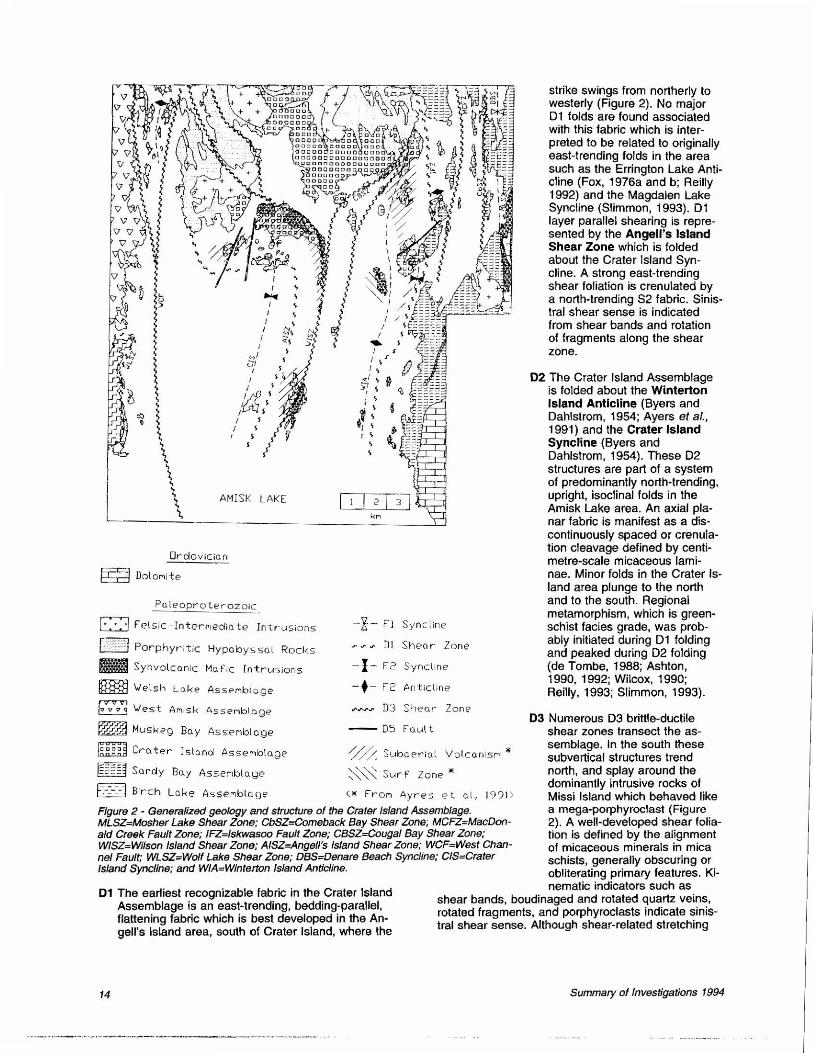
Figure 2 - Generalized geology and structure of the Crater Island Assemblage. MLSZ=Mosher Lake Shear Zone; CbSZ==Comeback Bay Shear Zone; MCFZ=MacDonald Creek Fault Zone; IFZ=lskwasoo Fault Zone; CBSZ==Cougal Bay Shear Zone; WISZ=Wilson Island Shear Zone; AISZ=Angell's Island Shear Zone; WCF=West Channel Fault; WLSZ=Wolf Lake Shear Zone; DBS=Denare Beach Syncline; CIS=Crater Island Sync/fne; and WIA=Wintetton /stand Anticline.
strike swings from northerly to westerly (Figure 2). No major D1 folds are found associated with this fabric which is interpreted to be related to originally east-trending folds in the area such as the Errington Lake Anticline (Fox, 1976a and b; Reilly 1992) and the Magdalen Lake Syncline (Slimmon, 1993). D1 layer parallel shearing is represented by the Angeli's Island Shear Zone which is folded about the Crater Island Syncline. A strong east-trending shear foliation is crenulated by a north-trending S2 fabric. Sinistral shear sense is indicated from shear bands and rotation of fragments along the shear zone.
02 The Crater Island Assemblage is folded about the Winterton Island Anticline (Byers and Dahlstrom, 1954; Ayers et al. , 1991) and the Crater Island Syncline (Byers and Dahlstrom, 1954). These D2 structures are part of a system of predominantly north-trending, upright, isoclinal folds in the Amisk Lake area. An axial planar fabric is manifest as a discontinuously spaced or crenulation cleavage defined by centimetre-scale micaceous laminae. Minor folds in the Crater Island area plunge to the north and to the south. Regional metamorphism, which is greenschist facies grade, was probably initiated during D1 folding and peaked during D2 folding (de Tombe, 1988; Ashton, 1990, 1992; Wilcox, 1990; Reilly, 1993; Slimmon, 1993).
03 Numerous D3 brittle-ductile shear zones transect the assemblage. In the south these subvertical structures trend north, and splay around the dominantly intrusive rocks of Missi Island which behaved like a mega-porphyroclast (Figure 2). A well-developed shear foliation is defined by the alignment of micaceous minerals in mica schists, generally obscuring or obliterating primary features. Ki-
01 The earliest recognizable fabric in the Crater Island Assemblage is an east-trending, bedding-parallel, flattening fabric which is best developed in the Angell's Island area, south of Crater Island, where the
nematic indicators such as shear bands, boudinaged and rotated quartz veins, rotated fragments, and porphyroclasts indicate sinistral shear sense. Although shear-related stretching
14 Summary of Investigations 1994

lineations are not well-developed, reverse-sinistral displacement has been documented along shear zones throughout the Amisk Lake area (Stauffer and Mukherjee, 1971 ; Wilcox, 1990; Reilly, 1993; Slimmon, 1993). Retrograde mineral assemblages composed of calcite±ankerite±chlorite±sericite±epidote are associated with the shear zones and represent post-peak of metamorphism.
Two 03 shear zones have been distinguished, namely, Wilson Island and Cougal Bay shear zones. Numerous smaller shears and splays are associated. The geometry of the shear zones has been described by Woodcock and Fischer (1986) as a positive (reverse faulted) flower structure. The shear zones may converge at depth into a single zone.
The Crater Island Assemblage is separated from the Sandy Bay Assemblage by the lskwasoo Fault Zone. This subvertical, north-trending structure extends form the Shield edge northward to Missi Island where it swings to the west. Deformation is dominantly brittle. The alignment of tectonic fragments parallel to a penetrative fabric suggests that brittle deformation may have pre-dated the 03 ductile deformation. Brittle-ductile shearing at Grant Bay, on the south shore of Missi Island, may represent reactivation along the lskwasoo Fault Zone.
04 The Embury Lake Antiform, an open east-northeasterly-trending, easterly plunging flexural fold designated as 04, (Stauffer and Mukherjee, 1971), passively folds the 03 brittle-ductile shear zones in the north Missi Island area (Wilcox, 1990; Reilly, 1993; Slimmon, 1993).
05 Late stage faulting is interpreted from strong negative topographic lineaments which transect the area and displace lithological contacts. These lineaments form a regional northeast and northwest conjugate fault set (Reilly, 1992, 1993).
3. Contact Relationships: A Summary
The Crater Island Assemblage is in contact with the Sandy Bay Assemblage along the lskwasoo Fault Zone. The contact is exposed near the base of the Crater Island Assemblage at lskwasoo Island where a distinct tectonic breccia separates aphyric pillowed basalts of the Sandy Bay Assemblage to the east from intercalated basaltic amygdaloidal pillowed flows and very thinly bedded tufts of the Crater Island Assemblage to the west. The breccia comprises poorly sorted basaltic fragments, averaging 30 x 1 O cm in size, in a highly carbonatized heteroltihic matrix of smaller angular fragments of chert, quartz, carbonate, and sediment. Deformation is dominantly brittle at the contact and along subsidiary faults in adjacent rocks of the Crater Island Assemblage.
The Crater Island Assemblage has a gradational stratigraphic contact with the overlying West Amisk Assemblage. Southwest of Crater Island, a unit of coarse
Saskatchewan Geological Survey
feldspar-phyric (trachytic) flows intercalated with heterolithic tuff breccias marks the transition from very thinly bedded basaltic tuft at the top of the Crater Island Assemblage to poorly sorted heterolithic andesitic tuft breccia at the base of the West Amisk Assemblage. This transitional unit roughly coincides with high-alumina basalts of Fox (1976a).
The Crater Island Assemblage and the poorly exposed Muskeg Bay Assemblage, which is located on the western mainland of Amisk Lake, are. composed of largely tholeiitic island arc basalts which exhibit a gradational contact with the overlying West Amisk Assemblage (Fox, 1976a and b; Walker and Watters, 1982; Watters and Ashton, 1991 ; Reilly, 1992). Stratigraphic correlation is impeded by lake cover and the West Channel Fault. Geochemical and isotopic studies which are in progress will improve our understanding of this relationship.
4. Mineralization Potential
a) Volcanogenic Massive Sulphide Mineraliza-tion
The application of whole-rock geochemistry to evaluating tectonic environments is a useful tool for mineral exploration (Fox 1976a and b; Swinden, 1991) and, as suggested by Syme and Bailes (1993), could be used profitably in the Flin Flon-Snow Lake greenstone belt.
Large Zn-rich massive sulphide (VMS) deposits occur in the Flin Flon region {Flin Flon and Callinan mines) where they are hosted by tholeiitic island arc assemblages, whereas small Cu-rich deposits (Coronation, Birch, and Flexar mines) are hosted by tholeiitic back arc-ocean floor-type assemblages (Thomas, 1990). In the Snow Lake region, all VMS deposits are hosted by a tholeiitic island arc assemblage (Bailes, 1988). The Crater Island Assemblage has a largely tholeiitic island arc tectonic setting (Fox, 1976a and b).
Other factors controlling VMS mineralization on a more detailed scale must be considered:
1) Firstly, VMS deposits typically, if not exclusively, occur within submarine volcanic environments (Lydon, 1984). As was first suggested by Ayres (1978), the subaerial sequences of the Crater Island Assemblage may be poor exploration targets for such deposits.
2) Secondly, the best documented VMS deposits within island arc assemblages occur at major stratigraphic and compositional breaks in the volcanic sequence, which are commonly marked by felsic volcanic units (Syme and Bailes, 1993). No felsic volcanic rocks have been recognized in the Crater Island Assemblage to date.
3) Thirdly, Syme and Bailes (1993) also note that most VMS deposits are associated with coarse volcaniclastic rocks in the stratigraphic footwall. Volcaniclastic rocks of the Crater Island Assemblage are chlefly
15

tuff and fine lapilli tuft units, and coarser volcaniclastic rocks such as tuft breccias are rare.
In summary, the Crater Island Assemblage was deposited in a tectonic environment similar to the large Znrich VMS deposits, such as the Flin Flon mine in the Flin Ron-Snow Lake greenstone belt. Detailed characteristics of the Crater Island Assemblage, however, reveal features which are inconsistent with this type of VMS deposit, as may be borne out by the lack of known VMS deposits in the Crater Island Assemblage.
b) Gold Mineralization
Two types of gold mineralization are documented in the Amisk Lake area:
1) The Laural Lake Au-Ag deposit, situated in the northwest part of Missi Island, is an epithermal-type deposit hosted by felsic volcanic rocks (Ansdell and Kyser, 1991; Harper, 1993). Mineralization predates regional metamorphism and the major deformation events in the Amisk Lake area.
2) The majority of gold occurrences in the region, including the Graham, Monarch-Prince Albert, and Black Diamond deposits, are mesothermal deposits hosted by 03 brittle-ductile shear zones, such as the West Channel Fault (Ansdell and Kyser, 1992; Reilly, 1992, 1993). Some of the shear-zone hosted deposits may represent remobilization of early mineralization (Reilly, 1993; Harper, 1993). To date, several gold showings have been found in the Crater Island Assemblage. Recognition of major shear zones and subsidiary splays serve as exploration targets for structurally controlled mineralization. The flower structure geometry of these structures and the possibility of convergence to a larger single shear zone at depth may enhance the potential for gold mineralization.
5. Acknowledgments Field and office assistance was provided by Cliff Revering. Field visits by Richard Stern, Steve Lucas, and Dave Thomas proved helpful. An early version of this manuscript was critically reviewed by Bob Macdonald and Ken Ashton.
6. References Ansdell, K.M. and Kyser T.K. (1991): The geochemistry and
fluid history of the Proterozoic Laurel Lake Au-Ag deposit, Flin Flon greenstone belt; Can. J. Earth Sci., v28, p155-171.
____ (1992): Mesothermal Gold Mineralization in a Proterozoic Greenstone Belt: Western Flin Flon Domain, Sas· katchewan, Canada; Econ. Geol. , v87, p1496-1524.
Ashton, K.E. (1990): Geology of the Snake Rapids area, Flin Flon Domain (parts of NTS 63L-9 and -10); in Summary of Investigations 1990, Saskatchewan Geological Survey, Sask. Energy Mines, Misc. Rep. 90-4, p4-12.
16
_ _ _ _ (1992): Geology of the Snake Rapids area: Update; in Summary of Investigations 1992, Saskatchewan Geological Survey, Sask. Energy Mines, Misc. Rep. 92-4, p97·113.
Ayres, LO. (1978): A transition from subaqueous to subaerial eruptive environments in the middle Precambrian Amisk Group at Amisk Lake, Saskatchewan-Progress report; Cent. Pree. Stud., 1978 Annual Rep., Univ. Man., p36-51 .
_ _ _ _ (1980a): Preliminary stratigraphic investigation of the upper felsic-intermediate component of the Early Proterozoic Amisk Group, Amisk Lake, Saskatchewan; Cent. Pree. Stud., 1980 Annual Rep., Univ. Man., p36·46.
_ _ _ _ (1980b): Volcanology research; Cent. Pree. Stud., 1980 Annual Rep., Univ. Man., p29-35.
_ ___ (1981): A subaqueous to subaerial transition zone in the early Proterozoic metavolcanic sequence, Amisk Lake, Saskatchewan; Cent. Pree. Stud., 1981 Annual Rep., Univ. Man., p49-61 .
Ayres, LD., Van Wagoner, N.A., and Ferreira, W .S. (1991): Voluminous shallow-water to emergent phreatomagmatic basaltic volcaniclastic rocks, Proterozoic (=1886 Ma) Amisk Lake composite volcano, Flin Ron greenstone belt, Canada; in Sedimentation in Volcanic Settings, SEPM Spec. Publ. No. 45, p175·187.
Ayres, LO., Van Wagoner, N.A., and Van Wagoner S. (1981): Physical volcanology of the Amisk Lake volcano; in Summary of Investigations 1981, Saskatchewan Geological Survey, Sask. Miner. Resour., Misc. Rep. 81·4, p47·51.
Bailes, A.H. (1988): Chisel-Morgan lakes project; in Report of Field Activities, 1988, Man. Energy Mines, Min. Div., p53· 61.
Byers, A.A. and Dahlstrom, C.D.A. (1954): Geology and min· eral deposits of the Amisk-Wildnest lakes area, 63L-9, 63L-16, Saskatchewan; Sask. Dep. Miner. Resour., Rep. 14, 177p.
de Tombe, J. (1988): The metamorphic stability fields of the Welsh Lake Area in east-central Saskatchewan; unpubl. B.Sc. thesis, Queen's Univ., 46p.
Ferreira, W.S. (1981 ): An example of a volcanic subaerial and surf environment in the middle Precambrian Amisk Group at Amisk Lake, Saskatchewan-A progress report; Cent. Pree. Stud., 1981 Annual Rep., Univ. Man., p47-59.
_ _ __ (1984): A physical comparison of subaerial and subaqueous eruptive environments in the Proterozoic Amisk Group, Saskatchewan, Canada: unpubl. M.Sc. thesis, Univ. Man., 199p.
Fox, J.S. (1976a): Some comments on volcanic stratigraphy and economic potential of the West Amisk Lake area, Saskatchewan; Sask. Resear. Coun., Circ. 9, 30p.
____ (1976b): Volcanic stratigraphy and mineralization in the Amisk Group; Geol. Assoc. Can./Min. Assoc. Can., Jt. Annu. Meet., Edmonton, Prog. Abstr., v1, p72.
Gaskarth, J.W. and Parslow, G.R. (1987): Proterozoic volcanism in the Flin Flon greenstone belt, east-central Saskatchewan, Canada; Geol. Soc., Spec. Publ. 33, p183-200.
Harper, C.T. (1993): Intrusive and extrusive rocks of the western part of Missi Island, Amisk Lake; In Summary of lnvesti· gations 1993, Saskatchewan Geological Survey, Sask. Energy Mines, Misc. Rep. 93·4, p30-39.
Summary of Investigations 1994

Heaman, L.M., Ashton, K.E., Reilly, B.A., Sibbald, T.1.1., Slimmon. W.L., and Thomas, D.J. (1993): 1992-1993 U-Pb geochronological investigations in the Trans-Hudson Orogen, Saskatchewan; in Summary of Investigations 1993, Saskatchewan Geological Survey, Sask. Energy Mines, Misc. Rep. 93-4, p109-111.
Lydon, J.W. (1984): Volcanogenic massive sulphide deposits Part 1: A descriptive model; Geosci. Can., v11, p195-202.
Parslow, G.R. and Gaskarth, J.W. (1984): Geochemistry of the east Amisk area; Sask. Energy Mines, Open File Rep. 84· 23, 156p.
___ _ _ (1988): Proterozoic rocks of east-central Sask· atchewan: Geochemistry, structure, and mineralization controls; in Summary of Investigations 1988, Saskatchewan Geological Survey, Sask. Energy Mines, Misc. Rep. 88·4, p127-139.
Reilly, B.A. (1992): Revision bedrock geological mapping, Neagle Lake-Errington Lake area (parts of NTS 63L·9 and -16); in Summary of Investigations 1992, Saskatchewan Geological Survey, Sask. Energy Mines, Misc. Rep. 92-4, p16-22.
___ _ {1993): Revision bedrock geological mapping of the northwest Amisk Lake area (parts of NTS 63L-9 and -16); in Summary of Investigations 1993, Saskatchewan Geological Survey, Sask. Energy Mines, Misc. Rep. 93-4, p12·20.
Reilly, B.A., Slimmon, W.L., Harper, C.T., Ashton, K.E., Heaman, L.M., and Watters, B.R. (in press): Contrasting lithotectonic assemblages from the western Flin Aon Do· main; LITHOPROBE, Trans-Hudson Orogen Transect Report.
Slimmon, W.L. (1991a): Revision bedrock geological mapping, Table Lake area (part of NTS 63L·9); in Summary of Investigations 1991, Saskatchewan Geological Survey, Sask. Energy Mines, Misc. Rep. 91-4, p16·20.
_ _ _ _ (1991b): Revision bedrock geological mapping, Table Lake area (part of NTS 63L-9); with Summary of In· vestigations 1991, Saskatchewan Geological Survey, Sask. Energy Mines, Misc . Rep. 91-4, preliminary map at 1:12 500 scale.
_ _ __ (1993): Bedrock geological mapping of the Comeback Bay area, Amisk Lake (part of NTS 63L·9 and -16); in Summary of Investigations 1993, Saskatchewan Geological Survey, Sask. Energy Mines, Misc. Rep. 93-4, p21-29.
Stauffer, M.A. and Mukherjee, A.C. (1971): Superimposed de· formations ;n the Missi metasedimentary rocks near Flin Flon, Manitoba; Can. J. Earth Sci., v12, p2012·2035.
Stem, A.A. and Lucas, S.B. (in press): U-Pb zircon age constraints on the early tectonic history of the Flin Flon accretionary collage, Saskatchewan; in Radiogenic Age and Isotopic Studies: Report 8, Geol. Surv. Can., Pap. 94-2.
Saskatchewan Geological Survey
Stern, A.A., Syme, E.C. , and Lucas, S.B. (in press a): MOAB· and OJB-like volcanism in the Flin Aon Belt, Canada: Tapping heterogeneities in the 1 .9 Ga sub-oceanic mantle; Geochem. Cosmochim. Acta.
Stem, A.A., Syme, E.C., and Bailes, A.H. (in press b): Paleoproterozic (1.90 to 1.86 Ga) volcanism in the Flin Flon Belt, Trans-Hudson Orogen, Canada; Contrib. Mineral. Pet· rot.
Swinden, H.S. (1991 ): Paleotectonic settings of volcanogenic massive sulphide deposits in the Dunnage zone, Newfoundland Appalachians; Can. Min. Met. Bull., v83, no934, p59-69.
Syme, E.C. and Bailes, A.H. (1993): Stratigraphic and tectonic setting of Early Proterozoic volcanogenic massive sulphide deposits, Flin Flon, Manitoba; Econ. Geol., vaa, p566-589.
Thomas, D.J. (1990): New perspectives of the Amisk Group and regional metallogeny, Douglas Lake-Phantom Lake area; in Summary of Investigations 1990, Saskatchewan Geological Survey, Sask. Energy Mines, Misc. Rep. 90-4, p13-20.
Van Wagoner, N., Moon, N., Ayres, L.D., Tange, R., and Carswell, A. (1982): Preliminary results of rheological model· ing of a Proterozoic volcano and Earth; Cent. Pree. Stud., 1982 Annual Rep., Univ. Man. , p128·150.
Van Wagoner, N. and Van Wagoner, S. (1987): Shallow water volcanism and sedimentation in a portion of the Flin FlonSnow Lake greenstone belt: A preliminary report; Cent. Pree. Stud., 1987 Annual Rep., Univ. Man., p71 ·88.
Van Wagoner, S. ( 1982): A probable storm-generated turbidite association-Proterozoic Flin Flon-Snow Lake greenstone belt; Cent. Pree. Stud., 1982 Annual Rep., Univ. Man., p115-127.
Walker. D. and Watters. B.R. (1982): Geochemistry of metavol· canic rocks, Amisk Lake West area; in Summary of lnvesti· gations 1982, Saskatchewan Geological Survey, Sask. Energy Mines, Misc. Rep. 82-4, p24-30.
Watters, B.R. and Ashton, K.E. (1991): Geochemistry and tectonic setting of metabasaltic rocks from the Snake Rapids area, Flin Fion Domain; in Summary of Investigations 1991 , Saskatchewan Geological Survey, Sask. Energy Mines, Misc. Rep. 91-4, p130-134.
Watters, B.R., Dostal, J., Slimmon, W.L., and Thomas, D.J. (in press): Geochemistry, petrogenesis, and tectonic setting of Early Proterozoic volcanic rocks of the Flin Flon Domain, Saskatchewan {Canada) Oceanic back-arc volcanism; N. Jb. Miner. Mh.
Wilcox, K.H. (1990): Geology of the Amisk-Welsh lakes area, Saskatchewan; unpubl. M.Sc. thesis, Univ. Calgary, 245p.
Woodcock, N.H. and Fischer, M. (1 986): Strike-slip duplexes; J. Struc. Geol., vs. no7, p725-735.
17

Recommended