The Bukit Tigapuluh Ecosystem
Conservation Implementation Plan

The Bukit Tigapuluh Conservation Implementation Plan
May 2009
In collaboration between:
Bukit Tigapuluh National Park and Frankfurt Zoological Society
Editors: Arnold Sitompul and Dr. Peter Pratje
Contributors: Ibram Eddy Chandra, Hisan Hasibuan, Johny Santoso
Maps and GIS: Hisan Hasibuan and Paska Iswanto
Photos credits: N. Guthier (Page 11, 23, 31, 43, 83, 139); Peter Pratje (Cover page, Page 31, 73) Perry van Duijnhoven (Page 59); James Godwin/ZSL (Page 47);Y. Hadiprakarsa (Page 1).


The Conservation Implementation Plan of Bukit Tigapuluh Ecosystem has been developed through participatory planning process and support from Directorate General Forest Protection and Nature Conservation, Bukit Tigapuluh National Park
Funding for the planning process and developing The Conservation Implementation Plan of Bukit Tigapuluh Ecosystem is provide by the Federal Ministry and Economic Cooperation and Development
Technical support for the planning process and developing The Conservation Implementation Plan of Bukit Tigapuluh Ecosystem is provided by the Frankfurt Zoological Society


THIS DOCUMENT IS PRODUCED IN COLLABORATION WITH:
Second Level District Government Institutions
Tebo District Tanjabar District INHIL District INHU District
And
Non Government Conservation Organisations


i
FOREWORD
The Bukit Tigapuluh Ecosystem is considered as a one of the “storage” areas for natural resources and biodiversity, which has a strategic function and high potential to support sustainable development in Riau Province. The area is known for its high biodiversitywhich plays a critical role in supporting human livelihoods and has a strategic function to reduce global warming. Due to the important role of the Bukit Tigapuluh Ecosystem this area is a priority for conservation and urgently needs to be protected. In this regard, we believe the compilation of The Bukit Tigapuluh Ecosystem Conservation Implementation Plan is a significant effort to protect The Bukit Tigapuluh Ecosystem.
We fully support the aim of The Bukit Tigapuluh Ecosystem Conservation Implementation Plan. The collaborative effort from various key stakeholders and participatory process during the compilation of the document has shown that we all care for and support the new paradigm of sustainable forest management. We hope this document will be used as the guidelines for any development activities planned in the Bukit Tigapuluh Ecosystem.
Finally, I would like to express my thanks to all parties who have been actively involved during the compilation process. We hope this document is useful for everyone and will be used to support the conservation of natural resources in Riau Province.
Head of Riau Province Natural Resource and Conservation Agency

ii

iii
FOREWORD
We thank to God for his blessing that we could manage to complete the “The Bukit Tigapuluh Ecosystem Conservation Implementation Plan” document in a collaborative way. This document compiles all the important commitments from various key stakeholders in the form of a “collaborative agenda” to protect and manage the Bukit Tigapuluh Ecosystem in a sustainable way. The Bukit Tigapuluh Ecosystem comprises of the Bukit Tigapuluh National Park at its core and extends into the surrounding high biodiversity forests. These two adjoining forest fragments are considered as undividable parts of an intact ecosystem that needs to be protected as one of the most important tropical rainforests in Sumatra.
The concept we intend to emphasise in this document is “Forestry is the Mother of Sustainable Development” and we also advise that forest is not an area that can be used for any further kind of development. In this document we offer the concept of “Commercial Conservation Area Management” for Production Forest Areas. This concept can act as “Conservation Investment Guidelines” for the Jambi province that may be used by all parties supporting conservation and biodiversity in Jambi and for development actors to manage natural resources in a sustainable way.
Head of Jambi Natural Resource and Conservation Agency

iv

v
GENERAL SUMMARY
The Bukit Tigapuluh Ecosystem Conservation Implementation Plan is an activity planned, prepared and endorsed by all stakeholders involved in the Bukit Tigapuluh ecosystem area. In its preparation, this document referred to the 2006 Bukit Tigapuluh National Park action plan and conservation strategy documents, later revised and updated to reflect the present conditions. The document was endorsed by all stakeholders to be used as the basis of conservation development in the Bukit Tigapuluh ecosystem area.
In the preparation of this document, a series of workshops and initial data collections were performed by the Core Planning Team. An open and participatory collaborative approach to all stakeholders was taken to obtain the optimum result in its preparation. The directly and indirectly involved stakeholders include: Governmental Institutions: the Bukit Tigapuluh National Park Agency, the Riau Provincial Natural Resource Conservation Center (BBKSDA-Riau), the Jambi Provincial Natural Resource Conservation Agency (BKSDA Jambi), the Jambi Provincial First-Level Forestry Service, the Tebo District Second-Level Forestry Service, the Tanjung Jabung Barat District Second-Level Forestry Service, the Indragiri Hulu District Second-Level Forestry Service, the Indragiri Hilir District Second-Level Forestry Service, the Tebo Second-Level District Government, the Tanjabar Second-Level District Government, the Indragiri Hulu Second-Level District Government, the Indragiri Hilir Second-Level District Government, Non-Government Conservation Organisations: the Frankfurt Zoological Society, the WWF-Indonesia Foundation, the Indonesian Conservation Community-WARSI (KKI-WARSI), the Zoological Society of London (ZSL), the Sumateran Tiger Rescue and Conservation Foundation (PKHS). Primary Interaction Village Communities: the Primary Interaction Villages represented by the communities of Lubuk Kambing Village, Suo-Suo Village, Semabu Village, Pemayungan Village, Datai Village and Sanglap Village. Industrial Companies: APRIL Group and APP/Sinar Mas Group. The planning process to develop the document was carried out as an active and participative mult-stakeholder approache The purpose of the participative planning process was to provide all stakeholders with as many opportunities as possible to contribute to the management plan during the planning process in a realistic, appropriate and synergistic manner.
The creation stage of the Bukit Tigapuluh Ecosystem conservation implementation plan was carried out with the formation of a Core Planning Team, followed by an intensive information gathering period and consultation with stakeholders that led to the preparation of a Resource Base Inventory (RBI/ISD) report. From the result of this Resource Base Inventory, four key topics were determined: 1) Ecology and Conservation, 2) Natural Resource Protection, 3) Land Use Planning, 4) Sustainable Natural Resource Utilisation and Community Development. These four topics were then discussed in a series of workshops from August 2008 to March 2009. The outcome of each workshop was later compiled and tabulated in a five-year (2010-2015) action plan matrix for the implementation of Bukit Tigapuluh ecosystem conservation.
The five-year action plan to implement conservation in the Bukit Tigapuluh ecosystem is laid out in the action plan matrix which was prepared in detail, based on the four key topics endorsed by the stakeholders. The matrix specifies the management targets to be achieved, the forms of action to be taken to achieve conservation, success indicators, participating institutions and action coordinators including an execution time frame. Each planning target is broken down into annual activities.
The final part of this document contains a draft for monitoring the progress of the conservation implementation plan. This monitoring work draft was prepared in such a way as to serve as a reference to guide the implementation of each action. The substance of the action plan monitoring draft is the annual achievements of each measured activity. The monitoring of the Bukit Tigapuluh ecosystem conservation implementation plan contains the key to the success of the conservation implementation plan as a whole.

vi
Finally, the Bukit Tigapuluh ecosystem conservation implementation plan is expected to become a living document that can be revised and improved from time to time in keeping up with the stakeholders’ needs, so that the optimisation of the conservation activity in the Bukit Tigapuluh ecosystem area can proceed in line with the national and local land use plan.

vii
TABLE OF CONTENT
Foreword from Head of Riau Province Natural Resource and Conservation Agency .... i
Foreword from Head of Jambi Natural Resource and Conservation Agency ................. iii
General Summary .......................................................................................................... v
Table of Contents............................................................................................................ vii
List of Tables ................................................................................................................... xi
List of Figures ................................................................................................................. xi
List of Appendices ......................................................................................................... xiv
Acronyms........................................................................................................................ xv
CHAPTER I. INTRODUCTION ...................................................................................... 1
Background ......................................................................................................... 3
The Objective of the Implementation Plan ......................................................... 4
The Bukit Tigapuluh Ecosystem ......................................................................... 4
The Bukit Tigapuluh Ecosystem Conservation Vision......................................... 6
The Bukit Tigapuluh Ecosystem Conservation Mission ...................................... 6
Participation ........................................................................................................ 6
Process ............................................................................................................... 7
CHAPTER II. GENERAL DESCRIPTION OF THE BUKIT TIGAPULUH ECOSYSTEM ................................................................................................................. 11
Fauna and Flora in the Bukit Tigapuluh Ecosystem ........................................... 13
Flora .................................................................................................................... 13
Fauna .................................................................................................................. 13
Distribution and Population of Key Species in Bukit Tigapuluh Ecosystem ........ 14
Distribution of Key Species ................................................................................. 14
Population of Key Species .................................................................................. 15
Key Species Distribution and Topography of Bukit Tigapuluh Ecosystem .......... 19
Indigenous Community in Bukit Tigapuluh Ecosystem ....................................... 19
Talang Mamak Tribe ........................................................................................... 20
Old Malay Tribe ................................................................................................... 20
Kubu / Orang Rimba Tribe .................................................................................. 21
Rationalisation of Bukit Tigapuluh National Park ................................................ 21

viii
CHAPTER III. ALTERNATIVE MANAGEMENT OF BUKIT TIGAPULUH ECOSYSTEM ........................................................................................... 23
Conservation Area .............................................................................................. 25
Colaborative Management .................................................................................. 26
Ecosystem Restoration Concept ........................................................................ 26
The HCVF-based Management Mechanism ...................................................... 27
The Man and the Biosphere Programme ............................................................ 29
CHAPTER IV. IMPORTANT AREAS INSIDE THE BUKIT TIGAPULUH ECOSYSTEM ................................................................................................................ 31
Puntianai Forest Block ...................................................................................... 33
Forest Areas of Ex. Concession of PT. Indonesie Forest et Asiatique (IFA), Pasir Mayang Block ............................................................................................ 35
Forest Areas of Ex. Concession PT. Dalek Hutani Esa (DHE) .......................... 37
Forest Areas of Ex. Concession PT. Hatma Hutani ........................................... 38
CHAPTER V. BUKIT TIGAPULUH ECOSYSTEM CONSERVATION IMPLEMENTATION PLAN ............................................................................................. 41
Mechanism ..................................................................................................................... 43
CHAPTER VI. ECOLOGY AND CONSERVATION IMPLEMENTATION PLAN ............ 45
Bukit Tigapuluh ecosystem delineation1. ....................................................... 47
Key areas prioritised for conservation of Bukit Tigapuluh ecosystem2. ......... 47
Important areas for the conservation of key species (Tigers, Elephants, 3. Orangutans and Malay Tapirs) .................................................................... 47
Identifying the impact of deforestation on wildlife and key species4. ............. 48
Key species monitoring and habitat restoration5. .......................................... 48
Sumatran Elephant ................................................................................. 48
Sumatran Tiger ........................................................................................ 49
Sumatran Orangutan ............................................................................... 49
Tapir ........................................................................................................ 49
Management of Human-Wildlife Conflicts6. ................................................... 49
Objective 1: Key Species Population and Viable Habitat Protection ............................ 50
Target 1.1. Key species distribution and habitat maps ...................................... 50
Target 1.2. The key species populations measured........................................... 51
Target 1.3 A wildlife corridor between BTNP and Bukit Batabuh/ Bukit Sosa Forest (west of BTNP) established ............................................................ 52
Target 1.4. The rationalisation of BTNP on realistic areas continued ................ 52

ix
Objective 2: High Conservation Value Forest (HCVF) areas in the EB30 identified and mapped.................................................................................................................... 53
Target 2.1. HCVF areas within the EB30 mapped ............................................. 53
Objective 3: High conservation value forests maintained .............................................. 53
Target 3.1. HCVF areas accommodated within company concessions ............. 54
Target 3.2. Participation of concession rights-holders in conserving HCVF areas independently. ........................................................................................... 54
Target 3.3. Integrated assistance to HCVF management implemented ............ 54
CHAPTER VII. NATURAL RESOURCE PROTECTION IMPLEMENTATION PLAN ... 57
Objective 1: Illegal logging practices in EB30 totally stopped ........................................ 59
Target 1.1. All access roads into the EB30 areas strictly monitored .................. 60
Target 1.2. Law enforcement against illegal logging activities .......................... 62
Target 1.3. Comprehension of forest crimes among law enforcement officers significantly improved ......................................................................................... 63
Target 1.4. Address the gap between timber supply and timber demand .......... 63
Objective 2: Human and Wildlife Conflicts Mitigation ..................................................... 64
Target 2.1. Human-Wildlife conflicts mitigated according to up-to-date protocols ............................................................................................................. 64
Target 2.2. Human and wildlife conflicts minimised ........................................... 65
Target 2.3. Conflict mitigation funds at the local level (Provinces and districts) available ............................................................................................... 65
Objective 3: Poaching of protected species totally stopped ...................................... 66
Target 3.1. Dissemination of information on protected species ......................... 66
Target 3.2. Poaching and illegal trading activities of protected species monitored. ........................................................................................................... 66
Target 3.3. Law enforcement against poaching activities implemented ............. 67
Target 3.4. The use of both organic and homemade firearms strictly controlled. .......................................................................................................... 68
Objective 4: Forest Fires in the EB30 controlled ........................................................... 68
Target 4.1. Awareness programme for communities inside and around the EB30’s not using fire (zero burning) for land clearing ......................................... 68
Target 4.2. Areas vulnerable to forest fire identified ........................................... 69
Target 4.3. Information system among forest fire sectors optimised ................. 71
Target 4.4. Forest-fire early warnings system established ................................. 71

x
Target 4.5. Early mitigation of forest fire implemented ....................................... 71
Target 4.6. Trained human resources to mitigate forest fires adequately available. ............................................................................................................. 71
CHAPTER VIII. LAND USE PLANNING IMPLEMENTATION PLAN ............................ 73
Objective 1: Illegal forest encroachment in the Tebo, Tanjabar, Inhu, and Inhil Districts halted ........................................................................................................ 75
Target 1.1. A database on forest coverage statistics compiled .......................... 76
Target 1.2. Clear delineation of forest area boundaries materialised ................ 76
Target 1.3. Community land-use regulations established .................................. 77
Target 1.4. EB30 accommodated in the Spatial Planning for Sumatra .............. 77
Target 1.5. Execute law enforcement against forest encroachment .................. 78
Target 1.6. Rehabilitation and restoration of forests areas realised ................... 78
CHAPTER IX. SUSTAINABLE NATURAL RESOURCE MANAGEMENT AND COMMUNITY DEVELOPMENT IMPLEMENTATION PLAN ......................................... 81
Objective 1: Decrease dependence of traditional communities in BTNP on forest resources ........................................................................................................................ 84
Target 1.1. Improve capacity of traditional communities on intensified land cultivation methods ............................................................................................. 84
Target 1.2. Maximise agricultural products of traditional communities in a sustainable manner ............................................................................................ 84
Target 1.3. Local and traditional law relevant to natural resources conservation empowered .................................................................................... 85
Target 1.4. Develop ecological and cultural tourism as non-agricultural income sources for traditional communities ........................................................ 86
Target 1.5. Working capital and profitable markets for local community accessible ........................................................................................................... 87
Target 1.6. Competitive education for the young generations of traditional community accessible ......................................................................................... 87
Target 1.7. Healthcare for traditional communities accessible ........................... 87
Objective 2: Decrease dependence of communities outside the BTNP (Main interaction Village /MIV) on forest resources .................................................................. 88
Target 2.1. Capability of MIV community on land intensification method improved ............................................................................................................. 88
Target 2.2. Agricultural products of local communities continue to increase. .... 88
Target 2.3. Local cultural values and norms relevant to natural resources conservation empowered .................................................................................... 89
Target 2.4. Capital and profitable markets for community made accessible ...... 90
Target 2.5. Non-agricultural job opportunities available ..................................... 90

xi
LIST OF TABLES
Table 1. Communication Strategy for the Bukit Tigapuluh Ecosystem Conservation Implementation Planning Process ...................................................................... 6
Table 2. Size of ex-HPH concessions in the EB30 and forest coverage based on satellite images analysis in January 2009 (Figures 15, 17, 19, and 21) ........... 33
xii
LIST OF FIGURES
Figure 1 : The Bukit Tigapuluh Ecosystem Area is a delineation and expansion of Bukit Tigapuluh National Park in the surrounding forest area ...................... 5
Figure 2 : Ilustration of the Involvement of Stakeholders in forming the Bukit Tigapuluh Ecosystem Conservation Implementation Planning Team .......... 7
Figure 3 : Framework and Compilation Process of the Bukit Tigapuluh Ecosystem Conservation Implementation Document .................................. 8
Figure 4 : Sumatran tiger distribution in the Bukit Tigapuluh Ecosystem area ........... 15
Figure 5 : Sumatran elephant distribution in the Bukit Tigapuluh Ecosystem area ......................................................................................... 16
Figure 6 : Sumatran Orangutan distribution in the Bukit Tigapuluh Ecosystem area ......................................................................................... 16
Figure 7 : Malayan Tapir distribution in the Bukit Tigapuluh Ecosystem Area ............ 17
Figure 8 : Photo of a Sumatran tiger taken by a ZSL-FZS survey team with a camera trap in the Bukit Tigapuluh Ecosystem ....................................... 17
Figure 9 : A herd of Sumatran elephants photographed by a camera trap in the Bukit Tigapuluh Ecosystem by a ZSL-FZS survey team ...................... 18
Figure 10 : Sumatran orangutan reintroduced in the Bukit Tigapuluh Ecosystem area ......................................................................................... 18
Figure 11 : A Malayan tapir photographed by a camera trap in the Bukit Tigapuluh Ecosystem by ZSL-FZS survey team. ........................................................ 19
Figure 12 : Key species distribution and topography of Bukit Tigapuluh Ecosystem ... 20
Figure 13 : A part of the TNBT Rationalisation Area as proposed by KKI-WARSI ....... 22
Figure 14 : Areas of ex-logging concessions located in EB30 ..................................... 33
Figure 15 : PT. Asia Pulp and Paper (APP)’s concession area in the Puntianai Forest Block ............................................................................................... 34
Figure 16 : Comparison of forested and non-forested areas in the Puntianai Block based on satellite images interpretation (January 2009). .......................... 35
Figure 17 : The ex- concession of PT. IFA in the Bukit Tigapuluh ecosystem .............. 36
Figure 18 : Comparison of forest coverage and non-forest coverage in ex- concession area of PT.IFA in the EB30; based on satellite images interpretation (January 2009). .......................................................................................... 36
Figure 19 : Ex- concession areas of PT. Dalek Hutani Esa in the Bukit Tigapuluh Ecosystem .................................................................................................. 37
Figure 20 : Comparison of forest coverage and non-forest coverage in ex- concession area of PT. DHE in the EB30; based on satellite images interpretation (January 2009). .................................................................... 38
Figure 21 : Ex-concession areas of PT. Hatma Hutani in EB30 ................................... 39
Figure 22 : Comparison of forest coverage and non-forest coverage in ex- concession area of PT. Hatma Hutani in the EB30; based on satellite images interpretation (January 2009) ..................................................................... 39
Figure 23 : Illustration of the conservation target achievement mechanism through several objectives. ...................................................................................... 43

xiii
Figure 24 : Forest covers change in, 2007-2009. (The identified area size of the forest cover change for 2007-2009 is 49.546 ha) ................................ 59
Figure 25 : Road corridor developed by PT. Wira Karya Sakti (APP/Sinar Mas Group) in the southern part of EB30 (red line). This road development poses a major threat to EB30’s integrity .................................................................. 60
Figure 26 : Distribution map of area vulnerable for deforestation areas (encroachment, forest fire and illegal logging) in the EB30 area ............... 61
Figure 27 : Location for the planned construction of guard posts and forest areas signs around the EB30 ............................................................................... 61
Figure 28 : Map of human-elephant conflict locations in 2006-2008 around EB30 ...... 64
Figure 29 : Several locations in EB30 where poaching on endangered species were detected during 2006-2008 ........................................................................ 67
Figure 30 : Hot spot locations during the period of 2006-2008 in Bukit Tigapuluh Ecosystem .................................................................................................. 70

xiv
LIST OF APPENDICES
Appendix 1: Reference .................................................................................................145
Appendix 2: List of participants..................................................................................... 147

xv
ACRONYMS
APL : Area for non forestry purposes
APP : Asian Pulp and Paper
CITES : Convention on International Trade of Endangered Fauna and Flora
DAS : Riverine Area
DAMKARHUT : Forest Fire Mitigation Unit
DHE : Dalek Hutani Esa
DIU : Main Interaction Village
EB30 : Bukit Tigapuluh Ecosystem
FZS : Frankfurt Zoological Society
HCVF : High Conservation Value Forest
HHNK : Non-Forest Product
HL : Protected Forest
HPH : Logging Consession Licence
HPT : Limited Production Forest
HTI : Industrial Plantation Forest
IBSAP : Indonesian Biodiversity Strategy and Action Plan
IFA : Indonesie Forest et Asiatique
IK-EB30 : Bukit Tigapuluh Ecosystem Conservation Implementation Plan
INHIL : Indragiri Hilir
INHU : Indragiri Hulu
IUCN : The World Conservation Union
IUPHHK : Timber Extraction Permit from Natural Forest
IUPHHK-HT : Timber Extraction Permit from Industrial Forest
KKI-WARSI : Indonesian Conservation Community WARSI
LANDSAT TM : Land Satellite Thematic Mapper
MENHUT : Ministry of Forestry
MPA : Fire Aware Community Group
NORINDRA : Norwegian - Indonesian Rainforest and Resource Management Project
PAMHUTSWAKARSA : Forest Protection Unit
PHKA : Department of Forest Protection and Natural Conservation
PKHS : Sumatran Tiger Protection and Conservation Foundation
PPNS : Civil Servant Investigation Staff
POLRI : Indonesia Police Department
RAPP : Riau Andalan Pulp and Paper
RAU : Regunas Agri Utama
RBI : Resource Base Inventory
RePPPROT : Regional Planning Programme for Transmigration

xvi
RPTN : National Park Management Plan
RPBI : Industrial Supply and Production Plan
RTRW : Regional Land Use Planning
SATKORLAK : Implementation Coordination Unit
SDA : Natural Resource
SITU : Commpany Licenses
SIUP : Trade Licenses
SK : Decision Letter
SKAU : Timber Source Licence
SMART : Forest Fire Combat Unit
SPTN : National Park Management Unit
TANJABAR : Tanjung Jabung Barat
TGHK : Forest Use Agreement
TNBT : Bukit Tigapuluh National Park
UPT : Techincal Implementation Unit
UNESCO : United Nations Educational Scientific and Cultural Organisation
WKS : Wira Karya Sakti
WPU : Wildlife Protection Unit
WWF : World Wide Fund for Nature
ZSL : Zoological Society of London

1
INTRODUCTION


3
1. Introduction
Background
The Bukit Tigapuluh Ecosystem (EB30) is one of the important conservation areas in Sumatra with a strategic function to support sustainable conservation. The Bukit Tigapuluh National Park (BTNP) is located in the core area of this ecosystem and surrounded by a buffer zone with forests of high conservation value. The forest in the BTNP area and its buffer zone constitute an integral system with a direct impact on the integrity of the ecosystem as a whole.
The Bukit Tigapuluh Ecosystem area is an important habitat for four key species namely the Sumatran tiger, the Sumatran elephant, the Sumatran orangutan and Malayan Tapir. Therefore, the conservation of the Bukit Tigapuluh Ecosystem plays an important role in the conservation of these four key species. The Bukit Tigapuluh Ecosystem is the only orangutan re-introduction area in Sumatra and the largest orangutan habitat outside the Leuser Ecosystem. The Bukit Tigapuluh Ecosystem is also an important habitat for the Sumatran elephant and the Sumatran tiger. The Sumatran elephant and the Sumatran tiger population in the Bukit Tigapuluh Ecosystem are one of the most important populations in the whole Sumatra. Considering the uniqueness of the Bukit Tigapuluh vegetation, the Bukit Tigapuluh Ecosystem is characterised as hilly lowland forest geographical separate from the Bukit Barisan mountain chain in Sumatra. Due to its geographical isolation the Bukit Tigapuluh Ecosystem has a unique type of vegetation.
In spite of the high biodiversity value of the Bukit Tigapuluh Ecosystem, a comprehensive management for this area has not been developed until now. Most of the conservation activities for the management of the Bukit Tigapuluh Ecosystem are outlined for the Bukit Tigapuluh National Park (BTNP) area, which is under the management of the BTNP agency. The BTNP agency as the Technical Implementation Unit (TIU) responsible for the management of the national park has developed five-year and twenty-five-year management plans which are included in the 1997-2021 National Park Management Plan. The most recent five-year management plan has been developed for 2009-2014 period. In addition to the five year management plans, the BTNP agency also develops annual work plans which describe in detail the short term management mission to be achieved for each year of the five-year work plan.
As the BTNP agency has already prepared several recent work plans, it is considered no longer necessary to compile a management plan for the national park itself. On the landscape level, the latest management plan is “The Integrated Action Plan and the Integrated Natural Resource Management Strategy for the Bukit Tigapuluh National Park and the Buffer Zone” published in 2006. However, the implementation of this very general planning document is considered to be not effective enough.
The major threats to conservation of the Bukit Tigapuluh National Park and alternative solutions have been identified in this document. However, several important matters that should have been included within the scope of area management, have not been clearly stated. For example, a clearly defined vision of conservation, a detailed implementation plan, the ecological monitoring, the presence of key species and land use management have not been included in this document. Priority conservation areas and major components of the conservation action plan have also not been clearly identified. Besides that, specific and detailed implementation activities on the district level have not been included, therefore stakeholders in the buffer zone experience difficulties in implementing activities and raising funds for conservation.
In an effort to promote the conservation of Bukit Tigapuluh National Park and the surrounding area, Frankfurt Zoological Society (FZS), in cooperation with the Bukit Tigapuluh National Park Office (BTNP), initiated an integrated management plan by working with key partners who are actively involved in the Bukit Tigapuluh Ecosystem namely: World Wildlife Fund

4
Bukit Tigapuluh Ecosystem Conservation Implementation Plan
Foundation- Indonesia, the Indonesian Conservation Community (Komunitas Konservasi Indonesia)-WARSI (KKI-WARSI), the Zoological Society of London (ZSL) and the Sumatran Tiger Protection and Conservation Foundation (PKHS). In order to obtain a form of management which is integrated and synergic with local development it is considered necessary to create a supporting document, approved by all the relevant stakeholders, which will prevent overlapping and contradictions in management. This supporting document is called the Bukit Tigapuluh Conservation Implementation Plan.
The Objective of the Implementation Plan
This Bukit Tigapuluh Ecosystem Conservation Implementation Plan is compiled with reference to the strategic action plan and the 2006 BTNP Conservation Strategy. This document aims to explain the conservation vision of the Bukit Tigapuluh Ecosystem and identify priority areas of the action plan based on the level of the threat. This document elaborate the implementation in detail and is focused on stakeholders on the district level.
It is expected that the document provides a basis for coordination among working partners in the Bukit Tigapuluh Ecosystem and focus activities on highly important areas. Finally, this document function as a strong base line to promote cooperation among institutions concerned and to be used as a reference for fund raising activities.
The Bukit Tigapuluh Ecosystem
The majority of the remaining tropical forests in Sumatra is these days concentrated on high elevation and montanious areas along the western part of Sumatra. This area is known as the Bukit Barisan Mountain range. However, lowland and hilly forest areas are still found in the central part of Sumatra separated from the Bukit Barisan Mountains. This seperation makes the Bukit Tigapuluh Ecosystem a highly unique area. In view of the significance and the high conservation value of this area, parts of the ecosystem were finally designated as a national park by the Government of Indonesia through a decree of the Minister of Forestry No. 539/Kpts-II/1995, and this area is now more popularly known as the Bukit Tigapuluh National Park.
To understand the spatial scale and the scope of conservation activities in the Bukit Tigapuluh National Park and the surrounding area which is supposed to be managed under this conservation implementation plan, it was necessary to become familiar with the management area to prevent overlapping management and to prevent conflicts of interest with other stakeholders. In addition, the buffer zone concept proposed by local forest policies that designates the bufferzone as wide as 500 meters outside the national park boundary is not sufficient to support the protection of the Bukit Tigapuluh Ecosystem and is insufficient to conserve the identified key species. Therefore, it was necessary to designate a comprehensive work area for the conservation of Bukit Tigapuluh National Park and the surrounding forest area.
Based on an agreement among the stakeholders working in BTNP and the surrounding area (BBTNP & FZS, 2008), several criteria have been established for the delineation of the area to support the existence of BTNP. These criteria include :
The BTNP area and the forest area around BTNP1.
The distribution area of the key species (Elephant, Tiger, Orangutan and 2. MalayanTapir)
Area for local communities to maintain their livelihood3.
Area of high biodiversity value 4.

5
1. Introduction
Considering these important criteria, five conservation institutions (WWF, KKI-WARSI, FZS, ZSL, and PKHS) actively working in BTNP and the relevant government institutions consisting of BBTNP, the Jambi and Riau provincial BKSDA agreed to propose the Bukit Tigapuluh Ecosystem as an integral unit in the management of BTNP (Figure 1).
Without comprehensive management the forest area in the Bukit Tigapuluh Ecosystem will experience rapid degradation. For this reason, it is necessary to establish an ecosystem-based management through a holistic approach to ensure the integrity of the ecosystem and support viable populations of the key species. The viability of the key species can be achieved only if high quality habitat is available that is sufficiently large to support reproduction of sustainable populations.
To optimise the conservation activities in the Bukit Tigapuluh Ecosystem, a vision and mission that are agreed by all parties is needed. Several criteria have been set up to determine the vision and mission of the Bukit Tigapuluh Ecosystem so that the final vision and mission will accommodate the interests of various parties. The main criteria to be used in determining the vision and mission are as follows:
Accommodate the rationalisation of Bukit Tigapuluh National Park area1.
Prioritise the protection of key habitat species (Elephant, Tiger, Orangutan and 2. MalayanTapir)
Strive for community development around the area (enhancement of local capacity)3.
Pay attention to the interest and role of the stakeholders through the development of 4. sustainable forests, the sustainable management of natural resources, the involvement of stakeholders and conflict resolution.
Figure 1. The Bukit Tigapuluh Ecosystem Area is a delineation and expansion of Bukit Tigapuluh National Park in the surrounding forest area

6
Bukit Tigapuluh Ecosystem Conservation Implementation Plan
The Bukit Tigapuluh Ecosystem Conservation Vision
To achieve a sustainable Bukit Tigapuluh Ecosystem and support the conservation of biodiversity and the welfare of the community through the sustainable management of natural resources by focusing on stakeholder engagement and conflict resolution.
The Bukit Tigapuluh Ecosystem Conservation Mission
Implement the rationalisation of BTNP boundaries which supports and forms the 1. national park as an intact and compact area so that its management can run to the optimum.
Protect the key species (tiger, elephant, orangutan and tapir) and optimise the 2. participation of the community in the conservation of the Bukit Tigapuluh Ecosystem.
Prioritise the management of natural resources in a sustainable manner and mininise 3. negative impact through a multi-stakeholder participation approach.
Participation
The participation of stakeholders in the process of compiling the Bukit Tigapuluh Conservation Implementation Plan is of vital importance to ensure that the stakeholders within the national park and parties involved in development activities around the national park area are given the appropriate opportunity to contribute to the compilation of the Bukit Tigapuluh Ecosystem Conservation Implementation Plan. In this way we can ensure that the planning is realistic and recognises the needs of all parties which are committed to support the implementation.
At the preliminary stage, the Bukit Tigapuluh Ecosystem Conservation Implementation Plan Core Planning Team used a stakeholders analysis as a basis to ensure maximum participation and as a communication strategy in the implementation process (Table 1)
The stakeholders are divided into several categories based on the level of their involvement in the planning process:
• Involved – the major stakeholders in the forming of the Bukit Tigapuluh Ecosystem Conservation Implementation Planning Team invited to participate and contribute in the main Bukit Tigapuluh Ecosystem Conservation Implementation Planning workshop and in accordance with the Implementation Document Compilation Working Group.
Table 1: Communication Strategy for the Bukit Tigapuluh Ecosystem Conservation Implementation Planning Process
Involved Consulted Awareness Raising
BTNP Office Bappeda Tk II Kabupaten, Inhu, Inhil, Tanjabar, Tebo
Village level Government
Riau and Jambi provincial Natural Resources Conservation Offices
District Attorney’s Office and Office of High Prosecutor
Traditional Community
Conservation NGOs (WWF, FZS, WARSI, PKHS, ZSL)
The Indonesian Police Public Community
Forestry Services, Riau and Jambi provinces and districts of Inhu, Inhil, Tanjabar and Tebo
The Tourism Services on the Provincial and District levels
PERBAKIN
Companies (APRIL Group and Sinar Mas Group)
Tourism Operators

7
1. Introduction
• Consulted – significant stakeholders who were actively consulted for input and directly involved in the planning process. Consultation was done using the one by one interview method.
• Awareness Raising – stakeholders who were continuously given information concerning the development of the planning process and also given the opportunity to provide comments or input, but were not directly involved or consulted.
The planning process was consistently adopted for the Bukit Tigapuluh Ecosystem Conservation Implementation involving a variety of approaches for participation. The purpose was to provide an opportunity to as many stakeholders as possible to contribute in a practical manner towards the planning process.
The Bukit Tigapuluh Ecosystem Conservation Implementation Planning Team
Process
In accordance with the above diagram, the Bukit Tigapuluh Ecosystem Conservation Implementation (IK-EB30) is developed through the participative process to ensure that the Bukit Tigapuluh Ecosystem Conservation Implementation has the support of various stakeholders and is both realistic and practical. The time frame, main activities and the results of the planning process are shown in the diagram below.
Figure 2. Ilustration of the Involvement of Stakeholders in forming the Bukit Tigapuluh Ecosystem Conservation Implementation Planning Team

8
Bukit Tigapuluh Ecosystem Conservation Implementation Plan
The planning process started with a meeting of the Bukit Tigapuluh Ecosystem Conservation Implementation Core Planning Team, followed by an intensive information gathering period and consultation with the stakeholders to compile a Resource Base Inventory (RBI) Report. The RBI shows an actual synthesis based on information concerning the background and the condition of the Bukit Tigapuluh Ecosystem which is useful for the development of Conservation Implementation Plan, and includes the following topics:
Figure 3. Framework and Compilation Process of the Bukit Tigapuluh Ecosystem Conservation Implementation Document

9
1. Introduction
Ecology and Conservation •
Protection of Natural Resources•
Land Use Planning•
Utilisation of Sustainable Natural Resources and Community Development •
Based on the resource base inventory, a series of Working Group Discussions on the Bukit Tigapuluh Ecosystem Conservation Implementation were held in the months of August 2008, November 2008 and December 2008 involving the full Bukit Tigapuluh Ecosystem Conservation Implementation Planning Team in developing the long term strategic framework for the management of the Bukit Tigapuluh Ecosystem. Several important matters were identified including reviews on the main objectives of the Bukit Tigapuluh Ecosystem and resources, threat identification, threat mitigation, collaboration with multiple-parties and priority activities in the management of the Bukit Tigapuluh Ecosystem. The Bukit Tigapuluh Ecosystem IMP Planning Team developed a tentative plan for management objects and a five-year target for the Bukit Tigapuluh Ecosystem management programme, which delivers a framework for further development plans.
Detailed and specific programmes were gradually developed by Working Groups that are later elaborated in the Bukit Tigapuluh Ecosystem Conservation Implementation Programme. Each group carefully prepared an overall strategy, or development and implementation of regulations, and provided the necessary guidance and suggestions, and finally the five-year action plan for the Bukit Tigapuluh Ecosystem Management Programme. The outputs of these four working groups were then presented again for review by the Bukit Tigapuluh Ecosystem Conservation Implementation Planning Team in a Workshop for Finalizing the Bukit Tigapuluh Ecosystem Conservation Implementation in March 2009. The final phase of this process was to carry out a direct inspection on the management programme action plan by all stakeholders. All workshop participants were gathered and then issued their respective jobs according to the work programme of the parties concerned, and prepared a time frame to clarify what is needed for implementation.


11
GENERAL DESCRIPTION OF THE BUkIT TIGAPULUH ECOSYSTEM


13
2. General Description of the Bukit Tigapuluh Ecosystem
Fauna and Flora of the Bukit Tigapuluh Ecosystem
Flora
Based on its characteristics, the Bukit Tigapuluh National Park and the surrounding area have a high diversity of flora. There are at least 1,500 types of flora in the Bukit Tigapuluh National Park area and most of which produce timber, latex, bark, fruits and medicine (Basuni, et.al 1997). Among the flora diversity there are unique types which may be rare such as cendawan mukarimau (Rafflesia hasseltii), Salo (Johannesteijsmannia altifrons), mapau (Pinanga multiflora), jelutung (Dyera costulata), kemenyan (Styrax benzoin), pasak bumi (Eurycoma longifolia), pinang bacung (Nenga gajah), kabau tupai (Archidendron bubalinum), akar mendera (Phanera kochiana), Shorea peltata, keduduk rimba (Baccaurea racemosa), and silima tahun (Baccaurea stipulata) (Wiradinata, 1994).
In addition to that based on a biotic inventarisation conducted by NORINDRA in cooperation with LIPI 158 species of forest plants were found cultivated and 486 species of forest plants utilised. The utilised plants consisted of 27 species of decorative plants, 16 species of cooking spices, 10 species as sources of carbohydrates, 5 species as sources of latex and resin, 26 species for rituals and magical rites, 18 species as sources of timber, 21 species as sources of ropes and strings, and 3 species as colouring matter. In general, out of 660 species of useful plants found in the Bukit Tigapuluh National Park and the surrounding area, 20% were obtained from primary forests, 11% from cut off areas, 29% from secondary forests, 15% from community rubber plantations, 5% from unirrigated agricultural fields and 19% from yards (Schumacher, 1994). Considering the large percentage of species originating from primary and secondary forest areas, it is concluded that communities around the forest are very much dependent on the existence of forests to fulfill their day to day needs.
A biomedical expedition conducted in 1988 by LIPI in cooperation with the Ministry of Health produced several notes on the utilisation of the flora diversity by the indigenous communities in and around the Bukit Tigapuluh National Park for medicinal purposes. The Talang Mamak tribe used 110 species to treat 56 kinds of diseases, and 22 mushroom species to treat 18 kinds of diseases. The Melayu or Malay tribe used 182 species to treat 45 diseases and 8 mushroom species to treat 8 diseases.
Fauna
The Bukit Tigapuluh National Park (BTNP) is an ideal habitat for a variety of wildlife species and especially those endemic on Sumatra. According to Danielson and Heegard in Basuni 1997, there were 59 species of mammals (including primates) in BTNP. These include 5 species of mammals that belong to the endangered species and are protected, namely: otter (Aonyx cinerea), clouded leopard (Neofelis nebulosa), Sumatran tiger (Panthera tigris sumatrae), Sumatran elephant (Elephas maximus sumatranus), and Malayan tapir (Tapirus indicus). Meanwhile, no report/data is available on the presence of the Sumatran rhino (Dicerorhinus sumatraensis) in BTNP to this moment although it had been recorded to exist in this area in the past. The Bukit Tigapuluh Ecosystem area is also an area for the reintroduction of the Sumatran orangutan. The Sumatran orangutan population was known to exist in the Bukit Tigapuluh Ecosystem area in the 1830’s (Schlegel and Mueller 1829-1844). Besides the Orangutan, 8 primates represented by 4 families live in the Bukit Tigapuluh Ecosystem area (Yunus, et. al, 2007). In the Bukit Tigapuluh Ecosystem area 18 types of bats dominated by the fruit-eating type of the Pteropodidae family (6 species) were also found. In addition to this, there are also a large number of medium sized and small mammals, buffaloes (Bubalus sp.), brought up by the community which they allowed to live in the wild within the BTNP area.

14
Bukit Tigapuluh Ecosystem Conservation Implementation Plan
The Bukit Tigapuluh National Park area also has approximately 193 species of birds or one-third of the species of birds in Sumatra (Danielsen and Heegaard, 1993). The rare species include Strom’s Stork (Ciconia stormi), Lesser Adjutant (Leptoptilos javanicus), Oriental Darter (Anghinga melanogaster), White-winged Duck (Cairina scutulata) Black Wood-Partridge (Melanoperdix nigra), Crestless Fireback (Lophura erythrophthalma), Crested Fireback (Lophura ignita), Large Frogmouth (Batrachostamus auritius), Helmeted Hornbill (Rhinoplax vigil), Garnet Pitta (Pitta granatina), and Grey-breasted Babbler (Malacopteron albogulare). The endemic species in Sumatra consist of the White-winged Duck (Cairina scutulata), Great Hornbill (Buceros bicornis), Black-crested Bulbul (Pycnonotus melanictrus), Buff-breasted Babbler (Trichastoma tickelli), and White-rumped Munia (Lonchura striata). Other species found include Great Argus (Argusianus argus), Little Green Pigeon (Treron olax), White-rumped Shama (Copsychus malabaricus), White-bellied Woodpecker (Dryocopus javensis), Crested Serpend-eagle (Spilornis cheela), Hill Myna (Graucula religiosa), and Helmeted Hornbill (Rhinoplax vigil). There are diverse species of fish in the BTNP area. Research by Siregar et al, (1993) recorded 97 species of fish from 52 genera and 25 families in the waters around BTNP (Siregar et.al, 1993 in Basuni, et.al, 1997).
The compositions of wildlife species found in the buffer zone of BTNP are relatively similar to those in BTNP. However, it is estimated that the buffer zone has a greater number of several key species, especially the Sumatran elephant, than the BTNP area. This is probably caused by topographic conditions as the area surrounding the national park is relatively flat and the abundance of food for elephants and tigers is high. The area around Desa Pemayungan and Suo-Suo (Tebo district) and that around Desa Keritang (Indragiri Hilir district; Basuni et.al, 1995) are considered to be the important home range of the Sumatran elephant and the Sumatran tiger.
Distribution and Population of Key Species in Bukit Tigapuluh Ecosystem
The key wildlife species in BTNP consist of the Sumatran tiger, the Sumatran elephant, Malayan tapir, and the Sumatran orangutan. According to the characteristics and behaviour of the respective species, the distribution of these key species is not limited to the BTNP area only but extends to the surrounding forest area. Data of direct and indirect encounters in the field obtained from species monitoring indicate that the Bukit Tigapuluh National Park and the surrounding forest area are part of the home range or territory of these key species.
Distribution of Key Species (Tiger, Elephant, Orangutan and Malayan tapir)
The distribution of the Sumatran tiger in the central and the northern parts of BTNP (in the subdistricts of Batang Gansal and Kemuning in Riau province) is concentrated within the BTNP area. Only a few traces were found outside the area (Figure 4; Source:Yayasan PKHS, 2007; Priatna, D., 2008). For the western part of BTNP (Sanglap and the surrounding area, Batang Cinaku subdistrict - Riau), traces of the Sumatran tiger were found not only within the area, namely the forest zone and the core zone, but also in forest areas designated for other uses (APL) such as plantations, (PT. RAPP and SML), and community plantations in villages around BTNP, namely: Desa Lahai, Alim, Sipang, and Anak Talang (Yayasan PKHS, 2007; WWF, 2008).
In the southern part of BTNP (Jambi), most traces of existing Sumatran tigers were found in Limited Production Forest (HPT) within the former concession area of HPH Dalek Hutani Esa, including the village areas of Semambu, Suo-Suo, Muara Sekalo and Pemanyungan (Tebo district). The areas where the Sumatran tiger was found were forest stands with medium and low vegetation. Meanwhile in the south-eastern part of BTNP (Tanjabar district) the Sumatran tiger was found in the BTNP area and the surrounding area adjacent to Desa Lubuk Kambing (Source: FZS, 2007; WWF, 2008; Priatna,, 2008). In the forest area

15
2. General Description of the Bukit Tigapuluh Ecosystem
which was the former forest concession area of HPH Hatma Hutani no data of traces were found as until now no intensive field monitoring has been carried out in this area. Results of a survey by KKI-WARSI (2007) in the former HPH area of Hatma Hutani indicated that traces of the existence of the Sumatran tiger were still found in the area.
A large part of the distribution of the Sumatran elephant is concentrated in the south of BTNP, namely in the former HPH areas of PT.Dalek Hutani Esa and PT. IFA (“Semambu” population), and in the west of the Bukit Sosa – Bukit Batabuh protection forest (“Riau-Jambi” population). The distribution is related to the relatively flat topographical condition of the location (Figure 5; FZS 2007; WWF Riau, 2008).
A large part of the orangutan population can be found in the southern part of the Bukit Tigapuluh Ecosystem (Figure 6). This limited distribution of the orangutan population is believed to be caused by the high availability of food sources in the southern part of the Bukit Tigapuluh Ecosystem area.
The Malayan tapir is a protected key wildlife species in Indonesia which can be found in the Bukit Tigapuluh Ecosystem. According to a survey by PKHS and WPU-FZS, the Malayan tapir distribution is found in almost the whole area of the Bukit Tigapuluh Ecosystem. Significant distribution areas of the Malayan tapir in the Bukit Tigapuluh Ecosystem include the former concesssion areas of PT.IFA, PT. HH and PT. DHE (Figure 7). Meanwhile, within the Bukit Tigapuluh National Park area, the Malayan tapir population is scattered along the Gansal River.
Population of Key Species
The population of the Sumatran tiger in the Bukit Tigapuluh Ecosystem area is estimated to be around 30 tigers (PKHS 2007; Figure 8). However, to this moment no accurate data is available to explain the demographical structure and the sex-ratio of the Sumatran tiger in the Bukit Tigapuluh Ecosystem.
Figure 4. Sumatran tiger distribution in the Bukit Tigapuluh Ecosystem area

16
Bukit Tigapuluh Ecosystem Conservation Implementation Plan
Figure 6. Sumatran Orangutan distribution in the Bukit Tigapuluh Ecosystem area
Figure 5. Sumatran elephant distribution in the Bukit Tigapuluh Ecosystem area

17
2. General Description of the Bukit Tigapuluh Ecosystem
The Sumatran elephant can be found in two population enclaves in the Bukit Tigapuluh Ecosystem (Figure 9). At the moment no detailed information is available on the number of the elephant population in the two population enclaves in the area. However, according to a WWF report in 2006, the elephant population in each population enclave was around 20 to 30 elephants (WWF Riau, 2008). A most recent survey in 2008 by post-graduate students from the Albert-Ludwigs University of Freiburg in Germany in collaboration with Frankfurt Zoological Society estimated that the Semambu population was around 117 individuals
Figure 7. Malayan tapir distribution in the Bukit Tigapuluh Ecosystem Area
Figure 8. Photo of a Sumatran tiger taken by a ZSL-FZS survey team with a camera trap in the Bukit Tigapuluh Ecosystem.

18
Bukit Tigapuluh Ecosystem Conservation Implementation Plan
(95% CI= [69,196]) and the Riau-Jambi population 47 individuals (95% CI= 20,108]; Mossbrucker, 2009). The study also explained that the Riau-Jambi population could have been underestimated as the recent survey was limited to the core elephant habitat. By measuring the diameter of the dung it was estimated that the elephant population in the Bukit Tigapuluh Ecosystem was dominated by young elephants (sub-adult; Mossbrucker, 2009).
The Sumatran Orangutan species in the BTNP and the surrounding area were part of a re-introduction programme of confiscated orangutans (BTNP Office, 2002; Figure 10 ). According to data from the Sumatran Orangutan Re-introduction Programme (FZS), around 103 orangutans were reintroduced. Three baby orangutans were born during the re-introduction process and six orangutans died mainly due to illness (FZS, 2007). According
Figure 9. A herd of Sumatran elephants photographed by a camera trap in the Bukit Tigapuluh Ecosystem by a ZSL-FZS survey team.
Figure 10. Sumatran orangutan reintroduced in the Bukit Tigapuluh Ecosystem area

19
2. General Description of the Bukit Tigapuluh Ecosystem
to the results of a habitat assessment, the Bukit Tigapuluh Ecosystem is a high quality area for orangutan habitat. A population model simulation conducted by IUCN/Captive Breeding Specialist Group estimated that at least 500 orangutans should be reintroduced to ensure the sustainability of the population over a period of 1000 years with the assumption that there is no human disturbance such as poaching or habitat destruction.
The exact number of Malayan tapir population (Figure 11) in the Bukit Tigapuluh Ecosystem area is still not known because several methods normally used for other key species are not applicable to the Malayan tapir population. Besides that, direct encounters with the Malayan tapir are very rare and therefore, a more appropriate method should be developed to estimate the Malayan tapir population in their habitat.
Key Species Distribution and Topography of Bukit Tigapuluh Ecosystem
Topographic condition of the core area of EB30 is mainly mountainous; however it is separated from the mountainous range of Bukit Barisan in the west coast of Sumatra. This situation have put the vegetation type in EB30 is very unique. Administratively, the core area is managed as Bukit Tigapuluh National Park (BTNP). Despite the important of the core area of EB30, this area is not a main area for key species distribution (Figure 12), therefore saving only the core area of EB30 might not support the conservation of the key species in the region. Previous studies showed that most of the key species distribution is represented in the lowland area around the core area of EB30 thus the integrity of this forested area is essential to support the persistence of the key species. Furthermore, this area also functioned as a buffer to prevent further destruction in the core area. In this regards, the management of the EB30 needs to be developed in a holistic and comprehensive way. Forested area around the BTNP need to be managed and develop in a sustainable way to prevent further forest degradation in EB30.
Indigenous Community in Bukit Tigapuluh Ecosystem
Three indigenous tribes are known to live in the Bukit Tigapuluh National Park and surrounding area. These are the Talang Mamak, Old Malay and Kubu/Orang Rimba. The indigenous tribes rely on the forest area for their living. The presence of these tribes are very useful because of their traditional wisdom, which is a part of their culture and helps maintain the sustainability of the forest.
Figure 11. A tapir photographed by a camera trap in the Bukit Tigapuluh Ecosystem by ZSL-FZS survey team.

20
Bukit Tigapuluh Ecosystem Conservation Implementation Plan
Talang Mamak Tribe
Talang Mamak is one of the indigenous tribes of Indragiri district (now Indragiri Hulu district)- Riau province, which is included in the Melayu Tua tribal group. There are different beliefs about the origin of this tribe; among others, there is a belief that the Talang Mamak originates from the Pagaruyung empire in West Sumatra province, which was driven out by traditional and religious conflicts. Another belief is based on the myth that the Talang Mamak tribe was the third generation from Adam that descended to earth from heaven at Sungai Limau and Sungai Tunu.
The Talang Mamak community settlements are scattered in 5 subdistricts. Four of the subdistricts are located in Indragiri Hulu district in Riau province. These are the subdistricts of Rengat, Kelayang, Batang Cenaku and Batang Gansal. Meanwhile another subdistrict, the Sumay subdistrict, is in Tebo district, Jambi province.
A large number of the Talang Mamak community believe in animism (worshipping the spirit of ancestors). Some of the community members, especially those staying in Siambul Village and Talang Lakat Village, Batang Gansal subdistrict, have been converted to Catholic. The Talang Mamak community follow the matrilineal system for their lineage. A large number of the Talang Mamak community earn their living by working in agricultural fields, tapping rubber from traditional plantations and collecting non-timber forest products such as jernang.
Old MalayTribe
Old Malay is also one of the original tribes in Indragiri district (now Indragiri Hulu and Hilir districts) - Riau Province. The Old Malay community has settled since more than 500 years
Figure 12. Key species distribution and topography of Bukit Tigapuluh Ecosystem
21
2. General Description of the Bukit Tigapuluh Ecosystem
ago, generally by the side of the Indragiri river and its tributary. Unlike the Talang Mamak community, the Old Malay community have accepted and followed the teachings of Islam. The Arab culture has a greater influence on the tradition of this community. The Old Malay community is governed by the patrilineal lineage.
Kubu/Orang Rimba Tribe
The Kubu or Orang Rimba tribe is the original tribe of the Central Part of Sumatra and settles at the foot of the Bukit Barisan mountain range between the Provinces of South Sumatra and Jambi. Most of the Kubu community live within the forest.
There are several versions of the story about the history of the Kubu tribe. According to the first version, their ancestors were the Maalau Sesat people, who left their families and fled to the jungle around Air Hitam, Bukit Duabelas National Park - Jambi Province. They were later called Moyang Segayo. Meanwhile, according to the second version, the Kubu community originating from Pagaruyung - West Sumatra province, migrated in search of better livelihood sources in the forest. This second version is supported by a number of similarities in the languages of the Kubu and West Sumatra communities. In addition to that, the Kubu community also follow the matrilineal system, which is similar to the culture of West Sumatra.
Unlike the Talang mamak and Old Malay communities, the Kubu community are nomadic because of death, avoiding enemies, and shifting cultivation. The Kubu community live in and around the forest, in huts with walls made of bark and roofs made of leaves. The Kubu community live in small groups to facilitate mobility. The group leader is a person who is relatively older.
Rationalisation of Bukit Tigapuluh National Park
The proposal for the rationalisation of Bukit Tigapuluh National Park area was first initiated by KKI-WARSI in 2000. It was originally expected that the expansion of BTNP would be able to optimise the management of Bukit Tigapuluh National Park area by reducing the high ratio between the size and the boundary of the area. In addition it was also expected that a more “compact” area would lower the level of threat and disturbance in the area (Figure 13). In the course of time, the efforts to expand the national park area had to go through such a complicated process of bureaucracy that in the end KKI-WARSI together with 4 other NGOs (FZS, ZSL, WWF and PKHS) proposed to PHKA to do the Rationalisation gradually. Until the time this document is written the rationalisation process is still under discussion at the Ministry of Forestry of the Republic of Indonesia.
Rationalisation efforts for Bukit Tigapuluh National Park area finally got the support of the Tebo district head through a Decree No. 522/453/Dinhut/2008. Through this decree the head of Tebo district allocated the former concession area of PT Dalek Esa Hutani of 17,500 ha to be a part of the Bukit Tigapuluh National Park area. In addition, support also came from the Governor of Jambi as part of the Rationalisation efforts in Jambi province with total area of 73,835 ha through Decree No. 522/428/Dishut/2006. However, until the time this document was written the Department of Forestry had not followed up on the letter of support from the local government and the expansion process is still pending.

22
Bukit Tigapuluh Ecosystem Conservation Implementation Plan
Figure 13. A part of the BTNP Rationalisation Area as proposed by KKI-WARSI

23
ALTERNATIVE MANAGEMENT OF THE ECOSYSTEM BUkIT TIGAPULUH


25
3. Alternative Management of the Bukit Tigapuluh Ecosystem
Alternative Management of the Bukit Tigapuluh EcosystemThere are several kinds of alternative management options for the conservation of the Bukit Tigapuluh Ecosystem. Some of these alternative management options have definitive advantages for conservation but also several limitations in their conservation effect. However, a deeper understanding of alternative conservation concepts and a more in-depth discussion with stakeholders is needed prior to the implementation of an appropriate holistic form of conservation management. Some alternative forms of conservation management that could be implemented in the Bukit Tigapuluh Ecosystem are:
Conservation Area 1.
Colaborative Management2.
Ecosystem Restoration Concept3.
High Conservation Value Forest Mechanism4.
The Man and the Biosphere Programme5.
Conservation Area
Conservation based management of an area with no former conservation status can be implemented by a change of the official land use status and a change of function of the area in question. The change of land status is important in order to focus on clear conservation goals as a basis for conservation action, and to avoid controversial overlaps in land use planning. There are several types of conservation statuses regulated in the national laws, such as: National Park, Wildlife Reserve, Nature Preserve, Ecotourism Park, or Forest Protection. Each type of these conservation areas has different management forms and different leading actors to run the management. In Indonesia, generally areas holding particular protection status have better opportunity to be saved rather than those without conservation status at all.
Protection status of the areas clearly regulated under the prevailing laws1.
Management of the area controlled by government, meaning financial support for 2. the management spent from both local and/or national government budgets.
Law enforcement activities can be directly implemented.3.
It is relatively easy to protect the areas through establishing independent protection 4. system (such as a protection unit).
Foreign donor institutions are more confident to invest their conservation 5. activities
However, the conservation area model also poses a number of weaknesses, such as:
Most conservation areas are managed by Technical Executive Units that are 1. directly responsible to the central government. Local governments often find this coordination ineffective since the benefits of the area can not be directly experienced in the local region.
Efforts to shift to a protection area status will have to deal with long and complicated 2. red tape.
Local communities in the vicinity of the protected areas have very little access to 3. the management area, thus sustainability of the conservation efforts are far from optimal.

26
Bukit Tigapuluh Ecosystem Conservation Implementation Plan
In most conservation areas, activities relating to exploitation and utilisation are 4. strictly restricted, so that stakeholders often feel less financial contribution from the protection areas to their personal interests.
Collaborative Management
Collaborative management among stakeholders is an alternative form of natural resources management. Its method frequently adopted as a management model since it is capable of accommodating wide-ranging stakeholder interests. In putting it into practice, there are particular attentions that should be taken into thorough considerations, among which are:
Stakeholders with a legitimate interest in the management1.
Proportional and balancing power sharing among the relevant stakeholders2.
Sustainable financial supports3.
Penalty: to ensure that a mutual agreement always precedes each decision m 4. making
A standardised mechanism for conflict resolution 5.
With proper attention to the abovementioned conditions, there must be a mutual understanding among the stakeholders and they should not only consider natural resources as exploitable resources for development from different perspectives, but also to improve natural resources and direct them to better management approaches.
In the following are some strong points of the collaborative management method:
In implementing the management activity, participative mechanism can run at 1. best.
Sharing of responsibility can ensure implementation of the management plan at 2. best.
Wide-ranging interests and expertise of stakeholders can be better 3. accommodated.
Decision making is done mutually. 4.
Sustainable security, conservation, and resources exploitation can run more 5. effectively.
Meanwhile, some weak points of the method can include:
Decision-making process will take longer time as it involves multiple 1. stakeholders.
Commitment inconsistency of one of the stakeholders due to its internal 2. management affairs can seriously affect the continuity the management programme as a whole
There is tendency to wait for each other to commence action3.
Sponsorship through a shared budget mechanism has not always run at best. 4.
Ecosystem Restoration Concept
The Ecosystem Restoration Concept is regulated in the Governmental Regulation or Peraturan Pemerintah/PP No 6/2007 and PP No 3/2008. This concept basically follows the Conservation Concession Model that has long been proposed as a viable alternative

27
3. Alternative Management of the Bukit Tigapuluh Ecosystem
for conservation-based natural resource management (Rice, 2002). However, this model is not quite implemented in Indonesia. The Ecosystem Restoration Management is defined as re-management and restoration efforts on certain former production forest, which is including biotic (floral and faunal) and abiotic (soil, hydrology and nutrition cycles, and other natural processes) components in order to return its biological balance re-establishment (MOF 2008). The simplest form of this model is almost similar to the commercial timber harvesting permits (HPHHK) where there is a definite time period that can be extended or terminated, and the client/land user/investor pays incentives to the government in return for the given management rights. The principal difference between both models is that in the Ecosystem Restoration, the forest will not be cut for its timber but allowed to grow or even actively restored.
In practice, there are several issues that must be clearly addressed between the investor and the government as the authority holder of forestry management, including
The nominal value of the management rights1.
The allowed time-period for managing the concession 2.
Investment portfolio and fund allocation of the concession3.
Agreed rules and guidelines abide by both parties4.
Several strengths of Ecosystem Restoration Model:
In implementation it has clear delineation of authorities and regulated in the annual 1. management plans of the responsible company.
Management funding is made available by the responsible company. 2.
It has possibilities to develop the carbon credit mechanism.3.
Sustainable management can be ensured.4.
Monitoring and safeguarding area opposed to illegal exploitation can be done 5. more effectively.
Weaknesses of the Ecosystem Restoration Model can include:
Participation of other related stakeholders is restricted.1.
Restricted access for local communities to sustainably utilise non-timber 2. products.
Limited number of companies with preparedness and capability to implement 3. the concept because there is no clear scheme to ensure continuous funding availability of the management.
The HCVF-based Management Mechanism
Companies that require logging concession rights for industrial hard-timber demands and industrial forest plantations also have management rights on certain forest areas. However, expertise’s of these companies to manage their forests concessions in sustainable and non destructive ways have made many parties doubtful. And so, many conservation activists have strongly urged the companies to adopt and apply High Conservation Value Forest (HCVF) concept in their concession management.

28
Bukit Tigapuluh Ecosystem Conservation Implementation Plan
What is a High Conservation Value Forest (HCVF)?
The term “HCVF” was originally put forward by the Forest Stewardship Council (FSC), an association of international accreditation institutions to develop a forestry development concept that responsible through a forest products certification system, and to promote forestry development that generate positive impacts to economy development, environmental conservation, poverty alleviation, and socio-political amplification (WWF 2005; GTZ 2006).
Logging concessionaires are highly expected to put the HCVF concept in its management practices that environmental damage and loss of biodiversity can be significantly minimised. Forested areas categorised into HCVF criteria will include:
Forest areas containing globally, regionally or nationally significant concentrations 1. of biodiversity values (e.g. endemism, endangered species, refugia), and/or significant large landscape level forests, contained within, or containing the management unit, where viable populations of most if not all naturally occurring species exist in natural patterns of distribution and abundance.
Forest areas that are in or containing rare, threatened or endangered 2. ecosystems.
Forest areas that provide basic services of nature in critical situations (e.g. 3. watershed protection, erosion control)
Forest areas fundamental to meeting basic needs of local communities (e.g. 4. subsistence, health), and/or critical to local communities’ traditional cultural identity (areas of cultural, ecological, economic or religious significance identified in cooperation with such local communities).
From a conservation viewpoint, the implementation of HCVF management concept by a concession right-holding company has some advantages, among which are:
Areas within the concession that proposed HCVF will be prudently managed. 1.
More effective monitoring, protecting, and controlling on the proposed HCVF 2. area.
Clear delineation of management authority and routine monitoring of conservation 3. activities
Management funds for conservation activity secured in the overall management 4. financial plan of the responsible company.
Aside from the abovementioned advantages, there are potential disadvantages of this model when HCVF concept is adopted by concession-holding company, among which are:
Normally, only small portion of its concession set aside for HCVF1.
Involvement of other stakeholders in implementing and making decision for the 2. management is very limited.
Risk of habitat fragmentation tends to increase since development aspects must 3. be accommodated by the concession-holding company.
Corporate interests are the high-priority in all management implementation 4. activities
Access of local communities to non-timber forest resources is restricted.5.

29
3. Alternative Management of the Bukit Tigapuluh Ecosystem
The Man and the Biosphere Programme
The Man and the Biosphere Programme (MAB) is promoted by the United Nations Educational and Cultural Organisation (UNESCO) as an interdisciplinary research and capacity building programme that is aimed at improving global relationship between human beings and the environment. This programme was originally introduced in 1970 to improve ecological, social, and economic dimensions targeting at efforts to halt degradation of biodiversity. The programme employs the existing biosphere reserve network as a method for sharing knowledge, research, monitoring, education, training, and decision-making in a participative manner. To date there has been 480 biosphere reserves created in more than 100 countries. The objectives of these biosphere reserves are to:
Reduce the rate of biodiversity degradation;1.
Improve quality of local community livelihood;2.
Enhance social, economic, and cultural roles for environmental stability; and3.
Achieve Millenium Development Goals (MDGs), in particular MDG 7 on 4. environmental sustainability.
It is expected that the objectives can be achieved through a number of important actions supported by the related stakeholders, among these are:
To reduce the rate of biodiversity destruction through research and capacity-1. building in ecosystem management;
To establish biosphere reserves that can ensure the sustainability of environmental 2. management; and
To fasten the bond between culture and biodiversity resources.3.
In context of EB30 management, the MAB programme is a viable management model that can be used to keep biodiversity destruction down. Below is list of expected outcomes if MAB programme is to be implemented in the EB30:
International recognition for the importance of preservation and entirety of EB30 1. in preserving biodiversity.
Opportunity for the EB30 management to seek long-term funding from international 2. donor institutions.
Settling of EB30 as a strategic region for activities relating to research, education, 3. and monitoring on biodiversity.
Besides the abovementioned advantages of the adoption MAB programme in EB30, there are several issues that have been identified and need to be anticipated, among which are:
The Biosphere Reserve under the UNESCO’s MAB concept has not obtained 1. appropriate legitimacy in Indonesia Law and Regulation. It is therefore its implementation without the establishment of appropriate laws and regulations beforehand will raise many problems.
The requirement for approved funding commitment (at least for a five-year period) 2. since its launching to ensure the management to run at best.
The MAB management model has to be entered on an agenda of national forestry 3. development concept that its long-term management can run independently.

30
Bukit Tigapuluh Ecosystem Conservation Implementation Plan

31
IMPORTANT AREAS INSIDE THE BUkIT TIGAPULUH ECOSYSTEM


33
4. Important Areas Inside The Bukit Tigapuluh Ecosystem
Important Areas Inside The Bukit Tigapuluh Ecosystem Forested areas within the EB30 outside the BTNP were designated as production forest and limited production forest. In 1990 the forest’s status was managed by logging concession and currently the concession license for these companies are no longer extended (HPH; Table, 1 Figure 14).
As the concessions license have expired, some industrial forestry companies (subsidiaries of April Group and Asia Pulp and Paper/Sinar Mas Group) submitted a proposal to convert both concessions into industrial forest plantations. This has raised deep concern among many parties seeing as natural forest conversion into industrial plantations can result in enormously negative impacts on biodiversity conservation in the region.
Figure 14. Areas of ex-logging concessions located in EB30
Table 2. Size of ex-HPH concessions in the EB30 and forest coverage based on satellite images analysis in January 2009 (Figures 15, 17, 19 and 21)
Concession Total Area (ha)
Forested Area (ha)
Non-forested
Area
% Forested (ha)
% Non-forested
(ha)Ex. PT. Dalek Hutani Esa 80,347 40,387 39,960 50.26 49.74
Ex. PT. IFA (Indonesie Forest et Asiatique)
173,991 93,344 80,647 53.65 46.35
Ex.PT. Hatma Hutani 45,849 32,591 13,258 71.08 28.92
PT. RAPP (Puntianai Block) 17,117 11,302 5,815 66.03 33.97
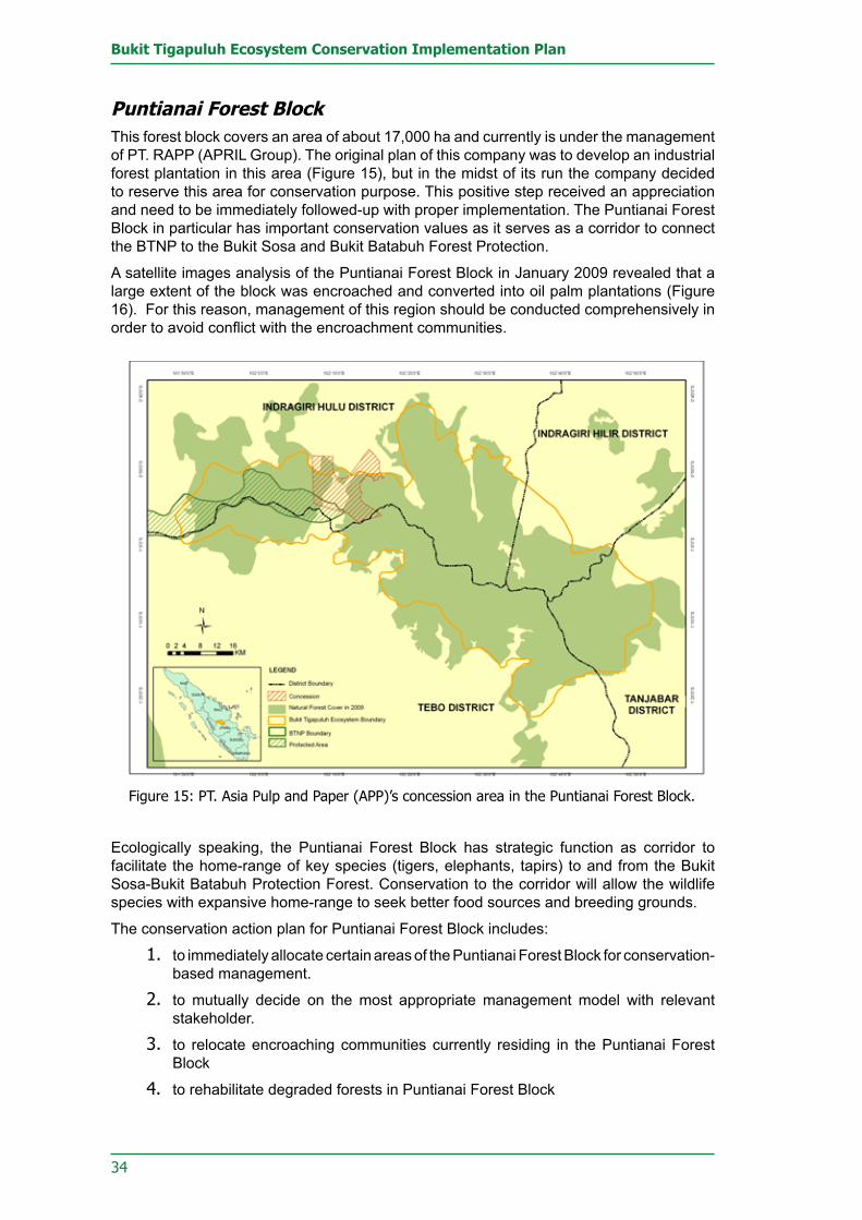
34
Bukit Tigapuluh Ecosystem Conservation Implementation Plan
Puntianai Forest BlockThis forest block covers an area of about 17,000 ha and currently is under the management of PT. RAPP (APRIL Group). The original plan of this company was to develop an industrial forest plantation in this area (Figure 15), but in the midst of its run the company decided to reserve this area for conservation purpose. This positive step received an appreciation and need to be immediately followed-up with proper implementation. The Puntianai Forest Block in particular has important conservation values as it serves as a corridor to connect the BTNP to the Bukit Sosa and Bukit Batabuh Forest Protection.
A satellite images analysis of the Puntianai Forest Block in January 2009 revealed that a large extent of the block was encroached and converted into oil palm plantations (Figure 16). For this reason, management of this region should be conducted comprehensively in order to avoid conflict with the encroachment communities.
Ecologically speaking, the Puntianai Forest Block has strategic function as corridor to facilitate the home-range of key species (tigers, elephants, tapirs) to and from the Bukit Sosa-Bukit Batabuh Protection Forest. Conservation to the corridor will allow the wildlife species with expansive home-range to seek better food sources and breeding grounds.
The conservation action plan for Puntianai Forest Block includes:
to immediately allocate certain areas of the Puntianai Forest Block for conservation-1. based management.
to mutually decide on the most appropriate management model with relevant 2. stakeholder.
to relocate encroaching communities currently residing in the Puntianai Forest 3. Block
to rehabilitate degraded forests in Puntianai Forest Block4.
Figure 15: PT. Asia Pulp and Paper (APP)’s concession area in the Puntianai Forest Block.

35
4. Important Areas Inside The Bukit Tigapuluh Ecosystem
Forest Areas of Ex-concession of PT. Indonesie Forest et Asiatique (IFA) Pasir Mayang Block.Forest areas formerly belonged to concession of PT. IFA located in Jambi Province and Riau Province. Its total concession in both provinces is approx. 173,991 ha (Table 1). In Jambi Province, the concession covers an area of 76,544 ha that located in the Tebo District, or better known with Pasir Mayang Forest Block. The remaining 97,447 ha are in Riau Province (Figure 17). Legal permits released for this type of land use is IUPHHK/HT, but dispute prolongs between the APRIL Group (the company succeeds the contract and also recommended by Forestry Dept.) and the Sinar Mas Group (the company appointed by local governments). Such conditions remains unresolved as yet. On the other hand, encroachment is predicted to increase few years in the near future. This ex-concession of PT. IFA is an important habitat for Sumatran tigers, elephants, and orangutans. Additionally, it is a home to indigenous tribes whose livelihood mostly depends on the forest. Converting the natural forest in the ex PT. IFA concession to industrial forest plantation will cause severe negative impacts on the key species in EB30, as well as the indigenous tribes.
The total ex-concession area of PT IFA within the EB30 is approximately 52,331 ha. Major portions of the area have been converted into oil palm plantations and into acacia plantations as a part of expansion of industrial forestry plantations.
The total non-forest area in the ex-concession area of PT IFA within the EB30 is 8,237 ha, while coverage for forested areas reaches up to 44,094 ha (Figure 18). Considering the vast forested coverage over the ex-concession areas, a proposal to convert large amounts of forested areas to industrial forestry plantation certainly do not fit into the general concept of sustainable forestry industry proposed by Indonesian law. The forested areas within this ex-concession are still important habitat for key species (Tiger, Elephant, Orangutan and Malayan Tapir) and also home for 3 indigenous tribes.
Figure 16. Comparison of forested and non-forested areas in the Puntianai Block based on satellite images interpretation (January 2009).

36
Bukit Tigapuluh Ecosystem Conservation Implementation Plan
The conservation action plans for the ex-concession area of PT. IFA, in particular the Pasir Mayang Block, are as follows:
Figure 17. The ex-concession of PT. IFA in the Bukit Tigapuluh ecosystem
Figure 18. Comparison of forest coverage and non-forest coverage in ex- concession area of PT.IFA in the EB30; based on satellite images interpretation (January 2009).

37
4. Important Areas Inside The Bukit Tigapuluh Ecosystem
to re-evaluate the tender process due to unsolved designated management 1. decision in the area.
to propose a new management model for Pasir Mayang Block.2. to recommend the Ecosystem Restoration Management Mechanism to ex-3. concession areas of PT.IFA.
to enforce laws against the encroachers who have illegally occupied the areas.4.
Forest Areas of Ex-concession of PT. Dalek Hutani Esa (DHE) Total ex-concession area of PT. Dalek Hutani Esa is 80,437 ha (Figure 19). The area of 40,080 ha that located in Tebo Dictrict of Jambi Province has been proposed by the PT. Sinar Mas Group for its industrial plantation forests expansion. Based on satellite image interpretation conducted in January 2009 approximately 50.3 % of this ex-concession area is still covered with forests (Figure 20). This region is also an important area in EB30 as habitat for key species such as Sumatran tigers, elephants, and orangutans.
Other than serving as important habitat for the three key species, this ex-logging concession is also homes to Talang Mamak and Orang Rimba indigenous tribes. Converting this ex-logging concession area to an industrial forestry plantation development will definitely demolish native settlements of the two indigenous tribes. Furthermore, this conversion plan will potentially trigger human-wildlife conflicts.
The conservation action plans for the ex-concession area of PT. DHE are as follows:
to recommend the Ecosystem Restoration Management Mechanism to ex-1. concession areas of PT. DHE
to implement law enforcement against the encroachers who have illegally occupied 2. the areas.
to take action against various forestry violations by companies without no proper 3. indulgence.
Figure 19: Ex-concession areas of PT. Dalek Hutani Esa in the Bukit Tigapuluh Ecosystem.

38
Bukit Tigapuluh Ecosystem Conservation Implementation Plan
Forest Areas of Ex- Concession of PT. Hatma Hutani This ex-concession covers 45,849 ha of forested land in the Tanjabar District of Jambi Province (Figure 21). Parts of the concession were proposed as an expansion area for industrial forest plantations of PT. Rimba Hutani Mas (APP/SMG, covering 18,022 ha), but this project has not yet been completely implemented.
The ex-concession areas formerly belonged to PT. Hatma Hutani connects some forest areas (ones that designated by the Tanjung Jabung Barat Government to be maintained as buffer zones of BTNP) to the Taman Raja Block (a 9300-hectare forest area allocated by PT. Rimba Hutani Mas for conservation purposes). If the forest function status in the ex-concession areas of PT Hatma are changed, BTNP and Taman Raja Forest Block will be disconnected.
Based on interpretations of satellite imagery maps produced in January 2009, approximately 71.08% of the ex-concession area is still covered with pristine forests (Figure 22). Similar to other ex-concession areas in the vicinity of EB30, this area is essential to be maintained. Forest conversion in this area to industrial plantations will intensify human and wildlife conflicts, as well as increase potential natural disasters, such as landslides and floods.
The conservation action plans for the ex-concession area of PT. Hatma Hutani are as follows:
to recommend management models without allowing conversion into industrial 1. plantations.
to propose the adoption of High Conservation Value Forest (HCVF) concept in the 2. management
to provide a wildlife corridor to connect BTNP and Taman Raja Forest Block.3.
Figure 20. Comparison of forest coverage and non-forest coverage in ex- concession area of PT. DHE in the EB30; based on satellite images interpretation (January 2009).

39
4. Important Areas Inside The Bukit Tigapuluh Ecosystem
Figure 21. Ex-concession areas of PT. Hatma Hutani in EB30.
Figure 22. Comparison of forest coverage and non-forest coverage in ex- concession area of PT. Hatma Hutani in the EB30; based on satellite images interpretation (January 2009).


41
BUkIT TIGAPULUH ECOSYSTEM CONSERVATION
IMPLEMENTATION PLAN


43
5. Bukit Tigapuluh Ecosystem Conservation Implementation Plan
MechanismThe EB30 conservation implementation plan aims to determine the framework for the landscape management strategy which will be linked to the long-term management plan for the BTNP. The conservation strategy is expected to be jointly carried out by all stakeholders in a collaborative way to avoid overlapping planning and contradictions in management of the remaining forest areas in the EB30. To determine a concrete and manageable format for the B30 ecosystem conservation implementation plan, four key subjects as priorities for conservation management have been identified:
Ecology and Conservation•Natural Resource Protection•Land Use Planning•Sustainable Natural Resource Utilisation and Community Development•
To determine the format for conservation implementation of the four key subjects listed above, an initial threat analysis was conducted. The aim of the threat analysis was to identify the primary objectives for conservation implementation for each specific area and to address the conservation activities to be taken. “Threat” in this document refers to any form of human activity that directly or indirectly has a potential to may destroy, diminish or degrade the natural function of the B30 ecosystem.
After each specific threat was identified and described, the conservation objectives and targets of each management area were determined. After determination of the objectives and targets, a concrete and practicable action plan format was developed to ensure that the identified targets can be achieved. The precondition for EB30 conservation activities can be characterised by two aims:
Figure 23 Illustration of the conservation target achievement mechanism through several objectives.
Conservation Targets
Ecological Key Component
ThreatsDirect and Indirect human
activities
Objective 1Management Action
Objective 2Monitoring Action
Restoration Decrease threats
Threat statusBiodiversity Persistence
Adaptive Management

44
Bukit Tigapuluh Ecosystem Conservation Implementation Plan
the proposed conservation activities in the EB30 need to be achievable so that 1. conservation will effectively increase and therefore minimise the existing threats
Evaluation mechanism to monitor and optimise conservation of EB30 can proceed 2. in a sustainable manner
To achieve each of the set objectives, the management target and management action for the next five years are then formulated. Every management target is aimed to alleviate threats through a series of practicable actions and activities. Through the ongoing threat analysis mechanism, the EB30 conservation implementation effort is expected to proceed efficiently and effectively. To guide the implementation plan, a serial monitoring activity will follow every implementation action. A series of monitoring efforts need to be established to oversee the implementation action.

45
ECOLOGY AND CONSERVATION IMPLEMENTATION PLAN


47
6. Ecology and Conservation Implementation Action Plan
ECOLOGY AND CONSERVATION IMPLEMENTATION PLANBTNP and its surrounding forested areas are considered as a contiguous ecosystem complex. From an ecological perspective, the existence of this area plays a major role in supporting human livelihood, biodiversity preservation, and sustainable use of natural resources, therefore the integrity of the ecosystem is important to be preserved. In regards to the strategic role of the forested area around BTNP, the management for these areas needs to accommodate land use development aspects and at the same time also incorporate the conservation of wildlife and their habitat especially for those key species in EB30. In the implementation of this plan, stakeholders especially from the conservation institution should be able to identify, agree upon and aligning their perceptions in defining the priorities for the conservation activities in the Bukit Tigapuluh ecosystem. Some key issues that need to be taken into account in the ecological and conservation aspect in EB30 are:
1. Bukit Tigapuluh ecosystem delineationTo determine the boundaries of the conservation area, a delineation of the B30 ecosystem needs to refer to 1) the forested areas outside/around BTNP, 2) home range sizes of the key species populations, 3) consideration of interaction with local communities (human-wildlife conflicts), and 4) a realistic and practicable zonation of conservation areas. The EB30 conservation area delineation does not necessarily have to alter the status of the forest area outside BTNP (HP. HPT or HL); if stakeholders were to be actively involved and committed in conservation activities. Within the defined boundaries, the EB30 area will be delineated to include the BTNP as a core conservation area and large forested and non-forested areas around the park that are essential as home ranges to the defined key species (tigers, elephants, orangutans and tapirs). The delineated B30 ecosystem needs to be managed in an integrated collaborative manner involving a wide range of stakeholders.
2. key areas prioritised for conservation of Bukit Tigapuluh ecosystem Conservation activities in EB30 essentially focus on the protection and conservation of key species (tiger, elephant, orangutan and tapir) population and habitat by maintaining the function of high conservation value forest zones inside the B30 ecosystem. Furthermore, wild animal populations that are already fragmented by development activities immediately need to be reconnected by the creation of wildlife corridors to increase the long term survival chances of the species and therefore reducing the risk that key species go extinct.
Given the current issues in EB30, the key priorities in the Bukit Tigapuluh ecosystem management lies in (1) the extension and rationalisation of BTNP boundaries, (2) protection of key species distribution areas, (3) managing and remedy side effects of the east-west road corridor development (PT. WKS road) (4) and traditional community-managed areas inside the BTNP.
3. Important areas for the conservation of key species (Tigers, Elephants, Orangutans and Tapirs) BTNP and its surrounding areas are important habitats for the defined key species. However, the population distribution of the key species (tigers, elephants, orangutans and tapirs) is not homogenously spread over the whole ecosystem. This may be due to the fact that the majority of the BTNP area has an extreme rugged topography and therefore most of the protected areas are located at high elevation. Furthermore the availability of food for most animals is also limited in this type of environment. A survey by several conservation institutions shows that the distribution of Sumatran tigers is relatively equal inside and outside the BTNP area, while Sumatran elephants and Sumatran orangutans are mostly

48
Bukit Tigapuluh Ecosystem Conservation Implementation Plan
spread outside the southern and western parts of the BTNP area (Figures 5 and 6). Several areas outside the BTNP have been identified as important for the conservation of the key species. These areas are; the ex- HPH concession of PT. IFA, the ex HPH concession of PT. Dalek Hutani Esa, and the ex- HPH concession of PT. Hatma Hutani. The current threats to the important areas for the key species conservation outside of the BTNP area are the development of the APP road corridor, forest conversion into HTI industrial plantation proposed by several corporations and forest encroachment by local communities around the APP road corridor.
4. Identifying the impact of deforestation on wildlife and key species.The forested areas to the south and the west of BTNP were formerly used as timber concessions which are currently under threat of conversion to industrial plantations which would compromise the integrity of the ecosystem as wildlife habitat. One of the major activities threatening and compromising wildlife habitat in the B30 ecosystem is the recent development of a road corridor built by APP/SMG. This road fragments the habitat of key species such as elephants, tigers, orangutans and tapirs. Since the proposal for forest conversion (from natural forest to industrial fiber plantation) is not yet approved upon by the Ministry of forestry any proposed forest conversion activity in the area should be halted.
Hunting activities are continuing in the BTNP and its surrounding area. The impact of hunting has not been measured in detail but may have a profoundly significant effect on slow breeding animals such as most large mammals. Therefore, integrated monitoring and law enforcement on hunting in the EB30 need to be conducted.
To secure migration routes and distribution of key species from the devastating impact of large-scale conversion activities, five NGOs (WWF, FZS, PKHS, WARSI and ZSL) have proposed a conservation effort in the EB30 area, namely: 1) BTNP area expansion, 2) declaration of protected areas outside the national park, 3). Special protected forest (forest area proposed to be the conservation area for tigers, elephants, orangutans and tapirs), 4) Special conservation area within the HTI Concession to be protected by the company
5. key species monitoring and habitat restorationKey species population monitoring is an essential tool to monitor the success of conservation interventions. To identify the status of key species populations (tiger, elephant, orangutan and tapir), a systematic and periodic monitoring system needs to be implemented. Key species monitoring should be conducted at least every three to five years, using a standardised method. With the establishment of monitoring system population size comparisons after certain periods of time and with other areas can be done consistently and with a high level of accuracy. Some frequently used methods to calculate population density are line-transect survey (Buckland et.al 1993; Buckland et.al 2001), camera trap capture-recapture survey; fecal DNA capture-recapture (Williams et.al 2001; Eggert et.al 2003) dung/nest count survey (Barnes and Jensen 1987; McClanahan 1986; Barnes 1993; Hedges and Tyson 2002; Hedges and Lawson 2006; Wich et.al 2009). Additionally, patch-occupancy surveys (MacKenzie et.al 2002, 2003; MacKenzie and Royle 2005) are often used to determine population distribution. A combination of these surveys also needs to be conducted for a more accurate result.
Sumatran ElephantThe elephant population in the BTNP ecosystem consists of two population groups: the Semambu population and the Riau-Jambi population. Unfortunately, these populations are located in an HPH (Production Forest) area with no protection status. Furthermore, these two sub-populations are fragmented and distributed in two distant locations. This fragmentation was caused by large-scale land clearing by local communities and commercial corporations. To preserve the elephant population in EB30, habitat protection

49
6. Ecology and Conservation Implementation Action Plan
needs to be established immediately. A habitat corridor between the two populations should be established to prevent permanent isolation. A systematic survey based on the dung-count method performed by FZS estimates that the Semambu population consist of 117 individuals (95% CI= [69.196]) and the Riau-Jambi population of 47 individuals (95% CI= [20.108]; Mossbrucker, 2009). The demography of the two populations is known to be dominated by young elephant age classes (Mossbrucker, 2009). Population monitoring in a specific time frame is vital to identify the population dynamics and determine the appropriate management intervention.
Sumatran TigerThe tiger population in the BTNP area is estimated to be about 13-43 individuals at a density of 0.9-2.97 individuals/100 km2 (Yayasan PKHS 2007). From the generated photographs, 8 adult male individuals and 5 adult female individuals could be identified. This population was monitored using camera traps within an installment area of about 35,000 ha (24.2% of the total BTNP area). Estimates for the areas surrounding BTNP count at least five (5) individual tigers (ZSL 2008) detected by camera traps during a joint survey conducted in cooperation between FZS and ZSL. The five individuals consist of three (3) adult male individuals and two (2) adult female individuals. From the monitoring result of these conservation institutions, it is estimated that the Bukit Tigapuluh ecosystem still possesses a reasonable large tiger population. Comprehensive and regular monitoring will need to be executed to monitor tiger population trends in the Bukit Tigapuluh ecosystem.
Sumatran orangutanThe Sumatran orangutan population that has been successfully reintroduced into the BTNP area consists of 96 individuals. During the reintroduction process, three baby orangutans were born, and six orangutan died, mainly from diseases. The current orangutan distribution is concentrating in the HPT area in the area surrounding the reintroduction station; only a few orangutans were confirmed within the BTNP boundaries. The reintroduction process is expected to eventually involve 250-500 individual orangutans. The recommended population size is predicted to be a viable orangutan population for some 1000 years. Orangutan population monitoring should be continued to identify the level of success of the reintroduction programme in EB30.
Malayan TapirThe total population size, habitat use and movement patterns of the tapir population has not yet been identified. To determine effective tapir conservation efforts, the total size and distribution of the tapir population in EB30 needs to be estimated accurately. A robust methodology to determine the tapir population at EB30 need to be tested to ensure population monitoring can be implemented efficiently.
6. Management of Human-Wildlife ConflictsHuman-wildlife conflicts are among the major threats for many endangered mammal species. Some counter measures developed by local communities to mitigate wildlife conflict results regularly in the death of wildlife. In EB30, frequently encountered human-wildlife conflicts involve destruction of fields and plantations by elephants and cattle killed caused by tiger attacks. Some important measures to effectively mitigate human wildlife conflicts in the future are:
Effective coordination between the responsible agencies, including direct handling 1. of conflict mitigation and long-term strategic planning to avoid human-wildlife conflicts.
Disseminating of the national policies outlined in the human-wildlife conflict 2. mitigation protocol published by the Indonesian Department of Forestry
Implementation and dissemination of the elephant and human conflict mitigation 3. protocol

50
Bukit Tigapuluh Ecosystem Conservation Implementation Plan
Wildlife habitat rehabilitation especially for elephants and tigers since habitat loss 4. is the main cause of human-wildlife conflicts.
Conducting scientific approaches in the human-wildlife conflict mitigation.5. If the intense land conversion around EB30 continues at the current rate human-wildlife conflicts, especially elephant-human conflicts will increase drastically if no effort is taken to reduce and mitigate the conflicts. Therefore, short-term efforts should continue to be made by empowering the local communities in conflict handling. Immediate measures that need to be applied in conflict mitigation, especially for human-elephant conflict, are:
Attempting to apply traditional elephant expulsion techniques, such as coordinated 1. land safeguarding, firecrackers, carbide cannons, etc.
Intensive discussions with industrial corporations, to ensure their optimum 2. participation in elephant conservation
Establishing an animal conflict management team coordinated by conservation 3. institutions or the relevant government agencies.
Objective 1. Key Species Population and Viable Habitat ProtectionResearch results show that the EB30 area is a vital habitat of key species: tigers, elephants, orangutans and tapirs, whose existence are protected by law. In general, the population of these key species in the Indonesian territory tends to be on the decline due to diminishing natural habitat. These species will face extinction if no immediate action is taken. Concrete conservation efforts to protect the existence of the key species in EB30 are developed in this management plan. The following part is structured in target and action sections; recommended activities are guided by a population and habitat management approach.
To achieve the conservation objectives, four major targets have been identified which were divided into two groups. The first two targets focus on mapping the key species distribution and estimation of population sizes, while the next two targets are aiming at the protection and restoring of existing vital habitats.
Target 1.1: Key species distribution and habitat mapsPopulation distribution and vital habitats of key species in EB30, especially for the areas around BTNP have not been comprehensively mapped. Some forest areas/zones have not been surveyed until now, such as the forest area formerly managed by PT. Hatma Hutani (PT. HH) in Tanjabar District and the forest area formerly managed by PT. Seberida Wana Sejahtera (PT. SWS) in Inhil District. Therefore, the actual distribution and the state of the key species habitat in EB30 is not totally clear. On the other hand, the threat of habitat fragmentation and forest degradation around the BTNP area persists unstopped, potentially damaging the distribution and integrity of the key species populations.
Frequent area revisions, an up to date database and ongoing information gathering on distribution of key species as well as recent status of critical habitats are important to determine priority areas that need to be protected and restored. In the EB30 area, a number of field surveys have been carried out in the past, but until now no sustainable long term monitoring could be established including a data management system and information sharing among the executing parties. Regarding these issues three management actions have been identified that are important to be taken:
Action 1.1.1: To conduct surveys and research on key species habitatsThe first management step to conserve the population and habitat of key species will focus on gathering quantitative information through field surveys and research in the EB30 area. This can be achieved through cooperation between government and non-government

51
6. Ecology and Conservation Implementation Action Plan
(NGO) conservation institutions and Universities. If collaborations can be established, a sustainable series of surveys and researches could be possible. The survey results gained would illustrate the home ranges of the key species present in EB30.
Action 1.1.2: To compile spatial data and information in a Geographical Information System/GISA detailed map and database of population distribution and status of key species habitats is important to determine priorities for conservation activities. Accurate data generated by a series of surveys and research on key species need to be summarised in a database /server and spatial data generated should be stored in a Global Information System (GIS) format. With a joint database format updates of key species distribution data and information on habitats from various data sources can then be performed by any GIS operator of the involved parties working on ecology and conservation.
Action 1.1.3: To develop database system of habitat distribution and conditionA frequently updated database and good data management will determine the success of the ecology and conservation programme monitoring in EB30 especially with regard to key species. In this regard, creating a standardised and accessible database system is necessary to optimise the data collection activity in the field. The system may take the form of a data management system network with an application or with a more simple and user-friendly system. This system is expected to serve as a data bank that can deliver requested information in an up-to-date manner.
Target 1.2: The key species populations measuredIdentifying the population size of the key species is important to determine appropriate action to protect the key species population and their habitat. From actual information of the population size, population trends can be periodically identified– to predict whether the population increases or decreases. Furthermore trends can be correlated with dynamic developments in the EB30. The proposed method for population estimates is a standard method that is commonly used on large mammal species. Population measures can be performed in collaboration with conservation institutions and NGOs that already execute field surveys, covering the following actions:
Action 1.2.1: To monitor and estimate Sumatran tiger populations Conducting tiger population survey (every 5 years), with appropriate methods to identify the presence of Sumatran tiger in EB30 and perform tiger population size counts/estimates in the EB30. Following the Sumatran tiger survey, an estimation of the tiger population size needs to be conducted in the EB30. The main methods used to estimate tiger population size and their distribution are Capture-Recapture (using camera traps) and Patch Occupancy (MacKenzie etal 2002; 2003; MacKenzie and Royle 2005).
Action 1.2.2: To monitor and estimate Sumatran elephant populationsConducting elephant population survey (every 5 years), with appropriate methods to identify the presence of elephant in EB30 and perform elephant population size counts/estimates in the EB30. Following the elephant survey, Sumatran elephant population size estimation needs to be conducted in the EB30. The main methods used to estimate Sumatran elephant population size and their distribution are Dung Count (Barnes & Jensen 1987; McClanahan 1986; Barnes 1993; Hedges & Tyson 2002 and Hedges and Lawson, 2006) and Fecal DNA capture –recapture (Eggert et.al 2003).
Action 1.2.3: To monitor and estimate Sumatran orangutan populationsConducting orangutan population survey (every 5 years), with appropriate methods to identify the presence of Sumatran orangutan in EB30 and perform orangutan population

52
Bukit Tigapuluh Ecosystem Conservation Implementation Plan
size counts/estimates in the EB30. Following the orangutan survey, Sumatran orangutan population size estimation needs to be conducted in the EB30. The main methods used to estimate Sumatran orangutan population size is a Nest Count and Line transect survey (see Wich et.al 2009).
Action 1.2.4: To monitor and estimate Malayan tapir populationsConducting tapir population survey (every 5 years), using appropriate method to identify the presence of Sumatran tapir in EB30. Following the tapir survey, tapir population size estimation needs to be conducted in the EB30. The main method used to estimate tapir distribution is Patch Occupancy (MacKenzie et.al 2002; 2003; MacKenzie and Royle 2005)
Target 1.3: A wildlife corridor between BTNP and Bukit Batabuh/ Bukit Sosa Forest (west of BTNP) established A critical effort to save fragmented populations and habitat of key species in EB30 is the connection of scattered wildlife habitats by establishing green corridors. The corridors shall ensure and increase the probability of wildlife dispersing among sub-populations and furthermore prevent conflict with humans. The wildlife corridor to be developed needs to connect wildlife at BTNP with wildlife in the Bukit Sosa protected forest. This corridor will pass through the concession area IUPHHKT managed by PT. Riau Andalan Pulp and Paper (RAPP) at the Puntianai block. The wildlife corridor can be developed by:
Action 1.3.1: To propose to PT. RAPP to develop conservation-based management for the Puntianai Forest Block In the year 2008, PT. RAPP announced to allocate the HTI concession area in the Puntianai block to be converted into a wildlife conservation corridor. However, the implementation of this plan has not yet progressed. In this regard, the participation of PT. RAPP to co-manage the area based on conservation concept needs to be encouraged intensively (hands-on). The corridor may be regenerated by a mosaic planting system which has been applied by PT. RAPP in other places of their concession area.
Action 1.3.2: To delineate wildlife corridor areas within the Puntianai Forest BlockTo optimise the conservation and protection effort in the wildlife corridor area, the boundaries of the corridor area, and the required size of the corridor need to be determined. The responsibility and execution of this measure should be initiated by the company and their conservation area manager.
Target 1.4. The rationalisation of BTNP on realistic areas continuedBTNP rationalisation is the effort to reinforce and optimise the shape of the national park in four districts, with the purpose to maximise protection by minimising disruptions and to maintain important wildlife habitats in the forested areas around BTNP. This process has continued over several years without significant progress as the park extension needs recommendations from each district government. Areas that receive the endorsement from the district government, to be allocated to the BTNP needs to be proceed immediately. To solidify the recommendation, the following actions can be taken:
Action 1.4.1: To implement BTNP rationalisation in the Tebo District (17,500 ha)Currently, the local government of Tebo District endorsed the rationalisation programme by allocating 17,000 ha of land out off the ex HPH of PT. Dalek Hutani Esa (PT. DHE) to

53
6. Ecology and Conservation Implementation Action Plan
be integrated into the BTNP. This endorsement needs to be immediately implemented through the Department of Forestry’s Directorate General of Planology until a Decree of the Minister of Forestry is issued. A boundary delineation needs to be carried out while performing a comprehensive assessment on the other rationalisation areas not yet been allocated to the BTNBT.
Action 1.4.2: To disseminate information about the rationalised boundaries of BTNPAs soon as the BTNP rationalisation area is delineated and endorsed, dissemination of the new BTNP area boundaries, especially in the Tebo District, Jambi Province area is essential, for the understanding, awareness and support for conservation measures by the affected local communities.
Action 1.4.3: To follow up rationalisation proposed in areas without current real and widespread supportThe recommended rationalisation of the BTNP area for the Indragiri Hulu and Indragiri Hilir Districts (Riau) and Tanjung Jabung Barat District (Jambi) has not been endorsed until now. Currently however, recommendations from the Governors of Riau and Jambi have been acquired. While studying the factual conditions in the field, the engagement of the district governments continues to seek technical support from the Forestry Service and further recommendation from the District of Inhu, Inhil and Tanjabar.
Objective 2. High Conservation Value Forest (HCVF) areas in the EB30 identified and mapped The EB30 is an area with a high biodiversity and deserves an important protection and conservation status, including the areas managed under industrial company concession. The remaining forest areas in the EB30 (outside of BTNP) need to be comprehensively identified and conserved to ensure their optimum ecological function and sustainable utilisation. The implementation of the HVCF concept in these areas should be based on international standards and carried out in a participatory manner to keep the company interest in line with the objective and concept of the HCVF area. There are two key targets to implement the above objectives: firstly to map the HCVF area in the EB30, and secondly recommendations on how the companies can adopt the HCVF concept and include them in their management.
Target 2.1: HCVF areas within the EB30 mapped The mapping of HCVF area in the EB30 is crucial especially in the forest areas adjacent to the Bukit Tigapuluh National Park. From a legal standpoint this forest area can be managed (converted) as an Industrial Crop Forest; therefore, it is critically important to map the HCVF so that the forest areas around the BTNP categorised as HCVF but managed by HTI companies with IUPHHK-HT, can be conserved.
Action 2.1.1: To conduct a survey on HCVF areas in EB30Using HCVF basic criteria as a guideline, a survey and assessment of the forested area in the Bukit Tigapuluh ecosystem needs to be conducted. The result of this survey and assessment is important in determining the priority areas that need to be managed as HCVF. This activity can be undertaken by conservation institutions or NGOs.
Action 2.1.2: To plot/map HCVF areas in EB30 The result of the HCVF zone survey and assessment on the entire Bukit Tigapuluh ecosystem area is presented in the form of a HCVF area map and overlaid with the land use map. The entire HCVF areas in the Bukit Tigapuluh ecosystem need to be clearly determined along with potential stakeholders that request the authority of managing the areas.

54
Bukit Tigapuluh Ecosystem Conservation Implementation Plan
Objective 3. High conservation value forests maintained The successful, sustainable management of the Bukit Tigapuluh ecosystem demands the maintenance of the high conservation value forest areas in the ecosystem in order to save the ecosystem as a whole. If the HCVF concept can be successfully implemented, the ecological functions of the Bukit Tigapuluh ecosystem can proceed optimally. In that regard, the following targets and activities emphasise two objectives: firstly an active participation of the concession-holding companies, to manage the HCVF zone in an optimum and sustainable manner, secondly a joint monitoring and evaluation system.
Target 3.1: HCVF areas accommodated within company concessions The HCVF areas inside company concessions are expected to be conserved and managed independently for conservation purposes. The concession companies are expected to actively participate in applying conservation concepts in their concession areas. The aim of the HCVF concept is to maintain and protect conservation areas inside industrial concessions.
Action 3.1.1: To implement conservation-based management systems on HCVF within concession areasHCVF areas inside a company concession are managed based on conservation principles. The conservation values in the area should be protected to ensure the optimum ecological functions including maintaining the structural integrity in surrounding areas. However the implementation may be subject to technical difficulties that will be faced with relation to management techniques and human resource capacity issues. To that end, the application of this concept can involve other stakeholders such as actively involving conservation institutions or government agencies.
Target 3.2: Participation of concession rights-holders in conserving HCVF areas independentlyThe entire forest outside the BTNP areas has a legal status of HPT or HP. Most of these areas are managed by companies for Industrial Crop Forest. Still large areas inside the concessions contain high biodiversity value until now, so a positive approach to companies to manage high conservation value areas inside their concession is needed. Some important actions that have to be taken are:
Action 3.2.1: To develop HCVF monitoring teams within the concession management The establishment of an HCVF monitoring team is an important measure for area management. To keep this monitoring team independent, collaboration between the company management and other stakeholders is needed. Furthermore, the monitoring team’s activities should be incorporated into the concession management agenda to ensure that accountability and funding for the monitoring is granted.
Action 3.2.2: To build capacity of HCVF monitoring teams through periodic trainings and on-the-job trainingTo improve the capacity of the monitoring team member and maintain the sustainability of the monitoring activity, it is important to conduct periodic training. Training can be held by involving the stakeholders who have expertise in their respective fields.

55
6. Ecology and Conservation Implementation Action Plan
Target 3.3: Integrated assistance to HCVF management implemented Providing technical assistance to the company to manage HCVF in their concession areas is crucial. The technical assistance is needed to monitor the management and optimise HCVF management in the concession areas.
Action 3.3.1: To monitor HCVF areas regularly and collectivelyProviding technical assistance for companies in monitoring, especially wildlife monitoring, is crucially important. To facilitate training is essential to build and improve the corporate personnel’s capacity in wildlife monitoring techniques.
Action 3.3.2: To evaluate HCVF management practicesEvaluation is needed to monitor the performance of HCVF zone management in commercial concession areas to ensure optimum conservation effort in the HCVF. The evaluation should be performed by an independent institution agreed upon by the stakeholders.

57
NATURAL RESOURCE PROTECTION IMPLEMENTATION PLAN

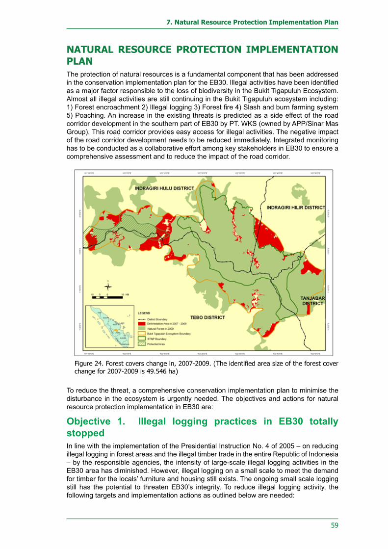
59
7. Natural Resource Protection Implementation Plan
NATURAL RESOURCE PROTECTION IMPLEMENTATION PLANThe protection of natural resources is a fundamental component that has been addressed in the conservation implementation plan for the EB30. Illegal activities have been identified as a major factor responsible to the loss of biodiversity in the Bukit Tigapuluh Ecosystem. Almost all illegal activities are still continuing in the Bukit Tigapuluh ecosystem including: 1) Forest encroachment 2) Illegal logging 3) Forest fire 4) Slash and burn farming system 5) Poaching. An increase in the existing threats is predicted as a side effect of the road corridor development in the southern part of EB30 by PT. WKS (owned by APP/Sinar Mas Group). This road corridor provides easy access for illegal activities. The negative impact of the road corridor development needs to be reduced immediately. Integrated monitoring has to be conducted as a collaborative effort among key stakeholders in EB30 to ensure a comprehensive assessment and to reduce the impact of the road corridor.
To reduce the threat, a comprehensive conservation implementation plan to minimise the disturbance in the ecosystem is urgently needed. The objectives and actions for natural resource protection implementation in EB30 are:
Objective 1. Illegal logging practices in EB30 totally stoppedIn line with the implementation of the Presidential Instruction No. 4 of 2005 – on reducing illegal logging in forest areas and the illegal timber trade in the entire Republic of Indonesia – by the responsible agencies, the intensity of large-scale illegal logging activities in the EB30 area has diminished. However, illegal logging on a small scale to meet the demand for timber for the locals’ furniture and housing still exists. The ongoing small scale logging still has the potential to threaten EB30’s integrity. To reduce illegal logging activity, the following targets and implementation actions as outlined below are needed:
Figure24.Forestcoverschangein,2007-2009.(Theidentifiedareasizeoftheforestcoverchange for 2007-2009 is 49.546 ha)

60
Bukit Tigapuluh Ecosystem Conservation Implementation Plan
Target 1.1: All access roads into the EB30 areas strictly monitored The majority of the EB30 areas outside of the BTNP are designated as production forest areas. These areas were formerly managed by forest concession companies. As a consequence, most of this ex logging concession still has road access in place which is frequently used by timber trucks to transport illegal wood from the EB30. In the Jambi area in particular, some of these ex logging roads have even been reopened by PT. WKS as a road corridor. The now improved road access is triggering illegal activities that threaten the integrity of EB30. To address this condition, implementation targets in the form of monitoring of all road access in the EB30 area, has to be conducted through the following actions:
Action 1.1.1: To Patrol and monitor the region on a routine basisPatrolling is an important means to reduce opportunities for crimes and to prevent illegal activities. Routine patrolling along roads that potentially trigger illegal activities is required as to stop the illegal logging activities in EB30.
Action 1.1.2: To built portals and guard posts at strategic locationsAs the number of patrol officers is limited and the density of roads to and/or in the EB30 is high, the construction of portals and guard posts along the major access roads is highly recommended to prevent illegal loggers from entering the EB30.
Action 1.1.3: To strictly control road access into and towards the BTNPRestriction of road access to and towards the BTNP borders is urgently required. Closing access roads that potentially function as the entry point for illegal loggers into the BTNP and its buffer zone has been identified as an effective tool to minimise illegal activities.
Figure 25. Road corridor developed by PT. Wira Karya Sakti (APP/Sinar Mas Group) in the southern part of EB30 (red line). This road development poses a major threat to EB30’s integrity

61
7. Natural Resource Protection Implementation Plan
Figure 26. Distribution map of area vulnerable for deforestation areas (encroachment, forest fireandillegallogging)intheEB30area.
Figure 27. Location for the planned construction of guard posts and forest areas signs around the EB30.
62
Bukit Tigapuluh Ecosystem Conservation Implementation Plan
Action 1.1.4: To encourage forestry companies to secure their areas of responsibilityThe EB30 area is surrounded by forest concession managed by Plantation and Mining Companies. The access roads built by the companies play an essential role as entry points for illegal loggers to the EB30. To respond to this condition, the current operating companies should participate actively to secure their working area.
Action 1.1.5: To empower and optimise utilisation of community patrols and protection unit teamsCommunity based patrols (pamhutswakarsa) are formed by members of the local communities surrounding forested areas who are recruited by governmental institutions to take an active part in securing the forest areas. On the other hand, a protection unit is a team established through collaboration between government institutions and other relevant agencies (NGOs, companies, etc.) with the primary task to safeguard the forest ecosystem. Community patrol and protection unit officers are usually equipped with a basic knowledge on forest conservation and safeguarding. These community patrol and protection unit officers can be empowered as supporting patrol officers and/or informers on illegal logging activities taking place in the Bukit Tigapuluh ecosystem.
Target 1.2: Law enforcement activities against illegal logging To impose a repressive effect on illegal loggers, consistent law enforcement against every illegal logging case is urgently required. To date, law enforcement on the illegal logging cases tends to be “selectively applied”. This will encourage other illegal loggers to continue without any respect to the law. To address this condition, a law enforcement effort in each illegal logging case is required, through the following implementation actions:
Action 1.2.1: To increase the numbers, and capabilities of civil servants in the forestry sectorA Civil Forestry Investigator (Forestry-PPNS) is a Civil Official whose scope of duties and responsibilities including forest management, and the investigation of illegal activities in a forestry department. With the existing authority, the Forestry PPNS can perform law enforcement against illegal logging cases or other illegal activities in coordination with the Indonesian Police (POLRI).
The number of Forestry PPNS at each forestry agency is currently limited. Therefore, the number of Forestry PPNS resources needs to be increase through education and training of forest crime investigation. The training also needs to be conducted with forestry police officers and/or non-structural officials and/or structural officials within the forestry agency. It is expected that each Forestry Service Office will have at least five Forestry-PPNS.
Action 1.2.2: To improve inter-sectoral coordination (police, state attorneys, law courts) in law enforcement effortsCoordination among law enforcement agencies especially in the forestry sector is limited. Improvement in coordination among law agency especially Indonesian Police, State attorneys, Law courts is necessary to optimise the prosecution of every known case in a distinct forestry sector. Coordination can be done by conducting regular coordination meeting per year, and workshop that are especially designed for law enforcement in the forestry sector.

63
7. Natural Resource Protection Implementation Plan
Action 1.2.3: To safeguard and supervise law enforcement process to illegal logging activities The monitoring of the implementation of law enforcement against forest crimes, especially illegal logging, is urgently required to ensure fair law enforcement. As an independent institution, committed NGOs are very much expected to play an active part in monitoring law enforcement. The respective NGO will monitor the law enforcement for every illegal logging case by joining a special monitoring team. This team will consist of several NGO members.
Action 1.2.4: To build an open information system on illegal logging activitiesCurrently the availability of information related to illegal logging activities and their prosecution are still institution based (not integrated). To facilitate the availability of the information needed for law enforcement against forest crimes, especially illegal logging, an information network needs to be built. This information network shall be coordinated by BKSDA and BBTNP.
Target 1.3: Comprehension of forest crimes among law enforcement officers significantly improvedThe law enforcement officers understanding of legal offenses in forestry is still limited, therefore the repression of forest criminal offenses is not optimal. To that end, the law enforcement officer’s understanding of forestry cases needs to be improved for an effective law enforcement operation in forestry. This can be achieved as follows:
Action 1.3.1: To organise periodical workshops and training sessions (every six months)To further synergise the law enforcement efforts against illegal logging training and workshop for law enforcement agencies need to be enhanced. BKSDA and BBTNP shall establish a training and workshop for law enforcement in forestry twice a year.
Action 1.3.2: To prosecute violations against forestry law To send a clear message to illegal loggers or encroachers that violating the law will lead to persecution an exposé of forest clearing can be done on selected cases.
Target 1.4: Address the gap between timber supply and timber demand The existing demand for timber is driving producers to supply and source timber in large quantities. The demand is increasing year to year and timber stock in production forests and/or limited production forests is declining. As a result illegal logging in conservation areas (including in EB30) is increasing. To address this issue, a comprehensive approach to deal with the gap between timber supply and demand through the following implementation actions will be needed:
Action 1.4.1: To promote Chain of Custody (CoC) certification for government projectsThe limited availability of timber in the legal market can potentially drive consumers, including the operator of government projects, to obtain the material illegally. To prevent illegal logging, especially in EB30, the establishment of a chain of custody policy for government projects needs to be encouraged.
Action 1.4.2: To promote the use of wood substitute materialsConsumer dependence on timber and the limited availability of the material in the legal market can potentially give rise to illegal logging activities. To reduce the consumer dependence, a campaign for the use of timber substitutes is vital.

64
Bukit Tigapuluh Ecosystem Conservation Implementation Plan
Action 1.4.3: To encourage communities to plant timber treesCurrently the potential of production forest and/or limited production forest around EB30 to fulfill the consumer demand for timber is very limited. Planting trees for timber in community plots needs to be developed to meet the local timber demand in particular.
Action 1.4.4: To enforce regulations on primary wood extraction industries inside and around EB30Most primary timber industries around the Bukit Tigapuluh ecosystem only possess a Business Premise Permit (SITU) and Trade Business Permit (SIUP), most of them unaccompanied by an Industrial Basic Material Supply Plan Permit (RPBI) or Certificate of Timber Origin (SKAU). This condition reflects the fact that the industries do not have a legitimate timber collection source (the timber is obtained illegally). To stop illegal logging activities, the primary timber industry license permits around EB30 need to be enforced.
Objective 2. Human-Wildlife Conflict Mitigation The high intensity of human-wildlife conflicts in EB30 is mainly triggered by human activities, such as the conversion of forested areas for development purposes, plantation, mining, settlement expansion, transmigration and other infrastructure developments. The conflicts cause victims among both parties, often ending in the marginalisation of the wildlife and their habitat. Given this condition, human-wildlife conflicts needs to be kept under control, through the following targets and implementation actions:
Target 2.1: Human-Wildlife conflicts mitigated according to up-to-date protocolsTo control human-wildlife conflicts, as suggested in the protocols, the following implementation action needs to be undertaken:
Figure28.Mapofhuman-elephantconflictlocationsin2006-2008aroundEB30.

65
7. Natural Resource Protection Implementation Plan
Action 2.1.1: To disseminate mitigation protocolsA Conflict mitigation protocol for Sumatran tiger, Sumatran elephant and orangutan has been completed by the Department of Forestry in 2007. To tackle and mitigate human-wildlife conflicts the protocol needs to be disseminated. The dissemination needs to be carried out by the Department of Forestry in cooperation with the Local Government, species FORUM (elephants, tigers, orangutans), NGOs and the Community. The dissemination should be done in workshops and in distribution of brochures to communities.
Action 2.1.2: To conduct training sessions on the mitigation of human and wildlife conflictsIn its implementation, the human-wildlife conflict mitigation technique needs to be disseminated through continuous and measurable training programmes especially among the local government and the community that lives in the proximity of wildlife habitat.
Action 2.1.3: To establish a conflict mitigation networkTo control human-wildlife conflict comprehensively, a conflict mitigation network needs to be set up. This network will involve all stakeholders to guarantee that the implementation and operation of human-wildlife conflict mitigation can be carried out in a comprehensive way.
Action 2.1.4: To involve company stakeholders in mitigating the conflictsThe EB30 areas are surrounded by industrial concessions actively converting wildlife habitat for development purposes such as industrial timber plantation, palm oil plantation and mining. These companies have been determined to increase the intensity of human wildlife conflict. In this regards company’s involvement in mitigating human wildlife conflict is crucial.
Target 2.2: Human and wildlife conflicts minimisedHuman-wildlife conflict usually cause victims on both sides, often even resulting with the marginalisation of wild animals and their habitat. To quell the number of victims, a reduced intensity of human-wildlife conflict needs to be achieved through the following implementation actions:
Action 2.2.1: To conduct a public awareness programme on conflict mitigation practicesHuman-wildlife conflict generally occurs in the areas where humans live around wildlife habitat. Therefore, conflict mitigation programme through awareness programme and mitigation training need to be conducted once a year in specified villages.
Action 2.2.2: To encourage corporations to implement conservation concepts in the management of their forestry concessionsLarge-scale forest conversions have increased the intensity of human-wildlife conflict. To address this, the application of a conservation concept in the concession area executed by the managing companies needs to be encouraged. Consultation and monitoring of the company’s concessions needs to be conducted once a year
Target 2.3: Conflict mitigation funds at the local level (Provinces and districts) availableTo undertake human-wildlife conflict mitigation at local (Provincial and District) level requires sustainable operational costs. Therefore, a human-wildlife conflict mitigation fund at the local level needs to be provided, through the following implementation actions.

66
Bukit Tigapuluh Ecosystem Conservation Implementation Plan
Action 2.3.1: To promote the inclusion of conflict mitigation funds in local governmental budgetsTo accommodate the human-wildlife conflict mitigation activities in the local budget (Provincial and District level), the conflict mitigation budget proposal needs to be prepared and submitted to the local house of representative.
Action 2.3.2: Help local governments to raise conflict mitigation fundTo anticipate the limited local expenditure budget at the Provincial and District level, human-wildlife conflict mitigation fund raising efforts by the local government need to be assisted. NGO’s should incorporate human-wildlife conflict mitigation activities in their fund raising programmes.
Objective 3. Poaching of protected species totally stopped Besides the threat of habitat conversion due to development activities (such as; plantation, mining, settlement expansion, transmigration and other infrastructure developments), poaching is another form of human activity that leads directly to the loss of endangered wildlife. To stop the poaching of endangered wildlife, the targets and implementation actions as described below will be needed.
Target 3.1: Dissemination of information on protected species To stop the hunting of endangered wildlife, a list of endangered species that are protected by Indonesian laws, needs to be distributed on the local level, through workshops and awareness programmes.
Action 3.1.1: To disseminate currently prevailing laws and regulationsThe laws and regulations on wildlife protection and their criminal charge need to be disseminated at the local level. The dissemination needs to be conducted in the form of workshops, inter-stakeholder meetings, and site visits by the relevant departments every six months. Dissemination will also be done by distribution of brochures, leaflets and legal guidebooks on the prevailing laws and regulations.
Action 3.1.2: To compile and disseminate relevant information on protected speciesTo optimise the distribution of information regarding protected species, including laws and regulations on their protection, relevant information material needs to be prepared and distributed at the local level. The relevant information hould be compiled in the form of guidebooks, brochures and leaflets. Distribution should be done from district to the village level.
Target 3.2: Poaching and illegal trading activities of protected species monitoredThe initial step to control poaching and wildlife trade especially of endangered species is the conduction of intensive monitoring. Monitoring on poaching and wildlife trade can be implemented through several activities describe below:
Action 3.2.1: To conduct intelligence operationsIntelligence operations, to identify the poachers, buyers and sellers and illegal trade network on the endangered species need to be undertaken. The intelligence operations are performed throughout the year at random times. They will be coordinated between BKSDA, BBTNP and Police.

67
7. Natural Resource Protection Implementation Plan
Action 3.2.2: To conduct routine patrols to secure wildlife and their habitatRegular patrolling to secure wildlife and their habitat need to be undertaken to prevent poaching activities in the Bukit Tigapuluh ecosystem. Patrols are conducted at least every week by involving the relevant stakeholders.
Action 3.2.3: To establish an information network to deal with poaching and wildlife tradeTo facilitate the flow of information needed, especially about illegal cases on poaching and wildlife trade, a comprehensive information network needs to be set up. The network should involve the village, sub-district, district and provincial level.
Action 3.2.4: To compile a database on poaching activities and trade of protected speciesA database containing the history of poaching and illegal trade needs to be created to develop strategies to control and to reduce illegal activities. The database should be developed in coordination of BTNP and Conservation Agency (BKSDA).
Action 3.2.5: To improve the capacity of forest police, forest ranger and community based protection unitThe capacity of forest Police, forest rangers and community based protection units need to be expanded to provide optimum control on poaching and illegal wildlife trade. Personal skills need to be increased. BTNP, Conservation Agency (BKSDA) and Conservation NGOs need to facilitate training at least once a year to improve personal skills of the forest police, forest rangers and community based protection units.
Figure 29. Several locations in EB30 where poaching on endangered species were detected during 2006-2008

68
Bukit Tigapuluh Ecosystem Conservation Implementation Plan
Action 3.2.6: To inform Perbakin Association (Indonesian Shooting Organisation) about the key species population pockets in EB30The key species population pocket in EB30 should be free from illegal and professional hunting activities. To that end, members of PERBAKIN (the Indonesian Association of Shooting and Hunting) who frequently organise hunting safaris need to be approached to prohibit hunting of endangered wildlife and restrict hunting in key species habitats..
Action 3.2.7: To engage Perbakin in to the monitoring of poaching activitiesHunting Safaris organised by Perbakin are frequently conducted in EB30 area. This type of activity is mainly to help the community control pest problems – especially wild boars – However, certain people frequently ride on the back of these activities to hunt for other wildlife, which are often protected species. To avoid misperception and minimise the risk of poaching, PERBAKIN needs to be engaged to perform monitoring programmes on all hunting activities.
Target 3.3: Law enforcement against poaching activities implementedTo impose a repressive effect on poachers, law enforcement in poaching cases needs to be executed through the following implementation actions:
Action 3.3.1: To build capacity of government officials in forestry investigation officersWithin the coordination and supervision of the Indonesian Police Department the Forestry Investigation officers have the authority to perform law enforcement against any forestry crime activities, such as poaching and illegal logging. Today, the available number of Forestry Investigation officers at each forestry agency is very limited. Therefore, the quality of Forestry Investigation officers needs to be increase through investigator education and training within the forestry agencies.
Action 3.3.2: To improve intersectoral coordination (police, general attorney, and the courts) in law enforcing activitiesTo optimise law enforcement efforts against illegal logging, encroachment and poaching, coordination between forestry agencies and the criminal justice system (POLRI, the District Attorney’s Office and the Court) needs to be further enhanced. Coordination can be enhancing through six month regular meeting coordinate by BTNP or Conservation Agency (BKSDA).
Action 3.3.3: To accompany and monitor the law enforcement processActivities to monitor the implementation of law enforcement against poaching are vital. As an independent institution, NGOs are greatly required to play an active part in this activity.
Target 3.4: The use of both organic and homemade firearms strictly controlled Most poaching activities involve organic and homemade firearms. Therefore, the use of these weapons needs to be monitored through the following implementation actions:
Action 3.4.1: In coordination with the national police to regulate the use of organic and homemade firearms Control the use of organic and homemade weapons around EB30 needs to be coordinated with POLRI as the competent institution. Coordination will be conducted by BTNP and Conservation agency (BKSDA).

69
7. Natural Resource Protection Implementation Plan
Action 3.4.2: To conduct a control over the ownership of homemade firearms among the communityControl of the homemade weapons possessed by the community around the Bukit Tigapuluh ecosystem needs to be conducted together with POLRI. All weapons illegally owned by community members have to be surrendered to the POLRI. Regular sweeping and field inspections are needed at randomly chosen locations and times.
Objective 4. Forest Fires in the EB30 controlledForest fires are a major factor that causes forest ecosystem degradation. The degradation severely limits the ecological function of the burned forest area. Furthermore, the smoke emitted from the forest fires has an adverse impact on human health and disturb land, air and sea transportation. Considering the negative impacts listed above, the appearance of forest fires in the Bukit Tigapuluh ecosystem needs to be prevented, through the following targets and implementation actions:
Target 4.1: Awareness programme for communities inside and around the EB30’s not using fire (zero burning) for land clearingOne of the important triggers on forest fire is land clearing through burning for farming by the community that lives in or around the forest zone. Therefore, the community’s awareness of not using fire for land clearing purposes needs to be achieved through the following implementation actions:
Action 4.1.1: To disseminate information about the negative impacts of forest fires upon human beings and the ecosystemCommunity awareness in and around EB30 on the impact of forest fire on the ecosystem needs to be disseminated in an intensive and continuous programme. The dissemination is to be carried out in the form of workshops every six months at the district, sub-district and village levels.
Action 4.1.2: To disseminate information on the relevant laws and regulationsThe laws and regulations on the illegal burning and the punishment, such as Indonesian Law No. 41 of 1999, need to be disseminated to the community in and around EB30. The laws and regulations will be disseminated by distributing brochures, leaflets and books.
Action 4.1.3: To ensure the community cares about fire control (Masyarakat Peduli Api / MPA) To promote community awareness and participation in and around the Bukit Tigapuluh ecosystem in forest fire control. ‘Society against fire’ (MPA) groups need to be encouraged and facilitated in a gradual and sustainable manner. Training to MPAs is given every six months at the district level.
Action 4.1.4: To introduce conservational land-clearing methodsCurrently, land burning practices remains the most economical way for the communities in land clearing for farming. Furthermore, the ashes generated by the burning are believed to be beneficial as fertilisers. To address this, other environmentally-friendly land clearing systems need to be introduced to the community in and around EB30. Training in environmentally-friendly land clearing need to be held annually at the sub-district and village levels.

70
Bukit Tigapuluh Ecosystem Conservation Implementation Plan
Target 4.2: Areas vulnerable to forest fire identifiedTo prevent and support the early control of forest fires, vulnerable areas in the EB30 area need to be detected through the following implementation actions:
Action 4.2.1: To inventory and map areas vulnerable-to-firesAreas that are vulnerable to forest fires in and around EB30 need to be inventoried and subsequently presented in an informative manner by preparing maps illustrating areas vulnerable to forest fires. The maps are to be prepared by committed NGOs, BKSDA and BBTNP and distributed through brochures and books to the entire relevant agencies at the district and sub-district levels.
Action 4.2.2: To inventory and map resources for forests fire preventionFire prevention resources, such as natural (rivers, natural firebreak, etc.) or artificial (artificial firebreak, firefighter’s post, equipment warehouse, etc.) need to be inventoried and subsequently presented in an informative manner by preparing a fire resource map. The distribution map of the rivers and other fire containers is updated annually, and distributed to the relevant agencies.
Action 4.2.3: To monitor prone-to-fires forest areasDuring particularly long droughts, the inventoried and mapped fire-prone regions should be prioritised for intensive monitoring. With the monitoring, fire prevention and control can be implemented early. Fire monitoring is performed monthly, coordinated by the Second-Level forestry service.
Figure 30. Hot spot locations during the period of 2006-2008 in Bukit Tigapuluh Ecosystem

71
7. Natural Resource Protection Implementation Plan
Target 4.3: Information system among forest fire sectors optimisedTo enable the implementation of early forest fire control, the cross-cutting information system needs to be run optimally, through the following implementation actions:
Action 4.3.1: To optimise the performance of forest firefighting task forces in 4 districts (Tebo, Tanjabar, INHU and INHIL)A Forest Fire Control Coordination Unit (Satkorlak) that involves the relevant agencies in four districts (Indragiri Hulu, Indragiri Hilir, Tanjung Jabung Barat and Tebo) should be established. To enable maximum forest fire control, the effective working mechanism of each Satkorlak needs to be optimised. This will be achieved by quarterly inter-Satkorlak coordination meeting and yearly regular training.
Action 4.3.2: To build communication system of anti-fires inter-sectorsTo optimise forest fire control, the need to develop effective communication through upgrading communication equipment as a coordination tools among the agencies in the Satkorlak is urgently required. The communication equipment is built by providing facilities and infrastructure in the form of radio communication, cars and other supporting equipment.
Target 4.4: Forest-fire early warnings system establishedAn early warning system is an important means to prevent forest fire and/or its spread. This system needs to be created through the following implementation actions:
Action 4.4.1: To continuously actualise and distribute hotspot data from satellitesCurrently, one of the existing early warning systems is from hot spot detection by NOAA satellites, in which all areas with a temperature of >=40oC will be monitored. The detected data will be processed at the Forestry Department in Jakarta, and distributed to the local level. For an optimum result, the data at the local level need to be updated monthly. Data dissemination is coordinated by BBTNP and BKSDA and distributed to all relevant agencies at the district, sub district and village levels.
Action 4.4.2: To install and socialise information and warnings about forest fireAnother early warning system is the use of fire warning signs, Fire warning signs around EB30 need to be installed and publicised. The fire signs are installed along the forest zone borders at 500-meter intervals. The locations of the fire-prone areas in question are shown in Figure 26. Dissemination is done by distributing the map at every relevant agency coordinated by BKSDA and BBTNP
Target 4.5: Early mitigation of forest fire implementedEarly forest fire control is a critically important activity to successfully control forest fires quickly and to prevent the widespread of fire. Firefighter training at the district, sub-district and village levels needs to be conducted immediately.
Action 4.5.1: To establish and improve infrastructures relevant for forest firefighting in certain vulnerable areasTo support the forest fire early control activities infrastructure needs to be built and promoted. Firefighting post infrastructures at sub-districts, in areas that are known to be prone to fire should be established withfive fire trucks provided to every district.

72
Bukit Tigapuluh Ecosystem Conservation Implementation Plan
Action 4.5.2: To optimise the roles of SMART, forest fire brigades, MPA, and community forest patrolsThe role of the forest fire control personnel united in the Tactical Response Fire Commander Unit (SMART), forest fire brigade (Damkarhut), MPA (Forest Fire Community Aware) and Community Protection Unit needs to be optimised through regular training and workshops to enhance their members’ skill. The training and workshop shall be carried out on a quarterly basis at the district level.
Target 4.6: Trained human resources to mitigate forest fires adequately availableTo achieve effective forest fire control in a sustainable manner requires well trained staff. The trained staff is expected to be formed and developed in fire-prone areas.
Action 4.6.1: To conduct forest fire mitigation trainings regularly Training for forestry personnel to control forest fire needs to be held regularly in fire-prone areas in the four districts around EB30. The training shall be conducted by involving the stakeholders and be supported by the local government. This training need to be held twice a year at each district.

73
LANDUSE PLANNING IMPLEMENTATION PLAN


75
8. Landuse Planning Implementation Plan
LAND USE PLANNING IMPLEMENTATION PLANThe high demand by industry to convert the surrounding forest in the BTNP buffer-zone to plantations severely threatens the integrity of the EB30 (Adisoemarto, et.al, 1997). Furthermore, the nondistinctive Land use Planning (RTRW) in Jambi and Riau Provinces including the four districts around BTNP has caused overlaps in area allocation. Areas originally designated for protection often overlap with other land use forms, mainly production activities. For example, the area of PT. Riau Bara Harum and PT. Citra Tambang Riau’s allocated to coal mining used to be within the BTNP (the block has currently been revoked; BTNP Agency, 2006). This example demonstrates that land use planning rarely favours conservation values such as habitat protection, ecosystem preservation, and/or recognition of traditional culture (adat) (KKI-WARSI, 2007).
Forest encroachment in the EB30 within the four districts of Tebo, Tanjabar, Inhu, and Inhil still continues and tends to increase annually. Encroachment activities often remain undetected by the government due to a lack of frequently updated data and information system that can monitor changes in land use conditions. Apart from the lack of up-to-date data, the existing data presentation system is also too conventional to maximise its distribution.
Due to unclear and/or unmarked park boundaries and limited knowledge regarding laws and regulations, local communities often participate in illegal logging and encroachment. The limited knowledge in local communities regarding conservation area designation results from a lack of regulation dissemination by governmental agencies at the local level. Physical boundaries remain unrecognisable as most of the park boundary signs are damaged or missing. Furthermore, the uncertain land use planning, is the major factor contributing to high levels of encroachment makes any law enforcement extremely difficult.
Another important factor contributing to high levels of encroachment is conventional farming by slash and burn culture. Currently there are three local tribes living in and around the Bukit Tigapuluh ecosystem zone – Old Malay, Talang Mamak and Anak Dalam Tribe (Kubu). These local tribes are still practicing a nomadic traditional slash and burn farming system. Nomadic shifting of fields happens when the harvest yield, from an area that has been opened 2-3 years before, is declining due to soil degradation. The decline on harvest yield results from inappropriate land maintenance and plant handling techniques during growth periods. To reduce the dependency of local tribes on new land, alternative employment and capacity building through education on farming systems is necessary. Furthermore, practical schemes to generate additional income and capital for the genuine tribes from small scale business are needed to market crops and non timber products after the harvest period.
Moreover, despite all the efforts from dissemination of information, persuasive approaches and law enforcement, encroachment is not declining; therefore, a strict law enforcement operation against offenders is needed.
If law enforcement and the legal status of the Bukit Tigapuluh ecosystem is clear, rehabilitative efforts will immediately be required, especially at cleared land sites and restorative efforts in former logging concession area.
Objective 1. Illegal forest encroachment in the Tebo, Tanjabar, Inhu, and Inhil Districts halted.Encroachment in the Bukit Tigapuluh ecosystem within the District of Tebo, Tanjabar, Indragiri Hulu, and Indragiri Hilir is still continuing. Based on satellite image analysis from the years 2002-2007, 5418.07 hectares of forest at the Bukit Tigapuluh ecosystem has been cleared. This amount is equal to 1083.614 hectares of forest loss per year. Anticipating that the illegal land clearing will continue more or less unstopped concrete actions that involve various stakeholders are needed.

76
Bukit Tigapuluh Ecosystem Conservation Implementation Plan
Target 1.1: A database on forest coverage statistics compiledAs reference to measure current encroachment activities, a frequent update on the forest coverage is needed. Currently, the updated forest cover data for the Bukit Tigapuluh ecosystem are very limited and originate from low-resolution satellite imaging, i.e. LANDSAT-TM and ALOS AVNIR-2 (30 x 30 m resolution). Furthermore, the forest cover data are still presented manually due to a lack of an integrated database system. Thus an updated database is necessary that facilitates resource allocation to mitigate encroachment activities in the EB30.
Action 1.1.1: To generate land cover mapsAn updated Land cover map for the years 2008 and 2009 for the EB30 is still not available. The current land cover map is based on a Landsat and Alos images analysis, witha low resolution (30m x 30 m resolution). In the future, land cover data are expected to be produced using high-resolution satellite imaging, i.e. Ikonos or Quickbird (1 x 1 m resolution).
Action 1.1.2: To compile a database system for forest encroachment activitiesAn encroachment database system is a multimedia technology-based information system that on a routine base displays the area size, location and suspected encroachment in a relatively fast and with high accuracy. The data are obtained from land cover change analysis, population migration data, population growth rate, ground truth and intelligence data.
Action 1.1.3: To establish a mechanism for information dissemination on forest encroachment threats in the EB30 Encroachment in the EB30 continues to increase annually. The encroachment coincides with an increasing number of immigrants who demand forest for their cultivations. This often goes undetected by the local government, thus the quality of available information on land clearing needs to be improved and made accessible to local stakeholders. If up-to-date encroachment data are made available and accessible to the governmental agencies encroachment activity can be reduced significantly in the future.
Action 1.1.4: To conduct relevant training sessions for GIS and remote-sensing operatorsThe experience of available GIS and remote sensing operators are limited in handling existing spatial data. Therefore, GIS and remote sensing training is required to increase the GIS operator skills. Training needs to be held on a yearly basis, coordinated by BKSDA, BBTNP in cooperation with NGOs and academic institutions.
Action 1.1.5: To establish a formal task force with responsibility to collect and process spatial dataCurrently, spatial data preparation and processing are performed by several stakeholders with a lack of communication between institutions. This causes overlaps to frequently occur in preparation and analysis of spatial data. By building a joint task force, any overlap can be avoided, thus costs and time can be saved. The task force will be coordinated by BKSDA and BTNP.
Target 1.2: Clear delineation of forest area boundaries materialisedForestry offenses or crimes are often occuring due to a lack of information of forest boundary demarcation. The violators sometimes did not realise their activity is prohibited due to the unclear forest boundary.

77
8. Landuse Planning Implementation Plan
Action 1.2.1: To disseminate information about boundaries of forested areasThe community is often unaware of the forest area boundaries due to the lack of information dissemination. Furthermore, forest area boundaries are often marked by a small cement block with size of 10 x 10 x 50 cm and are therefore sometimes difficult to spot on the site; moreover, many of the markers are missing or damaged. Information dissemination is critically important and needs to be conducted by the forestry agency at the village level, especially in villages adjacent to the forest area boundaries. This activity may be coordinated by the Second Level Forestry Service and/or BKSDA and/or BTNP.
Action 1.2.2: To install warnings and information signs boards at strategic locationsProhibition and signs boards need to inform and teach the communities what kind of activities are allowed and what is forbidden in the forest area. Furthermore, the prohibition and signs boards will make people aware whether their location is close or already inside a restricted forest area. This will make people more cautious while planning to establish new plantations or houses. Proposed locations of prohibition and announcement signs are shown in Figure 25.
Target 1.3: Community land-use regulations establishedLand use regulations on the community level is vital to ensure the forest’s protection in the vicinity of the villages. To achieve proper land use planning at a community level, comprehensive planning is needed, the below list such measures:
Action 1.3.1: To facilitate the establishment of participatory land-use plans on village levelEstablishing land use planning on the community level should be lead by the local communities themselves. However land use planning on a community level has often failed as local communities have limited knowledge and facilities to produce and map the layout of a community based land use plan. In this regard participatory mapping exercises in all communities within EB30 need to be conducted with the participation of local communities but technically supported by expertise from outside. The implementation need to be facilitated by the NGO’s, BTNP and Conservation Agency (BKSDA).
Action 1.3.2: Produce community mapsA comprehensive community map is crucial for the land use planning process; therefore, a map needs to be produced before conducting comprehensive land use planning.
Action 1.3.3: Initiate the establishment of land-use regulations at community levelThe land use regulation should be understood by the local communities. Therefore land use regulation need to be formalised and enforced. To formalised a land use plan, a set of regulation is needed to be created at the community level.
Action 1.3.4: To encourage higher local-government levels to acknowledge the community land-use plansThe community land use regulation should not contradict the national and regional land use plan, thus land use regulation at community level need to be distributed to the local government at the sub-district and district level. .

78
Bukit Tigapuluh Ecosystem Conservation Implementation Plan
Target 1.4: EB30 accommodated in the Spatial Planning for SumatraThe EB30 area endorsed by all stakeholders in 2008 has not yet been accommodated by governmental documents. To enforce the concept of the Bukit Tigapuluh ecosystem, the area of EB30 needs to be accommodated in the national, and regional land use plan.
Action 1.4.1: To recommend the endorsement of EB30 in the Spatial Planning for SumatraAs an initial step, the EB30 needs to be proposed to be accommodated in the Land Use Planning for Sumatra. The EB30 proposal will be submitted by NGOs in collaboration with BKSDA, BTNP, and the District Forestry Department. The proposal will be addressed to the Minister of Forestry or to the President of the Republic of Indonesia.
Action 1.4.2: To recommend a permanent legalisation for the EB30 managementCurrently the EB30 is separately managed by several institutions such as the BTNP Agency, Natural Resource Conservation Agency (KSDA), Local Forest Department and the Local Government. A multi institution management often results in duplication or overlapping of planning. A collaborative “one-door” management with a permanent legal basis is needed to effectively implement EB30 management.
Target 1.5: Execute law enforcement against forest encroachmentThe whole forested area in the EB30 consists of forest in the national park, protected forest outside the park, inactive ex logging concession and active company concessions. The ex logging concessions are currently unmanaged – which fosters the perception of “open access” to all people. These areas are often sold off by profit seeking agents in the local communities. Law enforcement to stop this illegal activity is crucial to secure the forest area.
Action 1.5.1: To socialise laws and regulations relating to forest area managementIllegal forest conversion in the plantation or settlement often occurs when the local community has limited understanding on laws and regulations. Forest areas are often sold by the community to third parties especially in case of ex logging concession areas. In this regard dissemination of the law and regulations, especially related to the forest management, is necessary.
Action 1.5.2: To form an integrated team to mitigate forest encroachmentAn integrated team that focus on encroachment issues needs to be established at a district level, given the rampant forest area clearing activities in the EB30 area of the four districts. Encroachment has been known to threaten the degradation the entire natural forest ecosystem. This integrated team can involve various parties including the Government, NGOs and communities to ensure integrated participation.
Action 1.5.3: To conduct law enforcement operations by an integrated teamAfter all the efforts from the dissemination of information to a persuasive approach has been implemented, a strict law enforcement system needs to be established to fight all illegal activities in forest areas.

79
8. Landuse Planning Implementation Plan
Action 1.5.4: To bring illegal forest encroachment cases to courtTo impose a repressive effect to perpetrators or community groups who potentially will conduct encroachment, a case exposé of forest encroachment can be done on select cases (shock therapy).
Target 1.6: Rehabilitation and restoration of forests areas realisedForest rehabilitation in the EB30 is vital, especially in traditional community settlement areas within the park. Restoration needs to be undertaken in ex-logging concessions that have been converted into plantations.
Action 1.6.1: To inventory and map the locations for rehabilitation and restorationBefore starting the rehabilitation and restoration, the location and size of the area need to be identified. Thus the initial step to be taken is an inventory and mapping project.
Action 1.6.2: To plan rehabilitation and restoration After the inventory and mapping activities are completed, the plan for the rehabilitation and restoration activity needs to be prepared. The plan consists of an Annual Work Plan and a Five-Year Work Plan incorporating all related stakeholders.
Action 1.6.3: To implement rehabilitation and restorationComprehensive forest rehabilitation and forest restoration projects in all disturbed areas need to be conducted. The forest rehabilitation and forest restoration has to be incorporated in the regular activities of the Conservation Agency (BKSDA) and Forestry Department on district and provincial level.
Action 1.6.4: To conduct monitoring and evaluation (Mon-Ev)To measure the success of the forest rehabilitation and forest restoration projects, regular monitoring and evaluation surveys have to be conducted at least annually. Conservation Agency (BKSDA) and Forestry Department are responsible for the implementation of the monitoring activities.


81
SUSTAINABLE NATURAL RESOURCE MANAGEMENT AND COMMUNITY
DEVELOPMENT IMPLEMENTATION PLAN


83
9. Sustainable Natural Resource Management And Community Development Implementation Plan
SUSTAINABLE NATURAL RESOURCE MANAGEMENT AND COMMUNITY DEVELOPMENT IMPLEMENTATION PLANThere are approximately 23 villages around BTNP that are categorised as Primary Interaction Village (PIV) with a total population of 44388 (in 2006). Currently, high-accessibility in PIV has encouraged a large number of immigrants to come and establish settlements in the area. In general, the population in the PIV is dominated by men at the productive-age class. The average number of potential worker possessed by each family is two.
The primary source of family income in the PIVs is the sale of farming products, such as rubber sap and palm fruit. An additional income is generated from the sale of non-timber forest products, such as jernang (sap of rottan) and manau rattan, which is abundant in natural forest. However the availability of non timber forest products is very limited. Compared to the local purchase price in July 2008, the local purchase price of the above products in 2009 has decreased by 50%.
The general farming activity by native local communities in the PIV is rubber production. Limited manpower and funding results in the lack of maintenance of the rubber plantations. The average ownership of land per family varies from 1.5-2.0 hectares, with an average yield of 75-100 kg of rubber sap/ha/month. Meanwhile, the general farming activities of immigrants, with adequate financial capital, is oil-palm plantation. However, not all oil-palm plantations owned by the immigrants are productive. Compared to the local price in July 2008, the local purchase price of rubber sap and palm fruits has decreased by as much as 50% in early 2009.
Recent surveys show that the families in the PIV cannot determine the minimum farmland size required to ensure their sustainable livelihood. This is due to the increasing expectations of living standards, competition in legal ownership and the necessary investment value of the farmland. Only families in the Sadan and Datai Tua settlements are able to determine the minimum farmland size required by the families. In view of the level of livelihood, future competition in land ownership, and the land use restriction, every family in the Sadan and Datai Tua settlement requires at least 6 ha of rubber plantation.
Existing local regulations that support ecosystem preservation are still implemented by the local community in the PIV. Prohibitions are still active against fish poisoning and cutting of plants that produce non-timber forest products (NTFP). However, the local regulations are generally not formalized.
Most of the heads of the native families in the PIV are illiterate. Only a few heads of families attended elementary school for 1-2 years or even completed elementary school (generally new families). Meanwhile, the immigrants generally possess a higher education background. Educational facilities, infrastructure and available teaching staff are still limited until today.
In general health facilities, infrastructure and workers in the PIV, especially in settlements inside the BTNP area, are very limited. Formal institutions that exist in the entire representative PIV refers to the Government Regulation of the Republic of Indonesia No. 72 of 2005 on Village.
The local community in the PIV is generally aware of the existence and function of the BTNP area. The stakeholders are also aware that local communities livelihood are highly dependent on forest land, therefore might threaten the integrity of BTNP’s ecosystem. There are several recommendations suggested by the stakeholders to deal with the issue, such as: (1) cultivating Daemanorops draco rattan in the locals’ rubber plantations and/or in the BTNP buffer forest zone; (2) developing an irrigated rice field system; and (3) procuring superior rubber seedlings and facilitating a rubber plantation management intensification system.

84
Bukit Tigapuluh Ecosystem Conservation Implementation Plan
The existence of industrial companies in the surrounding areas of some PIV may create an advantage for the locals. On the other hand, large-scale conversion of forest vegetation by industrial companies may increase the risk of conflicts between local people and wildlife.
Objective 1. Decrease dependence of traditional communities in BTNP on forest resources The community in the PIV located in the BTNP area, is dominated by native peoples that depend on forest resources. Their livelihood depends on the forest since ancient times and may not easily change. If their population continues to grow the increasing needs of local communities will have negative impacts on the integrity of the B30 ecosystem. To address this, a number of targets and implementation actions will be required to reduce the locals’ life dependency on forest resources, are described below.
Target 1.1: Improve capacity of traditional communities on intensified land cultivation methods Due to limited capacity (knowledge, manpower and financial capital possessed by the families), the commonly applied practice of land use for farming, by the population in PIV inside the BTNP area, are based on extensive land cultivation. In their effort to meet their permanently growing living needs, the locals will continue to expand their farmland. To meet the expected demands, capacity building for the locals will be needed to practice intensified farming through the following three implementation actions:
Action 1.1.1: To establish a farmer group to develop a knowledge transfer system A transfer of knowledge on land intensification farming, has to be done simultaneously over a large area. Individual approaches will be effective as it may cost an enormous amount of time and money. Therefore, forming farmer groups with the locals living in the BTNP zone as a means of knowledge transfer units is critically important.
The existence of the gotong royong (communal mutual assistance) culture in the locals’ life has the potential to address the issue of limited manpower and financial capital among the families living in the BTNP zone to apply the land intensification farming. In this regard, the farmer groups can also act as the PIV that will organise gotong royong schedules and participants.
Action 1.1.2: To conduct public enlightenments on land intensification methods using a traditional, practicable, and comprehensive approachTo improve the knowledge in the traditional communities in the BTNP area of intensive farming, the teaching of this intensive farming system need to be carried out in an applicative and sustainable manner. The traditional approach can be taken through community leaders/group leaders, which will essentially increase the productivity of smallholder rubber plantations and other commodities.
Target 1.2: Maximise agricultural products of traditional communities in a sustainable mannerThe majority of the traditional communities inside the BTNP area use natural (unscreened) rubber seeds for planting. Furthermore, the rubber plantations are not intensively managed. As a consequence, the harvest rubber sap yield per hectare is very low.
Some locals also plant other crops, especially fruit trees, in their rubber plantation. Due to the limited access to the market, the yield often has a low sale value (not fresh by the time they are sold at the market).

85
9. Sustainable Natural Resource Management And Community Development Implementation Plan
These circumstances drive the locals to constantly expand their farmland to meet their living needs. Obviously these activities have a negative impact on the ecosystem. To address this problem, implementation actions to maximise the local farmland yield are vital.
Action 1.2.1: To provide seedlings of fruit-bearing jernang (Daemonorops draco)The additional income of the majority of the locals living inside the BTNP area is from jernang (Daemanorops draco rattan fruit sap). As an impact of forest conversion and a growing number of collectors the availability of jernang in the forest will be increasingly limited in the future. As a consequence, the locals’ dependence on outputs from farming land will increase.
An effort to cultivate the productive Daemanorops draco rattan plant has been done by a few local communities. Rattan plants are cultivated by planting seeds obtained from a host plant in the forest. This activity might be useful although, it will take a significant amount of time (±7 years) until the plant produces jernang. In this regard an intensification of the farming system is needed.
Action 1.2.2: To develop jernang rattan (Daemonorops draco) in old traditional rubber plantationsDaemanorops draco is a type of rattan tree that can grow effectively under the shade. Furthermore the species need a host tree to climb to support the vine to live. This species produces rattan sap all year around as soon as it reaches the productive stage. The price of rattan sap has a relatively high sale value. Cultivation of Daemanorops draco rattan within rubber plantations of locals living inside the BTNP area should be encouraged. Cultivation of rattan species in secondary forest vegetation is believed to maximise the yield.
Action 1.2.3: To set up marketing and develop a trading system of jernang (dragon’s blood)Non-timber forest products especially jernang is an important alternative income for the traditional community besides rubber. However, the added value from selling this commodity is often low due to the “black market” nature of its trade; so the profit earned by the collector is minimal due to the low selling price. A good market organisation will raise the selling price and can keep the selling price competitive, which will eventually boost the collectors’ profit.
Action 1.2.4: To apply land intensification methods on natural rubber plantationIn general, non-intensive rubber plant maintenance keeps the output of the natural rubber plantation low. Furthermore, it takes a relatively long time to reach the productive age of the rubber plantation (about 12 years). With intensive maintenance, the output of the local community rubber plantation is expected to increase with an earlier productive age of the plant.
The use of selective rubber seeds is also believed to boost output and speed up the productive age of local community rubber plantation. However non-endemic plant cultivation inside the BTNP area is strictly prohibited.
Target 1.3: Local and traditional law relevant to natural resources conservation empoweredThe native culture in the traditional communities living adjacent to the forest is believed capable of maintaining the protection of natural resources especially forest resources. On the other hand, however, the existence of native culture is declining, contaminated by outside influences, and is neglected or no longer used by local communities to regulate the use of natural resources.

86
Bukit Tigapuluh Ecosystem Conservation Implementation Plan
In some cases, the values are still inherent in traditional communities with the potential to be used as a tool, prevent unsustainable use of natural resources. To empower the local cultural values, the following actions can be taken:
Action 1.3.1: To identify and analyse local cultural values to minimise natural resource over-exploitationThe first step in empowering local culture that supports the protection of natural resources is information gathering from the traditional communities. The so identified cultural values are than analysed and discussed among the local communities, through a series of discussions, studies or workshops.
Action 1.3.2: To strengthen and legalise local cultural law in harmony with the natural resource conservationThe local cultural values that support natural resource protection should be supported and fully endorsed by the local communities. Therefore, the local cultural values agreed to be followed need to have their legal formal status promoted as a community law.
Target 1.4: Develop ecological and cultural tourism as non-agricultural income sources for traditional communities The PIVs in the BTNP area have a potential value for nature and/or culture tourism. However only the tourism potential in the Datai Tua and Air Bomban settlements (located at the Gansal River area inside the BTNP area) have been explored and developed for ecotourism by the BTNP Agency since the late 1900’s.
To a certain extent tourism activities can contribute an additional income for several households in the communities of Datai Tua and Air Bomban. This additional income is generated from, tour guide services, house rental, boat rental, raft building, craft sales, etc. However, the intensity of local and international tourist visits to the area is still low due to low promotion for tourism. To further develop tourism activities as a non-farming source of income for the traditional community residents in the BTNP area, the following implementation actions will be needed:
Action 1.4.1: To identify cultural and ecological tourism potentials in and around traditional community settlementsNot all of the nature and culture tourism potential in the traditional community inside the BTNP area has been identified. To develop tourism comprehensively, the existing natural and cultural potential needs to be identified. A tourism survey needs to be conducted by the NGO, BTNP, Conservation Agency (BKSDA) and relevant stakeholder.
Action 1.4.2: To promote traditional community settlements as ecological and cultural tourism spotsTo promote tourism for both local and international tourists, the nature and culture tourism potential of the traditional communities in the BTNP areas needs to be promoted through a cooperation with the news papers, electronic media, travel agents, hotels, relevant NGOs, etc.
Action 1.4.3: To conduct tour-guide training for traditional communitiesTour guide service has the potential value to boost the income of the traditional communities inside the BTNP area. To increase professionalism as a tourist guide, training for the locals needs to be undertaken.

87
9. Sustainable Natural Resource Management And Community Development Implementation Plan
Action 1.4.4: To prepare relevant infrastructures and facilities for ecotourism (naturally scenic spots) To support the development of nature and culture tourism activity in the traditional community in the BTNP area, tourism facilities and infrastructure (such as tourist transport, hostels, nature trails, outbound facility, bird watching tower, etc.) need to be provided adequately.
Action 1.4.5: To develop the potential commercial value of traditional handicraftsIn line with the nature and culture tourism development effort, souvenir craft ventures have the potential to increase the income of the traditional community inside the BTNP area. An increase in quality and diversification of the handicrafts of the locals’ needs to be promoted.
Target 1.5: Working capital and profitable markets for local community accessibleThe financial capital in the traditional communities at the BTNP area is very limited. This situation makes the effort to develop non-forestry business activities difficult. Furthermore poor access to the villages and a limited number of merchants caused a low and unstable price for the local products in the BTNP area.
To address the conditions above, and to increase the locals’ capacity in developing non-farming business activities, access to venture capital and lucrative product market is required.
Action 1.5.1: To form village cooperatives for deposit-and-lending operations and marketing of agricultural productsA cooperative for savings, loan business unit and community product marketing needs to be established to help with non-farming venture capital for the locals who live in the BTNP zone. Furthermore, the enterprise will also be beneficial in raising and stabilising the sale price of local products.
Target 1.6: Competitive education for the young generations of traditional community accessible The education facilities and availability of teacher in the traditional communities in the BTNP area is very limited. Furthermore, there is a limited number of people to be able to work in the household, resulting in many school-age children in the traditional communities being unable to pursue their education. School-age children have to help their parents at work in the morning. This condition clearly reduces the ability to prepare the younger generation to gain the capability to live and work outside the BTNP area.
Action 1.6.1: To establish education center in traditional community settlementsTo prepare a better future for the younger generation in the traditional communities in the BTNP area study groups need to be developed. The study group will gather when children complete their work. Furthermore, teachers for this programme need to be exclusively prepared to increase the success of the programme.
Action 1.6.2: To provide adequate teaching staffsTeachers who can help provide lessons to the traditional communities especially in environmental education need to be provided continuously so that the children will possess more adequate knowledge on conservation and environmental education.

88
Bukit Tigapuluh Ecosystem Conservation Implementation Plan
Target 1.7: Healthcare for traditional communities accessibleHealth care facilities, infrastructure and nurses in the BTNP area are very limited. The traditional communities generally get their medication and care from the local healer.
The poor access to medical services results in poor health in the local community. Members of the local communities generally need a significant amount of time to recover from an illness. This situation obviously disrupts the productivity of locals’. To deal with the above issue, health access for the locals needs to be provided.
Action 1.7.1: To conduct regular medical visitsTo improve the locals’ health and their productivity, regular medical visits to the traditional communities in the BTNP area are important to be conducted. Regular visit by local medical institution on the district level need to be conducted on a monthly basis.
Objective 2. Decrease dependence of communities outside the BTNP (Main interaction Village /MIV) on forest resources Most of the local communities living in the surrounding area of BTNP are heavily dependent on forest resources. This condition will increase pressure on the integrity of the ecosystem and ecological function of the BTNP area. To reduce the locals’ life dependency on forest resources, some targets and implementation actions will be needed as elaborated below:
Target 2.1: Capability of MIV community on land intensification method improvedMost of the native communities have limited capacities in terms of knowledge, manpower and financial capital. The main farming system generally applied by native people living outside the BTNP area, is a non-intensive farming scheme. This farming system drives the locals to keep expanding their agricultural areas to increase productivity. To reduce the dependency on continuous field extension, an intensified farming system needs to be implemented through the following three activities
Action 2.1.1: To form farmer groups for knowledge transfer in MIVAn individual approach to the knowledge transfer on land intensification farming patterns to locals living outside the BTNP area can be time consuming and require a large amount of funding. Forming farmer groups as a means of knowledge transfer needs to be encouraged. The persistence of the gotong royong (communal mutual assistance) culture in the life of the native people has the potential to address the problem of limited manpower and financial capital among the traditional communities. Farmer groups formed by locals can also act as the initiator that will organise gotong royong schedules and manage the participating members.
Action 2.1.2: To conduct public agricultural enlightenments on land intensification methodsTo increase knowledge of the native people living outside the BTNP area regarding intensive farming systems training in the technique needs to be carried out in a gradual and sustainable manner. Training and guidance from an agricultural agency at the district level needs to be conducted every three months.

89
9. Sustainable Natural Resource Management And Community Development Implementation Plan
Action 2.1.3: To assist knowledge transfers between immigrants and native communities on land intensification methodsIn general immigrants have a higher capacity and knowledge in intensive farming systems. Sharing knowledge in the area will provide valuable additional knowledge for the native people living outside the BTNP area. This activity need to be facilitated by NGOs or relevant institution at a district level.
Target 2.2: Agricultural products of local communities continue to increaseThe harvest yield from rubber plantations managed by native people living outside the BTNP area is very low. This is due to non selective rubber seed used and non-intensive rubber plant management (the rubber plants are left to grow along with other secondary forest vegetations).
Low productivities in farming drive the native people to constantly expand their farmland. To address this problem actions to maximise the locals’ farmland yield are vital.
Action 2.2.1: To procure prime rubber seeds and to implement land intensification methodsThe use of natural (unscreened) rubber seeds and non-intensive plantation management methods keeps the yield of rubber plantation managed by native people relativ low. Furthermore, a non intensive management postpones the productive age of rubber plantations (about 12 years). With intensive maintenance and the use of superior rubber seeds, the gained yield in traditional rubber plantations is expected to increase and production of the rubber plant supposed to start at an early age (±7 years).
This intensive farming programme is specifically aimed at native people who own farmlands in a non-forest zone (Miscellaneous Use Allocation/APL).
Action 2.2.2: To analyse opportunities to develop rice fields in selected MIVs of Tebo DistrictOther than rubber plantations, some native people living outside the BTNP area also depend on dry rice field farming. Dry rice farming normally requires intensive field management. To reduce the locals’ dependency on dry rice farming, the stakeholders in Jambi’s Tebo District recommend the development of a wet rice field (sawah) system.
The local communities in the MIV never applied a wet rice field (sawah) system. Therefore, supporting facilities and infrastructure for the system, such as a water dam and irrigation channels, which are not currently available in the villages. Given the above conditions, a preliminary study will need to be conducted with the opportunity to develop a wet rice farming system in the non-forest area in Jambi’s Tebo District.
Action 2.2.3: To develop local community’s land potentials which are focused on the village’s/district’s potentialsTo improve the potential harvest on land owned by communities, planting schedules should be adjusted to the village and sub-district development programme and be endorsed by the district government’s programme based on the land intensification farming system. To ensure a maximum yield and competitive products for the market, local communities need to be assisted to implement the intensive farming system.

90
Bukit Tigapuluh Ecosystem Conservation Implementation Plan
Target 2.3: Local cultural values and norms relevant to natural resources conservation empoweredCultural traditions of native communities traditionally living in forest environments are believed capable to maintain the integrity and minimise damage to natural resources especially forest resources. However, cultural traditions inherent in customary laws (adat) are diminishing and are contaminated by outside influences. Moreover, the cultural tradition in some areas have been neglected and no longer used as rules that needs to be complied to regulate the use of natural resources.
In many cases the cultural traditions have been proved useful as a preventive measures for natural resource protection. To empower the local cultural traditions related to natural resource conservation, the following actions are proposed:
Action 2.3.1: To identify and analyse local cultural values edible to minimise natural resources over-exploitationThe first step in empowering local culture in support of natural resource conservation is to gather information directly from the traditional communities. The important of cultural tradition then needs to be assessed through a series of discussions, studies or workshops.
Action 2.3.2: To strengthen and legalise local cultural norms in harmony with natural resource conservationLocal cultural values that have been assessed to be able to support natural resource preservation should be supported and fully implemented by the communities. Therefore, the legal statues of local cultural values need to be promoted with a formal legal power such as through a PERDES.
Action 2.3.3: To develop a sustainable forest management under using traditional forestry mechanismForest management by traditional communities have been proved to have minimum negative impact on the ecosystem. Furthermore, developing the traditional community forest management system will also preserve the cultural values of the traditional community directly.
Target 2.4: Capital and profitable markets for community made accessibleMost of the local community living outside of the BTNP area, have limited financial capital. Furthermore, due to the poor access to the nearest town and limited number of merchants, purchase prices at a local level for products of the traditional communities in the BTNP area are very low. The lack of financial resources makes it difficult for the locals to develop non-forest based business activities. To increase local capacities in developing non-farming business, access to venture capital and lucrative product market is needed.
Action 2.4.1: To develop deposit-and-loan cooperation mechanism and improved marketing traditional agriculture products.A small deposit and loan unit (Koperasi) for savings, loan mechanism and product marketing needs to be established to open access to capital for the locals living outside the BTNP area in order to support non-farming business The unit will also be beneficial in raising and stabilising price of the locals’ products.

91
9. Sustainable Natural Resource Management And Community Development Implementation Plan
Action 2.4.2: To facilitate local communities to accessible credits for small enterprisesTo improve local community livelihood, access to various small business loans, whether initiated by the local or national government should be provided. Accessible funding schemes include; rural agricultural business loan, plantation revitalisation loan, plantation business loan, community empowerment national scheme, etc. including loans issued by corporations.
Target 2.5: Non-agricultural job opportunities availableMost source of income of the community living outside the BTNP areas involves the utilisation of natural resources, such as forest land and non-timber forest products. In the effort to reduce local dependency on forest resources, especially forest land, non-farming job alternatives need to be created. The above implementation target can be achieved through the following actions:
Action 2.5.1: To build the capacity of MIV communities through training and education programmesMost of the native communities living outside the BTNP area are illiterate. The poor academic background creates resistant of local communities to accept influence from the outside, including a new job.
To create non-farming jobs, as an effort to increase locals’ capacity and to enable them to join work training and education is critically needed.
Action 2.5.2: To create labor-intensive non-agricultural employment opportunitiesThe creation of non-farming jobs in an effort to reduce the locals’ dependency on the forest land is critically important. The target to achieve large numbers of the locals living outside the BTNP area in labor-intensive non farming jobs.

92
Bukit Tigapuluh Ecosystem Conservation Implementation Plan

93
9. Sustainable Natural Resource Management And Community Development Implementation Plan
Man
agem
ent
Actio
n Pl
an o
f th
e Bu
kit
Tiga
pulu
h Ec
osys
tem
Targ
etA
ctio
n/A
ctiv
ities
Succ
ess
Indi
cato
rsPa
rtic
ipan
tsC
oord
inat
or/
Faci
litat
or
Tim
e Fr
ame
Phas
e 1
Phas
e 2
2010
2011
2012
2013
2014
2015
1. E
colo
gy a
nd C
onse
rvat
ion
Div
isio
n
Obj
ectiv
e #1
: Vi
able
pop
ulat
ions
and
hab
itat o
f key
spe
cies
(Tig
er, E
leph
ant,
Ora
ngut
an, a
nd M
alay
an ta
pir)
1.1.
The
key
spe
cies
di
strib
utio
n an
d ha
bita
ts m
appe
d
1.1.
1.To
con
duct
su
rvey
s an
d re
sear
ch
on k
ey s
peci
es
habi
tats
1.1.
1.1.
Per
iodi
c da
ta
on th
e di
strib
utio
n an
d co
nditi
on o
f key
sp
ecie
s ha
bita
ts
avai
labl
e
FZS
, PK
HS
, ZS
L W
AR
SI,
WW
F,
Aut
horit
y of
B
TNP,
BK
SD
A
Aut
horit
y of
B
TNP
1.1.
2. T
o co
mpi
le
spat
ial d
ata
and
info
rmat
ion
in
a G
eogr
aphi
cal
Info
rmat
ion
Sys
tem
/G
IS
1.1.
2.1.
Map
s on
th
e di
strib
utio
n an
d co
nditi
on o
f key
sp
ecie
s ha
bita
ts
avai
labl
e
FZS
, PK
HS
, ZS
L,W
AR
SI,
WW
F, A
utho
rity
of
BTN
P, B
KS
DA
Aut
horit
y of
B
TNP
1.1.
3. T
o de
velo
p da
taba
se s
yste
m o
f ha
bita
t dis
tribu
tion
and
cond
ition
1.1.
3.1.
A d
atab
ase
syst
em o
n ha
bita
t di
strib
utio
n an
d co
nditi
on e
stab
lishe
d
FZS
, PK
HS
, ZS
L W
AR
SI,W
WF,
A
utho
rity
of
BTN
P, B
KS
DA
Aut
horit
y of
B
TNP
1.2.
The
key
sp
ecie
s po
pula
tions
m
easu
red.
1.2.
1. T
o m
onito
r and
es
timat
e S
umat
ran
tiger
pop
ulat
ions
1.2.
1.1.
Tig
er
popu
latio
ns m
onito
red
and
accu
rate
ly
iden
tified
PK
HS
, ZS
L, F
ZS,
WW
F,P
KH
S, Z
SL
Con
tinue

94
Bukit Tigapuluh Ecosystem Conservation Implementation Plan
Managem
ent Action Plan of the Bukit Tigapuluh Ecosystem (From
previous)
TargetA
ction/Activities
Success IndicatorsParticipants
Coordinator/Facilitator
Time Fram
ePhase 1
Phase 22010
20112012
20132014
2015
1.2. The key S
pecies populations m
easured.
1.2.2. To monitor and
estimate S
umatran
elephant populations
1.2.2.1. Elephant
populations monitored
and accurately identified
FZS, W
WF,
WW
F
1.2.3. To monitor
and estimate
Sum
atran orangutan populations
1.2.3.1. Orangutan
populations monitored
and accurately identified
FZSFZS
1.2.4. To monitor and
estimate M
alayan tapir populations
1.2.4.1. Malayan Tapir
populations monitored
and accurately identified
FZS, P
KH
S,
ZSL, A
uthority of B
TNP
PK
HS
, A
uthority of B
TNP
1.3. A wildlife corridor
between B
TNP
and Bukit B
etabuh/ B
ukit Limau Forest
Preserve (w
est of B
TNP
) established
1.3.1. To pressure P
T. RA
PP to develop
conservation-based m
anagement for the
Puntianai Forest
Block
1.3.1.1. Cooperative
managem
ent w
ith RA
PP for
conservation activities in the P
untianai Forest B
lock in place
PT. R
AP
P, FZS
, PK
HS
, W
AR
SI, W
WF,
Authority of
BTN
P
WW
F, Authority
of BTN
P
1.3.2. To delineate w
ildlife corridor areas w
ithin the Puntianai
Forest Block
1.3.2.1. Wildlife
corridor of BTN
P-
Bukit B
etabuh-Bukit
Limau in place
PT. R
AP
P, A
uthority of B
TNP, W
WF,
PK
HS
WW
F, P
T.RA
PP
Continue

95
9. Sustainable Natural Resource Management And Community Development Implementation Plan
Man
agem
ent
Actio
n Pl
an o
f th
e Bu
kit
Tiga
pulu
h Ec
osys
tem
(Fr
om p
revi
ous)
Targ
etA
ctio
n/A
ctiv
ities
Succ
ess
Indi
cato
rsPa
rtic
ipan
tsC
oord
inat
or/
Faci
litat
or
Tim
e Fr
ame
Phas
e 1
Phas
e 2
2010
2011
2012
2013
2014
2015
1.4.
The
ra
tiona
lisat
ion
of
BTN
P on
real
istic
ar
eas
cont
inue
d
1.4.
1. T
o im
plem
ent
BTN
P ra
tiona
lisat
ion
in th
e Te
bo D
Istri
ct
(17,
500
ha)
1.4.
1.1.
The
m
inis
teria
l dec
ree
on
the
ratio
nalis
atio
n of
BTN
P in
the
Tebo
D
istri
ct re
leas
ed
WA
RS
I, A
utho
rity
of
BTN
P, D
ishu
t
Aut
horit
y of
B
TNP
1.4.
2. T
o di
ssem
inat
e in
form
atio
n ab
out
the
ratio
nalis
ed
boun
darie
s of
BTN
P
1.4.
2.1.
The
ra
tiona
lised
bo
unda
ries
of B
TNP
area
s di
ssem
inat
ed
WA
RS
I, A
utho
rity
of
BTN
P, B
PK
H
Aut
horit
y of
B
TNP
1.4.
3. T
o fo
llow
up
ratio
nalis
atio
n pr
opos
ed in
are
as
with
out r
eal a
nd
wid
espr
ead
supp
orts
cu
rren
tly
1.4.
3.1.
Tan
gibl
e su
ppor
t fro
m th
e di
stric
t gov
ernm
ents
of
Inhu
, Inh
il, a
nd
Tanj
abar
obt
aine
d
WA
RS
I, B
ukit
Tiga
pulu
h C
onso
rtium
WA
RS
I
Obj
ectiv
e #2
: H
igh
Con
serv
atio
n Va
lue
Fore
st (H
CVF
) are
as in
the
EB30
iden
tified
and
map
ped
2.1.
HC
VF
area
s w
ithin
the
EB
30
map
ped
2.1.
1 To
con
duct
a
surv
ey o
n H
CV
F ar
eas
in E
B30
2.1.
1.1.
HC
VF
surv
eys
cond
ucte
d in
E
B30
WW
F, P
KH
S,
FZS
, W
AR
SI
, Aut
horit
y of
BTN
P,
BK
SD
A,,
Uni
vers
ity
WW
F, A
utho
rity
of B
TNP,
B
KS
DA
Con
tinue
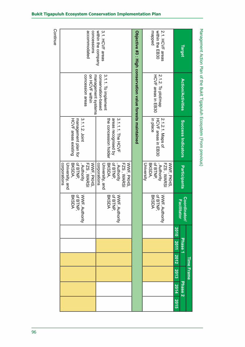
96
Bukit Tigapuluh Ecosystem Conservation Implementation Plan
Managem
ent Action Plan of the Bukit Tigapuluh Ecosystem (From
previous)
TargetA
ction/Activities
Success IndicatorsParticipants
Coordinator/Facilitator
Time Fram
ePhase 1
Phase 22010
20112012
20132014
2015
2.1. HC
VF areas
within the E
B30
mapped
2.1.2. To plot/map
HC
VF areas in E
B30
2.1.2.1. Maps of
HC
VF areas in E
B30
in place
WW
F, PK
HS
, FZS
, WA
RS
I , A
uthority of B
TNP,
BK
SD
A,
University
WW
F, Authority
of BTN
P, B
KS
DA
Objective #3 : H
igh conservation value forests maintained
3.1. HC
VF areas
within the com
pany concessions accom
modated
3.1.1. To implem
ent conservation-based m
anagement system
s on H
CV
F within
concession areas
3.1.1.1. The HC
VF
areas recognised by the concession holder
WW
F, PK
HS
, FZS
, WA
RS
I , A
uthority of B
TNP,
BK
SD
A,
University, and
corporations
WW
F, Authority
of BTN
P, B
KS
DA
3.1.1.2. Joint m
anagement plan for
HC
VF areas existing
WW
F, PK
HS
, FZS
, WA
RS
I , A
uthority of B
TNP,
BK
SD
A,
University, and
corporations
WW
F, Authority
of BTN
P, B
KS
DA
Continue

97
9. Sustainable Natural Resource Management And Community Development Implementation Plan
Man
agem
ent
Actio
n Pl
an o
f th
e Bu
kit
Tiga
pulu
h Ec
osys
tem
(Fr
om p
revi
ous)
Targ
etA
ctio
n/A
ctiv
ities
Succ
ess
Indi
cato
rsPa
rtic
ipan
tsC
oord
inat
or/
Faci
litat
or
Tim
e Fr
ame
Phas
e 1
Phas
e 2
2010
2011
2012
2013
2014
2015
3.2.
Par
ticip
atio
n of
con
cess
ion
right
s-ho
lder
s in
co
nser
ving
HC
VF
area
s in
depe
nden
tly
mat
eria
lised
3.2.
1. T
o de
velo
p H
CV
F m
onito
ring
team
s w
ithin
th
e co
nces
sion
m
anag
emen
t
3.2.
1.1.
The
HC
VF
mon
itorin
g te
ams
as
part
of c
once
ssio
n m
anag
emen
t es
tabl
ishe
d
Cor
pora
tions
, B
KS
DA
, A
utho
rity
of
BTN
P, W
WF
WW
F, A
utho
rity
of B
TNP,
B
KS
DA
3.2.
2. T
o bu
ild
capa
city
of H
CV
F m
onito
ring
team
s th
roug
h pe
riodi
c tra
inin
gs a
nd o
n-th
e-jo
b tra
inin
g
3.2.
2.1.
The
HC
VF
mon
itorin
g te
ams'
ca
pabi
litie
s im
prov
ed
Cor
pora
tions
, B
KS
DA
, A
utho
rity
of
BTN
P, W
WF
WW
F, A
utho
rity
of B
TNP,
B
KS
DA
3.3.
Inte
grat
ed
assi
stan
ce to
HC
VF
man
agem
ent
impl
emen
ted
3.3.
1. T
o m
onito
r H
CV
F ar
eas
regu
larly
an
d co
llect
ivel
y
3.3.
1.1.
Joi
nt ro
utin
e m
onito
ring
of H
CV
F ar
eas
in p
lace
Cor
pora
tions
, B
KS
DA
, A
utho
rity
of
BTN
P, W
WF
WW
F, A
utho
rity
of B
TNP,
B
KS
DA
3.3.
2. T
o ev
alua
te
HC
VF
man
agem
ent
prac
tices
3.3.
2.1.
The
HC
VF
man
agem
ent
prac
tices
and
pe
rform
ance
in
conc
essi
on a
reas
ev
alua
ted
Cor
pora
tions
, B
KS
DA
, A
utho
rity
of
BTN
P, W
WF
WW
F, A
utho
rity
of B
TNP,
B
KS
DA
Con
tinue
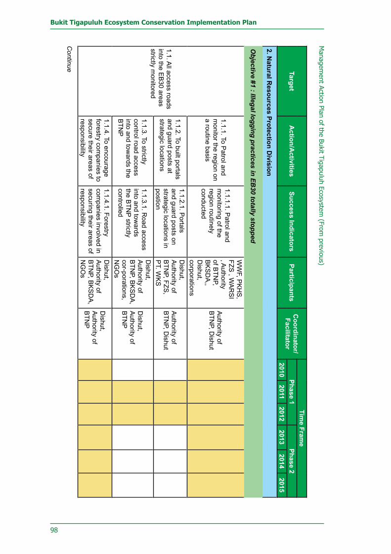
98
Bukit Tigapuluh Ecosystem Conservation Implementation Plan
Continue
Managem
ent Action Plan of the Bukit Tigapuluh Ecosystem (From
previous)
TargetA
ction/Activities
Success IndicatorsParticipants
Coordinator/Facilitator
Time Fram
ePhase 1
Phase 22010
20112012
20132014
2015
2. Natural R
esources Protection Division
Objective #1 : Illegal logging practices in EB
30 totally stopped
1.1. All access roads
into the EB
30 areas strictly m
onitored
1.1.1. To Patrol and
monitor the region on
a routine basis
1.1.1.1. Patrol and
monitoring of the
region routinely conducted
WW
F, PK
HS
, FZS
, WA
RS
I , A
uthority of B
TNP,
BK
SD
A,,
Dishut,
corporations
Authority of
BTN
P, Dishut
1.1.2. To built portals and guard posts at strategic locations
1.1.2.1. Portals
and guard posts on strategic locations in postion
Dishut,
Authority of
BTN
P, FZS,
PT. W
KS
Authority of
BTN
P, Dishut
1.1.3. To strictly control road access into and tow
ards the B
TNP
1.1.3.1. Road access
into and towards
the BTN
P strictly controlled
Dishut,
Authority of
BTN
P, BK
SD
A,
cor-porations, N
GO
s
Dishut,
Authority of
BTN
P
1.1.4. To encourage forestry com
panies to secure their areas of responsibility
1.1.4.1. Forestry com
panies involved in securing their areas of responsibility
Dishut,
Authority of
BTN
P, BK
SD
A,
NG
Os
Dishut,
Authority of
BTN
P

99
9. Sustainable Natural Resource Management And Community Development Implementation Plan
Con
tinue
Man
agem
ent
Actio
n Pl
an o
f th
e Bu
kit
Tiga
pulu
h Ec
osys
tem
(Fr
om p
revi
ous)
Targ
etA
ctio
n/A
ctiv
ities
Succ
ess
Indi
cato
rsPa
rtic
ipan
tsC
oord
inat
or/
Faci
litat
or
Tim
e Fr
ame
Phas
e 1
Phas
e 2
2010
2011
2012
2013
2014
2015
1.1.
All
acce
ss ro
ads
into
the
EB
30 a
reas
st
rictly
mon
itore
d
1.1.
5. T
o em
pow
er
and
optim
ise
the
utili
satio
n of
co
mm
unity
pat
rols
an
d pr
otec
tion
unit
team
s
1.1.
5.1.
Com
mun
ity
patro
ls a
nd
prot
ectio
n un
it te
ams
empo
wer
ed a
nd
optim
ised
Dis
hut,
Aut
horit
y of
B
TNP,
BK
SD
A,
PK
HS
, FZS
Aut
horit
y of
B
TNP,
PK
HS
, FZ
S
1.2.
Law
enf
orce
men
t ag
ains
t ille
gal l
oggi
ng
activ
ities
impl
emen
ted
1.2.
1. T
o in
crea
se th
e nu
mbe
rs, r
esou
rces
, an
d ca
pabi
litie
s of
ci
vil s
erva
nts
in th
e fo
rest
ry s
ecto
r
1.2.
1.1.
The
requ
ired
num
bers
of c
ivil
serv
ants
fulfi
lled
Dis
hut,
Aut
horit
y of
B
TNP,
BK
SD
A
Dis
hut,
Aut
horit
y of
B
TNP,
BK
SD
A1.
2.1.
2 T
he h
uman
re
sour
ce q
ualit
y of
th
e fo
rest
ry s
ervi
ces
impr
oved
Dis
hut,
Aut
horit
y of
B
TNP,
BK
SD
A
Dis
hut,
Aut
horit
y of
B
TNP,
BK
SD
A
1.2.
2. T
o im
prov
e in
ter-
sect
oral
co
ordi
natio
n (p
olic
e,
stat
e at
torn
eys,
la
w c
ourts
) in
law
en
forc
emen
t effo
rts
1.2.
2.1.
Inte
rsec
tora
l co
ordi
natio
n ru
n sm
ooth
ly
Dis
hut,
Aut
horit
y of
B
TNP,
BK
SD
A
Dis
hut,
Aut
horit
y of
B
TNP,
BK
SD
A
1.2.
3. T
o sa
fegu
ard
and
supe
rvis
e la
w
enfo
rcem
ent p
roce
ss
to il
lega
l log
ging
ac
tiviti
es
1.2.
3.1.
Law
en
forc
emen
t pro
cess
co
mpa
tible
with
the
prev
ailin
g re
gula
tions
ef
fect
ivel
y ru
n
Dis
hut,
Aut
horit
y of
B
TNP,
BK
SD
A
Dis
hut,
Aut
horit
y of
B
TNP

100
Bukit Tigapuluh Ecosystem Conservation Implementation Plan
Continue
Managem
ent Action Plan of the Bukit Tigapuluh Ecosystem (From
previous)
TargetA
ction/Activities
Success IndicatorsParticipants
Coordinator/Facilitator
Time Fram
ePhase 1
Phase 22010
20112012
20132014
2015
1.2. Law enforcem
ent against illegal logging activities im
plemented
1.2.3. To safeguard and supervise law
enforcem
ent process to illegal logging activities
1.2.3.1. Law
enforcement process
compatible w
ith the prevailing regulations effectively run
Dishut,
Authority of
BTN
P, BK
SD
A
Dishut,
Authority of
BTN
P
1.2.4. To build an anticipating inform
ation system
on illegal logging activities
1.2.4.1. Informative
network system
established
Dishut,
Authority of
BTN
P, BK
SD
A,
NG
Os
Dishut,
Authority of
BTN
P
1.3. Com
prehension of forestry aspects am
ong law
enforcement officers
significantly improved
1.3.1. To organise periodical w
orkshops and training sessions (every six m
onths)
1.3.1.1. C
omprehension
among law
enforcem
ent agencies im
proved
Dishut,
Authority of
BTN
P, BK
SD
A,
NG
Os
Dishut,
BK
SD
A,,
Authority of
BTN
P
1.3.2. To bring forestry violation cases to court
1.3.2.1. Selected
forestry law violations
brought to court
Dishut,
Authority of
BTN
P, BK
SD
A,
NG
Os, law
enforcem
ent
Dishut,
BK
SD
A,,
Authority of
BTN
P
1.3.2.2. Potential
lawbreakers are
deterred from
encroaching upon forest areas
Dishut,
Authority of
BTN
P, BK
SD
A,
NG
Os, law
enforcem
ent agencies
Dishut,
Authority
of BTN
P, K
ejaksaan, P
engadilan

101
9. Sustainable Natural Resource Management And Community Development Implementation Plan
Con
tinue
Man
agem
ent
Actio
n Pl
an o
f th
e Bu
kit
Tiga
pulu
h Ec
osys
tem
(Fr
om p
revi
ous)
Targ
etA
ctio
n/A
ctiv
ities
Succ
ess
Indi
cato
rsPa
rtic
ipan
tsC
oord
inat
or/
Faci
litat
or
Tim
e Fr
ame
Phas
e 1
Phas
e 2
2010
2011
2012
2013
2014
2015
1.4.
The
gap
bet
wee
n th
e tim
ber s
uppl
y an
d de
man
d ad
dres
sed
1.4.
1. T
o pr
omot
e C
hain
of C
usto
dy
(CoC
) cer
tifica
tion
for
gove
rnm
ent p
roje
cts
1.4.
1.1.
A C
oC p
olic
y fo
r gov
ernm
ent
proj
ects
est
ablis
hed
Dis
hut,
Dis
perin
dag,
N
GO
sD
ishu
t
1.4.
2. T
o pr
omot
e th
e us
e of
woo
d su
bstit
ute
mat
eria
ls
1.4.
2.1.
Woo
d-su
bstit
utio
n m
ater
ial
prom
otio
n ca
mpa
igns
em
bark
ed
Dis
hut,
NG
Os,
A
utho
rity
of
BTN
P, B
KS
DA
Dis
hut
1.4.
3. T
o en
cour
age
com
mun
ities
to p
lant
tim
ber t
rees
1.4.
3.1.
Pla
ntin
g an
d ex
pand
ing
of
fore
st tr
ees
amon
g co
mm
unity
Dis
hut,
Aut
horit
y of
B
TNP,
BK
SD
A,
Fore
stry
R
esea
rch,
fo
rest
ry
corp
orat
ions
Dis
hut
1.4.
4. T
o en
forc
e re
gula
tions
on
prim
ary
woo
d ex
tract
ion
indu
strie
s in
side
and
aro
und
EB
30
1.4.
4.1.
No
prim
ary
woo
d ex
tract
ion
indu
strie
s in
/aro
und
EB
30 w
ithou
t ap
prop
riate
per
mits
Dis
hut,
Dis
perin
dag
Dis
hut

102
Bukit Tigapuluh Ecosystem Conservation Implementation Plan
Continue
Managem
ent Action Plan of the Bukit Tigapuluh Ecosystem (From
previous)
TargetA
ction/Activities
Success IndicatorsParticipants
Coordinator/Facilitator
Time Fram
ePhase 1
Phase 22010
20112012
20132014
2015
Objective #2: H
uman and W
ildlife Conflicts M
itigated
2.1. Hum
an and w
ildlife conflicts m
itigated according to up-to-date protocols
2.1.1 To disseminate
mitigation protocols
2.1.1.1. Mitigation
protocols dissem
inated
BK
SD
A,
Authority of
BTN
P, FZS,
PK
HS
, WW
F, O
rangutan Forum
, E
lephant Forum
, Tiger Forum
BK
SD
A
2.1.2 To conduct training sessions on the m
itigation of hum
an and wildlife
conflicts
2.1.2.1. Training sessions on the m
itigation of human
and wildlife conflicts
successfully conducted
Elephant
Forum, Tiger
Forum, W
WF,
FZS, B
KS
DA
, A
uthority of B
TNP
2.1.3. To establish a conflict m
itigation netw
ork
2.1.2.2. A number
of personnel w
ith capability of im
plementing the
conflict mitigation
protocols
Elephant
Forum, Tiger
Forum, W
WF,
FZS, B
KS
DA
, A
uthority of B
TNP
2.1.3.1. Conflict
mitigation netw
ork established
BK
SD
A,
Authority of
BTN
P, FZS,
PK
HS
, WW
F

103
9. Sustainable Natural Resource Management And Community Development Implementation Plan
Con
tinue
Man
agem
ent
Actio
n Pl
an o
f th
e Bu
kit
Tiga
pulu
h Ec
osys
tem
(Fr
om p
revi
ous)
Targ
etA
ctio
n/A
ctiv
ities
Succ
ess
Indi
cato
rsPa
rtic
ipan
tsC
oord
inat
or/
Faci
litat
or
Tim
e Fr
ame
Phas
e 1
Phas
e 2
2010
2011
2012
2013
2014
2015
2.1.
Hum
an a
nd
wild
life
confl
icts
m
itiga
ted
acco
rdin
g to
up
-to-d
ate
prot
ocol
s
2.1.
4. T
o in
volv
e co
rpor
ate
stak
ehol
ders
in
miti
gatin
g th
e co
nflic
ts
2.1.
4.1.
Rel
ated
co
mpa
nies
act
ivel
y in
volv
ed in
con
flict
m
itiga
tion
BK
SD
A,
Aut
horit
y of
B
TNP,
FZS
, P
KH
S, W
WF
BK
SD
A
2.2.
Hum
an a
nd
wild
life
confl
icts
m
inim
ised
2.2.
1. T
o co
nduc
t a
publ
ic a
war
enes
s pr
ogra
mm
e on
co
nflic
t miti
gatio
n pr
actic
es
2.2.
1.1.
Pub
lic
enlig
hten
men
ts o
n co
nflic
t miti
gatio
n pr
actic
es c
ompl
eted
BK
SD
A,
Aut
horit
y of
B
TNP,
FZS
, P
KH
S, W
WF
2.2.
1.2.
Cap
acity
of
loca
l com
mun
ities
' in
miti
gatio
n co
nflic
ts
impr
oved
BK
SD
A,
Aut
horit
y of
B
TNP,
FZS
, P
KH
S, W
WF
2.2.
2. T
o en
cour
age
corp
orat
ions
to
impl
emen
t co
nser
vatio
n co
ncep
ts in
the
man
agem
ent o
f the
ir fo
rest
ry c
once
ssio
ns
2.2.
2.1.
Con
serv
atio
n co
ncep
ts a
dopt
ed
by c
ompa
nies
in
thei
r con
cess
ion
man
agem
ents
BK
SD
A,
Aut
horit
y of
B
TNP,
FZS
, P
KH
S, W
WF
BTN
BT,
Dis
hut
dan
BK
SD
A
2.3.
Con
flict
miti
gatio
n fu
nds
at th
e lo
cal
leve
l (P
rovi
nces
and
di
stric
ts) a
vaila
ble
2.3.
1. T
o pr
omot
e th
e in
clus
ion
of c
onfli
ct
miti
gatio
n fu
nds
in
loca
l gov
ernm
enta
l bu
dget
s
2.3.
1.1.
Loc
al b
udge
t al
loca
ted
for h
uman
an
d w
ildlif
e co
nflic
t m
itiga
tion
in p
lace
Dis
hut,
BK
SD
A,
corp
orat
ions
BK
SD
A, D
ishu
t

104
Bukit Tigapuluh Ecosystem Conservation Implementation Plan
Continue
Managem
ent Action Plan of the Bukit Tigapuluh Ecosystem (From
previous)
TargetA
ction/Activities
Success IndicatorsParticipants
Coordinator/Facilitator
Time Fram
ePhase 1
Phase 22010
20112012
20132014
20152.3. C
onflict mitigation
funds at the local level (P
rovinces and districts) available
2.3.2. Help local
governments to raise
conflict mitigation
fundings
2.3.2.1. Reserve
funds for conflict m
itigation activities at local level in place
BK
SD
A, N
GO
s, E
lephant Forum
, Tiger Forum
BK
SD
A,
Objective #3: Poaching on protected species totally stopped
3.1. Dissem
ination inform
ation on protected species done
3.1.1. To disseminate
currently prevailing law
s and regulations
3.1.1.1. Relevant
laws and regulations
disseminated
Authority of
BTN
P, BK
SD
A,
Dishut,
police, public prosecutors
Authority of
BTN
P, BK
SD
A3.1.1.2. P
ublic know
ledge on the prevailing law
s im
proved
3.1.2. To compile and
disseminate relevant
information on
protected species
3.1.2.1. Information
related to protected w
ildlife species available
Authority of
BTN
P, BK
SD
A,
Dishut, N
GO
s
BK
SD
A,
Authority of
BTN
P
3.1.2.2. Information
relevant to protected protected w
ildlife species w
ell distributed through various m
edia down to
the village level

105
9. Sustainable Natural Resource Management And Community Development Implementation Plan
Con
tinue
Man
agem
ent
Actio
n Pl
an o
f th
e Bu
kit
Tiga
pulu
h Ec
osys
tem
(Fr
om p
revi
ous)
Targ
etA
ctio
n/A
ctiv
ities
Succ
ess
Indi
cato
rsPa
rtic
ipan
tsC
oord
inat
or/
Faci
litat
or
Tim
e Fr
ame
Phas
e 1
Phas
e 2
2010
2011
2012
2013
2014
2015
3.2.
Poa
chin
g an
d ill
egal
trad
ing
activ
ities
of p
rote
cted
sp
ecie
s m
onito
red
3.2.
1. T
o co
nduc
t in
telli
genc
e op
erat
ios
3.2.
1.1.
Inte
llige
nce
serv
ices
impl
emen
ted
Aut
horit
y of
B
TNP,
BK
SD
A,
Dis
hut,
Pol
ice,
N
GO
s
Dis
hut,
Aut
horit
y of
B
TNP,
BK
SD
A
3.2.
1.2.
Acc
urat
e in
form
atio
n on
ille
gal
poac
hing
act
iviti
es
and
and
illeg
al tr
adin
g of
the
prot
ecte
d w
ildlif
e
3.2.
2. T
o co
nduc
t ro
utin
e pa
trols
for t
he
secu
rity
of th
e w
oods
an
d th
e w
ildlif
e
3.2.
2.1.
Rou
tine
patro
ls o
f for
ests
and
w
ildlif
e pr
otec
tion
Aut
horit
y of
B
TNP,
BK
SD
A,
NG
Os
Aut
horit
y of
B
TNP,
BK
SD
A3.
2.2.
2. C
rimin
al
act t
hrou
gh il
lega
l po
achi
ng a
ctiv
ities
on
pro
tect
ed w
ildlif
e pr
even
ted
3.2.
3. T
o es
tabl
ish
an
info
rmat
ion
netw
ork
to d
eal w
ith p
oach
ing
and
wild
life
trade
3.2.
3.1.
Sys
tem
of
net
wor
king
and
in
form
atio
n on
ant
i-po
achi
ng a
nd tr
adin
g of
pro
tect
ed s
peci
es
esta
blis
hed
Dis
hut,
Aut
horit
y of
B
TNP,
BK
SD
A,
NG
Os
Aut
horit
y of
B
TNP,
BK
SD
A

106
Bukit Tigapuluh Ecosystem Conservation Implementation Plan
Continue
Managem
ent Action Plan of the Bukit Tigapuluh Ecosystem (From
previous)
TargetA
ction/Activities
Success IndicatorsParticipants
Coordinator/Facilitator
Time Fram
ePhase 1
Phase 22010
20112012
20132014
2015
3.2. Poaching
and illegal trading activities of protected species m
onitored
3.2.4. To compile
database system on
poaching activities and trades of protected species
3.2.4.1. Database
on illegal poaching and illegal trading of protected w
ildlife developed
Dishut,
Authority of
BTN
P, BK
SD
A,
NG
Os
Authority of
BTN
P, BK
SD
A
3.2.5. To improve
the capacity of responsible officers, including police, forest rangers, and protection team
personnel
3.2.5.1. Capacity
of forest ranger, com
munity patrol,
and protection team
personnel in com
bating illegal poaching and illegal trading of protected w
ildlife
Dishut,
Authority of
BTN
P, BK
SD
A,
NG
Os
Authority of
BTN
P, BK
SD
A
3.2.6. To explain to P
erbakin Association
about the key species population pockets in E
B30
3.2.6.1. Areas that
off-limits for hunting
activities known and
accepted by Perbakin
Dishut,
Authority of
BTN
P, BK
SD
A,
NG
Os
Authority of
BTN
P, BK
SD
A3.2.7. To engage P
erbakin in to the m
onitoring of poaching activites
3.2.7.1. A joint m
onitoring of hunting activities established3.2.7.2. H
unting activities by P
erbakin m
embers effectively
controlled

107
9. Sustainable Natural Resource Management And Community Development Implementation Plan
Con
tinue
Man
agem
ent
Actio
n Pl
an o
f th
e Bu
kit
Tiga
pulu
h Ec
osys
tem
(Fr
om p
revi
ous)
Targ
etA
ctio
n/A
ctiv
ities
Succ
ess
Indi
cato
rsPa
rtic
ipan
tsC
oord
inat
or/
Faci
litat
or
Tim
e Fr
ame
Phas
e 1
Phas
e 2
2010
2011
2012
2013
2014
2015
3.3.
Law
enf
orce
men
t ag
ains
t poa
chin
g ac
tiviti
es im
plem
ente
d
3.3.
1. T
o bu
ild
capa
city
of
gove
rnm
ent
offic
ials
in fo
rest
ry
inve
stig
ator
s
3.3.
1.1.
Req
uire
d nu
mbe
r for
go
vern
men
t offi
cial
s in
fo
rest
ry o
ffice
s fu
lfille
dD
ishu
t, A
utho
rity
of
BTN
P, B
KS
DA
, P
olic
e
Dis
hut,
Aut
horit
y of
B
TNP,
BK
SD
A.
3.3.
1.2.
Qua
lity
of
hum
an re
seou
rce
of
gove
rnm
ent o
ffici
als
in fo
rest
ry o
ffice
s im
prov
ed3.
3.2.
To
impr
ove
inte
rsec
tora
l co
ordi
natio
n (p
olic
e,
gene
ral a
ttorn
ey, a
nd
the
cour
ts) i
n la
w
enfo
rcin
g ac
tiviti
es
3.3.
2.1.
Goo
d la
w-e
nfor
cem
ent
coor
dina
tion
syst
em
esta
blis
hed
AU
THO
RIT
YY
OF
BTN
P,
Dis
hut,
BK
SD
A, l
aw
enfo
rcem
ent
agen
cies
3.3.
3. T
o ac
com
pany
an
d m
onito
r the
law
en
forc
emen
t pro
cess
3.3.
3.1.
Law
en
forc
emen
ts th
at
abid
e by
the
prev
ailin
g no
rms
and
regu
latio
ns
impl
emen
ted
Aut
horit
y of
B
TNP,
Dis
hut,
BK
SD
A, l
aw
enfo
rcem
ent
agen
cies
3.4.
The
use
of
both
org
anic
and
ho
mem
ade
firea
rms
stric
tly c
ontro
lled
3.4.
1. In
coo
rdin
atio
n w
ith th
e na
tiona
l po
lice
to re
gula
te th
e us
e of
org
anic
and
ho
mem
ade
firea
rms
3.4.
1.1.
Coo
rdin
atio
n sy
stem
to re
gula
te th
e us
e of
org
anic
and
ho
mem
ade
firea
rms
esta
blis
hed
Aut
horit
y of
B
TNP,
BK
SD
A,
polic
e, N
GO
sP
olic
e

108
Bukit Tigapuluh Ecosystem Conservation Implementation Plan
Managem
ent Action Plan of the Bukit Tigapuluh Ecosystem (From
previous)
TargetA
ction/Activities
Success IndicatorsParticipants
Coordinator/Facilitator
Time Fram
ePhase 1
Phase 22010
20112012
20132014
2015
3.4. The use of both organic and hom
emade firearm
s strictly controlled
3.4.2. To conduct a control over the ow
nership of hom
emade
firearms am
ong the com
munity
3.4.1.2. No m
isusing of organic firearm
s
Authority of
BTN
P, BK
SD
A,
police, NG
Os
Police
3.4.2.1. No
homem
ade firearms
found among local
comm
unities
Police
Police
Objective #4 : Forest Fires in the EB
30 controlled
4.1. Com
munity
inside and around the E
B30’s aw
areness program
me for not
using fire (zero burning) on land clearing established
4.1.1. To disseminate
information about
the negative impacts
of forest fires upon hum
an beings and the ecosystem
4.1.1.1. Information
about the negative im
pacts of forest and land fires upon hum
an beings and the ecosystem
dissem
inated
Dishut,
Authority of
BTN
P, BK
SD
A,
Bapedalda,
NG
Os
Dishut,
Authority of
BTN
P, BK
SD
A
Dishut,
Authority of
BTN
P, BK
SD
A4.1.2. To distribute inform
ation on the relevant law
s and regulations
4.1.2.1. Information on
the relevant laws and
regulations distributed
Dishut,
Authority of
BTN
P, BK
SD
A,
police, public prosecutors, B
apedalda, N
GO
s
Continue

109
9. Sustainable Natural Resource Management And Community Development Implementation Plan
Con
tinue
Man
agem
ent
Actio
n Pl
an o
f th
e Bu
kit
Tiga
pulu
h Ec
osys
tem
(Fr
om p
revi
ous)
Targ
etA
ctio
n/A
ctiv
ities
Succ
ess
Indi
cato
rsPa
rtic
ipan
tsC
oord
inat
or/
Faci
litat
or
Tim
e Fr
ame
Phas
e 1
Phas
e 2
2010
2011
2012
2013
2014
2015
4.1.
Com
mun
ity
insi
de a
nd a
roun
d th
e E
B30
’s a
war
enes
s pr
ogra
mm
e fo
r not
us
ing
fire
(zer
o bu
rnin
g) o
n la
nd
clea
ring
esta
blis
hed
4.1.
3. T
o or
gani
se
com
mun
ity c
ares
for
fires
(Mas
yara
kat
Ped
uli A
pi /
MPA
)
4.1.
3.1.
Com
mun
ity
care
s fo
r fire
s (M
asya
raka
t Ped
uli
Api
/ M
PA) e
stab
lishe
d
Aut
horit
y of
B
TNP,
BK
SD
A,
Dis
hut,
Bap
edal
da
Dis
hut,
Aut
horit
y of
B
TNP,
BK
SD
A
4.1.
4. T
o in
trodu
ce
cons
erva
tiona
l lan
d-cl
earin
g m
etho
ds
4.1.
4.1.
C
onse
rvat
iona
l lan
d-cl
earin
g m
etho
ds
know
n an
d ac
cept
ed
by lo
cal c
omm
unity
Bap
edal
da4.
1.4.
2.
Con
serv
atio
nal l
and-
clea
ring
met
hods
ad
opte
d an
d ap
plie
d by
loca
l com
mun
ity
4.2.
Are
as v
ulne
rabl
e to
fore
st fi
re id
entifi
ed
4.2.
1. T
o in
vent
ory
and
map
are
as
vuln
erab
le-to
-fire
s
4.2.
1.1.
Are
as
vuln
erab
le to
fore
st
fires
iden
tified
and
m
appe
dA
utho
rity
of
BTN
P, B
KS
DA
, D
ishu
t, B
aped
alda
, co
rpor
atio
nsD
ishu
t, B
aped
alda
4.2.
2. T
o in
vent
ory
and
map
reso
urce
s fo
r for
ests
fire
pr
even
tion
4.2.
2.1
Res
ourc
es
capa
ble
of fi
re
prev
entin
g an
d fir
efigh
ting
map
ped
4.2.
3. T
o m
onito
r pr
one-
to-fi
res
fore
st
area
s
4.2.
3.1.
The
are
as
vuln
erab
le to
fore
st
fires
sup
ervi
sed
Aut
horit
y of
B
TNP,
BK
SD
A,
Dis
hut,
Bap
edal
da

110
Bukit Tigapuluh Ecosystem Conservation Implementation Plan
Managem
ent Action Plan of the Bukit Tigapuluh Ecosystem (From
previous)
TargetA
ction/Activities
Success IndicatorsParticipants
Coordinator/Facilitator
Time Fram
ePhase 1
Phase 22010
20112012
20132014
2015
4.3. Information
system am
ong sectors optim
ised
4.3.1. To optimise the
performance of forest
firefighting task forces in 4 districts
4.3.1.1 Work
mechanism
of forest firefighting task forces in 4 districts optim
ised
Authority of
BTN
P, BK
SD
A,
Dishut,
Bapedalda,
corporationsB
apedalda4.3.2. To build com
munication
system of anti-fires
inter-sectors
4.3.2.1 C
omm
unication system
of anti-fires inter-sectors established
Authority of
BTN
P, BK
SD
A,
Dishut,
Bapedalda,
corporations
4.4. Forest-fire early w
arnings system
established.
4.4.1. To continuously actualise and distribute hotspot data from
satellites
4.4.1.1. Accurate and
actual hotspot data at local level in place
Dishut,
Authority of
BTN
P, BK
SD
A
Dishut,
Authority of
BTN
P, BK
SD
A4.4.2. To install and socialise inform
ation and w
arnings about forest fires
4.4.2.1. Forest-fire w
arnings and signs installed
Authority of
BTN
P, BK
SD
A,
Dishut,
Bapedalda
4.4.2.2. Both w
arnings and signs understood by local com
munities
Authority of
BTN
P, BK
SD
A,
Dishut
Continue

111
9. Sustainable Natural Resource Management And Community Development Implementation Plan
Con
tinue
Man
agem
ent
Actio
n Pl
an o
f th
e Bu
kit
Tiga
pulu
h Ec
osys
tem
(Fr
om p
revi
ous)
Targ
etA
ctio
n/A
ctiv
ities
Succ
ess
Indi
cato
rsPa
rtic
ipan
tsC
oord
inat
or/
Faci
litat
or
Tim
e Fr
ame
Phas
e 1
Phas
e 2
2010
2011
2012
2013
2014
2015
4.5.
Ear
ly m
itiga
tion
of fo
rest
fire
im
plem
ente
d
4.5.
1. T
o es
tabl
ish
and
impr
ove
infra
stru
ctur
es
rele
vant
for f
ores
t fir
efigh
ting
in c
erta
in
vuln
erab
le a
reas
4.5.
1.1.
Rel
evan
t in
frast
ruct
ures
for
fore
st fi
refig
htin
g in
ce
rtain
vul
nera
ble
area
s in
pla
ce
Aut
horit
y of
B
TNP,
BK
SD
A,
Dis
hut,
Bap
edal
da
Dis
hut,
Aut
horit
y of
B
TNP,
BK
SD
A,
Bep
edal
da
4.5.
2. T
o op
timis
e th
e ro
les
of S
MA
RT,
fo
rest
fire
brig
ades
, M
PA, a
nd c
omm
unity
fo
rest
pat
rols
4.5.
2.1.
Par
ticip
atio
n of
SM
AR
T, fo
rest
fire
br
igad
es, M
PA, a
nd
com
mun
ity fo
rest
pa
trols
in c
omba
ting
fore
st fi
res
impr
oved
Aut
horit
y of
B
TNP,
BK
SD
A,
Dis
hut
4.6.
Tra
ined
hum
an
reso
urce
s fo
r m
itiga
ting
fore
st fi
res
adeq
uate
ly a
vaila
ble
4.6.
1. T
o co
nduc
t fo
rest
fire
trai
ning
s re
gula
rly
4.6.
1.1.
Rel
evan
t tra
inin
gs fo
r for
est fi
re
prev
entio
n re
gula
rly
orga
nise
d
Aut
horit
y of
B
TNP,
BK
SD
A,
Dis
hut,
Bap
edal
da
3. L
and-
Use
Pla
nnin
g D
ivis
ion
Obj
ectiv
e #1
: Ill
egal
fore
st e
ncro
achm
ent i
n th
e Te
bo, T
anja
bar,
Inhu
, and
Inhi
l Dis
tric
ts h
alte
d.
1. A
dat
abas
e on
fo
rest
cov
erag
e st
atis
tics
com
pile
d
1.1.
1. T
o co
mpo
se
land
cov
er m
aps
1.1.
1.1.
For
est
cove
rage
map
s of
in
side
and
out
side
the
BTN
P ar
eas
in p
lace
NG
Os,
A
utho
rity
of B
TNP,
B
AP
PE
DA
, D
ishu
t
Aut
horit
y of
B
TNP

112
Bukit Tigapuluh Ecosystem Conservation Implementation Plan
Managem
ent Action Plan of the Bukit Tigapuluh Ecosystem (From
previous)
TargetA
ction/Activities
Success IndicatorsParticipants
Coordinator/Facilitator
Time Fram
ePhase 1
Phase 22010
20112012
20132014
2015
1.1. A database on forest coverage statistics com
piled
1.1.2. To compile a
database system for
forest encroachment
activities
1.1.2.1. A database sstem
established
NG
Os,
Authority of
BTN
P, BK
SD
A,
BA
PP
ED
A,
Dishut
Authority of
BTN
P1.1.3. To establish a m
echanism
for information
dissemination on
forest encroachment
threats in the EB
30 areas
1.1.3.1. Data on forest
encroachment in the
EB
30 disseminated
down to local levels
1.1.4. To conduct relevant training sessions for G
IS
and remote-sensing
operators
1.1.4.1. Training in G
IS and rem
ote sensing operations organised
Authority of
BTN
P, Dishut
1.1.4.2. Skilled G
IS
operators in place
1.1.5. To establish a form
al task force to be responsible for collecting and processing spatial data
1.1.5.1. A formal task
force establishedN
GO
s, A
uthority of B
TNP,
BK
SD
A,
BA
PP
ED
A,
Dishut
Authority of
BTN
P, Dishut
1.1.5.2. Providing and
processing of spatial data run w
ell smoothly
Continue

113
9. Sustainable Natural Resource Management And Community Development Implementation Plan
Con
tinue
Man
agem
ent
Actio
n Pl
an o
f th
e Bu
kit
Tiga
pulu
h Ec
osys
tem
(Fr
om p
revi
ous)
Targ
etA
ctio
n/A
ctiv
ities
Succ
ess
Indi
cato
rsPa
rtic
ipan
tsC
oord
inat
or/
Faci
litat
or
Tim
e Fr
ame
Phas
e 1
Phas
e 2
2010
2011
2012
2013
2014
2015
1.2.
Cle
ar
delin
eatio
n of
fore
st
area
bou
ndar
ies
mat
eria
lised
1.2.
1. T
o di
ssem
inat
e in
form
atio
n ab
out t
he
boun
darie
s fo
rest
ar
eas
1.2.
1.1.
Bou
ndar
ies
of
fore
st a
reas
soc
ialis
ed
Aut
horit
y of
B
TNP,
Dis
hut,
BK
SD
AA
utho
rity
of
BTN
P, D
ishu
t1.
2.2.
To
inst
all
war
ning
s an
d in
form
atio
n si
gns
on
stra
tegi
c lo
catio
ns
1.2.
2.1.
A
nnou
ncem
ents
and
w
arni
ngs
inst
alle
d on
st
rate
gic
loca
tions
Aut
horit
y of
B
TNP,
Dis
hut,
BK
SD
A, N
GO
s,
corp
orat
ions
1.3.
Vill
age
land
-us
e re
gula
tions
es
tabl
ishe
d
1.3.
1. T
o fa
cilit
ate
the
esta
blis
hmen
t of
parti
cipa
tory
land
-use
pl
ans
in th
e vi
llage
le
vel
1.3.
1.1.
Vill
age
land
us
e pl
anni
ng le
galis
ed
Bap
emad
es,
Dis
hut,
Aut
horit
y of
B
TNP,
NG
Os
Bap
emad
es
1.3.
2. T
o m
ake
villa
ge
map
s1.
3.2.
1. V
illag
e m
aps
com
plet
ed1.
3.3.
To
initi
ate
the
estb
alis
hmen
t of l
and-
use
regu
latio
ns a
t vi
llage
leve
l
1.3.
3.1.
Vill
age
regu
latio
ns o
n la
nd-
use
arra
nged
1.3.
4. T
o en
cour
age
the
high
er lo
cal-
gove
rnm
ent l
evel
s to
ack
now
ledg
e th
e vi
llage
land
-use
pla
ns
1.3.
4.1.
Vill
age
regu
latio
n an
d la
nd-
use
plan
ning
lega
lised
by
loca
l gov
ernm
ent/
PE
MD
A

114
Bukit Tigapuluh Ecosystem Conservation Implementation Plan
Managem
ent Action Plan of the Bukit Tigapuluh Ecosystem (From
previous)
TargetA
ction/Activities
Success IndicatorsParticipants
Coordinator/Facilitator
Time Fram
ePhase 1
Phase 22010
20112012
20132014
2015
1.4. EB
30 accom
modated
in Sum
atra Island S
patial Planning
1.4.1. To recomm
end the inclusion of E
B30 in the S
patial P
lanning for Sum
atra Island
1.4.1.1. The EB
30 areas accom
modated
in the Sum
atran spatial planning
Dishut,
Authority of
BTN
P, BK
SD
A , N
GO
s
Authority of
BTN
P, Dishut
1.4.2. To recomm
end a perm
anent legalisation for the E
B30 m
anagement
1.4.2.1. The m
anagement schem
e of E
B30 legalised
Dishut,
Authority of
BTN
P, BK
SD
A , N
GO
s
1.5. Law
enforcement against
forest encroachers executed
1.5.1. To distribute law
s and regulations relating to forests areas m
anagement
1.5.1.1. Laws and
regulations currently prevailing to forest areas m
anagement
distributed D
ishut, A
uthority of B
TNP, B
KS
DA
, police, public prosecutors
1.5.2. To form an
integrated team for
mitigating forest
encroachment
activities
1.5.2.1 Participation of
comm
unity in forestry law
s enforcement
enlarged
1.5.3. To conduct law
enforcement
operations together w
ith an integrated team
1.5.3.1. The execution of law
-enforcement
operations done periodically
Continue

115
9. Sustainable Natural Resource Management And Community Development Implementation Plan
Con
tinue
Man
agem
ent
Actio
n Pl
an o
f th
e Bu
kit
Tiga
pulu
h Ec
osys
tem
(Fr
om p
revi
ous)
Targ
etA
ctio
n/A
ctiv
ities
Succ
ess
Indi
cato
rsPa
rtic
ipan
tsC
oord
inat
or/
Faci
litat
or
Tim
e Fr
ame
Phas
e 1
Phas
e 2
2010
2011
2012
2013
2014
2015
1.5.
Law
en
forc
emen
t aga
inst
fo
rest
enc
roac
hers
ex
ecut
ed
1.5.
3. T
o co
nduc
t la
w e
nfor
cem
ent
oper
atio
ns to
geth
er
with
an
inte
grat
ed
team
1.5.
3.2.
Leg
al a
ctio
n ag
ains
t tra
ding
and
fo
rest
enc
roac
hing
pe
rpet
rato
rs
effe
ctiv
ely
exec
uted
Dis
hut,
Aut
horit
y of
B
TNP,
BK
SD
A,
polic
e, p
ublic
pr
osec
utor
s
Dis
hut,
Aut
horit
y of
B
TNP
1.5.
4. T
o br
ing
fore
st
illeg
al e
ncro
achm
ent
case
s to
cou
rt
1.5.
4.1.
Fea
r to
cond
uct i
llega
l en
croa
chm
ent
amon
g w
ider
loca
l co
mm
uniti
es a
nd
publ
ic in
pla
ce
Pol
ice,
pub
lic
pros
ecut
ors
1.6.
Reh
abili
tatio
n an
d re
stor
atio
n of
fo
rest
s ar
eas
real
ised
1.6.
1. T
o in
vent
ory
and
map
the
loca
tions
of
reha
bilit
atio
n an
d re
stor
atio
n
1.6.
1.1.
Tar
get
loca
tions
for
reha
bilit
atio
n an
d re
stor
atio
n pl
anni
ng
map
ped
Dis
hut,
BK
SD
A,
BP
DA
S,
Aut
horit
y of
B
TNP,
NG
Os
BP
DA
S, D
ishu
t
1.6.
2. T
o m
ake
reha
bilit
atio
n an
d re
stor
atio
n pl
anni
ngs
1.6.
2.1.
Reh
abili
tatio
n an
d re
stor
atio
n pl
anni
ng c
ompi
led
1.6.
3. T
o im
plem
ent
reha
bilit
atio
n an
d re
stor
atio
n
1.6.
3.1.
Reh
abili
tatio
n an
d re
stor
atio
n ac
tiviti
es e
xecu
ted
1.6.
4. T
o co
nduc
t m
onito
ring
and
eval
uatio
n (M
on-E
v)
1.6.
4.1.
Mon
itorin
g ov
er th
e re
habi
litat
ion
and
rest
orat
ion
activ
ities
impl
emen
ted

116
Bukit Tigapuluh Ecosystem Conservation Implementation Plan
Managem
ent Action Plan of the Bukit Tigapuluh Ecosystem (From
previous)
TargetA
ction/Activities
Success IndicatorsParticipants
Coordinator/Facilitator
Time Fram
ePhase 1
Phase 22010
20112012
20132014
2015
4. Sustainable Natural R
esource Managem
ent and Com
munity D
evelopment D
ivision
Objective #1 : D
ependence of traditional comm
unities in BTN
P on forest resources decreased
1.1. Capacity
of traditional com
munities on
cultivation using land intensification m
ethod im
proved
1.1.1. To establish a farm
er group for developing know
ledge transfer am
ong them
1.1.1.1. Farmer/
grower groupd
established
Authority of
BTN
P, NG
Os,
Distan, D
ishut
Authority of
BTN
P, Distan
1.1.2. To conduct public enlightenm
ents on land intensification m
ethod using traditional, practicable, and com
prehensible approach
1.1.2.1. Public
enlightenments on
land intensification m
ethod conductedA
uthority of B
TNP, D
istan, B
akorluh, N
GO
s, Dishut
Authority of
BTN
P, Distan
1.1.2.2. Productivity of
tradionally agricultural land using the land intensification m
ethod increased
Authority of
BTN
P1.2. A
gricultural products of the traditional com
munity
maxim
um in
sustainable manner
1.2.1. To provide seedlings of fruit-bearing jernang (D
aemonorops
draco).
1.2.1.1. Jernang rattan seedlings available and accessable to the local com
munity
Authority of
BTN
P, Forestry R
esearch, N
GO
s
Continue

117
9. Sustainable Natural Resource Management And Community Development Implementation Plan
Con
tinue
Man
agem
ent
Actio
n Pl
an o
f th
e Bu
kit
Tiga
pulu
h Ec
osys
tem
(Fr
om p
revi
ous)
Targ
etA
ctio
n/A
ctiv
ities
Succ
ess
Indi
cato
rsPa
rtic
ipan
tsC
oord
inat
or/
Faci
litat
or
Tim
e Fr
ame
Phas
e 1
Phas
e 2
2010
2011
2012
2013
2014
2015
1.2.
Agr
icul
tura
l pr
oduc
ts o
f the
tra
ditio
nal c
omm
unity
m
axim
um in
su
stai
nabl
e m
anne
r
1.2.
2. T
o de
velo
p je
rnan
g ra
ttan
(Dae
mon
orop
s dr
aco)
in
old
trad
ition
al
rubb
er p
lant
atio
ns
1.2.
2.1.
Jer
nang
ra
ttan
culti
vate
d on
ol
d tra
ditio
nal r
ubbe
r pl
anta
tions
Aut
horit
y of
B
TNP,
For
estry
R
esea
rch,
N
GO
s
Aut
horit
y of
B
TNP
1.2.
3. T
o se
t m
arke
ting
and
deve
lop
tradi
ng
syst
em o
f jer
nang
(d
rago
n’s
bloo
d)
1.2.
3.1.
Mar
ketin
g an
d de
velo
p fa
ir tra
ding
sy
stem
of j
erna
ng
(dra
gon’
s bl
ood)
set
Des
perin
dag,
D
isbu
n,
Aut
horit
y of
B
TNP,
NG
Os
Des
perin
dag
1.2.
3.1.
Loc
al
com
mun
ities
der
ive
bene
fit fr
om a
dded
va
lue
of s
tabi
lised
pr
ice
Des
perin
dag,
D
isbu
n,
Aut
horit
y of
B
TNP,
NG
Os
Aut
horit
y of
BTN
P,
Des
perin
dag
1.2.
4. T
o ap
ply
land
in
tens
ifica
tion
met
hod
on n
atur
al ru
bber
pl
anta
tion
1.2.
4.1
Inte
nsifi
catio
n sy
stem
on
tradi
tiona
l ru
bber
pla
ntat
ions
ad
opte
d an
d im
plem
ente
d
Dis
tan,
Dis
bun,
A
utho
rity
of
BTN
P, D
ishu
t, N
GO
sA
utho
rity
of
BTN
P1.
3. L
ocal
and
tra
ditio
nal n
orm
s re
leva
nt to
na
tura
l res
ourc
es
cons
erva
tion
empo
wer
ed
1.3.
1. T
o id
entif
y an
d an
alys
e lo
cally
cu
ltura
l val
ues
usef
ul
to m
inim
ise
the
natu
ral r
esou
rces
ov
er-e
xplo
itatio
n
1.3.
1.1.
Loc
ally
cu
ltura
l val
ues
usef
ul
to m
inim
ise
the
natu
ral r
esou
rces
ov
er-e
xplo
itatio
n id
entifi
ed
Aut
horit
y of
B
TNP,
NG
Os

118
Bukit Tigapuluh Ecosystem Conservation Implementation Plan
Managem
ent Action Plan of the Bukit Tigapuluh Ecosystem (From
previous)
TargetA
ction/Activities
Success IndicatorsParticipants
Coordinator/Facilitator
Time Fram
ePhase 1
Phase 22010
20112012
20132014
20151.3. Local and traditional norm
s relevant to natural resources conservation em
powered
1.3.2. To strengthen and legalise locally cultural norm
s that in harm
ony with the
natural resource conservation
1.3.2.1. Traditional norm
s relevant to the natural resources conservation legalised underneath Village R
egulations/PE
RD
ES
Authority of
BTN
P, NG
Os
Bapem
ades
Authority of
BTN
P1.4. E
cological and cultural tourism
as non-agricultural incom
e sources for traditional com
munities
developed
1.4.1. To identify cultural and ecological tourism
potentials in and around traditional com
munity
settlements
1.4.1.1. Cultural
and ecological tourism
potentials in and around traditional com
munity
settlements identified
Authority of
BTN
P, Dispar,
NG
Os
1.4.2. To promote
traditional comm
unity settlem
ents as ecological and cultural tourism
spots
1.4.2.1. Traditional com
munity
settlements as
ecological and cultural tourism
spots prom
oted
1.4.3. To conduct tour-guide trainings for traditional com
munities
1.4.3.1. Tour-guide trainings for traditional com
munities
conducted
Continue

119
9. Sustainable Natural Resource Management And Community Development Implementation Plan
Con
tinue
Man
agem
ent
Actio
n Pl
an o
f th
e Bu
kit
Tiga
pulu
h Ec
osys
tem
(Fr
om p
revi
ous)
Targ
etA
ctio
n/A
ctiv
ities
Succ
ess
Indi
cato
rsPa
rtic
ipan
tsC
oord
inat
or/
Faci
litat
or
Tim
e Fr
ame
Phas
e 1
Phas
e 2
2010
2011
2012
2013
2014
2015
1.4.
Eco
logi
cal a
nd
cultu
ral t
ouris
m a
s no
n-ag
ricul
tura
l in
com
e so
urce
s fo
r tra
ditio
nal
com
mun
ities
de
velo
ped
1.4.
4. T
o pr
epar
e re
leva
nt
infra
stru
ctur
es
and
faci
litie
s fo
r ec
otou
rism
(nat
ural
ly
scen
ic s
pots
)
1.4.
4.1.
Rel
evan
t in
frast
ruct
ures
an
d fa
cilit
ies
for
ecot
ouris
m (n
atur
ally
sc
enic
spo
ts) i
n pl
ace
Aut
horit
y of
BTN
P,
Dis
par,
NG
O,
corp
orat
ions
Aut
horit
y of
B
TNP
1.4.
5. T
o de
velo
p th
e po
tent
ially
co
mm
erci
al o
f tra
ditio
nal h
andi
craf
ts
1.4.
5.1.
Pot
entia
lly
com
mer
cial
of
tradi
tiona
l han
dicr
afts
id
entifi
ed
Aut
horit
y of
B
TNP,
NG
Os,
D
ispa
r
1.5.
Wor
king
cap
ital
and
profi
tabl
e m
arke
ts fo
r loc
al
com
mun
ity a
cces
sibl
e
1.5.
1 To
form
vill
age
coop
erat
ives
for
depo
sit-a
nd-le
ndin
g op
erat
ions
and
m
arke
ting
agric
ultu
ral
prod
ucts
1.5.
1.1.
Vill
age
coop
erat
ives
es
tabl
ishe
d
Bap
emad
es,
Aut
horit
y of
B
TNP,
Dis
tan,
sm
all/m
id-s
ized
bu
sine
sses
1.6.
Com
petit
ive
educ
atio
n fo
r the
yo
ung
gene
ratio
ns o
f tra
ditio
nal c
omm
unity
ac
cess
ible
1.6.
1. T
o es
tabl
ish
educ
atio
n ce
nter
in
tradi
tiona
l com
mun
ity
settl
emen
ts
1.6.
1.1.
Edu
catio
n ce
nter
in tr
aditi
onal
co
mm
unity
se
ttlem
ents
es
tabl
ishe
d
NG
Os,
Dik
nas,
A
utho
rity
of
BTN
P
Aut
horit
y of
B
TNP,
Dik
nas,
N
GO
s
1.6.
2. T
o pr
ovid
e ad
equa
te te
achi
ng
staf
f
1.6.
2.1.
Ade
quat
e nu
mbe
r of t
each
ing
staf
fs in
pos
ition
NG
Os,
Dik
nas,
A
utho
rity
of
BTN
P
Aut
horit
y of
B
TNP,
Dik
nas,
N
GO
s

120
Bukit Tigapuluh Ecosystem Conservation Implementation Plan
Managem
ent Action Plan of the Bukit Tigapuluh Ecosystem (From
previous)
TargetA
ction/Activities
Success IndicatorsParticipants
Coordinator/Facilitator
Time Fram
ePhase 1
Phase 22010
20112012
20132014
20151.7. H
ealthcare for traditional com
munities m
ade accessible
1.7.1. To conduct regular m
edical visits
1.7.1.1. Regular
medical visits
conducted
NG
Os, D
iskes, A
uthority of B
TNP
Authority of
BTN
P Diskes
Objective #2 : D
ependence of comm
unities outside the BTN
P (Main interaction Village or D
esa Interaksi Utam
a/DIU
) on forest resources decreased
2.1. Capability of D
IU
comm
unity on land intensification m
ethod im
proved
2.1.1. To form farm
er groups as m
edium of
knowledge transfer
2.1.1.1. Farmer/
grower groups
established
Distan, N
GO
s, D
isbun, A
uthority of B
TNP,
Bapem
ades
Disbun, D
ishut
2.1.2. To conduct public agricultural enlightenm
ents on land intensification m
ethods
2.1.2.1. Publicly
agricultural enlightenm
ents on land intensification m
ethods conducted
Authority of
BTN
P, Distan,
Bakorluh,
NG
Os, D
ishut, D
isbun
Distan, D
isbun
2.1.3. To assist know
ledge transfers betw
een imm
igrants and native com
munities on land
intensification method
2.1.3.1. Know
ledge transfers betw
een im
migrants and native
comm
unities on land intensification m
ethod w
ell assisted
Authority of
BTN
P, Distan,
Bakorluh,
NG
Os, D
ishut, D
isbun
Disbun, D
ishut
2.2. Agricultural
products of local com
munity continually
increased
2.2.1. To procure prim
e rubber seeds and to im
plement the
land intensification m
ethod
2.2.1.1. Intensive m
anagement of
rubber plantations by rubber farm
ers adopted
Distan, D
ishut, N
GO
s, Disbun
Disbun
Continue
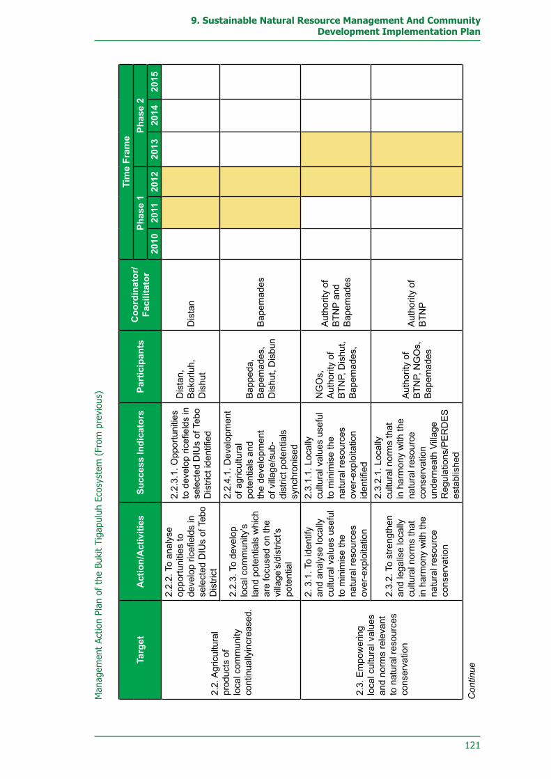
121
9. Sustainable Natural Resource Management And Community Development Implementation Plan
Man
agem
ent
Actio
n Pl
an o
f th
e Bu
kit
Tiga
pulu
h Ec
osys
tem
(Fr
om p
revi
ous)
Targ
etA
ctio
n/A
ctiv
ities
Succ
ess
Indi
cato
rsPa
rtic
ipan
tsC
oord
inat
or/
Faci
litat
or
Tim
e Fr
ame
Phas
e 1
Phas
e 2
2010
2011
2012
2013
2014
2015
2.2.
Agr
icul
tura
l pr
oduc
ts o
f lo
cal c
omm
unity
co
ntin
ually
incr
ease
d.
2.2.
2. T
o an
alys
e op
portu
nitie
s to
de
velo
p ric
efiel
ds in
se
lect
ed D
IUs
of T
ebo
Dis
trict
2.2.
3.1.
Opp
ortu
nitie
s to
dev
elop
rice
field
s in
se
lect
ed D
IUs
of T
ebo
Dis
trict
iden
tified
Dis
tan,
B
akor
luh,
D
ishu
tD
ista
n
2.2.
3. T
o de
velo
p lo
cal c
omm
unity
’s
land
pot
entia
ls w
hich
ar
e fo
cuse
d on
the
villa
ge’s
/dis
trict
’s
pote
ntia
l
2.2.
4.1.
Dev
elop
men
t of
agr
icul
tura
l po
tent
ials
and
th
e de
velo
pmen
t of
vill
age/
sub-
dist
rict p
oten
tials
sy
nchr
onis
ed
Bap
peda
, B
apem
ades
, D
ishu
t, D
isbu
nB
apem
ades
2.3.
Em
pow
erin
g lo
cal c
ultu
ral v
alue
s an
d no
rms
rele
vant
to
nat
ural
reso
urce
s co
nser
vatio
n
2. 3
.1. T
o id
entif
y an
d an
alys
e lo
cally
cu
ltura
l val
ues
usef
ul
to m
inim
ise
the
natu
ral r
esou
rces
ov
er-e
xplo
itatio
n
2.3.
1.1.
Loc
ally
cu
ltura
l val
ues
usef
ul
to m
inim
ise
the
natu
ral r
esou
rces
ov
er-e
xplo
itatio
n id
entifi
ed
NG
Os,
A
utho
rity
of
BTN
P, D
ishu
t, B
apem
ades
,
Aut
horit
y of
B
TNP
and
Bap
emad
es
2.3.
2. T
o st
reng
then
an
d le
galis
e lo
cally
cu
ltura
l nor
ms
that
in
har
mon
y w
ith th
e na
tura
l res
ourc
e co
nser
vatio
n
2.3.
2.1.
Loc
ally
cu
ltura
l nor
ms
that
in
har
mon
y w
ith th
e na
tura
l res
ourc
e co
nser
vatio
n un
dern
eath
Vill
age
Reg
ulat
ions
/PE
RD
ES
es
tabl
ishe
d
Aut
horit
y of
B
TNP,
NG
Os,
B
apem
ades
Aut
horit
y of
B
TNP
Con
tinue

122
Bukit Tigapuluh Ecosystem Conservation Implementation Plan
Managem
ent Action Plan of the Bukit Tigapuluh Ecosystem (From
previous)
TargetA
ction/Activities
Success IndicatorsParticipants
Coordinator/Facilitator
Time Fram
ePhase 1
Phase 22010
20112012
20132014
2015
2.3. Em
owering local
cultural values and norm
s relevant to natural resources conservation
2.3.3. To develope a sustainable forest m
anagement under
using traditional forestry m
echanism
1.3.3.1 Certified
Traditional Forests w
ith the acknow
ledgment of
local and national governm
ental authorities established
Authority of
BTN
P, Dishut,
NG
Os
DisH
ut
2.4. Working capital
and profitable markets
for comm
unities accessible
2.4.1. To develop deposit-and-loan cooperation m
echanism and
improved m
arketing traditional agriculture products
2.4.1.1. Village cooperatives for deposit-and-lending operations and m
arketing traditional agriculture products established
Bapem
ades, D
isperindag, D
istan, Disbun
dan Dishut
Bapem
ades2.4.2. To facilitate local com
munities to
the accessible credits for sm
all enterprises
2.4.2.1. Credits for
small enterprises
accessible
2.5. Non-agricultural
job opportunities available
2.5.1. To build the capacity of D
IU
comm
unities through training and education program
mes
2.5.1.1. Capacity of
DIU
comm
unities im
proved
Dishut, D
iknas B
apemades,
Disnaker,
Authority of
BTN
P and N
GO
s2.5.2. To create labor-intensive of non-agricultural em
ployment
opportunities
2.5.2.1. Labor-intensive non-agricultural job opportunities w
idely in place
Disnaker,
Regional
Investment
Authorities
Disnaker

123
9. Sustainable Natural Resource Management And Community Development Implementation Plan
Notes:
Bakorluh: : Badan Koordinasi dan Penyuluhan (The Coordination and Public Enlightenment Board)
Bapedalda : Badan Penanggulangan Dampak Lingkungan Daerah (Regional Environmental Impacts Mitigation Board)
Bapemades : Badan Pengembangan Masyarakat Desa ( Village Community Development Board)
Bappeda : Badan Perencanaan Pembangunan Daerah (Regional Development and Planning Board)
BKSDA : Badan Konservasi dan Sumberdaya Alam (Natural Resources and Conservation Board)
BPDAS : Badan Pengelolaan Daerah Aliran Sungai (Watershed Areas Management Board)
Diknas : Dinas Pendidikan Nasional (National Education Service) Disbun : Dinas Perkebunan (Plantation Service)Dishut : Dinas Kehutanan (Forestry Service)Diskes : Dinas Kesehatan (Health Service)Disnaker : Dinas Tenaga Kerja (Human Resource Service)Dispar : Dinas Pariwisata (Tourism Service)Disperindag : Dinas Perindustrian dan Perdagangan (Trading and Industrial Service) Distan : Dinas Pertanian (Agricultural Service)DIU : Desa Interaksi Utama (Main Interaction Villages)EB30 : Ekosistem Bukit Tigapuluh (Ecosystem of Bukit Tigapuluh)FZS : Frankfurt Zoological SocietyHCVF : High Conservation Value ForestJIKALAHARI : Jaringan Kerja Penyelamat Hutan Riau (Riau Forest Preservation
Action Network)OCSP : Orangutan Conservation Services ProgrammePKHS : Yayasan Pelestarian dan Konservasi Harimau Sumatera (Sumatran
Tiger Preservation Foundation)WWF : World Wide Fund for NatureWARSI : Komunitas Konservasi Indonesia – Warung Konservasi (Indonesian
Conservation Community – Conservation Workshop)ZSL : Zoological Society London

124
Bukit Tigapuluh Ecosystem Conservation Implementation Plan

125
9. Sustainable Natural Resource Management And Community Development Implementation Plan
Monitoring Plan of Implementation Management Bukit Tigapuluh Ecosystem
Target Actions/activitiesExpected
Phase 1 Phase 22010 2011 2012 2013 2014 2015
1. Ecology and Conservation Division
Objective #1 : Populations and habitat of key species (tiger, elephant, orangutan, and tapir) maintained
1.1. The key species distribution and habitats mapped
1.1.1.To conduct surveys and research on key species habitats
Data on the distribution and condition of key species habitats in EB30 satisfactorily collected
Data on the distribution and condition of key species habitat continuously recorded and updated
1.1.2. To compile spatial data and information in a Geographical Information System/GIS
Completion of a GIS map on the distribution and condition of key Species habitats
Utilisation of habitat map as a basis for the management/development of the forest habitats
1.1.3. To develop database system of habitat distribution and condition
Successful compilation of a key species habitat database
Key species habitat database runs optimally and allows easy, intuitive access
1.2. The key species populations measured
1.2.1. To monitor and estimate Sumatran tiger populations
Tiger population sizes measured and effectively monitored
Continued monitoring along with preservation and improvement of tiger habitats and populations
1.2.2. To monitor and estimate Sumatran elephant populations
Elephant population sizes measured and effectively monitored
Continued monitoring along with preservation and improvement of elephant habitats and populations
1.2.3. To monitor and estimate Sumatran orangutan populations
Orangutan population sizes measured and effectively monitored
Continued monitoring along with preservation and improvement of orangutan habitats and populations
1.2.4. To monitor and estimate Malayan tapir populations
Tapir population sizes measured and effectively monitored
Continued monitoring along with preservation and improvement of tapir habitats and populationsContinue

126
Bukit Tigapuluh Ecosystem Conservation Implementation Plan
Target Actions/activitiesExpected
Phase 1 Phase 22010 2011 2012 2013 2014 2015
1.3. A wildlife corridor between BTNP and Bukit Betabuh/ Bukit Limau Forest Preserve (west of BTNP) established
1.3.1. To pressure PT. RAPP to develop conservation-based management for the Puntianai Forest Block
Commencement of cooperative management with RAPP in the Puntianai Block
Continued and optimal cooperation in management activities
1.3.2. To delineate wildlife corridor areas within the Puntianai Forest Block
The Puntianai Forest Block designated by the concession-holder as a wildlife corridor
The Puntianai Block works effectively as a wildlife movement corridor between BTNP and the Bukit Sosa Preserve
1.4. The rationalisation of BTNP on realistic areas continued
1.4.1. To implement BTNP rationalisation in the Tebo DIstrict (17,500 ha).
Completion of the legal-formal process for the rationalisation of BTNP in Tebo (promulgation of ministerial decree)
Rationalisation of BTNP boundaries in the Tebo District satisfactorily accomplished
1.4.2. To disseminate information about the rationalised boundaries of BTNP
50% of all communities around the BTNP in the Tebo District can recognise the rationalised boundaries of BTNP
All stakeholders and communities around the BTNP in the Tebo District are aware of the rationalised BTNP boundaries
1.4.3. To follow up rationalisation proposed in areas without real and widespread supports currently
Tangible support obtained from the administration of Inhu and Inhil Districts
Objective #2 : High Conservation Value Forest areas in the EB30 identified and mapped
2.1. HCVF areas within the EB30 mapped
2.1.1 To conducti a survey on HCVF areas in EB30
The entire EB30 area covered by an HCVF survey
Total and certain identification of HCVF areas within the EB30
2.1.2. To plot/map HCVF areas in EB30
HCVF areas in EB30 successfully mapped
Constant updates to the map of HCVF areas
Continue

127
9. Sustainable Natural Resource Management And Community Development Implementation Plan
Target Actions/activitiesExpected
Phase 1 Phase 22010 2011 2012 2013 2014 2015
Objective #3 : High conservation value forests maintained
3.1. HCVF areas within the management of concessions rights-holding company accommodated
3.1.1. To implement conservation-based management systems on HCVF within concession areas
50% concession-holding companies in EB.30 adopt the HCVF concept and modify their management plans accordingly
All concession-holding companies in EB30 have adopted the HCVF concept
3.2. Participation of concession rights-holders in conserving HCVF areas independently materialised
3.2.1. To develop HCVF monitoring teams within the management concession
All companies implementing the HCVF concept have formed a monitoring team
The monitoring team is empowered to become the vanguard of conservation-based management in the concession area
3.2.2. To build capacity of HCVF monitoring teams through periodic trainings and on-the-job training
All HCVF monitoring team members have received appropriate trainings
Monitoring teams can apply their training optimally in the management of HCVF areas
3.3. Integrated assistance to HCVF management implemented
3.3.1. To monitor HCVF areas regularly and collectively
Routine monitoring scheduled by at least 50% concession-holders that adopt HCVF management methods
Routine monitoring scheduled by all concession-holders that have adopted HCVF
3.3.2. To evaluate HCVF management practices
Evaluation conducted on 50% of HCVF management efforts performed by concession-holders
All HCVF management by concession-holders are closely evaluated
2. Natural Resource Protection Division
Objective #1 : Illegal logging practices in EB30 totally stopped
1.1. All access roads into the EB30 areas strictly monitored
1.1.1. To Patrol and monitor the region on a routine basis
Regular patrols done on all access roads
Continued implementation of regular patrols on access roads
1.1.2. To erect portals and guard posts at strategic locations
Portals and guard posts established on 50% of the to-be-secured areas
Portals and guard posts established over the entire area
Continue

128
Bukit Tigapuluh Ecosystem Conservation Implementation Plan
Target Actions/activitiesExpected
Phase 1 Phase 22010 2011 2012 2013 2014 2015
1.1. All access roads into the EB30 areas strictly monitored
1.1.3. To strictly control or cut off road access into and towards the BTNP
All road access into and towards TNBT cut off or tightly controlled
No new access roads built into or towards TNBT
1.1.4. To encourage forestry companies to secure their areas of responsibility
All companies in and around EB30 secure their responsible areas in an optimal and coordinated manner
All companies in and around EB30 support and assist the maintenance of EB30’s security
1.1.5. To empower and optimise the utilisation of community patrols and protection unit teams
All community patrols and protection units are actively involved in the monitoring of access roas
Community patrols and protection unit operations are conducted optimally on all access roads to EB30
1.2. Law enforcement against illegal logging activities improved
1.2.1. To increase the numbers, resources, and capabilities of civil servants in the forestry sector
Manpower requirements for the forestry service in four Regencies are fulfilledAll forestry service staff in the 4 regencies are capable of processing forestry law violations according to the prevailing laws and regulations
1.2.2. To improve intersectoral coordination (police, state attorneys, law courts) in law enforcement efforts
Effective intersectoral coordination in the management of all illegal logging cases
Establishment of a coordination system under a standardised mechanism
1.2.3. To safeguard and supervise law enforcement process to illegal logging activities
All illegal logging cases processed to a final court verdict
All illegal logging cases processed to a final court verdict with maximum sentences
1.2.4. To build an anticipating information system on illegal logging activities
The entire illegal-logging monitoring network is integrated in a task force
All relevant information accessible even at the local level
Continue

129
9. Sustainable Natural Resource Management And Community Development Implementation Plan
Target Actions/activitiesExpected
Phase 1 Phase 22010 2011 2012 2013 2014 2015
1.3. Comprehension of forestry aspects among law enforcement officers significantly improved
1.3.1. To organise periodical workshops and training sessions (every six months)
80% of law enforcement officers are aware of the contents and procedures of forestry laws
The entire law enforcement apparatus comprehends the whole body of forestry laws
1.3.2. To bring forestry violation cases to court
All violations against forestry-laws are processed in court
1.4. The gap between the timber supply and demand addressed
1.4.1. To promote Chain of Custody (CoC) certification for government projects
80% of all government projects in four districts use only certified legal timber materials
All government projects in four districts use only legally certified timber
1.4.2. To promote the use of wood substitute materials
All districts promote and support the campaign for the use of wood substitute materials
All districts continue the campaign to promote the use of wood substitute materials
1.4.3. To encourage communities to plant forest trees
Planting of forest trees conducted and supported by the community in 80% of prioritised villages
Planting of forest trees conducted and supported on autonomous community initiative in all vllages
1.4.4. To enforce regulations on primary wood extraction industries inside and around EB30
Primary timber extraction industries can only operate in EB30 with complete permits
Objective #2: Human and Wildlife Conflicts Mitigated
2.1. Human and wildlife conflicts mitigated according to up-to-date protocols
2.1.1 To disseminate mitigation protocols
All relevant institutions in the four districts understand the mitigation protocols
All relevant institutions in the four districts include conflict mitigation within their regular action plans and budgets
2.1.2 To conduct training sessions on the mitigation of human and wildlife conflicts
-Successful training on the mitigation of human vs. wildlife conflict in four districts.
Knowledge transfer on the mitigation of human vs. wildlife conflicts accomplished in four districts on local initiative
Continue

130
Bukit Tigapuluh Ecosystem Conservation Implementation Plan
Target Actions/activitiesExpected
Phase 1 Phase 22010 2011 2012 2013 2014 2015
2.1. Human and wildlife conflicts mitigated according to up-to-date protocols
2.1.3. To establish a conflict mitigation network
Conflict mitigation network established across all four districts
2.1.4. To involve corporate stakeholders in mitigating the conflicts
All companies around EB30 actively participate in conflict mitigation
All companies around EB30 have formed dedicated conflict mitigation teams
2.2. Human and wildlife conflicts minimised
2.2.1. To conduct a public awareness programme on conflict mitigation practices
Public awareness programmes conducted in all prioritised villagesConflict mitigation team formed on community initiative in every village with conflict potentialHuman vs. wildlife conflict mitigation mechanisms established in each village with conflict potential
2.2.1. To conduct a public awareness programme on conflict mitigation practices
All companies around EB30 apply conservation concepts in the management of their concession areas
2.3. Conflict mitigation funds at the local level (Provinces and districts) available
2.3.1. To promote the inclusion of conflict mitigation funds in local governmental budgets
Conflict mitigation budgets continuously available in four districts
Conflict mitigation budgets continuously put into action in four districts
2.3.2. Help local governments raise conflict mitigation fundings
Reserve funds collected for conflict mitigation at the local level
Continuance of reserve funding for conflict mitigation at the local level
Objective #3: Illegal poaching on protected wildlife totally stopped
3.1. Dissemination information on protected wildlife species completed
3.1.1. To disseminate currently prevailing laws and regulations
All priority villages are informed of the most current laws and regulations
Continue

131
9. Sustainable Natural Resource Management And Community Development Implementation Plan
Target Actions/activitiesExpected
Phase 1 Phase 22010 2011 2012 2013 2014 2015
3.1. Dissemination information on protected wildlife species completed
3.1.1. To disseminate currently prevailing laws and regulations
Information on wildlife protection laws formed in all prioritised villages
3.1.2. To compile and disseminate relevant information on protected wildlife species
All relevant information on protected wildlife species are made availableAll relevant information on protected wildlife species disseminated down to the village level
3.2. Illegal poaching and illegal trading activities of protected wildlife monitored
3.2.1. To conduct intelligence service
Intelligence teams formed at the village level
All illegal poaching activities detected in intelligence service
All necessary information on illegal poaching activities and illegal trading of protected wildlife can be obtained
Collected information on illegal poaching and illegal trading of protected wildlife provide a basis for the suppression of poaching and illegal trading activities
3.2.2. To conduct routine patrols for the security of the woods and the wildlife
Routine patrols established throughout the forest areas
Routine patrols continue throughout the forest area
Halt of illegal poaching activities in the forests areas
Formation of a prevention mechanism against poaching in the forest area
3.2.3. To establish an information network to deal with illegal poaching and trades of protected wildlife
Information network on illegal poaching and illegal wildlife trading is integrated into the task force organisation
All necessary information can be accessed down to the local level
3.2.4. To compile database system on illegal poaching activities and trades of protected wildlife
Database system successfully compiled
Database system operates at best
Continue

132
Bukit Tigapuluh Ecosystem Conservation Implementation Plan
Target Actions/activitiesExpected
Phase 1 Phase 22010 2011 2012 2013 2014 2015
3.2. Illegal poaching and illegal trading activities of protected wildlife monitored
3.2.5. To improve the capacity of responsible officers, including police, forest rangers, and protection team personnel
All forestry law enforcement personnel in four districts know how to act against illegal poaching activities and illegal trade of protected wildlife
Formation of a mechanism for the mitigation of illegal poaching activities and illegal trading of protected wildlife
3.2.6. To explain to Perbakin Association about the key species population pockets in EB30
Information on all important key species pouches transmitted to Perbakin
3.2.7. To engage Perbakin in to the monitoring of poaching activites
Perbakin is fully involved in the monitoring of illegal poaching activities
3.3. Law enforcement against poaching activities implemented
3.3.1. To build capacity of government officials in forestry offices
Manpower requirements of the forestry services in four districts can be fulfilledAll forestry service employees in the forestry services of the four districts are capable of processing forestry law violation according to prevailing regulations
3.3.2. To improve intersectoral coordination (police, general attorney, and the courts) in law enforcing activities
All efforts to mitigate illegal poaching and illegal trading are placed under effective inter-sectoral coordination
A coordination system formed with a standardised mechanism
3.3.3. To accompany and monitor the law enforcing process
All poaching and illegal trade cases processed to achieve final verdicts at court
All poaching and illegal trading cases processed to achieve final verdicts at court with maximum sentences
Continue

133
9. Sustainable Natural Resource Management And Community Development Implementation Plan
Target Actions/activitiesExpected
Phase 1 Phase 22010 2011 2012 2013 2014 2015
3.3. Law enforcement against poaching activities implemented
3.3.3. To accompany and monitor the law enforcing process
Information network on poaching and illegal wildlife trade is integrated into the task force organisation
All necessary information can be accessed down to the local level
3.4. The use of both organic and homemade firearms strictly controlled
3.4.1. In coordination with the national police to regulate the use of organic and homemade firearms
Coordination systems formed in four regencies for the regulation of the use of organic firearms
A coordination system formed complete with a standardised mechanism
All organic firearms in the four regencies recorded and not used for poaching activities
3.4.2. To conduct a control over the ownership of homemade firearms among the community
All homemade firearms in the four districts confiscated from private hands
Objective #4 : Forest Fires in the EB30 controlled
4.1. Community inside and around EB30 awareness of not using fire (zero burning) on land clearing established
4.1.1. To disseminate information about the negative impacts of forest and land fires upon human beings and the ecosystem
Awareness formed about the impact of forest fires in all prioritised villages
4.1.2. To disseminate information on the relevant laws and regulations
Relevant information disseminated in all prioritised villages
Relevant laws understood by the communities in all prioritised villages
4.1.3. To organise community cares for fires (Masyarakat Peduli Api / MPA)
MPA formed in 50% of prioritised villages
MPA formed in all prioritised villages
4.1.4. To introduce conservational land-clearing methods
Adoption of environmentally-friendly land clearance techniques in 50% of prioritised villages
Adoption of environmentally-friendly land clearance techniques in all prioritised villages
4.2. Areas vulnerable to forest fire identified
4.2.1. To inventory and map areas vulnerable-to-fires
Maps of vulnerable areas available in all four districts
Vulnerability maps can be accessed at the local level
Continue

134
Bukit Tigapuluh Ecosystem Conservation Implementation Plan
Target Actions/activitiesExpected
Phase 1 Phase 22010 2011 2012 2013 2014 2015
4.2. Areas vulnerable to forest fire identified
4.2.2. To inventory and map resources for firefighting
Maps of firefighting resources available in all four districts
Resource maps can be accessed at the local level
4.2.3. To monitor prone-to-fires forest areas
All vulnerable areas in the four districts are monitored
Effective monitoring mechanism formed
4.3. Information system among sectors operated optimally
4.3.1. To optimise the performance of forest firefighting task forces in four districts
Working mechanisms of firefighting units in the four regencies can perform optimally
4.3.2. To build communication system of anti-fires among related sectors
All regencies are equipped with forest fire communication equipment
Cross-regency firefighting communication mechanism formed
4.4. Forest-fire early warnings system established
4.4.1. To continuously actualise and distribute hotspot data from satellites
Accurate and actual hotspot data distributed periodically to all firefighting task forces
4.4.2. To install and distribute information and warnings about forest fire
Fire hazard warning signs installed in all vulnerable areas
4.5. Early mitigation of forest fire implemented
4.5.1. To establish and improve infrastructures relevant for forest firefighting in certain vulnerable areas
Forest fire mitigation infrastructure available in 50% of vulnerable areas
Forest fire mitigation infrastructures available in all vulnerable areas
4.5.2. To optimise the roles of SMART, forest fire brigades, MPA, and community forest patrols
All SMART, forest fire brigades, MPA, and community forest patrol personnel know how to act in the mitigation of forest fires
Effective forest fire mitigation mechanisms formed
4.6. Trained human resources for mitigating forest fires adequately available
4.6.1. To consistently conduct relevant trainings
Forest fire mitigation training held in all four districts
Knowledge transfer on forest fire mitigation techniques in the four districts on local initiative
Continue

135
9. Sustainable Natural Resource Management And Community Development Implementation Plan
Target Actions/activitiesExpected
Phase 1 Phase 22010 2011 2012 2013 2014 2015
3. Land-Use Planning Divison
Goal #1 : Cessation of forest encroachment in the Tebo, Tanjabar, Inhu, and Inhil Regencies
1.1. A database on forest coverage statistics compiled
1.1.1. To compose land cover maps
80% completion of database on forest encroachment in four districts
Information systems operate optimally and sustainably
1.1.2. To compile a database system for forest encroachment activities
Database system completed
Database systems operate in an optimal manner
1.1.3. To establish a mechanism for information dissemination on forest encroachment threats in the EB30 areas
Relevant data distributed down to the local level
Distributed data serve as an optimal source of relevant information
1.1.4. To conduct relevant training sessions for GIS and remote-sensing operators
- GIS and remote-sensing training held in four regencies (Inhu, Inhil, Tebo, Tanjabar)
- Knowledge transfer on GIS and remote sensing done in all four districts on local initiative- All four districts possess skilled GIS and remote-sensing operators, a minimum of four personnel in each relevant service
- All four districts possess skilled GIS and remote-sensing operators, a minimum of two personnel in each relevant service
1.1.5. To establish a formal task force to be responsible for collecting and processing spatial data
Formal task forces established
Formal task forces operate in an optimal and sustainable manner
Complete spatial data collected, managed, and actualised
Spatial data can be effectively accessed at the local level
Continue

136
Bukit Tigapuluh Ecosystem Conservation Implementation Plan
Target Actions/activitiesExpected
Phase 1 Phase 22010 2011 2012 2013 2014 2015
1.2. Clear delineation of forest area boundaries materialised
1.2.1. To disseminate information about the boundaries of forest areas
Information on forest area boundaries disseminated in 80% of prioritised villages around forest areas in four districts
Information on forest area boundaries thoroughly disseminated in all prioritised villages
1.2.2. To install warnings and information signs at strategic locations
All warning and information signs installed
All warning and information signs are properly maintained
1.3. Village land-use regulations established
1.3.1. To facilitate the establishment of village land-use plans in participatory
50% of prioritised villages have formal land-use plans
All prioritised villages have formal land-use plans
1.3.2. To make village maps
50% of prioritised villages mapped
All prioritised villages mapped
1.3.3. To initiate the establishment of land-use regulations at village level
50% of prioritised villages have promulgated village land-use regulations
All prioritised villages have established village land-use regulations
1.3.4. To encourage the higher local-government levels to acknowledge the village land-use plans
50% of prioritised villages gain official recognition of their village land-use regulations
All prioritised villages have gained official recognition for their village land use regulations
1.4. EB30 accommodated in Sumatra Island Spatial Planning
1.4.1. To recommend the inclusion of EB30 in the Spatial Planning for Sumatra Island
The EB30 areas accommodated in Sumatran land-use planning
New land use and adonation laws do not attempt to convert EB30 into other land uses
1.4.2. To recommend a permanent legalisation for the EB30 management
The form of the EB30 management has been discussed on the national level
EB30 management institution formed underneath presidential decree
Proposal on management method and structure put forward to the State Secretariate through the Forestry Department
Continue

137
9. Sustainable Natural Resource Management And Community Development Implementation Plan
Target Actions/activitiesExpected
Phase 1 Phase 22010 2011 2012 2013 2014 2015
1.5. Law enforcement against forest encroachers executed
1.5.1. To distribute laws and regulations relating to forests areas management
Relevant laws and regulations disseminated in prioritised villages
Relevant laws and regulations are understood by the local communities
1.5.2. To form an integrated team for mitigating forest encroachment activities
Joint team formed
1.5.3. To conduct law enforcement operations together with an integrated team
Relevant authorities in the four districts autonomously plan and budget law-enforcement operations in their yearly action plans
Relevant authorities in all four districts conduct law enforcement operations in a regular and coordinated manner
1.5.4. To bring forest illegal encroachment cases to the court
Forest encroachment cases brought to court
1.6. Rehabilitation and restoration of encroached forests realised
1.6.1. To inventory and map the locations of rehabilitation and restoration
Planned rehabilitation and restoration locations mapped
Map of planned rehabilitation and restoration locations is integrated into task force planning
1.6.2. To make rehabilitation and restoration plannings
Four districts around the TNBT have composed rehabilitation and restoration plans
Plans utilised as an effective framework for rehabilitation and restoration activities
Rehabilitation and restoration plans proposed and discussed in four districts (Inhu, Inhil, Tebo, Tanjabar)
1.6.3. To implement rehabilitation and restoration
50% of target areas rehabilitated and restored
All target areas rehabilitated and restored
1.6.4. To conduct monitoring and evaluation (Monev.)
50% of restored/rehabilitated target areas monitored and evaluated
All restored/rehabilitated target areas are monitored and evaluated
Continue

138
Bukit Tigapuluh Ecosystem Conservation Implementation Plan
Target Actions/activitiesExpected
Phase 1 Phase 22010 2011 2012 2013 2014 2015
4. Sustainable Natural Resource Management and Community Development Division
Objective #1 : Dependence of traditional communities in BTNP on forest resources decreased
1.1. Capacity of traditional communities in the use of cultivation intensification methods improved
1.1.1. To establish farmer/grower groups medium of knowledge transfer
Agricultural workgroups formed in 75% of traditional communities
Agricultural workgroups formed in all traditional communities
1.1.2. To conduct public seminars on land intensification method using traditional, practicable, and comprehensible approach
50% of agricultural workgroups informed about intensive farming methods
All agricultural workgroups informed about intensive farming methods
1.2. Agricultural products of the traditional community maximised in a sustainable manner
1.2.1. To procure seedlings of fruit-bearing jernang (Daemonorops draco)
50% of the traditional communities' demand for jernang rattan seedlings is fullfilled
All traditional communitiy demands for jernang rattan seedlings are fulfilled
1.2.2. To develop jernang rattan (Daemonorops draco) in old traditional rubber plantations
50% of traditional communities cultivate jernang rattan seedlings on old rubber plantations
All traditional communities cultivate jernang rattan seedlings on old rubber plantations
1.2.3. To set marketing and develop trading system of jernang rattan (dragon’s blood)
Equitable and community-oriented jernang rattan marketing network formed
1.2.4. To apply land intensification methods on natural rubber plantation
50% of traditional communities employ the intensification of traditional rubber agriculture
All traditional communities apply intensive rubber agriculture methods
1.3. Local and traditional law relevant to natural resources conservation empowered
1.3.1. To identify and analyse local cultural values to minimise the natural resources over-exploitation
All favorable local cultural values and norms identified and compiled
All traditional villages apply local cultural values and norms that prevent over-exploitation of natural resources
Continue

139
9. Sustainable Natural Resource Management And Community Development Implementation Plan
Target Actions/activitiesExpected
Phase 1 Phase 22010 2011 2012 2013 2014 2015
1.3. Local and traditional law relevant to natural resources conservation empowered
1.3.2. To strengthen and legalise locally cultural law that in harmony with the natural resource conservation
Local norms on natural resource management are sustainably accommodated in village-level regulations
1.4. Ecological and cultural tourism as non-agricultural income sources for traditional communities developed
1.4.1. To identify cultural and ecological tourism potentials in and around traditional community settlements
All ecological and cultural tourism potentials around traditional settlements are identified
Ecological and cultural tourism potentials of traditional communities have begun to be developed
1.4.2. To promote traditional community settlements as ecological and cultural tourism spots
Ecological and cultural tourism spots are known and visited by domestic and international tourists
Tourist visits to ecological and cultural tourism spots increase to 100% from 2011 statistics
1.4.3. To conduct tour-guide trainings for traditional communities
50% of traditional settlements with tourism potentials possess qualified tour guides
All traditional settlements with tourism potential possess qualified tour guides
1.4.4. To prepare relevant infrastructures and facilities for ecotourism (naturally scenic spots)
50% of traditional settlements with tourism potential have been provided with ecological tourism infrastructure and facilities
All traditional settlements with tourism potential have been provided with ecological tourism infrastructure and facilities
1.4.5. To develop the potentially commercial of traditional handicrafts
50% of traditional settlements with tourism potential have developed the economic potentials of their handicrafts
All traditional settlements with tourism potential have developed the economic potentials of their handicrafts
1.5. Working capital and profitable markets for local community accessible
1.5.1 To form village cooperatives for deposit-and-lending operations and marketing agricultural products
Village cooperative formed
Village cooperative optimally managed
Continue

140
Bukit Tigapuluh Ecosystem Conservation Implementation Plan
Target Actions/activitiesExpected
Phase 1 Phase 22010 2011 2012 2013 2014 2015
1.6. Competitive education for the young generations of traditional communities accessible
1.6.1. To establish education center in traditional community settlements
50% of traditional settlements are provided with education centers
All traditional settlements provided with education centers
1.6.2. To provide adequate teaching staff
50% of all traditional settlements are provided with qualified teachers
All traditional settlements provided with qualified teaching staff
1.7. Healthcare for traditional communities accessible
1.7.1. To conduct regular medical visits
All traditional settlements receive routine medical visits
Routine medical visits conducted on a more intensive basis
Objective #2 : Dependence of communities outside the BTNP (Mainly interacting Villages or Desa Interaksi Utama/DIU) on forest resources decreased
2.1. Capability of DIU community on land intensification methods improved
2.1.1. To form farmer/grower groups as medium of knowledge transfer
Farmer/grower groups formed in 50% of DIU
Farmer/grower groups formed in all DIU
2.1.2. To conduct publicly agricultural enlightenment on land intensification methods
25% of DIU Farmer/grower groups are informed about land intensification methods
All DIU Farmer/grower groups are informed about land intensification methods
2.1.3. To assist knowledge transfers between immigrants and native communities regarding land intensification methods
25% of DIU Farmer/grower groups have accomplished knowledge transfer on land intensification practices
All DIU Farmer/grower groups have accomplished knowledge transfer on land intensification practices
2.2. Agricultural land productivity of local community maximised in a sustainable manner
2.2.1. To procure prime rubber seeds and to implement the intensive plantation management methods
50% rubber-farming households in DIUs have applied intensive rubber agriculture with prime rubber seeds
All rubber-farming households in DIUs have applied intensive rubber agriculture with prime rubber seedlings
2.2.2. To analyse opportunities to develop ricefields in selected DIUs of Tebo District
Prospects for the development of ricefield cultivation in the DIUs of Tebo District are identified and evaluated
Continue

141
9. Sustainable Natural Resource Management And Community Development Implementation Plan
Target Actions/activitiesExpected
Phase 1 Phase 22010 2011 2012 2013 2014 2015
2.2. Agricultural land productivity of local community maximised in a sustainable manner
2.2.3. To develop local community’s land potential which focus on the village/regional potential
Synchronisation between the development of community potential and regional potential
2.3. Empowerment of local cultural values and norms relevant to the natural resourceconservation
2.3.1. To identify and analyse locally cultural values useful to minimise the over-exploitation of natural resources
Local knowledge in natural resource conservation is identified and implemented
2.3.2. To strengthen and legalise locally cultural norms that in harmony with the natural resource conservation
Village-level regulations almalgamated to give formal recognition to traditional norms of natural resource conservation
2,.3.3. To develop a sustainable forest management plan using traditional forestry mechanism
Every traditional settlement possessed a traditional forest sanctuary
Traditional Forest Sanctuaries are recognised and protected under Indonesian law
2.4. Working capital and profitable markets for community accessible
2.4.1. To develop village cooperatives for deposit-and-lending operations and marketing traditional agriculture products
50% of DIUs have established cooperatives
All DIUs have established cooperatives
2.4.2. To facilitate local communities to the accessible credits for small enterprises
50% of DIUs have banking institutions capable of providing credits
All DIUs have banking institutions capable of providing credits
2.5. Non-agricultural job opportunities available
2.5.1. To build the capacity of DIU communities through training and education programmes
50% of DIU communities have gained additional skills for the improvement of their livelihood
All DIU communities have gained additional skills for the improvement of their livelihood
2.5.2. To create labor-intensive opportunities away fromagricultural employment
50% of DIU communities have developed non-agricultural livelihoods
All DIUs have developed non-agricultural livelihoods

142
Bukit Tigapuluh Ecosystem Conservation Implementation Plan

143
APPENDIX


145
10. Appendix
REFERENCES
Balai Taman Nasional Bukit Tigapuluh dan Frankfurt Zoological Society. 2008. Laporan Implementasi Konservasi Ekosistem Bukit Tigapuluh. Unpublished report.
Barnes, R.F.W and Jensen, K.L. 1987. How to count elephants in the forest. IUCN African Elephant and Rhino Specialist Group Technicall Bulletin 1: 1-6
Barnes, R.F.W 1993. Indirect method for counting elephants in forest. Pachyderm 16:24-30.
Basuni, S., I. Hilwan, C. Kusmana, A. H. Mustari, I. Ichwandi, N. Kosmaryandi. 1997. Rencana Pengelolaan TN. Bukit Tigapuluh 1997 – 2021. Balai Konservasi Sumber Daya Alam Riau. Pekanbaru.
Buckland, S.T. Anderson, D.R., Burnham, K.P. and Laake, J.L. 1993. Distance sampling: Estimating abundance of biological populations. Chapman and Hall. London .UK
Buckland, S.T. Anderson,D.R. Burnham,K.P. Laake, J.L. Borchers, D.L. and Thomas, L. 2001. Introduction to Distance Sampling. Oxford University Press.Oxford.UK.
Danielsen, F., M. Heegard. 1993. The Impact of Logging dan Forest Conversion on Lowland Forest Birds and other Wildlife in Seberida, Riau Province, Sumatera. Proc. of NORINDRA Seminar. Jakarta 25-26 Mei 1993.
Eggert, L.S. Eggert, J.A. , and Woodruff,D.S. 2003. Estimating population sizes for elusive animals: the forest elephants of Kakum National Park, Ghana, Molekular Ecology, 12: 1389-1402
FZS. 2007. Laporan Perkembangan Tahun 2007. Programme Reintroduksi Orangutan Sumatera. Kerjasama BKSDA Jambi, BBTNP dan Frankfurt Zoological Society. Laporan Tahunan. (Tidak dipublikasikan)
GTZ. 2006. Experiences with voluntary standards initiatives and related multi-stakeholder dialogues. B.Lang. Cited from web: http://www2.gtz.de/dokumente/bib/06-0656.pdf
Hedges, S and Tyson, M 2002. Some thoughts on counting elephants in South East Asian Forest, with particular reference to the CITES Monitoring Illegal Killing of Elephants Programme.
Hedges, S and Lawson, D. 2006 (eds). Monitoring the illegal killing of elephant. Dung survey standards for the MIKE Programme. Unpublished Report.
KKI-WARSI. 2007. Justifikasi Rasionalisasi TN. Bukit Tigapuluh. Jambi.
MacKenzie, D.M., Nichols, J.D., Lachman, G.B., Droege, S., Royle, J.A and Langtimm. C.A. 2002. Estimating site occupancy rates when detection probabilities are less than one. Ecology 83: 2248-2255
MacKenzie, D.M., Nichols, J.D., Hines, J.E., Knutson, M.G., and Franklin. A.B. 2003. Estimating site occupancy rates, colonizations, and local extinction when a species is detected imperfectly. Ecology 84:2200-2207.
MacKenzie, D.M and Royle, J.A. 2005. Designing efficient occupancy studies: general advice and tips on allocation of survey effort. Journal of Applied Ecology 42: 1105-1114
McClanahan, T.R. 1986. Quick population survey method using faecal droppings and steady stage assumption. African Journal of Ecology 24:37-39.
Memorandum Kerjasama Teknis Departemen Kehutanan dan Frankfurt Zoological Society, 2001. Sumatran orangutan conservation programmeme in Bukit Tigapuluh National Park and adjacent provinces, Riau and Jambi.

146
Bukit Tigapuluh Ecosystem Conservation Implementation Plan
Ministry of Forestry. 2008. A guide to the concession licensing and management of Ecosystem Restoration.
Mossbrucker, A. M 2009. Zum Status des Sumatra Elefanten (Elephas maximus sumatranus) im Landschaftsraum Bukit Tigapuluh, Sumatra, Indonesien: Verbreitung, Abundanz, Altersstruktur und Gefahrdung. Diploma thesis. Freigburg.
Priyatna, D. 2008. Bukit Tigapuluh Ecosystem: Hasil survey harimau ZSL di wilayah BTNP dan sekitarnya. Makalah pada working group discussion on conservation and ecology, Global Management Planning Bukit Tigapuluh Programme di Hotel Ratu, Jambi tanggal 21-22 Agustus 2008.
Rice, R. 2002. Conservation Concessions - Concept Description. Center for Applied Biodiversity Science. November 22. Conservation International
Schlegel, H & S, Mueller 1829-1844. Bijdragen tot de Natuurlijke Historie van de Orang-oetan (Simia satyrus). In: Verhandelingen over de Natuurlijke geschiedenis der Nederlandsche Overzeesche Bezittingen, door de Leden der Natuurkundige Commissie in Indie en andere Schrijvers. C.J. Temminck. Zoologie, 2: 1-28.Leiden
Schumacher, T. 1994. The Useful Plants of Bukit Tigapuluh Hills, Riau, Sumatera and Their Local and Regional Significance. Rain Forest and Resource Management. Proceeding of the Norindra Seminar (Sandbukt, O. Ed). 25 – 26 May 1993. Indonesian Institute of Science (LIPI). Jakarta.
Siregar, S., R.M Putra., Sukendi. 1993. Fauna Ikan di Perairan Sekitar Bukit Tigapuluh Seberida. Sumatera. Proc. NORINDRA Seminar. Jakarta 25-26 Mei 1993.
Wich,S.A.,S.S.Utami Atmoko, T.M.Setia, C.P.van Schaik. 2009. Orangutans: Geographic variation in behavioral ecology and conservation. Oxford University Press. UK
Williams, B.K., J.D. Nichols and M.J. Conroy.2001. Analysis and management of animal population. Academic Press California, USA.
Wiriadinata, H. 1994. Tumbuhan yang Menarik Secara Taksonomi dan Konservasinya di Daerah Seberida, Kabupaten Indragiri Hulu, Riau. Rain Forest and Resource Management. Proceeding of the Norindra Seminar (Sandbukt, O. Ed). 25 – 26 May 1993. Indonesian Institute of Science (LIPI). Jakarta.
WWF. 2005. Effects of FSC certification in Estonia, Germany, Latvia, Russia, Sweden and the UK. Cited from web: http://www.panda.org/about_wwf/where_we_work/ europe/where/russia/publications/index.cfm?
WWF Riau. 2008. Bukit Tigapuluh Ecosystem: Penyebaran species dan ancaman. Makalah pada working group discussion on conservation and ecology, General Management Plan Bukit Tigapuluh Programme di Hotel Ratu, Jambi tanggal 21-22 Agustus 2008
Yayasan PKHS. 2007. Laporan Triwulan dan Laporan Tahunan (Progres Report) Programme Konservasi Harimau Sumatera. Programme Konservasi Harimau Sumatera (PKHS) 2007 sampai dengan 2008.
Yunus M. 2007. Laporan Kegiatan Identifikasi Kondisi Sosial Ekonomi Masyarakat di sepanjang Sungai Gansal dalam Kawasan BTNP. Yayasan Penyelamatan dan Konservasi Harimau Sumatra. 2007
ZSL. 2008. Monitoring species kunci di Taman Nasional Bukit Tigapuluh dan sekitarnya. Makalah pada working group discussion on conservation and ecology, Genral Management Plan Bukit Tigapuluh Programme di Hotel Ratu, Jambi tanggal 21-22 Agustus 2008

147
10. Appendix
LIST
OF P
AR
TIC
IPA
NT
S
Nam
ePosition/Institution
Working G
roup Meeting
Ecology and C
onservation
Natural
Resources
Conservation
Landuse Planning
Sustainable N
atural Resource
Managem
ent and C
omm
unity D
evelopment
Division
Finalisation of C
onservation Im
plementation
EB30
A. M
uradK
epala Dusun 01-D
esa P
emayungan
●
A.Vevri
Staf B
BTN
P Seksi W
ilayah Jam
bi●
Abu K
asimK
etua RT.08 D
esa Lubuk K
ambing
●
Adnun
Salam
pessyZoological S
ociety of London●
●
Afri Yanto
Staf S
PTN
I Jambi (B
BTN
P)
●A
hmad
Kepala D
usun-Air B
omban-
Datai
●
Ahm
ad. IK
epala Dusun D
esa S
emam
bu●
Aidik
Kaur P
embangunan D
esa S
uo Suo
●
Akm
alK
etua BP
D D
esa Sem
ambu
●
Continue

148
Bukit Tigapuluh Ecosystem Conservation Implementation Plan
Nam
ePo
sitio
n/In
stitu
tion
Wor
king
Gro
up M
eetin
g
Ecol
ogy
and
Con
serv
atio
n
Nat
ural
R
esou
rces
C
onse
rvat
ion
Land
use
Plan
ning
Sust
aina
ble
Nat
ural
Res
ourc
e M
anag
emen
t an
d C
omm
unity
D
evel
opm
ent
Div
isio
n
Fina
lisat
ion
of
Con
serv
atio
n Im
plem
enta
tion
EB30
Alw
iLe
mba
ga A
dat D
esa
San
glap
●
Am
bok
Tuo
BA
PP
ED
ALD
A●
Am
inW
ira K
arya
Sak
ti●
Ap.
Suh
erm
anTo
koh
Mas
yara
kat D
esa
San
glap
●
Arif
Bud
iman
Bat
ang
Gan
gsal
●A
rifin
Sut
risno
OC
SP
●●
●A
ripin
Imam
Mes
jid D
esa
San
glap
●A
rkad
ius
Cam
at B
atan
g C
enak
u●
Arn
old
Sito
mpu
lFr
ankf
urt Z
oolo
gica
l Soc
iety
●●
●●
Bah
arud
inLP
MD
Des
a Lu
buk
Kam
bing
●B
amba
ngS
inar
Mas
For
estry
●B
eth
VS
taf B
KS
DA
Jam
bi●
Bob
Sid
inS
inar
Mas
For
estry
●B
udi P
riyon
oS
taf B
KS
DA
Jam
bi●
Can
dra
Kira
naZo
olog
ical
Soc
iety
of L
ondo
n●
List
of P
artic
ipan
ts (C
ontin
ued)
Con
tinue

149
10. Appendix
Nam
ePosition/Institution
Working G
roup Meeting
Ecology and C
onservation
Natural
Resources
Conservation
Landuse Planning
Sustainable N
atural Resource
Managem
ent and C
omm
unity D
evelopment
Division
Finalisation of C
onservation Im
plementation
EB30
Cici
World W
ildlife Fund ●
Citra N
ovalina P
anjaitanZoological S
ociety of London●
CP M
unozS
inar Mas Forestry
●D
adan R
udiana, Shut
Staf D
inas Kehutanan
Tanjabar●
Dadang
Suhendar
Kepala D
inas Kehutanan
Tanjabar●
Dahlan
Masyarakat D
esa Suo-S
uo●
Dedi K
urniaS
taf BB
TNP S
eksi Wilayah
Jambi
●●
Diki K
urniawan
KK
I-WA
RS
I●
●●
Djuralis
Sinar M
as Forestry●
Dolly P
riatnaZoological S
ociety of London●
Donny
Gunaryadi
Forum K
onservasi Gajah
Indonesia●
●
Edi S
usantoB
alai Besar K
SD
A Riau
●●
●E
rwin
Anggota W
PU
-FZS●
List of Participants (Continued)
Continue

150
Bukit Tigapuluh Ecosystem Conservation Implementation Plan
Nam
ePo
sitio
n/In
stitu
tion
Wor
king
Gro
up M
eetin
g
Ecol
ogy
and
Con
serv
atio
n
Nat
ural
R
esou
rces
C
onse
rvat
ion
Land
use
Plan
ning
Sust
aina
ble
Nat
ural
Res
ourc
e M
anag
emen
t an
d C
omm
unity
D
evel
opm
ent
Div
isio
n
Fina
lisat
ion
of
Con
serv
atio
n Im
plem
enta
tion
EB30
Faja
r Abd
illah
Sta
f Din
as K
ehut
anan
Teb
o●
●Fa
zriy
asP
SL-
Uni
vers
itas
Jam
bi●
Feri
Juna
idi
BA
PP
ED
A IN
HIL
●G
awi
Toko
h M
asya
raka
t Des
a D
atai
●
H.R
Dar
wis
Din
as K
ehut
anan
Indr
agiri
H
ilir
●
Had
inat
aP
emud
a D
esa
Pem
ayun
gan
●H
aeru
lZo
olog
ical
Soc
iety
of L
ondo
n●
Hai
riK
epal
a D
usun
03
Des
a Lu
buk
Kam
bing
●
Ham
idi
Kep
ala
Des
a D
esa
Sem
ambu
●
Har
is S
uron
oS
inar
Mas
For
esty
●H
aryo
noP
T.Ay
amar
u B
akti
Per
tiwi
●H
asan
Ket
ua R
T D
esa
Sem
ambu
●
List
of P
artic
ipan
ts (C
ontin
ued)
Con
tinue

151
10. Appendix
Nam
ePosition/Institution
Working G
roup Meeting
Ecology and C
onservation
Natural
Resources
Conservation
Landuse Planning
Sustainable N
atural Resource
Managem
ent and C
omm
unity D
evelopment
Division
Finalisation of C
onservation Im
plementation
EB30
Hasan B
asriK
etua RT. 01 D
esa Lubuk K
ambing
●
Hasan B
asriK
epala Desa S
anglap●
Hata U
sK
etua LPM
Desa S
uo Suo
●H
endi S
umantri
Burung Indonesia
●
Heri
Pem
uda-Desa S
emam
bu●
Herm
ansyah S
ormin
Gita B
uana●
●
Hernow
o SS
taf BB
TNP S
eksi II Wilayah
Riau
●
Herry D
joko S
usiloForum
Orang U
tan Indonesia
●
Hisan
Staf B
alai Taman N
asional B
ukit Tigapuluh●
●●
Husaini
Dinas K
ehutanan Indragiri H
ilir●
Husni Tham
rin P
INS
E●
List of Participants (Continued)
Continue

152
Bukit Tigapuluh Ecosystem Conservation Implementation Plan
Nam
ePo
sitio
n/In
stitu
tion
Wor
king
Gro
up M
eetin
g
Ecol
ogy
and
Con
serv
atio
n
Nat
ural
R
esou
rces
C
onse
rvat
ion
Land
use
Plan
ning
Sust
aina
ble
Nat
ural
Res
ourc
e M
anag
emen
t an
d C
omm
unity
D
evel
opm
ent
Div
isio
n
Fina
lisat
ion
of
Con
serv
atio
n Im
plem
enta
tion
EB30
Ibra
m E
ddy
Cha
ndra
Sta
f Bal
ai T
aman
Nas
iona
l B
ukit
Tiga
pulu
h●
●●
●
Ida
Har
wat
iS
taf B
KS
DA
Jam
bi●
●Ir.
Bud
iday
aK
epal
a D
inas
Keh
utan
an
Pro
pins
i Jam
bi●
Ir. D
aru
Pra
tom
oD
inas
Keh
utan
an P
ropi
nsi
Jam
bi●
●
Ir. D
idy
Wur
jant
oK
epal
a B
alai
KS
DA
Jam
bi●
●
Ir. H
alas
an
Tulu
sK
epal
a B
alai
Tam
an
Nas
iona
l Buk
it Ti
gapu
luh
●●
●
Ir.R
isw
andi
BA
PP
ED
A Ja
mbi
●Is
hak
Kep
ala
Des
a-P
emay
ugan
●Is
la H
amda
nP
G. S
ara'
Des
a P
emay
unga
n●
Ita F
Sta
f BK
SD
A Ja
mbi
●Iy
anP
emud
a D
esa
Lubu
k K
ambi
ng●
List
of P
artic
ipan
ts (C
ontin
ued)
Con
tinue

153
10. Appendix
Nam
ePosition/Institution
Working G
roup Meeting
Ecology and C
onservation
Natural
Resources
Conservation
Landuse Planning
Sustainable N
atural Resource
Managem
ent and C
omm
unity D
evelopment
Division
Finalisation of C
onservation Im
plementation
EB30
IyanFrankfurt Zoological S
ociety●
Jaya Nofyandri
YLB
HL
●Jerri P
ermana
BA
PP
ED
A Tebo●
Johny Santoso
Staf B
alai Taman N
asional B
ukit Tigapuluh●
●●
●
JunaidiK
epala Dusun 02 D
esa P
emayungan
●
Kam
renC
amat K
emuning
●K
asman
Dahlan
Staf D
inas Kehutanan
Indragiri Hulu
●
Krism
anko P
adangS
taf BK
SD
A / FZS●
●●
●
Kurniaw
an DJ
Wira K
arya Sakti
●Lukm
an BK
epala Dusun 02 D
esa Lubuk K
ambing
●
M. C
andraS
taf BB
TNP S
eksi Wilayah
Jambi
●
List of Participant (Continued)
Continue

154
Bukit Tigapuluh Ecosystem Conservation Implementation Plan
Nam
ePo
sitio
n/In
stitu
tion
Wor
king
Gro
up M
eetin
g
Ecol
ogy
and
Con
serv
atio
n
Nat
ural
R
esou
rces
C
onse
rvat
ion
Land
use
Plan
ning
Sust
aina
ble
Nat
ural
Res
ourc
e M
anag
emen
t an
d C
omm
unity
D
evel
opm
ent
Div
isio
n
Fina
lisat
ion
of
Con
serv
atio
n Im
plem
enta
tion
EB30
M. N
asir
Sek
reta
ris D
esa
Pem
ayun
gan
●
M.Y
unus
Yaya
san
PK
HS
●●
●M
ardi
usTo
koh
Mas
yara
kat D
esa
Dat
ai●
Mar
zian
Ket
ua R
T D
esa
Sem
ambu
●M
arzo
niG
ita B
uana
●M
awar
diP
eran
gkat
Des
a D
esa
Suo
S
uo●
Mje
mM
asya
raka
t Des
a S
uo S
uo●
Muz
irLP
M-D
esa
Sem
ambu
●N
ajar
Lag
u S
inag
aK
epal
a R
esor
t Sia
mbu
l (B
BTN
P)
●
Nas
riK
aur P
emba
ngun
an D
esa
Pem
ayun
gan
●
Nau
liTo
koh
Mas
yara
kat D
esa
Dat
ai●
Nirw
anto
Kec
.R.H
●
List
of P
artic
ipan
ts (C
ontin
ued)
Con
tinue
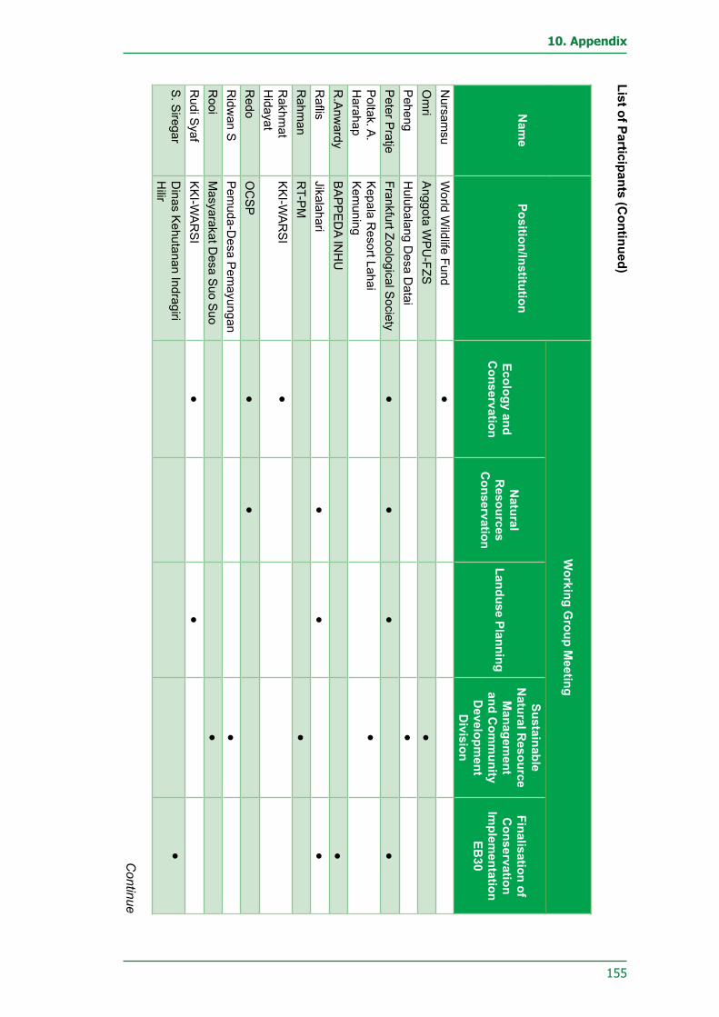
155
10. Appendix
Nam
ePosition/Institution
Working G
roup Meeting
Ecology and C
onservation
Natural
Resources
Conservation
Landuse Planning
Sustainable N
atural Resource
Managem
ent and C
omm
unity D
evelopment
Division
Finalisation of C
onservation Im
plementation
EB30
Nursam
suW
orld Wildlife Fund
●O
mri
Anggota W
PU
-FZS●
Peheng
Hulubalang D
esa Datai
●P
eter Pratje
Frankfurt Zoological Society
●●
●●
Poltak. A
. H
arahapK
epala Resort Lahai
Kem
uning●
R.A
nwardy
BA
PP
ED
A INH
U●
Raflis
Jikalahari●
●●
Rahm
anR
T-PM
●R
akhmat
Hidayat
KK
I-WA
RS
I●
Redo
OC
SP
●●
Ridw
an SP
emuda-D
esa Pem
ayungan●
Rooi
Masyarakat D
esa Suo S
uo●
Rudi S
yafK
KI-W
AR
SI
●●
S. S
iregarD
inas Kehutanan Indragiri
Hilir
●
List of Participants (Continued)
Continue

156
Bukit Tigapuluh Ecosystem Conservation Implementation Plan
Nam
ePo
sitio
n/In
stitu
tion
Wor
king
Gro
up M
eetin
g
Ecol
ogy
and
Con
serv
atio
n
Nat
ural
R
esou
rces
C
onse
rvat
ion
Land
use
Plan
ning
Sust
aina
ble
Nat
ural
Res
ourc
e M
anag
emen
t an
d C
omm
unity
D
evel
opm
ent
Div
isio
n
Fina
lisat
ion
of
Con
serv
atio
n Im
plem
enta
tion
EB30
Sah
mad
iK
aur U
mum
-Des
a S
angl
ap
●S
aidi
Ang
gota
WP
U-F
ZS●
Sai
niK
epal
a D
usun
Des
a S
uo
Suo
●
Sak
arP
emud
a-D
esa
Dat
ai
●S
ambo
do T
Sta
f Din
as K
ehut
anan
In
drag
iri H
ulu
●
Sam
suan
Ket
ua R
T. 0
6 D
esa
Lubu
k K
ambi
ng●
San
toso
Yaya
san
PK
HS
●S
arba
wi
LPM
-Des
a S
angl
ap●
Sid
amK
epal
a D
usun
Dat
ai D
esa
Dat
ai●
Sla
met
A
prija
nto
Sta
f Din
as K
ehut
anan
Ta
njab
ar●
Sla
met
KW
ira K
arya
Sak
ti●
Sob
irin
Sta
f Kec
amat
an B
atan
g G
ansa
l●
List
of P
artic
ipan
ts (C
ontin
ued)
Con
tinue

157
10. Appendix
Nam
ePosition/Institution
Working G
roup Meeting
Ecology and C
onservation
Natural
Resources
Conservation
Landuse Planning
Sustainable N
atural Resource
Managem
ent and C
omm
unity D
evelopment
Division
Finalisation of C
onservation Im
plementation
EB30
Sudirm
anK
aur Um
um-P
M●
Suhadi
Wira K
arya Sakti
●S
uhandriW
orld Wildlife Fund
●●
Sukardi
Cam
at Batang G
angsal●
Sukdini
Ketua P
emuda D
esa S
anglap●
Sulaim
anS
ekretaris Desa S
uo Suo
●S
ulkarnainK
epala Desa A
lim●
Sunardi
BP
D D
esa Sanglap
●S
urfirdausK
epala Desa S
uo Suo
●S
uvendriC
amat Tengah Ilir Tebo
●S
yamsir. M
. Zen
Sekretaris D
esa Lubuk K
ambing
●
Syam
sul B
ahariA
nggota BP
D D
esa Lubuk K
ambing
●
Syarif
Kepala D
usun 02 Desa
Sem
ambu
●
List of Participants (Continued)
Continue

158
Bukit Tigapuluh Ecosystem Conservation Implementation Plan
Nam
ePo
sitio
n/In
stitu
tion
Wor
king
Gro
up M
eetin
g
Ecol
ogy
and
Con
serv
atio
n
Nat
ural
R
esou
rces
C
onse
rvat
ion
Land
use
Plan
ning
Sust
aina
ble
Nat
ural
Res
ourc
e M
anag
emen
t an
d C
omm
unity
D
evel
opm
ent
Div
isio
n
Fina
lisat
ion
of
Con
serv
atio
n Im
plem
enta
tion
EB30
Sya
rifS
ekre
taris
Des
a R
anta
u La
ngsa
t●
Tarm
izi
BP
D D
esa
Sem
ambu
●Ti
tin H
erya
tinS
taf B
KS
DA
Jam
bi●
●U
ndri
BP
D D
esa
Suo
Suo
●U
pal
Ket
ua P
emud
a D
esa
Dat
ai●
Vera
Cik
oS
taf B
BTN
P S
eksi
Wila
yah
Jam
bi●
Wid
yani
ngsi
h P
eni
Fran
kfur
t Zoo
logi
cal S
ocie
ty●
Yahy
aTo
koh
Mas
yara
kat A
ir B
omba
n D
esa
Dat
ai●
Yolly
B.B
Kep
ala
Din
as K
ehut
anan
Te
bo●
Zain
iM
saya
raka
t Des
a S
emam
bu●
Zaka
riaS
ekre
taris
Des
a S
emam
bu●
Zam
zam
iK
etua
BP
D-L
ubuk
Kam
bing
●
List
of P
artic
ipan
ts (C
ontin
ued)


Recommended