TOR: Special EIA on gold mining at Mt Wullersdorf, Tawau, Sabah.
Southsea Gold Sdn Bhd
GMC Environmental Sdn Bhd (Tor-Sgd-15-001)
January 2015
Page 1 of 37
TABLE OF CONTENTS Page
1 INTRODUCTION 5
1.1 Project Title
1.2 Project Initiator
1.3 EIA Consultants
1.4 Statement of Needs
2 BACKGROUND INFORMATION 6
2.1 Project Location
2.2 Project Concept
2.3 Environmental Compliance
2.4 Project Status
2.5 Land Status
2.6 Project Activities
2.6.1 Site Investigations
2.6.2 Site Preparation & Development
2.6.3 Mining Operations
2.6.4 Cessation
3 DESCRIPTION OF THE EXISTING ENVIRONMENT 14
3.1 Physical Environment
3.1.1 Meteorology
3.1.2 Topography
3.1.3 Hydrology
3.1.4 Geology
3.2 Biological Environment
3.2.1 Flora
3.2.2 Fauna
3.3 Socio-Economic Environment
3.3.1 Existing Land Use & Water Use
3.3.2 Gazette (Designated) Land Use
4 SCOPE OF STUDY 23
4.1 Main Environmental Impacts
4.2 Other Potential Impacts
4.3 EIA Matrix
4.4 Zone of Impact
5 DESCRIPTION OF THE IMPACTS & 25
PROPOSED ASSESSMENT METHODOLOGY 5.1 Main Environmental Impacts
5.1.1 Soil Erosion
5.1.2 Water Pollution
5.1.3 Waste Disposal
5.1.4 Ecological Impact
5.1.5 Safety & Health Hazards
TOR: Special EIA on gold mining at Mt Wullersdorf, Tawau, Sabah.
Southsea Gold Sdn Bhd
GMC Environmental Sdn Bhd (Tor-Sgd-15-001)
January 2015
Page 2 of 37
Page
5 DESCRIPTION OF THE IMPACTS & 25
PROPOSED ASSESSMENT METHODOLOGY (cont) 5.2 Other Potential Impacts
5.2.1 Air Pollution
5.2.2 Noises
5.2.3 Ground Vibration
5.2.4 Traffic & Transportation
5.2.5 Landscape Modification
6 DATA COLLECTION 34
6.1 Activities
6.2 Data
6.2.1 Maps & Plans
6.2.2 Documents & Reports
6.3 Consulting Authorities
7 WORK SCHEDULE 36
8 STUDY TEAM 37
ATTACHMENTS
A FIGURES
A1 Project locality
A2 Proposed mine layout
B SUPPORTING DOCUMENTS
B1 Prospecting licence
LSC.4326.245 Vol.1/(101) dated 17.01.2013
B2 Mining lease offer document
LSC.4326.245 Vol.1/(234)/(MYA/FK/fk) dated 23.12.2014
B3 Project site boundary survey plan
B4 Proposed mining scheme clearance document
JMG.SBH (LK):040/139(4) dated 07.11.2014
B5 MSDS (SEX)
B6 Baseline water quality analysis & reference standards
C CURRICULA VITAE
C1 QRP registration certificates
C2 QRP qualifications

TOR: Special EIA on gold mining at Mt Wullersdorf, Tawau, Sabah.
Southsea Gold Sdn Bhd
GMC Environmental Sdn Bhd (Tor-Sgd-15-001)
January 2015
Page 3 of 37
LIST OF ABBREVIATIONS
AMD : Acid Mine Drainage (aka Acid Rock Drainage)
AMSL : Above Mean Sea Level
BOD : Biochemical Oxygen Demand
COD : Chemical Oxygen Demand
CSP : Crushing & Screening Plant
CSR : Corporate Social Responsibilities
DO : Dissolved Oxygen
EIA : Environmental Impact Assessment
ESCP : Erosion & Sediment Control Plan
FR : Forest Reserve
gm : gram
ha : hectare
JAS : Jabatan Alam Sekitar
JKKP : Jabatan Keselamatan & Kesihatan Pekerjaan
JMG : Jabatan Mineral & Geosains
JPAS : Jabatan Perlindungan Alam Sekitar
JPBW : Jabatan Perancang Bandar & Wilayah
JPS : Jabatan Pengairan & Saliran
JTU : Jabatan Tanah & Ukur
JUPEM : Jabatan Ukur & Pemetaan Malaysia
km : kilometre
km2 : square kilometre
µm : micron
MAAQG : Malaysian Ambient Air Quality Guidelines (JAS)
MNRE : Ministry of Natural Resources & Environment
mt : metric tonne
MOH : Ministry of Health
MSDS : Material & Safety Data Sheet
MSMA : Manual Saliran Mesra Alam
NE : Northeast
NH3-N : Ammoniacal nitrogen
NWQS M : National Water Quality Standards for Malaysia (JAS)
O&G : Oil & Grease
OPP : Ore Processing Plant
OSY : Ore Storage Yard
OTP : Ore Treatment Plant
OWP : Ore Washing Plant
PL : Prospecting Licence
PPE : Personal Protection Equipment
PPV : Peak Particle Velocity
QRP : Qualified Registered Professional
RIL : Reduced Impact Logging
ROM : Run-Of-Mine

TOR: Special EIA on gold mining at Mt Wullersdorf, Tawau, Sabah.
Southsea Gold Sdn Bhd
GMC Environmental Sdn Bhd (Tor-Sgd-15-001)
January 2015
Page 4 of 37
LIST OF ABBREVIATIONS (cont)
SAPS : Successive Alkalinity Producing System
SEX : Sodium Ethyl Xanthate
SFD : Sabah Forestry Department
SHE : Safety, Health & Environment
SO4 : Sulphate
SOP : Standard Operating Procedures
SWD : Sabah Wildlife Department
SWR : Scheduled Waste Regulation
TAS : Tactical Air Sampler
TDS : Total Dissolved Solids
TSF : Tailings Storage Facilities
TSP : Total Suspended Particulates
TSS : Total Suspended Solids
WQI : Water Quality Index (JAS)
WWF-MY : World Wildlife Organization (Malaysia)

TOR: Special EIA on gold mining at Mt Wullersdorf, Tawau, Sabah.
Southsea Gold Sdn Bhd
GMC Environmental Sdn Bhd (Tor-Sgd-15-001)
January 2015
Page 5 of 37
1 INTRODUCTION
1.1 Project Title
The title of this project is:
ENVIRONMENTAL IMPACT ASSESSMENT (SPECIAL) FOR THE
PROPOSED GOLD MINING AT MOUNT WULLERSDORF, TAWAU,
SABAH
This is a gold mining project, and shall be hereinafter referred to as “the
Project”.
1.2 Project Initiator
Name : Southsea Gold Sdn Bhd
Address : Lot 4, Block E, Bandar Nam Tung, Jalan Leila
P O Box 2112, 90724 Sandakan, Sabah
Contact number : 089-611 133, 611 633
089-613 633 (fax)
Contact person : Datuk Lo Fui Min
1.3 EIA Consultants
Name : GMC Environmental Sdn Bhd
(No: F005/ Exp: 30.09.2015)
Address : Lot 41, 3rd
Floor, Block F
Damai Plaza Phase IV
88300 Kota Kinabalu, Sabah
Contact number : 088-233 821
088-231 820 (fax)
Contact person : Tan Han Meng
1.4 Statement of Needs
The Project proposes to:
• expand mineral-based resource development in Sabah feasibly through
developing the site into a workable mine
• generate alternative resource revenue to the Sabah Government
• enhance local socio-economic development through long-term chain
employment with related contracting activities and CSR contributions
TOR: Special EIA on gold mining at Mt Wullersdorf, Tawau, Sabah.
Southsea Gold Sdn Bhd
GMC Environmental Sdn Bhd (Tor-Sgd-15-001)
January 2015
Page 6 of 37
2 BACKGROUND INFORMATION
2.1 Project Location
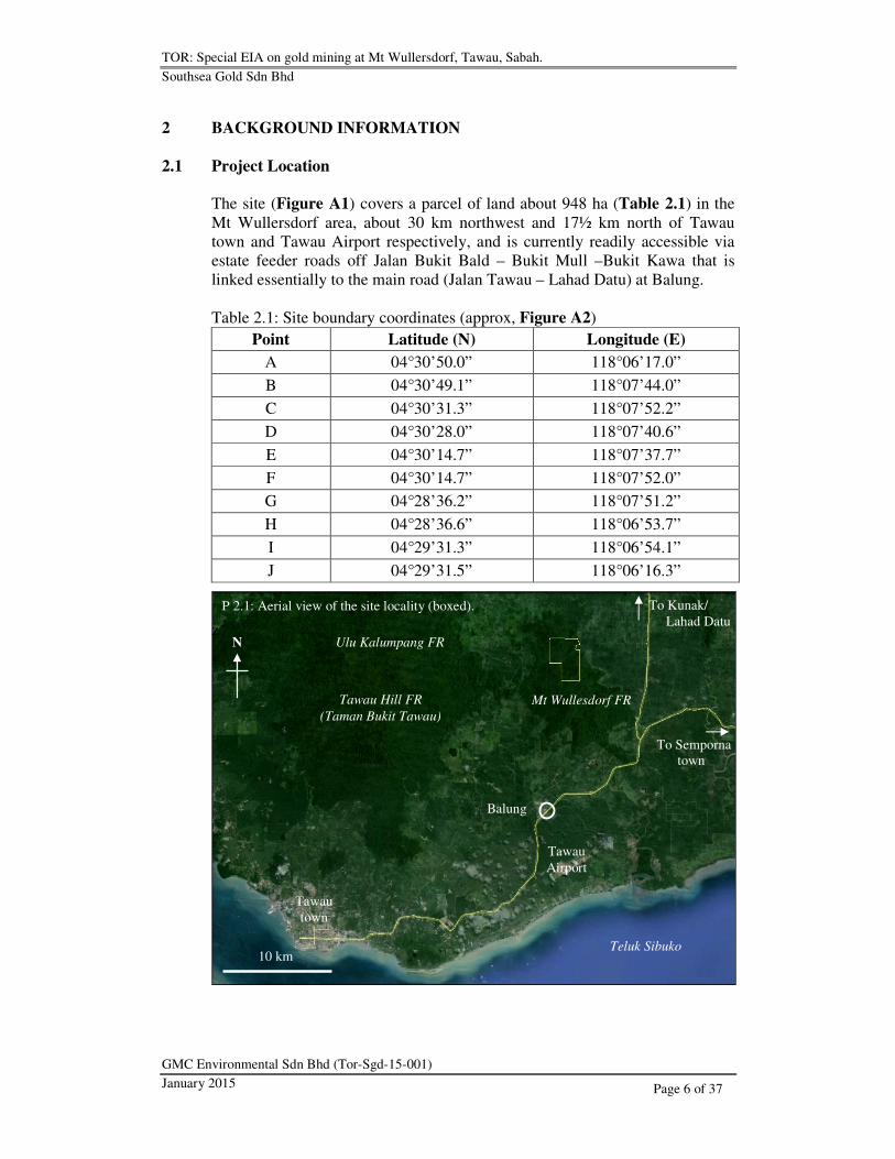
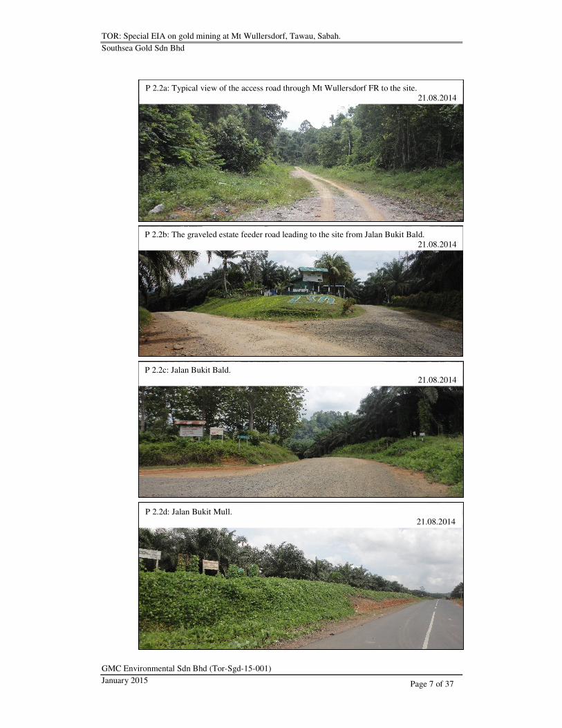
The site (Figure A1) covers a parcel of land about 948 ha (Table 2.1) in the
Mt Wullersdorf area, about 30 km northwest and 17½ km north of Tawau
town and Tawau Airport respectively, and is currently readily accessible via
estate feeder roads off Jalan Bukit Bald – Bukit Mull –Bukit Kawa that is
linked essentially to the main road (Jalan Tawau – Lahad Datu) at Balung.
Table 2.1: Site boundary coordinates (approx, Figure A2)
Point Latitude (N) Longitude (E)
A 04°30’50.0” 118°06’17.0”
B 04°30’49.1” 118°07’44.0”
C 04°30’31.3” 118°07’52.2”
D 04°30’28.0” 118°07’40.6”
E 04°30’14.7” 118°07’37.7”
F 04°30’14.7” 118°07’52.0”
G 04°28’36.2” 118°07’51.2”
H 04°28’36.6” 118°06’53.7”
I 04°29’31.3” 118°06’54.1”
J 04°29’31.5” 118°06’16.3”
z
P 2.1: Aerial view of the site locality (boxed).
Tawau
town
Tawau
Airport
To Semporna
town
To Kunak/
Lahad Datu
10 km
N
Teluk Sibuko
Ulu Kalumpang FR
Mt Wullesdorf FR Tawau Hill FR
(Taman Bukit Tawau)
Balung
TOR: Special EIA on gold mining at Mt Wullersdorf, Tawau, Sabah.
Southsea Gold Sdn Bhd
GMC Environmental Sdn Bhd (Tor-Sgd-15-001)
January 2015
Page 7 of 37
P 2.2a: Typical view of the access road through Mt Wullersdorf FR to the site.
21.08.2014
P 2.2b: The graveled estate feeder road leading to the site from Jalan Bukit Bald.
21.08.2014
P 2.2c: Jalan Bukit Bald.
21.08.2014
P 2.2d: Jalan Bukit Mull.
21.08.2014

TOR: Special EIA on gold mining at Mt Wullersdorf, Tawau, Sabah.
Southsea Gold Sdn Bhd
GMC Environmental Sdn Bhd (Tor-Sgd-15-001)
January 2015
Page 8 of 37
2.2 Project Concept
The Project proposes surface mining at 2 predetermined mining blocks
(Figure A2) at the Bukit Mantri and Bukit Tundong areas (hereinafter referred
to as Mantri Block and Tundung Block respectively) for the surface (oxidized)
and the underlying sulfide (un-oxidized) ores by excavations using only
hydraulic excavators, but necessarily engaging also fragblasts (rock
fragmentation by blasting) for the latter.
The overburden and intraburden materials will be disposed on-site at the waste
dumps while the ROM (source materials) further physically processed on-site
at the OWP, CSP and OTP for sizing (crushing), screening (segregation),
washing and grinding (pulverization) then separation (centrifugal and flotation)
of the ore minerals prior to shipping out the ore concentrates from the sea port
nearest to the site, with the slurry discharge retained in the TSF.
P 2.3: Conceptual profiling of the mining blocks.
P 2.2e: Jalan Bukit Kawa.
21.08.2014

TOR: Special EIA on gold mining at Mt Wullersdorf, Tawau, Sabah.
Southsea Gold Sdn Bhd
GMC Environmental Sdn Bhd (Tor-Sgd-15-001)
January 2015
Page 9 of 37
2.3 Environmental Compliance
The Project will observe the following environmental requirement to effect the
mining operations.
• A mandatory EIA approval from JPAS under Prescribed Activity 7 of the
Second Schedule of the Environment Protection (Prescribed Activities)
(Environment Assessment Impact) Order 2005, Environment Protection
Enactment 2002, for Mining including open cast mining for minerals
pursuant to any mining lease:
(i) Covering an area of 20 ha or more
(ii) Any form of mining which is likely to affect the landscape of the
mining area so as to require rehabilitation thereof upon the cessation
of the mining activities, or which involves the use of chemicals or
explosives.
2.4 Project Status
A 4-year prospecting (Annex B1) covering an area about 200 km2 (ie 20,000
ha) has delineated economical ore reserves (Section 3.1.4) at the Mantri and
Tundung areas, and the Mining Lease (Annex B2) was also recently granted
for the Project subject notwithstanding to the Project meeting the statutory
requirements (Table 2.2) under the prevailing laws.
Table 2.2: Statutory compliance status of the Project
Requirement Compliance
status
Auditing/ approving
authority
Clearance
status
Mining Lease Completed JTU Cleared
Land title demarcation1 Completed JTU Pending
Mining scheme Completed JMG Cleared2
EIA In progress JPAS Pending
ESCP Pending JPS Pending 1: Annex B3
2: Annex B4
2.5 Land Status
The site covers an area recently excised that which otherwise comprising
about 720 ha and 228 ha of Mt Wullersdorf and Ulu Kalumpang FR
respectively, and shall be subject to such other prior clearance from the
relevant authorities for the mining.

TOR: Special EIA on gold mining at Mt Wullersdorf, Tawau, Sabah.
Southsea Gold Sdn Bhd
GMC Environmental Sdn Bhd (Tor-Sgd-15-001)
January 2015
Page 10 of 37
2.6 Project Activities
These activities are categorized in the following general procedural order of
implementation.
• Site investigations
• Site preparation and development
• Operations
• Cessation
2.6.1 Site Investigations
Investigations shall primarily include geological, mining engineering, erosion
and sediment control, and EIA. Current geological assessment by way of
mineral exploration during the Prospecting Licence period has indicated ore
mineralization while engineering assessment through the proposed mining
scheme also suggested possible mining subject to meeting the environmental
requirements.
2.6.2 Site Preparation & Development
Site preparation and development will require mobilizing the mine equipment
and machinery necessary for land clearance by stripping the surface vegetation
and levelling to establishing the mine structures (Table 2.3) such as the OWP,
CSP, OTP and the internal infrastructures such as the haul road to the mining
blocks and waste tips. The OWP installation may require about 3 months
while the CSP and OTP about 9 months.
Essentially, the development phase will be implemented over several stages,
with the initial stage anticipated completion in about 4 months prior to
commencing the mining operations thereafter concurrently with the
subsequent stages.
The Project has proposed to begin the mining at ES-1 where the surface area
will be progressively cleared of vegetation and the earth waste materials
tipped at the neighbouring waste dumps along with the dry muckpiles from the
processing plant. Hence, the initial stage of development will include but not
necessarily limit to following installations and preparations.
• Mine quarters and workshop
• Haul roads to Mantri Block and waste dumps (WD-1 and WD-2)
• TSF (tailings storage facilities)
• OSY (ore storage yard)
• OWP (ore washing plant)

TOR: Special EIA on gold mining at Mt Wullersdorf, Tawau, Sabah.
Southsea Gold Sdn Bhd
GMC Environmental Sdn Bhd (Tor-Sgd-15-001)
January 2015
Page 11 of 37
Table 2.3: Proposed primary mine equipment and machinery
No Equipment/ machinery Oxidized ore Sulfide ore
1 Hydraulic excavator 6
2 Bulldozer 1 – 2
3 Dump truck 10
4 Backhoe tractor 1 -
5 Hydraulic driller - 2
6 OWP 1 -
7 Hopper feeder - 1
8 CSP - 1
9 Scrubber 1
10 Ball mill 2 – 4
11 Screener 2 – 4
12 Shaking table 2 -
13 Flotation cell - 4 – 8
14 Centrifugal concentrator 1 -
15 Classifier - 1
16 Water pump 2
17 Power generator 1 1 NB: OTP consisting of items (9) – (15)
2.6.3 Mining Operations
The mining operations will consist of surface excavations and processing of
both the oxidized and un-oxidized sulfidic ores, where the former is essentially
unconsolidated to semi-consolidated in its physical nature thus confined to the
surface layer, and is underlain by the latter in solid rock formation. The
operations will begin at the ES-1 with mining of the oxidized ore possibly
commencing during the OWP installation.
Mining of the oxidized ore
The oxidized ore is literally confined to the surface layer and will be mined by
surface excavations using hydraulic excavators and the excavated materials
(ROM) then trucked for processing at the on-site OWP to first separating the
fine materials from the oversize (+20 mm) by water jetting, whereby the
heavier finer materials will be subsequently pulverized (to 150 µm) for
recovery of the free ore particles through a centrifugal concentrator, and the
tailings retained in the wet ponds (TSF). The oversize are recycled for further
breakdown through crushing into smaller fragments then pulverized to
recovering the free gold. The OWP consists essentially of a large hopper lined
with steel plates that is eventually linked on one part to the tertiary cone
crushers (CSP) for the oversize and on the other the centrifugal concentrator
through the scrubber in the OTP.

TOR: Special EIA on gold mining at Mt Wullersdorf, Tawau, Sabah.
Southsea Gold Sdn Bhd
GMC Environmental Sdn Bhd (Tor-Sgd-15-001)
January 2015
Page 12 of 37
Mining of the sulfide (un-oxidized) ore
The sulfide (un-oxidized) ore becomes extractable only upon removal of the
surface layer bearing the oxidized ore. Mining the sulfide ore will essentially
require fragbalst, where the shot fragments will then undergo a series of
processes from further sizing of the mineralized rocks through crushing to
pulverizing (to 150 µm) then concentrating the ores through flotation using
SEX (Annex B5) or equivalent as the collecting agent and the pulp alkalinity
controlled using calcium carbonate (CaCO3) and sulfuric acid (H2SO4) as the
conditioners. The heavier particles are then segregated through gravitational
separation in the classifier, with the lighter gangue minerals discharged as
tailings and retained in the TSF.
P 2.4: Process flow of the mining operations.

TOR: Special EIA on gold mining at Mt Wullersdorf, Tawau, Sabah.
Southsea Gold Sdn Bhd
GMC Environmental Sdn Bhd (Tor-Sgd-15-001)
January 2015
Page 13 of 37
The mining of the sulfide ore differs from the oxidized ore in that the former
inevitably requiring rock blasting at the mining blocks along with a more
complicated series of closed-circuit processes in the OTP to extracting the ore
particles.
The used xanthates and the conditioners essentially will be classified
scheduled wastes under SWR (2005) and categorized (Table 2.4) according to
specific disposable nature of such materials.
Table 2.4: Scheduled waste categorization
Code Description
SW1 Metal & metal-bearing wastes
SW2 Waste containing principally inorganic constituents which may
contain metals & organic materials
SW3 Waste containing principally organic constituents which may
contain metals & inorganic materials
SW4 Waste which may contain either inorganic or organic constituents
SW5 Other wastes
Overburden & intraburden clearance Removing the overburden and intraburden materials will be progressive and
continuous during the mine development and operations. The overburden and
intraburden are essentially undesirable materials consisting mainly of waste
earth and fragmental rocks with gangue minerals, and will be trucked for
tipping at the waste dumps.
Waste Tipping The slurry mixture (tailings) discharge from the OTP will be drained into the
adjacent TSF consisting of a series of compartments necessarily lined with
impermeable geo-membranes to not only preventing seepage of AMD into the
ground but also possibly reusing of the treated water.
AMD generally refers to acid drainage resulted from sulfide oxidation through
mining. AMD may have significant impacts affecting the economics of the
mining operations owing to its corrosive effects on infrastructure and
equipment, the limitations on water reuse and discharge, and mine closure
options, in as much the potential long-term environmental impacts from
decreasing pH and possibly increasing concentrations of heavy metals in the
nearby water and soils.
On the other hand, the solid overburden and intraburden earth waste materials
from excavations will be tipped on-site at the waste dumps tentatively
proposed at 5 designated areas.

TOR: Special EIA on gold mining at Mt Wullersdorf, Tawau, Sabah.
Southsea Gold Sdn Bhd
GMC Environmental Sdn Bhd (Tor-Sgd-15-001)
January 2015
Page 14 of 37
Stockpiling The fragmental mineralized rocks may be temporarily stockpiled in situ at the
mining blocks prior to processing or at the processing area as crushed
aggregates ready for pulverization, or as processed auriferous ore concentrates
in the sheltered storage yard for scheduled shipment.
Haulage & transportation Dump trucks will be used for carrying the raw deposits from the mining
blocks to the processing plant, specific to mining and are only used off-road.
Trucking also will be engaged for transporting the processed ores from the on-
site storage yard to the designated port for shipment, using the existing roads.
Routine Maintenance
The routines will include infrastructural maintenance covering the haul roads
and waste dumps, and necessary servicing and repairs of the mine machinery
and equipment in situ or at the on-site workshop.
2.6.4 Cessation
Cessation of the mining operations will require the Project to inter alia
rehabilitating the disturbed areas such as the waste dumps, removing the
structural hazards as appropriate, and necessarily maintaining the TSF secured
and functional over an extended period of time.
3 DESCRIPTION OF THE EXISTING ENVIRONMENT
3.1 Physical Environment
3.1.1 Meteorology
Rainfall is convectional with monsoonal influence for an annual average about
1,826 mm over 172 wet days typical with increasing rain towards the year end.
3.1.2 Topography
The site (refer Figure A2) may be generally divided into southwesterly and
northeasterly dipping slope areas, separated by a curvilinear ridge grossly
running through Bukit Mantri and Bukit Tundung. The Mantri peak is located
just northwest off-site at an elevation about +564 m AMSL while the Tundung
peak within the site at about +600 m AMSL edging the eastern boundary
towards southeast.
The mineralized areas were identified lying essentially on the southwesterly
dipping slope area, with the 2 mining blocks separated over about 2 km apart.
The southwesterly dipping slopes gradually descend into Sg Mantri Kanan
along the southwestern border areas lowest at about +200 m AMSL.

TOR: Special EIA on gold mining at Mt Wullersdorf, Tawau, Sabah.
Southsea Gold Sdn Bhd
GMC Environmental Sdn Bhd (Tor-Sgd-15-001)
January 2015
Page 15 of 37
The processing facilities were proposed located at the lower ground area
between the 2 mining blocks and adjacent to the other surface mine structures
north of Sg Mantri Kanan by the road access entrance towards the western
boundary.
On a regional scale, the site covers the peak area (Bukit Tundung) of Mt
Wullersdorf located east of Taman Bukit Tawau which covers the larger and
higher Mt Magdalena separated essentially by Sg Mantri.
3.1.3 Hydrology
The site is located at about the centre area of the Kalumpang Basin, which
covers an area about 1,006 km2 encompassing Sg Kalumpang and its
tributaries consisting mainly of Sg Malati and Sg Mantri where the latter
branches into Sg Mantri Kanan originating in Mt Wullersdorf FR and Sg
Mantri Kiri in Taman Bukit Tawau along with Sg Malati further upstream of
Sg Kalumpang.
Sg Mantri Kanan is truncating the southwesterly dipping slopes along the
southwestern site boundary areas, where the stream is about 6-m wide and is
the nearest to the mine facilities. Sg Mantri Kanan runs westerly off-site to
eventually merging with Sg Mantri Kiri about 10 km downstream before
turning into Sg Kalumpang about 12 km further downstream. Sg Mantri
Kanan originates in Mt Wullersdorf FR, while Sg Mantri Kiri and Sg
Kalumpang in Taman Bukit Tawau and Ulu Kalumpang FR respectively.
P 3.1: Regional topography (contours in foot).
Proposed mine area is boxed in red.
20 km
Depicted from TPC L-11B
Taman
Bukit Tawau
Ulu Kalumpang
FR
TOR: Special EIA on gold mining at Mt Wullersdorf, Tawau, Sabah.
Southsea Gold Sdn Bhd
GMC Environmental Sdn Bhd (Tor-Sgd-15-001)
January 2015
Page 16 of 37
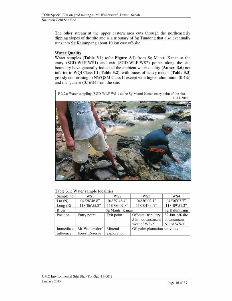
The other stream at the upper eastern area cuts through the northeasterly
dipping slopes of the site and is a tributary of Sg Tundong that also eventually
runs into Sg Kalumpang about 10 km east off-site.
Water Quality
Water samples (Table 3.1; refer Figure A1) from Sg Mantri Kanan at the
entry (SGD-WLF-WS1) and exit (SGD-WLF-WS2) points along the site
boundary have generally indicated the ambient water quality (Annex B.6) not
inferior to WQI Class III (Table 3.2), with traces of heavy metals (Table 3.3)
grossly conforming to NWQSM Class II except with higher aluminium (0.4%)
and manganese (0.16%) from the site.
Table 3.1: Water sample localities
Sample no WS1 WS2 WS3 WS4
Lat (N) 04°28’46.8” 04°29’46.4” 04°30’02.1” 04°36’03.7”
Long (E) 118°06’55.8” 118°06’02.8” 118°04’00.7” 118°09’51.2”
River Sg Mantri Kanan Sg Kalumpang
Position Entry point Exit point Off-site tributary
5 km downstream
west of WS-2
32 km off-site
downstream
NE of WS-3
Immediate influence
Mt Wullersdorf Forest Reserve
Mineral exploration
Oil palm plantation activities
P 3.2a: Water sampling (SGD-WLF-WS1) at the Sg Mantri Kanan entry point of the site.
11.11.2014

TOR: Special EIA on gold mining at Mt Wullersdorf, Tawau, Sabah.
Southsea Gold Sdn Bhd
GMC Environmental Sdn Bhd (Tor-Sgd-15-001)
January 2015
Page 17 of 37
Table 3.2: Water quality index (WQI)
Parameter WQI Class II WS1 WS2 WS3 WS4
NH3-N (mg/l) 0.1 – 0.3 0.29 0.25 0.26 (0.37)
BOD (mg/l) 1 – 3 (5) (6) (4) (5)
COD (mg/l) 10 – 25 3 < 2 14 11
DO (mg/l) 5 – 7 - - - -
pH 6 – 7 - - 7.6 7.8
TSS (mg/l) 25 – 50 8 14 5 4 NB: Disqualified parameters in brackets
P 3.2b: Water sampling (SGD-WLF-WS2) at the Sg Mantri Kanan exit point of the site.
11.11.2014
P 3.2c: Water sampling (SGD-WLF-WS3) along an off-site tributary of Sg Mantri Kanan.
04.12.2014
TOR: Special EIA on gold mining at Mt Wullersdorf, Tawau, Sabah.
Southsea Gold Sdn Bhd
GMC Environmental Sdn Bhd (Tor-Sgd-15-001)
January 2015
Page 18 of 37
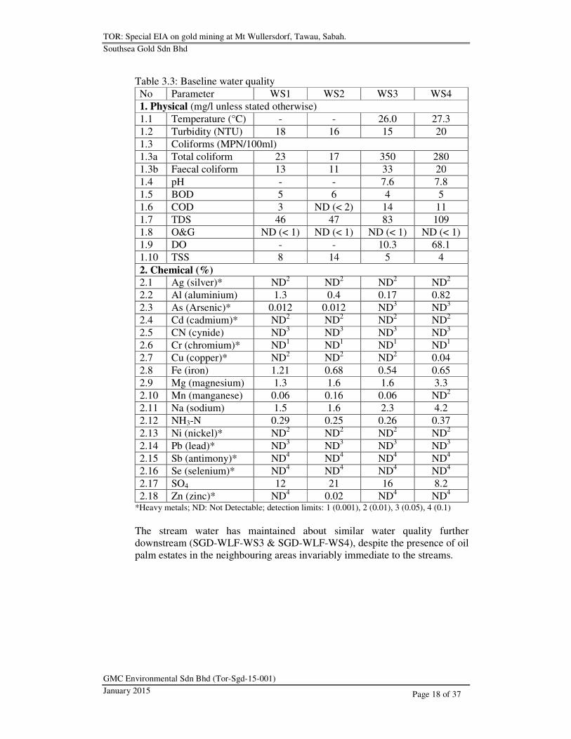
Table 3.3: Baseline water quality
No Parameter WS1 WS2 WS3 WS4
1. Physical (mg/l unless stated otherwise)
1.1 Temperature (°C) - - 26.0 27.3
1.2 Turbidity (NTU) 18 16 15 20
1.3 Coliforms (MPN/100ml)
1.3a Total coliform 23 17 350 280
1.3b Faecal coliform 13 11 33 20
1.4 pH - - 7.6 7.8
1.5 BOD 5 6 4 5
1.6 COD 3 ND (< 2) 14 11
1.7 TDS 46 47 83 109
1.8 O&G ND (< 1) ND (< 1) ND (< 1) ND (< 1)
1.9 DO - - 10.3 68.1
1.10 TSS 8 14 5 4
2. Chemical (%)
2.1 Ag (silver)* ND2 ND
2 ND
2 ND
2
2.2 Al (aluminium) 1.3 0.4 0.17 0.82
2.3 As (Arsenic)* 0.012 0.012 ND3 ND
3
2.4 Cd (cadmium)* ND2 ND
2 ND
2 ND
2
2.5 CN (cynide) ND3 ND
3 ND
3 ND
3
2.6 Cr (chromium)* ND1 ND
1 ND
1 ND
1
2.7 Cu (copper)* ND2 ND
2 ND
2 0.04
2.8 Fe (iron) 1.21 0.68 0.54 0.65
2.9 Mg (magnesium) 1.3 1.6 1.6 3.3
2.10 Mn (manganese) 0.06 0.16 0.06 ND2
2.11 Na (sodium) 1.5 1.6 2.3 4.2
2.12 NH3-N 0.29 0.25 0.26 0.37
2.13 Ni (nickel)* ND2 ND
2 ND
2 ND
2
2.14 Pb (lead)* ND3 ND
3 ND
3 ND
3
2.15 Sb (antimony)* ND4 ND
4 ND
4 ND
4
2.16 Se (selenium)* ND4 ND
4 ND
4 ND
4
2.17 SO4 12 21 16 8.2
2.18 Zn (zinc)* ND4 0.02 ND
4 ND
4
*Heavy metals; ND: Not Detectable; detection limits: 1 (0.001), 2 (0.01), 3 (0.05), 4 (0.1)
The stream water has maintained about similar water quality further
downstream (SGD-WLF-WS3 & SGD-WLF-WS4), despite the presence of oil
palm estates in the neighbouring areas invariably immediate to the streams.
TOR: Special EIA on gold mining at Mt Wullersdorf, Tawau, Sabah.
Southsea Gold Sdn Bhd
GMC Environmental Sdn Bhd (Tor-Sgd-15-001)
January 2015
Page 19 of 37
3.1.4 Geology
The proposed mining blocks are immediately underlain by the Pliocene
andesitic flows and pyroclastics, intercalated with sedimentary clastics and
intruded by granodiorite – dioritic dykes with auriferous (gold-bearing) veins,
and further underlain by the older Kalumpang Formation.
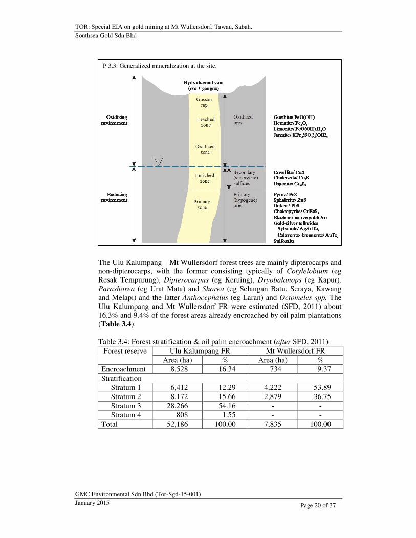
Mineralization The ore mineralization essentially belongs to the epithermal system which
occurred as a series of quartz-sulfide hydrothermal veins coalesce in tension
fractures in the rock formation, where the ore mineralogy generally is
characterized by pyrite, sphalerite, galena, chalcopyrite, electrum-native gold,
sulfosalts and gold-silver tellurides. However, the sulfide ore is susceptible to
oxidation through weathering upon prolonged exposure and may be thus
subject to alteration and subsequently replaced by goethite, haematite, jarosite,
limonite, covellite, chacocite, digenite and manganese oxides. Essentially, the
oxidized ore is confined to the outer layer with a thickness about 20 m, while
the sulfide ore believed reaching a depth up to 280 m
3.2 Biological Environment
3.2.1 Flora
The site presently remains largely covered with common forest vegetation,
and is surrounded by Mt Wullersdorf and Ulu Kalumpang FR immediately
south and north respectively. Oil palm is otherwise predominant, with
plantation estates notably covering the neighbouring northern area from
northeast to northwest.
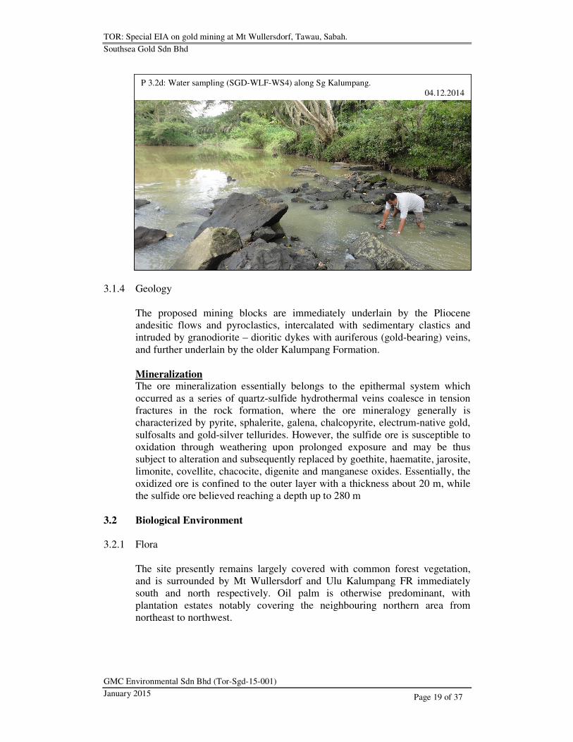
P 3.2d: Water sampling (SGD-WLF-WS4) along Sg Kalumpang.
04.12.2014
TOR: Special EIA on gold mining at Mt Wullersdorf, Tawau, Sabah.
Southsea Gold Sdn Bhd
GMC Environmental Sdn Bhd (Tor-Sgd-15-001)
January 2015
Page 20 of 37
The Ulu Kalumpang – Mt Wullersdorf forest trees are mainly dipterocarps and
non-dipterocarps, with the former consisting typically of Cotylelobium (eg
Resak Tempurung), Dipterocarpus (eg Keruing), Dryobalanops (eg Kapur),
Parashorea (eg Urat Mata) and Shorea (eg Selangan Batu, Seraya, Kawang
and Melapi) and the latter Anthocephalus (eg Laran) and Octomeles spp. The
Ulu Kalumpang and Mt Wullersdorf FR were estimated (SFD, 2011) about
16.3% and 9.4% of the forest areas already encroached by oil palm plantations
(Table 3.4).
Table 3.4: Forest stratification & oil palm encroachment (after SFD, 2011)
Forest reserve Ulu Kalumpang FR Mt Wullersdorf FR
Area (ha) % Area (ha) %
Encroachment 8,528 16.34 734 9.37
Stratification
Stratum 1 6,412 12.29 4,222 53.89
Stratum 2 8,172 15.66 2,879 36.75
Stratum 3 28,266 54.16 - -
Stratum 4 808 1.55 - -
Total 52,186 100.00 7,835 100.00
P 3.3: Generalized mineralization at the site.

TOR: Special EIA on gold mining at Mt Wullersdorf, Tawau, Sabah.
Southsea Gold Sdn Bhd
GMC Environmental Sdn Bhd (Tor-Sgd-15-001)
January 2015
Page 21 of 37
3.2.2 Fauna
Sabah Wildlife Department (2011) has reported the presence of mainly
orangutan at the site, while the others including the clouded leopard, Bornean
sun bear, pig-tailed macaque and banteng (SFD, 2012) largely in the
neighbouring Ulu Kalumpang – Mt Wullersdorf FR along with the more
common wild boar, deer, porcupine, greater mousedeer, Malay civet, long-
tailed macaque, Bornean yellow muntjac, banded linsang and monitor lizard
(WWF-MY, 2012 – unpublished, with permission)
The orangutan population was estimated a density about 5 – 15 at the site
(Alfred et al, 2010), with no such population estimate reported otherwise for
the other species at the site or the surrounding areas.
3.3 Socio-Economic Environment
3.3.1 Existing Land Use & Water Use
The site (refer Figure A1) is immediately surrounded by Ulu Kalumpang – Mt
Wullersdorf FR, with otherwise mainly neighbouring oil palm plantations
further off-site that essentially are also commonly using the existing
connecting feeder roads to reaching the main road. Taman Bukit Tawau
(Tawau Hill Forest Reserve) is located about 8 km west off-site, separated by
an oil palm estate entirely enclosed by the forest reserves.
P 3.4: Orangutan population density (after Alfred et al, 2010 as in SWD, 2011).
The proposed mine site is boxed in red.

TOR: Special EIA on gold mining at Mt Wullersdorf, Tawau, Sabah.
Southsea Gold Sdn Bhd
GMC Environmental Sdn Bhd (Tor-Sgd-15-001)
January 2015
Page 22 of 37
There are no indigenous communities within 5 km from the site, and the
nearest is Kg Bukit Kawa located about 14 km south at the main road junction,
while Kg Pinang (04°24’43.4”N, 118°06’00.0”E) the only riparian community
and Sipadan Mangrove Resort (04°21’24.0”N, 118°19’11.8”E) the only resort
establishment along Sg Kalumpang, located amidst the mangrove forest area
about 70 and 80 km downstream respectively from the site.
There are no established potable water intake stations along Sg Mantri Kanan,
nor further downstream thereafter or along Sg Kalumpang until the estuary
about 83 km downstream from the site.
3.3.2 Gazette (Designated) Land Use
The site covers an area recently excised from Mt Wullersdorf and Ulu
Kalumpang gazette protection (Class 1) forest reserves, which have remained
covering the larger areas off-site (refer Figure A1) immediately south and
northwest respectively, with the further surrounding areas designated
otherwise Countryside Area.
P 3.5: Kg Bukit Kawa by the main road roundabout.
04.12.2014
P 3.6: Sipadan Mangrove Resort near Sg Kalumpang estuary.
04.12.2014

TOR: Special EIA on gold mining at Mt Wullersdorf, Tawau, Sabah.
Southsea Gold Sdn Bhd
GMC Environmental Sdn Bhd (Tor-Sgd-15-001)
January 2015
Page 23 of 37
4 SCOPE OF STUDY
The EIA will predict and evaluate the adverse environmental impacts from the
mining operations and proposing mitigation measures against such impacts
along with recommended monitoring programmes to maintain compatibility of
the Project with protection of the environment.
4.1 Main Environmental Impacts
The following environmental impacts are prioritized for the Project.
• Water pollution (physicochemical, including sedimentation)
• Waste disposal (overburden/ intraburden, tailings and scheduled wastes)
• Soil erosion
• Ecological impact
• Safety and health hazards (including flyrocks)
4.2 Other Potential Impacts
Other adverse environmental impacts are as follows:
• Air pollution (on-site)
• Noises (on-site, including airblast)
• Ground vibration (fragblast)
• Traffic and transportation (including traffic noises off-site)
• Landscape modification
Any other impacts not listed herein but which may be deemed associated with
the Project shall be identified and determined during the course of EIA.
4.3 EIA Matrix
Some of the development activities will be run concurrently with the mining
operations, and the impacts (Table 4.1) essentially will be similar in nature
and are hence assessed integral to the operations.
The potential and significance of the impacts were evaluated based upon
integrated assessment in relation to the following 4 criteria specific to the
environmental and proposed operational settings (without consideration of
practicable mitigation).

TOR: Special EIA on gold mining at Mt Wullersdorf, Tawau, Sabah.
Southsea Gold Sdn Bhd
GMC Environmental Sdn Bhd (Tor-Sgd-15-001)
January 2015
Page 24 of 37
Table 4.1a: EIA matrix (no-mitigation option)
Environmental
Aspect
Impact Assessment Rating Score
M P R C
Development & Operation
Physical Water pollution 3 3 2 3 Major
Waste disposal
Tailings 2 3 3 3 Major
Scheduled waste 1 2 2 3 Medium
Earth dumps 1 3 2 2 Medium
Soil erosion 1 3 3 3 Medium
Air pollution 2 2 2 1 Minor
Noises (on-site) 2 2 1 2 Minor
Ground vibration 2 2 3 3 Medium
Landscape modification 1 3 3 2 Medium
Biological Ecological impact 2 2 3 3 Medium
Socio-economic Safety & health hazards 2 3 3 3 Major
Traffic & transportation 2 2 2 2 Minor
Abandonment
Physical Landscape / aesthetics 1 3 3 2 Medium
Waste management
Tailings 2 3 3 3 Major
Biological Ecological impact 1 1 1 1 Minor
Socio-economic Safety & health hazards 1 3 3 3 Medium
Table 4.1b: EIA rating and impact score
Aspect 1 2 3
Assessment
Magnitude (M) Within site Local Regional
Permanence (P) Negligible Temporary Permanent
Reversibility (R) Negligible Reversible Irreversible
Cumulative (C) Negligible Non-cumulative Cumulative
Adverse Impact Potential
Score Minor Medium Major
• The magnitude (M) of change/ effect relative to the spatial boundaries and
is measured as follows:
(1) change/ effect is confined within the project site
(2) change/ effect is local and/ or limited to immediate surroundings
(3) change/ effect is regional
• The permanence (P) of the impact, indicating temporary or permanent of
the condition, and is measured as follows:
(1) effect is negligible/ no change/ not applicable
(2) temporary effect
(3) permanent effect

TOR: Special EIA on gold mining at Mt Wullersdorf, Tawau, Sabah.
Southsea Gold Sdn Bhd
GMC Environmental Sdn Bhd (Tor-Sgd-15-001)
January 2015
Page 25 of 37
• The reversibility (R) of the impact, indicating if the condition can be
changed and is controllable over its effect, and is measured as follows:
(1) effect is negligible/ no change/ not applicable
(2) effect is reversible
(3) effect is irreversible
• The cumulative (C) extent of the impact, indicating if the impact will have
a single direct effect or cumulative effect over time, or a synergistic effect
with other conditions, and is measured as follows:
(1) effect is negligible/ no change/ not applicable
(2) effect is non-cumulative/ single
(3) effect is cumulative
4.4 Zone of Impact (ZOI)
The impact influence (ZOI) can be far-reaching and the effect possibly long-
term dependent upon the characteristics of the impacts. Hence, the influence
coverage (Table 4.2) has been identified specific to these impacts (Table 4.1a)
relative to the environmental sensitivity of the surrounding influence areas.
Table 4.2: ZOI No Impact Primary effects Potential ZOI
1 Water pollution Physicochemical water
contamination
Sg Mantri – Kalumpang
2 Waste disposal
3 Soil erosion Slope failure Benching slopes (on site)
4 Ecological Floral & faunal habitat
destruction
Ulu Kalumpang –
Mt Wullersdorf FR
5 Safety & health Safety & health Work place (on site)
6 Air pollution Dusting Local surroundings
7 Noises Noises Local surroundings
8 Fragblast Airblast & ground vibration Local surroundings
9 Traffic & transportation
Socio-economic (traffic pollution & safety)
Haul road & local surroundings
10 Landscape
modification
Aesthetic depreciation Local surroundings
Some of the impact influence may be controlled primarily by the local
topography, which typically include but not limit to water pollution, while
some others invariably effected by physiographical factors.
5 DESCRIPTION OF THE IMPACTS &
PROPOSED ASSESSMENT METHODOLOGY
While there can be no zero impact possibly achievable, there is existing
practicable mitigation that which may be compatible with the local settings
and applicable to the Project

TOR: Special EIA on gold mining at Mt Wullersdorf, Tawau, Sabah.
Southsea Gold Sdn Bhd
GMC Environmental Sdn Bhd (Tor-Sgd-15-001)
January 2015
Page 26 of 37
5.1 Main Environmental Impacts
5.1.1 Soil Erosion
Soil erosion is the function of erosivity of rainfall and erodibility of soil,
whereby the rains essentially scour away, loosen and break soil particles then
washed down by the force of gravity and get carried away to hence resulting in
soil loss, leaving behind an altered bare surface. Consequently, an altered bare
slope surface with the formation of sheet, rill and gully erosion features will
easily become destabilized and eventually lead to slope failure or landslide.
Soil loss (A) often may be estimated using RUSLE (Equation 1).
A (mt/ ha) = R*K*LS*C*P - Equation 1
where R = Rainfall erosivity factor
K = Soil erodibility factor
LS = Slope length & steepness factor
C = Cover management factor
P = Erosion control practice factor
Soil erosion is natural, but the process often may be invariably accelerated
under anthropogenic influence such that the mining operations will inevitably
expose the bare surfaces to erosion, typically the unconsolidated/ semi-
consolidated earth surface at the mining blocks and waste dumps.
Aim of Mitigation
• To minimize soil loss that may otherwise lead to physical water pollution
by way of sedimentation
• To maintain stable earth wall/ benches at the waste dumps and TSF
Assessment Methodology
• Soil loss estimation using RUSLE as a basic instrument to identifying the
best erosion control practice
• Engineering and geological assessments to designing stable and
sustainable slopes for the mining blocks, waste dumps and TSF
• Identification of monitoring stations and frequency requirements based
upon the above assessments
Monitoring Programmes
• Compliance monitoring on the engineered slopes and such related stability
enhancement installations
• Reporting on slope/ design failure and the restorative rectification
TOR: Special EIA on gold mining at Mt Wullersdorf, Tawau, Sabah.
Southsea Gold Sdn Bhd
GMC Environmental Sdn Bhd (Tor-Sgd-15-001)
January 2015
Page 27 of 37
5.1.2 Water Pollution
Physical Eroded soil materials typically get carried by the surface runoff and deposited
downstream (ie sedimentation) whereby the sediment yield (Y) may be
estimated using MUSLE (Equation 2) and is specific to a storm event.
Sediment yield is defined as the amount of eroded soil delivered to a point in
the watershed that is remote from the original of the detached soil particles,
which includes the erosion from slopes, channels and mass wasting but
excluding the deposition amount before reaching the point. Serious
downstream sedimentation often causes the rivers and waterways to shallow
and prompting flash and regular floods in the low-lying areas.
Y (mt) = 89.6(V*Qp)0.56
(K*LS*C*P) - Equation 2
where V = Runoff volume
Qp = Peak discharge
K = Soil erodibility
LS = Slope length & steepness
C = Cover management
P = Erosion control practice
Geochemical
Oxidation of the sulfide ore minerals by way of weathering is a natural process
that eventually leads to minerals replacement through chemical reactions and
the beginning of acid (H+) forming process such as follows:
FeS2 (pyrite) + 3½O2 + H2O → Fe2+
+ 2SO42-
+ 2H+ - Reaction 1A
Fe2+
+ ¼O2 + H+ → Fe
3+ + ½H2O - Reaction 1B
Fe3+
+ 3H2O → Fe(OH)3 + 3H+ - Reaction 1C
Oxidation (Reaction 1B) of Fe2+
(ferrous iron) to Fe3+
(ferric iron) in the mine
water may take several travelling kilometres downstream under natural
influence to result in precipitation (Reaction 1C) of Fe(OH)3 (ferric hydroxide)
through hydrolysis of Fe3+
, which otherwise may accelerate further sulfide
oxidation (Reaction 2) in the presence of sulfide such as follows:
FeS2 (pyrite) + 14Fe3+
+ 8H2O → 15Fe2+
+ 2SO42-
+ 16H+ - Reaction 2
The precipitation of Fe(OH)3 is a key acid producing stage, and would be
inevitable with oxidation of Fe2+
to Fe3+
and the subsequent hydroxide
formation upon oxidation (Reaction 1A) of the sulfides to sulphates.
Aim of Mitigation
• To regulate surface runoff prior to entering natural waterways
• To maintain outflow water quality conforming to required standard
• To contain sedimentation and chemical pollution
• To retard AMD formation for possible water reuse in mineral processing
TOR: Special EIA on gold mining at Mt Wullersdorf, Tawau, Sabah.
Southsea Gold Sdn Bhd
GMC Environmental Sdn Bhd (Tor-Sgd-15-001)
January 2015
Page 28 of 37
Assessment Methodology
• Erosion and sedimentation assessment with reference to MSMA guideline
• Engineering assessment to designing the mine layout, drainage and TSF
• Analysis on the baseline water quality (refer Section 3.1.3) to establishing
conformance requirement with reference to NWQSM and MOH standards
• Geochemical assessment to identifying potential mineral-related hazards
• Analysis on the viable AMD containment (including contingency) and
treatment (active/ passive including SAPS) options, for possible reuse of
water in mineral processing
• Identification of monitoring stations and frequency requirements based
upon the above assessments
Monitoring Programmes
• Conformance monitoring of the water quality of effluent from TSF with
reference to established limits
• Compliance monitoring on the proposed water pollution mitigation and
such related installations
• Reporting on spills and leaks of influent, effluent or such other hazardous
materials and the restorative rectification
5.1.3 Waste Impacts
The disposable waste materials may be categorized as liquid (aqueous) or
solid, and hazardous or non-hazardous in nature. The hazardous materials
essentially are more damaging to the environment and hence classified
scheduled wastes regulated under SWR (2005), with the non-hazardous
materials remaining notwithstanding possible environmental risks.
Overburden & Intraburden
The overburden will consist generally of ordinary earth materials stripped
from the mining blocks, while the intraburden the non-mineralized rocks and
will tipped in multiple tiers at the designated waste dumps.
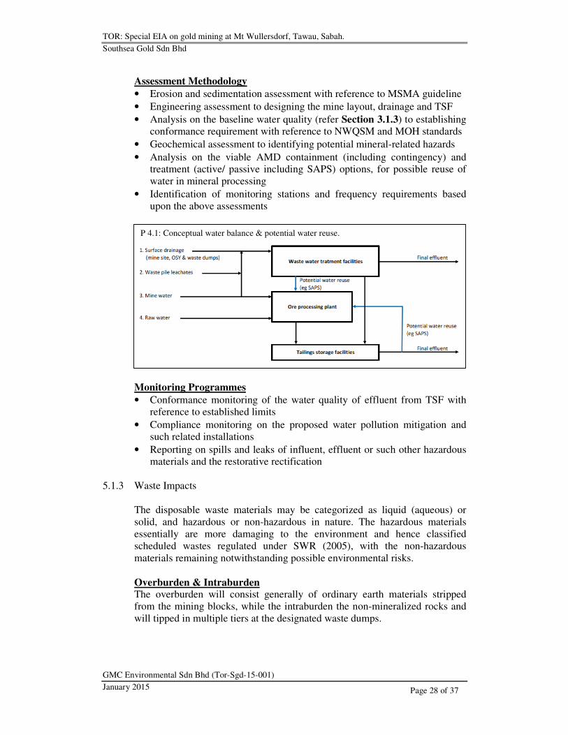
P 4.1: Conceptual water balance & potential water reuse.
TOR: Special EIA on gold mining at Mt Wullersdorf, Tawau, Sabah.
Southsea Gold Sdn Bhd
GMC Environmental Sdn Bhd (Tor-Sgd-15-001)
January 2015
Page 29 of 37
Tailings The tailings will consist of undesirable gangue minerals derived essentially
from processed ores, mixed with water and are invariably exposed to oxidation
and hence formation of AMD. The tailings will be contained and treated in
TSF (wet ponds) for possible recycle and reuse of the treated water at OWP.
Scheduled Wastes The scheduled wastes (refer Table 2.4) from the mining operations will
typically include spent motor oils and chemicals, disposable or possibly
recyclable for off-site reuse. Essentially, the containment and handling of
these spent materials will be primary to preventing spills and leaks to the
natural environment.
Aim of Mitigation
• To minimize environmental hazards through regulating containment of the
environmental waste materials
• To contain the waste materials within physical limits
Assessment Methodology
• Assessment on site suitability for the proposed waste dumps and TSF with
reference to local environmental setting, topographic reliefs and
foundation stability
Monitoring Programmes
• Compliance monitoring on the structural integrity of the containment
facilities
5.1.4 Ecological Impacts
The chain mining activities from development to cessation of the operations
will inevitably introduce impact to the influence area. Typically, the impact
will be considerably long-term and the effect irreversible depending upon the
scale of the operations. Drastic ecological impacts will invariably lead to
broken food chain in the ecosystem, which eventually further endanger the
wildlife species.
The changing ecology often is accelerated with destruction of the natural
habitats, and the adaptation thereafter further disturbed and possibly
decelerated by the various impacts associated typically with noises, air
pollution and human activities.
Aim of Mitigation
• To minimize disturbance on the existing ecosystem
• To sustain floral and faunal conservation
TOR: Special EIA on gold mining at Mt Wullersdorf, Tawau, Sabah.
Southsea Gold Sdn Bhd
GMC Environmental Sdn Bhd (Tor-Sgd-15-001)
January 2015
Page 30 of 37
Assessment Methodology
• Analysis on existing research data
• Interactive collaboration and discussion with the relevant authorities and
organizations, which include but not limit to SFD, SWD and WWF
• Analysis on viable faunal conservation options such as translocation and
establishing wildlife corridor
• Pre-development population (orangutan) surveillance for the proposed
disturbed and influence area
• Identification of monitoring stations and frequency requirements based
upon the above assessments
Monitoring Programmes
• Compliance monitoring on the forest reserve (100 m) and riparian (50 m)
buffers
• Compliance monitoring on land clearance with reference to RIL
specifications
• Compliance monitoring and policing on prohibition against hunting and
disposal of waste materials with harmful chemical composition
5.1.5 Safety & Health Hazards
Safety and health hazards are closely associated with workers and the public at
large. Consequently, a sound management with stringent environmental policy
will be critical to essentially providing a conducive and safe working
environment.
Aim of Mitigation
• To minimize safety and health risks
• To promote environmental performance
Assessment Methodology
• Risk analysis on workplace safety and health
• Applicability analysis on PPE with reference to JKKP standard
• Practicability analysis on SOP for the mining activities and handling of
equipment
Monitoring Programmes
• Compliance monitoring as per regulatory requirements
TOR: Special EIA on gold mining at Mt Wullersdorf, Tawau, Sabah.
Southsea Gold Sdn Bhd
GMC Environmental Sdn Bhd (Tor-Sgd-15-001)
January 2015
Page 31 of 37
5.2 Other Potential Impacts
5.2.1 Air Pollution
Air pollution includes dusting, exhaust smokes and fumes, which are also
inherent to the mining operations. Dusting will inevitably come from the
various mining activities ranging from drilling to crushing and screening to
trucking while toxic fumes (CO, NOX and SOX) from blasting and smokes
from the running machinery.
Aim of Mitigation
• To control and suppress excessive dusting, unwarranted toxic fumes and
exhaust emissions
Assessment Methodology
• Assessment on the mining equipment options, prioritizing machinery with
dusting suppression and low exhaust emissions
• Assessment on the ambient air quality (TSP) using TAS
• Assessment on periodic/ continuous monitoring requirement for the
mining operations
• Identification of monitoring stations and frequency requirements based
upon the above assessments
Monitoring Programmes
• Conformance monitoring of dusting (TSP) with reference to MAAQG
• Compliance monitoring on the proposed air pollution control/ suppression
mitigation and such related installations
5.2.2 Noises
Noises are inherent to running machinery and various activities, and the
impact is naturally inevitable. The proposed mining operations will hence
introduce noises additional to the ambient environment, invariably through the
working machines and the various mining and processing activities throughout
the mine development and operations. These inherent noises are audible and
non-destructive, but often can be disturbing or hazardous to occupational
safety and health.
On the other hand, airblast can be structurally destructive owing to its very
low frequency typically beyond our audible spectrum, more particularly when
the resonance of the vibration is amplified by the structures with similar
natural frequency and that if such resultant amplitude and PPV of the vibration
are sufficiently high. Airblast typically is derived from blasting (detonation)
and is short-lived.
TOR: Special EIA on gold mining at Mt Wullersdorf, Tawau, Sabah.
Southsea Gold Sdn Bhd
GMC Environmental Sdn Bhd (Tor-Sgd-15-001)
January 2015
Page 32 of 37
Aim of Mitigation
• To maintain noise levels within permissible boundary, and within
environmental and safe working limits
Assessment Methodology
• Forestry and cadastral buffer assessment
• Assessment on the mining and processing activities to establishing the
conformance requirement on permissible operating hours with reference to
prevailing JAS and JKKP standards, and to identifying monitoring stations
• Formulation of blast design based upon local environmental setting with
reference to prevailing JMG guideline
• Identification of monitoring stations and frequency requirements based
upon the above assessments
Monitoring Programmes
• Conformance monitoring of the noise levels with reference to established
limits
• Compliance monitoring on the proposed noise mitigation and such related
installations
5.2.3 Ground Vibration
Ground vibration may be natural from seismic activities such as earthquakes,
or resulted from blasting activities. Tectonically, Sabah by large is free from
the destructive forces of earthquakes in as far the regional geological setting
shall remain unchanged, but may be subject to repeated intermittent episodes
of tremors that are inevitable natural occurrences associated with the distant (>
2000 km) earthquake epicentres.
On the other hand, rock blasting (fragblast) activities also trigger ground
vibration as a result of shockwave released from detonation of explosives.
Depending upon the blast design and rock characteristics, the immense amount
of explosive energy may be transformed into ground vibration and/ or flyrocks
which nonetheless are both destructive and may cause serious structural
damages.
Improper blast designs not only produce excessive ground vibration but also
airblast and flyrocks, while good designs trigger minimum ground vibration,
less airblast and flyrocks, and more importantly optimizing fragmentation.
Aim of Mitigation
• To optimize fragblast with appropriate blast design

TOR: Special EIA on gold mining at Mt Wullersdorf, Tawau, Sabah.
Southsea Gold Sdn Bhd
GMC Environmental Sdn Bhd (Tor-Sgd-15-001)
January 2015
Page 33 of 37
Assessment Methodology
• Engineering and geological assessment to designing the blast based upon
characteristics of the rock formation with reference to the local
environmental setting, cadastral and structural buffering requirements
• Assessment on explosives and blast initiation options with SHE
prioritization
• Assessment on scheduling of fragblast and explosives storage options
• Identification of monitoring stations and frequency requirements based
upon the above assessments
Monitoring Programmes
• Conformance monitoring of blast vibrations with reference to established
JAS and JMG limits
• Compliance monitoring of fragblast with reference to established buffering
requirements
• Reporting on environmental hazards triggered by blasting
5.2.4 Traffic & Transportation
Transportation by trucking of the processed ores en route from the site to the
nearest port will essentially make use of the existing access roads, with a
section currently unsealed and that trucking may hence inevitably aggravate
dusting, more significantly during long dry period.
The trucking transportation will also incur an increase in the haulage traffic
density along the existing common feeder roads, which currently appear
chiefly used by the plantations as the main haul route to the main road.
Aim of Mitigation
• To minimize traffic impact affecting Kg Bukit Kawa
• To possibly avoid road accidents
Assessment Methodology
• Traffic observations and prediction on foreseeable changes
Monitoring Programmes
• Compliance monitoring on the proposed dusting and traffic safety
mitigation and such related installations
5.2.5 Landscape Modification
Surface mining will eventually allow massive topographic alteration with
large depressions through massive excavations at the mining blocks and raised
elevations at the waste dumps. The landscape changes are normally permanent,
with the progress dependent essentially upon the scale of operations.
TOR: Special EIA on gold mining at Mt Wullersdorf, Tawau, Sabah.
Southsea Gold Sdn Bhd
GMC Environmental Sdn Bhd (Tor-Sgd-15-001)
January 2015
Page 34 of 37
While topographic restoration currently remains uncommonly practiced or
reasonably practicable for mining, rehabilitation is a preferred and more viable
option to minimizing the risk of environmental hazards after the mine life,
primarily associated with AMD.
Aim of Mitigation
• To appreciate environmental aesthetics of the mined-over/ disturbed areas
• To contain environmental hazards from the mined-over/ disturbed areas
Assessment Methodology
• Assessment on the prevailing rehabilitation options with reference to the
local settings
• Analysis on AMD prevention alternatives for the mined-over and/ or
disturbed areas
Monitoring Programmes
• Compliance monitoring on the proposed rehabilitation
6 DATA COLLECTION
The TOR was based upon the following findings and sources of reference.
6.1 Activities
• Site reconnaissance on 21.08.2014 and assessments on 11.11.2014 and
04.12.2014 to correlating the environmental settings with the proposed
concept of mining operations
• Baseline water sampling at the entry and exit points of Sg Mantri Kanan
along the proposed border area of the site, and downstream at the
immediate river junction offsite and Sg Mantri – Kalumpang junction
(refer Section 3.1.3)
• Land use and water use assessment along Sg Kalumpang up to estuary and
along the access road from the main road junction (refer Section 3.3.1)
• Liaison with SFD, SWD and WWF-MY on floristic and faunal researches
and findings (refer Section 3.2)
6.2 Data
6.2.1 Maps & Plans
Cadastral
• District of Tawau map. Scale 1:12,500. JTU, KK
Geological
• Geological map of Sabah. Scale 1:500,000. 1985; Hydrogeological map of
Sabah & Labuan Island. Scale 1:500,000. 2007. JMG, KK
TOR: Special EIA on gold mining at Mt Wullersdorf, Tawau, Sabah.
Southsea Gold Sdn Bhd
GMC Environmental Sdn Bhd (Tor-Sgd-15-001)
January 2015
Page 35 of 37
Soil
• The soil of Sabah – Tawau NB 50-15. Scale 1:250,000. 1974. UK
Topography
• Restricted map Apas Balung 4/118/9 & Mastyn 4/118/5. Scale 1:50,000.
1985. JUPEM, KK
• Tactical pilotage chart TPC L-11B. Scale 1:500,000. 1989. DGMS,
London
6.2.2 Documents & Reports
Legislation
• Environment Protection Enactment. 2002. State Gov of Sabah, KK
• Environment Protection Enactment (Prescribed Activities) (EIA) Order.
2005. State Gov of Sabah, KK
• Mineral Development (Operational Mining Scheme, Plans & Record
Books) Regulations. PU(A)067/2007. 2007. JMG, KL
• Mineral Enactment. 1999. State Gov of Sabah, KK
• Wildlife Conservation Enactment. 1997. State Gov of Sabah. KK
Reporting guidelines
• Handbook on EIA in Sabah. 2005. JPAS, KK
• EIA guidelines for mines & quarries. EG 7/95. 1995. JAS, KL
Other references
• A summary of passive & active treatment technologies for AMD. 2005.
ACMER
• Forest conservation management plan – Ulu Kalumpang Forest Reserve,
Mt Wullersdorf Forest Reserve, Kalumpang FR & Madai Baturong FR
(01.01.2011 – 31.12.2020). 2011. SFD
• Introduction mining engineering. 2002. JWS
• Malaysia’s 5th
national report to convention on biological biodiversity
(CBD). 2014. MNRE
• Orangutan Action Plan (2012 – 2016). 2011. SWD
• Proposed opencast mining scheme in Mining Lease of 1,000 ha for gold
mining operation in Mount Wullersdorf area, Tawau.. 2014. KMCS, PJ
• Rainfall data for Tawau. 2011. JMM, KK
• Report on clouded leopard survey in Ulu Kalumpang FR, Sabah. 2012.
WWF-MY
• The Ulu Kalumpang – Wullersdorf sustainable forest management project.
In Forestry Annual Report. 2012. SFD
TOR: Special EIA on gold mining at Mt Wullersdorf, Tawau, Sabah.
Southsea Gold Sdn Bhd
GMC Environmental Sdn Bhd (Tor-Sgd-15-001)
January 2015
Page 36 of 37
6.3 Consulting Authorities
• Jabatan Alam Sekitar
• Jabatan Hidupan Liar Sabah
• Jabatan Meteorologi Malaysia
• Jabatan Mineral & Geosains
• Jabatan Pengairan & Saliran
• Jabatan Perancang Bandar & Wilayah
• Jabatan Perhutanan Sabah
• Jabatan Perikanan
• Jabatan Perlindungan Alam Sekitar
• Jabatan Tanah & Ukur
• Majlis/ Pejabat Daerah Tawau
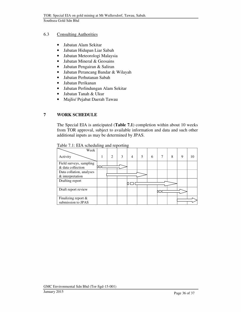
7 WORK SCHEDULE
The Special EIA is anticipated (Table 7.1) completion within about 10 weeks
from TOR approval, subject to available information and data and such other
additional inputs as may be determined by JPAS.
Table 7.1: EIA scheduling and reporting Week
Activity
1
2
3
4
5
6
7
8
9
10
Field surveys, sampling
& data collection
Data collation, analyses
& interpretation
Drafting report
Draft report review
Finalizing report &
submission to JPAS

TOR: Special EIA on gold mining at Mt Wullersdorf, Tawau, Sabah.
Southsea Gold Sdn Bhd
GMC Environmental Sdn Bhd (Tor-Sgd-15-001)
January 2015
Page 37 of 37
8 STUDY TEAM
Table 8.1 lists the EIA team members for the Project.
Table 8.1a: Study team members
No Name Reg no/
Exp date
Responsibilities Fields of
expertise
1 Tan Han Meng CPESC, MIGM, FIQ
S0018/
30.09.2015
Project manager,
geological, mining
engineering, safety
& health
Geology &
blasting
2 Hillery Niting
S0019/
30.09.2015
Socio-economic &
land use
Socio-
economics &
land use
3 Freddy Lee
S0023/
30.09.2015
GIS Survey &
mapping/
GIS
4 Ng Ling Pheng CHRA
S0179/
12.02.2016
Air, noise & water
quality
Air, noise &
water quality
Table 8.1b: Supporting team members*
No Name Responsibilities
1 Albrecht P Raphael B Eng
Chemical Engineering
Chemical health risk & waste management
2 Ivoni Felix B Sc (Hons)
Conservation Biology
Biological & ecological
3 Mohd Afinday Ahmad
B Sc (Hons)
Conservation Biology
Air, noise & water quality
*Registration with JPAS pending
Recommended