Project Site & Linear Facilities Built Environment Survey – Technical Report
Orange Grove Project Pala, California
Submitted To Tom Jackson, Ph.D.
Pacific Legacy, Inc 1525 Seabright Avenue Santa Cruz, CA 95062
&
Joe Stenger, Project Manager
TRC Solutions, Inc. 21 Technology Drive
Irvine, CA 92618
Prepared By Wendy L. Tinsley, AICP, Principal
Urbana Preservation & Planning 255 G Street #399, San Diego, CA 92101
619-543-0693/Phone [email protected]
August 2008
Project Site & Linear Facilities Built Environment Survey – Technical Report Proposed Orange Grove Project, Pala, California
Urbana Preservation & Planning August 2008
Page ii
TABLE OF CONTENTS I. INTRODUCTION ................................................................................................................................ 1
Methodology ......................................................................................................................... 1 II. HISTORICAL OVERVIEW .................................................................................................................. 2
Historical Overview of the Pala Community........................................................................ 2 Spanish & Mission Period.................................................................................................... 3 Subject Property ................................................................................................................... 4
III. SURVEY AREA OBSERVATIONS ..................................................................................................... 5 Properties Observed ............................................................................................................. 5 Proposed Project Area ......................................................................................................... 6 Linear Facilities ................................................................................................................... 8
IV. HISTORICAL RESOURCE INTERPRETATION .................................................................................... 12 Proposed Project Area ......................................................................................................... 12 Linear Facilities ................................................................................................................... 12 Surrounding Historical Resources ....................................................................................... 13
V. BIBLIOGRAPHY ............................................................................................................................... 14 ATTACHMENTS 1. Urbana, San Diego Aqueduct – Preliminary California Register of Historical Resources Eligibility Review & Department of Parks & Recreation 523 Forms A & B, May 2008. 2. Urbana, Remnant Pala Area Orange Grove – Preliminary California Register of Historical Resources Eligibility Review & Department of Parks & Recreation 523 Forms A & L, August 2008. 3. CV for Wendy L. Tinsley, AICP, Principal: Urbana Preservation & Planning
Project Site & Linear Facilities Built Environment Survey – Technical Report Proposed Orange Grove Project, Pala, California
Urbana Preservation & Planning August 2008
Page 1
I. INTRODUCTION From September 2007 forward Urbana Preservation & Planning (Urbana) has collaborated with TRC Solutions, Inc. and Pacific Legacy, Inc., to complete built environment surveys for the proposed Orange Grove Project to comply with historical resource identification, documentation, and evaluation requirements as part of the Application for Certification to the California Energy Commission (CEC) for the proposed Orange Grove Project generating plant and ancillary facilities in the vicinity of the communiies of Pala and Fallbrook, California. In support of this historical resource compliance effort Urbana has completed reconnaissance-level built environment surveys and preliminary historical research (both contextual and property specific) for the proposed project site and associated facility locations in Pala to:
• Identify all buildings or structures at least 45 years of age (‘Over 45’) within the a 200 foot radius of the proposed project site and within 50 feet of the proposed linear facilities;
• Prepare a historical overview of the proposed project site and associated linear facility locations; • Document all ‘Over 45’ properties on State of California Department of Parks & Recreation
(DPR) 523 Series Forms; • Evaluate all ‘Over 45’ properties observed for eligibility to the California Register of Historical
Resources; and • Provide a regulatory interpretation regarding impacts to historical resources resultant from the
proposed Orange Grove Project. Survey efforts for the Pala area project components were completed in September 2007, May 2008, and August 2008.
• The September 2007 survey covered the proposed project site at Pala Del Norte Road and Highway 76, and also included a review of the planned alignments for the linear facilities proposed for construction out from the project site and along Highway 76.
• The May 2008 survey entailed historical research, documentation and a preliminary California Register evaluation of the subterranean San Diego Aqueduct, which intersects the planned alignment of a proposed linear facility and construction staging area, on DPR 523 Series forms.
• The August 2008 survey effort entailed documentation and a preliminary California Register evaluation of a remnant Orange Grove located at the project site on DPR 523 Series forms.
The purpose of this document is to provide a single comprehensive built environment survey technical report for the project site and linear facilities which includes all survey observations, documentation and site historical significance evaluations, and historical resource regulatory interpretations which have been compiled for the project Methodology The methodological approach undertaken by Urbana to respond to each of the above-listed data requests included conducting archival and internet research to identify locally designated and other recognizable non-designated historic buildings or structures, contacting individuals and organizations to inquire about the history of the proposed project area, and conducting a field survey to determine the land uses and property types associated with the proposed project area and its vicinity. All survey efforts were completed by Wendy L. Tinsley, AICP, Principal of Urbana. Ms. Tinsley meets The Secretary of the Interior’s Professional Qualification Standards in the disciplines of history and architectural history. Her resume demonstrating qualifications and similar project experience are attached to this report. Historical research for the subject property and surrounding area was conducted primarily at the San Diego Historical Society Research Archives and the California History Room at the Central (Downtown) San Diego Public Library. Resources reviewed include historic plat books for San Diego County, historic photographs of the Pala community, aerial images from a 1929 countywide photosurvey, historic and current U.S. Geological Survey topographic maps for the Pala Quad, reference books on the history of the Pala Community, the Spanish Mission system, the Native American experience in the Pala area during the Mission Era and after desecularization, and creation of the Pala Indian Reservation; and vertical files with newspaper clippings related to Rancho Monserrate and landowners associated with Sections 29 and 32.
Project Site & Linear Facilities Built Environment Survey – Technical Report Proposed Orange Grove Project, Pala, California
Urbana Preservation & Planning August 2008
Page 2
Internet research conducted included reviewing the County of San Diego’s list of historic resources available online through the County Historic Site Board’s website to determine whether any locally designated properties were sited within or nearby the proposed project area. The California State Office of Historic Preservation’s (OHP) list of California Historic Landmarks and Points of Historical Interest for San Diego County was reviewed via the OHP website, and the National Register of Historic Places information database was also reviewed to identify any Pala area properties which may be listed on the National Register of Historic Places. Previous environmental documentation associated with the proposed project and a circa 2001 substation construction project in the Pala area was also reviewed to gain additional insight on the past uses and construction campaigns associated with the proposed project site. Field survey efforts included walking the proposed project site and driving the routes for the proposed linear facilities. Every building or structure observed was photographed as part of the field survey effort. All properties observed were researched at the San Diego County Assessor-Recorders Office to identify:
• the Assessors Parcel Number associated with each property, • street addresses associated with each property (if any), • land use classifications (zoning), and • property construction dates.
Visual observations and San Diego County Assessor-Recorders databases assisted in the determination of whether any properties within the survey areas were constructed prior to 1962 and consequently would be at least 45 years of age. II. HISTORICAL OVERVIEW Historical Overview of the Pala Community The history of the Pala community is entrenched in the dual traditions of the Luiseño and Cupeño tribes and later, the Spanish and Mexican colonial system of governance represented by Mission San Luis Rey de Francia and Mission San Antonio de Pala. After desecularization of the California Mission system, the former mission lands that comprise Pala and the surrounding areas came under private ownership primarily by Mexican or American citizens with no land ownership considerations provided to the native groups who occupied and worked the lands prior to and during the Mission period. Rancho Monserrate, a 13,322-acre Mexican period land holding located approximately two miles west of the proposed project area was deeded into private ownership in 1846.1 In 1877 American William Veale purchased Mission San Antonio de Pala and its lands from the U.S. Government. In 1902, the United States Government appropriated funds to purchase land in the Pala Valley as a permanent reservation for tribal groups displaced by the Mission system and its subsequent dissolution which established the Pala Band of Mission Indians Tribal Reservation.2 With no options or effective advocates in government positions, displaced native peoples primarily from the Cupeño tribe were viewed as trespassers without legal land titles or rights, and were removed from their homes and lands their ancestors occupied for centuries to be relocated to the reservation at Pala Valley. The U.S. Government’s Indian Bureau, using armed teamsters, evicted the Cupeños from their homes at present-day Warner Springs and ushered them on their forty-mile journey west to the Pala Valley, ancestral home of the Luiseño tribe, and location of the newly established 10,000 acre Indian Reservation. Although the proposed project site is located immediately west of the Pala Indian Reservation, the land and its vicinity in all of the Pala Valley is considered to maintain ancestral importance to the tribe. Today the Pala Community, home to the Pala Band of Mission Indians, as well as non-tribal and non-Native American property owners, retains it’s primarily bucolic setting which has historically characterized the land. Few major development projects have occurred to alter the natural setting of the area. From Highway 76, an old transportation route which was developed by the California Department of
1 Rush, Philip S., “Historic Ranchos: Monserate” The Southern California Rancher, September-October 1962. Article included in “Rancho Monserate” Vertical File available for review at the San Diego Historical Society Research Archives. 2 Leffingwell, Randy & Alastair Worden, California Missions & Presidios: The History & Beauty of the Spanish Missions.
Project Site & Linear Facilities Built Environment Survey – Technical Report Proposed Orange Grove Project, Pala, California
Urbana Preservation & Planning August 2008
Page 3
Transportation (Caltrans) between ca.1955 and 1963, one observes agricultural land uses including nurseries and farms wherein produce and other resources are produced for sale and distribution. Typical fruit products attributed to the Pala Valley and the San Diego (and Southern California) region are citrus, especially oranges, and avocados, touted as the premier salad fruit in the 1920s thru 1940s. Spanish & Mexican Period Founded in 1798 under the supervision of Padre Presidente Fermin Francisco de Lasuen, Mission San Luis Rey de Francia was the eighteenth of twenty-one missions established along the California coastline. The Mission was built approximately four miles east of the intersection of present-day Interstate 5 and Highway 76, which is known as Mission Road. In 1810 a granary was built for Mission purposes in the valley at present-day Pala (the word for water in the Shoshone language) and in 1816 a Ramada was erected there to hold morning mass for the neophyte Indians in the area. Soon thereafter a chapel and bell tower were erected as an Asistencia (annex) and dedicated as Mission San Antonio de Pala.3 According to G.W. James in his 1916 publication Picturesque Pala
Under Peyri’s administration, despite its disadvantages of soil, San Luis Rey grew steadily in population and material prosperity. In 1800 cattle and horses were six hundred and sheep sixteen hundred. The wheat harvest gave two thousand bushels, but corn and beans were failures and barely gave a hundred and twenty fanigas. Ten years later 11,000 fanigas of all kinds of grain were gathered as a crop. Cattle had grown to ten thousand five hundred and sheep and hogs nearly ten thousand. Fourteen hundred and fifty had been baptized while there had been only four hundred deaths recorded. By 1826 the parent mission counted nearly three thousand Christian Indians and nearly a thousand gathered at Pala, six leagues from the central establishment. A church was built there and a priest usually resided at it. At its best time San Luis Rey counted nearly thirty thousand cattle, as many sheep and over two thousand horses as the property of its three thousand Indians. Its average grain crop was about thirteen thousand bushels. San Gabriel surpassed it in farming prosperity with a crop which reached thirty thousand bushels in a year, but in populations, in livestock, in the low death rate among its Indians and in the character of its church and buildings, San Luis Rey continued to the end first among the Franciscan Missions.4
In addition to the prosperity of Mission San Luis Rey being highlighted in California history publications at the time, Pala Valley itself was also highly regarded as “one of the most beautiful appanages of the San Luis Rey Mission.”5 At the time of dissolution, the Mission territories of the Pala Valley were divided into private land holdings including Rancho Monserrate, which was granted to Ysidro Alvarado in 1846 by his brother-in-law Mexican Governor Pio Pico shortly before he fled to Baja California to escape American occupation forces. Alvarado lived at Rancho Monserrate with his wife Micaela until 1863 when they both died from a Smallpox epidemic. Eleven years later, after the U.S. Land Commission officially confirmed ownership of the rancho by the three children of Ysidro and Micaela Alvarado, who in turn were able to rightfully inherit the property. According to Don Rivers, President of the Fallbrook Historical Society:
Lugarda Alvarado Palomares was living in Los Angeles with her husband and two daughters when she received ownership of her approximately 4,500 acres of the western portion. Dolores Alvarado de Serrano and her husband inherited the middle portion of 4,500 acres and built their home in the lower portion of what today is known as Live Oak Canyon. William Gird purchased the Serrano Rancho in the early 1880s and lived in the Serrano house until they could build their own frame house on higher ground. Tomas Alvarado, the son, received approximately 4,500 acres of the eastern portion and built an adobe hacienda on the south side of San Luis Rey River just west of Interstate 15. Today the Rancho Monserate Country Club is located there.6
In 1877 American William Veale and his wife purchased from the U.S. Government, the Asistencia and its lands, although his wife, reportedly a devout Roman Catholic, persuaded Veale to return the chapel and
3 James, G.W., Picturesque Pala, 16. 4 Ibid, 32. 5 Jackson, Helen Hunt, Ramona (1884) within G.W. James Picturesque Pala, 34. 6 Rivers, Don “Rancho Monserate” The Village News, October 29, 1998.
Project Site & Linear Facilities Built Environment Survey – Technical Report Proposed Orange Grove Project, Pala, California
Urbana Preservation & Planning August 2008
Page 4
related cemetery to the Catholic Church in 1893. At the turn-of-the-century the Pala Asistencia had fallen into disrepair. In 1902, as part of a growing Mission Revival movement in California the Landmarks Club of Southern California, led by Charles F. Lummis, acquired the church ruins and commenced a restoration campaign. Regular church services resumed when the project was completed. 1902 also corresponds to the year the United States Congress passed an appropriation bill that authorized the 10,000 acre land purchase in the Pala Valley to establish the present-day Pala Indian Reservation. Coordination between Lummis and Indian advocates likely occurred. In 1916 the Pala Campanile fell from storm damage and was rebuilt. Today the Pala Mission is still actively used with a restored quadrangle, classrooms and library, and a new Parish Hall. The Pala Casino Spa and Resort are located nearby. Subject Property Plat books and Property Deed Books for San Diego County disclose early land owners associated with Sections 29 and 32 (in which the power plant is proposed for installation) include:
• 1886: Maurelita Cota, Madison Smith, D.A. Higgins, W.A. Stephens, Henry G. Stephens, and Maggie Lovell,7
• 1892: Maurelita Cota, Madison Smith, and D.A. Higgins,8 • 1910: W.W. Culver (411.6 acres), Charles Foreman (138.75 acres), M.J. Gordon (40 acres), Y.
Yalenguel (30 acres), F.A. Salmon (21.75 acres), and M. Frujito (10-18 acres),9 and • 1930s: Griffith & Irene Henshaw, John & Catherine E. Turner, and Frank M. & Mary Moreno.10
A review of San Diego City & County Directories reveals property owners Frank A. Salmons and his wife Hazel were proprietors of the Pala Store, near the Pala Mission, in 1930 and 1935. Frank Moreno, with his wife Mary, was a local rancher who was listed as a Pala resident in 1930 and 1935. Moreno’s full given name of ‘Francisco’ was utilized for the purposes of the directory listing.11 Of Spanish lineage from Sonora, Mexico, Francisco (Frank) M. Moreno arrived in the Pala Valley in 1875 to attend school there and reside with his childless uncle (also Francisco Moreno – no middle name identified) and aunt. After completing his studies Frank M. Moreno assisted his uncle in the operations of the approximate 320 acre family ranch and winery which he took over in 1902 after his uncle died.12 Records of the Old Luiseno Cemetery at Mission San Antonio de Pala include a listing for a Francisco Moreno, born on February 13, 1853, died in 1928, and buried at the Pala cemetery.13 Although not substantiated, it is likely the Francisco Moreno buried at the Old Luiseno Cemetery is related to landowner and rancher Frank M. Moreno. A tree grove was planted at the proposed project site as early as ca. 1949 when the tree grouping was first demarcated on a Pala Quadrangle map by the U.S. Interior Department Geological Survey. The trees did not appear to constitute a major agricultural operation, and the land use is typical to historic land use patterns of the Pala area which are classified as agricultural and miscellaneous and include land preserves, nurseries and other agricultural uses. In 1964 the present-day substation was constructed by SDG& E, presumably on land leased from property owners Robert and Gale Driscoll.14 In 1970 SDG&E acquired the subject parcel adjacent to the substation
7 Townships 8-19 South Range West: 1892. Plat Book on file at the San Diego County Historical Society Research Archives. 8 Townships 3-19 South Range West: 1886. Plat Book on file at the San Diego County Historical Society Research Archives. 9 Plat Book of San Diego County, 1910. Plat Book on file at the San Diego County Historical Society Research Archives. 10 Chicago Title Company, “Preliminary Title Report” within TRC, Phase 1 Environmental Site Assessment Orange Grove Project Site San Diego County, California, Appendix D, April 2007. 11 San Diego City & County Directories, 1930 and 1935. Directories available at the San Diego Public Library California History Room. 12 Gunn, Guard D., History of California. Article included in “Francisco Moreno” Vertical File available for review at the San Diego Historical Society Research Archives. 13 Johnson, Steve Paul, “Mission San Antonio de Pala, Pala, San Diego County, California” Interment.net Cemetery Transcription Library http://www.interment.net/data/us/ca/sandiego/mission_pala/san_antonio.htm. 14 Dudek & Associates, Final Mitigation Negative Declaration San Diego Gas & Electric Company Pala Substation Project, Section 1.1 (page 6 of 36), August 2001.
Project Site & Linear Facilities Built Environment Survey – Technical Report Proposed Orange Grove Project, Pala, California
Urbana Preservation & Planning August 2008
Page 5
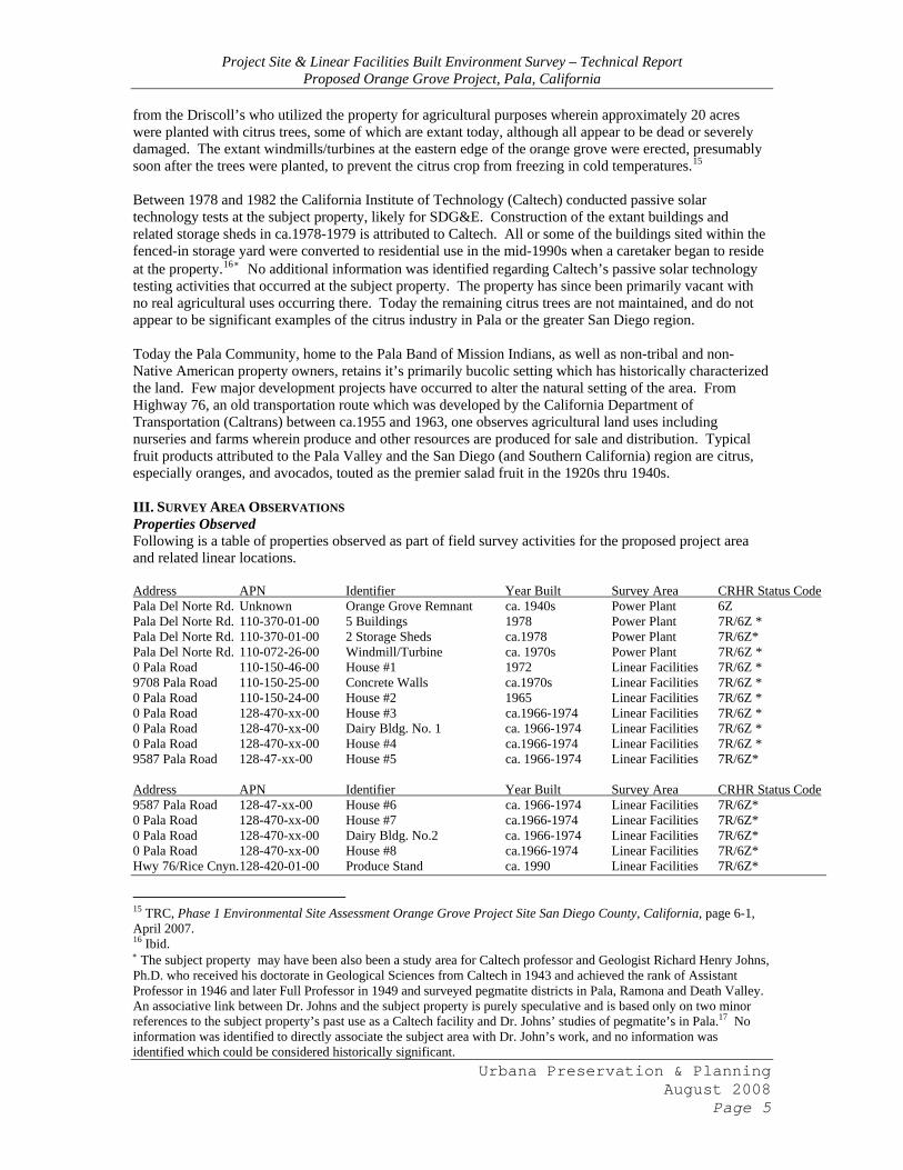
from the Driscoll’s who utilized the property for agricultural purposes wherein approximately 20 acres were planted with citrus trees, some of which are extant today, although all appear to be dead or severely damaged. The extant windmills/turbines at the eastern edge of the orange grove were erected, presumably soon after the trees were planted, to prevent the citrus crop from freezing in cold temperatures.15 Between 1978 and 1982 the California Institute of Technology (Caltech) conducted passive solar technology tests at the subject property, likely for SDG&E. Construction of the extant buildings and related storage sheds in ca.1978-1979 is attributed to Caltech. All or some of the buildings sited within the fenced-in storage yard were converted to residential use in the mid-1990s when a caretaker began to reside at the property.16 ∗ No additional information was identified regarding Caltech’s passive solar technology testing activities that occurred at the subject property. The property has since been primarily vacant with no real agricultural uses occurring there. Today the remaining citrus trees are not maintained, and do not appear to be significant examples of the citrus industry in Pala or the greater San Diego region. Today the Pala Community, home to the Pala Band of Mission Indians, as well as non-tribal and non-Native American property owners, retains it’s primarily bucolic setting which has historically characterized the land. Few major development projects have occurred to alter the natural setting of the area. From Highway 76, an old transportation route which was developed by the California Department of Transportation (Caltrans) between ca.1955 and 1963, one observes agricultural land uses including nurseries and farms wherein produce and other resources are produced for sale and distribution. Typical fruit products attributed to the Pala Valley and the San Diego (and Southern California) region are citrus, especially oranges, and avocados, touted as the premier salad fruit in the 1920s thru 1940s. III. SURVEY AREA OBSERVATIONS Properties Observed Following is a table of properties observed as part of field survey activities for the proposed project area and related linear locations. Address APN Identifier Year Built Survey Area CRHR Status Code Pala Del Norte Rd. Unknown Orange Grove Remnant ca. 1940s Power Plant 6Z Pala Del Norte Rd. 110-370-01-00 5 Buildings 1978 Power Plant 7R/6Z * Pala Del Norte Rd. 110-370-01-00 2 Storage Sheds ca.1978 Power Plant 7R/6Z* Pala Del Norte Rd. 110-072-26-00 Windmill/Turbine ca. 1970s Power Plant 7R/6Z * 0 Pala Road 110-150-46-00 House #1 1972 Linear Facilities 7R/6Z * 9708 Pala Road 110-150-25-00 Concrete Walls ca.1970s Linear Facilities 7R/6Z * 0 Pala Road 110-150-24-00 House #2 1965 Linear Facilities 7R/6Z * 0 Pala Road 128-470-xx-00 House #3 ca.1966-1974 Linear Facilities 7R/6Z * 0 Pala Road 128-470-xx-00 Dairy Bldg. No. 1 ca. 1966-1974 Linear Facilities 7R/6Z * 0 Pala Road 128-470-xx-00 House #4 ca.1966-1974 Linear Facilities 7R/6Z * 9587 Pala Road 128-47-xx-00 House #5 ca. 1966-1974 Linear Facilities 7R/6Z* Address APN Identifier Year Built Survey Area CRHR Status Code 9587 Pala Road 128-47-xx-00 House #6 ca. 1966-1974 Linear Facilities 7R/6Z* 0 Pala Road 128-470-xx-00 House #7 ca.1966-1974 Linear Facilities 7R/6Z* 0 Pala Road 128-470-xx-00 Dairy Bldg. No.2 ca. 1966-1974 Linear Facilities 7R/6Z* 0 Pala Road 128-470-xx-00 House #8 ca.1966-1974 Linear Facilities 7R/6Z* Hwy 76/Rice Cnyn. 128-420-01-00 Produce Stand ca. 1990 Linear Facilities 7R/6Z*
15 TRC, Phase 1 Environmental Site Assessment Orange Grove Project Site San Diego County, California, page 6-1, April 2007. 16 Ibid. ∗ The subject property may have been also been a study area for Caltech professor and Geologist Richard Henry Johns, Ph.D. who received his doctorate in Geological Sciences from Caltech in 1943 and achieved the rank of Assistant Professor in 1946 and later Full Professor in 1949 and surveyed pegmatite districts in Pala, Ramona and Death Valley. An associative link between Dr. Johns and the subject property is purely speculative and is based only on two minor references to the subject property’s past use as a Caltech facility and Dr. Johns’ studies of pegmatite’s in Pala.17 No information was identified to directly associate the subject area with Dr. John’s work, and no information was identified which could be considered historically significant.

Project Site & Linear Facilities Built Environment Survey – Technical Report Proposed Orange Grove Project, Pala, California
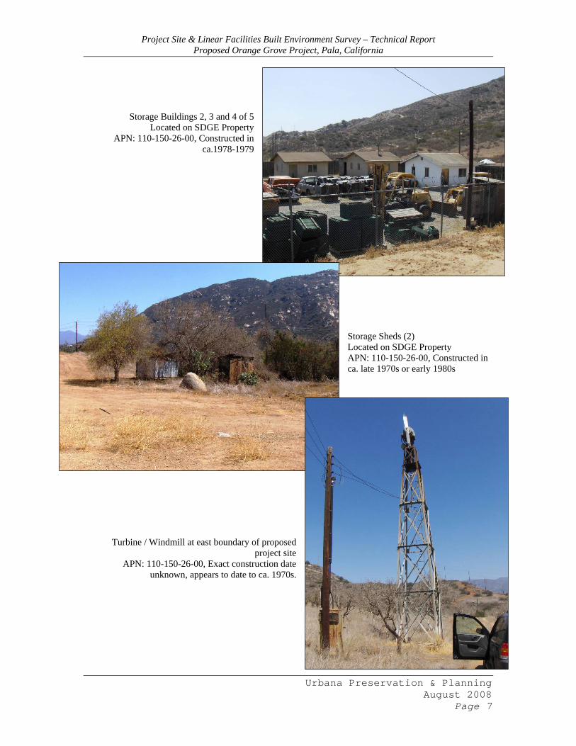
N.A. N.A. San Diego Aqueduct 1945 Linear Facilities 3CS *All properties observed which are less than 45 years of age have been assigned a California Register of Historical Resources (CRHR) Status Code of 7R/6Z, which means the properties are not eligible due to age eligibility thresholds not being met, and would require evaluation in the future once an approximate 45-50 year age has been achieved. Proposed Project Area The proposed project area includes a remnant orange orchard dating to the late 1940s, within which many of the trees are dead and not maintained. A turbine/windmill is sited near the southeast corner of the proposed project area, with an additional turbine/windmill sited further east beyond the proposed project boundaries and related fifty-foot radius. Also sited on the subject property is an enclosed storage yard which contains five buildings utilized for residential and miscellaneous storage purposes. These buildings were erected or moved onto the site in approximately 1978-1979 when the California Institute of Technology (Caltech) conducted passive solar energy tests there. A property caretaker has resided at one of the buildings for the last decade. Two ancillary storage sheds are sited immediately south of the enclosed storage yard; one of wood construction and the second of metal construction. The small sheds appear to date to the late 1970s or early 1980s. A non-historic substation owned by the San Diego Gas & Electric Company is sited within view of the proposed project area. The substation was installed in approximately 2003 to replace an older substation at the site. A road entry sign demarcating the location of Pala Del Norte Road is immediately north of Highway 76 between the subject parcel and the adjacent parcel containing the SDGE substation. The sign is non-historic and appears to also have been installed in the 1970s or 1980s. None of the buildings or structures observed appear to be at least 45 years of age. Following are current photographs and brief descriptions of the properties observed within the project site.
Storage Building 1 of 5 (possibly utilized as caretaker’s residence)
Located on SDGE Property APN: 110-150-26-00, Constructed in
ca.1978-1979
Urbana Preservation & Planning August 2008
Page 6
Project Site & Linear Facilities Built Environment Survey – Technical Report Proposed Orange Grove Project, Pala, California
Storage Buildings 2, 3 and 4 of 5 Located on SDGE Property
APN: 110-150-26-00, Constructed in ca.1978-1979
Storage Sheds (2) Located on SDGE Property APN: 110-150-26-00, Constructed in ca. late 1970s or early 1980s
Turbine / Windmill at east boundary of proposed project site
APN: 110-150-26-00, Exact construction date unknown, appears to date to ca. 1970s.
Urbana Preservation & Planning August 2008
Page 7
Project Site & Linear Facilities Built Environment Survey – Technical Report Proposed Orange Grove Project, Pala, California
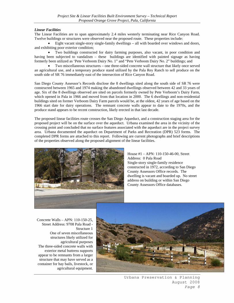
Linear Facilities The Linear Facilities are to span approximately 2.4 miles westerly terminating near Rice Canyon Road. Twelve buildings or structures were observed near the proposed route. These properties include:
• Eight vacant single-story single-family dwellings – all with boarded over windows and doors, and exhibiting poor exterior condition;
• Two buildings constructed for dairy farming purposes, also vacant, in poor condition and having been subjected to vandalism – these buildings are identified with painted signage as having formerly been utilized as ‘Pete Verboom Dairy No. 1” and “Pete Verboom Dairy No. 2” buildings; and
• Two miscellaneous structures – one three-sided concrete wall structure that likely once served an agricultural use, and a temporary produce stand utilized by the Pala Rey Ranch to sell produce on the south side of SR 76 immediately east of the intersection of Rice Canyon Road. San Diego County Assessor’s Records disclose the 8 dwellings sited along the south side of SR 76 were constructed between 1965 and 1974 making the abandoned dwellings observed between 42 and 33 years of age. Six of the 8 dwellings observed are sited on parcels formerly owned by Pete Verboom’s Dairy Farm, which opened in Pala in 1966 and moved from that location in 2000. The 6 dwellings and non-residential buildings sited on former Verboom Dairy Farm parcels would be, at the oldest, 42 years of age based on the 1966 start date for dairy operations. The remnant concrete walls appear to date to the 1970s, and the produce stand appears to be recent construction, likely erected in that last decade. The proposed linear facilities route crosses the San Diego Aqueduct, and a construction staging area for the proposed project will be on the surface over the aqueduct. Urbana examined the area in the vicinity of the crossing point and concluded that no surface features associated with the aqueduct are in the project survey area. Urbana documented the aqueduct on Department of Parks and Recreation (DPR) 523 forms. The completed DPR forms are attached to this report. Following are current photographs and brief descriptions of the properties observed along the proposed alignment of the linear facilities.
House #1 – APN: 110-150-46-00, Street Address: 0 Pala Road Single-story single-family residence constructed in 1972, according to San Diego County Assessors Office records. The dwelling is vacant and boarded up. No street address on building or within San Diego County Assessors Office databases.
Concrete Walls – APN: 110-150-25, Street Address: 9708 Pala Road -
Structure 1 One of seven miscellaneous structures likely utilized for
agricultural purposes The three-sided concrete walls with
exterior metal buttress supports appear to be remnants from a larger structure that may have served as a
container for hay bails, livestock, or agricultural equipment.
Urbana Preservation & Planning August 2008
Page 8
Project Site & Linear Facilities Built Environment Survey – Technical Report Proposed Orange Grove Project, Pala, California
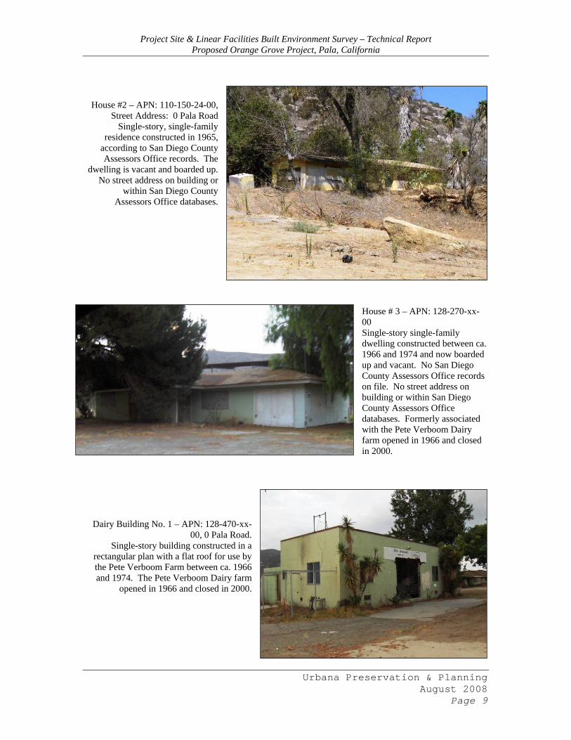
House #2 – APN: 110-150-24-00,
Street Address: 0 Pala Road Single-story, single-family
residence constructed in 1965, according to San Diego County Assessors Office records. The
dwelling is vacant and boarded up. No street address on building or
within San Diego County Assessors Office databases.
House # 3 – APN: 128-270-xx-00 Single-story single-family dwelling constructed between ca. 1966 and 1974 and now boarded up and vacant. No San Diego County Assessors Office records on file. No street address on building or within San Diego County Assessors Office databases. Formerly associated with the Pete Verboom Dairy farm opened in 1966 and closed in 2000.
Dairy Building No. 1 – APN: 128-470-xx-00, 0 Pala Road.
Single-story building constructed in a rectangular plan with a flat roof for use by the Pete Verboom Farm between ca. 1966 and 1974. The Pete Verboom Dairy farm
opened in 1966 and closed in 2000.
Urbana Preservation & Planning August 2008
Page 9
Project Site & Linear Facilities Built Environment Survey – Technical Report Proposed Orange Grove Project, Pala, California
House #4 – APN: 128-47-xx-00, 0 Pala Road.
Single-story single-family dwelling constructed between
ca. 1966 and 1974 and now boarded up and vacant. No
San Diego County Assessors Office records on file. No
street address on building or within San Diego County
Assessors Office databases. Formerly associated with the
Pete Verboom Dairy farm opened in 1966 and closed in
2000.
House #5 – APN: 128-47-xx-00, 0 Pala Road. Single-story single-family dwelling constructed between ca. 1966 and 1974 and now boarded up and vacant. No San Diego County Assessors Office records on file. No street address on building or within San Diego County Assessors Office databases. Formerly associated with the Pete Verboom Dairy farm opened in 1966 and closed in 2000.
Urbana Preservation & Planning August 2008
Page 10
associ
House #6 – APN: 128-47-xx-00, 0 Pala
Road. Single-story single-family dwelling
constructed between ca. 1966 and 1974 and now boarded up and vacant. No San Diego County Assessors Office
records on file. No street address on building or within San Diego County
Assessors Office databases. Formerly ated with the Pete Verboom Dairy farm opened in 1966 and closed in
2000.
Project Site & Linear Facilities Built Environment Survey – Technical Report Proposed Orange Grove Project, Pala, California
Urbana Preservation & Planning August 2008
Page 11
Cou
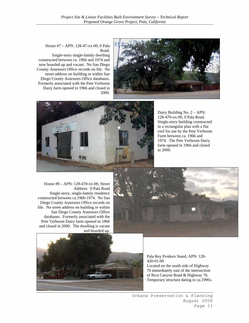
House #7 – APN: 128-47-xx-00, 0 Pala Road.
Single-story single-family dwelling constructed between ca. 1966 and 1974 and now boarded up and vacant. No San Diego
nty Assessors Office records on file. No street address on building or within San
Diego County Assessors Office databases. Formerly associated with the Pete Verboom
Dairy farm opened in 1966 and closed in 2000.
Dairy Building No. 2 – APN: 128-470-xx-00, 0 Pala Road. Single-story building constructed in a rectangular plan with a flat roof for use by the Pete Verboom Farm between ca. 1966 and 1974. The Pete Verboom Dairy farm opened in 1966 and closed in 2000.
House #8 – APN: 128-470-xx-00, Street Address: 0 Pala Road
Single-story, single-family residence constructed between ca.1966-1974. No San
Diego County Assessors Office records on file. No street address on building or within
San Diego County Assessors Office databases. Formerly associated with the
Pete Verboom Dairy farm opened in 1966 and closed in 2000. The dwelling is vacant
and boarded up.
Pala Rey Produce Stand, APN: 128-420-01-00 Located on the south side of Highway 76 immediately east of the intersection of Rica Canyon Road & Highway 76. Temporary structure dating to ca.1990s.
Project Site & Linear Facilities Built Environment Survey – Technical Report Proposed Orange Grove Project, Pala, California
Urbana Preservation & Planning August 2008
Page 12
IV. HISTORICAL RESOURCE INTERPRETATION The California Environmental Quality Act (CEQA) was originally enacted in 1970 in order to inform, identify, prevent, and disclose to decision-makers and the general public the effects a project may have on the environment. Historical resources are included in the comprehensive definition of the environment under CEQA. Under CEQA a historical resource is defined as:
• Any resource listed in or determined eligible for listing in the California Register of Historical Resources by the State Historical Resources Commission; or
• Any resource included in a local register of historical resources pursuant to §5020.1 (k) of the California Public Resources Code; or
• Any resource identified as significant in a historical resource survey meeting the criteria set forth in §5024.1 (g) of the California Public Resource Code; or
• Any object, building, structure, site, area, place, record, or manuscript which a lead agency determines to be historically significant or significant in the architectural, engineering, scientific, economic, agricultural, educational, social, political, military, or cultural annals of California.18
In order to be eligible for listing on the California Register of Historical Resources, one of the four following criteria must be met:
1) It is associated with events that have made a significant contribution to the broad patterns of local or regional history, or the cultural heritage of California or the United States; or 2) It is associated with the lives of persons important to local, California, or national history; or 3) It embodies the distinctive characteristics of a type, period, region, or method or construction, or represents the work of a master, or possesses high artistic values; or 4) It has yielded, or has the potential to yield, information important to the prehistory or history of the local area, California, or the nation.
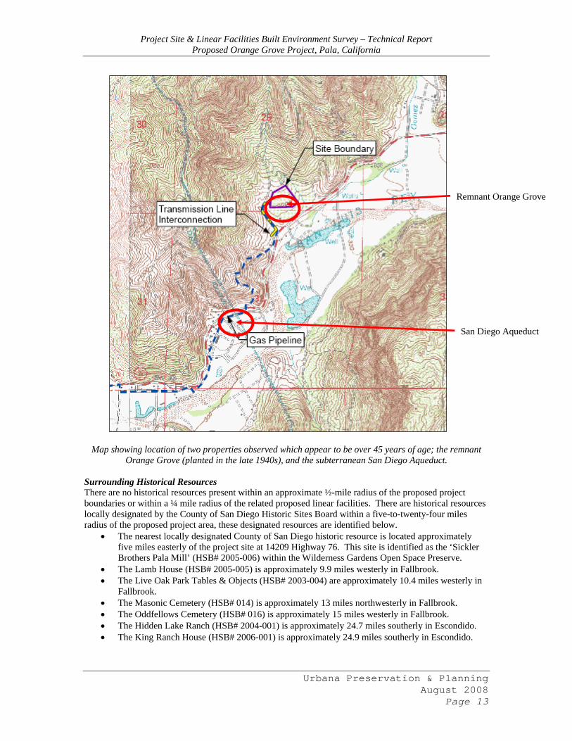
Proposed Project Area No buildings or structures were observed within the proposed project area which appear to be over 45 years of age, and moreover, none of the buildings or structures observed appear to be eligible for inclusion on the County of San Diego Historical Resource Register or the California Register of Historical Resources. The remnant Orange Grove was planted at the project site in the late 1940s and was documented by Urbana on DPR 523 forms in August 2008. The Orange Grove DPRs are attached to this report. No information was identified to support a statement of significance for any property observed in the proposed project area, including the remnant Orange Grove; therefore no historical resources appear to be located within the proposed project area or within view of the proposed project area. Linear Facilities No above-ground buildings or structures were observed within the proposed project area which appear to be over 45 years of age, and moreover, none of the buildings or structures observed appear to be eligible for inclusion on the County of San Diego Historical Resource Register or the California Register of Historical Resources. The below ground San Diego Aqueduct was installed in the area in 1945 and was documented by Urbana on DPR 523 forms in May 2008. The San Diego Aqueduct DPRs are attached to this report. Urbana has identified the San Diego Aqueduct as eligible for inclusion on the California Register of Historical Resources. The subterranean water conveyance system appears to meet the definition of a historical resource pursuant to CEQA Section §15064.5.
18 C.C.R. Title 14, Chapter 3, Article 5, §15064.5 (a)(1-3).
Project Site & Linear Facilities Built Environment Survey – Technical Report Proposed Orange Grove Project, Pala, California
Remnant Orange Grove
San Diego Aqueduct
Map showing location of two properties observed which appear to be over 45 years of age; the remnant
Orange Grove (planted in the late 1940s), and the subterranean San Diego Aqueduct. Surrounding Historical Resources There are no historical resources present within an approximate ½-mile radius of the proposed project boundaries or within a ¼ mile radius of the related proposed linear facilities. There are historical resources locally designated by the County of San Diego Historic Sites Board within a five-to-twenty-four miles radius of the proposed project area, these designated resources are identified below.
• The nearest locally designated County of San Diego historic resource is located approximately five miles easterly of the project site at 14209 Highway 76. This site is identified as the ‘Sickler Brothers Pala Mill’ (HSB# 2005-006) within the Wilderness Gardens Open Space Preserve.
• The Lamb House (HSB# 2005-005) is approximately 9.9 miles westerly in Fallbrook. • The Live Oak Park Tables & Objects (HSB# 2003-004) are approximately 10.4 miles westerly in
Fallbrook. • The Masonic Cemetery (HSB# 014) is approximately 13 miles northwesterly in Fallbrook. • The Oddfellows Cemetery (HSB# 016) is approximately 15 miles westerly in Fallbrook. • The Hidden Lake Ranch (HSB# 2004-001) is approximately 24.7 miles southerly in Escondido. • The King Ranch House (HSB# 2006-001) is approximately 24.9 miles southerly in Escondido.
Urbana Preservation & Planning August 2008
Page 13
Project Site & Linear Facilities Built Environment Survey – Technical Report Proposed Orange Grove Project, Pala, California
Urbana Preservation & Planning August 2008
Page 14
Also of note within an approximate five-mile radius, but not included on the County of San Diego HSB historic resources list is the following recognized property.
• Asistencia de San Antonio de Pala (Mission San Antonio de Paula), identified as State Historic Landmark #243 is located on Pala Mission Road, approximately 2.9 miles easterly in Pala, California. This historic chapel is located on the Pala Indian Reservation. A website dedicated to disseminating information about Mission San Antonio de Pala is under construction at http://www.sanantoniodepala.com/. This property qualifies as an historical resource for CEQA purposes.
A review of the National Park Service National Register Information System did not identify any historic properties / historical resources included on the National Register of Historic Places within a five-mile radius of the proposed project area or related proposed linear facilities. V. BIBLIOGRAPHY California Code of Regulations Title 14 Dudek & Associates, Final Mitigation Negative Declaration San Diego Gas & Electric Company Pala
Substation Project, August 2001 Gunn, Guard D., History of California. Article included in “Francisco Moreno” Vertical File available for review at
the San Diego Historical Society Research Archives. James, G.W., Picturesque Pala (Pasadena, CA: Radiant Life Press) 1916. Johnson, Steve Paul, “Mission San Antonio de Pala, Pala, San Diego County, California”
Interment.net Cemetery Transcription Library http://www.interment.net/data/us/ca/sandiego/mission_pala/san_antonio.htm Leffingwell, Randy & Alastair Worden, California Missions & Presidios: The History & Beauty of the Spanish
Missions (Stillwater, MN: Voyager Press, Inc.) 2005. Plat Book for San Diego County, Township 9S, Range 2W – Sections 29 & 32, 1892. On file at the San Diego
Historical Society Research Archives. -----, 1896. On file at the San Diego Historical Society Research Archives. -----, 1910. On file at the San Diego Historical Society Research Archives. Real Estate Atlas of San Diego, County, CA (8th Edition) Aerial / Map Volume 1, 1972. On file at the San Diego
Historical Society Research Archives. Rivers, Don “Rancho Monserate” The Village News, October 29, 1998. Rush, Philip S., “Historic Ranchos: Monserate” The Southern California Rancher, September-October 1962. Article
included in “Rancho Monserate” Vertical File available for review at the San Diego Historical Society Research Archives.
San Diego County Assessors Recorders Office, Assessors Parcel Maps: Book 110 – Index and Pages 07, 09, 15 and 36. -----, Assessors Parcel Maps: Book 128 – Pages 42 and 47. -----, Grantee Index, ca. 1916-1970. San Diego Historical Society, Vertical File: Rancho Monserrate, no date. -----, Historic Photograph Books: Community – Pala, Erickson Aerials – Pala. San Diego City & County Directories. Directories available at the San Diego Public Library California History Room. San Diego County 1929 Air Photos, Volume 8, Sheet/Photo #3A (Township 9S, Range 2W). On file at the San Diego
Historical Society Research Archives. -----, Volume 8, Sheet/Photo #3B (Township 9S, Range 2W). On file at the San Diego Historical Society Research
Archives. TRC, Phase 1 Environmental Site Assessment Orange Grove Project Site San Diego County, California, April 2007. United States Interior Department – U.S. Geological Survey, Pala, CA (Pala Quadrangle, 1:24,000) 1949. On file at
the San Diego Historical Society Research Archives. -----, Pala, CA (Pala Quadrangle, 1:24,000) 1968. On file at the San Diego Historical Society Research Archives. -----, Pala, CA (Pala Quadrangle, 1:24,000) 1988. On file at the San Diego Historical Society Research Archives. -----, Pala, CA (Pala Quadrangle, 1:24,000) 1997. On file at the San Diego Historical Society Research Archives. Young, James R., We Are Not Savages: Native Americans in Southern California and the Pala Reservation, 1840-1920
(East Lansing, MI: Michigan State University Press) 2001.
ATTACHMENT 1
San Diego Aqueduct – Preliminary California Register of Historical Resources Eligibility Review & Department of Parks & Recreation 523 Forms A & B,
May 2008.
Northern California 248 3rd Street #841, Oakland, CA 94607 510-663-7443 Southern California 255 G Street #399, San Diego, CA 92101 619-543-0693
Urban Planning Historic Preservation History Architectural History
May 20, 2008 Tom Jackson, Ph.D., Senior Archaeologist Pacific Legacy, Inc. 1525 Seabright Avenue Santa Cruz, CA 95062 RE: San Diego Aqueduct – Preliminary California Register of Historical Resources Eligibility Review. Dear Mr. Jackson, At the request of Pacific Legacy, Inc. and TRC Solutions, Urbana Preservation & Planning (Urbana) has preliminarily documented the San Diego Aqueduct (SDA) on State of California Department of Parks & Recreation (DPR) 523 series forms, and has evaluated the SDA for eligibility under the significance criteria of the California Register of Historical Resources in order to determine if the World War II-era subterranean water conveyance system appears to meet the definition of an historical resource under the California Environmental Quality Act (CEQA), and pursuant to CEQA Section 15064.5, to determine whether any impacts would occur to the SDA and historical resources resultant from installation of a proposed construction staging area above the ground surface which covers the subterranean SDA or from a gas pipeline installed in a trench five-feet deep over the SDA. The construction staging area and gas pipeline is associated with the installation of a power plant near the intersection of Highway 76 and Pala del Norte Road. The San Diego Aqueduct, also known as the ‘San Diego Project’ is an engineered water conveyance system designed and built by the United States Interior Department - Bureau of Reclamation and the United States Navy Department – Bureau of Docks & Yards, and was authorized by President Franklin Roosevelt as a wartime expedient on November 29, 1944 and ratified by the United States Congress on April 15, 1948. The SDA helped to resolve the severe water shortage that threatened San Diego in the WW II-period resultant from mass suburbanization (partly financed through the Serviceman’s Readjustment Act of 1944) and commercial growth due primarily to a large military presence having been developed in the San Diego region. The SDA is comprised of two separate aqueducts identified as the First and Second Aqueducts. The First aqueduct was constructed under two separate campaigns from 1944-1947 and 1953-1954, and is approximately 70 miles long constructed primarily of precast concrete pipe designed to withstand a carrying capacity of 196 cubic feet per second, and consisting of two pipelines which share common tunnels and inverted siphons extending from the Colorado River Aqueduct near San Jacinto, California to the City of San Diego’s San Vicente Reservoir located approximately 15 miles northeast of the city. The Second San Diego Aqueduct was also constructed under two separate campaigns between 1957-1971 and is approximately 94 miles long constructed primarily of precast concrete pipe and steel pipe designed to withstand a carrying capacity ranging from 144 cubic feet per second to 500 cubic feet per second, and consists of two pipelines which are operated separately and extend from the Colorado River Aqueduct near Hemet, California to the Lower Otay Reservoir in San Diego and the Alvarado Treatment Plant near Lake Murray in La Mesa, California (within San Diego County). As part of the preliminary California Register eligibility evaluation, Urbana has determined the SDA appears to be eligible for inclusion on the California Register of Historical Resources under significance criterion 1 (events/patterns of events) and 3 (design/construction) for its association with and representation of the legal and political subject of water rights for California, and in particular the Southern California region, and as an example of an engineered water conveyance system designed and built by the United States Bureau of Reclamation and the United States Navy Department. Based on this preliminary determination of significance, the SDA would appear to meet the definition of an historical resource for the purposes of CEQA and any discretionary project review processes associated with the proposed power plant project.
Tom Jackson, Pacific Legacy, Inc. San Diego Aqueduct CalReg/CEQA Review
May 20, 2008 - Page 2 of 2
The proposed power plant project and related gas pipeline and construction staging area would be sited in close proximity to the First San Diego Aqueduct in that both would cross over the area where the SDA is installed beneath the ground surface. The proposed project area is 100 feet on either side of the gas line and 100 feet around the staging area. There were no above-ground features observed or found to be associated with the SDA where the proposed gas line or construction staging area would be installed. The installed depth of the SDA was not identified; however, it is likely that the precast concrete pipes were installed deeper than five feet as is proposed for the gas pipeline, thus the proposed gas line would not likely cause any material impacts to the SDA. Similarly, the proposed construction staging area would not appear to cause major ground disturbing activity which would penetrate the SDA, and thus would not appear to cause any material impacts to the SDA. If the SDA becomes exposed as part of ground disturbing activities associated with the installation of the gas pipeline or building of the construction staging area, it is recommended that monitoring occurs to ensure that the SDA is not materially impacted and adversely affected. Copies of the DPR 523 A (Primary Record) and B (Building, Structure, Object Record) forms completed for the SDA by Urbana have been attached to this letter for your use, information, and dissemination. Please feel free to contact me if you have any questions or comments regarding Urbana’s preliminary California Register eligibility evaluation for the SDA and related CEQA historical resource conclusions. Respectfully Submitted,
Wendy L. Tinsley, Principal Copy: -Urbana File
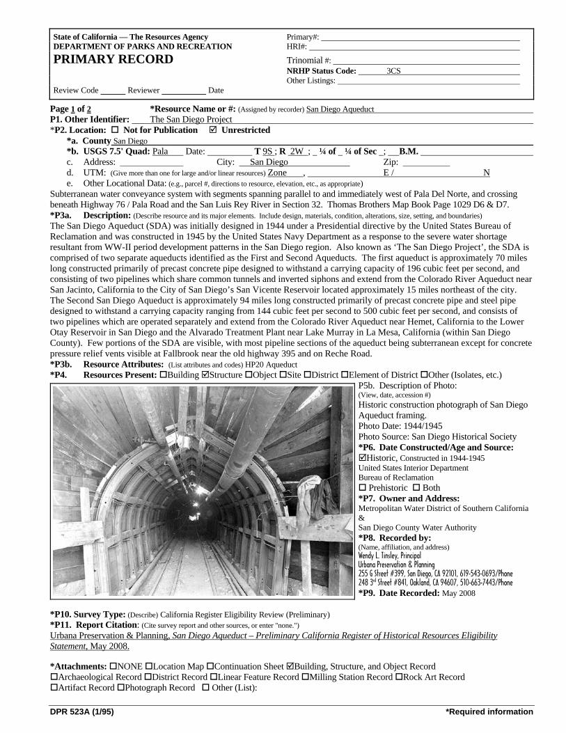
DPR 523A (1/95) *Required information
Page 1 of 2 *Resource Name or #: (Assigned by recorder) San Diego Aqueduct P1. Other Identifier: The San Diego Project *P2. Location: Not for Publication Unrestricted *a. County San Diego *b. USGS 7.5' Quad: Pala Date: T 9S ; R 2W ; ¼ of ¼ of Sec ; B.M. c. Address: City: San Diego Zip:
d. UTM: (Give more than one for large and/or linear resources) Zone , E / N e. Other Locational Data: (e.g., parcel #, directions to resource, elevation, etc., as appropriate) Subterranean water conveyance system with segments spanning parallel to and immediately west of Pala Del Norte, and crossing beneath Highway 76 / Pala Road and the San Luis Rey River in Section 32. Thomas Brothers Map Book Page 1029 D6 & D7. *P3a. Description: (Describe resource and its major elements. Include design, materials, condition, alterations, size, setting, and boundaries) The San Diego Aqueduct (SDA) was initially designed in 1944 under a Presidential directive by the United States Bureau of Reclamation and was constructed in 1945 by the United States Navy Department as a response to the severe water shortage resultant from WW-II period development patterns in the San Diego region. Also known as ‘The San Diego Project’, the SDA is comprised of two separate aqueducts identified as the First and Second Aqueducts. The first aqueduct is approximately 70 miles long constructed primarily of precast concrete pipe designed to withstand a carrying capacity of 196 cubic feet per second, and consisting of two pipelines which share common tunnels and inverted siphons and extend from the Colorado River Aqueduct near San Jacinto, California to the City of San Diego’s San Vicente Reservoir located approximately 15 miles northeast of the city. The Second San Diego Aqueduct is approximately 94 miles long constructed primarily of precast concrete pipe and steel pipe designed to withstand a carrying capacity ranging from 144 cubic feet per second to 500 cubic feet per second, and consists of two pipelines which are operated separately and extend from the Colorado River Aqueduct near Hemet, California to the Lower Otay Reservoir in San Diego and the Alvarado Treatment Plant near Lake Murray in La Mesa, California (within San Diego County). Few portions of the SDA are visible, with most pipeline sections of the aqueduct being subterranean except for concrete pressure relief vents visible at Fallbrook near the old highway 395 and on Reche Road. *P3b. Resource Attributes: (List attributes and codes) HP20 Aqueduct *P4. Resources Present: Building Structure Object Site District Element of District Other (Isolates, etc.)
P5b. Description of Photo: (View, date, accession #) Historic construction photograph of San Diego Aqueduct framing. Photo Date: 1944/1945 Photo Source: San Diego Historical Society *P6. Date Constructed/Age and Source:
Historic, Constructed in 1944-1945 United States Interior Department Bureau of Reclamation
Prehistoric Both *P7. Owner and Address: Metropolitan Water District of Southern California & San Diego County Water Authority *P8. Recorded by: (Name, affiliation, and address) Wendy L. Tinsley, Principal Urbana Preservation & Planning 255 G Street #399, San Diego, CA 92101, 619-543-0693/Phone 248 3rd Street #841, Oakland, CA 94607, 510-663-7443/Phone *P9. Date Recorded: May 2008
*P10. Survey Type: (Describe) California Register Eligibility Review (Preliminary) *P11. Report Citation: (Cite survey report and other sources, or enter "none.") Urbana Preservation & Planning, San Diego Aqueduct – Preliminary California Register of Historical Resources Eligibility Statement, May 2008. *Attachments: NONE Location Map Continuation Sheet Building, Structure, and Object Record
Archaeological Record District Record Linear Feature Record Milling Station Record Rock Art Record Artifact Record Photograph Record Other (List):
State of California — The Resources Agency Primary#: DEPARTMENT OF PARKS AND RECREATION HRI#: PRIMARY RECORD Trinomial #: NRHP Status Code: 3CS Other Listings: Review Code Reviewer Date
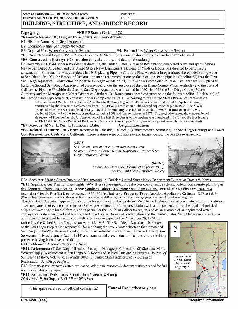
DPR 523B (1/95) *Required information
Page 2 of 2 *NRHP Status Code: 3CS *Resource Name or # (Assigned by recorder) San Diego Aqueduct B1. Historic Name: San Diego Aqueduct B2. Common Name: San Diego Aqueduct B3. Original Use: Water Conveyance System B4. Present Use: Water Conveyance System *B5. Architectural Style: N/A – Precast Concrete & Steel Piping – no attributable style of architecture observed. *B6. Construction History: (Construction date, alterations, and date of alterations) On November 29, 1944 under a Presidential directive, the United States Bureau of Reclamation completed plans and specifications for the San Diego Aqueduct and the United States Navy Department’s Bureau of Yards & Docks was directed to perform the construction. Construction was completed in 1947, placing Pipeline #1 of the First Aqueduct in operations, thereby delivering water to San Diego. In 1951 the Bureau of Reclamation made recommendations to the install a second pipeline (Pipeline #2) into the First San Diego Aqueduct. Construction of Pipeline #2 began on March 23, 1953 and was completed in 1954. By February 1956 plans to build the Second San Diego Aqueduct had commenced under the auspices of the San Diego County Water Authority and the State of California. Pipeline #3 within the Second San Diego Aqueduct was installed in 1960. In 1968 the San Diego County Water Authority and the Metropolitan Water District of Southern California commenced construction on the fourth pipeline (Pipeline #4) of the Second San Diego aqueduct; construction was completed in 1971. According to the United States Bureau of Reclamation
“Construction of Pipeline #1 of the First Aqueduct by the Navy began in 1945 and was completed in 1947. Pipeline #2 was constructed by the Bureau of Reclamation from 1952-1954. Construction of the Second Aqueduct began in 1957. The MWD section of Pipeline 3 was completed in May 1960 and the Authority’s section in November 1960. Construction of the MWD section of Pipeline 4 of the Second Aqueduct started in 1968 and was completed in 1971. The Authority started the construction of its section of Pipeline 4 in 1969. Construction of the first three phases of the pipeline was completed in 1973, and the fourth phase in 1979.” (United States Bureau of Reclamation, San Diego Project, page 5 of 6, www.usbr.gov/dataweb/html/sandiego.html)
*B7. Moved? No Yes Unknown Date: Original Location: *B8. Related Features: San Vicente Reservoir in Lakeside, California (Unincorporated community of San Diego County) and Lower Otay Reservoir near Chula Vista, California. These features were built prior to and independent of the San Diego Aqueduct.
(LEFT) San Vicente Dam under construction (circa 1939). Source: California Border Region Digitization Project & San Diego Historical Society
(RIGHT) Lower Otay Dam under Construction (circa 1919).
Source: San Diego Historical Society
B9a. Architect: United States Bureau of Reclamation b. Builder: United States Navy Department Bureau of Docks & Yards *B10. Significance: Theme: water rights; WW II-era state/regional/local water conveyance systems; federal community planning & development efforts; Engineering. Area: Southern California Region; San Diego County. Period of Significance: 1944-1954 (preliminary) for the First San Diego Aqueduct; 1957-1971 (preliminary). Property Type: Aqueduct Applicable Criteria: CalReg 1 & 3. (Discuss importance in terms of historical or architectural context as defined by theme, period, and geographic scope. Also address integrity.) The San Diego Aqueduct appears to be eligible for inclusion on the California Register of Historical Resources under eligibility criterion 1 (events/patterns of events) and criterion 3 (design/construction) for its association with and representation of the legal and political subject of water rights for California, and in particular the Southern California region, and as an example of an engineered water conveyance system designed and built by the United States Bureau of Reclamation and the United States Navy Department which was authorized by President Franklin Roosevelt as a wartime expedient on November 29, 1944 and ratified by the United States Congress on April 15, 1948. The San Diego Aqueduct, also known as the San Diego Project was responsible for resolving the severe water shortage that threatened San Diego in the WW II-period resultant from mass suburbanization (partly financed through the Serviceman’s Readjustment Act of 1944) and commercial growth due primarily to a large military presence having been developed there. B11. Additional Resource Attributes: None *B12. References: (1) San Diego Historical Society – Photograph Collection. (2) Sholdars, Mike, “Water Supply Development in San Diego & A Review of Related Outstanding Projects” Journal of San Diego History, Vol. 48, o. 1, Winter 2002. (3) United States Interior Dept. - Bureau of Reclamation, San Diego Project. B13. Remarks: Preliminary CalReg evaluation–additional research & documentation needed for full nomination/eligibility report. *B14. Evaluator: Wendy L. Tinsley, Principal: Urbana Preservation & Planning, 255 G Street #399, San Diego, CA 92101, 619-543-0693/Phone
*Date of Evaluation: May 2008
State of California — The Resources Agency Primary #: DEPARTMENT OF PARKS AND RECREATION HRI #:
BUILDING, STRUCTURE, AND OBJECT RECORD
(This space reserved for official comments.)
N ↑
Intersection of the San Diego Aqueduct & Highway 76
ATTACHMENT 2
Remnant Pala Area Orange Grove – Preliminary California Register of Historical Resources Eligibility Review & Department of Parks & Recreation
523 Forms A & L, August 2008.
Northern California 248 3rd Street #841, Oakland, CA 94607 510-663-7443 Southern California 255 G Street #399, San Diego, CA 92101 619-543-0693
Urban Planning Historic Preservation History Architectural History
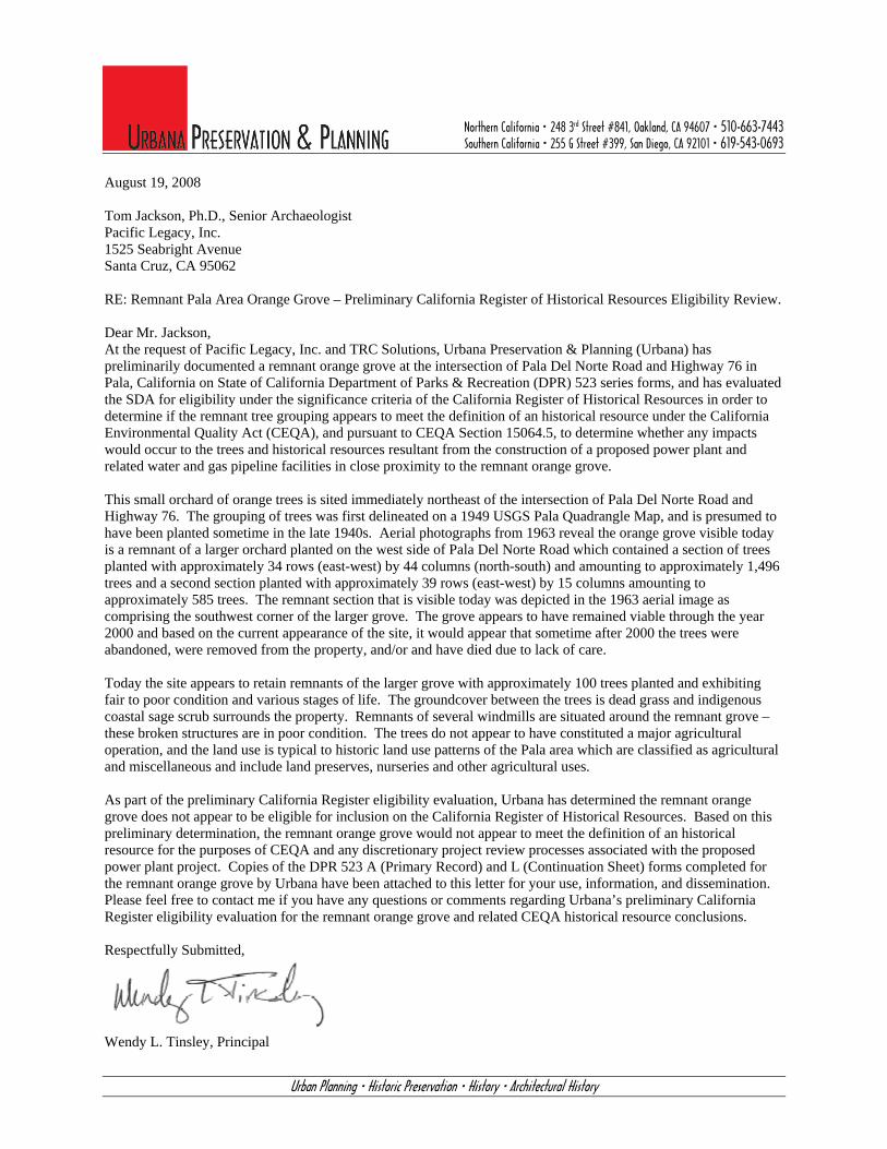
August 19, 2008 Tom Jackson, Ph.D., Senior Archaeologist Pacific Legacy, Inc. 1525 Seabright Avenue Santa Cruz, CA 95062 RE: Remnant Pala Area Orange Grove – Preliminary California Register of Historical Resources Eligibility Review. Dear Mr. Jackson, At the request of Pacific Legacy, Inc. and TRC Solutions, Urbana Preservation & Planning (Urbana) has preliminarily documented a remnant orange grove at the intersection of Pala Del Norte Road and Highway 76 in Pala, California on State of California Department of Parks & Recreation (DPR) 523 series forms, and has evaluated the SDA for eligibility under the significance criteria of the California Register of Historical Resources in order to determine if the remnant tree grouping appears to meet the definition of an historical resource under the California Environmental Quality Act (CEQA), and pursuant to CEQA Section 15064.5, to determine whether any impacts would occur to the trees and historical resources resultant from the construction of a proposed power plant and related water and gas pipeline facilities in close proximity to the remnant orange grove. This small orchard of orange trees is sited immediately northeast of the intersection of Pala Del Norte Road and Highway 76. The grouping of trees was first delineated on a 1949 USGS Pala Quadrangle Map, and is presumed to have been planted sometime in the late 1940s. Aerial photographs from 1963 reveal the orange grove visible today is a remnant of a larger orchard planted on the west side of Pala Del Norte Road which contained a section of trees planted with approximately 34 rows (east-west) by 44 columns (north-south) and amounting to approximately 1,496 trees and a second section planted with approximately 39 rows (east-west) by 15 columns amounting to approximately 585 trees. The remnant section that is visible today was depicted in the 1963 aerial image as comprising the southwest corner of the larger grove. The grove appears to have remained viable through the year 2000 and based on the current appearance of the site, it would appear that sometime after 2000 the trees were abandoned, were removed from the property, and/or and have died due to lack of care. Today the site appears to retain remnants of the larger grove with approximately 100 trees planted and exhibiting fair to poor condition and various stages of life. The groundcover between the trees is dead grass and indigenous coastal sage scrub surrounds the property. Remnants of several windmills are situated around the remnant grove – these broken structures are in poor condition. The trees do not appear to have constituted a major agricultural operation, and the land use is typical to historic land use patterns of the Pala area which are classified as agricultural and miscellaneous and include land preserves, nurseries and other agricultural uses. As part of the preliminary California Register eligibility evaluation, Urbana has determined the remnant orange grove does not appear to be eligible for inclusion on the California Register of Historical Resources. Based on this preliminary determination, the remnant orange grove would not appear to meet the definition of an historical resource for the purposes of CEQA and any discretionary project review processes associated with the proposed power plant project. Copies of the DPR 523 A (Primary Record) and L (Continuation Sheet) forms completed for the remnant orange grove by Urbana have been attached to this letter for your use, information, and dissemination. Please feel free to contact me if you have any questions or comments regarding Urbana’s preliminary California Register eligibility evaluation for the remnant orange grove and related CEQA historical resource conclusions. Respectfully Submitted,
Wendy L. Tinsley, Principal
DPR 523A (1/95) *Required information
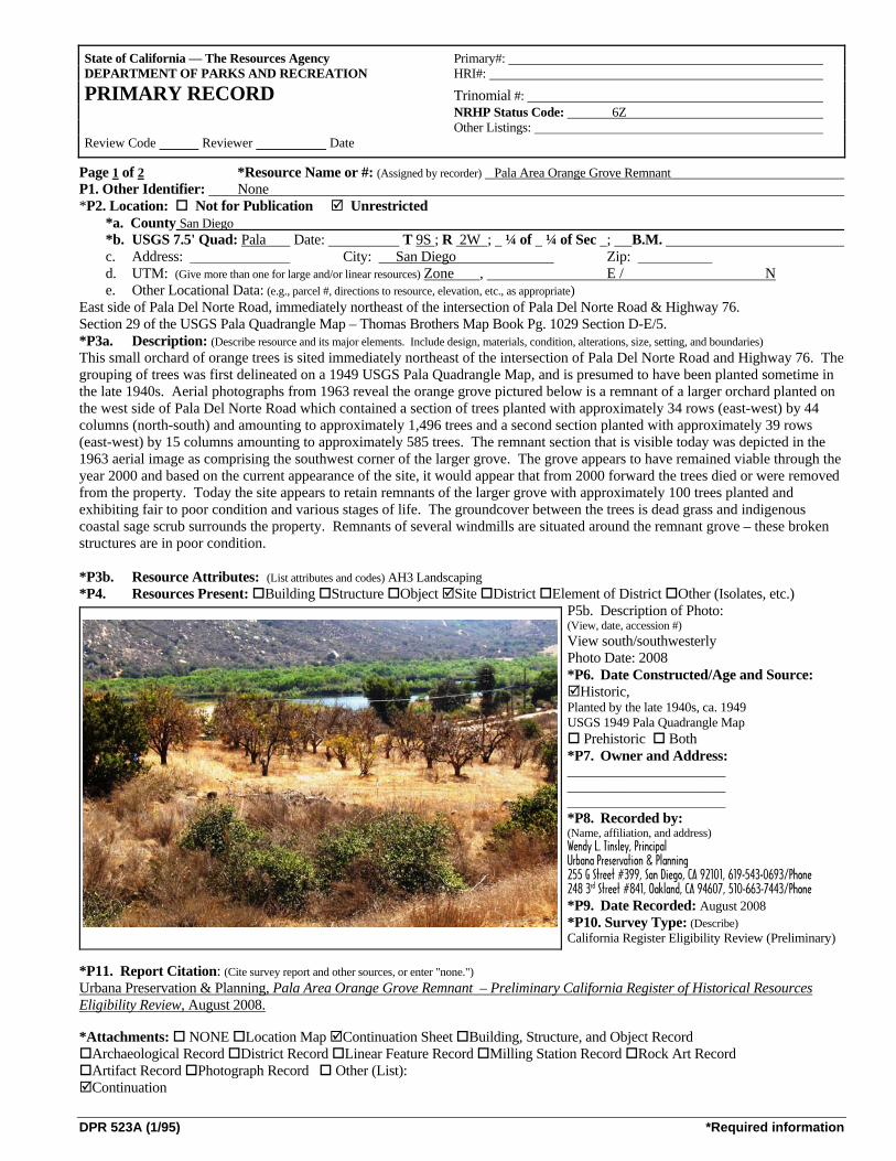
Page 1 of 2 *Resource Name or #: (Assigned by recorder) Pala Area Orange Grove Remnant P1. Other Identifier: None *P2. Location: Not for Publication Unrestricted *a. County San Diego *b. USGS 7.5' Quad: Pala Date: T 9S ; R 2W ; ¼ of ¼ of Sec ; B.M. c. Address: City: San Diego Zip:
d. UTM: (Give more than one for large and/or linear resources) Zone , E / N e. Other Locational Data: (e.g., parcel #, directions to resource, elevation, etc., as appropriate) East side of Pala Del Norte Road, immediately northeast of the intersection of Pala Del Norte Road & Highway 76. Section 29 of the USGS Pala Quadrangle Map – Thomas Brothers Map Book Pg. 1029 Section D-E/5. *P3a. Description: (Describe resource and its major elements. Include design, materials, condition, alterations, size, setting, and boundaries) This small orchard of orange trees is sited immediately northeast of the intersection of Pala Del Norte Road and Highway 76. The grouping of trees was first delineated on a 1949 USGS Pala Quadrangle Map, and is presumed to have been planted sometime in the late 1940s. Aerial photographs from 1963 reveal the orange grove pictured below is a remnant of a larger orchard planted on the west side of Pala Del Norte Road which contained a section of trees planted with approximately 34 rows (east-west) by 44 columns (north-south) and amounting to approximately 1,496 trees and a second section planted with approximately 39 rows (east-west) by 15 columns amounting to approximately 585 trees. The remnant section that is visible today was depicted in the 1963 aerial image as comprising the southwest corner of the larger grove. The grove appears to have remained viable through the year 2000 and based on the current appearance of the site, it would appear that from 2000 forward the trees died or were removed from the property. Today the site appears to retain remnants of the larger grove with approximately 100 trees planted and exhibiting fair to poor condition and various stages of life. The groundcover between the trees is dead grass and indigenous coastal sage scrub surrounds the property. Remnants of several windmills are situated around the remnant grove – these broken structures are in poor condition. *P3b. Resource Attributes: (List attributes and codes) AH3 Landscaping *P4. Resources Present: Building Structure Object Site District Element of District Other (Isolates, etc.)
P5b. Description of Photo: (View, date, accession #) View south/southwesterly Photo Date: 2008 *P6. Date Constructed/Age and Source:
Historic, Planted by the late 1940s, ca. 1949 USGS 1949 Pala Quadrangle Map
Prehistoric Both *P7. Owner and Address: ________________________ ________________________ ________________________ *P8. Recorded by: (Name, affiliation, and address) Wendy L. Tinsley, Principal Urbana Preservation & Planning 255 G Street #399, San Diego, CA 92101, 619-543-0693/Phone 248 3rd Street #841, Oakland, CA 94607, 510-663-7443/Phone *P9. Date Recorded: August 2008*P10. Survey Type: (Describe) California Register Eligibility Review (Preliminary)
*P11. Report Citation: (Cite survey report and other sources, or enter "none.") Urbana Preservation & Planning, Pala Area Orange Grove Remnant – Preliminary California Register of Historical Resources Eligibility Review, August 2008. *Attachments: NONE Location Map Continuation Sheet Building, Structure, and Object Record
Archaeological Record District Record Linear Feature Record Milling Station Record Rock Art Record Artifact Record Photograph Record Other (List): Continuation
State of California — The Resources Agency Primary#: DEPARTMENT OF PARKS AND RECREATION HRI#: PRIMARY RECORD Trinomial #: NRHP Status Code: 6Z Other Listings: Review Code Reviewer Date
DPR 523L (1/95) *Required information
State of California — The Resources Agency Primary#: DEPARTMENT OF PARKS AND RECREATION HRI #:
CONTINUATION SHEET Trinomial:
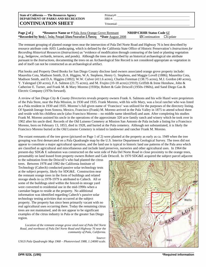
Page 2 of 2 *Resource Name or # Pala Area Orange Grove Remnant NRHP/CRHR Status Code 6Z *Recorded by Wendy L. Tinsley, Principal: Urbana Preservation & Planning *Date August 2008 Continuation Update The remnant grouping of planted orange trees near the intersection of Pala Del Norte Road and Highway 76 is best described by resource attribute code AH3: Landscaping, which is defined by the California State Office of Historic Preservation’s Instructions for Recording Historical Resources (Instructions) as “evidence of modification through contouring of the land or planting vegetation (e.g., hedgerow, orchards, terraces, and ponds). Although the trees are described by an historical archaeological site attribute pursuant to the Instructions, documenting the trees on an Archaeological Site Record is not considered appropriate as vegetation in and of itself can not be constructed as an archaeological artifact. Plat books and Property Deed Books for San Diego County disclose land owners associated orange grove property include: Maurelita Cota, Madison Smith, D.A. Higgins, W.A. Stephens, Henry G. Stephens, and Maggie Lovell (1886); Maurelita Cota, Madison Smith, and D.A. Higgins (1892); W.W. Culver (411.6 acres), Charles Foreman (138.75 acres), M.J. Gordon (40 acres), Y. Yalenguel (30 acres), F.A. Salmon (21.75 acres), and M. Frujito (10-18 acres) (1910); Griffith & Irene Henshaw, John & Catherine E. Turner, and Frank M. & Mary Moreno (1930)s; Robert & Gale Driscoll (1950s-1960s), and Sand Diego Gas & Electric Company (1970s forward). A review of San Diego City & County Directories reveals property owners Frank A. Salmons and his wife Hazel were proprietors of the Pala Store, near the Pala Mission, in 1930 and 1935. Frank Moreno, with his wife Mary, was a local rancher who was listed as a Pala resident in 1930 and 1935. Moreno’s full given name of ‘Francisco’ was utilized for the purposes of the directory listing. Of Spanish lineage from Sonora, Mexico, Francisco (Frank) M. Moreno arrived in the Pala Valley in 1875 to attend school there and reside with his childless uncle (also Francisco Moreno – no middle name identified) and aunt. After completing his studies Frank M. Moreno assisted his uncle in the operations of the approximate 320 acre family ranch and winery which he took over in 1902 after his uncle died. Records of the Old Luiseno Cemetery at Mission San Antonio de Pala include a listing for a Francisco Moreno, born on February 13, 1853, died in 1928, and buried at the Pala cemetery. Although not substantiated, it is likely the Francisco Moreno buried at the Old Luiseno Cemetery is related to landowner and rancher Frank M. Moreno. The extant remnants of the tree grove (pictured on Page 1 of 2) were planted at the property as early as ca. 1949 when the tree grouping was first demarcated on a Pala Quadrangle map by the U.S. Interior Department Geological Survey. The trees did not appear to constitute a major agricultural operation, and the land use is typical to historic land use patterns of the Pala area which are classified as agricultural and miscellaneous and include land preserves, nurseries and other agricultural uses. In 1964 the present-day SDG& E substation was constructed on the west side of Pala Del Norte Road in close proximity to the orange trees, presumably on land leased from property owners Robert and Gale Driscoll. In 1970 SDG&E acquired the subject parcel adjacent to the substation from the Driscoll’s who had planted the citrus trees. Between 1978 and 1982 the California Institute of Technology (Caltech) conducted passive solar technology tests at the subject property, likely for SDG&E. Construction near the remnant orange trees in the form of buildings and related storage sheds in ca.1978-1979 is attributed to Caltech. All or some of the buildings sited within the fenced-in storage yard were converted to residential use in the mid-1990s when a caretaker began to reside at the property. No additional information was identified regarding Caltech’s passive solar technology testing activities that occurred at the subject property. The property has since been primarily vacant with no real agricultural uses occurring there. Today the remaining citrus trees are not maintained, and do not appear to be significant examples of the citrus industry in Pala or the greater San Diego region.
Location of the remnant orange grove sited east of Pala Del Norte Road, and northeast of Pala Del Norte Road and Highway 76 near the
community of Pala, California.
Source: USGS Pala Quadrangle Map 1968 – Photorevised 1988, 1:24000 scale.
ATTACHMENT 3
CV for Wendy L. Tinsley, AICP, Principal: Urbana Preservation & Planning
1
WENDY L. TINSLEY, AICP PRINCIPAL HISTORIAN / PRESERVATION PLANNER
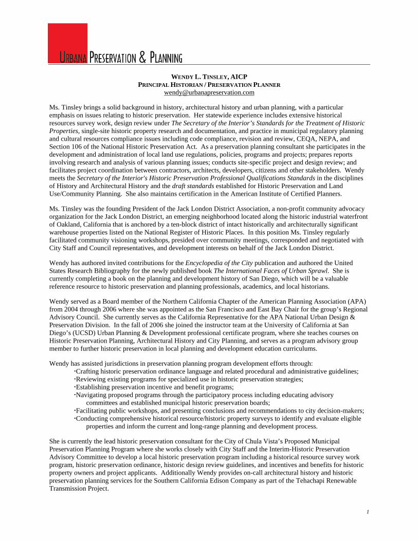
[email protected] Ms. Tinsley brings a solid background in history, architectural history and urban planning, with a particular emphasis on issues relating to historic preservation. Her statewide experience includes extensive historical resources survey work, design review under The Secretary of the Interior’s Standards for the Treatment of Historic Properties, single-site historic property research and documentation, and practice in municipal regulatory planning and cultural resources compliance issues including code compliance, revision and review, CEQA, NEPA, and Section 106 of the National Historic Preservation Act. As a preservation planning consultant she participates in the development and administration of local land use regulations, policies, programs and projects; prepares reports involving research and analysis of various planning issues; conducts site-specific project and design review; and facilitates project coordination between contractors, architects, developers, citizens and other stakeholders. Wendy meets the Secretary of the Interior's Historic Preservation Professional Qualifications Standards in the disciplines of History and Architectural History and the draft standards established for Historic Preservation and Land Use/Community Planning. She also maintains certification in the American Institute of Certified Planners. Ms. Tinsley was the founding President of the Jack London District Association, a non-profit community advocacy organization for the Jack London District, an emerging neighborhood located along the historic industrial waterfront of Oakland, California that is anchored by a ten-block district of intact historically and architecturally significant warehouse properties listed on the National Register of Historic Places. In this position Ms. Tinsley regularly facilitated community visioning workshops, presided over community meetings, corresponded and negotiated with City Staff and Council representatives, and development interests on behalf of the Jack London District. Wendy has authored invited contributions for the Encyclopedia of the City publication and authored the United States Research Bibliography for the newly published book The International Faces of Urban Sprawl. She is currently completing a book on the planning and development history of San Diego, which will be a valuable reference resource to historic preservation and planning professionals, academics, and local historians. Wendy served as a Board member of the Northern California Chapter of the American Planning Association (APA) from 2004 through 2006 where she was appointed as the San Francisco and East Bay Chair for the group’s Regional Advisory Council. She currently serves as the California Representative for the APA National Urban Design & Preservation Division. In the fall of 2006 she joined the instructor team at the University of California at San Diego’s (UCSD) Urban Planning & Development professional certificate program, where she teaches courses on Historic Preservation Planning, Architectural History and City Planning, and serves as a program advisory group member to further historic preservation in local planning and development education curriculums. Wendy has assisted jurisdictions in preservation planning program development efforts through:
Crafting historic preservation ordinance language and related procedural and administrative guidelines; Reviewing existing programs for specialized use in historic preservation strategies; Establishing preservation incentive and benefit programs; Navigating proposed programs through the participatory process including educating advisory
committees and established municipal historic preservation boards; Facilitating public workshops, and presenting conclusions and recommendations to city decision-makers; Conducting comprehensive historical resource/historic property surveys to identify and evaluate eligible
properties and inform the current and long-range planning and development process. She is currently the lead historic preservation consultant for the City of Chula Vista’s Proposed Municipal Preservation Planning Program where she works closely with City Staff and the Interim-Historic Preservation Advisory Committee to develop a local historic preservation program including a historical resource survey work program, historic preservation ordinance, historic design review guidelines, and incentives and benefits for historic property owners and project applicants. Additionally Wendy provides on-call architectural history and historic preservation planning services for the Southern California Edison Company as part of the Tehachapi Renewable Transmission Project.
WENDY L. TINSLEY, AICP PRINCIPAL HISTORIAN / PRESERVATION PLANNER
2
EDUCATION Master of City Planning, Historic Preservation & Urban Design Concentration Thesis Title: How Cities Grow: A History Of San Diego Neighborhood Development Patterns, 1769-1955 California State University, San Diego Bachelor of Arts – History, Public History & Urban Studies Concentration Senior Research Thesis: Another Streetcar Suburb: The Development of Mission Beach, 1914-1930 California State University, San Diego PROFESSIONAL EXPERIENCE Principal: Urbana Preservation & Planning, (Oakland & San Diego) 04/2005-present Architectural Historian & Preservation Planner: Architectural Resources Group (San Francisco & Los
Angeles), 10/2002-04/2005 Architectural Historian & Preservation Planner: Historic Research Services, (San Diego) 12/2001-10/2002 Historian & Historic Preservation Planner: Office of Marie Burke Lia, Attorney at Law, (San Diego)
01/2000-11/2001 Assistant Coordinator: SHPO/CHRIS-South Coastal Information Center, 07/1998-08/1999 Consultant, East Side Survey and Oral History Program: City of Oceanside Department of Planning and
Land Use, 01/1999-06/1999 Consultant, National Register of Historic Places Travel Itinerary: City of San Diego Historic Site Board,
06/1998-06/1999 Research Assistant: SHPO/CHRIS-South Coastal Information Center, 12/1996-07/1998 SELECT RELATED EXPERIENCE / PROFESSIONAL SEMINARS / CONTINUING EDUCATION Instructor: UCSD Urban Planning & Development Extension Certificate Program, 2006-forward
Courses Taught: Architectural History, Historic Preservation Planning, Fundamentals of City Planning, Foundations of Planning & the Built Environment
Seminar Facilitator / Panel Speaker: Planning for Preservation: A Survey of Municipal Preservation Programs Throughout San Diego County, UCSD Extension–UPD Cert. Program (forthcoming)
Invited Speaker: Local Historic Site Designation & The Mills Act Historic Property Tax Credit Program, City of San Leandro (CA), 04/2005
Attendee: CA Preservation Foundation & CA Office of Historic Preservation, Historical Resource Surveys for Local Governments, San Diego (CA) 02/2004
Attendee: National Charrette Institute, Introduction to Dynamic Planning (Level 1 NCI Charrette Manager Certification Training), San Diego (CA) 10/2003
Attendee: CA Preservation Foundation, Incentives for Historic Preservation Projects, Berkeley (CA) 09/2003 Attendee: University of Southern CA, Preservation Planning & Law, Los Angeles (CA) 07/2003 Attendee: League of CA Cities, Smart Growth Zoning Codes, Lodi (CA) 12/2002 Invited Participant: Second Natures, Redefining The Los Angeles Riverfront, Los Angeles (CA)
01/2002 (2-Day Planning & Design Charrette hosted by MOCA & The Geffen) Graduate Instructor: Urban Studies & Planning Program, University of CA at San Diego,
Courses Taught: USP 124-Land Use Planning, Dr. Nico Calavita, 09/2001 – 12/2001 Graduate Teaching Assistant: City Planning Graduate Program, San Diego State University,
Dr. Nico Calavita, 01/2000 – 08/2000, 09/2001 – 12/2001, 01/2002 – 05/2002 Selected Smart Growth Researcher: San Diego State University Foundation & City Planning Graduate
Program, Dr. Roger Caves, 01/2001 – 08/2001 (Grant Topic: Planning for Sprawl in the U.S) Attendee: Section 106 An Introductory Course, National Preservation Institute, San Francisco (CA) 04/1999 MEMBERSHIPS American Planning Association (APA) Society of Architectural Historians (SAH) Society for American City and Regional Planning History (SACRPH) National Trust for Historic Preservation (NTHP) California Preservation Foundation (CPF)
WENDY L. TINSLEY, AICP PRINCIPAL HISTORIAN / PRESERVATION PLANNER
3
BOARDS & COMMITTEES Appointment Public Member – City of San Diego Historical Resources Board Incentives Subcommittee, 2008 forward Consultant Advisor – City of Chula Vista Interim Historic Preservation Advisory Committee, 2007 forward California Representative – Urban Design & Preservation Division, American Planning Association, 2007 forward Member – UCSD Extension Advisory Group Urban Planning & Development Certificate Program, 2007 forward President – Jack London District Association, 2005-2006 East Bay Co-Chair – Regional Advisory Council, APA Northern Section-CA Chapter, 2005-2006 San Francisco Chair – Regional Advisory Council, APA Northern Section-CA Chapter, 2004-2005 SELECT PUBLICATIONS Article in-progress The General Plan and Historic Preservation; An Overview of Historic Preservation
Elements in the State of CA. Article in-progress San Diego County’s Municipal Preservation Report Card 2006 “United States Research Bibliography” The International Faces of Urban Sprawl:
Lessons Learned From North America. Fritz Wagner (ed.) Geography Dept. University of Waterloo: Waterloo, Ontario.
2005 “Courtyards” invited entry for Encyclopedia Of The City. Roger Caves (ed.) Routledge: London.
2005 “Robert Venturi” invited entry for Encyclopedia Of The City. Roger Caves (ed.) Routledge: London.
SELECT PROJECTS / REPORTS / DOCUMENTATION In-Progress Lead Consultant – City of Chula Vista Historic Preservation Program Development In-Progress Lead Architectural History/Preservation Planning Consultant – Southern California
Edison Company On-Call Contract for the Tehachapi Renewable Energy Project In-Progress Mayor John Gill Residence, Designation, Mills Act & Rehabilitation Consulting, San
Leandro, CA. In-Progress Proposed Heidi Square Project Historical Resource, Preservation Planning &
Subdivision Re-Design Consulting, San Lorenzo, CA In-Progress Historical Site Designation, Design Review, & Mills Act Property Tax Consulting for the
Olmstead Building Company’s Calavo Gardens Queen Avenue Dwelling, Mt. Helix, CA July 2008 California Portland Cement Company P&H Excavators #3 & #4 Historic Context &
Eligibility Review, Mojave, CA. July 2008 Historic Context Statement – Bean Springs Site, Rosamond, CA June 2008 Cultural Resource Report & Regulatory Review, PL-SCE-Tehachapi-10H, Acton, CA May 2008 Historical Resource Documentation & Review, San Diego Aqueduct, San Diego, CA April 2008 Historic Site Designation & Mills Act Historic Property Tax Consulting for the
Goldberg Residence, 4654 Iowa Street, San Diego, CA April 2008 Storefront Improvement / Façade Revitalization Historical Resource Analysis & Design
Review Assistance, 3201 Adams Avenue, San Diego, CA March 2008 Lombardi Ranch CEQA Review, San Ardo, California February 2008 Del-Sur Saugus Mining Complex Historical Resource Review, Grass Valley, CA February 2008 Foothill Ranch Historical Resource Review, Palmdale, CA January 2008 Section 106 Review 1425-1475 South Main Street, Walnut Creek, CA January 2008 Historic Site Designation Report & Mills Act Property Tax Consulting - Ocean Beach
Cottage Emerging Historic District Contributor, 4670 Del Monte Ave., San Diego, CA November 2007 Historic Site Designation & Mills Act Historic Property Tax Consulting for the
Olmstead Building Company’s Calavo Gardens Project #531, Mt. Helix, CA October 2007 Southern CA Edison Company’s Del Sur-Saugus Transmission Line Historical Resource
Review, Lancaster - Palmdale, CA October 2007 Southern CA Edison Company’s Antelope Substation Historical Resource Review,
Lancaster, CA September 2007 Historical Resource Review & Data Responses for the Proposed SDG&E Orange Grove
Energy Project in Pala, CA September 2007 Southern CA Edison Company’s Kaiser Pass Cabin Historic Property
Assessment, Fresno Co., CA August 2007 USDA Forest Service Meeks Creeks Historic Bridge Assessment, Lake Tahoe, CA
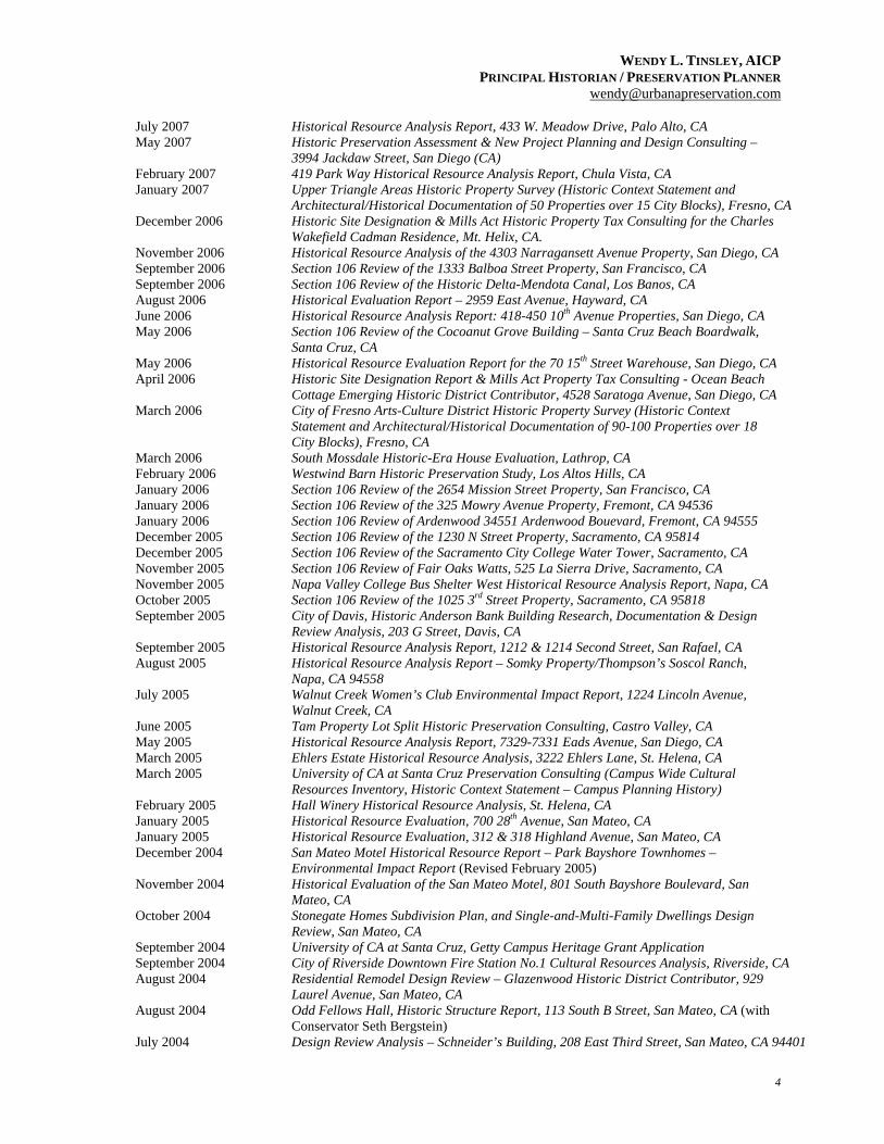
WENDY L. TINSLEY, AICP PRINCIPAL HISTORIAN / PRESERVATION PLANNER
4
July 2007 Historical Resource Analysis Report, 433 W. Meadow Drive, Palo Alto, CA May 2007 Historic Preservation Assessment & New Project Planning and Design Consulting –
3994 Jackdaw Street, San Diego (CA) February 2007 419 Park Way Historical Resource Analysis Report, Chula Vista, CA January 2007 Upper Triangle Areas Historic Property Survey (Historic Context Statement and
Architectural/Historical Documentation of 50 Properties over 15 City Blocks), Fresno, CA December 2006 Historic Site Designation & Mills Act Historic Property Tax Consulting for the Charles
Wakefield Cadman Residence, Mt. Helix, CA. November 2006 Historical Resource Analysis of the 4303 Narragansett Avenue Property, San Diego, CA September 2006 Section 106 Review of the 1333 Balboa Street Property, San Francisco, CA September 2006 Section 106 Review of the Historic Delta-Mendota Canal, Los Banos, CA August 2006 Historical Evaluation Report – 2959 East Avenue, Hayward, CA June 2006 Historical Resource Analysis Report: 418-450 10th Avenue Properties, San Diego, CA May 2006 Section 106 Review of the Cocoanut Grove Building – Santa Cruz Beach Boardwalk,
Santa Cruz, CA May 2006 Historical Resource Evaluation Report for the 70 15th Street Warehouse, San Diego, CA April 2006 Historic Site Designation Report & Mills Act Property Tax Consulting - Ocean Beach
Cottage Emerging Historic District Contributor, 4528 Saratoga Avenue, San Diego, CA March 2006 City of Fresno Arts-Culture District Historic Property Survey (Historic Context
Statement and Architectural/Historical Documentation of 90-100 Properties over 18 City Blocks), Fresno, CA
March 2006 South Mossdale Historic-Era House Evaluation, Lathrop, CA February 2006 Westwind Barn Historic Preservation Study, Los Altos Hills, CA January 2006 Section 106 Review of the 2654 Mission Street Property, San Francisco, CA January 2006 Section 106 Review of the 325 Mowry Avenue Property, Fremont, CA 94536 January 2006 Section 106 Review of Ardenwood 34551 Ardenwood Bouevard, Fremont, CA 94555 December 2005 Section 106 Review of the 1230 N Street Property, Sacramento, CA 95814 December 2005 Section 106 Review of the Sacramento City College Water Tower, Sacramento, CA November 2005 Section 106 Review of Fair Oaks Watts, 525 La Sierra Drive, Sacramento, CA November 2005 Napa Valley College Bus Shelter West Historical Resource Analysis Report, Napa, CA October 2005 Section 106 Review of the 1025 3rd Street Property, Sacramento, CA 95818 September 2005 City of Davis, Historic Anderson Bank Building Research, Documentation & Design
Review Analysis, 203 G Street, Davis, CA September 2005 Historical Resource Analysis Report, 1212 & 1214 Second Street, San Rafael, CA August 2005 Historical Resource Analysis Report – Somky Property/Thompson’s Soscol Ranch,
Napa, CA 94558 July 2005 Walnut Creek Women’s Club Environmental Impact Report, 1224 Lincoln Avenue,
Walnut Creek, CA June 2005 Tam Property Lot Split Historic Preservation Consulting, Castro Valley, CA May 2005 Historical Resource Analysis Report, 7329-7331 Eads Avenue, San Diego, CA March 2005 Ehlers Estate Historical Resource Analysis, 3222 Ehlers Lane, St. Helena, CA March 2005 University of CA at Santa Cruz Preservation Consulting (Campus Wide Cultural
Resources Inventory, Historic Context Statement – Campus Planning History) February 2005 Hall Winery Historical Resource Analysis, St. Helena, CA January 2005 Historical Resource Evaluation, 700 28th Avenue, San Mateo, CA January 2005 Historical Resource Evaluation, 312 & 318 Highland Avenue, San Mateo, CA December 2004 San Mateo Motel Historical Resource Report – Park Bayshore Townhomes –
Environmental Impact Report (Revised February 2005) November 2004 Historical Evaluation of the San Mateo Motel, 801 South Bayshore Boulevard, San
Mateo, CA October 2004 Stonegate Homes Subdivision Plan, and Single-and-Multi-Family Dwellings Design
Review, San Mateo, CA September 2004 University of CA at Santa Cruz, Getty Campus Heritage Grant Application September 2004 City of Riverside Downtown Fire Station No.1 Cultural Resources Analysis, Riverside, CA August 2004 Residential Remodel Design Review – Glazenwood Historic District Contributor, 929
Laurel Avenue, San Mateo, CA August 2004 Odd Fellows Hall, Historic Structure Report, 113 South B Street, San Mateo, CA (with
Conservator Seth Bergstein) July 2004 Design Review Analysis – Schneider’s Building, 208 East Third Street, San Mateo, CA 94401
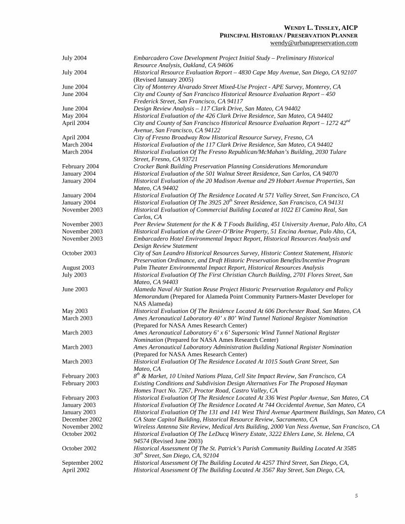
WENDY L. TINSLEY, AICP PRINCIPAL HISTORIAN / PRESERVATION PLANNER
5
July 2004 Embarcadero Cove Development Project Initial Study – Preliminary Historical Resource Analysis, Oakland, CA 94606
July 2004 Historical Resource Evaluation Report – 4830 Cape May Avenue, San Diego, CA 92107 (Revised January 2005)
June 2004 City of Monterey Alvarado Street Mixed-Use Project - APE Survey, Monterey, CA June 2004 City and County of San Francisco Historical Resource Evaluation Report – 450
Frederick Street, San Francisco, CA 94117 June 2004 Design Review Analysis – 117 Clark Drive, San Mateo, CA 94402 May 2004 Historical Evaluation of the 426 Clark Drive Residence, San Mateo, CA 94402 April 2004 City and County of San Francisco Historical Resource Evaluation Report – 1272 42nd
Avenue, San Francisco, CA 94122 April 2004 City of Fresno Broadway Row Historical Resource Survey, Fresno, CA March 2004 Historical Evaluation of the 117 Clark Drive Residence, San Mateo, CA 94402 March 2004 Historical Evaluation Of The Fresno Republican/McMahan’s Building, 2030 Tulare
Street, Fresno, CA 93721 February 2004 Crocker Bank Building Preservation Planning Considerations Memorandum January 2004 Historical Evaluation of the 501 Walnut Street Residence, San Carlos, CA 94070 January 2004 Historical Evaluation of the 20 Madison Avenue and 29 Hobart Avenue Properties, San
Mateo, CA 94402 January 2004 Historical Evaluation Of The Residence Located At 571 Valley Street, San Francisco, CA January 2004 Historical Evaluation Of The 3925 20th Street Residence, San Francisco, CA 94131 November 2003 Historical Evaluation of Commercial Building Located at 1022 El Camino Real, San
Carlos, CA November 2003 Peer Review Statement for the K & T Foods Building, 451 University Avenue, Palo Alto, CA November 2003 Historical Evaluation of the Greer-O’Brine Property, 51 Encina Avenue, Palo Alto, CA, November 2003 Embarcadero Hotel Environmental Impact Report, Historical Resources Analysis and
Design Review Statement October 2003 City of San Leandro Historical Resources Survey, Historic Context Statement, Historic
Preservation Ordinance, and Draft Historic Preservation Benefits/Incentive Program August 2003 Palm Theater Environmental Impact Report, Historical Resources Analysis July 2003 Historical Evaluation Of The First Christian Church Building, 2701 Flores Street, San
Mateo, CA 94403 June 2003 Alameda Naval Air Station Reuse Project Historic Preservation Regulatory and Policy
Memorandum (Prepared for Alameda Point Community Partners-Master Developer for NAS Alameda)
May 2003 Historical Evaluation Of The Residence Located At 606 Dorchester Road, San Mateo, CA March 2003 Ames Aeronautical Laboratory 40’ x 80’ Wind Tunnel National Register Nomination
(Prepared for NASA Ames Research Center) March 2003 Ames Aeronautical Laboratory 6’ x 6’ Supersonic Wind Tunnel National Register
Nomination (Prepared for NASA Ames Research Center) March 2003 Ames Aeronautical Laboratory Administration Building National Register Nomination
(Prepared for NASA Ames Research Center) March 2003 Historical Evaluation Of The Residence Located At 1015 South Grant Street, San
Mateo, CA February 2003 8th & Market, 10 United Nations Plaza, Cell Site Impact Review, San Francisco, CA February 2003 Existing Conditions and Subdivision Design Alternatives For The Proposed Hayman
Homes Tract No. 7267, Proctor Road, Castro Valley, CA February 2003 Historical Evaluation Of The Residence Located At 336 West Poplar Avenue, San Mateo, CA January 2003 Historical Evaluation Of The Residence Located At 744 Occidental Avenue, San Mateo, CA January 2003 Historical Evaluation Of The 131 and 141 West Third Avenue Apartment Buildings, San Mateo, CA December 2002 CA State Capitol Building, Historical Resource Review, Sacramento, CA November 2002 Wireless Antenna Site Review, Medical Arts Building, 2000 Van Ness Avenue, San Francisco, CA October 2002 Historical Evaluation Of The LeDucq Winery Estate, 3222 Ehlers Lane, St. Helena, CA
94574 (Revised June 2003) October 2002 Historical Assessment Of The St. Patrick’s Parish Community Building Located At 3585
30th Street, San Diego, CA, 92104 September 2002 Historical Assessment Of The Building Located At 4257 Third Street, San Diego, CA, April 2002 Historical Assessment Of The Building Located At 3567 Ray Street, San Diego, CA,
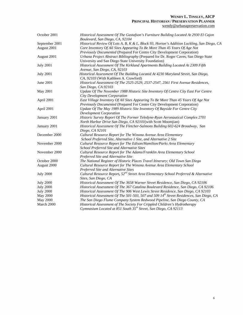
WENDY L. TINSLEY, AICP PRINCIPAL HISTORIAN / PRESERVATION PLANNER
6
October 2001 Historical Assessment Of The Gustafson’s Furniture Building Located At 2930 El Cajon Boulevard, San Diego, CA, 92104
September 2001 Historical Review Of Lots A, B, K & L, Block 93, Horton’s Addition Lockling, San Diego, CA August 2001 Core Inventory Of All Sites Appearing To Be More Than 45 Years Of Age Not
Previously Documented (Prepared For Centre City Development Corporation) August 2001 Urbana Project Abstract Bibliography (Prepared for Dr. Roger Caves, San Diego State
University and San Diego State University Foundation) July 2001 Historical Assessment Of The Kirkland Apartments Building Located At 2309 Fifth
Avenue, San Diego, CA, 92103 July 2001 Historical Assessment Of The Building Located At 4230 Maryland Street, San Diego,
CA, 92103 (With Kathleen A. Crawford) June 2001 Historical Assessment Of The 2525-2529, 2537-2547, 2561 First Avenue Residences,
San Diego, CA 92103 May 2001 Update Of The November 1988 Historic Site Inventory Of Centre City East For Centre
City Development Corporation April 2001 East Village Inventory Of All Sites Appearing To Be More Than 45 Years Of Age Not
Previously Documented (Prepared For Centre City Development Corporation) April 2001 Update Of The May 1989 Historic Site Inventory Of Bayside For Centre City
Development Corporation January 2001 Historic Survey Report Of The Former Teledyne-Ryan Aeronautical Complex 2701
North Harbor Drive San Diego, CA 92101(with Scott Moomjian) January 2001 Historical Assessment Of The Fletcher-Salmons Building 602-624 Broadway, San
Diego, CA 92101 December 2000 Cultural Resource Report for The Winona Avenue Area Elementary
School Preferred Site, Alternative 1 Site, and Alternative 2 Site November 2000 Cultural Resource Report for The Edison/Hamilton/Parks Area Elementary
School Preferred Site and Alternative Sites November 2000 Cultural Resource Report for The Adams/Franklin Area Elementary School Preferred Site and Alternative Site October 2000 The National Register of Historic Places Travel Itinerary; Old Town San Diego August 2000 Cultural Resource Report for The Winona Avenue Area Elementary School
Preferred Site and Alternative Sites July 2000 Cultural Resource Report, 52nd Street Area Elementary School Preferred & Alternative
Sites, San Diego, CA July 2000 Historical Assessment Of The 3658 Warner Street Residence, San Diego, CA 92106 July 2000 Historical Assessment Of The 367 Catalina Boulevard Residence, San Diego, CA 92106 July 2000 Historical Assessment Of The 906 West Lewis Street Residence, San Diego, CA 92103 May 2000 Historical Assessment Of The 501-503, 507 and 509 14th Street Residences, San Diego, CA May 2000 The San Diego Flume Company System Redwood Pipeline, San Diego County, CA March 2000 Historical Assessment of The Society For Crippled Children’s Hydrotherapy
Gymnasium Located at 851 South 35th Street, San Diego, CA 92113
Recommended


![historic locust grove GROVE GAZETTE · historic locust grove GROVE GAZETTE [FAll/WINTER 2016] Savvy Costumed Interpreters Enliven Locust Grove’s ‘Christmastide’ C hristmastide](https://img.dokumen.tips/doc/110x75/5f665b0e862ec713605d20c5/historic-locust-grove-grove-gazette-historic-locust-grove-grove-gazette-fallwinter.jpg)