1
Examination of the Basingstoke and Deane Local
Plan (2011 to 2029)
STATEMENT OF COMMON GROUND
between
Hounsome Fields (Wates Developments Ltd) and
Basingstoke and Deane Borough Council
and Hampshire County Council Highways (Local Highways Authority) and Hampshire County
Council Children’s Services (Local Education Authority)
Local Plan Policy: SS3.12 August 2015

2
Appendices Appendix 1: Hounsome Fields Site Features (NLP,August 2015)
Appendix 2: Draft Inset Map for South-West Basingstoke (Basingstoke Golf
Club, Hounsome Fields and Kennel Farm)
Appendix 3:
Draft constraints map for South-West Basingstoke (Basingstoke Golf Club, Hounsome Fields and Kennel Farm)
Appendix 4: Land use parameter plan for Kennel Farm (BDB/77382)
Appendix 5: Council’s preferred distribution of on-site infrastructure (BDBC, August 2015)
Appendix 6: Transport Statement provided by Promoter and Basingstoke Golf Club (iTransport and Stuart Michael Associates, August 2015)
3
1. Introduction
1.1 The purpose of this Statement of Common Ground is to identify key areas of agreement and disagreement between Wates Developments Ltd, the Promoters of Hounsome Fields, and the Local Planning Authority (LPA) in advance of the Local Plan being considered at an Examination in Public. The key areas of agreement/disagreement are highlighted in the boxes after each section. The statement also provides information on the rationale behind the proposed inset maps, the overall vision for development in south west Basingstoke, and demonstrate how the criteria in the policies can deliver high quality, sustainable development.
1.2 Where relevant, Hampshire County Council Highways (Local Highway Authority – LHA) and Hampshire County Council Children’s Services (Local Education Authority – LEA) have entered into parts of this agreement. The sections of this document that they are signed up to are recorded in the boxes after each section.
1.3 Through this document a number of changes are proposed to the emerging Local Plan policy and the supporting text. Where changes are proposed, the new text is underlined and the old text is struck through.
2. Site Features and Context
2.1 Hounsome Fields lies on the south western edge of Basingstoke and has a site area of approximately 43 hectares. The site is well contained by clear boundaries. In the south-east it is defined by the A30, and in the north-west the line of the former Roman road forms a clear boundary. In the north the site merges with Kennel Farm (Policy SS3.2 currently benefitting from outline consent Ref. BDB/77382 - land use parameter plan in Appendix 3).
2.2 Currently Hounsome Fields is open countryside with some tree belts within and on the boundaries of the site. In particular there is a tree belt along the A30 frontage which provides screening from this main road entry point to the town. There is an east-west ridgeline at the northern end of the site at approximately 165m AOD, from which the site slopes gently southwards to a low point of approximately 140m AOD at the A30. There is also a shallow ridge running down the centre of the site in a north-east to south-west direction.
2.3 The site is currently used for agricultural purposes. The agricultural land
quality of the site has been assessed as predominantly Grade 3 ‘Good Quality’, with two small areas of Grade 2 ‘Very Good’ land in the north-west corner and southern part of the site respectively. Most agricultural land on the edge of Basingstoke falls within the Grade 3 classification, with some falling within Grade 2.

4
2.4 The only features benefitting from statutory protection lie on the edge of, or just outside, the site. Parts of the woodland area adjacent to the Roman Road are an SINC. Southwood Farmhouse, just beyond the boundary of the site, but looking onto the southern part of Hounsome Fields, is a Grade 2 listed building.
2.5 A very small area at the southern tip of the site lies within the Environment Agency defined Flood Zone 2.
2.6 An oil pipeline that is owned by Government Pipelines and Storage crosses the southern part of the site. This requires a standard easement of 6m (3m either side of the pipeline) to be maintained.
2.7 The site is within the freehold ownership of Pellipar Investments Ltd, a company wholly owned by the Skinners Company. It is the subject of a farm business tenancy only, and is not subject to any long term leases. There are no other property or title encumbrances.
2.8 A plan showing the principal site features is attached as Appendix 1.
2.9 As noted above, outline planning permission for 310 residential units was granted on land to the north of Hounsome Fields, known as Kennel Farm (BDB/77382). Kennel Farm is promoted by a joint venture called Linden Wates Kennel Farm Limited, which includes Wates Developments Ltd.
2.10 On this site, the reserved matters application for the erection of 310 residential units, including affordable housing was submitted by the joint venture in March 2015 (15/00905/RES). This demonstrates Wates Developments Ltd (via the joint venture) commitment to delivering development to the South West of Basingstoke.
2.11 To the south west of Hounsome Fields, a planning application was submitted by the Hampshire Hospitals NHS Foundation Trust in April 2015 for a new Critical Care Hospital. The proposal includes provision of an Emergency Department, Acute Diagnostic Unit, Diagnostic Imaging, Theatres, Critical Care, Local Neonatal Unit, Maternity, Inpatient Wards, Paediatric Ward and Pharmacy.
Availability of site and timescales for delivery
3.1 Over a considerable number of years the Skinners Company has been actively seeking to make the land available for new uses. The constraint that has prevented this from happening to date has been planning policy.
3.2 Wates Developments Ltd has entered into contractual arrangements with the Skinners Company, whereby it (Wates Developments) has taken over responsibility for promoting Hounsome Fields for housing and associated development through the planning process. The Promoter is committed,

5
and contractually obliged, to move forward speedily, including submission of an early planning application.
3.3 The Promoter is working to the following timetable for preparation, submission and determination of a planning application:
Submission of outline application – no later than 31st January
2016;
Planning Committee – no later than 31st May 2016;
Sign S106 and issue decision notice - no later than 31st August
2016.
3.4 Thereafter it will be necessary to secure approval of reserved matters and agreements in respect of the provision and funding of infrastructure. Having allowed for this, it is envisaged that a start on site would take place in the financial year 2017/18. On the basis of this timetable, the housing delivery target is:
2017/18 50 units
2018/19 – 2027/28 70 units per annum.
It is common ground between the Promoter and the LPA that the site can be available for development in 2017/18, and can be delivered within the plan period (in accordance with the above timetable).
4 Capacity of the site for housing and infrastructure
4.1 The LPA’s site assessments, and the early masterplanning work undertaken by the Promoter has identified that 750 dwellings can be accommodated on the site with the necessary on-site infrastructure.
4.2 The Promoter and its consultant team are currently preparing a masterplan, which will support the planning application for development on the site.
It is common ground between the Promoter and BDBC that the site could accommodate 750 dwellings in an acceptable manner.
5 Vision for development in south west Basingstoke
5.1 It is important to have a clear vision to guide the development in south-
west Basingstoke and coordinate the individual sites to create a well-planned place. The following vision is agreed by both the Promoter of Hounsome Fields and the landowners of Basingstoke Golf Club.

6
Basingstoke and Deane Borough Council and the landowners share the vision of creating a high quality, comprehensively planned new development in south-west Basingstoke.
The sites will deliver approximately 2060 new homes up to 2029 (with Hounsome Fields coming forward early in the plan period), which will enable the delivery of new community infrastructure and services to serve both new and existing residents. The new developments will be comprehensively masterplanned in terms of access, linkages and infrastructure delivery. A principal centre on Hounsome Fields will accommodate a primary school and enhanced community facilities with further amenities on the golf course site. Although the sites straddle the A30, through the creation of safe, legible crossing points reflecting desire lines, the sites will be interlinked to build a strong community with a clear shared identity. The sites will include integrated and accessible transport systems that cater for all modes including public transport and safe routes for pedestrians and cyclists, both within the allocations and with particular reference to sustainable routes to the town centre. The new homes will be of a high quality of design and demonstrate good practice in sustainable design, and include a mix of size and tenure to create a mixed, thriving new community. Their layout and design will take account of the opportunities and constraints presented by the greenfield sites, and in particular ensure that they respond to, and build upon, the landscape sensitivities, ecological significance, and existing green infrastructure to deliver a high quality place and provide a new gateway into Basingstoke from the south west.
5.2 The vision will be enhanced and refined through the community
engagement that the Promoters will undertake prior to the submission of any planning application.
5.3 Based upon the agreed vision, the Council and the Promoters agree that the following text be inserted in the Local Plan alongside the inset map to provide an introduction to the sites in south-west Basingstoke.
(Insert before Policy SS3.11 and SS3.12)
‘Approximately 2060 new homes will be brought forward in south-west Basingstoke as part of a high quality, comprehensively planned, infrastructure-rich development. The sites will respect, respond to and enhance their landscape and biodiversity context and build upon the local green infrastructure assets to provide a high quality new gateway to the town’.
The vision for development in south west Basingstoke is common ground between the Promoter the LPA, the LHA and the LEA.
The proposed additional supporting text is common ground between the
7
Promoter and the LPA
6 Inset Map
6.1 At the exploratory meeting in December 2014, the Inspector indicated that
he would like to see further detail on the strategic sites, and suggested that an Inset Map should be agreed through the Hearings.
6.2 To assist the Inspector at the examination, a draft Inset Map for the sites in south-west Basingstoke (see Appendix 2) has been agreed through discussion between the Promoters, landowners and agents of Basingstoke Golf Course, Hounsome Fields, the LPA (and internal consultees), the LHA and the LEA. To provide a comprehensive picture of development in the area, the Inset Map also includes the adjacent site at Kennel Farm (Policy SS3.2, currently benefitting from outline consent Ref. BDB/77382 - land use parameter plan in Appendix 4)
6.3 Whilst recognising that further information will become available through
the detailed design process, the indicative Inset Map identifies the general location of the principal access and key infrastructure on the site.
6.4 The key features shown for the area include: - Single principal access to/from A30 comprehensively planned between
Basingstoke Golf Course and Hounsome Fields; - Centres (including community facilities) on both sites; and - A primary school on Hounsome Fields. - Pedestrian/cycling connections to the town centre.
6.5 The part of the inset map specifically relating to Hounsome Fields
identifies a centre located close to principal access to provide a desire line across a safe multi modal crossing on the A30.
6.6 A constraints map (Appendix 3) has also been agreed showing the following: - Grade II Listed Building - Surrounding SINCs; and - Area of land in flood zone 2
6.7 Although it is recognised that there are other constraints that will need to
be taken into account when detailing the proposals, these would have less of an impact upon the high level masterplan (for example, protection of individual trees). These matters are covered by policies in the emerging Local Plan, and the detailed design response will be considered through the Development Management process.
The draft inset map and the constraints map are common ground between the Promoter the LPA, the LHA and the LEA.

8
7 Text of Policy SS3.12
7.1 Unless otherwise stated below, the criteria in Policy SS3.12 (with proposed modifications, May 2015) have been agreed by the landowner. This section focuses on those criteria where:
- there is a difference in view between the Promoter and one of the Councils; or
- further explanation is provided to demonstrate how the policy criteria would be satisfied (particularly in relation to issues which have been raised during the consultations).
Gypsies and Travellers (criterion b) 7.2 Criterion b is not agreed.
7.3 The Council considers that the approach set out in Criterion b provides a
flexible framework to meet the Council’s needs through the Development Management process, taking account of the needs identified at that time.
7.4 The Promoter is not satisfied that the Council has justified the need for
accommodation for gypsies, travellers, and travelling showpeople on the southwest edge of the town at Hounsome Fields; particularly as there is a County Council owned site nearby (Peake Copse) which has in the past been used for such accommodation and appears to be suitable.
The requirement for gypsy and traveller sites in criterion b) is not common ground between the landowner and the LPA.
Other elements of the criterion relating to the mix of units and the provision of self-build properties are common ground between the landowner and the LPA.
On-site infrastructure and comprehensive development (criteria c and q)
7.5 The Council and the landowners understand the importance of planning and delivering infrastructure in a comprehensive manner.
7.6 The Local Planning Authority has liaised with internal stakeholders and the LEA with regards to on-site infrastructure requirements. The LPA, the LEA and the Promoter agree that a piecemeal approach to infrastructure delivery (with each site ‘consuming its own smoke’) would undermine the opportunity to comprehensively plan the area and result in inefficiencies in the facilities’ future management. This includes issues associated with the delivery of single form entry primary schools which the LEA do not view as desirable, and the division of sports pitches which would result in management issues.
7.7 Notwithstanding this, it is agreed that it is not the intention of the Policy to prevent the early delivery of one site (e.g. Hounsome Fields), while other sites with a responsibility to contribute to the delivery of infrastructure for
9
the wider area, come forward later in the plan period (e.g. Basingstoke Golf Club).
7.8 The Council’s preferred arrangement of on-site infrastructure is shown in Appendix 5. It is agreed that in the context of Hounsome Fields this would result in a principal centre with the following mix of uses:
- 3 form entry primary school on the site (to serve Hounsome Fields, the golf course and the wider area).
- Principal community centre – providing community hub to serve surrounding area
- Indoor sports facilities to be provided on site and funded through CIL.
- Site safeguarded for a private nursery, subject to market demand - Flexibly designed local shopping facilities. - Neighbourhood park – with potential to create a village green using,
in part, the existing wooded areas.
7.9 It is envisaged that outdoor sports facilities would be provided on the Basingstoke Golf Course site to serve both Hounsome Fields and the Golf Course.
7.10 To reflect this approach, the LPA and the Promoter are in agreement that the relevant criteria in each policy should be redrafted to be more specific about the infrastructure sought on each site and to require the submission of an Infrastructure Delivery Plan (IDP) with each outline planning application to justify what is being provided (as explained below).
7.11 In the case of Policy SS3.12 relating to Hounsome Fields:
‘c) make provision for the provision of social and physical infrastructure, including the provision of a community centre, local shopping facilities, indoor sports facilities, a three form entry primary school, and early years facilities, with an Infrastructure Delivery Plan to demonstrate that the needs of the development sites in south-west Basingstoke, including outdoor sports, have been comprehensively planned and will be met.’
7.12 Furthermore, it is agreed that criterion q) be strengthened to refer to joint
infrastructure delivery.
‘q) Ensure through joint masterplanning and joint infrastructure planning, that it provides for a comprehensive development with Kennel Farm (policy SS3.2) and Basingstoke Golf Course (policy SS3.11) allocations
7.13 The Promoters have indicated that this approach is achievable. It is anticipated that Hounsome Fields will be delivered first, in which case the Council could secure provision of the outdoor sports facilities through a financial contribution, which would allow comprehensive provision on the golf course site. Should the golf course be delivered first, the policy would

10
ensure that sufficient space for pitches was reserved. The principle of this approach has also been agreed through Basingstoke Golf Club’s Statement of Common Ground.
What would the Infrastructure Delivery Plan include? 7.14 It is agreed that each outline planning application should be provided with
an Infrastructure Delivery Plan (IDP) which has regard to the needs of both Hounsome Fields and Basingstoke Golf Course to ensure the vision is achieved and to avoid a piecemeal approach. The IDP will set an overarching framework for the S106 agreement in each case, reflect the Council’s Regulation 123 List, and provide the suitable assurances that infrastructure is being jointly and comprehensively planned.
7.15 It is agreed that the IDP should demonstrate that the development in question would: - contribute towards a comprehensive infrastructure plan for the wider
area; - mitigate its own impacts (in accordance with the tests in CIL Reg 122);
and - not prejudice and, in fact, facilitate the delivery of future development
in the allocated sites.
7.16 The document should include: - A list of the area-wide infrastructure requirements (in the absence of
any adopted document detailing the infrastructure required, this should include those identified in the Borough-wide Infrastructure Delivery Plan);
- Details of how (and broadly where) that infrastructure would be delivered or funded (including costs, levels of funding and timings); and
- A high-level infrastructure phasing strategy.
7.17 The IDP will cover those elements of infrastructure: - to be provided solely by one development site to meet their own needs
(for example, on-site amenity open space); - to be delivered on one site but serve the entire development area or a
wider area (for example, outdoor sports pitches); - to be delivered on site but to be funded by an alternative means (for
example, CIL); - to be delivered off site (for example, off-site highway improvements); - included on the Reg 123 list, that may be delivered off-site by CIL.
Education 7.18 The school will be within reasonable walking distance of the homes of all
pupils within the area to be served by the school, with safe (preferably segregated) routes for journeys on foot or bicycle and related to public transport. The school will be located in proximity to local shops and other community facilities to maximise opportunities for the efficient use of land for activities such as drop off cark parking and, as part of a focus for new

11
development. It is agreed that discussions on the location of the school sites should take place with all stakeholders at the earliest opportunity.
It is common ground between the LPA, the LEA and the Promoter that infrastructure in south west Basingstoke should be comprehensively planned.
It is common ground between the LPA, LEA and the Promoter of Hounsome Fields that criteria c) and q) of Policy SS3.12 should be amended to provide more detail about the infrastructure required, and to include reference to the requirement for an infrastructure delivery plan.
Landscape character, urban design and ecology (criteria d, e and f)
7.19 These criteria provide a policy framework to ensure that the development will respond to landscape and ecological considerations. The site has notable landscape and ecological constraints (SINCs and woodland) that will influence the site layout. The detailed consideration of these matters can be addressed at the Development Management stage. It is, however, agreed that the criterion d) should be strengthened to include reference to the importance of the site as a ‘gateway’ into south-west Basingstoke.
‘d) Respond positively to the special characteristics and sensitivities of the landscape, ensuring that the density, heights and layout or buildings respond positively to the site and its setting, create an attractive gateway into Basingstoke, and minimise any visual impact’.
7.20 It is agreed a detailed Landscape and Visual Impact Assessment will be
submitted with any future planning application to demonstrate how the proposals would respond to the special characteristics and sensitivities of the landscape. This will inform judgements about the location of development and its height and intensity to ensure it responds, for example, to the topography of the site and vegetation, to reduce any visual impacts.
7.21 A soft edge to the development will provide a green transition to the surrounding countryside and mitigate any impact upon the bridleway that borders the site.
2.12 An Arboricultural Impact Assessment will inform the retention of existing
trees and groups of trees within the site, and inform a landscaping structure that would include green corridors. Additional east-west landscape corridors, particularly within the most visually prominent areas. An ecological assessment will highlight biodiversity issues, such as areas of ecological potential and importance, buffers, along with links with the wider green infrastructure beyond the site. Each of these assessments will help to inform a framework that defines the green infrastructure for the site.
It is common ground between the Promoter and the LPA that the criteria

12
(d) (as amended) and (e) provide an acceptable framework to protect the natural environment.
Heritage (criterion g)
7.22 Although a more detailed assessment will be required through any future planning application, discussions with BDBC’s Conservation Officer have indicated that a separation distance of at least 100m will be required to preserve the setting of Southwood Farmhouse (a Grade II Listed Building). The Promoter has indicated that they will take this into account on their illustrative masterplan and adequate protection is provided through the detailed criterion in the policy.
7.23 A Roman Road runs along the western boundary, a small part of which crosses the site. It is recognised that this has heritage significance and may have archaeological potential. It is common ground between the LPA and the Promoter that any issues can be addressed by emerging Local Plan Policy EM11 – The Historic Environment.
It is common ground between the Promoter and the LPA that criteria g) and emerging Local Plan Policy EM11 provide an acceptable framework to protect the historic environment.
Highways (criteria h, l, j and k)
7.24 The promoter of Hounsome Fields and the landowner of Basingstoke Golf Club have jointly provided a highway statement dealing with access issues and broader sustainability considerations (Appendix 6 - this is a statement between the two landowners which has not been agreed by the LHA or the LPA).
7.25 In its role as local highway authority, Hampshire County Council (HCC) has considered initial transport and highways matters relating to the proposed allocation of Basingstoke Golf Course (ref: Policy SS3.11) and Hounsome Fields (ref: Policy SS3.12) in BDBC’s ‘Proposed Main Modifications to the Submission Local Plan’. This has included a review of high level data and associated commentary within the ‘Agreed Transport Statement’ (which for the avoidance of doubt is an agreed statement between the promoters of the two sites).
7.26 In terms of the principal vehicular access to the sites, both sites include very long frontages with the A30 and therefore there are numerous options to achieve safe and suitable vehicular access.
7.27 The LHA has considered the opportunity to provide access via both a
signalised junction option and a roundabout. The access options are noted as being viable propositions for the quantum of development set out in the local plan.

13
7.28 The final type of junction will be refined as detailed studies are undertaken
to support planning applications.
7.29 Any planning application will be supported by a detailed Transport Assessment including Travel Plans. As part of this, it will enable safe, healthy and sustainable routes to the school for all, and should in turn result in minimal car alone journeys and reduced congestion within the school vicinity.
It is common ground between the landowner, the LHA and the LPA that:
The concept of at-grade pedestrian/cyclist crossing facilities within the new junctions on the A30 is supported.
It is agreed that an appropriate land envelope can and will be safeguarded within the site and on the A30 to allow the site access junction to accommodate possible future development to the north as required by Policy SS3.12.
The wider traffic impact of the proposed local plan allocations is set out in the strategic level Transport Assessment (TA) produced by Parsons Brinckerhoff which is agreed by HCC with the exception of a specific concern explained within its representations on Policy SS3.10.
HCC is satisfied that the development on land covered by Policy SS3.11 and SS3.12 has potential to be acceptable in transport sustainability terms. As matters progress, the LHA will expect to see the detail of how the sites will build upon existing walking, cycling and public transport provision to provide connectivity to local facilities and services and those further afield. Access strategies will need to allow for (and capitalise upon) improvements that may or may not be brought forward by others. At this stage, the LHA consider that the sites have potential to opportunities for sustainable travel in a reasonable and realistic way.
Sewerage and Drainage (criterion j)
7.30 The Council’s Water Cycle Study and subsequent discussions with the Environment Agency (Examination Library: PS/02/28) demonstrate that there is sufficient capacity at the Basingstoke Sewage Treatment Works to accommodate all the development proposed in the plan period, including the 750 dwellings on Hounsome Fields and the 1000 dwellings on the Basingstoke Golf Club site. It is therefore common ground that sewerage capacity does not provide a constraint to development.
7.31 Thames Water has responded to the Local Plan consultation and confirmed they support the new Policy for Hounsome Fields regarding sewerage and surface water.

14
7.32 A full Utilities Assessment will be provided with the planning applications to identify the other improvements required to the drainage network. The LPA will work with Thames Water to ensure these are provided, and it would not be unusual for planning consent to be granted subject to a Grampian condition on this issue.
It is common ground between the Promoter and BDBC that sewerage capacity is not a constraint.
Future Development to the north-west of the site (criterion k)
7.33 Criterion k indicates the Council’s requirement for vehicular access through Hounsome Fields that may be needed to serve development to the north-west of the site.
7.34 The Promoter has indicated that they will make provision for this as part of the masterplan for the site.
It is common ground between the Promoter, the LPA and the LHA that provision will be made for vehicular access of an appropriate specification to serve future development to the north-west of the site.
Flooding (criterion m)
7.35 The Council’s Flood Risk Ranking and Sequential Test Updated (2014) identifies that only a very small part of the site is within Flood Zone 2 and that small areas would be susceptible to surface water flooding.
7.36 It is common ground that flood risk will need to be attenuated in accordance with the requirements of emerging Local Plan policy EM7 (Managing Flood Risk) and the National Planning Policy Framework and National Planning Practice Guidance, and that flooding will not be a significant constraint to development on the site.
7.37 The Promoter is of the view that the words “and points of access” should be deleted from criterion m, because with appropriate mitigation works it would not be reasonable to restrict a new access on this ground. The LPA considers that the sequential test should still apply in accordance with Para ID: 7-019 of the NPPG.
It is common ground between the Promoter and the LPA that flood risk will need to be attenuated in accordance with the requirements of local and national policy, and that flooding will not be a significant constraint to development on the site.
However, the policy requirement that points of access should avoid Flood Zone 2 is not common ground between the Promoter and the LPA.

15
Noise and air quality (criterion o)
It is common ground between the Promoter and the LPA that acceptable noise and air quality standards and mitigation can be provided.

16
Appendix 1 – Site Features (Hounsome Fields), NLP, August 2015

17
Appendix 2: Draft Inset Map

18
Appendix 3: Constraints Map
19
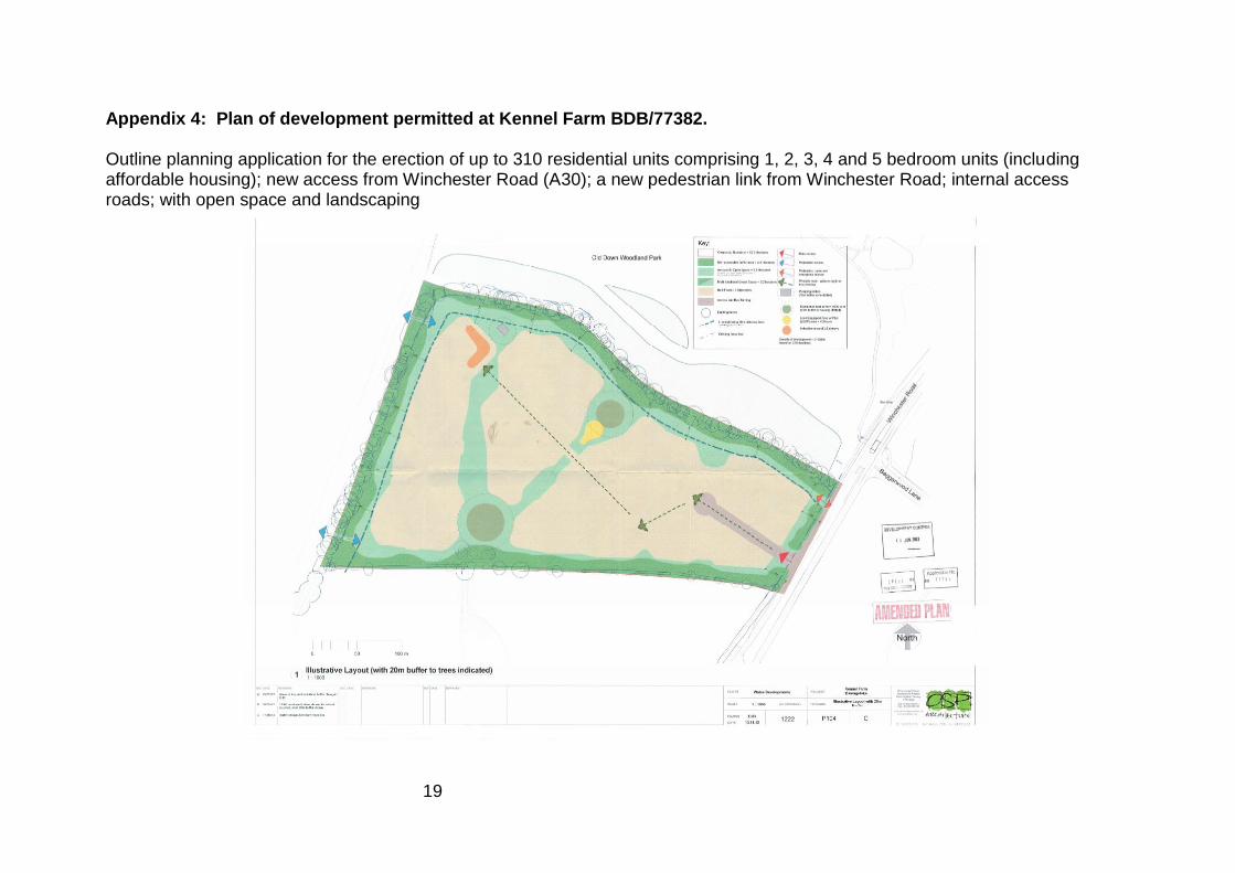
Appendix 4: Plan of development permitted at Kennel Farm BDB/77382. Outline planning application for the erection of up to 310 residential units comprising 1, 2, 3, 4 and 5 bedroom units (including affordable housing); new access from Winchester Road (A30); a new pedestrian link from Winchester Road; internal access roads; with open space and landscaping
20
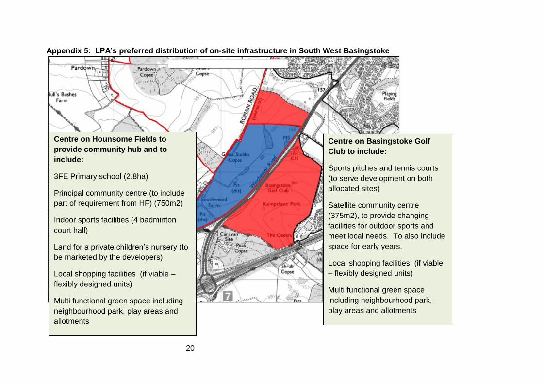
Appendix 5: LPA’s preferred distribution of on-site infrastructure in South West Basingstoke
Centre on Basingstoke Golf
Club to include:
Sports pitches and tennis courts
(to serve development on both
allocated sites)
Satellite community centre
(375m2), to provide changing
facilities for outdoor sports and
meet local needs. To also include
space for early years.
Local shopping facilities (if viable
– flexibly designed units)
Multi functional green space
including neighbourhood park,
play areas and allotments
Centre on Hounsome Fields to
provide community hub and to
include:
3FE Primary school (2.8ha)
Principal community centre (to include
part of requirement from HF) (750m2)
Indoor sports facilities (4 badminton
court hall)
Land for a private children’s nursery (to
be marketed by the developers)
Local shopping facilities (if viable –
flexibly designed units)
Multi functional green space including
neighbourhood park, play areas and
allotments

21
Appendix 6 - Transport Statement provided by Promoter and Basingstoke Golf Club (iTransport and Stuart Michael
Associates, August 2015)

Ref: JCB/JDW/AH/ITB11069-002A TN
Date: 21 August 2015 Page 1
TECHNICAL NOTE
Project No: ITB11069
Project Title: Golf Course and Hounsome Fields, Basingstoke
Title: Agreed Transport Statement
Ref: JCB/JDW/AH/ITB11069-002A TN
Date: 21 August 2015
INTRODUCTION
1.1 Introduction
1.1.1 This Agreed Transport Statement (ATS) has been prepared by:
• i-Transport LLP on behalf of Wates Developments (promoters of the
Hounsome Fields site); and
• Stuart Michael Associates on behalf of Basingstoke Golf Course.
1.1.2 The ATS has been prepared in close consultation with Basingstoke and Deane Borough
Council (BDBC) as local planning authority, and Hampshire County Council (HCC) as
local highway authority. The ATS sets a proposed outline vehicular and sustainable
access strategy for the following proposed allocation in the ‘Proposed Main
Modifications to the Submission Local Plan’:
• Basingstoke Golf Course – 1,000 dwellings and a community centre with local
shopping facilities (ref: Policy SS3.11); and
• Hounsome Fields – 750 dwellings plus a primary school and a local centre (ref:
Policy SS3.12).

Golf Course and Hounsome Fields, Basingstoke
Agreed Transport Statement
Ref: JCB/JDW/AH/ITB11069-002A TN
Date: 21 August 2015 Page 2
Figure 1.1: Site Location Plan
Note: Reproduced in Full at end of report
1.2 Policy Tests
1.2.1 In particular this ATS provides an appraisal of the proposed allocations against the
three key transport tests set out in paragraph 32 of the National Planning Policy
Framework (NPPF):
• Can the opportunities for sustainable travel be taken up in a reasonable and
realistic way? Section 2 of the ATS sets out the provision of facilities and
services in the local area, which will be enhanced by development of the two
sites, as well as the existing good level of provision for walking, cycling and
public transport use. Section 3 of the ATS provides an outline sustainable
transport strategy to illustrate how the opportunities for sustainable travel
can be realistically taken up.
• Will safe and suitable access be achieved for all people? The proposed
pedestrian, cyclist and public transport strategy for the two sites is set out in
Section 3 of the ATS. Section 3 also includes the proposed vehicular access
arrangements to comprehensively serve the two proposed allocations.
Golf Course and Hounsome Fields, Basingstoke
Agreed Transport Statement
Ref: JCB/JDW/AH/ITB11069-002A TN
Date: 21 August 2015 Page 3
• Will the residual impact be severe? Section 4 of the ATS provides a capacity
appraisal of the proposed site access arrangements, including identifying how
the arrangements will be able to provide for future flexibility in the event that
a new ‘Western Link Road’ is provided between the A339, B3400 and A30 in
the next local plan period. Section 4 also provides an overview of how the
wider traffic impact of the proposal can be mitigated.
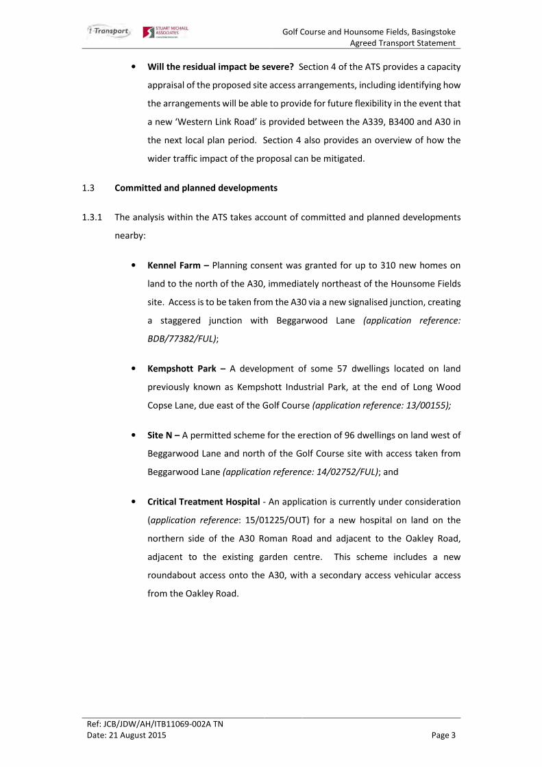
1.3 Committed and planned developments
1.3.1 The analysis within the ATS takes account of committed and planned developments
nearby:
• Kennel Farm – Planning consent was granted for up to 310 new homes on
land to the north of the A30, immediately northeast of the Hounsome Fields
site. Access is to be taken from the A30 via a new signalised junction, creating
a staggered junction with Beggarwood Lane (application reference:
BDB/77382/FUL);
• Kempshott Park – A development of some 57 dwellings located on land
previously known as Kempshott Industrial Park, at the end of Long Wood
Copse Lane, due east of the Golf Course (application reference: 13/00155);
• Site N – A permitted scheme for the erection of 96 dwellings on land west of
Beggarwood Lane and north of the Golf Course site with access taken from
Beggarwood Lane (application reference: 14/02752/FUL); and
• Critical Treatment Hospital - An application is currently under consideration
(application reference: 15/01225/OUT) for a new hospital on land on the
northern side of the A30 Roman Road and adjacent to the Oakley Road,
adjacent to the existing garden centre. This scheme includes a new
roundabout access onto the A30, with a secondary access vehicular access
from the Oakley Road.

Golf Course and Hounsome Fields, Basingstoke
Agreed Transport Statement
Ref: JCB/JDW/AH/ITB11069-002A TN
Date: 21 August 2015 Page 4
ACCESSIBILITY
2.1 Introduction
2.1.1 This section of the note demonstrates that the sites are in an acceptably sustainable
location in transport terms, and identifies how the opportunities to use sustainable
mods of travel can be realistically ‘taken up’.
2.1.2 The principle of residential development in this area has been established through the
Kennel Farm, Area N and Kempshott Park schemes, including Kennel Farm which was
considered by an inspector and found to be acceptable at appeal. It is also noted that
development of Hounsome Fields and the Golf Course will bring forward their own
local centres and a new school, which will enhance the transport sustainability of the
area.
2.2 Key Local Destinations
2.2.1 The National Travel Survey identifies the main reasons for making a journey:
Table 2.1: Proportion of Trips per Year by Journey Purpose
(Source: Table NTS0401 of Transport Statistics Great Britain – 2013 Edition)
2.2.1 The main reasons for travelling are leisure, shopping, commuting/business and
education/escort education trips. Together these account for over 80% of the reasons
for making a journey.

Golf Course and Hounsome Fields, Basingstoke
Agreed Transport Statement
Ref: JCB/JDW/AH/ITB11069-002A TN
Date: 21 August 2015 Page 5
2.3 Walking and Cycling Catchments
Walking
2.3.1 Paragraph 4.4.1 of the Manual for Streets states:
“Walkable neighbourhoods are typically characterised by having a
range of facilities within 10 minutes’ (up to about 800 m) walking
distance of residential areas which residents may access comfortably
on foot. However, this is not an upper limit and PPG131 states that
walking offers the greatest potential to replace short car trips,
particularly those under 2km. MfS encourages a reduction in the need
to travel by car through the creation of mixed-use neighbourhoods with
interconnected street patterns, where daily needs are within walking
distance of most residents.”
2.3.2 On this basis, 800m is considered to be a ‘comfortable’ walk distance, but this is by no
means an upper limit. A walking distance of 2km offers the greatest potential to
replace cars trips and therefore this is consider to be a ‘reasonable’ walking distance.
It is important to note that 2km is not a maximum walking distance - paragraph 2.3 of
the Design Manual for Roads and Bridges TD91/05 “Provision for Non-Motorised
Users” states:
“Walking is used to access a wide variety of destinations including
educational facilities, shops, and places of work, normally within a
range of up to 2 miles. Walking and rambling can also be undertaken
as a leisure activity, often over longer distances”.
2.3.3 On this basis, it is reasonable to consider 2 mile/3.2km as a ‘maximum’ walking
distance for most day-to-day journeys.
2.3.4 Against this background, the following distances are considered to be useful for
assessing the likelihood of walking journeys to and from the south west sites:
• 800m – comfortable walking distance;
• 2km – reasonable walking distance; and
• 3.2km – maximum walking distance.
1 Whilst PPG13 has been superseded by the NPPF, the NPPF does not include any reference to walking distances. Given that the most recent version of PPG13 was published in January 2011 it is reasonable to assume that the guidance regarding the 2km distance remains valid, i.e. we are not aware of anything that would have changed people’s propensity to walk since than time.

Golf Course and Hounsome Fields, Basingstoke
Agreed Transport Statement
Ref: JCB/JDW/AH/ITB11069-002A TN
Date: 21 August 2015 Page 6
2.3.5 Figure 2.1 illustrates the facilities and services that are within a comfortable and
reasonable walk journey from the south west Basingstoke sites.
Figure 2.1: Local Facilities Plan
Note: Reproduced in Full at end of report
Cycling
2.3.6 In terms of cycling journeys, the National Travel Survey sets out that the average
journey distance by bike is some 4.4km, with the current average length of an
employment and leisure cycle trips some 5.2km (ref: Table NTS0306 of the National
Travel Survey 2012). Local Transport Note 02/08 ‘Cycle Infrastructure Design’
(Department for Transport, 2008) (ref: CD5.9) sets out typical cycle trip distances at
paragraph 1.5.1:
“Urban networks are primarily for local journeys. In common with
other modes, many utility cycle journeys are under three miles (ECF,
1998), although, for commuter journeys, a trip distance of over five
miles is not uncommon. Novice and occasional leisure cyclists will cycle
longer distances where the cycle ride is the primary purpose of their
journey. A round trip on a way-marked leisure route could easily
involve distances of 20 to 30 miles. Experienced cyclists will often be
prepared to cycle longer distances for whatever journey purpose.”
2.3.7 Therefore, whilst the average ‘commuter’ trip is circa 5.2km, cycling distances for such
journeys of more than 5 miles (circa 8km) is not uncommon.

Golf Course and Hounsome Fields, Basingstoke
Agreed Transport Statement
Ref: JCB/JDW/AH/ITB11069-002A TN
Date: 21 August 2015 Page 7
2.3.8 From the primary access point to the two sites onto the A30 Winchester Road:
Basingstoke rail station is some 6.6km away; the ‘edge of the town centre is some
5.9km away; the Brighton Hill retail park is 4km away; and Hatch Warren Retail Park
is 1km away. A good range of further facilities and services are therefore within a
reasonable cycle distance of the sites.
2.3.9 The draft policy proposes that Hounsome Fields will include a primary school and a
local centre (e.g. day to day facilities including a convenience store); and the Golf
Course site will also provide an additional local centre. The provision of on-site
facilities will help reduce external traffic generation and traffic impacts on the local
highway network.
2.3.10 Local amenities located within a reasonable walking and/or cycling distance of the
sites are listed in Table 2.1 below and illustrated in Figure 2.1.
Table 2.1: Local Services and Facilities
Journey Purpose Destination Distance
(m)
Walking
Time
(minutes)
Cycling
Time
(minutes)
Education St Mark’s Primary School 2,310 28 9
Kempshott Junior and Infant School 2,890 34 11
Hatch Warren Junior School 3,130 - 12
Brighton Hill Community College 3,750 - 14
Aldworth Science College 4,310 - 16
Bishop Challenor Catholic Secondary
School
4,630 - 17
Cranbourne Business and Enterprise
College
5,290 - 20
Employment Kempshott Park Industrial Estate 2,000 24 8
Viables Industrial Estate 5,380 - 20
Hatch Warren Industrial Estate 4,850 - 18
Brighton Hill/South Ham Industrial
Estate
5,020 - 19
Leisure Basingstoke Golf Course 700 8 3
Old Down and Beggarwood Wildlife
Park
1,000 12 4
Hatch Warren Community Centre 1,980 24 7
Hatch Warren Football Pitches 3,750 - 14
Stratton Park and Playing Fields 3,560 - 13
Beechdown Health and Fitness Club 3,180 - 12
Retail Co-op/Boots 1,330 16 5
Sainsbury’s 1,560 19 6
Hatch Warren Retail Park 1,420 17 5

Golf Course and Hounsome Fields, Basingstoke
Agreed Transport Statement
Ref: JCB/JDW/AH/ITB11069-002A TN
Date: 21 August 2015 Page 8
Journey Purpose Destination Distance
(m)
Walking
Time
(minutes)
Cycling
Time
(minutes)
Tesco Express 2,430 29 9
Health The Beggarwood Surgery 1,380 16 5
Gillies Health Centre, Brighton Hill 3,810 - 14
Source: Consultants Estimates Note: Walk journey time assume a walk speed of 1.4m/s (Guidelines for Providing for Journeys on Foot, IHT). Cycle
journey time assumes an average cycling speed of 16km/h (MfS 2). Journey times are approximate and measured via
the shortest practicable route from the centre of the site
2.3.11 The sites are located within close proximity to a good range of local services and
facilities. With the addition of further on-site facilities, future residents will have
genuine opportunities to make local journeys for the main reasons for travelling.
2.4 Provision for Walking and Cycling
2.4.1 The primary desire lines for pedestrians and cyclists from the sites will be to the north
and north-east; i.e. towards the local facilities and services and the town centre. The
sites are well located to take advantage of the existing, committed and proposed
walking and cycling infrastructure, including:
• A new 3m footway/cycleway along the A30 between the proposed Critical
Treatment Hospital Site and the A30/Beggarwood Lane signal junction (which
forms part of the proposals for the proposed Critical Treatment Hospital site);
• Improvements secured by the Kennel Farm permission, including:
I. A new footway/cycleway along the Winchester Road site frontage
connecting with the existing Toucan crossing on the northern side of
the Beggarwood Lane traffic signals, and the existing pedestrian/cycle
route across Old Down Woodland Park;
II. A Toucan crossing of Winchester Road to the south of the proposed
Kennel Farm site access;
III. Improvements to the existing A30 Toucan crossing to bring it in line
with current design guidance; and
IV. New footway provision along the south eastern side of the A30
between Short Wood Copse and Beggarwood Lane.

Golf Course and Hounsome Fields, Basingstoke
Agreed Transport Statement
Ref: JCB/JDW/AH/ITB11069-002A TN
Date: 21 August 2015 Page 9
• The footpath through the Old Down Woodland Park which provides access to
Kempshott Lane and northwards to the Roman Road providing a link
eastwards to Kempshott;
• A shared pedestrian/cycleway that leads along the eastern side of
Beggarwood Lane to Beggarwood (a residential area with retail facilities);
• A pedestrian/cycleway leading across Beggarwood Park towards Sainsbury’s;
and
• The Roman Road Public Right of Way along the western boundary of
Hounsome Fields.
2.4.2 The pedestrian and cycle infrastructure in Beggarwood and through Old Down
Woodland Park form part of a wider network of pedestrian/cycleways leading to
destinations in Kempshott, Hatch Warren and onwards to Brighton Hill and the centre
of Basingstoke.
2.4.3 Local walking and cycling routes are shown on Figure 2.2, while the Basingstoke cycle
map in Appendix A identifies current and proposed cycle routes across Basingstoke.
Figure 2.2: Local Walking and Cycling Routes
Note: Reproduced in Full at end of report

Golf Course and Hounsome Fields, Basingstoke
Agreed Transport Statement
Ref: JCB/JDW/AH/ITB11069-002A TN
Date: 21 August 2015 Page 10
2.5 Provision for Public Transport
2.5.1 Currently the closest bus stops to the site are the Shortwood Copse Lane bus stops
located on Beggarwood Lane. These bus stops are well served by buses Service 8 and
Service 12, respectively providing a 15 minute and an hourly frequency service from
Beggarwood to the town centre, typically with a 22 to 25 minute journey time.
2.5.2 Details of local bus services are provided in Table 2.2 below and a plan of these routes
is shown in Figure 2.3.
Table 2.2: Bus Services and Frequencies
Service Route Typical Daytime Frequency
Mon-Fri Sat Sun
8
(loop
service)
Basingstoke – Hatch Warren –
Kempshott Park - Hatch
Warren – Kempshott –
Basingstoke
Every 15
minutes
(first depart
0528, last
return
2255)
Every 15
minutes
(first depart
0645, last
return
2255)
Hourly (first
depart
0905, last
return
2040)
12 Hatch Warren – Kempshott -
Basingstoke
Hourly (first
depart
0654, last
return
1915)
Hourly (first
depart
0735, last
return
1915)
No Service
Source: Traveline South East
Figure 2.3: Local Bus Services
Note: Reproduced in Full at end of report

Golf Course and Hounsome Fields, Basingstoke
Agreed Transport Statement
Ref: JCB/JDW/AH/ITB11069-002A TN
Date: 21 August 2015 Page 11
2.5.3 The planning application for the proposed Critical Treatment Hospital includes
proposals to improve Service 8 with a planned diversion of the route to run along the
A30 Winchester Road and serve a new bus stop at the hospital. This provides an
opportunity to serve the sites (see Section 3), as well as the opportunity for additional
patronage to assist with financial viability to secure the service in the long term and/or
enable increased service frequency.
2.5.4 Basingstoke Railway Station is located some 6.6km south of the sites, adjacent to the
town centre. The station provides frequent rail services to destinations including
London Waterloo, Reading, Salisbury and Southampton. Table 2.3 provides a
summary of the key destinations served and the typical frequency and journey times
of services:
Table 2.3: Rail Services – Basingstoke Station
Destination Typical Frequency (weekdays) Typical Journey Time
(approx.)
Winchester 6 services per hour 15 minutes
Fleet/Farnborough 4 services per hour 10-20 minutes
Woking 4 services per hour 20-30 minutes
Reading 4 services per hour 17-30 minutes
London Waterloo 6 services per hour 40 minutes
Salisbury 2 service per hour 40 minutes
Southampton Central 4 services per hour 42 minutes
Source: South West Trains and Cross Country
2.5.5 Bus Services 8 and 12 serve the station, which is also within an acceptable cycle
distance from the sites.
2.6 Summary
2.6.1 The sites are well located to existing facilities and services, and will improve the
provision in the local area through two new local centres and a new primary school.
It is noted that the acceptability of residential development in this area is well
established by recent planning permissions including Kennel Farm, which was
considered acceptable by an inspector.

Golf Course and Hounsome Fields, Basingstoke
Agreed Transport Statement
Ref: JCB/JDW/AH/ITB11069-002A TN
Date: 21 August 2015 Page 12
2.6.2 There is an existing good quality network of footway and cycle routes in the adjacent
urban area. These will be extended and improved by the recently permitted schemes,
as well as the proposal for a new Critical Treatment Hospital to the south west. The
hospital scheme proposes a continuous footway/cycleway along the A30 past the sites
on the Hounsome Fields frontage.
2.6.3 Frequent existing bus services are also available within the local area and these are
also proposed to be improved/extended past the sites by the new hospital scheme.
2.6.4 Against this background, the sites are well located to ‘take up’ the opportunity for
travel by sustainable modes. The outline sustainable transport strategy is set out in
Section 3 of this note.
Golf Course and Hounsome Fields, Basingstoke
Agreed Transport Statement
Ref: JCB/JDW/AH/ITB11069-002A TN
Date: 21 August 2015 Page 13
ACCESS STRATEGY
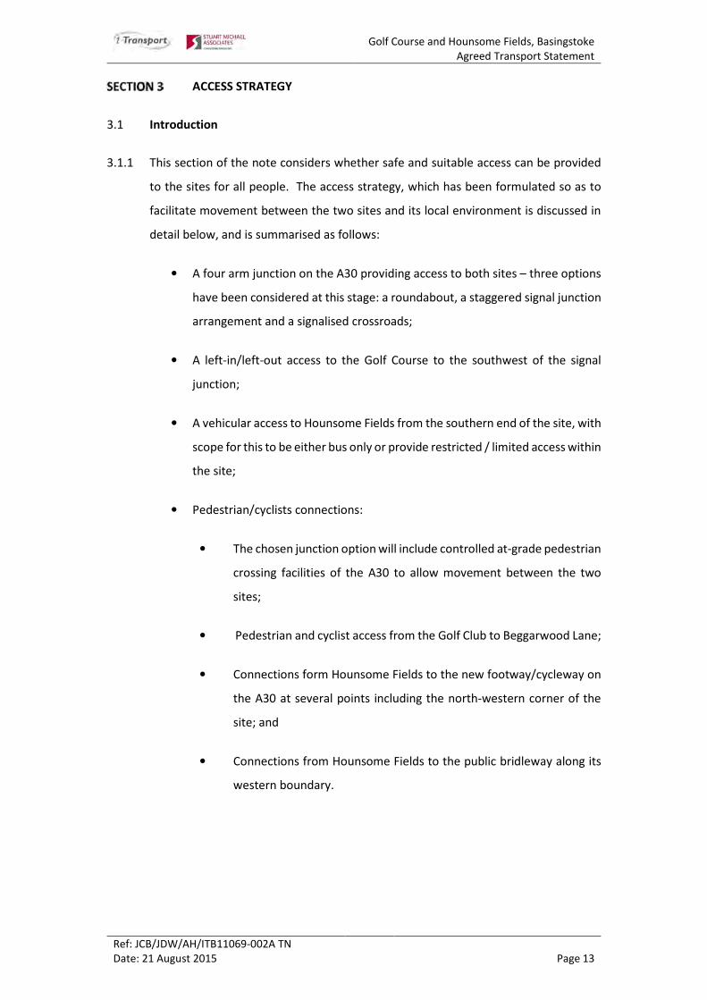
3.1 Introduction
3.1.1 This section of the note considers whether safe and suitable access can be provided
to the sites for all people. The access strategy, which has been formulated so as to
facilitate movement between the two sites and its local environment is discussed in
detail below, and is summarised as follows:
• A four arm junction on the A30 providing access to both sites – three options
have been considered at this stage: a roundabout, a staggered signal junction
arrangement and a signalised crossroads;
• A left-in/left-out access to the Golf Course to the southwest of the signal
junction;
• A vehicular access to Hounsome Fields from the southern end of the site, with
scope for this to be either bus only or provide restricted / limited access within
the site;
• Pedestrian/cyclists connections:
• The chosen junction option will include controlled at-grade pedestrian
crossing facilities of the A30 to allow movement between the two
sites;
• Pedestrian and cyclist access from the Golf Club to Beggarwood Lane;
• Connections form Hounsome Fields to the new footway/cycleway on
the A30 at several points including the north-western corner of the
site; and
• Connections from Hounsome Fields to the public bridleway along its
western boundary.

Golf Course and Hounsome Fields, Basingstoke
Agreed Transport Statement
Ref: JCB/JDW/AH/ITB11069-002A TN
Date: 21 August 2015 Page 14
3.2 Sustainable Access Strategy
Opportunity
3.2.1 As set out in Section 2, the sites are well located to take up the opportunity for
sustainable travel in a reasonable and realistic way. The main objectives of the
sustainable access strategy for the sites will be to a) seek to minimise the number of
eternal trips; and b) to maximise walking, cycling and public transport use for these
trips that cannot be contained on site.
3.2.2 The provision of on-site facilities and services (including a primary school) will help to
minimise off-site journeys. It is however accepted that many journeys will be made
off-site and it will be important to encourage and facilitate walking, cycling and public
transport use.
Walking/Cycling
3.2.3 In terms of walking and cycling, new links will be provided to connect with the good
level of existing provision in the adjacent urban area, as well as the new facilities
provided by committed development. These facilities may include a new
footway/cycleway along the A30 provided by the proposed Critical Health Hospital.
Development of the two sites provides the opportunity to deliver that link in the event
that the hospital does not come forward.
3.2.4 An audit of pedestrian and cycle routes to key destinations, including the Town Centre
will be undertaken to identify any missing links and crossing facilities. Improvements
can then be made to strengthen these routes to allow a greater take up of walking
and cycling trips for future and existing residents.
3.2.5 The proposed walking/cycling strategy is illustrated in Figure 2.2.
Public Transport
3.2.6 At this stage, two options to serve the sites have been discussed with Stagecoach and
have merit:
• The extension of services 8 and/or 12 to serve the sites – as noted in Section
2, the Critical Treatment Hospital proposes an extension of the number 8
service and making a small diversion to serve both sites will improve financial
viability and/or provide the opportunity to increase frequency; or

Golf Course and Hounsome Fields, Basingstoke
Agreed Transport Statement
Ref: JCB/JDW/AH/ITB11069-002A TN
Date: 21 August 2015 Page 15
• A dedicated service between the town centre/rail station and the south west
sites (and potentially the Critical Treatment Hospital).
3.2.7 The provision of an all moves junction serving both Hounsome Fields and the Golf
Course, along with secondary connections on to the A30, will allow buses to loop
through both sites. The aim will be to provide a 15 to 20 minute frequency service
within at least 400m of all residents, with a travel time to central Basingstoke and the
rail station of some 20 to 25 minutes.
3.2.8 The proposed bus strategy is illustrated on Figure 2.3.
Travel Plan
3.2.9 A robust travel plan will also be implemented for the two sites. This will encourage
and facilitate travel by walking, cycling and public transport use through a range of
measures. In particular, this will include provision of travel vouchers to new residents,
which can be used for purchasing season tickets; as well as Personal Travel Planning
(PTP).
3.2.10 PTP is a well-established method that encourages people to make more informed
sustainable travel choices. It seeks to overcome the habitual use of the car, enabling
more journeys to be made on foot, bike, bus, train or in shared cars. Modal shift is
achieved through a package of measures including, providing information, incentives
and motivation to individuals to identify where travel behaviour changes can be made
so that they can voluntarily make more informed travel choices.
3.2.11 PTP forms an important part of UK national and local transport policy, contributing to
the suite of tools promoted under the general heading of Smarter Choices, and is
currently being implemented across six towns in Hampshire including Basingstoke, via
the ‘My Journey Campaign’ supported through the Local Sustainable Transport Fund.

Golf Course and Hounsome Fields, Basingstoke
Agreed Transport Statement
Ref: JCB/JDW/AH/ITB11069-002A TN
Date: 21 August 2015 Page 16
3.2.12 PTP is often offered through residential travel plans to help inform new residents of
the proposed development of the travel choices available to them. Area wide PTP is
typically delivered across large residential areas, to inform existing residents of their
travel choices to ensure that they are aware of local walking and cycling routes the
quality, service patterns and frequency of bus services and other sustainable travel
options such as car sharing. Each person within the target population is encouraged
to think about how they currently travel for each of the trips they make, and to
consider how they might make those trips in more sustainable ways. This is backed
up with incentives, such as vouchers for fee bus travel.
3.2.13 Within the UK, PTP has been reported to typically reduce car driver trips by 11%
(among the targeted population) and reduce the distance travelled by car by 12%.
3.2.14 As a result of (and in addition to) reduced car use, successful PTP projects can also
deliver:
• A shift in attitude towards sustainable modes;
• Increased walking and cycling, with associated health benefits;
• Increased public transport use, making services more feasible and profitable;
• Increased viability of local shops and businesses;
• More sociable and ‘liveable’ neighbourhoods; and
• Improved local air quality and reductions in carbon emissions.
3.2.15 By applying PTP to a large number of households, the cumulative reductions in traffic
from households participating in PTP could help off-set the additional traffic
generation of the local plan sites on the highway network.
3.2.16 The My Journey programme has already undertaken some personalised travel
planning visits in Hatch Warren and Brighton Hill, on the basis that these locations
‘offer good existing walking and cycling networks and links; they are well served by
frequent high-quality bus routes connecting into the town centre; and many key
workplace, school, retail and leisure destinations are all within easy walking and
cycling distance.” Ref http://myjourneyhampshire.com/personal-travel-planning-
hampshire

Golf Course and Hounsome Fields, Basingstoke
Agreed Transport Statement
Ref: JCB/JDW/AH/ITB11069-002A TN
Date: 21 August 2015 Page 17
3.3 Vehicular Access Strategy
3.3.1 Three options for the main site access have been considered, with due regard to the
existing topography of the A30; the need to comply with the design standards set-out
in the Design Manual for Road and Bridges (DMRB); the need to provide adequate
capacity; and seeking to minimise the impact on existing trees. These options are
included in Appendix B and are as follows:
• A four arm roundabout junction, with an associated pedestrian / cycle
crossing point;
• A staggered signal arrangement, which provides the best arrangement in
terms of capacity whilst accommodating pedestrian movements internally;
and
• A signalised crossroad arrangement with pedestrian / cycle facilities which
minimises the footprint of the junction.
3.3.2 Both of the signalised junctions can be built as a standalone signalised junction, i.e.
the site can be delivered comprehensively or independently.
3.3.3 In addition to the primary access point, a secondary left-in/left-out vehicular access
to the Golf Course from the A30 is proposed.
3.3.4 A copy of the proposed junction arrangements are reproduced below:

Golf Course and Hounsome Fields, Basingstoke
Agreed Transport Statement
Ref: JCB/JDW/AH/ITB11069-002A TN
Date: 21 August 2015 Page 18
Figure 3.1: Site Access Option – 4 Arm Roundabout
Figure 3.2: Site Access Option – Staggered Signal Junction

Golf Course and Hounsome Fields, Basingstoke
Agreed Transport Statement
Ref: JCB/JDW/AH/ITB11069-002A TN
Date: 21 August 2015 Page 19
Figure 3.3: Site Access Option – Signalised crossroad Junction
3.3.5 The proposed junctions have been tested in terms of their future year capacity and
operation, and this is discussed further in Section 4.

Golf Course and Hounsome Fields, Basingstoke
Agreed Transport Statement
Ref: JCB/JDW/AH/ITB11069-002A TN
Date: 21 August 2015 Page 20
TRAFFIC IMPACT
4.1 Background
4.1.1 This section of the note provides initial traffic impact analyses. It assesses the
adequacy of the site access options; consider the future robustness of that junction in
the event that a western link road comes forward; and also considers traffic impact
issues on the main A30 corridor into the centre of Basingstoke.
4.2 Traffic Flows
4.2.1 In order to undertake a thorough and robust assessment of the operation of the site
accesses, the following has been undertaken
• Baseline traffic flows for 2024 are consistent with those recently used to
assess the Critical Treatment Hospital;
• These 2024 baseline flows include planned local plan growth (derived from
the TEMPRO database) and have been factored to allow for traffic growth to
2029, i.e. the end of the emerging Local Plan period, without any discounting
to allow for the proposed sites;
• Locally committed development (including Kennel Farm and the Long Wood
Copse Lane scheme) plus traffic generated by the Critical Treatment Hospital
have been separately allowed for;
• Traffic generation from Hounsome Fields and the Golf Course has been
derived from appropriate survey data from the TRICS trip generation
database, and verified against rates used and agreed for the recently
permitted Kennel Farm site; and
• Development trips have then been assigned to the network using the same
distribution methodology used for the approved Kennel Farm scheme
4.2.2 This future year 2029 assessment are considered robust because:
• The TEMPRO traffic growth rates have not been discounted to take account
of the permitted and planned housing – i.e. there is double counting of the
Golf Course and Kennel Farm traffic flows;

Golf Course and Hounsome Fields, Basingstoke
Agreed Transport Statement
Ref: JCB/JDW/AH/ITB11069-002A TN
Date: 21 August 2015 Page 21
• It uses trip generation rates and distribution analysis previously, scrutinised
and agreed for Kennel Farm;
• The trip rates are for private housing and make no allowance for affordable
housing provision, which generally has lower peak hour trip generation rates;
• These trip generation rates make no allowance for the impacts of any travel
plan;
• The identified trip rates are higher than those used within the Basingstoke
Transport Assessment; and
• No allowance has been made for sustainable travel interventions such as
Personalised Travel Planning on the western side of Basingstoke which is
currently being implemented through the ‘My Journey’ programme.
Operational Assessment
4.2.3 The site access options have been assessed using the computer programmes Arcady
and LINSIG. The assessment results are summarised in Table 4.1, 4.2 and 4.3 below.
Table 4.1: 4 Arm Roundabout
Morning Peak (8:00 – 9:00) Evening Peak (17:00 – 18:00)
Max RFC Queue Length Max RFC Queue Length
2029 ‘With Development’
A30 (East) 0.68 2 0.65 <1
Golf Course 0.42 <1 0.22 <1
A30 (West) 0.40 <1 0.66 <1
Hounsome Fields 0.34 <1 0.31 <1
Source: ARCADY

Golf Course and Hounsome Fields, Basingstoke
Agreed Transport Statement
Ref: JCB/JDW/AH/ITB11069-002A TN
Date: 21 August 2015 Page 22
Table 4.2: Staggered Arrangement
Arm 2029 ‘With Development’
Morning Peak Hour Evening Peak Hour
Degree of
Saturation
Mean Max.
Queue
Length
Degree of
Saturation
Mean Max.
Queue
Length
A30 (W) – Ahead 46% 8 72.6% 16
A30 (W) – Ahead + RT 49.3% 9 76.8% 18
Hounsome Fields - LT
83.9% 8 76.6% 5 Hounsome Fields - RT
A30 (E) - Ahead 85.1% 23 74.4% 17
A30 (E) – Ahead + RT 80.6% 21 76.5% 15
Golf Course – LT + RT
67.6% 6 63.8% 4 Golf Course –RT
Cycle Time 90 90
Practical Reserve
Capacity
5.8% 17.2%
Source: LINSIG
Table 4.3: Crossroads Arrangement
Arm 2029 ‘With Development’
Morning Peak Hour Morning Peak Hour
Degree of
Saturation
Degree of
Saturation
Degree of
Saturation
Degree of
Saturation
Golf Course – LT
90.2% 13 80.1% 6 Golf Course – Ahead +
RT
A30 (W) – Ahead + LT 53.5% 12 81.5% 19
A30 (W) – Ahead + RT 55.3% 13 83% 20
Hounsome Fields - LT
90.5% 11 78.3% 5 Hounsome Fields -
Ahead + LT
A30 (E) – Ahead + LT 89.8% 29 82% 18
A30 (E) – Ahead + RT 90.5% 31 81.9% 12
Cycle Time 120 90
PRC -0.6% 8.4%
Source: LINSIG
Golf Course and Hounsome Fields, Basingstoke
Agreed Transport Statement
Ref: JCB/JDW/AH/ITB11069-002A TN
Date: 21 August 2015 Page 23
4.3 Sensitivity test – Western Link Road
4.3.1 It is understood that there is a long term aspiration for a Western Link Road to be
provided between the A30 and the A339 Newbury Road. This would serve an enlarged
‘Manydown’ site and would only come forward post 2029; i.e. in the next period local
plan.
4.3.2 BDBC has advised that the Western Link Road is likely to be a high order residential
street/local distributor single carriageway road. It would be designed to
accommodate future year traffic volumes, whilst taking on board the guidance set-
out in the Manual for Streets.
4.3.3 A sensitivity test of the proposed site access has been undertaken to understand how
the proposed junction may operate in this post plan period the additional land that
can be safeguarded to accommodate future traffic movements.
4.3.4 The assessment utilises the traffic forecasts identified above, but also includes
additional traffic related to the Western Link road.
4.3.5 Data has been obtained from both the Basingstoke Transport Assessment model and
the North Hants Transport Model (NHTM) to identify a future year flow on the
Western Link Road. For robustness the data from the Hampshire Model has been
used as this represents the worse case scenario.
4.3.6 HCC have confirmed that:
• The NHTM model year is 2031;
• The 2031 model run currently includes the golf course, Kennel Farm and 7,900
dwellings at Manydown (3,400 for the first phase and 4,500 for the second
phase in the next local plan period), but currently does not take account of
Hounsome Fields.
• The indicative flows from the model for the Western Link Road suggest that
the flow will be circa 2,000 two way movements for both the morning and
evening peak hours. The split for this is circa 60% or 1,200 vehicles heading
south (i.e. onto the A30) and 40% or 800 vehicles heading north (i.e. from the
A30) in the morning peak and a reverse of this in the evening peak.

Golf Course and Hounsome Fields, Basingstoke
Agreed Transport Statement
Ref: JCB/JDW/AH/ITB11069-002A TN
Date: 21 August 2015 Page 24
4.3.7 The Western Link Road flows identified above have been added to the 2029 flows sets
and a junction assessment run to determine what additional infrastructure may be
required.
Operational Assessment
4.3.8 The analysis shows that the following amendments are likely to be needed to
accommodate the additional traffic in the event that a Western Link Road comes
forward.
Roundabout junction
• A two lane approach on the Western Link Road with a Flare.
Signal junction
• Providing a double right turn lane from the golf course, with the ahead
movement from nearside lane; and/or
• Extending the right turn lane on the A30 east; and/or
• Providing extended and additional lanes at the Hounsome Fields entrance to
allow double turning lanes for both left and right turns; and/or
• Increasing the signal cycle time.
4.3.9 The masterplan for the Hounsome Fields site will take account of the land required to
deliver these amendments. This land can be secured as highway land, to allow the
junction to be upgraded at such time as additional capacity may be required.
4.3.10 By way of an example, a plan showing the enlarged envelope of the roundabout and
signal arrangement is included in Appendix B.
4.4 A30 Corridor
4.4.1 The Borough Council strategic level Transport Assessment (TA) has been produced to
inform and guide both the draft Local Plan and the supporting Infrastructure Delivery
Plan (IDP).

Golf Course and Hounsome Fields, Basingstoke
Agreed Transport Statement
Ref: JCB/JDW/AH/ITB11069-002A TN
Date: 21 August 2015 Page 25
4.4.2 The Findings from the Basingstoke Transport Assessment Ninth Edition (February
2015) include both Hounsome Fields and the Golf Course and these findings have
been endorsed by Hampshire County Council as the Local Highway Authority, as set
out in the Position Statement on the Transport Assessment to Support the Draft
Basingstoke and Deane Local Plan 2011 – 2029, which states that:
“Both the Borough Council and HCC recognise that the spreadsheet
model can only represent a high level approach to assessing future
traffic flows, and that this approach has its limitations. Nevertheless,
the approach has been endorsed by HCC and was the best methodology
available at the time. “
4.4.3 And that:
“… the authorities are content that this strategic model is sufficiently
robust to assess the impact of development….”
4.4.4 The Basingstoke TA therefore includes a robust study of the local highway network
and particularly the A30 corridor. The position statement goes on to set out that:
“The TA sets out a proposed package of measures, which is reflected in
the Local Plan and IDP, to mitigate the impact of the additional traffic
generated. The package concentrates on a number of key junctions in
and around Basingstoke, where the Local Plan traffic levels are 10%
above the reference case. Junctions which are already scheduled for
improvement (including the A33 and A340 corridors and Black Dam,
Brighton Hill, Thornycroft and Winchester Road roundabouts) were
excluded on the basis that these schemes will provide adequate
capacity for growth in the plan period. These junction/corridor
improvements are jointly funded by the Enterprise M3 Local Enterprise
Partnership (LEP), developer contributions and the Borough and
County Councils. These major schemes are planned for phased
implementation over the next five years.”
4.4.5 The position statement goes on to state that:
“This joint statement recognises, notwithstanding some specific
concerns over elements of the methodology, that both local authorities
consider that overall the TA is for fit for purpose as a strategic
assessment of the traffic impacts of the proposed Local Plan
development. Both parties are broadly content with the findings and
agree that the level and location of development proposed in the draft
Local Plan can be accommodated at the strategic level with the
required package of mitigation and that the development scenario is
unlikely to result in severe cumulative impacts on traffic congestion on
key routes.”
Golf Course and Hounsome Fields, Basingstoke
Agreed Transport Statement
Ref: JCB/JDW/AH/ITB11069-002A TN
Date: 21 August 2015 Page 26
4.4.6 The Brighton Hill, Winchester Road and Thornycroft roundabouts are key junctions on
the A30 corridor between the site and the Town centre, and as identified above
improvement schemes which will provide adequate capacity for growth in the plan
period have been identified and funding secured.
4.4.7 The TA also identifies mitigation measures to accommodate planned growth and
Hounsome Fields and the Golf Course at the following A30 junctions:
• A30 / Wallop Drive Roundabout and
• The A30 Kempshott Roundabout
4.4.8 With mitigation, both of these junctions are shown to have sufficient and even spare
capacity in the future year 2029 assessment.
4.4.9 Table 4.3 summarises mitigation proposals which could be implemented along the
A30 corridor, and which the proposed sites could contribute towards as part of their
off site mitigation package.

Golf Course and Hounsome Fields, Basingstoke
Agreed Transport Statement
Ref: JCB/JDW/AH/ITB11069-002A TN
Date: 21 August 2015 Page 27
Table 4.3: Mitigation of Impacts on the A30 Corridor
Location Issues and Impact of Local Plan Proposed Mitigation
A30 / Wallop
Drive
Roundabout
Operates well in the 2012 and 2029
Base scenarios. With the addition
of Local Plan development traffic
the A30 northbound and
southbound arms are forecasted to
be over capacity in the AM and PM
peaks respectively.
Convert roundabout to a signalised
Junction;
Add or lengthen flares on all
entries
A30
Kempshott
roundabout
approach
Widen 750m of A30 southbound
carriageway up to Kempshott
roundabout
A30 /
Kempshott
Roundabout
A30 northbound and southbound
arms predicted to be over capacity
in 2029 Reference Case scenario.
The addition of Local Plan
development causes further rise in
the RFC for A30 northbound and
southbound.
Signalise the roundabout
Add or lengthen flares on all
entries
Widen the circulatory
Brighton Hill
Roundabout
Significantly over-capacity in the
2029 Reference case. Without any
improvements the roundabout
cannot accommodate the demand
in the Local Plan scenarios.
Amendments based on a signalised
‘Hamburger’ design provided by
BDBC
Winchester
Road
Roundabout
The Winchester Road westbound
approach operates over capacity in
the 2029 reference case scenario.
With the addition of the 2029 Local
Plan traffic all arms operate over
capacity in either the AM or PM
peaks.
HCC Widening and Signalisation
Scheme
Source: BDBC TA V9 and Hantsweb
4.4.10 In respect to M3 Junction 7, the Basingstoke TA(at Para 3.7.9) concludes that:
“The junction is shown to have sufficient reserve capacity to cope with
the worst case scenario where all A30 traffic reroutes onto the M3.
Therefore, it is not necessary for any mitigation measures to be
proposed in this transport assessment for Junction 7.” (para 3.4.9)

Golf Course and Hounsome Fields, Basingstoke
Agreed Transport Statement
Ref: JCB/JDW/AH/ITB11069-002A TN
Date: 21 August 2015 Page 28
SUMMARY AND CONCLUSIONS
5.1 Summary
5.1.1 This note has been produced jointly by Stuart Michael Associates (on behalf of the
Golf Course site) and i-Transport LLP (on behalf of Hounsome Fields) to provide a high
level transport appraisal of the proposed residential-led development of both sites.
The note demonstrates how both sites can come forward with a comprehensive and
complementary transport strategy. The note also assesses the sites against the key
transport tests set out in paragraph 32 of the NPPF.
Can the opportunities for sustainable travel be taken up in a reasonable and realistic
way?
5.1.2 The simple answer to this is yes. The in-principle acceptability of residential
development in this area is well established, and the sites are well located to existing
facilities and services and will bring forward additional facilities – two local centres
and a new primary school – that will improve the transport sustainability of the local
area.
5.1.3 There is a good network of pedestrian and cycle routes in the existing urban area, and
these will be improved by committed and proposed development. For example, the
proposed Critical Treatment Hospital scheme will provide a new footway/cycleway
along the A30 past the sites (noting that this can be delivered by development of the
sites if the hospital does not come forward).
5.1.4 The walking and cycling strategy for the sites will appropriately ‘take up’ the
opportunities. The sites will be connected to the walking/cycling network to facilitate
sustainable local journeys. They will also be connected with each other – the design
of the proposed site access has considered the need to provide at-grade
pedestrian/cycle crossing facilities to allow walking and cycling between the two sites,
especially to provide sustainable connections from the Golf Course to the primary
school on the Hounsome Fields site.

Golf Course and Hounsome Fields, Basingstoke
Agreed Transport Statement
Ref: JCB/JDW/AH/ITB11069-002A TN
Date: 21 August 2015 Page 29
5.1.5 There is a very good level of bus service in the existing urban area – a near ‘turn up
and go’ level of frequency. The new hospital proposes to extend frequent buses along
the A30 corridor past the sites. Either in conjunction or independently of this
proposal, the access strategy for the sites will allow buses to make a short diversion
to loop through the sites. The aim will be for new residents to be located within 400m
for the bus services and for these serves to operate on a circa 15- to 20-minute
headway.
5.1.6 In addition, comprehensive travel plans will be implemented and there is the
opportunity for Personalised Travel Planning, which demonstrably reduces the
amount of traffic generated by new housing. It is noted that the combined scale of
development (1,750 dwellings) provides significant ‘economies of scale’ in Travel
Planning terms.
Will safe and suitable access be achieved for all people?
5.1.7 The provision for walking, cycling and public transport connectivity is set out above –
safe and suitable access will be achieved for those modes.
5.1.8 In terms of the principal vehicular access to the sites, both include very long frontages
with the A30 and therefore there are numerous options to achieve safe and suitable
vehicular access. At this stage, three options have been designed allowing for local
constraints and in compliance with the relevant design guidance:
• A four arm roundabout;
• A staggered signalised arrangement incorporating at-grade pedestrian/cyclist
crossings; and
• A crossroads arrangement, again incorporating at-grade pedestrian/cyclist
crossings.
5.1.9 All options have been robustly tested and will provide an acceptable level of operation
at the end of the local plan period.
5.1.10 On this basis, safe and acceptable vehicular access can also be realistically achieved.

Golf Course and Hounsome Fields, Basingstoke
Agreed Transport Statement
Ref: JCB/JDW/AH/ITB11069-002A TN
Date: 21 August 2015 Page 30
Will the residual impact be severe?
5.1.11 In terms of the site access arrangements, adequate capacity will be achieved at the
site accesses. In addition, land can be safeguarded around the junction to allow for
upgrading to cope with increased traffic demands resulting from the potential delivery
of a Western Link Road connecting the A339 with the A30 via the Hounsome Fields
site in the next local plan period.
5.1.12 In terms of wider traffic impacts, the strategic Transport Assessment produced by
Parsons Brinkerhoff identifies a series of interventions along the A30 corridor
between M3 Junction 7 and the town centre. These set out how additional traffic
demands of the local plan allocations can be mitigated. In addition, a comprehensive
mitigation scheme has been identified by HCC and funding secured at the Brighton
Hill roundabout, which is the main capacity constraint on the A30 corridor. Whilst it
is accepted that further design and associated modelling work is needed – this is
inevitable with a strategic level Transport Assessment – it is clear that suitable
interventions are a) achievable and b) deliverable. Development of the sites provides
the opportunity for the junction improvements on the A30 corridor to be realised.
5.2 Conclusion
5.2.1 Against this background, the Golf Course and Hounsome Fields sites a) provide
reasonable and realistic opportunities for sustainable travel to be taken up; b) can
achieve safe and suitable access for all people; and c) will not have a severe residual
impact.

FIGURES

KENNEL FARM (CONSENTED)
SS3.11 GOLF COURSE SITE
M3 JUNCTION 7
SS3.12 HOUNSOME FIELDS
PROPOSED HOSPITAL SITE
M3
BEGGARWOOD LANE
LONG WOOD COPSE LANE
A30 WINCHESTER ROAD
FILE REF: REV:
ITB11069 -
TITLE:
FIGURE No:
Grove House, Lutyens Close, Chineham Court, Basingstoke, RG24 8AG
Tel: 01256 338 640Fax: 01256 338 644
www.i-transport.co.uk
HOUNSOME FIELDS/GOLF COURSE, BASINGSTOKE
SITE LOCATION PLAN
FIGURE 1.1
Reproduced from ordnance survey by the permission of the controller of her majestys stationery office. Crown copyright. All rights reserved. Licence number 100022432

KEY
1L2L3L4L5L6L7L8L9L
1R
3R
4R
2R
1
ED2
ED
BASINGSTOKE MOTORCYCLES
CO-OP
HATCH WARREN RETAIL PARK
SAINSBURY’S, MOTHER CARE & GOLF CENTRE
GOLF COURSE LOCAL CENTRE
HOUNSOME FIELDS LOCAL CENTRE
PORTSMOUTH ARMS
PLAYING FIELDS
COMMUNITY CENTRE
DUMMER GOLF COURSE
BEGGERWOOD LOCAL CENTRE INCLUDING: - CO-OP - NURSERY - DOCTOR SURGERY - DENTIST - PHARMACY - ESTATE AGENTS
DUMMER, A WYEVALE GARDEN CENTRE
ST MARKS CofE SCHOOL
2km ISOCHRONE
COUNCIL DEPOT
HATCH WARREN PRIMARY SCHOOL
HATCH WARREN COMMUNITY CENTRE
1
E
2L
9L
1L
3L
4L
5L
1R
2R
3R
1
ED
2
ED
KENNEL FARM (CONSENTED)
SS3.11 GOLF COURSE SITE
SS3.12 HOUNSOME FIELDS
PROPOSED HOSPITAL SITE
6L
7L
8L
1
E
FILE REF: REV:
ITB11069 -
TITLE:
FIGURE No:
Grove House, Lutyens Close, Chineham Court, Basingstoke, RG24 8AG
Tel: 01256 338 640Fax: 01256 338 644
www.i-transport.co.uk
HOUNSOME FIELDS/GOLF COURSE, BASINGSTOKE
LOCAL FACILITIES PLAN
FIGURE 2.1
Reproduced from ordnance survey by the permission of the controller of her majestys stationery office. Crown copyright. All rights reserved. Licence number 100022432

SS3.12 HOUNSOME FIELDS
EXISTING FOOTPATH (PROW)
BRIDLEWAY
PEDESTRIAN LINK (PROPOSED BY HOSPITAL DEVELOPMENT)
OFF ROAD CYCLE LINK
PROPOSED OFF ROAD/SHARED USE CYCLE LINK
EXISTING FOOTPATH & PROPOSED OFF ROAD/SHARED USE CYCLE LINK
ON ROAD CYCLE LINK
PEDESTRIAN IMPROVEMENT SECURED BY KENNEL FARM
2km ISOCHRONE
PEDESTRIAN/CYCLE ACCESS
PEDESTRIAN/CYCLE ACCESS
SS3.11 GOLF COURSE SITE
KENNEL FARM (CONSENTED)
PROPOSED HOSPITAL SITE
FILE REF: REV:
ITB11069 -
TITLE:
FIGURE No:
Grove House, Lutyens Close, Chineham Court, Basingstoke, RG24 8AG
Tel: 01256 338 640Fax: 01256 338 644
www.i-transport.co.uk
HOUNSOME FIELDS/GOLF COURSE, BASINGSTOKE
PEDESTRIAN AND CYCLE CONNECTIVITY
FIGURE 2.2
Reproduced from ordnance survey by the permission of the controller of her majestys stationery office. Crown copyright. All rights reserved. Licence number 100022432

EXISTING BUS ROUTE 8 (15 MINUTE FREQUENCY)
EXISTING BUS ROUTE 12(HOURLY FREQUENCY)
PROPOSED SOUTH-WEST BASINGSTOKE SERVICE
KENNEL FARM (CONSENTED)
SS3.11 GOLF COURSE SITE
SS3.12 HOUNSOME FIELDS
PROPOSED HOSPITAL SITE
TO BASINGSTOKE
FROM BASINGSTOKE
FILE REF: REV:
ITB11069 -
TITLE:
FIGURE No:
Grove House, Lutyens Close, Chineham Court, Basingstoke, RG24 8AG
Tel: 01256 338 640Fax: 01256 338 644
www.i-transport.co.uk
HOUNSOME FIELDS/GOLF COURSE, BASINGSTOKE
BUS ROUTE PLAN
FIGURE 2.3
Reproduced from ordnance survey by the permission of the controller of her majestys stationery office. Crown copyright. All rights reserved. Licence number 100022432
APPENDIX A Basingstoke Cycle Map

Basin
gsto
ke C
yCle n
etwo
rk
Basingstoke Cycle Network map.indd 1 18/05/2012 15:08

APPENDIX B Site Access Options
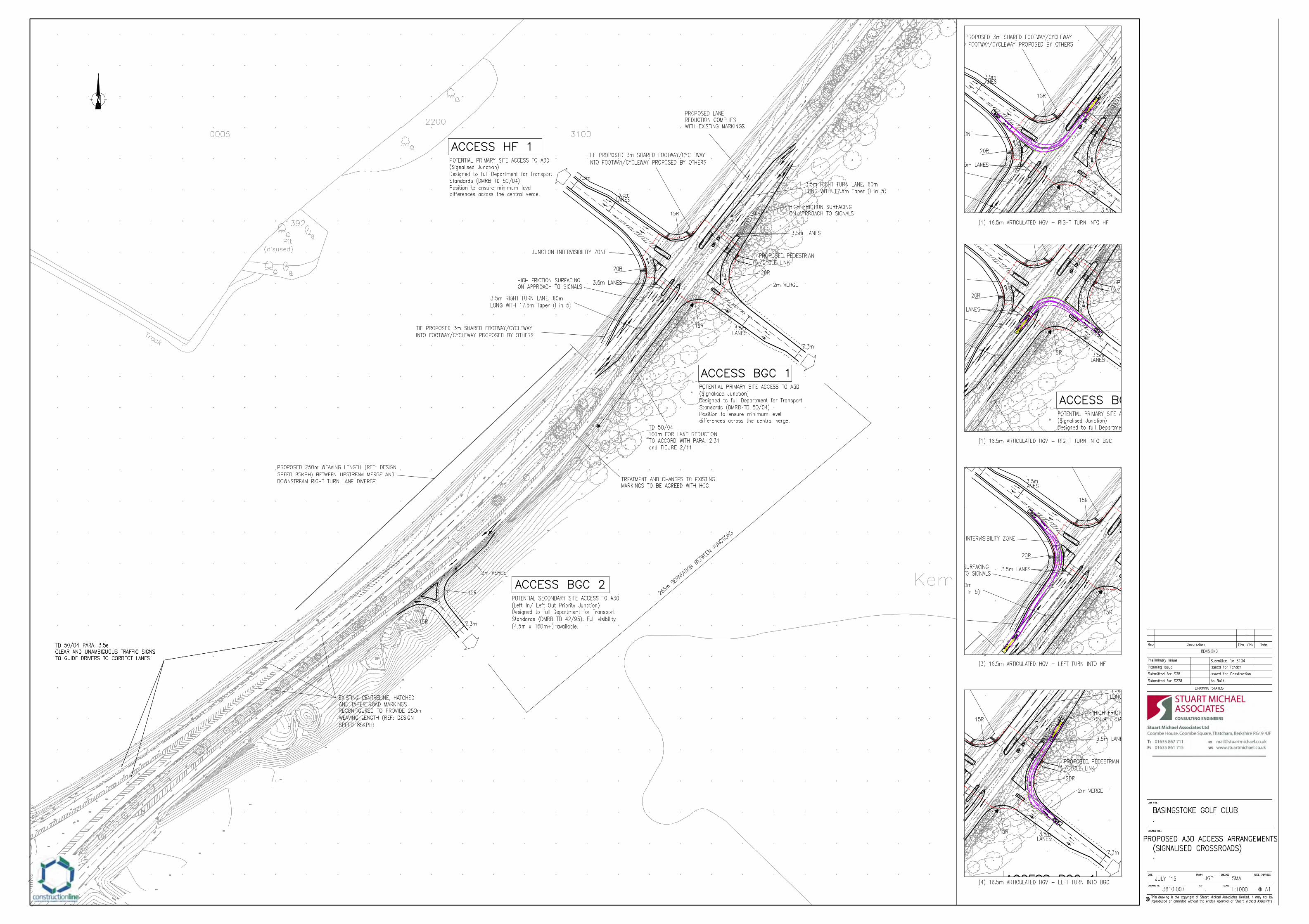

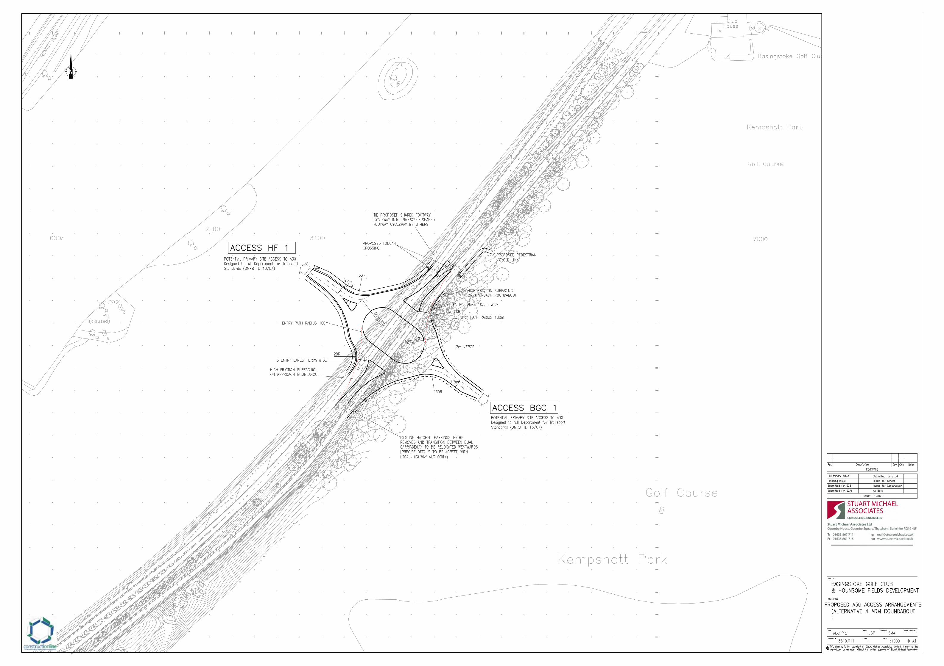


Recommended