Prof. Stephen Briggs
European Space Agency
ISRSE, Tshwane
10 May 2017
Satelite observations contributing to
global change science and policy

Credit: Victor & Kennel, Nature Climate Change, 2014.
The importance of observations………

First image of the Earth from space

1990 1996 2000 2004 2008 2012
50
0
-50
-100
-150
-200
-250
-300
-350
Ice
mas
s lo
ss (
Gt/
yr)
-400
Previous surveys: Antarctica
imbie
Gravimetry
Radar Altimetry
Interferometry
Laser altimetry
1mm

50
0
-50
-100
-150
-200
-250
-300
-350
1990 1996 2000 2004 2008 2012
Ice
mas
s lo
ss (
Gt/
yr)
-400
Previous surveys: Greenland
imbie
Gravimetry
Radar Altimetry
Interferometry
Laser altimetry
1mm

ESA-NASA IMBIE Initiative

1987 1992 1997 2002 2007 2012
0
Combined
Greenland
Antarctica
Increased ice sheet mass losses
10
8
6
4
2
12
0.27 mm per yr
0.95 mm per year
imbie
Sea
leve
l co
ntr
ibu
tio
n (
mm
)

CryoSat: Yearly Ice Loss in Greenland
Courtesy: Helm et al. (2014)
Digital Elevation Model
2003-2008 2011-2012
IMBIE CryoSat
-189±20 km3/yr
-352±29 km3/yr

• Unique (first ever) combination of S1A stripmap and TerraSAR-X SAR data
provides first map of Austfonna ice speed in 2014
• Data show that glacier at Cap Mohn has experienced a rapid acceleration
Ice Speed (kilometres per year)
0 4
1995 (ERS) 2008 (ALOS) 2014 (TSX-S1)
Credit: N. Gourmelen, University of Edinburgh
Sentinel-1A: Svalbard Ice Cap

Slide 10
Sea Ice Thickness from SMOS
Copyright:University of Hamburg

Slide 11
SMOS & Cryosat: Expanding HorizonsCopyright: AWI

Arctic sea ice 2016-2017

Arctic Sea Ice Volume 1979-2017

Polar shipping summer 2014

Glacierarea
Inventory
Elevation change
dh/dttrendsfrom
altimetry
mean changes fromDEM differencing
Velocity
DisplacementVectors
Glacier products

Surface albedo from geostationary satellites
MODIS
Lattanzio A.; et al., 2013:
Land Surface Albedo from Geostationary
Satellites: a multi-agency collaboration
within SCOPE-CM, 2013.
Bulletin of the American Meteorological
Society.
Geo Sats
Geostationary satellites have
better temporal sampling, hence a
higher probability to obtain a clear
sky view

7/31/201717

Climate Impact on Marine Ecosystem StateImpact of El Niño variability on ocean primary producers
Impact on Phytoplankton Indicators:• Chlorophyll• Primary Production• Phenology (bloom timing, growth duration)
Change in forcing:• Climate Index• El Niño variability
Primary Production
0
+10
-10
% change
Growth duration
0
+50
-50
% change
Racault et al., In prep. ESA Living Planet Fellowship 2015-2017 Capotondi et al., JAS 2014
Eastern Pacific El Niño
Central Pacific El Niño
The impact on ocean primary producers is different in different regions for the two types of El Niño

ENVISAT
ENVISAT vs Sentinel 1A
Sentinel 1A+B
ENVISAT vs. Sentinel-1 coverage of flood prone area : the Danube river (5-day simulation)

Ozone layer depletion recovering
Ozone hole
Montreal Protocol outcome
Slightly positive trend of
global ozone increase of
almost 1% per decade in the
total ozone from the last 14
years(result confirmed by comparisons with
ground-based measurements)

Mean sea level rise(ESA CCI/CLS/LEGOS)

Global SLR (+/- 10mm variation about mean) (ESA Climate Change Initiative)

Sea Surface Temperature- ESA Climate Change Initiative

ESA/PB-EO/166/RoomDoc(2016)21
UNFCCC Paris Agreement 2015

COP-21 and relevanace to ESA EO programmes | Slide 26ESA UNCLASSIFIED - For Internal Use
Perception?
asdfssdfsadfasdfsdf

UNFCCC Paris Agreement–How can observations support the Agreement
• Support stocktaking methods by provision of anthropogenic
emissions data – CO2, land use change, etc…
• Support mitigation measures e.g. REDD+, land use change
• Provide improved indicators of change and support definition of
risk factors and indicators
• Guide future policy by providing data on effectiveness
of implementations of adaptation measures
• Continue to provide data to support disaster risk reduction
• Support indicators and targets of Sustainable Development Goals
related to climate change (many of them)
• Further support research in climate change by enhanced data
provision and support development of climate services
• Etc..
• BUT be cautious about ensuring political leadership


OCO-2 CO2 concentrations (NASA-JPL)

Atmospheric Methane (CH4) is Increasing
• Third most abundant greenhouse gas after H2O and CO2
• Grown by 150% since pre-industrial era (in 1750 it was 700 ppb)
• Less abundant than CO2 but more efficient as a greenhouse gas
• Relative to CO2 it contributes about 60% in terms of radiative forcing

Source World Economic Forum Global Risks Report 2016 Copyright World Economic Forum 2016
http://www.weforum.org/reports/the-global-risks-report-2016
Global Risks Landscape 2016
Failure of
climate-change
mitigation and
adaptation

Source World Economic Forum Global Risks Report 2017 Copyright World Economic Forum 2016
http://www.weforum.org/reports/the-global-risks-report-2017
Global Risks Landscape 2017
Extreme Weather
&
Natural Disasters

Increased likelihood of 2003 European heatwave due to anthropogenic change (Christidis et al. 2015)
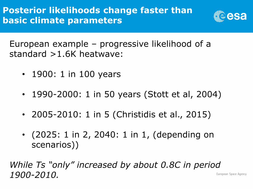
Posterior likelihoods change faster than basic climate parameters
European example – progressive likelihood of a standard >1.6K heatwave:
• 1900: 1 in 100 years
• 1990-2000: 1 in 50 years (Stott et al, 2004)
• 2005-2010: 1 in 5 (Christidis et al., 2015)
• (2025: 1 in 2, 2040: 1 in 1, (depending on scenarios))
While Ts “only” increased by about 0.8C in period 1900-2010.

Normalised future summer temperature anomalies (ibid.)

Non-linear dependence of specific outcomes (King et al. 2015)

COST OF MORTALITY OF PM2.5 EXPOSURE

OMI, 2007 OMI, 2008
NO2 reductions detectedfrom space during the 2008Beijing Olympic GamesMijling et al., Geophys. Res. Lett. (2009)
Monthly OMI NO2over Beijing
Witte et al. (2009)

Climate observations and data
analytics
Requires plentiful data, datasets as complete as
possible
all data items must to be tagged with a unique identifier
(x,y,z,t,…..) together with specific information
May be helpful when processes are too complex to be
modelled, or even unkown, and when data structures
are not a priori identifiable
Can in some cases examine questions relating to
societal risk much better than Bayesian methods
Show promise
Test: can analytics techniques (re)discover known
structures in data, and hence known causal relationships
in relation to climate impacts?
Recommended