Gwinnett County Planning Division Rezoning Application
Last Updated I 2/20 I 5
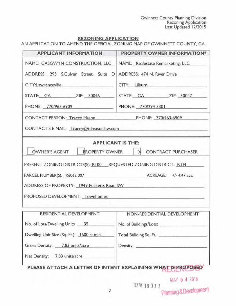
REZONING APPLICATION AN APPLICATION TO AMEND THE OFFICIAL ZONING MAP OF GWINNETT COUNTY, GA.
.APPLICANT INFORMATION PROPERTY OWNER INFORMATION*
NAME: CASGWYN CONSTRUCTION. LLC NAME: Realestate Remarketing. LLC
ADDRESS: 295 S.Culver Street. Suite D ADDRESS: 474 N. River Drive
CITY: Lawrenceville CITY: Lilburn
STATE: GA ZIP: 30046 STATE: GA ZIP: 30047
PHONE: 770/963-6909 PHONE: 770/294-330 I
CONTACT PERSON: Tracey Mason PHONE: 770/963-6909
CONTACT'S E-MAIL: [email protected]
APPLICANT IS THE:
[]wNER'S AGENT DROPERTY OWNER [] CONTRACT PURCHASER
PRESENT ZONING DISTRICTS(S): RIOO REQUESTED ZONING DISTRICT: RTH
PARCEL NUMBER(S): R6062 007 ACREAGE: +/- 4.47 acs.
ADDRESS OF PROPERTY: 1949 Pucketts Road SW
PROPOSED DEVELOPMENT: Town homes
RESIDENTIAL DEVELOPMENT NON-RESIDENTIAL DEVELOPMENT
No. of Lots/Dwelling Units _..:...;35=------ No. of Buildings/Lots: _______ _
Dwelling Unit Size (Sq. Ft.): 1600 sf min. Total Building Sq. Ft. _______ _
Gross Density: _..!.....:7 .'-=83=---=-:u n..!.!.Cit=s/-=-ac"'-'-r-=-e ___ _ Density: ___________ _
Net Density: 7.83 units/acre
PLEASE ATTACH A LETTER OF INTENT EXPLAINING WH
MAY 0 4 2018 RZM '18 011
2 Plann\ng & Deve\opment
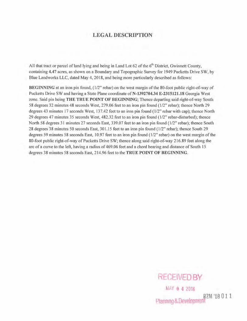
LEGAL DESCRIPTION
All that tract or parcel of land lying and being in Land Lot 62 of the 6111 District, Gwinnett County,
containing 4.47 acres, as shown on a Boundary and Topographic Survey for 1949 Pucketts Drive SW, by
Blue Land works LLC, dated May 4, 2018, and being more particularly described as follows:
BEGINNING at an iron pin found, (1/2" rebar) on the west margin ofthe 80-foot public right-of-way of
Pucketts Drive SW and having a State Plane coordinate ofN-1392704.34 E-2315121.18 Georgia West
zone. Said pin being THE TRUE POINT OF BEGINNING; Thence depatiing said right-of-way South
58 degrees 32 minutes 48 seconds West, 279.06 feet to an iron pin found (1/2" rebar); thence North 29
degrees 43 minutes 17 seconds West, 137.42 feet to an iron pin found (1/2" rebar with cap); thence Notih
29 degrees 47 minutes 35 seconds West, 482.32 feet to an iron pin found (1/2" rebar-disturbed); thence
Notih 58 degrees 31 minutes 27 seconds East, 339.07 feet to an iron pin found (1/2" rebar); thence South
28 degrees 3 8 minutes 50 seconds East, 301.15 feet to an iron pin found ( 1/2" rebar); thence South 29
degrees 59 minutes 58 seconds East, 10.97 feet to an iron pin found (1/2" rebar) on the west margin of the
80-foot public right-of-way ofPucketts Drive SW; thence along said right-of-way 216.89 feet along the
arc of a curve to the left, having a radius of 469.06 feet and a chord bearing and distance of South 15
degrees 38 minutes 58 seconds East, 214.96 feet to the TRUE POINT OF BEGINNING.
RECEIVED BY MAY 0 4 2018
RZM '18 0 11 Planning & Development

,Ot
=
.I '3
li>'JS
c~
(f)
,/
/'
w
a§" 0::
h~i 0 1
ca~~ 1
'-;~~
"<:t ..,f
MAY 0 4 2018
Plann\na & Deve\opment

IC a...c:.:orOJfle lrt I!JOTIOWruat [I..[VATION
D• IIOTlOWOTW"'-1.
1/l IIUUl....CUH(
C/l CCNTC!t\.DIC
C'Mf CDCJ!tlt\&OO<IAC:NlfCUioO CliP C:Citti\.CA.ltOWrTALI"'I'( CSP c:tJIII'ItL,C4l(DSlttl."'l
cac o.«~a(;IJnct Cl'f ata.U''ICPF'OUIIO
DC tMtJI.VU.CC(A!OI:WCH'T
Dl" D..CTU~I'PC D.c::a OCLOI..CWN:C#>TO<DI<:I" ~ CDCCO(P.o.YD.o[OIT
rc rAr:c.orcu~~t~
m fNSHCtlflO()III[L(VAl~
rc-;. n . .o.ll[l)o.o~cnCtrol
CONN CCOitQAI'O..o loiAN-!!II..[
tCII'C !1101DCHSITYPCI.l'Cl11Tli:Nt
((DSJ).ICSTIJIW rnlJCMt)
N/F t.IR PARKER CENTER, lP 24J5 N CENTRAL EXPWY 1650
RIOiAROSON TX 75060 PARCEl R6062 2J2
DEED 8~~~;9~/AGE 17
z'
~~
~~
~
IIICIIII"'"2:l•I/2•I!CaAII rllftlCAl'IONCOolfJI'Cl.VAL'I(
D.Jn.!T~ll'tQ.!ili!UClVft(
ii'O'fiCit/T(lD'H()N[POI.J:
IIIOMfOitttOctiHCJIICT[~
111/W ftlCHT •OI'•WA 'I' ~ ::,.t.MUJitT:;tw(II[A~Nl
~11 :;.AHTAII'T7-cltWAHI11).( $we!~ SIJ<CU WU<C. CATCHilA!.IN ';.fW ~WAU
1POI TliiU(,ONl0TDI[ClNNIN(;
'-..... -- • OltAH01/tMtC
- ··· - •v.HDLOTlNI:
-s-• =:.toNilAII'T~WCtUNC
==• ~Ofhol()ltAINA(;{UN(
-1--1-• ltUI'oO<a.!C
.......,._ ... lb'WCIII2: uO<[/f'CINT
"""""""
(Jl51NCISrul£SAI(~rotTKCD111Ut'TCJn t:OIIVOIOCI:I>&.T. TI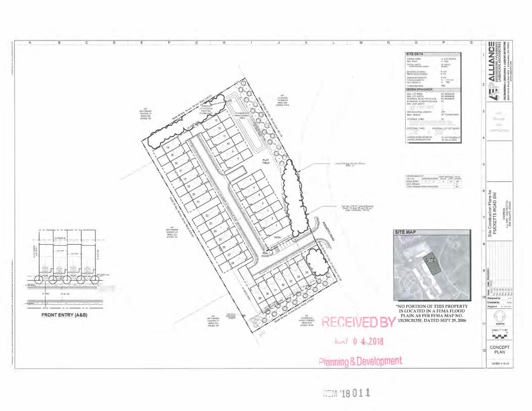
A L__B '--- _c _ _j_
-_[ ~~~.fn~l:l--'-~ ~~ ~§
I SO' IRIW 2i 'BC-BC
·~J~-- - -~ ------
FRONT ENTRY (A&B)
D L
,_,··
NIF MRPARKER CENTER LP 116002232
ZONED M1
,/
\
J
·,. \ .\ \\ . \
\
_j G
\\ . \
\ \\ \ ~ ·. \
\ \ \\ ~.
\\ MRP~~KER ~ •. \
CENTER LP %\ -\, 116062253 -~ · '
ZONED M1 • .,•
_j
\
""' JOHNSON THOMASD 116062006
_j
ZONED R100
K
\.~.(~
..,, .....
\.\ \ \ \
\ /
·., "b - \ \ \ ,sc~<f/.' 1i;;i-4 reJ> --.
•. ', \. tis k-~<C.~-... ~ • ~e:~e""' ' , ~ s . . 7-'~w>4·~-o""
~l~ff,~ ~~r~~ --~~t~~;~;~:c~,,~,o "'~f~~~~" ZONED Ml '· 1t_~'C: ... ~~·./ ZONED R1 00 . /
\.•' C) C)"\
\
South29deg 42m•n 39sec Eas1 , 11'
SITE DATA I GROSS AREA NET AREA
TOTAL UNITS
EXISnNG ZONING PROPOSED ZONING
MAXIMUM DENSITY GROSS DENSITY NET DENSITY
DESIGN STANDARDS
• /- 1147ACRES •1- TBD
35UNlTS
R-\00 R-TH
BUIA •I· 7 83U/A •/- TBD
---------------MIN LOT AREA MIN LOT WIDTH INTERNAL ROAD FRONTAGE EXTERNAL ROAD FRONTAGE MI N UNIT WIDTH
r-;,·~:~(.-::.:-;:~·"/ 11·.,_: ;::· ,';/
LANDSCAPED SETBACK LANDSCAPED BUFFER
NO MINIMUM NO MINIMUM NO MINIMUM so·
;:
200'
50' AT FRONTAGE 35'ASSHOWN
I PAA<I"O~LY~s I'm'~ ~:~E~TRY ~~~O,D~~4Y H~~E l~:~ ~~:~E~ AOO'LPARKING 6
TOTAL PARKING$>A.CESPROVIOEO H6
As~~~~~t§cg~p; ~~r~~,&~~~~g
CEIV
SITE MAP
*NO PORTION OF TillS PROPERTY IS LOCATED IN A FEMA FLOOD PLAIN AS PER FEMA MAP NO. 0 By 13135C0135F, DATED SEPT 29, 2006
i>t .. -d 0 4,>()2018
Ptanning & Oeve1opment
~=~:~q '18 0 11
Ill~~ [J~~
~ §
11 z~~ ~ · ~ ~C) <~; -zw
i M
~ ~ w .2
I I§ i ~i ..J::l ~ . wu
_.z~
~iS~ ~ ~5
~ ~ ~
21 Lrl1::, ~ ~ ~ i ~ ill"
~' ~ ~ ~ ~
91~ "Si ~ ~
11 ~ t t ~ t ~ t t a:a:a:a:a:a::a: n~~.-~~"'
101 Ooslgnod by
12
Chocked by
Pl'1)joct# 7?. ?77.???
~1 ~
CONCEPT PLAN
DATED 1-18-18
Gwinnett County Planning Division Rezoning Application
Last Updated 12/2015
REZONING APPLICANT 'S RESPONSE STANDARDS GOVERNING THE EXERCISE OF THE ZONING POWER
PURSUANT TO REQUIREMENTS OF THE UNIFIED DEVELOPMENT ORDINANCE, THE BOARD OF COMMISSIONERS FINDS THAT THE FOLLOWING STANDARDS ARE RELEVANT IN BALANCING THE INTEREST IN PROMOTING THE PUBLIC HEALTH, SAFETY, MORALITY OR GENERAL WELFARE AGAINST THE RIGHT TO THE UNRESTRICTED USE OF PROPERTY AND SHALL GOVERN THE EXERCISE OF THE ZONING POWER.
PLEASE RESPOND TO THE FOLLOWING STANDARDS IN THE SPACE PROVIDED OR USE AN ATTACHMENT AS NECESSARY:
(A) WHETHER A PROPOSED REZONING WILL PERMIT A USE THAT IS SUITABLE IN VIEW OF THE USE AND DEVELOPMENT OF ADJACENT AND NEARBY PROPERTY: This townhome development serves as a transitional use between the industrial property to the north
and to the west and the less dense residential property to the south.
(B) WHETHER A PROPOSED REZONING WILL ADVERSELY AFFECT THE EXISTING USE OR USABILITY OF ADJACENT OR NEARBY PROPERTY: This property currently contains a single family home and vacant land which the owner understands will be developed. We do not anticipate
that this townhome neighborhood will adversely affect the industrial property to the north and west or the residential property to the south,
as we have approached those homeowners who are not opposed to this development.
(C) WHETHER THE PROPERTY TO BE AFFECTED BY A PROPOSED REZONING HAS REASONABLE ECONOMIC USE AS CURRENTLY ZONED: This property is not likely to be marketable as a single family residence given the surrounding property zoned light industrial.
(D) WHETHER THE PROPOSED REZONING WILL RESULT IN A USE WHICH WILL OR COULD CAUSE AN EXCESSIVE OR BURDENSOME USE OF EXISTING STREETS, TRANSPORTATION FACILITIES, UTILITIES, OR SCHOOLS: Although the proposed rezoning will not create a more intense use than a single family home, this area located so close to Highway
78 and its commercial nodes is equipped to handle this type of use.
(E) WHETHER THE PROPOSED REZONING IS IN CONFORMITY WITH THE POLICY AND INTENT OF THE LAND USE PLAN: It appears that this property is sandwiched in between Corridor Mixed Use and Community Mixed Use on the Land Use Plan, and as
such, we submit that this property is appropriate for an R-TH zoning.
(F) WHETHER THERE ARE OTHER EXISTING OR CHANGING CONDITIONS AFFECTING THE USE AND DEVELOPMENT OF THE PROPERTY WHICH GIVE SUPPORTING GROUNDS FOR EITHER APPROVAL OR DISAPPROVAL OF THE PROPOSED VED BY REZONING: We submit that development patterns in this area create an appropriate environment for an R-TH zoning a
' RZM '18 011
LETTER OF INTENT FOR
REZONING APPLICATION OF CASGWYN CONSTRUCTION, LLC
May 4, 2018
Gwinnett County Department of Planning and Development One Justice Square 446 West Crogan Street Lawrenceville, GA 30046
RE: Rezoning Application of Casgwyn Construction LLC; concerning property located at 1949 Pucketts Road, SW; Gwinnett County, GA
Dear Planning Department:
I am writing to you on behalf ofCasgwyn Construction, LLC ("Casgwyn") who is the Applicant in the above-referenced case. The Applicant is respectfully requesting your approval to rezone the subject propetiy from its current R-1 00 (Single Family Residence District) zoning classification to R-TH (Single Family Townhouse Residence District) in order to construct townhomes at this location. This parcel contains approximately 4.47 acres, and we are proposing thirty-five (13) two-story townhomes, each containing a minimum of 1,600 heated s.f. The resulting gross and net density would be 7.83 units per acre. As you will see from the enclosed elevations, we are proposing architectural treatments for the fronts of the homes of brick, stacked stone, and hardiplank siding or hardiplank shingles with hardiplank siding on the remaining sides.
We submit that R-THat this location serves as a transition between the industrial uses bounding this property to the nmih and west and the less intense residential use to the south. Fmiher, we believe that an R-TH neighborhood is appropriate here in light of its proximity to Highway 78.
Please do not hesitate to contact me to answer any questions or provide additional information. We are also happy to meet with any of you at your convenience.
Thank you again for your time and attention to this matter.
Sincerely,
Trace . Mason /E BY Attorney for Applicant/Owner Casgwyn
cc: Capgwyn Construction LLC MAY 0 4 2018
P/annin~ & 0 ' lo nt
Gwinnett County Planning Division Rezoning Application
Last Updated 12/20 I S
REZONING APPLICANT'S CERTIFICATION
THE UNDERSIGNED BELOW IS AUTHORIZED TO MAKE THIS APPLICATION. THE UNDERSIGNED IS AWARE THAT NO APPLICATION OR REAPPLICATION AFFECTING THE SAME LAND SHALL BE ACTED UPON WITHIN 12 MONTHS FROM THE DATE OF LAST ACTION BY THE BOARD OF COMMISSIONERS UNLESS WAIVED BY THE BOARD OF COMMISSIONERS. IN NO CASE SHALL AN APPLICATION OR REAPPLICATION BE ACTED UPON IN LESS THAN SIX (6) MONTHS FROM THE DATE OF LAST ACTION BY THE BOARD OF COMMISSIONERS.
Type or Print Name and Title
Signature of Notary Public Date
MAY 0 l 2018
4 Planning & Development
Gwinnett County Planning Division Rezoning Application
Last Updated 12120 IS
REZONING PROPERTY OWNER'S CERTIFICATION
THE UNDERSIGNED BELOW, OR AS ATTACHED, IS THE OWNER OF THE PROPERTY · CONSIDERED IN THIS APPLICATION. THE UNDERSIGNED IS AWARE THAT NO APPLICATION
OR REAPPLICATION AFFECTING THE SAME LAND SHALL BE ACTED UPON W ITHIN 12 MONTHS FROM THE DATE OF LAST ACTION BY THE BOARD OF COMMISSIONERS UNLESS WAIVED BY THE BOARD OF COMMISSIONERS. IN NO CASE SHALL AN APPLICATION OR REAPPLICATION BE ACTED UPON IN LESS THAN SIX (6) MONTHS FROM THE DATE OF LAST ACTION BY THE BOARD OF COMMISSIONERS.
Signature~ Date
] ea.l e ~±frk_ z~IVQJP.b~j lL~ . Type or Print Name and Tit le
Signature ~ry Public
5
Date ~ffi"rE~~~KER NOTARY PUBLIC
GWINNETI COUNTY, GEORGIA MY COMMISSION EXPIRES
JUNE 4, 2021 l RZM ~1801 .
MAY 0 4 2018
P/anninp Oevel ment
Gwinnett County Planning Division Rezoning Application
Last Updated 12120 IS
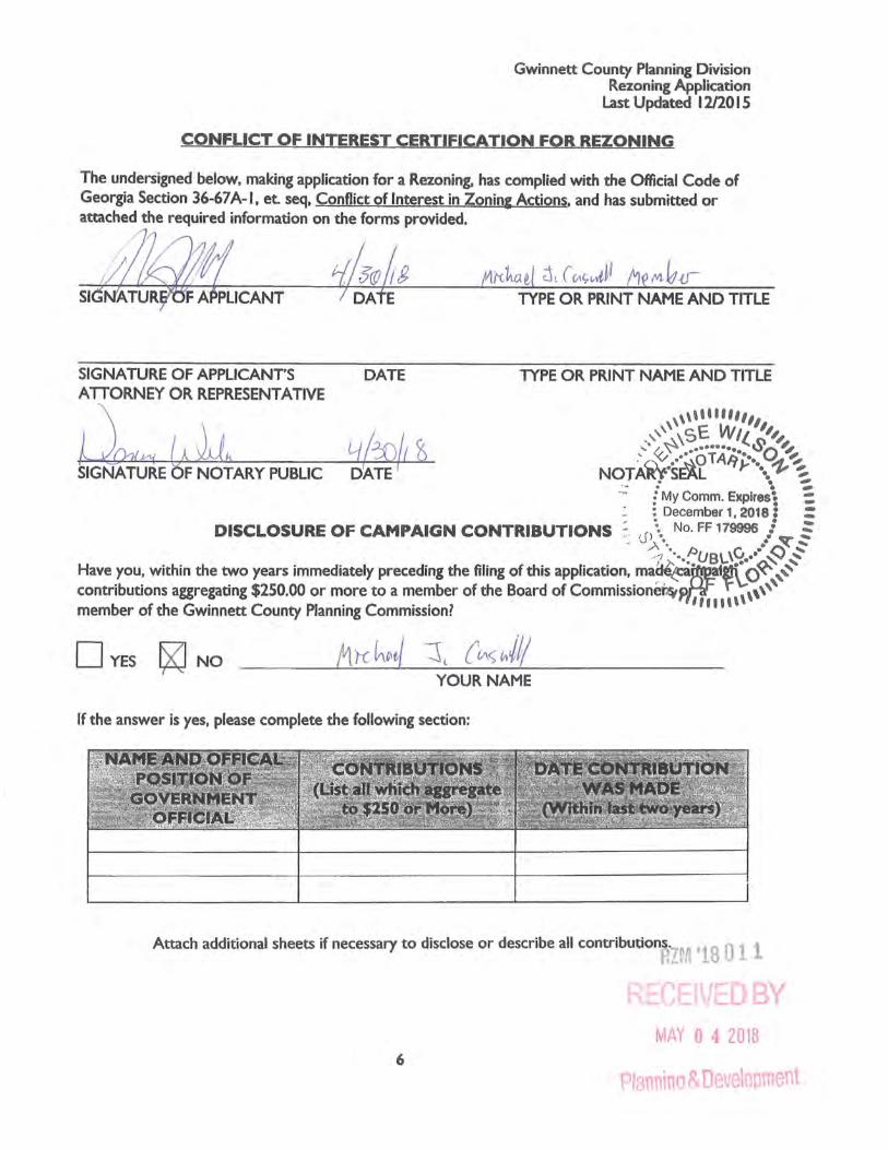
CONFLICT OF INTEREST CERTIFICATION FOR REZONING
The undersigned below, making application for a Rezoning, has complied with the Official Code of Georgia Section 36-67 A-I, et. seq, Conflict of Interest in Zonin& Actions. and has submitted or attached the required information on the forms provided.
Sl
DATE
TYPE OR PRINT NAME AND TITLE
TYPE OR PRINT NAME AND TITLE
,,,, .... ,,,,, _,,,, ,sE Wit.. ,,,,
..... /~~ ·········· ~o'~ ·'a.~ .·~OTAJi:.:•. ~-~ NOTAR~SEAL r \-~~ . . -- ~ . . -
·~ ; My Comm. E)(piresi : • : December 1, 2018 : :
. DISCLOSURE OF CAMPAIGN CONTRIBUTIONS -~: .J~··. No. FF 179996 •• .J ~ § · -·~ ···.fUBL\~ •• •• S ~
Have you, within the two years immediately preceding the filing of this application,. ma~e;:a~at~o~ ,,, contributions aggregating $250.00 or more to a member of the Board of Commission~Pt,r';. \ ,,,,,
b f h G . C PI · C • · 7 1111
'' mem er o · t e . wan nett ounty an nang ommasston.
DYEs fXJ No YOUR NAME
If the answer is yes, please complete the following section:
Attach additional sheets if necessary to disclose or describe all contributions.LM 'lS 1
MAY 0 4 2018 6
Pia nin Dv elo nt

Gwinnett County Planning Division Rezoning Application
Last Updated 12/20 I 5
VERIFICATION OF CURRENT PAID PROPERTY TAXES FOR REZONING
THE UNDERSIGNED BELOW IS AUTHORIZED TO MAKE TH IS APPLICATION. THE UNDERSIGNED CERTIFIES THAT ALL GWINNETT COUNTY PROPERTY TAXES BILLED TO DATE FOR THE PARCEL LISTED BELOW HAVE BEEN PAID IN FULL TO THE TAX COMMISSIONER OF GWINNETT COUNTY, GEORGIA. IN NO CASE SHALL AN APPLICATION OR REAPPLICATION FOR REZONING BE PROCESSED WITHOUT SUCH PROPERTY VERIFICATION.
*Note: A SEPARATE VERIFICATION FORM MUST BE COMPLETED FOR EACH TAX PARCEL INCLUDED IN THE REZONING REQUEST.
PARCEL I.D. NUMBER:
(Map Reference Number)
i
0 District Land Lot
&o{:-Parce
***PLEASE TAKE THIS FORM TO THE TAX COMMISSIONERS OFFICE AT THE GWINNETT JUSTICE AND ADMINISTRATION CENTER, 75 LANGLEY DRIVE, FOR THEIR APPROVAL BELOW.***
TAX COMMISSIONERS USE ONLY
(PAYMENT OF ALL PROPERTY TAXES BILLED TO DATE FOR THE ABOVE REFERENCED PARCEL HAVE BEEN VERIFIED AS PAID CURRENT AND CONFIRMED BY THE SIGNATURE BELOW)
~-~-~ t5A-L NAME TITLE
5-:_ C(- I~ DATE
7
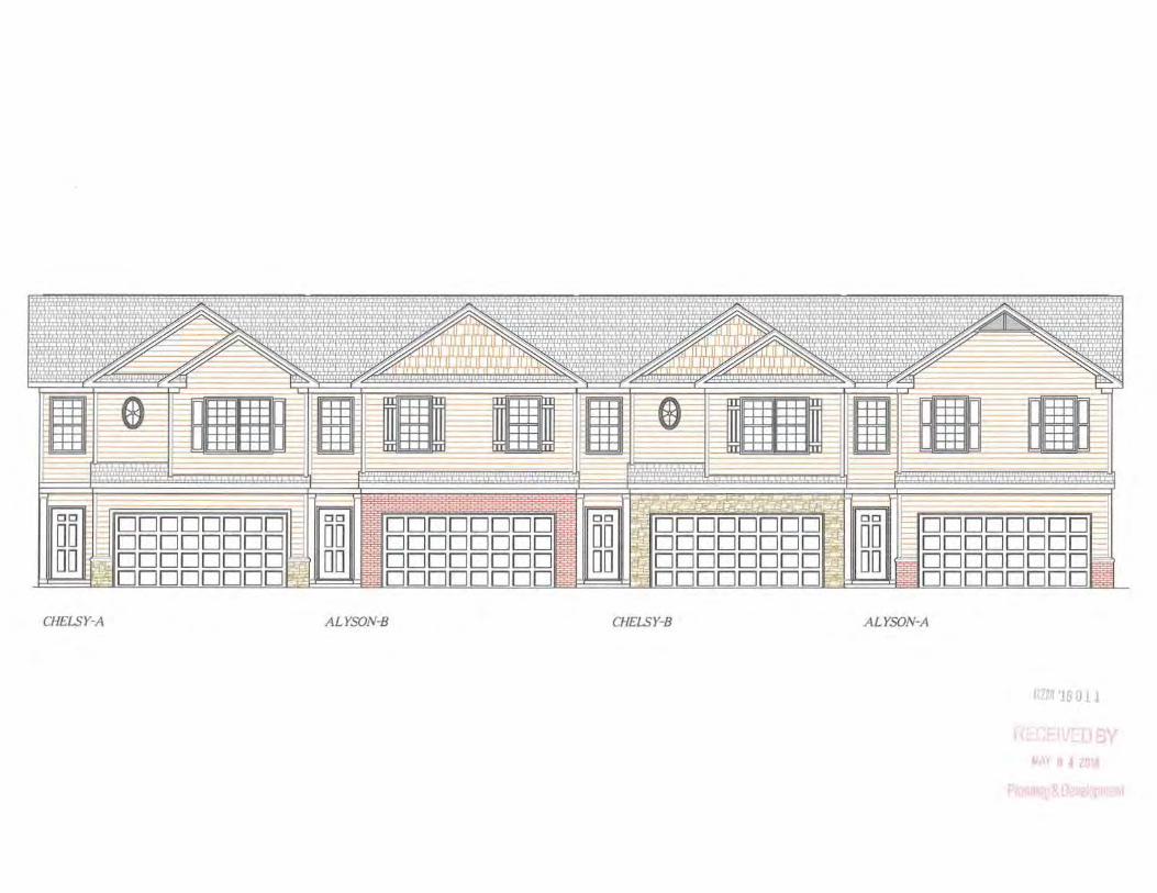
CHELSY-A ALYSON-8 CHELSY-8 ALYSON-A
~ y 0 4 20 8
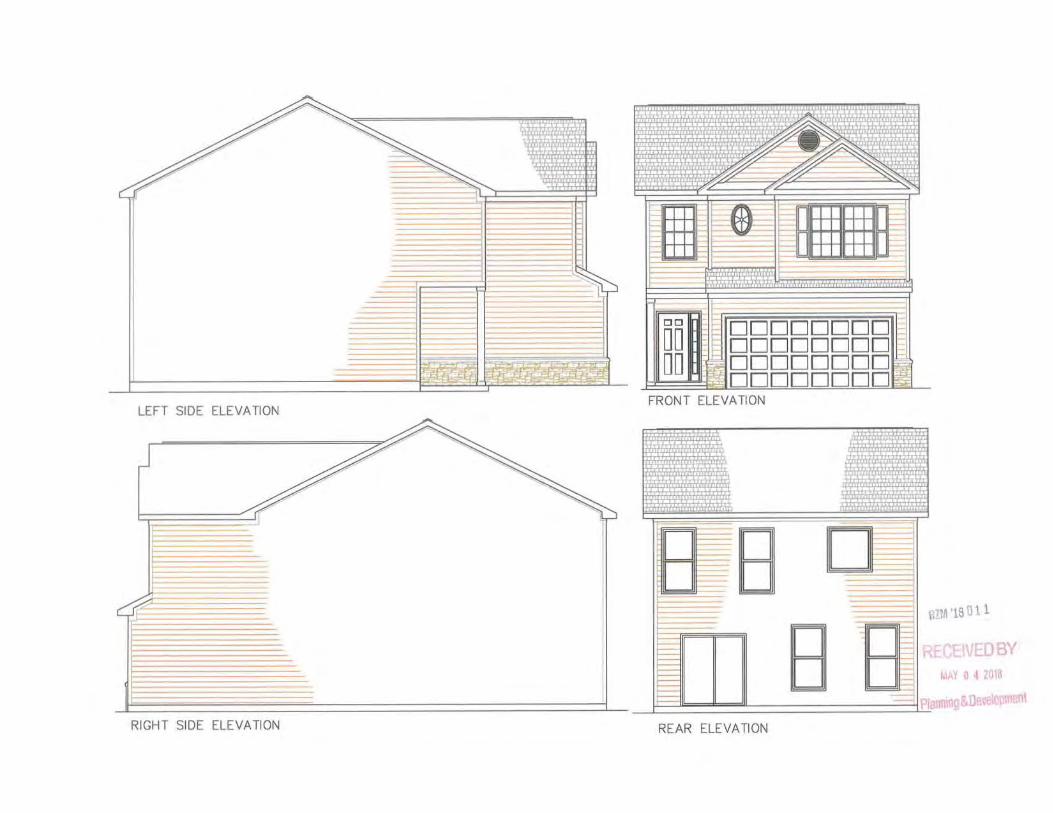
LEFT SIDE ELEVATION
r RIGHT SIDE ELEVATION
lh+lrli-TT'" ~ '·'p' \( .... ~·
,, - (l J ~
~~
• ~ i - D -~ D -
It-'
-00 DDDDDDDD DO DDDDDDDD DO -~ DDDDDDDD I~
t:J DDDDDDDD ...;!_
FRONT ELEVATION
-----~ _, -_, ___, ----:3
mrn '18 o 11
- R CBVEDBY ~ AY 0 4 2018
REAR ELEVATION
Recommended