Resources: Texas Hazard Mitigation Package
(THMP):
An Internet-based GIS Data Distribution Tool
www.thmp.info
Project by Texas Geographic Society
Sub-grantee of the Texas Governor’s Division of Emergency Management
The purpose of this grant is to compile and deliver digital geographicdatasets that can be used by state and local hazard mitigation planners
in identifying potential natural hazards and assessing relative risk

Texas Hazard Mitigation Packagewww.thmp.info
THMP is a free, easy-to-use, online application to: Identify historical hazard occurrences
• actual hazard event locations
• summarized by county Identify hazard risk areas Display supplemental information (including Base Data) for hazard-
related data Determine relative vulnerability (to population and property value) Download hazard-related data for use in other GIS-based systems

Hazards: Weather-related
1. Hurricanes & Tropical Storms• Hurricanes: 1851-2001• Tropical/Subtropical Storms: 1851-2001• Hurricane Tracks: 1851-2001• Tropical/Subtropical Storms: 1851-2001• Hurricane Risk Zones• Hurricane Evacuation Routes
2. Tornadoes• Tornadoes (F3-F5): 1950-2003• Tornadoes (F1-F5): 1950-2003• Tornado Risk Zones• Tornado Events (F3-F5): 1950-2003• Tornado Events (F1-F5): 1950-2003
3. Floods• Floods: 1961-1999• Flood Events (Major): 1905-2001• Flood Events: 1993-2003• Flood Risk Zones
THMP Data Layers
Currently, there are 62 GIS data layers in 11 hazard categories availableto map online, download or stream into your own GIS/mapping system
4. Other Storms• Other Storms: 1955-2003• Wind Risk Zones• Other Storm Events: 1994-2003
5. Outdoor Fires• Outdoor Fires: 2000-2003• Outdoor Fire Risk Zones
6. Drought• Drought (Months): 1976-2003• Drought Events: 1996-2003
7. Extreme Temperatures• Extreme Temperatures (Days): 1980-2003• Extreme Temperatures (Days): 1980-2003
8. Coastal Erosion• Coastal Erosion: 1931 – 2000• Coastal Erosion Rates• Coastal Shoreline Types

Hazards: Non Weather-related
9. Earthquakes• Earthquakes: 1882-1985• Earthquake Epicenters: 1882-1985• Earthquake Risk Zones
10. Hazardous Materials• Hazardous Materials (All): 2004• Hazardous Waste Sites: 2004• Radioactive Waste Sites: 2004• Superfund Sites: 2004• Hazardous Cargo Routes
11. Subsidence• Subsidence (Feet): 1918-1975• Subsidence Risk Zones
Data Layer List …continued

BASE MAPS:
Supplemental information to overlay with hazard-related data
6 Categories with 22 data layers (not shown)
1. Administrative Boundaries2. Transportation3. Hydrography4. Landscape5. Weather-base data

Floods: 1961 – 1999

Floods: 1961 – 1999

Flood Events (Major): 1905 - 2001

Flood Risk Zones

80 available Counties in THMP; 174 to go!
Flood Risk Zones:

Download linkData Layer Description Page

Hurricane Risk Zones and Evacuation Routes from THMP, added to HAZUS

Streaming THMP data from Map Viewers using ArcGIS: Connecting to www.tnris.org
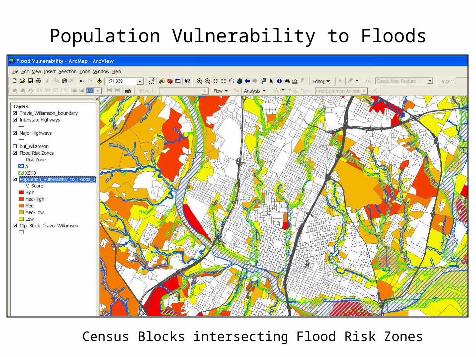
Population Vulnerability to Floods
Census Blocks intersecting Flood Risk Zones

Population Vulnerability to Floods
vulnerable area! …may need further investigation(see HAZUS!)

Texas Hazard Mitigation Package
Summary:
Use THMP, online, to identify and provide necessary data and mapsfor mitigation plans and other related risk assessment activities
Use THMP, online, to access other resources related to hazardsand mitigation planning
Use THMP to download data into your own GIS/mapping systemsto support or initiate your specific projects
Use THMP to download data into HAZUS to supplement the map
Use THMP, online, for preliminary investigation of vulnerable areasto analyze in HAZUS
Recommended