Remote Sensing of Snow and Ice
Lecture 21Nov. 9, 2005
Topics
• Remote sensing snow depth: passive microwave (covered in Lecture 14)
• Remote sensing sea ice and ice sheet elevation change: Lidar - ICESat (covered in Lecture 15)
• Remote sensing snow cover based on MODIS (covered in this lecture)

MODIS data-product sequenceInput MODIS Level 1B bands 1, 2, 4, 6
(MOD02_HKM ), 31 & 32 ( MOD02_1km)Input MODIS 1-km resolution geolocation, cloud mask MOD35 and land/water mask
MOD03
Calculate NDSI, NDVI, grouped-criteria tests, vegetation polygon
Apply surface temperature screen (≥ 283K)
Swath snow 500-m product MOD10_L2
(includes FSC)
Daily snow tile product 500-m
resolution MOD10A1
(includes daily snow albedo)
Daily snow CMG 0.05° resolution
MOD10C1
8-day composite snow tile product 500-m resolution
MOD10A2
8-day composite snow CMG 0.05° resolution
MOD10C2
Algorithm HeritageAlgorithm Heritage:Kyle et al., 1978
Bunting and d’Entremont, 1982
Crane and Anderson, 1984
Tucker et al., 1985
Dozier, 1989
Romanov et al., 2000
Monthly snow CMG 0.05° resolution
MOD10CM Source: Hall, 2004

MOD10_L2: Level 2, 500-m swath product of California and the western U.S., October 31, 2004
MODIS true-color image (left - bands 1, 4, 3) and snow map (right)Source: Hall, 2004

MOD10A1: Daily Tile Snow Map
Snow in northern Italy - March 29, 2002
cloud
snow
MOD09 bands 1,4,3 (Surface Reflectance Product) MOD10A1 (Snow Daily Tile Product)
Source: Hall, 2004
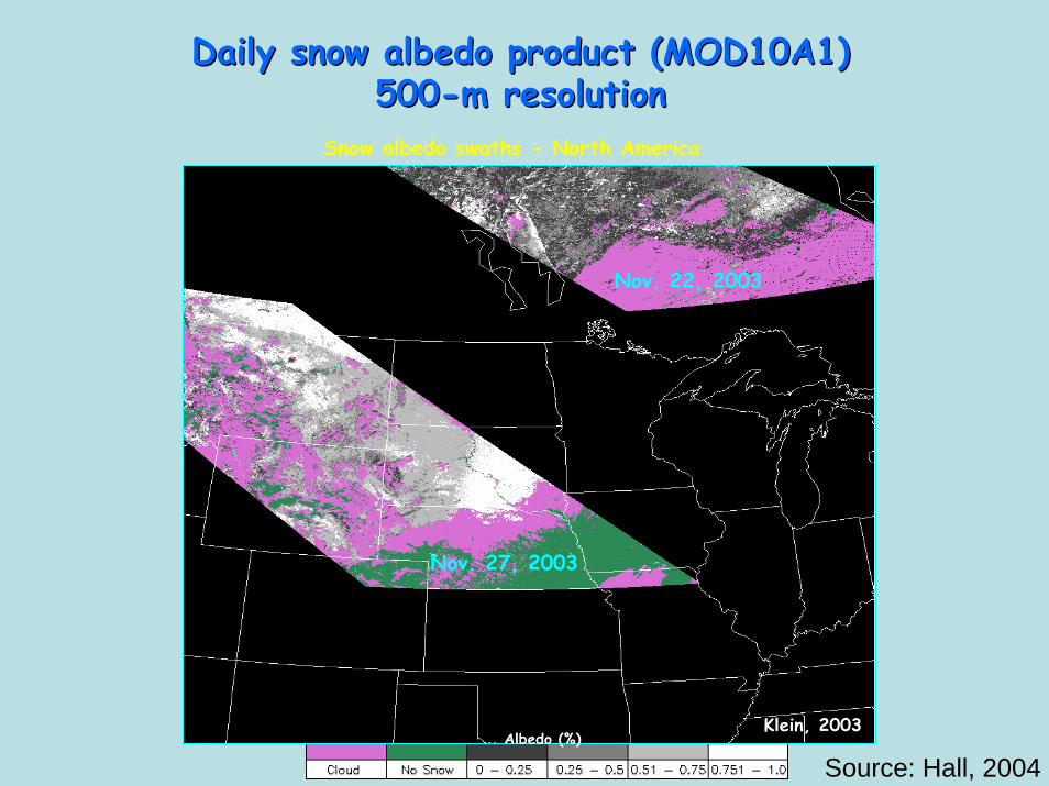
Daily snow Daily snow albedoalbedo product (MOD10A1) product (MOD10A1) 500500--m resolutionm resolution
Snow albedo swaths - North America
Nov. 22, 2003
Nov. 27, 2003
Albedo (%)Klein, 2003
Source: Hall, 2004

MOD10A2: 8-day Composite Tile Snow Map
Western North America - April 23, 2002
MOD09 bands 1,4,3 (Surface Reflectance Product) MOD10A2 (Snow 8-Day Tile Product)
Source: Hall, 2004

Columbia River basin
Missouri River basin
MOD10A1 snow product represents an improvement over the NOHRSC operational snow
product in many areas
From Maurer et al. (2003)
Source: Hall, 2004
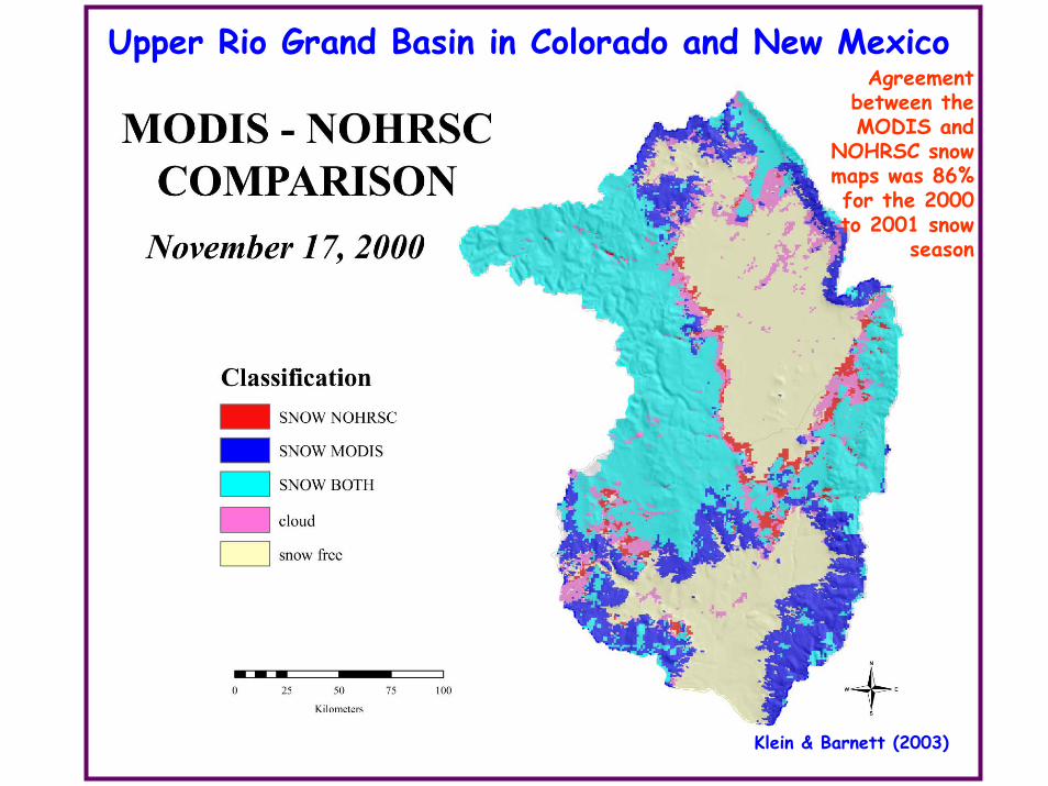
Upper Rio Grand Basin in Colorado and New MexicoAgreement
between the MODIS and
NOHRSC snow maps was 86% for the 2000 to 2001 snow
season
Klein & Barnett (2003)

MOD10C1: Daily CMG snow map (0.05º resolution)
Percent Snow Cover
April 25, 2004
Source: Hall, 2004
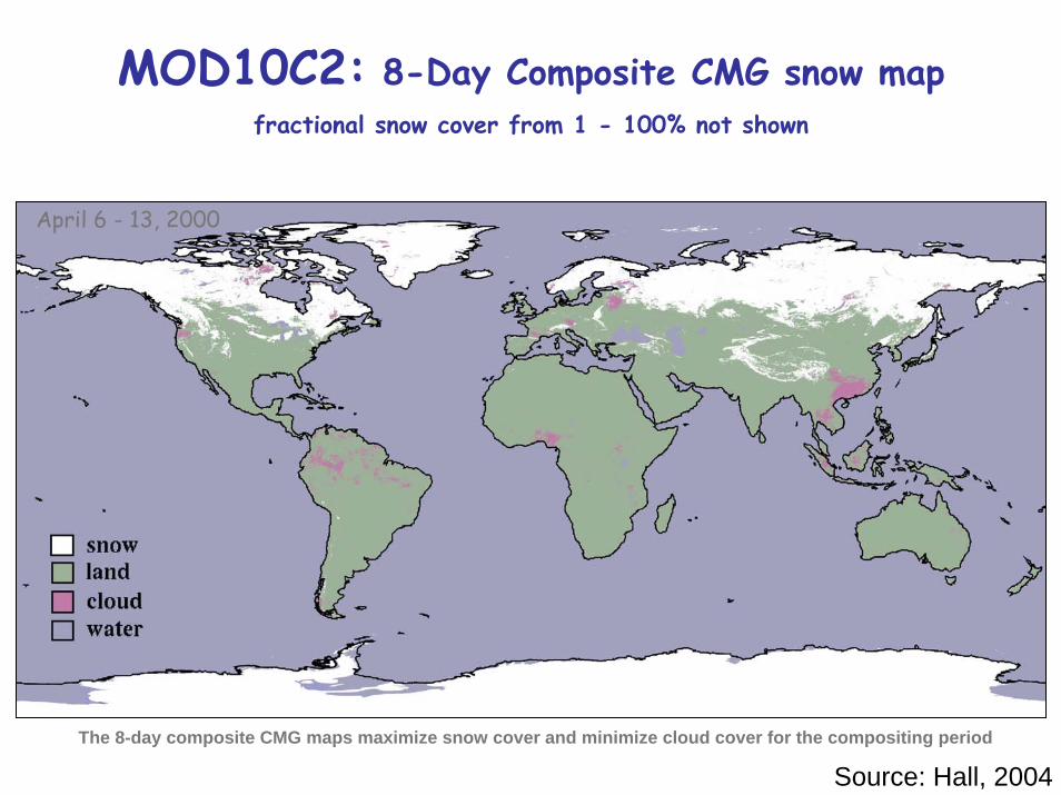
MOD10C2: 8-Day Composite CMG snow mapfractional snow cover from 1 - 100% not shown
March 6-13, 2002
April 6 - 13, 2000
The 8-day composite CMG maps maximize snow cover and minimize cloud cover for the compositing period
Source: Hall, 2004
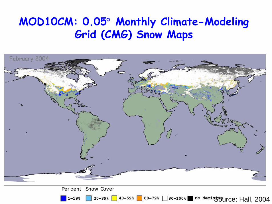
MOD10CM: 0.05° Monthly Climate-Modeling Grid (CMG) Snow Maps
February 2004
Percent Snow Cover
Source: Hall, 2004

The map on the top illustrates the current year snow conditions while the map on the
bottom shows the snow extent for the same 8-day MODIS period from last
year.
Applications of MODIS Applications of MODIS snow data in snow data in
Afghanistan for the Afghanistan for the Famine Early Warning Famine Early Warning
System (FEWS)System (FEWS)
Courtesy Michael Budde/USGShttp://edcw2ks21.cr.usgs.gov/Afghan/product.php?image=so
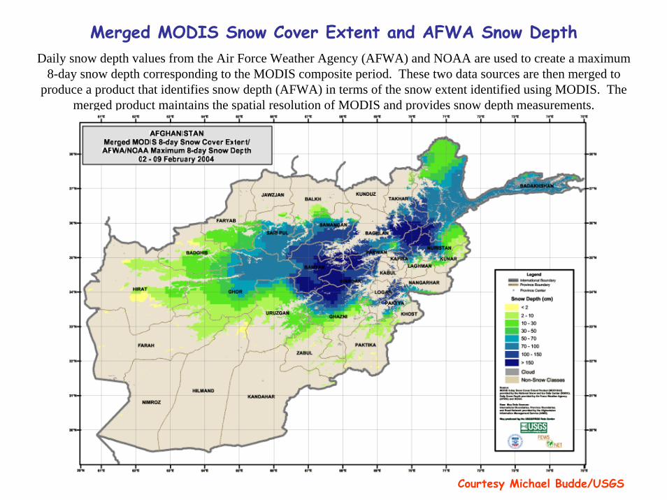
Merged MODIS Snow Cover Extent and AFWA Snow DepthDaily snow depth values from the Air Force Weather Agency (AFWA) and NOAA are used to create a maximum
8-day snow depth corresponding to the MODIS composite period. These two data sources are then merged to produce a product that identifies snow depth (AFWA) in terms of the snow extent identified using MODIS. The
merged product maintains the spatial resolution of MODIS and provides snow depth measurements.
Courtesy Michael Budde/USGS
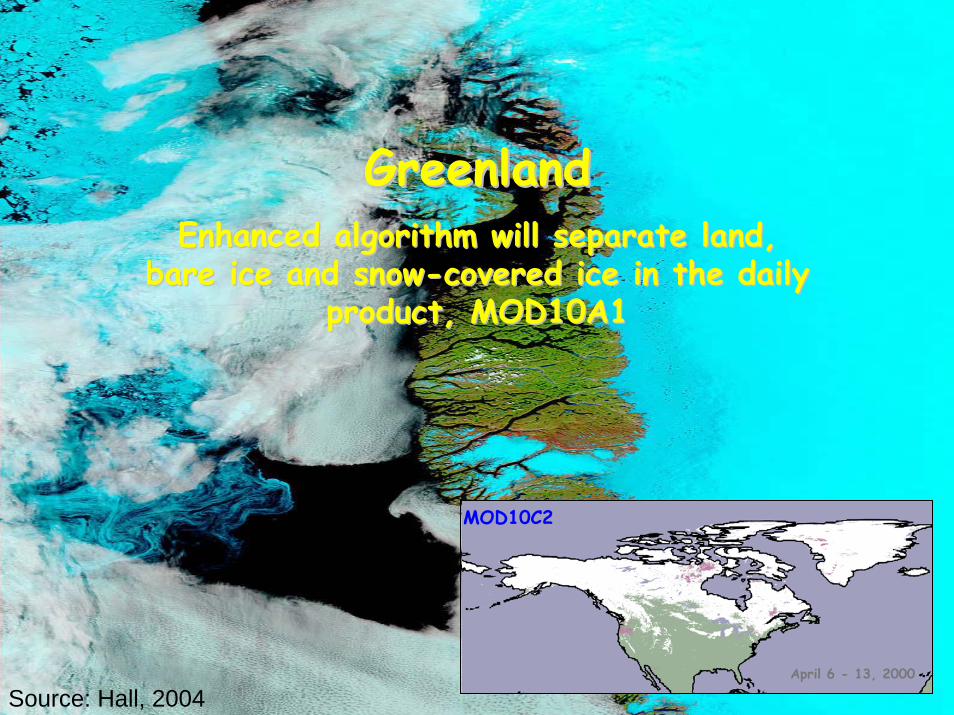
GreenlandGreenlandEnhanced algorithm will separate land, Enhanced algorithm will separate land,
bare ice and snowbare ice and snow--covered ice in the daily covered ice in the daily product, MOD10A1 product, MOD10A1
April 6 - 13, 2000
MOD10C2
Source: Hall, 2004

GreenlandJuly 7, 2002
True color composite (1,4,3) EnhancedSource: Hall, 2004
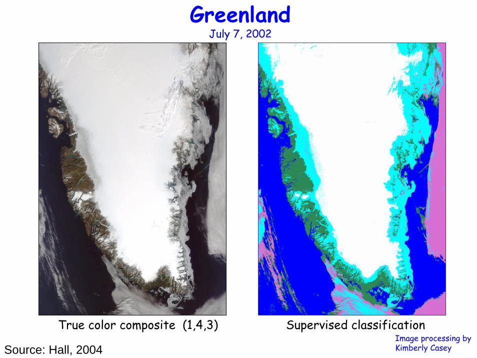
GreenlandJuly 7, 2002
True color composite (1,4,3) Supervised classificationImage processing by Kimberly CaseySource: Hall, 2004

West Coast of GreenlandJune 22, 2004 (1510 UTC)
1, 4, 6 calibrated radiance supervised classification
Unsupervised classification
Image processing by Kimberly Casey
Source: Hall, 2004

75,000
73,000(97.3%)
NM
PrecipitationEvapotranspiration
Elephant Butt ReservoirElephant Butt Reservoir
A Case Study in New Mexico
Zhu, Xie, and Hendrickx, 2005

Reduced Water in Reservoir over Time
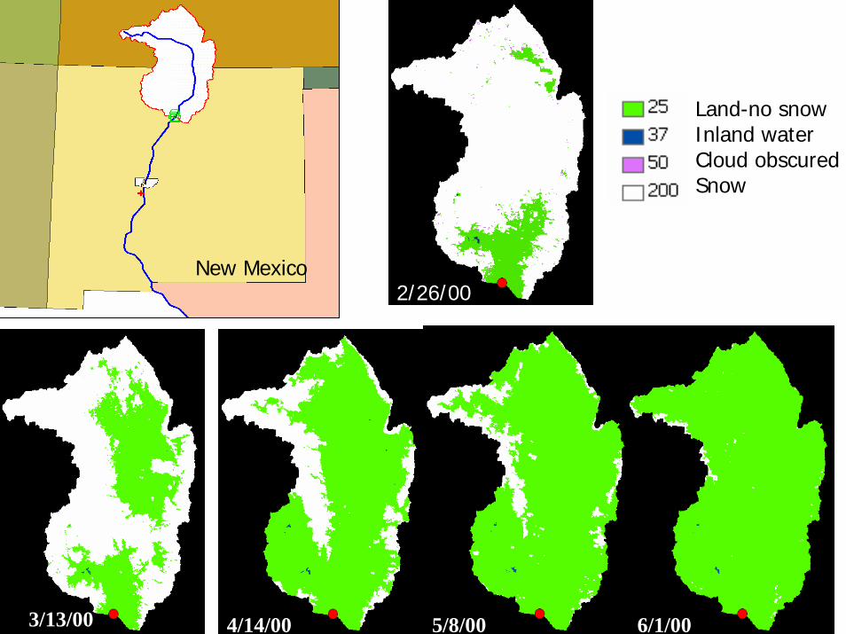
New Mexico2/26/00
Land-no snowInland waterCloud obscuredSnow
2/26/00
4/14/00 5/8/00 6/1/003/13/00
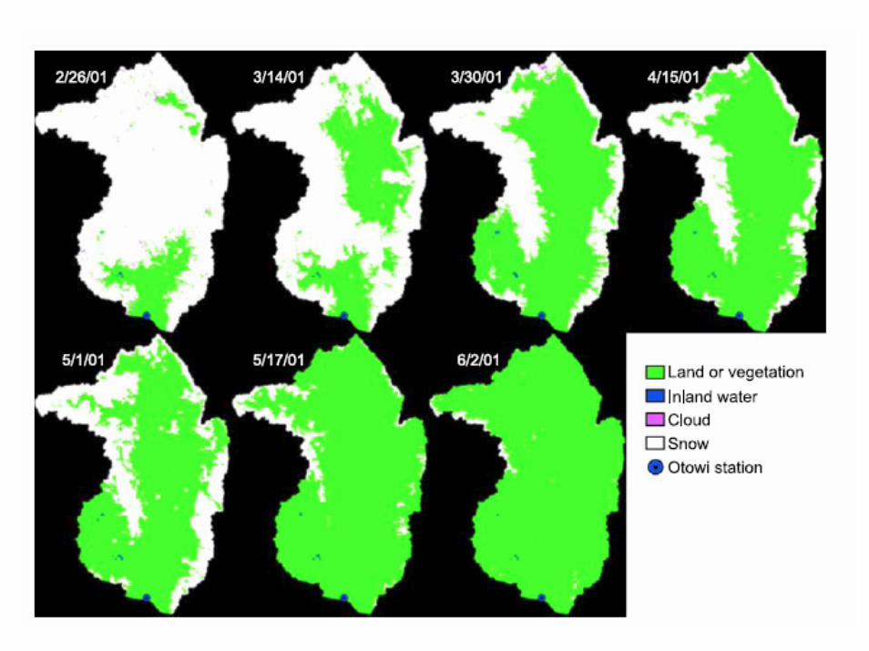

MODIS 8MODIS 8--day Snow Cover over Timeday Snow Cover over Time
20% of decrease

Time series of the 8-day MODIS snow cover of Upper Rio Grande river basin and the corresponding 8-day mean streamflow at Otowi gauge station.
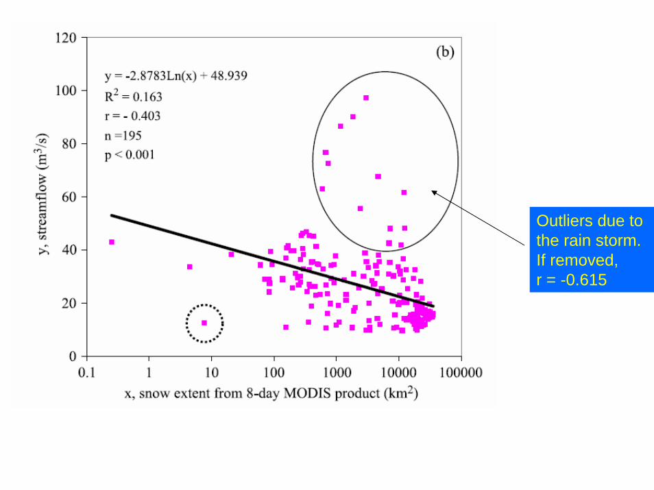
Outliers due to the rain storm.If removed,r = -0.615

No outlier in 2002, better correlation achieved


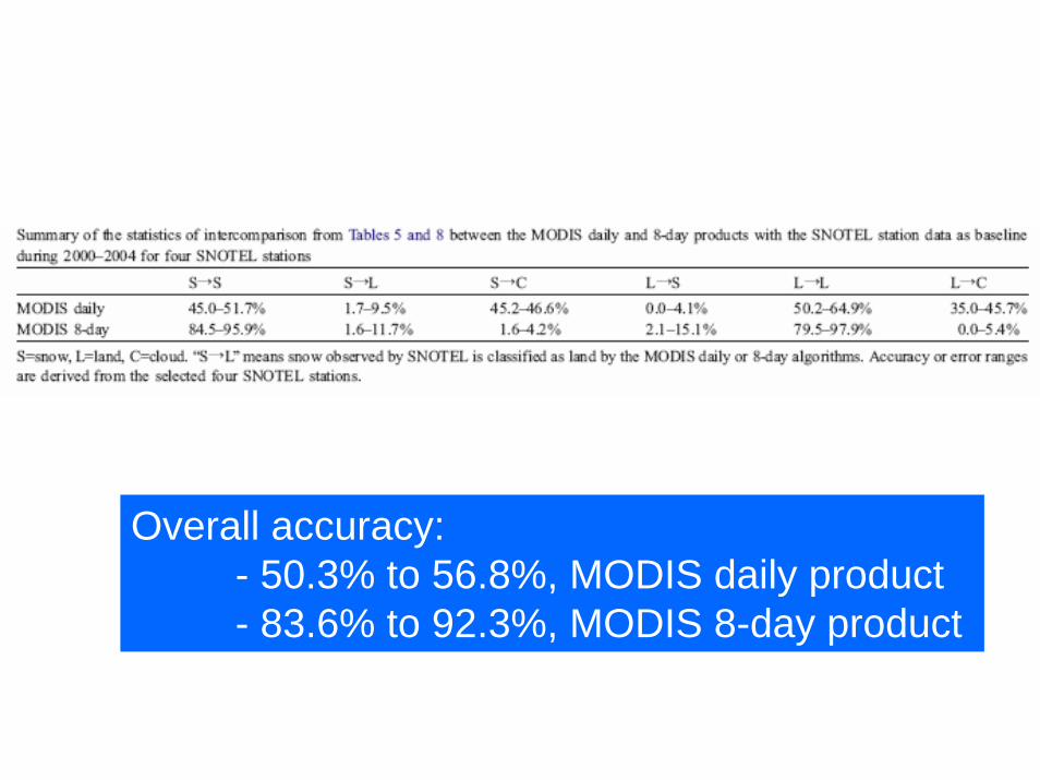
Overall accuracy:- 50.3% to 56.8%, MODIS daily product- 83.6% to 92.3%, MODIS 8-day product
Conclusions
• (1) the MODIS 8-day product has higher classification accuracy for both snow and land;
• (2) the omission error of misclassifying snow as land is similarfor both products, both are low;
• (3) the MODIS 8-day product has a slightly higher commission error of misclassifying land as snow than the MODIS daily product; and
• (4) the MODIS daily product has higher omission errors of misclassifying both snow and land as clouds.
• (5) Clouds are the major cause for reduction of the overall accuracy of the MODIS daily product. Improvement in suppressing clouds in the 8-day product is obvious from this comparison study. The sacrifice is the temporal resolution that is reduced from 1 to 8 days.
• (6) For clear sky days, the MODIS daily algorithm works quite well or even better than the MODIS 8-day algorithm.
Recommended


![[REMOTE SENSING] 3-PM Remote Sensing](https://img.dokumen.tips/doc/110x75/61f2bbb282fa78206228d9e2/remote-sensing-3-pm-remote-sensing.jpg)