1
Groundwater: Outline1. Groundwater intro and activity
2. Water table and groundwater flow
3. Darcy’s Law and the driver for groundwatermovement
4. Groundwater storage: aquifers & aquitards
4. Groundwater problems (e.g., contamination, pumping, etc.)
Problems Associatedwith Groundwater
• Overuse• Subsidence• Contamination
- Salt water intrusion- Hard water, pollutants
Others? Hazel Landslide
Drawdown due to Over Pumping Friday’s in-class activity
If pumping > recharge
Subsidence due to groundwater withdrawal in Pahrump Valley, Nevada
If pumping > recharge
Subsidence due to groundwater withdrawal in Pahrump Valley, Nevada

2
If pumping > recharge
Subsidence due to groundwater withdrawal in Pahrump Valley, Nevada
If pumping > recharge
Subsidence due to groundwater withdrawal in Pahrump Valley, Nevada
If pumping > recharge
Subsidence due to groundwater withdrawal in Pahrump Valley, Nevada
If pumping > recharge
Subsidence: when water is removed, sediment compacts, lowering ground surface.
San Joaquin Valley subsidence
DenverBasin
Aquifers
Barkmann, 2004
As of Feb 2001:~34,000water wells were drilled in the Denver Basin
Non-renewable (?) resource
Denver BasinCross Section
West East
Barkmann, 2004
3
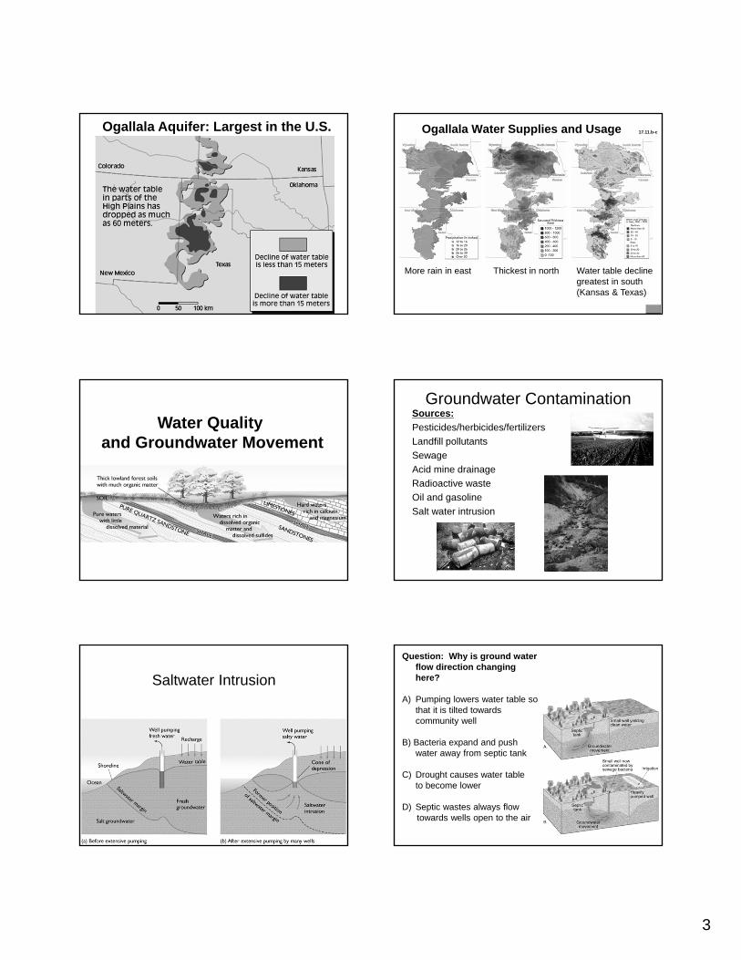
Ogallala Aquifer: Largest in the U.S.
First used for irrigation in the late 1800s
1950s: large-scale exploitation
Today: ~170,000 wells used for irrigation
Water table ~200’ lower in some areas!
Ogallala Water Supplies and Usage
Thickest in northMore rain in east Water table decline greatest in south (Kansas & Texas)
17.11.b-c
Water Quality and Groundwater Movement
Groundwater ContaminationSources:
Pesticides/herbicides/fertilizers
Landfill pollutants
Sewage
Acid mine drainage
Radioactive waste
Oil and gasoline
Salt water intrusion
Saltwater Intrusion
Question: Why is ground water flow direction changing here?
A) Pumping lowers water table so that it is tilted towards community well
B) Bacteria expand and push water away from septic tank
C) Drought causes water tableto become lower
D) Septic wastes always flowtowards wells open to the air

4
Problems Associatedwith Groundwater
• Overuse• Subsidence• Contamination
- Salt water intrusion- Hard water, pollutants
Others? Hazel Landslide
The Hazel LandslideDéjà vu all over again
1967 slide
2006 slide
From Miller and Sias, 1998 and ppt by Miller ca. 2007
N. Fork Stillaguamish River
On March 22, 2014, a major landslide occurred near Oso, Washington. Death toll currently at 30, with 15 still missing.
Before and After Swipehttp://bit.ly/PeN1JT
1947 1955 1965
19701976 1984
19911995
Meters
0 500
N
2006

5
2014 slide breakaway scarp
Harvest on Whitman Bench
Harvest of Headache Creek Basin
Toe Protected
Harvest on Whitman Bench
Figure 1. 3. A conceptual model of groundwater flow to the Hazel landslide.
Figure 3.7. Sensitivity to cutting of the landslide toe by the Stillaguamish River. The heavy line shows the limit of bank cutting imposed for the calculation. Again, grid cells having a factor of safety of 1.3 or greater in the least stable case are left uncolored. Heavy brown lines indicate approximate locations of landslide activity seen in the 1991 photographs (Figure 1.4).
Depth to slip-surface for factor of safety of 1.3.This figure illustrates the potential effects of further destabilization of the landslide. Progressive failure and unloading of the toe of Whitman bench could initiate movement of a vast volume of material,

6
Recommended