PRE-FEASIBILITY REPORT
For
Kutrumali Bauxite Mine Mining Capacity: 3.0 MTPA
(Mine Lease Area: 696.734 ha)
Pre-Feasibility Report for Kutrumali Bauxite Mining Project of 3.0 MTPA in Kalahandi & Rayagada, Districts of Odisha
Kutrumali Bauxite Mine (696.734 ha) 1
TABLE OF CONTENTS
1.0. Executive Summary .................................................................................... 2
2.0. Introduction of the Project/Background Information ....................................... 4
3.0. Project Description ..................................................................................... 8
4.0. Site Analysis ............................................................................................ 18
5.0. Planning Brief .......................................................................................... 22
6.0. Proposed Infrastructure ............................................................................ 25
7.0. Rehabilitation And Resettlement (R&R Plan) ................................................ 28
8.0. Project Schedule and Cost Estimates .......................................................... 28
9.0. Analysis of Proposal (Final Recommendation) .............................................. 29
LIST OF FIGURES
Figure-1. Flow Chart of the Project ....................................................................... 9
Figure-2. Clearance Process for Category-A Project .............................................. 17
LIST OF TABLES
Table-1. Salient Feature of the Project ................................................................... 2
Table-2. Proposed Extent of Mechanisation ............................................................. 5
Table-3. Quantity and Value of Import of Bauxite .................................................... 7
Table-4. Quantity and Value of Export of Bauxite .................................................... 7
Table-5. Employment Potential ............................................................................. 7
Table-6. Location Coordinates ............................................................................... 8
Table-7. Water Requirement ............................................................................... 15
Table-8. Year Wise Production of Minerals ............................................................ 16
Table-9. Mining Lease Area Breakup and Land Use Details ...................................... 18
Table-10. Landuse / Landcover of Core Zone ........................................................ 19
Table-11. List of Major Forest In Buffer Zone ........................................................ 20
Table-12. Village Wise Population ........................................................................ 22
Table-13. Landuse Pattern .................................................................................. 23
Table-14. Proposed Yearwise Plantation Programme .............................................. 24
Table-15. Project Cost Breakup ........................................................................... 28
LIST OF ANNEXURE
Annexure-I. Index Map ...................................................................................... 30
Annexure-II. Khasra No’s/ DGPS Map Certified by ORSAC ...................................... 31
Annexure-III. Study Area Map ............................................................................ 41
Annexure-IV. Mine General Layout ................................................................... 42
Annexure-V. Afforestation / Greenbelt ................................................................. 43
Annexure-VI. Surface Plan ................................................................................. 44
Annexure-VII. Geological Plan ............................................................................. 45
Annexure-VIII. Geological Cross Section .............................................................. 46
Annexure-IX. Conceptual Mine Plan ..................................................................... 47

Pre-Feasibility Report for Kutrumali Bauxite Mining Project of 3.0 MTPA in Kalahandi & Rayagada, Districts of Odisha
Kutrumali Bauxite Mine (696.734 ha) 2
1.0 Executive Summary
Introduction
M/s Larsen & Toubro Limited is proposing the bauxite mining project located in
the districts of Kalahandi and Rayagada, Odisha State. The proposed capacity of
the project is 3.0 MTPA.
The proposed bauxite mining project in ML area of 696.734 ha. About 8.22% of
the ML area is forest land (Forest land- 14.23 ha [village forest – 12.61 ha & DLC
forest – 1.62 ha], Proposed Reserved forest- 43.09 ha). Opencast mechanized
mining method without blasting is proposed for this project. Brief description of
the project is described below:
Salient Feature of the Project
The salient features of the mining details are presented in Table-1.
TABLE-1
SALIENT FEATURES OF THE PROJECT
Sr. No. Parameters Description
1 Name of the project Proposed Mining project of M/s Larsen & Toubro
Limited at Kutrumali Bauxite Mine
2 Location of the project
Kutrumali, Podapai, Majhigan, Murlimuhin,
Melrapa, Salabali villages and Mohangiri
Reserve Forest (Proposed) under Thuamal
Rampur Tehsil of Kalahandi District and
Padelgura, Alutunga under Kashipur Tehsil and
Sadalasa under Rayagada Tehsil of Rayagada
District in Odisha
Index map enclosed as Annexure-I
3 Nature of the project Bauxite Mining
4 Project Proponent M/s Larsen & Toubro Limited, Mumbai
5 Lease period validity 50 years
6 Total Lease area 696.734 ha (1721.68 acres)
7 Life of Mine 22 years
8 Details of the Lease
Area
Details provided in the map enclosed as
Annexure-II
9 Lease area Coordinates
(Details are as per DGPS map certified by
ORSAC enclosed as Annexure-II)
Corner Latitude Longitude
A 19° 27’ 48.25” N 83° 10’ 11.47” E
B 19° 29’ 6.12” N 83° 12’ 49.41” E
C 19° 26’ 33.88” N 83° 13’ 7.87” E
D 19° 25’ 50.28” N 83° 12’ 55.32” E
E 19° 26’ 49.64” N 83° 10’ 59.35” E
10 Capacity of the project
(peak) 3.0 MTPA
11 Category of the project “A”
12 Land Type Rain fed Single crop agricultural land and stone
waste land

Pre-Feasibility Report for Kutrumali Bauxite Mining Project of 3.0 MTPA in Kalahandi & Rayagada, Districts of Odisha
Kutrumali Bauxite Mine (696.734 ha) 3
Sr. No. Parameters Description
13 Method of Mining Opencast Mechanized Mining
14 Operational days/year 250 days
15 Bench Height 10 m
16 Ore to OB ratio 1 : 0.4
17 Overall pit slope 45o
18 Total water requirement 500 m3/day
19 Source of water Naragul nala, 3.5 km
20 Man power requirement 193
21
Nearest Railway
Station/ Airport along
with distance in km.
Nearest Railway Station
Sikarpai RS -12.5 km, SE
Nearest Airport
Visakhapatnam – 188 km, S
22 Nearest Highway
SH-44 (Rupkona – Kashipur – Gunupur -
Bawanipatna), 5.20 km, W
SH-45 (Jaykaypur - Kalyansinpur), 9.25 km, E
23
Nearest Town, city,
District Headquarters
along with distance in
km
Kashipur – 13.1 km, SW
Rayagada – 34 km, SSE
24
Ecological Sensitive
Areas (Wild life
Sanctuaries, National
Parks, Biosphere
Reserves,
Reserve/Protected
Forest etc.)
Karlapat wildlife sanctuary, 20.5 km, NNW
Reserved/Protected Forests
1. Mohanagiri RF
2. Mandibishi RF
3. Kalibhata RF
4. RF near Budegarha village
5. RF near Aliguna Village
6. Amapadar RF
7. Ladakhman RF
8. Singari RF
9. Kalyansinpur RF
10. Chhatapadar RF
11. Paharhapadas RF
12. Khakes RF
13. Kandabindha RF
14. Sajja PF
15. Kasapari RF
16. Kasapar Extn RF
17. Karanja RF
18. Karhakhaman RF
1.0 km, N
2.3 km, S
5.2 km, W
8.3 km, ESE
8.7 km, NW
9.4 km, NW
9.9 km, W
11.2, NNE
11.3 km, ENE
11.6 km, NE
12.3 km, N
12.6 km, NW
12.6 km, SW
13.9 km, ESE
14.0 km, NW
14.5 km NW
14.3 km, NE
14.7 km, NNW
Proposed Reserved Forest
1. Bijay Nagar RF
2. Kalagan RF
3. Melaghara RF
4. Dhanda RF
5. Bartibal RF
6. Ajaygarh RF
7. Bhasangamali RF
8. Mohanagiri RF
9. Rastugurha RF
Adj. East
2.15 km, S
2.9 km, N
3.1 km, SW
3.7 km, SSE
4.0 km, E
5.7 km, S
5.8 km, N
6.2 km, SSW

Pre-Feasibility Report for Kutrumali Bauxite Mining Project of 3.0 MTPA in Kalahandi & Rayagada, Districts of Odisha
Kutrumali Bauxite Mine (696.734 ha) 4
Sr. No. Parameters Description
10. Utang RF
11. Alanda RF
12. Sunger RF
13. Bijepur RF
14. RF near Sikarpai
15. Ribal kana RF
6.8 km, SE
6.9 km, ESE
7.0 km, W
9.0 km, NNE
9.8 km, ESE
11.3 km, ESE
25 Historical Places Nil
26 Seismicity Seismic zone-II as per IS 1893 (Part-I):2002
All values are aerial distance
2.0 Introduction of the Project/Background Information
2.1 Identification of the Project and Project Proponent
Larsen & Toubro Limited (L&T) is a diversified Indian multinational conglomerate
with very sound technical and financial resources. During 2014-15, the
consolidated revenue was in excess of Rs. 92,000 Crores. It operates in over 30
countries worldwide. A strong, customer–focused approach and the constant
quest for top-class quality have enabled L&T to attain and sustain leadership in its
major lines of business for over seven decades.
L&T has proposed to set up an alumina refinery project in Odisha. Investment
decision is dependent on the captive source of sizeable reserves of bauxite. The
state government granted the prospecting licenses to L&T for Kutrumali and
Sijimali bauxite deposits. Both the deposits are nearby and are located in
Kalahandi and Rayagada districts. After successfully completing the prospecting
operations, L&T applied for mining leases. State government has recommended
the applications to central government for their approval for grant of mining
leases in accordance with law.
Out of total estimated mineable reserves of bauxite in these two deposits to the
tune of 249 million tonnes, Kutrumali deposit has got 47 million tonnes and the
balance 202 million tonnes are from Sijimali deposit.
The ultimate capacity of 3 MTPA of the proposed alumina refinery will require
bauxite of 9 MTPA, considering 3 tonnes of bauxite for 1 tonne of alumina. This
requirement will be met partly from Kutrumali (3 MTPA) and partly from Sijimali
(6 MTPA). This report is for mining of bauxite from Kutrumali deposits at a rate of
3 MTPA (peak). A separate report for mining of bauxite from Sijimali deposits has
been prepared.
L&T is known to be a reputed engineering conglomerate having highly qualified
engineers. L&T is a leading manufacturer of state of the art mining equipment and
a global engineering player in the field of metals and mining and therefore they
are in a pre-eminent position to conduct scientific and environment friendly
mining. The mining methods, amongst others, shall aim at minimising or
eliminating blasting operations. Extensive use of Surface Miners and/or IPCC (In
Pit Crushing and Conveying) shall be resorted to.
2.2 Brief Description of Nature of Project
The lease area of 696.734 hectares (1721.680 acre) falls under tehsil Thaumul–
Rampur of Kalahandi district and tehsils Kashipur & Rayagada of Rayagada district

Pre-Feasibility Report for Kutrumali Bauxite Mining Project of 3.0 MTPA in Kalahandi & Rayagada, Districts of Odisha
Kutrumali Bauxite Mine (696.734 ha) 5
in the state of Odisha. The lease area falls under the Survey of India toposheet
no. E44F3 and bounded by latitude of 19° 25’ 50.28” to 19° 29’ 6.12” N &
longitude of 83° 10’ 11.47” to 83° 13’ 7.87” E. The proposed lease area is having
about 47 million tonnes of mineable reserves.
The extracted bauxite will be used in the proposed 3 MTPA production capacity
alumina refinery in Rayagada district, Odisha. The mining lease shall be granted
for Bauxite mining for a period of 50 years. The proposed Bauxite mine shall be
developed by opencast mechanized mining method. The main operation shall
include removal and stocking of top soil by excavator cum loaders, exposing the
aluminous bauxite/bauxite zone and proper levelling by dozer and use of surface
miners. Bauxite will be then sorted out and reduced its size. The remaining rejects
will be used for backfilling.
Extent of Mechanization
The entire mining activity involves fragmentation/loosening of in-situ rock mass,
excavation, loading and hauling, sizing and subsequent handling/transportation
etc. These are envisaged to be carried out by employing equipment like rippers,
drills, excavators and loaders, rear dump trucks, crusher, feeders and belt
conveyors etc. the details of proposed extent of Mechanization are given in below
Table-2.
TABLE-2
PROPOSED EXTENT OF MECHANISATION
Type No’s Capacity Motive Power
Surface Miner 1 800 tph Diesel/electrical
Primary Crusher 1 800 tph Electrical
Single shank ripper for Area-I & II 2 400 tonnes/hr 770 HP diesel
engine
150 mm crawler-mounted drills with
onboard compressor
3 12 m/hr diesel
105 mm crawler-mounted drills with
onboard compressor
4 12 m/hr diesel
Hydraulic excavator 3 3.8 m3 diesel
Front-end loader 5 5.6 m3 diesel
Dumper for bauxite transportation 12 50 tonnes diesel
Dumper for overburden
transportation
6 50 tonnes diesel
Rear dump trucks for bauxite
transportation
17 35 tonnes diesel
Rear dump trucks for overburden
transportation
8 35 tonnes diesel
Crawler-mounted bulldozer 4 - 410 HP diesel
engine Tyre-mounted bulldozer – 300 HP 2 -
Road grader 1 - 145 HP diesel
engine
Water Tanker 3 28 KL diesel
Tyre-mounted hydraulic rock breaker 2 - diesel
Truck-mounted AN-FO mixing cum
charging unit
2 - diesel

Pre-Feasibility Report for Kutrumali Bauxite Mining Project of 3.0 MTPA in Kalahandi & Rayagada, Districts of Odisha
Kutrumali Bauxite Mine (696.734 ha) 6
2.3 Need for the project and its importance to the country and region
Bauxite is basically an aluminous rock containing hydrated aluminium oxide as
the main constituent and iron oxide, silica and titania in varying proportions.
Hydrated aluminium oxides present in the bauxite ore are diaspore and
boehmite, Al2O3. H2O (Al2O3- 85%; Al- 45%); gibbsite or hydrargillite, Al2O3.
3H2O (Al2O3-65.4%; Al-34.6%), and bauxite (containing colloidal alumina
hydrogel), Al2O3. 2H2O (Al2O3-73.9%; Al-39.1%). Bauxite is an essential ore of
aluminium and is one of the most important nonferrous metals used in the
modern industry. It is also an essential ore for refractory and chemical
industries. The country has abundant resources of bauxite which can meet both
domestic and export demands.
The production of mineral and its subsequent use in the Alumina Refinery will
benefit by way of royalty and taxes and will also bring in large employment
opportunities to the local populace thereby usher in socio-economic benefit to
the backward region.
2.4 Demand and Supply Gap
The production of bauxite at 15,360 thousand tonnes in 2012-13 increased by
13% as compared to previous year, due to better market demand.
There were 152 reporting mines in 2012-13 as against 172 in the previous year.
Besides, production of bauxite was reported as associate mineral by 10 mines
during the year. In all, 70 producers reported production of bauxite in 2012-13.
Ten principal producers having 42 mines contributed 86% of the total
production. Forty seven major mines, each producing more than 50 thousand
tonnes per annum, together accounted for 93% of the total production. The
contribution of the Panchpatmali bauxite mine of NALCO was 35% of the total
production. The share of public sector mines was about 42% of the total
production in 2012-13 as against 43% in the previous year. About 63% of the
total production of bauxite was of 40-45% Al2O3 grade, 15% was of Cement
grade, 12% was of 45-50% Al2O3 grade, 7% was of below 40% Al2O3 grade,
2% was of Refractory grade and one percent of production was reported
together in 50-55% Al2O3, 55-60% Al2O3, Abrasive and Chemical grades during
the year under review.
Odisha continued to be the leading producing state and accounted for about
36% of the total production. Next in the order of production were Gujarat (20%)
Jharkhand & Maharashtra (13% each), Chhattisgarh (12%), Madhya Pradesh
(5%) and the remaining one percent was produced by Goa, Karnataka and Tamil
Nadu.
Mine-head stocks at the end of 2012-13 was 6,902 thousand tonnes as
compared to 7,988 thousand tonnes at the beginning of the year. About 90% of
the total stock was held in Gujarat at the end of the year. The average daily
employment of labour in bauxite mines was 6,905 in 2012-13 as against 7,684
in the previous year.
It has always been seen that in the cases i.e. for Bauxite there remains a
demand and supply gap as demand is always high in respect of supply.
(Source: Indian Mineral Year Book 2013, Part-III: Mineral Reviews)

Pre-Feasibility Report for Kutrumali Bauxite Mining Project of 3.0 MTPA in Kalahandi & Rayagada, Districts of Odisha
Kutrumali Bauxite Mine (696.734 ha) 7
2.5 Imports V/s indigenous production
The country has large resources of Bauxite, occupying the sixth place in the
world’s total resources. The resources of metallurgical grade Bauxite are quite
adequate while those of the chemical and refractory grade Bauxite are relatively
limited considering the future requirements. That’s why it is necessary to import
Bauxite of this grade. The quantity and value of import of Bauxite is given in the
following Table-3:
TABLE-3
QUANTITY AND VALUE OF IMPORT OF BAUXITE
Year Quantity (Thousand Kg.) Value (Rs. Lakhs)
2013-14 3,30,265.03 18,608.02
2014-15 (Apr-Oct) 10,47,315.00 41,245.14
(Source: Ministry of Commerce and Industry)
2.6 Export Possibility
The quantity and value of export of Bauxite is given in the following Table-4.
TABLE-4
QUANTITY AND VALUE OF EXPORT OF BAUXITE
Year Quantity (Thousand Kg.) Value (Rs. Lakhs)
2013-14 33,26,678.00 61,199.34
2014-15 (Apr-Oct) 37,88,039.50 74,105.96
(Source: Ministry of Commerce and Industry)
2.7 Domestic Markets
The bauxite of the lease area is of metal grade (+40% Al2O3 on an average),
therefore is suitable for Aluminium plants, like NALCO, Hindalco and BALCO.
2.8 Employment Generation (Direct & Indirect) due to the project
Actual requirement of manpower is generally worked out after industrial
Engineering study during project implementation stage. However, a preliminary
estimate has been made to indicate the order of manpower requirement. The
detail of manpower requirement is given in Table-5.
TABLE-5
EMPLOYMENT POTENTIAL
Sr. No. Category Manpower
1 Managerial 10
2 Supervisory 14
3 Clerical 09
4 Skilled 117
5 Semi- Skilled 22
6 Un-Skilled 21
Total 193

Pre-Feasibility Report for Kutrumali Bauxite Mining Project of 3.0 MTPA in Kalahandi & Rayagada, Districts of Odisha
Kutrumali Bauxite Mine (696.734 ha) 8
3.0 Project Description
3.1 Type of Project
As per Gazette notification of Ministry of Environment Forests and Climate Change
(MoEF&CC), New Delhi all projects greater than 50 hectare falls in category “A”.
As in this case, the lease area is 696.734 hectare, so this project falls in “A”
category. The extracted bauxite will be used in proposed aluminium refinery (3.0
MTPA) in Rayagada district, Odisha.
Bauxite is a naturally occurring rock which is site specific due to its geological
origin. No alternative sites are proposed.
3.2 Location (map showing general location, specific location, and project boundary &
project site layout) with coordinates
The Kutrumali bauxite mine is located at Villages - Kuturumali, Podapai,
Majhigaon, Murlimuhin, Melrapa, Salabali villages and Mohangiri Reserve Forest
(Proposed) under Thuamal Rampur Tehsil of Kalahandi District; Padelgura,
Alutunga under Kashipur Tehsil and Sadalasa under Rayagada Tehsil of Rayagada
District, State-Odisha over an area of 696.734 ha (1721.680 acre). The
geographical coordinates of ML area is given in Table-6. Study area map
enclosed as Annexure-III.
TABLE-6
LOCATION COORDINATES
Corner Latitude Longitude
A 19° 27’ 48.25” N 83° 10’ 11.47” E
B 19° 29’ 6.12” N 83° 12’ 49.41” E
C 19° 26’ 33.88” N 83° 13’ 7.87” E
D 19° 25’ 50.28” N 83° 12’ 55.32” E
E 19° 26’ 49.64” N 83° 10’ 59.35” E
Note: Details are as per DGPS map certified by ORSAC enclosed as Annexure-II
3.3 Details of alternate sites considered and the basis of selecting the proposed site,
particularly the environmental considerations gone into should be highlighted
Bauxite is a naturally occurring rock which is site specific due to its geological
origin. No alternative sites are proposed.
3.4 Size and Magnitude of Operation
The total geological reserve is 70 million tonnes, out of which 47 million tonnes
have been considered as mineable reserves.
Of the total mineable reserves, about 34 million tonnes occur in the western block
and the balance 13 million tonnes in the eastern block. It is proposed to
undertake mining operation initially in the western block having reserves of 34
million tonnes with an average alumina 43.5 % and silica 1.42 % which would last
for about 10/12 years at the end of which the eastern block will be taken up.

Pre-Feasibility Report for Kutrumali Bauxite Mining Project of 3.0 MTPA in Kalahandi & Rayagada, Districts of Odisha
Kutrumali Bauxite Mine (696.734 ha) 9
Mine general layout
General layout of the mine showing the proposed mining areas.
Overburden/waste and topsoil dumps, crushing plant, service centre, electric sub-
station, on-ground water reservoir, explosive magazine, haul roads, roads to
crusher house and waste disposal area etc. Mine general layout is enclosed as
Annexure-IV.
3.5 Project Description with Process Details
It is proposed to carryout mining activities at two locations in the western block,
namely Area-1 and Area-2. Two to three bauxite benches will be developed in
each of these areas. However, the two areas will merge in due course. Process
flow sheet is shown in Figure-1.
Based on the respective reserve base and average grade, it is planned to
excavate about 70 % of the annual requirement of bauxite from Area-2 and about
30% from Area-1. The suggested quantum of excavation from two areas is,
however, provisional only, and maybe adjusted suitably depending upon the
quality requirements and day to day situation in the field.
In order to ensure sustained availability of bauxite, the development work of
overburden removal will continue during production stage. The overburden raised
will be disposed-off to the waste stockpile and the r.o.m bauxite will be delivered
either to crusher house directly or to r.o.m Ore stockpile, the space for which has
been provided near crusher house.
FIGURE-1
FLOW CHART OF THE PROJECT
REMOVAL OF TOP SOIL
EXCAVATION AND SORTING OF MINERAL
LOADING ON DUMPERS FOR FINAL DISPATCH
BACKFILLING OF TOP SOIL/OB

Pre-Feasibility Report for Kutrumali Bauxite Mining Project of 3.0 MTPA in Kalahandi & Rayagada, Districts of Odisha
Kutrumali Bauxite Mine (696.734 ha) 10
Layout of Mining Benches
The layout/orientation of the mining benches depends mainly on:
i. Method of working;
ii. Topography of the area;
iii. Degree of variations in grade within the deposit;
iv. Degree of intercalations in the deposit;
v. Required output of r.o.m material per day; and
vi. Degree of pit blending required for quality control.
Taking the above factors into considerations, it is proposed to advance the mining
faces generally from east to west. The benches are planned to be laid accordingly.
Further it has been planned to leave a barrier all around the periphery of
adequate width as required under relevant mining laws and other statutory
provisions to prevent boulders rolling down or Surface runoff spilling into the hill
slope. A green belt is to be created on the barrier.
Bench Height
At kutrumali, the bench height in a 10 m slice may vary from place to place
depending upon topography, as well as varying thickness of overburden and ore.
The benches are proposed to be planned generally to follow the contour and
topography without much loss on dilution.
Accordingly, the overburden having varying thickness, maximum being about 9 m
in Area-1, will be removed ahead of bauxite excavation. The bulk of the bauxite
will be mined at 10 m bench height while benches of 5m height will be developed
in places. However, some of the benches, for both bauxite and overburden, will be
less than 5m height and will be exploited by ripping. Bauxite of 2m to 4m
thickness occurring immediately.
Overall Pit Slope
A steep overall pit slope is expected to be stable with 10 m bench height.
However, to assess this aspect more precisely, certain additional information such
as angle of friction and coefficient of cohesiveness of the rock are required which
are not presently available. It is, therefore planned to maintain the overall pit
slope at 45 degree.
Mine Drainage
The kutrumali plateau has almost a flat topography except at the western part
where the khondalite is exposed. The natural drainage, generally in the southeast
direction, drains the surface run-off into valleys which ultimately converges with
the main water courses.
During the initial years of mine operation, top soil and overburden excavated shall
be dumped at the selected sites. Peripheral drains all around the dumps shall be
made to trap rain water washing out of the dumps, which in turn will reduce the
load of suspended solids in the discharged waster. Sump pits will be provided
along the length of the drains for effective trapping of rain water washings and
discharging the clear overflow water to the nearby streams.

Pre-Feasibility Report for Kutrumali Bauxite Mining Project of 3.0 MTPA in Kalahandi & Rayagada, Districts of Odisha
Kutrumali Bauxite Mine (696.734 ha) 11
It is observed that ground water level at kutrumali region generally lies between
800 to 900 m above MSL which in words about 300 m below the plateau top.
Further, during drilling operation in kutrumali plateau, no sub-surface water to be
encountered to a level up to 1000 m above MSL. Hence, the effect of mining on
ground water is extremely remote.
Crushing Plant
The ore being of high grade, any preliminary treatment/beneficiation is not
envisaged at the mine head. However, to enable smooth and easy transportation,
the minus 800 mm r.o.m. bauxite will be required to be reduced to a suitable size
prior to delivering the same to the long distance transportation system. Crushing
plant and conveyor system to process and transfer 3 million tonnes of bauxite per
year as required by the alumina plant.
The crushing plant will consist of four sections namely:
i) R.O.M ore stockyard;
ii) Crushing section;
iii) Belt conveyor system; and
iv) Surge bin.
R.O.M Ore Stockyard
The ore transported from the mine may be dumped directly into the crusher or to
the stockpile depending upon the grade of bauxite and the requirement of the
crushing plant. Subsequently bauxite from the stockpile may be reclaimed in
appropriate proportions conforming to the stipulated blending requirement and
dumped into the crusher hopper.
Crushing Section
Receiving Hopper
One r.c.c. hopper will be provided at the crusher house to receive the ore directly
transported from the mine and dumped by 35 ton rear dump trucks. Ore
reclaimed from the r.o.m stockpile by front end loader and hauled by 35 ton rear
dump trucks will also be received in this hopper. The rear dump trucks will
approach the hopper though a ramp. The hopper will be of about 100 tons
capacity and fitted with MS grid on top to arrest stray plus 800 mm boulders. The
oversize boulders will be removed from the top of the hopper, fragmented with
the help of a hydraulic rock breaker provided for the purpose, and recharged into
the hopper from time to time.
Apron Feeder
The hopper will be equipped with a heavy duty apron feeder of 2000 mm x 7500
mm size suitable to withstand the load of big boulders dumped by 35 ton rear
dump trucks from large tipping height. The apron feeder will be driven by
thyristor controlled variable speed D.C. motor, and draw out and deliver the
material at a regulated rate to a set of stationary drizzly.

Pre-Feasibility Report for Kutrumali Bauxite Mining Project of 3.0 MTPA in Kalahandi & Rayagada, Districts of Odisha
Kutrumali Bauxite Mine (696.734 ha) 12
Stationary Grizzly
A set of stationary grizzly of robust construction and 2000 mm x 4000 mm size,
having wedge shaped opening tapering out towards the discharge end, will be
installed ahead of the crusher for scalping out as much minus 150 mm fraction as
possible from the r.o.m material to avoid unnecessary volumetric loading of the
crusher.
Crusher
Oversize of the grizzly will be fed directly to a crusher to reduce the same to
minus 150 mm. considering the size and other, physical characteristics of the feed
ore, throughput rate and the stipulated product size, it is proposed to provide a
toothed double roll crusher of 1700 mm dia x 2000 mm width. Each of the rolls
will have separate squirrel cage induction motor drive, and will run at different
speeds to ensure efficient crushing by the process of compaction and shearing.
Belt Conveyor System
A belt conveyor system will be provided to collect the minus 150 mm crushed
material and the scalped product, and transfer the same to the surge bin, located
near the long distance bauxite transport conveyor system. Each of these
conveyors will be 1000 mm wide operating at a speed of about 2 m per second,
and will be laid over a fairly level land avoiding the promising mining areas to the
extent possible.
Surge Bin
A surge bin complex will be provided to collect the minus 150 mm material and
feed the same at an uniform rate to the long distance transport system.
Bin Compartment
The surge bin will be of r.c.c. construction and have 2 compartments, each of 500
ton capacity. The crushed material of kutrumali mine will be delivered in one
compartment. The other compartment will be used for crushed material conveyed
from Sijimali at a later date. The bin will be enable to even out any fluctuation in
the feed rate of the incoming material and maintain a uniform rate of loading of
the long distance transport system throughout the period of its operation.
Apron Feeder
An apron feeder, 1500 mm x 6000 mm will be provided below each of the
compartments of the bin for drawing out and delivery of the material.
Belt Conveyor
A belt conveyor, 1000 mm wide and operating at about 2 m per sec, will collect
the material discharged by the apron feeder and transfer the same to the long
distance bauxite transport system. The capacity of this conveyor will be
augmented by suitably speeding it up, to match the envisaged transfer rate of
2000 tons per hour after commissioning of Sijimali mine.

Pre-Feasibility Report for Kutrumali Bauxite Mining Project of 3.0 MTPA in Kalahandi & Rayagada, Districts of Odisha
Kutrumali Bauxite Mine (696.734 ha) 13
Other Facilities
Other facilities envisaged to be provided for smooth functioning of the sizing plant
are briefly described below:
Crane and Hoist
The crusher house will be equipped with a 20/5 ton capacity E.O.T crane for
maintenance and upkeep of equipment there. The crane will also be used to
handle and remove the oversize boulders arrested by the MS grid fitted on top of
the receiving hopper. Besides the crane, mechanical traveling hoists of
appropriate capacity will be provided in the conveyor junction houses and the
surge bin.
Belt Scale
An electronic belt weight will be provided on belt conveyor to record and indicate
the rate of transfer of material.
Metal Detector and Magnetic Separator
A metal detector consisting of a search coil and a solid state control unit will be
provided on belt conveyor to facilitate detection and removal of tramp metal
pieces from bauxite being despatched to the alumina plant. The search coil
mounted on the conveyor senses the presence of any unwarranted metal piece in
bauxite, and through the control unit, activities an overband magnetic separator
which in turn ejects the piece from the system. In the event of failure of the
ejection device, a second metal detector installed further downstream will actuate
the trip circuit of the conveyor drive to facilitate manual removal of the metal
piece.
Automatic Sampler
A cutter type automatic primary sampler will be mounted at the discharge end of
belt conveyor for collection of representative samples at predetermined intervals
as required for monitoring of quality of despatchable bauxite. Along with sample
collector, facilities for preparation of samples consisting of two stage crushing,
handling and secondary sampling will be provided.
Dust Abatement Facilities
To combat dust nuisance caused by crushing, screening, transfer through chutes
etc, it is proposed to provide appropriate dust extraction facilities comprising
multiple collection hoods and ducting, bag filter, stack/exhaust duct in crusher
hoods and ducting, bag filter, stack/exhaust duct in crusher house, surge bin and
junction houses. The dust extraction system will be designed to limit the dust
content in the buildings to 5 mg per Nm3 for breathable fraction and that in the
stack discharge to 50 mg per Nm3. The dust arrested in the bag filters will be
recharged to the belt conveyors.
Besides the dust extraction system, water will be sprinkled at the receiving
hopper through appropriate header, pipeline and sprinklers to control generation
of dust.

Pre-Feasibility Report for Kutrumali Bauxite Mining Project of 3.0 MTPA in Kalahandi & Rayagada, Districts of Odisha
Kutrumali Bauxite Mine (696.734 ha) 14
3.6 Raw materials required along with estimated quantity, likely source,
marketing area of final products/s, Mode of transport of raw Material and
Finished Product.
No raw material will be required for production of Bauxite.
Use of Mineral
The bauxite from Kutrumali deposit will be used for production of metallurgical
grade alumina. The proposed alumina plant will be located at a distance of around
9 km in East direction from this bauxite deposit.
Bauxite Transportation
The bauxite raised from Kutrumali mine will be used for production of
metallurgical grade alumina at the plant proposed to be installed by L&T located
at about 9 km away from this deposit. The bauxite will, therefore, have to be
transported to the proposed alumina plant. After considering various options, it
has been decided to provide a belt conveyor system for the purpose. The belt
conveyor will be of either steel chord supported or conventional idler supported
type, or any other state of the art type, laid on generally on a declining ground
slope.
The drive house for the conveyor system will be located on the feed end at
Kutrumali plateau top and conveyor will receive bauxite feed from the surge bin
via apron feeder. However, most of the conveyor system will be installed outside
the Kutrumali ML area and its alignment will be generally follow the gorge of a
stream to terminate at the proposed plant site. The access road between
Kutrumali the alumina plant site is planned to be laid as close to the conveyor
installation as possible to facilitate its regular inspection, upkeep and
maintenance.
3.7 Resource optimization/recycling and reuse envisaged in the project, if
any, should be briefly outlined.
Water will be accumulated in the excavated mined out pit area during rains and
the pits shall serve as natural ground water recharging structure. As a result of
extraction of mineral, the rate of charging of ground water is likely to be
increased considerably.
3.8 Availability of water its source, Energy/power requirement and source
should be given
Water Source and Requirement
It is proposed to tap water from Naragul nala at an approximate distance of 3.5
km from Kutrumali hilltop.
Water will be required in the mining area for sprinkling on the roads to suppress
the dust, watering of green belt/green verge and trees planted to comply with
requisite EMP measures, miscellaneous industrial use, and drinking and sanitation.
The water requirements, source of water and distribution system envisaged for
Kutrumali are briefly discussed below:
For the purpose of design of water system, projected water requirement for
Kutrumali is given below Table-7:

Pre-Feasibility Report for Kutrumali Bauxite Mining Project of 3.0 MTPA in Kalahandi & Rayagada, Districts of Odisha
Kutrumali Bauxite Mine (696.734 ha) 15
TABLE-7
WATER REQUIREMENT
Consumer Requirement of Water (m3/day)
Mine road sprinkling 250
Provision for vegetation 50
Industrial use 125
Drinking and sanitation 75
Total 500
Power requirement
The requirement of power for crushing plant, bauxite transport conveyor, service
centre, water supply units, mine and plant lighting and other miscellaneous
consumers has been estimated as follows:
Annual energy consumption, 16.5 x 10⁶ kwh
15 min maximum demand, 4.0 MVA
Source of Power
It has been envisaged that power will be made available at the main receiving and
step-down substation (MRSS) of the proposed alumina plant by Odisha State
Electricity Board (OSEB) over 132 KV double circuit overhead line from Theruvali
substation. Power will be stepped down to 33 KV at the MRSS. It is also planned
to establish one in-house captive power at Alumina Refinery plant based on co-
generation system to meet the power demand. The in-plant power generation will
be connected to the 33 KV system.
33 KV power will be taken to Kutrumali mine over double circuit overhead line
from the 33 KV substation of the alumina plant. Further 33 KV power to Sijimali
mine will be taken over double circuit overhead line from the 33 KV substation at
Kutrumali. The 33 KV overhead line will generally follow the bauxite transport
conveyor alley.
Requirement of the construction power will be met from the DG sets.
It is also envisaged to install solar panels to produce green energy and fulfil part
of the requirement.
3.9 Stacking of Mineral and Disposal of Waste
Opencast working: taking into consideration factors, such as nature of occurrence,
geological setting of the deposit, topography, scale of operation, ore to waste
ratio etc., it is proposed to adopt opencast mechanised mining by top slicing
method in multiple benches. Proposed five year production details are shown in
the Table-8.

Pre-Feasibility Report for Kutrumali Bauxite Mining Project of 3.0 MTPA in Kalahandi & Rayagada, Districts of Odisha
Kutrumali Bauxite Mine (696.734 ha) 16
TABLE-8
YEAR WISE PRODUCTION OF MINERALS
3.10 Schematic representations of the feasibility drawing which give
information of EIA purpose
As per the Environment Impact Assessment (EIA) notification dated 14th Sept.
2006 and subsequent amendments, the proposal falls under category A. EIA/EMP
report shall be prepared to get the Environmental Clearance for this project from
the MoEF&CC. The baseline studies will be undertaken as per schematic diagram
given as Figure-2.
Plan Year Waste
(000’ Tonnes)
Bauxite
(000’ Tonnes)
Top soil Laterite Khondalite Total
First year 99 388 213 700 200
Second year 31 769 - 800 250
Third year 21 813 166 1000 2400
Fourth year 40 1049 111 1200 3000
Fifth year - 1200 - 1200 3000

Pre-Feasibility Report for Kutrumali Bauxite Mining Project of 3.0 MTPA in Kalahandi & Rayagada, Districts of Odisha
Kutrumali Bauxite Mine (696.734 ha) 17
FIGURE-2
CLEARANCE PROCESS FOR CATEGORY-A PROJECT

Pre-Feasibility Report for Kutrumali Bauxite Mining Project of 3.0 MTPA in Kalahandi & Rayagada, Districts of Odisha
Kutrumali Bauxite Mine (696.734 ha) 18
4.0 SITE ANALYSIS
4.1 Connectivity
Kutrumali Bauxite deposit is located in Thuamul-Rampur, Kashipur and Rayagada
sub-divisions in Kalahandi-Rayagada district. The bauxite deposit is located at a
distance of about 34 km from Rayagada town. Rayagada is the district
headquarter and is connected by SE railway.
The state highway connects Sunger with Rayagada via Kashipur, the sub-
divisional head quarter. From Sunger, the deposit is approachable by 11 km long
fair weather village road, followed by a 4 km kutcha road from the foothill to the
plateau top. The total road distance from Kutrumali hilltop to Rayagada is
approximately 97 km.
4.2 Land Form, Land Use and Land Ownership
The abstract of the details of land schedule and landuse is given in Table-9.
TABLE-9
MINING LEASE AREA BREAKUP AND LAND USE DETAILS
* All values are in ha
District
Name of
the
Village
Govt. Land
Private Total Village
Forest
DLC
Forest
Proposed
RF
Other
than
Forest
Kalahandi
Kutrumali 7.58 - - 165.12 13.66 186.36
Majhigan - - - 67.51 - 67.51
Melrapa - - - 52.56 - 52.56
Murlimuhin - - - 12.96 - 12.96
Podapai - 1.62 - 184.12 5.03 190.77
Salabali - - - 0.66 - 0.66
Mohangiri
Proposed
Reserve
Forest
- - 43.09 - 43.09
Rayagada
Pedalgura - - 86.73 - 86.73
Alutunga 5.03 - - 37.15 3.24 45.42
Sadalasa - - - 10.64 - 10.64
Total 12.61 1.62 43.09 617.45 21.93 696.73
It may be seen from the above table that the bulk of area is non-forest
government land. The total forest land covers about 8.22% of the ML area is
forest land (forest land- 14.23 ha [village forest – 12.61 ha & DLC forest – 1.62
ha], proposed reserved forest- 43.09 ha).
4.3 Topography
The area forms a part of the Eastern Ghat hill ranges which have a general NE-SW
trend. Series of hills ranging in an elevation between 1000 m and 1400 m have
been interspersed with valleys having an average elevation of 850 m and are
dotted with several isolated hillocks.

Pre-Feasibility Report for Kutrumali Bauxite Mining Project of 3.0 MTPA in Kalahandi & Rayagada, Districts of Odisha
Kutrumali Bauxite Mine (696.734 ha) 19
The main drainage pattern in this area is controlled by a number of streams,
which drains their water into Nagavalli River that flows from north to south. The
Barha Nadi, a tributary of Nagavalli River, flow along northeast direction on the
northern side of the Kutrumali plateau. The streams originating from the northern
part of the plateau drains the water into Barha Nadi. No streams are passing
through proposed ML area.
4.4 Existing Land use Pattern
The prevailing land use pattern in the study area has been divided into two
distinct zones, namely (i) the core zone covering an area about 7.0 sq.km over
the Kutrumali plateau top where the mining activities will be confined and (ii) the
buffer zone covering a total land area of 720 sq.km (exceeding 10 km radial
coverage).
Core Zone Land Use /Land Cover
The proposed mining site at Kutrumali plateau is principally a stony waste land.
However, there are patches of tree cover at the edge of plateau. The broad
distribution of the prevailing landuse/landcover in the core zone of the study area
as observed is presented in below Table-10.
TABLE-10
LANDUSE / LANDCOVER OF CORE ZONE
Sr. No. Land Use / Land Cover Unit Area (ha)
1 Village Forest 12.61
2 DLC Forest 1.62
3 Proposed RF 43.09
4 Scrub Land 83.29
5 Agricultural Land 0.00
6 Residential Land 2.61
7 Stony Waste Land 553.51
8 Roads / Corridors 0.00
9 Water Bodies 0.00
Total 696.73
Note: However, as per legal status, 43.09 ha of land area in northern sector of
plateau falls under Mohangiri proposed reserve forest. This area accounts for
total plateau land surface.
Buffer Zone Land Use/Land Cover
The buffer zone area has got substantial forest coverage of varying canopy
density. This is one way beneficial to the proposed project. The vast forest
coverage provides substantial ecological resources which are not being affected by
the present project activities. In the buffer zone, five major forest types are
recognised in Rayagada and Kalahandi forest divisions. The details of forests are
given in Table-11.

Pre-Feasibility Report for Kutrumali Bauxite Mining Project of 3.0 MTPA in Kalahandi & Rayagada, Districts of Odisha
Kutrumali Bauxite Mine (696.734 ha) 20
TABLE-11
LIST OF MAJOR FORESTS IN BUFFER ZONE
Sr. No. Name of Reserve/
Protected Forest
Forest Type Distance/
Direction
1 Sunger PRF Moist deciduous with scattered
evergreen patches
7.1 km / W
2 Mandibishi RF Moist deciduous with frequent
evergreen patches around
village settlement with rampant
podu cultivation
2.3 km / S
3 Bijayanagar PRF Dry and noist deciduous forest
rampant podu cultivation, severe
timber extraction
2.8 km / NE
4 Leliguma RF Moist deciduous and evergreen 15.2 km / S
5 Mohangiri PRF Dry deciduous forest with
extensive podu cultivation open
and degraded forest
5.8 km / N
There are no Ecological Sensitive Areas (Wild life Sanctuaries, Tiger reserves,
elephant reserves, National Parks and Biosphere Reserves etc.) present in the
study area.
4.5 Existing Infrastructure
Access roads:
The access roads to the nearby villages and to Kutrumali plateau from Sunger are
not metalled roads but jeepable throughout the year except during the period
from June to October covering monsoon and part of post-monsoon period.
Water:
Villages tap the water mostly from the natural springs and the nallahs and use it
in untreated form. Few hand tubewells have been set up in the study area.
Dugwells are also available in the valley land.
Electricity:
Electric poles have been laid under Rural Electrification Programme. Power will be
made available to some of the villages when the transformers are installed.
Education facilities:
Limited number of schools up to primary level are available in the valley area.
Health care:
Primary health care center is available in Sunger village.
Fuels:
The fuels used by the villagers are forest wood and kerosene.

Pre-Feasibility Report for Kutrumali Bauxite Mining Project of 3.0 MTPA in Kalahandi & Rayagada, Districts of Odisha
Kutrumali Bauxite Mine (696.734 ha) 21
Trade and Commerce Centre:
Kashipur is the sub-divisional headquarters located at a distance of 13.1 km from
Kutrumali ML area in SW direction. Basic infrastructural facilities like all-weather
road to the District headquarters Rayagada, electricity, schools, post office, STD
facilities, bank and police station are available at Kashipur, the main trade
commerce centre for almost all the villages in the study area.
Monuments/Buildings of Archaeological Significances:
There is as such no monument or public buildings of interest in the study area as
observed during field study.
4.6 Soil Classification
Top soil is yellowish brown to dark reddish brown and developed from the
tropical/subtropical weathering of khondalite and laterite residuum.
4.7 Climate data from Secondary Sources
The study area lies in the humid tropical climatic zone and receives the annual
precipitation in the range of 1400 to 1600 mm. Nearly 80 per cent of this rainfall
occurs during the period June to September. India Meteorological Departments
(IMD) nearest observatory at Koraput reports maximum temperature at 37.3°C
during summer and minimum temperature at 7.1° C during winter season. The
wind speeds lies within 11 kmph having predominant wind direction from
southwest (SW) to northwest (NW). The relative humidity lies in the range of 50
% to 80 % depending on the seasons.
In general, the climate in the study area is temperate type and there is a good
amount of rain during June to August which sustains the vegetation cover on the
hill slopes.
4.8 Social Infrastructure Available
Access roads:
The access roads to the nearby villages and to Kutrumali plateau from Sunger are
not metalled roads but jeepable throughout the year except during the period
from June to October covering monsoon and part of post-monsoon period.
Water:
Villages tap the water mostly from the natural springs and the nallahs and use it
in untreated form. Few hand tubewells have been set up in the study area.
Dugwells are also available in the valley land.
Electricity:
Electric poles have been laid under Rural Electrification Programme. Power will be
made available to some of the villages when the transformers are installed.
Education facilities:
Limited number of schools up to primary level are available in the valley area.

Pre-Feasibility Report for Kutrumali Bauxite Mining Project of 3.0 MTPA in Kalahandi & Rayagada, Districts of Odisha
Kutrumali Bauxite Mine (696.734 ha) 22
Health care:
Primary health care center is available in Sunger village.
Fuels:
The fuels used by the villagers are forest wood and kerosene.
Trade and Commerce centre:
Kashipur is the sub-divisional headquarters located at a distance of 13.1 km from
Kutrumali ML area in SW direction. Basic infrastructural facilities like all-weather
road to the District headquarters Rayagada, electricity, schools, post office, STD
facilities, bank and police station are available at Kashipur, the main trade
commerce centre for almost all the villages in the study area.
Monuments/Buildings of archaeological significances:
There is as such no monument or public buildings of interest in the study area as
observed during field study.
5.0 PLANNING BRIEF
5.1 Planning concept (type of industries, facilities, transportation etc.) Town
and country Planning/Development authority Classification
The bauxite mining project of M/s Larsen & Toubro Limited, Mumbai is located at
Villages- Kutrumali, Podapai, Majhigaon, Murlimuhin, Melrapa, Salabali villages
and Mohangiri Reserve Forest (Proposed) under Thuamal Rampur Tehsil of
Kalahandi District; Padelgura, Alutunga under Kashipur Tehsil and Sadalasa under
Rayagada Tehsil of Rayagada District , District- Kalahandi & Rayagada, State-
Odisha over an area of 696.734 ha (1721.680 acre). The proposed capacity of
the project is 3.0 MTPA. The bulk of Mine Lease area is non-forest government
land. Open-cast mechanized mining method without blasting is proposed for this
project
5.2 Population Projections
The project will employ most of the workers from nearby villages. Only
supervisory staff will be hired from outside. There will not be any increase in
population due to the project. However, few people from other areas may migrate
in this area for business opportunities. Village wise population of the core zone is
given in Table-12.
TABLE -12
VILLAGE WISE POPULATION
District Village Population
Kalahandi Kutrumali 250
Podapai 207
Majhigaon 382
Murlimoi 158
Melrupa 264
Salabali 20
Mohanagiri 1467
Rayagada Alutunga 68
Pedalguda 38
sadalasa 187
Source: Census Handbook, 2011

Pre-Feasibility Report for Kutrumali Bauxite Mining Project of 3.0 MTPA in Kalahandi & Rayagada, Districts of Odisha
Kutrumali Bauxite Mine (696.734 ha) 23
The above villages partly/fully fall within the proposed ML area. The actual
project affected people are 377 from 105 families out of the above.
5.3 Land Use planning (breakup along with green belt etc.)
Land Reclamation - Concomitant to Mining
During the course of mining, the original topography will be disturbed. It becomes
necessary to reclaim the degraded land so as to bring back to its approximate
original topography. It is planned to remove the top soil first and to dump at the
selected sites. Removal of the overburden and waste material would follow
thereafter and suitably dumped at the selected sites. During the operation of the
mining, concomitant reclamation of the land during the first five years may not be
possible because:
i) Opening of the different benches at different levels simultaneously for
achieving the desired tonnage and grade;
ii) Irregular and heterogeneous nature of the bauxite and non-exposure of
bottom profile of mineralization; and
iii) Unfavourable topography limiting the total backfilling of the mined out
areas.
Hence, it has been decided to take up the restoration of the degraded land in the
western block after exploitation of the bauxite. The restoration will cover
backfilling and terracing of the mined out area with overburden /waste and
surfacing the same with topsoil. The fast growing trees like Auriculiformis (Sona
Jhuri), Cassia Siamea (Chakunda), Albizzia Lebbek (Siris), Leucaena Leucocephala
(Suo Babul), Bombax Malabaricum (Simul), Butea Frondosa (Palas) and shrubs
will be planted to stabilise the reclaimed land. Landuse pattern of project area is
given in Table-13. The year wise plantation programme as proposed, is
presented in Table-14.
TABLE-13
LANDUSE PATTERN
Sr. No Particular Area (in ha)
1 Mining area 128.65
2 Over Burden Dump 24.51
3 Storage for Top Soil 9.34
4 Roads/ Connectivity 36.73
5 Infrastructure, like- Crusher house,
Belt conveyor etc. 68.13
6 General Administrative office
/Repair Shop 3.27
7 Greenbelt 201.57
8 Undisturbed land 224.53
Total Area 696.73

Pre-Feasibility Report for Kutrumali Bauxite Mining Project of 3.0 MTPA in Kalahandi & Rayagada, Districts of Odisha
Kutrumali Bauxite Mine (696.734 ha) 24
TABLE-14
PROPOSED YEARWISE PLANTATION PROGRAMME
Period Item Area, Ha No. of
Trees
Cost Rs
‘000
1st and 2nd
Year
Peripheral plantation
Nursery development
Tree plantation
9.9
2.0
10.0
25,000
-
25,000
145
40
145
3rd Year Tree plantation
Nursery development
Green belt development
25.0
4.0
15.0
62,500
-
16,500
360
80
150
4th Year Tree plantation
Green belt development
Arbori culture
Office garden
15.0
18.3
5 km
4.6
37,500
20,300
6,000
-
215
180
100
410
5th Year Tree plantation
Green belt development
Arbori culture
Land scape garden
Overburden dump
vegetation
15.0
22.0
3.8
5.1
10.6
37,500
35,500
-
-
26,500
215
220
180
460
150
5th to 10th
Year
Tree plantation
Overburden dump
vegetation
Green belt development
23.7
13.2
50.2
59,000
33,000
550,000
340
190
502
10th to 15th
Year
Post mining land
development in western
block (Part)
89.0 222,500 1290
15th to 20th
Year
Post mining development
in the Eastern Block
(balance)
44.0 110,000 638
Land Restoration – Post –Mining
Biological Stabilisation
Since the mining operation will degrade the landscape, it will be prudent to plan
and execute the post-mining restoration with an objective to recoup the lost
vegetation, restore the degraded land and impart advantages and benefits which
would not have otherwise been conceived. In European and other countries,
there are numerous examples where the reconstituted landscape has created
benefits with joint efforts of the mining agencies and the Government
authorities.
At the end of the total exploitation of the deposit, about 30 per cent of mine
leasehold land would be degraded due to the mining. It is proposed to reclaim
the degraded land to bring back to it’s approximate original contour by
backfilling and terracing the overburden and waste materials. Most of the land
would be suitable for plantations. It is proposed to plant quick growing trees,
shrubs and creepers taking advantages of the climatic conditions, altitude and
rainfall so that these vegetations cover up the dump quickly and stabilize the
same to prevent soil erosion.

Pre-Feasibility Report for Kutrumali Bauxite Mining Project of 3.0 MTPA in Kalahandi & Rayagada, Districts of Odisha
Kutrumali Bauxite Mine (696.734 ha) 25
Peripheral drains are to be provided around the dump sites and trees are to be
planted along both the sides of the drains. Local species of the vegetation’s
which attract the fauna like birds, will also be planted. Suitable trees capable of
arresting surface run-off will be planted.
5.4 Assessment of Infrastructure Demand (Physical & Social)
The access roads to the nearby villages and to Kutrumali plateau from Sunger
are not metalled roads but jeepable throughout the year except during the
period from June to October covering monsoon and part of post-monsoon
period. Preference will be given to local labour from nearby villages. Other
requisite infrastructures as transport of mine labours will be made available by
way of jeep and two-wheeler. Medical facility will be available for First Aid and
providing ambulance service at the project site.
5.5 Amenities/Facilities
The service centre will be provided with auxiliary facilities, namely quality
control centre, repair and maintenance shop, stores, training centre, canteen,
ambulance room, transport, communication facilities, the utility supplies, namely
power and water supply systems, and the auxiliary facilities.
6.0 PROPOSED INFRASTRUCTURE
6.1 Industrial Area (Processing Area)
The lease area shall be the processing area for the mining works. No other
industrial area has been proposed in the applied area.
6.2 Residential Area (Non Processing Area)
A separate campus has been provided on the south side of the crushing plant
where the administrative building and site service facilities will be located.
6.3 Greenbelt Development / Afforestation
Greenbelt development: As a part of the eco-restoration programme, it has been
decided to carry out afforestation in the following mine leasehold land:
i) Creation of greenbelt along the periphery of the mining area to take
effective measures for dust suppression and noise baffling, reducing
unpleasant visual impacts and prevention of soil erosion and landslide.
Further it has been planned to leave a barrier all around the periphery of
adequate width as required under relevant mining laws and other statutory
provisions. The vegetation of cover is planned to be created with a mixed
vegetation of quick growing trees and hardy indigenous slow growing trees.
ii) The greenbelt is required to be developed on both sides of the conveyor
gallery, haul roads, junction house, surge bin, r.o.m ore stockyard,
administrative office, service centre, magazine building, etc.
iii) Biological stabilization and protection of old and new waste dumps by
plantations and providing garland drains around these overburden/waste
dump sites. Since the overburden and waste dump would not be utilized
with in the period of five years or so, it is proposed to plant quick growing

Pre-Feasibility Report for Kutrumali Bauxite Mining Project of 3.0 MTPA in Kalahandi & Rayagada, Districts of Odisha
Kutrumali Bauxite Mine (696.734 ha) 26
trees, shrubs and creepers to cover up the dump and stabilize the same to
prevent erosion. The afforestation programme as envisaged for 2nd, 3rd, 4th
and 5th year is shown in Annexure-V.
Nursery
For taking up afforestation, road side plantation, garden development etc., it is
essential to develop a small nursery which is proposed to be developed near
administrative building.
Landscape Garden
An area near administrative building which commands the beautiful valley site is
proposed to be developed as landscape garden with lawn and flower beds.
Pisciculture
Some of the pits ranging in depth in between 13 m and 15 m will be utilised to
impound rain water to convert into ponds. These ponds will be utilised for
pisciculture growth and greenbelts will be developed around the pond.
6.4 Social Infrastructure and Benefits
The proposed mining project at Kutrumali will improve their present economic
conditions by having direct and indirect employment opportunity as miners,
skilled/semi – skilled workers, contractor’s labours etc. Thus the project will
have ‘significant beneficial impact on the economic condition and life style of the
local people.
Apart from this the following benefits will accrue to the local people:
- Road facility
- Medical camps
- Social awareness camps
- Secondary employment opportunities
6.5 Connectivity
The access road will be laid alongside the belt conveyor connecting Kutrumali
and Alumina plant site. Besides transportation of machineries for development
and construction, the road will also be used for regular transportation of
employees from township to mine, maintenance a regular surface linkage
between mine and plant.
6.6 Drinking Water Management (Source & Supply of Water)
It is proposed to tap this quantity of water from Naragul nala at an approximate
distance of 3.5 km from Kutrumali hill top. Total requirement of water amounts
to about 500 m3 per day. The project has not envisaged using tube well water
for drinking purpose. However, for drinking purpose the water may be
disinfected through chlorination.

Pre-Feasibility Report for Kutrumali Bauxite Mining Project of 3.0 MTPA in Kalahandi & Rayagada, Districts of Odisha
Kutrumali Bauxite Mine (696.734 ha) 27
Water supply distribution scheme
To enable tapping of water, it is proposed to construct a weir on the nala and an
intake well on the nala bed upstream of the weir. On the basis of 10 to 12 hours
working hours per day, two pumps (one working and one standby), each 50 cu
m per hour capacity at 500 mwc head will be provided to pump water from the
intake well to a ground water reservoir in the mine.
6.7 Sewerage System
A sewerage system of septic tanks followed by soak pits shall be provided for
the project area.
6.8 Power Requirement, Source/Supply of Power
The requirement of power for crushing plant, bauxite transport conveyor, service
centre, water supply units, mine and plant lighting and other miscellaneous
consumers has been estimated as follows:
Annual energy consumption, 16.5 x10⁶ kwh
15 min maximum demand, 4.0 MVA
Source / Supply of Power
It has been envisaged that power will be made available at the main receiving
and step-down substation (MRSS) of the proposed alumina plant by Odisha state
Electricity Board (OSEB) over 132 KV double circuit overhead line from Theruvali
substation. Power will be stepped down to 33 KV at the MRSS. It is also planned
to establish one in-house captive power at Alumina Refinery plant based on co-
generation system to meet the power demand. The in-plant power generation
will be connected to the 33 KV system.
33 KV power will be taken to Kutrumali mine over double circuit overheat line
from the 33 KV substation of the alumina plant. Further 33 KV power to Sijimali
mine will be taken over double circuit overhead line from the 33 KV substation at
Kutrumali. The 33 KV overhead line will generally follow the bauxite transport
conveyor alley.
It is also envisaged to install solar panels to produce green energy and fulfil part
of the requirement.
6.9 Solid Waste Management
Disposal of Waste/ Overburden
The waste generated in course of pre-mining development and subsequent
mining operation will consist of topsoil and overburden comprising mainly
laterite and low grade unusable bauxite. The rate of generation of
overburden/waste is expected to be of the order of 1.2 million tonnes per year
considering an average ore to waste ratio of about 1:0.4 in the initial years of
operation. However, during first five years of operation including two years of
pre-mining development, the total generation of overburden/waste has been
estimated at about 5 million tonnes, of which top soil is around 1,91,000 tonnes.

Pre-Feasibility Report for Kutrumali Bauxite Mining Project of 3.0 MTPA in Kalahandi & Rayagada, Districts of Odisha
Kutrumali Bauxite Mine (696.734 ha) 28
It is planned to stack topsoil and overburden separately on ground till some of
the bauxite benches have been worked out and the bottom of bauxite
mineralisation exposed in some of the benches. Two separate locations have
been selected on almost barren and non-promising zones for dumping of top soil
and overburden/waste. One on the lower eastern part marked OB-1 and TS-1
and the other on the lower western part marked OB-2 and TS-2. About 15 ha
and 7.5 ha of land have been provided for OB-1 and OB-2 respectively.
The waste/overburden loosened mostly by ripping would be loaded on rear-
dump truck by front-end loaders for transportation to waste disposal areas.
Overall height of the stacks would be 20 m, each step being 5 m high. The slope
of the individual terraces will be dictated by the angle repose of laterite which,
considering the size of the material, is about 30 degrees. The overall slope will
be maintained at about 15 to 20 degrees, well inside the stipulated limit. The
garland drain around the dumps are proposed to be provided to arrest the finer
particles of the overburden/waste dump as well as the top soil which are
susceptible to rain water washings.
During the commercial production stage, the loosened overburden benches will
be used for back filling of some of the worked out pits, as and when the same
will be available.
7.0 REHABILITATION AND RESETTLEMENT (R&R PLAN)
Odisha Resettlement & Rehabilitation Policy, 2006 (along with its subsequent
amendments) will be followed.
8.0 PROJECT SCHEDULE AND COST ESTIMATES
8.1 Likely date of start of construction and Completion of Project (Time
schedule for the project to be given)
A total time schedule of 30 months have been envisaged from the date of “go
ahead”. Out of the 30 months, 20 months have been provided for land
acquisition & construction of mine access road and 10 months for pre-mining
developmental work.
8.2 Estimated project cost and along with analysis in terms of economic
viability of the project.
TABLE-15
PROJECT COST BREAKUP
Expenditures Cost
(Rs. in Crores)
Land and R&R expenses 80
Mine access road 50
Buildings, Infrastructure & haul roads 10
Plant and Machinery 50
Utilities 10
EMP 25
Total 225
The bauxite mined from this deposit will be used captively at the Alumina
Refinery at Rayagada district.

Pre-Feasibility Report for Kutrumali Bauxite Mining Project of 3.0 MTPA in Kalahandi & Rayagada, Districts of Odisha
Kutrumali Bauxite Mine (696.734 ha) 29
9.0 ANALYSIS OF PROPOSAL (FINAL RECOMMENDATION)
This mining project, together with Alumina Refinery Plant, is of utmost
importance to the area/ region for interest of mineral development and shall
greatly contribute to improve the socio-economic conditions of the local
habitants. The operation of the proposed project will bestow various social and
economic benefits to the local communities of the area in addition to providing
better employment opportunities. The mining project shall improve social
infrastructure of the area, apart from increased financial benefits accruing to
State and Central agencies by way of taxes, royalties, DMF, cesses etc.

Pre-Feasibility Report for Kutrumali Bauxite Mining Project of 3.0 MTPA in Kalahandi & Rayagada, Districts of Odisha
Kutrumali Bauxite Mine (696.734 ha) 30
ANNEXURE-I
INDEX MAP
Kutrumali
ML Area
KALAHANDI & RAYAGADA
DISTRICTS

Pre-Feasibility Report for Kutrumali Bauxite Mining Project of 3.0 MTPA in Kalahandi & Rayagada, Districts of Odisha
Kutrumali Bauxite Mine (696.734 ha) 31
ANNEXURE-II
KHASRA NO’S/ DGPS MAP CERTIFIED BY ORSAC

Pre-Feasibility Report for Kutrumali Bauxite Mining Project of 3.0 MTPA in Kalahandi & Rayagada, Districts of Odisha
Kutrumali Bauxite Mine (696.734 ha) 32
Village Name
Khata No
RoR Plot No
Class of Land Tenant Name Type of Land
Land Schedule Proposed Area
DGPS Surveyed Area
Area in Acre Area in Hectare
Area in Acre Area in Hectare
Alutunga 32 1P Abada Ajogya Anabadi Govt. Land Patharbana 15.33 6.2 15.47 6.26
Alutunga 1 2 Abadi Kamalu Majhi Atta 0.41 0.17 0.43 0.17
Alutunga 23 3 Abadi Lakhi Majhi Atta 1.22 0.49 1.27 0.51
Alutunga 31 4 Sarba Sadharan Govt. Land Rasta 0.21 0.08 0.17 0.07
Alutunga 30 5 Rakhita Govt. Land Gochara 1.45 0.59 1.49 0.6
Alutunga 6 6 Abadi Ningi Majhi &
Others Atta 3.72 1.51 4.00 1.62
Alutunga 9 7 Abadi Patadi Majhi Atta 1.20 0.49 1.22 0.49
Alutunga 9 8 Abadi Patadi Majhi Atta 0.50 0.2 0.53 0.21
Alutunga 22 9 Abadi Rupdhar
Majhi Gharabari 0.02 0.01 0.02 0.01
Alutunga 9 10 Abadi Patadi Majhi Gharabari 0.02 0.01 0.02 0.01
Alutunga 18 11 Abadi Mana Majhi Gharabari 0.02 0.01 0.02 0.01
Alutunga 7 12 Abadi ningi Majhi Gharabari 0.02 0.01 0.02 0.01
Alutunga 5 13 Abadi Dasarathi
Majhi Gharabari 0.02 0.01 0.02 0.01
Alutunga 21 14 Abadi Ranu Majhi Gharabari 0.04 0.02 0.04 0.02
Alutunga 31 15 Sarba Sadharan Govt. Land Rasta 0.16 0.06 0.17 0.07
Alutunga 31 16 Sarba Sadharan Govt. Land debostana 0.01 0 0.00 0
Alutunga 10 17 Abadi Pichulu Majhi Gharabari 0.02 0.01 0.02 0.01
Alutunga 23 18 Abadi Lakhi Majhi Gharabari 0.02 0.01 0.01 0
Alutunga 17 19 Abadi Jama Majhi Gharabari 0.02 0.01 0.01 0
Alutunga 1 20 Abadi Kamalu Majhi Gharabari 0.02 0.01 0.02 0.01
Alutunga 20 21 Abadi Raju Majhi Gharabari 0.02 0.01 0.02 0.01
Alutunga 1 22 Abadi Kamalu Majhi Atta 0.33 0.13 0.35 0.14
Alutunga 30 23P Rakhita Rakhita Gramya jungle
jogyA 12.00 4.86 12.42 5.03
Alutunga 32 24P Abada Ajogya Anabadi Govt. Land Pahada 11.90 4.82 11.79 4.77
Alutunga 32 25P Abada Ajogya Anabadi Govt. Land Pahada 13.25 5.36 13.50 5.46
Alutunga 32 26P Abada Ajogya Anabadi Govt. Land Pahada 0.60 0.24 0.40 0.16
Alutunga 32 34P Abada Ajogya Anabadi Govt. Land Pahada 12.18 4.93 12.07 4.88
Alutunga 32 35P Abada Ajogya Anabadi Govt. Land Pahada 13.58 5.5 13.26 5.37
Alutunga 32 61P Abada Ajogya Anabadi Govt. Land Pahada 1.92 0.78 1.77 0.72
Alutunga 32 131 Abada Ajogya Anabadi Govt. Land Pahada 2.50 1.01 3.59 1.45
Alutunga 32 132 Abada Ajogya Anabadi Govt. Land Pahada 20.60 8.34 18.13 7.34
Total Area 113.31 45.86 112.26 45.43
Kuturumali 41 1 Abada Ajogya Anabadi Govt. Land Donger 39.83 16.12 39.99 16.18
Kuturumali 41 2 Abada Ajogya Anabadi Govt. Land Donger 31.73 12.84 31.56 12.77
Pre-Feasibility Report for Kutrumali Bauxite Mining Project of 3.0 MTPA in Kalahandi & Rayagada, Districts of Odisha
Kutrumali Bauxite Mine (696.734 ha) 33
Village Name
Khata No
RoR Plot No
Class of Land Tenant Name Type of Land
Land Schedule Proposed Area
DGPS Surveyed Area
Area in Acre Area in Hectare
Area in Acre Area in Hectare
Kuturumali 41 3 Abada Ajogya Anabadi Govt. Land Donger 20.50 8.3 20.36 8.24
Kuturumali 41 4 Abada Ajogya Anabadi Govt. Land Donger 31.33 12.68 31.59 12.78
Kuturumali 41 5 Abada Ajogya Anabadi Govt. Land Donger 30.13 12.19 30.14 12.2
Kuturumali 41 6 Abada Ajogya Anabadi Govt. Land Donger 34.05 13.78 34.25 13.86
Kuturumali 41 7 Abada Ajogya Anabadi Govt. Land Donger 20.45 8.28 20.50 8.3
Kuturumali 41 8 Abada Ajogya Anabadi Govt. Land Donger 19.25 7.79 19.52 7.9
Kuturumali 41 9 Abada Ajogya Anabadi Govt. Land Donger 8.25 3.34 8.01 3.24
Kuturumali 39 10 Sarba Sadharan Govt. Land Gramya Rasta 0.08 0.03 0.07 0.03
Kuturumali 32 11 Abadi Lili Majhi Atta 0.58 0.23 0.51 0.21
Kuturumali 6 12 Abadi Dambu Majhi
& Others Atta 4.76 1.93 4.93 2
Kuturumali 40 13 Abada Jogya Anabadi Govt. Land Patita 3.72 1.51 4.09 1.66
Kuturumali 32 14 Abadi Lili Majhi Atta 1.30 0.53 1.66 0.67
Kuturumali 39 15 Sarba Sadharan Govt. Land Smasan 1.68 0.68 1.85 0.75
Kuturumali 40 16 Abada Jogya Anabadi Govt. Land Patita 1.27 0.51 1.16 0.47
Kuturumali 40 17 Abada Jogya Anabadi Govt. Land Patita 0.95 0.38 0.89 0.36
Kuturumali 39 18 Sarba Sadharan Govt. Land Rasta/ Road 0.52 0.21 0.54 0.22
Kuturumali 40 19 Abada Jogya Anabadi Govt. Land Patita 0.83 0.34 0.80 0.32
Kuturumali 19 20 Abadi Magalu Majhi Atta 3.04 1.23 3.08 1.25
Kuturumali 10 21 Abadi Deuju Majhii Atta 0.60 0.24 0.63 0.25
Kuturumali 40 22 Abada Jogya Anabadi Govt. Land Patita 1.38 0.56 1.38 0.56
Kuturumali 39 23 Sarba Sadharan Govt. Land Rasta 0.30 0.12 0.27 0.11
Kuturumali 40 24 Abada Jogya Anabadi Govt. Land Patita 2.46 1 2.55 1.03
Kuturumali 41 25 Abada Ajogya Anabadi Govt. Land Pathar-Chatan 1.50 0.61 1.58 0.64
Kuturumali 38 26 Rakhita Govt. Land Sarbasadharan 0.45 0.18 0.38 0.15
Kuturumali 38 27 Rakhita Govt. Land
Sarbasadharana Jogya(Reserved for Dead body
Place)
0.36 0.15 0.36 0.15
Kuturumali 6 28 Abadi Mangalu
Majhi Mal 0.84 0.34 0.83 0.34
Kuturumali 13 29 Abadi Peradesi &
Others Mala 0.07 0.03 0.07 0.03
Kuturumali 13 30 Abadi Peradesi &
Others Atta 1.52 0.62 1.51 0.61
Kuturumali 6 31 Abadi Mangalu
Majhi Atta 0.06 0.02 0.04 0.02
Kuturumali 13 32 Abadi Peradesi & Atta 0.89 0.36 0.88 0.36

Pre-Feasibility Report for Kutrumali Bauxite Mining Project of 3.0 MTPA in Kalahandi & Rayagada, Districts of Odisha
Kutrumali Bauxite Mine (696.734 ha) 34
Village Name
Khata No
RoR Plot No
Class of Land Tenant Name Type of Land
Land Schedule Proposed Area
DGPS Surveyed Area
Area in Acre Area in Hectare
Area in Acre Area in Hectare
Others
Kuturumali 13 33 Abadi Peradesi &
Others Atta 0.25 0.1 0.20 0.08
Kuturumali 6 34 Abadi Hita Majhi Atta 2.28 0.92 2.33 0.94
Kuturumali 39 35 Sarba Sadharan Govt. Land Bizestali
Debastani 0.04 0.02 0.04 0.02
Kuturumali 39 36 Sarba Sadharan Govt. Land Road 0.36 0.15 0.31 0.13
Kuturumali 6 37 Abadi Hita Majhi Mal 0.11 0.04 0.11 0.04
Kuturumali 40 38 Abada Jogya Anabadi Govt. Land Patita 0.37 0.15 0.30 0.12
Kuturumali 40 39 Abada Jogya Anabadi Govt. Land Patita 0.19 0.08 0.18 0.07
Kuturumali 40 40 Abada Jogya Anabadi Govt. Land Patita 0.11 0.04 0.07 0.03
Kuturumali 24 41 Abadi Mania Majhi Mala 0.11 0.04 0.13 0.05
Kuturumali 10 42 Abadi Deuju Majhii Mala 0.25 0.1 0.25 0.1
Kuturumali 24 43 Abadi Mania Majhi Atta 0.03 0.01 0.04 0.02
Kuturumali 3 44 Abadi Jamu Majhi Atta 1.03 0.42 1.10 0.45
Kuturumali 40 45 Abada Jogya Anabadi Govt. Land Patita 0.17 0.07 0.18 0.07
Kuturumali 40 46 Abada Jogya Anabadi Govt. Land Patita 0.46 0.19 0.44 0.18
Kuturumali 40 47 Abada Jogya Anabadi Govt. Land Patita 0.41 0.17 0.38 0.15
Kuturumali 6 48 Abadi Hita Majhi Atta 0.11 0.04 0.11 0.04
Kuturumali 6 49 Abadi Hita Majhi Atta 0.62 0.25 0.62 0.25
Kuturumali 6 50 Abadi Hita Majhi Atta 0.52 0.21 0.50 0.2
Kuturumali 40 51 Abada Jogya Anabadi Govt. Land Patita 0.12 0.05 0.12 0.05
Kuturumali 40 52 Abada Jogya Anabadi Govt. Land Patita 0.15 0.06 0.12 0.05
Kuturumali 40 53 Abada Jogya Anabadi Govt. Land Patita 0.33 0.13 0.30 0.12
Kuturumali 40 54 Abada Jogya Anabadi Govt. Land Patita 0.15 0.06 0.16 0.06
Kuturumali 40 55 Abada Jogya Anabadi Govt. Land Patita 0.31 0.13 0.31 0.13
Kuturumali 40 56 Abada Jogya Anabadi Govt. Land Patita 0.09 0.04 0.08 0.03
Kuturumali 40 57 Abada Jogya Anabadi Govt. Land Patita 0.09 0.04 0.09 0.04
Kuturumali 40 58 Abada Jogya Anabadi Govt. Land Patita 0.09 0.04 0.07 0.03
Kuturumali 40 59 Abada Jogya Anabadi Govt. Land Patita 0.14 0.06 0.11 0.04
Kuturumali 6 60 Abadi Hita Majhi Atta 0.27 0.11 0.27 0.11
Kuturumali 6 61 Abadi Hita Majhi Atta 0.25 0.1 0.24 0.1
Kuturumali 6 62 Abadi Hita Majhi Atta 0.30 0.12 0.27 0.11
Kuturumali 6 63 Abadi Hita Majhi Atta 0.23 0.09 0.26 0.11
Kuturumali 40 64 Abada Jogya Anabadi Govt. Land Patita 0.10 0.04 0.06 0.02
Kuturumali 40 65 Abada Jogya Anabadi Govt. Land Patita 0.94 0.38 0.93 0.38
Kuturumali 39 66 Sarba Sadharan Govt. Land Road 0.12 0.05 0.15 0.06
Kuturumali 40 67 Abada Jogya Anabadi Govt. Land Patita 0.08 0.03 0.07 0.03

Pre-Feasibility Report for Kutrumali Bauxite Mining Project of 3.0 MTPA in Kalahandi & Rayagada, Districts of Odisha
Kutrumali Bauxite Mine (696.734 ha) 35
Village Name
Khata No
RoR Plot No
Class of Land Tenant Name Type of Land
Land Schedule Proposed Area
DGPS Surveyed Area
Area in Acre Area in Hectare
Area in Acre Area in Hectare
Kuturumali 40 68 Abada Jogya Anabadi Govt. Land Patita 0.57 0.23 0.63 0.25
Kuturumali 39 69 Sarba Sadharan Govt. Land Road 0.10 0.04 0.09 0.04
Kuturumali 39 70 Sarba Sadharan Govt. Land Road 0.03 0.01 0.02 0.01
Kuturumali 6 71 Abadi Hita Majhi Gharabari 0.03 0.01 0.03 0.01
Kuturumali 6 72 Abadi Hita Majhi Gharabari 0.01 0 0.01 0
Kuturumali 6 73 Abadi Hita Majhi Gharabari 0.02 0.01 0.02 0.01
Kuturumali 18 74 Abadi Magada Majhi Gharabari 0.02 0.01 0.02 0.01
Kuturumali 15 75 Abadi Puni Majhi Gharabari 0.02 0.01 0.02 0.01
Kuturumali 6 76 Abadi Hita Majhi Gharabari 0.03 0.01 0.04 0.02
Kuturumali 39 77 Sarba Sadharan Govt. Land Ghar 0.01 0 0.01 0
Kuturumali 39 78 Sarba Sadharan Govt. Land Road 0.03 0.01 0.02 0.01
Kuturumali 39 79 Sarba Sadharan Govt. Land Road 0.02 0.01 0.02 0.01
Kuturumali 10 80 Abadi Deuju Majhii Gharabari 0.01 0 0.01 0
Kuturumali 26 81 Abadi Mahadei
Majhi Gharabari 0.01 0 0.01 0
Kuturumali 28 82 Abadi Rupanga
Majhi Gharabari 0.01 0 0.01 0
Kuturumali 6 83 Abadi Hita Majhi Gharabari 0.02 0.01 0.01 0
Kuturumali 6 84 Abadi Hita Majhi Gharabari 0.02 0.01 0.02 0.01
Kuturumali 12 85 Abadi Pati Majhi
Banji Majhi & Others
Gharabari 0.01 0 0.01 0
Kuturumali 12 86 Abadi Pati Majhi
Banji Majhi & Others
Gharabari 0.02 0.01 0.01 0
Kuturumali 21 87 Abadi Mana Majhi Gharabari 0.02 0.01 0.02 0.01
Kuturumali 35 88 Abadi Sriram Majhi Gharabari 0.02 0.01 0.01 0
Kuturumali 24 89 Abadi Mania Majhi Gharabari 0.02 0.01 0.01 0
Kuturumali 31 90 Abadi Ladu Majhi Gharabari 0.01 0 0.01 0
Kuturumali 27 91 Abadi Ranu majhi Gharabari 0.01 0 0.01 0
Kuturumali 29 92 Abadi Laki Mjhai Gharabari 0.01 0 0.01 0
Kuturumali 37 93 Abadi Suktu Majhi
& Others Gharabari 0.02 0.01 0.02 0.01
Kuturumali 23 94 Abadi Mangudu
Majhi Gharabari 0.02 0.01 0.02 0.01
Kuturumali 39 95 Sarba Sadharan Govt. Land Road 0.14 0.06 0.12 0.05
Kuturumali 39 96 Sarba Sadharan Govt. Land Bizestali
Debastani 0.01 0 0.00 0

Pre-Feasibility Report for Kutrumali Bauxite Mining Project of 3.0 MTPA in Kalahandi & Rayagada, Districts of Odisha
Kutrumali Bauxite Mine (696.734 ha) 36
Village Name
Khata No
RoR Plot No
Class of Land Tenant Name Type of Land
Land Schedule Proposed Area
DGPS Surveyed Area
Area in Acre Area in Hectare
Area in Acre Area in Hectare
Kuturumali 39 97 Sarba Sadharan Govt. Land Road 0.01 0 0.01 0
Kuturumali 25 98 Abadi Mandhanga
Majhi Gharabari 0.02 0.01 0.01 0
Kuturumali 25 99 Abadi Mandhanga
Majhi Gharabari 0.01 0 0.01 0
Kuturumali 39 100 Sarba Sadharan Govt. Land Road/Ghar 0.01 0 0.00 0
Kuturumali 39 101 Sarba Sadharan Govt. Land Road/Ghar 0.01 0 0.01 0
Kuturumali 9 102 Abadi Dulkia Majhi Gharabari 0.01 0 0.00 0
Kuturumali 7 103 Abadi Dahana Majhi Gharabari 0.01 0 0.01 0
Kuturumali 32 104 Abadi Lili Majhi Gharabari 0.02 0.01 0.02 0.01
Kuturumali 34 105 Abadi Singa Majhi Gharabari 0.01 0 0.01 0
Kuturumali 3 106 Abadi Jamu Majhi Gharabari 0.02 0.01 0.03 0.01
Kuturumali 4 107 Abadi Jari Majhi Gharabari 0.02 0.01 0.02 0.01
Kuturumali 14 108 Abadi Pandaru
Majhi Gharabari 0.01 0 0.01 0
Kuturumali 39 109 Sarba Sadharan Govt. Land Road/Ghar 0.01 0 0.01 0
Kuturumali 6 110 Abadi Hita Majhi Ghar 0.01 0 0.01 0
Kuturumali 6 111 Abadi Hita Majhi Gharabari 0.03 0.01 0.02 0.01
Kuturumali 6 112 Abadi Hita Majhi Atta 0.80 0.32 0.65 0.26
Kuturumali 6 113 Abadi Hita Majhi Atta 0.27 0.11 0.28 0.11
Kuturumali 6 114 Abadi Hita Majhi Atta 0.25 0.1 0.25 0.1
Kuturumali 6 115 Abadi Hita Majhi Atta 0.31 0.13 0.32 0.13
Kuturumali 40 116 Abada Jogya Anabadi Govt. Land Patita 0.22 0.09 0.22 0.09
Kuturumali 40 117 Abada Jogya Anabadi Govt. Land Patita 0.09 0.04 0.11 0.04
Kuturumali 40 118 Abada Jogya Anabadi Govt. Land Patita 0.64 0.26 0.68 0.28
Kuturumali 40 119 Abada Jogya Anabadi Govt. Land Patita 0.23 0.09 0.19 0.08
Kuturumali 40 120 Abada Jogya Anabadi Govt. Land Patita 0.30 0.12 0.32 0.13
Kuturumali 6 121 Abadi Hita Majhi Atta 0.21 0.08 0.18 0.07
Kuturumali 6 122 Abadi Hita Majhi Atta 0.20 0.08 0.17 0.07
Kuturumali 40 123 Abada Jogya Anabadi Govt. Land Patita 0.57 0.23 0.55 0.22
Kuturumali 40 124 Abada Jogya Anabadi Govt. Land Patita 0.42 0.17 0.40 0.16
Kuturumali 6 125 Abadi Hita Majhi Atta 0.14 0.06 0.14 0.06
Kuturumali 39 126 Sarba Sadharan Govt. Land Rasta 0.21 0.08 0.49 0.2
Kuturumali 6 127 Abadi Hita Majhi Atta 0.14 0.06 0.26 0.11
Kuturumali 6 128 Abadi Hita Majhi Atta 0.23 0.09 0.38 0.15
Kuturumali 6 129 Abadi Hita Majhi Atta 0.45 0.18 0.45 0.18
Kuturumali 6 130 Abadi Hita Majhi Atta 0.59 0.24 0.54 0.22
Kuturumali 13 131 Abadi Peradesi & Atta 0.50 0.2 0.46 0.19

Pre-Feasibility Report for Kutrumali Bauxite Mining Project of 3.0 MTPA in Kalahandi & Rayagada, Districts of Odisha
Kutrumali Bauxite Mine (696.734 ha) 37
Village Name
Khata No
RoR Plot No
Class of Land Tenant Name Type of Land
Land Schedule Proposed Area
DGPS Surveyed Area
Area in Acre Area in Hectare
Area in Acre Area in Hectare
Others
Kuturumali 6 132 Abadi Hita Majhi Atta 0.42 0.17 0.46 0.19
Kuturumali 38 133 Rakhita Rakhita Gramya jungle
jogyA 0.46 0.19 0.44 0.18
Kuturumali 38 134 Rakhita Rakhita Gramya jungle
jogyA 0.77 0.31 0.77 0.31
Kuturumali 38 135 Rakhita Rakhita Gramya jungle
jogyA 0.24 0.1 0.20 0.08
Kuturumali 38 136 Rakhita Rakhita Gramya jungle
jogyA 0.11 0.04 0.08 0.03
Kuturumali 17 137 Abadi Bhikaram Harijan
Gharabari 0.04 0.02 0.04 0.02
Kuturumali 20 138 Abadi Matiram Harijan
Gharabari 0.04 0.02 0.04 0.02
Kuturumali 15 139 Abadi Puni Majhi Gharabari 0.04 0.02 0.03 0.01
Kuturumali 2 140 Abadi Jaga Majhi Gharabari 0.04 0.02 0.04 0.02
Kuturumali 8 141 Abadi Jugi Majhi Gharabari 0.04 0.02 0.02 0.01
Kuturumali 7 142 Abadi Dahana Majhi Gharabari 0.04 0.02 0.04 0.02
Kuturumali 36 143 Abadi Sriram Majhi
& Others Gharabari 0.04 0.02 0.04 0.02
Kuturumali 33 144 Abadi Singa Majhi Gharabari 0.04 0.02 0.04 0.02
Kuturumali 4 145 Abadi Jari Majhi Gharabari 0.04 0.02 0.04 0.02
Kuturumali 38 146 Rakhita Govt. Land Unnayan Jojana
jogya 0.17 0.07 0.17 0.07
Kuturumali 37 147 Abadi Suktu Majhi
& Others Gharabari 0.04 0.02 0.04 0.02
Kuturumali 29 148 Abadi Laki Mjhai Gharabari 0.04 0.02 0.04 0.02
Kuturumali 27 149 Abadi Ranu majhi Gharabari 0.04 0.02 0.04 0.02
Kuturumali 31 150 Abadi Ladu Majhi Gharabari 0.04 0.02 0.04 0.02
Kuturumali 24 151 Abadi Mania Majhi Gharabari 0.04 0.02 0.03 0.01
Kuturumali 21 152 Abadi Mana Majhi Gharabari 0.04 0.02 0.04 0.02
Kuturumali 16 153 Abadi Banji Majhi Gharabari 0.04 0.02 0.04 0.02
Kuturumali 11 154 Abadi Pati Majhi Gharabari 0.04 0.02 0.03 0.01
Kuturumali 30 155 Abadi Laki Mjhai Gharabari 0.04 0.02 0.03 0.01
Kuturumali 38 156 Rakhita Govt. Land School play
ground 0.26 0.11 0.23 0.09
Kuturumali 38 157 Rakhita Govt. Land School play
ground 0.60 0.24 0.59 0.24

Pre-Feasibility Report for Kutrumali Bauxite Mining Project of 3.0 MTPA in Kalahandi & Rayagada, Districts of Odisha
Kutrumali Bauxite Mine (696.734 ha) 38
Village Name
Khata No
RoR Plot No
Class of Land Tenant Name Type of Land
Land Schedule Proposed Area
DGPS Surveyed Area
Area in Acre Area in Hectare
Area in Acre Area in Hectare
Kuturumali 38 158 Rakhita Govt. Land School play
ground 0.73 0.3 0.67 0.27
Kuturumali 41 159 Abada Ajogya Anabadi Govt. Land Pathar-Chatan 7.20 2.91 6.88 2.78
Kuturumali 3 160 Abadi Jamu Majhi Atta 1.22 0.49 1.16 0.47
Kuturumali 38 161 Rakhita Govt. Land Gochara 0.57 0.23 0.56 0.23
Kuturumali 38 162 Rakhita Govt. Land Gochara 0.70 0.28 0.68 0.28
Kuturumali 38 163 Rakhita Govt. Land Gochara 1.45 0.59 1.48 0.6
Kuturumali 38 164 Rakhita Govt. Land Basti Jogya 0.44 0.18 0.43 0.17
Kuturumali 38 165 Rakhita Govt. Land Basti Jogya 0.03 0.01 0.03 0.01
Kuturumali 39 166 Sarba Sadharan Govt. Land Rasta 0.13 0.05 0.13 0.05
Kuturumali 38 167 Rakhita Govt. Land Basti Jogya 1.70 0.69 1.56 0.63
Kuturumali 39 168 Sarba Sadharan Govt. Land Rasta 0.30 0.12 0.28 0.11
Kuturumali 38 169 Rakhita Govt. Land Basti Jogya 1.05 0.42 1.01 0.41
Kuturumali 40 170 Abada Jogya Anabadi Govt. Land Patita 1.56 0.63 1.53 0.62
Kuturumali 40 171 Abada Jogya Anabadi Govt. Land Patita 0.68 0.28 0.68 0.28
Kuturumali 40 172 Abada Jogya Anabadi Govt. Land Patita 0.23 0.09 0.21 0.08
Kuturumali 40 173 Abada Jogya Anabadi Govt. Land Patita 0.18 0.07 0.16 0.06
Kuturumali 40 174 Abada Jogya Anabadi Govt. Land Patita 0.16 0.06 0.13 0.05
Kuturumali 40 175 Abada Jogya Anabadi Govt. Land Patita 0.14 0.06 0.11 0.04
Kuturumali 40 176 Abada Jogya Anabadi Govt. Land Patita 0.11 0.04 0.12 0.05
Kuturumali 40 177 Abada Jogya Anabadi Govt. Land Patita 2.34 0.95 2.29 0.93
Kuturumali 40 178 Abada Jogya Anabadi Govt. Land Patita 1.66 0.67 2.98 1.21
Kuturumali 40 179 Abada Jogya Anabadi Govt. Land Patita 2.40 0.97 2.42 0.98
Kuturumali 39 180 Sarba Sadharan Govt. Land Rasta 0.19 0.08 0.16 0.06
Kuturumali 38 181 Rakhita Rakhita Gramya jungle
jogyA 1.47 0.59 1.38 0.56
Kuturumali 41 182 Abada Ajogya Anabadi Govt. Land Pathar-Chatan 4.40 1.78 4.41 1.78
Kuturumali 40 183 Abada Jogya Anabadi Govt. Land Patita 9.10 3.68 9.04 3.66
Kuturumali 40 184 Abada Jogya Anabadi Govt. Land Patita 29.33 11.87 29.78 12.05
Kuturumali 5 185 Abadi Damu Majhi Atta 1.90 0.77 2.01 0.81
Kuturumali 40 186 Abada Jogya Anabadi Govt. Land Patita 31.20 12.63 31.58 12.78
Kuturumali 40 187 Abada Jogya Anabadi Govt. Land Patita 2.08 0.84 2.23 0.9
Kuturumali 40 188 Abada Jogya Anabadi Govt. Land Patita 3.28 1.33 3.35 1.36
Kuturumali 22 189 Abadi Makedi Majhi Atta 2.22 0.9 2.36 0.96
Kuturumali 40 190 Abada Jogya Anabadi Govt. Land Patita 4.50 1.82 4.41 1.78
Kuturumali 1 191 Abadi Kamalu Majhi Atta 1.86 0.75 1.96 0.79
Kuturumali 40 192 Abada Jogya Anabadi Govt. Land Patita 26.70 10.81 26.83 10.86
Kuturumali 38 183/193 Rakhita Rakhita Gramya jungle 6.85 2.77 6.57 2.66

Pre-Feasibility Report for Kutrumali Bauxite Mining Project of 3.0 MTPA in Kalahandi & Rayagada, Districts of Odisha
Kutrumali Bauxite Mine (696.734 ha) 39
Village Name
Khata No
RoR Plot No
Class of Land Tenant Name Type of Land
Land Schedule Proposed Area
DGPS Surveyed Area
Area in Acre Area in Hectare
Area in Acre Area in Hectare
jogyA
Kuturumali 38 183/194 Rakhita Rakhita Gramya jungle
jogyA 9.35 3.78 9.29 3.76
Kuturumali 40 184/195 Abada Jogya Anabadi Govt. Land Patita 10.90 4.41 10.68 4.32
Kuturumali 40 137/196 Abada Jogya Anabadi Govt. Land Patita 0.03 0.01 0.01 0
Kuturumali 40 139/197 Abada Jogya Anabadi Govt. Land Patita 0.02 0.01 0.02 0.01
Kuturumali 40 141/198 Abada Jogya Anabadi Govt. Land Patita 0.03 0.01 0.04 0.02
Total Area 458.25 185.45 460.62 186.4
Majhigan 56 394P Abada Ajogya Anabadi Govt. Land Donger 0.15 0.06 0.14 0.06
Majhigan 56 396P Abada Ajogya Anabadi Govt. Land Donger 16.10 6.52 15.94 6.45
Majhigan 56 397P Abada Ajogya Anabadi Govt. Land Donger 16.55 6.7 16.26 6.58
Majhigan 56 398P Abada Ajogya Anabadi Govt. Land Donger 39.80 16.11 39.36 15.93
Majhigan 56 399P Abada Ajogya Anabadi Govt. Land Donger 26.50 10.72 25.72 10.41
Majhigan 56 400 Abada Ajogya Anabadi Govt. Land Donger 16.13 6.53 16.28 6.59
Majhigan 56 401 Abada Ajogya Anabadi Govt. Land Donger 8.65 3.5 8.91 3.61
Majhigan 56 402P Abada Ajogya Anabadi Govt. Land Donger 13.45 5.44 13.75 5.56
Majhigan 56 403P Abada Ajogya Anabadi Govt. Land Donger 4.40 1.78 4.57 1.85
Majhigan 56 434P Abada Ajogya Anabadi Govt. Land Donger 0.09 0.04 0.07 0.03
Majhigan 56 435P Abada Ajogya Anabadi Govt. Land Donger 26.11 10.57 25.79 10.44
Total Area 167.93 67.96 166.80 67.5
Melarapa 38 273P Abada Ajogya Anabadi Govt. Land Donger 15.95 6.45 16.83 6.81
Melarapa 38 274P Abada Ajogya Anabadi Govt. Land Donger 43.00 17.4 42.98 17.39
Melarapa 38 272/282P Abada Ajogya Anabadi Govt. Land Donger 30.50 12.34 32.18 13.02
Melarapa 38 274/283P Abada Ajogya Anabadi Govt. Land Donger 37.25 15.07 37.91 15.34
Total Area 126.70 51.27 129.89 52.56
Murlimuhin 34 1P Abada Ajogya Anabadi Govt. Land Donger 12.68 5.13 12.70 5.14
Murlimuhin 34 2P Abada Ajogya Anabadi Govt. Land Donger 6.50 2.63 7.00 2.83
Murlimuhin 34 3P Abada Ajogya Anabadi Govt. Land Donger 1.00 0.4 1.02 0.41
Murlimuhin 34 33P Abada Ajogya Anabadi Govt. Land Donger 1.59 0.64 1.67 0.68
Murlimuhin 34 34P Abada Ajogya Anabadi Govt. Land Donger 10.31 4.17 9.63 3.9
Total Area 32.08 12.98 32.03 12.96
Padelgura 20 1P Abada Ajogya Anabadi Govt. Land Parbat 15.75 6.37 15.92 6.44
Padelgura 20 2P Abada Ajogya Anabadi Govt. Land Parbat 33.75 13.66 33.13 13.41
Padelgura 20 3P Abada Ajogya Anabadi Govt. Land Parbat 39.99 16.18 39.78 16.1
Padelgura 20 4P Abada Ajogya Anabadi Govt. Land Parbat 36.00 14.57 33.22 13.44
Padelgura 20 5P Abada Ajogya Anabadi Govt. Land Parbat 15.00 6.07 14.68 5.94
Padelgura 20 6P Abada Ajogya Anabadi Govt. Land Parbat 25.30 10.24 25.50 10.32
Padelgura 20 7P Abada Ajogya Anabadi Govt. Land Parbat 20.80 8.42 20.52 8.3

Pre-Feasibility Report for Kutrumali Bauxite Mining Project of 3.0 MTPA in Kalahandi & Rayagada, Districts of Odisha
Kutrumali Bauxite Mine (696.734 ha) 40
Village Name
Khata No
RoR Plot No
Class of Land Tenant Name Type of Land
Land Schedule Proposed Area
DGPS Surveyed Area
Area in Acre Area in Hectare
Area in Acre Area in Hectare
Padelgura 20 11P Abada Ajogya Anabadi Govt. Land Parbat 7.20 2.91 7.08 2.87
Padelgura 20 12P Abada Ajogya Anabadi Govt. Land Parbat 21.30 8.62 21.13 8.55
Padelgura 20 13P Abada Ajogya Anabadi Govt. Land Parbat 3.60 1.46 3.36 1.36
Total Area 218.69 88.5 214.32 86.73
Porapai 33 237P Abada Ajogya Anabadi Govt. Land Donger 19.50 7.89 19.12 7.74
Porapai 33 238P Abada Ajogya Anabadi Govt. Land Donger 31.90 12.91 32.74 13.25
Porapai 33 239P Abada Ajogya Anabadi Govt. Land Donger 7.60 3.08 6.91 2.8
Porapai 33 240P Abada Ajogya Anabadi Govt. Land Donger 81.30 32.9 82.64 33.44
Porapai 33 241 Abada Ajogya Anabadi Govt. Land Donger 48.95 19.81 48.89 19.78
Porapai 18 242 Abadi Ranu Kandha
& Others Atta 3.20 1.3 3.18 1.29
Porapai 33 243 Abada Ajogya Anabadi Govt. Land Donger 75.38 30.51 75.78 30.67
Porapai 33 244 Abada Ajogya Anabadi Govt. Land Donger 104.20 42.17 104.47 42.28
Porapai 33 245 Abada Ajogya Anabadi Govt. Land Donger 74.20 30.03 74.07 29.97
Porapai 14 246 Abadi Mana Majhi Atta 0.52 0.21 0.47 0.19
Porapai 30 247 Rakhita Govt. Land Unnati Jojana
Jogya 0.44 0.18 0.32 0.13
Porapai 30 248 Rakhita Rakhita Gramya Jungle 4.00 1.62 4.00 1.62
Porapai 18 249 Abadi Ranu Kandha
& Others Atta 1.53 0.62 1.48 0.6
Porapai 31 250 Sarba Sadharan Govt. Land Rasta 0.76 0.31 0.79 0.32
Porapai 18 251 Abadi Ranu Kandha
& Others Atta 4.56 1.85 4.39 1.78
Porapai 12 252 Abadi Basu Majhi Atta 2.90 1.17 2.88 1.17
Porapai 32 253 Abada Jogya Anabadi Govt. Land Patita 6.52 2.64 6.67 2.7
Porapai 30 248/254 Rakhita Govt. Land Gochara 2.55 1.03 2.58 1.04
Total Area 470.01 190.21 471.37 190.76
Sadalasa Unsurveyed
Donger 26.25 10.62 26.28 10.64
Salabali 15 57P Abada Jogya Anabadi Govt. Land Donger 1.40 0.57 1.64 0.66
Reserve Forest(Proposed) 112.00 45.33 106.48 43.09
Grand Total Area 1726.62 698.754 1721.68 696.734

Pre-Feasibility Report for Kutrumali Bauxite Mining Project of 3.0 MTPA in Kalahandi & Rayagada, Districts of Odisha
Kutrumali Bauxite Mine (696.734 ha) 41
ANNEXURE-III
STUDY AREA MAP
Corner Latitude Longitude
A 19° 27’ 48.25” N 83° 10’ 11.47” E
B 19° 29’ 6.12” N 83° 12’ 49.41” E
C 19° 26’ 33.88” N 83° 13’ 7.87” E
D 19° 25’ 50.28” N 83° 12’ 55.32” E
E 19° 26’ 49.64” N 83° 10’ 59.35” E
A
C
D
E
B

Pre-Feasibility Report for Kutrumali Bauxite Mining Project of 3.0 MTPA in Kalahandi & Rayagada, Districts of Odisha
Kutrumali Bauxite Mine (696.734 ha) 42
ANNEXURE-IV
MINE GENERAL LAYOUT
N
6500
N
6500
E 5000
E 4500
E 4100
E 3500
E 3000
E 2500
E 2000
E 1500
E 1000
E 500
N
7000
N
7500
N
8000
N
8500
N
9000
N
9500
N
10000
N
10500
N 1
1000
N 1
1500
N 1
2000
E 5500
E 6000
E 6500
1045
800
850
900
950
1000
950
900
850
800
900
950
1000
1050
1040
1000
1050
1060
1050
900
850
950
1000
1000
1080
1090
1100
1110
1050
1120
1130
1140
1050
1060
1150
900
1200
1000
1050
1100
1110
1020
1030
1040
1050
1000
950
950
900
950
1000
1130
1131
1120
1110
1120
1150
1160
1170
1180
1190
1200
1224
1220
1210
1200
1190
1180
1170
1160
1140
1120
1110
1100
1090
1080
1060
1000
1050
1070
1000
900
800
1040
950
1040950
900
850
800
850950
900
1000
1050
1040
1040
1050
900
950
950
1030
1030
1040
1040
1040
950
1000
1000
950
850
900
850
800
900
850
850
900
950
950
900
850
800
750
700
1150
950
1000
1000
950
1040
1030
750
850
900
950
1030
1050
1000
1040
1050
1000
1060
1040
1050
0B -2
3
PERIPHERAL DRAIN
PERIPHERAL DRAIN
K-25
44
KUTRUMALI
DISTRICT BOUNDARY
3
0.B-1
K-22
T . S -1K-24K-21
K-23
20
DISTRICT BOUNDARY
B L O
C
K
W E S T E R N
M.L. BOUNDARY
1
K-14K-1
22
26
26
4
T.S-2
K-19
K-18K-16
A R E A -2
K-17K-15K-2
K-3
A R E A -1
K-13
18
K-4
6
1917
K-20
57
K-5K-12
8
109
E A
S
T
E
R
N
B
L
O
C
K
K-7
5
1125
21
K-8
2
12
13
15
14
K-9
16
K-10
23
TO
ALU
MIN
A P
LAN
T
DISTRICT BOUNDARY
K-6
LELINGAPADAR
K-26
K-27
Z
Z3
24
K-28 K-30
K-29 K-31
K-32
K-33
K-34 K-35
23 GATE HOUSE
22 GROUND WATER RESERVOIR
21 RECEIVING AND STEPDOWN SUB-STATION
20 FUEL FILLING STATION
19 SERVICE CENTRE
18 ADMINISTRATIVE OFICE
17 SPACE FOR R.O.M ORE STOCKYARD
16 BELT CONVEYOR FOR BAUXITE TRANSPORT TO
15 CONEYOR DRIVE HOUSE
14 JUNCTION HOUSE -2
13 BELT CONVEYOR, BC -3
12 SURGE BIN
11 BELT CONVEYOR, BC -2
10 SAMPLE PREPARATION UNIT
9 JUNCTION HOUSE -1
8 BELT CONVEYOR, BC - 1
7 CRUSHER HOUSE
6 APPROACH RAMP TO CRUSHER HOUSE
5 ROADS FOR HAULGE AND ACCESS TO VARIOUS
4 TOPSOIL DUMP
3 OVERBURDEN / WASTE DUMP
2 MINING ZONE - EASTERN BLOCK
1 MINING ZONE - WESTERN BLOCK
INSTALLATIONS
ALUMINA PLANT
L E G E N D
100 0 200 400 meters
M.L. BOUNDARY
DISTRICT BOUNDARY
For:LARSEN & TOUBRO LIMITED
MUMBAI
DEVELOPMENT OF BAUXITE DEPOSITAT KUTRUMALI
MINING PLAN
MINE GENERAL LAYOUT
10352-K-4-6
SCALE
24 BAUXITE BEARING AREA
(BAUXITE THICKMESS<5M
STRIPPING RATIO>1)
25 BENCH MARK
NOTE:
FOR CONTOUR LINE UPTO 500 METERS BEYOND M.L BOUNDARY
LINES REFER TOPOGAPHICAL SHEET NO. 65/M/3/NE,
ENLARGED TO SCALE 1 : 10 000

Pre-Feasibility Report for Kutrumali Bauxite Mining Project of 3.0 MTPA in Kalahandi & Rayagada, Districts of Odisha
Kutrumali Bauxite Mine (696.734 ha) 43
ANNEXURE-V
AFFORESTATION / GREENBELT DEVELOPMENT
1120
1125
1130
1100
1075
1025
1025
10501055
1050
1075
1060
1050
1040
1050
1045
1020
1050
1025
1040
1035
1025
1025
1025
1040
1040
1030
10001000
1000
1100
1200
1175
1150
N6000
N5000
N4000
N3000
N2000
N1000
N0
E12000
E11000
E10000
E9000
E8000
23 GATE HOUSE
22 GROUND WATER RESERVOIR
21 RECEIVING AND STEPDOWN SUB-STATION
20 FUEL FILLING STATION
19 SERVICE CENTRE
18 ADMINISTRATIVE OFICE
17 SPACE FOR R.O.M ORE STOCKYARD
16 BELT CONVEYOR FOR BAUXITE TRANSPORT TO
15 CONEYOR DRIVE HOUSE
14 JUNCTION HOUSE -2
13 BELT CONVEYOR, BC -3
12 SURGE BIN
11 BELT CONVEYOR, BC -2
10 SAMPLE PREPARATION UNIT
9 JUNCTION HOUSE -1
8 BELT CONVEYOR, BC - 1
7 CRUSHER HOUSE
6 APPROACH RAMP TO CRUSHER HOUSE
5 ROADS FOR HAULGE AND ACCESS TO VARIOUS
4 TOPSOIL DUMP
3 OVERBURDEN / WASTE DUMP
2 MINING ZONE - EASTERN BLOCK
1 MINING ZONE - WESTERN BLOCK
INSTALLATIONS
ALUMINA PLANT
L E G E N D
GREEN BELT
I N D E X
TREE PLANTATION
VEGETATION BARRIER
LANDSCAPE GARDEN
ARBORICULTURE
OFFICE GARDEN
NURSERY
TOPSOIL DUMP VEGETATION
OVERBURDEN/WASTE DUMP
VEGETATION
POST MINING VEGETATION
L E G E N D
First Year
Second Year
Third Year
N
SPACE FOR R.O.M ORE STOCKYARD
Fifth Year
Fourth Year
17
DISTRICT BOUNDARY
21
10
4
3
O.B -
2T.S
- 2
PERIPHERAL DRAIN
7
A R
E A
- 1
W E
S T
E R
N B
L O
CK
A R
E A
- 2
22
16
8
9
11
125
15
23
16
14
13
LELINGAPADAR
2
E A
S T E
R N
B
L O C
K
10
PERIPHERAL DRAIN
DISTRICT BOUNDARY
O.B-1205
19
18
4
3
T.S-1
KUTRUMALIPERIPHERAL DRAIN
PERIPHERAL DRAIN
M.L BOUNDARY
100 0 200 400 meters
For:LARSEN & TOUBRO LIMITED
MUMBAI
DEVELOPMENT OF BAUXITE DEPOSIT
AT KUTRUMALI
MINING PLAN
AFFORESTATION PLAN-FIRST FIVE YEARS
10352-K-13-3
SCALE
GREENBELT
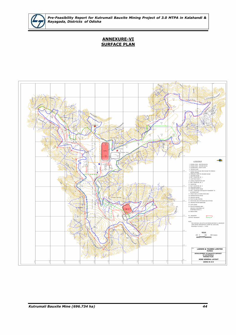
Pre-Feasibility Report for Kutrumali Bauxite Mining Project of 3.0 MTPA in Kalahandi & Rayagada, Districts of Odisha
Kutrumali Bauxite Mine (696.734 ha) 44
ANNEXURE-VI
SURFACE PLAN
N
6500
N
6500
E 5000
E 4500
E 4100
E 3500
E 3000
E 2500
E 2000
E 1500
E 1000
E 500
N
7000
N
7500
N
8000
N
8500
N
9000
N
9500
N
10000
N
10500
N 1
1000
N 1
1500
N 1
2000
E 5500
E 6000
E 6500
1045
800
850
900
950
1000
950
900
850
800
900
950
1000
1050
1040
1000
1050
1060
1050
900
850
950
1000
1000
1080
1090
1100
1110
1050
1120
1130
1140
1050
1060
1150
900
1200
1000
1050
1100
1110
1020
1030
1040
1050
1000
950
950
900
950
1000
1130
1131
1120
1110
1120
1150
1160
1170
1180
1190
1200
1224
1220
1210
1200
1190
1180
1170
1160
1140
1120
1110
1100
1090
1080
1060
1000
1050
1070
1000
900
800
1040
950
1040950
900
850
800
850950
900
1000
1050
1040
1040
1050
900
950
950
1030
1030
1040
1040
1040
950
1000
1000
950
850
900
850
800
900
850
850
900
950
950
900
850
800
750
700
1150
950
1000
1000
950
1040
1030
750
850
900
950
1030
1050
1000
1040
1050
1000
1060
1040
1050
0B -2
3
PERIPHERAL DRAIN
PERIPHERAL DRAIN
K-25
44
KUTRUMALI
DISTRICT BOUNDARY
3
0.B-1
K-22
T . S -1K-24K-21
K-23
20
DISTRICT BOUNDARY
B L O
C
K
W E S T E R N
M.L. BOUNDARY
1
K-14K-1
22
26
26
4
T.S-2
K-19
K-18K-16
A R E A -2
K-17K-15K-2
K-3
A R E A -1
K-13
18
K-4
6
1917
K-20
57
K-5K-12
8
109
E A
S
T
E
R
N
B
L
O
C
K
K-7
5
1125
21
K-8
2
12
13
15
14
K-9
16
K-10
23
TO
ALU
MIN
A P
LAN
T
DISTRICT BOUNDARY
K-6
LELINGAPADAR
K-26
K-27
Z
Z3
24
K-28 K-30
K-29 K-31
K-32
K-33
K-34 K-35
23 GATE HOUSE
22 GROUND WATER RESERVOIR
21 RECEIVING AND STEPDOWN SUB-STATION
20 FUEL FILLING STATION
19 SERVICE CENTRE
18 ADMINISTRATIVE OFICE
17 SPACE FOR R.O.M ORE STOCKYARD
16 BELT CONVEYOR FOR BAUXITE TRANSPORT TO
15 CONEYOR DRIVE HOUSE
14 JUNCTION HOUSE -2
13 BELT CONVEYOR, BC -3
12 SURGE BIN
11 BELT CONVEYOR, BC -2
10 SAMPLE PREPARATION UNIT
9 JUNCTION HOUSE -1
8 BELT CONVEYOR, BC - 1
7 CRUSHER HOUSE
6 APPROACH RAMP TO CRUSHER HOUSE
5 ROADS FOR HAULGE AND ACCESS TO VARIOUS
4 TOPSOIL DUMP
3 OVERBURDEN / WASTE DUMP
2 MINING ZONE - EASTERN BLOCK
1 MINING ZONE - WESTERN BLOCK
INSTALLATIONS
ALUMINA PLANT
L E G E N D
100 0 200 400 meters
M.L. BOUNDARY
DISTRICT BOUNDARY
For:LARSEN & TOUBRO LIMITED
MUMBAI
DEVELOPMENT OF BAUXITE DEPOSITAT KUTRUMALI
MINING PLAN
MINE GENERAL LAYOUT
10352-K-4-6
SCALE
24 BAUXITE BEARING AREA
(BAUXITE THICKMESS<5M
STRIPPING RATIO>1)
25 BENCH MARK
NOTE:
FOR CONTOUR LINE UPTO 500 METERS BEYOND M.L BOUNDARY
LINES REFER TOPOGAPHICAL SHEET NO. 65/M/3/NE,
ENLARGED TO SCALE 1 : 10 000

Pre-Feasibility Report for Kutrumali Bauxite Mining Project of 3.0 MTPA in Kalahandi & Rayagada, Districts of Odisha
Kutrumali Bauxite Mine (696.734 ha) 45
ANNEXURE-VII
GEOLOGICAL PLAN
N 6000E 5
00
E 1
000
E 1
500
E 2
000
E 2
500
E 3
000
E 3
500
E 4
000
E 4
500
E 5
000
E 5
500
E 6
000
E 6
500
N 6500
N 7000
N 7500
N 8000
N 8500
N 9000
N 9500
N 10000
N 10500
N 11000
N 11500
N 12000
L E G E N D
SOIL
KHONDALITE
LATERITIC BAUXITE/BAUXITE
FOLIATION AND DIP
SCRAP HEIGHT IN METERS
BORE HOLE
M.L. BOUNDARY
DISTRICT BOUNDARY
BENCH MARK
1130
1140
1150
1160
1170
1180
1190
1200
1200
1150
1140
1130
1120
1110
1100
1090
1080
1070
1060 1
050
1040
1050
1040
1030
1030
1030
1040
1030
1040
1030
1040
1050
1050
1040
1030
1030
1040
1050
1050
1040
1050
1070
1040
1050
1070
1060
1050
1040
1040
1020
1030
1100
1120
1110
1110
1050
1131
1224
1045
50°
60°
65°
65° 70°
75°
75°
1130
1120
1130
1140
1150
1160
1170
1180
1190
1200
1210
1220
75°
1224
N
100 0 200 400 meters
For:LARSEN & TOUBRO LIMITED
MUMBAI
DEVELOPMENT OF BAUXITE DEPOSIT
AT KUTRUMALI
MINING PLAN
GEOLOGICAL MAP
10352-K-3-1
SCALE

Pre-Feasibility Report for Kutrumali Bauxite Mining Project of 3.0 MTPA in Kalahandi & Rayagada, Districts of Odisha
Kutrumali Bauxite Mine (696.734 ha) 46
ANNEXURE-VIII
GEOLOGICAL CROSS SECTION
1000
1020
1040
1060
1080
1100
1120
1140
1160
1180
1200
BH-K1(RL - 1158.7)
BH-K2
(RL - 1106.6)
BH-K3(RL - 1074.9) BH-K4
(RL - 1062.5)
WESTERN BLOCK
BH-K5(RL - 1057.4)
EASTERN BLOCK
BH-K6(RL - 1052.0)
BH-K7(RL - 1052.0)
POSITIONS OF MINING FACES/BLOCKS TOBE MINED OUT:
YEAR - 1
YEAR - 2
YEAR - 3
YEAR - 4
YEAR - 5
WORKING ZONE FOR
1ST FIVE YEAR
2ND FIVE YEAR
3RD FIVE YEAR
L E G E N D
SOIL
LATERITE
BAUXITE
ALUMINOUS LATERITE
KHONDALITE
PARTIALLY LATERISED KHONDALITE
SCRAP POINT (TOP)
1000
1020
1040
1060
1080
1100
1120
1140
BH-K15
(RL - 1091.8)
BH-K14
(RL - 1127.7)
1000
1020
1040
1060
1080
BH-K3
(RL - 1074.9)
1000
1020
1040
1060
BH-K13
(RL - 1066.1)
1000
1020
1040
1060
BH-K4
(RL - 1062.5)
1030
1050
1070
1130
1110
1170
1150
1130
1110
1020
1000
1020
1040
1060
1080
1100
1120
1140
1160
BH-K1
(RL - 1158.7)
BH-K14
(RL - 1127.7)
BH-K16
(RL - 1102.1)
BH-K18
(RL - 1078.3)
1110
1130
25 0 50 100 meters
For:LARSEN & TOUBRO LIMITED
MUMBAI
DEVELOPMENT OF BAUXITE DEPOSIT
AT KUTRUMALI
MINING PLAN
GEOLOGICAL SECTIONS
10352-K-3-4 TO 10352-K-3-9
SCALE

Pre-Feasibility Report for Kutrumali Bauxite Mining Project of 3.0 MTPA in Kalahandi & Rayagada, Districts of Odisha
Kutrumali Bauxite Mine (696.734 ha) 47
ANNEXURE-IX
CONCEPTUAL MINE PLAN
1060
1060
1120
1110
1060
1130
1120
1160
1140
1160
1140
1140
1150
1070
1070
1070
1080
1110
1080
1080
1070
1060
1060
1070
1070
1110
11201130
1140
1150
1140
1130
1170
1150
1130
1110
1130
1060
1110
1120
1120
1130
1150
1120
1070
1070
1060
1060
1070
1070
1080
K-17
K-13 K-12
K-6
K-24K-23
K-21K-20
K-5K-3 K-4
K-16
K-15K-1A
K-2K-1
K-6
K-8
K-7
K-22
1170
1200
1190
1100
1120
1130
1140
1070
1080
1090
1080
1090
1090
1100
1080
1070
1080
1070
1060
1040
1050
1060
10501060
1070
1080
1090
1110
1110
1150
1160
1170
1180
1190
1170
1150
1140
1110
1120
1130
1110
1110
1100
1060
1050
1040
1040
1040
1050
1060
1050
1070
1050
1040
1040
1050
1050
1050
1030
1030
1040
1046
1046
1040
1030
1050
1048
1042
1050
1050
1050
1040
1040
1060
1062
E4000
E3900
E3800
E3700
E3600
E3500
E3400
E3300
E3200
E3100
E3000
E2900
E2800
E2700
E2600
E2500
E2400
E2300
E2200
E2100
E2000
E1900
E1800
N10700
N10600
N10500
N10400
N10300
N9200
N9300
N9400
N9500
N9600
N9700
N9800
N9900
N10000
N10100
N10200
METERS
METERS
E4800
E4100
E4200
E4300
E4400
E4500
E4600
E4700
N
BORE HOLES DRILLED
SURFACE CONTOUR LINES
ULTIMATE LIMITE OF MINING
PIT BOUNDARIES / WORKING LIMITS FOR:
FIRST FIVE YEARS
SECOND FIVE YEARS
REFERENCE DRAWINGS:
GEOLOGICAL SECTIONS
10352-K-3-4 to 10352-K-3-9
BORE HOLES PROPOSED TO BEDRILLED AFTER 1ST 5 YEAR
THIRD FIVE YEARS
WESTERN BLOCK
EASTERN BLOCK
K-7
1050
TO CRUSHING PLANT
TO WASTE DUMPS
TO
WASTE D
UM
PS
KUTURMALI
25 0 50 100 meters
For:LARSEN & TOUBRO LIMITED
MUMBAI
DEVELOPMENT OF BAUXITE DEPOSIT
AT KUTRUMALI
MINING PLAN
CONCEPTUAL MINING PLAN
10352-K-4-5
SCALE
Recommended