System Portable Synthetic Vision
Portable Synthetic Vision System (PSV) is portable electronic flight and navigation instrumentation system (EFIS), which is fully independent from onboard systems of an aircraft. It includes its own navigation data source and accumulator battery to provide autonomous power supply. PSV is a bring in equipment and can be easily mounted on any type of light aircraft or helicopter.
The PSV equipment integrates all the functions of a modern EFIS in a single compact easy-to-install system.
Introduction
PSV equipment provides the whole range of flight preparation, in flight and post mission operations. PSV implements intuitive flight data indication (3D visualization of aircraft motion -“synthetic vision”) and advanced data processing functions to increase the flight safety. PSV displays all necessary information in easy to interpret way and provides intuitive flight guidance, thus reducing pilot's workload and increasing the situation awareness. All data is displayed on a sunlight readable screen of portable PC mounted on the panel.
The PSV equipment does not require complicated installation procedure because it is bring in equipment and does not substitute any ondoard system. Thus it is optimal (taking into account price-to-performance ratio) solution for cockpit retrofit and cockpit modernization.
Flight preparation and simulation
Data bases: routes, maps, charts, digital terrain, approaches, obstacles, navigation points
Primary flight display (PFD) with 3D terrain, obstacles and flight trajectory indication
Predictive flight guidance throughout the whole flight from takeoff to landing, including taxing patterns and approach guidance
Navigation display and moving map
Terrain Awareness Warning System (TAWS)
Terrain color change according to the flight altitude
Quick charts and digital terrain maps upload
Quick enroute marking of obstacles and points of interest in the map
“Hovering” mode (for helicopters)
AS/SI measurement systems
PSV functionality
PSV in the cockpit of Mi-8 helicopter
Portable Synthetic Vision System Page 1

Approach and landing pattern programming
Visual and audible warnings about dangerous flight or aircraft limitations override
Special modes for “grid” flight (terrain-following aerial survey missions), search and rescue flights and for wild fire fighting missions
System Description
The PSV standard architecture includes the following units:
Inertial GNSS-aided Navigation System
GNSS antenna
Ruggedized Tablet PC CF-19 with Windows OS and special PSV Software
Commutation unit with built-in battery and commutation cables
Optionally the system can be connected to air data sensor.
PSV basic architecture
For helicopters, which allow installation of two displays in the cockpit (one for pilot and another for co-pilot) the PSV can be supplied in extended configuration with two computers (see Fig.3).
PSV extended architecture
The two computers onboard interoperate via 100 megabit per second network. There are two possible modes of interoperation – synchronous and data transfer. In synchronous operation mode both computers act simultaneously – the command to switch, for instance, to 3D view will activate 3D view on both computers. In data transfer mode the changes at one PC will be transmitted to another only after a command. This mode allows the co-pilot, for instance, to prepare a route change in flight on his PC and
Portable Synthetic Vision System Page 2
then transfer the changes to the pilot's PC to display the new route to the pilot. The interoperation between computers helps to reduce the pilot's workload during the flight.
“VIP” architecture of PSV equipment provides backup of each component of the system. In case of failure of any item, the backup one will substitute the faulty one to guarantee system uninterrupted operation.
“VIP” architecture
Inertial GNSS-aided navigation system
The inertial GNSS-aided navigation system Nav-2M is the source of navigation and flight data for the PSV system. It determines position coordinates (latitude, longitude and height), attitude angles (pitch, roll and heading) and motion parameters of an aircraft. The system outputs 50 Hz rate navigation data to the Panasonic CF-19 computer where the data is processed and displayed.
The navigation system includes built in GNSS receiver (in standard configuration it is GPS/GLONASS receiver). Meeting the customer requirements another model of GNSS receiver can be applied.
GNSS antenna
The GNSS receiver antenna is housed in a water-resistant case and designed to withstand rugged operating conditions.
Commutation unit
The commutation unit provides data and power interconnection between the PSV system units. To provide system power supply it is connected to onboard power circuit.
The unit also incorporates built-in accumulator battery and guarantees 2.5 hours of autonomous work of the whole set of PSV equipment.
The LED indicators in front panel display the battery charge and system state.
Toughbook The Panasonic Toughbook CF-19 is a ruggedized laptop computer, which
was designed and tested in accordance with MIL-STD-810F. Panasonic Toughbook meets all the categories and levels of durability expected in the work environment of a cockpit: vibration, drop, water and dust resistance, humidity, high and low temperature, altitude.
As part of PSV the Panasonic CF-19 provides flight data processing, displaying, management and recording. Panasonic CF-19 runs special PSV software to provide mission planning and flight data analysis functions.
The PC can be easily dismounted from the board, so the route planning and flight analysis procedures can be carried out in any place where it is
Portable Synthetic Vision System Page 3
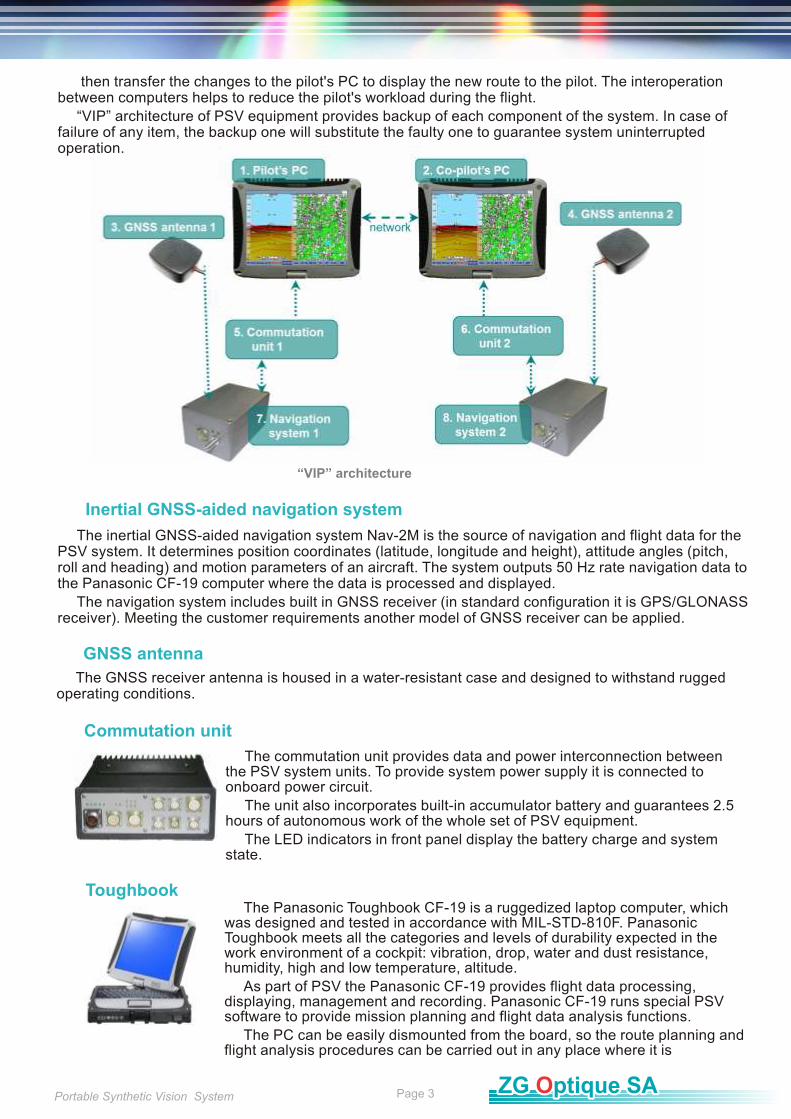
Inertial GNSS-aided navigation system
Panasonic CF-19 (MIL-STD-810F)
Rs232
50 Hz
30 sec
-20..+60˚С
20g (5 ms)
10-30 VDC
1.5 W
125х80х57 mm
0.7 kg
±250 °/s
±6g
±90°
±90°
0..360°
MEMS
Angular velocity
Acceleration
Pitch
Roll
Heading
Type of sensors
Interface
Updata rate
Warm-up time
Operating temperature
Shock
Input voltage
Power
Size
Weight
Operating Ranges
System specification
Specification
Intel Core Duo 1,06 Ghz
HDD 80 Gb
RAM 1.5 Gb
RS 232
Brightness 500 nit
Power 60 W
Operating temperature 0..+60˚C
Storage temperature -40..+60˚C
Weight 2.3 kg
Deployment
System deployment is easy and does not require complicated installation procedures or disassembly of any onboard equipment. The deployment consists of three basic stages:
1. mounting
2. unit interconnection
3. powering up All units should be located within the aircraft in accordance with the following considerations:
The ideal location of inertial navigation system unit is close to the centre of mass of the aircraft. The unit must be placed on a horizontal surface so that the label on the top of the unit points to the flight direction. The system is tolerant to misalignments between unit axis and longitudinal aircraft axis of up to ±5°. The unit location must enable convenient cable connection.
The location of GNSS antenna should ensure a clear view of the sky.
The cables should not run adjacent to heaters, exhausts or other heat sources. Care must be taken to route and tie the cables away from aircraft controls and harnesses.
The tablet PC shall be in view of pilot and its location must provide free access of pilot's hand to the screen. However, it should not create an obstruction to the field of view of the instrument panel. The tablet PC must be installed to enable easy mounting and dismounting to allow flight planning and post-flight analysis on the ground.
The commutation unit must be located in any place, where access to the cables can be provided. The unit location also must guarantee easy dismounting to allow battery re-charging on the ground.
After units are properly arranged and fixed they must be connected with proper cables according to the cable labels. Then the commutation unit must be connected to the board power supply circuit (if such connection is available). If connection to onboard power circuit is not possible, take care to check the battery charge before the flight.
System Operation
The PSV system is fully independent from other onboard equipment.
The navigation system calculates motion parameters based on GNSS and inertial sensor measurements and outputs the data to the tablet PC via RS 232 interface. Data output rate is 50 Hz thus the navigation solution responds the aircraft dynamics and has no time lags. The integration of inertial and GNSS data guarantees uninterrupted navigation solution during GNSS outages. Then the data are processed and visualized by the PSV software into a 3D view of flight (“synthetic vision”). The flight data
Operating Principle
Portable Synthetic Vision System Page 4

are displayed with respect to moving map or aerial image and 3D digital terrain. The software also calculates forecast vectors of motion acceleration, motion speed and altitude vectors and flight direction in order to inform the pilot about the upcoming maneuvers. The 3D view of flight is implemented with easy to interpret visual images, thus providing reliable situation awareness under all flight conditions. The display of motion direction and recommended values of speed and altitude enables more precise route following.
The system provides visual and audible warnings in case of dangerous flight or in case of risk of obstacle or terrain collision (TAWS function). Software is controlled by the means of touch-screen display to simplify the software operation in flight.
The same tablet PC is used for flight data visualization in flight, for flight planning and for flight data analysis. The flight data and the data base of routes, maps, terrain, obstacles, etc. are stored in the PC hard drive.
PSV software provides the functionality of several avionics instruments and systems, including TAWS, EFIS and Electronic Flight Bag. The PSV is able to perform the whole range of flight operations, including flight preparation (flight planning), route, map, airfield data base creation, inflight operations (flight director, approaches, obstacles marking, etc.), post mission flight data analysis.
The PSV offers true-to-life and realistic display of the flight situation thus enhancing situation awareness and eliminating pilot's stress. Route-following flight with PSV is as easy as it has never been before – flight direction cross and recommendation for speed and altitude values guide pilot through all the route from takeoff to landing to any spot – helipad, landing site, runway or any other point you choose.
Operating Principle
The navigation data, motion parameters and trajectory can be displayed in one of the following ways:
in 3D image with digital terrain as background (Primary Flight Display with synthetic vision, PFD)
in 2D image (Navigation Display) with digital terrain, map, approach pattern or aerial image as background
in standard gauges (instrumental panel)
in combined image (3D+2D, 3D+map, 3D+instrumental panel, instrumental panel+map)
The type of data indication is selected by the button in the lower corner of the PGC window.
Primary Flight Display
The primary indication mode in flight is PFD. It displays all standard flight instrumentation as graphical objects: aircraft symbol, rulers, vectors, etc. The aircraft symbol depicts the actual attitude of the aircraft with respect to horizon. The aircraft symbol depicts the actual attitude of the aircraft with respect to horizon.
Primary Flight Display
Portable Synthetic Vision System Page 5

While flying, flight director cross marks the flight direction according to the desired flight plan. When circle of the forecast vector of acceleration matches the flight director cross, the aircraft won't deviate from the programmed route.
Desired speed and height values are marked at the scales to the right and to the left.
The digital terrain data is overlaid as colored three dimensional image on both PFD display and Navigation Display. The PSV software applies color coding of the terrain data. The above-flight-level terrain is coloured red, while the below-flight-level terrain is green.
According to terrain data the terrain proximity line is calculated and displayed in 3D PFD view. Terrain proximity line along with 3D terrain display function and warnings about aircraft operating limitations increase pilot situation awareness, thus TAWS function is implemented.
Navigation Display
The Navigation Display shows planned trajectory, predicted path, and turn limitation. The aircraft shape is displayed as a cross with the arrow pointing in the direction of flight. In the Navigation Display can be displayed digital map or 2D terrain.
PSV software provides raster images georeferencing in order to create digital maps of topographical map images, aerial photos and approach charts meeting the user requirements.
Navigation Display
Navigation display with moving map
Instruments Panel
Instruments Panel Display simulates the following standard avionics instruments:
Artificial horizon
Heading Indicator (HSI)
Altimeter
Climb meter
Ground speed indicator
G-meter
Low altitude altimeter
Portable Synthetic Vision System Page 6
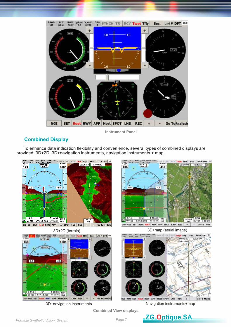
Combined Display
To enhance data indication flexibility and convenience, several types of combined displays are provided: 3D+2D, 3D+navigation instruments, navigation instruments + map.
Instrument Panel
Combined View displays
3D+2D (terrain) 3D+map (aerial image)
3D+navigation instruments Navigation instruments+map
Portable Synthetic Vision System Page 7
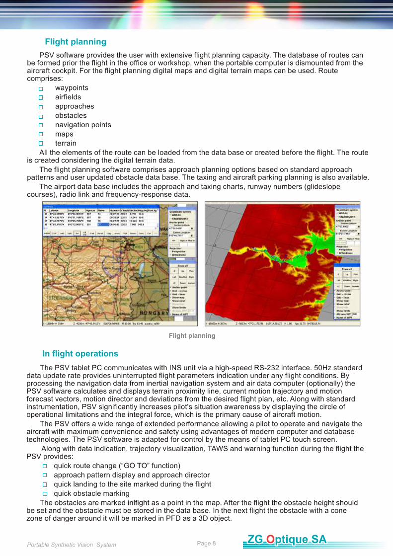
Flight planning
PSV software provides the user with extensive flight planning capacity. The database of routes can be formed prior the flight in the office or workshop, when the portable computer is dismounted from the aircraft cockpit. For the flight planning digital maps and digital terrain maps can be used. Route comprises:
waypoints
airfields
approaches
obstacles
navigation points
maps
terrain
All the elements of the route can be loaded from the data base or created before the flight. The route is created considering the digital terrain data.
The flight planning software comprises approach planning options based on standard approach patterns and user updated obstacle data base. The taxing and aircraft parking planning is also available.
The airport data base includes the approach and taxing charts, runway numbers (glideslope courses), radio link and frequency-response data.
Flight planning
In flight operations
The PSV tablet PC communicates with INS unit via a high-speed RS-232 interface. 50Hz standard data update rate provides uninterrupted flight parameters indication under any flight conditions. By processing the navigation data from inertial navigation system and air data computer (optionally) the PSV software calculates and displays terrain proximity line, current motion trajectory and motion forecast vectors, motion director and deviations from the desired flight plan, etc. Along with standard instrumentation, PSV significantly increases pilot's situation awareness by displaying the circle of operational limitations and the integral force, which is the primary cause of aircraft motion.
The PSV offers a wide range of extended performance allowing a pilot to operate and navigate the aircraft with maximum convenience and safety using advantages of modern computer and database technologies. The PSV software is adapted for control by the means of tablet PC touch screen.
Along with data indication, trajectory visualization, TAWS and warning function during the flight the PSV provides:
quick route change (“GO TO” function)
approach pattern display and approach director
quick landing to the site marked during the flight
quick obstacle marking
The obstacles are marked inlfight as a point in the map. After the flight the obstacle height should be set and the obstacle must be stored in the data base. In the next flight the obstacle with a cone zone of danger around it will be marked in PFD as a 3D object.
Portable Synthetic Vision System Page 8
Training
The PSV allows user getting familiar with system performance before flight. A set of joysticks turns the PSV into a compact desktop simulator.
As a simulator the PSV provides two functions:
Learning basic system operation.
Flight preparation: once flight plan is ready the pilot can perform the virtual flight, following selected trajectory, learning navigation over a particular area of the forthcoming flight.
Debriefing
All the data coming from INS can be recorded in the tablet PC. The system allows simultaneous recording of more then 30 flight parameters, including pitch, roll, heading angles, speed, coordinates, altitude and barometric height, GPS data and other.
The PSV software has an advanced capacity for debriefing and post mission flight data analysis. The system is capable to playback the flight data with different time scales.
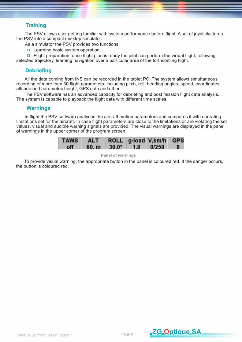
Warnings
In flight the PSV software analyses the aircraft motion parameters and compares it with operating limitations set for the aircraft. In case flight parameters are close to the limitations or are violating the set values, visual and audible warning signals are provided. The visual warnings are displayed in the panel of warnings in the upper corner of the program screen.
To provide visual warning, the appropriate button in the panel is coloured red. If the danger occurs, the button is coloured red.
Panel of warnings
Portable Synthetic Vision System Page 9
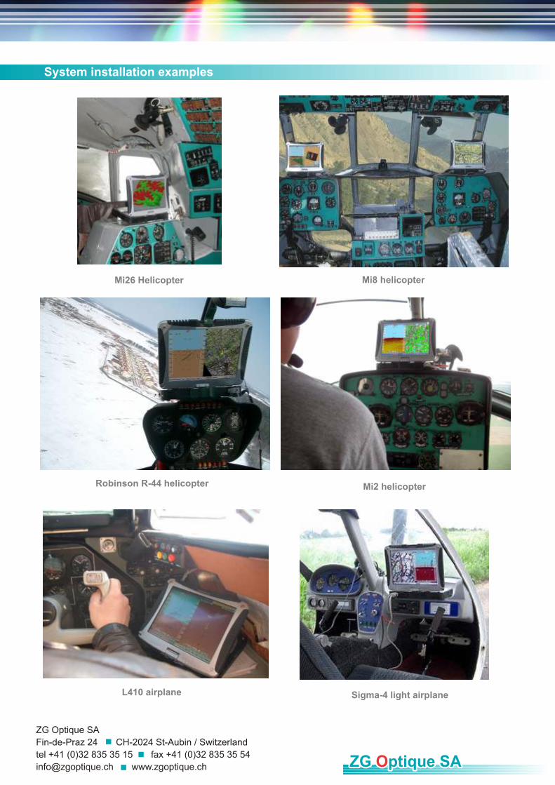
Sigma-4 light airplaneL410 airplane
System installation examples
Mi8 helicopter Mi26 Helicopter
Mi2 helicopterRobinson R-44 helicopter
ZG Optique SA
Fin-de-Praz 24 CH-2024 St-Aubin / Switzerland
tel +41 (0)32 835 35 15 fax +41 (0)32 835 35 54
[email protected] www.zgoptique.ch
Recommended