Petroleum Geology and Hydrocarbon Plays of the
San Juan Basin Petroleum Province
A. Curtis Huffman, Jr.
U.S. Geological Survey Open-File Report
87-450 B
This report is preliminary and has not been reviewedfor conformity with U.S. Geological Survey editorial
and stratigraphic nomenclature.
!u.S. Geological Survey, Box 25046, MS 939, Denver, Colorado 80225

CONTENTSPage
IntroductionLocation, size, and type.......................................... 1Structural setting................................................ 1Stratigraphy...................................................... 5Source Rocks...................................................... 9Burial history, thermal maturity, timing of migration............. 9Hydrocarbon occurrence............................................ 13
Stratigraphic and structural habitat of petroleum............ 13Basis for play definition.................................... 13Criterion for plays selected................................. 14Other prospective areas or intervals......................... 14
Principal PlaysPennsylvanian..................................................... 15
Play description and type.................................... 15Reservoirs................................................... 15Traps and seals.............................................. 18Source rocks and geochemistry................................ 18Timing and migration......................................... 19Depth of occurrence.......................................... 19Exploration status........................................... 19
EntradaPlay description and type.................................... 23Reservoirs................................................... 23Traps and seals.............................................. 23Source rocks and geochemistry................................ 26Timing and migration......................................... 26Depth of occurrence.......................................... 26Exploration status........................................... 27
DakotaPlay description and type.................................... 29Reservoirs................................................... 29Traps and seals.............................................. 30Source rocks and geochemistry................................ 30Timing and migration. ........................................ 34Depth of occurrence.......................................... 34Exploration status........................................... 34
GallupPlay description and type.................................... 38Reservoirs................................................... 38Traps and seals.............................................. 39Source rocks and geochemistry................................ 39Timing and migration. ........................................ 39Depth of occurrence.......................................... 44Exploration status........................................... 44

CONTENTS (continued)
MesaverdePlay description and type.................................... 47Reservoirs................................................... 47Traps and seals.............................................. 48Source rocks and geochemistry................................ 48Timing and migration......................................... 51Depth of occurrence.......................................... 51Exploration status........................................... 51
Pictured CliffsPlay description and type.................................... 54Reservoirs................................................... 54Traps and seals.............................................. 54Source rocks and geochemistry................................ 55Timing and migration. ........................................ 55Depth of occurrence.......................................... 55Exploration status........................................... 55
Fruitland/KirtlandPlay description and type.................................... 59Reservoirs................................................... 59Traps and seals.............................................. 59Source rocks and geochemistry................................ 59Timing and migration. ........................................ 60Depth of occurrence.......................................... 60Exploration status........................................... 60
References Cited....................................................... 64
TABLES
1. Pennsylvanian oil and gas fields.................................. 162. Entrada oil and gas fields........................................ 243. Dakota oil and gas fields......................................... 314. Gallup oil and gas fields......................................... 405. Mesa oil and gas fields........................................... 496. Pictured Cliffs oil and gas fields................................ 567. Fruitland/Kirtland oil and gas fields............................. 61
FIGURES
1. Location map, San Juan Basin petroleum province................. 22. Tectonic map, San Juan Basin petroleum province................. 33. Structure map, San Juan Basin and vicinity...................... 44. Cross Sections.................................................. 65. Stratigraphic nomenclature chart................................ 76. Lopatin, diagrams, San Juan Basin petroleum province............ 107. Pennsylvanian play outline and fields........................... 178. a. Pennsylvanian discovery history (oil)........................... 20
b. Pennsylvanian pool size distribution (oil)...................... 209. a. Pennsylvanian discovery history (gas)........................... 21
b. Pennsylvanian field size distribution (gas)..................... 2110. Entrada play outline and fields................................. 2511.a. Entrada discovery history (oil)................................. 28
b. Entrada pool size distribution (oil)............................ 28
ii
CONTENTS (continued)
12. Dakota play outline and fields.................................. 3313.a. Dakota discovery history (oil).................................. 35
b. Dakota pool size distribution (oil)............................. 3514.a. Dakota discovery history (gas).................................. 36
b. field size distribution (gas)................................... 3615. Gallup play outline and fields.................................. 4316.a. Gallup discovery history (oil).................................. 45
b. Gallup pool size distribution (oil)............................. 4517.a. Gallup discovery history (gas).................................. 46
b. Gallup field size distribution (gas)............................ 4618. Mesaverde play outline and fields............................... 5019.a. Mesaverde discovery history (oil)............................... 52
b. Mesaverde pool size distribution (oil).......................... 5220.a. Mesaverde discovery history (oil)............................... 53
b. Mesaverde field size distribution............................... 5321. Pictured Cliffs play outline and fields......................... 5722.a. Pictured Cliffs discovery history (gas)......................... 58
b. Pictured Cliffs field size distribution (gas)................... 5823. Fruitland/Kirtland play outline and fields...................... 6224.a. Fruitland/Kirtland discovery history (gas)...................... 63
b. Fruitland/Kirtland field size distribution (gas)................ 63
iii
INTRODUCTION
Location, Size, and Type
The San Juan Basin petroleum province incorporates much of the area from 35° to 38° north latitude and from 106° to 109° west longitude and comprises all or parts of San Juan, McKinley, Rio Arriba, and Sandoval Counties in northwest New Mexico and Montezuma, La Plata, Archuleta, San Juan, Mineral, and Hinsdale Counties in southwestern Colorado (fig. 1). As defined for this study, it includes areas that lie outside the structural or topographic San Juan Basin (figs. 2 and 3). The southern part of the area lies in the Colorado Plateau physiographic province while much of the northern part is within the southern Rocky Mountain province. Nearly all hydrocarbon production and subsurface data are restricted to the topographic San Juan Basin but there is increasing interest in the area surrounding and underlying the San Juan volcanic field. Little information is as yet available in this frontier area and it will not be included in any of the plays discussed in this report.
The San Juan Basin petroleum province covers an area of about 23,700 mi (61,400 km2 ). Of this total about 9,900 mi 2 (25,600 km2 ) or 42 percent, is administered by the U.S. Government; about 9,500 mi 2 (24,600 km2 ) or 40 percent is Indian land- about 3,700 mi2 (9,600 km2 ) or 16 percent is privately held; and about 600 mi (1,600 km2 ) or 2 percent is state land.
The San Juan Basin itself has been classified as a craton-accreted margin (complex) basin (type IIB) by Klemme (1986) and as a foredeep basin (type B2) by Bally (1975). A characteristic of these types of basins is that they commonly are filled by sequences comprising two or more cycles of deposition a first cycle of carbonate shelf or platform sediments and a second cycle of erogenic elastics. The San Juan Basin contains two such sequences or megacycles: (1) Paleozoic and, (2) Upper Cretaceous to Oligocene.
Structural Setting
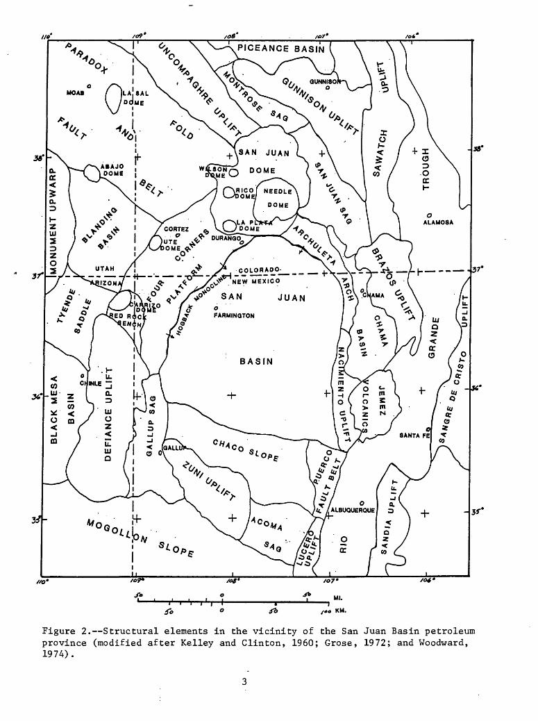
The San Juan Basin petroleum province contains all or parts of a number of tectonic elements (fig. 2). In their present form most of these are Laramide features but much of the tectonic framework was inherited from older structures. The pre-Laramide structures influenced depositional patterns throughout much of the stratigraphic section thereby affecting reservoir quality and, to some extent, source rock distribution. Laramide tectonic and thermal patterns determined the maturation and migration history within the basin.
The structural San Juan Basin is rimmed on the east, west, and north by uplifts or monoclinal structures with structural relief of as much as 15,000 ft (4570 m). The southern boundary is somewhat nebulously defined as the northern limit of the Chaco slope, a homocline dipping north from the Zuni uplift (fig. 3). The interior of the basin is characterized by gently dipping to flat lying sedimentary rocks and a few widely scattered low-relief domal or anticlinal structures. Very few faults have been mapped at the surface.

106
38*
_.UIAH._
SAN JUAN
SGUNNISON 1
Figure 1. Location of the San Juan Basin petroleum province in relation to states, counties, and Indian reservations of the Four Corner area. Also shown are the locations of cross sections of figure 4 and wells used for Lopatin diagrams of figure 6.
2
/of
COLjORADO-___ __ X \
//O*
Ml.
KM.
Figure 2. Structural elements in the vicinity of the San Juan Basin petroleum province (modified after Kelley and Clinton, 1960; Grose, 1972; and Woodward, 1974).

32 « «4 KM
Figure 3. Generalized structure of the San Juan Basin and vicinity on the base of the Dakota Sandstone (Thaden and Zech, 1984).

Immediately adjacent to the structural basin on the south and west, the Chaco slope and part of the Four Corners platform also lie within the topographic basin. In these areas the sedimentary rocks are gently dipping, but domal and anticlinal structures are more pronounced and more common as are surface faults (fig. 3). Deep-seated structures with little or no surface expression are also more common.
Included in the San Juan Basin petroleum province but separated from the structural and topographic basin by the Hogback monocline and Archuleta arch respectively, the San Juan dome and Chama basin contain sedimentary sequences that are similar to those of the San Juan Basin. Within much of the San Juan dome the sedimentary section is covered by variable thicknesses of volcanic rocks surrounding numerous caldera structures.
Stratigraphy
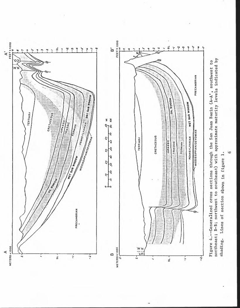
The stratigraphic section in the San Juan Basin attains a maximum thickness of approximately 15,000 ft (4570 m) in the northeast part of the structural basin (fig. 4) where the Upper Devonian Elbert Formation lies on Precambrian basement. Elsewhere in the province Cambrian, Mississippian, Pennsylvanian or Permian rocks may overlie the Precambrian (fig. 5).
CambrianCambrian rocks are present only in the northern part of the province
where there is as much as 150 ft (46 m) of Upper Cambrian quartzite, quartzose sandstone, and local shale lenses of the Ignacio Quartzite. The Ignacio is thought to have been deposited by an eastward-transgressing sea and only preserved in relatively small, isolated down-thrown fault blocks (Stevenson and Baars, 1977).
DevonianThe Devonian of the petroleum province, comprising the Aneth, Elbert, and
part(?) of the Ouray Formations, may reach thicknesses of 500 ft (150 m) in the Four Corners area but is absent in the southern San Juan Basin (Stevenson and Baars, 1977). The Upper Devonian Aneth and lower part of the Ouray Formations are primarily limestone and dolomite, whereas, the lower part of the Elbert Formation contains fine- to medium-grained glauconitic sandstones of the McCraken Sandstone Member. The upper member of the Elbert consists of waxy shale, thin-bedded limestone and dolomite, and glauconitic sandstone. Baars (1966) suggested a tidal-flat environment of deposition for the upper member of the Elbert.
MississippianWithin the San Juan Basin petroleum province, the Mississippian System is
composed of limestone and fine-grained dolomite of the Leadville and upper part of the Ouray Limestones. Total thickness is commonly between 150 and 300 ft (50-100 m). Armstrong and Mamet (1977) suggest a subtidal-intertidal depositional environment for the upper part of the Ouray and lower part of the Leadville and sedimentation on a shallow shelf with localized areas of lime mud accumulation or ooid sands developed in shoaling waters for much of the upper part of the Leadville.
AM
ET
ER
S «
1000
SL
-
-i-
A'FEET X1000
PRECAMBRIAN
3 2
-SL -2 -3 -6 -7 -a
BM
ET
ER
SX
1000
SL -
CRETACEOUS
PENNS/LVANIAN
WET QA* V*»HOO
Figure 4. Generalized coross se
ctio
ns through
the
San
Juan
Basin
(A-A
1, southwest
to
northeast; B-B; no
rthw
est
to southeast) with approximate
matu
rity
levels indicated
by
shad
ing.
Li
nes
of section
sbown
in figure 1.
SAN JUAN BASIN TIME-STRATIGRAPHIC NOMENCLATURE CHART
SOUTH NORTHM.Y.
65
136
190 :?:>
225
280
320
345
395435500
EOCENE
PALEOCENE
MIDDLE
LOWER
WOLFCAMP
570PRECAMBRIAN
SAN JOSE FM 2500*
NACIMIENTO FM 500-1300; O ALAMO SS 0-250'
^
2ANIMAS
UPPER SH MBRKIRTLAND SH
0-1500'FARMINGTON SS MBRLOWER SH MBR
FRUITLANO FM 0-500'
.X*-
ALLISON MBR
PICTURED CLIFFS ss 0-400-^
HUERFANITO BENTONITE BED
i. CLIFF HOUSE SS 0-800' LEWIS SH 0-2400'
MESAVERDE GROUP MENEFEE FM 0-2200-
"5^3W
MORRISON FM 400^900'
WANAKAH BECLABITO MBR. 20-100'BLUFF / JUNCTION CREEK SS 0-250'
ENTRADA SS 100-250'
DATA SUGGEST JURASSIC-TRIASSIC BOUNDARY BASE OF LUKACHUKAI MBR OF WINGATE SS.
OWL ROCK MBR
p OtEO SS LENTIL ~ =
DE CHELLY SS 0-600'
ABO FM OR LOWER CUTLER 400-2000' CUTLER FACIES
xaxiiiiHONAKER TRAIL F
GRANITIC AND HIGH RANK METAMORPHIC ROCKS
Figure 5. --San Juan Basin time-strati graphic nomenclature chart (modified after Moleriaar, 1977b).
Pennsylvania!!The Pennsylvanian System in the petroleum province is represented by the
Molas Formation, which consists of a paleo-sol developed on the underlying Mississippian carbonates and red marine shale, and by the Hermosa Formation of Middle to Late Pennsylvanian age. The Hermosa, which may be as thick as 3,000 ft (914 m), wedges out to the south. Three members of the Hermosa are recognized: the lower member, the Paradox Member, and the upper member (Pinkerton Trail, Paradox, and Honaker Trail Formations of Wengard and Matheny, 1958). The upper and lower members consist primarily of a cyclic sequence of intercalated sandstone and shale beds and thin marine limestone beds of a normal marine environment (Stevenson, 1983). In the Paradox evaporitic basin, the Paradox Member is composed of repetitive cycles of halite, anhydrite, dolomite, and black shale but southeastward into the San Juan Basin it changes facies to restricted marine carbonates and black shale.
PermianPermian arkosic redbeds overlie the Pennsylvanian marine rocks throughout
most of the petroleum province except along the flanks of the basin where the Permian unconformably overlies the Precambrian. In the northern and central part of the San Juan Basin and on the Four Corners platform, the Permian System is composed of the Halgaito, Cedar Mesa, and Organ Rock Formations of the Cutler Group and the overlying eolian DeChelly Sandstone. The source of the reddish-brown arkosic elastics that dominate the 1,000 to 2,500-ft (300- 760 m)-thick Cutler Group and equivalent Abo Formation was the Uncompahgre Uplift to the north and northeast (Baars, 1962). In the southern part of the area the Permian System becomes more marine above the Abo Formation where the Yeso Formation, Glorieta Sandstone, and San Andres Limestone are preserved.
TriassicWithin the San Juan Basin petroleum province the Triassic System is
represented by continental deposits of the Upper Triassic Chinle Formation in New Mexico and the partly equivalent Dolores Formation in Colorado. Thickness ranges from 0 to 1,600 ft (0-500 m). The overlying eolian Lukachukai Member of the Wingate Sandstone is of questionable age but was assigned to the Early Jurassic by Peterson and others (1977) based on palynomorphs found in the intertonguing Moenave Formation in south-central Utah. The Lukachukai Member is present in the northwestern part of the area only. Elsewhere in the province the Chinle and Dolores are unconformably overlain by the Entrada Sandstone of Middle Jurassic age.
JurassicThe dominantly continental San Rafael Group and Morrison Formation make
up the bulk of the Jurassic System in the petroleum province. The Entrada sandstone is primarily eolian while the Wanakah Formation contains a marine limestone and evaporite member (Todilto Limestone Member in New Mexico, Pony Express Limestone Member in Colorado) at the base overlain by tidal flat and eolian deposits. Along the southwestern margin of the San Juan Basin the eolian Cow Springs Sandstone overlies and intertongues with the Wanakah. Throughout much of the province the Morrison Formation is eolian at the base, fluvial in the middle, and lacustrine at the top. Total thickness of Jurassic rocks in the area ranges from 0 to 1,500 ft (0-450 m).
CretaceousMost of the hydrocarbon production in the San Juan Basin petroleum
province is from the 6,500-ft (1980 m)-thick Upper Cretaceous section that comprises five major transgressive/regressive cycles. The basal transgression and associated deposits of the Dakota Sandstone advanced from east to west whereas the later transgressions were from the northeast (Molenaar, 1977a). The Dakota Sandstone and coastal barrier sandstone deposits of the Gallup, Point Lookout, Cliff House, and Pictured Cliffs sandstones constitute the principal reservoirs, and black marine shales of the Mancos and Lewis Shales are the primary source rocks of the province. Coal deposits in the Dakota Sandstone, Menefee Formation, and Fruitland Formation not only are a resource in themselves but also are a major source of gas within the central part of the basin.
TertiaryAn unknown thickness of Tertiary continental sediments were deposited and
subsequently removed throughout the province. What remains is typically conglomerate, sandstone, arkosic sandstone, and shale of fluvial and lacustrine origin that ranges in thickness from 0 to 4,000 ft (0-1200 m), plus the overlying volcanics in the northern part of the province.
Source Rocks
Principal source rocks in the San Juan Basin petroleum province are marine black shales of the Pennsylvanian Hermosa Formation and Upper Cretaceous Mancos and Lewis Shales; marine limestone of the Pennsylvanian Hermosa and Upper Jurassic Wanakah Formations; and coals of the Upper Cretaceous Dakota Sandstone, Menefee Formation, and Fruitland Formation.
Burial History, Thermal Maturity, Timing of Migration
Prior to Cretaceous time the region of the Colorado Plateau that was to become the San Juan Basin experienced several depositional cycles punctuated by periods of uplift and erosion. At the initiation of Cretaceous marine transgressions there were approximately 6,000 ft (1830 m) of sedimentary rocks overlying the Precambrian basement complex in the northern part of the area and less to the south. During the Late Cretaceous the basin subsided rapidly and received as much as 6,500 ft (1980 m) of marine and continental sediments. In the northern part of the basin, subsidence and marginal uplift continued at a similar or even accelerated rate to the end of the Oligocene resulting in a thick (approximately 7,500 ft; 2280 m) section of continental deposits including volcanic flows and ejecta in the northernmost areas. Uplift and erosion since the close of the Oligocene has left about 15,000 ft (4570 m) of sedimentary fill in the deepest part of the basin.
The thermal history of the basin can be divided into a pre-Tertiary normal basin regime and a Tertiary thermal event. Throughout most of the basin, a thermal gradient of 1.5°F/100 ft (27°C/km) is assumed for the pre- Tertiary (figs. 6.a,b.) except in the southernmost part of the basin where proximity to the intermittently active Zuni uplift and its Precambrian core suggests higher gradients (fig. 6.c). The intrusive and extrusive activity of the San Juan dome beginning in the Paleocene and culminating in a "heat flash" during the Oligocene raised the gradient to approximately 3.1°F/100 ft (55°C/km) according to Bond (1984). In the southern part of the basin,Miocene to Pleistocene volcanism may have raised the gradient to similar values. Data are not available to allow analyses of the gradient in the

ui
METERS fPENN. t PERMIAN | TRIAS, t JURASSIQ
o zUl Ul *-j o 2 X< o -< 2
t CRETACEOUS faj ui t O I s J PPCT
2,000
2<x> /&0 /oo JO
AGE (MYBP)
Figure 6a. Lopatin diagram for north-central San Juan Basin (T. 34 N.,
R. 8 W., S. 11).
10

METERS FEETPERMIAN I TRIAS. I JURASSIC
AGE (MYBP)
Figure 6b. Lopatin diagram for south-central San Juan Basin (T. 23N., R. 9W., S. 12).
.11

Ul
METERS PEET\ PENN. I PERMIAN I TRIAS.
6,000-
C./KM.
AGE (MYBP)
Figure 6c. Lopatin diagram for southern Chaco slope (T. 15 N., R. 13 W., S. 8).
12

northernmost part of the petroleum province beneath the volcanics, but it was probably quite high.
Maturity of any particular stratigraphic interval depends both on its burial history and on proximity to one of the major heat sources. Consequently, very few generalizations can be made for the entire basin except that Pennsylvanian strata are at least mature throughout and that the Cretaceous source rocks in the northern part of the basin reached maturity in the Eocene. Bond (1984) credits the Oligocene "heat flash" with eliminating the time consideration from maturation calculations for the Cretaceous section in the northern part of the basin where most of the Cretaceous and older rocks are super mature.
Similar reasoning can be applied to the timing of migration. Nearly all hydrocarbon migration would have taken place since the Late Cretaceous with most having occurred since the Eocene. Basin configuration has remained relatively stable since cessation of Oligocene volcanism.
Hydrocarbon Occurrence
Stratigraphic and Structural Habitat of PetroleumMost hydrocarbon occurrences in the San Juan Basin petroleum province are
at least partially stratigraphically controlled. In the central part of the basin, stratigraphy and hydrodynamic forces control nearly all production while around the margins of the basin, structure and stratigraphy are the primary factors. Although most Pennsylvanian oil and gas is found on structures around the northwestern margin, it commonly accumulates only in the highly porous biothermal limestone buildups. Jurassic oil on the southern margin of the basin is stratigraphically trapped in eolian dunes at the top of the Entrada Sandstone. Nearly all oil and gas in Upper Cretaceous sandstones of the central basin is produced from stratigraphic traps such as reservoir sandstone pinchouts into marine shale or continental shale and coal, or where abnormally thick reservoir sandstone buildups resulted from still stands or tectonic activity during deposition. Around the margins of the basin, the same Cretaceous units produce oil on many of the structures.
Two additional factors affecting the distribution and production of oil and gas from the Upper Cretaceous reservoirs are hydrodynamic forces and differences in permeability. Neither are completely understood but together create a situation where gas in the central basin is structurally lower than oil or water in the same units around the margins. Even though most of the reservoirs of the central basin are saturated with gas, because of their low permeability many will only produce where fractured, either naturally or artificially.
Basis for play definitionIn this analysis, plays are defined primarily on the basis of
stratigraphy because of the strong stratigraphic controls on the occurrence of hydrocarbons throughout the province. In general, the plays correspond to lithostratigraphic units such as formations or members containing good reservoir rocks and with access to source beds. Several of the plays are further divided into basinal and basin flank components based on both location and dominant trap type.
13
Criterion for plays selectedThe San Juan Basin petroleum province is moderately to well explored in
much of the area with a long history of development. The plays selected for discussion in this analysis are the generally recognized producing intervals.
Other prospective areas or intervalsSeveral prospective exploration targets remain inadequately tested. The
entire area surrounding and even underlying some of the volcanics of the San Juan dome has potential for hydrocarbon accumulations especially in the Pennsylvanian and the lower part of the Cretaceous section as do the deeper parts of the section on the Southern Ute and Jicarilla Apache Indian Reservations where very little deep drilling has been attempted. The Mississippian and Pennsylvanian have been inadequately tested throughout most of the area but depth and probable target size east of the Four Corners platform will probably limit activity in the near future. Several large structures in the northern part of the San Juan Basin, such as the Hogback monocline and Archuleta arch (fig. 2) have also been inadequately tested. Recent reprocessing of seismic data along the Hogback monocline suggests easterly directed thrust faulting at depth with as much as 4,000 ft (1220 m) vertical offset and about 3,000 ft (900 m) of overlap along parts of this structure. The southwestern flank of the Archuleta arch has not been explored either by drilling or seismic surveys.
By far the largest undeveloped potential within the petroleum province is coal-bed methane within the Fruitland Formation in the central basin. The few wells producing from this interval show great promise but further development will depend on technological advances in engineering, drilling, and completion techniques.
14
PRINCIPAL PLAYS
Perms ylvanian
Play description and typeThe Pennsylvania!! oil and gas play is in mounds of algal (Ivanovia)
limestone associated with organic-rich black shale rimming the evaporite sequences of the Paradox Member of the Hermosa Formation. Most of the developed fields within the San Juan Basin petroleum province produce from combination traps on the Four Corners platform at depths ranging from 5,100 to 8,500 ft (1550-2590 m).
Nearly all hydrocarbon production from Pennsylvanian rocks in the vicinity of the San Juan Basin has been from vuggy limestone and dolomite in the Paradox Member of the Hermosa Formation on the Four Corners Platform. Jentgen (1977) described the Paradox Member as containing "complex lateral facies changes, from thick interbedded evaporites and black shale in the northwestern San Juan Basin and the southeasternmost Paradox basin, to thinner conglomeratic and cherty limestone, sandy siltstone, and arkosic rocks in the central San Juan Basin. Evaporites in the Paradox wedge out abruptly in places against carbonate buildups." Hydrocarbon producing zones in the Paradox Member have been given informal names (Malin, 1958) and correlated by Hite (1960) with salt cycles in the Paradox basin. In ascending order, these zones are the Alkali Gulch, Barker Creek, Akah, Desert Creek, and Ismay. The zones gradually become less distinct toward the central part of the San Juan Basin.
Pennsylvanian production on the Four Corners Platform and in the northwestern part of the San Juan Basin is typically both stratigraphically and structurally controlled. Zones of biostromal porosity or "carbonate buildups" located on anticlinal noses or domes and intersected by structure- related fractures are the most common types of traps (Fassett and others, 1978). Carbonate shelf deposits in the San Juan Basin generally rim the Paradox evaporite sequences and may have formed barriers between the central Paradox basin and its inlet to the sea, the Cabezon accessway, in the southeastern part of the San Juan Basin (Wengard and Matheny, 1958). Strong uplift of the Uncompahgre, San Luis, and Penasco highlands resulted in an influx of clastic material and arkose during late Desmoinesian time, initiating the final regression of the Pennsylvanian sea from the area.
ReservoirsPennsylvanian reservoirs in the San Juan Basin are developed in the shelf
counterparts of the evaporitic sequences of the Paradox Basin. Their depositional history is one of variation in shelf deposition, partial evaporitic cyclic deposition, and changes due to local conditions. A common cycle is a succession of siltstone, black shale, dolomite, argillaceous limestone, bioclastic (algal) limestone, argillaceous limestone, dolomite, and siltstone (Picard and others, 1960). The cyclic character of the basinal evaporitic sequences was first described by Herman and Barkell (1957).
The following brief reservoir descriptions are modified primarily from Picard and others (1960). The Barker Creek zone is the main producer at the Barker Creek field (table 1, fig. 7) where it is predominantly fossiliferous, microcrystalline to large-grained algal limestone with about 20 percent of the interval being calcareous and dolomitic shale. Total thickness is about 230 ft (70 m) with a net pay thickness of about 100 ft (30 m) and a porosity range of 2 to 10 percent. At Tocito dome field (table 1, fig. 7) it is 100 to 120
15

Table 1. Pennsylvanian oil and gas fields, San Juan Basin petroleum province(Fassett, 1978, 1983)
No. FieldLocation
discovery wellDate of Estimated ultimate recovery discovery Oil (MBO) Gas (MCFG)
1 Alkali Gulch
2 Barker Creek
3 Big Gap
4 Blue Hill
5 Buena Suerte
6 Cone
7 Four Corners
8 Hogback
9 Pajarito
10 Rattlesnake
11 Shiprock N.
12 Table Mesa
13 Tocito Dome
14 Tocito Dome N.
15 Ute Dome
16 Wikiup
T.34 N.,R.12 W.,8.32 1957 30,000,000
T.32 N.,R.14 W.,8.16 1945 200 230,000,000
T.27 N.,R.19 W.,8.20 1979 40 50,000
T.32 N.,R.18 W.,S.36 1953 1,300,000
T.25 N.,R.ll W.,S. 3 1971 10 8,000
T.31 N.,R.18 W.,8.22 1964 16 400,000
T.32 N.,R.20 W.,8.29 1956 100 85,000
T.29 N.,R.16 W.,8.19 1954 450 13,000,000
T.29 N.,R.17 W.,8.31 1963 175 150,000
T.29 N.,R.19 W.,8. 2 1929 950 1,900,000
T.30 N.,R.18 W.,8.14 1974 70,000
T.27 N.,R.17 W.,8. 3 1961 180 7,500,000
T.26 N.,R.18 W.,8.17 1963 15,000 30,000,000
T.26 N.,R.18 W.,8. 9 1967 350 700,000
T.32 N.,R.14 W.,8.35 1948 160 85,000,000
T.33 N.,R.14 W.,8.24 1972 30,000
16

_. ._CQ.LORADO____r_/£U ______ ___.
^ 1 * BLOOMFIELD j
.« f
Figure 7. Pennsylvanian play outline and developed oil and gas fields, San Juan Basin petroleum province. Numbered fields from table 1.
17
ft (30-36 m) thick with a net pay of about 17 ft (5 m).The Akah zone at the Hogback field (table 1, fig. 7) contains algal
(Ivanovia) limestone, sparsely to moderately fossiliferous limestone, dolomitic limestone, secondary dolomite, and oolitic and pelletoid limestone. Calcarenite, secondary dolomite, and fractured limestone beds are productive where intercrystalline, vuggy, and fracture porosity is found. Total thickness is about 180 ft (55 m) with a net pay of 16 ft (5 m) and a porosity range of 8 to 20 percent.
The Desert Creek zone at the Aneth field (present outside province, but not numbered on fig. 7) is predominantly microcrystalline to large-grained fossiliferous algal limestone with lesser amounts of oolitic limestone and dolomite. The productive intervals at Aneth are calcarenite, calcirudite, secondary dolomite, and oolitic limestone with vuggy intercrystalline, intra- oolitic and inter-oolitic porosity. Total thickness of the zone ranges from 120 to 200 ft (37-61 m) with about 50 ft (15 m) of net pay and 10 percent porosity.
The Ismay zone at the Ismay and Flodine Park fields (present outside province, but not numbered on fig. 7) produces from bioclastic carbonate buildups that occur stacked one above another in three intervals and trend northeast (Mecham, 1978). Porosity and permeability are related to depositional fabric, extent of leaching, and degree of pore filling by calcite and anhydrite. Average porosity is about 11 percent and permeability about 13 millidarcies. Total Ismay thickness is about 200 ft (60 m) with a net pay of 24 to 40 ft (7-12 m).
Traps and sealsCombination stratigraphic and structural trapping mechanisms predominate
among Pennsylvanian fields of the San Juan Basin and Four Corners platform. Most are located on structures although not all of these demonstrate closure. The structures themselves may have been a critical factor in the deposition of the bioclastic limestone reservoir rocks (Elias, 1963). A number of the fields are faulted as well, further complicating analyses of the traps. Seals are provided by a variety of mechanisms including porosity differences in the reservoir rock, overlying evaporites, and interbedded shale.
Source rocks and geochemistrySource beds for Pennsylvanian oil and gas are believed to be organic-rich
shales and laterally equivalent carbonates within the Paradox Member (Picard and others, 1960). Rice (1983) concurs and notes that the presence of hydrogen sulfide (t^S) and appreciable amounts of C02 at Barker Creek and Ute dome fields (table 1, fig. 7) indicate high temperature decomposition of carbonates. Ross (1980) was not able to establish a firm correlation between Pennsylvanian oil and bitumen from Pennsylvanian sources in the San Juan Basin but observed similarities of pristane/phytane ratios. Kite and others (1984) correlated the black shale units of the Paradox Member in the Paradox evaporitic basin with prodelta facies in clastic cycles present in the Silverton fan delta complex (Silverton embayment clastic delta of Fetzner, 1960) on the northeastern edge of the basin. This correlation helps explain the high percentage of kerogen from terrestrial plant material in the black shale source rocks.
18

Pennsylvanian oil in the San Juan Basin ranges from 40° to 55° API gravity and is oaraffin based. Rice (1983) states that "the isotopic composition (<5 * C values range from -35.3 to -37.9 permil) and chemical composition (Cj/Cj_5 values range from 0.98 to 0.95) of natural gases from Barker Creek field suggest they are the product of the post-mature stage."
Timing and migrationIn the central part of the San Juan Basin, the Pennsylvanian sediments
entered the oil generation window during the Late Cretaceous to Paleocene and the dry gas window during the Eocene to Oligocene (fig. 6a). The burial and thermal histories of the Four Corners platform are not presently available but it seems probable that the Pennsylvanian source rocks would have entered the oil window during the Oligocene over much of the area.
Picard and others (1960) suggested two principal types of hydrocarbon migration in the Pennsylvanian of the Four Corners platform: "(1) An updip migration from the basinward shelf-edge toward the south flank; and (2) local migration in the areas of favorable reservoir beds from laterally equivalent carbonates and their shale laminae and beds." They also thought remigration probable in areas of faulting and fracturing.
Depth of occurrenceMost Pennsylvanian production on the Four Corners platform ranges in
depth from 5,100 to 8,500 ft (1550-2590 m). Minor production and shows in the central part of the San Juan Basin occur as deep as 11,000 ft (3350 m).
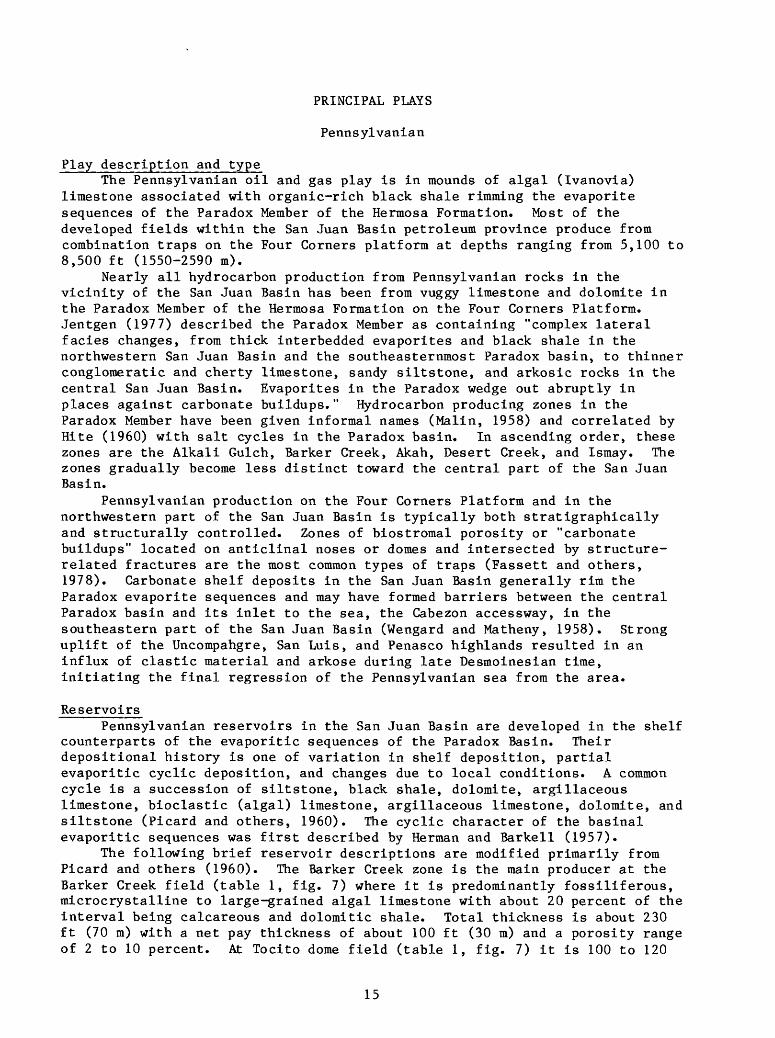
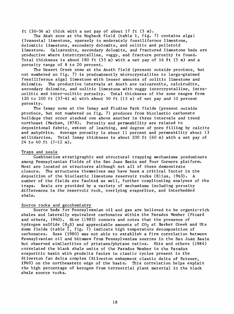
Exploration statusTable 1 lists all developed fields, active and abandoned, within the
province that have produced from the Pennsylvanian as shown on figure 6. The primary source of data for this and similar tables is Fassett (1978, 1983). Figure 8a is the historic finding rate of oil in the Pennsylvanian of the province and 8b is the actual number of oil pools in 500,000 bbl size classes. Figures 9a and 9b are comparable to 8a and 8b for the Pennsylvanian gas fields of the province.
Oil and associated gas, including helium, was first produced from the Pennsylvanian in the San Juan Basin area in 1929 at the Rattlesnake field. Nonassociated gas was first discovered at the Barker Creek field in 1945. The largest Pennsylvanian oil field in the area, Tocito dome, was discovered in 1963 (fig. 8a) after shallow tests produced nothing but water. A well completed in the Mississippian in 1943 produced helium but was abandoned in 1944 because of uncontrollable salt water flow (Spencer, 1978).
Pennsylvanian field sizes vary considerably (table 1). Productive areas range from 40 to 8,000 acres with most production from those larger than 1,000 acres. Most of the oil discoveries are in the 100 to 1,000 MBO (Thousand Barrels Oil) size range with associated gas (fig. 8b). The largest, Tocito dome and Tocito dome north, have produced a total of about 13,000 MBO and 26 BCFG (Billion Cubic Feet Gas). Eight significant nonassociated and associated gas fields have been developed in the area (table 1, fig. 9), the largest of which, Barker Creek, has produced 205 BCFG.
19
O00
QC UJ> O oCO
oUl1-
CO UJ
o1-
VEAR OF DISCOVER*
Figure-8a. History of discovery, Pennsylvanian oil fields, San Juan Basin petroleum province (semi-log plot; K-thousand, M-million).
CO-I O O0.o"
9-8-
4-\ 32H
q_^_P_/,»GO /£3>00 y*;,^000
SIZE (MBO)
Figure 8b. Distribution of sizes, Pennsylvanian oil fields, San Juan Basin petroleum province.

XT*-.
o u. o
trUJ> o o22 ooUJ
COUJ
-J <Ho
18-
YEAR OF DISCOVERY
Figure 9a. History of discovery, Pennsylvanian gas fields, San Juan Basin petroleum province (semi-log plot; M-million, B-billion, T-trillion).
COo
/O
-
3- 2-
:jx/O &
n,<#> '*>
SIZE (BCFG)
Figure 9b . Distribution of sizes, Pennsylvanian gas fields, San Juan Basin petroleum province.
21
The Pennsylvania!! interval of the northern part of the San Juan Basin and the Four Corners platform is inadequately explored except in the Four Corners area and is difficult to assess properly because of the paucity of subsurface data. Most structures with surface expression have probably been drilled but there are undoubtedly a number of structures in the subsurface which have not yet been tested. The likelihood that a structure would produce hydrocarbons depends largely on the presence of bioclastic (algal) limestone buildups and a local organic shale deposit. The distribution of these facies on the carbonate shelf marginal to the Paradox evaporitic basin has not been adequately mapped nor has the Silverton fan delta model of Hite and others (1984) been tested.
The probability of finding oil versus gas depends largely on position in the basin. The Pennsylvanian interval falls within the gas generation window throughout the structural San Juan Basin (fig. 4). On the Four Corners platform proximity to the San Juan volcanic centers will determine whether the interval is oil or gas prone, the likelihood of gas increasing northeastward with thermal maturity.
A comparison of figures 8 and 9 suggests that the Pennsylvanian is a reasonably mature gas play but that oil exploration is relatively immature with a good probability of several additional fields in the 1-10 MMBO range in addition to a number of smaller pools. Expected gas field sizes range from 1- 10 BCF.
22

Entrada
Play description and typeThe Middle Jurassic Entrada oil play is in relict dune topography on top
of the eolian Entrada Sandstone in the southeastern part of the San Juan Basin. It depends on the presence of organic-rich limestone and overlying anhydrite of the Todilto Limestone Member of the Wanakah Formation.
The Entrada Sandstone is an eolian deposit ranging in thickness from about 35 to 300 ft (11-100 m) within the San Juan Basin. Where exposed in outcrops around the perimeter of the basin, the Entrada is dominantly crossbedded dune sandstone with varying amounts of interdune or sabkah deposits. Topographic relief of about 50 ft (15 m) on top of the Entrada along the eastern margin of the basin was interpreted by Tanner (1970) to be preserved eolian dunes. Oil is produced from similar and larger features in the subsurface of the southeastern part of the basin. Core analyses from several of these fields, Ojo Encino (Vincelette and Chittum, 1981) and Media (Reese, 1978), suggests that water reworked the upper part of the Entrada.
Overlying the Entrada throughout the San Juan Basin, the Todilto Limestone Member of the Wanakah Formation consists of a lower, 3-to 10-ft (1-3 m)-thick limestone, and in the eastern part of the basin, an upper 0-125-ft (0-38 m)-thick anhydrite/gypsum unit. In the deeper parts of the depositional basin, where the anhydrite is present, the limestone is organic rich, whereas beyond the limits of the anhydrite the limestone was deposited in oxygenated water and therefore, has a much lower organic-carbon content.
ReservoirsSome of the relict dunes are as thick as 100 ft (30 m) but have flanks
that dip at only 2 degrees (Vincelette and Chittum, 1981). They are composed of fine-grained, subrounded, well-sorted sandstone which is massive or horizontally bedded in the water reworked zone and thinly laminated, steeply dipping crossbedded in the lower part. Porosity (average 23 percent), and permeability (average 370 md) are very good throughout. Average net pay in the developed fields (table 2, fig. 10) is 23 ft (7 m).
North of the producing area, in the deeper, northeastern part of the San Juan Basin, the porosity in the Entrada diminishes rapidly (Vincelette and Chittum, 1981). Compaction and silica cement make the Entrada very tight below a depth of 9,000 ft (2,700 m). South and west of the producing area, no sandstone buildups have been found, although in a recent seismic study in the Crownpoint, New Mexico area several structures similar to those illustrated by Vincelette and Chittum (1981) were found in the Entrada (Zech and others, 1985). None of these have been drilled, however, so their origin is still unknown. Traps and seals
All traps so far discovered in the Entrada are stratigraphic and are sealed by the Todilto limestone and anhydrite. Local faulting and drape over deep-seated faults has enhanced, modified, or destroyed the potential closures of the Entrada sand ridges, so must be taken into consideration. Hydrodynamic tilting of oil/water contacts and/or "base of movable oil" interfaces has had a destructive influence on the oil accumulations in that the direction of tilt typically has an updip component. Rates of calculated hydrodynamic tilt for the various fields range from 60 to 80 ft/mi (11-15 m/km) and may be in nearly any direction except north (Vincelette and Chittum, 1981).
23

Table 2. Entrada oil fields, San Juan Basin petroleum province(Fassett, 1978, 1983)
No.
1
2
3
4
5
6
7
Field
Eagle Mesa
Leggs
Media
Media SW
Ojo Encino
Papers Wash
Snake Eyes
Location discovery well
T.19 N. ,R.
T.21 N. ,R.
T.19 N. ,R.
T.19 N. ,R.
T.20 N. ,R.
T.19 N. ,R.
T.21 N. ,R.
4 W. ,5.12
10 W. ,S.ll
3 W.,S.14
3 W.,S.22
5 W.,S.21
5 W. ,5.15
8 W.,S.20
Date of discovery
1975
1977
1953
1972
1976
1977
1977
Estimated ultimate recoveryOil (MBO) Gas (MCFG)
1,615
275
2,198
1,800
150
2,000
500
24

3*
196'
SAN JUAN
r-"--.^LUFF^ -rl]
ARIZONA'
APACHE
UTE ilfi^6uHTAiH>_J h en VATIOH i
*-, SOUTHERN UTE RE SfKVATn
^.gOkSflA22_.._r ^_L_..____.__.____L,___._F_.__lr____.__.___.JNEW MEXICO" ("
IOM | ^- T-y
r
» 0ALBUOUEDOUE
A BERNALILLO
L.L.,
VALENCIA
L. ..
36°
106*
Figure 10. Entrada play outline and developed oil fields, San Juan Basin
petroleum province. Numbered fields from table 2.
25

Source rocks and geochemistryLimestone in the Todilto Limestone Member of the Wanakah Formation has
been identified as the source of Entrada oil by Ross (1980) and Vincelette and Chittum (1981). Ross (1980) states: "This oil is clearly unique as demonstrated by the high pour point (90°F), low pristane/phytane ratio (0.86), and even-carbon predominance (0.91 CPI), suggestive of genesis from a carbonate source sequence." Entrada oil has an average API gravity of 33°, an initial boiling point of 205°F (96°C), and a paraffin base with the possible exception of the Media field which Reese (1978) characterized as asphaltic based.
Vincelette and Chittum (1981) note the "correlation between the presence of organic material in the Todilto Limestone and the presence of the overlying Todilto anhydrite". This association limits the source rock potential of the Todilto to the deeper parts of the depositional basin in the eastern San Juan Basin. Elsewhere, the limestone was oxygenated during deposition and much of the organic material destroyed.
Timing and migrationMaximum depth of burial throughout most of the San Juan Basin occurred
during the Oligocene. In the eastern part of the basin the Todilto entered the oil generation window during the Oligocene (fig. 6b). Migration into the Entrada reservoirs either locally or updip to the south probably occurred almost immediately. However, as Vincelette and Chittum (1981) point out, "in some Entrada oil fields, remigration of the original accumulations has occurred subsequent to original emplacement. Whether such remigration is due to a change in the hydrodynamic gradient, post-accumulation structural movement, leakage out of the reservoir, or a combination of these factors has not been determined. . ."
Depth of occurrenceAll fields developed to date have been at depths of 5,000 to 6,000 ft
(1525-1825 m). A maximum depth of 9,000 ft (2,740 m) was placed on suitable reservoir conditions due to increasing cementation (Vincelette and Chittum, 1981).
26
Exploration statusThe initial Entrada discovery, Media, was made in 1953 (table 2, fig.
11), but only produced 14,196 bbl of oil before being abandoned because of increasing water production. The field was reopened in 1969 when an offset to the discovery well was completed at 500 bbl of oil and 1,500 bbl of water per day. Development was inhibited by problems of high water cut and high pour point, problems common to all subsequent Entrada development. Between 1972 and 1977, seven Entrada fields similar to Media were discovered, primarily though seismic techniques. Sizes range from 100 to 400 acres with total estimated production varying between 150 and 2,000 MBO each.
A number of areas of anomalously thick Entrada in the southeastern part of the San Juan Basin have yet to be tested. There is a high probability that at least some of these areas of thick Entrada would have closures containing oil in economic quantities but also with the same development problems as the developed fields. Limiting factors include presence of sufficient topographic relief on top of the Entrada, local structural conditions, hydrodynamics, source-rock and oil migration history, and local porosity/permeability variations in the Entrada (Vincelette and Chittum, 1981).
Figure 11 suggests an immaturely explored play and much of the area is sparsely drilled. Most of the finds to date have been on the basis of seismic data and additional coverage will probably result in new prospects.
27

oGQ
CC Ol
OoeoQ
Q 01l-
to01
1- O1-
lOty -
/98o
VEAR OF DISCOVERS
Figure lla. History of discovery, Entrada oil fields, San Juan Basin petroleum province (semi-log plot; K-thousand, M-million) ,
° f,aoo f,ooo 3,000
SIZE (MBO)
Figure lib. Distribution of sizes, Entrada oil fields, San Juan Basin petroleum province.
28

Dakota
Play description and type
The Upper Cretaceous Dakota oil and gas play is in coastal barrier marine sandstone and continental fluvial sandstone units primarily within the transgressive Dakota Sandstone. It is divided into a basinal gas play that is dominantly stratigraphic and a basin flank oil and gas play that is typically both stratigraphic and structural.
The Dakota producing interval is defined by the New Mexico Oil Conservation Commission as extending 400 ft (122 m) below the Greenhorn Limestone (Bridge Creek Limestone) Member of the Upper Cretaceous Mancos Shale. This definition includes the Graneros Shale Member of the Mancos and in many places upper sandstones and shales of the underlying Lower Cretaceous Burro Canyon Formation or Upper Jurassic Morrison Formation. The Dakota Sandstone of the San Juan Basin is a transgressive deposit resting on an erosional unconformity, but as Fassett and others (1978) point out, it is not a "typical" littoral marine transgressive unit. In the northwestern part of the basin the Dakota is largely composed of fluvial sandstones, coal, and carbonaceous shale with some marine sandstone at the top, whereas, in the southeastern part it is nearly all marine sandstone and shale. In the central part of the basin the Dakota is generally nonmarine at the base and becomes increasingly marine upward.
Owen (1973) described five major depositional units in the Dakota of the San Juan Basin: (1) braided-stream sandstone (present primarily in the Chama basin and northeastern part of the San Juan Basin); (2) meandering-stream complex; (3) coastal shale; (4) coastal sandstone; (5) offshore shale. All five are rarely present at any particular locality and one or more may dominate in various parts of the basin. Because of the wide variety of depositional environments, lithologies vary considerably as do reservoir quality and trapping mechanisms.
Most gas produced from the Dakota is from the giant Basin Dakota field in the central part of the basin where the trapping mechanism is hydrodynamic and stratigraphic. Away from the central basin, oil and gas are produced from both stratigraphic and structural or combination traps. Production is greatest from the upper marine part of the interval but significant amounts of both oil and gas have been produced from the nonmarine section as well.
ReservoirsOwen (1973) describes the channel sandstone of the meandering-stream
complex as ". . .mostly quartz and chert-rich arenites with local pebbly beds and thin conglomerates near the base. . ." and notes that "most of the channel sandstones are fine-grained, with some medium-grained strata in the fairly abrupt transition between the pebbly beds and the fine beds." Most of the channel sandstones are composed of fining upward, crossbedded trough sequences. The coastal sandstone unit is a coarsening upward, fine- to very fine grained, well sorted, quartz-rich sandstone that is commonly burrowed and horizontally bedded or crossbedded. Net pay thicknesses range from 10 to 100 ft (3-30 m).
29
Reservoir quality within the Dakota producing interval is highly variable. Most of the sandstone within the Basin Dakota field of the central basin is considered "tight" with porosities ranging from 5 to 15 percent and permeabilities from 0.1 to 0.25 millidarcies (Hoppe, 1978). Fracturing, both natural and induced, is essential for effective development (Deischl, 1973). In contrast, the Lone Pine field (table 3, fig. 12) in the southern part of the San Juan Basin has an average porosity of 20 percent and permeability range of about 80 to 150 millidarices (Storhaug, 1978). Permeabilities elsewhere may be as high as 400 millidarcies.
Traps and sealsDakota production is from a variety of traps throughout the San Juan
Basin. Most is to some extent stratigraphically controlled although this is rarely the primary mechanism. Production in the Basin Dakota field in the central basin is determined partially by the distribution of marine sandstone buildups, but many of these sandstone are continuous to the outcrop with no known seal between. Dieschl (1973) suggested "decreased permeability and strong hydrodynamic pressure" as the trapping mechanism. He further states: "it is apparent that the Basin Dakota gas accumulation is a rather unique situation in that the gas is present on the flanks and bottom of a large depression and is not localized by structural configurations. The transmissibility of the Dakota sandstones is generally consistent from the central basin to the outcrop and, therefore, hydrodynamic forces, acting in a basinward direction, are essential to prevent the gas from escaping." Fassett and others (1978) note that there are problems with this explanation and that the mechanism is still poorly understood.
Most oil production from the Dakota is from structural or combination traps away from the central basin. The Price Cramps, Table Mesa, Hogback, and Lone Pine fields (table 3, fig. 12), four of the largest Dakota oil fields, are located on faulted anticlinal structures. The seal in most Dakota fields is provided by either marine shale or paludal carbonaceous shale and coal.
Source rocks and geochemistrySource beds for Dakota oil and gas are highly variable. Nonassociated
gas from the Basin Dakota field was interpreted by Rice (1983) as having been generated during late mature and post-mature stages and probably had a Mancos Shale source. The chemical composition (C^/C^.c) ranges from 0.99 to 0.86 and the isotopic composition (6 13C) from -31.4 to -41.9 per mil (Rice, 1983). Condensate production within the New Mexico portion of the basin averages 0.4 gal/mcf (0.05 dnr/nr) of nonassociated gas (Fassett and others, 1978).
Nonassociated gas produced from the Dakota at Barker Creek field has almost identical chemical and isotopic composition as gas from underlying Pennsylvanian reservoirs (Rice, 1983). Based on this and several other lines of evidence, Rice (1983) concluded that it had migrated from the deeper (6,000 ft, 1.8 km) more mature Pennsylvanian strata. Because of the difference in depth and the presence of a number of intervening potential reservoirs, it seems likely that faulting provided the conduit along which the gas migrated.
30

Table 3. Dakota oil and gas fields, San Juan Basin petroleum province(Fassett,
No. Field
1
*2
3
4
5
6
7
8
9
10
11
12
13
14
15
16
17
18
19
20
21
22
23
24
25
26
27
28
29
Barker Creek
Basin
Blackeye
Chacon
Cinder Buttes
Dufer's Point
Five Lakes
Hogback
Hospah
Lindrith
Lindrith S.
Lindrith W.
Lone Pine
Marcelina
Menefee Mtn.
Middle Canyon
Ojito
Point Lookout
Price Cramps
Rattlesnake
Red Mesa
Salt Creek
Shiprock N.
Sierra
Slick Rock
Snake Eyes
Stoney Butte
Straight Canyon
Table Mesa
Location discovery well
T.32
T.27
T.20
T.23
T.32
T.25
T.22
T.29
T.17
T.24
T.23
T.24
T.17
T.16
T.35
T.32
T.25
T.36
T.33
T.29
T.33
T.30
T.30
T.35
T.30
T.21
T.21
T.31
T.27
N.
N.
N.
N.
N.
N.
N.
N.
N.
N.
N.
N.
N.
N.
N.
N.
N.
N.
N.
N.
N.
N.
N.
N.
N.
N.
N.
N.
N.
,R.14
,R.10
,R. 9
,R. 3
,R.12
,R. 8
,R. 3
,R.16
,R. 9
,R. 2
,R. 4
,R. 4
,R. 9
,R. 9
,R.13
,R.15
,R. 3
,R.14
,R. 2
,R.19
,R.12
,R.17
,R.18
,R.13
,R.17
,R. 8
,R.14
,R.16
,R.17
W.
W.
W.
W.
W.
W.
W.
W.
W.
W.
W.
W.
W.
W.
W.
W.
W.
W.
E.
W.
W.
W.
W.
W.
W.
W.
W.
W.
W.
,s,s,s,s,s,s,s,s,s,s,s,s,s,s,s,s,s,s,s,s,s,s,s,s,s,s,s
,s,s
1978 , 1983)
Date of discovery
.16
. 4
.29
.23
.13
.17
.25
.19
.12
.20
. 5
. 1
.13
.18
.16
.14
.18
.29
.24
. 1
.23
. 4
.14
. 5
.36
.20
. 1
.14
. 3
1925
1947
1972
1974
1966
1959
1970
1922
1967
1949
1958
1959
1970
1975
1978
1969
1958
1930
1935
1924
1924
1958
1966
1957
1966
1971
1950
1975
1925
Estimated ultimate recoveryOil (MBO) Gas (MCFG)
5
3,000
600
50
6,000
230
35
NA
NA
5,000
650
NA
5
203
7,200
5,000
500
170
1
170
850
30
8
1,400
150,000
5,000,000
83,000
250
5,000
1,500
8,000
300
312
50
75
250
550
35
1,000
250
150
,000
,000
,000
,000
,000
,000
NA
NA
,000
,000
NA
,000
,000
,000
,000
,000
,000
,000
,000
,000
31

Table 3. Dakota (Continued)
Location Date of Estimated ultimate recoveryNo. Field
30 Ute Dome
31 Wildhorse
discovery well discovery Oil (MBO) Gas (MCFG)
T.32 N. ,R.14 W. ,8.36 1921 160 20,000,000
T.26N. ,R. 4 W. ,8.27 1960 97 1,500,000
*Present Basin Dakota field formed by combining following fields in 1961
Angels Peak T.27 N.,R.10 W.,S. 4 1947
Ignacio T.33 N.,R. 7 W.,8.18 1950
Kutz W. T.28 N.,R.12 W.,8.22 1951
Huerfanito T.26 N.,R. 9 W.,S. 3 1951
Huerfano T.26 N.,R.10 W.,8.24 1951
Campanero T.27 N.,R. 5 W.,S. 4 1952
Blanco T.31 N.,R.10 W.,8.27 1952
Largo T.27 N.,R. 9 W.,8. 3 1955
Otero T.25N.,R. 5W.,8.22 1955
Campanero E. T.27 N.,R. 4 W.,S. 7 1955
32

196
SAN JUAN
i I n , ,- I_ _ _ _ _s j <. j\ ,-j"j
MEXICO o 16
0 5 10 16 32 48 64 KM
Figure 12. Dakota play outline and developed oil and gas fields, San Juan Basin petroleum province. Broken line separates basinal and basin flank parts of play. Numbered fields from table 3.
33

Oil produced from the Dakota on the Chaco slope has a marine Cretaceous source identified as the Mancos Shale by Ross (1980). API gravities range from 44° to 59° with green to brown colors (Fassett and others, 1978). Oil produced from the Dakota on the Four Corners Platform (fig. 2) have similar API gravities but on the basis of chemical and isotopic compositions were classified by Ross (1980) as originating from nonmarine Cretaceous source rocks of the Lewis-Mesaverde interval. Although these source beds are nearly 4,000 ft (1220 m) above the Dakota, stratigraphically, they are brought into nearly the same structural position across the Hogback monocline (fig. 3) (Thaden and Zech, 1984).
Timing and migrationIn the northern part of the central San Juan Basin the Dakota Sandstone
and Mancos Shale entered the oil generation window in the Eocene and were elevated to temperatures appropriate for the generation of dry gas by the Late Oligocene (fig. 6a). Along the southern margin of the central basin the Dakota and lower Mancos entered the oil generation window during the Late Miocene (fig. 6b). It is not known at what point the hydrodynamic forces reached sufficient strength to establish a trapping mechanism but Early Miocene would seem a reasonable estimate for the establishment of the present- day uplift and erosion pattern throughout most of the basin. Migration of oil in the Dakota was still taking place in the Late Miocene or even more recently in the southern part of the San Juan Basin.
Depth of occurrenceOil and gas are produced from the Dakota interval at depths ranging from
about 1,000 to 8,000 ft (300-2440 m). Gas production in the central part of the basin is typically at depths of 6,500 to 7,500 ft (1980-2280 m). Oil production around the margin of the basin ranges in depth from 1,000 to 3,000 ft (300-900 m).
Exploration statusThe first Dakota discoveries were made in the early 1920's (table 3, fig.
13a) on small anticlinal structures on the Four Corners Platform (fig. 2). The central basin Dakota discovery well was drilled in 1947 (fig. 14a) in the Angel Peak area south of Bloomfield, New Mexico (fig. 12). Although a number of discoveries were made within the central part of the basin during the early and mid 1950's (table 3), by the end of 1958 there were only 46 producing Dakota wells within the central basin (Deischl, 1973). The Basin Dakota field was formed February 1, 1961 by combining several existing fields (table 3) and by the end of 1976 it contained 2,400 producing wells that had produced over 2.7 trillion cubic feet with an estimated total production exceeding 5 trillion cubic feet (Hoppe, 1978).
Dakota oil fields range in size from 40 to 10,000 acres with most production from fields of 100 to 2,000 acres. Approximately 30 percent of the oil fields have an estimated total production exceeding 1,000 MBO (fig. 13b) with the largest (Price Cramps) estimated at just over 7,000 MBO (table 3). About 13 billion cubic feet of associated gas has been produced through 1985.
Future gas production from the Dakota interval will depend largely on the development of tight gas sand production technology. The limits of production from the Basin Dakota field have not yet been defined and new discoveries are still being made. Although of lesser importance, Dakota oil production is more dependent on better understood mechanisms and future discoveries seem likely, as basin structure and Dakota depositional patterns are more fully understood.
34
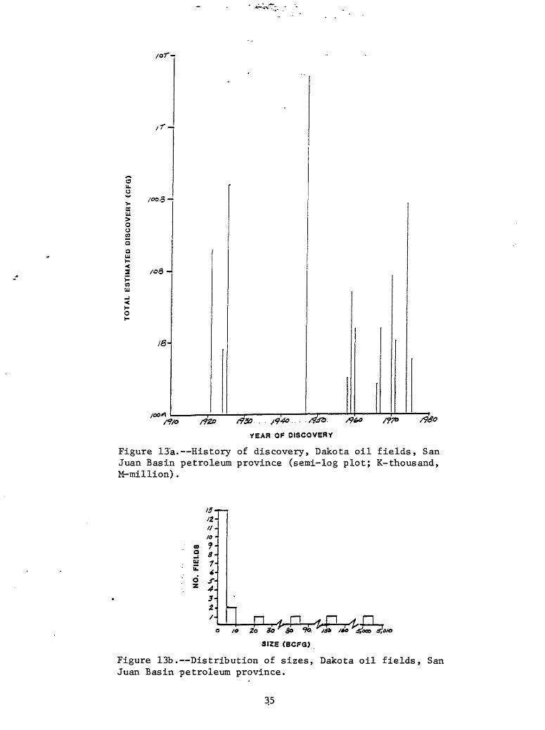
/or-
/e-
YEAR OF DISCOVERY
Figure 13a. History of discovery, Dakota oil fields, San Juan Basin petroleum province (semi-log plot; K-thousand, M-million).
It-
16 09 «-a.;Hi 7H
3-2- 1 p-ft^fctgrfg^,.
SIZE (BCFQ)
Figure 13b. Distribution of sizes, Dakota oil fields, San Juan Basin petroleum province.
35
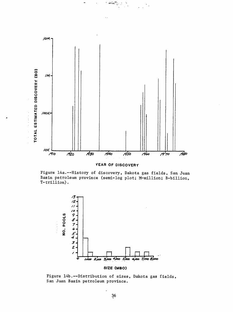
S Mf-
trUJ
O O COQQ UJ1- <
COUJ
1- o1-
loK
OF DISCOVERy
Figure 14a. History of discovery, Dakota gas fields, San Juan Basin petroleum province (semi-log plot; M-million; B-billion, T-trillion).
CO_J0 0Q.0*
z
/J-
/<? «9-
7-
4\3 -2-/ - i n PI n n
<*,«*»
SIZE (MBO)
Figure 14b. Distribution of sizes, Dakota gas fields, San Juan Basin petroleum province.
36

Figure 13 illustrates the relative immaturity of Dakota oilexploration. This play is primarily in combination traps around the margins of the central part of the San Juan Basin. Drilling density is sparse in much of the area and additional discoveries in the 1-10 MMBO size range seem likely. Figure 14 may be somewhat misleading as the 5TCF Basin Dakota field is shown as a single discovery in 1947 whereas in reality it is a combination of discoveries made between 1947 and 1961. This is not quite as bad as it may first appear, however, since nearly all of the Dakota in the central part of the basin is saturated with gas. Additional gas discoveries in the Basin Dakota field and around its margins appear probable.
37
Gallup
Play description and typeThe Gallup is primarily an oil and associated gas play in bar-like
sandstone bodies of the Upper Cretaceous Tocito sandstones lying immediately above an unconformity. Most production is from stratigraphic traps along a NW-SE trending belt adjacent to the southern margin of the central San Juan Basin.
As used here and by the New Mexico Oil and Gas Conservation Commission, the Gallup interval comprises the marine lower Mancos Shale above the Bridge Creek Limestone Member (formerly Greenhorn Limestone Member), the regressive marine lower Gallup Sandstone, the fluvial Torrivio Member of the Gallup Sandstone, the nonmarine coal bearing Dilco Coal Member of the Crevasse Canyon Formation, the transgressive marine Tocito Sandstone Lentil of the Mancos Shale, and the marine upper part of the Mancos Shale. Overall thickness of this interval is about 1,500 to 2,000 ft (450-600 m) and the lithology is dominantly dark gray marine shale. With the exception of a small amount of oil from several fields in fractured Mancos Shale, nearly all production from this thick and rather nebulous interval has been from the Tocito Sandstone Lentil of the Mancos Shale and the Torrivio Member of the Gallup Sandstone. Nomenclatural problems within this interval have caused some confusion and were discussed at some length by Fassett and others (1978), Fassett and Jentgen (1978), and Molenaar (1973).
The Tocito Sandstone Lentil of the Mancos Shale is the major oil producer in the San Juan Basin. The name is applied to a number of lenticular sandstone bodies commonly less than 50 ft (15 m) thick that lie on or just above the Niobrara unconformity and are of undetermined origin. Most of the sandstone buildups are encased in and intertongue with Mancos Shale forming stratigraphic traps along a northwest-southeast trending zone through the central part of the San Juan Basin and continuing onto the Four Corners Platform to the northwest. The only significant production from the regressive Gallup Sandstone is from the Torrivio Member, a lenticular fluvial channel sandstone lying above and in some places scouring into the top of the main regressive marine Gallup Sandstone. The Torrivio is typically encased in finer-grained sediments of the Dilco Coal Member below and the Mancos Shale above. Hospah and Hospah South, the largest fields developed in the regressive Gallup (table 4, fig. 15), are combination stratigraphic and structural traps.
ReservoirsMaximum sandstone development in the Tocito Sandstone Lentil occurs
within a northwest-trending belt beyond the northeastern limit of the regressive Gallup Sandstone. The origin of the long, narrow sandstone bodies paralleling the paleoshoreline is still poorly understood but many of the bar- like bodies are associated with topography on the underlying Niobrara unconformity (Lamb, 1968; McCubbin, 1969). Sabins (1963) did not recognize the unconformity. Where the Tocito crops out along the northwest side of the San Juan Basin it is typically two ledges of thin bedded, bioturbated, medium- to coarse-grained calcareous sandstone containing scattered quartz granules and pebbles and thin beds of quartz granule conglomerate and shell hash containing shark teeth (Huffman, 1976, 1979). The ledges are 3-6 ft (1-2 m) thick and appear to have a sheet geometry although exposures are too limited to determine their continuity over long distances. Porosities in the
38
producing fields range from 4 to 20 percent and average about 15 percent. Permeabilities range from 0.5 to 150 millidarcies with 50 to 100 millidarcies being most typical.
The main producing interval at the Hospah fields on the Chaco Slope (fig. 15) has been called the Hospah Sandstone but was correlated to the Torrivio Member of the regressive Gallup by Molenaar (1973). The Torrivio is a high- energy fluvial channel deposit that genetically belongs with the nonmarine Dilco Coal Member of the Crevasse Canyon Formation (Molenaar, 1973; Kirk and others, 1978). Along the outcrops in the southern part of the San Juan Basin the Torrivio is an angular to subangular, very poorly to moderately well sorted, very coarse to fine-grained feldspathic sandstone containing medium- to very large scale trough crossbeds. It commonly is composed of 25 percent granule-size quartzose grains, sparse chert and quartzite pebbles, and significant amounts of interstitial clay. Plant debris and carbonaceous material occur on bedding planes and in lenses of conglomerate composed of granules, pebbles, and clay clasts at the base of troughs. The geometry is a series of troughs, each as much as 16 ft (5 m) thick, that coalesce into lenticular bodies of sandstone, which in turn combine with similar sandstone bodies or intertongue laterally and vertically with carbonaceous mudstone. Porosity of the Torrivio at Hospah field is 24 to 30 percent and permeability ranges from 200 to 500 millidarcies.
Traps and sealsNearly all Gallup production is from stratigraphic traps. The Tocito
bar-like sandstone bodies are encased in and intertongue with the marine Mancos Shale, likewise, the fluvial channel Torrivio Member is encased in and intertongues with finer grained sediment of the Dilco Coal Member. The most notable exception to this generality is the Hospah field where faulting is combined with the stratigraphic controls to form the trapping mechanism. Some additional production also comes from fractured Mancos Shale on or above structures.
Source rocks and geochemistrySource beds for Gallup oil have been identified as the marine Upper
Cretaceous Mancos Shale (Ross, 1980). Rice (1983) also cited the Mancos as the source of both associated and nonassociated gas produced from the Gallup interval. The Mancos contains 1-3 weight percent organic carbon (Ross, 1980) and produces a sweet, low-sulfur, paraffin-base oil that ranges from 38° to 43° API gravity in the Tocito fields and from 24° to 32° API gravity farther south in the Hospah fields. Associated gas from the Tocito has a chemical composition (C^/C^.^) of 0.77 and an isotopic (6^C]_) range of -48.4 to -48.7 per mil. Nonassociated gas compositions are 0.83 and -45.7 per mil, respectively (Rice, 1983).
Timing and migrationThe upper Mancos Shale of the central part of the San Juan Basin entered
the oil generation window in the late Eocene and the gas window in the Oligocene (fig. 6a). Migration updip to reservoirs in the Tocito Sandstone Lentil and regressive Gallup followed pathways similar to those determined by present structure since basin configuration has changed little. Migration was facilitated by the presence of sheet sandstone and siltstone bodies in the Tocito interval above the Niobrara unconformity.
39

Table 4. -Gallup oil and gas fields, San Juan Basin petroleum province(Fassett,
No,
1
2
3
4
5
6
7
8
9
10
11
12
13
14
15
16
17
18
19
20
21
22
23
24
25
26
27
28
29
30
Field
Aland, to
Albino
Amarillo
Angel's Peak
Armenta
Aztec Wash
B S Mesa
Bisti
BlancoTocito S
Boulder
Campo
Cha Cha
Chipeta
Choza Mesa
Chromo
Cinder Buttes
Counselors
Cuervo
Devil's Fork
Dufer's Point
Escrito
Flora Vista
Gallegos
Gavilan
Horseshoe
Hospah
Hospah S.
Jewett Valley
KnickerbockerButte
Kutz
Location discovery well
T.23
T.32
T.28
T.27
T.29
T.32
T.26
T.25
T.26
T.28
T.29
T.28
T.33
T.28
T.32
T.32
T.23
T.24
T.24
T.25
T.24
T.30
T.26
T.25
T.30
T.17
T.17
T.29
T.30
T.27
N.
N.
N.
N.
N.
N.
N.
N.
N.
N.
N.
N.
N.
N.
N.
N.
N.
N.
N.
N.
N.
N.
N.
N.
N.
N.
N.
N.
N.
N.
,R. 7
,R. 8
,R.13
,R.10
,R.10
,R.17
,R. 4
,R.12
,R. 6
,R. 1
,R. 4
,R.13
,R.18
,R. 3
,R. 1
,R.12
,R. 6
,R. 8
,R. 7
,R. 8
,R. 7
,R.12
,R.12
,R. 2
,R.16
,R. 9
,R. 9
,R.16
,R.10
,R.ll
W.
W.
W.
W.
W.
W.
W.
W.
W.
W.
W.
W.
W.
W.
E.
W.
W.
W.
W.
W.
W.
W.
W.
W.
W.
W.
W.
W.
W.
W.
,s,s,s,s,s,s,s,s
,s,s,s,s,s,s,s,s,s,s,s,s,s,s,s,s,s,s,s,s
,s,s
1978 , 1983)
Date of discovery
.31
.26
.33
.34
.28
. 8
. 5
.16
. 9
.15
.11
.17
.35
. 6
. 4
.13
. 3
.27
.24
.17
.27
. 2
.14
.26
. 4
. 1
.12
. 3
.17
. 9
1971
1973
1958
1958
1980
1961
1964
1955
1951
1961
1973
1959
1974
1975
1929
1966
1981
1981
1958
1959
1957
1961
1954
1982
1956
1927
1965
1961
1975
1958
Estimated ultimate recoveryOil (MBO)
175
200
55
854
NA
50
110
51,000
5,600
2,000
120
9,000
400
200
575
50
2,170
200
3,500
100
2,256
7,500
40,000
9,200
9,000
22
250
542
Gas (MCFG)
900
66,000
4
12,000
12,000
1,700
18,000
44
50
251
75
36,000
20
19,000
8,700
39,000
37,500
7,900
6,000
1,500
2,300
,000
,000
NA
,000
,000
,000
,000
,000
,000
,000
,000
,000
,000
,000
,000
,000
,000
,000
,000
,000
,000
,000
40
Table 4. Gallup (Continued)
No.
31
32
33
34
35
36
37
38
39
40
41
42
43
44
45
46
47
48
49
50
51
52
53
54
55
56
57
58
59
60
61
Field
La Plata
Largo
Lindrith
Lindrith S.
Lindrith W.
Long Hollow
Lybrook
Mancos River
Many Rocks
Many Rocks N.
Marcelina
Meadows
Media
Mesa
Miguel Creek
Nageezi
Ojito
Ojo
Otero
Pinon
Puerto Chi-quito E.&W.
Ramona
Rattlesnake
Red Mesa
Regina
Rosa
Rusty
San Ysidro
Shiprock
Shiprock N.
Simp son
Location discovery well
T.31 N. ,R.13 W. ,S. 5
T.26 N. ,R. 7 W. ,S. 3
T.24 N. ,R. 4 W. ,S. 1
T.23 N. ,R. 4 W. ,S. 5
T.24 N. ,R. 4 W. ,S.24
T.34 N. ,R.ll W. ,S.21
T.23 N. ,R. 7 W. ,S. 9
T.32 N. ,R.18 W. ,8.15
T.32 N. ,R.17 W. ,S.27
T.32 N. ,R.17 W. ,S.18
T.16 N. ,R. 9 W. ,S.18
T.30 N. ,R.15 W. ,8.33
T.19 N. ,R. 3 W. ,8.22
T.32 N. ,R.18 W. ,S.24
T.16 N. ,R. 6 W. ,S.29
T.23 N. ,R. 9 W. ,S. 1
T.25 N. ,R. 3 W. ,8.17
T.18 N. ,R.15 W. ,8.26
T.22 N. ,R. 5 W. ,S. 1
T.28 N. ,R.12 W.,S.14
T.26 N. ,R. 1 W. ,S. 5
T.33 N.,R.18 W. ,S.15
T.29 N. ,R.19 W. ,S. 2
T.33 N. ,R.12 W. ,8.23
T.24 N. ,R. 1 W. ,S.36
T.32 N. ,R. 5 W. ,8.20
T.22 N. ,R. 7 W.,S.16
T.21 N. ,R. 3 W. ,8.29
T.29 N. ,R.18 W. ,S.17
T.30 N. ,R.18 W. ,8.14
T.28 N. ,R.12 W. ,8.26
Date of Estimated ultimate recoverydiscovery
1959
1961
1959
1958
1978
1981
1957
1927
1962
1963
1977
1961
1969
1961
1973
1971
1974
1961
1955
1966
1960
1965
1968
1924
1979
1971
1975
1981
1959
1967
1959
Oil (MBO)
650
105
75
3,200
100
NA
700
25
3,100
560
NA
105
20
600
55
75
500
10
2,500
360
14,500
2
6
1,000
12
120
50
670
300
900
Gas (MCFG)
13,600,000
750,000
130,000
NA
5,141,000
76,000
NA
400,000
60,000
2,000,000
900,000
13,500,000
950,000
15,000,000
1,000,000
73,000
300,000
700,000
82,000
3,300,000
41
Table 4. Gallup (Continued)
No. FieldLocation
discovery wellDate of Estimated ultimate recovery
discovery Oil (MBO) Gas (MCFG)
62 Tapacito
63 Totah
64 Verde
65 Walker Dome
66 Waterflow S.
67 White Wash
68 Wildhorse
T.26 N.,R. 5 W.,8.18 1965 560
T.29 N.,R.13 W.,8.27 1959 3,400
T.31 N.,R.15 W.,8.14 1955 7,950
T.15 N.,R.10 W.,S.13 1956 NA
T.29 N.,R.15 W.,8.19 1963 224
T.24 N.,R. 9 W.,S. 2 1977 120
T.26 N.,R. 4 W.,8.21 1957 190
25,000,000
6,750,000
3,240,000
NA
250,000
37,000,000
42

/ 54« / X I1- S/OWTHEflW UTE R£ SfRVA TION \J
057 L:_
Figure 15. Gallup play outline and developed oil and gas fields, San Juan Basin petroleum province. Broken line separates basinal and basin flank parts of play. Numbered fields from table 4.
4,3
Depth of occurrenceOil has been produced from the Gallup interval at depths ranging from
about 400 to 7,700 ft (120-2350 m). The belt of Tocito sandstone buildups produces from about 1,500 ft (450 m) on the Four Corners Platform as in the northwest part of the Horseshoe field (fig. 15), and from about 4,500 to 5,500 ft (1370-1675 m) farther to the southeast in the central part of the basin. The regressive Gallup in the southern part of the San Juan Basin produces from about 1,500 ft (450 m) at the Hospah fields. Oil seeps and oil-stained sandstone occur at several locations along the outcrops in the southern and western parts of the basin (Molenaar, 1973).
Exploration statusInitial Gallup discoveries were made in the mid 1920's at Red Mesa in
Colorado and Hospah in New Mexico (table 4, fig. 16a). The major discoveries, however, were not made until the late 1950's and early 1960's (table 4, figs. 16a, 17a) in the deeper Tocito fields, the largest of which, Bisti, encompasses 37,500 acres with an estimated total recovery of 51,000 MBO (table 4). Most Gallup fields are classified as oil fields with associated gas, although several produce nonassociated gas. Total production through 1985 was approximately 165,000 MBO, 490 MBNGL (Thousand Barrels Natural Gas Liquids) 350 BCF associated gas, and 71 BCF nonassociated gas.
Gallup fields are typically 1,000 to 10,000 acres in area with 15 to 30 ft (5-10 m) of pay. About one third have an estimated total production exceeding one million barrels of oil and one billion cubic feet of associated gas (table 4, figs. 16b, 17b). All of the larger fields produce from the Tocito Sandstone Lentil of the Mancos Shale and are stratigraphically controlled.
South of the zone of bar-like sandstone buildups of the Tocito, the regressive Gallup produces primarily from the fluvial channel sandstone of the Torrivio Member. The only large field producing from the Torrivio is Hospah field, which is primarily a structural trap. Other such traps probably exist in the southern half of the basin and are likely to have been charged during the Oligocene. Evidence of oil migration can be found in several locations along the outcrops in both the southern and western parts of the basin.
The possible relationship of deep-seated basement structures to Gallup deposition and younger structures has yet to be determined. The aerial distribution of Tocito sandstone buildups is very similar to those in the overlying Mesaverde (fig. 18) and Pictured Cliffs (fig. 21) suggesting a common control. If such a control exists, the implications for future exploration could be significant.
Figure 16 reflects a mature cycle of exploration and suggests the possibility of a second cycle. Drilling density is very high along the known trend of Tocito sandstone bodies and much lower to the south. Hospah type accumulations are possible nearly anywhere on the Chaco slope.
44

oa> ccID> Oo 22Q
Q UJ
YEAR OF DISCOVERY
Figure 16a. History of discovery, Gallup oil fields, San Juan Basin petroleum province (semi-log plot; K-thousand; M-million).
4o-
0 SsH
/* -
/o-
J0 I £ 3 4 f * 7 £ ? /o // /^
SIZE (MBO)
5/^2
Figure 16b. Distribution of sizes, Gallup oil fields, San Juan Basin petroleum province.
45

/r
ou. o~VtrIU> OoCO
aIU
COIU
V-o
ftio
VEAR OF DISCOVER*
Figure 17a. History of discovery, Gallup gas fields, San Juan Basin petroleum province (semi-log plot; M-million, B-billion, T-trillion).
j£+ A* j
*s *-^1 j%£mt
S /4*
2 /O-8-
4-
Tlln -Ell ......... ...X3
SIZE (BCPQ)
Figure 17b. Distribution of sizes, Gallup gas fields, San Juan Basin petroleum province.

Mesaverde
Play description and typeThe Mesaverde is primarily a gas play in sandstone buildups associated
with stratigraphic rises in the Upper Cretaceous Point Lookout and Cliff House Sandstones. It is divided into a basinal gas play that is dominantly stratigraphic and a basin flank oil and gas play that is typically both stratigraphic and structural.
The major gas producing interval in the San Juan Basin, the Upper Cretaceous Mesaverde Group, comprises the regressive marine Point Lookout Sandstone, the nonmarine Menefee Formation, and the transgressive marine Cliff House Sandstone (fig. 5). Total thickness of the interval ranges from about 500 to 2,500 ft (150-750 m), of which 20 to 50 percent is sandstone. The Mesaverde interval is enclosed by marine shale with the Mancos Shale beneath and the Lewis Shale above.
Most wells are completed through the entire interval so it is difficult to assign definite volumes of production to specific units but the Point Lookout is thought to be the major producer primarily because it is thicker and has greater continuity than the Cliff House (Fassett and others, 1978; Rice, 1983). Both the Point Lookout and Cliff House Sandstones intertongue with the intervening nonmarine Menefee Formation that is composed of carbonaceous shale, siltstone, fluvial channel sandstone, and coal. The basal Point Lookout Sandstone is transitional and intertonguing with the underlying Mancos Shale. Stratigraphic rises in the Point Lookout resulting from stillstands or brief reversals in the general regression produce sandstone bodies as thick as 300 ft (90 m) intertongued with finer-grained nonmarine deposits of the Menefee on the updip side.
Similar mechanisms produced intertonguing of the Cliff House Sandstone and the overlying Lewis Shale. A combination of several of these tongues is locally known as the "Chacra producing interval" (Fassett and others, 1978) which is included here in the Mesaverde interval.
ReservoirsThe principal gas reservoirs in the Mesaverde interval are the Point
Lookout and Cliff House marine sandstones with a small amount of dry nonassociated gas produced from thin lenticular channel sandstone bodies and thin coal beds of the Menefee. Reservoir quality in the Mesaverde depends largely on the degree of fracturing.
Hollenshead and Pritchard (1961) describe the Point Lookout as a fine to very fine grained, well cemented, angular to subangular sandstone composed of 55 percent quartz, trace chert, 15 percent feldspar, 5 percent rock fragments, 15 percent argillaceous cement, and 10 percent silica cement. The same authors describe the Cliff House as very fine grained, well cemented, angular to subangular sandstone composed of 60 percent quartz, 10 percent feldspar, 5 percent rock fragments, 10 percent argillaceous cement, and 15 percent silica cement.
47
Together the Blanco Mesaverde and Ignacio Blanco fields (table 5, fig. 18) account for nearly half of the total nonassociated gas and condensate production from the San Juan Basin. Within these two fields, porosity averages about 10 percent and permeability about 2 millidarices with a total pay thickness range of 20 to 200 ft (6-60 m). Smaller Mesaverde fields have porosities from 14 to 28 percent and permeabilities from 2 to 400 millidarcies with 6 to 25 ft (2-8 m) of pay thickness. The Chacra interval averages about 10 percent porosity and 0.3 millidarcies permeability with 8 to 40 ft (2.5-12 m) of pay thickness.
Traps and sealsGas accumulation and production from the Mesaverde interval is controlled
by the pattern of sandstone distribution, lithologic characteristics of the sandstone, degree of fracturing, and hydrodynamic factors (Hollenshead and Pritchard, 1961). Thick sandstone buildups associated with stratigraphic rises in the Point Lookout and Cliff House Sandstones are the major producers and have been mapped across the San Juan Basin from northwest to southeast. Stratigraphic traps along these rises are produced by intertonguing of the marine sandstone reservoir rocks with finer grained continental and marine sediments. These rises parallel and overlie similar trends in both younger and older Cretaceous marine sandstones suggesting deep-seated structural control. Fracturing of the reservoir rocks along these trends could also have resulted from movement on underlying structures but this is highly speculative.
The trapping mechanisms for the largest fields in the central part of the San Juan Basin are not well understood. Both the Blanco Mesaverde and Ignacio Blanco fields are thought to employ hydrodynamic forces to contain the gas in structurally lower parts of the basin (Hill and others, 1961; Fassett and others, 1978) but other factors such as cementation and swelling clays may also play a role. Most of the smaller fields are either stratigraphic traps or a combination of stratigraphic and structural. Chacra fields are nearly all stratigraphic.
Updip pinchouts of marine sandstone into finer grained paludal or marine sediments account for nearly all of the stratigraphic traps with a shale or coal seal. Structural or combination structural/stratigraphic traps with similar seals have accounted for most of the small amount of oil production from the Mesaverde.
Source rocks and geochemistryAnalyses of Mesaverde hydrocarbons indicate different sources for the
nonassociated gas and the oil. Rice (1983) reports a ratio of liquids to gas production of 0.17 gal/mcf (0.02 dnr/nr) and states that "most of the liquids produced within the central basin qualify as condensates, that is, they are hydrocarbon mixtures that are gaseous in the ground, condense into fluid when produced, and have an API gravity greater than 60°." The chemical composition (C 1 /C 1 _ 5 ) of 0.99-0.79 and isotopic (6 13C X ) range of -33.4 to -46.7 per mil of the nonassociated gas together with several other criteria suggest to Rice (1983) a mixture of source rocks including coal and carbonaceous shale in the Menefee Formation.
48

Table 5. Mesaverde oil and gas fields, San Juan Basin petroleum province(Fassett, 1978, 1983)
No.
1
2
3
4
5
6
7
8
9
10
11
12
13
14
15
16
17
18
19
20
21
22
23
24
25
26
27
28
29
30
31
Field
Adobe
Animas
Blackeye
Blanco
Bloomf ield
Chaco Wash
Crouch Mesa
Cuervo
Devil's Fork
Flora Vista
FranciscanLake
Gobernador
Gonzales
Harris Mesa
Ignacio Blanco
Largo
Nava j o Ci ty
Nenahnezad
Otero
Parlay
Red Mesa
Red Mountain
Rusty
San Luis
San Luis S.
Seven Lakes
Star
Stoney Butte
Torreon
Twin Mounds
Venado
Location discovery well
T.24 N. ,R.
T.31 N. ,R.
T.20 N. ,R.
T.30 N. ,R.
T.29 N. ,R.
T.20 N. ,R.
T.29 N. ,R.
T.27 N. ,R.
T.24 N. ,R.
T.30 N. ,R.
T.20 N. ,R.
T.20 N. ,R.
T.25 N. ,R.
T.28 N. ,R.
T.32 N. ,R.
T.27 N. ,R.
T.30 N. ,R.
T.29 N. ,R.
T.25 N. ,R.
T.22 N. ,R.
T.33 N. ,R.
T.20 N. ,R.
T.22 N. ,R.
T.18 N. ,R.
T.18 N. ,R.
T.18 N. ,R.
T.19 N. ,R.
T.22 N. ,R.
T.18 N. ,R.
T.29 N. ,R.
T.22 N. ,R.
4 W.,S.13
4 W. ,S. 6
9 W.,S.32
9 W.,S.29
10 W.,S.18
9 W.,S.21
11 W.,S. 6
8 W. ,S.28
6 W. ,S.16
12 W. ,S.22
5 W. ,S. 7
9 W. ,S.32
5 W.,S. 6
9 W. ,S.29
11 W.,S.15
8 W.,S.23
8 W.,S.35
15 W. ,S.10
5 W.,S.23
3 W. ,S.29
12 W.,S.23
9 W.,S.29
7 W.,S.14
3 W. ,S.21
3 W.,S.33
11 W.,S.18
6 W.,S.16
14 W.,S.36
4 W.,S.22
14 W. ,S. 4
5 W.,S. 8
Date of Estimated ultimate recoverydiscovery
1981
1975
1972
1927
1972
1961
1961
1958
1969
1961
1975
1972
1971
1956
1952
1972
1974
1970
1956
1971
1924
1934
1975
1950
1959
1911
1974
1928
1953
1954
1971
Oil (MBO)
NA
40
100
60
100
97
400
200
1
121
1,000
300
70
NA
4
NA
NA
.3
45
Gas (MCFG)
NA
3,400,000
12,000,000,000
11,000,000
7,000,000
300,000
25,000,000
50,000,000
21,000,000
550,000,000
33,000,000
11,600,000
172,000,000
1,000,000
6,000,000
NA
NA
NA
650,000
49

O 5 10 1« 32 48 84 KM
Figure 18. Mesaverde play outline and developed oil and gas fields San Juan Basin petroleum province. Broken line separates basinal and basin flank parts of play. Numbered fields from table 5.
50

Oil is produced primarily from the transitional interval between the Mancos Shale and the Point Lookout Sandstone. Ross (1980) positively correlated the composition of Mesaverde oil with bitumen from the marine Mancos Shale. API gravity of Mesaverde oil ranges from 37° to 50°.
Timing and migrationIn the central part of the San Juan Basin the Mancos Shale entered the
oil generation window in the Eocene and the gas window in the Oligocene (fig. 6a). The Menefee Formation also entered the gas generation window in the Oligocene (fig. 6a). Because the basin configuration was similar to that of today, updip migration would have been toward the south. Migration was impeded by hydrodynamic pressures directed toward the central basin as well as by the deposition of authigenic swelling clays due to dewatering of Menefee coals.
Depth of occurrenceThe Mesaverde interval crops out around the perimeter of the central part
of the San Juan Basin and reaches depths of approximately 7,000 ft (2,130 m) in the basin. Production depths range from 300 to 5,300 ft (90-1600 m) but most has been from 4,100 to 5,300 ft (1250-1600 m). Production from the Chacra interval is in the 1,900 to 3,800 ft (580-1150 m) range.
Exploratory statusThe first oil producing area in the state of New Mexico, the Seven Lakes
field, was discovered by accident in 1911 when a well being drilled for water produced oil from the Menefee Formation at a depth of approximately 350 ft (106 m). The only significant Mesaverde oil field, Red Mesa (table 5) was discovered in 1924 (fig 19). The Blanco Mesaverde discovery well was completed in 1927 and the Ignacio Blanco Mesaverde discovery well in 1952 (table 5, fig. 20a). Together these two adjacent fields encompass much of the central part of the San Juan Basin, more than 1,000,000 acres, and have produced about 7,000 BCF of gas and more than 19,000 MBO of condensate which is approximately half of their estimated total recovery.
Most recent discoveries have been in the Chacra interval. Sizes range from 2,000 to 10,000 acres and estimated total recovery from 10 to 35 BCF (table 5, fig. 20). Mesaverde oil fields are generally small, less than 1,000 acres, and range in estimated total recovery from 300 to 400,000 Bbl of oil. (table 5, fig. 19b)
The occurrence of gas in the lower parts of the basin has been generally ascribed to the action of hydrodynamic forces but this trapping mechanism is incompletely understood in the San Juan Basin. The probability of large gas production outside of the central part of the basin must be considered low until this factor is better understood and until tight gas sand production technology improves.
Figure 19 suggests immature oil discovery in the Mesaverde but the field sizes are small and drilling density is moderate to heavy throughout the area so future discoveries are likely to be small also. Figure 20 indicates mature gas exploration so future discoveries will probably be in the 1-10 BCFG range.
51

oOQ
IT UJ
O O COO
oUJt-
COUJ
l- ot-
/At-
YEAR OF DISCOVERY
Figure 19a. History of discovery, Mesaverde oil fields, San Juan Basin petroleum province (semi-log plot; K-thousand, M-million).
NO. POOLS
&- 7-
S-4- 3-z-
~n nSIZE (MBO)
Figure 19b. Distribution of sizes Mesaverde oil fields, San Juan Basin petroleum province.
52

/o-r-
e in > o oV)
5
aUJ
1OCQ-
to8-
/oortrt/o /980
fEAR OF DISCOVER*
Figure 20a. History of discovery, Mesaverde gas fields, San Juan Basin petroleum province (semi-log plot, M-million, B-billion, T-trillion).
00oUl
a-7-
£-4-5-z-
=U3-700
SIZE (BCFQ)
ZL4 P-
Figure 20b . Distribution of sizes, Mesaverde gas fields, San Juan Basin petroleum province.
53

Pictured Cliffs
Play description and typeHydrocarbon production from the Upper Cretaceous Pictured Cliffs
sandstone has been primarily gas from stratigraphic traps in sandstone beds enclosed in shale or coal at the top of the unit. Still stands or brief reversals in the regression of the Cretaceous sea to the northeast produced thicker shoreline sandstones which have been the most productive.
The Pictured Cliffs Sandstone is the uppermost regressive marine sandstone in the San Juan Basin. It ranges in thickness from 0-400 ft (0-122 m) and is conformable with both the marine Lewis Shale beneath and the overlying nonmarine Fruitland Formation. The lower part is a transitional zone with interbedded sandstone and marine shale. The upper part is massive fine-grained marine sandstone which is interbedded with coal and fluvial units of the Fruitland.
ReservoirsReservoir quality within the Pictured Cliffs is determined to a large
extent by the abundance of authigenic clay (Cumella, 1981). Burgener (1953) described a typical sandstone as being composed of 86 percent quartz, 7 percent potassium feldspar, 6 percent plagioclase feldspar, and 4 percent coal fragments. Cementing material averages 60 percent calcite, 30 percent clay, and 10 percent silica. Average porosity is about 15 percent and permeability averages 5.5 millidarcies although many fields are less than 1 millidarcy. Pay thicknesses range from 5-150 ft (1.6-45 m) but are typically less than 40 ft (12 m).
Reservoir quality improves southward from the deepest parts of the basin due to secondary diagenetic effects (Cumella, 1981). Low permeabilities in the northernmost part of the basin are caused primarily by the precipitation of authigenic illite-smectite clay that Meissner (1984) attributes to the "expulsion of highly reactive waters produced by coal maturation (Law and others, 1983) in the overlying Fruitland Formation."
Traps and sealsStratigraphic traps resulting from landward pinchout of nearshore and
foreshore marine sandstone bodies into finer grained silty, shaly, and coaly facies of the Fruitland Formation (especially in the areas of stratigraphic rises) produce most of the hydrocarbons. These rises are concentrated along a northwest-southeast-trending "fairway" in the central part of the basin generally overlying similar trends in the Gallup and Mesaverde intervals. Seals are formed by the finer grained back-beach and paludal sediments into which the marine sandstone intertongues throughout most of the central part of the basin. The Pictured Cliffs is sealed off from any connection with other underlying Upper Cretaceous reservoirs by the Lewis Shale.
54
Source rocks and geochemistryThe source of the Pictured Cliffs gas was probably the overlying and
interbedded Fruitland coal (Rice, 1983). The gas is nonassociated with very little condensate (0.006 gal/mcf, 0.0008 dm3 /nr), as are the Fruitland/Kirtland gases, with a chemical composition (Ci/C]^) of 0.98-0.70 and an isotopic (6 ^Cj) range of -40.7 to -45.8 per mil (Rice, 1983), also very similar to the Fruitland/Kirtland gases. The volume of coal at a rank of high volatile A bituminous to medium volatile bituminous in the Fruitland Formation lying in deeper parts of the basin is more than sufficient to account for the volume of gas in both the Pictured Cliffs and Fruitland/Kirtland reservoirs (Meissner, 1984).
Timing and migrationGas generation from the Fruitland coals was probably at a maximum during
the late Oligocene and the Miocene (fig. 6a). Updip gas migration would have been predominantly toward the southwest because the basin configuration was similar to that of today. Most of the traps formed by landward pinchout of sandstone tongues into the continental deposits and by stratigraphic rises parallel to the paleoshoreline were ideally situated to be charged during the migration (Meissner, 1984). Rice (1983) questions the updip migration mechanism because of low permeabilities and discontinuity of the upper Pictured Cliffs Sandstones but Meissner (1984) notes that the low-permeability rocks are all gas-saturated and that the stratigraphic discontinuities probably have limited seal capacities.
Depth of occurrenceThe Pictured Cliffs Sandstone crops out around the perimeter of the
central part of the San Juan Basin and reaches depths of about 4,300 ft (1310 m). Most production has been from depths of 1,000 to 3,000 ft (305-915 m). Depths along the "fairway" range from 1,500 to 3,500 ft (450-1060 m).
Exploratory statusGas was discovered in the Pictured Cliffs in 1927 at the Blanco and
Fulcher Kutz fields of northwest New Mexico (table 6, fig. 21). Most of the Pictured Cliffs fields were discovered before 1954 with only 9 relatively small fields coming into production since then (table 6, fig. 22). Of the 25 fields having significant production from the Pictured Cliffs, 7 are thought to exceed 100 BCF total production and 1, South Blanco, to exceed 1,000 BCF (Fassett, 1978). Cumulative production through 1985 amounted to about 90 MBO, 3,000 BCF gas, and 370 MBbls condensate. Field sizes range from 1,000 to 236,000 acres with most falling in the 10,000 to 90,000 acre range. Discoveries since 1954 have been smaller, averaging 3,000 acres and 11 BCF estimated ultimate recovery.
Much of the resource potential of the Pictured Cliffs depends on future recovery technology. A large quantity of gas is held in tight sandstone reservoirs north of the currently producing areas. Stratigraphic traps and excellent source rocks exist in the deeper parts of the basin but low permeabilities due to authigenic illite-smectite clay have so far limited production.
Figure 22 indicates mature exploration in the Pictured Cliffs with probable future discoveries in the 1-10 BCF range with the possibility of one or more in the 10-100 BCF range. The high density of drilling within the play area supports such a conclusion.
55

Table 6. Pictured Cliffs gas fields, San Juan Basin petroleum province(Fassett ,
No. Field
1
2
3
4
5
6
7
8
9
10
11
12
13
14
15
16
17
18
19
Albino
Aztec
Ballard
Blanco
Blanco E.
Blanco 8.
Choza Mesa
Fulcher Kutz
Gavilan
Harper Hill
Huerf ano
Ignacio-Blanco
Kutz W.
Nipp
Ojo
Potwin
Tapacito
Twin Mounds
Waw
Location discovery well
T.32
T.30
T.25
T.30
T.30
T.26
T.29
T.29
T.25
T.29
T.26
T.33
T.27
T.26
T.28
T.24
T.26
T.30
T.27
N. ,1
N. ,1
N. ,1
N. ,1
N. ,1
N. ,!
N. ,1
N. ,!
N. ,1
N. ,!
N. ,1
N. ,1
N. ,1
N. ,!
N. ,!
N. ,!
N. ,!
N. ,1
N. ,!
*. 8
1. 11
i. 7
I. 9
I. 4
I. 6
I. 4
1. 11
I. 2
1.14
1. 10
I. 7
1.12
1.12
1.15
I. 8
I. 4
1.14
1.13
W.
W.
W.
W.
W.
W.
W.
W.
W.
W.
W.
W.
W.
W.
W.
W.
W.
W.
W.
,s,s,s,s,s,s,s,s,s,s,s,s,s,s,s,s,s,s,s
1978 , 1983)
Date of Estimated ultimate recoverydiscovery Oil (MBO) Gas
.26
.10
. 4
.29
.18
.15
.35
.34
.14
. 1
.25
. 7
.12
.17
.36
.15
.14
.33
.32
1973
1941
1953
1927
1952
1951
1953
1927
1949
1969
1950
1951
1950
1975
1972
1976
1954
1954
1970
4
433
480
800
32
1,400
6
326
97
3
1
10
212
7
2
392
1
4
(MCFG)
,520
,000
,000
,000
,500
,000
,000
,000
,000
,900
,600
,000
,000
,500
,000
100
,000
,600
,000
,000
,000
,000
,000
,000
,000
,000
,000
,000
,000
,000
,000
,000
,000
,000
,000
,000
,000
,000
56

108°
0 JO 20 30 40 Ml
0 8 10 16 32 48 64 KM
Figure 21. Pictured Cliffs play outline and developed gas fields, San Juan Basin petroleum province. Numbered fields from table 6.
57

/or
IT
o o033
aUJ»- < 2 ?COUJ
cJ ̂
18-
YEAR OF DISCOVERY
Figure 22a. History of discovery, Pictured Cliffs gas fields, San Juan Basin petroleum province (semi-log plot; M-million, B-billion T-trillion).
01aUJuT
10 -
a-
4- 3-Z-
n £L^£L,
SIZE (BCPQ)
Figure 22b . Distribution of sizes, Pictured Cliffs gas fields, San Juan Basin petroleum province.
58

Fruitland/Kirtland
Play description and typeHydrocarbon production from the Upper Cretaceous Fruitland/Kirtland
interval has been primarily gas from stratigraphic traps in lenticular fluvial sandstone bodies enclosed in shale and/or coal. Limited production of coalbed methane from the lower part of the Fruitland has been recorded since the 1950's.
The Fruitland and Kirtland Formations are continental deposits with a maximum combined thickness of more than 2,000 ft (610 m). The Fruitland is composed of interbedded sandstone, siltstone, shale, carbonaceous shale, and coal. Fassett and Hinds (1971) estimated approximately 200 billion tons of coal in beds 2 ft (60 cm) or more thick, predominantly in the lower third of the Fruitland. Sandstone occurs primarily in northerly trending channel deposits in the lower part. The upper part of the formation is dominantly siltstone and shale. The lower part of the overlying Kirtland Shale is dominantly siltstone and shale, differing from the upper Fruitland mainly in the absence of carbonaceous shale and coal. The upper two-thirds or more of the formation, known as the Farmington Sandstone Member, is composed of interbedded sandstone lenses and shale.
ReservoirsReservoirs within the Fruitland/Kirtland are predominantly lenticular
fluvial channel sandstone bodies and most are considered tight gas sands. Average composition of Fruitland sandstones in the northern part of the San Juan Basin is 85 percent quartz, 6.5 percent orthoclase feldspar, 5.5 percent plagioclase feldspar, and 2.7 percent coal (Burgener, 1953). It is commonly calcite cemented with average porosity of 10-18 percent and low permeability (0.1 to 1.0 millidarcy). Pay thicknesses range from 15 to 50 ft (5-15 m).
The Farmington Sandstone Member of the Kirtland Shale is typically fine grained with an average composition of 21 percent quartz, a trace to 5 percent chert, 12 percent potash feldspar, 33 percent plagioclase feldspar, 9 percent biotite, and 20 percent clay cement (Dilworth, 1960). Porosity ranges from 3 to 20 percent and permeability from 0.6 to 9 millidarcies. Pay thicknesses are generally in the 10 to 20 ft (3-6 m) range.
Traps and sealsThe discontinuous lenticular channel sandstone bodies that form the
reservoirs in both the Fruitland and Kirtland Formations intertongue with overbank mudstone and shale deposits and with paludal coals and carbonaceous shale in the lower part of the Fruitland. Although some of the fields are located on structures, the traps themselves are predominantly stratigraphic at updip pinchouts of sandstone into the fine-grained sediments forming the seal.
Source rocks and geochemistryThe Fruitland/Kirtland interval produces nonassociated gas with very
little condensate which Rice (1983) correlated with nonmarine (coaly) source rocks. Chemical composition (C 1 /C 1 _ 5 ) of Fruitland gases ranges from 0.99 to 0.87 and isotopic (6 C^) compositions range from -41.8 to -44.2 per mil (Rice, 1983). Although an abundance of coal exists in close proximity to the gas-productive area, Rice (1983) points out that it is not thought to be of sufficient rank to produce significant amounts of gas. In the northern part of the basin, however, Fruitland coals have vitrinite reflectance values ranging from 0.75 to 1.5, indicating a high volatile A-bituminous to medium volatile rank, high enough to produce large quantities of hydrocarbons.
59
Timing and MigrationDeepest burial throughout the San Juan Basin probably occurred during the
Oligocene (fig. 6a), which also coincided with the thermal pulse related to volcanic and intrusive activity in the San Juan uplift along the northern edge. In the northern part of the basin the Fruitland/Kirtland interval entered the oil window during the latest Eocene and the wet gas window probably during the Oligocene (fig. 6a). It is doubtful that the Fruitland coal beds ever reached the dry gas generation window since the well for which the Lopatin diagram (fig. 6a) was prepared is very close the deepest part of the basin (fig. 3). Migration of hydrocarbons updip through fluvial channel sandstone is suggested by the occurrence of gas production from immature reservoirs and by the aerial distribution of production from the Fruitland (fig. 23). Basin configuration has changed little since the Oligocene so that migration paths would be updip to the south since formation of the hydrocarbons (Meissner, 1984).
Depth of occurrenceThe outcrop belt of the Fruitland/Kirtland interval defines the central
part of the San Juan Basin. Sandstones and coals in the lower part of the Fruitland reach maximum depths of about 4,000 ft (1220 m). Most production has been from depths of 1,500 to 2,700 ft (457-823 m). Production from the Farmington Sandstone Member of the Kirtland Shale has been from 1,100 to 2,300 ft (335-700 m).
Exploratory statusThe first commercially produced gas in the state of New Mexico was
discovered in 1921 in the Farmington Member at a depth of 900 ft (275 m) in what later became part of the Aztec field. An unknown quantity of gas was produced during the 1920's before the field was abandoned. Gas was first discovered in the Fruitland in 1952 at the Gallegos Aztec fields (table 7, fig. 24a). Three oil fields and 22 gas fields in the Fruitland/Kirtland have produced 70 MBO oil, 39 BCF gas, and 21 MBbls condensate. Distribution of estimated ultimate recovery by field is plotted in figure 24b. Field sizes range from 160 acres to 32,000 acres with nearly 50 percent in the 1,000 to 3,000 acres size. It is difficult to get accurate size and production values because many fields produce from the underlying and interbedded Pictured Cliffs Sandstone as well.
The near linear northeasterly alignment of fields along the western side of the basin (fig. 23) suggests a fluvial channel system of northeasterly flowing streams. Similar channel systems are probable in other parts of the basin (Fassett and Hinds, 1971) and are likely to contain similar amounts of hydrocarbons. Undiscovered pools will probably be in the 1,000 to 3,000 acre size range at depths between 1,000 and 3,000 ft (300-900 m). Because most large structures have probably been tested, future discoveries will undoubtedly be in updip stratigraphic pinchouts of channel sandstone into coal or shale. A large undeveloped potential exists in the coals themselves and coalbed methane remains an unknown. Recent estimates of this potential resource in the San Juan Basin range from about 25 TCF (Bryer and others, 1984; Meissner, 1984) to 31 TCF (Choate and Rightmire, 1982).
Figure 24 suggests a maturely explored play as does the high density of drilling in much of the play area, however, because many of the Fruitland/Kirtland fields are small, relative to the underlying Mesaverde and Dakota fields, they have often been ignored. This may well change as more activity focuses on the Fruitland coals.
60

Table 7.-Fruitland/Kirtland oil and gas fields, San Juan Basin petroleumprovince (Fassett
No.
1
2
3
4
5
6
7
8
9
10
11
12
13
14
15
16
17
18
19
20
21
22
23
24
25
26
27
28
29
Field
Alamo
Aztec
Aztec N.
Bisti
Blanco
Conner
Cottonwood
Crouch Mesa
Farmer
Flora Vista
Gallegos
Gallegos S.
Glades
Harper Hill
Ignacio-Blanco
Jasis Canyon
Kutz
Kutz W.
La Jara
Los Pinos N.
Los Pinos S.
Mt. Nebo
Nipp
Os well
Pinon
Pinon N.
Pump Mesa
Sedro Canyon
Wyper
Location discovery well
T.30 N. ,R.
T.30 N. ,R.
T.30 N. ,R.
T.26 N. ,R.
T.30 N. ,R.
T.30 N. ,R.
T.32 N. ,R.
T.29 N. ,R.
T.30 N. ,R.
T.30 N. ,R.
T.27 N. ,R.
T.26 N. ,R.
T.32 N. ,R.
T.29 N. ,R.
T.34 N. ,R.
T.29 N. ,R.
T.28 N. ,R.
T.29 N. ,R.
T.30 N. ,R.
T.32 N. ,R.
T.31 N. ,R.
T.28 N. ,R.
T.26 N. ,R.
T.30 N. ,R.
T.28 N. ,R.
T.29 N. ,R.
T.32 N. ,R.
T.31 N. ,R.
T.30 N. ,R.
9 W.,S. 4
11 W. ,8.16
10 W.,S.20
12 W. ,8.31
8 W.,S.29
14 W. ,S. 1
5 W.,S.35
12 W. ,S. 4
11 W.,S. 4
12 W.,S.10
11 W.,S.27
12 W. ,8.12
12 W.,S.36
14 W. ,S. 1
8 W. ,8.18
8 W. ,8.36
11 W.,S.28
13 W. ,8.23
6 W. ,8.13
7 W.,S.18
7 W.,S.17
10 W. ,8.28
12 W.,S.17
11 W. ,8.34
12 W.,S.13
12 W. ,8.28
8 W.,8.32
9 W. ,8.23
12 W. ,8.19
, 1978, 1983)
Date of Estimated ultimate recoverydiscovery Oil (MBO)
1967 NA
1952
1954
1979
1968
1976
1953 NA
1959
1979 NA
1956
1952
1968
1978
1969
1951
1976
1956
1952
1955 NA
1953
1953
1972
1975 NA
1932 70
1966
1966
1969
1973
1946 7
Gas (MCFG)
NA
33,600,000
1,700,000
250,000
11,400,000
200,000
NA
124,000
NA
1,700,000
1,300
10,000,000
1,710,000
3,900,000
50,000,000
400,000
16,000,000
1,370,000
NA
929,000
2,500,000
1,600,000
NA
5,406,000
180,000
425,000
1,000,000
61

____._._._._ _ .
\ BERNALILLO |__
0 6 tO It 32 48 84
Figure 23. Fruitland/Kirtland play outline and developed gas fields, San Juan Basin petroleum province. Numbered fields from table 7.
62

a u. o
tuo oCO
Qtu
H CO UJ
oH
OF DISCOVERy
Figure 24a. History of discovery, Fruitland/Kirtland gas fields, San Juan Basin petroleum province (semi-log plot; M-million, B-billion).
CO Q_J Ul\L62
/*1-1Jf>
#.
ti
n- to*
# 7-
5> 4* 3
dii P., n0 Jo Zo ^_ -,^.
SIZE (BCFG)
Figure 24b. Distribution of sizes, Fruitland/Kirtland gas fields, San Juan Basin petroleum province.
63
REFERENCES CITED
Armstrong, A.K., and Mamet, B.L., 1977, Biostratigraphy and paleogeography of the Mississippian System in northern New Mexico and adjacent San Juan Mountains of southwestern Colorado, in_ Fassett, J.E., ed., Guidebook of San Juan Basin III: New Mexico Geological Society 28th Field Conference, p. 111-127.
Baars, D.L., 1962, Permian System of Colorado Plateau: American Association of Petroleum Geologists Bulletin, v. 46, p. 149-218.
____1966, Pre-Pennsylvanian paleotectonics - Key to basin evolution and petroleum occurrences in Paradox basin, Utah and Colorado: American Association of Petroleum Geologists Bulletin, v. 50, p. 2082-2111.
Bally, A.W., 1975, A geodynamic scenario for hydrocarbon occurrences: Ninth World Petroleum Congress, Proceedings, v. 2, p. 33-44.
Bond, W.A., 1984, Application of Lopatin's method to determine burial history, evolution of the geothermal gradient, and timing of hydrocarbon generation in Cretaceous source rocks in the San Juan Basin, northwestern New Mexico and southwestern Colorado, in Woodward, Jane, Meissner, F.F., and Clayton, J.L., eds., Hydrocarbon source rocks of the greater Rocky Mountain region: Rocky Mountain Association of Geologists Symposium, p. 433-447.
Bryer, C.W., Mroz, T.H., and Covatch, G.L., 1984, Production potential for coalbed methane in U.S. basins, ^Proceedings of the 1984 SPE/DOE/GRI symposium on unconventional gas recovery: Society of Petroleum Engineers/Department of Energy/Gas Research Institute 12832, p. 15-22.
Burgener, J.A., 1953, The stratigraphy and sedimentation of the PicturedCliffs Sandstone and Fruitland Formation, Upper Cretaceous of the San Juan Basin: Unpublished master's thesis, Illinois University, 59 p.
Choate, R. and Rightmire, C.T., 1982, Influence of San Juan Mountaingeothermal anomally and other Tertiary igneous events on the coalbed methane potential of the Piceance, San Juan, and Raton basins, Colorado and New Mexico, in Unconventional Gas Recovery Symposium, Pittsburgh, proceedings: Society of Petroleum Engineers SPE/DOE 10805, p. 151-164.
Cumella, S.P., 1981, Sedimentary history and diagenesis of the Pictured Cliffs Sandstone, San Juan Basin, New Mexico and Colorado: Unpublished master's thesis, University of Texas, Austin, 219 p.
Deischl, D.G., 1973, The characteristics, history and development of the Basin Dakota Gas Field, San Juan Basin, New Mexico, in Fassett, J.E., ed., Cretaceous and Tertiary rocks of the southern Colorado Plateau: Four Corners Geological Society Memoir, p. 168-173.
Dilworth, L.O., 1960, Upper Cretaceous Farmington Sandstone of northeastern San Juan County, New Mexico: Unpublished master's thesis, New Mexico University, 96 p.
Elias, G.K., 1963, Habitat of Pennsylvanian algal biotherms, Four Corners area, in. Bass, R.O., ed., Shelf carbonates of the Paradox basin - A Symposium: Four Corners Geological Society, 4th Field Conference, p. 185-203.
Fassett, J.E., 1978, editor, Oil and gas fields of the Four Corners area: Four Corners Geological Society, v. I & II, 726 p.
____1983, editor, Oil and gas fields of the Four Corners area: Four Corners Geological Society, v. Ill, 438 p.
64

Fassett, J.E., Arnold, E.G., Hill, J.M., Hatton, K.S., Martinez, L.B., and Donaldson, D.A., 1978, Stratigraphy and oil and gas production of northwest New Mexico, in Fassett, J.E., ed. , Oil and gas fields of the Four Corners area: Four Corners Geological Society, v. 1, p. 46-61.
Fassett, J.E., and Hinds, J.S., 1971, Geology and fuel resources of theFruitland Formation and Kirtland Shale of the San Juan Basin, New Mexico and Colorado: U.S. Geological Survey Professional Paper 676, 76 p.
Fassett, J.E., and Jentgen, R.W., 1978, Blanco Tocito, South, in Fassett, J.E., ed., Oil and gas fields of the Four Corners area: Four Corners Geological Society, v 1, p. 233-240.
Fetzner, R.W., 1960, Pennsylvanian paleotectonics of the Colorado Plateau: American Association of Petroleum Geologists Bulletin, v. 44, p. 1371- 1413.
Grose, L.T. , 1972, Tectonics, jLn. Mallory, W.W. , ed. , Geologic Atlas of theRocky Mountain Region: Rocky Mountain Association of Geologists, p. 35- 44.
Herman, George and Barkell, C.R., 1957, Pennsylvanian stratigraphy andproductive zones, Paradox salt basin: American Association of Petroleum Geologists Bulletin, v. 41, p. 861-881.
Hite, R.J., 1960, Stratigraphy of the saline facies of the Paradox Member of the Hermosa Formation of southeastern Utah and southwestern Colorado, in Geology of the Paradox fold and fault belt: Four Corners Geological Society 3rd Field Conference, p. 86-89.
Hite, R.J., Anders, D.E., and Ging, T.G., 1984, Organic-rich source rocks of Pennsylvanian age in the Paradox basin of Utah and Colorado, in Woodward, Jane, Meissner, F.F., and Clayton, J.L., eds., Hydrocarbon source rocks of the greater Rocky Mountain region: Rocky Mountain Association of Geologists, p. 255-274.
Hollenshead, C.T. , and Pritchard, R.L. , 1961, Geometry of producing Mesaverde Sandstone, San Juan basin, jLn_ Peterson, J.A. , and Osmond, J.C., eds., Geometry of sandstone bodies: American Association of Petroleum Geologists Symposium, p. 98-118.
Hoppe, W.F., 1978, Basin Dakota, J.n. Fassett, J.E., ed. , Oil and gas fields of the Four Corners area: Four Corners Geological Society, v. 1, p. 204- 206.
Huffman, A.C., Jr., 1976, Preliminary geologic map of the Sand Springsquadrangle, San Juan County, New Mexico: U.S. Geological Survey Open- File Report 76-408.
_____1979, Preliminary geologic map of the Mitten Rock quadrangle, San Juan County, New Mexico: U.S. Geological Survey Open-File Report 79-723.
Jentgen, R.W., 1977, Pennsylvanian rocks in the San Juan Basin, New Mexico and Colorado, jLn_ Fassett, J.E. , ed. , Guidebook of San Juan Basin III: New Mexico Geological Society, 28th Field Conference, p. 129-132.
Kelley, V.C., and Clinton, N.J., 1960, Fracture systems and tectonic elements of the Colorado Plateau: University of New Mexico publications in geology, No. 6, 104 p.
Kirk, A.R., Huffman, A.C., Jr., Zech, R.S., Robertson, J.F., and Jackson,T.J. , 1978, Review of the history of usage of the Gallup Sandstone and related units, southern and western San Juan Basin: U.S. Geological Survey Open-File Report 78-1055, 51 p.
Klemme, H.D., 1986, Field size distribution related to basin characteristics, rn_ Rice, D.D., ed., Oil and gas assessment - methods and applications: American Association of Petroleum Geologists Studies in Geology 21, p. 85-99.
65
Lamb, G.M., 1968, Stratigraphy of the lower Mancos Shale in the San Juan Basin: Geological Society of America Bulletin, v. 79, p. 827-854.
Law, B.E., Hatch, J.R., Kukdal, C.C., and Keighin, C.W., 1983, Geologic implications of coal dewatering: American Association of Petroleum Geologists Bulletin, v. 67, p. 2255-2260.
Malin, W.J., 1958, A preliminary informal system of nomenclature for a part of the Pennsylvanian of the Paradox basin, in Guidebook to the geology of the Paradox basin: Intermountain Association of Petroleum Geologists 9th Annual Field Conference, p. 135-136.
McCubbin, D.G., 1969, Cretaceous strike-valley sandstone reservoirs,northwestern New Mexico: American Association of Petroleum Geologists Bulletin, v. 53, p. 2114-2140.
Mecham, D.F., 1978, Ismay, J.n_ Fassett, J.E., ed. , Oil and gas fields of the Four Corners area: Four Corners Geological Society, v. II, p. 654-657.
Meissner, F.F., 1984, Cretaceous and lower Tertiary coals as sources for gas accumulations in the Rocky Mountain area, in Woodward, Jane, Meissner, F.F., and Clayton, J.L., eds., Hydrocarbon source rocks of the greater Rocky Mountain region: Rocky Mountain Association of Geologists Symposium, p. 401-431.
Molenaar, C.M., 1973, Sedimentary facies and correlation of the GallupSandstone and associated formations, northwestern New Mexico, in Fassett, J.E., ed., Cretaceous and Tertiary rocks of the southern Colorado Plateau: Four Corners Geological Society Memoir, p. 85-110.
____1977a, Stratigraphy and depositional history of Upper Cretaceous rocks of the San Juan area, New Mexico and Colorado, with a note on economic resources, in Fassett, J.E., ed., Guidebook of San Juan Basin III: New Mexico Geological Society 28th Field Conference, p. 159-166.
____1977b, San Juan Basin time-stratigraphic nomenclature chart, in Fassett,J.E., ed., Guidebook of San Juan Basin III: New Mexico GeologicalSociety 28th Field Conference, p. XII.
Owen, D.E., 1973, Depositional history of the Dakota Sandstone, San Juan Basinarea, New Mexico, _in_ Fassett, J.E., ed. , Cretaceous and Tertiary rocks ofthe southern Colorado Plateau: Four Corners Geological Society Memoir,p. 37-51.
Peterson, Fred, Cornet, Bruce, and Turner-Peterson, C.E., 1977, New databearing on the stratigraphy and age of the Glen Canyon Group (Triassicand Jurassic) in southern Utah and northern Arizona: Geological Societyof America Abstracts with Programs, v. 9, no. 6, p. 755.
Picard, M.D., Brown, B.R., Loleit, A.J., and Parker, J.W., 1960, Geology ofPennsylvanian gas in Four Corners region: American Association ofPetroleum Geologists Bulletin, v. 44, p. 1541-1569.
Reese, J.R., 1978, Media Entrada, ^n_ Fassett, J.E., ed., Oil and gas fields ofthe Four Corners area: Four Corners Geological Society, v. II, p. 410-412.
Rice, D.D., 1983, Relation of natural gas composition to thermal maturity andsource rock type in San Juan Basin, northwestern New Mexico andsouthwestern Colorado: American Association of Petroleum GeologistsBulletin, v. 67, p. 1199-1218.
Ross, L.M., 1980, Geochemical correlation of San Juan Basin oils - A study:Oil and Gas Journal, v. 78, p. 102-110.
Sabins, F.F., Jr., 1963, Anatomy of a stratigraphic trap, Bisti field, NewMexico: American Association of Petroleum Geologists Bulletin, v. 47, p.193-228.
66
Spencer, C.W. , 1978, Tocito dome Pennsylvanian "D", in Fassett, J.E., ed., Oil and gas fields of the Four Corners area: Four Corners Geological Society, v. II, p. 522-527.
Stevenson, G.M., 1983, Paleozoic rocks of the San Juan Basin: An exploration frontier, in Fassett, J.E., ed., Oil and gas fields of the Four Corners area: Four Corners Geological Society, v. Ill, p. 780-788.
Stevenson, G.M., and Baars, D.L., 1977, Pre-Carboniferous paleotectonics of the San Juan Basin, in Fassett, J.E., ed., Guidebook of San Juan Basin III: New Mexico Geological Society 28th Field Conference, p. 99-110.
Storhaug, D.G., 1978, Lone Pine Dakota "A", _rn Fassett, J.E., ed., Oil and gas fields of the Four Corners area: Four Corners Geological Society, v. II, p. 385-386.
____1978, Lone Pine Dakota "D", in Fassett, J.E., ed., Oil and gas fields of the Four Corners area: Four Corners Geological Society, v. II, p. 387- 389.
Tanner, W.F., 1970, Triassic-Jurrassic lakes in New Mexico: Mountain Geologist, v. 7, p. 281-289.
Thaden, R.E., and Zech, R.S., 1984, Preliminary structure contour map on the base of the Cretaceous Dakota Sandstone in the San Juan Basin and vicinity, New Mexico, Arizona, Colorado, and Utah: U.S. Geological Survey Miscellaneous Field Studies Map MF-1673, scale 1:500,000.
Vincelette, R.R., and Chittum, W.E., 1981, Exploration for oil accumulations in Entrada Sandstone, San Juan Basin, New Mexico: American Association of Petroleum Geologists Bulletin, v. 65, p. 2546-2570.
Wengerd, S.A., and Matheny, M.L., 1958, Pennsylvanian System of Four Cornersregion: American Association of Petroleum Geologists Bulletin, v. 42, p. 2048-2106.
Woodward, L.A., 1974, Tectonics of central-northern New Mexico _rn Siemers, C.T., ed., Ghost Ranch, central-northern New Mexico: New Mexico Geological Society Twenty-fifth Field Conference Guidebook, p. 123-129.
Zech, R.S., Huffman, A.C., Jr., and Northrup, D.R., 1985, Seismic techniques in uranium exploration, San Juan Basin, New Mexico, in Cries, R.R., and Dyer, R.C., eds., Seismic exploration of the Rocky Mountain region: Denver Geophysical Society and Rocky Mountain Association of Geologists Atlas, p. 157-164.
67
Recommended