This article was downloaded by: [the Bodleian Libraries of the University of Oxford]On: 16 October 2014, At: 10:23Publisher: Taylor & FrancisInforma Ltd Registered in England and Wales Registered Number: 1072954Registered office: Mortimer House, 37-41 Mortimer Street, London W1T 3JH, UK
Polar GeographyPublication details, including instructions for authors andsubscription information:http://www.tandfonline.com/loi/tpog18
Permafrost in the Yamal‐Gydan areaof Western SiberiaR. I. YunakPublished online: 23 Dec 2008.
To cite this article: R. I. Yunak (1979) Permafrost in the Yamal‐Gydan area of WesternSiberia, Polar Geography, 3:1, 49-63, DOI: 10.1080/10889377909377101
To link to this article: http://dx.doi.org/10.1080/10889377909377101
PLEASE SCROLL DOWN FOR ARTICLE
Taylor & Francis makes every effort to ensure the accuracy of all the information(the “Content”) contained in the publications on our platform. However, Taylor& Francis, our agents, and our licensors make no representations or warrantieswhatsoever as to the accuracy, completeness, or suitability for any purpose of theContent. Any opinions and views expressed in this publication are the opinions andviews of the authors, and are not the views of or endorsed by Taylor & Francis. Theaccuracy of the Content should not be relied upon and should be independentlyverified with primary sources of information. Taylor and Francis shall not be liablefor any losses, actions, claims, proceedings, demands, costs, expenses, damages,and other liabilities whatsoever or howsoever caused arising directly or indirectly inconnection with, in relation to or arising out of the use of the Content.
This article may be used for research, teaching, and private study purposes. Anysubstantial or systematic reproduction, redistribution, reselling, loan, sub-licensing,systematic supply, or distribution in any form to anyone is expressly forbidden.Terms & Conditions of access and use can be found at http://www.tandfonline.com/page/terms-and-conditions

PERMAFROST IN THE YAMAL-GYDAN AREA OF WESTERN SIBERIA
R. I. Yunak
From: Yamalo-Gydanskaya oblast' [The Yamal-Gydan area], R. K. Sisko (ed.).Leningrad: Gidrometeoizdat, 1977, pp. 123-137.
Abstract: The article presents a précis of available information on permafrostconditions in the tundra environment of the Yamal-Gydan area, much of it collectedduring expeditions of 1970-72; although it never claims to be a study of applied aspects,the article indicates that the present intensive activity in the area in terms of oil and gasexploration is never far from the author's mind. Permafrost temperatures in the area varyfrom -6° to -9°C in the north and -1° to -5°C in the south. The range of permafrostdepths is quite wide, from a maximum of 450 m (west of Lake Neyto) to 2—5 min coastal marshes. Groundwater conditions are examined in some detail, with thepossibilities of potential water supply in mind. Variations in the depth and temperatureof the active layer, and the types, amounts and distribution of underground ice arediscussed with a view to possible problems which these phenomena might pose in termsof exploitation. For example, it was calculated that massive underground ice underlies13.2% of the land area (in the Lake Neyto area) and that the ice content of thepermafrost to depths of 20—30 m reaches 30-50% of total volume. The implications ofany disruption of the thermal regime are obvious. (The translation is by William Barr,University of Saskatchewan, Saskatoon.)
The Yamal-Gydan region falls within the zone of continuous permafrost; thelatter binds together the sands and silty clays of the unconsolidated Quaternarydeposits and contains inclusions of ground ice. The building of oil and gas pipelines,roads, settlements and harbors associated with the exploitation of oil and gasdeposits demands a thorough and comprehensive study of the geocryologicalconditions.
The matter of the history of permafrost development in Western Siberia, whichhas been examined in many previous works [1, 2, 5, 7, 19, 20, 23, etc.], is of greatsignificance to a study of the present cryogenic structure of the permafrost. Themajor elements in the history of the development of the permafrost in theYamal-Gydan area at the present time are presented below.
The beginning of permafrost formation may be ascribed to the Quaternaryperiod. In the mid-Pleistocene, when a cold marine basin, 50—100 m in depth [16,20] occupied the site of present Western Siberia, the sediments clearly were notfrozen. During the Kazan epoch, in association with a marine regression, islandsappeared on the sites of the current highest parts of Yamal and Gydan, and therocks forming them were subjected to active freezing. The mean annual airtemperature at that time dropped to —7°C, and the ground temperature to —3 or—4°C. (According to V. A. Kudryavtseva [15], for permafrost to exist the meanannual air temperature must not exceed —3.6°C.) Under these conditions thethickness of the actively frozen materials reached 250—300 m. In the southern partsof Taz Peninsula, and in parts of Gydan Peninsula, the rocks did not freeze, sinceaccording to the calculated data the temperature was no lower than 0.5 to 0.9°C[23].
In the second half of the Upper Pleistocene and in the early Holocene, the
49ISSN 0148/7671/79/0001-0049$07.50/0
© 1979 Scripta Publishing Co.
Dow
nloa
ded
by [
the
Bod
leia
n L
ibra
ries
of
the
Uni
vers
ity o
f O
xfor
d] a
t 10:
23 1
6 O
ctob
er 2
014
majority of the present land area emerged from the sea. The severe climaticconditions existing at this time were conducive to active freezing of the deposits.During the period of the Zyryan Glaciation only the coastal strip of the presentYamal and Gydan lay beneath the sea. Permafrost developed throughout the landarea, but with thicknesses less than in areas farther south. N. A. Shpolyanskayaexplains this phenomenon by the fact that in the northern part of the region thepermafrost represented newly frozen materials, whereas in the south the permafrostwas relic. During the present epoch, with the onset of the cooling trend after theclimatic optimum, when the permafrost noticeably degraded, the freezing of therocks has continued.
Thus the basic peculiarities of the permafrost have been established over aconsiderable portion of the Quaternary under the influence of various naturalfactors which V. V. Baulin [6] has divided into two groups. In the first group heincludes long-term fluctuations in climate and in the level of heat exchange at theearth's surface, the development of the geomorphological features of the landscape,etc. To assess these factors, operating over hundreds and thousands of years,methods of calculation were used to determine the temperature and thickness of thepermafrost [15, 17, 23]. The second group of factors (short-term fluctuations inclimate, and in the regimes of streams, lakes and bogs) affected the upper horizonsof the permafrost without penetrating to great depths. As a result of changes in theenvironmental conditions over the period of formation of the permafrost, aheterogeneous structure may be observed in the permafrost in the various regions ofthe West Siberian Plain at the present time [11].
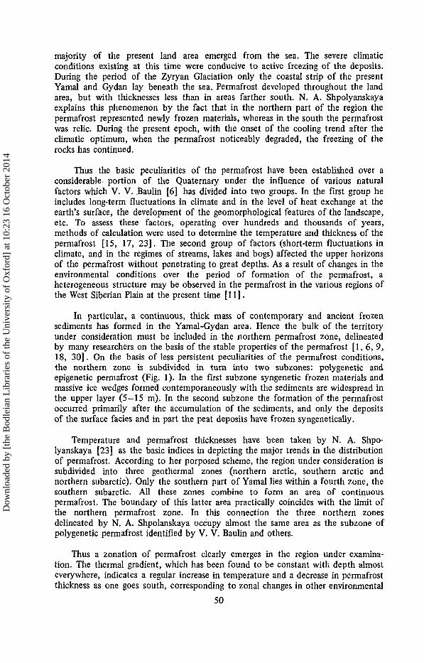
In particular, a continuous, thick mass of contemporary and ancient frozensediments has formed in the Yamal-Gydan area. Hence the bulk of the territoryunder consideration must be included in the northern permafrost zone, delineatedby many researchers on the basis of the stable properties of the permafrost [1, 6, 9,18, 30]. On the basis of less persistent peculiarities of the permafrost conditions,the northern zone is subdivided in turn into two subzones: polygenetic andepigenetic permafrost (Fig. 1). In the first subzone syngenetic frozen materials andmassive ice wedges formed contemporaneously with the sediments are widespread inthe upper layer (5—15 m). In the second subzone the formation of the permafrostoccurred primarily after the accumulation of the sediments, and only the depositsof the surface facies and in part the peat deposits have frozen syngenetically.
Temperature and permafrost thicknesses have been taken by N. A. Shpo-lyanskaya [23] as the basic indices in depicting the major trends in the distributionof permafrost. According to her porposed scheme, the region under consideration issubdivided into three geothermal zones (northern arctic, southern arctic andnorthern subarctic). Only the southern part of Yamal lies within a fourth zone, thesouthern subarctic. All these zones combine to form an area of continuouspermafrost. The boundary of this latter area practically coincides with the limit ofthe northern permafrost zone. In this connection the three northern zonesdelineated by N. A. Shpolanskaya occupy almost the same area as the subzone ofpolygenetic permafrost identified by V. V. Baulin and others.
Thus a zonation of permafrost clearly emerges in the region under examina-tion. The thermal gradient, which has been found to be constant with depth almosteverywhere, indicates a regular increase in temperature and a decrease in permafrostthickness as one goes south, corresponding to zonal changes in other environmental
50
Dow
nloa
ded
by [
the
Bod
leia
n L
ibra
ries
of
the
Uni
vers
ity o
f O
xfor
d] a
t 10:
23 1
6 O
ctob
er 2
014

Fig. 1. Map of permafrost zonal divisions and distribution of underground ice.
Legend:1—Boundaries of subzones;2—Subzone of polygenetic permafrost;3—Subzone of epigenetic permafrost;4—Syngenetic wedge ice;5—Epigenetic wedge ice;6—Sheet-like ice bodies;7—Injection ice.
51
Dow
nloa
ded
by [
the
Bod
leia
n L
ibra
ries
of
the
Uni
vers
ity o
f O
xfor
d] a
t 10:
23 1
6 O
ctob
er 2
014

components, primarily that of climate. Fairly close agreements exist at the presenttime on many questions as to the general trends in the distribution and character ofpermafrost in the area. In particular it is generally accepted that the temperature ofthe permafrost varies between —1° in the south and -9° in the north [24].
Permafrost Temperature and Thickness
In conformity with the relief, N. A. Shpolyanskaya [24] identifies two types ofpermafrost developed in interfluves and in river valleys, respectively. The meanannual temperature of interfluve permafrost varies from —8° to —9°C in the northto —5°C in the south. The temperature of permafrost developed beneath rivervalleys varies from -6°C to -8°C in the north to -1°C to -5°C in the south ofthe region.
Thus major differences in permafrost temperatures may be detected betweenthe upland and lowland areas [24]. The annual amplitude of temperature inpermafrost under conditions of varying relief in the north of Yamal is 4°C. Thespatial distribution of temperature in the Yamal-Gydan area is mainly associatedwith the winter heat regime. Here the summer heat exchange noticeably exceedsthat in winter; the difference between the two seasons is from 1 kcal/cm2 in thesouthern parts of the region to 5 kcal/cm2 in the north [24]. The main factor inthe winter heat exchange is the snow cover with its insulating qualities. Hence thedistribution of permafrost temperature corresponds to the snow cover distribution.
Along with its low temperatures, the permafrost is characterized by fairly greatthickness. Until recently it was generally accepted that permafrost thickness in thenorth of Western Siberia fluctuated between 100-300 m and 500-700 m,increasing regularly from south to north [6, 15, 23, 24, etc.]. According to datagathered by V. T. Trofimov and B. V. Varenyshev [27] as part of complexengineering-geology field investigations carried out in 1969—1972 on Yamal Penin-sula by the Tyumen' Expedition, and from analysis of data collected earlier byother expeditions, permafrost thicknesses have turned out to be considerably lower.These authors have compiled a map of permafrost thicknesses in Yamal, which,when compared with the geomorphological map, demonstrates very well thedependence of the permafrost thickness on the age and genesis of the geomorpho-logical levels on which these deposits have formed.
Permafrost thicknesses (according to these data) vary within quite a wide rangein Yamal: from 2—5 m up to 300—400m, and in places even higher. The maximumthickness has been pinpointed west of Lake Neyto (450 m). The greatest permafrostthicknesses coincide with the oldest geomorphological level: the marine terrace ofthe Yamal Transgression, and in the majority of cases they exceed 300 m. Over themajority of the Yamal Peninsula, representing surfaces of the fourth, third, secondand first marine terraces, permafrost thickness varies from 300 to 150 m,corresponding to the decreasing altitude and age of the geomorphological level. Theleast permafrost thicknesses (50 m to 150 m) are typical of the Holocene levels(coastal marshes, floodplains, deltas, etc.). Beneath the present coastal marshes ofthe Kara Sea coast, permafrost thicknesses increase from 2—10 m at the seawardside to 50-80 m at the landward side, while on the landward areas of the coastalmarshes of Ob' Bay, permafrost thicknesses are 120-200 m.
A regular variation in permafrost thicknesses has been recorded in the
52
Dow
nloa
ded
by [
the
Bod
leia
n L
ibra
ries
of
the
Uni
vers
ity o
f O
xfor
d] a
t 10:
23 1
6 O
ctob
er 2
014

floodplains of the river valleys (the Yuribey, Seyakha, Kharasavey, Shchuch'ya,Mordyyakha, etc.)- On the upper reaches of the rivers, where the floodplains arenarrower and the streams small, the permafrost thickness differs little from that ofsurrounding areas. In the middle reaches permafrost thicknesses beneath thecentral parts of the floodplains are 50—100 m, while in the lowest reaches, wherethe floodplains reach several kilometers in width, permafrost thicknesses decrease to40—50 m. V. T. Trofimov and V. B. Varenyshev believe that the permafrostthicknesses, in the case of all wide floodplains, increase from the zone near the riverchannel, where the warming influence of the river water is both constant and ofconsiderable magnitude, to the edges of the floodplain.
Apart from this they confirm V. V. Baulin's data [6] to the effect thatpermafrost thicknesses are less in the core areas of geological structures than ontheir fringes. However, in their opinion, this decrease in permafrost thickness in thecore areas of structures ought to appear clearly only in the event that the entirestructure lies within a single geomorphological level.
The continuous extent of thick permafrost within the region is broken by opentaliks only beneath large rivers. Closed taliks exist beneath the channels of smallrivers and lakes deeper than 1.5 m [4, 6, 17]. On the Yamal, Gydan and Tazpeninsulas the majority of rivers have quite low discharges and possess fairly lowwater temperatures; the warming influence of the water affects only the veryuppermost horizons of the permafrost. Thus, beneath the channel of the KhayvichoRiver near Cape Kamennyy, the permafrost table lies at a depth of 4.2 m.
In the southwestern part of Yamal permafrost has been encountered whichcontains layers of unfrozen materials. Here drill holes in the floodplains of theupper reaches of the Tarsedeyakha and Tanlovayakha rivers have revealed layers ofunfrozen material within the permafrost between the depths of 50 to 123 m and 50to 125 m respectively [27]. Unfrozen layers within the permafrost are encounteredless frequently at higher levels. Double layers of permafrost are widespread, theupper layer being late-Holocene in age and the lower (relic) layer much older; thisphenomenon occurs only in the extreme southwesterly areas of Yamal. Accordingto V. T. Trofimov and V. B. Varenyshev, throughout a wide coastal strip along theKara Sea coast of Yamal Peninsula there occur within the permafrost layers andlenses of sediments with a negative temperature, but saturated with mineralizedwater.
Hydrogeological Peculiarities
In the present paper we will consider only the water within the first aquifercomplex, located within the West Siberian Artesian Basin, the northern part ofwhich includes the Yamal-Gydan area. Within this aquifer complex four main typesof water may be distinguished: suprapermafrost, intrapermafrost, subpermafrost andtalik water [28].
Suprapermafrost water refers to the water of the active layer and of thepermanent closed taliks. The main source of water in the active layer is atmosphericprecipitation and surface runoff. It freezes completely during winter. The thicknessof the water-bearing horizon under consideration is determined by the depth ofseasonal thaw and decreases from south to north. In summer, the water reaches veryhigh temperatures. Suprapermafrost water is concentrated mainly in the depressions
53
Dow
nloa
ded
by [
the
Bod
leia
n L
ibra
ries
of
the
Uni
vers
ity o
f O
xfor
d] a
t 10:
23 1
6 O
ctob
er 2
014

of the landscape, creating marshy areas. With regard to its chemical composition itis mildly alkaline (hydrocarbonates of sodium and clacium types) or neutral [10].Water in permanent closed taliks involves only the water beneath river channels andlakes [22]. Taliks commonly form beneath river channels and lakes. In the valleysof central reaches of rivers, suprapermafrost water commonly involves considerablewinter reserves of water, even in the absence of a subpermafrost source of flow, andmay be used for water supply [10]. The yields of individual boreholes which haveintercepted ground water beneath rivers have reached 5—10 1/sec and more.
According to V. T. Trofimov and N. A. Fil'kin [28], intrapermafrost wateroccurs primarily south of the Arctic Circle. Within the region intrapermafrost waterin mid-Quaternary deposits has been revealed by drill holes in the area of CapeKamennyy at a depth of 132 m. This was minearlized water with a negativetemperature and was associated with a stratum of marine deposits of the Salekhard(?) series. It was under a hydraulic pressure of 118 m. The formation of such wateris associated with the freezing of a massive thickness of marine deposits containinglenses of salt water [6]. On the west coast of the Yamal Peninsula, in the vicinityof the lower reaches of the Mordyyakha River, underground salt water wasencountered in younger deposits (Kazan and recent) at depths of 30 and 5 m [6,28].
Subpermafrost water is not characteristic of the aquifer complex underconsideration. In the opinion of V. T. Trofimov and N. A. Fil'kin [28], itsoccurrence within the northern part of West Siberia is extremely dubious due to thegreat depth of the base of the permafrost. This is the predominant type of water inthe second combined complex of rocks [26].
Water in the talik zones represents a water-bearing horizon within the con-temporary alluvial deposits [28]. This water is encountered beneath the channels ofmajor rivers and beneath Ob', Taz and Gydan bays. Aquifer horizons in thecontemporary alluvial deposits, and also the intrapermafrost water of the Salekhardseries present the best prospects for water supply. Underground water, as a rule, isonly slightly mineralized, and is quite homogeneous in chemical composition, with,if anything, only a slight tendency toward alkalinity. The aquifer complexes of thelarge rivers are characterized by their reliability, the consistency of depth of theaquifer, and by interconnection with the rivers. Suprapermafrost water is dis-tinguished by its limited amount, and the limited period of its existence; it is of nopractical significance in terms of water supply. At the same time suprapermafrostwater exerts a great influence on the development of processes operating in theactive layer.
The Active Layer
The depth of the active layer increases from 0.2 m in the north to 2 m andmore in the south. In the arctic turndra subzone in the north of the region, thedepth of the seasonally thawed layer varies between 0.2 and 0.6 m. On Belyy Islandthe maximum depth of thaw (0.75 m), as recorded in 1970 by the Arctic-AntarcticInstitute expedition, was found to be in patches of sandy ground devoid ofvegetation cover. Farther south, in the area of Cape Leskin, it increases to 1 m. Inthe central part of the Yamal Peninsula, in the vicinity of lakes Neyto andYambuto, which are located in the moss-lichen tundra subzone, the mean depth ofthaw is 0.5 to 0.6 m. The depth of the active layer increases in the shrubtundra
54
Dow
nloa
ded
by [
the
Bod
leia
n L
ibra
ries
of
the
Uni
vers
ity o
f O
xfor
d] a
t 10:
23 1
6 O
ctob
er 2
014

subzone. In the northern part of this subzone (Cape Kamennyy and the middlecourse of the Yuribey River) mean thaw depths are around 0.7 to 0.8 m, with themaximum exceeding 1 m. In the southern parts of the shrub tundra, in areas free ofvegetation, sandy ground thaws to a depth of 2 m, but to lesser depths (only 1.7 to1.8 m) in floodplain meadows and bars.
Thawing of the ground begins immediately after the disappearance of the snowcover. On Belyy Island it began in mid-June in 1970, and at Cape Kamennyy (in1971) it began in late May-early June and ended in the latter part of September.The thaw zone reaches its maximum depth (1.3 m) in late July and in August.Earlier thawing may be observed on ridges and in the upper sections of slopes ofvalleys and gullies. At sites where the snow cover survives longer, thawing is delayedby 15—17 days. Thus in 1971 on a ridge in the vicinity of Cape Kamennyy,thawing began on June 2, but not until the 17th at the base of the slope. The latestthawing of all was recorded at the bottom of deep gullies and on the shadedportions of valley side slopes, where the snow survives until mid-July in the northof the region, and until the second half of June in the south. By this time theground has thawed to a depth equal to 70—75% of the ultimate thaw depth overthe remainder of the area.
The main factors affecting the depth of thaw are as follows: solar radiation,relief, lithological composition of the rocks, moisture, soil and vegetation cover, etc.With regard to the relief, some authors [16, 18] maintain that the influence ofrelief on the depth of the active layer depends primarily on exposure and slopegradient; others [14] consider that in northern areas these factors do not provokesharp changes in the depth of thaw. The results of field measurements made onslopes of varying exposure in the area of Cape Leskin confirmed the latterconclusion [14]. With regard to rates of thaw, they vary depending upon slopegradient and exposure. Thus on July 20 the difference in thaw depth between gullyslopes with northerly and southerly exposures (other factors being equal) was 4—5cm. A similar pattern was observed on Belyy Island.
A more critical influence on depth and speed of thaw in the active layer isexerted by those differences in relief which result in inequalities in the distributionof snow cover; this in turn affects the freezing of the ground in winter and itsthawing in summer. As is well known the snow cover represents a very effectiveinsulator. The insulating properties of snow increase particularly with low snowdensities and large snow depths, characteristic of gullies, river valleys, lake basinsand other depressions in the relief.
According to a snow survey carried out in the spring of 1972 in the area ofCape Leskin, the depth of snow cover associated with the forms just enumeratedreached 4.2, 1.0, 1.75 and 2.6 m. Average snow densities were: 0.34 in gullies; 0.32in river valleys; and 0.33 in lake basins. On interfluve areas snow depths were quiteinsignificant. Thus in the Cape Leskin area, snow depths on the majority of thedivides fluctuated between. 12 and 20 cm; only in isolated depressions did it reach40—60 cm. Snow density on interfluves was also lower (0.27—0.28), with theexception of large hollows in which snow densities were close to those quoted forthe negative relief forms. Isolated areas on the divides were completely devoid ofsnow cover, and hence the soil was poorly protected against frost penetration. Onsuch areas frost cracking is well displayed [13]. The depth of snow cover on thedivides increases gradually toward the south. The ground thaws to considerably
55
Dow
nloa
ded
by [
the
Bod
leia
n L
ibra
ries
of
the
Uni
vers
ity o
f O
xfor
d] a
t 10:
23 1
6 O
ctob
er 2
014

TABLE 1
Mean Monthly Air Temperatures and Ground Surface Temperatures
Observation June July August Septembersite surface air surface air surface air surface air
Belyy IslandCape LeskinCape KamennyyYar-Sale
2.01.02.08.0
-0.30.20.76.1
6.08.0
11.016.0
4.16.58.1
13.2
6.07.0
11.012.0
5.36.8
10.110.7
2.02.05.05.0
1.92.15.05.0
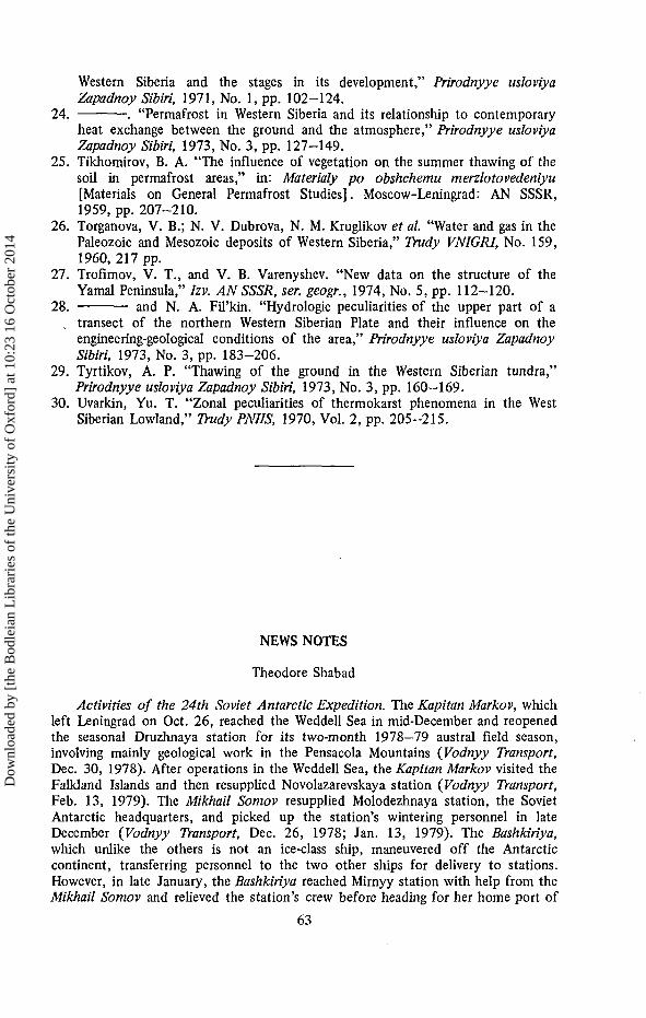
north to south. They reach their highest values in July and August. In the arctictundra subzone the long-term mean maximum ground surface temperature usuallydoes not exceed 14—16°C; in typical tundra it rises to 20°C and in shrub tundra itreaches 23°C. The highest absolute maximum temperature (45°C) was recorded inthe south of the region at Yar-Sale. In all subzones, the absolute maxima arerecorded in July. The ground surface temperatures in summer display a well-developed daily oscillation (Fig. 2). The amount of the daily amplitude decreaseswith depth. The highest values of daily amplitude also occur in July.
During the warm season, the mean monthly ground surface temperatures arehigher than the air temperatures (see Table 1). The greatest spread between airtemperatures and ground surface temperatures is observed in July. The maximumgradients between air temperature and ground surface temperature occur mainly inwarm, clear, calm weather. Thus on Belyy Island, at 12:00 am with a lightnorthwesterly wind (2 m/sec) the ground surface temperature was 16.2°C, whereasthe air temperature at that time did not exceed 5°C. With a solid overcast and calmconditions, air temperature and ground surface temperature are almost identical: inthe vicinity of Cape Kamennyy on July 19 the air temperature was 16.0°C and theground surface temperature 17.2°C.
The lithological composition of the rocks and their moisture conditions, as wellas the peculiarities of the relief and of the vegetation cover, exert a major influenceon the temperature regime of the ground. The greatest difference in temperatureoccurs between inorganic surfaces and peatlands, this being particularly noticeable inthe southern areas. In the north of the region, where cloudiness increases and theamount of direct radiation received noticeably diminishes, ground temperatures areleast affected by the influence of lithology.
The same may be said about the influence of exposure and slope gradients onthe ground thermal regime, as has been indicated by A. I. Popov [18] and by N. A.Shpolyanskaya [24]. According to the data from the AANII expedition, in thenorth of the Gydan Peninsula the difference in the mean daily ground surfacetemperatures in summer between slopes with a northerly and those with a southerlyexposure does not exceed 0.8°C, whereas farther south it is more than 5°C (at CapeKamennyy). The difference in thermal conditions at the ground surface at thebottom of negative relief forms vs. those at the surface of positive forms is also lessin the northern areas. Thus in the vicinity of Cape Leskin, the difference betweenthe mean daily ground surface temperature at the bottoms of valleys, and those on
57
Dow
nloa
ded
by [
the
Bod
leia
n L
ibra
ries
of
the
Uni
vers
ity o
f O
xfor
d] a
t 10:
23 1
6 O
ctob
er 2
014

greater depths in those areas where large amounts of snow accumulate, andespecially deeply where a deep snow cover melts rapidly.
One of the main factors affecting the depth of seasonal freezing and thawing isthe lithological composition of the rocks. Some light has been thrown on thequestion of the thawing of ground materials of varying lithologies (sands, sandy-clays, and peat) on the West Siberian tundra by the work of A. P. Tyrtikov [29].He considers that the depth of thaw in bare sand deposits is approximately twice asgreat as in exposed silty clays, and that bare peat thaws to a depth only half asgreat.
An equally critical influence on the depth and rate of seasonal thawing isexerted by the vegetation cover and by the humidity of the ground. In tundra witha continuous vegetation cover, which occupies the major part of the divides, rivervalleys, lake basins, etc., the depth of thaw is considerably less than in bare areas.B. A. Tikhomirov [25] has noted a number of relationships as to the change in thedepth of thaw in the active layer associated with changes in the character of thevegetation cover. Our observations have shown that on the interfluves in thenorthern part of the arctic tundra the amplitude of thaw depth in areas vegetatedwith a continuous lichen-moss or grass-moss cover and on patches of ground devoidof vegetation reaches 0.3 to 0.4 m. In this connection the maximum depth of thawis recorded in the centers of bare patches and gradually decreases to the edges asthe vegetation border is approached.
In the northern part of the shrub tundra the average depth of the active layer is0.5-0.6 m. In areas with a grass-shrub cover the ground thaws to 0.7—0.75 m. Thusthe depth of thaw beneath a dense mossy vegetation is 1.5 times less, and in somecases even 2 times less than beneath a grass-shrub cover or beneath areas devoid ofvegetation.
Moisture also has an impact on the depth and rate of thaw; the moister theground, the more energy is required to warm it. Hence at severely waterlogged sitesthe depth of the active layer is barely half as much as at neighboring vegetated sites.The difference in the rate of thaw between dry divides and moist areas isparticularly noticeable at the beginning of the warm season, when the temperatureof the suprapermafrost water is close to 0°C. From year to year the depth of theactive layer may fluctuate by 10-20 cm.
The most critical influence on changes in the depths of thawing and freezing inthe active layer is exerted by climatic factors, the major ones of which are solarradiation, and air and soil temperatures which are in turn dependent upon it. Thespeed and intensity of thawing and freezing in the active layer are controlled by thepeculiarities of ground temperature, whereby one may judge as to the influx of heatand exhaustion of heat reserves.
The lowest ground temperatures in the arctic tundra subzone are observed inthe north of the region in March. After the disappearance of the snow cover andthe rise of air temperature across the 0°C threshold into positive temperatures, thesurface of the ground is characterized by positive mean daily temperatures.Throughout the entire region the mean monthly ground surface temperatures arepositive for four months from June to September (Table 1). As can be seen fromthe table, the mean monthly ground surface temperatures increase steadily from
56
Dow
nloa
ded
by [
the
Bod
leia
n L
ibra
ries
of
the
Uni
vers
ity o
f O
xfor
d] a
t 10:
23 1
6 O
ctob
er 2
014

Fig. 2. Hourly march of temperature in the upper layer of the ground (in cm)at Cape Kamennyy in 1971 (a: June 17—18; b: Aug. 13—14); and at Cape Leskin in1972 (c: June 15-26; d: July 13-14; e: Aug. 20-21).
the interfluve areas rarely exceeds 2°C, but in the vicinity of Cape Kamennyy itreaches 7.5°C.
Vegetation inhibits moisture circulation and heat exchange, and its influence onthe thermal regime of the ground is determined by the species composition andpercentage cover of the vegetation association. On tundra, where moss communitiespredominate, the influx of heat into the soil is retarded. Particularly low groundtemperatures are observed beneath sphagnum and other mosses. In the Cape Leskin
58
Dow
nloa
ded
by [
the
Bod
leia
n L
ibra
ries
of
the
Uni
vers
ity o
f O
xfor
d] a
t 10:
23 1
6 O
ctob
er 2
014

12 15 18 U\ 24
area the differential between the temperature at the moss surface, and that beneaththe moss cover in moss/sedge tundra reached 8°C. Farther south, in the transitionalzone between moss-lichen and shrub tundra on August 13 the temperature at the mosssurface was 23.7°C, whereas beneath the moss it was 10.3°C, the air temperature atthe time being 20.5°C.
Underground Ice
Many researchers have focussed attention on underground ice [3, 8, 12, 16, 18,20, 21]. During the last few years it has been established that two types of ice arewidely distributed in the Yamal-Gydan region: wedge ice and sheet ice (see Fig. 1).Other varieties of underground ice are of considerably less significance in thestructure of the cryogenic zones. Wedge ice is developed in Quaternary deposits ofvarious origins (marine, littoral, alluvial, swamp/lacustrine, etc.). By genesis this ice
59
Dow
nloa
ded
by [
the
Bod
leia
n L
ibra
ries
of
the
Uni
vers
ity o
f O
xfor
d] a
t 10:
23 1
6 O
ctob
er 2
014

may be divided into syngenetic and epigenetic, and by age it may be described aseither contemporary or relic [12].
Contemporary syngenetic ice wedges are distributed throughout the northernhalf of the region and coincide with deposits of ice-bearing silty-clays developed inriver floodplains. Their dimensions are small: width at the surface 0.5—2 m; depth2—6 m. Relic syngenetic wedges, coinciding with alluvial deposits on terraces abovethe floodplains and with the ice-bearing silty-clays of coastal marshes of Late-Pleistocene age, are encountered throughout the entire region, but are especiallycharacteristic of the northern half. As one moves from west to east, in the directionof increasing continentality, the number of ice wedges decreases, and the boundaryof the zone in which they are most widely distributed moves north. Ancientsyngenetic wedges form extremely large accumulations of wedge ice and are of themaximum dimensions. Their depth reaches 8—12 m; their width (in the upper parts)2—3 m. These wedges are covered by a layer of sediments 1—10 m thick, and liebeneath the base of the active layer. The depth of the wedges developed in alluvialdeposits fluctuates between 2—4 m on the first terrace above the floodplain to10—12 m on the third terrace, with the widths at the top of correspondingdimensions (from 0.5—1-5 to 1-3 m).
According to G. I. Dubikov [12], this type of ice is less developed on theGydan Peninsula than in Yamal; he explains this in terms of the more homogene-ous, sandy composition of the Gydan alluvium, which has a lower moisture content.Late-Pleistocene ice wedges are particularly well developed in the coastal sedimentsin the north of the Gydan Peninsula. In the interior of Yamal they are encounteredsporadically in the surfaces of the second and third terraces above the floodplains.By composition and structure these old syngenetic wedges may be divided into icewedges, ice/sediment wedges, and mineral wedges.
Epigenetic ice wedges, whether actively developing or inactive, may be dividedinto ice wedges and ice/sediment wedges. They are encountered on all elements ofthe relief and coincide mainly with the silty-clay deposits of either marine orswamp/lacustrine origin. Developing epigenetic wedges were investigated in the northof Yamal Peninsula in the valley of the Seyakha and at Lake Neyto [12]. Theytake the form of narrow wedges 2.5 to 4 m deep and 0.5 to 1.5 m wide (in theirupper parts). Wedges of even larger dimensions were encountered in marine andswamp/lacustrine silty clays in Gydan (in the lower valley of the Yuribey). In thesouthwestern part of the area developing epigeneitc ice wedges are widely dis-tributed in the peatlands. In the valley of the Shchuchya they reach 2—3 m indepth and 1.5 m in width (in their upper parts). Inactive epigenetic wedges arewidely distributed in the alluvium of river terraces throughout the entire region.
On a morphogenetic basis sheet ice may be subdivided into injection ice in theform of either laccoliths or stocks, and stratified bodies of segregation ice. Apartfrom these one may also differentiate complex bodies of ice, in the formation ofwhich both injection and segregation processes operated simultaneously.
Injection ice is widely distributed throughout the region and is comparable involume with wedge ice. Injection ice is mainly confined to marine and littoraldeposits of Kazan age, but is also encountered in older deposits. Injection icebodies, reaching 20 m in thickness and up to 100—200 m in extent, represent thelargest formations of underground ice. The depth of occurrence of these bodies
60
Dow
nloa
ded
by [
the
Bod
leia
n L
ibra
ries
of
the
Uni
vers
ity o
f O
xfor
d] a
t 10:
23 1
6 O
ctob
er 2
014

fluctuates between a few meters and 100—200 m. They are distinguished not onlyby their dimensions but also by their form and foliations, although they all have ageneral structure similar to that of the ice in contemporary frost mounds.
Segregation ice is characterized by a layered structure. Layers of ice alternatewith layers of ice-saturated sediments. On the Yamal and Gydan peninsulas it occursat various depths. In exposures its visible thickness and extent may be 5—10 and70—100 m respectively. Complex ice bodies consist of layered (segregation) ice andmassive, clean, transparent ice. In one exposure in the Yamal Peninsula the visiblethickness of the ice body is 6 m, and the width at its base 15—16 m [3].
Underground ice (especially shallow ice masses) is of great practical significance.According to calculations made for the Lake Neyto area, the area occupied by icecomprises 13.2% of the land area. The volumetric ice content of the permafrost todepths of 20—30 m reaches 30—50%. The universal distribution of the permafrost,together with its high ice content and great depth, represents a serious danger interms of construction, since even minor, short-term dynamic actions will provokerapid thawing and a sharp reduction in the bearing capacity of the ground.
The upper horizons of the permafrost are characterized by the greatest amountof settlement on thawing, down to depths of 10—15 m, and particularly within thedepth range of 1.5—7 m. According to rough calculations, in the southern part ofYamal the maximum amount of settlement with the thawing of a 100 m thicknessof silty clays would be 13.4 m [6]. According to A. P. Tyrtikov [29], in the arcticand moss-lichen tundras, one should not create conditions for the degradation ofthe permafrost to any significant depth, even through such simple techniques as theremoval of vegetation or systematic snow clearance. He considers that, withexploitation, thawing of silty clays in the northern part of the moss-lichen tundrazone could increase by 50—70 cm and to 60—100 cm in the southern part. Theincrease of depth of thaw in the permafrost leads to an intensification of thecryogenic processes, which provoke the destruction of buildings and the eliminationof agricultural land.
Bibliography
1. Baranov, I. Ya. Printsipy geokriologicheskogo (merzlotnogo) rayonirovaniyaoblasti mnogoletnemerzlykh gornykh porod [Principles of Geocryological(Permafrost) Regionalization of Areas of Perennially Frozen Ground]. Moscow:Nauka, 1965, 150 pp.
2. Baulin, V. V. "Permafrost and the paleogeography of Western Siberia," in:Osnovnye problemy izucheniya chetvertichnogo perioda [Major Problems in theStudy of the Quaternary Period]. Moscow: Nauka, 1965, pp. 295-300.
3. and G. I. Dubikov. "Sheet formations of underground ice," TrudyPNIIIS, 1970, Vol. 2, pp. 175-193.
4. and V. P. Chernyad'yev. "Regionalization and prediction of permafrostconditions for construction," Trudy V Vsesoyuz. soveshchaniya-seminara poobmenu opytom stroitel'stva v surovykh klimaticheskikh usloviyakh, 1968, Vol.6, No. 4, pp. 61-75.
5. ; Ye. B. Belopukhova, and G. I. Dubikov. "Geographical peculiarities ofpermafrost in Western Siberia," Izv. AN SSSR. ser. geogr., 1968, No. 6, pp.64-70.
6. ; Ye. B. Belopukhova, G. I. Dubikov, and L. M. Shmelev.
61
Dow
nloa
ded
by [
the
Bod
leia
n L
ibra
ries
of
the
Uni
vers
ity o
f O
xfor
d] a
t 10:
23 1
6 O
ctob
er 2
014

Geokriologicheskiye usloviya Zapadno-Sibirskoy nizmennosti [GeocryologicalConditions in the West Siberian Lowland]. Moscow: Nauka, 1967, 214 pp.
7. ; Ye. B. Belopukhova, G. I. Dubikov and L. M. Shmelev. "Regulartrends in the development of permafrost and permafrost regionalization," in:Geokriologicheskiye usloviya Zapadno-Sibirskoy nizmennosti [GeocryologicalConditions in the West Siberian Lowland]. Moscow: Nauka, 1967, pp.192-205.
8. Belopukhova, Ye. B. "Peculiarities of polygonal ice-wedge relief in northernWestern Siberia," Izv. AN SSSR, ser. geogr., 1965, No. 4, pp. 70-76.
9. Chernyad'yev, V. P. "Investigation of the dynamics of seasonal and perennialfreeze-thaw under Western Siberian conditions," Trudy PNIIIS, 1970, Vol. 2,pp. 6-81.
10. Dostovaloy, B. I., and V. A. Kudryavtsev. Geokriologiya (obshcheye merzlo-tovedeniye) [Geocryology (General Permafrost Studies)]. Moscow University,1967, 392 pp.
11. Dubikov, G. I. "Peculiarities of permafrost distribution in the northern part ofthe West Siberian Lowland," Trudy Instituta Merzlotovedeniya, 1962, Vol. 19,pp. 25-31.
12. and M. M. Koreysha. "Composition and structure of permafrost," in:Geokriologicheskiye usloviya Zapadno-Sibirskoy nizmennosti [GeocryologicalConditions in the West Siberian Lowland]. Moscow: Nauka, 1967, pp. 95—155.
13. Korotkevich, Ye. S. Polyarnye pustyni [Polar Deserts]. Leningrad: Gidro-meteoizdat, 1972, 411 pp.
14. Kosov, B. F., and G. S. Konstantinova. "Gullying in the north of WesternSiberia," Prirodnyye usloviya Zapadnoy Sibiri, 1973, No. 4, pp. 104-115.
15. Kudryavtsev, V. A. "Temperature, thickness and discontinuity of permafrost,"in: Osnovy geokriologii [Fundamentals of Geocryology], Part 1. Moscow: ANSSSR, 1959, 459 pp.
16. Lazukov, G. I. "Quaternary glaciation of the West Siberian Lowland," in:Paleogeografiya chetvertichnogo perioda [Paleogeography of the Quaternary].Moscow University, 1965, 371 pp.
17. Lynov, V. A., and S. Ye. Sukhodol'skiy. "Application of a calculated diagramof the station regime in permafrost/geology investigations under conditions ofhigh-temperature permafrost," Stroitel'stvo na vechnomerzlykh gruntakh, 1968,Vol. 6, No. 4, pp. 5-18.
18. Popov, A. I. Vechnaya merzlota v Zapadnoy Sibiri [Permafrost in WesternSiberia]. Moscow: AN SSSR, 1953, 219 pp.
19. — . "History of permafrost in the USSR during the Quaternary," Vest.MGU, ser. biol., pochvoved., geol., geogr., 1957, No. 3, pp. 49—62.
20. . "The Quaternary period in Western Siberia," in: Lednikovyy periodna territorii Yevropeyskoy chasti SSSR i Sibiri [The glacial period in theEuropean part of the USSR and in Siberia]. Moscow University, 1959, pp.360-384.
21. . "Maps of periglacial permafrost-geomorphological formations innorthern European Russia and in Siberia," in: Voprosy geograficheskogomerzolotovedeniya i periglyatsial'noy morfologii [Problems of GeographicalPermafrost Studies and of Periglacial Morphology]. Moscow University, 1962,196 pp.
22. Ravdonikas, O. V. "Major results of hydrogeological investigations of theoil-bearing areas of northern Western Siberia," Trudy NIIGA, 1962, Vol. 129,193 pp.
23. Shpolyanskaya, N. A. "Major trends in the distribution of permafrost in
62
Dow
nloa
ded
by [
the
Bod
leia
n L
ibra
ries
of
the
Uni
vers
ity o
f O
xfor
d] a
t 10:
23 1
6 O
ctob
er 2
014
Western Siberia and the stages in its development," Prirodnyye usloviyaZapadnoy Sibiri, 1971, No. 1, pp. 102-124.
24. . "Permafrost in Western Siberia and its relationship to contemporaryheat exchange between the ground and the atmosphere," Prirodnyye usloviyaZapadnoy Sibiri, 1973, No. 3, pp. 127-149.
25. Tikhomirov, B. A. "The influence of vegetation on the summer thawing of thesoil in permafrost areas," in: Materialy po obshchemu merzlotovedeniyu[Materials on General Permafrost Studies]. Moscow-Leningrad: AN SSSR,1959, pp. 207-210.
26. Torganova, V. B.; N. V. Dubrova, N. M. Kruglikov et al. "Water and gas in thePaleozoic and Mesozoic deposits of Western Siberia," Trudy VNIGRI, No. 159,1960, 217 pp.
27. Trofimov, V. T., and V. B. Varenyshev. "New data on the structure of theYamal Peninsula," Izv. AN SSSR, ser. geogr., 1974, No. 5, pp. 112-120.
28. and N. A. Fil'kin. "Hydrologic peculiarities of the upper part of atransect of the northern Western Siberian Plate and their influence on theengineering-geological conditions of the area," Prirodnyye usloviya ZapadnoySibiri, 1973, No. 3, pp. 183-206.
29. Tyrtikov, A. P. "Thawing of the ground in the Western Siberian tundra,"Prirodnyye usloviya Zapadnoy Sibiri, 1973, No. 3, pp. 160-169.
30. Uvarkin, Yu. T. "Zonal peculiarities of thermokarst phenomena in the WestSiberian Lowland," Trudy PNIIS, 1970, Vol. 2, pp. 205-215.
NEWS NOTES
Theodore Shabad
Activities of the 24th Soviet Antarctic Expedition. The Kapitan Markov, whichleft Leningrad on Oct. 26, reached the Weddell Sea in mid-December and reopenedthe seasonal Druzhnaya station for its two-month 1978—79 austral field season,involving mainly geological work in the Pensacola Mountains {Vodnyy Transport,Dec. 30, 1978). After operations in the Weddell Sea, the Kapitan Markov visited theFalkland Islands and then resupplied Novolazarevskaya station {Vodnyy Transport,Feb. 13, 1979). The Mikhail Somov resupplied Molodezhnaya station, the SovietAntarctic headquarters, and picked up the station's wintering personnel in lateDecember {Vodnyy Transport, Dec. 26, 1978; Jan. 13, 1979). The Bashkiriya,which unlike the others is not an ice-class ship, maneuvered off the Antarcticcontinent, transferring personnel to the two other ships for delivery to stations.However, in late January, the Bashkiriya reached Mirnyy station with help from theMikhail Somov and relieved the station's crew before heading for her home port of
63
Dow
nloa
ded
by [
the
Bod
leia
n L
ibra
ries
of
the
Uni
vers
ity o
f O
xfor
d] a
t 10:
23 1
6 O
ctob
er 2
014
Recommended