×
Log in
Upload File
Most Popular
Art & Photos
Automotive
Business
Career
Design
Education
Hi-Tech
+ Browse for More
Download pdf -
NADCON - Home | National Geodetic Survey · PDF fileBACKGROUND The North American Datum of 1983 (NAD 83) represents the single most accurate and comprehensive geodetic survey datum
Download pdf
Transcript
Page 1
Page 2
Page 3
Page 4
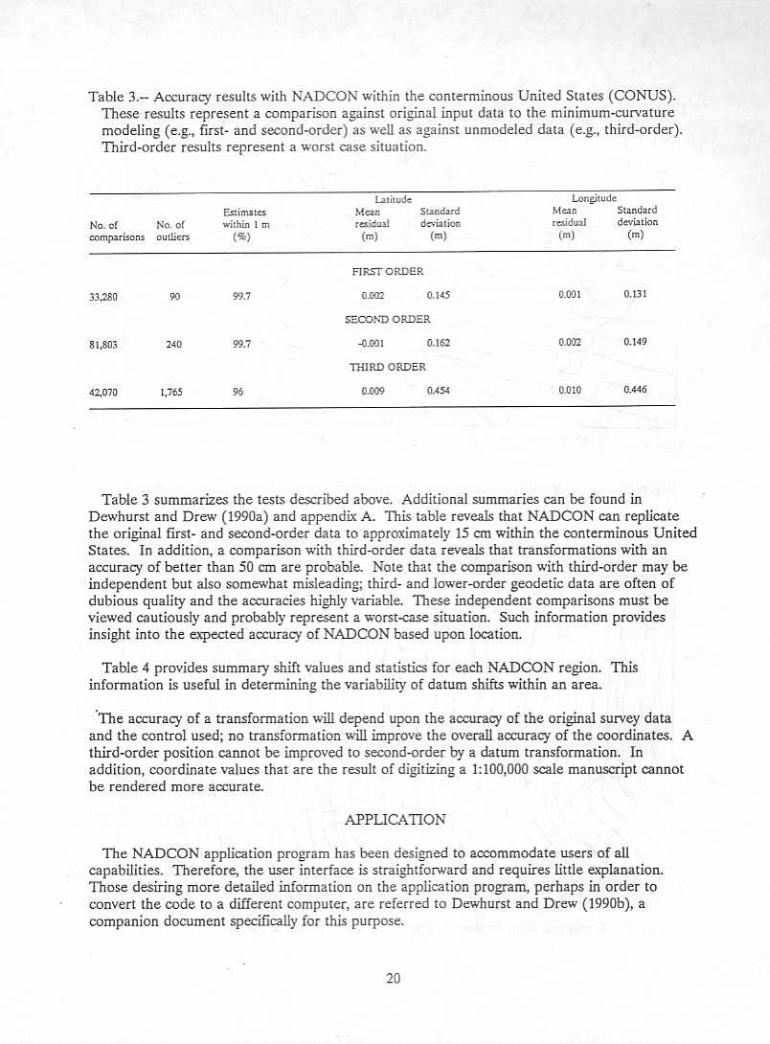
Page 5
Page 6
Page 7
Page 8
Page 9
Page 10
Page 11
Page 12
Page 13
Page 14
Page 15
Page 16
Page 17
Page 18
Page 19
Page 20
Page 21
Page 22
Page 23
Page 24
Page 25
Page 26
Page 27
Page 28
Page 29
Page 30
Page 31
Page 32
LOAD MORE
Recommended
Geodetic Datum Transformation · PDF fileGeodetic Datum Transformation. 1 What coordinates? Which system? Where is the point on ... z, – Note : no need to define the reference ellipsoid
Documents
Geodetic Datum 1
Documents
New Official Geodetic Datum of Croatia and CROPOS System as its
Documents
Investigations into a Dynamic Datum for California Yehuda ...sopac-csrc.ucsd.edu/wp-content/uploads/2019/12/SIOTask4Report_fi… · Maintenance of a fixed geodetic datum is complicated
Documents
Report of Survey- SK356npdc.ncaor.gov.in/npdc/cruisdatadownload.jsp... · 5. GEODETIC PARAMETERS Geodetic Parameters Horizontal Datum and Ellipsoid WGS 84 Spheroid WGS 84 Semi major
Documents
Presented by John Schaeffer Juniper GIS Services, Inc. · (a horizontal datum) or heights above or below a surface (a vertical datum). Geodetic Datum – A datum that is the basis
Documents
Geodetic or Rhumb Line Polygon Area Calculation over the ... · Geodetic or Rhumb Line Polygon Area Calculation over the WGS-84 Datum Ellipsoid FIG Congress 2010 Facing the Challenges
Documents
The Geodetic Datum Problems of the Territorial Sea Boundary
Documents
The Canadian Geodetic Vertical Datum of 2013 A modernized ... · The Canadian Geodetic Vertical Datum of 2013 A modernized Reference for Heights Height System Unification with GOCE
Documents
Geodetic Datum TransformationGeodetic Datum (local datum) For classical geodesy, a local geodetic datum (e.g. HK80 geodetic datum) is customary defined by: • latitude and longitude
Documents
Geodetic Datum of Indonesian Maritime Boundaries: Status and
Documents
A DIGITAL-COMPUTER MODEL OF THE BIG SIOUX AQUIFER …kinematic viscosity. National Geodetic Vertical Datum of 1929 (NGVD of 1929). A geodetic datum derived from a general adjustment
Documents
Progress Towards a New Geodetic Datum for Australia
Documents
201201 Sarib, Rob a New Geodetic Datum for the Northern Territory
Documents
NADCON - Home | National Geodetic Survey · tracking systems such as Doppler and the Global Positioning System (GPS) all contributed to the identification of weaknesses in NAD 27
Documents
The North American Datum of 1983...North America Datum (Introduction) by Commander John D. Bossler Project Manager, NAD National Geodetic Survey NOS, NOAA, Rockville, Md. series of
Documents
Using GPS with Maps. GPS’ Own Internal System GPS Ellipsoid: GRS-80 (Geodetic Reference System 1980) GPS Datum: WGS-84 (World Geodetic System 1984) (equivalent
Documents
Potomac-Raritan-Magothy (PRM) system · °F = 1.8 (°C) + 32 Sea level: In this report "sea level" refers to the National Geodetic Vertical Datum of 1929--a geodetic datum derived
Documents