DOMASAFARIAREA
CHEWORE& SAPI
SAFARI AREA
HARTLEY
MUPFURE
DARWENDALE
HURUNGWESAFARI AREA
CHARARASAFARIAREA
MANA POOLSNATIONAL
PARK
MBIRE
GURUVE
CHINHOYI
NORTON
HURUNGWE
CHEGUTU
MAKONDE
KADOMA
ZVIMBA
5
2A
4
3
2B
16
17
20
108
9
3
12
11
24
2
11
13
6 7 12
31
6
914
5 13
3
11
18
30
15
32
5
13
22
15
9
4
23
15
16
13
17
14
3
22
7
6
19
11
18
10
14
13
12
25
16
23
16
2
26
18
16
32
13
8
14
6
7
1
12
46
27
53
7
2
11
19
29
28
289
10
14
21
12
81
21
23
242
11
22
17
12
20
11
1314
15
12
5
6
9 8
10
18
3
19
8
16
20
9
4
16
10
19
17
33
8
1
310
1
17
21
2
22
9
18
7
5
8
15
12
1
4
3
23
7
34
15
2
16
20
GIANT
ST.RUPERTS
MARSHALLHARTLEY
KUTAMA
KAPFUNDE
CHARLESCLACK
ST.CECELIA
PERSEVERANCE
DALNY
SPRINGBOK
SILVERSIDENORAH
MHANGURA
GOLDENKOPJE
ALASKA
SHACKLETON
LYNX
SHAMROCKE
NYIMO
KASIRISIRI
MAREVANANI
CHIGARO
MAPFUNGWE
HOMBWE
ZUMBARA
MAZEZURU
MURINDAGOMO
KAZANGARARE
MADZORERA
DOMBWE
GADZEMA
SELOUS
MAKWIRO
MASIYARWA
MARYLANDJUNCTION
LIONSDEN
ZAVE
DOMA
KENZAMBA
MASONA
COPPERQUEEN
KAMONDE
MARERE
CHIMUSIMBE
TENGWE
KAPFUNDE
MAUMBE
CHANETSA
MADADZI
MWAMIKAPIRI
DORA
RUKOMECHI
VUTI
CHITINDIWA
MASOKA
KACHUTA
ANGWABRIDGE
MUROMBEDZI
ALASKA
TRELAWNEY
RAFFINGORA
MAGUNJE
MUSHUMBIPOOLS
CHAKARI
BANKET
MHANGURA
ChitamboClinic
PremierMedical CentreClinic
ChinhoyiHealth Center
Clinic Private Clinic
PSIClinic
Private Clinic
Chinhoyi UniversityClinicUniversity clinic
DoroClinic
Lan lorryClinic
KemutambaRural HealthCentre
RiverRanchClinic
NyagombeClinic
GreenValleyClinic
KemuraraRural Health
Centre
Elvington ClinicGold Mine ClinicLizmore
Clinic
ShamrockUnderConstruction
BlackMovaleClinic
ZvimbaRural
Hospital
UmboeClinic
TrelawneyCouncilClinic
TRBCCouncilClinic
TeneweCouncilClinic
St. RupetsMissionHospital
SelousCouncilClinic
RuweniUnderConstruction
RusvingoClinic(construction)
RaffingoraRural
Hospital
PfupajenaMunicipality-
clinic
ObvaClinic
NyaondeRural HealthCentre
NyangomaCouncilClinic
NyamakazeGvt Clinic Nyama
Council
NyabangoRural HealthCentre
Mwamiclinic
MuuyuCouncilClinic
MurombedziPrivateClinic
MurerekaClinic
MupurubuCouncilClinic
MukohweClinic
MuitubuClinic
MsengeziMissionHospital
MsengeziCouncilClinic
MhanguraPrivateHospital
MbuyanehandaRural HealthCentre
MatorangeraClinic
MasokaClinic
MasiyarwaCouncilClinic
MashongweCouncilClinic
ZumbaraClinic
ZowaCouncilClinic
ZIMPAMPrivateHospital
Magunje ArmyArmy Clinic
MagunjeRural
Hospital
LynxClinic PrivateClinic
KuwadzanaCouncilClinic
KutamaCouncilClinic
KosanaClinic
KenzambaClinic
KazangarareGvt Council
KasimubeRural HealthCentre
KaruruCouncil(Construction)
KaroiDistrict
Hospital
KapfundeCouncilClinic
KamondeClinic
KachutaClinic
JompaniRural HealthCentre
JokwaniCouncilClinic(Construction)
JariCouncilClinic
HombweClinic
HewiyaiCouncilClinic
HeskethCouncilClinic
GodziClinic
Father OneaMissionHospital
DoribweCouncilClinic
DomaClinic
DeteCouncilClinic
David WhiteheadPrivate Clinic
DarwendaleRural
Hospital
ChunduCouncilClinic
ChivhereGvt Clinic
ChivendeGvt Clinic
ChirikitiCouncilClinic
ChirauCouncilClinic
Chinhoyi P.HProvincialHospital
ChinhereCouncilClinic
ChikonohonoClinic
ChikanziweCouncil
Clinic
ChenjiriCouncilClinic
Chegutu UrbanMunicipality-
clinic
Chegutu DCCouncil Clinic
Chegutu 6(New Site)
ChegutuDistrictHospital
ChambadziGold MineClinic
ChakariPrivateMine Clinic
BHPPrivateClinic
BanketDistrict
Hospital
AyrshireCouncil
Clinic
AngwaClinic
AlaskaClinic
ARDA SisiCouncilClinic
4
5
3
2 A
1
2 B
Map data source(s):Vector data from Surveyor General. Natural farming regionsfrom AgritexDisclaimers:The designations employed and the presentation of materialon this map do not imply the expression of any opinionwhatsoever on the part of the Secretariat of the UnitedNations concerning the legal status of any country, territory,city or area or of its authorities, or concerning thedelimitation of its frontiers or boundaries.
Map Doc Name:Creation Date:Projection/Datum:Web Resources:Nominal Scale at A0 paper size:
LocationsSmall TownPlace of local ImportanceMissionMine
Primary School
Secondary School
Health FacilityBoundaries
Province Boundary
District Boundary
Ward BoundaryTransport Network
Major RoadSecondary RoadFeeder RoadConnector RoadTrack
Railway LineNatural Farming Regions
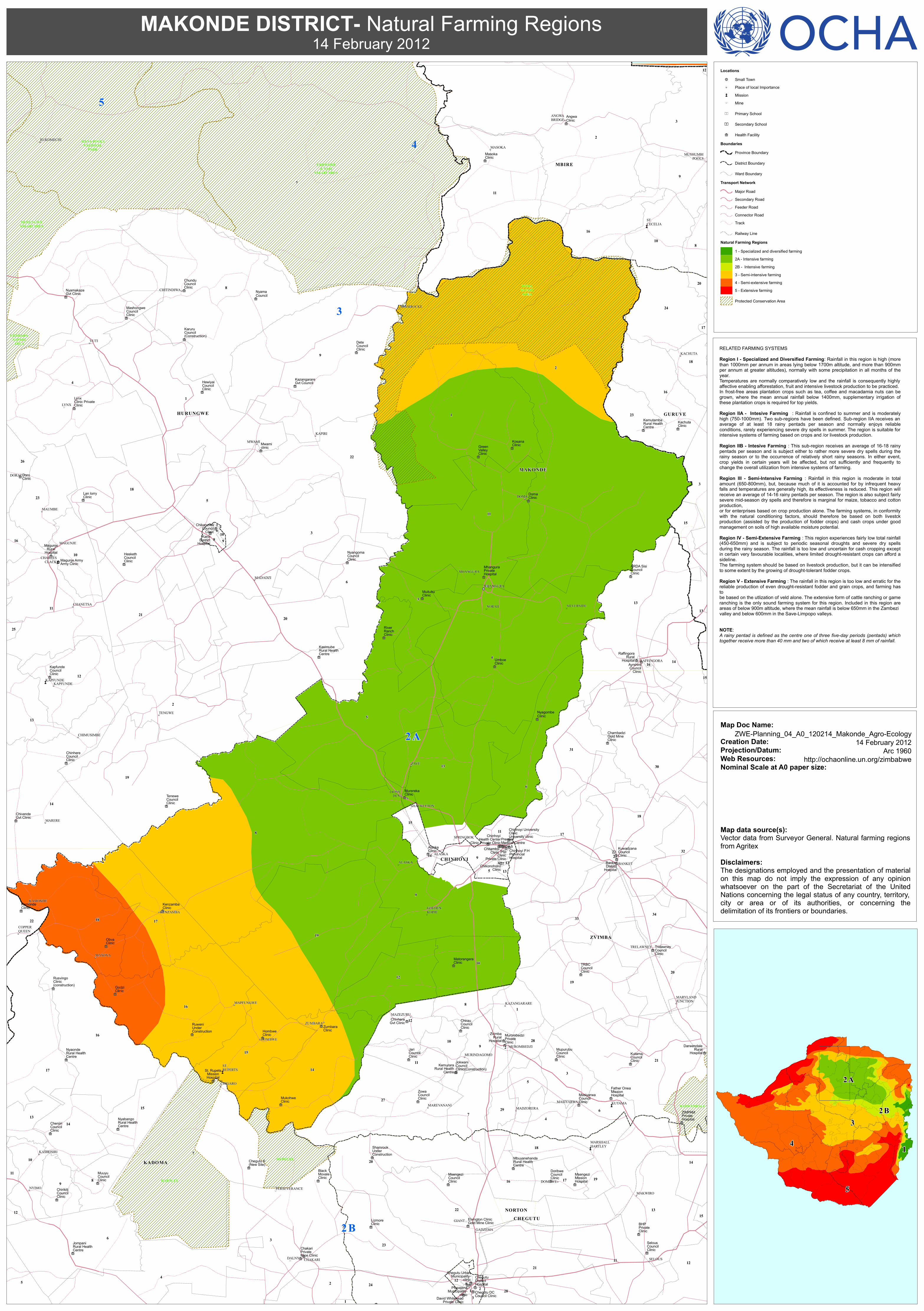
1 - Specialized and diversified farming2A - Intensive farming2B - Intensive farming3 - Semi-intensive farming4 - Semi-extensive farming5 - Extensive farming
Protected Conservation Area
RELATED FARMING SYSTEMSRegion I - Specialized and Diversified Farming: Rainfall in this region is high (morethan 1000mm per annum in areas lying below 1700m altitude, and more than 900mmper annum at greater altitudes), normally with some precipitation in all months of theyear.Temperatures are normally comparatively low and the rainfall is consequently highlyaffective enabling afforestation, fruit and intensive livestock production to be practiced.In frost-free areas plantation crops such as tea, coffee and macadamia nuts can begrown, where the mean annual rainfall below 1400mm, supplementary irrigation ofthese plantation crops is required for top yields.Region IIA - Intesive Farming : Rainfall is confined to summer and is moderatelyhigh (750-1000mm). Two sub-regions have been defined. Sub-region IIA receives anaverage of at least 18 rainy pentads per season and normally enjoys reliableconditions, rarely experiencing severe dry spells in summer. The region is suitable forintensive systems of farming based on crops and /or livestock production.Region IIB - Intesive Farming : This sub-region receives an average of 16-18 rainypentads per season and is subject either to rather more severe dry spells during therainy season or to the occurrence of relatively short rainy seasons. In either event,crop yields in certain years will be affected, but not sufficiently and frequently tochange the overall utilization from intensive systems of farming.Region III - Semi-Intensive Farming : Rainfall in this region is moderate in totalamount (650-800mm), but, because much of it is accounted for by infrequent heavyfalls and temperatures are generally high, its effectiveness is reduced. This region willreceive an average of 14-16 rainy pentads per season. The region is also subject fairlysevere mid-season dry spells and therefore is marginal for maize, tobacco and cottonproduction,or for enterprises based on crop production alone. The farming systems, in conformitywith the natural conditioning factors, should therefore be based on both livestckproduction (assisted by the production of fodder crops) and cash crops under goodmanagement on soils of high available moisture potential.Region IV - Semi-Extensive Farming : This region experiences fairly low total rainfall(450-650mm) and is subject to periodic seasonal droughts and severe dry spellsduring the rainy season. The rainfall is too low and uncertain for cash cropping exceptin certain very favourable localities, where limited drought-resistant crops can afford asideline.The farming system should be based on livestock production, but it can be intensifiedto some extent by the growing of drought-tolerant fodder crops.Region V - Extensive Farming : The rainfall in this region is too low and erratic for thereliable production of even drought-resistant fodder and grain crops, and farming hastobe based on the utlization of veld alone. The extensive form of cattle ranching or gameranching is the only sound farming system for this region. Included in this region areareas of below 900m altitude, where the mean rainfall is below 650mm in the Zambezivalley and below 600mm in the Save-Limpopo valleys.
NOTE:A rainy pentad is defined as the centre one of three five-day periods (pentads) whichtogether receive more than 40 mm and two of which receive at least 8 mm of rainfall.
MAKONDE DISTRICT- Natural Farming Regions14 February 2012
ZWE-Planning_04_A0_120214_Makonde_Agro-Ecology
14 February 2012Arc 1960
http://ochaonline.un.org/zimbabwe
Recommended