General InformationArea of Interest
SettlementsIndustrialOther or UnknownResidential
HydrologyRiverStreamDitchLake
PhysiographyContour Lines and Elevation (m)
TransportationRailwayPrimary RoadSecondary RoadLocal Road
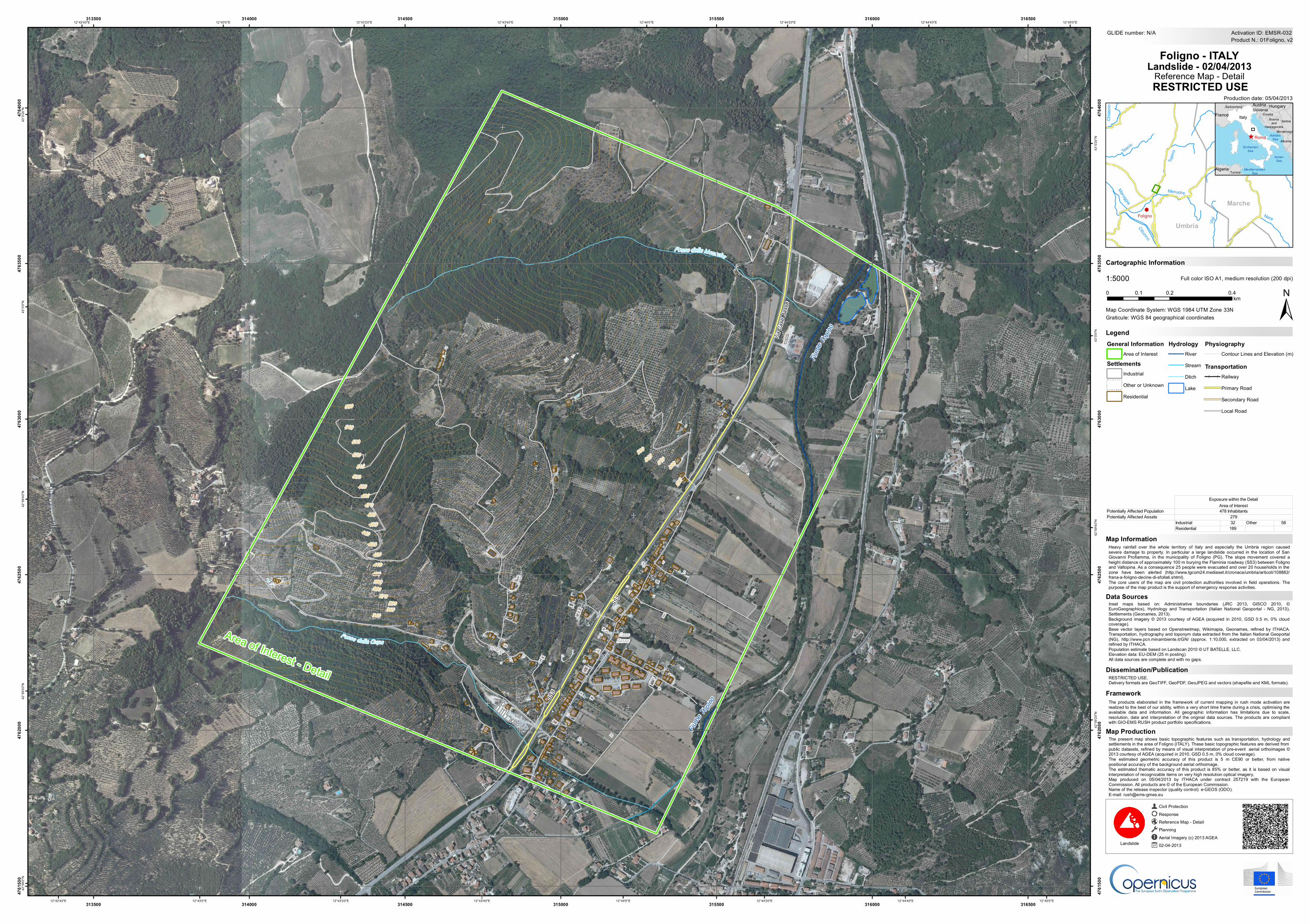
The present map shows basic topographic features such as transportation, hydrology andsettlements in the area of Foligno (ITALY). These basic topographic features are derived frompublic datasets, refined by means of visual interpretation of pre-event aerial orthoimages ©2013 courtesy of AGEA (acquired in 2010, GSD 0.5 m, 0% cloud coverage).The estimated geometric accuracy of this product is 5 m CE90 or better, from nativepositional accuracy of the background aerial orthoimage.The estimated thematic accuracy of this product is 85% or better, as it is based on visualinterpretation of recognizable items on very high resolution optical imagery.Map produced on 05/04/2013 by ITHACA under contract 257219 with the EuropeanCommission. All products are © of the European Commission.Name of the release inspector (quality control): e-GEOS (ODO).E-mail: [email protected]
9
Fiume
Topino
Fiume
Topino
Fiume Topino
Fosso della Cupa
Fosso delle Monache
SS3
SS3
ViaCa
seBa
sse
CaseBasse
550
540
530
520510
500490
480470460450
440430
420410
400390380
370360
350340
330320
310300
290
12°45'0"E
12°45'0"E
12°44'40"E
12°44'40"E
12°44'20"E
12°44'20"E
12°44'0"E
12°44'0"E
12°43'40"E
12°43'40"E
12°43'20"E
12°43'20"E
12°43'0"E
12°43'0"E
12°42'40"E
12°42'40"E43
°0'20
"N
43°0
'20"N
43°0
'0"N
43°0
'0"N
42°5
9'40"N
42°5
9'40"N
42°5
9'20"N
42°5
9'20"N
42°5
9'0"N
313500
313500
314000
314000
314500
314500
315000
315000
315500
315500
316000
316000
316500
316500
4761
500
4761
500
4762
000
4762
000
4762
500
4762
500
4763
000
4763
000
4763
500
4763
500
4764
000
4764
000
GLIDE number: N/A
!.!.
Umbria
MarcheFoligno
Tescio
Chienti
Nera
Menodre
Clitunno
Chias
cio
Vigi
Chienti DiGelagna
Topin
o
Maroggia
^
Bosniaand
HerzegovinaMontenegro
Albania
Austria HungarySlovenia
Algeria
CroatiaFrance ItalySerbia
Switzerland
Tunisia MediterraneanSea
TyrrhenianSea
AdriaticSea
IonianSea
Roma
Production date: 05/04/2013
Cartographic Information
1:5000
±Map Coordinate System: WGS 1984 UTM Zone 33N
Full color ISO A1, medium resolution (200 dpi)
The products elaborated in the framework of current mapping in rush mode activation arerealized to the best of our ability, within a very short time frame during a crisis, optimising theavailable data and information. All geographic information has limitations due to scale,resolution, date and interpretation of the original data sources. The products are compliantwith GIO-EMS RUSH product portfolio specifications.
Heavy rainfall over the whole territory of Italy and especially the Umbria region causedsevere damage to property. In particular a large landslide occurred in the location of SanGiovanni Profiamma, in the municipality of Foligno (PG). The slope movement covered aheight distance of approximately 100 m burying the Flaminia roadway (SS3) between Folignoand Valtopina. As a consequence 25 people were evacuated and over 20 households in thezone have been alerted (http://www.tgcom24.mediaset.it/cronaca/umbria/articoli/108882/frana-a-foligno-decine-di-sfollati.shtml).The core users of the map are civil protection authorities involved in field operations. Thepurpose of the map product is the support of emergency response activities.
RESTRICTED USE.Delivery formats are GeoTIFF, GeoPDF, GeoJPEG and vectors (shapefile and KML formats).
LegendGraticule: WGS 84 geographical coordinates
Product N.: 01Foligno, v2Activation ID: EMSR-032
Inset maps based on: Administrative boundaries (JRC 2013, GISCO 2010, ©EuroGeographics), Hydrology and Transportation (Italian National Geoportal - NG, 2013),Settlements (Geonames, 2013).Background imagery © 2013 courtesy of AGEA (acquired in 2010, GSD 0.5 m, 0% cloudcoverage).Base vector layers based on Openstreetmap, Wikimapia, Geonames, refined by ITHACA.Transportation, hydrography and toponym data extracted from the Italian National Geoportal(NG), http://www.pcn.minambiente.it/GN/ (approx. 1:10,000, extracted on 03/04/2013) andrefined by ITHACA.Population estimate based on Landscan 2010 © UT BATELLE, LLC.Elevation data: EU-DEM (25 m posting).All data sources are complete and with no gaps.
Civil ProtectionResponseReference Map - DetailPlanningAerial Imagery (c) 2013 AGEA02-04-2013Landslide
0 0.2 0.40.1km
Foligno - ITALYLandslide - 02/04/2013
Reference Map - Detail
Data Sources
Map Information
Dissemination/Publication
Framework
Map Production
RESTRICTED USE
Area of Interest - Detail
Potentially Affected PopulationPotentially Affected Assets
Industrial 32 Other 58Residential 189
Exposure within the Detail Area of Interest478 Inhabitants
279
Recommended